Landscape Design for Andrew Lawrence
15
INDEX 1. Context 2. Goals and Existing Conditions 3. Legal 4. Slopes and Drainage 5. Soils 6. Solar Access 7. Land Cover 8. Summary Analysis 9. Sustainability Potential 10. Inspiration 11. Preferred Design 12. Preferred Design: Sections 13. Planting Palette 14. Alternative Designs Landscape Design for ANDREW LAWRENCE 146 NASH HILL ROAD HAYDENVILLE, MASSACHUSETTS John C. Lepore Conway School of Landscape Design 332 South Deerfield Road Conway, Massachusetts Fall 2010 Wooded Wetland Looking South Endangered Jefferson Salamander
-
Upload
john-c-lepore -
Category
Documents
-
view
214 -
download
0
description
This landscape design challenge balances the new landowner’s sustainable lifestyle passions with misguided damage to a fragile wetland. The owner’s interests in this rural setting include passive solar heating, edible forest gardens, and fruit trees, but before conservation commission permitting began, a wetland damaged from excessive tree removal required a detailed restorative site plan strategy. The plan takes advantage of the preferred solar aspect with abundant food production potential. Additionally it ecologically addresses the combination of excessively drained and disturbed soils and steep slopes create challenges for septic and well placement in less than one acre under strict town and wetland permitting setbacks.
Transcript of Landscape Design for Andrew Lawrence

INDEX
1. Context2. Goals and Existing Conditions3. Legal 4. Slopes and Drainage5. Soils6. Solar Access7. Land Cover8. Summary Analysis 9. Sustainability Potential
10. Inspiration 11. Preferred Design12. Preferred Design: Sections13. Planting Palette14. Alternative Designs
Landscape Design for Andrew LAwrence
146 NASh hILL RoADhAyDENvILLE, MASSAChuSEttS
John C. LeporeConway School of Landscape Design
332 South Deerfield RoadConway, Massachusetts
Fall 2010
Woo
ded W
etlan
d Loo
king S
outh
Enda
nger
ed Je
fferso
n Sala
mand
er

Law
Renc
e PR
oPeR
ty14
6 naS
h hi
LL R
D.
hayD
envi
LLe,
Ma
John
c. L
ePoR
eCo
nway
Sch
ool o
f Lan
dsca
pe D
esign
FaL
L 20
10
1/14
not
foR
conS
tRuc
tion
. thi
S DR
awin
g iS
PaR
t of
a St
uDen
t PR
oJec
t anD
iS n
ot b
aSeD
on
a Le
gaL S
uRve
y.
co
nt
ext
imagine the excitement of purchasing property to gain independence from a conventional food supply and traditional energy systems. then, after many long hard days of work, a major error threatens to destroy these goals. the Lawrence property is located on the secluded and unpaved nash hill Road in haydenville, part of williamsburg, Massachusetts. vast hilly terrain offers hikers miles of trails through rolling forested hills. Driving along on nash hill Road, one looks down onto seven stream crossings - of them, three traverse old failing bridges. Each side of the road contains mixed hardwood forests and mysterious wooded wetlands. about 15 homes reside on this road about 3 miles (7 minutes by car) from Williamsburg town center. the nearest neighbors, who are also close friends to andrew Lawrence, live less than a few hundred yards away on large lots.
on a larger scale, this beautiful landscape is connected to the huge connecticut River watershed and joins the long connecticut River through a series of small streams and brooks. Protected “eco-regions,” prescribed surface water protection areas, several certified vernal pools, and the potential for many more surround the Lawrence property. Seven natural heritage Rare and endangered Species find refuge in the vicinity, as well. the area affords invaluable natural resources yet presents many challenges in land development for the property owner.
ConneCtiCut RiveR WateRshed: the Lawrence property drains water to the wright brook, then into the Mill River which empties into the connecticut River.
CommonWealth of massaChusetts: Williamsburg is located in the state’s western portion.
WilliamsbuRg showing bioMap2 core habitat
context
nash hill Road: natural heritage Rare and endangered Species program includes certified vernal pools (stars) and acknowledges the potential for several more (disks). wright brook moves water south from this area to Mill River in williamsburg, about 3 miles south.
wright brook
laWRenCe PRoPeRty, 146 nash hill Road, haydenville (part of williamsburg), focus area front half of the 2-acre lot.
wright brook
Law
Renc
e PR
oPeR
ty14
6 naS
h hi
LL R
D.
hayD
envi
LLe,
Ma
John
c. L
ePoR
eCo
nway
Sch
ool o
f Lan
dsca
pe D
esign
FaL
L 20
10
2/14
not
foR
conS
tRuc
tion
. thi
S DR
awin
g iS
PaR
t of
a St
uDen
t PR
oJec
t anD
iS n
ot b
aSeD
on
a Le
gaL S
uRve
y.
Go
ALs
& e
xis
tin
G
co
nd
itio
ns
GoALs• Design a self-reliant, passive solar home
with shed/greenhouse, & food production areas.
• Design an ecologically sensitive homestead with on-site nutrient & water cycling that protects the wetland and other natural resources.
contour intervals 5 ft
n0’ 5’ 10’ 15’ 20’
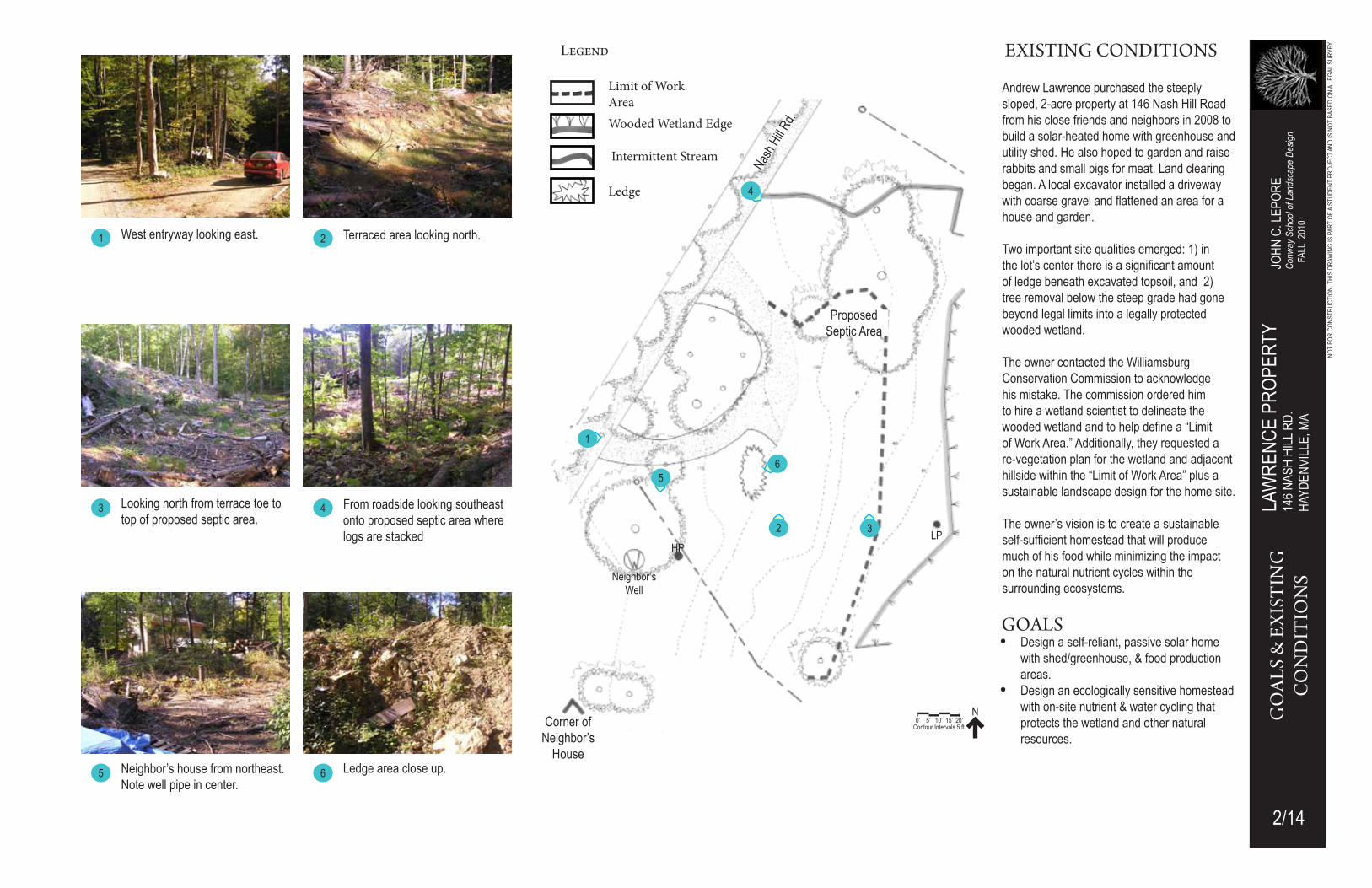
West entryway looking east.
Intermittent Stream
Wooded Wetland Edge
Limit of Work Area
terraced area looking north. 2
Looking north from terrace toe to top of proposed septic area.
3 4 From roadside looking southeast onto proposed septic area where logs are stacked
existinG conditions
Corner of neighbor’s
house5 neighbor’s house from northeast.
note well pipe in center.6 Ledge area close up.
andrew Lawrence purchased the steeply sloped, 2-acre property at 146 nash hill Road from his close friends and neighbors in 2008 to build a solar-heated home with greenhouse and utility shed. he also hoped to garden and raise rabbits and small pigs for meat. Land clearing began. a local excavator installed a driveway with coarse gravel and flattened an area for a house and garden.
two important site qualities emerged: 1) in the lot’s center there is a significant amount of ledge beneath excavated topsoil, and 2) tree removal below the steep grade had gone beyond legal limits into a legally protected wooded wetland.
the owner contacted the williamsburg Conservation Commission to acknowledge his mistake. the commission ordered him to hire a wetland scientist to delineate the wooded wetland and to help define a “Limit of work area.” additionally, they requested a re-vegetation plan for the wetland and adjacent hillside within the “Limit of work area” plus a sustainable landscape design for the home site. the owner’s vision is to create a sustainable self-sufficient homestead that will produce much of his food while minimizing the impact on the natural nutrient cycles within the surrounding ecosystems.
Proposed Septic area
1
1
5
2
6
3
4
Legend
Ledge
nash
hill R
d.
neighbor’s Well
hPLP

Law
Renc
e PR
oPeR
ty14
6 naS
h hi
LL R
D.
hayD
envi
LLe,
Ma
John
c. L
ePoR
eCo
nway
Sch
ool o
f Lan
dsca
pe D
esign
FaL
L 20
10
3/14
not
foR
conS
tRuc
tion
. thi
S DR
awin
g iS
PaR
t of
a St
uDen
t PR
oJec
t anD
iS n
ot b
aSeD
on
a Le
gaL S
uRve
y.
LeG
AL
contour intervals 5 ft
n0’ 5’ 10’ 15’ 20’
Legal restrictions on this site demand primary consideration in the design process. the delineation of the wetland is described in “existing conditions,” page 2. a number of setbacks limit the location of the well, septic system and buildings on the site. Limit of Work Area: identified by the wetland scientist and accepted by natural heritage and endangered Species Program. the owner may use land to this line as long as the conditions outlined in “conservation commission” below are met.
Re-vegetation of Disturbed Area: the conservation commission requires that this area be re-vegetated for a development permit. this reduces potential impact on the wooded wetland.
Deeded Easement to Share Neighbor’s Well: the owner’s deed stipulates shared use of the neighbor’s well as an option with clearly stipulated provisions.
town-Right-of-Way: the town requires a 25-1/2 foot setback from the edge of road to the property line.
Property Setback: no structures, such as fences, allowed within 10’ of the town-Right-of-way; this applies to all boundaries of the property.
Building Setback: no building can be placed closer than 40’ from the town-Right-of-way and 15 feet from the neighbor’s property line; determines the closest location for buildings.
Limit of 100’ Wetland Buffer Zone: 100 feet from the wetland boundary.
Well Setbacks: the well must be a minimum of 30 feet from the town’s-Right-of-way and neighbor’s property line; it must also be 100 feet from the septic system. • this limits the well’s location to the site’s northwest corner unless the owner
chooses to exercise the deeded easement to the neighbor’s well.
Septic Setbacks: the septic system may not be closer than 50 feet to a wetland or stream and 20 feet from a building. • the septic is limited to the northeast corner of the Limit of work area unless
the owner chooses to exercise the deeded easement to the neighbor’s well, which creates more opportunities for placement.
• a compost toilet would reduce the standard system area by 50%.
Conservation Commission: to obtain a permit to build within the wetland buffer zone the owner must agree to:• Re-vegetate the disturbed area.• Replace trees in the wooded wetland removed before wetland delineation• Present a sustainable landscape design that reduces the potential impact on
the fragile wetland.
Proposed Septic
Location
Proposed Well
Location
Maple-saplings (center) replace accidentally cut trees within protected wooded wetland.
WetlandNeighbor’s
Well
LeGAL
25 1/2’10’
40’
10’
15’
Re-vegetation of Disturbed
area
Suitable Development
area
SuItABLE DEvELoPMENt AREA: Defined by the town-Right-of-way, Property Setback, and the Limit of Work area.
Limit of Work area
Wooded Wetland Edge
Stream
Legend
Limit of 100’ wetland buffer Zone

Law
Renc
e PR
oPeR
ty14
6 naS
h hi
LL R
D.
hayD
envi
LLe,
Ma
John
c. L
ePoR
eCo
nway
Sch
ool o
f Lan
dsca
pe D
esign
FaL
L 20
10
4/14
not
foR
conS
tRuc
tion
. thi
S DR
awin
g iS
PaR
t of
a St
uDen
t PR
oJec
t anD
iS n
ot b
aSeD
on
a Le
gaL S
uRve
y.
sLo
pes
& d
rain
AGe
Nash H
ill R
oad
high Point
Low Point
contour intervals 1 ft
n0 5 10 15 20
Proposed Septic Area
WoodedWetland
Stream
contour intervals 1 ft.
n0’ 5’ 10’ 15’ 20’
• Site drains toward wetland.
• Large percentage of site is greater than 25% slope
• a large portion of the site has slopes from 15 to 25% slope
• Driveway slopes 10 to 15%
• Driveway slopes toward stream and wetland
• Some proposed garden areas have slopes greater than 25%
• Proposed septic area in steep location
• Rooftops are impervious
→ Slope directs water and potential undesirable nutrients toward sensitive wetland.
→ these areas are highly unstable and prone to erosion; may require vegetation for erosion control & minimal use
→ Slopes 15 % or greater are difficult to traverse. garden rows should run parallel with slopes; stairs are necessary for movement up and down slopes.
→ creates potentially dangerous conditions during winter months; requires regrading.
→ Drainage from driveway needs to be directed away from wetland.
→ in addition to careful terracing, regrading to less than 33% slope is necessary; fill will be required; contour terracing is needed to prevent vertical runoff.
→ Septic system can leach excess nutrients that could make their way into the nearby wooded wetland and stream. Efforts to reduce nutrient leaching toward wetland are critical.
→ Roofs should have a water collection system to reduce rapid runoff toward wetland.
Driveway
Proposed Garden
area
1 to 5 % Slope
sLopes & drainAGe Legend
> 25 % Slope
15 to 25 % Slope
10 to 15 % Slope
5 to 10 % Slope
Drainage direction
Suitable Development area
(See page 3)
nash
hill R
d.

Law
Renc
e PR
oPeR
ty14
6 naS
h hi
LL R
D.
hayD
envi
LLe,
Ma
John
c. L
ePoR
eCo
nway
Sch
ool o
f Lan
dsca
pe D
esign
FaL
L 20
10
5/14
not
foR
conS
tRuc
tion
. thi
S DR
awin
g iS
PaR
t of
a St
uDen
t PR
oJec
t anD
iS n
ot b
aSeD
on
a Le
gaL S
uRve
y.
soiL
s
soiLs
SEPtIC SyStEMS
Massachusetts title 5 Septic regulations (310 cMR 15) allow the use of compost toilets, subject to certain conditions. these offer several advantages to the Lawrence site:• compost toilet use allows the reduction of the septic system size by 50%; this
would enable placement of the system away from the steep slope and the wet-land while remaining on a well-drained soil.
• Since solid human waste containing undesirable nitrogen compounds is removed and does not enter a standard septic design, the potential harm to wetlands is greatly reduced.
• compost toilets significantly reduce the amount of water needed for home use, a significant water conservation measure.
conventional and alternative systems require approval by the town’s board of health.
a
‘a
Section A to A’ through the Lawrence Property Focus Area
WetlandCharacteristics of Scitico & Saco Silt Loam
• this is a very deep, poorly drained soil, formed in silty/clayey sediments which tend to filter materials moving into the substratum.
• Materials transported from the hillside above tend to accumulate on the surface, decreasing its filtering capabilities. this can interfere with natural water purification, a major function of the wetland.
Source: Soil Survey of hampshire County Massachusetts, Natural Resource Conservation Service; formerly u.S. Department of Agriculture, Soil Conservation Service 1981
2 Suitable Development areaCharacteristics of Merrimac fine sandy loam• Water passes very rapidly through this soil and substratum (which typically extends
to a depth of 60 inches).
• Permeability is moderately rapid. therefore, dissolved nutrients travel easily into the wetland.
• Severe erosion and drought are the main limitations to crop cultivation.
• Minimum tillage, terracing, and cover crop usage can reduce erosion and excessive runoff from reaching the protected wetland.
• excessive slope on Merrimac fine sandy loam limits its use for buildings and septic system placement.
• Rapid permeability limits this soil for septic system use and could create a hazard of contamination to ground water and nearby wells.
1
A ntS
Suitable Development area* Wetland
A’1 2

Law
Renc
e PR
oPeR
ty14
6 naS
h hi
LL R
D.
hayD
envi
LLe,
Ma
John
c. L
ePoR
eCo
nway
Sch
ool o
f Lan
dsca
pe D
esign
FaL
L 20
10
6/14
not
foR
conS
tRuc
tion
. thi
S DR
awin
g iS
PaR
t of
a St
uDen
t PR
oJec
t anD
iS n
ot b
aSeD
on
a Le
gaL S
uRve
y.
soLA
r A
cc
ess
soLAr Access
growing season sun/shade occurs from tree leaf-out in late spring to early fall when leaves drop. Solar heated homes and greenhouses generally require afternoon shade in warmer seasons to avoid overheating. the ideal location for a passive solar home and greenhouse on this site, therefore, is “shade: moRning & mid-afteRnoon”.
gardens produce best under full sun conditions, so their best spot is “full sun: all day.” the greenhouse could be here if shading curtains were added.
Perennial growing areas, such as edible forest gardens and fruit orchards, enjoy full sun but also produce well in conditions like “shade: mid-afteRnoon”. Mid-afternoon shade would benefit a greenhouse.
tree removal during the landscape development could change these conditions and may need to be considered in the home and greenhouse final locations.
Leaf-less trees during the seasons opposite the growing season (late fall to early spring) enable optimal passive solar gain for the solar heated home and greenhouse.
Site analysis reveals that the Lawrence property solar aspect is ideal for passive solar gain during the winter months. however, if the owner hopes to include photovoltaic panels for electricity, then locating the home in the full sun or placement of the panels on the ground in the full sun area will be necessary.
autumn equinox 8 aM
Winter Solstice 9 aM
Spring equinox 8 aM
Summer Solstice 2 PM
contour intervals 5 ft.
n0’ 5’ 10’ 15’ 20’
Suitable Development Area
Suitable Development areaboundary
nash
hill R
d.
Legend

Law
Renc
e PR
oPeR
ty14
6 naS
h hi
LL R
D.
hayD
envi
LLe,
Ma
John
c. L
ePoR
eCo
nway
Sch
ool o
f Lan
dsca
pe D
esign
FaL
L 20
10
7/14
not
foR
conS
tRuc
tion
. thi
S DR
awin
g iS
PaR
t of
a St
uDen
t PR
oJec
t anD
iS n
ot b
aSeD
on
a Le
gaL S
uRve
y.
LanD
cov
eR
Wooded Wetlandin the Lawrence property’s lower reaches a number of water-tolerant woody and herbaceous species thrive: eastern hemlock, red maple, american elm, spicebush, sensitive fern, christmas fern, foam-flower, and grey birch. tree cutting has disturbed the outer edge of this area. Coppice maple and birch occur from the cutting of primary trunks on several middle-aged trees. a remediation plan is being implemented to restore this area, because this disturbance encourages invasive species, which will have a significant impact on the ecology of this area in a number of ways still discussed by ecologists.
Mixed ForestRed oak dominates the mixed forest on the Lawrence property with an occasional beech and red maple. Ring count here and in the wooded wetland reveals tree ages to be about eighty years. this suggests that the trees here grew in after a disruption occurred in the 1930s when hurricanes could have downed the older, larger growth.a similar forest flourishes across the road, but with fewer red oaks. an interesting community of eastern hemlock, red maple, beech, black birch, and wild grape surround a small man-made off site pond established some time ago, possibly when the area was cleared for farming. this reservoir holds water that enters the Lawrence property via the stream on the east side
Early Succession Fieldthis area appears to have been cleared when the property was sold. birches, maples and oaks are in the early stages of re-growth along with low ground cover. it, as with other areas on the property, is vulnerable to invasive plants becoming established.
Excavatedthe central portion was re-sculptured within the last few years to gain terraced space to garden, establish a driveway, and confirm the location of bedrock. this area faces a high likelihood of invasive plants becoming established as it transitions into a new plant community. the east edge of the flat terrace requires vegetative remediation with the addition of organic matter and topsoil to reduce the slope and the potential of heavy erosion into the wetland.
Disturbed Areaa steep slope between the excavated and disturbed areas with require restoration. Slopes as high as 80% exist and should be regraded to a 1:3 slope. Portions are disrupted from tree and brush piles removal, and the foot traffic associated with this work. More than any other areas the challenge here is to manage plant communities to avoid invasive plants from becoming established.
Suitable Development area
contour intervals 5 ft
n0’ 5’ 10’ 15’ 20’
LegendLAnd cover
nash
hill R
d.

Law
Renc
e PR
oPeR
ty14
6 naS
h hi
LL R
D.
hayD
envi
LLe,
Ma
John
c. L
ePoR
eCo
nway
Sch
ool o
f Lan
dsca
pe D
esign
FaL
L 20
10
8/14
not
foR
conS
tRuc
tion
. thi
S DR
awin
g iS
PaR
t of
a St
uDen
t PR
oJec
t anD
iS n
ot b
aSeD
on
a Le
gaL S
uRve
y.
sum
mAr
y An
ALys
is
the “wetland edge” requires vegetative restoration, and a sustainable landscape design within the Suitable Development area will require a special permit from the Williamsburg Conservation Commission.
this special permit will allow the development of 0.46 acres befoRe Property Setbacks and the town-Right-of-way are subtracted.
the on-site “Proposed well Location” in the property’s northwest corner must be at least 100’ from the septic system in the northeast corner.
excessively drained soil in the “Suitable Development area” has a potential for wetland contamination.
because slopes greater than 25% constitute much of the property, development, use, and excessive erosion are a serious challenge.
a large area of ledge in the center of the “Suitable Development area” could hinder construction. (existing conditions, page 2)
the “Re-vegetation area” needs additional topsoil and stabilizing ground cover to reduce the slopes to no more than 33%. this should reduce erosion significantly.Re-vegetation of this area is subject to review by the williamsburg conservation Commission.
the “growing Season: Shaded Morning & Mid-afternoon” zone produces ideal summer shade to prevent solar-heated home and greenhouse overheating.
the growing Season: full Sun all Day creates ideal conditions for food production gardens. Wetland Edge
Proposed Septic
Location
Proposed Well
Location
contour intervals 5 ft
n0’ 5’ 10’ 15’ 20’
summAry AnALysis
nash
hill R
d.
growing Season full Sun all DaySlope >25%
Suitable Development area*Re-vegetation area
growing Season Shaded Morning & Mid-afternoon
Legend

Law
Renc
e PR
oPeR
ty14
6 naS
h hi
LL R
D.
hayD
envi
LLe,
Ma
John
c. L
ePoR
eCo
nway
Sch
ool o
f Lan
dsca
pe D
esign
FaL
L 20
10
9/14
not
foR
conS
tRuc
tion
. thi
S DR
awin
g iS
PaR
t of
a St
uDen
t PR
oJec
t anD
iS n
ot b
aSeD
on
a Le
gaL S
uRve
y.
sust
Ain
AbiL
ity
pot
ent
iAL
Schematic Alternativestwo alternative site plans show options for the potential overall site layout and the relationship of the solar home, greenhouse, food production areas, driveway, and wooded wetland. Mr. Lawrence plans to construct a two-story passive solar home of about 1200 square feet and a 240 square-foot greenhouse with utility shed of equal size. this greenhouse would serve to extend the growing season.
Renewable Energyhaving a solar heated home shows the owner’s commitment to renewable energy. Solar heating would be supplemented with selectively harvested off-site firewood. if the greenhouse and utility shed share a common foundation with the home, heat from various sources could be easily moved by small electric fans and convection. home orientation, location, and design will determine the optimal ways to reduce the need for supplemental cooling during the hotter seasons of the year. as climate change continues to bring uncertain conditions, a design that considers heating and cooling in extreme situations could prove beneficial. use of photovoltaic panels may be considered at a later date. although the roof aspect on two designs are southern, none of the designs presented in the following pages fits this application since the home’s shaded location is not sufficient to meet solar panel demands. Global Climate Changeextreme temperatures, precipitation, drought, and winds loom on the horizon in the next decade and beyond. careful planning and management of water and forests can protect valuable natural resources along with personal property.Resourceful rainwater collection from impermeable surfaces such as rooftops is ideal since water can easily be directed into rain collecting gutters and piped to a storage area. Management of runoff during extreme rainfall will also ensure that valuable soils and vulnerable wetlands are protected. Reduction of impervious driveway area also encourages improved water infiltration and aquifer recharging.Selective cutting of surrounding trees requires very careful consideration. trees work together as communities in dispersing intense winds especially in the winter, so removal of one or two trees from a critical area may make others vulnerable to uprooting and breakage. trees and shrubs enhance home temperature control in hot spells and help control excessive drying during droughts.
Food Productionfood production is one of the client’s goals. Raising caged rabbits support sustainability three ways: a source of food, on-site availability of their food and rich compost from their waste. the client is also interested in a breed of small swine. Since pigs dig heavily to locate food underground, a pen on very level ground away from the steep slopes with several sections to avoid overgrazing would accommodate their needs while reducing the prospect of erosion.
gardening with annual vegetables, fruit orchards and edible forest gardens could produce an abundance of food for a large portion of the year. Food preservation by canning, drying, curing and freezing would also extend the season of eating locally. the greenhouse offers more opportunities for winter food production.`
GuidinG principLes of A sustAinAbLe siteDo No harmMake no changes to the site that will degrade the surrounding environment. Promote projects on sites where previous disturbances or development present an opportunity to regenerate ecosystems services through sustainable design.
Precautionary principlebe cautious in making decisions that could create risk to human and environmental health. Some actions can cause irreversible damage. examine a full range of alternatives - including no action – and be open to contributions from all affected parties.
Design with Nature and CultureCreate and implement designs that are responsible to economic, environmental and cultural conditions with respect to the local, regional and global context.
use a decision-making hierarchy of preservation, conservation and regenerationMaximize and mimic the benefits of ecosystem services by preserving existing environmental features, conserving resources in a sustainable manner, and regenerating lost or damaged ecosystem services.
Provide regenerative systems as intergenerational equityProvide future generations with a sustainable environment supported by regenerative systems and endowed with regenerative resources.
Support a living processContinuously re-evaluate assumptions and values and adapt to demographic and environmental change.
use a systems thinking approachunderstand and value the relationships in an ecosystem and use an approach that reflects and sustains ecosystem services; re-establish the integral and essential relationship between natural processes and human activity.
use a collaborative and ethical approachEncourage direct and open communication among colleagues, clients, manufacturers and users to link the long-term sustainability with ethical responsibility.
Maintain integrity in leadership and researchimplement transparent and participatory leadership, develop research with technical rigor and communicate new findings in a clear, consistent and timely manner.
Foster environmental stewardshipin all aspects of land development and management, foster an ethic of environmental stewardship – an understanding that responsible management of healthy ecosystems improves the quality of life for present and future generations.
Sustainable Sites Initiative; Guidelines & Performance Benchmarks, 2009. ASLA, Lady Bird Johnson Wildflower Center & US Botanical Garden. Page 7
the beautiful nash hill Road in early fall
sustAinAbiLity potentiAL

Law
Renc
e PR
oPeR
ty14
6 naS
h hi
LL R
D.
hayD
envi
LLe,
Ma
John
c. L
ePoR
eCo
nway
Sch
ool o
f Lan
dsca
pe D
esign
FaL
L 20
10
10/14
not
foR
conS
tRuc
tion
. thi
S DR
awin
g iS
PaR
t of
a St
uDen
t PR
oJec
t anD
iS n
ot b
aSeD
on
a Le
gaL S
uRve
y.
grantwater.ie
upload.wikimedia.org
http://www.grantwater.ie/wordpress/wp-content/uploads/rainwater-collection.jpg 1.bp.blogspot.com
http://1.bp.blogspot.com/_4azgesdgnwi/tMl452ri-7i/aaaaaaaacaQ/1vpbno-9Pgy/s1600/large-pond-half-empty.jpg
waldeneffect.org
http://upload.wikimedia.org/wikipedia/commons/4/49/illust_passive_solar_d1.gif 2.bp.blogspot.com
http://2.bp.blogspot.com/_4azgesdgnwi/tMvpi4axboi/aaaaaaaacaw/PPvbxXaptpe/s1600/large-pond-refilled-with-plants.jpg
hillsideherbs.com
upload.wikimedia.org water-gardens-information.comrichsoil.com
http://www.richsoil.com/hugelkultur/bed_d.jpg
richsoil.com
farm4.static.flickr.com
http://newworldgeek.com/wp-content/uploads/2009/06/hugelkultur.jpg
newworldgeek.com
insp
irat
ion
Passive solar-heated home and terracing supports sustainable design.
Ledge pond collects water from the roofs and reduces runoff and stores irrigation water.
“hugelkultur” uses woody waste for soil building. very effective on steep slopes and is an abundant resource
from land clearing. Edible forest garden produces food perennially.

Law
Renc
e PR
oPeR
ty14
6 naS
h hi
LL R
D.
hayD
envi
LLe,
Ma
John
c. L
ePoR
eCo
nway
Sch
ool o
f Lan
dsca
pe D
esign
FaL
L 20
10
11/14
not
foR
conS
tRuc
tion
. thi
S DR
awin
g iS
PaR
t of
a St
uDen
t PR
oJec
t anD
iS n
ot b
aSeD
on
a Le
gaL S
uRve
y.
pref
erre
d d
esiG
n
preferred desiGn: restorationCommonName
Slop
e R
e-ve
geta
tion New England Erosion Control/
Restoration Mix
Sweet fern
Bankers Dwarf Willow
Raspberry, Blackberry
Wet
land
Re-
vege
tatio
n Swamp Rose
Common Spicebush
Pussy Willow
Common Elderberry
Meadowsweet
Royal Fern
Swamp Milkweed
Swamp Aster
Hardstem Bulrush
Edib
le F
ores
t Gar
den
Hog Peanut
Hardy Kiwi
Groundnut
Paw Paw
Strawberries
Sweet Cicily
Comfrey
Fragrant False Indigo
New Jersey Tea
Anise hyssop
Mints
Bee Balm
Sea Kale
Coreopsis
Dutch white clover
Rhubarb
Orc
hard
Apple
Peach
Asian Pear
European Pear
Lowbush Blueberry
Highbush Blueberry
Nut
s/
Mas
t Beaked Filbert
Black Walnut
Filbert
planting palette (Abbreviated)
the preferred design, “Restoration,” addresses andrew Lawrence’s goals. he wishes to build a sustainable homestead with a solar-heated home, a greenhouse with utility shed and to produce food while living in harmony with the surrounding woods and wetland. this design includes the following: Passive Solar home, Greenhouse and utility Shed
• Locate for optimal summer shade, and provide great exposure for solar heating during cooler months• Centralize access for entry, entertainment and daily use of the land• Reduce the driveway size to increase garden space and privacy from the
road• Reuse former driveway coarse sand material as garden walkway mulch• collect rooftop rainwater to fill a 3000-gallon “ledge pond” constructed
on the ledge; irrigate gardens with it by gravity feedEdible Forest Garden
• Locate in sunny areas for most of the growing season• Layer plants to replicate ecological forest interactions with sun/shade,
nutrient production/ use• terrace slope to reduce erosion and ease access on steep slopes • Produce multi-layered effects with perennial crops
Annual vegetable Garden• Locate near greenhouse for daily access • use raised beds with “hugelkultur” (logs underneath compost) to build soil and
terrace against erosion while encouraging water infiltrationFruit orchard
• Locate for occasional access• grade steep slopes to an “angle of repose”, ~33% with erosion control grass
mix to stabilize bank as fruit crops develop• channel excess water from driveway to irrigate the orchard and reduce
erosion from rapid water runoff into the wetlandBank and Wetland Re-vegetation
• use native plants to encourage wildlife habitat, pollination and moisture retention• increase re-vegetation potential with shrubs and ground cover • arrange plantings to be aesthetically pleasing from multiple locations
Well and Septic• Create a standard septic design for a 2-bedroom home placed beyond the 100’
well protection zone• Provide a grassy area on septic system for rabbit fodder • Drain water away from the driveway to protect the septic from water
saturation
contour intervals 5 ft.
n0’ 5’ 10’ 15’ 20’
annualvegetablegardens
utility Shed
greenhouse
Solar home
Septic
Well
LedgePond

Law
Renc
e PR
oPeR
ty14
6 naS
h hi
LL R
D.
hayD
envi
LLe,
Ma
John
c. L
ePoR
eCo
nway
Sch
ool o
f Lan
dsca
pe D
esign
FaL
L 20
10
12/14
not
foR
conS
tRuc
tion
. thi
S DR
awin
g iS
PaR
t of
a St
uDen
t PR
oJec
t anD
iS n
ot b
aSeD
on
a Le
gaL S
uRve
y.
b’
b
a’a
pref
erre
d d
esiG
n
sec
tio
ns
preferred desiGn sections
Ledge Pond & roof water collection
system
Solar home &greenhouse
Edible Forest garden orchard
with Re- graded Slope & Drainage Swale NTSa a’
• Ledge pond (15’ wide, 3’ high) holds 3000 gallons of water, about the volume received from roof areas of greenhouse, home and shed/month. a gutter system delivers water to the ledge pond.
• Regraded slope changes from ~ 80% to 33%; re-vegetated with erosion control mix and planted with low bush blueberry - a terrific erosion control food producing shrub.
• Drainage swale diverts water from driveway runoff and to water the orchard: this re-directs about 3000 gallons of sediment carrying water from directly reaching the wetland/ month.
annual vegetable garden greenhouse Solar home utility Shed Drivewayb b’
NTS
• Most of the former driveway coarse sand is re-used as mulch in the gardens.
• the greenhouse, solar home and utility shed share walls, so moving heat with small fans and by convection provides efficiency in maintaining comfort.
• Erosion control Restoration Mix should be used throughout the design for erosion control. (See Planting Palette, page 13)

Law
Renc
e PR
oPeR
ty14
6 naS
h hi
LL R
D.
hayD
envi
LLe,
Ma
John
c. L
ePoR
eCo
nway
Sch
ool o
f Lan
dsca
pe D
esign
FaL
L 20
10
13/14
not
foR
conS
tRuc
tion
. thi
S DR
awin
g iS
PaR
t of
a St
uDen
t PR
oJec
t anD
iS n
ot b
aSeD
on
a Le
gaL S
uRve
y.
pLAn
tin
G p
ALett
e
oBL- obligate wetland species; FACW- Facultative Wetland Plants; FAC- Facultative Species
CommonName Botanical name Perennial Ht(ft.) Width(ft.) Sun/Shade Water Soil EcologicalFunction HumanUses/Notes
Slop
e R
e-ve
geta
tion New England Erosion Control/
Restoration Mix for Dry SitesAgrostis alba, Agrostis perennials, Bouteloua gracilis, Elymus canadensis, Festuca rubra, Lolium multiflorum, Lolium perenne, Schizachycium scoparium, Sorgastrum nutans
Mixed Grasses - - Full Dry Fine Sandy Loam Erosion Control
Mulch with weed free straw/ add 10-10-10// New England Wetland Plants, Amherst, MA
Sweet fern Comptonia peregina Shrub 2-5' 2-5' Full Dry Fine Sandy Loam Erosion Control/Fixes Nitrogen/ Spreads by root suckers
Bankers Dwarf Willow Salix x cotteti Shrub 7' or less Trailing Full-Partial FAC Fine Sandy Loam Erosion Control/ Fast growing native
Raspberry, Blackberry Rubus spp. Biennial shrub 5-7' 3' Full FAC Well Drained Erosion Control Edible fruit
Wet
land
Re-
vege
tatio
n Swamp Rose Rosa palustris Shrub 5-7' 5-7' Full-Partial OBL Fine Silty Loam Insect attraction/cover/nesting
Common Spicebush Lindera benzoin Shrub 6-10' 6-10' Full-Partial OBL Fine Silty Loam Attracts insects
Pussy Willow Salix discolor Shrub 6-10' 6-10' Full - Low FACW Fine Silty Loam Erosion Control
Common Elderberry Sambucus canadensis Shrub 6-8' 6-8' Full FACW- Fine Silty Loam Bird food for many species Edibleflowers&fruit/Toleratesvarioussoilconditions
Meadowsweet Spiraea latifolia Shrub 2-4' 2-4' Full FAC+ Either Root suckers
Royal Fern Osmunda regalis Fern 2' 2' Partial-shade OBL Fine Silty Loam Native
Swamp Milkweed Asclepias incarnata Herb 4' 4' Full OBL Fine Silty Loam Attracts insects
Swamp Aster Symphyotrichum puniceum Herb 4-8' 3' Full OBL Fine Silty Loam Attractsbutterflies/Easilyself-seeds
Hardstem Bulrush Schoenoplectus acutus Herb 10' 1' Full OBL Fine Silty Loam Wildlifeattraction/Removesheavymetals&nutrients
Edib
le F
ores
t Gar
den
Hog Peanut Amphicarpa bracteata Herb >12" Spreads Partial-shade Varies Nitrogen Fixation/ Ground Cover
Hardy Kiwi Actinidia arguta Vine Varies Spreads Full Well Drained Fine Sandy Loam Edible fruit; aggressive, needs further study
Groundnut Apios americana Herb >12" Varies Partial-shade Well Drained Fine Sandy Loam Nitrogen Fixation/ Ground Cover Edible tubers
Paw Paw Asimina triloba Tree 30' 20' Full-Partial Well Drained Fine Sandy Loam Edible fruit
Strawberries Fragaria spp. Herb >12" 10" Full Well Drained Fine Sandy Loam Edible Fruit
Sweet Cicily Osmorhiza spp. Herb 2' Varies Partial-shade Well Drained Fine Sandy Loam Edible bulbs, roots or tubers
Comfrey Symphytum officinale Herb 5' 5' Full Well Drained Fine Sandy Loam Pulls nutrients up
Fragrant False Indigo Amorpha nana Shrub 5' 5' Full Well Drained Fine Sandy Loam Nitrogenfixer/Attractsbeneficialinsects Leaves for tea
New Jersey Tea Ceanothus americanus Shrub 3' 3' Full-Partial Well Drained Fine Sandy Loam Nitrogenfixer/Attractsbeneficialinsects
Anise hyssop Agastache foeniculum Herb 2-4' 2' Full-Partial Well Drained Fine Sandy Loam Attracts insects Tea, edible leaves
Mints Mentha spp. Herb 2-3' 2-3' Full-Partial Well Drained Fine Sandy Loam Attracts insects, groundcover Tea,
Bee Balm Monarda didyma Herb 2-4' 2-3' Full-Partial Well Drained Fine Sandy Loam Attracts hummingbirds Tea
Sea Kale Crambe maritima Herb 2-3' 2-3' Full Partial Well Drained Fine Sandy Loam Edible greens, shoots and broccoli heads
Coreopsis Coreopsis verticillata Herb Full Well Drained Fine Sandy Loam Groundcover, attracts insects
Dutch white clover Trifolium repens Herb 1' 1' Full Well Drained Fine Sandy Loam Groundcover,dynamicaccumulator,nitrogenfixer
Rhubarb Rheum rhabarbarum Herb 5' 4' Full Well Drained Fine Sandy Loam Edible stem Edible Forest Garden
Orc
hard
Apple Pyrus malus Tree Semi- Dwarf Varies Full Well Drained Fine Sandy Loam Edible Fruit
Peach Prunus persica Tree Semi- Dwarf Varies Full Well Drained Fine Sandy Loam Edible Fruit
Asian Pear Pyrus pyrifolia Tree Semi- Dwarf 30-40' Full Well Drained Fine Sandy Loam Edible Fruit
Pear Pyrus communis Tree Semi- Dwarf Varies Full Well Drained Fine Sandy Loam Edible Fruit
Lowbush Blueberry Vaccinium angustifolium Shrub >12” Varies Full Well Drained Fine Sandy Loam Erosion Control/ Fast growing native Edible Fruit
Highbush Blueberry Vaccinium corymbosum Shrub 4-6' 4-6' Full - Partial Drained to Moist Fine Sandy Loam Edible Fruit
Nut
s/
Mas
t Beaked Filbert Corylus cornuta Shrub-Tree 6-10' 6-8' Full Well Drained Fine Sandy Loam Shade Nuts/ Mast
Black Walnut Juglans nigra Tree 100' 50-70' Full Well Drained Fine Sandy Loam Shade
Filbert Corylus avellana Tree to 25' 25' Full Well Drained Fine Sandy Loam Shade Edible Forest Garden
pLAntinG pALette

Law
Renc
e PR
oPeR
ty14
6 naS
h hi
LL R
D.
hayD
envi
LLe,
Ma
John
c. L
ePoR
eCo
nway
Sch
ool o
f Lan
dsca
pe D
esign
FaL
L 20
10
14/14
not
foR
conS
tRuc
tion
. thi
S DR
awin
g iS
PaR
t of
a St
uDen
t PR
oJec
t anD
iS n
ot b
aSeD
on
a Le
gaL S
uRve
y.
“for Sale” prepares a building lot for selling. bank re-grading and wetland re-vegetation would still be necessary, but no building or utilities would be constructed. this suggested basic site plan, which would be transferred to the new owner, shows a simple scheme which utilizes the original driveway, leaves room for an on-site well and septic and suggests a home location for easiest driveway access. the site could also be sold, left undeveloped, and returned to woodland.
ALt
ern
Ativ
e d
esiG
ns
compromise is similar to the preferred “Restoration” design but it moves the home, greenhouse and utility shed away from the “Limit of work area,” toward nash hill Road, thus reducing the potential impact of construction near the fragile wetland. a variance to reduce the town’s 40-foot building setback to 25 feet would require support from the williamsburg conservation commission to work with the town’s Zoning board of appeals for its approval. other minor changes include:
• Slight modifications in the walkway/ house entryway
• Loss of patio feature at the west corner of the house/greenhouse
• integrating the ledge pond to the west corner of the house/greenhouse
desiGn ALternAtive: compromise
town
-Righ
t-of-w
aybu
ilding
Setba
ck wit
h 25’
varia
nce
Preferred Design: Restoration footprint
alternative Design: Compromise
desiGn ALternAtive: for sALe
contour intervals 5 ft.
n0’ 5’ 10’ 15’ 20’
Well
home
Septic