Landscape Architecture In Zurich - A Historical Timeline
16
Peter Wullschleger, Hayal Oezkan, Lukas Handschin LANDSCAPE ARCHITECTURE IN ZURICH – A HISTORICAL TIMELINE
-
Upload
hayal-oezkan -
Category
Documents
-
view
226 -
download
4
description
Need A Shot Of Landscape Architecture? Well Then, We Have It For You! Zurich special of behalf of the 48th IFLA World Congress 2011, Switzerland.
Transcript of Landscape Architecture In Zurich - A Historical Timeline

Peter Wullschleger, Hayal Oezkan, Lukas Handschin
LANDSCAPE ARCHITECTURE INZURICH – A HISTORICAL TIMELINE

2
Cover: The “tree pot”, a 155-metre long seating wall around
the backstop of a former firing range in the Leutschenpark
is illuminated by a blue light band by the artist Christopher
T. Hunziker. Image © Christopher T. Hunziker
Imprint:
A special Topos publication,Verlag Georg D.W. Callwey
GmbH und Co. KG, Streitfeldstraße 35, 81673 Munich, in
cooperation with Grün Stadt Zürich, Beatenplatz 2,
CH-8001 Zurich, www.ifla2011.com, on the occasion of the
48th IFLA World Congress, from June 27 to 29 2011 in
Zurich. From Topos 73, Munich 2010. Responsible: Robert
Schäfer (address as for publishing house)
Text: Peter Wullschleger, Hayal Oezkan, Lukas Handschin
All photos without credits by Grün Stadt Zurich.
Graphic design: Sabine Hoffmann
Translation: Caroline Ahrens
Print run: 2,000 copies
Make a note in your 2011 calendar and be sure to visit the 48th IFLA WorldCongress in Zurich, Switzerland, where you can unwind, network and find somegreat ideas for advancing your career.
Landscape architecture professionals from around the globe will be meeting in Zurich for
the IFLA World Congress on 27– 29 June 2011. Verdant surroundings, mild temperatures
and innovative design make Zurich the perfect place for a gathering of landscape architec-
ture professionals.
More than 36 educational sessions, technical visits and social activities will be held over
the three days of the Congress. In addition, tours will be laid on after the Congress, which will
enable you to explore Switzerland, its mountain idyll, hospitality, world-famous gastronomy
and unique landscape.
The Congress is organised by the Bund Schweizer Landschaftsarchitekten und Landschafts-
architektinnen BSLA (Swiss Federation of Landscape Architects) and Grün Stadt Zürich, the
city of Zurich’s Office of Parks and Open Spaces who are looking forward to presenting you
with an interesting agenda. www.ifla2011.com
From Urban Landscapes to Alpine Gardens
The city of Zurich has many public parks and green spaces. Each of these parksembodies a piece of the city’s history and is witness to the changing relation-ship between man and nature.Zurich in the 13th century was a small, labyrinthine town on the banks of the River Limmat.
The lake lay far from the city walls. In 1642, the town began work on the construction of
enclosing ramparts. This was the city’s largest construction project, and the land that it gained
in the process provided space for new squares and gardens.
In 1834 Zurich began to raze the town wall, sending out a clear signal for its expansion
towards the lake. The plans of city engineer Arnold Bürkli claimed 216,000 square metres from
the lake by means of landfill in only five years. However, this had been preceded by a swift and
costly procedure to bring the entire embankment into public ownership. Until then the lake
had been inaccessible, since the surrounding land was privately owned. The quay’s grand open-
ing took place in 1887. Turning towards the lake and the mountains marked the start of a trans-
formation from small town on the banks of a river to a modern lakeside city.
Zurich’s sudden growth was certainly set off by the demolition of its fortifications but the
liberal federal constitution of 1884 also made a major contribution. The city became Switzer-
land’s principal economic hub. Increasing prosperity led to the construction of many villa gar-
dens and parks that continue to be highlights of garden art today. Excellent examples can be
seen in the gardens at Villa Patumbah, Belvoirpark and Rieterpark.
The demands made on public open space have changed over time. Promenading used to
be an important aspect, but today the emphasis lies on the multiple uses provided by parks.
The last decade has seen the construction of new and innovative parks, mainly in the north-
ern parts of Zurich, which meet the multi-functional challenges of our times.
Index
03 Open spaces in the 18th and 19th centuries
05 From private property to public park07 Recreation in “public parks”08 Green links10 From brownfield sites to urban
green spaces14 Zurich 2025
3
The Platzspitz at the junction of the rivers Limmat and Sihl: the detail from the “Malerischer Plan der Stadt Zürich
und ihrer Umgebung” by H. F. Leuthold, around 1850, illustrates how the wedge of the station divides park and city.
Platzspitz. The place where the rivers Sihl and Limmat meet has attracted Zurich’s population
for many generations. The land was once used for pasture, but also for military exercises. Initial
design interventions were carried out in the 18th century, when avenues were planted along the
riverbanks. They became popular promenades beyond the gates of the Baroque city. In 1780
Johann Caspar Fries, who had been introduced to landscape design in France when serving as
an officer in the French army, designed Baroque pleasure gardens, some of whose large plane
trees have survived until today. 72 gardens on the land adjacent to the park were leased to citi-
zens for cultivation in 1798 and remained there until 1854.
The construction in 1847 of the railway station, which was wedged in between city and
park, put an end to all of this. Within only a few years the Baroque park had fallen derelict.
However, the first Schweizerische Landesausstellung (Swiss National Exhibition) in 1883
brought about another change. The park was redeveloped in the landscape garden style and
adorned with small-scale structures. The band stand and path layout are part of the original
design. Fifteen years later the Swiss National Museum was opened and the park acquired the
prestigious character it maintains to this day.
Hidden behind the station and the National Museum, the park was a perfect hideaway for
marginalised groups of people. The open policy towards the drug scene led to a tragic peak in
the 1980s,but was not halted until the park was redeveloped and subsequently reopened in 1993.
Open spaces in the 18th and 19th centuries
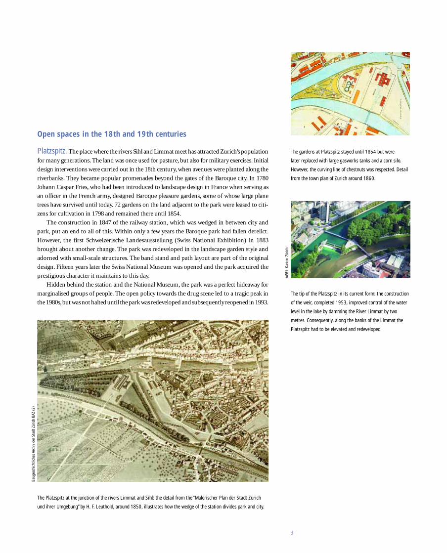
The gardens at Platzspitz stayed until 1854 but were
later replaced with large gasworks tanks and a corn silo.
However, the curving line of chestnuts was respected. Detail
from the town plan of Zurich around 1860.
The tip of the Platzspitz in its current form: the construction
of the weir, completed 1953, improved control of the water
level in the lake by damming the River Limmat by two
metres. Consequently, along the banks of the Limmat the
Platzspitz had to be elevated and redeveloped.
Baug
esch
icht
liche
s Ar
chiv
der
Sta
dt Z
üric
h BA
Z (2
)
AWEL
Kan
ton
Züric
h

4
For the Arboretum clever contouring was added to the terrain
that had only recently been taken from the lake, and groups
of trees were planted in the late landscape garden style.
Left: Contemporary coloured postcard of Alpenquai prior to its extension in the 1920s.The opening of the city
towards the lake finds expression in the numerous benches with cast-iron lion-shaped legs. The terraced promenade
at General-Guisan-Quai as it is today, with a double row of horse chestnuts pruned into whorled crowns and the
bowl-shaped water feature by Christoph Haerle.
Arboretum. Laid out after extensive parts of the lake were filled when Zurich began to open
up towards the lakefront, the Arboretum is one of the most popular green spaces in the city
today. Shortly before construction commenced, a group of renowned botany and geology
professors presented the quay directorate with proposals of an improved concept including
scientific considerations for the site which had initially been designed as a conventional park.
This resulted in a committee being set up, which included amongst its members the landscape
architects Evariste Mertens and Otto Froebel as well as the botanist professor Carl Schröter.
They succeeded in combining beauty and science in the new park by implementing clever
contouring in the flat territory that had only recently been reclaimed from the lake, and plant-
ing groups of trees in the style of the late landscape garden. A geological collection and the
first alpine panorama rounded off the scientific concept. Over the last one hundred years
the trees have thrived; and many of them have now reached maturity while others have been
replanted. The Arboretum, Zurich’s first historic park, is maintained in accordance with
conservation principles.
General-Guisan-Quai. On the promenade at Alpenquai, which was renamed General-
Guisan-Quai in 1960, large numbers of specially designed benches with cast iron feet and red
timber seats offered places to rest. The Alpenquai was so popular that it had to be extended to
double its width between 1919 and 1921. The mature chestnut avenues date back to that time.
In the course of redevelopment works in 2002, the asphalt from the 1930s was replaced with
the original macadam surface. Trees now stand in the macadam and the space is no longer
interrupted by tree pits. The bowl-shaped water feature by the sculptor Christoph Haerle pro-
vides a view stop and a link between the historical and present-day park.
Baug
esch
icht
liche
s Ar
chiv
der
Sta
dt Z
üric
h BA
Z (2
)

5
Zürichhorn on the eastern lakeside is by far the most used
open space in the city.
Zürichhorn. On warm summer evenings Zürichhorn is the city’s busiest green space. With
2.5 million visitors per year Zürichhorn is one of the most popular leisure and recreation
areas in Zürich. The landscape architects Otto Froebel and Evariste Mertens, commissioned
in the 19th century to design the original Wildbach stream delta, proposed a generous park
landscape around existing trees. Zürichhorn has been the venue for many major events includ-
ing the Schweizerische Landesausstellung (Swiss National Exhibition) 1939 and the first
Schweizerische Gartenbau-Ausstellung G59 (Swiss Landscape Industries Exhibition), both of
which have left their marks. Changes in leisure behaviour and increasing pressure from usage
offer constant political and maintenance challenges.
Fountain and flower borders at Belvoirpark are reminders
of the first Schweizerische Gartenbau-Ausstellung 1959,
known as the G59.
Belvoirpark is one of the earliest landscape gardens in the region and is one of the pearls
amongst Zurich’s parks. Three factors determine the appeal of Belvoirpark: its location with
splendid views across the city, lake and mountains, the tension of its topography designed with
large level changes, and the abundant backdrop of trees once considered exotic. In 1826 the
merchant Heinrich Escher-Zollikofer, whose trade with North America had brought him great
riches early on in his life, bought Wyssbühel, a vine-covered hill on the lake. He executed plans
to excavate the hilltop and use the spoil to fill the boggy lakeside of Zürichsee and plant the
site with exotic trees. From 1828 to 1831 the classical-style villa was constructed.After its com-
pletion Escher attended to the design and maintenance of his estate, which he called “Belvoir”.
The construction of the railway on the left bank caused major interventions that severed the
park from the lakeside. After the death of Escher’s granddaughter in 1891, Belvoir was at risk
of development, but the park was purchased by a committee of citizens in a remarkable res-
cue mission. Following some minor alterations by the landscape architect Evariste Mertens,
the park was opened to the public.
From private property to public park
Gior
gio
von
Arb

6
Rieterpark is one of the largest and best preserved 19th
century landscape gardens in Zurich.
Rieterpark was laid out in 1855 and still exudes the atmosphere of a generous landscape gar-
den. In the mid-19th century the German merchant Otto Wesendonck bought a large piece of
vineyard and commissioned the architect Leonhard Zeugheer and the landscape architect
Theodor Froebel to design a mansion and park. For 14 years Otto and Mathilde Wesendonck’s
estate was the cultural and social centre of Zurich.
The subsequent owners were the Rieters, a family of industrialists from Winterthur who
extended the estate by adding the Park Villa Rieter and Villa Schönberg. The design of the en-
semble reached its high point in 1890. Its privacy was closely guarded for decades, but a ple-
biscite in 1945 resulted in the purchase of Rieterpark. The park was then opened to the pub-
lic. Only Villa Schönberg remained in family ownership until 1970. Today, all three villas are
part of the Museum Rietberg for non-European art.
Longed-for land: the gardens at Villa Patumbah have a
chequered history.
Patumbah-Park. The story of the making of Villa Patumbah is exotic. Karl Fürchtegott Grob,
a merchant from Riesbach, became enormously rich from his shares in a tobacco plantation
on Sumatra. When he returned home, he bought a large piece of land and built a villa on it in
the opulent colonial style. In memory of good times on Sumatra, he called it Patumbah, which
in Malayan means “longed-for land”. The landscape architect Evariste Mertens was commis-
sioned to design the grounds, and applied the classical landscape garden theory, only on a Swiss
scale. Ornamental sections near the house, open landscape and a large potager were linked by
a network of curving paths.
After the Grob daughters donated the estate to Diakoniewerk Neumünster (a protestant
social welfare service) in 1910 the villa was used as a nursing home, and in 1929 the northern
section of the park was sold. From then on the elaborate estate was divided into two parts. In
1977 the city bought the villa and the sections of the park immediately surrounding it. Thanks
to the “Pro Patumbah Park” popular campaign it was granted listed park status in 1985 and
restored with the help of historical plans. In 1995 the private “Stiftung zur Erhaltung des
Patumbah-Parks” (Foundation for the conservation of Patumbah Park) was founded. It was
able to find a buyer for the northern part of the property, who intends to preserve the pretzel-
shaped network of paths so that the expanse and generosity of Mertens’s concept can be
experienced once again.
Gior
gio
von
Arb
(2)

7
Josefwiese is a typical example of a Volkspark, the public
parks created at the end of the 19th century.
Josefwiese. This chief public green space in the working-class housing estate, which was
built at the end of the 19th century, was facilitated by the sale of the northern part of the
Stadthaus site for a new building for Schweizerische Nationalbank. Half of the profits were
used by the city to set up the “fund for the purchase of woodland and the creation of parks”.
The first project was the Josefwiese in 1918, implementing proposals by the inspector for
gardens Gottlieb Friedrich Rothpletz. Existing fruit trees were incorporated into the plan.
The town master builder Hermann Herter designed a building of rural character, which
served as a sales stall for milk. During the 1950s the first play equipment was installed,
followed by a paddling pool in the 1960s. The park, designed for multi-functionality and
variety, embraces the concept of the “Volkspark” (public park) that had emerged at the end
of the 19th century. Large geometric lawns framed by avenues and small, sheltered zones on
the edge are typical design elements. For the last two years Josefwiese has been restored
according to the needs of the local population.
Recreation in “public parks”
The 1938 redevelopment with sunny lawns and shade under
clumps of trees still shapes the character of the Bäckeranlage.
Bäckeranlage. In 1893 extensive immigration made increasingly apparent the lack of pub-
lic green space in the newly suburbanised workers’ district of Aussersihl. The initial concept
was intended as a people’s public park and designed by Evariste Mertens in 1901. It featured
large macadam squares and paths that occupied most of the area. However, it failed to meet
the needs of the population and fell derelict within a short period of time. In 1938 the Bäck-
eranlage, which had become a favourite spot for marginalised people, was completely re-
designed by Mertens’s sons, Walter and Oskar. The overgrown grounds were extensively
cleared. Paths and squares with existing planting borders were converted into one large, con-
tinuous piece of lawn, which was – an exception at the time – accessible and designed for play.
With the addition of a paddling pool this was far more suited to the needs of the population.
During the 1970s the park was once again taken over by homeless people. After the clo-
sure of the open drug scene at Platzspitz in the late 1990s, drug users came in and local resi-
dents again stayed away. A competition for a new neighbourhood centre in 2004 produced a
simple three-storey building designed by EM2N. Now it is mainly young families that domi-
nate the picture. Many people working in the area use the space in their lunch hours.

8
Schanzengraben has evolved from a military fortification
into a green promenade in the city centre.
Schanzengraben, once a military fortification, now forms the idyllic, green promenade from
the main station to the lake. At the time of industrialisation it had deteriorated into an un-
sightly factory canal. This changed in 1975, after it was redeveloped into an attractive inner
city recreation space which traces the zigzag line of the former fortification.
Green links
Contrasting the modern university buildings and the densely
populated neighbourhood, Irchelpark was constructed with
natural materials, and wild vegetation is tolerated up to a
certain degree.
Irchelpark. The former site of an agricultural college forms a counterpoint to the new uni-
versity building and serves as a local recreation area. One of the city’s conditions was that
around 400,000 cubic metres of excavated material from the university building had to be used
to shape Irchelpark. “Terra”, a joint project by the landscape practices ASP Atelier Stern und
Partner and Eduard Neuenschwander envisaged a naturalistic park with indigenous plant
species – an “untouched” landscape with natural elements such as water, hedges and natural
meadows. When it opened in 1986, the local population regarded the 32-hectare park with
much scepticism. At that time the popular conception of a park included exotic trees, mani-
cured lawns, flowerbeds and avenues. Criticism soon dissipated as it became widely accepted.
Ichelpark now serves as a model in the argument against the controversial “designer parks”
in the north of Zurich.

9
The banks of the River Sihl allow direct access to the
water’s edge.
Sihlraum. When the two car parking decks that spanned the River Sihl near the main station
became redundant as a result of the newly built Gessnerallee underground car park, Grün
Stadt Zürich commissioned a project group to develop the Sihl spatial concept. It demonstrates
how the banks of the River Sihl can be developed as an area of nature conservation and recre-
ation. Gravel islands allow the Sihl to meander within its riverbed. Steps leading to the water’s
edge offer room to linger, rest and look out over the river.
Agglopark between Zurich and Baden includes some
sections with a designed semi-urban character.
Agglopark Limmattal. The River Limmat provides a “blue ribbon” that passes through
adjoining landscape spaces downstream from Zurich and forms the central open space and
recreational axis in the Agglopark Limmattal. The project crosses both canton and municipal
borders, and provides a continuous green recreation space that highlights particular urban de-
sign developments. Other areas are developed for tranquil recreation.Attractive footpaths and
cycle ways are an integral part of the concept. The aim is to provide a landscape that, despite
its continuing development, offers a liveable housing and working environment for residents.

10
The “Zentrum Zürich-Nord” project opened up one of Switzerland’s largest industrial areas
for new uses. Proposals for the new district were based on plans by the young team of archi-
tects Silva Ruoss, Cary Siress and Karen Schrader. In 1998 special building regulations were
passed and a framework agreement between the landowners and the city of Zurich was signed.
This settled matters of land grants and infrastructure, but the owners also agreed to give the
city of Zurich approximately five hectares of land for four new parks.
From brownfield sites to urban green spaces
Oerlikerpark is a park in transformation. The project team Zulauf, Seippel, Schweingruber
Landschaftsarchitekten and Hubacher und Haerle Architekten took into consideration the
constraints provided by a newly built neighbourhood, some contaminated soil, a road (Birch-
straße) passing through its middle and the, at the time, unknown users, and proposed a park
that would never be completed but is constantly transformed. Ash trees were planted very
densely to grow into a walkable hall with a clearing at its centre, which straddles the road to
link the two sides. Very young ash and other deciduous 3 to 4-metre high species were planted
on a grid of 4 x 4 metres. Over time they will be thinned out to a maximum of 8 x 8 metres.
The many functions of Oerlikerpark are enhanced by a water feature as well as a pavilion that
accommodates the facilities required for various events. An intervention zone along the clear-
ing was set aside for recreation and play in response to the wishes of the residents. A tower
provides vertical access through the tree canopies and beyond the buildings’ horizon. It is
reminiscent of the industrial chimney stacks that used to stand here and reflects humanity’s
age-old desire for long views and distance.
Zurich’s city council selected Oerlikerpark in 2001 as exemplary for a conscientious con-
struction ethos and architectural achievement and gave it the city of Zurich’s award for good
architecture.
The many ways to use Oerlikerpark are augmented by a
water feature and a pavilion that accommodates the facili-
ties required for all kinds of events.
A steel frame covered in climbing plants at MFO Park
echoes the volume of the demolished industrial buildings
whilst being awash with the play of light and shadow and
ethereal scents.
MFO Park. Until the 1990s Oerlikon was dominated by industrial buildings. For around 100
years the site of the park was occupied by the engine factory Maschinenfabrik Oerlikon
(MFO), which gave the park its name. The “Park-Haus”, designed by Burckhardt+Partner und
Raderschall Landschaftsarchitekten AG, traces the volume of the demolished industrial build-
ing. MFO Park accommodates various activities: neighbourhood fetes, open air cinema, the-
atre performances, concerts and other events are possible. Some spaces in between are used as
small garden rooms and, like boxes at the opera, present views into the hall. The sundeck on
the roof offers panoramic views across the urban quarter. The park’s character changes with
the seasons; in winter the structure becomes visible and then disappears during the course of
the growing season beneath green layers of vegetation. In autumn the park is aglow with the
red foliage of Virginia creeper. The park’s innovative concept has won many national and in-
ternational awards since its opening in 2002.
Louis Häfliger Park opened in 2003 and lies in heterogeneous surroundings, nestled be-
tween housing estates, industrial and service sector buildings. It was envisaged as a neighbour-
hood park. The proposal by landscape architects Kuhn Truninger is based on dissolving the

11
Lawn pyramids at Louis Häfliger Park are reminiscent of
the grass funnels in which the former ammunition huts
were located.
boundaries between park, industry and housing. Similar to a patchwork quilt composed of
different pieces, the various fields meet and are united into one whole.
Eight grass pyramids in the lawn reveal aspects of the local history. They form the quasi
protuberances of the conspicuous lawn funnels of the former ammunition huts. The park’s
patchwork is complemented with a band of play equipment for toddlers, a blue sports pitch
for ball games and a timber stage.
The name of the park reminds us of Louis Häfliger (1904–1993),“saviour of Mauthausen”.
The bank clerk from Zurich took leave in 1945 and as a delegate of the International Red Cross
accompanied a food shipment to Mauthausen concentration camp. Shortly before the Second
World War ended, he led American troops to Gusen and Mauthausen concentration camps
and so saved the lives of tens of thousands of inmates, amongst them many homosexuals. Af-
ter being condemned by the International Committee of the Red Cross for his unauthorised
actions, he was not rehabilitated until 1990. He also lost his job at the bank. Louis Häfliger was
nominated for the Nobel peace prize in 1950 and 1988.
Wahlenpark. In their concept for Wahlenpark the team of designers, Dipol Landschafts-
architekten, Basle and Christopher T. Hunziker, Zurich, envisaged a multi-functional space for
play and movement to be used by local residents and young people from the nearby school.
The park comprises three sections: a bosquet, a playing field and a promenade.
The playing field, which is uncharacteristically open for the surrounding area, comprises
four distinct functional elements: a vast sculptural lighting mast, a robust ball stop net, a

12
The shade structure on an eccentric column beside a pool
and wide concrete edge form a landmark in the Wahlenpark.
paddling pool with a wide concrete rim and a shade structure, all of which offer a contrast to
the monochrome lawn.
The park’s name commemorates Friedrich Traugott Wahlen (1899–1985), the agronomist
and later federal councillor. He lived in Zurich’s Oerlikon district, and had planned Swiss self-
sufficiency for basic foods as early as the 1930s. Thanks to Wahlen’s plan, better known as the
“Anbauschlacht” (growing battle), famine was averted during the Second World War. Even
parks and sports fields were used to grow potatoes and cereal.
The cover of foliage provided by randomly planted Gleditsia
links different spaces in the park.View from the stage to the
sunken playground with sand, climbing ropes and boulder wall.
Leutschenpark. The curved shapes at Leutschenpark, designed by Dipol Landschaftsar-
chitekten and Christopher T. Hunziker, introduce a new element to this district on the urban
periphery, where the majority of buildings serve commercial or service industry purposes. The
white concrete wall around the backstop of a former firing range forms a vast container, a “tree
pot” that lends the space its particular character. A bench is integrated along the entire length
of the 155-metre enclosing wall and is illuminated at night. Randomly planted Gleditsia form
a cover of foliage that links the different spaces in the park. Between the trees there are gravel
areas, a lawn square with a pool and a playing landscape for children, which entice people to
linger. A stage takes on the function of the once-popular band stands and is available for
all kinds of activities. The light installation designed by the artist Christopher T. Hunziker
shines through the tree canopies at night and symbolises the underground Leutschenbach
River which flows beneath this space.

13
Turbinenplatz is located in the centre of Zurich-West; its
design is reminiscent of the site’s industrial past.
Turbinenplatz. Zurich-West, another large development area in the city of Zurich, is a step-
by-step conversion of an existing site into an attractive neighbourhood, executed in a coop-
erative planning process. Turbinenplatz (turbine square), around 14,000 square metres in area,
is currently the city’s largest urban square. The design of the landscape architects refers to its
industrial past. Rails subdivide the space and take water to stormwater basins where it soaks
into the ground whilst supplying the vegetation with moisture. The lighting provides a fur-
ther distinctive feature.
Elegantly tapered arcs face one another at Gleisbogen
Passerelle, spanning the access and exit roads at Pfingst-
weidstraße, and form the new gateway to Zurich.
Gleisbogen. In 2002 and 2003, the city of Zurich and the owners of the land conducted a
study of the arched industrial railtrack in Zurich-West. The first open spaces at Gleisbogen
were realised by private landowners in 2003. The narrow band along the industrial railtrack
forms the backbone of this “hybrid park” and is lined with Ginkgo trees. The area of ruderal
vegetation at Gleisbogen provides a habitat for wall lizards and numerous insect species. It is
listed in the inventory of municipal nature conservation sites. Consequently, different mea-
sures designed to protect nature form an integral part of the Gleisbogen site.

14
Zurich’s city council described the future of urban development in its Vision 2025 document.
On the basis of this plan Grün Stadt Zürich defined ten strategic key areas for a sustainable
green impact, from which was developed a general strategy for green spaces in the city as doc-
umented in the “Grünbuch der Stadt Zürich”; Zurich is a green city – and will remain so.
The city has consistently and for a long time taken green issues into consideration, and it
was worth it: international rankings of quality of life have repeatedly placed Zurich at the top
of the world-wide list. The high quality of open spaces undoubtedly plays a major role. The
city boasts a great diversity of plant and animal species, and there is no conflict between na-
ture and urban environment. Regular surveys show the population to be content with the
availability of green spaces and to consider this matter an important issue.
The juxtaposition of uses determines the city as a living space. But it also requires careful
planning. The “Grünbuch der Stadt Zürich” provides the city with a comprehensive strategy
for green and open spaces. Nevertheless, demands made on open space are changing all the
time. This is, and will remain, a challenge. Undoubtedly, the city will continue to grow, main-
ly through infill development. But in Zurich there is no development without high-quality
green and open spaces.
Zurich 2025
Heerenschürli is the largest sports facility in Zurich.The
changing room building also accommodates a public restau-
rant, and its roof forms the stands.
Sports facilities for local recreation. The Heerenschürli sports facility was completely
refurbished from 2008 to 2010, and now it is much more than just the city’s largest sports
grounds. The site also serves the recreational needs of local people, offering a restaurant as
meeting place, a central square and a skater park. Changing trends in popular sports – away
from tennis and athletics towards football – meant that the old grounds’ infrastructure had
ceased to meet current needs. In September 2004 Grün Stadt Zürich, the sports department
and the building authority launched a competition won by the “Immergrün”(Evergreen) proj-
ect by landscape architects Topotek 1 from Berlin in cooperation with the Zurich-based
architects Dürig AG. Two principal axes structure the new grounds. A square at the junction
forms the centre of the site around which the sports pitches are grouped along with the chang-
ing rooms. The new playing fields are enclosed by distinctive 6-metre high ball stop nets, cre-
ating a translucent architecture in a series of spaces which, through the double netting in two
shades of green, appear to have different degrees of transparency, depending on the viewpoint.

15
Historische Gärten und Parkanlagen in der Stadt
Zürich. Published in cooperation with Garten-
bauamt Zürich, Büro für Gartendenkmalpflege.
Zürich: Genossenschafsdruckerei Zürich, 1989.
119 p.
Landschaftsarchitekturführer Schweiz. Udo
Weilacher, Peter Wullschleger et al (Eds.). Basel:
Birkäuser, 2002. 355 p.
Leisi, Christian; Bächli, Daniela. Limmatraum
Stadt Zürich: Landschaftsentwicklungskonzept
(LEK). Zürich: Grün Stadt Zürich, 2006. 86 p., 8
plans
Moll, Claudia. Zürich: ein Begleiter zu neuer
Landschaftsarchitektur. München: Callwey,
2006. 80 p.
Nutzen und Zierde: Fünfzig historische Gärten
in der Schweiz. Brigitt Sigel et al. (Eds.) with
photographs by Heinz Dieter Finck. Zürich:
Scheidegger & Spiess, 2006. 336 p.
Rohrer-Amberg, Judith. Der Platzspitz: Chronik
eines Gartendenkmals. Published on the occa-
sion of the Swiss Year of Historical Gardens.
Zürich: Gartenbauamt Zürich, 1995. 55 p.
Rohrer-Amberg, Judith & Steeb, Silvia. 12
Gärten: historische Anlagen in Zürich. Zürich:
Kontrast, 2004. 143 p.
Rotzler Krebs Partner GmbH. Leitbild Sihlraum.
Published by Grün Stadt Zürich,Amt für Städte-
bau, Tiefbauamt der Stadt Zürich, AWEL.
Zürich: Grün Stadt Zürich, 2003. Limited edi-
tion, ringbinder, without page numbers
Schönauer, Roman G.Von der Stadt am Fluss zur
Stadt am See: 100 Jahre Zürcher Quaianlagen.
Zürich: Stadtarchiv, 1987. 99 p. Reprint: Zürich:
Verlag Matthieu des Zürcher Heimatschutzes,
2006.
Sigel, Brigitt; de Jong, Erik A. Der Seeuferweg in
Zürich: eine Spazierlandschaft der Moderne von
1963. Zürich: Scheidegger & Spiess, 2010. 88 p.
with a facsimile edition of the original layout by
Willi Neukom
Stadtlandschaften: Schweizer Gartenkunst im
Zeitalter der Industrialisierung. Julia Burbulla et
al. (Eds.). Photographs by Anna Halm Schudel
and Peter Schudel. Zürich: Offizin, 2006. 167 p.
Strategien Zürich 2025: Ziele und Handlungs-
felder für die Entwicklung der Stadt Zürich.
Zürich: Stadtrat von Zürich, 2007. 30 p.
Unterwegs in Zürich und Winterthur: Land-
schaftsarchitektur und Stadträume, 2000–2009.
Roderick Hönig, Claudia Moll, Björn Allemann
(Eds.). Zürich: Edition Hochparterre bei Schei-
degger & Spiess, 2009. 168 p.
Wyss, R. von; Senti, A. Zürichs Parkanlagen und
Grünflächen. In: Zürcher statistische Nachricht-
en, 1952(1), offprint, 50 p.
Further reading
Baumberger, Isabel. Freie Sicht auf die Sihl! Das
neue Leitbild Sihlraum der Stadt Zürich soll den
lange vernachlässigten Fluss wieder besser
wahrnehmbar machen. In: Grünzeit 2003(6);
2–5.
Bühler, Elisabeth; Kaspar, Heidi; Ostermann,
Frank. Sozial nachhaltige Parkanlagen:
Forschungsbericht NFP 54. Zürich: vdf
Hochschulverlag an der ETH Zürich, 2010.
184 p.
Das Grünbuch der Stadt Zürich: integral pla-
nen, wirkungsorientiert handeln. Cordula We-
ber et al (Eds.) Zürich: Grün Stadt Zürich, 2006.
155 p.
Grünzeit: Zeitschrift für den Lebensraum
Zürich. Published by Grün Stadt Zürich, Ver-
bund Lebensraum Zürich. Quarterly magazine
first published in April 2002. www.gruenzeit.ch
Gute Gärten: gestaltete Freiräume in der Region
Zürich. Guido Hager (Ed.). Zürich: Bund
Schweizer Landschaftsarchitekten und Land-
schaftsarchitektinnen BSLA, 1995. 104 p.
Hansen, Anne; Kräuchi, Men. Zürichs grüne In-
seln: unterwegs in 75 Gärten und Parks. Pub-
lished by Gartenbau- und Landwirtschaftsamt
der Stadt Zürich; Judith Rohrer¸ Fachstelle Gar-
tendenkmalpflege. Zürich: vdf Hochschulverlag
an der ETH Zürich, 1997. 192 p.
Historische Gärten & Landschaften: Erhalt und
Entwicklung. Published by Institut für
Geschichte und Theorie der Landschaftsar-
chitektur GTLA der Hochschule für Technik
Rapperswil HSR. Zürich: vdf Hochschulverlag
an der ETH Zürich, 2005. 136 p.