LANDFORMS TEMPE QUADRANGLE, MARICOPA COUNTY,...
1
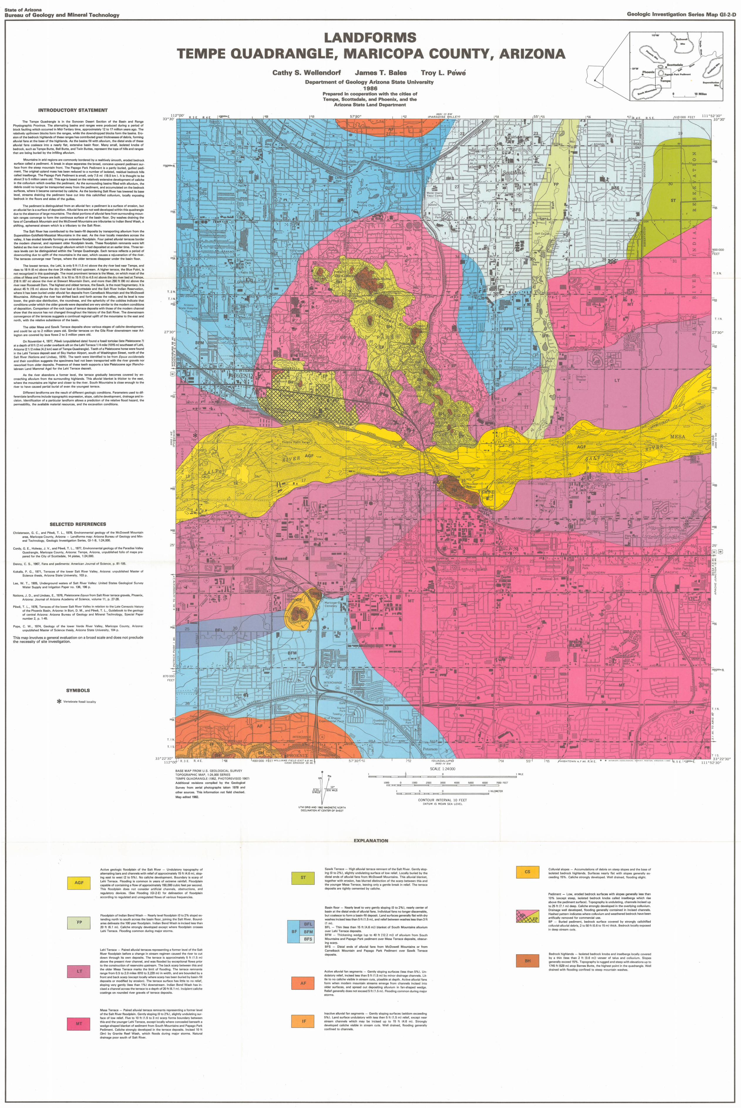
State of Ari zona Bureau of Geology and Mineral Technology Geologic Investigation Series Map GI-2-D LANDFORMS 112"00 ' TEMPE QUADRANGLE, MARICOPA COUNTY, ARIZONA INTRODUCTORY STATEMENT The Tempe Quadrangle is in the Sonoran Desert Section of the Basin and Range Physiographic Province. The alternating basins and ranges were produced during a period of block faulting which occurrod in M id -Tertiary time, approximataly 12 to 17 million years ago. The re la ti ve ly upthrow n blocks form the ranges, whi le the downdropped blocks fonn the ba sins. Ero- sion of the bedrock highlands of th esa ranges has contributed great thicknesses of dabris. fo rming alluvial fans at the base of the hi gh lands. As t he ba sins fill with alluvium, the dis tal ends of these alluvial fan s cOli lesce Into a nea rly flat, elCtansl va basin floor. Many small. isolated knobs of bedrock. such as Butte, Bell Butte, 1md Twin Buttes, represent the tops of hills and ranges that are tieing buried by the infi lling allUVium. Mountains in arid regions are commonly bordered by a rea litively Smooth, eroded bedrock surface called a pediment. A break In slope separates the broad , concavtl upward pedimont Sut- face from the steep mountain front. The Papago Pa rk Pediment is a partly buried, gu llied ped i- ment. The Original upland mass has be!!n reduced to a number of isolated, residual bedrock hills ca lled inselbergs. The Papago P3rk Pediment is small. only 7.5 mi 09.5 km l. II is thought to 1M! about 3 to 5 million years old. This age is Uased on the rclmlvely extensive development of caliche In tha colluvium which overl ies the pediment. As the surrounding basins filled wi th alluvium, the debris could no longer btl transpocted away f rom tha pediment, and accumulated on the bedrock surfaces, it became cemented by caliche. As thEl bordering Salt River has lowered Its base level. streams drai ning tha pediment have cut into this calichified coll uvium, locally aJlPosing bedrock in the floors and sides of the gullies. The pediment Is distinguished from an alluvial fa n: a pediment is a surfa ce of erosion, but an alluvial f an is a s ur1ace of deposition. Ailuv ia l f ans are not well devaloped w ith in this quadrangle due to the absence of large mountnins. The rlistal portions of alluvial fans from surrounding moun- tain ranges converge to fonn the cont lnOUS surface of the basin floor. Dry washes drai ning the fans of Camelback Mountlli n and the McDowell Mou nteins are tributa ri es to Indian Bend W ash, a shifting, ephemeral straa m which is a tributary to the Salt Rivar. The Salt River has contributed to the basin-f i ll deposits by al luvium from the Superstition-Goldfield-MazetZ91 Mountains In the east. As me ri ver locelly mea nders across the valley, It MS Oroded laterally forming an eJlt en si va floodplain. Four paired alluvi al terraces bordar the modern chanr18l, and represent older floodplain level s. These floodpillin remnants were left behind as th e river cut down thr ough all uvium wh ich It had deposited at an eerller time. Three ter- rar.:o levels can be distinguished within the TerTlle Quadrangle. Each terrace reflects a period of downcutting due to uplift of the mountains in th e east, which causes a rejuvenation of the ri ver. The terraces converge nsar Tempe, where the older terraces disappear und el the basin floor . Tho Iowost terrace, the Leh i, is only 5 It (1.6 m) above Ihe dry river bed near Tempe, and rises to 18 ft 16 m) above the ri ve r 24 miles (40 km) upstream . A higher terrace, the Bl ue Point. is not recognized In Ihls Quad rangle. The most prominent tartllce is the Mesa. on which most of the citios of Mesa and Tempe are bui lt . II is 10 to 15 ft (3 to 4.5 m) above the dry ri ver b ed atTemJle . 21B ft (67 m) above th e river at StllWClrt Mountain Dam. an d mor a than 290 ft (90 m) above tho river near Roosevelt Dam. The highest and oldest terrace, t he Sawik. is the most fragmentary. It is about 45 ft (15 m) above the dry river bed at Scottsdale and the Sa lt River IMlan Reservetio n. whore It h..'lS boon bur ied under all uvia l fan deposits horn Camelbac k: Mountain and t he McDowell Mounta ins. Although the river h as shifted back and fo rth across the va lley, and its level is now lower . the groin-size distribution, the roundne5S. and the of the indicate that conditions under which the older gravels were dep06ited are very simila r to t he modarn condilions of depositi on. Comparison of th e rock types of terrace daposlts wi th those of the modern channel show that the source has 1'101 changed th roughout the history of the Salt River. The downstrnam convergence of the lerrac es suggests a conti nual reg ional uplift of the mountains to the east and north, with the relative subsidence of tho basin. The older Mesa and Sawik Terrace deposits show various stages of caliche development, and could be up to 2 million years old. Similar terraces on the Gila River downstream nee r Arl- ington are covered by lava flows 2 to 3 million yoars o ld. On November 4, ,9n, Nwl! (unp ublished data) found II fossil tortoise (l<!to Pleistocene 7) at a depth of 6 It 12 m) under overbank silt on the Lohi Tarnu:e 1/ 4 mile t1016 ml southeast of Lehi, Arizona 12 1/2 miles 14.2 kmJ east of Tempe Quadrangle). Teeth of II Pleisto c8f1e horse we re found in the Lehl Terrace deposit ellst of Sky Herbor Airpon , south of Washington Stroet, north of the Salt RIver INalions and Lindsoy, 1976). The tOElt h were identrfied to be from Equus ucciden(iJfk> nnd th eir condition suggests the specimefls had not been transported w ith the rivar gravels nor reworked from older deposits Presence of those teeth supports a late Pleistocene age (Rancho- labrean Land Mammal Age) fo r the Lehi Terrace deoosit. As th e river abandons a fo rmer level, the terrace gradually becomes covered by en- croaching allUVium fro m t he surroundillQ highlands. This alluvIal blanket Is thicker to the aast, where the mountains are higher end closur to Ihe river. South Mountains is clooe enough to the river to have caused part ial bur ia l of even the youngest terrace. Different landforms are the resuh of different geologic conditions. Parameters used to dif- ferentiat olond forms include topogral llljc expression, sloplt, caliche development, drainage and in- cision. Identi fication of a particular l<!n dform allows a predicti on of the reilltive f lood hazard, the penneability , t he 1nIai iabie materi.'l l resources, and exca va tion conditions. SELECTED REFERENCES Christenson, G. C., and P6we, T. L. 1978, Environmental geology of the McDowell Mountain area, Maricopa County, Arizona - Landforms map: Arizona Burea u of Geology and Min- era i Technology. Geologic Investi gation Series, GI-l -B, 1:24,000. Cordy. G. E.. Holw ay, J. V., end T. L. , 19n, Environmental geology of the Pnradisc V;:lIley Quadrangle, Mari copa Co unty, Ar izon a: Tempe. Arizona, unpublished folio of maps pl e- pared for the City of Scotts dale. 14 plates. 1:24,000. Den ny. C. S .. 1967. Fans and pediments: American Journal of Science, p. 81- 105 Koka lis, P. G., 1971 , Terraces of the l ower Salt River Valley. Arizona' unpubli shed Master of Science thesis. Arizono Stllte Un iversity, 103 p. Lee , W. T. , 1905. Underground wat ers 01 Salt River Va lley: United Stat es Geological SUf\lr!y Water Supply a nd Ir rigat i on Paper 1'10. 136,196 P Nation s, J. D., and Lindsay, E. , 1976, Pleistocene Equus from SaH River terrace gravel s. PhoeniX, Arizona: Joornal of A rizona Academy of Science, volume 11, p . 27-28. Pewe. T. L, 1978. TerracllS of the l ower Salt River Valley in rela tion to Ihe Late Ctlilezoil: history ol lhe Phoenix Basin, Arizona: in ail n, D. M., and Nwe. T. L., Guidebook to the geology of central Arizona: Arizona Bureau of Geology and Minerai Technology, Spm:i al Paper number 2, p. 1-45. Pope, C. W ., 1974, Geology 01 th e low er Vcrdr: River Valley, Maricopa County, Arizona: unpublished of Science Arizona State Universi ty , 104 p. This map involves a general evaluation on a broad sca le and does not preclude t he necessity of site investigation. SYMBOLS * Vertebrate fossil locality "'" 27',," 1- 25' 870 FEET bfc=,;, , . BASE MAP FROM U.S. GEOLOGICAL SURVEY TOPOGRAPH IC MAP. 1:24.000 SERIES TE M PE QUADRANGLE (1952 PHOTOFI EV ISED 1 9B7 ) Additional revisions compiled by the Geological Survey from aorial photographs tak sn 1978 and otha. sources. This information not f ield chocked. edited 1982. Active geologic fluodll iam af Ili a Sa il River - Undu latory topograph\l of al terna ting bars and channels with rel ief of approximately 15 ft (4.6 m). slop- Ing eest to west (2 to 5%). No ca liche development . Boundary Is scarp of Lehi Terrace. Flooding is common Ifl years of eJl treme rainfall. Floodplain cepable of containing a f low of approximately 150,000 cubic feet per second. This floodplain docs nol .:orlSi df!J ilttif icial channels. obstructiorno, and regulatory devices. (See Flooding 1G1-2- EI lor delineation of fl oodplain according to regulated and unregulated fl ows of various frequencies. LT MT Floodplain 01 Indian Bend W as h - Nearly level floodplain 10 t 02 % slopel ex- tending north to south across the basin fl oor, ioining th e Salt River Bound- aries dellnealll the 100 yeilr fl oodp lilin. Indliln Bend Wash is in cised l ess than 20 ft 16.1 m). Caliche strongly developed except w here fl ood pl ain crosses Lehi Terrace. Flooding common during major storms. Lehl Terra ce - Paired alluvial terraces representing a former leval of t he Sa lt Rivel floodplam befo re a change III stream regimen caused the river to cut down its own deposits. The terrace is approximately 5 h 11.5 m) above the present river channel. and was flooded by exceptional fl ows prior to the construction of reservoirs upstream. The back scarp between this and the older Mesa Terrace marks the li mit of fl ooding . The terrace remnants range from 0.5 to 2.0 miles (610 10 3,220 ml in wi dth , and are boulldoo by a f ront and back scarp (eJlcept locally where scarp MS been buried by ba sin-fill deposits 01' modi li ed by erosion). Thr: terra co surface has lillie to no rel ief, sl oping very Silently (tess th an 1% 1 dow nstream. Indian Bend Was h has in- cised a channel across the terrace to a depth of 20 ft {5 . 1 mi . locipient calich e coatings on rounded nver gravels of terrace depoSits. Mesa Terral:e - Paired al lu vial tEl r raCtl rern llanlli representing a former level of the Sa lt River f loodplain. Gently sloping (0 to 2% I. s li g ht ly undulaling sur- l ace of l ow re lief. Flva to 10 It 11 .5 to 3 m) scerp forms boundary between th is and the younger Lehl Terrace , ex cept loca lly whe re con cea l ed beneath a wedge-shaped bla nket of sediment fro m South Mountains and Pap890 Park Pediment . Caliche st ron gly developed in th e terrace deposits. InCised 10 It 1 3m) by Granite Reef Wash, which floods during major storms. Natural drainage poor south of Salt River. Cathy S. Wellendorf James T. Bales Troy L. P ewe BF Department of Geology Arizona State University 1986 Prepared in cooperation with the cities of Tempe, Scottsdale, and Phoenix, and the Arizona State Land Department •. i L * I 1) 1M GRID ANO 1982 MAGNETIC NOlrnH OEC LINATION AT CENi EA OF SH EET BFL BFM BFS AF EXPLANATION Sawlk Terrac e - High alluvial terrace remnant of the Sail River. Gently slop- ing W to 2%), sli ghtly undulating surf ace of l ow re lief. Locally burie d by distal ends of alluvial f an s f rom Mc Dowe ll Mountains. Th iS a ll uvial blanket. together with erOSion, has hlurred distinct ion of the scarp ber.veen this and the younger Mesa Terrace, leaving only a gt!ntle brea k in rehel . The terrace deposits arc tightly cemented by calich e. Basin f loor - Nearly level to very gently sloping (0 to 2% ), nearly center of basin at the distal ends of all uvial fans. Individual fans no longer dlscemable, bu t coa lesce to form a basin-fill deposit. Land surfaces generally flat Wi th dry w ashes incised less than 5ft (1.5 m), and relief betwee n washes less tt1an 3 ft (1 m). BFL - Thin (less t han 15 ft 14.6 mIl blallket of South Mountains alluvium over Leh l Terrace deposits. BF M - Thickenin g wHrlge l up t o 40 It 112.2 m]) of alluvium from South Mounta ins and Papago Pari< pediment over Mesa Ter race deposits, obscur- ing scarp. BFS - Distal ends of alluvial Fa ns from McDowel l Mountains or fro m Camelback Mounta in and Papago Parte: Ped iment over 5aw ik Terrace deposi ts. A ctive alluvial fan se gments - Gently sloping sur1aces Il ess than 5%). Un- dul<! t ory relief, incised less than 5 ft (1.5 m) by minor drainage channels. Li t- tl e to no caliche visible in stream cut s, at depth. Act ive alluvial fail S form when modern mountain streams emerge from channels inc is ed into older surfaces, and spread ou t rl epositing alluvium in fan-shaped wedge. Relief generally does not exceed 5 ft 11 .5 mi . Fl ooding common during llIaJ O! storms. Inact ive alluvial fan - Gently sl oping I seldom ()x{)oodlng 5% ). Land surface undulatory with less then 5 ft \1.5 ml re lief, except near strc3m r:h annElls wh ich m Oly be inci sed up to 15 h (46 m). St ro nf)ly d evelope d ca li che VISible In stream culs. Well drained, flooding generally conf ined to channels. 3 6.'5/ III SW (PARAD f S£ :> 55' 6CO.) 7003 FEET BH ".,.' Phoenix ( I I • PllfI Pedlm.,t -- - . '15 Co ll uvia l slopes - Accumulations of debri S on st eep slopes and the base of isol nted bedrock highlands. Surfaces nea rl y flat wi th slopes generall\l ex- eeading 16%. Caliche strongly dElvelopod. Well drained, flooding slight. Pediment - Low , eroded bedrock surfaces with slopes generally less than 10 % (except steep, isolated bedrock knobs called inselbergs w hi ch rise above t he pediment surface!. Topography is undulating, channels incised up to 25 ft (7.1 m) deep. Ca liche strongly developed in the overlyiog colluvium. Drainage well developed, flooding generally con tained in incised d mrmel s. Hashed pattern ind icat es where coll uviu m and weathered bedrock have been artlflcally re moved for commercial use . BP - BUried pedime nt , tted rock: surface covered by strongly cal!chifi ed co ll UV ial-alluvial debris. 2 to 50 f t (0.5 to 15 m) thick. Bedrock locally exposed in deep struam cuts. Bedrock highlands - l solaled bedrock knobs and inselbergs locally covered by a t hi n (lw..s than 2 tt (O .6 m J) VCIlCCI of talus mId collU Vium. Slopes generally exceed 15%. Topography IS rugged and steep with elevations up 10 1745 It (529 m) atop Barnes Butte, the highest po int in the quadrangle. Well drained with flooding conlined to steep mountain washes. Tampe o I ST '31 18 SUP'Ontitution MI.:; '0 M il as , -" 000 FE ET 111· 52 '3 0" 33"30' I , I .' z o '" :> , , . , T 2 N. T.! N. 27'3 0" ." 30gB 11 1 °52'3 0"
-
Upload
nguyenkiet -
Category
Documents
-
view
214 -
download
0
Transcript of LANDFORMS TEMPE QUADRANGLE, MARICOPA COUNTY,...
State of Arizona Bureau of Geology and Mineral Technology Geologic Investigation Series Map GI-2-D
LANDFORMS 112"00 '
TEMPE QUADRANGLE, MARICOPA COUNTY, ARIZONA
INTRODUCTORY STATEMENT
The Tempe Quadrangle is in the Sonoran Desert Section of the Basin and Range Physiographic Province. The alternating basins and ranges were produced during a period of block faulting which occurrod in M id-Tertiary time, approximataly 12 to 17 million years ago. The re la tive ly upthrown blocks form the ranges, whi le the downdropped blocks fonn the basins. Erosion of the bedrock highlands of thesa ranges has contributed great th icknesses of dabris. fo rming alluv ial fans at the base of the high lands. As t he ba sins f ill with alluvium, the dis ta l ends of these
alluvial fan s cOli lesce Into a nearly flat, elCtanslva basin floor. Many small. iso lated knobs of bedrock. such as T~mpe Butte, Bell Butte, 1md Twin Buttes, represent the tops of hills and ranges that are tieing buried by the infi lling allUVium.
Mountains in arid reg ions are commonly bordered by a realit ively Smooth, eroded bedrock surface called a pediment. A break In slope separates the broad , concavtl upward pedimont Sut
face f rom the steep mountain f ront. The Papago Park Pediment is a partly buried, gu llied ped iment. The Original upland mass has be!!n reduced to a number of isolated, residual bedrock hills called inselbergs. The Papago P3rk Pediment is small. only 7.5 mi 09.5 km l. II is thought to 1M! abou t 3 to 5 million years old. This age is Uased on the rclm lvely extensive development of caliche In tha colluvium which overl ies the pediment. As the surrounding basins f illed wi th alluvium, the
debris could no longer btl t ranspocted away f rom tha pediment, and accumulated on the bedrock surfaces, ~here it became cemented by caliche . As thEl bordering Salt River has lowered Its base level. streams d raining tha pediment have cut into this calichified colluvium, locally aJlPosing bedrock in the floors and sides of the gullies.
The pediment Is distinguished from an alluvial fan: a pediment is a surface of erosion, bu t
an alluvial fan is a sur1ace of deposition. A iluvia l f ans are not well devaloped w ithin this quadrangle due to the absence of large mountnins. The rlistal portions of alluvial fans f rom surround ing mountain ranges converge to fonn the cont lnOUS surface of the basin f loor. Dry washes draining the fans of Camelback Mountllin and the McDowell Mounteins are t ributaries to Indian Bend W ash, a
shifting, ephemeral straam which is a tributary to the Salt Rivar.
The Salt River has contributed to the basin-fill deposits by trllnspottin~ al luvium from the
Superstition-Goldfield-MazetZ91 Mountains In the east . As me river locelly meanders across the valley, It MS Oroded laterally forming an eJltensiva floodpla in. Four paired alluvial terraces bordar the modern chanr18l, and represent older floodplain levels. These floodpi ll in remnants were left behind as the river cut down through alluv ium which It had deposited at an eerller time. Three terrar.:o levels can be distinguished w ithin the TerTlle Quadrangle. Each terrace reflects a period of downcutting due to uplift of the mountains in the east, which causes a rejuvenation of the river. The terraces converge nsar Tempe, where the older terraces disappear undel the basin floor .
Tho Iowost terrace, the Leh i, is only 5 It (1.6 m) above Ihe dry r iver bed near Tempe, and rises to 18 ft 16 m) above the ri ve r 24 miles (40 km) upstream . A higher terrace, the Blue Point. is not recognized In Ihls Quadrangle. The most prominent tartllce is the Mesa. on which most of the citios of Mesa and Tempe are built. II is 10 to 15 ft (3 to 4 .5 m) above the dry ri ver bed atTemJle. 21B ft (67 m) above the river at StllWClrt Mountain Dam. and mora than 290 ft (90 m) above t ho
river near Roosevelt Dam. The highest and oldest terrace, t he Sawik. is the most fragmentary. It is about 45 ft (15 m) above the dry river bed at Scottsda le and the Sa lt River IMlan Reservetion. whore It h..'lS boon buried under alluvia l fan deposits horn Camelback: Mountain and the McDowell Mounta ins. Although the river has shifted back and forth across the va lley, and its leve l is now lower. the groin-size distribution, the roundne5S. and the ~phericity of the cobble ~ indicate that
cond it ions under which the older gravels were dep06ited are very simila r to the modarn condil ions of deposition. Comparison of the rock types of terrace daposlts with those of the modern channel show that the source has 1'101 changed th roughout the hist ory of the Salt River . The downstrnam convergence of the l erraces suggests a continual reg ional uplift of the mountains to the east and north, w ith the relative subsidence of tho basin .
The older Mesa and Saw ik Terrace deposits show various stages of caliche development, and could be up to 2 million years old. Similar terraces on the Gila River downstream neer Arl
ington are covered by lava flows 2 to 3 million yoars old.
On November 4, ,9n, Nwl! (unpublished data) found II fossil torto ise (l<!to Pleistocene 7)
at a depth of 6 It 12 m) under overbank silt on the Lohi Tarnu:e 1/ 4 mile t1016 ml sou theast of Lehi,
Arizona 12 1/2 miles 14.2 kmJ east of Tempe Quadrang le). Teeth of II Pleistoc8f1e horse were found in the Lehl Terrace deposit ellst of Sky Herbor Airpon, south of Washington Stroet, north of the Salt RIver INalions and Lindsoy, 1976) . The tOElth were identrfied to be from Equus ucciden(iJfk> nnd their condition suggests the specimefls had not been t ransported with t he riva r gravels nor reworked f rom older deposits Presence of those teeth suppor ts a late Pleistocene age (Rancho
labrean Land Mammal Age) for the Lehi Terrace deoosit.
As the river abandons a former level, the terrace gradually becomes covered by en
croaching allUVium from t he surroundillQ highlands. This alluvIal blanket Is thicker to the aast, where the mountains are higher end closur to Ihe river. South Mountains is clooe enough to the
river to have caused partial buria l of even the youngest terrace.
Different landforms are the resuh of different geologic conditions . Parameters used to differentiatolondforms include topogral lll jc expression, slop lt, calic he development, drainage and in
cision. Identifica tion of a particular l<!ndform allows a prediction of the reilltive f lood hazard, the penneability, t he 1nIaiiabie materi.'l l resources, and t~ excavation conditions.
SELECTED REFERENCES
Christenson, G. C., and P6we, T. L . 1978, Environmental geology of the McDowell Mountain area, Maricopa County, Arizona - Landform s map: Arizona Bureau of Geology and Minera i Technology. Geologic Investigation Series, GI-l -B, 1:24,000.
Cordy. G. E.. Holway, J . V., end Pew~, T. L. , 19n, Environmental geology of the Pnradisc V;:lIley Quadrangle, Maricopa County, Arizona: Tempe . Arizona , unpublished folio of maps pl e
pared for the City of Scottsdale. 14 plates. 1 :24,000.
Denny. C. S .. 1967. Fans and pediments: American Journal of Science, p. 81-105
Koka lis, P. G., 1971 , Terraces of the lower Salt River Valley . A rizona' unpubli shed Master of Science thesis. Arizono Stllte Un iversity, 103 p .
Lee, W. T. , 1905. Underground waters 01 Salt River Va lley: United States Geological SUf\lr!y Water Supply and Irrigat ion Paper 1'10. 136,196 P
Nations, J . D., and Lindsay, E. , 1976, Pleistocene Equus from SaH River terrace gravels. PhoeniX,
Arizona: Joornal of A rizona Academy of Science, volume 11, p . 27-28.
Pewe. T . L , 1978. TerracllS of the lower Salt River Valley in rela tion to Ihe Late Ctlilezoil: history
ol l he Phoenix Basin, Arizona: in a iln, D. M., and Nwe. T. L., Guidebook to the geology of central Arizona: Arizona Bureau of Geology and Minerai Techno logy, Spm:ial Paper
number 2, p. 1-45.
Pope, C. W ., 1974, Geology 01 the lower Vcrdr: Rive r Valley, Maricopa County, Arizona:
unpublished Ma~ter of Science Ihesl~ , Arizona State University, 104 p.
This map invo lves a genera l evaluation on a broad scale and does not preclude t he necessity of site investigation .
SYMBOLS
* Vertebrate fossil locality
"'"
2 7',," 1-
25'
870 FEET
bfc=,;,
, .
BASE MAP FROM U.S. GEOLOGICAL SURVEY
TOPOGRAPH IC MAP. 1:24.000 SERIES TE M PE QUADRANGLE (1952 PHOTOFI EV ISED 19B7)
Additional revisions compiled by the Geologica l
Survey from aorial photographs taksn 1978 and
otha. sources. This information not f ield chocked.
Ma~ edited 1982.
Active geologic fluodlliam af Ilia Sa il River - Undulatory topograph\l of alterna ting bars and channels with rel ief of approximately 15 ft (4.6 m). slopIng eest to west (2 t o 5%). No caliche development . Boundary Is scarp of
Lehi Terrace. Flooding is common Ifl years of eJlt reme rain fall. Floodplain cepable of containing a flow of approximately 150,000 cubic feet per second. This flood plain docs nol .:orlSidf!J ilttificial channels. obst ructiorno, and regulatory devices. (See Flooding 1G1-2-EI lor delineation of floodplain
accord ing to regulated and unregulated f lows of various f requenc ies.
LT
MT
Floodplain 01 Indian Bend W ash - Nearly level floodplain 10 t02 % slopel extend ing north to south across the basin f loor, ioining the Salt Rive r Boundaries dellnealll the 100 yeilr f loodp lilin. Ind liln Bend Wash is incised less than 20 ft 16.1 m). Caliche strong ly developed except w here floodplain crosses Lehi Terrace. Flooding common during major storms.
Lehl Terrace - Paired alluvial terraces representing a former leval of t he Sa lt
Rivel floodplam before a change III stream regimen caused the river to cut down throu~h its own deposits. The terrace is ap proximately 5 h 11.5 m) above the present river channel. and was f looded by exceptional flows prior to the construction of reservoirs upstream. The back scarp between this and the older Mesa Terrace marks the limit of flooding. The terrace remnants range from 0.5 to 2.0 miles (610 10 3,220 ml in width, and are boulldoo by a f ront and back scarp (eJlcept locally where scarp MS been buried by basin-f ill deposits 01' modilied by erosion). Thr: terraco surface has lillie to no relief, sloping very Silently (tess than 1% 1 downstream. Indian Bend Wash has incised a channel across the terrace to a depth of 20 ft {5 .1 mi . locipient caliche
coatings on rounded nver gravels of terrace depoSits.
Mesa Terral:e - Paired allu vial tElrraCtl rern llanlli representing a former level of the Sa lt River f loodplain. Gently slop ing (0 to 2% I. slightly undulaling surl ace of low relief. Flva to 10 I t 11 .5 to 3 m) scerp forms boundary between
th is and the younger Lehl Terrace , except loca lly where concea led beneath a wedge-shaped blanket of sediment from South Mountains and Pap890 Park Pediment. Caliche st ron gly developed in the terrace deposits. InCised 10 It 13m) by Granite Reef W ash, which floods during major storms. Natural drainage poor south of Salt River.
Cathy S. Wellendorf James T. Bales Troy L. Pewe
BF
Department of Geology Arizona State University 1986
Prepared in cooperation with the cities of Tempe, Scottsdale, and Phoenix, and the
Arizona State Land Department
•. i · - I ~I
L
*
I .~B
1)1M GRID ANO 1982 MAGNETIC NOlrnH OEC LINATION AT CENi EA OF SH EET
BFL
BFM
BFS
AF
EXPLANATION
Sawlk Terrac e - High alluv ial terrace remnant of the Sail River. Gently sloping W to 2%), slightly undulating surface of low relief. Locally burie d by thl~ distal ends of alluvial fans f rom McDowe ll Mountains. Th iS alluvial blanket. together with erOSion, has hlurred dist inct ion of the scarp ber.veen this and the younger Mesa Terrace, leaving only a gt!ntle brea k in rehel . The terrace deposits arc t ight ly cemented by caliche.
Basin f loor - Nearly level to very gently sloping (0 to 2% ), nearly center of basin at the distal ends of alluv ial fans. Individua l fans no longer dlscemable, but coa lesce to fo rm a basin-fill deposit. Land surfaces generally flat With dry
w ashes incised less than 5ft (1.5 m), and relief between washes less tt1an 3 ft ( 1 m).
BFL - Thin (less t han 15 ft 14.6 mIl blallket of Sou th Mountains alluvium over Leh l Terrace deposits. BFM - Thickenin g wHrlge lup t o 40 It 112.2 m]) of alluvium f rom South Mountains and Papago Pari< pediment over Mesa Terrace deposits, obscuring scarp. BFS - Distal ends of alluvia l Fa ns f rom McDowel l M ountains or from
Camelback Mounta in and Papago Parte: Ped iment over 5awik Terrace deposits.
A ctive alluvial fan segments - Gent ly sloping sur1aces I less t han 5% ). Undul<! tory relief, incised less than 5 ft (1.5 m ) by minor drainage channels . Littl e to no caliche visible in stream cuts, ~ssi ble at depth. Active alluvial fail S form when modern mountain streams emerge from channels inc ised into older surfaces, and spread ou t rlepositing alluvium in fan-shaped wedge.
Relief generally does not exceed 5 ft 11 .5 mi . Flooding common during llIaJO! storms.
Inactive alluv ial fan ~0l:lme ll ts - Gently sl oping surf~cus Iseldom ()x{)oodlng 5% ). Land surface undulatory with less then 5 ft \1.5 m l relief, except near strc3m r:h annElls wh ich m Oly be incised up to 15 h (46 m). St ro nf)ly d eveloped ca liche VISible In st ream c ul s. Well drained, f looding generally conf ined to channels.
3 6 .'5/ III S W (PARAD fS£
:>
55'
6CO.) 7003 FEET
BH
".,.'
Phoenix "'~"~ ( I
I • I-0:"""::'~'~-To PllfI Pedlm.,t --- .
'15
Colluvia l slopes - Accumulations of debriS on st eep slopes and the base of isolnted bedrock highlands. Surfaces nea rly f lat with slopes generall\l exeead ing 16% . Caliche strong ly dElvelopod. Well drained, flood ing slight .
Pediment - Low, eroded bedrock surfaces with slopes generally less than
10% (except steep , isolated bedrock knobs called inselbergs w hich rise above the pediment surface!. Topography is undulating, channels inc ised up
to 25 ft (7.1 m) deep. Ca liche strongly developed in the overlyiog colluv ium. Drainage well developed, f loo ding generally contained in incised d mrmels. Hashed pattern ind icates where colluvium and weathered bedrock have been artlf lcally removed for commercial use . BP - BUried pediment, tted rock: surface covered by st rongly cal!chified co ll UV ial-alluvial debris. 2 to 50 f t (0.5 to 15 m) thi ck. Bedrock loca lly exposed
in deep struam cuts.
Bedrock highlands - lsolaled bedrock knobs and inselbergs locally covered by a t hin (lw..s than 2 tt (O.6 m J) VCIlCCI of talus mId collU Vium. Slopes
generally exceed 15%. Topography IS rugged and steep w ith elevations up 10 1745 It (529 m) atop Barnes Butte, the highest po int in the quadrangle. Well drained with flooding conlined to steep mountain washes.
Tampe
o I
ST
'31
18
SUP'Ontitution ~ MI.:;
'0 M ilas , -"
000 FE ET 11 1 · 52'30 " 33"30'
I , I
.'
z o
'" :>
, , . ,
T 2 N.
T.! N.
27'30 "
."
30gB
11 1 °52'30 "