Landforms. Types of Landforms Plains Plateaus Hills Mountains.

geology.utah.gov3/09
UTAH GEOLOGICAL SURVEY
Landforms of Utah
Fifth Grade Science Concepts

Utah Science Core Curriculum5th Grade
Standard IIStudents will understand that volcanoes, earthquakes, uplift,
weathering, and erosion reshape Earth’s surface.Obj. 1 Describe how weathering and erosion change Earth’s surface.
Obj. 2 Explain how volcanoes, earthquakes, and uplift affect Earth’s surface.
Obj. 3 Relate the building up and breaking down of Earth’s surface over timeto the various physical land features.
geology.utah.gov3/09
UTAH GEOLOGICAL SURVEY
Science BenchmarkThe Earth’s surface is constantly changing. Some changes happen very slowly overlong periods of time, such as weathering, erosion, and uplift. Other changes happenabruptly, such as landslides, volcanic eruptions, and earthquakes. All around us, wesee the visible effects of the building up and breaking down of the Earth’s surface.

geology.utah.gov3/09
UTAH GEOLOGICAL SURVEY
List of slides*
1. Landforms of Utah2. 5th grade science core curriculum3. List of slides4. Quick outlineObjective 25. How volcanoes, earthquakes, and uplift affect Earth’s
surface.6. Volcanoes create landforms7. Volcanic eruptions create different mountains8. Cinder cone and shield volcano9. Composite volcano10. Crater11. Islands12. Earthquakes create landforms13. Fault14. Fault scarp15. Wasatch fault scarp16. Mountains and valleys17. Uplift creates mountains and plateaus18. Uplift and different types of mountains19. Volcanic mountains and fault-block mountains20. Folded mountains and dome mountains21. PlateausObjective 122. Erosion on plateaus
23. River erosion & deposition / meandering river24. Entrenched meanders25. River erosion during flooding26. Different canyon shapes27. Glacier28. Glacier erosion (cirque)29. Glacier deposition (moraine)30. Wind erosion & deposition31. Weathering32. Freeze-thaw weathering33. Freeze-thaw weathering creates different geological
features34. How arches form35. Arches vs. bridgesObjective 336. Grand Canyon37. Island in the SkyExtra38. Lake Bonneville shorelines39. Landslide – fast erosion & deposition
* See notes with each slide for definitions and explanations.* Some slides are animated (so keep on clicking!)

geology.utah.gov3/09
UTAH GEOLOGICAL SURVEY
Quick outline
• Volcanoes can create mountains, craters, and islands.• Volcanic eruptions can create different types of mountains: cinder
cone, shield volcano, composite volcano.• Earthquakes can create fault scarps, mountains and valleys.• Uplift can create mountains and plateaus.
• Erosion on plateaus can create mesas, buttes, and pinnacles.• River erosion and deposition / the meandering river.• V-shape canyon eroded by a river.• U-shape canyon eroded by a glacier.• Wind erosion and deposition.• Weathering.• Arches vs. bridges.
Objective 2 Explain how volcanoes, earthquakes, and uplift affect Earth’s surface (slides # 5 – 21)
Objective 1 Describe how weathering and erosion change Earth’s surface (slides # 22 – 35)
Objective 3 Relate the building up and breaking down of Earth’s surface over time to the various physical land features (slides # 36 - 37)
geology.utah.gov3/09
UTAH GEOLOGICAL SURVEY
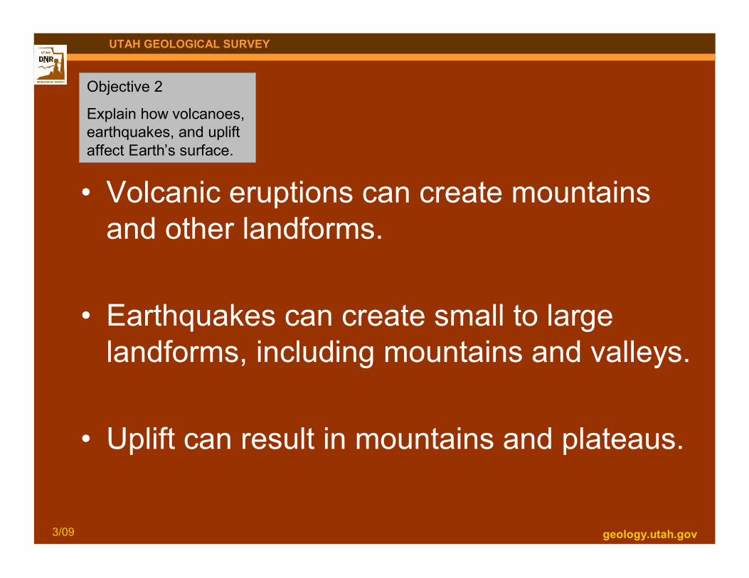
• Volcanic eruptions can create mountainsand other landforms.
• Earthquakes can create small to largelandforms, including mountains and valleys.
• Uplift can result in mountains and plateaus.
Objective 2
Explain how volcanoes,earthquakes, and upliftaffect Earth’s surface.

geology.utah.gov3/09
UTAH GEOLOGICAL SURVEY
Volcanoescan create . . . Craters
Photo courtesy of NASAhttp://gohawaii.about.com/library/gallery/blgallery573.htm
Islands
Mountains
pubs.usgs.gov/gip/volc/types.html

geology.utah.gov3/09
UTAH GEOLOGICAL SURVEY
Volcanic eruptionscan create differenttypes of mountains.
Cinder cone near St. George
Cindercone
Shield volcano north of Great Salt Lake
Shield volcano Composite volcano
http://Vulcan.wr.usgs.gov/volcanoes

geology.utah.gov3/09
UTAH GEOLOGICAL SURVEY
Cinder coneA small cone-shaped
volcano with steep sides.
Cinder cone near St. George
Shield volcanoA wide, low-profile
volcano shaped like aflattened dome.
Shield volcano north of Great Salt Lake
geology.utah.gov10/08
UTAH GEOLOGICAL SURVEY
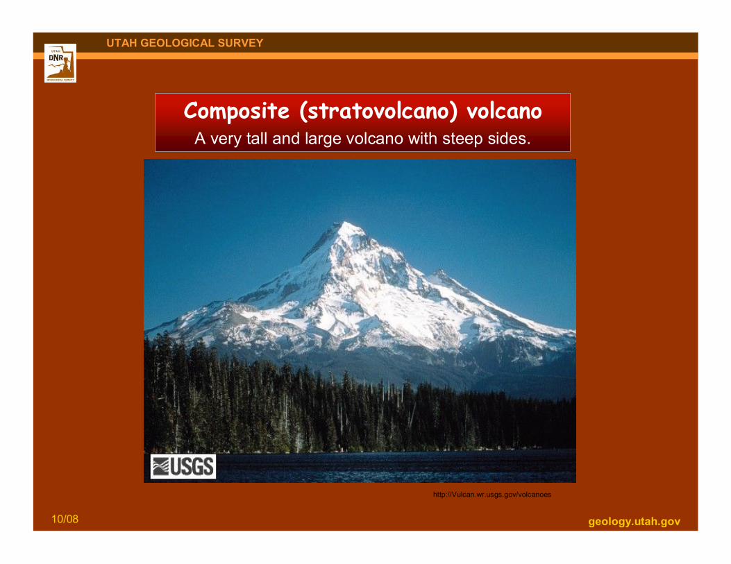
Composite (stratovolcano) volcanoA very tall and large volcano with steep sides.
http://Vulcan.wr.usgs.gov/volcanoes

geology.utah.gov3/09
UTAH GEOLOGICAL SURVEY
CraterA circular-shaped depression at the top of a volcano
formed by collapse from a large eruption.
geology.utah.gov3/09
UTAH GEOLOGICAL SURVEY
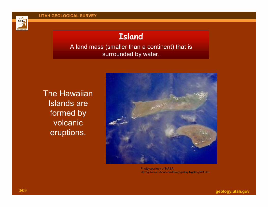
IslandA land mass (smaller than a continent) that is
surrounded by water.
Photo courtesy of NASAhttp://gohawaii.about.com/library/gallery/blgallery573.htm
The HawaiianIslands areformed byvolcanic
eruptions.
geology.utah.gov3/09
UTAH GEOLOGICAL SURVEY
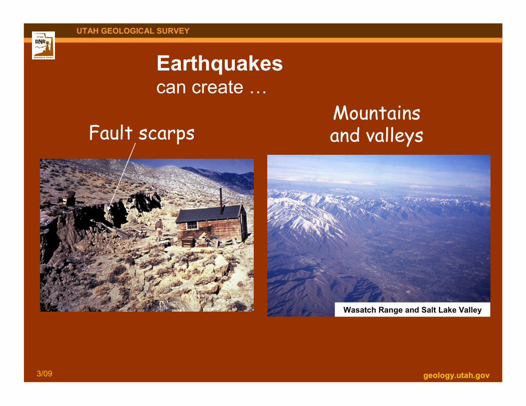
Earthquakescan create …
Mountainsand valleys
Wasatch Range and Salt Lake Valley
Fault scarps

geology.utah.gov3/09
UTAH GEOLOGICAL SURVEY
fault
FaultA crack in the Earth’s surface along whichtwo rock masses slide past one another.

geology.utah.gov3/09
UTAH GEOLOGICAL SURVEY
Fault scarpA steep break (escarpment) that forms where vertical
fault movement reaches the ground surface.

geology.utah.gov3/09
UTAH GEOLOGICAL SURVEY
Fault scarp formed by movement along the Wasatch fault.
Juab County

Mountains and valleys
geology.utah.gov3/09
UTAH GEOLOGICAL SURVEY

geology.utah.gov3/09
UTAH GEOLOGICAL SURVEY
UpliftA rise of land to a higher elevation.
Uplift can create …
Tushar Mountains
Mountains
Digital.lib.uiowa.edu/cdm4/results.php?CISOOP
Colorado Plateau
Plateaus
geology.utah.gov3/09
UTAH GEOLOGICAL SURVEY
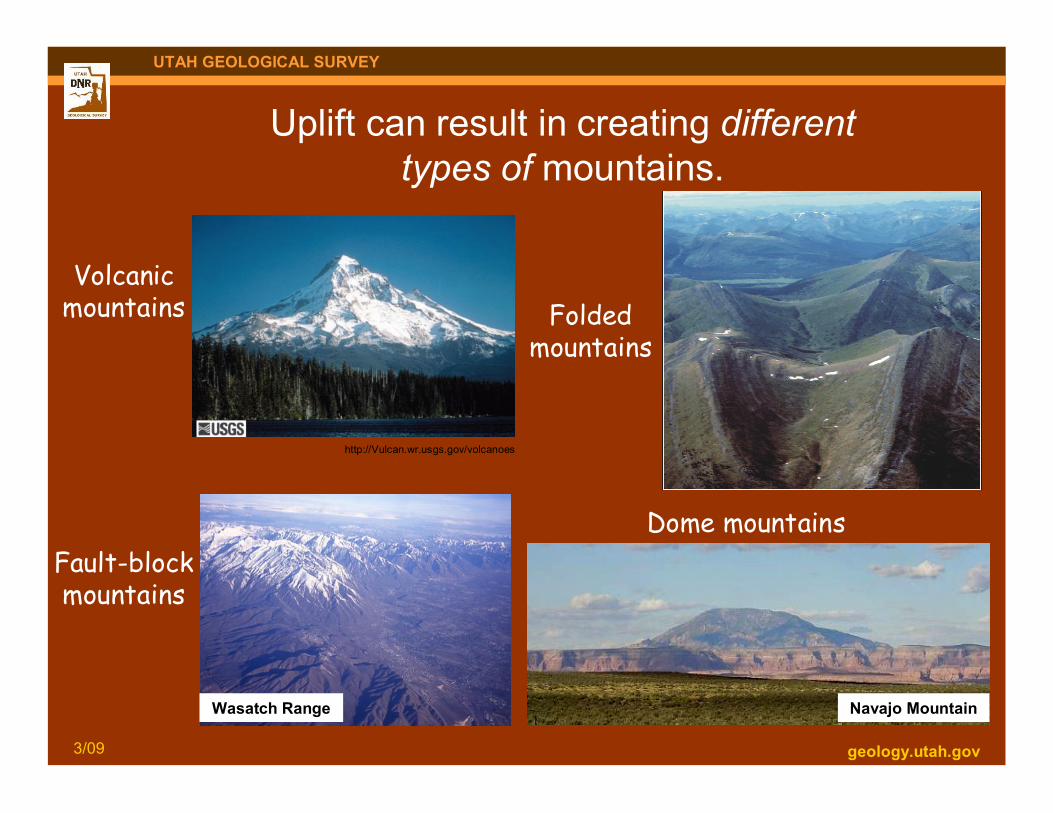
Uplift can result in creating differenttypes of mountains.
http://Vulcan.wr.usgs.gov/volcanoes
Volcanicmountains Folded
mountains
Wasatch Range
Fault-blockmountains
Navajo Mountain
Dome mountains

geology.utah.gov3/09
UTAH GEOLOGICAL SURVEY
Fault-block mountainA mountain that rises
along a fault.
Wasatch Range
Wasatch fault
Volcanic mountainA mountain that forms asrising magma erupts onto
the Earth’s surface.
http://Vulcan.wr.usgs.gov/volcanoes

geology.utah.gov3/09
UTAH GEOLOGICAL SURVEY
Navajo Mountain
Dome mountainA mountain produced where aregion of flat-lying sedimentary
rocks is bowed upward to form astructural dome.
Folded mountainA mountain formed by
compression of theEarth’s crust.
http://gsc.nrcan.gc.ca/natmap/cf/images/syncline440.gif

geology.utah.gov3/09
UTAH GEOLOGICAL SURVEY
Wasatch Plateau
PlateauA large, wide landform that is much higher than the adjacent land.
Kaiparowits Plateau
Straight Cliffs
Digital.lib.uiowa.edu/cdm4/results.php?CISOOP
Colorado Plateau

geology.utah.gov3/09
UTAH GEOLOGICAL SURVEY
Erosion on plateaus results in different geological features.
mesa
buttepinnacle
Castle Valley
Objective 1
Describe howweathering anderosion changeEarth’s surface.
ErosionThe wearing away and carrying away of land
by water, wind, or moving ice.

geology.utah.gov3/09
UTAH GEOLOGICAL SURVEY
River erosionand deposition
San Juan River
Picasawebhttp://picasaweb.google.com/lh/view?q=san%20juan%20river%20&psc=G&filter=1#5212557515730750498
Meanderingrivers
ErosionThe wearing away and carrying
away of land by water, wind,or moving ice.
DepositionThe laying down of eroded
material (sediments) by water,wind, or moving ice.

geology.utah.gov3/09
UTAH GEOLOGICAL SURVEY
Entrenched meanders
San Juan River

geology.utah.gov3/09
UTAH GEOLOGICAL SURVEY
River erosionduring flooding
Santa Clara River

geology.utah.gov3/09
UTAH GEOLOGICAL SURVEY
Different types of erosioncreate different canyon shapes.
Stream-eroded canyon“V-shaped”
Mill Creek Canyon
Glacier-eroded canyon“U-shaped”
Little Cottonwood Canyon

geology.utah.gov3/09
UTAH GEOLOGICAL SURVEY
GlacierA large sheet of moving ice.

geology.utah.gov3/09
UTAH GEOLOGICAL SURVEY
Mt. Nebo
Glacial erosioncreates othergeologicalfeatures . . .
CirqueSemi-circular bowl formed at
the head of a glacier.
geology.utah.gov3/09
UTAH GEOLOGICAL SURVEY
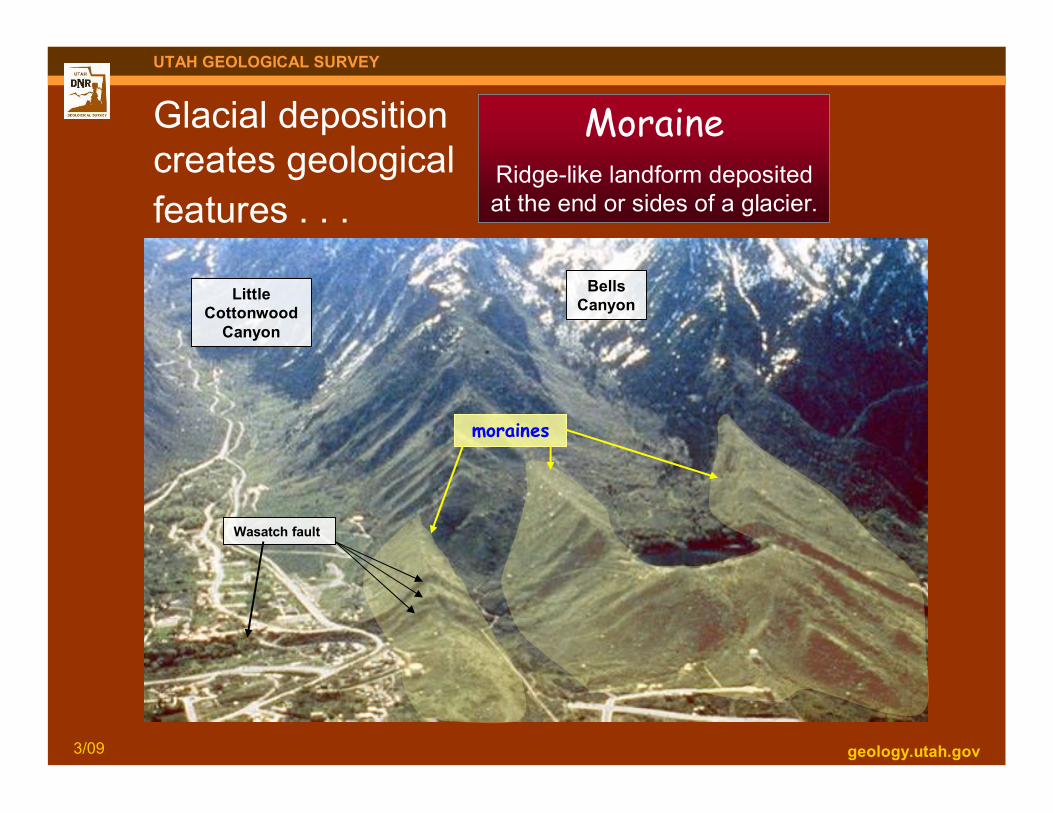
Glacial depositioncreates geologicalfeatures . . .
moraines
LittleCottonwood
Canyon
BellsCanyon
Wasatch fault
MoraineRidge-like landform depositedat the end or sides of a glacier.

geology.utah.gov3/09
UTAH GEOLOGICAL SURVEY
Wind erosionand deposition
Little Sahara Recreation Areahttp://www.gps.caltech.edu/~carltape/personal/images/ge136/ge136_photos.html
Moab

geology.utah.gov3/09
UTAH GEOLOGICAL SURVEY
WeatheringThe breaking down of rocks into smaller pieces by natural processes.
Rocks can be broken down by water, air, chemicals, temperaturechanges (freezing and thawing), and plant and animal activity.

geology.utah.gov3/09
UTAH GEOLOGICAL SURVEY
Freeze-thaw weatheringThe breaking down of rock by repeated cycles of freezingand thawing of water in cracks and other openings in rock.
stloe.most.go.th/.../302/images/3_2_3.jpg
Water fills a crack and freezes to ice and expands, which canbreak apart the rock.

geology.utah.gov3/09
UTAH GEOLOGICAL SURVEY
Weathering caused by freeze-thawcan create . . .
Rockfalls
Arches
Arches National Park
Hoodoos
Bryce Canyon National Park

geology.utah.gov3/09
UTAH GEOLOGICAL SURVEY
Photo courtesy of Louis J.Maher, Jr.
http://www.geology.wisc.edu/~maher/air/air05.htm
How archesform
Landscape Arch
geology.utah.gov3/09
UTAH GEOLOGICAL SURVEY
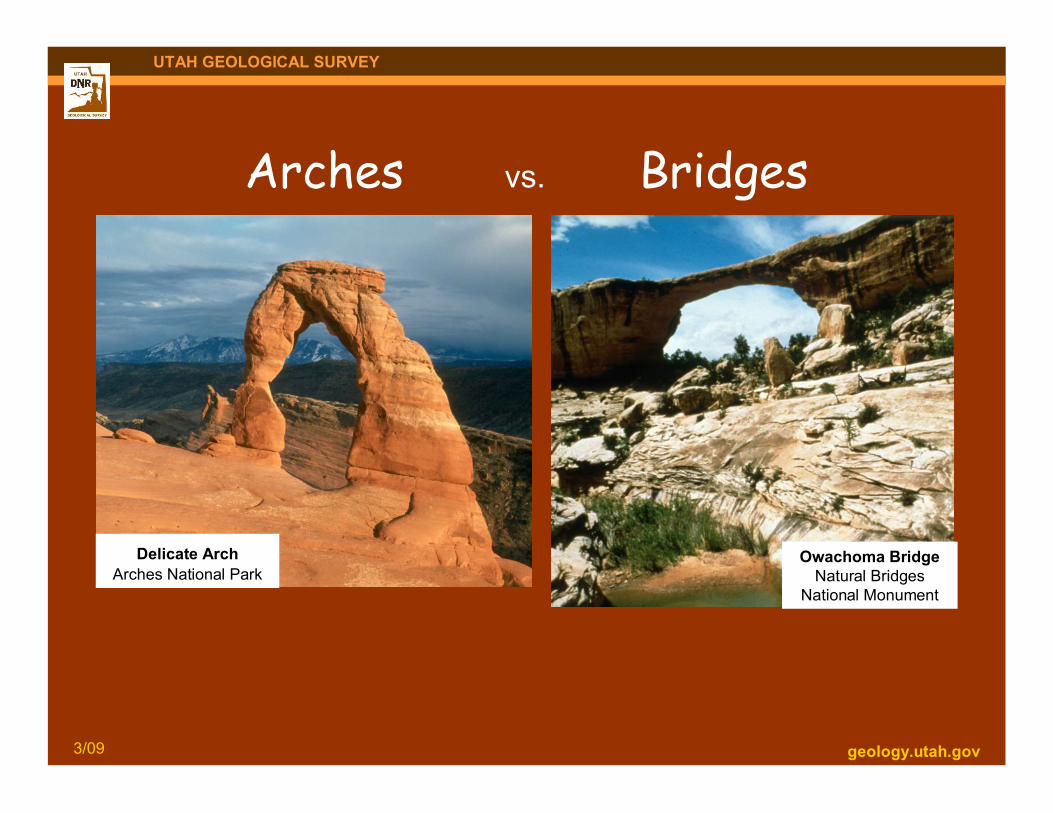
Arches vs. Bridges
Delicate ArchArches National Park
Owachoma BridgeNatural Bridges
National Monument
geology.utah.gov3/09
UTAH GEOLOGICAL SURVEY
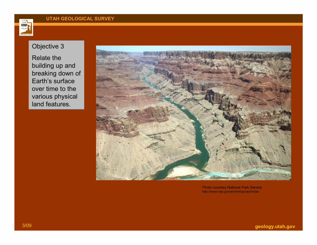
Objective 3
Relate thebuilding up andbreaking down ofEarth’s surfaceover time to thevarious physicalland features.
Photo courtesy National Park Servicehttp://www.nps.gov/archive/grca/photos/

geology.utah.gov3/09
UTAH GEOLOGICAL SURVEY
Candlestick Butte & Island in the SkyCanyonlands National Park

geology.utah.gov3/09
UTAH GEOLOGICAL SURVEY
Extra (1 of 2): forinterested teachers
Lake Bonneville shorelines
Point of the Mountain (photo left) at theborder of Salt Lake and Utah Counties

geology.utah.gov3/09
UTAH GEOLOGICAL SURVEY
Extra (2 of 2): forinterested teachers Fast/big step erosion and
deposition by a landslide
Thistle LandslideUtah County