Landform - study.sagepub.comstudy.sagepub.com/sites/default/files/04_gregory_lewinweb_ch-04.pdf ·...
9
4 Landform Landform has been basic to the study of geomorphology since the late 19th century, and form component definition evolved as a central concept until the second half of the 20th century, when remote sensing, GIS, DEMs and geomorphometry allowed more rigorous quantitative procedures, although this also involved a review of first principles. Land form, as land shape, may have received more attention than landforms, involving their genesis, and awareness of natural kinds reminds us how both are dependent upon human perception.
Transcript of Landform - study.sagepub.comstudy.sagepub.com/sites/default/files/04_gregory_lewinweb_ch-04.pdf ·...
4Landform
Landform has been basic to the study of geomorphology since the late 19th century, and form component definition evolved as a central concept until the second half of the 20th century, when remote sensing, GIS, DEMs and geomorphometry allowed more rigorous quantitative procedures, although this also involved a review of first principles. Land form, as land shape, may have received more attention than landforms, involving their genesis, and awareness of natural kinds reminds us how both are dependent upon human perception.
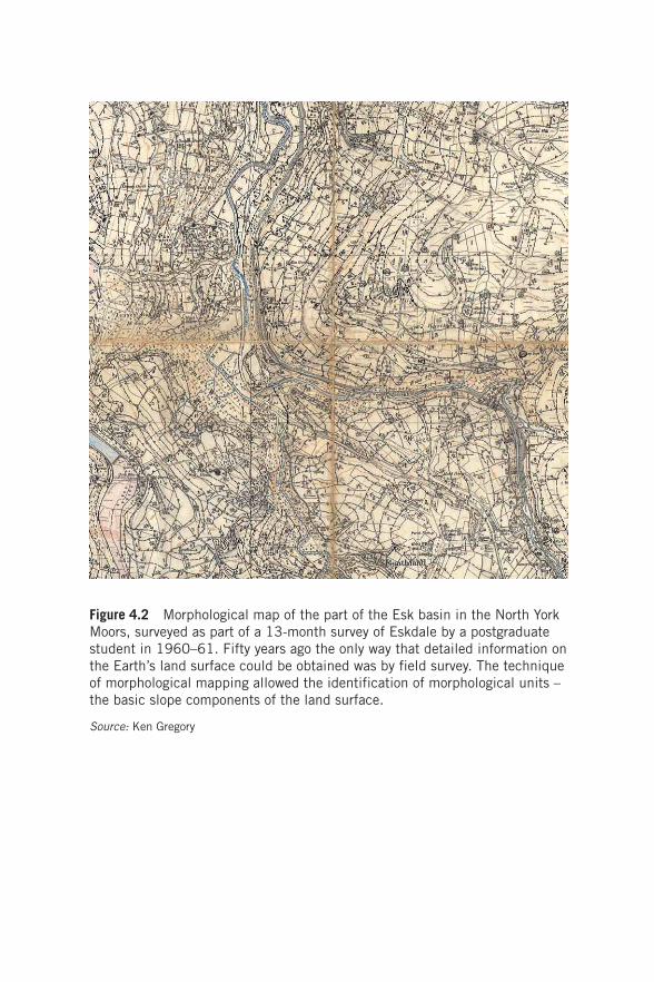
Figure 4.2 Morphological map of the part of the Esk basin in the North York Moors, surveyed as part of a 13-month survey of Eskdale by a postgraduate student in 1960–61. Fifty years ago the only way that detailed information on the Earth’s land surface could be obtained was by field survey. The technique of morphological mapping allowed the identification of morphological units – the basic slope components of the land surface.
Source: Ken Gregory
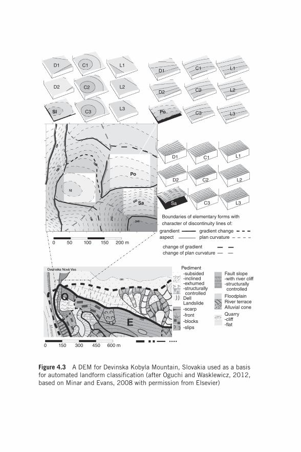
Figure 4.3 A DEM for Devinska Kobyla Mountain, Slovakia used as a basis for automated landform classification (after Oguchi and Wasklewicz, 2012, based on Minar and Evans, 2008 with permission from Elsevier)
D1 C1 L1
L2C2D2
SI C3L3
D1
D2
Po C3
C2
C1 L1
L2
L3
C1 L1
L2C2D2
Sa C3
Boundaries of elementary forms withcharacter of discontinuity lines of:
grandient gradient changeplan curvatureaspect
change of gradient
PedimentFault slope-with river cliff-structurallycontrolled
FloodplainRiver terraceAlluvial coneQuarry-cliff-�at
-subsided-inclined-exhumed-structurally
-scarp-front-blocks-slips
controlledDellLandslide
change of plan curvature
0 50
Po
Sa
100 150 200 m
L3
D1
0 150 300 450 600 m
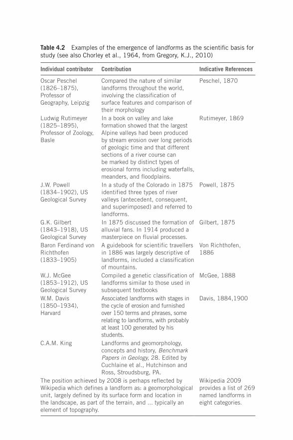
Table 4.2 Examples of the emergence of landforms as the scientific basis for study (see also Chorley et al., 1964, from Gregory, K.J., 2010)
Individual contributor Contribution Indicative References
Oscar Peschel (1826–1875),Professor of Geography, Leipzig
Compared the nature of similar landforms throughout the world, involving the classification of surface features and comparison of their morphology
Peschel, 1870
Ludwig Rutimeyer (1825–1895), Professor of Zoology, Basle
In a book on valley and lake formation showed that the largest Alpine valleys had been produced by stream erosion over long periods of geologic time and that different sections of a river course can be marked by distinct types of erosional forms including waterfalls, meanders, and floodplains.
Rutimeyer, 1869
J.W. Powell (1834–1902), US Geological Survey
In a study of the Colorado in 1875 identified three types of river valleys (antecedent, consequent, and superimposed) and referred to landforms.
Powell, 1875
G.K. Gilbert(1843–1918), US Geological Survey
In 1875 discussed the formation of alluvial fans. In 1914 produced a masterpiece on fluvial processes.
Gilbert, 1875
Baron Ferdinand von Richthofen (1833–1905)
A guidebook for scientific travellers in 1886 was largely descriptive of landforms, included a classification of mountains.
Von Richthofen, 1886
W.J. McGee (1853–1912), US Geological Survey
Compiled a genetic classification of landforms similar to those used in subsequent textbooks
McGee, 1888
W.M. Davis (1850–1934), Harvard
Associated landforms with stages in the cycle of erosion and furnished over 150 terms and phrases, some relating to landforms, with probably at least 100 generated by his students.
Davis, 1884,1900
C.A.M. King Landforms and geomorphology, concepts and history, Benchmark Papers in Geology, 28. Edited by Cuchlaine et al., Hutchinson and Ross, Stroudsburg, PA.
The position achieved by 2008 is perhaps reflected by Wikipedia which defines a landform as: a geomorphological unit, largely defined by its surface form and location in the landscape, as part of the terrain, and ... typically an element of topography.
Wikipedia 2009 provides a list of 269 named landforms in eight categories.
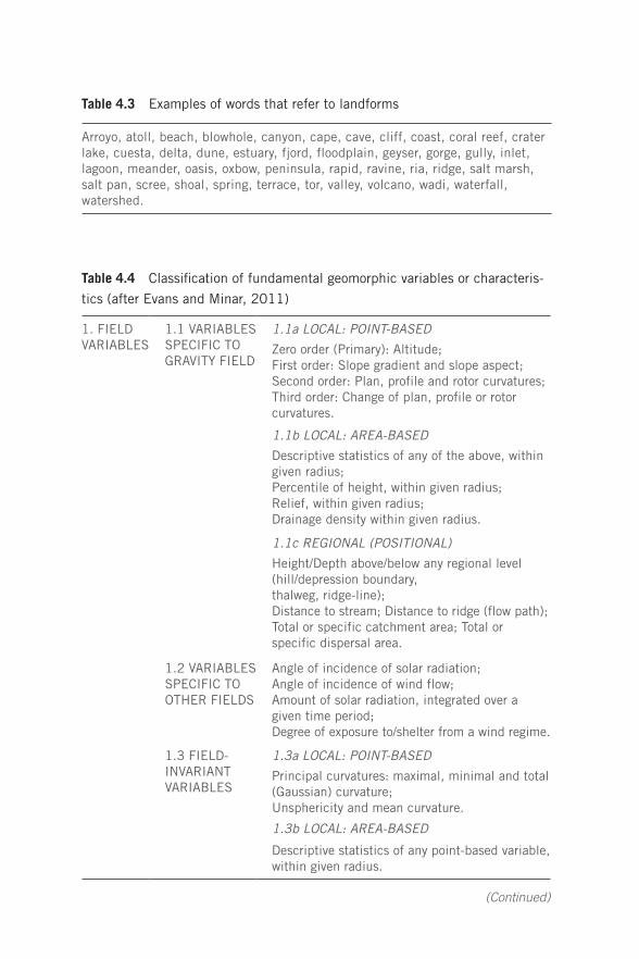
Arroyo, atoll, beach, blowhole, canyon, cape, cave, cliff, coast, coral reef, crater lake, cuesta, delta, dune, estuary, fjord, floodplain, geyser, gorge, gully, inlet, lagoon, meander, oasis, oxbow, peninsula, rapid, ravine, ria, ridge, salt marsh, salt pan, scree, shoal, spring, terrace, tor, valley, volcano, wadi, waterfall, watershed.
Table 4.3 Examples of words that refer to landforms
Table 4.4 Classification of fundamental geomorphic variables or characteris-
tics (after Evans and Minar, 2011)
1. FIELD VARIABLES
1.1 VARIABLES SPECIFIC TO GRAVITY FIELD
1.1a LOCAL: POINT-BASED
Zero order (Primary): Altitude;First order: Slope gradient and slope aspect;Second order: Plan, profile and rotor curvatures;Third order: Change of plan, profile or rotor curvatures.
1.1b LOCAL: AREA-BASED
Descriptive statistics of any of the above, within given radius;Percentile of height, within given radius;Relief, within given radius;Drainage density within given radius.
1.1c REGIONAL (POSITIONAL)
Height/Depth above/below any regional level (hill/depression boundary,thalweg, ridge-line);Distance to stream; Distance to ridge (flow path);Total or specific catchment area; Total or specific dispersal area.
1.2 VARIABLES SPECIFIC TO OTHER FIELDS
Angle of incidence of solar radiation;Angle of incidence of wind flow;Amount of solar radiation, integrated over a given time period;Degree of exposure to/shelter from a wind regime.
1.3 FIELD-INVARIANT VARIABLES
1.3a LOCAL: POINT-BASED
Principal curvatures: maximal, minimal and total (Gaussian) curvature;Unsphericity and mean curvature.
1.3b LOCAL: AREA-BASED
Descriptive statistics of any point-based variable, within given radius.
(Continued)
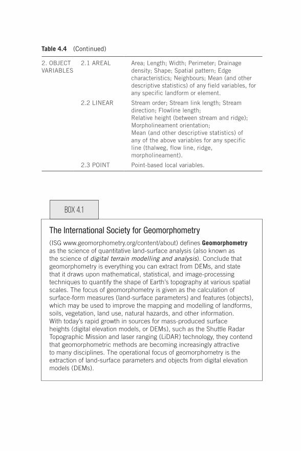
The International Society for Geomorphometry(ISG www.geomorphometry.org/content/about) defines Geomorphometry as the science of quantitative land-surface analysis (also known as the science of digital terrain modelling and analysis). Conclude that geomorphometry is everything you can extract from DEMs, and state that it draws upon mathematical, statistical, and image-processing techniques to quantify the shape of Earth’s topography at various spatial scales. The focus of geomorphometry is given as the calculation of surface-form measures (land-surface parameters) and features (objects), which may be used to improve the mapping and modelling of landforms, soils, vegetation, land use, natural hazards, and other information. With today’s rapid growth in sources for mass-produced surface heights (digital elevation models, or DEMs), such as the Shuttle Radar Topographic Mission and laser ranging (LiDAR) technology, they contend that geomorphometric methods are becoming increasingly attractive to many disciplines. The operational focus of geomorphometry is the extraction of land-surface parameters and objects from digital elevation models (DEMs).
2. OBJECT VARIABLES
2.1 AREAL Area; Length; Width; Perimeter; Drainage density; Shape; Spatial pattern; Edge characteristics; Neighbours; Mean (and other descriptive statistics) of any field variables, for any specific landform or element.
2.2 LINEAR Stream order; Stream link length; Stream direction; Flowline length;Relative height (between stream and ridge);Morpholineament orientation;Mean (and other descriptive statistics) of any of the above variables for any specific line (thalweg, flow line, ridge, morpholineament).
2.3 POINT Point-based local variables.
Table 4.4 (Continued)
Box 4.1
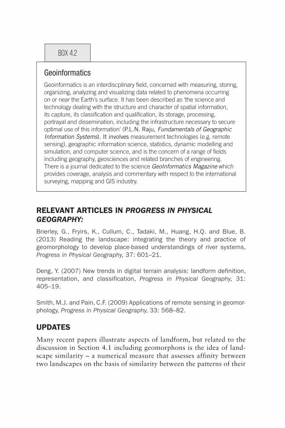
GeoinformaticsGeoinformatics is an interdiscplinary field, concerned with measuring, storing, organizing, analyzing and visualizing data related to phenomena occurring on or near the Earth’s surface. It has been described as ‘the science and technology dealing with the structure and character of spatial information, its capture, its classification and qualification, its storage, processing, portrayal and dissemination, including the infrastructure necessary to secure optimal use of this information’ (P.L.N. Raju, Fundamentals of Geographic Information Systems). It involves measurement technologies (e.g. remote sensing), geographic information science, statistics, dynamic modelling and simulation, and computer science, and is the concern of a range of fields including geography, geosciences and related branches of engineering. There is a journal dedicated to the science GeoInformatics Magazine which provides coverage, analysis and commentary with respect to the international surveying, mapping and GIS industry.
RELEVANT ARTICLES IN PROGRESS IN PHYSICAL GEOGRAPHY:
Brierley, G., Fryirs, K., Cullum, C., Tadaki, M., Huang, H.Q. and Blue, B. (2013) Reading the landscape: integrating the theory and practice of geomorphology to develop place-based understandings of river systems, Progress in Physical Geography, 37: 601–21.
Deng, Y. (2007) New trends in digital terrain analysis: landform definition, representation, and classification, Progress in Physical Geography, 31: 405–19.
Smith, M.J. and Pain, C.F. (2009) Applications of remote sensing in geomor-phology, Progress in Physical Geography, 33: 568–82.
UPDATESMany recent papers illustrate aspects of landform, but related to the discussion in Section 4.1 including geomorphons is the idea of land-scape similarity – a numerical measure that assesses affinity between two landscapes on the basis of similarity between the patterns of their
Box 4.2
constituent landform elements. A similarity function provides core technology for a landscape search engine enabling exploration of large topographic datasets:
Jasiewicz, J., Netzel, P. and Stepinski, T.F. (2014) Landscape similarity, retrieval, and machine mapping of physiographic units, Geomorphology, 221: 104–12.
A further example of a development in geomorphometry (Section 4.1, p.35) is an application of a multiple point geostatistics (MPS) to map landforms, using information at multiple cell locations:
Vannametee, E., Babel, L.V., Hendriks, M.R., Schuur, J. de Jong, S.M., Bierkens, M.F.P. and Karssenberg, D. (2014) Semi-automated mapping of landforms using multiple point geostatistics, Geomorphology, 221: 298–319.
Phillips, J.D. (2016) Landforms as extended composite phenotypes, Earth Surface Processes and Landforms, 41: 16–26 provides an explora-tion of whether landforms may be extended (composite) phenotypes of biota, based on four criteria: process–form relationships between biota and landforms; evolutionary synchrony; selective pressure via ecosystem engineering and niche construction; and positive feedback benefitting the engineer organism(s). Suggests that biological evolution will continue to drive landscape metamorphosis, the appearance of new landform types, and presumably the disappearance of extended phenotypes associated with extinct species.
Fluvial landforms are variously referred to as geomorphic units, mor-phological units, habitat units, and channel units, with few examples of manual or automated classification, so a paper presenting a 4-tiered framework for describing geomorphic units and applied to differing valley settings is: Wheaton, J.M., Fryirs, K.A., Brierley, G., Bouwes, N. and O’Brien, G. (2015) Geomorphic mapping and taxonomy of fluvial landforms, Geomorphology, 248: 273–95.
A geomorphosite is a landform to which a value can be attributed and has acquired a scientific, cultural/historical, aesthetic and/or social/economic value due to human perception or exploitation. A working group (2001–12) of the International Association of Geomorphologists (IAG) focused on geomorphosites, in relation to the geomorphological part of geoheritage. See Reynard, E. (2005) Géomorphosites et paysages. Geomorphosites and landscapes, Geomorphologie: Relief, processus, environnement, 3: 181–88.
A different perspective, based on an analysis of a large data set of sub-glacial forms, is provided by Ely, J.C., Clark, C.D., Spagnolo, M., Stokes, C.R., Greenwood, S.L., Hughes, A.L.C., Dunlop, P.and Hess, D. (2016) Do subglacial bedforms comprise a size and shape continuum?, Geomorphology, 257: 108–19. They show that for some groupings a continuum of forms exists without clear size or shape distinctions accord-ing to named types. Others form distinct clusters. This approach could be used in other areas (such as river or coastal depositional forms) so that some of the many subjective namings in use become redundant.
Archetypes, which can be existing taxonomic or landscape units or may involve new combinations of landscape attributes developed for a specific purpose, are proposed as a way of moving between concep-tual framings, empirical observations and the dichotomous classification rules upon which maps are based, and suggest future use in conserva-tion science and management: Cullum, C., Brierley, G., Perry, G.L.W. and Witkowski, E.T.F. (2017) Landscape archetypes for ecological clas-sification and mapping. The virtue of vagueness, Progress in Physical Geography, 41: 95–123.