Landform characterizations and water resource … · Landform characterizations and water resource...
10
INTERNATIONAL JOURNAL OF GEOMATICS AND GEOSCIENCES Volume 3, No 1, 2012 © Copyright by the authors - Licensee IPA- Under Creative Commons license 3.0 Research article ISSN 0976 – 4380 Submitted on May 2012 published on July 2012 111 Landform characterizations and water resource management –A case study of Mohand in the foothills of Siwaliks Arti Singh 1 , Savindra Singh 2 1- Society for Application research and Consultancy, New Delhi, India 2- Department of Geography, University of Allahabad (U.P) [email protected] ABSTRACT The present study presents an understanding of landforms and its characteristics for water resource management in the Foothills of siwaliks, study area forming a mountain ecosystem of the lesser Himalayas represents a part of the Siwaliks extending between 30° 19’ N and 77° 35’ E from the Badshahibagh Rao and 30° 11’ N and 77° 55’ E the Mohand Rao rivers. The study focuses on various landforms found in the study area and its relation with the water resource. The fluvial landforms were the main source of potable water for the local population, which has dried up at the upper levels. Thus, the study of classification of water resource potential areas in the Siwaliks is of paramount significance. Water table information is inferred from the various thematic layer like geomorphology, drainage patterns, vegetation characteristics, land use patterns, linear and curvilinear features (geological importance), and image tones and textures. The total areas covered for study was 970.47 km 2 . The piedmont zone is found most suitable for the water resource management which covers an area of 544.74 km 2 , the lower piedmont covers an area of 167.67 km 2 and found most suitable with almost flat on gentle sloping land with less drainage density, intensive agricultural and composed of alluvial fan materials like gravels, sand, clay, silt, pebbles etc. as underlying lithology acting as discharge zone with shallow to moderate water table. In piedmont regions, vegetation characteristics indicate various groundwater depth and quality which can be further used for the decision makers and policy issues. Keywords: Siwaliks, Water Resource, Remote Sensing, Policy issues. 1. Introduction The objectives of this study are to understand the characteristics of the landforms of the siwaliks in the foot-hills (Badshahibagh rao river to Mohand rao river), in order to establish the landform history and to clarify the crustal movements of the area and emergence of landform. The southernmost zone of the outer Himalaya consists of about 9500m thick piles of tertiary sedimentary rocks (conglomerate, sandstone, mudstone, phyllites, shale, limestone ranging in age from paleocene to lower pleistocene (Thakur, 1998). The breakdown of the rising central Himalaya has resulted in deposition of the siwalik group in the form of Molasses deposits, overlain by late Pleistocene doon gravels (Parkash et. al, 1980). Landforms are Critical in the identification of the areas potential slope instability (Howes 1987; Niemann and Howes 1992). Now, the rate of exploitation of groundwater for different purposes like irrigation, drinking and industrial development has been accelerated while the rate of recharge is decreasing due deforestation, urbanization, industrialization etc. and hence the subsurface environment is deteriorating day by day. ‘The changes of subsurface environment mostly include changes in subsurface materials e.g. expansion or contraction, loosening or compaction, fracturing and displacement, upward or downward movement,
Transcript of Landform characterizations and water resource … · Landform characterizations and water resource...
INTERNATIONAL JOURNAL OF GEOMATICS AND GEOSCIENCES
Volume 3, No 1, 2012
© Copyright by the authors - Licensee IPA- Under Creative Commons license 3.0
Research article ISSN 0976 – 4380
Submitted on May 2012 published on July 2012 111
Landform characterizations and water resource management –A case
study of Mohand in the foothills of Siwaliks Arti Singh
1, Savindra Singh
2
1- Society for Application research and Consultancy, New Delhi, India
2- Department of Geography, University of Allahabad (U.P)
ABSTRACT
The present study presents an understanding of landforms and its characteristics for water
resource management in the Foothills of siwaliks, study area forming a mountain ecosystem
of the lesser Himalayas represents a part of the Siwaliks extending between 30° 19’ N and
77° 35’ E from the Badshahibagh Rao and 30° 11’ N and 77° 55’ E the Mohand Rao rivers.
The study focuses on various landforms found in the study area and its relation with the water
resource. The fluvial landforms were the main source of potable water for the local
population, which has dried up at the upper levels. Thus, the study of classification of water
resource potential areas in the Siwaliks is of paramount significance. Water table information
is inferred from the various thematic layer like geomorphology, drainage patterns, vegetation
characteristics, land use patterns, linear and curvilinear features (geological importance), and
image tones and textures. The total areas covered for study was 970.47 km2. The piedmont
zone is found most suitable for the water resource management which covers an area of
544.74 km2, the lower piedmont covers an area of 167.67 km
2 and found most suitable with
almost flat on gentle sloping land with less drainage density, intensive agricultural and
composed of alluvial fan materials like gravels, sand, clay, silt, pebbles etc. as underlying
lithology acting as discharge zone with shallow to moderate water table. In piedmont regions,
vegetation characteristics indicate various groundwater depth and quality which can be
further used for the decision makers and policy issues.
Keywords: Siwaliks, Water Resource, Remote Sensing, Policy issues.
1. Introduction
The objectives of this study are to understand the characteristics of the landforms of the
siwaliks in the foot-hills (Badshahibagh rao river to Mohand rao river), in order to establish
the landform history and to clarify the crustal movements of the area and emergence of
landform. The southernmost zone of the outer Himalaya consists of about 9500m thick piles
of tertiary sedimentary rocks (conglomerate, sandstone, mudstone, phyllites, shale, limestone
ranging in age from paleocene to lower pleistocene (Thakur, 1998). The breakdown of the
rising central Himalaya has resulted in deposition of the siwalik group in the form of
Molasses deposits, overlain by late Pleistocene doon gravels (Parkash et. al, 1980).
Landforms are Critical in the identification of the areas potential slope instability (Howes
1987; Niemann and Howes 1992). Now, the rate of exploitation of groundwater for different
purposes like irrigation, drinking and industrial development has been accelerated while the
rate of recharge is decreasing due deforestation, urbanization, industrialization etc. and hence
the subsurface environment is deteriorating day by day. ‘The changes of subsurface
environment mostly include changes in subsurface materials e.g. expansion or contraction,
loosening or compaction, fracturing and displacement, upward or downward movement,
Landform characterizations and water resource management –A case study of Mohand in the foothills of
Siwaliks
Arti Singh, Savindra Singh
International Journal of Geomatics and Geosciences
Volume 3 Issue 1, 2012 112
decrease or increase of stresses, deformation of subsurface materials etc., (Singh Savindra,
1997). So, it is necessary to study the groundwater potential of a region because this is very
precious resource and its depletion may cause water scarcity. Some other notable workers
who have studied geomorphic features of the foothill zones of Himalaya are Baber 1972,
Nakata 1972, Mukerjee 1976.They identified fluvial landforms and associated the landform
either with tectonic movements or climatic fluctuations. The deforestation of the Himalayas,
mainly the Siwaliks, has resulted in the lowering of groundwater table and drying of water
springs at different levels and hence it becomes imperative to identify groundwater resource
in the foot hills of the Siwaliks.
Landform Characteristics of the study area speaks too much about the morphogenesis means
development of different fluvial landform due to tectonic activity in the region. These
morphogenesis features witness the past history of landform development in the region .A
number of terraces along the river valleys like the Mohand Rao, the Khanjnaur Rao, the
Shanjatianpur Rao, the Khaironwala Rao, the Kaluwala Rao, the Khaironwala Rao the
Bhurawala Rao, the Mascara Rao, the Sahansara Rao, the Shahkumbhari Rao, the
Khaironwala Rao, the Raipur Rao, the Gair Rao, the Chapri Rao, the Gejra Rao, the
Khaironwala Rao, the Bhurawala Rao, the Barkala Rao, the Sarbot Rao, the Rangli Rao, the
Kirkiti Rao,the Andheri Rao and the Yamuna represents the earlier surfaces of the valley.
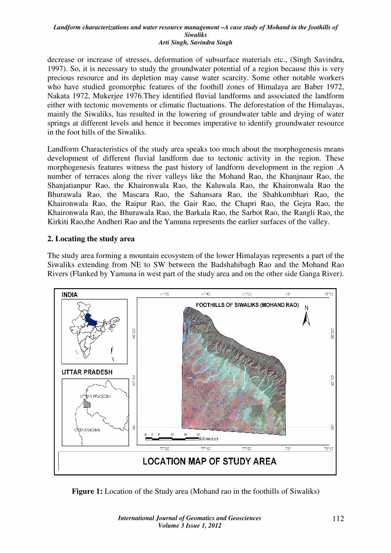
2. Locating the study area
The study area forming a mountain ecosystem of the lower Himalayas represents a part of the
Siwaliks extending from NE to SW between the Badshahibagh Rao and the Mohand Rao
Rivers (Flanked by Yamuna in west part of the study area and on the other side Ganga River).
Figure 1: Location of the Study area (Mohand rao in the foothills of Siwaliks)
Landform characterizations and water resource management –A case study of Mohand in the foothills of
Siwaliks
Arti Singh, Savindra Singh
International Journal of Geomatics and Geosciences
Volume 3 Issue 1, 2012 113
The region bordered by the Yamuna river in the west and the Mohand and the Barkala Rao
rivers in the east and is confined between two metalled roads e.g. (i) Saharanpur - Chakrata
and (ii) Saharanpur, Dehradun which cut the Siwaliks precisely at Badshahibag, (30° 19’ N
and 77° 35’ E), Timili (30° 22’ N and 77° 59’ E) in the north-west and Mohand (30° 11’ N
and 77° 55’ E), Asarohi (30° 15’ N and 77° 59’ E) in the north-east. The Mohand rao area is
influenced by the climatic conditions of Doon valley because of its proximity. The Mohand
falls under the sub-tropical to temperate climate due to variations in the topographic
elevations. The meteorological data (from the two stations operating in the region, FRI and
CSWCRTI) of the last 75 years showed that the average maximum temperature for the Doon
valley was 27.65◦C and the average minimum temperature was 13.8◦C, with average
maximum in June (40.00◦C) and average minimum in the month of January (1.80◦C). The
area receives an average annual rainfall of 2025.43 mm. The region receives most of the
annual rainfall during June to September, the maximum rainfall occurring in July and August.
The soil moisture is usually udic with a thermic to a hyperthermic soil temperature regime
according to the Soil Survey Staff (1998).
2. Materials and method
The analytical method has been followed in the present study wherein a multiple hypotheses
have been deduced in the beginning for testing after detailed discussion and analysis on the
basis of primary and secondary data from different sources. Before embarking on field,
literature was extensively reviewed. The following steps have been followed.
2.1 Data collection
The data that served as medium for the study was in the form of Survey of India Toposheets.
The Survey of India toposheets were. 53 F/11, 53 F/12, 53 F/15, 53 F/16 on scale 1:50,000
was used for the base map preparation, Drainage map preparation and Contour digitization
for preparation of Digital Elevation Mode and for the field study Aerial Photographs were
used .Total Aerial Photographs used were 72 in number. The strip numbers were 25(photos
30-47),26 (Photos 26-43),29(Photos 20-37),30 (Photos 26-43). Landsat Thematic Mapper
data was also used for other layer enhancement techniques and thematic mapping. During the
first phase, i.e. the pre-field phase a detailed study of the aerial photographs together with the
Survey of India, toposheets were carried out. The toposheets were studied for the derivation
of information related to geomorphological and cultural details, and a cultural-cum base map
was prepared. The photographs were studied stereoscopically, pair by pair for photo-
geological and photo- morphological details. Lithological units, structure, bedding traces,
lineaments, faults etc. were identified, and the details were transferred on to Mylar sheets.
The details were then mosaic and compiled to form a semi controlled pre-field map. Areas of
geological interest were demarcated and field traverses were selected accordingly.
2.2 Field investigation
The second phase of the study included data acquisition from field. The various traverses
selected, were taken and the pre-field data were modified, corrected and incorporated. The
traverses were chosen along wide, accessible rivers and nearly as far as possible all the major
rivers were covered. In almost all the cases these were along the dip direction, which
facilitated covering most of the units in a single traverse. Any changes and modifications
encountered or deviations from the pre-field mapped data were incorporated. The scale of the
aerial photographs being 1:25,000 was of a great help in this work.
Landform characterizations and water resource management –A case study of Mohand in the foothills of
Siwaliks
Arti Singh, Savindra Singh
International Journal of Geomatics and Geosciences
Volume 3 Issue 1, 2012 114
2.3. Data analysis
The third and the final phase of the study involved post field interpretation of the compiled
data and a re-look into the entire data gathered and satellite imageries were also included
during this phase of the study. The data interpretation and analysis were performed by using
the software’s of Remote Sensing and GIS mainly ARCGIS 2010, ERDAS 9.1 and Arc View.
4. Results
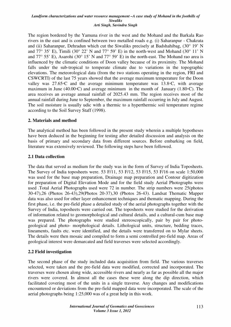
A conceptual model for Landform characteristics and water resource management in the
foothills of Siwaliks is given in Figure 2. In this model Landforms are schematically arranged
and further were classified based on their water recharge capacity.
Figure 2: Conceptual Diagram of the Landforms and their role for water Management in the
study area
4.1 Fluvial landforms
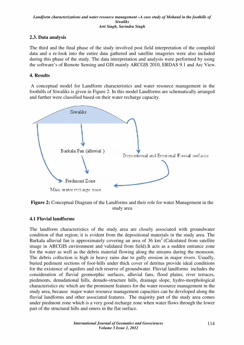
The landform characteristics of the study area are closely associated with groundwater
condition of that region; it is evident from the depositional materials in the study area. The
Barkala alluvial fan is approximately covering an area of 36 km2
(Calculated from satellite
image in ARCGIS environment and validated from field).It acts as a sudden entrance zone
for the water as well as the debris material flowing along the streams during the monsoon.
The debris collection is high in heavy rains due to gully erosion in major rivers. Usually,
buried pediment sections of foot-hills under thick cover of detritus provide ideal conditions
for the existence of aquifers and rich reserve of groundwater. Fluvial landforms includes the
consideration of fluvial geomorphic surfaces, alluvial fans, flood plains; river terraces,
piedmonts, denudational hills, denudo-structure hills, drainage slope, hydro-morphological
characteristics etc which are the prominent features for the water resource management in the
study area, because major water resource management capacities can be developed along the
fluvial landforms and other associated features. The majority part of the study area comes
under piedmont zone which is a very good recharge zone when water flows through the lower
part of the structural hills and enters in the flat surface.
Landform characterizations and water resource management –A case study of Mohand in the foothills of
Siwaliks
Arti Singh, Savindra Singh
International Journal of Geomatics and Geosciences
Volume 3 Issue 1, 2012 115
Figure 3: The profile and field picture of Barkala Rao alluvial fan (the main geomorphic
feature) showing the fluvial landforms of the river while entering into piedmont Zone.
4.2 Topographical genesis
The topographic surface principally consist of alluvial deposits and are formed as alluvial
fans (fluvial geomorphic features), river terraces, and sand bars in the foothills of the
Himalayas. There are two types of fluvial landform which was identified in the study area
they are either depositional or erosional. The lateral erosion of the streams is more prominent
than the deposition in the area except at the place where the rivers come down directly from
the steep slopes of the lower Himalayas and at the confluence of the branch stream from
upper siwalik boulder conglomerate zone. In this way, mode of development of the fluvial the
contrary, the Foot-hills are mainly the place of fluvial deposition. This is especially true
where the mountain front forms distinct boundary of elevation by the tectonically originated
steep slopes, as in the Himalayan Foot-hill zone. Deposition at the foot-hill are distressed by
unwrap movements raising old depositional surfaces to the higher elevation. In the area
where depositional and erosional fluvial surface co-exist forming compound topography,
special attention must be paid in distinguishing these surfaces.
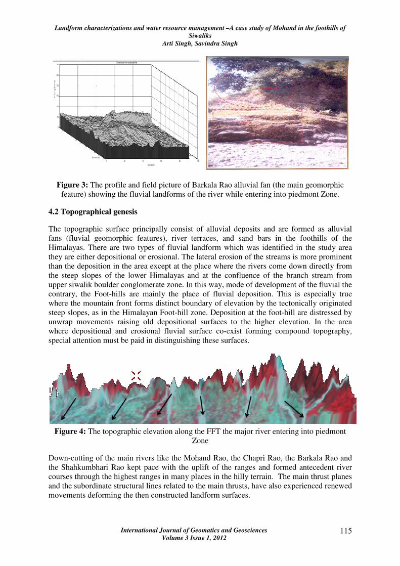
Figure 4: The topographic elevation along the FFT the major river entering into piedmont
Zone
Down-cutting of the main rivers like the Mohand Rao, the Chapri Rao, the Barkala Rao and
the Shahkumbhari Rao kept pace with the uplift of the ranges and formed antecedent river
courses through the highest ranges in many places in the hilly terrain. The main thrust planes
and the subordinate structural lines related to the main thrusts, have also experienced renewed
movements deforming the then constructed landform surfaces.
Landform characterizations and water resource management –A case study of Mohand in the foothills of
Siwaliks
Arti Singh, Savindra Singh
International Journal of Geomatics and Geosciences
Volume 3 Issue 1, 2012 116
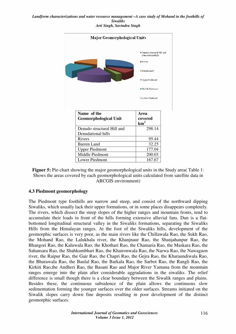
Name of the
Geomorphological Unit
Area
covered
km2
Denudo structural Hill and
Denudational hills
298.14
Rivers 95.44
Barren Land 32.25
Upper Piedmont 177.04
Middle Piedmont 200.03
Lower Piedmont 167.67
Figuer 5: Pie-chart showing the major geomorphological units in the Study area( Table 1:
Shows the areas covered by each geomorphological units calculated from satellite data in
ARCGIS environment)
4.3 Piedmont geomorphology
The Piedmont type foothills are narrow and steep, and consist of the northward dipping
Siwaliks, which usually lack their upper formations, or in some places disappears completely.
The rivers, which dissect the steep slopes of the higher ranges and mountain fronts, tend to
accumulate their loads in front of the hills forming extensive alluvial fans. Dun is a flat-
bottomed longitudinal structural valley in the Siwaliks formations, separating the Siwaliks
Hills from the Himalayan ranges. At the foot of the Siwaliks hills, development of the
geomorphic surfaces is very poor, as the main rivers like the Chillawala Rao, the Sukh Rao,
the Mohand Rao, the Lalukhala river, the Khanjnaur Rao, the Shanjahanpur Rao, the
Bhangori Rao, the Kaluwala Rao, the Khothari Rao, the Chamaria Rao, the Maskara Rao, the
Sahansara Rao, the Shahkumbhari Rao, the Khaironwala Rao, the Narwa Rao, the Nawagaon
river, the Raipur Rao, the Gair Rao, the Chapri Rao, the Gejra Rao, the Kharaundiwala Rao,
the Bhurawala Rao, the Baulal Rao, the Barkala Rao, the Sarbot Rao, the Rangli Rao, the
Kirkiti Rao,the Andheri Rao, the Basani Rao and Major River Yamuna from the mountain
ranges emerge into the plain after considerable aggradations in the siwaliks. The relief
difference is small though there is a clear boundary between the Siwalik ranges and plains.
Besides these, the continuous subsidence of the plain allows the continuous slow
sedimentation forming the younger surfaces over the older surfaces. Streams initiated on the
Siwalik slopes carry down fine deposits resulting in poor development of the distinct
geomorphic surfaces.
Landform characterizations and water resource management –A case study of Mohand in the foothills of
Siwaliks
Arti Singh, Savindra Singh
International Journal of Geomatics and Geosciences
Volume 3 Issue 1, 2012 117
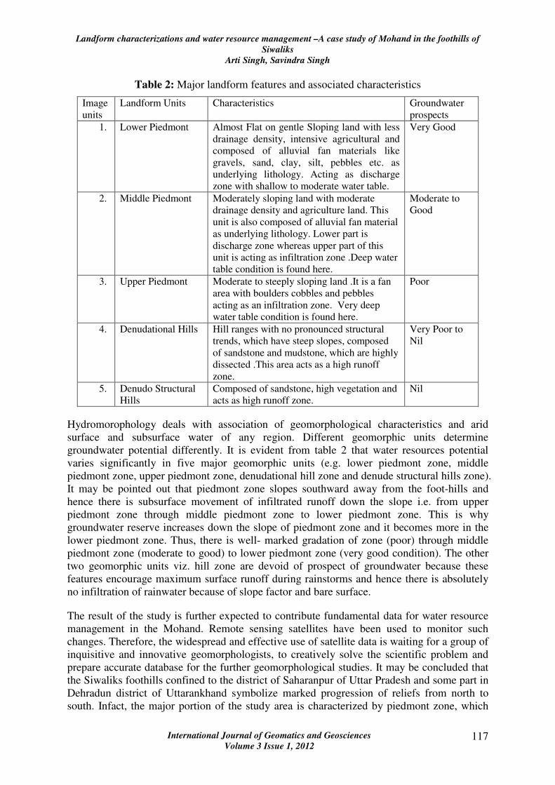
Table 2: Major landform features and associated characteristics
Image
units
Landform Units Characteristics Groundwater
prospects
1. Lower Piedmont Almost Flat on gentle Sloping land with less
drainage density, intensive agricultural and
composed of alluvial fan materials like
gravels, sand, clay, silt, pebbles etc. as
underlying lithology. Acting as discharge
zone with shallow to moderate water table.
Very Good
2. Middle Piedmont Moderately sloping land with moderate
drainage density and agriculture land. This
unit is also composed of alluvial fan material
as underlying lithology. Lower part is
discharge zone whereas upper part of this
unit is acting as infiltration zone .Deep water
table condition is found here.
Moderate to
Good
3. Upper Piedmont Moderate to steeply sloping land .It is a fan
area with boulders cobbles and pebbles
acting as an infiltration zone. Very deep
water table condition is found here.
Poor
4. Denudational Hills Hill ranges with no pronounced structural
trends, which have steep slopes, composed
of sandstone and mudstone, which are highly
dissected .This area acts as a high runoff
zone.
Very Poor to
Nil
5. Denudo Structural
Hills
Composed of sandstone, high vegetation and
acts as high runoff zone.
Nil
Hydromorophology deals with association of geomorphological characteristics and arid
surface and subsurface water of any region. Different geomorphic units determine
groundwater potential differently. It is evident from table 2 that water resources potential
varies significantly in five major geomorphic units (e.g. lower piedmont zone, middle
piedmont zone, upper piedmont zone, denudational hill zone and denude structural hills zone).
It may be pointed out that piedmont zone slopes southward away from the foot-hills and
hence there is subsurface movement of infiltrated runoff down the slope i.e. from upper
piedmont zone through middle piedmont zone to lower piedmont zone. This is why
groundwater reserve increases down the slope of piedmont zone and it becomes more in the
lower piedmont zone. Thus, there is well- marked gradation of zone (poor) through middle
piedmont zone (moderate to good) to lower piedmont zone (very good condition). The other
two geomorphic units viz. hill zone are devoid of prospect of groundwater because these
features encourage maximum surface runoff during rainstorms and hence there is absolutely
no infiltration of rainwater because of slope factor and bare surface.
The result of the study is further expected to contribute fundamental data for water resource
management in the Mohand. Remote sensing satellites have been used to monitor such
changes. Therefore, the widespread and effective use of satellite data is waiting for a group of
inquisitive and innovative geomorphologists, to creatively solve the scientific problem and
prepare accurate database for the further geomorphological studies. It may be concluded that
the Siwaliks foothills confined to the district of Saharanpur of Uttar Pradesh and some part in
Dehradun district of Uttarankhand symbolize marked progression of reliefs from north to
south. Infact, the major portion of the study area is characterized by piedmont zone, which
Landform characterizations and water resource management –A case study of Mohand in the foothills of
Siwaliks
Arti Singh, Savindra Singh
International Journal of Geomatics and Geosciences
Volume 3 Issue 1, 2012 118
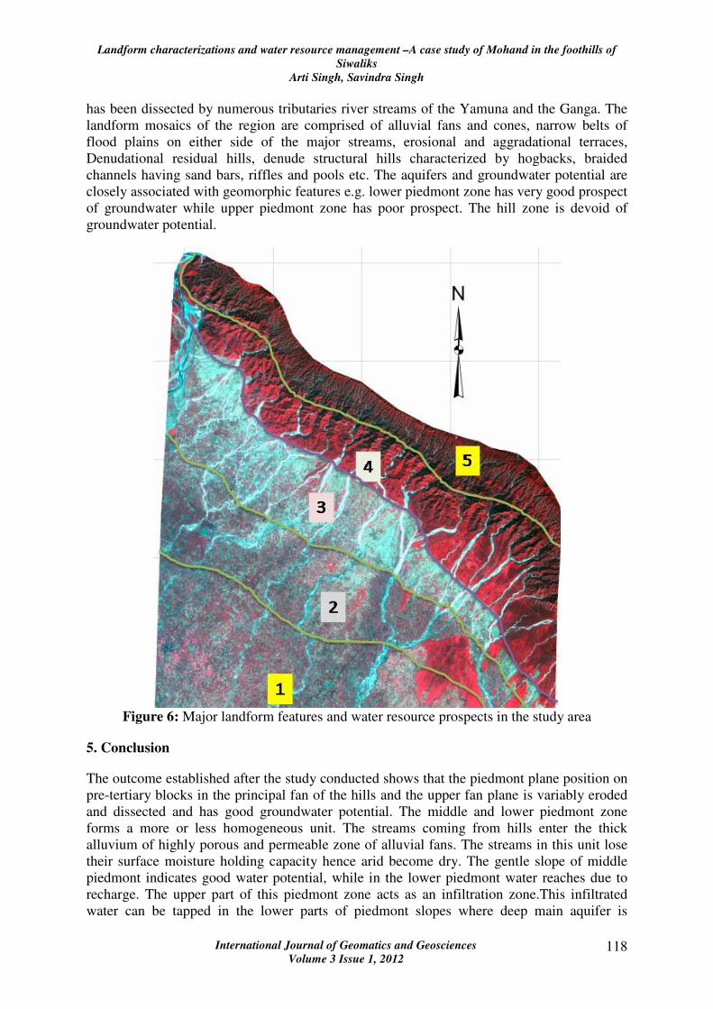
has been dissected by numerous tributaries river streams of the Yamuna and the Ganga. The
landform mosaics of the region are comprised of alluvial fans and cones, narrow belts of
flood plains on either side of the major streams, erosional and aggradational terraces,
Denudational residual hills, denude structural hills characterized by hogbacks, braided
channels having sand bars, riffles and pools etc. The aquifers and groundwater potential are
closely associated with geomorphic features e.g. lower piedmont zone has very good prospect
of groundwater while upper piedmont zone has poor prospect. The hill zone is devoid of
groundwater potential.
Figure 6: Major landform features and water resource prospects in the study area
5. Conclusion
The outcome established after the study conducted shows that the piedmont plane position on
pre-tertiary blocks in the principal fan of the hills and the upper fan plane is variably eroded
and dissected and has good groundwater potential. The middle and lower piedmont zone
forms a more or less homogeneous unit. The streams coming from hills enter the thick
alluvium of highly porous and permeable zone of alluvial fans. The streams in this unit lose
their surface moisture holding capacity hence arid become dry. The gentle slope of middle
piedmont indicates good water potential, while in the lower piedmont water reaches due to
recharge. The upper part of this piedmont zone acts as an infiltration zone.This infiltrated
water can be tapped in the lower parts of piedmont slopes where deep main aquifer is
Landform characterizations and water resource management –A case study of Mohand in the foothills of
Siwaliks
Arti Singh, Savindra Singh
International Journal of Geomatics and Geosciences
Volume 3 Issue 1, 2012 119
expected to occur in the north facing piedmont slope, the groundwater condition is quite
different. In the fan areas, the groundwater is very deep. Its depth would depend on the
thickness of the fan materials or the depth to the underlying impervious upper Siwaliks beds.
The upper Siwaliks formations consist of boulders, conglomerate and pebbles. They show
high dissection and head ward erosion by the streams. This whole unit acts as a runoff zone;
groundwater potential is poor in this unit. This unit consists of jointed sandstones, mudstones
and boulders which are resistant to fluvial erosion. Most of the litho units are very compact.
Soil profile is shallow and poorly developed. Topography is rugged. The drainage density is
medium and runoff coefficient is high. This area shows poor groundwater potential zone.
Acknowledgement
This research work was conducted for the award of Doctorate Degree from University of
Allahabad. The author wishes to thanks Dr.P.S.Roy(Dean ,IIRS) for giving her opportunity to
work in Remote Sensing Laboratory of IIRS ,Dehradun, for this research . Thanks are due
for Guruji (Savindra Sir), Papa(Late Sri D.N.Singh), Aaryyamaa and Aarna Pratap Singh (my
daughters).
6. References
1. Abrahams, A. D., (1984), Channel networks: A geomorphologic perspective, Water
resources research, 20, pp 161-188.
2. Alistair F. Pitty., (1982), The nature of geomorphology. 1970), ASCE, The ground
water management, ASCE (New York), pp 67-82.
3. Baber, P.V.L.P, (1972), Photo geomorphological analysis of the Dun valley, Bulletin
of ONGC, 9(2), pp 51-55.
4. Bloom, A.L., (1978), Geomorphology, Prentice-hall of India private limited, New
Delhi, ed.1, pp 67-82.
5. Burrough, P.A., (1981), Fractal dimensions of landscapes and other environmental
data nature, 294, pp 240-242.
6. Chorley, R.J., S.A. Schumm and D.E. Sudgen., (1985), Geomorphology, Methuen and
Co. Ltd, London, New York, pp 36-70.
7. Dikau, R., (1989), The application of a digital relief model to landform analysis in
geomorphology, in three dimensional applications in GIS, pp 108-207.
8. Howes DE, (1987), A terrain evaluation method for predicting terrain susceptible to
post logging landslide activity, B.C. technical report, pp 28-38.
9. Jha, V. C., (1988), Himalayan Geomorphology, ed.1, pp 42-56.
10. Medlicott, H. B., (1864), on the geological structure and relations of the southern
portions of the Himalayan ranges between the Ganges and Ravee, Mem. Geol. Surv.
India, 3, pp 1–86.
Landform characterizations and water resource management –A case study of Mohand in the foothills of
Siwaliks
Arti Singh, Savindra Singh
International Journal of Geomatics and Geosciences
Volume 3 Issue 1, 2012 120
11. Mukerjee A.B., (1976), Choe terrain of the Chandigarh Siwalik hills: A
morphogenetic analysis, rev. Geomor.ph.Dyn., pp 1-17.
12. Nakata T., (1972, Geomorphic history and crustal movement of the foothills of the
Himalaya,Science report of the Tohokee university, 7 series (Geography), 22(1), pp
40-177.
13. Niemann Ko, Howes DE, (1992), Applicability of digital terrain models for slope
stability assessment, Journal of the international institute of aerospace survey of earth
sciences, 3, pp 127-137.
14. Parkash, B., Sharma, R.P. & Roy, A.K., (1980), The Siwalik Group (molasse)
sediments shed by collision of continental plates. Sediment. Geol., 25, pp127-159.
15. Singh, Savindra., (1997), Geomorphology, Prayag Pustak Bhawan, Allahabad, pp 18-
107.
16. Soil Survey Staff, (1998), Soil survey manual (Jodhpur, India: Scientific Publishers),
1, pp 18-36.
17. Thakur,V.C., (1998), Structure of the Chamba nappe and position of the main central
thrust in Kashmir Himalaya. J. Asian Earth Sci., 16, pp 269-282.
18. Thorne,C.R., (1997), Channel types and morphological classification, In Thorne, C.R.,
Hey,R.D., Newson,M.D.,(Eds.), Applied fluvial geomorphology for river engineering
and management, John Wiley and sons, Chichester, pp 175-222.
19. Vaidyanathan,R., (1967), An outline of geomorphic history of India, South of north
latitude 180,Proceedings of seminar on Geomorphological studies in India, Center for
advance study in Geology, Sagar, pp 121-130.
20. Valdiya, K. S., (1988), Geology and natural environment of Nainital Hills, Kumaun
Himalaya, Gyanodaya Prakashan, Nainital, pp 155.