Land Use Chapter-Revised
23
Land Use—1 HAMILTON, MT GROWTH POLICY PART 1: EXISTING CONDITIONS LAND USE Hamilton is located in the Bitterroot Valley between the Bitterroot Mountain Range to the west and the Sapphire Mountain Range to the east. The Bitterroot River is the dominant natural feature in town. The city is built along an axis following U.S. Highway 93 which runs north-south roughly paralleling the Bitterroot River. The high- way is the primary route to Missoula to the north. According to the U.S. Census, in 2000 Hamilton encompassed about 2.31 square miles of land area. Most of the incorporated city is contained between the Bitterroot River and US 93. The city limits extend west of the River to encompass the city run cemetery. East of U.S. 93 the city boundaries are limited to an area roughly defined by Marcus Street on the south, the fairgrounds on the north and the high school to the east. Within the city limits, there are pockets of unincorporated areas that are wholly surrounded by the city. The city is annex- ing these neighborhoods where there are plans to provide services. The GlaxoSmithKline manufacturing facility is a non-contiguous parcel northeast of the city on Old Corvallis Road that is annexed as part of the city. Hamilton is located at 46°14'54" North, 114°9'35" West. It has an altitude of approximately 3,500 feet above sea level. Neighboring communities include Pinesdale (pop. 742) and Corvallis (pop. 443) to the north and Grantsdale to the south. Other communities in the county are Darby, Florence, Stevensville and Victor. Agricultural land with scattered housing developments surrounds the city. A significant floodplain and riparian area is associated with the Bitterroot River which runs on the west side of town. Within the City limits land is primarily in private ownership. Gov- ernment owned land include facilities such as local government buildings, parks, and schools. Federal owned land includes the Rocky Mountain Laboratory campus and National Guard Amory. The State of Montana Department of Fish, Wildlife, and Parks has a fishing access in town and Montana Department of Transporta- tion owns the right—of-way for the roads, trails and adjoining park on US 93. There is no Federally owned public land in the un- incorporated planning area. The USFS Bitterroot Forest, however, is located just outside the planning area boundaries. 2. Land Ownership Figure 1: Hamilton Fire Department 1. Geography
Transcript of Land Use Chapter-Revised

Land Use—1
HAMILTON, MT GROWTH POLICY
PART 1: EXISTING CONDITIONS
1. Geography
LAND USE
Hamilton is located in the Bitterroot Valley between the Bitterroot Mountain Range to the west and the Sapphire Mountain Range to the east. The Bitterroot River is the dominant natural feature in town. The city is built along an axis following U.S. Highway 93 which runs north-south roughly paralleling the Bitterroot River. The high-way is the primary route to Missoula to the north.
According to the U.S. Census, in 2000 Hamilton encompassed about 2.31 square miles of land area. Most of the incorporated city is contained between the Bitterroot River and US 93. The city limits extend west of the River to encompass the city run cemetery. East of U.S. 93 the city boundaries are limited to an area roughly defined by Marcus Street on the south, the fairgrounds on the north and the high school to the east. Within the city limits, there are pockets of unincorporated areas that are wholly surrounded by the city. The city is annex-ing these neighborhoods where there are plans to provide services. The GlaxoSmithKline manufacturing facility is a non-contiguous parcel northeast of the city on Old Corvallis Road that is annexed as part of the city.
Hamilton is located at 46°14'54" North, 114°9'35" West. It has an altitude of approximately 3,500 feet above sea level. Neighboring communities include Pinesdale (pop. 742) and Corvallis (pop. 443) to the north and Grantsdale to the south. Other communities in the county are Darby, Florence, Stevensville and Victor.
Agricultural land with scattered housing developments surrounds the city. A significant floodplain and riparian area is associated with the Bitterroot River which runs on the west side of town.
Within the City limits land is primarily in private ownership. Gov-ernment owned land include facilities such as local government buildings, parks, and schools. Federal owned land includes the Rocky Mountain Laboratory campus and National Guard Amory. The State of Montana Department of Fish, Wildlife, and Parks has a fishing access in town and Montana Department of Transporta-tion owns the right—of-way for the roads, trails and adjoining park on US 93. There is no Federally owned public land in the un-incorporated planning area. The USFS Bitterroot Forest, however, is located just outside the planning area boundaries.
2. Land Ownership Figure 1: Hamilton Fire Department
1. Geography

Land Use—2
HAMILTON, MT GROWTH POLICY
Map 1: Ravalli County—Cities and Towns
Source: Montana Department of Natural Resources

Land Use—3
HAMILTON, MT GROWTH POLICY
Most of the land within the city limits is developed with limited opportunities for in-fill development. Commercial uses generally follow Highway 93 and Main Street. Industrial uses are concentrated along the north and south portions of the US 93 corridor. For the most part, land uses are clearly delineated except for some transition areas adjacent to the commercial areas, there is little intrusion of incompatible uses in neighborhoods. Land uses in the Hamilton can be divided into the following categories:
• Single Family: This type of development includes single family detached structures and single-family at-tached units. Within the city limits, such developments are generally on smaller lots, of less than 10,000 square feet. In the old parts of town a typical lot may be 30’ by 140’ although it is not uncommon to find these smaller platted lots that have been combined into a lar-ger lot. Traditional neighborhoods are found west of US 93 and are laid out on a grid pattern. Newer neighborhoods east of 93 have somewhat larger lot size and curvilinear streets. The Arbors is a new subdivision incorporating some neo-traditional elements such as front porches, narrower streets and smaller homes on small lots. The photo to the right shows a shared drive-way which allows for more efficient use of land and higher densities.
• Multi-family: This land use designation includes apartments, hotel apartments, nursing homes, and mo-bile homes. Typical apartment buildings in Hamilton are multi-story garden apartments of two to three stories. Such units are at scattered locations throughout town. There is a concentration of assisted living units with somewhat higher density near the hospital. Mobile home units are located east of US Highway 93 near the Vester Williams ball fields. There are also several such developments in the planning area.
• Office-Transitional: Offices transitional areas are generally located between commercial and single-family residential uses with a mix of lower impact uses such as offices, public facilities and residential. Office buildings are typically one- to two-story buildings. Near downtown there are some single-family structures that have been converted to office space.
3. Land Use Patterns—City
Figure 2: Single-family homes with shared driveway
Figure 3: Multi-Family Development
Figure 4: Office in transitional area north of downtown.

Land Use—4
HAMILTON, MT GROWTH POLICY
• Commercial, General: Retail, food and beverage, lodging, personal or business service, banks, entertain-ment, professional offices, medical clinics, auto sales, farm implement, gas station, auto repair or service, drive-in restaurants, car washes, and other uses are typical types of retail land uses. In highway commercial areas, sign clutter and lack of landscaping is a common concern.
Most of the commercial development along Highway 93 is single story structures with a mix of building facades. The largest structures are limited to supermarkets—grocery stores of medium size. Big box super centers that are commonly found in larger urban areas have not been established in Hamilton.
Hamilton has good examples of commercial redevelop-ment that have adapted old industrial structures into commercial uses. These redevelopment projects encour-age investment in older areas of town while retaining the community character of Hamilton.
• Downtown Commercial: Commercial activities in the core area of town centered on Main Street. (See Section on Central Business District)
• Industrial: This land use category includes process-ing, manufacturing, contractor shops, outdoor storage, utilities, salvage yards, transfer stations, heavy equip-ment storage, warehouses, rail yards, and trucking ter-minals. This land use category has the widest variety of building types and land use impacts from outdoor proc-essing to modern clean industrial buildings.
• Public/Institutional: Includes churches, government offices, schools, airport, and museums.
• Parks – Open space (See Parks and Recreation Ele-ment)
Figure 5: Highway commercial along US 93
Figure 6: Commercial Redevelopment Project
Figure 7: Modern Industrial Building in Hamilton

Land Use—5
HAMILTON, MT GROWTH POLICY
Map 2: Existing Land Use

Land Use—6
HAMILTON, MT GROWTH POLICY
Central business districts or downtowns often define the com-munity. The impressions visitors have of a place most often relates to the impression they have of downtown. Downtowns give communities a sense of place, preserve the history of the community and differentiate the city from homogenous high-way commercial developments. A vital downtown can be the foundation for other economic development success. The com-munity survey indicated that promoting downtown Hamilton is a top priority. Some of the features that give a downtown its character and ambience are described below.
A. Boundaries
The downtown boundaries as defined by the Central Business District zoning district and the Business Improve-ment District contains 11 city blocks between Cherry Street and State Street with US 93 as the east border and 5th street as the western most border.
B. Signage/Gateway
There is no directional signage to downtown or gateway entrance treatment. The main entryway is Main Street at US 93.
C. Land Use and Zoning
The Hamilton Zoning Ordinance has a Central Business District zone that contains regulations that differentiate the downtown from the general highway commercial uses. Examples of permitted uses include retail, financial institutes, restaurants and tavern, and offices.
The CBD zone also permits dwellings but restricts such units to upper stories. Drive-thru restaurants are prohib-ited. Parking requirements provide for a credit for on-street parking spaces. Building height is limited to three stories. In addition to the “City of Hamilton Building and Site Design Guidelines” has an appendix with specific design guidelines for the downtown area to recognize the unique historical character of the district. In general there is a concentration of retail and eating/drinking establishments on Main Street. Some first floor office space is interspersed amidst the retail space. Office space is more prevalent on the periphery of the district.
4. Central Business District
Figure 8 : Downtown Hamilton
Figure 9: Central Business District Boundaries

Land Use—7
HAMILTON, MT GROWTH POLICY
D. Business Mix
Retail establishments are the most common type of business in the CBD followed by professional/medical of-fices. Office space located on both first and second floors of downtown buildings.
Table 1: Business Mix in Downtown Hamilton
Source: Field Survey, Fall 2008
E. Architectural Features
The Downtown Hamilton Historic District Design Guidelines describe the architectural character of the district.
“Buildings in downtown Hamilton date from the 1890’s to the present and vary widely in style. They include a few wooden “boomtown” structures with false fronts, early com-mercial brick structures, a variety of styles form the 30’s to the 50’s and a few more recent structures. Brick predomi-nates, with a variety of accents, from insets to cornices and other ornaments, and painted wood accents. Brick varies in color and type and may be painted. Recent awnings have replaced historical in nearly all cases. Some buildings re-tain pressed metal ceilings, leaded glass transoms, recessed entrances, and other distinctive features. Some buildings have been remodeled with stucco, and others of more re-cent construction have used this simple exterior finish.
The cohesive visual character of downtown is enhanced by similarly-scaled buildings elements. Most are two-story, similar in height, width, and upper story window and design treatments. Storefronts are mostly in alignment as you walk down the sidewalk.”
4. Central Business District (cont)
Use Number
Auto 1
Eating/Drinking Establishment 14
Finance - Insurance—Real Estate 13
Retail 36
Professional/Medical Office 32
Institutional – Government, Library, Senior Center, Post Office 4
Personal Service 7
Entertainment 1
Vacant Building or Partially Vacant 11
Lodging 1
Figure : Example of Architecture in Downtown Hamilton

Land Use—8
HAMILTON, MT GROWTH POLICY
F. Business Improvement District
A business improvement district is when downtown property owners elected to tax themselves and form a busi-ness improvement district under the powers granted by the State of Montana per MCA 17-12-11. The City appoints the BID Board of Trustees (MCA 7-12-1121), approves the annual budget and work plan (MCA 7-12-1132), and shall by resolution levy an annual assessment upon the properties within the district (MCA 7-12-1133).
The Downtown Hamilton Business Improvement District (DHBID) was established in 1998 and reauthorized for another 10-years in August of 2008. The purpose of the BID is to :
• To conserve the historic values and promote the economic vitality of Downtown Hamilton.
• To promote the health, safety, prosperity, security, and the general welfare of those who work, shop, visit, own property in, and enjoy Downtown Hamilton.
• To provide special benefits to owners of property and businesses within the DHBID.
• To serve as a unified voice, to the public and to government entities, for the owners of properties and their tenants within the DHBID.
Since 1998, accomplishments of the DHBID include overseeing downtown streetscaping and infrastructure im-provements. Maintenance of public spaces, advocacy, and marketing. The DHBID coordinated with local gov-ernment on issues such as parking, historic preservation, capital improvement planning, transportation planning, special improvement district, tax increment finance district and design standards. As part of the reauthorization process, the DHBID conducted a survey among property owners in the district. Parking and marketing were top issues for downtown business owners.
Table 2: DHBID Survey—2007
4. Central Business District (cont.)
Source: Downtown Business Improvement Survey

Land Use—9
HAMILTON, MT GROWTH POLICY
A. Zoning
Title 17 of the Municipal Code. The Zoning Ordinance was most recently updated in 2006. The regulations contain provisions for 14 zoning districts plus parking, signs, home occupations and planned unit developments. (PUDs) Zoning regulations will control for the types of land uses allowed in each district, minimum lot sizes, and setbacks. Regulations also includes standards to minimize conflicts between incompatible land uses. Following is a list of zoning districts.
17.24 Single-Family Residential 17.30 Multiple-Family Residential 17.32 Residential High Density 17.38 Historical (Residential) District (Reserved) 17.44 Mobile Home Park Residential 17.60 Professional Services Business 17.64 Transitional Neighborhood Business 17.68 Local Business 17.74 Highway Related Business 17.76 Central Business District 17.80 Commercial/Manufacturing 17.84 Manufacturing/Industrial 17.88 Public and Institutional 17.92 Planned Unit Development
B. Subdivision
The Subdivision Regulations are contained in Title 16 of the Municipal Code. The provisions in these chapters are in conformance with the Montana Subdivision and Planning Act (Title 75, Chapter 3 MCA). The regulations provide for the division of land, the provision of roads and other infrastructure to serve new developments and the promote other public safety and conservation objectives. Public works standards with specifications for road, water and sewer improvements are incorporated by reference by the subdivision regulations.
C. Design Regulations
The City has adopted “Building and Design Guidelines” for the city of Hamilton. The guidelines apply to all development within the city’s jurisdictional area for proposals to develop land or remodel existing structures. The purpose of the standards is to protect the unique character of Hamilton. The design guidelines are used for reviewing proposals for new development in regards for site design and building design. Applicants should comply with the guidelines to the extent possible. Deviations from the standards may be obtained through a special use process as established in the zoning ordinance.
D. Annexation
The procedures for annexing land to the city vary depending on the type of annexation. The Montana Code Annotated specifies the various methods of annexation (MCA, Title 7, Chapter 2, Part 42 through 47)
5. Land Development Regulations
Land Use—10
HAMILTON, MT GROWTH POLICY
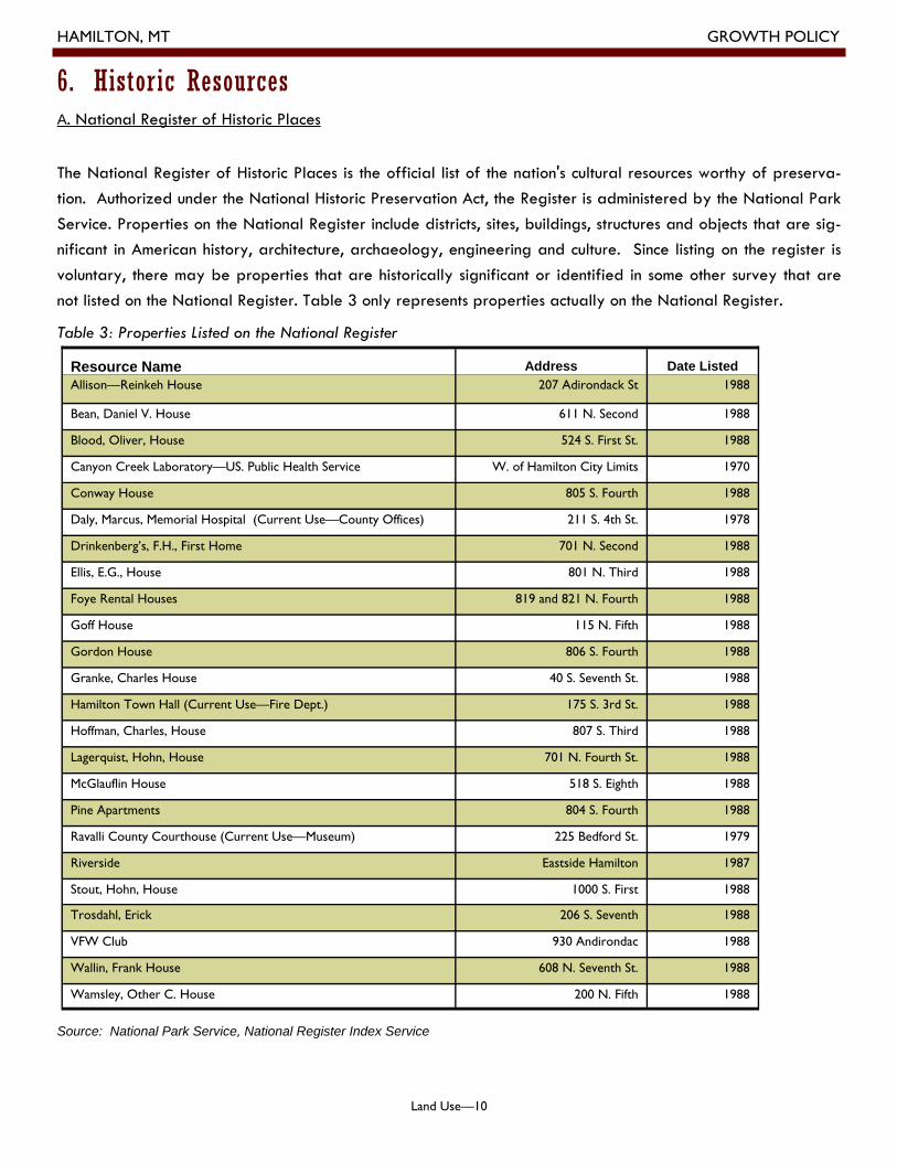
A. National Register of Historic Places
The National Register of Historic Places is the official list of the nation's cultural resources worthy of preserva-tion. Authorized under the National Historic Preservation Act, the Register is administered by the National Park Service. Properties on the National Register include districts, sites, buildings, structures and objects that are sig-nificant in American history, architecture, archaeology, engineering and culture. Since listing on the register is voluntary, there may be properties that are historically significant or identified in some other survey that are not listed on the National Register. Table 3 only represents properties actually on the National Register.
Table 3: Properties Listed on the National Register
Source: National Park Service, National Register Index Service
Resource Name Address Date Listed Allison—Reinkeh House 207 Adirondack St 1988
Bean, Daniel V. House 611 N. Second 1988
Blood, Oliver, House 524 S. First St. 1988
Canyon Creek Laboratory—US. Public Health Service W. of Hamilton City Limits 1970
Conway House 805 S. Fourth 1988
Daly, Marcus, Memorial Hospital (Current Use—County Offices) 211 S. 4th St. 1978
Drinkenberg’s, F.H., First Home 701 N. Second 1988
Ellis, E.G., House 801 N. Third 1988
Foye Rental Houses 819 and 821 N. Fourth 1988
Goff House 115 N. Fifth 1988
Gordon House 806 S. Fourth 1988
Granke, Charles House 40 S. Seventh St. 1988
Hamilton Town Hall (Current Use—Fire Dept.) 175 S. 3rd St. 1988
Hoffman, Charles, House 807 S. Third 1988
Lagerquist, Hohn, House 701 N. Fourth St. 1988
McGlauflin House 518 S. Eighth 1988
Pine Apartments 804 S. Fourth 1988
Ravalli County Courthouse (Current Use—Museum) 225 Bedford St. 1979
Riverside Eastside Hamilton 1987
Stout, Hohn, House 1000 S. First 1988
Trosdahl, Erick 206 S. Seventh 1988
VFW Club 930 Andirondac 1988
Wallin, Frank House 608 N. Seventh St. 1988
Wamsley, Other C. House 200 N. Fifth 1988
6. Historic Resources

Land Use—11
HAMILTON, MT GROWTH POLICY
B. Historic Districts
In addition to the individual buildings listed on the National Historic Register, there are three historic districts that have been established within the city limits of Hamilton. Historic Districts are established after a survey establishes boundaries that encapsulates a particular architectural type of historic context. The survey identi-fies contributing and non-contributing structures in the district. Contributing structures are those buildings or features which sustain and enforce the historic context of the neighborhood. Once the district is established, properties owners may be eligible for certain tax incentives, cities and states may impose design standards or review. The city does not currently have zoning regulations for historic preservation. The Downtown Business Improvement District has “Historic District Design Guidelines”. Following is a summary of the Historic Districts in Hamilton.
1.Hamilton Commercial Historic District
• Boundaries—Main, N. Second, S. Second, S. Third and States Streets
• Date Listed—1988 • Appendix A of the “City of Hamilton Building
and Site Design Standards” include specific guidelines for this the Historic Downtown Area
• The Downtown BID has published a walking tour brochure for this district identifying historically significant structures.
2.Hamilton Southside Residential
• Boundaries—S. First, S. Second, S. Third, S. Fourth, and S. Fifth Sts.
• Date Listed—1988 • Section 17.38 of the Zoning Ordinance is re-
served for a “Historical Residential District”
3. Rocky Mountain Laboratory Historic District
• Boundaries—900 Block of Forth St. • Date Listed 1988 • The eastern portion of the RML campus
contains structures that together comprise the Rocky Mountain Laboratories Historic District. It includes 10 buildings and site amenities such as mature trees, period lighting, and landscaping that contribute to the integrity of the district. The buildings are generally brick academic style and clapboard frame houses. The recently adopted RML Master Plan maintains the buildings within the Historic District.
Figure 11: Historic Downtown
Figure 12 : Historic Residential Area
Figure 13 : Historic RML Building

Land Use—12
HAMILTON, MT GROWTH POLICY
C. Marcus Daly Mansion
The Daly Mansion is located in the Hamilton Planning Area. The Daly Mansion was purchased by the State of Montana in 1986 through the Montana Estate Tax Forgiveness Act, in conjunction with a loan from the National Trust for historic Preservation. It is a public/private State historic site, operated by the Daly Mansion Preserva-tion Trust (DMPT) in partnership with the University of Montana. The State of Montana leases the Mansion and approximately 50 acres of grounds to the DMPT. The DMPT is charged with the full financial responsibility of the Mansion which includes salaries, maintenance, restoration and operation costs. The DMPT does not receive any operational support, at this time, from either the State or the Federal Government. The Mansion was first opened to the public in May 1987, after being closed, boarded up, and abandoned following Margaret Daly's death in 1941.
6. Historic Resources (cont.)
Figure 14 : Marcus Daly Mansion
Land Use—13
HAMILTON, MT GROWTH POLICY
Brownfields are real property, the expansion, redevelopment, or reuse of which may be complicated by the presence or potential presence of a hazardous substance, pollutant, or contaminant. Cleaning up and reinvest-ing in these properties both improves and protects the environment.
A. Leaking Underground Storage Tanks
Petroleum and hazardous substance releases can contaminate soil, groundwater and surface water, and may threaten or impact public and private drinking water supplies. Additionally, harmful and potentially explosive hydrocarbon vapors can accumulate in confined spaces such as basements, crawl spaces and utility corridors. If a petroleum release occurs, the Montana Department of Environmental Quality (DEQ) Petroleum Release Section assists the facility owner or operator to assess the potential threat to human health and the environment, and provides assistance with corrective action. The Montana Petroleum Tank Release Compensation Board (PTRCB) provides financial reimbursement of eligible corrective action cleanup costs to tank owners and operators.
The Montana DEQ database reports a total of 55 storage tank facilities in and around Hamilton. Of these tanks there are nine properties with reported leaks that are actively being remediated or monitored. All but the BPOE and Rocky Mountain Lab sites have received funding from the PTCRB PROGRAMS. Causes of con-tamination include perforation of the tank, corrosion, leaking pipes and spills. Remediation may include re-moval of contaminated soil, groundwater testing and other preventative measures. More information on these sites is available from the Department of Natural Resource and Information, Natural Resource Information System. ( http://nris.mt.gov/interactive.html)
B. Remediation Response Sites
According to the Montana Department of Environmental Quality list there are two remediation sites in the plan-ning area. These sites may include state superfund sites, Federal superfund sites, Metal Mine Reclamation Sites, brownfields and voluntary clean-up sites. The sites in the planning area are described below.
1. Garlick Helicopters (Township : 6N, Range 21W, Section 25) - Misue of empty pesticide drums. Delisted in 1999.
2. Montana Department of Transportation ((Township : 6N, Range 21W, Section 25) - Deer Pit cleanup re-quired. Delisted in 1999.
3. Rocky Mountain Laboratory—National Institute of Health (Township: 6N, Range 21W, Section 36) - Federal Facility. Former radioactive waste burial facility. Listed in 1994. All contamination was removed in 1996. Delisted in 2004.
C. Resource Conservation Recovery Act (RCRA)
The U.S. Environmental Protection Agency regulates facilities that deal with hazardous substances. The Resource Conservation Recovery Act (RCRA) requires that generators, transporters, treaters, storers, and disposers of hazardous waste provide information concerning their activities to state environmental agencies. These types of uses typically include transportation, construction, commercial cleaning and medical uses. State agencies report to regional and national U.S. Environmental Protection Agency (EPA) offices who use the data primarily to track handler permit or closure status, compliant with Federal and State regulations, and cleanup activities. There are 17 handlers in the planning area listed in the database.
7. Brownfields

Land Use—14
HAMILTON, MT GROWTH POLICY
Noise is unwanted sound. Noise has become a serious environmental problem because of its adverse effects on people and the environment. People are exposed to various levels and sources of noise every day, which af-fects them physically and psychologically. The most apparent physiological effect of noise is the temporary, or in some cases, permanent, loss of hearing. Noise can disrupt or interfere with communications and disturb sleep. It can also decrease children’s ability to discriminate among different sounds which affects their learning ability.
The predominant land use in the City is residential, and should also be considered the most noise sensitive. Other noise sensitive land uses include schools, parks, hospitals and churches. The noise sources in Hamilton consist pri-marily of transportation related noise and other attendant urban sources, such as heating and ventilating equip-ment, barking dogs, and human activities.
Because Highway 93 bisects Hamilton, traffic noise levels are relatively elevated throughout the City when com-pared with similarly sized communities. Maintenance of a moderately quiet ambience is important to maintain-ing the overall atmosphere of the area. The ambient noise levels for the City are lower in areas not adjacent to the Highway 93. Motor vehicle noise will continue to be significant even if each individual vehicle eventually meets state noise standards.
Noise ordinances are designed to protect people from the non-transportation related noise sources such as mu-sic, machinery and vehicular traffic on private property. Noise ordinances do not apply to motor vehicle noise on public streets or other transportation related noise sources that are preempted by the State or Federal gov-ernment.
The most effective method the City has to mitigate all types of noise is through reducing the impact of the noise on the community through the use of noise barriers and site design review. Mitigation through the design and construction of a noise barrier (wall, berm, or combination wall/berm) is the most common way of alleviating noise impacts. The effect of a noise barrier is critically dependent on the geometry between the noise source and the receiver. A noise barrier effect occurs when the “line of sight” between the source and receiver is penetrated by the barrier. The greater the penetration the greater the noise reduction. Another option to miti-gate noise is to use less noise sensitive uses such as office space as transitional buffers.
Noise concerns should be incorporated into land use planning to reduce future noise and land use incompatibil-ity. This is achieved by establishing standards and criteria that specify acceptable limits of noise for various land uses throughout the City. These criteria are designed to integrate noise considerations into land use plan-ning to prevent noise/land use conflicts. The noise/land use compatibility is used to assess the compatibility of proposed land uses with the noise environment.
8. Land Use and Noise

Land Use—15
HAMILTON, MT GROWTH POLICY
PART 2: TRENDS
Community character is comprised of physical elements that contribute to the individual identity of a place or neighborhood. These elements include natural features, historic and cultural resources, parks schools and other focal points. The mix of land uses and scale of buildings as well as architectural type are other important aspects of community character. Neighborhoods are more stable when the positive attributes of community character are protected. Design standards are one way to promote community character by identifying site layouts and building components that should be incorporated into new construction to main-tain the sense of place. Land use changes should represent the type of neighborhood whether it is established and traditional, rural or new suburban type of development.
Hamilton Community Survey:
• 56.3% of respondents rated “Preserving small town charac-ter.” as a top priority. This was the second highest rated priority.
• The top two planning policies sup-ported by survey respondents were “Neighborhood Revitaliza-tion” and “Promote historic pres-ervation” . Both of these policies contribute to community charac-ter.
• Limiting billboards on US 93 was the top land-use policy in the sur-vey.
Trend 1: Community Character
Figure 15 : Example of new commercial development built to
reflect the historic character of downtown through scale, build-
ing materials, signage and period light fixtures.
Figure 16: Well maintained older homes, front porches,
mature landscaping, and architectural style all contribute to
the community character of this residential neighborhood
south of downtown. .
“You will love Hamilton! The City is surrounded by beautiful mountains, and has some of the best fishing in the country. The people are very friendly, and there is a real small-town atmosphere here. You may never want to leave!”
(Quote from Growth Policy Focus Group Meeting—June, 2008)

Land Use—16
HAMILTON, MT GROWTH POLICY
The concept of “Smart Growth” was mentioned repeatedly in focus group meetings, visioning sessions and in comments from the community survey. Smart growth is a term to describe how growth and development can promotes quality of life in a community rather than diminishes the characteristics that are valued by citizens. Smart growth practices extend infrastructure in a cost-effective manner, minimize traffic congestion, use land efficiently, and protect the environment. Smart growth techniques include a combination of actions from both the public and private sectors to meet the challenges of growth.
The International City Management Association defines “Smart Growth” as follows:
“Smart growth is development that serves the economy, community, and the envi-ronment. It provides a framework for communities to make informed decisions about how and where they grow. Smart growth makes it possible for communities to grow in ways that support economic development and jobs; create strong neighborhoods with a range of housing, commercial, and transportation options; and achieve healthy communities that provide families with a clean environment.”
(Source: International City Management Association, “Getting to Smart Growth: 100 Policies for Implementation”, January 2002, www.icma.org)
The publication identifies ten Smart Growth Principles. Many of them relate to land use decisions and regulations. The City of Hamilton has already incorporated many of the suggestions such as a establishing historic districts, adopting design stan-dards, examining the fiscal impact of development and annexation, and incorpo-rating a public process to develop the growth policy. Future planning efforts and regulatory changes can continue to adopt these principles.
Trend 2: Smart Growth
Figure 17: The new pathway and park where US 93 crosses the
Bitterroot River represents a number of Smart Growth
Principles. It promotes walkable communities and repre-
sents a collaboration of a number of State and local
stakeholders. Period lighting and landscaping contribute
to a sense of place while the open space protects the
floodplain along the river.

Land Use—17
HAMILTON, MT GROWTH POLICY
Housing starts in the last ten years peaked in 2001 and 2005. There was a decline in new housing starts in 2008. Since 2000, there have been a total of 455 building permits for dwelling units issued in the city limits of Hamilton.
Figure 18: Building Permits for Dwelling Units Issued by City of Hamilton
Source: U.S. Census Bureau
Trend 3: Residential Growth
Trend 4: Commercial Growth
Use Number
Auto 35
Eating/Drinking Establishment 29
Finance - Insurance—Real Estate 39
Retail 50
Professional/Medical Office 25
Institutional – Government 7
Personal Service 20
Entertainment 3
Vacant Building or Partially Vacant 33
Lodging 7
Commercial Services 17
Contractor 21
Industrial/Warehouse 8
Most of the commercial growth of in the City over the last ten years has occurred along the US 93 corridor. A field survey of businesses was conducted in January, 2009 and extended from Skalkaho Road to the bridge crossing on US 93. According to the field sur-vey, retail is the most common type of business fol-lowed by Finance-Insurance-Real Estate offices and auto oriented uses. Contractor and industrial/warehouse uses tend to be concentrated along the north and south ends of the corridor. About half of the eating and drinking establishments were either casinos, fast-food or coffee huts. Large-scale retail such as grocery stores, hardware stores, and lawn and garden stores were mostly located along this cor-ridor as opposed to the central business district. Va-cancies rate reflects vacant suites or offices in com-mercial businesses. The vacancy rate was 11% on US 93 as opposed to 9% in the downtown area. Source: Field Survey—January, 2009
Table 4: Business Mix on US 93 Corridor

Land Use—18
HAMILTON, MT GROWTH POLICY
Trend 5: Rocky Mountain Lab Master Plan
The Rocky Mountain Laboratories (RML) is a 33-acre facility located in Hamilton, Montana. It is one of the fa-cilities that is operated by the National Institute of Health. RML was originally established in Hamilton, MT in 1928 to study Rocky Mountain Spotted Fever. It’s mission has expanded over the years and it is now one of the NIH facilities that conduct biodefense research. The facility currently employs approximately 330 individuals. The 20-year Master Plan provides for an increase in employment over the planning horizon to 427 employees. The lab is located adjacent to an established residential area with primary access on local residential streets.
The 2008 Plan is the first Master Plan for the RML campus. The Plan is a guide for orderly development of the campus that provides a framework in which design and construction may occur on the campus over the next 20 years. It does not represent a specific construction program. The planning process included RML staff inter-views, community scoping meetings and an Environmental Impact Statement. The basic goals of the RML Master Plan are:
• An attractive campus whose setting and composition promote collegial interaction and opportunities for in-formal collaboration and conversation. A flexible framework for development of the campus, one the can adapt to the potential needs of current and future RML and NIAID programs over time.
• A campus that affords a secure, supportive, and convenient work environment for RML personnel, with amenities that enhance the quality of life for staff.
• Enhanced appearance of the RML campus to complement the surrounding residential community.
• Protected and enhanced natural, historic, and scenic resources at RML.
• Enhanced communications about NIH goals and policies.
• Environmental Sustainability/Low Impact Development
In order to achieve the goals, the Master Plan calls for an expansion of the campus to the north and northeast that will require land acquisition. To mitigate the impact of this expansion the Plan incorporates the following key features:
• 100’ buffer zone around site perimeter. Parking on north end is within the perimeter.
• Concentrate tallest buildings at center of campus with a transition in height to lower buildings at the perime-ter.
• Best Management Practices (BMP) for Low Impact Development (LID) to protect natural areas and protect water quality from stormwater run-off.
• Acquire property at northeast corner of the site to create a publically accessible Interpretive Center.
• Use the Secretary of the Interior’s Standards for Rehabilitation for RML Historic District.
• Develop a pedestrian trail in the floodplain area to link to a public trail system should one be developed.
• Avoid spillover lighting into adjacent neighborhoods.
• The plan may require demolition of buildings and construction. Noise, traffic and waste disposal should be mitigated during these phases.
(A complete copy of the Plan and EIS are available at: http://orf.od.nih.gov/Planning+and+Space+Management/NIHMasterPlanning/RMLMasterPlan.htm)

Land Use—19
HAMILTON, MT GROWTH POLICY

Land Use—20
HAMILTON, MT GROWTH POLICY
2. Main Street Program
The State of Montana Main Street program uses an integrated, strategic Four Point Approach to Downtown re-vitalization that includes the following elements: Organization, Design, Economic Restructuring and Promotion. It is an incremental, grass-roots driven effort based on local community priorities and investment. It is based on the principal that effective Downtown revitalization doesn’t “just happen” – it requires focused energy and strategic decisions based on sound market analysis and community values. Typical Main Street program activities are business retention, recruitment, promotion, safety, maintenance, and planning. The underlying premise is to en-courage economic development within the context of historic preservation. The Main Street approach encour-ages communities to use their unique assets--distinctive architecture, pedestrian friendly atmosphere, local own-ership, and personal services--to rebuild their downtowns. The DHBID provides many services associated with a Main Street Program. The State of Montana Main Street Program was established in 2005 and consists of two types of designation:
1) Fully designated communities. Designated Communities must hire at least a part-time paid executive director and must have more than 5,000 residents. Designated communities receive on-site technical training delivered by the National Main Street Center. 2)Affiliate Communities: Affiliate communities are those with fewer than 5,000 residents. There is no require-ment to hire a paid director. However, affiliate communities do not receive on-site technical training. The pur-pose of the affiliate program is to provide educational and networking opportunities for rural communities. (Source: http://mtmainstreet.mt.gov/)
1. Downtown Master Plan The City of Hamilton does not have a comprehensive Master Plan. The purpose of a master plan is to illustrate the overall vision of the Downtown and to provide an implementation strategy that enables the City, property owners and citizens to make informed, strategic decisions about future development and public improvements. A master plan details a Downtown urban design framework and identifies specific public improvements includ-ing streetscape amenities, directional signage systems, opportunity sites for infill and/or redevelopment, circula-tion framework and parking improvements. The elements of the master plan vary depending on the needs of the community. Some elements may be separate planning documents that supplement the other planning ef-forts. Following are common elements of a Downtown Master Plan.
• Historic Preservation & Urban Design
• Streetscape & Public Amenities
• Parking, Transportation & Pedestrian Improvements
• Marketing Plan
• Land use, signage & zoning
PART 3: OPPORTUNITIES—BEST PRACTICES

Land Use—21
HAMILTON, MT GROWTH POLICY
The U.S. Environmental Protection Agency (EPA) Brownfields Program provides direct funding for brownfields assessment, cleanup, revolving loans, and environmental job training. To facilitate the leveraging of public re-sources, EPA’s Brownfields Program collaborates with other EPA programs, other federal partners, and state agencies to identify and make available resources that can be used for brownfields activities. In addition to direct brownfields funding, EPA also provides technical information on brownfields financing matters. EPA Brownfields Grants are listed below.
• Assessment Grants
• Revolving Loan Fund Grants
• Cleanup Grants
• Job Training Grants
• Training, Research, and Technical Assistance Grants
(http://www.epa.gov/brownfields/assessment_grants.htm)
4. EPA Brownfield Programs
Montana's Community Preservation program, also known as the Certified Local Government (CLG) program, is a means of preserving historic re-sources in communities. The program is based upon an appreciation of the community's historic pat-terns, architectural styles, influential architects and builders, significant people and events, and historic and prehistoric archeology.
In partnership with the National Park Service under the National Historic Preservation Act, the Montana State Historic Preservation Office (SHPO) certifies local governments with historic preservation pro-grams, provides technical preservation assistance, and annually dedicate 10% of federal funding to cities, towns, and counties that commit themselves to preserving their heritage under the program. Each CLG receives $1,000 to $5,000, depending on their level of activity and the federal allocation. Towns can spend in ways that best assist their com-munity's local preservation needs.
http://mhs.mt.gov/shpo/
3. Historic Preservation—Certified Cities
The National Historic Preservation Act, as amended (16 USC 470 et
seq.), established the Certified Local Government program. A local gov-
ernment that meets the following criteria is eligible to apply for certifica-
tion. The criteria have been set forth by federal regulation, 36 CFR 61.
A. Enforce the appropriate federal, state, or local heritage resource
legislation for the designation and protection of historic properties
within its jurisdiction.
B. Establish a qualified historic preservation Commission.
C. Appoint a local Historic Preservation Officer.
D. Maintain survey and inventory information on historic and prehis-
toric properties.
E. Institute and update a local historic preservation plan and include the
Commission and local Historic Preservation Officer in local planning.
F. Provide for adequate public participation in the historic preservation
program, including the process of recommending properties to the
National Register.
G. Meet the Standards for Performance
H.Report on preservation activities.
I. Attend at least one training session annually and train new local His-
toric Preservation Officers.
J. Avoid conflict of interest.
K. Perform other responsibilities delegated to the CLG by the SHPO.

Land Use—22
HAMILTON, MT GROWTH POLICY
A. Work with the Business Improvement District to prepare a downtown master plan to strengthen the commu-nity center for shopping, finance, entertainment and culture.
B. Coordinate with the Business Improvement District to investigate the benefits of participation the Montana Main Street program.
C. Promote retail uses on first floor of buildings on Main Street to create a uninterrupted shopper traffic for shops on Main Street.
D. Use entry treatments, signage and public art to attract traffic from US 93 to the downtown area.
E. Encourage the use of on-street parking for customers of downtown businesses.
F. Reinforce downtown development through strategic public-private investment that will encourage further investment in the downtown
G. Create a vibrant atmosphere to attract new businesses and residents with a mix of entertainment, eateries, public facilities, office, and medium-high density multi-family uses.
H. Promote events that contribute to the lively atmosphere of downtown and attract customers and residents to the area.
PART 4: GOALS & POLICIES
Goal 2: Promote an economically viable Central Business District.
A. Encourage variety, quality, and innovation in land use practice through modern, flexible land development regulations.
B. Promote quality commercial and industrial development.
C. Coordinate development review with different local, state and federal agencies that are involved in various aspects of development or may be affected by new development.
D. Continue to periodically review development standards to determine if they are adequate to meet health and safety concerns and are consistent with desired development patterns.
E. Require buffers between different types of land use that may cause conflict between the property owners.
F. Incorporate amenities into developments such as pocket parks, activity nodes, courtyards, plazas, and gath-ering places.
G. Coordinate with the National Institute of Health to make sure that any future expansion of the Rocky Moun-tain Lab does not negatively impact the surrounding neighborhood.
Goal 1: Maintain and enhance high quality development throughout the city.

Land Use—23
HAMILTON, MT GROWTH POLICY
Goal 5: Confine impacts of development to the site or mitigate adverse impacts.
There should be energy efficient affordable housing. Try to encourage central affordable housing to replace energy needs.
A. Development projects should reflect the character and scale of nearby properties.
B. Investigate the adoption of zoning regulations for historic districts and consider participation in the Certified Local Government Program.
C. Review development regulations and amend provisions for signs, billboards, landscaping and other fea-tures promote an attractive gateway to the community along the US 93 corridor.
D. New development should protect the visual and scenic quality of the community.
E. Work with community groups and the state agencies to preserve and rehabilitate sites of historic signifi-cance within the community.
F. Transition areas between residential land uses and the RML site or commercial core should allow for rede-velopment and new investment while being sensitive to the existing character of surrounding neighborhoods.
Goal 4: Preserve the small town and community character of Hamilton.
A. Annexations should provide a direct benefit to the City and should be evaluated for fiscal soundness.
B. Annexations should represent the logical extension of city boundaries and services.
C. The City should consider an intergovernmental agreement with the county to regulate development adjacent to the city and ensure such development is consistent with the goals of the city.
D. Allow for innovative development that promotes principles of smart growth.
E. Promote in-fill development that is served by infrastructure and compatible with existing neighborhoods.
F. Direct development to areas already served by infrastructure.
G. Consider annexation and extension of services where such action will have a public health or environmental benefit.
H. Annexation that is not contiguous to the city it should meet all of the objectives of this section.
A. New development should mitigate potential traffic safety hazards and should not create undue traffic con-gestion.
B. Include performance standards for industrial and commercial development in the transition areas to make sure such uses do not negatively impact nearby residential uses.
C. Investigate brownfield programs to clean-up hazardous sites for redevelopment.
D. Reduce the impact of noise on the community through design features that are incorporated during site re-view and through the use of land use transitions.
E. Identify programs to assist property owners with the clean-up of sites that are contaminated from leaking underground storage tanks.
Goal 3: Encourage the orderly growth and development of the community.


![Lake Newell Reservoir Land Use Policy - eid.ca · EID POLICY MANUAL . LAND . Lake Newell Reservoir Land Use Policy. Revised Jan 17 2017 [supersedes May 9 2016]](https://static.fdocuments.in/doc/165x107/5b34c1f37f8b9a3a6d8c6b6e/lake-newell-reservoir-land-use-policy-eidca-eid-policy-manual-land-lake.jpg)