Land Use Analysis Report - Kenya Power |...
15
Land Use Analysis Report Report Prepared for Gulf Power Ltd. NEMA Reference No. NEMA/PR/5/2/6972 Report No. 201004-EIA-004 July 2010 Prepared By: Mr. G. Njoroge Eco Plan Kenya Occidental House, Westlands Nairobi, Kenya Your Health, Safety & Environment Partner
-
Upload
dangkhuong -
Category
Documents
-
view
216 -
download
0
Transcript of Land Use Analysis Report - Kenya Power |...
Land Use Analysis Report
Report Prepared for
Gulf Power Ltd.
NEMA Reference No. NEMA/PR/5/2/6972
Report No. 201004-EIA-004
July 2010
Prepared By: Mr. G. NjorogeEco Plan Kenya
Occidental House, WestlandsNairobi, Kenya
Your Health, Safety & Environment Partner
ESIA Study of the Proposed IPP Power Plant, Mombasa Road, Athi River, Kenya
Page 2
Contents
1 INTRODUCTION ......................................................................................................................... 3
1.1 HISTORY OF MAVOKO MUNICIPAL COUNCIL ................................................................................ 3
1.2 LOCATION .............................................................................................................................. 3
1.3 POPULATION ........................................................................................................................... 4
2 LAND USE ANALYSIS BY ACTIVITIES ..................................................................................... 5
2.1 RESIDENTIAL .......................................................................................................................... 5
2.2 INDUSTRIAL ............................................................................................................................ 5
2.3 COMMERCIAL .......................................................................................................................... 5
2.4 EDUCATIONAL ......................................................................................................................... 6
2.5 RECREATIONAL ....................................................................................................................... 6
2.6 PUBLIC PURPOSE .................................................................................................................... 6
2.7 PUBLIC UTILITIES ..................................................................................................................... 6
2.8 TRANSPORTATION ................................................................................................................... 6
2.9 DEFERRED LAND ..................................................................................................................... 6
3 SITE ANALYSIS ......................................................................................................................... 8
3.1 CURRENT AND PAST LAND USE AND DEVELOPMENT ON THE SITE ................................................... 8
3.2 CURRENT AND PAST LAND USE AND DEVELOPMENT ON ADJACENT AND NEARBY LANDS .................... 9
3.3 LAND REQUIREMENTS FOR VARIOUS CATEGORIES OF INDUSTRIES ............................................... 10
3.4 PROJECT COMPATIBILITY WITH ADJACENT AND NEARBY LAND USES ............................................. 10
3.5 TRANSPORT AND ACCESSIBILITY ............................................................................................. 10
3.6 SERVICES: ELECTRICITY, WATER AND SANITATION ..................................................................... 11
3.7 PLOT COVERAGE AND BUILDING LINES ..................................................................................... 11
3.8 LEGAL AND INSTITUTIONAL FRAMEWORK .................................................................................. 11
3.9 APPROVALS AND PLANNING PERMISSION .................................................................................. 12
4 PLANNING ISSUES ................................................................................................................. 13
5 CONCLUSIONS AND RECOMMENDATIONS .......................................................................... 14
5.1 CONCLUSION ........................................................................................................................ 14
5.2 RECOMMENDATIONS .............................................................................................................. 14

ESIA Study of the Proposed IPP Power Plant, Mombasa Road, Athi River, Kenya
Page 3
1 Introduction
This brief presents a land use analysis for the proposed power plant project. Itbegins with background information on Mavoko Municipal Council anddiscusses the past, current and future land use development frameworksoperating in the area. A description of the current and recent past land useson the site and on adjacent and nearby lands is provided. A suitability andland use compatibility analysis for the proposed project is also presented.
1.1 History of Mavoko Municipal Council
Mavoko town is one of the oldest towns in the Kenya. The Town came intoexistence through trading with the main business activity being centred at theold town area next to the railway station. It began as a Local Native Council(LNC) in 1940 then became an African District Council (ADC).In 1974 it wascurved from the County Council of Masaku and became an Urban Council. Itwas upgraded to a Town Council in 1987 and to a Municipal Council status in1993. The Council being a service provider operates under the LocalGovernment Act. The Council has core functions of planning all developmentactivities within its area of jurisdiction.
1.2 Location
Mavoko Municipality covers an area of 693 km². It borders Nairobi CityCouncil to the west and covers Katani and Ruai on Kangundo road. It extendsto Muthwani-Lukenya and Makutano (Kyumbi) to the east where it bordersMachakos Municipal Council. It covers Kapiti plains to the south west towardsKitengela area where it borders Olkejado County Council and to Embakasi atthe Nairobi City Council border.

ESIA Study of the Proposed IPP Power Plant, Mombasa Road, Athi River, Kenya
Page 4
1.3 Population
According to the 1999 population census, the population within MavokoMunicipal Council was 47,971 people while according to a physicaldevelopment research project of 2004 the total population was 61,809 people.Today the population of the town is estimated to be 80,000persons. Thepopulation growth rate for the municipality is 1.7% and for Athi RiverTownship is 5.2%. It is observed that the population grows in the eveningbecause of workers from Nairobi and other surrounding areas who residewithin the town. Most of the population is hosted at the Municipality’s satellitetowns of Mlolongo, Athi River and Kyumvi.
Figure 1: Location map of Athi River in the context of Nairobi Metropolitan Area
ESIA Study of the Proposed IPP Power Plant, Mombasa Road, Athi River, Kenya
Page 5
2 Land use analysis by activities
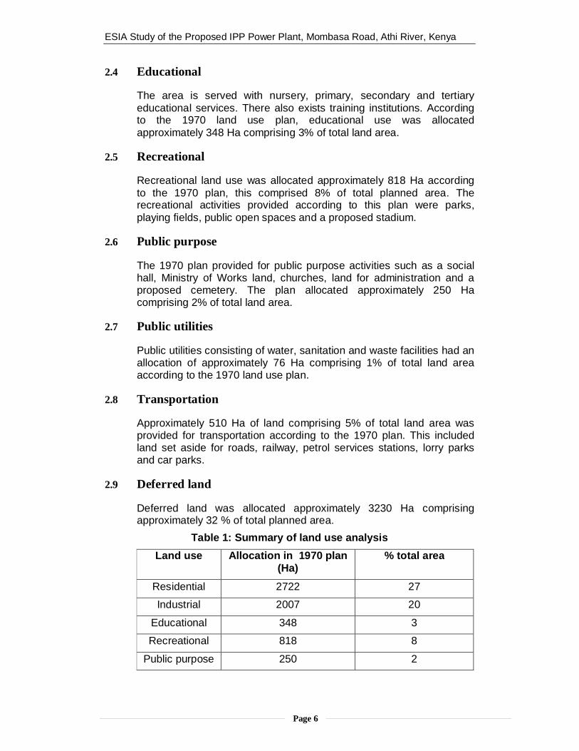
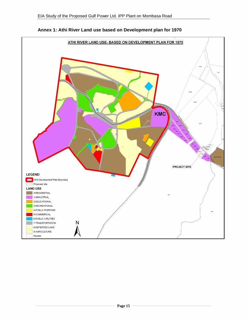
Land use within the Municipality is divided into nine categories namelyresidential, commercial, industrial, recreational, educational, publicpurpose and public utility. The allocation and character of land use inthe town is explained below. The land use as per the Athi RiverDevelopment Plan prepared in 1970 is captured in a map attached asannex 1 of this report. Table 2.1 below provides a quantified summaryof the land use analysis.
2.1 Residential
The Municipality acts as a dormitory town for Nairobi city, other nearbygrowing centres and also provides housing for the local industrialworkers. According to the 1970 land use plan residential use wasdivided into three sub-categorises namely low, medium and highdensity and allocated approximately 2722 Ha of land comprisingapproximately 27% of total land area. There has been a lot ofdevelopment since 1970 that did not entirely conform to the plannedland use.
2.2 Industrial
The area is primarily industrial in character with factories employingthree quarters of the town's residents. There are many factories suchas Kenya Meat Commission, E A Portland Cement, Bamburi Cement,Kapa Oil Refinery, E P Z A, Nation Media, Mabati Rolling Mills, DevkiSteel Works Company, Athi River steel rolling plant, Sun-Rose andPrimarosa flower companies among others. In total there are over sixtyfactories. The factories are mainly steel, cement manufacturing, flowerfarms and textile manufacturers. The Export Processing Zone employsa majority of the women population.According to the 1970 land use plan Industrial use was allocatedapproximately 2007 Ha covering 20% of the total land area. Thedevelopment since 1970 did not conform to the plan.
2.3 Commercial
The area is characterised by a number of whole sale and retailbusinesses, small and medium scale enterprises and commercialservice providers. According to the 1970 land use plan, commercialuse was allocated approximately 102 Ha comprising 1% of the totalland area.
ESIA Study of the Proposed IPP Power Plant, Mombasa Road, Athi River, Kenya
Page 6
2.4 Educational
The area is served with nursery, primary, secondary and tertiaryeducational services. There also exists training institutions. Accordingto the 1970 land use plan, educational use was allocatedapproximately 348 Ha comprising 3% of total land area.
2.5 Recreational
Recreational land use was allocated approximately 818 Ha accordingto the 1970 plan, this comprised 8% of total planned area. Therecreational activities provided according to this plan were parks,playing fields, public open spaces and a proposed stadium.
2.6 Public purpose
The 1970 plan provided for public purpose activities such as a socialhall, Ministry of Works land, churches, land for administration and aproposed cemetery. The plan allocated approximately 250 Hacomprising 2% of total land area.
2.7 Public utilities
Public utilities consisting of water, sanitation and waste facilities had anallocation of approximately 76 Ha comprising 1% of total land areaaccording to the 1970 land use plan.
2.8 Transportation
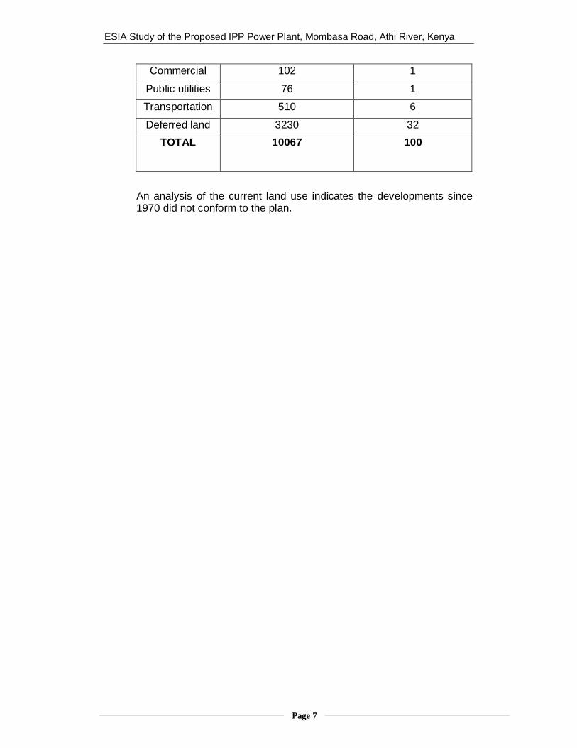
Approximately 510 Ha of land comprising 5% of total land area wasprovided for transportation according to the 1970 plan. This includedland set aside for roads, railway, petrol services stations, lorry parksand car parks.
2.9 Deferred land
Deferred land was allocated approximately 3230 Ha comprisingapproximately 32 % of total planned area.
Table 1: Summary of land use analysisLand use Allocation in 1970 plan
(Ha)% total area
Residential 2722 27
Industrial 2007 20
Educational 348 3
Recreational 818 8
Public purpose 250 2
ESIA Study of the Proposed IPP Power Plant, Mombasa Road, Athi River, Kenya
Page 7
Commercial 102 1
Public utilities 76 1
Transportation 510 6
Deferred land 3230 32TOTAL 10067 100
An analysis of the current land use indicates the developments since1970 did not conform to the plan.
ESIA Study of the Proposed IPP Power Plant, Mombasa Road, Athi River, Kenya
Page 8
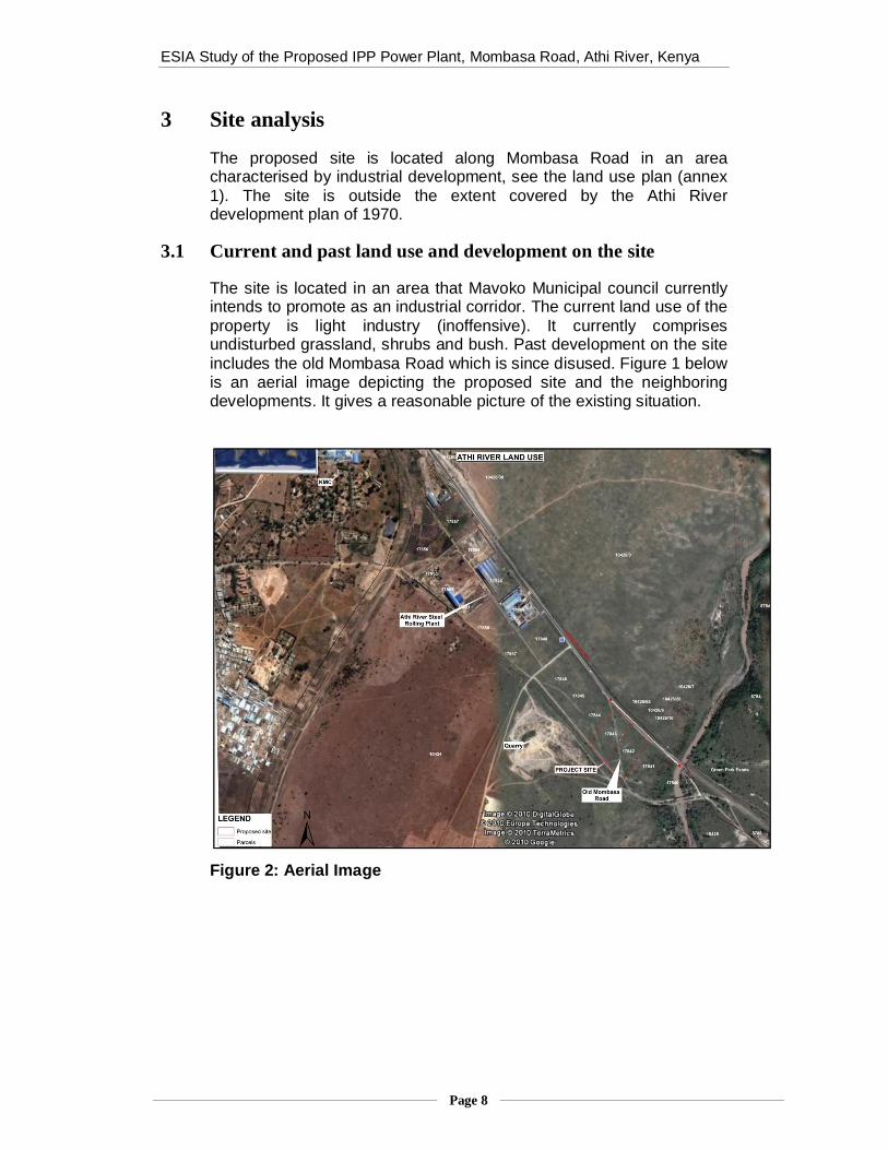
3 Site analysis
The proposed site is located along Mombasa Road in an areacharacterised by industrial development, see the land use plan (annex1). The site is outside the extent covered by the Athi Riverdevelopment plan of 1970.
3.1 Current and past land use and development on the site
The site is located in an area that Mavoko Municipal council currentlyintends to promote as an industrial corridor. The current land use of theproperty is light industry (inoffensive). It currently comprisesundisturbed grassland, shrubs and bush. Past development on the siteincludes the old Mombasa Road which is since disused. Figure 1 belowis an aerial image depicting the proposed site and the neighboringdevelopments. It gives a reasonable picture of the existing situation.
Figure 2: Aerial Image

ESIA Study of the Proposed IPP Power Plant, Mombasa Road, Athi River, Kenya
Page 9
The current site characteristics are captured in figures 3 and 4 below.
3.2 Current and past land use and development on adjacent andnearby lands
The adjacent land parcels comprise undisturbed grassland, shrubs andbush. They have not been developed previously. The land uses withina 1Km radius of the proposed site are also vacant. The following landuses are to be found beyond a 1Km radius of the site:-
Industrial – Athi River Steel Plant, proposed factory and warehousefor Tile & Carpet Center and Kenya Meat Commission
Residential – Green Park Estate (approximately 0.6km from site)
Quarry
Vacant land – undeveloped grassland and Stony Athi River.Figures 5 – 7 below show the nearby developments.
Figure 3: Depicts the existing sitecharacteristics, Mombasa Road to the left andold Mombasa Road to the right
Figure 4: The yellow arrow marks the site,also in this picture can be seen the 15m accessroad
Figure 5: Athi river steel rollingplant
Figure 6: Factory andwarehouse for Tile and CarpetCentre
Figure 7: Quarry

ESIA Study of the Proposed IPP Power Plant, Mombasa Road, Athi River, Kenya
Page 10
3.3 Land requirements for various categories of industries
The categories of industries are heavy, medium, light, small andmedium and special industries. They are determined by the type oftechnology used, type of by products produced and the workforce.Land requirements for the different types of industries are shown intable 2 below.
Table 2: Land requirements for industriesType ofIndustry
Land Requirements inha.
CatchmentPopulation
Min LandSize in Ha.
Light 4 30,000 0.05
medium 10 100,000 to500,000 2
Heavy none Over 1 million 20
The specific land requirement for heavy industries is not indicated intable 3.1 above because it may transcend one town and will depend onthe type of technology and the level of services available.
3.4 Project compatibility with adjacent and nearby land uses
A suitability analysis shows that the site is suitable for the proposedproject. The project is compatible with adjacent and nearby uses.Criteria for suitability and compatibility analysis are shown in table 3below.
Table 3: Suitability analysis table
Factors/constraints Suitable Notsuitable1. Soil
2. Topography3. Vegetation4. Wind direction5. Land use zoning6. Distance to main road7. Distance to rail way8. Distance from incompatible land uses9. Distance from river and riparian reserve10. Distance to and availability of fire fighting11. Distance to and availability of labour12. Neighbouring users13. Land size
3.5 Transport and Accessibility
The property is accessible via a 15m wide access road that connects toMombasa Road at a distance of approximately 900m. It lies at adistance of approximately 4km from the railway line and 10km from thetrain station.
ESIA Study of the Proposed IPP Power Plant, Mombasa Road, Athi River, Kenya
Page 11
Vehicles accessing the site might interfere with traffic along MombasaRoad. Sufficient parking facilities will need to be provided on site tocater for both small and heavy vehicles. Similarly, sufficient spaceshould be provided on site for loading and offloading.
3.6 Services: electricity, water and sanitation
The property is served with electricity, there are power lines on theback along Mombasa Road. Currently the site is not connected to anywater supply lines. There are no sewerage services available.
3.7 Plot coverage and building lines
The project will occupy two parcels of land each having an area of 2hectares. The plot coverage of the proposed development should notexceed 75 per cent to allow for sufficient scope for circulation, utilities,services and facilities.The building lines for the proposed development should be 25 to 31mfrom the centreline of Mombasa road and 12 to 15m from the centrelineof the access road.
3.8 Legal and Institutional framework
The proposed project will be guided by various laws, and regulationsrelated to land use planning. These are listed below:-- Physical Planning Act (cap 286)- Environmental Management and Coordination Act (EMCA) 1999- Building code 2000- Local Government Act (cap 265)- Land Titles Act (cap 282)- Way Leaves Act ( cap 292)- Registration of Titles Act (cap 281)- Factories and other places of work Act (cap 514)- Mavoko Municipal Council by laws- The Zoning guidelines for the areaThe main institutions with which the proposed project should maintaincontact with in regards to land use planning include the MavokoMunicipal council, the Machakos/Athi River District Physical PlanningOffice, the District Environmental Office and the District LandAdministration Office.

ESIA Study of the Proposed IPP Power Plant, Mombasa Road, Athi River, Kenya
Page 12
3.9 Approvals and planning permission
The current use of the property is light industry (in offensive).Consideration should be made for application of a change of use oextension of use to include heavy industrial.

ESIA Study of the Proposed IPP Power Plant, Mombasa Road, Athi River, Kenya
Page 13
4 Planning issues
1. Municipal Council of Mavoko lacks a frame work to guide andcontrol development within it area of jurisdiction save for the oldtown area whose development plan is already obsolete having beenprepared in 1974.
2. Pressure from rapid expansion of Nairobi City towards Mavoko andrapid urbanization in the district has stretched the council’s ability todeliver services.
3. The old Mombasa road cuts across the property. Survey plans donot indicate such a road.
4. The means of transmitting generated power from the site to theintended consumer might raise issues relating to way leave.
5. Lack of sufficient fire-fighting services in the area.

EIA Study of the Proposed Gulf Power Ltd. IPP Plant on Mombasa Road
5 Conclusions and recommendations
Based on the foregoing analysis of land use and the emerging planningissues, the following conclusions and recommendations are provided.
5.1 Conclusion
The proposed project satisfies majority of the land use planning regulationsand guidelines. It is compatible with neighbouring users and suitable for theproposed site given the industrial character. However, in order to ensurefulfilment of the planning standards, the recommendations provided belowshould be considered.
5.2 Recommendations
The project should adhere to land use zoning regulations.
An application for change of land use from light industrial to heavyindustrial should be undertaken.
The project should implement current state of art technology and bestpractice to mitigate against environmental impacts.
Movoko Municipal Council should prepare a land use plan to guide andcontrol development in light of the existing land use.
The industrial corridor along Mombasa Road should be zoned for heavyindustrial use.
Accessibility to the site should not be directly from Mombasa Road. Thetraffic generated due to the project should ensure minimum interferencewith traffic along Mombasa.
Further analysis of the effect radius of environmental impacts of theproposed project should be considered together with this report.
Confirmation should be made that the old Mombasa Road wasdegazzeted.
The means of transmitting power from the site to the intended consumershould adhere to the relevant land use planning framework.
EIA Study of the Proposed Gulf Power Ltd. IPP Plant on Mombasa Road
Page 15
Annex 1: Athi River Land use based on Development plan for 1970