Land North of Didcot oad, Harwell INTRODUCTION · (Natural England) Lowland Village Farmlands LCT...
8
Harwell Didcot West Hagbourne A34 Rowstock Site Boundary Woodland Primary Roads Secondary Roads Public Footpaths/ Bridleways Byways Water Course Developed Land Proposed Development Area Land North of Didcot Road, Harwell 01 Housing Need Every Council is required by the Government to boost significantly the supply of housing and to make planning decisions in the light of a presumpon in favour of sustainable development. Vale of White Horse District Council is required to provide enough housing land to meet its full future housing needs. Approval of this development will help towards meeng the housing need within the local authority area. Introducon Gladman Developments Ltd has successfully invested in communies throughout the UK for over 20 years, developing high quality and sustainable residenal, commercial and industrial schemes. A process of public consultaon is being undertaken by Gladman Developments Ltd in order to present the emerging development proposal for land off Didcot Road, Harwell to the local community. We are proposing a new residenal development of up to 60 homes, together with new green infrastructure. The purpose of this consultaon process is to outline the details of the draſt scheme and seek comments from the local community which will be considered before the planning applicaon is lodged with Vale of White Horse District Council. Site Descripon The site comprises 4.23ha of arable land and is located to the north east of Harwell. Didcot Road, from which the site access is proposed, runs along the southern boundary, just beyond which exisng residenal development is found. The Applicaon Gladman Developments Ltd intends to submit a planning applicaon to Vale of White Horse District Council in early 2016. Why is the site suitable for development? The site is sustainably located with easy access to a wide range of exisng community amenies and the local public transport network. It is a logical housing site with exisng development to the south and west. The site can be safely accessed via Didcot Road and already enjoys pedestrian links to the surrounding area. Development Proposals • A residenal development to include up to 60 new homes of varying sizes, types and tenures; • Green Infrastructure, comprising: new publicly accessible greenspace, an equipped play area, recreaonal paths and tree and shrub planng. • Creaon and maintenance of new community orchard. INTRODUCTION
Transcript of Land North of Didcot oad, Harwell INTRODUCTION · (Natural England) Lowland Village Farmlands LCT...

Harwell
Didcot
West Hagbourne
A34
Rowstock
Site Boundary
Woodland Primary Roads
Secondary Roads Public Footpaths/BridlewaysByways
Water CourseDeveloped Land
Proposed Development Area
Land North of Didcot Road, Harwell01
Housing NeedEvery Council is required by the Government to boost significantly the supply of housing and to make planning decisions in the light of a presumption in favour of sustainable development. Vale of White Horse District Council is required to provide enough housing land to meet its full future housing needs. Approval of this development will help towards meeting the housing need within the local authority area.
IntroductionGladman Developments Ltd has successfully invested in communities throughout the UK for over 20 years, developing high quality and sustainable residential, commercial and industrial schemes. A process of public consultation is being undertaken by Gladman Developments Ltd in order to present the emerging development proposal for land off Didcot Road, Harwell to the local community. We are proposing a new residential development of up to 60 homes, together with new green infrastructure. The purpose of this consultation process is to outline the details of the draft scheme and seek comments from the local community which will be considered before the planning application is lodged with Vale of White Horse District Council.
Site DescriptionThe site comprises 4.23ha of arable land and is located to the north east of Harwell. Didcot Road, from which the site access is proposed, runs along the southern boundary, just beyond which existing residential development is found.
The ApplicationGladman Developments Ltd intends to submit a planning application to Vale of White Horse District Council in early 2016.
Why is the site suitable for development?The site is sustainably located with easy access to a wide range of existing community amenities and the local public transport network. It is a logical housing site with existing development to the south and west. The site can be safely accessed via Didcot Road and already enjoys pedestrian links to the surrounding area.
Development Proposals• A residential development to include up to 60 new homes of varying
sizes, types and tenures;• Green Infrastructure, comprising: new publicly accessible greenspace,
an equipped play area, recreational paths and tree and shrub planting.• Creation and maintenance of new community orchard.
INTRODUCTION

1802
1840
18832015
1932
1972-1975
2006
Land North of Didcot Road, Harwell02HISTORIC CONTEXT
Historic MapsThe adjacent plans show the historic development of Harwell over the last 213 years. The 1802 map illustrates that the site forms two fields to the north east of the historic core of Harwell. The 1883 map shows orchard planting west of the site and by 1932 development has spread along Didcot Road to the south of the site, between Didcot Road and the Driftway. The 1975 plan shows relatively little change adjacent to the site, with expansion of the village to the west. The 2006 plan illustrates the most significant change to the study area, with the A34 within cutting to the east. Further development is currently under construction within Didcot to the east.

NCA 108: UPPER THAMES CLAY VALES
NCA 116: BERKSHIRE
& MARLBOROUGH DOWNS
National Character Area (NCA) Boundary (Natural England)
Lowland Village Farmlands LCTLocal Character Area P: Harwell (WH/2)Rolling Farmlands LCTLocal Character Area L: Blewbury (WD/6)
Oxfordshire Wildlife & Landscape Study (OWLS), 2004
Site Boundary
Land North of Didcot Road, Harwell03EXISTING CHARACTER
Landscape CharacterThe Site lies within the “Lowland Village Farmlands” Landscape Character Type, covered by the Oxfordshire Wildlife & Landscape Study (OWLS), 2004, undertaken by Oxfordshire County Council and within the Local Character Area P: Harwell (WH/2).
The southern portion of the site proposed for development is generally flat lying at 78 to 79m AOD. Within the northern half of the site, the land gently slopes down towards a stream. To the north of the watercourse, the land rises to a minor ridge at Cow Lane at approximately 80m AOD similar to the site. Generally, the land to the north and west of the site is undulating and to the south, the land gently rises to a local vantage point, Hagbourne Hill at 137m AOD 2.5km from the site.
There is no hedgerow along the majority of the Didcot Road frontage to the site, leaving open views across the Site for vehicular and pedestrian users of the road and adjacent footpath. Mature trees and a gappy hedgerow follow the site boundary/road edge at the eastern end of Didcot Road, and for a short stretch to the west. A row of properties (predominantly bungalows) face the Site on the southern side of Didcot Road.
Settlement CharacterAlthough the vernacular character is generally strong in the villages, most of them have varying amounts of modern residential development. In some villages, such as Harwell, East and West Hagbourne, there is a significant proportion of modern housing. Ribbon development is also a feature along main roads such as the A417, and urban fringe development is more noticeable around main towns such as Didcot.
• Large-scale agricultural barns can also be visually dominant, particularly when located on roadsides.
• Motorways and main roads such as the A4130 and A417, with their associated junctions and roundabouts, have a major impact , particularly in the area around Didcot. Along the A34, landscaping and tree planting helps to mitigate the impact of continuous traffic.
Above: Examples of built form and materials used within the surrounding area. The proposals will seek to reflect the existing built character so as to create an appropriate and sympathetic development in keeping with the character of the site and its context.

PHOTO VIEWPOINT 2: View looking west from Didcot Road
PHOTO VIEWPOINT 1: View looking north from Didcot Road1
PHOTO VIEWPOINT 3: View looking south east towards site from Cow Lane3
Townsend/Cow LaneSite
Houses on Didcot Road Didcot Road Proposed Site
Houses on Didcot Road
2
Land North of Didcot Road, Harwell04VISUAL CONTEXT
Site and SettingThe site lies on the eastern edge of Harwell and comprises a single medium scale arable field. Mature trees run along the embankment to the A34, forming a strong visual barrier along the Site’s eastern boundary. The Site and its immediate context are not covered by any landscape designations.
Harwell lies to the north of the Wessex Downs Area of Outstanding Natural Beauty (AONB), with the Site located approximately 500m north of the designated boundary. The A34 lies adjacent to the east of the Site and village, within a cutting and is the major road linking Newbury in the south with Abingdon and Oxford to the north. The site does not include any features of particular landscape importance and is an arable field typical of the surrounding landscape. Aerial photograph with site boundary and viewpoint locations
3
Proposed Site Didcot Power Station
21
400m
800m
2km
5 mins
10 mins
25 mins
Primary School
Secondary School
Public House/Restaurant
Pre School
Proposed Site Boundary
Public Footpaths/Bridleways
Local Bus Stop
Place of Worship
Supermarket/Convenience Store
Distance from centre of site/walking time
Hospital/Health Centre
Railway Station
Royal British Legion
Sports Facilities
Park/Recreation Ground
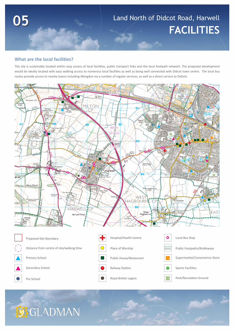
Land North of Didcot Road, Harwell05FACILITIES
What are the local facilities?The site is sustainably located within easy access of local facilities, public transport links and the local footpath network. The proposed development would be ideally located with easy walking access to numerous local facilities as well as being well connected with Didcot town centre. The local bus routes provide access to nearby towns including Abingdon via a number of regular services, as well as a direct service to Oxford.

78m
76m
77m
75m
74m
73m
72m
71m
A34
Grade II ListedBlenheim House
Didcot Road
Blenheim Hill
Cow Lane
Towns
end
TraditionalOrchard
Newly Approved Scheme
B4493
1
2
3
3
3
3
4
5
7 7
7
8
12
11
8
9
13
14
10
6
5
Potential Site Access
Arrival Views from Didcot Road
Overhead Powerlines
Adjacent Watercourse (Stream)
Potential Noise from A34
Base of Shallow Watercourse Valley
Potential Attenuation Area
Easement (5m offset from centreline)
Listed Buildings
Newly Approved Scheme
Public Rights of Way
Conservation Area
Existing Vegetation
Application Boundary
Contours1
2
3
4
5
6
7
8
9
10
11
12
13
14
Kings Lane
Grade II Listed Agricultural Buildings
Land North of Didcot Road, Harwell06CONSTRAINTS & OPPORTUNITIES
The assessment of the site and its surroundings has identified a number of features which should be protected, retained and enhanced wherever possible as part of the development proposals for the site. These considerations provide the opportunities and constraints for development and have been used to inform the preparation of the Framework Plan.

Proposed Residential 2.07 ha[60 dwellings @ 29dph]
Proposed Main Vehicular Access Point
Proposed Public Open Space with Structural Landscape
Proposed Footpath
Proposed Play Area
Existing Footpaths
Proposed Balancing Pond
Proposed Community Orchard
Proposed Agricultural Access
Application Boundary 4.23ha
Grade II ListedBlenheim House
Didcot Road
Blenheim Hill
Cow Lane
Towns
end
TraditionalOrchard
Newly Approved Scheme
B4493
Kings Lane
Grade II Listed Agricultural Buildings
A34
Existing Vegetation3
1
2
4
5
6
7
8
9
10
1
2
3
7
8
9
10
3
3
5
5
5
4
5
6
6
Land North of Didcot Road, Harwell07THE FRAMEWORK
The Framework Plan addresses the identified constraints and opportunities. Areas of green infrastructure wrap around the proposed development area creating a landscape buffer that will both respect and reinforce existing trees and vegetation to provide a softer green edge to new built form. The green infrastructure of the site will accommodate new tree and shrub planting, including a community Cherry Orchard, an equipped children’s play area, balancing ponds (SuDS) and traffic free pedestrian routes (including a new public footpath).

Land North of Didcot Road, Harwell08THANK YOU
Have Your Say
Thank you for taking the time to view this information. Your comments and suggestions will be taken into account when formulating the final planning application submission. All comments and feedback will be provided to the Local Planning Authority as part of the planning application.
Comments can be sent via the website:
www.your-views.co.uk/harwell
Or you can respond by email:
[email protected] (using “Harwell” as the subject line)
Or by post:
Your Views HarwellGladman Developments Ltd. Gladman House Alexandria Way Congleton CW12 1LB
Gladman consider all correspondence received and our response to the issues raised will be set out in a Statement of Community Involvement (SCI).
As part of the planning application, Gladman will submit a complete copy of all correspondence received (including any details such as your name, address and email where you have provided them) to the Local Planning Authority. This ensures all your comments are available to the Council during their consideration of the application and shows who we have consulted. As the SCI forms part of the formal application documents, the Council may publish it online, subject to their own Data Protection policies.
Should the application be the subject of an appeal, the same information will be forwarded to the Planning Inspectorate.
If further consultation is carried out as part of the planning process, Gladman may use your details to make you aware of this and to ask for your views, but will not use this information for any other purpose.