LAND FOR SALE / JOINT VENTURE Notley Vista @The ...
62
LAND FOR SALE / JOINT VENTURE Notley Vista @The Admirathoria Trail Ideal For Independent Senior Living Community With Full Life Medical Care Facility Clay Drive • Fort Washington, MD 20744 Prepared by: Trust Properties, Inc. Greg McGillicuddy [email protected] Phone (703) 392-0002 • Fax (703) 392-1140 www.TrustPropertiesInc.com
Transcript of LAND FOR SALE / JOINT VENTURE Notley Vista @The ...
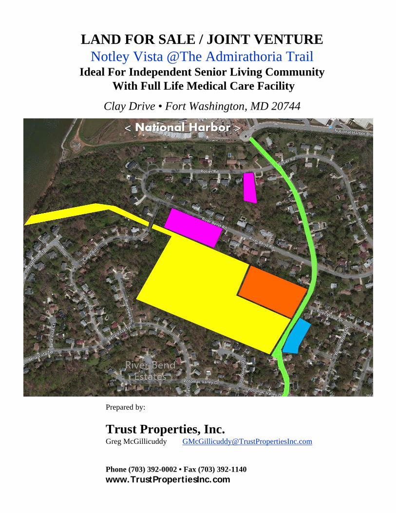
LAND FOR SALE / JOINT VENTURENotley Vista @The Admirathoria Trail
Ideal For Independent Senior Living CommunityWith Full Life Medical Care Facility
Clay Drive • Fort Washington, MD 20744
Prepared by:
Trust Properties, Inc.Greg McGillicuddy [email protected]
Phone (703) 392-0002 • Fax (703) 392-1140www.TrustPropertiesInc.com

T R U S T P R O P E R T I E Swww.TrustPropertiesInc.com
8100 Ashton Avenue • Suite 206 • Manassas, VA 20109Office (703) 392-0002 • Fax (703) 392-1140
LAND FOR SALE/JOINT VENTURENotley Vista @The Admirathoria Trail
Ideal for Independent Senior Living CommunityWith Full Life Medical Care Facility
Location: Clay Drive • Fort Washington, MD 20744
Tax Map #: 1356914
Parcel Size: 18.75 acres Owned Outright; Free & Clear+3.96 acres Under Contract + 4.13 LOI Out for signatureTotal: 26.84 acres owned/under contractNote: Minimum acreage required for unlimited density is 25 acres.
Zoning: R-R (Residential Rural) Prince George’s County
Comments: • Property is located literally 1500+ linear feet from National Harbor• Property is currently preliminarily approved, with conditions, for 19
lots, 2 parcels and 1 out parcel, for the purpose of developing Single Family Lots.
• Zoning allows, by Special Exception, the following uses:•• Independent Senior Living Community
with Full Life Medical Care Facility•• Planned retirement Community (with 25 acres there is no
limit to density); additional land is available• Demographics are suitable for this use• Access easement to the Potomac River; Approx 20 ft wide increasing
to 50 ft wide as you near the river; Approx 350 ft long
Sale Price $6,000,000.00 “As Is”$10,000,000.00 at entitlement
Contact: Greg McGillicuddy [email protected]: 703-392-0002 ext 20 • Cell: 703-625-0714 *Agent licensed in Maryland
Information concerning this listing and contained herein has been obtained from the owner of the property or from sources deemed reliable, but no warranty is made as to the accuracy thereof, and it is submitted subject to errors, omissions, and changes of price,
terms or withdrawal without notice. The prospective tenant/purchaser should carefully verify each item and all other information herein.
Rev Oct.31.2017

The Upper Notley Hall/Admirathoria Link to National Harbor
We own an easement between the National Harbor and the second oldest home in Prince George’s County, the main house of the Rosier Estate. In 1791, this is where Pierre L'Enfant summered while awaiting word on his designs for the new Capital City, the District of Columbia.
Notley Vista @The Admirathoria Trail is looking to complete the assemblage to bring an Independent Senior Living Community to the National Harbor/Ft. Washington community. This destination facility will allow our Residents a great sun‐setting life community.
Capital Funding, represented by Mr. Ed Powell, is engaged to participate in bringing the capital required to fund this senior living community to the banks of the Potomac.
This development proposal provides a full service community which will include up to 300 independent high end condo type apartments, 50 or so memory care units, and 50 or so Assisted/rehab units to this community.
A 25 acre assemblage will allow density to meet the demand for this type of community to emerge in this part of the county. At present, we control 26.84 acres.
This assemblage will allow a state of the art, green community to emerge in the center cut of the Riverbend Estates neighborhood, the community that bounds the southern fence line of the National Harbor complex. It is the development team’s vision to link this senior living community to National Harbor via the
current easement that the development team is entitled to.
Cooperation with National Harbor will allow this gated entrance to emerge along this right of way at the
bottom of Notley Vista Drive (proposed), allowing National Harbor guests and Notley Vista tenants full
access to this historic residence and the National Harbor amenities.
A gated entrance will emerge across this federally owned gateway, which will be mutually maintained,
by the non‐profit which is set up to be caretaker for this old house and its access/easement across this
river front entrance.
300+ independent living community members will have concierge access to the amenities of National Harbor, spending freely while sun setting in this community. While the guest of National Harbor can tour this historic property, that participated in the founding of our great capital city, the District of Columbia and National Harbor.
Seeking the support of National Harbor, to allow this secured entrance to emerge, we will jointly go lobby the Federal Government to allow this improvement to occur on their two parcels at the river front an appropriate pervious path to accommodate this gate entrance.
Look forward to moving this to the next step of interest and entitlement.
Kevin Furnary for Lutov Properties
1 877 550-9228

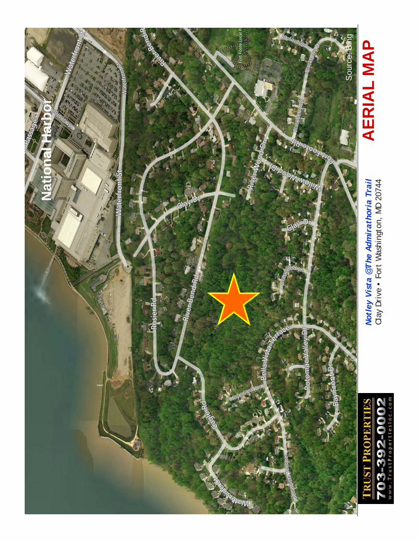
REGIONAL MAPNotley Vista @The Admirathoria TrailClay Drive • Fort Washington, MD 20744
Source: Google Maps

LOCATION MAPNotley Vista @The Admirathoria TrailClay Drive • Fort Washington, MD 20744
National Harbor
Source: Google Maps

AE
RIA
L M
AP
Not
ley
Vis
ta @
The
Adm
irath
oria
Trail
Cla
y D
rive
• F
ort
Was
hing
ton,
MD
207
44
Sou
rce:
Bin
g
AE
RIA
L M
AP
Nat
ion
al H
arb
or
Sou
rce:
Bin
g
Not
ley
Vis
ta @
The
Adm
irath
oria
Trail
Cla
y D
rive
• F
ort
Was
hing
ton,
MD
207
44

TAX MAPNotley Vista @The Admirathoria TrailClay Drive • Fort Washington, MD 20744
Source: www.pgatlas.comEasement providing access to the river:• Width: 20 then widens to 50 ft• Length: 350 ft

UN
DER
CO
NTR
AC
T:
Lo
t 10
–R
iver
Ben
d R
dT
ax ID
: 171
2121
0335
0.46
acr
es
Lo
t 11
-R
iver
Ben
d R
dT
ax ID
: 171
2121
0343
0.46
acr
es
Lo
t 12
–R
iver
Ben
d R
dT
ax ID
: 171
2121
0350
0.46
acr
es
Lo
t 13
-R
iver
Ben
d R
dT
ax ID
: 171
2121
0368
0.46
acr
es
Lo
t 14
–62
4 R
iver
Ben
d R
dT
ax ID
: 171
2121
0376
0.46
acr
es
Lo
t 20
-60
8 R
osi
er R
dT
ax ID
: 171
2121
0509
0.69
acr
es
SU
BT
OT
AL
: 2.
99 a
cres
Cla
y D
r-G
RA
ND
E V
ISTA
L
LC
Tax
ID: 1
7121
3569
1418
.75
acre
s +E
asem
ent
to P
oto
mac
Riv
er0.
4 ac
res
UN
DER
CO
NTR
AC
T84
06 C
lay
Dr
Tax
ID: 1
7121
3237
810.
97 a
cres
NO
TL
EY
VIS
TA @
TH
E A
DM
IRA
TH
OR
IA A
SS
EM
BL
AG
E •
Tot
al A
cres
= 2
6.84
acr
es
LOI O
UT
FOR
SIG
NA
TUR
E84
09 C
lay
Dr
Tax
ID: 1
7121
3623
004.
13 a
cres
Cla
y D
rive
Rig
ht-O
f-Way

TO
PO
GR
AP
HY
MA
P
Sou
rce:
Bin
g
Eas
emen
t pro
vidi
ng a
cces
s to
the
river
:•
Wid
th: 2
0 th
en w
iden
s to
50
ft•
Leng
th: 3
50 ft
Not
ley
Vis
ta @
The
Adm
irath
oria
Trail
Cla
y D
rive
• F
ort
Was
hing
ton,
MD
207
44

SITE PLANProposed Independent Senior Living
With Full Life Medical Care FacilityNotley Vista @The Admirathoria TrailClay Drive • Fort Washington, MD 20744

SIT
E P
LA
N –
CO
NC
EP
TU
AL
SIT
E P
LA
NS
ourc
e: B
ing
Not
ley
Vis
ta @
The
Adm
irath
oria
Trail
Cla
y D
rive
• F
ort
Was
hing
ton,
MD
207
44

SIT
E P
LA
N –
Pre
limin
ary
Pla
n f
or
19 S
F H
om
es
Sou
rce:
Bin
g
Not
ley
Vis
ta @
The
Adm
irath
oria
Trail
Cla
y D
rive
• F
ort
Was
hing
ton,
MD
207
44

FR
ON
T E
LE
VA
TIO
N –
Pro
po
sed
Ind
epen
den
t S
enio
r L
ivin
g
Wit
h F
ull
Lif
e M
edic
al C
are
Fac
ility
Sou
rce:
Bin
g
Not
ley
Vis
ta @
The
Adm
irath
oria
Trail
Cla
y D
rive
• F
ort
Was
hing
ton,
MD
207
44

307 CIRCLE AVENEUE, TAKOMA PARK, MARYLAND, 20912
B Y R N E H A C K E T T K E L L Y LANDSCAPE ARCHITECT – ENVIRONMENTAL PLANNER – BUILDER
thegreenfieldscompany.com [email protected]
240-678-9121
Agent for Grande Vista, LLC 1434 Kennedy Street, NW
Washington D.C.
PROJECT UPDATE: 8/4/2014:> The Lands of GRANDE VISTA <:NRI/SWM RE: “The Lands of Grande Vista” Natural Resource Inventory (NRI) and SWM Regulatory Update: The original NRI for the Approved Preliminary Plan, for the then proposed Residential Subdivision Plan, included a NRI as created in 2008 by Ben Dyer Associates, Inc. and was approved by the Maryland National Capital Park & Planning Commission (M-NCPPC) on July 11th, 2008; including a Revision to the NRI on February 13th, 2009. That Natural Resource Inventory information has not significantly changed since that time. The following has occurred: The suburban single family residential design has been rejected by the owners due to market forces. Over the past five years, strong storms including the snow storms of 2008-2009 and 2014 have caused reduction of the tree canopy, as can be evidenced in PG Atlas. The new State: Storm-Water Management (SWM) Regulations have been adopted, including the paradigm shift known as inclusion of Bio-Retention for the on-site treatment, attenuation, re-infiltration, quantity management, and release rules. This is encouraging for the Green Roof industry and Bio-Retention Designers and Builders, and for the planet. A new Design for a new Use: Residential Retirement and Medical Care Campus Concept, has been created. The Conceptual Design significantly reduces the originally proposed Limits of Disturbance, Tree and Canopy Removal, Earthwork, Grading and Impervious Surfaces. The Conceptual Design significantly increases the Capture and Harvesting of Storm Water, new Tree and Plantings (vis a vis large Green-Roof(s); and, Public Recreation & Park Facilities. The Concept creates new opportunities for Public Transportation connections (via National Harbor, and the Potomac River, via water-taxi) as well as the existing bus transit system and eventually for a heliport. At the appropriate time the Owner/Applicant shall submit updated designs pending approval of the Conceptual Design and all other applicable regulations as required at the time of submission.

The Maryland-National Capital Park and Planning Commission Prince George’s County Planning Department Development Review Division 301-952-3530 Note: Staff reports can be accessed at www.mncppc.org/pgco/planning/plan.htm.
Preliminary Plan 4-08060 Application General Data
Project Name: Grande Vista Location: Located off of Clay Drive, Approximately 280 feet north of its intersection with Potomac Valley Drive Applicant/Address: Grande Vista, LLC 1474 Belmont Street, NW Washington, DC 20009 Property Owner: Grande Vista, LLC 1474 Belmont Street, NW Washington, DC 20009
Planning Board Hearing Date: 03/18/10
Staff Report Date: 03/10/10
Date Accepted: 10/30/09
Planning Board Action Limit: 04/16/10
Plan Acreage: 18.36
Zone: R-R
Gross Floor Area: N/A
Lots: 19
Parcels: 2
Planning Area: 80
Tier: Developing
Council District: 08
Election District 12
Municipality: N/A
200-Scale Base Map: 211SW01
Purpose of Application Notice Dates
19 Single-family Dwellings Informational Mailing 11/06/09
Acceptance Mailing: 07/20/09
Sign Posting Deadline: 02/16/10
Staff Recommendation Staff Reviewer: Ray Dubicki
APPROVAL APPROVAL WITH
CONDITIONS DISAPPROVAL DISCUSSION
X

THE MARYLAND-NATIONAL CAPITAL PARK AND PLANNING COMMISSION
PRINCE GEORGE’S COUNTY PLANNING BOARD
STAFF REPORT SUBJECT: Preliminary Plan of Subdivision 4-08060
Grande Vista Lots 1–19, Parcels A and B, Outparcel A
OVERVIEW
The subject property is located on Tax Map 113, Grid C1 and is known as part of Parcel 2. The property is 18.36 acres in the Rural Residential (R-R) Zone. The property is currently undeveloped. The applicant proposes to divide the property into 19 lots, two parcels, and one outparcel for the purpose of developing single-family dwellings.
The site is adjacent to the historic property of Admirathoria/Upper Notley Hall. As discussed extensively below, this is an important historic resource as the remaining house of a once extensive and notable land grant. Appropriately, it has driven the pattern of lotting on the subject property. Archeological assessments have revealed little on the site, which is not unexpected given the topography of the site and the relation of the property to the front of the historic house. Initial plans proposed double loading the full length of Road A, including several houses that backed up to the front of the historic house. These lots have been moved and replaced with Parcel A, a proposed homeowners association (HOA) property containing a Landscape Manual-recommended 40-foot planting buffer. Revisions to initial plans have worked to balance respect for the historic site and development of a true infill property that is surrounded on all sides with similar development.
The property is accessed by Clay Drive, 280 feet from its intersection with Potomac Valley Drive, southeast of the site. As proposed, the applicant will continue Clay Drive as a 60-foot-wide right-of-way along the east side of the site. Approximately one half of the right-of-way will be dedicated from the property. The other half of the road is made up of the existing 30-foot right-of-way identified in deeds and plats as “Spring Road” or “Extension of Clay Drive.” This extension is proposed to continue through the eastern edge of the Admirathoria site, connecting to River Wood Road and River Bend Drive. Those connections are not a part of this application.
The property also connects to Cagle Drive on the west via a 50-foot-wide stem running 197 feet from the road to the bulk of the site. While the stem is the minimum width for a road similar to those in the development, no automobile connection is proposed. The stem is encumbered with a 20-foot-wide easement connecting Admirathoria to the Potomac River. That easement runs along the entire northern boundary of the site through land proposed to be in Parcel A or Outparcel A. No action is proposed for this easement. In a choice between the proposed access at Clay Drive and the available access at Cagle Road, the proposed access at Clay Drive is preferable. Entering the site from the southeast provides a better opportunity to preserve environmental features, continue existing patterns of development, and address the historic site. However, there are some outstanding requirements before the applicant will have authority to dedicate the area outside the subject property as a right-of-way. As Clay Road is the preferred

entrance, staff is proposing two conditions to allow the applicant to move forward with this application while working to clear the title on this right-of-way.
The applicant proposes a connecting trail across this stem between the end of Road A and Cagle Drive. The sidewalk system within the proposed development and the existing sidewalks surrounding the site support this recommendation.
The southern edge of the site is encumbered with a 30-foot right-of-way. The property description identifies this as one half of the right-of-way for Fort Foote Road. The right-of-way has no counterpart on the plats of River Bend Estates, does not continue in either direction, and does not appear on the Approved Countywide Master Plan of Transportation (MPOT). The applicant does not propose to remove this right-of-way from the lots prior to subdividing the property, and has created Lots 1, 3 through 12, and Parcel B to have adequate lot size without the area encumbered by the right-of-way. The applicant should pursue abandoning this right-of-way prior to the time of final plat.
At several points in this process, the applicant was advised that site conditions and development constraints warranted a conservation subdivision. The applicant chose not to utilize the conservation subdivision process because their design process had advanced past the stage where a conservation subdivision would be timely for their goals. Staff does not fully agree with this position, but respects the applicant’s choice in the matter.
Outparcel A is being created as a location for potential future development. The northern border of Outparcel A is adjacent to six undeveloped lots which front on River Bend Road. Any development of Outparcel A will require a preliminary plan of subdivision and tree conservation plan. These applications will have to reflect the present application, including the calculation of woodland preservation and retention or replacement of the proposed footpath. Staff recommends that Outparcel A and Parcels A and B be incorporated into a single HOA parcel. SETTING
The property is located at the terminus of Clay Drive, 280 feet north of its intersection with Potomac Valley Drive. The property is surrounded by single-family detached residences. Neighboring properties on all sides are zoned R-R and are developed with single-family detached residences. To the northeast of the site is Historic Site 80-005, Admirathoria/Upper Notley Hall.
2 4-08060

FINDINGS AND REASONS FOR STAFF RECOMMENDATION 1. Development Data Summary—The following information relates to the subject preliminary
plan application and the proposed development. EXISTING PROPOSED
Zone R-R R-R
Use(s) Undeveloped Single-family Detached
Dwellings Acreage 18.36 18.36 Lots 0 19 Outlots 0 1 Parcels 1 2 Dwelling Units:
Detached 0 19 Public Safety Mitigation Fee No No Pursuant to Section 24-119(d)(2) of the Subdivision Regulations, this case was heard before the Subdivision and Development Review Committee (SDRC) on November 13, 2009.
2. Property and Title Issues—A portion of the access to the site is provided across a 30-foot
right-of-way identified as “Spring Road” in the deed from the Temple of Understanding, Inc. to Grande Vista, LLC at Liber 14817, Folio 80. This is the preferred access to the site due to environmental features and the existing pattern of development. The historic site is currently accessed via an existing gravel driveway crossing a portion of this right-of-way. The applicant should provide documentation of the ownership of this property prior to signature approval of this plan and evidence they have secured the authority to dedicate the property as a public road prior to approval of a final plat. Approval of this preliminary plan does not legitimate or grant the Planning Board’s approval of the existence of these rights-of-way as streets, private roads, or easements under the Subdivision Regulations. The southern edge of the site is encumbered with a 30-foot right-of-way. The property description identifies this as one half of the right-of-way for Fort Foote Road. The right-of-way has no counterpart on the plats of River Bend Estates, does not continue in either direction, and does not appear on the MPOT. The potential owners of lots encumbered by this easement should not be burdened with such an easement. The applicant should pursue abandoning this right-of-way prior to final plat. Outparcel A is proposed as a location for potential future development. Any development of Outparcel A will require a preliminary plan of subdivision and tree conservation plan. Future applications will have to reflect the present application, including the calculation of woodland preservation and the proposed footpath. Outparcel A and Parcels A and B should be incorporated into a single HOA parcel because development of this site under the present application relies on woodland conservation and proposed features located on Outparcel A.
3. Environmental—The preliminary plan for Grande Vista, 4-08060, the Type I Tree Conservation
Plan, TCPI/012/09, and the Natural Resources Inventory, NRI/034/08, were reviewed for conformance with the Approved Countywide Green Infrastructure Plan and relevant master or sector plans. As currently designed, the plan is not in conformance with the master plan or the
3 4-08060

Countywide Green Infrastructure Plan because it does not provide for the preservation of the priority natural features on the site and does not address the policies and strategies with regard to water quality. The Environmental Planning Section recommends approval of the application subject to conditions. The Environmental Planning Section memorandum dated March 9, 2010 supersedes other correspondence on the application. Background Currently, there are no streams, wetlands, or 100-year floodplain shown on the property. This property is located in the Upper Potomac River watershed in the Potomac River basin. The site is currently undeveloped and mostly wooded. According to the Prince George’s County Soil Survey, the principal soils on the site are in the Aura and Rumford series. Marlboro clay does not occur on this property. According to information obtained from the Maryland Department of Natural Resources, Natural Heritage Program, there are no rare, threatened, or endangered species found to occur on this property or on adjacent properties. There are no designated scenic or historic roads adjacent to the subject property. The site is located in the Developing Tier as reflected in the Prince George’s County Approved General Plan. Master Plan Conformance The Approved Master Plan and Sectional Map Amendment for the Henson Creek-South Potomac Planning Area (April, 2006) contains environmental policies that should be addressed during the review of developments within the plan area. The specific language of the master plan is shown in bold type and comments are provided in regular type. Policy 1: Protect, preserve and enhance the green infrastructure network within the Henson Creek planning area.
Relevant Strategy: Evaluate carefully land development proposals in the vicinity of identified countywide and local Special Conservation Areas (SCA) including Piscataway Creek SCA, Potomac shoreline SCA and Broad Creek SCA to ensure that the SCAs are not impacted and that connections are either maintained or restored.
The Countywide Green Infrastructure Plan indicates that most of the property is within a designated evaluation area within the established network. In addition, the green infrastructure corridor on this property abuts the Potomac Shoreline Special Conservation Area. The preservation of existing woodlands on this site, and the restoration of water quality on-site and ensuring that it is not degraded by the development of the property are essential to a finding of conformance with the Green Infrastructure Plan. As currently designed, the plan shows areas of severe grading on steep slopes. Policy 2: Restore and enhance water quality in areas that have been degraded and preserve water quality in areas not degraded.
Relevant Strategy: Ensure the use of Low Impact Development (LID) techniques to the fullest extent possible during the development process.
The site is located in the Upper Potomac River watershed which has a water quality rating of poor and a water habitat rating of fair. This means that much of the existing streams in the watershed maintain adequate habitat, but that habitat is not sufficient to address poor water quality entering the receiving streams and the Potomac River. The existing vegetation on the subject property contributes to water quality habitat by shading the areas of run-off on the site.
4 4-08060

The plan shows the provision of a stormwater management pond in a rather irregular location (at an elevation higher than other places on the site). An explanation is needed regarding the proposed stormwater management techniques and how they are best suited for the site. An approved Stormwater Management Concept Plan, CSD 413-2009-00, shows an on-site pond to provide for both extended detention and attenuation. An improvement to the stormdrain system on Cagle Road is also required. None of the methods proposed are considered low impact development (LID) stormwater management techniques. As such, the proposed design is not in conformance with this policy and strategy. In addition, the Maryland stormwater management requirements were revised in the Stormwater Management Act of 2007 with a goal of reducing the number of stormwater management ponds by promoting the use of other methods of stormwater control. While the state and county have not yet adopted these provisions, the plan should be revised to include environmental site design techniques (the current name for “low impact development” techniques”) to the fullest extent practicable. Also, the stormwater management concept plan does not show the same lotting pattern and roadway systems as the tree conservation plan. This is problematic because the revised stormwater management design does not address all of the issues raised in the conditions of the stormwater management approval letter. Policy 3: Reduce overall energy consumption and implement more environmentally sensitive building techniques. The development is conceptual at the present time. In future applications, the applicant should consider environmentally-sensitive building techniques to reduce overall energy consumption. Policy 4: Reduce light pollution and intrusion into rural and environmentally sensitive areas. The Department of Public Works and Transportation (DPW&T) should consider the use of full cut-off optics for street lights to ensure that off-site light intrusion into residential and environmentally-sensitive areas is minimized. Policy 5: Reduce adverse noise impacts to meet State of Maryland noise standards. The proposed development is not expected to be a noise generator and is not impacted by any nearby sources of noise. Conformance with the Green Infrastructure Plan The Countywide Green Infrastructure Plan indicates that most of the property is an evaluation area within the designated network. Designing the Type I tree conservation plan to preserve high-priority woodland on-site will provide compliance with the Countywide Green Infrastructure Plan. The current lot layout and stormwater management design do not provide conformance with the preservation aspects of the Green Infrastructure Plan. The following policies and relevant strategies are applicable to the review of the subject application for conformance to the Countywide Green Infrastructure Plan.
5 4-08060

Policy 1: Preserve, protect, enhance or restore the green infrastructure network and its ecological functions while supporting the desired development pattern of the 2002 General Plan. The subject property contains an evaluation area that represents a significant block of woodland in this otherwise developed community. The subject property was included in the designated network because of the existing historic site and the woodlands connecting the site to the Potomac Shoreline Special Conservation Area. The woodlands on-site connect to larger woodland areas through Parcel 156 to the west, which is owned by the United States of America. This connectivity provides an opportunity for the protection of a portion of this pocket of woodlands. Reducing the clearing of the severe slopes will result in the preservation of more of this woodland that is needed to stabilize the slopes and protect water quality. A corridor at least 100 feet wide is needed along the widest portions of the subject property along the northern property line. The existing 20-foot-wide easement can be included in the green, open space corridor. See the recommended condition at the end of this section. Policy 2: Preserve, protect, and enhance surface and ground water features and restore lost ecological functions. See the comments above regarding water quality. Policy 3: Preserve existing woodland resources and replant woodland, where possible, while implementing the desired development pattern of the 2002 General Plan. The tree conservation plan submitted does not provide all of the woodland conservation requirements on-site. At a minimum, the plans must be revised to provide all of the conservation on-site in order to be in conformance with the Green Infrastructure Plan. In order to be in conformance with the Henson Creek master plan and the Countywide Green Infrastructure Plan, the plan needs to be substantially revised to protect the woodlands on-site and provide connectivity between the historic site, the woodlands, and the federal property to the west. The redesign should include the use of environmental site design stormwater management techniques to the fullest extent practicable. Environmental Review A signed Natural Resources Inventory (NRI/034/08) was submitted with this application. Currently there are no streams, wetlands, or 100-year floodplain shown on the property. The preliminary plan and TCPI show the environmental features as currently shown on the NRI. Based upon five sample areas, the forest stand delineation indicates a single forest stand containing 19 specimen trees. The forest is dominated by mature tulip poplar, many exceeding 12-inches diameter at breast height, with an understory containing pawpaw, American holly, and spicebush. Invasive species in the understory include honeysuckle, stilt grass, and English ivy. The highest priority woodland for preservation is located in the northwestern corner of the site where there are steep and severe slopes with highly erodible soils. Because the Landscape Manual requires a Type “D” bufferyard between the historic site and structures on adjacent residential lots, the woodland adjacent to the historic site has additional priority for preservation.
6 4-08060

Based on a site visit conducted in January 2010, new information came to light regarding the possible presence of a regulated stream on the subject property. The heavy snow cover prevented further exploration of this issue throughout much of February. A subsequent on-site exploration was conducted on March 9, 2010 and it was determined that the channel is ephemeral in nature and is not a regulated feature. This property is subject to the provisions of the Prince George’s County Woodland Conservation and Tree Preservation Ordinance because the gross tract area is in excess of 40,000 square feet and there are more than 10,000 square feet of existing woodland on-site. A Type I tree conservation plan is required. A Type I Tree Conservation Plan, TCPI/012/09, has been reviewed and was found to require revisions. It should be noted that revisions made to the layout or design may change the woodland conservation requirements and a revised worksheet must be provided on resubmitted plans. The plan shows a different lot layout than that shown on the stormwater management concept plan and the preliminary plan (stamped as received January 11, 2010). All plans must show the same lot layout and limits of disturbance. The plan shows extensive areas along the northern and southern property lines as being “preservation area—not counted.” These areas need to be addressed as follows: Northern property line: The 20-foot-wide right-of-way along the northern property line shows this area as “woodland preserved—counted as cleared” because it is an easement and could be cleared at any time. The remaining block of woodlands on the lots can continue to be shown as “preservation area—not counted,” except for the narrow area between Lots 15 and 17 where severe grading in this area will not likely result in these trees being preserved. This will allow for any field changes that may be needed to accommodate proper grading in this area. Southern property line: The area along the southern property line within the easement on proposed Lots 1 and 3 through 9 must be calculated as cleared and symbols added to the plan and the legend to reflect this. The remaining block of woodlands on the lots can continue to be shown as “preservation area—not counted,” except for the area of woodlands on Lot 1 because it skews the house location on that lot and unduly constrains the layout design. This area must be shown to be counted as cleared. The worksheet will need to be revised to address these changes. The stormwater management concept plan shows clearing within the public right-of-way of Cagle Road; however, the limits of disturbance do not reflect this work on the TCPI. The limits of disturbance should also be revised to show this work as required on the stormwater management concept plan and it needs to be labeled on the plan with the acreage. The subject property contains an evaluation area that represents a significant block of woodland in this otherwise developed community. The woodland connects to larger woodland areas through Parcel 156 to the west, which is owned by the United States of America. This connectivity provides an opportunity for the protection of a portion of this pocket of woodlands. The plan proposes to meet the requirements using off-site woodland conservation. Because of the site’s location within the designated network of the Green Infrastructure Plan, all of the woodland conservation should be provided on-site. According to the Prince George’s County Soil Survey, the principal soils on the site are in the Aura and Rumford series. Aura series soils are typically highly erodible, but pose no other special problems for development. Rumford soils pose no other special problems for development.
7 4-08060

Water and Sewer Categories The water and sewer categories are W-3 (Dormant) and S-3 (Dormant), according to water and sewer maps obtained from the Department of Environmental Resources dated June 2003, and will therefore be served by public systems.
4. Community Planning—The application is located in the Developing Tier. The vision for the
Developing Tier is to maintain a pattern of low- to moderate-density suburban residential communities, distinct commercial centers, and employment areas that are increasingly transit serviceable. Specifically, this application is consistent with Developing Tier goals to “[m]aintain low- to moderate-density land uses (except in Centers and Corridors)” and to “[r]einforce existing suburban residential neighborhoods.” (p 37) This preliminary plan of subdivision application is consistent with the 2002 Prince George’s County General Plan Development Pattern policies for the Developing Tier by maintaining a pattern of low- to moderate-density suburban residential communities. The site is in the 2006 Approved Master Plan and Sectional Map Amendment for the Henson Creek-South Potomac Planning Area. This master plan and sectional map amendment (SMA) classified the subject property in the R-R Zone, permitting residential low-density land use (up to 3.5 dwelling units per acre). The primary residential use on the property conforms to the residential, low-density land use recommendation of the 2006 approved Henson Creek-South Potomac master plan and SMA.
5. Parks and Recreation—In accordance with Section 24-135 of the Subdivision Regulations, the
Department of Parks and Recreation, Park Planning and Development Division recommends that a fee-in-lieu of mandatory parkland dedication be required because the land available is unsuitable for dedication due to its location and topography.
6. Trails—The plan was reviewed for conformance with the Adopted and Approved Countywide
Trails Plan and the appropriate area master plan in order to implement planned trails. The approved Henson Creek-South Potomac master plan recommends pedestrian connections as important community priorities, particularly in the vicinity of the Oxon Hill core area. Continuous sidewalks, wide sidewalks, pedestrian safety measures, and sidewalk or trail connections between communities and to public facilities are especially important. The proposal for 19 single-family detached lots is located just south of National Harbor. Many of the surrounding neighborhoods contain sidewalks along both sides of the internal roads. The pedestrian facilities, as shown on the proposal, are not adequate for the proposed use. The proposed 50-foot rights-of-way for Roads A and B on the subject preliminary plan do not contain sidewalks. Staff recommends that these roads contain sidewalks along both sides of the road so that pedestrians will have a safe place to walk, and so that they do not have to share the roads with vehicles. The proposal includes a footpath that will connect the subdivision along Road A to Cagle Road. Sidewalks along Road A will serve this trail connection.
7. Transportation—The application is a preliminary plan of subdivision for a residential
subdivision consisting of 19 single-family detached lots. Using trip generation rates in the “Guidelines for the Analysis of the Traffic Impact of Development Proposals,” it is determined that the proposed development would generate 15 AM (3 inbound and 12 outbound) and 18 PM (12 inbound and 6 outbound) weekday peak-hour vehicle trips. The traffic generated by the
8 4-08060

proposed preliminary plan would impact the following intersections, interchanges, and links in the transportation system: • Oxon Hill Road and Fort Foote Road—north intersection (signalized) Due to the size of the subdivision, a traffic study was not required. Traffic counts at the critical intersection were requested for the purpose of making an adequacy finding, and counts dated September 2009 were submitted by the applicant. The findings and recommendations outlined below are based upon a review of these materials and analyses conducted by staff of the Transportation Planning Section, consistent with the guidelines. The subject property is located within the Developing Tier, as defined in the Prince George’s County Approved General Plan. As such, the subject property is evaluated according to the following standards: Links and signalized intersections: Level-of-Service (LOS) D, with signalized intersections operating at a critical lane volume (CLV) of 1,450 or better. Mitigation, as defined by Section 24-124(a)(6) of the Subdivision Regulations, is permitted at signalized intersections within any tier subject to meeting the geographical criteria in the guidelines. Unsignalized intersections: The Highway Capacity Manual procedure for unsignalized intersections is not a true test of adequacy, but rather an indicator that further operational studies need to be conducted. Vehicle delay in any movement exceeding 50.0 seconds is deemed to be an unacceptable operating condition at unsignalized intersections. In response to such a finding, the Planning Board has generally recommended that the applicant provide a traffic signal warrant study and install the signal (or other less costly warranted traffic controls) if deemed warranted by the appropriate operating agency. The intersection of Oxon Hill Road and Fort Foote Road, when analyzed with existing traffic and existing lane configurations, operates with a CLV of 974, LOS A during the AM peak hour, and with a CLV of 1,097, LOS B during the PM peak hour. The Prince George’s County Planning Board has defined an upper CLV limit of 1,450, LOS D in any peak hour as the worst acceptable operating condition on the transportation system within the Developing Tier when mitigation is not utilized. The identified critical intersection (Oxon Hill Road and Fort Foote Road) is not programmed for improvement with 100 percent construction funding within the next six years in the current Maryland Department of Transportation Consolidated Transportation Program or the Prince George’s County Capital Improvement Program. Background traffic has been developed by using five approved developments in the area and a 1.5 percent annual growth rate in through traffic along Oxon Hill Road. The critical intersection of Oxon Hill Road and Fort Foote Road, when analyzed with background traffic and existing lane configurations, would operate as follows: AM peak hour—LOS B, with a CLV of 1,062; PM peak hour—LOS C, with a CLV of 1,237. Trip distribution from the site is projected as follows: 85 percent north along Oxon Hill Road, 5 percent south along Oxon Hill Road, and 10 percent south from the site along Fort Foote Road to the south. The critical intersection of Oxon Hill Road and Fort Foote Road, when analyzed with total future traffic as developed using the guidelines, including the site trip generation and trip distribution, would operate as follows: AM peak hour—LOS B, with a CLV of 1,072; PM peak hour—LOS C, with a CLV of 1,243.
9 4-08060
Therefore, it is found that the critical intersection operates acceptably under existing, background, and total traffic in both peak hours. The site is not within or adjacent to any master plan transportation facilities. All access in the short term would be via a proposed extension of Clay Drive to the south of the site as a 60-foot right-of-way street. This is acceptable provided that the status of the 30-foot parcel on the east side of the site can be confirmed; this parcel is essential to complete the extension. There is no indication that the extension of Clay Drive to the north of the site is needed to serve this site. The extension would only be constructed at such time that the Admirathoria property to the north of this site would be redeveloped. The adjacent Admirathoria property is served by a driveway crossing the subject property. It must be determined if there is also an easement associated with that driveway. In any regard, with the development of this site, that driveway would be replaced with access via proposed Street A and a driveway within proposed Parcel A. This is acceptable provided that access to the Admirathoria property is maintained during construction on the subject site, and any existing easement associated with the driveway is ultimately extinguished. Based on the preceding findings, adequate transportation facilities would exist to serve the proposed subdivision as required under Section 24-124 of the Prince George’s County Code if the application is approved with regard to the confirmation of the extension of Clay Drive and assurance of a connection to Admirathoria during the construction of the subdivision.
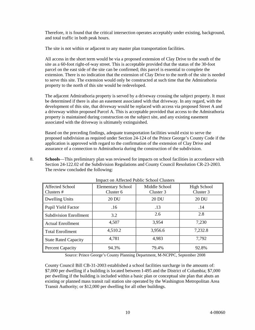
8. Schools—This preliminary plan was reviewed for impacts on school facilities in accordance with
Section 24-122.02 of the Subdivision Regulations and County Council Resolution CR-23-2003. The review concluded the following:
Impact on Affected Public School Clusters
Affected School Clusters #
Elementary School Cluster 6
Middle School Cluster 3
High School Cluster 3
Dwelling Units 20 DU 20 DU 20 DU
Pupil Yield Factor .16 .13 .14
Subdivision Enrollment 3.2 2.6 2.8
Actual Enrollment 4,507 3,954 7,230
Total Enrollment 4,510.2 3,956.6 7,232.8
State Rated Capacity 4,781 4,983 7,792
Percent Capacity 94.3% 79.4% 92.8%
Source: Prince George’s County Planning Department, M-NCPPC, September 2008 County Council Bill CB-31-2003 established a school facilities surcharge in the amounts of: $7,000 per dwelling if a building is located between I-495 and the District of Columbia; $7,000 per dwelling if the building is included within a basic plan or conceptual site plan that abuts an existing or planned mass transit rail station site operated by the Washington Metropolitan Area Transit Authority; or $12,000 per dwelling for all other buildings.
10 4-08060
County Council Bill CB-31-2003 allows for these surcharges to be adjusted for inflation and the current amounts are $8,120 and $ 13,921, to be paid at the time of the issuance of each building permit. The school facilities surcharge may be used for the construction of additional or expanded school facilities and renovations to existing school buildings or other systemic changes.
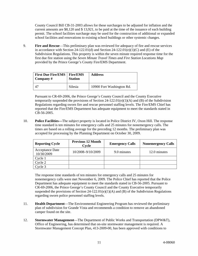
9. Fire and Rescue—This preliminary plan was reviewed for adequacy of fire and rescue services
in accordance with Section 24-122.01(d) and Section 24-122.01(e)(1)(C) and (E) of the Subdivision Regulations. This property is within the seven minute required response time for the first due fire station using the Seven Minute Travel Times and Fire Station Locations Map provided by the Prince George’s County Fire/EMS Department. First Due Fire/EMS Company #
Fire/EMS Station
Address
47 Silesia 10900 Fort Washington Rd.
Pursuant to CR-69-2006, the Prince George’s County Council and the County Executive temporarily suspended the provisions of Section 24-122.01(e)(1)(A) and (B) of the Subdivision Regulations regarding sworn fire and rescue personnel staffing levels. The Fire/EMS Chief has reported that the Fire/EMS Department has adequate equipment to meet the standards stated in CB-56-2005.
10. Police Facilities—The subject property is located in Police District IV, Oxon Hill. The response
time standard is ten minutes for emergency calls and 25 minutes for nonemergency calls. The times are based on a rolling average for the preceding 12 months. The preliminary plan was accepted for processing by the Planning Department on October 30, 2009.
Reporting Cycle Previous 12 Month
Cycle Emergency Calls Nonemergency Calls
Acceptance Date 10/30/2009
10/2008–9/10/2009 9.0 minutes 12.0 minutes
Cycle 1 Cycle 2 Cycle 3 The response time standards of ten minutes for emergency calls and 25 minutes for nonemergency calls were met November 6, 2009. The Police Chief has reported that the Police Department has adequate equipment to meet the standards stated in CB-56-2005. Pursuant to CR-69-2006, the Prince George’s County Council and the County Executive temporarily suspended the provisions of Section 24-122.01(e)(1)(A) and (B) of the Subdivision Regulations regarding sworn police personnel staffing levels.
11. Health Department—The Environmental Engineering Program has reviewed the preliminary
plan of subdivision for Grande Vista and recommends a condition to remove an abandoned camper found on the site.
12. Stormwater Management—The Department of Public Works and Transportation (DPW&T),
Office of Engineering, has determined that on-site stormwater management is required. A Stormwater Management Concept Plan, 413-2009-00, has been approved with conditions to
11 4-08060

ensure that development of this site does not result in on-site or downstream flooding. Development must be in accordance with this approved plan.
13. CemeteriesNo cemeteries have been identified on the site. 14. Historic—The Historic Preservation Commission reviewed Preliminary Plan 4-08060, Grande
Vista at its January 26, 2010 meeting and forwarded the following recommendations, findings, and conclusions to the Planning Board for its review of the subject application. The Historic Preservation Commission recommends that the Planning Board approve the application with conditions addressing street names and requiring a detailed site plan examining the relationship of the site to the historic property. The subject preliminary plan of subdivision is located off of Clay Drive, approximately 280 feet north of its intersection with Potomac Valley Drive. The subject property comprises 18.36 acres in the R-R Zone, and is adjacent to the south and west of Admirathoria/Upper Notley Hall (Historic Site 80-005). The subject preliminary plan of subdivision proposes a total of 19 building lots, 2 parcels, and 1 outparcel. Archeology Findings The original 2,500-acre land grant of Admirathoria was patented to George Thompson in 1662; 2,200 acres were resurveyed for Notley Rozer in 1715. Notley Rozer built a house on the Admirathoria patent which was later known as Lower Notley Hall, located southwest of the project area. After the death of Notley Rozer in 1727, his wife was granted a life tenancy with an estate of inheritance to their son Henry Rozer. According to the 1790 census, Henry Rozer held 120 slaves, making him one of the largest slaveholders in Prince George’s County. It is likely that Upper Notley Hall was built about 1792, when Henry Rozer’s granddaughter, Maria Rozer, married Francis Hall. Hall adopted his wife’s surname and became Francis Hall Rozer. Francis H. Rozer is listed in the 1800 census; at that time, he held 37 slaves. Maria Rozer inherited most of Henry Rozer’s property upon his death in 1802. Francis Hall Rozer died in 1803 and Maria remarried to William Daingerfield in 1807. William A. Daingerfield is included in the 1820 census and held 47 slaves at that time. There were also three free black males in the household. Maria Rozer Daingerfield sold 500 acres of Admirathoria to her son, Francis E. Rozer in 1822. Francis E. Rozer’s two sons, Charles B. and Francis W. Rozer, inherited Upper Notley Hall after their father’s death in the 1840s. Daniel Seltzer of Pennsylvania acquired 246 acres of Admirathoria in 1870. Seltzer died in 1887 and an Equity Cause for the division of his estate notes that his property contained “a large substantial brick dwelling...three tenant houses, stable, hay barracks, and other outbuildings...” The former Rozer property was divided many times during the 20th century and much of the land converted to housing developments. In 1945, the historic site and 4.13 acres were purchased by Van Arsdale Turner; the property was owned by Marian Bahrenburg Turner until 1974, and is still held by members of the Bahrenburg family. Grande Vista, LLC acquired the subject property identified on the deed as 18.75 acres from the Temple of Understanding on July 2, 2001, which had acquired the property on July 18, 1966 from Ralph and Jean Rocks and Thomas and Carol Martin. Phase I archeological investigations were conducted on the subject property in June 2008. Two archeological sites, 18PR945 and 18PR946, were identified. Site 18PR945 is a light scatter of both prehistoric Native American and historic period artifacts. The prehistoric Native American artifacts date to the late Woodland period (900–1600 AD) and the historic artifacts include items made and used during the 1800s and 1900s. Site 18PR946 is also a scatter of both prehistoric Native American and historic period artifacts. The prehistoric Native American artifacts of Site 18PR946 date to the early to late Woodland periods (1000 BC–1600 AD) and the historic
12 4-08060

artifacts include items made and used during the 1800s and early 1900s. Based on the findings of the Phase I archeological survey, Historic Preservation staff requested that Phase II investigations be conducted at both 18PR945 and 18PR946. Phase II investigations were conducted on the Grande Vista property from August 2008 to February 2009. Phase II investigations at site 18PR945 consisted of a close-interval shovel test pit (STP) survey and the excavation of 1-x-1 m test units. A total of 99 STPs were excavated across site 18PR945. Seven 1-x-1 m test units were placed in the areas of highest artifact concentrations, five in the eastern area and two in the west. Phase II investigations of site 18PR945 produced 217 artifacts. It is evident from the excavation of the test units that the artifacts recovered have been mixed by the process of erosion. No intact cultural features were identified in any of the test units. Due to the lack of subsurface integrity and the lack of research value of site 18PR945, no further work was recommended. Phase II investigations at site 18PR946 consisted of close-interval shovel testing and the excavation of 13 1-x-1 m units. A total of 328 STPs were excavated at 5-m intervals. Based on the results of the STP survey, five 1-x-1 m test units were placed in Area A, three in Area B, and five in Area C. A total of 2,690 artifacts, ranging in date from the early to late Woodland periods to the 20th century, were recovered from the Phase II investigations at site 18PR946. Only one possible feature was identified in Test Unit 11. It was not possible to determine whether the feature was natural or cultural and only one piece of unidentified metal was recovered. No additional features were identified in the other 12 test units. Layers within the units from which artifacts were collected exhibited deposition from secondary contexts and mixing of artifacts. All of the test units lacked subsurface integrity and, therefore, lacked any research context. Therefore, no further work was recommended on site 18PR946. Findings—Historic Preservation Built in the eighteenth century and altered in the 1870s, Admirathoria/Upper Notley Hall is a 2½-story, late Georgian brick plantation house. Its walls are laid in Flemish bond and the stairhall takes up one of the four large spaces of the square floor plan. Admirathoria/Upper Notley Hall was built in the mid-to-late 1700s for the Rozer family, and remained the family home for nearly a century. In the 1870s, the original hip roof was replaced with the present mansard roof. Admirathoria/Upper Notley Hall is a significant Georgian structure and a unique example of its type in the county. The historic site and its 4.13-acre environmental setting were designated through the 1981 Prince George’s County Historic Sites and Districts Plan. The subject preliminary plan proposes two new streets. Street A is approximately 1,000 feet long and terminates in a cul-de-sac south and west of the boundary of the historic site. The first 500 feet of Street A, along the southern boundary of the historic site will be single loaded and no building lots are proposed to be located adjacent to the historic site. Street B is approximately 200 feet long and includes four building lots as well as approximately 140 feet of open frontage at the southwest corner of the historic site. The historic site will be surrounded on two sides by a 50-foot-wide buffer that will be one of the parcels conveyed to the HOA for the development. Access to the historic site will be provided by an easement across the HOA parcel. The HOA parcel will also include a public utility easement. The area within the parcel outside the easement will be planted to provide additional screening for the historic site. Lot sizes range from 20,824 square feet to 29,388 square feet. Clay Drive will be developed to provide full frontage for the subject property, but that frontage will terminate at the historic site’s southern property line. Current access to the adjacent Admirathoria/Upper Notley Hall historic site is provided by an unpaved entry lane from Clay Drive (a public street) that traverses the southeast corner of the
13 4-08060
developing property. The driveway for the historic site will meet Street A at the current grade. The entry lane leads to the south elevation or main façade of the historic site. The historic site is located on a slight rise above the developing property, which slopes to the south and east toward the Potomac River. Houses to the south of the developing property on Driftwood Lane and Bella Vista Terrace are now partially visible from the historic site; because of the historic site’s elevation, houses to the north on River Bend Road, at a lower elevation, are not readily visible. With the construction of houses south of the historic site, the view of houses on Driftwood Lane and Bella Vista Terrace will be blocked. Based on the topography of the developing property and the clearing and grading that will be associated with the proposed development, houses on a number of lots may be substantially visible from the historic site. In particular, Lots 2, 3, 4, 5, 6, 7, 8, 16, 17, and 18 will have front elevations visible from Admirathoria, and the front and east side elevation of Lot 19 will be visible from the western portion of the historic site. Lot 1 will be part of the view driving up Clay Drive. The applicant’s proposed Type “D” bufferyard is in compliance with the Prince George’s County Landscape Manual. Nevertheless, the character of the existing woodland is largely deciduous and spotty as a result of the recent loss of trees from storm damage. As a result, only limited seasonal screening at a significant height will be provided. The woodland understory is largely transparent and lacks evergreens that would provide screening below the deciduous canopy. Based on the applicant’s proposed layout and the county’s requirement that public roads be illuminated by streetlights, the required lighting in the vicinity of the historic site may impact the historic character of the historic site. Conclusions Staff concurs with the findings and conclusions of the Phase II archeology report that sites 18PR945 and 18PR946 lack subsurface integrity and research value. Although the cultural deposits are related to prehistoric occupation of the Grande Vista property and the occupation of Upper Notley Hall during the historic period, the deposits are mixed and do not retain their integrity. Therefore, staff also concurs with the report’s conclusions that no further archeological work is necessary on sites 18PR945 and 18PR946. The applicant’s proposed development plan makes an effort to provide a buffer for the Admirathoria historic site. However, the required clearing and re-grading of house sites for the developing property will have a substantial impact on the character of the historic site, which is currently located on a rise and largely surrounded by trees. Road construction will also render the historic site substantially visible, in spite of the partially wooded character of the perimeter of the historic site’s property. As a result, a requirement for detailed site plan review for the height, scale, massing, design, and materials of the proposed new houses in the vicinity of the historic site, as well as the character of landscape buffering, street-lighting, and the development’s entrance features in the vicinity, will ensure that appropriate architecture for new construction and appropriately designed infrastructure, such as landscaping and street-lighting, are provided. The applicant has not proposed names for the development’s two proposed streets at this time and should work with Historic Preservation staff to identify street names that reflect the history of the property, the adjacent Admirathoria historic site, and its associated families.
14 4-08060
RECOMMENDATION
APPROVAL, subject to the following conditions: 1. Prior to signature approval of the preliminary plan, the applicant shall revise the plan to
consolidate Outparcel A into a single parcel with Parcels A and B. This consolidated parcel shall be identified as Parcel A for conveyance to the homeowners association.
2. At the time of final plat, the applicant shall demonstrate it has the authority to dedicate a public
street over the Spring Road/Cagle Drive right-of-way. 3. Prior to approval of a final plat for the site, the applicant will abandon the right-of-way running
along the southern border of the site. 4. Prior to submission of the required detailed site plan (DSP), the natural resources inventory (NRI)
shall be revised to show the channel in the northwestern portion of the site clearly labeled as ephemeral. The revised, signed NRI is a submission requirement for the detailed site plan.
5. Prior to signature approval of the preliminary plan, the TCPI shall be revised as follows:
a. the plans shall conform with the provisions of this approval; b. the plans shall show the land area within the two easements, parallel to the northern and
southern property lines as “counted as cleared”; c. for areas that are shown to be preserved but not counted, count as cleared areas less than
50 feet wide; d. add a symbol to the legend and on the plan for woodland retained but calculated as
cleared; e. include all off-site clearing; f. show proposed woodlands preserved—not counted on Lot 1 as “counted as cleared”; g. revise the worksheet as needed; h. show the same lot layout on all plans; i. revise Note 1 to read “…in conjunction with the approval of the Detailed Site Plan.”; j. illustrate a break in the buffer around the historic site showing the entrance to the historic
site and any necessary construction; k. revise the plan to match the NRI and show the channel clearly labeled as ephemeral; and l. have the revised plan signed and dated by the qualified professional who prepared the
plan.
15 4-08060
6. The following note shall be placed on the final plat of subdivision:
“Development is subject to restrictions shown on the approved Type I Tree Conservation Plan (TCPI/012/09), or as modified by the Type II Tree Conservation Plan, and precludes any disturbance or installation of any structure within specific areas. Failure to comply will mean a violation of an approved Tree Conservation Plan and will make the owner subject to mitigation under the Woodland Conservation Ordinance. This property is subject to the notification provisions of CB-60-2005. Copies of all approved Tree Conservation Plans for the subject property are available in the offices of the Maryland-National Capital Park and Planning Commission, Prince George’s County Planning Department.”
7. In conjunction with the detailed site plan, a Type II tree conservation plan shall be approved. 8. Development of this site shall be in conformance with the Stormwater Management Concept Plan
CSD 413-2009-00 and any subsequent revisions. 9. Unless modified by the Department of Public Works and Transportation (DPW&T), the applicant
and the applicant’s heirs, successors, and/or assignees shall:
a. Provide standard sidewalks, a minimum of four feet in width, along both sides of the internal roadway network.
b. Place signage at both ends of the proposed footpath that will indicate the footpath
terminus, such as “Cagle Road.” 10. Access to the adjacent Admirathoria property via the existing driveway shall be maintained
during construction on the subject site until such time as adequate access via proposed Street A and a driveway within proposed Parcel A is provided. Any existing easement associated with the existing driveway shall ultimately be extinguished once alternative legal access is provided.
11. Total development within the subject property shall be limited to 19 single-family detached
dwellings or equivalent development which generates no more than 15 AM (3 inbound and 12 outbound) and 18 PM (12 inbound and 6 outbound) weekday peak-hour trips. Any development generating a traffic impact greater than that identified herein shall require a new preliminary plan of subdivision with a new determination of the adequacy of transportation facilities.
12. Prior to approval of the finial plat, the applicant and the applicant’s heirs, successors, and/or
assignees shall pay a fee-in-lieu of the mandatory dedication of parkland in accordance with the requirements of Section 24-135 of the Subdivision Regulations.
13. Prior to the issuance of any building permit, the abandoned camper found on the property must be
removed and properly disposed.
16 4-08060

14. Prior to approval of the final plat, the applicant and the applicant’s heirs, successors, and/or assignees shall have a detailed site plan approved by the Planning Board in accordance with Part 3, Division 9 of the Zoning Ordinance. The DSP shall be reviewed by the Historic Preservation Commission prior to approval by the Planning Board. The purpose of the Historic Preservation Commission’s detailed site plan review is to:
a. Ensure that the siting, scale, massing, materials, landscaping, and lighting of houses on
Lots 1, 2, 3, 4, 5, 6, 7, 8, 16, 17, 18, and 19 are compatible with the historic and architectural character of the historic site.
b. Illustrate supplemental buffer plantings within proposed Parcel A to screen the views to
and from the Admirathoria historic site. c. Identify the character of improvements associated with the entry to the historic site across
Parcel A to be provided by the applicant with particular reference to the provision of an entrance feature for the historic site.
d. Review the character of street lighting and the design of entrance features for the
development in the vicinity of the historic site, to ensure that they do not impact its character and setting.
15. At the time of detailed site plan, the following design standards shall be addressed:
a. A reduction in the severe grading of the site and an increase in the on-site woodland conservation with the goal of providing all of the woodland conservation on-site;
b. The provision of a green, open space corridor from the historic site along the northern
property line, inclusive of the established easement, to connect with the woodlands to the west at least 100 feet wide as it passes through the wide part of the subject property;
c. The provision of stormwater management techniques that implement environmental site
design techniques to the fullest extent practicable and protects the downstream properties and stabilizes the receiving stream(s) as necessary; this may result in the need to obtain a revised stormwater management concept approval as determined by the Department of Public Works and Transportation; and
d. The treatment of the existing buffer around the historic site with regard to invasive plant
removal, supplemental planting, and long-term maintenance recommendations. 16. Prior to approval of the detailed site plan for the Grande Vista development, the applicant and the
applicant’s heirs, successors, and/or assignees shall work with Historic Preservation staff to develop names for the subdivision’s two streets that reflect the history of the property, the adjacent Admirathoria historic site, and its associated families.
17. Prior to the approval of building permits, the applicant and the applicant’s heirs, successors,
and/or assignees shall demonstrate that a homeowners association has been established and that the common areas have been conveyed to the homeowners association.
17 4-08060
18. Prior to the approval of building permits, the applicant and the applicant’s heirs, successors, and/or assignees shall convey to the homeowners association open space land in accordance with the approved detailed site plan. Land to be conveyed shall be subject the following:
a. Conveyance shall take place prior to the issuance of building permits. b. A copy of the unrecorded, special warranty deed for the property to be conveyed shall be
submitted to the Subdivision Section of the Maryland-National Capital Park and Planning Commission, Planning Department, Development Review Division (DRD), along with the final plat.
c. All waste matter of any kind shall be removed from the property, prior to conveyance,
and all disturbed areas shall have a full stand of grass or other vegetation upon completion of any phase, section, or the entire project.
d. The conveyed land shall not suffer the disposition of construction materials, soil filling,
discarded plant materials, refuse, or similar waste matter. e. Any disturbance of land to be conveyed to a homeowners association shall be in
accordance with an approved detailed site plan or shall require the written consent of DRD. This shall include, but not be limited to, the location of sediment control measures, tree removal, temporary or permanent stormwater management facilities, utility placement, and stormdrain outfalls. If such proposals are approved, a written agreement and financial guarantee shall be required to warrant restoration, repair, or improvements required by the approval process.
f. Stormdrain outfalls shall be designed to avoid adverse impacts on land to be conveyed to
a homeowners association. The location and design of drainage outfalls that adversely impact property to be conveyed shall be reviewed and approved by DRD prior to the issuance of grading or building permits.
g. Temporary or permanent use of land to be conveyed to a homeowners association for
stormwater management shall be approved by DRD. h. The Planning Board or its designee shall be satisfied that there are adequate provisions to
assure retention and future maintenance of the property to be conveyed. STAFF RECOMMENDS APPROVAL OF TYPE I TREE CONSERVATION PLAN TCPI/012/009.
18 4-08060

10461 Mill Run Circle - Suite 215
Owings Mills, MD 21117
410 998 9310 fax 410 998 9320
www.thevincagroup.com
Cost Effective Strategies for Quality Health Care
December 21, 2015
Mr. Ed PowellManaging DirectorCFG Capital Markets, LLC1422 Clarkview RoadBaltimore, MD 21209
Dear Mr. Gumbin,
The Vinca Group L.L.C. is pleased to present the demand estimate for an independent living,routine assisted living and/or Alzheimer’s disease/dementia assisted living facility to be locatedon Clay Drive in Fort Washington, MD. The demand calculations indicate that the market couldsupport up to 48 routine assisted living beds and 24 dementia assisted living beds for Phase I ofthe project. A possible Phase II could include an additional 46 dementia assisted living beds.
We defined the primary market area using the following 11 zip codes:20032 District of Columbia20607 Accokeek20613 Brandywine20735 Clinton20744 Fort Washington20745 Forest Heights20746 Suitland20747 District Heights20748 Temple Hills20762 Joint Base Andrews20772 Upper Marlboro
We tested the market demand using $3,000 monthly rent for independent living, $6,500 monthlyrent for routine assisted living and $8,200 monthly rent for dementia assisted living based onNIC MAP information.

Mr. Ed PowellDecember 21, 2015Page 2
We use two projections to evaluate the market area’s ability to support a project at stabilizedoccupancy. The Market Penetration Rate helps to determine a market’s depth and assess thedegree of difficulty for a single facility to achieve and maintain occupancy. We use 5% as thethreshold for Market Penetration Rates. Saturation occurs when the market’s total capacity ofunits exceed market demand. The Saturation Rate compares the market’s total inventory of unitsto the qualified market. We use Saturation Rates that are less than 25% for assisted living.
We use the following assumptions when projecting demand:
We assumed 93% stabilized occupancy for the project.
We assumed that 100% of the project’s residents will come from the market area.
The market for people entering independent living and routine assisted living is limited topeople ages 75 and older.
The market for people entering Alzheimer’s disease/dementia assisted living is limited topeople ages 65 and older.
Income qualifications assume independent living residents use 60% of available incomeand $10,000 of their assets annually to help pay for independent living.
Income qualifications assume routine assisted living and Alzheimer’s disease/dementiaassisted living residents use 92% of available income and $20,000 of their assets annuallyto help to pay for assisted living care.
The demand for routine assisted living uses age specific rates for people who requireassistance with activities of daily living reported in U.S. Census, Americans withDisabilities, Household Economic Studies, July 2012.
Age Routine AL Utilization75-79 15.40%80 and Older 30.20%
Mr. Ed PowellDecember 21, 2015Page 3
The incidence rate for dementia is from “Alzheimer Disease in the United States using2010 Census,” published February 2013 by the American Academy of Neurology.
Age Dementia AL Utilization65-74 2.90%75-84 17.30%85 and Older 32.10%
The Market Penetration Rate is projected to be 5.0% for 250 units using 2016 demographic dataand 3.9% using 2021 demographic data. There are no other independent living units in themarket area so the projected Saturation Rates are the same as the Market Penetration Rateprojections. The market area is projected to have a net need for 459 additional independent livingunits above the 250 units projected for one facility using 2016 demographic data.
The Market Penetration Rate is projected to be 5.1% for 40 routine assisted living beds using2016 demographic data and 3.7% using 2021 demographic data. The market area’s SaturationRate is projected to be 13.9% using 2016 demographic data and 10.5% using 2021 demographicdata. The market area is projected to have a net need for 89 additional routine assisted livingbeds above the f40 bed projected for one facility using 2016 demographic data.
The Market Penetration Rate is projected to be 5.0% for 56 Alzheimer’s disease/dementiaassisted living beds using 20165 demographic data and 3.9% using 2021 demographic data. Themarket area’s projected Saturation Rate is the same as the projected Market Penetration Ratebecause there are no other Alzheimer disease/dementia assisted living beds in the market area.
Following this letter are the following documents:
A map of the market area showing the locations of retirement facilities
A list of the retirement facilities in the market area with addresses and bed complements
Exhibits 1 through 10 showing the demand calculations
A Claritas Senior Life Report presenting 2016 and 2021 demographic projections for themarket area.

Mr. Ed PowellDecember 21, 2015Page 4
This report is intended for use in the planning of this project. Conclusions are based on a deskreview of published data. Site visits were not conducted. The report is based on estimates,assumptions and other information available to us when we conducted the study or developed inconnection to the study. Sources of the information and the basis of the estimates andassumptions are stated in the appropriate places within this report. However, some assumptionsmay not materialize and unanticipated events and circumstances may occur. Therefore, actualresults achieved may vary from those reported. We have not evaluated the effectiveness of theproject’s management and we are not responsible for future marketing efforts and othermanagement actions upon which results will depend.
If we can answer any questions, or if you require additional information please do not hesitate tocontact us at 410-998-9310. Thank you for this engagement.
Very truly yours,
Alice KatzPresident
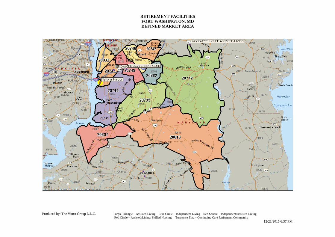
RETIREMENT FACILITIESFORT WASHINGTON, MDDEFINED MARKET AREA
Produced by: The Vinca Group L.L.C. Purple Triangle – Assisted Living Blue Circle – Independent Living Red Square – Independent/Assisted LivingRed Circle – Assisted/Living/ Skilled Nursing Turquoise Flag – Continuing Care Retirement Community
12/21/2015 6:37 PM

FACILITY LIST
RETIREMENT FACILITIES
FORT WASHINGTON, MD
DEFINED MARKET AREA
Page 1 of 1
IL AL ALZ SNF
BIRCHWOOD GROUP HOME I 1602 JARVIS AVE OXON HILL MD 20745 301-567-8190 0 10 0 0
HENSON CREEK HOUSE 5075 TEMPLE HILL RD TEMPLE HILLS MD 20748 301-505-7230 0 16 0 0
WOODMORE HOUSE ASSISTED LIVING 1717 LARGO RD UPPER MARLBORO MD 20774 240-510-0786 0 55 0 0
0 81 0 0TOTAL
BEDSNAME ADDRESS CITY ST ZIP PHONE
Source: The Vinca Group L.L.C. Analysis 12/21/2015 - 6:37 PM

EXHIBIT 1
INDEPENDENT LIVING, ROUTINE ASSISTED LIVING AND DEMENTIA ASSISTED LIVING
REQUIRED INCOME
FORT WASHINGTON, MD
DEFINED MARKET AREA
2016 AND 2021 PROJECTED
2016 2021 2016 2021 2016 2021
HOUSING VALUE CALCULATION
Median housing value $269,298 $269,298 $269,298 $269,298 $269,298 $269,298
Elderly Housing Valued at 77% of Median $207,359 $207,359 $207,359 $207,359 $207,359 $207,359
Less: 8% transaction costs $16,589 $16,589 $16,589 $16,589 $16,589 $16,589
Net Proceeds $190,771 $190,771 $190,771 $190,771 $190,771 $190,771
Income invested at 5% per year $9,539 $9,539 $9,539 $9,539 $9,539 $9,539
REQUIRED INCOME
Renter Occupied Units: 26.43% 26.43% 26.43% 26.43% 24.13% 24.13%
Market area rent $3,000 $3,000 $6,500 $6,500 $8,200 $8,200
Annualized $36,000 $36,000 $78,000 $78,000 $98,400 $98,400
Available income used per year - 60% IL; 92% AL; 92% ALZ $60,000 $60,000 $84,783 $84,783 $106,957 $106,957
Weighted average renter income $15,858 $15,858 $22,408 $22,408 $25,809 $25,809
Owner Occupied Units: 73.57% 73.57% 73.57% 73.57% 75.87% 75.87%
Market area base rent $3,000 $3,000 $6,500 $6,500 $8,200 $8,200
Annualized $36,000 $36,000 $78,000 $78,000 $98,400 $98,400
Available income used per year - 60% IL; 92% AL; 92% ALZ $60,000 $60,000 $84,783 $84,783 $106,957 $106,957
Less: income from home sale $9,539 $9,539 $9,539 $9,539 $9,539 $9,539
Net income qualification for owners $50,461 $50,461 $75,244 $75,244 $97,418 $97,418
Weighted average owner income $37,124 $37,124 $55,357 $55,357 $73,911 $73,911
Weighted average required income $52,982 $52,982 $77,765 $77,765 $99,720 $99,720
Less: Asset spend down $10,000 $10,000 $20,000 $20,000 $20,000 $20,000
Net Income Qualification $42,982 $42,982 $57,765 $57,765 $79,720 $79,720
Assumptions:
1. Market area rents are from NIC Map Property Advisor Data 3Q15.
Dementia Assisted LivingIndependent Living Assisted Living
Source: The Vinca Group L.L.C. Analysis 12/21/2015 6:38 PM

EXHIBIT 2
INDEPENDENT LIVING
MARKET PENETRATION RATE
FORT WASHINGTON, MD
DEFINED MARKET AREA
2016 AND 2021 PROJECTED
MONTHLY RENT $3,000
2016 2021
Income Qualified Households
Age 75 - 84 3,906 5,179
Age 85+ 706 844
Total IL Qualified Households 4,612 6,023
Less CCRC Households 0 0
Net IL Qualified Households 4,612 6,023
Competitor Units (Existing and Planned) 0 0
Assumed Occupancy @ 93% 93% 93%
Occupancy Adjusted Competitive Units 0 0
Net Available Households 4,612 6,023
Subject Facility Units 250 250
Occupancy @ 233 233
Adjusted for 233 233
Market Penetration Rate 5.0% 3.9%
Assumptions:
2. Please refer to Exhibit 10 for a schedule of units in the market area.
1. The Market Penetration Rate is used to measure a market's depth and assess the
difficulty in achieving and maintaining stabilized occupancy. The higher the Penetration
Rate, the greater the potential level of risk.
####
93%
PMA Origin
Source: The Vinca Group L.L.C. Analysis 12/21/2015 6:38 PM

EXHIBIT 3
INDEPENDENT LIVING
SATURATION RATE
FORT WASHINGTON, MD
DEFINED MARKET AREA
2016 AND 2021 PROJECTED
MONTHLY RENT $3,000
2016 2021
Total Independent Living Qualified Households 4,612 6,023
Less CCRC Households 0 0
Net IL Qualified Households 4,612 6,023
Saturation Rate @ 15% 15%
Market Area Households Using IL 692 903
Total IL Units Including Subject Facility 250 250
Assumed Occupancy @ 93% 93% 93%
Occupancy Adjusted Units 233 233
PMA Origin @ 100% 100%
Occupancy and PMA Origin Adjusted Units 233 233
Market Area Households Using IL 692 903
Less: Occupancy & PMA Adjusted Units 233 233
Net Need 459 671
Saturation Rate 5.0% 3.9%
2016 = 233 units / 4,612 IL qualified PMA households
2021 = 233 units / 6,023 IL qualified PMA households
Assumptions:
1. The Saturation Rate is used to compare the inventory of units (or capacity) in the market to the qualified
market. The Saturation Rate equals the total occupancy and PMA adjusted units including the proposed project
divided by the IL qualified market. Saturation Rates under 15% are viewed favorably for independent living.
15%
100%
Source: The Vinca Group L.L.C. Analysis 12/21/2015 6:38 PM
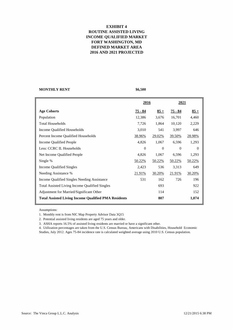
EXHIBIT 4
ROUTINE ASSISTED LIVING
INCOME QUALIFIED MARKET
FORT WASHINGTON, MD
DEFINED MARKET AREA
2016 AND 2021 PROJECTED
MONTHLY RENT $6,500
Age Cohorts 75 - 84 85 + 75 - 84 85 +
Population 12,386 3,676 16,701 4,460
Total Households 7,726 1,864 10,120 2,229
Income Qualified Households 3,010 541 3,997 646
Percent Income Qualified Households 38.96% 29.02% 39.50% 28.98%
Income Qualified People 4,826 1,067 6,596 1,293
Less: CCRC IL Households 0 0 0 0
Net Income Qualified People 4,826 1,067 6,596 1,293
Single % 50.22% 50.22% 50.22% 50.22%
Income Qualified Singles 2,423 536 3,313 649
Needing Assistance % 21.91% 30.20% 21.91% 30.20%
Income Qualified Singles Needing Assistance 531 162 726 196
Total Assisted Living Income Qualified Singles 693 922
Adjustment for Married/Significant Other 114 152
Total Assisted Living Income Qualified PMA Residents 807 1,074
Assumptions:
2. Potential assisted living residents are aged 75 years and older.
3. ASHA reports 16.5% of assisted living residents are married or have a significant other.
2016 2021
1. Monthly rent is from NIC Map Property Advisor Data 3Q15
4. Utilization percentages are taken from the U.S. Census Bureau, Americans with Disabilities, Household Economic
Studies, July 2012. Ages 75-84 incidence rate is calculated weighted average using 2010 U.S. Census population.
Source: The Vinca Group L.L.C. Analysis 12/21/2015 6:38 PM
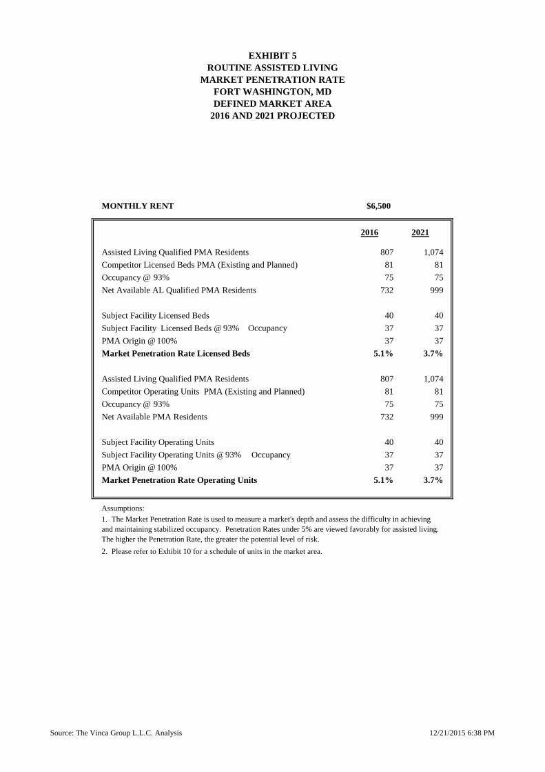
EXHIBIT 5
ROUTINE ASSISTED LIVING
MARKET PENETRATION RATE
FORT WASHINGTON, MD
DEFINED MARKET AREA
2016 AND 2021 PROJECTED
MONTHLY RENT $6,500
2016 2021
Assisted Living Qualified PMA Residents 807 1,074
Competitor Licensed Beds PMA (Existing and Planned) 81 81
Occupancy @ 75 75
Net Available AL Qualified PMA Residents 732 999
Subject Facility Licensed Beds 40 40
Subject Facility Licensed Beds @ 37 37
PMA Origin @ 100% 37 37
Market Penetration Rate Licensed Beds 5.1% 3.7%
Assisted Living Qualified PMA Residents 807 1,074
Competitor Operating Units PMA (Existing and Planned) 81 81
Occupancy @ 75 75
Net Available PMA Residents 732 999
Subject Facility Operating Units 40 40
Subject Facility Operating Units @ Occupancy 37 37
PMA Origin @ 100% 37 37
Market Penetration Rate Operating Units 5.1% 3.7%
Assumptions:
2. Please refer to Exhibit 10 for a schedule of units in the market area.
1. The Market Penetration Rate is used to measure a market's depth and assess the difficulty in achieving
and maintaining stabilized occupancy. Penetration Rates under 5% are viewed favorably for assisted living.
The higher the Penetration Rate, the greater the potential level of risk.
93%
93%
Occupancy93%
93%
Source: The Vinca Group L.L.C. Analysis 12/21/2015 6:38 PM

EXHIBIT 6
ROUTINE ASSISTED LIVING
SATURATION RATE
FORT WASHINGTON, MD
DEFINED MARKET AREA
2016 AND 2021 PROJECTED
MONTHLY RENT $6,500
2016 2021
Total Assisted Living Qualified PMA Residents 807 1,074
Saturation Rate @ 25% 25%
Market Area PMA Residents Seeking Assisted Living 202 268
Total Licensed Assisted Living Beds Including Subject Facility 121 121
Assumed Occupancy @ 93% 93%
Occupancy Adjusted Beds 113 113
PMA Origin @ 100% 100%
Occupancy and PMA Adjusted Licensed Beds 113 113
Market Area Residents Using AL 202 268
Less: Occupancy and PMA Adjusted Licensed Beds 113 113
Net Need 89 156
Saturation Rate Licensed Beds 13.9% 10.5%
2016 = 113 beds / AL qualified PMA residents
2021 = 113 beds / AL qualified PMA residents
Total Operating Assisted Living Units Including Subject Facility 121 121
Assumed Occupancy @ 93% 93%
Occupancy Adjusted Units 113 113
PMA Origin @ 100% 100%
Occupancy and PMA Adjusted Operating Units 113 113
Market Area Residents Using AL 202 268
Less: Occupancy and PMA Adjusted Operating Units 113 113
Net Need 89 156
Saturation Rate Operating Units 13.9% 10.5%
2016 = 113 beds / AL qualified PMA residents
2021 = 113 beds / AL qualified PMA residents
Assumptions:
1. The Saturation Rate is used to compare the inventory of units (or capacity) in the market to the qualified market.
The Saturation Rate equals the total occupancy and PMA adjusted units including the proposed project divided by
the AL qualified market. Saturation Rates under 25% are viewed favorably for assisted living.
93%
100%
93%
25%
807
1,074
807
1,074
100%
Source: The Vinca Group L.L.C. Analysis 12/21/2015 6:38 PM
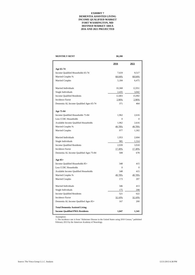
EXHIBIT 7DEMENTIA ASSISTED LIVINGINCOME QUALIFIED MARKET
FORT WASHINGTON, MDDEFINED MARKET AREA
2016 AND 2021 PROJECTED
MONTHLY RENT $8,200
2016 2021
Age 65-74
Income Qualified Households 65-74 7,619 9,517
Married Couples % 68.04% 68.04%
Married Couples 5,184 6,475
Married Individuals 10,368 12,951
Single Individuals 2,435 3,042
Income Qualified Residents 12,803 15,992
Incidence Factor 2.90% 2.90%
Dementia AL Income Qualified Ages 65-74 371 464
Age 75-84
Income Qualified Households 75-84 1,962 2,616
Less CCRC Households 0 0
Available Income Qualified Households 1,962 2,616
Married Couples % 49.78% 49.78%
Married Couples 977 1,302
Married Individuals 1,953 2,604
Single Individuals 985 1,314
Income Qualified Residents 2,939 3,918
Incidence Factor 17.30% 17.30%
Dementia AL Income Qualified Ages 75-84 508 678
Age 85+
Income Qualified Households 85+ 348 415
Less CCRC Households 0 0
Available Income Qualified Households 348 415
Married Couples % 49.78% 49.78%
Married Couples 173 207
Married Individuals 346 413
Single Individuals 175 208
Income Qualified Residents 521 622
Incidence Factor 32.10% 32.10%
Dementia AL Income Qualified Ages 85+ 167 200
Total Dementia Assisted Living
Income Qualified PMA Residents 1,047 1,341
Assumption:
1. The incidence rate is from “Alzheimer Disease in the United States using 2010 Census,” published
February 2013 by the American Academy of Neurology.
Source: The Vinca Group L.L.C. Analysis 12/21/2015 6:38 PM

EXHIBIT 8
DEMENTIA ASSISTED LIVING
MARKET PENETRATION RATE
FORT WASHINGTON, MD
DEFINED MARKET AREA
2016 AND 2021 PROJECTED
MONTHLY RENT $8,200
2016 2021
Dementia Assisted Living Qualified PMA Residents 1,047 1,341
Competitor Licensed Beds PMA 0 0
Occupancy @ 0 0
Net Available Dementia AL Qualified PMA Residents 1,047 1,341
Subject Facility Licensed Beds 56 56
Subject Facility Licensed Beds @ 93% Occupancy 52 52
PMA Origin @ 100% 52 52
Market Penetration Rate Licensed Beds 5.0% 3.9%
Assumptions:
2. Please refer to Exhibit 10 for a schedule of units in the market area.
1. The Market Penetration Rate is used to measure a market's depth and assess the difficulty in achieving and
maintaining stabilized occupancy. Penetration Rates under 5% are viewed favorably for assisted living. The
higher the Penetration Rate, the greater the potential level of risk.
93%
Source: The Vinca Group L.L.C. Analysis 12/21/2015 6:38 PM

EXHIBIT 9
DEMENTIA ASSISTED LIVING
SATURATION RATE
FORT WASHINGTON, MD
DEFINED MARKET AREA
2016 AND 2021 PROJECTED
MONTHLY RENT $8,200
2016 2021
Total AL Dementia Qualified PMA Residents 1,047 1,341
Saturation Rate @ 25% 25%
Market Area Residents Seeking AL Dementia Care 262 335
Licensed AL Dementia Beds Including Subject Facility 56 56
Assumed Occupancy @ 93% 93%
Occupancy Adjusted Beds 52 52
PMA Origin @ 100% 100%
Occupancy and PMA Adjusted Licensed Beds 52 52
Market Area Residents Seeking AL Dementia Care 262 335
Less: Occupancy and PMA Adjusted Licensed Beds 52 52
Net Need 210 283
Saturation Rate Licensed Beds 5.0% 3.9%
2016 = 52 beds / AL qualified PMA residents
2021 = 52 beds / AL qualified PMA residents
Assumptions:
1. The Saturation Rate is used to compare the inventory of units (or capacity) in the market to the qualified market. The
Saturation Rate equals the total occupancy and PMA adjusted units including the proposed project divided by the
dementia AL qualified market. Saturation Rates under 25% are viewed favorably for dementia assisted living.
####
1,047
1,341
93%
25%
Source: The Vinca Group L.L.C. Analysis 12/21/2015 6:38 PM

EXHIBIT 10
SCHEDULE OF UNITS
FORT WASHINGTON, MD
DEFINED MARKET AREA
NOVEMBER 2015
Independent
Routine
Assisted
Dementia
Assisted
Routine
Assisted
Dementia
AssistedExistingBirchwood Group Home 1 0 10 0 10 0Henson Creek House 0 16 0 16 0Woodmore House Assisted Living 0 55 0 55 0Existing Beds Total 0 81 0 81 0
Planned Beds
Planned Beds Subtotal 0 0 0 0 0
Subject Facility Beds250 40 56 40 56
Subject Facility Beds Total 250 40 56 40 56
TOTAL 250 121 56 121 56
FACILITYTOTAL LICENSED BEDS
TOTAL OPERATING
UNITS
Source: The Vinca Group L.L.C. Analysis 12/21/2015 6:38 PM

Fort Washington, MD Map
Senior Life
Pop-Facts Premier 2016
Report Generated: November 11, 2015 10:21:49 AM EST
Copyright 2015, The Nielsen Company.

R-R Zoning • Prince George’s County Page 1 of 2
R‐R Zone (Rural Residential) • Prince George’s County, MD
Extracted from: Online Code of Ordinances, Supplement 2017, Update 9, Online content updated on 9-25-2017 CODE OF ORDINANCES • PRINCE GEORGE'S COUNTY • MARYLAND Codified through CB-57-2017, effective September 18, 2017. . (2017 Supp., Update 9)
Sec. 27‐428. ‐ R‐R Zone (Rural Residential).
(a) Purposes.
(1) The purposes of the R-R Zone are:
(A) To provide for and encourage variation in the size, shape, and width of one-family detached residential subdivision lots, in order to better utilize the natural terrain;
(B) To facilitate the planning of one-family residential developments with moderately large lots and dwellings of various sizes and styles;
(C) To encourage the preservation of trees and open spaces; and
(D) To prevent soil erosion and stream valley flooding.
(b) Uses.
(1) The uses allowed in the R-R Zone are as provided for in the Table of Uses (Division 3 of this Part).
(c) Regulations.
(1) Additional regulations concerning the location, size, and other provisions for all buildings and structures in the R-R Zone are as provided for in Divisions 1 and 5 of this Part, the Regulations Tables (Division 4 of this Part), General (Part 2), Off-Street Parking and Loading (Part 11), Signs (Part 12), and the Landscape Manual.
(CB-1-1989) __________________________________________
DIVISION 3. ‐ USES PERMITTED.
Sec. 27‐441. ‐ Uses permitted.
(a) No use shall be allowed in the Residential Zones, except as provided for in the Table of Uses. In the table, the following applies:
(1) The letter "P" indicates that the use is permitted in the zone indicated.
(2) The letters "SE" indicate that the use is permitted, subject to the approval of a Special Exception in accordance with Part 4 of this Subtitle.
(3) The letters "PA" indicate that the use is permitted, subject to the following:
(A) There shall be no entrances to the use directly from outside the building;
(B) No signs or other evidence indicating the existence of the use shall be visible from outside the building, other than a business identification sign lettered on a window. The sign shall not exceed six (6) square feet in area; and
(C) The use shall be secondary to the primary use of the building.
(4) The letters "PB" indicate that the use is permitted, subject to the following:

R-R Zoning • Prince George’s County Page 2 of 2
(A) The use shall be related to, dependent on, and secondary to a primary use on the premises;
(B) The use shall be located on the same record lot as the primary use;
(C) The use shall not be located within a building not occupied by the primary use; and
(D) The floor area of any building (and the land area occupied by any structure other than a building) devoted to the use shall not exceed an area equal to forty-five percent (45%) of the gross floor area of the building within which the primary use is located.
(5) The letter "X" indicates that the use is prohibited.
(6) The letters "SP" indicate that the use is permitted subject to approval of a Special Permit, in accordance with Section 27-239.02.
(7) All uses not listed are prohibited.
(8) Whenever the table refers to an allowed use, that use is either permitted (P), permitted by Special Exception (SE), permitted by Special Permit (SP), or permitted as a (PA) or (PB) use, as accordingly listed in the zone in which it is allowed.
(CB-12-2001; CB-4-2003)
Editor's note— CR-81-2012 repealed the enactment of CB-18-2007 regarding "Rural Entertainment Park", (Chapter 10, 2007 Laws of Prince George's County, Maryland), effective October 16, 2012.
(b) TABLE OF USES.
ZONE
USE R‐O‐S O‐S R‐A R‐E R‐R R‐80 R‐55 R‐35 R‐20
(3) Institutional/Educational:
(CB‐12‐2016)
Assisted living facility
(CB‐110‐2004) X X X X SE 77 X X X X
Health campus X X X X SE SE SE SE SE
Medical/residential campus X SE SE SE SE SE SE SE SE
(7) Residential/Lodging:
(CB‐12‐2016)
Planned retirement community
(CB‐53‐2005; CB‐4‐2013) X X SE SE SE SE SE SE SE

Page 1
Additional Requirements for Specific Special Exceptions Extracted from: Online Code of Ordinances, Supplement 2017, Update 9, Online content updated on 9-25-2017 CODE OF ORDINANCES • PRINCE GEORGE'S COUNTY • MARYLAND • Codified through CB-57-2017, effective September 18, 2017. . (2017 Supp., Update 9)
Subtitle 27. Zoning > Part 4.-Special Exceptions > Division 3.- Additional Requirements For Specific Special Exceptions…
Sec. 27‐362. ‐ Health campus.
(a) A health campus may be permitted, subject to the following:
(1) General requirements.
(A) The subject property shall be suitable for the integration of a hospital and other medical facilities with any proposed residences, services, and recreational facilities.
(2) Special requirements.
(A) The subject property shall contain at least twenty-five (25) contiguous acres, except as provided in paragraph (5), below;
(B) The subject property shall have frontage on, and direct vehicular access to, a street with sufficient capacity to accommodate the traffic generated by the campus;
(C) All buildings and structures shall be located at least:
(i) Fifty (50) feet from all adjoining property lines (except street lines); and
(ii) Twenty-five (25) feet from all adjoining street lines;
(D) All off-street parking and loading facilities shall be located at least:
(i) Fifty (50) feet from any adjoining land in a Residential Zone, or land proposed to be used for residential purposes on an approved Basic Plan for a Comprehensive Design Zone, approved Official Plan for an R-P-C Zone, or any approved Conceptual or Detailed Site Plan;
(ii) Six (6) feet from any adjoining street; and
(iii) Ten (10) feet from any other land than that in (i) and (ii), above;
(E) All of the parking and loading needs of employees and residents of, and visitors and delivery services to, the site shall be met on the subject property;
(F) All perimeter setback areas of the site shall be buffered or screened in accordance with the provisions of the Landscape Manual. The applicant shall demonstrate that the required buffer yards will provide reasonable sight and sound barriers;
(G) Not less than forty percent (40%) of the site shall be devoted to green area; and
(H) Regulations restricting location, height, coverage, density, frontage, and yards, of buildings and structures, as specified for the zone in which such campus is located, shall not apply to uses or structures provided for in this Section. The dimensions and percentages shown on the approved site plan shall constitute the regulations for development under a given Special Exception.
(I) Notwithstanding Section 27-118.01, more than one (1) building may be located on a lot containing a one-family dwelling.
(3) Uses.

Page 2
(A) Only those uses which appear on an approved site plan shall be permitted on the health campus. The District Council may only approve those uses which provide a harmonious, balanced mix of medical, residential, and limited commercial uses, and which are necessary to meet the needs of the campus. Every health campus shall contain a general acute care hospital developed as the core of the campus. Other uses may include, (but need not be limited to) the following:
(i) Medical facilities, including professional offices, medical laboratories and testing facilities, clinical facilities, professional or paramedical training centers, ambulatory care facilities, and accessory uses. Business signs in conjunction with approved medical facilities shall only be permitted in accordance with the provisions of Part 12 of this Subtitle applicable to the C-O Zone;
(ii) Nursing and care homes; medical day care, adult day care, respite care, and day care for sick children (all of which may include areas beyond the health campus as their service area); rental dwelling units for the use of staff, visitors, and elderly or physically handicapped persons; one (1) motel or hotel as an integral part of the campus; provided that day care for sick children shall only be provided in a licensed hospital unit.
(iii) Retail commercial and service uses (including accessory warehousing and laundry facilities), which are strictly related and subordinate to the medical/residential character of the campus, and which directly serve the residents, employees and guests of the campus or other campuses or medical facilities. The commercial uses shall be chosen to reflect their local orientation to the immediate campus vicinity, and shall be of such size and scope as to not interfere with existing or proposed retail uses located in the off-campus area. Business signs in conjunction with retail commercial uses shall only be permitted in accordance with the provisions of Part 12 of this Subtitle applicable to the commercial zones (other than the C-O Zone); and,
(iv) Recreational and social uses, such as swimming pools, tennis courts, athletic facilities, community centers, assembly halls, or private educational institutions, limited to use by only campus residents, employees, and guests.
(4) Site plans and other submission requirements.
(A) In addition to the requirements of Section 27-296(c), the site plan shall set forth the:
(i) Use, character, and zoning classification of adjoining properties;
(ii) Existing and proposed right-of-way and paving widths of adjoining streets;
(iii) Existing and proposed topography of the site at not more than five (5) foot contour intervals;
(iv) Existing and proposed drainage patterns;
(v) Existing vegetation and other natural features; and
(vi) Proposed provisions for erosion and sediment control and storm water management.
(5) Addition of land.
(A) After the approval of a Special Exception, any addition of land to the campus shall be the subject of a new Special Exception application. The site plan accompanying the new application shall include the required information for both the previously approved campus and the proposed additional land. The approval of the new site plan shall nullify the previously approved site plan. The additional land shall be contiguous to an approved health campus, and may contain less than twenty-five (25) acres.
(6) Amendment of site plan.

Page 3
(A) Notwithstanding other provisions of this Subtitle concerning revision of site plans, requests to amend a site plan for a health campus shall only be approved by the Planning Board under paragraph 27-362(a)(7) or the District Council under this paragraph 27-362(a)(6). The Planning Board is authorized to grant minor changes to site plans for health campuses, subject to appeal to the District Council. Such amendments to site plans may be permitted provided that any of the following three (3) situations exists:
(i) Situation No. 1.
(aa) There is a proposed increase in gross floor area of a building or in land area covered by a structure other than a building (over that approved on the original or amended site plan) which is not greater than ten percent (10%) of the gross floor area or covered land area or 500 square feet, whichever is less (see Figure 40), except as provided in (iii) below; or
(bb) There is a proposed relocation (in any direction) of any improvement (approved on the original or amended plan) which is not greater than ten percent (10%) of the distance to the boundary line of the special exception or twenty (20) feet, whichever is less (see Figure 41).
(ii) Situation No. 2.
(aa) There is a proposed expansion or addition of a parking lot or parking garage; or
(bb) There is a proposed change in a landscape plan.
(iii) Situation No. 3.
(aa) There is a proposed increase in gross floor area of the hospital for an addition to the emergency room only; and
(bb) There is a proposed relocation of the existing helipad of less than 150 feet to accommodate the addition described in (aa).
(B) The minor change request shall be in the form of an application filed with the Planning Board. The contents of the application shall be determined by the Planning Board. Along with filing the application, the applicant shall submit an amended site plan and Statement of Justification. The Planning Board shall conduct a public hearing and notice shall be provided in the same manner as for the original application.
(C) The Planning Board's decision to amend a site plan may be appealed to the District Council upon petition by any person of record. The petition shall specify the error which is claimed to have been committed by the Planning Board and shall also specify those portions of the record relied upon to support the error alleged. The petition shall be filed with the Clerk of the Council within thirty (30) days after the date of the notice of the Planning Board's decision. The District Council may vote to review the Planning Board's decision on its own motion within thirty (30) days after the date of the notice.
(i) The Clerk of the Council shall notify the Planning Board of any appeal or review decision. Within seven (7) calendar days after receiving this notice, the Planning Board shall transmit to the District Council a copy of the amended site plan, all written evidence and materials submitted for consideration by the Planning Board, a transcript of the public hearing on the site plan, and any additional information or explanatory material deemed appropriate.
(ii) Within forty-five (45) days, the District Council shall schedule a public hearing on the appeal or review. Testimony at the hearing shall be limited to the facts and information contained within the record made at the hearing before the Planning Board.
(iii) Within sixty (60) days after the close of the Council's hearing, the Council shall affirm, reverse, or modify the decision of the Planning Board, or return the amended site plan to the Planning Board to take further testimony or reconsider its decision. Where the

Page 4
Council approves an amended site plan, it shall make the same findings which are required to be made by the Planning Board.
(iv) The Council shall give its decision in writing, stating the reasons for its action. Copies of the decision shall be sent to all persons of record and the Planning Board.
(D) Requests to amend the approved site plan in all instances other than those described in paragraph 6(A), above, shall be filed concurrently with the Clerk of the Council and the office of the Planning Board. Upon receipt of the request by the Clerk, the Office of the Zoning Hearing Examiner shall schedule a public hearing, which shall occur not less than sixty (60), nor more than one hundred twenty (120), days after receipt of the request. The request shall be reviewed by the Technical Staff, taking into consideration the requirements of this Subtitle. The Technical Staff shall submit its recommendations to the Zoning Hearing Examiner within sixty (60) calendar days from the date of filing. The public hearing shall be conducted by the Zoning Hearing Examiner, at which time the applicant, the Planning Board, Technical Staff, and members of the public may comment on the proposed amendment. The hearing shall be conducted in accordance with Section 27-129. The property shall be posted with a sign in the same manner as required for original applications. After the close of the hearing record, the Zoning Hearing Examiner shall file a written recommendation with the District Council.
(E) Any person of record may appeal the recommendation of the Zoning Hearing Examiner within fifteen (15) days of the filing of the Zoning Hearing Examiner's recommendation with the District Council. If appealed, all persons of record may testify before the District Council. Persons arguing shall adhere to the District Council's Rules of Procedure, and argument shall be limited to thirty (30) minutes for each side, and to the record of the hearing.
(F) All amendments shall be in conformance with the purposes, regulations, and standards of this Section.
(G) The approved amended site plan shall become the official site plan, as if it had been approved as a part of the original application for a Special Exception.
(H) The revised site plan shall comply with all applicable requirements of this Subtitle and with any conditions, relating to the use, imposed by the District Council or Planning Board in the approval of the building or use.
(I) When a minor change is approved by the Planning Board, any requirements or conditions deemed necessary to protect adjacent properties and the general neighborhood may be added.
(7) Optional method of amending site plan.
(A) Notwithstanding the provisions of paragraph 27-362(a)(6), the procedures in this paragraph 27-362(a)(7) may be followed, at the applicant's option, to amend a Special Exception Site Plan for a health campus approved before January 1, 1982, if the application involves at least ten (10) but no more than fifteen (15) acres; if the lots or parcels which are the subject of the application contain a hospital; if all site plan amendments are confined to those lots or parcels; and if the amendments meet all requirements in this paragraph.
(B) The applicant shall meet all filing requirements for site plan amendments under paragraph (6). The application shall be accepted for processing if it is signed by the owner of the subject lots or parcels where the hospital is located and the improvements will be built.
(C) Proposed site plan amendments under this paragraph (7) shall meet the following requirements:
(i) Amendments may not reduce any setbacks required in this Subtitle or the Landscape Manual;

Page 5
(ii) The site plan as amended shall show compliance with all parking and loading requirements in Part 11;
(iii) Amendments may not reduce the greenspace on the subject lots or parcels below twenty percent (20%) of the area of the subject lots or parcels, but if site plan amendments reduce the greenspace on the subject lots, then the greenspace requirement on all property covered by the Special Exception shall also be reduced to twenty percent (20%); and
(iv) Amendments may show the following improvements only: additions to the hospital building; one medical office building; and parking structures required for the hospital or office building;
(D) The application may be approved administratively by the Planning Director, subject to appeal to the Planning Board, but no further administrative appeal is allowed. Notification and posting shall be provided in the same manner as for the original application. Any person who requests it shall be registered as a person of record and given written notice by first-class mail of the Planning Director's final decision. An appeal to the Planning Board may be filed with the Planning Director by any person of record, within thirty (30) days of the mailing of notice of the decision. The Planning Board shall hear and decide the appeal within sixty (60) days of its filing.
(8) Conversion of hospital to health campus.
(A) Requests to convert an existing hospital to a health campus shall be made only for residential property containing a minimum of twenty-five (25) acres and shall be processed in accordance with the requirements for an amendment of a health campus site plan.
(CB-57-1986; CB-20-1991; CB-56-1993; CB-41-1998; CB-10-2002; CB-21-2002; CB-1-2004)
Sec. 27‐374. ‐ Medical/residential campus.
(a) A medical/residential campus for retirement-aged persons may be permitted, subject to the following:
(1) General requirements.
(A) The campus shall primarily serve needs of the retirement-aged community. Age restrictions in conformance with the Federal Fair Housing Act shall be set forth in covenants submitted with the application and shall be approved by the District Council and filed in the land records at the time the final subdivision plat is recorded;
(B) The campus shall achieve a balanced residential/medical environment which is unique to the neighborhood in which it is located, and which cannot be achieved through the use of conventional zoning proposals;
(C) Residences shall be functionally, physically, and architecturally integrated with service and recreational/activity centers;
(D) Medical services (if any) shall be conveniently located for the residents; and
(E) Commercial or service-oriented uses shall be grouped together, and shall be located near the population being served.
(2) Specific requirements.
(A) The subject property shall contain at least twenty-five (25) contiguous acres;

Page 6
(B) The site shall have frontage on, and direct vehicular access to, an existing street with sufficient capacity to accommodate any traffic generated by the campus;
(C) All buildings, structures, off-street parking compounds, and loading areas shall be located at least:
(i) One hundred (100) feet from any adjoining land in a Residential Zone, or land proposed to be used for residential purposes on an approved Basic Plan for a Comprehensive Design Zone, approved Official Plan for an R-P-C Zone, or any approved Conceptual or Detailed Site Plan;
(ii) Fifty (50) feet from all other adjoining property lines (except street lines); and
(iii) Twenty-five (25) feet from all adjoining street lines;
(D) All perimeter areas of the site shall be buffered or screened in accordance with the provisions of the Landscape Manual, and the applicant shall demonstrate that the required buffer yards will provide reasonable sight and sound barriers;
(E) Not less than forty percent (40%) of the site shall be devoted to green area;
(F) Regulations concerning the height of structure, lot size and coverage, frontage, setbacks, density, and other requirements of the specific zone in which such campus is to be located, shall not apply to uses and structures provided for in this Section. The dimensions and percentages shown on the approved site plan shall constitute the regulations for development under a given Special Exception; and
(G) Notwithstanding Section 27-118.1, more than one (1) dwelling may be located on a lot containing a one-family dwelling.
(H) Prior to approval of a Special Exception for a medical/residential campus for property for which a subdivision is not approved for the entire property in accordance with the proposed medical/residential campus site plan, the applicant shall demonstrate to the satisfaction of the Zoning Hearing Examiner or of the District Council that the entire development and use meet the following criteria:
(i) Transportation facilities (including streets and public transit) which are existing, which are under construction, or for which one hundred percent (100%) of the construction funds are allocated within the adopted County Capital Improvement Program, within the current State Consolidated Transportation Program, or will be provided by the applicant, will be adequate to carry the anticipated traffic generated by the development based on the maximum proposed density. The uses proposed will not generate traffic which would lower the level of service anticipated by the land use and circulation systems shown on the approved General or Area Master Plans, or urban renewal plans;
(ii) Other existing or planned private and public facilities which are existing, under construction, or for which construction funds are contained in the first six (6) years of the adopted County Capital Improvement Program (such as public safety, recreation areas, water and sewerage systems, libraries, and fire stations, but excluding schools) will be adequate for the uses proposed; and
(iii) Notwithstanding subparagraphs (i) and (ii), above, where the application anticipates a construction schedule of more than six (6) years, public facilities (existing or scheduled for construction within the first six (6) years) will be adequate to serve the development proposed to occur within the first six (6) years. The Zoning Hearing Examiner or the Council shall also find that public facilities will probably be adequately supplied for the remainder of the project. In considering the probability of future public facilities construction, the Zoning Hearing Examiner or the Council may consider such things as existing plans for construction, budgetary constraints on providing public facilities, the public interest and public need for the particular development, the

Page 7
relationship of the development to public transportation, or any other matter that indicates that public or private funds will likely be expended for the necessary facilities.
(3) Uses.
(A) Only those uses which appear on an approved site plan shall be permitted on the medical/residential campus. The District Council may only approve those uses which provide a harmonious, balanced mix of medical, residential, and limited commercial uses primarily serving campus residents, and public, quasi-public, and medical services for the off-campus retirement-aged community. Other uses may include (but need not be limited to) the following:
(i) Dwellings, nursing and care homes, and congregate living facilities for the elderly or physically handicapped;
(ii) Medical facilities, including professional offices, laboratories, clinics, professional or paramedical training centers, and ambulatory care facilities. Business signs in conjunction with approved medical facilities shall be permitted in accordance with the provisions of Part 12 applicable to the C-O Zone;
(iii) Retail commercial uses which are strictly related and subordinate to the residential/medical character of the campus and which directly serve the residents and employees of, or visitors to, the center, including retail uses similar to those in the C-A (Commercial Ancillary) Zone. The uses should be chosen to reflect their local orientation to the immediate campus vicinity and should be of a size and scope so as not to interfere with existing or proposed retail uses located in the off-campus area. Business signs in conjunction with retail commercial uses shall be permitted in accordance with the provisions of Part 12 of this Subtitle applicable to the C-A Zone; and
(iv) Recreational and social uses, such as athletic facilities, community centers, and assembly halls, limited to use only by campus residents, employees, and guests.
(4) Site plan and other submission requirements.
(A) In addition to the requirements of Section 27-296(c), the site plan shall set forth:
(i) Existing and proposed topography at not more than five (5) foot contour intervals;
(ii) Existing and proposed drainage patterns;
(iii) Existing vegetation and other natural features; and
(iv) Proposed provisions for sediment control and storm water management.
(5) Addition of land.
(A) After the approval of a Special Exception, any addition of land to the campus shall be the subject of a new Special Exception application. The site plan accompanying the new application shall include the required information for both the previously approved campus and the proposed additional land. The approval of the new site plan shall nullify the previously approved site plan. The additional land shall be contiguous to an approved medical/residential campus, and may be less than twenty-five (25) acres.
(6) Amendment of site plan.
(A) Notwithstanding other provisions of this Subtitle concerning the revision of site plans, requests to amend a site plan for a medical/residential campus shall only be approved by the District Council, and in accordance with this paragraph.
(B) Requests to amend the approved site plan shall be filed concurrently with the Clerk of the Council and the office of the Planning Board. After receipt of the request by the Clerk, the Office of the Zoning Hearing Examiner shall schedule a public hearing, which shall occur

Page 8
not less than sixty (60), nor more than one hundred twenty (120), days after receipt of the request. The request shall be reviewed by the Technical Staff, taking into consideration the requirements of this Subtitle. The Technical Staff shall submit its recommendations to the Zoning Hearing Examiner within sixty (60) calendar days from the date of filing. The public hearing shall be conducted by the Zoning Hearing Examiner, in accordance with Section 27-129, at which time the applicant, Planning Board, Technical Staff, and members of the public may comment on the proposed amendments. The property shall be posted with a sign in the same manner as required for original applications. After the close of the hearing record, the Zoning Hearing Examiner shall file a written recommendation with the District Council. Any person of record may appeal the recommendation of the Zoning Hearing Examiner within fifteen (15) days of the filing of the Zoning Hearing Examiner's recommendation with the District Council. If appealed, all persons of record may testify before the District Council. Persons arguing shall adhere to the District Council's Rules of Procedure, and argument shall be limited to thirty (30) minutes for each side, and to the record of the hearing.
(C) All amendments shall be in conformance with the purposes, regulations, and standards of this Section.
(i) The approved amended site plan shall become the official site plan, as if it had been approved as a part of the original application for a Special Exception.
(CB-1-1989; CB-20-1991; CB-56-1993; CB-62-1997; CB-1-2004; CB-78-2005)
Sec. 27‐395. ‐ Planned retirement community.
(a) A planned retirement community may be permitted, subject to the following criteria:
(1) Findings for approval.
(A) The District Council shall find that:
(i) The proposed use will serve the needs of the retirement-aged community;
(ii) The proposed use will not adversely affect the character of the surrounding residential community; and
(iii) In the R-A Zone, there shall be a demonstrated need for the facility and an existing medical facility within the defined market area of the subject property.
(2) Site plan.
(A) In addition to the requirements of Section 27-296(c), the site plan shall set forth the proposed traffic circulation patterns.
(3) Regulations.
(A) Regulations restricting the height of structures, lot size and coverage, frontage, setbacks, density, dwelling unit types, and other requirements of the specific zone in which the use is proposed shall not apply to uses and structures provided for in this Section. The dimensions and percentages shown on the approved site plan shall constitute the regulations for a given Special Exception.
(B) The subject property shall contain at least twelve (12) contiguous acres.
(C) The average number of dwelling units per acre shall not exceed eight (8) for the gross tract area.
(D) In the R-A Zone, buildings shall not exceed three (3) stories.

Page 9
(E) In the I-3 Zone, the following shall apply:
(i) The gross tract area shall be a minimum of ninety (90) acres with at least twenty-five percent (25%) of its boundary adjoining residentially-zoned land or land used for residential purposes;
(ii) The property shall have at least one hundred fifty (150) feet of frontage on, and direct vehicular access to, a public street;
(iii) All buildings shall be set back a minimum of seventy-five (75) feet from all nonresidentially-zoned boundary lines or satisfy the requirements of the Landscape Manual, whichever is greater; and
(iv) The property shall be located within two (2) miles of mass transit, regional shopping, and a hospital.
(F) In the I-3 and C-O Zones, townhouses shall comply with the design guidelines set forth in Section 27-274(a)(11) and the regulations for development set forth in Section 27-433(d).
(4) Uses.
(A) The planned retirement community shall include a community center or meeting area, and other recreational facilities which the District Council finds are appropriate. These recreational facilities shall only serve the retirement community. The scope of the facilities shall reflect this fact. The Council may only permit a larger facility which serves more than the retirement community if the facility is harmoniously integrated with the retirement community and the surrounding neighborhood. All recreational facilities shall be constructed prior to, or concurrent with, the construction of the residential units, or in accordance with a schedule approved by the District Council;
(B) Retail commercial uses, medical uses, health care facilities, and other uses which are related to the needs of the community may be permitted.
(5) Residents' age.
(A) Age restrictions in conformance with the Federal Fair Housing Act shall be set forth in covenants submitted with the application and shall be approved by the District Council, and filed in the land records at the time the final subdivision plat is recorded.
(6) Recreational facilities.
(A) Covenants guaranteeing the perpetual maintenance of recreational facilities, and the community's right to use the facilities, shall be submitted with the application. The covenants shall be approved by the District Council, and shall be filed in the land records at the time the subdivision plat is recorded. If the recreational facilities are to be part of a condominium development, a proposed condominium declaration showing the recreational facilities as general common elements shall be approved by the District Council, and shall be recorded (pursuant to Title II of the Real Property Article of the Annotated Code of Maryland) at the time the subplat is recorded.
(CB-144-1987; CB-1-1989; CB-77-1991; CB-89-1999; CB-22-2002; CB-78-2005)