Land data assimilation with NASA LIS – Research and ...
19
Land data assimilation with NASA LIS – Research and operational updates Sujay Kumar NASA Goddard Space Flight Center, Greenbelt, MD http://lis.gsfc.nasa.gov
Transcript of Land data assimilation with NASA LIS – Research and ...

Land data assimilation with NASA LIS – Research and operational updates
Sujay Kumar
NASA Goddard Space Flight Center, Greenbelt, MD
http://lis.gsfc.nasa.gov

Land Information System (LIS)
Kumar, S.V., C.D. Peters-Lidard, Y. Tian, P.R. Houser, J.Geiger, S. Olden, L.Lighty,J.L. Eastman, B. Doty, P.Dirmeyer, J. Adams, K. Mitchell, E.F. Wood, J. Sheffield (2006), Land Information System – An Interoperable Framework for Land Surface Modeling, Environmental Modeling and Software, 21, 1402—1415.
A system for uncoupled and coupled land modeling and data assimilationRuns a variety of land surface models (Noah, Noah-MP, JULES, CLM, VIC, CABLE, …..)LIS-DA includes advanced algorithms such as the Ensemble Kalman Filter (EnKF), Ensemble Kalman Smoother (EnKS), built leveraging the NASA GMAO DA infrastructureSupports the interoperable use of multiple land surface models, multiple algorithms and multiple observational data sourcesSupport for concurrent data assimilation, forward models, radiance assimilation, observation operators.

LIS–DA applicationsSupports a large suite of variables and sensors.
Assimilation is supported across multiple classes of models (LSM, routing, ..)
Operational/Routine environments:
557th WW (NWP, hydro, agricultural needs, …)
Famine early warning (FEWSNET)
GLDAS (drought monitoring)
NOAA NCEP (NWP, seasonal forecasting, drought monitoring)
NASA SPoRT (NWP, Flood forecasting)
Kumar, S.V., R.H. Reichle, C.D. Peters-Lidard, R.D. Koster, X. Zhan, W.T. Crow, J.B. Eylander, P.R. Houser (2008), A Land Surface Data Assimilation Framework using the Land Information System: Description and Applications, Adv. Wat. Res., 31, 1419-1432.

Multivariate land data assimilation with LIS
Kumar et al. (2018) : NCA-LDAS land analysis: Development and performance of a multisensor, multivariate land data assimilation system for the National Climate Assessment, J. Hydromet. In press.
Concurrent data assimilation capabilities of LIS has been employed to generate a first of its kind, multivariate land analysis for the National Climate Assessment (NCA), over the continental U.S.
Assimilates passive microwave soil moisture, snow depth, optical snow cover, irrigation intensity retrievals from multiple sensors over the last 30+ years (1979-present)
SMMR (ESA CCI)
1980 1985 1990 1995 2000 2005 2010 2015
SSM/I (ESA CCI)AMSR-E (LPRM)
SMOS (SMOPS)
ASCAT (SMOPS)
SMAP (NASA)
SMMR SSM/I (ESA CCI)
AMSR-E
AMSR2
Nimbus-7 DMSPAqua
MetOp-A
SMOS
SMAP
GCOM-W1
MODIS Terra
IMS
MODIS
Soil moisture Snow depth Snow cover Irrigation
GOES

Multivariate land data assimilation
Improvements from multivariate DA are observed in all water budget components (soil moisture, snow depth, ET, runoff)
More significant improvements with the use of more modern sensors
Challenges remain (e.g. over western U.S. with more complex topography)
Improvements in soil moisture anomaly R
Improvements in snow depth RMSE
2000-2006
2007-2009
2010-2015
2000-2015
1998-2002
2003-2012
2013-2015

Multivariate land data assimilation
NCA-LDAS provides consistently high skills for all water budget components, likely due to the observational constraints through data assimilation
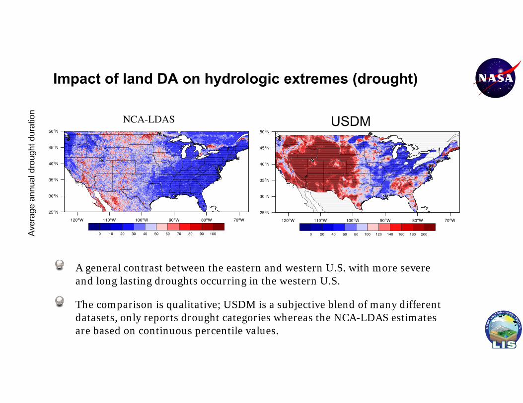
Impact of land DA on hydrologic extremes (drought)
A general contrast between the eastern and western U.S. with more severe and long lasting droughts occurring in the western U.S.
The comparison is qualitative; USDM is a subjective blend of many different datasets, only reports drought categories whereas the NCA-LDAS estimates are based on continuous percentile values.
USDM
Aver
age
annu
al d
roug
ht d
urat
ion

Trends in drought annual duration/severity
Root zone soil moisture based drought indicators based on the NCA-LDAS demonstrate an increasing trend in average annual drought duration over the Southwest U.S., consistent with the patterns from the US Drought Monitor.
The slope of the trendlines is highest over the Southwest region, followed by Northwest and Southeast
USDM data is based on a shorter record, based on categorical drought estimates
-50
0
50
100
150
200
250
1980 1985 1990 1995 2000 2005 2010 2015
NCA-LDASUSDM
Dro
ught
dur
atio
n (d
ays)
Southwest US

A support vector machine-based forward operator was developed by training to microwave brightness temperature differences in 10, 18, 36, 89 GHz
Kwon, Y., B.A. Forman, J. Ahmad, S.V. Kumar, Y. Yoon : Pitfalls and perils of machine-learning passive microwave brightness temperature data assimilation over terrestrial snow in High Mountain Asia, Frontiers Earth Sci.. In review.
Assimilation of passive microwave dTB assimilation with machine learning
DA performs best during ablation/dry season likely due to better sensitivity to SWE and less contribution from the presence of liquid water
Machine learning-based observation operators lose sensitivity and controllability during deep and/or wet snow conditions. Discrimination of such instances would provide valuable input for DA

Systematic and consistent improvements over the Central Plains, lower Mississippi, central California valley. Larger improvements are over agricultural areas of maize and soybean
LAI estimates from AVHRR/MODIS was assimilated into the Noah-MP land surface model during 1980-2017
Change in RMSE (W/m2) Warm colors indicate improvements; cool colors indicate degradations from DA
Kumar, S.V., D. Mocko, S. Wang, C.D. Peters-Lidard (2019), Assimilation of remotely sensed leaf areas index into the Noah-MP land surface model: Impacts on water, energy and carbon fluxes and states over the Continental U.S., J. Hydrometeorology, 10.1175/JHM-D-18-0237.1
Assimilation of Leaf Area Index (LAI)

LAI assimilation impacts on carbon fluxes
Strong improvements in GPP over agricultural areas
Change in RMSE (g/m2) of GPP and NEE compared to FLUXCOM. Warm colors indicate improvements; cool colors indicate degradations from DA

Assimilation of remotely sensed albedo
Albedo influences the available net radiation, snow melt, runoff and evaporation
Increase in albedo leads to increase in SWE and better agreement with observations
Black-sky and white-sky albedo and snow albedo estimates from MODIS was assimilated into the Noah-MP land surface model during 2000-2018
Kumar, S.V., D. Mocko, C. Vuyovich, C.D. Peters-Lidard (2019), Impact of surface and snow albedo assimilation on terrestrial water budget and snow estimation, in review

VOD describes the vegetation attenuation of the passive microwave signal. It is directly related to the water content of the vegetation. VOD retrievals from X, C and L-band (SMAP) was assimilated into Noah-MP
VOD from microwave radiometry provides an all-weather capability for vegetation sensing
Kumar, S.V., et al. (2019), Assimilation of vegetation optical depth retrievals from passive microwave radiometry, in prep.
Assimilation of Vegetation Optical Depth (VOD)
Anomaly R
(DA-O
L)
ET (vs GO
ME SIF)Stronger improvements (and
degradations) in soil moisture and streamflow from soil moisture DA
More impacts (particularly over agricultural areas) from SMAP VOD assimilation
Assimilation of SMAP VODAssimilation of SMAP soil moisture
Soil moisture (vs ISM
N)
R(D
A-OL)

Land Characterization at the U.S. Air Force 557th Weather Wing
557 WW (DoD’s Executive Agent for Land Information) provide routine geospatial intelligence information to war-fighters, planners, and decision makers at all echelons and services of the U.S. military, government and intelligence community. 557th Weather Wing (557 WW) and its predecessors have been home to the DoD’s onlyoperational regional and global land data analysis systems (GLDAS) since January 1958.
Original OSU LSM
development
”Soil moisture project”
19741958
“AGROMET”(Penman evaporation
formula) 1980
1990
AGRMET –OSU LSM in
ops
2001
AGRMET-Noah LSM in
ops 2005
NASA/GSFC strategic
partnership
Initial transition to LIS from AGRMET
2007
2008
LIS transitioned to AFWA ops,
increasing spatial resolution to 25km 2010
LIS-DA development
2009 LIS-WRF, CMORPH, LIS-RTM
developed
2011 Noah updates, Lake model development, soil
moisture, snow DA
LIS-UE, ensemble data assimilation 2015
IOC2019
LIS7.2 in ops10km global

Operational DA updates at 557WWLIS7.2 configuration (to be operational in the summer of 2019)
An observation-based precipitation product generated through a Bratsethanalysis
Uses GALWEM precipitation as the first guess and then assimilates CMORPH, SSMIS, GEOPRECIP and rain gauge data.
Assimilates ~1.74 million observations in 3 wall clock minutes
Extended support for satellite DA (assimilation of SMAP SM from JPL, ASCAT Metop- A/B SM from SMOPS, SNODEP snow analysis) using Ensemble Kalman Filter
Fully global at 10km resolution
vs NLDASBest results using GALWEM background data; Comparable quality to NLDAS, as verified from (indirect) evaluation of soil moisture

Operational DA updates at 557WW: Assimilation of SMAP data in JULES
Anomaly R (DA – OL) ubRMSE (OL-DA)
Surface soil moisture retrievals from SMAP were assimilated into JULES in the 557WW configuration (2015-2017)Evaluated against USDA ARS, SCAN and USCRN station data
Statistically significant improvements in soil moisture over most parts of the domain (improved anomaly R and reduced ubRMSE)
Improved: 63.8%; Degraded: 36.2% Improved: 75.4%; Degraded: 24.6%

Operational DA updates at 557WW: New snow analysis
A new 557WW snow analysis is being developed, replacing the SNODEP product. Major changes include updates to the passive microwave retrieval algorithm. The blending of gauge data is performed with the Bratseth approach.
16.8% improvement during the winter of 2018 (using GHCN data as the reference)
More improvements with newer algorithms and the Bratseth analysis

Operational DA updates at 557WW: Evaluation of the new snow analysis vs SNODAS
More improvements with newer algorithms and the Bratseth analysis
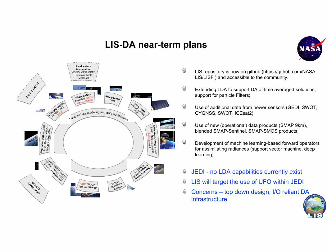
LIS-DA near-term plans
Reservoir
Snow cover:
AVHRR, MODIS,
VIIRS
Water surface
elevation: SWOT,
Jason, ICESat2
Soil moist
ure: S
MMR/
SSMI, AMSR-E
, ASCAT
,
SMOS, AMSR2,
SMAP
LAI/NDVI: A
VHRR,
MODIS, VIIR
S,
GEDI
Terrestrial water
stroage: GRACE,
GRACE-FO
Irrigatio
n intensity:
MODIS
Land surface modeling and data assimilation
Precipitation: GPM
Snow depth/SW
E: SMM
R,
SSM/I, AM
SR-E, AMSR
2, Landsat ;VIIR
S
Albedo: AVHRR, MODIS, VIIRS
Vege
tatio
n O
ptic
al D
epth
: SS
MI,
AMSR
-E, A
SCAT
, SM
OS,
AM
SR2,
SM
AP
Land surface temperature:
MODIS, VIIRS, GOES, Himawari, MSG,
Meteosat
OCO-2, O
CO-3
SMAP (9km),
CYGNSSLIS repository is now on github (https://github.com/NASA-LIS/LISF ) and accessible to the community.
Extending LDA to support DA of time averaged solutions; support for particle Filters;
Use of additional data from newer sensors (GEDI, SWOT, CYGNSS, SWOT, ICEsat2)
Use of new (operational) data products (SMAP 9km), blended SMAP-Sentinel, SMAP-SMOS products
Development of machine learning-based forward operators for assimilating radiances (support vector machine, deep learning)
JEDI - no LDA capabilities currently existLIS will target the use of UFO within JEDIConcerns – top down design, I/O reliant DA infrastructure