Land Consolidation Experiances of Turkey Consolidation Experiances of Turkey ... •Simply tractor...
18
1 Dr. Gürsel KÜSEK General Director General Directorate of Agrarian Reform-MoFAL Land Consolidation Experiances of Turkey Ankara, Turkey 2015 Consolidation Stuatiation: Total Consolidated Area 5 Mil. Ha. On Going Land Consolidation Area is 2 Mil. Ha. Our goal is to finis 9 Mil. Ha. till to year 2023 Total Land: 78 Mil. Ha Agricultural Land: 24 Mil. Ha Total Irregable Land: 8.5 Mil. Ha Total Grazing Land: 15.5 Mil. Ha Total Consolidation Area: 14 Mil. Ha Total Farmer: 3 Mil. Avarage Farm Size: 6 Ha Fragmentated Parcels : 11 Parcel/Farmer About Turkey…
Transcript of Land Consolidation Experiances of Turkey Consolidation Experiances of Turkey ... •Simply tractor...

1
Dr. Gürsel KÜSEK
General Director
General Directorate of Agrarian Reform-MoFAL
Land Consolidation
Experiances
of Turkey
Ankara, Turkey 2015
Consolidation Stuatiation:
Total Consolidated Area 5 Mil. Ha.
On Going Land Consolidation Area is 2 Mil.
Ha.
Our goal is to finis 9 Mil. Ha. till to year
2023
Total Land: 78 Mil. Ha
Agricultural Land: 24 Mil. Ha
Total Irregable Land: 8.5 Mil. Ha
Total Grazing Land: 15.5 Mil. Ha
Total Consolidation Area: 14 Mil. Ha
Total Farmer: 3 Mil.
Avarage Farm Size: 6 Ha
Fragmentated Parcels : 11 Parcel/Farmer
About Turkey…

2
1961-2008
• Land consolidation executed in the simple sence
• Simply tractor ways between parcels was building
• Project generation was very slow. It was 30.000 Ha/Year
Improvement Management
• Regulations about legal procedures
• Started to use High Technology (Softwares, Photogrammetry, GPS etc.)
• We had given educations to technical stuff for improving the human sources
• Created Public Awareness by using media and extensions
• Creating New Financial Sources from National Budget
2008-2015
• Basin based land consolidation projects has started
• Multi purpose land consolidation has started (ecology, hydrology, historycal places, public investment, state investments etc.)
• Project area has been improved to 1 milliyon Ha per year
• Total budget per year has improved to 200 Million USD per year
Evaluation of Land Consolidation…
WHAT IS THE LAND CONSOLIDATION?
THUS, IRRIGATION RATE HAS EXCEEDED OVER 80’S %
Ex Ownership
Irrigation canals
The shape after the consolidation
Former and new plots
Integration of 7 plots

3
The new parcels
Roads
Roads
Terracing
Open drainage channel
Irrigation channel
Center of
Village
The infrastructures.
All development activities are being completed with LC.
Rippering
The Cadastral Map Showing the
Previous Situation
The number of former plots :
11 342 pcs.
The Map After the Consolidation
The number of the
new plots:
2745 pcs.
27 Parcels 1 Parcel

4
sattelement
Every Phase of the Projects are Negotiated With Farmers

5
Participory approach

6
Public Investment With Land Consolidation
The basic problem;
- Higher costs of expropriation
- Lack of budgets
- to object expropriation values
- delay investments
With consolidation;
Reduction of investment costs
(40%) and,
accelerating investment
are possible
- Shares of common usage (% 10)
- Swap with tresure lands,
- Physical investment savings,
- Less expropriation,
Irrigation scheme
Hıghway - road
Airport
highway intersection
Rail road
• Motorways and highways are made with
consolidation projects
– Ankara-Niğde hıghway 327 km
– İstanbul-İzmir hıghway 75 km
– Malatya ring road 45 km.
– Airport roads
– …
• Tresure land is used as a generally
• The edges of the roads are reserved for
the local farmers market and afforestation
TRANSPORTATION AND LC General Directorate of Highways

7
We Care About Ecology
All Land Consolidation Projects have been prepared by planning the ecological areas,
These areas must be connected to gether as much as possible
Development of an ecological network

8
We Care History
Determination and inventory
of historical and cultural places
FRAGMENTATION OF AGRICULTURAL LAND HAS BEEN PREVENTED BY
INHERITANCE LAW (2014)
Only one farmer uses land which has 13
shareholders farmer
83 % of all farmers
have less than 10 hectare
Existing Situation
Cadastre parcel 23,1 Million
Agricultural parcel 32,5 Million
Agricultural holding 3 Million
The average land size per
capita 6 hectar
Number of parcels per farm 11 Parcel
Number of shareholder 40 Million
“Indivisible Parcel Size” was determined.
«Indivisible land size» was calculated in the 81 province 920 city level..
Fragmentation by inheritance is not allowed under this size
Credit will be given to farmers who want to expand their land
Land Banking studies are going on.

9
Existing Stuation
May 2014 May 2015
Agriment time Sue time
1 year 3 month
Warn time
Notification
Population Database
Agricultural Holding
Database
Cadastrland
Database
450.000 dead
260.000 agri-land owner
Sanction
Expopriation
Avarnes
Land Banking/Land Consolidation?
• Agricultural Holdings : 3.1 milyon
• Avarage land size : 6 ha
• Parcels per holding : 11 Land Consolidation
Agricultural Parcels : 32,5 million
Total shareholder(owner) : 40 million
Active business : 3.1 million
Shareholder not cultivated land : 37 million
Transfer of shares is compulsory to active
busines by means of Land Banking (Land
Ofice)
Prevent of fragmentation is required for
farmland by inheritace Law
Land Banking
Land Consolidation is Inavitable ! Cannot Put a Solution For Heritage

10
19
Land Consolidation
Automation System
K
V
T
October 2015

11
What is TVK?
• TVK is a Web portal that all land consolidation process have
been executing over a central database
Citizens:
Can query all project
informations and the
conclusion of land
consolidation for
his/her parcel
Consultant Company:
Reporting
Comments
Corrections
Redlining
Data control
Approve in every phase
…
Land Consolidation Head od
Department:
Approving the e-documents
Approving the projects
Finale Data control
Official letters
Payment
Contract management
…
Conntractor Company and Subcontractor
Data download
Producing new data
Uploading Construction Draws
Data upload
Offical letters
Working program
Payment Request Reports
…
Work Flow Management - Project
Preparation
- Bid
- Approximate
Cost
- Contract
- Contractor
- Bill of
Quantities
- Site and Office
Works
-
Correspondence
- Minutes
- Geographical Data
Upload
- File Upload
- Data Control
- Progress payment
affairs
- Fund Transfer
- Time Extension
- Building audit
organization
- Office Delivery
- TKGM Data
- Correspondance
Consultant /
Administration
Control/
Approval
Mechanism
Temporary
Acceptance
Final Account
Final Acceptance
Contract Transfer
Withdrawal
Settlement
Work
Experience /
Audit
Records

12
Lifecycle Model In Land Consolidation Projects, Model is generated by
daily life activities.
All off the workflows are defined by natural project
management activities.
Therefore we can manage many controls. For example:
A company who requires progress payment has to upload
all of his data to the system.
Construction draws, without being uploaded to the system and approved by consultancy
and head of department, will not be in the approved state in the system.
All of the data upload activities are integrated with workflows. For example if ownership
data is not in the system then the company can not make block planning.
System knows if there should be a revision in a work item to be paid.
A Project without any fund can not continue to Construction Works, so can not request any
progress payment.
Inside of Database On-line Data
TAKBİS
KVK
Meteorology
Geographical Data
Base Map
Soil Data
Project Border
Proprietorship data
Takbis Data
KVK data
Hydrologic Data
Blok and Subdivision Plan
Practice and Application
Projects
Road
domestic water
waste water
Irrigation
Orthophoto
Satellite Imaging
Correspodences
All Correspondences within the scope of
project
Files
Lists
Documents
Minutes
Reports ( Social Structure of Village, Soil
Survey Report, Block Plan Report,
Subdivision Plan Report, Consultancy
Firm Report)

13
Contents
TVK
Query
Statistics
All Official Letters Archive Web
Mobile
WEB GIS
Authentication
Redlining
Consolidation
All Project Input and Outputs
• Map Data
• Correspondences
• Minutes
• User, Project, History
• Progress Payment
• Practice Projects
• Application Projects
• ......
Consolidation Database
TVK
14
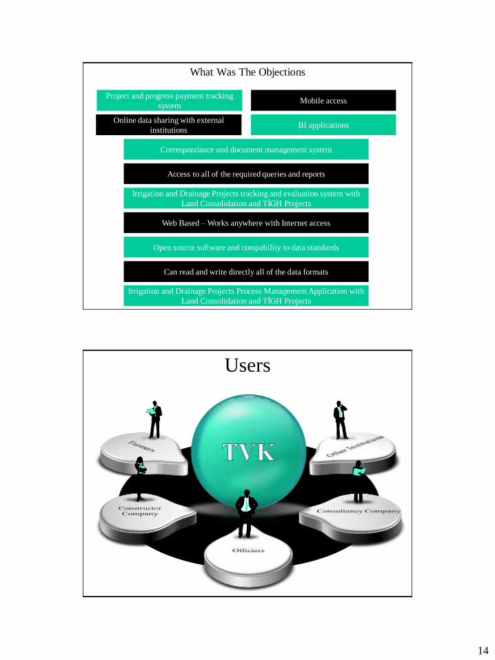
What Was The Objections
Project and progress payment tracking
system
Irrigation and Drainage Projects Process Management Application with
Land Consolidation and TİGH Projects
BI applications
Access to all of the required queries and reports
Correspondance and document management system
Online data sharing with external
institutions
Irrigation and Drainage Projects tracking and evaluation system with
Land Consolidation and TİGH Projects
Open source software and compability to data standards
Web Based – Works anywhere with Internet access
Mobile access
Can read and write directly all of the data formats
Users

15
Main Functionalty
• Project
Management
• Contol
• Tracking
• Evaluation
• Correspondences
• Progress Payment • Reporting
• Control
• Data Display
• Correspondences
• Correspondences
• progress payment
• Data Loading
• Tracking)
Institution
Consultancy Company
Contractor
TVK is open source
software and the property
belongs to GENERAL
MANAGEMENT OF
AGRİCULTURAL
REFORM
Goals • All of the Land Consolidation activities in our country are combined in one
database.
• Work done can be monitored and tracked easily.
• Next generations can see how we made Land Consolidation.
• Audit, tracking evaluation is very transparent, and can be made easily in
one screen.
• Document search activities from archive decreases, all of the documents to
be paid and informations and geographical details can be kept in the system
and are always accessible.
• Code of accounts, Bill of Quantities, Work Done, Revised Prices, Work
Augmentation, etc. All of the details are now unique and prevent us to
make a mistake.
• Data Services can be made accessible to the external institutions and
contractor companies. Data can be read from every software module.
• Land registry cadastre data (20 minutes delayed) is easily accessible.
• Data upload operations can be made easily.

16
Basic Features of the Application
Ödemeler ve
Yazışmalar
ile ilgili
işlemler
Mevzuat ile
ilgili
dokümanlar
Harita
üzerindeki
işlemler
Proje izleme
ile ilgili
çizelgeler ve
grafikler
Projelerin
çeşitli
kriterlere göre
sorgulanması
Proje detay
bilgilerinin
tanımlanması
ile ilgili
işlemler
Kullanıcı
tanımlama ve
yetkilendirme
işlemleri
Uygulama ile
ilgili eğitim
dokümanları,
diğer bilgiler
Land Consolidation and Irrigation
Projects with TİGH Projects and
Business Processes within the
scope of Drainage Project
- Easly accessible and
- work oriented
work flows designed and placed in
the reason of access to data and
report
Screenshots

17
Example Correspondance/ Report
Screens
Control Mechanism Examples Surface Analysis
Using map we can control parcel, road, river, centre
of population and fields without registration
Parcel Shape Analysis In map layer, it is used for the control
of «area» specific cadastre and/or
block specific parcel datas geometric
shapes
Road distance per land In map ensures control of road distances per land
and all distance of roads, road and projects total
area via block , roads after consolidations using
road and road axis data
Parcelling Control Examining parcels created after Land
Consolidation by their topology, average
proportion size, irrigation mechanism
and road side

18
3
5
TVK Mobile Features User can monitor detailed and
statistical informations about
projects via Android/iOS based
phones.
All of the phases of progress
payment activities can be tracked
from entry to approval.
Maps used in the map (google maps,
bing maps etc.) can be changed on
request.
Basic map functions are applicable
anywhere where internet is via
android/ios based phones. (length,
area measurement etc.)