LAND BETWEEN THE LAKES WOODLANDS TRACE CORRIDOR …
45
LAND BETWEEN THE LAKES WOODLANDS TRACE CORRIDOR MANAGEMENT PLAN December 2008 1
Transcript of LAND BETWEEN THE LAKES WOODLANDS TRACE CORRIDOR …

LAND BETWEEN THE LAKES WOODLANDS TRACE
CORRIDOR MANAGEMENT PLAN
December 2008
1

WOODLANDS TRACE Corridor Management Plan
TABLE OF CONTENTS
1. Executive Summary 2. Introduction
a. Purpose b. Scope of the Plan c. Location of the Byway
3. Profile of the Byway
a. Current Opportunities b. Visitor Profile c. History of the Area
4. Intrinsic Quality
a. Recreation 5. Public Participation
a. Partnerships b. Implementation c. Evaluation
6. Desired Conditions
a. Vision b. Goals and Objectives
7. Strategies
a. Site Identification b. Implementation Priorities
8. Management Guidelines
a. Road Safety b. Overall Design Considerations c. Maintenance and Operations Considerations
9. Tourism and Marketing
a. Tourism and Visitation b. Marketing c. Publicity
3

EXECUTIVE SUMMARY The Land Between The Lakes (LBL) National Recreation Area (NRA) is located in the Western portion of Kentucky and Tennessee on an inland peninsula between Kentucky Lake and Lake Barkley. The proposed “Woodlands Trace” is a 43 mile stretch of road passing through the heart of LBL. Already designated as a state byway in both Tennessee and Kentucky, the road, known officially as The Trace within LBL, follows the ridge of land which divides the two lakes. The region is only about a day’s drive from several major population centers such as Nashville and Memphis, TN, Lexington and Louisville, KY, St Louis, MO, Indianapolis, IN and Cincinnati, OH. The byway is a North /South route traveling through the heart of the NRA. The road is the main thoroughfare of the 170,000 acre peninsula devoted to a diverse spectrum of quality recreational experiences and environmental education opportunities. Nearly every one of LBL’s 2 million annual visitors must travel at least a portion of this route during the course of their recreational pursuits.
LBL offers visitors diverse recreation opportunities to fit everyone’s need
With the entirety of the road being within LBL, the route provides access to many types of recreational opportunities. Biking and hiking trail access is found in numerous places along the byway corridor. Camping opportunities range from large full service campgrounds to remote backcountry experiences. Information centers are operated on the North and South ends as well as a large visitor center and planetarium/observatory at the midway portion of the route. Interpretive facilities such as a nature center, a drive through Elk & Bison Prairie, the South Bison Range and a living history farm are located along the route or in close proximity. From its creation as a unique peninsular land mass in the 1960’s, LBL has provided a rich, majestic natural resource setting for a wide range of recreation opportunities and environmental education experiences. This combination sets LBL apart from other public lands across the country. The Scenic Byway is the logical means to experience the plethora of recreational and environmental opportunities.
4

INTRODUCTION Purpose The Corridor Management Plan (CMP) is a tool used to describe and direct the management of a byway and its immediate surroundings. It highlights the significance of the route and the actions needed to preserve, maintain, and enhance those qualities. Management of the corridor is designed to ensure the intrinsic resources are conserved along with enhancing opportunities for tourism and economic development. The plan uses a ‘broad brush’ approach and sets general goals and objectives. However, with the route being on federal property, individual projects will require site-specific analyses prior to action. All future implementation must take place under the scope of LBL’s Land and Resource Management Plan. The corridor for this route extends one-half mile on either side from the center of the road bed. This includes the view shed of open lands and forests along the route. The plan was developed in cooperation with the local communities and their representatives. In addition, input was received from other state and federal agencies. Future management decisions will be made with the assistance of these government and non-government entities.
Scope of the Plan The 43 mile section of highway described in this plan is currently designated as a state scenic byway in both KY and TN. Known as The Trace, it is completely within the boundary of LBL. As such the land and roadway are entirely under the jurisdiction of the US Forest Service (FS). No private land exists within the boundary of the area or along the corridor of the route. Though portions of the highway exist outside the NRA, determination was made not to seek national scenic byway designation beyond the current termination points of the state scenic byway. As legislated in the LBL Protection Act of 1998, the states of Tennessee and Kentucky have maintenance responsibilities for the roadway and its shoulders. The extent of maintenance performed on a yearly basis is agreed upon annually by FS personnel and state representatives. LBL and the surrounding region have been a national destination for outdoor enthusiasts for decades. The Trace offers plentiful access to the water based recreation opportunities of Barkley and Kentucky lakes along with numerous forms of land based recreation. Combined with the many developed facilities on the route this access forms a center piece of tourism in the region. Four gateway communities offer access to the NRA. Dover, TN at the southern end, Grand Rivers, KY to the North, Canton, KY to the East and Aurora, KY to the West. These communities rely heavily on the tourism industry for the success of business. Tourism, though somewhat seasonal, is not restricted to the summer months since fishing and hunting opportunities abound bringing fringe season revenue to local hotels, campgrounds, and restaurants.
5

The Trace runs the length of LBL through scenic woodlands and connects Grand Rivers, KY to Dover, TN
Even though the route is traveled and enjoyed by thousands of visitors annually, it is not extensively promoted as a scenic drive. This plan will assist in guiding the local communities and government officials by setting forth ideas for developing the route as a destination for travelers. Enhancements to the road and its surroundings along with promotional materials touting its attributes should offer opportunities currently being missed for the travelers and communities alike. Location of the Byway LBL sits on one of the largest inland peninsulas in North America. Located between Kentucky Lake and Lake Barkley in Western Kentucky and Middle Tennessee, the 170,000 acre land area is not much more than a day’s drive from a large portion of the U.S. population. Some population centers less than 400 miles from the area include: Chicago, IL (395 miles), Cincinnati, OH (300), Indianapolis, IN (284), Knoxville, TN (278), Lexington, KY (245), Chattanooga, TN (230), Terre Haute, IN (213), Louisville, KY (200), Memphis, TN (200), Huntsville, AL (210), St Louis, MO (190), and Nashville, TN (90). Many travelers of Interstate 24 between St. Louis and Nashville currently take advantage of the proximity of LBL to this route by getting off the highway and taking the scenic drive. (Refer to Map) The scenic byway is comprised of a 43 mile stretch of road running along the dividing ridge of land separating the Cumberland and Tennessee River Drainages. These rivers have been inundated and are now referred to as Lake Barkley and Kentucky Lake respectively. The route begins at the border of LBL and the end of highway 461 near Dover, TN. Here the roadway name changes to The Trace. The route continues north 13.5 miles to the Kentucky line. Still known as The Trace in LBL, the route also becomes State Route 453 in KY. This section continues 29.5 miles to the northern border of LBL near Grand Rivers, KY. Highway 453 continues through Grand Rivers to Interstate 24 and beyond to its termination point in Smithland, KY.
6

PROFILE OF LAND BETWEEN THE LAKES AND THE BYWAY The Trace serves as the main travel artery for visiting the NRA while guiding visitors to an assortment of recreation endeavors. The Trace has been designated as a State Scenic Byway by both Kentucky and Tennessee mainly for its abundance of wildlife and scenic viewing opportunities. Although many travelers of the byway may only use the corridor for scenic viewing, The Trace grants access and offers a recreational experience for everyone to enjoy. The rolling terrain lends itself greatly to enjoyable trails for a solitary experience, a long distance horseback ride, or a motorized trail adventure. Although evidence of past habitation is present the absence of current dwellings creates a travel route lush with vegetation and unspoiled by an overabundance of human activity on the land. The varied views of temperate deciduous hardwood forests and open fields of wildflowers, grasses, and crops provide food for the eye as well as for the wildlife that inhabit them.
Native grasses and wildflowers grow throughout LBL and provide habitat for wildlife both large and small
Unbeknownst to the vast majority of byway travelers, the road generally follows a dividing ridge of land, known as the Tennessee Divide, along its path through LBL. The Tennessee Divide separates the Tennessee and Cumberland River drainages all the way from their headwaters in the Appalachians to their confluence with the Ohio River, north of LBL. The Divide narrows near the southern boundary of LBL and veers from its east/west trajectory to head north, basically bisecting what is now LBL. The Divide served as the western boundary of the United States until the 1790’s; and its path through LBL is one of the few places on earth where two major rivers flow so closely together (often less than 8 miles) yet never naturally meet. Most visitors never realize they are riding on top of this ridge due to the fact that the vast woodlands along the route offer no view of the lakes themselves. Given that all the land along the route is in federal ownership, the visitor is treated to forty five miles of undeveloped landscape except for the occasional open lands or recreation sites. Cultivated fields with their crops of corn, soybeans, and hay remind one of the past agricultural
7

uses of the land; while providing excellent wildlife viewing opportunities today. An historic iron furnace also provides clues of past industry and the people who provided the power to run it. Evidence of past habitation can also be found along the corridor of the byway. Stands of naturalized daffodils and other ornamental plants are a beautiful reminder of those who once lived along the Trace.
Current Opportunities The diverse range of recreational opportunities provided along the byway are unmatched elsewhere in the region. Nowhere else do visitors have the ability to travel and experience a 43 mile undeveloped roadway yet have direct access to 1500 campsites, 260 miles of non-motorized trails, 100 miles of motorized trails, and 420 miles of arterial roads for scenic driving and wildlife viewing. The Byway provides access to 170,000 acres of land for hunting, bird watching, and observing the night sky unblemished by lights.
Opportunities directly along the corridor A mix of active and passive, motorized and non-motorized, and developed and backcountry activities are currently permitted along the byway. Hiking, biking, wildlife viewing, driving for pleasure, picnicking, and nature photography comprise most of the recreational activities participated in along the corridor.
Cars and bikers share The Trace and give everyone an opportunity to see LBL from their favorite seat
The Turkey Bay Off Highway Vehicle area, The Homeplace living history farm, Elk/ Bison Prairie, Golden Pond Planetarium, and South Bison Range are developed recreation or education facilities found directly along the byway corridor. These facilities offer a wide range of experiences for the traveler that may not have the time or inclination to venture far from their route.
8

Opportunities with access dependent on the byway Camping, boating, canoeing, fishing, swimming, horseback riding, and hunting are all examples of activities which are accessed from the byway; but not typically done within the corridor. The byway provides access to four major camping facilities with a variety of services available to the public. Three traditional campgrounds, Hillman Ferry, Piney, and Energy Lake provide camping opportunities for tents to large RVs while Wranglers Campground caters to equestrian users. There are also 7 lake access campgrounds with basic amenities, 28 boat ramps, 16 semi-primitive camping areas, and 1 primitive group camp area. Two of the large interpretive facilities at LBL are the Woodlands Nature Station and Brandon Spring Group Center. Both are just a short distance off The Trace but offer a multitude of opportunities for visitors. The Nature Station is the hub of activity and information for the Nature Watch area in the North. Brandon Spring offers overnight accommodations for organized groups. The shear volume of opportunities for visitors to experience can make a trip to LBL exciting and different each time. These opportunities will be discussed in greater detail in the Intrinsic Quality section.
Visitor Profile LBL attracts approximately two million visits from throughout all 50 states to LBL and surrounding communities annually. Some 70 million Americans live within a six-hour drive of LBL, making it one of the most accessible NRAs in the United States. Visitors can be generally divided into three major geographic groups: 67 percent local visitors (from the seven counties surrounding LBL), 21 percent regional visitors (outside the surrounding counties but from adjoining states), and 12 percent national and international visitors. Peak visitation period runs between April and November. Additional visitor information for LBL is available through a ‘Point of Sale’ (POS) cash register system which is operated at each of the area’s developed facilities. Additional information has recently been received from the USFS’s ‘National Visitor Use Monitoring’ (NVUM) survey. POS indicates that:
• 44% of LBL’s visitors are Mature Adults • 24% are Families with Children • 15% are Young Adults • An additional 10% is made up of Organized Groups such as school field trips,
church retreats, commercial tours, etc. The NVUM survey, completed in 2007 offers insight into the types of activities visitors participate in while at LBL. The most popular are:
• Viewing Natural Features 44.1% • Fishing 40.4% • Wildlife Viewing 30.5% • Developed Camping 28.8% • Hiking/ Walking 23.2% • Driving for Pleasure 18.0% • Picnicking 11.3%
9

In addition, surveyed visitors have asked for more information on the activities below.
• Wildlife Viewing- Related Activities 54.9% • Scenic Driving 54.1% • Outdoor Special Events 51.6% • History- Related Activities 49.1% • Hiking Trails 47.1% • Pleasure Walking 45.4% • Freshwater Beaches 43.4%
Interestingly, most of these activities are either directly related to the byway corridor or are accessed directly from the route.
History of the Area
To understand the significance of the corridor and its importance to the region; one must first have an understanding of LBL itself and the people who once inhabited it. The story of human occupation begins as far back as 10,000 years ago when Paleo-Indians, the first Native American peoples, arrived in the area. The area between the rivers was home to native peoples for thousands of years prior to the arrival of European settlers. One of the more tragic themes in the history of this area, that of displaced people uprooted and relocated by the U.S. government, begins with the arrival of early settlers. It is ironic that many of the early settlers, who were awarded lands here by the newly formed U.S. government, displaced the Native Americans that were here before them and then, many years later, early settler descendents along with others who moved to the area over the years and built homes, farms, schools, churches, and communities, found themselves displaced, uprooted, and relocated by that same government. European American settlers began arriving in the late 1780’s developing farmsteads in the floodplains and rolling uplands along the Cumberland and Tennessee Rivers. The rivers served as the main form of transportation. Villages, camps, settlements, ferries, taverns, and towns grew up along the banks as travelers and goods navigated the rivers’ corridors. As settlements developed, schools, churches, and businesses followed and like many other parts of the United States, industrialization came to the area by way of the timber and iron industries. The American iron industry expanded into frontier regions such as that which existed here between the rivers during the early 1800’s. The presence of the iron furnaces and the transportation system offered by the rivers made this area strategically important for both sides when the Civil War started. The capture of Fort Henry and Fort Donelson in February 1862 was the first major success of Union forces during the war. This campaign also marked the beginning of the rise of General Ulysses S. Grant to leadership of all Union forces and eventually to the presidency. Fort Henry today lies below the waters of Kentucky Lake, but some of its outer defensive works can still be seen on LBL about 4 miles from The Trace. Fort Donelson National Battlefield, directly south of LBL, is managed by the National Park Service. After the war, times were difficult for many; family members had been killed and recovering from the personal, economic, and social losses often took years. The disruptions of the Civil
10

War and advancements in the iron industry led to the closure of most of the iron furnaces in Western Kentucky and Tennessee during and after the war. Post-Civil War changes between the rivers included an influx of immigrants and a return to the small community-focused and family managed farming lifestyle for many old and new residents in the area. Residents of this area, as in the South as a whole, tended to remain predominantly agricultural, while the rest of the country entered the industrial age. The main cash crops were corn and tobacco, but the local residents took every opportunity they could to produce other goods for sale. This included producing railroad crossties, bricks, whiskey, and any other product that might diversify their earnings potential. However, the basic economy remained rural subsistence farming. Over the years, some good farmland became overused and under-productive. The area that is now LBL was acquired by the federal government in several stages, beginning in the 1930s, displacing and relocating some former residents as many as four times. The first displacement and relocation began in 1936 with the purchase of 41,000 acres from the Hillman Land Company and an additional 15,000 from other individuals. This New Deal ‘Land Utilization Project’ was designed to reclaim land that had been deemed not suitable for profitable agriculture. The goal was to develop the land as a game reservation, recreation center, and for production of forest products. This 56,000 acres, originally called the Coalins Forest and Game Preserve, was eventually transferred to the wildlife refuge system and renamed the Kentucky Woodlands Wildlife Refuge. Management of the land was transferred to TVA in 1965 when it officially took over the area. The second relocation, the result of a plan to create Kentucky Lake by damming the Tennessee River at Gilbertsville, Kentucky, was born after the flood of 1937 struck the Tennessee and Ohio Valleys. The flood caused devastation to communities, farms, and families, causing some to temporarily relocate. The following year, in 1938, five years after TVA was created, TVA told people living along the banks of the Tennessee River that they would have to move. The third relocation began in the mid-1950s, when the Army Corps of Engineers began to plan the impoundment of the Cumberland River. This formed Lake Barkley on the eastern side of the area between the rivers. The final relocation loomed over residents beginning in the late 1950s when the U.S. government initiated a study for a national recreation area between the two lakes. The final plan to make the entire area a federal entity meant that those residents still living between the rivers, many who had been moved three times, faced the possibility of having to relocate for a fourth time. This time they would be leaving the area for good. In 1963 President John F. Kennedy signed the legislation that granted TVA authority and funding to purchase the remaining lands and relocate all of the residents. This last displacement, forced relocation, and finally complete removal from the area, was marked by bitterness, resentment, and distrust among many of the former residents. They feel a closeness and relationship with the lands that are LBL because of the sacrifices, whether willing or not, their families made over the years leading to the establishment of the national recreation area. From 1964-1969, all of the land between the two lakes was bought or condemned and claimed through imminent domain by TVA. Structures were moved, sold, or bulldozed to make way for
11

a more “natural” setting. Today the area is predominantly forested and contains typical forest recreation activities: hunting, camping, hiking, and scenic driving. Under TVA (1963-1999), natural resources were managed in order to provide public outdoor recreation and environmental education opportunities. Several facilities and amenities were constructed along, or in close proximity to, The Trace to help increase opportunities for visitors. These facilities will be discussed in latter sections. By 1994, the primary focus was on ensuring that natural resource management activities added value to a visitor’s experience through enhanced scenic driving and wildlife viewing. Activities included timber sales to manage vegetation and open land plantings designed to attract wildlife. In 1998, Congress passed The LBL Protection Act to transfer management of LBL to the US Forest Service in the event TVA did not receive appropriated funding. In 1999, management of LBL was transferred to the Forest Service through the Protection Act, P.L. 105-277, which clearly defined LBL’s mission:
To protect and manage the resources of the Recreation Area for optimum yield of outdoor Recreation and Environmental Education through multiple use management; to authorize, research, test, and demonstrate innovative programs and cost-effective management of the Recreation Area; to help stimulate the development of the surrounding region; and to extend the beneficial results as widely as possible.
INTRINSIC QUALITY
Recreation
Visitors to the byway can choose from a wide range of popular recreation activities. Campers utilizing the byway can find ample accommodations at more than 1,500 campsites in LBL’s developed recreation facilities. Thousands of acres of backcountry areas provide solitude for more primitive camping and exploring opportunities. Nature viewing and scenic driving can be accomplished at a leisurely pace. Either on the byway, or within close proximity, are specialized recreation use areas that offer facilities specifically for equestrian sports and off highway vehicle (OHV) riding. Biking and hiking enthusiasts are afforded many opportunities, challenges, and rewards along more than 260 miles of non-motorized trails. The access to so many different opportunities within a virtually small land area compared to the western public lands makes LBL and The Trace a very unique experience. Nowhere else in the region can one find such a wide variety of experiences in so natural a setting. Picnic Areas, Day Use and Overlooks Multiple picnicking and overlook facilities are available along The Trace. Immediately adjacent to The Trace at the northern entrance is Kentucky Lake Drive. This one-way semicircular drive begins shortly after crossing the “Between The Rivers” memorial bridge over the canal from Grand Rivers. Visitors to this area enjoy several pull offs offering sweeping vistas of mile wide Kentucky Lake and numerous picnicking opportunities.
12

Ten additional picnic areas are available for outdoor dining along The Trace as one travels south. Four of those sites are located adjacent to the facilities known as North Welcome Station, Golden Pond Visitors Center, The Homeplace and South Welcome Station. Accessible picnic pavilions, accommodating up to 60 individuals, are available at The Homeplace and Golden Pond Visitor Center. The other six sites are typically located at strategic locations so visitors can enjoy another activity while they are in the area. Jenny Ridge Picnic area, for example, offers quick access to a portion of the North/South (N/S) Trail or the Elk & Bison Prairie. The South Trailhead for the N/S Trail is a popular site for picnickers as well as hikers wishing to utilize the Fort Henry trail system. Colson Overlook is located in a location along the Tennessee Divide which is close enough for viewing Kentucky Lake in the winter season. Cedar Pond, on the TN/KY border, offers fishing and hiking opportunities. South Bison Picnic area overlooks the bison range near the former town of Model TN. Star Camp provides a large open area which can accommodate large groups of approximately 175 and is available for group overnight stays by permit.
Cedar Pond Picnic Area offers visitors a quite spot to pull off and enjoy the outdoors
Moss Creek Day Use Area, located just two miles off The Trace, offers swimming and picnicking opportunities. This lake level site also offers sweeping views of mile wide Kentucky Lake. Wildlife/ Nature Viewing In a 1998 customer survey, 54.6% visitors indicated that they participated in wildlife viewing activities during their visit. This trend has remained nearly unchanged over the last ten years as the NVUM study mentioned in the Visitor Profile shows. Opportunities abound to observe wildlife in the many open areas along the corridor. It is not unusual to observe 10 to 50 deer and/or turkeys on a drive during prime seasons. Colorful dragonflies and swarms of gorgeous butterflies easily catch the attention of travelers. Birds of many species thrive in the forests and open lands of the corridor as well. Over 100 species can be seen in a single day during migratory
13
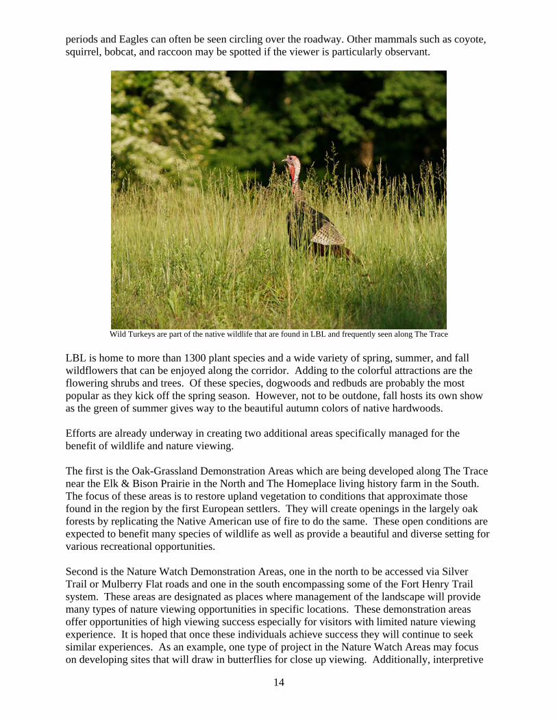
periods and Eagles can often be seen circling over the roadway. Other mammals such as coyote, squirrel, bobcat, and raccoon may be spotted if the viewer is particularly observant.
Wild Turkeys are part of the native wildlife that are found in LBL and frequently seen along The Trace
LBL is home to more than 1300 plant species and a wide variety of spring, summer, and fall wildflowers that can be enjoyed along the corridor. Adding to the colorful attractions are the flowering shrubs and trees. Of these species, dogwoods and redbuds are probably the most popular as they kick off the spring season. However, not to be outdone, fall hosts its own show as the green of summer gives way to the beautiful autumn colors of native hardwoods. Efforts are already underway in creating two additional areas specifically managed for the benefit of wildlife and nature viewing. The first is the Oak-Grassland Demonstration Areas which are being developed along The Trace near the Elk & Bison Prairie in the North and The Homeplace living history farm in the South. The focus of these areas is to restore upland vegetation to conditions that approximate those found in the region by the first European settlers. They will create openings in the largely oak forests by replicating the Native American use of fire to do the same. These open conditions are expected to benefit many species of wildlife as well as provide a beautiful and diverse setting for various recreational opportunities. Second is the Nature Watch Demonstration Areas, one in the north to be accessed via Silver Trail or Mulberry Flat roads and one in the south encompassing some of the Fort Henry Trail system. These areas are designated as places where management of the landscape will provide many types of nature viewing opportunities in specific locations. These demonstration areas offer opportunities of high viewing success especially for visitors with limited nature viewing experience. It is hoped that once these individuals achieve success they will continue to seek similar experiences. As an example, one type of project in the Nature Watch Areas may focus on developing sites that will draw in butterflies for close up viewing. Additionally, interpretive
14

media may discuss how this was achieved and offer information as to what types of butterflies may be seen. The byway also grants access to an additional 420 miles of roads open to the public to explore other options for scenic driving and wildlife viewing. Scenic Driving There may be times when travelers don’t have the time to stop and investigate nature except for what they see as they pass through. All along the route, historic, cultural, recreational, and natural features contribute to the area’s scenic qualities. The scenic experience along the route varies from a winding travel-way with dense woods at close range to vast open agricultural hay and crop fields and big sky. Large well-developed trees - remnants of old house sites and farms - are scattered in grassy fields all along the route. The rolling terrain in the southern portion provides a sense of climb or descent and views at longer range, while the northern portion offers scenery more level to the horizon. Graveled side roads break blocks of dense woodland and offer a sense of intrigue to the traveler as “roads less traveled.”
The Great Western Furnace is one of the few remaining remnants of the areas iron industry
The remains of the Great Western Iron Furnace is one of the few structures visible from this corridor. Such a massive stacked-limestone structure is a scenic curiosity to those who have never viewed an historic iron furnace. Natural and cultural features contribute to the ephemeral scenic qualities. In the spring months, fields of wild mustard create vast expanses of yellow among the greening trees and field edges. Native spring-flowering vegetation, including black cherry, service berry, dogwood, redbud and sassafras trees, and banks of bird’s-foot violets and fire pink create visual interest along the corridor. Beds of daffodils and irises recall the home places of the area’s historic inhabitants. During the fall, the deciduous woodlands display yellow and red hues as the trees prepare to drop
15

their foliage. The winter months offer deeper views into the forest edges through gray and brown trunks. Farm fields change seasonally as the crops grow: from plowed, bare ground to growing and maturing crops to harvest stubble. Hayfields metamorphose from short dull green vegetation and the winter orange of Andropogon and other warm-season grasses to taller, seeding waves of maturing grasses to changes by mechanical harvest. A part of the corridor’s scenic experience is watching the process of harvesting corn and other row crops and hay-baling. Seeing square or round bales in the fields, short or long term, adds to the scenic quality of this rural landscape.
American Bison can be found in the South Bison Range and the Elk and Bison Prairie
Elk and bison roam singly and in herds in ever-changing patterns through the Elk and Bison Prairie and the South Bison Range. Deer are often visible in mowed edges alongside the corridor. Along the parts of the travel way where views are open to the sky, clouds constantly change and vary the sun-shade patterns on the landscape. Winds provide ripples in visible water bodies like Cedar Pond and movement along woodland edges and in fields of hay and corn. Hawks, vultures, and eagles are often seen soaring overhead or perched in trees along the roadway. From lake-side vantage points like the Canal Loop shoreline, the colors of sunset and the light of the full moon juxtaposed with Kentucky Lake creates spectacular ephemeral scenery. Cycling and Motorcycling Cycling along The Trace itself is enjoyed by many and has increased dramatically in recent years. The Trace has been designated as part of two bicycle touring routes by the Adventure Cycling Association. One of these routes, known as the ‘Underground Railroad’ trail, stretches from Mobile, AL to Owen Sound, Ontario. The other route titled the ‘Great Rivers Route’ follows a path from St. Francisville, LA to Muscatine, IA. However, with practically no shoulders on the highway and a very curvy path through much of the route, cycling can be hazardous to those not paying close attention.
16

The route is also a favorite among motorcycle enthusiasts in the local region and beyond. The Trace is routinely used for Sunday drives with small groups of friends to large charity rides consisting of 200 or more motorcyclists. The motorcyclists often seek out The Trace as a route of low congestion and a 43 mile ride of panoramic open roadway. Hiking and Trails Over 260 miles of non-motorized trails traverse LBL. The majority of these trails intersect The Trace in one or more places. The 58 mile North/South (N/S) National Recreation Trail extends the length of LBL. Sections of this trail can be shared by hikers with mountain bikers or with horseback riders. The N/S trail intersects the byway at five different locations allowing access for short or medium distance hikes.
Winter offers some of the best hiking opportunities and some spectacular scenery
The Canal Loop Trail system is located in the vicinity of the North Welcome Station and is a favored single track destination for local mountain bike enthusiasts. This system of 1.5 to 14.2 mile trails is the site of several sanctioned foot and mountain bike races and locally organized events each year. In the south end of LBL is the Fort Henry National Recreation Trail system. This system lies in an area close to the site of this Civil War era fort. Two of the trails in this system actually follow the route of Union soldiers as they marched from the defeated Fort Henry to attack Fort Donelson a short distance to the East. These trails are popular with visitors searching for a semi primitive experience in a more isolated portion of the recreation area. With approximately 29 miles of loop trails, visitors can choose to hike in for a night, a day, or simply an hour or so. Also adjacent to The Trace is the Turkey Bay Off Highway Vehicle (OHV) area. Turkey Bay OHV Area was the first federally designated OHV area in the nation. This 2100 acre area offers 106 miles of designated routes for off-road driving experiences. Even though portions of this 17

area are within 100 yards of the roadway, few visitors driving The Trace will ever notice its presence. Located in very close proximity to the byway is 100 miles of designated equestrian and wagon trails that offer campers at Wrangler’s Campground and day riders a variety of trail riding experiences from shore line riding to ridge top views. Camping Although camping is not allowed in the corridor of The Trace, the road serves as the main thoroughfare to camping and boating accommodations in LBL with more than 1,500 campsites and 28 boat launches in LBL’s developed recreation areas. There are thousands of acres of backcountry areas that provide solitude for more primitive camping and exploring opportunities. In a 1998 survey, visitors indicated that camping with family was one of the top five reasons for visiting LBL. Hillman Ferry Campground is the only major family campground with an entrance directly off The Trace. It has accommodations for over 378 camping units and offers all the amenities of a full service campground including an outpost, beach, amphitheater, pavilion, playgrounds, ball fields, and boat ramps. However, the route grants access to 3 other major camping facilities, 7 ‘lake access’ campgrounds with limited services, 16 semi-primitive ‘Backcountry Areas’, and 1 primitive group camp area. The Wranglers Campground is unique to LBL because of its specialized camping and trails facilities. This 200 site campground caters to horse back riding and wagon driving enthusiasts. This facility also offers a full range of guided horse back riding trips, farrier and blacksmith services, cabin rentals, as well as an Outpost for camping supplies and food services. Piney Campground is located on the far southern end of LBL on Fort Henry Road just eight miles off the byway. It has accommodations for over 384 camping units and offers all the amenities of a full service campground including an outpost, beach, amphitheater, cabin rentals, pavilion, playgrounds, ball fields, and boat ramps. Energy Lake Campground is a cozy 48 unit campground located on the shore of Energy Lake, a 300 acre sub-impoundment of Lake Barkley. The campground offers some amenities as well as a beach, activity building, canoe rentals, and ice and wood sales. There are seven ‘Lake Access’ campgrounds (Jones Creek, Rushing Creek, Fenton, Gatlin Point, Cravens Bay, Smith Bay, and Birmingham Ferry) that offer less developed facilities than the full service campgrounds; but still provide some basic amenities. These areas are all located on the shore of one of the two lakes and all have boat ramps, developed camping sites, and potable water. Most of these sites offer accessible vault toilets. However, Cravens Bay offers flush toilets and Rushing Creek offers flush toilets and seasonal shower availability. All of these campgrounds offer shore fishing, swimming opportunities, and boat ramps. These campgrounds offer the user a camping experience that changes with the seasons, such as wildlife viewing, scenic lake views, changing foliage from the stark browns of winter, the bright greens of new growth in spring, the dark greens of summer, and the explosion of colors in fall.
18

There is one group camping area, Colson Hollow, that offers an opportunity for large group camping. With a reservation to this area, scouts, families, churches, etc. can spend time together right on the shores of Kentucky Lake. It can accommodate up to 200 users who get a spectacular view of the lake while enjoying relative solitude from other users of LBL. There are 16 designated backcountry areas ( Nickell Branch, Twin Lakes, Eddyville Ferry, Kutawa Landing , Demumbers Bay, Pisgah Point, Taylor Bay, Shaw Branch, Devils Elbow, Sugar Bay, Redd Hollow, Bacon Creek, Neville Bay, Ginger Bay, Boswell Landing, and Grays Landing) located on the shore of one of the two lakes and are all accessed off the byway. All have boat ramps, but offer a variety of amenities. Some have designated sites with tables and grills; others are just large fields. Some have vault toilets, trash bins, and courtesy docks; others require pack it in and pack it out. There is also variety of camping experiences from large family camping to opportunities for solitude. Throughout LBL just off the byway, there are opportunities to primitive camp. Many visitors seeking a more primitive setting utilize these ‘user developed’ sites. These areas are often found along the lake shores. Some, however, are very close to The Trace and typically are used by hunters seeking fast access to areas in which they will pursue their quarry. Others backpack into the general forest to get away from the pressures of modern life. Whatever camping experience you seek, it is available at LBL; and the byway provides the access. Fishing and Hunting While scenic driving and wildlife viewing were the most popular activities at LBL in the 1998 survey, results also show that fishing is the top reason visitors chose to come to LBL and hunting/scouting is the fourth. Fishing opportunities directly on The Trace corridor are extremely limited. Small ponds at the Golden Pond Visitor Center, Cedar Pond Picnic Area, and near Hillman Ferry Campground, along with access to the Barkley/Kentucky Lake Canal, are viable places for fishing along The Trace. These offer fishing for catfish and sunfish species and are used on a regular basis by visitors. For access to Kentucky and Barkley lakes, where the majority of fishing in the region takes place, boaters must utilize one of the many roads to lake access areas. There are also countless areas with access for shoreline fishing. Fishing docks are also available at Devils Elbow and Energy Lake Dam. Hunting opportunities abound in the recreation area. Although regulations prohibit hunting within 150 feet of developed facilities and The Trace, many hunters park along The Trace or access side roads leading from the byway to their intended destination. All in all, with no closed fishing season, plentiful wildlife and about 250 hunting days available annually, the area hosts tremendous opportunities for sportspeople year round. Interpretive Facilities Though interpretive programs are often considered something different than recreational activities; they are both enjoyed by individuals during their free time. This is especially true at LBL, which has a congressional mandate to provide educational and interpretive information and activities to the public. Thus, interpretive facilities are an integral aspect of the overall visitor’s experience as they travel in the NRA.
19

There are a total of three visitor centers along the corridor. These are operated under a joint venture agreement between the U.S. Forest Service and the Friends of LBL, a valued non-profit partner. These centers are located at each of the main entrances to LBL and serve as vital sources of general information and trip planning for visitors traveling the byway. On either end of The Trace are the North and South Welcome Stations. Each of these facilities offers individualized visitor information about the area shared by trained staff. Restroom facilities, picnic areas, and close proximity to trail heads of the N/S Trail are a few of the amenities offered at these sites. The welcome stations further serve as ‘hunter check stations’ to inventory deer and turkey taken during specific hunts held during the season. This also provides a valuable source of information to manage the populations of game species within the NRA. The largest of the visitor contact facilities, situated at LBL’s main entrance near the junction of The Trace and Hwy 68/80, is the Golden Pond Visitor Center (GPVC). This facility offers basic amenities such as restrooms and picnic areas as well as interpretive exhibits and programs. The main exhibit area features an historical time line of LBL from prehistoric times, through early European settlement and on to the federal acquisition of the land. A planetarium and observatory are also operated at this location. The planetarium offers visitors an opportunity to learn about our universe and what the night sky will look like on the evening of their visit. The observatory, operated on select evenings and hosted special events, gives visitors a first hand chance to observe the heavens in an area with one of the darkest night time skies in the region. The Elk & Bison Prairie offers visitors a chance to drive through a 700 acre enclosure of restored native prairie and get up close and personal with a herd of American Bison and Elk. This area was created in 1996 to accommodate the reintroduction of 29, once native, woodland elk to the area from Elk Island National Park in Alberta, Canada. The population continues to grow and offers rare, relatively close observation of natural animal behavior, including bison calving in April and May, elk calving in May and June, and fall rut behavior. This area is one of the most popular attractions at LBL with over 120,000 visits per year. It is currently the only recognized “source herd” of elk in North America. The continent-wide concern over the potential transmission of chronic-wasting disease has basically shut down importation of these animals for reintroduction efforts. Because of the great care exercised to monitor and maintain the health of this herd over the past ten years, as the herd size is thinned periodically, the excess LBL animals can and have been used to start-up or supplement other elk populations elsewhere in the eastern United States. The South Bison Range, directly across from The Homeplace living history farm, is home to a second herd of American Bison and was home to the original 19 bison brought from the Theodore Roosevelt National Memorial Park in North Dakota and reintroduced into LBL in 1969. Combined, these two facilities are home to the largest publicly owned herd of American Bison east of the Mississippi River. They allow visitors the opportunity to see and learn about two of the long forgotten large native mammals of the region’s past. At The Homeplace living history farm, staff interpret the life of a middle class family of the 1850’s. This facility showcases log structures, working techniques, farm animals, and crops of the time. Interpreters dressed in period clothing share their knowledge of how the family would have made wooden and textile goods, cooked meals, utilized animal power, and many other skills required for survival. Several seasonal events highlight our connection to the land through family friendly activities including historic music celebrations, wedding traditions, and an
20

historic agricultural fair. Sixteen restored historic buildings serve as the backdrop for this living history experience Just south of The Homeplace and adjacent to the South Bison Range is one of the best preserved examples of an 1800’s iron furnace in the region. The Great Western Furnace, listed on the National Register of Historic Places, was in operation for only a short time; but its ruins teach visitors about one of the most robust industries of the area in the 1800’s. Interpretive signage explains the process of manufacturing iron and the vast resources needed for its production. Just four miles off the byway, the Nature Station serves as a focal point for nature related activities. Native plant and animal exhibits serve as a backdrop for a variety of interactive programs that encourage visitors to participate in conservation at LBL and at home. Information is available regarding popular wildlife viewing sites in the Nature Watch area and across LBL. Education staff is available to answer questions and recommend wildlife viewing routes and destinations. Picnic areas and several popular hiking trails can be accessed from Woodlands Nature Station. Brandon Spring Group Center in the Tennessee portion of LBL is located just one mile off The Trace and offers overnight accommodations as well as environmental education opportunities to over 100 groups annually. The environmental education effort at LBL offers approximately 1,200 interpretive programs to the general public and 900 formal education programs a year at both developed facilities and remote sites. Through a diversity of interpretive, educational and recreational opportunities, visitors learn about LBL’s natural and cultural resources, the management of those resources, and their personal stewardship roles and responsibilities.
Investigating History Although not typically thought of as a recreational pursuit, visiting and investigating heritage sites has become a recreation activity for many. In the 2008 NVUM survey 6.7% of respondents indicated they visited historic sites while at LBL. However, 49.1% said they would like to have additional information about ‘history- related activities’.
21

An 1850’s double –pen house is the centerpiece of The Homeplace living history farm
The Homeplace living history farm and the Great Western Furnace have already been mentioned as interpretive facilities operated by LBL. However, there are other signs of past habitation within the NRA and a growing number of individuals interested in seeking those signs out and learning about them. Although they are less visible, the remains of Native American habitation and hunting sites along The Trace are no less real than the more visible remains of the more recently displaced. Two communities, Twin Lakes at the north end, and Model at the south end, used to exist along what is now The Trace. These communities included businesses, churches, cemeteries, schools, in addition to the homesites. At first glance it appears that The Trace runs through a “natural” setting. Closer inspection, however, reveals traces of past lives such as building remains, open fields, and old road traces that led to homes and other communities. Natural appearing plants such as quince, forsythia, and daffodils are ornamental reminders of each home site’s past residents. During an early springtime drive visitors cannot help but notice the most widespread signs of past human habitation in LBL - the daffodils. These early flowering narcissuses pop up all along the corridor where housewives of the past planted them in front and side yards. Though the daffodils, or ‘buttercups’ as they’re known locally, may catch the eye first; other ornamental plantings such as quince, forsythia, and other flowering shrubs are have naturalized and become an integral part of the historic landscape. Foundation stones bring additional attention to these former homesites, churches, and schools found along the length of The Trace. Of the 200 plus cemeteries in LBL several are immediately adjacent to The Trace corridor. Signs directing those interested in exploring genealogy or history can be found along The Trace in many locations. The cemeteries are prominent yet solemn reminders of the people that once called this place home. 22

One activity of the past that has continued within the boundaries of the recreation area is that of farming. In order to efficiently maintain openlands and provide forage for wildlife in times of ever-increasing costs, the USDA Forest Service allows cooperative farmers to tend crop and hay fields. Most of these fields were in agricultural production long before they became public land. Some fields likely date back to the first European settlement of the area in the early 1800’s. There are hundreds of acres of these fields visible from the corridor, many providing broad sweeping views and excellent opportunities for watching wildlife. PUBLIC PARTICIPATION
Partnerships Public involvement builds a sense of ownership and pride, and establishes a presence befitting the community. Public participation will continue to be an important aspect in the planning and implementation of scenic byway projects along the Woodlands Trace. As the lead entity, LBL staff coordinated meetings with the surrounding County Judge Executives and Mayors and other community leaders to educate and inform them about national scenic byways and the intention of LBL to seek such a status. The community leaders showed support for the project and willingness to participate in planning and implementation. Presentations along with additional public input opportunities were made. Ideas from these meetings were compiled into a draft CMP and reviewed by members of the community committee. The draft was then refined and completed based on their input. Ongoing community support is essential to the future management and development of the byway. The current CMP committee made up of interested individuals from the surrounding communities will continue to act as a steering committee until such time as the Woodlands Trace should be designated as a National Scenic Byway. Upon that designation a more formal steering committee shall be formed that will meet at least once a year to advise the Forest Service and assist in planning, implementing, and evaluating the strategies as stated in this CMP. Ultimately, however, the Forest Service is the responsible organization for all projects within LBL and the byway corridor. The current committee along with any future steering committees will be made up of individuals from the surrounding area. They may include representatives from local governments, state and federal agencies, tourism organizations, and other interested individuals. The CMP committee is made up of representatives from: USDA Forest Service’s: Land Between The Lakes NRA (chair) National Park Service’s: Fort Donelson National Battlefield The Friends of LBL (a non profit friends group) Grand Rivers, KY Kentucky Transportation Cabinet Regional Tourism Coalition Two appointed representatives from each of the following counties: Livingston County, KY Lyon County, KY Stewart County, TN
23

Trigg County, KY
Implementation This plan is designed to be a working document that sets strategic goals rather than specific projects. It is intended that the plan will change with the needs of the visitor and the surrounding communities. Any modifications of the plan must, however, be made under the advisement of the steering committee made up of community, federal, and state agency representatives. Representatives of special interest groups, such as hiking clubs, will be included when appropriate. Individual projects must also abide by the rules of the USDA Forest Service and applicable laws and regulations such as the National Environmental Policy Act (NEPA). Evaluation Monitoring of the plan implementation will be accomplished by the steering committee as well. Since the byway is located on public land, the lead role or ‘chair’ shall be maintained by a representative of LBL. Other committee members will be as described earlier and shall meet no less than once a year. Members may review the plan and its implementation progress as well as evaluate site conditions of projects. Other interested individuals may also be invited who can provide meaningful input to the committee about the plan or individual projects. Recommended groups can include: bicycling enthusiasts, hiking clubs, mountain biking clubs, tourism groups, individuals affected by byway management, and historical societies. As on all USFS land, environmental concerns about individual projects will be addressed before implementation of that project. Monitoring for environmental and other issues will be ongoing by professional resource managers during the course of any project implementation.
DESIRED CONDITION Vision Travelers are drawn to the byway by the beauty and diversity of the landscape resulting from a series of carefully planned land and resource management decisions and actions. A visual mosaic of vegetation types and spatial diversity create scenic views and nature viewing opportunities displaying a wide range of landscape types. The unique geologic feature of the Tennessee Divide and its impact on the natural resources and the people who chose to settle the area are showcased through various interpretive methods. Access to a wide range of recreational and educational experiences exists in a variety of settings ranging from highly developed well maintained, accessible facilities to semi-primitive undeveloped areas. The byway serves as a conduit for visitors to the various regional opportunities provided by LBL and surrounding communities.
Goals And Objectives
24

Goal 1: Scenic integrity and diversity are improved and maintained along the corridor. Landscape management, vistas, and pull-offs provide a diversity of seasonal views and spatial experiences
Objective 1: Open overgrown scenic vistas and maintain current vistas along corridor and Kentucky Lake Drive.
Objective 2: Replace ‘pole and wire’ power distribution lines with underground lines on right of ways along the corridor. Objective 3: Utilize native vegetation and appropriate landscape techniques for enhancement of facility entrances, scenic views, and purposes of erosion control along the corridor. Objective 4: Screen unsightly infrastructure, such as, chemical toilets, trash receptacles, and utility corridors, to improve aesthetics.
Goal 2: Create opportunities to showcase the uniqueness of the area through a variety of interpretive experiences. The corridor becomes a classroom for teaching about the geology, nature, conservation, and history of the area, and how each is shaped by the other. .
Objective 1: Construct interpretive pull-offs for Nature Watch Area and Oak-Grassland Demonstration Areas.
Objective 2: Develop driving tour guides for corridor that include information relating to environmental education, recreation, geology, history, etc. Utilize a variety of technologies and media to deliver this information.
Goal 3: Improve and maintain infrastructure in support of recreational opportunities.
Objective 1: Enhance entrances and attractiveness of the buildings and grounds of Golden Pond Visitor Center and North and South Welcome Stations to serve as welcoming information portals for visitors. Objective 2: Provide well maintained attractive picnic sites with parking areas, and pull-offs for scenic vistas and trail access where available. Parking and pull-offs will include areas large enough for school buses, motor coaches, and campers where possible. Objective 3: Highlight and create attractive, visible access to trailheads along the corridor. Objective 4: Develop a standardized sign plan for corridor. Objective 5: Develop a plan for construction of a ‘hike/bike’ path parallel to byway corridor.
Goal 4: Develop and support partnerships and cooperation with local communities.
25

Objective 1: Byway committee will meet no less than once annually for purposes of reviewing, discussing and planning progress of byway actions.
Objective 2: Establish partnerships to provide additional funding for corridor projects and seek funding from potential donors.
Goal 5: Interpret and protect historic resources along the byway corridor.
Objective 1: Work with former community residents and other interested parties to develop a plan for interpretation of the history of the area. This collaboration will especially focus on the key messages and content for educating the public about the area’s history.
Goal 6: Maintain and enhance natural resources.
Objective 1: Encourage Oak/ Grassland Demonstration and Nature Watch habitat improvement activities adjacent to corridor.
Objective 2: Continue restoration of native warm season grass and wildlife plantings along corridor to enhance open land habitat and provide additional scenic viewing opportunities.
STRATEGIES Site Identification The following sites have been identified as significant or of possible significance to the byway traveler. They are listed by mileage from south to north and are indicated on the accompanying map. The route map is divided into six segments for magnification purposes. Each entry contains a “Site” name or description and “Potential” modifications which may enhance the site. 0.0 Site: Southern Entrance Portal Sign
Potential: Keep as is
0.6 Site: South Welcome Station Serves as information center for visitors entering from the south. Is also the portal for the Southern Nature Watch Area and an alternative trail head for the Fort Henry and North/South trail systems. Also provides picnic sites, a playground, and restroom facilities. Potential: As one of the three major entrances to the byway, this is one of the main information distribution centers. Brochures, maps, and other information of the byway will be available at the facility. Welcome stations are currently operated by information personnel. This face to face interaction allows for up to date or seasonal information to be discussed with visitors. Also develop electronic media interpretive materials for distribution or sale at the welcome
26

stations. Electronic kiosks could be constructed for information distribution after hours. Upgrade picnic sites to provide universal access for all visitors. Showcase opportunities in the Nature Watch Area.
0.6 Site: South Trailhead for Fort Henry and N/S Trail Trailhead accommodates asphalt parking for vehicles of all sizes. Picnic tables and grills are also available. Potential: Improve trailheads’ (Fort Henry and N/S) visibility by developing and implementing a common trail entrance portal design for the Byway. Reduce mowing zone or replant in native wildflowers
1.6 Site: Junction of The Trace and Gatlin Point Road (FS Rd 227) Road serves as only access to Gatlin Point Lake Access Area and a boat ramp to Lake Barkley. Also leads to shore fishing opportunities from Bard’s Lake dam. (Bard’s Lake is a sub-impoundment of Lake Barkley.) Road is well marked for directional purposes. Potential: Add a fishing sign to Gatlin Point directional sign.
3.0 Site: Junction of The Trace and Brandon Spring Road (FS Rd 226)
Road serves as only access to Brandon Spring Group Center which is an environmental education camp one mile from the junction. Potential: Entrance is close to an existing hay field. Potential exists to modify field by introducing and managing for native plants and grasses. This would also create opportunities for Brandon Spring staff to interpret the native grass ecosystem.
4.1 Site: Gravel Pull-off Overlooking Tharpe Bottoms and Fields Pull-off serves as an access road for cooperative farm fields. It’s location on top of a knoll overlooking fields of native plants and crops offers one of the most spacious scenic views in LBL. The parking is very limited and is not easily seen until one is passing the location on The Trace. Potential: Expand the size of the pull- off to allow for better parking and safety. Install signage identifying the site as a scenic overlook. Develop interpretive messages on the area.
7.1 Site: Gravel Pull-off Overlooking Neville Bay Area Fields
This user made pull- off offers sweeping views of native warm season grass restoration areas. Abundant nature viewing opportunities exist. However, parking is limited and may not be seen by travelers until after passing the area. Potential: Expand parking area and install signage identifying the spot as a scenic or interpretive stop. Develop interpretive media to showcase reintroduction of native grass species and wildlife viewing opportunities.
10.3 Site: Great Western Iron Furnace Ruins On the National Register of Historic Places, this remnant of the iron industry offers interpretive panels explaining the significance of the industry to the area and also the process of making iron. Interpretive programs are held at the furnace periodically through the year. The site is included in Tennessee Iron Furnace Trail: A Guide to Resources on The Western Highland Rim by the Center for
27

Historic Preservation and the Tennessee Civil War National Heritage Area at Middle Tennessee State University. The site has a large parking area that will accommodate all sizes of vehicles. For safety, the speed limit of the road is reduced in the congested area from the iron furnace to the northern end of the South Bison Range. Potential: Expand onsite interpretive programming. Rebuild upper structure of furnace works in order to provide better understanding of the industry and its impact to the area. Develop program which deals with the geology of why the iron ore and limestone were in the region making it so prolific for this industry. Utilize as Trailhead and Parking lot for the Southern Oak/ Grassland Demonstration Area (OGDA) Multiple Use trail. Add directional and interpretive signage for the driving loop for the OGDA.
10.3 Site: Natural Heritage Area at Model This site is directly across the byway from the Great Western Furnace and is currently not identified on maps or by signage. Parking is non-existent and site is overgrown most of the year. Potential: Mark, record, and excavate building foundations within the community along The Trace in conjunction with former residents, descendents, and the national Passport In Time Volunteer Program. Plant native flowers and grasses within former building foundations. Mow around outside of “buildings” to make them more visible. Construct parking area large enough to accommodate large vehicles such as RVs and tour busses. Develop interpretive plan and materials for site.
11.0 Site: South Bison Range Interpretive Sign and Overlook Located across from The Homeplace this 200 acre grassland maintains a herd of about 60 bison in two separate pastures. Viewing from The Trace is excellent. One large paved pull-off exists with an interpretive panel about the history of the herd and the American Bison. Potential: Replace current interpretive panel with updated information on the herd and its management. Improve parking area for viewing public’s safety and to enhance learning opportunities. Create electronic media interpretive program such as ‘pod casts’ or ‘cell casts’. Install metal view scopes for distant viewing opportunities. Create screening for corral to help blend the structure with its surroundings.
11.0 Site: South Bison Picnic Area This small picnic site is across from the South Bison Range parking area. This site generally offers a wide view of the bison range while sitting at picnic tables under the shade of large oak trees. A portable toilet is available for use. The site is access via a small gravel parking lot not suitable for large vehicles. It is also the site of the annual reunion for former residents of the town of Model. Potential: The site could be improved with a permanent accessible toilet building designed to fit with a built environment theme developed for the byway and accessible picnic sites. Trees in the Bison Range block some of the view and could be removed will no detrimental effect on the bison herd. The location also
28

is sited on the boundary of the Southern Oak/ Grassland Demonstration area and could possibly serve as an interpretive site for the area.
11.4 Site: Homeplace Living History Farm
Just across from the south Bison Range and less than a mile from the Great Western Furnace, The Homeplace is a living history farm/museum. The site contains 16 original structures, most relocated from within ten miles of the facility. Staff dressed in period clothing interprets the life of a middle class family of the 1850’s period. Daily and seasonal chores are interpreted utilizing tools and techniques of the time period. In addition to general public programming school groups are also welcomed and educated. Special events consisting of larger social gatherings are offered throughout the March to November operating season as well. A modern interpretive center includes static exhibits of the four seasons as experienced on the farm, an orientation video and a gift shop. Potential: Current static exhibits have changed little since the facility’s opening in the 1980’s. New exhibits could be developed which would include information from an historical standpoint about the geology and its’ role in history along the byway. Plans are also underway to create interpretive materials for the Oak/Grassland Area. There will be a horse trail crossing near the picnic site built in 2009.
11.6 Site: Gravel Pull-off Overlooking South Bison Range Pond This small pull-off overlooking a pond in the north section of the range accommodates one to three vehicles depending on size. Visitors often utilize this spot when the bison are close to the edge of the enclosure drinking or cooling themselves in the water. The site is very small and some hazard exists due to overcrowding during periods of high visitation. Visitors traveling north often pull off across The Trace from this spot even though no designated parking area has been constructed Potential: Expansion of parking area, on both sides of the road, to accommodate larger vehicles would help relieve safety concerns. Paint crosswalks on the roadway to facilitate safer passage from one side of the road to another. Enhance safety signage adjacent to area to warn drivers of possible pedestrians. Develop and install signage across road interpreting the Oak/ Grassland area directly behind it. Install signs directing visitors to the entrance of the travel loop and interpretive stops designed for the Oak/ Grassland area.
12.4 Site: Gravel Pull-off Overlooking Homeplace Facing South
This user made pull-off offers a wonderful view of the vast wooded ridges surrounding The Homeplace. It is very small and poses a safety hazard for those stopping to take photos of the view. Potential: This site could be improved by creating a larger gravel pull-off which would extend the safety margin off the roadway. Scenic view signing may be helpful in delineating this site for visitors. Tree limbs close to the viewer may be trimmed to allow for greater sight pictures.
12.6 Site: Junction of The Trace and N/S Trail
29

This site is typically used as a road crossing by users of the trail. However, the trail is very hard to see by drivers along the route traveling at 50 mph. Minimal access to the trail exists from The Trace. Potential: This site could be enhanced by installing identifying signs for the trails, and developing and implementing a common trail entrance portal design for the byway. Potential for a cross walk painted on the roadway.
13.4 Site: Cedar Pond Picnic Site
This site was constructed by a private individual prior to the land being procured by the government. During his visits to the area he dug the pond, planted pine trees around it, and created a public picnic area for anyone driving along the road to use. The site offers picnicking, hiking, and fishing opportunities. Gravel parking for all but the largest of vehicles is available. Picnic tables and an accessible vault toilet (scheduled to be installed in 2009) are the basic amenities present. Potential: Interpret the history of the site through signage and/or other media. Develop accessible picnicking and fishing opportunities.
14.0 Site: Cross Roads to Rushing Creek and Wranglers’ Campgrounds
This junction offers access to Rushing Creek Campground to the West and Wranglers’ Campground to the East. Travelers descend a hill on either side of the junction offering chances to view wildlife often congregated in the fields surrounding the site. Potential: Keep as is
19.5 Site: Colson Hollow Overlook
A large gravel parking area accommodates vehicles of all sizes on a knoll facing west toward Kentucky Lake. This is the only spot on The Trace itself high enough for the lake to be seen. However, large trees on the opposite side of the byway block the view of the lake from the hill. The site offers picnicking and rest among a grove of scented pines. An accessible stone faced toilet is located for travelers’ convenience. Potential: Interpret fire fighting at LBL by relocating Golden Pond Fire Tower to the overlook. Use for Junior Ranger programs, history of Civilian Conservation Corps (CCC), history of fire fighting, and as an incredible scenic vista opportunity. Accessible picnic sites are needed at the area as well.
19.6 Site: Junction of The Trace and Colson Hollow Road (FS Rd 169)
This junction offers the only access to the group camp a short distance down a gravel road. This camping area is reserved for use by groups such as Boy Scouts. The location offers a long sweeping view of Kentucky Lake from the hollow adjacent to Colson Bay. Amenities include two chemical toilets (new accessible vault toilet building to be installed in 2009), an electrical hookup, and picnic tables. Potential: Keep as is.
21.0 Site: Turkey Bay Off Highway Vehicle Area
Site of first nationally designated OHV riding area. Boundary of area parallels the byway but is screened by forest.
30

Potential: Develop an aesthetically pleasing entrance utilizing native plantings to the Off Highway Vehicle Area entryway.
22.4 Site: RV Dump Station This site offers a circular one way drive for convenience of dumping black and gray water from RVs. A man made wetland is utilized for sewage treatment and a trail offers access to the treatment lagoon and interpretive signage. Potential: Utilize native plantings for screening of site. Increase use of interpretive materials for alternative treatment facilities. Highlight trail access for N/S trail and paint cross walk.
23.0 Site: Golden Pond Visitor Center The main visitor center in LBL offers interpretive panels illustrating the history of the area and the ecology of the Elk/ Bison Prairie. Clerks answer questions and distribute information. Inside the center is an 80 seat planetarium. Interpretation in the planetarium is focused on the universe, the night sky, and atmosphere. Shows are scheduled at various times daily during an April through December season. An outside observatory adds to the program offerings of the center allowing real time viewing of the night sky. Observatory programs are often accomplished with the combined help of paid staff and volunteers. Potential: Potential exists to produce a byway orientation video to be shown in the planetarium theater. This program along with additional interpretive exhibits could highlight the route and the many opportunities it accesses.
23.0 Site: Junction of The Trace and Hwy 68/80
This site is currently under construction as part of expanding highway 68/80 into a four lane road. Entrance to the byway will be directly from 68/80 and will offer better directional flow than currently exists. Highway 68/80 is an East/ West route leading to the gateway communities of Canton and Aurora in those respective directions. Potential: Install signs indicating the availability of drinks, snacks, and a toilet on Golden Pond Drive. The location for these amenities may change dependant upon existing construction at this junction. Look at the interchange of N/S and the new E/W trail and install signage to warn of hikers and bikers crossing 68/80 via The Trace.
23.5 Site: Elk/ Bison Prairie This 700 plus acre prairie restoration is home to a large herd of both bison and elk. The acreage is enclosed by a high fence and includes a 3 ½ mile drive through loop. Pamphlets and roadside exhibits give visitors a self guided experience. Staff interpreters lead some guided tours during specific seasons. In addition, a docent program known as the Bugle Corps offer on-site interpretation and visitor monitoring. The annual Prairie Celebration at Golden Pond Visitor Center highlights cultural and natural history of the prairie. Potential: Keep as is.
24.0 Site: Jenny Ridge Picnic Site
The location offers picnic tables, grills, trail information board, and access to the N/S trial. A small gravel lot offers parking for small to medium size vehicles.
31

Chemical toilets are also available. (New permanent accessible toilet building to be installed in 2009) Potential: Develop and implement a common trail entrance portal design for the byway.
29.7 Site: Junction of The Trace and Mulberry Flat Road This junction provides access to the Northern Nature Watch Area and its hub, the Woodlands Nature Station. The 5,515 acre Nature Watch Area borders the western side of The Trace between Mulberry Flat and Silver Trail roads. The Woodlands Nature Station (a nature center facility which focuses on forest and lake ecology) is surrounded by the area and is considered the hub of activity and information for nature exploration. The Nature Watch Area’s goal is to offer opportunities to observe a variety of flora and fauna through use of interpretive staff and self guided activities. Five hiking trails offer opportunities to bring visitors close up to nature in a variety of habitats. Interpretive staff lead various excursions into the area and its surroundings. Potential: Future development and management activities will seek to enhance viewing opportunities along the byway corridor and other easily accessible routes. Expanded interpretive programs, both staff led and self-guided, will be developed. A Nature Watch plan is currently under development and more specific details are not available as of this writing. However, future improvements, especially those along the corridor, will be planned and implemented with byway travelers in mind.
32.2 Site: Junction of The Trace and Silver Trail Road
See description of The Trace junction with Mulberry Flat Road.
35.8 Site: Junction of The Trace and Old Ferry Road Old Ferry Road is the only access to Smith Bay camping area and the Birmingham Ferry Campground to the West. It also offers access to Cravens Bay Campground and Eddyville Ferry and Kuttawa Landing lake access areas. A dumpster is located at this junction for convenience of campers exiting the mentioned areas. Potential: Relocate dumpster to less visible location.
38.0 Site: Star Camp
This popular picnic site is one of the largest in LBL. It offers tables, grills, and an electrical hookup surrounded by a large shady, park like area. A permanent accessible toilet building is available. There is adequate parking. Potential: Change usage to a group camp area similar to Colson Hollow. Allow picnicking when no group has reserved site. Add a pavilion for group activities.
39.7 Site: Hillman Ferry Campground
With over 378 campsites, this site is one of the largest campgrounds in the area. Open March through November, this facility offers camping for those who enjoy tenting as well as visitors with full size motor homes. The campground includes amenities such as an outpost, beach, amphitheater, pavilion, playgrounds, ball fields, and boat ramps. Potential: Keep as is.
32

40.5 Site: Junction of The Trace and FS Road 106
This junction offers access to Moss Creek Day Use Area, less than a half mile off the byway. This site provides picnicking and swimming opportunities on the shores of Kentucky Lake. Potential: Site distance from Road 106 is poor. Cut back vegetation along the intersection with The Trace to improve. Continue to make improvements to Moss Creek Day Use Area. Additional tables and grills will be added in 2009.
40.9 Site: Junction of The Trace and FS Road 104
Road 104 offers the only access to Twin Lakes Lake Access Area. This site offers camping and picnicking on the shores of Kentucky Lake. Potential: Keep as is.
41.1 Site: North Welcome Station
As the main entry point to LBL from the North this facility is one of the major hubs of information for travelers. The facility serves as the parking area for the North Trailhead for the N/S Trail and the Canal Loop mountain biking trail system. The area also provides picnic sites, a playground, and restroom facilities. Potential: Brochures, maps, and other information on the byway will be available at the facility. Welcome stations are currently operated by information personnel. This face to face interaction allows for up to date or seasonal information to be discussed with visitors. Also develop electronic media interpretive materials for distribution or sale at the welcome stations. Electronic kiosks could be constructed for information distribution after hours. Upgrade picnic sites to provide universal access for all visitors. Develop and implement a common trail entrance portal design for the byway. Also develop a sign management plan for North Welcome as there are a variety of signage issues at the site. Paint crossing at the North Welcome Station and look to do it at the canal loop connector crossings.
43.0 Site: Kentucky Lake Drive Entrance This one-way, mile loop drive offers visitors wide sweeping views from the bluffs overlooking KY Lake. The scenic drive offers several gravel pull-offs with picnic tables. Potential: Remove brush and small trees that are blocking views of the lake. Improve parking and picnic areas.
43.0 Site: North Entrance Portal Sign Potential: Keep as is
Implementation Priorities This section sets forth the priority projects for the next five years as determined by the steering committee. Projects are based on items recognized in the Goals and Objectives or Site Identification sections of this document. Short term priorities are those which are already in the design or implementation phase, or are funded based on LBL’s continued recreation and education mission. Mid-term priorities are those which are not currently funded and may require
33

less formal planning or minimal funding to implement. Long term priorities are those which require high levels of planning and/or funding to achieve, but which have been determined to be very important to the success of the byway as a destination. Short Term Priorities 1. Landscaping of Facilities
Replacement of overgrown, sick, and damaged plant material scheduled to begin at South Welcome Station. (FY 2009)
2. Vault Toilet Installation
Replacement of portable chemical toilets is with permanent vault toilets scheduled to begin FY 2009 at the following sites.
• Cedar Pond Picnic Area • Colson Hollow Group Camping Area • Jenny Ridge Picnic Area
3. Improve Picnic Sites
Additional tables and grills are scheduled to be added to Moss Creek Day Use Area in 2009.
4. Create Regional Marketing Plan.
LBL’s communications staff currently works closely with surrounding tourism organizations to promote the area as a recreational destination. A cooperative byway marketing plan will be developed for the region.
Mid- Term Priorities 1. Sign Evaluation and Plan
In addition to the sign guidelines stated in this document a general sign evaluation will be initiated. This evaluation and plan will focus specifically on the aspect of ‘sign pollution’ and how to get messages to the traveler with a minimal amount of signage.
2. Kentucky Lake Drive
• Reopen overgrown vistas at Kentucky Lake Drive. • Rejuvenate parking and picnic sites.
3. Facility Landscaping Plan
Develop a landscaping plan for each facility following guidelines set forth in the CMP. Priority facilities should be:
• South Bison Range corral • Turkey Bay OHV entrance • Golden Pond RV dump station
34

• Golden Pond Visitor Center • North Welcome Station
4. Pull-offs
Develop plan for enhancement of pull-offs. The initial plan should concentrate specifically on the current developed and user made pull-offs.
• Tharpe Bottoms pull-off (Mile 4.1) • Neville Bay area pull-off (Mile 7.1) • Great Western Furnace • South Bison Range Interpretive Pull-off • South Bison pond pull-off • Homeplace Overlook pull-off (Mile 12.4) • Colson Overlook
Long Term Priorities 1. Parallel Hike/Bike Path
Develop a plan for and begin implementation of construction of a parallel hike/bike path for the byway.
2. Bury or Relocate Power Lines
Work with local utility companies to plan and implement the burial or relocation of pole and wire power lines currently running along the byway.
3. Heritage Site Development
• Plan and develop the former site of Model, TN (Mile 10.3) as a heritage site.
• Evaluate other sites for heritage interpretation • Develop plan for further interpretation of heritage sites
4. TrailHead Enhancement Design and construct trail head portals adjacent to the byway.
• South trailhead for N/S Trail • South trailhead for Fort Henry trails and Nature Watch • Oak /Grassland trailhead at Great Western Furnace • Junction of The Trace and N/S Trail (Mile 12.6) • Jenny Ridge Picnic Site • North Trailhead for N/S Trail
5. Long Range Interpretive Plan
Develop and implement a comprehensive interpretive plan for the byway. MANAGEMENT GUIDELINES
Road Safety
The entire 43 mile roadway is a two lane asphalt construction with very occasional passing opportunities along the route and several locations for turnouts to view wildlife, heritage sites, and to enjoy the scenic beauty of the area. The posted driving speed for most of the route is 50
35

miles per hour (mph). However, in more congested areas such as the entrances and the South Bison Range, there is a posted speed of 40 mph.
State highway agencies of Tennessee Department of Transportation (TDOT) and the Kentucky Transportation Cabinet (KTC) are responsible to maintain the paved roads of LBL, including The Trace. Funding comes to the states from the US Department of Transportation, through the FHWA. Vegetation management along The Trace is conducted mechanically by the two state highway departments and an onsite contractor who mows near recreation and administration facilities. ‘Woods to woods’ mowing along stretches of the corridor opens viewing distances in order to reduce vehicular collisions with deer. Spraying is not permitted on the NRA as a means to control vegetation along the roadways. Rarely, vegetation thinning projects are conducted to provide occasional views of the lakes. The Trace accommodates passenger vehicles, campers, recreational vehicles, very minimal commercial traffic in the form of logging trucks, the occasional tour bus, motorcycles, and bicycles. Safety has always been a concern along The Trace. Portions of the original route were ‘straightened’ via re-routes due to safety concerns in the past. Additionally, the states assist by providing snow and ice removal operations during infrequent events of freezing weather. Recently, the KTC provided a new asphalt overlay on the Kentucky portion of The Trace. The TDOT has provided new surfacing to the Fort Henry Road, which provides access to The Trace from the southwestern portion of LBL and adjoining communities in that direction. Annual maintenance is done regularly by both highway departments. The Trace has become a very popular route for tour bike riders. This is a growing area of concern from a rider safety perspective. The route has little to no shoulder for bicyclists to retreat to when encountering vehicular traffic. Also, with a growing trend toward physical fitness in the country, more walkers and joggers are using the area for these activities. Many enjoy walking The Trace due to its ease of access in the evenings. Safety concerns for pedestrians are the same as for bicyclists.
Overall Design Considerations
Restrooms Since most of the facilities along the route were constructed in the 1970’s and 80’s, modern accessible restroom facilities are not abundant. However, steps have been made in the last few years to upgrade restroom facilities in welcome centers and day use areas. All new construction, remodeling, or upgrading of facilities must, by law, be accomplished to meet accessibility standards. Visitor Center and Welcome Stations These areas are the portals to the byway and are the first impressions travelers have of the area. They provide opportunities for visitors to stretch, use restroom facilities, picnic, and receive information about the area in general. Therefore, it is essential that visitors see well maintained facilities and receive good accurate information about the opportunities along the route.
36
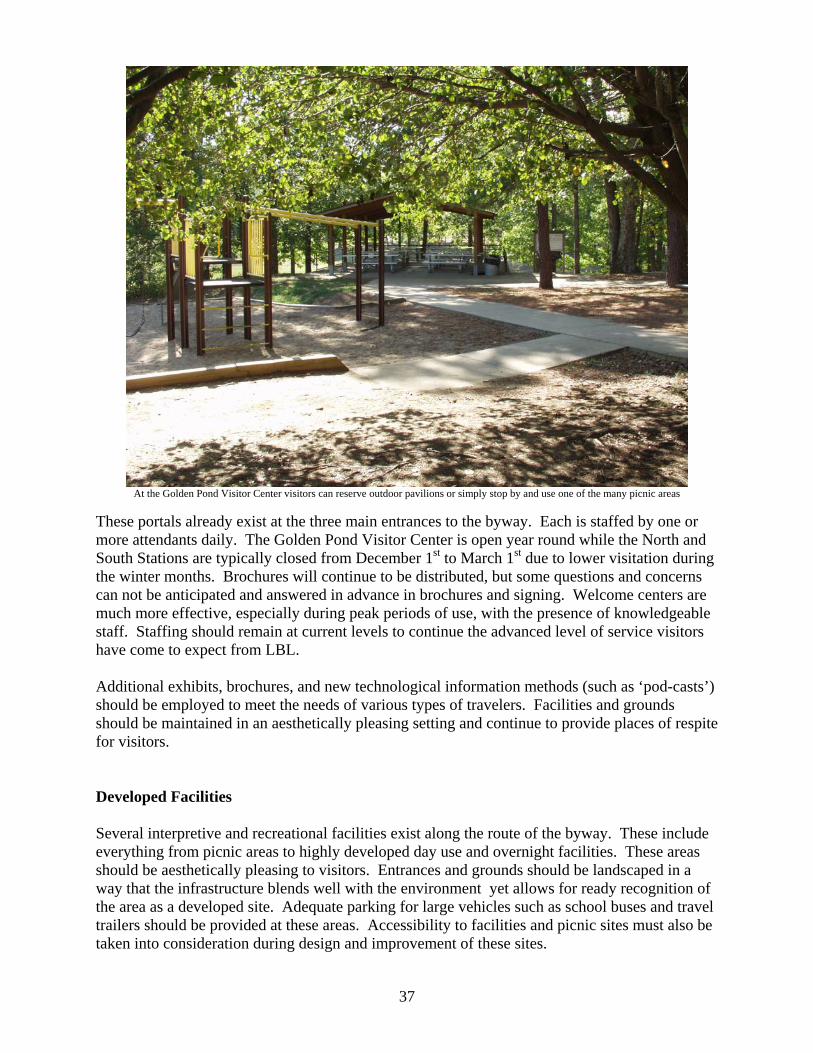
At the Golden Pond Visitor Center visitors can reserve outdoor pavilions or simply stop by and use one of the many picnic areas
These portals already exist at the three main entrances to the byway. Each is staffed by one or more attendants daily. The Golden Pond Visitor Center is open year round while the North and South Stations are typically closed from December 1st to March 1st due to lower visitation during the winter months. Brochures will continue to be distributed, but some questions and concerns can not be anticipated and answered in advance in brochures and signing. Welcome centers are much more effective, especially during peak periods of use, with the presence of knowledgeable staff. Staffing should remain at current levels to continue the advanced level of service visitors have come to expect from LBL. Additional exhibits, brochures, and new technological information methods (such as ‘pod-casts’) should be employed to meet the needs of various types of travelers. Facilities and grounds should be maintained in an aesthetically pleasing setting and continue to provide places of respite for visitors. Developed Facilities Several interpretive and recreational facilities exist along the route of the byway. These include everything from picnic areas to highly developed day use and overnight facilities. These areas should be aesthetically pleasing to visitors. Entrances and grounds should be landscaped in a way that the infrastructure blends well with the environment yet allows for ready recognition of the area as a developed site. Adequate parking for large vehicles such as school buses and travel trailers should be provided at these areas. Accessibility to facilities and picnic sites must also be taken into consideration during design and improvement of these sites.
37

Interpretive Exhibits Interpretive exhibits play a key role in the story of the byway. Several exhibits currently exist along the route. Design of new exhibits and signs should be consistent with current design features of interpretive materials. If current design is determined to be in need of change then new standards shall be set for future and current exhibits. Pull-outs Design vehicular pull-outs along the byway to allow mobility and efficient movement of traffic. Locations of pullouts will meet state DOT guidelines for proper site distance. When needed for safety considerations, turning lanes should be constructed. Design of the pull-outs need to consider vehicles traveling from both directions to make sure that adequate turning radii and parking lot widths are provided. Interaction between pedestrians and vehicles will be prominent at pullouts. Pavement striping will be crucial to ensure safe, efficient circulation patterns.
Maintenance and Operation Considerations
Infrastructure
• Manage the road system and corridor to reduce maintenance costs, and create safer utilization by multiple transportation methods. These methods include: vehicles, pedestrian, bicycle, and equestrian travel.
• Provide opportunities for visitors to enjoy a wide range of activities at each developed
site along the byway. For example, receiving interpretive information, picnicking, hiking, and nature viewing may be participated in at one site.
• Road and trail design and construction must blend with the natural landscape. Trail
systems connected to a recreation facility is considered as one congruent recreational facility. The preferred trail surfacing in developed sites is exposed aggregate concrete. Construction of the trails in developed sites will meet the standards of universal design.
• Undertake long range scoping and planning for potential development of a transportation
system for bicyclists and pedestrians within the scenic byway corridor that will provide an alternative mode of travel. Bicycle trails will be developed that are separated from the highway by vegetation, natural features, or natural-looking features. Trails will follow the natural contour of the land as much as possible to minimize earth disturbance. Trail width will be eight feet wide and surfaced with asphalt or concrete providing a smooth, even surface.
• South Bison Range corral should blend with the natural, scenic qualities of the byway.
• Pull-off design will be very site specific. When locating pull-offs and parking areas,
sight distance, the option to use turning lanes, and proper signing are design factors to be incorporated.
38

• Toilet facilities will be provided at sites along the byway. All toilet facilities will meet accessibility and Forest Service requirements.
• Provide site amenities, such as tables and benches, for visitor use at recreational sites.
Site amenities, such as benches, tables, and grills, will be constructed of durable, vandal resistant materials while meeting accessibility criteria set forth in the Universal Access to Outdoor Recreation: A Design Guide.
• Plantings will be needed around highly visible areas, highly used areas, and in disturbed
areas to reduce visual impact and potential erosion problems. Native plant materials and grasses will be used around all facilities. The plantings will be contained in planting beds where necessary.
• Utility Lines: Utility lines within the corridor should be buried or relocated as soon as
feasible to enhance the visual appeal of natural features along the route. Signage General signage Signing along The Trace should be consistent with the intrinsic qualities of the scenic beauty and the high recreation use of the area. Signing along The Trace is limited to Forest Service Signage for speed, heritage and interpretation, guide and information, and caution. Portal signs are placed at either end of The Trace where they cross into National Forest lands. The signage on National Forest Lands is maintained in compliance with Forest Service Manual (FSM) Chapter 7160, Forest Service Handbook (FSH) 7709, and LBL Policy. National Scenic Byway Signs
Install logo signs where appropriate. Locations are recommended at the following highway intersections. 1. US 79 at LBL Trace (TN 461) US 79 eastbound US 79 westbound LBL Trace northbound 2. Forest Service Road 230 at US 79 US 79 eastbound US 79 westbound Forest Service Road 230 northbound 3. US 68/80 at LBL Trace LBL Trace northbound LBL Trace southbound US 68/80 westbound US 68/80 eastbound
39

4. I-24 at US 68/80 Both north and southbound lanes US/68/80 westbound I-24 and Highway 62 at Highway 453 Southbound lanes 5. Exit 7 on I-24 southbound US 79 leaving Paris, TN eastbound I-24 at 41A westbound US 79 leaving Clarksville, TN Westbound US 68/80 leaving Hopkinsville, KY Westbound
Outdoor Advertising
Outdoor Advertising Control is maintained in strict compliance with area policy. The Forest Service has permitted no outdoor advertising along The Trace for commercial purposes. Occasionally, small portable banners advertising local events, sponsored by LBL, are seen prior to an event at strategic locations along The Trace to provide information and guide visitors to the scheduled events. An example of these might be the annual Hummingbird Festival, the periodic events at the Nature Station or the observatory, or public events such as the annual bicycle or boat races. These banners are small in nature, measuring approximately 4 feet by 16 feet, are set up just prior to the event, and are removed immediately after the event is staged, being up for a very short time periods. Minimizing exposure of banners adds to the pristine nature of The Trace and enhances the traveling experience. Interpretive Signs
• To have continuity of signing throughout the corridor, the sign message, shape, and materials should be designed by the LBL interpretive staff and an IDT, then reviewed by the scenic byway committee.
• Develop and post signs that interpret scenic, historic, geologic, or other unique features
where identified in this plan. Such sites should include vehicular pull-outs.
• Approach signs to alert motorists about recreational sites and byway turning points are recommended to be placed approximately one-fourth mile before each turn. The signs will use international symbols and will be brown with white lettering/symbols.
Warning and Regulatory Signs
• The USDA Forest Service LBL is responsible for placement and maintenance of all warning and regulatory signs along the byway.
• The USDA Forest Service LBL is responsible for setting and posting speed limits along
the byway.
• Install warning signs along the byway where potentially conflicting recreational uses may occur (such as bicyclists using the byway road surface, foot or horse trail crossings, etc.).
40

Travel Management Commercial Traffic Due to the remote location of LBL, very minimal commercial traffic is found along The Trace. Occasionally, logging trucks may be seen if a current logging operation is occurring on the NRA. Trucks hauling equipment, gravel, rock, or other materials for use on the NRA are occasionally seen on The Trace. Commercial fisherman occasionally use The Trace to haul their boats to various boat launches across LBL, and a very occasional tour bus can be seen going to or from various locations on LBL for events or other destination experiences. In general, commercial traffic does not use The Trace because it is a road which, having been signed by the respective states with a load capacity of 20,000 pounds, is not designed for primary commercial traffic. Kentucky rates the section of The Trace from Lyon County north to Livingston County at 80,000 pounds. General
• Protect the resources within the byway corridor from actual or potential damage through
education, design principles, and responsible construction techniques. • Provide for traveler safety and comfort while still preserving the highest levels of visual
integrity and attractiveness possible.
• Allow for the widening and/or improving of existing roads and their shoulders wherever safety needs dictate.
• Develop long range plans for a bicycle/pedestrian trail within the byway corridor to
provide alternative modes of travel and enhance opportunities for leisurely and safe enjoyment of the natural area.
• Wherever possible, locate bicycle pathways to run parallel with the byway. Furthermore,
construct these pathways so they are physically separated from the roadway. Consider natural or natural-looking safety barriers to protect bicyclists from motorists.
Vegetative Management
• Emphasize visual resources and wildlife management throughout the corridor. • May include projects that increase the potential for viewing a variety of wildlife species
without endangering them through physical contact with motorists.
• Will not introduce exotic plant and animal species which may invade and compete with native plant communities. Domesticated plant species will not be planted under normal circumstances.
• Shall emphasize vegetative manipulation, such as harvest cuts, precommercial thinning,
products other than logs thinning, prescribed burning, hardwood regeneration cuts, and wildlife and vista opening cuts, to perpetuate and enhance biological diversity at different spatial scales and of differing desired conditions in different management areas. The
41

• Is also utilized to restore native plant and animal communities and ecosystems.
• Will perform tree marking in such a way that it is not visible from the byway.
• Will use timber management to improve visual quality, particularly where there are
opportunities to enhance scenic views, to provide a landscape associated with the public’s expectations, to increase vegetative variety, or to reduce stand homogeneity.
Visitor Information
• Brochures and flyers are an effective means of providing interpretation, especially focusing on topics that have application over a large area or for walking tours where signs may be inappropriate or undesirable. Flyers provide brief general information. Brochures can provide more detailed information than flyers or signs and can be combined with audio techniques as part of a driving tour. As with other interpretation, brochures should be thematic and include graphics with text.
• This interpretive plan recommends the following flyer and brochures.
A flyer providing a general overview of the LBL Scenic Byway with brief
descriptions of various points of interest along the byway and a map of the route.
A highly detailed tour brochure that allows travelers to guide themselves through the byway and allows them to learn more about historic and natural resources along the byway.
• Use of updated audio technology, such as Pod casts, for use in supplying interpretive
information.
• A Pod cast or similar audio type message designed to accompany a driving tour brochure of the byway will allow travelers to hear information as they drive along the route. This method is a friendly way to provide information while the visitor is “on the move.” An audio message is a useful tool where space is inadequate for roadside turn-outs. Audio messages can be produced for travel in both directions on the byway and should be referenced to ground markers.
• Develop a promotional video of the byway. This video could be shown in the Golden
Pond Planetarium and possibly at the other welcome stations. In addition, interactive videos could be developed for use at sites along the byway.
• Roadside signs should be developed and placed to aid in directing visitors along the
byway. Roadside interpretive signs should be placed at pull-outs, overlooks, and rest areas.
Visual Management
42

Preserving and enhancing visual resources along the byway corridor must be a top land management priority and can be achieved as follows.
• Provide scenic and/or panoramic views from the byway through the removal of trees and other vegetation that impede visitors’ views. Enhance vista openings, open land composition and hardwood stands to provide visual diversity.
• Viewsheds adjacent to the byway shall meet, as a minimum, the visual quality objective
of “partial retention.” Partial retention is a VQO classification which maintains management activities visually subordinate to the characteristics of the landscape.
• The visual resource along the corridor will be taken into account for all management
activities.
• Slash, trash and litter shall be removed from the forest floor within a minimum of 300 feet from the edges of the byway.
• Utility and transmission lines shall be buried or relocated as soon as feasibly possible.
MARKETING PLAN
Tourism and Visitation The Scenic Byway in Western Kentucky and Tennessee offers visitors an opportunity to explore one of the most unique scenic drives in the United States. The byway stretches 45 miles through the heart of Land Between The Lakes National Recreation Area with state resort parks located in each of the four gateway communities. As visitors traverse the Scenic Byway they will enjoy the LBL’s nature-dominated scenery. Along with the scenery, visitors can learn about the areas historical significance and explore a wealth of recreational and educational opportunities. There are a variety of campgrounds, trails, interpretive sites, day-use facilities, and other points of interest along the route or off on a side road. The four gateway communities of Dover, TN; Canton, KY; Aurora, KY; and Grand Rivers, KY, offer easy access to the scenic byway from the south, east, west, and north respectively. These communities provide visitors a variety of lodging, dining, shopping, recreation, and entertainment. Visitors will discover that the gateway communities offer additional options to consider working into their travel agenda such as an art museum, live theater, and a country music opera. The state resort parks offer additional options for waterfront dinning, lodging, marinas, golf courses, fitness center, gift shops, and recreation programs. A scenic byway designation highlights the special features and intrinsic values the route offers to area visitors. This designation would provide the portal communities with economic development and new tourism opportunities. LBL partners with regional and local tourism organizations connected with the portal communities to effectively market the area. These marketing partnerships focus on increasing visitor use, extending length of stay, and fostering repeat visitation to stimulate the local economies. The regional tourism industry, centered at LBL, currently has an estimated annual value of over $650 million dollars. Land Between The
43

Lakes will continue partnering with the surrounding communities to incorporate the scenic byway into marketing plans. LBL is annually one of the top two places visited in Kentucky receiving approximately two million visitors annually, and we know our visitors have certain needs and expectations for services, experiences, and information. Ensuring potential visitors have sufficient information to determine the value of this scenic byway experience will be a key part of the LBL marketing plan. Natural, historical, recreational, cultural, and scenic are all elements the visitor is looking for when visiting the area. In 2006, LBL completed a Promotions Effectiveness Study which found that the top five reasons for visiting LBL were: 1) to enjoy nature, 2) to have fun, 3) do something relaxing, 4) to be with spouse/family, and 5) to escape. The study also reported that information on recreation opportunities was the most important information for choosing vacation destinations. It was followed by safety, camping accommodations, and support services, such as restaurants and convenient stores. The surrounding communities boast a strong tourism infrastructure of convention and visitors bureaus, chambers of commerce, attractions, hotels, bed and breakfasts, restaurants, and antiquing and other unique shopping opportunities. The Woodlands Trace designation will benefit tourism to the area by providing an additional attributes for marketing opportunities.
Marketing The scenic byway is centered in LBL with the surrounding communities providing support services for area visitors. The National Recreation Area is the centerpiece for regional tourism and works with local communities and regional tourism groups to promote the region as a whole. The scenic byway will be integrated into the existing LBL strategic marketing plan. In addition, LBL will work with local county tourism groups, regional tourism organizations, and state tourism offices to incorporate the scenic byway into their marketing plans. The LBL marketing plan will provide goals strategies and actions for utilizing publicity, publications, and promotional tools to ensure the public is aware of the scenic byway, along with available associated recreational and educational opportunities, facilities and services. The marketing goals:
• Develop and enhance the awareness of the scenic byway and nearby recreational opportunities.
• Provide sufficient information to the prospective visitor so they may have an enjoyable and high quality experience.
• Attract visitors year round. The following section describes potential opportunities for promoting a quality experience to our byway travelers. The targeted audience for marketing the scenic byway is anyone interested in visiting the Land Between The Lakes region where opportunities for recreation and education are plentiful, varied, unique, and in demand. Activities may include, wildlife viewing, birding, photography, driving for pleasure, sightseeing, camping, hiking, fishing, hunting, biking, water recreation, horseback riding, dinning, shopping, antiquing, and historical and cultural events.
44

45
Currently, LBL’s marketing efforts are geared towards families with children, mature adults, young adults, and groups. Additional markets to target for the scenic byway are organized travel groups and special interest clubs such as motorcycle and car clubs, recreational vehicle and camping clubs, and overnight tour groups. With so much to offer along the corridor, in the portal and adjoining communities, emphasis will be placed on visitors who plan overnight stays, but will not exclude day trips. The following three geographical target markets have been identified for the scenic byway marketing efforts. The goal in targeting these three markets is awareness of the byway as a travel destination.
• Local market – Persons that live within a 100 mile radius of the byway. • Regional market – Persons within a 300 mile radius of the byway. • National – Persons beyond a 300 mile radius of the byway. Publicity
Public information includes press releases, media kits, social media, web site information, trade shows and travel industry conventions, photo image library for use in media kits and articles, along with other ongoing publicity efforts. Promotion efforts will be coordinated with local, regional, and state tourism organizations such as Land Between The Lakes Region Tourism Group and Kentucky Western Waterlands Tourism Organization, and Tennessee and Kentucky state tourism initiatives. Regional tourism organizations will work together to identify publicity opportunities, prepare a list of targeted publications and web sites to keep informed, and develop press releases and other information materials. These tourism organizations, along with LBL, provide a network for information coordination development and distribution to the public. Collaboratively planned publicity will raise awareness and interest in the target markets, enticing them to plan a trip to the area and travel the byway. Successful publicity is dependent on several factors. Some of the key factors include: 1) timing of publicity activity in reaching targeted markets during their trip research and planning window; 2) utilizing available social science information to help craft key messages about the advantages and opportunities offered on and along the byway; and 3) making informative and visually appealing photographs available to reinforce publicity communication efforts. LBL and our regional tourism organizations have a proven track record for collaborative planning and will provide staff expertise for this effort.