land administration
35
Article under Review for the International Journal of Spatial Data Infrastructures Research, Special Issue GSDI-11, submitted 2009-04-09 Land Admi nist ration as a Cornerston e in the Global Spatial Information Infrastructur e Peter van Oosterom 1 , Arco Groothedde 2 , Christiaan Lemmen 3 , Paul van der Molen 4 , and Harry Uitermark 5 1 TU Delft, {[email protected] }, 2 Kadaster, {[email protected] }, 3 Kadaster/ITC, {[email protected]}, 4 {[email protected] }, 5 {[email protected]} Ab st ract This paper shows how standardization activities are progressing and contributing to the fact that Land Administration (LA) is considered more and more the cornerstone of the spatial information infrastructure. This is equally valid for regional, national, continental, and global levels, as will be illustrated in this paper. The paper describes the involved organizations and the current status of the LA standardization efforts. The crucial role that LA plays within the spatial information infrastructure is analyzed; including the relationship LA does have with other registrations and themes within the information infrastructure, of which some are non-spatial ones, such as persons. Special attention is given to a number of global aspects related to LA: combating slums (UN-HABITAT), stabilizing post-conflict areas, developme nt of LA based on f ree/libre/open source software (UN-FAO) and climate change. Finally, the concept of ‘land administration levels of maturity’ is introduced and four stages of maturity are identified: 1. Standards, 2. Connectivity, 3. Integration, and 4. Network. The earlier described LA initiatives are assessed in the context of these levels of maturity. Keywords: land administration, standardization, information infrastructure 1. INTRODUCTION Spatial data sets are most useful in the support of areas like decision making, management of space, performance of government or business processes, when they are integrated in governmental information infrastructures (architectures). This implies availability of well maintained links between spatial data sets and other ‘basic’ or ‘key’ data sets, e.g. on addresses, persons, companies, buildings, ∗ This work is licensed under the Creative Commons Attribution-Noncommercial Works 3.0 License. To view a copy of this license, visit http://creativecommons.org/licenses/by-nc-nd/3.0/ or send a letter to Creative Commons, 543 Howard Street, 5th Floor, San Francisco, California, 94105, USA.
-
Upload
connie-lee-li-ting -
Category
Documents
-
view
228 -
download
0
Transcript of land administration

8/13/2019 land administration
http://slidepdf.com/reader/full/land-administration 1/35
Article under Review for the International Journal of Spatial Data InfrastructuresResearch, Special Issue GSDI-11, submitted 2009-04-09
Land Administ ration as a Cornerstone in the Global SpatialInformation Infrastructure
Peter van Oosterom 1, Arco Groothedde2, Christiaan Lemmen3, Paul van derMolen4, and Harry Uitermark5
1TU Delft, {[email protected]},2Kadaster,{[email protected]},3Kadaster/ITC, {[email protected]},4
{[email protected]},5{[email protected]}
Abst ract
This paper shows how standardization activities are progressing and contributingto the fact that Land Administration (LA) is considered more and more the cornerstone of the spatial information infrastructure. This is equally valid forregional, national, continental, and global levels, as will be illustrated in thispaper. The paper describes the involved organizations and the current status ofthe LA standardization efforts. The crucial role that LA plays within the spatialinformation infrastructure is analyzed; including the relationship LA does havewith other registrations and themes within the information infrastructure, of whichsome are non-spatial ones, such as persons. Special attention is given to anumber of global aspects related to LA: combating slums (UN-HABITAT),stabilizing post-conflict areas, development of LA based on free/libre/open sourcesoftware (UN-FAO) and climate change. Finally, the concept of ‘landadministration levels of maturity’ is introduced and four stages of maturity areidentified: 1. Standards, 2. Connectivity, 3. Integration, and 4. Network. Theearlier described LA initiatives are assessed in the context of these levels ofmaturity.
Keywords: land administration, standardization, information infrastructure
1. INTRODUCTION
Spatial data sets are most useful in the support of areas like decision making,
management of space, performance of government or business processes, whenthey are integrated in governmental information infrastructures (architectures).This implies availability of well maintained links between spatial data sets andother ‘basic’ or ‘key’ data sets, e.g. on addresses, persons, companies, buildings,
∗ This work is licensed under the Creative Commons Attribution-Noncommercial Works 3.0 License.To view a copy of this license, visithttp://creativecommons.org/licenses/by-nc-nd/3.0/ or send aletter to Creative Commons, 543 Howard Street, 5th Floor, San Francisco, California, 94105, USA.

8/13/2019 land administration
http://slidepdf.com/reader/full/land-administration 2/35
Article under Review for the International Journal of Spatial Data InfrastructuresResearch, Special Issue GSDI-11, submitted 2009-04-09
or land rights. Integrated inter-organizational value chains and business processmanagement with a reduction in administrative overhead can be realized basedon new business models. In general, solving the problems in society requiresmore information than provided by one single data set. It is evident that this typeof data provision is complex in case data is stored at a variety of locations and indata models specific to their applications.
In our view the land administration itself contains both spatial information, e.g. onland parcels, and administrative information, e.g. property rights. In addition theland administration has important relationships with other registrations in the(spatial) information infrastructure, again spatial, e.g. topography, or buildings,and administrative information, like names of persons, addresses, or names ofcompanies. It is therefore important to have unambiguous definitions of thecontents of these registrations in order to avoid overlap and to enable reuse ofinformation in other registrations. Further, due to continuous updating of theseindependent, but related, registrations care has to be taken to maintainconsistency, not only within one registration, but also between registrations. Byreusing basic standards (for geometry, temporal aspects, metadata, observationsand measurements from the field), at least the semantics of these fundamentalparts of the model are well defined and can be shared. What is needed inaddition to this is domain specific standardization to capture the semantics of thecadastral domain on top of this agreed foundation.
International standardization of relevant concepts is a condition for domainspecific standardization. The development of the domain specific LandAdministration Domain Model (ISO 19152 – a Committee Draft will be available inJune 2009) will be worked out in Section 2 to demonstrate the relevance ofdomain standards in relation to international information infrastructures. Aneffective (spatial) information infrastructure (SII) can be achieved by the use of‘authentic registers’ (or 'key registers') to store key data which is available forintegration and multiple use; see Section 3. This will be illustrated with anexample from The Netherlands, were it became clear that the SII is part of alarger Information Infrastructure (II) with also non-spatial key registers (containingdata on persons, companies, etc.). In this contribution we will further extend thisapproach from a national Information Infrastructure to an international Information
Infrastructure. Land administration (LA) is considered to be a cornerstone, that is,a indispensable part of the (S)II - besides foundations such as referencesystem(s). And, of course there will be attention to the European perspective:INSPIRE cadastral parcels (geometry) and EULIS (administrative/legal). Someimportant implementation issues will be discussed; e.g. the spatial-administrativeintegration, and the global access to LA data.
Section 4 then goes further form national or continental to global use of landadministration in the context of the spatial infrastructure. Different examples will

8/13/2019 land administration
http://slidepdf.com/reader/full/land-administration 3/35
Article under Review for the International Journal of Spatial Data InfrastructuresResearch, Special Issue GSDI-11, submitted 2009-04-09
be given in this context; from UN-HABITAT, UN-FAO, and the US Department ofState (about Afghanistan post-war recovery), all institutions with a high interest inthe Land Administration Domain Model (LADM). The relation between land use,land use change and forestry with respect to carbon storage and emissionreduction is worked out, because land tenure and land management have aneminent role in relation to (possible solutions for) climate change. Section 4 alsorefers to the evolving voluntary retail market of carbon credits. To promote carbonsequestration and emission reduction, land policy and associated landinstruments (like market regulation, land use planning, land taxation and landreform) should include climate proof goals. This requires international informationinfrastructures including land rights and land holders. The flexibility of the LADMis demonstrated here.
This paper introduces the concept of ‘land administration levels of maturity’ andillustrates this with examples; see Section 5. The following four stages of maturityare identified: 1. Standards, 2. Connectivity, 3. Integration, 4. Network. Thesestages are comparable to the six stages defined by (Nolan, 1979). In the laststage different key-players work together in a networked cross sector approach. Itwill place the spatial information infrastructure in the context of current relevantsocial themes; e.g. public safety, environmental issues, or spatial planning.Within these themes many players, with different information sets, and fromdifferent sectors must work together to face the social challenges. This will clearlyrequire some ‘semantic’ translations of information and associated concepts inorder to be suitable to be used in the context of these different social themes. It isenvisioned that the levels of maturity also apply to other (information) sectorsthan Land Administration. Finally, in Section 6 the main results and contributionsof this paper are summarized together with a list of future work.
2. LAND ADMINISTRATION STANDARDIZATION
In this section an overview of the Land Administration standardization andimplementation activities will be given. A standardized Land AdministrationDomain Model (LADM) provides an extensible basis for efficient and effectivecadastral system development based on a model driven architecture (MDA), andenables involved parties to communicate on a shared ontology implied by themodel. Despite the fact that it is difficult to agree on the used concepts and theirsemantics (especially in the land administration where countries often have morethan several centuries of different history behind their current systems), this cannot be avoided if a meaningful interoperable spatial information infrastructure hasto be developed and implemented.
In Subsection 2.1 some background with respect to standardization of the LandAdministration Domain Model in the context of ISO TC211 (geo-information) is

8/13/2019 land administration
http://slidepdf.com/reader/full/land-administration 4/35
Article under Review for the International Journal of Spatial Data InfrastructuresResearch, Special Issue GSDI-11, submitted 2009-04-09
given. Next the relationships between ISO TC211 and other standardizationorganizations, such as CEN TC 287 and OGC are described. The last subsectiongives an introduction to the current version of the LADM itself (Subsection 3.3).
2.1 ISO TC211 and ISO 19152 LADM
A standardized Land Administration Domain Model (LADM), covering landregistration and cadastre in a broad sense (a multipurpose cadastre), serves atleast two important goals: (1) to provide a extensible basis for efficient andeffective cadastral system development based on a model driven architecture(MDA) in order to avoid reinventing and re-implementing the same functionalityover and over again, and (2) to enable involved parties, both within one countryand between different countries, to communicate based on a shared ontologyimplied by the model. The second goal is very important for creating standardizedinformation services in an international context, where land administration domainsemantics have to be shared between countries (in order to get correcttranslations of terms of similar concepts). But the second goal is also importantwithin one country, in order to combine and exchange information meaningfullyfrom several different registrations in the information infrastructure.
Important conditions during the design of the model were, and still are: it shouldcover the common aspects of land administrations all over the world, and itshould be based on the conceptual framework of Cadastre 2014 (Kaufmann andSteudler, 1998); it should also follow the international ISO and OGC standards,and yet the model should be as simple as possible in order to be useful inpractice. The LADM itself heralds an important new wave in geo-informationstandardization: after the domain independent basic geo-information standards(like the current series of ISO and OGC standards), the new standards based onspecific domains will now be developed. Due to historical differences betweencountries (and regions) similar domains, such as the land administration domain,are modeled differently and therefore a non-trivial harmonization has to be donefirst. The LADM is a result of this harmonization and one of the first examples of asemantic geo-information domain standard.
A cadastral parcel is single area of land or more particularly a volume of space,
under homogeneous real property rights and unique ownership (UNECE 2004and WG-CPI 2006). By homogeneous property rights is meant that rights ofownership, leases and mortgages affect the whole parcel. By unique ownership ismeant that the ownership is held by one or several owners for the whole parcel.This does not apply to specific rights as servitudes, which may only affect part ofthe parcel. Irrespective of the legal system adopted by a government, theCadastre is defined as a register under its responsibility. Its use complies with theprinciples of equality, security and justice. Access to cadastral information is ruledby laws and regulations in order to protect personal information. The classical

8/13/2019 land administration
http://slidepdf.com/reader/full/land-administration 5/35
Article under Review for the International Journal of Spatial Data InfrastructuresResearch, Special Issue GSDI-11, submitted 2009-04-09
Cadastre basic unit is the parcel. Parcels can be grouped in register objects. Aparcel has a nationwide unique real property identifier. The spatial description ofparcels and other cadastral objects should be provided with an adequate degreeof accuracy. Descriptive data may include the nature, size, value and legal rightsor restrictions associated with each separate land object under or over thesurface (adapted from PCC 2003). Cadastral parcels cover a territory (regional ornationwide) and there are no overlaps or gaps between parcels. An exception tothis rule may be government land (or public domain) not registered within theCadastre - though this practice is not recommended.
Besides ownership, cadastral parcels, or to be more general register objects, canbe associated with other types of rights (e.g. usufruct, superficies, or long lease),responsibilities or restrictions. The location where a discontinuity in the specificlegal situation occurs is the cadastral boundary. Vertices of this boundary may, ormay not be marked in the field. In many cases field sketches with surveyobservations are available as source documents. Field measurements andobservations (classical surveying: directions or bearings, angles and distancescombined with control points or ‘GPS-based surveying’, resulting in coordinates)are used to determine coordinates in a reference system; these coordinates areadjusted to the cadastral map. Current practice is to express the coordinates inthe cadastral map in the National Reference System. In the future this might bechanged to the European Terrestrial Reference System (ETRS89), becausemore and more Global Network Satellite Systems (like GPS, GLONASS andGalileo) surveys will be used to collect data and this will improve dataconsistency near European country boundaries.
A cadastral boundary does have several attributes of its own. Field sketches (orsurvey plans) can be used for boundary reconstruction in case of disputes. Froma technical point of view the set of related boundaries is sometimes stored as aclosed polygon, with a risk for gaps and overlaps between parcels (this is aquality problem in the database). This also implies that every boundary would bestored at least twice (in 'left' and 'right' parcel), which is redundant. Further, theattributes of boundaries have to be attached to a specific instance. A parcelrepresentation based on a topological structure is often used. Mostly, boundariesdo not have a meaningful identifier (such as based on an administrative
hierarchy), but they could be associated with field sketches (which do have somekind of meaningful identifier).
All those information aspects are represented in the LADM, which was developedover several years (van Oosterom et al, 2003, 2004, 2006). Many reviewsenriched its contents. In practice it was very difficult to keep it simple. After thefirst version, launched at the XXIII International Conference in Munich, Germany,2006 (Lemmen and Van Oosterom, 2006) it was decided to “go” for anInternational Standard: in early 2008 the LADM has been submitted by the

8/13/2019 land administration
http://slidepdf.com/reader/full/land-administration 6/35
Article under Review for the International Journal of Spatial Data InfrastructuresResearch, Special Issue GSDI-11, submitted 2009-04-09
International Federation of Surveyors (FIG) as a New Working Item Proposal(NWIP) to the International Organization for Standardization (ISO). Thissubmission has been done by the FIG Standards Network. This initiative hasbeen accepted by ISO Technical Committee 211 on GeographicalInformation/Geomatics (ISO TC 211). The work of ISO TC 211 amongst otherswill link LADM to appropriate standards for information technology and data, andprovide a framework for the development of sector-specific applications usinggeographic data.
The Technical Committee 211 (TC211) of ISO (hereafter ISO/TC211) isresponsible for the ISO geographic information series of standards (ISO/TC211,2009). Many bodies are actively engaged in the work of ISO/TC211. Theseinclude national standardization bodies, the Open Geospatial Consortium (OGC),international professional bodies (such as FIG and ICA), UN agencies (such asthe UN Economic Commission for Africa), and sector bodies (such as theInternational Civil Aviation Organization, ICAO). Since its inception ISO/TC211has published well over 40 standards, among which is GML, a highly visible OGCspecification. ISO/TC211 has participating and observing members from over 60countries. There are three main phases in the ISO standards developmentprocess:1. The need for a standard is usually expressed by some community (FIG, in
our case), which proposes a new work item (an NWIP) to ISO as a whole.Once the need for an International Standard has been recognized andformally agreed, the first phase involves definition of the technical scopeof the future standard.
2. Once agreement has been reached on which technical aspects are to becovered in the standard, a second phase is entered during whichcountries negotiate the detailed specifications within the standard. This isthe consensus-building phase. In our case three Working Drafts werediscussed and a Committee Draft –CD– will be available in June 2009.
3. The final phase comprises the formal approval of the resulting draftInternational Standard following (DIS) which the agreed text is publishedas an ISO International Standard. The acceptance criteria stipulateapproval by two-thirds of the ISO members that have participated activelyin the standards development process, and approval by 75% of all
members that vote.The LADM ISO 19152 Project Team (PT) had three meetings in 2008. First inMay in Copenhagen, Denmark. Then in September in Delft, The Netherlands andfinally in December in Tsukuba, Japan . The meetings in Europe received mostinput from PT members from that continent; in Tsukuba the majority of theparticipants was from outside Europe. The next meeting of the PT is scheduled inMolde, Norway, 25-26 May 2009. The scope of LADM ISO 19152 includes thefollowing:

8/13/2019 land administration
http://slidepdf.com/reader/full/land-administration 7/35
Article under Review for the International Journal of Spatial Data InfrastructuresResearch, Special Issue GSDI-11, submitted 2009-04-09
- it defines a reference model, covering all basic information-relatedcomponents of Land Administration- it provides a abstract, conceptual schema with five basic packages,
related to (1) people and organizations (parties in LADM terminology), (2)parcels (spatial units in LADM terminology), (3) property rights (rights,responsibilities, and restrictions in LADM terminology), (4) surveying, and(5) geometry and topology
- a terminology for Land Administration, based on various national andinternational systems, as simple as possible in order to be useful inpractice. The terminology allows a shared description of differentpractices and procedures in various jurisdictions
- a basis for national and regional profiles- it enables the combining of land administration information from different
sources in a coherent manner.
LADM should be able to accommodate any legal framework. However, legalimplications that interfere with (national) land administration laws, are outside thescope of the LADM development as an International Standard. The so calledSocial Tenure Domain Model (STDM) is a specialization of the LADM and can beconsidered as a pro poor land tool. This specialization of the LADM will be furtherintroduced in Subsection 4.1 of this paper.
2.2 Related organizations (CEN and OGC)
What ISO is to the world is the European Committee for Standardization (CEN) toEurope. There is a close cooperation between ISO/TC211 and CEN/TC287Geographic Information. The scope, objectives and strategy of CEN/TC287activities are formulated in Resolution 40 (CEN/TC287, 2003): ‘The committeewill work out structural frameworks of standards and guidelines of methodologywhich specify methodology of defining, describing and transferring geographicaldata and appropriate services. The work will be made in strict co-operation withISO/TC211. These standards will support coherent use of geographicalinformation in Europe in accordance with international use. These standards willalso support spatial infrastructure of data at all levels in Europe.’ Applying to ISOstandards the Vienna Agreement as expressed in Resolution 52 (CEN/TC287,
2003): ‘The CEN/TC287 Geographic information, considering the Viennaagreement; instructs the secretariat of CEN/TC287 to initiate Unique AcceptanceProcedure (UAP) or parallel voting for all deliverables and work items ofISO/TC211 as appropriate.’ The goal is to have equal ISO and EN standards viaeither submitting the published ISO standard to UAP (completed work) or viaparallel and simultaneous voting in the ISO and in the CEN (new/on-going work).An ISO/CEN Joint Coordination Group, consisting of representatives of bothorganizations, has been established to monitor and manage the operation of the

8/13/2019 land administration
http://slidepdf.com/reader/full/land-administration 8/35
Article under Review for the International Journal of Spatial Data InfrastructuresResearch, Special Issue GSDI-11, submitted 2009-04-09
Vienna Agreement and to deal with any problems that may arise. The Groupusually meets annually.
On 26 February 2009, in the Madrid meeting of CEN/TC287 after voting on the‘ISO19152 Draft Resolution 153 New Work Item Proposal GeographicInformation - Land Administration Domain Model (LADM) - second vote’ (CENdocument number N 1304) it was decided to accept also the LADM within CENTC287. Based on the above resolutions this means that from this momentonwards there will be parallel and simultaneous voting in the ISO and in the CENon the different stages of the LADM towards an international (and European)standard.
Similar to ISO and CEN, where desired, ISO and the Open GeospatialConsortium (OGC) coordinate their activities. OGC is an international consortiumto develop publicly available "geo-enabled" interface specifications. In 1995,OGC established a Class A Liaison with ISO/TC211 and in 1999 the twoorganizations signed an agreement that allows both organizations to take fulladvantage of the contributions of the other. The agreement spells out theintellectual property rights related to documents that fall under the agreement andcalls for the alignment of ISO and OGC procedures. The coordination betweenISO and OGC is best demonstrated by the fact that many geo-informationexperts take part in both ISO and OGC activities.
2.3 The current version of the LADM
In this subsection an overview will be given of the LADM corresponding to theCD-version. After the initial submission to ISO TC211 (ISO/TC211, 2008),significant comments were received stating that the original model (Hespanha etal, 2008) was too complex. Therefore simplification was one of the mostimportant goals and the motivation to integrate all different types of spatialrepresentations (text parcel, point parcel, spaghetti parcel, or topology parcel) inthe single LA_SpatialUnit class. Further, some classes were removed(ServingParcel and NPRegion) and the spatial representation was made moredirect via ISO 19107 data types (TP_ and GM_ types) and not via associations toISO 19107 classes (node, edge, face, solid, in both basic and directed variants).
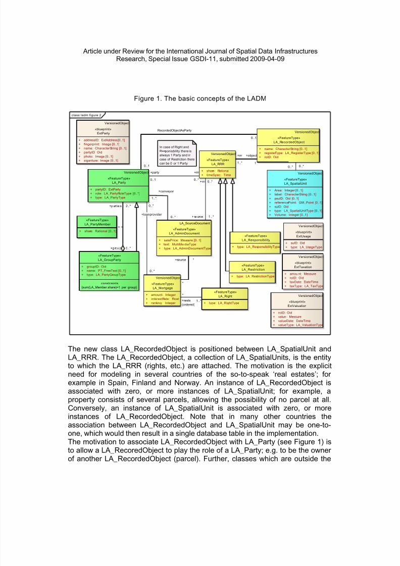
This also resulted in a significant model simplification. Based on the ISO/TC211convention all class names did got an ‘LA_’ prefix. The four central classes in theLADM are LA_Party (persons and groups), LA_RRR (right, restriction,responsibility), LA_RecordedObject and LA_SpatialUnit (parcel); see Figure 1.
8/13/2019 land administration
http://slidepdf.com/reader/full/land-administration 9/35
Article under Review for the International Journal of Spatial Data InfrastructuresResearch, Special Issue GSDI-11, submitted 2009-04-09
Figure 1. The basic concepts of the LADM
class ladm figure 2
«FeatureType»LA_PartyMember
+ share: Rational [0..1]
«FeatureType»LA_GroupParty
+ groupID: Oid+ name: PT_FreeText [0..1]+ type: LA_PartyGroupType
constraints{sum(LA_Member.share)=1 per group}
VersionedObject
«FeatureType»LA_RRR
+ share: Rational+ timeSpec: Time
«FeatureType»LA_Responsibility
+ type: LA_ResponsibilityType
«FeatureType»LA_Restriction
+ type: LA_RestrictionType
«FeatureType»
LA_Right+ type: LA_RightType
VersionedObject
«FeatureType»LA_Party
+ partyID: ExtParty+ role: LA_PartyRoleType [0..*]
+ type: LA_PartyType
VersionedObject
«FeatureType»LA_RecordedObject
+ name: CharacterString [0..1]+ registerType: LA_RegisterType [0..1]+ roID: Oid
VersionedObject
«FeatureType»LA_Mortgage
+ amount: Integer + interestRate: Float+ ranking: Integer
LA_SourceDocument
«FeatureType»LA_AdminDocument
+ salePrice: Measure [0..1]+ text: MultiMe diaType+ type: LA_AdminDocumentType
VersionedObject
«blueprint»ExtParty
+ addressID: ExtAddress [0..1]+ fingerprint: Image [0..1]+ name: CharacterString [0..1]+ partyID: Oid+ photo: Image [0..1]+ siganture: Image [0..1]
VersionedObject
«blueprint»ExtUsage
+ suID: Oid+ type: LA_UsageType
VersionedObject
«blueprint»ExtValuation
+ roID: Oid+ value : Messure+ valueDate: DateTime+ valueType: LA_ValuationType
VersionedObject
«blueprint»ExtTaxation
+ amou nt: Messure+ roID: Oid+ taxDate: DateTime+ taxType: LA_TaxType
In case of Right andResponisbility there isalways 1 Party and incase of Restriction therecan be 0 or 1 Party
VersionedObject
«FeatureType»LA_SpatialUnit
+ Area: Integer [0..1]+ label: CharacterString [0..1]
+ psuID: Oid [0..1]+ referencePoint: GM_Point [0..1]+ suID: Oid+ type: LA_SpatialUnitType [0..1]+ Volume: Integer [0..1]
+rr r 0 . .*
+ so urce 1 .. *
+conveyor
1..*
0..*
*
+source *
+rrr
1..*
+object
1
+party
0..1
+rrr
0..*
+p art ie s 2 ..*
+g rou p 0..*
0..*0..*
0..*
+loanprovider
0..*
+rests(ordered)
*
1..*
0..1
RecordedObjectAsParty
0..1
The new class LA_RecordedObject is positioned between LA_SpatialUnit andLA_RRR. The LA_RecordedObject, a collection of LA_SpatialUnits, is the entityto which the LA_RRR (rights, etc.) are attached. The motivation is the explicitneed for modeling in several countries of the so-to-speak ‘real estates’; forexample in Spain, Finland and Norway. An instance of LA_RecordedObject isassociated with zero, or more instances of LA_SpatialUnit; for example, aproperty consists of several parcels, allowing the possibility of no parcel at all.Conversely, an instance of LA_SpatialUnit is associated with zero, or moreinstances of LA_RecordedObject. Note that in many other countries theassociation between LA_RecordedObject and LA_SpatialUnit may be one-to-one, which would then result in a single database table in the implementation.The motivation to associate LA_RecordedObject with LA_Party (see Figure 1) isto allow a LA_RecoredObject to play the role of a LA_Party; e.g. to be the ownerof another LA_RecordedObject (parcel). Further, classes which are outside the
8/13/2019 land administration
http://slidepdf.com/reader/full/land-administration 10/35
Article under Review for the International Journal of Spatial Data InfrastructuresResearch, Special Issue GSDI-11, submitted 2009-04-09
scope of the LADM (e.g. ExtPersons, ExtAddress, ExtTaxation, Extvaluation,ExtUsage) are represented as blueprint classes. They do not have the ‘LA_’prefix, but they do give an exact definition of what the LADM is expecting of theseexternal classes.
Figure 2. The basic concepts of the LADM with LA_SpatialUnit and LA_Layer
class ladm figure 2d
VersionedObject
«FeatureType»LA_Party
+ partyID: ExtParty+ role: LA_PartyRoleType [0..*]+ type: LA_PartyType
VersionedObject
«FeatureType»LA_RRR
+ share: Rational+ timeSpec: Time
VersionedObject
«FeatureType»LA_RecordedObject
+ name: CharacterString [0..1]+ registerType: LA_RegisterType [0..1]+ roID: Oid
VersionedObject
«FeatureType»LA_SpatialUnit
+ Area: Integer [0..1]+ label: CharacterString [0..1]+ psuID: Oid [0..1]+ referencePoint: GM_Point [0..1]+ suID: Oid+ type: LA_SpatialUnitType [0..1]+ Volume: Integer [0..1]
+ areaClosed() : Boolean
+ computeArea() : Integer + computeVolume() : Integer + createArea () : GM_Su race+ createVolume() : GM_Solid+ volumeClosed() : Boolean
VersionedObject
«FeatureType»LA_SpatialUnitSet
+ label: CharacterString+ level: Integer + name: CharacterString [0..1]+ oidType: LA_SuOidType [0..1]+ referencePoint: GM_Point [0..1]+ susID: Oid
VersionedObject
«blueprint»ExtAddress
+ addressAreaName: CharacterString [0..1]+ addressCoordinate: GM_Point [0..1]+ addressID: Oid+ building Name: CharacterString [0..1]+ building Number: CharacterString [0..1]+ City: CharacterString [0..1]+ Country: CharacterString [0..1]+ postalCode: CharacterString [0..1]+ State: CharacterString [0..1]+ streetName: CharacterString [0..1]
«FeatureType»LA_BuildingUnit
+ addressID: ExtAdd ress+ type: UnitType+ unitNum: Integer
«FeatureType»LA_BuildingReserve
+ complNum: CharacterString+ dimension: Integer + numberOfFloors: Integer [0..1]+ numberOfUnits: Integer [0..1]
«FeatureType»LA_NetworkReserve
+ belowSurface: LA_NetworkLevelType+ dang erous: LA_Netwo rkRiskType+ extPh ysicalNetworkLink: ExtPhysical Network+ status: LA_Netwo rkStatusType+ typ e: LA_NetworkType
+ getGeometry() : GM_Geometry
VersionedObject
«FeatureType»LA_Layer
+ lID: Oid+ name: CharacterString [0..1]+ structure: LA_StructureType [0..1]+ type: LA_LayerContentType [0..1]
«FeatureType»LA_Parcel
+ addressID: ExtAddress [0..*]
+rrr
1..*
+object
1
+party
0..1
+rrr
0..*
+set
0..*
+element
1..*
+element 1..*
+set 0..1
+element 1..*
+partOf 1
0..*
0..*
+layer
0..1
+su
0..*
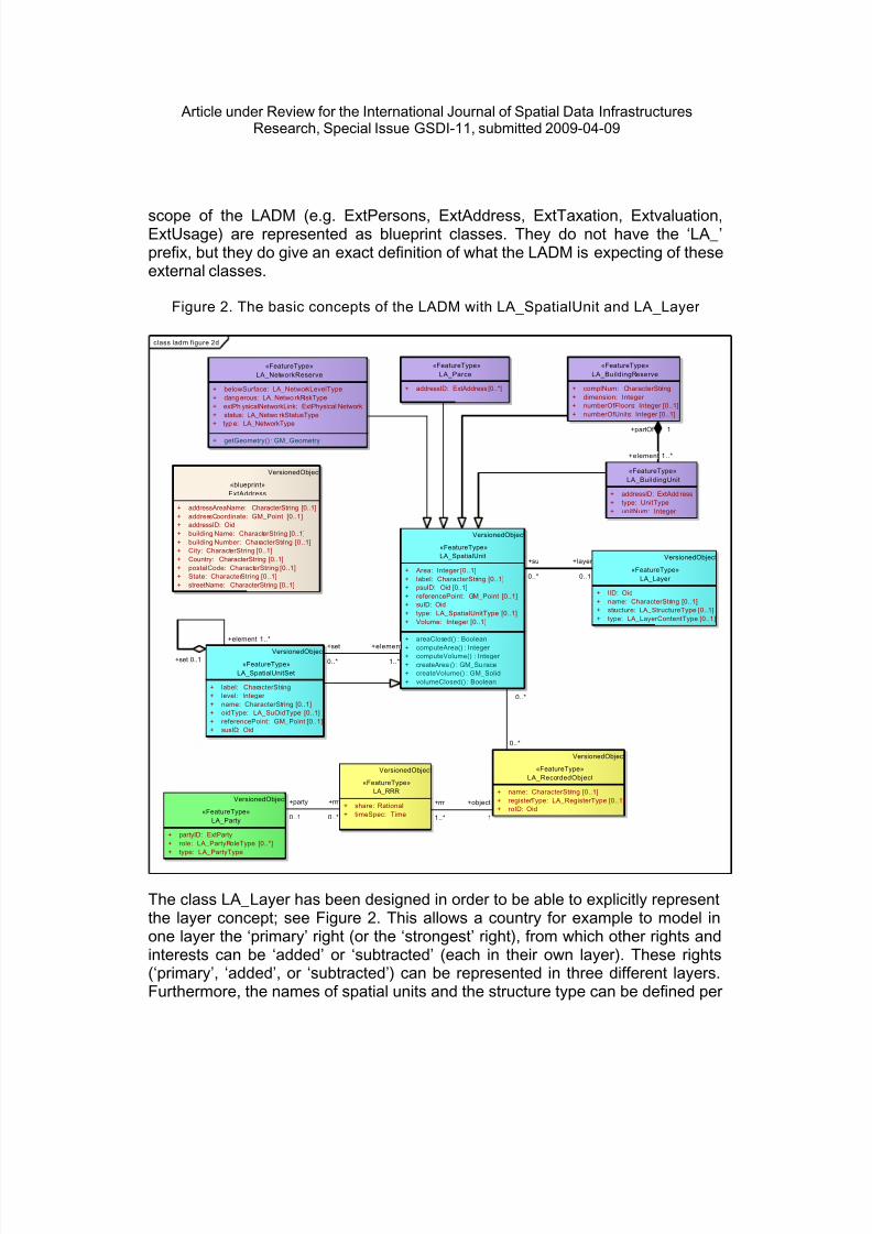
The class LA_Layer has been designed in order to be able to explicitly representthe layer concept; see Figure 2. This allows a country for example to model inone layer the ‘primary’ right (or the ‘strongest’ right), from which other rights andinterests can be ‘added’ or ‘subtracted’ (each in their own layer). These rights(‘primary’, ‘added’, or ‘subtracted’) can be represented in three different layers.Furthermore, the names of spatial units and the structure type can be defined per

8/13/2019 land administration
http://slidepdf.com/reader/full/land-administration 11/35

8/13/2019 land administration
http://slidepdf.com/reader/full/land-administration 12/35
Article under Review for the International Journal of Spatial Data InfrastructuresResearch, Special Issue GSDI-11, submitted 2009-04-09
Figure 3. Classes LA_FaceString, LA_Face, LA_SourcePoint , andLA_SpatialSource-Document
class ladm figure 2e
VersionedObject
«FeatureType»LA_Party
+ partyID: ExtParty
+ role: LA_PartyRoleType [0..*]+ type: LA_PartyType
VersionedObject
«FeatureType»LA_RRR
+ share: Rational+ timeSpec: Time
VersionedObject
«FeatureType»LA_RecordedObject
+ name: CharacterString [0..1]+ registerType: LA_RegisterType [0..1]+ roID: Oid
VersionedObject
«FeatureType»LA_SpatialUnit
+ Area: Integer [0..1]+ label: CharacterString [0..1]+ psuID: Oid [0..1]+ referencePoint: GM_Point [0..1]+ suID: Oid+ type: LA_SpatialUnitType [0..1]+ Volume: Integer [0..1]
+ areaClosed() : Boolean+ computeArea() : Integer + computeVolume() : Integer + createArea() : GM_Su race+ createVolume() : GM_Solid+ volumeClosed() : Boolean
VersionedObject
«FeatureType»LA_Face
+/ estimatedAccracy: Length [0..1]+ fID: Oid+/ geometry: GM_Surface [0..1]+/ productionMethod: LI_Lineage [0..1]
VersionedObject
«FeatureType»LA_FaceString
+/ estimatedAccuracy: Length [0..1]+ fsID: Oid [0..1]+/ geometry: GM_Curve [0..1]+ locationByText: CharacterString [0..1]+/ productionMethod: LI_Lineage [0..1]
VersionedObject
«FeatureType»LA_SourcePoint
+ locationOrig: GM_Point+ locationTransf: GM_Point [0..1]+ pID: Oid+ poin tType: LA_Monumentation Type+ quality: DQ_Element [0..*]+/ spaceDimension: Integer + transformation: CC_Operation [0..1]
LA_SourceDocument
«FeatureType»LA_SpatialSourceDocument
+ measurements+ quality: DQ_Element [0..*]+ surveyDate: DateTime+ type: SurveyDocumentType
for polygon-based spatial units: no minus and at least one p lus,for topology-base spatial units: at least one plus or min us
1..* 1..*
1..*
/derived
1..*
+sourcePo in t 1 .. *
+ so urce 1 ..*
+surveyor 1..*
0..*
+source
0..1 0..*
0..*0,3..*{ordered}
0..*
0..*
+rrr
1..*
+object
1
1..*
plus
0..*
+source
0..1
0..*
0..*
minus
0..*
0..*0,2..*{ordered}
0..*
plus
0..*
+party
0..1
+rrr
0..*
0..*
minus
1..*
3. LAND ADMINISTRATION WITHIN THE INFORMATIONINFRASTRUCTURE
Information and Communication Technology (ICT) offers many opportunities forimproving the performance of government and business. Areas which may profitinclude education, safety, health care, international co-operation, economicefficiency (integrated value chains, business-process management, andreduction in administrative overhead), prevention and detection of fraud, oraccident and disaster management. ICT trends such as ubiquitous access, smartobjects, open source, increased bandwidth; interoperability and data-exchangestandards will result in new business models. New perspectives are opened upby options like increased location independence, high-quality online servicesbased on immediate access to all required data, use of identified objectsavailable for process control, integration within business chains and governmentorganizations, and increased e-shopping.
8/13/2019 land administration
http://slidepdf.com/reader/full/land-administration 13/35
Article under Review for the International Journal of Spatial Data InfrastructuresResearch, Special Issue GSDI-11, submitted 2009-04-09
In (Groothedde et al 2008) it was argued that the information content within the(Spatial) Information Infrastructure (SII) consists of several registrations and thatit is therefore important to define what contents belong to what registration (as anexample LADM in Section 2). The different registrations within the (S)II arerelated, i.e. there are references in the content from one registration to anotherregistration. As the registrations are maintained by ‘independent’ organizationscare has to be taken when information is updated that related registrations areinformed (in order to trigger potential related updates elsewhere). Thefundamental question is: ‘How to maintain consistency between two relateddistributed systems in case of updates?’. Assume that System A refers to objectX in System B (via object id B.X_id), now the data in System B is updated andobject ‘X_id’ is removed. As long as System A is not updated the reference toobject X should probably be interpreted as the last version of this objectavailable. Note that the temporal aspect has an important role in and between thesystems! The true solution is also updating system A and removing the referenceto object X (at least at the ‘current’ time). How this should be made operationalwill mainly depend on the actual situation and involved systems. It might help tosend ‘warning/update messages’ between systems, based on a subscriptionmodel of the distributed users/systems.
An extremely important aspect of the future (S)II, in which (related) objects canbe obtained from another registration/organization (instead of copied), is that of‘information assurance’. Though the related objects, e.g. persons in case of acadastral system, are not the primary purpose of the registration, the wholecadastral ‘production process’ (both update and delivery of cadastral information)does depend on the availability and quality of the data at the remote server.Some kind of ‘information assurance’ is needed to make sure that the primaryprocess of the cadastral organization is not harmed by disturbances elsewhere.In addition, remote (or distribute) systems/users might not only be interested atthe current state of the objects, but they may need an historic version of theseobject; e.g. for taxation or valuation purposes. So even if the organizationresponsible for the maintenance of the objects is not interested in history, thedistributed use may require this (as a kind of ‘temporal availability assurance’). Itis clear that this can have a serious impact on the data management at the sideof registering organization.
Other topics have a strong relationship in the sense that these (physical) objectsmay result in legal objects (‘counterparts’) in the land administration. Forexample, the presence of utility cables or pipelines can also result in a restrictionarea or space (2D or 3D) in the land administration. However, it is not the cableor pipeline itself that is represented in the cadastral system; it is the legal aspectof this. Though strongly related, these are different aspects, compare this to awall, fence or hedge in the field and the ‘virtual’ parcel boundary. The fact thatthese ‘physical’ objects are so closely related to the ‘legal’ objects within the

8/13/2019 land administration
http://slidepdf.com/reader/full/land-administration 14/35
Article under Review for the International Journal of Spatial Data InfrastructuresResearch, Special Issue GSDI-11, submitted 2009-04-09
Cadastre, also implies that it is likely that some form of interoperability is needed.When the cables or pipelines are updated then both the physical and legalrepresentations should be updated consistently (within a given amount of time).This requires some semantic agreement between the ‘shared’ concepts, or atleast the interfaces and object identifiers. In other words these different, butrelated domain models need to be harmonized. As it is already difficult within onedomain (such as the cadastral world) to agree on the used concepts and theirsemantics, it will be even more difficult when we are dealing with other domains.However, we can not avoid this if a meaningful interoperable geo-informationinfrastructure has to be developed and implemented. It seams appropriate thatalso a more neutral organization plays a coordinating role in this harmonizationprocess: OGC, ISO, INSPIRE, FIG (International Federation of Surveyors), CEN(European Committee for Standardization) were already mentioned.
In several countries of the world we see attempts to harmonize a number ofdomain models within one country; e.g. Australia, USA, Germany, TheNetherlands (see Subsection 3.1). But it is not sufficient to harmonize within onecountry, as the models should also be harmonized internationally as in the caseof INSPIRE (see Subsection 3.2), which emphasizes spatial data. Furthermore, inSubsection 3.3 it is shown how the non-spatial components of LandAdministration are included in EULIS. In this system users can get access tolegal and administrative information related to cadastral parcels in the differentpartitioning countries. This is quite a heterogeneous network environment aseach country operates its own land administration system (land registry andCadastre).
3.1 The Netherlands
The basic idea behind information infrastructures is that they provide the toolsthat give easy access to distributed databases to people who need those data fortheir own decision making processes. Although information infrastructures have asubstantial component of information technology, the most fundamental asset isthe data itself, because without data there is nothing to have access to, to beshared or to be integrated. In the last decade it was understood that thedevelopment of information infrastructures not only provided easy access to
distributed databases, but also gave good opportunities for re-thinking the role ofinformation supply for the performance of governments. Based on this startingpoint, the Program ‘Streamlining Key Data’ of the Dutch government (Duivenbodeand De Vries 2003) took the lead in the development and implementation of astrategy for restructuring government information in such a way that an electronicgovernment will evolve that:• will only bother the public and the business community with requests for data
when this is absolutely necessary
8/13/2019 land administration
http://slidepdf.com/reader/full/land-administration 15/35
Article under Review for the International Journal of Spatial Data InfrastructuresResearch, Special Issue GSDI-11, submitted 2009-04-09
• offers the public and the business community a rapid and good service• can not be misled• instills the public and the industrial community with confidence• is provided at a cost that is not higher than strictly necessary.
Jointly with five other government registers, the property register, cadastral mapand topographic map of the Dutch Cadastre, Land Registry and Mapping Agency(‘Kadaster’) have been formally appointed in 2002 as ‘key registers’ of thegovernmental information infrastructure. The key registers will be the core of asystem of so-called authentic registers, which might be any register that ismaintained by a single government body and used by many others as theauthentic source of certain data. If a register is formally designated as anauthentic register, all other government organizations are strictly forbidden tocollect the same data by themselves. In their budget allocation they will not findany money for data collection at this point. The Program ‘Streamlining Key Data’concentrates on two goals:• The communal use of data: in principle data would be collected on one
occasion, and repeatedly used for the implementation of series of laws• The joint use of data: data from different registrations (organizations) required
for the performance of a specific government duty would be combined in oneapplication.
• An authentic register is defined in the Program as ‘a high quality databaseaccompanied by explicit guarantees ensuring for its quality assurance that, inview of the entirety of statutory duties, contains essential or frequently-useddata pertaining to persons, institutions, issues, activities or occurrences andwhich is designated by law as the sole officially recognized register of therelevant data to be used by all government agencies and, if possible, byprivate organizations throughout the entire country, unless important reasonssuch as the protection of privacy explicitly preclude the use of the register’(Duivenbode and De Vries, 2003).
Legislation has been created for the designation of the following registers:• Municipal Personal Records Database - Population Register•
Cadastre (Parcels and Rights)• Company Key Register ('New Trade Register')• Addresses, Buildings, and• Topography.
In order to provide well harmonized definitions of the content of these registers acommon approach has to be applied. In 2005 the ISO/TC211 compliant versionof NEN3610 (Basic Model Geo-Information) was accepted (NEN3610, 2005).

8/13/2019 land administration
http://slidepdf.com/reader/full/land-administration 16/35
Article under Review for the International Journal of Spatial Data InfrastructuresResearch, Special Issue GSDI-11, submitted 2009-04-09
This generic model provides the concepts, definitions, and relations for objectswhich are related to the earth surface in The Netherlands and can be sharedbetween the different domains within the context of the SII. Specificdomains/sectors can extend NEN3610 by defining their classes as subclasses ofthe generic NEN3610 classes. The classes inherit all properties, such asattributes, methods and associations, of the NEN3610 and these are then furtherextended with additional properties. Also the cardinality of inherited attributes andassociations may be refined, that is, made more restrictive; e.g. at superclasslevel an attribute may be optional (multiplicity ‘0..1’) and at subclass level thesame attribute can be made mandatory (multiplicity ‘1’). In addition to the morecadastral (IMKAD) and topographic (TOP10NL and IMGEO) models, some otherexamples of accepted domain models are: water (IMWA), physical planning(IMRO), cables and pipelines (IMKL), soil and subsurface (IMBOD), safety andsecurity (IMOOV), well-being (IMWE) (Geonovum, 2008).
On 8 February 2007 the Dutch Parliament approved the Act on BasicRegistration Cadastre and Topography. The implementation start date was 1st ofJanuary 2008. The Municipal Personal Records Database has also beenaccepted as authentic register; the laws where Buildings and Addresses andfurther the New Trade Register will be appointed as key register are underconstruction.
Experience acquired with the Municipal Personal Records Database (thepopulation register, which can not yet be consulted on-line) indicates that theDutch Cadastre could play a role in rendering these addresses and buildingsaccessible at a national level, even though the municipalities remain the owner ofthe source information. The Dutch Cadastre’s justification for this approach isbased on one of the agency’s competences, i.e. its skills in the management andmaintenance of national databases with an extremely high update frequency. It isDutch Cadastre’s strategy to play a leading role in the system of key registers.Figure 4 provides an overview of the system of key registers.

8/13/2019 land administration
http://slidepdf.com/reader/full/land-administration 17/35
Article under Review for the International Journal of Spatial Data InfrastructuresResearch, Special Issue GSDI-11, submitted 2009-04-09
Figure 4: A landscape: the system of key registers and the Dutch Cadastre’s landinformation portal
Landinformationportal
Landinformation
baseservices
Person
Company
System ofKey registers
Real EstateRights
Top 10NL
BuildingsAddresses
Non inhabitants
GBKN
Persons
Companies &other organisations
Kadaster
Persons Nationwideinformation
supply
Companies
Nationwideinformationsupply
Address &buildings
NationwideInformation
supply
Kadaster Nation wideInformation
supply(ISPS)
Identification;Authorisation
Kadaster-services
Notary, Lawyer, Tax service , RealEstae Brooker, Citizen, Financialinstitutions, Accountant, Project-developer, Utility Company
K a d a s t e r . n l
MunicipalEntry point
Users of governmental services
Company/organisation
Private person
Privat person /Company
G o v e r n m e n t . n l
PersonalInternet page
CompaniesEntry point
One may observe that this infrastructure does not only concern spatial data.Dutch Cadastre will review the extent to which supplementary relevant data couldbe included in the land register. The Kadaster can play a leading directive role inthe organization of the provision of this information to the market players,whereby consideration will need to be given to the cooperation with someregisters within the context of digital availability and fast accessibility. The DutchCadastre can acquire a good position by the provision of a series of topographicand geographic products that possess an internal consistency and areindispensable to third parties within the context of spatial planning, land use,management, and maintenance. For this reason the cadastral map, the LargeScale Topographic Base Map 1:1.000 and Topographic Key Register 1:10.000(TOP10NL) has to be object-oriented and maintained in a mutually consistentway by means of data set integration using ontologies. Advanced detection ofchanges, for example using satellite images followed by the processing of the

8/13/2019 land administration
http://slidepdf.com/reader/full/land-administration 18/35
Article under Review for the International Journal of Spatial Data InfrastructuresResearch, Special Issue GSDI-11, submitted 2009-04-09
changes in all data sets (‘change propagation’) will then become a feasibleproposition. The ‘General Elevation Dataset of The Netherlands’, and the‘National Road Database’, indispensible to dynamic traffic management would becompatible with this. The integration of the National Reference System (namedRD : x- and y coordinates) and Elevation Datum (named NAP : z coordinate) in a3D reference system will play a pivotal role in the geometric infrastructure.
Figure 5: The implementation of the Dutch Spatial Information Infrastructur e
Based on the above, the Dutch Cadastre’s current strategic objectives might bereformulated. It aims for the best possible performance of current public dutiesand the promotion of innovation and knowledge by adopting a leading role in theirevolution in response to societal developments. Strategic sub-objectives are:• Investigation of evolution towards more legal evidence of registered data (apositive land-registration system with state guarantee)• Introduction of a 3D land register• Ambition to adopt role as centre for a range of key registers• Provision of more complete in-sight into private and public legal status of
registered property
Cadastral map
Topographic map
Zones
Water
InfrastructureNational Geo Portal
National Safety
8/13/2019 land administration
http://slidepdf.com/reader/full/land-administration 19/35
Article under Review for the International Journal of Spatial Data InfrastructuresResearch, Special Issue GSDI-11, submitted 2009-04-09
• Achieving a substantial role in organizing information needs of the propertymarket chain• Provision of appropriately linked set of object-oriented topographic and
geographic datasets, mutually consistent with respect to change• Fulfillment of pivotal role in geometric infrastructure (x, y and z)• Acceptance of prominent EU partner role in harmonizing registered-property
law, land registration, and cadastres• Development of flexible land-planning instruments suitable for use in realizing
a variety of societal spatial objectives.
3.2 Land Administration and INSPIRE
For cross-border access to geo-data, a European metadata profile based on ISOstandards has been developed and described via rules of implementation definedby the Infrastructure for Spatial Information in the European Community –INSPIRE (Directive, 2007). For actual data exchange, the INSPIRE implementingrules will further define harmonized data specifications and network services.This is complemented with data access policies and monitoring and reporting onthe use of INSPIRE.
To illustrate the relationships of the cadastral parcel registration (as part of LA)with other registrations within an (S)II, a number of examples from INSPIRE will
now be described. Specific boundaries of cadastral parcels are, in manycountries, also the boundary of an administrative unit (municipality, province,country); this is an important relationship with theme 4 from Annex I of INSPIREdirective (Directive, 2007). Parcels and boundaries have associations withBuildings (theme 2 from Annex III of INSPIRE directive) - sometimes used aslocal reference for boundaries, but also used for orientation purposes. Parcelsand boundaries have associations with Transport Networks (theme 7 from AnnexI of INSPIRE directive) - same orientation purpose, but also roads, railroads,waterways are separate parcels as they are often owned by government. Astrong link exists between cadastral parcels and Addresses (theme 5 from AnnexI of INSPIRE directive). Further, links exist between cadastral parcels, land use(theme 4 from Annex III of INSPIRE directive) and land cover (theme 2 fromAnnex II of INSPIRE directive).

8/13/2019 land administration
http://slidepdf.com/reader/full/land-administration 20/35
Article under Review for the International Journal of Spatial Data InfrastructuresResearch, Special Issue GSDI-11, submitted 2009-04-09
Figure 6. European activit ies support ing the Spatial Information Infrastructure
Cadastral parcels must have a unique real property identifier to which the legalstatus is attached. This identifier is often based on a hierarchy of administrativearea's (provinces/districts/cantons/..., municipalities/communes/....,sections/polygons/...) and sometimes to the 'mother' parcel (subdivision of parcel..../..../..../37 means for example ..../..../..../37/1 and ..../..../..../37/2). At a Europeanlevel, the national identifiers should get a country code prefix to make themunique within Europe. In addition, there could be explicit associations betweenpredecessors and successors. The cadastral information should be maintainedcontinuously in order to reflect the actual legal situation. Of course, in reality andin information provision there might be a slight delay. Due to the legalimportance, the history is currently maintained in some countries, but this may beneeded in many countries.
The data model for INSPIRE cadastral parcels has been prepared in a way thatsupports compatibility with the upcoming international standard for the LADM.The INSPIRE model is compatible with LADM and might in the future beextended by the supplementary feature types as included in LADM. SeveralEuropean countries are represented in the ISO19152 Working Group, whichensures that European cadastral systems are taken into account in this standard.Once adopted, this ISO19152 standard will provide quite interesting ReferenceMaterial if Data Specification for Cadastral parcels has to be updated orextended. It may for instance propose harmonization solutions for rights andowners or for 3D cadastral objects (such as building or network reserves).
• Eurogeographics
• ESA / Galileo
• X-border initiatives
• Inspire• EULIS

8/13/2019 land administration
http://slidepdf.com/reader/full/land-administration 21/35
Article under Review for the International Journal of Spatial Data InfrastructuresResearch, Special Issue GSDI-11, submitted 2009-04-09
Figure 7. The INSPIRE cadastral parcel model derived from ISO LADM viainheritance
class inspire cad parcels based on ladm - pure
LA_SpatialUnitSet
«FeatureType»CadastralIndexSet
+ geometry: GM_Surface+ inspireId: Identifier + national CadastralIndexSetReference: CharacterString+ name: GeographicalName [0..*]+ level : CadastralIndexSetLevel+ levelName: LocalisedCharacterString [1..*]+ originalMapScaleDenominator: Integer [0..1]+ estimatedAccuracy: Length [0..1]
+ oidType: LA_SuOidType [0]::LA_SpatialUnitSet+ national CadastralIndexSetReference: Oid+ level: Integer + label : CharacterString+ name: CharacterString [0..1]+ referencePoint: GM_Point [0..1]+ oidType: LA_SuOidType [0..1]::VersionedObject+ beginLi fespanVersion: DateTime+ endLifespanVersion: DateTime [0..1]
LA_FaceString
«FeatureType»CadastralBoundary
+ geometry: GM_Curve+ inspireId: Identifier + estimatedAccuracy: Length+ topology: TP_Edge [0..1]+ fsID: Oid [0]+ locati onByText: CharacterString [0]+ productionMethod: LI_Lineage [0]::LA_FaceString+ fsID: Oid [0..1]+/ geometry: GM_Curve [0..1]+ locati onByText: CharacterString [0..1]+/ estimatedAccuracy: Length [0..1]+/ producti onMethod: LI_Lineage [0..1]::VersionedObject+ beginLi fespanVersion: DateTime+ endLifespanVersion: DateTime [0..1]
LA_SpatialUnit
«FeatureType»CadastralParcel
+ geometry: GM_Surface+ inspireId: Identifier + nationalCadastralReference: CharacterString+ national CalculatedArea: Area+ label : CharacterString+ originalMapScaleDenominator: Integer [0..1]+ estimatedAccuracy: Length [0..1]+ topology: TP_Face [0..1]
+ psuID: Oid [0]+ type: LA_Spatial UnitType [0]+ layer: Integer [0]+ structure: LA_StructureType [0]+ nationalVolume: Integer [0]+ addressID: ExtAddress [0]::LA_SpatialUnit+ nationalCadastralReference: Oid+ psuID: Oid [0..1]+ label : CharacterString [0..1]+ referencePoint: GM_Point [0..1]+ type: LA_Spatial UnitType [0..1]+ nationalCalculatedArea: Integer [0..1]+ Volume: Integer [0..1]::VersionedObject+ beginLi fespanVersion: DateTime+ endLifespanVersion: DateTime [0..1]
Note: The LADM attributes inherited by INSPIRE can have a more specifi cdata type or cardinali ty in INSPIRE (compared to LADM). Thi s has beenincluded in the diagram. This implies that an optional LADM attribute[0..1], might not occur at all in INSPIRE as the cardinality can be set to0; e.g. nationalVolume. This also implies that an optional LADMattribute [0..1], might be an obligatory attribute in INSPIRE; e.g. l abel.
«enumeration»CadastralIndexSetlev el
1st-order = 1 2nd-order = 2 3rd-order = 3
0..*
/derivedLADM
0..1
+0..* /derived LADM
0..1
1..2/derived LADM
0..*
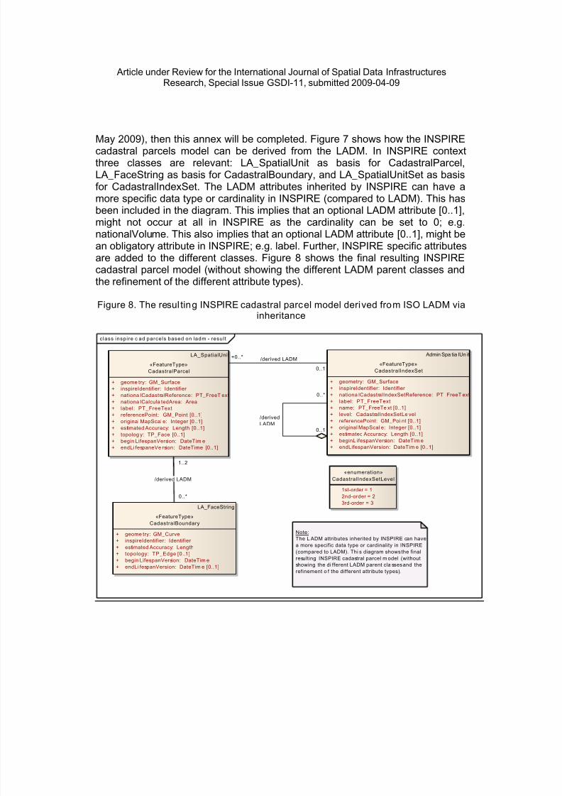
To be included in future the ISO19152 (as Annex G): a LADM-based version ofINSPIRE cadastral parcels, showing that the INSPIRE development fits within theLADM and that there are no inconsistencies. When the implementing rule andguidance material for INSPIRE cadastral parcels are published (target date 15
8/13/2019 land administration
http://slidepdf.com/reader/full/land-administration 22/35
Article under Review for the International Journal of Spatial Data InfrastructuresResearch, Special Issue GSDI-11, submitted 2009-04-09
May 2009), then this annex will be completed. Figure 7 shows how the INSPIREcadastral parcels model can be derived from the LADM. In INSPIRE contextthree classes are relevant: LA_SpatialUnit as basis for CadastralParcel,LA_FaceString as basis for CadastralBoundary, and LA_SpatialUnitSet as basisfor CadastralIndexSet. The LADM attributes inherited by INSPIRE can have amore specific data type or cardinality in INSPIRE (compared to LADM). This hasbeen included in the diagram. This implies that an optional LADM attribute [0..1],might not occur at all in INSPIRE as the cardinality can be set to 0; e.g.nationalVolume. This also implies that an optional LADM attribute [0..1], might bean obligatory attribute in INSPIRE; e.g. label. Further, INSPIRE specific attributesare added to the different classes. Figure 8 shows the final resulting INSPIREcadastral parcel model (without showing the different LADM parent classes andthe refinement of the different attribute types).
Figure 8. The resul ting INSPIRE cadastral parcel model derived from ISO LADM viainheritance
class inspire c ad parcels based on ladm - resul t
Admin Spa tia lUn it
«FeatureType»CadastralIndexSet
+ geometry: GM_Surface+ inspireIdentifier: Identifier + nationa lCadastralIndexSetReference: PT_FreeT ext+ label: PT_FreeText+ name: PT_FreeTe xt [0..1]+ level: CadastralIndexSetLe vel+ referencePoint: GM_Poi nt [0..1]+ original MapScal e: Integer [0..1]+ estimated Accuracy: Length [0..1]+ beginL ifespanVersion: DateTim e+ endLifespanVersion: DateTim e [0..1]
LA_FaceString
«FeatureType»CadastralBoundary
+ geome try: GM_Curve+ inspireIdentifier: Identifier + estimated Accuracy: Length+ topology: TP_Edge [0..1]+ begin LifespanVersion: DateTim e+ endLi fespanVersion: DateTim e [0..1]
LA_SpatialUnit
«FeatureType»CadastralParcel
+ geome try: GM_Surface+ inspireIdentifier: Identifier + nationa lCadastralReference: PT_FreeT ext+ nationa lCalcula tedArea: Area+ label: PT_FreeText+ referencePoint: GM_Point [0..1]+ original MapScal e: Integer [0..1]+ estimated Accuracy: Length [0..1]+ topolog y: TP_Face [0..1]+ begin LifespanVersion: DateTim e+ endLi fespaneVe rsion: DateTime [0..1]
Note: The L ADM attributes inherited by INSPIRE can havea more specific data type or cardinality in INSPIRE(compared to LADM). Thi s diagram shows the final
resulting INSPIRE cadastral parcel m odel (withoutshowing the di fferent LADM parent cla sses and therefinement o f the different attribute types).
«enumeration»CadastralIndexSetLevel
1st-order = 1 2nd-order = 2 3rd-order = 3
+0..* /derived LADM
0..1
1..2
/derived LADM
0..*
0..*
/derivedLADM
0..1

8/13/2019 land administration
http://slidepdf.com/reader/full/land-administration 23/35
Article under Review for the International Journal of Spatial Data InfrastructuresResearch, Special Issue GSDI-11, submitted 2009-04-09
3.3 Land Administration and EULIS
European Land Information Service (EULIS) provides since 2005 subscribedcustomers (such as banks or estate agents) access to property information in sixEuropean countries (England and Wales, Ireland, Lithuania, The Netherlands,Norway and Sweden) and pending for 7 other countries (Austria, Czech Republic,Finland, Iceland, Italy, Northern Ireland and Scotland) (EULIS, 2009). The servicewas developed by governmental land registration organizations who understandthe differences in practices and procedures between different Europeancountries. The EULIS Glossary and reference information assist in understandingthe meaning of national terminology. The EULIS Glossary is a service to helpcustomers understand the property registration terminology in their own countryand a country in which they are searching. It is an example of an informationservice that is completely focused on the legal side of Land Administration.
4. GLOBAL IMPACT OF LAND ADMINISTRATION
According to the International Federation of Surveyors (FIG) Land AdministrationSystems provide the infrastructure for implementation of land polices and landmanagement strategies in support of sustainable development. The infrastructureincludes institutional arrangements, legal frameworks, processes, standards, landinformation, management and dissemination systems, and technologies requiredto support allocation, land markets, valuation and control of use and developmentof interests in land. The way these systems function, their costs, and theirgovernance have enormous implications for the ability of the poor to receive landadministration services, to engage in land markets and to use property assetsmost effectively.
Land Administration Systems are the basis for conceptualizing rights, restrictionsand responsibilities (RRR) related to policies, places and people. Rights arenormally concerned with ownership and tenure whereas restrictions usuallycontrol use and activities on land. Responsibilities relate more to a social, ethicalcommitment or attitude to environmental sustainability and good husbandry. RRRmust be designed to suit individual needs of each country or jurisdiction, andmust be balanced between different levels of government, from local to national.
This theme will focus on how different jurisdictions are building these systems inways which are sustainable, well-governed and inclusive and how such systemscan best help to achieve the Millennium Development Goals.
In this section we will analyze a number of examples that illustrate the globalimpact of land administration. First in Subsection 4.1 the role of the LADM as oneof the UNO-HABITAT’s Pro Poor Land Tools combating slums is discussed. Thecase of the post-conflict recovery and stabilization in Afghanistan and theimportance of land administration is described in Subsection 4.2. The

8/13/2019 land administration
http://slidepdf.com/reader/full/land-administration 24/35
Article under Review for the International Journal of Spatial Data InfrastructuresResearch, Special Issue GSDI-11, submitted 2009-04-09
development of land administration systems based on free/libre/open sourcesoftware (FLOSS) by UN-FAO is next described in Subsection 4.3. Finally,Subsection 4.4 explains the role of land administration in the context of climatechange.
4.1 UN HABITAT– Global Land Tool Network: Pro Poor Land Tools
The Global Land Tool Network’s (GLTN) main objective is to contribute to povertyalleviation and the Millennium Development Goals through land reform, improvedland management and security of tenure. The GLTN originates from requestsmade by Member States and local communities world-wide to the United NationsHuman Settlements Program (UN-HABITAT), who initiated the network incooperation with the Swedish International Development Cooperation Agency(Sida), the Norwegian Ministry of Foreign Affairs and the World Bank, in 2006.
The Social Tenure Domain Model (STDM) is a multi-partner softwaredevelopment initiative to support pro-poor land administration. The initiative isbased on open source software development principles. The STDM, as it stands,has the capacity to broaden the scope of land administration by providing a landinformation management framework that would integrate formal, informal, andcustomary land systems and integrating administrative and spatial components.The STDM makes this possible through tools that facilitate recording all forms ofland rights, all types of rights holders and all kinds land and property objects(spatial units) regardless of the level of formality. Not only in regard to formality,but the thinking behind the STDM also makes a departure in terms of goingbeyond some established conventions. Traditional or conventional landadministration systems, for example, relate names or addresses of persons toland parcels via rights. An alternative option being provided by STDM, on theother hand, relates personal identifiers such as fingerprints to a coordinate pointinside a plot of land through a social tenure relation such as tenancy. The STDMthus provides an extensible basis for efficient and effective system of land rightsrecording. The STDM is a specialization of the Land Administration DomainModel (LADM). It should be noted that the LADM International Standard which isunder development includes the STDM in Annex B.
The Social Tenure Domain Model (STDM) describes relationships betweenpeople and land in unconventional manner because it tackles land administrationneeds in hitherto neglected communities such as people in informal settlementsand customary areas. It supports development and maintenance of records inareas where regular or formal registration of land rights is not the rule. It focuseson land and property rights, which are neither registered nor registerable, as wellas overlapping claims, that may have to be adjudicated both in terms of the ‘who’,the ‘where’ and the ‘what right’. In other words, the emphasis is on social tenurerelationships as embedded in the continuum of land rights concept promoted by

8/13/2019 land administration
http://slidepdf.com/reader/full/land-administration 25/35
Article under Review for the International Journal of Spatial Data InfrastructuresResearch, Special Issue GSDI-11, submitted 2009-04-09
GLTN and UN-HABITAT. This means informal rights such as occupancy, adversepossession, tenancy, use rights (this can be formal as well), or customary rights,or indigenous tenure, as well as the formal ones are recognized and supported(with regard to information management) in STDM enabled land administrationsystem. Likewise, the STDM accommodates a range of spatial units (‘where’, e.g.a piece of land which can be represented as one point – inside a polygon, a setof lines, as a polygon with low/high accuracy coordinates, as a 3D volume, etc.).Similarly, the STDM records all types of right holders (‘who’, e.g., individuals,couples, groups with defined and non-defined membership, group of groups,company, municipality, government department, etc.). In regard to evidence,STDM handles the impreciseness and possible ambiguities that may arise in thedescription of land rights. In a nutshell, the STDM addresses information relatedcomponents of land administration in an innovative way.
In STDM enabled land administration, data coming from diversified sources issupported based on local needs and capabilities. This pertains to both spatialand administrative (non-spatial) data. For example, it may be, in informalsettlements, sufficient as a start to relate people-land relationships to a singlepoint. Then attributes such as photographs and fingerprints can be attached tothe records. In a central business district (CBD) of a city, a traditional cadastralmap/register may be required while in a residential area, land administrationneeds may entail using a map derived from satellite images and combined withformal descriptions of rights and right holders. The STDM encourages and catersfor all these variations.
High resolution satellite image is one of the emerging and a very promisingsource of spatial data for land administration. A large-scale plot of such imagescan be used to identify land over which certain rights are exercised by the peoplethemselves, i.e., in a participatory manner. As a proof of the concept, WorldBank, with GLTN funding, organized and led an exercise in Ethiopia in June 2008which included doing preliminary test on the feasibility of high resolution satelliteimages. The results that came out of this experiment are encouraging. Similarinitiatives in other countries like Rwanda are also yielding comparable outcomes.The STDM development activity has thus far generated conceptual, functionaland technical designs. The next logical step is the software development, starting
with a prototype and testing this through a pilot project in a country which hasslums, customary tenure, overlapping claims and non-polygon spatial units, etc.The prototype is under development at the International Institute for Geo-Information Science and Earth Observation (ITC) in close co-operation withGlobal Land Tool Network / UN-HABITAT and the International Federation ofSurveyors (FIG). A World Bank led pre-project (preparatory) activity in Ethiopia iscreating opportunities to pilot test the prototype in the context of rural landadministration.

8/13/2019 land administration
http://slidepdf.com/reader/full/land-administration 26/35
Article under Review for the International Journal of Spatial Data InfrastructuresResearch, Special Issue GSDI-11, submitted 2009-04-09
4.2 Land Administration in Post Conflict Area’s: Afghanistan’s recovery
The causes of conflicts and violence are many. For example ethnic envy,nationalistic tendencies, opposing interests, class conflicts, disputed frontiers,acts of expansion or economic interests (FIG, Commission 7, 2004). During suchconflicts people are killed or disappear, buildings and physical infrastructure isdestroyed, legal frameworks are set aside, public registers are destroyed,markets cease to function, properties are taken and lands occupied. If the conflictends, peace treaties, UN resolutions or national development plans aim atrestoring governance and the rule of law in all its variety (security, health, energy,shelter etc.)
In many cases, a substantial component of the restorative process consists of the(re-introduction) of secure land tenure, mechanisms of resolution of land conflicts,land allocation, restitution, transparent land markets, land use planning, landtaxation and the like. This implies both institutional and operational measures.Some form of land registration and Cadastre is needed as a provider of secureproperty rights, as a facilitator for the land and land-credit market and as aninformation source for various public tasks like planning, taxation, land reformand the management of natural resources.
In his book ‘Registering the Human Terrain: A Valuation of Cadastre’ the authorDoug Batson (Batson, 2008) observes that property rights in volatile countries isan auspicious field of international development for the U.S. to assert its “softpower”. His book is explicitly not about mapping the human terrain, but aboutregistering the human terrain: relating a “person” (an individual, a group, or anon-natural person such as an organization) to a geographical place throughproperty records. This book manifests how to answer the “who” question with thesame precision the U.S. Intelligence Community answers the “where’’ question. Itis observed that also conflicts (overlapping land claims) can be recorded inLADM.
It may be objected that the LADM cannot represent all possible cases for onearea of the world, or that the categories it describes for one country may need tochange for the next. But this is LADM’s strength, not its weakness. The classes in
LADM are expandable. The system is being designed so that additionalattributes, operators, associations, and perhaps even complete new classes canbe added for a specific country or region. According to (Batson, 2008) the LADMaspires to be everything that civilian land administrators and civil-military plannerswant to address regarding land issues of post-conflict societies. It merits closeattention by NATO, the U.S. State and Defense Departments, and USAID orother entities tasked with bringing about stabilization because it could be animportant breakthrough tool for aiding countries with weak or totally absent landadministration.

8/13/2019 land administration
http://slidepdf.com/reader/full/land-administration 27/35
Article under Review for the International Journal of Spatial Data InfrastructuresResearch, Special Issue GSDI-11, submitted 2009-04-09
4.3 Free/Libre/Open Source Software: Land Administration
The initiative for this project came from the Land Tenure Group of the Food andAgricultural Organization (FAO) of the United Nations. Several landadministration projects in developing countries sponsored by the FAO in the pasthave failed, often due to high software licensing costs and inadequateinformation technology (IT) systems. Despite these failures, IT holds greatpromise for land administration systems, but only when introduced in asustainable way. To address this issue a seminar on the use of Free/Libre/OpenSource Software (FLOSS) was held on 8th and 9 th of May 2008 at the Universityof Otago, New Zealand (OSCAR, 2008).In parallel to the organization of theseminar, the University has been working on the design of a software shell thatincludes a data schema for cadastre and land registration. The presentations anddiscussions in this seminar provide an overview of the software needs and otherrequirements of land administration projects. The project goals further include: • To carry out a thorough high level conceptual analysis and design, as well as
prepare a preliminary analysis/proposal of FLOSS tools, for the developmentof a cadastre and land registration shell including at least requestmanagement, editorial and maintenance functions for the maintenance of ageneric cadastral index map and cadastral record based on the CoreCadastral Domain Model (CCDM, note that this is the previous name of theLADM) and Social Tenure Domain Model (STDM) or similar.
• To prepare a design and main milestones and a tentative budget for a FAO
administered support for establishing a sustainable OSS product andcommunity for FLOSS cadastre and land registration.It was concluded that LADM provides the ontology, the basic concepts forsoftware development. While the model is still abstract and cannot be directlyconverted to a data structure, it provides the conceptual framework on which tobuild land administration systems. However, modelling cannot be seen as a goalin itself . After modelling it is necessary to start implementing.
4.4 Land Administration and Climate Change
A standardized Land Administration Domain Model (LADM) provides an
extensible basis for efficient and effective cadastral system development.Examples on the need for extensibility are provided above in Subsection 4.1where the social tenure in less developed countries is introduced. Another typicalexample case is on Carbon Credits (Van der Molen, 2009). Van der Molenconcludes that in addition to appropriate registration of land tenure and cadastralgeometry, additional information is required about environmental rating ofbuildings, energy use, current and potential land use related to carbon stockpotential and greenhouse gases emissions, clearer definitions of various landtypes related to the application of various legal regimes (like what is exactly ‘idle’

8/13/2019 land administration
http://slidepdf.com/reader/full/land-administration 28/35
Article under Review for the International Journal of Spatial Data InfrastructuresResearch, Special Issue GSDI-11, submitted 2009-04-09
land), flood and storm prone areas, salinization rates and transport indicators.This information might not necessarily be recorded in the land registration andcadastre system itself, but at least connected with it, so that a strong link withprivate and public rights to land remains in existence (within the SII).
In the case of ‘unbundled’ property rights, with the separation of carbon credittitles, these registers and cadastres should be able to register such rights(registration) and to attach appropriate geometric attributes and to make thosetitles accessible for trade in the carbon credit market. A study by the IPPC (IPPC,2003) reveals widespread demand for a well-designed carbon accounting systemthat provides for the ‘transparent, consistent, comparable, complete, accurate,verifiable and efficient recording and reporting of changes in carbon stocks and/orchanges in greenhouse gas emissions by resources and removals by sinks fromapplicable land use, land use change and forestry activities’. Although differentapproaches are possible, in many cases land surface areas, above-ground andbelow-ground volumes of biomass, canopy surveys, and geo-information play arole – new types of spatial units.
Land registers and cadastres also have to fulfill their most vital purpose, namelyto provide land tenure security to right holders, with a focus on the poor, thevulnerable and indigenous peoples, in order to safeguard their land rights. Forexample, in case of demands for land for purposes of large-scale bio fuelproduction or afforestation for carbon sequestration and to provide informationabout tenure, value and use of land when governments want to encouragechanges in livestock, crop production, conversion from arable land to grazingland, from tillage to no-tillage cropping, reforestation and combating degradationof soils though sound land-use planning and management. These spatial unitrelated carbon credits can be registered or recorded in the LADM.
When governments want to apply taxation as a measure to achieve suchobjectives, land registers and cadastres are supposed to provide relevantinformation about taxable objects, taxable values and taxable persons, includingearlier mentioned indicators regarding energy use etc. This would mean inclusionin the LADM of functionality to support taxation. In this moment this is included asexternal classes.
When governments need lands to realize certain land use (water storage, carbonsinks – which are 3D objects), land registers and cadastres should provideinformation about right holders to be compensated in the land acquisitionprocess, in such a way that people’s land rights are respected and the risk ofeviction is avoided. When land reform is at stake, land registers and cadastresprovide information about the existing land tenure pattern and provide anoperational process to change from old to new situations. In summary, landregisters and cadastres have a role to play in supporting governments and

8/13/2019 land administration
http://slidepdf.com/reader/full/land-administration 29/35
Article under Review for the International Journal of Spatial Data InfrastructuresResearch, Special Issue GSDI-11, submitted 2009-04-09
citizens in their efforts at mitigating global climate change and trying to adapt toits impact.
5 LAND ADMINISTRATION LEVELS OF MATURITY
In this section the concept of ‘information sharing levels of maturity’ will beexplained and illustrated with land administration examples. When movingtowards the higher stages, with higher value and efficiency, none of the previousstages can be omitted, as the subsequent stage builds on the previous stage.The step towards the last stage means an important mind shift. It will place thespatial information infrastructure in the context of current relevant social themes;e.g. public safety, environmental issues, spatial planning. Within these themesmany different players, information sets, sectors must work together to face thesocial challenges. It should be noted that the levels of maturity also apply to other(information) sectors than just the land administration.
5.1 Land Administration Levels of Maturi ty
The practice of Land Administration has many different levels of maturity.Maturity differences between countries are recognized and every country wantsto benchmark themselves to relevant institutes. A model is used to specifydifferent levels of maturity. This model can be used for many other purposes, butfor now we can use it for measuring Land Administration maturity. Growth inmaturity will follow the four levels. A kind of ladder where every step gives highervalue and efficiency. Every level can be met after finishing the previous one. Inalmost every situation no level can be omitted as the subsequent level builds onthe previous one. The model has four stages: Standards, Connectivity,Integration and Network; see Figure 9. These stages are comparable to the sixstages defined by (Nolan, 1979). Although the names of each level are derivedfrom the technical arena, they hold the entire Land Administration processes andorganization:Standards. In this stage the necessary standards are created. E.g.Standards in Data modeling, Standards in exchange formats, Standards in LandAdministration Systems. Standards are the basic needs in maturity.• Connectivity. Once standards are clear, different organizations, or countries
can start to make a connection. A point to point connection createspossibilities to exchange Land Administration information, both geographicand administrative information.
• Integration. After organizations or countries are connected they start acting asa whole. This will form a kind of Land Administration InformationInfrastructure. The spatial information “hang-out” for all related users.
• Network. The ultimate level seems a small step, but means a big mind shift.The focus will shift from the Land Administration, or Spatial InformationInfrastructure towards higher level social themes. It will place the spatial

8/13/2019 land administration
http://slidepdf.com/reader/full/land-administration 30/35
Article under Review for the International Journal of Spatial Data InfrastructuresResearch, Special Issue GSDI-11, submitted 2009-04-09
information infrastructure in the context of current relevant social themes. E.g.public safety, environmental issues, spatial planning, water management,poverty reduction. Within these themes many different players(stakeholders), information sets, sectors must work together to face the socialchallenges. This will require semantic translations of the information in orderto be useful.
Figure 9. Land Administration Maturity Model
5.2 Current Levels of Land Administration Maturit y
At the different scales, world-wide, European, national, the level of maturity cannow be assessed as follows:• World-scale: When we take a look at a global scale, we see the GSDI efforts
resulting in standards. This is the first stage of maturity. An absolutenecessity for creating a base level to build on.
• European-scale: In Europe a big step is made with the Inspire initiative.Inspire gives the standardization base for data and exchange of data. Thestandardization level of maturity is met in Europe and we see initiatives likeEULIS making the step to the next level of Connectivity; Connections
Connected
Integrated
Networked
Standards
Effect
Time

8/13/2019 land administration
http://slidepdf.com/reader/full/land-administration 31/35
Article under Review for the International Journal of Spatial Data InfrastructuresResearch, Special Issue GSDI-11, submitted 2009-04-09
between different countries. We also see some cross border initiatives forbetter Land Administration processes.• National-scale: The Netherlands is making the next step towards the
Connectivity level. Different organizations and sectors work together in a socalled National Geo Portal where Public Services are being places on a map.Data is being organized on a national level in so called key registers, a steptowards the Integrated level. All spatial data is being structured, whereinterconnectivity is a prime goal. With this structuring scheme it is securedthat data is collected once and used many times by all governmental bodies.Different governmental bodies like Ministries, Provinces, Municipalities dowork together.
Only very premature efforts are made to come to this Network level. Oneexample in The Netherlands is the pilot of public safety where a SpatialInformation Infrastructure is one of the elements in disaster management. Thestep towards a nationwide public safety solution will take some years.Experiencing working together with equality, balance, and shared responsibility iseasily said and written but very difficult to execute.
5.3 The last step: fact of futur e?
Worldwide themes like melting ice-caps, the rising of the sea-level, growing worldwide poverty, land with rich resources becomes more scarce every year wherespatial planning should help out organizing our earth. It is these themes forsociety where Land Administration and its Spatial Information Infrastructure canplay its role. Land Administration is not the center of the solution, but only onenecessary brick in the wall. The success will be the balance of power between allrelevant organizations or countries. Once one organization or country startsregulating one of these themes and takes a central role, the balance can easilybe disturbed. So a Networked approach is needed. A network where everybodyis equal and has its own contribution to the solution. It will be a success onceeverybody starts placing themselves outside the center of the network and accepta cooperative role. The world needs the network approach, the last stage inmaturity, where the theme is placed in a central position and not the organizationof country. To face the current global themes, our world deserves the networkapproach. All disciplines should actively and equally work together. LandAdministration and Spatial Information Infrastructures is one contribution tohandle the challenges in an ever more complex society. It is crucial in such anetworked society that the involved stakeholders do understand each other,despite their different background and terminology. An agreed set of concepts(an ontologiy) is needed and delivered by the LADM.

8/13/2019 land administration
http://slidepdf.com/reader/full/land-administration 32/35
Article under Review for the International Journal of Spatial Data InfrastructuresResearch, Special Issue GSDI-11, submitted 2009-04-09
6. CONCLUSION
Every country (or, federation of countries) in Europe has a Cadastral or LandAdministration system operational (although in some countries not yet for thecomplete territory), often as the responsibility of a national organization, or as theresponsibility of a more local government organization. Due to different legalsystems and different national tradition, there is a rich variety of cadastralsystems around. As this limits interoperability (e.g. in the context of EULIS) andresults in high system development and maintenance costs, non-governmental(international) organizations, such as the FIG, developed the Land AdministrationDomain Model (LADM) and submitted this to ISO/TC211.
Land Administration Systems form an important part of the Spatial InformationInfrastructure of the Member States. Cadastral activity is related to creating andupdating the land parcel’s alphanumerical and graphical information and itsaggregation. The Cadastral Organizations in each Member State are those publicorganizations that have specific legal responsibility in creating and updating theland parcel’s alphanumerical and graphical geo-referenced information, or itscoordination at national level (IPCC, 2003).
Looking from a distance one can observe that the systems are in principle mainlythe same: they are all based on the relationships between persons and land, via(property) rights and are in most countries influenced by developments in theInformation and Communication Technology (ICT). The two main functions ofevery cadastral system are: (1) keeping the contents of these relationships up-to-date (based on legal transactions) in a land administration system and (2)providing information on this registration. In this paper it has been explored whichimportant issues related to a registration in an (S)II have to be confronted(registration content boundaries, keeping related registrations consistent afterupdates, and harmonized data content). Based on the experience of the DutchCadastre solutions are proposed to solve these issues and this has beenillustrated with on-going standardization activities within several internationalbodies (FIG, CEN/TC287, ISO/TC211, INSPIRE).
Besides important traditional applications of land administration, such as legal
security in real estate, taxation, and spatial planning, also less expected crucialsocietal challenges are benefiting. Examples include combating slum areas(Subsection 4.1), post-war recovering (Subsection 4.2), carbon credits(Subsection 4.4), food security, energy scarcity, natural disasters, urban growthand environmental degradation (FIG, 2009). All these spatial unit related (legal)registrations can be registered or recorded in the proposed LADM.
Some important implementation issues will be discussed in the future: how tomanage the different levels of accuracy for LA applications and for small scale

8/13/2019 land administration
http://slidepdf.com/reader/full/land-administration 33/35
Article under Review for the International Journal of Spatial Data InfrastructuresResearch, Special Issue GSDI-11, submitted 2009-04-09
topographic data sets, the integration of 3D Cadastres and marine Cadastres,‘map-matching’ between adjacent countries, a high degree of up-to-date-ness,the integration with surveys (sources), resulting into cadastral index maps.
References
Batson, D. (2008). Registering the Human Terrain: A Valuation of Cadastre. NDIC Press, National Defense Intelligence College, Washington, DC.
CEN/TC287 (2003). ‘Geographic Information’ doc.nr. N 1015, Resolutions 39 - 54taken by CEN/TC287 meeting November 10/11, 2003.
DIRECTIVE 2007/2/EC OF THE EUROPEAN PARLIAMENT AND OF THECOUNCIL of 14 March 2007 establishing an Infrastructure for SpatialInformation in the European Community (INSPIRE).Official Journal of theEuropean Union, 25.04.2007, L108/1-14 (Acts adopted under the ECTreaty/Euratom Treaty whose publication is obligatory).
Duivenbode, H. van, and Vries, M. de. (2003). Upstream: Chronicle of theStreamlining Key Data Programme. The Hague: voormaligeprogrammabureau Stroomlijning Basisgegevens..
EULIS (2009).http://www.eulis.eu/countries/ FIG, Commission 7 (2004): ‘Land Administration in Post Conflict Area’s’,
Proceedings of a Symposium held by FIG Commission 7 on 29 and 30 April2004 at the European UN-Headquarters Palais de Nations, Geneva,Switzerland; editors Paul van der Molen and Christiaan Lemmen.
FIG (2009), FIG/ World Bank Conference “Land Governance in Support of theMillennium Development Goals: Responding to New Challenges”,Washington DC, USA 9-10 March 2009.http://www.fig.net.
Geonovum (2009), Standaarden voor Geo-informatie, the National Spatial DataInfrastructure (NSDI). Executive committee in the Netherlands,http://www.geonovum.nl/standaarden.html. In Dutch.
Groothedde A., Lemmen C., van der Molen P. and van Oosterom P. (2008). "AStandardized Land Administration Domain Model as Part of the (Spatial)Information Infrastructure", in van Oosterom P. and Zlatanova S. (Eds.).Creating Spatial Information Infrastructures, Towards the Spatial SemanticWeb . CRC Press, 2008, pp. 129-150..
Hespanha, J., J. van Bennekom-Minnema, P.J.M. Van Oosterom and C.Lemmen (2008). The Model Driven Architecture approach applied to the LandAdministration Domain Model version 1.1 - with focus on constraints specifiedin the Object Constraint Language. FIG Working Week 2008, Stockholm,Sweden.

8/13/2019 land administration
http://slidepdf.com/reader/full/land-administration 34/35
Article under Review for the International Journal of Spatial Data InfrastructuresResearch, Special Issue GSDI-11, submitted 2009-04-09
INSPIRE (2008). Infrastructure for Spatial Information in Europe. D2.8.I.6INSPIRE Data Specification on Cadastral Parcels, Draft Guidelines (version2).
IPCC. (2003). Common Principles on Cadastre in the European Union .Declaration, Rome, 3rd December 2003..
ISO/TC211 (2008). Geographic information/Geomatics, New Work Item Proposal,Geographic information — Land Administration Domain Model (LADM),ISO/TC211 N 2385, 2008-02-01.
ISO/TC211 (2009).www.isotc211.org.Kaufmann, J. and Steudler, D. (1998). Cadastre 2014, A Vision for a Future
Cadastral System. Copenhagen: International Federation of Surveyors..Lemmen, Christiaan and Peter van Oosterom: ‘Version 1.0 of the FIG Core
Cadastral Domain Model’, XXIII FIG Congress, Munich, Germany, October 8-13, 2006.
Lemmen, Christiaan and Peter van Oosterom, Harry Uitermark, Rod Thompson,and João Hespanha (2009). Transforming the Land Administration DomainModel (LADM) into an ISO standard (ISO19152). In FIG Working Week 2009,Surveyors Key Role in Accelerated Development, Eilat, Israel, 3-8 May 2009.
NEN3610 (2005). Base model geo-information - Terms, definitions, relations andgeneral rules for interchange of information of spatial objects related to the
earth's surface. Norm commissie 351 240 "Geo-informatie". In Dutch.Nolan, Richard L (1979). Managing the Crisis in Data Processing, Harvard
Business Review 1979 57 (2) 115-126.Van Oosterom, P.J.M. and C.H.J. Lemmen (2003). 'Towards a Standard for the
Cadastral Domain’, Journal of Geospatial Engineering , p. 11-28, Vol. 5,Number 1, June 2003.
Van Oosterom, P.J.M., C.H.J. Lemmen and P. van der Molen (2004). ‘Remarksand observations related to the further development of the Core CadastralDomain Model’, in:Proceedings of the Workshop Standardisation in theCadastral Domain, Bamberg, Germany, 9-10 December 2004 , FIG, Denmark,2004.
Van Oosterom, P.J.M., C.H.J. Lemmen, T. Ingvarsson, P. van der Molen, H.Ploeger, W.Quak, J. Stoter, and J. Zevenbergen (2006). The core cadastraldomain model. Computers, Environment and Urban Systems , Volume 30, 5.
OSCAR (2008).http://source.otago.ac.nz/oscar/OSCAR_Home.UNECE. (2004).ECE Guidelines on Real Estate Units and Identifiers . New York
and Geneva: United Nations.

8/13/2019 land administration
http://slidepdf.com/reader/full/land-administration 35/35
Article under Review for the International Journal of Spatial Data InfrastructuresResearch, Special Issue GSDI-11, submitted 2009-04-09
Van der Molen, Paul, (2009). ‘Cadastre’s and Climate Change’; paper to bepresented at FIG Working Week 2009, ‘Surveyors’ Key Role in AcceleratedDevelopment’, Éclat, Israel, 3-8 May 2009
WG-CPI. (2006).Role of the cadastral parcel in INSPIRE and national SDIs withimpacts on cadastre and land registry operations. Joint Working Group ofEuroGeographics and the PCC (WG-CPI), Inventory document.