Lake Vermont Northern Extension€¦ · · 2014-12-03Lake Vermont Northern Extension Flora and...
114
Lake Vermont Northern Extension Flora and Fauna Report Prepared for: Bowen Basin Coal Pty Ltd June 2014
Transcript of Lake Vermont Northern Extension€¦ · · 2014-12-03Lake Vermont Northern Extension Flora and...

Lake Vermont Northern Extension
Flora and Fauna Report
Prepared for:
Bowen Basin Coal Pty Ltd
June 2014

Flora and Fauna Report i June 2014
Document History and Status
Issue Rev. Issued To Qty Date Reviewed Approved
1 0 Bowen Basin Coal 1 19/11/13 GB GB
2 1 Bowen Basin Coal 1 6/01/14 GB GB
3 2 Bowen Basin Coal 1 20/06/14 GB GB
Project Manager: Gareth Bramston
Name of Client : Bowen Basin Coal Pty Ltd
Name of Project: Lake Vermont Northern Extension Project
Title of Document: Flora and Fauna Report
Document Version: Final
This controlled document is the property of AustralAsian Resource Consultants Pty Ltd and all rights are reserved
in respect of it. This document may not be reproduced or disclosed in any manner whatsoever, in whole or in
part, without the prior written consent of AustralAsian Resource Consultants Pty Ltd. AustralAsian Resource
Consultants Pty Ltd expressly disclaims any responsibility for or liability arising from the use of this document by
any third party.
Opinions and judgments expressed herein, which are based on our understanding and interpretation of current
regulatory standards, should not be construed as legal opinions. Information obtained from interviews and
contained in the documentation has been assumed to be correct and complete. AustralAsian Resource
Consultants Pty Ltd does not accept any liability for misrepresentation of information or for items not visible,
accessible, nor able to be inspected at the sites at the time of the site visits.

Flora and Fauna Report ii June 2014
EXECUTIVE SUMMARY ........................................................................................... IX
1.0 INTRODUCTION ............................................................................................. 1
1.1 SCOPE OF STUDY ............................................................................................................... 1
2.0 PROJECT DESCRIPTION .............................................................................. 2
2.1 PROJECT GEOGRAPHIC AND BIOREGIONAL LOCATION ............................................. 2
2.2 PROJECT DESIGN ............................................................................................................... 2
2.3 LOCAL WATERWAYS AND TOPOGRAPHY ...................................................................... 4
2.4 GEOLOGY AND SOILS ........................................................................................................ 5
2.5 REGIONAL CLIMATE ........................................................................................................... 6
2.6 CURRENT LAND AND WATER USE ................................................................................... 6
3.0 RELEVANT LEGISLATION ............................................................................ 7
3.1 ENVIRONMENT PROTECTION AND BIODIVERSITY CONSERVATION ACT 1999 ......... 7
3.2 NATURE CONSERVATION ACT 1992 ................................................................................. 7
3.3 VEGETATION MANAGEMENT ACT 1999 ........................................................................... 8
3.4 QUEENSLAND DEPARTMENT OF ENVIRONMENT AND HERITAGE PROTECTION BIODIVERSITY STATUS ................................................................................................................... 8
3.5 BIODIVERSITY PLANNING ASSESSMENTS...................................................................... 9
3.6 LAND PROTECTION (PEST AND STOCK ROUTE MANAGEMENT) ACT 2002 ............... 9
4.0 DATABASE SEARCH AND LITERATURE REVIEW ................................... 10
4.1 FLORA ................................................................................................................................. 10
4.1.1 Threatened Ecological Communities ............................................................................... 10
4.1.2 Regional Ecosystems ...................................................................................................... 11
4.1.3 Threatened Flora Species ............................................................................................... 13
4.2 FAUNA ................................................................................................................................. 15
4.2.1 Threatened Fauna Species ............................................................................................. 15
4.2.2 Migratory Fauna Species ................................................................................................. 17
4.3 ENVIRONMENTALLY SENSITIVE AREAS ........................................................................ 18
4.4 WETLAND MAPPING ......................................................................................................... 20
4.5 BRIGALOW BELT BPA ...................................................................................................... 20
5.0 SURVEY METHODOLOGY ........................................................................... 21
5.1 INITIAL SITE SCOPING ...................................................................................................... 21
5.2 FLORA ................................................................................................................................. 21
5.2.1 Vegetation Classification and Regional Ecosystem Mapping ......................................... 21
5.2.1.1 Flora and Regional Ecosystem Identification ....................................................................... 24
5.2.1.2 Surveys for Species of Conservation Significance ............................................................... 24
TABLE OF CONTENTS

Flora and Fauna Report iii June 2014
5.3 FAUNA ................................................................................................................................. 24
5.3.1 Detection Methods ........................................................................................................... 24
5.3.2 Fauna Survey Sites ......................................................................................................... 27
5.3.2.1 FS1 ...................................................................................................................................... 29
5.3.2.2 FS2 ...................................................................................................................................... 29
5.3.2.3 FS3 ...................................................................................................................................... 30
5.3.2.4 FS4 ...................................................................................................................................... 31
5.3.2.5 FS5 ...................................................................................................................................... 32
5.3.2.6 FS6 ...................................................................................................................................... 33
5.3.2.7 FS7 ...................................................................................................................................... 34
5.3.2.8 FS8 ...................................................................................................................................... 35
6.0 RESULTS ...................................................................................................... 37
6.1 SURVEY TIMING ................................................................................................................. 37
6.2 WEATHER CONDITIONS ................................................................................................... 37
6.3 FLORA RESULTS ............................................................................................................... 37
6.3.1 Community 1 – Poplar Box Open Woodland on alluvial plains ....................................... 39
6.3.1.1 Community Description ........................................................................................................ 39
6.3.1.2 Conservation Value .............................................................................................................. 40
6.3.1.3 Vegetation Condition and Habitat Value............................................................................... 40
6.3.2 community 2 – poplar box open woodland on sand plains .............................................. 40
6.3.2.1 Conservation Value .............................................................................................................. 41
6.3.2.2 Vegetation Condition and Habitat Value............................................................................... 42
6.3.3 Community 3 – River Red Gum Riparian Woodland ....................................................... 42
6.3.3.1 Community Description ........................................................................................................ 42
6.3.3.2 Conservation Value .............................................................................................................. 43
6.3.3.3 Vegetation Condition and Habitat Value............................................................................... 43
6.3.4 Community 4 – Poplar Gum Open Woodland ................................................................. 43
6.3.4.1 Community Description ........................................................................................................ 43
6.3.4.2 Conservation Value .............................................................................................................. 45
6.3.4.3 Vegetation Condition and Habitat Value............................................................................... 45
6.3.5 Community 5 – Mixed Bloodwood Open Woodland ........................................................ 46
6.3.5.1 Community Description ........................................................................................................ 46
6.3.5.2 Conservation Value .............................................................................................................. 47
6.3.5.3 Vegetation Condition and Habitat Value............................................................................... 47
6.3.7 Community 6 – Freshwater Wetlands ............................................................................. 48
6.3.7.1 Community Description ........................................................................................................ 48
6.3.7.2 Conservation Value .............................................................................................................. 49
6.3.7.3 Vegetation Condition and Habitat Value............................................................................... 49
6.3.8 Community 7 – regrowth Vegetation ............................................................................... 49
6.3.8.1 Community Description ........................................................................................................ 49
6.3.8.2 Conservation Value .............................................................................................................. 51
Flora and Fauna Report iv June 2014
6.3.8.3 Vegetation Condition and Habitat Value............................................................................... 51
6.3.10 Community 8 – Non-remnant Grassland ......................................................................... 52
6.3.10.1 Community Description ........................................................................................................ 52
6.3.10.2 Conservation Value .............................................................................................................. 53
6.3.10.3 Vegetation Condition and Habitat Value............................................................................... 53
6.3.11 Flora Species and Vegetation Communities of Conservation Significance .................... 53
6.3.11.1 Threatened Species ............................................................................................................. 53
6.3.11.2 Summary of Threatened Communities ................................................................................. 54
6.3.12 Weeds of Management Concern ..................................................................................... 54
6.4 FAUNA RESULTS ............................................................................................................... 54
6.4.1 Amphibians ...................................................................................................................... 54
6.4.1.1 Amphibian Species of Conservation Significance ................................................................ 55
6.4.2 Birds ................................................................................................................................. 55
6.4.2.1 Bird Species of Conservation Significance ........................................................................... 56
6.4.3 Reptiles ............................................................................................................................ 61
6.4.3.1 Reptile Species of Conservation Significance ...................................................................... 62
6.4.4 Mammals ......................................................................................................................... 63
6.4.4.1 Mammal Species of Conservation Significance ................................................................... 64
6.4.5 Pest Species .................................................................................................................... 64
6.4.6 Regional Fauna Species of Conservation Significance ................................................... 64
7.0 ENVIRONMENTAL VALUES, POTENTIAL IMPACTS AND RECOMMENDED MITIGATION AND MANAGEMENT STRATEGIES ................... 77
7.1 SUMMARY OF ENVIRONMENTAL VALUES .................................................................... 77
7.2 POTENTIAL IMPACTS ........................................................................................................ 77
7.3 MITIGATION AND MANAGEMENT STRATEGIES ............................................................ 78
7.3.1 Flora ................................................................................................................................. 78
7.3.2 Fauna ............................................................................................................................... 79
8.0 REFERENCES .............................................................................................. 80

Flora and Fauna Report v June 2014
Figure 1 Project Site Layout .......................................................................................................... 3
Figure 2 Local Waterways on the Project Site .............................................................................. 5
Figure 3 Regional Rainfall and Temperature Data ....................................................................... 6
Figure 4 EHP Regional Ecosystem Mapping for the Project Site ...............................................12
Figure 5 ESA Mapping ................................................................................................................19
Figure 6 Flora Survey Sites.........................................................................................................23
Figure 7 Fauna Survey Sites.......................................................................................................28
Figure 8 Vegetation Communities of the Project Site .................................................................38
Table 1 Threatened Ecological Communities within the Project Region ...................................11
Table 2 Regional Ecosystems Mapped within the Project Site .................................................11
Table 3 Threatened Flora Species within the Project Region ...................................................13
Table 4 Threatened Fauna Species within the Project Region .................................................15
Table 5 Migratory and Marine Species within the Project Region .............................................17
Table 6 Community 1 Profile......................................................................................................39
Table 7 Community 2 Profile......................................................................................................41
Table 8 Community 3 Profile......................................................................................................42
Table 9 Community 4 Profile......................................................................................................44
Table 10 Community 5 Profile......................................................................................................46
Table 11 Community 6 Profile......................................................................................................48
Table 12 Community 7 Profile......................................................................................................50
Table 13 Community 8 Profile......................................................................................................52
Table 14 Migratory and Marine Species Observed on the Project Site .......................................60
Table 15 Assessment of Likelihood of Occurrence and Potential Impacts on Threatened Fauna Species identified from Desktop Searches ........................................................66
LIST OF FIGURES
LIST OF TABLES

Flora and Fauna Report vi June 2014
Photo Plate 1 Fauna Site 1 ..................................................................................................................29
Photo Plate 2 Fauna Site 2 ..................................................................................................................30
Photo Plate 3 Fauna Site 3 ..................................................................................................................31
Photo Plate 4 Fauna Site 4 ..................................................................................................................32
Photo Plate 5 Fauna Site 5 ..................................................................................................................33
Photo Plate 6 Fauna Site 6 ..................................................................................................................34
Photo Plate 7 Fauna Site 7 ..................................................................................................................35
Photo Plate 8 Fauna Site 8 ..................................................................................................................36
Photo Plate 9 Community 1 – Poplar Box Woodland on Alluvial Plains .............................................40
Photo Plate 10 Community 2 – Poplar Box Woodland on Sand Plains ................................................41
Photo Plate 11 Community 3 – River Red Gum Riparian Woodland ....................................................43
Photo Plate 12 Community 4 – Poplar Gum Woodland ........................................................................44
Photo Plate 13 Community 5 – Mixed Bloodwood Woodland ...............................................................47
Photo Plate 14 Community 6 – Freshwater Wetlands...........................................................................49
Photo Plate 15 Community 7 – Regrowth Vegetation ...........................................................................50
Photo Plate 16 Community 8 – Derived Grassland ...............................................................................53
Photo Plate 17 Scarlet Sided Pobblebonk (Limnodynastes terreginae) ...............................................55
Photo Plate 18 Spotted Harrier (Circus assimilis) .................................................................................56
Photo Plate 19 Southern Squatter Pigeon (Geophaps scripta scripta) .................................................57
Photo Plate 20 Black-necked Storks (Ephippiorhynchus asiaticus) ......................................................60
Photo Plate 21 Tree Dtella (Gehyra variegata) .....................................................................................62
Appendix A Database Searches ....................................................................................................... A
Appendix B Flora Species List .......................................................................................................... B
Appendix C Assessment of Likelihood of Occurrence of Threatened Flora Species on the Project Site ..................................................................................................................... C
Appendix D Fauna Species List ........................................................................................................ D
Appendix E Microbat Analysis Report ............................................................................................... E
LIST OF PHOTO PLATES
LIST OF APPENDICES

Flora and Fauna Report vii June 2014
oC - Degrees Celsius
% - Percent
AARC - AustralAsian Resource Consultants Pty Ltd
BOM - Bureau of Meteorology
Bowen Basin Coal - Bowen Basin Coal Pty Ltd
BPA - Biodiversity Planning Assessment
cm - Centimetre
DSEWPAC - Department of Sustainability, Environment, Water, Population and
Communities
EHP - Queensland Department of Environment and Heritage Protection
EP Act - Environmental Protection Act 1994
EPBC Act - Environment Protection and Biodiversity Conservation Act 1999 (Cth)
ERE - Endangered Regional Ecosystem
ESA - Environmentally Sensitive Area
FS - Fauna site
GIS - Geographical Information System
GPS - Global Positioning System
ha - Hectare(s)
km - Kilometre(s)
LP Act - Land Protection (Pest and Stock Route Management) Act 2002
m - metre(s)
ML - Mining Lease
mm - millimetre(s)
MNES - Matters of National Environmental Significance
NC Act - Nature Conservation Act 1992
LIST OF ABBREVIATIONS

Flora and Fauna Report viii June 2014
NCWR - Nature Conservation (Wildlife) Regulation 2006
RAD - Recovery Actions Database
RE - Regional Ecosystem
REDD - Regional Ecosystem Description Database
VM Act - Vegetation Management Act 1999
VMR - Vegetation Management Regulation 2000
WONS - Weeds of National Significance

Flora and Fauna Report ix June 2014
EXECUTIVE SUMMARY
AustralAsian Resource Consultants Proprietary Limited was commissioned by Bowen Basin Coal
Proprietary Limited to conduct a Flora and Fauna Assessment for the proposed Lake Vermont
Northern Mining Lease Project. To assess the environmental values of flora and fauna communities
on the Project site, AustralAsian Resource Consultants undertook the following scope of works:
Production of a literature and database review in order to identify species, regional
ecosystems and ecological communities of conservation significance within the region in
which the Project is located;
Compilation of an inventory of the ecological communities, regional ecosystems, vertebrate
fauna and flora inhabiting the Project site, with particular focus on species and communities of
conservation significance; and
Preparation of a report describing significant ecological factors, potential impacts and outlining
possible management strategies, in order to reduce any foreseeable impacts associated with
the proposed activities.
The Project is located approximately 15 kilometres north of Dysart and 165 kilometres south-west of
Mackay in Central Queensland. The Project is an augmentation of the current Lake Vermont Coal
Mine and will involve open-cut coal mining in parts of the Project site. The Project site has been
extensively cleared for pasture and is currently used for cattle grazing.
Due to the highly degraded state of the Project site, the Project site contains little of environmental
value or significance.
Database searches found that several threatened ecological communities and species occur in the
region in which the Project is located. One Environmentally Sensitive Area (an Endangered Regional
Ecosystem) is mapped on the Project site (0.9 hectares). This area, however, was examined during
the site investigation associated with this report, which confirmed the classification of the area to be
incorrect and that no Category B Environmentally Sensitive Areas exist within the Project site. A
bioregional corridor was also identified intersecting a small portion of the site.
A site survey was conducted from the 13th to the 21
st May 2013. Nine flora transects and eight fauna
sites were surveyed to assess the biodiversity of the Project site. Fauna survey techniques utilised
included Elliot trapping, pitfall trapping, funnel traps, cage traps, bat call recording, habitat searching,
spotlighting and motion detector cameras.
A total of 232 species of plants were recorded during the survey period. Eight different vegetation
communities were identified on the Project site:
Community 1 – Poplar Box Open Woodland on Alluvial Plains (Regional Ecosystem 11.3.2);
Community 2 – Poplar Box Open Woodland on Sand Plains (Regional Ecosystem 11.5.3);
Community 3 – River Red Gum Riparian Woodland (Regional Ecosystem 11.3.25);
Community 4 – Poplar Gum Open Woodland (Regional Ecosystem 11.3.35);
Community 5 – Mixed Bloodwood Open Woodland (Regional Ecosystem 11.3.7);

Flora and Fauna Report x June 2014
Community 6 – Freshwater Wetlands (Regional Ecosystem 11.3.27);
Community 7 – Regrowth Vegetation; and
Community 8 – Derived Grasslands (non-remnant).
The extent of most of these vegetation communities is relatively small, as the majority of the Project
site has been cleared.
No threatened flora species were identified on the Project site during the survey. Three weed species
listed as Class 2 declared weeds under the Land Protection (Pest and Stock Route Management) Act
2002 were noted to occur on site in low densities. Two of these species are also Weeds of National
Significance.
A total of 163 fauna species were identified on the Project site, consisting of six amphibians, 124 birds,
12 reptiles and 20 mammals. Four threatened bird species and four migratory bird species were
observed on the Project site. No threatened mammals, reptiles or amphibians were located. One pest
amphibian species and four mammalian pests were encountered on the Project site. Four of these
species are Class 2 declared pests under the Land Protection (Pest and Stock Route Management)
Act 2002.
As the Project site has been almost completely cleared of native vegetation, the potential impacts on
native flora and fauna are minimal, however the following potential impacts were identified for the
Project:
Clearing of small areas of remnant vegetation;
Reduction in the size and connectivity of habitat corridors along Phillips Creek;
Reduction of fauna habitat;
Increased erosion;
Increased abundance of weed and pest species; and
Increased risk of fauna injuries and mortality.
Mitigation and management strategies recommended to address these potential impacts include:
Restricting the clearing footprint to the approved disturbance areas ;
Siting any new infrastructure, roads and tracks in non-remnant areas where possible;
Implementation of an Erosion and Sediment Control Plan;
Implementation of Water Management Plans;
Revegetation of the creek diversion with native flora species representative of the existing
riparian community;
Progressive rehabilitation of the disturbance area;

Flora and Fauna Report xi June 2014
Development and implementation of a Rehabilitation Management and Monitoring Plan; and
Training of staff and contractors.

Flora and Fauna Report 1 June 2014
1.0 INTRODUCTION
AustralAsian Resource Consultants Proprietary Limited (AARC) was commissioned by Bowen Basin
Coal Proprietary Limited (Bowen Basin Coal) to conduct a Flora and Fauna Assessment for the
proposed Lake Vermont Northern Mining Lease (ML) Project (the Project).
1.1 SCOPE OF STUDY
To assess the environmental values of flora and fauna communities on the Project site, AARC
ecologists undertook the following scope of works:
Literature and database review in order to identify species of conservation significance known
to occur within the region. This review enabled such species to be targeted during the field
survey components of the study;
Field surveys employing standard methodologies from the guidelines set out by the
Queensland Government to develop an inventory of terrestrial flora and fauna species
inhabiting the Project site, with emphasis on the presence of conservation significant species;
and
The preparation of a report to Bowen Basin Coal describing the significant ecological features
identified and outlining possible management strategies to reduce any foreseeable impacts
associated with the proposed activities.

Flora and Fauna Report 2 June 2014
2.0 PROJECT DESCRIPTION
2.1 PROJECT GEOGRAPHIC AND BIOREGIONAL LOCATION
The Project is located approximately 15 kilometres (km) north of Dysart and 165 km south-west of
Mackay in Central Queensland. The Project site is located adjacent to the northern boundary of the
existing Lake Vermont Coal Mine (refer to Figure 1).
The Project is located in the Brigalow Belt Bioregion. The Brigalow Belt bioregion covers over 36 400
000 hectares (ha) of land between Townsville and northern New South Wales. Much of this area has
been cleared for agricultural and pastoral land. The remaining vegetation is dominated by the tree
species Brigalow (Acacia harpophylla), as well as Eucalypt communities. Human activities have
fragmented the vegetation in the bioregion and introduced a range of weed and pest species. Despite
this, the bioregion continues to support a diverse range of flora and fauna, including many threatened
species (Threatened Species Network, 2008).
2.2 PROJECT DESIGN
The Project is an augmentation of the existing Lake Vermont Coal Mine which currently bases its
operations on ML 70331, located directly south of the Project site. The extension will involve open-cut
mining of coal resources identified in parts of the Project site. Diversion of part of Phillips Creek will be
required to access the target resource. The proposed Project layout is shown in Figure 1.

Flora and Fauna Report 3 June 2014
Figure 1 Project Site Layout
Flora and Fauna Report 4 June 2014
2.3 LOCAL WATERWAYS AND TOPOGRAPHY
The main watercourse on the Project area is Phillips Creek. Phillips Creek is an ephemeral creek that
runs through the centre of the Project area in an easterly direction. Phillips Creek runs into the Isaac
River, which runs south-east into the Fitzroy River. The Fitzroy flows east into the Coral Sea at
Rockhampton. Watercourses on and around the Project site are shown in Figure 2.
Permanent water sources include a dam in the centre of the Project site, and a smaller dam in the
west of the Project, both of which were constructed to supply water for cattle. Lake Vermont is also
located on the eastern boundary of the Project site.
The topography of the Project site is dominated by undulating downs country.

Flora and Fauna Report 5 June 2014
Figure 2 Local Waterways on the Project Site
2.4 GEOLOGY AND SOILS
The stratigraphic units present at the Lake Vermont Coal Mine are summarised as:
Cenozoic - Mainly unconsolidated sand and clay alluvial deposits;
Triassic - Sagittarius Sandstone, mainly greenish-grey siltstones and sandstones; and

Flora and Fauna Report 6 June 2014
Late Permian – Blackwater Group coal measures.
Predominant surface geology of the Project site is described as locally red-brown mottled, poorly
consolidated sand, silt, clay, minor gravel; high-level alluvial deposits, generally dissected, and related
to present stream valleys.
2.5 REGIONAL CLIMATE
Regional climate data has been obtained from the Australian Bureau of Meteorology (BOM). The data
was sourced from the Clermont Post Office weather station, which has been recording data since
1870. The weather data for the region in which the Project is located is presented in Figure 3. Figure 3
shows that rainfall in the region is seasonal, with most rain falling in the period between November
and March. The average annual rainfall for the region is 667.3 millimetres (mm). Average annual
temperatures range from a minimum of 15°C to a maximum of 29.7°C.
Figure 3 Regional Rainfall and Temperature Data
2.6 CURRENT LAND AND WATER USE
The current land use at the Project location is cattle grazing. Several dams, cattle yards and windmills
are located on the Project site. The areas adjacent to the Project site are subject to extensive coal
mining and exploration activities. Water use on and downstream of the site primarily consists of stock
watering.
0
5
10
15
20
25
30
35
40
0
20
40
60
80
100
120
140
Jan Feb Mar Apr May Jun Jul Aug Sep Oct Nov Dec
Tem
peratu
re (°C
) R
ain
fall
(mm
)
Month
Rainfall Mean max temperature Mean min temperature
Flora and Fauna Report 7 June 2014
3.0 RELEVANT LEGISLATION
Legislation relevant to the assessment of flora, fauna and biodiversity on the Project site is discussed
below.
3.1 ENVIRONMENT PROTECTION AND BIODIVERSITY CONSERVATION ACT 1999
The Environment Protection and Biodiversity Conservation Act 1999 (EPBC Act) requires that actions
that have, will have, or are likely to have a significant impact on a Matter of National Environmental
Significance (MNES) obtain approval from the Federal Environment Minister. The MNES are:
World Heritage properties;
Ramsar wetlands of international importance;
Listed threatened species and communities;
Migratory species protected under international agreements;
National Heritage Places;
Nuclear actions;
Commonwealth marine areas; and
Water resources (in relation to coal seam gas and large coal mine development).
If the Project is likely to impact upon any MNES, it should be referred to the Commonwealth
Department of Sustainability, Environment, Water, Population and Communities (DSEWPAC) to
determine if Federal approval of the Project is required.
3.2 NATURE CONSERVATION ACT 1992
The Nature Conservation Act 1992 (NC Act) applies to protected wildlife. Protected wildlife is
categorised as:
Extinct in the wild;
Endangered;
Vulnerable;
Near Threatened; or
Least Concern.
The associated Nature Conservation (Wildlife) Regulation 2006 (NCWR) lists the species that fall into
each of these categories.
The NC Act defines ‘threatening processes’ as any process that is capable of:

Flora and Fauna Report 8 June 2014
a) Threatening the survival of any protected area, area of major interest, protected wildlife,
community of native wildlife or native wildlife habitat; or
b) Affecting the capacity of any protected area, area of major interest, protected wildlife,
community of native wildlife or native wildlife habitat to sustain natural processes.
The NC Act is relevant to the Project if any impacts on protected flora and/or fauna species are
predicted as a result of the Project.
3.3 VEGETATION MANAGEMENT ACT 1999
The Vegetation Management Act 1999 (VM Act) is the key component for regulation of Queensland’s
native vegetation management system. The associated Vegetation Management Regulation 2000
(VMR) prescribes the status of each Regional Ecosystem (RE) in Queensland. REs are classified
under the VMR as Endangered, Of Concern or Least Concern, based on the areal extent of the RE.
The RE mapping and classifications provided by the VM Act and VMR are of relevance to the Project,
as they provide useful information on the vegetation on the Project site, including its conservation
significance.
Each RE has two conservation statuses assigned to it: a VM Act status and a Department of
Environment and Heritage Protection (EHP) Biodiversity Status. The VM Act status is the basis for
determining Matters of State Environmental Significance when assessing vegetation offset
requirements. Biodiversity Status is discussed in more detail in the following section.
An integral component of vegetation categorisation is determining whether vegetation is Remnant or
Regrowth. The VM Act defines Remnant vegetation as vegetation:
Covering more than 50% of the undisturbed predominant canopy;
Averaging more than 70% of the vegetation’s undisturbed height; and
Composed of species characteristic of the vegetation’s undisturbed predominant canopy.
The VM Act defines Regrowth vegetation as vegetation that is not Remnant vegetation.
3.4 QUEENSLAND DEPARTMENT OF ENVIRONMENT AND HERITAGE PROTECTION BIODIVERSITY STATUS
The EHP Biodiversity Status is a classification assigned to REs in order to assist with biodiversity
planning in Queensland. The Biodiversity Status is assigned based upon an assessment of the
condition of the vegetation, in addition to the pre-clearing and current extent of an RE. It takes into
account other threatening processes in addition to land clearing, such as:
Reduction in biodiversity;
Weed invasion;
Grazing pressures;
Inappropriate fire management;
Flora and Fauna Report 9 June 2014
Fragmentation; and
Infrastructure development.
3.5 BIODIVERSITY PLANNING ASSESSMENTS
Biodiversity Planning Assessments (BPA) were developed by the Queensland government to assess
and protect biodiversity values in bioregions exposed to intensive planning and development. Panels
of experts were established to assess three categories of biodiversity values in each bioregion:
Landscape, Flora and Fauna. Within each category, species, habitats and significant landscape
features were identified and ranked in order of concern/conservation significance (Low, Medium, High,
Critical; Regional and State).
Geographical Information System (GIS) data output displays spatial information on the significant
features identified during the BPAs.
The Brigalow Belt BPA and GIS data were reviewed to determine if there are any significant ecological
values on the Project site.
3.6 LAND PROTECTION (PEST AND STOCK ROUTE MANAGEMENT) ACT 2002
The objectives of the Land Protection (Pest and Stock Route Management) Act 2002 (LP Act) are to
manage and control pest and weed species declared under the Act and to protect and manage
Queensland’s Stock Route network.
The classes of pest set out in the LP Act are:
Class 1 – pests that are not commonly present in Queensland, and if introduced would cause
an adverse economic, environmental or social impact;
Class 2 – pests that are established in Queensland and have, or could have, a substantial
adverse economic, environmental or social impact; and
Class 3 – pests that are widespread in Queensland and have, or could have, an adverse
economic, environmental or social impact.
The LP Act requires that land managers prevent the spread of declared pests on their land and
manage declared pests effectively.

Flora and Fauna Report 10 June 2014
4.0 DATABASE SEARCH AND LITERATURE REVIEW
Database searches gather information on flora and fauna species identified from previous ecological
surveys, museum and observational records. A review of database records facilitates the formulation
of field survey techniques to target significant flora and fauna species known from the region.
The following database searches were undertaken using a 100 km buffer around a central coordinate:
Protected Matters Search, administered by DSEWPAC. This search was used to ascertain if
any MNES are likely to occur on the Project site; and
EHP’s Wildlife Online database. This search provides a list of all flora and fauna species
recorded in the search area, including any threatened species.
EHP’s RE mapping was reviewed to determine which remnant vegetation communities were mapped
on the Project area. The RE mapping also shows any mapped Essential Habitat for threatened
species. Regrowth mapping was consulted to determine if any High Value Regrowth is likely to exist
on the Project site.
EHP’s Environmentally Sensitive Area (ESA) mapping was consulted to identify any ESAs on the
Project site. ESAs include Endangered REs, national parks, state forests, Ramsar wetlands and other
protected areas.
The Brigalow Belt BPA GIS dataset for the Project site was viewed to identify Regional and/or State
significant biodiversity values for the Project site.
The ‘Back on Track’ Species Prioritisation Framework Recovery Actions Database (RAD) for the
Fitzroy region was consulted to identify the regionally significant fauna and flora species in the Project
region.
Queensland Wetland Mapping Database was searched to determine if there are any wetlands
mapped on the Project site.
Relevant literature and reports from previous ecological surveys conducted in the vicinity of the Project
were also reviewed. The following reports were consulted to gain an understanding of the ecology of
the Project area:
Lake Vermont Western Extension Terrestrial Flora and Fauna Assessment (AARC, 2012);
and
Vermont Coal Project Environmental Impact Statement (Bowen Basin Coal Pty Ltd, 2004).
The database searches and literature review revealed that a number of flora and fauna species of
conservation significance are known from the area surrounding the Project site. Database search
results are included in Appendix A and summarised below.
4.1 FLORA
4.1.1 THREATENED ECOLOGICAL COMMUNITIES
The Protected Matters Search tool identified five Threatened Ecological Communities that could
potentially occur on or within 100 km of the Project site. These communities are listed in Table 1.

Flora and Fauna Report 11 June 2014
Table 1 Threatened Ecological Communities within the Project Region
Community Name EPBC Act Status
Brigalow (Acacia harpophylla dominant and co-dominant) Endangered
Broad Leaf Tea-tree (Melaleuca viridiflora) woodlands in high rainfall
coastal north Queensland Endangered
Natural Grasslands of the Queensland Central Highlands and the
northern Fitzroy Basin Endangered
Semi-evergreen vine thickets of the Brigalow Belt (North and South)
and Nandewar Bioregions Endangered
Weeping Myall Woodlands Endangered
4.1.2 REGIONAL ECOSYSTEMS
The six REs mapped on the Project site are listed in Table 2. The majority of the Project site is
mapped as non-remnant vegetation. One of the mapped REs is classified as Endangered and one is
classified as Of Concern under the VM Act classification. Three of the remaining REs have a
Biodiversity Status of Of Concern. The RE map for the Project site is shown in Figure 4.
Table 2 Regional Ecosystems Mapped within the Project Site
Regional
Ecosystem Description VM Act Status
EHP
Biodiversity
Status
11.3.2 Eucalyptus populnea woodland on alluvial
plains Of Concern Of Concern
11.3.7 Corymbia spp. woodland on alluvial plains.
Sandy soils Least Concern Of Concern
11.3.25
Eucalyptus tereticornis and/or E.
camaldulensis woodland fringing drainage
lines
Least Concern Of Concern
11.3.27 Freshwater wetlands Least Concern Of Concern
11.4.9
Acacia harpophylla shrubby open forest to
woodland with Terminalia oblongata on
Cainozoic clay plains
Endangered Endangered
11.5.3
Eucalyptus populnea and/or E. melanophloia
and/or Corymbia clarksoniana on Cainozoic
sand plains/remnant surfaces
Least Concern No concern at
present

Flora and Fauna Report 12 June 2014
Figure 4 EHP Regional Ecosystem Mapping for the Project Site

Flora and Fauna Report 13 June 2014
4.1.3 THREATENED FLORA SPECIES
Database searches identified 30 species of threatened flora that have been recorded within the region
in which the Project is located. These species are listed in Table 3. Appendix C presents an
assessment of the likelihood of occurrence of these species on the Project site.
Table 3 Threatened Flora Species within the Project Region
Scientific Name Common Name
Conservation Status
EPBC Act NC Act
Acacia arbiana - NL NT
Acacia spania - NL NT
Aristida annua - V V
Bertya pedicellata - NL NT
Cadellia pentastylis Ooline V V
Capparis humistrata - NL E
Cerbera dumicola - NL NT
Cycas megacarpa - E E
Cycas ophiolitica - E E
Daviesia discolor - V V
Desmodium macrocarpum Large-Fruited Tick -
trefoil NL LC
Dichanthium queenslandicum King Blue-grass E V
Dichanthium setosum Bluegrass V LC
Digitaria porrecta Finger Panic Grass NL NT
Eleocharis blakeana - NL LC
Eucalyptus raveretiana Black Ironbox V V
Macropteranthes fitzalanii - NL NT

Flora and Fauna Report 14 June 2014
Scientific Name Common Name
Conservation Status
EPBC Act NC Act
Macropteranthes leiocaulis - NL NT
Omphalea celata - V V
Paspalidium scabrifolium - NL NT
Phaius australis Lesser Swamp-
orchid E E
Phalaenopsis rosenstromii Native Moth Orchid E E
Rhodamnia pauciovulata - NL NT
Samadera bidwillii Quassia V V
Solanum adenophorum - NL E
Solanum elachophyllum - NL E
Streblus pendulinus Siah's Backbone E NL
Taeniophyllum muelleri Minute Orchid NL NL
Trioncinia patens Peak Downs Daisy NL E
Trioncinia retroflexa Belyando Cobblers
Peg NL E
E - Endangered
LC – Least Concern
NL – Not listed
NT – Near threatened
V – Vulnerable

Flora and Fauna Report 15 June 2014
4.2 FAUNA
4.2.1 THREATENED FAUNA SPECIES
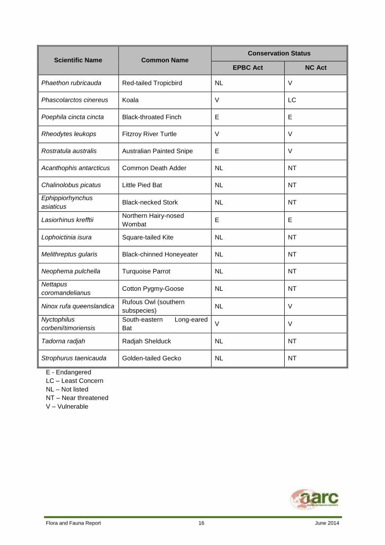
Thirty-five threatened fauna species have been identified or potentially occur in the region surrounding
the Project site. These species are listed in Table 4.
No Essential Habitat for threatened fauna is mapped on the Project site.
Table 4 Threatened Fauna Species within the Project Region
Scientific Name Common Name Conservation Status
EPBC Act NC Act
Accipiter
novaehollandiae Grey Goshawk NL NT
Calyptorhynchus lathami Glossy Black-cockatoo NL V
Crocodylus porosus Saltwater Crocodile NL V
Cyclorana verrucosa Rough Collared Frog NL NT
Dasyurus hallucatus Northern Quoll E LC
Delma labialis Striped-tailed Delma NL V
Delma torquata Collared Delma V V
Neochmia ruficauda
ruficauda Star Finch (eastern) E E
Tyto novaehollandiae
kimberli Masked Owl (northern) V V
Erythrotriorchis radiatus Red Goshawk V E
Denisonia maculata Ornamental Snake V V
Egernia rugosa Yakka Skink V V
Furina dunmalli Dunmall’s Snake V V
Lerista allanae Allan's Lerista E E
Geophaps scripta scripta Squatter Pigeon (southern) V V
Hemiaspis damelii Grey Snake NL E
Jalmenus eubulus Pale Imperial Hairstreak NL V
Paradelma orientalis Brigalow Scaly-foot NL V
Flora and Fauna Report 16 June 2014
Scientific Name Common Name Conservation Status
EPBC Act NC Act
Phaethon rubricauda Red-tailed Tropicbird NL V
Phascolarctos cinereus Koala V LC
Poephila cincta cincta Black-throated Finch E E
Rheodytes leukops Fitzroy River Turtle V V
Rostratula australis Australian Painted Snipe E V
Acanthophis antarcticus Common Death Adder NL NT
Chalinolobus picatus Little Pied Bat NL NT
Ephippiorhynchus
asiaticus Black-necked Stork NL NT
Lasiorhinus krefftii Northern Hairy-nosed
Wombat E E
Lophoictinia isura Square-tailed Kite NL NT
Melithreptus gularis Black-chinned Honeyeater NL NT
Neophema pulchella Turquoise Parrot NL NT
Nettapus
coromandelianus Cotton Pygmy-Goose NL NT
Ninox rufa queenslandica Rufous Owl (southern
subspecies) NL V
Nyctophilus
corbeni/timoriensis
South-eastern Long-eared
Bat V V
Tadorna radjah Radjah Shelduck NL NT
Strophurus taenicauda Golden-tailed Gecko NL NT
E - Endangered
LC – Least Concern
NL – Not listed
NT – Near threatened
V – Vulnerable

Flora and Fauna Report 17 June 2014
4.2.2 MIGRATORY FAUNA SPECIES
The Protected Matters Search identified a total of 15 listed migratory and/or marine species that may
inhabit the Project region. A full list of these species is presented in Table 5.
Table 5 Migratory and Marine Species within the Project Region
Scientific Name Common
Name
Migratory Species
Listed Marine Species
Migratory Marine Species
Migratory Terrestrial Species
Migratory Wetlands Species
Anseranas semipalmata
Magpie Goose - - - X
Apus pacificus Fork-tailed Swift X - - X
Ardea alba Great Egret X - X X
Ardea ibis Cattle Egret X - X X
Gallinago hardwickii
Latham’s Snipe - - X X
Haliaeetus leucogaster
White-bellied Sea Eagle - X - X
Hirundapus caudacutus
White-throated Needletail - X - X
Hirundo rustica Barn Swallow - X - X
Merops ornatus Rainbow Bee-eater - X - X
Monarcha melanopsis
Black-faced Monarch - X - X
Monarcha trivirgatus
Spectacled Monarch - X - X
Myiagra cyanoleuca
Satin Flycatcher - X - X
Pandion haliaetus
Osprey - - - X
Rhipidura rufifrons
Rufous Fantail - X - X
Rostratula benghalensis
Painted Snipe - - X X

Flora and Fauna Report 18 June 2014
4.3 ENVIRONMENTALLY SENSITIVE AREAS
EHP’s ESA mapping (refer to Figure 5) shows that there is one Category B ESA within the Project
boundary. This ESA is a very small patch of RE 11.4.9, which is classified as Endangered. This area,
however, was examined during the site investigation associated with this report, which confirmed the
classification of the area to be incorrect and that no Category B ESA areas exist within the Project
area. No Category A or C ESAs are mapped on or around the Project site. No conservation parks,
declared fish habitat areas, wilderness areas, aquatic reserves, heritage or historic areas, national
estates, World Heritage listings, sites listed under international treaties or agreements or biodiversity
and scientific reserves are located within or adjacent to the Project site.

Flora and Fauna Report 19 June 2014
Figure 5 ESA Mapping

Flora and Fauna Report 20 June 2014
4.4 WETLAND MAPPING
The WetlandMaps database showed three areas of palustrine wetland and one lacustrine wetland on
the Project site. Phillips Creek is mapped as a riverine system and a riverine wetland.
Referable wetland mapping shows one Great Barrier Reef Catchment wetland of High Ecological
Significance (SPP 4/11) on the eastern boundary of the Project site. Phillips Creek is mapped as a
wetland of General Ecological Significance.
No wetlands of international importance as nominated under the Ramsar Convention have been
recorded on or near the Project site.
Wetland values are discussed in further detail in the Lake Vermont Northern ML Aquatic Ecology and
Stream Morphology Assessment (AARC, 2013).
4.5 BRIGALOW BELT BPA
Review of the Brigalow Belt BPA GIS dataset revealed that several areas of the Project site are
mapped as having significant biodiversity values. The vegetation on the banks of Phillips Creek is
accorded both State and Regional significance. Phillips Creek forms part of a bioregional corridor and
contains REs with a Biodiversity Status of Of Concern. There is also a small patch of an Endangered
RE mapped on the north of Phillips Creek, which is classed as being of State significance. This area,
however, was examined during the site investigation associated with this report, which confirmed the
classification of the area to be incorrect and that no Category B ESA areas exist within the Project site.
The remnant vegetation on the east of the Project site is classed as regionally significant. It contains
an RE that has only 10 – 30% of its original extent in the Isaac-Comet Downs subregion and a small
portion of an Of Concern RE. It is also part of a larger patch of vegetation and forms part of a
bioregional corridor.

Flora and Fauna Report 21 June 2014
5.0 SURVEY METHODOLOGY
5.1 INITIAL SITE SCOPING
Site scoping was conducted through the examination of aerial photography, satellite imagery and
existing EHP RE Mapping. This enabled the ecologists to gain an overall perspective of the vegetation
distribution and landscape features on the Project site.
Vehicle-based reconnaissance was carried out to assist in locating suitable survey sites, maximising
the representative vegetation and fauna habitat survey coverage. This also aided in targeting habitats
potentially occupied by species of conservation significance.
5.2 FLORA
The flora survey methodology for the Project was conducted in accordance with the Methodology for
Survey and Mapping of Regional Ecosystems and Vegetation Communities in Queensland (Neldner et
al., 2012).
5.2.1 VEGETATION CLASSIFICATION AND REGIONAL ECOSYSTEM MAPPING
The field surveys involved a baseline study of the Project using standard floristic survey methods
(Neldner et al., 2012). Two vegetation survey techniques (Secondary and Quaternary plots) were
utilised during the field surveys.
Secondary surveys consist of a 20 m x 50 m transect, precisely marked using a Global Positioning
System (GPS) and accurately measured with a marking tape. Data recorded at each Secondary site
included a complete floral assemblage (all species observed from each vegetation layer). Species that
fall outside the plot but are deemed typical of the community are also listed. Where a plant could not
be positively identified to species level, a voucher specimen was collected for identification by the
Queensland Herbarium. Relative abundance for individual woody species in each stratum, stem
density, foliage projection cover and height of the tree and shrub layers was recorded. Percentage
composition of each ground cover species was recorded in five 1 m x 1 m quadrats located at 10 m
intervals along the transect line. A minimum of one representative Secondary plot was positioned in
each of the REs known to exist on the Project site. A total of nine Secondary flora sites were
assessed.
Quaternary or rapid vegetation survey sites consist of a single observation plot, marked into a GPS. At
each plot, important features relevant to vegetation community mapping are noted, such as dominant
species in the characteristic layers, vegetation structure, soil/landform and an intuitive classification of
the vegetation (i.e. RE). These plots are commonly used to ground truth desktop assessment and/or
mapping previously completed for the local area. A total of 33 Quaternary assessments were
conducted.
The condition and quality of vegetation at each survey site was assessed. Attention was paid to
identifying the presence of weeds, species of conservation significance or potential habitat for species
of conservation significance.
The location of the flora survey sites is shown in Figure 6. Flora and habitat values identified in the
desktop assessment were targeted in the site selection process.

Flora and Fauna Report 22 June 2014
Vegetation (RE) maps of the Project site were produced following field surveys to a minimum scale of
1:10 000. The maps were developed based upon survey results, satellite images, aerial photographs,
and geological maps featuring the Project site. Where possible, each RE is mapped as a homogenous
polygon wherever it occurs on the Project site. Occasionally vegetation patches occur that consist of
more than one RE. When the least common RE in the remnant patch is smaller than the minimum
mappable area defined in Neldner et al. (2012) or the structure of the vegetation does not allow clear
delineation of each RE, all contributing REs are mapped together as a “mixed polygon”.

Flora and Fauna Report 23 June 2014
Figure 6 Flora Survey Sites

Flora and Fauna Report 24 June 2014
5.2.1.1 Flora and Regional Ecosystem Identification
All plants encountered during the survey were identified by experienced ecologists using a number of
field guides and other reference material where necessary. All REs were described and classified
according to EHP’s Regional Ecosystem Descriptions Database (EHP, 2012). For any plant species
that could not be identified in the field, a voucher specimen was collected and sent to the Queensland
Herbarium for identification.
5.2.1.2 Surveys for Species of Conservation Significance
A number of flora species of conservation significance were highlighted in the desktop searches
undertaken prior to the field survey. Targeted searches for species of conservation significance were
undertaken upon the identification of suitable habitat in the field. Such searches involved the use of
methods discussed Neldner et al. (2012).
The targeted survey technique utilised in this study was the ‘Random Meander’ survey. This technique
involves traversing areas of suitable habitat along a meandering route whilst searching for the plant
species of interest. If there was any uncertainty in identification of a species, a voucher specimen was
collected for identification by the Queensland Herbarium.
5.3 FAUNA
The fauna survey methodology for the Project was based on the Terrestrial Vertebrate Fauna Survey
Guidelines for Queensland (DSITIA, 2012). The survey was conducted in compliance with AARC’s
scientific purposes permit and animal ethics approval. All fauna trapping efforts were conducted over
four consecutive nights (unless otherwise stated). Motion detector cameras and a micro-bat acoustic
detection device were set at some of the survey sites and at a selection of locations to target specific
fauna groups. Each fauna survey method is described in detail below
Many fauna species, notably frogs and reptiles, do not have widely accepted common names.
Scientific names for species often change with taxonomic revisions. For the purpose of this report, all
nomenclature used will follow that used in the EHP Wildlife Atlas.
5.3.1 DETECTION METHODS
A description of the techniques employed to survey the fauna occurring on the Project site is provided
below.
Elliott trapping
Type ‘A’ Elliott traps (aluminium boxes with doors triggered by a floor treadle) were used to target
small ground-dwelling mammals inhabiting the Project site during the field survey period. Traps were
baited with a mixture of oats, honey, peanut butter, sesame oil and vanilla essence. At each site, 20
Elliott traps were deployed at strategically positioned locations. Each trap was positioned
approximately ten metres from the next. The overall survey effort for Elliot trapping was 400 trap
nights.
Cage trapping
Cage traps are useful for capturing medium sized fauna that are unlikely to be caught in pitfall traps
and funnel traps. Cage traps were used only at sites where automated cameras were not used. One
cage trap was deployed at two of the fauna sites and baited with chicken necks. The overall survey
effort for cage trapping was eight trap nights.

Flora and Fauna Report 25 June 2014
Automated camera trapping
Automated camera trapping is a less invasive method of surveying medium and large-sized nocturnal
terrestrial species. Cameras are usually attached to a tree in a position that offers an unobstructed
view over a track or clearing. A bait tube constructed of a PVC pipe and filled with ‘marsupial bait’ and
dry cat food is pegged to the ground and positioned in clear view of the camera. Motion-sensing
technology in the camera picks up movement by target fauna which then triggers an automatic
photographic response. This is a highly effective survey method and is now widely used instead of
cage trapping (DSITIA, 2012). Automated cameras were deployed at three locations for four nights
and at another two locations for one night. Survey effort was 14 camera trap nights.
Pitfall trapping
A pitfall trap line was established at three of the survey sites to target small ground-dwelling fauna
(reptiles, mammals and amphibians). Each line consisted of a 20 centimetre (cm) tall drift fence
running along the ground and crossing the middle of four 20 litre buckets buried flush with the soil
surface. The bottom edge of each drift fence was buried to guide target animals towards the buckets.
A small amount of soil, vegetation litter, a damp sponge and a small plastic pipe were placed in the
bottom of each bucket to provide shelter and moisture for captured wildlife.
Funnel trapping
Funnel traps are elongated box-shaped traps made of wire and fine mesh. They have two funnel
shaped entrances which allow fauna to enter with ease but make exiting difficult. Funnel traps were
positioned at four fauna sites in order to catch medium and large-sized terrestrial reptiles, snakes and
some species of medium-sized skinks, dragons and geckos, which are able to climb out of pitfall traps.
Funnel traps were placed at the end of each drift fence at all pitfall traplines and along fallen timber at
targeted trap sites. Total funnel trap effort was 96 trap nights.
Micro-bat surveying
Micro-bats (Microchiropterans) form an extremely diverse group of wildlife and the identification of
individual species requires the use of specialised survey methods due to the superficial similarity of
many species, their small size, and largely inaudible calls.
In order to navigate and hunt at night micro-bats use high frequency echolocation calls, most of which
are above the frequency range audible to humans (i.e. ultrasound). These echolocation calls provide
an opportunity to unobtrusively survey and identify micro-bats through the use of a specialised
ultrasonic recorder such as a Songmeter. Such recorders were positioned to detect micro-bat calls at
strategic locations throughout the Project site. Sound recordings were sent to an experienced bat-call
analyst (Greg Ford of Balance! Environmental, Toowoomba, Queensland) for analysis.
Bird surveying
A dedicated search for diurnal birds was conducted visually and aurally on mornings and afternoons of
the survey in the immediate vicinity of each fauna transect. In addition, opportunistic diurnal searches
were also conducted on foot in areas considered likely to have high avian diversity (e.g. vegetated
dams), or likely to contain cryptic or threatened bird species. Approximately eight hours of diurnal bird
searching was conducted during the survey.
Flora and Fauna Report 26 June 2014
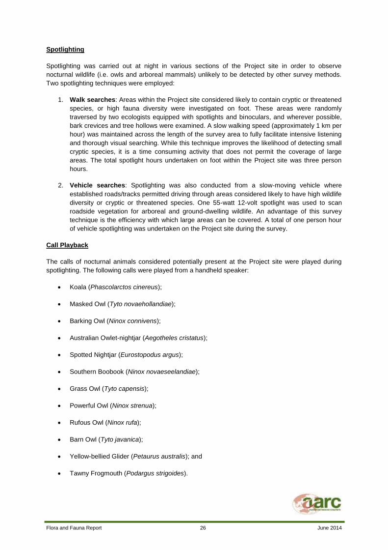
Spotlighting
Spotlighting was carried out at night in various sections of the Project site in order to observe
nocturnal wildlife (i.e. owls and arboreal mammals) unlikely to be detected by other survey methods.
Two spotlighting techniques were employed:
1. Walk searches: Areas within the Project site considered likely to contain cryptic or threatened
species, or high fauna diversity were investigated on foot. These areas were randomly
traversed by two ecologists equipped with spotlights and binoculars, and wherever possible,
bark crevices and tree hollows were examined. A slow walking speed (approximately 1 km per
hour) was maintained across the length of the survey area to fully facilitate intensive listening
and thorough visual searching. While this technique improves the likelihood of detecting small
cryptic species, it is a time consuming activity that does not permit the coverage of large
areas. The total spotlight hours undertaken on foot within the Project site was three person
hours.
2. Vehicle searches: Spotlighting was also conducted from a slow-moving vehicle where
established roads/tracks permitted driving through areas considered likely to have high wildlife
diversity or cryptic or threatened species. One 55-watt 12-volt spotlight was used to scan
roadside vegetation for arboreal and ground-dwelling wildlife. An advantage of this survey
technique is the efficiency with which large areas can be covered. A total of one person hour
of vehicle spotlighting was undertaken on the Project site during the survey.
Call Playback
The calls of nocturnal animals considered potentially present at the Project site were played during
spotlighting. The following calls were played from a handheld speaker:
Koala (Phascolarctos cinereus);
Masked Owl (Tyto novaehollandiae);
Barking Owl (Ninox connivens);
Australian Owlet-nightjar (Aegotheles cristatus);
Spotted Nightjar (Eurostopodus argus);
Southern Boobook (Ninox novaeseelandiae);
Grass Owl (Tyto capensis);
Powerful Owl (Ninox strenua);
Rufous Owl (Ninox rufa);
Barn Owl (Tyto javanica);
Yellow-bellied Glider (Petaurus australis); and
Tawny Frogmouth (Podargus strigoides).

Flora and Fauna Report 27 June 2014
Habitat searching
To further enhance the likelihood of detecting small cryptic species, opportunistic diurnal searches of
likely micro-habitats were conducted at each transect and in other selected areas on the Project site.
Searching techniques involved the rolling of rocks and logs, rustling through leaf litter, and peeling
back of exfoliating bark from standing trees. In addition, notes were made on habitat features such as
tree hollow numbers or the presence of fallen logs and bark. Observed animals were caught where
possible to aid positive species identification.
Scat/track searching
At each survey site a search of the immediate area was conducted for evidence of the presence of
wildlife through the identification of obvious tracks, scats and other signs of occupation (e.g. tree trunk
scratchings).
Incidental recordings
Throughout the survey period, numerous wildlife species were observed or heard on the Project site
during the course of routine activities (i.e. driving between sites, checking traps, vegetation surveys
etc.). Where required, a closer inspection of detected wildlife was carried out to ensure positive
species identification. All incidental observations were recorded and appropriate notes were made on
the surrounding habitat.
5.3.2 FAUNA SURVEY SITES
Detailed fauna surveys were carried out within each of the vegetation communities on the Project site.
Fauna trapping was conducted at five survey sites. Habitat searches, bird surveys and camera
trapping were conducted at an additional three targeted survey sites. A map of the location of each
fauna survey site is presented in Figure 7. Detailed descriptions of each survey site are provided
below.

Flora and Fauna Report 28 June 2014
Figure 7 Fauna Survey Sites

Flora and Fauna Report 29 June 2014
5.3.2.1 FS1
Site FS1 was located in a large patch of Poplar Gum (Eucalyptus platyphylla) woodland in the eastern
portion of the Project site. A T-shaped pitfall line (consisting of one 30 m pitfall fence with one 15 m
pitfall fence running perpendicular to it), six funnel traps, 20 Elliot traps, one camera trap and one
Songmeter were deployed at this site.
Photo Plate 1 Fauna Site 1
5.3.2.2 FS2
Fauna site two was located in a patch of Poplar Box (Eucalyptus populnea) woodland in the south-
west of the Project area. Twenty Elliot traps and an automated camera were deployed at this site. A
pitfall trapline could not be established due to the extremely hard nature of the clay soils at this site.
Targeted reptile searches were conducted when checking the Elliot trapline to compensate for the lack
of pitfall trapping at this site. The Songmeter could not be deployed at this site due to access being
restricted by heavy rainfall.

Flora and Fauna Report 30 June 2014
Photo Plate 2 Fauna Site 2
5.3.2.3 FS3
FS3 was located at Phillips Creek in the central portion of the site. The vegetation at this site was
dominated by River Red Gum (Eucalyptus camaldulensis) and Moreton Bay Ash (Corymbia
tessellaris). A pitfall line, six funnel traps, 20 Elliot traps, one camera and one Songmeter were
deployed at this site. A T-shaped design was not used at this site due to the narrow width of the
riparian habitat being sampled.

Flora and Fauna Report 31 June 2014
Photo Plate 3 Fauna Site 3
5.3.2.4 FS4
Site FS4 was located on the shores of Lake Vermont in a marsh area surrounded by Poplar Box
(Eucalyptus populnea) woodland. A pitfall line, six funnel traps, a cage trap and a Songmeter were
placed at this site. One automated camera was also deployed at FS4 for one night.

Flora and Fauna Report 32 June 2014
Photo Plate 4 Fauna Site 4
5.3.2.5 FS5
FS5 was located east of the large dam in the central portion of the site. This site was located in a
patch of Poplar Box regrowth vegetation dominated by shrubs and grasses such as Leichardt Bean
(Cassia brewsteri) and Guinea Grass (Panicum maximum). Twenty Elliot traps, one cage trap, six
funnel traps and a Songmeter were deployed at this site. This site was designed primarily to target
mammal species.

Flora and Fauna Report 33 June 2014
Photo Plate 5 Fauna Site 5
5.3.2.6 FS6
FS6 was a targeted bird survey site. It was located at the small dam in the south-west of the Project
site. No trapping was conducted at this site. Bird surveys, habitat searches and spotlighting for
amphibians were undertaken at FS6.

Flora and Fauna Report 34 June 2014
Photo Plate 6 Fauna Site 6
5.3.2.7 FS7
Site FS7 was a targeted large mammal survey site located at a crossing of Phillips Creek in the south-
west of the Project area. The site was located in riparian vegetation dominated by River Red Gum
(Eucalyptus camaldulensis), Moreton Bay Ash (Corymbia tessellaris), and River She-oak (Casuarina
cunninghamiana). One camera was deployed at this site and spotlighting, scat/track searches and bird
surveys were carried out.

Flora and Fauna Report 35 June 2014
Photo Plate 7 Fauna Site 7
5.3.2.8 FS8
FS8 was a targeted bird survey site. No trapping was conducted at this site. The site was located at
the large dam in the central portion of the Project area. FS8 was vegetated with a variety of grasses,
sedges and macrophytes. Buffel Grass (Cenchrus ciliaris) and Umbrella Cane Grass (Leptochloa
digitata) were the dominant grasses at this site.

Flora and Fauna Report 36 June 2014
Photo Plate 8 Fauna Site 8

Flora and Fauna Report 37 June 2014
6.0 RESULTS
6.1 SURVEY TIMING
The survey was conducted between the 13th and the 21
st of May 2013. Survey timing was selected in
accordance with the Terrestrial Vertebrate Fauna Survey Guidelines for Queensland, which
recommend that Autumn sampling be undertaken between March and mid-May (DSITIA, 2012).
6.2 WEATHER CONDITIONS
Weather conditions leading up to the survey were warm and wet, consistent with typical autumn
conditions. 12.4 mm of rain fell in May prior to the survey. 133.4 mm of rain fell in April 2013. During
the survey 17.8 mm of rain fell. Temperatures ranged from 8.6°C to 27°C. Conditions were generally
overcast, and cooler temperatures were experienced in the latter half of the survey.
6.3 FLORA RESULTS
A total of 232 flora species were identified on the Project site during the field survey. A full list of the
species observed is provided in Appendix B.
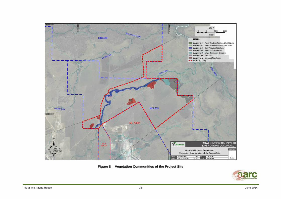
Eight vegetation communities were recorded on the Project site, six of which are classified as remnant
vegetation. These communities correspond to six REs:
Community 1 – Poplar Box Open Woodland on Alluvial Plains (RE 11.3.2);
Community 2 – Poplar Box Open Woodland on Sand Plains (RE 11.5.3);
Community 3 – River Red Gum Riparian Woodland (RE 11.3.25);
Community 4 – Poplar Gum Open Woodland (RE 11.3.35);
Community 5 – Mixed Bloodwood Open Woodland (RE 11.3.7);
Community 6 – Freshwater Wetlands (RE 11.3.27);
Community 7 – Regrowth Vegetation; and
Community 8 – Derived Grasslands (non-remnant).
Each of these vegetation communities are discussed in detail below. The location and extent of the
vegetation communities on the Project site is presented in Figure 8.
Figure 8 shows that the majority of the Project site has been cleared for grazing. Remaining
vegetation is confined to the banks of Phillips Creek, the two large dams and the area around Lake
Vermont in the eastern portion of the Project site.
Flora and Fauna Report 38 June 2014
Figure 8 Vegetation Communities of the Project Site

Flora and Fauna Report 39 June 2014
6.3.1 COMMUNITY 1 – POPLAR BOX OPEN WOODLAND ON ALLUVIAL PLAINS
6.3.1.1 Community Description
Community 1 is an open woodland dominated by Poplar Box (Eucalyptus populnea). This community
exists as small sections of remnant vegetation on alluvial deposits around the shore of Lake Vermont
in the east of the Project site.
This community is consistent with RE 11.3.2. Detailed information on Community 1, including the
dominant species in each stratum of vegetation, is presented in Table 6.
Table 6 Community 1 Profile
Regional Ecosystem RE 11.3.2 Eucalyptus populnea woodland on alluvial plains
Extent on Project site 9.7 ha
EPBC Status Not listed
VM Act Status Of Concern
Biodiversity Status Of Concern
Tree Layer Eucalyptus populnea (D), Lysiphyllum carronii (A), Corymbia
dallachiana (O)
Shrub Layer Carissa ovata (D), Cassia brewsteri (A)
Ground Layer Cenchrus ciliaris (D)
Weed Species Panicum maximum
Canopy Height 12 m
Crown Cover <20%

Flora and Fauna Report 40 June 2014
Photo Plate 9 Community 1 – Poplar Box Woodland on Alluvial Plains
6.3.1.2 Conservation Value
RE 11.3.2 is listed as Of Concern under both the VM Act and Biodiversity Status. In December 2006,
remnant extent was >10,000 ha and 10 – 30% of the pre-clearing area remained. The extent of this
community in reserve areas is low. RE 11.3.2 has been extensively cleared or modified by grazing.
6.3.1.3 Vegetation Condition and Habitat Value
Community 1 is small in extent (<10 ha). Vegetation dieback and cattle grazing were noted in this
community. The introduction of Buffel Grass has modified the ground layer of this community. It
provides suitable habitat for macropods, small mammals, woodland birds and reptiles.
6.3.2 COMMUNITY 2 – POPLAR BOX OPEN WOODLAND ON SAND PLAINS
Community 2 is a low open woodland of Poplar Box (E. populnea) and Ghost Gum (Corymbia
dallachiana) that occurs on Cainozoic sand plains. This vegetation community is found in one small
patch in the west of the Project site, north of Phillip’s Creek.
This community is consistent with RE 11.5.3. Detailed information on Community 2, including the
dominant species in each stratum of vegetation, is presented in Table 7.

Flora and Fauna Report 41 June 2014
Table 7 Community 2 Profile
Regional Ecosystem RE 11.5.3 Eucalyptus populnea and/or E. melanophloia and/or
Corymbia clarksoniana on Cainozoic sand plains/remnant surfaces
Extent on Project site 0.9 ha
EPBC Status Not listed
VM Act Status Least Concern
Biodiversity Status No concern at present
Tree Layer Eucalyptus populnea (D), Corymbia dallachiana (A), Corymbia
tessellaris (A), Corymbia clarksoniana (A), Acacia salicina (A)
Shrub Layer Cassia brewsteri (D), Carissa ovata (A)
Ground Layer Cenchrus ciliaris (D), Heteropogon contortus (A)
Weed Species -
Canopy Height 16 m
Crown Cover 11%
Photo Plate 10 Community 2 – Poplar Box Woodland on Sand Plains
6.3.2.1 Conservation Value
RE 11.5.3 is listed as Least Concern, as remnant extent is greater than 10 000 ha and over 30% of
the pre-clearing area remains. The extent of this community in reserve areas is low. RE 11.5.3 has

Flora and Fauna Report 42 June 2014
been extensively cleared or modified by grazing, and is subject to total grazing pressure and Buffel
Grass invasion (EHP, 2013).
6.3.2.2 Vegetation Condition and Habitat Value
This vegetation community is in poor health and its extent on site is extremely limited. Weed invasion,
grazing and extensive dieback were noted in this community. This community is unlikely to form
significant fauna habitat. It provides a limited amount of food and shelter for animals such as
macropods, reptiles and birds.
6.3.3 COMMUNITY 3 – RIVER RED GUM RIPARIAN WOODLAND
6.3.3.1 Community Description
Community 3 occurs in a continuous thin strip along the banks of Phillips Creek. It is the largest
vegetation community on the Project site. Table 8 describes Community 3 and lists the dominant
species recorded.
Table 8 Community 3 Profile
Regional Ecosystem RE 11.3.25 Eucalyptus tereticornis or E. camaldulensis woodland
fringing drainage lines
Extent on Project site 184.5 ha
EPBC Status Not listed
VM Act Status Least Concern
Biodiversity Status Of Concern
Tree Layer Eucalyptus camaldulensis (CD), Corymbia tessellaris (CD), Acacia
salicina (A)
Shrub Layer Lysiphyllum hookerii (D), Ficus opposita (A), Cassia brewsteri (A),
Acacia salicina (A)
Ground Layer Panicum maximum (D), Cenchrus ciliaris (A)
Weed Species Panicum maximum, Bidens bipinnata, Opuntia stricta, Passiflora
foetida, Vachellia farnesiana
Canopy Height 20 m
Crown Cover 30%

Flora and Fauna Report 43 June 2014
Photo Plate 11 Community 3 – River Red Gum Riparian Woodland
6.3.3.2 Conservation Value
Community 3 has a Biodiversity Status of Of Concern. As of December 2006, just over 30% of its pre-
clearing extent (>10 000 ha) remained in Queensland.
The total area of this community located in protected areas is classed as low. It is impacted by total
grazing pressure and subject to invasion by Rubber Vine (Cryptostegia grandiflora) and Buffel Grass
(EHP, 2013).
6.3.3.3 Vegetation Condition and Habitat Value
This community possesses value as a movement corridor for fauna. It connects with larger patches of
remnant vegetation in the east of the Project area. Community 3 is present as a very narrow strip, and
therefore subject to edge effects, such as weed invasion. Grazing and erosion were noted in this
community. The ground layer is heavily modified and dominated by introduced pasture grasses.
6.3.4 COMMUNITY 4 – POPLAR GUM OPEN WOODLAND
6.3.4.1 Community Description
Community 4 occurs in the east of the Project site. It is the second largest vegetation community on
the Project site. It consists of a canopy dominated by Poplar Gum (Eucalyptus platyphylla) with

Flora and Fauna Report 44 June 2014
associated Clarkson’s Bloodwood (Corymbia clarksoniana) and a patchy Paperbark (Melaleuca spp.)
understorey. Table 9 describes this community and lists the dominant plant species observed.
Table 9 Community 4 Profile
Regional Ecosystem RE 11.3.35 Eucalyptus platyphylla, Corymbia clarksoniana woodland on
alluvial plains
Extent on Project site 132.2 ha
EPBC Status Not listed
VM Act Status Least Concern
Biodiversity Status No concern at present
Tree Layer Eucalyptus platyphylla (D), Eucalyptus populnea (A/O), Corymbia
clarksoniana (A), Cassia brewsteri (A)
Shrub Layer Melaleuca viridiflora (D), Carissa ovata (A)
Ground Layer Cenchrus ciliaris (D), Arabidella eremigena (A)
Weed Species Melinis repens
Canopy Height 14 m
Crown Cover 17%
Photo Plate 12 Community 4 – Poplar Gum Woodland

Flora and Fauna Report 45 June 2014
6.3.4.2 Conservation Value
Community 4 has a Biodiversity Status of Least Concern. At September 2009, over 30% and 10 000
ha of its pre-clearing extent remained. The extent of this community protected in reserves is low. In
some districts it is invaded by Chinee Apple (Ziziphus mauritiana) and Rubber Vine (Cryptostegia
grandiflora) (EHP, 2013).
6.3.4.3 Vegetation Condition and Habitat Value
Community 4 is well connected to remnant vegetation stands outside the Project area. This
community is relatively unaffected by disturbance. Minor infestations of exotic grasses were observed
in the ground layer. Grazing was noted in this community, but a high diversity of native grasses and
forbs persists. Community 4 provides habitat for many terrestrial species that utilise woodlands for
shelter and foraging, such as nectarivorous birds, reptiles, bats and arboreal mammals.

Flora and Fauna Report 46 June 2014
6.3.5 COMMUNITY 5 – MIXED BLOODWOOD OPEN WOODLAND
6.3.5.1 Community Description
Community 5 is a tall woodland with a canopy of Clarkson’s Bloodwood (Corymbia clarksoniana),
Moreton Bay Ash (Corymbia tessellaris) and Ghost Gum (Corymbia dallachiana). This community
exists in a single patch in the north-east of the Project site. It is contiguous with Community 4. The
features and main species of Community 5 are described in Table 10.
Table 10 Community 5 Profile
Regional Ecosystem RE 11.3.7 Corymbia spp. woodland on alluvial plains.
Extent on Project site 43.9 ha
EPBC Status Not listed
VM Act Status Least Concern
Biodiversity Status Of Concern
Tree Layer Corymbia clarksoniana (D), Corymbia tessellaris (A), Corymbia
dallachiana (O)
Shrub Layer Petalostigma pubescens (D), Carissa ovata (A), Cassia brewsteri (O),
Ficus opposita (O)
Ground Layer Cenchrus ciliaris (CD), Melinis repens (CD), Heteropogon contortus (O)
Weed Species Melinis repens
Canopy Height 18 m
Crown Cover <20%
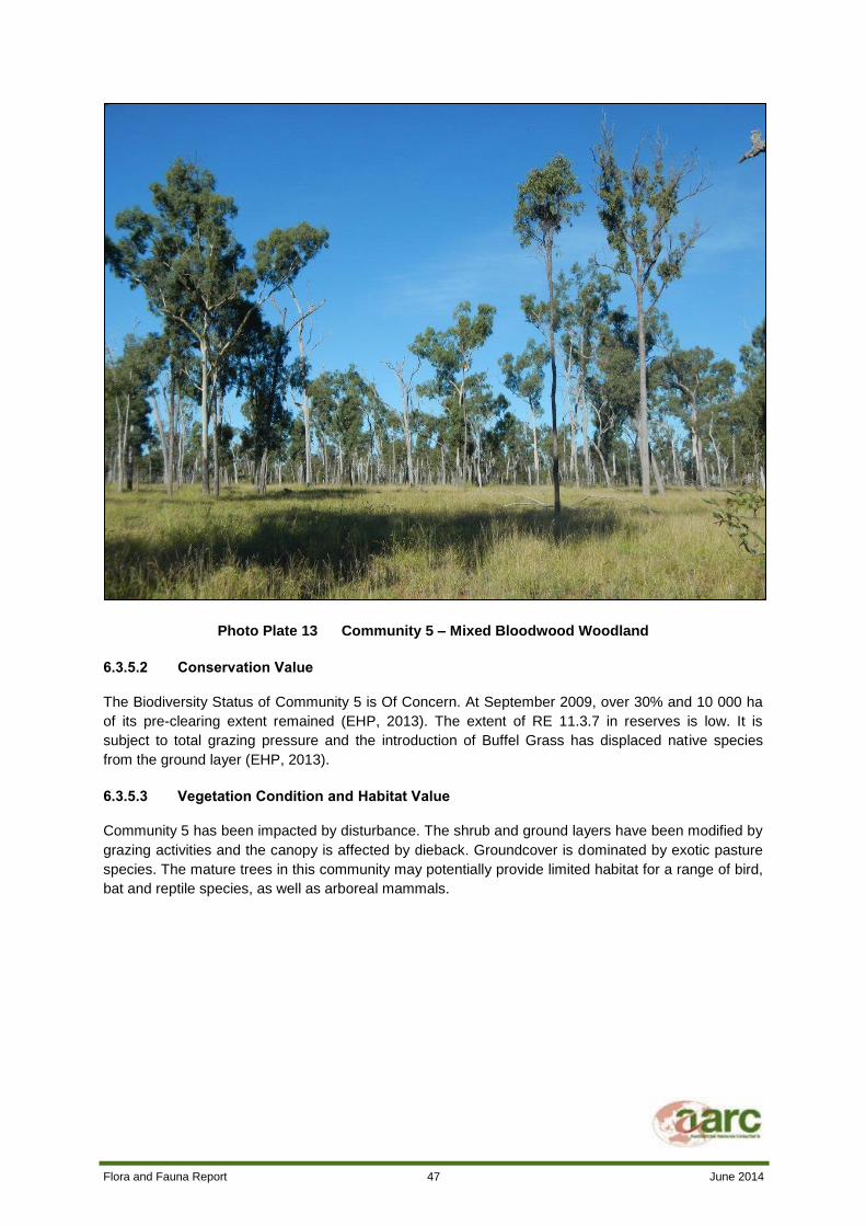
Flora and Fauna Report 47 June 2014
Photo Plate 13 Community 5 – Mixed Bloodwood Woodland
6.3.5.2 Conservation Value
The Biodiversity Status of Community 5 is Of Concern. At September 2009, over 30% and 10 000 ha
of its pre-clearing extent remained (EHP, 2013). The extent of RE 11.3.7 in reserves is low. It is
subject to total grazing pressure and the introduction of Buffel Grass has displaced native species
from the ground layer (EHP, 2013).
6.3.5.3 Vegetation Condition and Habitat Value
Community 5 has been impacted by disturbance. The shrub and ground layers have been modified by
grazing activities and the canopy is affected by dieback. Groundcover is dominated by exotic pasture
species. The mature trees in this community may potentially provide limited habitat for a range of bird,
bat and reptile species, as well as arboreal mammals.

Flora and Fauna Report 48 June 2014
6.3.7 COMMUNITY 6 – FRESHWATER WETLANDS
6.3.7.1 Community Description
This community occurs in the wetland areas of the Project site. The largest area of Community 6 is
located at Lake Vermont. One very small patch of this community is located south of Phillips Creek in
the west of the Project site. Community 6 is described in Table 11.
Table 11 Community 6 Profile
Regional Ecosystem RE 11.3.27 Freshwater wetlands
Extent on Project site 20.6 ha
EPBC Status Not listed
VM Act Status Least Concern
Biodiversity Status Of Concern
Tree Layer Eucalyptus camaldulensis (D), Corymbia tessellaris (A), Eucalyptus
populnea (A)
Shrub Layer Cassia brewsteri (D), Citrus glauca (A)
Ground Layer Leptochloa digitata (CD), Elaeocharis sphacelata (CD), Elaeocharis
pallens (CD), Ludwigia peploides (CD)
Weed Species Cynodon dactylon, Argemone ochroleuca, Passiflora foetida
Canopy Height 20 m
Crown Cover 12%

Flora and Fauna Report 49 June 2014
Photo Plate 14 Community 6 – Freshwater Wetlands
6.3.7.2 Conservation Value
Community 6 has a VM Act Status of Least Concern and Biodiversity Status of Of Concern. Its extent
in reserve areas is low. In December 2006, remnant extent was >10,000 ha and >30% of the pre-
clearing area remained (EHP, 2013).
6.3.7.3 Vegetation Condition and Habitat Value
This community provides important habitat for a diverse range of aquatic birds and frogs. It also
provides drinking water for terrestrial fauna. It has a high proportion of native species and is relatively
unaffected by grazing. It is well connected to surrounding patches of remnant vegetation.
6.3.8 COMMUNITY 7 – REGROWTH VEGETATION
6.3.8.1 Community Description
Community 7 consists of regrowth of various vegetation communities. The regrowth vegetation
consists mainly of Brigalow (Acacia harpophylla) regrowth and Poplar Box (E. populnea) regrowth,
located around the central dam area and in the south-west and north-east corners of the Project site.
Small patches of Freshwater Wetland, Mixed Bloodwood and River Red Gum Woodland regrowth
occur in the north-east of the Project site, south of Phillips Creek. The largest patch of this community
occurs around the central dam area. Community 7 is discussed in further detail in Table 12.

Flora and Fauna Report 50 June 2014
Table 12 Community 7 Profile
Regional Ecosystem N/A. Non-remnant.
Extent on Project site 123.9 ha
EPBC Status Not listed
VM Act Status Not listed
Biodiversity Status N/A
Tree Layer
Variable. Key species include Eucalyptus cambageana, Casuarina
cristata, Eucalyptus populnea, Corymbia dallachiana, Lysiphyllum
hookeri, Eucalyptus camaldulensis, Corymbia clarksoniana, Corymbia
tessellaris
Shrub Layer Variable. Key species include Acacia harpophylla, Carissa ovata,
Cassia brewsteri
Ground Layer Variable. Key species include Panicum maximum, Cenchrus ciliaris,
Heteropogon contortus, Bothriochloa decipiens
Weed Species Opuntia stricta
Canopy Height 12 m
Crown Cover 0 - 50%
Photo Plate 15 Community 7 – Regrowth Vegetation

Flora and Fauna Report 51 June 2014
6.3.8.2 Conservation Value
The regrowth vegetation is mapped as Category X vegetation, which means that this vegetation is not
regulated under the VM Act. Brigalow regrowth is listed as an Endangered Ecological Community (and
therefore a MNES) under the EPBC Act only if:
Queensland law requires a clearing permit; or
The regrowth is more than 15 years old.
Additionally, Brigalow regrowth is not considered part of the Brigalow Endangered Ecological
Community if it is of poor quality. Activities that affect Brigalow regrowth of poor quality are therefore
not subject to the EPBC Act (DSEWPAC, 2003). The Brigalow regrowth on the Project site was noted
to be of poor quality due to past clearing, the introduction of exotic species, dieback and construction
of roads and fences. Therefore, it does not form part of the Brigalow Endangered Ecological
Community, is not classified as a MNES, and clearing is not subject to the requirements of the EPBC
Act.
6.3.8.3 Vegetation Condition and Habitat Value
This vegetation community is severely degraded. Extensive dieback of the canopy was noted. Ground
cover is dominated by exotic pasture species. The largest patch (located around the central dam) is
extremely fragmented by tracks and fencelines. This vegetation community is generally surrounded by
cleared areas and isolated from the other communities that occur on site. It has limited habitat
potential for small mammals, reptiles and birds, which may shelter in the denser stands of Brigalow.
Dead trees provide a small amount of shelter for hollow-dwelling animals, such as bats.

Flora and Fauna Report 52 June 2014
6.3.10 COMMUNITY 8 – NON-REMNANT GRASSLAND
6.3.10.1 Community Description
Community 8 covers the majority of the Project site. It is dominated by improved pasture species such
as Buffel Grass (Cenchrus ciliaris). This community was formed by the removal of native vegetation to
facilitate grazing activities. No native grassland communities were identified on the Project site.
Typical floral assemblages for each stratum in this community are outlined in Table 13.
Table 13 Community 8 Profile
Regional Ecosystem N/A. Non-remnant.
Description Open grassland dominated by exotic grasses with scattered shrubs and
low trees.
Extent on Project site 3264.4 ha
EPBC Status N/A
VM Act Status N/A
Biodiversity Status N/A
Tree Layer Absent
Shrub Layer Very sparse. Apophyllum anomalum (CD), Acacia salicina (CD), Atalaya
hemiglauca (A)
Ground Layer Urochloa mosambicensis (D), Cenchrus ciliaris (A)
Weed Species Parthenium hysterophorus, Stylosanthes scabra, Medicago polymorpha,
Bidens bipinnata, Harrisia martinii
Canopy Height 4 m
Crown Cover 0%

Flora and Fauna Report 53 June 2014
Photo Plate 16 Community 8 – Derived Grassland
6.3.10.2 Conservation Value
This community is non-remnant, heavily disturbed and dominated by exotic species. It is therefore of
little conservation value.
6.3.10.3 Vegetation Condition and Habitat Value
This community is heavily disturbed. The tree layer has been removed and the groundcover is
dominated by exotic pasture grasses and weeds. Community 8 is subject to heavy grazing. This
community provides foraging habitat for the threatened Squatter Pigeon (southern) (Geophaps scripta
scripta). This species was observed within this community on the Project site and is locally common
within cleared grazing lands. Community 8 also provides habitat for other species that feed on grass
and grass-seed, such as large macropods and granivorous birds.
6.3.11 FLORA SPECIES AND VEGETATION COMMUNITIES OF CONSERVATION SIGNIFICANCE
6.3.11.1 Threatened Species
No threatened flora species were observed on the Project site during the survey period. Although
potentially suitable habitat exists on the site for a small number of threatened flora species, targeted
surveys were unable to locate these species. As a result, the proposed Project is highly unlikely to
impact on any flora species of conservation significance.

Flora and Fauna Report 54 June 2014
6.3.11.2 Summary of Threatened Communities
Community 1 has a VM Act Status of Of Concern. The extent of this community on the Project site is
very small. The ground layer of this community is dominated by introduced species and the shrub
layer is essentially absent. This community has been modified by grazing and is subject to canopy
dieback.
6.3.12 WEEDS OF MANAGEMENT CONCERN
The exotic pasture grass Buffel Grass (Cenchrus ciliaris) dominates the ground layer of the Project
site, particularly in cleared areas. A range of other exotic grasses and forbs are also present across
the Project site in low to moderate abundance.
Three declared Class 2 weeds under the LP Act were recorded in small numbers during the survey:
Harrisia Cactus (Harrisia martini);
Prickly Pear (Opuntia stricta); and
Parthenium (Parthenium hysterophorus).
Parthenium and Prickly Pear are also classified as WONS.
6.4 FAUNA RESULTS
A total of 163 fauna species were identified on the Project site during the survey period. This consisted
of six amphibians, 124 birds, 12 reptiles and 20 mammals. A complete list of species recorded during
the survey is provided in Appendix D.
Fauna habitat on the Project site is generally fragmented and heavily disturbed by grazing activities.
The majority of the Project site has been cleared and is vegetated with predominantly exotic pasture
species. The riparian corridor along Phillips Creek is narrow and subject to vegetation dieback, weed
invasion and erosion. It is however the only continuous corridor of vegetation on the Project site, and
is likely to facilitate the movement and dispersal of aquatic and woodland fauna across the
predominantly cleared site. The largest, most significant and intact area of fauna habitat on the Project
site is the area of remnant woodland on the eastern boundary of the Project site and the freshwater
wetland at Lake Vermont. Lake Vermont and the two cattle dams on the Project site provide habitat for
a variety of aquatic birds.
6.4.1 AMPHIBIANS
Six amphibian species were recorded on the Project site during the field survey. One of these species,
the Cane Toad (Rhinella marina), is an introduced species. Cane Toads are common on the Project
site. The most abundant native frog species on the Project site were the Salmon-striped Frog
(Limnodynastes salmini) and the Spotted Marsh Frog (Limnodynastes tasmaniensis). A single Scarlet
Sided Pobblebonk (Limnodynastes terreginae) was captured in a pitfall trap at FS1 (shown in Photo
Plate 17). The Desert Treefrog (Litoria rubella) was observed in Phillips Creek. The Bumpy Rocketfrog
(Litoria inermis) was captured in a funnel trap at FS4 on the shore of Lake Vermont.
Suitable habitat for amphibians occurs at Lake Vermont; the two cattle dams and along Phillips Creek.
Phillips Creek is an ephemeral creek, so it does not provide permanent water for frog species. It has a
sandy bed and banks that provide excellent habitat for burrowing frogs. The creek is likely to provide

Flora and Fauna Report 55 June 2014
good amphibian habitat in the wetter summer and autumn months. Frogs also inhabit the grassy
woodland near Lake Vermont.
Photo Plate 17 Scarlet Sided Pobblebonk (Limnodynastes terreginae)
6.4.1.1 Amphibian Species of Conservation Significance
No amphibian species of conservation significance (including Back on Track priority species) were
identified on the Project site.
6.4.2 BIRDS
A total of 124 bird species were observed during the survey period. The variety of habitat types on the
Project site supports a diverse range of bird species. Grassland habitats cover the majority of the site,
and support granivorous birds such as the Brown Quail (Coturnix ypsilophora), Galah (Eolophus
roseicapilla) and Budgerigar (Melopsittacus undulatus).
The Poplar Box and Poplar Gum woodlands in the west and east of site and the riparian woodland
along Phillips Creek are inhabited by a variety of insectivorous and nectivorous birds, such as the
Grey Fantail (Rhipidura albiscapa), Rufous Whistler (Pachycephala rufiventris), White-throated
Honeyeater (Melithreptus albogularis) and Blue-faced Honeyeater (Entomyzon cyanotis). Frugivorous
bird species, such as the Australasian Figbird (Sphecotheres vielloti) were uncommon on site,
probably due to a lack of fruiting plants.
Relatively high numbers of raptor species were observed in all habitats on the Project site, including
the Collared Sparrowhawk (Accipter cirrocephalus), Brown Goshawk (Accipter fasciatus), Wedge-
tailed Eagle (Aquila audax) and Pacific Baza (Aviceda subcristata). Photo Plate 18 shows the Spotted

Flora and Fauna Report 56 June 2014
Harrier (Circus assimilis), which was observed in cleared areas. The nocturnal Tawny Frogmouth
(Podargus strigoides) and Eastern Barn Owl (Tyto alba) were also recorded, on the edge of the
riparian habitat along Phillips Creek.
A diverse range of aquatic bird species, including a variety of Cormorants, Egrets, Dotterels, Ducks
and Herons were present in relatively high numbers on the two cattle dams and at Lake Vermont.
The full list of bird species observed on the Project site is provided in Appendix D.
Photo Plate 18 Spotted Harrier (Circus assimilis)
6.4.2.1 Bird Species of Conservation Significance
Many of the bird species of conservation significance detected by the desktop searches are listed as
“High Mobility” Taxa (EPA, 2002). The presence of such mobile species on the Project site is thought
to be sporadic, and they are able to utilise other favourable habitats away from the Project site.
Impacts on these High Mobility species are therefore unlikely.
Threatened and Near Threatened Species
One vulnerable and three near threatened bird species were identified on the Project site:
Squatter Pigeon (southern subspecies) (Geophaps scripta scripta) (Vulnerable);
Cotton Pygmy Goose (Nettapus coromandelianus);

Flora and Fauna Report 57 June 2014
Freckled Duck (Stictonetta naevosa); and
Black-necked Stork (Ephippiorhynchus asiaticus).
Each of these species is discussed in detail below. All four species are classified as High Mobility
Taxa. No Back on Track priority bird species were identified on the Project site.
Squatter Pigeon (southern subspecies)
The Squatter Pigeon (southern subspecies) (Geophaps scripta scripta) (shown in Photo Plate 19) was
found on the Project site. It is listed as Vulnerable under both the EPBC Act and NC Act. A pair was
observed in a clear grassy area near the small dam in the west of the Project site and the southern
Squatter Pigeon was also heard calling in woodland near Lake Vermont.
Photo Plate 19 Southern Squatter Pigeon (Geophaps scripta scripta)

Flora and Fauna Report 58 June 2014
The southern Squatter Pigeon occurs on the inland slopes of the Great Dividing Range, from the
Burdekin-Lynd divide in central Queensland, west to Charleville and Longreach, east to the coastline
between Proserpine and Gladstone, and south to scattered sites throughout south-eastern
Queensland (DSEWPAC, 2013). Southern Squatter Pigeons inhabit a range of habitats, including
grassy woodlands, open forests and disturbed areas (including heavily grazed areas, roads and
railways). The southern Squatter Pigeon is commonly observed close to waterbodies (DSEWPAC,
2013). Southern Squatter Pigeons feed on seeds and insects, for which they forage on the ground.
The southern Squatter Pigeon is locally common north of the Tropic of Capricorn. The population is
thought to be stable at present (DSEWPAC, 2013).
The main threats to the southern Squatter Pigeon are habitat loss, habitat degradation and excessive
predation (particularly from cats and foxes) (DSEWPAC, 2013).
Suitable habitat for the southern Squatter Pigeon exists throughout the Project site. Given that only a
small number of individuals were observed during the survey, it is unlikely that the Project site is of
particular importance to this species. Suitable habitat is extensive throughout the local area including
immediately adjacent to the Project site. Given the mobile nature of this species, the continuing
presence of suitable habitat both on and off site, and its ability to utilise disturbed habitats, it is
considered unlikely that the Project will have a significant impact on the southern Squatter Pigeon.
Cotton Pygmy Goose
The Cotton Pygmy Goose (Nettapus coromandelianus) is listed as Near Threatened under the NC
Act. It is not listed under the EPBC Act. Flocks of Cotton Pygmy Geese were observed on Lake
Vermont.
The Cotton Pygmy Goose inhabits wetlands in coastal and subcoastal tropical north-east Queensland.
It is also found in Asia and Papua New Guinea. In Australia it occurs as far south as Brisbane and
west to Charters Towers and Clermont. It is almost entirely aquatic. The Cotton Pygmy Goose prefers
deep, permanent, fresh waterbodies (including artificial dams) that support abundant floating and
submerged aquatic plants. These plants form the basis of its diet (Marchant and Higgins, 1993).
The range of the Cotton-Pygmy Goose contracted at the end of the 19th century. It was previously
found as far south as the Hunter River in New South Wales. Threats to the species include wetland
drainage, grazing and introduced aquatic plants (Marchant and Higgins, 1993). The population is
currently stable and relatively large in size (BirdLife International, 2013).
Suitable habitat for the Cotton Pygmy Goose occurs at Lake Vermont and the central dam. The central
dam is likely to be impacted by Project development. Project activities may reduce the amount of
suitable habitat available to the species on the Project site. Cotton Pygmy Geese are mobile and will
be able to relocate to suitable habitat in nearby wetlands along the Isaac River.
Freckled Duck
The Freckled Duck (Stictonetta naevosa) is listed as Near Threatened under the NC Act. It is not listed
under the EPBC Act. Small numbers of Freckled Ducks were observed at Lake Vermont and at the
central dam.
The Freckled Duck is endemic to south-east and south-west Australia. It is widespread in central and
southern Queensland. It inhabits wetlands, usually with shallow water. They prefer densely vegetated
Flora and Fauna Report 59 June 2014
ephemeral waters in the breeding season and large, permanent, open waterbodies in the non-
breeding period. Freckled Ducks are filter feeders (Marchant and Higgins, 1993).
The main threat to the species is the destruction or modification of wetlands from activities such as
drainage, flood mitigation works, clearing and grazing. Shooting has also been identified as a threat in
southern areas (Marchant and Higgins, 1993). The Freckled Duck population is suspected to be
fluctuating, with no clear trend at present (BirdLife International, 2013).
Suitable habitat for the Freckled Duck occurs at Lake Vermont and the central dam. These areas are
likely to be impacted by Project development. Project activities may reduce the amount of suitable
habitat available to the species on the Project site. Freckled Ducks are highly mobile and will be able
to relocate to suitable habitat in nearby wetlands along the Isaac River.
Black-necked Stork
The Black-necked Stork (Ephippiorhynchus asiaticus) (shown in Photo Plate 20) is listed as Near
Threatened under the NC Act. It is not listed under the EPBC Act. Pairs of Black-necked Storks were
observed at Lake Vermont and the small dam in the north-west of site.
The Black-necked Stork is found throughout India, south-east Asia, Papua New Guinea and Australia.
It is widespread in coastal and near-coastal areas across northern and eastern Australia. It inhabits
tropical and warm-temperate wetlands and estuaries, grasslands and woodlands. The Black-necked
Stork prefers shallow, open, fresh waterbodies, but is known to use a wide variety of aquatic habitats.
It feeds mostly on fish and crustaceans (Marchant and Higgins, 1993).
Threats to the Black-necked Stork are drainage of wetlands, Mimosa pigra invasion of habitat, habitat
destruction by Feral Buffalo and encroachment of development. The Black-necked Stork is known to
be sensitive to disturbance (Marchant and Higgins, 1993). The population size of the Black-necked
Stork is moderately small, but stable (BirdLife International, 2013).
Suitable habitat for the Black-necked Stork occurs at all wetland and dam areas on the Project site.
Phillips Creek may also provide suitable habitat for the species in the wet season. Some of these
areas are likely to be impacted by Project development. Project activities may reduce the amount of
suitable habitat available to the species on the Project site. The Black-necked Stork is highly mobile
and will be able to relocate to suitable habitat in nearby wetlands along the Isaac River.
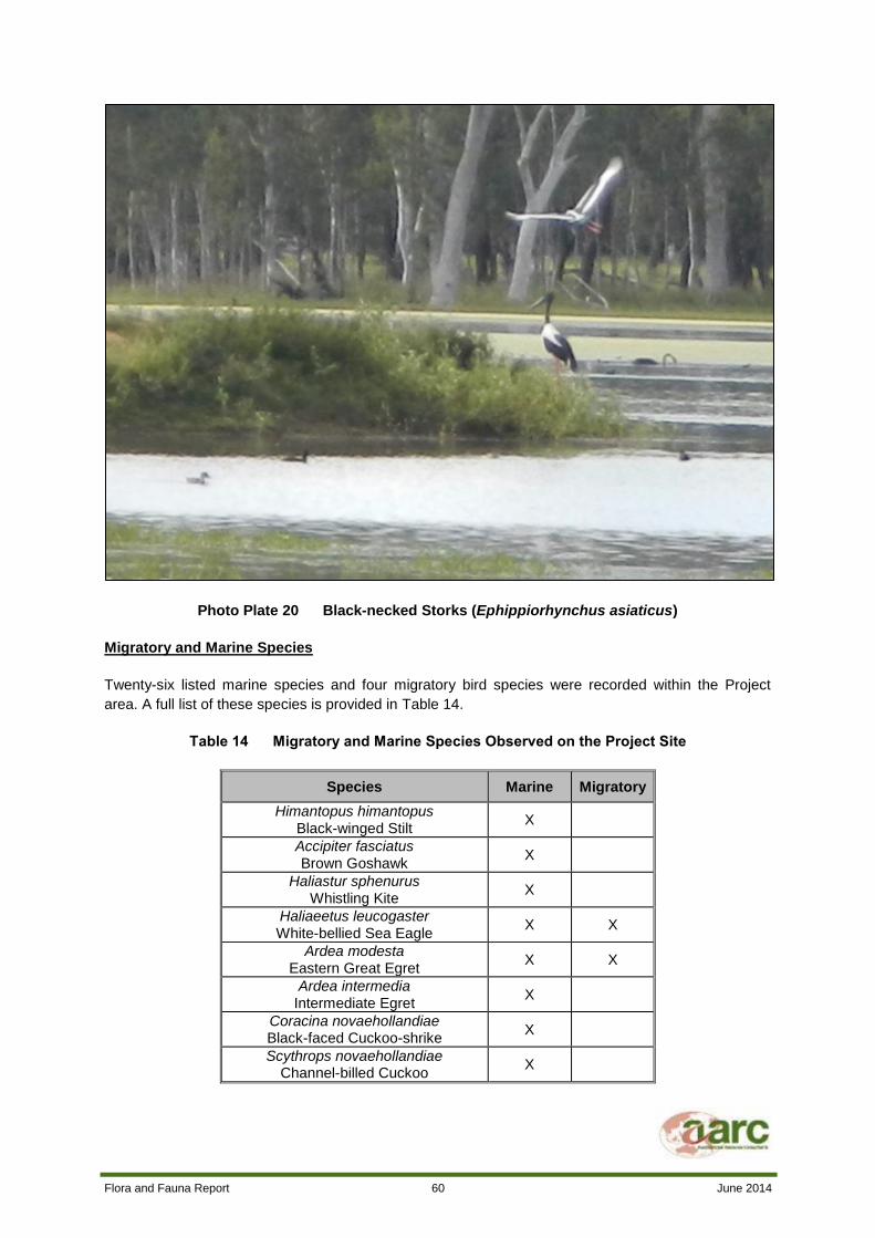
Flora and Fauna Report 60 June 2014
Photo Plate 20 Black-necked Storks (Ephippiorhynchus asiaticus)
Migratory and Marine Species
Twenty-six listed marine species and four migratory bird species were recorded within the Project
area. A full list of these species is provided in Table 14.
Table 14 Migratory and Marine Species Observed on the Project Site
Species Marine Migratory
Himantopus himantopus Black-winged Stilt
X
Accipiter fasciatus
Brown Goshawk X
Haliastur sphenurus Whistling Kite
X
Haliaeetus leucogaster White-bellied Sea Eagle
X X
Ardea modesta Eastern Great Egret
X X
Ardea intermedia Intermediate Egret
X
Coracina novaehollandiae Black-faced Cuckoo-shrike
X
Scythrops novaehollandiae Channel-billed Cuckoo
X
Flora and Fauna Report 61 June 2014
Species Marine Migratory
Dicrurus bracteatus Spangled Drongo
X
Falco cenchroides Nankeen Kestrel
X
Hirundo neoxena Welcome Swallow
X
Petrochelidon nigricans Tree Martin
X
Merops ornatus Rainbow Bee-eater
X X
Grallina cyanoleuca Magpie-lark
X
Anthus novaeseelandiae
Australasian Pipit X
Pelecanus conspicillatus Australian Pelican
X
Ninox boobook Southern Boobook
X
Ardea ibis Cattle Egret
X X
Circus approximans
Swamp Harrier X
Dendrocygna arcuata
Wandering Whistling-duck X
Egretta garzetta
Little Egret X
Hydroprogne caspia
Caspian Tern X
Nettapus pulchellus Green Pygmy-goose
X
Porzana pusilla
Baillon’s Crake X
Threskiornis molucca
Australian White Ibis X
Threskiornis spinicollis
Straw-necked Ibis X
The Project is unlikely to have a significant impact on these species as they are generally common,
widespread and highly mobile and will be able to use the suitable habitat that exists outside the mine
footprint and the Project site.
6.4.3 REPTILES
A total of 12 reptile species were observed during the survey. Habitat suitable for reptiles occurs
throughout the Project site, and includes grasslands, the riparian vegetation along Phillips Creek and
the remnant woodland in the east of the site. Riparian and woodland habitats are particularly important
reptile habitat, as they provide fallen timber, bark, leaf litter and hollows/crevices that many reptile
species use for shelter.
Few reptiles were captured at the survey sites. Most reptiles were observed opportunistically while
traversing the Project site. The most frequently observed species were the Inland Snake-eyed Skink

Flora and Fauna Report 62 June 2014
(Cryptoblepharus australis) and the Elegant Snake-eyed Skink (Cryptoblepharus pulcher). These
small skinks were observed on the trunks of large trees at Phillips Creek, Lake Vermont and the small
Poplar Box woodland in the west of the site. The Tree Dtella (Gehyra variegata, shown in Photo Plate
21) and Bynoe’s Gecko (Heteronotia bynoei) were also frequently encountered in wooded areas of the
Project site. A single Eastern Snake-neck Turtle (Chelodina longicollis) corpse was encountered
adjacent to the central dam. Three ground-dwelling snake species, the Yellow-faced Whipsnake
(Demansia psammophis), the Carpentaria Snake (Cryptophis boschmai) and a Black Snake
(Pseudechis sp.) were identified. One arboreal snake species, a deceased Green Tree Snake
(Dendrolaphis punctulata), was also observed. The Yellow-faced Whipsnake was the most commonly
encountered snake.
Other reptile species recorded in low numbers were the Lively Rainbow Skink (Carlia vivax) and
Shaded Litter Skink (Lygisaurus foliorum). A single Fire-tailed Skink (Morethia taeniopleura) was
captured in disturbed woodland near Phillips Creek.
Photo Plate 21 Tree Dtella (Gehyra variegata)
6.4.3.1 Reptile Species of Conservation Significance
No reptile species of conservation significance or Back on Track priority species were observed on the
Project site.

Flora and Fauna Report 63 June 2014
6.4.4 MAMMALS
A total of 20 mammals were positively identified on the Project site. This includes seven microbat
species identified from acoustic recordings. Another seven microbat species may also be present, but
could not be confirmed as present, or identified to species level, due to the constraints of the acoustic
recording method used to detect bats.
Habitat suitable for a range of large and small mammal species, arboreal mammals and bats was
present across the Project area. The cleared pasture areas provided habitat suitable for large grazers,
such as Kangaroos. The riparian vegetation along Phillips Creek contains large, hollow-bearing trees
that are suitable habitat for bats and arboreal mammals. Wetland areas provide habitat for aquatic
mammals such as the Water Rat (Hydromys chrysogaster) and drinking water for larger mammal
species. The wooded areas of the Project site contain dense low shrubs, hollow logs and leaf litter,
which are potential small mammal habitat. The fenced area near the central dam also contained tall
grasses which were considered suitable mammal habitat.
No small mammal species were observed or captured during the survey, despite the presence of
potentially suitable habitat and seeding grasses. This was consistent with the results of other recent
surveys conducted by AARC in the local area. It is possible that the disturbed, grazed and weed-
dominated ground cover on the Project site is unfavourable habitat for small mammals. Nearby mining
activity, altered fire frequency and predation by introduced species such as the Feral Cat may have
also impacted the small mammal population on the Project site.
Four species of native medium-sized ground mammals were recorded on the Project site. The
Northern Brown Bandicoot (Isoodon macrourus) was the most commonly encountered of these. It was
found at most survey sites. The Water Rat (Hydromys chrysogaster) was photographed by automated
camera at Lake Vermont and its tracks were observed in Phillips Creek. The tracks of the Rufous
Bettong (Aepyprymnus rufescens) were observed at Lake Vermont and Echidna (Tachyglossus
aculeatus) scats were identified at FS1.
The only large native mammal observed on the Project site was the Eastern Grey Kangaroo
(Macropus giganteus). Small numbers of Eastern Grey Kangaroos were observed in cleared areas, in
the Poplar Box woodland and on the shores of Lake Vermont.
Six introduced mammal species were observed on the Project site. The Feral Cat (Felis catus), Feral
Pig (Sus scrofa) and European Rabbit (Oryctolagus cuniculus) were observed in cleared areas
adjacent to the site access track. Feral Pig tracks were also observed in Phillips Creek. A Dingo
(Canis familiaris dingo) was photographed by automated camera at FS1 and Dingo tracks were also
observed in Phillips Creek and at Lake Vermont. Large numbers of domestic Cattle (Bos taurus) and
Horses (Equus caballus) also inhabit the Project site. The Feral Cat, Feral Pig, Dingo and European
Rabbit are Class 2 declared pests.
The only arboreal mammal observed on the Project site was the Common Brush-tailed Possum
(Trichosurus vulpecula). It was observed in Phillips Creek and its scats were collected from the Poplar
Box woodland in the west of the site. Glider feed marks were observed on trees in the wooded areas
of the Project site. These marks are likely to be caused by the Sugar Glider (Petaurus breviceps).
Suitable habitat for arboreal mammals on the Project site is restricted to Phillips Creek and the
remnant woodland in the east of the site. These two areas contain mature, hollow-bearing trees that
arboreal mammals use for shelter and feeding. The Poplar Box regrowth in the west of the site also
provides some habitat for arboreal mammals, but due to the small size and isolated nature of this
patch of vegetation it is unlikely to form significant habitat.

Flora and Fauna Report 64 June 2014
A total of seven bat species were positively identified from acoustic recordings. Bat species commonly
recorded were Gould’s Wattled Bat (Chalinolobus gouldii), the Chocolate Wattled Bat (Chalinolobus
morio), Beccari’s Freetail Bat (Mormopterus beccarii) and the Yellow-bellied Sheathtail Bat
(Saccolaimus flaviventris). Long-eared Bats (Nyctophilus geoffroy and/or N. gouldi) were also
commonly recorded, but could not be identified to species level. White-striped Freetail Bats
(Austronomus australis) and Broad-nosed Bats (Scotorepens greyii and/or S. sanborni) were also
recorded. An additional five species of bat from several genera may also be present on the Project
site, but their presence could not be reliably confirmed from the call data collected. The full microbat
analysis report is provided in Appendix E. The likelihood of threatened bat species inhabiting the
Project site is discussed in Table 15, however, no threatened species were observed within the
Project site.
6.4.4.1 Mammal Species of Conservation Significance
No mammal species of conservation significance were positively identified on the Project site. No
mammalian Back on Track priority species were identified on the Project site.
6.4.5 PEST SPECIES
Five pest species were identified on the Project site, four of which are Class 2 pests under the LP Act.
Landholders must take reasonable steps to control Class 2 pests on their land.
Cane Toads (Rhinella marina) were observed in and around wetland areas on the Project site. Cane
Toads are toxic to animals that consume them and they prey on a range of small native wildlife.
Feral Cats (Felis catus) prey on a range of small native species. Feral Cat predation has caused the
extinction of several native mammal species. They can also transmit fatal diseases to native
mammals.
Dingoes (Canis familiaris dingo) prey on both stock and native wildlife. They carry disease and can
pose a risk to human safety.
Feral Pigs (Sus scrofa) favour riparian habitats. They cause erosion and degradation of these areas
by trampling, wallowing and stripping vegetation. Feral Pigs are known to prey on small native
animals. They can also spread disease.
Rabbits (Oryctolagus cuniculus) are a widespread and very abundant pest species. They consume
native vegetation and compete with small native herbivores for food. High rabbit numbers can cause
degradation of native vegetation and erosion.
6.4.6 REGIONAL FAUNA SPECIES OF CONSERVATION SIGNIFICANCE
This section discusses species of conservation significance that are known from the broad region and
have been identified from desktop searches, but were not observed on the Project site during the
survey.
The assessment of potential for presence and impact on each species is based on the knowledge of
AARC ecologists, information obtained from field surveys on the Project site, previous surveys
conducted on or near the Project site and scientific literature.
Many of the bird species of conservation significance detected by the desktop searches are listed as
“High Mobility” Taxa (EPA, 2002). The presence of such mobile species on the Project site is thought

Flora and Fauna Report 65 June 2014
to be sporadic, and they are able to utilise other favourable habitats away from the Project site.
Impacts on these High Mobility species are therefore unlikely.

Flora and Fauna Report 66 June 2014
Table 15 Assessment of Likelihood of Occurrence and Potential Impacts on Threatened Fauna Species identified from Desktop Searches
Species
Status Habitat Description and Likelihood of
Occurrence Assessment of Impact Significance EPBC
Act
NC
Act
Threatened Species
Northern Hairy-nosed
Wombat
Lasiorhinus krefftii
E E
Forage in open Eucalypt woodlands with
open areas of native grass. Excavate burrows
on deep, sandy soils often along dry creek
beds (Menkhorst and Knight, 2011).
Highly unlikely to occur on the Project site as this species is
only found in two areas, which are located far west of the
site. Scat/track searching did not reveal any sign of
occupation by this species. Spotlighting was also conducted.
As per Commonwealth survey guidelines, trapping is not
necessary to ascertain the presence of this species.
Black-throated Finch
Poephila cincta cincta E E
Inhabits open woodland, scrubby plains and
Pandanus flats with deep cover of grasses.
Its habitat is never far from water. It is known
to occur south of Townsville, particularly
around Townsville and Charters Towers
(DSEWPAC, 2013).
This species is unlikely to occur on the Project site. There is
some potentially suitable habitat on the Project site, but the
Black-throated Finch is not known from the local area.
Targeted bird surveys and searches for threatened species
were conducted during the survey. Eight hours of diurnal bird
surveys were conducted and opportunistic searches were
conducted in areas containing habitat likely to support
threatened birds. It is therefore unlikely that the Project will
impact this species.
Ornamental Snake
Denisonia maculata V V
Known only from the Brigalow Belt
biogeographical region, chiefly from the
Fitzroy and Dawson River catchments.
Prefers woodlands and open forests
associated with moist areas, particularly gilgai
(melon-hole) mounds and depressions. Also
occurs on lake margins and wetlands.
Suitable habitat for this species exists around Lake Vermont
and other wetland areas. It was not recorded during the
survey. Pitfall trap lines targeted small ground-dwelling
fauna, including reptiles, and funnel traps were used to
capture various reptiles. No significant impacts are expected
on populations of this species as minimal habitat is expected
to be disturbed and suitable habitat remains on and
immediately off-site outside main disturbance areas.

Flora and Fauna Report 67 June 2014
Species
Status Habitat Description and Likelihood of
Occurrence Assessment of Impact Significance EPBC
Act
NC
Act
Brigalow Scaly-foot
Paradelma orientalis NL V
Inhabits a variety of habitats on ridges, sand
or clays. Appears to prefer undisturbed
vegetation where grass, fallen timber, rocks
or dense leaf litter provides shelter
(DSEWPAC, 2013).
Suitable habitat for this species occurs in the woodland
remnants. It was not observed during the survey. No
significant impacts are expected on populations of this
species as minimal habitat is expected to be disturbed and
suitable habitat remains on and immediately off-site outside
main disturbance areas.
Red Goshawk
Erythrotriorchis radiatus V E
This species prefers forest and woodland with
a mosaic of vegetation types, large prey
populations (birds) and permanent water. The
vegetation types include Eucalypt woodland,
open forest, tall open forest, gallery rainforest,
swamp sclerophyll forest, and rainforest
margins. The Red Goshawk nests in large
trees, within 1 km of permanent water.
May occur on site. The Project site does not contain the
mosaic of habitat types preferred by this species; therefore
impacts upon this species are unlikely. This species is listed
as a ‘High Mobility Taxon’. Given its high mobility and the
continued presence of habitat on and around the Project site,
no significant impact on this species is expected.
Star Finch
Neochmia ruficauda
ruficauda
E E
Inhabits tall grass and reed beds associated
with swamps and watercourses in central
Queensland. It may also be found in grassy
woodlands, open forests, mangroves, urban
and cleared areas.
Highly unlikely to occur on site as expert opinion suggests
this taxon is extinct in the wild (Garnett, Szabo and Dutson,
2010). Some suitable habitat exists on site but it is extremely
unlikely that it is utilised by the Star Finch. Targeted bird
surveys and searches for threatened species were
conducted during the survey. Eight hours of diurnal bird
surveys were conducted and opportunistic searches were
conducted in areas containing habitat likely to support
threatened birds.
Grey Goshawk
Accipiter novaehollandiae NL NT
Inhabits rainforests, forests and tall
woodlands in coastal northern Australia and
eastern Australia (Pizzey and Knight, 2007).
Unlikely to occur on site due to the absence of suitable
habitat.
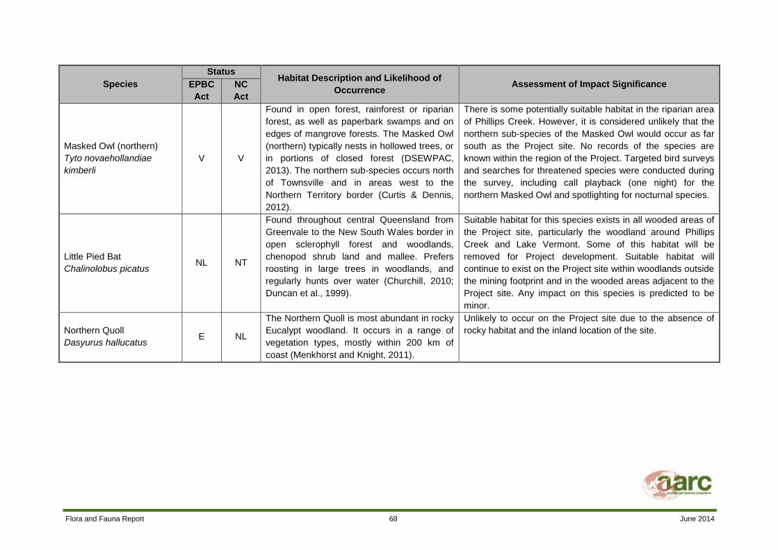
Flora and Fauna Report 68 June 2014
Species
Status Habitat Description and Likelihood of
Occurrence Assessment of Impact Significance EPBC
Act
NC
Act
Masked Owl (northern)
Tyto novaehollandiae
kimberli
V V
Found in open forest, rainforest or riparian
forest, as well as paperbark swamps and on
edges of mangrove forests. The Masked Owl
(northern) typically nests in hollowed trees, or
in portions of closed forest (DSEWPAC,
2013). The northern sub-species occurs north
of Townsville and in areas west to the
Northern Territory border (Curtis & Dennis,
2012).
There is some potentially suitable habitat in the riparian area
of Phillips Creek. However, it is considered unlikely that the
northern sub-species of the Masked Owl would occur as far
south as the Project site. No records of the species are
known within the region of the Project. Targeted bird surveys
and searches for threatened species were conducted during
the survey, including call playback (one night) for the
northern Masked Owl and spotlighting for nocturnal species.
Little Pied Bat
Chalinolobus picatus NL NT
Found throughout central Queensland from
Greenvale to the New South Wales border in
open sclerophyll forest and woodlands,
chenopod shrub land and mallee. Prefers
roosting in large trees in woodlands, and
regularly hunts over water (Churchill, 2010;
Duncan et al., 1999).
Suitable habitat for this species exists in all wooded areas of
the Project site, particularly the woodland around Phillips
Creek and Lake Vermont. Some of this habitat will be
removed for Project development. Suitable habitat will
continue to exist on the Project site within woodlands outside
the mining footprint and in the wooded areas adjacent to the
Project site. Any impact on this species is predicted to be
minor.
Northern Quoll
Dasyurus hallucatus E NL
The Northern Quoll is most abundant in rocky
Eucalypt woodland. It occurs in a range of
vegetation types, mostly within 200 km of
coast (Menkhorst and Knight, 2011).
Unlikely to occur on the Project site due to the absence of
rocky habitat and the inland location of the site.

Flora and Fauna Report 69 June 2014
Species
Status Habitat Description and Likelihood of
Occurrence Assessment of Impact Significance EPBC
Act
NC
Act
South-eastern Long-eared
Bat
Nyctophilus corbeni/
timoriensis
V V
Found across semi-arid southern Australia to
southern Queensland. Inhabits a range of dry
woodland and shrubland communities in arid
and semi-arid regions. Roosts mostly in tree
hollows (Menkhorst and Knight, 2011).
Suitable habitat exists in the wooded areas of the Project
site. Ultrasonic recorders were used across the site to record
micro-bat echolocation calls. Recordings were analysed by
an experienced bat-call analyst. The South-eastern Long-
eared Bat was not identified (neither positively nor possibly)
through these recordings. Suitable habitat will remain in
undisturbed portions of the Project site and in woodland
adjacent to the Project site. Given the mobility of this
species, no significant impact is expected if it does occur on
site.
Yakka Skink
Egernia rugosa V V
Inhabits dry open forests, woodlands and
rocky areas in the Brigalow Belt, where it
occurs in fallen timber, wood piles, uprooted
trees, deep rock crevices, deeply eroded
gullies or disused rabbit warrens (DSEWPAC,
2013).
Suitable habitat exists in the wooded areas of the Project
site. It was not observed during the survey. Pitfall trap lines
targeted small ground-dwelling fauna, including reptiles, and
funnel traps were used to capture various reptiles, including
medium-sized skinks. Recommended methods for the Yakka
Skink (including fauna transects, spotlighting and Elliott and
cage trapping) were also undertaken (DSEWPAC 2011b).
No significant impacts area expected on populations of this
species as minimal habitat is expected to be disturbed and
suitable habitat remains on and immediately off-site outside
main disturbance areas.
Dunmall’s Snake
Furina dunmalli V V
Inhabits forests and woodlands on black
alluvial cracking clay and clay loams
dominated by Brigalow (Acacia harpophylla).
Preferred microhabitat includes fallen timber
and leaf litter and possibly cracks in clay soils
(DSEWPAC, 2013).
Unlikely to occur on the Project site as suitable Brigalow
habitat has been cleared and it is extremely uncommon.
Brigalow regrowth on the site is unlikely to provide suitable
habitat due to its structure and composition. The species was
not recorded on the Project site during field surveys despite
targeted survey methods. Significant impacts on this species
are considered unlikely.

Flora and Fauna Report 70 June 2014
Species
Status Habitat Description and Likelihood of
Occurrence Assessment of Impact Significance EPBC
Act
NC
Act
Glossy Black-cockatoo
Calyptorhynchus lathami NL V
Found from the Queensland central coast to
eastern Victoria. In Queensland most
individuals are found east of the Great
Dividing Range. It inhabits woodland, open
woodland, coastal lowlands, offshore islands
and residential areas where She-oaks are
present. Feeds almost exclusively on She-
oak seeds, particularly Allocasuarina littoralis
and A. torulosa (Curtis and Dennis, 2012).
Unlikely to occur on the Project site due to the absence of
suitable feed trees.
Golden-tailed Gecko
Strophurus taenicauda NL NT
Occurs from the Darling Downs to the coastal
regions of central and south-eastern
Queensland. Occurs in dry sclerophyll forests
and Eucalypt and Cypress woodlands
(Cogger, 2000).
Suitable habitat for this species occurs in the woodland
areas of site. It was not observed during the survey. No
significant impacts are expected on populations of this
species as minimal habitat is expected to be disturbed and
suitable habitat remains on and immediately off-site outside
main disturbance areas.
Square-tailed Kite
Lophoictinia isura NL NT
Found throughout most of Australia, except
for the arid interior. This species is found in a
range of habitats including woodlands
dominated by Eucalypts and Pandanus,
gallery forests and heaths (Pizzey and Knight,
2007).
Suitable habitat for this species occurs in the woodland
areas and along Phillips Creek. It was not observed during
the survey. It is listed as a ‘High Mobility Taxon’. Given its
mobility and the continued existence of suitable habitat
outside the mine footprint and in the surrounding area, no
significant impact is expected.
Black-chinned Honeyeater
Melithreptus gularis NL NT
Found in all mainland Australian states.
Occurs in open Eucalypt forests and
woodlands in a range of climatic zones. They
prefer forests and woodlands with box and
ironbark Eucalypts, and are often found in
riparian areas (Pizzey and Knight, 2007).
Suitable habitat exists on site and throughout the region in
which the Project is located. This species has an extremely
large range. Surveys failed to locate this species on site.
Given the large range of this species, its high mobility and
the existence of suitable alternative habitat, development of
the Project site is unlikely to have any significant impact on
the species.

Flora and Fauna Report 71 June 2014
Species
Status Habitat Description and Likelihood of
Occurrence Assessment of Impact Significance EPBC
Act
NC
Act
Turquoise Parrot
Neophema pulchella NL NT
Open woodland with dead trees, permanent
water and forested hillsides, also pastures
and roadsides. Known from south-east
Australia, south of Gayndah (Pizzey and
Knight, 2007).
Unlikely to occur on site, as the Project site is located well
north of the current distribution of this species.
Rufous Owl (southern
subspecies)
Ninox rufa queenslandica
NL V
Found in coastal and upland north-east
Queensland. Inhabits rainforest and forests
and woodlands located near rainforest (Curtis
and Dennis, 2012).
Highly unlikely to occur on the Project site due to the
absence of rainforest habitat.
Koala
Phascolarctos cinereus V NL
Inhabits Eucalypt forests and woodlands on
the east coast of Australia (Curtis and Dennis,
2012).
Suitable habitat exists on site. One individual was observed
in sparse woodland in a paddock adjacent to the site access
road (outside the Project site). Suitable habitat for Koalas
occurs along Phillips Creek and in the large woodland in the
eastern area of site. The species has been observed in
similar habitat nearby, to the south east, of the Project site. If
Koalas do inhabit the site, their numbers are expected to be
low and their presence would only be sporadic. Given the
lack of habitat connectivity and the absence of koalas on the
site over the past 10 years, it is unlikely that potential koala
habitat on the site is of particular importance to the species.
Allan's Lerista
Lerista allanae E E
Found around Clermont in central
Queensland. Occurs in open grasslands on
plains with rich-brown surface soils, leaf litter
and scattered trees (Curtis and Dennis,
2012).
This species is extremely rare and thought to be sensitive to
land use changes that have occurred with the introduction of
grazing and pastoral activities to the Brigalow Belt (Curtis
and Dennis, 2012). Given the disturbed and artificial nature
of the grasslands on the Project site, it is unlikely that this
species inhabits the site.

Flora and Fauna Report 72 June 2014
Species
Status Habitat Description and Likelihood of
Occurrence Assessment of Impact Significance EPBC
Act
NC
Act
Grey Snake
Hemiaspis damelii NL E
Prefers cracking flood-prone soils in the
Brigalow Belt. Inhabits clay floodplains with
grassland and open woodlands of Brigalow,
Belah and Poplar Box, usually near water
bodies (Curtis and Dennis, 2012).
A small amount of potential habitat for this species occurs on
the Project site around the central dam and the Poplar Box
woodland. The central dam habitat will be disturbed by
Project activities. Given that the habitat in this area is already
heavily disturbed by clearing and past grazing, it is unlikely to
form significant habitat for the species and no significant
impact is expected.
Pale Imperial Hairstreak
Jalmenus eubulus NL V
Inhabits central Queensland from Eungella to
the Darling Downs. Occurs in mature
Brigalow stands (Curtis and Dennis, 2012).
Unlikely to occur on site due to the absence of suitable
mature Brigalow habitat.
Death Adder
Acanthophis antarcticus NL NT
Found throughout Queensland in a variety of
habitats (Wilson, 2005). Preferred
microhabitat includes fallen timber and leaf
litter and grass tussocks.
Suitable habitat for this species occurs on the Project site in
woodland areas. It was not observed during the survey. No
significant impacts are expected on populations of this
species as minimal habitat is expected to be disturbed and
suitable habitat remains on and immediately off-site outside
the mining area.
Striped-tailed Delma
Delma labialis NL V
Inhabits coastal sandy dunes and rocky hill
slopes in coastal ranges and flats (Curtis and
Dennis, 2012).
Unlikely to occur on the Project site due to lack of suitable
habitat.
Collared Delma
Delma torquata V V
Known mainly from south-east Queensland,
with recent records from the Blackdown
Tablelands and Roma. Mainly inhabits
ridgelines vegetated with dry open woodland,
also Eucalyptus tereticornis and Brigalow
woodlands. Shelters under loose rocks
(Curtis and Dennis, 2012).
Unlikely to occur on the Project site due to lack of suitable
habitat. This was confirmed during surveys, which did not
record any occurrences of evidence of this species, despite
the use of targeted methods.

Flora and Fauna Report 73 June 2014
Species
Status Habitat Description and Likelihood of
Occurrence Assessment of Impact Significance EPBC
Act
NC
Act
Radjah Shelduck Tadorna radjah
NL NT
Occurs in coastal tropical northern Australia.
Inhabits swamps, coastal creeks, shallow
river margins, estuaries, lagoons and
wetlands (Pizzey and Knight, 2007).
Unlikely to occur on site, as this is a coastal species and is
not known to occur in the Project region.
Fitzroy River Turtle Rheodytes leukops
V V
Found in flowing streams and permanent
waterbodies in the Fitzroy, Connors, Dawson,
Isaac and Mackenzie Rivers. In the dry
season it may be found in large slow-flowing
pools and non-flowing permanent water
holes.
Unlikely to occur on the Project site as the creek system is
ephemeral and only flows briefly after heavy rainfall. There is
no suitable habitat available on site. The species was not
detected during aquatic surveys.
Saltwater Crocodile Crocodylus porosus
NL V
Reefs, coastal and inland waterways in
central and northern Queensland (Curtis and
Dennis, 2012).
Highly unlikely to occur on the Project site, due to the
absence of suitable habitat. The Project site is also located
west of the current distribution of this species.
Rough Collared Frog Cyclorana verrucosa
NL NT
Occurs near seasonal ponds, creeks, and
claypans in open country in southern
Queensland and northern New South Wales
(Tyler and Knight, 2011).
Unlikely to occur on site, as the Project site is located far
north of the species’ northern distribution limit.
Painted Snipe Rostratula australis
E, Ma, Mi
V
Found in shallow inland wetlands, either
freshwater or brackish, that are either
permanently or temporarily filled, throughout
many parts of Australia (DSEWPAC, 2013).
May occur on the Project site in wetland areas. This species
is a ‘High Mobility Conservation Significant Taxon’ which
exists as a single population across the Australian continent.
The Project is unlikely to have a significant impact on this
species due to its high mobility and the continued existence
of suitable habitat on and around the Project site following
Project construction. Targeted bird surveys and searches for
threatened species were conducted during the survey. Eight
hours of diurnal bird surveys were conducted and
opportunistic searches were conducted in areas containing
habitat likely to support threatened birds.

Flora and Fauna Report 74 June 2014
Species
Status Habitat Description and Likelihood of
Occurrence Assessment of Impact Significance EPBC
Act
NC
Act
Red-tailed Tropicbird Phaethon rubricauda
NL V Restricted to marine environments. Breeds on
offshore islands (Pizzey and Knight, 2007).
Highly unlikely to occur on the Project site due to lack of
suitable marine habitat.
Migratory and Marine Species
White-throated Needletail
Hirundapus caudacutus Mi, Ma NL
Widespread in eastern and south-eastern
Australia. Occurs over most types of habitat,
most often above wooded areas, including
open forest and rainforest, but they are less
commonly recorded flying above woodland
(DSEWPAC, 2013). Known to appear and
forage for aerial insects over any habitat.
May potentially occur over the Project site but none were
observed during the survey period. Development on site is
unlikely to affect this species as it is strictly aerial, remaining
high above ground.
Barn Swallow
Hirundo rustica Mi, Ma NL
Widespread in the northern hemisphere and
winters in the southern hemisphere. It
inhabits open country, agricultural land and
urban areas (Pizzey and Knight, 2007).
May potentially occur over the Project site but none were
observed during the survey period. Development on site is
unlikely to affect this species as it is strictly aerial, remaining
high above ground.
Black-faced Monarch
Monarcha melanopsis Mi, Ma NL
Found in coastal eastern Australia, east of
the Great Dividing Range. Inhabits rainforest,
Eucalypt forest and woodlands, and coastal
scrub (Pizzey and Knight, 2007).
Unlikely to occur on site, as the Project site is located outside
its main distribution area and does not contain its preferred
habitat.
Spectacled Monarch
Monarcha trivirgatus Mi, Ma NL
Found in coastal north-east and eastern
Australia, most abundant in the wet tropics.
Inhabits rainforests, thickly wooded gullies
and waterside vegetation (Pizzey and Knight,
2007).
Unlikely to occur on site, as the Project site is located outside
its main distribution area and does not contain its preferred
habitat.
Satin Flycatcher
Myiagra cyanoleuca Mi, Ma NL
Widespread but scattered in eastern
Queensland, being recorded on passage on a
few islands in the western Torres Strait. They
are mainly recorded in Eucalypt forests,
especially wet sclerophyll forest (DSEWPAC,
2013).
Unlikely to occur on the Project site due to the absence of
suitable habitat.

Flora and Fauna Report 75 June 2014
Species
Status Habitat Description and Likelihood of
Occurrence Assessment of Impact Significance EPBC
Act
NC
Act
Rufous Fantail
Rhipidura rufifrons Mi, Ma NL
Occurs in coastal and near coastal districts of
northern and eastern Australia in wet
sclerophyll forests and rainforests
(DSEWPAC, 2013).
Unlikely to occur on the Project site due to the absence of
suitable habitat.
Fork-tailed Swift
Apus pacificus Mi, Ma NL
Known to forage over any habitat. Strictly
aerial. A summer visitor to Australia (Pizzey &
Knight, 2006).
Potentially suitable habitat for this species occurs across the
Project site and throughout the region. This species is
unlikely to be impacted by Project development as it rarely
comes into contact with the ground or vegetation.
Magpie Goose
Anseranas semipalmata Ma NL
The Magpie Goose occupies large seasonal
wetlands and well-vegetated dams with
rushes and sedges; wet grasslands and
floodplains (Pizzey & Knight, 2006).
Suitable habitat for this species occurs on the Project site.
Given that this species is listed as marine and the Project
does not occur at its distributional range the Project is not
likely to have a significant impact on the species.
Latham’s Snipe
Gallinago hardwickii Mi, Ma NL
This species occurs in association with areas
of soft wet ground or shallow water with
tussocks, seepage areas below dams,
irrigated areas, scrub or open woodland from
sea level to alpine bogs over 2000 m,
saltmarshes and mangrove fringes (Pizzey &
Knight, 2006).
The Project site provides areas of suitable habitat for this
species. Suitable habitat for this species occurs throughout
the region and as such the Project is not likely to impact on
the species.
Eastern Osprey
Pandion haliaetus Ma NL
This species predominantly occupies coastal
and littoral habitats as well as terrestrial
wetlands of tropical and temperate Australia
and offshore islands (DSEWPAC, 2013).
Eastern Ospreys require extensive areas of
open fresh, brackish or saline water for
foraging (Marchant & Higgins, 1993).
The Project site potentially provides suitable foraging habitat
for individuals that are passing through the region. Given that
this species prefers coastal areas and offshore islands, the
Project site is considered unlikely to support a population of
this species.
NL – Not listed
LC – Least Concern
NT – Near Threatened
Flora and Fauna Report 76 June 2014
V – Vulnerable
E – Endangered
Mi – Migratory

Flora and Fauna Report 77 June 2014
7.0 ENVIRONMENTAL VALUES, POTENTIAL IMPACTS AND RECOMMENDED MITIGATION AND MANAGEMENT STRATEGIES
7.1 SUMMARY OF ENVIRONMENTAL VALUES
The following summarises environmental values that have been identified for the Project site
(described in Section 6):
Phillips Creek and the Poplar Gum woodland in the east of the site form a corridor that is of
limited bioregional significance;
Woodland areas on the Project site provide habitat for a range of flora and fauna species;
Lake Vermont and the two dams on the Project site provide drinking water for terrestrial fauna
and habitat for a range of aquatic species;
Suitable habitat of one vulnerable (NC Act, EPBC Act) and three near threatened (NC Act)
bird species;
Suitable habitat for four migratory bird species;
Stands of vegetation that are listed as Of Concern (VM Act); and
Areas of highly degraded Regrowth which is largely dominated by Brigalow.
Effective mitigation strategies will minimise Project impacts on these values.
7.2 POTENTIAL IMPACTS
Development of the Project will require the clearing of vegetation from a small portion of Phillips
Creek, the central dam area and the Poplar Gum woodland. These areas will then be mined. Areas of
remnant vegetation and regrowth vegetation will be removed for Project development.
Project development will decrease the area of remnant vegetation on the Project site. Removal of
vegetation reduces flora species diversity and removes fauna habitat. It may also cause erosion of the
exposed top soil and increased edge effects in the remaining vegetation.
Construction and operational activities may increase the risk of weed introduction and spread on the
Project site. Earth moving activities and vehicle movement can spread weed seeds into and around
the Project site. This has the potential to cause degradation of the remaining vegetation communities
on site.
Mining operations will partially disrupt the connectivity of the habitat corridor along Phillips Creek.
However, revegetation of the creek diversion area will restore this connectivity. Clearing of the
woodland in the east of site will slightly impact the outer extent of a large bioregional corridor.
Areas of fauna habitat at the central dam, wetland on Phillips Creek and Lake Vermont may be
cleared as part of Project development. This may reduce the diversity and abundance of fauna
species inhabiting the Project site. Birds of conservation significance are known to utilise this habitat. It
is likely that mobile fauna will use alternate suitable wetland habitat which exists in the floodplain of

Flora and Fauna Report 78 June 2014
the Isaac River. Project development will also remove microhabitat such as tree hollows, logs and leaf
litter.
Project activities may lead to increased fauna injuries and mortality. This risk is particularly high during
the clearing operations. Construction of roads and increased vehicle movements will increase the risk
of collisions with fauna. Mine voids also have the potential to harm ground-dwelling fauna should they
attempt to access these areas.
Project activities will remove some suitable habitat for the southern Squatter Pigeon and may also
inadvertently cause destruction of their nests. This impact is not considered significant as suitable
habitat will continue to remain in the undisturbed pasture areas of the Project site and adjacent lands.
Development of the Project site will involve the construction of roads, tracks, water storages and
waste disposal areas. Human activities on the Project site will introduce additional food sources for
fauna such as food scraps. This will increase the suitability of the Project site to feral animals, and
may lead to an increase in their numbers on the Project site. Increased pest numbers will result in
increased predation upon and competition with native fauna, which may lead to further reductions in
native populations.
7.3 MITIGATION AND MANAGEMENT STRATEGIES
7.3.1 FLORA
A range of mitigation measures are recommended to minimise Project impacts on the vegetation
communities on the Project site. The clearing footprint should be limited to areas required for mining
and associated activities. Site access roads should follow existing tracks or be established through
non-remnant areas where possible.
Erosion controls such as water management infrastructure should be constructed consistent with other
water management infrastructure at Lake Vermont Mine. This will minimise the loss of topsoil
associated with vegetation clearing. The topsoil in the cleared area should be removed and stockpiled
for use in site rehabilitation.
The creek diversion area should be planted with native species that occur in Community 3 (RE
11.3.25) to replace the vegetation removed from the diverted section of the creek and restore the
connectivity of the vegetation corridor along Phillips Creek. Refer to Appendix B for appropriate
species to use in the planting works.
Progressive rehabilitation of the mine area should be undertaken over the life of the mine. Mined
areas should be landscaped and covered with the stockpiled topsoil. The site should be replanted with
native or pasture species that occurred in the area prior to clearing (refer to Appendix B).
The risk of uncontrolled fires will be minimised by the provision of fire extinguishers in all mining plant
and buildings and staff training (including staff trained in emergency response). All chemicals must be
stored and handled in appropriate areas in accordance with the requirements of the Material Data
Safety Sheet.
A Rehabilitation Management and Monitoring Plan should be developed to provide for the
identification, reporting, management and control of weed species in rehabilitated areas.
A staff training and awareness program should be implemented that identifies the key environmental
values of the site and provides procedures and best practice strategies for environmental protection.
Flora and Fauna Report 79 June 2014
7.3.2 FAUNA
Project impacts on native fauna can be minimised by the implementation of appropriate mitigation and
management measures.
Clearing should be conducted in a staged manner to enable fauna to move out of the disturbance area
into adjacent habitat.
Vehicle speeds on the Project site will be restricted. This will minimise the risk of collisions with native
fauna. Where it is possible and safe to do so, injured or orphaned animals should be taken to a local
wildlife carer or vet to receive treatment.
Rehabilitation activities should aim to recreate fauna habitat values of the existing site. Hazardous
areas such as mine voids and contaminated water storages should be managed in accordance with
the site’s Water Management Plan. The creation of shallow open water storages should be avoided
where possible to minimise Cane Toad numbers.
A staff training and awareness program should be implemented that identifies the key environmental
values of the site and provides procedures and best practice strategies for environmental protection.

Flora and Fauna Report 80 June 2014
8.0 REFERENCES
AustralAsian Resource Consultants (2013). Lake Vermont Northern Extension Aquatic Ecology
Assessment.
AustralAsian Resource Consultants (2012). Lake Vermont Western Extension Terrestrial Flora and
Fauna Report.
Australian Tropical Rainforest Plants (2013). Desmodium macrocarpum http://keys.trin.org.au/key-
server/data/0e0f0504-0103-430d-8004
060d07080d04/media/Html/taxon/Desmodium_macrocarpum.htm.
Bean, A.R. (2012). Solanum species of eastern and northern Australia. http://delta-intkey.com.
BirdLife International (2013). IUCN Red List for birds. Accessed 15th November 2013 at
http://www.birdlife.org.
Bowen Basin Coal (2004). Lake Vermont Environmental Impact Statement.
Churchill, S. (2010). Australian Bats, Reed New Holland, Sydney.
Cogger, H.G. (2000). Reptiles and Amphibians of Australia. Reed New Holland, Sydney.
Commonwealth of Australia (2011). The Bureau of Meteorology, Queensland. Accessed 26th July
2013 at http://www.bom.gov.au.
Curtis, L.K., Dennis, A.J., McDonald, K.R., Kyne, P.M and Debus, S.J.S. (2012). Queensland’s
Threatened Animals. CSIRO Publishing, Collingwood.
Department of Sustainability, Environment, Water, Population and Communities (2013). Species
Profile and Threats Database. http://www.environment.gov.au/sprat.
Department of Sustainability, Environment, Water, Population and Communities (2011a). Environment
Protection and Biodiversity Conservation Act 1999: Protected Matters Search Tool.
http://www.environment.gov.au/erin/ert/epbc/index.html.
Department of Sustainability, Environment, Water, Population and Communities (2011b), Survey
guidelines for Australia’s threatened reptiles,
http://www.environment.gov.au/system/files/resources/eba674a5-b220-4ef1-9f3a-
b9ff3f08a959/files/survey-guidelines-reptiles.pdf
Department of Sustainability, Environment, Water, Population and Communities (2003). Nationally
threatened species and ecological communities – Brigalow Regrowth and the EPBC Act.
Duncan, A., Baker, G.B. and Montgomery, N. (1999). The Action Plan for Australian Bats.
Environment Australia, Canberra.
Environmental Protection and Biodiversity Conservation Act 1999.
Flora of Australia Online (2013). Macropteranthes fitzalanii. http://www.anbg.gov.au/abrs/online-
resources/flora/stddisplay.xsql?pnid=47170.
Flora and Fauna Report 81 June 2014
Garnett. S., Szabo, J. and Dutson, G. (2010) The Action Plan for Australian Birds 2010. CSIRO
Publishing, Canberra.
Land Protection (Pest and Stock Route Management) Act 2002.
Marchant, S. and Higgins, P. J. (eds) (1993). Handbook of Australian, New Zealand and Antarctic
Birds. Oxford University Press, Melbourne.
Menkhorst, P. and Knight, F (2011). A Field Guide to the Mammals of Australia, Oxford University
Press.
Nature Conservation Act 1992.
Nature Conservation (Wildlife) Regulation 2006.
Neldner, V.J., Wilson, B.A., Thompson, E.J. and Dillewaard, H.A. (2012). Methodology for Survey and
Mapping of Regional Ecosystems and Vegetation Communities in Queensland. Version 3.2. Updated
August 2012. Queensland Herbarium, Queensland Department of Science, Information Technology,
Innovation and the Arts, Brisbane.
New South Wales National Parks and Wildlife Service (2001). Threatened Species Survey and
Assessment: Guidelines for Developments and Activities. Draft for Comment. Prepared by the NSW
National Parks and Wildlife Service and SMEC Australia.
Pizzey, G. and Knight, F (2007). The Field Guide to the Birds of Australia, HarperCollins Publishers,
Pty, Ltd.
SGAP (2007). Society for Growing Australian Plants (Queensland Region) Inc. Newsletter No. 67.
http://www.sgapcairns.org.au/Newsletters/67_May07.pdf.
The State of Queensland Department of Environment and Heritage Protection (2013). Regional
Ecosystems Descriptions Database (REDD).
http://www.ehp.qld.gov.au/ecosystems/biodiversity/regional-ecosystems/index.php.
The State of Queensland Department of Environment and Heritage Protection (2013). Wetland Info –
Eleocharis blakeana.
http://wetlandinfo.derm.qld.gov.au/wetlands/factsfigures/FloraAndFauna/Species/eleocharis-
blakeana.html.
The State of Queensland Department of Environment and Heritage Protection (2013). Wetland Info –
Solanum adenophorum.
http://wetlandinfo.derm.qld.gov.au/wetlands/factsfigures/FloraAndFauna/Species/solanum-
adenophorum.html.
The State of Queensland Department of Environment and Heritage Protection (2012) Pre-clearing and
remnant regional ecosystem dataset. Brigalow Belt North.
The State of Queensland Department of Environment and Heritage Protection (2012). Wetland Info –
Eucalyptus raveretiana.
http://wetlandinfo.ehp.qld.gov.au/wetlands/factsfigures/FloraAndFauna/Species/eucalyptus-
raveretiana.html.

Flora and Fauna Report 82 June 2014
The State of Queensland Department of Environment and Heritage Protection (2010). Fitzroy Natural
Resource Management Region Back on Track Actions for Biodiversity, Department of Environment
and Heritage Protection, Brisbane.
The State of Queensland Department of Science, Information Technology, Innovation and the Arts
(2012). Terrestrial Vertebrate Fauna Survey Guidelines for Queensland.
The State of Queensland Environmental Protection Agency (2002). Biodiversity Assessment and
Mapping Methodology. Environmental Protection Agency. Biodiversity Planning Unit, Biodiversity
Branch. Version 2.1 July 2002.
Threatened Species Network (2008). Brigalow Belt bioregion – a biodiversity jewel.
http://www.qmdc.org.au/publications/download/49/.
Threatened Species Scientific Committee (2008). Approved Conservation Advice for Digitaria porrecta
(Finger Panic Grass). http://www.environment.gov.au/biodiversity/threatened/species/pubs/12768-
conservation-advice.pdf.
Vegetation Management Act 1999.
Wilson, S. (2005). A Field Guide to Reptiles of Queensland, New Holland Publishers, Sydney.
Wilson, S. and Swan, G. (2003). A Complete Guide to Reptiles of Australia, Reed.
World Wide Wattle (2009). Acacia spania. http://www.worldwidewattle.com/speciesgallery/spania.php.

Flora and Fauna Report A June 2014
Appendix A Database Searches

Flora and Fauna Report B June 2014
Appendix B Flora Species List
Flora and Fauna Report C June 2014
Appendix C Assessment of Likelihood of Occurrence of Threatened Flora Species on the Project Site

Flora and Fauna Report C June 2014
Species EPBC Act
Status
NC Act
Status Habitat Impact Assessment
Acacia arbiana NL NT
Confined to the summits of peaks of the Peak Range, east of
Clermont, Queensland. Recorded from trachyte outcrops in heath-like
vegetation.
Unlikely to occur on the Project site due to
lack of suitable habitat.
Acacia spania NL NT Grows in stands in the shrub layer of open Eucalyptus woodlands on
shallow red soils (World Wide Wattle, 2009).
Unlikely to occur on the Project site due to
lack of suitable soil type.
Aristida annua V V This species is restricted to Eucalypt woodland on black clay and
basalt soils (DSEWPAC, 2013).
Unlikely to occur on the Project site due to
the lack of suitable soil types on the site.
Bertya pedicellata NL NT
Restricted to central Queensland on iron stone jump-ups and
associated with communities dominated by Corymbia trachyphloia,
Acacia catenulata, A. curvinervia and/or A. shirleyi.
Unlikely to occur on the Project site due to
lack of suitable habitat.
Ooline
Cadellia pentastylis V V
Occurs in a range of vegetation types including semi-evergreen vine
thicket, Brigalow-Belah, Poplar Box and Bendee communities
(DSEWPAC, 2013). Ooline often occurs on the edges of sandstone
and basalt escarpments, 200 to 500 m above sea level. Ooline grows
on the moderately fertile soils preferred for agriculture and pasture
development (DSEWPAC, 2013).
Unlikely to occur on the Project site due to
lack of suitable habitat.
Capparis humistrata NL E
Grows in Eucalypt woodland with a shrubby understorey, on stony
hard ridges and serpentinite soil. It also occurs on the margins of
Brigalow forest on sandy soil.
Unlikely to occur on the Project site due to
lack of suitable habitat.
Cerbera dumicola NL NT
Primarily found in Lancewood communities and semi-evergreen vine
thickets in coastal and sub-coastal Central Queensland (SGAP,
2007).
Unlikely to occur on the Project site due to
lack of suitable habitat.
Cycas megacarpa E E
Grows in a wide range of woodland communities in south-east
Queensland, as far north as Bouldercombe. Often grows on
undulating to hilly terrain at an altitude of 40 – 680 m. The soil is
typically a well-draining rocky or shallow clay, clay/loam (DSEWPAC,
2013).
Unlikely to occur on the Project site as it is
located outside the known distribution of
this species. The site terrain and soils are
not very suitable for this species.
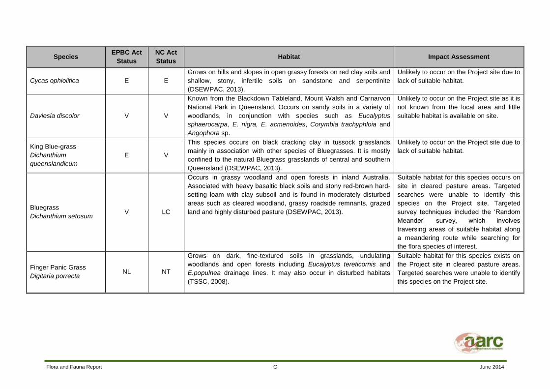
Flora and Fauna Report C June 2014
Species EPBC Act
Status
NC Act
Status Habitat Impact Assessment
Cycas ophiolitica E E
Grows on hills and slopes in open grassy forests on red clay soils and
shallow, stony, infertile soils on sandstone and serpentinite
(DSEWPAC, 2013).
Unlikely to occur on the Project site due to
lack of suitable habitat.
Daviesia discolor V V
Known from the Blackdown Tableland, Mount Walsh and Carnarvon
National Park in Queensland. Occurs on sandy soils in a variety of
woodlands, in conjunction with species such as Eucalyptus
sphaerocarpa, E. nigra, E. acmenoides, Corymbia trachyphloia and
Angophora sp.
Unlikely to occur on the Project site as it is
not known from the local area and little
suitable habitat is available on site.
King Blue-grass
Dichanthium
queenslandicum
E V
This species occurs on black cracking clay in tussock grasslands
mainly in association with other species of Bluegrasses. It is mostly
confined to the natural Bluegrass grasslands of central and southern
Queensland (DSEWPAC, 2013).
Unlikely to occur on the Project site due to
lack of suitable habitat.
Bluegrass
Dichanthium setosum V LC
Occurs in grassy woodland and open forests in inland Australia.
Associated with heavy basaltic black soils and stony red-brown hard-
setting loam with clay subsoil and is found in moderately disturbed
areas such as cleared woodland, grassy roadside remnants, grazed
land and highly disturbed pasture (DSEWPAC, 2013).
Suitable habitat for this species occurs on
site in cleared pasture areas. Targeted
searches were unable to identify this
species on the Project site. Targeted
survey techniques included the ‘Random
Meander’ survey, which involves
traversing areas of suitable habitat along
a meandering route while searching for
the flora species of interest.
Finger Panic Grass
Digitaria porrecta NL NT
Grows on dark, fine-textured soils in grasslands, undulating
woodlands and open forests including Eucalyptus tereticornis and
E.populnea drainage lines. It may also occur in disturbed habitats
(TSSC, 2008).
Suitable habitat for this species exists on
the Project site in cleared pasture areas.
Targeted searches were unable to identify
this species on the Project site.
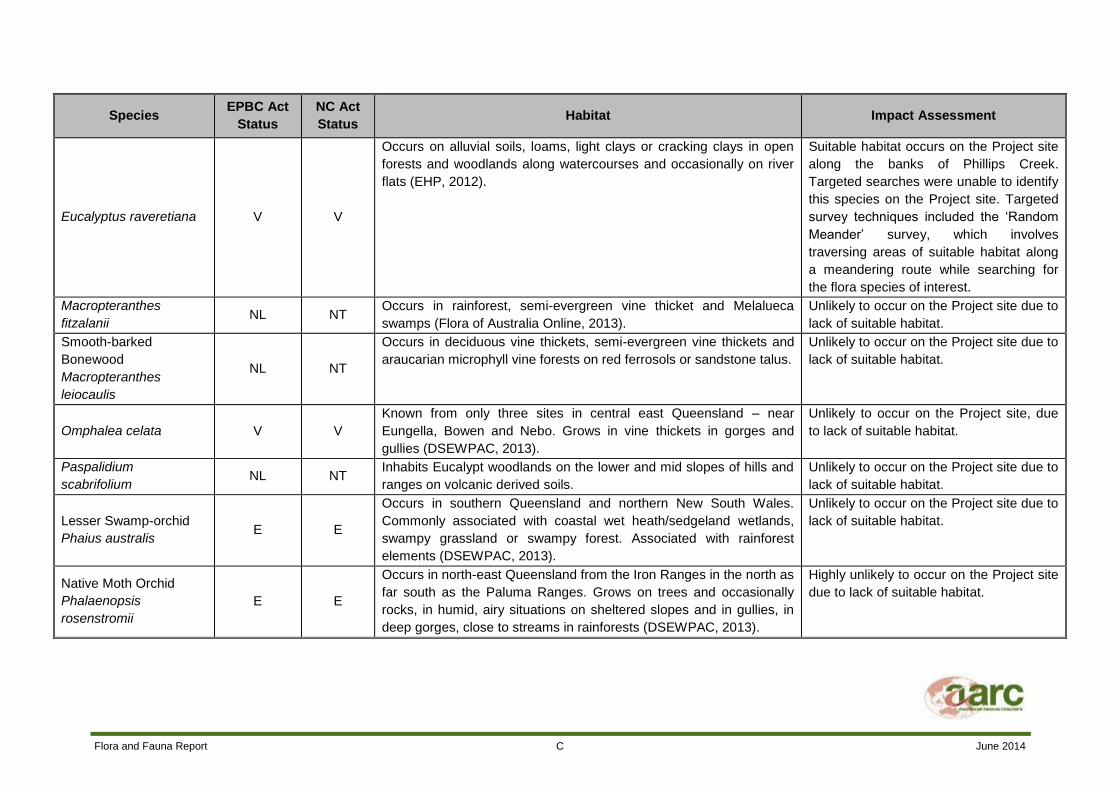
Flora and Fauna Report C June 2014
Species EPBC Act
Status
NC Act
Status Habitat Impact Assessment
Eucalyptus raveretiana V V
Occurs on alluvial soils, loams, light clays or cracking clays in open
forests and woodlands along watercourses and occasionally on river
flats (EHP, 2012).
Suitable habitat occurs on the Project site
along the banks of Phillips Creek.
Targeted searches were unable to identify
this species on the Project site. Targeted
survey techniques included the ‘Random
Meander’ survey, which involves
traversing areas of suitable habitat along
a meandering route while searching for
the flora species of interest.
Macropteranthes
fitzalanii NL NT
Occurs in rainforest, semi-evergreen vine thicket and Melalueca
swamps (Flora of Australia Online, 2013).
Unlikely to occur on the Project site due to
lack of suitable habitat.
Smooth-barked
Bonewood
Macropteranthes
leiocaulis
NL NT
Occurs in deciduous vine thickets, semi-evergreen vine thickets and
araucarian microphyll vine forests on red ferrosols or sandstone talus.
Unlikely to occur on the Project site due to
lack of suitable habitat.
Omphalea celata V V
Known from only three sites in central east Queensland – near
Eungella, Bowen and Nebo. Grows in vine thickets in gorges and
gullies (DSEWPAC, 2013).
Unlikely to occur on the Project site, due
to lack of suitable habitat.
Paspalidium
scabrifolium NL NT
Inhabits Eucalypt woodlands on the lower and mid slopes of hills and
ranges on volcanic derived soils.
Unlikely to occur on the Project site due to
lack of suitable habitat.
Lesser Swamp-orchid
Phaius australis E E
Occurs in southern Queensland and northern New South Wales.
Commonly associated with coastal wet heath/sedgeland wetlands,
swampy grassland or swampy forest. Associated with rainforest
elements (DSEWPAC, 2013).
Unlikely to occur on the Project site due to
lack of suitable habitat.
Native Moth Orchid
Phalaenopsis
rosenstromii
E E
Occurs in north-east Queensland from the Iron Ranges in the north as
far south as the Paluma Ranges. Grows on trees and occasionally
rocks, in humid, airy situations on sheltered slopes and in gullies, in
deep gorges, close to streams in rainforests (DSEWPAC, 2013).
Highly unlikely to occur on the Project site
due to lack of suitable habitat.

Flora and Fauna Report C June 2014
Species EPBC Act
Status
NC Act
Status Habitat Impact Assessment
Small-leaved
Malletwood
Rhodamnia
pauciovulata
NL NT
Dry rainforest and vine-thickets in coastal and near coastal areas. Unlikely to occur on the Project site due to
lack of suitable habitat.
Quassia
Samadera bidwillii V V
Known from coastal and near coastal areas in central Queensland.
Commonly found in rainforest, but can also occur in open forest and
woodland (DSEWPAC, 2013).
Unlikely to occur on the Project site as
there is little suitable habitat available and
the site is located far west of its known
distribution.
Solanum adenophorum NL E Occurs mostly in undulating Brigalow woodlands (EHP, 2013). Unlikely to occur on the Project site due to
lack of suitable habitat.
Solanum elachophyllum NL E Occurs in cracking clay soils associated with Brigalow and semi-
evergreen vine thicket (Bean, 2012).
Unlikely to occur on the Project site due to
lack of suitable habitat.
Siah's Backbone
Streblus pendulinus E NL
Found in warmer rainforests, chiefly along watercourses (DSEWPAC,
2013).
Highly unlikely to occur on the Project site
due to lack of suitable habitat.
Peak Downs Daisy
Trioncinia patens NL E
Occurs in grasslands on basalt downs and also on dark brown or
black cracking clay soils in the Peak Range area.
Potential habitat for this species exists in
cleared pasture areas on the Project site.
Targeted searches were unable to identify
this species on the Project site.
Belyando Cobblers Peg
Trioncinia retroflexa NL E
Restricted to Bluegrass grasslands on basalt soils in central
Queensland.
Unlikely to occur on the Project site due to
lack of suitable habitat.
LC – Least Concern NL – Not listed NT – Near Threatened V – Vulnerable E – Endangered

Flora and Fauna Report D June 2014
Appendix D Fauna Species List

Scientific Name Common Name EPBC NCA OPP FS1 FS2 FS3 FS4 FS5 FS6 FS7 FS8
AMPHIBIANS Limnodynastes salmini Salmon-striped Frog NL LC x x x x
AMPHIBIANS Limnodynastes tasmaniensis Spotted Marsh Frog NL LC x x x x
AMPHIBIANS Limnodynastes terreginae Scarlet sided Pobblebonk NL LC x
AMPHIBIANS Litoria inermis Bumpy Rocketfrog NL LC x
AMPHIBIANS Litoria rubella Desert Treefrog NL LC x
AMPHIBIANS Rhinella marina Cane Toad I I x x x x
BIRDS Accipter cirrocephalus Collared Sparrowhawk NL LC x
BIRDS Accipter fasciatus Brown Goshawk Ma LC x x x
BIRDS Acrocephalus australis Australian Reed-Warbler NL LC x x x
BIRDS Anas gracilis Grey Teal NL LC x x x x
BIRDS Anas rhynchotis Australasian Shoveler NL LC x x
BIRDS Anas superciliosa Pacific Black Duck NL LC x x x x
BIRDS Anhinga novaehollandiae Australasian Darter NL LC x x x x
BIRDS Anthus novaeseelandiae Australasian Pipit Ma LC x
BIRDS Aprosmictus erythropterus Red-winged Parrot NL LC x x x x
BIRDS Aquila audax Wedge-tailed Eagle NL LC x x x x
BIRDS Ardea ibis Cattle Egret Mi, Ma LC x x
BIRDS Ardea intermedia Intermediate Egret Ma LC x x x
BIRDS Ardea modesta Eastern Great Egret Mi, Ma LC x x x x x
BIRDS Ardea pacifica White-necked Heron NL LC x x x
BIRDS Ardeotis australis Australian Bustard NL LC x
BIRDS Artamus leucorynchus White-breasted Woodswallow NL LC x x
BIRDS Artamus personatus Masked Woodswallow NL LC x
BIRDS Artamus superciliosus White-browed Woodswallow NL LC x
BIRDS Aviceda subcristata Pacific Baza NL LC x x
BIRDS Aythya australis Hardhead NL LC x x x x
BIRDS Cacatua galerita Sulphur-crested Cockatoo NL LC x x x x x x
BIRDS Cacatua sanguinea Little Corella NL LC x x
BIRDS Centropus phasianinus Pheasant Coucal NL LC x x x x
BIRDS Chenonetta jubata Australian Wood Duck NL LC x x x x
BIRDS Chlamydera maculata Spotted Bowerbird NL LC x x
BIRDS Circus approximans Swamp Harrier Ma LC x x x
BIRDS Circus assimilis Spotted Harrier NL LC x x
BIRDS Cisticola exilis Golden-headed Cisticola NL LC x x x
BIRDS Coracina novaehollandiae Black-faced Cuckoo-shrike Ma LC x x x x

BIRDS Corvus orru Torresian Crow NL LC x x x x x x x x x
BIRDS Coturnix ypsilophora Brown Quail NL LC x x x
BIRDS Cracticus nigrogularis Pied Butcherbird NL LC x x x x x x x x x
BIRDS Cracticus tibicen Australian Magpie NL LC x x x x x x x x
BIRDS Cracticus torquatus Grey Butcherbird NL LC x x x x x
BIRDS Cygnus atratus Black Swan NL LC x x x
BIRDS Dacelo leachii Blue-winged Kookaburra NL LC x x x
BIRDS Dacelo novaeguineae Laughing Kookaburra NL LC x
BIRDS Daphoenositta chrysoptera Varied Sittella NL LC x
BIRDS Dendrocygna arcuata Wandering Whistling-Duck Ma LC x x
BIRDS Dendrocygna eytoni Plumed Whistling Duck NL LC x x x
BIRDS Dicaeum hirundinaceum Mistletoebird NL LC x
BIRDS Dicrurus bracteatus Spangled Drongo Ma LC x
BIRDS Dromaius novaehollandiae Emu NL LC x x
BIRDS Egretta garzetta Little Egret Ma LC x x
BIRDS Egretta novaehollandiae White-faced Heron NL LC x x x x
BIRDS Elanus axillaris Black-shouldered Kite NL LC x
BIRDS Elseyornis melanops Black-fronted Dotterel NL LC x x
BIRDS Entomyzon cyanotis Blue-faced Honeyeater NL LC x x x x
BIRDS Eolophus roseicapilla Galah NL LC x x x x x x x
BIRDS Ephippiorhynchus asiaticus Black-necked Stork NL NT x x x
BIRDS Erythrogonys cinctus Red-kneed Dotterel NL LC x x x x
BIRDS Falco berigora Brown Falcon NL LC x x x
BIRDS Falco cenchroides Nankeen Kestrel Ma LC x x
BIRDS Falco longipennis Australian Hobby NL LC x x
BIRDS Fulica atra Eurasian Coot NL LC x x x
BIRDS Gallinula tenebrosa Dusky Moorhen NL LC x x x
BIRDS Gallinula ventralis Black-tailed Native Hen NL LC x x x
BIRDS Geopelia placida Peaceful Dove NL LC x x
BIRDS Geophaps scripta scripta Squatter Pigeon (southern) V V x x x
BIRDS Gerygone olivacea White-throated Gerygone NL LC x x x
BIRDS Grallina cyanoleuca Magpie-lark Ma LC x x x x x x
BIRDS Grus rubicunda Brolga NL LC x x x
BIRDS Haliaeetus leucogaster White-bellied Sea-Eagle Mi, Ma LC x x
BIRDS Haliastur sphenurus Whistling Kite Ma LC x x x x x x
BIRDS Himantopus himantopus Black-winged Stilt Ma LC x x x

BIRDS Hirundo neoxena Welcome Swallow Ma LC x
BIRDS Hydroprogne caspia Caspian Tern Ma LC x x
BIRDS Irediparra gallinacea Comb-crested Jacana NL LC x x x
BIRDS Lichenostomus virescens Singing Honeyeater NL LC x x x
BIRDS Lichmera indistincta Brown Honeyeater NL LC x x
BIRDS Malacorhynchus membranaceus Pink-eared Duck NL NT x x x x
BIRDS Malurus melanocephalus Red-backed Fairy-wren NL LC x x x
BIRDS Manorina flavigula Yellow-throated Miner NL LC x x x x x
BIRDS Manorina melanocephala Noisy Miner NL LC x x x x
BIRDS Megalurus gramineus Little Grassbird NL LC x x x
BIRDS Megalurus timoriesis Tawny Grassbird NL LC x x
BIRDS Melithreptus albogularis White-throated Honeyeater NL LC x x x
BIRDS Merops ornatus Rainbow Bee-eater Ma, Mi LC x x
BIRDS Melopsittacus undulatus Budgerigar NL LC x x x x
BIRDS Microcarbo melanoleucos Little Pied Cormorant NL LC x x x
BIRDS Milvus migrans Black Kite NL LC x x x x
BIRDS Mirafra javanica Horsfield's Bushlark NL LC x x
BIRDS Myiagra inquieta Restless Flycatcher NL LC x
BIRDS Neochmia modesta Plum-headed Finch NL LC x x x
BIRDS Nettapus coromandelianus Cotton Pygmy-goose NL NT x x
BIRDS Nettapus pulchellus Green Pygmy-goose Ma LC x x
BIRDS Ninox boobook Southern Boobook Ma LC x
BIRDS Nymphicus hollandicus Cockatiel NL LC x x x
BIRDS Ocyphaps lophotes Crested Pigeon NL LC x x x
BIRDS Oriolus sagittatus Olive-backed Oriole NL LC x x x x x
BIRDS Pachycephala rufiventris Rufous Whistler NL LC x x x x x x
BIRDS Pardalotus striatus Striated Pardalote NL LC x x x x x x x
BIRDS Pelecanus conspicillatus Australian Pelican Ma LC x x
BIRDS Petrochelidon ariel Fairy Martin NL LC x x x
BIRDS Petrochelidon nigricans Tree Martin Ma LC x x x x x x
BIRDS Phalacrocorax carbo Great Cormorant NL LC x x x
BIRDS Phalacrocorax sulcirostris Little Black Cormorant NL LC x x x
BIRDS Phalacrocorax varius Pied Cormorant NL LC x x
BIRDS Philemon corniculatus Noisy Friarbird NL LC x
BIRDS Platalea flavipes Yellow-billed Spoonbill NL LC x x
BIRDS Platalea regia Royal Spoonbill NL LC x x

BIRDS Platycercus adscitus Pale-headed Rosella NL LC x x x x x x
BIRDS Plectorhyncha lanceolata Striped Honeyeater NL LC x
BIRDS Podargus strigoides Tawny Frogmouth NL LC x x x
BIRDS Podiceps cristatus Great Crested Grebe NL LC x x x
BIRDS Pomatostomus temporalis Grey-crowned Babbler NL LC x x x x
BIRDS Porphyrio porphyrio Purple Swamphen NL LC x x
BIRDS Porzana pusilla Baillon's Crake Ma LC x x
BIRDS Rhipidura albiscapa Grey Fantail NL LC x x x x x
BIRDS Rhipidura leucophrys Willie Wagtail NL LC x x x x x
BIRDS Scythrops novaehollandiae Channel-billed Cuckoo Ma LC x
BIRDS Smicrornis brevirostris Weebill NL LC x x
BIRDS Sphecotheres vielloti Australasian Figbird NL LC x x x
BIRDS Strepera graculina Pied Currawong NL LC x x
BIRDS Stictonetta naevosa Freckled Duck NL NT x x x
BIRDS Struthidea cinerea Apostlebird NL LC x x x x
BIRDS Tachybaptus novaehollandiae Australasian Grebe NL LC x x x x
BIRDS Taeniopygia bichenovii Double-barred Finch NL LC x
BIRDS Taeniopygia guttata Zebra Finch NL LC x
BIRDS Threskiornis molucca Australian White Ibis Ma LC x x
BIRDS Threskiornis spinicollis Straw-necked Ibis Ma LC x x x x
BIRDS Trichoglossus haematodus Rainbow Lorikeet NL LC x x x x x
BIRDS Tyto alba Eastern Barn Owl NL LC x x x
BIRDS Vanellus miles Masked Lapwing NL LC x x x x x
MAMMALS Aepyprymnus rufescens Rufous Bettong NL LC x
MAMMALS Austronomus australis White-striped Freetail Bat NL LC x x
MAMMALS Bos taurus Cattle NL NL x x x x x
MAMMALS Canis lupus dingo Dingo I C2 x x x x
MAMMALS Chalinolobus gouldii Gould's Wattled Bat NL LC x x x
MAMMALS Chalinolobus morio Chocolate Wattled Bat NL LC x x x
MAMMALS Chalinolobus nigrogriseus Hoary Wattled Bat NL LC *
MAMMALS Chalinolobus picatus Little Pied Bat NL NT *
MAMMALS Equus caballus Horse NL NL x
MAMMALS Felis catus Feral Cat I C2 x
MAMMALS Hydromys chrysogaster Water Rat NL LC x x x
MAMMALS Isoodon macrourus Northern Brown Bandicoot NL LC x x x x x x
MAMMALS Macropus giganteus Eastern Grey Kangaroo NL LC x x x x

MAMMALS Miniopterus orianae oceanensis Eastern Bentwing Bat NL LC * * *
MAMMALS Mormopterus beccarii Beccari's Freetail Bat NL LC x x x
MAMMALS Mormopterus ridei Eastern Freetail Bat NL LC *
MAMMALS Nyctophilus geoffroy / N. gouldi Long-eared Bat NL LC x x x
MAMMALS Oryctolagus cuniculus Rabbit I C2 x
MAMMALS Petaurus breviceps Sugar Glider NL LC x
MAMMALS Saccolaimus flaviventris Yellow-Bellied Sheathtail Bat NL LC x x x
MAMMALS Scotorepens greyii / S. sanborni Broad-nosed Bat NL LC x *
MAMMALS Sus scrofa Feral Pig I C2 x x
MAMMALS Tachyglossus aculeatus Echidna NL LC x x
MAMMALS Trichosurus vulpecula Brush-tailed Possum NL LC x x x
MAMMALS Vespadelus baverstocki Inland Forest Bat NL LC * * *
REPTILES Carlia vivax Lively Rainbow Skink NL LC x
REPTILES Chelodina longicollis Eastern Snake-neck Turtle NL LC x
REPTILES Cryptoblepharus australis Inland Snake-eyed Skink NL LC x x x
REPTILES Cryptoblepharus pulcher Elegant Snake-eyed Skink NL LC x x x x
REPTILES Cryptophis boschmai Carpentaria Snake NL LC x
REPTILES Demansia psammophis Yellow-faced Whipsnake NL LC x x
REPTILES Dendrolaphis punctulata Green Tree Snake NL LC x
REPTILES Gehyra variegata Tree Dtella NL LC x x
REPTILES Heteronotia bynoei Bynoe' s Gecko NL LC x x
REPTILES Lygisaurus foliorum Shaded Litter Skink NL LC x
REPTILES Morethia taeniopleura Fire-tailed Skink NL LC x
REPTILES Pseudechis sp. Black Snake NL LC x

Flora and Fauna Report E June 2014
Appendix E Microbat Analysis Report

Microbat Call Identification Report
Prepared for (“Client”): AustralAsian Resource Consultants
Survey location/project name: Lake Vermont, Dysart
Survey dates: 14-17 May 2013
Client project reference:
Job no.: AARC1306
Report date: 29 June 2013
DISCLAIMER:
© Copyright – Balance! Environmental, ABN 75 795 804 356. This document and its content arecopyright and may not be copied, reproduced or distributed (in whole or part) without the prior writtenpermission of Balance! Environmental other than by the Client for the purposes authorised byBalance! Environmental (“Intended Purpose”). To the extent that the Intended Purpose requires thedisclosure of this document and/or its content to a third party, the Client must procure suchagreements, acknowledgements and undertakings as may be necessary to ensure that the third partydoes not copy, reproduce, or distribute this document and its content other than for the IntendedPurpose. This disclaimer does not limit any rights Balance! Environmental may have under theCopyright Act 1968 (Cwlth).
The Client acknowledges that the Final Report is intended for the sole use of the Client, and only to be
used for the Intended Purpose. Any representation or recommendation contained in the Final Report
is made only to the Client. Balance! Environmental will not be liable for any loss or damage
whatsoever arising from the use and/or reliance on the Final Report by any third party.

AARC1306_Dysart_14-17May2013_batcall analysis.docx29/06/2013 Page 2 of 6
Methods
Data receipt and processing
Bat calls were recorded using a Song Meter detector (Wildlife Acoustics, Concord MA, USA), which
saved data in Wildlife Acoustics’ compressed audio file format (WAC). Balance! Environmental
received a single SD card containing 104 WAC files recorded on the nights of 14th, 15
th, 16
thand 17
th
May 2013.
The WAC files were processed with Wildlife Acoustics’ Kaleidoscope Pro (Version1.1.13) to produce
bat call files in both zero-crossing analysis (ZC) and full-spectrum (WAV) formats. This process
yielded 286 ZC files and 504 WAV files across the four nights of survey; however, many of these files
contained only background noise (“false triggers”) or very weak and short duration bat calls that were
of no use for species identification.
Bat call identification
Bat species identification was undertaken in two phases:
Phase 1 – AnalookW (Corben 2009)
All ZC files were viewed and a subset of files containing representative samples of all call types
were selected for identification. Sonograms of representative calls were then compared with
those of reference calls from southern and central Queensland and/or with published call
descriptions (Reinhold et al. 2001; Pennay et al. 2004).
Phase 2 – Kaleidoscope Pro
Calls that could not be positively identified using the ZC data were also viewed in full-spectrum
format in an effort to obtain a more reliable species determination. This process was applied
particularly to emballonurid and molossid calls that are often similar in ZC format but which can
mostly be differentiated due to harmonic patterns in WAV versions of the calls.
Species' identification was also guided by considering their probability of occurrence based on general
distribution information (Churchill 2008; van Dyck & Strahan 2008) and/or database records obtained
from the Queensland Museum, the Atlas of Living Australia (http://www.ala.org.au) and Wildlife Online
(http://www.ehp.qld.gov.au/wildlife/wildlife-online/index.html)
Reporting standard
The format and content of this report follows Australasian Bat Society standards for the interpretation
and reporting of bat call data (Reardon 2003), available on-line at http://www.ausbats.org.au/.
Species nomenclature follows Churchill (2008).

AARC1306_Dysart_14-17May2013_batcall analysis.docx29/06/2013 Page 3 of 6
Results & Discussion
Data quantity and quality
Time signals stored in the original WAC files indicate that the detector ran from sunset to sunrise on
each of the four survey nights; however, field notes provided by the client indicate that the detector
was dislodged from its original position on the night of 16th
May, which explains the low number of files
recorded that night compared with the other three nights (see Table 1).
Many of the recorded calls were of relatively short duration (<10 pulses) and often fragmented, which
resulted in low reliability of species identification.
Species recorded
At least eight and up to 14 bat species were recorded during this survey (see Table 1).
Five call types were positively identified to single species (Chalinolobus gouldii, C. morio,
Austronomus australis, Mormopterus beccarii and Saccolaimus flaviventris); and a further two types
were attributable to pairs of species that cannot be differentiated (Nyctophilus geoffroyi/N. gouldi and
Scotorepens greyii/S. sanborni). Numerous low-quality calls, some within the frequency ranges of the
above-listed species, could not be reliably identified and could have represented these or several
other species. The call characteristics and possibility of species involved in these undifferentiated
calls is discussed in the following section.
Table 1 Bat species recorded in the Lake Vermont study area, 14-17 May 2013.
♦ denotes species positively identified from call data.□ denotes species possibly present, but not reliably identified.
Survey Date: 14/05/2013 15/05/2013 16/05/2013 17/05/2013
Number of ZC files: 190 51 7 38
Number of WAV files: 353 85 19 47
Number of calls identified: 47 16 8 25
Chalinolobus gouldii ♦ ♦ ♦ ♦
Chalinolobus morio ♦ ♦ ♦ ♦
Chalinolobus nigrogriseus □
Chalinolobus picatus □
Nyctophilus geoffroyi/N. gouldi ♦ ♦ ♦ ♦
Scotorepens greyii / S. sanborni ♦ □ □
Vespadelus baverstocki □ □ □
Miniopterus orianae oceanensis □ □ □
Austronomus australis ♦ ♦
Mormopterus beccarii ♦ ♦ ♦ ♦
Mormopterus ridei □
Saccolaimus flaviventris ♦ ♦ ♦

AARC1306_Dysart_14-17May2013_batcall analysis.docx29/06/2013 Page 4 of 6
Calls/species not reliably identified
Most calls were reliably attributed to known species, although several species that are likely to occur
in the area have similar call characteristics and are difficult to differentiate using call data. These are
discussed below.
Chalinolobus nigrogriseus
This species’ calls are very similar to those produced by Scotorepens greyii/S. sanborni, although it
can sometimes be differentiated on longer pulse duration, more angular slope change and flatter pulse
body. Of the three calls in the relevant frequency range (36-39 kHz), two (14th
May) had the shorter
duration, more curved pulses typical of Scotorepens spp, but the third (17th
May) had intermediate
pulse shape and could have been from any of these three species.
Chalinolobus picatus
Call frequency (39-42 kHz) also overlaps with S. greyii/S. sanborni, but C. picatus calls often exhibit
distinctive frequency alternation between adjacent pulses. A single, very low quality call (16th
May)
had weak evidence of this alternating pattern, but could have been from any of the three species.
Vespadelus baverstocki and Miniopterus orianae oceanensis
These species’ calls have completely overlapping frequency range (42-47 kHz) and brief or low-quality
calls cannot be reliably differentiated. The few calls recorded at Lake Vermont had some evidence of
the narrow, curved pulse bodies more likely attributable to V. baverstocki (M. o. oceanensis is usually
more angular with flatter body); however, the low quality data precluded reliable attribution.
Mormopterus ridei
Call frequency (30-35 kHz) overlaps with that of C. gouldii, but M. ridei pulses are generally uniform
and flat or angular, compared with steeper, curved pulses that alternate in frequency for C. gouldii.
Most calls from this study were positively attributed to C. gouldii but a few had mixed or intermediate
pulse shapes and could have been from either species.
References
Churchill, S. (2008). Australian Bats. Jacana Books, Allen & Unwin; Sydney.
Corben, C. (2013). AnalookW for bat call analysis using ZCA. Version 3.9f; 22 March 2013.
Pennay, M., Law, B. and Reinhold, L. (2004). Bat Calls of New South Wales. Department of
Environment and Conservation, Hurstville.
Reardon, T. (2003). Standards in bat detector based surveys. Australasian Bat Society Newsletter
20, 41-43.
Reinhold, L., Law, B., Ford, G. and Pennay, M. (2001). Key to the bat calls of south-east Queensland
and north-east New South Wales. Department of Natural Resources and Mines, Brisbane.
van Dyck, S. and Strahan, R. (ed.) (2008). The Mammals of Australia (Third Edition). New Holland;
Sydney.

AARC1306_Dysart_14-17May2013_batcall analysis.docx29/06/2013 Page 5 of 6
Appendix Representative call sequences recorded at Lake Vermont, 14-17 May 2013.(10msec per tick; time between pulses removed)
Chalinolobus gouldii Chalinolobus morio
Possibly Chalinolobus nigrogriseus Possibly Chalinolobus picatus
Nyctophilus sp. Scotorepens greyii or S. sanborni

AARC1306_Dysart_14-17May2013_batcall analysis.docx29/06/2013 Page 6 of 6
V. baverstocki or M. o. oceanensis Austronomus australis
Mormopterus beccarii Possibly Mormopterus ridei
Saccolaimus flaviventris