
Educational Assistants in Manitoba Schools - Manitoba Department


Lake St. Martin Emergency Outlet Channel – Legal Description
SE-03-33-06-W NE-03-33-06-W NW-02-33-06-W SW-11-33-06-W NE-11-33-06-W SE-14-33-06-W NE-14-33-06-W SE-23-33-06-W

MANITOBA ENVIRONMENT ACT PROPOSAL
Lake St. Martin Flood Relief Channel:
Interim Operating Licence
Manitoba Infrastructure
December 2016
Manitoba Environment Act Proposal for the Lake St. Martin Emergency Outlet Channel: Interim Operating Licence
Submitted to:
Sustainable Development Environmental Approvals Branch
Submitted by:
Manitoba Infrastructure
1420-215 Garry Street Winnipeg, Manitoba R3C 3P3
December 2016

Executive Summary
Widespread record flooding throughout southern Manitoba during 2011 led to water lev-els in Lake Manitoba and Lake St. Martin that were several feet higher than desirable, resulting in significant damage to hundreds of properties, restricted road access to sev-eral communities, and long-term evacuation of four First Nations communities in the vi-cinity of Lake St. Martin. As part of emergency relief measures, the Province of Mani-toba, through Manitoba Infrastructure (MI), constructed the Lake St. Martin Emergency Outlet Channel System, which is comprised of two emergency channels. The Reach 1 Emergency Outlet Channel (Reach 1) begins at the northeast shore of the north basin of Lake St. Martin and extends approximately 6 km to the bog area surrounding Big Buffalo Lake. Water from Reach 1 inundates the bog area and then follows the natural Buffalo Creek Drainage System until flowing into the lower Dauphin River and ultimately into Sturgeon Bay. Water began to flow through Reach 1 on November 1, 2011; the channel was operated until November 21, 2012. Computer models of potential water levels at the mouth of the Dauphin River indicated that there was a significant risk of major flooding to the Dauphin River communities in the spring of 2012. Consequently, a second channel (Reach 3 Emergency Outlet Chan-nel; Reach 3) was constructed during winter 2012. Reach 3 was designed to divert ex-cess flow from Reach 1 and Buffalo Creek away from the lower Dauphin River. It was determined that operation of Reach 3 prior to spring break up, in combination with the construction of dikes along the banks of the Dauphin River, should substantially reduce the risk of flooding for the Dauphin River communities. Due to extremely mild winter conditions in 2011/2012, ice effects on both Reach 1 and the Dauphin River were much less severe than forecasted. With the continuous mild conditions, updated flood forecasts indicated that the estimated discharge in the lower Dauphin River during ice break up would be well below the capacity of the Dauphin River community dikes. Consequently, the proposed operation of Reach 3 was not re-quired. Heavy precipitation during winter 2013/2014 and spring of 2014 again elevated water levels in Lake Manitoba and Lake St. Martin, prompting MI to re-open Reach 1 at the beginning of July 2014. The channel was re-opened in two stages. The first occurred during in July 2014 when approximately 35 m of the berm closing Reach 1 was re-moved. The second stage occurred in November 2014, when an additional 10 m of the closure berm were removed to allow additional flow into the channel. Flow into Reach 1 was halted in late August 2015. Concurrent with construction of Reach 1 in summer 2011, MI initiated monitoring to help describe and assess environmental effects arising from the Project. These included studies to document changes to the physical environment (e.g., measurement of water flow through Reach 1 and the Dauphin River; sedimentation and erosion) and potential effects to the biological environment (e.g., possible change to fish community in Buffalo

Creek). Environmental studies began in August 2011 and continued until September 2015. MI is currently investigating options for a more permanent solution to mitigate the im-pacts of flooding in Lake Manitoba and Lake St. Martin. However, until studies are com-pleted and the Lake Manitoba/ Lake St. Martin Outlet Channel is constructed and com-pleted, MI would like to continue to use the LSMEOC in the interim should the need arise for flood protection purposes. The environmental effects analysis for the interim operation of Reach 1 generally follows the Environment Act Proposal Report Guidelines. Key potential effects emerging from the analysis include temporary and minor effects on fish and fish habitat, as well as ero-sion and bank destabilization along Buffalo Creek. The potential for fish stranding at Reach 1 has been documented, the extent of fish stranding can be mitigated by opera-tional conditions on Reach 1. In order to address the issue of potential fish mortality, MI will ensure that the Reach 1 will remain open between September and June 15th of the following year during fish migration, spawning, hatching and rearing periods. Taking into consideration the scope of the project, its benefit to the people of Manitoba, identified environmental issues and mitigation measures, MI is of the opinion that the interim operation of the Lake St. Martin Emergency Outlet Channel is not likely to result in any significant adverse environmental effects.

Lake St. Martin Flood Relief Channel: Interim Operating Licence December 2016
Table of Contents
1. Introduction .......................................................................................................................................... 1 1.1. Need and Rationale for Development .......................................................................................... 2
2. Description of Project Components ...................................................................................................... 2 2.1. Lake St. Martin Emergency Outlet Channel .................................................................................. 2 2.2. Reach 3 Emergency Channel ........................................................................................................ 8 2.3. Interim Operating Rule and Associated Activities ........................................................................ 9
2.3.1. Operating Rules and Procedures .......................................................................................... 9 2.3.2. Maintenance and Related Activities ..................................................................................... 9
2.4. Property Ownership and Mineral Rights .................................................................................... 13 2.5. Existing Land Uses ....................................................................................................................... 13 2.6 Land Use Designations ................................................................................................................ 13 2.7. Proposed Schedule and Dates .................................................................................................... 18 2.8. Other Federal/Provincial/Municipal Approvals .......................................................................... 18
2.8.1. Funding................................................................................................................................ 18 2.9. First Nations and Public Engagement Activities .......................................................................... 18
3. Existing Environment .......................................................................................................................... 21 3.1. Biophysical Environment ............................................................................................................ 21
3.1.1 Regional Setting .................................................................................................................. 21 3.1.2. Prevailing Climate and Meteorological Conditions ............................................................. 21 3.1.3. Air Quality and Greenhouse Gas Emissions ........................................................................ 22 3.1.4 Geology and Soils ................................................................................................................ 25 3.1.5. Water Resources ................................................................................................................. 27 3.1.6 Fish and Aquatic Environment ........................................................................................... 29 3.1.7. Terrestrial Environment ...................................................................................................... 32 3.1.8 Species at Risk ..................................................................................................................... 37 3.1.9. Current Conditions .............................................................................................................. 37
3.2. Socio-Economic Environment ..................................................................................................... 41 3.2.1. Public Safety and Health Risks ............................................................................................ 41 3.2.2. Protected Areas and Areas of Special Interest ................................................................... 42 3.2.3. Heritage Resources ............................................................................................................. 42 3.2.4. Communities ....................................................................................................................... 42 3.2.5 First Nation Communities ................................................................................................... 43 3.2.6 Population ........................................................................................................................... 43
4. Environmental Effects Analysis ........................................................................................................... 45 4.1. Physical Processes ....................................................................................................................... 46
4.1.2. Air Quality & Greenhouse Gases ......................................................................................... 46 4.1.3. Bedrock Geology ................................................................................................................. 46 4.1.4. Soils and Terrain .................................................................................................................. 46 4.1.5. Groundwater ....................................................................................................................... 47 4.1.6 Surface Water ..................................................................................................................... 48
4.2. Biophysical Environment ............................................................................................................ 49 4.2.1. Vegetation ........................................................................................................................... 49 4.2.2. Wildlife and Wildlife Habitat ............................................................................................... 50 4.2.3. Birds .................................................................................................................................... 51 4.2.4. Fish Habitat ......................................................................................................................... 51

Lake St. Martin Flood Relief Channel: Interim Operating Licence December 2016
4.2.5. Fish ...................................................................................................................................... 53 4.2.6. Amphibians/Reptiles ........................................................................................................... 54
4.3. Socio-economic Effects ............................................................................................................... 55 4.3.1. Land Use .............................................................................................................................. 55 4.3.2. Parks, Protected Areas and Areas of Special Interest ......................................................... 56 4.3.3. Heritage Resources ............................................................................................................. 56 4.3.4. Commercial Fishing ............................................................................................................. 56 4.3.5. Recreation ........................................................................................................................... 57 4.3.6. Public Health and Safety ..................................................................................................... 57
5. Conclusions ......................................................................................................................................... 63 6. References .......................................................................................................................................... 64 Figures Figure 1 Location of Reach 1 and Reach 3 ................................................................................ 4 Figure 2 Reach 1 Site Plan and Construction Details ................................................................. 5 Figure 3 Reach 1 Inlet Site Plan and Construction Details ......................................................... 6 Figure 4 Reach 1 Typical Channel Cross-Section ...................................................................... 7 Figure 5 Reach 1 Inlet Profile ..................................................................................................... 7 Figure 6 Reach 1 Inlet Plug Detail .............................................................................................10 Figure 7 Reach 1 Inlet Plug Location ........................................................................................11 Figure 8 Reach 1 Inlet Plug Construction Details ......................................................................12 Figure 9 Quarry Withdrawals near Reach 1 ..............................................................................14 Figure 10 Location of Ecodistrict near Reach 1 .........................................................................15 Figure 11 Forest Management Activities near Reach 1 .............................................................16 Figure 12 Location of Gypsumville Community Traplines and GHAs .........................................17 Figure 13 History of Fire Occurrence in Reach 1 Area ..............................................................24 Figure 14 Geological Information for the LSMEOC (from Leybourne et al 2007) .......................26 Figure 15 Reach 1 Inlet at Lake St. Martin ................................................................................38 Figure 16 Looking along Reach 1 showing limited vegetation growth ........................................38 Figure 17 Erosion along Reach 1 ..............................................................................................39 Figure 18 Vegetation die off from Flooding along Buffalo Creek ................................................40 Figure 19 Bank Erosion along Buffalo Creek (2014) .................................................................40 Figure 20 Signage at Reach 1 Inlet on Lake St. Martin .............................................................41 Figure 21 Buoys Installed in Lake St. Martin near Reach 1 Inlet ...............................................42 Figure 22 Protected Areas near Reach 1 ..................................................................................44
Tables Table 1 Summary of First Nations and Public Engagement Activities .......................................19 Table 2 Climate Normals Summary for Lundar Manitoba (1981-2010) ......................................22 Table 3 Air Quality Parameters for Winnipeg, December 07, 2015 ............................................23 Table 4 Population Statistics for the R.M. of Grahamdale (KGS 2013b) ....................................45 Table 5 Population Statistics for Selected Aboriginal Communities (INAC, 2016) .....................45 Table 6 LSMEOC Interim Operation Summary of Environmental Effects Analysis ....................59
Lake St. Martin Flood Relief Channel: Interim Operating Licence December 2016
Appendices
Appendix A – LSMEOC Regulatory Approval Documents Appendix B – LSMEOC Reach 1 and 3 Soil Logs Appendix C – Water Quality Summary Results Appendix D – LSMEOC Species Lists Appendix E –LSMEOC Summary of Debris Monitoring
Lake St. Martin Flood Relief Channel: Interim Operating Licence December 2016
1
1. INTRODUCTION
The Lake St. Martin Emergency Outlet Channel (LSMEOC), also known as Reach 1 was con-structed by Province of Manitoba over the winter of 2011/2012 on an emergency basis in order to reduce high water levels in Lake St. Martin. Due to the emergency requirement to construct and initiate operation of Reach 1 within very tight timelines, the Province of Manitoba sought an exemption from the regulatory review proc-ess dictated by Canadian Environmental Assessment Act (CEAA) and The Environment Act. On 02 August 2011, The Province of Manitoba officially established the emergency status of the Project through an Order in Council (124/2011). The resultant Lake St. Martin Outlet Channel Authorization Regulation 124/2011 was developed under The Environment Act and allowed for emergency action to mitigate or alleviate high water levels on Lake Manitoba and Lake St. Mar-tin without reference to the normal approval or licensing process under The Environment Act (Order in Council and Regulation 124/2011 provided in Appendix A). In October 2011, the Canadian Environmental Assessment Agency granted exclusion under section 7(1)(c) of the Canadian Environmental Assessment Act, providing exemption from fed-eral environmental assessment requirements related to the construction of the LSMEOC (exclu-sion letter from CEAA to Minister of Infrastructure provided in Appendix A). Although an environmental assessment was not required by the CEAA, federal agencies such as Transport Canada, Aboriginal Affairs and Northern Development Canada, and Fisheries and Oceans Canada (DFO) do not have emergency provisions in their respective environmental statutes and approval requirements were still applicable to the Project. Approval requirements stipulated by TC under the Navigable Waters Protection Act are provided in Appendix A and are not discussed further in this document. A Fisheries Act authorization issued by DFO was required for the Project. The initial authoriza-tion (Authorization # DA-11-1585-01) for the Project was received on 28 October 2011. Despite the successful operation of Reach 1 throughout the winter of 2011/2012, high water levels per-sisted on Lake Manitoba and Lake St. Martin in spring 2012 and, consequently, MI applied for an amendment to continue Reach 1 operation until fall 2012. The Authorization amendment (Authorization # DA-11-1585-A1) was received on 14 June 2012. Heavy precipitation in winter 2013/2014 and spring 2014 again resulted in high water level on Lake Manitoba and Lake St. Martin and MI applied for an authorization to operate Reach 1 during summer 2014. Authoriza-tion (Authorization # 14-HCAA-00582) for the second operation was received on 18 June 2015 under the Fisheries Act (2012). All Fisheries Act Authorizations and Amendments for this Pro-ject are provided in Appendix A. Although the project was initially considered temporary, Manitoba Infrastructure (MI) is currently reviewing options to incorporate the LSMEOC as part of Manitoba’s permanent flood protection infrastructure. MI is submitting an Environment Act Proposal for licensing the Interim operation of the existing LSMEOC under the Environment Act in the event that conditions (i.e. flood stag-

Lake St. Martin Flood Relief Channel: Interim Operating Licence December 2016
2
ing in Lake Manitoba and Lake St. Martin) warrant its use. Once a channel alignment for the LSMEOC has been selected, MI will submit another Environment Act Proposal in order to Li-cence permanent works and their operation. The following includes a review of the proposed development and assessment of its potential effects as outlined under the Environment Act Proposal Report Guidelines published by Manitoba Sustainable Development’s Environmental Approvals Branch. 1.1. Need and Rationale for Development
Widespread record flooding throughout southern Manitoba during 2011 led to water levels in Lake Manitoba and Lake St. Martin that were approximately 1.4 m and 1.7 m higher than desir-able, resulting in significant damage to hundreds of properties around the lakes, restricted road access to several communities, and long-term evacuation of four First Nations communities in the vicinity of Lake St. Martin. In the absence of remedial action, it was expected that the ex-treme high water levels on Lake Manitoba and Lake St. Martin would persist for an extended duration, leaving communities, homes, cottages, and farms at high risk of additional damage from flooding, wind, waves, and wind-driven ice. The LSMEOC was constructed under emergency conditions in order to provide relief from 2011 flooding. However, given the risks associated with annual flooding, MI will be incorporating the LSMEOC as a new asset into the Province of Manitoba’s flood protection system. Studies are currently underway in order to update and formalize the LSMEOC for inclusion in to the Provin-cial flood protection network. Once studies and planning have been completed, the Project as a whole will be submitted for review under The Environment Act. In the mean time and recogniz-ing additional work is required, MI is applying for an Interim Operating Licence for the LSMEOC in the event that it is needed for flood protection purposes. 2. DESCRIPTION OF PROJECT COMPONENTS
The following section contains two parts; an overview of the existing LSMEOC; and a descrip-tion of the proposed operating rules, procedures and associated activities required for the inter-im operation of the emergency channel. 2.1. Lake St. Martin Emergency Outlet Channel
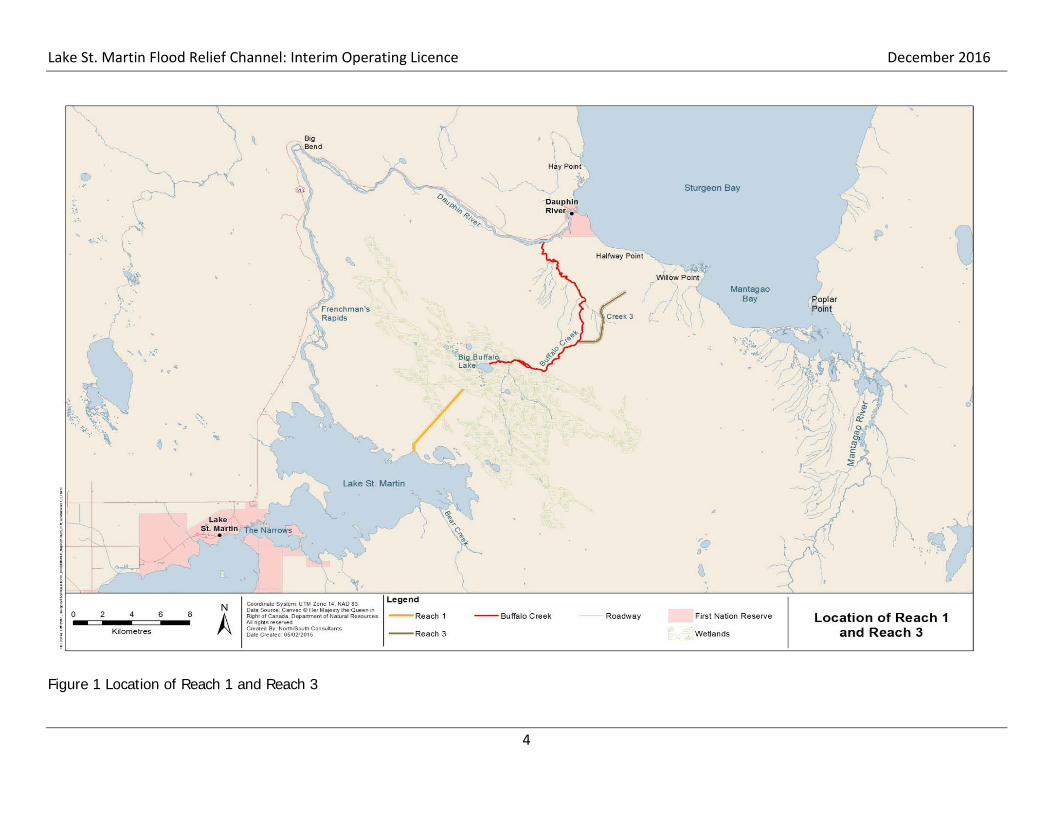
Reach 1 begins at the northeast shore in the north basin of Lake St. Martin and extends ap-proximately 6 km to a bog complex that is the headwaters for Buffalo Creek, a small tributary that drains into the lower Dauphin River approximately 4 km upstream of Sturgeon Bay on Lake Winnipeg (Figure 1). Water from Reach 1 inundates the bog area and then flows into Buffalo Creek, the lower Dauphin River and, ultimately; into Sturgeon Bay (North/South 2015). The channel design specified a bottom width of 60 m and 3:1 side slopes, and an elevation de-crease of 1.0 m along the length of the channel (from 241.0 meters above sea level (mASL) at the upstream end to 240.0 mASL at the downstream end) in order to convey a desired flow of 142 m3/s at a Lake St. Martin water level elevation of 244.2 mASL. Site and construction details

Lake St. Martin Flood Relief Channel: Interim Operating Licence December 2016
3
are provided in Figures 2, 3, and 4. Compact fines comprise the substrate within Reach 1, so the channel walls of the inlet, which were designed to extend 3.0 m above the regulated water levels within Reach 1, were armoured with till boulders and a geotextile underlay. Because the water level on Lake St. Martin was significantly higher than 244.2 mASL during fall 2011, it was predicted that flow within Reach 1 would be approximately 255 m3/s immediately following open-ing of the channel. Logistical issues that led to delays in channel construction necessitated that the proposed base width of Reach 1 (60 m) be reduced by approximately 25% in order to en-sure that the proposed operation target date of 01 November 2011 was met. Water from Lake St. Martin enters Reach 1 by flowing through the Reach 1 inlet and over a constructed sill that acts as a control structure. The top of the sill is approximately 135 m wide and 15 m long, and sits at an elevation of 243.2 mASL (Figure 5), which is approximately 0.3 m above the minimum desirable water level for Lake St. Martin. The approach is approximately 400 m long, with a width that gradually increases upstream towards Lake St. Martin. This was originally an area of flooded terrestrial vegetation that was excavated to an elevation of 242.9 m to provide barge access to support construction as well as to permit water to flow freely up to the constructed sill. Downstream (over approximately 100 m), the sill transitions in width from 135 m to 45 m, the constructed width of Reach 1 (North/South 2015).
Lake St. Martin Flood Relief Channel: Interim Operating Licence December 2016
4
Figure 1 Location of Reach 1 and Reach 3

Lake St. Martin Flood Relief Channel: Interim Operating Licence December 2016
5
Figure 2 Reach 1 Site Plan and Construction Details

Lake St. Martin Flood Relief Channel: Interim Operating Licence December 2016
6
Figure 3 Reach 1 Inlet Site Plan and Construction Details

Lake St. Martin Flood Relief Channel: Interim Operating Licence December 2016
7
.
Figure 4 Reach 1 Typical Channel Cross-Section
Figure 5 Reach 1 Inlet Profile

Lake St. Martin Emergency Outlet Channel: December 2016 Interim Operating Licence
8
2.2. Reach 3 Emergency Channel
Reach 3 originates at Buffalo Creek and is approximately 6 km in length, it terminates in a low-land area 3.5 km inland of Sturgeon Bay (Figure 1). Substrate within the channel is mostly clayey till but an area of bedrock occurs just upstream of the channel outlet. The channel base is 21 m wide in areas where the substrate is comprised of fines but it expands to a width of 28 m within the bedrock section. The channel outlet was designed to daylight gradually, after which water exiting the channel would flow overland into Sturgeon Bay northwest of Willow Point. In order to convey flows di-rectly into Sturgeon Bay, a shoreline breach was to be constructed through the natural beach ridge to the west of Willow Point. This structure, together with the dikes and excavated areas that were proposed to support its function, were scheduled to be constructed immediately be-fore the Reach 3 operation began. These structures were not constructed because the re-quirement to operate Reach 3 had become unnecessary by mid-March 2012 (North/South 2015). Currently, construction of Reach 3 is approximately 85-90% complete, it is not antici-pated that Reach 3 will be used for Lake St. Martin interim flood management. As a result, Reach 3 is not considered further in this document.

Lake St. Martin Emergency Outlet Channel: December 2016 Interim Operating Licence
9
2.3. Interim Operating Rule and Associated Activities
2.3.1. Operating Rules and Procedures
MI intends to operate the LSMEOC at such times when forecasts indicate that Lake St. Martin is approaching and likely to exceed 244.7 mASL. During these conditions, Reach 1 will be opened by removing the limestone and clay plug in place at its inlet. Removal of the plug will be done in a gradual manner, in order to minimize sedimentation. The LSMEOC top of sill sits at an elevation of 243.2 mASL, approximately 0.3 m above mini-mum desired water levels. When Lake St. Martin water levels drop below 244.1 mASL, provided that lake level forecasts indicate that water levels are not expected to rise to above 244.7 mASL, the channel will be closed by re-installing the limestone plug across the channel open-ing. The limestone plug will be constructed out of salvaged and other stockpiled rock on site near the Reach 1 entrance. Heavy equipment such as an excavator, bull dozer and/or rock truck will be on site during the installation and/or removal of the Reach 1 entrance plug. It is antici-pated that the gradation of the limestone material will provide an impervious barrier. However, if seepage is detected, an impervious clay liner will be constructed on the upstream (lakeside) side of the plug. To construct the plug, limestone will be pushed across the channel to an initial elevation of ap-proximately two feet above water levels at the Reach 1 entrance. Once the entire channel has been closed to this elevation, the plug will be built up further to a final design elevation of 245.4 mASL with a minimum top width of 4.9 m and either 1:1 or 2:1 side. Figures 6, 7, and 8 provide a profile view and relevant details of Reach 1 Inlet plug. Fish stranding in Reach 1 and potentially in the Bog complex are operational issues that were identified during the 2011 operation, these issues are related to the timing of closure (also see Section 4.2.5). In order to avoid future fish stranding concerns, operational conditions provided by DFO describing timing restrictions will be used. When in use, Reach 1 will remain open be-tween September and June 15th during fish migration, spawning, hatching and rearing periods. Ensuring that Reach 1 remains open during this time period will ensure that any fish drawn into the system have sufficient time to complete their life history activities and move into either Lake St. Martin or Dauphin River.
2.3.2. Maintenance and Related Activities
No regular or other maintenance activities are currently planned for the interim operation of the LSMEOC.

Lake St. Martin Emergency Outlet Channel: December 2016 Interim Operating Licence
10
Figure 6 Reach 1 Inlet Plug Detail

Lake St. Martin Emergency Outlet Channel: December 2016 Interim Operating Licence
11
Figure 7 Reach 1 Inlet Plug Location

Lake St. Martin Emergency Outlet Channel: December 2016 Interim Operating Licence
12
Figure 8 Reach 1 Inlet Plug Construction Details

Lake St. Martin Emergency Outlet Channel: December 2016 Interim Operating Licence
13
2.4. Property Ownership and Mineral Rights
The land where the existing LSMEOC was constructed is Crown land. The Manitoba Mineral Resources Branch GIS Mining Map Gallery was reviewed in relation to the LSMEOC Project Area in order to determine if any mineral rights/properties were located within the general vicini-ty of the LSMEOC. Based on the review of available data, it does not appear that any mineral rights/properties have been allocated in the immediate vicinity of the LSMEOC. The closest mineral properties that could be identified are situated west of the Northern Affairs community of Dauphin River and Dauphin River First Nation. Four quarry withdrawals were noted as having been obtained by MI for the purposes of developing/obtaining sand and gravel or quarry materi-als as part of its operations. The identified quarry withdrawals were taken out a number of years ago with dates ranging from 1973 to 1993 as the latest. Figure 9 shows the location of the MI quarry withdrawals in relation to the existing LSMEOC. 2.5. Existing Land Uses
The LSMEOC is located within the Sturgeon Bay Ecodistrict. Figure 10 shows the location of the LSMEOC within the Sturgeon Bay Ecodistrict. According to Smith et al. (1998), land uses within the Sturgeon Bay Ecodistrict are somewhat limited as the area is relatively remote with a limited number of communities. The bulk of lands are publically held (i.e. Crown Land). Although some areas of the Sturgeon Bay Ecodistrict have the potential to support agriculture, this is not likely to be the case in the specific vicinity of the project area given the prevalence of wetlands, bogs muskeg. Land uses include forestry (pulpwood/sawlog), hunting, trapping, and fishing (recrea-tional/commercial). Other land uses identified in the vicinity of the LSMEOC include park and protected areas as well as lands of interests to local First Nations. The LSMEOC is located within the Interlake Forestry Section, specifically; Forest Management Units 45 and 41. The LSMEOC area is not currently managed under a Forest Management Li-cense. However, the surrounding area has been identified as being an Integrated Wood Supply Area, one of two that have been established in the Province of Manitoba. Figure 11 shows the location of the LSMEOC in relation to the administrative boundaries associated with forest man-agement activities in Manitoba. Hunting and trapping have also been identified as land uses within the vicinity of the LSMEOC. Reach 1 is situated in Game Hunting Area (GHA) 21 (Figure 12). GHAs are a management tool used by Manitoba Sustainable Development used for the regulation of hunting activities. A por-tion of the Reach 3 Channel is located within the Gypsumville Open Trap Line Area which is part of the broader Interlake Registered Trap Line (RTL) District. 2.6 Land Use Designations
There is neither land use nor zoning designations in the LSMEOC area.

Lake St. Martin Emergency Outlet Channel: December 2016 Interim Operating Licence
14
Figure 9 Quarry Withdrawals near Reach 1

Lake St. Martin Emergency Outlet Channel: December 2016 Interim Operating Licence
15
Figure 10 Location of Ecodistrict near Reach 1

Lake St. Martin Emergency Outlet Channel: December 2016 Interim Operating Licence
16
Figure 11 Forest Management Activities near Reach 1

Lake St. Martin Emergency Outlet Channel: December 2016 Interim Operating Licence
17
Figure 12 Location of Gypsumville Community Traplines and GHAs

Lake St. Martin Emergency Outlet Channel: December 2016 Interim Operating Licence
18
2.7.Proposed Schedule and Dates
The schedule for operation, maintenance is currently unknown. The operation of the channel is dependent on unknown flood events which cannot be predicted at this time. Manitoba is currently reviewing a permanent solution to the flooding in the area and once that identified, will seek all necessary approvals at that time. In the Interim, this current submission is seeking approval to operate the existing channel in the event that it becomes necessary to re-spond to flood protection needs. 2.8. Other Federal/Provincial/Municipal Approvals
Authorization from the Fisheries and Oceans Canada will be required for the interim operation of the LSMEOC.
2.8.1. Funding
The project will be funded by the Province of Manitoba.
2.9. First Nations and Public Engagement Activities
MI through its Engineering Service Providers and Environmental Consultants has maintained ongoing communication with key communities and interest groups likely to be affected by the operation of the LSMEOC. Public engagement activities have been documented extending back to 2011 during the initial planning, construction, and operation of the LSMEOC project. Throughout the environmental monitoring program community updates and presentations were held to provide preliminary results of ongoing monitoring results. Initial contact was made to a number of First Nations and the Manitoba Metis Federation regarding the permanent outlet channel project. Recently, the communities located on Lake St. Martin and the Manitoba Metis Federation have been contacted regarding MI intention to utilize the LSMEOC for interim operation. Meetings are to be schedule with the following communities: Lake St. Martin First Nation; Little Saskatch-ewan First Nation; Dauphin River First Nation; Pinaymootang First Nation; Dauphin River Abo-riginal and Northern Affairs Community; and the Manitoba Metis Federation. A summary of community and interest group engagement activity is presented in Table 1.

Lake St. Martin Emergency Outlet Channel: December 2016 Interim Operating Licence
19
Table 1 Summary of First Nations and Public Engagement Activities
Community Format Date Location Details
1 Dauphin River Fishers Association Presentation October 6, 2011 Gypsumville Presentation: Preliminary Assess-ment
2 Pinaymootang First Nation Presentation October 11, 2011 Pinaymootang Band Office
Presentation: Preliminary Assess-ment
3 Pinaymootang First Nation Presentation November 3, 2011
Pinaymootang Band Office
Presentation: Preliminary Assess-ment
4 Dauphin River First Nation Presentation December 12, 2011 Winnipeg Presentation: Preliminary Assess-
ment of
5 Dauphin River First Nation Presentation January 11, 2012 Dauphin River Presentation: Preliminary Assess-ment
8 Dauphin River Fishers Association Letter & Reports March 3, 2013 N/A Response to Information Request
9 Dauphin River Fishers Association Presentation July 3, 2013 Dauphin River Presentation: Environmental Moni-toring
10 Fresh Water Fish Marketing Corporation Information Request July 5, 2013 Winnipeg Emailed Presentation given at July 5, 2013 Meeting
11 Dauphin River Fishers Association Letter & Reports September 20, 2013 N/A Update Letter & Update Report Sent
12 Dauphin River Fishers Association Letter & Report September 20, 2013 N/A Update Letter & Report Send
13 Fairford Fishway Working Group Information Request December 20, 2013 N/A Response Provided
14 Dauphin River First Nation Community Meeting December 11, 2013 Winnipeg Project Update and Report
15 Dauphin River Fishers Association Presentation May 7,2014 Winnipeg Presentation at Annual Meeting
16 Lake St. Martin First Nation, Little Sas-katchewan First Nation, Pinaymootang First Nation
Letter August 13, 2015 Winnipeg Invitation to Information Session (September 9, 2015)
17 Interlake Reserves Tribal Council Letter September 1, 2015 Winnipeg IRTC resolution

Lake St. Martin Emergency Outlet Channel: December 2016 Interim Operating Licence
20
Table 1 Continued Summary of First Nations and Public Engagement Activities
Community Format Date Location Details
18 Lake St. Martin First Nation, Little Sas-katchewan First Nation Presentation September 9,
2015 Winnipeg Attended Open House Information Session
19 Little Saskatchewan First Nation, Pinaymootang First Nation, Lake St. Martin First Nation, Kingfisher First Nation
Meeting November 26, 2015 Winnipeg Information sharing and community
concerns
20 Lake St. Martin First Nation, O-Chi-Chak-Ko-Sipi First Nation, Little Saskatchewan First Nation
Meeting July 5, 2015 Winnipeg Information sharing and community concerns
21 Little Saskatchewan First Nation Meeting July 2, 2016 Winnipeg Meeting to discuss community con-cerns
22 Lake St. Martin First Nation, Little Sas-katchewan First Nation, Pinaymootang First Nation
Letter July 22, 2016 N/A Letter requesting meeting to dis-cuss consultation
23 Pinaymootang First Nation Meeting July 28, 2016 Winnipeg Information sharing and community concerns
24 Lake St. Martin First Nation Meeting August 30, 2016 Winnipeg Project update and discussion
25 Lake St. Martin First Nation, Little Sas-katchewan First Nation, Pinaymootang First Nation
Letter September 23, 2016 N/A Letter requested meeting to discuss
consultation
26 Pinaymootang First Nation Meeting October 12, 2016 Pinaymootang MI Staff provided project update and initial discussion
27 Lake St. Martin First Nation Meeting October 27, 2016 Winnipeg MI staff provided project update and initial discussion
28 Little Saskatchewan First Nation Meeting November 4, 2016 Winnipeg MI Staff provided project update
and initial discussion

Lake St. Martin Emergency Outlet Channel: December 2016 Interim Operating Licence
21
3. EXISTING ENVIRONMENT
3.1. Biophysical Environment
This section provides a description of the biophysical characteristics of the project area. Topics are discussed on a regional scale with some focused on the area in which the LSMEOC is situ-ated.
3.1.1 Regional Setting
The LSMEOC is located with the Boreal Plains Ecozone and Interlake Plain Ecoregion. This Ecoregion extends northwestward from the southeastern corner of Manitoba to the Saskatche-wan boundary north of the Porcupine Hills (Mid-Boreal Uplands 152). The climate is marked by warm summers and cold winters. The mean annual temperature is approximately 1°C. The mean summer temperature is 15.5°C and the mean winter temperature is -14.5°C. The mean annual precipitation ranges from 425 mm in the northwest to 575 mm in the southeast. This eco-region is classified as having a sub-humid low boreal ecoclimate. It is part of the dominantly de-ciduous boreal forest that extends from southeastern Manitoba to the Peace River in north-central Alberta. It presents a mosaic of farmland and forest, marking the southern limit of closed boreal forest and northern extent of arable agriculture. Its native vegetative cover consists of a closed cover of tall to low trembling aspen with secondary quantities of balsam poplar, an un-derstory of tall shrubs, and a ground cover of mixed herbs. White spruce and balsam fir are the climax species but are not well represented. Open stands of tall jack pine occur on dry, sandy sites. Depressions are water-filled or are covered with sedges, willow, some black spruce, and tamarack. Underlain by flat-lying Palaeozoic limestone, the region is covered by broadly ridged, extremely calcareous, glacial till and by shallow, level lacustrine sands, silts, and clays. Pre-dominant soils are Dark Gray Chernozems. Peaty Gleysols and Mesisols are usually associated with poorly drained depressions. The ecoregion includes habitat for white-tailed deer, black bear, moose, beaver, coyote, snowshoe hare, and eastern cottontail, as well as for waterfowl and colonial water birds like cormorant, gull, tern, heron, American white pelican, and grebe. Approximately 40% of the ecoregion is in farmland. Growing season length, available heat, and precipitation permit production of spring wheat, other cereal grains, oilseeds, and hay on the more suitable lacustrine soils. Native hay used for pasture is more prevalent on the stony, gla-cial till soils. The major communities include Swan River, Gypsumville, Winnipegosis, Riverton, Steinbach, and Selkirk. The population of the ecoregion is approximately 84 600 (Retrieved from http://ecozones.ca/english/region/155.html November 2016).
3.1.2. Prevailing Climate and Meteorological Conditions
The Sturgeon Bay Ecodistrict is located within the warmer subdivision of the Sub-humid Mid-Boreal Ecoclimactic Region in Manitoba. The climate is generally characterized by short, mod-erately warm summers and long, cold winters. The presence and close proximity of Lake Winni-peg within the Sturgeon Bay Ecodistrict has been noted as having a moderating effect on the climate particularly along the Lakes shorelines (Smith et al 1998).

Lake St. Martin Emergency Outlet Channel: December 2016 Interim Operating Licence
22
Environment Canada has collected climate data at various locations across Canada in order to establish a snapshot of climate normals over a defined period of time. Environment Canada’s reporting station located in the community of Lundar, Manitoba was noted as being closest to the LSMEOC Project area with recent data available. Table 2 provides a summary of select cli-mate parameters including temperature and precipitation over the 1981-2010 reporting period for Lundar. The 30 year climate normals report an average annual temperature of 1.9 degrees Celsius (°C), with a maximum of 18.3°C in July, and a minimum of -18.1°C in January (Govern-ment of Canada 2016). Mean annual precipitation is 480.2 millimetres (mm), of which 385.5 mm falls as rain with the remainder 94.7 mm as snow (approximately 20 percent [%]). Precipitation falls primarily as snow during the winter months, with the greatest snowfalls occurring in No-vember, December and January. Precipitation occurs mainly as rain during the spring, summer and fall seasons, with overall levels of precipitation peaking in June, July and August.
Table 2 Climate Normals Summary for Lundar Manitoba (1981-2010)
Parameter Jan Feb Mar Apr May Jun Jul Aug Sep Oct Nov Dec Year Daily Average Temperature (oC)
-18.1 -13.5 -6.6 3.3 10.9 16.4 18.3 17.7 11.3 4.4 -6.5 -14.6 1.9
Daily Max (oC) -12.7 -8.0 -1.3 9.4 17.7 22.8 24.7 24.7 17.7 9.7 -2.1 -9.8 7.7
Daily Min (oC)
-23.6 -18.8 -11.9 -2.9 4.1 9.9 11.9 10.6 4.9 -1.1 -10.8 -19.4 -3.9
Rainfall (mm)
0.0 0.2 5.9 14.8 55.2 80.1 74.8 68.9 45.8 35.7 3.0 1.2 385.5
Snowfall (cm)
16.1 13.5 13.4 11.9 0.4 0.0 0.0 0.0 0.0 5.3 16.3 17.7 94.7
Precipitation (mm)
16.1 13.7 19.3 26.7 55.6 80.1 74.8 68.9 45.8 41.0 19.4 18.9 480.2
Source: Government of Canada 2016.
3.1.3. Air Quality and Greenhouse Gas Emissions
Air quality and greenhouse gas emissions are an important consideration for human and envi-ronmental health. According to Manitoba Conservation and Water Stewardship (Retrieved from http://www.gov.mb.ca/conservation/cdc/ecoregion.html August 2011) air quality concerns in Manitoba are typically localized meaning that should any occur their effects tend to be limited to persons and environments in their immediate area. Typical human and environmental effects associated with poor air quality are generally associated with nuisance odour, noise, and air pol-lutants. For example, ground level ozone or smog can serve to damage vegetation and degrade various types of materials (MCWS 2005). Interestingly, acid rain does not appear to be much of a concern in Manitoba compared with other Provinces due to the natural buffering capacity in-herent to its soils and waters (MCWS 2015). The U.S. Environmental Protection Agency (2009) states poor air quality can generally be linked to a number of health related respiratory problems such as aggravated asthma, lung disease, and reduced lung functioning among others. Key sources of air pollutants affecting air quality and greenhouse gasses in Manitoba are industrial

Lake St. Martin Emergency Outlet Channel: December 2016 Interim Operating Licence
23
operations, vehicle emissions, and the release of manmade substances into the atmosphere (Retrieved from http://www.gov.mb.ca/conservation/ cdc/ecoregion.html August 2011). In Manitoba, air quality is monitored at four locations including Winnipeg, Brandon, Thompson, and Flin Flon. The range of parameters measured include Sulfate (SO4), Sulfur Dioxide (SO2), PM10 (Particulate Matter ≤ 10 microns), PM2.5 (Particulate Matter ≤ 2.5 microns), ammonia (NH3), nitrous oxide (N2O), nitrogen dioxide (NO2), nitric oxide (NO), ozone (O3), carbon monox-ide (CO), wind speed, and wind direction. The suite of air quality parameters measured at each of the four monitoring locations varies. The closest air quality monitoring station to the LSMEOC is located in the City of Winnipeg, Manitoba at 65 Ellen Street and 299 Scotia Street. Table 3 provides a snapshot of air quality variables measured at Winnipeg for December 07, 2015. Table 3 Air Quality Parameters for Winnipeg, December 07, 2015
Station Date Time PM
PM10t PM2.5s CO O3 NO NO2 NOX SO2 Wind Dir
Wind Speed µg/m3 µg/m3 ppm ppb ppb ppb ppb ppb
Ellen Street 12/7/2015 12:00 9.4 4.9 0.24 10.5 12.3 8.7 21.1 0 173 9
Scotia Street 12/7/2015 12:00 - 2.7 0.13 9.3 2.9 5.4 8.4 - - -
Manitoba’s Ambient Air Quality Criteria (2005) provides maximum and tolerable concentrations of air pollutants. A cursory review of the parameters for December 07, 2015 indicates that all parameters measured were within the maximum acceptable levels of concentration. The LSMEOC is located some 233 km north of Winnipeg in a remote and undeveloped area that appears to be in relatively pristine condition. In general, air quality within the LSMEOC pro-ject area is assumed to be good. Although limited potential anthropogenic sources of green-house gas emissions include vehicle use for recreation of transportation purposes (e.g. cars/trucks, snow mobiles, quads, boats etc.). It is important to note that the general area in which the LSMEOC is located has been subject to 15 forest fires of various sizes over the peri-od from 1931-2008. The largest forest fires having been recorded in the area occurred in 1961 and 1989 respectively. Forest fires generally occur naturally and sporadically depending on conditions within a given area. As a natural emission source forest fire contributions to air quali-ty (should they occur) would outweigh those stemming from anthropogenic origins (e.g. vehicle emissions etc.) particularly in a relatively pristine area that maintains little development. Figure 13 shows the occurrence and extent of forest fires within the vicinity of the LSMEOC.

Lake St. Martin Emergency Outlet Channel: December 2016 Interim Operating Licence
24
Figure 13 History of Fire Occurrence in Reach 1 Area

Lake St. Martin Emergency Outlet Channel: December 2016 Interim Operating Licence
25
3.1.4 Geology and Soils
The following section has been taken from M. Forster et al 2016. This area of Manitoba is referred to as the “Interlake” region as it lies between Lake Manitoba and Lake Winnipeg. The geology of the regional project area is composed of layers of Devoni-an, Silurian and Ordovician carbonates and sandstone formed during the Paleozoic era that overly with Precambrian granites or gneisses (Figure 14) (Leybourne et al 2007). The Lake St. Martin area is a region of great geological interest as it was struck by a meteor during the Ju-rassic, Triassic or Permian period (Lapenskie and Bamburak 2015; Leybourne et al 2007; McCabe 1971). The Lake St. Martin meteorite impacted dolomitic Ordovician to Devonian car-bonates, basal sandstones and underlying Precambrian rock formations (Lapenskie and Bamburak 2015; Leybourne et al 2007; McCabe 1971). The Lake St. Martin impact structure was described by McCabe (1971) as a crypto-explosion crater consisting of a crater or hole 14 miles (22.4 km) in diameter and more than 1,000 feet (about 350 m) deep, with a central core 2 to 3 miles (3.2 to 4.8 km) in diameter, consisting of highly shock-metamorphosed Precambrian gneiss that was uplifted by at least 700 feet (about 213 m), and is exposed in the centre of the crater. At the crater rim, lower Paleozoic and Precambrian rocks have been uplifted by 700 feet (about 213 m) or more and are exposed in outcrop near The Narrows of Lake St. Martin; be-yond the crater rim is a structurally uplifted belt extending for about 14 miles (22.4 km) (McCabe 1971). The geological history of the area also resulted in large deposits of limestone, dolomite and gypsum, many of which have been mined for use as foundations and building structures, aggregate materials, cement, wallboard and Plaster of Paris (Government of Manitoba 2016e). Over time, areas within the limestone, dolomite and gypsum deposits become dissolved, form-ing what is referred to as karst topography, which produces a variety of features such as under-ground drainage systems, sinkholes and caves (Bilecki 2003). These sinkholes and caves can provide wildlife habitat for a variety of species as dens, hibernacula and resting areas (Bilecki 2003). The Paleozoic boundaries mainly encompass the Interlake Plain (155), Mid-Boreal Low-lands (148), and a small portion of the Lake Manitoba Plain (162) Ecoregions, as defined by Smith et al. (1998). The project area is located just south of the localized permafrost zone (Lockery 1984). The surficial geology can be described as very calcareous, stony (cobble or gravel), water-worked glacial till that is deep to shallow (20-30 m) over limestone bedrock (Smith et al. 1998). In 2011, KGS Group drilled soil data cores in specified areas surrounding Reach 1 and Reach 3 (KGS Group 2013b). Results from the drilling identified that the surface soils were typically 0.75 to 0.9 m of organic peat underlain by silty clay till layers. The silty clay layers ranged from light grey, wet, soft with medium to low plasticity. There were some traces of sand and gravel to light brown, wet, low plasticity (KGS Group 2013b). In some of the cores, the soil represented silt till comprised of grey/tan, moist to wet, firm low plasticity soil with fine to coarse grain sand. Some gravel and clay was encountered followed by limestone granite bedrock at approximately 9.75 m (KGS Group 2013b).

Lake St. Martin Emergency Outlet Channel: December 2016 Interim Operating Licence
26
Soil/Drill logs from the Reach 1 and 3 field investigations can be found in Appendix B.
Figure 14 Geological Information for the LSMEOC (from Leybourne et al 2007)

Lake St. Martin Emergency Outlet Channel: December 2016 Interim Operating Licence
27
3.1.5. Water Resources
3.1.5.1. Surface Water
The major lakes involved with the LSMEOC are Lake Manitoba, Pineimuta Lake, Lake St. Mar-tin, and Lake Winnipeg. Major Rivers related to the LSMEOC are the Fairford and Dauphin Riv-ers. According to KGS Group (2013b), Manitoba Sustainable Development has historically mon-itored water quality at several locations within Lake Manitoba, the Fairford and Dauphin Rivers, and in Lake Winnipeg at Sturgeon Bay. Minor water bodies and watercourses associated with the LSMEOC include Big Buffalo Lake, Little Buffalo Lake and Buffalo Creek. Prior to the con-struction of the LSMEOC water quality data was not available for these minor water bodies and watercourses. Pineimuta Lake can be characterized as a flood basin that is situated between Lake Manitoba and Lake St. Martin within the area located downstream of the Fairford River Water Control Structure (FRWCS). The Fairford River flows through the southern tip of Pineimuta Lake before continuing to Lake St. Martin. Pineimuta Lake is surrounded by marshland that benefits from annual flooding and subsequent deposition from the Fairford River (Manitoba Water Commission, 1978). The Fairford River has been characterized as a well-oxygenated, slightly alkaline, very hard, and containing a moderate amount of dissolved nutrients. Water quality pa-rameters have shown some degree of seasonal variation (North/South 2011). Lake St. Martin receives inflows from Lake Manitoba via the Fairford River and Pineimuta Lake, as well as smaller tributaries and feeds into Lake Winnipeg via the Dauphin River. Lake St. Martin has an area of approximately 344 km2 that is divided into two basins: a southern or main basin, and the northern basin. The main basin has an average depth of 2.5 m, with maximum depth of 4.1 m while the northern basin has an average depth of 0.9 m with maximum depth of 1.5 m (Manitoba Water Commission, 1978). The lake supports a winter commercial fishery, and is a known spawning area for Lake Whitefish (Coregonus clupeaformis) (Manitoba Water Commission 1978). In Lake St. Martin, pH typically ranged from 7.8 to 8.4. During periods of ice cover, when discharge rates at the FRWCS are lower, DO concentrations may fall to 0 to 3 mg/L, which are conditions that can be lethal for most species of fish (North/South 2011). Water quality in the Dauphin River is characterized as being well-oxygenated, slightly alkaline, and relatively nutrient rich. Information indicates that concentrations for many routine water quality parameters in the Dauphin River experience some degree of seasonal variation (North/South 2011). Lake Winnipeg is the largest freshwater lake in Manitoba, and is responsible for 47% of the commercial harvest production for the provinces’ freshwater fishery (KGS Group 2013b). The lake drains an area approaching 1,000,000 km2 and has a total lake area of 23,750 km2, with an average depth of 12 m (maximum 36 m) and a total volume of water held at 284 km3 (KGS Group 2013). Inflows are provided by the Winnipeg River (39.6%), Saskatchewan River (22.1%), Red River (8.2%), and smaller rivers including the Dauphin, Fisher, Manigotagan,

Lake St. Martin Emergency Outlet Channel: December 2016 Interim Operating Licence
28
Berens, Poplar, and Pigeon, as well as minor streams (8.4%) and precipitation (12.1%) (Red River Basin Commission 2005). The deteriorating health of Lake Winnipeg due to eutrophica-tion has led to blue-green algal blooms, reductions in dissolved oxygen (DO), decreased popu-lations of benthic invertebrates, and the release of toxins harmful to humans and aquatic organ-isms (Red River Basin Commission 2005). While no historical data is available for Big Buffalo Lake and the Buffalo Creek Drainage System prior to construction in 2011, some preliminary in situ data was collected during initial fisheries assessment work in Big Buffalo Lake in August 2011 which suggest that the lake was relatively well oxygenated, near neutral, and not thermally stratified. Turbidity values were less than 7 NTU and Secchi disk depth ranged from 1.2 to 2.2 m (North/South 2011). During the initial planning stages of the emergency work, potential effects on water quality were anticipated. A comprehensive water quality monitoring program was developed as part of the overall LSMEOC environmental management strategy which consisted of both a Regional Wa-ter Quality Monitoring Program as well as water quality monitoring within the LSMEOC itself. A summary of water quality monitoring results is provided in Appendix C. 3.1.5.2. Groundwater
According to KGS Group (2013a), the bedrock aquifers within the LSMEOC project area are made up of the Paleozoic rock sequence commonly referred to in Manitoba as the “Carbonate Aquifer System”. Based on regional data, potentiometric surface maps, the locations of ground-water springs, and general topography, a relatively fresh groundwater quality mound is found in the Interlake area. This area is a major zone of fresh-water recharge to the carbonate aquifer due to the relatively thin sediment cover. Regional groundwater flow generally occurs in an easterly direction towards Lake Winnipeg. However, some groundwater flow also occurs in westerly direction towards Lake Manitoba, Lake St. Martin, and Lake Winnipegosis. Typically, discharge from the regional bedrock aquifer occurs as seepage and flow into streams, marshes, and lakes found throughout the Interlake area. Piezometric pressures in the aquifer are generally between approximately El. 250 m to El. 260 m in the Birch Creek area, and between approximately El. 240 m to El. 250 m in the Fairford River area. Sparse data in the northeast near Dauphin River shows regional piezometric levels in the order of El. 220 m to El. 230 m. flowing artesian well conditions are common throughout the general area under review, in particular along Birch Creek, and in the vicinity of Lake St. Martin. Flowing artesian well conditions also occur in the Dauphin River area. Well yields are highly variable in the region, a direct result of the fractured rock conditions. Wa-ter yields depend on the number of fractures intersected by a well, their size (aperture), extent, and interconnection to other fractures. East of Lake Manitoba, the water quality is generally fresh, with Total Dissolved Solids (TDS) <1,000 mg/L. Water quality is generally Mg-Ca-HCO3 type, with TDS in the order of 400 mg/L to

Lake St. Martin Emergency Outlet Channel: December 2016 Interim Operating Licence
29
650 mg/L. This water quality reflects the significant meteoric water, aquifer recharge zone noted within the Interlake area. Due to more complex geology and evaporate mineralogy in the Gypsumville area, water quality varies, and is locally poorer, with TDS concentrations up to 4,550 mg/L. According to KGS Group (2013a), field investigations for the LSMEOC Reach 3 channel re-vealed that groundwater infiltration was encountered in all test pits from the overlying peat layer. Infiltration through the dense basal till, through sand layers within the clay till at select sites. Ar-tesian flow conditions were encountered in four test holes with the water inflow stemming from a gravel layer above suspected bedrock, or from a weathered bedrock zone, between Elev. 226.9 m and 228.8 m. In general, the estimated artesian flow heads were in the order of 2 times the overburden soil thicknesses.
3.1.6 Fish and Aquatic Environment
Fish and the aquatic environment is an important consideration for the interim operation of the LSMEOC. In particular, fish and fish habitat are protected under the Fisheries Act. Both Lake St. Martin and Lake Winnipeg contain known spawning grounds for Lake Whitefish populations which are an important commercial species. Lake Whitefish (Coregonus clupeaformis) are able to move between Lake St. Martin and Lake Winnipeg via the Dauphin River (Manitoba Water Commission, 1978). Other large bodied native fish species that are common to these lake sys-tems include Walleye (Sander vitreus), Yellow Perch (Perca flavascens), Northern Pike (Esox lucius), Burbot (Lota lota), Freshwater Drum (Aplodinotus grunniens), Cisco (Coregonus spp.) and Goldeye (Hiodon tergisus). Common introduced species found within these lake systems include Rainbow Smelt (Osmerus mordax), Common Carp (Cyprinus carpio), and White Bass (Morone chrysops) (Stewart and Watson, 2004). In 2011, during the initial planning and construction phases of the LSMEOC Project MI contract-ed environmental consultants in order to establish baseline fisheries/aquatic conditions. An ini-tial aquatic effects assessment was conducted involving a desktop review of the surrounding water bodies and watercourses in consideration of the potential effects of the Project on fish and aquatic habitat. Field investigation conducted by North/South (2016a) from 2011 until 2015 confirmed the pres-ence of spawning Lake Whitefish in the Narrows at Lake St Martin. The presence, abundance, and distribution of larval fish within Lake St. Martin during spring have been documented and the downstream movement of larvae out of Lake St. Martin via the Dauphin River and via Reach 1 was monitored using larval drift traps. Fish larvae representing approximately 7–10 taxa were captured during spring sampling. White Suckers were observed spawning in Lake St. Martin at the inlet to Reach 1 during 2012 and are also known to spawn in Bear Creek, which enters the north basin of Lake St. Martin across from the inlet to Reach 1. Very few adult Walleye and no confirmed Walleye eggs or lar-vae have been captured (North/South 2016a).

Lake St. Martin Emergency Outlet Channel: December 2016 Interim Operating Licence
30
Larval Lake Whitefish were captured throughout the north basin each spring, indicating that spawning occurred in Lake St. Martin during the previous fall seasons. It is known that Lake Whitefish move from Sturgeon Bay to spawning areas in Lake St. Martin during late sum-mer/early fall as confirmed by catches in fall 2014. The occurrence of Lake Whitefish larvae in Lake St. Martin suggests that adults were able to ascend the Dauphin River and, during opera-tion phases, Buffalo Creek and Reach 1. There may also be a small resident population of Lake Whitefish within the lake, but this population is not likely the sole source of the observed larvae during spring. Few Lake Whitefish have been captured during spring gillnetting programs, which is when you would expect to capture residents and not transient spawners (North/South 2016a). Existing data indicate that Lake St. Martin has been an important spawning area for Lake White-fish, sucker species (notably White Sucker and Shorthead Redhorse [Moxostoma macrolepido-tum]), and Yellow Perch during the operation and the closure phases of the Project (North/South 2016a). Big Buffalo Lake is a small lake with a maximum measured water depth of 2.1-2.2 m and sub-strate historically comprised of a deep layer of loosely compacted organic sediments. Aquatic vegetation (primarily Potamogeton sp.) occurred throughout much of the lake. Lake shorelines are largely shrub wetlands comprised of cattails and bulrushes, as well as floating bog and pockets of black spruce in some areas (North/South 2016b). Habitat type in Buffalo Creek is highly variable, but was often dominated by runs and/or pools. Substrate type and compaction were variable, but hard-compacted gravel and smaller-sized substrates tended to be more common. Moving downstream, the creek typically narrowed, wa-ter velocity increased, and the proportion of cobble and boulder substrates also increased (North/South 2016b). Yellow Perch, Northern Pike, and White Sucker occurred in Big Buffalo Lake during each spring, and Lake Whitefish were common in fall catches during operation. Most of the fish captured during closure phases were juveniles, likely using the lake for feeding during the open water pe-riod. Larger juveniles and adults were more common during operation phases and at least some of these species (e.g., White Sucker) may have been spawning within the watershed. Yellow Perch may have been the only species using the lake for significant spawning activity and it is thought that a resident population may have already inhabited the lake prior to opera-tion of Reach 1. The abundance of young of the year and juvenile perch captured in Big Buffalo Lake declined substantially during and shortly following operation of Reach 1. Adult Lake Whitefish were captured during operation in the fall 2012 and 2014 surveys, but were not pre-sent during closure in 2011 or 2013 surveys (North/South 2016a). In Buffalo Creek, species diversity during surveys decreased between the pre-operation and early closure phases, but showed some recovery by spring 2014. The most abundant species

Lake St. Martin Emergency Outlet Channel: December 2016 Interim Operating Licence
31
(Central Mudminnow [Umbra limi] and Longnose Dace [Rhinichthys cataractae]) remained the same throughout monitoring. The biggest change in fish use observed within the Buffalo Creek watershed during operation of Reach 1 was the occurrence of adult Lake Whitefish throughout the system during fall 2012 and 2015 and adult White Sucker during spring 2015. It is thought that high discharge from Buffalo Creek served as an attraction flow to both species while migrat-ing up the Dauphin River to spawning locations, and many fish chose to move into Buffalo Creek rather than continuing up the Dauphin River (North/South 2016a). It is not known whether Lake Whitefish spawned in Buffalo Creek during fall 2012 or continued upstream to Lake St. Martin. However, a large number of fish, mostly adult Lake Whitefish, were stranded in Reach 1 at closure during late November 2012. A large number of fish were stranded during the 2014 operation, however; a salvage fishery rescued many of the stranded fish. The repeated occurrence of Lake Whitefish in Reach 1 prior to closure indicates that at least some portion of whitefish that entered Buffalo Creek ascended as far as Reach 1. Whether these fish were using Buffalo Creek and Reach 1 to access Lake St. Martin or choos-ing to use habitat in Reach 1 is not known (North/South 2016a). Limited spawning activity has been documented within the Buffalo Creek watershed. Lake Whitefish spawning has been documented in the mouth of Buffalo Creek and around the Buffalo Creek/Dauphin River confluence, but larger spawning areas were more associated with the Dauphin River than the lower reaches of Buffalo Creek. In contrast, there is sufficient evidence from catches of adult fish and, in particular, from larval drift that White Sucker are spawning somewhere in Buffalo Creek during periods of operation (North/South 2016a). Substrate conditions of Dauphin River were mapped for approximately 800,000 m2 of riverbed habitat in the lower Dauphin River. The majority of the river bottom surveyed was consistently characterized by hard compacted, large-grained materials. Gravel/cobble was particularly abundant, representing approximately 50% of the total substrate in all surveys. Generally, bed-rock and cobble/boulder substrates dominated near the Buffalo Creek confluence, with progres-sively smaller substrates increasing in abundance downstream (North/South 2016b). White Sucker and Common Carp have consistently been the most abundant spring species in the Dauphin River. Freshwater Drum and Shorthead Redhorse are also common, depending on the timing of surveys. Although variation in catch rates was observed for some species dur-ing spring, no substantive differences were observed in the general fish community composition and distribution within the river between phases of the Project. Only small numbers of Walleye have been captured each year (North/South 2016a). Fish larvae representing at least 8–10 taxa were captured during spring sampling in the Dau-phin River. Larval suckers were consistently the most abundant larvae captured. Lake White-fish larvae have also been captured each year, confirming successful incubation of eggs spawned the previous fall (North/South 2016a).

Lake St. Martin Emergency Outlet Channel: December 2016 Interim Operating Licence
32
Echosounder habitat assessment of the Sturgeon Bay area was repeatedly conducted during 2011 to 2015. This investigation revealed medium to hard compacted sand and gravel domi-nated nearshore. Gravel, cobble, and boulder were most common in a shallow, offshore band. Sand/silt and then silt/clay dominated progressively deeper, more distant offshore habitat. Gravel/sand is typically most common at the mouth of the Dauphin River and in shallow areas (North/South 2016b). Sediment traps installed in Sturgeon Bay demonstrated that no evident relationship can be es-tablished between sedimentation rate and trap distances from the mouth of the Dauphin River. This appears to be in agreement with the 1999-2007 State of the Lake report for Lake Winnipeg, while inputs from rivers that discharge into the lake do affect sediment dynamics in the lake, it has been shown that “antecedent winds were the most significant contributor to suspended sediment dynamics” (North/South 2016b).
3.1.7. Terrestrial Environment
3.1.7.1. Vegetation
The LSMEOC is located within the Boreal Plains Ecozone. In Manitoba, the ecozone extends from the central portion of the Manitoba-Saskatchewan border east to Lake Winnipeg, and then south in a narrow band along the Red River (Smith et al. 1998). White spruce (Picea glauca), black spruce (Picea mariana), jack pine (Pinus banksiana), tamarack (Larix laricina), white birch (Betula papyrifera), trembling aspen (Populus tremuloides), and balsam poplar (Populus balsamifera) are the most common tree species in the ecozone (Smith et al. 1998). Within the Boreal Plains Ecozone, the LSMEOC is situated in the Gypsumville and Ashern Ecodistricts of the Interlake Plain Ecoregion and the southwest portion of the Sturgeon Bay Ecodistrict within the Mid-boreal Lowland Ecoregion, which straddles the west side of Lake Winnipeg (Smith et al. 1998). The Ashern Ecodistrict occupies a major portion of the area generally referred to as the “Inter-lake”. Trembling aspen dominates the forest stands in the ecodistrict, while balsam poplar and white spruce occur to a lesser extent (Smith et al. 1998). Poorly drained areas have willow (Sa-lix spp.), sedge (Carex spp.) and meadow grass (e.g, Poa spp.) vegetation. Black spruce and tamarack dominate the vegetative cover in the bogs in association with swamp birch (Betula pumila), ericaceous shrubs (e.g. Labrador tea [Rhododendron groenlandicum]) and sphagnum (Sphagnum spp.) and other mosses. Willows and sedges, and to a lesser extent tamarack, and various herbs and forbs, are dominant in fen peatlands (Smith et al. 1998). The Gypsumville Ecodistrict occupies a small area in the north-central part of the Interlake Plain Ecoregion and encompasses Lake St. Martin (Smith et al. 1998). Nearly all of the soils are im-perfectly drained, and the vegetation varies based on moisture content of the soils (Smith et al. 1998). The forest stands in the ecodistrict are a mixture of trembling aspen, balsam poplar and white spruce in varying quantities. Jack pine is prevalent on drier sites (Smith et al. 1998).

Lake St. Martin Emergency Outlet Channel: December 2016 Interim Operating Licence
33
The Sturgeon Bay ecodistrict has poor drainage due to surface topography (Smith et al. 1998). Peatlands are extensive in the area; most being flat bogs and peat plateau bogs, but also con-sisting of horizontal and water track fens (Smith et al. 1998). Due to the extensive amounts of peatlands and poorly drained mineral soils, the majority of the Sturgeon Bay Ecodistrict consists of black spruce dominant bogs, transitional bogs and areas of poorly drained mineral soils. The associated vegetation in these stands varies from sphagnum and feather (e.g., Ptilium crista-castrensis) mosses, swamp birch and ericaceous shrubs such as Labrador tea, leatherleaf (Chamaedaphne calyculata) and bog rosemary (Andromeda polifolia) on bogs, to sedges, mosses, tamarack and willow on transitional bogs (Smith et al. 1998). Fens have vegetation dominated by tamarack, sedges, brown mosses, willow and swamp birch shrub, and occasion-ally some black spruce (Smith et al. 1998). The uplands have varied vegetation dependent on drainage, soil texture and fire history. Stands are generally mixed with black spruce, jack pine, trembling aspen and white spruce (Smith et al. 1998). Shrubs include willow and red-osier dog-wood (Cornus sericea) on wetter sites and ericaceous shrubs on dry sites. Feather mosses are common as groundcover in coniferous stands, whereas deciduous stands have a forb dominant ground cover, with a hazel (Corylus spp.) shrub layer (Smith et al. 1998). A complete list of potential plant species within the LSMEOC project area can be found in Ap-pendix D. 3.1.7.2. Wildlife
The following section has been taken from M.Forester et al (2016). The project area, which occurs within the Manitoba Lowlands of the Boreal Forest, consists of flat, poorly drained land with forested patches of various deciduous and coniferous tree species, intermixed with swamps, meadows, and arable areas cleared for agriculture, as described above (Rowe 1972). Based on this diversity of habitat types, mammal species typical in the area include American marten (Martes americana), beaver (Castor canadensis), black bear (Ursus americanus), coyote (Canis latrans), elk (Cervus canadensis), ermine (Mustela erminea), fisher (Mustela pennanti), grey wolf (canis lupus), least chipmunk (Eutamias minimus), lynx (Lynx canadensis), mink (Neovison vison), moose (Alces alces), muskrat (Ondatra zibethicus), otter (Lutra canadensis), red squirrel (Tamiasciurus hudsonicus), snowshoe hare (Lepus americanus), and white-tailed deer (Odocoileus virginianus). Moose are distributed across much of forested Canada (Banfield 1974) and are common within many areas of Manitoba. Moose are found particularly in forest, shrub and wetland habitats oc-cupying much of the northern extent of Manitoba and increasingly are more common in the southern prairie region of Manitoba where they were previously absent, including Spruce Woods and Turtle Mountain Provincial Parks. The home range is typically 40 km2 where moose are as-sociated with riparian habitat, predominantly featuring willow, a key forage species, and other habitats that feature areas of aquatic feeding, coniferous cover, and mineral licks (Gillingham and Parker 2008). Such successional (newly emergent or young growth) vegetation frequently exists after disturbance, both natural (i.e. wildfire) and anthropogenic (i.e. forest removal).
Lake St. Martin Emergency Outlet Channel: December 2016 Interim Operating Licence
34
Moose are most commonly found in swampy areas with aquatic plants and willows, which make up the majority of their diet (Renecker and Schwartz 1998). Cover is critical in winter to reduce snow depths and provides relief from heat stress in the summer. Moose are an integral compo-nent of the ecosystem in their predator/prey relationships. Moose population sustainability is a specific concern in several areas of western Manitoba. White-tailed deer are also present in this area. White-tailed deer tend to inhabit both woodland and open areas, which are used for cover and forage (Reid 2006). The occurrence of higher ungulate populations in an area (increased prey) may result in increased predator populations. The increasing deer occurrence in areas near to moose may result in higher wolf populations in the area, and subsequent increases in predation. Black bears are found across most wooded habitats in North America and are relatively com-mon through the northern mixed and eastern deciduous forests (Kolenosky and Strathearn 1987; Reid 2006). Black bear densities are highest in diverse forests at relatively early stages of development and lowest where soils are thinner and plant growth generally poorer (Kolenosky and Strathearn 1987). Black bears are found in this area, but due to habitat needs, they tend to stay away from the wetter lowland areas and the denser areas of forest stands. Coyotes are a highly adaptable species found most commonly in mixed habitats versus dense unbroken forests (Reid 2006). Coyotes are found throughout the area and feed upon small mammals and rodents, as well as scavenging on deer and larger ungulates. Coyotes, when banding together, can also take down these large animals (Caras 1967). Grey wolves are also plentiful in most of Manitoba and in the LSMEOC area. They tend to inhabit forested areas with sufficient prey species such as moose, beaver, and snowshoe hare. The LSMEOC area offers suitable habitat to many furbearers. Beaver (Castor canadensis) and muskrat (Ondatra zibethicus) provide valuable furs and good meat for eating, as do hare and “bush chickens” (spruce grouse [Falcipennis canadensis] in particular). Ermine (Mustela er-mine), fisher (Martes pennant), marten (Martes americana), mink (Neovison vison), otters (Lontra feline), red fox (Vulpes vulpes), and red squirrel (Sciurus vulgaris) are furbearers that are known to be present in this area. Ermine habitat includes coniferous or mixedwood forests, fields, areas of dense vegetation and areas near wetlands, and can be found in most of these habitats in Manitoba, including the LSMEOC area (Reid 2006). Both fisher and marten can be found in most of Manitoba with marten being limited to the northwest and eastern parts of the province. They generally inhabit mature coniferous or mixedwood forests and will feed on small mammals such as hares, some birds, fruit, nuts, and carrion (Reid 2006). They also feed on ro-dents, hares, shrews, and insects. Mink inhabit areas along streams, lakes, and wooded cover. They can be found in all of Manitoba and will primarily feed on small to medium mammals, cray-fish, frogs, snakes, and birds (Reid 2006). Otters can be found in most of central/northern Mani-toba and within the area near or in lakes, streams, rivers, or swamps. They feed on fish, frogs, crayfish, and shellfish (Reid 2006).

Lake St. Martin Emergency Outlet Channel: December 2016 Interim Operating Licence
35
There are several species of small mammals that can be considered to be within or at the edge of their natural range. These include the least weasel (Mustela nivalis), masked shrew (Sorex cinereus), meadow jumping mouse (Zapus hudsonius), Northern bog lemming (Synaptomys bo-realis), pygmy shrew (Sorex hoyi), raccoon (Procyon lotor), short-tailed shrew (Blarina brevicauda), striped skunk (Mephitis mephitis), and woodchuck (Marmota monax). A listing of known mammals that can be found in the Interlake Plain Ecoregion and their conser-vation classification is presented in Appendix D. 3.1.7.3. Birds
Bird species present in the Interlake Plain may include, the American white pelican (Pelecanus erythrorhynchos), bald eagle (Haliaeetus leucocephalus), bank swallow (Pelecanus erythrorhynchos), barn swallow (Hirundo rustica), black-crowned night heron (Nycticorax nycticorax), bobolink (Dolichonyx oryzivorus), Canada warbler (Cardellina canadensis), Caspian tern (Hydroprogne caspia), common nighthawk (Nycticorax nycticorax), eastern whip-poor-will (Caprimulgus vociferous), eastern wood-pewee (Contopus virens), golden-winged warbler (Vermivora chrysoptera), great horned owl (Bubo virginianus), herring gull (Larus argentatus), grey jay (Perisoreus canadensis), horned grebe (Podiceps auritus), least bittern (Ixobrychus exilis), northern hawk owl (Surnia ulula), olive-sided flycatcher (Contopus cooperi), osprey (Pandion haliaetus), ovenbird (Seiurus aurocapilla), peregrine falcon (Falco peregrinus), piping plover (Charadrius melodus) red-headed woodpecker (Melanerpes erythrocephalus), short-eared owl (Asio flammeus), spruce grouse, trumpeter swan (Cygnus buccinators), and yellow rail (Coturnicops noveboracensis), among others (Bezener and De Smet 2000; Peterson and Peterson 2002; Manitoba Avian Research Committee 2003; MBBA 2015). Geese, ducks, and other waterfowl are also plentiful in the area. Bald eagles can be found in most of Manitoba including the Project area. They nest in tall shoreline trees along lakes, rivers, and open areas. They primarily feed on waterbirds, small mammals, fish, and often carrion (Bezener and De Smet 2000). Osprey can be found in most of Manitoba and within the area. Their habitat is located along slow flowing rivers, streams as well as lakes, where they nest in tall trees or on artificial platforms. Their diet consists mostly of fish, though they will also take rodents, birds, and small vertebrates (Bezener and De Smet 2000). Within the area, there is a Canada Important Bird Area (IBA), referred to as the Lake St. Martin islands (IBA 2016). The IBA website states that “the islands of Lake St. Martin support signifi-cant numbers of several colonial waterbird species: terns, cormorants, and pelicans. A total of 3,400 Common Tern nests were recorded at this site, representing about 3% of the estimated North American population of this species. In 1986, 1,500 Caspian Tern nests were recorded on a reef in Lake St. Martin. This number of nests is roughly equivalent to 4.5% of the North Ameri-can Caspian Tern population. Double-crested Cormorants also occur in large numbers at this site. In 1991, 2,414 cormorant nests, or about 1.6% of the Interior cormorant population, were observed at this site. Hundreds of American White Pelicans nest here too, although a recent estimate is not available. In 1969, 670 nests were counted and if increases in the overall popu-

Lake St. Martin Emergency Outlet Channel: December 2016 Interim Operating Licence
36
lation of pelicans also occurred here, then the population on these islands may equal about 1% of the Canadian population of the species. Small numbers of Great Blue Herons and Black- crowned Night-Herons breed on islands within the lake. Twenty Great Blue Heron nests were recorded on an unnamed island in 1979, and another 20 nests were recorded on Big Fisher Is-land in 1991. Moderate numbers of ducks and geese breed and migrate amongst the Lake St. Martin Islands, and small numbers of Forster’s Terns have nested in the past in the marshes bordering Lake St. Martin. Bald Eagles have been recorded as both a breeding and a staging species - it is thought that they are attracted to the fish that spawn at the mouth of the Dauphin River” (IBA 2016). A listing of known birds that can be found in the Interlake Plain Ecoregion and their conservation classification is presented in Appendix D. 3.1.7.4. Reptile and Amphibian
The area surrounding the LSMEOC provides habitat for a number of herp (i.e., reptile and am-phibian) species. The red-sided garter snake (Thamnophis sirtalis parietalis) has the northern-most distribution of any species of snake in North America and, along with the smooth green snake (Liochlorophis vernalis) and the western plains garter snake (Thamnophis radix haydenii), are the only snake species known to inhabit this area (Cook 1984; Conant and Collins 1991; Nature North 2014; Preston 1982). The red-sided garter snake prefers mesic woodlands where they can be often found at the margins of ponds (Preston 1982). They will often hibernate within crevices in upland areas. The range of the red-sided garter snake extends throughout much of the Project area (Conant and Collins 1991). The limestone substrate found within this area is characterized by crevices and cavernous formations that make for suitable habitat for snake hi-bernacula. The smooth green snake is the only snake species listed as a species of conserva-tion concern by MBCDC for the area and is ranked S3S4 by MBCDC (MBCDC 2015). The species of frogs and toads that may occur within the area include: boreal chorus frog (Pseudacris triseriata maculata), Canadian toad (Anaxyrus hemiophrys), grey tree frog (Hyla versicolor), northern leopard frog (Rana pipiens), and wood frog (Rana sylvatica) (Conant and Collins 1991). These species generally require shallow ponds and puddles for breeding and moist environments in shrubby and wooded areas for the rest of the year. Of these frog and toad species, only the Northern Leopard frog is listed as a species of conservation concern. The northern leopard frog requires several habitat types to meet its needs throughout the year, using different sites for overwintering, breeding, and foraging. The overwintering sites for northern leopard frogs need to be well-oxygenated bodies of water that do not freeze to the bottom (SARA 2015). A typical breeding pond is 30 to 60 m in diameter and 1.5 to 2.0 m deep, located in an open area with abundant vegetation and no fish (SARA 2015). A listing of known reptiles and amphibians and that can be found in the Interlake Plain Ecoregion and their conservation classification is presented in Appendix D.

Lake St. Martin Emergency Outlet Channel: December 2016 Interim Operating Licence
37
3.1.8 Species at Risk
This section has been abbreviated from M.Forster (2016). A number of bird species of conservation concern listed by COSEWIC, SARA and/or MBESEA, have ranges that overlap with in the general project area (MC 2015; SARA 2015). Although field studies have been conducted, the following species have not been documented specifically as being located on the LSMEOC. They include bank swallow, barn swallow, bobolink, Canada warbler, common nighthawk, eastern whip-poor-will, eastern wood-pewee, golden-winged war-bler, horned grebe, least bittern, olive-sided flycatcher, peregrine falcon, red-headed woodpeck-er, rusty blackbird, short-eared owl, trumpeter swan and yellow rail (MBBA 2015). The MBCDC provided a list of known locations of species of concern and special interest that had been identified within the RSA; the information on the known locations of species of con-cern as provided by MBCDC is presented on a Map in Appendix D (MBCDC 2015; C. Friesen pers. comm. 2015).
3.1.9. Current Conditions
In order to facilitate the construction of the Reaches 1 and 3, the existing vegetation/organic matter along the channel alignments was cleared and stripped (trees, peat, organic materials etc.). The current condition of the Reach 1 & 3 Channels can generally be characterized as de-void of vegetation although some limited natural re-growth was observed along the periphery of the Reach 1 Channel. Figures 12, 13, and 14 below show the Reach 1 Channel and limited nat-ural re-growth occurring along the periphery. Figures 15, 16, and 17 show the major compo-nents of the Reach 3 Channel. At the time the photographs were taken it appears that limited natural re-growth was occurring along the Reach 3 Channel. It is expected that some limited natural re-growth will occur over time along the periphery of the Reach 3 Channel similar to what is occurring along the Reach 1 Channel. A general lack of natural vegetation re-growth along the Reach 1 & 3 Channels can generally be attributed to the disturbed nature of the conditions at these sites. Scatliff, Miller & Murray (2013) indicate that conditions inhibiting the natural regeneration of vegetation along the Reach 1 & 3 Channels include: •Ground compaction stemming from initial Channel construction activities and settlement of
materials over time; •Large tracts of exposed glacial tills/base material along the extent of the Reach 1 & 3 Chan-
nels. Base materials do not serve as a good growth medium and tend to be slightly alkaline, low in salinity, as well as deficient in organic matter and major nutrients;
•Presence of heavy rill erosion along the Reach 1 & 3 Channels; and •Low to marginal soil organics and fertility.

Lake St. Martin Emergency Outlet Channel: December 2016 Interim Operating Licence
38
Figure 15 Reach 1 Inlet at Lake St. Martin
Figure 16 Looking along Reach 1 showing limited vegetation growth

Lake St. Martin Emergency Outlet Channel: December 2016 Interim Operating Licence
39
Figure 17 Erosion along Reach 1
In addition to the Reach 1, Buffalo Creek also serves as an important component of the LSMEOC that serves to convey diverted flows into the Dauphin River. Vegetation cover along Buffalo Creek was surveyed as part of the sediment erosion monitoring program in order to bet-ter determine the creeks resiliency and/or susceptibility to erosion. It is generally accepted that the increased flows and subsequent flooding along the Buffalo Creek Channel stemming from the Project operation has led to the mortality of vegetation along the banks of the Buffalo Creek Channel. Figures 19 and 20 below show an example of erosion and vegetation mortality along Buffalo Creek delineating the zone of inundation due to the operation of Reach 1.

Lake St. Martin Emergency Outlet Channel: December 2016 Interim Operating Licence
40
Figure 18 Vegetation die off from Flooding along Buffalo Creek
Figure 19 Bank Erosion along Buffalo Creek (2014)

Lake St. Martin Emergency Outlet Channel: December 2016 Interim Operating Licence
41
3.2. Socio-Economic Environment
3.2.1. Public Safety and Health Risks
The LSMEOC was constructed in response to widespread flooding that occurred throughout much of southern Manitoba in 2011. The LSMEOC itself serves as a broader public safety measure that mitigates flood related risks to the people of Manitoba. The interim operation of the LSMEOC does not appear to present any obvious health risks to the general public or community members living in the Dauphin River First Nation and Northern Affairs communities. The LSMEOC is located in a relatively remote and isolated area. The Reach 1 and 3 channels are not currently road accessible. The inlet for the Reach 1 Channel on Lake St. Martin may be approached by boat during the summer months. The Reach 1 channel inlet does present a po-tential public safety concern for boaters if operation occurs under open water conditions on Lake St. Martin. Recognizing the potential safety concern at this location, MI has installed permanent signage and maintains warning buoys during open water conditions at the location of the Reach 1 inlet. The installation of signage and maintenance of warning buoys were approved by Transport Canada’s Navigation Protection Program (Approval no. 8200-2011-600278). Figures 21 and 22 respectively show the signage and buoys installed at the Reach 1 inlet location.
Figure 20 Signage at Reach 1 Inlet on Lake St. Martin
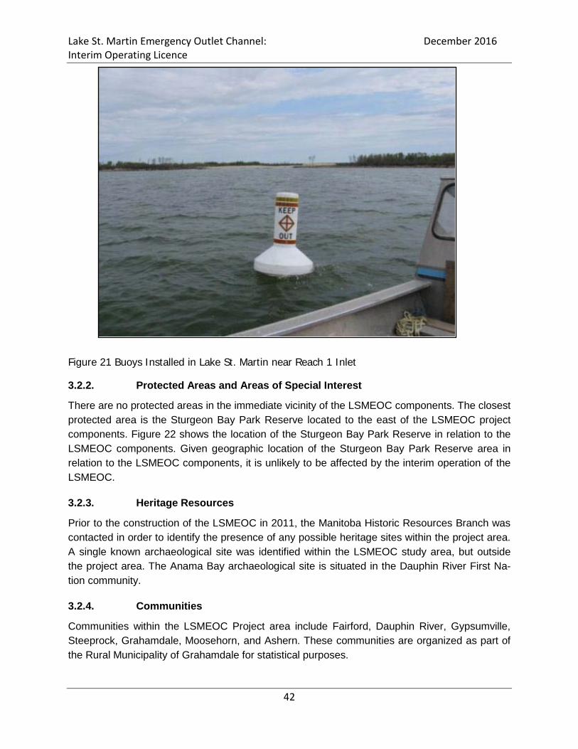
Lake St. Martin Emergency Outlet Channel: December 2016 Interim Operating Licence
42
Figure 21 Buoys Installed in Lake St. Martin near Reach 1 Inlet
3.2.2. Protected Areas and Areas of Special Interest
There are no protected areas in the immediate vicinity of the LSMEOC components. The closest protected area is the Sturgeon Bay Park Reserve located to the east of the LSMEOC project components. Figure 22 shows the location of the Sturgeon Bay Park Reserve in relation to the LSMEOC components. Given geographic location of the Sturgeon Bay Park Reserve area in relation to the LSMEOC components, it is unlikely to be affected by the interim operation of the LSMEOC.
3.2.3. Heritage Resources
Prior to the construction of the LSMEOC in 2011, the Manitoba Historic Resources Branch was contacted in order to identify the presence of any possible heritage sites within the project area. A single known archaeological site was identified within the LSMEOC study area, but outside the project area. The Anama Bay archaeological site is situated in the Dauphin River First Na-tion community.
3.2.4. Communities
Communities within the LSMEOC Project area include Fairford, Dauphin River, Gypsumville, Steeprock, Grahamdale, Moosehorn, and Ashern. These communities are organized as part of the Rural Municipality of Grahamdale for statistical purposes.

Lake St. Martin Emergency Outlet Channel: December 2016 Interim Operating Licence
43
3.2.5 First Nation Communities
First Nation Communities with an interest in the interim operation of the Reach 1 and 3 channels include Little Saskatchewan First Nation and Lake St. Martin First Nation on Lake St. Martin, Dauphin River First Nation on the Dauphin River, and Pinaymootang First Nation Reserve on the Fairford River.
3.2.6 Population
The project study area straddles the boundary between two census divisions: No. 18 and No. 19. The 2006 population estimates were 23,861 and 16,321 persons respectively with densities of 2.1 and 0.3 persons per square kilometer. The median ages of the populations are 44.5 years and 24.5 years. Population information is summarized in Table 9 below.

Lake St. Martin Emergency Outlet Channel: December 2016 Interim Operating Licence
44
Figure 22 Protected Areas near Reach 1

Lake St. Martin Emergency Outlet Channel: December 2016 Interim Operating Licence
45
Table 4 Population Statistics for the R.M. of Grahamdale
Population and Dwelling Information R.M. of Grahamdale Division No. 18 Division No. 19
Population in 2006 1, 416 23, 861 16, 321 Population in 2001 1, 500 22, 593 15, 805 Pop. Change in % -5.6 5.6 3.3 Total Private Dwellings 864 15, 355 7, 131 Population Density (persons/km2) 0.6 2.1 0.3
Land Area (km2) 2, 385 11, 331 61, 219 (KGS 2013b) Population information for First Nation communities with land situated in proximity to the LSMEOC is presented in Table 5. This data is current to 2016 census by Aboriginal Affairs and Northern Development Canada. Table 5 Population Statistics for Selected Indigenous Communities
Communities
Population on Own Reserve
Population on Oth-er Reserve/Other Crown Land
Population off Reserve
Total Pop-ulation
Little Saskatchewan First Nation 677 8 560 1,245
Pinaymootang First Nation 1,263 5 1,989 3,257 Dauphin River First Nation 254 2 118 374 Lake St. Martin First Nation 1,647 18 1,011 2,676 Peguis First Nation 3,609 130 6,341 10,080 (INAC, 2016)
4. ENVIRONMENTAL EFFECTS ANALYSIS
The following section presents the environmental effects analysis for the interim operation of the LSMEOC. The effects analysis considers potential environmental effects of the LSMEOC under operating and non-operating conditions. The environmental effects analysis considered physical processes as well as relevant biophysical and socio-economic attributes as follows: Physical Processes
Biophysical Attributes Socio-Economic
Air Quality & Greenhouse Gases Soils & Terrain Bedrock Geology Groundwater Surface Water
Vegetation Wildlife, Mammals, & Habitat Birds Fish & Fish Habitat Amphibians/Reptiles
Land Use
Protected Areas, ASI’s Heritage Resources Commercial Fishing Recreation/Tourism
Public Health & Safety
The following sections describe the environmental effects assessment for attributes in conjunc-tion with the application of mitigation measures, assessment of residual effects, determination of

Lake St. Martin Emergency Outlet Channel: December 2016 Interim Operating Licence
46
significance, and if necessary the need for any follow-up and/or monitoring program. Potential environmental effects were assessed as being significant, not significant, or unknown. A sum-mary of the environmental effects assessment is presented in Table 6 below. 4.1. Physical Processes
4.1.2. Air Quality & Greenhouse Gases
Potential effects to air quality and greenhouse gases associated with the interim operation of the LSMEOC relate to the periodic use of heavy equipment and machinery (loaders, excavators, rock trucks etc.). Select pieces of heavy equipment would be used in order to facilitate the open-ing and closure of the Reach 1 inlet (i.e. remove and replace material) during operation as well as conduct maintenance activities as needed throughout the LSMEOC under non-operating conditions. Minor emissions will be released into the atmosphere as a result of equipment being used during that time. The use of heavy equipment and machinery will occur periodically (as needed) and be short term in duration under both operating and non-operating conditions. MI will ensure that all equipment and machinery used during operation (opening and closure of Reaches 1) and non-operating (maintenance activities) phases of the LSMEOC is maintained and serviced regularly to ensure optimal function and efficient combustion of fuel. Despite regular maintenance and servicing, the release of some minor emissions is still ex-pected to occur as a result of the use of machinery. However, considering the relatively remote location of the LSMEOC coupled with the periodic and short term use of equipment and ma-chinery, the minor release of emissions is not likely to result a significant or residual adverse effect on air quality.
4.1.3. Bedrock Geology
The interim operation of the LSMEOC involves the diversion of excess floodwater from Lake St. Martin into Sturgeon Bay on Lake Winnipeg. The interim operation of the LSMEOC will not in-volve the use, alteration, or impact on bedrock geology during its operation and non-operation phases. Because the project will not have any significant adverse effects on bedrock geology, no mitigation measures or monitoring is proposed.
4.1.4. Soils and Terrain
Potential effects on soils and terrain associated with the interim operation of the LSMEOC relate to ongoing erosion, deposition of sediments, and bank destabilization along Buffalo Creek as well as the Reach 1 channel. Erosion, sedimentation, and bank destabilization are ongoing and occur to varying degrees during operating and non-operating phases of the project. It is im-portant to note that LSMEOC and its associated components are considered existing. The inter-im operation of the LSMEOC will not involve the additional exposure or alteration of soils or ter-rain outside of the existing project area. Ongoing erosion, sedimentation, and bank destabiliza-tion is limited to the primary components of the LSMEOC.
Lake St. Martin Emergency Outlet Channel: December 2016 Interim Operating Licence
47
Post operation site visits have shown that erosion has taken place along all the major compo-nents of the LSMEOC (i.e. Reach 1 and Buffalo Creek). Susceptibility to ongoing erosion and deposition of sediments is attributable to the lack of vegetation and/or other protective cover along the Reach 1. Under operation, scour from diverted water is the primary source of erosion and mobilization of sediments along the Reach 1 Channel and Buffalo Creek. Although Buffalo Creek is well vegetated, flooding of its riparian areas due to the operation of the Reach 1 has resulted in the loss of vegetation leading to slumping and destabilization of its banks. Compari-son of cross-section surveys conducted in Buffalo Creek between 2011-2013 and 2013-2015 (2011 and 2014 operational periods) indicate an estimated total in-situ volume of 60,000m3 and 75,000m3 eroded material respectively (KGS, 2016) Erosion along the primary components of the LSMEOC also occurs under non-operating condi-tions. Sources of erosion during non-operation are attributable to the lack of vegetation or other protective cover in combination with natural forces such as wind, rain, run-off, and seep-age/infiltration of groundwater. The mobilization of material along the channel base and side slopes is expected to continue un-til an equilibrium point is reached and no further erosion would occur. The bog complex is in-tended to serve as a large scale settling basin that slows water velocities and allows some of the sediments mobilized from the operation of the Reach 1 Channel to drop out of suspension. Despite the inclusion of design mitigation measures, erosion, sedimentation, and bank destabili-zation are ongoing (both under operation and non-operating conditions) and expected to contin-ue in the near future as part of the interim operation of the LSMEOC. The mobilization of sedi-ments due to erosion and scour is limited and does not extend beyond the primary components of the LSMEOC. At some point in the future, it is anticipated that the self armoring of the Reach 1 will occur and no further erosion and destabilization of the channel side slopes will take place. Operational mitigative measures will be used to minimize the effects of erosion and deposition in Reach 1 and Buffalo Creek. A staged approach will be used during the opening and closing of Reach 1. In addition, monitoring efforts have confirmed critical timing and sensitive areas. By utilizing a staged approach, the areas that may experience erosion will not expand into unaf-fected zones and the amount and significance or erosional effects are not expected to increase with future and additional operations of Reach 1. No monitoring of erosion, sedimentation and bank destabilization is proposed for the interim operation of the LSMEOC.
4.1.5. Groundwater
The presence of groundwater was noted during initial geotechnical investigations (drilling and test pitting) along the LSMEOC channel alignments. In general, groundwater discharge points from the regional bedrock aquifer typically occur as seepage/flow into streams, lakes, marsh-es/bogs/wetlands area. The LSMEOC is located in a low lying bog/complex that also supports some small lakes and water courses suggesting that there are multiple potential points of groundwater discharge present within the project area. Flowing artesian well conditions have

Lake St. Martin Emergency Outlet Channel: December 2016 Interim Operating Licence
48
been identified throughout the Dauphin River area (KGS 2013). Significant groundwater infiltra-tion (seepage) into Reach 1 from the surrounding bog areas was also noted during post 2011/2012 operation investigations. Potential effects on groundwater resources stemming from the interim operation of the LSMEOC include hydrocarbon infiltration primarily associated with leaks and spills from equip-ment and machinery, and fuel handling. The use of heavy equipment and machinery will be necessary for the opening and closure of the Reach 1 as well as to conduct periodic mainte-nance activities during non-operating periods. Mitigation measures to offset potential risks to groundwater resources include adherence to adherence to all applicable regulations and MI’s best management practices (BMP’s) concerning the use of equipment, machinery and fuel stor-age/handling. No residual effects on groundwater resources are expected to occur after the ap-plication of mitigation measures. No follow up or monitoring activities are being proposed in rela-tion to potential effects on groundwater resources. In considering the nature of the effects in conjunction with the application of mitigation measures, the LSMEOC is not likely to result in any significant adverse effects on groundwater resources.
4.1.6 Surface Water
Potential effects to surface water stemming from the interim operation of the LSMEOC are re-lated to changes in water quality. Monitoring program results to date have revealed some short-term temporary changes to water quality within the Buffalo Creek watershed, Dauphin River and in Sturgeon Bay. In general, the Buffalo Creek watershed experienced the greatest variation in water quality changes during operation. For example, TSS levels were noted as increasing during operational periods. Changes in other water quality parameters such as nutrients and metals were also documented to varying degrees at sampling locations in each of the affected areas (Buffalo Creek watershed, Dauphin River and Sturgeon Bay). However, elevated values tended to de-cline quickly and return within guideline parameters or baseline/background conditions relatively quickly (days) during operation. Further monitoring also revealed very few elevated values ex-ceeded guideline parameters. The exception being TSS levels which generally remained high throughout the LSMEOC operation and for a short period of time following its closure. Elevated TSS levels stem from erosion and scour taking place throughout the Reach 1 Channel and Buf-falo Creek watershed and deposition into the Dauphin River/Sturgeon Bay. It is expected that variability in water quality parameters will subside with continued use of the LSMEOC as the Buffalo Creek watershed stabilizes, and as vegetation reestablishes itself over time. Similarly, erosion is expected to continue throughout the Reach 1 Channel until it “self ar-mors” and materials are no longer being mobilized during operation. Elevated values for routine parameters, nutrients, and metals are also expected to decline over the short-term in are likely the result of “flushing” a system which had previously been relatively undisturbed.

Lake St. Martin Emergency Outlet Channel: December 2016 Interim Operating Licence
49
Mitigation measures to offset increased water values and guideline exceedances are largely de-sign based and focused on managing TSS levels (i.e. erosion and scour) throughout the LSMEOC. Reach 1 was designed so that floodwater entering the channel inundated the Buffalo Lake Bog Complex. The bog complex is intended to serve as a large scale settling basin that would allow any sediments mobilized through the Reach 1 Channel to settle out to some degree before water continues on through Buffalo Creek, the Dauphin River and ultimately Sturgeon Bay. This design, in conjunction with the operational controls mentioned in section 4.1.4 (staged opening and closing) will assist in minimizing the potential effects to water quality. The application of mitigation measures have focused on managing erosion and TSS levels throughout the LSMEOC. However, water quality monitoring results to date suggest that erosion continues to occur and TSS levels have remained relatively high during operation and for a short period of time following the closure of the LSMEOC. Similarly, elevated levels in water quality variables and occasional exceedances of applicable water quality guidelines likely stemming from the “flushing” of the LSMEOC have also been observed. As such residual effects on water quality stemming from the operation of the LSMEOC are expected to include continued variability in water quality parameters during operating and immediate post closure periods. Var-iability in water quality parameters is expected to continue for the short-term until the LSMEOC stabilizes. In considering the nature of potential effects in conjunction with the application of mitigation measures, the interim operation of the LSMEOC is not likely to result in any significant adverse or residual effects on surface water quality. 4.2. Biophysical Environment
4.2.1. Vegetation
Potential effects associated with the operation of the LSMEOC on vegetation are generally re-lated to the mobilization and loss of vegetation and other woody debris during operation. Key areas where mobilization of vegetation and woody debris is expected to occur includes the bog complex located at the terminus of the Reach 1 Channel (i.e. settling basin and mobilization of vegetation mats due to flooding), along Buffalo Creek (stemming from flooded riparian zone and subsequent bank destabilization). Mortality of riparian and other vegetation due to inundation is expected to occur along Buffalo Creek, the surrounding bog complex. Under non-operational periods, Buffalo Creek may experience some additional loss of riparian vegetation due to ongoing erosion and bank destabilization processes. Loss of riparian vegeta-tion along Buffalo Creek under non-operating conditions is expected to be minor. No other ef-fects on vegetation are expected to occur under non-operating conditions associated with the LSMEOC.

Lake St. Martin Emergency Outlet Channel: December 2016 Interim Operating Licence
50
No formal mitigation measures have been established to prevent vegetation loss and mobiliza-tion as a result of the interim operation of the LSMEOC. Mobilization of vegetation mats out of the bog complex located at the terminus of the Reach 1 Channel may occur periodically over time with the operation of the LSMEOC. No significant adverse effects on vegetation or habitat stemming from the interim operation of the LSMEOC are expected to occur.
4.2.2. Wildlife and Wildlife Habitat
Potential effects associated with the operation of the LSMEOC on wildlife populations include loss of local habitat due to flooding of riparian areas at big Buffalo Lake and along Buffalo Creek Flooding of potential wildlife habitat is temporary and only occurs during operation of the LSMEOC. Once closed and diverted flood flows drain out of the system riparian and other habi-tat areas which may be affected can over time become viable again. Wildlife movement may be constrained as a result of the operation of the Reach 1. Constraints on wildlife movement are considered temporary and only likely to occur during operation. Fur-ther, the area in which the LSMEOC is located is relatively pristine and supports little develop-ment. There is considerable space available in order to support movement/mobility of wildlife species while the LSMEOC is in operation. Additionally, the operation of the LSMEOC is not continuous or sustained but occurs in reaction to flood staging taking place on Lake St. Martin. Once the LSMEOC is closed and water drains out of the system, the opportunity for wildlife movement would be re-established. Reach 1 may serve as predation corridors. The Reach 1 and 3 Channels are cleared areas which have had little success in natural vegetation being re-established. As such, these “corri-dors” can allow for the quicker movement of predatory species such as wolves throughout the area and lead to increases in predation success. No mitigation measures are being proposed for potential impacts to wildlife species as a result of the interim operation of the LSMEOC. The loss of riparian habitat along Buffalo Creek due to flooding and bank instability is expected to slow down over the short-term and eventually stabi-lize as the creek is able to accommodate increased flows during operation. Once Buffalo Creek stabilizes, riparian areas and the habitat they support will reestablish. Residual effects associated with the interim operation of the LSMEOC include temporary loss of local wildlife habitat areas along Buffalo Creek. Loss of riparian and other wildlife habitat due to the operation of the LSMEOC is expected to be temporary and short-term. No significant adverse effects on wildlife and wildlife habitat are expected to occur as a result of the interim operation of the LSMEOC.

Lake St. Martin Emergency Outlet Channel: December 2016 Interim Operating Licence
51
4.2.3. Birds
Potential effects on various bird species (waterfowl, shorebirds, and migratory bird species) as-sociated with the interim operation of the LSMEOC include temporary habitat (nesting rearing etc.) disruptions (loss of use), and temporary habitat loss. Key areas likely to be affected include the bog complex (i.e. landscape level settling basin) located at the end of the Reach 1 Outlet, riparian areas along Buffalo Creek. Disruption of waterfowl and shorebird habitat is expected to be temporary (short-term), and pe-riodic (occur during periods of LSMEOC operation). Temporary loss of habitat use for birds is expected to take place due to inundation at the bog complex located at the terminus of the Reach 1 Channel, flooded riparian areas along Buffalo Creek. Following the closure of the LSMEOC, it is expected that inundated habitat will become viable. Further, given that operation occurs periodically in reaction to flood staging on Lake St. Martin, the temporary loss of habitat use would occur infrequently. No mitigation measures will be implemented for potential effects on birds associated with the temporary loss of habitat use. The LSMEOC will result in the temporary loss of some riparian habitat due to erosion and bank destabilization taking place along Buffalo Creek. Temporary habitat loss is expected to occur over the short-term under both operating and non-operating conditions. Causes of habitat loss during operation include inundation, erosion, and bank destabilization. Similarly, erosion and bank destabilization processes leading to some continued habit loss is likely to occur to a lesser degree under non-operation. The temporary loss of riparian habitat is expected to continue at a declining rate during the short-term until Buffalo Creek stabilizes, vegetation cover returns, and riparian areas reestablish. No mitigation measures will be employed to offset potential effects associated with the temporary loss of riparian habitat along Buffalo Creek. No significant adverse effects on bird habitat are expected to occur as a result of the interim op-eration of the LSMEOC.
4.2.4. Fish Habitat
The following considers potential effects on fish and fish habitat associated with the interim op-eration of the LSMEOC. For convenience the effects assessment is presented in two distinct components including fish and fish habitat. Potential effects associated with the interim operation of the LSMEOC on fish habitat include:
•Alteration of habitat due to increased flow and flooding along the diversion route; •Alteration of habitat due to erosion and sedimentation.
Temporary alteration of fish habitat due to increased flow and flooding has occurred as a result of prior operation of the LSMEOC. Temporary habitat alterations have generally included an in-crease in wetted habitat during operation and loss of riparian habitat along Buffalo Creek. In-creases in wetted habitat during the operation period will occur along the Reach 1 channel, Big Buffalo Lake, throughout the bog complex in which the LSMEOC is situated, and along the

Lake St. Martin Emergency Outlet Channel: December 2016 Interim Operating Licence
52
lower Dauphin River between the Buffalo Creek outflow and Sturgeon Bay. Increases in wetted habitat are considered to be both temporary and periodic and would be available during opera-tion and a period following closure of the Reach 1 Channel where drainage/drying takes place. Increases in available wetted habitat are contingent on the operation of the LSMEOC, which in turn depends on flood staging in Lake St. Martin. Temporary reduction of riparian zone is focused on Buffalo Creek and generally attributed to inundation, erosion and bank instability issues stemming from increased flows associated with the operation of the LSMEOC to date. Riparian vegetation along Buffalo Creek is expected to re-establish itself over the short-term once the creek has stabilized and is able to accommodate the additional diverted flows diverted along its extent. Field investigation confirmed that vegeta-tive cover had already begun to return along the banks of Buffalo Creek in June 2014, about a year after the operation of Reach 1. Minor changes in substrate conditions as a result of previous operation of the LSMEOC have been noted along Buffalo Creek, near the Mouth of the Dauphin River, and in near shore areas in Sturgeon Bay. Minor changes in substrate composition can be attributed to increased flows/velocities, mobilization of bed load and other substrate materials and deposition of sus-pended sediments. Substrate changes in Buffalo Creek focused primarily on the mobilization and deposition of sediments. Monitoring has indicated that the Dauphin River experienced some slight redistribution of gravel substrate towards Sturgeon Bay. Because velocities where rela-tively high, suspended sediments mobilized through the LSMOEC system remained in suspen-sion and were not deposited in the Dauphin River but were transported into Sturgeon Bay. Monitoring program results indicated that there was an increase in the amount of silt found in fine sediment samples. Comparison of 2011 and 2013 substrate conditions throughout Sturgeon Bay generally did not reveal any significant changes. However, monitoring revealed that the most definite substrate changes occurred in the area immediately north of the mouth of the Dauphin River, where fine substrates were deposited over what had previously been identified as gravel and boulder/cobble in fall of 2011. The change in substrate composition north of the Mouth of the Dauphin River is expected to be temporary in nature. Ongoing river flows, coupled with wind, wave and tidal action over time is likely to result on some level of continued change to substrates in this area. This means that substrates are expected to undergo some degree of shifting and resorting naturally. The interim operation of the LSMEOC will result in some minor short-term, temporary, and periodic changes to substrate conditions within Sturgeon Bay. Deposition of sediments contributing to substrate change is expected to decline over time as materials most likely to become mobilized are removed from the system and as Buffalo Creek stabilizes. Mitigation measures established to offset potential effects of fish habitat include locating the terminus of the Reach 1 Channel in a bog complex which serves as a large scale settling basin. In addition to design mitigation measures, MI is currently involved in a supplementary process with Fisheries and Oceans Canada in order to review the effects of the LSMEOC on fish and
Lake St. Martin Emergency Outlet Channel: December 2016 Interim Operating Licence
53
fish habitat. Any additional mitigation measures or requirements emerging from the supplemen-tary aquatics review process will also be implemented. No significant adverse effects on fish habitat are expected to occur as a result of the interim op-eration of the LSMEOC.
4.2.5. Fish
Potential effects in fish biology and life history traits (e.g. spawning behaviour and metal con-centrations in muscle tissue);
•Altered access to habitat due to increased flow, creating possible attraction flows and/or velocity barriers during operation; and,
•Re-distribution of fish species in all affected waterbodies resulting directly from changes to flow patterns or water levels.
•Fish stranding and possible mortality in Reach 1. Monitoring revealed some temporary changes in spawning behaviour throughout the Buffalo Creek watershed between operation and post operation phases of the project. Monitoring re-sults showed an increase in spawning behaviour and larval transport throughout the Buffalo Creek watershed during previous operation of the LSMEOC. Similarly, a decline in spawning behaviour and larval transport was noted throughout the Buffalo Creek watershed during the post closure period. Changes in spawning behaviour are directly attributable to the timing and operation of the LSMEOC. Operation of the LSMEOC creates access via Buffalo Creek into the Bog complex and Reach 1. Fish stranding and mortality was also identified as a potential effect associated with the interim operation of the LSMEOC. During the initial closure of the LSMEOC approximately 2,000 fish become stranded and died due to low dissolved oxygen levels. The stranding and mortality of fish throughout the LSMEOC is an operational issue related to the timing of the closure of the Reach 1 Channel. In order to ensure that fish stranding and mortality does not occur, MI will ensure that, if operated, the LSMEOC will remain open between Sep-tember and June 15th of the following year during fish migration, spawning, hatching and rearing periods. Ensuring that the LSMEOC remains open during this time period will ensure that any fish drawn into the system have sufficient time to complete their life history activities and move into either Lake St. Martin or Sturgeon Bay. Monitoring results have revealed that the operation of the LSMEOC has provided altered access to fish habitat. This is largely due to additional pathways of access via the Reach 1 Channel (moving from Lake St. Martin into the Dauphin River and Sturgeon B ay) and Buffalo Creek (movement from Sturgeon Bay/Dauphin River into the Buffalo Creek wa-tershed and Lake St. Martin). Altered opportunities for accessing habitat and the presence of attraction flows are expected to occur on a temporary and periodic basis coincident with the op-eration of the LSMEOC. During the closure period, opportunities for alternate access to habitat and attraction flows would not be present.

Lake St. Martin Emergency Outlet Channel: December 2016 Interim Operating Licence
54
Changes in fish species diversity throughout the Buffalo Creek watershed is a potential effect associated with the operation of the LSMEOC. Monitoring study results revealed that during op-eration fish species diversity declined throughout the Buffalo Creek watershed. However, follow-ing the operation, species diversity returned to pre-operation conditions. The decline in species diversity is likely due to increased flows and velocities entering the Buffalo Creek watershed during which caused smaller bodies fish that prefer slow water environments to move out and return during the post closure period. Changes in species diversity throughout the Buffalo Creek watershed are expected to be temporary, short-term, and periodic. No effects on species diver-sity or composition were noted in Lake St. Martin, Dauphin River, or Sturgeon Bay. Mitigation measures to offset potential effects on fish associated with the interim operation of the LSMEOC focus on timing for the closure of the Reach 1 inlet. If the LSMEOC is operated, it will remain open between September and June 15th of a given year during fish migration, spawning, hatching and rearing periods. Ensuring that the LSMEOC remains open during this time will ensure that fish species present throughout the system have sufficient time to complete their life history traits and move out into either Lake St. Martin or Sturgeon Bay. Timing of clo-sure will also ensure that fish stranding and mortality due to low dissolved oxygen levels does not occur. A fish salvage program will be required for each operation of Reach 1. Residual effects associated with the interim operation of the LSMEOC include temporary and periodic increases in available habitat, temporary and periodic opportunity for alternate access habitat and presence of attraction flows, temporary, short-term, and periodic changes in species diversity in the Buffalo Creek watershed. No significant adverse effects on fish are likely to occur as a result of the interim operation of the LSMEOC.
4.2.6. Amphibians/Reptiles
Potential effects associated with the operation of the LSMEOC on amphibians and reptiles in-clude loss of riparian habitat (vegetation) along the periphery of Big Buffalo Lake, along Buffalo Creek, and throughout the bog complex area due to the diversion/routing of flood flows through the LSMEOC. The interim operation of the LSMEOC may also result in the loss of instream hab-itat including emergent/aquatic vegetation stemming from increased flow/velocities diverted throughout the Buffalo Creek watershed. However, potential habitat losses (e.g. loss of riparian and emergent in stream vegetation) should be offset by the creation of additional habitat from the introduction of additional flows in key areas throughout the LSMEOC. For example, this could include improved overwintering habitat in Big Buffalo Lake and surrounding bog complex. Habitat losses associated within the Buffalo Creek watershed associated with the interim opera-tion of the LSMEOC are expected to be temporary and short term. Riparian and instream vege-tation will re-establish once the Buffalo Creek watershed has stabilized and is able to accom-modate additional flows diverted from Lake St. Martin. Monitoring studies have revealed that herbaceous cover has already started to return along the banks of Buffalo Creek. Increases in available habitat for amphibians and other reptile species present would also be considered

Lake St. Martin Emergency Outlet Channel: December 2016 Interim Operating Licence
55
temporary, short-term, and periodic. Increases in available aquatic habitat would be coincident with the operation of the LSMEOC and associated flooding that occurs. Following the closure of the LSMEOC and a period of drainage/drying, available aquatic habitat is expected to return to pre-operation conditions. No potential project related effects on amphibians or other reptile species are expected to occur during the non-operation/closure period. No mitigation measures have been established in order to minimize potential effects associated with the interim operation of the LSMEOC on amphibians and reptiles. Residual effects on amphibians and reptiles associated with the LSMEOC may include tempo-rary, short-term and periodic changes in available aquatic habitat. Temporary loss of riparian and instream habitat, and some potential variability in population size due to an increase in available habitat and predation rates are also expected to occur. No significant adverse effects to amphibians and reptiles are likely to occur as a result of the interim operation of the LSMEOC. 4.3. Socio-economic Effects
4.3.1. Land Use
Potential land uses within close proximity to the LSMEOC include forestry, hunting and trapping. The LSMEOC is located within an area designated as Integrated Woodlot Supply Area (IWSA) previously allocated to the Pine Falls Paper Company which is no longer active. The operation of the LSMEOC is not expected to have any adverse effects on forestry operations within the project area. Hunting has been identified as another general land use within the broader area in which the LSMEOC is situated. The LSMEOC is located in a remote and fairly inaccessible area. During operation some areas in the immediate vicinities of the LSMEOC components may be inundat-ed and not be accessible to hunting but would not restrict the activity within the broader area in which the LSMEOC is found. The effects on hunting are expected to be periodic and occur as a result on the interim operation of the LSMEOC. No non-operating project related effects on land use (hunting, trapping, and potential forestry related activities) are expected to occur. No mitigation measures have been proposed or implemented to offset potential land uses (for-estry, hunting, and trapping) related effects associated with the interim operation of the LSMEOC.

Lake St. Martin Emergency Outlet Channel: December 2016 Interim Operating Licence
56
Residual effects on land use may include temporary, short-term, and periodic difficulty access-ing lands for the purpose of hunting and trapping in the immediate vicinity of the LSMEOC pri-mary components during operation. No significant adverse effects on land-use are likely to occur as a result of the interim operation of the LSMEOC.
4.3.2. Parks, Protected Areas and Areas of Special Interest
There are no parks or protected areas located within the immediate vicinity of the LSMEOC. The closest protected area is the Sturgeon Bay Park located to the east of the LSMEOC. The operation of the LSMEOC is not expected to have any adverse effects on the Parks, Pro-tected Areas, or the Sturgeon Bay ASI during non-operation. No mitigation measures are proposed for potential project related effects on Parks, Protected Areas, or ASI’s. No significant adverse effects to parks, protected areas and areas of special interest are likely to occur as a result of the interim operation of the LSMEOC.
4.3.3. Heritage Resources
No known heritage resources were identified in the immediate vicinity of the LSMEOC. No potential project related effects are expected to occur on heritage resources during the non-operational phases of the LSMEOC Mitigation measures are not proposed for potential project related effects on heritage resources associated with the interim operation of the LSMEOC. No residual project related effects on heritage resources are expected to occur as a result of the interim operation of the LSMEOC. No adverse effects to heritage resources are likely to occur as a result of the interim operation of the LSMEOC.
4.3.4. Commercial Fishing
Monitoring studies from previous operation of the LSMOEC did not reveal any significant ad-verse effects on fish and fish habitat. Similarly, the interim operation of the LSMEOC is not ex-pected to have any significant or long term effect on commercial fishing. The mobilization of some vegetation and woody debris is expected to occur as a result of flush-ing from the interim operation of the LSMEOC. Sources of vegetation and woody debris include the bog complex at the terminus of the Reach 1, and riparian areas along Buffalo Creek. Debris

Lake St. Martin Emergency Outlet Channel: December 2016 Interim Operating Licence
57
loading in Sturgeon Bay was monitored during previous operation of the LSMEOC. Monitoring results revealed that although some of the mobilized materials (primarily aquatic vegetation, roots, and sticks) were found in commercial and other fishing nets, debris levels remained rela-tively low and were similar to pre-operation levels. Although vegetation and woody debris may be mobilized as a result of the interim operation of the LSMEOC, it is expected to decline over time as the system experiences flushing associated with its periodic use. As such, debris load-ing in Sturgeon Bay from the interim operation of the LSMEOC and its effect on commercial fishing activities. A summary of the results of debris monitoring activities has been included in Appendix E. No mitigation measures have been established in order to offset any effects associated with the interim operation of the LSMEOC on commercial fishing activities. Minor effects may be experienced related to higher occurrences of aquatic vegetation in com-mercial fishing net.
4.3.5. Recreation
Potential effects on local recreation associated with the interim operation of the LSMEOC may include potential effects on local recreational fishing. Potential effects on local recreational fishing activities are premised on the likelihood of changes to the local fishery as a result of the interim operation of the LSMEOC. Aquatic monitoring stud-ies revealed that there have been no significant effects on fish and fish habitat in Lake St. Mar-tin, Buffalo Creek Watershed, the lower Dauphin River, and in Sturgeon Bay. No specific mitigation measures have been established to offset potential project related effects on recreational fishing. No residual effects on local recreational fishing are expected to occur. No significant adverse effects on local recreational fishing are likely to occur as a result of the interim operation of the LSMEOC.
4.3.6. Public Health and Safety
Potential project related effects of the interim operation of the LSMEOC on public health and safety are not expected. In general, the LSMEOC serves to protect public health and safety by mitigating flood related hazards and damages. The LSMEOC and its primary components are located in a relatively remote and isolated area generally inaccessible to the public except by air or possibly snowmobile under frozen conditions.
Lake St. Martin Emergency Outlet Channel: December 2016 Interim Operating Licence
58
There is a risk or potential safety hazard for the boating public at the Inlet to the Reach 1 Chan-nel located on Lake St. Martin. The inlet to the Reach 1 Channel is accessible by boat under non-frozen conditions. Under non-operating conditions, the LSMEOC is not expected to result in any effects on public health and safety. Public health and safety mitigation measures include installation of permanent signage and buoys during open water conditions at the entrance of the Reach 1 Channel on Lake St. Martin. Buoys and permanent signage are intended to warn the boating public of the Reach 1 Inlet. No residual effects on public health and safety are expected in associated with the interim oper-ation of the LSMEOC. No significant adverse effects on public health and safety are likely to occur as a result of the interim operation of the LSMEOC.

Lake St. Martin Emergency Outlet Channel: December 2016 Interim Operating Licence
59
Table 6 LSMEOC Interim Operation Summary of Environmental Effects Analysis
Variables Attributes Operation Non-Operation Mitigation Measures Residual Effects Significance Follow-Up & Monitoring
Physical Processes
Air Quality/Greenhouse Gases
Minor emissions will be released from the operation of equipment and machinery used to facilitate the opening and closure of the Reach 1 inlets (i.e. remove and replace ma-terial).
Potential for minor amounts of emissions to be released from the operation of equipment used during maintenance activities.
Ensure that all equipment is main-tained and serviced regularly.
No residual effects
Not significant
None
Bedrock Geology
No potential effects on bed rock geology are expected to occur stemming from the operation of the LSMEOC.
No potential effects on bed rock geology are expected to occur dur-ing the non-operation phases of the LSMEOC.
Not required
No residual effects
Not significant
None
Soils & Terrain
Potential for erosion and bank de-stabilization stemming from water flow, operation, groundwater, and overland flow from the operation of Reach 1 through Buffalo Creek wa-tershed into lake Manitoba.
Potential for erosion and bank de-stabilization stemming from envi-ronmental factors (ground water, run-off, wind and rain etc.).
Self-armoring design of the Reach 1 channel. Locating terminus of the Reach 1 channel at a large bog complex which is intended to serve as a set-tling basin for mobilized sediments.
Ongoing erosion and bank destabili-zation at a decreasing rate over the short-term during operation and non-operational phases of the LSMEOC.
Not significant over the long term, as the primary components of the LSMEOC will stabilize and self ar-mor.
None
Groundwater
Potential infiltration of fuel and/or other hazardous substances into the groundwater table stemming from the use of equipment/machinery and/or storage/handling of sub-stances used to open and close the Reach 1 and 3 channels.
Potential infiltration of fuel and/or other hazardous substances into the groundwater table stemming from the use of equipment/machinery, transportation/storage of fuel and other hazardous substances to facili-tate periodic maintenance activities.
Adherence to MI BMP’s concerning the use of equipment/machinery, fuel handling/storage. Adherence to all applicable regula-tory requirements concerning the use of equipment/machinery, stor-age and transportation of fuels and other hazardous substances
None
Not significant
None
Surface Water
Short-term variability (elevated and/or occasional exceedance of applicable guidelines) in water quali-ty parameters (routine, metal, and nutrients).
Potential for elevated levels in water quality parameters such as TSS dur-ing the immediate (short-term/temporary) period following the closure of the LSMEOC. Elevated TSS levels and other possi-ble water quality parameters in the Buffalo Creek watershed due to ongoing erosion and bank destabili-zation in the short-term under non-operation conditions.
Design mitigation measures to man-age erosion/sedimentation, and TSS levels. Locating the outlet of the Reach 1 Channel in a large bog complex to serve as a settling basin before di-verted flood flows continue through the Buffalo Creek watershed. Design mitigation measures are permanently associated with the LSMEOC and are active under non-operational conditions.
Residual effects include ongoing erosion and sedimentation (i.e. elevated TSS levels) during operating and non-operating conditions over the short-term. Elevated values and occasional exceedances in water quality parameters over the short-term under operating and non-operating conditions. Residual effects are expected to continue at a declining rate over the short-term with continued and until stabilization.
Not significant
None

Lake St. Martin Emergency Outlet Channel: December 2016 Interim Operating Licence
60
Variables Attributes Operation Non-Operation Mitigation Measures Residual Effects Significance Follow-Up & Monitoring
Biophysical
Vegetation
Potential effects associated with the operation of the LSMEOC on vegeta-tion are generally related to the mortality and mobilization of vege-tation through the LSMEOC. Key locations where the mortality and/or mobilization of vegetation are expected to occur include the bog complex, along Buffalo Creek.
Under non-operating conditions potential project related effects of the LSMEOC on vegetation are not likely to occur. However, die off of riparian vegetation along Buffalo Creek stemming from the diversion of flows is expected to continue during immediate post operation periods (i.e. short-term following the closure of the Reach 1 Inlet).
No mitigation measures are pro-posed in order to minimize vegeta-tion mortality or mobilization. Con-tinued use of the LSMEOC and sub-sequent flushing will remove most woody debris and vegetation not well suited to inundation. In the short-term the LSMEOC will stabilize itself.
LSMEOC may experience period-ic/occasional occurrences of vegeta-tion mortality/mobilization with continued use over time.
Not Significant
None
Wildlife/Mammals and Habitat
Temporary habitat loss and loss of use during operation along Buffalo Creek. Operation of the LSMEOC may pre-sent a minor temporary barrier to wildlife movement (i.e. crossing Buffalo Creek or the Reach 1) during operation.
Under non-operation conditions the Reach 1 Channel may serve as pre-dation corridors allowing predators to move more quickly throughout the area and lead to increases in predation success.
No mitigation measures are being proposed for potential impacts to wildlife species as a result of the interim operation of the LSMEOC. Potential effects on wildlife and wildlife habitat stemming from the operation of the LSMEOC are ex-pected to be temporary and short term.
Residual effects associated with the interim operation of the LSMEOC include temporary and short-term loss of habitat, loss of habitat use, and temporary impedance to some wildlife movement while in opera-tion. Non-operation residual effects in-clude the potential for increased access and predation on wildlife.
Not significant.
None
Birds
Temporary habitat loss and loss of habitat use due to inundation and erosion at the Reach 1 bog complex, along Buffalo Creek.
Temporary/ongoing loss of riparian habitat along Buffalo Creek due to erosion and bank instability.
Limiting habitat loss through opera-tional considerations
Residual effects associated with the interim operation of the LSMEOC include temporary disruption and loss of habitat for local bird species.
Not significant.
None
Fish Habitat
Minor permanent alteration of fish habitat associated with the footprint of the Reach 1 inlet. Temporary loss of riparian area is focused on Buffalo Creek and gen-erally attributed to inundation, ero-sion and bank instability issues Minor permanent alteration of channel morphology along buffalo Creek Temporary and minor changes to substrate conditions in Sturgeon Bay due to deposition of sediments (de-clining rate).
Minor permanent alteration of fish habitat associated with the footprint of the Reach 1 inlet. Temporary ongoing erosion and deposition of sediments stemming from natural forces (wind rain, snow-melt/run-off, and seepage of water) throughout the LSMEOC components Reach 1, Buffalo Creek.
Design mitigation measures associ-ated with minimizing potential im-pacts on fish and fish habitat include Locating the terminus of the Reach 1 Channel at a bog complex area in order to serve as a large settling basin intended to settle out sedi-ments prior to flows moving on through the system. Additional mitigation measures may be applied, as they are determined through a supplementary review of aquatic effects between MI and Fisheries and Oceans Canada.
Temporary increase in available fish habitat under operation. Ongoing erosion and deposition of sediments at a declining rate under operation and non-operation condi-tions. Temporary changes in substrate due to increased flow/velocities as a result of operating the LSMEOC. Temporary loss of riparian habitat.
Not significant.
None

Lake St. Martin Emergency Outlet Channel: December 2016 Interim Operating Licence
61
Variables Attributes Operation Non-Operation Mitigation Measures Residual Effects Significance Follow-Up & Monitoring
Fish
Stranding in Reach 1 and potentially Bog complex due to attraction flow at the confluence of Buffalo Creek and Dauphin River. Temporary/periodic/short-term reduction in species diversi-ty/composition throughout Buffalo Creek Watershed.
Fish related impacts minimized dur-ing non-operational periods.
Timing relating to the closure of the Reach 1 Channel Inlet has been es-tablished as a mitigation measure to ensure that if the Reach 1 channel is operated it must remain open be-tween September 15th and June 15th of any given year during fish migra-tion, spawning, hatching and rearing periods. Reach 1 Fish Salvage Program
Temporary/periodic/short-term reduction in species diversi-ty/composition throughout Buffalo Creek Watershed. Temporary/periodic/short-term increases in spawning activity throughout Buffalo Creek Water-shed.
Not Significant
Reach 1 Fish Salvage Program
Amphibians/Reptiles
Temporary/short-term loss of ripar-ian/aquatic habitat Temporary/periodic/short-term increase in available aquatic habitat. Potential for increased predation on tadpoles and adults due to the in-troduction of additional fish into habitat areas.
None
None
Minor fluctuation in population numbers due to habitat variability and predation.
Not Significant
None
Socio-economic
Land Use
No potential effects on Land use (forestry, hunting, trapping) are expected to occur as a result of the interim operation of the LSMEOC.
No potential effects on Land use (forestry, hunting, trapping) are expected to occur during the non-operation of the LSMEOC.
None.
None.
Not significant.
None.
Parks, Protected Areas and Areas of Special Interest
No potential effects on parks, pro-tected areas, and areas of special interested are expected to occur as a result of the interim operation of the LSMEOC.
No potential effects are expected to occur on parks, protected areas, and areas of special interest during the non-operation of the LSMEOC.
None.
None.
Not Significant.
None.
Heritage Resources
No known heritage resources were identified in the immediate vicinity of the LSMEOC and its constituent components at the time of initial construction.
No potential project related effects are expected to occur on heritage resources during the non-operation phases of the LSMEOC.
None.
None.
Not Significant.
None.
Commercial Fishing
Potential for debris loading to be-come entangled in commercial nets set in Sturgeon Bay.
No potential effects on commercial fishing are expected to occur during non-operation phases of the LSMEOC.
Mitigation measures associated with the potential effects of operating the LSMEOC on local commercial fishing activities are related to the initial design of the LSMEOC and focus on erosion and sediment con-trol and timing. Mitigation measures
Minor periodic debris present in commercial nets set in Sturgeon Bay.
Not significant
None.

Lake St. Martin Emergency Outlet Channel: December 2016 Interim Operating Licence
62
Variables Attributes Operation Non-Operation Mitigation Measures Residual Effects Significance Follow-Up & Monitoring
include: •Locating the terminus of the
Reach 1 Channel at a large bog complex that serves as a large settling basin.
•Timing relating to the closure of the Reach 1 channel in-let and ensuring that it remains open between September 15th and Jun 15th if operated. During fish migration, spawning, hatching and rearing peri-ods.
Recreation/Tourism
Potential effect on local recreational fishing activities.
Under non-operating conditions the operation of the LSMEOC is not ex-pected to have any effects on local recreational fishing.
None
No residual effects on local recrea-tional fishing activities are expected.
Not significant.
None.
Public Health & Safety
Potential safety risk for the boating public on Lake St. Martin in the vi-cinity of the Reach 1 channel inlet under open water conditions.
Under non-operating conditions the LSMEOC is not expected to result in any effects on public health and safety.
Installation of permanent warning signage and buoys during open wa-ter conditions at the entrance of the Reach 1 Channel on Lake St. Martin.
No residual effects on public health and safety are expected in associat-ed with the interim operation of the LSMEOC.
Not Significant.
None.

Lake St. Martin Emergency Outlet Channel: December 2016 December 2016 Interim Operating Licence
63
5. CONCLUSIONS
The LSMEOC was initially constructed on an emergency basis in order to reduce water levels in Lake Manitoba and Lake St. Martin as a means of mitigating damages to peo-ple, property, livelihoods, and infrastructure due to widespread flooding taking place throughout southern Manitoba and Interlake areas in 2011. The potential effects associated with the interim operation of the LSMEOC have been evaluated in conjunction with mitigation measures and residual effects. The potential en-vironment effects associated with the interim operation of the LSMEOC are considered to be not significant.

Lake St. Martin Emergency Outlet Channel: December 2016 December 2016 Interim Operating Licence
64
6. REFERENCES
Banfield, A.W.F. 1974. The Mammals of Canada. University of Toronto Press. Toronto,
Ontario.
Bilecki, L. C. 2003. Bat Hibernacula in the Karst Landscape of Central Manitoba: Pro-tecting Critical Wildlife Habitat While Managing for Resource Development. Natural Resources Institute, University of Manitoba. Winnipeg, Manitoba. August 25, 2003.
Bezener. K. and A. De Smet. 2000. Manitoba Birds. Lone Pine Publishing, Edmonton, AB.
Caras, R.A. 1967. North American Mammals- Fur-bearing Animals of the United States and Canada. Meredith Press. University of Minnesota, MN.
Conant, R. and J.T. Collins. 1991. A Field Guide to Reptiles and Amphibians of Eastern and Central North America. Houghton Mifflin Co. Boston, MA.
Cook, F.R. 1984. Introduction to Canadian Amphibians and Reptiles. National Museums of Canada. Ottawa, Ontario.
Ecological Framework of Canada. 2014. Environment Canada. Available at http://ecozones.ca/english/region/155.html. Accessed October 29, 2016.
Environment Canada. 2015. Canadian Climate Normals Available at http://climate.weather.gc.ca/climate_normals/results_1981_2010_e.html?stnID=3717&lang=e&StationName=Arborg&SearchType=Contains&stnNameSubmit=go&dCode=1&dispBack=1. Accessed August 7, 2015.
Environment Canada (EC). 2015b. Recovery Strategy for Little Brown Myotis (Myotis lucifugus), Northern Myotis (Myotis septentrionalis), and Tri-colored Bat (Perimyotis subflavus) in Canada [Proposed]. Species at Risk Act Recovery Strategy Series. En-vironment Canada, Ottawa. ix + 110 pp.
Government of Manitoba. 2016. Soil Management Guide. Available at
https://www.gov.mb.ca/agriculture/environment/soil-management/soil-management-guide/print,greenhouse-gases-in-agriculture.html. Accessed October 31, 2016.
Government of Canada. Species at Risk Public Registry. Available at www.sararegistry.gc.ca/search/default_e.cfm. Accessed August 2011
Important Bird Areas. 2016. Available at: http://www.ibacanada.com. Accessed October 2015.
Indigenous and Northern Affairs Canada. Government of Canada. Updated November 29, 2016. . Available at http://fnp-ppn.aandcaadnc.gc.ca/ fnp/Main/ Index.aspx ?lasng=eng. Accessed December 6, 2016
Kolenosky, G.B. and S.M. Strathearn. 1987. Black Bear; in Novak, M., J.A. Baker, M.E. Obbard and B. Malloch. (eds.). Wild Furbearer Management and Conservation in North America. Ontario Ministry of Natural Resources. Toronto, Ontario. 443-454 pp.
KGS Group. 2013a. Emergency reduction of Lake Manitoba & Lake St. Martin Water Levels: Reach 3 Design and Construction Report.

Lake St. Martin Emergency Outlet Channel: December 2016 December 2016 Interim Operating Licence
65
KGS Group. 2013b. Emergency Reduction of Lake Manitoba And Lake St. Martin Water Levels Environmental Scoping Report. Final Report. Prepared for Manitoba Infra-structure and Transportation. January 2013.
Lapenskie, K. and Bamburak, J.D. 2015: Preliminary results from geological investiga-tions into gypsum, Harcus area, southwestern Manitoba (NTS 62J10); in Report of Activities 2015, Manitoba Mineral Resources, Manitoba Geological Survey, p. 106–114.
Leybourne, M. I, R.E. Denison, B.L. Cousens, R.K. Bezys, D. C. Gregoire, D. R. Boyle and E. Dobrzanski. 2007. Geochemistry, geology, and isotopic (Sr, S, and B) compo-sition of evaporites in the Lake St. Martin impact structure: New constraints on the age of melt rock formation. G3
Lockery, A.R. 1984. The Post-Glacial Period: Manitoba’s Present Landscape; in Teller J. T. (ed.). Natural Heritage of Manitoba: Legacy of the Ice Age. ISBN 0-920704-14-X. Manitoba Museum of Man and Nature, and Manitoba Nature Magazine. Winnipeg, Manitoba.
Geochemistry, Geophysics, Geosystems. An Electronic Journal of the Earth Sciences. Published by American Geophysical Union and the Geochemical Society. Volume 8, Number 3. 3 March 2007.
McCabe, H.R. 1971. Stratigraphy of Manitoba, An Introduction and Review. The Geolog-ical Association Of Canada, Special Paper Number 9, 1971.
M.Forester Ent., AAE Tech Services, Ecologic Environmental Inc., SG Environmental Services Inc., Northern Lights Heritage Services Inc. 2016: Lake St. Martin outlet channel all season access road summary of existing environment.
Manitoba Avian Research Committee. 2003. The Birds of Manitoba. Manitoba Natural-ists Society, 401-63 Albert Street, Winnipeg, Manitoba. Friesens Printers. Winnipeg, Manitoba.
[MAFRD] Manitoba Agriculture, Food and Rural Development, Soils and Crops Branch, Soil Resource Section. 1998. Generalized Surface Texture of Soils in Southern Manitoba. Retrieved August 7, 2015 from http://www.gov.mb.ca/agriculture/land/soil-survey/pubs/fss03s00e.pdf
MBBA (Manitoba Breeding Bird Atlas). 2015. Manitoba Species at Risk. Available at http://www.birdatlas.mb.ca/speciesatrisk/master.htm.
MBCDC (Manitoba Conservation Data Centre). 2015. Interlake Plain Ecoregion list of species of conservation concern. Available at:
Accessed October 10, 2015.
http://www.gov.mb.ca/conservation/cdc/ecoreg/interlake.html. Accessed August 2011
MC. 2015. Manitoba Species at Risk Fact Sheet: Small White Lady’s-Slipper (Cypripedi-um candidum). Wildlife and Ecosystem Protection Branch. Available at www.gov.mb.ca/conservation/wildlife/sar/pdf/ladyslipper.pdf . Accessed October 2015.
[MCDC] Manitoba Conservation Data Centre. n.d. Available at http://www.gov.mb.ca/conservation/cdc/ecoregion.html. Accessed August 2011
[MCWS] Manitoba Conservation and Water Stewardship. 2005. Objectives and Guide-lines for Various Air Pollutants: Ambient Air Quality Criteria. Available at

Lake St. Martin Emergency Outlet Channel: December 2016 December 2016 Interim Operating Licence
66
http://www.gov.mb.ca/conservation/envprograms/airquality/aq-criteria/ambientair_e.html. Accessed August 7, 2015
[MCWS] Manitoba Conservation and Water Stewardship Environmental Programs & Strategies. n.d. Air Quality Management in Manitoba. Available at http://www.gov.mb.ca/conservation/envprograms/airquality/index.html. Accessed Au-gust 7, 2015
Manitoba Mineral Resources Division, Aggregate Resources Section. 1981. Surficial Geological Map of Manitoba: Map 81-1.
Nature North. 2014. The Manitoba Herps Atlas. Available at http://www.naturenorth.com/Herps/Manitoba_Herps_Atlas.html. Accessed October 8, 2015.
North/South Consultants Inc. 2011. Emergency Reduction of Lake Winnipeg and Lake St. Martin Water Levels: Existing Aquatic Environment, Potential Impacts and Work Plan - Draft Report.
North/South Consultants Inc. 2015. Assessment of Effects to Aquatic habitat and Fish.
North/South Consultants Inc. 2016a. Lake St. Martin emergency relief channel monitoring and development of habitat compensation: volume 5 – fish. Final Report.
North/South Consultants Inc. 2016b. Lake St. Martin emergency relief channel monitoring and development of habitat compensation: volume 4 – fish habitat. Final Report
Norquay, K.J. O., F. Martinez-Nunez, J. E. Dubois, K.M. Monson, and C. K. R. Willis. 2013. Long-Distance Movements of Little Brown Bats (Myotis lucifugus). Journal of Mammology 94(2):000-000, 2013.
Peterson, R.T. and V.M. Peterson. 2002. A Field Guide to the Birds of Eastern and Cen-tral North America. Houghton Mifflin Harcourt. New York, NY.
PASSC. Planetary and Space Science Centre. Available at http://www.passc.net/EarthImpactDatabase/saintmartin.html. Accessed August 07, 2015.
Preston, W.B. 1982. The Amphibians and Reptiles of Manitoba. Manitoba Museum of Man and Nature. Winnipeg, Manitoba.
Red River Basin Commission. 2005. Restoring the Health of lake Winnipeg: Canada's Sixth Great Lake: A report by the Lake Winnipeg Implementation Committee
Renecker, L.A. and C.C. Schwartz. 1998. Food Habits and Feeding Behaviour in Ecolo-gy and Management of the North American Moose. Franzmann and Schwartz (eds.) Smithsonian Institution Press. Washington, U.S.A. p.403-439.
Reid, F.A. 2006. A Field Guide to the Mammals of North America. Houghton Mifflin Har-court. New York, NY.
SARA (Species At Risk Act). 2015. Species At Risk Public Registry. Available at: http://www.sararegistry.gc.ca/default.asp?lang=En&n=24F7211B-1. Accessed Oc-tober 2015.
Scatliff Miller Murray. 2013. Lake St. Martin Emergency Outlet Channel Revegetation: Preliminary Assessment of Native Revegetation Conditions.

Lake St. Martin Emergency Outlet Channel: December 2016 December 2016 Interim Operating Licence
67
Smith, R.E., Veldhuis, H., Mills, G.F., Eilers, R.G., Fraser, W.R., and G.W. Lelyk. 1998. Terrestrial Ecozones, Ecoregions, and Ecodistricts, An Ecological Stratification of Manitoba’s Landscapes. Technical Bulletin 98-9E. Land Resource Unit, Brandon Re-search Centre, Research Branch, Agriculture and Agri-Food Canada, Winnipeg, Man-itoba.
Stewart, K. W.; and Watkinson, D.A. 2004. The Freshwater Fishes of Manitoba.
University of Manitoba Press. Winnipeg, Manitoba.
U.S. Environmental Protection Agency. 2009. AQI Air Quality Index: A Guide to Air Qual-ity and Your Health. Office of Air Quality Planning and Standards Outreach and In-formation Division Research Triangle Park, NC. Available at http://www.epa.gov/airnow/aqi_brochure_02_14.pdf. Accessed August 7, 2015
Personal Communication
Friesen, Chris. 2015. Manitoba Conservation Data Centre, Provincial Biologist. Re-quest for Review of Manitoba Conservation Data Centre Rare Species Database.