Lake Hopatcong Water Level Management Plan - New Jersey · 2 Contributors to the Lake Hopatcong...
54
1 LAKE HOPATCONG WATER LEVEL MANAGEMENT PLAN 2011 March 2011 New Jersey Department of Environmental Protection Bob Martin Commissioner Disclaimer: At no time is this plan is intended to restrict the ability of the Superintendent in charge of Hopatcong State Park to exercise best professional judgment in response to unusual or unforeseen circumstances as necessary to minimize property damage or the threat to human safety in the Lake Hopatcong and Musconetcong Watershed.
Transcript of Lake Hopatcong Water Level Management Plan - New Jersey · 2 Contributors to the Lake Hopatcong...

1
LAKE HOPATCONGWATER LEVEL MANAGEMENT
PLAN
2011
March 2011
New Jersey Department of Environmental ProtectionBob Martin Commissioner
Disclaimer: At no time is this plan is intended to restrict the ability of the Superintendent in chargeof Hopatcong State Park to exercise best professional judgment in response to unusual or unforeseencircumstances as necessary to minimize property damage or the threat to human safety in the LakeHopatcong and Musconetcong Watershed.

2
Contributors to the Lake Hopatcong Water Level Management Plan:
Larry Baier, NJDEP, Division of Watershed ManagementLisa Barno, NJDEP, Division of Fish and WildlifeLynn Fleming, NJDEP, Division of Parks and ForestryJan Gheen, NJDEP, Division of Water SupplyPat Hamilton, NJDEP, Division of Fish and WildlifeJeffrey L. Hoffman, NJDEP, New Jersey Geological SurveyDaveki Keymoore, NJDEP, Division of Water QualityKerry Kirk Pflugh, NJDEP, Commissioner’s Representative L. Hopatcong CommissionRichard Kropp, United States Geological Survey, West TrentonHelen Maurella, NJDEP, Superintendent Hopatcong State ParkJohn Moyle, NJDEP, Dam SafetyDan Saunders, NJDEP, Historic Preservation OfficeLewin Weyl, Deputy Attorney General
Citizens Advisory Committee Members:William Doran, Borough of Mount ArlingtonRay Fernandez, Lake Hopatcong AllianceNita Galate, Borough of Mount Arlington (alt.)David Gedicke, Township of RoxburySteve Gebeloff, Lake Hopatcong Alliance (alt.)Chuck Gullage, Musconetcong Watershed Association (alt.)Seth Katz, Borough of HopatcongCliff Lundin, Lake Musconetcong Regional Planning BoardDonna Macalle-Holly, Lake Hopatcong CommissionDan McCarthy, Lake Hopatcong CommissionArt Ondish, Lake Hopatcong CommissionRon Sorensen, Jefferson TownshipBeth Styler Barry, Musconetcong Watershed Association
Photographs provided by Chuck Gullage, Dan McCarthy and Larry Baier

3
Lake Hopatcong Water Level Management PlanTABLE OF CONTENTS
Conversion Factors……………………………………………………………………3
Drawdown / Refill Dates and Procedures Summary………….………………………4
Introduction……………………………………………………………………………8
Goal and Objective of the Plan……………..……………………………………...…10
Resource Management Considerations……………………………………………….10Fish and Wildlife………………….11Water Quality……………………..12Flooding…………………………..13Dam Safety………………………..14Historic……………………………15Water Supply……………………...16Hopatcong State Park……………..17Wild and Scenic River…………….18Lake Hopatcong Boating………….19
Water Level Management Procedures…………………………………………………20Schedule………………………………..21Summer Water Level Management…….2226 Inch Drawdown Procedure………….2460 Inch Drawdown Procedure………….27
Changes from Normal Operation……..……………………………………………….32
Roles and Responsibilities…………………………………………………..…………36
Annual Review…..…………………………………………………………………….40
Appendices……………………………………………………………………………..41Appendix A – Lake Hopatcong and Watershed Statistics………………..41Appendix B – Calculated Lake Level Response………….……………...42Appendix C – Unresolved Issues by CAC………………………………..43Appendix D – Permit Information……………………………………......46Appendix E – Musconetcong River Monitoring Plan…………………….49
References…………………………………………………………………………..…52
Conversion Factors
1 square mile = 640 acres1 acre = 43,560 square feet1 inch = .083 feet1 day = 86,400 seconds1 cubic foot = 7.48 gallons1 cubic foot per second (CFS) = .65 million gallons per day (MGD)1 MGD = 1.56 CFS

4
SUMMARYWATER LEVEL MANAGEMENT PROCEDURES
Schedule of Water Lowering Events
In order to allow for waterfront maintenance and to protect property from ice damage, thewater level in Lake Hopatcong will be lowered by 26 inches to a surface elevation of 6.83feet, as measured from normal pool elevation, each fall. Every fifth year, the lake levelwill be lowered by 60 inches to allow for major repairs to lakeshore structures and anynecessary repairs to the dam.
Year Maximum ScheduledDrawdown*
Elevation(gauge elevation)
2010 26” 6.83 ft2011 26” 6.83 ft2012 26” 6.83 ft2013 60” 4 ft2014 26” 6.83 ft2015 26” 6.83 ft2016 26” 6.83 ft2017 26” 6.83 ft2018 60” 4 ft
*Normal pool elevation is 9 feet
Normal ConditionLake Hopatcong Drawdown / Refill Dates and Procedures
Summary(See Detail Sections for Special Conditions)
Summer Lake Elevation
• During the non-drawdown months, the water level in the lake shall be managed tomaintain a water surface elevation of 9 feet, but not to exceed 9.5 feet, but shall atall times meet the minimum passing flow of 12 cubic feet per second.
• When water spilling over the dam is sufficient to meet the 12 CFS passing flowall gates shall be closed, unless the water surface elevation is above 9.25 feet ( 9feet, 3 inches) and rising.
26 Inch Annual Drawdown1
1 In the fall of 2010 the Department operated the drawdown starting on November 19 with a rate of 1 inchper day. A two-inch rainfall event on December 1 caused the Department to miss the December 15 target

5
• If the water level in the lake is at 9 feet: beginning on November 12th the gatesshall be opened to reduce the water level in the lake by .79 inch per day (88 CFS= 2.44 feet on the gage).
• The start date for the drawdown shall be adjusted according to the water level inthe lake, such that if the lake is above 9 feet the drawdown will begin one dayearlier for each inch above 9 feet and if the lake is below 9 feet the start of thedrawdown will be delayed by one day for each inch below 9 feet. The rate ofdrawdown shall be adjusted to account for rainfall throughout the drawdownperiod.
• The rate of release shall be adjusted to reach a water elevation in the lake of 6.83feet by December 15th.
LAKE HOPATCONG 26" DRAWDOWN
12-Nov, 9
15-Nov, 8.8
18-Nov, 8.6
21-Nov, 8.4
24-Nov, 8.2
27-Nov, 8
30-Nov, 7.8
3-Dec, 7.6
6-Dec, 7.4
9-Dec, 7.2
12-Dec, 7
15-Dec, 6.83
6.5
7
7.5
8
8.5
9
9.5
11/12 11/15 11/18 11/21 11/24 11/27 11/30 12/3 12/6 12/9 12/12 12/15
DATE
Gag
e H
eigh
t (ft
)
Drawdown Goal
Figure 1: Lake Elevation Goal on each date during the 26 inch drawdown
Winter Water Level Management
• Unless ice would cause damage, the release of water shall be adjusted as neededthroughout the winter in response to rainfall or melting snow, to maintain thewater elevation in the lake at 6.83 feet, and the required minimum passing flow of12 CFS shall be met throughout the winter.
Refill Procedures date by seven days. The rainfall event was followed by very cold weather. Though the Departmentreceived no reports of ice damage to property from the falling water level, the Department is concerned thatsuch damage may occur in the future. Based on this experience the Department has adjusted the scheduleto begin the drawdown seven days earlier than in the draft plan.
6
• When, in the opinion of the Hopatcong State Park Superintendent, spring thawhas softened the ice on the lake sufficient to avoid ice damage to private property,the gates on the Lake Hopatcong Dam shall be closed to allow the 12 CFS passingflow and the lake shall be allowed to fill to the spillway crest elevation of 9 feet.
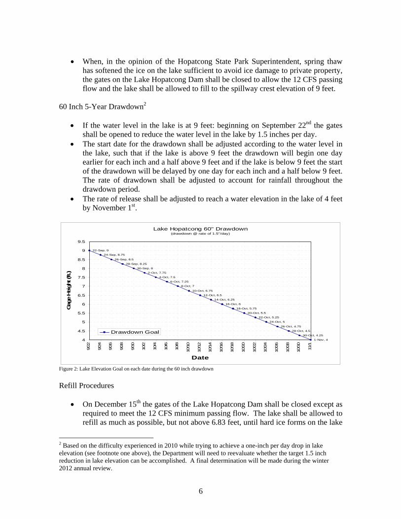
60 Inch 5-Year Drawdown2
• If the water level in the lake is at 9 feet: beginning on September 22nd the gatesshall be opened to reduce the water level in the lake by 1.5 inches per day.
• The start date for the drawdown shall be adjusted according to the water level inthe lake, such that if the lake is above 9 feet the drawdown will begin one dayearlier for each inch and a half above 9 feet and if the lake is below 9 feet the startof the drawdown will be delayed by one day for each inch and a half below 9 feet.The rate of drawdown shall be adjusted to account for rainfall throughout thedrawdown period.
• The rate of release shall be adjusted to reach a water elevation in the lake of 4 feetby November 1st.
Lake Hopatcong 60" Drawdown(drawdown @ rate of 1.5"/day)
22-Sep, 9
24-Sep, 8.75
26-Sep, 8.5
28-Sep, 8.25
30-Sep, 8
2-Oct, 7.75
4-Oct, 7.5
6-Oct, 7.25
8-Oct, 7
10-Oct, 6.75
12-Oct, 6.5
14-Oct, 6.25
16-Oct, 6
18-Oct, 5.75
20-Oct, 5.5
22-Oct, 5.25
24-Oct, 5
26-Oct, 4.75
28-Oct, 4.5
30-Oct, 4.25
1-Nov, 44
4.5
5
5.5
6
6.5
7
7.5
8
8.5
9
9.5
9/22
9/24
9/26
9/28
9/30
10/2
10/4
10/6
10/8
10/1
0
10/1
2
10/1
4
10/1
6
10/1
8
10/2
0
10/2
2
10/2
4
10/2
6
10/2
8
10/3
0
11/1
Date
Gag
e Hei
ght (
ft.)
Drawdown Goal
Figure 2: Lake Elevation Goal on each date during the 60 inch drawdown
Refill Procedures
• On December 15th the gates of the Lake Hopatcong Dam shall be closed except asrequired to meet the 12 CFS minimum passing flow. The lake shall be allowed torefill as much as possible, but not above 6.83 feet, until hard ice forms on the lake
2 Based on the difficulty experienced in 2010 while trying to achieve a one-inch per day drop in lakeelevation (see footnote one above), the Department will need to reevaluate whether the target 1.5 inchreduction in lake elevation can be accomplished. A final determination will be made during the winter2012 annual review.

7
such that, in the opinion of the Superintendent, a continuing rise in waterelevation may cause property damage.
• If the water elevation reaches 6.83 feet before a hard freeze occurs, the gates shallbe operated in response to rainfall to maintain that water level.
• If the elevation does not reach 6.83 feet before the hard ice forms, the gates shallbe operated to maintain the water level existing on the date of the hard freeze.
• If the water elevation of 6.83 feet is not achieved, and conditions change duringthe winter that soften the ice to the point that, in the opinion of the Superintendenta water level rise will not cause property damage, or unduly interfere with winterrecreation on the lake, the water level will be allowed to rise during that period,but not over 6.83 feet.

8
INTRODUCTION
Lake Hopatcong lies on the southern border of Sussex and Morris Counties, and islocated within the boundaries of four municipalities, the Boroughs of Hopatcong andMount Arlington and the Townships of Jefferson and Roxbury. Lake Hopatcong isapproximately nine miles long, with 38 miles of shoreline encompassing 2,658 acres(normal pool). For such a large lake, Lake Hopatcong has a relatively small drainagearea of only 25.3 square miles. Lake Hopatcong is the largest freshwater lake in the Stateof New Jersey and through aggressive stocking programs supports perhaps the greatestdiversity of freshwater fish anywhere in the State. The lake is a significant recreationalresource for the residents of New Jersey providing year round opportunities for boating,fishing, swimming, ice skating, ice boating etc. The lake is a focal point for the local andregional economy.
Lake Hopatcong originally existed as two separate bodies of water formed by the retreatof the Wisconsin glacier over 12,000 years ago. In the 1750s a six-foot high dam wasconstructed across the Musconetcong River primarily as a water source for the BrooklynForge. The dam increased the water level and engulfed the two ponds and surroundingareas to form Lake Hopatcong. Later the dam was raised to supply water to the MorrisCanal which connected the Delaware River to the Passaic River and ultimately to theHudson River. The Morris Canal and Banking Company was chartered in the State ofNew Jersey in 1824 to construct the Morris Canal. Lake Hopatcong and downstreamLake Musconetcong were part of the Morris Canal and Banking Company (as wereCranberry and Greenwood Lakes). Fourteen (14) Canal Acts passed during the period ofFebruary 28, 1923 to March 13, 1925 continued these lakes as part of the Morris Canaland Banking Company, whose charter and rights were deeded in trust to the State of NewJersey. The Canal Acts placed the administration and management of the Company andits property under the Board of Conservation and Development. By succession theseresponsibilities now reside with the Department of Environmental Protection, Division ofParks and Forestry.
Included in those legislative enactments at N.J.S.A. 13:12-5 is direction to theDepartment of Environmental Protection concerning the management of Lake Hopatcongstating:
“The waters of Lake Hopatcong may be used as an aquatic public park, forboating, bathing, fishing, and winter sports, and the lake level shall be maintainedfor such purposes at the normal high water mark as established on March eleven,one thousand nine hundred and twenty-two, natural elements permitting.”
Following the adoption of the 1922 Act, a court action by the Association ofMusconetcong Millers resulted in a court order requiring the construction of a fountainbelow the newly constructed Lake Hopatcong Dam designed to measure the minimumflow of 7.5 million gallons per day (12 CFS) from Lake Hopatcong down theMusconetcong River (from “A Summary Report on the Morris Canal and Banking

9
Company”, by Frederick A. Eckhardt, Sr. June 27, 1975).3 Initial rules for themanipulation of Lake Hopatcong water levels date from October 20, 1932. Historicallywater levels in Lake Hopatcong were lowered by 30 inches annually for waterfrontmaintenance and to protect property from ice damage. Effective January 1, 1990 theannual drawdown was reduced to 26 inches. Since 1982, the lake is lowered 60 inchesonce every five years to allow for major repairs to lakeshore structures and facilitateinspection and repairs to the lake Hopatcong Dam. Prior to 1982 the five-year loweringwas 84 inches. The next 60 inch drawdown is scheduled to occur in September 2013.Prior to this update the plan was most recently updated in 2000.
From Lake Hopatcong flows the Musconetcong River. About 1.25 miles downstreamfrom Lake Hopatcong, the Musconetcong River feeds Lake Musconetcong, another of thewater reservoirs used to support the Morris Canal. Lake Musconetcong has a surfacearea of 315 acres and an additional drainage area of 4.4 square miles (29.7 sq. mi. total).Eight miles below Lake Musconetcong, the River has been designated as a recreationaland scenic river and was included in the National Wild and Scenic River System in 2006.The Musconetcong River also provides an important recreational trout fishery. Ingeneral, as the distance along the Musconetcong River increases from the LakeHopatcong Dam, the operation of the Lake Hopatcong Dam has less of an effect on flowsin the river. For example, while Lake Hopatcong flows make up a significant portion ofthe flow of the Musconetcong River between Lake Hopatcong and Lake Musconetcong,at Bloomsbury the 12 CFS passing flow from Lake Hopatcong makes up only about 10percent of the median flow.
The United States Geological Survey (USGS) maintains a stream gauge 300 feetdownstream of the Lake Hopatcong Dam (# 01455500) on the left bank just upstream ofthe highway bridge on Lakeside Boulevard. Water releases from the lake are measured atthis gauge. A USGS lake level gauge (#01455400) is also maintained and is located inthe Lake Hopatcong gatehouse. The base elevation for this gauge is 914.57 (1929NGVD). Lastly, USGS maintains a rain gauge at Lake Hopatcong (#405502074295601).Data gathered from these gauges can be viewed on the USGS web site athttp://waterdata.usgs.gov/nj/nwis/current/?type=flow. All gauges are funded by the NewJersey Department of Environmental Protection.
3 Although the fountain was designed to measure the minimum passing flow of 12 CFS required by thecourt, Helen Maurella, Superintendent of Hopatcong State Park reports that it actually releases more than12 CFS.

10
GOAL OF THE LAKE HOPATCONGWATER LEVEL MANAGEMENT PLAN
The goal of this plan is to protect the environmental health and the natural, and scenicresources of Lake Hopatcong / Musconetcong River System, maximize recreationalopportunities, minimize the potential for damage to property and waterfront structures,while maintaining the minimum flow requirements necessary to protect downstream uses,including but not necessarily limited to: aquatic biota, historic resources and waterquality.
OBJECTIVE OF THE LAKE HOPATCONGWATER LEVEL MANAGEMENT PLAN
To establish a set of easily understood management and operational guidelines for themanipulation of the Lake Hopatcong water control structure to maintain a lake elevationas near as possible to 9 feet in Lake Hopatcong between May 1st and November 19th
conditions permitting, except during the five-foot drawdown years when the drawdownshall start on or about September 22, while meeting the requirements of downstreamuses.
Disclaimer: At no time is this plan is intended to restrict the ability of theSuperintendent in charge of Hopatcong State Park to exercise best professionaljudgment in response to unusual or unforeseen circumstances as necessary tominimize property damage or the threat to human safety in the Lake Hopatcongand Musconetcong Watershed.
RESOURCE MANAGEMENT CONSIDERATIONS
The annual drawdown of Lake Hopatcong is primarily intended to protect waterfrontstructures from ice damage that would be caused by fluctuating water levels once solidice has formed on the Lake. An ancillary benefit from the annual drawdown is that itprovides waterfront property owners and the municipalities the ability to perform minormaintenance, sediment and debris removal. The five-year, five-foot drawdown providesan opportunity for property owners to schedule and perform more significantmaintenance. It is noted that due to the bedrock geology beneath the lake, typical marineconstruction practices (e.g. driving of sheet pile and pilings) employed in the coastalwaters of New Jersey cannot be applied everywhere in Lake Hopatcong. Consequently,many structures are supported by concrete or rock revetments and rock-filled cribstructures. Maintenance of these structures typically cannot occur under water and wouldrequire coffer damming if the Lake was not lowered. Underwater constructiontechniques may be available but are generally cost prohibitive.

11
Fish and Wildlife
The Division of Fish and Wildlife (DFW) notes that both the fishery in Lake Hopatcongand the fishery downstream in the Musconetcong River are important resources andmanagement requires balancing the needs of both. The DFW stocks Lake Hopatcong,Lake Musconetcong, and the Musconetcong River, both in-between the two lakes anddownstream of the Lake Musconetcong dam, with a variety of fish. All three waterbodies provide strong recreational fisheries.
Lake Hopatcong supports an abnormally large number and diversity of top levelpredators including trout, walleye, musky, hybrid striped bass, and channel catfish. Theability of the lake to support these predators owes to its high productivity resulting in astrong forage base of fish such as alewife. These forage fish have little difficultyadjusting to the water level in the lake as it is raised or lowered. Lake Hopatcong isdesignated as FW2 Trout-Maintenance in the New Jersey Surface Water QualityStandards (N.J.A.C. 7:9B). This designation means that water quality in the lake is goodenough year-round to support trout, though reproduction of trout in the lake does notoccur probably due to the lack of suitable substrate.
The Division’s regulations governing water lowering in impoundments (N.J.A.C. 7:25-6.25) require that north of I-195 lake lowering must be completed by November 1 inorder to protect hibernating turtles and amphibians. The DFW has made an exception tothis requirement for Lake Hopatcong due to the lake’s large size. Requiring drawdown tobe completed by November 1 would result in the initiation of lowering in the late summerand early fall when recreational use of the lake is still at its peak. These regulations alsorequire that downstream flows must be maintained at all times.
The Musconetcong River below the Lake Hopatcong Dam is classified as Trout-Maintenance, it supports trout on a year round basis. The Division of Fish and Wildlifesurveyed the Musconetcong River, downstream of the lake, during the summer of 2009,and found 15 species of fish reside in the river. Some of those species such as trout andmargined madtom are indicators of high water quality and habitat. Trout in particular arevery sensitive to elevated water temperatures. Stream temperatures are dependent onflow conditions. Reductions in stream flows result in accelerated temperature increasesresulting in the significant mortality to the trout that reside in the river year round. LakeMusconetcong by comparison is designated as FW2 Non-Trout because it cannot supporttrout year-round.
Maintaining stream flows below the lake is extremely important to maintaining aquaticlife in the river. These flows are especially critical during the summer months, when hot,dry weather results in natural increases in water temperatures. Reduced or low flowsexacerbate these already stressful conditions.

12
Musconetcong River between Lake Hopatcong and Lake Musconetcong
The Division of Fish and Wildlife believes that the 12 CFS passing flow in the currentplan is generally protective of the downstream resources. In fact, the ecology of thesection of the Musconetcong River between Lake Hopatcong and Lake Musconetconghas stabilized in reliance on the passing flow that has been in place since prior to 1932.4Under extreme circumstances the Division of Fish and Wildlife may entertain a furtherreduction to 8.2 CFS; however, the Division stresses that numerous considerations mustbe taken into account including spawning seasons, spawning habitat requirements, watertemperature, day and night air temperature, weather pattern forecasting and duration,wettable habitat and others. During the spring of 2009 when the DEP reduced flowsbelow 8.2 CFS to facilitate refilling of the lake very close monitoring of in-streamconditions was required. Weather conditions during that period were generally cool andrainy which allowed additional flexibility in minimum flows without jeopardizing theaquatic resources downstream of the lake. Absent those mitigating conditions (had itbeen hot and dry) the reduction in stream flow may have resulted in fish kills in theMusconetcong River, and the reduction in flow could not have occurred.
Water Quality
The New Jersey Pollutant Discharge Elimination System (NJPDES) program is federallydelegated under the federal Clean Water Act (N.J.A.C. 7:14A). The program setseffluent limits for point source discharges (such as industrial discharges and wastewatertreatment plant discharges). Specific water quality criteria for various pollutants areestablished in the Surface Water Quality Standards as necessary to protect the designateduses of the surface waters of the State. The designated uses of Lake Hopatcong and theMusconetcong River are: primary and secondary contact recreation; maintenance,migration and propagation of the natural and established biota; potable water supply afterconventional filtration and treatment; and industrial and agricultural water supply.Effluent limits are set to be protective of human health and ecological resources, bymeeting the Surface Water Quality Standards (N.J.A.C. 7:9B) in the receiving waters.
4 Please see Unresolved Issues Raised by the CAC toward the end of this document.

13
Most Surface Water Quality Criteria are established as concentrations of a particularpollutant in the receiving water for aquatic life (acute and chronic) and human healthcriteria. Therefore, effluent limits are driven by the amount of dilution (flow) available inthe stream under low flow conditions. Typically different flows are used to establisheffluent limits for “acute” criteria (those where a short term exposure will causeunacceptable impacts) and “chronic” criteria (those conditions that can be tolerated for alonger duration before a negative effect is observed) and human health carcinogenic andnon-carcinogenic effect-based criteria. For example, the DEP uses the MA1CD10 flow(the one day minimum flow with a return interval of 10 years) for acute criteria; and theMA7CD10 (the seven day minimum flow with a return interval of 10 years) for chronicand human health non-carcinogenic criteria; and the MA30CD10 (the 30 day low flowwith a return interval of ten years) for ammonia nitrogen. The nearest regulateddischarge with effluent limits on the Musconetcong River is the Musconetcong SewerageAuthority (MSA) (NJPDES Permit # NJ0027821). MSA’s discharge point is locatedapproximately 1.45 river miles downstream of the Lake Musconetcong Dam. Thedrainage area to the MSA discharge is 30.9 square miles of which 25.3 square miles iscontributed by Lake Hopatcong. Consequently, the operation of the Lake HopatcongDam may have a significant effect on the dilution available at MSA’s discharge,particularly during extended dry periods or droughts.
At present MSA discharges about 4.31 million gallons per day (MGD) of treatedwastewater, but its permit allows that discharge to increase to 5.79 MGD. MSA’seffluent limits are set based on low river flows of 3.6 CFS, 4.4 CFS and 5.4 CFS at thedischarge point. If low flows in the Musconetcong River were reduced below theselevels, MSA would receive more stringent effluent limits, which could lead to costlytreatment plant upgrades. During periods of drought the minimum passing flow has beenreduced to lower levels. Historically this had been reduced to 6.2 CFS, however, duringthe 2002 drought this flow level was evaluated and found to provide inadequate dilutionto protect aquatic life from toxic concentrations of ammonia due to the loading from adownstream publicly owned wastewater treatment plant and a new low flow criterion of6.8 CFS was recommended.
Flooding
As a result of the August 11 - 14, 2003 flood, the stage discharge relationship for theLake Hopatcong stream gauge has changed. Flood stage as reported by USGSdownstream of Lake Hopatcong is now 4 feet (increased from 3.3 feet). However, basedon personal experience, Superintendent Maurella believes the maximum discharge thatcan safely be accommodated by the downstream structures is equal to a gauge height of3.5 feet. This rate of out flow cannot be exceeded and will control how fast the waterlevel in the lake can be lowered. There is an old mill building located on Furnace Roadin Stanhope that straddles the Musconetcong River. There is a second buildingimmediately downstream that also straddles the River. That building is presentlyoccupied, and the dam cannot be operated so as to put that property at peril. Members ofthe citizens advisory committee suggest that a diversion channel has been created around

14
this building and that flooding of the structure may not be an issue. An inspection of thisdiversion channel reveals that floodwaters would hit the building and make a 90 degreeleft hand turn into the concrete channel that surrounds the building. While this channelmay reduce flood elevations upstream of the building and the pressure on the upstreamwall, it will not likely keep the building itself from being damaged. Numerous otherbuildings downstream of Lake Hopatcong also lie in the floodplain of the MusconetcongRiver. A number of structures around Lake Hopatcong are also located in the floodplain.The Superintendent will have to evaluate conditions both around the Lake anddownstream to determine what adjustments to the sluice gates on the Lake Hopatcongand Lake Musconetcong Dams, if any should be made to reduce flood the potential forflood damage.
Old mill building across the Musconetcong River in Stanhope, low water (top) and high water (bottom)
Dam Safety
The Lake Hopatcong Dam spillway is about 100 feet long and has an elevation of 9 feet.The dam also has a water control structure consisting of a fountain and four sluice gateswhich allow the water level to be manipulated below the spillway elevation. The LakeHopatcong Dam is a Large Dam as it impounds in excess of 1,000 acre/feet of water.The Lake Hopatcong Dam is also classified as a High Hazard Dam. The High Hazardclassification owes to the inundation potential and threat to life and property if the damwere to fail. The classification has nothing to do with the condition of the dam itself.
Under the Dam Safety Rules the Lake Hopatcong Dam must be inspected by a LicensedProfessional Engineer every year (N.J.A.C. 7:20). A drawdown of the lake is notrequired to perform this inspection, though it is beneficial to stop water from spilling overthe dam to facilitate inspection of the downstream face of the dam. Based on the most
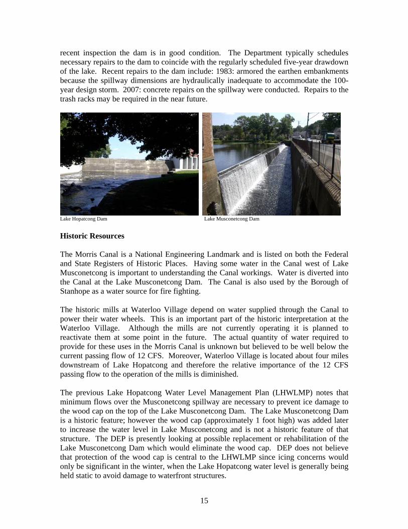
15
recent inspection the dam is in good condition. The Department typically schedulesnecessary repairs to the dam to coincide with the regularly scheduled five-year drawdownof the lake. Recent repairs to the dam include: 1983: armored the earthen embankmentsbecause the spillway dimensions are hydraulically inadequate to accommodate the 100-year design storm. 2007: concrete repairs on the spillway were conducted. Repairs to thetrash racks may be required in the near future.
Lake Hopatcong Dam Lake Musconetcong Dam
Historic Resources
The Morris Canal is a National Engineering Landmark and is listed on both the Federaland State Registers of Historic Places. Having some water in the Canal west of LakeMusconetcong is important to understanding the Canal workings. Water is diverted intothe Canal at the Lake Musconetcong Dam. The Canal is also used by the Borough ofStanhope as a water source for fire fighting.
The historic mills at Waterloo Village depend on water supplied through the Canal topower their water wheels. This is an important part of the historic interpretation at theWaterloo Village. Although the mills are not currently operating it is planned toreactivate them at some point in the future. The actual quantity of water required toprovide for these uses in the Morris Canal is unknown but believed to be well below thecurrent passing flow of 12 CFS. Moreover, Waterloo Village is located about four milesdownstream of Lake Hopatcong and therefore the relative importance of the 12 CFSpassing flow to the operation of the mills is diminished.
The previous Lake Hopatcong Water Level Management Plan (LHWLMP) notes thatminimum flows over the Musconetcong spillway are necessary to prevent ice damage tothe wood cap on the top of the Lake Musconetcong Dam. The Lake Musconetcong Damis a historic feature; however the wood cap (approximately 1 foot high) was added laterto increase the water level in Lake Musconetcong and is not a historic feature of thatstructure. The DEP is presently looking at possible replacement or rehabilitation of theLake Musconetcong Dam which would eliminate the wood cap. DEP does not believethat protection of the wood cap is central to the LHWLMP since icing concerns wouldonly be significant in the winter, when the Lake Hopatcong water level is generally beingheld static to avoid damage to waterfront structures.

16
Water Supply
The Water Supply Management Act and Rules (N.J.A.C. 7:19) direct the Department toregulate large diversions of water (100,000 GPD or more, 50,000 GPD in the HighlandsPreservation Area) such that downstream uses and users are protected, including thenatural environment of the waterways of the State. The DEP is required to set minimumpassing flows on all diversions that will ensure that these uses are protected. Passingflows can only be altered under a declared water emergency by the Governor (N.J.A.C.7:19-10.2(a)6).
There had been two significant downstream permitted users of water in theMusconetcong identified in the prior version of the Lake Hopatcong Water LevelManagement Plan: U.S. Mineral Wool and MSA. Presently neither is diverting waterfrom the river or has approval to do so. There are six other approved diversionsdownstream on the Musconetcong River, but these appear to be far enough downstreamthat it is unlikely that the Lake Hopatcong Water Level Management Plan would have asignificant effect on them. Consequently, there appear to be no current downstreampermit holders that would be affected by the LHWLMP. However, there are downstreamuses that must be protected including: dilution required for the MSA discharge; thehistoric uses at the Morris Canal and Waterloo Village; the Wild and Scenic Riverdesignation of the Musconetcong River; recreational uses and fisheries and wildlifeconcerns.
There is one in-lake registered user of water, Lakeshore Village Condos, who is allowedto take water directly from Lake Hopatcong not to exceed 3.1 million gallons per month(MGM), using three 70 gallons per minute pumps. Note, diversions of 100,000 GPD or3.1 MGM require a permit from NJDEP, (50,000 GPD in the Highlands PreservationArea). To date they have not reported any water use. Also the Delaware River BasinCompact allows the Delaware River Basin Commission to order releases from LakeHopatcong of up to 75 CFS down to elevation 915.2 feet (18 CFR Part 410,2.5.6D.3.b.viii, D.3.f., E.3.a.) during water emergencies (.62 feet on the gauge).
Historical notes:1) The current LHWLMP provides reference to a court ordered passing flow of 12
CFS from Lake Hopatcong as the result of a court action brought against the Stateby the Musconetcong Millers Association. DEP does not believe that theMusconetcong Millers Association still exists. However, the court order isunpublished and DEP has been unable to locate a copy of to assess whether itremains in full force and effect. An August 22, 1924 letter from CorneliusVermeule to the Board of Conservation and Development references the disputebetween the millers and the lake community.
2) During the drought of record from 1961-67, passing flows from Lake Hopatcongwere reduced significantly and records indicate at times no outflow from the Lakeoccurred.

17
3) Lake Hopatcong has been used as a source of water during droughts. DuringOctober, November and December of 1965 approximately 3.675 billion gallons ofwater was pumped from Lake Hopatcong to the Rockaway River. BetweenNovember 1980 and February 1981 approximately 2.5 billion gallons of waterwas pumped from Lake Hopatcong to the Rockaway River. Although nopumping equipment is in place presently, the pipeline is still intact and wasinspected during the drought of 2001-02. Under previous declared wateremergencies, the passing flow out of Lake Hopatcong has been reduced. Duringthe 2001-02 drought the Department calculated the minimum required passingflow for dilution at MSA to be 6.8 CFS.
4) A July 9, 1985 letter from Deputy (DEP) Commissioner Richard Dewling toMorton A. Siegler established rules for the use of Lake Hopatcong as anemergency water supply based on Boonton Reservoir levels.
Hopatcong State Park
Releases from Lake Hopatcong and consequently water levels in the lake are controlledthrough a series of four sluice gates and one “fountain” located at the Hopatcong StatePark. The fountain is designed to release 12 CFS as required by the MusconetcongMillers Association court order; however, it actually releases more than 12 CFS whenfully open. The State Park has not been able to control access to the fountain to keepunauthorized bathing out of the basin surrounding the fountain. The “fountain” lackswater quality testing required for bathing, and lifeguards to prevent drowning or otheraccidents. Therefore, the State Park has shut the fountain off during the bathing seasonand opted to use the sluice gates to meet passing flow requirements.
The sluice gates and the fountain must be manually opened and closed by turning wheelsin the gate house. The wheels are not automated and not graduated; however, seven turnsof the wheel will open or close the gate by about one inch.5 Once an adjustment is madestaff must read the staff gauge downstream of the Dam and readjust based on waterelevation in the stream (web reporting from the USGS gauge is delayed perhaps by up toseveral hours). Staffing issues are a major limitation with regard to manipulating thecontrol structure. The Park does not have staff dedicated to just watching the Dam, andstaff are not available 24 hours a day, 7 days a week. However, the State Park doesbelieve it can monitor and adjust the flow out of the lake in the morning and in theevening on any day that the Park is open and adequately staffed.
Other than the winter drawdown and spring refill, park staff regulate the water level inthe Lake during the summer to prevent the Lake from reaching 9.5 feet at the gauge at thedam which results in a “no-wake” declaration on the Lake, and to maintain a static waterlevel to the extent possible during the winter to reduce ice damage potential.
The State Park does not have specific facilities that require routine lowering of the waterlevel. However, the State Park does try to arrange any required maintenance around the 5 Per Superintendent of Hopatcong State Park

18
established drawdown schedule. The schedule can be found in the Water LevelManagement Procedure section of this Plan.
Lake Hopatcong Gate House Hand cranks control sluice gates and fountain
Lake Hopatcong sluice gates Fountain at Lake Hopatcong.
Stream gauges are located under bridge in the background
Wild and Scenic River
On December 26, 2006 President Bush signed P.L. 109-452 designating theMusconetcong River below Saxton Falls as a National Wild and Scenic River. The 3.5mile segment from Saxton Falls to the Route 46 Bridge is designated a “scenic” river andthe 20.7 mile segment below the King’s Highway Bridge is designated a “recreational”river. One of the requirements for designation is that a river must be in a “free flowingcondition.” The operation of the Lake Hopatcong Dam in a manner that wouldsignificantly reduce or eliminate flows to the designated segments could be cause foraction by the National Park Service and the downstream municipalities that make up theMusconetcong management partnership. Saxton Falls is located about 8 milesdownstream of Lake Hopatcong and the drainage area to the river at that location is about68 square miles. Lake Hopatcong’s drainage area by comparison is just over 25 squaremiles. Therefore, Lake Hopatcong’s flow would be expected to make up less than half ofthe flow at Saxton Falls under natural conditions. However, during extremely dryweather the 12 CFS passed from Lake Hopatcong may be more important to maintainingdownstream flows.

19
Lake Hopatcong Recreational Boating
The spillway elevation of Lake Hopatcong is 9 feet. Marina owners who are members ofthe CAC report that ten percent (10%) of their slips are not usable when the water level inthe lake drops to 8.25 feet. In addition to the loss of dockage, low water levels increasethe risk to boaters from submerged rocks in the lake. The CAC reports that recreationalboating will be severely impacted if the water surface elevation drops to 7.5 feet. Highwater also affects recreational boating. At an elevation of 9.5 feet a “no wake”declaration is issued by the State Police Marine Division in Lake Hopatcong to reduce thepotential for shoreline erosion and damage to structures due to wake action. A “no wake”declaration negatively impacts recreational boating activities. In order to maximizerecreational boating opportunities the goal of the plan is to maintaining a water surfaceelevation below 9.5 feet and above 7.5 feet during the spring and summer months,conditions permitting.
Conclusion
There are several downstream and in lake considerations that must be balanced by theLake Hopatcong Water Level Management Plan. In general, the Department believes the12 CFS passing flow from Lake Hopatcong to be protective of all of the downstreamresources. Based on the information above, if a reduction in the passing flow iscontemplated the most sensitive resource consideration is the protection of aquatic life inthe segment between Lake Hopatcong and Lake Musconetcong. This river segmentrelies almost exclusively on the water released from Lake Hopatcong. The release from

20
Lake Hopatcong makes up less of the overall flow in the Musconetcong River as onemoves progressively farther downstream. However, during extremely dry periods allresource considerations enumerated above should be examined before any departure fromthe Lake Hopatcong Water Level Management Plan is authorized.
WATER LEVEL MANAGEMENT PROCEDURES
General Information
The LHWLMP has been established to maximize recreational opportunities, minimizethe potential for damage to property and waterfront structures, while maintaining theminimum flow requirements necessary to protect downstream uses. The plan also takesinto consideration the important aquatic resources residing within the lake. To this end,the following Water Level Management Procedures have been established through thecooperative efforts of the Lake Hopatcong Citizens Advisory Committee, the LakeHopatcong Commission, and several facets of the Department of EnvironmentalProtection, including the Division of Parks and Forestry, Division of WatershedManagement, Division of Water Supply and the Division of Fish and Wildlife.
In order to maximize recreational opportunities, a lake level of 9 feet (spillway elevation)is targeted for the spring and summer months. Depending on the location within the lake,certain recreational uses may be impeded at lower surface elevations, ranging from 8.25to 7.5 feet. To the contrary, an elevation of 9.5 feet a “no wake” declaration is issued bythe State Police Marine Division in Lake Hopatcong to reduce the potential for shorelineerosion and structural damage due to wake action. A “no wake” declaration negativelyimpacts recreational boating activities. So to the extent possible, elevations below 9.5will be maintained. However, it is important to note that downstream flooding concernswill dictate how much water can be released from Lake Hopatcong and how quickly lakeelevation may be reduced at any given time.
The flood elevation established by the United States Geological Survey for the gaugeimmediately downstream of Lake Hopatcong is 4 feet. However the Park Superintendentbelieves that downstream flooding concerns actually limit the discharge to 3.5 feet on thegauge. An elevation of 3.5 feet on this staff gauge is equivalent to a discharge of 213CFS from Lake Hopatcong. At this rate of discharge, and assuming no additional wateris entering the lake, the lake can be lowered by approximately 1.9 inches per day. Theactual rate of allowable discharge will be determined by the superintendent based onflooding conditions downstream of Lake Hopatcong and shall be managed so as to avoidcausing or increasing downstream flood damage and to ameliorate such damage whenpossible.
To minimize the potential for property damage, an annual lowering of 26 inches will beperformed to prevent waterfront structures from ice damage. This also permits someminor maintenance to be completed along the shoreline. A static water level will bemaintained until spring once ice has hardened. A more substantial drawdown of 60

21
inches will occur every five years to provide lakefront property owners time to performmore significant repairs or replacement of shoreline structures. To the extent feasible,any necessary dam maintenance/repair will be scheduled in accordance with thistimetable.
Once ice has thawed in the spring the refilling of the lake will begin. In general, theDepartment has more control over lowering the lake level than raising it. The keyingredient to increasing the water level in the lake is precipitation. Adequate andconsistent rainfall events are especially important to the lake considering its large size butrelatively small drainage area that contains no significant tributaries. Average rainfallduring the summer is about 4.5 inches per month. Each inch or rain typically raises thelake by two inches for a total increase of about 9 inches. The 12 CFS passing flowrequirement, absent rainfall, would reduce the lake elevation by an estimated 3.6 inchesper month. The evaporation loss of water from the lake would reduce the lake elevationby 4.3 to 4.5 inches per month.6 Therefore, with normal rainfall the water surfaceelevation in the lake should remain relatively constant. However, precipitation is notdistributed evenly over time periods and if rainfall is below average during the summerthe water level in the lake will drop due to outflow from the lake and evaporation.Retaining water in the lake when rainfall is abundant is an important consideration.Consequently, this water level management plan recommends a conservative approachthat will maintain the water level above the 9 foot spillway elevation, but below the 9.5“no wake” elevation, when possible while continually meeting the 12 CFS passing flowrequirement.
Schedule of Water Lowering Events
The LHWLMP includes an annual 26-inch lowering, and a 60-inch lowering to beperformed every five years. The annual 26-inch drawdown of Lake Hopatcong isprimarily intended to protect waterfront structures from ice damage that would be causedby fluctuating water levels once solid ice has formed on the lake. An ancillary benefitfrom the annual draw down is that it provides waterfront property owners and themunicipalities the ability to perform minor maintenance, sediment and debris removal.The five-year, 60-inch drawdown provides an opportunity for property owners toschedule and perform more significant maintenance. It is noted that due to the bedrockgeology beneath the lake, typical marine construction practices (e.g. driving of sheet pileand pilings) employed in the coastal waters of New Jersey cannot be applied everywherein Lake Hopatcong. Consequently, many structures are supported by concrete or rockrevetments and rock-filled crib structures. Maintenance of these structures typicallycannot occur under water and would require coffer damming if the lake was not lowered.The five foot drawdown also provides some aquatic weed control benefits. The extent of
6 A CDM report for the Water Supply Authority calculated summer evaporation at Lake Hopatcong duringthe summer of 1965 to average 4.3 inches per month. The National Oceanic and AtmosphericAdministration calculated pan evaporation loss at the Canoe Brook Reservoir located in westernEssex County NJ for the period between 1994-1997 at 6.4 inches per month. Lake evaporation istypically in the neighborhood of 70 percent of the pan evaporation loss or 4.5 inches per month.

22
weed control is dependent on winter weather conditions. Long, cold winters providegreater aquatic weed control benefits as the roots of the exposed plants are subject to frostand freezing. Snow cover on the lake for long durations also assists in controlling weedsin the lake.
Based upon the guidelines outlined in this Plan the schedule of future lowering events is:
Year Maximum ScheduledDrawdown*
Elevation(gauge elevation)
2010 26” 6.83 ft2011 26” 6.83 ft2012 26” 6.83 ft2013 60” 4 ft2014 26” 6.83 ft2015 26” 6.83 ft2016 26” 6.83 ft2017 26” 6.83 ft2018 60” 4 ft
Summer Water Level Management
In order to protect the aquatic biota residing in the Musconetcong River downstream ofthe lake a minimum passing flow of 12 CFS, from the Lake Hopatcong Dam, has beenestablished in previous versions of the LHWLMP. Maintaining minimum passing flowsduring the summer months are particularly critical to protecting the downstreamcoldwater aquatic resources. Hot, dry weather patterns during the summer result innatural increases in water temperatures. Elevated water temperatures and resultingdecreases in dissolved oxygen levels stress fish and other aquatics, particularly so withcoldwater species. Reduced or low flows exacerbate these already stressful conditions.Without rainfall the water surface elevation in the lake will generally fall due to therequirement to pass 12 CFS downstream and evaporation. In general, absent rainfall thelake elevation response to passing 12 CFS out of the lake is to lower the water surface byabout 3.6 inches per month. However, evaporation losses through the summer monthscan further reduce the water elevation in the lake by an additional 4.5 inches per monthfor a total loss of 8.1 inches per month. Average monthly precipitation during thesummer months is about 4.5 inches and each inch of precipitation results in about 2inches of increased elevation in the lake for a total make up of 9 inches per month. Dryperiods or extended periods of below normal rainfall will result in the water level in thelake dropping due to the passing flow and evaporation. Therefore the goal of water levelmanagement in the summer months is to maintain a surface elevation at or slightly above9-feet (the spillway elevation) whenever possible while still maintaining the passing flowof 12 CFS (river gauge at 1.26 feet).
At an elevation of 9.5 feet a “no wake” declaration is issued by the State Police MarineDivision in Lake Hopatcong to reduce the potential for shoreline erosion and structuraldamage due to wake action. Therefore, the goal of the Water Level Management Plan

23
during the summer months shall be to maintain a water surface elevation below 9.5 feet.However, it must be understood that downstream flooding concerns will dictate howmuch water can be released from Lake Hopatcong and how quickly the Lake elevationcan be reduced. The flood elevation established by the United States Geological Surveyfor the gauge immediately downstream of Lake Hopatcong is 4 feet, though theSuperintendent observes that the maximum discharge without causing potential damagedownstream is likely 3.5 feet. An elevation of 4 feet on this staff gauge is equivalent to adischarge of 292 CFS from Lake Hopatcong. At 3.5 feet on the gauge the discharge isapproximately 213 CFS. Based on these figures, and assuming no additional water isentering the Lake, the Lake can be lowered by about 1.9 to 2.6 inches per day.7 Theactual rate of allowable discharge will be determined by the Superintendent based onflooding conditions downstream of Lake Hopatcong and shall be managed so as to avoidcausing or increasing downstream flood damage and to ameliorate such damage whenpossible.8
1) The required minimum passing flow of 12 CFS shall be met at all times unlessa lower passing flow is dictated by the NJDEP Assistant Commissioner forNatural and Historic Resources. The gates and or fountain shall be operatedto ensure that this condition is met.
2) The operational goal shall be to maintain the water level in the Lake at orslightly above 9 feet while meeting the required passing flow. When waterspilling over the dam is sufficient to meet the 12 CFS passing flow all gatesshall be closed, unless the water surface elevation is above 9.25 feet (9 feet, 3inches) and rising.
3) The operational goal shall be to prevent the water level from reaching 9.5 feet.
Lake Response to Summer Rainfall24 hour precipitation in inchesStarting
lakeelevationin feet
.5” 1” 1.5” 2” 2.5” 3”
9.0 9.08 9.17 9.25 9.33 9.42 9.59.1 9.18 9.27 9.35 9.43 9.52 9.69.2 9.28 9.37 9.45 9.53 9.62 9.79.3 9.38 9.47 9.55 9.63 9.72 9.89.4 9.48 9.57 9.65 9.73 9.82 9.99.5 9.58 9.67 9.75 9.83 9.92 10.0
7 The lake will typically be at 9.5 feet only after significant rain, consequently it is likely that there will beadditional water entering the lake during these times. Based on June 2010 data from the USGS gauges itappears that it may take about 4 days for water entering the lake to return to “normal.”8 It may take 6-8 hours for adjustments at the Hopatcong Dam to be apparent downstream at the Compacbuilding located on Furnace Road in Stanhope.

24
Note: this chart is provided for informational and illustrative purposes only. The lake elevations reported here are based on a limitedset of observations and the actual lake elevation response may vary due to the intensity and duration of rainfall, ground saturation andother factors.
4) 222 CFS would have to be released to reduce the Lake surface elevation by 2inches (.17 feet) in a 24 hour period.
Gauge Height / Discharge RelationshipGauge Heightin Feet
Dischargein CFS
24 Hour Lake ElevationResponse in Feet
1.15 8.2 .0061.26 12 .011.97 50 .042.56 100 .0753.02 150 .113.41 200 .153.75 250 .194.0 292 .22Note: full gauge / discharge relationship available at: http://waterdata.usgs.gov/nwisweb/data/exsa_rat/01455500.rdb
Water Level Management ProcedureAnnual 26 Inch Drawdown
Once hard ice three inches thick forms on Lake Hopatcong, rising or falling waterelevation in the lake can dislodge piles, crib structures, revetments, boat housefoundations and bulkheads or lift decking.9 To reduce the potential for ice damage, LakeHopatcong shall be drawn down 26 inches to a water surface elevation of 6.83 eachwinter. Releases from Lake Hopatcong shall be made over the course of the winter inresponse to precipitation and snow melt as necessary to maintain the water level as nearto 6.83 as possible. However, if significant rainfall is followed by a hard freeze, it maybe necessary to maintain the water level at an elevation above 6.83 feet to prevent thepotential for ice damage from a falling water level. Ancillary benefits from the annualdrawdown are to allow minor maintenance on waterfront structures, minor debris and siltremoval and the control of rooted aquatic weeds, also known as macrophytes. The targetwater surface elevation for the annual drawdown shall be achieved by December 15th.10
Refilling the lake will begin once the condition of the ice has softened sufficiently toreduce the concern over damage, generally when the ice is less than 4 inches thick,(typically around March 15th). Even if ice has freed itself from the shoreline, thick ice
9 In the prior plan “hard ice” was defined as ice capable of supporting 100 pounds. There is no definedthickness of ice that will support 100 pounds as its strength will vary depending on climatic factors as theice was formed. As a general rule of thumb for the public, if people are walking on the ice, it is too thick toalter the water level without the prospect of causing property damage.10 Historical Note: The prior version of the plan (2000) started the 26-inch annual drawdown on November1st at a rate of .75 inches per day.

25
floating on the lake is subject to movement due to wind, which could cause damage if itis blown into structures on the shoreline. Beginning on March 1st the Superintendent incharge of Hopatcong State Park, shall monitor ice conditions at several locations aroundthe lake. Recommended ice monitoring locations are: Byram Cove, Woodport, MainLake, Davis Cove, Henderson Cove, Great Cove, Bertrand Island, River Styx and theHopatcong State Park.
The Lake Hopatcong Commission may advise the Superintendent responsible forHopatcong State Park as to the ice condition on the Lake. However, the Superintendentshall have the sole discretion to determine when to begin refilling the Lake based on iceconditions around the Lake. The Superintendent shall advise the Lake HopatcongCommission and the Lake Musconetcong Regional Planning Board of his or her findingsand decision to begin refilling of the lake or not. The Lake Hopatcong Commission maypublicize the decision on its web-site.
Fall Drawdown Procedure
1) The Superintendent shall apply for a Lake Lowering Permit from the Divisionof Fish and Wildlife as required by N.J.S.A. 25:5-29 on or before August 1st.
2) If the Lake elevation is at 9 feet on November 12th the gates at the LakeHopatcong Dam shall be opened to reduce the lake elevation .79 inch per day(.066 feet). The date of the initiation of the drawdown shall be adjusted basedon the actual water surface elevation. For each .79 inch (.066 feet) departurefrom the 9-foot water surface elevation the drawdown date shall be moved upor back by one day. 11
3) The .79 inch rate of drawdown requires a release of approximately 88 CFS.The gauge depth downstream of Lake Hopatcong to achieve 88 CFS is about2.44 feet.
4) Figure 1 provides the target water surface elevation for each date during thedrawdown. The release rate of water through the Lake Hopatcong Dam shallbe adjusted in response to rainfall during the drawdown to maintain a lakeelevation as close as possible to the target which corresponds to the date onfigure 1. The public must understand that the .79 inch per day drawdown isthe Department’s target and that significant rainfall may temporarily result ina higher than predicted water surface elevation. If such an event occurs, itwill be the Department’s goal to accelerate the drawdown rate to achieve thetarget elevation as soon as possible. If the actual lake elevation in comparison
11 In the fall of 2010 the Department operated the drawdown starting on November 19 with a rate of 1 inchper day. A two-inch rainfall event on December 1 caused the Department to miss the December 15 targetdate by seven days. The rainfall event was followed by very cold weather. Though the Departmentreceived no reports of ice damage to property from the falling water level, the Department is concerned thatsuch damage may occur in the future. Based on this experience the Department has adjusted the scheduleto begin the drawdown seven days earlier than in the draft plan.

26
with the chart indicates that the drawdown is proceeding too quickly (i.e. thelake elevation is below the target for the date) the outflow shall be reduced toslow the rate of the drawdown until the lake elevation equals the targetelevation.
5) The Superintendent has the latitude to determine the maximum rate of releasefrom Lake Hopatcong based on downstream conditions so as to avoid orminimize the potential for flood damage downstream.
LAKE HOPATCONG 26" DRAWDOWN
12-Nov, 9
15-Nov, 8.8
18-Nov, 8.6
21-Nov, 8.4
24-Nov, 8.2
27-Nov, 8
30-Nov, 7.8
3-Dec, 7.6
6-Dec, 7.4
9-Dec, 7.2
12-Dec, 7
15-Dec, 6.83
6.5
7
7.5
8
8.5
9
9.5
11/12 11/15 11/18 11/21 11/24 11/27 11/30 12/3 12/6 12/9 12/12 12/15
DATE
Gag
e H
eigh
t (ft
)
Drawdown Goal
Figure 1: Lake Elevation Goal on each date during the 26 inch drawdown
Winter Maintenance Procedure
1) Water shall be released throughout the winter as required to meet the required12 CFS passing flow. The release of water shall be adjusted as neededthroughout the winter in response to rainfall or melting snow to maintain thewater elevation in the lake as near as possible to 6.83 feet. Based on a limitedset of recent observations in winter, an inch of rainfall will raise the lakesurface elevation by about 4 inches. Based on personal experience theSuperintendent believes the maximum discharge that can be safely released byLake Hopatcong is 3.5 feet or 213 CFS.12 This maximum rate of dischargewould reduce the lake surface elevation by 1.92 inches (.16 feet) in 24-hours.Consequently, maintaining the Lake elevation following any 24 hour rainfallevent over an inch may not be possible if a hard freeze follows within 24
12 United States Geological Survey estimates four feet as measured on the stream gauge immediatelydownstream of Lake Hopatcong as flood stage at this location.

27
hours. The Superintendent shall aggressively release water as downstreamconditions permit in an attempt to maintain a static water surface elevation.
2) The Park Superintendent shall have the discretion to determine the rate ofrelease from Lake Hopatcong Dam considering downstream floodingpotential. The Park Superintendent shall have the discretion to maintain ahigher lake elevation following a significant rainfall, if in the opinion of theSuperintendent the risk of ice damage caused by lowering the water surface inthe lake is unacceptable.
Lake Response to Winter Rainfall24 hour precipitation in inchesStarting
lakeelevationin feet
.5” 1” 1.5” 2” 2.5” 3”
6.83 6.83 7.00 7.17 7.33 7.50 7.67Note: This chart is provided for general information only and to illustrate that it may not be possible to maintain a static waterelevation if significant rainfall occurs. The lake elevations reported here are based on a limited set of observations and the actual lakeelevation response may vary due to the intensity and duration of rainfall, ground saturation and other factors. The predicted elevationsassume maximum rate of discharge for all rainfall events over .5 inches.
Spring Refill Procedure
1) The timing of refilling shall be determined by the Superintendent in charge ofHopatcong State Park. Beginning on March 1st the Superintendent shallmonitor ice conditions on the Lake. Recommended ice monitoring locationsare: Byram Cove, Woodport, Main Lake, Davis Cove, Henderson Cove, GreatCove, Bertrand Island, River Styx and the Hopatcong State Park.
2) Refilling the lake will begin once the condition of the ice has softenedsufficiently to reduce the concern over damage (generally less than 4 inchesthick or when the ice will no longer support 100 lbs.) Once ice conditions aredeemed safe, the Lake Hopatcong Commission and the Lake MusconetcongRegional Planning Board shall be notified and all gates on the LakeHopatcong Dam shall be closed except as necessary to maintain a passingflow of 12 CFS (1.26 feet on the gauge below the dam).
3) Once the gates are closed, the summer water level management procedureshall be followed (above).
Water Level Management ProcedureFive-Year 60-Inch (5 foot) Drawdown
Last 60-inch Drawdown 2008-09Next Scheduled 60-inch Drawdown 2013-14
Depth to bedrock in places around the Lake prevents typical marine constructiontechniques (such as driving of pilings for docks and sheetpile for bulkheads) from being
28
employed. The purpose of the five-foot drawdown is to allow access to waterfrontstructures for inspection and maintenance. If the Lake were not drawn down, acofferdam would have to be installed around work sites significantly increasing the costof repairs. A drawdown also allows an inspection/repair of boat house foundationswithout hiring divers which can be expensive. Ancillary benefits to the five footdrawdown is that it allows clean up of the Lake bed, removing trash and debris and alsoseems to have the beneficial impact of reducing aquatic weeds in the following season.In the event that dam repairs or maintenance is required, the Department will schedulethose repairs to coincide with the scheduled 5-foot drawdown whenever possible (seeemergency conditions section).
Because the purpose of the five foot drawdown is to allow maintenance work onwaterfront structures the drawdown must take place before winter weather makes itimpossible to conduct repairs. The target date for completing the 60-inch drawdown isNovember 1st. At a proposed drawdown rate of 1.5 inches per day and assuming thewater surface elevation in the lake is 9 feet, the drawdown would begin on September22nd. The date of initiation of the drawdown will be adjusted based on the actual watersurface elevation in the lake: 1 day earlier or later for each 1.5 inch departure from the 9-foot starting elevation. The Department will attempt to manage the drawdown to meetthe corresponding target elevations on the dates reflected in Figure 2. Because thedrawdown rate has been increased in this plan to three-quarters of the 1.9 inch maximum,the Department’s ability to achieve the targets after rainfall will be more difficult. In theevent that the lake elevation is higher than the target on any given date, the Departmentwill accelerate, or maintain an accelerated drawdown rate until the water surfaceelevation is back on target. 13
The drawdown schedule was designed to provide a water surface elevation of about 4 feetlong enough to allow a reasonable opportunity to complete repairs: from November 1until December 15. It should be noted that depending on the depth to bottom at anyparticular location repairs may begin before the drawdown is complete and continue afterrefilling begins. Refilling will begin on December 15th so that the water elevation in thelake can be maximized before hard ice forms on the lake (usually around the first week ofJanuary). This will assist in the recovery of the water level in the lake prior to thebeginning of the boating season. In the event that an elevation of 6.83 feet (the level ofthe 26 inch annual drawdown) is achieved before hard ice forms, the Department willmaintain that elevation in accordance with the procedures established for the 26 inchdrawdown (above).
Historical Note: The prior edition of the plan started the drawdown on the day after LaborDay with a target end date of November 1st. This edition of the Water LevelManagement Plan proposes to increase the rate of drawdown from 1 inch per day to 1.5inches per day so that the boating season can be extended by two weeks.
13 Based on the difficulty experienced in 2010 while trying to achieve a one-inch per day drop in lakeelevation (see footnote one above), the Department will need to reevaluate whether the target 1.5 inchreduction in lake elevation can be accomplished. A final determination will be made during the winter2012 annual review.

29
Fall Drawdown Procedure:
1) Superintendent of the Hopatcong State Park shall apply for a LakeLowering Permit on or before August 1st.
2) On September 1st Superintendent shall contact the Director of the Divisionof Water Supply to determine whether the 60-inch drawdown will proceedas scheduled. If drought or near drought conditions exist on September 1st
the 60 inch drawdown may be postponed to the following year. Results ofthat contact shall be made known to the Lake Hopatcong Commission.
3) Assuming a water surface elevation of 9 feet: on September 22nd, the gatesof the Lake Hopatcong Dam shall be opened to release sufficient water toreduce the surface elevation by 1.5 inches per day. Under dry conditions,167 CFS would have to be released to reduce the water surface elevationby 1.5 inches per day. 167 CFS is roughly 3 feet on the stream gaugelocated downstream of the Lake Hopatcong Dam. If the lake elevation ismore or less than 9 feet the start date shall be adjusted up or back by oneday for each 1.5 inch departure from 9 feet.
4) Figure 2 provides the target water surface elevation for each date duringthe drawdown. The release rate of water through the Lake HopatcongDam shall be adjusted in response to rainfall during the drawdown tomaintain a lake elevation as close as possible to the target whichcorresponds to the date on figure 2. The public must understand that the1.5 inch per day drawdown is the Department’s target and that significantrainfall may temporarily result in a higher than predicted water surfaceelevation. If such an event occurs, it will be the Department’s goal toaccelerate the drawdown rate to achieve the target elevation as soon assafely possible. In the event that the drawdown results in a lower watersurface elevation than the target elevation the rate of release shall beslowed until the target elevation has been achieved.
5) The Superintendent has the latitude to determine the maximum rate ofrelease from Lake Hopatcong based on downstream conditions so as toavoid or minimize the potential for flood damage downstream.
6) The target is to complete the 60 inch drawdown by November 1st and tomaintain a water surface elevation in the lake of 4-feet until December15th by adjusting the gates in response to precipitation. However theminimum downstream passing flow of 12 CFS must be met at all times.

30
Ice creep along shoreline of Lake Hopatcong
Lake Hopatcong 60" Drawdown(drawdown @ rate of 1.5"/day)
22-Sep, 9
24-Sep, 8.75
26-Sep, 8.5
28-Sep, 8.25
30-Sep, 8
2-Oct, 7.75
4-Oct, 7.5
6-Oct, 7.25
8-Oct, 7
10-Oct, 6.75
12-Oct, 6.5
14-Oct, 6.25
16-Oct, 6
18-Oct, 5.75
20-Oct, 5.5
22-Oct, 5.25
24-Oct, 5
26-Oct, 4.75
28-Oct, 4.5
30-Oct, 4.25
1-Nov, 44
4.5
5
5.5
6
6.5
7
7.5
8
8.5
9
9.5
9/22
9/24
9/26
9/28
9/30
10/2
10/4
10/6
10/8
10/1
0
10/1
2
10/1
4
10/1
6
10/1
8
10/2
0
10/2
2
10/2
4
10/2
6
10/2
8
10/3
0
11/1
Date
Gag
e H
eigh
t (ft.
)
Drawdown Goal
Figure 2: Lake Elevation Goal on each date during the 60 inch drawdown
Winter Refill Procedure:
1) On December 15th the gates shall be adjusted so that only the 12 CFSpassing flow is released, (1.26 feet on the stream gauge downstream of thedam) thereby allowing the water level to rise until hard ice forms on thelake. The Lake Hopatcong Commission shall be notified when the gatesare closed, and when the Superintendent determines to maintain the waterelevation due to ice conditions.
31
2) If the water surface elevation in the lake reaches 6.83 feet before hard iceforms on the lake, that water surface elevation shall be maintainedthroughout the winter in accordance with the winter maintenanceprocedures listed for the 26-inch drawdown above.
3) When hard ice forms on the lake the gates shall be operated to regulate therelease rate as necessary to maintain that water level or the 12 CFSpassing flow whichever is greater. If, in the opinion of the ParkSuperintendent, ice conditions on the lake during the winter do not presenta significant risk of property damage if the water level is allowed to risethen the Superintendent shall reduce the outflow from the lake and allowthe water surface elevation to rise to a maximum of 6.83 feet. If hard icereforms on the lake, the new water surface elevation shall be maintained.
4) In winter an inch of rainfall will raise the lake surface elevation by about 4inches. Based on personal experience the Superintendent believes themaximum discharge from Lake Hopatcong without causing downstreamflooding to be 3.5 feet or 213 CFS. This maximum rate of dischargewould reduce the lake surface elevation by 1.92 inches (.16 feet) in 24-hours. Consequently, maintaining the Lake elevation following any 24hour rainfall event over an inch may not be possible if a hard freezefollows within 24 hours. At any time that the water level increases overthe winter, the Superintendent has the discretion to set a new water level tobe maintained provided that the water level is not higher than 6.83 feet orif the level is above 6.83 feet if in the opinion of the Superintendentlowering the water level poses a greater threat of property damage thanmaintaining the newly established water level.
5) The Park Superintendent shall have the discretion to determine the rate ofrelease from Lake Hopatcong Dam considering downstream floodingpotential. The Park Superintendent shall have the discretion to maintain ahigher lake elevation following a significant rainfall, if in the opinion ofthe Superintendent the risk of ice damage caused by lowering the watersurface in the lake is unacceptable.
Spring Refill Procedure:
1) The timing of refilling shall be determined by the Superintendent incharge of Hopatcong State Park. Beginning on March 1st theSuperintendent shall monitor ice conditions on the Lake. Recommendedice monitoring locations are: Byram Cove, Woodport, Main Lake, DavisCove, Henderson Cove, Great Cove, Bertrand Island, River Styx and theHopatcong State Park.
2) Refilling the lake will begin once the condition of the ice has softenedsufficiently to reduce the concern over damage, (generally when the ice is

32
less than 4 inches thick and unable to support 100 pounds). Once iceconditions are deemed safe, the Lake Hopatcong Commission shall benotified and all gates on the Lake Hopatcong Dam shall be closed exceptas necessary to maintain a passing flow of 12 CFS (1.26 feet on the gaugebelow the dam).
3) Once the gates are closed, the summer water level management procedure(above) shall be followed.
CHANGES FROM NORMAL OPERATION
Imminent DangerThe Superintendent in charge of Hopatcong State Park shall have the discretion andauthority to adjust the settings at the Lake Hopatcong Dam at all times as necessary torespond to specific local conditions for the protection of life and property at LakeHopatcong and downstream of Lake Hopatcong. The Superintendent shall report anyemergency actions to the Director of the Division of Parks and Forestry and the LakeHopatcong Commission and the Lake Musconetcong Regional Planning Board as soon aspossible after those actions are taken.
DroughtIf a drought warning is declared by the Commissioner of the Department ofEnvironmental Protection, or a water supply emergency is declared by the Governor, theAssistant Commissioner for Natural and Historic Resources14 shall consult with theAssistant Commissioner for Water Resources15 to determine whether a departure fromthe Lake Hopatcong Water Level Management Plan is warranted. This could affect thedrawdown schedule particularly the five-year 60-inch drawdown, as well a reduction inthe passing flow out of Lake Hopatcong. Any deviation from the Lake Hopatcong WaterLevel Management Plan shall be immediately communicated to the Lake HopatcongCommission and the Lake Musconetcong Regional Planning Board so that it may bebroadcast on the Commission’s web-site. During the 2002 drought the Departmentcalculated an absolute minimum passing flow of 6.8 CFS at the Musconetcong SewerageAuthority based on ammonia toxicity.
Also the Delaware River Basin Compact allows the Delaware River Basin Commissionto order releases from Lake Hopatcong of up to 75 CFS down to elevation 915.2 feet (18CFR Part 410, 2.5.6D.3.b.viii, D.3.f., E.3.a.) during water emergencies.
Spring Lake Water Level Recovery
14 The Assistant Commissioner for Natural Resources oversees the Division of Parks and Forestry and theDivision of Fish and Wildlife. It is the expectation of this plan that the Directors of those divisions will beconsulted as part of any decision making involving the Assistant Commissioner for Natural Resources.15 The Assistant Commissioner for Water Resources oversees the Division of Water Supply and theDivision of Water Quality. It is the expectation of this plan that the Directors of those divisions will beconsulted as part of any decision making involving the Assistant Commissioner for Water Resources.

33
In the event that spring precipitation for any preceding three months is less than seven (7)inches in aggregate, (eight inches following a 60 inch drawdown) the AssistantCommissioner for Natural and Historic Resources, after consultation with, and upon theadvice and consent from, the Commissioner for Water Resources may reduce the passingflow out of Lake Hopatcong below the normal 12 CFS passing flow. The outflow fromLake Hopatcong will not be altered in response to low water levels in the lake unless thepotential impacts to downstream resources are minimal.
In determining whether potential downstream impacts are minimal, the Department shallconsider the flow conditions in the Musconetcong River downstream to ensure thatadequate dilution exists at the Musconetcong Sewerage Authority discharge to avoidacute or chronic toxicity in the receiving waters. The Department shall monitortemperature, and/or other facets of stream habitat in the Musconetcong River at variouslocations downstream of Lake Hopatcong as it deems necessary to monitor conditions inthe River and the importance of the Lake Hopatcong discharge in maintaining waterquality (see Appendix E for locations and procedures).
Presently the Musconetcong River downstream of Lake Hopatcong is classified as FW2-Trout Maintenance (N.J.A.C. 7:9B-1.15(c)). The temperature criterion for troutmaintenance waters is not to exceed an absolute maximum of 25 degrees Celsius (770 F)and not to exceed a rolling seven day average of maximum temperatures of 23 degreesCelsius (73.40 F) (N.J.A.C. 7:9B-1.14(d)11.). The dissolved oxygen criterion for TroutMaintenance waters is not less than 6 parts per million (ppm) as a 24-hour averageconcentration and no instantaneous concentration of less than 5 ppm. It must be notedthat the Department does not have continuous monitoring equipment at its disposal andtherefore samples will typically consist of “grab” samples taken during the afternoon.The Department will use best professional judgment taking into consideration factorswhich may include, but are not limited to, current river conditions, prevailing weatherconditions, forecasted weather conditions, time of year relative to weather patterns,spawning seasons, recreational activities, stocking programs and lake levels in making afinal determination as to whether outflow from Lake Hopatcong can be reduced. TheDepartment will monitor stream conditions, as it deems necessary, during any period ofreduced flow. Flow will be returned to the 12 CFS minimum passing flow level ifchanging conditions or the Department’s monitoring indicate an impact or potentialimpact to the river system and its ecology.

34
Table 1. Northern New Jersey 3-month precipitation totals, with months < 7"highlighted

35
Table 2. Northern New Jersey 3-month precipitation totals, with months < 8"highlighted

36
Low WaterIn the event that the summer water surface elevation drops more than a foot below thenormal levels identified in this plan (i.e. 8 feet or below), the Superintendent ofHopatcong State Park shall notify the Director of the Division of Parks and Forestry andthe Assistant Commissioner for Natural and Historic Resources. The Superintendentshall also advise the Lake Hopatcong Commission and the Lake Musconetcong RegionalPlanning Board that a low water condition exists. The Assistant Commissioner forNatural and Historic Resources after consultation with the Assistant Commissioner forWater Resources shall determine whether any reduction of the 12 CFS passing flowshould be implemented.
In determining whether potential downstream impacts are minimal, the Department shallconsider the flow conditions in the Musconetcong River downstream to ensure thatadequate dilution exists at the Musconetcong Sewerage Authority discharge to avoidacute or chronic toxicity in the receiving waters. The Department shall monitortemperature, and/or other facets of stream habitat in the Musconetcong River at variouslocations downstream of Lake Hopatcong as it deems necessary to monitor conditions inthe River and the importance of the Lake Hopatcong discharge in maintaining waterquality (see Appendix E for locations and procedures).
Presently the Musconetcong River downstream of Lake Hopatcong is classified as FW2-Trout Maintenance (N.J.A.C. 7:9B-1.15(c)). The temperature criterion for troutmaintenance waters is not to exceed an absolute maximum of 25 degrees Celsius (770 F)and not to exceed a rolling seven day average of maximum temperatures of 23 degreesCelsius (73.40 F) (N.J.A.C. 7:9B-1.14(d)11.). The dissolved oxygen criterion for TroutMaintenance waters is not less than 6 parts per million (ppm) as a 24-hour averageconcentration and no instantaneous concentration of less than 5 ppm. It must be notedthat the Department does not have continuous monitoring equipment at its disposal andtherefore samples will typically consist of “grab” samples taken during the afternoon.The Department will use best professional judgment taking into consideration factorswhich may include, but are not limited to, current river conditions, prevailing weatherconditions, forecasted weather conditions, time of year relative to weather patterns,spawning seasons, recreational activities, stocking programs and lake levels in making afinal determination as to whether outflow from Lake Hopatcong can be reduced. TheDepartment will monitor stream conditions, as it deems necessary, during any period ofreduced flow. Flow will be returned to the 12 CFS minimum passing flow level ifchanging conditions or the Department’s monitoring indicate an impact or potentialimpact to the river system and its ecology.
Based on these discussions, the Assistant Commissioner for Natural and HistoricResources shall advise the Superintendent of any adjustments. The Superintendent shallnotify the Lake Hopatcong Commission and the Lake Musconetcong Regional PlanningBoard of any change in the passing flow. The outflow from Lake Hopatcong will not bealtered in response to low water levels in the lake unless the potential impacts todownstream resources are minimal. Once a decision has been made to reduce theoutflow the reduced outflow shall be maintained until the pool elevation in the lake

37
reaches 9 feet, unless changes in downstream conditions indicate an impact or potentialimpact to the River system or its ecology. The Lake Hopatcong Commission and theLake Musconetcong Regional Planning Board shall be notified whenever adjustments tothe passing flow are made pursuant to this paragraph and the reasons therefore.
Emergency Lake LoweringThe Division of Parks and Forestry will attempt to schedule repairs to the LakeHopatcong Dam during the regularly scheduled 5-year 60 inch drawdown. However, inthe event that emergency repairs are necessary, the Division of Parks and Forestry mayimplement an unscheduled drawdown of 60 or 84 inches. The Superintendent shall giveas much notice as possible to the Lake Hopatcong Commission and the LakeMusconetcong Regional Planning Board of any unscheduled drawdown, the reason forthe drawdown, the depth of the drawdown and an approximate schedule for initiation andrate of the drawdown, and an estimate of the date refilling is expected to begin.
ROLES AND RESPONSIBILITIES
I. ASSISTANT COMMISSIONER FOR NATURAL RESOURCES
Assistant Commissioner Amy Cradic – (609) 292-3541
The Assistant Commissioner for Natural and Historic Resources oversees the Division ofParks and Forestry and the Division of Fish and Wildlife (among others). The AssistantCommissioner for Natural Resources shall have the authority to respond to abnormalcircumstances, such as those outlined above, and order a deviation from normal operationunder this plan. Any such order shall occur only after consultation with the AssistantCommissioner for Water Resources, who oversees the Division of Water Supply and theDivision of Water Quality. The Assistant Commissioners shall draw upon the expertiseunder their aegis in making any such decision.
A. DIVISION OF PARKS AND FORESTRY
1. Director – John Trontis - (609) 292-2733
The Director of the Division of Parks and Forestry shall consult with the DivisionDirector of the Division of Fish and Wildlife, the Director of the Division ofWater Supply and the Director of the Division of Water Quality to advise theAssistant Commissioner for Natural and Historic Resources whether adjustmentsto the passing flow can be accommodated in the event of inadequate rainfallduring spring refilling or if the water surface elevation falls below eight (8) feetduring the summer season.
In the event of a drought emergency or drought warning, the Director of Parksand Forestry shall consult with the Division Director of the Division of Fish andWildlife, the Director of the Division of Water Supply and the Director of the

38
Division of Water Quality to advise the Assistant Commissioner for Natural andHistoric Resources whether any departure from this plan is required. If adeparture from this plan is required, the Director of Parks and Forestry shall directthe Superintendent of the actions to be taken with regard to water levelmanagement.
2. Superintendent – Helen Maurella – (973) 398-7010
The Superintendent shall direct operation of the water control structure at theLake Hopatcong Dam in accordance with this plan or as otherwise directed by theAssistant Commissioner for Natural and Historic Resources.
The Superintendent shall advise the Lake Hopatcong Commission and the LakeMusconetcong Regional Planning Board of any departures from the proceduresestablished in the Lake Hopatcong Water Level Management Plan, and thereasons therefore. The Superintendent shall also advise the Lake HopatcongCommission and the Lake Musconetcong Regional Planning Board whenoperations according to the Lake Hopatcong Water Level Management Plan areresumed.
The Superintendent in charge of Hopatcong State Park shall have the discretionand authority to adjust the settings at the Lake Hopatcong Dam at all times asnecessary to respond to specific local conditions for the protection of life andproperty at Lake Hopatcong and downstream of Lake Hopatcong. TheSuperintendent shall report any emergency actions to the Director of the Divisionof Parks and Forestry, and the Lake Hopatcong Commission the LakeMusconetcong Regional Planning Board as soon as possible after those actionsare taken.
Upon inspection of ice conditions at several locations around the lake, determinewhen spring refilling can commence. Notify the Director of the Division of Parksand Forestry, and the Lake Hopatcong Commission and the Lake MusconetcongRegional Planning Board when such a decision is made.
The Superintendent may request from the Assistant Commissioner for Natural andHistoric Resources, through the Division Director as appropriate, approval toreduce the outflow from Lake Hopatcong due to difficulty recovering the 9-footnormal water level in the spring, or if the lake water surface elevation falls beloweight (8) feet during the summer season.
Maintain accurate and complete records in regards to the operation of the gate,fountain, and overflow from the Lake Hopatcong dam, and reasons foradjustments for there operation as they occur.
39
B. DIVISION OF FISH AND WILDLIFE
1. Director – David Chanda – (609) 292-9410
Assure that Water Lowering Permits are consistent with the proceduresestablished in the Lake Hopatcong Water Level Management Plan.
In the event that a potential reduction in passing flow is requested by the ParkSuperintendent, direct resources to assess stream conditions and current weatherpatterns to determine if minimum passing flows can be temporarily reduced to 8.2CFS, or other outflow as may be required under drought conditions, withoutjeopardizing the downstream aquatic resources. If such a reduction is made, thenthe Division will monitor stream and weather conditions to determine when aminimum passing flow of 12 CFS must be reinstated to protect downstreamresources.
II. ASSISTANT COMMISSIONER FOR WATER RESOURCES
Assistant Commissioner John Plonski – (609) 292-4543
The Assistant Commissioner for Water Resources shall advise the AssistantCommissioner for Natural and Historic Resources of any drought warning or droughtemergency declaration, which may warrant an alteration, either an increase or decrease,of the outflow from Lake Hopatcong. The Assistant Commissioner for Water Resourcesshall make such recommendation in consultation with the Director of the Division ofWater Supply and the Director of the Division of Water Quality. The AssistantCommissioner for Water Resources shall also provide consultation with respect to waterquantity or quality at the request of the Assistant Commissioner for Natural and HistoricResources prior to any departure from normal operation of the Lake Hopatcong Dam.
A. DIVISION OF WATER SUPPLY
Director – Fred Sickels – (609) 292-7219
In the event of a drought warning or water supply emergency, the Director of theDivision of Water Supply shall advise the Assistant Commissioner for WaterResources, the Director of the Division of Parks and Forestry and the Director ofthe Division of Fish and Wildlife of any recommended departure from the LakeHopatcong Water Level Management Plan required to ensure adequate watersupply for the residents of the State. Drought warnings are declared by theCommissioner of the Department of Environmental Protection. Water supplyemergencies are declared by the Governor.

40
B. DIVISION OF WATER QUALITY
Director – Michele Putnam – (609) 292-4543
In the event that a decrease in the outflow from Lake Hopatcong is requested theDirector of the Division of Water Quality shall provide consultation to ensure thatadequate dilution of regulated point source discharges, such as the MusconetcongSewerage Authority, is maintained. The Director of the Division of Water Supplyshall be responsible to recalculate required dilution as necessary and provideinformation to the Assistant Commissioner for Water Resources.
III. LAKE HOPATCONG COMMISSION – (973)-601-1070
A. Chairman – Mayor Russ Felter, Jefferson Township Administrator – Donna Macalle-Holly
As a courtesy to the public, the Lake Hopatcong Commission shall prominentlypost information of significant operational activities, such as commencement oflowering or refilling, as well as any departures from this water level managementplan on its web-site.
Concerns and recommendations from the general public over the management ofthe Lake Hopatcong water level may be directed to the Lake HopatcongCommission.
The Lake Hopatcong Commission shall relay any concerns over the managementof the Lake Hopatcong water level to the Superintendent or the AssistantCommissioner for Natural and Historic Resources as appropriate.
The Lake Hopatcong Commission may make recommendations to theSuperintendent concerning the water level in the Lake and may make requests forspecial management measures to the Director of the Division of Parks andForestry or the Assistant Commissioner for Natural and Historic Resources.
B. Commissioner’s Representative on the Lake Hopatcong CommissionRepresentative – Kerry Kirk-Pflugh – (609) 622-7242
Facilitate annual reviews of the Lake Hopatcong Water Level Management Planwith members of the Citizens Advisory Committee, Lake Hopatcong Commissionand the Division of Parks and Forestry and Division of Fish and Wildlife.
Incorporate any necessary changes to the procedures outlined within this planbased upon annual review.
41
Assist with the communication between the Department and the Lake HopatcongCommission concerning any required departure from this plan and the reasonstherefore.
Facilitate succession planning by arranging meetings and briefings between theLake Hopatcong Commission and any newly appointed Assistant Commissionerfor Natural and Historic Resources, Director of the Division of Parks and Forestryor Superintendent of the Hopatcong State Park.
ANNUAL REVIEW
This water level management plan shall be reviewed annually prior to April 1 todetermine whether adjustments to the plan are required. The annual review shall includethe Lake Hopatcong Commission and a citizens advisory committee made up ofrepresentatives from each of the following: the Lake Hopatcong Commission, MountArlington, Hopatcong, Jefferson, Roxbury, the Lake Hopatcong Alliance, the LakeMusconetcong Regional Planning Board and the Musconetcong Watershed Association.The first such reexamination of the draft plan occurred in February 2011 and reviewedthe 2010 fall drawdown. The next reexamination shall occur before April 1, 2012 andshall review the spring 2011 refill and the fall 2011 drawdown.

42
Appendix A - Lake Hopatcong and Watershed Statistics
Lake Hopatcong Surface Area - source2658 acres – Lake Hopatcong Commission2,658 * 43,560 sq.ft. / acre = 115,782,480 sq. ft.
Lake Hopatcong Watershed Area (to dam) – source25.3 square miles – United States Geological Survey16,192 acres = 25.3 sq. mi. * 640 acres / sq. mi. (includes surface area of the lake)
Lake Musconetcong Surface Area - source315 acres - NJDEP Lakes coverage based on 2002 land use coverage – (GIS Calculated Area)
Lake Musconetcong Watershed Area ( to dam) – source29.7 square miles – United States Geological Survey19,008 acres = 29.7 sq. mi. * 640 acres / sq. mi. (includes the surface area of both lakes)2,816 acres = 19,008 – 16,192 (Musconetcong drainage area below Lake Hopatcong)
Average Monthly Precipitation – Source: Average of data from Oak Ridge Reservoir, Long Valley,and HopatcongNote period of record is 1971-2000, only Oak Ridge and Long Valley are certified stationsJanuary = 4.18 / February = 3.14 / March = 4.21 / April = 4.29 / May = 4.64 / June = 4.61July = 4.57 / August = 4.33 / September = 4.86 / October = 4.02 / November = 4.07 / December= 3.70
March – May = 4.38 inches / monthJune – August = 4.50 inches / monthSeptember – November = 4.32 inches / month
Average Pan Evaporation Losses – Source: NOAA 1994-1997 at Canoe Brook Reservoir as reportedSESI Consulting Engineers, 1999May = 5.51 inchesJune = 6.17 inchesJuly = 6.4 inchesAugust = 5.63 inchesSeptember = 4.15 inches
Winter / Spring Rainfall vs. Lake Elevation – observations March 7 – May 2, 2009 from USGSgauges at Lake Hopatcong4 inches of rainfall through the period caused an 18 inch rise in surface elevation (outflows werereduced below 12 CFS)1 inch of rainfall = 4 inches of Lake elevation (not including evaporation losses)
Summer Rainfall vs. Lake Elevation – observations June 13-14, 2010 from USGS gauges at LakeHopatcong1 inch of rainfall = 2 inches of Lake elevation (dam overtopped discharge about 22 CFS)

43
Appendix B - Calculated Water Level Responses
Lake Elevation Response to 12 CFS discharge (disregarding evaporation andprecipitation)12 CFS * 86,400 seconds/day = 1,036,800 cu.ft./day1,036,800 cu ft. / 115,782,480 sq.ft. = .01 ft./day = .12 inches per day = 3.6 inches permonth.083 feet (1 inch) * 115,782,480 sq.ft. = 9,609,946 cu.ft.9,013,391 cu.ft. / 1,036,800 cu.ft = 9.27 days to lower one inch
Maximum Discharge Rate and Lake Elevation ResponseFlood elevation = 4 feet on stream gauge – USGS web site = 3.5 feet on steam gauge – Superintendent Maurella pers. obs.8.2 CFS = 1.15 feet on stream gauge12 CFS = 1.26 feet on stream gauge – current Lake Hopatcong Water Level ManagementPlan75 CFS = 2.27 feet on stream gauge120 CFS = 2.76 feet on stream gauge – observation 12/30/2009 USGS web site213 CFS = 3.5 feet on stream gauge (max. per Superintendent personal observation)292 CFS @ 4 feet gauge height
292 CFS * 86,400 = 25,228,800 cu. ft. per day25,228,800 cu.ft. / 115,782,480 sq. ft. = .22 feet per day.22 feet * 12 inches = 2.64 inches per day26 inches / 2.64 inches = 9.84 days4.32 inches (precip) * 4 inches (lake rise) = 17.28 inches17.28 inches / 2.64 inches = 6.52 daysTotal Days to lower 26 inches at 4 feet on gauge = 16.36 daysTotal Days to lower 26 inches at 3.5 feet on gauge = 22.5 days
60 inches / 2.64 inches per day = 22.72 days4.32 inches of precip * 4 inches lake elevation = 17.28 inches17.28 inches / 2.64 inches per day = 6.52 daysTotal Days to lower 60 inches at 4 feet on gauge = 29.24 daysTotal Days to lower 30 inches at 3.5 feet on gauge = 40.25 days
Normal operation for 60 inch drawdown takes two months213 CFS * 86,400 = 18,403,200 cu. ft. per day18,403,200 cu. ft. / 115,782,480 sq. ft. = .16 ft. per day.16 ft. * 12 in. per ft. = 1.92 in. per day4.32 in. precip. per month * 2 months * 4 in. lake elevation = 34.56 in. during drawdown60 in. + 34.56 in. = 94.56 in. / 1.92 in per day = 49.25 days

44
Appendix C – Unresolved Issues Raised by the CAC Members
Minimum Passing FlowSome members of the Citizens Advisory Committee continue to question the need for a 12CFS passing flow. As part of this reexamination of the Lake Hopatcong Water LevelManagement Plan the New Jersey Geological Survey reconstructed the streamflow in theMusconetcong River at Lake Hopatcong to estimate the flow in the river if the Lake did notexist (Technical Memorandum 10-1). The intent of this reconstruction was to determinewhether the 12 CFS minimum passing flow established by court order was reasonable whencompared to the expected flow if the Lake did not exist. That analysis indicates that themedian monthly low flows for the Musconetcong River are predicted to be about 18 CFS.This means half of the low flows in August and September over the analysis period (1928-1962 and 2002-2009) would have been above 18 CFS and half would have been below 18CFS. The 75th percentile flow for the period was 12 CFS and 13 CFS for August andSeptember respectively (i.e. 75% of the time stream flows would have exceeded 12 CFS and25% of the flows would have been less than 12 CFS). Based on the analysis a 12 CFSpassing flow is not unreasonably high or low relative to the expected norm.
However, members of the CAC point out that historically from 1956 through 2005 thepassing flow has often dropped below 12 CFS, without reports of widespread fish kills.Some of the events occurred during the winter and spring when water temperaturesdownstream of Lake Hopatcong would likely have been less critical. However, otherexcursions below 12 CFS were in direct response to water supply emergencies such as duringthe drought of 1961-67. More research is needed to determine duration of reduced passingflows, the prevailing weather conditions at the time and whether any information existsconcerning the effects of these excursions on the downstream ecology. Representatives ofthe Lake community question whether there is a scientific basis for the 12 CFS passing flowand whether some lower flow might be equally protective of downstream resources.Representatives of the downstream interests objected to the allowance for reductions of the12 CFS passing flow to address low water levels on Lake Hopatcong questioning theecological effects of those reductions are understood. Therefore, CAC members ask thatstudies be performed downstream of Lake Hopatcong to document the ecological effects ofreducing the passing flow with the goal of establishing a new science based passing flow.
Basis for the 12 CFS Passing FlowThe CAC recommends that the Department find a copy of the court order in the suit filedby the Association of Musconetcong Millers, which reportedly established the 12 CFS as aminimum passing flow. Without reviewing the document it is not possible to determinewhether that court order has any continuing force and effect on the Department. TheDepartment of Law and Public Safety, Division of Law was asked if it could find the courtorder, but it is an unpublished decision and their efforts were unsuccessful. TheDepartment has found two period records that reference the Musconetcong MillerAssociation settlement: 1) March 1, 1923 letter from Oliver Hartwell (U.S.G.S. DistrictEngineer to E.T. Critchlow (Department of Conservation and Development hydraulicengineer) concerning claims of damages made by the Millers Association due to theoperation of the dam at Lake Hopatcong; and 2) August 22, 1924 letter from CorneliusVermeule (consulting engineer) to Dr. Henrey B Mummel (Director Board of Conservationand Development) concerning the deisgn of the Lake Hopatcong Dam.

45
Depth of Annual DrawdownThe CAC members did not agree on the 26 inch depth of the annual winter drawdown asestablished in this plan. Some members did not believe that any winter drawdown wasnecessary to protect against ice damage. Other members felt as though a 30 inch drawdownwould provide better protection, particularly when considering that there may be incrementalincreases in the lake elevation over the winter in response to significant rainfall. Themajority of the membership agreed to retain the 26 inch depth from the 2000 Plan.
Summer Water ElevationThis water level management plan sets as a goal maintaining the water surface elevation at orslightly above 9 feet for as long as possible while still meeting the 12 CFS passing flow. Onemember of the CAC suggested that the target water surface elevation of the Water LevelManagement Plan should not exceed 9-feet because of the increased potential for propertydamage and shoreline erosion.
Water QualitySome CAC members questioned whether the effects of a lowered water level in the Lake haswater quality or ecological impacts in the Lake. These members requested that studies to beperformed to quantify these effects. Readers should understand that the Lake HopatcongWater Level Management Plan is intended to address quantity issues only.
Lake Hopatcong is currently listed as impaired for pH and Mercury. Mercury is the result ofatmospheric deposition and altering the water level will not adversely affect concentrationsof Mercury in fish tissue. Similarly, altering the water level will not affect its pH. LakeHopatcong had previously been listed as impaired for Phosphorus. The Department hasprepared a total maximum daily load for Phosphorus and the Lake Hopatcong Commissionhas prepared and is implementing a water quality restoration plan for the Lake. Reducingthe water level in the Lake will not impact Phosphorus loads and concentrations in the Lake.
The exact impact of any water level fluctuation cannot be determined without detailedhydrography and substrate analysis. The biological effects of a lower lake level will dependon the severity, timing and duration of low water events. Shallow water areas are generallyimportant for fish spawning, nursery and refuge. However, in large shallow lakesfluctuations in water level are common and the established community of fish and plants arewell adapted. Fish in a lake environment will adjust to short duration changes water level bysimply moving with the littoral, or near shore, zone as water levels fluctuate. The same istrue of submerged aquatic plants which will grow in areas where light now penetrates to thebottom due to the lower water level.
Effect of the FountainThe CAC questioned whether the fountain would have a significant net positive effect ondissolved oxygen in the Musconetcong River downstream of Lake Hopatcong. Presently thefountain is shut off in the summer months due to health and safety concerns associated withbathing in untested and unguarded waters. The summer is also the time of year whendissolved oxygen is most critical in the River. If the fountain does exert a significantpositive effect on dissolved oxygen the State may wish to invest in a means of restrictingaccess so that the fountain could be left on over the summer months.

46
Accelerated 60 inch Drawdown ScheduleIn the fall of 2010 the Department attempted to follow the proposed drawdown schedulefrom the first draft of this plan. That schedule increased the rate of drawdown from three-quarters of an inch per day starting on November 1 to one inch per day starting onNovember 19. Both schedules sought to have the 26 inch drawdown completed byDecember 15. The Department successfully followed the schedule from November 19 untilDecember 1. On December 1, two inches of rainfall fell in a 24-hour period. This caused asignificant rise in the lake water level. Park Superintendent maximized the outflow fromLake Hopatcong to the extent possible without causing flooding of the Compaq building inStanhope. The Superintendent found that the maximum elevation on the gauge that couldbe sustained without impacting the building was 3.5 feet, not 4 feet as reported to be theflood stage for this gauge. Despite the Superintendent’s best efforts the lake level did notachieve the 26 inch drawdown until December 22. The December 1 storm was followed byseasonally cold temperatures and ice quickly formed on the lake. The Department did notreceive any reports of damage to waterfront structures due to the delay in reaching the 26inch target. However, the Department as part of this final plan has adjusted the start date ofthe 26 inch drawdown to November 12 to account for the one-week delay in reaching ourtarget.
More importantly, this plan seeks to delay the initiation of the 60 inch drawdown from theday after Labor Day to September 22 in an attempt to extend the boating season to the endof the summer. To accommodate this delay and still reach the desired 60 inch level byNovember 1, the rate of drawdown has been increased from one inch per day to an inch anda half per day. Given the experience of 2010, this accelerated schedule may not provideenough flexibility to account for a significant rainfall event such as a tropical storm orhurricane. Consequently, we recommend that the schedule be reevaluated based prior to thescheduled 2013 60-inch drawdown in light of experience gained in the fall of 2011 and 2012.

47
Appendix D – Permit Information
Lake Lowering PermitResponsibility to obtain: Division of Parks and Forestry
Pursuant to N.J.S.A. 23:5-29 and N.J.A.C. 7:25-6:25, a water lowering permit must beobtained to partially or completely lower a body of water, regardless of ownership. Waterwithdrawal activities (water supply, irrigation etc.) which are already permitted or specificallyexempted by the Department do not require a water lowering permit. For example: thelowering of water on a water supply reservoir for potable water use does not require a waterlowering permit. However, a water lowering permit is needed for lowering the same body ofwater for dam repair, or aquatic vegetation control. If uncertain whether or not a permit isrequired please contact the Bureau of Freshwater Fisheries at (908) 236 – 2118 forclarification. The Division of Fish and Wildlife issues water lowering permits for the solepurpose of protecting the state’s aquatic biota.
The timing, duration and extent of lowerings are tailored to each situation and are designedto avoid or minimize the loss of fish, and impacts to other biota. Permits are conditioned tofurther minimize these impacts to the extent possible and permittees assume responsibilitiesto protect aquatic biota while the waterway is lowered. Every lowering has an impact to bothaquatic biota present within the waterway and downstream and no waterway should belowered on a routine annual basis. Typically, the Division of Fish and Wildlife requires thelowering of lakes north of I-195 to be completed before November 1 to minimize impactson reptiles and amphibians that hibernate by burrowing into the mud. The Division hasroutinely made an exception for Lake Hopatcong in consideration of the long standing waterlevel management practices in the lake and as an accommodation to recreational boatinguses on the lake.
APPLICATION INFORMATIONApplications are available on the Division of Fish and Wildlife’s websitewww.NJFISHANDWILDLIFE.com or by contacting the Bureau of Freshwater Fisheries at(908) 236 - 2118. Applications should be submitted at least two months prior to the daterequested to begin lowering to allow time for review and processing. There is a $ 2application fee. A separate application is required for each water body requested tobe lowered.
Applications should be submitted to:Division of Fish and Wildlife
Bureau of Freshwater FisheriesPO Box 394
Lebanon, NJ 08833
Land Use Regulation PermitsResponsibility to obtain: Individual property owners conducting regulated activities
Contact:NJDEP, Division of Land Use Regulation
P.O. Box 439Trenton, New Jersey 08625-0439

48
Phone: (609) 292-0060
MINOR DREDGING AND SHORELINE CLEANUPNo permits are required for the hand removal of accumulated sediment and debris.All material must be removed from the flood hazard area and properly disposed.
Flood Hazard Area Control Act (Stream Encroachment)Mechanical removal of debris is covered by a permit-by-rule at N.J.A.C. 7:13-7.2(a)5 andrequires written notification 14-days prior to initiation:
Attn: Permit-By-Rule NotificationNJDEP, Coastal and Land Use Compliance and Enforcement
P.O. Box 422Trenton, New Jersey 08625-0422
Fax: (609)633-6798
Mechanical removal of accumulated sediment requires an individual Flood HazardArea Control Act Permit.
Freshwater Wetlands Protection ActN.J.A.C. 7:7A-5.13(b) – No Permit Required if: 1) Activity is in open waters only (nowetlands involved); 2) No fill is being place in open waters for any reason (no cofferdams);3) Activity doesn’t occur until water level has been lowered and finishes prior to water levelbeing raised; 4) No dredging below the original lake bed.
N.J.A.C. 7:7A-5.13(a) – General Permit required if wetlands disturbance is proposed. Inaddition to limitations 2-4 above: 5) Only one acre and only emergent wetlands may bedredged; 2) temporary wetlands disturbance to gain access to dredging site is limited to .125of an acre of other wetlands (.25 of an acre with justification); no permanent fill of dredgedmaterial may be placed in wetlands.
DOCKS AND PIERS
Flood Hazard Area Control Act (Stream Encroachment)N.J.A.C. 7:13-7.2(b)14 – Permit-By-Rule (No notice required): 1) New dock up to 1,000square feet built on pilings, 2) No more than 1,000 square feet of riparian zone vegetationdisturbance.
Freshwater Wetlands Protection ActN.J.A.C. 7:7A-5.19(a) – No Permit Required: Construction of docks and piers on pilings (orfloating) only affecting state open waters (no wetlands disturbance).
N.J.A.C. 7:7A-5.19(b) – General Permit: Docks and piers must be elevated on pilings overwetlands, not exceed 6-feet in width and not disturb more than .1 of an acre (4,356 sq. ft.) ofwetlands or transition area. Limit one dock per private property.

49
BOAT RAMPS
Flood Hazard Area Control Act (Stream Encroachment)N.J.A.C. 7:13-7.2(a)6 – Permit-By-Rule (Requires prior written notice to the Department 14days prior to commencing construction): 1) footprint not greater than 2,000 square feet; 2)must be constructed at or below grade; 3) not more than 2,000 square feet of vegetationremoved from riparian zone.
Freshwater Wetlands Protection ActN.J.A.C. 7:7A-5.19(b) – General Permit: 1) disturbance in wetlands, transition areas andopen waters limited to .1 acre
REPAIR OF EXISTING STRUCTURES(bulkheads, boat houses, crib structures, revetments)
Flood Hazard Area Control Act (Stream Encroachment)N.J.A.C. 7:13-7.2(b)4: Permit-By-Rule (Requires prior written notice to the Department 14days prior to commencing construction): 1) Structure is not a habitable building; is notenlarged; and does not result in any riparian zone vegetation clearing.
Freshwater Wetlands Protection ActN.J.A.C. 7:7A-5.1 – General Permit (30 day review from receipt of a complete application):Repair, reconstruction, rehabilitation, replacement or maintenance of lawfully existing andcurrently serviceable structures provided that it is not put to a different use and shall notexpand or enlarge the structure except for minor deviations due to changes in materials orconstruction techniques may be allowed.

50
Appendix E – Musconetcong River Monitoring Plan
Introduction / Purpose
Purpose: Under certain circumstances the Lake Hopatcong Water Level Management Planrequires the Department to consider reducing the outflow from Lake Hopatcong to assist inthe attainment or maintenance of navigable conditions in the Lake. The Lake HopatcongWater Level Management Plan and the New Jersey Surface Water Quality Standards(N.J.A.C. 7:9B) require the Department to ensure that designated uses are maintained in theMusconetcong River. The Musconetcong River downstream of Lake Hopatcong isdesignated as FW2 Trout Maintenance. The designated uses of all FW2 waters include: themaintenance, migration and propagation of the natural and established biota;primary andsecondary contact recreation; industrial and agricultural water supply; public potable watersupply after conventional treatment; and any other reasonable uses. In revising the LakeHopatcong Water Level Management Plan, the Department of Environmental Protectionassessed all downstream uses and users to determine which is likely to be the most sensitiveto any reduction in outflow from Lake Hopatcong. As a result of the analysis included inthe plan, the Department concludes that the most sensitive use to any change in outflow isthe protection of the natural and established biota. This Quality Assurance Protection Planis provided to detail the sampling locations, equipment and methods the Department willemploy to determine whether a reduction in outflow from Lake Hopatcong will beprotective of the aquatic life criterion.
Quality Control Plan
QA/QC for Dissolved Oxygen/Temperature Monitoring Musconetcong River
Water chemistry measurements are determined in the field, using one or more YSI(Yellow Springs Instrument) meters. Field measurements for dissolved oxygen andtemperature are recorded by means of a YSI (Yellow Springs Instrument) 85, orProfessional Plus meters. A certified thermometer may also used to determinetemperature.
For QA/QC purposes, oxygen meters are re-verified on a monthly basis against aWinkler Titration of de-ionized water samples, and certified thermometer readings.Temperature readings are verified against a BOD bottle filled with a de-ionized watersample stored for a 24 hour period in an incubator set at 21.0°C. YSI temperatureprobes have a resolution and accuracy of ± 0.1 °C. These re-verification procedures arealso repeated after any atypical field readings to verify the meter was functioningproperly. Records of re-verification are kept for each probe. Probes/meters failing tocalibrate or that fail re-verification procedures against known solutions will be replacedand/or returned to the manufacturer for repair.
All meters are field calibrated prior to each use according to the manufacturerspecifications.

51
Probes are stored in a moist environment in calibration/transport sleeve provided by themanufacturer during active field season. During winter months storage is consistentwith manufacturer’s recommendation.
DESIGNATED SAMPLING LOCATIONS – TEMPERATURE
1 Musconetcong River, immediately below Lk Hopatcong dam40° 55’ 3.3”N 74° 39’ 52.3” W
2 Musconetcong River, approx. 50m downstream of Lakeside Blvd (Rt 602) bridge40° 55’ 1.2” N 74° 39’ 58.2” W
3 Musconetcong River, at end of Trudy Court – wetland area40° 54’ 42.3” N 74° 40’ 26.0” W
4 Musconetcong River, end of Willow Street (off Center St) by pump station40° 54’ 32.9° N 74° 40° 53.3” W
5 Musconetcong River, below Lk Musconetcong, approx. 50m downstream off Rt183 bridge40° 54’ 7.1”N 74° 42’ 19.2” W
6 Tributary stream to wetlands below Lk Hopatcong @ Brooklyn – Stanhope Rdbridge40° 54’ 53.5” N 74° 40’ 31.0’ W
Additional locations may be added as necessary to evaluate any particular area of concern. Ifadditional locations are added the reasons for their addition shall be specified and thelocation shall be documented through landmark description and latitude and longitudeconsistent with the below sampling locations. Monitoring shall be performed near thecenter of the stream at each location.
All monitoring shall be performed by a fisheries biologist or other person trained in the fieldcalibration, deployment, reading, transit and storage of the monitoring equipment specifiedby this plan. Temperature readings will be taken at designated locations after 12:00 pm. Allmonitoring shall be performed near center of stream at the designated locations.Temperature and Dissolved Oxygen monitoring data shall be recorded in the field at thetime of sampling together with the location, date and time of sampling for each monitoringpoint. Field data collected may be supplemented with any additional observations that in theopinion of the person conducting the sampling may influence the determination with regardto best professional judgment. Field information shall be transferred to tabular format andshared with the Lake Hopatcong Commission.
QA/QC Field Measurements for Water Quality Parameters:
CALIBRATION TIMEFRAMES DURING ACTIVE FIELD SAMPLING:
Thermometer- Does not require calibration. Re-verified each month.
Dissolved Oxygen (DO) – Field calibrated before each use. Re-verified each month.

52
STORAGE PROCEDURES:
Less than 30 days:
Probes in moist environment in calibration/transport sleeve.
Long Term Storage:
Thermometer/Conductivity- No special storage required
Dissolved Oxygen probe (Professional Plus) - Stored dry. Membrane cap is removed,rinsed with clean water, let completely to air dry, and covered with a new and drymembrane cap. Probe assembly placed in field casing for protection.
Dissolved Oxygen probe (YSI 85) - Stored in moist environment with wet sponge inmembrane cap.
MAINTENANCE PROCEDURES:
All O-Rings- O-rings are inspected whenever a probe is removed and are checked andreplaced if cracks are seen or felt.
Dissolved Oxygen probe (Professional Plus) - has a polarographic sensor. Thepotassium chloride (KCl) solution in the membrane cap needs to be changed every 30days or if air bubbles or cracks/scratches are seen on or under membrane. Whilechanging the membrane an inspection of the gold cathode and silver anode is completed.If gold looks dull or silver looks black to resurface these probe parts.
Dissolved Oxygen probe (YSI 85) - Replace DO membrane cap if cracked, scratched,damaged or every 3 weeks. While changing the membrane an inspection of the goldcathode and silver anode is completed. If gold cathode looks dull restore with YSIreconditioning kit 5238. If silver cathode looks black soak overnight on 3% ammoniumhydroxide solution. Fill new cap with Na2SO4, KCl oxygen probe electrolyte solution
Thermometer- Keep free of build up with the conductivity brush.
53
REFERENCES
Delaware River Basin Water Code with Amendments Through July 16, 2008, DRBC,September 12, 2008
Emergency Action Plan for Lake Hopatcong Dam, NJ File Number 25-42, Civil Dynamics,February 2005
Lake Hopatcong Water Level Management Plan, New Jersey Department of EnvironmentalProtection, Division of Parks and Forestry, State Park Service, 2001
New Jersey Water Supply Authority Lake Hopatcong Emergency Water Supply SystemHydraulic and Hydrologic Report, CDM, November 1985
New Jersey Water Supply Authority, Lake Hopatcong Emergency Water Supply System,Operations and Maintenance Manual, CDM, 1985
Proposed Scope of Work for the US EPA Targeted Watersheds Grant, Lake HopatcongCommission, Princeton Hydro, LLC, May 6, 2005
Memorandum of Recommendations for Revised Passing Flows for Several DroughtRegions, New Jersey Department of Environmental Protection, Drought Passing FlowWork Group, May 20, 2002
DATA SOURCES
Delaware River Basin Commissionhttp://www.state.nj.us/drbc/
Lake Hopatcong Commissionhttp://www.lakehopatcong.org/
Office of the New Jersey State Climatologisthttp://climate.rutgers.edu/stateclim/
New Jersey Department of environmental Protectionhttp://www.state.nj.us/dep/index.html
NOAAhttp://www.erh.noaa.gov/er/hq/
United States Geological Surveyhttp://nj.usgs.gov/
Real-time Stream Flow for USGS stream gauge (# 01455500)http://waterdata.usgs.gov/nj/nwis/uv/?site_no=01455500&PARAmeter_cd=00065,00060

54
All available data for USGS stream gauge (# 01455500)http://waterdata.usgs.gov/nj/nwis/nwisman/?site_no=01455500&agency_cd=USGS
Real-time Lake Level for USGS lake level gauge (#01455400)http://waterdata.usgs.gov/nj/nwis/uv/?site_no=01455400&PARAmeter_cd=00065,00060
All available data for USGS lake level gauge (#01455400)http://waterdata.usgs.gov/nj/nwis/nwisman/?site_no=01455400&agency_cd=USGS
Stage – Discharge Relationship for Lake Hopatcong, USGS stream gauge (# 01455500) http://waterdata.usgs.gov/nwisweb/data/exsa_rat/01455500.rdb


![Thompson-I-MACS condensed [Read-Only] · 2017. 5. 30. · George R. Thompson, Ph.D. PRESIDENT & CEO 706 Route 15 South, Suite 207 • Lake Hopatcong, NJ 07849 • 973-663-2148 •](https://static.fdocuments.in/doc/165x107/5fdacd69aa89fb095602ead1/thompson-i-macs-condensed-read-only-2017-5-30-george-r-thompson-phd-president.jpg)