LACEY PLANNING COMMISSION THURSTON … · port to the Lacey Planning Commission; Cindy Carmichael...
18
i LACEY CITY COUNCIL Graeme Sackrison, Mayor John Darby, Deputy Mayor Ann Burgman Virgil Clarkson Mary Dean Jason Hearn Tom Nelson LACEY PLANNING COMMISSION O’Dean Williamson, Chair Donald Melnick Bruce Freeland Barbara Lally Kenneth Mitchell Raymond Payne, Jr. Ruth Shearer Richard Sovde Carolyn St. Claire LACEY CITY MANAGER Greg J. Cuoio LACEY COMMUNITY DEVELOPMENT DEPARTMENT Jerry Litt, Director David R. Burns, AICP, Principal Planner Rick Walk, AICP, Senior Planner Ryan Andrews, Associate Planner Sarah Hawkins, Associate Planner Samra Seymour, Assistant Planner Jolene Howard, Permit Technician Leah Bender, Permit Technician Cindy Carmichael, Department Assistant THURSTON COUNTY BOARD OF COMMISSIONERS Cathy Wolfe Diane Oberquell Bob McLeod THURSTON COUNTY PLANNING COMMISSION Liz Lyman, Chair Mark Lovrein, Vice Chair Bob Bower Thomas F. Cole George Darkenwald Liz Kohlenberg Craig Ottavelli Margaret Paradise Joyce Roper COUNTY ADMINISTRATOR Don Krupp THURSTON COUNTY SUPPORT STAFF Michael Welter, Director Fred Knostman, Planning Manager Mike Cain, Planning Manager John Sonnen, Senior Planner Jennifer Hayes, Associate Planner Gina Suomi, Administrative Supervisor PHOTOGRAPHS David R. Burns, AICP, Principal Planner All historic photographs in Chapter II were provided courtesy of the Lacey Museum/City of Lacey, except where noted A number of studies and articles were used in preparing this element of the Comprehensive Plan. Special acknowledgement must go to Anton Clarence Nelessen and his book “Visions for a New American Dream” used extensively in the Urban Center section. Additional acknowledgement is deserved by Thurston County Regional Planning for work on residential population allocation and distribution, which was used to allocate population to, and create projections for, Lacey’s planning areas.
-
Upload
nguyenkhanh -
Category
Documents
-
view
219 -
download
0
Transcript of LACEY PLANNING COMMISSION THURSTON … · port to the Lacey Planning Commission; Cindy Carmichael...
i
LACEY CITY COUNCILGraeme Sackrison, MayorJohn Darby, Deputy Mayor
Ann BurgmanVirgil Clarkson
Mary DeanJason HearnTom Nelson
LACEY PLANNING COMMISSIONO’Dean Williamson, Chair
Donald MelnickBruce FreelandBarbara Lally
Kenneth MitchellRaymond Payne, Jr.
Ruth ShearerRichard Sovde
Carolyn St. Claire
LACEY CITY MANAGERGreg J. Cuoio
LACEY COMMUNITY DEVELOPMENT
DEPARTMENTJerry Litt, Director
David R. Burns, AICP, Principal PlannerRick Walk, AICP, Senior Planner Ryan Andrews, Associate PlannerSarah Hawkins, Associate PlannerSamra Seymour, Assistant PlannerJolene Howard, Permit TechnicianLeah Bender, Permit Technician
Cindy Carmichael, Department Assistant
THURSTON COUNTY BOARD OF COMMISSIONERS
Cathy Wolfe Diane Oberquell Bob McLeod
THURSTON COUNTY PLANNING COMMISSION
Liz Lyman, ChairMark Lovrein, Vice Chair
Bob BowerThomas F. Cole
George DarkenwaldLiz KohlenbergCraig Ottavelli
Margaret Paradise Joyce Roper
COUNTY ADMINISTRATOR Don Krupp
THURSTON COUNTY SUPPORT STAFFMichael Welter, Director
Fred Knostman, Planning ManagerMike Cain, Planning ManagerJohn Sonnen, Senior Planner
Jennifer Hayes, Associate PlannerGina Suomi, Administrative Supervisor
PHOTOGRAPHSDavid R. Burns, AICP, Principal Planner
All historic photographs in Chapter II were provided courtesy of the Lacey Museum/City of Lacey, except where noted
A number of studies and articles were used in preparing this element of the Comprehensive Plan. Special acknowledgement must go to Anton Clarence Nelessen and his book “Visions for a New American Dream” used extensively in the Urban Center section. Additional acknowledgement is deserved by Thurston County Regional Planning for work on residential population allocation and distribution, which was used to allocate population to, and create projections for, Lacey’s planning
areas.

ii
City of Lacey Community Development Staff that worked on the Comprehensive Land Use Plan, serving the citizens of Lacey in development efforts and community planning
From top left to right: Marci Price is one of Lacey’s Permit Technicians and provides administrative support to the Planning Commission. She was responsible for all of the administration work and de-tail required in putting the Plan document together; Joyce Phillips, AICP, is Lacey’s Senior Planner responsible for the current planning program that implements the Comprehensive Land Use Plan; Jerry Litt is the Community Development Director. He was responsible for overseeing development of the 2003 Plan update and he is the chair of the Site Plan Review Committee that reviews develop-ment projects and ensures they meet goals and policies of the Plan. He is also the lead on Lacey’s economic development efforts; Chrissy Bailey is an Assistant Planner who works primarily on cur-rent planning projects. She also provided support for hearings held on the Comprehensive Land Use Plan update and was the lead for development of Lacey’s Comprehensive Plan for Outdoor Recre-ation; Sharyl Robbins is one of Lacey’s Permit Technicians and is primarily responsible for opera-tion of the building permit side of the City’s permit counter. She was also backup administrative sup-port to the Lacey Planning Commission; Cindy Carmichael is department assistant and provides administrative support to the Community Development Department as well as backup support to the Lacey Planning Commission; David Burns, AICP, is the City’s Principal Planner responsible for Lacey’s long range planning program. He was the lead planner for development of the City’s original 1994 GMA Plan and the major 2003 update; Rick Walk, AICP, is an Associate Planner responsible for working on current planning projects ensuring compliance with Plan goals and policies. He also provided support to the Planning Commission for development of commercial goals and policies and he wrote the executive summary for the 2003 Plan update.

iii

iv
EXECUTIVE SUMMARYCITY OF LACEY AND THURSTON COUNTY
LAND USE PLAN FOR THE LACEY URBAN GROWTH AREA

v
Executive SummaryCity of Lacey and Thurston
County Land Use Plan For the
Lacey Urban Growth AreaLocated at the southern tip of the Puget Sound, Lacey has grown from rural beginnings into a dynamic and vibrant community with a pro-gressive eye towards the future. The area now known as Lacey was first settled in 1848. For many years farming and logging activities domi-nated the landscape and by 1891 a horse race track, railroad line, station and hotel were con-structed. Soon after, in 1903, the Lacey Post Of-fice was established, signifying Lacey’s identity.
Slow and steady growth occurred in the Lacey area during the early part of the twentieth cen-tury based primarily on the logging and agricul-tural industries. The Lacey area experienced a housing boon after World War II due to the com-munity’s proximity to Fort Lewis. By 1965, the pressures of growth spurred the incorporation of the City of Lacey in 1966.
The 1970 population of the newly founded City of Lacey was 9,696, and Lacey continued to experience steady growth during the first two decades after incorporation. During the decade of the nineties, Lacey once again experienced a surge of population through in-migration and annexation. Lacey’s population has more than tripled in the 38 years since Lacey has incorpo-rated, now consisting of 32,240 people, covering 16.2 square miles in 2003. 2007 estimates have Lacey with 35,860 people and its growth area with another 33,245.
What is a Comprehensive Plan?The intent of the comprehensive plan is to present a clear vision for Lacey’s future over a twenty year period. A vision that can be easily understood, evaluated and implemented. The
Lacey Comprehensive Plan is actually comprised of a series of documents or elements (see figure #1) that as a whole provide a consistent policy direction relating to growth and development, housing, parks, open space, environmentally sensitive areas, historic preservation, public ser-vices and other issues. These policies establish the foundation for the development and updates to Lacey’s Capital Facilities Plan, Transportation Plan and implementation ordinances.
• City of Lacey and Thurston County Land Use Plan for the Lacey Urban Growth Area–2003
• Housing Element for the City of Lacey and the Lacey Urban Growth Area–2003
• Environmental Protection and Resource Conservation Plan for the City of Lacey
• City of Lacey 1998 Transportation Plan
• Capital Facilities Element for the City of Lacey and the Lacey Urban Growth Area
• Utilities Element for the City of Lacey and the Lacey Urban Growth Area
• City of Lacey Comprehensive Plan for Out-door Recreation
• Water Comprehensive Plan for City of Lacey
• City of Lacey Wastewater Comprehensive Plan, 1998
• Economic Development Element for the City of Lacey
• Comprehensive Plan Downtown Element as supplemented by the Woodland District Guidelines and Northeast Area Plan
Figure #1 Elements of the Comprehensive Plan
vi
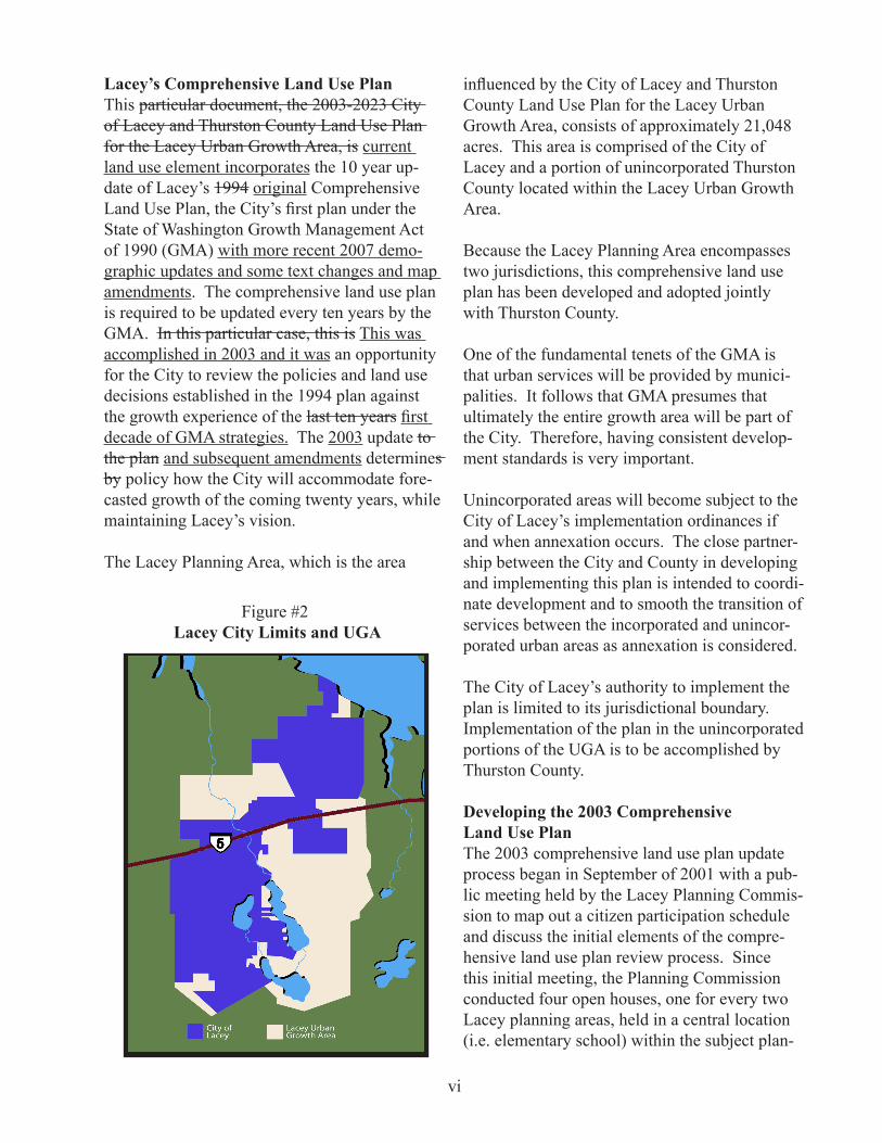
Lacey’s Comprehensive Land Use PlanThis particular document, the 2003-2023 City of Lacey and Thurston County Land Use Plan for the Lacey Urban Growth Area, is current land use element incorporates the 10 year up-date of Lacey’s 1994 original Comprehensive Land Use Plan, the City’s first plan under the State of Washington Growth Management Act of 1990 (GMA) with more recent 2007 demo-graphic updates and some text changes and map amendments. The comprehensive land use plan is required to be updated every ten years by the GMA. In this particular case, this is This was accomplished in 2003 and it was an opportunity for the City to review the policies and land use decisions established in the 1994 plan against the growth experience of the last ten years first decade of GMA strategies. The 2003 update to the plan and subsequent amendments determines by policy how the City will accommodate fore-casted growth of the coming twenty years, while maintaining Lacey’s vision.
The Lacey Planning Area, which is the area
influenced by the City of Lacey and Thurston County Land Use Plan for the Lacey Urban Growth Area, consists of approximately 21,048 acres. This area is comprised of the City of Lacey and a portion of unincorporated Thurston County located within the Lacey Urban Growth Area.
Because the Lacey Planning Area encompasses two jurisdictions, this comprehensive land use plan has been developed and adopted jointly with Thurston County.
One of the fundamental tenets of the GMA is that urban services will be provided by munici-palities. It follows that GMA presumes that ultimately the entire growth area will be part of the City. Therefore, having consistent develop-ment standards is very important.
Unincorporated areas will become subject to the City of Lacey’s implementation ordinances if and when annexation occurs. The close partner-ship between the City and County in developing and implementing this plan is intended to coordi-nate development and to smooth the transition of services between the incorporated and unincor-porated urban areas as annexation is considered.
The City of Lacey’s authority to implement the plan is limited to its jurisdictional boundary. Implementation of the plan in the unincorporated portions of the UGA is to be accomplished by Thurston County.
Developing the 2003 Comprehensive Land Use PlanThe 2003 comprehensive land use plan update process began in September of 2001 with a pub-lic meeting held by the Lacey Planning Commis-sion to map out a citizen participation schedule and discuss the initial elements of the compre-hensive land use plan review process. Since this initial meeting, the Planning Commission conducted four open houses, one for every two Lacey planning areas, held in a central location (i.e. elementary school) within the subject plan-
Figure #2 Lacey City Limits and UGA

vii
In addition to considering public input received, the review and development of the 2003 compre-hensive land use plan included revisiting goals and policies established in the 1994 plan, exam-ining current land use trends, market pressures and demographic data (population forecasts and buildable lands inventories) supplied by the Thurston Regional Planning Council (TRPC).
In developing the population projections for Lac-ey and the Lacey UGA, TRPC used a computer model (EMPFOR) that included past population and employment trends based on age cohorts to provide forecast information to the year 2025. It is anticipated that the population of Lacey and its UGA will grow at an annual rate of 1.84% to a forecasted population of 94,700 in the year 2025.
Table #1: Population Projections
Figure #3Lacey Planning Areas
ning areas. Residents of the specific planning areas attending the open houses were able to review information such as maps and demo-graphic data specific to their neighborhoods and the city as whole and provide written comment and/or discuss these issues directly with Plan-ning Commission members and staff.
After conducting the open houses, the planning commission held 37 public meetings (including two joint meetings with the City Council) and four public hearings (including one joint hearing with the Thurston County Planning Commis-sion) prior to issuing a recommendation to the Lacey City Council.
The Lacey City Council held eight public meet-ings and work sessions discussing the Planning Commission recommendation prior to adopting the final draft of the 2003 comprehensive land use plan.
The most recent forecasted population estimate looks to the year 2030. Table #1 shows the an-ticipated growth at five year intervals to the year 2025 2030.
The first is whether residential development in the urban growth areas is occurring at the densi-ties which were envisioned in local comprehen-sive land use plans. The second is whether there is an adequate land supply in the urban growth areas for anticipated future growth in population and employment.
This report provided a synopsis of the amount of land that is currently developed and undeveloped for each general land use classification (i.e. resi-

viii
Table #2Land Consumption Trends
dential, commercial, industrial and open space) for the Lacey UGA.
As described in Table #2 below, approximately 50% of the land zoned for residential use within the City and UGA had been developed by 2002. The report also determined that developed residential lands are being built out at an aver-age density of 3.2 units per acre. The residential lands developed within the City of Lacey have been built out at an average density of 4.7 units per acre. Overall, this report shows that residen-tial land consumption trends over the past ten years are on track and meeting the minimum density scenario envisioned in the 1994 Compre-hensive Land Use Plan.
In looking toward the next twenty years, 60% of the residential lands designated with medium and high density classifications (such as Low Density 3-6, Moderate Density 6-12 and High Density 12 and above units per acre) remain undeveloped, versus 40% of the Low Density 0-4 designated lands. the buildable lands program has provided us with the information summarized in Table 2. Based on this, and projections using average household size upon the buildable lands report
and general projections, it is anticipated that there is adequate land supply to accommodate the population growth forecasted for the next twenty years with a final build out meeting either the minimum or medium density scenarios iden-tified in the comprehensive land use plan.
The buildable lands report also indicated that of the 2,337 2,516 acres of commercially designat-ed land, 40% 1087 remain undeveloped build-able. While 957 acres remain available to ac-commodate future retail/economic development, This update confirmed that the amount of avail-able commercial land should be closely moni-tored to ensure a sufficient supply is available to serve the growing population. This is especially important because municipalities in the State of Washington rely heavily on sales tax revenue as property taxes in and of themselves do not cover the cost of primary residential services such as water, sewer, police and fire protection.
Summary of changesAfter reviewing progress of growth and devel-opment over the first ten years of Lacey’s com-prehensive land use plan, it was found that the primary goals and policies of the 1994 plan have been very successful as described below.
Urban Growth AreaThe Lacey UGA remains appropriately sized to accommodate the growing population with an adequate amount of residential designated land to supply the next twenty years of population growth.
Residential ClassificationsMaintaining the variety of zoning districts (i.e. Low Density 0-4, Low Density 3-6, Moderate Density 6-12 and High Density 12 and above units per acre) with slight adjustments to their acreage allocations will maintain or slightly increase the average density of 4.7 units per acre within the City and 3.2 acres per unit UGA wide for the next twenty years. This serves to achieve the minimum and potentially the moder-ate density scenarios in the plan and, if market
ix
serve the immediate surrounding neighborhood, catering to the day-to-day needs of the surround-ing residents for a limited range of commercial goods and services. These designations are to be located within residential areas, usually at key intersections, as a focal point of an Urban Center in a town square concept, or strategically located for easy pedestrian access from surrounding residential areas.
The function of the Community Commercial Districts was clarified through this update pro-cess. These districts are designed to provide for convenience type businesses and commercial services to serve the needs of residents from the surrounding neighborhoods and accommodate the vehicular trips regularly using the adjacent arterial(s) on a daily basis. This district is not to include uses that will, in and of themselves, draw customers from a broad area or region. It is not the intent of this district to serve the needs of a significant portion of the city or the region. These designations are to be located on the periphery of residential neighborhoods, buffered by uses other than residential and located on one or more arterials. Commercial Districts such as the Woodland, Central Business and General Commercial districts, are intended to provide op-portunities for mixed use development, business centers and commercial uses that serve the entire community and local region. These districts are located in the downtown core and the northeast area of Lacey, with access to major arterials and Interstates.
Policies of the 1994 plan placed a focus on developing diversity in employment opportuni-ties for the residents of Lacey. These policies promote the development of public-private partnerships to invest in infrastructure to serve the industrial areas and classifying 573 acres of industrial land under Foreign Trade Zone status. Through the implementation of the policies and programs, employment opportunities have grown in Lacey’s industrial and business park areas, reducing Lacey’s dependence on one single em-ployment sector.
factors change, being able to accommodate the high density scenario as described, while still providing a solid mix of housing choice and af-fordability.
Innovative Tools This planning update process also recognizes and reaffirms concepts such as urban centers, planned residential developments, clustering and transfer of development rights programs. These are successful tools for providing an affordable and diverse mixture of housing types in well planned neighborhood developments with open space and in some cases, limited commercial services.
Urban DesignCommercial and residential design policies established in 1994 have taken hold and a tour of Lacey will confirm the positive affect of these policies. Design policies for residential develop-ment were updated in 2008 and new residential developments are being designed to create walk-able neighborhoods that have varying rooflines and interesting streetscapes less dominated with garages.
Commercial buildings are being located closer to streets with elevations that are pedestrian friend-ly and define the street. In appropriate locations, commercial buildings with larger footprints and parking areas are allowed, but are still designed with elevations and landscaping to both break up mass of the building and be complementary to their surroundings. The comprehensive land use plan reaffirms these design policies as key to Lacey’s future vision and aesthetic character as new development and redevelopment occur.
Economic DevelopmentThe adoption of this plan reaffirms and clarifies the policies of dispersing commercial designa-tions throughout the planning area based on the function, intended service area and access needs of the specific type of commercial designation.
Neighborhood commercial uses are intended to

x
Table #3Summary of Land Use
Cover Photo for the Executive Summary taken by Doug Walker
Open SpaceFinally, this plan continues the policies and vision of providing active recreational oppor-tunities for the citizens of Lacey. It promotes the development of a community and regional parks system, recognizes the importance of small and convenient neighborhood/pocket parks and establishes policies for their placement as neigh-borhoods are developed.
Passive recreational opportunities are also highly promoted by this plan through the establishment of policies for the protection and preservation of lakes, streams, wetlands and other sensitive areas.
The goal of these policies is to provide the citi-zens of Lacey an active, healthy and high quality of life through both built and natural spaces.
With the adoption of the 2003 City of Lacey and Thurston County Land Use Plan for the Lacey Urban Growth Area and subsequent amend-ments, the Council has taken into consideration all of the public input and technical data. The result was the Council’s reaffirmation and clari-fication of the goals and policies established in the 1994 plan. To achieve these policies and in recognition of the development trends of the pre-vious ten years, this plan establishes an acreage allocation of land use as described in Table #3 to maintain the vision of Lacey as a strong vibrant community.
ConclusionThe 2003 plan maintains the vision established by the 1994 plan of a livable urban area where
growth is tied to the City of Lacey’s ability to provide public services. A special thank you is extended to the citizens of Lacey for participat-ing and providing comments in the planning process, and the City of Lacey Planning Com-mission Members for the countless hours of dis-cussion and consideration of comment, data and information presented to them as they worked through the many issues involved in this compre-hensive planning effort.
Through the efforts of the citizens of the City of Lacey and the Lacey Urban Growth Area, the 2003 Plan will continue to envision a range of residential options, consisting of traditional single-family and multi-family housing and neo-traditional housing through either urban centers or planned residential development concepts. It will carry forward the framework for well designed and planned commercial, industrial and recreational development and achieve the goal of providing consistent and cost effective utility and transportation systems.
xi
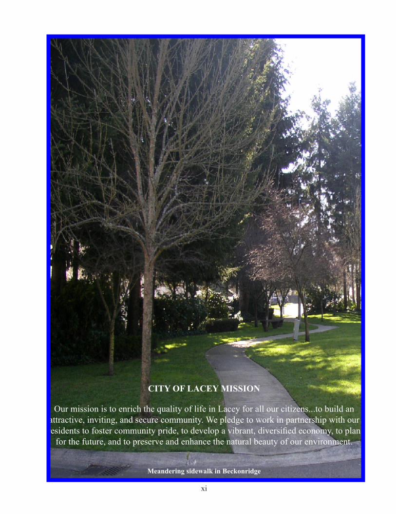
CITY OF LACEY MISSION
Our mission is to enrich the quality of life in Lacey for all our citizens...to build an attractive, inviting, and secure community. We pledge to work in partnership with our residents to foster community pride, to develop a vibrant, diversified economy, to plan
for the future, and to preserve and enhance the natural beauty of our environment.
Meandering sidewalk in Beckonridge

xii
Table of Contents
Part I General City-Wide Land Use Profile, Issues, Goals and Policies
I. Introduction 1-1
II. Profile 2-1
A. Historical Context 2-2B. Current Land Use Patterns 2-9C. Population Projections and Vacant Lands 2-10D. Land Use 2-14E. Vacant Land Resources and Sizing of Urban Growth Area 2-14
III. Growth Management Act Land Use Goals and County-Wide Planning Policies 3-1
IV. Land Use Issues and Analysis 4-1
A. Densities 4-2B. Distribution of Land Uses 4-6C. Dispersion vs. Consolidation of Commercial Areas 4-6D. Integration and Design Review 4-7E. Recreation Needs and Amenities 4-8F. Multi-modal Transportation 4-9G. Schools 4-9H. Neighborhood Character and Design 4-10I. Water Quality and Regional Drainage Basin Planning 4-10
V. Innovative Techniques 5-1
A. Clustering 5-2B. Transfer of Development Rights 5-2C. Transition Zones 5-4D. Village or Urban Centers 5-5E. Modern Roundabouts 5-9
VI. General Goals and Policies for the Land Use Element Applyingto all Planning Areas 6-1
A. Coordination Between Comprehensive Plan Elements 6-2B. Plan Implementation/Amendment & Land Use Maps 6-2C. Traditional and Innovative Land Use Techniques 6-3D. UGMA Boundary and Densities 6-3E. Residential Goals and Policies 6-5
xiii
F. Mixed Use Goals and Policies 6-7G. Environmental Quality 6-9H. Parks and Recreation 6-10I. Residential Streets 6-11J. Special Needs Housing 6-12K. Neighborhoods 6-12L. Commercial Goals and Policies 6-13M. Industrial 6-17N. Utilities and Capital Facilities 6-18O. Water Resources 6-18P. Institutional Uses 6-19Q. Essential Public Facilities 6-20
VII. Proposed Land Use Key Concepts, Maps and Description ofProposed Designations 7-1
A. Key Concepts 7-2B. Meeting Needs for Various Land Uses 7-2C. Proposed Land Use Maps 7-2D. Proposed Map Designations 7-3
Part 2 Planning Area Land Use Profiles, Issues, Goals and Policies
. Central Lacey Planning Area
I. Profile 8-1 II. Analysis 8-6 III. Goals and Policies 8-6
Hawks Prairie Planning Area
I. Profile 9-1 II. Analysis 9-5 III. Goals and Policies 9-6
Horizons Planning Area
I. Profile 10-1 II. Analysis 10-7 III. Goals and Policies 10-9 Lakes Planning Area I. Profile 11-1 II. Analysis 11-5 III. Goals and Policies 11-7
xiv
Meadows Planning Area
I. Profile 12-1 II. Analysis 12-5 III. Goals and Policies 12-6
Pleasant Glade Planning Area
I. Profile 13-1 II. Analysis 13-5 III. Goals and Policies 13-6
. Seasons Planning Area
I. Profile 14-1 II. Analysis 14-4 III. Goals and Policies 14-6
Tanglewilde/Thompson Place Planning Area
I. Profile 15-1 II. Analysis 15-6 III. Goals and Policies 15-7
xv
List of ChartsChart 1 Thurston County Historic Population Profile - 1900 to 2000 2-11Chart 2 Population in Thurston County - 2007 to 2030 2-11Chart 3 Comparison of Population Allocation between City of Lacey
and all other Areas of Thurston County in 2007 2-12Chart 4 Planning Area Projected Population Profiles - 2007 to 2030 2-13Chart 5 Lacey Urban Growth Management Area Population Projection 2007 to 2030 2-13Chart 6 Comparison of Projected Population Allocation between Lacey
UGMA and other areas of Thurston County - 2030 2-14Chart 7 Developed and Undeveloped Land in Lacey by Land Use Zone 2007 2-17Chart 8 Percentage of Buildable Land in Lacey by Land Use Zone 2007 2-20Chart 9 Percentage of Developed Land in Lacey by Land Use Zone 2007 2-20Chart 10 Developed and Undeveloped Land in Lacey Urban Growth Area by Land Use Zone 2007 2-21Chart 11 Lacey Urban Growth Area Proposed Land Use - Percentage of
Buildable Land by Comprehensive Plan Designations 2007 2-22Chart 12 Developed Land in Lacey Urban Growth Area by Land Use Zone 2-22 Chart 13 Developed Land in Lacey and Lacey Urban Growth Area by Land
Use Zone 2007 2-23Chart 14 Percentage of Land Resources in Lacey and Lacey Urban Growth Area Consumed by Specific Land Uses 2007 2-23Chart 15 Percentage of Developed Land in Lacey and Lacey Urban Growth Area by Specific Land Use Type 2007 2-24Chart 16 Buildable Land in General Land Use Zones for Lacey and Lacey Urban Growth Area 2007 2-26Chart 17 Residential Units Development Capacity to Year 2030 2-27 Central Planning AreaChart 18A Population Projection 2007-2030 8-2Chart 18B Housing Forecast 2006-2030 8-3Chart 19 Existing Land Use 2002 8-3Chart 20 Acres of Developed and Vacant Land by Zoning Designations 8-4
Hawks Prairie Planning AreaChart 21A Population Projection 2000-2030 9-2 Chart 22 Existing Land Use 2002 9-3Chart 23 Acres of Developed and Vacant Land by Zoning Designations 9-4
Horizons Planning AreaChart 24A Population Projection 2007-2030 10-3Chart 24B Housing Forecast 2006-2030 10-4 Chart 25 Existing Land Use 2002 10-4Chart 26 Acres of Developed and Buildable Land by Zoning Designations 10-6
xvi
Lakes Planning AreaChart 27A Population Projection 2007-2030 11-2Chart 27B Housing Forecast 2006-2030 11-2Chart 28 Existing Land Use 2002 11-3Chart 29 Acres of Developed and Buildable Land by Zoning Designations 11-4
Meadows Planning AreaChart 30A Population Projection 2007-2030 12-2Chart 30B Housing Forecast 2006-2030 12-3Chart 31 Existing Land Use 2002 12-3Chart 32 Acres of Developed and Buildable Land by Zoning Designations 12-4
Pleasant Glade Planning AreaChart 33A Population Projection 2007-2030 13-2 Chart 33B Housing Forecast 2006-2030 13-3 Chart 34 Existing Land Use 2002 13-3Chart 35 Acres of Developed and Buildable Land by Zoning Designations 13-4
Seasons Planning AreaChart 36A Population Projection 2007-2030 14-2Chart 36B Housing Forecast 2006-2030 14-3Chart 37 Existing Land Use 2002 14-4Chart 38 Acres of Developed and Buildable Land by Zoning Designations 14-5
Tanglewilde/Thompson Place Planning AreaChart 39A Population Projection 2007-2030 15-2Chart 39B Housing Forecast 2006-2030 15-3Chart 40 Existing Land Use 2002 15-4Chart 41 Acres of Developed and Vacant Land by Zoning Designations 15-5

xvii
List of TablesTable 1P Developed and Buildable Land Resources 2007 2-18Table 2P Developed and Buildable Land in Lacey and UGA 2-25
Central Planning Area
Table 2 Breakdown of Zoned Properties by Number of Acres 2006 8-4
Hawks Prairie Planning Area
Table 3 Residential Units in Hawks Prairie Planning Area 2000 9-3Table 4 Breakdown of Zoned Properties by Number of Acres 2002 9-4
Horizons Planning Area
Table 5 Residential Units in Horizons Planning Area 2006 10-3Table 6 Breakdown of Zoned Properties by Number of Acres 2006 10-5
Lakes Planning Area
Table 8 Breakdown of Zoned Properties by Number of Acres 2002 11-3
Meadows Planning Area
Table 9 Residential Units in Meadows Planning Area 2006 12-2Table 10 Breakdown of Zoned Properties by Number of Acres 2002 12-4
Pleasant Glade Planning Area
Table 11 Residential Units in Pleasant Glade Planning Area 2006 13-2Table 12 Breakdown of Zoned Properties by Number of Acres 2002 13-4
Seasons Planning Area
Table 13 Residential Units in Seasons Planning Area 2006 14-2Table 14 Breakdown of Zoned Properties by Number of Acres 2002 14-3
Tanglewilde/Thompson Place Planning Area
Table 15 Residential Units in Tanglewild/Thompson Place Planning Area 2006 15-3Table 16 Breakdown of Zoned Properties by Number of Acres 2002 15-4

xviii
List of Maps
Map 1 Lacey Planning Areas
Map 2 Lacey Urban Growth Area - Existing Land Use 2004
Map 3 Lacey Urban Growth Area - Proposed Land Use
Map 4 Central Planning Area Existing Land Use 2004
Map 5 Central Planning Area Proposed Land Use
Map 6 Hawks Prairie Planning Area Existing Land Use 2004
Map 7 Hawks Prairie Planning Area Proposed Land Use
Map 8 Horizons Planning Area Existing Land Use 2004
Map 9 Horizons Planning Area Proposed Land Use
Map 10 Lakes Planning Area Existing Land Use 2004
Map 11 Lakes Planning Area Proposed Land Use
Map 12 Meadows Planning Area Existing Land Use 2004
Map 13 Meadows Planning Area Proposed Land Use
Map 14 Pleasant Glade Planning Area Existing Land Use 2004
Map 15 Pleasant Glade Planning Area Proposed Land Use
Map 16 Seasons Planning Area Existing Land Use 2004
Map 17 Seasons Planning Area Proposed Land Use
Map 18 Tanglewilde/Thompson Place Existing Land Use 2004
Map 19 Tanglewilde/Thompson Place Proposed Land Use