La Paz Transportation Planning Study - Home |...
45
La Paz Transportation Planning Study La Paz Transportation Planning Study Executive Summary Executive Summary June 2010 June 2010
Transcript of La Paz Transportation Planning Study - Home |...

La Paz TransportationPlanning Study
La Paz TransportationPlanning Study
ExecutiveSummaryExecutiveSummary
June 2010June 2010
TABLE OF CONTENTS
Page
PURPOSE .................................................................................................... 1
STUDY PROCESS.......................................................................................... 1
AGENCY COORDINATION AND PUBLIC INVOLVEMENT................................... 3
ENVIRONMENTAL JUSTICE (TITLE VI) POPULATIONS...................................... 5
FUTURE GROWTH AREAS............................................................................. 5
FUTURE ROAD AND TRAFFIC CONDITIONS .................................................... 8
FUTURE MULTIMODAL CONDITIONS............................................................12
FUTURE FREIGHT CONDITIONS....................................................................12
MULTIMODAL TRANSPORTATION PLAN .......................................................12
TRANSPORTATION VISION...........................................................................13
ALTERNATIVE ROAD NETWORK ANALYSIS...................................................13
RECOMMENDED ROAD PLAN ......................................................................21
RECOMMENDED MULTIMODAL ELEMENT....................................................27
RECOMMENDED FREIGHT ELEMENT............................................................30
IMPLEMENTATION .....................................................................................33
FUNDING SOURCES ....................................................................................39
i
LIST OF TABLES
Page
1. COORDINATION, COOPERATION, & COMMUNICATION ACTIVITIES.............. 3
2. TECHNICAL ADVISORY COMMITTEE......................................................... 4
3. STAKEHOLDER INTERVIEWEES ................................................................ 4
4. POTENTIAL GROWTH SCENARIO, LA PAZ COUNTY .................................... 8
5. 2020 CAPACITY DEFICIENCIES FOR ROADS AT, NEAR, OR OVER CAPACITY................................................................................ 9
6. 2020 CANDIDATE LOCATIONS FOR PASSING LANES...................................10
7. 2030 CAPACITY DEFICIENCIES/NEEDS FOR ROADS AT, NEAR, OR OVER CAPACITY...............................................................................10
8. 2030 CANDIDATE LOCATIONS FOR PASSING LANES...................................11
9. MOHAVE ROAD EXTENSION TRAFFIC VOLUMES.......................................16
10. PERFORMANCE AND FEASIBILITY MEASURES ..........................................16
11. COMPARISON OF 2030 NETWORKS ...........................................................19
12. LA PAZ ROADWAY IMPLEMENTATION STRATEGIES..................................34
13. LA PAZ MULTIMODAL IMPLEMENTATION STRATEGIES.............................36
14. LA PAZ RAIL AND TRUCK FREIGHT IMPLEMENTATION STRATEGIES ..........37
15. MATRIX OF KEY FUNDING SOURCES .......................................................39
ii
LIST OF FIGURES
Page
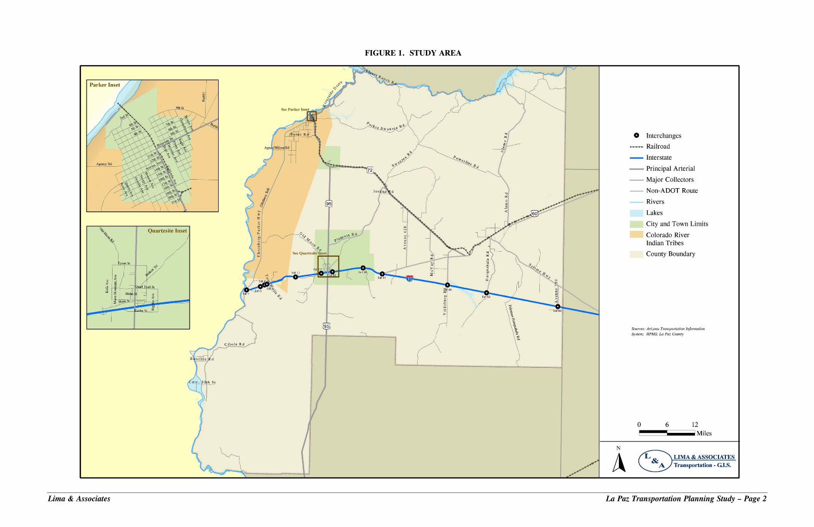
1. STUDY AREA .......................................................................................... 2
2. LA PAZ COUNTY PROPOSED DEVELOPMENTS............................................ 7
3. RECOMMENDED FUTURE FUNCTIONAL CLASSIFICATION..........................24
4. 2020 ROAD PLAN....................................................................................25
5. 2030 ROAD PLAN....................................................................................26
6. TRANSIT PLAN.......................................................................................28
7. FREIGHT ELEMENT ................................................................................31
iii
Lima & Associates La Paz Transportation Planning Study – Page 1
EXECUTIVE SUMMARY PURPOSE The La Paz Transportation Planning Study was conducted as part of the Planning Assistance for Rural Areas (PARA) program sponsored by the Arizona Department of Transportation (ADOT) Multimodal Planning Division. The PARA program provides federal funds to non-metropolitan communities for the purpose of conducting transportation planning studies. The La Paz Transportation Planning Study has been a joint effort of ADOT, La Paz County, Town of Parker, Town of Quartzsite, and the Colorado River Indian Tribes (CRIT). This Study developed 5, 10, and 20-year transportation plans, as well as an implementation program, to guide the County, Towns, and the CRIT in meeting transportation needs for the Study Area into the future. Figure 1 presents the Study Area. The Study identified roadway and multimodal improvements to meet the growing population and changing land uses to improve mobility and safety, and to encourage sensible and sustainable development. The feasibility of funding and implementing the needed improvements was assessed, and a long-range multimodal transportation plan is provided as well as practical tools for day-to-day programming and funding of transportation improvements. While this Study includes roadway facilities owned and operated by ADOT within the planning area, it is important to recognize that improvements to the State Highway System can be made only after in-depth planning and engineering studies are conducted by ADOT, and upon approval of the State Transportation Board. All traffic interchange improvements must be approved by the Federal Highway Administration (FHWA). Any recommendations made by this Study for improvements on State facilities can serve only as suggestions for further study. STUDY PROCESS This Study produced a transportation plan with short-, mid- and long-range elements, as well as a Transportation Improvement Program (TIP) to guide La Paz County, the Towns of Parker and Quartzsite, and the CRIT in implementing improvements to ensure a safe and efficient transportation system. The consultant team worked closely with the Technical Advisory Committee (TAC), other stakeholders, and the public to develop a transportation plan that meets transportation needs within the community vision. Working papers were prepared documenting the existing and future socioeconomic and multimodal transportation conditions as well as previous and ongoing studies. In addition, a TransCAD travel demand model was developed and calibrated against available traffic counts as a tool to estimate future travel demand. Public Involvement activities were coordinated with the public involvement firm, Logan Simpson Design under the guidance of the ADOT Communication and Community
ociates La Paz Transportation Planning Study – Page 2
FIGURE 1. STUDY AREA
Lima & Ass
Lima & Associates La Paz Transportation Planning Study – Page 3
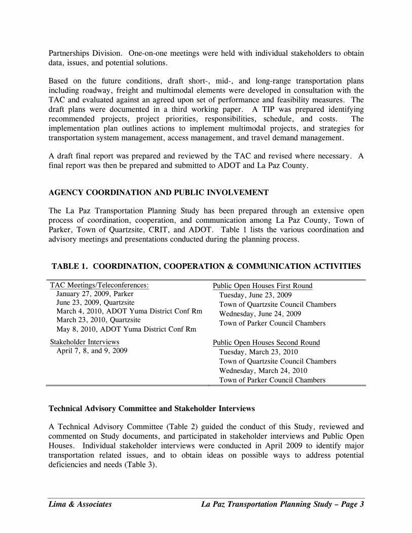
Partnerships Division. One-on-one meetings were held with individual stakeholders to obtain data, issues, and potential solutions. Based on the future conditions, draft short-, mid-, and long-range transportation plans including roadway, freight and multimodal elements were developed in consultation with the TAC and evaluated against an agreed upon set of performance and feasibility measures. The draft plans were documented in a third working paper. A TIP was prepared identifying recommended projects, project priorities, responsibilities, schedule, and costs. The implementation plan outlines actions to implement multimodal projects, and strategies for transportation system management, access management, and travel demand management. A draft final report was prepared and reviewed by the TAC and revised where necessary. A final report was then be prepared and submitted to ADOT and La Paz County. AGENCY COORDINATION AND PUBLIC INVOLVEMENT The La Paz Transportation Planning Study has been prepared through an extensive open process of coordination, cooperation, and communication among La Paz County, Town of Parker, Town of Quartzsite, CRIT, and ADOT. Table 1 lists the various coordination and advisory meetings and presentations conducted during the planning process. TABLE 1. COORDINATION, COOPERATION & COMMUNICATION ACTIVITIES
TAC Meetings/Teleconferences: January 27, 2009, Parker June 23, 2009, Quartzsite March 4, 2010, ADOT Yuma District Conf Rm March 23, 2010, Quartzsite May 8, 2010, ADOT Yuma District Conf Rm
Public Open Houses First Round Tuesday, June 23, 2009 Town of Quartzsite Council Chambers Wednesday, June 24, 2009 Town of Parker Council Chambers
Stakeholder Interviews April 7, 8, and 9, 2009
Public Open Houses Second Round Tuesday, March 23, 2010 Town of Quartzsite Council Chambers Wednesday, March 24, 2010 Town of Parker Council Chambers
Technical Advisory Committee and Stakeholder Interviews A Technical Advisory Committee (Table 2) guided the conduct of this Study, reviewed and commented on Study documents, and participated in stakeholder interviews and Public Open Houses. Individual stakeholder interviews were conducted in April 2009 to identify major transportation related issues, and to obtain ideas on possible ways to address potential deficiencies and needs (Table 3).
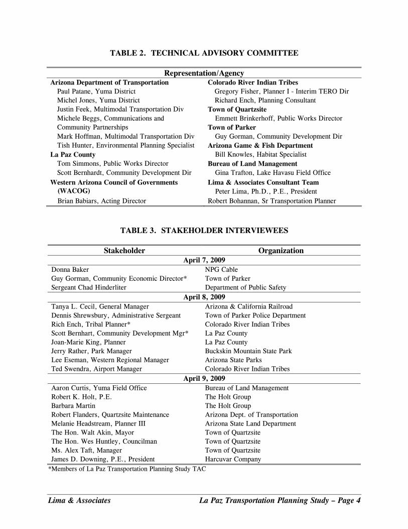
TABLE 2. TECHNICAL ADVISORY COMMITTEE
Representation/Agency Arizona Department of Transportation Colorado River Indian Tribes Paul Patane, Yuma District Gregory Fisher, Planner I - Interim TERO Dir Michel Jones, Yuma District Richard Ench, Planning Consultant Justin Feek, Multimodal Transportation Div Town of Quartzsite Michele Beggs, Communications and Emmett Brinkerhoff, Public Works Director Community Partnerships Town of Parker Mark Hoffman, Multimodal Transportation Div Guy Gorman, Community Development Dir Tish Hunter, Environmental Planning Specialist Arizona Game & Fish Department La Paz County Bill Knowles, Habitat Specialist Tom Simmons, Public Works Director Bureau of Land Management Scott Bernhardt, Community Development Dir Gina Trafton, Lake Havasu Field Office Western Arizona Council of Governments
(WACOG) Lima & Associates Consultant Team Peter Lima, Ph.D., P.E., President
Brian Babiars, Acting Director Robert Bohannan, Sr Transportation Planner
TABLE 3. STAKEHOLDER INTERVIEWEES
Stakeholder Organization April 7, 2009
Donna Baker NPG Cable Guy Gorman, Community Economic Director* Town of Parker Sergeant Chad Hinderliter Department of Public Safety
April 8, 2009 Tanya L. Cecil, General Manager Arizona & California Railroad Dennis Shrewsbury, Administrative Sergeant Town of Parker Police Department Rich Ench, Tribal Planner* Colorado River Indian Tribes Scott Bernhart, Community Development Mgr* La Paz County Joan-Marie King, Planner La Paz County Jerry Rather, Park Manager Buckskin Mountain State Park Lee Eseman, Western Regional Manager Arizona State Parks Ted Swendra, Airport Manager Colorado River Indian Tribes
April 9, 2009 Aaron Curtis, Yuma Field Office Bureau of Land Management Robert K. Holt, P.E. The Holt Group Barbara Martin The Holt Group Robert Flanders, Quartzsite Maintenance Arizona Dept. of Transportation Melanie Headstream, Planner III Arizona State Land Department The Hon. Walt Akin, Mayor Town of Quartzsite The Hon. Wes Huntley, Councilman Town of Quartzsite Ms. Alex Taft, Manager Town of Quartzsite James D. Downing, P.E., President Harcuvar Company
*Members of La Paz Transportation Planning Study TAC
Lima & Associates La Paz Transportation Planning Study – Page 4
The Summary Public Involvement Report, under separate cover, presents additional details on the public involvement process including information material distributed and comments from the public. ENVIRONMENTAL JUSTICE (TITLE VI) POPULATIONS Environmental justice was established as a federal government priority in 1994 with the issuance of Executive Order 12898, Federal Actions to Address Environmental Justice in Minority Populations and Low Income Populations. In addition, to minority and low income populations, this Study addresses both elderly (Aged 65 and older), and mobility-limited populations. La Paz County has been identified as a County that has one of the highest proportions of people aged 65 and older in the nation. The percent population 65 and over in the County is double the statewide proportion, approximately 26 percent compared to the State proportion of approximately 13 percent. This proportion increases during the peak season as winter visitors come to the County. Similarly, the proportion of mobility limited is relatively high, 26 percent compared to the State proportion of approximately 18 percent. The proportion of the population below poverty is also higher – 19 percent compared the State proportion of approximately 14 percent. Although the countywide proportion of minority populations tracks that of the statewide proportion of approximately 36 percent, Native Americans residing on the Colorado River Tribes Reservation and throughout the County are a critical group to address. Projects such as reconstructing the Ehrenberg Parker Highway (Mohave Road) will impact Native Americans both positively and negatively. Other projects such as transit service will improve mobility of Native Americans. Both potential positive and negative impacts need to be analyzed closely when projects are implemented. Positive impacts on Environmental Justice population groups include increased mobility and safety through traffic operations improvements, provision of transit facilities, and implementation of pedestrian and bicycle facilities. Potential negative impacts on these population groups include disruption of neighborhoods with higher proportions of elderly and minority populations as well as populations below the poverty level. Another negative impact is not providing transportation alternatives such as transit service. Future more detailed studies of recommended improvements must assess the positive and negative impacts on Environmental Justice population groups. Examples of possible future studies include Design Concept Reports for road improvements and transit feasibility studies. FUTURE GROWTH AREAS Growth within the County will occur on current private lands and lands that potentially could be converted from non-private ownership to private ownership. The land ownership within La Paz County is illustrated in the Final Report, currently approximately five percent of the land
Lima & Associates La Paz Transportation Planning Study – Page 5
is privately owned. An example of land that may convert to private ownership includes Bureau of Land Management (BLM) parcels in the vicinity of the Town of Quartzsite. The BLM identified potential lands for sale in its Approved Resource Management Plan, January 2010 (See Map 2-17. Lands and Realty/Minerals and Appendix I: Lands Identified for Disposal). The Town of Quartzsite requested that the BLM offer parcels in the vicinity of the Town for sale and the BLM is evaluating the potential sale. Lands identified for disposal must meet the criteria for public land sale or exchange under existing laws, regulations, and policies at time of disposal. Anticipated growth areas within the County include:
• Salome area • Bouse area • Town of Quartzsite • Ehrenberg area • Town of Parker Annex
In addition to the above growth areas, commercial growth is anticipated at the following I-10 interchanges:
• Ehrenberg (Exit 1) • Vicksburg Road (Exit 45) • Exits 17 and 19, Quartzsite • 75E (Exit 69)
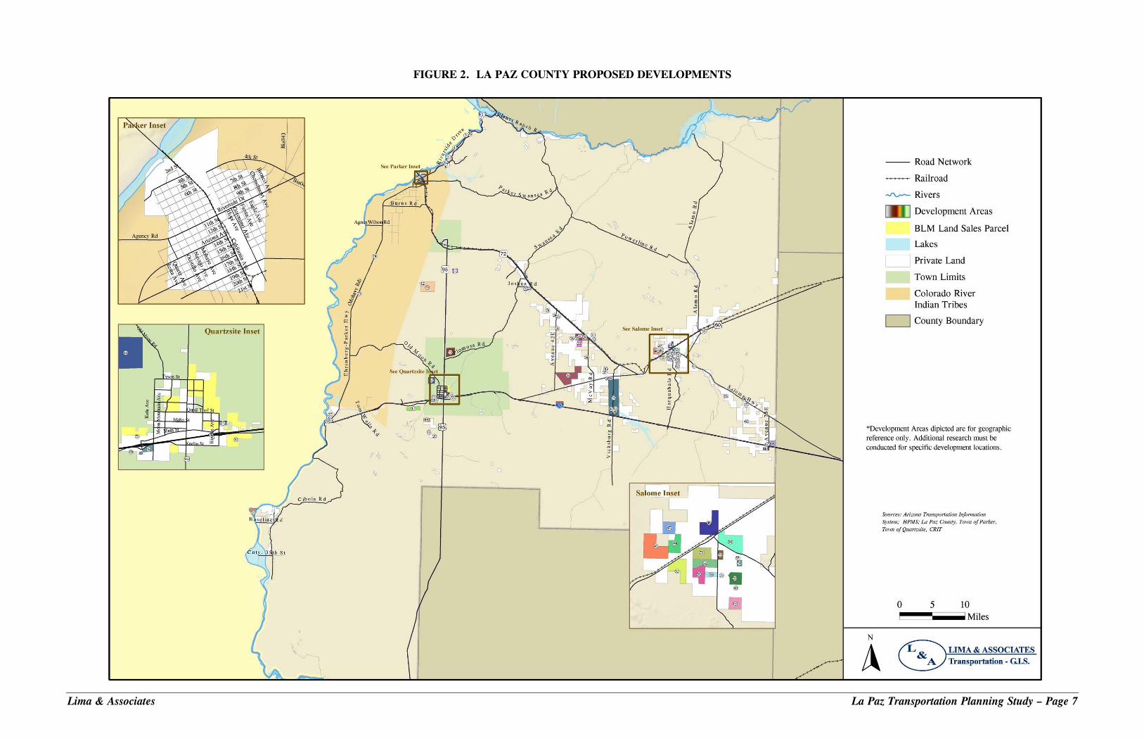
Approved and proposed residential and commercial developments within the County are shown in Figure 2. Future Population Projections Future population projections were developed based on a review of projections by the Arizona Department of Commerce and planned and proposed developments within the County. The Arizona Department of Commerce is responsible for developing statewide population projections, recently assuming responsibility from the Arizona Department of Economic Security. According to the Department of Commerce, La Paz County grew to an estimated population of 22,347 in 2009 from a population of 19,715 in the year 2000, a total of approximately 13.4 percent. The Department’s population projection for La Paz County is just over 28,000 residents by 2030, an overall growth rate of approximately 26 percent from 2009 to 2030. More Aggressive Growth Scenario A more aggressive growth scenario was formulated to represent potential development of portions of the approved and proposed residential and commercial properties. This scenario is based on conversations with the County, Town of Parker, Town of Quartzsite, and Colorado Indian Tribes. Yet, it is recognized that the magnitude of planned development over the past several years has slowed due to the economic downturn and that the completion years for many of these proposed developments have been delayed. During the review and discussion of the projections by the TAC and stakeholders, individuals expressed that the “more aggressive” scenario was too optimistic given the economic downturn and near-term
Lima & Associates La Paz Transportation Planning Study – Page 6
Lima & Associates La Paz Transportation Planning Study – Page 7
FIGURE 2. LA PAZ COUNTY PROPOSED DEVELOPMENTS
Lima & Associates La Paz Transportation Planning Study – Page 8
development prospects. However, other individuals expressed that the scenario was not aggressive enough and particularly in the Quartzsite area that growth would be higher. The use of more aggressive population projections recognizes the potential for development of the approved and planned developments as the economy rebounds. This will allow for planning future infrastructure conditions and preserving rights-of-way. The overall agreement of the TAC was to maintain the “more aggressive” growth scenario. The population projections for this Study can be revisited as updated population data becomes available. Sources of updated data will include: the 2010 US Census, updated population projections for the County from the Arizona Department of Commerce, and renewed activity with respect to the planning and approval of new developments. The “more aggressive” growth scenario is based on following assumptions (see Table 4):
• The Town of Quartzsite is expected to grow to 9,000 residents by 2030.
• The “Original Town of Parker” is assumed to grow in the future as estimated by the Arizona Department of Commerce based on historical growth and assumptions of future growth.
• The Parker Annex will grow to approximately 790 residents by 2030.
• The population of the Colorado River Indian Tribes is assumed to grow as projected by the Arizona Department of Commerce
• Commercial and industrial uses in the Parker Annex will grow to approximately 1,600 employees by 2030.
TABLE 4. POTENTIAL GROWTH SCENARIO, LA PAZ COUNTY
2009 2020 % Growth 2009-2030
2030 % Growth 2009-2030
Total DUs 16,495 27,361 66.0% 33,386 102.0% Population 21,114 35,022 66.0% 42,734 102.0% Employees 9,456 14,473 1.54 16,281 73.0% Employees/Population 0.45 0.41 N/A 0.38 N/A
Estimated by Lima & Associates; DUs – Dwelling Units; N/A – Not applicable FUTURE ROAD AND TRAFFIC CONDITIONS Projection of Future Traffic Volumes Base Road Network To identify potential future traffic capacity deficiencies, future average daily traffic volumes were estimated for a Base Future Road Network with both the projected 2020 and 2030 socioeconomic conditions.

The Base Future Road Network is comprised of the following roads:
• The future Quartzsite road functional classified roads identified in the Town of Quartzsite General Plan.
• The future road function classified roads for the Town of Parker plus the Parker annex identified in the Town of Parker General Plan.
• Existing County roads with existing number of lanes in the 2009 road network outside of the Town of Parker and the Town of Quartzsite.
• Additional County roads in selected areas in recognition of proposed future developments.
• Existing State routes SR 95, SR 72, and US 60 with existing number of lanes.
• Existing I-10 mainline and interchanges with existing number of lanes.
Capacity Deficiency Analysis Results 2020 Capacity Deficiency Analysis The 2020 daily traffic volumes were adjusted to represent peak-seasonal traffic and were then estimated for the roads in the Base Road Network. Table 5 summarizes the road segments that are at, near, or over capacity. These segments are candidates for widening. Candidate locations for passing lanes in 2020 are listed in Table 6.
TABLE 5. 2020 CAPACITY DEFICIENCIES FOR ROADS AT, NEAR, OR OVER CAPACITY
Road Location
Off-Peak Season Traffic SR 95 Beacon Rd./Riverside Dr. to Rio Vista Rd. Peak Season Traffic Kuehn Street, Quartzsite Riggles Ave. to Quartzsite Blvd. SR 95, La Paz County Beacon Rd./Riverside Dr. to Cienega Springs Rd. Ehrenberg-Parker Hwy Juneau Ave. to Sourdough Rd. I-10 Exit 17 EB off ramp and WB on ramp
Note: Roads listed in table are candidates for widening.
Lima & Associates La Paz Transportation Planning Study – Page 9

TABLE 6. 2020 CANDIDATE LOCATIONS FOR PASSING LANES
Road Location Off-Peak Season Traffic
US 60 Alamo Road/Centennial Park Rd. to SR 72 SR 72 Willamette Dr. to SR 95 SR 95 Quartzsite Northern Boundary to SR 72 SR 95 SR 72 to Mohave Rd. SR 95 Beacon Rd./Riverside Dr. to northern County Boundary SR 95 Kuehn St to US 95 MP 99
Peak Season Traffic US 60 Alamo Road/Centennial Park Rd. to Vicksburg Rd. SR 72 Avenue 42E to SR 95 SR 95 Quartzsite northern boundary to SR 72 SR 95 SR 72 to Mohave Road US 95 Kuehn St to US 95 MP 99
Candidate locations based on a threshold daily traffic volume of approximately 4,300 Average Annual Daily Traffic (AADT) for level terrain and 2,300 AADT for rolling terrain.
2030 Capacity Deficiency Analysis Similar to the analysis of the 2020 projected traffic volumes, 2030 average daily traffic volumes were estimated for the Base Future Road Network with the projected 2030 socioeconomic conditions. Table 7 lists the road segments that are at, near, or over capacity. These segments are candidates for widening by 2030. Candidate locations for passing lanes by 2030 are listed in Table 8.
TABLE 7. 2030 CAPACITY DEFICIENCIES/NEEDS FOR ROADS AT, NEAR, OR OVER CAPACITY
Road Location
Off- Peak Season Traffic Ehrenberg-Parker Hwy Juneau Ave. to Sourdough Rd. SR 95 Beacon Rd./Riverside Dr. to Rio Vista Rd Peak Season Traffic Kuehn St., Quartzsite Riggles Ave. to Quartzsite Blvd SR 95, La Paz County Beacon Rd/Riverside Dr. to Cienega Springs Rd Riverside Drive, Parker Strip Golf Club Drive to SR 95 Exit 153 Crossing Ehrenberg-Parker Hwy Juneau Ave. to Comber Blvd I-10 Exit 17 EB off ramp and WB on ramp Note: Roads listed in table are candidates for widening.
Lima & Associates La Paz Transportation Planning Study – Page 10
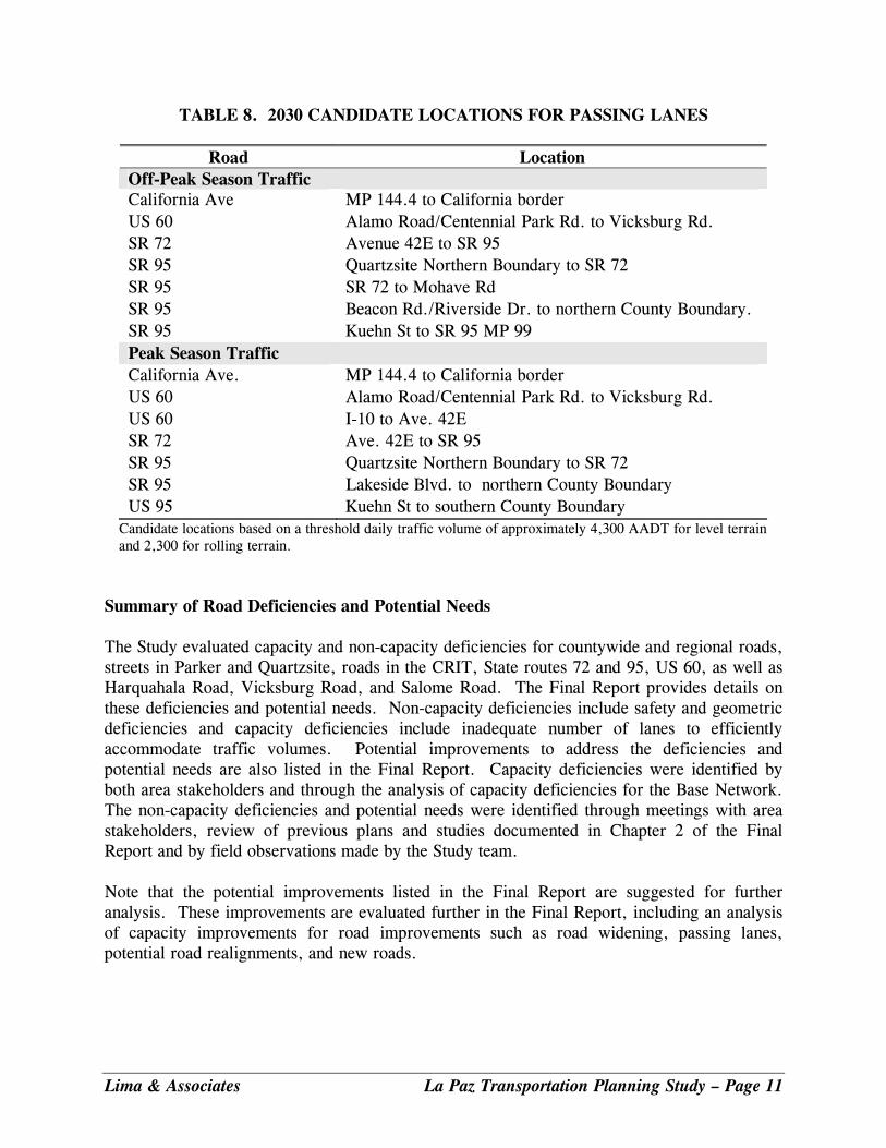
TABLE 8. 2030 CANDIDATE LOCATIONS FOR PASSING LANES
Road Location Off-Peak Season Traffic California Ave MP 144.4 to California border US 60 Alamo Road/Centennial Park Rd. to Vicksburg Rd. SR 72 Avenue 42E to SR 95 SR 95 Quartzsite Northern Boundary to SR 72 SR 95 SR 72 to Mohave Rd SR 95 Beacon Rd./Riverside Dr. to northern County Boundary. SR 95 Kuehn St to SR 95 MP 99 Peak Season Traffic California Ave. MP 144.4 to California border US 60 Alamo Road/Centennial Park Rd. to Vicksburg Rd. US 60 I-10 to Ave. 42E SR 72 SR 95
Ave. 42E to SR 95 Quartzsite Northern Boundary to SR 72
SR 95 Lakeside Blvd. to northern County Boundary US 95 Kuehn St to southern County Boundary
Candidate locations based on a threshold daily traffic volume of approximately 4,300 AADT for level terrain and 2,300 for rolling terrain.
Summary of Road Deficiencies and Potential Needs The Study evaluated capacity and non-capacity deficiencies for countywide and regional roads, streets in Parker and Quartzsite, roads in the CRIT, State routes 72 and 95, US 60, as well as Harquahala Road, Vicksburg Road, and Salome Road. The Final Report provides details on these deficiencies and potential needs. Non-capacity deficiencies include safety and geometric deficiencies and capacity deficiencies include inadequate number of lanes to efficiently accommodate traffic volumes. Potential improvements to address the deficiencies and potential needs are also listed in the Final Report. Capacity deficiencies were identified by both area stakeholders and through the analysis of capacity deficiencies for the Base Network. The non-capacity deficiencies and potential needs were identified through meetings with area stakeholders, review of previous plans and studies documented in Chapter 2 of the Final Report and by field observations made by the Study team. Note that the potential improvements listed in the Final Report are suggested for further analysis. These improvements are evaluated further in the Final Report, including an analysis of capacity improvements for road improvements such as road widening, passing lanes, potential road realignments, and new roads.
Lima & Associates La Paz Transportation Planning Study – Page 11
FUTURE MULTIMODAL CONDITIONS Future multimodal conditions were evaluated for the Study Area including transit, pedestrian and bicycle conditions, and airport needs. Unmet multimodal needs are summarized in the Final Report. Continued growth within the County, the Towns of Parker and Quartzsite and the CRIT generate a need for transit services as an alternative to the automobile. This need is reinforced by the higher proportion of residents and visitors 65 years and older as well as a higher proportion of the population with mobility limitation. Future transit demand was also estimated for a hypothetical countywide transit system. In addition, future needs for bicycle and pedestrian facilities were identified. Related needs include the widening of roadway shoulders on State highways, County roads, and community streets, separate bicycle and pedestrian paths, and bicycle lanes. Airport needs were also identified based on discussion with key stakeholders. FUTURE FREIGHT CONDITIONS Within the Study Area, a key concern is the increasing truck volumes on I-10. Throughout the Study Area, commercial trucks—primarily large tractor-trailer rigs—comprise about 40 percent of all motor vehicle traffic on I-10. On SR 72, trucks comprise 44 percent of all traffic. While total motor vehicle traffic volume on SR 72 is less than a tenth of that on the Interstate, SR 72 is a narrow, two-lane, largely shoulder-less facility. Sight-distance on SR 72 is frequently impacted by dips through low-water crossings, and opportunities for motorists to pass trucks are limited. The high truck volumes on the two lane road segments of the State routes significantly degrade traffic level of service (LOS). These high truck volumes combined with roads segments in rolling and mountainous terrain further degrade traffic levels of service. An example of such a segment is SR 95 from Buckskin State Park north to the County boundary. The Final Report summarizes the unmet rail and truck freight service needs within La Paz County. The proximity of Quartzsite to the growing area of Western Maricopa County, including the planned Hassayampa and Hidden Valley areas, suggests the potential for the development of Quartzsite as a potential distribution center. The development of this center would require significant additional investment in both rail and roadway infrastructure, but would also provide stable, year-round employment. MULTIMODAL TRANSPORTATION PLAN This section presents the Multimodal Transportation Plan for La Paz County including 2020 and 2030 Road Plans, Multimodal Transit Element, and a Freight Element. The road plans and multimodal elements were developed based on the analysis of future conditions presented in Chapter 4 of the Final Report. Additional analyses were conducted to assess possible alternative road networks in the County and are presented here.
Lima & Associates La Paz Transportation Planning Study – Page 12
TRANSPORTATION VISION The following vision for the transportation system in La Paz County was prepared based on stakeholder comments:
The La Paz County Transportation System will be developed and maintained in cooperation with the residents, visitors, businesses, County, Town, Colorado River Indian Tribes, federal land management agencies, businesses, and other stakeholders. The transportation system will be efficient and safe supporting economic development, tourism, and recreational activities for residents, businesses, and visitors. A multimodal transportation system will serve pedestrians, equestrian riders, bicyclists, automobiles, and transit users. Alternative routes and transit services will be provided connecting the Towns, Colorado River Indian Tribes, and rural areas as well as provide for interregional travel connecting County activities to Phoenix, Las Vegas, and Los Angeles metropolitan areas.
ALTERNATIVE ROAD NETWORK ANALYSIS Capacity deficiencies for the years 2020 and 2030 were identified in Working Paper 2: Future Conditions. This section presents the analysis of alternative road networks to correct the capacity deficiencies. The analysis included the following steps.
1. Identify alternative road networks.
2. Forecast of off-peak and peak season average daily traffic volumes.
3. Computation of level of service for the alternative road networks.
4. Compare alternative road networks using performance and feasibility measures. Identify Alternative Road Networks Three alternative roadway networks were identified based on the capacity deficiencies as well as stakeholder suggestions. The three alternative networks are: 1) Road Widening Network; 2) New Alignments Network; and Mohave Road Extension. Road Widening Alternative Network The Final Report presents the functional classification and number of lanes for the Road Widening Alternative Network, respectively. This network includes roads in the Base Future Network plus the following segments widened from two to four lanes:
Lima & Associates La Paz Transportation Planning Study – Page 13
• Kuehn Street, Quartzsite from Riggles Avenue to Quartzsite Boulevard
• Quartzsite Boulevard from Main Street to Kuehn Street
• Riggles Avenue from Main Street to Kuehn Street
• SR 95 from SR 72 north to Mohave Road
• SR 95 from Lakeside Boulevard to northern La Paz County boundary
New Alignments Network The Final Report presents the functional classification and number of lanes for the New Alignments Alternative Network. This road network includes roads in the Road Widening Network plus the following new road alignments:
• Four-lane realignment of SR 95 from south of the Town of Quartzsite to north of Plomosa Road.
• Four-lane realignment of SR 95 from existing SR 95 west of the Parker Annex running northeast to SR 95 to the vicinity of Lakeside Boulevard.
Mohave Road Extension The extension of Mohave Road in the Parker area was assessed from SR 95, S. California Avenue to Riverside Drive. The potential extension traverses to the east, staying to the south of the Avi Suquilla Airport, and then turns north to intersect with SR 95, Riverside Drive beyond the new runway. Forecasting Traffic and Computing Level of Service The methodology for estimating daily traffic volumes and levels of service was discussed in Working Paper 2: Future Conditions. In brief, the LA Paz County TransCAD travel demand model was used to estimate daily traffic volumes and LOS were then estimated for the Road Widening and New Alignments alternatives for both the off-peak and peak seasons. Levels of service were then computed for roads based on the relationship of volume-to-capacity ratios to LOS ranges of A to F. Level of service A indicates free flow and LOS F represents congested conditions. In general, levels of service in the range LOS C-D are considered acceptable. Road Widening Alternative Network The Final Report presents the daily traffic volumes and level of service for the Road Widening Alternative Network during the off-peak season and peak season, respectively. The analysis
Lima & Associates La Paz Transportation Planning Study – Page 14
shows that the roads in the network will operate at or above level of service range of C-D during the both the off-peak season and peak season. New Alignments Alternative Network The Final Report presents the daily traffic volumes and level of service for the New Alignments Alternative Network during the off-peak season and peak season, respectively. The analysis for the new alignments alternative network shows the following:
• The 2030 daily traffic volume during the peak season on the new alignment connecting US 95 south of Quartzsite to SR 95 north of Quartzsite is low ranging from 500 vehicles per day (vpd) to 2000 vpd.
• The 2030 daily traffic volume on the new alignment connecting SR 95 south of Parker
to SR 95 (Riverside) east of Parker has a volume of approximately 6,200 vpd.
• Roads in the New Alignments Alternative Network will operate at or above level of service range of C-D during both the off-peak season and peak season.
• The level of service on portions of Kuehn Street is improved over the Road Widening Alternative Network.
• The New Alignments Alternative Network also reduces traffic volumes on California Avenue south of Riverside Drive and Riverside Drive east of California Avenue due to the realignment of SR 95 to the east of the Town of Parker.
Mohave Road Extension The estimated 2030 Daily Peak Seasonal Traffic Volume on the Mohave Road Extension is approximately 9,900 vehicles per day. The extension decreased the traffic volume on Riverside Drive west of Bluewater Drive by approximately 13,625 vehicles per day from the Base Road Network. The traffic volume on California Avenue north of Mohave Road is decreased by approximately 11,427 vehicles per day. The following table presents traffic volumes for selected locations with and without the extension:
Lima & Associates La Paz Transportation Planning Study – Page 15
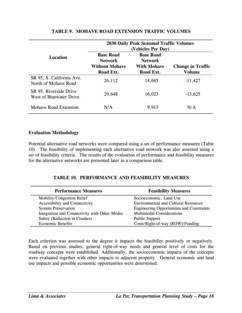
TABLE 9. MOHAVE ROAD EXTENSION TRAFFIC VOLUMES
2030 Daily Peak Seasonal Traffic Volumes (Vehicles Per Day)
Location Base Road Network
Without Mohave Road Ext.
Base Road Network
With Mohave Road Ext.
Change in Traffic Volume
SR 95, S. California Ave. North of Mohave Road
26,112 14,685 -11,427
SR 95, Riverside Drive West of Bluewater Drive
29,648 16,023 -13,625
Mohave Road Extension N/A 9,913 N/A
Evaluation Methodology Potential alternative road networks were compared using a set of performance measures (Table 10). The feasibility of implementing each alternative road network was also assessed using a set of feasibility criteria. The results of the evaluation of performance and feasibility measures for the alternative networks are presented later in a comparison table.
TABLE 10. PERFORMANCE AND FEASIBILITY MEASURES
Performance Measures Feasibility Measures Mobility/Congestion Relief Socioeconomic, Land Use Accessibility and Connectivity Environmental and Cultural Resources System Preservation Engineering Opportunities and Constraints Integration and Connectivity with Other Modes Multimodal Considerations Safety (Reduction in Crashes) Public Support Economic Benefits Costs/Right-of-way (ROW)/Funding
Each criterion was assessed to the degree it impacts the feasibility positively or negatively. Based on previous studies, general right-of-way needs and general level of costs for the roadway concepts were established. Additionally, the socioeconomic impacts of the concepts were evaluated together with other impacts to adjacent property. General economic and land use impacts and possible economic opportunities were determined.
Lima & Associates La Paz Transportation Planning Study – Page 16

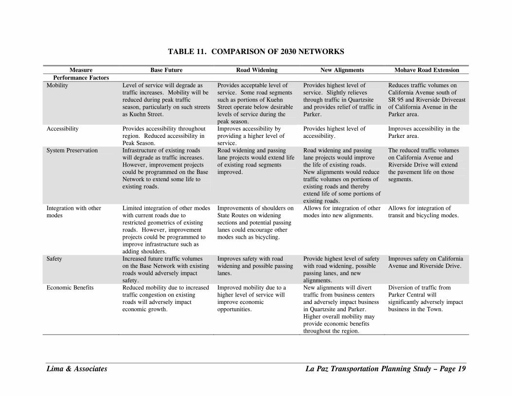
Comparison of Alternative Road Networks The Road Widening Network Alternative performed better than the other alternative networks evaluated in regard to performance and feasibility criteria. The road widening and passing lane candidate projects comprising this alternative provide good mobility and safety throughout the County with minimal impacts on residents, businesses, and the environment. This alternative also corrects infrastructure deficiencies on existing facilities. The magnitude of the daily traffic volumes accommodated during the peak season by the New Alignments and Mohave Road Extension alternatives do not warrant the cost and impacts of constructing new facilities. In addition, the New Alignments and the Mohave Road Extension alternatives would adversely impact the economy of the Towns of Quartzsite and Parker by diverting traffic from business centers. Table 11 presents a comparison of the Base Future Network, Road Widening Alternative Network, and New Alignments Alternative Network. Working Paper 2: Future Conditions described the Base Future Network and presents the forecasted traffic volumes and levels of service for the Base Future Network. The following summarizes the performance and feasibility of the alternative networks. Road Widening Alternative Network The Road Widening Alternative provides an acceptable level of service with the increased traffic volumes in 2030 and improves accessibility by providing a higher level of service. Road widening and passing lane projects in this alternative would improve safety and extend the life of existing road segments. Improvements of shoulders on State Routes on widening sections and potential passing lanes could encourage other modes such as bicycling. Moreover, the improved mobility due to a higher level of service will improve economic opportunities. The widening of roads in the Road Widening Alternative will impact adjacent properties to some extent. However, reduced traffic congestion also reduces impacts on adjacent properties. Improved speeds and reduced congestion may reduce air pollution. But noise may be increased with increased vehicle speeds. Public lands may also be impacted as roads are widened. No major engineering constraints are anticipated. Right-of-way may be required for widening of some road segments and potential passing lane segments. This alternative would require moderate capital costs. Road reconstruction for road widening and passing lane projects provides opportunities to incorporate multimodal facilities such as bike lanes and pedestrian paths. New Alignments Alternative The New Alignments Alternative provides the overall highest level of service and accessibility, slightly reduces through traffic in Quartzsite, and provides sine relief of traffic in
Lima & Associates La Paz Transportation Planning Study – Page 17

Parker. The road widening and passing lane projects would improve the life of existing roads. New alignments would reduce traffic volumes on portions of existing roads and thereby extend the life of some portions of existing roads. This alternative would provide the highest level of safety with road widening, possible passing lanes, and new alignments. The New Alignments Alternative would significantly impact local businesses in Quartzsite and Parker by diverting traffic from business centers. This alternative reduces congestion impacts on adjacent properties. Improved speeds and reduced congestion may reduce air pollution. But noise may be increased with increased vehicle speeds. This alternative has high impact on properties and businesses where new alignments are constructed. Moreover, the new alignments would generate the highest direct impact on environmental resources and public lands. Also, the alternative requires the highest level of planning and design. In addition, the alternative has the highest level of typographical and drainage constraints. However, no major engineering constraints are anticipated. The New Alignments Alternative has high cost and right-of-way requirements for road widening and new alignments. Road reconstruction for road widening and passing lanes and new alignment projects provides the most opportunities to incorporate multimodal facilities such as bike lanes and pedestrian paths. Mohave Road Extension The Mohave Road Extension would reduce traffic volumes on California Avenue south of SR 95 and Riverside Drive east of California Avenue in the Parker area and improve accessibility in the Parker area. The reduced traffic volumes on California Avenue and Riverside Drive will improve safety and extend the pavement life on those segments. Reduced congestion on California Avenue and Riverside Drive may reduce air pollution as well as noise levels along these segments. The Mohave Road Extension generates significant impacts. The diversion of traffic from Parker Central by the Extension will significantly adversely impact business in the Town of Parker. The extension lays entirely in the CRIT reservation and would impact CRIT lands. The extension would also have significant impact on virgin land, species habitat, and cultural resources. Engineering location and design studies would be required. In addition, the alternative would require the relocation and of Bluewater Drive in order to align with the Mohave Road extension to the north of the airport. The relocation would entail significant earthwork and reconstruction of Bluewater Drive. The extension would also require significant right-of-way all within the CRIT area and would also require high construction costs. Similar to the other alternatives, a new facility would provide an opportunity to incorporate multimodal facilities such as bike lanes and pedestrian paths.
Lima & Associates La Paz Transportation Planning Study – Page 18
Lima & Associates La Paz Transportation Planning Study – Page 19
TABLE 11. COMPARISON OF 2030 NETWORKS
Measure Base Future Road Widening New Alignments Mohave Road Extension Performance Factors
Mobility Level of service will degrade as traffic increases. Mobility will be reduced during peak traffic season, particularly on such streets as Kuehn Street.
Provides acceptable level of service. Some road segments such as portions of Kuehn Street operate below desirable levels of service during the peak season.
Provides highest level of service. Slightly relieves through traffic in Quartzsite and provides relief of traffic in Parker.
Reduces traffic volumes on California Avenue south of SR 95 and Riverside Driveeast of California Avenue in the Parker area.
Accessibility Provides accessibility throughout region. Reduced accessibility in Peak Season.
Improves accessibility by providing a higher level of service.
Provides highest level of accessibility.
Improves accessibility in the Parker area.
System Preservation Infrastructure of existing roads will degrade as traffic increases. However, improvement projects could be programmed on the Base Network to extend some life to existing roads.
Road widening and passing lane projects would extend life of existing road segments improved.
Road widening and passing lane projects would improve the life of existing roads. New alignments would reduce traffic volumes on portions of existing roads and thereby extend life of some portions of existing roads.
The reduced traffic volumes on California Avenue and Riverside Drive will extend the pavement life on those segments.
Integration with other modes
Limited integration of other modes with current roads due to restricted geometrics of existing roads. However, improvement projects could be programmed to improve infrastructure such as adding shoulders.
Improvements of shoulders on State Routes on widening sections and potential passing lanes could encourage other modes such as bicycling.
Allows for integration of other modes into new alignments.
Allows for integration of transit and bicycling modes.
Safety Increased future traffic volumes on the Base Network with existing roads would adversely impact safety.
Improves safety with road widening and possible passing lanes.
Provide highest level of safety with road widening, possible passing lanes, and new alignments.
Improves safety on California Avenue and Riverside Drive.
Economic Benefits Reduced mobility due to increased traffic congestion on existing roads will adversely impact economic growth.
Improved mobility due to a higher level of service will improve economic opportunities.
New alignments will divert traffic from business centers and adversely impact business in Quartzsite and Parker. Higher overall mobility may provide economic benefits throughout the region.
Diversion of traffic from Parker Central will significantly adversely impact business in the Town.
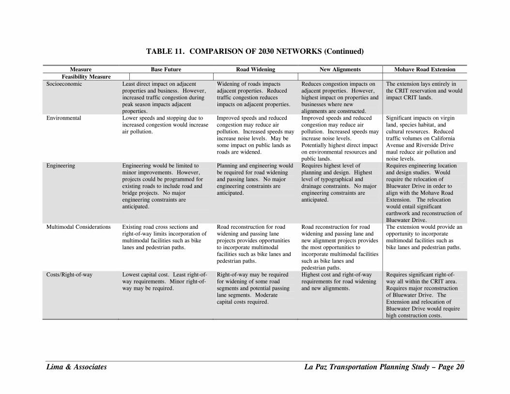
TABLE 11. COMPARISON OF 2030 NETWORKS (Continued)
Measure Base Future Road Widening New Alignments Mohave Road Extension Feasibility Measure
Socioeconomic Least direct impact on adjacent properties and business. However, increased traffic congestion during peak season impacts adjacent properties.
Widening of roads impacts adjacent properties. Reduced traffic congestion reduces impacts on adjacent properties.
Reduces congestion impacts on adjacent properties. However, highest impact on properties and businesses where new alignments are constructed.
The extension lays entirely in the CRIT reservation and would impact CRIT lands.
Environmental Lower speeds and stopping due to increased congestion would increase air pollution.
Improved speeds and reduced congestion may reduce air pollution. Increased speeds may increase noise levels. May be some impact on public lands as roads are widened.
Improved speeds and reduced congestion may reduce air pollution. Increased speeds may increase noise levels. Potentially highest direct impact on environmental resources and public lands.
Significant impacts on virgin land, species habitat, and cultural resources. Reduced traffic volumes on California Avenue and Riverside Drive maul reduce air pollution and noise levels.
Engineering Engineering would be limited to minor improvements. However, projects could be programmed for existing roads to include road and bridge projects. No major engineering constraints are anticipated.
Planning and engineering would be required for road widening and passing lanes. No major engineering constraints are anticipated.
Requires highest level of planning and design. Highest level of typographical and drainage constraints. No major engineering constraints are anticipated.
Requires engineering location and design studies. Would require the relocation of Bluewater Drive in order to align with the Mohave Road Extension. The relocation would entail significant earthwork and reconstruction of Bluewater Drive.
Multimodal Considerations Existing road cross sections and right-of-way limits incorporation of multimodal facilities such as bike lanes and pedestrian paths.
Road reconstruction for road widening and passing lane projects provides opportunities to incorporate multimodal facilities such as bike lanes and pedestrian paths.
Road reconstruction for road widening and passing lane and new alignment projects provides the most opportunities to incorporate multimodal facilities such as bike lanes and pedestrian paths.
The extension would provide an opportunity to incorporate multimodal facilities such as bike lanes and pedestrian paths.
Costs/Right-of-way Lowest capital cost. Least right-of-way requirements. Minor right-of-way may be required.
Right-of-way may be required for widening of some road segments and potential passing lane segments. Moderate capital costs required.
Highest cost and right-of-way requirements for road widening and new alignments.
Requires significant right-of-way all within the CRIT area. Requires major reconstruction of Bluewater Drive. The Extension and relocation of Bluewater Drive would require high construction costs.
Lima & Associates La Paz Transportation Planning Study – Page 20
Lima & Associates La Paz Transportation Planning Study – Page 21
RECOMMENDED ROAD PLAN This section presents the recommended road plans for the 2020 and 2030 planning horizon years. The plans have been developed based on the analysis of alternatives presented in the previous section. While this Study includes roadway facilities owned and operated by ADOT within the planning area, it is important to recognize that improvements to the State Highway System can be made only after in-depth planning and engineering studies are conducted by ADOT, and upon approval of the State Transportation Board. All traffic interchange improvements must be approved by the Federal Highway Administration (FHWA). Any recommendations made by this Study for improvements on State facilities can serve only as suggestions for further study. 2020 Road Plan Figure 3 illustrates the recommended road functional classification for both 2020 and 2030. Figure 4 illustrates the 2020 road plan with number of lanes and improvement projects. Key components of the 2020 road plan include: State Routes
SR 95/US 95 • Widen SR 95 to four lanes - Beacon Road/Riverside Drive to Cienega Springs Road.
• Widen California Avenue to four lanes – 7th Street to California Avenue Bridge.
• Construct new California Avenue Bridge across Colorado River. • Upgrade configuration and traffic signalization at the California Ave/Riverside Drive
intersection. • Reconstruct intersection and upgrade traffic control at the SR 95/SR 72 intersection.
• Construct additional passing lanes in the following candidate locations:
o Quartzsite Northern Boundary to SR 72
o Kuehn Street to SR 95 MP 99
o Lakeside Boulevard to northern County Boundary
o SR 95 - SR 72 to Mohave Road
SR 72 • Reconstruct SR 72 to include standard road cross section, construction cross drainage.
• Reconstruct SR 72/US 60 intersection
• Reconstruct intersections with local roads along SR 72 to right-angle intersections with left-turn lanes and acceleration and deceleration lanes.
• Construct passing lanes in the following candidate location:
o Willamette Drive to SR 95
• Construct cross drainage improvements on SR 72 US 60 • Reconstruct US 60 to include standard road cross section, construct cross drainage, and
reconstruct intersections to right-angle intersections with left-turn lanes and acceleration and deceleration lanes.
• Construct cross drainage improvements on US 60 at Centennial Wash.
• Construct passing lanes in the following candidate location:
o Alamo Road/Centennial Park Road to Vicksburg Rd.
I-10 • Reconstruct I-10 Exit 1.
• Reconstruct I-10 Exit 17 interchange and upgrade traffic control. Town of Quartzsite
• Widen and reconstruct Kuehn Street including drainage structures, Town of Quartzsite from Riggles Avenue to Quartzsite Boulevard to four lanes as shown.
• Widen Quartzsite Boulevard to 4 lanes from Main Street to Kuehn Street, Town of Quartzsite.
• Widen Riggles Avenue to 4 lanes from Main Street to Kuehn Street.
• Widen Kofa Avenue to 4 lanes from Main Street to Kuehn Street. Ehrenberg
• Reconstruct Juneau Avenue to Minor Arterial standards from I-10 Exit 1 to Ehrenberg Parker Highway.
• Reconstruct Ehrenberg Parker Highway to a Minor Arterial standard from Juneau Avenue to Southern CRIT Boundary to increase capacity.
La Paz County
• Construct new Cibola Bridge.
• Construct new River Road Bridge.
• Reconstruct Salome Highway from US 60 to I-10.
• Pave the road segments (illustrated in the Final Report)
• Reconstruct Vicksburg Road and construct passing lanes between I-10 and SR 72.
Lima & Associates La Paz Transportation Planning Study – Page 22
Colorado Indian Tribes
• Reconstruct Ehrenberg Parker Highway (Mohave Road) from CRIT southern boundary to SR 95 to standard cross section with cross drainage improvements.
• Reconstruct bridges on Ehrenberg Parker Highway (Mohave Road). 2030 Road Plan Figure 3 illustrates the recommended road functional classification for both 2020 and 2030 and Figure 5 illustrates the recommended 2030 Road Plan. Key components of the 2030 road in addition to those recommended for the 2020 Road Plan include: State Routes
SR 95/US 95 • Widen SR 95 to four lanes from the Town of Quartzite to the northern County
boundary.
• Construct 4-lane divided highway on US 95 from MP 70.2 to southern County boundary as recommended by the Initial Design Report: US 95, MP 42 to Cibola Lake Road, September 2008.
• Add passing lanes between MP 99 and southern County Border, (approximately MP 60)
SR 72 • Add passing lanes on the following road segment:
o Avenue 42E to Willamette Drive
I-10 • Reconstruct I-10 Interchanges at all locations by 2030.
Ehrenberg
• Reconstruct Ehrenberg Parker Highway to a higher two-lane road standard from Juneau Avenue to CRIT southern boundary.
• Reconstruct Juneau Avenue to a higher two-lane road standard from I-10 to Ehrenberg Parker Highway (Mohave Road)
Lima & Associates La Paz Transportation Planning Study – Page 23
Lima & Associates La Paz Transportation Planning Study – Page 24
FIGURE 3. RECOMMENDED FUTURE FUNCTIONAL CLASSIFICATION
FIGURE 4. 2020 ROAD PLAN
Lima & Associates La Paz Transportation Planning Study – Page 25

FIGURE 5. 2030 ROAD PLAN
Lima & Associates La Paz Transportation Planning Study – Page 26
Lima & Associates La Paz Transportation Planning Study – Page 27
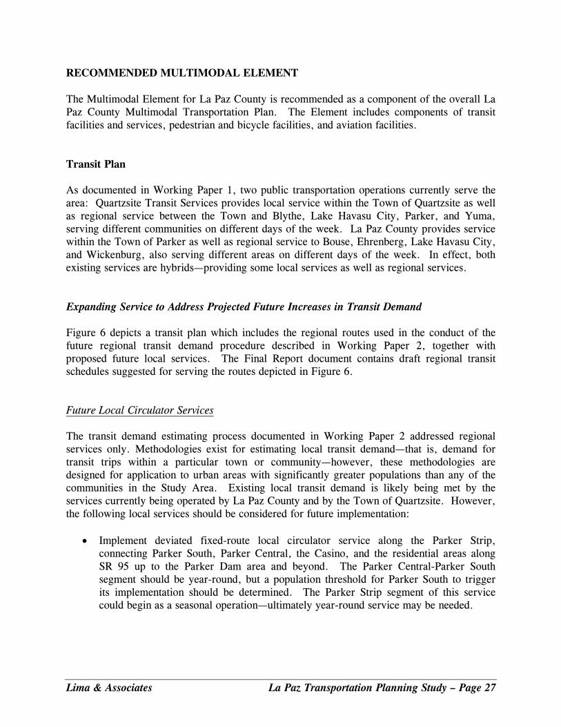
RECOMMENDED MULTIMODAL ELEMENT The Multimodal Element for La Paz County is recommended as a component of the overall La Paz County Multimodal Transportation Plan. The Element includes components of transit facilities and services, pedestrian and bicycle facilities, and aviation facilities. Transit Plan As documented in Working Paper 1, two public transportation operations currently serve the area: Quartzsite Transit Services provides local service within the Town of Quartzsite as well as regional service between the Town and Blythe, Lake Havasu City, Parker, and Yuma, serving different communities on different days of the week. La Paz County provides service within the Town of Parker as well as regional service to Bouse, Ehrenberg, Lake Havasu City, and Wickenburg, also serving different areas on different days of the week. In effect, both existing services are hybrids—providing some local services as well as regional services. Expanding Service to Address Projected Future Increases in Transit Demand Figure 6 depicts a transit plan which includes the regional routes used in the conduct of the future regional transit demand procedure described in Working Paper 2, together with proposed future local services. The Final Report document contains draft regional transit schedules suggested for serving the routes depicted in Figure 6. Future Local Circulator Services The transit demand estimating process documented in Working Paper 2 addressed regional services only. Methodologies exist for estimating local transit demand—that is, demand for transit trips within a particular town or community—however, these methodologies are designed for application to urban areas with significantly greater populations than any of the communities in the Study Area. Existing local transit demand is likely being met by the services currently being operated by La Paz County and by the Town of Quartzsite. However, the following local services should be considered for future implementation:
• Implement deviated fixed-route local circulator service along the Parker Strip, connecting Parker South, Parker Central, the Casino, and the residential areas along SR 95 up to the Parker Dam area and beyond. The Parker Central-Parker South segment should be year-round, but a population threshold for Parker South to trigger its implementation should be determined. The Parker Strip segment of this service could begin as a seasonal operation—ultimately year-round service may be needed.
FIGURE 6. TRANSIT PLAN
Source: Lima & Associates
• Implement deviated fixed-route local circulator service within the Town of Quartzsite. Such service could mitigate traffic congestion on Main Street during the tourist season, and facilitate local travel among the RV Parks, Rock and Gem Shows, and other area traffic generators and attractions.
• Local circulator transit serving Tribal communities on the CRIT. Initially, this service could double as the Parker-Ehrenberg regional service, with a more relaxed schedule to allow for route deviation. Ultimately, this and other local circulators should be structured to feed passengers to the fixed-route regional routes.
As population and seasonal activities both increase, a study should be conducted to assess the feasibility of providing increased local circulator services in the Study Area. In the near term, ridesharing programs and other lower-cost techniques should be examined as ways of enhancing the mobility of Study Area residents and visitors. Opportunities may also exist for enhancing the efficiency of the two existing operations through closer coordination. These concepts are discussed in the Final Report, together with types of transit vehicles and services.
Lima & Associates La Paz Transportation Planning Study – Page 28
Bicycle and Pedestrian Facilities A strategy to develop bicycle and pedestrian facilities and an integrated system is recommended. Bicycle facilities include bicycle lane, multi-use paths, bicycle routes, and shared roadway. Pedestrian facilities include sidewalks, separate pedestrian paths, and multi-use paths. In order to develop this strategy, the available general and comprehensive plans for the agencies participating in the study were reviewed as well as national and local practice in planning and designing for bicycle and pedestrian facilities. The bicycle and pedestrian strategy for the La Paz County transportation system is to provide regional and local bicycle and pedestrian facilities as alternatives to motorized travel. Local facilities should be connected to State Routes and regional facilities. The strategy is discussed in detail in the Final Report The plans of all the agencies—La Paz County, the Town of Parker, the Town of Quartzsite, and the CRIT—contain goals that recognize the need for developing local and regional bicycle and pedestrian facilities. A goal for all communities is to be walkable and bikeable. Aviation Plan Within the Study Area, potential aviation improvements are the following:
• Correct deficiencies identified for the CRIT Avi Suquilla Airport at Parker, including the reconstruction of the airport entry, access road, parking lot, and terminal facilities.
• Study the feasibility of a new airport at Quartzsite, which could serve as both a General Aviation facility open to the public and an adjunct to the proposed industrial park—designed to permit future introduction of scheduled passenger service.
• Monitor flight operations at the two private McMillan Valley airports to identify when the development of a General Aviation facility in the area might be warranted.
Recommended Next Steps to Implement Multimodal Transportation Services La Paz County, the Town of Parker, the Town of Quartzsite, the Colorado River Indian Tribes, and the Participating Agencies in the La Paz Transportation Planning Study should take the following steps to implement and expand multimodal transportation services:
• The Participating Agencies should closely study the Pinal Rides Pilot Program to learn what features of the program are applicable to the Study Area.
• La Paz County, the Town of Parker, the Town of Quartzsite, and the Colorado River Indian Tribes should communicate and coordinate with organizations and agencies.
Lima & Associates La Paz Transportation Planning Study – Page 29
• La Paz County, the Town of Parker, the Town of Quartzsite, and the Colorado River Indian Tribes should continue to present short- and long-range plans to ADOT Multimodal Planning Division.
• The Participating Agencies should conduct a Transit Feasibility and Implementation Study to identify current and future public transportation needs within the Study Area as well as demographic thresholds for implementing future services.
• Participating Agencies should designate a Transportation Coordinator, when needed.
• Participating Agencies should appoint a volunteer Transportation Advisory Committee.
• The Participating Agencies should explore the concept of providing one or more “gateway centers” within the Study Area.
• The Colorado River Indian Tribes should continue to work with ADOT Aeronautics Division to program improvements to the Avi Suquilla Airport.
• The Town of Quartzsite should study the feasibility of developing an airport.
A multimodal implementation schedule based on the “Next Steps” recommended above is presented in the Final Report. RECOMMENDED FREIGHT ELEMENT The Multimodal Transportation Element in the La Paz County Comprehensive Plan included developing County rail and trucking facilities. A number of strategies are focused on moving trucks efficiently and safely through and within the County. Within the County, a key concern is the increasing truck volumes on I-10 and the State Routes. Throughout the County, commercial trucks—primarily large tractor-trailer rigs—comprise about 40 percent of all motor vehicle traffic on I-10. On SR 72, trucks comprise 44 percent of all traffic. While total motor vehicle traffic volume on SR 72 is less than a tenth of that on the Interstate, SR 72 is a narrow, two-lane, largely shoulder-less facility. Sight-distance is frequently impacted by dips through low-water crossings, and opportunities for motorists to pass trucks are limited. Other strategies include increasing bridge load capabilities, improving interchanges to accommodate large trucks, and managing truck parking in developed areas. Another strategy focuses on developing an industrial and distribution center north of the Town of Quartzsite. The following actions are recommended to implement freight services (see Figure 7):
• Develop truck stop and off-street parking for tractor-trailer rigs in the Town of Parker to eliminate truck parking in the center median of California Avenue.
• Reconstruct Ehrenberg Parker Highway (Mohave Road) roadway and bridges to handle truck traffic that use the facility as a short cut from I-10 West to SR 95 North.
Lima & Associates La Paz Transportation Planning Study – Page 30
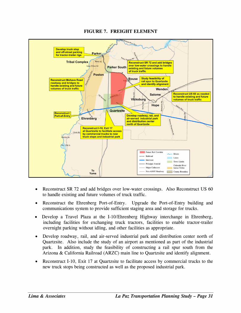
FIGURE 7. FREIGHT ELEMENT
• Reconstruct SR 72 and add bridges over low-water crossings. Also Reconstruct US 60 to handle existing and future volumes of truck traffic.
• Reconstruct the Ehrenberg Port-of-Entry. Upgrade the Port-of-Entry building and communications system to provide sufficient staging area and storage for trucks.
• Develop a Travel Plaza at the I-10/Ehrenberg Highway interchange in Ehrenberg, including facilities for exchanging truck tractors, facilities to enable tractor-trailer overnight parking without idling, and other facilities as appropriate.
• Develop roadway, rail, and air-served industrial park and distribution center north of Quartzsite. Also include the study of an airport as mentioned as part of the industrial park. In addition, study the feasibility of constructing a rail spur south from the Arizona & California Railroad (ARZC) main line to Quartzsite and identify alignment.
• Reconstruct I-10, Exit 17 at Quartzsite to facilitate access by commercial trucks to the new truck stops being constructed as well as the proposed industrial park.
Lima & Associates La Paz Transportation Planning Study – Page 31
As part of the Arizona Multimodal Freight Analysis Study conducted for ADOT in 2008, a proposed Freight Planning Agenda was developed for ADOT (see Final Report). La Paz County, the Town of Parker, the Town of Quartzsite, and the Colorado River Indian Tribes should take into consideration the findings and recommendations of the study. The Transportation Advisory Committee previously recommended coordination with ADOT and truck and rail freight stakeholders. Recommended Next Steps The following next steps relating to freight improvements are recommended:
• La Paz County, the Town of Parker, the Town of Quartzsite, and the CRIT should take into consideration the findings and recommendations of the 2008 Arizona Multimodal Freight Analysis Study, when updating general or comprehensive plans.
• The participating agencies should also monitor closely the concepts for developing alternatives to West Coast ports such as Punta Colonet and Guymas, which were alluded to in the Multimodal Freight Analysis Study.
• The Town of Parker should identify candidate locations for off-street parking for tractor-trailer rigs and program funding for site preservation. The Town should continue to work for attracting truck stop developers to the area.
• The CRIT should work with ADOT to program roadway and bridge improvements for Ehrenberg Parker Highway (Mohave Road).
• Continue to coordinate with ADOT on improvements to SR 72 and SR 95 including bridges or culverts for low-water crossings, roadway geometry, and widening.
• Continue to coordinate with ADOT on reconstruction of the Ehrenberg Port-of Entry.
• The Town of Quartzsite should study the feasibility of developing a multimodal industrial park north of Town and begin the appropriate site and zoning processes.
• The County should work with ADOT and private interests to develop a Travel Plaza at the I-10/Ehrenberg Parker Highway interchange in Ehrenberg to serve commercial trucking as well as the general public.
• The Town of Quartzsite should coordinate with ADOT to program the reconstruction of I-10, Exit 17 to improve access and safe movement of heavy trucks into the Town.
Lima & Associates La Paz Transportation Planning Study – Page 32
IMPLEMENTATION Challenges to Implementation Major challenges to implementation include the following:
• Coordination of recommendations among the various stakeholders • Right-of-way needs and preservation for roadways • Lead time needed to construct roads • Cost of needed improvements and funding implications • Limited funding and ability to obtain funding • Prioritization of projects as development phases in • Implementation of multimodal and transit projects
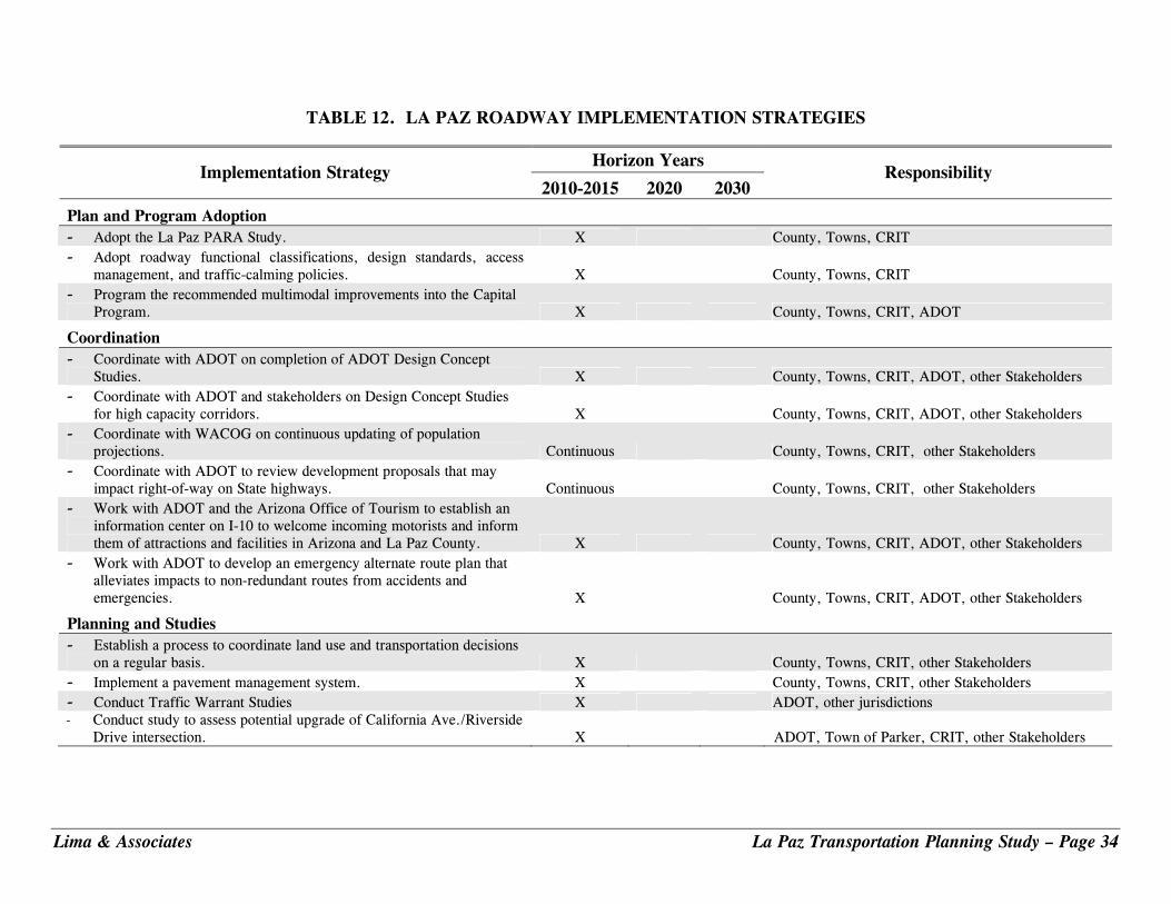
Implementation Strategies To meet these challenges, it is essential that an implementation action plan for short-, mid-, and long-range transportation projects be developed in coordination with key stakeholders. Tables 12 through 14 list recommended strategies for road, multimodal and freight projects for the 2010, 2015, 2020, and 2030 planning horizons. The tables also list the likely primary responsible parties for implementing the projects. Note, it is important that recommendations made by this Study for improvements on State facilities serve only as suggestions for further study. Improvements to the State Highway system can be made only after in-depth planning and engineering studies are conducted by ADOT, and upon approval of the State Transportation Board. All traffic interchange improvements must be approved by the Federal Highway Administration. In addition, environmental assessments must be conducted and Design-Concept Reports must be developed prior to the construction of any new roadway or multimodal facility.
Lima & Associates La Paz Transportation Planning Study – Page 33
Lima & Associates La Paz Transportation Planning Study – Page 34
TABLE 12. LA PAZ ROADWAY IMPLEMENTATION STRATEGIES
Horizon Years Implementation Strategy
2010-2015 2020 2030 Responsibility
Plan and Program Adoption - Adopt the La Paz PARA Study. X County, Towns, CRIT - Adopt roadway functional classifications, design standards, access
management, and traffic-calming policies. X County, Towns, CRIT - Program the recommended multimodal improvements into the Capital
Program. X County, Towns, CRIT, ADOT
Coordination - Coordinate with ADOT on completion of ADOT Design Concept
Studies. X County, Towns, CRIT, ADOT, other Stakeholders - Coordinate with ADOT and stakeholders on Design Concept Studies
for high capacity corridors. X County, Towns, CRIT, ADOT, other Stakeholders - Coordinate with WACOG on continuous updating of population
projections. Continuous County, Towns, CRIT, other Stakeholders - Coordinate with ADOT to review development proposals that may
impact right-of-way on State highways. Continuous County, Towns, CRIT, other Stakeholders - Work with ADOT and the Arizona Office of Tourism to establish an
information center on I-10 to welcome incoming motorists and inform them of attractions and facilities in Arizona and La Paz County. X County, Towns, CRIT, ADOT, other Stakeholders
- Work with ADOT to develop an emergency alternate route plan that alleviates impacts to non-redundant routes from accidents and emergencies. X County, Towns, CRIT, ADOT, other Stakeholders
Planning and Studies - Establish a process to coordinate land use and transportation decisions
on a regular basis. X County, Towns, CRIT, other Stakeholders - Implement a pavement management system. X County, Towns, CRIT, other Stakeholders - Conduct Traffic Warrant Studies X ADOT, other jurisdictions - Conduct study to assess potential upgrade of California Ave./Riverside Drive intersection. X ADOT, Town of Parker, CRIT, other Stakeholders
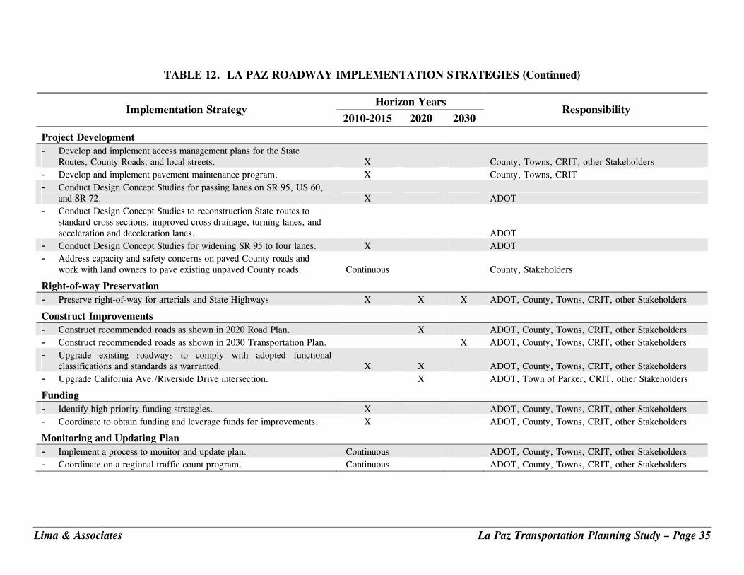
TABLE 12. LA PAZ ROADWAY IMPLEMENTATION STRATEGIES (Continued)
Horizon Years Implementation Strategy
2010-2015 2020 2030 Responsibility
Project Development - Develop and implement access management plans for the State
Routes, County Roads, and local streets. X County, Towns, CRIT, other Stakeholders - Develop and implement pavement maintenance program. X County, Towns, CRIT - Conduct Design Concept Studies for passing lanes on SR 95, US 60,
and SR 72. X ADOT - Conduct Design Concept Studies to reconstruction State routes to
standard cross sections, improved cross drainage, turning lanes, and acceleration and deceleration lanes. ADOT
- Conduct Design Concept Studies for widening SR 95 to four lanes. X ADOT - Address capacity and safety concerns on paved County roads and
work with land owners to pave existing unpaved County roads. Continuous County, Stakeholders
Right-of-way Preservation - Preserve right-of-way for arterials and State Highways X X X ADOT, County, Towns, CRIT, other Stakeholders
Construct Improvements - Construct recommended roads as shown in 2020 Road Plan. X ADOT, County, Towns, CRIT, other Stakeholders - Construct recommended roads as shown in 2030 Transportation Plan. X ADOT, County, Towns, CRIT, other Stakeholders - Upgrade existing roadways to comply with adopted functional
classifications and standards as warranted. X X ADOT, County, Towns, CRIT, other Stakeholders - Upgrade California Ave./Riverside Drive intersection. X ADOT, Town of Parker, CRIT, other Stakeholders
Funding - Identify high priority funding strategies. X ADOT, County, Towns, CRIT, other Stakeholders - Coordinate to obtain funding and leverage funds for improvements. X ADOT, County, Towns, CRIT, other Stakeholders
Monitoring and Updating Plan - Implement a process to monitor and update plan. Continuous ADOT, County, Towns, CRIT, other Stakeholders - Coordinate on a regional traffic count program. Continuous ADOT, County, Towns, CRIT, other Stakeholders
Lima & Associates La Paz Transportation Planning Study – Page 35

TABLE 13. LA PAZ MULTIMODAL IMPLEMENTATION STRATEGIES
Horizon Years Implementation Strategy
2010-2015 2020 2030 Responsibility
Plan and Program Adoption - Adopt the La Paz PARA Study. X County, Towns, CRIT, ADOT
- Program the recommended multimodal improvements into the capital program.
X Public Works departments of Participating Agencies, ADOT
Coordination
- Appoint Transit Advisory Board. X County, Towns, CRIT
- Designate County Transportation Coordinator. X County, Towns, CRIT
- Explore implementation of ride-sharing program. X Transportation Coordinator with input from the Transportation Advisory Board
- Participate in an “Arizona Rides” program as warranted. Assess unmet needs and deficiencies with respect to human services transportation and potential rationalization of vehicles and other assets.
X X Transportation Coordinator with input from the Transportation Advisory Board and the ADOT Multimodal Planning Division
- Work with ADOT to improve shoulders for biking. X County, Towns, CRIT, ADOT
Planning and Studies
- Conduct La Paz County Transit Feasibility Study. X County, Towns, CRIT, ADOT Multimodal Planning Division
- Identify potential sites of future park-and-ride lots, transit centers, and passenger rail facilities and preserve acreages.
X County, Towns, CRIT
- Study improvement and expansion of multiuse pathway network. Determine most appropriate bicycle and pedestrian facilities for each roadway segment given planned abutting land uses.
X County, Towns, CRIT with input from the Transportation Coordinator and Transportation Advisory Board
- Develop La Paz County standards for bike paths and trails. Public Works departments of Participating Agencies
- Develop regional bike and trails system. Public Works departments of Participating Agencies
- Develop an integrated bicycle trail system in the Parker Strip area that will allow visitors and residents an alternate form of transportation.
X Public Works departments of La Paz County, Town of Parker, and CRIT
Lima & Associates La Paz Transportation Planning Study – Page 36

TABLE 13. LA PAZ MULTIMODAL IMPLEMENTATION STRATEGIES (Continued)
Horizon Years Implementation Strategy 2010-2015 2020 2030
Responsibility
- Construct extensions to multiuse pathway network to connect new developments as warranted.
X X Public Works departments of Participating Agencies with input from the Transportation Coordinator and Transportation Advisory Board
- Work with the ADOT Aviation Department and the CRIT to monitor activity at Avi Suquilla Airport and anticipate and prepare for future facility improvements.
X X Public Works departments of La Paz County, Town of Parker, and CRIT
- Construct additional T-hangars at airport. X CRIT Public Works department - Design and construct new airport terminal building. X CRIT Public Works department - Complete 2030 multimodal plan. X Public Works departments of Participating Agencies with input
from the Transportation Coordinator and Transportation Advisory Board
Funding
- Identify high priority funding strategies. X
Transportation Coordinator with input from the Transportation Advisory Board and the ADOT Multimodal Planning Division
- Coordinate to obtain funding and leverage funds for improvements.
X
Participating Agency councils, with input from the Transportation Advisory Board
Monitoring and Updating Plan
- Implement a process to monitor and update plan. X
Public Works departments of Participating Agencies with input from the Transportation Coordinator and Transportation Advisory Board
- Coordinate on a regional multimodal usage count program (incorporating motor vehicle traffic counts and gathering of transit ridership data).
Continuous
Public Works departments of Participating Agencies with input from the Transportation Coordinator and Transportation Advisory Board
Lima & Associates La Paz Transportation Planning Study – Page 37

TABLE 14. LA PAZ RAIL AND TRUCK FREIGHT IMPLEMENTATION STRATEGIES
Horizon Years Implementation Strategy 2010-2015 2020 2030
Responsibility
Plan and Program Adoption - Adopt the La Paz PARA Study. X County, Towns, CRIT, ADOT
Coordination - Assist the Arizona & California Railroad in recruiting rail-served
industries to Parker South and other La Paz County sites. X X County, Town of Parker, ARZC
- Consider existing and future needs of truck operators when developing expansion and access management plans for County roadways.
X Councils and Public Works departments of Participating Agencies
- Develop a plan for an industrial and distribution center north of Quartzsite. X Town of Quartzsite Public Works with input from La Paz County and ADOT
- Develop a plan for a truck-tractor interchange facility near Ehrenberg to accommodate truck-tractor swaps as California moves to ban diesel tractors from the State.
X x ADOT Multimodal Planning Division with input from La Paz County and CRIT
Lima & Associates La Paz Transportation Planning Study – Page 38

Lima & Associates La Paz Transportation Planning Study – Page 39
FUNDING SOURCES This section summarizes multimodal revenue sources and estimates that are applicable to the La Paz area, together with financial constraints and opportunities pertaining to needed roadway improvements. A number of funding mechanisms exist that could be used to fund multimodal improvements in the Study Area. Key federal, State, regional, and local sources are shown in Table 15.
TABLE 15. MATRIX OF KEY FUNDING SOURCES
Fund Name Description Eligible Uses Application Process
Federal Surface Transportation Program (STP)
Federal funds, administered by FHWA and ADOT
Variety of capital projects including highways, bridges, and enhancement projects
Programmed WACOG and ADOT District
High Risk Rural Roads
Federal funds, administered by FHWA and ADOT
Correct safety problems on roadways classified as rural major collectors, rural minor collectors and rural local roads
Programmed through ADOT
Safe Routes to School Program
Federal funds, administered by FHWA and ADOT focused on enabling and encouraging children to safely walk and bicycle to school.
Projects can include sidewalk, traffic calming and speed reduction improvements, pedestrian and bicycle crossing improvements, and traffic diversion improvements near schools. Each State must use between 10-30 percent of the funds for non-infrastructure related activities, such as public awareness campaigns, traffic education and enforcement near schools, and student sessions on pedestrian and bicycle safety.
Programmed through ADOT.
Highway Safety Improvement Program (HSIP)
Federal funds administered by FHWA and ADOT
Funds can be used on safety improvement projects to reduce the number and severity of highway-related crashes. As a part of the HSIP, there are specific set asides for High Risk Rural Roads and for Railway-Highway Grade Crossings. Every state is required to develop a Strategic Highway Safety Plan that involves a comprehensive, collaborative and data driven approach of highway safety.
Programmed through WACOG and ADOT.
Federal Transit Administration (FTA)
Federal Transit Funds administered by ADOT Multimodal Transportation Division.
- Section 5310: Formula Grants for Special Needs of Elderly Individuals and Individuals with Disabilities
- Section 5311: Formula Grants for rural and small urban public transportation
- Section 5313: State Planning and Research Programs
Application to ADOT Multimodal transportation Division

TABLE 15. MATRIX OF KEY FUNDING SOURCES (Continued)
Fund Name Description Eligible Uses Application Process
Community Development Block Grants
Funds provided by the Federal Office of Housing and Urban Development.
Construction of capital improvement projects that benefit low to medium income groups. Projects that alleviate slums or address an urgent need such as circumstances caused by a natural disaster may be eligible. A transportation improvement project must be located in a census tract or block group with at least 51 percent of the population in the low and moderate-income group.
Application submitted to Federal Office of Housing and Urban Development.
State Highway User Revenue Fund (HURF)
State funds, derived from fuel tax and VLT, administered by ADOT
Nearly any capital project related to roadway improvements
Funds allocated to jurisdiction as proportion of population
Local Transportation Assistance Fund (LTAF)
State funds derived from lottery sales
General transportation improvements Funds allocated to jurisdiction as proportion of population
Off-Highway Vehicle (OHV) Recreation Fund
State funds as a portion of total license tax on motor fuel.
Designation, construction, and maintenance of OHV recreational facilities, OHV use areas, and OHV trails, enforcement of off-highway vehicle laws, and mitigation of damages to land.
Funds distributed to the State Parks Department, and Game and Fist Department.
Arizona State Parks Law Enforcement and Boating Safety Fund (LEBSF)
State funds granted to County Boards of Supervisors intended to support boating safety and law enforcement.
Funds enforcement of boating laws to ensure safety.
Application to Arizona State Parks Department.
Economic Strength Projects Fund
State funds administered by Arizona Department of Commerce and funded by HURF.
Selected road projects that support economic development objectives.
Application to Arizona Department of Commerce.
Governor’s Office of Highway Safety
Federal funds are allocated by the Governor’s Office of Highway Safety to finance State and local government highway safety projects.
Projects are selected according to safety priorities.
Application to Governor’s Office of Highway Safety.
Lima & Associates La Paz Transportation Planning Study – Page 40
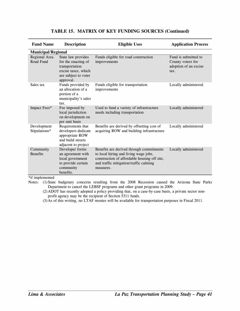
Lima & Associates La Paz Transportation Planning Study – Page 41
TABLE 15. MATRIX OF KEY FUNDING SOURCES (Continued)
Fund Name Description Eligible Uses Application Process
Municipal/Regional Regional Area Road Fund
State law provides for the enacting of transportation excise taxes, which are subject to voter approval.
Funds eligible for road construction improvements
Fund is submitted to County voters for adoption of an excise tax.
Sales tax Funds provided by an allocation of a portion of a municipality’s sales tax.
Funds eligible for transportation improvements
Locally administered
Impact Fees* Fee imposed by local jurisdiction on development on per unit basis
Used to fund a variety of infrastructure needs including transportation
Locally administered
Development Stipulations*
Requirements that developers dedicate appropriate ROW and build streets adjacent to project
Benefits are derived by offsetting cost of acquiring ROW and building infrastructure
Locally administered
Community Benefits
Developer forms an agreement with local government to provide certain community benefits.
Benefits are derived through commitments to local hiring and living wage jobs, construction of affordable housing off site, and traffic mitigation/traffic calming measures.
Locally administered
*if implemented Notes: (1) State budgetary concerns resulting from the 2008 Recession caused the Arizona State Parks
Department to cancel the LEBSF programs and other grant programs in 2009. (2) ADOT has recently adopted a policy providing that, on a case-by-case basis, a private sector non-
profit agency may be the recipient of Section 5311 funds. (3) As of this writing, no LTAF monies will be available for transportation purposes in Fiscal 2011.