La Défense 2050 - Ateliers
23
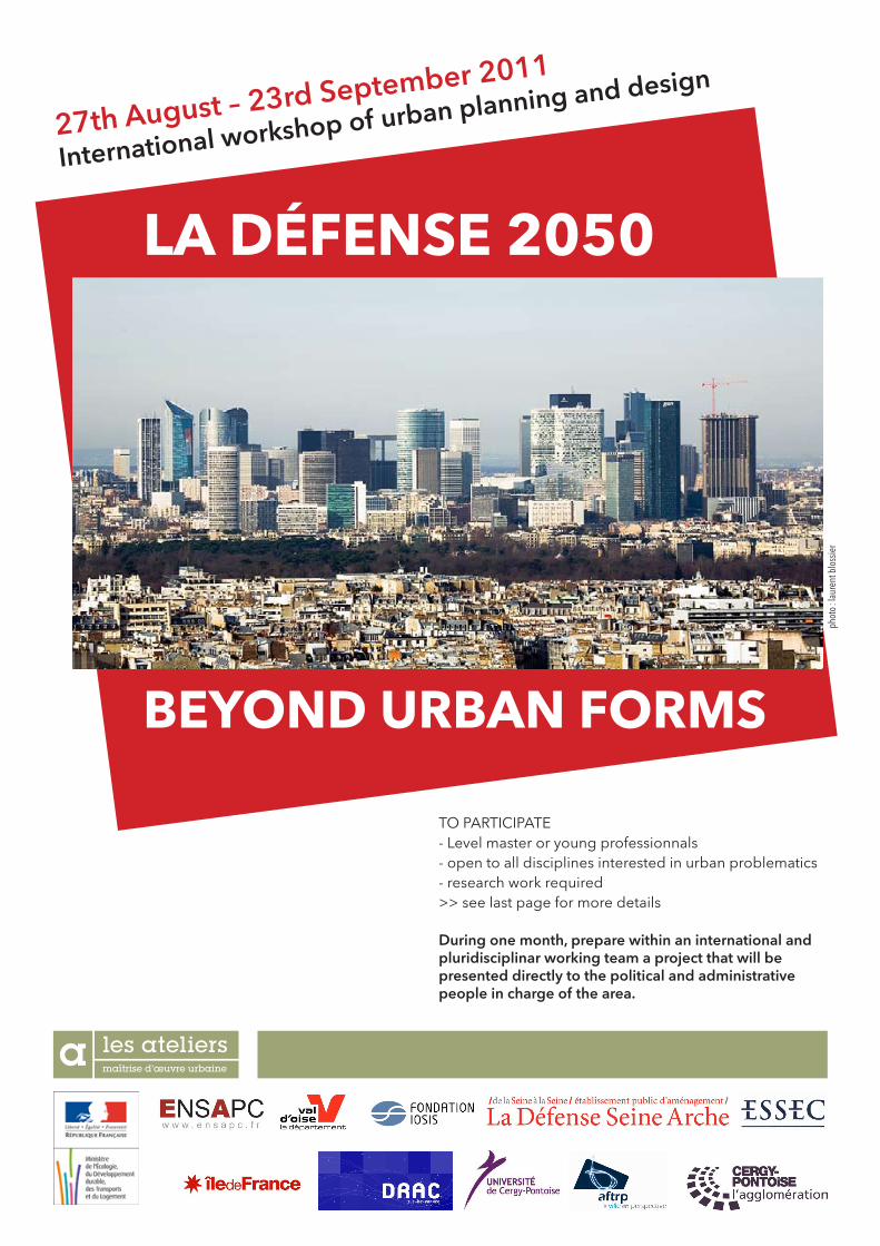
27th August – 23rd September 2011 International workshop of urban planning and design LA DÉFENSE 2050 BEYOND URBAN FORMS TO PARTICIPATE - Level master or young professionnals - open to all disciplines interested in urban problematics - research work required >> see last page for more details During one month, prepare within an international and pluridisciplinar working team a project that will be presented directly to the political and administrative people in charge of the area. photo : laurent blossier
Transcript of La Défense 2050 - Ateliers
27th August – 23rd September 2011
International workshop of urban planning and design
La Défense 2050
BeYOnD URBan fORMs
TO PARTICIPATE - Level master or young professionnals - open to all disciplines interested in urban problematics - research work required>> see last page for more details
During one month, prepare within an international and pluridisciplinar working team a project that will be presented directly to the political and administrative people in charge of the area.
phot
o : la
uren
t blo
ssie
r
29th International Workshop of urban planning and design - Cergy-Pontoise 2/23
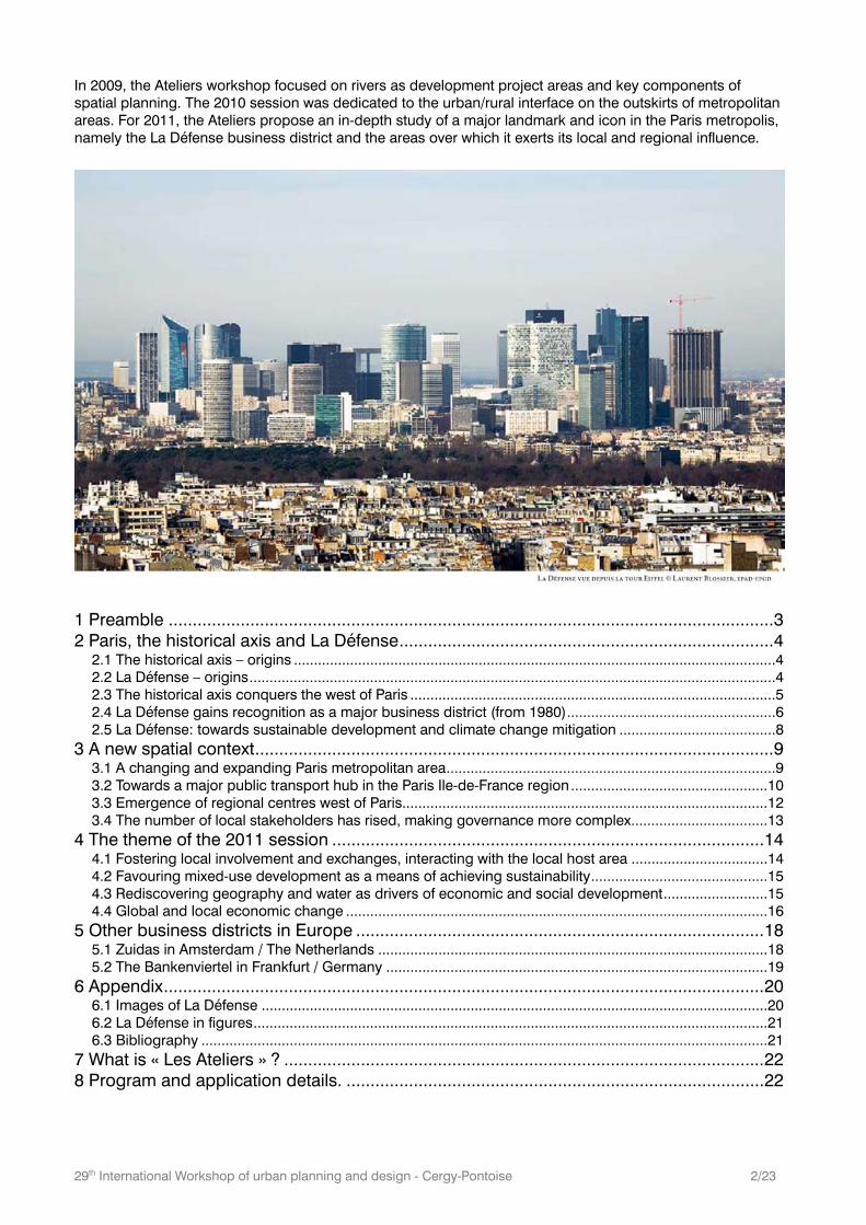
In 2009, the Ateliers workshop focused on rivers as development project areas and key components of spatial planning. The 2010 session was dedicated to the urban/rural interface on the outskirts of metropolitan areas. For 2011, the Ateliers propose an in-depth study of a major landmark and icon in the Paris metropolis, namely the La Défense business district and the areas over which it exerts its local and regional influence.
1 Preamble .............................................................................................................................. 3 2 Paris, the historical axis and La Défense .............................................................................. 4
2.1 The historical axis – origins ........................................................................................................................4 2.2 La Défense – origins ...................................................................................................................................4 2.3 The historical axis conquers the west of Paris ...........................................................................................5 2.4 La Défense gains recognition as a major business district (from 1980) ....................................................6 2.5 La Défense: towards sustainable development and climate change mitigation .......................................8
3 A new spatial context ............................................................................................................ 9 3.1 A changing and expanding Paris metropolitan area ..................................................................................9 3.2 Towards a major public transport hub in the Paris Ile-de-France region .................................................10 3.3 Emergence of regional centres west of Paris...........................................................................................12 3.4 The number of local stakeholders has rised, making governance more complex ..................................13
4 The theme of the 2011 session .......................................................................................... 14 4.1 Fostering local involvement and exchanges, interacting with the local host area ..................................14 4.2 Favouring mixed-use development as a means of achieving sustainability ............................................15 4.3 Rediscovering geography and water as drivers of economic and social development ..........................15 4.4 Global and local economic change .........................................................................................................16
5 Other business districts in Europe ..................................................................................... 18 5.1 Zuidas in Amsterdam / The Netherlands .................................................................................................18 5.2 The Bankenviertel in Frankfurt / Germany ...............................................................................................19
6 Appendix ............................................................................................................................. 20 6.1 Images of La Défense ..............................................................................................................................20 6.2 La Défense in figures ................................................................................................................................21 6.3 Bibliography .............................................................................................................................................21
7 What is « Les Ateliers » ? .................................................................................................... 22 8 Program and application details. ....................................................................................... 22
29th International Workshop of urban planning and design - Cergy-Pontoise 3/23
1 Preamble
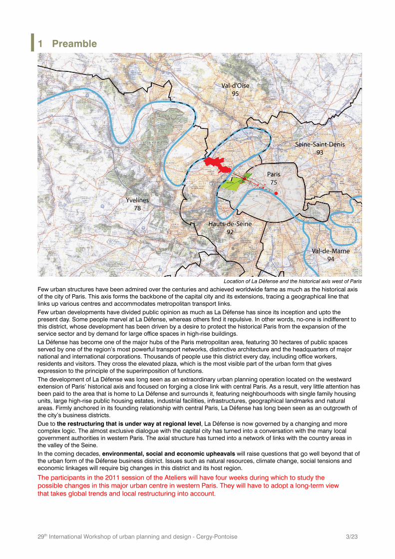
Location of La Défense and the historical axis west of Paris
Few urban structures have been admired over the centuries and achieved worldwide fame as much as the historical axis of the city of Paris. This axis forms the backbone of the capital city and its extensions, tracing a geographical line that links up various centres and accommodates metropolitan transport links. Few urban developments have divided public opinion as much as La Défense has since its inception and upto the present day. Some people marvel at La Défense, whereas others find it repulsive. In other words, no-one is indifferent to this district, whose development has been driven by a desire to protect the historical Paris from the expansion of the service sector and by demand for large office spaces in high-rise buildings. La Défense has become one of the major hubs of the Paris metropolitan area, featuring 30 hectares of public spaces served by one of the region’s most powerful transport networks, distinctive architecture and the headquarters of major national and international corporations. Thousands of people use this district every day, including office workers, residents and visitors. They cross the elevated plaza, which is the most visible part of the urban form that gives expression to the principle of the superimposition of functions. The development of La Défense was long seen as an extraordinary urban planning operation located on the westward extension of Paris’ historical axis and focused on forging a close link with central Paris. As a result, very little attention has been paid to the area that is home to La Défense and surrounds it, featuring neighbourhoods with single family housing units, large high-rise public housing estates, industrial facilities, infrastructures, geographical landmarks and natural areas. Firmly anchored in its founding relationship with central Paris, La Défense has long been seen as an outgrowth of the city’s business districts. Due to the restructuring that is under way at regional level, La Défense is now governed by a changing and more complex logic. The almost exclusive dialogue with the capital city has turned into a conversation with the many local government authorities in western Paris. The axial structure has turned into a network of links with the country areas in the valley of the Seine. In the coming decades, environmental, social and economic upheavals will raise questions that go well beyond that of the urban form of the Défense business district. Issues such as natural resources, climate change, social tensions and economic linkages will require big changes in this district and its host region.
The participants in the 2011 session of the Ateliers will have four weeks during which to study the possible changes in this major urban centre in western Paris. They will have to adopt a long-term view that takes global trends and local restructuring into account.
29th International Workshop of urban planning and design - Cergy-Pontoise 4/23
2 Paris, the historical axis and La Défense
2.1 The historical axis – origins
The Tuileries gardens in the 17th century
(L’axe historique, La Défense Seine Arche)
The historical axis features a series of events along its timeline
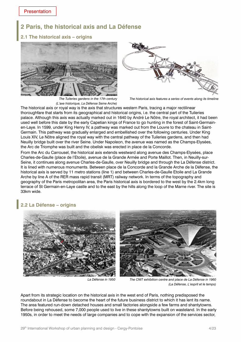
The historical axis or royal way is the axis that structures western Paris, tracing a major rectilinear thoroughfare that starts from its geographical and historical origins, i.e. the central part of the Tuileries palace. Although this axis was actually marked out in 1640 by André Le Nôtre, the royal architect, it had been used well before this date by the early Capetian kings of France to go hunting in the forest of Saint-Germain-en-Laye. In 1599, under King Henry IV, a pathway was marked out from the Louvre to the chateau in Saint-Germain. This pathway was gradually enlarged and embellished over the following centuries. Under King Louis XIV, Le Nôtre aligned the royal way with the central pathway of the Tuileries gardens, and then had Neuilly bridge built over the river Seine. Under Napoleon, the avenue was named as the Champs-Elysées, the Arc de Triomphe was built and the obelisk was erected in place de la Concorde. From the Arc du Carrousel, the historical axis extends westward along avenue des Champs-Elysées, place Charles-de-Gaulle (place de l’Etoile), avenue de la Grande Armée and Porte Maillot. Then, in Neuilly-sur-Seine, it continues along avenue Charles-de-Gaulle, over Neuilly bridge and through the La Défense district. It is lined with numerous monuments. Between place de la Concorde and la Grande Arche de la Défense, the historical axis is served by 11 metro stations (line 1) and between Charles-de-Gaulle Etoile and La Grande Arche by line A of the RER mass rapid transit (MRT) railway network. In terms of the topography and geography of the Paris metropolitan area, the Paris historical axis is bordered to the west by the 2.4km long terrace of St Germain-en-Laye castle and to the east by the hills along the loop of the Marne river. The site is 33km wide.
2.2 La Défense – origins
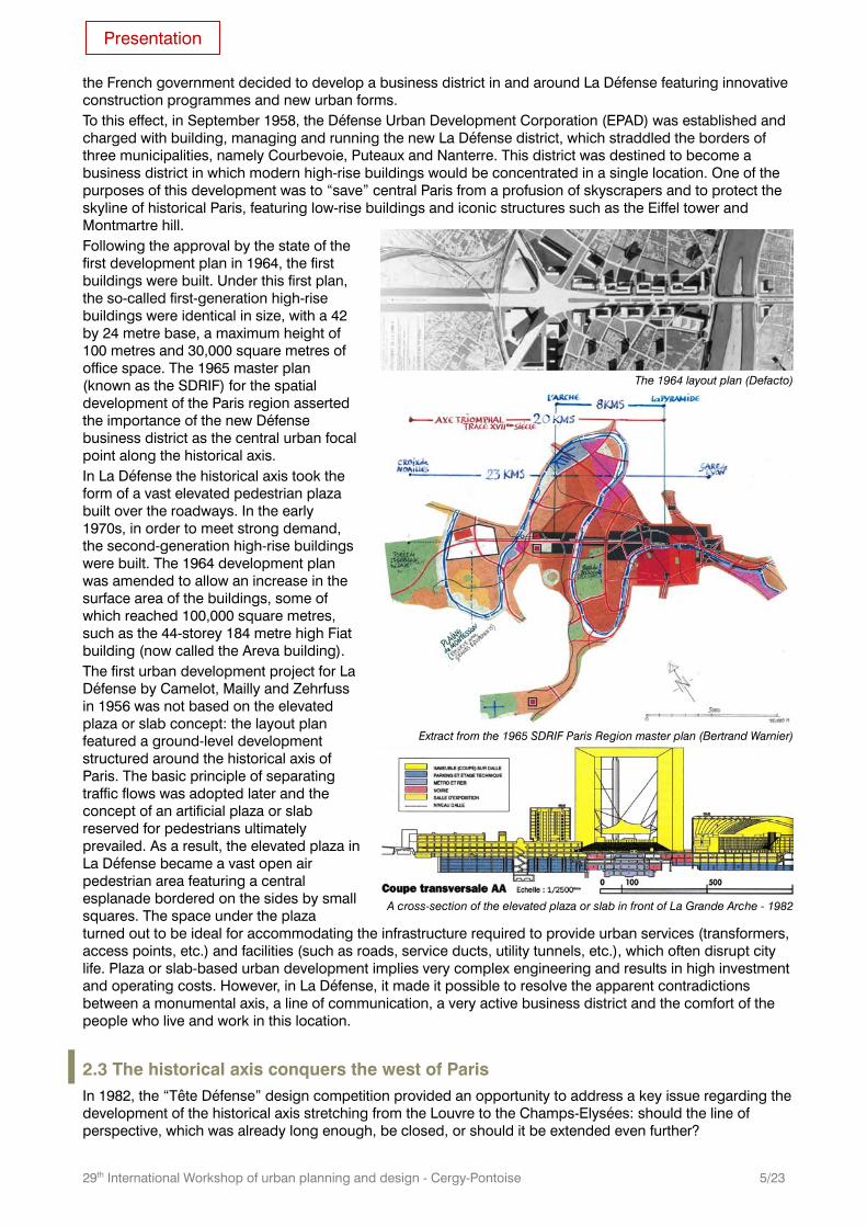
La Défense in 1950
The CNIT exhibition centre and place de La Défense in 1960
(La Défense, L’esprit et le temps)
Apart from its strategic location on the historical axis in the west end of Paris, nothing predisposed the roundabout in La Défense to become the heart of the future business district to which it has lent its name. The area featured run-down detached houses and small factories alongside a few farms and shantytowns. Before being rehoused, some 7,000 people used to live in these shantytowns built on wasteland. In the early 1950s, in order to meet the needs of large companies and to cope with the expansion of the services sector,
Presentation
29th International Workshop of urban planning and design - Cergy-Pontoise 5/23
the French government decided to develop a business district in and around La Défense featuring innovative construction programmes and new urban forms. To this effect, in September 1958, the Défense Urban Development Corporation (EPAD) was established and charged with building, managing and running the new La Défense district, which straddled the borders of three municipalities, namely Courbevoie, Puteaux and Nanterre. This district was destined to become a business district in which modern high-rise buildings would be concentrated in a single location. One of the purposes of this development was to “save” central Paris from a profusion of skyscrapers and to protect the skyline of historical Paris, featuring low-rise buildings and iconic structures such as the Eiffel tower and Montmartre hill. Following the approval by the state of the first development plan in 1964, the first buildings were built. Under this first plan, the so-called first-generation high-rise buildings were identical in size, with a 42 by 24 metre base, a maximum height of 100 metres and 30,000 square metres of office space. The 1965 master plan (known as the SDRIF) for the spatial development of the Paris region asserted the importance of the new Défense business district as the central urban focal point along the historical axis. In La Défense the historical axis took the form of a vast elevated pedestrian plaza built over the roadways. In the early 1970s, in order to meet strong demand, the second-generation high-rise buildings were built. The 1964 development plan was amended to allow an increase in the surface area of the buildings, some of which reached 100,000 square metres, such as the 44-storey 184 metre high Fiat building (now called the Areva building). The first urban development project for La Défense by Camelot, Mailly and Zehrfuss in 1956 was not based on the elevated plaza or slab concept: the layout plan featured a ground-level development structured around the historical axis of Paris. The basic principle of separating traffic flows was adopted later and the concept of an artificial plaza or slab reserved for pedestrians ultimately prevailed. As a result, the elevated plaza in La Défense became a vast open air pedestrian area featuring a central esplanade bordered on the sides by small squares. The space under the plaza turned out to be ideal for accommodating the infrastructure required to provide urban services (transformers, access points, etc.) and facilities (such as roads, service ducts, utility tunnels, etc.), which often disrupt city life. Plaza or slab-based urban development implies very complex engineering and results in high investment and operating costs. However, in La Défense, it made it possible to resolve the apparent contradictions between a monumental axis, a line of communication, a very active business district and the comfort of the people who live and work in this location.
2.3 The historical axis conquers the west of Paris In 1982, the “Tête Défense” design competition provided an opportunity to address a key issue regarding the development of the historical axis stretching from the Louvre to the Champs-Elysées: should the line of perspective, which was already long enough, be closed, or should it be extended even further?
The 1964 layout plan (Defacto)
Extract from the 1965 SDRIF Paris Region master plan (Bertrand Warnier)
A cross-section of the elevated plaza or slab in front of La Grande Arche - 1982
Presentation
29th International Workshop of urban planning and design - Cergy-Pontoise 6/23
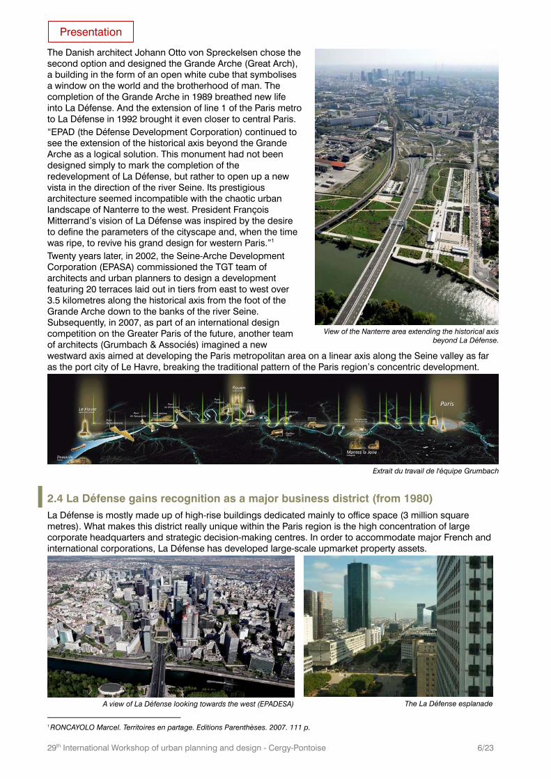
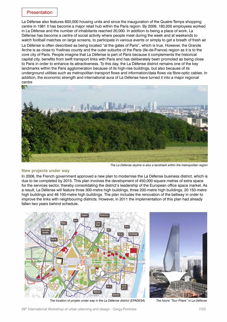
The Danish architect Johann Otto von Spreckelsen chose the second option and designed the Grande Arche (Great Arch), a building in the form of an open white cube that symbolises a window on the world and the brotherhood of man. The completion of the Grande Arche in 1989 breathed new life into La Défense. And the extension of line 1 of the Paris metro to La Défense in 1992 brought it even closer to central Paris. “EPAD (the Défense Development Corporation) continued to see the extension of the historical axis beyond the Grande Arche as a logical solution. This monument had not been designed simply to mark the completion of the redevelopment of La Défense, but rather to open up a new vista in the direction of the river Seine. Its prestigious architecture seemed incompatible with the chaotic urban landscape of Nanterre to the west. President François Mitterrand’s vision of La Défense was inspired by the desire to define the parameters of the cityscape and, when the time was ripe, to revive his grand design for western Paris.”1 Twenty years later, in 2002, the Seine-Arche Development Corporation (EPASA) commissioned the TGT team of architects and urban planners to design a development featuring 20 terraces laid out in tiers from east to west over 3.5 kilometres along the historical axis from the foot of the Grande Arche down to the banks of the river Seine. Subsequently, in 2007, as part of an international design competition on the Greater Paris of the future, another team of architects (Grumbach & Associés) imagined a new westward axis aimed at developing the Paris metropolitan area on a linear axis along the Seine valley as far as the port city of Le Havre, breaking the traditional pattern of the Paris region’s concentric development.
Extrait du travail de l'équipe Grumbach
2.4 La Défense gains recognition as a major business district (from 1980) La Défense is mostly made up of high-rise buildings dedicated mainly to office space (3 million square metres). What makes this district really unique within the Paris region is the high concentration of large corporate headquarters and strategic decision-making centres. In order to accommodate major French and international corporations, La Défense has developed large-scale upmarket property assets.
A view of La Défense looking towards the west (EPADESA)
The La Défense esplanade
1 RONCAYOLO Marcel. Territoires en partage. Editions Parenthèses. 2007. 111 p.
View of the Nanterre area extending the historical axis
beyond La Défense.
Presentation
29th International Workshop of urban planning and design - Cergy-Pontoise 7/23
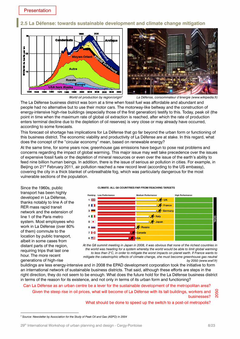
La Défense also features 600,000 housing units and since the inauguration of the Quatre-Temps shopping centre in 1981 it has become a major retail hub within the Paris region. By 2009, 180,000 employees worked in La Défense and the number of inhabitants reached 20,000. In addition to being a place of work, La Défense has become a centre of social activity where people meet during the week and at weekends to watch football matches on large screens, to participate in various events or simply to get a breath of fresh air. La Défense is often described as being located “at the gates of Paris”, which is true. However, the Grande Arche is as close to Yvelines county and the outer suburbs of the Paris (Ile-de-France) region as it is to the core city of Paris. People imagine that La Défense is part of Paris because it complements the historical capital city, benefits from swift transport links with Paris and has deliberately been promoted as being close to Paris in order to enhance its attractiveness. To this day, the La Défense district remains one of the key landmarks within the Paris agglomeration because of its high-rise buildings, but also because of its underground utilities such as metropolitan transport flows and information/data flows via fibre-optic cables. In addition, the economic strength and international aura of La Défense have turned it into a major regional centre
The La Défense skyline is also a landmark within the metropolitan region
New projects under way In 2006, the French government approved a new plan to modernise the La Défense business district, which is due to be completed by 2015. This plan involves the development of 450,000 square metres of extra space for the services sector, thereby consolidating the district’s leadership of the European office space market. As a result, La Défense will feature three 300-metre high buildings, three 200-metre high buildings, 20 150-metre high buildings and 46 100-metre high buildings. The plan includes the renovation of the beltway in order to improve the links with neighbouring districts. However, in 2011 the implementation of this plan had already fallen two years behind schedule.
The location of projets under way in the La Défense district (EPADESA)
The future “Tour Phare” in La Défense
Presentation
29th International Workshop of urban planning and design - Cergy-Pontoise 8/23
2.5 La Défense: towards sustainable development and climate change mitigation
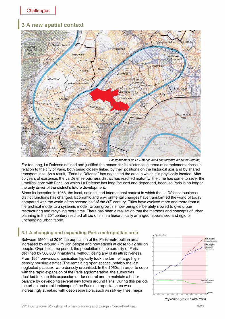
World oil production by region/origin2
La Défense, consommateur d’énergie (www.wikipedia.fr)
The La Défense business district was born at a time when fossil fuel was affordable and abundant and people had no alternative but to use their motor cars. The motorway-like beltway and the construction of energy-intensive high-rise buildings (especially those of the first generation) testify to this. Today, peak oil (the point in time when the maximum rate of global oil extraction is reached, after which the rate of production enters terminal decline due to the depletion of oil reserves) is very close or may already have occurred, according to some forecasts. This forecast oil shortage has implications for La Défense that go far beyond the urban form or functioning of this business district. The economic viability and productivity of La Défense are at stake. In this regard, what does the concept of the “circular economy” mean, based on renewable energy? At the same time, for some years now, greenhouse gas emissions have begun to pose real problems and concerns regarding the impact of global warming. This major issue may well take precedence over the issues of expensive fossil fuels or the depletion of mineral resources or even over the issue of the earth’s ability to feed nine billion human beings. In addition, there is the issue of serious air pollution in cities. For example, in Beijing on 21st February 2011, air pollution reached a new record level (according to the US embassy), covering the city in a thick blanket of unbreathable fog, which was particularly dangerous for the most vulnerable sections of the population. Since the 1960s, public transport has been highly developed in La Défense, thanks notably to line A of the RER mass rapid transit network and the extension of line 1 of the Paris metro system. Most employees who work in La Défense (over 80% of them) commute to the location by public transport, albeit in some cases from distant parts of the region, requiring trips that last one hour. The more recent generations of high-rise buildings are less energy-intensive and in 2008 the EPAD development corporation took the initiative to form an international network of sustainable business districts. That said, although these efforts are steps in the right direction, they do not seem to be enough. What does the future hold for the La Défense business district in terms of the reason for its existence, and not only in terms of its urban form and functioning?
Can La Défense as an urban centre be a lever for the sustainable development of the metropolitan area?
Given the steep rise in oil prices, what will become of La Défense with its tall buildings, workers and businesses?
What should be done to speed up the switch to a post-oil metropolis?
2050
2 Source: Newsletter by Association for the Study of Peak Oil and Gas (ASPO) in 2004
At the G8 summit meeting in Japan in 2008, it was obvious that none of the richest countries in
the world was heading for a system whereby the world would be able to limit global warming to less than 2°C, in order to mitigate the worst impacts on planet earth. If France wants to
mitigate the catastrophic effects of climate change, she must become greenhouse gas neutral by 2050 (www.wwf.fr)
Presentation
29th International Workshop of urban planning and design - Cergy-Pontoise 9/23
3 A new spatial context
For too long, La Défense defined and justified the reason for its existence in terms of complementariness in relation to the city of Paris, both being closely linked by their positions on the historical axis and by shared transport lines. As a result, “Paris-La Défense” has neglected the area in which it is physically located. After 50 years of existence, the La Défense business district has reached maturity. The time has come to sever the umbilical cord with Paris, on which La Défense has long focused and depended, because Paris is no longer the only driver of the district’s future development. Since its inception in 1958, the local, national and international context in which the La Défense business district functions has changed. Economic and environmental changes have transformed the world of today compared with the world of the second half of the 20th century. Cities have evolved more and more from a hierarchical model to a systemic model. Urban growth is now being deliberately slowed to give urban restructuring and recycling more time. There has been a realisation that the methods and concepts of urban planning in the 20th century resulted all too often in a hierarchically arranged, specialised and rigid or unchanging urban fabric.
3.1 A changing and expanding Paris metropolitan area Between 1960 and 2010 the population of the Paris metropolitan area increased by around 7 million people and now stands at close to 12 million people. Over the same period, the population of the core city of Paris declined by 500,000 inhabitants, without losing any of its attractiveness. From 1954 onwards, urbanisation typically took the form of large high-density housing estates. The remaining open spaces, notably the last neglected plateaux, were densely urbanised. In the 1960s, in order to cope with the rapid expansion of the Paris agglomeration, the authorities decided to keep this expansion under control and to maintain a better balance by developing several new towns around Paris. During this period, the urban and rural landscape of the Paris metropolitan area was increasingly streaked with deep separators, such as railway lines, major
Positionnement de La Défense dans son territoire d’accueil (rethink)
Population growth 1900 - 2006
Challenges
29th International Workshop of urban planning and design - Cergy-Pontoise 10/23
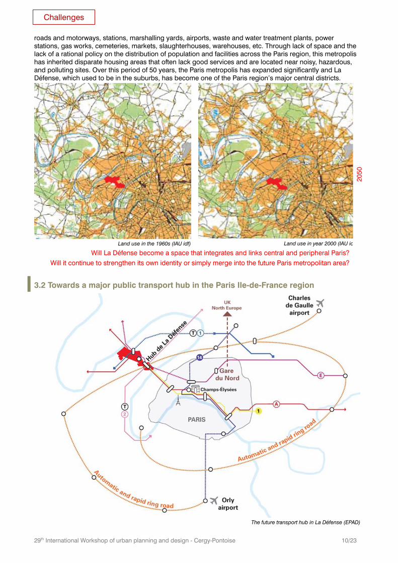
roads and motorways, stations, marshalling yards, airports, waste and water treatment plants, power stations, gas works, cemeteries, markets, slaughterhouses, warehouses, etc. Through lack of space and the lack of a rational policy on the distribution of population and facilities across the Paris region, this metropolis has inherited disparate housing areas that often lack good services and are located near noisy, hazardous, and polluting sites. Over this period of 50 years, the Paris metropolis has expanded significantly and La Défense, which used to be in the suburbs, has become one of the Paris region’s major central districts.
Will La Défense become a space that integrates and links central and peripheral Paris?
Will it continue to strengthen its own identity or simply merge into the future Paris metropolitan area?
Land use in the 1960s (IAU idf) Land use in year 2000 (IAU id
2050
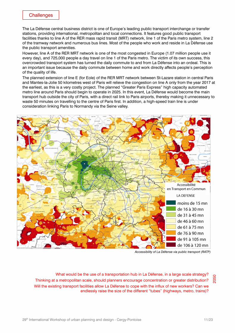
3.2 Towards a major public transport hub in the Paris Ile-de-France region
The future transport hub in La Défense (EPAD)
Challenges
29th International Workshop of urban planning and design - Cergy-Pontoise 11/23
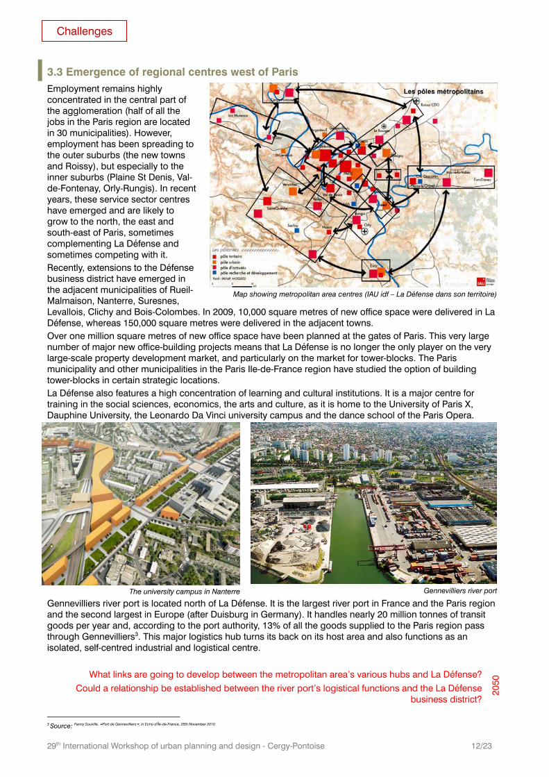
The La Défense central business district is one of Europe’s leading public transport interchange or transfer stations, providing international, metropolitan and local connections. It features good public transport facilities thanks to line A of the RER mass rapid transit (MRT) network, line 1 of the Paris metro system, line 2 of the tramway network and numerous bus lines. Most of the people who work and reside in La Défense use the public transport amenities. However, line A of the RER MRT network is one of the most congested in Europe (1.07 million people use it every day), and 725,000 people a day travel on line 1 of the Paris metro. The victim of its own success, this overcrowded transport system has turned the daily commute to and from La Défense into an ordeal. This is an important issue because the daily commute between home and work directly affects people’s perception of the quality of life. The planned extension of line E (for Eole) of the RER MRT network between St-Lazare station in central Paris and Mantes-la-Jolie 50 kilometres west of Paris will relieve the congestion on line A only from the year 2017 at the earliest, as this is a very costly project. The planned “Greater Paris Express” high capacity automated metro line around Paris should begin to operate in 2025. In this event, La Défense would become the main transport hub outside the city of Paris, with a direct rail link to Paris airports, thereby making it unnecessary to waste 50 minutes on travelling to the centre of Paris first. In addition, a high-speed train line is under consideration linking Paris to Normandy via the Seine valley.
What would be the use of a transportation hub in La Défense, in a large scale strategy?
Thinking at a metropolitan scale, should planners encourage concentration or greater distribution?
Will the existing transport facilities allow La Défense to cope with the influx of new workers? Can we endlessly raise the size of the different “tubes” (highways, metro, trains)?
2050
Accessibility of La Défense via public transport (RATP)
Challenges
29th International Workshop of urban planning and design - Cergy-Pontoise 12/23
3.3 Emergence of regional centres west of Paris Employment remains highly concentrated in the central part of the agglomeration (half of all the jobs in the Paris region are located in 30 municipalities). However, employment has been spreading to the outer suburbs (the new towns and Roissy), but especially to the inner suburbs (Plaine St Denis, Val-de-Fontenay, Orly-Rungis). In recent years, these service sector centres have emerged and are likely to grow to the north, the east and south-east of Paris, sometimes complementing La Défense and sometimes competing with it. Recently, extensions to the Défense business district have emerged in the adjacent municipalities of Rueil-Malmaison, Nanterre, Suresnes, Levallois, Clichy and Bois-Colombes. In 2009, 10,000 square metres of new office space were delivered in La Défense, whereas 150,000 square metres were delivered in the adjacent towns. Over one million square metres of new office space have been planned at the gates of Paris. This very large number of major new office-building projects means that La Défense is no longer the only player on the very large-scale property development market, and particularly on the market for tower-blocks. The Paris municipality and other municipalities in the Paris Ile-de-France region have studied the option of building tower-blocks in certain strategic locations. La Défense also features a high concentration of learning and cultural institutions. It is a major centre for training in the social sciences, economics, the arts and culture, as it is home to the University of Paris X, Dauphine University, the Leonardo Da Vinci university campus and the dance school of the Paris Opera.
Gennevilliers river port is located north of La Défense. It is the largest river port in France and the Paris region and the second largest in Europe (after Duisburg in Germany). It handles nearly 20 million tonnes of transit goods per year and, according to the port authority, 13% of all the goods supplied to the Paris region pass through Gennevilliers3. This major logistics hub turns its back on its host area and also functions as an isolated, self-centred industrial and logistical centre.
What links are going to develop between the metropolitan area’s various hubs and La Défense? Could a relationship be established between the river port’s logistical functions and the La Défense
business district?
2050
3 Source: Fanny Souville, “Port de Gennevilliers”, in Echo d'Île-de-France, 25th November 2010
Map showing metropolitan area centres (IAU idf – La Défense dans son territoire)
The university campus in Nanterre
Gennevilliers river port
Challenges
29th International Workshop of urban planning and design - Cergy-Pontoise 13/23
3.4 The number of local stakeholders has rised, making governance more complex
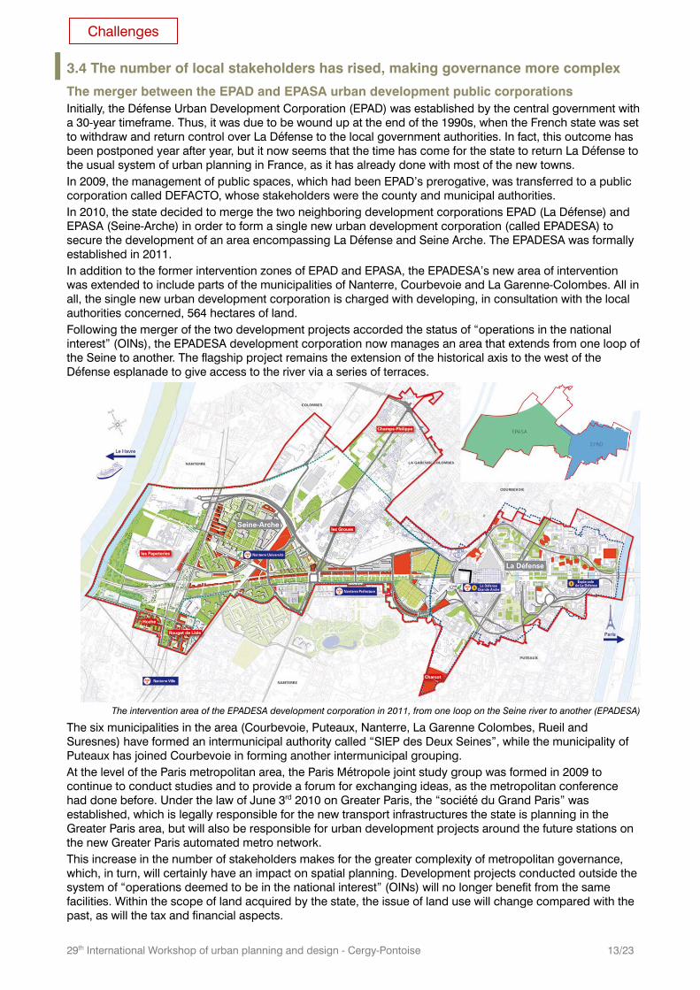
The merger between the EPAD and EPASA urban development public corporations Initially, the Défense Urban Development Corporation (EPAD) was established by the central government with a 30-year timeframe. Thus, it was due to be wound up at the end of the 1990s, when the French state was set to withdraw and return control over La Défense to the local government authorities. In fact, this outcome has been postponed year after year, but it now seems that the time has come for the state to return La Défense to the usual system of urban planning in France, as it has already done with most of the new towns. In 2009, the management of public spaces, which had been EPAD’s prerogative, was transferred to a public corporation called DEFACTO, whose stakeholders were the county and municipal authorities. In 2010, the state decided to merge the two neighboring development corporations EPAD (La Défense) and EPASA (Seine-Arche) in order to form a single new urban development corporation (called EPADESA) to secure the development of an area encompassing La Défense and Seine Arche. The EPADESA was formally established in 2011. In addition to the former intervention zones of EPAD and EPASA, the EPADESA’s new area of intervention was extended to include parts of the municipalities of Nanterre, Courbevoie and La Garenne-Colombes. All in all, the single new urban development corporation is charged with developing, in consultation with the local authorities concerned, 564 hectares of land. Following the merger of the two development projects accorded the status of “operations in the national interest” (OINs), the EPADESA development corporation now manages an area that extends from one loop of the Seine to another. The flagship project remains the extension of the historical axis to the west of the Défense esplanade to give access to the river via a series of terraces.
The six municipalities in the area (Courbevoie, Puteaux, Nanterre, La Garenne Colombes, Rueil and Suresnes) have formed an intermunicipal authority called “SIEP des Deux Seines”, while the municipality of Puteaux has joined Courbevoie in forming another intermunicipal grouping. At the level of the Paris metropolitan area, the Paris Métropole joint study group was formed in 2009 to continue to conduct studies and to provide a forum for exchanging ideas, as the metropolitan conference had done before. Under the law of June 3rd 2010 on Greater Paris, the “société du Grand Paris” was established, which is legally responsible for the new transport infrastructures the state is planning in the Greater Paris area, but will also be responsible for urban development projects around the future stations on the new Greater Paris automated metro network. This increase in the number of stakeholders makes for the greater complexity of metropolitan governance, which, in turn, will certainly have an impact on spatial planning. Development projects conducted outside the system of “operations deemed to be in the national interest” (OINs) will no longer benefit from the same facilities. Within the scope of land acquired by the state, the issue of land use will change compared with the past, as will the tax and financial aspects.
The intervention area of the EPADESA development corporation in 2011, from one loop on the Seine river to another (EPADESA)
Challenges
29th International Workshop of urban planning and design - Cergy-Pontoise 14/23
4 The theme of the 2011 session The prospects for the future development of La Défense within the Paris metropolitan area seem less clear-cut than a few years ago. The bursting of the internet bubble in 2000 and the financial crisis since 2007 have called into question our certainties regarding economic growth. In addition, there is a demand for more balanced spatial development and a higher quality of life for all, based on greater proximity in order to enhance mobility. The fundamental characteristics of the La Défense district defined 50 years ago still exist: La Défense still relies on its historical axis. This is what poses problems. Faced with a changing world, La Défense has become obsolete in many ways. The plaza-based (or slab-based) concept of urban development is no longer synonymous with modernity. The almost monofunctional nature of La Défense is less well accepted today than in the past. The high-rise buildings that used to epitomise modernity are now criticised from an ecological point of view. It is as if the concept has run out of steam. Even though La Défense remains a balcony from which to enjoy a spectacular vista of Paris, this is no longer enough to ensure its attractiveness. The La Défense redevelopment plan approved in 2006 is scheduled to be completed in 2015. At its inception in the 1950s, the plan for the original development of the La Défense district was based on an urban strategy and a metropolitan vision with a 30 to 40 year timeline. The 2006 redevelopment plan is based on a property developer’s 10-year timeline. As a result, five years later, the question that must be asked again is that of this district’s future within a metropolitan area that has undergone deep change since 1958. The current debate on the development of the Paris metropolitan area (“Greater Paris”) provides the Ateliers’ 2011 summer session with a great opportunity to view this fascinating district from a broader, more coherent and well-argued perspective.
What future, what new long-term roadmap for La Défense and its development area?
What renewed vision in the face of the new environmental, economic and social contexts? 2050
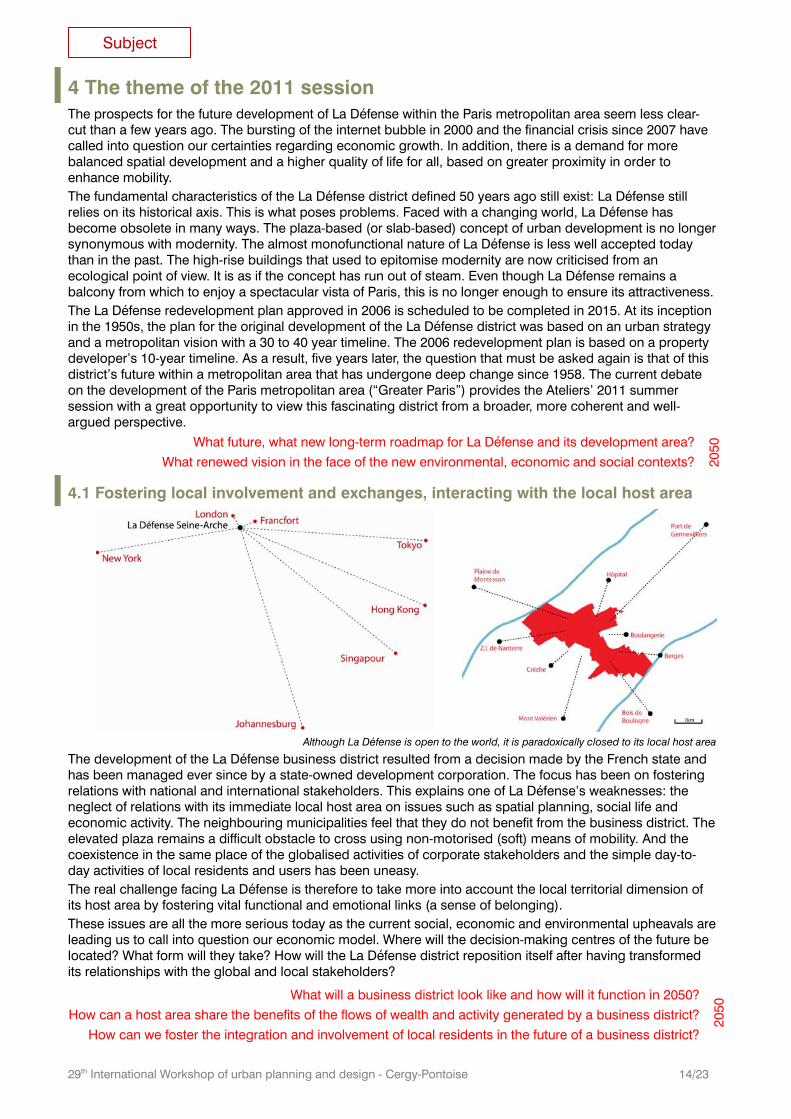
4.1 Fostering local involvement and exchanges, interacting with the local host area
The development of the La Défense business district resulted from a decision made by the French state and has been managed ever since by a state-owned development corporation. The focus has been on fostering relations with national and international stakeholders. This explains one of La Défense’s weaknesses: the neglect of relations with its immediate local host area on issues such as spatial planning, social life and economic activity. The neighbouring municipalities feel that they do not benefit from the business district. The elevated plaza remains a difficult obstacle to cross using non-motorised (soft) means of mobility. And the coexistence in the same place of the globalised activities of corporate stakeholders and the simple day-to-day activities of local residents and users has been uneasy. The real challenge facing La Défense is therefore to take more into account the local territorial dimension of its host area by fostering vital functional and emotional links (a sense of belonging). These issues are all the more serious today as the current social, economic and environmental upheavals are leading us to call into question our economic model. Where will the decision-making centres of the future be located? What form will they take? How will the La Défense district reposition itself after having transformed its relationships with the global and local stakeholders?
Although La Défense is open to the world, it is paradoxically closed to its local host area
What will a business district look like and how will it function in 2050?
How can a host area share the benefits of the flows of wealth and activity generated by a business district?
How can we foster the integration and involvement of local residents in the future of a business district?
2050
Subject
29th International Workshop of urban planning and design - Cergy-Pontoise 15/23
4.2 Favouring mixed-use development as a means of achieving sustainability In spite of its 20,000 inhabitants, shopping centre and fairly diverse supply of jobs, there is no doubt that La Défense is a district with a specific character. As it is difficult to combine several functions within a single urban development project, La Défense is characterised by buildings exclusively dedicated to office space. Any system that is too specialised is more sensitive to change than balanced systems. A business district changes in line with changing global trading patterns. Consequently, La Défense risks turning into a “globalised isolated district”, a space utterly divorced from the metropolitan area in which it is located, a space where change is driven by global competitiveness. We need to think again about how to change the way La Défense functions. This implies rethinking its relationships with time, space and services, as well as with cultural and sports activities. The aim should be to seek a much greater mix of functions, blending office space, retail outlets, sports facilities, cultural amenties and housing units. The worsening housing shortage in the Paris Ile-de-France region has turned housing and home/work mobility into top priorities. The ratio of office space to housing units is inadequate in terms of meeting the needs of all workers for affordable housing. Today, everyone recognises that a mix of urban uses and functions makes for more resilient towns and cities. At a time when oil is expensive it is senseless to encourage people who live on the other side of the Paris metropolitan area to come and work in La Défense. Moreover, pressures on society and deep changes due to climate-related events have increased the risk of very serious social unrest. How can an urban environment be created that could be an answer to this potential crisis? The search for the right mix should include everything: social diversity, mixing of functions, types of jobs, etc. It should be conducted on different scales, ranging from individual buildings to the urban development area as a whole. In La Défense, we need to make sure that the functions and development programmes are complementary across the three municipalities of Puteaux, Courbevoie and Nanterre, as well as the six municipalities that form part of the SIEP intermunicipal local authority and even beyond these. Perhaps the search for greater mixed-use development could also include other inward-looking and monofunctional entities such as the neighbouring university campuses or high-rise housing estates?
Should La Défense be turned into a mixed-use district, which is lively and open to everyone (really everyone!)?
Which of the business district’s characteristics are key and which can afford to change?
What capacity does La Défense have for renewing itself and evolving within the Paris metropolitan area?
2050
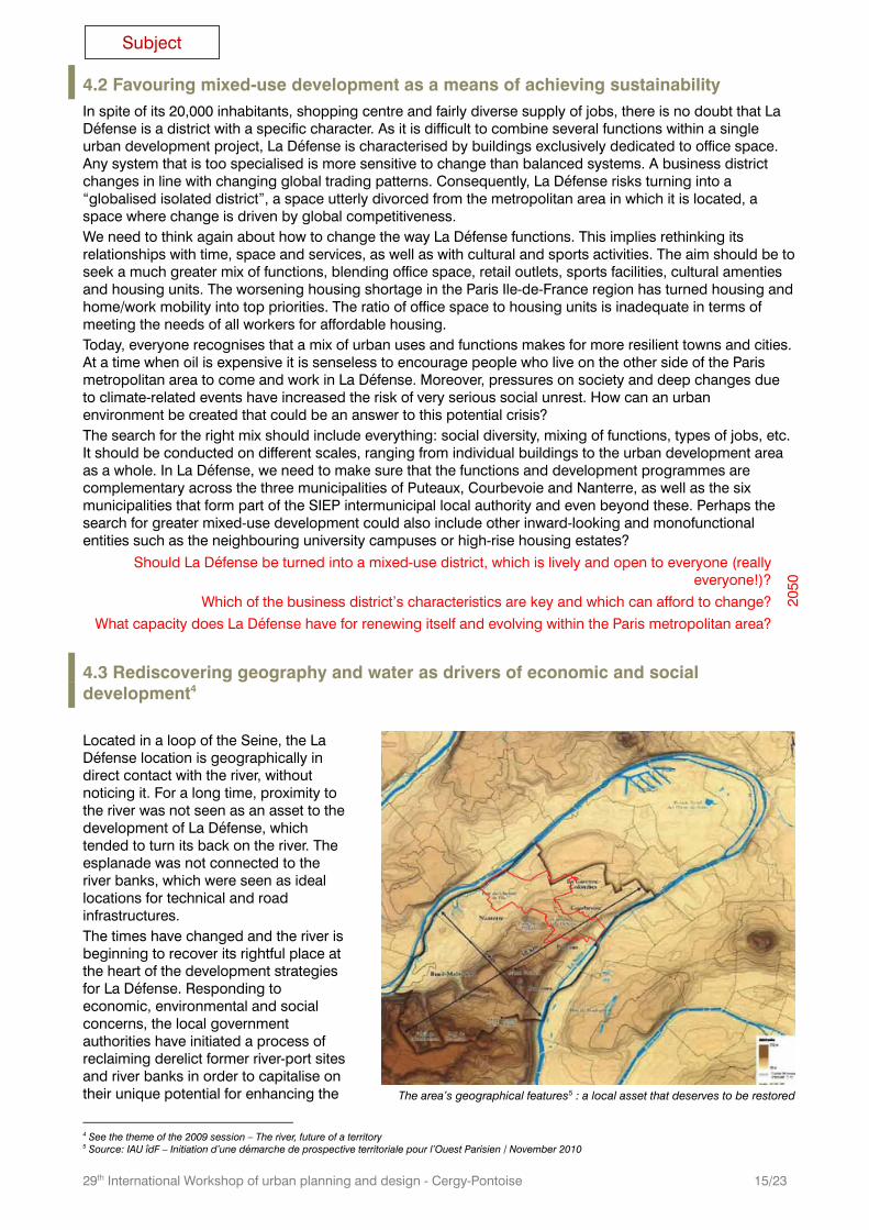
4.3 Rediscovering geography and water as drivers of economic and social development4 Located in a loop of the Seine, the La Défense location is geographically in direct contact with the river, without noticing it. For a long time, proximity to the river was not seen as an asset to the development of La Défense, which tended to turn its back on the river. The esplanade was not connected to the river banks, which were seen as ideal locations for technical and road infrastructures. The times have changed and the river is beginning to recover its rightful place at the heart of the development strategies for La Défense. Responding to economic, environmental and social concerns, the local government authorities have initiated a process of reclaiming derelict former river-port sites and river banks in order to capitalise on their unique potential for enhancing the
4 See the theme of the 2009 session – The river, future of a territory 5 Source: IAU îdF – Initiation d’une démarche de prospective territoriale pour l’Ouest Parisien / November 2010
The area’s geographical features5 : a local asset that deserves to be restored
Subject
29th International Workshop of urban planning and design - Cergy-Pontoise 16/23
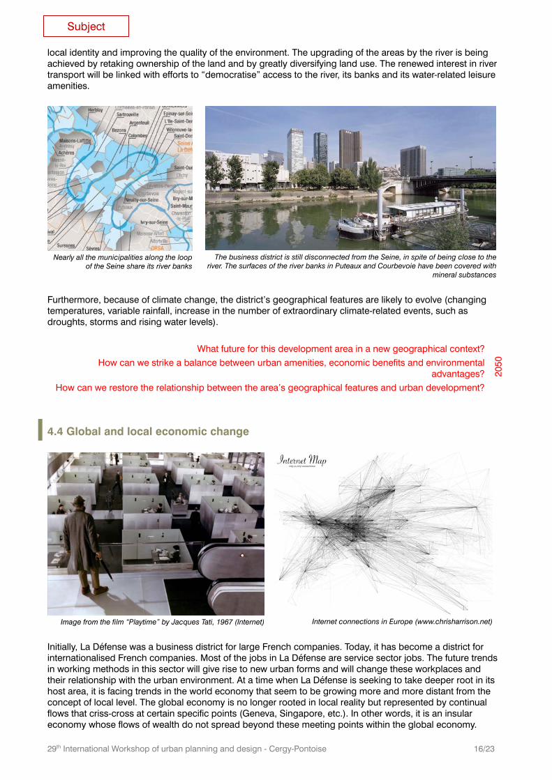
local identity and improving the quality of the environment. The upgrading of the areas by the river is being achieved by retaking ownership of the land and by greatly diversifying land use. The renewed interest in river transport will be linked with efforts to “democratise” access to the river, its banks and its water-related leisure amenities.
Nearly all the municipalities along the loop
of the Seine share its river banks
The business district is still disconnected from the Seine, in spite of being close to the
river. The surfaces of the river banks in Puteaux and Courbevoie have been covered with mineral substances
Furthermore, because of climate change, the district’s geographical features are likely to evolve (changing temperatures, variable rainfall, increase in the number of extraordinary climate-related events, such as droughts, storms and rising water levels).
What future for this development area in a new geographical context?
How can we strike a balance between urban amenities, economic benefits and environmental advantages?
How can we restore the relationship between the area’s geographical features and urban development?
2050
4.4 Global and local economic change
Initially, La Défense was a business district for large French companies. Today, it has become a district for internationalised French companies. Most of the jobs in La Défense are service sector jobs. The future trends in working methods in this sector will give rise to new urban forms and will change these workplaces and their relationship with the urban environment. At a time when La Défense is seeking to take deeper root in its host area, it is facing trends in the world economy that seem to be growing more and more distant from the concept of local level. The global economy is no longer rooted in local reality but represented by continual flows that criss-cross at certain specific points (Geneva, Singapore, etc.). In other words, it is an insular economy whose flows of wealth do not spread beyond these meeting points within the global economy.
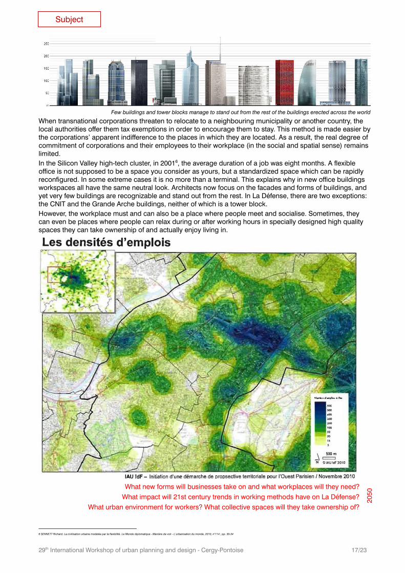
Image from the film “Playtime” by Jacques Tati, 1967 (Internet)
Internet connections in Europe (www.chrisharrison.net)
Subject
29th International Workshop of urban planning and design - Cergy-Pontoise 17/23
When transnational corporations threaten to relocate to a neighbouring municipality or another country, the local authorities offer them tax exemptions in order to encourage them to stay. This method is made easier by the corporations’ apparent indifference to the places in which they are located. As a result, the real degree of commitment of corporations and their employees to their workplace (in the social and spatial sense) remains limited. In the Silicon Valley high-tech cluster, in 20016, the average duration of a job was eight months. A flexible office is not supposed to be a space you consider as yours, but a standardized space which can be rapidly reconfigured. In some extreme cases it is no more than a terminal. This explains why in new office buildings workspaces all have the same neutral look. Architects now focus on the facades and forms of buildings, and yet very few buildings are recognizable and stand out from the rest. In La Défense, there are two exceptions: the CNIT and the Grande Arche buildings, neither of which is a tower block. However, the workplace must and can also be a place where people meet and socialise. Sometimes, they can even be places where people can relax during or after working hours in specially designed high quality spaces they can take ownership of and actually enjoy living in.
What new forms will businesses take on and what workplaces will they need?
What impact will 21st century trends in working methods have on La Défense?
What urban environment for workers? What collective spaces will they take ownership of?
2050
6 SENNETT Richard. La civilisation urbaine modelée par la flexibilité. Le Monde diplomatique - Manière de voir - L’urbanisation du monde, 2010, n°114 ; pp. 30-34
Few buildings and tower blocks manage to stand out from the rest of the buildings erected across the world
Subject
29th International Workshop of urban planning and design - Cergy-Pontoise 18/23
5 Other business districts in Europe
5.1 Zuidas in Amsterdam / The Netherlands
A new business district on the outskirts of the city
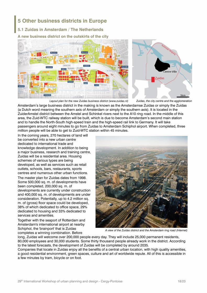
Layout plan for the new Zuidas business district (www.zuidas.nl)
Zuidas, the city centre and the agglomeration
Amsterdam’s large business district in the making is known as the Amsterdamse Zuidas or simply the Zuidas (a Dutch word meaning the southern axis of Amsterdam or simply the southern axis). It is located in the ZuiderAmstel district between the Amstel and Schinkel rivers next to the A10 ring road. In the middle of this area, the Zuid-WTC railway station will be built, which is due to become Amsterdam’s second main station and to handle the North-South high-speed train and the high-speed rail link to Germany. It will take passengers around eight minutes to go from Zuidas to Amsterdam Schiphol airport. When completed, three million people will be able to get to Zuid-WTC station within 45 minutes. In the coming years, 270 hectares of land will be converted into a new urban centre dedicated to international trade and knowledge development. In addition to being a major business, research and training centre, Zuidas will be a residential area. Housing schemes of various types are being developed, as well as services such as retail outlets, schools, bars, restaurants, sports centres and numerous other urban functions. The master plan for Zuidas dates from 1998. Some 500,000 sq. m. of developments have been completed, 200,000 sq. m. of developments are currently under construction and 400,000 sq. m. of developments are under consideration. Potentially, up to 4.2 million sq. m. of (gross) floor space could be developed, 38% of which dedicated to office space, 29% dedicated to housing and 33% dedicated to services and amenities. Together with the seaport of Rotterdam and Amsterdam's international airport at nearby Schiphol, the 'brainport' that is Zuidas completes a winning combination. Before long, Zuidas will welcome over 200,000 people every day. They will include 25,000 permanent residents, 80,000 employees and 30,000 students. Some thirty thousand people already work in the district. According to the latest forecasts, the development of Zuidas will be completed by around 2035. Companies that locate in Zuidas enjoy all the benefits of a central urban location, with high quality amenities, a good residential environment, green spaces, culture and art of worldwide repute. All of this is accessible in a few minutes by tram, bicycle or on foot.
A view of the Zuidas district and the Amsterdam ring road (Internet)
29th International Workshop of urban planning and design - Cergy-Pontoise 19/23
5.2 The Bankenviertel in Frankfurt / Germany
A former business district in the city centre
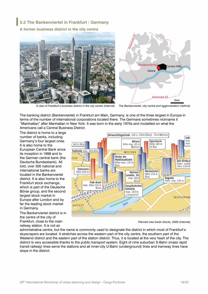
A view of Frankfurt’s business district in the city centre (Internet)
The Bankenviertel, city centre and agglomeration (rethink)
The banking district (Bankenviertel) in Frankfurt am Main, Germany, is one of the three largest in Europe in terms of the number of international corporations located there. The Germans sometimes nickname it “Mainhattan” after Manhattan in New York. It was born in the early 1970s and modelled on what the Americans call a Central Business District. The district is home to a large number of banks, including Germany’s four largest ones. It is also home to the European Central Bank since its inception in 1998 and to the German central bank (the Deutsche Bundesbank). All told, over 300 national and international banks are located in the Bankenviertel district. It is also home to the Frankfurt stock exchange, which is part of the Deutsche Börse group, and the second largest stock market in Europe after London and by far the leading stock market in Germany. The Bankenviertel district is in the centre of the city of Frankfurt, close to the main railway station. It is not an administrative centre, but the name is commonly used to designate the district in which most of Frankfurt’s skyscrapers are located. It stretches across the western part of the city centre, the southern part of the Westend district and the eastern part of the station district. Thus, it is located at the very heart of the city. The district is very accessible thanks to the public transport system. Eight of nine suburban S-Bahn (mass rapid transit railway) lines serve the stations and all inner-city U-Bahn (underground) lines and tramway lines have stops in the district.
Planned new tower blocks, 2008 (Internet)
29th International Workshop of urban planning and design - Cergy-Pontoise 20/23
6 Appendix
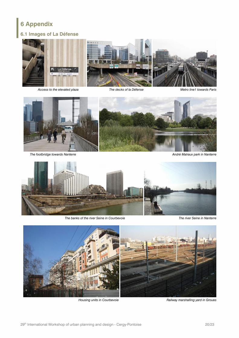
6.1 Images of La Défense
Access to the elevated plaza The decks of la Défense Metro line1 towards Paris
The footbridge towards Nanterre André Malraux park in Nanterre
The banks of the river Seine in Courbevoie The river Seine in Nanterre
Housing units in Courbevoie Railway marshalling yard in Groues
29th International Workshop of urban planning and design - Cergy-Pontoise 21/23
6.2 La Défense in figures
Milestones: 1958: Inauguration of the CNIT exhibition centre; establishment of La Défense development corporation (EPAD) 1972: Doubling of new office space programme, from 800,000 sq. m. to 1.55 million sq. m. 1981: Inauguration of the “Quatre Temps” shopping centre. 1989: Inauguration of the Grande Arche. 1990: Start of the “Grand Axe” development west of the Arche. 1992: Extension of metro line 1 as far as la Grande Arche. 2001: Construction of the “Cœur Défense” complex; 190,000 sq. m. of office space. Planned in 2017: Inauguration of the Eole mass rapid transit (RER) line. Planned in 2025: Inauguration of the Grand Paris Express automated metro network.
The elevated plaza or slab: Surface area: 1,350m x 650m; 30 hectares, of which 4 hectares planted with vegetation Number of superimposed levels or decks: up to 7 levels + utility tunnels. Under the slab: Railway lines; roadways; parking spaces (25,000). Above the slab: Offices; housing units; retail outlets; facilities and amenities.
The business district The largest business district in Europe on 160 hectares (straddling the municipalities of Courbevoie and Puteaux). 3 million sq. m. of office space occupied by 3,500 businesses; 1,500 corporate head offices; 15 CAC 40 listed companies. 170,000 employees, 80% of whom commute to La Défense by public transport. 450,000 people/day use the “Cœur Transport” hub. 230,000 sq. m. of retail space. 600,000 sq. m. of housing space occupied by 20,000 inhabitants.
La Défense redevelopment plan: 450,000 sq.m. of extra office space, of which 150,000 sq. m. renovated office space. 100,000 sq. m. of extra housing space.
Seine-Arche: 320 hectares of development projects labelled as “in the national interest” (OIN) 124 hectares of comprehensive development zones 75% of the development area dedicated to public spaces 292,000 sq. m. of housing space, i.e. 3,500 housing units to be built per 10,000 new inhabitants. 217,000 sq. m. of office and industrial space. 100,000 sq. m. of retail and services space. 35,000 sq. m. of public facilities and amenities.
Comparisons: 50 million sq. m. of office space in the Paris Ile-de-France region, of which 16 million sq. m. in Paris. Paris Ile-de-France region: 5.5 million jobs, of which 1,771,000 in Paris.
6.3 Bibliography L'urbanisme de dalles, continuités et ruptures. Actes du colloque des Ateliers d'été 1993 de Cergy-Pontoise. Editeur : Ponts et Chaussées (Presses), 1995. RONCAYOLO, Marcel. Territoires en partage : Nanterre, Seine Arche, en recherche d'identité(s). Marseille : Editions Parenthèses, 2006. DOTTELONDE, Pierre. La Défense : L'esprit et le temps. Paris : Editions Le Cherche midi, 2009. L'Axe historique, La Défense Seine-Arche. Hors série Découvertes. Editions Gallimard, 2010
About this session brief (version 2.5): This Session Brief has not been written for publication, but seeks to encourage students and young professionals to apply to participate in the workshop. Some text, some images and illustrations have been extracted from other documents without the usual acknowledgements required for published material. Illustration and image copyright holders are invited to get in touch with the managers of the Ateliers.
"According to the IEA, cheap and accessible fossil fuels are a thing of the past. According to the BRGM (France’s leading geoscience institution) and the UBGM, the shortage of raw materials is also a thing of the past. According the United Nations Organisation, planet earth may not be able to feed its nine billion inhabitants in 2050. However, these three basic facts are nothing compared with climate change and the disastrous effects of global warming if temperatures exceeded certain thresholds by 2°C. This could result, for example, from the disappearance of the “conveyor belt”, the ocean current that goes from Greenland to India. One of its offshoots is the Gulf Stream, which explains why the climate in France is different from the climate in Quebec, which is on the same latitude. Think what French agriculture would be like if France had the same climate as Quebec. Jean Michel VINCENT, Paris’ Region State administration.
29th International Workshop of urban planning and design - Cergy-Pontoise 22/23
7 What is « Les Ateliers » ? Les ateliers is a non-governmental organization that gathers universities, decision makers and professionals dedicated to planning, development and urban design. Since 1982, les ateliers has been organizing international workshops on topics defined together with local authorities for city or regional planning. The method consists in gathering students or professionals of different nationalities and different specializations (landscape designers, architects, engineers, economists...), and make them work in different teams that finally present their proposals to an international jury composed of local authorities and international experts.
Workshop management Management comitee : Christian HORN / Maria BASILE / Thibaut DE LALEU / Daphné VIALAN, assistant. Also : many others, among them all participants of January’s seminary. For further information, check our website: www.ateliers.org or contact us at: [email protected]
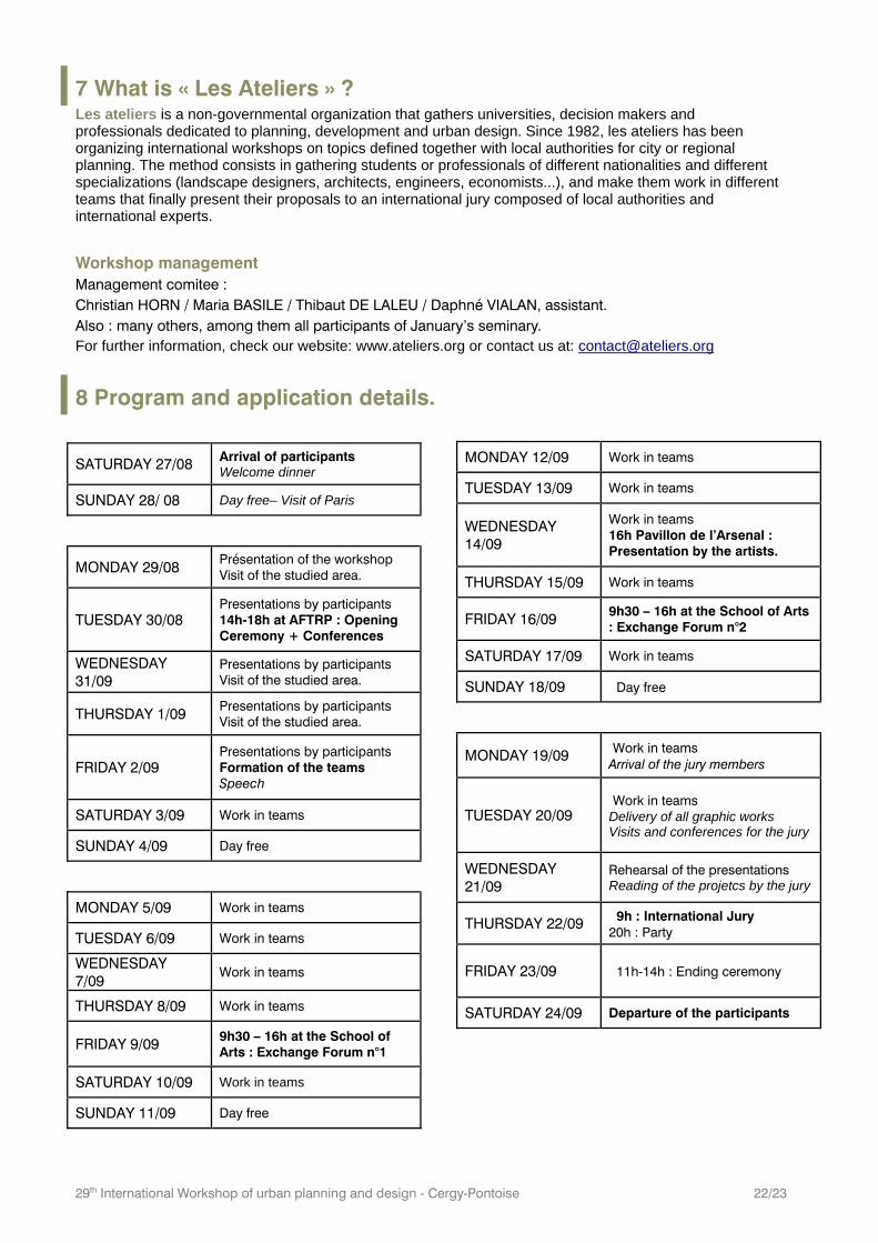
8 Program and application details.
SATURDAY 27/08 Arrival of participants Welcome dinner
SUNDAY 28/ 08 Day free– Visit of Paris
MONDAY 29/08 Présentation of the workshop Visit of the studied area.
TUESDAY 30/08 Presentations by participants 14h-18h at AFTRP : Opening Ceremony + Conferences
WEDNESDAY 31/09
Presentations by participants Visit of the studied area.
THURSDAY 1/09 Presentations by participants Visit of the studied area.
FRIDAY 2/09 Presentations by participants Formation of the teams Speech
SATURDAY 3/09 Work in teams
SUNDAY 4/09 Day free
MONDAY 5/09 Work in teams
TUESDAY 6/09 Work in teams
WEDNESDAY 7/09
Work in teams
THURSDAY 8/09 Work in teams
FRIDAY 9/09 9h30 – 16h at the School of Arts : Exchange Forum n°1
SATURDAY 10/09 Work in teams
SUNDAY 11/09 Day free
MONDAY 12/09 Work in teams
TUESDAY 13/09 Work in teams
WEDNESDAY 14/09
Work in teams 16h Pavillon de l’Arsenal : Presentation by the artists.
THURSDAY 15/09 Work in teams
FRIDAY 16/09 9h30 – 16h at the School of Arts : Exchange Forum n°2
SATURDAY 17/09 Work in teams
SUNDAY 18/09 Day free
MONDAY 19/09 Work in teams Arrival of the jury members
TUESDAY 20/09 Work in teams Delivery of all graphic works Visits and conferences for the jury
WEDNESDAY 21/09
Rehearsal of the presentations Reading of the projetcs by the jury
THURSDAY 22/09 9h : International Jury 20h : Party
FRIDAY 23/09 11h-14h : Ending ceremony
SATURDAY 24/09 Departure of the participants
29th International Workshop of urban planning and design - Cergy-Pontoise 23/23
Les Ateliers welcome any education background ! Artists, planners, designers, architects, sociologists, geographers, economists, engineers, photographs, landscape artists... and others : the workshop is for young professionals of all nationalities and training, and for students whose education is equivalent at least to a master's degree. Entry requirements : English proficiency, being free of any obligations during the workshop period, 30 years old maximum. For further information/prospectus : [email protected] / +33 (0)1 34 41 93 82 (Antoine PLANE, deputy director).
Application : The selection of 30 international participants, who will work in 5 teams of 6 participants, coached by a group of professionals, is made on the basis of an application file that must be sent before May, 15th.
- CV on 1 page. Filename: FULL_Name_CV - Research work on the topic of the workshop applied to a different site (preferably in your home country). The goal is to choose the participants while giving them the opportunity to think about the workshop's issues before it begins. The applicants must try to study some questions raised by the workshop's theme, while analysing a different district (8 A4 pages maximum, or 4 A3 pages). Applicants are allowed to work with a partner, as long as each partner's work is clearly defined and identified. Filename : FULL_Name_CV - Registration form (download on our website www.ateliers.org/en) completed. Filename: FULL_Name_ID
Location and date: The workshop will take place in Cergy-Pontoise from August 27th to September 23rd, 2011.
Budget : The application fees are 300 euros, including accomodation, breakfasts, ceremony dinners, visits and drawing material. 50% of the transport fares (economic fares) are refunded for foreigner participants.
Academic opportunities (students) : The workshop's participants can benefit from a partnership with the University of Cergy-Pontoise and are awarded with a university's diploma, as well as 12 ECTS credits. Internship Agreement.
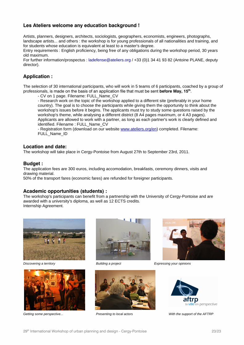
Discovering a territory Building a project Expressing your opinions
Getting some perspective... Presenting to local actors With the support of the AFTRP