USACE Asset Management Program USACE Asset Management Program

l
!
I US Army Corps| of Engineers
..=_______._. New York DistrictII FINDING OF NO SIGNIFICANT IMPACT/
DRAFT ENVIRONMENTAL ASSESSMENT FOR THE
I SELECTION OF POTENTIAL DREDGED MATERIALPLACEMENT SITES FOR THE KILL VAN KULL-
I NEWARK BAY CHANNELS PHASE II DEEPENINGPROJECT (AREA 4A)
IIIIIIIi Kill Van Kull Federal Navigation ChannelNew York/New Jersey
I OCTOBER 1999
II

I FINDING OF NO SIGNIFICANT IMPACT '
SELECTION OF POTENTIAL DREDGED MATERIAL PLACEMENT SITES
I FOR THE KILL VAN KULL-NEWARK BAY CHANNELSPHASE II DEEPENING PROJECT (AREA 4A)
I I have reviewed and evaluated the Environmental Assessment (EA) for this project in of overallterms
public interest. The proposed action is an administrative decision on the selection of potential sites forplacement of dredged material that is unsuitable for use as remediation material at the Historic Area
I will be removed channel in the Kill Van Kull andRemediation Site. This material during deepeningNewark Bay Channels, New York and New Jersey. The authorized channel deepening would increase
depth from -40 feet below mean low water (MLW) to -45 feet below MLW, plus an additional 2-foot
I allowance for tolerance. The environmental conditions in the project area are analyzed indredging
previous documents, including the Final Environmental Impact Statement (USACE 1980 a,b) and theFinal EA (USACE 1997) for the Kill Van Kull/Newark Bay Channels Phase II Deepening Project. The
I of this EA is to select placement sites, evaluate the manner in which the proposed action wouldpurposechange conditions in the project area, and to determine whether the impacts associated with placementsite selection warrant the preparation of a supplement to the FEIS.
I The USACE, in coordination with non-Federal partner(s), has identified and integrated a number of
placement strategies into an overall management plan. Three potential upland sites and one potential sub-
I aqueous site have been identified by the non-Federal sponsor. In addition, the New York HarborDredged Material Management Plan (DMMP) (USACE, Implementation Report, September 1999) has
identified other placement or beneficial use opportunities whichmay become available during the life of
I the Kill Van Kull/Newark Bay deepening project.
Placement sites selected as part of the Kill Van Kull/Newark Bay Channels Phase II Deepening Project
I must show costs commensurate with suitable benefits and full compliance with environmentalrequirements. In the Final EA for the Kill Van Kull/Newark Bay project (USACE, N.Y. District, FinalEnvironmental Assessment/Finding of No Significant Impact for the Kill Van Kull/Newark Bay Channels
I Phase II Deepening Project, December 1997), a tiering strategy was developed in accordance with theCounsel on Environmental Quality (CEQ), NEPA regulations 40 CFR 1502.20 and 1508.28, in which thefinal selection of dredged material placement sites was deferred until such time as the issue was ready to
I be decided upon. All potential sites have been, or will be, permitted and in compliance with allappropriate Federal, state, and local regulatory and permitting requirements and analyses. Placement siteutilization will not occur until all Federal, state, and local regulatory agencies have issued the required
I permits. Permit approval for the placement of dredged material at individual sites would be obtained bythe owner/lessee of each of the potential placement sites.
I As a result of my review, I find at this time that there are no substantial changes in the proposed action orsignificant new circumstances or information relevant to environmental concerns or bearing on theproposed action or its impacts that would warrant the preparation of a supplement to the FEIS.
IOctober 1999 William H. Pearce
I Colonel, Corps of EngineersCommanding
I

IIIIIIIIIIIiIIIIIII

I FINDING OF NO SIGNIFICANT IMPACTSELECTION OF POTENTIAL DREDGED MATERIAL PLACEMENT SITES
i FOR THE KILL VAN KULL-NEWARK BAY CHANNELSPHASE II DEEPENING PROJECT (AREA 4A)
I have reviewed and evaluated the Environmental Assessment (EA) for this project in terms of overall
I public interest. The proposed action is an administrative decision on the selection of potential sitesfor placement of dredged material that is unsuitable for use as remediation material at the HistoricArea Remediation Site. This material will be removed during channel deepening in the Kill Van Kull
I and Newark Bay Channels, New York and New Jersey. The authorized channel deepening wouldincrease depth from -40 feet below mean low water (MLW) to --45 feet below MLW, plus anadditional 2-foot allowance for dredging tolerance. The environmental conditions in the project area
i are analyzed in previous documents, including the Final Environmental Impact Statement (USACE1980 a,b) and the Final EA (USACE 1997) for the Kill Van Kull/Newark Bay Channels Phase IIDeepening Project. The purpose of this EA is to select placement sites, evaluate the manner in whichthe proposed action would change conditions in the project area, and to determine whether the
I impacts associated With placement site selection warrant the preparation of a supplement to the FEIS.
The USACE, in coordination with non-Federal partner(s), has identified and integrated a number of
I placement strategies into an overall management plan. Three potential upland sites and one potentialsub-aqueous site have been identified by the non-Federal sponsor. In addition, the New York HarborDredged Material Management Plan (DMMP) (USACE, Implementation Report, September 1999)
i has identified other placement or beneficial use opportunities which may become available during thelife of the Kill Van Kull/Newark Bay deepening project.
Placement sites selected as part of the Kill Van Kull/Newark Bay Channels Phase II Deepening Project
I must show costs commensurate with suitable benefits and full compliance with environmentalrequirements. In the Final EA for the Kill Van Kull/Newark Bay project (USACE, N.Y. District, FinalEnvironmental Assessment/Finding of No Significant Impact for the Kill Van Kull/Newark Bay
I Channels Phase II Deepening Project, December 1997), a tiering strategy was developed inaccordance with the Counsel on Environmental Quality (CEQ), NEPA regulations 40 CFR 1502.20and 1508.28, in which the final selection of dredged material placement sites was deferred until suchtime as the issue was ready to be decided upon. All potential sites have been, or will be, permitted and
I Federal, and local regulatory and permitting requirementsin compliance with all appropriate state,
and analyses. Placement site utilization will not occur until all Federal, state, and local regulatoryagencies have issued the required permits. Permit approval for the placement of dredged material at
I individual sites would be obtained by the owner/lessee of each of the potential placement sites.
AS a result of my review, I find at this time that there are no substantial changes in the proposed
I action or significant new circumstances or information relevant to environmental concerns or bearingon the proposed action or its impacts that would warrant the preparation of a supplement to the FEIS.
I October 1999 William H. PearceColonel, Corps of Engineers
I Commanding
!I!
DRAFT ENVIRONMENTAL ASSESSMENT/ l
FINDING OF NO SIGNIFICANT IMPACT ITHE SELECTION OF POTENTIAL DREDGED MATERIAL PLACEMENT
u
SITES FOR THE KILL VAN KULL-NEWARK BAY CHANNELSPHASE II DEEPENqNG PROJECT (AREA 4A) n
EXECUTIVE SUMMARY: The proposed action is an administrative decision on the selection of IIpotential sites for placement of dredged material. This material would be removed during channeldeepening in the Kill Van Kull and Newark Bay Channels, New York and New Jersey. The 1authorized channel deepening would increase depth from -40 feet below MLW to -45 feet MLW, 1plus an additional 2-foot allowance for dredging tolerance. The environmental conditions in theproject area are analyzed in previous documents, including the Final EIS (USACE 1980 a,b) and theFinal EA (USACE 1997) for the Kill Van Kull/Newark Bay Channels Phase 1I Deepening Project. nThe purpose of this EA is to select placement sites, evaluate the manner in which the proposedaction would change conditions in the project area, and to determine whether the impacts associated
with placement site selection warrant the preparation of a supplement to the FEIS. n
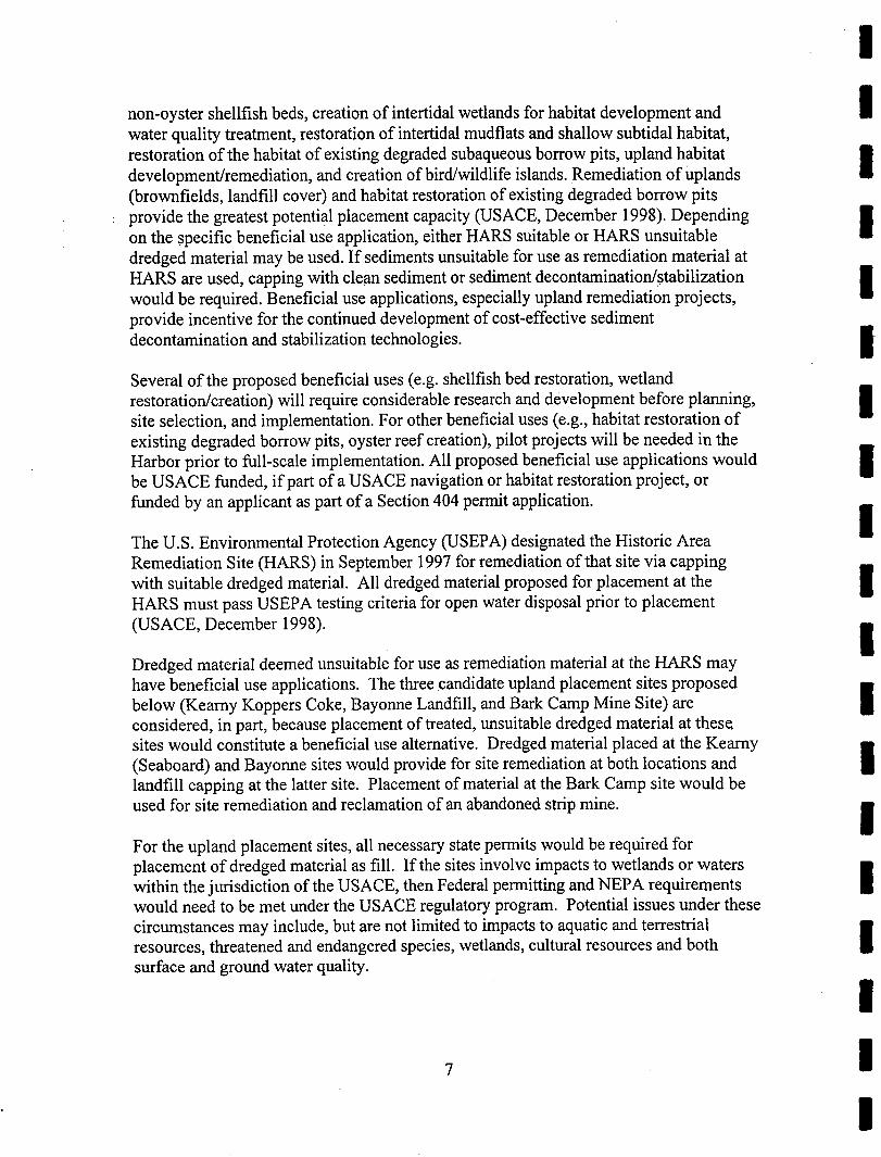
The former Mud Dump Site, located approximately 6 miles east of Sandy Hook, New Jersey, hasrecently been de-designated as a dredged material placement site by the Environmental Protection
unconfined ocean placement sites are unlikely to be designated in the near future, nAgency. NewSuitable material may be placed at the Historic Area Remediation Site (HARS).
_1_,, the-volumes-of-materi-al_6be reS'no)ed_d_filg_-th-6_de6-peii!hg_6fAr_- 4A -6ftl'i___ nKVK/Newafk'_ay'ehaflnel are _stiiiiafed to b_ 25'_0_0t2Y of&edg_d mate_al suitablef0r/ •
. 151hd6inenthi:th6Historic Area Remediation Site (HARS), 228,000 CY of rock matenal statable f_r-u-_e fitdesi _nated re?f S_tesana96 000 _Y of dred ed material unsuitable for placement at HARS -"
Withrespect-to sediments-thiifinay riot be suitable for use as remediatmn material at the Historic [IArea Remediation Site (HARS), initial selection of potential placement sites has been finalized.
The non-Federal sponsor has identified three upland beneficial use sites (Kearny Koppers Coke, IINJ; Bayonne Landfill, NJ; and Bark Camp Mine site, PA) and one sub-aqueous disposal site(Newark Bay Confined Disposal Facility, NJ ). The Kearny Koppers Coke site is currentlyoperating and is permitted to accept up to 1 MCY of treated dredged material. A second project nphase at the Kearny site, which is currently under permit review, could accommodate an additionalestimated 2.4 MCY of dredged material. Closure of the Bayonne Landfill and remediation of theadjoining PSE&G Company property will require approximately 4.5 MCY of fill. Processed •dredged material is suitable for these purposes, and all necessary permits have been obtained by the 1site owner. The Bark Camp Mine site in Penfield, Pennsylvania, is operating with a permit andshould allow for placement of up to 480,000 CY of treated dredged material. An existing permittedcontained aquatic disposal (CAD) cell at the Newark Bay Confined Disposal Facility has a nremaining capacity of 830,000 CY. All potential sites must be permitted and in compliance with allappropriate regulatory and permitting requirements and analyses prior to placement of dredgedmaterial. Approval for the placement of dredged material at individual sites would be obtained by •the owner/lessee of the each of the potential placement sites. 1
!I

I The USACE, in coordination with non-Federal partner(s), has identified and integrated a number ofplacement strategies into an overall management plan. In addition, the New York Harbor Dredged
I Material Management Plan (DMMP) (USACE, Implementation Report, September 1999) hasidentified other placement and beneficial re-use opportunities which may become available duringthe entire Kill Van Kull/Newark Bay Channels Phase II Deepening Project, including non-local
i alternatives and long-term strategies.The District has concluded that the changes in the conditions of environmental resources are notsignificant, and the proposed impacts on these resources as a result of the authorized project are not
I significantly different than those described in the FEIS.If you would like further information on this
i assessment, contact:Ms. Megan GrubbProject Biologist
I U.S. Army Corps of EngineersNew York District, CENAN-PL-EA26 Federal Plaza
I New York, New York 10278-0900(212) 264-5759
I : . :

!I
TABLE OF CONTENTS
ITEM PAGE IEXECUTIVE SUMMARY "
1.0 INTRODUCTION........................................................................................... 1 I
2.0 PURPOSE AND NEED FOR ACTION .......................................................... 3
2.1 MARINE TRAFFIC AND SAFETY CONCERNS ................................... •.......................... 3 I
2.2 ECONOMIC CONCERNS ............................................................................................. 3
2.3 COMMITMENT OF RESOURCES .................................................................................. 4 l[
3.0 ALTERNATIVES TO THE PROPOSED ACTION ................................. ........ 4 •3.1 No ACTION ALTERNATIVE ....................................................................................... 5
3.2 SITE SELECTION CRITERIA ......................................... i............................................. 5 I
3.3 BENEFICIAL USE ALTERNATIVES ............................................................ 6
3.3.1 Kearny Koppers Coke, NJ......................................................... 8 •3.3.2 Bayonne Landfill, NJ................................................................ 83.3.3 Bark Camp Mine Facility, PA ..................................................... 8
3.4 CONTAINED AQUATIC DISPOSAL FACILITIES ALTERNATIVES .......................... 12 I
3.5 LONG-TERM PLACEMENT STRATEGIES.......................................... 12 I
3.6 RECOMMENDEDPLAN...................................................................... 14
4.0 AFFECTED ENVIRONMENT............................................................ 14 I
5.0 ENVIRONMENTAL IMPACTS.................................................................... 15
6.0 CONCLUSIONS .......................................................................................... 15 •
7.0 COORDINATION ........................................................................................ 16 I
8.0 REFERENCES............................................................................................ 17
!!!
i !!

II
LIST OF FIGURES
I Figure 1 Project Location: Kill Van Kull and Newark Bay ............................................. 2
I Figure 2 Kearny Koppers Coke Site, NJ Location ............................................................ 9
Figure 3 Bayonne Landfill Site, NJ Location ............................................................... 10
I Figure 4 Bark Camp Mine Site, PA Map ....................................................... 11
i Figure 5 Newark Bay Confined Disposal Facility Site, NJ Location ........ .............. 13
!!i!!!I!I!!l ii
!

IAPPENDICES I
Appendix A - Mailing List for Draft Environmental Assessment IAppendix B - Administration's Closure of Mud Dump Site (July 24, 1996 Letter)Appendix C - U.S. Fish & Wildlife Coordination Act Section 2(B) Report (April 1997)
Appendix D - Correspondence IAppendix E - New Jersey Coastal Zone Management EvaluationAppendix F - New York Coastal Zone Management Evaluation
Appendix G - Clean Water Act Section 404 (B)(1) Guidelines Evaluation IAppendix H - Project CommentsAppendix I - USFWS Biological Opinion on the Effects of Channel Deepening Activities
Within the Arthur Kill, Kill Van Kull, and Newark Bay Channels, New IYork and New Jersey, on the Peregrine FalconAppendix J - Clean Air Statement of Conformity
IIII!!II!II
iii I
I

LIST OF ACRONYMS
BERH - Board of Engineers for Rivers and HarborsCEQ - Council on Environmental QualityCY - Cubic Yard
CZM - Coastal Zone ManagementDMMP - Dredged Material Management Plan for the Port of New York and New JerseyEA - Environmental Assessment
ER - Engineer RegulationFEA - Final Environmental Assessment
FEIS - Final Environmental Impact StatementFONSI - Finding of No Significant ImpactFSFEIS - Final Supplement to the Final Environmental Impact StatementHARS - Historic Area Remediation SiteMLW - Mean Low WaterMCY - Million Cubic Yards
NBCDF - Newark Bay Confined Disposal FacilityNEPA - National Environmental Policy ActNJDEP - New Jersey Department of Environmental ConservationNJDIG - New Jersey Dredging Inter-Agency GroupNMFS - National Marine Fisheries Service
NRHP - National Register of Historic PlacesNYD - New York District
NYSDEC - New York State Department of Environmental ConservationNY/NJ - New York and New JerseyO&M - Operations and MaintenanceSHPO - State Historic Preservation Office
SEIS - Supplemental Environmental Impact StatementUSACE - U.S. Army Corps of EngineersUSEPA - U.S. Environmental Protection AgencyUSFWS - U.S. Fish and Wildlife Service '
WRP - Waterfront Revitalization Program
iv

!|
1.0 INTRODUCTION m
This Environmental Assessment (EA) was prepared in accordance with the National •Environmental Policy Act (NEPA) to address the selection of potential placementalternatives for dredged material unsuitable for open ocean placement. The dredgedmaterial will be removed during the proposed Federal Navigation Project located at the iKill Van Kull and Newark Bay waterways, Port of New York and New Jersey (Figure 1).The authorized project plan provides for the deepening of existing navigational channels,from the confluence of the Kill Van Kull and Anchorage channels to the northern edge of ithe Port Newark Reach in Newark Bay. The project would increase channel depth from-40 ft below mean low water (MLW) to -45 ft below MLW, plus an additional 2 ft over
depth allowance for dredging tolerance. The proposed navigation improvements to the IIPort were analyzed in the Navigation Study on Improvements to Existing Federal II
Navigation Channels Report (USACE 1980 a,b), the Supplemental Environmental ImpactStatement (SEIS)(USACE 1986), and the Final Supplement to the Final Environmental IImpact Statement (FSFEIS) (USACE 1987).
u
The U.S. Army Corps of Engineers, New York District is developing a comprehensive idredged material management plan for the New York/New Jersey (NY/NJ) Harbor area.Part of this plan is concerned with the placement of dredged material that is found to be
for use as remediation material at the Historic Area Remediation Site (HARS). iunsuitable
Material unsuited for placement at the HARS would be placed in permitted upland orm
sub-aqueous disposal sites (USACE, December, 1998). The non-Federal sponsor is m
responsible for providing potential placement sites, as well as other management options, ifor the material removed during Kill Van Kull/Newark Bay project construction.
A tiering strategy for dredged material placement was developed in accordance with the iCouncil on Environmental Quality (CEQ), NEPA regulations 40 CFR§ 1502.20 and§ 1508.28. The final selection of potential dredged material placement sites was deferred •until the issue could be decided upon (United States Army Corps of Engineers, N.Y |District, Final Environmental Assessment/Finding of No Significant Impact for the KillVan Kull/Newark Bay Channels Phase II Deepening Project, December 1997; hereafter •cited as: USACE, FEA/FONSI 1997). This EA documents the selection of potential |placement sites. Candidate sites are subject to, and must comply with, all appropriateregulatory and permitting requirements and analyses. Placement site utilization will not •occur until all Federal, state, and local regulatory agencies have issued the required |permits. Obtaining permit approval for placement of dredged material at each of the
proposed sites is the responsibility of the owner/lessee of each respective site. iuThis EA is required for NEPA compliance and identifies potential sites for placement ofKill Van Kull/Newark Bay dredged material. The location and selection of appropriate •sites for beneficial use or disposal of dredged material unsuitable for use as remediation lmaterial at the HARS, that may be collected during deepening of Area 4A (Figure 1) isnecessary for further deepening of the Kill Van Kull/Newark Bay channels to proceed. •This EA has been prepared by the U.S. Army Corps of Engineers, New York District l(NYD) to address the status of the alternative dredged material placement sites described
herein. This assessment was prepared in accordance with NEPA, the implementing •1
I

m m m n m m m m m n m m m m m m m n
4"
._ _ KEY.
iElizabelh Port
AuthorityMarine Terminal
I,,J
Elizabeth ,)_ BAYONNE, NJ
Newark Conslable _'Bay Hook
... BergenPoint
Elizabelh Pod
J.,./
Howland Hook
Marine Terminal _. I _...__._IFigu_ I. Project Location:Kill Van KullSTATENISLAND, NY I and Newark Bay (Adapted From:
: I |ISACE Finnli,LR, Dr'retailer

|regulations of the CEQ, and guidance contained in Engineer Regulation (ER) 200-2-2, •Environmental Quality Procedures for Implementing NEPA (3-4-88).
2.0 PURPOSE AND NEED FOR ACTION i
This EA is required for NEPA compliance regarding the selection of potential upland andsub-aqueous dredged material disposal sites. These proposed sites would be utilized forplacement of unsuitable dredged material removed during the authorized deepening ofthe Kill Van Kull and Newark Bay Channels. The selection of disposal sites wasdeferred in the Final EA for the Kill Van Kull/Newark Bay Channels Phase II DeePeningProject until specific areas were ready for contract solicitation and subsequent contractaward and execution (USACE, FEA/FONSI 1997). Since then, no new concerns iaffecting the administrative selection of disposal sites have been identified.
u
The distinction between material that is potentially suitable and unsuitable for placement iat the Historic Area Remediation Site(HARS) has been based on geologic boring data,
m
but will be tested and confirmed prior to actual placement. Based on preliminary i
evaluation, the NYD currently estimates that dredging for the entire Kill Van iKull/Newark Bay project will require management of approximately 1.1 million cubic
li
yards (MCY) of rock, 6.3 MCY of HARS suitable sediments and 3.3 MCY of sediments uwhich are unsuitable for placement at the HARS. For Area 4A of the multi-year and imulti-contract project, preliminary evaluation estimates the required management of
i
approximately 228,000 CY of rock, approximately 25,000 CY of dredged material i
meeting the criteria for use as remediation material at the HARS, and approximately96,000 CY of dredged material unsuitable for placement at HARS. Material unsuitablefor use as remediation material at HARS requires alternative.placement methods •(USACE, FEA/FONSI 1997). Testing to confirm the estimated sediment volumes and |sediment suitability characteristics for Area 4A is underway and will be completed priorto actual placement. A summary of the purpose and need presented in the Final EA for ithe Kill Van Kull/Newark Bay Channels Phase II Deepening Project (USACE, lFEA/FONSI 1997) is provided below.
2.1 Marine Traffic and Safety Concerns i
Water depths in the existing Federal Navigation Channels in the Kill Van Kull and
Newark Bay at present do not provide for economically efficient and safe utilization bydeep draft (> 40 feet) vessels. Container ships and oil tankers either transit thesechannels in a lightered or underloaded condition, or anchor in NY/NJ Harbor to await a •favorable tide. As a result, tanker vessel congestion within the Harbor markedly |increases, thereby increasing the potential for accidents. The additional shipping/transferoperations needed for lightering also elevates the probability of water pollution from •spillage. |
2.2 Economic Concerns n
The Port of New York and New Jersey is vitally important to the economy of theNortheast, handling more tonnage than any other port on the U.S. East Coast. According
!

I to American Association of Port Authorities (AAPA) figures, container traffic throughthe Port in 1997 totaled 12.6 million metric tons of cargo in 1.3 million containers,
I equaling 2.4 million twenty-foot equivalent units (TEUs). The Port provides more than166,000 jobs and $20 billion in economic activity. (USACE, Draft Feasibility Report,September 1999) Despite this level of commercial activity, the Port's volume of cargo
I has an average annual growth rate of only 3%, substantially lagging behind its major U.S.and international competitors. The future shipping trend is toward increasedcontainerization in larger vessels requiring deeper drafting channels and Port facilities. It
I is possible to alleviate this problem by making the Kill Van Kull Channel deeper. Thedeepening project can be justified only if, over the assumed 50-year life of the project, itsannualized total costs are less than its annualized total benefits. Reanalysis of deepening
I costs and project benefits for the Kill Van Kull and Newark Bay Channels Phase IIDeepening Project (USACE, FEA/FONSI 1997) estimated that the annualized cost ofdeepening the Kill Van Kull to -45 feet MLW is approximately $148 million. The
I annualized benefits resulting from incurring this cost are estimated to be $615 million,thus indicating highly favorable economic viability.
I 2.3 Commitment of Resources
The Kill Van Kull and Newark Bay Channel project was authorized for construction in
I the Supplemental Appropriations Act for fiscal year 1985, Conference Report stating:
"...That the Secretary of the Army acting through the Chief of
I Engineers is authorized and directed to proceed with planning, design,engineering, and construction of the following projects substantially inaccordance with the individual report describing such projects as reflected
I in the Joint Explanatory Statement of the Committee of Conferenceaccompanying the Conference Report for H.R. 2577...; Kill Van KullChannel, Newark Bay Channel, New York and New Jersey..."
I The report referenced in the Joint Explanatory Statement was the December 1981 reportof the Chief of Engineers, who concurred with the views of the Board of Engineers for
I Rivers and Harbors (BERH). The BERH report generally agreed with the NYD's andDivision Commander's Reports except that it recommended deepening to -45 feet MLW.Therefore, the depth to -45 feet MLW was authorized by the Supplemental
I Appropriations Act, 1985; Public Law 99 - 88. The completion of the authorized KillVan Kull/Newark Bay Channels Phase II Deepening Project is contingent upon theselection and approval of suitable sites for the management of dredged material
I unsuitable for remediation material at the HARS. This EA documents theuse as
selection of potential placement sites.
I 3.0 ALTERNATIVES TO THE PROPOSED ACTION
This section includes a discussion of the alternatives analyses for dredged material
I contained in the 1987 Feasibility Study and FEIS and the December 1997managementFinal EA for the Kill Van Kull and Newark Bay Channels Phase II Deepening Project
(USACE, FEA/FONSI 1997). The alternative dredged material placement sites
! 4!

!|
considered in this EA include only those sites selected from the options identified in that •EA (USACE, FEA/FONSI 1997). Dredged material management alternatives will followthe standards presented by the New Jersey Department of Environmental Protection R(NJDEP) in "The Management and Regulation of Dredging Activities and DredgedMaterial in New Jersey's Tidal Waters" (NJDEP, 1997) and the dredged material
standards of the other applicable states, including New York and imanagementPennsylvania. All potentially utilized placement sites have been, or will be, permitted
m
and in compliance with all applicable regulatory requirements.
3.1 No Action Alternative i
Without the selection of disposal sites for dredged material unsuitable for use as iremediation material at the HARS, necessary channel maintenance, and/or channel I
deepening, cannot occur. As a result, economic benefits in the form of economicallyefficient trade and commerce would not be realized, most likely resulting in the loss of i
jobs and tax revenue in the region. Furthermore, sediments that are contaminated frompast and present human activities within the NY/NJ Harbor area, including the Kill Van
Newark Bay waterways, will remain as a potential threat to the health of aquatic iKull and
ecosystems.. •119
3.2 Site Selection Criteria i
The screening process employed for the consideration of potential placement sites formaterial unsuitable for ocean placement included objectives outlined in the Bdredged
Newark Bay Confined Disposal Facility FSEIS (USACE, FEIS 1997). These criteriai
included: i• Must be suitable for receipt of unsuitable dredged material within a short-term
timeframe i• Must be permittable, defined as:
-The action requires no changes to existing regulations or laws necessary •for permitting. I-The current permit process for local, state, Federal, and intemational laws •and regulations can be accomplished within the required timeframe for the |project.
• Must be constructable, defined as: I
i
-The action will use existing technology, with no untested constructionHI
methods involved, i-There is no encumbrance on existing or proposed land uses.
-There are no access or utility restrictions (e.g., underground electric icables).
I

I • Must be environmentally acceptable, defined as:
i -There are no substantial adverse impacts.-Any impacts are to be at balance or have a net beneficial effect.
I -The action does not put additional stress on endangered or threatenedspecies.
I In addition to these criteria, the non-Federal sponsor has requested in a letter to the Corpsdated March 31, 1998, that capacity of a potential placement site be between 0.50 MCYand 14 MCY, thereby allowing smaller permitted facilities to compete for smaller volume
I placement contracts.
The non-Federal sponsor has proposed four potential placement sites for unsuitable
I material removed from Area 4A of the Kill Van Kull/Newark Bay project.dredgedThree upland beneficial use alternative sites are proposed: (1) Kearny Koppers Coke,
New Jersey; (_onne Landfill, New Jersey; andS(3) Bark Camp Mine Facility,I Pennsylv___qWeo-usdis-p_loptionis proposed by the non-Federal
sponsor: (l_)_._I3[a'Y_ C_ned _isposal Facility_nd (2) S_ub-Channel Cells in _0q"
I _Newark Bay. _- ' _6g_ 177ffTD ]Beneficial use alternatives are the preferred group of options for Area 4A and subsequentcontracts. However, these alternatives may not be capable of handling all of the dredged
I eliminate the need for containment facilities, disposal facilities andmaterial and may not
other long-term disposal strategies. The following sections describe the three groups ofdredged material management strategies selected for Area 4A: beneficial use, contained
I aquatic disposal facilities and long-term disposal strategies, completeA discussion of
dredged material management options is presented in the District's Dredged Material
i Management Plan for the Port of New York and New Jersey (DMMP) DraftImplementation Report (USACE, September 1999) and the DMMP Progress Report(USACE, December 1997). There has been considerable work undertaken to identify
i placement site alternatives for dredged materials found to be unsuitable for use asremediation material at the HARS. Several possible alternatives have been eliminateddue to a number of factors, including timeframe and capacity requirements, high
I monetary costs, Federal regulations, and permitting issues.
3.3 Beneficial Use Alternatives
I Beneficial use of dredged material for habitat restoration, creation, and enhancement is anintegral part of the NYD's Dredged Material Management Plan (DMMP) for the Port of
I NY/NJ (USACE 1999; USACE, December 1998). Beneficial use applications areintended to maximize the potential economic and environmental outputs of dredgedmaterial as a resource.
!Beneficial use applications currently being considered for NY/NJ Harbor include:construction of artificial reefs (using rock), creation of oyster reef habitat, restoration of
!
!|
non-oyster shellfish beds, creation of intertidal wetlands for habitat development and HIwater quality treatment, restoration of intertidal mudflats and shallow subtidal habitat,restoration of the habitat of existing degraded subaqueous borrow pits, upland habitat idevelopment/remediation, and creation of bird/wildlife islands. Remediation of Uplands(brownfields, landfill cover) and habitat restoration of existing degraded borrow pits
: provide the greatest potential placement capacity (USACE, December 1998). Depending ion the specific beneficial use application, either HARS suitable or HARS unsuitabledredged material may be used. If sediments unsuitable for use as remediation material atHARS are used, capping with clean sediment or sediment decontamination/stabilization iwould be required. Beneficial use applications, especially upland remediation projects, g
provide incentive for the continued development of cost-effective sediment
decontamination and stabilization technologies. I
Several of the proposed beneficial uses (e.g. shellfish bed restoration, wetlandrestoration/creation) will require considerable research and development before planning, isite selection, and implementation. For other beneficial uses (e.g., habitat restoration ofexisting degraded borrow pits, oyster reef creation), pilot projects will be needed in the am
Harbor prior to full-scale implementation. All proposed beneficial use applications would Ube USACE funded, if part of a USACE navigation or habitat restoration project, or
funded by an applicant as part of a Section 404 permit application, i
The U.S. Environmental Protection Agency (USEPA) designated the Historic AreaRemediation Site (HARS) in September 1997 for remediation of that site via capping n
with suitable dredged material. All dredged material proposed for placement at the iHARS must pass USEPA testing criteria for open water disposal prior to placement
(USACE, December 1998). HIII
Dredged material deemed unsuitable for use as remediation material at the HARS mayhave beneficial use applications. The three candidate upland placement sites proposed •below (Kearny Koppers Coke, Bayonne Landfill, and Bark Camp Mine Site) are |considered, in part, because placement of treated, unsuitable dredged material at thesesites would constitute a beneficial use alternative. Dredged material placed at the Kearny •(Seaboard) and Bayonne sites would provide for site remediation at both locations and |landfill capping at the latter site. Placement of material at the Bark Camp site would be
used for site remediation and reclamation of an abandoned strip mine. iU
For the upland placement sites, all necessary state permits would be required forplacement of dredged material as fill. If the sites involve impacts to wetlands or waters •within the jurisdiction of the USACE, then Federal permitting and NEPA requirements IIwould need to be met under the USACE regulatory program. Potential issues under thesecircumstances may include, but are not limited to impacts to aquatic and terrestrial •resources, threatened and endangered species, wetlands, cultural resources and both INsurface and ground water quality.
!7 !
!

I 3.3.1 Kearny Koppers Coke, NJ
I Kearny Koppers Coke is a brownfield project under the jurisdiction of NJDEP SiteRemediation Program (Figure 2). Utilization of dredged material at the site would have adual purpose: 1) remediation of a former industrial property that has been the site of
I unregulated dumping; and, 2) providing a viable, beneficial use for dredged material. Thesite has already accepted 1.1 MCY of dredged material and is currently permitted toaccept an additional 1 MCY of dredged material. The permit application for the full use
I of the site is currently under review by the USACE. The proposed site remediation planinvolves the removal of coal tar deposits from intertidal areas, installation of a cutoffwall, and capping of the entire site with cement-stabilized dredged material. The full use
I of the site would accommodate estimated total of 4.5 MCY of dredged materialan
(USACE, September 1999). The Kearny Koppers Coke site encompasses an area ofapproximately 167.3 acres. No unique plant communities exist on the Kearny site and
I approximately 19.4 acres of the site support community is typical ofwetlands. The faunal
the nearby urban area.
I Bayonne Landfill,3.3.2 NJ
The Bayonne Landfill is located at the City of Bayonne, Hudson County, New Jersey
I (Figure 3). The site has been permitted by the Federal, state, and local agencies. The sitehas capacity for approximately 4.5 MCY of dredged material. Utilization of the site
I would provide multiple benefits: 1) proper closure of a former sanitary landfill; 2)remediation of an industrial brownfield that has been the site of uncontrolled dumping;and, 3) creation of a viable, beneficial use alternative for the placement of dredged
i material.The Bayonne site encompasses an area of approximately 135 acres. The former landfill
i encompasses the western 38 acres of the site, while the other 97 acres are a formerindustrial property, which is to be remediated. Approximately 18 acres of the site containjurisdictional wetlands, although only 8 acres of wetland area would be impacted during
i site remediation activities. The site has been moderately disturbed and the faunalcommunity that does exist is typical of the area, as is described in the Final EA for theKill Van Kull/Newark Bay Channels Phase II Deepening Project (USACE, FEA/FONSI
I 1997).3.3.3 Bark Camp Mine Facility, PA
I The Bark Camp Mine Facility is located in Huston Township, Clearfield County,Penfield, Pennsylvania (Figure 4). The site has been permitted by state and local
I agencies as a strip mine reclamation facility. The site has accepted 20,000 CY ofdredged material from Perth Amboy dredging projects and could accept up to 480,00 CYof treated dredged material (PADEP 1998). Utilization of the site would provide multiple
I benefits including remediation of an abandoned strip mine that is currently contaminatingwater resources and wetlands downstream from the facility as well as reclamation of stateforest and terrestrial habitat.
!

I

!!!
I Map Scale: 1" = 2000'I'--._
NEW e
JERSEY's"5 "7' Figure 3. Bayonne Landfill¢-" ;,"2,'/ Site Location
QL'_ANGLELOCA'nON
Source: USGS 7.5" Topographic MapJersey City, N.J. - N.Y.1967, Photorevised 1981
I
I

N
FIGURE4: BARK CAMP MINE SITE MAP ,_,,USGS QUADRANGLE MAP "'_ '_CLEARFIELD COUNTY 0 ., 1 MilesPENFIELD, PA _ '
_. o
m mm m m m m m m m m mm mm m m m m mm n m

I The Bark Camp site encompasses approximately 1200 acres and is being reclaimedbythe Pennsylvania Department of Environmental Protection and Consolidated
I Technologies, Inc. (PADEP 1998). Two deep mine shafts and an open strip mine havebeen acidifying a stream that runs through the facility since abandonment of the mine in1988. Efforts are being made to restore the impacted wetlands and stream in the facility
I as well as reclaim the strip mine. Dredged material from the KVK would have to bedewatered and mixed with coal fly ash (10%-20% of total volume). It would then have tobe transported by rail to Driftwood, PA and, subsequently, by local railway to Bark
I Camp.
3.4 Contained Aquatic Disposal Facility
I The second type of placement option is a local contained aquatic disposal facility (CAD)which offers a large volume of disposal capacity for HARS unsuitable dredged material.
I The CAD facility is a depression excavated into the bottom of a Newark Bay for thepurposes of disposing and confining dredged material. Depending upon the character andnature of the material excavated from the channel bottom, the material excavated to
i create the CAD facility would either be used beneficially (including remediation of theHARS) or disposed of in an appropriate manner if other beneficial use options were notavailable or feasible. For area 4a, dredged material would be placed into the CAD
I and then covered natural sedimentation if withfacility by or, necessary, capped an
appropriate layer of sediment to isolate the contaminants from both the surrounding watercolumn and the marine/estuarine organisms that inhabit the area (USACE, September
I 1999).
i The non-Federal sponsor has proposed the Newark Bay Confined Disposal Facility(NBCDF) as a local sub-aqueous placement alternative for Area 4A of the Kill VanKull/Newark Bay project:
I The Newark Bay Confined Disposal Facility (NBCDF) is located in a shalloW water areaseaward of Port Newark/Elizabeth (Figure 5). The construction of the first sub-aqueous
i cell of the NBCDF was completed in November 1997 and has approximately 830,000 CYof remaining capacity. The NBCDF is permitted and available for disposal of unsuitabledredged material. The NBCDF is currently operating and undergoing extensive
I environmental monitoring as disposal occurs. Two NBCDF CAD cells, which arepermitted but not yet constructed, would have the additional capacity of 1.5 MCY forHARS unsuitable material. A complete description of the NBCDF is presented in the
I Dredged Material Management Plan for the Port of New York and New Jersey DraftInterim Report and Technical Appendix (USACE, September 1999).
I 3.5 Long -Term Placement StrategiesA third group of placement options contains solutions that are anticipated to become
I available over the projected life (50 years) of the Kill Van Kull/Newark Bay ChannelsPhase II Deepening Project (USACE, FEA/FONSI 1997). Within this timeframe,maintenance dredging will be required. Any additional placement alternatives developed
I subsequent to this EA also will be considered for the placement of dredged material12
!

I,g
F;=
\
°, IIi
\ • •o
• ,• °b
z= i_
NEWARK BAY CONFINED "ql DISPOEJ_LFACILITY
...." CHA_NNEL- \_) FEDERAL
_°
\\ .-_' •....•.- \ \ ,• o
% • ,-°°°
\ \ BAYONNE ."""'"'L
PLAN Figure 5: Newark Bay Confined
o looo 2000 'mEVonT̂u, mmw:.1,r_.._v_r._'__v.]_(_, _ Disposal Facility/ "= = " Site LocationSCALE IN FEET
m m m ,m, mm m mm m n m m mmm mm m m m m m m
I generated by the Operations and Maintenance (O&M) Program. It is estimated thatdeepening the channels to -45 ft MLW will increase annual shoaling rates by about
I 138,700 CY (USACE, FSEIS 1986).
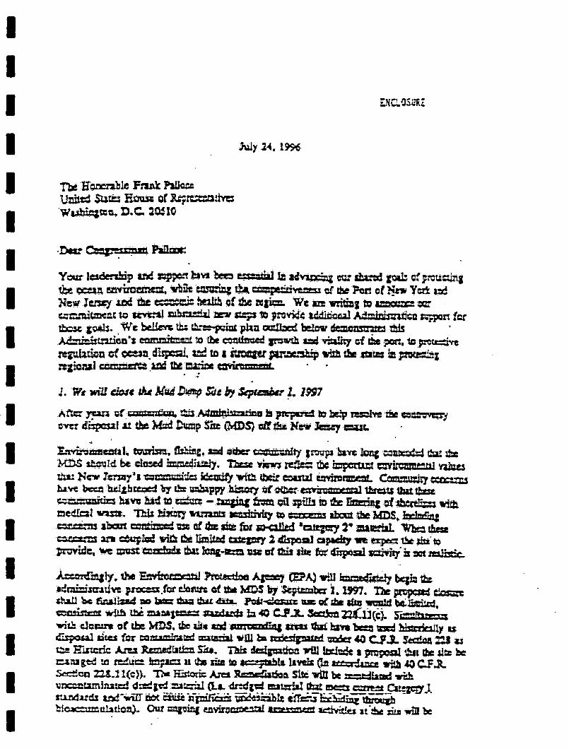
Long-term placement alternatives are dependent on implementation of the policies
I mandated in the "Three Party Letter" of July 24, 1996 (see Appendix B). In thatstatement and in other authorizations, the USACE has been directed to evaluate all
feasible dredged material placement alternatives needed to maintain and improve the Port
I ofNY/NJ (USACE, 1999). This is currently underway. The NYD has recentlyprocess
issued a draft Implementation Report for DMMP (September 1999) documenting theprogress to date, as well as potential alternatives for incorporation into the scoping
I for EIS. Two of the DMMP alternatives whichcomprehensiveprocess a many maybecome available for the O&M needs of the Kill Van Kull/Newark Bay project are theconstruction of additional land remediation sites and the implementation of emerging
I If alternatives that considered viable for thedecontamination technologies. placement are
Kill Van Kull/Newark Bay project become available, and if potential impacts relating toany additional alternatives have not been addressed by a state or Federal regulatory
I process, then the NYD will supplement this NEPAdocument.
3.6 Recommended Plan
I The recommended plan for dredged material removed during implementation of Area 4Aof the Kill Van Kull/Newark Bay Channels Phase II Deepening Project, which is
I unsuitable for ocean disposal, will be placement at the Newark Bay Confined Disposalfacility or upland beneficial use sites. One or all of the four sites proposed by the non-federal sponsor and described in Sections 3.3 and 3.4 of this EA may be selected based
I and preference at the time of construction. Selection ofon need, availability sponsorplacement sites will not be made until all Federal, state, and local regulatory agencieshave issued the required permits. Site selection will be coordinated with the New Jersey
I New Dredging Inter-Agency Group ProgramMaritime Resources (NJMR), Jersey
(NJDIG).
I 4.0 AFFECTED ENVIRONMENT
The selection of potential placement sites is documented in this EA, which addresses
I appropriate Federal, state, and local regulatory permitting requirements. All proposedsites have been, or will be, permitted and in cOmpliance with all appropriate regulatoryand permitting requirements. The environmental and biological characterization of the
I affected environment for each of the potential placement sites is the responsibility of, andhas been completed by or will be conducted by, the applicants via the permitting process.Placement site utilization will not occur until all Federal, state, and local regulatory
I have issued the required permits.agencies
A complete environmental description of the deepening project area was summarized in
I the Final EA for the Kill Van Kull/Newark Bay Channels Phase II Deepening Project(USACE, FEA/FONSI 1997). An environmental description of the HARS also has beenentered into the public record as part of the Supplement to the Environmental Impact
I 14
!

|Statement On New York Dredged Material Disposal Site Designation for the Historic •Area Remediation Site (HARS) and the New York Bight Apex, May, 1997; hereafter
cited as: (USEPA, SEIS 1997). The selection of potential placement sites would not IIaffect any additional project area resources.
5.0 ENVIRONMENTAL IMPACTS I
The administrative decision selecting potential sites for the placement of unsuitable ndredged material that may be removed during the Kill Van Kull/Newark Bay ChannelsPhase II Deepening Project would not result in impacts on resources beyond thosediscussed in the Final EA (USACE, FEA/FONSI 1997) and the HARS SEIS (USEPA, nSEIS 1997). The NYD is committed to implementing appropriate mitigation measuresfor any long-term or major environmental impacts that may result from channelconstruction. Potential environmental impacts of all proposed placement sites discussed Iabove have been, or will be, addressed via the placement site permitting process by the
m
site owner/lessee of each potential site prior to dredged material placement, n
6.0 CONCLUSIONS IThe purpose of this EA is to propose candidate sites for the placement of dredgedmaterial that is unsuitable for ocean placement at the HARS. This material will be n
removed during the authorized channel deepening and navigation improvements within IArea 4a of the Kill Van Kull and Newark Bay Channels. This EA primarily documentsthe administrative decision selecting potential sites identified for placement of dredged m
material unsuitable for ocean placement. Other potentially affected environmentalresources were not identified, nor were there additional potential impacts to such
resources associated with the proposed action. The NYD concludes that the proposed •action described above would involve no changes within the project area since the |publication of the FEIS, and accordingly does not warrant preparation of a supplement tothe EIS. Any and all potential environmental impacts resulting from the use of the sites •will be addressed by the owner/lessee of each candidate placement site via the permitting |process. The beneficial impacts that will result directly from the implementation of theproposed action is contingent upon the timely availability of sites for placement of •dredged material. Ultimately, benefits will be manifested in the increased and more IIefficient use of navigational channels in the Port of NY/NJ and beneficial use of dredged
material. IAll appropriate Federal, state, and local regulatory requirements, including NEPA, U.S.Fish and Wildlife Coordination Act, Endangered Species Act, National Historic •Preservation Act, and State Water Quality and CZM regulations, necessary for the use of IIany placement site (or sites) shall be met, and an opportunity for public review andcomment ensured, prior to placement site utilization. •
l
15 l
I

!
I 7.0 COORDINATION
I The NYD is coordinating with all appropriate agencies, including the USEPA, U.S. Fishand Wildlife Service (USFWS), National Marine Fisheries Service (NMFS), the NJDEP,and New York State Department of Environmental Conservation (NYSDEC) on updating
I the CZM consistency, and Water Quality Certification for the project and this specificarea (4A). The New Jersey and New York CZM Evaluations are included in AppendicesE and F of this document, respectively. The Clean Water Act, Section 404(b)(1)
I Guidelines evaluation is included in Appendix G. All relevant correspondence andproject comments are included in Appendices D and H, respectively. A Clean AirStatement of Conformity is included in Appendix J.
!I!IIIII!!II
I 16
I

!
8.0 REFERENCES i
New Jersey Department of Environmental Protection. (1997). The Management and IIRegulation of Dredging Activities and Dredged Material in New Jersey's Tidal Waters.
Pennsylvania Department of Environmental Protection. (1998). Operating Plan forDredge Stabilization Project at the Bark Camp Mine Facility. Pennsylvania Departmentof Environmental Protection, Land Recycling and Waste Management, Williamsport, PA.
U.S. Army Corps of Engineers, New York District (September 1999). Dredged Material IIManagement Plan for the Port of New York and New Jersey, Draft Implementation
Report, Programmatic EIS and Technical Appendix. i
U.S. Army Corps of Engineers, New York District (September 1999). Draft Feasibility I
Report for New York and New Jersey Harbor Navigation Study, Volume 1, Main Report. i
U.S. Army Corps of Engineers, New York District. (1999). Beneficial uses of dredged i
material for habitat creation, enhancement and restoration in NY/NJ Harbor. i
U.S. Army Corps of Engineers -New York District. December (1998). Dredged m
Material Management Plan for the Port of New York and New Jersey. B
U.S. Army COrps of Engineers. (April 1997). Final Environmental Impact Statement on i
the Newark Bay Confined Disposal Facility.
U.S. Army Corps of Engineers -New York District. (December 1997). Final Limited •Reevaluation Report and Final Environmental Assessment/Finding of No Significant iImpact, Kill Van Kull-Newark Bay Channels Phase II Deepening Project.
U.S. Army Corps of Engineers -New York District. (September, 1996). Dredged I
i
Material Management Plan for the Port of New York and New Jersey, Interim Report.
U.S. Army Corps of Engineers. (1987). Newark Bay/Kill Van Kull Navigation Project, IFinal Supplement to the Final Environmental Impact Statement.
U.S. Army Corps of Engineers. (1986). Final Supplemental Environmental Impact iStatement, Newark Bay/Kill Van Kull Navigation Project.
U.S. Army Corps of Engineers. (1980a). Navigation Study on Improvements to Existing IFederal Navigation Channels, Main report.
me
U.S. Army Corps of Engineers. (1980b). Navigation Study on Improvements to Existing iFederal Navigation Channels, Technical Appendices.
i
U.S. Environmental Protection Agency. (May, 1997). Supplement to the Environmental IImpact Statement On New York Dredged Material Disposal Site Designation for the
Historic Area Remediation Site (HARS) and the New York Bight Apex. i17
I

IIIIIIIIIIi Appendix A - Mailing List for Draft Environmental Assessment
IIIIIIII

II
Federal Agency Mailing List i
Federal Transit Administration Mr. F. L. Rath, Deputy Commissioner BRegion II Div. of Historic Preservation I26 Federal Plaza, Suite 2940 NYS Dept. of Parks and RecreationNew York, NY 10278 Bldg. 1, Empire State Plaza
Albany, NY 12238Office of Federal ActivitiesU.S. EPA Mr. David Bardin, Preservation OfficerNEPA Compliance Division NJ Dept. of State Historic Environmental ==EIS Filing Section Protection lMail Code 2252-A P.O. Box 1390401 M Street S.W. Trenton NJ 08625Washington, DC 20400 •
Mr. Robert Hargrove, Chief lU.S. Geological Survey Attn: Mr. Joseph Bergstein425 Jordan Rd. Strategic Planning & Multimedia ProgramsTroy, NY 12180 Branch i
U.S. Environmental Protection Agency, RegionMr. Anthony Ward IIExecutive Coordinator 290 Broadway iMilitary Ocean Base New York, NY 10007-1866 lBayonne, NJ 07002
Mr. Clifford G. DayMr. Anton J. Sidoti Supervisor •Federal Energy Regulatory Commission U.S. Fish & Wildlife Service I19 West 34th Street, Suite 400 927 North Main St., Bldg. D 1New York, NY 10001 Pleasantville, NJ 08232
Ms. Marie Rust Mr. Robert F. McKeon iRegional Director, North Atlantic Region U.S. Maritime AdministrationNational Park Service, Dept. of the Interior 26 Federal Plaza ==15 State St. New York, NY 10278 lBoston, MA 02109-3572
Ms. Diane RusanowskyMs. Sheila Huff U.S. Department of Commerce •Office of Env. Policy and Compliance National Marine Fisheries Service IUS. Dept. of the Interior 212 Rogers Avenue1849-C St. NW, Room 2340 Milford, CT 06460-6499 i
Washington, DC 20240 •Mr. Stanley W. Gorski
Mr. Terry Martin Attn: Ms. Karen GreenEnvironmental Affairs National Marine Fisheries Service iDept. of the Interior Habitat & Protected Resources Division lOffice of the Secretary Sandy Hook Biological LaboratoryWashington, DC 20240 74 Magruder Rd.
Highlands, NJ 07732 •Mr. Ronald LambertsonRegional Director Mr. Don L. Kilma, DirectorU.S. Fish & Wildlife Service Advisory Council on Historic Preservation i
Dept. of the Interior The Old Post Office Building •300 Westgate Center Dr. 1100 Pennsylvania Ave. NW #809Hadley, MA 01035-9589 Washington, DC 20004
!!!

I Mr. Joe Picciano, Division ChiefFederal Emergency Management Agency
i Region 226 Federal PlazaNew York, NY 10278
I Ms. Grace MusumechStrategic Planning & Multimedia ProgramsBranchU.S. Environmental Protection Agency, Region
| ,,290 BroadwayNew York, NY 10007-1866
I Mr. Anthony G. CarrFederal Transit AdministrationOne Bowling Green, Room 429
I New York, NY 10004-1415Mr. Michael Ludwig
i Attn: Ms.Diane RusanowskyU.S. Department of CommerceNational Marine Fisheries Service212 Rogers Avenue
I Milford, CT 06460-6499
IState Agencies Mailing List
Mr. Vance Barr Mr. Peter King iNYS Department of State State of New YorkDivision of Coastal Resources and Waterfront Dept. of TransportationRevitalization Hunters Point P_aza iAlbany, NY 12231-0001 47-40 21st St. l
Long Island City, NY 11101Mr. Stephen ZahnMarine Resources Specialist Mr. Howard Golub, Acting Director iNew York State Dept. of Environmental Interstate Sanitation CommissionConservation 311 West 43rd Street, Suite 20147-40 21st. St. New York, NY 10036 i
Long Island City, NY 11101 iMr. Ron Mieszkowski
Mr. John Ferguson State of New JerseyNew York State Dept. of Environmental Highway Authority •Conservation P.O. Box 5050 l47-40 21st. St. Woodbridge, NJ 07095Long Island City, NY 11101
Mr. John Yencik •Thomas Wakeman New Jersey Dept. of Labor & Industry =Port Authority of New York & New Jersey P.O. Box VOne World Trade Center Trenton, NJ 08625 i
New York, NY 10048 •Mr. Joel Peccioli
Mr. Thomas Costanzo NEPA CoordinatorPort Authority of New York & New Jersey NJ Dept. of Environmental Protection •One World Trade Center 501 East State Street, CN 401 lNew York, NY 10048 Trenton, NJ 08625-0401
Director of Field Services Mr. Lawrence Schmidt, Director iDiv. ofHistorical Preservation Office Of Program CoordinationNew York State Dept.of Parks and Recreation New Jersey Dept. of Environmental ProtectionEmpire State Plaza, Bldg. 1 P.O. Box 418Albany, NY 12238 Trenton, NJ 08625-0418 I
Mr. George Stafford, Director Commander Larry LeahyNew York State Dept. of State ACTNY - Waterway •Coastal Management Program Bldg. 108 I
162 Washington Avenue, 4th Floor Governors Island, NY 10004Albany, NY 12231-0001
Ms. Dorothy Guzzo, Deputy Preservation IIMr. Robert James OfficerNew Jersey Dept. of Transportation NJ Dept. of State Historic Environmental1035 Parkway Avenue, CN 600 Protection •Trenton, NJ 08625-0600 P.O. Box 404 ITrenton, NJ 08625-0404State of New JerseyDept. of Community Affairs Mr Larry Baler •101 South Broad Street, CN 800 NJDEP Office of Dredging and Sediment ITrenton, NJ 08625-0800 Technology
401 E. State StreetTrenton, NJ 08625 i
l

I Local Mailing List
I Landmarks Preservation Commission Mr. Gary Surmay and Mr. Jorge ValenciaDirector of Environmental Review Housing Authority100 Old Slip City of Elizabeth, New JerseyNew York, NY 10005 668 Maple Avenue
I Elizabeth, NJ 07202Ms. Roberta Scott BoattiDirector, Business Development Mr. Mark Matsil, DirectorStaten Island Chamber of Commerce Natural Resources
I 130 Bay Street New York City Dept. of ParksStaten Island, NY 10301 1234 5th Avenue, Room 233New York, NY 10029
i Ms.-Omi Medford-RyanDept. of City Planning, Waterfront Division Ms. Annette Barbaccia22 Reade St. New York City Office of EnvironmentalNew York, NY 10278 Coordination
I 52 Chambers St., Room 215Mr. John Doherty New York, NY 10007New York City Dept. of Sanitation125 Worth Street, Room 72 Director of Planning
I New York, NY 10013 Metropolitan Transportation Authority347 Madison AvenueMs. Esther Siskind New York, NY 10017-3739
I New York City Dept. of EnvironmentalProtection Mr. Floyd Lapp59-17 Junction Blvd. Director of TransportCorona, NY 11368 Dept. of City Planning
I 2 Lafayette Street, Suite 1200Ms. Georgina Morgenstern New York, NY 10007Bureau of Environmental EngineeringNew York City Dept. of Environmental Senior Director Service Planning
I Protection New York City Transit Authority96-05 Horace Harding Expressway 130 Livingston StreetCorona, NY 11368 Brooklyn, NY 11201
I Mr. William Holzapfel DirectorCity Attorney New York MetroTransportation CouncilCity of Elizabeth, New Jersey One World Trade Center, Suite 82E
I Dept. of Law, Office of the City Attorney New York, NY 1004850 Winfield Scott PlazaElizabeth, NJ 07201-2462 Office of the Mayor
City of Elizabeth, New Jersey
I Ms. Christina City HallAdidjaja
New York Metropolitan Transportation Council 50 Winfield Scott Plaza347 Madison Avenue - 10th Floor Elizabeth, NJ 07201-2462
I New York, NY 10017 Ms. Linda CorcoranMr. Peter Janosik- Vice PresidentCity Council of New York Land Use Division New York City Economic Development Corp.
I 250 Broadway - 17th Floor 110 William Street, 4th FloorNew York, NY 10007 New York, NY 10038
i Mr. Christopher Lynn, CommissionerNew York City Dept. of Transportation40 Worth Street, 10th Floor (CEQR)New York, NY 10013
!

II
Mr. George Ververides Community Board No. 3Director of County Planning Borough of Staten Island 1Middlesex County Planning Board 655-218 Rossville Avenue40 Livingston Avenue Staten Island, NY 10309New Brunswick, NJ 08901 l
The Honorable George Pataki •Mr. Armand Fiorletti Governor of the State of New York l
Union County Engineer The Executive ChamberP.O. Box 2607 Albany, NY 12224 •Westfield, NJ 07091-2607 i
The Honorable Christine Todd WhitmanMr. Stephen Van Hecke Governor of the State of New Jersey l
Economic Development Office of The Governor •Union County 125 West State Street, CN 0011085 Morris Avenue Trenton, NJ 08625-0001
Union, NJ 07083 1
Ms. Janet TreamontEssex County Dept. of Planning and
Economics l120 Fairview AvenueCedar Grove, NJ 07009
Mr. John Rose, Director lNew York City Dept.of City Planning22 Reade Street
New York, NY 10007-1216 1
Ms. Susan KathEnvironmental LawDivisionNew York City LawDept. 1100 Church Street, 3rd FloorNew York, NY 10007
Office of the Mayer lCity of Bayonne l
City Hall630 Avenue C •Bayonne, NJ 07062 lOffice of the MayorCity of Jersey City 1280 Grove StreetJersey City, NJ 07302
Office of the Mayor ICity of Newark I920 Broad Street
Newark, NJ 07102 i
The Honorable Guy MolinariStaten Island Borough President
Borough Hall 1Staten Island, NY 10301
II

I Congressional Delegates Mailing List
i The Honorable Frank LautenbergUnited States Senate506 Hart Senate Office BuildingWashington, DC 20510-3002
I The Honorable Robert TorricelliUnited States SenateSenate Office Building
I 113 DirksenWashington, DC 20510-3010
i The Honorable Daniel P. MoynihanUnited States Senate464 Russell Senate Office Bldg.Washington, DC 20510-3201
I The Honorable Alfonse M. D'AmatoUnited States Senate520 Hart Senate Office Building
I Washington, DC 20510-3202The Honorable Robert Menendez
i House of Representatives1730 Longworth House Office BuildingWashington, DC 20515-3013
I The Honorable Donald M Payne2244 Rayburn House Office Bldg.House of RepresentativesWashington, DC 20515-3010
I Mr. Todd TurnerOffice of State Senator Gentile
i 664 Bay StreetStaten Island, NY 10304

II
Interested Parties Mailing List
Natural Resources Defense Council United Pilots Association II40 West 20th Street 10 Richmond AvenueNew York, NY 10011 Staten Island, NY 10302
New York City Sierra Club Mr. Tad Deshler i250 Riverside Drive EVS m
New York, NY 10025 200 W. Mercer St., Suite 403Seattle, WA 98119 •
Ms. Cindy Zipf lExecutive Director Mr. James BrownClean Ocean Action JMZ Geology, Inc. i
P.O. Box 505 43 Emery Avenue •Sandy Hook, NJ 07732 Flemington, NJ 08822
Sierra Club New York City Group Mr. James Tripp •625 Broadway, 8th Floor Environmental Defense Fund lNew York, NY 10012 257 Park Avenue South
New York, NY 10010
Sierra Club i310 Walnut Street Mr. Thomas J. Gilmore, Executive DirectorEnglewood, NJ 07631 New Jersey Audubon Society
P.O. Box 125
Ms. Beth Milleman, Executive Director 790 Ewing St. iCoast Alliance Franklin Lakes, NJ 07417235 Pennsylvania AvenueSE Washington, DC 20003 Mr. D.W. Bennett, Executive Director •
American Littoral Society IMr. Peter Mott Sandy Hook, Building #18New York City Audubon Society Highlands, NJ 0773271 West 23rd Street, Room 606 •New York, NY 10010-4102 Hudson River Foundation
40 West 20th St. Ninth FloorMr. John Santacrose, Executive Director New York, NY 10011 i
Audubon Society of New York State •46 Rarick Road New Jersey Alliance For Action IISelkirk, NY 12158 P.O. Box 6438
Raritan Plaza II •United NY and NJ Sandy Hook Pilots Edison, NJ 08818-6438 l201 Edgewater StreetStaten Island, NY 10305 Mr. Andrew Willner
NY/NJ Harbor Baykeeper •Mr. Mark Mascaro Sandy Hook, Building #181President and Chief Executive Officer Highlands, NJ 07732Staten Island Chamber of Commerce i
130 Bay Street Dr. Katherine Parsons iStaten Island, NY 10301 Manomet Bird Observatory II
P.O. Box 1770Mr. Gregory Storey Manomet, MA 02345 •New York Shipping Association lTwo World Trade Center, 20th Floor ' Dr. Henry RossNew York, NY 10048 Union CountyAlliance
P.O. Box 411 •Union, NJ 07083
II

I Utilities Mailing List
I Bell Atlantic, New Jersey, Inc. Mr. Mike Karlovich540 Broad Street Director of Community RelationsNewark, NJ 07012 TOSCO Bay Refinery
1400 Park Avenue
I Mr. Perry Boynton Linden, NJ 07036Jersey Central Power & Light300 Madison Avenue
i Morristown, NJ 07960Getty Petroleum Corporation125 Jericho Turnpike
I Jericho, NY 11753Transcontinental Gas Pipe Line Corp.Wood Avenue
I South Linden, NJ 07036
Mr. Raymond A. Tripodi
I Public Service Electric & Gas Co.80 Park Plaza - T17HP.O. Box 570Newark, NJ 07012
I The Reactance CorporationP.O. Box 256Bayonne, NJ 07002
I Mr. James KeeterCoastal Corporation
I Nine Greenway Plaza, Suite 468Houston, TX 77046-0995
NYNEX Corporation
I 230 W. 36th StreetNew York, NY 10018
Mr. Brian Clemence
I Dresser & McKeeCamp,10 Cambridge CenterCambridge, MA 02142
I Mr. Thomas EchiksonSidley & Austin1722 I Street, N.W.
I Washington, DC 20006Mr. Jack FrostTOSCO Refining Comp3ny
I 1400 ParkAvenue
Linden, NJ 07036
I Ms. Ruth HierroChemical Landholdings1015 Bellville TurnpikeKearny, NJ 07032
!

IIIIIIIIII
Appendix B - Administration's Closure of Mud Dump Site (July 24, 1996 Letter)
!IIIIIIII

I
I
I

I

III
o,
III

IIIIIIIIIi Appendix C - U.S. Fish & Wildlife Coordination Act Section 2(B) Report (April
1997)
iIIiiIIII


II
FISH AND WILDLIFE COORDINATION ACT ISECTION 2(b} REPORT
IAS,_$$1_ENT OF THE K_LLV_ KULL AND NEWARK BAY CHANNELS
_VIGATION PR_CT. NEW YO_ AND NEW JERSEY' I
IIII
IApril i_7
I


III
=,_.-_nc _.C£ng ;.':oco¢oi:
" i
I
I
I
I
I
I
I
I
l
I
I
I
,. |

I _IST o._ lr_,.T_s .............................. :_
I I. I__I_ _ ......................... L
l I_.. __ ............................... L*
I Iv. __ D_I_C_ ....................... - _
I A. _C_..x,._,._L,_..,_._A_..__ _,$_ .................. 4
I 2. 7_h . : ........................
m•. A_F._ ............... "............C. _ =_t..I_ . ................... ,...... 7
_'_:DA'I_-__2C_._S........ "........ " ...." ....
%'Z, _Z_cATI_ 07 _ _-CT._EESATE__ITE_T_TO }'I._A=_ _.,_._,_.-Z
I _. ._ _r_TC!,_t_ ,_.Ds ...................... iC,C. :;A_"__ ........ , ................... __OD. E__.A! co_,__'/_ ..............
I z, _._TA_ ____'T o_o_,._='¢':--z:g.s ............... i_
i vii. -DIST:I_.CATZONOY _,A _,_,A,_$IE_'DLT,CO_',._t_IO,_S_.DR}"C_"_W?.S_,_ _:.T..S............ : .... ,........... 15
ZX. _i__ "_.__ ................................
I A. ?t.Y._'EP..A.--J'_. _T-._ ............... . ...........T'T
_, P-_SO_ C_._I.,__C_%_IC_$ .....................
I ,r ,) _r

I
I
I
IZ:_ArB %. S_U_7 L_,afO: "_.8Kill Vl= Z'allmr_iNe_a:k _7 _t!2
!
IIIIII


1[m
Fi_,_ 1. St_y _ for l_ K_Van _1 _ Nev_rkBayCl__s r_<_ pmj_ 0.5 0 0.5 1 M[es¥od(and _ J_sc_. _: U.5. AI=W_ ot FJxj_rs, I_7. _: ..,___iJ,....--,
I I | I I I I I I I I I I I I I | I I

habi=a_ L_ Ncxi_k Bray,p_rELcuilzly _n _m sou_h_ii=Ir_ pot=i== =£ N_ark 3_y,

I
I
° I


I

I
I

I
I


[
I
{_' cli_h:!y h._- -.'..0= ; ............ 3 par:._pc: :hc'_,_.d)i= Nowar_ B_y%P':h a 'trt=_ t:vtXi _:oaZs: "'"*'_:--'+- _-^- .. ' |
i
......_-...... _:: .... ;'_:-_;C_"- bo=:o=, z:.d,I
1o I


I
I


I

I
J I .r I
IIIIIIIII
II
I

I
I
I
I
I
"J_.K=!I / KQwar_:_ f_dmr,! chm:nmla ._lwY=r"_L_ N_w Ja:sly _hu,_ i:
l Naw Y_:k.
Sor'vim_. _o,-=m_ C_,_--'. _sa,:h'u.d,_:_T.s. 8C7 p?,
I
I
I
I
I
I
I
I|
I
I
I

!!!!!!!!
, I
. i_.d!._..l $I=_.=8 _=."_a li_
IIII
' |
IIII

ii A-_

!
"" I
!!
!• !
t_!!!!!!
• !• |

,;_ P. Csdd:H

I

!II!!|
!!
J!J
o.
!n .,
J!!J


I.... : ,, ............i.,: i, , i ......................................._......q t t .,_lw
Io°
i ,
I
F_)m_L C,_)mA'rE .SPECIES |_w _m: I
II
I_ "_'_i .___ "_m_i"_f '. _ '_"" ;;_'_;_;;._".". ..._'......'' _ .............. TI....................................................,._:_', ±_ ...........................................=r...... 1"""'1...... °
II
II
Ic-4 m

i
I!
I!
IIIIIIIII

I
• WILDL/FE OF NEW JERSEY II i T - nt "-- ...... m I m i
mmLkt=_z_=-_.+__ m"• lcm or e&_e i_ ihabi._ ovt--_ptOimd_n, __, 1
i
IL ........... I11 rr,u_ ....... , =_ ............... II'"'T_?'"+'_'-_......... ...+ ''lrl .... I"_'"'_'_( ........ [ ..... I/'l
.r.Enttang_r_ ,Thrt_'entd 1
lROS_rJI TI.,"_, ,,.$'ram=ffOOg=_ LCh_,-mtrs_ 0_., A='_ otcra
5,'m,_-_=,udCwl. ° ,_J#o_n".-_,lu$ C_ Sw=_tow," H'_do pyrr_oa=teSu_;n W_,:e_,_l=tO_Or_s N._"llmr/s S:.av_._lh SparrOW, P#Xze+_!u$ $=rdw¢_ens_: 1
Iv_s=mr 5_rrow, P_oe¢#res g+,im/_tt$ GrasshOpper _-lL-t.-_w. _mm_dt_ae+r x_wntt_,zm_
Beg Tut'je, Cl_rrtmysmu/1,1_nbd_/_; \V,_od Tu_e. (=t_nyx z__ 1AttZ_._c Hawk:l_fll, _et_oc_e/y4r/a_t_+t_t * + AdartG=G,.._ 'r.=v.. c_,ion_,mv¢,_•" •A1;Itnt/cL:g_=thaad, C_tett# c,_,t_: *+" No,_er_ Pin= _:k_, P#,,._t:PJ_tm.. tnela_lau_u: II
A_.S_lc R[¢qly, l...,_/,_O_..,,_a,_y,.,,,Ir+_Ttp"".,t,tlan_c Ltzthetback+ OttmOCtt_f :t2+tte¢## "" "F.++..+ ...o,,..,,, .,,,,..,+.o.,, 1C=,_ S_.lki, Elaph41g. O0_¢&7_mb_r R=_d_s_ak_. Cto:r_/_ h. horRdu=
II
!ENDANGERED AND NON6AME SPECIES PROGRAM I• , ":. ........ m[:l r ......
I rttvt_'tf'_,_t'3._ #re =J_ /?.."/._r _£._.,', t=o. ,._, ,""

I . l_luVlpOrted .Saltier, AznOy_Omm/#¢,rda" =EM_#mMud _#l_*mana_N,,./_aU_tntX_=.a'=._=nr,w_r_Ez=_m Tl_ar 5zf=man_'., ,,L,nt>y=ram#,r,#vt/m,-_F'_nl_zrnznzT_zfr_, _w dnCwzon#
I ,,
S_[WI-,al.e,B_etro_t#:# be_l#_
J]_i V_zla, 8X/_ILaO,u'M/_tI'HJ:tCt//U_*_' , . "'_ _._'._d'_'_
I H_rnl_ba:_ _rrl+l+l,M_W'ap{Iu'l nov148mp#41"* •
|
I :erM
I
o.
I Th, rLs=_l Of NOW Jers(Iy)_ I)n..._t_Gfld I)_=1 h=l_.t'l,_l'r'le wildlife s:ecfe,',nrpmaims;mad ]by t_o b_=l=&.='s_'_om elfF_.,Sh,mG4m_ a_' 'llmtl_if'_]d=-
I 1)re'a, EnC_angs{ed.and N_:nglmll _)_¢:ie._ Progrim. i'ha)e ilsrJera u_ed to ,"datatrrdno protectl=n and rtmnagorn.P_m.$)_jOriSne¢_s,_ry ¢o thou,re the _u_viva_of _e State'_ endangered _r
m r,cngame w;;dlite. This wcrk ialm=do pr.,_lble o_Y t,hr0ui;hv_F_r,taty ¢.:rt:ril0uEor.._ _:=[vQd through 'rd_aVC'ddfifeCheck-c_n *J_ N_w Jersey St_=e T_ F_rlra,. The :Wildlife Check-off |
i ihno:_iymajor fu._lng so/,um_efor t reel :_©tmCidonand rn_._ag_mamt Of the "'_;=='OtBtls endanGs:_d and rl,o_gl_ml wildlife re-=source. For mors information =bout chs IE,._rlgered end
i N_n;omo Spa=les Pro;r=_ or :o report = sighting of s_emg.er8or the=ntoned w[ldlife ¢ontac',_ .:Endangecedand Non{;_m_ SpeCieSPrcErom0N_rthern DIs;rlcz Ol,q¢=, 15ox3lE3 _.D. _. lqam,Pt_n. N.J.
l 0S827 ot C-I[1905t 735-;1_g7_;. .

I' I
, III
_ IIII
Appendix D - Correspondence I
III
..
IIIIII

I
August 3, 1999 _'_'7_I;36s,i_o
I Dr Raimo A Liias "
q
m Deputy Chief of ProgramsI And'Project Management
i - New York District, Corps of EngineersJacob K. Ja_AtsFederal Building ' .
I New York, FrY 10278-0090
Dear Dr. Liias: .. , ....I The Final Environmental Assessment ("EA') for the deepening of the Kill Van Kuli and Newark
b
Bay Channels to 45 feet, dated,April 1997, states that the New York District adopts a tiered
• strategy to select the project s aisposal sites for contaminated material[ The strategy deferredI final site selection until the appropriate time when the final site &:cision was needed for
contracting. As you know, the Port Authority and the New York District have been working with• the New Jerscs" Maritime Resources ("N]MR') to actuate the New Jersey DIG proaramI ("NIDIG"). This program, which perhaps can best be described as a clearinghouse for available-- upland disposal sites/processes, is in its early statzcs of development. We anticipated designating
• NJDIG as the sponsor provided disposal site fo_ Contract 4A. However, there are contractual• issues that need to be resolved before the program can be imple,nented;. "l"-hercfore, the Port-- Authori[v wishes to continue the site selection process for the Kill van Kull and Newark Bay
Channels project.I In the EA the Port Authority in its role as local sponsor identified two upland sites - Koppers
Keamey and OENJ Bayonne- as potential repositories for contaminated material. Contract 4A,I scheduled for award in very. earl), 2000, is the first project contract where contaminated material• (less than 100,000 cubic yards) is cxpected to be cncountered. For Contract 4A, the Port
AuthoriD, wishes to augment the EA site list (Koppers Keamey and OENJ Bayonne) with a third
I i
J I., l" ' t
N,aw/'York State Department of Environmental Conservation
Division of Environmental Permits, Region 2 I47-40 21st Street Long Island City, NY 1-1-101
Tel: (718) 482-4997 Fax: (718) 482-4975 I
John P. Cahill
Commissioner I"i
August 26, 1999 i
Mr. Frank Santomauro, P.E. " INY District, Corps of EngineersJacob K. Javits Federal Building
New York, NY 10278-O090 I
Re: Permit Modification Request - Seasonal Windows: Special Condition 20 (Shooters Island) and IISpecial Condition 21 (Contract Reach 3 -Winter flounder, Blue crab}Kill Van Kull Deepening iDEC No. 2-6499-00002/00004 •
i
Dear Mr. Santomauro: i
This is in response to your letters of June 7, 1999 and August 16, 1999 to Steven Zahn of
NYSDEC, Marine Resources regarding the seasonal restrictions on dredging activities for the Kill Van iKull Deepening project. Special Condition No. 20 requires a 1000 foot buffer surrounding ShootersIsland during the period of March 1 - August 31. Special Condition No. 21 contains a provision for •a seasonal window from November 15 - May 31 in any portion of Contract Reach 3 determined to =harbor significant populations of Winter flounder of Blue-claw crab.
Special Condition 21. I
The department has determined, based on biological and habitat surveys conducted by the •Corps, that Contract Reach 3 does not support signif.icant populations of Winter flounder or Blue-claw =crab. Therefore, the provision for a seasonal dredging window from November 15 - May 31 is not
required. Special Condition 21 is deleted. •
Special Condition 20.i
DEC does not agree that there is sufficient information to consider a reduction in the seasonal idredging window surrounding Shooters Island at this time. Shooters Island has been well documented
as an important nesting and foraging area for wading birds and shore birds. Over the past two •breeding seasons, one-day surveys by New York Audubon have indicated that there may be asignificant reduction in the number of herons using the island. However, these surveys are not as
detailed or extensive as previous surveys conducted by Manumet and can not predict whether the iherons will return to prior levels during the next, or subsequent breeding seasons. More detailedstudies will be necessary to document the use of Shooters Island by herons and other birds. If yourassessment is based on additional surveys, please forward them to us. •

. There is also some evidence that recent, temporary disturbance due to human activities onShooters Island may have played a role in the apparent reduction in the use of the area by herons'and
I other birds. The NYC Department of P,3rJ_sand Recreation is currently responsible for themaintenance of the area. We intend pursue this matter with NYC Parks in order to investigate andrectify this situation.
I Your letters stated that pre-construction monitoring will be necessary to establish the use ofShooters Island as a nesting site. We agree and express our willingness to work with you to
I determine the level of data to make a sup'portable decision regarding the seasonal window.necessary
This will be needed for each breeding season that may be affected by the project. We also expectto work with you in the development of monitoring studies to evaluate dredging and blasting impacts
I the bird and shore bird populations should they be determined necessary. If breedingon wadingpopulationsare shown to be present, we request that the monitoring studies be designedto evaluatethe impact of construction activities, particularly blasting, which may have a greater impact than
I distance of at least 2500 feet from'the shoreline of Shooters Island.dredging, beginningat a
The Corps should plan based on the assumption that the dredging window for Shooters Island
I will remain in effect until it be definitively shown that there will be no adverse affect on thecan l
nesting colonies. Sincethis work can not start until the beginningof next spring's breeding season,SpecialCondition No. 20, requiring a 1000 foot buffer around Shooters Islandfrom March 1 - August
I • 31, will remain in effect.
If you have any questions, please contact me at the above address, or by telephone at (718)
I 482-4077.
Charles de Quillfeldt
I Environmental 3Analyst
i cc: J. GilmoreJ. PaneS. Zahn
i H. Ruben, USACE..
!

!Dr. Raimo A. Liias |Deputy Chief of Programs
and Project Management IDepartment of the Army |New York District, Corps of EngineersJacob K. Javits Federal Building IINew York, NY 10278-0090 |
Dear Dr. Liias: _ ._
This is in reference to the Kill Van Kull & Newark Bay Channel Deepening Project -
Contract 4A. I
In my letter of August 3, the Port Authority updated potential upland disposal sites for thesubject contract so that the New York District could complete the required Environmental |Assessment. The identified sites were Koppers Kearney, OENJ Bayonne and the Bark |
Camp site in Pennsylvania.II
In order to ensure that all options are addressed in the Environmental Assessment, the |Port Authority hereby supplements the aforementioned list of three sites with twoadditional sites. The two additional sites are the Newark Bay Confined Disposal Facility mand Subchannel cells in Newark Bay. As you know, the Subchannel cells are the subjectof an ongoing permit application before the New York District and the New Jersey
Department of Environmental Protection.
If you have any questions, please contact Tom Costanzo or me. !1!
Sincerely,
. ' , III |m _
Program Manager [Dredging Division
Cc: Frank McDonough, NJMR mHal Hawkins, NYD-COEArthur Connolly, NYD-COE II
I
II

IIIIIIIIII Appendix E - New Jersey Coastal Zone Management Evaluation
IIIII "
IIII

I!
APPENDIX E:
NEW JERSEY COASTAL ZONE MANAGEMENT EVALUATION i
The Coastal Zone Management Act of 1972 (16 U.S.C. {}{}1451-1464) was enacted byCongress to balance the competing demands of growth and development with the need to •protect coastal resources. Its stated purpose is to "..:: preserve, protect, develop and, Uwhere possible to restore or enhance, the resources of the nation's coastal zone..." The
primary means of achieving this balance is through coastal zone management programs •adopted by the states and designed to regulate and use activities that could affect coastalwaters. The act offered incentives to encourage the coastal states and territories to
exercise their full authority over coastal areas through development of coastal zone Imanagement programs, consistent with the minimum federal standards. The CoastalZone Act Reauthorization Act Amendments of 1990 strengthened the Act by requiringthe state programs to focus more on controlling land use activities and the cumulative neffect of activities in coastal zones.
New Jersey administers its Federally approved coastal zone program (N.J.A.C. 7:7, 7:7E) ithrough the Department of Environmental Protection. Pursuant to the Federal CoastalZone Management Act, New Jersey has defined its coastal zone boundaries and thepolicies to be utilized to evaluate projects occurring within the designated zones. The iWaterfront Development Law (N.J.S.A. 12:5-3) and related requirements (N.J.A.C. 7:7223) provide the authority for issuance of permits for, among other activities, the
placement or construction of structures, pilings, or other obstructions in any tidal nwaterway. New Jersey's Rules on CZM are employed by the state's Land Use
m
Regulation Program in the review of permit applications and coastal decision making; m
they address issues of location, use and resources. New Jersey's rules provide for a nbalancing between economic development and coastal resource protection, recognizing
u
that coastal management involves explicit consideration of a broad range of concerns, incontrast to other resource management programs which have a more limited scope of 1concerrl.
The proposed project is within the coastal zone boundaries of New Jersey. The following Iassessment identifies the coastal zone policies and evaluates the project's consistency
•- with the applicable policies. The consistency evaluation is provided to enable New
Jersey to consider the effect of the project on their coastal zone resources.
E.I NEW JERSEY COASTAL ZONE MANAGEMENT POLICIES n
SUBCHAPTER 3 - SPECIAL AREAS
7:7E-3.2 Shellfish Habitat I
i
This policy generally limits disturbance of shellfish habitat. Over-wintering blue crabs •are known to exist in the project area. As part of the coordination for the authorized plan land prior to construction of Phase I of the KVK/NB Navigation Project, the Districtinitiated a survey to monitor fishery impacts and collected baseline data. A recent study •
l
I

I titled "A Biological and Hydrographical Characterization of Newark Bay, New Jersey,May 1993-April 1995" is available to update the baseline study. The District has agreed
I with the USFWS, NMFS, and NJDEP Division of Game, Fish, and Wildlife, to assess theneed for including additional biological monitoring in order to determine appropriatemeasures to avoid adverse impacts to blue crabs as a result of construction activities.
I 7:7E-3.3 Surf Clam Areas
I This that would contaminate surf clam beds.policy prohibits development destroy or
The project area does not support surf clam beds; therefore, this policy is not applicable.
7:7E-3.4 Prime Fishing Areas
i This policy prohibits sand or gravel submarine mining in prime fishing areas. Theproject does not involve submarine mining and the project area is not considered a primefishing area; therefore, this policy is not applicable.
I 7:7E-3.5 Finfish Migratory Pathways
I This policy prohibits construction of dams or dikes which would create physical barriersto migratory fish. Development which reduce lower water quality so as to interfere withfish movement is also prohibited. While the project area is not a designated finfish
I migratory pathway, it is used by migratory fish. The proposed project would not interferewith fish movement; therefore, this policy is not applicable.
I 7:7E-3.6 Submerged Vegetation Habitat
This policy prohibits or restricts dredging so as to protect water areas that support
I submerged vegetation. This project area is an existing and maintained navigationchannel; therefore, this policy is not applicable.
I 7:7E-3.7 Navigation Channels
-- This policy prohibits construction that would extend into a navigation channel and
I restricts dredging in navigation channels. The proposed project deepens the Kill VanKull and Newark Bay Navigation Channels in the project area. Dredging standardswould meet all applicable conditions for maintenance dredging in navigation channels;
I therefore, the project is consistent with this policy.
7:7E-3.8 Canals
!This policy prohibits actions that would interfere with boat traffic in canals used fornavigation. The project area is not a canal as defined by the NJDEP; therefore, this
I policy is not applicable.

!
7:7E-3.9 Inlets I
This policy prohibits filling and discourages submerged infrastructure in coastal inlets, iThe project area is not an inlet as defined by the NJDEP; therefore, this policy is not
applicable. I7:7E-3.10 Marina Moorings
This policy prohibits non-water dependent development in marina mooring areas, i
i
Construction of the proposed project would not involve development in any marina
mooring areas; therefore, this policy is not applicable. Im7:7E-3.11 Ports
iThis policy prohibits actions which would interfere with port uses. The proposed projectwould not interfere with port uses. By deepening the project area navigation channels,the proposed project would benefit port related activities (e.g., improve navigation, iefficiency of cargo delivery); therefore, the project is consistent with thi s policy.
7:7E-3.12 Submerged Infrastructure Routes i
This policy prohibits any activity which would increase the likelihood of submergedinfrastructure damage or interfere with maintenance operations. Several submerged ipipelines exist within the project area. According to Federal policy, all buried pipelinesand cables must be at least 7 feet below the authorized navigation channel project depth.Exceptions may be made provided plans providing less top cover are found to be itechnically sound and owners guarantee that the Government and its contractors would beheld free of any liability for damage during construction and maintenance. Constructionof the project would meet all applicable Federal and state guidelines; therefore, the Rproject is consistent with this policy.
g
7:7E-3.13 Shipwrecks and Artificial Reefs i
•- This policy restricts the use of special areas with shipwrecks and artificial reefs which i
would adversely affect the usefulness of this special area as a fisheries resource. The i
project area does not contain any known shipwrecks Or artificial reefs; therefore, thism
policy is not applicable. Known abandoned vessels in the vicinity of the project will not g
be impacted by this project action, i
7:7E-3.14 Wet Borrow Pits i
This policy restricts the use and filling of wet borrow pits. The project area does containany known wet borrow pits; therefore, this policy is not applicable, i
|
!!

!7:7E-3.15 Intertidal and Subtidal Shallows
I This policy discourages disturbance of shallow water areas (i.e., permanently or twicedaily submerged areas from the spring high tide to a depth of four feet below MLW).
i Disturbance of shallow water areas generally requires mitigation by creating similarhabitat at a ratio of one acre created to one acre lost, unless the dredged area is reduced tothe minimum extent practicable. The proposed KVK/NB project will disturb
I approximately 16 acres of shallow water habitat. The overall project area encompassesapproximately 1500 acres. This area will be converted from shallow to deep waterhabitat. Construction of the project would meet all applicable Federal and state
I guidelines or permit requirements (e.g., mitigation/monitoring); therefore, the project isconsistent with this policy.
I 7:7E-3.16 Dunes
This policy protects and preserves ocean and bayfront dunes. The project area does not
I contain any dunes; therefore, this policy is not applicable.7:7E-3.17 Overwash Areas
I This policy restricts development in overwash areas due to their sensitive nature. Theproject area does not contain anv overwash areas; therefore, this policy is not applicable.
I 7:7E-3.18 Coastal High Hazard Areas
I This policy restricts development in coastal high hazard (i.e., flood prone) areas. Theproject area is not a coastal high hazard area; therefore, this policy is not applicable.
I 7:7E-3.19 Erosion Hazard Areas
This policy prohibits development under most circumstances to protect public safety.
I The project area is not an erosion area; therefore, policy applicable.hazard this is not
i 7:7E-3.20 Barrier Island CorridorThis policy restricts new development on barrier islands. The project area is not a barrier
i island corridor; therefore, this policy is not applicable.7:7E-3.21 Bay Islands
I This policy restricts development on bay islands. The project area does not contain anybay islands; therefore, this policy is not applicable.
!

!!
7:7E-3.22 Beaches
This policy restricts development on beach areas. The project area does not contain any ibeach areas; therefore, this policy is not applicable.
7:7E-3.23 Filled Water's Edge i
This policy seeks to promote water dependent uses at areas along the waterfront that have ibeen previously filled. The proposed project is not a waterfront development; therefore, lthis policy is not applicable.
m
7:7E-3.24 Existing Lagoon Edges i
This policy restricts development at lagoon edges because of potential water quality IIproblems. The project area does not contain any lagoon edges; therefore, this policy is II
not applicable.
7:7E-3.25 Flood Hazard Areas i
This policy is designed to restrict development in flood hazard areas and ensure that thewaterfront is not preempted by uses which could function equally well at inland
I
locations. Construction of the proposed project would not involve development in a
flood hazard area; therefore, this policy is not applicable, i
7:7E-3.26 (Reserved) i7:7E-3.27 Wetland
•This policy restricts disturbance in wetland areas and requires mitigation if wetlands are Idestroyed or disturbed. The proposed project will not impact any wetlands. Constructionof the project would meet all applicable guidelines or permit requirements (e.g., •
mitigation); therefore, the project is consistent with this policy. I
7:7E-3.28 Wetland Buffers •
This policy restricts development in wetland buffer areas in order to protect wetlands.
The proposed project would not affect wetland buffer areas; therefore, this policy is not •applicable. II
7:7E-3.29 (Reserved) i7:7E-3.30 (Reserved)
I!!

! 7:7E-3.31 Coastal Bluffs
I This policy restricts development on project area notcoastal bluffs. The does contain
coastal bluffs; therefore, this policy is not applicable.
I 7:7E-3.32 Intermittent Stream Corridors
i This policy restricts actions in stream corridors. The project area does not containintermittent stream corridors; therefore, this policy is not applicable.
I 7:7E-3.33 Farmland Conservation AreasThis policy seeks to preserve large parcels of land used for farming. The project area
I does not contain farmland conservation areas; therefore, this policy is not applicable.
7:7E-3.34 Steep Slopes
I This policy seeks to preserve steep slopes by restricting development in such areas.Steep slopes help to control erosion and reduce flooding. The project area does not have
I steep slopes, therefore, this policy is not applicable.
7:7E-3.35 Dry Borrow Pits
I This policy restricts the excavation and filling of dry borrow pits. The project area doesnot contain any dry borrow pits; therefore, this policy is not applicable.
E 7:7E-3.36 Historic and Archaeological Resources
I This the value of historic and archaeological resources and may requirepolicy protectscultural resource surveys and other protective measures.
I conducted in connection with the New YorkRecent cultural investigationresources
Harbor Collection and Removal of Drift Project have identified a number of vesselseligible or potentially eligible for the National Register of Historical Places (NRHP)
I along the Kill Van Kull shoreline. Ten are alongvessels found within five clusters the
Staten Island side of the waterway, and three vessels are located along the Bayonne
i shoreline. A structure, the B&O Transfer Bridge, was identified along the Staten Islandshore. Another vessel at Port Johnson was also determined potentially significant as a
contributing element to the Port Johnson Historic Sailing Vessels cluster. Coordination
I with the NY/NJ State Historic Preservatic, n Offic (SHPO) will be undertaken todetermine specific monitoring requirements during blasting. Monitoring will beconducted to ensure there are no impacts to the B&O Transfer Bridge or historic vessels.
I 7:7E-3.37 Specimen Trees
I This policy seeks to protect specimen trees. The project area does not contain specimen

I!
trees; therefore, this policy is not applicable.
7:7E-3.38 Endangered or Threatened Wildlife or Vegetation Species Habitats I
This policy restricts development in endangered or threatened wildlife or vegetation •species habitat areas. The peregrine falcon, nesting on local area bridges (see Section I4.1..5 Threatened and Endangered Species), was the only threatened and/or endangered
species for which potential adverse impacts were identified. The proposed project would •have no adverse impact on habitat areas for this species; therefore, the proposed project lwould be consistent with this policy. The district will employ any and all measures
recommended by the USFWS and NJDEP to avoid adverse impacts to state and Federally ilisted threatened and endangered species.
7:7E-3.39 Critical Wildlife Habitats i
This policy discourages development that would adversely affect critical wildlife habitat.The coastal heron rookery located on Shooters Island (part of the Harbor Herons iComplex) was listed as a rare natural community by the NJDEP. The District willcontinue to folow the USFWS recommendation that no blasting or dredging be conductedwithin 300 feet of Shooters Island. The District will further coordinate with both the iUSFWS and the NJDEP Division of Game, Fish, and Wildlife regarding appropriatemeasures to avoid adverse impacts to nesting waterbirds and other sensitive biological
of the environment. The proposed project would not affect this critical Rcomponentshabitat; therefore, the proposed project would be consistent with this policy.
m
7:7E-3.40 Public Open Space I
This policy encourages new public open spaces and discourages development that might i
adversely affect existing public open space. Construction of the proposed project would inot affect any public open space; therefore, this policy is not applicable.
7:7E-3.41 Special Hazard Areas i
i
This policy discourages development in hazard areas due to potential dangers. The •project area does not contain special hazard areas; therefore, this policy is not applicable. I
7:7E-3.42 Excluded Federal Lands
Federal lands are beyond the jurisdiction of the New Jersey Coastal Zone. New Jerseyhas the authority to review activities on Federal lands if there may be spillover impacts •on New Jersey's Coastal Zone. There are no excluded federal lands in the project area;therefore, this policy is not applicable.
!!!

!7:7E-3.43 Special Urban Areas
I This policy seeks to encourage waterfront development that would benefit certainmunicipalities that receive state aid. The project area is located near Elizabeth, which
i qualifies as a special urban area. Construction of the proposed project would provideindirect economic benefits to Elizabeth, NJ because of improved shipping efficienciesand commercial navigation access. Therefore, the proposed project would be consistent
i with this policy.7"7E-3.44 Pinelands National Reserve and Pinelands Protection Area
I This policy allows the Pinelands Commission to serve as the reviewing agency foractions within the Pinelands National Reserve. The proposed project is not located
I within the pinelands; therefore, this policy is not applicable.7:7E-3.45 Hackensack Meadowlands District
I This policy allows the Hackensack Meadowlands Development Commission to serve asthe reviewing agency for actions within the Hackensack Meadowlands District. The
I proposed project is not located within the Hackensack Meadowlands District; therefore,this policy is not applicable.
I 7:7E-3.46 Wild and Scenic River Corridors
This policy recognizes the outstanding value of certain rivers in New Jersey by restricting
I development to compatible uses. The proposed project is not located within a wild andscenic river corridor; therefore, this policy is not applicable.
I 7:7E-3.47 Geodetic Control Reference Marks
This policy discourages disturbance of geodetic control reference marks. There are no
I known geodetic control reference project study area; therefore, policymarks in the this is
not applicable.
I 7:7E-3.48 Hudson River Waterfront Area
i This policy restricts development along the Hudson River Waterfront and requiresdevelopment, maintenance, and management of a section of the Hudson WaterfrontWalkway coincident with the shoreline of the development property. The proposedproject is not located within the Hudson.River Waterfront Area; therefore, this policy is
I not applicable.

!!
SUBCHAPTER 3A - STANDARDS FOR BEACH AND DUNE ACTIVITIES
These standards apply to routine beach maintenance, emergency post-storm beach i
i
restoration, dune creation and maintenance, and construction of boardwalks. The
proposed project is not located within a beach or dune area; therefore, these standards are •not applicable. i
SUBCHAPTER 3B - WETLAND MITIGATION PROPOSALS HiThis section details the requirements of a wetland mitigation proposal. Construction ofthe project would meet all applicable guidelines or permit requirements; therefore, the iproject is consistent with this section.
SUBCHAPTER 3C - IMPACT ASSESSMENT FOR ENDANGERED AND ii
THREATENED WILDLIFE SPECIES.
This section details the performance and reporting standards for impact assessments for iendangered and threatened wildlife species. The peregrine falcon, nesting on local areabridges, was the only threatened and/or endangered species for which potential adverse
impacts were identified. The impact assessment for endangered and threatened wildlife ispecies is described in sections 4.1.5 and 5.1.5 Threatened and Endangered Species. Abiological assessment has been prepared by the USACE and submitted to the USFWS onMarch 12, 1997 and assesses potential dredging impacts to the peregrine falcon. This Haction is consistent with the standards provided with this policy.
i
SUBCHAPTER 4 - GENERAL WATER AREAS l
This section defines general water areas. For purposes of definition, the Kill Van Kull is i
considered a tidal straight, a waterway connection between two estuarine bodies of water. D
7:7E-4.2 Acceptability Conditions for Uses i
This section defines the important uses of general water areas and sets conditions or
standards of acceptability for certain uses. Only those standards applicable to the •proposed project area are listed: I
(g) Standards relevant to new dredging •(h) Standards relevant to dredged material placement I
Dredging and dredged material placement would meet the acceptability conditions for •both applicable standards; therefore, the proposed project is consistent with this policy. I
!!!

!SUBCHAPTER 5 - GENERAL LAND AREAS
I The proposed project area includes the Cities of Newark and Bayonne. From a coastwideperspective, development in these regions is preferred over development in other regions.No development is associated with the proposed project; therefore, this policy is not
I applicable.
I SUBCHAPTER 6 - GENERAL LOCATION RULES7:7E-6.1 Location of Linear Development
I This rule sets conditions for acceptability of linear development (e.g., roads, walkways,pipelines). The proposed project is consistent with the rules on location of linear
I development..7:7E-6.2 Basic Location
I This rule states that NJDEP may reject or conditionally approve a project for safety,protection of certain property, or preservation of the environment. The proposed project
I is consistent under the location rule.
7 7E-6 3 Secondary Impacts
I This rule sets the requirements for the secondary impact analysis. The proposed projectwould be consistent with the requirements for secondary impact analysis.
!SUBCHAPTER 7 - USE RULES
I 7:7E-7.2 Housing Use
These rules set standards for housing construction in the coastal area. The proposed
I project does not involve housing therefore, policy not applicable.construction. this is
i 7:7E-7.3 Resort Recreational UseThis rule sets standards for resort and recreational uses in the coastal area. The proposed
i " project does not involve resort recreational uses; therefore, this policy is not applicable.7:7E-7.3A Marina Development
I This rule sets standards for marina development in the.coastal area. The proposed projectdoes not involve marina development; therefore, this policy is not applicable.
!

!|
7:7E-7.4 Energy Use
This rule sets standards for energy uses in the coastal area. The proposed project does inot involve energy uses; therefore, this policy is not applicable.
!7:7E-7.5 Transportation Use
This rule sets standards for roads, public transportation, foot paths and parking facilities I
_m
in the coastal area. The proposed project does not involve construction of roads, public
transportation, foot paths, or parking facilities; therefore, this policy is not applicable, ii7:7E-7.6 Public Facility Use
i
This rule sets standards for public facilities (e.g., solid waste facilities) in the coastal area. iThe proposed project does not involve construction of a public facility; therefore, this
policy is not applicable, ii
7:7E-7.7 Industry Use
This rule sets standards for industrial uses in the coastal area. Construction of the
proposed project would improve commercial navigation and access to existing industrialcenters in the port of New York and New Jersey and allow for more efficient movementof cargo to the Port Newark and Elizabeth - Port Authority Marine Terminal, Tosco OilRefinery, GATX Facility, and Gulfport petroleum storage facility. Therefore, the
proposed project would be consistent with this policy. I
7:7E-7.8 Mining Use
!This rule sets standards for mining in the coastal area. The proposed project does not
involve mining; therefore, this policy is not applicable, i
7:7E-7.9 Port Use
This rule sets standards for port uses and port-related development. The standards are idesigned to ensure that port facilities retain their economic vitality. Deepening the KillVan Kull Channel will improve navigation and cargo movement to established facilities •in the Port of New York/New Jersey; therefore, the proposed project is consistent with Ithis policy.
7:7E-7.10 Commercial Facility Use i
i
This rule sets standards for commercial facilities such as hotels, and other retail services •in the coastal zone. The proposed project does not involve construction of commercial lfacilities; therefore, this policy is not applicable.
!I

I 7:7E-7.11 Coastal Engineering
I This rule sets standards to the shoreline, maintain and beachprotect dunes, providenourishment. Standards applying to structural shore protection are included. Deepeningof the navigation channels would be consistent with standards for shoreline protection;
I therefore, proposed project would be consistent with this policy.the
7:7E-7.12 Dredged Material Placement on Land
!This rule sets standards for placement of dredged materials. Dredging operations and
i placement of dredged material would be done in accordance with the DMMP and theNJDEP's Management and Regulation of Dredging Activities and Dredged Material inNew Jersey Tidal Waters, and would comply with applicable state and Federal
i regulations. Therefore, the proposed project would be consistent with this policy.7:7E-7.13 National Defense Facility Use
I This rule sets standards for the location of defense facilities in the coastal zone. Theproposed project does not involve location of a defense facility; therefore, this policy is
I not applicable.7:7E-7.14 High Rise Structures
I This rule sets standards for high rise structures in the coastal zone. The proposed projectdoes not involve construction of high rise structures; therefore, this policy is not
I applicable.
SUBCHAPTER 8 - RESOURCE RULES
I 7:7E-8.2 Marine Fish and Fisheries
I This rule sets standards of acceptability so as to cause minimal feasible interference withthe reproductive and migratory patterns of estuarine and marine species of finfish and" shellfish. While the project area is used by migratory estuarine and marine fish, the
I proposed project would not interfere with the reproductive and migratory patterns of fish;therefore, the project is consistent with this policy.
I 7:7E-8.3 (Reserved)
7:7E-8.4 Water Quality
!This rule sets standards for coastal development so as to limit effects on water quality.Construction of the project would meet all applicable Federal and state guidelines or
I permit requirements and regulations for water quality; therefore, the project is consistentwith this policy.
!!

!!
7:7E-8.5 Surface Water Use
This rule sets standards for coastal development so as to limit effects on surface water, iDeepening of the navigation channels will not cause unacceptable surface water
disturbances (e.g., drawdown, alteration of flow patterns); therefore, the proposed project •is consistent with this policy. |
7:7E-8.6 Groundwater Use i
This rule sets standards for coastal development so as to limit effects on groundwater
reserves. The proposed project will not involve groundwater supplies; therefore, this •policy is not applicable. l
7:7E-8.7 Stormwater Management Ii
This rule sets standards for coastal development so as to limit effects of stormwater
runoff. The proposed project does not involve stormwater runoff; therefore, this policy is inot applicable.
7:7E-8.8 Vegetation i
This rule sets standards for coastal development so as to protect vegetation. The
proposed project does not involve the disturbance of vegetation; therefore, this policy is inot applicable.
7:7E-8.9 (Reserved) i
7:7E-8.10 Air Quality
This rule sets standards for coastal development with requirements that projects meetapplicable air quality standards. The proposed project would not contravene Federal orstate air quality standards. Reduction of marine traffic and congestion would benefit Hoverall air quality in the project area. Therefore, the proposed project would be
i
-- consistent with this policy. •
7:7E-8.11 Public Access to the Waterfront
This rule requires that coastal development adjacent to the waterfront provide Iperpendicular and linear access to the waterfront to the extent practicable, including bothvisual and physical access. Construction of the proposed project would not preclude a
access to public water related recreation resources and facilities located along the Kill iVan Kull and Newark Bay. Deepening of the navigation channels will maintain access topublic water related recreation resources and facilities. Therefore, the project would be •consistent with this policy. l
!

!
I 7:7E-8.12 Scenic Resources and Design
I This rule sets standards for new coastal development to be visually compatible with itssurroundings. The project area consists mainly of industrial uses, roadways, and somerecreational uses. The proposed project would be consistent with this policy.
I7:7E-8.13 Buffers and Compatibility of Uses
I This rule sets standards for adequate buffers between uses found to be not compatible.The proposed project would be consistent with this policy.
I 7:7E-8.14 Traffic
i This rule sets standards for coastal development to not disturb traffic systems. Theproposed project does not involve existing traffic systems; therefore, this policy is notapplicable.
I 7:7E-8.15 through 8.20 (Reserved)
I 7:7E-8.21 Subsurface Sewage Disposal SystemsThis rule sets standards for subsurface sewage disposal systems in the coastal zone. The
I proposed project does not involve sewage disposal; therefore, this policy is notapplicable.
III!IIII!
IIIIIIIII
Appendix F - New York Coastal Zone Management Evaluation I
IIIIIIIII

I APPENDIX F:
i NEW YORK COASTAL ZONE MANAGEMENT EVALUATIONThe Coastal Zone Management Act of 1972 (16 U.S.C. §§1451-1464) was enacted byCongress to balance the competing demands of growth and development with the need to
I protect coastal resources. Its stated purpose is to "...preserve, protect, develop and, wherepossible to restore or enhance, the resources of the nation's coastal zone..." The primary
i means of achieving this balance is through coastal zone management programs adoptedby the states and designed to regulate land use activities that could affect coastal waters.The act offered incentives to encourage the coastal states and territories to exercise their
i full authority over coastal areas through development of coastal zone managementprograms, consistent with the minimum federal standards. The Coastal Zone ActReauthorization Act Amendments of 1990 strengthened the Act by requiring the state
I programs to focus more on controlling land use activities and the cumulative effect ofactivities in coastal zones.
I New York currently administers its Federally approved coastal zone program (ExecutiveLaw §§910-921) through the Department of State. Pursuant to the federal Coastal ZoneManagement Act, New York State has defined its coastal zone boundaries and the
I policies to be utilized to evaluate projects occurring within the designated zones. In 1981New York State adopted the Waterfront Revitalization and Coastal Resources Act,creating the New York State Coastal Management Program (CMP). The CMP embodies
I 44 policy statements supportive of the act's intent to promote a balance betweeneconomic development and coastal resource preservation and optimization.
I The proposed project is within the coastal zone of New York State. The followingassessment identifies the coastal zone policies and evaluates the project's consistencywith the applicable policies. The consistency evaluation is provided to enable New York
I to consider the effect of the project on their coastal zone resources.
F.1 NEW YORK STATE COASTAL ZONE MANAGEMENT POLICIES
I 1) Restore, revitalize and redevelop deteriorated and underutilized waterfront areas" for commercial, industrial, cultural, recreational and other compatible uses.
I Construction of the proposed project would contribute to the revitalization of the StatenIsland waterfront area if the project deepening spurs the development of additional water
I dependent uses of the Staten Island waterfront which would otherwise not occur withoutthe proposed project. Therefore, the proposed project would be consistent with this
i policy.2) Facilitate the siting of water dependent uses and facilities on or adjacent to coastal
i waters.The proposed project would improve the existing navigation channel serving existing
i water dependent facilities and assist in the placement of water dependent uses adjacent to

!|
coastal waters. Therefore, the proposed project would be consistent with this policy. B
Further develop the state's major ports of Albany, Buffalo, New York, i3)Ogdensburg, and Oswego as centers of commerce and industry, and encourage
i
the siting, in these port areas, including those under the jurisdiction of state public i
authorities, of land use and development which is essential to, or in support of, the iwaterborne transportation of cargo and people.
i
Construction of the proposed project would improve commercial navigation and access to iexisting centers of commerce and industry in the Port of New York and New Jersey andallow for more efficient movement of cargo to Port Newark and Elizabeth - Port
Authority Marine Terminal. This in turn could result in greater port development and iincreased port related commerce. This will sustain the numerous maritime support
industries currently located along the Kill Van Kull, including tug and barge companies, •marine repair and drydock facilities, oil and petroleum transporters, vessel outfitters and Iconverters, and marine operations. Therefore, the proposed project would be consistent
with this policy.i
4) Strengthen economic base of smaller harbor areas by encouraging the
development and enhancement of those traditional uses and activities which have •provided such areas with their unique maritime identity. II
Construction of the proposed project would not strengthen the economic base of smaller •harbor areas. Therefore, this policy does not apply.
5) Encourage the location of development in areas where public services and ifacilities essential to such development are adequate.
Construction of the proposed project would not result directly in any new development in ithe area requiring additional public services or facilities. Therefore, this policy does notapply.
6) Expedite permit procedures in order to facilitate the siting of development.. activities at suitable locations.
Construction of the proposed project would not involve the siting of development iactivities. Therefore, this policy does not apply.
i7) Significant coastal fish and wildlife habitats, as identified on the coastal area map,
shall be protected, preserved, and where practicable, restored so as to maintain Inn
their viability as habitats, i
Potential impacts to significant coastal fish and wildlife habitats (e.g., Shooters Island) i
and measures to protect and mitigate potential adverse effects are described in Section i5.0. By avoiding or mitigating for potential impacts, the proposed project would be
m
consistent with this policy, m
I
!

!8) Protect fish and wildlife resources in the coastal area from the introduction of
I hazardous wastes and other pollutants which bio-accumulate in the food chainor
which cause significant sublethal or lethal effect on those resources.
I impacts to resources exposure to contaminates releasedPotential fish and wildlife include
from sediments during dredging or placement operations. Potential impacts would belimited due to the low potential for contaminated sediments at the proposed project depth.
I Best management practices will be employed during dredging in order to minimizedisturbance and resuspension of solids in the water column. By utilizing these mitigationmeasures for contaminated sediments, the proposed project would be consistent with this
I policy.
i 9) Expand recreational use of fish and wildlife resources in coastal areas byincreasing access to existing resources, supplementing existing stocks, anddeveloping new resources. Such efforts shall be made in a manner which ensures
i the protection of renewable fish and wildlife resources and considers otheractivities dependent on them.
I Construction of the proposed project would not affect recreational use of fish and wildliferesources. There is no commercial fishing in the Kill Van Kull and Newark Bay.Therefore, this policy does not apply.
I 10) Further develop commercial finfish, shellfish and crustacean resources in thecoastal area by encouraging the construction of new, or improvement of existing
I onshore commercial fishing facilities, increasing marketing of the state's seafoodproducts, maintaining adequate stocks, and expanding aquaculture facilities. Suchefforts shall be made in a manner which ensures the protection of renewable fish
I and wildlife resources and considers other activities dependent on them.
Construction of the proposed project would not affect commercial fishing. There is no
I commercial fishing in the Kill Van Kull and Newark Bay. Therefore, this policy does notapply.
I 11) Buildings and other structures will be sited in the coastal area so as to minimizedamage to property and the endangering of human lives caused by flooding anderosion.
I The proposed project does not include the siting of buildings or other structures in thecoastal area. Therefore, this policy does not apply.
I12) Activities or development in the coastal area will be undertaken so as to minimize
damage to natural resources and property from flooding and erosion by protecting
I natural protective features including beaches, dunes, barrier islands,and bluffs.
Primary dunes will be protected from all encroachments that could impair theirnatural protective capacity.I

!!
Construction of the proposed project would not involve beaches, dunes, barrier islands, or •bluffs. The project would not adversely impact wetlands. Construction of the project |would not involve other types of natural protective features as noted under this policy.
Therefore, this policy does not apply, n
13) The construction or reconstruction of erosion protection structures shall beundertaken only if they have a reasonable probability of controlling erosion for at •least thirty years as demonstrated in design and construction standards and/or IIassured maintenance or replacement programs.
n
The proposed project does not include the construction or reconstruction of erosion Iprotection structures. Therefore, this policy does not apply.
n
14) Activities and development, including the construction or reconstruction of Ierosion protection structures, shall be undertaken so that there will be no
measurable increase in erosion or flooding at the site of such activities or ndevelopment, or at other locations.
The proposed project does not include the construction or reconstruction of erosion nprotection structures. Therefore, this policy does not apply.
15) Mining, excavation or dredging in coastal waters shall not significantly interferewith the natural coastal processes which supply beach materials to land adjacentto such waters and shall be undertaken in a manner which will not cause an
increase in erosion of such land. n
Dredging and excavation associated with the proposed project would not affect naturalcoastal processes or increase the potential of erosion from adjacent land. Therefore, the Dproposed project would be consistent with this policy.
me
16) Public funds shall only be used for erosion protective structures where necessary nto protect human life, and new development which requires a location within or
m
" adjacent to an erosion hazard area to be able to function, or existing development;and
only where the public benefits outweigh the long-term monetary and other Hcosts including the potential for increasing erosion and adverse effects on natural
protective features, iThe proposed project does not include erosion protective structures. Therefore, this
policy does not apply, n
17) Use nonstructural measures to minimize damage to natural resources and propertyfrom flooding and erosion shall be used whenever possible. Such measures shall •include: (i) the setback of buildings and structures; (ii) the planting of vegetation |and the installation of sand fencing and draining; (iii) the reshaping of bluffs; and(iv) the flood-proofing of buildings or their elevation above the base flood level. •
|
!

!Construction of the proposed project would not include structural flood control elements.
I Therefore, this policy does not apply.
i 18) To safeguard the vital economic, social and environmental interests of the stateand of its citizens, proposed major actions in the coastal area must give fullconsideration to those interests, and to the safeguards which the state has
i established to protect valuable coastal resource areas.Construction of the proposed project would promote the economic interests of the region.
I Potential impacts to valuable coastal resources (e.g., colonial wading bird rookery) andmeasures to mitigate adverse effects (i.e., safeguards), are described in Section 5.0 Theproposed project would be consistent with this policy.
I 19) Protect, maintain, and increase the level and types of access to public waterrelated recreation resources and facilities, so that these resources and facilities
I may be fully utilized in accordance with reasonably anticipated public recreationneeds and the protection of historic and natural resources.
I Construction of the proposed project would not preclude access to public water relatedrecreation resources and facilities located along the Kill Van Kull and Newark Bay.Deepening of the navigation channels will maintain access to public water related
I recreation resources and facilities. Therefore, the project would be consistent with thispolicy.
I 20) Access to the publicly-owned foreshore and to lands immediately adjacent to theforeshore or the water's edge that are publicly-owned shall be provided and itshall be provided in a manner compatible with adjoining uses. Such lands shall
I be retained in public ownership.
No publicly-owned foreshore is located in the project area. Construction of the proposed
I project would not preclude public access to waterfront land in the project vicinity.Therefore, this policy does not apply.
I and water-enhanced recreation will be and21) Water-dependent encouragedfacilitated, and will be given priority over non-water related use along the coast,provided it is consistent with the preservation and enhancement of other coastal
I resources and takes into account demand for such facilities. In facilitating suchactivities, priority shall be given to areas where access to the recreation
i opportunities of the coast can be provided by new or existing publictransportation, services, and to those areas where the use of the shore is severelyrestricted by existing development.
I Construction of the proposed project would not preclude access to public water relatedrecreation resources and facilities located along the Kill Van Kull and Newark Bay.
i Deepening of the navigation channel will maintain access to public water related

!!
recreation resources and facilities. Therefore, the project would be consistent with this
policy. I22) Development, when located adjacent to the shore, will provide for water related
recreation, whenever such use is compatible with reasonably anticipated demand •for such activities, and is compatible with the primary purpose of the ldevelopment.
The proposed project does not include shoreline development. Therefore, this policy Idoes not apply.
,Jim
23) Protect, enhance, and restore structures, districts, areas or sites that are of isignificance in history, architecture, archaeology or culture of the state, its
communities, or the nation, ii
Recent cultural resources investigation conducted in connection with the New YorkHarbor Collection and Removal of Drift Project have identified a number of vessels neligible or potentially eligible for the NRHP along the Kill Van Kull shoreline. Tenvessels are found within five clusters along the Staten Island side of the waterway, and
three vessels are located along the Bayonne shoreline. A structure, the B&O Transfer iBridge, was identified along the Staten Island shore. Another vessel at Port Johnson wasalso determined potentially significant as a contributing element to the Port JohnsonHistoric Sailing Vessels cluster. Coordination with the NY/NJ SHPOs will be IIundertaken to determine specific monitoring requirements during blasting. Monitoringwill be conducted to ensure there are no impacts to the B&O Transfer Bridge or historic
vessels, i
24) Prevent impairment of scenic resources of statewide significance as identified onthe coastalarea map. Impairment shall include: (i) the irreversible modification iof geologic forms, the destruction or removal of structures, whenever the geologic
i
forms, vegetation or structures are significant to the scenic quality of an identified i
and (ii) the addition of structures which, because of siting or scale will iresource;reduce identified views or which because of scale, form, or materials, will
i
" diminish the scenic quality of an identified resource.
!No scenic resources of statewide significance are located in the project area. Therefore,
the policy does not apply, n
25) Protect, restore or enhance natural and man-made resources which are notidentified as being of statewide significance but which contribute to the overall
scenic quality of the coastal area. U
The proposed project would not adversely impact the overall scenic quality of the coastal •area. Therefore, this policy does not apply. |
!!

I 26) To conserve and protect agricultural lands in the state's coastal area, an actionshall not result in a loss nor impair the productivity of important agricultural lands
I as identified on the coastal area if that loss or impairment would adverselymap,
affect the viability of agriculture in an agricultural district, or if there is noagricultural district, in the area surrounding such lands.
!The project study area is not located adjacent to agricultural lands. Therefore, this policydoes not apply.
!27) Decisions on the siting and construction of major energy facilities in the coastal
area will be based on public energy needs, compatibility of such facilities with the
I environment, and the facility's need for a shorefront location.
Construction of the proposed project would not involve siting of an energy facility.
I Therefore, this policy does not apply.
I 28) Ice management practices shall not interfere with the production of hydroelectricpower, damage significant fish and wildlife and their habitats, or increase shoreline erosion or flooding.
I This policy is not applicable to the project area.
I 29) Encourage the development of energy resources on the outer continental shelf inLake Erie and in other water bodies, and ensure the environmental safety of suchactivities.
I Construction of the proposed project does not involve development of energy resources.Therefore, this policy does not apply.
I 30) Municipal, industrial, and commercial discharge of pollutants, including but notlimited to, toxic and hazardous substances, into coastal waters will conform to
I state and national water quality standards.
-- The project would conform with the applicable permitting requirements. Therefore, the
I proposed project would be consistent with this policy.
31) State coastal area policies and management objectives of approved local
I waterfront revitalization programs will be considered while reviewing coastalwater classifications and while modifying water quality standards; however, thosewaters already overburdened with contaminants will be recognized as being a
I development constraint.
Construction of the proposed project would not affect the water classification or water
I standards of the Kill Van Kull and Newark Therefore, this does notquality Bay. policyapply.
!

!!
32) Encourage the use of alternative or innovative sanitary waste systems in small
communities where the costs of conventional facilities are unreasonably high, •given the size of the existing tax base of these communities. |
Construction of the proposed project would not involve sanitary waste systems, iTherefore, this policy does not apply. |
33) Best management practices will be used to ensure the control of stormwater •runoff and combined sewer overflows draining into coastal waters. I
The proposed project would not involve stormwater runoff or construction of combined •sewer overflows. Therefore, this policy does not apply. l
34) Discharge of waste materials into coastal waters from vessels subject to state IIjurisdiction will be limited so as to protect significant fish and wildlife habitats,recreational areas and water supply areas.
Construction of the proposed project would not affect discharge from vessels into the Kill IIvan Kull and Newark Bay. Therefore, this policy does not apply.
i
35) Dredging and dredged material placement in coastal waters will be undertaken in ia manner that meets existing state dredging permit requirements, and protects
significant fish and wildlife habitats, scenic resources, natural protective features, iimportant agricultural lands, and wetlands.
Dredging operations and placement of dredged materials would be done in accordance iwith the District's DMMP and would comply with applicable state and Federal l
regulations including the protection of significant fish and wildlife habitats, social i
resources and wetlands. Therefore, the proposed project would be consistent with this ipolicy.
m
Activities related to the shipment and storage of petroleum and other hazardous I36)materials will be conducted in a manner that will prevent or at least minimize
i
" spills into coastal waters; all practicable efforts will be undertaken to expedite the
cleanup of such discharges; and restitution for damages will be required when Ithese spills occur.
Construction of the proposed project would provide safer and more efficient itransportation of petroleum. Therefore, the proposed project would be consistent with
this policy, i37) Best management practices will be utilized to minimize the non-point discharge
of excess nutrients, organics and eroded soils into coastal waters. II
Construction of the proposed project does not involve the non-point discharge ofnutrients, organics and eroded soils. Therefore, this policy does not apply. •
|
!

!38) The quality and quantity of surface water and groundwater supplies will be
I protected, particularly waters constitute the primary orconserved and where such
sole source of water supply.
I proposed project would not affect surface water or groundwater reserves in the area.The
Therefore, this policy does not apply.
I 39) The transport, storage, treatment and disposal of solid wastes, particularlyhazardous wastes, within coastal areas will be conducted in such a manner so as
i to protect groundwater and surface water supplies, significant fish and wildlifehabitats, recreation areas, important agricultural land, and scenic resources.
i The proposed project does not involve the transport, storage, treatment and disposal ofsolid wastes. Therefore, this policy does not apply.
I 40) Effluent discharged from major steam electric generating and industrial facilitiesinto coastal waters will not be unduly injurious to fish and wildlife and shallconform to state water quality standards.
I The proposed project would not affect any effluent discharge from generating andindustrial facilities into the Kill Van Kull and Newark Bay. Therefore, this policy does
I not apply.
41) Land use or development in the coastal area will not cause national or state air
I quality standards to be violated.
The proposed project would not contravene air quality standards. Marine traffic
I reduction and congestion would benefit overall air quality in the project area. Therefore,the proposed project would be consistent with this policy.
I 42) Coastal management policies will be considered if the state reclassifies land areaspursuant to the prevention of significant deterioration regulations of the Federal-- Clean Air Act.
I The proposed project would not affect state classifications of land areas. Therefore, thispolicy does not apply.
I 43) Land use or development in the coastal area must not cause the generation of
i significant amounts of acid rain precursors: nitrates and sulfates.The proposed project would not cause the generation of significant amounts of acid rain
i precursors nitrates and sulfates. Therefore, this policy does not apply.44) Preserve and protect tidal and freshwater wetlands and preserve the benefits
i derived from these areas.
!

!!
The proposed project would not cause any impacts to tidal and freshwater wetlands;
therefore, this policy does not apply. I
IIIIIIIIIII!III!

!NEW YORK CITY
I CONSISTENCY WITH WATERFRONT REVITALIZATION PROGRAM (WRP)
i POLICIESThe twelve New York City WRP policies are discussed below. Insight into the
i objectives of these policies and the rationale behind their development were provided bythe following documents: State of New York Coastal Management Program and FinalEnvironmental Impact Statement (Section 6, August 1982), CEQRTechnical Manual(Appendix 1, December 1993), New York City Waterfront Revitalization Program
I (September 1982).
i New York City WRP PoliciesPolicy A
I Improve urban shorelines by maintaining, removing, or recycling waterfrontstructures (piers, docks, wharves, etc.) in accordance with waterfront development
I policies and plans. Identify alternative uses for underutilized waterfrontstructures.
I The purpose of this policy is to address rehabilitation of the waterfront consistent with theCity's economic and recreational needs. The project does not directly include piers,docks, or wharves within the Staten Island portion of the project. To this extent, this
I policy does not apply. Indirect benefits may occur to support maritime industries locatedalong the Kill Van Kull.
I Policy B
Improve channels as necessary to maintain and stimulate economic development.
I The purpose of this policy is to add specificity to New York State Policy 2 and identifies" the need to develop or modify federal waterways on a timely basis and where needed to
I support water dependent uses.
The proposed project would improve the existing federal navigation channel serving
I existing water dependent facilities and assist in the of waterplacement dependent uses
adjacent to coastal waters. Therefore, the proposed project would be consistent with this
i policy.Policy C
I shorefront protection against coastal erosion hazards where there is publicProvide
benefit and public use along non-public shores.
I

!!
This policy adds specificity to New York State Policies 11 and 16 by providing erosionprotection and by identifying a particular public resource endangered by erosion. The a
proposed project does not include the siting of buildings or other structures in the coastal iarea and the proposed project does not include erosion protective structures. Therefore,
this policy does not apply.
Policy D
Provide technical assistance for the identification and evaluation of erosion Iproblems, as well as the development of erosion control plans along privately-
owned eroding shores, iI
This policy adds specificity to New York Policies 11 and 16 since it addresses erosionprotection for private property which may impact other sites. The proposed project does •not include the siting of buildings or other structures in the coastal area and the proposed iproject does not include erosion protective structures. Therefore, this policy does not
apply, i
Policy Em
Implement public and private structural flood and erosion control projects only iwhen:
i
Public economic and environmental benefits exceed public economic and ienvironmental costs;non-structural solutions are proven to be ineffective or cost prohibitive; i
- projects are compatible with other coastal management goals and objectives,including aesthetics, access and recreation;
- adverse environmental impacts are minimized; II- natural protective features are not impaired; and- adjacent (downdrift) shorelines are not adversely affected.
This policy adds specificity to New York State Policies 11, 12, 13, 14, 15, 16, and 17 by i-- identifying potential problems associated with structural flood control projects. These
state policies address the siting of activities and development in hazard areas. The iproposed project is not a structural flood and erosion control project, therefore this policy
i
does not apply, i
Policy F
Priority shall be given to the development of mapped parklands and appropriate iopen space where the opportunity exists to meet the recreational needs of:
- immobile user groups; and I- communities without adequate waterfront park space and/or facilities.
I!

I This policy was developed to address the concems of recreational needs of special usergroups who rarely enjoy water-related activities. The policy also adds specificity to New
I York State Policy 21.
The project would not result in a reduction of existing or required access to or along
I coastal waters, public access areas, public parks or open spaces. Therefore, this policydoes not apply.
I Policy G
Maintain and protect New York City beaches to the fullest extent possible.
!This policy adds specificity to New York State Policy 21 by insuring that waterdependent recreation will be encouraged and facilitated, and adds specificity to New
I York State Policy 16 by identifying a particular public resource endangered byerosion.
The project area and vicinity does not contain any New York City public beaches,
i therefore this policy is not applicable.Policy H
I Insure ongoing maintenance of all waterfront parks and beaches to promote fulluse of secure, clean areas with fully operable facilities.
I The purpose of this policy is to address the operation and maintenance of New York Citywaterfront parks and outdoor recreational facilities. The project area does not contain
I any waterfront parks or beaches, therefore this policy is not applicable.Policy I
I Siting of liquefied and substitute natural gas facilities, including those associatedwith the tinkering of such gas, shall take into consideration state and national
I energy needs, public safety concerns and the necessity for a shorefront location.
-- The purpose of this policy is to address the safety of locating liquefied natural gas
I facilities in metropolitan areas. The proposed project does not involve the siting ofnatural gas facilities, therefore this policy does not apply.
I Policy J
Adopt end-use plans for landfill areas which specify the following:
I - final capacity- final contours
I - leachate, erosion and gas control systems- revegetation strategies- interim review schedules.
!

!!
The proposed project will not affect landfill areas, therefore this policy is not applicable. IPolicy K
Curtail illegal dumping throughout the coastal zone and restore areas scarred by Ithis practice.
This policy adds specificity to New York State Water Quality Policy 39. The proposed Iproject will follow best management practices during project construction. All required
permits for construction of the project and placement of dredged material will be Iobtained. Illegal dumping will not occur. Therefore, the proposed project would beconsistent with this policy.
Policy L I
Encourage energy development from waste and waste landfills. I
The purpose of this policy is to assist in achieving the national objective of energy
independence through recovering or producing energy from waste. The proposed project Idoes not involve energy development from waste and waste landfills, therefore, thispolicy does not apply.
IIIIIIII!I

IIIIIIIiII Appendix G - Clean Water Act Section 404 (B)(1) Guidelines Evaluation
IIIIIIIII

I|
APPENDIX G: SECTION 404(b)(1) GUIDELINES EVALUATION Ill
G.1 INTRODUCTION I
This appendix of the Draft Potential Dredged Material Placement Sites EA for the Kill mR
Van Kull and Newark Bay Federal Navigation Channel Deepening project presents a iSection 404(b)(1) guidelines evaluation for the placement of the dredged material from
m
the proposed project that is determined to be unacceptable for ocean placement. The i
evaluation is based the regulations found at 40 CFR 230, Section 404(b)(1): ion
Guidelines for Specification of Disposal Sites for Dredged or Fill Material. Them
Regulations implement Sections 494(b) and 401 (a) of the Clean Water Act, which govern I
the placement of dredged and fill material inside the territorial sea baseline (§230.2(b)). 1
G.2 DRAFT 404(b)(1) EVALUATION i
The following Section 404(b)(1) evaluation is presented in a format consistent with
typical evaluations in the NY/NJ Harbor area and addresses all required elements of the •evaluation. l
I. Project Description i
a. Location: The Kill Van Kull & Newark Bay Federal Navigation
Deepening Project area extends from the confluence of the Kill Van Kull •& Anchorage Channels to Station 168+22N, the northern edge of the Port IINewark Reach.
b. General Description: The authorized project plan entails deepening of i
i
existing navigational channels from the confluence of the Kill Van Kulland Anchorage channels to the northern edge of the Port Newark Reach in iNewark Bay (Station 168+22N) to -45 feet MLW plus a 2-foot overdepthallowance for dredging tolerance. This will approach or equal the depth ofthe Ambrose-Anchorage channel feeder arteries which connect the harbor •with the Atlantic Ocean. At this time, construction of the Port Newark
-- Channel and a portion of the Newark Bay Channel (Station 139+20N toStation 168+22N) has been deferred at the request of the non-federal isponsor (Port Authority of New York and New Jersey and/or State of NewJersey).
c. Authority and Purpose: The project is authorized in the Supplemental iAppropriations Act of 1985 and in Section 202 (b) of the Water ResourcesDevelopment Act (WRDA) 1986 IPL 99-88). The Limited ReevaluationStudy, which includes this EA was initiated at the request of the non-federal sponsor (the Port Authority of New York and New Jersey and/orthe State of New Jersey) for the purpose of accommodating deeper draft iand otherwise larger ocean-going vessels entering Port Newark and
i
Elizabeth - Port Authority Marine Terminal. .,
!
!

!d. General Description of Dredged Material: Approximately 10.7 million
I cubic yards (mcy) of dredged material would be removed theby proposedaction. This includes about 1.1 mcy of rock.
I e. Proposed Discharge Sites: Potential discharge sites that are proposedinclude the Newark Bay Confined Placement Facility (permitted), theBayonne Landfill (permitted), and Kearny Koppers Coke (permit pending)
I site.
f. Placement Method: the District will utilize a site (or sites) listed above
I pending approval through a separate compliance process or through theDMMP process.
I II. Factual Determinations
I a. Physical Substrate Determinations(1) Substrate Elevation and Slope: No Impact
I (2) Sediment Type: No Impact
I (3) Dredged Material Movement: Minor short term movement
(4) Physical Effects on Benthos: Minimal to no impact
I (5) Other Effects: None identified
I (6) Action to Minimize Impacts: Not applicable
b. Water Circulation, Fluctuations, and Salinity Determinations
I (1) Water
I (a) Salinity: The proposed deepening of the Kill Van Kull andNewark Bay Channels will have no effect on salinitybecause the project does not influence the water mass
I movements (tidal flow and river discharge) that controlsalinity.
I (b) Chemistry: proposed deepening projectWater The channel
will have localized effects on water chemistry during thedredging operations. The effects are associated with
I sediment resuspension from dredging activities (see Section5.5). The localized effects will be limited to the period of
i time that the dredging activities take place.

!!
(c) Clarity: Temporary increase in turbidity will occur from
sediment resuspension from dredging activities (see Section H5.5).
i
(d) Color: Minor temporary changes possible I
(e) Odor: Odor typical of dredging operations will be created m
in the project area during operations. Because the site is Dremote from residential areas the potential odor problem
will be minimal to no impact. •
(f) Taste: Not applicable
(g) Dissolved Gas Levels: Not applicable I
(h) Nutrients: No long-term increase in nutrients and •eutrophication will result from the proposed project. I
(i) Eutrophication: A short-term, localized increase in •nutrients could contribute to an increase in algal growth. IIHowever, the limited quantity of disturbed sediments willresult in minimal short-term nutrient releases which will •not result in project area eutrophication. II
(j) Other: None identified. H
(2) Current Patterns and Circulation: No impacts identified
(3) Normal Water Level Fluctuations: No impacts identified g
(4) Salinity Gradients: No impacts identified I
-- (5) Actions to Minimize Impact: Not applicable
c. Suspended Particulate/Turbidity Determination II
(1) Change at Placement Site: Not applicable I
(2) Effects on Chemical and Physical Properties of the Water Column:Impact should be minimal since dredging activities would cause Hprior disturbance.
m
Effects on Biota: There will be short-term, localized increases in H(3)suspended particulates/turbidity due to dredging activity. Motile
i
fauna are capable of avoiding the impacted area.
|
!

!(4) Action to Minimize Impacts: Not applicable
I d. Contaminant Determination: As noted in the Code of Federal
Regulations, 40 CRF §227.13 (b) dredged material which meets the
I set following paragraphs (b) (1), (2), or (3)criteria forth in the of this
section is environmentally acceptable for ocean disposal without further
i testing under this section (it'):(1) Dredged material is composed predominantly of sand, gravel, rock
or any other naturally occurring bottom material with particle sizes
I larger than silt, and the material is found in areas of high current orwave energy such as streams with large bed loads or coastal areas
i with shifting bars and channels; or(2) Dredged material is for beach nourishment or restoration and is
I composed predominantly of sand, gravel or shell with particle sizescompatible with material on the receiving beaches; or
I (3) When (ii) The site from Which the material proposed for placementis to be taken is far removed from known existing and historicalsources of pollution so as to provide reasonable assurance that such
I material has not been contaminated by such pollution.
Channel deepening may result in the temporary and localized
I resuspension and distribution of sediments within the project area.On the basis of current analysis, it is estimated that approximately6.8 mcy of sediments meet the criteria listed above under (b)(1)
I and (b)(3)(ii) for ocean placement. Borings data indicate thatapproximately 3.3 mcy of sediments may contain contaminantsknown to exist in the harbor. For this material, a sampling design
I will be developed to evaluate the nature and extent ofcontamination as well as compliance with required discharge-- permit limitations.
I Rock material removed from the project area will be used in theconstruction of artificial reefs. Both the NJDEP and the NYSDEC-
I have indicated an interest in obtaining the rock material for thispurpose.
I and Organisms Determination: No impactAquatice. Ecosystems
f. Proposed Placement Site Determination: The selection of potential
I material sites is result of extensive alternativesdredged placement a
analyses, as included in the Final EA for the KVK/NB navigation project
i and other documents. The analyses took into account all pertinent factors,

!|
including timing, constructability, capacity, permitability, and menvironmental acceptance, as well as all methods of placement. The i
selection of potential placement sites will have no direct impact on any ienvironmental resource. i
Determination of Cumulative Effects on the Aquatic Ecosystem: None Hg.identified
i
h. Determination of Secondary Effects on the Aquatic Ecosystem: None iidentified
III. Findings of Compliance or Noncompliance i
a. There are no practicable alternatives for the proposed action under the •jurisdiction of Section 404 (b)(1) Guidelines. |
b. The proposed action does not appear to violate applicable state water •quality standards or effluent standards. |
c. The USFWS is concerned that Channel deepening may cause resuspension •of contaminated sediments and that the contaminants could be transported lthrough the food chain and result in adverse impacts to peregrine falcons.Pursuant to the Endangered Species Act, the District has prepared a •Biological Assessment to evaluate the potential impacts of resuspension of lcontaminants during dredging. The District will continue to consult withthe USFWS to evaluate the need for and design of a monitoring program •which will fully evaluate the nature and extent of any outstandingconcerns.
m
The proposed action would result in moving the channel away from the Hcolonial wading bird rookery on Shooters Island. Minimal short-term
impacts and no long-term impacts are expected, ii
-- d. The proposed action will not result in significant adverse impacts on
human health or welfare, including municipal and private water supplies, irecreational and commercial fishing, plankton, shellfish, wildlife andspecial aquatic sites.
e. All appropriate steps to minimize adverse environmental impacts have Ifbeen taken.
f. No significant adaptation of the guidelines were made relative to this II
evaluation, i
!!

!
I IV. Conclusions
I Based on all of the above, the proposed action is determined to be in compliancewith the Section 404(b)(1) Guidelines, subject to appropriate and reasonableconditions, to be determined on a case-by-case basis, to protect the public interest.
!I!IIIIIIIII!III

IIIIIIIII
Appendix H - Project Comments I
IIIIIIIII

III!IIIII
Appendix I - USFWS Biological Opinion on the Effects of Channel Deepening
I Activities Within the Arthur Kill, Kill Van Kull, and Newark Bay Channels, NewYork and New Jersey, on the Peregrine Falcon
1IIIII1II

I
II

II BIOLOGICAL OPINION ON THE EFFECTSOF
CHANNEL DE_ENING A_IVITtES WITHIN THE
I ARTHUR K|_ KiLL V_N KULL, AND NEWARK .:BAYCHANNELS,.' NEW YORK AND N.EW.jERSEY,,ON TFi_ P_RINE. FALCON
III
_,_md f_
Nm,,' Yo_k Did:riot '
O_.¢err_er 1_J07

S_OeOG_CA_OPiniONONTH£__S ;OF II_ANNEL DEBPENING ACTIVITIES WITHINTHE.,
ARTHUR KILl,, KILL VAN KULL AND NEWARKBAYCHANNELS,
.NEWYorK_o NEwJersEY,ONthe PER_RI.NEFALcoN |
II
Pr_r_ _,, I
N_."Y_,kDis__._w York New. York 1027a
_epared b_. I
U_, .Fi._ha.r.d Wildlife Service II
'Eccdo_h:_iServl_.
!
A,-,,,e_eM-So,beret(CoC-_;n_t_r). IIC._rl_e Z_m_,: i_h.O.
PEP.[ _ "l _Blenj&miT1 11
_t=¢_ P_i_ L_=_:,
Robe_ A, Frakes. Ph.D.
Pro_ectL_; CI;if/ord G_ I_ I
II

I
i
7:I _._C_,T._'TO_ _;r_ _ • ..... "..... _.
2, _tr_ E.Ell / K_wl_n_ B=ol_ _av_smt!en _aun61 ...... _'
I •c, ,D_"_o_"_. _._:- . . . , ,- ........... . . , :
n _
I _e=l_._ , . ...................... , 10
I _'-} _ . ......... . ....... _._
| """ T:_'_-_--._,_f.i_ ......... . .... ' . 17 "
I _) _C,_.,_-_-ac_o_ t ,o___e_-- _m_'_ a_¢___c_ _ ,
U C'_I_.L_ '_.0L_ .............. ......... , • ,
I

Ii
I_. D="PII'_'TII01,IOF I_C_:DL'_-"_V...T_XE• " :................. 2£
II
v,. ¢_S_.VAYiO_ _¢O_?zt).ws ..... :.... ... :_ .... '....... _6 I
I
I
• !I
T.,kBI.K i P,_::,,=$i'J_riel_aleo'_ '_,_e41_$ _umm,:,,ry ................. ,. :_
!I
I
I:i._. I
II

X., COgSVLTATZ_. _ZS_O_._

I
I
III
•l_'o_c_ Ao_:iv£til_(U,S. ,_-my ¢or_',of _i_, 1997b):..
!J_'_,_ _7, 1997 _e $_c_ recd.:re@. _he _rFs J_n_ 2-_,,_gg? l:e_.=_:
I
c_u_Lc&r Irm,
' I
-- .J_ly ].7.,. L_97 The _.erv'i©_ provldmd _z'i_t.._ ac_.xvowl._Se,oenr- o_ _b¢ Corps
I
•OCto'i>a_:2. 1997 _.¢ 5arvlc_ .p_¢i_ Ch¢ Corps v_t'_ a. _r_ft 0£ _-. :.- II
II
' !II
I:; .."
I


Ir
|

F-/_ 2, S.l_dy_,Jea for t_e Ar_._.u.T:_[./Ho_|_nd ]I-lookHav|ga.,tl_tCharge|
N _ _ m m _ m m m mm m mm _ m... --.._

I
I

II|
T_hle I. PeregrineFalcon__r_ng _mma_ I; g !
Sile Name N_I Omc_me ffnu_g Hat_h_ t Fled_;e_ |.19_S _o = i9_I 't_Z ls_ <!_94 "!_gS 1996 I
O_r_rh_ge C_ossln_ 'T_ T T T T _F _F _ U _ lc;o_h_k Br_ie - l T T 44 ;Y3 _3 ,_p
Say _dge " A_ T I
,- I


II

I
I
+

I
Table2, Oi0_er_edEft_ tevol_ofTCDDandTCDDE_iva'lc_ h Bid Eg_ I
I.............. , .................:7':_ %...... .L__._L ± -'- ..... -- I
• I
inje_iar_t,_udyl_L_ian)
I
¢_r>,o m_J_f_ in _ I,_ I-li,_i_bat,_m et _L, 196g I
I._in_-ned_d phe_=._ e,_b_yo mor_i_ iF) e_ i:_300.2,200 N_-_,a_.¢__1_.,1993
|g_t_,_ N_bir¢l em_rv_ mortati_ itt _ < 1,OiOOO N_.e._ e[ at v 1993
I
.....TCD_,EQ_,'_^LE_;" I¢p_or p_ per$_;IIIo_)
I
Wood d_-_. _pr_d_'._U,,_eIn_pai_m¢_ _0 - 50 Whi_ and _,_k, !9?,4 J
" ';o_'_ rein No e_cr,in wild• _,1 TiJtlitte!aL, 1_
wH_ popul_l_ I
II
13

Ii

"rabl_e.4, O_er_-d Effect Le,,'e]_of- Tolal PCII_ in ltird".Eg,_
I
r_Ju_: h_-t,.'hingin _g $:L_'o_r _t 2_ Bru_t_ _.d.Orbed,.
iz41p
,'-_,,,-m.-I'i__iId
e_e p_pu_t_n
p_pu],z_ior_
A.'!allard d_c_'.e_ _,_",._-_II 'IC5 (Ar_;t._ i 242] l-lz,.r,¢lcLn._a_dP_'ou_,,
• ;t _nt r. put:l_n no e'tfe_ iF.,._._',tdg_l 10 - _i _Jo,' | 2_,_1) I'_rr's ar,d _n_, 19Q,i _
" AS¢lZC,d _n_w by,HO4fm,z_ ecaL,,l_J.>:],6
|
' 3,5i

II
I
I


I
I


II
A. _EFINI;r:O_OF i_C_L Tm_J_

II
II

I
I

III
|
II

I
2_

I

:27

m

I
I

I
II


II


I
I
I
_° I
I
I

IIIIIIIIII Appendix J - Clean Air Statement of Conformity
IIIIIIIII

,
IIII
DRAFT ICLEAN AIR ACT
STATEMENT OF CONFORMITY
UPPER BAY OF NEW YORK HARBOR I
NEW YORK/NEW JERSEY HARBOR iKILL VAN KULL
FEDERAL NAVIGATION PROJECT
I
Based on the conformity analysis in the subject report, I have determined I
that the proposed action conforms to the applicable State Implementation Plan
(SIP). The Environmental Protection Agency had no adverse comments under Itheir Clean Air Act authority. All air quality comments were fully addressed, and
the project would not lead to adverse air emission as compared to the no-action Ialternative; and thus, would comply with Section 176 ( c ) ( 1 ) of the Clean Air
Act Amendments of 1990. I
IDATE WILLIAM H. PEARCE I
Colonel, Corps of Engineers
District Engineer I
I!!