Kumar, Sushil and Dohare, Upasana and Kumar, Kirshna and ...
12
Kumar, Sushil and Dohare, Upasana and Kumar, Kirshna and Prasad, Durga and Qureshi, Kashif Naseer and Kharel, Rupak (2018) Cybersecurity Mea- sures for Geocasting in Vehicular Cyber Physical System Environments. IEEE Internet of Things, 6 (4). ISSN 2327-4662 Downloaded from: Version: Accepted Version Publisher: Institute of Electrical and Electronics Engineers DOI: https://doi.org/10.1109/JIOT.2018.2872474 Please cite the published version
Transcript of Kumar, Sushil and Dohare, Upasana and Kumar, Kirshna and ...

Kumar, Sushil and Dohare, Upasana and Kumar, Kirshna and Prasad, Durgaand Qureshi, Kashif Naseer and Kharel, Rupak (2018) Cybersecurity Mea-sures for Geocasting in Vehicular Cyber Physical System Environments.IEEE Internet of Things, 6 (4). ISSN 2327-4662
Downloaded from: https://e-space.mmu.ac.uk/621311/
Version: Accepted Version
Publisher: Institute of Electrical and Electronics Engineers
DOI: https://doi.org/10.1109/JIOT.2018.2872474
Please cite the published version
https://e-space.mmu.ac.uk

Cybersecurity Measures for Geocasting in Vehicular
Cyber Physical System Environments
Sushil Kumar, Member IEEE, Upasana Dohare, Kirshna Kumar, Durga Prasad, Kashif Naseer Qureshi, Member
IEEE, Rupak Kharel, Senior Member IEEE
Abstract- Geocasting in vehicular communication has witnessed
significant attention due to the benefits of location oriented
information dissemination in vehicular traffic environments.
Various measures have been applied to enhance geocasting
performance including dynamic relay area selection, junction
nodes incorporation, caching integration, and geospatial
distribution of nodes. However, the literature lacks towards
geocasting under malicious relay vehicles leading to cybersecurity
concern in vehicular traffic environments. In this context, this
paper presents Cybersecurity Measures for Geocasting in
Vehicular traffic environments (CMGV) focusing on security
oriented vehicular connectivity. Specifically, a vehicular intrusion
prevention technique is developed to measure the connectivity
between the cache agent and cache user vehicles. The connectivity
between static transport vehicles and cache agent/cache user is
measured via vehicular intrusion detection approach. The
performance of the proposed vehicular cybersecurity measure is
evaluated in realistic traffic environments. The comparative
performance evaluation attests the benefits of security oriented
geocasting in vehicular traffic environments.
Index Terms–Geocasting, Vehicular ad-hoc networks, Vehicle
cybersecurity, Caching
I. INTRODUCTION
OCATION oriented decision making in driverless cars is
one of the finest examples of the significance of location
oriented communication in vehicular cyber physical systems
environments (see Fig. 1) [1, 2, 3]. The location-oriented
services in vehicular environments is continuously growing
staring from navigation to real time traffic prediction. It
includes smart use cases of intelligent transport system such as
safety and efficiency oriented cooperative vehicular
communication, and sensor oriented emergency response for
driver assistance [4, 5]. Recently, location oriented vehicular
communication also known as geocasting has witnessed
significant attention considering its applicability in the wide
range of ITS applications [6].
S. Kumar, U. Dohare and K. Kumar are with Jawaharlal Nehru University
(JNU), New Delhi, 110067, India. Email: {[email protected],
[email protected], [email protected]}
D. P. Dora is with Central University of Himachal Pradesh, 176206, India. Email: [email protected]
KN. Qureshi is with Department of Computer Science, Bahria University,
Islamabad, Pakistan, Email: [email protected]
R. Kharel (Corresponding Author) is with the School of Engineering,
Manchester Metropolitan University, M1 5GD, UK Email:
Location oriented vehicular communication has been
extensively explored for performance improvements focusing
on vehicle mobility management. A geocasting technique has
been presented focusing on locality centric regular vehicles as
information caching points during opportunistic transmissions
[7]. It has developed a dynamic transmission range adaptation
enabled caching technique for addressing intermittent
connectivity in urban vehicular traffic environments. However,
the caching centric geocasting is far from addressing malicious
caching vehicles in traffic environments. The segment vehicle,
link quality, and degree of connectivity oriented performance
improvement in geographic information dissemination has been
suggested for vehicular traffic environments [8]. The relay
vehicles have been selected within the dynamic segment area of
the transmission range. The selection has been aided using the
information about quality of link, and degree of connectivity,
with the corresponding next cell of transmission for each
vehicle within segment area. However, the segment vehicle
oriented performance improvement lacks malicious segment
vehicles consideration. A mobility immune geographic
information dissemination technique has been suggested
suitable for opportunistic vehicular networks [9]. It has
identified information dissemination trajectory from source to
destination focusing on mobility immune characteristic of the
trajectory. It has utilized a multi-queueing system for
prioritizing data transmission during opportunistic node
encounters. The mobility immune geographic information
dissemination also lacks considering malicious mobile nodes
environments and its security oriented implications.
The cybersecurity on location centric information
dissemination lacks volume in literature under vehicular traffic
environments. Location centric malicious vehicle detection has
been investigated considering single and multiple location
(path) forging of vehicles as case studies [10]. The malicious
vehicles detection strategy is based on the transmission range
and speed variance monitoring via roadside units infrastructure.
The deployment constraints of roadside infrastructure reduces
the feasibility considering financial and planning aspects. To
overcome the infrastructure constraint, directional antenna
based location verification system has been suggested without
depending on roadside units [11]. The multiple directional
antennas have been utilized for preprocessing received signal
strength values of the location claim of vehicles. The claim has
been further verified using a static wireless location verification
system. The number of directional antenna requirement reduces
the applicability and generalization of the technique. Towards
reducing the directional antenna constraint, a location
verification oriented security framework has been suggested for
geographic information dissemination [12]. The two levels of
L

security filter has been presented for detecting malicious
vehicle focusing on link quality in initial level, and statistical
accumulation of neighbor belief in second level. However, the
aforementioned location verification oriented vehicular
security approaches are more suitable for non-critical traffic
applications, rather than location oriented information
dissemination or geocasting. More provable security approach
than verification is the need of the hour for location centric
information dissemination in vehicular traffic environments.
Towards this end, this paper presents a framework for
Cybersecurity Measures for Geocasting in Vehicular traffic
environments (CMGV) focusing on security oriented vehicular
connectivity. It consists of vehicular intrusion prevention and,
detection techniques against cyberattacks in connected vehicle
environments. The vehicular cybersecurity framework is
implemented for location oriented information dissemination or
geocasting to test its resistive performance against malicious
vehicles. The key contributions of the paper can be summarized
as follows:
1) Firstly, a system model for the vehicular cybersecurity
connectivity is presented focusing on expectation of the
presence of the nearest security authenticator and the
probability of connectivity.
2) Secondly, a vehicular intrusion prevention (VIP) technique
is proposed using two-way authentication at network
initialization stage namely, cache-user side authentication
and cache-agent side authentication.
3) Thirdly, a vehicular intrusion detection technique is
developed focusing on next hop verification using
unauthorized node detection and compromised node
detection.
4) Finally, the proposed vehicular security framework CMGV
is tested to comparatively evaluate the performance with
state-of-the-art techniques focusing on network
performance and security related metrics under vehicular
traffic environments.
The rest of the paper is organized as follows. Section II
reviews the recent unsecure and security oriented geocasting techniques for vehicular networks. Section III presents the
detail of the proposed vehicular cybersecurity measures for
geocasting in vehicular traffic environments. Section IV
discusses simulation setting and analysis of results. Section V
presents conclusion and future direction of the work.
II. RELATED WORK
In this section, related literature on data propagation in
VANETs has been reviewed focusing on unsecured geocasting
and security-based geocasting.
A. Unsecured Geocasting
Caching and transmission range control (CTRC) based
geocast routing utilizes two forwarding schemes: line
forwarding for hop- to- hop data delivery and area forwarding
for hop-to-multi hop data delivery [13]. Range forwarding
reduces the transmission range. For that reason the effect of
dynamic mobility patterns and speed of vehicular nodes on data
delivery ratio is greatly reduced. It also increases hop count
drastically. The metrics: segment vehicle, link quality and
degree of connectivity have been utilized to select next hop
vehicle in vehicular adhoc networks [8]. Although it reduces
one hop disconnection, yet increases hop count. . However, the
segment vehicle oriented performance improvement lacks
malicious segment vehicles consideration. Guaranteed geocast
routing has been suggested to provide reliable packet
forwarding based on caching and heuristic function in
intermittently connected vehicular environment [7]. It
minimizes the hop to hop disconnection, hop count and end to
end delay in non-malicious environment while lacking
performance in malicious environment. Multi-metric
geographical routing has been proposed to select next hop
vehicle from dynamic forwarding region while considering
future position of vehicle, received signal strength and critical
area vehicles as forwarding metrics [14]. It reduces end to end
delay, hop count and probability of link failure while
maintaining quality of connectivity. In case of integration with
traffic light and real time traffic status, performance is
degraded.
Cache agent based geocast (CAG) routing has been
suggested while categorizing vehicles as cache agent (CA) and
cache user (CU) [15]. When a CU leaves its old locality and
enters into a new locality, the incumbent CA sends its presence
information. Connectivity assurance algorithm (CAA) is
utilized to assure successful delivery of cached data. Despite of
transmitting data packets with full radio range, probability of
connectivity drastically reduces in case of attack by intruders.
The static cache used in CAA, causes resource wastage. The
issue of reachability is also a big concern. It only retransmits
when cached data is not successfully delivered to the notified
target node. A mobility immune geographic information
dissemination technique has been suggested suitable for
opportunistic vehicular networks [9]. It has identified
information dissemination trajectory from source to destination
focusing on mobility immune characteristic of the trajectory. It
has utilized a multi-queueing system for prioritizing data
transmission during opportunistic node encounters. The
mobility immune geographic information dissemination also
lacks considering malicious mobile nodes environments and its
security oriented implications. The channel selection
framework based on fuzzy has been suggested for location
oriented services in multichannel vehicular cyber physical
system [16]. Channel access delay which is derived using
Markov chain model, and signal to interference ratio are
utilized to estimate channel quality. It minimizes the problem
of traffic imbalance and end to end delay and enhances
throughput. Still, this approach does not incorporate dynamic
node mobility patterns. For that reason, its efficiency is not
accurately gauged in VANETs. Connectivity-aware routing
(CAR) has been explored while utilizing path segments with
higher probability of connectivity [17]. The probability of
connectivity is derived from probabilistic model of network
disconnection and uses statistical traffic information. In case of
inaccurate road density calculation, estimation of optimized
path selection can be inaccurate.
B. Security Oriented Geocasting
Location centric malicious vehicle detection has been
investigated considering single and multiple location (path)
forging of vehicles as case studies [10]. The malicious vehicles
detection strategy is based on the transmission range and speed

variance monitoring via roadside units infrastructure. The
deployment constraints of roadside infrastructure reduces the
feasibility considering financial and planning aspects. To
overcome the infrastructure constraint, directional antenna
based location verification system has been suggested without
depending on roadside units [11]. The multiple directional
antennas have been utilized for preprocessing received signal
strength values of the location claim of vehicles. The claim has
been further verified using a static wireless location verification
system. The number of directional antenna requirement reduces
the applicability and generalization of the technique. Towards
reducing the directional antenna constraint, a location
verification oriented security framework has been suggested for
geographic information dissemination [12]. The two levels of
security filter has been presented for detecting malicious
vehicle focusing on link quality in initial level, and statistical
accumulation of neighbor belief in second level.
Location error resilient geographical routing has been
suggested to assess error in the neighboring vehicle’s location
while utilizing error estimation technique based on Rayleigh
distribution [18]. The neighboring vehicle’s location is
predicted using location prediction and correction technique
based on Kalman filter. The route reporting scheme while
preserving privacy has been proposed for both self-organizing
and infrastructure based traffic management systems [19]. In
this scheme, two variants of route sharing: elliptical curve
cryptography point addition based route sharing scheme and
homomorhic encryption based route sharing scheme have been
suggested for self-organizing vehicular ad hoc network. An
information theoretic framework for location verification has
been developed while minimizing mutual information between
input and output data of system [20]. In this framework, input
data is taken as user’s claimed location and base station
received signal strength, while forming optimal decision rules.
Non line of sight location verification scheme has been
suggested among cooperative neighboring vehicles while
securing integrity for localization services in vehicular
environment [21]. The false location advertising malicious
vehicle detection has been investigated using proactive
cooperative neighbor location verification scheme [22]. It
avoids malicious vehicle to forward critical information by
utilizing two warning dissemination techniques in vehicular
environment.
In [23, 24], Public Key Infrastructure (PKI) model based on
asymmetric cryptography has been proposed to protect
VANETs from outside attacks. But, it is unable to detect the
inside attacks. A novel model, simpler and cheaper than PKI
based system utilizes two techniques for data dissemination:
directional data verification and time based data verification
[25]. The critical data has been disseminated through two
channels and information received from both channels has been
verified by the recipient vehicles to check integrity.
III. VEHICLE CYBERSECURITY MEASURES FOR GEOCASTING
In this section, the proposed Cybersecurity Measures for
Geocasting in Vehicular traffic environments (CMGV) is
presented in detail. It consists of system model for connectivity
oriented vehicular cybersecurity, vehicular intrusion
prevention, and vehicular intrusion detection.
Table I. Notations
Notation Description Notation Description
R1 Transmission range of CA xln Longitude
R2 Transmission range of CU xlt Latitude
r E
Euclidean distance
Expectation
ts
P
Timestamp
Probability
𝑓𝑟(𝑟) Probability density function pu Public key
𝐸(𝑟) Expected distance pv Private key
𝑃CA 𝑐 Probability of connectivity of CA g Very large prime number
𝑃SV 𝑐 Probability of connectivity of SV rv Verification component
𝑉𝑛 Number of vehicles mv Validation component
𝜆 Density of vehicles x GPS location of vehicle
A. System Model-Vehicular Cybersecurity Connectivity
A realistic vehicular traffic environment is considered for
connectivity oriented vehicular cyber security measurements.
The vehicular infrastructure is based on cache agent1 (CA),
cache user2 (CU) and static vehicular infrastructure3 (SV)
consideration. Vehicles of particular locality or junction having
some predefined source and destination are considered as CA,
while other vehicles not belonging to this category are
considered as CU. Roadside transmission unit and other
infrastructure are considered as SV. The cache agent vehicles
execute distributed authentication and provide local caching
support in case of disconnected vehicular network
environments. The cache user vehicles executes cooperative
location oriented information dissemination or geocasting. The
cache users eliminates malicious vehicles while geocasting via
vehicular intrusion prevention and detection. The static
vehicular infrastructure executes alternative security
verification for cache user and cache agent vehicles in case of
network load oriented delay in vehicular security verification.
A vehicle vi execute the cybersecurity framework on either
nearest CA or SV. Here, the distance between the nearest CA
or SV and vi is quite significant and must be less than R for
maintaining connectivity to execute the framework. The
probability 𝑃𝑟|(𝑟+∆𝑟)
𝑛𝐶𝐴/𝑆𝑉of the presence of a nearest CA or SV is a
join probability as expressed in Eq. (1).
𝑃𝑟|(𝑟+∆𝑟)
𝑛𝐶𝐴/𝑆𝑉= 𝑃<𝑟
0 × 𝑃𝑟|(𝑟+∆𝑟)
𝑠𝐶𝐴/𝑆𝑉
= [1 − 𝑃<𝑟
𝑠𝐶𝐴/𝑆𝑉] × [𝑃
𝑟|(𝑟+∆𝑟)
𝑠𝐶𝐴/𝑆𝑉] (1)
Where 𝑃<𝑟 0 represents the probability of no CA or SV at a
distance smaller than 𝑟 < 𝑅, 𝑃𝑟|(𝑟+∆𝑟)
𝑠𝐶𝐴/𝑆𝑉denotes the probability of
some CA or SV between the distances 𝑟 and (𝑟 + ∆𝑟) , and
𝑃<𝑟
𝑠𝐶𝐴/𝑆𝑉represents the probability of some CA or SV at a
distance smaller than 𝑟 . Towards directional authenticator
searching, front half of the transmission range is considered in
Eq. (1) for further simplification as given by Eq. (2).
𝑃𝑟|(𝑟+∆𝑟)
𝑛𝐶𝐴/𝑆𝑉= [1 − ∑ (
𝑉𝑛
𝑗) (
𝜆𝜋𝑟2
2)
𝑗𝑉𝑛
𝑗=1
(1 −𝜆𝜋𝑟2
2)
𝑉𝑛−𝑗
] ×
[∑ (𝑉𝑛𝑗
) ∫ (2𝜆𝜋𝑟 𝑑𝑟
2)
𝑗
𝑑𝑟. ∫ (1 −𝑟+∆𝑟
𝑟
𝑟+∆𝑟
𝑟
𝑉𝑛𝑗=1
2𝜆𝜋𝑟 𝑑𝑟
2)
𝑉𝑛−𝑗
𝑑𝑟 ]

= (1 − 𝜆𝜋𝑟2)𝑉𝑛 [𝑉𝑛 𝜆𝜋𝑟𝑑𝑟 + 𝑉𝑛𝜆𝜋𝑑𝑟2 − (𝑉𝑛2
). (𝜆𝜋(𝑟𝑑𝑟 +
𝑑𝑟2))2
… ] (2)
Where 𝑉𝑛 represents the number of vehicles in network area,
and 𝜆 is the density of vehicles. By applying limit theorem in
Eq. (2), the probability density function 𝑓𝑟(𝑟) of the distance of
the nearest CA or SV is derived as given by Eq. (3).
𝑓𝑟(𝑟) = lim𝑑𝑟→0
𝑃𝑟|(𝑟+∆𝑟)
𝑛𝐶𝐴/𝑆𝑉
𝑑𝑟= 𝑉𝑛𝜆𝜋𝑟(1 − 𝜆𝜋𝑟2)𝑉𝑛 (3)
By utilizing Eq. (3) with restricted network area 𝑉𝐴 , the
expected distance of the nearest CA or SV can be derived as
expressed in Eq. (4).
𝐸(𝑟) = ∫ 𝑟𝑓𝑟(𝑟)𝑑𝑟𝑅
0= ∫ 𝑟𝑉𝑛𝜆𝜋𝑟(1 − 𝜆𝜋𝑟2)𝑉𝑛𝑑𝑟
𝑅
0
= [1
𝜆𝜋(𝑉𝑛 + 1)∑ (
𝑉𝑛 + 1
𝑖)
𝑉𝑛+1
𝑖
(−𝜆𝜋𝑟2)𝑖 𝑟
𝑖 + 1]
0
𝑅
=√𝑉𝐴
𝜆𝜋3
2⁄ (𝑉𝑛+1)∑
(−1)𝑖
𝑖+1
𝑉𝑛+1𝑖 (4)
The constraint 𝐸(𝑟) < 𝑅 related to the expected distance
𝐸(𝑟) and transmission 𝑅 is significant for the successful
execution of the vehicular cybersecurity framework. Once the
aforementioned constraints satisfies, the connectivity between
the target vehicles with either CA or SV is another major
service monitoring parameter. Towards verifying the
probability of connectivity, let us consider the arrival rate of
vehicular nodes on road follows Poisson process and the inter-
arrival time is exponentially distributed with parameter ρ. It is
also assumed that there are 𝑁 discrete levels of speed of
vehicles in the network, i.e. s1, s2, s3 … sN . The probability
𝑃CA 𝑐 of connectivity with CA can be expressed as given by Eq.
(5).
𝑃CA 𝑐 = {
𝑃𝑟|(𝑟+∆𝑟) 𝑛𝐶𝐴 , 𝐸(𝑟) < 𝑅
𝑃𝑟|(𝑟+∆𝑟) 𝑛𝐶𝑈 × 𝑃
𝑟|(𝑟+∆𝑟)
𝑛𝐶𝐴/𝑆𝑉, 𝑜𝑡ℎ𝑒𝑟𝑤𝑖𝑠𝑒
(5)
Where 𝑃𝑟|(𝑟+∆𝑟) 𝑛𝐶𝑈 is the probability of the presence of a CU
which is further connected to CA or SV in the next hop
transmission. Similarly the probability 𝑃SV 𝑐 of connectivity with
SV can be derived as given by Eq. (6).
𝑃SV 𝑐 = {
𝑃𝑟|(𝑟+∆𝑟) 𝑛𝑆𝑉 , 𝐸(𝑟) < 𝑅
𝑃𝑟|(𝑟+∆𝑟) 𝑛𝐶𝑈 × 𝑃
𝑟|(𝑟+∆𝑟)
𝑛𝐶𝑈/𝑆𝑉, 𝑜𝑡ℎ𝑒𝑟𝑤𝑖𝑠𝑒
(6)
By utilizing Eq. (5) and (6), the probability 𝑃CA/SV 𝑐 of
successful execution of the security framework can be
calculated as normalized probability.
B. Vehicular Security Measures
1) Vehicular Intrusion Prevention
In the vehicular intrusion prevention (VIP), authentication
is performed at both cache user, cache agent sides. The
authentication ensure security oriented connectivity between
cache agent and cache user in one and multi hops
communications. The transmission range of cache users and
cache agents are managed dynamically towards reducing error
insertion and further propagation. It is developed as two
authentication process namely, cache user side and cache agent
side authentication.
CU (Intruder)CA
Fig. 1. Vehicular Intrusion Prevention
Algorithm 1: Vehicular Intrusion Prevention
Input: xlt, xln, ts, m; Process:
1. Extract xlt, xln, and time stamp ts attached with a cache user.
2. Cache User side Autentication (xlt, xln, ts, m)
The cache user generates the public key pu, and the private key pv.
3. Broadcasts the key pu to neighboring vehicles.
4. Generates a large prime number g
5. Calculate k = xltxln and r = gpuk ln k
6. Encrypts the message 𝑚 using the Eq. (7) into the message m3.
7. Calculates s = pu × k × ln(m3 × k)
8. Transmit (m3, s) message to the intended cache agent inside the cache user’s cluster.
9. end Cache User side Autentication ()
10. Cache Agent side Authentication (pu, (m3, s))
11. The cache agent generates a private key 𝑝𝑣 = 𝑔𝑝𝑢.
12. Calculates verification component rv using Eq.(8)
13. if (rv = r) then
14. Calculates validation component mv using Eq. (9).
15. if (mv = m ) then
16. The cache agent validates the message 𝑚
17. else message 𝑚 is altered.
18. end if
19. else Discard 𝑚;
20. end if
21. end Cache Agent side Authentication ()
In cache-user side authentication, a cache user carries out
authentication before disseminating any data packets in the
network among cache agents. The authentication is performed
in three phases including setup, key generation and signing. In
the setup phase, spatiotemporal data such as latitude xlt , and
longitude xln of a GPS location x , and time stamp values
attached with cache user are extracted and passed it as
parameters to the next key generation phase. In key generation,
each cache user generates a public key pu and private key pv.
Further, the public key is disseminated among the neighboring
cluster vehicles. In the signing phase, the cache user generates
a large prime number g and calculates k = xltxln and r =
gpu×k ×ln×k. Here, pu is the public key of the intended cache
agent of the cluster in which target vehicle belongs. Further to
this, the hashing oriented triple encryption system is applied
message 𝑚. The three rounds of encryption execution can be
expressed as given by Eq. (7).
𝑚(𝑚1, 𝑚2, 𝑚3) = {
𝑚1 = 𝐸1(𝑝𝑢 , 𝑚)
𝑚2 = 𝐸2(𝑘, 𝑚1)
𝑚3 = ℎ𝑟(𝑚2)
(7)
Where E1and E2 represents encryption function and h denotes
the hashing function. Further, cache user calculates s = pu ×k × ln(m3 × k) and floods (m3, s) message inside its cluster
for disseminating the message to the intended cache agent for
authentication (see fig. 1).
In cache-agent side authentication operates in two phases
including verification and integrity tests towards ensuring
identification of malicious manipulation in received data. The
intended cache agent generates its public key pu and private
key 𝑝𝑣 = 𝑔𝑝𝑢 in key generation phase of cache-user side
authentication. The CA initiates verification once it receives
(m3, s) message from neighboring vehicles. In verification,
cache agent calculates verification component rv and compares
it with r as expressed in Eq. (8).
𝑟𝑣 =𝑔𝑠
𝑝𝑣𝑘 𝑙𝑛 𝑚3
== 𝑟 = 𝑔𝑝𝑢𝑘 𝑙𝑛 𝑘 (8)
The cache agent moves to integrity phase with the successful
verification test in Eq.(8). Towards ensuring malicious
altercation identification, cache agent calculates validation
component mv and compares it with m as expressed in Eq. (9).
𝑚𝑣 = {
𝐷1(𝑚1, 𝑝𝑣) == 𝑚
𝐷1(𝐷2(𝑚2, 𝑘), 𝑝𝑣) == 𝑚
𝐷1(𝐷2(𝑟ℎ𝑟𝑣(𝑚3), 𝑘), 𝑝𝑣) == 𝑚
(9)
Where 𝐷1 and 𝐷2 represents decryption function, 𝑟ℎ denotes
reverse of the hashing function considered. The cache agent
validates the message and moves to further transmission
towards the intended cache user vehicle. The complete process
of intrusion prevention is presented as Algorithm 1.
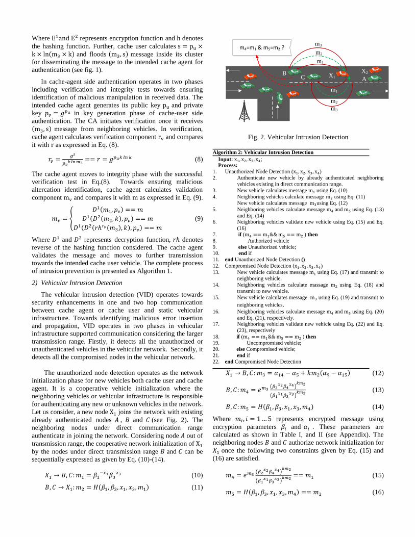
2) Vehicular Intrusion Detection
The vehicular intrusion detection (VID) operates towards
security enhancements in one and two hop communication
between cache agent or cache user and static vehicular
infrastructure. Towards identifying malicious error insertion
and propagation, VID operates in two phases in vehicular
infrastructure supported communication considering the larger
transmission range. Firstly, it detects all the unauthorized or
unauthenticated vehicles in the vehicular network. Secondly, it
detects all the compromised nodes in the vehicular network.
X1B
C
m1
m2
m3m4=m1 & m5=m2 ?
A
X2
m1
m2
m3
Fig. 2. Vehicular Intrusion Detection
Algorithm 2: Vehicular Intrusion Detection
Input: x1, x2, x3, x4; Process:
1. Unauthorized Node Detection (x1, x2, x3, x4)
2. Authenticate new vehicle by already authenticated neighboring
vehicles existing in direct communication range.
3. New vehicle calculates message m1 using Eq. (10)
4. Neighboring vehicles calculate message m2 using Eq. (11)
New vehicle calculates message m3using Eq. (12)
5. Neighboring vehicles calculate message m4 and m5 using Eq. (13)
and Eq. (14) 6. Neighboring vehicles validate new vehicle using Eq. (15) and Eq.
(16)
7. if (m4 == m1&& m5 == m2 ) then
8. Authorized vehicle
9. else Unauthorized vehicle; 10. end if
11. end Unauthorized Node Detection ()
12. Compromised Node Detection (x1, x2, x3, x4)
13. New vehicle calculates message m1 using Eq. (17) and transmit to
neighboring vehicle.
14. Neighboring vehicles calculate massage m2 using Eq. (18) and
transmit to new vehicle.
15. New vehicle calculates message m3 using Eq. (19) and transmit to
neighboring vehicles. 16. Neighboring vehicles calculate message m4 and m5 using Eq. (20)
and Eq. (21), respectively. 17. Neighboring vehicles validate new vehicle using Eq. (22) and Eq.
(23), respectively
18. if (m4 == m1&& m5 == m2 ) then
19. Uncompromised vehicle; 20. else Compromised vehicle;
21. end if
22. end Compromised Node Detection
The unauthorized node detection operates as the network
initialization phase for new vehicles both cache user and cache
agent. It is a cooperative vehicle initialization where the
neighboring vehicles or vehicular infrastructure is responsible
for authenticating any new or unknown vehicles in the network.
Let us consider, a new node X1 joins the network with existing
already authenticated nodes 𝐴 , 𝐵 and 𝐶 (see Fig. 2). The
neighboring nodes under direct communication range
authenticate in joining the network. Considering node 𝐴 out of
transmission range, the cooperative network initialization of X1
by the nodes under direct transmission range 𝐵 and 𝐶 can be
sequentially expressed as given by Eq. (10)-(14).
𝑋1 → 𝐵, 𝐶: 𝑚1 = 𝛽1−𝑥1𝛽3
𝑥3 (10)
𝐵, 𝐶 → 𝑋1: 𝑚2 = 𝐻(𝛽1, 𝛽3, 𝑥1, 𝑥3, 𝑚1) (11)
𝑋1 → 𝐵, 𝐶: 𝑚3 = 𝛼14 − 𝛼5 + 𝑘𝑚2(𝛼9 − 𝛼15) (12)
𝐵, 𝐶: 𝑚4 = 𝑒𝑚3(𝛽2
𝑥2𝛽4𝑥4)
𝑘𝑚2
(𝛽1𝑥1𝛽3
𝑥3)𝑘𝑚2
(13)
𝐵, 𝐶: 𝑚5 = 𝐻(𝛽1, 𝛽3, 𝑥1, 𝑥3, 𝑚4) (14)
Where 𝑚𝑖 , 𝑖 = 1 … 5 represents encrypted message using
encryption parameters 𝛽𝑖 and 𝛼𝑖 . These parameters are
calculated as shown in Table I, and II (see Appendix). The
neighboring nodes 𝐵 and 𝐶 authorize network initialization for
𝑋1 once the following two constraints given by Eq. (15) and
(16) are satisfied.
𝑚4 = 𝑒𝑚3(𝛽2
𝑥2𝛽4𝑥4)
𝑘𝑚2
(𝛽1𝑥1𝛽3
𝑥3)𝑘𝑚2
== 𝑚1 (15)
𝑚5 = 𝐻(𝛽1, 𝛽3, 𝑥1, 𝑥3, 𝑚4) == 𝑚2 (16)

Once the network initialization successfully completes for 𝑋1,
It can further helps in initialization of other new nodes joining
the network such as 𝑋2. As an illustration of VID, suppose 𝐴,
𝐵 and 𝐶 are authenticated nodes, and X1 and X2 are joining
nodes requesting for network initialization (see fig. 2).
Considering node X1 is out of transmission range of 𝐴 but 𝐵, 𝐶
are moving within its transmission range. Similarly, node X2 is
out of transmission range of 𝐵and 𝐶, but 𝐴 and X1 are moving
within its transmission range. Firstly, the node X1 joins the
network initialized by neighbors nodes B, C (node A is out
of X1 ’s transmission range). Secondly, node X2 joins the
network initialized by its neighbors X1 and 𝐴, as 𝐵 and 𝐶 are
out of transmission range of X2.
Node N
(CU or CV
or SV)
End
No
Yes
Yes
Yes
Yes
Yes
No
No
No
No
Start
Is intrusion
detection possible? Apply VIDApply unauthorized node detection of VID,
Calculate m1, m2, m3, m4, m5
If m4==m1&& m5==m2
Unauthorized
node
If m4==m1&& m5==m2
Compromised
node
Connectivity
disrupts
Authorized node, and
Apply compromised node detection,
Calculate m1, m2, m3, m4, m5
Uncompromised node,
Connectivity preserved
Beaconed position information not
changed, Connectivity preserved
If mv == m
If rv == r
Apply integrity phase of cache user
side authentication, Calculate mv
Apply verification phase of
cache agent side
authentication, Calculate rv
Apply VIP
Apply cache
agent side
authentication
Apply cache
user side
authentication
Fig.3. Vehicle Security Architecture of CMGV
The compromised node detection operates while hop-by-
hop data dissemination. It is executed by vehicular
infrastructure considering its vehicle monitoring capability due
to the regularity or availability in the traffic environments. The
detection is based on confidence interval calculation for next
hop node using chi-square function. Considering X1 as
candidate next hop, and 𝐴, 𝐵 as authenticated neighbors, the
detection oriented message communication can be summarized
as given by Eq. (17)-(21).
𝑋1 → 𝐵, 𝐶: 𝑚1 = 𝛽1−𝑥1𝛽3
𝑥3𝑒𝑓(𝑥1,𝑥2) (17)
𝐵, 𝐶 → 𝑋1: 𝑚2 = 𝐻(𝛽1, 𝛽3, 𝑥1, 𝑥3, 𝑚1) (18)
𝑋1 → 𝐵, 𝐶: 𝑚3 = 𝛼14 − 𝛼5 + 𝑘𝑚2(𝛼9 − 𝛼15) + 𝑓(𝑥1, 𝑥2) (19)
𝐵, 𝐶: 𝑚4 = 𝑒𝑚3(𝛽2
𝑥2𝛽4𝑥4)
𝑘𝑚2
(𝛽1𝑥1𝛽3
𝑥3)𝑘𝑚2
(20)
𝐵, 𝐶: 𝑚5 = 𝐻(𝛽1, 𝛽3, 𝑥1, 𝑥3, 𝑚4) (21)
Where 𝛽𝑖 and 𝛼𝑖 represent encryption parameters and Here,
𝑓(𝑥1, 𝑥2) denotes a chi-square distribution function. It is used
to determine the confidence interval of sender node. Towards
negating as a compromised node, the function value is
considered under confidence interval once the constraints given
by Eq. (22) and (23) satisfies.
𝑚4 = 𝑒𝑚3(𝛽2
𝑥2𝛽4𝑥4)
𝑘𝑚2
(𝛽1𝑥1𝛽3
𝑥3)𝑘𝑚2
= 𝛽1−𝑥1𝛽3
𝑥3𝑒𝑓(𝑥1,𝑥2) == 𝑚1 (22)
𝑚5 = 𝐻(𝛽1, 𝛽3, 𝑥1, 𝑥3, 𝑚4) = 𝐻(𝛽1, 𝛽3, 𝑥1, 𝑥3, 𝑚1) == 𝑚2 (23)
The next hop evaluation using confidence interval value
validates a non-compromise node which can be used in data
dissemination. The complete steps vehicular intrusion detection
is presented as algorithm 2. The control flow architecture of
CMGV framework is also presented in fig.3. It consists of VIP
and VID techniques against cyber attacks in connected vehicle
environments. In case of intrusion detection is not possible then,
a VIP technique is applied using two-way authentication at
network initialization stage namely, cache-user side
authentication and cache-agent side authentication. Otherwise,
a VID technique is applied focusing on next hop verification
using unauthorized node detection and compromised node
detection.
IV. SIMULATION RESULTS AND PERFORMANCE ANALYSIS
In this section, simulations carried out to evaluate the
performance of the proposed vehicle cybersecurity framework
for geocasting is discussed focusing on simulation settings,
performance metrics, and comparative analysis.

A. Simulation Settings
The proposed CMGV framework is implemented in a
vehicular traffic embedded and highly sophisticated ad-hoc
network communication testbed, named CA-VANSL (Cache
Agent based Vehicular Ad-hoc Networks Simulation Lab). This
test bed is established in Communication Networks and
Simulation Research Lab, School of Computer and Systems
Sciences (SC&SS), Jawaharlal Nehru University (JNU), New
Delhi, India. This testbed has effectively simulated a number of
our previous research works [15], [16]. CMGV is simulated
using Network Simulator (ns 2.35). Topologically Integrated
Geographic Encoding and Referencing (TIGER) database is
used for street layouts implementation in the proposed protocol
[26]. The US Census Bureau Department for analyzing
geospatial attributes of a region utilizes this database. Traffic
simulator: Simulation for Urban Mobility (SUMO) is used for
analyzing the distribution of vehicular nodes in different photo-
periods [27].
VanetMobiSim, an advanced version of CANU mobility
simulation environment is used for generating realistic mobility
patterns [28]. The main motive for optimal utilization of
VanetMobiSim is due to the availability of both macro and
micro mobility patterns. Intelligent-Driver Model is used for the
management of node’s movement in urban VANETs [29]. The
performance of CMGV is compared with the state of the art
techniques CTRC [13], D-Flooding [30], CAG [15],
respectively. Table II shows the list of parameters used to
configure the simulation scenario. The effectiveness of CMGV
framework is measured using three different types of malicious
vehicles. The type 1 malicious vehicles are prevented to join the
network. The type 2 malicious vehicles are able to penetrate the
secured architecture and are detectable. The type 3 malicious
vehicles neither prevent to join the network nor detectable. The
simulation result for every scenario is obtained by averaging
results of 20 simulation repetitions with different seeds.
Table III. Simulation parameters
Parameter Value Parameter Value
Mobility Model 𝑉𝑎𝑛𝑒𝑡𝑀𝑜𝑏𝑖𝑆𝑖𝑚 MAC protocol 802.11 𝐷𝐶𝐹
Simulation Time 300 𝑠𝑒𝑐 Channel Capacity 4 𝑀𝑏𝑝𝑠
Map Size 1500 𝑋 1500 𝑚2 Traffic Model 16 𝐶𝐵𝑅
No .of Lanes 2 𝑙𝑎𝑛𝑒𝑠/𝑑𝑖𝑟 Traffic light period 50 𝑠𝑒𝑐
No. of vehicles 500 Beaconing interval 0.75𝑠𝑒𝑐
Malicious vehicles 50 Packet senders 20
Velocity 10 − 150𝑘𝑚/ℎr Packet Type 𝑈𝐷𝑃
Size of Buffer 64 𝐾𝐵 Channel Type 𝑊𝑖𝑟𝑒𝑙𝑒𝑠𝑠
Size of Packet 512 𝐵𝑦𝑡𝑒𝑠 Propagation Model 𝑆ℎ𝑎𝑑𝑜𝑤𝑖𝑛𝑔
No. of Intersections 35 Antenna Model 𝑜𝑚𝑛𝑖𝑑𝑖𝑟𝑒𝑐𝑡𝑖𝑜𝑛𝑎𝑙
Transmission Range 500𝑚 𝑡𝑜 1000𝑚 Packet Rate 0.1 𝑡𝑜 1 𝑠𝑒𝑐
B. Analysis of Results
Two scenarios are considered to measure the impact of fixed
and varying number of malicious vehicles on connectivity. Fig.
5 shows the relationship between connectivity probability and
number of CU, CA and SV (fig. 4(a), 4(b), and 4(c))
respectively. As expected, for all the three cases, the
connectivity probability increases as number of vehicles (CU or
CA or SV) increase. The connectivity probability at high
transmission range is higher as compared to the connectivity
probability at low transmission range. CA achieves complete
connectivity with lesser number of vehicles as compared to CU,
since CA has higher transmission range as compared to CU.
Similarly, SV has higher transmission range as compared to
CA/CU, therefore achieves complete connectivity with lower
number of vehicles. The number of vehicles per segment length
to achieve desire level of connectivity can be precisely
expected.
(a)
(b)
(c)
Fig.4. Connectivity Probability (PC) vs Number of
CA, CU and SV
Fig.5 shows the impact of malicious vehicles on the
connectivity in case of CMGV and state-of-the-art techniques.
In this simulation, 200 vehicles are considered. It is clearly
enunciated that connectivity of CMGV steadily decreases as the

number of malicious vehicles increases. But connectivity in
case of CAG, CTRC, and D-Flooding decreases gradually with
lesser number of malicious vehicles, while decreases rapidly
with large number of malicious vehicles. More specifically, for
CMGV, the connectivity probability is in the range of 0.9-1.0,
whereas it is 0.7-0.9, 0.6-0.2 and 0.4-0.02 in case of CAG,
CTRC, and D-Flooding, respectively. This can be attributed to
the fact that, in case of CMGV, VIP identifies the fake-
beaconed position information and resists the intruder to join
the network. If the malicious attacker is able to penetrate the
secured architecture and compromises an insider, then VID
phase is able to detect and block both malicious vehicles.
Fig.5. Connectivity Probability (PC) vs Number of Malicious
Vehicles (𝑁𝑚)
Fig. 6. Packet Delivery Ratio (%) vs Number of CA, CU and
SV (NV) in presence of 20 malicious vehicles
Fig.6 shows the packet delivery ratio with different values
of the number of three types of vehicles NV . It is clearly
enunciated that packet delivery ratio of CMGV, and CAG
steadily increases in commensurate with the increase of number
of vehicles, while for CTRC, and D-Flooding, it remains
constant. More specifically, in case of CMGV, packet delivery
ratio is in the range of 35%-93%, whereas it is 30%-92%, 53%
and 7% in case of CAG, CTRC, and D-Flooding, respectively.
This can be attributed to the fact that, in case of CMGV, VIP
phase identifies the fake beaconed position information and
resists the intruder to join the network. If the malicious attacker
is able to penetrate the secured architecture and compromises
an insider, then VID phase is able to detect and block both
malicious node and compromised node. CTRC has better
packet delivery ratio as compared to D-flooding, due to
utilization of caching methodology in case of unavailability of
suitable nodes. D-flooding does not use caching technique in
case of network fragmentation and has lowest packet delivery
ratio.
Fig. 7: Packet Loss (%) vs. Number of CA, CU and SV (NV)
in presence of 20 malicious vehicles
Fig.7 shows the packet loss with different values of number
of vehicles (NV) . It clearly shows that the packet loss rate
decreases, when number of vehicles increases in case of CMGV
and CAG, and remains constant in case of CTRC, and D-
flooding. In case of CMGV, utilization of VIP and VID helps
in optimization of node selection process and chooses secure
node as data forwarder. This minimizes the probability of
packet loss. CAG utilizes CAA algorithm which reduces one
hop transmission failure rate. The packet loss of CTRC is higher
than CMGV and CAG, and not affected by the increment of NV
due to its non-usability of CAA algorithm, and non-
consideration of off-road vehicles for data forwarding. The
inability of delivering data packets in fragmented vehicular
networks makes the packet loss highest in case of D- Flooding.
In particular, for CMGV, packet loss rate is in the range of 20%-
8%, whereas it is 20%-10%, 43% and 94% in case of CAG,
CTRC and D-Flooding, respectively.
Fig. 8. Network Load (%) vs. Number of CA, CU and
SV (NV) in presence of 20 malicious vehicles

The results in Fig. 8 show the analysis of network load for
data forwarding as a function of number of vehicles(NV). It
clearly shows that network load decreases with the increase of
number of nodes. CMGV never uses flooding mechanism for
data forwarding and chooses suitable NHV filtered by VIP and
VID. It eliminates the probability of packet duplication. Both
CTRC and D-flooding do not use any connectivity assurance
methodology, therefore network load is very heavy initially. In
particular, for CMGV, network load is in the range of 45-5,
whereas it is 50-10, 100-70 and 100-90 in case of CAG, CTRC
and D-Flooding, respectively.
Fig. 9: Hop Count (N) vs. Number of CA, CU and
SV (NV) in presence of 20 malicious vehicles
Fig. 9 shows the variation in hop count with different values
of number of vehicles(NV). It clearly shows that enhancement
in hop count is proportional to the number of vehicles. CMGV
selects appropriate next hop vehicle using VIP and VID
techniques, which reduces the hop count. CAG also shows less
hop counts as it uses CAA algorithm integrated with most
forwarding within radius (MFR). Though CTRC uses MFR
techniques, it has no CAA mechanism, which enhances the one
time transmission failure rate and results into more hop count.
D-Flooding incorporates all vehicular nodes within the
transmission range as suitable next hop vehicle, which results
into the highest hop count. In particular, for CMGV, hop count
is in the range of 2-41, whereas it is 10-50, 30-100 and 60-400
in case of CAG, CTRC and D-Flooding, respectively.
The results in Fig. 10 show the analysis of end-to-end delay
as a function of number of vehicles(NV). It clearly shows that
the end-to-end delay reduces as number of vehicles increases.
More specifically, for CMGV, end-to-end delay is in the range
of 22-3, whereas it is 24-5, 33-25 and 36-21 in case of CAG,
CTRC and D-Flooding respectively. CMGV minimizes the
probability of one-hop connection failure as it uses a reliable
path with the highest connectivity probability. The connectivity
probability is high due to the selection of most trusted next hop
vehicle filtered by VIP and VID phases. CTRC faces the
problem of speed variation (when the intended next hop vehicle
moves out of the transmission range of current forwarder) and
increases the rate of one hop transmission failure. This results
high end-to-end delay. D-flooding uses flooding technique,
which increases the number of collisions.
Fig. 10. End-to-End Delay (s) vs. Number of CA, CU and SV
(NV) in presence of 20 malicious vehicles
Fig. 11: Packet Duplication (N) vs Number of CA, CU
and SV (NV) in presence of 20 malicious vehicles
Fig. 11 shows variation in the packet duplication with the
different values of number of vehicles(NV). It clearly shows
that the packet duplication is proportional to the number of
vehicles. CMGV shows very low packet duplication rate as it
prohibits the formation of duplicate packets by optimizing the
selection of NHV. The malicious attacker is unable to
masquerade the secured network and unable to form duplicate
packets due to screening by VIP and VID phases. More
specifically, for CMGV, packet duplication is in the range of
50-200, whereas it is 50-260, 80-500 and 100-4700 in case of
CAG, CTRC and D-Flooding, respectively. The packet
duplication rate in case of CAG is low due to its unique CA
selection approach. CTRC has higher retransmission rate,
which results into higher packet duplication rate. D-Flooding
has the highest packet duplication rate as it totally depends on
duplicate packets, generated due to flooding for its data
delivery.
V. CONCLUSION AND FUTURE WORK
In this paper, we have proposed a framework of
cybersecurity measures for geocasting in vehicular cyber
physical environment (CMGV). We determine the probability
of connectivity of vehicular nodes for V2V and V2I
communicational patterns. Connectivity oriented security
measures: VIP and VID are developed to protect and defend the

connected vehicles. The simulation results validate that CMGV
outperforms state of the art geocasting approaches in presence
of malicious vehicles. The probability of connectivity rapidly
increases for CMGV in commensurate with the increase of
number of vehicular nodes, transmission range and types of
vehicle. The packet delivery ratio, packet duplication, and hop
count of CMGV increase, whereas packet loss rate, end-to-end
delay and network load decrease in commensurate with the
increase of number of vehicular nodes. In future research,
authors will analyze the impact of traffic signal on connectivity
by securing the traffic system and will investigate the security
aspects by incorporating traffic load with the quality model and
integrate our proposed concept with multilane highways.
APPENDIX-I
At first, the node 𝑋1 sets Yii = 0. Then, it calculates Yij as
follows.
𝑌𝑖𝑗 = 𝑦𝑖 + 𝑦𝑗
𝑌𝑖𝑗 = 𝑙𝑛(𝛽𝑖𝑥𝑖𝛽𝑗
𝑥𝑗)
In this manner, all possible values of Yij are calculated. It is
seen that Yij = Yji . The calculated values of Yij are given in
Table III. The node 𝑋1 calculates α1 as follows.
𝛼1 = 𝑌12 + 𝑌13
= 𝑙𝑛(𝛽1𝑥1𝛽2
𝑥2) + 𝑙𝑛(𝛽1𝑥1𝛽3
𝑥3)
= 𝑙𝑛(𝛽12𝑥1𝛽2
𝑥2𝛽3𝑥3)
In this manner, the node 𝑋1 calculates different possible values
of αi as shown in Table IV.
TABLE I: calculation of 𝑌𝑖𝑗
𝑌𝑖𝑗 1 2 3 4
1 0 ln(𝛽1𝑥1𝛽2
𝑥2) ln(𝛽1𝑥1𝛽3
𝑥3) ln(𝛽1𝑥1𝛽4
𝑥4)
2 ln(𝛽1𝑥1𝛽2
𝑥2) 0 ln(𝛽2𝑥2𝛽3
𝑥3) ln(𝛽2𝑥2𝛽4
𝑥4)
3 ln(𝛽1𝑥1𝛽3
𝑥3) ln(𝛽2𝑥2𝛽3
𝑥3) 0 ln(𝛽3𝑥3𝛽4
𝑥4)
4 ln(𝛽1𝑥1𝛽4
𝑥4) ln(𝛽2𝑥2𝛽4
𝑥4) ln(𝛽3𝑥3𝛽4
𝑥4) 0
TABLE II : Calculation of 𝛼𝑖
𝛼1 = 𝑌12 + 𝑌13
= ln(𝛽12𝑥1𝛽2
𝑥2𝛽3𝑥3)
𝛼2 = 𝑌12 + 𝑌14
= ln(𝛽12𝑥1𝛽2
𝑥2𝛽4𝑥4)
𝛼3 = 𝑌12 + 𝑌23
= ln(𝛽1𝑥1𝛽2
2𝑥2𝛽3𝑥3)
𝛼4 = 𝑌12 + 𝑌24
= ln(𝛽1𝑥1𝛽2
2𝑥2𝛽4𝑥4)
𝛼5 = 𝑌12 + 𝑌34
= ln(𝛽1𝑥1𝛽2
𝑥2𝛽3𝑥3𝛽4
𝑥4) 𝛼6 = 𝑌13 + 𝑌14
= ln(𝛽12𝑥1𝛽3
𝑥3𝛽4𝑥4)
𝛼7 = 𝑌13 + 𝑌23
= ln(𝛽1𝑥1𝛽2
𝑥2𝛽32𝑥3)
𝛼8 = 𝑌13 + 𝑌24
= ln(𝛽1𝑥1𝛽2
𝑥2𝛽3𝑥3𝛽4
𝑥4)
𝛼9 = 𝑌13 + 𝑌34
= ln(𝛽1𝑥1𝛽3
2𝑥3𝛽4𝑥4)
𝛼10 = 𝑌14 + 𝑌23
= ln(𝛽1𝑥1𝛽2
𝑥2𝛽3𝑥3𝛽4
𝑥4)
𝛼11 = 𝑌14 + 𝑌24
= ln(𝛽1𝑥1𝛽2
𝑥2𝛽42𝑥4)
𝛼12 = 𝑌14 + 𝑌34
= ln(𝛽1𝑥1𝛽3
𝑥3𝛽42𝑥4)
𝛼13 = 𝑌23 + 𝑌24
= ln(𝛽22𝑥2𝛽3
𝑥3𝛽4𝑥4)
𝛼14 = 𝑌23 + 𝑌34
= ln(𝛽2𝑥2𝛽3
2𝑥3𝛽4𝑥4)
𝛼15 = 𝑌24 + 𝑌34
= ln(𝛽2𝑥2𝛽3
𝑥3𝛽42𝑥4)
REFERENCES
[1] Armstrong, L.; Fisher, W. IEEE 802.11P Wireless Access for Vehicular
Environment, Drafts Standard. Available online:
http://grouper.ieee.org/groups/802/11/
[2] O. Kaiwartya et al., "Internet of Vehicles: Motivation, Layered Architecture, Network Model, Challenges, and Future Aspects," in IEEE
Access, vol. 4,pp. 5356-5373, 2016.
[3] S. Al-Sultan, M. Al-Doori, A. H. Al-Bayatti, & H. Zedan, “A comprehensive survey on vehicular Ad Hoc network” Journal of Network
and Computer Applications, Elsevier, 37(1), pp. 380-392, 2014.
[4] Schoitsch E., Schmittner C., Ma Z., Gruber T. (2016) The Need for Safety and Cyber-Security Co-engineering and Standardization for Highly
Automated Automotive Vehicles. In: Schulze T., Müller B., Meyer G.
(eds) Advanced Microsystems for Automotive Applications 2016. Lecture Notes in Mobility. Springer, Cham
[5] P. Papadimitratos et al., "Secure vehicular communication systems:
design and architecture," in IEEE Communications Magazine, vol. 46, no. 11, pp. 100-109, November 2008.
[6] Levent Ertaul, Sridevi Mullapudi, “The Security Problems of Vehicular
Ad Hoc Networks (VANETs) and Proposed Solutions in Securing their Operations.” ICWN, pp. 3-9, 2009
[7] Kaiwartya, O. & Kumar, S. Wireless Pers Commun (2015) 83: 2657.
https://doi.org/10.1007/s11277-015-2562-4. [8] Kaiwartya, O.; Kumar, S.; Lobiyal, D.K.; Abdullah, A.H.; Hassan, A.N.
Performance Improvement in Geographic Routing for Vehicular Ad Hoc Networks. Sensors 2014, 14, 22342-22371.
[9] Cao, Y., Han, C., Zhang, X., Kaiwartya, O., Zhuang, Y., Aslam, N. and
Dianati, M., 2018. A Trajectory-Driven Opportunistic Routing Protocol for VCPS. IEEE Transactions on Aerospace and Electronic Systems.
[10] Grover, J., Laxmi, V. and Gaur, M.S., 2013. Attack models and
infrastructure supported detection mechanisms for position forging attacks in vehicular ad hoc networks. CSI transactions on ICT, 1(3),
pp.261-279.
[11] Monteiro, M.E.P., Rebelatto, J.L. and Souza, R.D., 2016. Information-theoretic location verification system with directional antennas for
vehicular networks. IEEE Transactions on Intelligent Transportation
Systems, 17(1), pp.93-103. [12] Sheet, D.K., Kaiwartya, O., Abdullah, A.H., Cao, Y., Hassan, A.N. and
Kumar, S., 2016. Location information verification using transferable
belief model for geographic routing in vehicular ad hoc networks. IET Intelligent Transport Systems, 11(2), pp.53-60.
[13] Maihofer, C. and Eberhardt, R. (2004) ‘Geocast in vehicular
environments: caching and transmission range control for improved efficiency (CTRC)’, Intelligent Vehicles Symposium, IEEE, pp.951–956.
[14] Hassan, A.N., Abdullah, A.H., Kaiwartya, O. et al. Wireless Netw (2017).
https://doi.org/10.1007/s11276-017-1502-5. [15] Kaiwartya, Omprakash, and Sushil Kumar. "Cache agent-based
geocasting in VANETs." International Journal of Information and
Communication Technology 7.6 (2015): 562-584. [16] R. Kasana et al., "Fuzzy based Channel Selection for Location Oriented
Services in Multichannel VCPS Environments," in IEEE Internet of
Things Journal. doi: 10.1109/JIOT.2018.2796639. [17] Qing Yang, Alvin Lim, Shuang Li, Jian Fang and Prathima Agrawal,
“ACAR: Adaptive Connectivity Aware Routing for Vehicular Ad Hoc
Networks in City Scenarios,”Mobile Networks and Applications, Volume-15, pp: 36-60,2010..
[18] R. Kasana, S. Kumar, O. Kaiwartya, W. Yan, Y. Cao and A. H. Abdullah,
"Location error resilient geographical routing for vehicular ad-hoc networks," in IET Intelligent Transport Systems, vol. 11, no. 8, pp. 450-
458, 10 2017.
[19] K. Rabieh, M. M. E. A. Mahmoud and M. Younis, "Privacy-Preserving Route Reporting Schemes for Traffic Management Systems," in IEEE
Transactions on Vehicular Technology, vol. 66, no. 3, pp. 2703-2713,
March 2017. [20] S. Yan, R. Malaney, I. Nevat and G. W. Peters, "Optimal Information-
Theoretic Wireless Location Verification," in IEEE Transactions on
Vehicular Technology, vol. 63, no. 7, pp. 3410-3422, Sept. 2014. [21] O. Abumansoor and A. Boukerche, "A Secure Cooperative Approach for
Nonline-of-Sight Location Verification in VANET," in IEEE
Transactions on Vehicular Technology, vol. 61, no. 1, pp. 275-285, Jan. 2012.
[22] M. Fogue et al., "Securing Warning Message Dissemination in VANETs
Using Cooperative Neighbor Position Verification," in IEEE Transactions on Vehicular Technology, vol. 64, no. 6, pp. 2538-2550,

June 2015.
[23] D. Ma, G. Tsudik, “Security and Privacy in Emerging Wireless
Networks”, IEEE Wireless Communications, Vol 17, Issue 5, pages 12-
21, 2010 [24] J. Kong et al., Adaptive security for multi-layer ad-hoc networks, Special
Issue of Wireless Communications and Mobile Computing, John Wiley
InterScience Press, 2002; 2:533–547. [25] Baber Aslam, Soyoung Park, Cliff C. Zou,, Damla Turgut, “Secure traffic
data propagation in Vehicular Ad Hoc Networks” International Journal of
Ad Hoc and Ubiquitous Computing, Vol. 6, no. 1, pp. 24-39, 2010. [26] J Sperling, Development and maintenance of the TIGER database:
experiences in spatial data sharing at the US Bureau of the Census, in
Proceedings of the Sharing Geographic Information (Centre for Urban Policy Research, New Brunseick, 1995), pp. 377-396
[27] Michael Behrisch, Laura Bieker, Jakob Erdmann, Daniel Krajzewicz,
“SUMO – Simulation of Urban Mobility”, in Proceedings of the 3rd International Conference on Advances in System Simulation (SIMUL
2011).
[28] J Harri, F Filali, C Bonnet, M Fiore, VanetMobiSim: generating realistic mobility patterns for VANETs, in Proceedings of the 3rd international
workshop on Vehicular adhoc networks, VANET’06 (ACM, New York,
NY, USA, 2006), pp. 96-97. [29] D Tian, K Shafiee, VCM Leung, Position-based directional vehicular
routing, in Proceeding of the Global Telecommunications Conference,
GLOBECOM (IEEE, Hoboken, 2009), pp. 1-6. [30] Sangho, O., Jaewon, K. and Gruteser, M. (2006) ‘Location-based flooding
techniques for Vehicular emergency messaging (D-Flooding)’, Mobile and Ubiquitous Systems: Networking &
Services, Third Annual International Conference on, pp.1–9, Springer.