
KULLEĠĠ SAN · PDF fileKulleġġ San Benedittu Secondary School Kirkop Level 5 - 8 Page 8...
13
Mark KULLEĠĠ SAN BENEDITTU Secondary School, Kirkop HALF YEARLY EXAMINATION – 2014/2015 Level 5 - 8 Form 4 Geography TIME: 1h 30min Question 1 2 3 4 5 6 Global Mark Max. Mark 10 28 24 18 10 10 100 Mark Instructions to students: Answer questions according to instructions in each section. Calculators are allowed; Good English and orderly presentation are important. You will not be penalised for English language mistakes. Read each question carefully. DO NOT WRITE ABOVE THIS LINE Name: _______________________________ Class: ___________ Section 1. Answer all questions. Question 1: Mapping The map below shows the area of Stonehenge, a famous temple, in England. The map has a scale of 1:25,000. 1a) How would you describe the landscape around Stonehenge today? (2 marks) ___________________________________________________________________________ ___________________________________________________________________________ ___________________________________________________________________________ 1b) Which is the highest point indicated in the map. (1 mark) __________________________________________________________________________ 1c) Give the 4-figure grid reference of the following points on the map (2 marks) The Park ______________________
Transcript of KULLEĠĠ SAN · PDF fileKulleġġ San Benedittu Secondary School Kirkop Level 5 - 8 Page 8...

Mark KULLEĠĠ SAN BENEDITTU Secondary School, Kirkop
HALF YEARLY EXAMINATION – 2014/2015
Level 5 - 8
Form 4 Geography TIME: 1h 30min
Question 1 2 3 4 5 6 Global Mark
Max. Mark 10 28 24 18 10 10 100
Mark
Instructions to students:
Answer questions according to instructions in each section.
Calculators are allowed; Good English and orderly presentation are important. You will
not be penalised for English language mistakes.
Read each question carefully.
DO NOT WRITE ABOVE THIS LINE
Name: _______________________________ Class: ___________
Section 1. Answer all questions.
Question 1: Mapping
The map below shows the area of Stonehenge, a famous temple, in England. The map has a
scale of 1:25,000.
1a) How would you describe the landscape around Stonehenge today? (2 marks)
___________________________________________________________________________
___________________________________________________________________________
___________________________________________________________________________
1b) Which is the highest point indicated in the map. (1 mark)
__________________________________________________________________________
1c) Give the 4-figure grid reference of the following points on the map (2 marks)
The Park ______________________

Halfmoon Clump ___________________
Wilsford _________________________
Coneybury Hill ____________________
1d) Give the 6-figure grid reference to the following points on the map (2 marks)
Stonehenge Cottages _________________________
New Barn __________________________________
Springbottom Farm __________________________
Memorial _________________________________
1e) What is the distance between Stonehenge Bottom and Long Barrow Crossroads, in Kms.
__________________________________________________________________________
(3 marks)

Kulleġġ San Benedittu Secondary School Kirkop Level 5 - 8 Page 3 of 13
Sca
le 1
: 25,0
00

Kulleġġ San Benedittu Secondary School Kirkop Level 5 - 8 Page 4 of 13

Kulleġġ San Benedittu Secondary School Kirkop Level 5 - 8 Page 5 of 13
2) Question 2 – The Hydrologic Cycle and Rivers
a) Fill in Figure 1 using the appropriate terms. (8 marks)
Figure 1: The Hydrological Cycle
2b) Define the following terms. (1mark each x 6 = 6 marks)
Stemflow -
__________________________________________________________________________
__________________________________________________________________________
__________________________________________________________________________
Infiltration -
__________________________________________________________________________
__________________________________________________________________________
__________________________________________________________________________
Soil moisture storage -
__________________________________________________________________________
__________________________________________________________________________
__________________________________________________________________________

Kulleġġ San Benedittu Secondary School Kirkop Level 5 - 8 Page 6 of 13
Ground water flow -
__________________________________________________________________________
__________________________________________________________________________
__________________________________________________________________________
Percolation -
__________________________________________________________________________
__________________________________________________________________________
__________________________________________________________________________
Throughflow -
__________________________________________________________________________
__________________________________________________________________________
__________________________________________________________________________
2c) What is the difference between Evaporation and Transpiration? (1 mark)
__________________________________________________________________________
__________________________________________________________________________
__________________________________________________________________________
d) What is the drainage basin of a river? (1 mark)
__________________________________________________________________________
__________________________________________________________________________
__________________________________________________________________________
e) Using examples, describe how the balance between transfers and stores in the
hydrological cycle can be affected by humans. (4 marks)
__________________________________________________________________________
__________________________________________________________________________

Kulleġġ San Benedittu Secondary School Kirkop Level 5 - 8 Page 7 of 13
__________________________________________________________________________
__________________________________________________________________________
__________________________________________________________________________
__________________________________________________________________________
__________________________________________________________________________
f) Outline one advantage of large scale water management systems (like dams). (2 marks)
__________________________________________________________________________
__________________________________________________________________________
__________________________________________________________________________
g) Figure 2 below shows a flood hydrograph. Answer the following questions about the
hydrograph.
Figure 2: Flood Hyrdrograph
i. At what time was peak rainfall? (1 mark)
______________________________________________________________________
ii. How much time did it pass between peak rainfall and peak discharge? (1 mark)
______________________________________________________________________

Kulleġġ San Benedittu Secondary School Kirkop Level 5 - 8 Page 8 of 13
iii. Would you consider this river as one which easily causes flooding or not? Give a reason
for your answer. (2 marks)
___________________________________________________________________________
___________________________________________________________________________
___________________________________________________________________________
___________________________________________________________________________
iv. Explain the formation of a waterfall using clearly labeled diagrams. (5 marks)
v. With the use of diagrams in the space below, explain how a meander changes shape, and
the formation of ox-bow lakes (5 marks)
Kulleġġ San Benedittu Secondary School Kirkop Level 5 - 8 Page 9 of 13
Question 3: - Plate Tectonics.
a) Explain the difference between oceanic plates and continental plates (2 marks)
___________________________________________________________________________
___________________________________________________________________________
___________________________________________________________________________
b) What happens at constructive plate boundaries? Name one example of a constructive
plate boundary. (3 marks)
___________________________________________________________________________
___________________________________________________________________________
___________________________________________________________________________
c) What happens at conservative plate boundaries? Name one example of a conservative
plate boundary. (3 marks)
___________________________________________________________________________
___________________________________________________________________________
___________________________________________________________________________
d) Explain why earthquakes happen at plate margins. (2 marks)
________________________________________________________________________________
________________________________________________________________________________
________________________________________________________________________________
e) Using examples you have studied, explain why more deaths due to earthquakes happen in
the Less Economically Developed Countries than in the More Economically Developed
Countries. Give at least 3 reasons. (6 marks)
________________________________________________________________________________
________________________________________________________________________________

Kulleġġ San Benedittu Secondary School Kirkop Level 5 - 8 Page 10 of 13
________________________________________________________________________________
________________________________________________________________________________
________________________________________________________________________________
________________________________________________________________________________
________________________________________________________________________________
_______________________________________________________________________________
f) State 3 (three) primary effects of earthquakes. (3 marks)
________________________________________________________________________________
________________________________________________________________________________
________________________________________________________________________________
g) What is the difference between an Active and a Dormant Volcano? (2 marks)
________________________________________________________________________________
________________________________________________________________________________
________________________________________________________________________________
________________________________________________________________________________
h) Why do people choose to live near an active volcano? (3 marks)
________________________________________________________________________________
________________________________________________________________________________
________________________________________________________________________________
________________________________________________________________________________
________________________________________________________________________________
Kulleġġ San Benedittu Secondary School Kirkop Level 5 - 8 Page 11 of 13
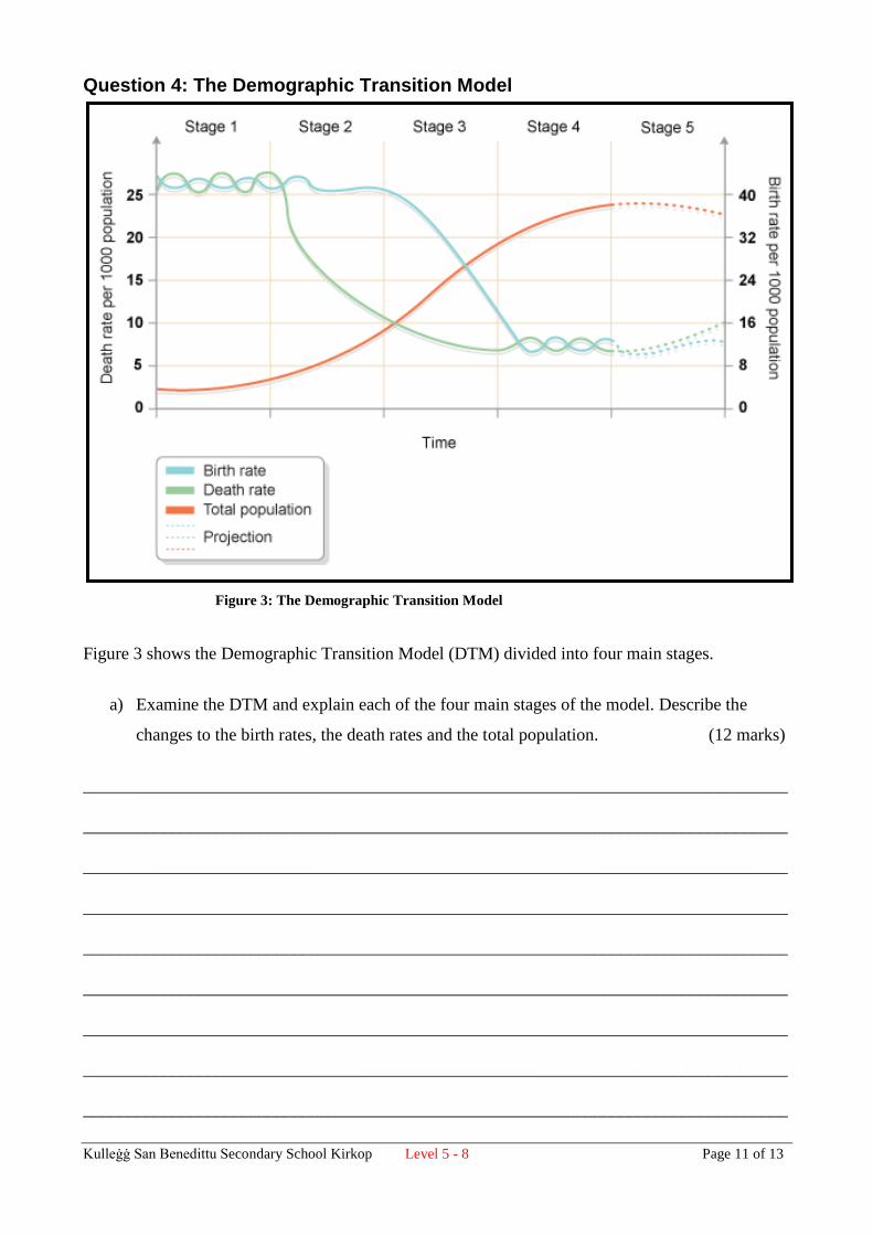
Question 4: The Demographic Transition Model
Figure 3 shows the Demographic Transition Model (DTM) divided into four main stages.
a) Examine the DTM and explain each of the four main stages of the model. Describe the
changes to the birth rates, the death rates and the total population. (12 marks)
________________________________________________________________________________
________________________________________________________________________________
________________________________________________________________________________
________________________________________________________________________________
________________________________________________________________________________
________________________________________________________________________________
________________________________________________________________________________
________________________________________________________________________________
________________________________________________________________________________
Figure 3: The Demographic Transition Model

Kulleġġ San Benedittu Secondary School Kirkop Level 5 - 8 Page 12 of 13
________________________________________________________________________________
________________________________________________________________________________
________________________________________________________________________________
________________________________________________________________________________
________________________________________________________________________________
________________________________________________________________________________
________________________________________________________________________________
________________________________________________________________________________
________________________________________________________________________________
b) Mention a country which is going through Stage 5. _____________________ (1 mark)
c) In which stage of the DTM would you put each of these countries?
i) Kenya ______________________________________
ii) Bangladesh ______________________________________
iii) Malta ______________________________________ (3 marks)
e) Explain what is happening at Stage 5 as shown in figure 1. (4 marks)
________________________________________________________________________________
________________________________________________________________________________
________________________________________________________________________________
________________________________________________________________________________
________________________________________________________________________________
________________________________________________________________________________

Kulleġġ San Benedittu Secondary School Kirkop Level 5 - 8 Page 13 of 13
Section 2 – Essay Type questions (30 marks)
Choose only two of the following titles. Write a short essay on each question.
Each question carries 10 marks. Answer on a separate sheet of paper.
1) Explain how and why flooding affects badly Bangladesh. Explain the causes and the effects
of flooding on developing countries. (10 marks)
2) Explain the benefits and problems of living in tectonically active regions. Focus especially
on areas in the Mediterranean. (10 marks)
3) Using case studies, discuss the problems encountered by people in areas which flood
continually. How does this affect the country economically? (10 marks)
4) Explain how pollution affects river basins. Describe at least 5 (five) causes of pollution in
rivers. (10 marks)
END OF EXAM


