KSC Plan of Management for Community Land - July 2017 · PDF file3.2 General objectives ......
42
APPENDIX H
Transcript of KSC Plan of Management for Community Land - July 2017 · PDF file3.2 General objectives ......

APPENDIX H
Page 2 of 42
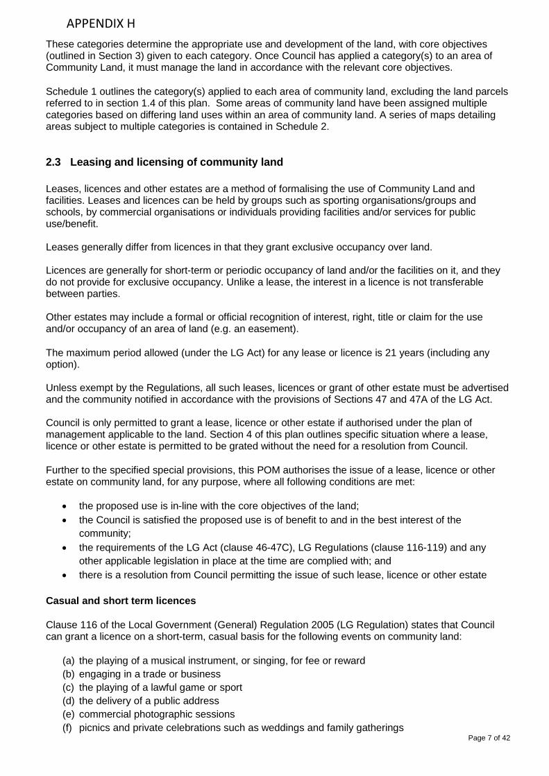
DOCUMENT MANAGEMENT
Title
Plan of Management for Community Land 2017 Revision history
Version
Prepared by
Reviewed by 1.1 – July 2017
Momentum Project Solutions
Robert Scott Exhibited
6 October 2017 to 16 November 2017 Adopted
APPENDIX H

Page 3 of 42
TABLE OF CONTENTS
1. INTRODUCTION .................................................................................................................... 41.1 What is a plan of management? .................................................................................. 4 1.2 What is community land? ............................................................................................ 4 1.3 Land covered by this plan ............................................................................................ 4 1.4 Relationship to other plans of management ............................................................... 5 1.5 Structure of this plan of management .......................................................................... 5
2. LEGISLATIVE FRAMEWORK .............................................................................................. 6 2.1 Local Government Act 1993........................................................................................... 6 2.2 Community land categories ........................................................................................... 6 2.3 Leasing and licensing of community land .................................................................. 7 2.4 Regulatory controls over community land ................................................................. 8 2.5 Development consent requirements ........................................................................... 9 2.6 Other statutory provisions ............................................................................................. 9
3. GENERAL PROVISIONS .................................................................................................... 10 3.1 Application of general and specific provisions .......................................................... 10 3.2 General objectives ....................................................................................................... 10 3.3 Core objectives ............................................................................................................. 10 3.3.1 Land categorised as a natural area .......................................................................... 10 3.3.3 Land sub-categorised as bushland .......................................................................... 11 3.3.3 Land sub-categorised as wetland ............................................................................. 11 3.3.4 Land sub-categorised as an escarpment ................................................................. 11 3.3.5 Land sub-categorised as a watercourse .................................................................. 11 3.3.6 Land sub-categorised as foreshore .......................................................................... 12 3.3.7 Land categorised as a sportsground ....................................................................... 12 3.3.8 Land categorised as a park ....................................................................................... 12 3.3.9 Land categorised as an area of cultural significance.............................................. 12 3.3.10 Land categorised as general community use ........................................................ 13
4. SPECIAL PROVISIONS ...................................................................................................... 14 4.1 Introduction .................................................................................................................. 14 4.2 Table of special provisions .......................................................................................... 15
5. PERFORMANCE AND ASSESSMENT ............................................................................... 19 SCHEDULE 1 – REGISTER OF COMMUNITY LAND PARCELS ........................................... 25 SCHEDULE 2 — MULTI-CATEGORY LAND MAPS ............................................................... 37
APPENDIX H

Page 4 of 42
1.1 What is a plan of management? A plan of management (POM) provides a framework for the management and development of public land. It establishes directions for planning, resource management and maintenance. The Local Government Act 1993 (LG Act) requires Council to have a POM in place for all public land that is classified ‘community land’. This is to ensure that the operation and development of these community resources is guided by a framework that is considered by the community and formally adopted by the Council. All land included in this generic plan of management is community land.
1.2 What is community land? The LG Act defines that all land in the ownership of Council is classified as either ‘community’ or ‘operational’. The default classification is ‘community’. The ‘community’ and ‘operational’ and classifications are not specifically defined in the LG Act. However, for the purposes this POM, the following general definitions apply:
• Community land is characterised as being land that:
(a) is retained for community use; (b) cannot be sold (except under limited circumstances outlined in section 45(4) of the LG Act); (c) cannot be leased/licenced for more than 21 years (section 46(3) of the LG Act); (d) cannot be leased for more than 5 years unless public notice is given (sections 47 & 47A of
the LG Act) (e) can only be used for purposes which are consistent with a POM (section 35 of the LG Act).
• Operational land is owned by Council and classified as such in accordance with the
requirements of the LG Act. Land classified as operational land is usually not intended for use by the general public. It may include land held by Council as a temporary asset or as an investment, land that facilitates the carrying out by Council of its functions or land that may not be open to the general public. Council is able to deal with such land without restrictions under the LG Act. That is, Council may deal with operational land in the same manner as any other person may deal with private freehold land.
1.3 Land covered by this plan There are approximately 116.7 hectares of community land in the Kempsey Shire. This POM covers all community land at the time of adoption as listed in Schedule 1 (excluding those referred to in section 1.4 of this plan). The provisions of this plan do not apply to:
• operational land • Crown land (managed by Council or devolved to Council) • land leased by Council.
APPENDIX H

Page 5 of 42
1.4 Relationship to other plans of management This POM contains the general management provisions applicable to all community land in the Kempsey Shire, excluding the land parcels listed in the table below. These land parcels are managed in accordance with a site-specific POM - Mattys Flat and New Entrance Plan of Management, Issue No. 2 January 2006 (revised August 2010).
Land Parcel ID (LA) Land Description Address Locality Lot DP
3940 Mattys Flat Park New Entrance Road South West Rocks 849 777322
3945 Mattys Flat Wetlands New Entrance Road South West Rocks 85 263591
The provisions of this POM will not apply to any community land where a site-specific POM is made and adopted by Council after the commencement of this plan.
1.5 Structure of this plan of management
1. Introduction This section contains introductory and explanatory information to assist in the application and interpretation of the plan.
2. Legislative framework This section details the relevant legislative requirements that regulate and control the use of community land.
3. General provisions The general provisions detailed in this section of the plan apply to all areas of community land. The general provisions provide the primary land management principles for each category of community land.
4. Special provisions The special provisions detail management provisions applicable to specific community land parcels and apply in addition to the general provisions.
5. Performance targets and assessment This section contains the performance targets, actions for implementation and assessment measures that will be used by Council in the management of community land.
Schedule 1 - Register of community land parcels Schedule 1 details all the land parcels of community land managed by Council at the time of adoption of this plan. It also details the relevant category applied to the land, which is used to determine which general management provisions apply.
Schedule 2 - Multi category land maps Schedule 2 contains a set of maps detailing several areas of community land containing more than one category. These maps are provided to assist in the identification of applicable land management provisions for these sites.
APPENDIX H

Page 6 of 42
2.1 Local Government Act 1993 It is a requirement of the LG Act that community land be used and managed in accordance with:
• the plan of management applying to the land • any law permitting the use of the land for a specified purpose or otherwise regulating the use of
the land • Part 2, Division 2 of the LG Act
Council’s must have an adopted POM for all community land, which identifies, at a minimum, the following:
• the category of the land
• the objectives and performance targets of the plan with respect to the land
• the means by which Council proposes to achieve the plan’s objectives and performance targets
• the manner in which Council proposes to assess its performance with respect to the plan's objectives and performance targets
A site specific POM is required where Council resolves that a community land site is either of the following:
• Land declared to be critical habitat under the Threatened Species Conservation Act 1995 (section 36A)
• Land directly affected by a recovery plan or a threat abatement plan (section 36B(2))
• Known natural, geological, geomorphological, scenic or other features that Council considers warrant protection or special management or a wildlife corridor (section 36C)
• Land that is categorised as “an area of cultural significance” (section 36D(2)) As at the date of this plan of management there is no land in Kempsey Shire directly affected by any of the above circumstances. This POM for community land satisfies the requirements of the LG Act.
2.2 Community land categories The LG Act requires that community land is categorised based on its predominant use, as one (or more) of the following:
• Natural area, then further categorised as: - bushland - wetland - escarpment - watercourse - foreshore
• Sportsground • Park • Area of Cultural Significance • General Community Use
APPENDIX H
Page 7 of 42
These categories determine the appropriate use and development of the land, with core objectives (outlined in Section 3) given to each category. Once Council has applied a category(s) to an area of Community Land, it must manage the land in accordance with the relevant core objectives. Schedule 1 outlines the category(s) applied to each area of community land, excluding the land parcels referred to in section 1.4 of this plan. Some areas of community land have been assigned multiple categories based on differing land uses within an area of community land. A series of maps detailing areas subject to multiple categories is contained in Schedule 2.
2.3 Leasing and licensing of community land Leases, licences and other estates are a method of formalising the use of Community Land and facilities. Leases and licences can be held by groups such as sporting organisations/groups and schools, by commercial organisations or individuals providing facilities and/or services for public use/benefit. Leases generally differ from licences in that they grant exclusive occupancy over land. Licences are generally for short-term or periodic occupancy of land and/or the facilities on it, and they do not provide for exclusive occupancy. Unlike a lease, the interest in a licence is not transferable between parties. Other estates may include a formal or official recognition of interest, right, title or claim for the use and/or occupancy of an area of land (e.g. an easement). The maximum period allowed (under the LG Act) for any lease or licence is 21 years (including any option). Unless exempt by the Regulations, all such leases, licences or grant of other estate must be advertised and the community notified in accordance with the provisions of Sections 47 and 47A of the LG Act. Council is only permitted to grant a lease, licence or other estate if authorised under the plan of management applicable to the land. Section 4 of this plan outlines specific situation where a lease, licence or other estate is permitted to be grated without the need for a resolution from Council. Further to the specified special provisions, this POM authorises the issue of a lease, licence or other estate on community land, for any purpose, where all following conditions are met:
• the proposed use is in-line with the core objectives of the land; • the Council is satisfied the proposed use is of benefit to and in the best interest of the
community; • the requirements of the LG Act (clause 46-47C), LG Regulations (clause 116-119) and any
other applicable legislation in place at the time are complied with; and • there is a resolution from Council permitting the issue of such lease, licence or other estate
Casual and short term licences Clause 116 of the Local Government (General) Regulation 2005 (LG Regulation) states that Council can grant a licence on a short-term, casual basis for the following events on community land:
(a) the playing of a musical instrument, or singing, for fee or reward (b) engaging in a trade or business (c) the playing of a lawful game or sport (d) the delivery of a public address (e) commercial photographic sessions (f) picnics and private celebrations such as weddings and family gatherings
APPENDIX H

Page 8 of 42
(g) filming sessions (h) the agistment of stock.
The use or occupation of community land for these purposes is allowed only if the use or occupation does not involve the erection of any building or structure of a permanent nature. Clause 116 of the LG Regulation also specifies the following as being appropriate short-term, casual purposes:
• the use of any existing road or fire trail on community land to transport building materials and equipment required in relation to building work that is to be, or is being, carried out on land adjoining the community land, or to remove waste that is consequential on such work
• the use of any community land that does not have an existing road or fire trail to transport building materials and equipment required in relation to building work that is to be, or is being, carried out on land adjoining the community land, or to remove waste that is consequential on such work, if such work is for the physical, cultural, social and intellectual welfare or development of persons.
Fees may apply for some casual and short term licences. Activities Approvals Section 68 of the LG Act requires that a person obtain prior approval form Council to carry out the following activities on community land:
(a) engaging in a trade or business (b) directing or procuring a theatrical, musical or other entertainment for the public (c) construction of a temporary enclosure for the purpose of entertainment (d) for fee or reward, playing a musical instrument or singing (e) setting up, operating or using a loudspeaker or sound amplifying device (f) delivering a public address or holding a religious service or public meeting
Council has a number of procedures identified in the Lands under Kempsey Shire Council Jurisdiction Policy. These procedures outline the guidelines for undertaking use of public land and must be complied with. Fees may also apply for use of community land for these activities.
2.4 Regulatory controls over community land Community land is defined as a public place under the provisions of the LG Act. Legislative provisions give Council the authority to regulate activities and behaviour in public places, confiscate or impound equipment and issue penalties. The LG Act (section 632) states that a person is guilty of an offence in a public place if they fail to comply with the terms of a notice that may relate to any of the following:
(a) the payment of a fee for entry to or the use of the place (b) the use of a vehicle in the place (c) the taking of any animal or thing into the place (d) the use of any animal or thing in the place (e) the doing of anything in the place (f) the use of the land or any part of the place.
APPENDIX H

Page 9 of 42
2.5 Development consent requirements The use of community land is subject to the regulatory provisions of the Environmental Planning and Assessment Act 1979 and any relevant environmental planning instruments and planning policies that may apply to the land. Any land use or development on community land must be permissible on the land as development permitted with or without consent, complying development or exempt development.
2.6 Other statutory provisions Other relevant legislation, plans and policies that guide the management of community land identified in this POM include, but is not limited to:
• The Local Government (General) Regulation 2005 • Environmental Planning and Assessment Act 1979, including State Environmental Planning
Policies and Regional Planning Policies • Kempsey Local Environmental Plan 2013 • Kempsey Development Control Plan 2013 • Native Vegetation Act 2003 • Noxious Weeds Act 1993 • Rural Fires Act 1997 • National Parks and Wildlife Act 1974 • Federal Environment Protection and Biodiversity Conservation Act 1999 • Threatened Species Conservation Act 1995 • Fisheries Management Act 1994 • Water Management Act 2000 • Protection of the Environment Operations Act 1997 • Soil Conservation Act 1938 • Companion Animals Act 1999
APPENDIX H

Page 10 of 42
3.1 Application of general and specific provisions The general provisions in this section are applicable to all parcels of community land listed in Schedule 1 (excluding those referred to in section 1.4 of this plan). Section 4 outlines the specific provisions that apply to certain sites in addition to the general provisions.
3.2 General objectives The general objectives for the management of community land are:
(a) provide a framework that has general public acceptance for the future development and management of the land
(b) provide facilities for the social, cultural, educational and recreational needs of the Kempsey Shire
(c) categorise community land based on the predominant and expected use of the land, in accordance with the requirements of the LG Act
(d) manage the use of community land to ensure it is consistent with the specified core objectives applicable to each community land category
(e) enable, where appropriate, commercial activities on community land where these activities are consistent with applicable management provisions and statutory requirements
(f) provide appropriate maintenance and embellishment of community land within Council’s budgetary constraints and community expectations.
3.3 Core objectives The core objectives as specified in the LG Act for the management of community land are as follows:
3.3.1 Land categorised as a natural area The core objectives for management of community land categorised as a natural area are to:
(a) conserve biodiversity and maintain ecosystem function in respect of the land, or the feature or habitat in respect of which the land is categorised as a natural area
(b) maintain the land, or that feature or habitat, in its natural state and setting
(c) provide for the restoration and regeneration of the land
(d) provide for community use of and access to the land in such a manner as will minimise and mitigate any disturbance caused by human intrusion
(e) assist in and facilitate the implementation of any provisions restricting the use and management of the land that are set out in a recovery plan or threat abatement plan prepared under the Threatened Species Conservation Act 1995 or the Fisheries Management Act 1994.
APPENDIX H

Page 11 of 42
3.3.3 Land sub-categorised as bushland The core objectives for management of community land categorised as bushland are to:
(a) ensure the ongoing ecological viability of the land by protecting the ecological biodiversity and habitat values of the land, the flora and fauna (including invertebrates, fungi and micro-organisms) of the land and other ecological values of the land
(b) protect the aesthetic, heritage, recreational, educational and scientific values of the land
(c) promote the management of the land in a manner that protects and enhances the values and quality of the land and facilitates public enjoyment of the land, and to implement measures directed to minimising or mitigating any disturbance caused by human intrusion
(d) restore degraded bushland
(e) protect existing landforms such as natural drainage lines, watercourses and foreshores
(f) retain bushland in parcels of a size and configuration that will enable the existing plant and animal communities to survive in the long term
(g) protect bushland as a natural stabiliser of the soil surface.
3.3.3 Land sub-categorised as wetland The core objectives for management of community land categorised as wetland are to:
(a) protect the biodiversity and ecological values of wetlands, with particular reference to their hydrological environment (including water quality and water flow), and to the flora, fauna and habitat values of the wetlands
(b) restore and regenerate degraded wetlands
(c) facilitate community education in relation to wetlands, and the community use of wetlands, without compromising the ecological values of wetlands.
3.3.4 Land sub-categorised as an escarpment The core objectives for management of community land categorised as an escarpment are to:
(a) protect any important geological, geomorphological or scenic features of the escarpment
(b) facilitate safe community use and enjoyment of the escarpment.
3.3.5 Land sub-categorised as a watercourse The core objectives for management of community land categorised as a watercourse are to:
(a) manage watercourses so as to protect the biodiversity and ecological values of the instream environment, particularly in relation to water quality and water flows
(b) manage watercourses so as to protect the riparian environment, particularly in relation to riparian vegetation and habitats and bank stability
(c) restore degraded watercourses
APPENDIX H

Page 12 of 42
(d) promote community education and community access to and use of the watercourse, without
compromising the other core objectives of the category.
3.3.6 Land sub-categorised as foreshore The core objectives for management of community land categorised as foreshore are to:
(a) maintain the foreshore as a transition area between the aquatic and the terrestrial environment, and to protect and enhance all functions associated with the foreshore’s role as a transition area
(b) facilitate the ecologically sustainable use of the foreshore, and mitigate impact on the foreshore
by community use.
3.3.7 Land categorised as a sportsground The core objectives for management of community land categorised as a sportsground are to:
(a) encourage, promote and facilitate recreational pursuits in the community involving organised and informal sporting activities and games
(b) ensure that such activities are managed having regard to any adverse impact on nearby residences.
3.3.8 Land categorised as a park The core objectives for management of community land categorised as a park are to:
(a) encourage, promote and facilitate recreational, cultural, social and educational pastimes and activities
(b) provide for passive recreational activities or pastimes and for the casual playing of games
(c) improve the land in such a way as to promote and facilitate its use to achieve the other core objectives for its management.
3.3.9 Land categorised as an area of cultural significance
(a) The core objectives for management of community land categorised as an area of cultural significance are to retain and enhance the cultural significance of the area (namely its Aboriginal, aesthetic, archaeological, historical, technical, or research or social significance) for past, present or future generations by the active use of conservation methods.
(b) Those conservation methods may include any or all of the following methods:
(i) the continuous protective care and maintenance of the physical material of the land or of
the context and setting of the area of cultural significance (ii) the restoration of the land, that is, the returning of the existing physical material of the land
to a known earlier state by removing accretions or by reassembling existing components without the introduction of new material
(iii) The reconstruction of the land, that is, the returning of the land as nearly as possible to a
known earlier state
APPENDIX H
Page 13 of 42
(iv) the adaptive reuse of the land, that is, the enhancement or reinforcement of the cultural
significance of the land by the introduction of sympathetic alterations or additions to allow compatible uses (that is, uses that involve no changes to the cultural significance of the physical material of the area, or uses that involve changes that are substantially reversible or changes that require a minimum impact)
(v) the preservation of the land, that is, the maintenance of the physical material of the land in
its existing state and the retardation of deterioration of the land.
(c) The reference in subsection (2) to land also includes any buildings erected on the land.
3.3.10 Land categorised as general community use The core objectives for management of community land categorised as general community use are to promote, encourage and provide for the use of the land and to provide facilities on the land to meet the current and future needs of the local community and of the wider public in relation to:
(a) public recreation and the physical, cultural, social and intellectual welfare or development of individual members of the public
(b) purposes for which a lease, licence or other estate may be granted in respect of the land (other than the provision of public utilities and works associated with or ancillary to public utilities).
APPENDIX H

Page 14 of 42
4.1 Introduction This section contains provisions that apply specifically to certain areas of community land. These special provisions are supplementary to the general provisions contained in section 3 of this plan. The special provisions recognise unique features of specified community land and may authorise specific land uses and/or authorise the granting of a lease, licence or other estate over the land or buildings contained on the land, without the need for a resolution from Council. Where any use of community land is not specified, but is not expressly prohibited in this POM, it may be authorised, at the discretion of Council, on a case by case basis via formal application to Council.
APPENDIX H

Page 15 of 42
4.2 Table of special provisions
Land applicable to (LA and land description)
Authorised improvements Authorised uses Authorised occupation
Greenhills: 22396 - Springfields Drive Reserve South West Rocks: 4816 - Currawong Cres Reserve 3941 - Reservoir Gilbert Cory St 13815 - Reservoir South West Rocks 5205 - Pump Station R4 4192 - Effluent Disposal SWR 5729 - Pump Station R9 5856 - Pump Station R1 19118 - Pump Station K6 (A,B,C) 20083 - Pump Station K6 (A,B,C) 4672, 19693, 4628 – Gordon Young/Arthur St Reserve 21524 - Trevor Judd Reserve
Public operational infrastructure - drains, pump stations, bores, reservoirs, effluent disposal and other infrastructure related to the provision of water, sewer and stormwater services
Use of land and infrastructure for operational purposes. Access to operational infrastructure. Operation and maintenance of infrastructure. Construction of new operational infrastructure and alterations and additions to existing infrastructure permitted subject to development consent requirements.
Exclusive occupation by Kempsey Shire Council for operational purposes.
APPENDIX H

Page 16 of 42
Land applicable to (LA and land description)
Authorised improvements Authorised uses Authorised occupation
Dondingalong: 7574 - Kalateenee Reserve Turners Flat: 19735 – Turners Flat/Mooneba RFS and all other community land categorised as ‘General Community Use’
Rural Fire Service sheds/buildings
Use of fire shed for activities associated with firefighting and fire protection or any other related activities as authorised in writing by Council or the NSW Rural Fire Service. Construction of new sheds/buildings and alterations and additions to existing sheds/buildings permitted subject to development consent requirements.
Exclusive occupation of fire station by or on behalf of the NSW Rural Fire Service.
Dondingalong: 7574 - Kalateenee Reserve Frederickton: 10867 - Frederickton Hall Millbank: 7396 – Millbank Hall Willawarrin: 10278 – Willawarrin Hall
Public hall/shed
Use of public hall/shed for social and recreational activities or any other related activities authorised in writing by Council. Small scale alterations and additions to hall permitted subject to development consent requirements.
Exclusive occupation of hall and surrounds by 355 committee or other group authorised in writing by Council.
APPENDIX H

Page 17 of 42
Land applicable to (LA and land description)
Authorised improvements Authorised uses Authorised occupation
East Kempsey: 1957 - Rudder Park (Tank)
Telecommunications towers, radio transmission facilities and associated infrastructure/facilities.
Use of a maximum of 50% of the site area for the provision of telecommunication/radio transmission facilities and infrastructure. Construction of additional telecommunication and associated infrastructure, including alterations and additions to existing infrastructure/facilities, permitted subject to development consent requirements.
Exclusive occupation of telecommunication/radio transmission infrastructure/facilities by any commercial operator authorised by Council.
Kempsey: 31949 - McElhone Memorial Baths 31950 - McElhone Baths/Chappel Park
Public swimming pools and associated buildings/facilities
Use of swimming pools and associated buildings, facilities and grounds to provide swimming, physical recreation and associated services to the public. Construction of additional pools, buildings and facilities, and alterations and additions to existing pools, buildings and facilities, permitted subject to development consent requirements.
Exclusive occupation of swimming pools and associated buildings, facilities and grounds by any commercial operator authorised by Council.
APPENDIX H

Page 18 of 42
Land applicable to (LA and land description)
Authorised improvements Authorised uses Authorised occupation
10560 – Frederickton Golf Course Golf course and associated infrastructure/facilities
Use of land and associated infrastructure/facilities for the operation of a golf course. Construction of additional greens and associated infrastructure/facilities and alterations of existing improvements permitted subject to development consent requirements.
Exclusive occupation of land and associated facilities by Frederickton Golf Club.
All community land categorised as ‘Sportsground’
Amenities buildings, storage facilities, clubhouses and canteens
Use of buildings/facilities and grounds for sporting, recreational and community activities any other related uses as authorised in writing by Council. Construction of additional buildings/facilities and alterations and additions to existing buildings/facilities permitted subject to development consent requirements.
Exclusive occupation of buildings/facilities and grounds by incorporated body or any other group authorised in writing by Council.
APPENDIX H

Page 19 of 42
This section contains the objectives and performance targets, means of achievement (actions) and performance measures that will guide Council in the management of community land. The POM provides the basis for management of community land, the means of achieving actions is by way of Council’s Delivery Plan and Operational Plan, which detail the strategic and operational actions required to complete tasks. Actions identified in this section will be integrated into Council’s Delivery Plan and annual Operational Plan’s. Preparation of the annual Operational Plan serves to prioritise works and develop key performance indicators. Achievements against these are then recorded in quarterly reviews.
Issue Performance Target Action Performance Measure
Aboriginal Cultural Heritage
To reduce the impact of land management on Aboriginal Cultural Heritage.
Mitigate the potential for aboriginal cultural heritage impact as a result of ground disturbance works on community land.
Aboriginal Cultural Heritage assessments conducted where works propose to disturb previously undisturbed land.
Archaeology
Protect significant archaeological relics.
Significant archaeological relics are identified, managed, preserved and excluded from public access as appropriate.
Damage to archaeological relics is prevented.
Commercial opportunities
Realise appropriate commercial opportunities on community land that are permissible under the LG Act and that do not affect the main purposes for which the land has been reserved.
Options and proposals for appropriate commercial activities will be assessed and authorised on community land in accordance with Council policy and applicable legislative requirements.
Community land is appropriately used for commercial activities.
APPENDIX H

Page 20 of 42
Issue Performance Target Action Performance Measure
Concept plans for the development of high profile community land
To increase the use and enjoyment of high profile Community Land through the development and upgrade of facilities.
Prepare concept plans for community land with high visitation rates and or in an area of high growth that identifies current and future uses and facilities.
Concept plans developed with community input for:
• Riverside Park • Memorial Park • Rudder Park • Service Clubs Park
And any other high profile areas identified.
Facilities
Provide community facilities on community land that support the main purposes for which the land has been reserved.
Community facilities are provided, maintained and improved on community land in accordance with Council’s adopted strategies and programs. Sportsgrounds are provided with appropriate facilities and maintenance and are made available for the use of sporting organisations/groups.
Existing community facilities are maintained at current levels or improved. Sportsgrounds are utilised and function as active and structured open space areas.
Fire management
To minimise impact of fires on adjoining residential properties and enable access for firefighting personnel.
Minimise the fire risk to private properties adjacent to natural areas by maintaining fire trails/fire breaks (the extent as specified by RFS) where a fire hazard has been identified.
Fire trails/fire breaks subject to programmed recurrent maintenance within the scope of annual budget allocations (Council or RFS).
Heritage
Protect and preserve buildings and structures on community land that have historic significance.
Buildings and structures having historic significance are identified, managed, preserved and public access controlled as appropriate.
Buildings and structures are maintained as functional assets and/or preserved and decay/damage is prevented or minimised.
APPENDIX H
Page 21 of 42
Issue Performance Target Action Performance Measure
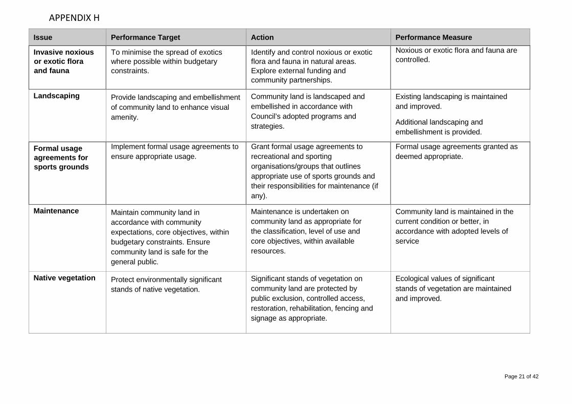
Invasive noxious or exotic flora and fauna
To minimise the spread of exotics where possible within budgetary constraints.
Identify and control noxious or exotic flora and fauna in natural areas. Explore external funding and community partnerships.
Noxious or exotic flora and fauna are controlled.
Landscaping
Provide landscaping and embellishment of community land to enhance visual amenity.
Community land is landscaped and embellished in accordance with Council’s adopted programs and strategies.
Existing landscaping is maintained and improved. Additional landscaping and embellishment is provided.
Formal usage agreements for sports grounds
Implement formal usage agreements to ensure appropriate usage.
Grant formal usage agreements to recreational and sporting organisations/groups that outlines appropriate use of sports grounds and their responsibilities for maintenance (if any).
Formal usage agreements granted as deemed appropriate.
Maintenance
Maintain community land in accordance with community expectations, core objectives, within budgetary constraints. Ensure community land is safe for the general public.
Maintenance is undertaken on community land as appropriate for the classification, level of use and core objectives, within available resources.
Community land is maintained in the current condition or better, in accordance with adopted levels of service
Native vegetation
Protect environmentally significant stands of native vegetation.
Significant stands of vegetation on community land are protected by public exclusion, controlled access, restoration, rehabilitation, fencing and signage as appropriate.
Ecological values of significant stands of vegetation are maintained and improved.
APPENDIX H

Page 22 of 42
Issue Performance Target Action Performance Measure
Neighbouring properties
To minimise adverse impact on surrounding properties
Manage community land and assets/facilities to minimise adverse impact on neighbouring properties. Provide suitable buffer zones within resource limits or environmental constraints
Limited customer requests from adjoining property owners in relation to substantiated adverse impacts emanating from community land.
Public infrastructure
Minimise the effects or detrimental impacts of installation/expansion of public infrastructure on community land.
Infrastructure proposals are assessed for their impacts on community land.
Where inappropriate, infrastructure is not placed on community land.
Infrastructure installations on community land are of minimal impact and do not unreasonably limit the use of the land for community purposes or achievement of the core objectives.
Public safety and risk management
Exclude public access from areas of community land containing public infrastructure to provide security and public safety.
To minimise the opportunity for risk of injury.
Infrastructure located on community land is placed and secured appropriately to minimise public risk.
Ensure that assets located on community land are inspected and maintained in a safe and serviceable condition
Infrastructure is secured by fencing and other appropriate means of access control
Formal and informal inspections undertaken with defects identified and treated/resolved
APPENDIX H

Page 23 of 42
Issue Performance Target Action Performance Measure
Rubbish dumping To minimise the occurrence and impact of illegal dumping.
The introduction of Waste Management education programs, increased surveillance, regulation and signage where required are all measures which may reduce the incidence of rubbish dumping on general community land. Actions at specific sites will be determined by the availability of resources.
Introduction of substantive measures resulting in a reduction in the number of instances of rubbish dumping on community land.
Sports ground utilisation and closures
To achieve an appropriate level of patronage and to close grounds when required.
Encourage and facilitate the use of all sports grounds within the carrying capacity of each facility
Maintain a sports ground closure protocol that minimises both the risk to users, and the potential for damage to the sports ground, as a result of either wet weather or ground renovation.
Overuse of sports grounds avoided with desirable levels of use achieved.
Sports ground closure protocol communicated to users and regulated.
Threatened species
Minimise adverse impacts upon threatened species, populations and ecological communities and their habitats
Ensure that maintenance operations do not adversely impact on threatened flora and fauna, or the habitat of threatened flora and fauna, in accordance with the Threatened Species Act.
Appropriate conservation and protection is provided to threatened species and ecological communities.
Numbers of threatened species, populations and the integrity of ecological communities and their habitats are maintained or improved.
APPENDIX H

Page 24 of 42
Issue Performance Target Action Performance Measure
Unauthorised vehicular access
To limit impact of unauthorised vehicular access.
Prohibit and prevent unauthorised vehicular access to community land.
Unauthorised vehicular access is restricted by the erection of signage, the installation of adequate barriers, and regulation. Emergency access maintained.
Unauthorised or Illegal Activities
To discourage the use of land and facilities for illegal or unauthorised activity.
Undertake the progressive installation of code of conduct signs on community land identifying illegal or unauthorised activities.
Code of conduct signs progressively installed as resources allow. Signs in place and maintained.
Vandalism and Theft
To minimise the opportunity for theft or vandalism.
Provide community land infrastructure which, by design, minimises the potential for loss due to vandalism or theft.
Overall reduction in vandalism and theft expenditure due to higher quality, vandal resistant materials and fixtures specified and funded for new replacement infrastructure works.
Volunteer maintenance
To increase the level of involvement of volunteers in land management.
Facilitate community partnerships to achieve sustainable community land management practices.
Successful expansion of the existing pool of volunteers, particularly in the open space maintenance area.
Wetland water quality
To improve water quality. Seek to obtain resources to monitor water quality in natural and constructed wetland sites.
Ongoing ability to be able to monitor water quality at natural and constructed wetland sites.
APPENDIX H

Page 25 of 42
The following table details of all community land in the Kempsey Shire at the time of adoption of this POM. It also specifies the category(s) applied to each parcel land. Areas of land where multiple categories have been applied have a reference to maps contained in Schedule 2.
Land Parcel ID (LA)
Land Description Address Locality Lot Section DP Category Map No.
13306 Riverbank Reserve Aldavilla Cecil Tarrant Drive Aldavilla 104 804497 Natural Area - Foreshore
12208 Riverbank Reserve Aldavilla Warne Drive Aldavilla 30 252385 Natural Area - Foreshore
8945 CWA Park 11-13 Main Street Bellbrook 1 758083 Park
16749 CWA Park 15 Main Street Bellbrook 2 758083 Park
22360 Clybucca Memorial Park Sutherlands Lane Bellimbopinni 12 1065720 Park
17960 Rese rve behind Charles Parry St Charles Parry Street Crescent Head 24 729843 General Community Use
7574 Kalateenee Reserve 613 Pipers Creek Road Dondingalong 11 703164 General Community Use
7664 Riverbank off Giblin Place Giblin Place Dondingalong 14 249690 Natural Area - Foreshore
1957 Rudder Park (Tank) Lord Street East Kempsey 1 124041 Park
20017 Milton Duffy Place Reserve Washington Street East Kempsey 5 855868 General Community Use
19364 Hodgson Park William Street East Kempsey 1 258641 General Community Use
17932 Wrights Lane Reserve Wrights Lane East Kempsey 5 819930 General Community Use
10933 Parkins Place Reserve 2 Parkins Place Frederickton 39 250703 General Community Use
10867 Frederickton Hall 20 Macleay St Frederickton 1 68179 General Community Use
10667 Frederickton Tennis Centre 42 Edgar Street Frederickton 2 22300 General Community Use
18561 Christmas Creek Reserve 50 Cyrus Saul Circuit Frederickton 50 832352 General Community Use
APPENDIX H

Page 26 of 42
Land Parcel ID (LA)
Land Description Address Locality Lot Section DP Category Map No.
10560 Frederickton Golf Course Yarrabandini Road Frederickton 191 752437 General Community Use
11011 Grassy Head Rd Bushland Reserve 324 Grassy Head Road Grassy Head 1 598595 Natural Area - Bushland
11574 Old Greenhills Ferry Park 18 Old Greenhills Ferry Road Greenhill 5 112084 Natural Area - Bushland
11587 Old Greenhills Ferry Park Old Greenhills Ferry Road Greenhill 19 255802 Natural Area - Foreshore
22396 Springfields Drive Reserve Springfields Drive Greenhill 26 1067942 General Community Use
14294 Boyters Lane Sportsground Boyters Lane Jerseyville 79 754396 General Community Use Natural Area - Wetland 1
14295 Boyters Lane Sportsground Boyters Lane Jerseyville 78 754396 General Community Use Natural Area - Wetland 1
19399 Boyters Lane Sportsground Boyters Lane Jerseyville 802 832777 Natural Area - Wetland 1
19439 Verge St Netball Courts 104 Belgrave Street Kempsey 5 1127988 Sportsground
14234 Verge St Netball Courts 106 Belgrave Street Kempsey 4 1127988 Sportsground
14233 Verge St Netball Courts 108 Belgrave Street Kempsey 3 1127988 Sportsground
14232 Verge St Netball Courts 110 Belgrave Street Kempsey 2 1127988 Sportsground
14231 Verge St Netball Courts 112 Belgrave Street Kempsey 1 1127988 Sportsground
156 Chappel Park Skating Facility 69 Belgrave Street Kempsey 2 1131759 General Community Use
31949 McElhone Memorial Baths 71 Belgrave Street Kempsey 1 1152962 General Community Use
31950 McElhone Baths/Chappel Park Belgrave Street Kempsey 2 1152962 General Community Use
14013 Verge St 2 Sporting fields Austral Street Kempsey 17 H 37215 Sportsground
14014 Verge St 2 Sporting fields Austral Street Kempsey 18 H 37215 Sportsground
14015 Verge St 2 Sporting fields Austral Street Kempsey 19 H 37215 Sportsground
APPENDIX H

Page 27 of 42
Land Parcel ID (LA)
Land Description Address Locality Lot Section DP Category Map No.
14016 Verge St 2 Sporting fields Austral Street Kempsey 20 H 37215 Sportsground
14017 Verge St 2 Sporting fields Austral Street Kempsey 21 H 37215 Sportsground
14018 Verge St 2 Sporting fields Austral Street Kempsey 22 H 37215 Sportsground
14019 Verge St 2 Sporting fields Austral Street Kempsey 23 H 37215 Sportsground
14020 Verge St 2 Sporting fields Austral Street Kempsey 24 H 37215 Sportsground
14021 Verge St 2 Sporting fields Austral Street Kempsey 25 H 37215 Sportsground
14022 Verge St 2 Sporting fields Austral Street Kempsey 26 H 37215 Sportsground
14023 Verge St 2 Sporting fields Austral Street Kempsey 27 H 37215 Sportsground
14024 Verge St 2 Sporting fields Austral Street Kempsey 28 H 37215 Sportsground
14025 Verge St 2 Sporting fields Austral Street Kempsey 29 H 37215 Sportsground
14026 Verge St 2 Sporting fields Austral Street Kempsey 30 H 37215 Sportsground
14027 Verge St 2 Sporting fields Austral Street Kempsey 31 H 37215 Sportsground
14028 Verge St 2 Sporting fields Austral Street Kempsey 32 H 37215 Sportsground
14169 Verge St 2 Sporting fields Austral Street Kempsey 2 J 37215 Sportsground
14170 Verge St 2 Sporting fields Austral Street Kempsey 3 J 37215 Sportsground
14171 Verge St 2 Sporting fields Austral Street Kempsey 4 J 37215 Sportsground
14172 Verge St 2 Sporting fields Austral Street Kempsey 5 J 37215 Sportsground
14173 Verge St 2 Sporting fields Austral Street Kempsey 6 J 37215 Sportsground
14174 Verge St 2 Sporting fields Austral Street Kempsey 7 J 37215 Sportsground
APPENDIX H

Page 28 of 42
Land Parcel ID (LA)
Land Description Address Locality Lot Section DP Category Map No.
14175 Verge St 2 Sporting fields Austral Street Kempsey 8 J 37215 Sportsground
14176 Verge St 2 Sporting fields Austral Street Kempsey 9 J 37215 Sportsground
14177 Verge St 2 Sporting fields Austral Street Kempsey 10 J 37215 Sportsground
14178 Verge St 2 Sporting fields Austral Street Kempsey 11 J 37215 Sportsground
14179 Verge St 2 Sporting fields Austral Street Kempsey 12 J 37215 Sportsground
132 Verge St 2 Sporting fields/Carpark Austral Street Kempsey 1 J 37215 Sportsground
1360 Service Clubs Park 21 Forth Street Kempsey 8 1109989 General Community Use 2
18456 Service Clubs Park 23 Forth Street Kempsey 8 1098561 General Community Use 2
18432 Service Clubs Park Belgrave Street Kempsey 4 20080 General Community Use 2
31453 Service Clubs Park Belgrave Street Kempsey 7 1109982 General Community Use 2
32067 Service Clubs Park Belgrave Street Kempsey 1 154524 General Community Use 2
18433 Service Clubs Park Belgrave Street Kempsey 5 20080 General Community Use 2
18435 Service Clubs Park Belgrave Street Kempsey 13 1109999 Sportsground / General Community Use 2
18436 Service Clubs Park Belgrave Street Kempsey 12 1109999 Sportsground 2
18437 Service Clubs Park Belgrave Street Kempsey 11 1109999 Sportsground 2
18438 Service Clubs Park Belgrave Street Kempsey 2 1109969 Sportsground 2
18443 Service Clubs Park Belgrave Street Kempsey 3 1109969 Sportsground 2
18444 Service Clubs Park Belgrave Street Kempsey 4 1109969 Sportsground 2
18448 Service Clubs Park Forth Street Kempsey C 156233 Sportsground 2
APPENDIX H

Page 29 of 42
Land Parcel ID (LA)
Land Description Address Locality Lot Section DP Category Map No.
18449 Service Clubs Park Forth Street Kempsey B 156233 Sportsground 2
18452 Service Clubs Park Forth Street Kempsey A 156233 Sportsground 2
31452 Service Clubs Park Forth Street Kempsey 10 1109991 Sportsground 2
18447 Service Clubs Park & Carpark Forth Street Kempsey 1 1109969 Sportsground / General
Community Use 2
18429 Service Clubs Park Holman Street Kempsey 1 20080 General Community Use 2
18430 Service Clubs Park Holman Street Kempsey 2 20080 General Community Use 2
18431 Service Clubs Park Holman Street Kempsey 3 20080 General Community Use 2
18445 Service Clubs Park & Carpark Stuart Street Kempsey 6 1109979 General Community Use 2
3255 Stuart St West Carpark Stuart Street Kempsey 1 776993 General Community Use 2
18446 Stuart St West Carpark Stuart Street Kempsey 5 1109971 General Community Use 2
3251 Stuart St East Carpark Stuart Street Kempsey F 39009 General Community Use
692 Future Carpark Clyde St Clyde Street Kempsey 9 804366 General Community Use
911 Eden Street Reserve Eden Street Kempsey 3 1088658 General Community Use
14090 Eden Street Reserve Eden Street Kempsey 2 1088658 General Community Use
14091 Eden Street Reserve Eden Street Kempsey 1 1088658 General Community Use
1068 Riverbank Smith St Forth Street Kempsey 1 707914 General Community Use
1116 Riverbank Smith St Forth Street Kempsey 3 775173 General Community Use
1140 Riverbank Smith St Geoffrey Debenham Street Kempsey 53 615663 General Community Use
3125 Riverbank Smith St Smith Street Kempsey 123 591722 General Community Use
APPENDIX H

Page 30 of 42
Land Parcel ID (LA)
Land Description Address Locality Lot Section DP Category Map No.
21670 Riverbank Smith St Smith Street Kempsey 314 1032381 General Community Use
21668 Riverbank Smith St Smith Street Kempsey 172 1038558 General Community Use / Natural Area - Foreshore 3
3138 Riverbank Smith St Smith Street Kempsey 163 738128 General Community Use / Natural Area - Foreshore 3
14181 Verge St 2 Sporting fields Eden Street Kempsey 13 J 37215 Sportsground
14182 Verge St 2 Sporting fields Eden Street Kempsey 14 J 37215 Sportsground
14183 Verge St 2 Sporting fields Eden Street Kempsey 15 J 37215 Sportsground
14184 Verge St 2 Sporting fields Eden Street Kempsey 16 J 37215 Sportsground
14185 Verge St 2 Sporting fields Eden Street Kempsey 17 J 37215 Sportsground
14186 Verge St 2 Sporting fields Eden Street Kempsey 18 J 37215 Sportsground
14187 Verge St 2 Sporting fields Eden Street Kempsey 19 J 37215 Sportsground
14188 Verge St 2 Sporting fields Eden Street Kempsey 20 J 37215 Sportsground
14189 Verge St 2 Sporting fields Eden Street Kempsey 21 J 37215 Sportsground
14190 Verge St 2 Sporting fields Eden Street Kempsey 22 J 37215 Sportsground
14191 Verge St 2 Sporting fields Eden Street Kempsey 23 J 37215 Sportsground
14192 Verge St 2 Sporting fields/Carpark Eden Street Kempsey 24 J 37215 Sportsground
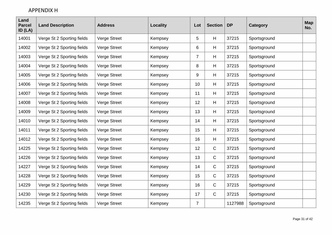
3639 Verge St 2 Sporting fields Verge Street Kempsey 1 H 37215 Sportsground
13998 Verge St 2 Sporting fields Verge Street Kempsey 2 H 37215 Sportsground
13999 Verge St 2 Sporting fields Verge Street Kempsey 3 H 37215 Sportsground
14000 Verge St 2 Sporting fields Verge Street Kempsey 4 H 37215 Sportsground
APPENDIX H
Page 31 of 42
Land Parcel ID (LA)
Land Description Address Locality Lot Section DP Category Map No.
14001 Verge St 2 Sporting fields Verge Street Kempsey 5 H 37215 Sportsground
14002 Verge St 2 Sporting fields Verge Street Kempsey 6 H 37215 Sportsground
14003 Verge St 2 Sporting fields Verge Street Kempsey 7 H 37215 Sportsground
14004 Verge St 2 Sporting fields Verge Street Kempsey 8 H 37215 Sportsground
14005 Verge St 2 Sporting fields Verge Street Kempsey 9 H 37215 Sportsground
14006 Verge St 2 Sporting fields Verge Street Kempsey 10 H 37215 Sportsground
14007 Verge St 2 Sporting fields Verge Street Kempsey 11 H 37215 Sportsground
14008 Verge St 2 Sporting fields Verge Street Kempsey 12 H 37215 Sportsground
14009 Verge St 2 Sporting fields Verge Street Kempsey 13 H 37215 Sportsground
14010 Verge St 2 Sporting fields Verge Street Kempsey 14 H 37215 Sportsground
14011 Verge St 2 Sporting fields Verge Street Kempsey 15 H 37215 Sportsground
14012 Verge St 2 Sporting fields Verge Street Kempsey 16 H 37215 Sportsground
14225 Verge St 2 Sporting fields Verge Street Kempsey 12 C 37215 Sportsground
14226 Verge St 2 Sporting fields Verge Street Kempsey 13 C 37215 Sportsground
14227 Verge St 2 Sporting fields Verge Street Kempsey 14 C 37215 Sportsground
14228 Verge St 2 Sporting fields Verge Street Kempsey 15 C 37215 Sportsground
14229 Verge St 2 Sporting fields Verge Street Kempsey 16 C 37215 Sportsground
14230 Verge St 2 Sporting fields Verge Street Kempsey 17 C 37215 Sportsground
14235 Verge St 2 Sporting fields Verge Street Kempsey 7 1127988 Sportsground
APPENDIX H

Page 32 of 42
Land Parcel ID (LA)
Land Description Address Locality Lot Section DP Category Map No.
31717 Verge St 1 Sporting fields Eden Street Kempsey 1 1189273 Sportsground
31718 Verge St 1 Sporting fields Eden Street Kempsey 2 1189273 Sportsground
14031 Verge St Basketball Courts Verge Street Kempsey 1 1165932 Sportsground
33099 Verge St Basketball Courts Verge Street Kempsey 1 1188981 Sportsground
14236 Verge St Netball Courts Verge Street Kempsey 6 1127988 Sportsground
14034 Verge St 1 Sporting fields Vincent Street Kempsey 4 I 37215 Sportsground
14035 Verge St 1 Sporting fields Vincent Street Kempsey 5 I 37215 Sportsground
14036 Verge St 1 Sporting fields Vincent Street Kempsey 6 I 37215 Sportsground
14037 Verge St 1 Sporting fields Vincent Street Kempsey 7 I 37215 Sportsground
14038 Verge St 1 Sporting fields Vincent Street Kempsey 8 I 37215 Sportsground
14039 Verge St 1 Sporting fields Vincent Street Kempsey 9 I 37215 Sportsground
14040 Verge St 1 Sporting fields Vincent Street Kempsey 10 I 37215 Sportsground
14041 Verge St 1 Sporting fields Vincent Street Kempsey 11 I 37215 Sportsground
14042 Verge St 1 Sporting fields Vincent Street Kempsey 12 I 37215 Sportsground
14043 Verge St 1 Sporting fields Vincent Street Kempsey 13 I 37215 Sportsground
19440 Verge St 2 Sporting fields Vincent Street Kempsey 1 151732 Sportsground
19441 Verge St 2 Sporting fields Vincent Street Kempsey 2 151732 Sportsground
14033 Verge St Basketball Courts Vincent Street Kempsey 3 I 37215 Sportsground
7396 Millbank Hall 522 Hickeys Creek Road Millbank 81 746608 General Community Use
APPENDIX H

Page 33 of 42
Land Parcel ID (LA)
Land Description Address Locality Lot Section DP Category Map No.
7336 Hickeys Creek Picnic Area Hickeys Creek Road Millbank 204 715334 Natural Area - Bushland
1332 Andrew Pacey Park Horatio Braham Place South Kempsey 43 705865 General Community Use
1354 Hill Street Park Hill Street South Kempsey 18 A 19637 General Community Use
13463 Hill Street Park Hill Street South Kempsey 19 19637 General Community Use
13464 Hill Street Park Hill Street South Kempsey 20 19637 General Community Use
20057 Arthur St/Cook Dr Reserve 12 Arthur Street South West Rocks 57 857026 General Community Use
13305 Dolphin Crescent Reserve 17 Dolphin Crescent South West Rocks 96 807707 General Community Use
4224 Rotary Park 17 Entrance Street South West Rocks 66 260720 General Community Use
15046 Wilfred Partridge Reserve 22-38 Lindsay Noonan Drive South West Rocks 50 808194 Natural Area - Bushland /
Natural Area - Foreshore 4
21858 Belle O'Connor/Dennis Cres Reserve 25 Belle O’Connor Street South West Rocks 69 1042899 General Community Use
22188 Belle O'Connor/Peter Mark Crt Reserve 44 Peter Mark Circuit South West Rocks 136 1051855 General Community Use
21524 Trevor Judd Reserve 5 Trevor Judd Avenue South West Rocks 43 1032725 General Community Use
5728 Phillip Drive Reserve 54 Phillip Drive South West Rocks 47 244025 Natural Area - Bushland
22149 Belle O'Connor/Dennis Cres Reserve 6 Dennis Crescent South West Rocks 135 1051855 General Community Use
4672 Gordon Young/Arthur St Reserve 60-62 Arthur Street South West Rocks 76 730037 General Community Use
32093 Public Reserve 6-8 Tallowwood Place South West Rocks 23 1156464 General Community Use
15048 Lindsay Noonan Dr Reserve
7-27 Lindsay Noonan Drive South West Rocks 49 808194 General Community Use
19693 Gordon Young/Arthur St Reserve Arthur Street South West Rocks 19 864255 General Community Use
APPENDIX H

Page 34 of 42
Land Parcel ID (LA)
Land Description Address Locality Lot Section DP Category Map No.
4628 Gordon Young/Arthur St Reserve Arthur Street South West Rocks 272 801143 General Community Use
4816 Currawong Cres Reserve Currawong Crescent South West Rocks 181 247665 General Community Use
3941 Reservoir Gilbert Cory St Gilbert Cory Street South West Rocks 24 748740 Natural Area - Bushland
13815 Reservoir South West Rocks Gregory Street South West Rocks 1 645213 Natural Area - Bushland
5205 Pump Station R4 Landsborough Street South West Rocks 1 777849 Natural Area - Bushland
12585 Gordon Young/Arthur St Reserve Lawson Street South West Rocks 4 786357 General Community Use
5348 South West Rocks Foreshore Reserve Livingstone Street South West Rocks 434 788736 General Community Use
5309 Pump Station R5 Off Livingstone Street South West Rocks 1 778105 General Community Use
4192 Effluent Disposal South West Rocks Off New Entrance Road South West Rocks 1 777848 Natural Area - Bushland
19923 South West Rocks Foreshore Reserve Paragon Avenue South West Rocks 33 855157 General Community Use /
Natural Area - Foreshore 5
5729 Pump Station R9 Phillip Drive South West Rocks 1 777845 General Community Use
5856 Pump Station R1 Simpson Street South West Rocks 1 777850 General Community Use
20378 Simpson St Reserve Simpson Street South West Rocks 71 865450 Natural Area - Bushland
3940 Mattys Flat Park New Entrance Road South West Rocks 849 777322 Uncategorised - managed under the Mattys Flat and New Entrance Plan of Management - Issue No. 2 January 2006 (revised August 2010)
3945 Mattys Flat Wetlands New Entrance Road South West Rocks 85 263591
11306 Riverbank Marine Parade 2 Marine Parade Stuarts Point 32 255098 Natural Area - Foreshore
11272 Riverbank Marine Parade Kimpton Street Stuarts Point 39 604990 Natural Area - Foreshore
APPENDIX H

Page 35 of 42
Land Parcel ID (LA)
Land Description Address Locality Lot Section DP Category Map No.
19779 Temagog Riverside Park Temagog Road Temagog 14 850406 Natural Area – Bushland
19735 Turners Flat/Mooneba RFS Wheeldons Access Turners Flat 1 863567 General Community Use
944 Forestry Park 29 Elbow Street West Kempsey 2 102403 Park
945 Forestry Park 31-33 Elbow Street West Kempsey 1 102403 Park
2863 Robert Gardem Place Reserve 4 Robert Gardem Place West Kempsey 59 262340 General Community Use
1543 Steele Park 61 North Street West Kempsey 126 243114 General Community Use
19308 Samuel Hoskins Park 7 James Ramsay Place West Kempsey 134 826640 General Community Use
430 Flanigan Park Broughton Street West Kempsey 22 2 1676 General Community Use
15434 Flanigan Park Broughton Street West Kempsey 23 1676 General Community Use
15435 Flanigan Park Broughton Street West Kempsey 24 1676 General Community Use
22594 Bunya Pines Park Bunya Pine Court West Kempsey 75 1071483 General Community Use
732 Eric Kennedy Reserve Cochrane Street West Kempsey 32 719585 Park
818 Kemp St Sporting Fields 46 Dangar Street West Kempsey 56 35947 General Community Use 6
770 Kemp St Sporting Fields Collin Tait Avenue West Kempsey 55 35947 General Community Use 6
820 Kemp St Sporting Fields Collin Tait Avenue West Kempsey 1 1120533 Sportsground 6
13230 Kemp St Sporting Fields Collin Tait Avenue West Kempsey 2 1120533 Sportsground 6
819 Kemp St Sporting Fields Dangar Street West Kempsey 1 512288 Sportsground 6
821 Kemp St Sporting Fields Dangar Street West Kempsey 4 18759 Sportsground 6
1428 Jack Bond Cres Reserve Jack Bond Crescent West Kempsey 35 263419 General Community Use
APPENDIX H

Page 36 of 42
Land Parcel ID (LA)
Land Description Address Locality Lot Section DP Category Map No.
1429 Jack Bond Cres Reserve Jack Bond Crescent West Kempsey 2 815558 General Community Use
1468 James Carney Playground James Carney Crescent West Kempsey 11 733007 General Community Use
1754 Lawrence Crescent Reserve Lawrence Crescent West Kempsey 16 249792 General Community Use
1838 Mitchell Park Leith Street West Kempsey 31 700647 General Community Use
1862 Lindsay Place Park Lindsay Place West Kempsey 34 263419 General Community Use
2230 Mitchell Avenue Park Mitchell Avenue West Kempsey 125 264558 General Community Use
3051 Riverbank River St Short Street West Kempsey 14 248428 Natural Area - Foreshore
19118 Pump Station K6 (A,B,C) Thompson Street West Kempsey 1 41543 General Community Use
20083 Pump Station K6 (A,B,C) Thompson Street West Kempsey 11 645214 General Community Use
10278 Willawarrin Hall 26-28 Main Street Willawarrin 1 340896 General Community Use
10259 Willawarrin War Memorial Park 33 Main Street Willawarrin 1 800846 Park
10306 Willawarrin War Memorial Park Main Road Willawarrin 1 415429 Park
32126 Willawarrin Sports Ground Main Street Willawarrin 1 1140806 Sportsground
20211 Willawarrin Sports Ground Main Street Willawarrin 21 862857 Sportsground
12072 Brushbox Cres Reserve Brushbox Crescent Yarravel 37 246962 Natural Area - Bushland
12115 Bushland Drive Reserve 1 Bushland Drive Yarravel 80 247905 Natural Area - Bushland
12116 Bushland Drive Reserve 2 Bushland Drive Yarravel 81 247905 Natural Area - Bushland
12220 Ironbark Crescent Reserve Ironbark Crescent Yarravel 93 258248 Natural Area - Bushland
12231 Stringybark Crescent Reserve Ironbark Crescent Yarravel 104 258248 Natural Area - Bushland
APPENDIX H

Page 37 of 42
This schedule contains maps of community land that has been assigned multiple categories based on differing land uses within a single area of land.
APPENDIX H

Page 38 of 42
APPENDIX H

Page 39 of 42
APPENDIX H

Page 40 of 42
APPENDIX H

Page 41 of 42
APPENDIX H

Page 42 of 42
APPENDIX H