
KRH EDDS/STR D TGO 112.5 TGO D - swe-gaming.comswe-gaming.com/fsx/approachcharts/EDDS.pdf ·...
23
R174^ 354^ 15 5000 6000 D REUTL 2A TEKSI REUTL 2 2 Clearance limit 354^ 2 COMMUNICATION FAILURE 2 | JEPPESEN SANDERSON, INC., 2002. ALL RIGHTS RESERVED. Apt Elev EDDS/STR 10-2 .STAR. Trans level: By ATC Trans alt: 5000' STUTTGART, GERMANY STUTTGART *D-ATIS 126.12 1276' Alt Set: hPa (IN on request) 1 1 STARs renumbered & revised; new format. R 0 7 8 ^ 2 62^ 25 8 ^ 2 6 6 ^ BABEG N48 40.3 E009 39.9 6000 5000 17 T EK SI 2 A (TGO R-082/D32.5) 082^ N48 41.4 E010 04.1 N48 22.2 E009 17.8 6000 16. 1 Proceed to TGO for standard approach. D 3 3 Between TEKSI & BABEG BRNAV equipment necessary 5000 5000 178^ 358^ D DINKELSBUHL N49 08.6 E010 14.3 LBU D 109.2 LBU LUBURG N48 54.8 E009 20.4 N48 37.1 E009 15.6 (IAF) (IAF) 117.8 DKB 228^ DKB D 112.5 TGO TANGO 048^ R06 8^ DKB 4A 50 0 0 3 8 24 8^ 09 8^ R278^ 30 5000 K R H 2 A KRH D 115.95 KRH N48 59.6 E008 35.1 KARLSRUHE TGO 128^ 24 2^ 4200' 3400' 3900' 050^ 010^ MSA TGO VOR 4800' NOT TO SCALE 3300' within 10 nm CHANGES: JEPPESEN .Eff.28.Nov. 22 NOV 02 DINKELSBUHL FOUR ALFA (DKB 4A) KARLSRUHE TWO ALFA (KRH 2A) REUTL TWO ALFA (REUTL 2A) TEKSI TWO ALFA (TEKSI 2A) RWYS 07, 25 ARRIVALS [REUT2A] [TEKS2A] Licensed to BISSIG, MIKE, . Printed from JeppView disc 23-03. Notice: After 27.11.2003 0901Z this chart should not be used without first checking JeppView or NOTAMs. WIBAD DS412 N48 36.7 E008 48.8 DS425 N48 40.5 E008 47.1 DS426 N48 41.6 E008 52.9 DS411 N48 37.8 E008 54.6 DS427 N48 46.0 E009 02.0 VATER N48 38.9 E009 00.1 LBU 07 KRH 07 WIBAD 07 .RNAV.TRANSITION. 130^ KRH 07 7 234^ 15 LBU 07 7.5 4 4 3.8 254^ 163^ 163^ 074^ 168 ^ 1 8.8 KRH 07 , WIBAD 07 Optional Optional Optio na l 4 4 Authorization to fly the lateral GPS/FMS-route. Altitude & speed assignments will be issued by ATC. Authorization to fly the GPS/FMS-route as published, including the vertical con- straints depicted on the procedure. Authorization to fly from the present position to one or a combination of waypoints. Altitude & speed assign- ments will be issued by ATC. GPS/FMS CLEARANCE PHRASEOLOGY "Cleared xxx Transition": 1. 2. "Cleared xxx Transition and Profile": 3. "Cleared direct Waypoint xxx": WIBAD (FL100+) - DS412 (6000'+) - DS411 (4000'+; K210-) - VATER (4000'). (FL100+) - DS412 (6000'+) - DS411 (4000'+; K210-) - VATER (4000'). (FL80+) - DS427 (5000'+) - DS426 - DS411 (4000'+; K210-) - VATER (4000'). | JEPPESEN SANDERSON, INC., 2002. ALL RIGHTS RESERVED. Apt Elev EDDS/STR Trans level: By ATC Trans alt: 5000' STUTTGART, GERMANY STUTTGART *D-ATIS 126.12 1276' Alt Set: hPa (IN on request) 1 1 New format. 10-2B KRH - WIBAD LBU N48 55.1 E008 43.2 FL100 At or above At or above 6000' At or above 5000' At or above FL80 KRH 07, LBU 07, WIBAD 07 At or above 210 KT 4000' MAX 4000' At ROUTING TRANSITION 3 5 8 ^ 1 7 8 ^ NOT TO SCALE 128^ 242^ 4200' 3400' 3900' 050^ 010^ MSA TGO VOR 4800' 3300' within 10 nm CHANGES: JEPPESEN .Eff.28.Nov. 22 NOV 02 FROM NORTH GPS- OR FMS-EQUIPPED AIRCRAFT RWY 07 RNAV TRANSITIONS LBU D 109.2 LBU LUBURG N48 54.8 E009 20.4 KRH D 115.95 KRH N48 59.6 E008 35.1 KARLSRUHE N48 37.1 E009 15.6 D 112.5 TGO TANGO TGO 50 00 Licensed to BISSIG, MIKE, . Printed from JeppView disc 23-03. Notice: After 27.11.2003 0901Z this chart should not be used without first checking JeppView or NOTAMs.
Transcript of KRH EDDS/STR D TGO 112.5 TGO D - swe-gaming.comswe-gaming.com/fsx/approachcharts/EDDS.pdf ·...

R174^354^ 15
50006000D
REUTL 2A
TEKSI
REUTL
2
2C
learance lim
it
354^
2
CO
MM
UN
IC
AT
IO
N F
AILU
RE
2
| JEPPESEN
SAN
DERSO
N, IN
C., 2002. A
LL RIGHTS RESERV
ED.
Apt Elev
EDDS/STR
10-2.STA
R.
Tra
ns le
vel: B
y A
TC T
rans a
lt: 5000'
STUTTG
ART, G
ERMANY
STUTTG
ART
*D
-ATIS
126.1
21276'
Alt S
et: h
Pa (IN
on re
quest)
1
1
STARs renum
bered & revised; new
format.
R078^
262^258^
266^
BA
BEG
N48 40.3
E009 39.9
6000
5000
17
TEKSI 2
A
(TGO
R-082/D32.5)
082^
N48 41.4 E010 04.1
N48 22.2 E009 17.8
6000
16.1
Pro
ceed to
TGO fo
r sta
ndard
appro
ach.
D3
3Betw
een T
EKSI &
BABEG
BRNAV e
quip
ment n
ecessary
5000
5000178^
358^
DDINKELSBU
HL
N49 08.6 E010 14.3
LB
UD109.2 LBU
LUBU
RG
N48 54.8 E009 20.4
N48 37.1 E009 15.6
(IAF)
(IAF)
117.8 DKB
228^
DK
B
D112.5 TGO
TANGO
048^
R068^DKB 4
A5000
38
248^
098^R278^
30
5000
KRH
2A
KR
HD115.95 K
RHN48 59.6 E008 35.1
KARLSRU
HETG
O
128^242^
4200'
3400'
3900'
050^
010^
MSA
TGO
VO
R4800'
NO
T TO SC
ALE
3300' within 10 nm
CHA
NG
ES:
JEPPESEN
.Eff.28.Nov.
22 NO
V 02
DINKELSBU
HL FO
UR A
LFA (D
KB 4A
)KARLSRU
HE TW
O A
LFA (K
RH 2A
)REU
TL TWO A
LFA (REU
TL 2A)
TEKSI TW
O A
LFA (TEK
SI 2A)
RWYS 07, 25 A
RRIVALS
[REU
T2A
][TEK
S2A
]
Licensed to BISSIG
, MIK
E, . Printed from JeppView
disc 23-03.N
otice: After 27.11.2003 0901Z this chart should not be used w
ithout first checking JeppView or N
OTA
Ms.
WIBAD
DS412N48 36.7 E008 48.8
DS425N48 40.5 E008 47.1
DS426N48 41.6 E008 52.9
DS411N48 37.8 E008 54.6
DS427N48 46.0 E009 02.0
VATERN48 38.9 E009 00.1
LBU 07
KRH 07
WIBAD 07
.RNAV.TRANSITIO
N.
130^KRH 07
7
234^
15
LBU 0
7
7.5
4
4
3.8
254^
163^
163^
074^
168^
18.8
KRH 0
7, W
IBA
D 0
7
Optional
Optional
Optional
4
4
Authorization to fly the lateral GPS/FMS-route. Altitude & speed assignments will be issued by ATC.
Authorization to fly the GPS/FMS-route as published, including the vertical con-straints depicted on the procedure.
Authorization to fly from the presentposition to one or a combination ofwaypoints. Altitude & speed assign-ments will be issued by ATC.
GPS/FMS CLEARANCE PHRASEOLOGY
"Cleared xxx Transition":1.
2. "Cleared xxx Transition and Profile":
3. "Cleared direct Waypoint xxx":
WIBAD (FL100+) - DS412 (6000'+) - DS411 (4000'+; K210-) - VATER (4000').
(FL100+) - DS412 (6000'+) - DS411 (4000'+; K210-) - VATER (4000').
(FL80+) - DS427 (5000'+) - DS426 - DS411 (4000'+; K210-) - VATER (4000').
| JEPPESEN
SAN
DERSO
N, IN
C., 2002. A
LL RIGHTS RESERV
ED.
Apt Elev
EDDS/STR
Tra
ns le
vel: B
y A
TC T
rans a
lt: 5000'
STUTTG
ART, G
ERMANY
STUTTG
ART
*D
-ATIS
126.1
21276'
Alt S
et: h
Pa (IN
on re
quest)
1
1
New
format.
10-2B
KRH - WIBAD
LBU
N48 55.1E008 43.2
FL100At or above
At or above6000'
At or above5000'
At or aboveFL80
KRH
07, LBU 07, W
IBAD 07
At or above
210 KT4000'
MAX
4000'At
ROUTINGTRANSITION
3 58 ^
178^
NOT TO SCALE
128^242^
4200'
3400'
3900'
050^
010^
MSA
TGO
VO
R4800'
3300' within 10 nm
CHA
NG
ES:
JEPPESEN
.Eff.28.Nov.
22 NO
V 02
FROM N
ORTH
GPS- O
R FMS-EQ
UIPPED
AIRC
RAFT
RWY 07 RN
AV TRA
NSITIO
NS
LBUD109.2 LBU
LUBURG
N48 54.8 E009 20.4
KRHD115.95 KRH
N48 59.6 E008 35.1
KARLSRUHE
N48 37.1 E009 15.6
D112.5 TGO
TANGO
TGO
5000
Licensed to BISSIG
, MIK
E, . Printed from JeppView
disc 23-03.N
otice: After 27.11.2003 0901Z this chart should not be used w
ithout first checking JeppView or N
OTA
Ms.

.RNAV.TRANSITIO
N.
| JEPPESEN
SAN
DERSO
N, IN
C., 2002. A
LL RIGHTS RESERV
ED.
Apt Elev
EDDS/STR
Tra
ns le
vel: B
y A
TC T
rans a
lt: 5000'
STUTTG
ART, G
ERMANY
STUTTG
ART
*D
-ATIS
126.1
21276'
Alt S
et: h
Pa (IN
on re
quest)
1
1
10-2C
DS530N48 48.9 E009 31.1
DS529
DS512
DS511
UNSERN48 44.0 E009 27.3
DKB 25
LBU 25
WUR 25
VENUDN49 00.7 E009 43.2
254^
164^164^
074^Optional
DKB 25, LBU
25, WUR 25
129^
191^
4
4
3.8
4.2
5
DS531N48 51.6 E009 26.2
At or above
LBU 25
WUR 2
5O
ptio
nal
4
4
43.3
N48 50.0E009 37.0
DKB 25
Optio
nal
226^
32.5
203^
17.1
GPS/FMS CLEARANCE PHRASEOLOGY
"Cleared xxx Transition":1.
2. "Cleared xxx Transition and Profile":
3. "Cleared direct Waypoint xxx":
(FL100+) - DS511 (4000'+;
(6000'+) - DS511 (4000'+;
(FL80+) - DS531 (5000'+) -(4000'+; K210-) - UNSER (4000').
(4000').
Authorization to fly from the present positionto one or a combination of waypoints. Altitude& speed assignments will be issued by ATC.
Authorization to fly the lateral GPS/FMS-route.Altitude & speed assignments will be issued byATC.
Authorization to fly the GPS/FMS-route as pub-lished, including the vertical constraints depic-ted on the procedure.
(4000').
DS530 -
N48 46.1E009 38.6
N48 45.1E009 32.8
At 4000'
At or above
210 KT
4000'
At or above6000'
At or aboveFL80
At or above5000
At or aboveFL100
New
format.
DKB - DS512
LBU
WUR - VENUD
K210-) -UNSER
DS511 -
K210-) -UNSER
MAX
DTANGO
112.5 TGOTGON48 37.1 E009 15.6
128^242^
4200'
3400'
3900'
050^
010^
MSA
TGO
VO
R4800'
3300' within 10 nm
CHA
NG
ES:
JEPPESEN
.Eff.28.Nov.
22 NO
V 02
FROM N
ORTH
GPS- O
R FMS-EQ
UIPPED
AIRC
RAFT
RWY 25 RN
AV TRA
NSITIO
NS
ROUTINGTRANSITION
358^
1 78^
DLUBURG
109.2 LBULBUN48 54.8 E009 20.4
DDINKELSBUHL117.8 DKBDKB
N49 08.6 E010 14.3
WURZBURG
110.2 WURWURN49 43.1 E009 56.8
5000
NOT TO SCALE
Licensed to BISSIG
, MIK
E, . Printed from JeppView
disc 23-03.N
otice: After 27.11.2003 0901Z this chart should not be used w
ithout first checking JeppView or N
OTA
Ms.
REUTLN48 22.2 E009 17.8
DS430N48 32.9 E008 50.4
DS433N48 29.0 E008 52.1
DS431N48 34.0 E008 56.2
DS435
VATERN48 38.9 E009 00.1
DS412
At or above
REUTL 07
TEKSI 07
TGO 07
292^
REUTL 07
18.4
4
4
3.8
4
343^
254^
343^
074^
Optional
Optional
4
4
TGO 07
256^13.2
DS411N48 37.8 E008 54.6
GPS/FMS CLEARANCE PHRASEOLOGY
"Cleared xxx Transition":1.
2. "Cleared xxx Transition and Profile":
3. "Cleared direct Waypoint xxx":
Authorization to fly the GPS/FMS-route as published, in-cluding the vertical constraints depicted on the procedure.
Authorization to fly the lateral GPS/FMS-route. Altitude &speed assignments will be issued by ATC.
Authorization to fly from the present position to one or acombination of waypoints. Altitude & speed assignmentswill be issued by ATC.
(FL100+) - (6000'+) - DS411(4000'+; (4000').K210-) - VATERREUTL DS433 - DS412
TEKSI (FL100+) -(6000'+) - DS411 (4000'+; K210-) - VATER (4000').
(FL70+) - DS431 - DS411 (4000'+;(4000').
.RNAV.TRANSITIO
N.
| JEPPESEN
SAN
DERSO
N, IN
C., 2002. A
LL RIGHTS RESERV
ED.
Apt Elev
EDDS/STR
Tra
ns le
vel: B
y A
TC T
rans a
lt: 5000'
STUTTG
ART, G
ERMANY
STUTTG
ART
*D
-ATIS
126.1
21276'
Alt S
et: h
Pa (IN
on re
quest)
1
1
10-2D
REUTL 07, TEK
SI 07, TGO 07
RNA
V TRA
NSITIO
N TEK
SI 07 revised; new form
at.
262^
TEKSI 07Optional
16.1 266^
TEKSIN48 41.4 E010 04.1
At or aboveFL100
N48 40.3E009 39.9
237^
17.8
DS434N48 30.6 E009 17.4
264^16.9
FL100At or above
At 4000'
At or aboveFL70
N48 36.7E008 48.8
At or above 4000'
210 KTMAX
At or above6000'
HOLDING OVERTEKSI
082^
6000
TGOVATER
K210-) -
DS435 - DS434 - DS433 - DS412 -
ROUTINGTRANSITION
6000
354^
048^
228^
DTANGO
112.5 TGOTGON48 37.1 E009 15.6
174^
NOT TO SCALE
128^242^
4200'
3400'
3900'
050^
010^
MSA
TGO
VO
R4800'
3300' within 10 nm
CHA
NG
ES:
JEPPESEN
.Eff.28.Nov.
22 NO
V 02
FROM SO
UTH
GPS- O
R FMS-EQ
UIPPED
AIRC
RAFT
RWY 07 RN
AV TRA
NSITIO
NS
5000
Licensed to BISSIG
, MIK
E, . Printed from JeppView
disc 23-03.N
otice: After 27.11.2003 0901Z this chart should not be used w
ithout first checking JeppView or N
OTA
Ms.

REUTLN48 22.2 E009 17.8
GPS- O
R FMS-EQ
UIPPED
AIRC
RAFT
FROM SO
UTH
REUTL 25, TEK
SI 25, TGO 25
TEKSIN48 41.4 E010 04.1
DS512N48 46.1 E009 38.6
DS511N48 45.1 E009 32.8
DS526N48 41.2 E009 34.4
DS525
DS533N48 32.6 E009 21.8
UNSERN48 44.0 E009 27.3
TEKSI 25
REUTL 25
TGO 25
4
4
3.8
344^
254^
Optional
4
4
074^
072^
13.4
TGO 25
(4000'+; (4000').K210-) - UNSER
(FL100+) -
(FL70+) - DS526 - DS511 (4000'+;
REUTL (4000'+; K210-) - UNSER (4000').
K210-) - UNSER (4000').
GPS/FMS CLEARANCE PHRASEOLOGY
"Cleared xxx Transition":1.
2. "Cleared xxx Transition and Profile":
3. "Cleared direct Waypoint xxx":Authorization to fly from the present position to one or a combinationof waypoints. Altitude & speed assignments will be issued by ATC.
Authorization to fly the GPS/FMS-route as published, including thevertical constraints depicted on the procedure.
Authorization to fly the lateral GPS/FMS-route. Altitude & speed as-signments will be issued by ATC.
.RNAV.TRANSITIO
N.
| JEPPESEN
SAN
DERSO
N, IN
C., 2002. A
LL RIGHTS RESERV
ED.
Apt Elev
EDDS/STR
Tra
ns le
vel: B
y A
TC T
rans a
lt: 5000'
STUTTG
ART, G
ERMANY
STUTTG
ART
*D
-ATIS
126.1
21276'
Alt S
et: h
Pa (IN
on re
quest)
1
1
10-2E
TEKSI 25N48 42.3E009 40.2
Optional
RWY 25 RN
AV TRA
NSITIO
NS
262^082^
6000
FL100At or above
280^
21
DS533 - DS526 - DS511
TGO
At or above
210 KT
4000'MAX
4000'At
At or above6000'
At or aboveFL70
FL100At or above
014^
044^
10.7
12
REUTL 2
5O
ptio
nal
344^
AA
LEN replaced by TEK
SI; REUTL 25 revised; new
format.
(FL100+) -TEKSI DS511
NOT TO SCALE
ROUTINGTRANSITION354^
6000
048^
228^
5000
174^
128^242^
4200'
3400'
3900'
050^
010^
MSA
TGO
VO
R4800'
3300' within 10 nm
CHA
NG
ES:
JEPPESEN
.Eff.28.Nov.
22 NO
V 02
TGOD112.5 TGO
TANGO
N48 37.1 E009 15.6
Licensed to BISSIG
, MIK
E, . Printed from JeppView
disc 23-03.N
otice: After 27.11.2003 0901Z this chart should not be used w
ithout first checking JeppView or N
OTA
Ms.
D
NKR
292
NKR240^1
480
1480
1480
1545
1480
1480
1545
1545
1610
1480
1545
1480
1480
1480
EDDS/STR
10-3STU
TTGART, G
ERMANY
STUTTG
ART
.SID.
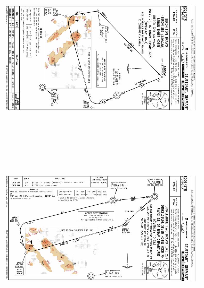
2
2
Clim
b to
BERO
N5B
If unable
to c
omply
request a
ltern
ate
instru
c-
tions b
y A
TC.
3500'
due to
BERO
N 5
BThis
SID
require
s a
min
imum c
limb g
radie
nt o
f 413' p
er N
M (6
.8%) u
ntil p
assin
gairs
pace s
tructu
re.
BERON 3H
BERO
NN49 17.3 E009 06.7
074^
254^
7 DME
5000
N48 47.3 E009 01.0
338^
074^
4.2 DME
008^
5000
BERON 5B
334^
R154^
16
D
.5000'
Apt Elev
Tra
ns le
vel: B
y A
TC T
rans a
lt: 5000'
125.0
5
1.
2.
1276'Radar im
media
tely
afte
r take-o
ff.
3.
1
1
SID
s a
re a
lso n
ois
e a
bate
-ment p
rocedure
s. S
trict a
dhere
nce w
ithin
the lim
its o
f airc
raft
perfo
rmance is
mandato
ry.
Rwy 2
5: E
XPECT c
lose-in
obsta
cle
s.
29
24.3
LAN
GEN
RadarConta
ct L
ANGEN
| JEPPESEN
SAN
DERSO
N, IN
C., 2002, 2003. A
LL RIGHTS RESERV
ED.
Radar callsign.CHA
NG
ES:
JEPPESEN
RWYS 25, 07 D
EPARTU
RES
RW
Y
25
07
SID
RO
UT
IN
G
Afte
r cro
ssin
g L
BU R
-240 B
RNAV e
quip
ment n
ecessary
.
CLIM
BIN
ST
RU
CT
IO
N
Inte
rcept 2
54^ b
earin
g to
ward
s S
Y, a
t SGD 4
.2 D
ME tu
rnRIG
HT, in
terc
ept 3
41^ b
earin
g to
ward
s N
KR, w
hen c
rossin
gLBU R
-240
turn
RIG
HT, 0
08^ tra
ck to
BERON.
BERO
N3H
75
100
150
200
250
300
413' p
er N
M516
689
1033
1377
1722
2066
109.2 LBULU
BURG
N48 54.8 E009 20.4
D112.5 TGO
TANGO
N48 37.1 E009 15.6
D(115.45) SGD
STUTTG
ART
DME
N48 41.3 E009 13.4
STUTTG
ART
306 SGN48 42.7 E009 20.1
NO
T TO SC
ALE O
UTSID
E THIS LIN
E
1717'1732'
1672'
1640'12
SG
LB
U
SGD
TGO
1726'
341^
STUTTG
ART
384 SYSY
N48 40.2 E009 06.9
128^242^
4200'
3400'
3900'
050^
010^
MSA
TGO
VO
R4800'
3300'w
ithin 10 NM
SPEED
REST
RIC
TIO
N
Not a
pplic
able
with
in a
irspace C
.or a
s b
y A
TC.
NOT A
VAILA
BLE FOR FLIG
HTS PLA
NNED
TO C
ONTIN
UE V
IA H
AREM
Inte
rcept 0
74^ b
earin
g v
ia S
G to
SGD 7
DME, tu
rn L
EFT, in
ter-
cept L
BU R
-154 in
bound to
LBU, L
BU R
-338 to
BERON.
MAX 2
50 K
T b
elo
w F
L100
1627'
BERON FIV
E BRAVO (BERO
N 5B)
BERON TH
REE HOTEL (BERO
N 3H
)
3.8
Gnd s
peed-K
T
6 JUN
03
Licensed to BISSIG
, MIK
E, . Printed from JeppView
disc 23-03.N
otice: After 27.11.2003 0901Z this chart should not be used w
ithout first checking JeppView or N
OTA
Ms.

292NKR
NKR
1480
1480
14801545
1480
1480
1545
1610
1480
1545
1480
1480
1480
1717'
254^
074^074^
1545
D25 DKB
N48 46.1E009 01.7
3500'
4 .2 DME
EDDS/STR
STUTTG
ART, G
ERMANY
STUTTG
ART
.SID.
Apt Elev
Tra
ns le
vel: B
y A
TC T
rans a
lt: 5000'
125.0
5
1.
2.
1276'Radar im
media
tely
afte
r take-o
ff.
3.
1
1
SID
s a
re a
lso n
ois
e a
bate
-ment p
rocedure
s. S
trict a
dhere
nce w
ithin
the lim
its o
f airc
raft
perfo
rmance is
mandato
ry.
Rwy 2
5: E
XPECT c
lose-in
obsta
cle
s.
10-3A
Climb to .5000'
DKB 2B:due to airspace structure.
This SID requires a minimum climb gradient of 413' per NM (6.8%)until passing
If unable to comply request alternateinstructions by ATC.
D
LAN
GEN
RadarConta
ct L
ANGEN
Availability; radar callsign.
| JEPPESEN
SAN
DERSO
N, IN
C., 2002, 2003. A
LL RIGHTS RESERV
ED.
DKB 2B
NOT TO SCALE OUTSIDE THIS LINE
1726'
1672'
1640'
DDINKELSBUHL
N49 08.6 E010 14.3
R230^
R248^
R235^068^
055^
117.8 DKB
5000
SPEED RESTRICTION
341^
10DM
E
050^
25
DKB 7H
DKB 2B
Not applicable within airspace C.
5000
DKB
or as by ATC.
DINKELSBU
HL TW
O BRA
VO (D
KB 2B)
11
DINKELSBU
HL SEV
EN H
OTEL (D
KB 7H
)
NOT FO
R FLIGHTS TERM
INATIN
G W
ITHIN M
UNICH FIR
20
75 100 150 200 250 300
413' per NM 516 689 1033 1377 1722 2066
CHA
NG
ES:
JEPPESEN
128^242^
4200'
3400'
3900'
050^
010^
MSA
TGO
VO
R4800'
3300'w
ithin 10 NM
25
07DKB 7H Intercept 074^ bearing via SG to SGD 10 DME, turn LEFT,intercept DKB R-230 inbound to DKB.
RWYSID ROUTINGCLIMB
INSTRUCTION
Intercept 254^ bearing towards SY, at SGD 4.2 DME turnRIGHT, intercept 341^ bearing towards NKR, interceptLBU R-235 inbound to LBU, LBU R-068 to DKB.
RWYS 25, 07 D
EPARTU
RES
D112.5 TGOTANGO
N48 37.1 E009 15.6TGO
109.2 LBULUBURG
N48 54.8 E009 20.4LBU
STUTTGART306 SG
N48 42.7 E009 20.1SG
D
(115.45) SGDSTUTTGART
DME
N48 41.3 E009 13.4SGD
STUTTGART384 SYSY
N48 40.2 E009 06.9
MAX 250 KT below FL100
1732'
1627'
Gnd speed-KT
15.1
38.1
3.8
6 JUN
03
AND N
OT FO
R FLIGHTS V
IA L 603, W
718 & T 104
(USE SID
ELVAG 1H
ON C
HART 10-3B &
Y 161)
Licensed to BISSIG
, MIK
E, . Printed from JeppView
disc 23-03.N
otice: After 27.11.2003 0901Z this chart should not be used w
ithout first checking JeppView or N
OTA
Ms.
1480
1480
14801545
1480
1480
1480
1545
1545
1610
1480
1545
1480
| JEPPESEN
SAN
DERSO
N, IN
C., 2002. A
LL RIGHTS RESERV
ED.
EDDS/STR
STUTTG
ART, G
ERMANY
STUTTG
ART
.SID.
Apt Elev
Tra
ns le
vel: B
y A
TC T
rans a
lt: 5000'
125.0
5
1.
2.
1276'STU
TTGA
RT RadarConta
ct S
tuttg
art
Radar im
media
tely
afte
r take-o
ff.
3.
SID
s a
re a
lso n
ois
e a
bate
-ment p
rocedure
s. S
trict a
dhere
nce w
ithin
the lim
its o
f airc
raft
perfo
rmance is
mandato
ry.
Rwy 2
5: E
XPECT c
lose-in
obsta
cle
s.
10-3B
Climb to .5000'
254^
4
4
2
3
23
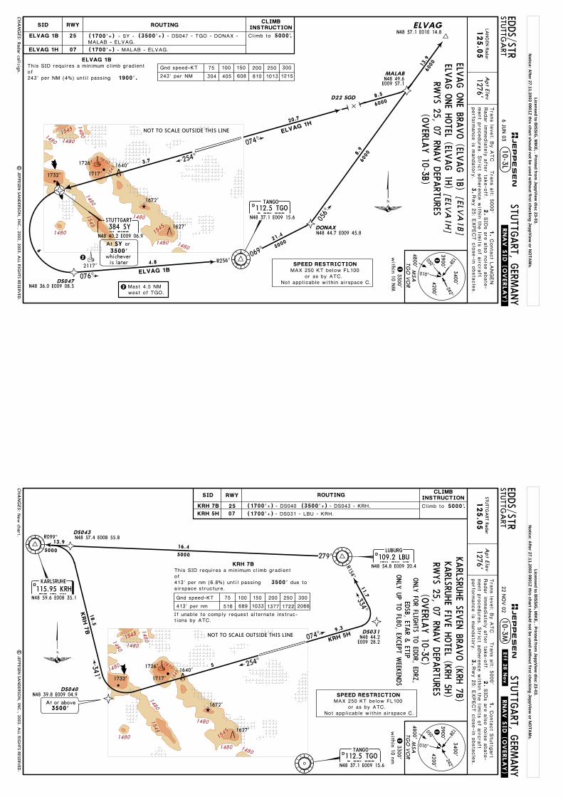
ELVAG 1B75 100 150 200 250 300
243' per nm 304 405 608 810 1013 12151900'.
This SID requires a minimum climb gradient of 243' per nm (4%) until passing
069^
056^
ELVAG 1H
074^
074^17
1460
00
6000
6000
5000
DONAX
MALAB
ELVAG
D22 SGD
N48 44.7 E009 45.8
N48 57.1 E010 14.8
N48 49.6E009 57.1
1
1is laterwhichever
Mast 4.5nmwest of TGO.
8.5
8.9
3.8
21.4
Gnd speed-KT
,SIDs established; new
format.
25
07
ELVAG1B
1HELVAG
CHA
NG
ES:
JEPPESEN.Eff.28.N
ov.
22 NO
V 02
RWYSID ROUTING
SPEED RESTRICTION
Not applicable within airspace C.or as by ATC.
RWYS 25, 07 D
EPARTU
RES
R256^
076^
11
NOT TO SCALE OUTSIDE THIS LINE
1717'
1726'
1732'
1672'
1640'
4.5
DME
2117'
ELVAG O
NE BRA
VO (ELV
AG 1B)
ELVAG O
NE H
OTEL (ELV
AG 1H
)
Intercept 254^ bearing to SY (SGD 4.5 DME) or 3500', which-
CLIMBINSTRUCTION
ELVAG 1B
128^242^
4200'
3400'
3900'
050^
010^
MSA
TGO
VO
R4800'
3300'w
ithin 10 nm
D112.5 TGOTANGO
N48 37.1 E009 15.6TGO
STUTTGART306 SG
N48 42.7 E009 20.1SG
D
(115.45) SGDSTUTTGART
DME
N48 41.3 E009 13.4SGD
STUTTGART384 SY
N48 40.2 E009 06.9SY3500'
At orSY
MAX 250 KT below FL100
1627'
3.7
ever is later, turn LEFT, intercept TGO R-256 inbound to TGO069^ track to DONAX, 056^ track via MALAB to ELVAG.
Intercept 074^ bearing via SG to MALAB, 056^ track to ELVAG.
After passing TGO BRNAV equipment necessary.After passing D22 SGD BRNAV equipment necessary.
Licensed to BISSIG
, MIK
E, . Printed from JeppView
disc 23-03.N
otice: After 27.11.2003 0901Z this chart should not be used w
ithout first checking JeppView or N
OTA
Ms.

1480
1480
14801545
1480
1480
1480
1545
1545
1610
1480
1545
1480
1480
R099^
074^
254^
D22 TGO 5000
E008 56.9N48 55.3
R154^334^
16
16
KRH 7B
5000
4.2 DME
074^
KRH 7B
If unable to comply request alternate instruc-tions by ATC.
3500' due to
This SID requires a minimum climb gradient of 413' per nm (6.8%) until passingairspace structure.
| JEPPESEN
SAN
DERSO
N, IN
C., 2002. A
LL RIGHTS RESERV
ED.
EDDS/STR
STUTTG
ART, G
ERMANY
STUTTG
ART
.SID.
Apt Elev
Tra
ns le
vel: B
y A
TC T
rans a
lt: 5000'
125.0
5
1.
2.
1276'STU
TTGA
RT RadarConta
ct S
tuttg
art
Radar im
media
tely
afte
r take-o
ff.
3.
1
1
SID
s a
re a
lso n
ois
e a
bate
-ment p
rocedure
s. S
trict a
dhere
nce w
ithin
the lim
its o
f airc
raft
perfo
rmance is
mandato
ry.
Rwy 2
5: E
XPECT c
lose-in
obsta
cle
s.
10-3C
Climb to .5000'
D
Chart reindexed; RN
AV SID
s transferred; new form
at.
30.3
279^
115.95 KRHKRHKARLSRUHE
N48 59.6 E008 35.1
21
292 NKRNECKAR
N49 20.2 E008 44.0
D
KRH 7
B
NOT TO SCALE OUTSIDE THIS LINE
1717'
1726'
1732'
1672'
1640'
KRH 5H
KARLSRU
HE FIV
E HOTEL (K
RH 5H
)
NKR
ONLY
UP TO
FL80, EXCEPT W
EEKEN
DS
KRH 5H
341^
ONLY
FOR FLIG
HTS TO
EDDR, ED
RZ,
EDSB, ETA
R & ETIP
KARLSRU
HE SEV
EN BRA
VO (K
RH 7B)SPEED RESTRICTION
Not applicable within airspace C.or as by ATC.
E7 DM
75 100 150 200 250 300
413' per nm 516 689 1033 1377 1722 2066
CHA
NG
ES:
JEPPESEN.Eff.28.N
ov.
22 NO
V 02
128^242^
4200'
3400'
3900'
050^
010^
MSA
TGO
VO
R4800'
3300'w
ithin 10 nm
25
07
RWYSID ROUTINGCLIMB
INSTRUCTION
Intercept 074^ bearing via SG to SGD 7 DME, turn LEFT,intercept LBU R-154 inbound to LBU, LBU R-279 to KRH.
Intercept 254^ bearing towards SY, at SGD 4.2 DME turnRIGHT, intercept 341^ bearing towards NKR, interceptKRH R-099 inbound KRH.
RWYS 25, 07 D
EPARTU
RES
D112.5 TGOTANGO
N48 37.1 E009 15.6TGO
109.2 LBULUBURG
N48 54.8 E009 20.4LBU
STUTTGART306 SG
N48 42.7 E009 20.1SG
D
(115.45) SGDSTUTTGART
DME
N48 41.3 E009 13.4SGD
STUTTGART384 SYSY
N48 40.2 E009 06.9
MAX 250 KT below FL100
1627'
Gnd speed-KT
3.8
Licensed to BISSIG
, MIK
E, . Printed from JeppView
disc 23-03.N
otice: After 27.11.2003 0901Z this chart should not be used w
ithout first checking JeppView or N
OTA
Ms.
292NKR NKR
1480
1480
1480
1545
1480
1480
1545
1545
1610
1480
1545
1480
1480
074^
254^
R154^
334^ 16
LBU 5H
074^
N48 46.1 E009 01.7
11
LBU
7B
4.2 DME
Clim
b to
If unable
to c
omply
request a
ltern
ate
instru
c-
tions b
y A
TC.
3500'due to
This
SID
require
s a
min
imum c
limb g
radie
nt o
f 413' p
er n
m (6
.8%) u
ntil p
assin
gairs
pace s
tructu
re.
.5000'
LBU
7B
| JEPPESEN
SAN
DERSO
N, IN
C., 2002. A
LL RIGHTS RESERV
ED.
EDDS/STR
STUTTG
ART, G
ERMANY
STUTTG
ART
.SID.
D
Apt Elev
Tra
ns le
vel: B
y A
TC T
rans a
lt: 5000'
125.0
5
1.
2.
1276'STU
TTGA
RT RadarConta
ct S
tuttg
art
Radar im
media
tely
afte
r take-o
ff.
3.
1
1
SID
s a
re a
lso n
ois
e a
bate
-ment p
rocedure
s. S
trict a
dhere
nce w
ithin
the lim
its o
f airc
raft
perfo
rmance is
mandato
ry.
Rwy 2
5: E
XPECT c
lose-in
obsta
cle
s.
10-3D
ONLY
FOR FLIG
HTS TO
EDDF, ED
FE, ETID &
ETOU
Chart reindexed; RN
AV SID
s transferred; new form
at.
R235^
LBU 7
B
SPEED
REST
RIC
TIO
N
Not a
pplic
able
with
in a
irspace C
.
NO
T TO SC
ALE O
UTSID
E THIS LIN
E
1717'
1726'
1732'
1672'
1640'
E7 DM
or a
s b
y A
TC.
LUBU
RG FIV
E HOTEL (LBU
5H)
341^
LUBU
RG SEV
EN BRA
VO (LBU
7B)
055^
RW
Y
25
07
SID
RO
UTIN
GC
LIM
BIN
ST
RU
CT
IO
N
75
100
150
200
250
300
413' p
er n
m516
689
1033
1377
1722
2066
Inte
rcept 2
54^ b
earin
g to
ward
s S
Y, a
t SGD 4
.2 D
ME tu
rnRIG
HT, in
terc
ept 3
41^ b
earin
g to
ward
s N
KR, in
terc
ept
LBU R
-235 in
bound to
LBU.
Inte
rcept 0
74^ b
earin
g v
ia S
G to
SGD 7
DME, tu
rn L
EFT,
inte
rcept L
BU R
-154 in
bound to
LBU.
LBU
5H
CHA
NG
ES:
JEPPESEN
.Eff.28.Nov.
22 NO
V 02
109.2 LBULU
BURG
N48 54.8 E009 20.4
D112.5 TGO
TANGO
N48 37.1 E009 15.6
D(115.45) SGD
STUTTG
ART
DME
N48 41.3 E009 13.4
STUTTG
ART
306 SGN48 42.7 E009 20.1
SG
LB
U
SGD
TGO
STUTTG
ART
384 SYSY
N48 40.2 E009 06.9
128^242^
4200'
3400'
3900'
050^
010^
MSA
TGO
VO
R4800'
3300'w
ithin 10 nm
RWYS 25, 07 D
EPARTU
RES
MAX 2
50 K
T b
elo
w F
L100
1627'
Gnd s
peed-K
T
3.8
15.1
Licensed to BISSIG
, MIK
E, . Printed from JeppView
disc 23-03.N
otice: After 27.11.2003 0901Z this chart should not be used w
ithout first checking JeppView or N
OTA
Ms.

1480
1480
1480
1545
1480
1480
1480
1545
1545
1610
1480
1545
1480
1480
NKR 7
H074^
254^
26
5000
NKR 9B21
5000
341^
NK
R 9
B
4.2 DME
| JEPPESEN
SAN
DERSO
N, IN
C., 2002. A
LL RIGHTS RESERV
ED.
EDDS/STR
STUTTG
ART, G
ERMANY
STUTTG
ART
.SID.
Clim
b to
If unable
to c
omply
request a
ltern
ate
instru
c-
tions b
y A
TC.
3500'due to
This
SID
require
s a
min
imum c
limb g
radie
nt o
f 413' p
er n
m (6
.8%) u
ntil p
assin
gairs
pace s
tructu
re.
.5000'
Apt Elev
Tra
ns le
vel: B
y A
TC T
rans a
lt: 5000'
125.0
5
1.
2.
1276'STU
TTGA
RT RadarConta
ct S
tuttg
art
Radar im
media
tely
afte
r take-o
ff.
3.
1
1
SID
s a
re a
lso n
ois
e a
bate
-ment p
rocedure
s. S
trict a
dhere
nce w
ithin
the lim
its o
f airc
raft
perfo
rmance is
mandato
ry.
Rwy 2
5: E
XPECT c
lose-in
obsta
cle
s.
10-3E
ND
G SID
s withdraw
n; NKR SID
s transferred; new form
at.
NK
R 9
B
7 DME074^
334^
R154^
16
D
317^
292 NKR
NEC
KAR
N49 20.2 E008 44.0
D22 T
GO
1717'
1726'
1732'
1672'
1640'
NO
T TO SC
ALE O
UTSID
E THIS LIN
E
1672'
1640'
NKR
NK
R 7
H
NEC
KAR N
INE BRA
VO (N
KR 9B)
NEC
KAR SEV
EN H
OTEL (N
KR 7H
)
CHA
NG
ES:
JEPPESEN
.Eff.28.Nov.
22 NO
V 02
RW
Y
25
07
SID
RO
UT
IN
GC
LIM
BIN
ST
RU
CT
IO
N
75
100
150
200
250
300
413' p
er n
m516
689
1033
1377
1722
2066
128^242^
4200'
3400'
3900'
050^
010^
MSA
TGO
VO
R4800'
3300'w
ithin 10 nm
SPEED
REST
RIC
TIO
N
Not a
pplic
able
with
in a
irspace C
.or a
s b
y A
TC.
Inte
rcept 2
54^ b
earin
g to
ward
s S
Y, a
t SGD 4
.2 D
ME tu
rnRIG
HT, in
terc
ept 3
41^ b
earin
g to
NKR.
Inte
rcept 0
74^ b
earin
g v
ia S
G to
SGD 7
DME, tu
rn L
EFT,
inte
rcept L
BU R
-154 in
bound to
LBU, L
BU R
-317 to
NKR.
109.2 LBULU
BURG
N48 54.8 E009 20.4
STUTTG
ART
306 SGN48 42.7 E009 20.1
SG
LB
U
D112.5 TGO
TANGO
N48 37.1 E009 15.6TG
O
RWYS 25, 07 D
EPARTU
RESONLY
FOR FLIG
HTS TO
EDFM
AND FLIG
HTS
TERMINATIN
G W
ITHIN ED
IE AREA
UP TO
FL100
D(115.45) SGD
STUTTG
ART
DME
N48 41.3 E009 13.4SG
D
STUTTG
ART
384 SYSY
N48 40.2 E009 06.9
MAX 2
50 K
T b
elo
w F
L100
1627'
34.9
3.8
Gnd s
peed-K
T
Licensed to BISSIG
, MIK
E, . Printed from JeppView
disc 23-03.N
otice: After 27.11.2003 0901Z this chart should not be used w
ithout first checking JeppView or N
OTA
Ms.
228^
D36
D
LBU
109.2BLU
1480
1480
14801545
1480
1480
1480
1545
1545
1610
1480
1545
1480
20
074^
254^
255^
5000
ROTW
E 2
B
ROTWE
11
ROTW
E 2
H
2
2
ROTWE 2B
75 100 150 200 250 300
243' per nm 304 405 608 810 1013 1215
1900'.
N48 30.8 E008 40.5
This SID requires a minimum climb gradient of 243' per nm (4%) until passing
| JEPPESEN
SAN
DERSO
N, IN
C., 2002. A
LL RIGHTS RESERV
ED.
EDDS/STR
STUTTG
ART, G
ERMANY
STUTTG
ART
.SID.
Apt Elev
Tra
ns le
vel: B
y A
TC T
rans a
lt: 5000'
125.0
5
1.
2.
1276'STU
TTGA
RT RadarConta
ct S
tuttg
art
Radar im
media
tely
afte
r take-o
ff.
3.
1
1
SID
s a
re a
lso n
ois
e a
bate
-ment p
rocedure
s. S
trict a
dhere
nce w
ithin
the lim
its o
f airc
raft
perfo
rmance is
mandato
ry.
Rwy 2
5: E
XPECT c
lose-in
obsta
cle
s.
10-3F
RNA
V SID
s transferred; new form
at.
Climb to .5000'
254^
Mast 4.5nmwest of TGO.
is laterwhichever
24.1
Gnd speed-KT
SPEED RESTRICTION
Not applicable within airspace C.
STUTTGART
384 SYSYN48 40.2 E009 06.9
15 DME
1717'
1726'
1732'
1672'
1640'
M4.6
DE
or as by ATC.
NOT TO SCALE OUTSIDE THIS LINE
3500',
25
07
2117'
ROTWE2B
2HROTWE
VIA
NATO
R ONLY
FOR JET A
IRCRA
FTRW
YS 25, 07 D
EPARTU
RES
CHA
NG
ES:
JEPPESEN
.Eff.28.Nov.
22 NO
V 02
128^242^
4200'
3400'
3900'
050^
010^
MSA
TGO
VO
R4800'
3300'w
ithin 10 nm
D
(115.45) SGDSTUTTGART
DME
N48 41.3 E009 13.4SGD
D112.5 TGOTANGO
N48 37.1 E009 15.6TGO
STUTTGART306 SG
N48 42.7 E009 20.1SG
Intercept 074^ bearing to SG (SGD 4.6 DME) or
RWYSID ROUTINGCLIMB
INSTRUCTION
Intercept 254^ bearing via SY to SGD 15 DME, turn LEFT,intercept LBU R-228 to ROTWE.
which-ever is later, turn RIGHT to TGO, TGO R-255 to ROTWE.
3500'At orSGMAX 250 KT below FL100
1627'
3.7
3.8
ROTW
E TWO BRA
VO (RO
TWE 2B)
ROTW
E TWO H
OTEL (RO
TWE 2H
)
Licensed to BISSIG
, MIK
E, . Printed from JeppView
disc 23-03.N
otice: After 27.11.2003 0901Z this chart should not be used w
ithout first checking JeppView or N
OTA
Ms.

1480
1480
14801545
1480
1480
1480
1545
1545
1610
1480
1545
1480
11
074^
254^
240^
R060^
25
SUL 6
H
5000
3
6000 D25 TGO
SULZ
SIX H
OTEL (SU
L 6H)
2
2
SULZ
NINE BRA
VO (SU
L 9B)
75 100 150 200 250 300
243' per nm 304 405 608 810 1013 1215
1900'.
This SID requires a minimum climb gradient of 243' per nm (4%) until passing
| JEPPESEN
SAN
DERSO
N, IN
C., 2002. A
LL RIGHTS RESERV
ED.
EDDS/STR
STUTTG
ART, G
ERMANY
STUTTG
ART
.SID.
Apt Elev
Tra
ns le
vel: B
y A
TC T
rans a
lt: 5000'
125.0
5
1.
2.
1276'STU
TTGA
RT RadarConta
ct S
tuttg
art
Radar im
media
tely
afte
r take-o
ff.
3.
1
1
SID
s a
re a
lso n
ois
e a
bate
-ment p
rocedure
s. S
trict a
dhere
nce w
ithin
the lim
its o
f airc
raft
perfo
rmance is
mandato
ry.
Rwy 2
5: E
XPECT c
lose-in
obsta
cle
s.
10-3G
RNA
V SID
s transferred; new form
at.
Climb to .5000'
SUL 9B
Mast 4.5nmwest of TGO.
RWYS 25, 07 D
EPARTU
RES
is laterwhichever
Gnd speed-KT
SULZ116.1 SUL
N48 22.9 E008 38.7
200^
23
SUL 9
B
SPEED RESTRICTION
Not applicable within airspace C.
NOT TO SCALE OUTSIDE THIS LINE
1717'
1726'
1732'
1672'
1640'
4.5
DME
M4.6
DE
SUL
or as by ATC.
ONLY
FOR PISTO
N EN
GINE &
TURBO
PRPOP A
CFT
JET ACFT O
NLY
WITH
DESTIN
ATIO
NED
NY, LSZ
H &
LSZR
3500',
2117'
SUL 9B
SUL 6H
25
07
CHA
NG
ES:
JEPPESEN
.Eff.28.Nov.
22 NO
V 02
128^242^
4200'
3400'
3900'
050^
010^
MSA
TGO
VO
R4800'
3300'w
ithin 10 nm
STUTTGART306 SG
N48 42.7 E009 20.1SG
RWYSID ROUTINGCLIMB
INSTRUCTION
Intercept 254^ bearing to SY (SGD 4.5 DME), turn LEFT, 200^track, intercept SUL R-060 inbound to SUL.
Intercept 074^ bearing to SG (SGD 4.6 DME) or which-ever is later, turn RIGHT to TGO, TGO R-240 to SUL.
STUTTGART
384 SYSYN48 40.2 E009 06.9
D
(115.45) SGDSTUTTGART
DME
N48 41.3 E009 13.4SGD
D112.5 TGOTANGO
N48 37.1 E009 15.6TGO
3500'At orSG
MAX 250 KT below FL100
1672'
3.8
3.7
Licensed to BISSIG
, MIK
E, . Printed from JeppView
disc 23-03.N
otice: After 27.11.2003 0901Z this chart should not be used w
ithout first checking JeppView or N
OTA
Ms.
1480
1480
1545
1480
1480
1480
1545
1545
1610
1480
1545
1480
074^
254^
2
2
11TGO 6H
TG
O 5
B
75
100
150
200
250
300
243' p
er n
m304
405
608
810
1013
1215
1900'.
This
SID
require
s a
min
imum c
limb g
radie
nt
of
243' p
er n
m (4
%) u
ntil p
assin
g
| JEPPESEN
SAN
DERSO
N, IN
C., 2002. A
LL RIGHTS RESERV
ED.
EDDS/STR
STUTTG
ART, G
ERMANY
STUTTG
ART
.SID.
Clim
b to
.
5000'
Apt Elev
Tra
ns le
vel: B
y A
TC T
rans a
lt: 5000'
119.8
5
1.
2.
1276'
Conta
ct S
tuttg
art
Radar im
media
tely
afte
r take-o
ff.
3.
1
1
SID
s a
re a
lso n
ois
e a
bate
-ment p
rocedure
s. S
trict a
dhere
nce w
ithin
the lim
its o
f airc
raft
perfo
rmance is
mandato
ry.
Rwy 2
5: E
XPECT c
lose-in
obsta
cle
s.
RNA
V SID
s transferred; new form
at.
STUTTG
ART A
rrival
TG
O 5
B
10-3H
whicheveris later
Mast 4
.5nm
west o
f TGO.
whicheveris later
Gnd s
peed-K
T
ONLY
FOR LO
CAL IFR TRA
INING FLIG
HTS
NO
T TO SC
ALE O
UTSID
E THIS LIN
E
1717'
1726'
1732'
1640'
4.5DME
M 4.6DE
SPEED
REST
RIC
TIO
N
Not a
pplic
able
with
in a
irspace C
.or a
s b
y A
TC.
TANGO FIV
E BRAVO (TG
O 5B)
R256^
TG
O 5
B
11
2117'
076^
3500',
3500',
TANGO SIX
HOTEL (TG
O 6H
)D(115.45) SGD
STUTTG
ART
DME
N48 41.3 E009 13.4SG
D
CHA
NG
ES:
JEPPESEN
.Eff.28.Nov.
22 NO
V 02
RW
Y
25
07
SID
RO
UT
IN
GC
LIM
BIN
ST
RU
CT
IO
N
128^242^
4200'
3400'
3900'
050^
010^
MSA
TGO
VO
R4800'
3300'w
ithin 10 nm
Inte
rcept 2
54^ b
earin
g to
SY (S
GD 4
.5 D
ME) o
rwhic
h-
ever is
late
r, turn
LEFT, in
terc
ept T
GO R
-256 in
bound to
TGO.
Inte
rcept 0
74^ b
earin
g to
SG (S
GD 4
.6 D
ME) o
rwhic
h-
ever is
late
r, turn
RIG
HT to
TGO.
TG
O 6
H
RWYS 25, 07 D
EPARTU
RES
D112.5 TGO
TANGO
N48 37.1 E009 15.6TG
O
STUTTG
ART
306 SGN48 42.7 E009 20.1
SGSTU
TTGART
384 SYSY
N48 40.2 E009 06.9
3500'
At
or
MAX 2
50 K
T b
elo
w F
L100
SY
3500'
At
orSG
1672'
1627'
3.8
3.7
Licensed to BISSIG
, MIK
E, . Printed from JeppView
disc 23-03.N
otice: After 27.11.2003 0901Z this chart should not be used w
ithout first checking JeppView or N
OTA
Ms.
D
1480
1480
1480
1545
1480
1480
1545
1545
1610
1480
1545
1480
1480
1480
| JEPPESEN
SAN
DERSO
N, IN
C., 2002. A
LL RIGHTS RESERV
ED.
EDDS/STR
STUTTG
ART, G
ERMANY
STUTTG
ART
Clim
b to
5000'.
If unable
to c
omply
request a
ltern
ate
instru
c-
tions b
y A
TC.
3500'due to
BERO
N 5
BThis
SID
require
s a
min
imum c
limb g
radie
nt o
f 413' p
er n
m (6
.8%) u
ntil p
assin
gairs
pace s
tructu
re.
BERON 3H
BERO
NN49 17.3 E009 06.7
254^
5000
338^
DS040
008^
28.75000
BERON 5B
334^
R154^
DS031
DS042
D
10-3J.RNAV.SID.(OVERLAY).
N48 48.9 E009 00.2
11.7
24.3
074^N48 44.2
E009 28.2
At or
above3500'
5000'
At or above
9.6
New
chart.
(1700'+
)
(1700'+
)
- DS040
- DS031 - L
BU - B
ERON.
(3500'+
)- D
S042
(5000'+
)- B
ERON.
Apt Elev
Tra
ns le
vel: B
y A
TC T
rans a
lt: 5000'
125.0
5
1.
2.
1276'STU
TTGA
RT RadarConta
ct S
tuttg
art
Radar im
media
tely
afte
r take-o
ff.
3.
SID
s a
re a
lso n
ois
e a
bate
-ment p
rocedure
s. S
trict a
dhere
nce w
ithin
the lim
its o
f airc
raft
perfo
rmance is
mandato
ry.
Rwy 2
5: E
XPECT c
lose-in
obsta
cle
s.
1
1
N48 39.8
E009 04.9
CHA
NG
ES:
JEPPESEN
.Eff.28.Nov.
22 NO
V 02
RO
UTIN
GC
LIM
BIN
ST
RU
CT
IO
N
75
100
150
200
250
300
413' p
er n
m516
689
1033
1377
1722
2066
109.2 LBULU
BURG
N48 54.8 E009 20.4
D112.5 TGO
TANGO
N48 37.1 E009 15.6
NO
T TO SC
ALE O
UTSID
E THIS LIN
E
1717'1732'
1672'
1640'5
LB
U
TGO
1726'
341^
BERON TH
REE HOTEL
(BERON 3H
)[B
ERO
3H]
BERON FIV
E BRAVO
(BERON 5B)
[BER
O5B]
RWYS 25, 07 RN
AV D
EPARTU
RES(O
VERLA
Y 10-3)
9.3
RW
Y
25
SID
BERO
N 5
B
BERO
N 3
H07
NOT A
VAILA
BLE FOR FLIG
HTS PLA
NNED
TO C
ONTIN
UE V
IA H
AREM
128^242^
4200'
3400'
3900'
050^
010^
MSA
TGO
VO
R4800'
3300'w
ithin 10 nm
SPEED
REST
RIC
TIO
N
Not a
pplic
able
with
in a
irspace C
.or a
s b
y A
TC.
MAX 2
50 K
T b
elo
w F
L100
1627'
Gnd s
peed-K
T
Licensed to BISSIG
, MIK
E, . Printed from JeppView
disc 23-03.N
otice: After 27.11.2003 0901Z this chart should not be used w
ithout first checking JeppView or N
OTA
Ms.
1480
1480
14801545
1480
1480
1545
1610
1480
1545
1480
1480
1480
1717'
254^
074^
1545
DS032
DS041
N48 44.5E009 29.6
D25 DKB
3500'
EDDS/STR
STUTTG
ART, G
ERMANY
STUTTG
ART
Apt Elev
Tra
ns le
vel: B
y A
TC T
rans a
lt: 5000'
125.0
5
1.
2.
1276'Radar im
media
tely
afte
r take-o
ff.
3.
1
1
SID
s a
re a
lso n
ois
e a
bate
-ment p
rocedure
s. S
trict a
dhere
nce w
ithin
the lim
its o
f airc
raft
perfo
rmance is
mandato
ry.
Rwy 2
5: E
XPECT c
lose-in
obsta
cle
s.
10-3K
Climb to .5000'
If unable to comply request alternateinstructions by ATC.
D
.RNAV.SID.(OVERLAY).
DS040
At orabove3500'
5
N48 46.1E009 01.7
N48 39.8E009 04.9
(1700'+) - DS040 (3500'+)
(1700'+) - DS032 - DKB.
- DS041 - LBU - DKB.
This SID requires a minimum climb gradientof413' per NM (6.8%) until passing
DKB 2B
dueto airspace structure.
Availability; radar callsign.
| JEPPESEN
SAN
DERSO
N, IN
C., 2002, 2003. A
LL RIGHTS RESERV
ED.
LAN
GEN
RadarConta
ct L
ANGEN
DKB 2B
NOT TO SCALE OUTSIDE THIS LINE
1726'
1732'
1672'
1640'
DDINKELSBUHL
N49 08.6 E010 14.3
R230^
R248^
R235^068^
055^
117.8 DKB
5000
SPEED RESTRICTION
341^
050^
25
DKB 7H
DKB 2B
Not applicable within airspace C.
5000
DKB
or as by ATC.
DINKELSBU
HL TW
O BRA
VO (D
KB 2B)
DINKELSBU
HL SEV
EN H
OTEL (D
KB 7H
)
75 100 150 200 250 300
413' per NM 516 689 1033 1377 1722 2066CHA
NG
ES:
JEPPESEN
128^242^
4200'
3400'
3900'
050^
010^
MSA
TGO
VO
R4800'
3300'w
ithin 10 NM
25
07DKB 7H
RWYSID ROUTINGCLIMB
INSTRUCTION
D112.5 TGOTANGO
N48 37.1 E009 15.6TGO
109.2 LBULUBURG
N48 54.8 E009 20.4LBU
RWYS 25, 07 RN
AV D
EPARTU
RES(O
VERLA
Y 10-3A
)
10.3
6.6
15.1
38.1
13.1
MAX 250 KT below FL100
1627'
NOT FO
R FLIGHTS TERM
INATIN
G W
ITHIN M
UNICH FIR
AND N
OT FO
R FLIGHTS V
IA L603, W
718 & T104
Gnd speed-KT
6 JUN
03
(USE RN
AV SID
ELVAG 1H
ON C
HART 10-3L &
Y 161)
Licensed to BISSIG
, MIK
E, . Printed from JeppView
disc 23-03.N
otice: After 27.11.2003 0901Z this chart should not be used w
ithout first checking JeppView or N
OTA
Ms.
1480
1480
14801545
1480
1480
1480
1545
1545
1610
1480
1545
1480
Climb to .5000'(1700'+)
(1700'+)ED
DS/STR
STUTTG
ART, G
ERMANY
STUTTG
ART
Apt Elev
Tra
ns le
vel: B
y A
TC T
rans a
lt: 5000'
125.0
5
1.
2.
1276'Radar im
media
tely
afte
r take-o
ff.
3.
SID
s a
re a
lso n
ois
e a
bate
-ment p
rocedure
s. S
trict a
dhere
nce w
ithin
the lim
its o
f airc
raft
perfo
rmance is
mandato
ry.
Rwy 2
5: E
XPECT c
lose-in
obsta
cle
s.
10-3L254^
DS047
2
2N48 36.0 E009 08.5
ELVAG 1B
75 100 150 200 250 300
243' per NM 304 405 608 810 1013 12151900'.
This SID requires a minimum climb gradient of 243' per NM (4%) until passing
069^
056^
ELVAG 1H
074^
6000
6000
6000
5000
DONAX
MALAB
ELVAG
D22 SGD
N48 44.7 E009 45.8
N48 57.1 E010 14.8
N48 49.6E009 57.1
1
1is laterwhichever
.RNAV.SID.(OVERLAY).
8.5
20.7
13.9
21.4
8.9
6
(3500'+)
- MALAB - ELVAG.
MALAB - ELVAG.- DS047 - TGO - DONAX -
Gnd speed-KT
- SY -
| JEPPESEN
SAN
DERSO
N, IN
C., 2002, 2003. A
LL RIGHTS RESERV
ED.
Radar callsign.
LAN
GEN
RadarConta
ct L
ANGEN
Mast 4.5 NMwest of TGO.
ELVAG 1B 25
07
RWYSID ROUTINGCLIMB
INSTRUCTION
ELVAG 1H
CHA
NG
ES:
JEPPESEN
SPEED RESTRICTION
Not applicable within airspace C.or as by ATC.
R256^
076^
NOT TO SCALE OUTSIDE THIS LINE
1717'
1726'
1732'
1672'
1640'
2117'
ELVAG O
NE BRA
VO (ELV
AG 1B)
ELVAG O
NE H
OTEL (ELV
AG 1H
)[ELV
A1B]
[ELVA
1H]
ELVAG 1B
128^242^
4200'
3400'
3900'
050^
010^
MSA
TGO
VO
R4800'
3300'w
ithin 10 NM
D112.5 TGOTANGO
N48 37.1 E009 15.6TGO
STUTTGART384 SY
N48 40.2 E009 06.9SY3500'
At orSY
RWYS 25, 07 RN
AV D
EPARTU
RES(O
VERLA
Y 10-3B)
4.8
3.7
MAX 250 KT below FL100
1627'
6 JUN
03
Licensed to BISSIG
, MIK
E, . Printed from JeppView
disc 23-03.N
otice: After 27.11.2003 0901Z this chart should not be used w
ithout first checking JeppView or N
OTA
Ms.
1480
1480
14801545
1480
1480
1480
1545
1545
1610
1480
1545
1480
1480
- DS040 (3500'+)
R099^
074^
254^
5000
R154^334^
DS031
DS043N48 57.4 E008 55.8
KRH 7B
DS040N48 39.8 E009 04.9
KRH 7B
If unable to comply request alternate instruc-tions by ATC.
3500' due to
This SID requires a minimum climb gradient of 413' per nm (6.8%) until passingairspace structure.
| JEPPESEN
SAN
DERSO
N, IN
C., 2002. A
LL RIGHTS RESERV
ED.
EDDS/STR
STUTTG
ART, G
ERMANY
STUTTG
ART
Apt Elev
Tra
ns le
vel: B
y A
TC T
rans a
lt: 5000'
125.0
5
1.
2.
1276'STU
TTGA
RT RadarConta
ct S
tuttg
art
Radar im
media
tely
afte
r take-o
ff.
3.
1
1
SID
s a
re a
lso n
ois
e a
bate
-ment p
rocedure
s. S
trict a
dhere
nce w
ithin
the lim
its o
f airc
raft
perfo
rmance is
mandato
ry.
Rwy 2
5: E
XPECT c
lose-in
obsta
cle
s.
10-3M
Climb to .5000'
D
(1700'+)
(1700'+)
- DS043 - KRH.
- DS031 - LBU - KRH.
.RNAV.SID.(OVERLAY).
N48 44.2E009 28.2
11.7
13.916.4
3500'At or above
New
chart.
5
5000279^
115.95 KRHKRHKARLSRUHE
N48 59.6 E008 35.1
D
KRH 7
B
NOT TO SCALE OUTSIDE THIS LINE
1717'
1726'
1732'
1672'
1640'
KRH 5H
KARLSRU
HE FIV
E HOTEL (K
RH 5H
)
ONLY
UP TO
FL80, EXCEPT W
EEKEN
DS
KRH 5H
341^
ONLY
FOR FLIG
HTS TO
EDDR, ED
RZ,
EDSB, ETA
R & ETIP
KARLSRU
HE SEV
EN BRA
VO (K
RH 7B)SPEED RESTRICTION
Not applicable within airspace C.or as by ATC.
75 100 150 200 250 300
413' per nm 516 689 1033 1377 1722 2066
CHA
NG
ES:
JEPPESEN.Eff.28.N
ov.
22 NO
V 02
128^242^
4200'
3400'
3900'
050^
010^
MSA
TGO
VO
R4800'
3300'w
ithin 10 nm
25
07
RWYSID ROUTINGCLIMB
INSTRUCTION
D112.5 TGOTANGO
N48 37.1 E009 15.6TGO
109.2 LBULUBURG
N48 54.8 E009 20.4LBU
(OVERLA
Y 10-3C
)
9.3
18.5
MAX 250 KT below FL100
RWYS 25, 07 RN
AV D
EPARTU
RES
1627'
Gnd speed-KT
Licensed to BISSIG
, MIK
E, . Printed from JeppView
disc 23-03.N
otice: After 27.11.2003 0901Z this chart should not be used w
ithout first checking JeppView or N
OTA
Ms.
1480
148
0
1480
1545
1480
1480
1545
1545
1610
1480
1545
1480
1480
- DS040
(3500'+
)
254^
R154^LBU 5H
DS041
LBU
7B
If unable
to c
omply
request a
ltern
ate
instru
c-
tions b
y A
TC.
3500'due to
This
SID
require
s a
min
imum c
limb g
radie
nt o
f 413' p
er n
m (6
.8%) u
ntil p
assin
gairs
pace s
tructu
re.
LBU
7B
| JEPPESEN
SAN
DERSO
N, IN
C., 2002. A
LL RIGHTS RESERV
ED.
EDDS/STR
STUTTG
ART, G
ERMANY
STUTTG
ART
Apt Elev
Tra
ns le
vel: B
y A
TC T
rans a
lt: 5000'
125.0
5
1.
2.
1276'STU
TTGA
RT RadarConta
ct S
tuttg
art
Radar im
media
tely
afte
r take-o
ff.
3.
1
1
SID
s a
re a
lso n
ois
e a
bate
-ment p
rocedure
s. S
trict a
dhere
nce w
ithin
the lim
its o
f airc
raft
perfo
rmance is
mandato
ry.
Rwy 2
5: E
XPECT c
lose-in
obsta
cle
s.
10-3N
D
New
chart.
.RNAV.SID.(OVERLAY).
DS031
074^N48 44.2
E009 28.2
11.7
6.6
N48 46.1
E009 01.7
5
EDDF, ED
FE, ETID &
ETOU
Clim
b to
5000'.
(1700'+
)
(1700'+
)
- DS041 - L
BU.
- DS031 - L
BU.
334^
DS040
At or
above3500'
N48 39.8
E009 04.9
R235^
LBU 7
B
SPEED
REST
RIC
TIO
N
Not a
pplic
able
with
in a
irspace C
.
NO
T TO SC
ALE O
UTSID
E THIS LIN
E
1717'
1726'
1732'
1672'
1640'
or a
s b
y A
TC.
LUBU
RG FIV
E HOTEL (LBU
5H)
341^
LUBU
RG SEV
EN BRA
VO (LBU
7B)
055^
75
100
150
200
250
300
413' p
er n
m516
689
1033
1377
1722
2066
LBU
5H
CHA
NG
ES:
JEPPESEN
.Eff.28.Nov.
22 NO
V 02
D112.5 TGO
TANGO
N48 37.1 E009 15.6TG
O
128^242^
4200'
3400'
3900'
050^
010^
MSA
TGO
VO
R4800'
3300'w
ithin 10 nm
109.2 LBULU
BURG
LB
UN48 54.8 E009 20.4
9.3
15.1
RWYS 25, 07 RN
AV D
EPARTU
RES
ONLY
FOR FLIG
HTS TO
(OVERLA
Y 10-3D
)
RO
UT
IN
GC
LIM
BIN
ST
RU
CT
IO
NRW
Y
25
SID
07
MAX 2
50 K
T b
elo
w F
L100
1627'
Gnd s
peed-K
T
Licensed to BISSIG
, MIK
E, . Printed from JeppView
disc 23-03.N
otice: After 27.11.2003 0901Z this chart should not be used w
ithout first checking JeppView or N
OTA
Ms.
1480
148
0
1480
1545
1480
1480
1480
1545
1545
1610
1480
1545
1480
1480
- DS040
(3500'+
)(1700'+
)- N
KR.
- DS031 - L
BU - N
KR.
(1700'+
)
254^
26
5000NKR 9B
5000
341^
NK
R 9
B
| JEPPESEN
SAN
DERSO
N, IN
C., 2002. A
LL RIGHTS RESERV
ED.
EDDS/STR
STUTTG
ART, G
ERMANY
STUTTG
ART
Clim
b to
If unable
to c
omply
request a
ltern
ate
instru
c-
tions b
y A
TC.
3500'due to
This
SID
require
s a
min
imum c
limb g
radie
nt o
f 413' p
er n
m (6
.8%) u
ntil p
assin
gairs
pace s
tructu
re.
.5000'
Apt Elev
Tra
ns le
vel: B
y A
TC T
rans a
lt: 5000'
125.0
5
1.
2.
1276'STU
TTGA
RT RadarConta
ct S
tuttg
art
Radar im
media
tely
afte
r take-o
ff.
3.
1
1
SID
s a
re a
lso n
ois
e a
bate
-ment p
rocedure
s. S
trict a
dhere
nce w
ithin
the lim
its o
f airc
raft
perfo
rmance is
mandato
ry.
Rwy 2
5: E
XPECT c
lose-in
obsta
cle
s.
10-3P
NK
R 9
B
074^
334^
R154^
D
317^
DS040
At or
above3500'
N48 39.8
E009 04.9
.RNAV.SID.(OVERLAY).
DS031
N48 44.2
E009 28.2
NKR 7
H
11.7
9.3
5
16.6
New
chart.
292 NKR
NEC
KAR
N49 20.2 E008 44.0
D22 T
GO
1717'
1726'
1732'
1672'
1640'
NO
T TO SC
ALE O
UTSID
E THIS LIN
E
1672'
1640'
NKR
NK
R 7
H
NEC
KAR N
INE BRA
VO (N
KR 9B)
NEC
KAR SEV
EN H
OTEL (N
KR 7H
)
CHA
NG
ES:
JEPPESEN
.Eff.28.Nov.
22 NO
V 02
RW
Y
25
07
SID
RO
UT
IN
GC
LIM
BIN
ST
RU
CT
IO
N
75
100
150
200
250
300
413' p
er n
m516
689
1033
1377
1722
2066
128^242^
4200'
3400'
3900'
050^
010^
MSA
TGO
VO
R4800'
3300'w
ithin 10 nm
SPEED
REST
RIC
TIO
N
Not a
pplic
able
with
in a
irspace C
.or a
s b
y A
TC.
109.2 LBULU
BURG
N48 54.8 E009 20.4
LB
U
D112.5 TGO
TANGO
N48 37.1 E009 15.6TG
O
ONLY
FOR FLIG
HTS TO
EDFM
AND FLIG
HTS
TERMINATIN
G W
ITHIN ED
IE AREA
UP TO
FL100
RWYS 25, 07 RN
AV D
EPARTU
RES(O
VERLA
Y 10-3E)
34.9
MAX 2
50 K
T b
elo
w F
L100
1627'
Gnd s
peed-K
T
Licensed to BISSIG
, MIK
E, . Printed from JeppView
disc 23-03.N
otice: After 27.11.2003 0901Z this chart should not be used w
ithout first checking JeppView or N
OTA
Ms.

228^
D36
D
LBU
109.2BLU
1480
1480
14801545
1480
1480
1480
1545
1545
1610
1480
1545
1480
(3500'+)
.RNAV.SID.(OVERLAY).
074^
254^
255^
5000
ROTW
E 2
BDS049
N48 37.1E008 50.8
ROTWE
11
ROTW
E 2
H
2
2
ROTWE 2B
75 100 150 200 250 300
243' per nm 304 405 608 810 1013 1215
1900'.
N48 30.8 E008 40.5
This SID requires a minimum climb gradient of 243' per nm (4%) until passing
| JEPPESEN
SAN
DERSO
N, IN
C., 2002. A
LL RIGH
TS RESERVED
.
EDDS/STR
STUTTG
ART, G
ERMANY
STUTTG
ART
Apt Elev
Tra
ns le
vel: B
y A
TC T
rans a
lt: 5000'
125.0
5
1.
2.
1276'STU
TTGA
RT RadarConta
ct S
tuttg
art
Radar im
media
tely
afte
r take-o
ff.
3.
1
1
SID
s a
re a
lso n
ois
e a
bate
-ment p
rocedure
s. S
trict a
dhere
nce w
ithin
the lim
its o
f airc
raft
perfo
rmance is
mandato
ry.
Rwy 2
5: E
XPECT c
lose-in
obsta
cle
s.
10-3Q
Climb to .5000'(1700'+) - DS049 - ROTWE.
- TGO - ROTWE.(1700'+)
9.3
24.1
New
chart.
Mast 4.5nmwest of TGO.
is laterwhichever
Gnd speed-KT
- SG -
ROTWE 2B
SPEED RESTRICTION
Not applicable within airspace C.
1717'
1726'
1732'
1672'
1640'
or as by ATC.
NOT TO SCALE OUTSIDE THIS LINE
2117'
ROTW
E TWO H
OTEL
(ROTW
E 2H)
[RO
TW2H]
ROTW
E TWO BRA
VO
(ROTW
E 2B)[R
OTW
2B]
VIA
NATO
R ONLY
FOR JET A
IRCRA
FT
CH
AN
GES:
JEPPESEN
.Eff.28.Nov.
22 NO
V 02
128^242^
4200'
3400'
3900'
050^
010^
MSA
TGO
VO
R4800'
3300'w
ithin 10 nm
D112.5 TGOTANGO
N48 37.1 E009 15.6TGO
STUTTGART306 SG
N48 42.7 E009 20.1SG
(OVERLA
Y 10-3F)
25
07
RWYSID ROUTINGCLIMB
INSTRUCTION
ROTWE 2H
14.7
3.8
3500'At orSGMAX 250 KT below FL100
RWYS 25, 07 RN
AV D
EPARTU
RES
1627'
Licensed to BISSIG
, MIK
E, . Printed from JeppView
disc 23-03.N
otice: After 27.11.2003 0901Z this chart should not be used w
ithout first checking JeppView or N
OTA
Ms.
1480
1480
14801545
1480
1480
1480
1545
1545
1610
1480
1545
1480
11
074^
254^
240^
R060^
SUL 6
H
5000
6000 D25 TGO
DS044
DS045
SULZ
SIX H
OTEL (SU
L 6H)
N48 31.5 E009 00.9
2
2
N48 39.9 E009 05.5
SULZ
NINE BRA
VO (SU
L 9B)
75 100 150 200 250 300
243' per nm 304 405 608 810 1013 1215
1900'.
This SID requires a minimum climb gradient of 243' per nm (4%) until passing
| JEPPESEN
SAN
DERSO
N, IN
C., 2002. A
LL RIGHTS RESERV
ED.
EDDS/STR
STUTTG
ART, G
ERMANY
STUTTG
ART
Apt Elev
Tra
ns le
vel: B
y A
TC T
rans a
lt: 5000'
125.0
5
1.
2.
1276'STU
TTGA
RT RadarConta
ct S
tuttg
art
Radar im
media
tely
afte
r take-o
ff.
3.
1
1
SID
s a
re a
lso n
ois
e a
bate
-ment p
rocedure
s. S
trict a
dhere
nce w
ithin
the lim
its o
f airc
raft
perfo
rmance is
mandato
ry.
Rwy 2
5: E
XPECT c
lose-in
obsta
cle
s.
10-3S
SUL 9B
Mast 4.5nmwest of TGO.
is laterwhichever
.RNAV.SID.(OVERLAY).
RWYS 25, 07 RN
AV D
EPARTU
RES(O
VERLA
Y 10-3G
)
New
chart.
3.3
13.8
11.2
(3500'+)
Climb to .5000'(1700'+)
(1700'+)
- DS044 - DS045 - SUL.
- TGO - SUL.
Gnd speed-KT
- SG -
SUL 9B
SULZ116.1 SUL
N48 22.9 E008 38.7
200^
9SUL 9
B
SPEED RESTRICTION
Not applicable within airspace C.
NOT TO SCALE OUTSIDE THIS LINE
1717'
1726'
1732'
1672'
1640'
SUL
or as by ATC.
2117'
CHA
NG
ES:
JEPPESEN
.Eff.28.Nov.
22 NO
V 02
128^242^
4200'
3400'
3900'
050^
010^
MSA
TGO
VO
R4800'
3300'w
ithin 10 nm
STUTTGART306 SG
N48 42.7 E009 20.1SG
D112.5 TGOTANGO
N48 37.1 E009 15.6TGO
3500'At orSG
ONLY
FOR PISTO
N EN
GINE &
TURBO
PRPOP A
CFT
JET ACFT O
NLY
WITH
DESTIN
ATIO
NED
NY, LSZ
H &
LSZR
3.8
4.6
25
07
RWYSID ROUTINGCLIMB
INSTRUCTION
MAX 250 KT below FL100
SUL 6H
1627'
Licensed to BISSIG
, MIK
E, . Printed from JeppView
disc 23-03.N
otice: After 27.11.2003 0901Z this chart should not be used w
ithout first checking JeppView or N
OTA
Ms.

1480
1480
1545
1480
1480
1480
1545
1545
1610
1480
1545
1480
074^
254^
2
DS047
N48 36.0 E009 08.5
2
11TGO 6H
(3500'+
)
(3500'+
)
TG
O 5
B
75
100
150
200
250
300
243' p
er n
m304
405
608
810
1013
1215
1900'.
This
SID
require
s a
min
imum c
limb g
radie
nt
of
243' p
er n
m (4
%) u
ntil p
assin
g
| JEPPESEN
SAN
DERSO
N, IN
C., 2002. A
LL RIGHTS RESERV
ED.
EDDS/STR
STUTTG
ART, G
ERMANY
STUTTG
ART
Clim
b to
.
5000'
Apt Elev
Tra
ns le
vel: B
y A
TC T
rans a
lt: 5000'
119.8
5
1.
2.
1276'
Conta
ct S
tuttg
art
Radar im
media
tely
afte
r take-o
ff.
3.
1
1
SID
s a
re a
lso n
ois
e a
bate
-ment p
rocedure
s. S
trict a
dhere
nce w
ithin
the lim
its o
f airc
raft
perfo
rmance is
mandato
ry.
Rwy 2
5: E
XPECT c
lose-in
obsta
cle
s.
STUTTG
ART A
rrival
TG
O 5
B
10-3T
whicheveris later
.RNAV.SID.(OVERLAY)
6
Mast 4
.5nm
west o
f TGO.
New
chart.
(1700'+
)
(1700'+
)- T
GO.
- DS047 - T
GO.
- SY -
- SG -
whicheveris later
Gnd s
peed-K
T
ONLY
FOR LO
CAL IFR TRA
INING FLIG
HTS
NO
T TO SC
ALE O
UTSID
E THIS LIN
E
1717'
1726'
1732'
1640'
SPEED
REST
RIC
TIO
N
Not a
pplic
able
with
in a
irspace C
.or a
s b
y A
TC.
TANGO FIV
E BRAVO (TG
O 5B)
R256^
TG
O 5
B2117'
076^
TANGO SIX
HOTEL (TG
O 6H
)
CHA
NG
ES:
JEPPESEN
.Eff.28.Nov.
22 NO
V 02
RW
Y
25
07
SID
RO
UT
IN
GC
LIM
BIN
ST
RU
CT
IO
N
128^242^
4200'
3400'
3900'
050^
010^
MSA
TGO
VO
R4800'
3300'w
ithin 10 nm
TG
O 6
H
D112.5 TGO
TANGO
N48 37.1 E009 15.6TG
O
STUTTG
ART
306 SGN48 42.7 E009 20.1
SGSTU
TTGART
384 SYSY
N48 40.2 E009 06.9
3500'
At
or
(OVERLA
Y 10-3H
)
4.8 3.7
3.8
3500'
At
orSG
SY
MAX 2
50 K
T b
elo
w F
L100
RWYS 25, 07 RN
AV D
EPARTU
RES
1672'
1627'
Licensed to BISSIG
, MIK
E, . Printed from JeppView
disc 23-03.N
otice: After 27.11.2003 0901Z this chart should not be used w
ithout first checking JeppView or N
OTA
Ms.
Licensed to BISSIG
, MIK
E, . Printed from JeppView
disc 23-03.N
otice: After 27.11.2003 0901Z this chart should not be used w
ithout first checking JeppView or N
OTA
Ms.

Licensed to BISSIG
, MIK
E, . Printed from JeppView
disc 23-03.N
otice: After 27.11.2003 0901Z this chart should not be used w
ithout first checking JeppView or N
OTA
Ms.
240^
200^
ROTWE
BERO
N
7 DME
334^
R154^
.NOISE.
BERON 3H, KRH 5H
LBU 5H, NKR 7H
ROTWE
BERO
N
008^BERON 5BK
RH 7B
NKR 9B
DONAX
EDDS/STR
STUTTG
ART, G
ERMANY
STUTTG
ART
10-4B
Apt Elev
1276'
CHA
NG
ES:
KRH
1
1Nois
e m
onito
ring p
oin
t
Hospita
l
25
07
DKB
LBU
TGO
SUL
SY
SGSG
D
NKR
34
8
2
5
7
6
255^
069^
240^ 074^
254^
341^
055^
279^
317^
338^
068^
076^
R099^
KRH
5HNKR 7H
DKB 2B
R235^
DKB 2B, LBU 7B
R248^
SUL 9B
TGO
5B
R060^
R256^
4.6 DME
4.5 DME
SUL 6H
NKR
BERON 3H
BERON 5B, DKB 2B, KRH 7B
LBU 7B, NKR 9B
ROTW
E 2B
ROTW
E 2H
ROTWE 2H, SUL 6H
TGO 6H
4 DME.2
ELVA
G 1B
ELVA
G 1B
ELVA
G 1H
DKB 7H
DKB
JEPPESEN
.Eff.28.Nov.
22 NO
V 02
| JEPPESEN
SAN
DERSO
N, IN
C., 2002. A
LL RIGHTS RESERV
ED.
ND
G SID
s replaced by ELVA
G SID
s; new form
at.
NO
ISE ABA
TEMEN
T PROCED
URES
KRH
Licensed to BISSIG
, MIK
E, . Printed from JeppView
disc 23-03.N
otice: After 27.11.2003 0901Z this chart should not be used w
ithout first checking JeppView or N
OTA
Ms.

Licensed to BISSIG
, MIK
E, . Printed from JeppView
disc 23-03.N
otice: After 27.11.2003 0901Z this chart should not be used w
ithout first checking JeppView or N
OTA
Ms.
Licensed to BISSIG
, MIK
E, . Printed from JeppView
disc 23-03.N
otice: After 27.11.2003 0901Z this chart should not be used w
ithout first checking JeppView or N
OTA
Ms.

Limit of ATCcompetence area
Treesup to
Bypass areas (P1, P2)
P2 P1
1329'
118.8 119.05
| JEPPESEN
SAN
DERSO
N, IN
C., 1998, 2003. A
LL RIGHTS RESERV
ED.
Apt Elev
48-41 48-41
48-42 48-42
09-11
09-11
09-12
09-12
09-13
09-13
09-14
09-14
09-15
09-15
1352'
1358'
1378'
1388'
1368'
VAR 0^126.12
121.9
Apron
121.7
1406'
29 AUG
03
General aviation area 1 & 2 unusable for aircraft exceeding 2.0 mt MPW. General aviation area 3 unusable for aircraft with wingspan exceeding 95'/29m. Arriving acft more than 5.7 tons MTOM shall use flwg turn offs when rwy conditions permit:rwy 07: jets twy D and props twy E, rwy 25: twy F.
ControlTower
MILITARYAPRON
Elev1181'
A
M
Z
FOR PARKING POSITIONS
25254^
NN
1368'
M B
07074^
Elev1276' Y X
Z
W
M
SEE 10-9B
Tower
STUTTG
ART
STUTTG
ART, G
ERMANY
CHA
NG
ES:
N48 41.4 E009 13.3
341.0^/4.6 from TG
O 112.5
AIS+
MET
R
1276'
EDDS/STR
0
0 200 400 600 800 1000
1000 2000 3000 4000
1200
Feet
Meters
10-9JEPPESEN
GENERALAVIATION 3
GENERALAVIATION 2 GENERAL
AVIATION 1
*A
TISSTU
TTGA
RT Ground (C
pt)
Z
GAT
Z
ACA
RS:D
CL
(see 10-9A etc)
Com
munications. N
ote.
ARP
3345m
N
NI
H F
G
S
SA
B
C
G
E
E
N D
S
C
B
D
N
S
F
HN I
K
S10,97
4'
S
Licensed to BISSIG
, MIK
E, . Printed from JeppView
disc 23-03.N
otice: After 27.11.2003 0901Z this chart should not be used w
ithout first checking JeppView or N
OTA
Ms.
| JEPPESEN
SAN
DERSO
N, IN
C., 2003. A
LL RIGHTS RESERV
ED.
10-9A1
29 AUG
03
New
page.
EDDS/STR
CHA
NG
ES:
JEPPESEN
STUTTG
ART
STUTTG
ART, G
ERMANY
DA
TA
LINK D
EPA
RTURE C
LEA
RA
NCE (D
CL)
1. M
ESSA
GE T
YPES
2. T
IME P
ARA
METERS
The maxim
um duration of the D
CL process is lim
ited by time param
eters.
RCD
CLD
CD
A FSM
Request for departure clearance downlink - m
essage of the pilot requesting start-up approval and en-route clearance. D
eparture clearance uplink message - issuance of start-up approval and
en-route clearance by the air traffic controller. D
eparture clearance readback message - confirm
ation of start-up approval and en-route clearance by the pilot. Flight system
uplink message - autom
atic acknowledgem
ent of receipt of RC
D/C
DA
by the air traffic control system, or the interruption of the D
CL
dialogue by the controller.
t t t t t
Earliest point in time at w
hich the request for start-up approval anden-route clearance (RC
D) m
ay be transmitted.
The point in time at w
hich the DCL dialogue is finished or at w
hich the pilot can assum
e that the process cannot be finished and sufficient time rem
ains to obtain the start-up approval and en-route clearance via radiotelephony. The period of tim
e between the transm
ission of an RCD
and receipt of an FSM
by the pilot. The period of tim
e between the transm
ission of a CLD
and receipt of a CD
A by the air traffic control system
. The period of tim
e between the transm
ission of a CD
A and receipt of an
FSM by the pilot.
i t 0 1 2
3. P
RO
CEDURE
The participating pilots shall maintain listening w
atch on the frequency published for the start-up approval. In the event of any doubts or system
-related difficulties, voice procedures shall be resum
ed. A clearance issued by voice procedures supersedes a transm
itted datalink clearance. If de-icing of the aircraft is required prior to departure, the start-up approval and en-route clearance w
ill only be issued via voice procedures. Prior to departure, both the pilot and the com
petent air traffic controller shall verify that the departure route assigned via D
CL logically refers to the runw
ay used and to the route indicated in the current A
TC flight plan. In the event of any
deviations or doubts, voice procedures shall be resumed.
i
The pilot shall request start-up approval and en-route clearance by means of
an RCD
not earlier than at point t.
3.1
3.2
Note: The data to be transm
itted (e.g.: airline code and aircraft type according to IC
AO
) shall correspond to the data contained in the current ATC
flight plan.
As soon as the air traffic control system
has received the RCD
, the FSM w
ill be transm
itted automatically. If the RC
D is rejected by m
eans of a negative FSM,
the pilot shall revert to voice procedures.
Licensed to BISSIG
, MIK
E, . Printed from JeppView
disc 23-03.N
otice: After 27.11.2003 0901Z this chart should not be used w
ithout first checking JeppView or N
OTA
Ms.

| JEPPESEN
SAN
DERSO
N, IN
C., 2003. A
LL RIGHTS RESERV
ED.
10-9A2
29 AUG
03
New
page.
EDDS/STR
CHA
NG
ES:
JEPPESEN
STUTTG
ART
STUTTG
ART, G
ERMANY
1
DA
TA
LINK D
EPA
RTURE C
LEA
RA
NCE (D
CL) (c
ont'd
)
A C
LD is used to issue a start-up approval and en-route clearance and to
transmit the designator or the current A
TIS broadcast, the CTO
T available at the TO
WER, next frequency and, if necessary, inform
ation in the free-text field. If a C
TOT is not available, the acronym
MD
I (Minim
um D
eparture Interval) w
ill be transmitted.
Note: In order to ensure integrity betw
een clearance (CLD
) and readback (CD
A),
the CD
A m
ay not differ from the C
LD. The air traffic control system
will
not accept and process differing CD
As.
As soon as a C
DA
has been processed successfully, the air traffic control system
will transm
it a positive FSM. O
nly when the FSM
has been received, is the process com
pletely finished.
If it is not possible to issue the start-up approval together with the en-route
clearance, the free-text field will contain a tim
e at which the start-up approval
is regarded as issued, or the pilot receives an FSM w
ith the instruction to revert to voice procedures.
3.3
3.4
3.5
3.6
The pilot shall confirm a C
LD by m
eans of a CD
A. If the pilot does not transm
it the C
DA
within the tim
eframe t
, the air traffic control system w
ill autom
atically issue a negative FSM together w
ith the instruction to revert to voice procedures.
Licensed to BISSIG
, MIK
E, . Printed from JeppView
disc 23-03.N
otice: After 27.11.2003 0901Z this chart should not be used w
ithout first checking JeppView or N
OTA
Ms.
RVR
2
2
TAKE-O
FF
ABCD
RCLM
(DA
Y only)
250m
300m
400m
500m
NIL
(DA
Y only)
1
1
RCLM
(DA
Y only)
RL & C
L
200m
250m
& m
ult. RVR req
125m
150m
LVP m
ust b
e in
Forc
e
or RLor RL
All R
wys
& m
ult. RVR req
150m
200m
RL, CL
HIRL, C
L
Operators applying U
.S. Ops Specs: C
L required below 300m
; approved guidance system required
below 150m
.
Approved O
perators
GEN
ERAL
Rwy 07/25 is approved for C
AT II/III operations, special aircrew
and acft certification required.M
IL acft wanting to use a parking position on C
IV apron and C
IV acft w
anting to use a parking positionon M
IL ramp are requested to advise Tow
er when establishing radio contact.
EDDS/STR
1
1
STUTTG
ART
STUTTG
ART, G
ERMANY
CHA
NG
ES:
0725
45m148'
RWY
AD
DITIO
NA
L RUN
WA
Y IN
FORM
ATIO
N
ThresholdLA
ND
ING
BEY
ON
DUSA
BLE LEN
GTH
S
WID
THTA
KE-O
FFG
lide Slope
304
9m
9990'8775'
304
5m2675m
10,002'
TAKE-O
FF RUN
AVA
ILABLE
From rw
y head
JEPPESEN
10-9A| JEPPESEN
SAN
DERSO
N, IN
C., 1998, 2003. A
LL RIGHTS RESERV
ED.
.JAR-OPS.
From rw
y headtw
y B int
twy C
inttw
y D int
twy E int
(3045m)
(2435m)
(2175m)
(1990m)
(1665m)
9990'7989'7136'6529'5463'
DE-IC
IN
G P
RO
CED
URE
Acft de-icing w
ill be performed on de-icing-areas L1 and L2. Pilots have to inform
aboutnecessary de-icing 20 m
in prior to start-up request on STUTTG
ART G
ROUN
D.
STUTTG
ART A
PRON
may instruct pilots to change parking position in case de-icing positions are blocked.
When de-icing position is available, STU
TTGA
RT APRO
N w
ill give taxi instructions and will request
pilots to establish radio contact with the de-icing service.
During the de-icing procedure, only the engines of prop acft and of acft w
ith jet engines, for which
special regulations exist, have to be turned-off.A
fter de-icing pilots have to request new start-up (w
here required) and/or taxi instructions on STU
TTGA
RT APRO
N.
twy X
inttw
y I inttw
y H int
twy W
inttw
y G int
twy F int
twy E int
10,974'10,663'10,138'
8251'8235'7251'6627'4593'
(3345m)
(3250m)
(3090m)
(2515m)
(2510m)
(2210m)
(2020m)
(1400m)
HIRL C
L ALSF-II TD
Z SFL REIL PAPI-L
(angle 3.0^)
RWY 07:
RWY 25:
29 AUG
03
Datalink departure clearance.
DA
TA
LIN
K D
EPA
RT
URE C
LEA
RA
NC
E (
DC
L)
t t ttt
25 min prior to EO
BT for unregulated flights.
30 min prior to C
TOT for A
FTM regulated flights.
11 min prior to EO
BT for unregulated flights.
16 min prior to C
TOT for A
FTM regulated flights.
1 min
5 min
1 min
Temporal param
eters:
i t 012
Licensed to BISSIG
, MIK
E, . Printed from JeppView
disc 23-03.N
otice: After 27.11.2003 0901Z this chart should not be used w
ithout first checking JeppView or N
OTA
Ms.
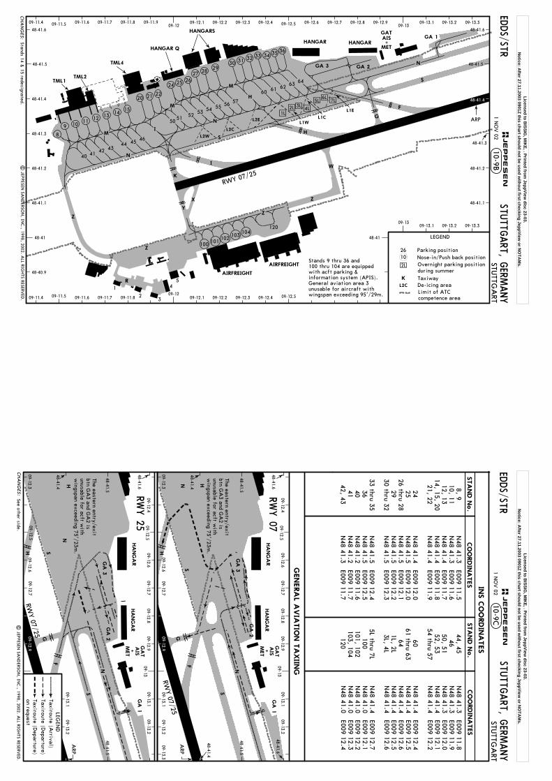
EDDS/STR
120
Z
ZY
X
W
K
L2W
L2C
L2E
2L
H
N
SM
TML1TML2
H
HANGAR
AIRFREIGHT
AIRFREIGHT
RWY 07/25
3L2L1L
M
M
I
G
N
F
5L6L
4L
HANGARS
HANGAR Q
TML4
S
Z
HANGAR
GA 3
GA 1
100 101102 103
104
I
48-41
48-40.9
48-41.1
48-41.2
48-41.3
48-41.4
48-41.6
48-41.5
48-41
48-41.6
48-41.5
48-41.3
48-41.2
48-41.1
09-1209-12.509-12.1 09-12.2 09-12.3 09-12.409-11.4 09-11.6 09-11.7 09-11.809-11.5
09-11.4 09-11.6 09-11.7 09-11.809-11.5 09-12.1 09-12.2 09-12.3 09-12.409-11.909-12 09-12.5 09-12.6 09-12.7 09-12.8 09-12.9
09-1309-13.1 09-13.2 09-13.3
09-1309-13.1 09-13.2 09-13.3
ARP
7L
L1E
L1CL1W
GA 2
N
R
1
23
45
Z
MET
AISGAT
+
48-41.4
Limit of ATCcompetence area
STUTTG
ART
STUTTG
ART, G
ERMANY
CHA
NG
ES:
10-9B1 N
OV 02
| JEPPESEN
SAN
DERSO
N, IN
C., 1998, 2002. A
LL RIGHTS RESERV
ED.
LEGEND
De-icing area
26
L2C
K Taxiway
Parking position
during summer
Nose-in/Push back positionOvernight parking position
9
21 22
10 11 12 13 14 15
8
40 41 42 4344 45 46
5051 52 53 54 55 56 57
24 25 2627 28
29
60 61 62 63 64
30 31 32 33 34 35 36
20
JEPPESEN
10Stands 9 thru 36 and100 thru 104 are equippedwith acft parking & information system (APIS).General aviation area 3 unusable for aircraft withwingspan exceeding 95'/29m.
Stands 14 & 15 redesignated.
Licensed to BISSIG
, MIK
E, . Printed from JeppView
disc 23-03.N
otice: After 27.11.2003 0901Z this chart should not be used w
ithout first checking JeppView or N
OTA
Ms.
H
EDDS/STR
ARP
H
HA
NG
AR
G
N
F
S
HA
NG
AR
GA
3
GA
1
GA
2
S
H
H
HA
NG
AR
G
F
S
HA
NG
AR
GA
3N
09-12.609-12.7
09-12.809-12.9
09-1309-13.1
09-13.2
N
ARP
RWY 07/25
RWY 07/25
09-12.409-12.5
09-13.109-13.2
09-13.309-12.6
09-12.709-12.3
48-41.4
48-41.5
48-41.6
09-13.1
09-12.609-12.3
48-41.4
48-41.5
48-41.6
09-12.609-12.7
09-12.809-12.9
09-1309-13.1
09-13.209-12.4
09-12.5
48-41.6
48-41.4
48-41.548-41.5
09-12.5 N
S
GA
1
RWY 07
RWY 25
GA
2
The eastern entry/exitbtn G
A3 and G
A2 is
unusable for acft with
wingspan exceeding 75'/23m
.
The eastern entry/exitbtn G
A3 and G
A2 is
unusable for acft with
wingspan exceeding 75'/23m
.
09-12.7
MET
AIS+
MET
AIS+
09-13.2
GA
T
GA
T
09-12.9
09-12.9
LEGEN
D
Taxiroute (Departure)
Taxiroute (Arrival)
Taxiroute (Departure)
on request
N48 41.3 E009 11.5
N48 41.3 E009 11.6
N48 41.4 E009 11.7
N48 41.4 E009 11.8
N48 41.4 E009 11.9
N
48 41.4 E009 12.0N
48 41.5 E009 12.0N
48 41.5 E009 12.1N
48 41.5 E009 12.2N
48 41.5 E009 12.3
N48 41.5 E009 12.4
N48 41.5 E009 12.5
N48 41.2 E009 11.6
N48 41.2 E009 11.7
N48 41.3 E009 11.7
8, 910, 1112, 13
14, 15, 2021, 22
242526 thru 28
2930 thru 32
33 thru 35
36404142, 43
44, 4546
50, 5152, 53
54 thru 57 60
61 thru 6364
1L, 2L3L, 4L
5L thru 7L
100101, 102103, 104
120
N48 41.3 E009 11.8
N48 41.3 E009 11.9
N48 41.3 E009 12.0
N48 41.4 E009 12.1
N48 41.4 E009 12.2
N
48 41.4 E009 12.4N
48 41.4 E009 12.5N
48 41.4 E009 12.6N
48 41.4 E009 12.5N
48 41.4 E009 12.6
N48 41.4 E009 12.7
N48 41.0 E009 12.1
N48 41.0 E009 12.2
N48 41.0 E009 12.3
N48 41.0 E009 12.4
CHA
NG
ES:
10-9CSTU
TTGART, G
ERMANY
STUTTG
ART
1 NO
V 02
CO
ORDIN
ATES
CO
ORDIN
ATES
INS C
OO
RDIN
ATES
STA
ND N
o.
STA
ND N
o.
| JEPPESEN
SAN
DERSO
N, IN
C., 1998, 2002. A
LL RIGH
TS RESERVED
.
JEPPESEN
GENERA
L AVIA
TIO
N T
AXIIN
G
See other side.
Licensed to BISSIG
, MIK
E, . Printed from JeppView
disc 23-03.N
otice: After 27.11.2003 0901Z this chart should not be used w
ithout first checking JeppView or N
OTA
Ms.
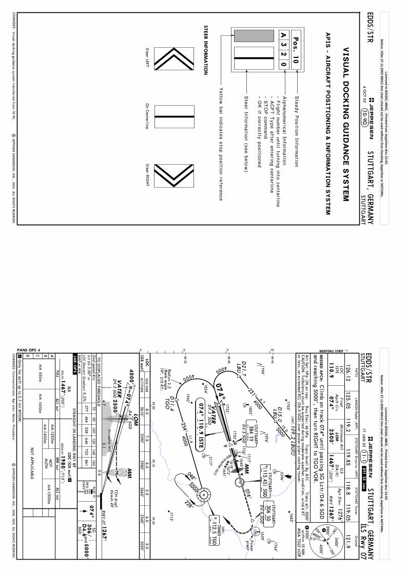
VISU
AL D
OC
KIN
G G
UID
AN
CE S
YSTEM
Pos. 1
0
A3
20
Ste
ady P
ositio
n In
form
atio
n
Alp
hanumeric
al In
form
atio
n
Yello
w b
ar in
dic
ate
s s
top p
ositio
n re
fere
nce
- Flig
ht n
umber u
ntil tu
rnin
g in
to c
ente
rline
- ACFT T
ype a
fter e
nte
ring c
ente
rline
- STOP c
ommand
- OK if c
orre
ctly
positio
ned
STEER IN
FO
RM
ATIO
N
Steer LEFTSteer RIG
HT
On C
enterline
Ste
er In
form
atio
n (s
ee b
elo
w)
APIS -
AIRC
RA
FT P
OSITIO
NIN
G &
IN
FO
RM
ATIO
N S
YSTEM
EDDS/STR
CHA
NG
ES:
10-9DSTU
TTGART, G
ERMANY
STUTTG
ART
JEPPESEN
4 OCT 02
Visual docking guidance system
transferred from 10-9C
.|
JEPPESEN SA
ND
ERSON
, INC., 2002. A
LL RIGH
TS RESERVED
.
Licensed to BISSIG
, MIK
E, . Printed from JeppView
disc 23-03.N
otice: After 27.11.2003 0901Z this chart should not be used w
ithout first checking JeppView or N
OTA
Ms.
Weidacher
048^
228^
Hill
5000
(IAF)
DTA
NGO
T G O
074^
112.5 TGO
MM
Power
plant
ILS
074^ 1
10.9
ISTE
I S T E
074^
D4.6 SG
D
D4.5 SG
D
384 SYS Y
4000
6.74000
D21.7
LB
U
4000
D11.4
TGO
(IAF)
15.05000
231^
LBU
D15.0
109.2
LBU LBU
VA
TER
D9.2
SGD
48-40
09-0009-10
09-20
48-45
48-35
LOC
110.9
ISTE
074^
Apt Elev
1276'
RW
Y1267'
LOM
ILS GS
or3.00^
5.2%377
484538
646753
861
1000m
550mRV
RRV
R
MD
A(H
)(7
13')
1980'
DA
(H)1
467'(2
00')
LOC D
escent Gra
dient
ALSF-II
074^
5000'
m4000'
074^
1267'
LOM
4.73.1
2500'
Weidacher H
ill
D4.5 SG
D
RW
Y 07
MMc
0.6
TCH displ
thresh 49'
SGD
DM
E6.0
2980'5.0
2660'7.0
3290'3.0
2020'8.0
3610'4.0
2340'
SG
NO
T APPLIC
ABLE
Alt Set: hPa
(IN on req)
Rwy Elev: 46 hPa
Trans level: By A
TCTrans alt: 5000'
and
ILSD
A(H
)
1467'(2
00')
VA
TER
D9.2
SGD
3400'4200'1M
SA TG
O V
OR
3900'4800'
1
RVR
RVR1
400m
1200m
1500m
RVR
MIS
SED A
PCH:
BRIEFING STRIP TM
Gnd speed-K
ts70
90100
120140
160
EDDS/STR
STUTTG
ART
STUTTG
ART, G
ERMANY
ILS Rwy 07
11-1*A
TIS
126.12
Ground
121.9118.8
119.05
STUTTG
ART Tow
er
Final
Apch C
rsM
inimum
Alt
2500'
050^
010^
128^242^
3300'w
ithin 10 NM
.
PANS OPS 4
| JEPPESEN
SAN
DERSO
N, IN
C., 2000, 2003. A
LL RIGH
TS RESERVED
.
MA
P a
t MM
0
05 5 10
125.05119.2
119.85
STUTTG
ART D
irector (APP)
and reaching 5000', then turn RIGHT to TG
O V
OR.
Clim
b on track 074^ until passing SG Lctr/D
4.6 SGD
CA
UTIO
N: Turbulence m
ust be expected during moderate w
eather condition, wind 6 K
Tor less, on extended RC
L (D6.0 SG
D) over pow
er plant cooling tower.REIL
PAPI
306/
D4.6
SGD
STRAIG
HT-IN
LAN
DIN
G RW
Y
ABCD
FULL
ALS out
07
ILS.JAR-OPS.
ALS out
LOC (G
S o
ut)
MM out
NO
TA
UTH
1
1
Only for acft up to 5.7 m
t MTO
W.
LAN
GEN
Radar (APP)
TO D
ISPLACED
THRESH
OLD
17 JAN
03.Eff.23.Jan
.
Com
munications. A
pt elev. Notes. Procedure.
D(115.45) SGD
STUTTG
ART
S G D
S GSTU
TTGART
306 SG
STUTTG
ART
254^11.4
4000
Radius 2.3(B
ank angle19^, 210 K
T)
CHA
NG
ES:
JEPPESEN
LOC
(GS o
ut)
ALTITU
DE
1799'
1618'1672'1641'
1640'
1717'
1703'
1802'
1732'
1683'
1732'
1942'
2117'
1713'
1764'
2296'
1976'
1824'
1629'
1726'
Licensed to BISSIG
, MIK
E, . Printed from JeppView
disc 23-03.N
otice: After 27.11.2003 0901Z this chart should not be used w
ithout first checking JeppView or N
OTA
Ms.

Weidacher
048^
228^
Hill
5000
(IAF)
DTA
NGO
T G O
074^
112.5 TGO
MM
Power
plant
ILS
074^ 1
10.9
ISTE
I S T E
074^
D4.6 SG
D
4000
6.74000
D21.7
LB
U
4000
D11.4
TGO
(IAF)
15.05000
231^
LBU
D15.0
109.2
LBU LBU
VA
TER
D9.2
SGD
48-40
09-0009-10
09-20
48-45
48-35
3.00^377
484538
646753
861
m4000'
074^
1267'
LOM
4.73.1
Weidacher H
ill
D4.5 SG
D
RW
Y 07
DA
(H)
1367'(100')
CAT II ILS Rw
y 07
CA
T II ILSRA
90'
GS
STRAIG
HT-IN
LAN
DIN
G RW
YCA
T II ILS
07
DA
(H)
(100')
1367'
RVR
300m1
RA
90'
.JAR-OPS.
1O
perators applying U. S. O
ps Specs: CA
T III authorization required below 350m
.
VA
TER
D9.2
SGD
LOC
110.9
ISTE
074^
Apt Elev
1276'
RW
Y1267'
LOM
Alt Set: hPa
(IN on req)
Rwy Elev: 46 hPa
Trans level: By A
TCTrans alt: 5000'
3400'4200'1M
SA TG
O V
OR
3900'4800'
1
MIS
SED A
PCH:
BRIEFING STRIP TM EDDS/STR
STUTTG
ART
STUTTG
ART, G
ERMANY
Final
Apch C
rs
2500'
050^
010^
128^242^
3300'w
ithin 10 NM
.
11-1A
Gnd speed-K
ts70
90
100
120
140
160
PANS OPS 4
| JEPPESEN
SAN
DERSO
N, IN
C., 2000, 2003. A
LL RIGH
TS RESERVED
.
ALSF-II
074^
5000'
MMc
0.6
TCH displ
thresh 49'
and
0
05 5 10
WeidacherHill
*A
TIS
126.12
Ground
121.9118.8
119.05
STUTTG
ART Tow
er
125.05119.2
119.85
STUTTG
ART D
irector (APP)
Minim
um A
lt
and reaching 5000', then turn RIGHT to TG
O V
OR.
Clim
b on track 074^ until passing SG Lctr/D
4.6 SGD
1. CA
UTIO
N: Turbulence m
ust be expected during moderate w
eather condition, wind
6 KT or less, on extended RC
L (D6.0 SG
D) over pow
er plant cooling tower.
2. Special Aircrew
& A
ircraft Certification Required.
D4.5 SG
D
384 SYS Y
2500'
REILPA
PI
SG306/
D4.6
SGD
LAN
GEN
Radar (APP)
TO D
ISPLACED
THRESH
OLD
17 JAN
03.Eff.23.Jan
.
Com
munications. A
pt elev. Notes. Procedure.
D(115.45) SGD
STUTTG
ART
S G D
S GSTU
TTGART
306 SG
254^11.4
4000
Radius 2.3(B
ank angle19^, 210 K
T)
JEPPESEN
CHA
NG
ES:
1799'
1618'1672'1641'
1640'
1703'
1802'
1683'
1732'
1942'
2117'
1713'
1764'
2296'
1976'
1824'
1629'
STUTTG
ART
1732'
1726' 1717'
Licensed to BISSIG
, MIK
E, . Printed from JeppView
disc 23-03.N
otice: After 27.11.2003 0901Z this chart should not be used w
ithout first checking JeppView or N
OTA
Ms.
D5.0
LBU
D9.6
ILS
254^ 1
09.9
ISTW
I S T W
306 SGS G
048^
4000
4000
D10.1
LB
U
D10.4
TGO
228^
5.1
4000141^
109.2
LBU LBU
UNSER
SGD
MHA
5000
25000
5.02
48-40
48-50
09-1009-20
09-30
109.9
ISTW
254^
1000m
550mRV
RRV
R
MD
A(H
)(3
39')
1520'
DA
(H)
D:1
388' (2
07')
ABC:1
381' (2
00')
600mRV
R
ILS Rwy 25
11-2
254^
SY
c
UNSER
D9.6 SG
D
LACFT: D
A(H
) 1388' (207'), FULL: RV
R 600m.
1
1
LOC
Apt Elev
1276'
RW
Y1181'
LOM
ILS GS
or3.00^
5.2%377
484538
646753
861LO
C D
escent Gra
dient
ALSF-II
5000'
Alt Set: hPa
(IN on req)
Rwy Elev: 43 hPa
Trans level: By A
TCTrans alt: 5000'
and
ILSD
A(H
)3400'4200'
1MSA
TGO
VO
R
3900'4800'
1
MIS
SED A
PCH:
BRIEFING STRIP TM
Gnd speed-K
ts70
90100
120140
160
EDDS/STR
STUTTG
ART
STUTTG
ART, G
ERMANY
Final
Apch C
rsM
inimum
Alt
2440'
050^
010^
128^242^
1. CA
UTIO
N: Turbulence m
ust be expected during moderate w
eather condition, wind
6 KT or less, on extended RC
L (D6.0 SG
D) over pow
er plant cooling tower.
2. LACFT: See A
TC state pages.
3300'w
ithin 10 NM
.
PANS OPS 4
| JEPPESEN
SAN
DERSO
N, IN
C., 2000, 2003. A
LL RIGH
TS RESERVED
.
MA
P a
t MM
Refer toM
inimum
s
SGD
DM
E5.0
2540'6.0
2860'3.0
1900'9.0
3810'2.0
1590'7.0
3180'
05 5 10
*A
TIS
126.12
Ground
121.9118.8
119.05
STUTTG
ART Tow
er
125.05119.2
119.85
STUTTG
ART D
irector (APP)
Clim
b on track 254^ until passing SY Lctr/D
4.5 SGD
and reaching 5000', then turn LEFT to TGO
VO
R.
REILPA
PI
384/
D4.5
SGD
STRAIG
HT-IN
LAN
DIN
G RW
Y
ABCD
FULL
ALS out
25
ILS.JAR-OPS.
ALS out
LOC (G
S o
ut)
MM out
NO
TA
UTH
RVR
RVR1
000m
RVR
1400m
900m
1500m
RVR
RVR
2000m
RVR
1800m
LAN
GEN
Radar (APP) 17 JA
N 03
.Eff.23.Jan.
Com
munications. A
pt elev. Notes. Procedure.
254^
MM
Power
plant
DSTU
TTGART
S G D
(115.45)SGD
384 SYSTU
TTGART
S YD
4.5 SG
D
(IAF)
DTA
NGO
T G O
112.5 TGO
D4.6 SG
D
STUTTG
ART
074^
4000
Radius 2.3(B
ank angle18^, 210 K
T)
10.4
(IAF)
254^
1181'
RW
Y 2
50.6
MM
254^
5.03.2
TCH 49'
2440'
4000'
M LOM
D4.6 SG
D
CHA
NG
ES:
JEPPESEN
0
LOC
(GS o
ut)
ALTITU
DE
1618'1672'1641'
1640'1717'
1732'
1683'
2117'2608'
Weidacher
Hill
1764'2296'
1976'1629'
Licensed to BISSIG
, MIK
E, . Printed from JeppView
disc 23-03.N
otice: After 27.11.2003 0901Z this chart should not be used w
ithout first checking JeppView or N
OTA
Ms.

377484
538646
753861 c
CAT II ILS Rw
y 25
CA
T II ILS
STRAIG
HT-IN
LAN
DIN
G RW
YCA
T II ILS
25
DA
(H)
(100')
1281'
RA
108'
RVR
300m1
.JAR-OPS.
1O
perators applying U. S. O
ps Specs: CA
T III authorization required below 350m
.
RA
108'
DA
(H)
(100')
1281'
UNSER
D9.6 SG
D
D5.0
LBU
D9.6
ILS
254^ 1
09.9
ISTW
I S T W
Weid
acherHill
306 SGS G
048^
4000
4000
D10.1
LB
U
D10.4
TGO
228^
5.1
4000141^
109.2
LBU LBU
UNSER
SGD
MHA
5000
25000
5.02
48-40
48-50
09-1009-20
09-30
109.9
ISTW
254^
254^
LOC
Apt Elev
1276'
RW
Y1181'
LOM
ALSF-II
5000'
Alt Set: hPa
(IN on req)
Rwy Elev: 43 hPa
Trans level: By A
TCTrans alt: 5000'
and
3400'4200'1M
SA TG
O V
OR
3900'4800'
1
MIS
SED A
PCH:
BRIEFING STRIP TM EDDS/STR
STUTTG
ART
STUTTG
ART, G
ERMANY
Final
Apch C
rs
2440'
050^
010^
128^242^
3300'w
ithin 10 NM
.
PANS OPS 4
| JEPPESEN
SAN
DERSO
N, IN
C., 2000, 2003. A
LL RIGH
TS RESERVED
.
11-2A
Gnd speed-K
ts70
90
100
120
140
160
05 5 10
*A
TIS
126.12
Ground
121.9118.8
119.05
STUTTG
ART Tow
er
125.05119.2
119.85
STUTTG
ART D
irector (APP)
LAN
GEN
Radar (APP)
Minim
um A
lt
Clim
b on track 254^ until passing SY Lctr/D
4.5 SGD
and reaching 5000', then turn LEFT to TGO
VO
R.
1. CA
UTIO
N: Turbulence m
ust be expected during moderate w
eather condition, wind
6 KT or less, on extended RC
L (D6.0 SG
D) over pow
er plant cooling tower.
2. Special Aircrew
& A
ircraft Certification Required.
REILPA
PI
SY384/
D4.5
SGD
17 JAN
03.Eff.23.Jan
.
Com
munications. A
pt elev. Notes. Procedure.
1181'
RW
Y 2
5
3.00^
0.6
MM
254^
5.03.2
TCH 49'
2440'
4000'
M LOM
D4.6 SG
D
GS
254^
MM
Power
plant
DSTU
TTGART
S G D
(115.45)SGD
384 SYSTU
TTGART
S YD
4.5 SG
D
(IAF)
DTA
NGO
T G O
112.5 TGO
D4.6 SG
D
STUTTG
ART
074^
4000
Radius 2.3(B
ank angle18^, 210 K
T)
10.4
(IAF)
254^
JEPPESEN
CHA
NG
ES:
0
1618'1672'1641'
1640'1717'
1732'
1683'
2117'2608'
1764'2296'
1976'1629'
Licensed to BISSIG
, MIK
E, . Printed from JeppView
disc 23-03.N
otice: After 27.11.2003 0901Z this chart should not be used w
ithout first checking JeppView or N
OTA
Ms.
GPS
MD
A(H
)
ABCD
ALS out
.JAR-OPS.
MD
A(H
)(7
13')
1980'
STRAIG
HT-IN
LAN
DIN
G RW
Y07 1
980'(7
13')
RVR
RVR
RVR
1400m
1800m
RVR
2000m
RVR
1500m
RNAV (G
PS) Rwy 07
VA
TER
074^
to RW
~7
DS4
31
DS4
11 D
S426
VA
TER
163^343^
234^
256^
074^
048^
228^
4000
5000
2.1
NM
to RW
~7
RW
~7
109.2
LBU
(IAW
P)
LBU
074^
Power
plant
(IWP)
1200m
1
1
Weidacher H
ill
Authorized for acft w
ith more than
5.7 mt M
TOW
under following conditions:
- only when ILS G
S inop- ceiling 1000'- ground visibilty 4000m
.
4000
251^
[D234P]
4.0
NM
to RW
~7
4.0
NM
to RW
~7
074^
Apt Elev
1276'
RW
Y1267'
ALSF-II
074^
5000'
Alt Set: hPa
(IN on req)
Rwy Elev: 46 hPa
Trans level: By A
TCTrans alt: 5000'
and
MIS
SED A
PCH:
BRIEFING STRIP TM EDDS/STR
STUTTG
ART
STUTTG
ART, G
ERMANY
12-117 JA
N 03
.Eff.23.Jan.
Final
Apch C
rsM
inimum
Alt
4000'
PANS OPS 4
| JEPPESEN
SAN
DERSO
N, IN
C., 2000, 2003. A
LL RIGH
TS RESERVED
.
05 5 10
MSA
ARP
CA
UTIO
N: Turbulence m
ust be expected during moderate w
eather condition, wind 6 K
Tor less, on extended RC
L (D6.0 SG
D) over pow
er plant cooling tower.
3.00^377
484538
646753
861G
nd speed-Kts
7090
100120
140160
48-40
09-0009-10
09-20
48-45
48-35
Com
munications. A
pt elev. Procedure.
WeidacherHill
*A
TIS
126.12
Ground
121.9118.8
119.05
STUTTG
ART Tow
er
125.05119.2
119.85
STUTTG
ART D
irector (APP)
LAN
GEN
Radar (APP)
Clim
b on track 074^ until passing SG Lctr/D
4.6 SGD
and reaching 5000', then turn RIGHT via D
S41~ to TGO
VO
R.
REILPA
PI
SG306/
D4.6
SGD
STUTTG
ART
306 SGS G
D4.6 SG
D
TANGO
112.5 TGO
DT G O
(IAW
P) 4800'
7.06.0
3.03550'
3230'2280'
5.02910'
MA
P a
t RW
~7
DIST to TH
R
1267'
4.42.1
2600'
4000' VA
TER
RW
Y 07
RW
~7
1.9
2.1
NM
1980'
Descent a
ngle
5000
D(115.45) SG
DSTU
TTGART
S G D
DS4
1~
3870'8.0
4.02600'
CHA
NG
ES:
JEPPESEN
ALTITU
DE
1799'
1618'1672'1641'
1640'1717'
1703'
1802'
1732'
1732'1942'
2117'
1713'
1764'2296'
1976'
1824'
1629'
1726'
4.0
4.0
15.5
7.0
3.8
13.2
Licensed to BISSIG
, MIK
E, . Printed from JeppView
disc 23-03.N
otice: After 27.11.2003 0901Z this chart should not be used w
ithout first checking JeppView or N
OTA
Ms.
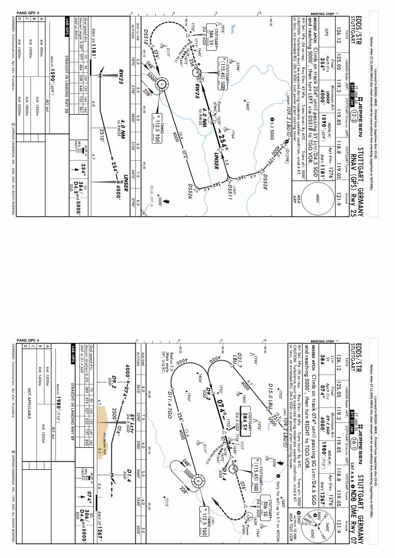
ED(R)-207 A
(IAW
P)1
09.2
LBU lbu
254^
ABCD
ALS out
.JAR-OPS.
MD
A(H
)(4
09')
1590'
STRAIG
HT-IN
LAN
DIN
G RW
Y25
900m
RVR
RVR
RVR
1000m
1400m
RVR
2000m
RVR
1800m
RVR
1500m
1
RNAV (G
PS) Rwy 25
UNSER
4.0129^
164^
UNSER
4.0
4.0
3.8
5.25000
1
DS5
3~DS5
11
(IWP)
072^D
S526
13.4
048^
228^
254^
to R
W25
to R
W25
344^
074^
[D129E]
4000
4000
GPS
MD
A(H
)
1590'(4
09')
Apt Elev
1276'
RW
Y1181'
Alt Set: hPa
(IN on req)
Rwy Elev: 43 hPa
Trans level: By A
TCTrans alt: 5000'
MIS
SED A
PCH:
BRIEFING STRIP TM EDDS/STR
STUTTG
ART
STUTTG
ART, G
ERMANY
12-217 JA
N 03
.Eff.23.Jan.
Final
Apch C
rsM
inimum
Alt
4000'
PANS OPS 4
| JEPPESEN
SAN
DERSO
N, IN
C., 2000, 2003. A
LL RIGH
TS RESERVED
.
05 5 10
MSA
ARP
CA
UTIO
N: Turbulence m
ust be expected during moderate w
eather condition, wind 6 K
Tor less, on extended RC
L (D6.0 SG
D) over pow
er plant cooling tower.
3.00^377
484538
646753
861G
nd speed-Kts
7090
100120
140160
254^
ALSF-II
5000'
and
48-40
48-50
09-1009-20
09-30
Com
munications. A
pt elev. Procedure.
*A
TIS
126.12
Ground
121.9118.8
119.05
STUTTG
ART Tow
er
125.05119.2
119.85
STUTTG
ART D
irector (APP)
LAN
GEN
Radar (APP)
Clim
b on track 254^ until passing SY Lctr/D
4.5 SGD
and reaching 5000', then turn LEFT via DS51~ to TG
O V
OR.
REILPA
PI
SY384/
D4.5
SGD
254^
Power
plant
5000D
TANGO
T G O
112.5 TGO
1181'
4.74.0
2510'
4000'
RW
Y 2
5
D4.5 SG
D
384 SYSTU
TTGART
S Y
UNSER
4.0
NM
4.0
NM
RW
25
DSTU
TTGART
S G D
(115.45) SGD
RW
25
254^
DS5
1~
4800'
3.05.0
8.02190'
2830'3790'
6.03150'
MA
P a
t RW
25
DIST to TH
R
Descent a
ngle
1870'2.0
7.03470'
CHA
NG
ES:
JEPPESEN
ALTITU
DE
1732'
1683'
2117'
2608'
Weidacher
Hill
1764'2296'
1976'
1717' 1640'
1618'1672'1641'
1629'
Licensed to BISSIG
, MIK
E, . Printed from JeppView
disc 23-03.N
otice: After 27.11.2003 0901Z this chart should not be used w
ithout first checking JeppView or N
OTA
Ms.
D9.2
SGD
074^
109.2
LBU
(IAF)
LBU
4000
6.7
15.05000
4000
231^
4000
D15.0
LBU
D11.4
TGO
LctrM
DA
(H)
ABCD
ALS out
.JAR-OPS.
MD
A(H
)(7
13')
1980'
STRAIG
HT-IN
LAN
DIN
G RW
Y07
NDB D
ME Rw
y 07
SY
384
1980'(7
13')
RVR
RVR
1400m
RVR
1500m
NO
T APPLIC
ABLE
1200m
D9.2
SGD
D1.4
SGD
D1.4
SGD
D4.5 SG
D
384 S
YS Y
D21.7
LB
U
CA
T A
& B
D9.2
SG
D
SY Lc
tr
074^
074^
D4.5 SG
D
48-40
09-0009-10
09-20
48-45
48-35
074^
Apt Elev
1276'
RW
Y1267'
ALSF-II
074^
5000'
Alt Set: hPa
(IN on req)
Rwy Elev: 46 hPa
Trans level: By A
TCTrans alt: 5000'
and
3400'4200'2M
SA TG
O V
OR
3900'4800'
2
MIS
SED A
PCH:
BRIEFING STRIP TM EDDS/STR
STUTTG
ART
STUTTG
ART, G
ERMANY
16-117 JA
N 03
.Eff.23.Jan.
Final
Apch C
rsM
inimum
Alt
4000'
050^
010^
128^242^
3300'w
ithin 10 NM
.
PANS OPS 4
| JEPPESEN
SAN
DERSO
N, IN
C., 1999, 2003. A
LL RIGH
TS RESERVED
.
05 5 10
CA
UTIO
N: Turbulence m
ust be expected during moderate w
eather condition, wind 6 K
Tor less, on extended RC
L (D6.0 SG
D) over pow
er plant cooling tower.
Gnd speed-K
tsD
escent Gra
dient5.2%
7090
100120
140160
369474
527632
737843
Com
munications. A
pt elev. Procedure.
*A
TIS
126.12
Ground
121.9118.8
119.05
STUTTG
ART Tow
er
125.05119.2
119.85
STUTTG
ART D
irector (APP)
LAN
GEN
Radar (APP)
Clim
b on track 074^ until passing SG Lctr/D
4.6 SGD
and reaching 5000', then turn RIGHT to TG
O V
OR.REIL
PAPI
SG306/
D4.6
SGD
D(115.45) SG
DSTU
TTGART
306 SGSTU
TTGART
048^
228^5000
254^11.4
4000
D4.6 SG
D
074^
Radius 2.3(B
ank angle19^, 210 K
T)
S G D
S G
Power
plant
Only for acft up to 5.7 m
t MTO
W.
MA
P a
t D1.4
SGD
4000'
074^
1267'
4.73.1
2500'
Weidacher H
ill
RW
Y 07
0.6
STUTTG
ART
SGD
DM
E
1
1W
eidacherHill
(IAF)
DTA
NGO
T G O
112.5 TGO
CHA
NG
ES:
JEPPESEN
7.06.0
3.03290'
2980'2020'
5.02660'
3610'8.0
4.02340'
ALTITU
DE
1799'
1618'1672'1641'
1703'
1802'
1683'
1732'1942'
2117'
1713'
1764'
2296'
1976'
1824'
1629'
1732'
1717'
1640'1726'
Licensed to BISSIG
, MIK
E, . Printed from JeppView
disc 23-03.N
otice: After 27.11.2003 0901Z this chart should not be used w
ithout first checking JeppView or N
OTA
Ms.
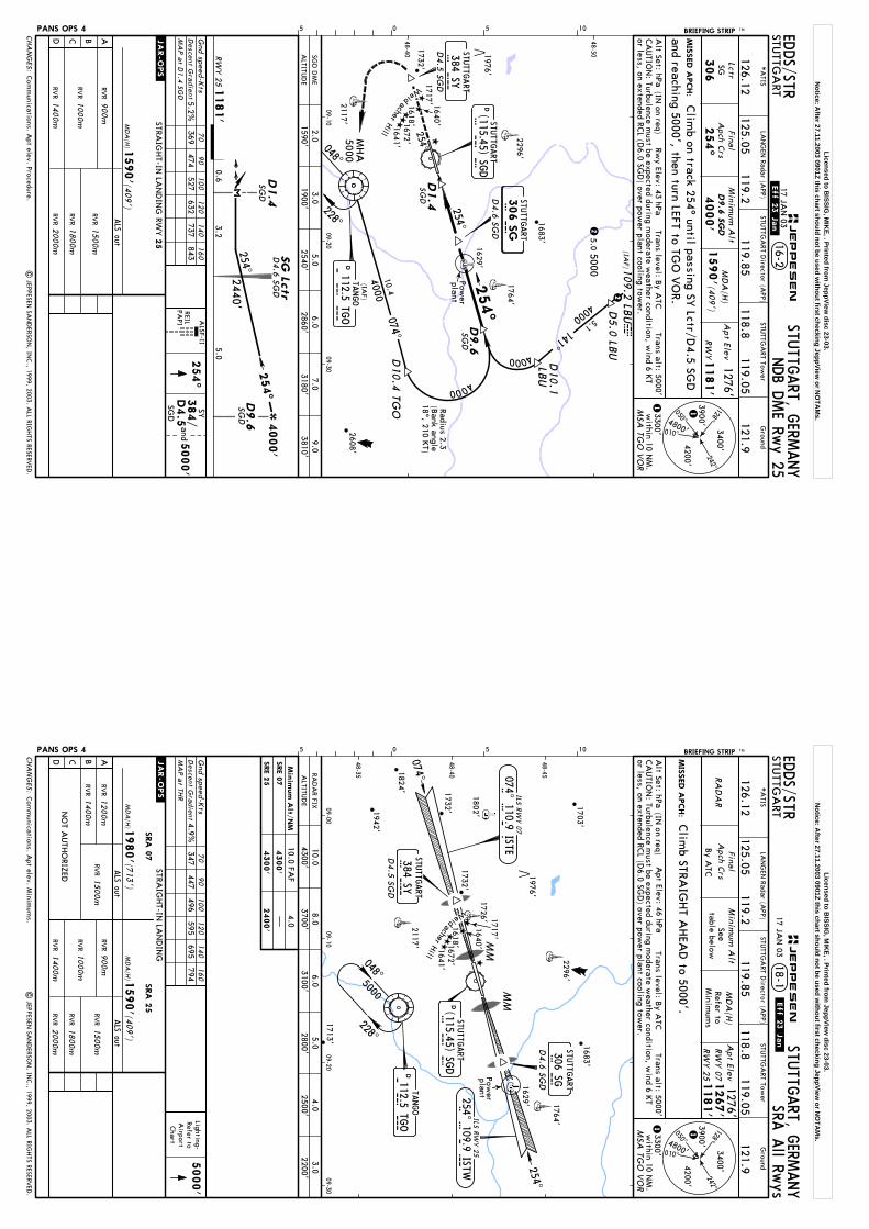
(IAF)1
09.2
LBU
4000 5.1141^
4000
D9.6
SGD
4000
D10.1
LB
U
lbuD5.0
LBUD
10.4
TGO
Lctr
254^
SGD
D9.6
ABCD
ALS out
.JAR-OPS.
MD
A(H
)(4
09')
1590'
STRAIG
HT-IN
LAN
DIN
G RW
Y25
NDB D
ME Rw
y 25
SG
306
900m
RVR
RVR
RVR
1000m
1400m
RVR
2000m
RVR
1800m
RVR
1500m
D4.6 SG
D
SGD
2
5.05000
2
306 S
GS G
254^
D9.6
SG
D
254^ MD
A(H
)
1590'(4
09')
Apt Elev
1276'
RW
Y1181'
Alt Set: hPa
(IN on req)
Rwy Elev: 43 hPa
Trans level: By A
TCTrans alt: 5000'
3400'4200'1M
SA TG
O V
OR
3900'4800'
1
MIS
SED A
PCH:
BRIEFING STRIP TM EDDS/STR
STUTTG
ART
STUTTG
ART, G
ERMANY
16-217 JA
N 03
.Eff.23.Jan.
Final
Apch C
rsM
inimum
Alt
4000'
050^
010^
128^242^
3300'w
ithin 10 NM
.
PANS OPS 4
| JEPPESEN
SAN
DERSO
N, IN
C., 1999, 2003. A
LL RIGH
TS RESERVED
.
05 5 10
CA
UTIO
N: Turbulence m
ust be expected during moderate w
eather condition, wind 6 K
Tor less, on extended RC
L (D6.0 SG
D) over pow
er plant cooling tower.
Gnd speed-K
tsD
escent Gra
dient5.2%
70
90
100
120
140
160
369474
527632
737843
254^
ALSF-II
5000'
and
48-40
48-50
09-1009-20
09-30048^
MHA
5000
228^
Com
munications. A
pt elev. Procedure.
*A
TIS
126.12
Ground
121.9118.8
119.05
STUTTG
ART Tow
er
125.05119.2
119.85
STUTTG
ART D
irector (APP)
LAN
GEN
Radar (APP)
Clim
b on track 254^ until passing SY Lctr/D
4.5 SGD
and reaching 5000', then turn LEFT to TGO
VO
R.
REILPA
PI
SY384/
D4.5
SGD
254^
Weid
acherHill
074^10.4
4000(IA
F)
DTA
NGO
T G O
112.5 TGO
Radius 2.3(B
ank angle18^, 210 K
T)
1181'
0.65.0
3.2
2440'
4000'
RW
Y 2
5
D1.4
DSTU
TTGART
S G D
(115.45) SGD
384 SYSTU
TTGART
S YD
4.5 SG
D
D4.6 SG
D
STUTTG
ART
SGD
D1.4
SG
Lctr
254^
254^
Power
plant
MA
P a
t D1.4
SGD
SGD
DM
E
CHA
NG
ES:
JEPPESEN
3.05.0
9.01900'
2540'3810'
6.02860'
1590'2.0
7.03180'
ALTITU
DE
1618'1672'1641'
1640'1717'
1732'
1683'
2117'2608'
1764'2296'
1976'1629'
Licensed to BISSIG
, MIK
E, . Printed from JeppView
disc 23-03.N
otice: After 27.11.2003 0901Z this chart should not be used w
ithout first checking JeppView or N
OTA
Ms.
1181'
RA
DA
R
ABCD
ALS out
.JAR-OPS.
MD
A(H
)(4
09')
RVR
1590'
RVR
RVR
1000m
1400m
RVR
1500m
RVR
2000m
900m
RVR
1800m
STRAIG
HT-IN
LAN
DIN
GSRA
25
RVR
1400m
RVR
1200m
RVR
1500m
ALS out
MD
A(H
)(7
13')
1980'
SRA
07
Lighting-Refer toA
irportChart
5000'
Min
imum
Alt/
NM
4300'
4.0
2400'
10.0 FAF
4300'
SRE 0
7
SRE 2
5
SRA A
ll Rwys
By A
TC
Seetable below
MD
A(H
)Refer to
Minim
ums
Clim
b STRAIG
HT A
HEA
D to 5000'.
1267'
RW
Y 07
RW
Y 2
5
Apt Elev
1276'
Alt Set: hPa
(IN on req)
Trans level: By A
TCTrans alt: 5000'
3400'4200'1M
SA TG
O V
OR
3900'4800'
1
MIS
SED A
PCH:
BRIEFING STRIP TM EDDS/STR
STUTTG
ART
STUTTG
ART, G
ERMANY
18-117 JA
N 03
.Eff.23.Jan.
Final
Apch C
rsM
inimum
Alt
050^
010^
128^242^
3300'w
ithin 10 NM
.
PANS OPS 4
| JEPPESEN
SAN
DERSO
N, IN
C., 1999, 2003. A
LL RIGH
TS RESERVED
.
05 5 10
CA
UTIO
N: Turbulence m
ust be expected during moderate w
eather condition, wind 6 K
Tor less, on extended RC
L (D6.0 SG
D) over pow
er plant cooling tower.
Gnd speed-K
ts70
90
100
120
140
160
Apt Elev: 46 hPa
Descent G
radient
4.9%347
447496
595695
794
NO
T AUTH
ORIZED
Com
munications. A
pt elev. Minim
ums.
48-40
09-0009-10
09-2009-30
48-45
48-35
*A
TIS
126.12
Ground
121.9118.8
119.05
STUTTG
ART Tow
er
125.05119.2
119.85
STUTTG
ART D
irector (APP)
LAN
GEN
Radar (APP)
Weid
306 SGSTU
TTGART
254^
S G
048^
228^5000
D4.6 SG
D
Power
plant
RAD
AR FIX
MM
254^ 109.9 ISTWI S T W
384 SYSTU
TTGART
S YD
4.5 SG
D
D112.5 TG
OTA
NGO
T G O
D(115.45) SG
DSTU
TTGART
S G D
074^
MM
ILS RW
Y 2
5
074^ 110.9 ISTEILS R
WY 0
7
I S T E
CHA
NG
ES:
JEPPESEN
8.06.0
3.03700'
3100'2200'
5.02800'
4300'10.0
4.02500'
ALTITU
DE
MA
P a
t THR
1618'1672'1641'
1703'
1802'1732'
1683'
1732'1942'
2117'
1713'
acherHill
1764'2296'
1976'
1824'
1629'
1726' 1717'
1640'
Licensed to BISSIG
, MIK
E, . Printed from JeppView
disc 23-03.N
otice: After 27.11.2003 0901Z this chart should not be used w
ithout first checking JeppView or N
OTA
Ms.
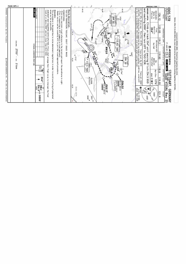
ED(R)-207A
RW
25
D6.0
SGD
306 SGS G
067^
DS625
At or above
3000'
MA
X IA
S 220 KT
DS517
At or above
4000'
TGO 2
5V
254^
RW
YN
o FAF
VISU
AL Rw
y 25G
PS/FM
SG
UID
ED
No
MD
A(H
)Published
Refer toPlanview
NA
VA
IDS-
2700' -
5 km
CEILIN
GVIS
.JAR-OPS.
ALSF-II
254^
5000'
PAPI
andREIL
MA
P a
t RW
25
3.6
7.6 to RW25
2001'
1545'
1627'
GLID
ERA
CTIV
ITY
1181'
Apt Elev
1276'
Alt Set: hPa
(IN on req)
Trans level: By A
TCTrans alt: 5000'
3400'4200'1M
SA TG
O V
OR
3900'4800'
1
MIS
SED A
PCH:
BRIEFING STRIP TM EDDS/STR
STUTTG
ART
STUTTG
ART, G
ERMANY
19-117 JA
N 03
.Eff.23.Jan.
Final
Apch C
rsM
inimum
Alt
050^
010^
128^242^
3300'w
ithin 10 NM
.
PANS OPS 4
| JEPPESEN
SAN
DERSO
N, IN
C., 1999, 2003. A
LL RIGH
TS RESERVED
.
05 5 10
CA
UTIO
N: Turbulence m
ust be expected during moderate w
eather condition, wind 6 K
Tor less, on extended RC
L (D6.0 SG
D) over pow
er plant cooling tower.
Rwy Elev: 43 hPa
Com
munications. A
pt elev. Procedure.
AIRC
RAFT N
OT EQ
UIPPED
WITH
GPS/FM
S: Pilots shall arrange their flight so as to intercept the finaltrack at or above 3000' and not closer than D
6.0 SGD
.
REMA
RKS:
This procedure is designed due to noise abatement regulations in order to avoid overflying of populated
areas as far as possible.
CO
ND
ITION
S:- Pilot m
ust maintain visual reference to the terrain and report the aerodrom
e in sight.- Pilot is requesting or A
TC suggests a visual approach.
- Radar vectors can be issued by ATC
to join the visual approach procedure.
TGO
25V TRA
NSITIO
N: TG
O(IA
F) DS517 D
S625 RW25
48-40
09-1009-20
09-30
48-45
48-35
*A
TIS
126.12
Ground
121.9118.8
119.05
STUTTG
ART Tow
er
125.05119.2
119.85
STUTTG
ART D
irector (APP)
LAN
GEN
Radar (APP)
Clim
b on track 254^ until passing SY Lctr/D
4.5 SGD
and reaching 5000', then turn LEFT to TGO
VO
R.
8.3
SY384/
D4.5
SGD
254^
048^
228^
Power
plant
5000
(IAF)
DTA
NGO
T G O
112.5 TGO
254^ STUTTG
ART
384 SYSTU
TTGART
S YD
4.5 SG
D
1672'1640'
1717'
1976'
1726'
1683'
2117'
1713'
2608'
Weid
acherHill
1764'
2296'DSTU
TTGART
S G D
(115.45) SGD
1629'
25
VISU
AL LA
ND
ING
RWY
2146'
1636'
CHA
NG
ES:
JEPPESEN
254^
Route description
Licensed to BISSIG
, MIK
E, . Printed from JeppView
disc 23-03.N
otice: After 27.11.2003 0901Z this chart should not be used w
ithout first checking JeppView or N
OTA
Ms.


