KK Watercourse Management Plan Update€¦ · goals established by MMSD and the Kinnickinnic River...
10
KINNICKINNIC RIVER WATERSHED FLOOD MANAGEMENT PLAN FINAL REPORT Prepared for MILWAUKEE METROPOLITAN SEWERAGE DISTRICT Prepared by GRAEF Hey and Associates, Inc. CDM Smith MAY 4, 2017 photo courtesy of Sixteenth Street Community Health Center
Transcript of KK Watercourse Management Plan Update€¦ · goals established by MMSD and the Kinnickinnic River...
KINNICKINNIC RIVER WATERSHED FLOOD
MANAGEMENT PLAN
FINAL REPORT
Prepared for
MILWAUKEE METROPOLITAN SEWERAGE DISTRICT
Prepared by
GRAEFHey and Associates, Inc.
CDM Smith
MAY 4, 2017
photo courtesy of Sixteenth Street Community Health Center

KINNICKINNIC RIVER WATERSHED FLOOD MANAGEMENT PLAN : 1
EXECUTIVE SUMMARY
E.1 INTRODUCTIONThe Kinnickinnic River Watershed drains approximately 25 square miles within Milwaukee County in southeastern Wisconsin. The watershed contains four major subwatersheds Wilson Park Creek, Lyons Park Creek, Villa Mann Creek and 43rd Street Ditch. Six communities, all within Milwaukee County, are represented in the watershed; these include the City of Milwaukee, City of Greenfield, City of West Allis, City of Cudahy, Village of West Milwaukee, and the City of St. Francis. These four subwatersheds include 17.9 miles of MMSD jurisdictional waterways.
This Kinnickinnic River Watershed Flood Management Plan is the culmination of many studies, planning processes, engineering designs, project construction and other work that has been undertaken by multiple agencies and cooperating partners over the last several decades. The Milwaukee Metropolitan Sewerage District (MMSD) prepared the Phase 1 Kinnickinnic River Watercourse Management Plan in 1999 and the Phase 2 Kinnickinnic River Watercourse Management Plan in 2005. The Phase 2 plan identified 24 structures within the one percent annual probability floodplain. Several studies were completed by MMSD in subsequent years to further develop and revise the Phase 2 plan recommendations.
In 2016, the Southeastern Wisconsin Regional Planning Commission (SEWRPC) developed a draft floodplain update for the Kinnickinnic River watershed. This draft update resulted in flood flow increases of between 20 to 50 percent over the Phase 2 Plan along the jurisdictional
streams for the one percent annual probability flood event and expanded floodplain. An estimated 688 structures are identified within this draft updated floodplain along the Kinnickinnic River upstream of S. Chase Avenue and along the jurisdictional tributary streams.
This Watershed Flood Management Plan identifies a system of improvements across the watershed to address the increased flood risk as well as other goals established by MMSD and the Kinnickinnic River Watershed Advisory Committee (WAC). The WAC consists of approximately 60 representatives of municipalities, Milwaukee County, regulatory agencies, and other stakeholders and non-government organizations.
These goals consisted of:
• Reduce flood risk to all structures subject to flooding in the 1% annual probability event
• Improve public safety by reducing the risk of drowning• Provide in-stream aquatic habitat• Improve natural aesthetics of channel• Leverage additional community objectives as
identified in the Kinnickinnic River Corridor Neighborhood Plan
E.2 FLOOD RISK ANALYSISThis Watershed Flood Management Plan used the SEWRPC models to define the updated estimated flood risk in the watershed. The project consultant team used the U.S. Environmental Protection Agency Hydrologic Simulation Program – Fortran (HSPF) model for the

2 : KINNICKINNIC RIVER WATERSHED FLOOD MANAGEMENT PLAN
watershed hydrologic modeling. The computed peak flows from HSPF were generated using rainfall data collected from a rain gauge at the General Mitchell International Airport from 1940 - 2012 and year 2020 planned land use for the watershed. The peak flows were then used in the HEC-RAS hydraulic models for each waterway to compute water surface profiles. Water surfaces for each annual probability were evaluated to determine the number of structures at risk in each event and the estimated damages in the watershed. The annual average damages due to the updated flood risk from the 17.9 miles of jurisdictional watercourses are estimated to be $2,160,000. The methodology used to calculate damages is consistent with SEWRPC damage calculation methodology. The damages are based on year 2014 Milwaukee County property assessment values.
E.3 SUMMARY OF SOLUTION DEVELOPMENTThe Watershed Flood Management Plan developed four alternatives to meet the overall project objectives. Various flood management strategies were used to develop the alternatives. These included storage, conveyance, flow diversions and green infrastructure. The alternatives build off of the draft and final recommendations proposed in previous MMSD engineering studies. They also include the replacement of all concrete lining along jurisdictional waterways with a bioengineered channel design to restore natural functions back to the streams. The concrete lining throughout the Kinnickinnic River watershed has deteriorated and is at the end of its useful life.
Concurrently with the Watershed Flood Management Plan, the District partnered with Milwaukee County Parks to develop updated park plans for the County parkland that could be potentially impacted by the project. These parks included Pulaski Park, Jackson Park, Wilson Park, the Kinnickinnic River Sports Complex and the Kinnickinnic River Parkway from S. 20th Street to S. 60th Street. The Parks were evaluated for current utilization, potential improvements, and potential opportunities for flood storage. Within the alternative development various levels of storage were evaluated for all the parks. Storage at both Jackson and Wilson parks provided the greatest opportunities for flood risk reduction. The summary of the park planning
is documented in a park planning report that was being developed at the time of this report.
The recommendations from previous MMSD studies and the concrete channel removal and stream naturalization make up a set of baseline improvements that are common components to each alternative. The primary components that distinguish the four preliminary alternatives are summarized below:
Refined Alternative 1: Small StorageDescription: Baseline improvements plus small storage basins in Jackson Park and Wilson Park; floodwalls
Alternative 1a: Small Storage with DiversionDescription: Alternative 1 components plus mainstem diversion/bypass
Alternative 2: Large Storage Description: Baseline improvements plus large storage basins in both parks
Alternative 3: Mixed Storage Description: Baseline improvements plus a small storage basin in Jackson Park and a large storage basin in Wilson Park
Each of these four alternatives will include green infrastructure. The details of the green infrastructure are currently being developed.
E.4 PUBLIC INVOLVEMENTThe WAC met four times over the course of the project to review the interim progress on the project and provide feedback to the project team. Meetings were held: February 11, 2015; June 17, 2015; December 16, 2015; and August 23, 2016. The February meeting set the stage for the future meetings and the objectives of the WAC. The June meeting reviewed the proposed flood management strategies, the December meeting included a presentation of the four alternatives and the August meeting included the recommended alternative.
Three park focus groups were also held at key milestones in the project. The focus group meetings were held on August 25, 2015; August 27,2015; and September 30, 2015. The focus groups were made
KINNICKINNIC RIVER WATERSHED FLOOD MANAGEMENT PLAN : 3
up of representatives from organizations that use the park or live near them. The meetings primarily provided feedback on the County Park planning process and desired future park amenities. Flood storage within the parks was also discussed. Focus groups demonstrated a strong desire for an improved wildlife habitat and a naturalized river system in the watershed. Feedback included: improved access to the river, making it an asset, restoring the appearance of a natural river, and consideration of saving old growth trees wherever possible, in tandem with the storage areas. There were 13 attendees on August 25, 19 on August 27, and 13 on September 30.
The four watershed alternatives and the parks plans were presented to the public at two meetings held on January 14 and January 19, 2016. The public provided feedback through various methods at these meetings which was incorporated into the recommended alternative and the parks planning. Participants generally found the improvements to the river, parks, and reduced flood risk highly desirable. There were approximately 55 attendees on January 14 and 65 attendees on January 19.
The recommended alternative and the parks plans were presented to the public at two meetings held on October 11 and October 13, 2016. This feedback was incorporated into the recommended alternative and park plans. Overall, attendees were accepting of the watershed and park recommendations, in addition
to the proposed timeline and next steps. There were 27 attendees on October 11 and 37 attendees on October 13.
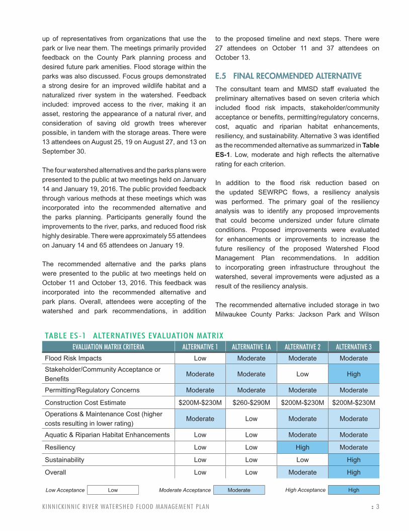
E.5 FINAL RECOMMENDED ALTERNATIVEThe consultant team and MMSD staff evaluated the preliminary alternatives based on seven criteria which included flood risk impacts, stakeholder/community acceptance or benefits, permitting/regulatory concerns, cost, aquatic and riparian habitat enhancements, resiliency, and sustainability. Alternative 3 was identified as the recommended alternative as summarized in Table ES-1. Low, moderate and high reflects the alternative rating for each criterion.
In addition to the flood risk reduction based on the updated SEWRPC flows, a resiliency analysis was performed. The primary goal of the resiliency analysis was to identify any proposed improvements that could become undersized under future climate conditions. Proposed improvements were evaluated for enhancements or improvements to increase the future resiliency of the proposed Watershed Flood Management Plan recommendations. In addition to incorporating green infrastructure throughout the watershed, several improvements were adjusted as a result of the resiliency analysis.
The recommended alternative included storage in two Milwaukee County Parks: Jackson Park and Wilson
TABLE ES-1 ALTERNATIVES EVALUATION MATRIXEVALUATION MATRIX CRITERIA ALTERNATIVE 1 ALTERNATIVE 1A ALTERNATIVE 2 ALTERNATIVE 3
Flood Risk Impacts Low Moderate Moderate Moderate
Stakeholder/Community Acceptance or Benefits
Moderate Moderate Low High
Permitting/Regulatory Concerns Moderate Moderate Moderate Moderate
Construction Cost Estimate $200M-$230M $260-$290M $200M-$230M $200M-$230M
Operations & Maintenance Cost (higher costs resulting in lower rating)
Moderate Low Moderate Moderate
Aquatic & Riparian Habitat Enhancements Low Low Moderate Moderate
Resiliency Low Low High Moderate
Sustainability Low Low Low High
Overall Low Low Moderate High
Low Acceptance Low Moderate Acceptance Moderate High Acceptance High

4 : KINNICKINNIC RIVER WATERSHED FLOOD MANAGEMENT PLAN
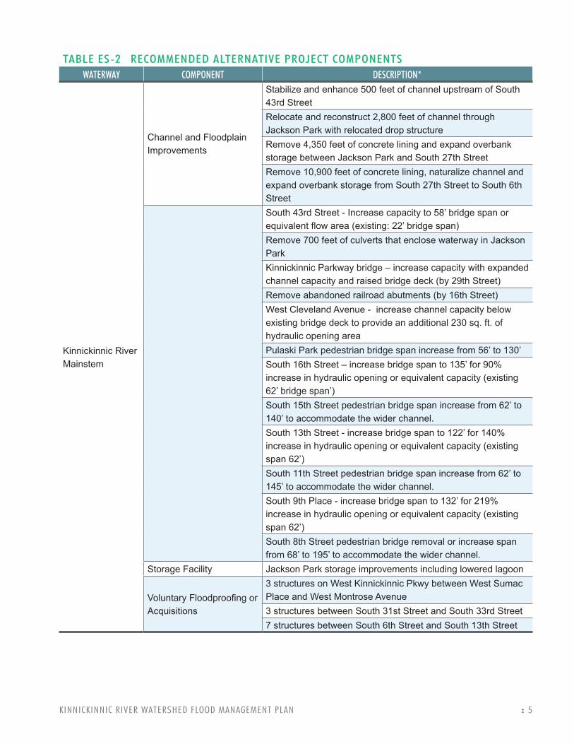
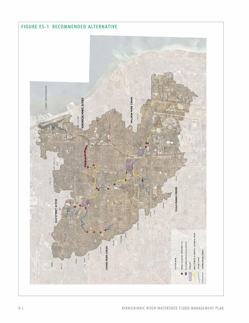
Park. The storage configuration and volume was further refined for the recommended alternative based on feedback provided by Milwaukee County, WAC, and the public through the park planning effort. The project components for the recommended alternative are listed in Table ES-2. Green infrastructure prioritization and locations will be further evaluated and determined in the Kinnickinnic River Watershed Green Infrastructure Plan. Figure ES-1 displays locations of all project components.
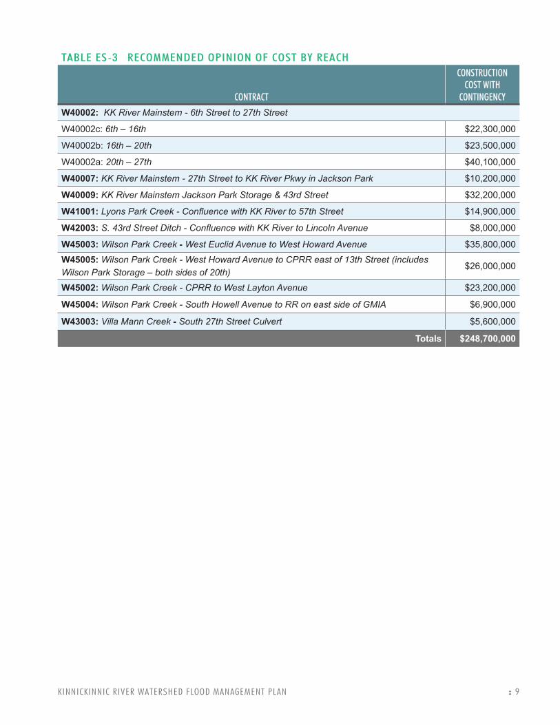
Opinions of probable construction cost (2016 cost basis) were developed using the planning level designs and estimated quantities. MMSD has assigned reach identifiers throughout the watershed that represent potential future implementation contracts. The costs were broken down according to these reaches, which were also used in the analysis of project implementation sequencing. Table ES-3 provides the summary of the construction costs by reach. These costs do not include engineering and design, construction management, project management, or green infrastructure.
E.7 IMPLEMENTATION AND NEXT STEPSAfter the final alternative was prepared, an analysis was conducted to determine the sequence or sequences that could be used to implement the improvements. Because the reaches involve a mix of both storage and conveyance improvements, it is important to identify which reaches are “dependent” on other reaches in order to provide the intended benefits. Without proper sequencing, the “dependent” reaches would temporarily increase flood risk to some locations, which would not be desirable or allowable. Only four reaches or areas were found to be completely independent - meaning that they could be implemented at any time without restrictions. These include South 16th Street to South 20th Street on the Kinnickinnic River Mainstem, the Jackson Park improvements, the Wilson Creek Park storage improvements, and the Central Steel and Wire storage basin.
Preliminary engineering is already underway for Reach 2 of the Kinnickinnic River which includes the South 16th Street to the UP Railroad reach. The next area that should be prioritized for implementation is the Jackson Park storage improvements. The Jackson
Park improvements are very important because they will facilitate the implementation of all other Kinnickinnic River Mainstem improvements as well as the 43rd Street Ditch and Lyons Park Creek improvements.
KINNICKINNIC RIVER WATERSHED FLOOD MANAGEMENT PLAN : 5
TABLE ES-2 RECOMMENDED ALTERNATIVE PROJECT COMPONENTSWATERWAY COMPONENT DESCRIPTION*
Kinnickinnic River Mainstem
Channel and Floodplain Improvements
Stabilize and enhance 500 feet of channel upstream of South 43rd StreetRelocate and reconstruct 2,800 feet of channel through Jackson Park with relocated drop structureRemove 4,350 feet of concrete lining and expand overbank storage between Jackson Park and South 27th StreetRemove 10,900 feet of concrete lining, naturalize channel and expand overbank storage from South 27th Street to South 6th StreetSouth 43rd Street - Increase capacity to 58’ bridge span or equivalent flow area (existing: 22’ bridge span) Remove 700 feet of culverts that enclose waterway in Jackson Park Kinnickinnic Parkway bridge – increase capacity with expanded channel capacity and raised bridge deck (by 29th Street) Remove abandoned railroad abutments (by 16th Street)West Cleveland Avenue - increase channel capacity below existing bridge deck to provide an additional 230 sq. ft. of hydraulic opening areaPulaski Park pedestrian bridge span increase from 56’ to 130’South 16th Street – increase bridge span to 135’ for 90% increase in hydraulic opening or equivalent capacity (existing 62’ bridge span’)South 15th Street pedestrian bridge span increase from 62’ to 140’ to accommodate the wider channel.South 13th Street - increase bridge span to 122’ for 140% increase in hydraulic opening or equivalent capacity (existing span 62’)South 11th Street pedestrian bridge span increase from 62’ to 145’ to accommodate the wider channel.South 9th Place - increase bridge span to 132’ for 219% increase in hydraulic opening or equivalent capacity (existing span 62’)South 8th Street pedestrian bridge removal or increase span from 68’ to 195’ to accommodate the wider channel.
Storage Facility Jackson Park storage improvements including lowered lagoon
Voluntary Floodproofing or Acquisitions
3 structures on West Kinnickinnic Pkwy between West Sumac Place and West Montrose Avenue 3 structures between South 31st Street and South 33rd Street7 structures between South 6th Street and South 13th Street

6 : KINNICKINNIC RIVER WATERSHED FLOOD MANAGEMENT PLAN
TABLE ES-2 RECOMMENDED ALTERNATIVE PROJECT COMPONENTSWATERWAY COMPONENT DESCRIPTION*
Lyons Park Creek
Channel and Floodplain Improvements
Concrete lining removal and overbank storage expansion for 650 feet between South 57th Street and West Lakefield DriveConcrete lining removal and channel reconstruction for 2,200 feet from West Bennett Avenue to West Cleveland AvenueConcrete lining for 280 feet and install grade control structures downstream of West Cleveland Avenue
Bridge/Culvert Improvements
South 57th Street – increase capacity to 19’ x 6’ culvert or equivalent flow area (existing 9’ x 5’ culvert)West Oklahoma Avenue – add bypass culverts comprised of 560 feet of twin 8-foot by 5-foot culverts and 150 feet of 12’ x 6’ culvert or equivalent flow area (existing 11’ x 7’ culvert)West Stack Drive – increase capacity to bridge span of 40 feet (existing culvert 12.5-foot by 7.9-foot pipe arch) West Cleveland Avenue – increase capacity to two 10’ x 8’ culverts or equivalent flow area (existing 10’ x 6’ culvert)
Villa Mann Creek
Channel and Floodplain Improvements
Concrete lining removal and channel reconstruction for 2,640 feet upstream of West Bolivar Avenue to confluence with Wilson Park Creek**
Bridge/Culvert Improvements
Install 1,340 feet of 8’ x 5’ concrete bypass culvert next to the existing 9.7’x5’ S. 27th St culvert on the Villa Mann Creek Tributary
Wilson Park Creek
Channel and Floodplain Improvements
Concrete lining removal and channel reconstruction for 4,050 feet from railroad east of GMIA to West Howell AvenueConcrete lining removal and channel reconstruction for 4,700 feet from West Layton Avenue to Canadian Pacific Railroad (CPRR) at I-94Concrete lining removal and channel reconstruction for 700 feet from CPRR to Wilson ParkConcrete lining removal and channel reconstruction for 4,320 feet from South 20th Street to South 27th Street Concrete lining removal and channel reconstruction for 1,930 feet from West Morgan Avenue to West Euclid Avenue

KINNICKINNIC RIVER WATERSHED FLOOD MANAGEMENT PLAN : 7
TABLE ES-2 RECOMMENDED ALTERNATIVE PROJECT COMPONENTSWATERWAY COMPONENT DESCRIPTION*
Wilson Park Creek
Bridge/Culvert Improvements
South 5th Street – increase capacity to three 14’ x 10’culverts or equivalent flow area (existing two 12.6’ x 10’ culverts)South 6th Street – increase capacity by adding three 12.5’ x 10’ bypass culverts or equivalent flow area (existing two 12.5’ x 10’ culverts) West Howard Avenue – increase capacity to three 19’ x 12’ culverts or equivalent flow area (existing three 11’ x 12’ culverts) South 27th Street to Morgan Tunnel – increase capacity to three 11’x16’ culverts of equivalent flow areaWest Lakefield Drive – increase capacity to three 13.4’ x 11’ culverts or equivalent flow area
Storage Facility
Central Steel and Wire Storage – 190 ac-ftWilson Park east storage (park/lagoon east of channel) – 150 ac-ftWilson Park west storage (Villa Mann Creek confluence west of South 20th Street) – 70 ac-ft
Voluntary Floodproofing or Acquisitions
7 structures near South 5th Street and West Armour Avenue2 structures near South 20th Street and West Howard Avenue
43rd Street Ditch
Channel and Floodplain Improvements
Remove 600 feet of concrete lining between West Lincoln Avenue and Union Pacific Railroad
Bridge/Culvert Improvements
43rd Street – increase capacity of 355 feet of double 11.5’ x 7.6’ pipe arch CMP culverts with two 16’ x 7’ concrete box culverts of equivalent flow capacityUnion Pacific Railroad – increase capacity of 475’ of double 10.5’ diameter culverts with additional 10’ diameter concrete culvert or equivalent flow capacity
* Green infrastructure will be integrated into improvement projects as recommended by the Kinnickinnic River Watershed Green Infrastructure Plan.** It is recommended that the concrete lining of Villa Mann Creek be removed, but its removal does not have any impact on the flood risk downstream.
8 : KINNICKINNIC RIVER WATERSHED FLOOD MANAGEMENT PLAN
FIGURE ES-1 RECOMMENDED ALTERNATIVE
KINNICKINNIC RIVER WATERSHED FLOOD MANAGEMENT PLAN : 9
TABLE ES-3 RECOMMENDED OPINION OF COST BY REACH
CONTRACT
CONSTRUCTION COST WITH
CONTINGENCY
W40002: KK River Mainstem - 6th Street to 27th Street
W40002c: 6th – 16th $22,300,000
W40002b: 16th – 20th $23,500,000
W40002a: 20th – 27th $40,100,000
W40007: KK River Mainstem - 27th Street to KK River Pkwy in Jackson Park $10,200,000
W40009: KK River Mainstem Jackson Park Storage & 43rd Street $32,200,000
W41001: Lyons Park Creek - Confluence with KK River to 57th Street $14,900,000
W42003: S. 43rd Street Ditch - Confluence with KK River to Lincoln Avenue $8,000,000
W45003: Wilson Park Creek - West Euclid Avenue to West Howard Avenue $35,800,000
W45005: Wilson Park Creek - West Howard Avenue to CPRR east of 13th Street (includes Wilson Park Storage – both sides of 20th)
$26,000,000
W45002: Wilson Park Creek - CPRR to West Layton Avenue $23,200,000
W45004: Wilson Park Creek - South Howell Avenue to RR on east side of GMIA $6,900,000
W43003: Villa Mann Creek - South 27th Street Culvert $5,600,000
Totals $248,700,000