Kittson Pembina Roseau Walsh Marshall/media/Enb/Documents/Projects/US/Exhibi… · 89 11 9 53 2 59...
5
336 332 23 135 45 13 113 64 37 46 317 66 194 54 1 92 286 200 1 227 78 200A 47 200 6 17 219 217 27 33 102 18 371 108 220 34 32 15 87 73 61 210 84 38 46 65 72 89 11 9 53 2 59 2 81 169 75 71 10 35 535 29 94 Plummer Cass Lake South Floodwood Donaldson Viking Deer River Clearbrook Terminal Aitkin Co. Becker Co. Beltrami Co. Carlton Co. Cass Co. Clay Co. Clearwater Co. Crow Wing Co. Hubbard Co. Itasca Co. Kittson Co. Koochiching Co. Lake Co. Lake of the Woods Co. Mahnomen Co. Marshall Co. Norman Co. Otter Tail Co. Pennington Co. Polk Co. Red Lake Co. Roseau Co. St. Louis Co. Wadena Co. Wilkin Co. Grand Forks Co. Pembina Co. Ransom Co. Richland Co. Steele Co. Traill Co. Walsh Co. Bayfield Co. Douglas Co. Warba Grand Rapids Detroit Lakes Baudette Cohasset Coleraine Effie Thief River Falls Keewatin Breezy Point Crosby Crosslake Cuyuna Jenkins Nisswa Pequot Lakes Emily Fifty Lakes Trommald Gilbert Mountain Iron Proctor Tower Virginia Crookston East Grand Forks Babbitt Biwabik Buhl Chisholm Duluth Ely Eveleth Hermantown Hibbing Hoyt Lakes Dilworth Moorhead Big Falls International Falls Mizpah Cloquet Perham Tenstrike Plummer Bluffton Tamarack Bemidji Two Harbors Park Rapids Menahga Wadena Lake Shore Grand Forks Horace Mapleton West Fargo Argusville Grafton Fargo Lake Nebagamon Poplar Superior This information is for environmental review purposes only. 0 5 10 Miles 1:1,150,000 Line 67 Expansion Project Enbridge Energy, LLC Existing Enbridge Line 67 Pump Station to be Upgraded New Line 67 Pump Station at or near Existing Enbridge Facility Existing Enbridge Terminal Existing Line 67 Existing Enbridge Pipelines (Lakehead System) Existing Enbridge Pipelines (North Dakota System) City Boundary Countiy Boundary FILE: M:\Clients\D-F\EEL\Mainline_Enhancement\_ArcGIS\2013\05\Overview\_EEL_MainlineOverview2.mxd | REVISED: 05/14/2013 | SCALE: 1:1,150,000 when printed at 11x17 DRAWN BY: RGCutting
Transcript of Kittson Pembina Roseau Walsh Marshall/media/Enb/Documents/Projects/US/Exhibi… · 89 11 9 53 2 59...

336
332
23
135
4513
113
64
37
46
317
66
194
54
1
92
286
200
1
227
78
200A
47
200
6
17
219
217
27
33
10218
371
108
220
34
32
15
87
73
61
210
84
38
46
65
72
89
11
9
53
2
592
81
169
75
71
10
35
535
29
94
Plummer
CassLakeSouth
Floodwood
Donaldson
Viking
DeerRiver
ClearbrookTerminal
AitkinCo.
BeckerCo.
Beltrami Co.
CarltonCo.
Cass Co.
Clay Co.
ClearwaterCo.
CrowWing Co.
HubbardCo.
ItascaCo.
KittsonCo.
KoochichingCo.
Lake Co.
Lake of theWoods Co.
MahnomenCo.
MarshallCo.
NormanCo.
OtterTail Co.
PenningtonCo.
Polk Co. RedLake Co.
RoseauCo.
St. LouisCo.
WadenaCo.Wilkin
Co.
GrandForks Co.
PembinaCo.
RansomCo. Richland
Co.
SteeleCo.
TraillCo.
WalshCo.
BayfieldCo.Douglas
Co.
Warba
GrandRapids
DetroitLakes
Baudette
Cohasset
Coleraine
Effie
ThiefRiverFalls
Keewatin
BreezyPoint
Crosby
Crosslake
Cuyuna
Jenkins
Nisswa
PequotLakes
EmilyFifty
Lakes
Trommald
Gilbert
MountainIron
Proctor
Tower
Virginia
Crookston
EastGrandForks
Babbitt
Biwabik
BuhlChisholm
Duluth
Ely
Eveleth
Hermantown
Hibbing
HoytLakes
Dilworth
Moorhead
BigFalls
InternationalFalls
Mizpah
Cloquet
Perham
Tenstrike
Plummer
Bluffton
Tamarack
Bemidji
TwoHarborsPark
Rapids
Menahga
WadenaLake
Shore
GrandForks
Horace
MapletonWestFargo
Argusville
Grafton
Fargo
LakeNebagamon
Poplar
Superior
This information is for environmental review purposes only.
0 5 10
Miles1:1,150,000
Line 67 Expansion ProjectEnbridge Energy, LLC
Existing Enbridge Line 67Pump Station to be UpgradedNew Line 67 Pump Stationat or near Existing Enbridge FacilityExisting Enbridge Terminal
Existing Line 67Existing Enbridge Pipelines (Lakehead System)Existing Enbridge Pipelines (North Dakota System)City BoundaryCountiy Boundary
FILE: M:\Clients\D-F\EEL\Mainline_Enhancement\_ArcGIS\2013\05\Overview\_EEL_MainlineOverview2.mxd | REVISED: 05/14/2013 | SCALE: 1:1,150,000 when printed at 11x17 DRAWN BY: RGCutting
santosk
Typewritten Text
santosk
Typewritten Text
santosk
Typewritten Text
EXHIBIT B.2
santosk
Typewritten Text
santosk
Typewritten Text
santosk
Typewritten Text
santosk
Typewritten Text
santosk
Typewritten Text
santosk
Typewritten Text
ST317
ST220
ST1
ST66
ST17
ST54
ST32
ST66
ST17
ST175
ST219
ST18
ST1
ST220
ST32
ST89
ST11
£¤59
£¤75£¤81
£¤59
§̈¦29
§̈¦29
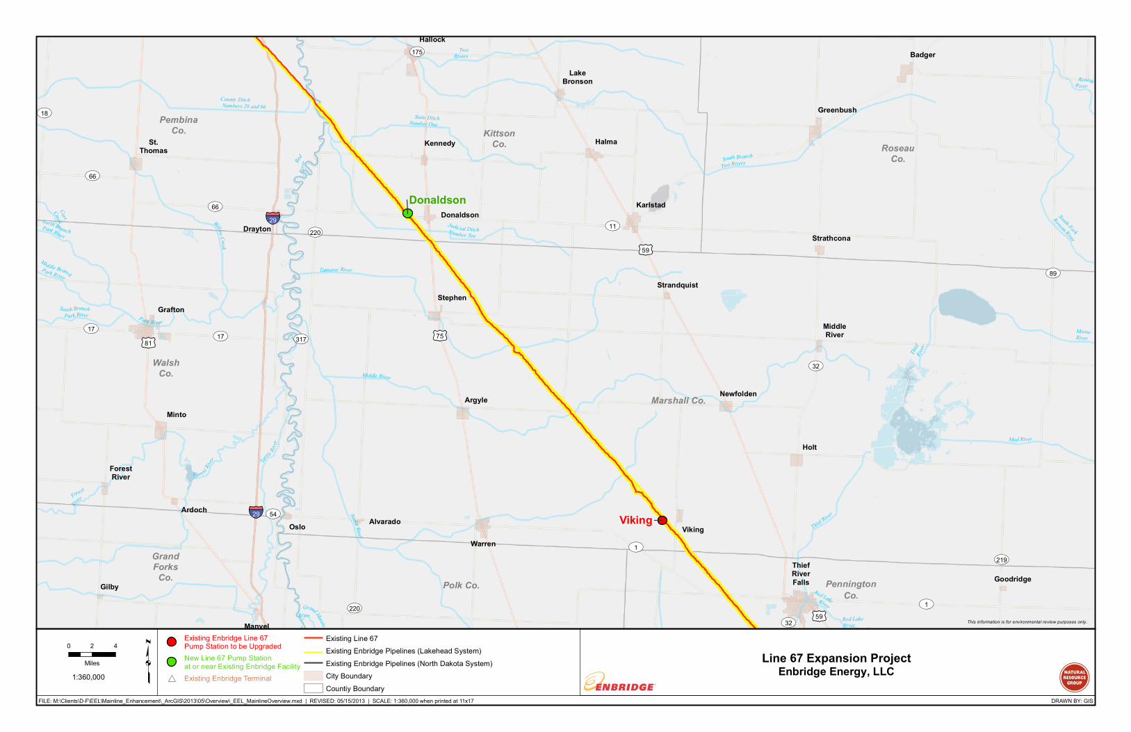
Donaldson
Viking
KittsonCo.
Marshall Co.
PenningtonCo.
Polk Co.
RoseauCo.
GrandForks
Co.
PembinaCo.
WalshCo.
GoodridgeThiefRiverFalls
Badger
Greenbush
Strathcona
Donaldson
Hallock
Halma
Karlstad
Kennedy
LakeBronson
MiddleRiver
Newfolden
Oslo
StephenStrandquist
VikingWarren
Alvarado
Argyle
Holt
St.Thomas
Gilby
Drayton
Ardoch
ForestRiver
Grafton
Minto
Manvel
RedR i
ver
Red LakeRiver
Tur
tle River
North BranchPark River
Grand Marais
River
RoseauR iver
Red LakeRiver
Car tCreek
TwoRivers
State DitchNumber One
Thief
River
Middle BranchPark River
South BranchPark River Park River
MooseRiver
Willow Creek
Mud River
Judicial DitchNumber Ten
Thief River
Fore st River
South Fork
Roseau RiverForest
Riv
er
County DitchNumbers 20 and 66
Snake River
Tamarac River
South BranchTwo Rivers
Middle River
This information is for environmental review purposes only.
0 2 4
Miles1:360,000 p Line 67 Expansion Project
Enbridge Energy, LLC
Existing Enbridge Line 67Pump Station to be UpgradedNew Line 67 Pump Stationat or near Existing Enbridge Facility
#* Existing Enbridge Terminal
Existing Line 67Existing Enbridge Pipelines (Lakehead System)Existing Enbridge Pipelines (North Dakota System)City BoundaryCountiy Boundary
FILE: M:\Clients\D-F\EEL\Mainline_Enhancement\_ArcGIS\2013\05\Overview\_EEL_MainlineOverview.mxd | REVISED: 05/15/2013 | SCALE: 1:360,000 when printed at 11x17 DRAWN BY: GIS

#*
ST1
ST223
ST197
ST32
ST92
ST219ST89
ST222
ST1
ST102
ST32ST9
ST89
£¤2
£¤2
£¤75
£¤59
£¤2 £¤71£¤59
£¤75
£¤2
£¤2
Plummer
ClearbrookTerminal
BeltramiCo.
ClearwaterCo.
Mahnomen Co.
Marshall Co.
NormanCo.
PenningtonCo.
Polk Co.
RedLake Co.
Goodridge
St.Hilaire
ThiefRiverFalls
Trail
Winger
Beltrami
Crookston
Erskine
Fertile
Fosston
Gully
Lengby
McIntosh
Mentor
SolwayBagley
TurtleRiver
Wilton
Clearbrook
Gonvick
Brooks
Leonard
Shevlin
Oklee
PlummerRed Lake
Falls
Bemidji
Lost River
Blackduck
River
Garde
nSlo
ughSpringCreek
Mississippi River
Spring
Creek
County DitchNumber Sixty Six
County DitchN umber Fourteen
MarshCreek
Upper Badger
Creek
Beau Gerlot
CreekLower Badger
Creek
Black
Rive r
MudRiver
Sandy Ri ve r
BurnhamCreek
Clearwater River
HillRiver
Poplar River
Red Lake RiverClearwater River
SandhillRiver
This information is for environmental review purposes only.
0 2 4
Miles1:360,000 p Line 67 Expansion Project
Enbridge Energy, LLC
Existing Enbridge Line 67Pump Station to be UpgradedNew Line 67 Pump Stationat or near Existing Enbridge Facility
#* Existing Enbridge Terminal
Existing Line 67Existing Enbridge Pipelines (Lakehead System)Existing Enbridge Pipelines (North Dakota System)City BoundaryCountiy Boundary
FILE: M:\Clients\D-F\EEL\Mainline_Enhancement\_ArcGIS\2013\05\Overview\_EEL_MainlineOverview.mxd | REVISED: 05/15/2013 | SCALE: 1:360,000 when printed at 11x17 DRAWN BY: GIS

ST371
ST197
ST200
ST65
ST286
ST64
ST371
ST6
ST89
ST64
ST34
ST6
ST200
ST84
ST46
ST200
ST38
£¤2
£¤71
£¤71
£¤71
£¤169
£¤169
CassLake
SouthDeerRiver
AitkinCo.
BeltramiCo.
Cass Co.HubbardCo.
ItascaCo.
SquawLake
Warba
Zemple
La Prairie
GrandRapids
Bovey
Cohasset
Coleraine
DeerRiver
Solway
Tenstrike
HillCity
TurtleRiver
Wilton
Bemidji
Akeley
Laporte
NevisPark
Rapids
Bena
BoyRiver
CassLake
FederalDam
Longville
Remer
Walker
Willow River
Mississippi
RiverSchool
craft
River
Schoo
lcraft
River
MississippiRiver
Hay
Creek
Fishhook
River
Bowstring River
Bowstring River
Crow Wing
River
SugarBrook
SwanRiver
D a y Broo
k
HayCreek
WillowRiver
Steamboa tRive r
MississippiRiver
C rowWing
River
BoyRiver
PrairieRiver
Bungash ing Creek
Boy R
iver
Willow River
PrairieRiver
Neckt
ie River
MississippiRiver
Prairie River
Mississippi
River
WillowRive r
MississippiRiver
Schoo
lcraft
River
Leech LakeRiver
SwanRiver
This information is for environmental review purposes only.
0 2 4
Miles1:360,000 p Line 67 Expansion Project
Enbridge Energy, LLC
Existing Enbridge Line 67Pump Station to be UpgradedNew Line 67 Pump Stationat or near Existing Enbridge Facility
#* Existing Enbridge Terminal
Existing Line 67Existing Enbridge Pipelines (Lakehead System)Existing Enbridge Pipelines (North Dakota System)City BoundaryCountiy Boundary
FILE: M:\Clients\D-F\EEL\Mainline_Enhancement\_ArcGIS\2013\05\Overview\_EEL_MainlineOverview.mxd | REVISED: 05/15/2013 | SCALE: 1:360,000 when printed at 11x17 DRAWN BY: GIS

#*#*
ST13
ST35
ST23
ST194 ST23
ST39
ST45
ST194ST61
ST105
ST47
ST65
ST200
ST232
ST210
ST210
ST65
ST200
ST33
ST73
ST73
ST61
ST210
£¤53
£¤2
£¤2
£¤2
£¤53
£¤169
£¤2
£¤53£¤2
§̈¦35
§̈¦35
§̈¦535
Superior Terminal
Floodwood
AitkinCo.
CarltonCo.
ItascaCo. Lake Co.
St.LouisCo.
DouglasCo.
Warba
GrandRapids
CohassetColeraine
Meadowlands
Proctor
Brookston
Duluth
Floodwood
Hermantown
Cloquet
Cromwell
KettleRiver
Scanlon
Thomson
Wrenshall
Wright
HillCity
McGregor
Palisade
Tamarack
Barnum
Carlton
TwoHarbors
LakeNebagamon
Oliver
Poplar
Superior
WillowRiver
PrairieRiver
Mississippi
River
Tamarack River
South ForkNemadji River
NetRiver
West S
av ann
aR iv
er
TamarackRiver
West Branch River
Hasty Bro
ok
Dead MooseRiver
Knife
River
RiceRiver
Beartrap Cre ek
WillowRiver
Saint Louis River
CloquetRiver
West Savanna
River
Black
River
FloodwoodRiver
NemadjiRiver
FrenchRiver
PineRiver
StewartRiver
KettleRiver
WestBranch
KnifeRiver
TamarackRiver
SavannaRiver
Mid way
Riv er
Poplar
Rive r
Us-Kab-Wan-Ka
River
LesterRiver
Big Sucker
Creek
BlackhoofRiver
Moose River
Sandy River
AmniconRiver
Cloque t River
MiddleRiver
Stoney Brook
SwanRiver
WhitefaceRiver
This information is for environmental review purposes only.
0 2 4
Miles1:360,000 p Line 67 Expansion Project
Enbridge Energy, LLC
Existing Enbridge Line 67Pump Station to be UpgradedNew Line 67 Pump Stationat or near Existing Enbridge Facility
#* Existing Enbridge Terminal
Existing Line 67Existing Enbridge Pipelines (Lakehead System)Existing Enbridge Pipelines (North Dakota System)City BoundaryCountiy Boundary
FILE: M:\Clients\D-F\EEL\Mainline_Enhancement\_ArcGIS\2013\05\Overview\_EEL_MainlineOverview.mxd | REVISED: 05/15/2013 | SCALE: 1:360,000 when printed at 11x17 DRAWN BY: GIS