Kingdom Core Advanced - · PDF fileKingdom Core Kingdom Advanced Kingdom Wide Capabilities...
31
1 Kingdom 8.7 Kingdom v8.7 Features Kingdom Core Kingdom Advanced Kingdom Wide Capabilities Help Center 9 9 Integrated Well Planning 9 9 Web-Mapping Services 9 9 Kingdom Fault Systems 9 9 Zooming Using the Mouse Wheel 9 9 EarthPAK Dipmeter Tadpole Log Plots 9 9 User Scripts 9 9 Redesigned Zones and Zone Attributes 9 9 Geosteering Integrated Real-Time Geosteering 9* 9 2d/3dPAK Horizon Picking 9 9 Picking Parameters Redesign 9 9 Manual Picking on Slices 9 9 Unidirectional Search for Inversion Data 9 9 Manual Picking on Slices 9 9 Flex Picker—Auto Tracking 9 9 Horizon Editing Tools 9 9 Horizon Attributes Extraction 9 9
Transcript of Kingdom Core Advanced - · PDF fileKingdom Core Kingdom Advanced Kingdom Wide Capabilities...

Kingdom v8.7 Features Kingdom Core
Kingdom Advanced
Kingdom Wide CapabilitiesHelp Center
Integrated Well Planning
Web-Mapping Services
Kingdom Fault Systems
Zooming Using the Mouse Wheel
EarthPAKDipmeter Tadpole Log Plots
User Scripts
Redesigned Zones and Zone Attributes
GeosteeringIntegrated Real-Time Geosteering *2d/3dPAKHorizon Picking
Picking Parameters Redesign
Manual Picking on Slices
Unidirectional Search for Inversion Data
Manual Picking on Slices
Flex Picker—Auto Tracking
Horizon Editing Tools
Horizon Attributes Extraction
1 Kingdom 8.7

* Available with EarthPAK Core as a separate purchased module.
Learn more about Kingdom through these resources on the Kingdom website:• Training Course Catalog• Getting Started Services• The IHS Energy Newsletter• Technical Webinars
Trace Calculations in Depth
Rock Solid AttributesRSA Attributes for Depth Volumes
VuPAKMicroseismic Interpretation
Horizon Intersection with 3D Seismic Data
VelPAKGenerate SEG Y Velocity Files from Profiles
Merge or Replace Data
User interface improvements
Colored InversionWell by Well Feet to Meter Unit Selection
User Interface Improvements
Kingdom Connect (New Module)Integration with any OpenSpirit-enabled Application
Kingdom v8.7 Features Kingdom Core
Kingdom Advanced
2 Kingdom 8.7

Help Center
Help CenterAn improved Help experience
Kingdom Wide Capabilities
Features BenefitsNew Help Interface
Search/browse online Knowledge Base
Access My Account from Kingdom
Clearer organization for browsing topics
Expanded search yields better answers
With the new Help Center you will be able to search or browse our online Knowledge Base—which includes the online help, how to articles, demos, videos, white papers, and tutorials. (Requires a onetime login into “My Account”.) In the case where no internet access is available, the help will revert to the local help.
In addition to greatly expanding your search for answers to your questions, the Help Center allows you to access the other my account functionality, such as entering and managing your tech support requests, without leaving the application.
Kingdom 8.7 3

Integrated Well Planning
Integrated Well PlanningDigitize targets, post engineering data along path, and export
Planning a well path is an important aspect of the well construction process. Target locations, well path types, and well profiles are core components of the design.
.
Features BenefitsDigitize targets on vertical arbitrary lines
Export as deviation surveys
Plan wells in an integrated environment
Share real-time data with drilling groups
With Kingdom 8.7, well path planning is extended across the suite that allows digitization of targets on vertical arbitrary lines and is updated both on map and 3D, in real time. Users can create multiple well plans and export as deviation surveys.
Users can also display the plan with relevant information such as Offset, TVD, Segment Length and Inclination at each of these targets along the path with a single click—allowing asset team members to quickly propose new wells in an integrated environment and easily share with the drilling groups.
4 Kingdom 8.7

Web-Mapping Services
Web-Mapping ServicesDisplay current geospatial culture on Base Map from web map services
Kingdom 8.7 provides the ability to consume Web-Mapping services for use in the interpretation basemap.
Features BenefitsPreview web map service layers prior to selection
Add one or many service layers to a base map
Manage layer selection in Cultures on the Project Tree
Leverage internal, subscription, or public web map services for direct use in Kingdom
Displayed geospatial information is always up to date
Under the Culture menu, select Add Web Map Service Layer.
Enter the Web Map server URL and preview all available maps for the Kingdom project.
The selected image is displayed on the Base Map and appears as a culture in the Project Tree.
Kingdom 8.7 5

Kingdom Fault Systems
Kingdom Fault SystemsBetter Technology—Better Faults
Kingdom 8.7 provides a number of enhancements to the fault system:
• Integrated Fault Interpretation and Editing• Fault to Fault Clipping• More Options for Creating Automatic Fault Polygons
Integrated Fault Interpretation and EditingIntegrated interpretation and editing mode reduces the confusion of having multiple surface representations (fault segments and fault surfaces) on a single fault.
Features BenefitsEdit any point that intersects with the displayed line
Edit the actual fault surface
Clip penetrating fault surfaces - a requirement for fault modeling
Additional options for creating automatic fault polygons
Ease of use for fault editing and interpretation
Improved accuracy for fault interpretation
Cleaner, more accurate automatic fault polygons
Integrated editing allows the user to edit any point that intersects with the currently displayed line, not just the points originally digitized on the currently displayed VSD.
Users can actually edit the surface of the fault. All surface triangle lines which intersect the VSD can be simply edited like any point.
6 Kingdom 8.7

Kingdom Fault Systems
Fault to Fault ClippingFault clipping removes fault surfaces that punch through other fault surfaces making more accurate and better looking geological interpretations and is required for fault modeling.
More Options for Creating Automatic Fault PolygonsEnhancements to automatic fault polygon creation produces more accurate fault polygons.
Before clipping, the blue fault penetrates the green fault.
After clipping, the faults are sealed. The clipped, blue fault no longer penetrates the green fault.
When clipping a fault, create a new fault, or simply replace the existing fault.
Smart cleaning will remove only the bad points that have bled through the fault surface and landed on the wrong side of the fault.
The option to limit surface construction to points that are within the fault block only, enhances the surface projection to the fault surface and makes a better fault polygon.
Kingdom 8.7 7
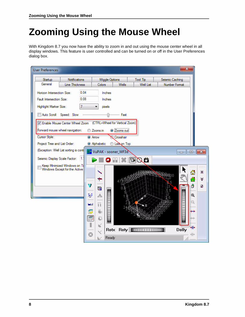
Zooming Using the Mouse Wheel
Zooming Using the Mouse WheelWith Kingdom 8.7 you now have the ability to zoom in and out using the mouse center wheel in all display windows. This feature is user controlled and can be turned on or off in the User Preferences dialog box.
8 Kingdom 8.7

Dipmeter Tadpole Log Plots
Dipmeter Tadpole Log PlotsImport and display dipmeter Tadpole log plots
User ScriptsRun custom scripts on logs and zones
With Kingdom 8.7, users can create scripts (in both VB and C#) that can range from simple operations on logs and zones to most complicated petrophysical analysis and zone attribute calculations.
EarthPAK
Features BenefitsDisplay standard dipmeter tadpole plots in section views
Dipmeter logs provide an invaluable insight into structural and stratigraphic information that can be used to identify unconformities, folds, channel geometries and validate fault and fracture locations and orientation
Features BenefitsRun VB or C# programs on logs and zones
Run on single well or in batch mode
Output calculated results as logs or zone attributes
Improve productivity by sharing specialized knowledge
Streamline use of in-house/proprietary equations for analysis
Kingdom 8.7 9

Redesigned Zones and Zone Attributes
This functionality is designed for the team that incudes users with programming experience who create the scripts, and members across the teams who run the scripts. This new functionality will improve productivity, facilitate the sharing of specialized knowledge, and support in-house/proprietary equations for analysis. The scripts can be executed on any number of wells in a batch mode. Users can input logs, zones, and constants; and write equations, loops, if-else logic to output as logs or zone attributes—all in runtime.
Redesigned Zones and Zone AttributesNew borehole zones, authored zones, and zone types
Features BenefitsDefine a new zone as a “borehole zone”, where the upper and lower surfaces are automatically defined by the top and bottom of the borehole. (A default borehole zone is automatically created for each borehole.)
Define a new zone as Authored or Public.
Copy an existing zone as Authored or Public.
Assign a zone type to a zone attribute. Zone attributes can be can be numeric, a date, or text and units.
Zone attributes support stored hyperlinks.
Borehole zones provide the flexibility to store any attributes that might not be specific to a zone, or any calculations that might span across multiple zones.
Users can perform a collaborated analysis with Public zones and/or perform a multitude of analyses individually with authored zones, and share results as needed.
Users can store and query important dates and/or tag key events with date and text attributes. Detailed documents can be linked through the hyperlinks.
Select the script from the designated directory and read the description. View/edit the script details if desired before reading the scrip. Then specify your input and output parameters and Run.
10 Kingdom 8.7

Integrated Real-Time Geosteering
Integrated Real-Time GeosteeringKingdom field development
Geosteering is an integrated tool within the Kingdom Field Development solution that enables geologists or geosteering specialists to work quickly in correlating the drilling well with the selected reference well so that the drill bit can be targeted accurately and efficiently.
.
Geosteering
Features BenefitsAuto-generated arbitrary line along the borehole
Reference Well(s) display window
Geosteering workspace window
Planned Borehole & Drilling Borehole
Correlation display window
Manual and automated correlation
Adjustment of the structural and stratigraphic guide surfaces to accommodate updated interpretation and position
Display and digitize faults
Seismic data backdrop
Integrates existing project well information
Integrates 2D and 3D seismic data with drilling technology
Near real-time drilling progress monitoring
Manual and automated correlation of the deviated well log(s) to the guide well log(s)
Rapid analysis of pertinent information to re-target the drill bit
Collaboration between geologists, geophysicists and engineers
Kingdom Geosteering has a very content and functionality rich vertical cross section views. The geosteering view is based on our Vertical View > Deviated Well Arbitrary Line. One more differentiated is the seismic backdrop.
Kingdom 8.7 11

Integrated Real-Time Geosteering
Geosteering WorkflowWith Geosteering, you can select a planned borehole and show it in a vertical display, mirroring the drilling wells deviation survey. It is also possible to select a drilling well and display it in a vertical view. Log curves can be shown along the drilling wellbore. As the drilling progresses, the incoming updates can be automatically loaded to the drilling well. These incoming update segments are correlated with a user selected reference well log curve. With this action, the geologists are able to ‘track’ the drilling borehole in relation to the target geologic interval. The Geosteerer can then determine if the drilling path needs to be adjusted: Add or Drop angle to point the drill bit up or down.
Features BenefitsFast and robust method of integrating well data and seismic data to steer the drill bit
One click data loading: nearly instantaneous, automatic well data loading
Quick, efficient Manual Correlation or innovative Automatic Correlation
Cost effectiveness: increasing drilling productivity and accuracy
Simple for the geosteering geoscientist to set up and use
Constant awareness of the original planned wellbore, the actual drilling wellbore and the predicted wellbore path
Knowledge retention through input of geological and drilling information into the project
The Geosteering workspace with the drillling log curve, auxiliary log data curves (ROP, Mud Logging data curves, etc.) and the reference log curve displayed, and reference log displayed.
12 Kingdom 8.7

Integrated Real-Time Geosteering
Geosteering Data Detection/Loading and Log Correlation.
Kingdom Geosteering provides both manual and auto log curve correlation options We will automatically take the new data segment correlate it with the Reference Well data and post the results, outputting the new drilling plan coordinates. This is unique to Kingdom.
The application will detect faults in the correlation process and allows the user to create a Kingdom fault and digitize it in the Geosteering view. This fault is not just a line on the display. This integrated project functionality is unique to Kingdom.
When new log data for the drilling well is detected in the data directory, the New Log Data dialog box appears with both the plotted curve for preview, and the log table.
The same functionality exists for deviation survey data. As new deviation survey data for the drilling well is detected in the data directory, the data is automatically displayed for preview before loading into the Geosteering case.
In both cases, the data is also loaded and updated in the Kingdom project.
Kingdom 8.7 13

Integrated Real-Time Geosteering
Geosteering Case Management and Data Export
.
The Geosteering Case Manager provides a quick look at any Geosteering well in the Kingdom project. This will display various geosteering well statistics and case status.
With a single click, export the newly updated planned deviation survey in either las format or as a .dev text file. Kingdom can also export the underlying Geosteering Data Table that contains multiple position data, depth data, inclination and azimuth data and zone marker information on a foot by foot basis.
14 Kingdom 8.7

Horizon Picking
Horizon PickingKingdom 8.7 includes the following horizon picking improvements and new features:
• Picking Parameters Redesign• Spline Fit for Manual Picking• Unidirectional Search for Inversion Data• Manual Picking on Slices• Polygon Erase on Slices• Flex Picker—Auto Tracking
2d/3dPAK
Features BenefitsNew Horizon Picking Parameters dialog Cleaner organization and improved display
Use linear or spline fit when picking horizons manually in VSD and in VuPAK as well as on time and depth slices
Produces smooth horizon curves with minimal clicks and supports integrated interpretation
Search behavior on inversion data can be right only, left only or both ways
Gives more control over picking direction when picking on fault blocks, when adding new picks to existing interpretation, or when picking on acoustic impedance anomolies.
Pick horizons manually on time and depth slices in Base Map and VuPAK display windows with linear or spline fit
Outline the areas of interest (salt, channels, anticline, etc.) and use as a starting point for interpolation or gridding
Apply Polygon Erase to horizons intersecting with a time or depth slice
Correct wrong picks made with manual picking, Flex Picker, Polygon Hunt on slices
Flex Picker, a new picking type, is a non-event based picking method that utilizes Flex Grid technology
Numerous benefits including:
• Pick Unconformities• Pick top or base of salt• Stratigraphic picking
Kingdom 8.7 15

Horizon Picking
Picking Parameters RedesignThe Picking Parameters dialog box has a new look. The same functionality is presented in a redesigned interface. The new design is supported on larger than 100% DPI screen resolution and can be displayed with no problems on smaller laptop screens.
Spline Fit for Manual PickingHorizon manual picking now supports spline fit option. You have an option to use linear of spline fit when picking horizons manually in a VSD, on slices, and in VuPAK.
The Picking Parameters dialog box displays only the options for the selected picking type.
Specify the picking parameters in a clean, uncluttered interface.
Displayed are the parameters for the new Flex Picker, and the 2D Seeker + picking type.
The spline fit option allows you to interpret a smooth horizon curve with less number of mouse clicks when you don’t need detailed interpretation. You can then preview the surface before finalizing picks with the rubber bend.
16 Kingdom 8.7

Horizon Picking
Unidirectional Search for Inversion DataRight/left only search behavior is now enabled for inversion data for 2d Hunt and 2d Seeker+. The search behavior can be right only, left only or both ways.
This option provides more control when picking on fault blocks and acoustic impedance anomalies, and facilitates picking around existing picks easily.
Polygon Erase on SlicesThe existing polygon erase functionality is now enabled on slices. Polygon Erase can be applied to horizons intersecting with a time or depth slice to correct wrong picks made with manual picking, Flex Picker, Polygon Hunt on slices.
In the Picking Parameters dialog box, specify the direction for the search.
Start picking with more control.
Kingdom 8.7 17

Horizon Picking
Manual Picking on SlicesHorizons can now be picked manually on time and depth slices in Base Map and VuPAK displays with either linear or spline fit.Outline the areas of interest (salt, channels, anticline, etc.) and use as a starting point for interpolation or gridding.
Outline a salt dome on multiple slices in VuPAK
Scroll through slices and pick the same surface.
Use transparency controls to look through slices while picking.
Pick across multiple surveys and feed it into gridding routines.
The resulting surface is displayed on the base map.
18 Kingdom 8.7

Horizon Picking
Flex Picker—Auto TrackingIncreased Productivity with Flex Picker
Work in 2d/3dPAK and VuPAK with new auto tracking functionality “Flex Picker” that increases productivity through automating the “Manual Picking > Gridding > Grid To Horizon” workflow.
Flex Picker utilizes the Flex Grid technology and provides a non-event based picking method for slices (time and depth), in the Base Map, on VSD’s and in all VuPAK displays.
Features BenefitsIncorporates spline and linear manual mode into the autopicking workflow
Recognizes fault polygon sets
Optional data type extraction for faster picking
Option to preserve existing autopicks
Two start options
Can be used with digitized or existing polygons when in 2d3dPAK or active scope or survey when in VuPAK
Pick Status attribute marks Flex Picker picks as interpolated picks
Autotracks where autotrackers cannot go
Improves efficiency and saves time
Interprets mixed phase events
Picks Unconformities
Picks top or base of salt
Stratigraphic picking
Improves accuracy when run on rotated surveys, and provides interpretation with better accuracy than the gridding
Picking parameters for the Flex Picker are as follows:
Flex Grid Parameters— include fit type and smoothness.
Other (Flex Picker) Options—exclusive to the Flex Picker include preserving autopicks and extracting the amplitude attribute while picking.
Fit options—include Use linear fit and Use spline fit
Start options—are available with Flex Picker and the 3D advanced horizon autopickers (3D Seeker, and 3D Seeker+).
Kingdom 8.7 19

Horizon Picking
Use Flex Picker for stratigraphic picking in a VSD.
Set of channels picked with Flex Picker in VuPAK for well planning.
Top salt picked in VuPAK with Flex Picker using chaircut animation mode.
20 Kingdom 8.7

Horizon Editing Tools
Horizon Editing ToolsMore convenient access to Fault Polygon Set control in Polygon Erase
Fault Polygon Set control has been added to the Polygon Erase parameters for easier access. Polygon can now be digitized for attribute erase.
Persistence of this parameter is not kept so that polygon erase can be applied using the Ctrl+E hot key as usual.
Features BenefitsFault polygon set parameters is accessible from the dialog box in addition to the Horizon menu
Can digitize a polygon with Erase by Attribute
Easier access to erase parameters
More interactive workflow for attribute erase
Digitize a polygon with Erase by Attribute.
Constrain by fault polygon set from within the Erase tab.
Kingdom 8.7 21

Horizon Attributes Extraction
Horizon Attributes ExtractionNew and improved dialog to perform horizon attribute extraction.
Features BenefitsSelect multiple horizons and multiple attributes at once to perform bulk extraction
Multi threaded for better performance
Log file is saved with the extraction status.
The horizon displayed in Base Map is automatically selected
Option to show extraction status report is provided
Increased productivity with improved workflow.
Easy troubleshooting with the status logging and report
Select multiple horizons and data types for bulk extraction.
Optional status report is provided, so that users can track down any extraction problems.
22 Kingdom 8.7

Trace Calculations in Depth
Trace Calculations in DepthRun trace calculations on time or depth data
Features BenefitsSpectrum for depth data is calculated in the wavenumber domain
Butterworth, Trapezoid and Minimum Phase filter parameters chosen correctly in the wavenumber domain
Spectrum is calculated in the wavenumber domain.
Butterworth Filter and Trapezoid parameters are defined in the wavenumber domain.
Kingdom 8.7 23

RSA Attributes for Depth Volumes
RSA Attributes for Depth Volumes
Rock Solid Attributes
Features BenefitsRSA Attributes algorithms for depth seismic volumes
Instantaneous, Wavelet, Geometry and Spectral Decomposition attributes
All parameters are in terms of wavenumber
Survey spectrum calculated in the wavenumber domain
Direct calculation on Depth volumes
User efficiency
One step calculations
Get tuning thickness directly from data
Easy parameters setup since spectrum is calculated in wavenumber domain
The RSA parameters dialog box is updated for the wavenumber domain.
24 Kingdom 8.7

RSA Attributes for Depth Volumes
Survey spectrum is calculated in the wavenumber domain.
Depth attributes can be analyzed and interpreted in any display window.
Kingdom 8.7 25

Microseismic Interpretation
Microseismic InterpretationNew interpretation tools for a better understanding of the fracture job results
VuPAK
Features BenefitsBest fit Planes calculated with option to save as TKS faults
Encapsulating geobodies—shrink wrap/box
Volumetrics and statistics for subsets from Pointsets
Histograms for all microseismic and treatment data
Crossplot of any microseismic or treatment
Interpret faults and fractures
Measure approximate affected rock volumes
Determine regional Fault and Fracture orientations
Improved performance
Best fit plane calculations on the point set and subsets are automatic and can be displayed in 3D views.
The calculated best fit plane can then be saved as a Kingdom fault
The three encapsulation geobodies can also be displayed in 3D views:
A. Shrink Wrap (convex hull)
B. Data aligned bounding box
C. Survey grid axis aligned bounding box
26 Kingdom 8.7

Microseismic Interpretation
Calculate statistics on pointsets or selected subsets. Statistics include Best Fit Plane, Bounding Box, Shrink Wrap (Convex Hull), and the min/max of any attribute. Statistics an be exported to Excel.
Plot a histogram or crossplot of selected attributes. Both microseismic and treatment curve attributes can be plotted. The crossplot can plot treatment curve and microseismic attributes on the same plot.
Kingdom 8.7 27

Microseismic Interpretation
Horizon Intersection with 3D Seismic DataCleaner view of horizon intersections with seismic
Features BenefitsDisplay horizon intersections with the top and bottom of the seismic cube
Provides a cleaner view for interpretation
The horizon is displayed above seismic data. The horizon is only displayed on visible seismic.
28 Kingdom 8.7

Microseismic Interpretation
The ability to generate velocity volumes directly from complex geological structures represent a major gain in modeling of intrusions, diapirs, channels and other geobodies.
Streamlined model updating, workflow and user interface improvements increase user productivity.
Generate SEG Y Velocity Files from Profiles
You can now generate SEG Y velocity files directly from 3d profile depth conversions (in-line or cross-line) as a 3d velocity volume.
Merge or Replace Data
New data can be merged or replaced in an existing model directly from the import data wizard.
User interface improvements
A default ‘Edit mode’ of ‘None’.
Visual distinction between the current well and deselected current well in the curve module.
Greater interaction & synchronization between display windows.
Extra workflow templates, samples and a new node to display the computed maps.
VelPAK
Kingdom 8.7 29

Microseismic Interpretation
Well by Well Feet to Meter Unit Selection
The user can now toggle display units between English and Metric units on a well by well basis.
User Interface Improvements
Windowing of logs and seismic is now improved to give better visual tie between the band-limited well acoustic impedance and the colored inversion traces.
The input seismic and colored inversion traces display a parameters have now been moved to drop downs for each window, enabling the user finer control over the individual displays & a less cluttered user interface.
Colored Inversion
30 Kingdom 8.7

Microseismic Interpretation
Integration with any OpenSpirit-enabled Application
Kingdom Connect (New Module)
Features BenefitsDirect data broadcast and receive to any OpenSpirit-enabled application or data store
Cursor tracking between applications
On-the-fly reprojection and history tracking
Streamline inter-application workflows
Shorten data import/export
Send and Receive the following data types between applications
• Wells/wellbores• logs• formation tops• 2D and 3D Geometry• Faults• Grids
Horizons are send only for this release.
Drag and drop data from the Kingdom Project Tree into the Kingdom Connect interface to broadcast data.
Kingdom Connect records and displays data sent.
Listening applications will receive the data.
Kingdom 8.7 31