Kindergarten - Kentucky Department of Education
23
AIR TRAFFIC CONTROL STUDY GUIDE Foreword This study guide contains information considered necessary for the successful completion of the examination conducted in association with the selection process for Air Cadet candidates of the Air Traffic Control course. This information is not intended for any other purpose. The information in this guide is taken from several publications and was accurate at time of printing. This study guide will not be amended. Excerpts from, "From The Ground Up, 28th Millennium Edition", have been reprinted with the permission of the publisher, Aviation Publishers Co. Limited, and each direct quote will be indicated thus; " . . . . "FTGU and page number. Date of Printing 01 April 2001
Transcript of Kindergarten - Kentucky Department of Education

AIR TRAFFIC CONTROL
STUDY GUIDE
Foreword This study guide contains information considered necessary for the successful completion of the examination conducted in association with the selection process for Air Cadet candidates of the Air Traffic Control course. This information is not intended for any other purpose. The information in this guide is taken from several publications and was accurate at time of printing. This study guide will not be amended. Excerpts from, "From The Ground Up, 28th Millennium Edition", have been reprinted with the permission of the publisher, Aviation Publishers Co. Limited, and each direct quote will be indicated thus; " . . . . "FTGU and page number. Date of Printing 01 April 2001
TABLE OF CONTENTS
DEFINITIONS ABBREVIATIONS Chapter 1 COMMUNICATION PROCEDURES Chapter 2 AIRPORTS Chapter 3 NAVIGATION Chapter 4 NAVIGATION AIDS Chapter 5 CANADIAN AIRSPACE AND AIR TRAFFIC CONTROL Chapter 6 AERODYNAMICS Chapter 7 AIRCRAFT OPERATING SPECIFICATIONS Chapter 8 METEOROLOGY Chapter 9 AERONAUTICAL CHARTS

DEFINITIONS As used in this study guide, the following terms have the meanings defined. NOTE: Some definitions have been abridged. AIR TRAFFIC CONTROL The objective of Air Traffic Control is to maintain a safe, orderly and expeditious flow of air traffic under the control of an appropriate unit. AIR TRAFFIC CONTROL CLEARANCE Authorization issued by an ATC unit for an aircraft to proceed within controlled Airspace in accordance with the conditions specified by that unit. AIR TRAFFIC SERVICES The following services are provided by ATC units: a. IFR CONTROL SERVICES
1. Area Control Service Provided by ACC's to IFR and CVFR aircraft. 2. Terminal Control Service Provided by ACC's and TCU's (incl. MTCU's)
b. VFR CONTROL SERVICES
1. Airport Control Service Provided by control towers(incl. DND) 2. Radar Service Provided by ATC units to certain aircraft.
c. INFORMATION SERVICES 1. Aircraft Movement Information Services The service provided by ACC’s for the collection, processing and
dissemination of aircraft movement information, for use by air defence units.
2. Alerting Service The service provided by ATC units to notify appropriate organizations regarding aircraft in need of search and rescue aid and to assist such organizations, as required. 3. Flight Information Services The service provided by ATC units for the purpose of giving advice and information, useful for the safe and efficient movement of aircraft. This service includes:
(a) information on adverse weather conditions as reported, visually observed or radar observed;
(b) information on the unserviceability of NAVAID's and facilities;
(c) traffic information; (d) radar assistance, on request, to all aircraft operating
within radar coverage and desiring position information, navigational guidance or both; and
(e) VHF/UHF direction finding assistance to aircraft operating within range of stations so equipped.
AZIMUTH Direction measured as an angle clockwise from a meridian.
Azimuth may be true, magnetic or compass. CLEARANCE LIMIT The point to which an aircraft is granted an ATC clearance. ESTIMATED The terminology used within Air Traffic Services when communicating an ATC estimate.

FIX A geographical location determined either by visual reference to the ground or by means of radio aids or other navigational devices. FLIGHT LEVEL An altitude expressed in hundreds of feet indicated on an altimeter set to 29.92 inches of mercury or 1013.2 millibars. FLIGHT PLAN Specified information submitted in accordance with the Canadian Aviation Regulations relative to the intended flight of an aircraft. IFR FLIGHT A flight conducted in accordance with instrument flight rules. PIREP A pilot weather report pertaining to current weather conditions encountered in flight PRECISION RADAR APPROACH An instrument approach in which the final approach is conducted in accordance with directions issued by a controller referring to a precision approach radar display. RADAR A radio detection device which provides information on range, azimuth and/or elevation of objects. a. PRIMARY RADAR A radar system which uses reflected radio signals. b. SECONDARY RADAR A radar system wherein a radio signal transmitted from a radar station initiates the transmission of a radio signal from another station. SEE - Transponder RADAR SERVICE The term used to indicate a service provided directly by means of radar. a. RADAR ADVISORY The provision of advice and information based on radar observations. b. RADAR CONTROL SERVICE
The control of aircraft through t he provision of radar vectors in order to establish required separation and/or desired spacing between aircraft and between aircraft and obstructions.
c. RADAR MONITORING The use of radar for the purpose of providing aircraft with information and advice relative to significant deviations from their normal flight path d. RADAR NAVIGATIONAL ASSISTANCE The provision of position information, vectors, or track and ground speed checks. e. RADAR SEPARATION Radar spacing of aircraft in accordance with established minima, with information derived from radar. SEPARATION Spacing between aircraft, altitudes, or tracks TRANSPONDER The SSR receiver-transmitter installed in an aircraft VARIATION The angle in degrees between true north and magnetic north. Variation may be expressed as east or west.

VECTOR a. A heading issued to an aircraft for the purpose of providing navigational guidance by means of radar..
b. To issue headings to an aircraft for the purpose of providing guidance by means of radar.
VFR FLIGHT A flight conducted in accordance with the visual flight rules. WIND The horizontal movement of air. (A movement of the air vertically is called a current)
ABBREVIATIONS As used in this study guide the following abbreviations have the meanings defined: ACC Area Control Center ADC Air Defense Command ADF Automatic Direction Finding Equipment AGL Above Ground Level A.I.P. Aeronautical In formation Publication AMTS Aircraft Movement Information Service ASL Above Sea Level CARs Canadian Aviation Regulations CASARA Civil Air Search and Rescue Association CVFR Controlled VFR DME Distance Measuring Equipment DND Department of National Defence DVFR Defence VFR ELT Emergency Locator Transmitter ETA Estimated Time of Arrival ETD Estimated Time of Departure ETE Estimated Time En route FL Flight Level FP Flight Plan FSS Flight Service Station IAS Indicated Air Speed ICAO International Civil Aviation Organization IFR Instrument Flight Rules ILS Instrument Landing System KHz Kilohertz MB Millibars MET Meteorological or Meteorology MHz Megahertz
MOA Military Operations Area NDB Non-Directional Beacon NM Nautical Miles NORAD North American Aerospace Command NORDO No Radio PAL Peripheral PAR Precision Approach Radar PIREP Pilot Report of Weather Conditions Encountered by Aircraft in Flight PSR Primary Search Radar QNH Altimeter Setting for Altitude Above Sea Level RCO Remote Communications Outlet RONLY Receiver Only RVR Runway Visual Range SSR Secondary Surveillance Radar SVFR Special VFR TACAN Tactical Air Navigation Aid TAS True Airspeed TC Transport Canada TCU Terminal Control Unit (Includes Military Also) TWR Control Tower UTC Coordinated Universal Time VFR Visual Flight Rules VOR VHF Omnidirectional Range Z Coordinated Universal Time

CHAPTER 1 COMMUNICATION PROCEDURES 1.1 The Air Traffic Controller must communicate with skill and precision. Optimum use of aeronautical
radio communication facilities depends on the good techniques of the controller. It is a good procedure to listen briefly on the frequency to be used before transmitting to ensure that you will not interrupt or cause harmful interference to stations already in communications. Plan the content of your message before transmitting so that your call will be brief and clear. Always use standard phraseology whenever practical.
1.2 Proper Speech Techniques
(a) Pronounce words clearly. Do not slur or run words together (b) Speak at a moderate rate, neither too fast nor too slow (Recommended 100 words per
minute). (c) Keep the pitch of the voice constant. High-pitched voices transmit better than low-pitched
voices. (d) Do not shout into the microphone. (e) Hold the microphone about 1 inch from the lips. (f) Know what you are going to say before starting the communication. Minimize "ums and
ahs", they take up valuable air time. (g) Acknowledge receipt of all messages properly by using approved phraseology. Do not
click your microphone button, it is not proper radio technique. (h) Profanity or offensive language is not permitted.
1.3 Simple misunderstanding is one of the greatest problems in pilot/controller communications. The
use of standard phraseology helps to avoid misunderstandings and interjects professionalism into all your communications.
1.4 Phonetics and Numbers
Clearly enunciate numbers used in transmissions. Use the following pronunciation if there is any likely hood of misunderstanding: 0 ZERO 5 FIFE 1 WUN 6 SIX 2 TOO 7 SEV en 3 TREE 8 AIT 4 FOW er 9 NINer

1.4.1 If it is necessary to clearly identify a station or spell a word in a message, use the ICAO phonetic alphabet as follows:
A ALPHA AL fah B BRAVO BRAH VO C CHARLIE CHAR lee D DELTA DELL tah E ECHO ECK oh F FOXTROT FOKS trot G GOLF GOLF H HOTEL hoh TELL I INDIA IN dee ah J JULIETT JEW lee ETT K KILO KEY loh L LIMA LEE mah M MIKE MIKE
N NOVEMBER no VEM ber O OSCAR OSS cah P PAPA pah PAH Q QUEBEC keh BECK R ROMEO ROW me oh S SIERRA see AIR ah T TANGO TANG go U UNIFORM YOU nee form V VICTOR VIK tah W WHISKEY WISS key X X-RAY ECKS RAY Y YANKEE YANG key Z ZULU ZOO loo
1.5 Use the following words and phrases, if practicable, in radio and interphone communications.
ACKNOWLEDGE "let me know that you have received and understood this message". AFFIRMATIVE "YES" or "permission granted". BREAK "I hereby indicate the separation between portions of the message". CONFIRM "My version is" .. Is that correct CORRECTION "An error has been made in this transmission", The correct version is GO AHEAD "Proceed with your message". Not to be used with ground vehicles. HOW DO YOU READ Self-explanatory I SAY AGAIN Self-explanatory NEGATIVE "No", or "Permission not granted", or "That is not correct". OUT "This conversation is ended and no response is expected". OVER "My transmission is ended and I expect a response from you". READ BACK "Repeat all of this message back to me". ROGER "I have received all of your last transmission". SAY AGAIN Self-explanatory SPEAK SLOWER Self-explanatory STAND-BY Self-explanatory THAT IS CORRECT Self-explanatory VERIFY Check coding, check text with originator, and send correct version. WORDS TWICE As a request: "communication is difficult. Please say every word twice".
CHAPTER 2 AIRPORTS 2.1 The Air Traffic Controller requires a broad knowledge of aviation related subjects. Airports and
how they are developed are part of that requirement. This study guide provides some information necessary for the professional Air Traffic Controller to carry out his/her duties.
2.2 Aerodrome - Any area of land, water (including the frozen surface thereof) or other supporting
surface used, designed, prepared, equipped or set apart for use, either in whole or in part, for the arrival, departure, movement or servicing of aircraft. This includes any buildings, installations and equipment situated thereon or associated therewith.
2.3 Airport - An aerodrome in respect of which a certificate is in force.
2.3.1 When it has been decided to construct an airport, many factors have to be considered. Factors such as:
(a) Population served (b) Road/rail access (c) Type of service (International, Local or general traffic) (d) Surrounding terrain (e) Subsoil conditions for construction (f) Impact on surrounding population (g) Weather factors
2.3.2 Among the weather factors considered are prevailing winds, which are establishe d from a study. To shorten landing and take-off distances, aircraft take-off and land into wind.
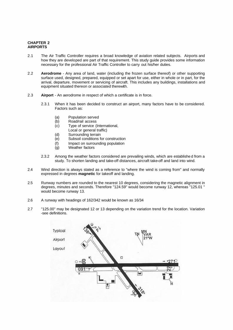
2.4 Wind direction is always stated as a reference to "where the wind is coming from" and normally
expressed in degrees magnetic for takeoff and landing. 2.5 Runway numbers are rounded to the nearest 10 degrees, considering the magnetic alignment in
degrees, minutes and seconds. Therefore "124.59" would become runway 12, whereas "125.01 " would become runway 13.
2.6 A runway with headings of 162/342 would be known as 16/34 2.7 "125.00" may be designated 12 or 13 depending on the variation trend for the location. Variation
-see definitions.

CHAPTER 3 NAVIGATION 3.1 The Air Traffic Controller requires a basic understanding of navigation. This study guide will
provide an introduction to navigation problems encountered by the Air Traffic Controller. 3.2 Navigation is based on the principle that the earth is covered with a grid of lines traveling north
and south and east and west. The lines traveling north/south are called Meridians of longitude and expressed as 180 degrees east or west of the prime meridian. The prime meridian passes through Greenwich England. The meridian opposite the prime meridian is called the international date line. Longitude is measured in degrees, minutes and seconds. The lines traveling east/west and parallel are called Parallels of Latitude and measured as zero to ninety degrees north or south of the equator. Latitude is measured in degrees, minutes and seconds.
3.3 The equator being a great circle contains 360 degrees and since the earth makesone revolution
each 24 hours, therefore, 15 degrees of longitude represent one hour in time. In Air Traffic Control accuracy is very important, therefore, a standard method of reporting time has been developed called Coordinated Universal Time (UTC). An atomic clock in Paris, France monitors the accuracy of time.
3.3.1 "One-in-sixty" Rule - "An error in the track of one degree will cause an error in position
of about one mile in a distance of 60 miles". FTGU P 195 3.4 Navigation terms
(a) Indicated Airspeed - The speed as indicated by the airspeed indicator. (b) True Airspeed - The speed corrected for density and temperature. (c) Ground Speed - The actual speed of the aircraft over the ground. (d) Heading -The angle between the longitudinal axis of the airplane at any moment and a
meridian. Headings may be true, magnetic or compass. (e) Track Made Good - The actual path of the aircraft over the ground. This track may be
expressed as true, magnetic or compass. (f) Drift-The angle between the heading being flown and the track made good. Drift is
expressed in degrees and may be left or right. 3.5 The controller should be capable of using the circular slide rule to solve basic navigation
problems. Included with this study guide is a very basic slide rule that may be constructed at home and will provide for some training. The three problems common to many control decisions are distance, elapsed time and ground speed. With any two known the third may be calculated.
(a) To find distance -when ground speed is 240kts, and time is 30 minutes, set 240 on the
outer scale opposite 60(black arrow) on the inner scale. Read the distance on the outer scale opposite 30 on the inner scale. Ans. 120nm.
(b) To find elapsed time - when ground speed is 300kts and distance is 100nm, set 300 on the outer scale opposite 60(black arrow) on the inner scale. Read the time on the inner scale opposite 100 on the outer scale. Ans. 20 minutes.
(c) To find Ground Speed -when distance is 150nm and the time is 30 minutes. Set 150 on the outer scale opposite 30 on the inner scale. Read ground speed opposite 60(black arrow) on the inner scale. Ans. 300kts
3.6 The slide rule may be used for other problems e.g. fuel consumption, fuel consumption rate as well as others, however, the controller's primary concern is distance, time and speed.

3.7 Follow these steps to construct a simple slide rule; (a) Glue the entire page to a piece of smooth cardboard. (Bristol board is fine) (b) Allow to dry under the weight of a book. (to keep from twisting) (c) Cut out the small circle. (d) Accurately locate the center of each disc. (e) Punch a small hole in the center of each disc. (f) Use a small bolt and nut to hold the disc's together and still allow them to rotate. (servo bolts from a radio control model aircraft work well)
(g) Trim the large disc to size.
NOTE: The most critical part of construction is the centering of the two parts, accuracy depends on it. Remember this slide rule is for practice only. Additional information on navigation is available in a publication titled "From The Ground Up".


CHAPTER 4 ELECTRONIC NAVIGATION AIDS 4.1 This chapter will review some of the current electronic navigational systems and aids available to
the pilot for the accurate positioning of his aircraft in the atmosphere. The Controller, in the course of his/her duties, will use one or more of these systems with every aircraft they control. These systems are the foundation for IFR control procedures.
4.1.1 These electronic aids may be categorized as follows; 1. en route or airway navigation. 2. non-precision/precision approach systems. NOTE: some may provide en route as well as approach guidance.
4.2 Distance measuring equipment- DME measures the distance directly from the aircraft to the
ground station. This measurement is referred to as slant range distance. The difference between a measured distance on the surface and the DME slant range is greatest when an aircraft is directly over the station, at which time it actually measures altitude. DME is often co-located with other navigational systems.
4.3 Global Positioning System - GPS was developed by the United States military. In February,
1994, the system was declared operational for civil aviation purposes in Canada and the United States. The system design calls for four satellites in each of six orbital planes, circling the earth twice each day at an altitude of 10900 nautical miles. GPS satellites transmit signals providing a precise navigation and course acquisition as well as ephemeris data. May be used for en route or approach. Ephemeris - A table giving the computed positions of a heavenly body for every day of a given period.
4.4 Instrument landing system - The ILS is designed to provide an aircraft with precision final
approach with horizontal and vertical guidance to the runway. DME is often co-located with an ILS system. The ILS is a precision approach system.
4.5 Loran c - Loran c is a long range navigation system based on the measurement of the time
difference in the arrival of signal pulses from a chain of widely spaced ground stations. A chain consists of a master station linked to a maximum of four secondary stations whose signals are synchronized with the master. The loran c receiver measures the time difference between the master and at least two of the secondary stations to provide a fix. Normally used for VFR en route operations.
4.6 Non-Directional Beacon - NDB's combine a transmitter with an antenna system providing a
non-directional radiation pattern. NDB's provide en route navigation and as well may be located with an ILS systems. NDB's may also provide a non-precision approach.
4.7 Tactical Air Navigation - TACAN is a navigation aid used primarily by the military for en rut and
non-precision approaches. It provides azimuth in the form of radials and slant range in nautical miles from the station
4.8 VHF Omnidirectional range -The VHF Omnidirectional Range (VOR) is a ground based short
distance navigation aid (NAVAID) which provides continuous azimuth information in the form of 360 radials to or from a station. It is used for en route navigation as well as non -precision Q approaches.
4.9 VORTAC - The VORTAC is simply a VOR and TACAN co- located and providing the same
navigational assistance.

4.10 Radar - The word Radar is derived from "Radio Detection and Ranging" and was developed in the 1930's and 40's. The use of radar increases airspace utilization by allowing Air Traffic Control to reduce separation between aircraft. There are two separate types of radar;
(a) Primary search radar - PSR determines the position (range and azimuth) of contacts by
measuring and displaying reflected radio signals from the contact. (b) Secondary search radar - SSR relies on the measurement of the time interval between
the interrogation and reply by an airborne transponder to determine aircraft range. The direction of the antenna determines azimuth.
NOTE: For SSR to function a transponder is required in each aircraft. A property
equipped aircraft, with the transponder set to MODE C, will display, for the controller, the aircraft altitude in 100 ft. increments.
4.11 Precision approach radar - PAR is a high definition short range system and is used for
precision approaches. The system provides the controller with altitude, azimuth and range information of high accuracy. PAR requires direct radio communication between the pilot and controller. PAR is basically a military system but may be used by civil aircraft. NOTE: PAR is primary radar
4.12 Airport surface detection equipment - ASDE is provided at certain airports where traffic
warrants. This high definition primary search radar is used by tower controllers to monitor the position of aircraft and vehicles during periods of reduced visibility.
4.13 Weather Radar - Weather radar is primary radar used by environment Canada to monitor for
hazardous weather conditions. While weather radar cannot be used by the controller to control air traffic it can be and is used to assist in the selection of routes, approaches and the provision of weather advisories.

CHAPTER 5 CANADIAN AIRSPACE and AIR TRAFFIC CONTROL Canadian Airspace 5.1 For the purposes of Air Traffic Control, Canadian Airspace has been divided in a number of
different ways. Several divisions have been made to ensure the safe and effective control of Air Traffic. This study guide will not detail these divisions, however, the Air Traffic Controller must have a complete knowledge of the Canadian Airspace plan.
5.2 Canadian Domestic Airspace (CDA) includes all airspace over the Canadian land mass, the
Canadian Archipelago and certain areas over the high seas. 5.3 For the effective use of Canadian Airspace seven (7) categories have been developed. Each
category requires control services appropriate to the type of traffic and activity within the area. Air Traffic Control 5.4 In the provision of service the Air Traffic Controller applies control procedures to aircraft operating
under visual flight rules and instrument flight rules. Control may also be applied to certain ground vehicles.
(a) Provide VFR control service to:
(i) Airport traffic operating on the maneuvering area (ii) VFR aircraft operating within the control zone or Tower Radar Area (iii) IFR aircraft for which the tower has responsibility for control.
(b) Provide IFR control service to: (i) IFR aircraft operating within controlled airspace (ii) VFR aircraft operating within specified airspace
5.5 The Air Traffic Controller applies approved control procedures to ensure the separation of aircraft. There are four broad categories which are used by the controller.
(a) Vertical - A controller may apply vertical separation by assigning different altitudes. (b) Lateral - A controller may apply lateral separation by requiring an aircraft to operate on
different routes, areas or geographic locations. (c) Longitudinal - A controller may apply longitudinal separation by requiring an aircraft to
maintain a minimum distance from another expressed in units of time or miles (these procedures are sometimes referred to as standard separation)
(d) Radar - The Controller may use Radar for the separation of aircraft. Separation using radar is expressed in miles and varies according to circumstances. The use of radar may be defined as;
(i) Air Traffic Control (separation of aircraft) (ii) Determine position of aircraft in flight (iii) Detecting weather (thunderstorms etc.) (iv) Approach and landing guidance (PAR etc.)
5.6 The controller, in the performance of his/her duties, is normally provided with information on aircraft and flights through the flight plan system. Flight plans are required for all IFR flights and for specified VFR flights. The Flight Service Station (FSS) is responsible for the flight planning service.

CHAPTER 6 AERODYNAMICS 6.1 While the Air Traffic Controller does not fly the airplane, an understanding of aerodynamics and
how an aircraft flies can be of great benefit to the controller. 6.2 "The study of theory of flight and aerodynamics can be a life time proposition. New theories are
forever being put forward. Some questions have answers that are difficultto find. Others perhaps do not yet have adequate answers. The information that comprises this chapter can only be considered an introduction to a substantial but fascinating study". FTGU P 21
6.3 "Forces acting on an airplane in flight.” There are four forces acting on an airplane in flight. These are thrust, drag, lift and weight.
(a) Thrust. The force exerted by the engine and its propellers) which push air backward with the object of causing a reaction or thrust, in the forward direction.
(b) Drag. The resistance to forward motion directly opposed to thrust. (c) Lift. The force upward which sustains the airplane in flight. (d) Weight. The downward force due to gravity, directly opposed to lift". FTGU P 21
6.4 Bernouilli's Theorem. Simply stated means; as the velocity of air increases its pressure decreases and vice-versa. 6.5 "The wings of an airplane are so designed that when moved through the air horizontally, the force
exerted on them produces a reaction as near vertical as possible. It is this reaction that lifts the weight of the airplane". FTGU P 21
6.6 Airfoils "An airfoil, or airfoil section, may be defined as any surface designed to obtain a reaction from the
air through which it moves, that is, to obtain lift. It has been found that the most suitable shape for producing lift is a curved or cambered shape". FTGU P 21 ,
6.6.1 The camber of an airfoil is the curvature of the upper and lower surfaces. Usually the
upper surface has a greater camber than the lower.

CHAPTER 7 AIRCRAFT ENGINE AND OPERATING SPECIFICATIONS 7.1 Air Traffic Controllers work with all types of aircraft from the small home built to the large airliner.
A complete working knowledge is required of the different types of engines and how they perform. The Controller must also know the operational characteristics of most aircraft. Control decisions are often made with operational capabilities in mind.
7.2 Engine Categories
(a) Piston (b) Turboprop (c) Jet 7.2.1 Piston "The three main types of piston engines in current use are radial, In-line and
horizontally opposed. They derive their name from the arrangement of their cylinders around the central crankshaft.
The horizontally opposed type is most commonly used in general aviation airplanes".
FTGU P51/52 (L-19 and Scout)
(a) Horizontally Opposed- "The horizontally opposed engine, as the name implies, has two banks of cylinders working on the same crankshaft which lie directly opposite to each other in the horizontal plane". FTGU P 52
(b) In-line - The in-line engine has the cylinders in a line and may be upright or
inverted. Some vintage aircraft use this engine style. (c) Radial - An odd number of cylinders arranged in a circle and connected to a
single crankshaft. Not in common use today. (d) Piston engines operate efficiently up to 15,000 feet
7.2.2 Turboprop The turboprop engine combines the properties of the propeller and jet engine. The basic
power source is a jet engine that is coupled to a propeller through a gear box. Depending on the individual aircraft, turboprop aircraft, generally operate most efficiently
at altitudes 15,000 to 25,000 feet. Although engine efficiency improves with altitude, the propeller efficiency drops off at higher altitudes due to thin air.
(a) JET - The jet engine can be divided into two main categories;
(i) Turbojet - This is an early model of the jet engine and is not very fuel efficient. The CL-41 -Tudor flown by the SNOWBIRDS in an example.
(ii) TURBOFAN - Basically a turbojet engine with a fan attached ahead of
the compressor to improve engine performance at lower speeds. This type of engine is found on most commercial and executive jets today. Boeing 767: Lear Jet, etc.
Jet engines operate more efficiently above 23,000 feet.
7.3 A guide for the approximate operating speeds of aircraft is as follows: PISTON - up to 250kts; TURBOPROP - 200 to 300kts; JET -250 to 500+kts 7.4 Controllers must recognize "TURN RADIUS", with bank constant, the higher the speed, the
greater the turn radius.
CHAPTER 8 METEOROLOGY 8.1 The atmosphere is forever in a state of physical change, giving rise to weather conditions that
vary throughout the range on an extremely vast scale. The Air Traffic Controller lives and works in this atmosphere. The weather, therefore, is a matter of vital concern to him. This study guide will provide a very brief introduction to meteorology.
8.2 The Atmosphere "Air, which is the material of which the atmosphere is composed, is a mixture of invisible gases.
At altitudes up to 250,000 feet, the atmosphere consists of approximately 78% nitrogen and 21 % oxygen. The remainder is made up of argon, carbon dioxide, several other gases and water vapour". FTGU p 123
8.2.1 Divisions of the Atmosphere "The atmosphere consists of four distinct layers surrounding the earth for a depth of
many hundreds of miles. They are, in ascending order, the troposphere, the stratosphere, the mesosphere and the thermosphere". FTGU P 123
(a) Troposphere - "This is the lowest layer of the atmosphere and varies in height in
different parts of the world from roughly 28,000 feet above sea level at the poles to 54,000 at the equator. Within the troposphere, the pressure, density and temperature all decrease rapidly with height. Most of the weather occurs in the troposphere because of the presence of water vapor". FTGU P 123
(b) Tropopause - The top layer of the troposphere. The temperature ceases to drop
and remains constant at about -56C. (i) Jet Stream - The Jet Stream appears to be closely associated with the
tropopause and the polar front. Jet streams flow from west to east and are usually about 30ONM wide and 3000 to 7000 feet thick. Wind speed within the jet may be 250kts, however, speeds are normally 100 to 150 kts.
(ii) Clear Air Turbulence - Closely associated with the jet stream and occurs in a cloudless sky. Turbulence may be severe enough to cause a hazard to modern jet aircraft.
(c) Stratosphere - The stratosphere begins at the tropopause and extends upward
50,000 feet. In this area pressure continues to decrease but temperature remains constant at about -56C. (Concorde may fly in the stratosphere)
(d) Mesosphere and thermosphere - These other divisions of the atmosphere will not
be discussed in this study guide. 8.3 Pressure Systems Atmospheric pressure determines the operation of an aircraft altimeter. Pressure distribution in
the atmosphere also controls the wind. Atmospheric pressure is measured in Inches of mercury. A standard altimeter setting is 29.92 inches of mercury.
8.4 Pressure systems are; lows, secondary lows, troughs, highs, ridges and cols. Some are
illustrated on the last page of this chapter. 8.5 "These pressure systems are constantly moving or changing in appearance. Lows may deepen
or fill and highs may build or weaken. Most systems move in a general west to east direction". FTGU P 128
8.6 Wind Speed and Direction Wind direction is reported as the compass point from which the wind is blowing. The speed of the
wind is reported in Kts(nautical miles per hour). The wind reported by the tower for landing and take-off is in degrees magnetic. The winds for other aviation weather reports are in degrees true.
8.7 Air Masses "An air mass may be defined as a large section of the troposphere with uniform properties of
temperature and moisture in the horizontal. An air mass may be several thousand miles across". FTGU P 139. The principle air masses of North America are; Continental Arctic, Continental Polar, Maritime Arctic, Maritime Polar and Maritime Tropical.
8.8 Fronts "The troposphere is made up of air masses. The transition zone between two air masses is called
a front. The interaction of these air masses along their frontal zones, is responsible for weather changes". FTGU P 140. Fronts are most commonly referred to as warm or cold.
8.9 Clouds Clouds are an indication of what is happening in the atmosphere. The location and type of cloud
are evidence of such weather phenomena as fronts, turbulence and thunderstorms. Clouds are classified into four groups, high, middle, low and clouds of vertical development. Clouds are also identified by the way they form;
(a) "Cumulus clouds form in rising air currents and are evidence of unstable air conditions. (b) Stratus clouds form in horizontal layers and usually form as a layer of moist air cooled
below its saturation point". FTGU P 124 (c) Nimbus clouds are clouds from which precipitation falls.
NOTE: Thunderstorms develop from cumulonimbus clouds that may reach to 60,000 feet. The
weather associated with cumulonimbus clouds should be avoided at all times. They produce the greatest hazard to aircraft.
8.10 Weather information Nav Canada provides a wide range of weather services for use by the aviation industry. Three
specific areas are; (a) Surface Weather Observations - METARs - A surface weather observation is issued on
the hour. If a significant weather change occurs a "special - SPECI" may be issued at any time. Data for the METAR report may be collected by human observer or automated station.
(b) Aerodrome Forecasts - TAFs - An aerodrome forecast states the expected weather
within an area of five miles of the aerodrome in question. TAFs are produced in the same language as the METAR. TAFs are issued four times a day and contain information on at least the following; wind, visibility, weather and cloud.
(c) Graphic Area Forecast - GFA - A graphic area forecast depicts the most probable
weather conditions expected over a given area below 24,000 ft at a specific time. The GFA is designed to meet the needs of general aviation and regional carriers. GFAs are issued four times a day.
8.11 Additional information on meteorology is available in a book titled "From the Ground Up" and the
Nav Canada publication "Aviation Weather Services Guide".


CHAPTER 9 AERONAUTICAL CHARTS 9.1 Air Traffic Controllers require a basic knowledge of the maps and charts used in aviation. This
study guide will provide some information and should be used in association with other study material.
9.2 Map scale is usually expressed in inches, i.e. one inch on the map represents "X" inches on the
ground, e.g. 1:500,000. This would represent approximately 8 miles to the inch 9.3 For VFR navigation the Lambert Conformal Conic Projection (1:500000) is used in map
production and is the ICAO standard. This type of map provides good ground detail. 9.4 For IFR navigation "en route charts" are used. They provide information on electronic navigation
aids as well as other information required for IFR flight. 9.5 The section of VFR navigation chart (1:500000) is included, to help develop a - knowledge of
maps and charts and the information they display. Note: VFR charts are produced in color. This section of chart is the "Air Series" 5003 (Moncton)