KFC Restaurant and Drive Thru South Terminal, Gatwick ... · KFC Restaurant and Drive Thru South...
35
KFC Restaurant and Drive Thru South Terminal, Gatwick Transport Statement January 2015
-
Upload
truongxuyen -
Category
Documents
-
view
219 -
download
0
Transcript of KFC Restaurant and Drive Thru South Terminal, Gatwick ... · KFC Restaurant and Drive Thru South...

KFC Restaurant and Drive Thru South Terminal, Gatwick Transport Statement
January 2015

Gatwick Airport Limited KFC Restaurant and Drive Thru Transport Statement
Document control sheet BPP 04 F8
version 17 July 2014
Project: KFC Restaurant and Drive Thru, Gatwick South Terminal
Client: GAL and Cobra Restaurants Ltd
Project Number: GAC20009
Document Title:
KFC Restaurant and Drive Thru Transport Statement
Ref. No: GAC20009/03
Originated by Checked by Reviewed by
ISSUE 4
NAME NAME NAME
Charlotte Saunders John Fincher Emily White
Approved by NAME As Project Manager I confirm that the
above document(s) have been subjected to
Jacobs’ Check and Review procedure and that I approve them for issue
INITIALS
Peter McCarthy
DATE 05/02/2014 Document status: DRAFT FOR COMMENT
ISSUE 5 NAME NAME NAME
Charlotte Saunders John Fincher Emily White
Approved by NAME As Project Manager I confirm that the
above document(s) have been subjected to Jacobs’ Check and Review procedure and that I approve them for issue
INITIALS
Peter McCarthy
DATE 07/02/2014 Document status: FINAL
ISSUE 6 NAME NAME NAME
Pramod Dahal Emily White Richard Smith
Approved by NAME As Project Manager I confirm that the
above document(s) have been subjected to Jacobs’ Check and Review procedure and that I approve them for issue
INITIALS
Peter McCarthy
DATE 20/01/2015 Document status: FINAL to reflect updated site layout
Jacobs U.K. Limited This document has been prepared by a division, subsidiary or affiliate of Jacobs U.K. Limited (“Jacobs”) in its professional capacity as consultants in accordance with the terms and conditions of Jacobs’ contract with the commissioning party (the “Client”). Regard should be had to those terms and conditions when considering and/or placing any reliance on this document. No part of this document may be copied or reproduced by any means without prior written permission from Jacobs. If you have received this document in error, please destroy all copies in your possession or control and notify Jacobs.
Any advice, opinions, or recommendations within this document (a) should be read and relied upon only in the context of the document as a whole; (b) do not, in any way, purport to include any manner of legal advice or opinion; (c) are based upon the information made available to Jacobs at the date of this document and on current UK standards, codes, technology and construction practices as at the date of this document. It should be noted and it is expressly stated that no independent verification of any of the documents or information supplied to Jacobs has been made. No liability is accepted by Jacobs for any use of this document, other than for the purposes for which it was originally prepared and provided. Following final delivery of this document to the Client, Jacobs will have no further obligations or duty to advise the Client on any matters, including development affecting the information or advice provided in this document.
This document has been prepared for the exclusive use of the Client and unless otherwise agreed in writing by Jacobs, no other party may use, make use of or rely on the contents of this document. Should the Client wish to release this document to a third party, Jacobs may, at its discretion, agree to such release provided that (a) Jacobs’ written agreement is obtained prior to such release; and (b) by release of the document to the third party, that third party does not acquire any rights, contractual or otherwise, whatsoever against Jacobs and Jacobs, accordingly, assume no duties, liabilities or obligations to that third party; and (c) Jacobs accepts no responsibility for any loss or damage incurred by the Client or for any conflict of Jacobs’ interests arising out of the Client's release of this document to the third party.
Gatwick Airport Limited KFC Restaurant and Drive Thru Transport Statement
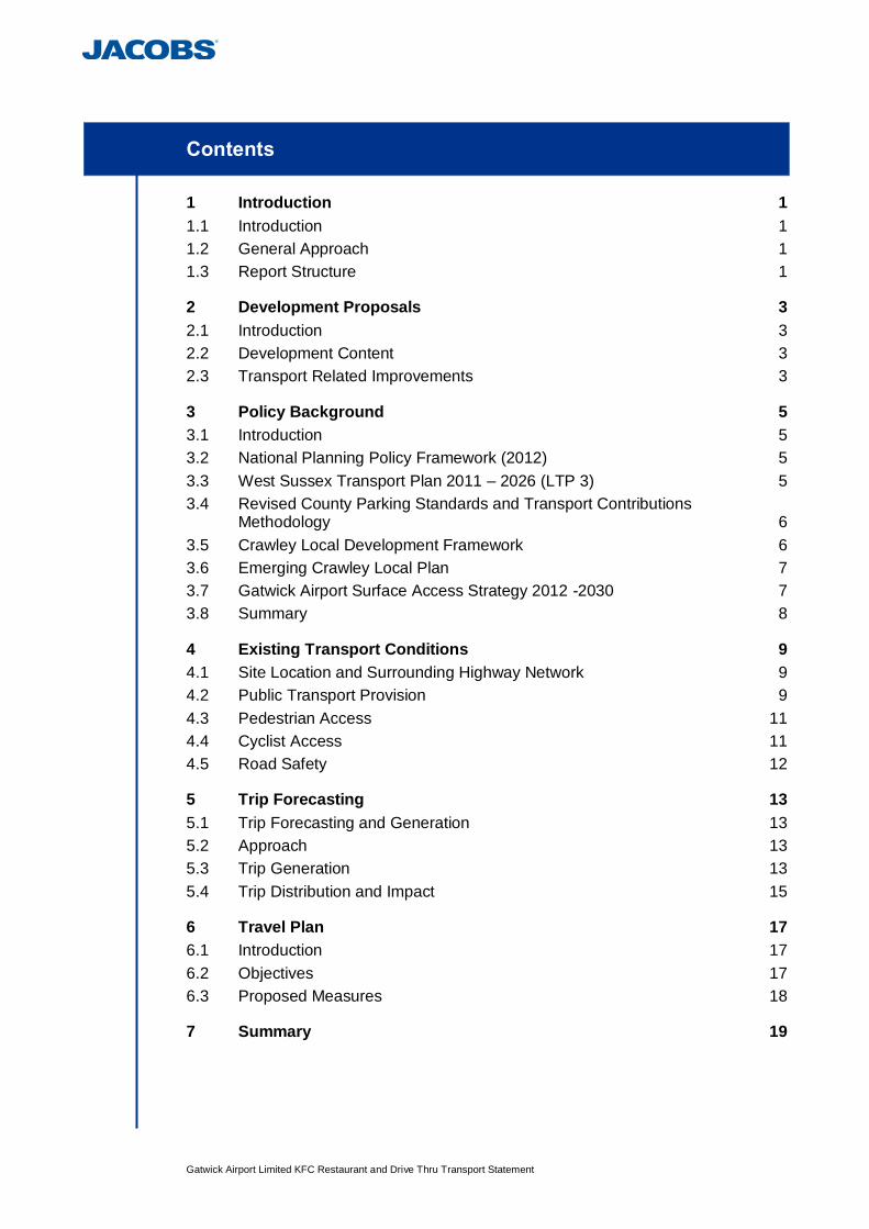
Contents
1 Introduction 1
1.1 Introduction 1
1.2 General Approach 1
1.3 Report Structure 1
2 Development Proposals 3
2.1 Introduction 3
2.2 Development Content 3
2.3 Transport Related Improvements 3
3 Policy Background 5
3.1 Introduction 5
3.2 National Planning Policy Framework (2012) 5
3.3 West Sussex Transport Plan 2011 – 2026 (LTP 3) 5
3.4 Revised County Parking Standards and Transport Contributions Methodology 6
3.5 Crawley Local Development Framework 6
3.6 Emerging Crawley Local Plan 7
3.7 Gatwick Airport Surface Access Strategy 2012 -2030 7
3.8 Summary 8
4 Existing Transport Conditions 9
4.1 Site Location and Surrounding Highway Network 9
4.2 Public Transport Provision 9
4.3 Pedestrian Access 11
4.4 Cyclist Access 11
4.5 Road Safety 12
5 Trip Forecasting 13
5.1 Trip Forecasting and Generation 13
5.2 Approach 13
5.3 Trip Generation 13
5.4 Trip Distribution and Impact 15
6 Travel Plan 17
6.1 Introduction 17
6.2 Objectives 17
6.3 Proposed Measures 18
7 Summary 19
Gatwick Airport Limited KFC Restaurant and Drive Thru Transport Statement
Appendix A Scoping Note
Appendix B Proposed Site Location and Layout
Appendix C Collision Data
Appendix D TRICS Outputs
Appendix E Traffic Flow Diagrams
Appendix F Feedback from Highways Agency
Gatwick Airport Limited KFC Restaurant and Drive Thru Transport Statement 1
1 Introduction
1.1 Introduction
Jacobs has been commissioned by Gatwick Airport Limited (GAL) and Cobra Restaurants Ltd to produce a Transport Statement (TS) in support of a planning application for construction of a KFC restaurant and drive thru located on Ring Road North at Gatwick South Terminal, West Sussex. This updated TS reflects the changes made to the proposal after an initial planning application (CR/2014/0082/FUL) was rejected on non-transport grounds. There were no issues with the transport impacts of the development as demonstrated in the original TS.
The development proposals include construction of a KFC restaurant and drive thru building and car parking area. Entrance to the site is to be provided by a left turn slip road from Ring Road North. Egress from the site will by the BP garage exit to the east of the site via an internal road. The proposed restaurant and drive thru will be 686 sq. m. This represents a reduction of 41 sq. m compared to the previous proposals. This version of the TS has been updated to reflect the revised development area and parking provision.
1.2 General Approach
This Transport Statement considers the transport implications of the proposed development and has been prepared in accordance with ‘National Planning Policy Framework’. Initial pre-application discussions were held with West Sussex County Council (WSCC) in September 2012 and it was agreed that a Transport Statement would be provided, given detailed analysis and modelling would not be required. A scoping note (dated 24/09/2012) was sent to WSCC, The Highways Agency and GAL outlining the assessment to be undertaken and any feedback was welcomed. Since then, the proposals have been updated and WSCC have subsequently been contacted to scope the requirements for these new proposals. It has been agreed that a Transport Statement is still appropriate. The correspondence can be found in Appendix A.
This Transport Statement provides a Chapter outlining potential Travel Plan objectives and measures that the Gatwick Airport South Terminal KFC Restaurant and Drive Thru could use to encourage their employees to adopt. In addition, the GAL Surface Access Strategy 2012-2030, ‘Access Gatwick’, includes measures for increased sustainable travel including improved car sharing, smart ticketing and improved local bus access. This document should be consulted to determine if the KFC restaurant and drive thru can link into some of these measures.
1.3 Report Structure
Subsequent sections of this Transport Statement are as follows:
Section 2 provides an overview of the development proposals;
Section 3 sets out the policy context for the development proposals;

Gatwick Airport Limited KFC Restaurant and Drive Thru Transport Statement 2
Section 4 discusses the existing transport situation;
Section 5 details the travel demand anticipated to be generated by the development proposals;
Section 6 discusses proposed Travel Plan objectives and measures; and
Section 7 provides a summary of the report.
Gatwick Airport Limited KFC Restaurant and Drive Thru Transport Statement 3
2 Development Proposals
2.1 Introduction
This section provides an overview of the development proposals, providing information on the floor areas and layout. This section also deals with the transport related improvements to be delivered in association with the proposed KFC restaurant and drive thru. Appendix B includes the preferred option site location
and layout.
2.2 Development Content
The proposed KFC restaurant and drive thru will be located to the west of the McDonald’s restaurant on Ring Road North, Gatwick South Terminal. The Gross External Area (GEA) of the restaurant and drive thru building will be 686sq.m. The front of house Gross Internal Area (GIA) will be 405sq.m. and back of house 140sq.m. The proposed parking provision is:
Cars: 58
Blue Badge: 3
Cycle: 8
Motor Cycle: 3 Parking restrictions will apply at the site to prevent long stay parking associated with waiting vehicles for arriving passengers. These restrictions will be in line with the current McDonald’s restaurant and drive thru. The WSCC parking standards make no requirements for employees parking however employees parking will be addressed as part of the wider GAL Surface Access Strategy.
A new pedestrian footpath will be provided as part of the development which will provide access from the south terminal building bus stop area to the KFC restaurant and adjacent McDonald’s running along the southern edge of the site (on the north side of Ring Road North).
2.3 Transport Related Improvements
2.3.1 Vehicular and Pedestrian Access
The new junction with Ring Road North will be a left turn only junction for eastbound vehicles travelling away from the South Terminal building. The site access road will be sufficiently long enough to allow vehicles to enter the site to park and/or manoeuvre. There will be sufficient queuing capacity at the drive thru to prevent following vehicles blocking back into the Ring Road north. A nearby lay-by on Ring Road North will be used for deliveries and servicing. For exiting vehicles, it is proposed to provide an internal link to the McDonald’s car park allowing vehicles to exit at the same junction as the current McDonald’s and BP
Gatwick Airport Limited KFC Restaurant and Drive Thru Transport Statement 4
Garage customers. The preferred scheme layout (in Appendix B) shows the proposals and access arrangements.
A new pedestrian link will be provided from the South Terminal Building bus stop area, along the southern edge of the site, to the existing McDonald’s restaurant on the east side of the proposed development. This will give pedestrians from the South Terminal building a direct entrance to the site.
2.3.2 Travel Plan
This Transport Statement provides potential objectives and measures that can be considered by the KFC management to encourage sustainable travel by employees and visitors. Consideration of measures to increase sustainable travel can also be sought from the Gatwick Surface Access Strategy.
Gatwick Airport Limited KFC Restaurant and Drive Thru Transport Statement 5
3 Policy Background
3.1 Introduction
This section of the report summarises the key national, regional and local planning and transport policies relevant to the assessment of the transport impact of the proposed development.
3.2 National Planning Policy Framework (2012)
The National Planning Policy Framework (NPPF) was adopted in March 2012 and replaces Planning Policy Guidance 13: Transport. It sets out the Government’s requirements for the planning system ‘seeking positive improvements to the quality of the built, natural and historic environment, as well as in people’s quality of life.’ The NPPF states that all developments which will generate significant amounts of movements should be supported by a Transport Statement or Transport Assessment. The following should be taken into account:
The opportunities for sustainable transport modes have been taken up depending on the nature and location of the site, to reduce the need for major transport infrastructure;
Safe and suitable access to the site can be achieved for all people; and
Improvements can be undertaken within the transport network that cost effectively limit the significant impacts of the development. Development should only be prevented or refused on transport grounds where the residual cumulative impacts of development are severe.
The location of the proposed development site ensures that sustainable access opportunities are available and the impact of vehicle trips should be limited due to the expectation that the type and location of the development will largely attract linked trips from Gatwick Airport Limited passengers and does not propose to attract a significant number of customer trips from further afield. Safe access to the site is also proposed through the left turn junction from Ring Road North and exit through the existing McDonald’s site and BP Garage junction and providing a footpath from the bus station at the South Terminal along the southern edge of the site to McDonald’s on the east of the proposed development.
3.3 West Sussex Transport Plan 2011 – 2026 (LTP 3)
The West Sussex Transport Plan 2011-2026 sets the strategy for guiding future investment in West Sussex highways and transport infrastructure and sets out a framework for considering transport infrastructure requirements associated with future development across the county. The Plan’s objectives for West Sussex are:
Promoting economic growth,
Tackling climate change,
Providing access to services, employment and housing, and
Improving safety, security and health.
Gatwick Airport Limited KFC Restaurant and Drive Thru Transport Statement 6
The Plan recognises that the Gatwick Diamond area has a growing economy and low rate of unemployment. It states ‘Gatwick Airport is the key economic driver in the area and makes substantial contribution to the economic performance of the wider South East and London.’ The proposed development would provide jobs for the local area whilst having a relatively small impact on the local transport network. It is proposed that customers to the KFC restaurant and drive thru will be largely passengers of the airport producing pass-by and diverted trips that are already travelling through the road network.
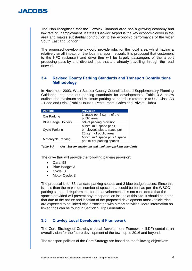
3.4 Revised County Parking Standards and Transport Contributions Methodology
In November 2003, West Sussex County Council adopted Supplementary Planning Guidance that sets out parking standards for developments. Table 3-A below outlines the maximum and minimum parking standards in reference to Use Class A3 – Food and Drink (Public Houses, Restaurants, Cafes and Private Clubs).
Parking Provision
Car Parking 1 space per 5 sq.m. of the public area
Blue Badge Holders 6% of parking provision
Cycle Parking Minimum 1 space per 4 employees plus 1 space per 25 sq.m of public area
Motorcycle Parking Minimum 1 space plus 1 space per 10 car parking spaces
Table 3-A West Sussex maximum and minimum parking standards
The drive thru will provide the following parking provision;
Cars: 58
Blue Badge: 3
Cycle: 8
Motor Cycle: 3 The proposal is for 58 standard parking spaces and 3 blue badge spaces. Since this is less than the maximum number of spaces that could be built as per the WSCC parking standard requirements for the development, it is not considered that the spaces provided will present any transportation issues at this site. It should be noted that due to the nature and location of the proposed development most vehicle trips are expected to be linked trips associated with airport activities. More information on linked trips can be found in Section 5 Trip Generation.
3.5 Crawley Local Development Framework
The Core Strategy of Crawley’s Local Development Framework (LDF) contains an overall vision for the future development of the town up to 2016 and beyond. The transport policies of the Core Strategy are based on the following objectives:

Gatwick Airport Limited KFC Restaurant and Drive Thru Transport Statement 7
To secure an effective integration of land use and transportation policies which reduces the need for people to travel long distances;
To secure a safe and efficient transport system, making best use of existing infrastructure and developing new infrastructure;
To encourage more sustainable use of transport, reducing energy consumption and pollution, and the environmental impact of car and lorry use;
To work with other public agencies and the private sector to bring forward sustainable transport initiatives including walking and cycling.
Transport Policy T1 identifies the importance of integrating transport, improving public transport, easing congestion and concentrating development where sustainable travel patterns can be achieved. The Core Strategy identifies the public transport opportunity that the Fastway guided bus system will bring to the town. These buses serve the South Terminal and will provide the employees of the proposed KFC restaurant and drive thru with an efficient bus service to access their place of work. The policies for Gatwick in the Core Strategy are based on the following objectives:
To ensure that the growth in business at the airport is associated with measures which limit its impact on the surrounding area.
To ensure that land which may be required for future development at the airport is protected from development in accordance with Government policy.
Saved transport policies of the Crawley Borough Local Plan (2000)
Saved Policy GAT 5 - Surface Transport Access to Gatwick Airport – confirms that
proposals which enable the existing and future surface transport access demands of the airport and its business to be managed in a sustainable manner, will normally be permitted and that encouragement will be given to improvements to the infrastructure and facilities which will enable staff, passengers and visitors to gain access to the airport by public transport, cycling and on foot.
3.6 Emerging Crawley Local Plan
Crawley is currently producing a local plan go alongside regional plans and Local development. The draft form submitted in 2014 contains priorities for ‘Provision of retail, leisure and other commercial development’ and ‘Control of Gatwick Airport’ which impact upon this assessment. The plan concurs with the NPPF in a preference for sustainable transport and that development should not cause ‘unacceptable impacts on existing traffic’.
3.7 Gatwick Airport Surface Access Strategy 2012 -2030
All major UK airports are required to prepare a surface access strategy that sets out how they propose to handle the demand for travel to and from the airport. Gatwick’s latest strategy document has as its main target to achieve 40% public transport mode share for both passengers and employees at 40 million passengers per annum.

Gatwick Airport Limited KFC Restaurant and Drive Thru Transport Statement 8
For employees its main objectives to achieve this are:
Introducing a new airport travel plan in 2013
Improving the attractiveness of public transport to staff by working with all operators to achieve consistent smart card technology for all staff discounts
This document draws together the travel patterns of all employees that work directly in and around the airport and the freight, retail and other movements that are associated with the Airport. It details all of the transport modes to and from the airport and how passengers are currently travelling including by rail, bus and coach, and by road and associated car parking. The report’s employee targets specific corridors with objectives to increase Public Transport usage as following:
Crawley/ Horley 34% to 40%
Croydon, Bromley 37% to 45%
Brighton and on Sussex Coast 22% to 30% Employees travel to and from the proposed KFC restaurant and drive thru will be incorporated within this document and associated reviews. The surface access strategy and proposed airport wide travel plan can be used to encourage sustainable travel at the proposed restaurant.
3.8 Summary
The development proposals for the KFC restaurant and drive thru are in line with the policies outlined in this section. The location of the development close to Gatwick South Terminal provides opportunities for employees to travel to work using public transport and the footpath improvements will enhance access by foot. Provision of cycle parking will also provide employees, and potentially some customers, with the opportunity to cycle to the site. Reducing dependency on car travel minimises the impact of the development on the wider road network.

Gatwick Airport Limited KFC Restaurant and Drive Thru Transport Statement 9
4 Existing Transport Conditions
4.1 Site Location and Surrounding Highway Network
This site is located to the east of Gatwick Airport on Ring Road North exiting the South Terminal. A McDonald’s restaurant and BP garage borders the development site to the east and the A23 borders the northern edge. To the south, on the inside of the ring road, are Employees Car Park H and a Hilton hotel. Figure 4-A illustrates the location of Gatwick Airport in relation to the surrounding highway network. Gatwick Airport is located south of the M23/A23 Airport Way roundabout junction and to the west of junction 9 of the M23. The M23 runs from the M25 to the north and to Pease Pottage to the south where the road merges into the A23 towards Brighton. Gatwick Airport sits on the southern outskirts of Horley and approximately 2 miles to the south is the town of Crawley.
Figure 4-A Site Location (Source: Google, September 2012)
The A23 London Road borders Ring Road North and runs on a general north-south alignment. To the north of Gatwick is the A23 London Road runs northwards to a point to the north of the M25/M23 junction where it merges into the A23 Brighton Road, which continues northwards towards London. To the south of Gatwick the A23 London Road runs southwards to Pease Pottage and then on to Brighton.
4.2 Public Transport Provision
4.2.1 Bus Stops and Routes
There is a large number of bus services serving Gatwick Airport, with stops located in the departures area of the South Terminal building which is an approximate 300 metre walk to the west of the development site. Fastway serves the
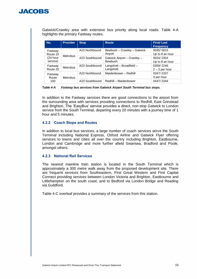
Gatwick Airport Limited KFC Restaurant and Drive Thru Transport Statement 10
Gatwick/Crawley area with extensive bus priority along local roads. Table 4-A highlights the primary Fastway routes.
No. Provider Stop Route First/ Last
Frequency
Fastway Route 10 (24 hour service)
Metrobus
A23 Northbound Bewbush – Crawley – Gatwick Airport
0045/ 0015
Up to 8 an hour
A23 Southbound Gatwick Airport – Crawley – Bewbush
0024/ 2354
Up to 8 an hour
Fastway Route 20
Metrobus A23 Southbound Langshott – Broadfield –
Langshott 0359/ 2246
2 – 3 per hour
Fastway Route 100
Metrobus
A23 Northbound Maidenbower – Redhill 0347/ 2337
3 per hour
A23 Southbound Redhill – Maidenbower 0447/ 2344
Table 4-A Fastway bus services from Gatwick Airport South Terminal bus stops.
In addition to the Fastway services there are good connections to the airport from the surrounding area with services providing connections to Redhill, East Grinstead and Brighton. The ‘EasyBus’ service provides a direct, non-stop Gatwick to London service from the South Terminal, departing every 20 minutes with a journey time of 1 hour and 5 minutes. 4.2.2 Coach Stops and Routes
In addition to local bus services, a large number of coach services serve the South Terminal including National Express, Oxford Airline and Gatwick Flyer offering services to towns and cities all over the country including Brighton, Eastbourne, London and Cambridge and more further afield Swansea, Bradford and Poole, amongst others. 4.2.3 National Rail Services
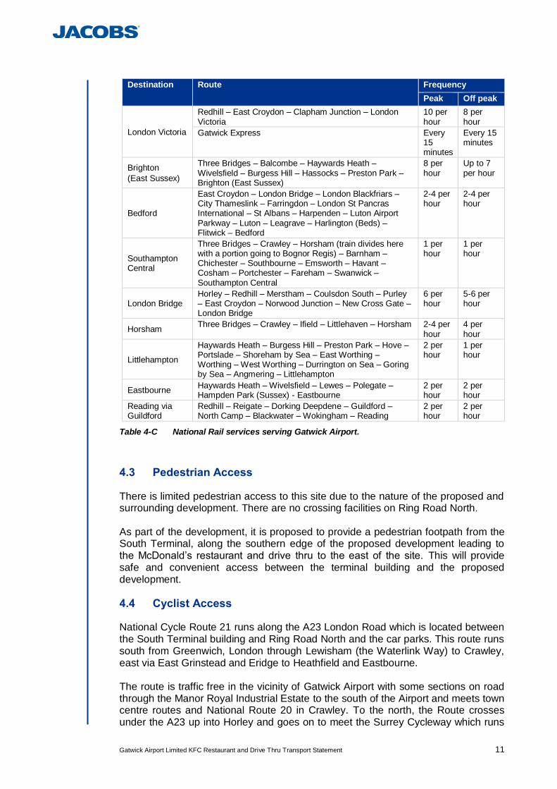
The nearest mainline train station is located in the South Terminal which is approximately a 300 metre walk away from the proposed development site. There are frequent services from Southeastern, First Great Western and First Capital Connect providing services between London Victoria and Brighton, Eastbourne and Littlehampton on the south coast, and to Bedford via London Bridge and Reading via Guildford. Table 4-C overleaf provides a summary of the services from this station.
Gatwick Airport Limited KFC Restaurant and Drive Thru Transport Statement 11
Destination Route Frequency
Peak Off peak
London Victoria
Redhill – East Croydon – Clapham Junction – London Victoria
10 per hour
8 per hour
Gatwick Express Every 15 minutes
Every 15 minutes
Brighton
(East Sussex)
Three Bridges – Balcombe – Haywards Heath – Wivelsfield – Burgess Hill – Hassocks – Preston Park – Brighton (East Sussex)
8 per hour
Up to 7 per hour
Bedford
East Croydon – London Bridge – London Blackfriars – City Thameslink – Farringdon – London St Pancras International – St Albans – Harpenden – Luton Airport Parkway – Luton – Leagrave – Harlington (Beds) – Flitwick – Bedford
2-4 per hour
2-4 per hour
Southampton Central
Three Bridges – Crawley – Horsham (train divides here with a portion going to Bognor Regis) – Barnham – Chichester – Southbourne – Emsworth – Havant – Cosham – Portchester – Fareham – Swanwick – Southampton Central
1 per hour
1 per hour
London Bridge Horley – Redhill – Merstham – Coulsdon South – Purley – East Croydon – Norwood Junction – New Cross Gate – London Bridge
6 per hour
5-6 per hour
Horsham Three Bridges – Crawley – Ifield – Littlehaven – Horsham 2-4 per
hour 4 per hour
Littlehampton
Haywards Heath – Burgess Hill – Preston Park – Hove – Portslade – Shoreham by Sea – East Worthing – Worthing – West Worthing – Durrington on Sea – Goring by Sea – Angmering – Littlehampton
2 per hour
1 per hour
Eastbourne Haywards Heath – Wivelsfield – Lewes – Polegate – Hampden Park (Sussex) - Eastbourne
2 per hour
2 per hour
Reading via Guildford
Redhill – Reigate – Dorking Deepdene – Guildford – North Camp – Blackwater – Wokingham – Reading
2 per hour
2 per hour
Table 4-C National Rail services serving Gatwick Airport.
4.3 Pedestrian Access
There is limited pedestrian access to this site due to the nature of the proposed and surrounding development. There are no crossing facilities on Ring Road North. As part of the development, it is proposed to provide a pedestrian footpath from the South Terminal, along the southern edge of the proposed development leading to the McDonald’s restaurant and drive thru to the east of the site. This will provide safe and convenient access between the terminal building and the proposed development.
4.4 Cyclist Access
National Cycle Route 21 runs along the A23 London Road which is located between the South Terminal building and Ring Road North and the car parks. This route runs south from Greenwich, London through Lewisham (the Waterlink Way) to Crawley, east via East Grinstead and Eridge to Heathfield and Eastbourne. The route is traffic free in the vicinity of Gatwick Airport with some sections on road through the Manor Royal Industrial Estate to the south of the Airport and meets town centre routes and National Route 20 in Crawley. To the north, the Route crosses under the A23 up into Horley and goes on to meet the Surrey Cycleway which runs
Gatwick Airport Limited KFC Restaurant and Drive Thru Transport Statement 12
east to west through the centre of the town. The proposed development will provide cycle parking in the form of 8 cycle stands.
4.5 Road Safety
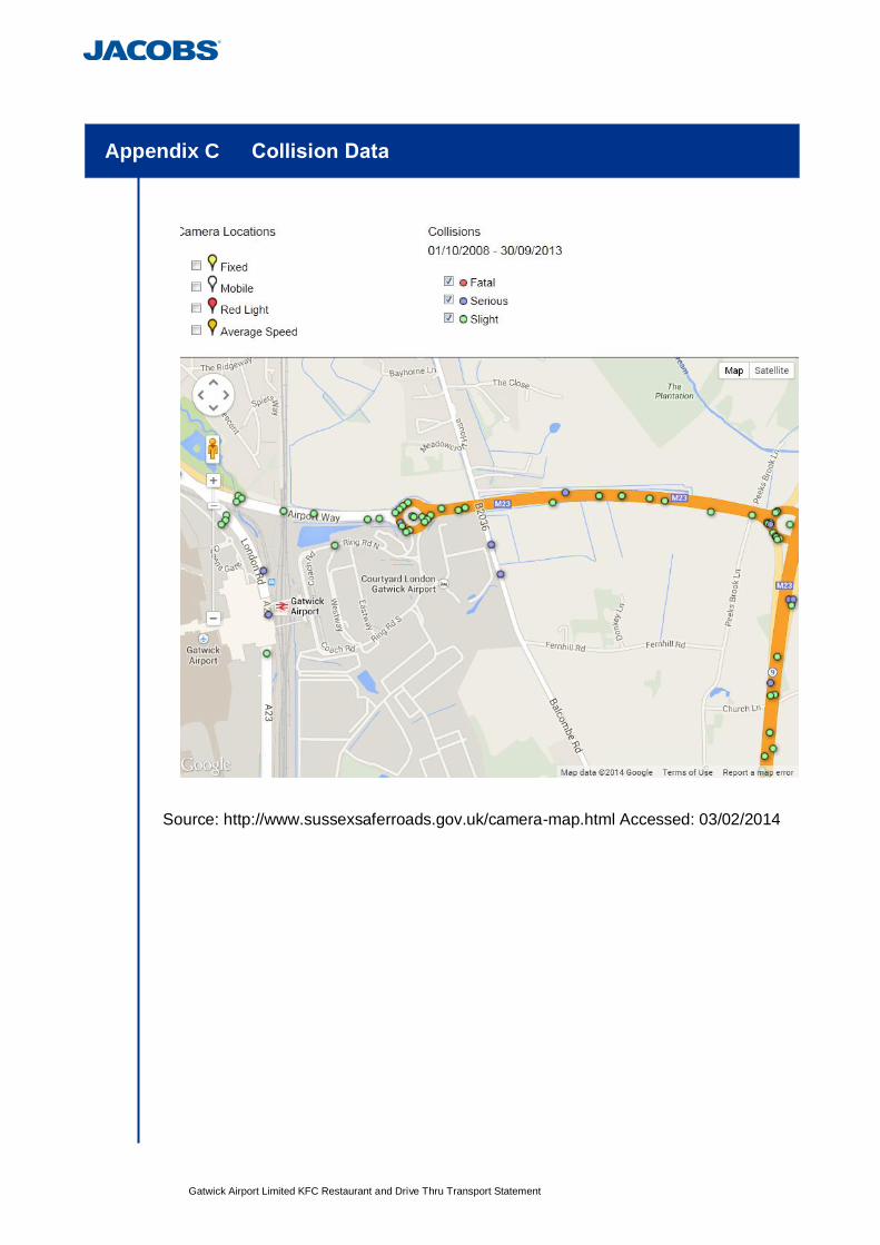
4.5.1 Collision Analysis
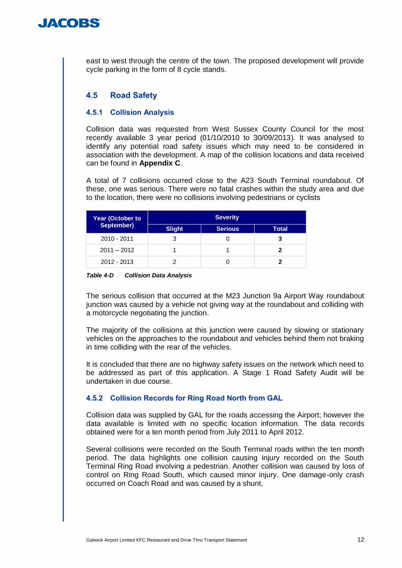
Collision data was requested from West Sussex County Council for the most recently available 3 year period (01/10/2010 to 30/09/2013). It was analysed to identify any potential road safety issues which may need to be considered in association with the development. A map of the collision locations and data received can be found in Appendix C.
A total of 7 collisions occurred close to the A23 South Terminal roundabout. Of these, one was serious. There were no fatal crashes within the study area and due to the location, there were no collisions involving pedestrians or cyclists
Year (October to September)
Severity
Slight Serious Total
2010 - 2011 3 0 3
2011 – 2012 1 1 2
2012 - 2013 2 0 2
Table 4-D Collision Data Analysis
The serious collision that occurred at the M23 Junction 9a Airport Way roundabout junction was caused by a vehicle not giving way at the roundabout and colliding with a motorcycle negotiating the junction. The majority of the collisions at this junction were caused by slowing or stationary vehicles on the approaches to the roundabout and vehicles behind them not braking in time colliding with the rear of the vehicles. It is concluded that there are no highway safety issues on the network which need to be addressed as part of this application. A Stage 1 Road Safety Audit will be undertaken in due course. 4.5.2 Collision Records for Ring Road North from GAL
Collision data was supplied by GAL for the roads accessing the Airport; however the data available is limited with no specific location information. The data records obtained were for a ten month period from July 2011 to April 2012. Several collisions were recorded on the South Terminal roads within the ten month period. The data highlights one collision causing injury recorded on the South Terminal Ring Road involving a pedestrian. Another collision was caused by loss of control on Ring Road South, which caused minor injury. One damage-only crash occurred on Coach Road and was caused by a shunt.
Gatwick Airport Limited KFC Restaurant and Drive Thru Transport Statement 13
5 Trip Forecasting
5.1 Trip Forecasting and Generation
This section discusses the approach to determine the trip generation associated with the development proposals discussed in Section 2 and also documents the resultant number of vehicle trips anticipated to be generated.
5.2 Approach
A trip rate based approach using information from comparative sites obtained from the TRICS database has been used to determine the weekday and Saturday peak hour vehicle trip generation associated with the proposed development. Sites were selected based on the following criteria:
Location – proximity to other land uses;
Limited public transport provision; and
Edge of town location.
As part of proposals for a new McDonald’s restaurant and drive thru at Gatwick North Terminal, a customer interview survey was undertaken at the McDonald’s restaurant and drive thru at the South Terminal to determine types of trips being made to the restaurant at Gatwick Airport. The results demonstrate that 77% of trips on a Friday and 76% of trips on a Saturday could be expected to be shared trips with the Airport. Through discussions with WSCC it has been decided to utilise the results from these surveys in this Transport Statement as they are site specific. Whilst there aren’t as many KFC restaurants in the surrounding areas as there are McDonald’s, they are located in the same surrounding towns, Crawley, East Grinstead, Redhill and Dorking.
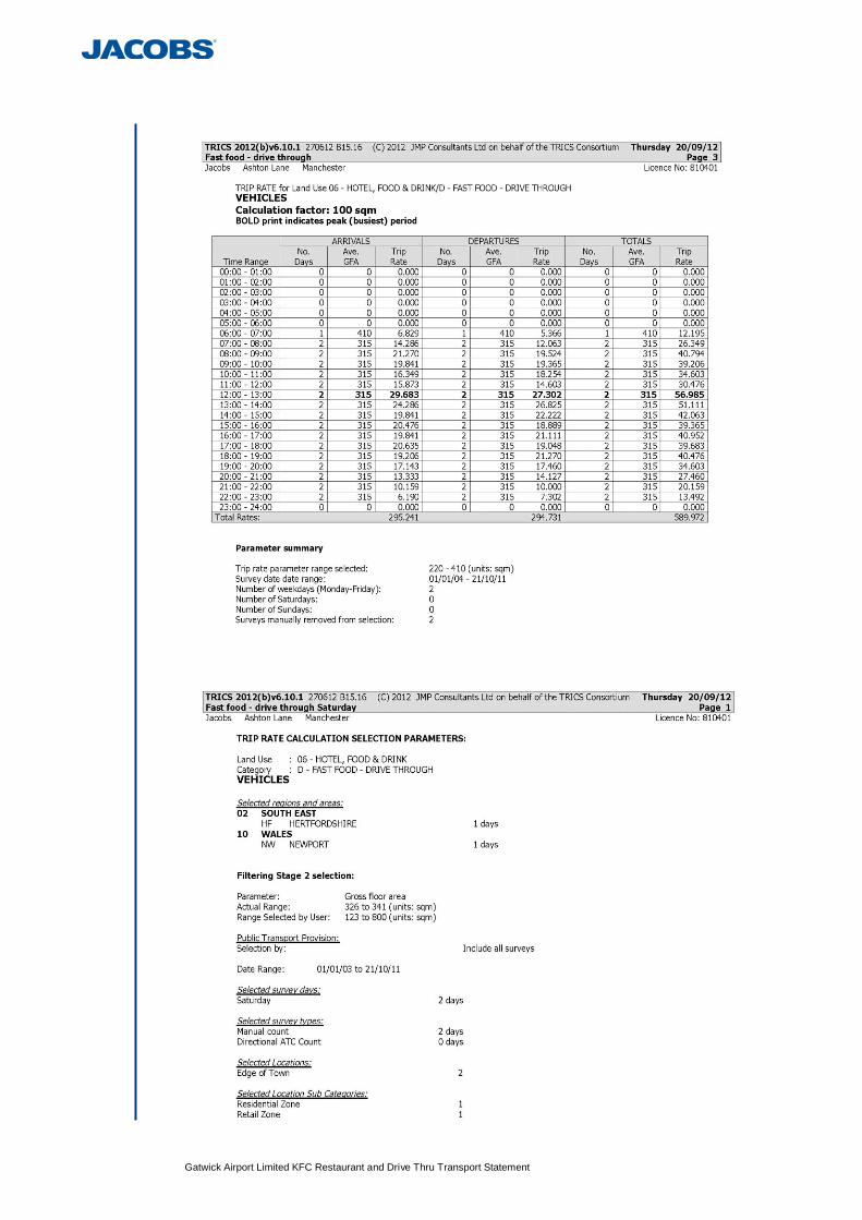
5.3 Trip Generation
Comparative trip rates were obtained from TRICS for the Fast Food – Drive thru land use for both an average weekday and Saturday.
Table 5-A below provides a summary of the sites extracted from TRICS which have been used to develop the trip forecasts for the KFC restaurant for the weekday peak period. Please note that no appropriate KFC sites could be identified in TRICS. The TRICS output reports are included at Appendix D.
Site Reference Area Location GFA Most Recent
Survey
McDonald’s CO-06-D-01 Abergele Edge of Town 410 19/10/2011
McDonald’s NR-06-D-01 Northamptonshire Edge of Town 220 22/05/2007
Table 5-A Data from TRICS sites for land use Fast Food – Drive thru for weekday
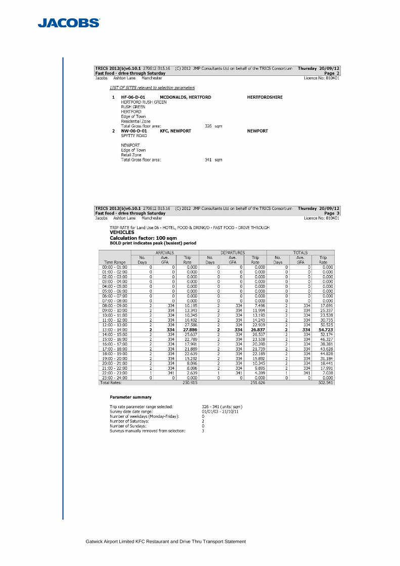
Table 5-B overleaf provides a summary of the sites extracted from TRICS which have been used to develop the trip forecasts for the KFC restaurant for the Saturday peak period. The TRICS output reports are included at Appendix D.
Gatwick Airport Limited KFC Restaurant and Drive Thru Transport Statement 14
Site Reference Area Location GFA Most Recent Survey
McDonald’s HF-06-D-01 Hertfordshire Edge of Town 326 22/03/2003
KFC NW-06-D-01 Newport Edge of Town 341 16/10/2010
Table 5-B Data from TRICS sites for land use Fast Food – Drive thru for Saturday
5.3.1 Trip Rates
The resultant vehicle trip rates per 100m2 for a typical weekday and Saturday peak are summarised in the table below.
Weekday 1200-1300 Saturday 1300-1400
In Out Total In Out Total
Fast Food – Drive thru 29.683 27.302 56.985 27.886 26.837 54.723
Table 5-C Resultant vehicle trips for land use Fast Food – Drive thru for weekday and Saturday peak periods
It is envisaged that the development will predominantly attract car based trips making their main trip to or from the airport. Using the trip rates identified above, predicted trip generation during typical weekday and Saturday peak hours has been identified in Table 5-D below.
Weekday 1200-1300 Saturday 1300-1400
In Out Total In Out Total
Fast Food – Drive thru 204 187 391 191 184 375
Table 5-D Predicted trip generation for the proposed KFC Restaurant and Drive thru for Weekday and Saturday peak periods
The table identifies that the development proposed will generate 391 two way vehicle trips in the weekday peak period and 375 two way vehicle trips in the Saturday peak period. This represents total vehicle trips before any trip type deductions are applied, as discussed in Section 5.3.2.
5.3.2 Trip Types
It is considered that the location and nature of the development would result in a very high number of linked trips and pass-by trips (from passengers leaving the airport or associated trips dropping off/ picking up passengers), rather than being new trips travelling from the wider highway network. It is unlikely that there will be many trips made to the site from the wider highway network, due to the length of the route, which would involve travelling the entire length of the South Terminal ring road to enter the site. The KFC restaurant will also not be advertised from the nearby Strategic Road Network and vehicles travelling on the M23 have the option of nearby Pease Pottage services (approximately 9 miles further south on the M23).
Newly Generated Trips - Newly generated trips are those that are made for the
specific purpose of visiting the KFC restaurant.

Gatwick Airport Limited KFC Restaurant and Drive Thru Transport Statement 15
Secondary Trips – those already existing on the network study area including:
Transfer – trips transferring from an existing land use to a new similar site
Diverted – trips diverting from an existing journey on principal network to a new site
Pass-by – trips existing on highway immediately adjacent to a new site.
As discussed above, the following table outlines the trip purpose results of the customer interview surveys carried out at the McDonald’s, South Terminal.
Trip Type Percentage
Friday Saturday
Newly Generated Trip 7% 6%
Trip Linking 75% 68%
Pass By 16% 18%
Diverted 2% 8%
Table 5-E McDonald’s Restaurant and Drive Thru, North Terminal Transport Assessment
5.3.3 Resultant New Trips
Taking into account the trip types identified above, resultant new trips are set out in Table 5-F. Please note that there are small discrepancies due to rounding.
Weekday 1200-1300 Saturday 1300-1400
In Out Total In Out Total
Total Trips 204 187 391 191 184 375
Linked 153 140 293 130 125 255
Pass-by 33 30 66 34 33 67
Diverted 4 4 8 15 15 30
Resultant proposal trips (newly generated trips)
14 13 27 11 11 22
Table 5-F Trip types and resultant number of trips for weekday and Saturday peak periods
The results show that with the trip deductions, the new trips generated on the highway network include 27 two-way trips during the weekday peak period and 22 two-way trips in the Saturday peak period.
5.4 Trip Distribution and Impact
Based on locations of other KFC restaurants and surrounding population centres, it is suggested that 70% of the new trips generated by the proposed development will travel from the direction of nearby Horley to the north of the site. These arrivals will travel from the west along the A23 from Horley and departures will leave to the west along the A23 towards Horley. It is proposed that the remaining 30% of new trips will originate from the Copthorne area which is located to the south east of Gatwick Airport. It would be quicker for residents here to travel one junction north on the M23 to Gatwick Airport than to East Grinstead where another KFC restaurant is located. All of the new trips will access the site via the A23/ M23 South Terminal roundabout junction. It is not considered that new trips will be made from further afield due to the location of KFC restaurants in other town centres and the extensive detour that
Gatwick Airport Limited KFC Restaurant and Drive Thru Transport Statement 16
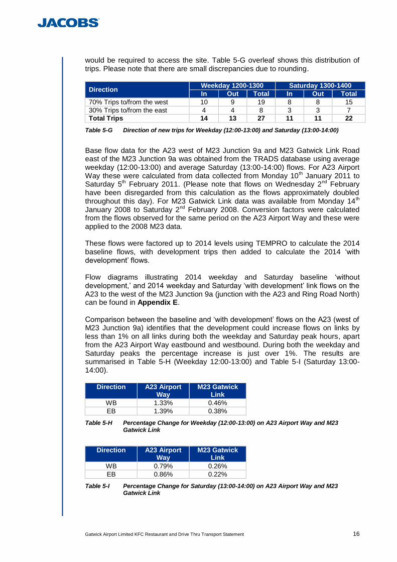
would be required to access the site. Table 5-G overleaf shows this distribution of trips. Please note that there are small discrepancies due to rounding.
Direction Weekday 1200-1300 Saturday 1300-1400
In Out Total In Out Total
70% Trips to/from the west 10 9 19 8 8 15
30% Trips to/from the east 4 4 8 3 3 7
Total Trips 14 13 27 11 11 22
Table 5-G Direction of new trips for Weekday (12:00-13:00) and Saturday (13:00-14:00)
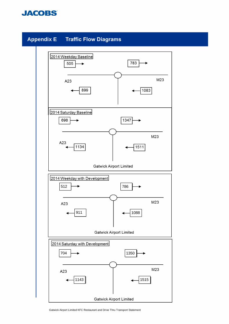
Base flow data for the A23 west of M23 Junction 9a and M23 Gatwick Link Road east of the M23 Junction 9a was obtained from the TRADS database using average weekday (12:00-13:00) and average Saturday (13:00-14:00) flows. For A23 Airport Way these were calculated from data collected from Monday 10 th January 2011 to Saturday 5th February 2011. (Please note that flows on Wednesday 2nd February have been disregarded from this calculation as the flows approximately doubled throughout this day). For M23 Gatwick Link data was available from Monday 14 th January 2008 to Saturday 2nd February 2008. Conversion factors were calculated from the flows observed for the same period on the A23 Airport Way and these were applied to the 2008 M23 data. These flows were factored up to 2014 levels using TEMPRO to calculate the 2014 baseline flows, with development trips then added to calculate the 2014 ‘with development’ flows. Flow diagrams illustrating 2014 weekday and Saturday baseline ‘without development,’ and 2014 weekday and Saturday ‘with development’ link flows on the A23 to the west of the M23 Junction 9a (junction with the A23 and Ring Road North) can be found in Appendix E.
Comparison between the baseline and ‘with development’ flows on the A23 (west of M23 Junction 9a) identifies that the development could increase flows on links by less than 1% on all links during both the weekday and Saturday peak hours, apart from the A23 Airport Way eastbound and westbound. During both the weekday and Saturday peaks the percentage increase is just over 1%. The results are summarised in Table 5-H (Weekday 12:00-13:00) and Table 5-I (Saturday 13:00-14:00).
Direction A23 Airport
Way M23 Gatwick
Link
WB 1.33% 0.46%
EB 1.39% 0.38%
Table 5-H Percentage Change for Weekday (12:00-13:00) on A23 Airport Way and M23 Gatwick Link
Direction A23 Airport
Way M23 Gatwick
Link
WB 0.79% 0.26%
EB 0.86% 0.22%
Table 5-I Percentage Change for Saturday (13:00-14:00) on A23 Airport Way and M23 Gatwick Link
Gatwick Airport Limited KFC Restaurant and Drive Thru Transport Statement 17
6 Travel Plan
6.1 Introduction
The GAL Surface Access Strategy provides an overview of all employees and passenger modal splits, travel objectives and targets for future travel to and from the Airport. Sections 6.2 and 6.3 below outline suggested objectives and measures for encouraging sustainable travel (travel by public transport, walking and cycling) by employees to the proposed KFC restaurant and drive thru. These can be considered by the restaurant in order to work towards achieving the overall targets set by GAL and supporting land uses set out in the Surface Access Strategy.
Successful implementation of the suggested measures in Section 6.3 below would contribute to the overall aims of the GAL Surface Access Strategy and deliver the following benefits:
Improve accessibility to the area;
Widen travel choice and encourage the use of environmentally friendly modes of transport such as walking, cycling, public transport and car sharing, thus reducing the carbon footprint of the development; and
Bring about health benefits from increased participation in active travel and reduced traffic and congestion around the development.
As described in Section 5 most of the trips to the new development are proposed to be existing trips already on the highway network therefore any changes in traffic are likely to be small. As part of the GAL Surface Access Strategy measures to reduce car travel would be significant for the area. As the numbers of employees for the completed KFC development are uncertain and employees travel will be incorporated into the Surface Access Strategy it is difficult, and perhaps not meaningful to set targets. The following sections provide suggested sustainable travel objectives and measures for employees accessing the proposed KFC site.
6.2 Objectives
The objectives for employee travel to the proposed KFC restaurant and drive thru are to:
1. Ensure measures to facilitate access by sustainable modes are incorporated within the scheme at the design stage, for example, the provision of on-site facilities for cyclists and pedestrians;
2. Raise awareness of the GAL Surface Access Strategy and travel options to employees;
3. Promote healthy travel by employees, improving the general health and wellbeing of future site users through increased levels of physical activity; and
4. Reduce the carbon footprint of the building to contribute towards the CO2
emissions targets in the GAL Surface Access Plan.
Gatwick Airport Limited KFC Restaurant and Drive Thru Transport Statement 18
6.3 Proposed Measures
The following range of employees-based measures could potentially be used for the KFC restaurant, to complement those already in the GAL Surface Access Strategy:
Promote the health benefits of active travel, walking and cycling;
Promote walking and cycling routes to the site and within its general vicinity;
Promote Council led initiatives to promote walking and cycling as an attractive transport option and encourage safe travel;
Promote local public transport stops, routes and frequencies, etc;
Promote the purpose and benefit of Car Sharing (www.liftshare.com);
Install a employees travel notice board in the employees room/ communal areas to provide travel information, display promotional materials or updates on the GAL Surface Access Strategy; and
Provide a copy of the “Your Journey to Work, Staff Travel Plan 2013-2030”1, part of the GAL Surface Access Strategy, to all new employees to inform them of their travel options.
The above measures would help to achieve the strategy targets of increasing the number of people (employees and passengers) travelling to the Airport by sustainable modes.
1http://www.gatwickairport.com/PublicationFiles/business_and_community/all_public_publications/corporate
_responsibility/LGW_Staff_Travel_Plan_V11_DM.pdf

Gatwick Airport Limited KFC Restaurant and Drive Thru Transport Statement 19
7 Summary
This Transport Statement supports the full planning application by Gatwick Airport Limited (GAL) and Cobra Restaurants Ltd for a proposed KFC restaurant and drive thru on Ring Road North at Gatwick South Terminal. The development proposals comprise a KFC restaurant and drive thru building of 686sq.m. and an associated car park. A new left turn junction is proposed to the west of the current McDonald’s / BP Garage entrance for vehicles to enter the site. For exiting vehicles, it is proposed to provide an internal link through the McDonald’s car park allowing vehicles to exit at the same junction as the current McDonald ’s and BP Garage customers. A new footpath is proposed between the South Terminal building and along the southern edge of the site towards the McDonald’s restaurant to the east of the site. This will provide a safe and convenient access for staff and customers, particularly from the rail station and bus stops. In addition, 8 cycle stands will be provided near to the building entrance to encourage sustainable travel to the site. As discussed in scoping discussions with Ian Gledhill, West Sussex County Council, the type of trips generated by the proposed development are expected to be largely linked trips. This is due to the nature and location of the development as being located on the exit road of the South Terminal most trips are likely to be passengers arriving at Gatwick or vehicles that have dropped off/picked up passengers at the South Terminal. These assumptions were confirmed by customer interview surveys undertaken at the neighbouring McDonald’s on Ring Road North done as part of the Transport Assessment for a proposed McDonald’s Restaurant and Drive Thru on Longbridge Way, Gatwick North Terminal. After these reductions, resultant new trips to the proposed development were calculated to be 7% of total peak hour weekday trips and 6% of total peak hour Saturday trips that could be generated according to TRICS. It is assumed that the majority of these trips would originate from Horley to the north of the site. A trip rate based approach, using information from comparative sites extracted from TRICS, has been adopted to determine the weekday (12:00-13:00) and Saturday (13:00-14:00) peak hour trip generation associated with the completed development. A total of 27 new vehicle trips would be generated by the development during a typical weekday peak period (12:00-13:00) and a total of 22 new vehicle trips would be generated by the development during a typical Saturday peak period (13:00-14:00).
It is proposed to provide 58 car parking spaces, 3 blue badge holder spaces and 3 motorcycle parking spaces. The car park will employ limits to parking times in line with the McDonald’s restaurant neighbouring this site.
In conclusion, there will be an increase in traffic likely to be generated by the proposed development; however it is anticipated to be very small as most trips are expected to be from passengers passing the site on their way out of the Airport. With the inclusion of on-site facilities to encourage sustainable development and the measures covered in the GAL Surface Access Strategy it is intended that these will

Gatwick Airport Limited KFC Restaurant and Drive Thru Transport Statement 20
minimise any potential increase in traffic generation associated with the completed development.

Gatwick Airport Limited KFC Restaurant and Drive Thru Transport Statement
Appendix A Scoping Discussions
Gatwick Airport Limited KFC Restaurant and Drive Thru Transport Statement
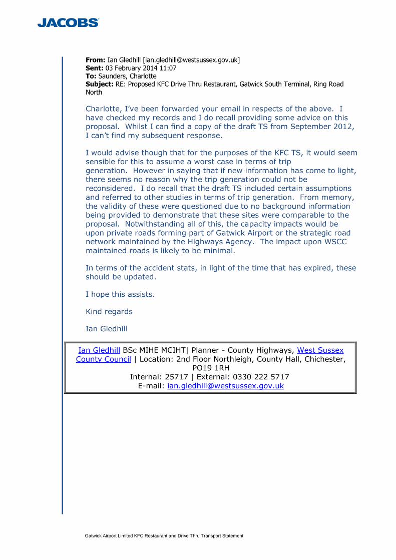
From: Ian Gledhill [[email protected]] Sent: 03 February 2014 11:07 To: Saunders, Charlotte Subject: RE: Proposed KFC Drive Thru Restaurant, Gatwick South Terminal, Ring Road North
Charlotte, I’ve been forwarded your email in respects of the above. I
have checked my records and I do recall providing some advice on this proposal. Whilst I can find a copy of the draft TS from September 2012,
I can’t find my subsequent response.
I would advise though that for the purposes of the KFC TS, it would seem
sensible for this to assume a worst case in terms of trip
generation. However in saying that if new information has come to light, there seems no reason why the trip generation could not be
reconsidered. I do recall that the draft TS included certain assumptions
and referred to other studies in terms of trip generation. From memory,
the validity of these were questioned due to no background information being provided to demonstrate that these sites were comparable to the
proposal. Notwithstanding all of this, the capacity impacts would be
upon private roads forming part of Gatwick Airport or the strategic road network maintained by the Highways Agency. The impact upon WSCC
maintained roads is likely to be minimal.
In terms of the accident stats, in light of the time that has expired, these
should be updated.
I hope this assists.
Kind regards
Ian Gledhill
Ian Gledhill BSc MIHE MCIHT| Planner - County Highways, West Sussex
County Council | Location: 2nd Floor Northleigh, County Hall, Chichester, PO19 1RH
Internal: 25717 | External: 0330 222 5717
E-mail: [email protected]

Gatwick Airport Limited KFC Restaurant and Drive Thru Transport Statement
Saunders, Charlotte" <[email protected]> 28/01/2014 10:38
To "[email protected]"
<[email protected]> cc "Philips, Daniel" <[email protected]>
Subject Proposed KFC Drive Thru Restaurant, Gatwick South Terminal, Ring Road North
Hi
I was previously in contact with your department in November 2012 in regards to a Transport Statement for a new KFC Drive Thru restaurant at Gatwick South Terminal, Ring Road North. Since then the development details have altered slightly so we propose to submit an updated Transport Statement. My email outlines the proposed changes for approval from your department. The new proposals are for: GEA = 727 sq/m. GIA Front of House = 403 sq/m
GIA Back of House = 241 sq/m
Proposed parking is: Cars: 83
Blue Badge: 6
Bikes: 12
Motorcycle: 6
Since the previous submission of the Transport Statement, we have the opportunity to refer
to a Transport Assessment that has been submitted for a McDonald's Drive Thru at the North Terminal and to consider their trip generation, which is based on customer surveys at the McDonalds Restaurant at Gatwick South Terminal, Ring Road North. The following assumptions have been used: Proposed KFC McDonalds
Friday/Saturday
Trip Linking 40% 75%/68%
Pass By 30% 16%/18%
Diverted 5% 2%/8%
New Trips 25% 7%/6%
It is therefore proposed to use the McDonalds results in our Transport Statement, however if you wish for us to continue to use our initial assumptions as it will provide a 'worst case'
scenario we can do this. The access and egress to the site will remain the same as previously proposed; entrance via a slip road from Ring Road North and exit via the petrol station exit. Previously, no junction capacity assessments were carried out. Would you require an update to the collision analysis section?
Please do not hesitate to contact me if you wish to discuss any of the above
Kind Regards Charlotte Saunders
01245 342777

Gatwick Airport Limited KFC Restaurant and Drive Thru Transport Statement
Appendix B Proposed Site Location and Layout
Gatwick Airport Limited KFC Restaurant and Drive Thru Transport Statement
Appendix C Collision Data
Source: http://www.sussexsaferroads.gov.uk/camera-map.html Accessed: 03/02/2014

Gatwick Airport Limited KFC Restaurant and Drive Thru Transport Statement
Appendix D TRICS Outputs
Gatwick Airport Limited KFC Restaurant and Drive Thru Transport Statement
Gatwick Airport Limited KFC Restaurant and Drive Thru Transport Statement
Gatwick Airport Limited KFC Restaurant and Drive Thru Transport Statement
Appendix E Traffic Flow Diagrams
512 786
1088 911
1350
1515 1143
704
Gatwick Airport Limited KFC Restaurant and Drive Thru Transport Statement
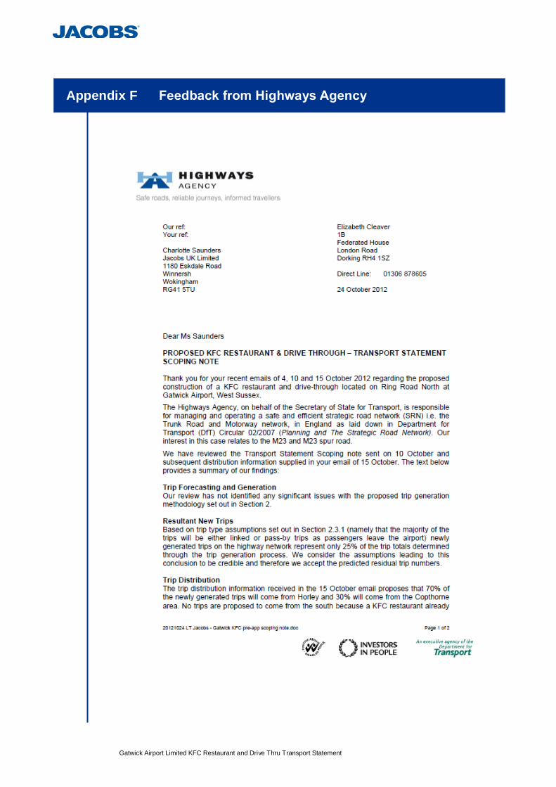
Appendix F Feedback from Highways Agency
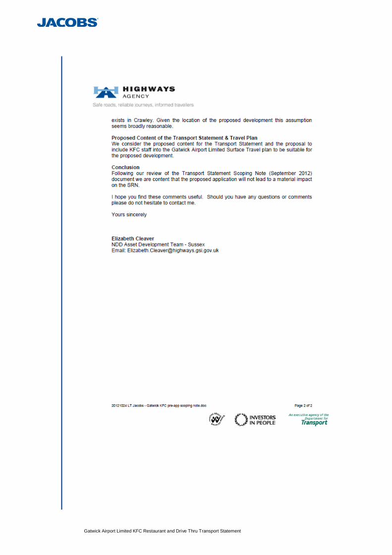
Gatwick Airport Limited KFC Restaurant and Drive Thru Transport Statement