Keys to Differentiating between Small- and Large-Drop ...
23
Keys to Differentiating between Small- and Large-Drop Icing Conditions in Continental Clouds BEN C. BERNSTEIN Leading Edge Atmospherics, Longmont, Colorado ROY M. RASMUSSEN National Center for Atmospheric Research, Boulder, Colorado FRANK MCDONOUGH Desert Research Institute, University of Nevada, Reno, Nevada CORY WOLFF National Center for Atmospheric Research, Boulder, Colorado (Manuscript received 6 February 2018, in final form 15 April 2019) ABSTRACT Using observations from research aircraft flights over the Great Lakes region, synoptic and mesoscale environments that appear to drive a relationship between liquid water content, drop concentration, and drop size are investigated. In particular, conditions that fell within ‘‘small drop’’ and ‘‘large drop’’ regimes are related to cloud and stability profiles, providing insight regarding whether the clouds are tied to the local boundary layer. These findings are supported by analysis of flight data from other parts of North America and used to provide context for several icing incidents and accidents where large-drop icing was noted as a contributing factor. The relationships described for drop size discrimination in continental environments provide clues that can be applied for both human- and model-generated icing forecasts, as well as automated icing algorithms. 1. Introduction It is well known that in-flight icing caused by aircraft encounters with supercooled liquid water can pose a significant safety hazard. This is especially true for supercooled large-drop (SLD) icing, which has been identified as a contributing factor in numerous acci- dents [e.g., National Transportation Safety Board (NTSB) 1996, 2002, 2006, 2007; Green 2006, 2015]. Over the last ;30 years, extensive flight, engineering and meteorological research has greatly improved the un- derstanding of SLD icing and its effect on aircraft. This research and prolonged cooperation between regula- tory agencies, aircraft manufacturers, scientists and engineers has culminated in new regulations that will require aircraft not certified for flight in freezing drizzle (FZDZ) and/or freezing rain (FZRA) to avoid these conditions and to escape all icing after inadvertent en- counters with them (FAA 2015; Cober and Isaac 2012). To adhere to the new regulations, pilots, dispatchers, and air traffic controllers will need more accurate, precise, high-resolution diagnoses and forecasts of drop size to allow for critical decisions relative to the certification and safety of their aircraft (DiVito and Riley 2017). Three primary meteorological factors characterize icing conditions: temperature (T), liquid water content (LWC), and the drop size distribution (DSD). Drop size is particularly important to the location and shape of ice that forms on aircraft surfaces, which can have dramatic impact on lift, drag and even the ability to maintain control (e.g., Ratvasky et al. 2010; Sand et al. 1984; Politovich 1989). When aircraft surface temper- atures are sufficiently cold (several degrees below freezing), the impact of small supercooled drops tends Corresponding author: Ben C. Bernstein, icingweather@ gmail.com SEPTEMBER 2019 BERNSTEIN ET AL. 1931 DOI: 10.1175/JAMC-D-18-0038.1 Ó 2019 American Meteorological Society. For information regarding reuse of this content and general copyright information, consult the AMS Copyright Policy (www.ametsoc.org/PUBSReuseLicenses). Unauthenticated | Downloaded 11/06/21 11:39 PM UTC
Transcript of Keys to Differentiating between Small- and Large-Drop ...
Keys to Differentiating between Small- and Large-Drop Icing Conditions inContinental Clouds
BEN C BERNSTEIN
Leading Edge Atmospherics Longmont Colorado
ROY M RASMUSSEN
National Center for Atmospheric Research Boulder Colorado
FRANK MCDONOUGH
Desert Research Institute University of Nevada Reno Nevada
CORY WOLFF
National Center for Atmospheric Research Boulder Colorado
(Manuscript received 6 February 2018 in final form 15 April 2019)
ABSTRACT
Using observations from research aircraft flights over the Great Lakes region synoptic and mesoscale
environments that appear to drive a relationship between liquid water content drop concentration and drop
size are investigated In particular conditions that fell within lsquolsquosmall droprsquorsquo and lsquolsquolarge droprsquorsquo regimes are
related to cloud and stability profiles providing insight regarding whether the clouds are tied to the local
boundary layer These findings are supported by analysis of flight data from other parts of NorthAmerica and
used to provide context for several icing incidents and accidents where large-drop icing was noted as a
contributing factor The relationships described for drop size discrimination in continental environments
provide clues that can be applied for both human- and model-generated icing forecasts as well as automated
icing algorithms
1 Introduction
It is well known that in-flight icing caused by aircraft
encounters with supercooled liquid water can pose a
significant safety hazard This is especially true for
supercooled large-drop (SLD) icing which has been
identified as a contributing factor in numerous acci-
dents [eg National Transportation Safety Board
(NTSB) 1996 2002 2006 2007 Green 2006 2015] Over
the last 30 years extensive flight engineering and
meteorological research has greatly improved the un-
derstanding of SLD icing and its effect on aircraft This
research and prolonged cooperation between regula-
tory agencies aircraft manufacturers scientists and
engineers has culminated in new regulations that will
require aircraft not certified for flight in freezing drizzle
(FZDZ) andor freezing rain (FZRA) to avoid these
conditions and to escape all icing after inadvertent en-
counters with them (FAA 2015 Cober and Isaac 2012)
To adhere to the new regulations pilots dispatchers
and air traffic controllers will need more accurate
precise high-resolution diagnoses and forecasts of
drop size to allow for critical decisions relative to the
certification and safety of their aircraft (DiVito and
Riley 2017)
Three primary meteorological factors characterize
icing conditions temperature (T) liquid water content
(LWC) and the drop size distribution (DSD) Drop
size is particularly important to the location and shape
of ice that forms on aircraft surfaces which can have
dramatic impact on lift drag and even the ability to
maintain control (eg Ratvasky et al 2010 Sand et al
1984 Politovich 1989) When aircraft surface temper-
atures are sufficiently cold (several degrees below
freezing) the impact of small supercooled drops tendsCorresponding author Ben C Bernstein icingweather
gmailcom
SEPTEMBER 2019 BERNSTE I N ET AL 1931
DOI 101175JAMC-D-18-00381
2019 American Meteorological Society For information regarding reuse of this content and general copyright information consult the AMS CopyrightPolicy (wwwametsocorgPUBSReuseLicenses)
Unauthenticated | Downloaded 110621 1139 PM UTC
to result in rime ice near the leading edge of the wing
and other surfaces while larger drops including SLD
have a greater tendency to result in mixed or clear ice
formation sometimes well aft of ice protection systems
(Fig 1 Messinger 1953)
Human- and numerical-model-generated forecasts
of T are reasonably accurate while LWC and drop size
remain challenging but have improved dramatically
(eg Thompson et al 2008 2017a) In nature drop
concentrations can vary between tens and thousands
per cm3 (eg Hudson and Yum 2001) but until re-
cently many models used fixed median values of drop
concentration across the domain such as 100 cm23 in
the Rapid Update Cycle (RUC) and High-Resolution
Rapid Refresh (HRRR) Such an approach served as a
compromise until the explicit prediction of aerosols
and subsequent drop concentration became compu-
tationally practical Recently modelers have started
to address this issue by using a microphysics pack-
age that allows drop concentrations to vary based on
source air and evolve via precipitation and other pro-
cesses (Thompson and Eidhammer 2014 Thompson
et al 2017ab) Even as microphysics schemes ad-
vance the question remains when should models and
forecasters expect clouds dominated by small drops
to convert to drizzle via collisionndashcoalescence In
nature this tends to happen relatively quickly in mari-
time environments (eg Rosenfeld et al 2013) but the
transition is more difficult to quantify in continental
environments where small drops tend to dominate yet
SLD is still commonly observed (eg Cortinas et al
2004 Rauber et al 2000 Cober et al 2001 Geresdi et al
2005 Williams et al 2015)
As part of several field programs conducted between
1997 and 2005 meteorologists from the National Center
for Atmospheric Research (NCAR) guided the NASA
Glenn Research Center (NASA-GRC) Twin Otter the
National Research Council of Canada Convair-580
and other research aircraft into a wide variety of icing
environments many of which included SLD (Miller
et al 1997 Isaac et al 2001 2005) In addition the lead
author has spent the last 16 years guiding commercial
test aircraft into supercooled clouds targeting specific
combinations of T LWC and drop size for the purpose
of achieving icing certification (Bernstein et al 2006a
2011 Bernstein and Flemming 2007 Kubryn et al 2011)
Through this experience case studies and climatological
research meteorological structures and patterns have
emerged that relate to characteristic combinations of
LWC drop concentration (CONC) and the presence
of SLD
In this paper NASA-GRC research aircraft obser-
vations will be used to establish further that a balance
between LWC and CONC strongly relates to the pro-
duction of supercooled clouds that are composed of
cloud droplets (lsquolsquosmall droprsquorsquo events) versus those that
include SLD (lsquolsquolarge droprsquorsquo events) These data and
those from other flight programs will be placed into the
context of synoptic patterns thermodynamic structures
and patterns in satellite imagery and radar reflectivity to
understand better themechanisms that drive drop size in
continental air masses Such information may provide
forecasters and modelers with valuable clues to differ-
entiate between small- and large-drop icing situations
2 Datasets and case selection
a Twin Otter research aircraft
Between 1996 and 2005 NASA-GRCrsquos Twin Otter
documented a broad spectrum of icing events in the
Great Lakes region (Fig 2) Standard measurements
were made for state parameters and cloud micro-
physics with a lsquolsquoKingrsquorsquo hot-wire probe for LWC (King
et al 1978) a Forward Scattering Spectrometer Probe
(FSSP) for the cloud droplet size distribution and
an Optical Array 2D-cloud probe (2DC) to capture
FIG 1 Photos of the NASA Glenn Research Centerrsquos Twin Otter
wing with small-drop and large-drop icing
1932 JOURNAL OF APPL IED METEOROLOGY AND CL IMATOLOGY VOLUME 58
Unauthenticated | Downloaded 110621 1139 PM UTC
particle images with 25-mm resolution King probes
respond well to cloud droplets but underestimate
LWC from drops with diameters larger than 50mm
(Biter et al 1987 Strapp et al 2003) Thus for the
purpose of this study the King-probe measured LWC
should be considered to essentially represent the
lsquolsquocloud-droplet liquid water contentrsquorsquo rather than full-
spectrum LWC Likewise FSSP-based CONC and
median volumetric diameter (MVD) values only ac-
counted for the cloud-droplet portion of the spectrum
rather than the full drop size spectrum Ten-second
averages of these fields will be presented The NASA
crew also took in-flight and postflight photos and
documented changes in flight characteristics It is
important to note that aerosol measurements were not
taken by the Twin Otter nor were any such mea-
surements available for any of the flights presented in
this paper
b Certification aircraft
To complement the Twin Otter dataset observations
from instrumented aircraft seeking icing certification
will also be presented When aircraft manufacturers test
new aircraft in icing they rely on probes similar to those
used in research with similar limitations to those
described above Instrument suites employed for certi-
fication include hot-wire LWC probes [King Johnson-
WilliamsScience Engineering Associates or Droplet
Measurement Technology (DMT)] cloud droplet sizing
probes [FSSP or a DMT Cloud Droplet Probe (CDP)]
and inmany cases a particle imaging probe [2DCorDMT
Cloud Imaging Probe (CIP) see Strapp et al 2003]
Icing certification flight tests required that the air-
craft be exposed to an engineering design envelope
covering specific ranges of T LWC and drop size
expressed as MVD Exposures to icing range from
2 to 451 min during which ice accretions are built
from initial indications of ice to accretions that may
exceed 3 in on leading edge surfaces Such accretions
are maintained while pilots and engineers test aircraft
systems and perform maneuvers (FAA 1999) High-
quality measurements of the icing environments sam-
pled are a critical part of the body of evidence that
is submitted to aviation authorities for certification
Thus the probes must be well maintained and fre-
quently calibrated Certification flights discussed herein
were conducted throughout the United States including
areas far from the Great Lakes (Fig 2)
c SLD determination and case selection
For the purposes of this study SLD are defined as
drops that were fully shadowed on the 2DC or CIP
probes with diameters 125mm the minimum size
for particle phase discrimination The presence or
absence of SLD and ice crystals was determined via
visual inspection of probe imagery and consultation
of flight notes All SLD cases presented in this study
appear to have formed via the collisionndashcoalescence
process (Huffman and Norman 1988) with no evidence
of the lsquolsquoclassical freezing rainrsquorsquo process (Bocchieri 1980)
where snow melts then falls into a lower subfreezing
layer to become supercooled
The events sampled occurred within a variety of syn-
optic environments and vertical structures including a
FIG 2 Locations of the flights and events described in this paper Boxes indicate the ap-
proximate position of the flights color-coded to identify the event types and research pro-
grams during which samples were made
SEPTEMBER 2019 BERNSTE I N ET AL 1933
Unauthenticated | Downloaded 110621 1139 PM UTC
range of stability profiles and both single-layer and
multilayered clouds To gain insight on the environ-
mental effects on LWC CONC and DSD Twin Otter
samples used were limited to cloud layers that were 1)
dominated by supercooled liquid water (SLW) with few
or no ice crystals and 2) isolated from higher cloud
layers eliminating the potential for seeding from above
Only samples made near cloud top are used Events
were only included when microphysical data were con-
sidered to be of good quality with hot-wire LWCs that
were self-consistent tracked well with those from the
FSSP and were consistent with data from other sources
including vertical profiles were made by the aircraft andor
radiosondes launched nearby in time and space In all
27 Twin Otter events met these criteria All Twin Otter
samples occurred between November and March at al-
titudes of 900ndash4300m (all heights MSL) and at T
between 2148 and 218CCertification program flights have been conducted
over a broader domain including more than 40 US
states as well as Canada and Europe Samples were obtain-
ed during all months of the year except July and August
covered a broader range of altitudes (900ndash7600m) and
temperatures (08 to 2308C) To date more than 500 h
of certification flight data have been collected from
more than 100 flights A small subset of flights made
over the United States including Alaska will be used
to demonstrate that conditions similar to those ob-
served by the Twin Otter were also found over a
broader domain (Fig 2)
3 Twin Otter icing environments
a Overview
A scatterplot of LWC and CONC for the Twin Otter
cases shows that LWC and CONC values ranged from
007 to 11 gm23 and 10 to 435 cm23 respectively
(Fig 3) The occurrence of small versus large drops
follows expectations from collisionndashcoalescence theory
(Pruppacher and Klett 1978) As cloud droplets in-
crease in size the process of growth through collisionndash
coalescence becomes increasingly important and leads
to the production of drops with diameters up to and
exceeding100mm In cases where CONC was toward
the high end of the spectrum in Fig 3 ( 300 cm23)
drops tended to be small (cloud droplets no SLD)
unless LWCs reached rather high values (06 gm23)
When CONC was toward the low end of the spectrum
( 100 cm23) SLD was much more common even
with LWC 025 gm23 This is consistent with previous
observations and bin microphysics studies (Rasmussen
et al 2002)
A transition zone between small- and large-drop en-
vironments slants from lower left to upper right in Fig 3
FIG 3 LWC vs CONC for the 27 Twin Otter cases Markers are colored and shaped by the
predominant temperature advection present warm (red triangles) cold (blue squares) and
neutral (green circles) Marker size is proportional to FSSP-measured MVD SLD events are
marked with tan circles Out-of-focus borderline SLD events are marked with dashed circles
A diagonal dashed line indicates a 23 1029 g ratio of LWCCONC indicated as the transition
between the small-drop domain where all cases were dominated by cloud droplets and the
large-drop domain where most cases featured SLD
1934 JOURNAL OF APPL IED METEOROLOGY AND CL IMATOLOGY VOLUME 58
Unauthenticated | Downloaded 110621 1139 PM UTC
This is expected since drop sizes should increase when
(i)LWC increaseswhileCONC is held steady or (ii) LWC
is held steady while CONC is decreased The former
tends to happen where clouds deepen typically due
to lower (and warmer) cloud base andor higher (and
cooler) cloud top or due to decreases in the amount of
glaciation The latter tends to occur in transitions to
pocketsareas of relatively clean air Both can show up
during a given flight where LWC MVD and the
presenceabsence of SLD can vary spatially and tem-
porally Both types of transitions appear to be associ-
ated with DSD broadening sometimes to the point
where collisionndashcoalescence is initiated and SLD forms
The transition zone is located roughly along the linewhere
the LWC to CONC ratio is 02 gm23 per 100 cm23
Ten cases fell within the lsquolsquosmall droprsquorsquo domain up and
to the left of the transition zone where low FSSPMVDs
(8ndash15mm) were found and SLD was not observed One
case landed on the transition line and 16 cases fell into
the lsquolsquolarge droprsquorsquo domain where MVDs were relatively
large (15ndash22mm) and SLDwas often present (11 cases)
Somewhat smaller out of focus drops were present in
3 of the 5 remaining lsquolsquolarge droprsquorsquo domain cases Small
drops were present in every case and were often the
primary contributor to the LWC Recall that the King
probe responds best to cloud droplets and FSSP CONC
values only cover the cloud-droplet portion of the
spectrum Thus some of the large-drop cases may have
had larger full-spectrum LWC CONC and MVD po-
tentially moving some markers up and to the right and
making them larger
Two cases in the lsquolsquolarge droprsquorsquo domain did not have
indications of SLD Those cases had MVD between
17 and 20mm rather narrowDSDs and few if any drops
larger than 30mm A vertical profile of aircraft data was
available for one of these clouds and it featured a narrow
DSD that shifted gradually toward larger sizes with
MVD increasing from 10 to 20mm between cloud
base and cloud top (not shown) For this case spectral
broadening may not have occurred yet if at all despite
the presence of favorable ratios of LWC to CONC
It is important to note that although the Twin Otter
cases in the small-drop domain had MVD of 8ndash15mm
icing conditions with MVD 15mm have been com-
monly found in clouds without SLD during research
and certification flights The reader should also bear in
mind that data points in Fig 3 were from a limited
geographic domain and only represent supercooled
liquid-dominated clouds with a limited spectrum of LWC
and CONC Conditions outside these ranges certainly
exist but the data points inFig 3 are typical for supercooled
clouds (Cober and Isaac 2006 2012 FAA 1999 2015)
Although this paper is focused on supercooled clouds
the concepts regarding drop size tendencies discussed
in this paper apply to above-freezing clouds as well
(see Wood 2005)
b Variations on continental cloud environments
Now that the Twin Otter cases have been broadly
categorized it is useful to examine some groupings
of cases Despite the basic idea that continental clouds
often have high drop concentrations it is common
knowledge that significant variations in drop concen-
tration can be found within them and that these changes
are likely associated with variations in cloud condensa-
tion nuclei (CCN) Such variations are apparent in some
of the cases presented here The structures associated
with these variations and their effect on drop size are
discussed below
1) CONTINENTAL CLOUDS WITH HIGH DROP
CONCENTRATIONS
Asmight be expected clouds with relatively high drop
concentrations ($200 cm23 hereafter lsquolsquohigh CONCrsquorsquo)
tended to be associated with air masses rooted in the
boundary layer Vertical temperature profiles often had
dry-adiabatic lapse rates from the ground to cloud base
moist-adiabatic lapse rates within the cloud layer and a
capping stable layer at cloud top This capped instability
scenario often resulted in widespread stratocumulus
clouds with uniform lsquolsquoquiltedrsquorsquo tops (Fig 4)
Such situations are commonly found in the wake of
cold fronts where cold-air advection destabilizes the
boundary layer (BL) and subsidence above the front
limits vertical development These layers are typi-
cally dominated by SLW in the form of small drops
when the cloud-top temperatures are relatively warm
(CTT 2128C) reducing the activation of ice nuclei
(IN) Similar situations can sometimes be found within
the lsquolsquowarm sectorrsquorsquo where the boundary layer may be
deeper but is often still capped by a stable layer Among
the 17 cases with high CONC 11 occurred behind cold
FIG 4 Example of lsquolsquoquiltedrsquorsquo stratocumulus cloud tops
SEPTEMBER 2019 BERNSTE I N ET AL 1935
Unauthenticated | Downloaded 110621 1139 PM UTC
fronts 1 behind an occluded front and 2 within the
warm sector while the remaining 3 occurred in ill-
defined synoptic environments Cold- neutral- and
warm-air advection (indicated as blue green and red
markers in Fig 3) were found at the flight level for 13
1 and 3 cases respectively
In these BL clouds LWC and MVD typically in-
creased steadily with height then rapidly decreased to
zero at the cloud-top interface while CONC values
were reasonably consistent throughout the layer (eg
Fig 5 Martin et al 1994 Reehorst et al 2009) A climb
through such a layer would essentially result in a move
toward the right in Fig 3 As noted earlier if such a
cloud was deep andor warm enough to achieve a large
LWCCONC ratio then SLD could form Such was the
case for the event shown in Fig 5 where LWC reached
076 gm23 and small drizzle formed
A comparison of two boundary layer rooted events
from 24 February 1998 when only cloud droplets
were present and 30 January 1998 when small drizzle
was present demonstrates this Among them the
30 January event had lower CONC (225 vs 275 cm23)
greater depth (1100 vs 300m) and much higher cloud-
top LWC (076 vs 025 gm23) resulting in a larger
LWCCONC ratio (034 vs 009) and larger FSSP-
measured MVD (18 vs 11mm see Fig 3) It is inter-
esting to note that the drizzle developed on 30 January
despite having colder CTT (2118 vs238C) cloud-baseT (258 vs 218C) and lower cloud-base mixing ratio
(28 vs 39 g kg21) Given the relatively low tem-
perature and mixing ratio at the base colder tops were
necessary for this cloud to achieve adequate depth to
generate sufficient LWC at cloud top to allow SLD to
form on 30 January
With that in mind it is important to note that CTT
tends to be a limiting factor for the amount of LWC and
drop size that can be achieved within BL clouds As cloud
layers deepen and LWC increases in moist-adiabatic
lapse rates T (and thus CTT) also decrease fairly rap-
idly (eg Fig 5) Once CTTs cool beyond about 2128Cthe preponderance of ice can increase in these clouds
resulting in at least partial glaciation at or just beneath
cloud top and sometimes results in seeding of the re-
mainder of the cloud below (egGeresdi et al 2005) The
development of significant ice can also result in prefer-
ential seeding of drops toward the large end of the DSD
due to their higher collision efficiency with ice crystals
This canmake it evenmore difficult for highly continental
wintertime clouds to initiate collisionndashcoalescence
The 30 January case is notable because SLD did form
in a relatively cold environment CTT was 2118C and
both drizzle and light snow were observed at the surface
for hours Clearly a balance was struck between drizzle
and snow production in these clouds BL clouds with
relatively warm bases and tops have a greater chance of
having sufficient LWC to generate SLD without signif-
icant ice production Of course when such a combina-
tion is combined with very low CONC as in maritime
cumulus large drops are even more likely to form (eg
Hudson and Yum 2001)
In addition the conversion of the small drops to drizzle
can also limit the LWC that a cloud can achieve since a
FIG 5 Example vertical profile of 10-s averages of temperature (T red) dewpoint temperature
(Td green) King LWC 3 10 (gm23 blue) FSSP MVD (mm magenta) and CONC10 (cm23
tan) for amissed approach descent overCantonndashAkronOhio 1319ndash1331UTC30 Jan 1998MVD
and CONC were screened out for FSSP counts less than 10 to eliminate noise below cloud base
1936 JOURNAL OF APPL IED METEOROLOGY AND CL IMATOLOGY VOLUME 58
Unauthenticated | Downloaded 110621 1139 PM UTC
portion of the SLWmay precipitate out of the cloud This
occurred on 30 January but precipitation rates were so
light that the effect on LWC was likely minimal Of
course if the updraft strength in a given cloud is sufficient
to suspend the SLD then the LWC can be maintained
and the SLD can continue to grow Because stronger
updrafts tend to activate more CCN (Thompson and
Eidhammer 2014 Feingold and Heymsfield 1992) a large
number of smaller drops can result in rapidly rising highly
continental clouds Thus low-to-moderate vertical ve-
locitiesmay be optimal for allowing large-drop generation
zones to persist whenLWCCONC ratios are appropriate
2) CONTINENTAL CLOUDS WITH LOW DROP
CONCENTRATIONS
All clouds with relatively low drop concentrations in
Fig 3 (200 cm23 hereafter lsquolsquolow CONCrsquorsquo) were located
above stable layers many of which were strong andor
deep inversions In otherwise continental environments
these stable layers isolated the clouds from local bound-
ary layer sources of CCN and IN Such situations are
commonly found on the cold side (often north) of warm
fronts and stationary fronts where warm air often glides
over a sloping stable layer These clouds sometimes lose
CCN and IN via precipitation processes especially near
the frontal zone (eg Rasmussen et al 1995 2002)
Several of the low-CONC continental cloud cases on
Fig 3 developedwithin layers of instability above a stable
zone (eg Fig 6 as in Bernstein 2000) In these situa-
tions LWC commonly increased with height in the ele-
vated unstable layer similar to BL clouds but with lower
CONC making them more ideal for SLD production
Among the 10 cases with CONC 200 cm23 7 of
them were associated with warm-air advection 2 with
FIG 6 ClevelandNEXRAD reflectivity from 1838UTC 4 Feb 1997 taken at (a) 248 and (b) 338 elevationsmatching flight location (red
dashed boxes) and altitude (mMSL) for SLD event in and around gaps in showery precipitation (c) PMS 2DC imagery from 1835UTC at
4000m and 298C (from Miller et al 1998) (d) Vertical profile of temperature on climb out of Cleveland 1754ndash1823 UTC
SEPTEMBER 2019 BERNSTE I N ET AL 1937
Unauthenticated | Downloaded 110621 1139 PM UTC
neutral advection and 1 with cold-air advection at flight
level Six cases occurred on the cold side of warm or
stationary fronts two occurred in the warm sector and
two were associated with occlusions Synoptic and
structural tendencies described for low-CONC envi-
ronments corroborate those found in climatological
and regional studies of FZDZ events (Bernstein et al
1998 Bernstein 2000)
Several of the low-CONC SLD cases occurred in
areas just outside or within breaks in precipitation An
excellent example occurred on 4 February 1997 where
strong patches of SLD icing were observed in gaps
between showers and resulted in one of the largest
performance degradations experienced by the Twin
Otter during the test programs (Miller et al 1997) This
event formed in a fairly deep unstable layer above a
38C inversion (Fig 6) Snow and relatively little LWC
were found within the higher reflectivity areas While
such situations fit the scenario of continental low-
CONC environments in elevated instability described
above they may also support the idea of localized
cleansing of the air removing some CCN and IN (eg
Rasmussen et al 1995 McDonough and Bernstein
2004) and allowing SLD to develop in newly formed
liquid water clouds with diminished CONC between
andor downstream of the showers
c Local variability
The local variability described in the previous sec-
tion has been noted in past studies (eg Sand et al
1984 Cober et al 2001 Jeck 2002 Wood 2005 Lasher-
Trapp et al 2008 Hauf and Schroeder 2006) Vari-
ability in LWC CONC and MVD during a flight is
typically linked to local changes in cloud depth cloud-
base and cloud-top temperature presence of showers
source air etc This can sometimes result in sporadic
SLD perhaps due to transitions between less and more
favorable LWCCONC ratios Such changes can result
in significant local differences in the effects that the ice
may have on aircraft passing through an area Local-
scale variability may have played a role in some acci-
dents such as the 1997 crash of an Embraer (EMB)-120
near Detroit Michigan where a series of aircraft were
flying the same approach through snow showers and
icing In postaccident interviews the pilots reported
the icing as lsquolsquononersquorsquo lsquolsquolightrsquorsquo lsquolsquomoderate-to-severersquorsquo
and lsquolsquoas bad as Irsquove ever seen itrsquorsquo (NTSB 1998)
d Capping stable layers and drop size
It is interesting to note that every cloud examined
in this study was capped by a stable layer and several
were capped by strong inversions over shallow depths
(eg Fig 5) SLD was present in some of these clouds
but many only had small drops Although finescale
wind data were not available from the Twin Otter
soundings and synoptic-scale weather data indicated
that at least some wind shear was present in most if not
every event It was not possible to determine whether
the shear was strong enough to initiate turbulent mix-
ing with the dry air above cloud top Cloud tops were
more commonly lsquolsquoquiltedrsquorsquo as described earlier or
relatively flat and nondescript
While SLD certainly can occur in the presence of
dynamically unstable layers near cloud top associated
with wind shear as proposed by Pobanz et al (1994) the
results presented here imply that their simultaneous
presence may not be necessary for SLD to develop
Rather the controlling factors appear to be whether
1) an adequate ratio of LWCCONC is present 2) the
below-cloud andor in-cloud stability structure limits
the contribution of local BL sources CCN and IN and
3) ice concentrations are sufficiently small to limit
scavenging of liquid water especially at the large end
of the DSD That said mixing and localized areas of
supersaturation may still play an important role as
demonstrated by Korolev and Isaac (2000)
4 Supporting evidence from certification flights
The certification flight dataset provides some exam-
ples of similar environments and trends over broader
geographic and temperature domains While guiding
aircraft into icing conditions for certification over
16 years many cases have proven interesting but it is
only practical to highlight a few that shed additional
light on the relationships between drop size and the
LWCCONC ratio Aircraft manufacturers names and
the dates of the cases described below have been omit-
ted to maintain client anonymity A brief summary of
the conditions observed and meteorological features
associated with each flight in sections 4 and 5 is provided
in Table 1
One April flight along the KansasndashMissouri border
was made into a cloud that had two layers separated
vertically by a 500-m deep 28C inversion The initial
climb through the clouds revealed that the lower cloud
was rooted in the boundary layer while the upper cloud
appeared to be somewhat isolated from the boundary
layer (Fig 7) LWC within the clouds peaked at 059
and 053 gm23 at their respective 288 and 278C cloud
tops MVDs peaked at 20 and 26mm near the top of each
layer illustrating the importance of subtle differences in
drop concentration in these two highly comparable
clouds Although particle imagery was not available for
this case smooth areas of low reflectivity typical of
drizzle (Ikeda et al 2009) were evident on radar data in
1938 JOURNAL OF APPL IED METEOROLOGY AND CL IMATOLOGY VOLUME 58
Unauthenticated | Downloaded 110621 1139 PM UTC
TABLE1Characteristicsofflightsdescribedin
sections4(certificationflightstopgroup)and5(literature
casesincidentsandaccidentsbottom
group)AC
5Aircraft(C
ERT5
CertificationU
WKA
5UniversityofW
yomingKingAirD
O-282285
Dornier28228C5605
CessnaCitation560S
F3405
Saab340)region5
generallocationofflightmonth
5earlym
idlate
portionandmonth
offlightlayers
5numberoflayers
thatappearedto
bepresentandcloudlayerofencounterifmore
thanonelayerwaspresentstructure
5vertical
stabilitystructureZ
(m)T(8C)LW
C(g
m23)CONC(cm
23)MVD
(mm)SLD
presence
(Yes5
yesasdeterm
inedin
officialreport)synopticenvironment(PCF5
postcold
front
AW
F5
aheadofwarm
front)andadvection5
temperature
advectionatthelevelofflight(C
AA
5cold
airadvectionW
AA5warm
airadvection)UNK
5unknownN
ote
thatsome
values
are
approxim
ate
AC
Region
Month
Layers
Structure
ZT
LW
CCONC
MVD
SLD
Synoptic
environment
Advection
CERT
Kansasndash
Missouri
EarlyApr
2upper
Aboveinversion
2400
27
053
150ndash200
26
UNK
PCF
CAA
CERT
Kansasndash
Missouri
EarlyApr
2upper
Belowinversion
1500
28
059
180ndash210
20
UNK
PCF
CAA
CERT
Michigan
EarlyDec
1Wellmixed
1300
213
02ndash05
300
10ndash13
No
PCF
CAA
CERT
Ohio
Mid-D
ec
2upper
Aboveinversion
3500
221
Estim
ated02
UNK
Estim
ated30ndash40
Notquite
Nearweak
trough
Weak
CAA
CERT
Alaska
EarlyOct
1Wellmixed
700
26
02ndash05
300ndash400
15ndash20
No
Betw
een
weaklows
Neutral
CERT
Alaskandash
example
Late
Oct
3middle
Abovestable
zone
isolated
1800
29
02ndash04
20
30ndash40
UNK
Notwell
defined
Neutral
CERT
Western
Oregon
Mid-M
ar
1Stronginstability
2400
29
03ndash09
UNK
20ndash25
No
PCFonshore
flow
Weak
CAA
CERT
Western
Atlantic
Late
Mar
1Wellmixed
1700
28
02ndash07
UNK
15ndash20
No
PCF
CAA
CERT
Eastern
Washington
EarlyJan
2upper
Unstable
above
stable
4000
212
02ndash04
10
35ndash50
Yes
Westerly
flowaloft
southwest
ofstationary
front
Neutral
UWKA
Eastern
Colorado
Mid-Feb
2upper
Unstable
above
stable
3000
210
035
UNK
modeled
at100
UNK
Yes
Overrunning
UNK
UWKA
Eastern
Colorado
Late
Feb
1Unstable
3500
210
045
100ndash150
10ndash13
No
PCF
CAA
DO-28
Southern
Germ
any
Mid-Jan
1Inversion
800
27
03
UNK
23
Yes
Highpressure
UNK
DO-228
Southern
Germ
any
Late
Mar
1Unstable
with
turrets
3000
28
015ndash030
UNK
UNK
NoandYes
PCF
CAA
ATR-72
Indiana
Late
Oct
UNK
Likely
unstable
abovestable
3100
0to
25
UNK
UNK
UNK
Yes
AW
FW
AA
C560
Southeastern
Colorado
Mid-Feb
3middle
Aboveastable
zone
2000ndash3000
210to
215
UNK
UNK
UNK
Yes
Overrunning
Weak
WAA
SF340
California
coast
EarlyJan
UNK
Instabilityabove
variable
stability
3500
approxim
ately
210
UNK
UNK
UNK
Yes
Onshore
flow
UNK
ATR-42
Southern
Norw
ay
Mid-Sep
21upper
Instabilityabove
astable
zone
3000ndash4400
approxim
ately
210
UNK
UNK
UNK
Yes
PCF
hurricane
remnants
UNK
SEPTEMBER 2019 BERNSTE I N ET AL 1939
Unauthenticated | Downloaded 110621 1139 PM UTC
the area of sampling and nearby surface stations re-
ported mist drizzle and very light rain (not shown)
An example of a very small-drop icing event oc-
curred immediately downwind of Lake Michigan fol-
lowing an early December front that brought very
cold air across the lake similar to events described by
Kristovich and Laird (1998) The surface T of the
lake was 198C while T at the flight level (1300m)
was 2138C This combination of steep lapse rates and
cool CTTs resulted in cellular stratocumulus clouds
and 15ndash25 dBZ snow showers Cloud-top LWCs were
highly variable (02ndash05 gm23) CONCs were on the
order of 300 cm23 andMVDs were only 10ndash13mm with
no indication of large drops The ratio of even peak
LWCs to CONC would have placed it within the small-
drop domain of Fig 3 The presence of small MVDs is
supported by a combination of young regenerating
clouds with relatively high CONC plus a rapid transi-
tion to snow just below the top which may be associ-
ated with preferential seeding of the larger drops in the
spectrum (Geresdi et al 2005)
One very different rather cold case was sampled in
clouds 3000m above a strong stable layer that was
capping some low warm clouds over northwestern
Ohio Although probe data were not available for this
case the encounter with vertically isolated 2218Cliquid cloud tops resulted in a mixed-ice accretion on
the deicing boots The aft extent of this ice was com-
pared to results from LEWICE (Wright 1999) tests
conducted before the flight program which identified
expected ice accretion limits for specific MVDs within
FAA appendix C These limits were clearly marked on
the boots for reference Postflight analysis photographs
and videos of the ice accretions resulted in MVD esti-
mates of 30ndash40mm Numerous other aircraft exposed to
this cloud reported moderate severity mixed ice with
one Boeing-757 reporting moderate-to-severe mixed ice
The presence of enhanced drop sizes is further supported
by satellite infrared derivatives that provide indications of
particle size near cloud top (Lee et al 1997 Fig 8) Icing
with relatively large drops at 2208 to 2308C is often
fleeting in nature However the slow-moving cloud layer
that caused this event persisted for several days resulting
in dozens of reports of moderate or greater icing around
Minneapolis Minnesota Chicago Illinois Detroit
Michigan Cleveland Ohio Pittsburgh Pennsylvania
and Buffalo New York This case suggests that a cold
cloud layer isolated from the boundary layer canmaintain
enhanced drop sizes for extended periods
One event near Fairbanks Alaska was typical of BL
clouds that develop over the Tanana River during au-
tumn when the bare ground is still exposed and air
masses tend to be highly continental On this day a
300-m thick cloud layer with a strong capping inversion
was present Several aircraft penetrations through the
cloud tops resulted in consistent encounters with LWC
up to 05 gm23 CONC of 300ndash400 cm23 and MVD of
15ndash20mmat268CLater in the fall when snow cover and
FIG 7 Vertical profiles of temperature (SAT 8C) liquid water content (LWC gm23) median
volumetric diameter (MVD mm) and FSSP total concentration (cm23) from a two-layer cloud
situation with changes in MVD across an inversion Dewpoint temperature was not available
1940 JOURNAL OF APPL IED METEOROLOGY AND CL IMATOLOGY VOLUME 58
Unauthenticated | Downloaded 110621 1139 PM UTC
low-level inversions were more common icing layers
sampled above the near-surface inversion layer tended
to have lower drop concentrations (CONC 50) and
larger MVDs (25ndash35mm) possibly due to reduced
aerosol loading Similar anecdotal tendencies were
foundwith snow cover over other parts ofNorthAmerica
especially when it was sustained for long periods perhaps
cutting off some CCN and IN sources
Certification aircraft also sampled maritime environ-
ments and those are briefly discussed here to provide
context Even when clouds were found within the well-
mixed BL low drop concentrations and large MVDs
(25ndash40mm) were commonly observed along the coasts
of Oregon Washington and southeastern Alaska es-
pecially with onshore flow (as in Ikeda et al 2007)
However it is interesting to note that on a few occasions
FIG 8 (a) Longwave infrared and (b) shortwave infrared reflectance imagery for 1545 UTC (c) Detroit MI (KDTX) sounding for
1200 UTC showing the vertical structure and (d) pilot reports of icing for 1052ndash1836 UTC Infrared imagery shows the cold cloud tops
while darker areas (higher values) indicate relatively large particles in shortwave infrared reflectance imagery Dashed boxes show the
location of sampling during the test flight
SEPTEMBER 2019 BERNSTE I N ET AL 1941
Unauthenticated | Downloaded 110621 1139 PM UTC
of onshore flow with strong instability clouds sampled
west of the Cascades were found to have relatively small
MVDs of 15ndash25mm It may be that CONC values rose
rapidly over a very short time and distance due to
BL mixing
Reversing this scenario one wintertime flight into
boundary layer stratocumulus over the Atlantic Ocean
250 km southeast of New York City featured vari-
able LWC (02ndash07 gm23) but relatively small MVD
(15ndash20mm) These clouds developed in strong cold-air
advection as cold continental air from the East Coast
caused stratocumulus to develop over the Atlantic As
expected this cloud had small drop sizes implying that
high CONC values were maintained despite the air
passing over open ocean for 4 h Similar tendencies
associated with airmass origin have been reported
within stratocumulus clouds off the coast of Europe by
Martin et al (1994)
Manufacturers sometimes need to test in clouds with
MVDs toward the large end of the certification enve-
lope (15ndash40mm FAA 1999) When seeking clouds with
MVDs of 30ndash40mm it is inevitable that SLD will
eventually be encountered This was the case for one
January event near Spokane Washington Both the Spo-
kane (KOTX) and upstream Quillayute (KUIL) sound-
ings had strong low-level stability across Washington
capped by a roughly moist-adiabatic subfreezing
layer in which the aircraft flew (Fig 9) Though cold
clouds were associated with snow reaching the surface
to the south of Spokane a dry layer to the north kept
the clouds of interest from being seeded from above
At the same time the low-level stability appears to
have allowed maritime air to advect well inland at
midlevels without contamination by BL air from below
making it a prime candidate for enhanced drop size
This proved to be the case as the aircraft twice en-
countered 02ndash04 gm23 LWCs and 35ndash50mm MVDs
at 2128C near 4000m SLD was observed and the
pilots reported moderate mixed icing
5 Putting past icing events into context
It is interesting to consider some well-documented
icing events from the literature and some well-known
icing accidents and incidents in the context of this
study providing some insight regarding the environ-
ments in which they occurred
a Icing research flight programs
During the Winter Icing and Storms Program
(Rasmussen et al 1992) a strong cold front passed
through Denver on 13 February 1990 followed by
upslope flow that produced SLW SLD and snow
The front stalled to the south of Denver and southerly
winds subsequently developed over the frontal in-
version providing upglide in a slightly stable layer
The University of Wyoming King Air (UWKA) made a
vertical profile into the drizzle-producing clouds finding
two liquid cloud layers with the upper layer having
LWCs up to 035 gm23 supercooled drizzle and no ice
crystals (Rasmussen et al 1995) The authors demon-
strated drizzle production in the upper layer using
a droplet growth model and an assumed CONC of
100 cm23 Given the LWC observed in this layer and
the fact that it produced SLD Fig 3 suggests that the
assumed CONC was reasonable
Another UWKA flight was initiated just as clouds
began to form northwest of Denver on 27 February
1990 The clouds formed after the passage of a second-
ary cold front and their upper portion featured LWC
of 04ndash05 gm23 and CONC of 100ndash150 cm23 (FSSP and
1-DC probes combined Politovich and Bernstein 1995)
Although this combination falls well within the large-
drop domain MVDs were only 10ndash13mm and large
drops were not observed during this initial encounter
Less than an hour later the aircraft found lower LWCs
(015ndash030gm23) andCONC (25cm23) as well as larger
MVDs (20ndash25mm) and SLD after exiting some snow
showers Farther away from the snow showers larger
LWC (06 gm23) and higher CONC (100ndash150 cm23)
were observed Most of the LWC increase was at the
small end of the DSD causing MVDs to fall to15mm
though large drops were still present Although all three
environments fell within the lsquolsquolarge droprsquorsquo domain of
Fig 3 not all of the DSDs included SLD
Hoffmann and Demmel (1992) documented three
SLD cases over southern Germany that resulted in
lsquolsquoseverersquorsquo effects on DLRrsquos Dornier-28 (DO-28) re-
search aircraft SLDwas noted near the cloud tops and
rough ice formed aft of the ice protection that caused
significant (sometimes rapid) airspeed losses in all
three cases Their single-layer all-liquid case lsquolsquoarsquorsquo is
particularly interesting In it T increased gradually
with height for several hundred meters then increased
more sharply toward cloud top (Fig 10) rather than
only within the dry air above cloud top as is com-
monly observed Hoffmann and Demmel (1992) noted
LWC CONC and MVDwere 039 gm23 179 cm23 and
23mm beneath the very stable cloud-top zone Though
not mentioned in their paper LWC of 028gm23 and
MVDof23mmwere observed within the stronger part
of the inversion just below cloud top This drizzle gen-
eration zone near cloud top is remarkably similar to the
lsquolsquoSLD overhangrsquorsquo structure found by the authors in
sounding data for numerous other FZDZ events over
continental parts of North America Such stable SLD
1942 JOURNAL OF APPL IED METEOROLOGY AND CL IMATOLOGY VOLUME 58
Unauthenticated | Downloaded 110621 1139 PM UTC
generation zones may be associated with gentle over-
running as in the 13 February 1990 case discussed
above andor may be associated with isobaric mixing as
described by Korolev and Isaac (2000)
Additional flights over southern Germany in 1997
were examined by Hauf and Schroeder (2006) this time
within stratocumulus that featured 200-m overshoot-
ing turrets Embedded within a background LWC of
015 gm23 LWC nearly doubled and SLD (mixed with
crystals) was observed in 100ndash300m wide patches im-
mediately beneath the turrets The authors noted that
lsquolsquothe occurrence of SLD seems to be correlated with the
LWC in the cloud drop modersquorsquo CONC was not re-
ported in their paper but several shallow stable zones
were present in radiosonde and aircraft temperature
profiles indicating potential for isolation from the local
BL In the context of Fig 3 their observations hint that
localized instability may have caused LWC enhance-
ment that pushed the LWCCONC ratio into the large-
drop domain This assumes that CONC values were
fairly similar from the top of the stratocumulus deck
into the turrets which may or may not have been the
FIG 9 (a) Quillayute (KUIL) and (b) Spokane WA (KOTX) soundings for 1200 UTC Some bad dewpoint data was present in the
KOTX sounding between 500 and 400 mb Temperature data also may have been somewhat compromised at those levels (c) GOES
infrared satellite image for 1500 UTC and (d) Spokane NEXRAD 058 reflectivity for 1456 UTC The area of sampling is enclosed by red
boxes on the satellite and radar imagery
SEPTEMBER 2019 BERNSTE I N ET AL 1943
Unauthenticated | Downloaded 110621 1139 PM UTC
case It is also unknown how consistent cloud bases
were Local variability in cloud-base temperature and
stability within the stratocumulus deck could have
played a role
Cober et al (2001) detailed several SLD environ-
ments sampled by the NRC Convair-580 during the
Canadian Freezing Drizzle Experiment (CFDE-I and
CFDE-III) The authors contrasted the nonclassical
SLD sampled in maritime (Saint Johns) and conti-
nental (Ottawa) environments finding that the conti-
nental SLD cases tended to have larger LWC and
CONC while MVD and LWC in drops 50mm were
generally smaller Placing the Cober et al (2001)
events into the context of Fig 3 is difficult because their
Table 2 only provided median and maximum values of
LWC and CONC for the encounters Still it is inter-
esting to note that when using the median LWC and
CONC values for SLW-dominated events all 6 mari-
time and 2 of the 3 continental SLD events would have
either fallen into Fig 3rsquos large-drop domain or slightly
above the line Significant LWC andor CONC variability
was noted in most of their cases and most were asso-
ciated with warm fronts or low pressure regions
b Icing-related accidents and incidents
On 31 October 1994 one of the most well-known
icing accidents occurred when an ATR-72 went into a
hold in SLD over Roselawn Indiana and subsequently
crashed killing all 68 people on board (NTSB 1996
Marwitz et al 1997) The aircraft was flying ahead of a
warm front in warm-air advection just above the
frontal zone The holding area was located in breaks
along the edges of precipitation in a patch of relatively
warm cloud tops (2108 to 2158C) with indications of
layering and higher colder clouds moving off to the
north (Fig 11) Soundings taken to the east of the up-
per low featured strong stable layers with variable
stability and saturated air above low-level stable layers
On 16 February 2005 a Cessna Citation crashed after
encountering SLD during descent into Pueblo Colorado
(KPUB NTSB 2007) Following the passage and
subsequent stalling of a cold front to the south over-
night morning reports from the KPUB ASOS in-
cluded low ceilings and lsquolsquomistrsquorsquo (a common misreport
during FZDZ events Landolt et al 2014) while
nearby stations and volunteer observers reported
FZDZ and some light snow Radar data indicated
smooth-textured low reflectivity (0 dBZ) close to
the radar (as in Ikeda et al 2009) while satellite im-
agery had relatively warm cloud tops (2108 to 2158C)beneath a broken higher layer (Fig 12) Sounding
data were not available over KPUB but the Denver
(KDEN) sounding had a post-cold-frontal boundary
layer with easterly flow capped by a shallow stable
layer then well-mixed clouds up to 2118C above
Light southerly winds were present in the upper layer
at KDEN and wind profiles from the Pueblo NEXRAD
indicated 10ms21 southerlies overrunning the station-
ary front at KPUB (not shown) This is another example
of SLD production in a liquid cloud layer isolated from
the boundary layer possibly contributing to an accident
At 2240 UTC 2 January 2006 a Saab-340 climbing
out of San Luis Obispo California encountered SLD
icing at 3500m near Santa Maria very close to the
Pacific coast The aircraft subsequently departed from
controlled flight and rapidly lost 1500m of altitude
FIG 10 (a) Vertical profiles of Johnson-Williams probe TWC
(LWC in this all-water case solid line) T (dashed line) and MVD
(dotted line) from the DLR Dornier-228 research aircraft for an
SLD event over southern Germany from Hoffmann and Demmel
(1992) (b) Sounding fromMunich Germany near the location and
time of the flight Both are from 1200 UTC 19 Jan 1987
1944 JOURNAL OF APPL IED METEOROLOGY AND CL IMATOLOGY VOLUME 58
Unauthenticated | Downloaded 110621 1139 PM UTC
before recovering (NTSB 2006) Showers and vari-
able CTTs were present A sounding from nearby
Vandenberg Air Force Base indicated deep onshore
flow with 40-kt (1 ktrsquo 051ms21) westerlies at3000m
and saturated (or nearly saturated) conditions from
just above the surface to 4475m (575 mb) where the
T was 2178C (Fig 13) Lapse rates were nearly moist
adiabatic in the upper portion of the clouds but more
variable below T was near 2108C at level of flight
where the aircraft lost control The combination of
unstable maritime cloud isolated from inland sources
of CCN and IN with warm enough cloud tops to
FIG 11 (a) Lockport IL (KLOT) NEXRAD 158 reflectivity scan from 2148 UTC 31 Oct
1994 with the holding track of American Eagle Flight 4184 superimposed (black oval) Re-
flectivity color table is shown at the right The radar beam was indicated to be 2900m at the
location of the aircraft [From NTSB (1996)] (b) GOES infrared satellite imagery from
2145 UTC (temperature scale in K shown at the left) The area of the hold is enclosed by tan
boxes on the radar and satellite imagery
SEPTEMBER 2019 BERNSTE I N ET AL 1945
Unauthenticated | Downloaded 110621 1139 PM UTC
FIG 12 (a) GOES infrared satellite imagery for 1615 UTC 16 Feb 2005 with the area of
interest enclosed by a box The locations of KDEN and KPUB are each indicated with a plus
(1) symbol (b) Pueblo CO (KPUX) NEXRAD258 reflectivity scan from 1611UTC with the
track (crosses) and altitudes (31000 ft) of aircraft N500AT superimposed Reflectivity color
table is shown at the right
1946 JOURNAL OF APPL IED METEOROLOGY AND CL IMATOLOGY VOLUME 58
Unauthenticated | Downloaded 110621 1139 PM UTC
support the presence of supercooled liquid water was
ideal for SLD production
On 14 September 2005 an ATR-42 encountered SLD
during climb through 3000m at 2108C over southern
Norway The pilots reported lsquolsquolarge drops splattering on
the windshieldrsquorsquo side window icing (commonly observed
during flight in SLD) and extremely rapid ice buildup As
the aircraft continued to 4400m airspeed decreased
climb capability deteriorated and the autopilot discon-
nected After losing control of the aircraft twice and
dropping 500m control of the aircraft was regained
between two cloud layers where icing was not present
(Accident Investigation Board Norway 2009) This event
occurred in the remnants of Hurricane Maria Onshore
winds from the Norwegian Sea brought unusually high
moisture contents layered clouds with 2128 to 2178Ctops that were slowly cooling and some showers to the
area (Fig 14) A sounding taken nearby6 h before the
event featured deep cold-topped heavily precipitating
clouds with variable stability including weak stability
near the surface and near 3000ndash4000m Dry air moved
into southern Norway above 500 mb and the heavy
precipitation ended there about 15 h before the in-
cident A WRFModel simulation of the event using the
Thompson et al (2008) microphysics featured high
LWC abundant SLD (supercooled lsquolsquorain waterrsquorsquo)
and very little snow (ice water) in the area of flight
(Kristjaacutensson et al 2010) This near disaster is another
example of SLD forming in isolated unstable maritime
air with light showers and relatively warm cloud tops
While LWC and CONC values were not available for
these incidents and accidents each had numerous en-
vironmental elements that were commonly found in
SLD events documented by the research and certifica-
tion aircraft in the previous sections
6 Retrospective on the climatology of FZDZ
This studymay also shed some light on the diurnal and
geographic tendencies noted in climatologies of FZDZ
Cortinas et al (2004) found that FZDZ frequency
gradually increased from dusk to dawn followed by a
rapid decrease in the morning This diurnal swing may
be associated with the nocturnal cloud-top radiative
FIG 13 Balloon-borne sounding fromVandenbergAir ForceBase valid at 0000UTC3 Jan 2006
SEPTEMBER 2019 BERNSTE I N ET AL 1947
Unauthenticated | Downloaded 110621 1139 PM UTC
cooling combined with the development and intensifi-
cation of surface-based stable layers Radiative cooling
can destabilize preexisting supercooled cloud tops and
enhance LWC there (Harrington et al 2000 Rasmussen
et al 2002) However newly developed nocturnal in-
versions are not likely to significantly affect drop con-
centrations within those clouds Instead as instability
develops aloft developing surface stability may inhibit
FIG 14 Meteosat (a) visible (0530 UTC) and (b) infrared (0515 UTC) satellite imagery (c) balloon-borne sounding from Stavanger Norway
valid at 0000UTCand (d)GFS 6-h forecast sounding in the incident area valid at 0600UTC14 Sep 2005 The area of the incident is enclosed by the
dashed boxes on satellite imagery The 0530 UTC visible image was used due to insufficient light and shadowing on the 0515 UTC visible image
1948 JOURNAL OF APPL IED METEOROLOGY AND CL IMATOLOGY VOLUME 58
Unauthenticated | Downloaded 110621 1139 PM UTC
the further addition of CCN and IN from surface sour-
ces presumably keeping CONC values relatively con-
stant As cloud-top LWCs increase LWCCONC ratios
would move gradually to the right in Fig 3 Thus clouds
with LWCCONC ratios close to transition zone may
cross it in short order while others may require more
time (further cooling) to allow SLD production to ini-
tiate This may explain the gradual increase in FZDZ
frequency from dusk to dawn One must also bear in
mind that time is required for the FZDZ developing
near cloud top to populate the cloud and fall to the
surface Soon after sunrise cloud-top cooling should
cease while surface inversions weaken reversing the
trend and perhaps explaining the marked decline in
FZDZ frequency in the morning
Geographic tendencies in SLD frequencies aloft
found by Bernstein et al (2007) appear to match the
exposure of high-frequency areas to the SLD-friendly
environments discussed here During the cool season
maritime air masses and frequent storm activity impact
the Pacific Northwest and Canadian Maritimes while
inland areas such as the Midwest and Great Lakes
frequently experience overrunning and warm-air ad-
vection High FZDZ frequency and particularly strong
diurnal swings in FZDZ frequency in places like the
Columbia River basin are more difficult to explain but
this study implies that they may be driven by a com-
bination of inland advection of maritime air (as in the
Spokane case) and nocturnal effects on long-lived con-
tinental stratusstratocumulus (Whiteman et al 2001
Cortinas et al 2004 Miller et al 1999) The latter effect
can occur anywhere and may help to explain other lo-
calized FZDZ maxima noted in climatological studies
7 Discussion and conclusions
While the relative lack of CCN in maritime clouds has
long been known to be conducive to the production of
large drops this study demonstrates that synoptic and
mesoscale phenomena that drive a high LWCCONC
ratio provide a good indication of whether large-drop
icing should be expected in continental clouds BL-
rooted continental clouds tended to have high concen-
trations of small drops and high LWC appears to be
necessary to force a sufficient ratio to initiate SLD In
contrast continental clouds isolated from the BL due to
low-level stability typically had low drop concentrations
possibly because they were cut off from ground-level
aerosol sources allowing them to more readily produce
SLD Such environments were common when elevated
layers of instability ormild stability and lift occurred above
stable layers In most cases these clouds had relatively
warm tops (usually 2128C) that promote liquid rather
than ice production Vertical stability and cloud layering
certain types of synoptic- andmesoscale forcing residence
time and snow cover may also play a significant role
Forecasters can look for these features to help identify
SLD-prone continental situations but other features
have also proven to be useful Surface observations of
FZDZ and DZ provide obvious clues to the presence
of large drops above (Bernstein 2001 McDonough
and Bernstein 2004) Satellite-based infrared deriva-
tives provide additional information about drop size
in the highest cloud layer when that layer is dominated
by liquid (eg Lee et al 1997 Smith et al 2012) Radar
data provide insights via (i) smooth areas of low re-
flectivity values (Ikeda et al 2009) (ii) polarization
signals like low ZDR (Vivekanandan et al 1999 Serke
et al 2015 2017) and (iii) showery areas where SLD
can sometimes be found in gaps between significant
echoes or within showers driven by slightly overshooting
tops especially when SLD-conducive vertical structures
are present Advanced model microphysics schemes can
now directly predict CONC based on full aerosol-
coupled models (Thompson and Eidhammer 2014)
Such an approach has good potential but its output
should be considered carefully in the context of other
information
It is important to recognize that the results of this
study provide tendencies based on hundreds of re-
search and certification flights over more than 20 years
There certainly are exceptions to the relationship be-
tween LWCCONC ratio and the presence of SLD
some of which have been noted herein When trying to
determine which drop size domain a given event may
fall within it is critical to consider the full spectrum of
factors described in this study in concert It is not as
simple as saying lsquolsquothere are warm cloud tops in a sat-
urated layer of instability above an inversion so expect
SLDrsquorsquo It is best to look for multiple clues in both ob-
servational and forecast data combining them to get a
notion of drop size Short-term nowcasts can benefit
from recent observations pattern movement and feature
evolution but longer-range forecasts have relatively little
SLD-relevant information to work with Beyond output
from explicit microphysics schemes forecasts of tem-
perature and moisture profiles dynamics (often subtle
for SLD) and 3D moisture patterns can be used in con-
junction with geographical and diurnal tendencies
Automated icing algorithms such as the Current Ic-
ing Product (CIP Bernstein et al 2005) Forecast Icing
Product (FIP McDonough et al 2004) System of Icing
Geographic Identification in Meteorology for Aviation
(SIGMA LeBot 2004) and Advanced Diagnosis and
Warning System for Aircraft Icing Environments
(ADWICE Tafferner et al 2003) ingest information
SEPTEMBER 2019 BERNSTE I N ET AL 1949
Unauthenticated | Downloaded 110621 1139 PM UTC
from data sources described above providing ample
opportunity to identify SLD-related signatures Re-
cently CIP and FIP began using vertical structure to
enhance their ability to assess the potential for SLD
(McDonough et al 2008) Their SLD fields might be
improved further by combining the presence strength
and longevity of this structure with the expected LWC
already calculated as part of the CIP and FIP icing
severity algorithms (Bernstein et al 2006b Wolff
et al 2009) Diagnoses and short-term forecasts of
icing SLD and mesoscale variability thereof can be
further enhanced through expanding the use of the
satellite- radar- surface- and model-based features
described above
Acknowledgments The authors would like to express
our sincere thanks to the crews of the NASA-Glenn
Twin Otter the NRC Convair-580 and the University
of Wyoming King Air who safely and thoroughly sam-
pled so many icing events We would also like to thank
the pilots and engineers from the anonymous aircraft
manufacturers that generously shared data from their
certification flights Lyle Lilie of Science Engineering
Associates for help with flight data Rick Kohrs of
Space Science Engineering Center for satellite imagery
Ian Wittmeyer of FlightCast Inc for help with graphics
GregThompson andMarcia Politovich (retired) ofNCAR
Alexei Korolev Walter Strapp (retired) Stewart Cober
and George Isaac (retired) of Environment and Climate
Change Canada and Richard Ranaudo (retired) of NASA
GRC and the University of Tennessee for insightful dis-
cussions over the many years that it took to complete
this work
REFERENCES
Accident Investigation Board Norway 2009 Report on the serious
incident over glacier Folgefonna Norway on 14 September
2005 with ATR 42-320 LN-FAO operated by Coast Air AS
AIBN Rep SL 200902 71 pp httpswwwaibnnoAviation
Reports2009-02-eng
Bernstein B C 2000 Regional and local influences on freezing
drizzle freezing rain and ice pellet eventsWea Forecasting 15
485ndash508 httpsdoiorg1011751520-0434(2000)0150485
RALIOF20CO2
mdashmdash 2001 Evaluation of NCAR IcingSLD forecasts tools and
techniques used during the 1998 NASA SLD flight season
NASA CRndash2001-210954 52 pp httpsntrsnasagovarchive
nasacasintrsnasagov20010097719pdf
mdashmdash and R Flemming 2007 Certification of the Sikorsky S-92A
Helicopter Ice Protection System Meteorological aspects of
tanker tests and natural icing flights SAE Trans 116 664ndash671
mdashmdash T Omeron M Politovich and F McDonough 1998 Surface
weather features associated with freezing precipitation and
severe in-flight aircraft icing Atmos Res 46 57ndash74 https
doiorg101016S0169-8095(97)00051-3
mdashmdash F McDonough M K Politovich B G Brown T P
Ratvasky D R Miller C A Wolff and G Cunning 2005
Current Icing Potential (CIP) Algorithm description and
comparison with aircraft observations J Appl Meteor 44
969ndash986 httpsdoiorg101175JAM22461
mdashmdash W Campo L Algodoal F Bottino L Lillie and
A Henriques 2006a The Embraer-170 and -190 Natural Icing
Flight Campaigns Keys to success American Institute of
Aeronautics and Astronautics 2006-264 21 pp
mdashmdash F McDonough C A Wolff M K Politovich G Cunning
S Mueller and S Zednik 2006b The new CIP icing severity
product 12th Conf on Aviation Range and Aerospace Mete-
orology Atlanta GA Amer Meteor Soc P95 http
amsconfexcomamspdfpapers102273pdf
mdashmdash C A Wolff and F McDonough 2007 An inferred clima-
tology of icing conditions aloft including supercooled large
drops Part I Canada and the continental United States
J Appl Meteor Climatol 46 1857ndash1878 httpsdoiorg
1011752007JAMC16071
mdashmdash F McDonough and C A Wolff 2011 A regional compar-
ison of icing conditions in boundary layer clouds Int Conf on
Aircraft and Engine Icing and Ground Deicing Chicago IL
SAE 2011-38-0021 httppaperssaeorg2011-38-0021
Biter C J J EDyeDHuffman andWDKing 1987 The drop-
size response of the CSIRO liquid water probe J Atmos
Oceanic Technol 4 359ndash367 httpsdoiorg1011751520-
0426(1987)0040359TDSROT20CO2
Bocchieri J R 1980 The objective use of upper air soundings to
specify precipitation type Mon Wea Rev 108 596ndash603
httpsdoiorg1011751520-0493(1980)1080596TOUOUA20CO2
Cober SG andGA Isaac 2006 Estimatingmaximumaircraft icing
environments using a large data base of in-situ observations
AIAA 44th Aerospace Sciences Meeting and Exhibit Reno NV
AIAA AIAA 2006-0266 httpsdoiorg10251462006-266
mdashmdash and mdashmdash 2012 Characterization of aircraft icing environ-
ments with supercooled large drops for application to com-
mercial aircraft certification J Appl Meteor 51 265ndash284
httpsdoiorg101175JAMC-D-11-0221
mdashmdash mdashmdash and J W Strapp 2001 Characterizations of aircraft
icing environments that include supercooled large drops
J Appl Meteor 40 1984ndash2002 httpsdoiorg1011751520-
0450(2001)0401984COAIET20CO2
Cortinas J V B C Bernstein C C Robbins and J W Strapp
2004 An analysis of freezing rain freezing drizzle and ice
pellets across the United States and Canada 1976ndash90Wea
Forecasting 19 377ndash390 httpsdoiorg1011751520-
0434(2004)0190377AAOFRF20CO2
DiVito S and J T Riley 2017 An overview of the Federal
Aviation Administration (FAA) Terminal Area Icing
Weather Information for NextGen (TAIWIN) Project
18th Conf on Aviation Range and Aerospace Seattle WA
Amer Meteor Soc httpsamsconfexcomams97Annual
webprogramPaper314380html
FAA 1999 Appendix C Airworthiness Standard Transport
Category Airplanes Part 25 Aeronautics and Space Title
14 US Code of Federal Regulations National Archives and
Records Administration 536ndash543
mdashmdash 2015 Airplane and Engine Certification Requirements in
Supercooled Large Drop Mixed Phase and Ice Crystal Icing
Conditions Final Rule Parts 25 and 33 Aeronautics and
Space Title 14 US Code of Federal Regulations National
Archives and Records Administration 34 pp
1950 JOURNAL OF APPL IED METEOROLOGY AND CL IMATOLOGY VOLUME 58
Unauthenticated | Downloaded 110621 1139 PM UTC
Feingold G and A J Heymsfield 1992 Parameterizations of
condensational growth of droplets for use in general circula-
tion models J Atmos Sci 49 2325ndash2342 httpsdoiorg
1011751520-0469(1992)0492325POCGOD20CO2
Geresdi I R Rasmussen W Grabowski and B Bernstein 2005
Sensitivity of freezing drizzle formation in stably stratified
clouds to ice processes Meteor Atmos Phys 88 91ndash105
httpsdoiorg101007s00703-003-0048-5
Green S D 2006 A study of US inflight icing accidents and
incidents 1978 to 2002 44th AIAA Aerospace Sciences
Meeting and Exhibit Reno NV AIAA AIAA 2006-82
httpsdoiorg10251462006-82
mdashmdash 2015 The icemaster database and an analysis of aircraft
aerodynamic icing accidents and incidents DOTFAATC-14
44 135 pp
Harrington J Y G Feingold and W R Cotton 2000 Radia-
tive impacts on the growth of a population of drops within
simulated summertime Arctic stratus J Atmos Sci 57
766ndash785 httpsdoiorg1011751520-0469(2000)0570766
RIOTGO20CO2
Hauf T and F Schroeder 2006 Aircraft icing research flights in
embedded convection Meteor Atmos Phys 91 247ndash265
httpsdoiorg101007s00703-004-0082-y
Hoffmann H E and J Demmel 1992 Analysis of three icing
test flights reaching the aircraft-referred icing degree lsquolsquose-
verersquorsquo DLR-Forschungsbericht Rep 90-34 114 pp
Hudson J G and S S Yum 2001 Maritime-continental drizzle
contrasts in small cumuli J Atmos Sci 58 915ndash926 https
doiorg1011751520-0469(2001)0580915MCDCIS20CO2
HuffmanG J andGANorman Jr 1988 The supercooledwarm
rain process and the specification of freezing precipitation
Mon Wea Rev 116 2172ndash2182 httpsdoiorg1011751520-
0493(1988)1162172TSWRPA20CO2
Ikeda K R M Rasmussen W D Hall and G Thompson 2007
Observations of freezing drizzle aloft in extratropical cyclonic
storms during IMPROVE-II J Atmos Sci 64 3016ndash3043
httpsdoiorg101175JAS39991
mdashmdashmdashmdash E Brandes and F McDonough 2009 Freezing drizzle
detection with WSR-88D radars J Appl Meteor Climatol
48 41ndash60 httpsdoiorg1011752008JAMC19391
Isaac G A S G Cober J W Strapp A V Korolev A Tremblay
andD LMarcotte 2001RecentCanadian research on in-flight
aircraft icing Can Aeronaut Space J 47 1ndash9mdashmdash and Coauthors 2005 First results from the Alliance Icing
Research Study II Preprints AIAA 43rd Aerospace Science
Meeting and Exhibit Reno NV AIAA AIAA 2005-252
httpsdoiorg10251462005-252
Jeck R K 2002 Icing design envelopes (14 CFR Parts 25 and 29
AppendixC) converted to a distance-based format FAARep
DOTFAAAR-0030 55 pp httpswwwfaagovaircraft
air_certdesign_approvalssmall_airplanesicing_protection_
systemsfaa_documentsmediaacereportar-00-30pdf
King W D D A Parkin and J Handsworth 1978 A hot-wire
liquid water device having fully calculable response charac-
teristics J Appl Meteor 17 1809ndash1813 httpsdoiorg
1011751520-0450(1978)0171809AHWLWD20CO2
Korolev A V and G A Isaac 2000 Drop growth due to high
supersaturation caused by isobaric mixing J Atmos Sci 57
1675ndash1685 httpsdoiorg1011751520-0469(2000)0571675
DGDTHS20CO2
Kristjaacutensson J E T Nordeng J Kristiansen T Iverson
O Saetra M Koltzow B E K Nygaard and E Irvine 2010
Polar NWPmdashNorwegian activities WMO WorkshopmdashA
THORPEX Contribution to the Improvement of Polar
Predictions on Weather to Seasonal Timescales Oslo
Norway WMO httpswwwwmointpagesprogarepwwrp
newdocumentsKristjanssonpdf
Kristovich D and N F Laird 1998 Observations of widespread
lake-effect cloudiness Influences of lake surface temperature and
upwind conditionsWea Forecasting 13 811ndash821 httpsdoiorg
1011751520-0434(1998)0130811OOWLEC20CO2
Kubryn M R Flemming B Bernstein and J Pietruszka 2011
Flight tests in natural icing of the PZL Mielec M28 commuter
turboprop airplane Int Conf on Aircraft and Engine Icing
and Ground Deicing Chicago IL SAE 2011-38-104 https
doiorg1042712011-38-0104
Landolt S M K Politovich A Schwartz K Goodrich and
C Phillips 2014 Weather support for terminal area icing
weather information Sixth AIAA Atmospheric and Space
Environments Conf 2014 AIAA AIAA 2014-2067 https
doiorg10251462014-2067
Lasher-Trapp S S Anderson-Bereznicki A Shackelford C H
Twohy and J G Hudson 2008 The influence of droplet
number concentration and giant aerosol particles on super-
cooled large drop formation in wintertime stratiform clouds
J Appl Meteor Climatol 47 2659ndash2678 httpsdoiorg
1011752008JAMC18071
Le Bot C 2004 SIGMA System of Icing Geographic Identifica-
tion in Meteorology for Aviation 11th Conf on Aviation
Range and Aerospace Meteorology Hyannis MA Amer
Meteor Soc P65 httpams confexcomamspdfpapers
81704pdf
Lee T F F J Turk and K Richardson 1997 Stratus and fog
products using GOES-8ndash9 39-mm data Wea Forecasting 12
664ndash677 httpsdoiorg1011751520-0434(1997)0120664
SAFPUG20CO2
Martin G M D W Johnson and A Spice 1994 The mea-
surement and parameterization of effective radius of
droplets in warm stratocumulus clouds J Atmos Sci 51
1823ndash1842 httpsdoiorg1011751520-0469(1994)0511823
TMAPOE20CO2
Marwitz J D M K Politovich B C Bernstein F M Ralph
P J Neiman R Ashenden and J Bresch 1997 Meteoro-
logical conditions associated with the ATR-72 aircraft
accident near Roselawn Indiana on 31 October 1994 Bull
Amer Meteor Soc 78 41ndash52 httpsdoiorg1011751520-
0477(1997)0780041MCAWTA20CO2
McDonough F and B C Bernstein 2004 A case study of a Great
Lakes supercooled large droplet icing cloud 11th Conf on
Aviation Range and Aerospace Meteorology Hyannis MA
Amer Meteor Soc P615 httpsamsconfexcomams
pdfpapers81884pdf
mdashmdash mdashmdash and M K Politovich 2004 The forecast icing po-
tential algorithm 42nd AIAA Aerospace Science Meeting
and Exhibit Reno NV AIAA AIAA 98-0557 https
doiorg10251462004-231
mdashmdash C A Wolff and M K Politovich 2008 Forecasting super-
cooled large drop icing conditions 13th Conf on Aviation
Range and Aerospace Meteorology New Orleans LA Amer
Meteor Soc 135 httpsamsconfexcomamspdfpapers
134167pdf
Messinger B L 1953 Equilibrium temperature of an unheated
icing surface as a function of airspeed J Aeronaut Sci 20
29ndash42 httpsdoiorg10251482520
Miller D T Ratvasky B Bernstein F McDonough and J W
Strapp 1997 NASA FAANCAR supercooled large droplet
SEPTEMBER 2019 BERNSTE I N ET AL 1951
Unauthenticated | Downloaded 110621 1139 PM UTC
icing flight research Summary of winter 96-97 flight opera-
tions 36th Aerospace Science Meeting and Exhibit Reno NV
AIAA AIAA 98-0557 httpsdoiorg10251461998-577
Miller R J B C Bernstein and L Koch 1999 A climatology of
freezing rain in the Columbia Basin Preprints 17th Conf
on Weather Analysis and Forecasting Denver CO Amer
Meteor Soc 48ndash52
NTSB 1996 Aircraft accident report In-flight icing encounter and
loss of control SimmonsAirlines dba American Eagle flight
4184 Avions de Transport Regional (ATR) Model 72-212
N401MA Roselawn Indiana October 31 1994 Safety Board
Rep NTSBAAR-9601 PB96-910401 DCA95MA001 Vol
1 341 pp
mdashmdash 1998 Aircraft accident report In-flight icing encounter and
uncontrolled collision with terrain COMAIR flight 3272
Embraer EMB-120RT N265 CA Monroe MI January 9
1997 Safety Board Rep NTSBAAR-9804 PB08-910404
DCA97MA017 348 pp
mdashmdash 2002 Accident number DCA01MA031 Aviation Accident
Final Rep 9 pp httpsreportsaviation-safetynet2001
20010319-0_E120_N266CApdf
mdashmdash 2006 Incident number LAX06IA076 Aviation Incident Data
Summary httpswwwntsbgov_layoutsntsbaviationbrief2aspx
ev_id520060109X00033ampntsbno5LAX06IA076ampakey51
mdashmdash 2007 Crash during approach to Landing Circuit City Stores
Inc Cessna Citation 560 N500AT Pueblo Colorado
February 16 2005 Aircraft Accident Rep NTSBAAR-07
02 86 pp httpsntsbgovinvestigationsAccidentReports
ReportsAAR0702pdf
Pobanz B J Marwitz and M Politovich 1994 Conditions asso-
ciatedwith large-drop regions J ApplMeteor 33 1366ndash1372
httpsdoiorg1011751520-0450(1994)0331366CAWLDR20CO2
Politovich M K 1989 Aircraft icing caused by large supercooled
droplets J Appl Meteor 28 856ndash868 httpsdoiorg101175
1520-0450(1989)0280856AICBLS20CO2
mdashmdash and B C Bernstein 1995 Production and depletion of
supercooled liquid water in a Colorado winter storm
J Appl Meteor 34 2631ndash2648 httpsdoiorg101175
1520-0450(1995)0342631PADOSL20CO2
Pruppacher H R and J D Klett 1978 Microphysics of Clouds
and Precipitation D Reidel 714 pp
Rasmussen R M and Coauthors 1992 Winter Icing and Storms
Project (WISP) Bull Amer Meteor Soc 73 951ndash974 https
doiorg1011751520-0477(1992)0730951WIASP20CO2
mdashmdash B C Bernstein M Murakami G Stossmeister J Reisner
and B Stankov 1995 The 1990 Valentinersquos Day arctic out-
break Part I Mesoscale and microscale structure and evolu-
tion of a Colorado Front Range shallow upslope cloud
J Appl Meteor 34 1481ndash1511 httpsdoiorg101175
1520-0450-3471481
mdashmdash I Geresdi G Thompson K Manning and E Karplus 2002
Freezing drizzle formation in stably stratified layer clouds The
role of radiative cooling of cloud droplets cloud condensation
nuclei and ice initiation J Atmos Sci 59 837ndash860 https
doiorg1011751520-0469(2002)0590837FDFISS20CO2
Ratvasky T P B Barnhart and S Lee 2010 Current methods for
modeling and simulating icing effects on aircraft performance
stability and control J Aircr 47 201ndash211 httpsdoiorg
102514144650
Rauber R M L S Olthoff M K Ramamurthy and K E
Kunkel 2000 The relative importance of warm rain and ice
processes in freezing precipitation events J Appl Meteor 39
1185ndash1195 httpsdoiorg1011751520-0450(2000)0391185
TRIOWR20CO2
Reehorst A D Brinker M Politovich D Serke C Ryerson
A Pazmany and F Solheim 2009 Progress towards the
remote sensing of aircraft icing hazards NASATMmdash2009-
215828 22 pp httpsntrsnasagovarchivenasacasintrsnasagov
20100001322pdf
Rosenfeld D and Coauthors 2013 The common occurrence of
highly supercooled drizzle and rain near the coastal regions
of the western United States J Geophys Res Atmos 118
9819ndash9833 httpsdoiorg101002jgrd50529
SandW R W A Cooper M K Politovich andD L Veal 1984
Icing conditions encountered by a research aircraft J Climate
Appl Meteor 23 1427ndash1440 httpsdoiorg1011750733-
3021-23101427
Serke D M King and A Reehorst 2015 Initial results from
radiometer and polarimetric radar-based icing algorithms
compared to in-situ data Int Conf on Icing of Aircraft En-
gines and Structures Prague Czech Republic SAE 2015-01-
2153 httpsdoiorg1042712015-01-2153
mdashmdash S Tessendorf B Geerts J R French B Pokharel
D Jacobson andD Albo 2017 Initial performance evaluation
of a radar-based supercooled water detection algorithm during
the SNOWIE Field Campaign 38th Conf on Radar Meteorol-
ogy Chicago IL AmerMeteor Soc 6 httpsamsconfexcom
ams38RADARwebprogramPaper320660html
Smith W L Jr P Minnis C Fleeger D Spangenberg
R Palikonda and L Nguyen 2012 Determining the flight icing
threat to aircraft with single-layer cloud parameters derived
from operational satellite data J Appl Meteor Climatol 51
1794ndash1810 httpsdoiorg101175JAMC-D-12-0571
Strapp JW andCoauthors 2003Wind tunnelmeasurements of the
response of hot-wire liquid water content instruments to large
droplets JAtmosOceanic Technol 20 791ndash806 httpsdoiorg
1011751520-0426(2003)0200791WTMOTR20CO2
Tafferner A T Hauf C Leifeld T Hafner H Leykauf and
U Voigt 2003 ADWICE Advanced Diagnosis and Warning
System for Aircraft Icing EnvironmentsWea Forecasting 18
184ndash203 httpsdoiorg1011751520-0434(2003)0180184
aadaws20co2
Thompson G and T Eidhammer 2014 A study of aerosol im-
pacts on clouds and precipitation development in a large
winter cyclone J Atmos Sci 71 3636ndash3658 httpsdoiorg
101175JAS-D-13-03051
mdashmdash P R Field R M Rasmussen and W D Hall 2008 Explicit
forecasts of winter precipitation using an improved bulk mi-
crophysics scheme Part II Implementation of a new snow
parameterization Mon Wea Rev 136 5095ndash5115 https
doiorg1011752008MWR23871
mdashmdash M Xu and P A Jimenez 2017a Towards improving rep-
resentation of sub-grid-scale clouds inWRF and application to
aircraft icing forecasts 18th Conf on Aviation Range and
Aerospace Seattle WA Amer Meteor Soc 72 https
amsconfexcomams97AnnualwebprogramPaper313599html
mdashmdash M K Politovich and R M Rasmussen 2017b A numerical
weather modelrsquos ability to predict characteristics of aircraft
icing environments Wea Forecasting 32 207ndash221 https
doiorg101175waf-d-16-01251
Vivekanandan J D S Zrnic S M Ellis R Oye A V Ryzhkov
and J Straka 1999 Cloudmicrophysics retrieval using S-band
dual-polarization radar measurements Bull Amer Meteor
Soc 80 381ndash388 httpsdoiorg1011751520-0477(1999)
0800381CMRUSB20CO2
1952 JOURNAL OF APPL IED METEOROLOGY AND CL IMATOLOGY VOLUME 58
Unauthenticated | Downloaded 110621 1139 PM UTC
Whiteman C D S Zhong W J Shaw J M Hubbe X Bian
and J Mittelstadt 2001 Cold pools in the Columbia basin
Wea Forecasting 16 432ndash447 httpsdoiorg1011751520-
0434(2001)0160432CPITCB20CO2
Williams E M Donovan D Smalley R Hallowell E Griffin
K Hood and B Bennett 2015 The 2013 Buffalo Area Icing
and Radar Study (BAIRS) MIT Lincoln Laboratory Project
Rep ATC-419 154 pp
Wolff C A F McDonoughM K Politovich andGM Cunning
2009 The forecast icing product Recent upgrades and
improvements First AIAA Atmospheric and Space Environ-
ments Conf Aerospace Science Meeting and Exhibit San
Antonio TX AIAA AIAA 2009-3531 httpsdoiorg102514
62009-3531
Wood R 2005 Drizzle in stratiform boundary layer clouds
Part I Vertical and horizontal structure J Atmos Sci 62
3011ndash3033 httpsdoiorg101175JAS35291
Wright W B 1999 User manual for the NASA Glenn ice ac-
cretion code LEWICE version 20 NASA Contractor Rep
1999-209409 182 pp
SEPTEMBER 2019 BERNSTE I N ET AL 1953
Unauthenticated | Downloaded 110621 1139 PM UTC
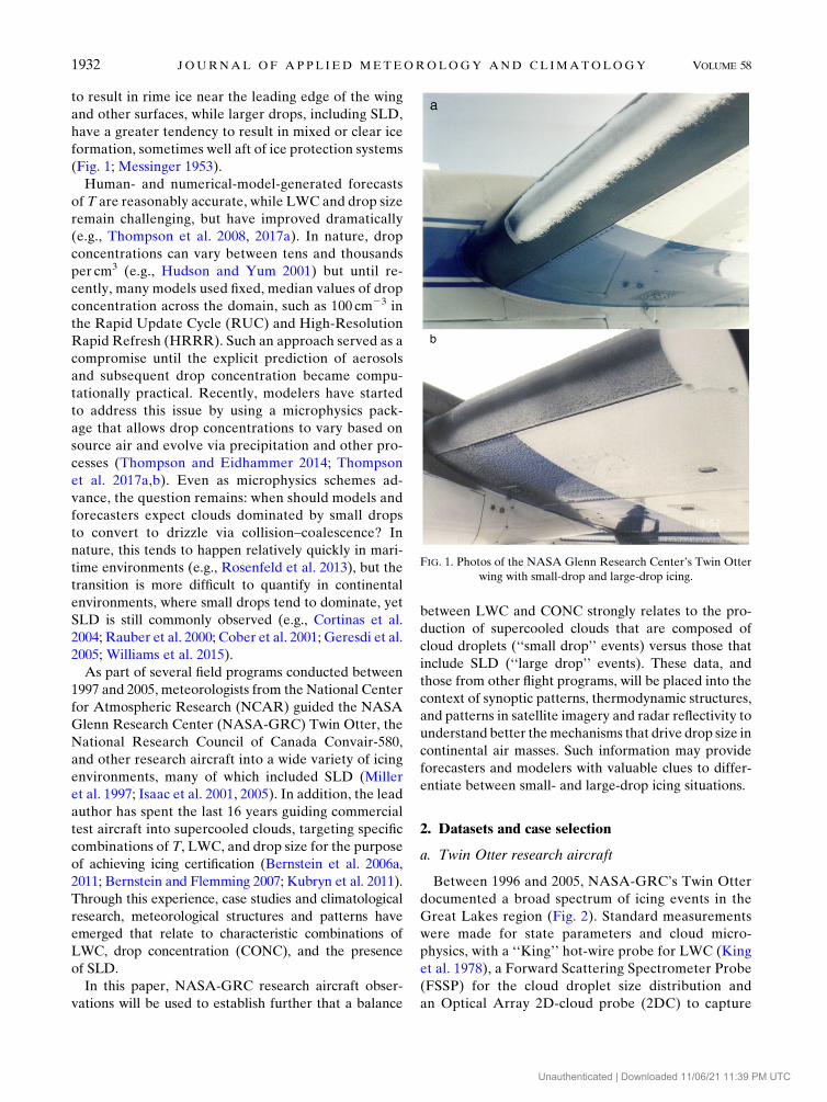
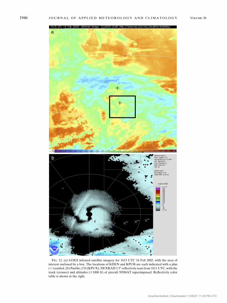