Kentucky Geological Survey Landslide Inventory: From … page from Kentucky Transportation Cabinet...
22
Kentucky Geological Survey James C. Cobb, State Geologist and Director University of Kentucky, Lexington Kentucky Geological Survey Landslide Inventory: From Design to Application Matthew M. Crawford Information Circular 31 Series XII, 2014
-
Upload
dinhkhuong -
Category
Documents
-
view
215 -
download
0
Transcript of Kentucky Geological Survey Landslide Inventory: From … page from Kentucky Transportation Cabinet...

Kentucky Geological SurveyJames C. Cobb, State Geologist and Director
University of Kentucky, Lexington
Kentucky Geological Survey Landslide Inventory:
From Design to Application
Matthew M. Crawford
Information Circular 31 Series XII, 2014

© 2006University of Kentucky
For further information contact:Technology Transfer OfficerKentucky Geological Survey
228 Mining and Mineral Resources BuildingUniversity of Kentucky
Lexington, KY 40506-0107
ISSN 0075-5591
Technical Level
General Intermediate Technical
Our MissionOur mission is to increase knowledge and understanding of the mineral, energy, and water resources, geologic hazards, and geology of Kentucky for the benefit of the Commonwealth and Nation.
Earth Resources—Our Common Wealth
www.uky.edu/kgs
Technical Level
General Intermediate Technical
ISSN 0075-5583
ContentsAbstract .........................................................................................................................................................1Introduction .................................................................................................................................................1Purpose .........................................................................................................................................................1Landslide Basics ..........................................................................................................................................3 Why Slopes Fail ..............................................................................................................................3 Causes of Landslides .....................................................................................................................4 Geology, Soils, Water, and Steep Slopes .......................................................................4 Triggers of Landslides ...................................................................................................................4 Intense Rainfall ..................................................................................................................4 Water-Level Change .........................................................................................................4 Erosion ................................................................................................................................5 Human Activities ..............................................................................................................5 Earthquakes .......................................................................................................................5 Landslide Types .............................................................................................................................5Landslide Inventory Database ..................................................................................................................6 Methodology...................................................................................................................................6 Design .............................................................................................................................................7 Data Sources ...................................................................................................................................8 Landslides and Related Features Maps ......................................................................................8Inventory Statistics ....................................................................................................................................10Application: Landslide Information Map .............................................................................................12Summary and Impact ...............................................................................................................................16Helpful Resources .....................................................................................................................................17Acknowledgments ....................................................................................................................................17References Cited ........................................................................................................................................18
Figures 1. Photograph of landslide damage along the now abandoned Ky. 10, Lewis County ..........2 2. Photograph of repaired landslide in Hickman, Fulton County ..............................................2 3. Diagram showing common terms used to describe landslide features .................................3 4. Diagram showing the driving and resisting forces on a slope and (left) and
photograph of a landslide along Big Eddy Road, Franklin County (right) ..........................4 5. Diagram showing multiple causes and triggers of landslides ................................................4 6. Photograph of landslide-damaged home, Lawrence County .................................................5 7. Diagram showing classification of landslide types ...................................................................5 8. Map showing landslide deposits in the Stricklett 7.5-minute quadrangle, Lewis
County .............................................................................................................................................9 9. Example page from Kentucky Transportation Cabinet landslide geotechnical report .......9 10. Screenshot of a landslides and related features map ..............................................................10 11. Graph showing distribution of landslides by county .............................................................11 12. Map showing example of landslide deposits on the 1:24,000-scale geologic
quadrangle maps..........................................................................................................................13 13. Graph showing distribution of landslides by slope angle .....................................................14 14. Graph comparing landslides documented by Kentucky Transportation Cabinet com-
pared with annual rainfall across Kentucky ............................................................................14 15. Screenshot of the KGS landslide information map .................................................................15

1. Example of the major category Setting and the different attributes associated with that category from the North Carolina and Oregon surveys ..................................................7
2. Landslide attributes and data types in the inventory database ..............................................8 3. Sources for landslide locations and data ....................................................................................9 4. Count of landslides from the landslide inventory database by source ...............................10 5. Landslide inventory by geologic formation .............................................................................12
16. Screenshot of an enlarged section of the landslide information map ..................................15 17. Screenshot of an enlarged view of a section of the landslide information map showing
the fields and data from the landslide inventory database a user can access .....................16
Figures (continued)
Tables

1
Kentucky Geological Survey Landslide Inventory:
From Design to ApplicationMatthew M. Crawford
AbstractThe Kentucky Geological Survey is compiling a landslide inventory database to bet-
ter document the distribution and geologic context of Kentucky’s landslides. The data-base provides users with easy access to landslide information, raises awareness of land-slide causes, and will help prevent property damage or injury. The database was used to create an online landslide information map, which provides online access to landslide data and gives users the ability to customize the map using other data layers pertinent to landslides. The database design is based on common attributes collected by other states with active inventories and landslide hazard programs, as well as attributes necessary to document landslides in Kentucky and help with future research goals. A comprehensive landslide inventory database serves as a foundation for understanding landslide distri-bution, assisting land-use planning decisions, creating hazard maps, and modeling land-slide susceptibility.
IntroductionIn Kentucky, as in other places in the world,
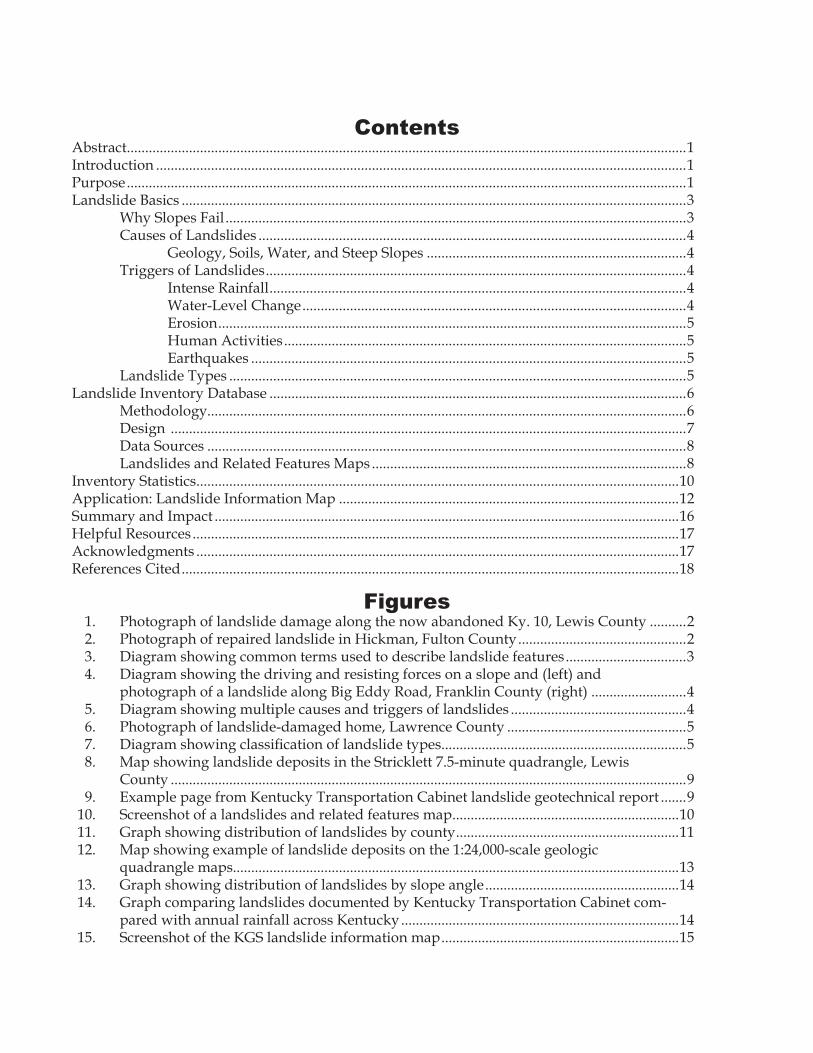
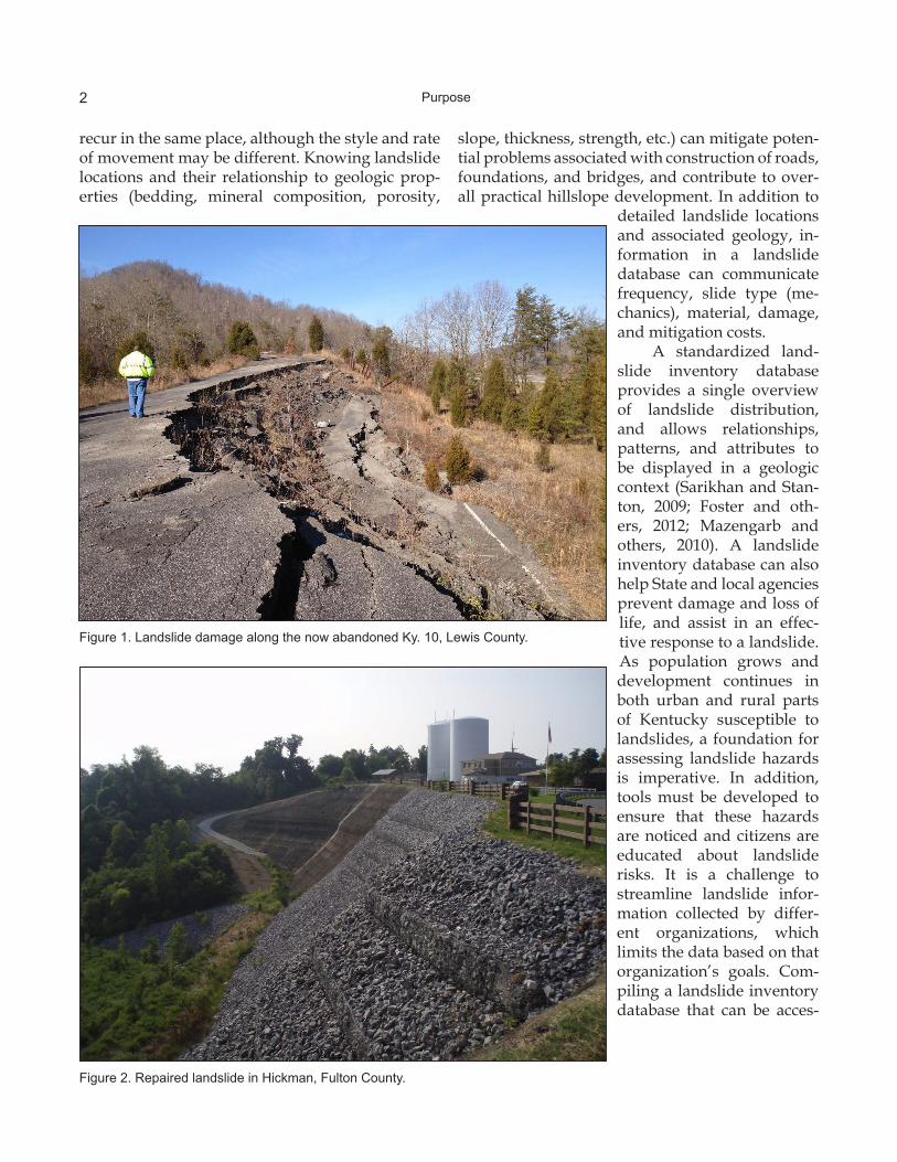
a combination of steep slopes, excessive water amounts, geology, and slope modification are the main causes of landslides. From 1973 to pres-ent, the Kentucky Transportation Cabinet has compiled 870 geotechnical reports documenting landslides that have affected roadways and have proposed landslide corrections (Fig. 1). Although the exact costs for mitigating these slides are not known, they are significant. For fiscal years 2002 to 2009, the Transportation Cabinet’s maintenance database documented landslide and rockfall re-pairs totaling $31.8 million. From 2003 to 2013, the Kentucky Hazard Mitigation Grant Program funded or will fund projects that acquire landslide-damaged homes or stabilizes the area for a total of $5.3 million. Along the Mississippi River in Hick-man, one of the largest landslides in the state af-fected numerous buildings and the town’s water supply (Fig. 2), costing the U.S. Army Corps of En-gineers more than $17 million to stabilize the slope. Indirect costs associated with landslides, such as
commerce hindered by road closures, devalued property, and environmental effects, often exceed direct costs. Hazard mitigation efforts continue across Kentucky to help citizens facing landslide problems; however, obtaining funding and imple-menting these projects can take years.
The State and local government agencies that respond to or document landslides vary, and the data collection, assessment, and documentation of landslide activity among these agencies vary widely. Several state geological surveys participate in landslide inventory projects, collecting data for displaying and analyzing landslide information (landslides.usgs.gov/research/inventory).
PurposeThe landslide inventory database stores and
updates landslide data and distributes the data to the public. Compiling landslide locations into a database allows landslides and rockfalls to be ana-lyzed in a geologic and geomorphic context along with other data. Landslide activity is more likely in areas of existing slides; that is, landslides tend to
2 Purpose
Figure 1. Landslide damage along the now abandoned Ky. 10, Lewis County.
Figure 2. Repaired landslide in Hickman, Fulton County.
slope, thickness, strength, etc.) can mitigate poten-tial problems associated with construction of roads, foundations, and bridges, and contribute to over-all practical hillslope development. In addition to
detailed landslide locations and associated geology, in-formation in a landslide database can communicate frequency, slide type (me-chanics), material, damage, and mitigation costs.
A standardized land-slide inventory database pro vides a single overview of landslide distribution, and allows relationships, patterns, and attributes to be displayed in a geologic context (Sarikhan and Stan-ton, 2009; Foster and oth-ers, 2012; Mazengarb and others, 2010). A landslide inventory database can also help State and local agencies prevent damage and loss of life, and assist in an effec-tive response to a landslide. As population grows and development continues in both urban and rural parts of Kentucky susceptible to landslides, a foundation for assessing landslide hazards is imperative. In addition, tools must be developed to ensure that these hazards are noticed and citizens are educated about landslide risks. It is a challenge to streamline landslide infor-mation collected by differ-ent organizations, which limits the data based on that organization’s goals. Com-piling a landslide inventory database that can be acces-
recur in the same place, although the style and rate of movement may be different. Knowing landslide locations and their relationship to geologic prop-erties (bedding, mineral composition, porosity,
3Landslide Basics
sible, disseminated easily, and assist users will be of benefit to all of Kentucky, however.
Landslide Basics“Landslide” is a broad term referring to the
downslope movement of rock, soil, or both un-der the influence of gravity. The type of material involved in a landslide and its style of movement influence decisions for hazard mitigation and risk reduction. For example, shales present slope-sta-bility problems because of their clay content and capability of holding large amounts of water, mak-ing proper drainage important for construction of buildings, roads, tunnels, retaining walls, and oth-er infrastructure. Clayey to silty soils that develop on steep slopes underlain by shale-dominated bed-rock are also susceptible to sliding.
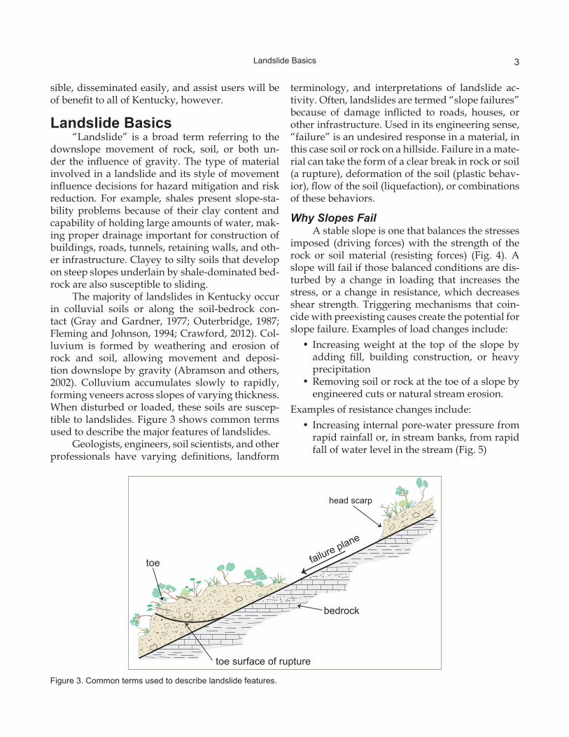
The majority of landslides in Kentucky occur in colluvial soils or along the soil-bedrock con-tact (Gray and Gardner, 1977; Outerbridge, 1987; Fleming and Johnson, 1994; Crawford, 2012). Col-luvium is formed by weathering and erosion of rock and soil, allowing movement and deposi-tion downslope by gravity (Abramson and others, 2002). Colluvium accumulates slowly to rapidly, forming veneers across slopes of varying thickness. When disturbed or loaded, these soils are suscep-tible to landslides. Figure 3 shows common terms used to describe the major features of landslides.
Geologists, engineers, soil scientists, and other professionals have varying definitions, landform
terminology, and interpretations of landslide ac-tivity. Often, landslides are termed “slope failures” because of damage inflicted to roads, houses, or other infrastructure. Used in its engineering sense, “failure” is an undesired response in a material, in this case soil or rock on a hillside. Failure in a mate-rial can take the form of a clear break in rock or soil (a rupture), deformation of the soil (plastic behav-ior), flow of the soil (liquefaction), or combinations of these behaviors.
Why Slopes FailA stable slope is one that balances the stresses
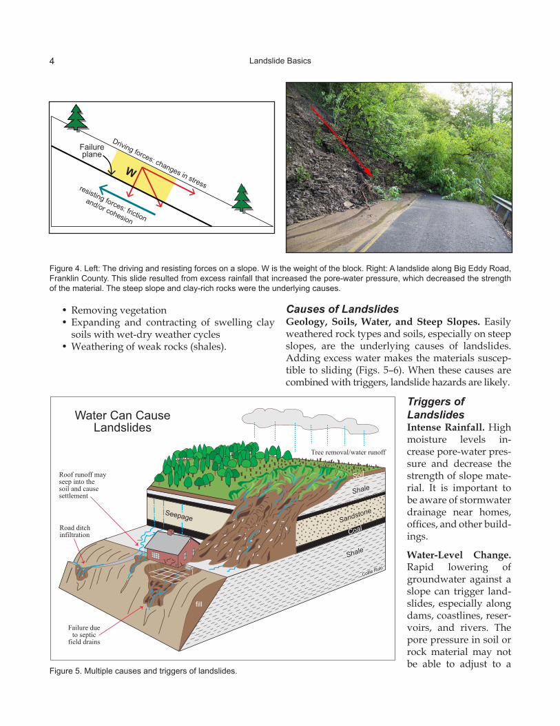
imposed (driving forces) with the strength of the rock or soil material (resisting forces) (Fig. 4). A slope will fail if those balanced conditions are dis-turbed by a change in loading that increases the stress, or a change in resistance, which decreases shear strength. Triggering mechanisms that coin-cide with preexisting causes create the potential for slope failure. Examples of load changes include:
• Increasing weight at the top of the slope by adding fill, building construction, or heavy precipitation
• Removing soil or rock at the toe of a slope by engineered cuts or natural stream erosion.
Examples of resistance changes include:• Increasing internal pore-water pressure from
rapid rainfall or, in stream banks, from rapid fall of water level in the stream (Fig. 5)
Figure 3. Common terms used to describe landslide features.
toe surface of rupture
toe failure plane
bedrock
head scarp
4 Landslide Basics
Figure 4. Left: The driving and resisting forces on a slope. W is the weight of the block. Right: A landslide along Big Eddy Road, Franklin County. This slide resulted from excess rainfall that increased the pore-water pressure, which decreased the strength of the material. The steep slope and clay-rich rocks were the underlying causes.
Figure 5. Multiple causes and triggers of landslides.
• Removing vegetation• Expanding and contracting of swelling clay
soils with wet-dry weather cycles• Weathering of weak rocks (shales).
Causes of LandslidesGeology, Soils, Water, and Steep Slopes. Easily weathered rock types and soils, especially on steep slopes, are the underlying causes of landslides. Adding excess water makes the materials suscep-tible to sliding (Figs. 5–6). When these causes are combined with triggers, landslide hazards are likely.
Triggers of LandslidesIntense Rainfall. High moisture levels in-crease pore-water pres-sure and decrease the strength of slope mate-rial. It is important to be aware of stormwater drainage near homes, offices, and other build-ings.
Water-Level Change. Rapid lowering of groundwater against a slope can trigger land-slides, especially along dams, coastlines, reser-voirs, and rivers. The pore pressure in soil or rock material may not be able to adjust to a
Driving forces: changes in stressresisting forces: friction
and/or cohesion
W
Failure plane
fill
Roof runoff may seep into thesoil and cause settlement
Road ditch infiltration
Tree removal/water runoff
Failure due to septic
field drains
Shale
Sandstone
Soil
Coal
Seepage
Water Can Cause Landslides
Shale
Collie Rulo

5Landslide Basics
Figure 6. Landslide-damaged home, Lawrence County.
Figure 7. Classification of landslide types. Modified from Highland and Bobrowsky (2008).
sudden drawdown of water, causing slope instability.
Erosion. Natural streamwater erosion can destabilize slopes and cause failure. This is com-mon at the toe (bottom) of a slope, often along sharp bends in a stream.
Human Activities. Vegeta-tion removal, excavation of toe slopes, loading on a slope, leakage from pipes, and sur-face and underground mining can trigger landslides.
Earthquakes. Ground shak-ing during earthquakes can cause landslides in many dif-ferent topographic and geo-logic settings. The 1811-12 large earthquakes in the New Madrid Seismic Zone gener-ated several hundred landslides along the Missis-sippi River.
Landslide TypesCruden and Varnes (1996) created a classifica-
tion system (Fig. 7):
• Translational slides—Material moves down a relatively planar surface. The sliding material can be composed of fine- to coarse-grained soils or rock. Slide planes typically occur at the soil-bedrock contact and are shallow (less than 3 m). Translational slides are very com-
debrisavalanche
6 Landslide Inventory Database
mon, occurring in all physiographic regions. Their size can range from small (lengths less than 30 m) to very large (several kilometers wide along roadways or cutbanks in streams).
• Rotational slides—Also called slumps, these slides are distinguished by an upward-curved slide plane, causing rotational movement. Ro-tational slides can have multiple scarps, cre-ating dis placement that tilts back toward the head scarp and crown. Slumps often have a hummocky surface and thick toe. These slides usually occur in thick, unconsolidated soils, loess, and artificial fills, but also may occur in weathered rock masses. Rotational slide ve-locity ranges from slow (less than 0.3 m ev-ery 5 yr) to moderately fast (1.5 m per month) (Highland and Bobrowsky, 2008).
• Flows—This category consists of styles differ-entiated by velocity and material. The types of flows include debris flow, debris avalanche, and earthflow. Each type ranges from small to very large. Smaller earthflows are common in soils developed on shale, weathered clay-rich rocks, and fill. Debris flows and debris ava-lanches are rapid movements (up to 56 km/hr). They are most common on slopes where thick, coarse soils are deposited in concave parts of the slope or steep channels. Excessive water commonly triggers the movement of these flows.
• Creep—Creep is extremely slow earthflow (less than 1 m per decade) that can only be no-ticed by its effects (Highland and Bobrowsky, 2008). Shear stresses in the soil or rock are suf-ficient to cause movement, but soil or rock dis-placement is gradual. Typical damage is tilted or curved tree trunks, broken or tilted fences, tilted telephone poles, cracked foundations, and broken underground utilities. Creep can lead to more destructive, faster-moving slides or flows. Creep often occurs seasonally with changes in moisture content and temperature (Highland and Bobrowsky, 2008). Slopes with creep often have a complex system of slide planes. This is the most common landslide type and occurs statewide.
• Spreads—These usually occur on very gentle slopes where soft, clay-rich layers undergo lateral extension, spreading apart overly-
ing firmer rocks and soil (Highland and Bo-browsky, 2008). Spreads can occur in clayey lacustrine and other glacial deposits in north-ern Kentucky and less commonly in thick, liq-uefiable soils of the Jackson Purchase Region.
• Rockfalls and topples—Rock material of vary-ing size can free-fall through the air from cliffs, roadcuts, or steep slopes. These failures are more susceptible if rocks are dipping the same direction as the slope. Rocks can become detached from in-place bedrock by fracturing, weathering from freeze-thaw cycles, erosion of underlying material, and human activities such as road construction (Highland and Bo-browsky, 2008).
Landslide Inventory DatabaseKGS began constructing the landslide in-
ventory database in 2011. The database contains known landslide locations and associated data. Some important questions asked before designing the database were:
• What is the aim and scope?• Who will be the users?• Is the goal to understand specific landslide
dynamics, gain a general understanding of their distribution, or model landslide suscep-tibility and risk?
• Can enough reliable landslide locations be gathered and attributed with the detail neces-sary to achieve the goals?There is no best practice or standard method-
ology to develop such a database. Much depends on the ability to collect landslide locations and as-sociated attributes. Access to geology, soils, and other geographic information system resources is very helpful in being able to put the slide locations in a geologic and geomorphic context, even if not much is known about the slide itself.
MethodologyLarge amounts of data can be associated with
landslides. It is unlikely that all pertinent data can be gathered for every documented landslide. One primary goal of constructing a landslide inventory database was to create an applied database, which facilitated adding, querying, and displaying data. In order to reduce complexity and size of the KGS database, other landslide inventory databases were
7Landslide Inventory Database
1The use of trade or product names is for descriptive purposes only and does not imply endorsement by the Kentucky Geologi-cal Survey.
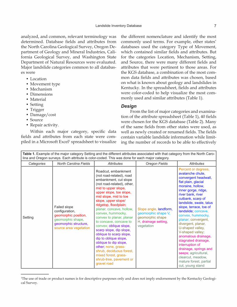
Table 1. Example of the major category Setting and the different attributes associated with that category from the North Caro-lina and Oregon surveys. Each attribute is color-coded. This was done for each major category.
Categories North Carolina Fields Attributes Oregon Fields Attributes
Setting
Failed slope configuration, geomorphic position, geomorphic shape, geomorphic structure, source area vegetation
Roadcut, embankment (not road-related), road embankment, cut slope (not road-related), other, mid to upper slope, upper slope, toe slope, mid slope, mid to toe slope, upper slope/ridgetop, floodplain; planar, concave, hollow, convex, hummocky, convex to planar, planar to concave, concave to convex; oblique slope, scarp slope, dip slope, oblique to scarp slope, dip to oblique slope, oblique to dip slope, other; none, grass-shrub, deciduous forest, mixed forest, grass-shrub-tree, pavement or gravel road
Slope angle, landform, geomorphic shape V, geomorphic shape H, drainage setting, vegetation
Percent or degrees, avalanche chute, convergent headwall, flat plain, glacial moraine, hollow, inner gorge, ridge, river bank, river cutbank, scarp of landslide, swale, talus slope, terrace, toe of landslide; concave, convex, hummocky, planar; convergent, divergent, planar, U-shaped valley, V-shaped valley; anomalous drainage, stagnated drainage, interruption of drainage, springs and seeps; agricultural, clearcut, meadow, mature forest, partial cut, young stand
analyzed, and common, relevant terminology was determined. Database fields and attributes from the North Carolina Geological Survey, Oregon De-partment of Geology and Mineral Industries, Cali-fornia Geological Survey, and Washington State Department of Natural Resources were evaluated. Major landslide categories common to all databas-es were
• Location• Movement type• Mechanism• Dimensions• Material• Setting• Trigger• Damage/cost• Source• Repair activity.
Within each major category, specific data fields and attributes from each state were com-piled in a Microsoft Excel1 spreadsheet to visualize
the different nomenclature and identify the most commonly used terms. For example, other states’ databases used the category Type of Movement, which contained similar fields and attributes. But for the categories Location, Mechanism, Setting, and Source, there were many different fields and attributes that were pertinent to those areas. For the KGS database, a combination of the most com-mon data fields and attributes was chosen, based on what is known about geology and landslides in Kentucky. In the spreadsheet, fields and attributes were color-coded to help visualize the most com-monly used and similar attributes (Table 1).
DesignFrom the list of major categories and examina-
tion of the attribute spreadsheet (Table 1), 40 fields were chosen for the KGS database (Table 2). Many of the same fields from other states were used, as well as newly created or renamed fields. The fields contain variable landslide information while limit-ing the number of records to be able to effectively

8 Landslide Inventory Database
populate the database. The database resides in a Microsoft Access database. The main advantages are easily facilitated queries, links to other KGS tabular data sets, and the capability to display the data in the online Kentucky Geologic Map Infor-mation Service. Access databases also allow for easy exporting and use in a GIS for spatial analysis.
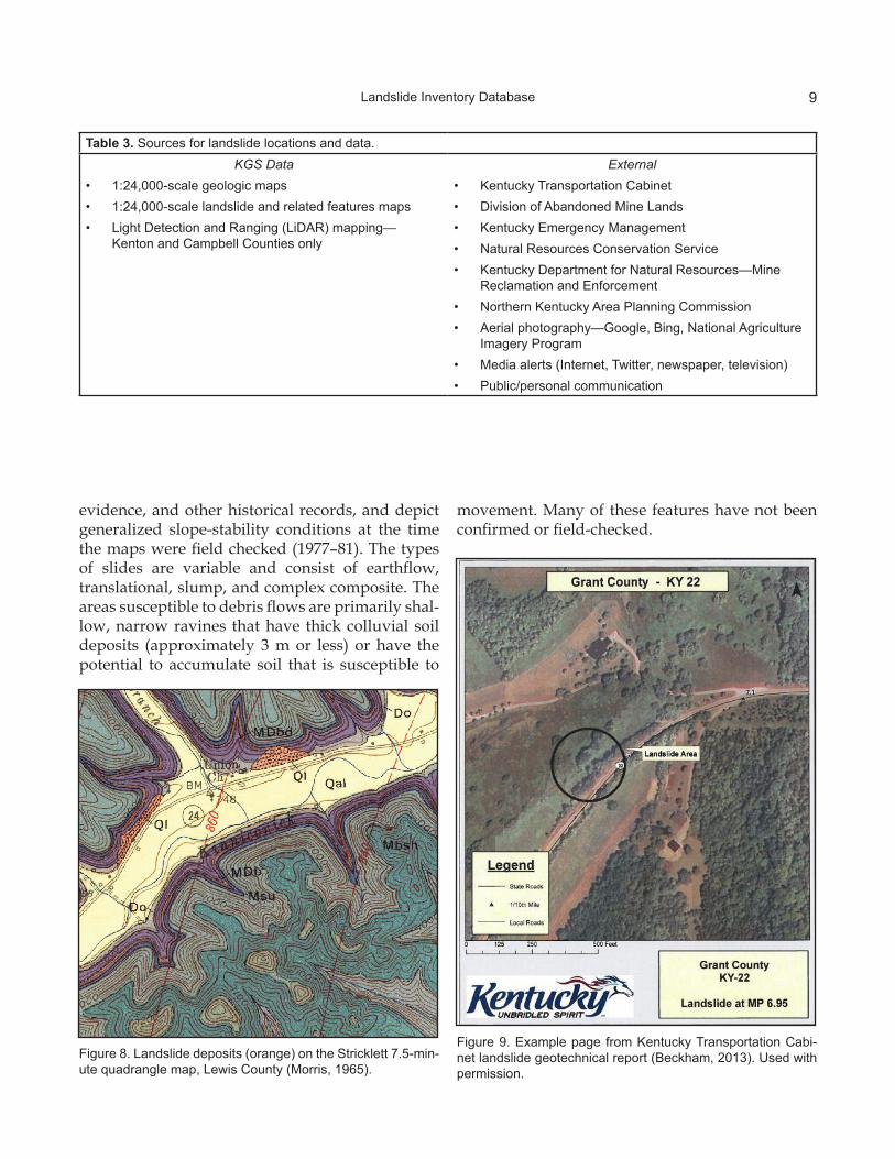
Data SourcesAn important and challenging factor in the
landslide inventory database is the source of the data. Sources for landslide locations include KGS research and field work, published geologic maps, State and local government agencies, media re-ports, and the public (Table 3, Figs. 8–9). Compiling landslide locations from different sources makes choosing data fields and standard attributes a chal-lenge. For example, landslides identified and miti-gated by the Kentucky Transportation Cabinet may have a geotechnical report providing much related data, but slides identified by Kentucky Emergency Management may only have location data and no extensive records. Also, for road-related landslides that prompt a Transportation Cabinet response,
the responsibility and documentation is divided up between many district and county maintenance offices, depending on the slide location. Is it worth the effort to reach out to all these potential sources and try to gather everything?
With such a wide variety of sources, the land-slide inventory database must maintain a balance of necessary fields, but not be overwhelmed with too many fields that would most likely be unpopu-lated. Attributing every field for every slide locat-ed will not be possible, but if the source of the data has an accurate location (latitude-longitude, mile marker, anecdotal, etc.), then some fields such as Geologic Unit, Slope Angle, Aspect, Soil Type, and Mile Points can be populated later using GIS geo-processing tasks.
Landslides and Related Features MapsA series of 7.5-minute, 1:24,000-scale quadran-
gle maps showing landslides and related features was published in the late 1970’s to early 1980’s by the U.S. Geological Survey; they cover much of the Eastern Kentucky Coal Field (Fig. 10). The maps were interpreted from aerial photography, field
Table 2. Landslide attributes and data types in the inventory database.1 ID Number 21 Lithology Text2 SourceDesc Text 22 Surficial_Geology Text3 SourceID Text 23 Geomorphic_Position Text4 County Text 24 Geomorphic_Shape Text5 24kQuad Text 25 Failure_Location Text6 Latitude83 Number 26 Slope_Angle Text7 Longitude83 Number 27 Aspect Text8 Route Number 28 Fractures Text9 DateObserved Date/Time 29 Faults Text
10 FailureDate Date/Time 30 Water_Present Text11 General_Type Text 31 Contributing_Factor Text12 FieldChecked Text 32 Soil_Type Text13 Process Text 33 Movement_Rate Text14 Material Text 34 Damage Text15 Failure_Type Text 35 New_or_Existing Text16 Track_Length Number 36 Cost Currency17 Width Number 37 Comments Memo18 Head_Scarp_Height Number 38 Nearest_mp Text19 Slip_Surface_Depth Number 39 Begin_mp Text20 GeologicUnit Text 40 End_mp Text
9Landslide Inventory Database
Figure 9. Example page from Kentucky Transportation Cabi-net landslide geotechnical report (Beckham, 2013). Used with permission.
Figure 8. Landslide deposits (orange) on the Stricklett 7.5-min-ute quadrangle map, Lewis County (Morris, 1965).
evidence, and other historical records, and depict generalized slope-stability conditions at the time the maps were field checked (1977–81). The types of slides are variable and consist of earthflow, translational, slump, and complex composite. The areas susceptible to debris flows are primarily shal-low, narrow ravines that have thick colluvial soil deposits (approximately 3 m or less) or have the potential to accumulate soil that is susceptible to
movement. Many of these features have not been confirmed or field-checked.
Table 3. Sources for landslide locations and data.KGS Data
• 1:24,000-scale geologic maps• 1:24,000-scale landslide and related features maps• Light Detection and Ranging (LiDAR) mapping—
Kenton and Campbell Counties only
External• Kentucky Transportation Cabinet• Division of Abandoned Mine Lands• Kentucky Emergency Management• Natural Resources Conservation Service• Kentucky Department for Natural Resources—Mine
Reclamation and Enforcement• Northern Kentucky Area Planning Commission• Aerial photography—Google, Bing, National Agriculture
Imagery Program• Media alerts (Internet, Twitter, newspaper, television)• Public/personal communication

10 Inventory Statistics
Figure 10. Screenshot of a landslides and related features map. The black ovals are landslides and the arrows are areas sus-ceptible to debris flows. Other map symbology indicates colluvial slopes, old landslides, or soil susceptible to landsliding. Image from Outerbridge (1979).
From these maps, 13,516 landslide locations and 60,067 areas susceptible to debris flows have been digitized as polygons and arcs, respectively. These features are maintained in an ArcGIS geoda-tabase and displayed in the interactive KGS Land-slide Information Map Service (see next section). The original landslides and related features maps can be downloaded from the KGS publications webpage: kgs.uky.edu/kgsweb/PubsSearching/PubResults.asp?pubtype=Landslide+Map&searchtype=typeofpub.
Inventory StatisticsAs of August 20, 2014, the KGS landslide in-
ventory database has 2,302 documented landslides (Table 4). The landslides are depicted by points, lines, and polygons, the former two features repre-senting larger landslide areas, many of which have
Table 4. Count of landslides from the landslide inventory database by source. Because many of the Kentucky Trans-portation Cabinet reports contain more than one landslide, the count in this table does not add up to 2,302. Features digitized from the landslide and related features maps are not included.
Source Description CountKentucky Transportation Cabinet 870Division of Abandoned Mine Lands 697Kentucky Geological Survey 458LiDAR (two counties) 234Kentucky Emergency Management 35Natural Resources Conservation Service 35Public 29Media alert 27Kentucky Department for Natural Resources–Mine Reclamation and Enforcement 24
Northern Kentucky Area Planning Commission 15
11Inventory Statistics
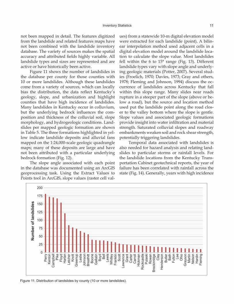
Figure 11. Distribution of landslides by county (10 or more landslides).
not been mapped in detail. The features digitized from the landslide and related features maps have not been combined with the landslide inventory database. The variety of sources makes the spatial accuracy and attributed fields highly variable. All landslide types and sizes are represented and are active or have historically been active.
Figure 11 shows the number of landslides in the database per county for those counties with 10 or more landslides. Although these landslides come from a variety of sources, which can locally bias the distribution, the data reflect Kentucky’s geology, slope, and urbanization and highlight counties that have high incidence of landslides. Many landslides in Kentucky occur in colluvium, but the underlying bedrock influences the com-position and thickness of the colluvial soil, slope morphology, and hydrogeologic conditions. Land-slides per mapped geologic formation are shown in Table 5. The three formations highlighted in yel-low indicate landslide deposits and alluvial fans mapped on the 1:24,000-scale geologic quadrangle maps; many of these deposits are large and have not been attributed with a particular underlying bedrock formation (Fig. 12).
The slope angle associated with each point in the database was documented using an ArcGIS geoprocessing task. Using the Extract Values to Points tool in ArcGIS, slope values (raster cell val-
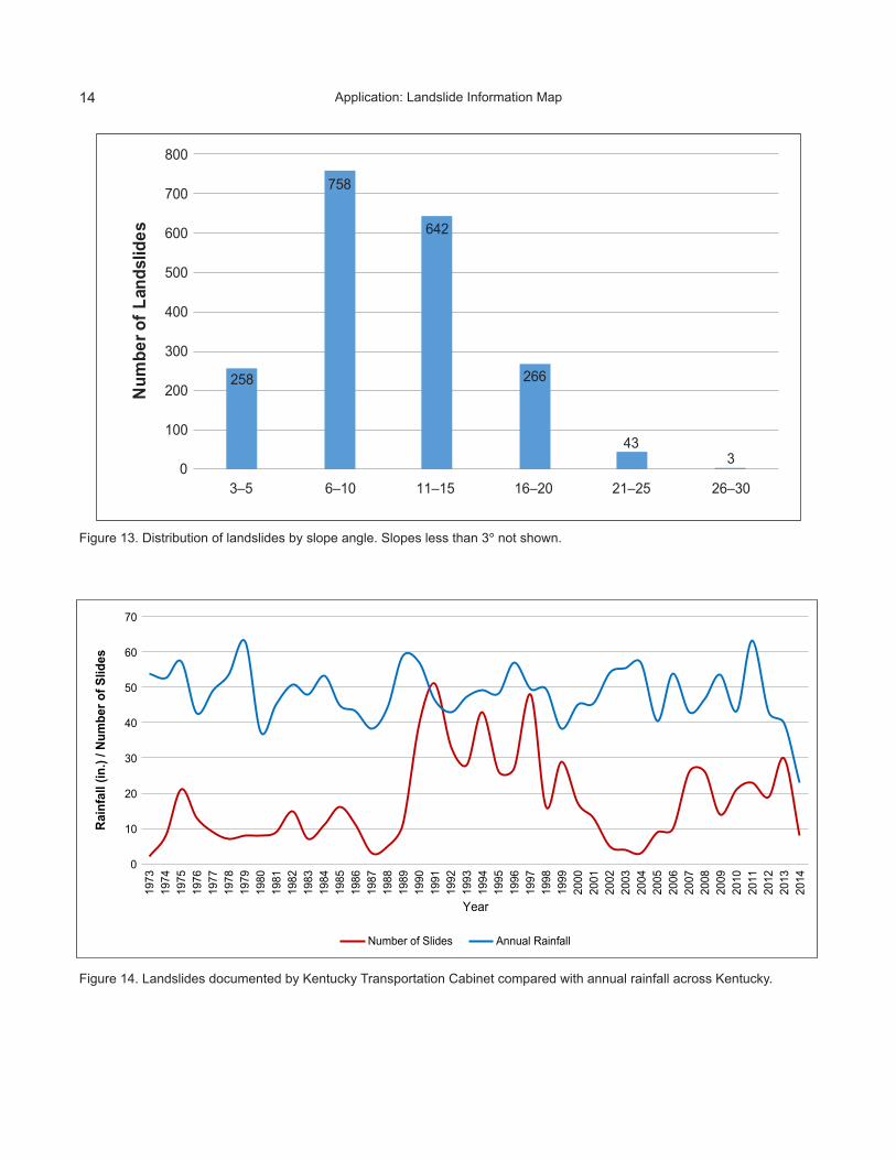
ues) from a statewide 10-m digital elevation model were extracted for each landslide (point). A bilin-ear interpolation method used adjacent cells in a digital elevation model around the landslide loca-tion to calculate the slope value. Most landslides fell within the 6 to 15° range (Fig. 13). Different landslide types vary with slope angle and underly-ing geologic materials (Potter, 2007). Several stud-ies (Froelich, 1970; Davies, 1973; Gray and others, 1978; Fleming and Johnson, 1994) discuss the oc-currence of landslides across Kentucky that fall within this slope range. Many slides near roads rupture in a steeper part of the slope (above or be-low a road), but the source and location method used put the landslide point along the road clos-er to the valley bottom where the slope is gentle. Slope values and associated geologic formations provide insight into water infiltration and material strength. Saturated colluvial slopes and roadway embankments weaken soil and rock shear strength, potentially triggering landslides.
Temporal data associated with landslides is also needed for hazard analysis and relating land-slides to particular storms or rainfall levels. For the landslide locations from the Kentucky Trans-portation Cabinet geotechnical reports, the year of failure has been correlated with rainfall across the state (Fig. 14). Generally, years with high incidence
0
25
50
75
100
125
150
175
200
Perry
Kent
onC
ampb
ell
Pike
Floy
dH
arla
nLe
tche
rKn
ott
Gre
enup
Lesl
ieJo
hnso
nBr
eath
ittBo
one
Gal
latin
Boyd Be
llLe
wis
Whi
tley
Fran
klin
Scot
tLa
wre
nce
Gra
ntC
arte
rC
arro
llH
ickm
anR
ockc
astle
Pula
ski
Row
anBr
ecki
nrid
geC
lay
Hen
ders
onBu
tler
Bath
Fulto
nLe
eO
hio
Gra
yson
Mar
tinN
elso
nH
ardi
nFl
emin
g
Num
ber o
f lan
dslid
es

12
Table 5. Landslide inventory by geologic formation (five or more). The highlighted records are deposits mapped on the 1:24,000-scale geologic quadrangle maps and have not been associated with a particular bedrock formation in the database. Often, these are large landslides that span several bedrock formations.
Geologic Formation Landslides Geologic Formation LandslidesPikeville Formation 474 Carbondale Formation 14
Kope Formation 334 Conemaugh Formation 14
Hyden Formation 285 Tradewater Formation 13
Landslide deposits 186 Shelburn Formation 11
Four Corners Formation 156 Grant Lake Limestone 11
Grundy Formation 67 Alvy Creek Formation 9
Fairview Formation 62 Buffalo Wallow Formation 8
Alluvium 57 Drakes Formation 8
Alluvial fan deposits 54 Middle Part of Breathitt Group 8
Princess Formation 53 Tyrone Limestone 8
Clays Ferry Formation 43 Ste. Genevieve Limestone 7
Landslide deposits and colluvium 41 Ohio Shale 7
Bull Fork Formation 27 Alger Shale 6
Borden Formation 21 Beech Creek Limestone Member 6
Paragon Formation 19 Borden Formation, Cowbell Member 6
St. Louis Limestone 18 Borden Formation, Nancy Member 6
Tradewater and Caseyville Formations 17 Estill Shale of Crab Orchard Group 6
Artificial fill 17 Point Pleasant Tongue of Clays Ferry Formation 6
Kope and Clays Ferry Formations 16 Big Clifty Sandstone Member 5
Terrace deposits 15 Fort Payne Formation 5
Corbin Sandstone Member 15 Glen Dean Limestone 5
Lower Part of Lexington Limestone 15 Leitchfield Formation 5
Loess 15 New Albany Shale 5
of landslides occurred during or just after years of high rainfall. There are a few anomalies in which there are years of peak rainfall and low incidence of landslides or vice versa. The more temporal data collected with each landslide location, the more of these types of correlations with weather can be made, although it is not always possible to gather temporal data.
Application: Landslide Information Map
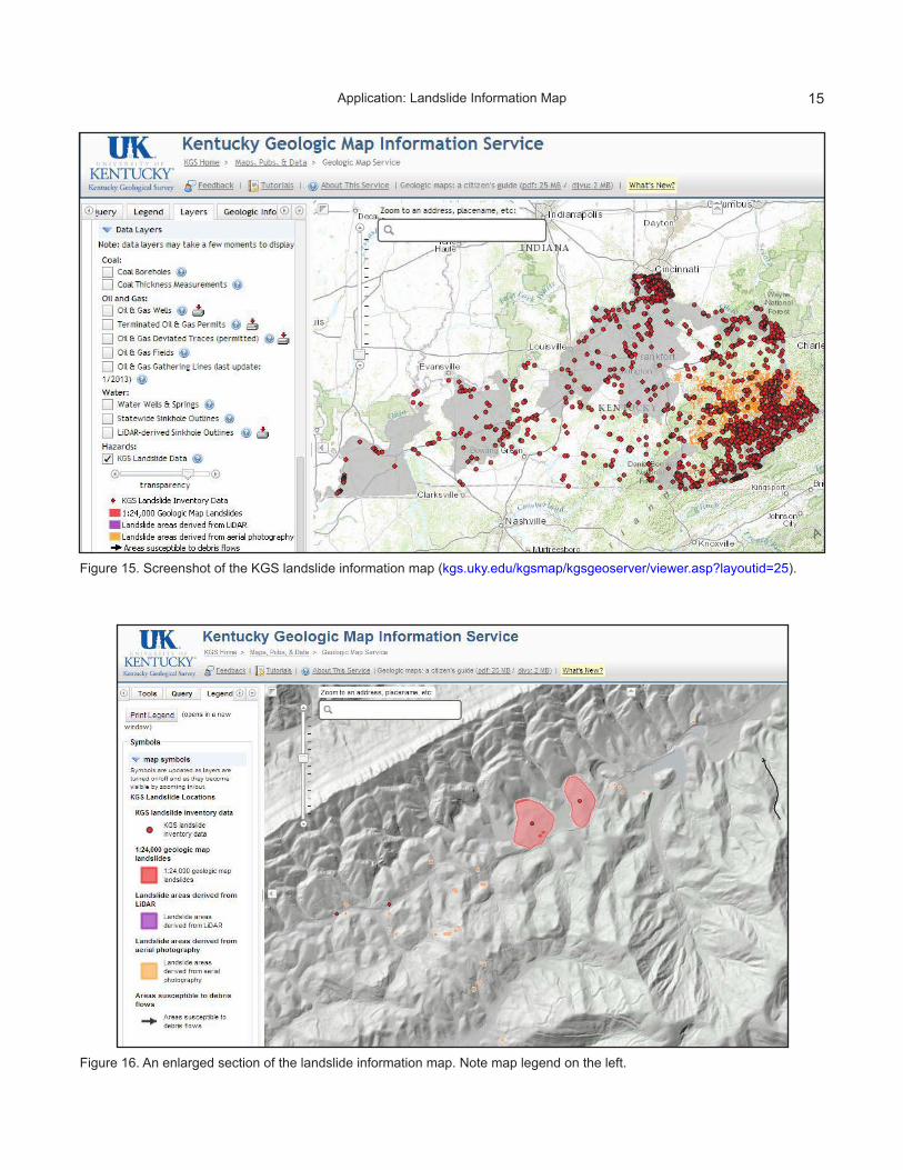
The landslide inventory database was used to create an online, interactive landslide informa-tion map, which provides an overall view of land-slide hazards across the state and shows locations of known landslides and areas susceptible to de-bris flows in a geologic and geomorphic context (Figs. 15–17). Five landslide data layers were cre-ated, represented as points, lines, and polygons.
These layers were taken from the landslide inven-tory database and best represent the variety of sources and feature types in the database. The lay-ers on the map are:Layer Name DescriptionLandslide Inventory Known landslide loca-Data (points) tions from different sources in the database1:24,000-Scale Geologic Mapped on theMap Landslides (poly- 7.5-minute geologicgons) quadrangle maps pub- lished jointly by the Kentucky Geological Survey and U.S. Geo- logical Survey from 1960 to 1978Landslide Areas Mapped and digitizedDerived from LiDAR using 1-m resolution
Application: Landslide Information Map

13Application: Landslide Information Map
(polygons) (horizontal) LiDAR dataLandslide Areas De- Digitized from land-rived from Aerial Pho- slide and related fea-tography (polygons) tures mapsAreas Susceptible to Digitized from land-Debris Flows (lines) slide and related fea- tures maps. The data are served as an ESRI Internet map service through KGS Web and GIS serv-ers. The landslide layers were compiled into an ESRI geodatabase, reviewed and symbolized in an ESRI ArcMap project, and then published via ESRI ArcGIS Server 10.1 as an ArcGIS Map Ser-vice. The online service is made to be a standalone service with capability for connections in ArcMap, ArcGIS.com, and Google Earth. Accompanying Li-
DAR data (5-ft hillshade base), also a layer in the service, are made available as an ArcGIS Image Service from the Kentucky Office of Geographic Information.
The landslide map and data can be accessed and viewed on a themed layout, but are also em-bedded in the KGS Geologic Map Information Service, which offers the capability of creating highly customized maps. Other available layers include topographic map imagery, aerial photog-raphy, boundary index maps, roads, mile markers, 1:24,000-scale geology, 1:24,000-scale faults, coal beds, structural contours, oil and gas data, quar-ries, sinkholes, water wells, springs, and slope (from 10-m digital elevation models). A sliding transparency tool is available for many of the base and raster layers, providing functionality to view multiple layers. A help file accompanies the map
Figure 12. Example of landslide deposits (stippled orange) mapped on the 1:24,000-scale geologic quadrangle maps. The geol-ogy is draped over a 5-ft horizontal-resolution LiDAR hillshade base.
14 Application: Landslide Information Map
Figure 13. Distribution of landslides by slope angle. Slopes less than 3° not shown.
Figure 14. Landslides documented by Kentucky Transportation Cabinet compared with annual rainfall across Kentucky.
258
758
642
266
433
0
100
200
300
400
500
600
700
800
3–5 6–10 11–15 16–20 21–25 26–30
Num
ber o
f Lan
dslid
es
0
10
20
30
40
50
60
70
1973
1974
1975
1976
1977
1978
1979
1980
1981
1982
1983
1984
1985
1986
1987
1988
1989
1990
1991
1992
1993
1994
1995
1996
1997
1998
1999
2000
2001
2002
2003
2004
2005
2006
2007
2008
2009
2010
2011
2012
2013
2014
Rain
fall
(in.)
/ Num
ber o
f Slid
es
Year
Number of Slides Annual Rainfall
15Application: Landslide Information Map
Figure 15. Screenshot of the KGS landslide information map (kgs.uky.edu/kgsmap/kgsgeoserver/viewer.asp?layoutid=25).
Figure 16. An enlarged section of the landslide information map. Note map legend on the left.
16 Summary and Impact
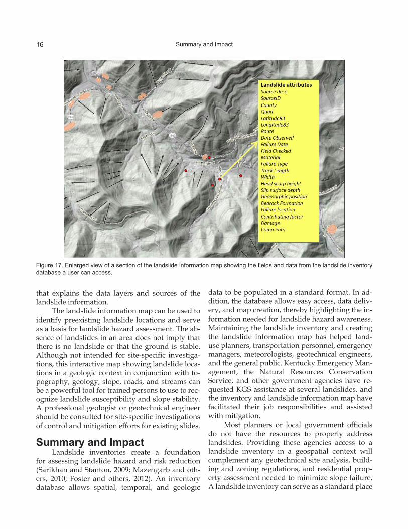
Figure 17. Enlarged view of a section of the landslide information map showing the fields and data from the landslide inventory database a user can access.
that explains the data layers and sources of the landslide information.
The landslide information map can be used to identify preexisting landslide locations and serve as a basis for landslide hazard assessment. The ab-sence of landslides in an area does not imply that there is no landslide or that the ground is stable. Although not intended for site-specific investiga-tions, this interactive map showing landslide loca-tions in a geologic context in conjunction with to-pography, geology, slope, roads, and streams can be a powerful tool for trained persons to use to rec-ognize landslide susceptibility and slope stability. A professional geologist or geotechnical engineer should be consulted for site-specific investigations of control and mitigation efforts for existing slides.
Summary and ImpactLandslide inventories create a foundation
for assessing landslide hazard and risk reduction (Sarikhan and Stanton, 2009; Mazengarb and oth-ers, 2010; Foster and others, 2012). An inventory database allows spatial, temporal, and geologic
data to be populated in a standard format. In ad-dition, the database allows easy access, data deliv-ery, and map creation, thereby highlighting the in-formation needed for landslide hazard awareness. Maintaining the landslide inventory and creating the landslide information map has helped land-use planners, transportation personnel, emergency managers, meteorologists, geotechnical engineers, and the general public. Kentucky Emergency Man-agement, the Natural Resources Conservation Service, and other government agencies have re-quested KGS assistance at several landslides, and the inventory and landslide information map have facilitated their job responsibilities and assisted with mitigation.
Most planners or local government officials do not have the resources to properly address landslides. Providing these agencies access to a landslide inventory in a geospatial context will complement any geotechnical site analysis, build-ing and zoning regulations, and residential prop-erty assessment needed to minimize slope failure. A landslide inventory can serve as a standard place

17Acknowledgments
to document landslides, helping to facilitate coop-eration among the various entities that deal with landslides. Although there is no best practice for landslide inventory development or maintenance, standardizing a database and making it available is a first step to best practices. Networking and com-municating with officials who deal with landslides and are stakeholders in research is the challenge to support the need for landslide inventories.
Helpful Resources• Crawford, M.M., 2012, Using LiDAR to map
landslides in Kenton and Campbell Coun-ties, Kentucky: Kentucky Geological Survey, ser. 12, Report of Investigations 24, 12 p.
• Highland, L.M., and Bobrowsky, P., 2008, The landslide handbook—A guide to understand-ing landslides: U.S. Geological Survey Circu-lar 1325, 129 p. (available online at landslides.usgs.gov)
• KGS Landslide Information Map: kgs.uky. edu/ kgsmap/kgsgeoserver/viewer.asp? layoutid=25
• KGS Landslides: www.uky.edu/KGS/ geologichazards/landslide.htm
• KGS Report a Landslide form: kgs.uky.edu/ kgsweb/KGSWEB/landslide.asp
• Potter, P.E., Bowers, M., Maynard, J.B., Crawford, M.M., Weisenfluh, G.A., and Ag nello, T., 2013, Landslides and your property: Indiana Geological Survey, kgs.uky.edu/kgsweb/pubs/MoreInfo.asp? titleInput=17740&map=0 [accessed 06/10/ 2014].
• U.S. Geological Survey Landslide Inven-tory Project: landslides.usgs.gov/research/ inventory
AcknowledgmentsI would like to thank the U.S. Geological Sur-
vey Landslide Inventory Pilot Project, Kentucky Transportation Cabinet, Kentucky Emergency Management, Kentucky Division of Abandoned Mine Lands, Kentucky Division of Mine Reclama-tion and Enforcement, Northern Kentucky Univer-sity Department of Physics and Geology, Northern Kentucky Area Planning Commission, Kentucky Natural Resources Conservation Service, Oregon Department of Geology and Mineral Industries, California Geological Survey, Washington State Department of Natural Resources, and North Caro-lina Geological Survey. Special thanks to Grondall Potter of the UK Department of Earth and Environ-mental Sciences for data entry.

18
References CitedAbramson, L.W., Lee, T.S., Sharma, S., and Boyce,
G.M., 2002, Slope stability and stabilization methods [2d ed.]: New York, Wiley, 712 p.
Beckham, T., 2013, Grant County, Ky. 22 (ap-proximately MP 8.1), geotechnical landslide recommendation: Kentucky Transportation Cabinet, 4 p., kgs.uky.edu/kgsweb/KYTC/Reports/L-012-2013.pdf [accessed 08/20/2014].
Crawford, M.M., 2012, Understanding landslides in Kentucky: Tools and methods to further landslide hazard research, in Eberhardt, E., Froese, C., Turner, K.A., and Leroueil, S., eds., Landslides and engineered slopes: Proceed-ings of the 11th International and 2nd North American Symposium on Landslides, Banff, Alberta, Canada, v. 1, p. 467–472.
Cruden, D.M., and Varnes, D.J., 1996, Landslide types and processes, in Turner, A.K., and Schuster, R.L., eds., Landslides: Investiga-tion and mitigation: Transportation Research Board Special Report 247, p. 36–75.
Davies, W.E., 1973, The landslide at Cumberland, Harlan County, Kentucky: U.S. Geological Survey Open-File Report 73-55, various pagi-nation.
Fleming, R.W., and Johnson, A.M., 1994, Land-slides in colluvium: U.S. Geological Survey Bulletin 2059-B, 24 p.
Foster, C., Pennington, C.V.L., Culshaw, M.G., and Lawrie, K., 2012, The national landslide data-base of Great Britain: Development, evolution and applications: Environmental Earth Sci-ences, v. 66, no. 3, p. 941–953.
Froelich, A.J., 1970, Field trip no. 1—Geologic features of southeastern Kentucky, in Mac-Quown, W.C., Jr., and Noger, M.C., eds., Guidebook for field trips (Geological Society of America–Southeastern Section 18th annual meeting, Lexington, Ky., April 1970): Ken-tucky Geological Survey, p. 5–16.
Gray, R.E., and Gardner, G.D., 1977, Processes of colluvial slope development at MC Mechen, West Virginia: Bulletin of the International Association of Engineering Geology, v. 16, no. 1, p. 29–32.
References Cited
Gray, R.E., Ferguson, H.F., and Hamel, J.V., 1978, Slope stability in the Appalachian Plateau, Pennsylvania and West Virginia, U.S.A., in Voight, B., ed., Rockslides and avalanches: Natural phenomena: New York, Elsevier, v. 2, p. 447–471.
Highland, L.M., and Bobrowsky, P., 2008, The landslide handbook—A guide to understand-ing landslides: U.S. Geological Survey Circu-lar 1325, 129 p.
Mazengarb, C., Flentje, P., Miner, A.M., and Os-uchowski, M., 2010, Designing a landslide database; lessons from Australian examples: Geologically Active, Proceedings of the 11th Congress of the International Association of Engineering Geology and the Environment, Auckland, New Zealand, ro.uow.edu.au/engpapers/559 [accessed 08/05/2014].
Morris, R.H., 1965, Geologic map of the Stricklett quadrangle, northeastern Kentucky: U.S. Geo-logical Survey Geologic Quadrangle Map GQ-394, scale 1:24,000.
Outerbridge, W.F., 1979, Landslides and related features of the Hellier 7.5-minute quadrangle, in Outerbridge, W.F., Landslides and related features, Virginia, Kentucky, and Tennessee; northwest part of Johnson City 1 degree × 2 de-gree sheet: U.S. Geological Survey Open-File Report 82-422, ngmdb.usgs.gov/Prodesc/proddesc_55244.htm [accessed 06/10/2014].
Outerbridge, W.F., 1987, Relation between land-slides and bedrock in the central Appalachian Plateaus, in Schultz, A.P., and Southworth, C.S., eds., Landslides of eastern North Amer-ica: U.S. Geological Survey Circular 1008, p. 36–37.
Potter, P.E., 2007, Exploring the geology of the Cin-cinnati/northern Kentucky region [2d rev. ed.]: Kentucky Geological Survey, ser. 12, Special Publication 8, 128 p.
Sarikhan, I.Y., and Stanton, M.D.K., 2009, Washing-ton Geological Survey GIS statewide landslide database—From design to implementation, in Soller, D.R., ed., Digital Mapping Techniques ‘08—Workshop proceedings, Moscow Ida-ho, May 18–21, 2008: U.S. Geological Survey Open-File Report 2009-1298, p. 197–199.