Kentish Flats Offshore Wind Farm Extension Environmental ......United Kingdom Document title Kentish...
183
Kentish Flats Offshore Wind Farm Extension Environmental Scoping Study Vattenfall Wind Power Limited October 2010
Transcript of Kentish Flats Offshore Wind Farm Extension Environmental ......United Kingdom Document title Kentish...
Kentish Flats Offshore Wind Farm Extension
Environmental Scoping Study
Vattenfall Wind Power Limited October 2010
Document title Kentish Flats Offshore Wind Farm Extension Environmental Scoping Study
Status Final Report Date October 2010
Project name Kentish Flats Offshore Wind Farm Extension Project number 9V9546
Client Vattenfall Wind Power Limited Reference 9V9546/01/R0001
Rightwell House
Bretton
Peterborough PE3 8DW United Kingdom
+44 (0)1733 334455 Telephone Fax
[email protected] E-mail www.royalhaskoning.com Internet
HASKONING UK LTD.
ENVIRONMENT
Drafted by Paolo Pizzolla, Georgina Chapman, Liz Weightman, Rosie Kelly, Neil Barnsdall, Randy Velterop, Peter Gaches, Emma Mundy, Cheryl Grover, David Tarrant, Peter Dunmow (SKM Enviros), John Beattie (Anatec), William Wheeler (LDA Design) and Kit Hawkins.
Checked by Kit Hawkins, Carina Oliver and Pete Gaches
Date/initials check 21/10/2010 ………………….
Approved by Dr. Martin Budd
Date/initials approval 21/10/2010 ………………….
Kentish Flats Offshore Wind Farm Extension 9V9546/01/R0001 Scoping report - i - October 2010
CONTENTS Page
INTRODUCTION 1
1 INTRODUCTION 1 1.1 Background to the project 1 1.2 Alternatives 3 1.3 Consultation completed and proposed 4 1.4 The scoping report 6 1.5 Need for the project 8 1.6 Legislative context 10 1.7 EIA process 10 1.8 Consenting regime 16 1.9 Pre-application consultation summary 17
PROJECT DETAILS 19
2 PROJECT DETAILS 19 2.1 Overview of the existing Kentish Flats project 19 2.2 The Kentish Flats Extension – project details 22
OFFSHORE ENVIRONMENT 28
3 PHYSICAL ENVIRONMENT 28 3.1 Overview of the Kentish Flats geology 28 3.2 Physical processes 33 3.3 Offshore water quality 40 3.4 Offshore physical environment – methodology and approach to
EIA 44
4 BIOLOGICAL ENVIRONMENT 47 4.1 Nature conservation designations 47 4.2 Ornithology 55 4.3 Benthic and intertidal ecology 80 4.4 Marine mammals 88 4.5 Natural fish & shellfish resource 94
5 HUMAN ENVIRONMENT 103 5.1 Commercial fisheries 103 5.2 Landscape, seascape and visual character 109 5.3 Shipping and navigation 115 5.4 Marine archaeology 123 5.5 Aviation Radar 127 5.6 Ministry of Defence 129 5.7 Unexploded ordnance 131 5.8 Other human activities 132
Kentish Flats Offshore Wind Farm Extension 9V9546/01/R0001 Scoping report - ii - October 2010
ONSHORE ENVIRONMENT 135
6 PHYSICAL ENVIRONMENT 135 6.1 Geology, groundwater and land quality 135
7 BIOLOGICAL ENVIRONMENT 138 7.1 Ornithology 138 7.2 Terrestrial habitats and species 141
8 HUMAN ENVIRONMENT 143 8.1 Archaeology 143 8.2 Traffic and access 148 8.3 Noise, dust and air quality 150 8.4 Landscape and visual character 154 8.5 Socio-economics 155
9 INFORMATION TO SUPPORT APPROPRIATE ASSESSMENT 159 9.2 Special Protection Areas 159 9.3 Special Areas of Conservation 159
10 MITIGATION AND MONITORING 159 10.1 Mitigation 159 10.2 Monitoring 160
11 CONCLUSION 161
12 REFERENCES 162
APPENDIX 1: STAKEHOLDER MEETING MINUTES 171 A1.1 Canterbury County Council 25th November 2009 172 A1.2 Natural England, 10th November 2009 173 A1.3 Natural England, 6th July 2010 175 A1.4 Port of London Authority 2nd November 2009 176 A1.5 Port of London Authority 19th July 2010 178
Kentish Flats Offshore Wind Farm Extension 9V9546/01/R0001 Scoping report - 1 - October 2010
INTRODUCTION 1 INTRODUCTION
1.1 Background to the project
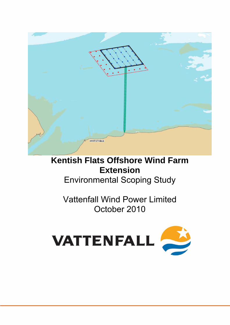
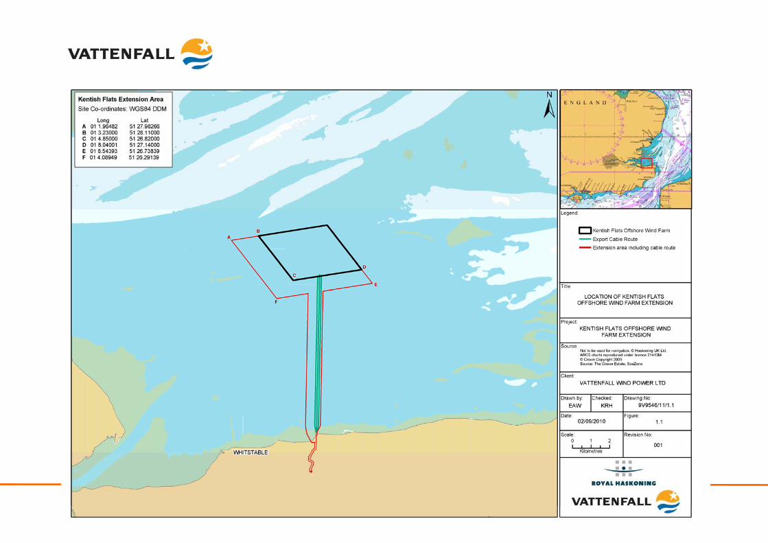
In July 2009, The Crown Estate invited Expressions of Interest (EOI) from companies wishing to extend constructed or consented Round 1 and Round 2 offshore wind farms. Following the submission of bid documents in December 2009, Vattenfall Wind Power Limited (Vattenfall) was subsequently awarded the rights in May 2010 to develop an extension to the Round 1 Kentish Flats Offshore Wind Farm (Kentish Flats), subject to the acquisition of necessary consents. The location of the proposed Kentish Flats Offshore Wind Farm Extension (Kentish Flats Extension) site is shown in Figure 1.1.
1.1.1 The Kentish Flats Offshore Wind Farm
Kentish Flats is a Round 1 offshore wind farm with an installed capacity of 90 megawatts (MW) and which has been fully operational since December 2005. The project is located on the southern side of the Outer Thames Estuary off the North Kent coast, approximately 8.6 kilometres (km) north of Herne Bay and 9.5km north of Whitstable. The electricity generated from the thirty 3.0MW wind turbine generators (WTG) at Kentish Flats is fed into the electricity network via an onshore substation at Herne Bay, for use in the local grid serving the needs of the communities of North Kent around Canterbury, Herne Bay and Whitstable. Higher than expected levels of maintenance on Kentish Flats meant availability levels for the WTG in the first three years of operation (2006, 87%; 2007, 73.5%; and 2008, 89.2%) were lower than expected. Despite this, the exported power in 2008 (263,139 megawatt hours (MWh)) was significantly higher than previous years, being 27% greater than 2007 (209,444MWh) and 16% more than 2006 (227,977MWh). The existing Kentish Flats project benefits from shallow water depths of around 5m below Chart Datum (CD) and a well understood environment (physical, biological and socio-economic), having been subject to detailed pre-construction surveys and assessments together with three years of post-construction monitoring. With Kentish Flats, Vattenfall has demonstrated an ability to develop and construct a wind farm at the site with an excellent wind resource, existing construction supply chain arrangements, an established Operations and Maintenance (O&M) base at Whitstable and excellent relationships with local stakeholders and other offshore wind farm developers in the Thames Estuary.
1.1.2 The Kentish Flats Extension site selection
The Kentish Flats Extension is located to the west and south of the existing wind farm (see Figure 1.1) in an area which has been specifically selected to mitigate potential effects on shipping and to avoid particularly sensitive ecological areas. To inform site selection, Vattenfall commissioned Royal Haskoning (Royal Haskoning, 2009) to undertake a thorough constraints assessment to investigate potential extension options. This study was influenced by The Crown Estate’s pre-requisites for Round 1 and 2 Extension Projects, namely:
Kentish Flats Offshore Wind Farm Extension 9V9546/01/R0001 Scoping report - 2 - October 2010
Kentish Flats Offshore Wind Farm Extension 9V9546/01/R0001 Scoping report - 3 - October 2010
• The proposed extension must share a substantial part of one or more
boundaries with the original site;
• No maximum size of extension is set, however, the scale of the extension should be appropriate for the scale of the original site;
• The extension proposal should demonstrate synergies with the original site (e.g. of construction, operation, improvement of economics and / or grid connectivity);
• No extension will be permitted to encroach within a radius less than 5km of any nearby Round One or Two sites, except with the express agreement of the tenant of the existing nearby site; and
• The proposed extension must not adversely affect delivery or operation of the original site or any neighbouring site.
The constraints assessment study included consideration of issues highlighted within the Offshore Energy Strategic Environmental Assessment (OSEA) (Department of Energy and Climate Change (DECC) formerly the Department for Trade and Industry (DTI), 2009a) such as proximity to shipping routes, physical environment, sensitive marine ecological features (marine benthos, fish, marine mammals and birds) and other aspects such as archaeology, offshore infrastructure, tourism and recreation, and commercial fisheries. It was further informed by the knowledge gained from having taken Kentish Flats through to operation. The Kentish Flats Extension site is also able to drawn upon the benefits associated with the existing cable landfall and grid infrastructure (namely, knowledge of the existing export corridor and suitable grid connection opportunity). It is acknowledged that coastal proximity also brings challenges in terms of potential visual impact issues and proximity to sites designated for their nature conservation interest. It is, however, Vattenfall’s belief that the Kentish Flats Extension takes into account the constraining factors in the region and is of a suitable scale and location which can be successfully developed within the context of The Crown Estates requirements, as well as Strategic Environmental Assessment (SEA) and Environmental Impact Assessment (EIA) considerations. The knowledge base developed during the realisation of Kentish Flats ensures that the Kentish Flats Extension is, above all, deliverable.
1.2 Alternatives
In accordance with The EIA Regulations (2009), specific consideration of alternative aspects of the proposed Kentish Flats Extension development (such as construction and / or operation technology types and design detail), as well as site layout options will be identified and addressed within the EIA as more detailed ongoing site specific studies and engineering investigations are completed prior to consent application. The Environmental Statement (ES – the principal reporting document of the EIA process) will contain a dedicated chapter detailing the main alternatives considered and include justification for any considered alternative options not being taken forward.
Kentish Flats Offshore Wind Farm Extension 9V9546/01/R0001 Scoping report - 4 - October 2010
Due to the nature of The Crown Estate’s pre-requisites (Section 1.1.2), alternative options for an extension to Kentish Flats were, however, limited; specifically any extension project was required to share boundaries, scale and synergies with the existing Kentish Flats project. The constraints assessment (Royal Haskoning, 2009) undertaken as part of The Crown Estate’s EOI, identified five potential extension areas, in which development was not immediately or obviously precluded (such as by, for example, built infrastructure, designated shipping lanes, etc.). These five potential development areas were then given further consideration with regard to remaining development considerations and were subject to consultation with a number of key consultees, these being:
• Port of London Authority (PLA);
• Natural England; and
• Canterbury City Council (CCC).
Based on this consultation, the site boundaries were refined and reduced, resulting in the preferred option that is now being taken forward as the Kentish Flats Extension (as detailed in Section 1.1.2). The five alternative (original) development areas were discounted on grounds of concerns raised through the consultation process (as detailed within the consultation responses in Section 1.3). The other option available to Vattenfall was to not progress the Kentish Flats Extension. However, given the need for the project (as described in Section 1.5) it was decided that as the Kentish Flats Extension was of an appropriate scale and location it should be pursued.
1.3 Consultation completed and proposed
In developing the scale and location of the Kentish Flats Extension and in preparing this scoping report, Vattenfall has already completed some limited consultation with key statutory bodies which is summarised in the section below.
1.3.1 Consultation completed
Given the nature of the project, (i.e. an extension to an existing development) Vattenfall recognise that clear and concise consultation from the outset will be fundamental in addressing any potential concerns that may arise. The consultation that will be undertaken for the Kentish Flats Extension will build upon the previous consultation undertaken as part of the EIA process for Kentish Flats. Consultation at an early stage of the EIA process allows potentially significant impacts to be identified and appropriately addressed in the EIA. Vattenfall have undertaken consultation with key stakeholders from the outset of the Kentish Flats Extension project. The focus of these consultations has been to:
• To introduce the proposals;
• To explain the nature of the proposals and answer any queries;
• To obtain existing information and data for the study area;
Kentish Flats Offshore Wind Farm Extension 9V9546/01/R0001 Scoping report - 5 - October 2010
• To obtain initial comments or concerns that stakeholders may have about the proposals; and
• To discuss and agree the proposed scope of the EIA investigations and requirements for the ES.
In evaluating the scale and location of the proposed Kentish Flats Extension, Vattenfall has focused consultation to date on the key statutory bodies with regard to the concerns expressed during the original development phase, together with an understanding derived from a thorough constraints mapping exercise (Royal Haskoning, 2009). In all cases, the results of the constraints mapping and the potential areas for extension were shown to the stakeholders and views sought on preferred areas and potential issues for development. A summary of key consultation completed to date is included below, with a more detailed record being provided in Appendix 1. Port of London Authority The potential for extension around the current site was discussed focusing on navigational issues. The PLA was strongly of the view that no extension to the north of the current site was possible and that the current separation from the Prince’s Channel must be maintained. The PLA had no significant concerns with extensions to the east and particularly the west. Similarly some slight extension to the south was considered feasible (but noting the use of the area by recreational craft and low volumes of commercial traffic). Natural England In general the options for extension were considered by Natural England to be proportionate to the existing site in scale. Visual impacts were discussed and Natural England noted that as an extension project of reasonable scale, this should be an issue of low significance. Natural England’s primary concern related to potential cumulative effects on red throated diver (and possibly other species) when considered with the other Thames wind farms (notably London Array). Natural England support the London Array population modelling approach which would be of use in determining effects from the Kentish Flats Extension. Effects on benthic habitats and marine mammals were considered to be of low significance by Natural England. Data needs were discussed in the light of existing data sets; Natural England suggested some limited additional ornithological (one summer season), benthic and geophysical data may be required. The approach to this scoping exercise was also discussed with Natural England, who was supportive of focusing the EIA on the key impacts arising from the development. Canterbury City Council CCC indicated during preliminary consultation that it would not expect great visual concerns given the scale of extension and the presence of the existing site. The positive local opinions for the existing project were noted – both amongst local populations and amongst CCC. A need to reassure the local fishing fleets was noted. Opportunities of local economic development opportunities were discussed in terms of local supply chain and research and development (R&D) initiatives.
Kentish Flats Offshore Wind Farm Extension 9V9546/01/R0001 Scoping report - 6 - October 2010
Maritime and Coastguard Agency The Maritime and Coastguard Agency (MCA) was approached for preliminary consultation on navigational issues with regard to the possible extensions; MCA decided not to engage at The Crown Estate bid stage, preferring to review successful sites with The Crown Estate prior to award.
1.3.2 Consultation proposed
In line with the requirements of the Planning Act, Vattenfall will undertake consultation with local communities and non-statutory interest groups (under s47 provisions) and with key statutory, relevant local authorities and landowner interests (s42 provisions). The s42 consultee list will be developed through discussions with the IPC and augmented by Vattenfall, where this is considered necessary. The s47 consultation list will be developed with the local authorities and through Vattenfall’s existing knowledge of the local area.
1.4 The scoping report
1.4.1 Objectives
This scoping report presents an initial review of the potential environmental issues associated with the construction, operation and eventual decommissioning of the Kentish Flats Extension, through a targeted scoping study. Vattenfall believes that an EIA for the Kentish Flats Extension must be adaptive and should take into account the lessons learnt on those Round 1 and 2 offshore wind farm projects that have gone through the consenting and construction processes already. As such, following early consultation with the statutory consultees, Vattenfall is submitting this scoping report as a formal request for a ‘scoping opinion’ (see Sections 1.6 and 1.7). This scoping report aims to identify the key issues for the Kentish Flats Extension project and sets out the proposed approach to addressing those issues through the EIA process and in developing the final ES in support of the application for consent.
1.4.2 Approach
The parameters considered within this scoping study may be summarised as follows: Offshore environment
• Overview of geology;
• Physical processes;
• Water quality;
• Nature conservation designations;
• Ornithology;
• Benthic and intertidal ecology;
Kentish Flats Offshore Wind Farm Extension 9V9546/01/R0001 Scoping report - 7 - October 2010
• Marine mammals;
• Natural fish and shellfish resource;
• Commercial fisheries;
• Landscape, seascape and visual character;
• Shipping and navigation (including navigational radar);
• Marine archaeology;
• Aviation radar systems;
• Ministry of Defence interests;
• Unexploded ordnance; and
• Other human activities (oil and gas, aggregate extraction, etc.).
Onshore environment
• Geology, groundwater and land quality;
• Ornithology;
• Terrestrial habitats and species;
• Archaeology;
• Traffic and access;
• Noise, dust and air quality;
• Landscape and visual character; and
• Socio-economics (Including tourism and recreation).
The identification (and evaluation) of the potential for significant impacts throughout this scoping report is based upon a review of the extensive existing data for the Kentish Flats area. From this, Vattenfall is able to understand the likely environmental impacts of the Kentish Flats Extension, in a manner not possible on previously undeveloped sites. This includes understanding how sensitive local receptors are actually impacted by the construction and operation phases of wind farm development and therefore, allows a much greater degree of confidence in the predictions of effects and the success of recommended mitigation. As a result of this significant background knowledge that not only encompasses what the environment comprises, but how it reacts to developments such as an offshore wind farm, it is expected that sufficient data and detail will already be held for a number of parameters and sensitivities. As such, extensive new research or data collection is not required for all receptors on the basis that the work already undertaken for Kentish Flats remains appropriate in area coverage, age and quality to assess the likely significant impacts. Where further survey work or detailed primary assessment is considered necessary, Vattenfall is proposing a level of work proportionate to the scale of the Kentish Flats Extension and sufficient to identify the scope of any significant impacts and develop suitable mitigation.
Kentish Flats Offshore Wind Farm Extension 9V9546/01/R0001 Scoping report - 8 - October 2010
Each section also contains a list of “key considerations” for each EIA topic, with it being intended that these are the impacts which will either require:
• The collection of new data;
• Detailed assessment through site specific studies; or
• Detailed analysis of existing data sets to determine any potential impacts and their magnitudes.
Also contained within each section is a list of what are termed, for the purposes of this scoping exercise, “secondary considerations”, which will be considered as part of the EIA, but which will not require primary data collection or site specific studies, but by which the potential impacts will be determined through desk-based study using the existing knowledge and data from Kentish Flats. This approach is accepted within the industry and is considered good practise. This approach correlates well with the Institute of Environmental Management and Assessment (IEMA) which states (IEMA, 2010): “Scoping is the process of identifying the issues to be addressed by an EIA. It is a method of ensuring that an EIA focuses on the important issues and avoids those which are considered to be less significant.”
1.4.3 Structure of report
The structure of this report will be based around the parameters listed above (Section 1.4.2), with each section presenting:
• A description of the baseline environment;
• Identified key issues resulting from the construction, operation and decommissioning of the Kentish Flats Extension; and
• Approach to EIA.
Reference is made throughout to the knowledge acquired from the development of the existing Kentish Flats project (i.e. from the EIA and subsequent monitoring studies) with the proposed approach to the EIA of the Kentish Flats Extension project being set out in each case. In developing this scoping report, due regard has been given to the guidance provided by the IPC in Advice Note 7 – Environmental Impact Assessment: screening and scoping (IPC, 2010).
1.5 Need for the project
The Kyoto Protocol is an international agreement which sets targets for industrialised countries to cut their greenhouse gas emissions. The protocol was agreed in 1997, based on principles set out in a framework convention signed in 1992. It came into effect in 2005, following ratification by Russia. The European Union’s (EU) overall
Kentish Flats Offshore Wind Farm Extension 9V9546/01/R0001 Scoping report - 9 - October 2010
emission target under the Kyoto Protocol is a reduction of greenhouse gas emissions to 8% below 1990 levels by the commitment period of 2008 – 2012. In line with the Kyoto Protocol, signatory states, including the UK, have developed national targets for energy generation from renewable sources. In Europe, following the European Commission Green Paper (2006) on ’A European strategy for sustainable, competitive and secure energy‘, the European Commission proposed an ‘Energy Policy for Europe’ (European Commission, 2007) as a first resolute step towards becoming a low energy economy. European energy policy recognises that the use of renewable energy undeniably contributes to limiting climate change and plays a part in securing energy supply and creating employment in Europe. European Council (EC) Directive 2009/28/EC ‘on the promotion of the use of energy from renewable sources’ (EC, 2009) agreed a binding target for 20% of overall EU energy consumption to be fed by renewable energies by 2020 through the Renewables Obligation (RO). The UK has a major role to play in meeting these targets as it has (amongst other sources) approximately 33% of the total EU wind resource (Risø National Laboratory, 1989), which is central to the Government’s objectives to secure a diverse energy supply, while reducing carbon emissions by 60% of 1990 levels by 2050. Part of this goal is to be achieved through renewable sources, with a target having been set to provide 15% of the UK’s electricity from renewable sources by 2020. The need for offshore wind farm development is underpinned within the draft National Policy Statement (NPS) for Renewable Energy Infrastructure (EN-3) and the Overarching NPS for Energy (EN-1), which concluded that there is a significant need for major energy generation infrastructure. This energy generation infrastructure would be required to be provided through projects with a short lead-in times, as opposed to infrastructure such as nuclear power stations, which typically have a much longer development period (DECC, 2009a). Several drivers for additional infrastructure were identified, including a requirement to move to a low-carbon energy mix; a need to ensure security of supply; a need to ensure that existing capacity scheduled to close could be replaced; and the ability to ensure that changes in demand could be met (DECC, 2009a). The commitment by the Government to extensions of existing offshore wind farms in assisting to achieve the UK’s carbon reduction targets is set out in Section 2.6.16 of the draft NPS (EN-3) where it is stated that: “…the Government has decided that, in line with Recommendation 6 of the Post Consultation Report (PCR), there is potential for capacity extensions to existing wind farm leases within UK waters..” However, it goes on to note that the extension programme should be subject to careful site-specific evaluation through the planning process and in line with the Government’s OSEA (DECC, 2009a). Having undertaken a detailed feasibility and constraints mapping exercise (Royal Haskoning, 2009), Vattenfall believes that the Kentish Flats Extension has a role to play in meeting the renewable targets, as they are unlikely to be reached without contributions from extensions to existing wind farms and is confident that the Kentish Flats Extension will help to provide a sustainable supply of energy to the UK market.
Kentish Flats Offshore Wind Farm Extension 9V9546/01/R0001 Scoping report - 10 - October 2010
1.6 Legislative context
The Planning Act 2008 has been established in order to provide a streamlined, faster and fairer development consent system for nationally significant infrastructure projects (NSIP). The Act made provision for the creation of an independent body, the Infrastructure Planning Commission (IPC), which is responsible for examining applications for development consent for NSIPs. Under the provisions of the Planning Act, all new offshore renewable energy generation developments over 100MW (including projects where an existing development is extended, increasing the cumulative capacity to over 100MW) require a single consent, known as the Development Consent Order (DCO) from the IPC, which replaces the previous multiple consent requirements for the construction and operation of an offshore wind farm1. Therefore, whilst the Kentish Flats Extension project has a maximum target capacity of 51MW (as detailed in Section 2.2.1), the cumulative capacity when combined with the existing project (90MW) will be in excess of 100MW and consequently is considered an NSIP under The Planning Act 2008.
1.7 EIA process
The EIA will be carried out in accordance with The Infrastructure Planning (Environmental Impact Assessment) Regulations 2009 (2009/2263), in particular Schedule 4 which sets out the information for inclusion within the ES. Furthermore, the approach to the EIA and the production of the resulting ES document will closely follow relevant guidance including:
• The Planning Act 2008 guidance on consenting a project under the new planning regime (IPC, 2009);
• Guidance Note ‘Offshore Wind farm Consents Process’ (DTI, 2004a); and
• Guidance note for Environmental Impact Assessment in respect of Food and Environment Act (1985) (FEPA) and Coastal Protection Act 1949 (CPA) requirements (Cefas, 2004b); and
• Draft Overarching National Policy Statements for Energy EN-1, Renewable Energy Infrastructure EN-3, and Electricity Networks Infrastructure EN-5.
It will also give due regard to The Conservation of Habitats and Species Regulations 2010, The Offshore Marine Conservation (Natural Habitats, &c.) (Amendment) Regulations 2010 and the Marine and Coastal Access Act 2009.
1 The existing Kentish Flats project required consent under section 36 of the Electricity Act 1989, FEPA and CPA consents for the offshore works and Town & Country Planning Act consent for the onshore works.
Kentish Flats Offshore Wind Farm Extension 9V9546/01/R0001 Scoping report - 11 - October 2010
1.7.1 Approach to EIA
Characterisation of the existing environment As discussed in Section 1.4.2, the characterisation of the existing environment will be established through the collation of data from a number of sources including the collection of new data acquired through dedicated survey work, detailed assessment through site-specific studies or detailed analysis of existing data. Vattenfall has amassed a significant amount of existing data from a number of sources including:
• Data acquisition and subsequent EIA process undertaken for the original ES;
• Post consent work on the section 36 (s36) and other consents; and
• Ongoing FEPA and CPA monitoring of the effects of the development.
Vattenfall therefore believes that there is an excellent level of information to aid in the characterisation of the existing environment. The specific approach to establishing a robust baseline (upon which impacts can be assessed) is set out under each parameter within this scoping report. Furthermore, it is envisaged that this approach will be subject to review following the receipt of the scoping opinion from the IPC and subsequent consultation with statutory bodies. It is also recognised that this approach may evolve over time with the collection of new data from the study area and as the design of the project advances. Assessment of impacts This existing knowledge held for the site, combined with the relatively small scale of the Kentish Flats Extension, enables Vattenfall to have a high degree of confidence with regards to those parameters where significant effects may be likely to occur. The approach to EIA for the various parameters established in this scoping report is therefore able to be focused on those potential impacts that are considered ‘likely to be significant’. This approach is in accordance with paragraphs 19, 20, 21 and 25 of Schedule 4 of the EIA Regulations (2009). Impact identification and evaluation will be informed through a number of methods and techniques, including:
• Data collation and literature review;
• Consultation;
• Reference to relevant guidance, policy and standards;
• Original data collection and analysis;
• Other forms of qualitative and quantitative assessment; and
• The application of previous experience and knowledge of similar schemes.
In order to predict the significance of an impact it is fundamental to establish the magnitude and probability of impact occurring through a consideration of:
• Spatial extent (small scale to large scale);
Kentish Flats Offshore Wind Farm Extension 9V9546/01/R0001 Scoping report - 12 - October 2010
• Duration (short term to long term);
• Sensitivity and level of tolerance of the species or receptor;
• Conservation or protected status;
• The margins by which set values are exceeded (e.g. noise or dust standards);
• Reversibility of the impact (including recoverability); and
• Confidence in the impact prediction.
Subsequent to establishing the magnitude and probability of an impact, the significance will be predicted by using quantitative criteria where available to ensure a robust assessment. Table 1.1 provides an indication of the definitions that Vattenfall proposes to be used in the assessment process for the majority of parameters. Table 1.1 Terminology for definition of impact significance
Impact significance Definition of significance
No impact There is an absence of one or more of the following: an impact source, a pathway or a receptor
Negligible The impact is assessed as not being of concern
Minor adverse The impact is undesirable but assessed as being of limited concern
Moderate adverse The impact gives rise to some concern, but is assessed as being tolerable (dependent upon the scale and duration of the impact)
Major adverse The impact gives rise to serious concern and therefore should be considered as unacceptable
Minor beneficial The impact is of minor significance, but has been assessed as having some environmental benefit
Moderate beneficial The impact is assessed as providing a moderate gain to the environment
Major beneficial The impact is assessed as providing a significant positive gain to the environment
A description of the approach to impact assessment and the interpretation of significance levels will be provided within each section of the ES. This approach will ensure that the definition of impacts is transparent and relevant to each parameter under consideration. The assessment of impacts will follow an iterative approach, where cumulative effects will be assessed by comparing the impact of the Kentish Flats Extension with Kentish Flats (an additive approach), before comparing the combined impacts of the Kentish Flats Extension and Kentish Flats cumulatively and in-combination with other offshore wind farms or infrastructure projects. Mitigation Where impact assessment identifies that an aspect of the development is likely to give rise to significant environmental impacts, mitigation measures will be proposed to avoid, reduce and if possible, enhance them
Kentish Flats Offshore Wind Farm Extension 9V9546/01/R0001 Scoping report - 13 - October 2010
Vattenfall will only put forward mitigation where they are able to make a firm commitment on the suitability and ability to implement the mitigation measure. Detail will be provided within the ES as to how Vattenfall will deliver the mitigation measure and justification given to the assumptions made on its effectiveness. Furthermore, due consideration will be given to ensuring that mitigation measures are not developed in isolation as they may benefit more than one topic area.
1.7.2 Structure of the ES
The EIA Regulations (2009) Schedule 4, Parts 1 and 2, established what information requires inclusion within an ES and Vattenfall will therefore give due consideration to this when preparing the ES for the Kentish Flats Extension. In addition, IPC (2010) suggests that scoping reports should provide an outline of the structure of the ES and this is therefore accordingly established below: Introduction and project details
• Non-technical summary;
• Glossary of terms;
• Introduction;
• Need for the project;
• Legislative context;
• EIA process;
• Consenting regime;
• Consultation; and
• Project definition (including assessment of alternatives).
Offshore environment
• Geology;
• Physical processes;
• Water quality;
• Nature conservation designations;
• Ornithology;
• Benthic and intertidal ecology;
• Marine mammals;
• Natural fish and shellfish resource;
• Commercial fisheries;
• Landscape, seascape and visual character;
• Shipping and navigation (including navigational radar);
• Marine archaeology;
• Aviation radar;
Kentish Flats Offshore Wind Farm Extension 9V9546/01/R0001 Scoping report - 14 - October 2010
• Ministry of Defence;
• Unexploded ordinance; and
• Other human activities.
Onshore environment
• Geology, groundwater and water quality;
• Ornithology;
• Terrestrial habitats and species;
• Archaeology and cultural heritage;
• Traffic and access;
• Noise, dust and air quality; and
• Socio-economics (including tourism and recreation).
Conclusion
• Information to support appropriate assessment;
• Cumulative impact assessment;
• Outline environmental management and monitoring plan;
• Summary; and
• References.
1.7.3 Cumulative Impact Assessment
Cumulative impact assessment (CIA) forms part of the EIA process. For the Kentish Flats Extension project the CIA will consider the effects of the construction, operation and decommissioning of the project with other offshore wind farm projects as well as other plans and projects that have the potential to impact on the same receptors. The scope of the CIA (in terms of relevant issues and projects) will be established with consultees as the EIA progresses. Vattenfall is part of the Thames Estuary Developers Group (TEDG), in their role as operators of Kentish Flats. Vattenfall, therefore, has a good knowledge of the cumulative concerns within the region and will bring the knowledge gained through this Forum to help inform the CIA for the Kentish Flats Extension. Within each section of this scoping report, Vattenfall has provided an informed opinion on the key cumulative considerations that are believed to require inclusion within the assessment.
Kentish Flats Offshore Wind Farm Extension 9V9546/01/R0001 Scoping report - 15 - October 2010
1.7.4 Habitat Regulations Assessment
Under The Conservation of Habitats and Species Regulations 20102 (the ‘Habitats and Species Regulations’) the Competent Authority (at the time of writing the IPC) must consider whether a plan or project has the potential to have an adverse effect on the integrity and features of a European site3 (including candidate and proposed sites). This process is known as Habitat Regulations Assessment (HRA). The requirement for “appropriate assessment” (stage two of the HRA – see below) arises from EC Directive 92/43/EEC on the Conservation of natural habitats and of wild fauna and flora (known as the Habitats Directive) and its implementation in the UK under the Habitats and Species Regulations. Under Regulation 61 of the Habitats and Species Regulations, appropriate assessment is required for a plan or project, which either alone or in combination with other plans or projects, is likely to have a significant effect on a European site and is not directly connected with or necessary for the management of the site. The HRA is a three stage process:
• Stage one: screening, where likely impacts upon a European site, either alone or in combination with other projects or plans, are considered and any potential for significant impact identified (also known as the test of likely significant effect (LSE));
• Stage two: the “appropriate assessment”, where assessment of the impacts of the plan or project is undertaken against the conservation objectives of the site, in order to identify whether there are likely to be any adverse effects on site integrity and site features. Where significant negative effects are identified at the appropriate assessment stage alternative options should be examined to avoid any potential damaging effects to the integrity of the site; and
• Stage three: where adverse impacts persist following stage two, consideration is given to compensatory measures, or if this is not feasible then an assessment of Imperative Reasons of Overriding Public Interest (IROPI) must be made for the plan or project.
The requirement for an appropriate assessment (HRA stage two – see Section 9.1.1) will be determined by the Competent Authority (at the time of writing the IPC), following assessment of the information presented in the ES and other application documents in accordance with Regulation 5 (2) (g) of the Infrastructure Planning (Applications: Prescribed Forms and Procedure) Regulations 2009 (APFP) and, also IPC Guidance Note 2 on preparation of application documents under section 37 (s37) of The Planning Act 2008 within a discrete Chapter in the ES.
2 The Conservation of Habitats and Species Regulations 2010 consolidate all the various amendments made to the Conservation (Natural Habitats, &c.) Regulations 1994 in respect of England and Wales. The 1994 Regulations transposed Council Directive 92/43/EEC on the conservation of natural habitats and of wild fauna and flora (EC Habitats Directive) into national law. 3 A European site is defined as being either a Special Area of Conservation (SAC) or a Special Protection Area (SPA). Government policy as outlined in the addendum to Planning Policy Statement 9 (PPS 9) (Department of Communities and Local Government (DCLG), 2005) is that wetlands of international importance, designated under the Ramsar Convention (Ramsar sites), should also be subject to the provisions of the Conservation of Habitats and Species Regulations.
Kentish Flats Offshore Wind Farm Extension 9V9546/01/R0001 Scoping report - 16 - October 2010
European sites of particular relevance to this project are the Outer Thames Special Protection Area (SPA), Thanet Coast and Sandwich Bay SPA and the Margate and Long Sands candidate Special Area of Conservation (cSAC).
1.8 Consenting regime
The Planning Act has transformed the arrangements for obtaining development consent for NSIP, with the IPC (or Secretary of State in certain situations) acting as the Competent Authority. Subsequent to the 2010 general election, the Coalition Government has confirmed its intention to abolish the IPC with all planning applications for NSIP (such as offshore wind farms) now being considered by a new unit to be formed within the Planning Inspectorate. Under the plans announced by the Department of Communities and Local Government (DCLG), NSIP will be considered by this new ‘Major Infrastructure Planning Unit' with the final decision made by the relevant Secretary of State. Primary legislation is required to amend the Planning Act and to abolish the IPC, with this expected to occur by autumn 2011. The Major Infrastructure Planning Unit will be established in the Planning Inspectorate to continue fast-tracking major infrastructure projects like offshore wind farms and nuclear power stations. Ministers will take decisions on applications within the same statutory fast-track timeframe as the current regime. In the interim, the IPC will continue to accept applications and (where a relevant NPS is in place) take decisions on those applications. Transitional arrangements to allow projects submitted to the IPC to be decided subsequent to any amendment to the Act are expected to be put in place. With regard to the NPS, the Coalition Government also confirmed that these will now have to be ratified by Parliament, to ensure the statements and the decisions based on them, are as "robust" as possible and that the risk of judicial review is reduced. Despite ratification now being required, it is the Government’s stated intention that the NPS are in place “as rapidly as possible.”
1.8.1 The Development Consent Order
Under The Planning Act 2008, consent is sought through the submission of a Development Consent Order (DCO), supported by a number of associated statutory documents, of which the ES is one component. The full list of supporting statutory documentation is set out in Regulation 5 of the APFP. Vattenfall intends to apply for the following consents:
• DCO to cover all offshore and onshore works; and
• The Kentish Flats Extension will also require a PLA works licence, as the Kentish Flats Extension lies within the PLA area This will be a separate application to the PLA in parallel with the DCO application process.
Due to the Kentish Flats Extension’s project timeline (Section 2.2.5) it is likely that the DCO application will be made to the IPC, although the consent may ultimately be awarded by the Secretary of State following recommendation made by the Major
Kentish Flats Offshore Wind Farm Extension 9V9546/01/R0001 Scoping report - 17 - October 2010
Infrastructure Planning Unit. Despite this, the main process for developing and making an application for a DCO under the requirements of the Planning Act remains intact with regard to the need to carry out pre-application consultation and to develop the relevant application documents.
1.8.2 The pre-application consultation process
This scoping report focuses on the work that will be undertaken by Vattenfall to inform the EIA for the Kentish Flats Extension. Separate from the scopjng process, the Planning Act requires applicants to undertake extensive pre-application consultation under the provisions of section 42 (s42), section 47 (s47) and section 48 (s48). These three strands of pre-application consultation under the IPC regime are as follows:
• s47 – Community consultation: The process for this will be established through a Statement of Community Consultation (SoCC) that will be developed with local authorities, including the MMO for the offshore community and primarily Canterbury City Council and Kent County Council (KCC) for the onshore communities;
• s42 – Statutory consultees, local authorities and landowners: Vattenfall intend to undertake both ‘informal’ early discussions with key bodies to evaluate technical issues and concerns followed by the statutory s42 consultation ; and
• s48 – Public notification: The requirement for formal newspaper public notices (under s48). The s48 notices require a deadline for comments of at least 28 days from the day after the last notice. It is currently Vattenfall’s intention to complete Section 48 notification in parallel with the main community consultation (s47) in order to ensure the most effective approach to consultation is adopted (in accordance with DCLG and IPC guidance). The s48 notice will also be sent to the Section 42 consultees – a requirement under Regulation 11 of the EIA Regulations.
1.9 Pre-application consultation summary
The new requirements for pre-application consultation are a vital aspect of the new regime. It is hoped that the early involvement of local communities, local authorities, land interests and statutory consultees at this early stage can bring about significant benefits for all parties. This involvement will allow stakeholders to:
• Influence the way the project is developed;
• Understand better what a particular project means for them, so that concerns resulting from misunderstandings are resolved early on in the project life cycle;
• Obtain important information relating to the EIA parameters, thus helping promoters identify project options;
• Enable mitigation measures to be considered and, in some cases, built into the project before an application is submitted; and
Kentish Flats Offshore Wind Farm Extension 9V9546/01/R0001 Scoping report - 18 - October 2010
• Identify ways in which the project could, without significant costs to the promoter, support wider strategic or local objectives.
Kentish Flats Offshore Wind Farm Extension 9V9546/01/R0001 Scoping report - 19 - October 2010
PROJECT DETAILS 2 PROJECT DETAILS
This section briefly sets out the details of Kentish Flats as well as providing the preliminary project description of the Kentish Flats Extension. Information on Kentish Flats is provided for context and will not form part of the application for the DCO, which will be limited to the Kentish Flats Extension only. Specifically, this section sets out a preliminary description of the likely location, design and dimensions of the following key components:
• Turbines;
• Foundations;
• Offshore cabling;
• Installation process;
• Onshore cabling; and
• Onshore substation.
The information provided here is intended to be detailed enough to undertake the scoping process and to provide sufficient detail to allow stakeholders to comment on the proposed scope of the EIA. The final design of the Kentish Flats Extension will be described in greater detail, following further work, during the pre-application phase with the final project design set out in detail in the application for the DCO and the accompanying application documents (including the project ES). It is Vattenfall’s intention that the Kentish Flats Extension application will be made along the same lines as Kentish Flats, whereby the key components used are similar to those already installed at the existing Kentish Flats project. Should detailed technical studies show that the current approach is not feasible, then Vattenfall shall consult the appropriate regulatory authorities at the earliest possible opportunity to determine the best approach to assessing the potential for impacts from other techniques or structures. This approach of installing structures similar to those already installed at the adjacent site allows this scoping report to have a high degree of confidence in assessing likely impacts arising from the Kentish Flats Extension.
2.1 Overview of the existing Kentish Flats project
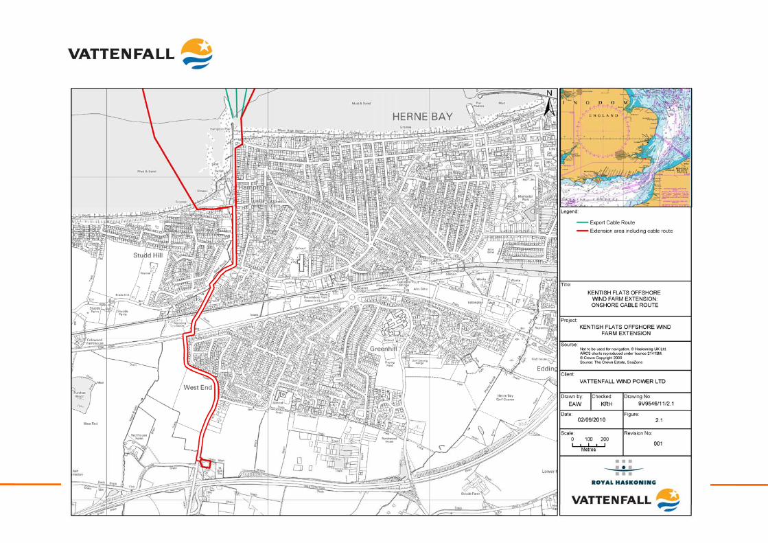
Kentish Flats is located on the southern side of the Outer Thames Estuary, offshore of the North Kent coast and approximately 8.6km north of Herne Bay and 9.5km north of Whitstable (see Figure 1.1) covering an area of approximately 10km2. Kentish Flats (see Plate 2.1) consists of thirty 3.0MW Vestas V90 offshore WTG, with buried subsea inter-array cabling and three buried subsea export cables which transmit the power generated by the turbines to landfall at Hampton Pier, just west of Herne Bay. Buried onshore cables then carry the electricity to the onshore substation located just south of Herne Bay, a distance of approximately 2km (Figure 2.1). An offshore meteorological monitoring mast is also installed at the south-west corner of the array (originally installed in 2003 to collect site specific met data).
Kentish Flats Offshore Wind Farm Extension 9V9546/01/R0001 Scoping report - 20 - October 2010
Kentish Flats Offshore Wind Farm Extension 9V9546/01/R0001 Scoping report - 21 - October 2010
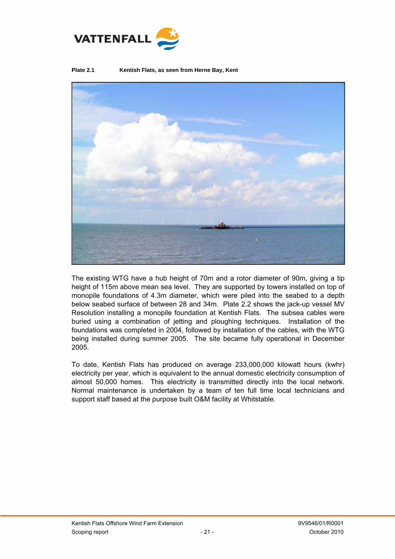
Plate 2.1 Kentish Flats, as seen from Herne Bay, Kent
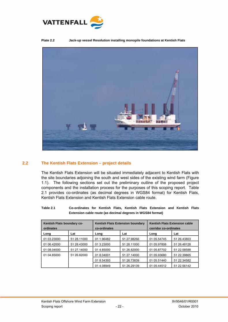
The existing WTG have a hub height of 70m and a rotor diameter of 90m, giving a tip height of 115m above mean sea level. They are supported by towers installed on top of monopile foundations of 4.3m diameter, which were piled into the seabed to a depth below seabed surface of between 28 and 34m. Plate 2.2 shows the jack-up vessel MV Resolution installing a monopile foundation at Kentish Flats. The subsea cables were buried using a combination of jetting and ploughing techniques. Installation of the foundations was completed in 2004, followed by installation of the cables, with the WTG being installed during summer 2005. The site became fully operational in December 2005. To date, Kentish Flats has produced on average 233,000,000 kilowatt hours (kwhr) electricity per year, which is equivalent to the annual domestic electricity consumption of almost 50,000 homes. This electricity is transmitted directly into the local network. Normal maintenance is undertaken by a team of ten full time local technicians and support staff based at the purpose built O&M facility at Whitstable.
Kentish Flats Offshore Wind Farm Extension 9V9546/01/R0001 Scoping report - 22 - October 2010
Plate 2.2 Jack-up vessel Resolution installing monopile foundations at Kentish Flats
2.2 The Kentish Flats Extension – project details
The Kentish Flats Extension will be situated immediately adjacent to Kentish Flats with the site boundaries adjoining the south and west sides of the existing wind farm (Figure 1.1). The following sections set out the preliminary outline of the proposed project components and the installation process for the purposes of this scoping report. Table 2.1 provides co-ordinates (as decimal degrees in WGS84 format) for Kentish Flats, Kentish Flats Extension and Kentish Flats Extension cable route. Table 2.1 Co-ordinates for Kentish Flats, Kentish Flats Extension and Kentish Flats
Extension cable route (as decimal degrees in WGS84 format)
Kentish Flats boundary co-ordinates
Kentish Flats Extension boundary co-ordinates
Kentish Flats Extension cable corridor co-ordinates
Long Lat Long Lat Long Lat
01 03.23000 51 28.11000 01 1.96482 51 27.98266 01 05.54745 51 26.43803
01 06.42000 51 28.43000 01 3.23000 51 28.11000 01 05.97808 51 26.48128
01 08.04000 51 27.14000 01 4.85000 51 26.82000 01 05.87702 51 22.58588
01 8.04001 51 27.14000 01 05.93680 51 22.39865
01 8.54393 51 26.73839 01 05.51440 51 22.34582
01 04.85000 51 26.82000
01 4.08949 51 26.29139 01 05.44512 51 22.56142
Kentish Flats Offshore Wind Farm Extension 9V9546/01/R0001 Scoping report - 23 - October 2010
2.2.1 Offshore Components
A summary of the key offshore project characteristics for the Kentish Flats Extension is provided below in Table 2.1. Table 2.1 Summary of the key project characteristics
Key project characteristics
Maximum Kentish Flats Extension capacity Up to 51MW
Maximum number of proposed turbines Up to 17
Kentish Flats Extension area Circa 7.77km²
Minimum distance from Kentish Flats Extension to
shore Approximately 7.8km
Indicative proposed turbine capacity Under evaluation, but likely to be of a 3MW class (circa 3
to 4MW)
Maximum turbine rotor diameter 115m
Maximum hub height 80m
Maximum tip height 135m
Minimum clearance above sea level 22m above mean high water springs level (MHWS)
700m within rows Indicative minimum separation between turbines
700m between rows
Average water depth over wind farm site Approximately 3 to 5m Chart Datum (CD)
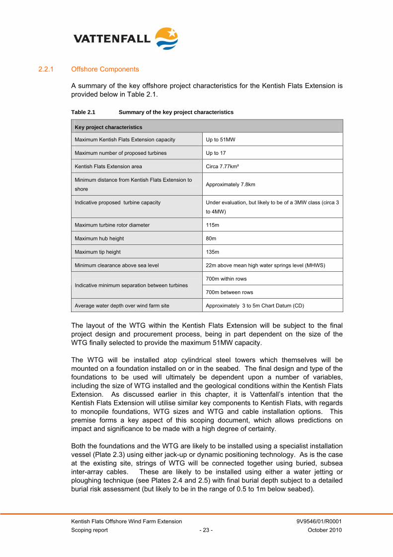
The layout of the WTG within the Kentish Flats Extension will be subject to the final project design and procurement process, being in part dependent on the size of the WTG finally selected to provide the maximum 51MW capacity. The WTG will be installed atop cylindrical steel towers which themselves will be mounted on a foundation installed on or in the seabed. The final design and type of the foundations to be used will ultimately be dependent upon a number of variables, including the size of WTG installed and the geological conditions within the Kentish Flats Extension. As discussed earlier in this chapter, it is Vattenfall’s intention that the Kentish Flats Extension will utilise similar key components to Kentish Flats, with regards to monopile foundations, WTG sizes and WTG and cable installation options. This premise forms a key aspect of this scoping document, which allows predictions on impact and significance to be made with a high degree of certainty. Both the foundations and the WTG are likely to be installed using a specialist installation vessel (Plate 2.3) using either jack-up or dynamic positioning technology. As is the case at the existing site, strings of WTG will be connected together using buried, subsea inter-array cables. These are likely to be installed using either a water jetting or ploughing technique (see Plates 2.4 and 2.5) with final burial depth subject to a detailed burial risk assessment (but likely to be in the range of 0.5 to 1m below seabed).
Kentish Flats Offshore Wind Farm Extension 9V9546/01/R0001 Scoping report - 24 - October 2010
Plate 2.3 Monopile foundations being installed at Kentish Flats by the jack up vessel Resolution
The export cable(s) will run from one of the new WTG and parallel to the existing export cables (Figure 2.1), to the cable landfall point at or adjacent to Hampton Pier, as is the case for Kentish Flats. Again water jetting or ploughing will be used for the export cable installation. All cables will be installed by a specialist cable laying vessel or barge with suitable dynamic positioning or anchor spreads to facilitate positioning, and using specialist subsea cable laying equipment. Although subject to the final project design (WTG number, spacing, etc.) it is currently estimated that approximately 12km of inter-array cables could be required with the export cable(s) likely to be up to 10km in length. The size of the Kentish Flats Extension and the connection to the local distribution network means that the cable(s) will operate at a voltage of 33kV with no requirement for an offshore substation. No additional meteorological monitoring equipment is required for the Kentish Flats Extension, as this will be provided by the existing infrastructure. Once operational, all of the structures installed would be marked according to the requirements of the Civil Aviation Authority (CAA) (aviation lighting) and Trinity House Lighthouse Service (THLS) (marine navigation) as well as being clearly marked with unique identification markers (compliant with the guidelines set out by the MCA).
Kentish Flats Offshore Wind Farm Extension 9V9546/01/R0001 Scoping report - 25 - October 2010
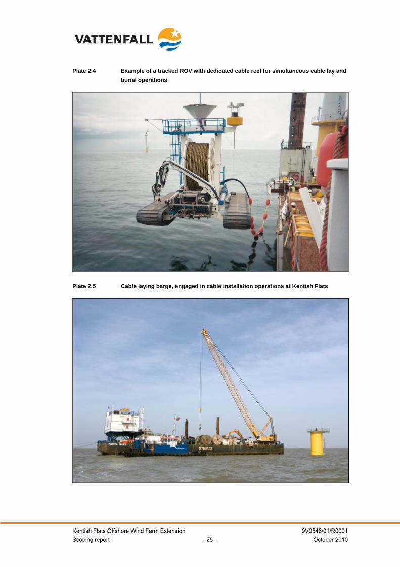
Plate 2.4 Example of a tracked ROV with dedicated cable reel for simultaneous cable lay and burial operations
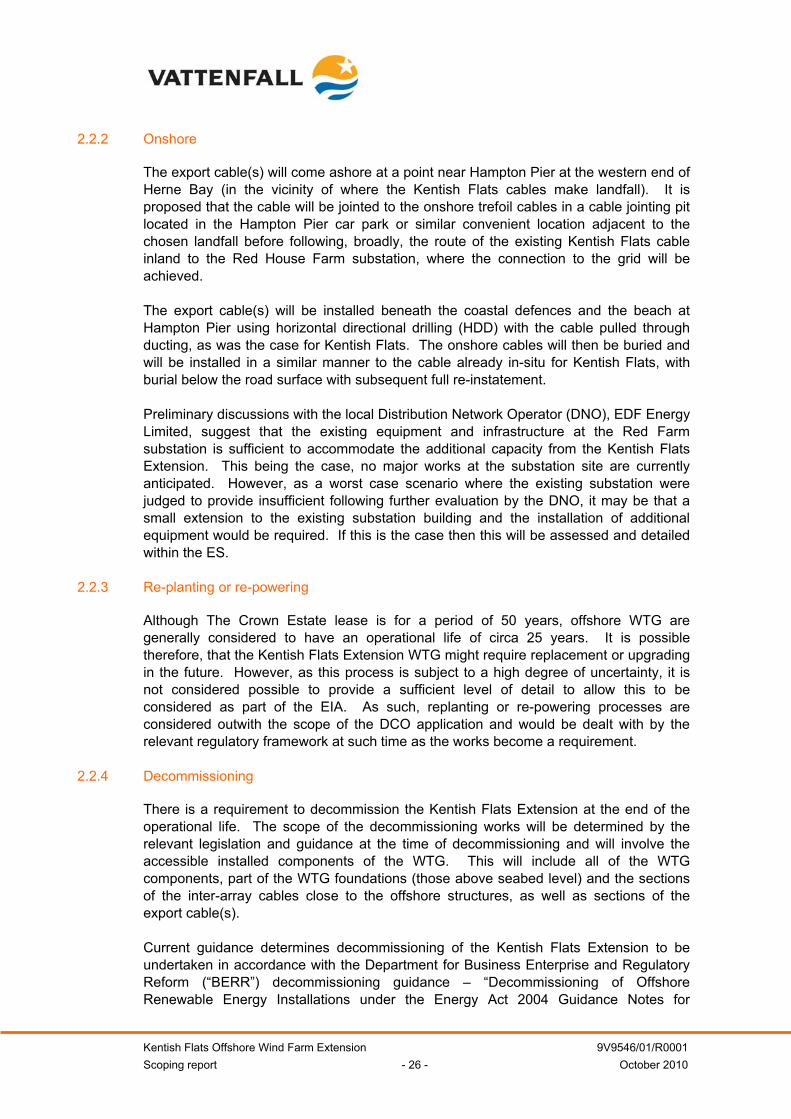
Plate 2.5 Cable laying barge, engaged in cable installation operations at Kentish Flats
Kentish Flats Offshore Wind Farm Extension 9V9546/01/R0001 Scoping report - 26 - October 2010
2.2.2 Onshore
The export cable(s) will come ashore at a point near Hampton Pier at the western end of Herne Bay (in the vicinity of where the Kentish Flats cables make landfall). It is proposed that the cable will be jointed to the onshore trefoil cables in a cable jointing pit located in the Hampton Pier car park or similar convenient location adjacent to the chosen landfall before following, broadly, the route of the existing Kentish Flats cable inland to the Red House Farm substation, where the connection to the grid will be achieved. The export cable(s) will be installed beneath the coastal defences and the beach at Hampton Pier using horizontal directional drilling (HDD) with the cable pulled through ducting, as was the case for Kentish Flats. The onshore cables will then be buried and will be installed in a similar manner to the cable already in-situ for Kentish Flats, with burial below the road surface with subsequent full re-instatement. Preliminary discussions with the local Distribution Network Operator (DNO), EDF Energy Limited, suggest that the existing equipment and infrastructure at the Red Farm substation is sufficient to accommodate the additional capacity from the Kentish Flats Extension. This being the case, no major works at the substation site are currently anticipated. However, as a worst case scenario where the existing substation were judged to provide insufficient following further evaluation by the DNO, it may be that a small extension to the existing substation building and the installation of additional equipment would be required. If this is the case then this will be assessed and detailed within the ES.
2.2.3 Re-planting or re-powering
Although The Crown Estate lease is for a period of 50 years, offshore WTG are generally considered to have an operational life of circa 25 years. It is possible therefore, that the Kentish Flats Extension WTG might require replacement or upgrading in the future. However, as this process is subject to a high degree of uncertainty, it is not considered possible to provide a sufficient level of detail to allow this to be considered as part of the EIA. As such, replanting or re-powering processes are considered outwith the scope of the DCO application and would be dealt with by the relevant regulatory framework at such time as the works become a requirement.
2.2.4 Decommissioning
There is a requirement to decommission the Kentish Flats Extension at the end of the operational life. The scope of the decommissioning works will be determined by the relevant legislation and guidance at the time of decommissioning and will involve the accessible installed components of the WTG. This will include all of the WTG components, part of the WTG foundations (those above seabed level) and the sections of the inter-array cables close to the offshore structures, as well as sections of the export cable(s). Current guidance determines decommissioning of the Kentish Flats Extension to be undertaken in accordance with the Department for Business Enterprise and Regulatory Reform (“BERR”) decommissioning guidance – “Decommissioning of Offshore Renewable Energy Installations under the Energy Act 2004 Guidance Notes for
Kentish Flats Offshore Wind Farm Extension 9V9546/01/R0001 Scoping report - 27 - October 2010
Industry”. DECC will request a decommissioning plan to be prepared following award of the project consents but prior to construction.
2.2.5 Development Program
Table 2.2 sets out the major milestones anticipated by Vattenfall in developing the Kentish Flats Extension. Table 2.2 Summary of the key project milestones
Milestone Date Consent application June 2011 Award of consents September 2012 Final design & procurement September 2012 until September 2013 Onshore construction works Q1 2014 Offshore construction works Q2 to Q3 2014 Commissioning Q3/Q4 2014
Kentish Flats Offshore Wind Farm Extension 9V9546/01/R0001 Scoping report - 28 - October 2010
OFFSHORE ENVIRONMENT 3 PHYSICAL ENVIRONMENT
This section details the offshore physical environment within and adjacent to the Kentish Flats Extension (i.e. array and cable area). The physical environment in the offshore zone is considered to comprise: geology, physical processes and offshore water quality. The existing environment is described, with the potential key issues that are likely to be encountered from the construction, operation and decommissioning phases of the Kentish Flats Extension subsequently discussed. The proposed approach to the EIA is then provided, with a description of those key parameters which shall be subject to detailed study or assessment as part of the EIA. A comprehensive data set for the Kentish Flats Extension is available through work already undertaken for Kentish Flats, this includes baseline data collected for the EIA, and pre-, during and post-construction monitoring data (see Table 3.1). Table 3.1 Available physical environment data sets
Data Date Borehole Investigation Survey of the Princes Channel, Thames estuary. Report to the Port of London Authority.
Fugro (2001)
Desk top study of the site conditions at Rough Shoals and the Kentish Flats. Report to Aerolaminates (NEG Micon).
Fugro (2001)
Hydrographic & Geophysical Survey Kentish Flats Emu (2002) Kentish Flats Environmental Statement GREP (2002) Kentish Flats Pre-construction Debris Survey Emu (2005) Kentish Flats Post-Construction Debris Survey Emu (2005) Kentish Flats Metocean Study HR Wallingford
(2003) Kentish Flats Offshore Windfarm Pre-Construction Swath Survey Emu (2005) Kentish Flats Offshore Windfarm Post-Construction Swath Survey (1 – 6) Emu (2005 –
2008) Kentish Flats Monitoring Programme Turbidity Monitoring Emu (2005) Kentish Flats Monitoring Programme Baseline Oyster Sampling Final Report Emu (2005) Kentish Flats Monitoring Programme Post Construction Oyster Sampling Emu (2005) Kentish Flats Offshore Wind Farm FEPA Monitoring Summary Reports OES (2008 &
2009)
3.1 Overview of the Kentish Flats geology
A full geophysical survey was carried out to inform the EIA for Kentish Flats using bathymetric and sub-bottom profiling, as well as side scan sonar (GREP, 2002). The interpretation of the sub-bottom profiler data confirmed that the bedrock immediately underlying Kentish Flats (including Kentish Flats Extension) and export cable route is the Tertiary London Clay Formation. The thickness of this formation is likely to be at least 70m, and is known to thicken towards the north of the survey area. In this area, the London Clay Formation generally consists of a sequence of silty clays and clayey silts, although some silty sands and sandy silts are also to be found (GREP, 2002).
Kentish Flats Offshore Wind Farm Extension 9V9546/01/R0001 Scoping report - 29 - October 2010
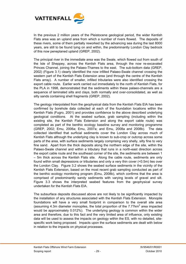
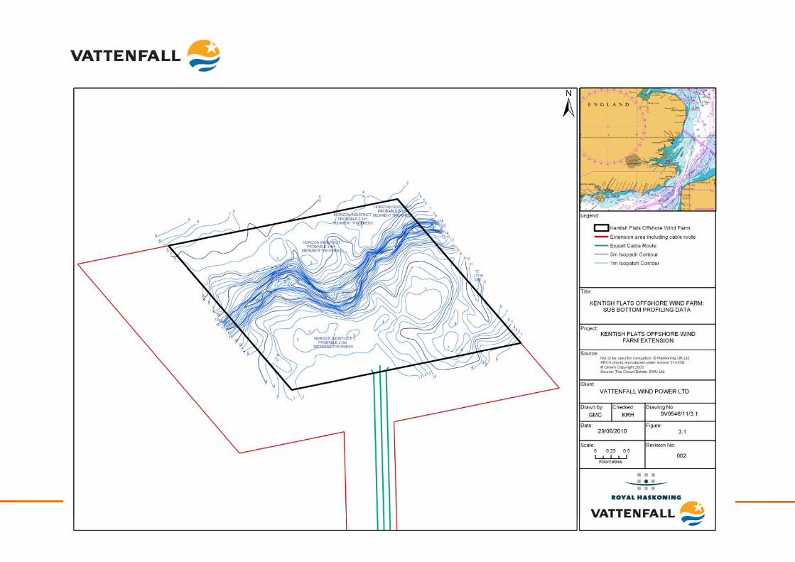
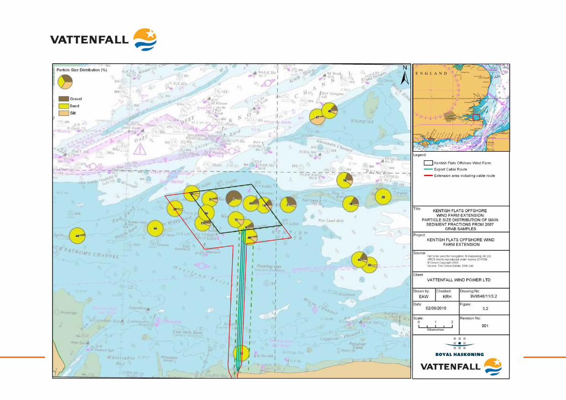
In the previous 2 million years of the Pleistocene geological period, the wider Kentish Flats area was an upland area from which a number of rivers flowed. The deposits of these rivers, some of them partially reworked by the advancing sea during the last 8000 years, are still to be found lying on and within, the predominantly London Clay bedrock of this now peneplaned upland (GREP, 2002). The principal river in the immediate area was the Swale, which flowed out from south of the Isle of Sheppey, across the Kentish Flats area, through the now re-excavated Princes Channel, joining the Palaeo-Thames to the east. The sub-bottom data (GREP, 2002) (Figure 3.1) clearly identified the now infilled Palaeo-Swale channel crossing the western part of the Kentish Flats Extension area (and through the centre of the Kentish Flats array). A number of smaller, infilled tributaries were also identified crossing the export cable route. Earlier work carried out immediately to the north of Kentish Flats, for the PLA in 1998, demonstrated that the sediments within these palaeo-channels are a sequence of laminated silts and clays, both normally and over-consolidated, as well as silty sands containing shell fragments (GREP, 2002). The geology interpolated from the geophysical data from the Kentish Flats EIA has been confirmed by borehole data collected at each of the foundation locations within the Kentish Flats (Fugro, 2001) and provides confidence to the above described underlying geological conditions. At the seabed surface, grab sampling (including within the existing site, the Kentish Flats Extension and along the export cable route) was completed as part of the benthic ecology baseline survey and monitoring programme (GREP, 2002; Emu, 2006a; Emu, 2007a; and Emu, 2008a and 2008b). The data collected identified that surficial sediments cover the London Clay across much of Kentish Flats although the underlying clay is known to sub-crop or outcrop across some parts of the area, with surface sediments largely comprising very shelly, silty fine to very fine sand. Apart from the thick deposits along the northern edge of the site, within the Palaeo-Swale channel and within a tributary that runs in a north-east direction across the export cable route and the southeast corner of the site, the sediments are between 1 – 5m thick across the Kentish Flats site. Along the cable route, sediments are only found within small depressions or tributaries and only a very thin cover (<0.5m) lies over the London Clay. Figure 3.2 shows the seabed surface sediments in the vicinity of the Kentish Flats Extension, based on the most recent grab sampling conducted as part of the benthic ecology monitoring program (Emu, 2008b), which confirms that the area is comprised of predominantly sandy sediments with varying levels of gravel and silt. Figure 3.3 shows the interpreted seabed features from the geophysical survey undertaken for the Kentish Flats EIA. The subsurface deposits discussed above are not likely to be significantly impacted by the installation of any structures associated with the Kentish Flats Extension. Monopile foundations will have a very small footprint in comparison to the overall site area (assuming 4.3m diameter monopiles, the total proportion of the 7.77km2 area impacted would be approximately 0.012%). The underlying geology is common within the wider area and therefore, due to this fact and the very limited area of influence, only existing data will be used to assess the impacts on geology within the ES, with no detailed, site-specific work being proposed. Impacts upon the surface sediments are dealt with below in relation to the impacts on physical processes.
Kentish Flats Offshore Wind Farm Extension 9V9546/01/R0001 Scoping report - 30 - October 2010
Kentish Flats Offshore Wind Farm Extension 9V9546/01/R0001 Scoping report - 31 - September 2010
Kentish Flats Offshore Wind Farm Extension 9V9546/01/R0001 Scoping report - 32 - September 2010
Kentish Flats Offshore Wind Farm Extension 9V9546/01/R0001 Scoping report - 33 - October 2010
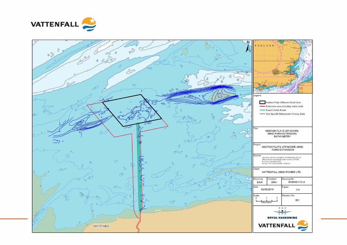
3.2 Physical processes
3.2.1 Existing environment
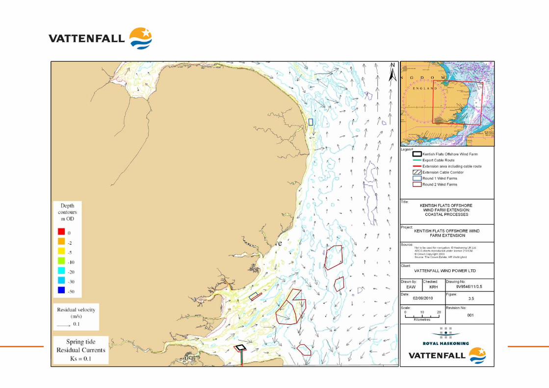
The Kentish Flats Extension is located in a sheltered position, approximately 7.8km at the nearest point from the north Kent coast and is protected by the adjacent coastlines and significant sandbanks of the Outer Thames Estuary (RPS, 2009). The water depth across the majority of the Kentish Flats Extension is approximately -4 to -5m CD (see Figure 3.4). To the west of the Kentish Flats Extension (and extending into the western part of the Kentish Flats Extension site itself) shallower water (-2m CD) occurs associated with the East Middle Sands sand bank (see Figure 3.4). To the south of the Kentish Flats Extension and along the cable route corridor, the seabed gently undulates between -4m CD and -2.1m CD depth (GREP, 2002). This was confirmed by Emu (2005b), with little variation being shown in seabed level. Depths within the Kentish Flats site ranged between -3.3m and -5.3m CD. Emu (2005b) stated that the depth data compared well with the pre-construction bathymetric survey with no significant changes. The stability of the two sandbank systems (the East Middle Sands to the west of the Kentish Flats Extension and the Pan Sands to the east-north-east4) was assessed as part of the original Kentish Flats EIA, through the examination of historic charts (GREP, 2002). Pan Sands was shown to have extended in a westward direction towards the Kentish Flats site by approximately 500 – 750m over a period of 150 years, or approximately 3 – 5m per annum on average. Over the same period of time, the East Middle Sand extended and realigned in an eastwardly direction (GREP, 2002). This assessment of bank stability concluded that the Kentish Flats area and the surrounding bank systems are relatively stable compared to other banks within the Outer Thames Estuary. Limited sediment transport through the site is evident from the various side scan data collected across the Kentish Flats array (e.g. Emu, 2008a) which show small sand waves to be moving slowly across the site, but with no overall, or dominant, transport direction and only very small volumes. Peak tidal flows in the Outer Thames Estuary are in an essentially east-north-easterly to west-south-westerly direction (as depicted in Figure 3.5) with higher flows on the ebb and a longer duration on the flood. Peak currents to the north and south-east of the site are higher than those to the west due to flow constriction by a complex system of sandbanks and channels (RPS, 2009). Wind fetch lengths are limited and waves from all directions are strongly affected and subject to shoaling, refraction and breaking by this short fetch or the system of sandbanks and intervening channels (GREP, 2002). A review of predicted significant wave heights was undertaken by HR Wallingford (2002) at two areas adjacent to the Kentish Flats site. For the south-eastern location, the predictive work suggested that waves from the north-north-west round to east were significant, with the largest coming from north-north-east, while waves from the west were the most persistent (HR Wallingford, 2002). For the northerly location, waves from the north-north-west round to north-east were significant, with the largest coming from the north-east, with waves from the west again being the most persistent. The calculations presented by HR Wallingford demonstrated that wave breaking would only occur with waves greater than 1.65m, with waves of this magnitude having only a 5% exceedance probability. It is also suggested that the highest surges and hence the highest water levels tend to be associated with
4 The Pan Sands forms part of the qualifying features for the Margate and Longsands cSAC
Kentish Flats Offshore Wind Farm Extension 9V9546/01/R0001 Scoping report - 34 - October 2010
winds and waves from the northwest. There is also a link between surges and high waves from the northeast (HR Wallingford, 2002). Data collected from 1999 – 2002 for the Kentish Flats EIA (GREP, 2002) indicated that the site has a substantial wind resource, with the prevailing, dominant wind direction being from the south-west, which accounted for almost 30% of the measurement period. Annual mean wind speeds were measured at 8.5 ms-1, while monitoring at Kentish Flats (Vattenfall, 2007) indicates that the mean wind speed at 70m height is approximately 8.7ms-1. Comparison of this site specific data to general reference data for Margate (Barne et al., 1998; cited in GREP, 2002) indicated a high degree of similarity with the dominant wind direction being from the south-west for a similar percentage of time. Barne et al. (1998, cited in GREP, 2002) reported that speeds of greater than 3.5ms-1 were exceeded for 75% of the time, but that wind speeds in excess of 15 – 16ms-1 occurred for less than 0.1% of the time. The strongest winds were recorded in the period January to March, during which time the north Kent coast can be affected by gales from the north.
Kentish Flats Offshore Wind Farm Extension 9V9546/01/R0001 Scoping report - 35 - September 2010
Kentish Flats Offshore Wind Farm Extension 9V9546/01/R0001 Scoping report - 36 - September 2010
Kentish Flats Offshore Wind Farm Extension 9V9546/01/R0001 Scoping report - 37 - October 2010
3.2.2 Identification of key issues
Potential effects5 during construction
Effect on wave climate and tidal currents: The effect due to the physical presence of the construction activities (e.g. plant and vessels) and installation of WTG foundations upon prevailing hydrodynamic conditions are not anticipated to be significant, with any effects being highly localised in extent and short-term in duration. Post-construction monitoring at Kentish Flats (Emu, 2005b) identified no major changes to bathymetry or seabed morphology (which would be reflective of significant changes to the hydrodynamic regime). Limited evidence of scour (between 0.8 and 1.4m depth) around the monopile foundations was observed, indicating minor, localised effects on currents as a result of the placement of the foundation structures. As a result these effects, based on the observations at the existing wind farm, are not considered significant and will be considered to be of secondary importance during the EIA. Change in morphological conditions: FEPA monitoring (Emu, 2005b) at Kentish Flats has revealed that the only form of direct effect on morphological conditions is from the physical presence of jack-up rig spud legs. Jack-up leg depressions were observed at each WTG location although the post-construction monitoring indicated that these localised depressions infilled naturally at a rate of around 0.2m to 0.5m per six months (Emu, 2005b to 2008a). Consequently, direct construction effects on the morphological regime can be considered localised and transient in nature. Indirect effects on morphological conditions may manifest through changes to the hydrodynamic regime; however, as stated above the effect on hydrodynamic processes is not anticipated to be significant, with any effects associated with localised scour events around the WTG foundations. Coastal morphology would only be affected if wave processes were substantially modified over the wind farm site. As discussed above, this will not be the case as effects on the hydrodynamic regime arising from the existing wind farm have been observed to be highly localised (Emu, 2008a) and thus far-field effects at the coastline are not anticipated to occur. Furthermore, the post construction monitoring work at Kentish Flats revealed no evidence of significant seabed change caused by the cable installation process (Emu, 2005b). As a result these effects will be considered of secondary importance during the EIA. Potential effects during operation
Effect on wave climate and tidal currents: Any changes to waves and tides resulting from the placement of structures in the marine environment will manifest in the form of seabed scour where the sediment is soft enough to be mobilised and therefore the extent of the scour at the seabed can be said to represent the footprint of the changes to the hydrodynamic regime. The most recent scour monitoring undertaken at Kentish Flats (Emu, 2008a) has confirmed that scour around the existing monopile structures is limited to a circa 5 to 10m radius around the foundations. These scour pits showed an increase in depth six months after the first post construction monitoring (March 2005), indicating the effect of the placement of the structures in the marine environment.
5 Note that it is not considered that ‘impacts’ will manifest on physical process parameters. It is possible that the construction, operation and decommissioning of the wind farm will have an effect on prevailing conditions which may then have an indirect ‘impact’ upon another parameter (e.g. marine ecology). Therefore, within this section, changes from baseline conditions are referred to as ‘effects’.
Kentish Flats Offshore Wind Farm Extension 9V9546/01/R0001 Scoping report - 38 - October 2010
However, in subsequent monitoring programmes (carried out between April 2006 and March 2008) scour depths remained constant (between 1.5 – 1.9m). The evidence gained from the Kentish Flats monitoring work demonstrates that effects on the hydrodynamic regime are restricted to near-field changes only (i.e. close to the structures); far field effects outside of Kentish Flats (such as at adjacent coastlines) have not been observed; indeed wider effects within the array on the seabed as a result of changes to waves or tides have not been observed. This is confirmed by Walker and Judd (2010) who reviewed the results of monitoring from several UK offshore wind farm projects and found no evidence of far-field effects. Installation of monopile foundations of a similar size at the Kentish Flats Extension would give rise to a similar magnitude of effect with no significant impact on the wider hydrodynamic regime. Indeed interactions between foundations (or indeed between the existing foundations and those proposed at the extension) would not occur given the highly localised nature of the scour effects). However, this effect will be considered in further detail during the EIA based on the existing data from Kentish Flats and a review of the geological conditions within the extension site. Effect on morphological conditions: Effects on sediment transport (through accretion or erosion) have been studied at industry level (ABPmer, 2005) as well as for site specific monitoring studies (Cefas, 2005). Such studies have concluded that minimal effects can be expected on prevailing sediment transport conditions, both within wind farm sites as well as in the far-field, provided that the foundations are adequately spaced. In this case, effects on sediment transport are likely to be localised to the areas immediately surrounding the individual foundations (i.e. those areas affected by scour). Bathymetric monitoring of the seabed across the Kentish Flats array has examined changes between pre- and post-construction surveys (Emu, 2005a and 2005b) and in more detail using swath-bathymetry surveys at a sub-set of WTG foundations (Emu, 2005c, 2005d, 2006a, 2006b, 2007a and 2008a). This monitoring has confirmed that no large-scale changes have occurred across Kentish Flats, with no discernable array-scale changes in bathymetry over the monitoring period that could be attributed to the presence of Kentish Flats. Rather the effects of monopile foundations have been restricted to areas close to each monopile in the form of scour. As described previously, the detailed post-construction scour surveys (Emu, 2005c, 2005d, 2006a, 2006b, 2007a and 2008a) show limited and stable scour depressions (see above); no scour has been recorded along the inter-array cable routes, which were buried to a depth of approximately 1m. This monitoring has also confirmed that the depressions arising from the jack-up vessels used for installation are slowly infilling as a result of natural sedimentary processes (OES, 2009), with the final survey (Emu, 2008a) showing that these had decreased to an average of 0.5 – 0.6m (from the post-construction baseline of 0.8 – 1.4m (Emu, 2005). Installation of monopile foundations of a similar dimension at the Kentish Flats Extension would give rise to a similar magnitude of effect with no significant effect on the wider morphological regime. However, this parameter will be considered in detail during the EIA based on the existing data from Kentish Flats and a review of the geological conditions within the extension site.
Kentish Flats Offshore Wind Farm Extension 9V9546/01/R0001 Scoping report - 39 - October 2010
Potential effects during decommissioning
Effects on seabed and / or coastal processes: The removal of the foundations (export and inter-array cables will be left in place) has the potential to affect seabed conditions and the prevailing physical processes. Any effects arising from decommissioning will be of no greater magnitude than those described for the installation and operational phases and are not therefore regarded as significant although they will be considered as part of the EIA process, albeit as a secondary consideration. Potential cumulative and in-combination effects
Cumulative effects on morphological conditions – interactions with other wind farms: No cumulative effects on the physical processes as a result of interactions with the construction of other offshore wind farms, such as London Array and the Gabbard / Galloper Offshore Wind Farms are anticipated. Given the distances between these other projects and the Kentish Flats Extension site (Table 3.3, below) the potential cumulative morphological effects is not considered significant and will therefore form a secondary consideration of the EIA. Table 3.3 Distances from Kentish Flats Extension to other Outer Thames Estuary / Southern
North Sea wind farms
Name Distance (km) London Array 24.8 Gunfleet Sands I 29.3 Gunfleet Sands II 28.7 Thanet 29.8 Galloper 61.3 Greater Gabbard 63.9 Norfolk R3 zone 91.8
Cumulative effects on hydrodynamic and sedimentary processes – interactions with other wind farms: It is unlikely that the construction and operation of Kentish Flats Extension will have significant cumulative effects on the hydrodynamic regime given the distance separating the Kentish Flats Extension and neighbouring wind farms. Coastal process studies and assessments in The Wash (Cefas, 2004a) have shown that the cumulative effects of offshore wind farms on waves, currents and sediment transport, both in the near field and far field are not considered significant where monopile foundations are used. Therefore, this effect is not considered significant. In-combination effects with other activities: Aggregate dredging occurs 40.2km from the site; as a result in-combination effects on physical processes are considered highly unlikely to occur. However, capital dredging is undertaken by the PLA and occurs approximately 3.4km to the north of the Kentish Flats Extension in the Princes Channel. This channel was deepened by approximately 8m between 2006 and 2008. The capital dredging was the subject of an EIA which concluded that the dredging works themselves would lead to no change in current speed, velocity or direction; no change to sediment transport or erosional processes and have little effect on the overall wave climate (PLA, 2004). Given that the likely hydrodynamic and sedimentary effects of the Kentish Flats Extension will be restricted to near-field change only, in-combination effects are unlikely to occur. Therefore, potential in-combination effects are not considered significant.
Kentish Flats Offshore Wind Farm Extension 9V9546/01/R0001 Scoping report - 40 - October 2010
3.3 Offshore water quality
3.3.1 Existing Environment
The Thames Estuary has historically suffered from high levels of anthropogenic pollution, with the situation being particularly acute in the nineteenth century due to increasing population and industry (GREP, 2002). Key water quality parameters at risk due to this pollution in the Thames have been identified as dissolved oxygen, temperature and ‘dangerous substances’. Dangerous substances are classified as those that are ‘toxic, persistent, may bio-accumulate or have a deleterious effect on the environment’ (GREP, 2002). Bathing water standards are applied at designated beaches, where microbiology is the principle concern. The closest designated bathing water to the Kentish Flats Extension is at Herne Bay Central, with Westgate Bay some 15km to the east and Sheerness approximately 25km to the west (GREP, 2002) (see Figure 3.6). Water quality is also important for shellfish production areas, with areas of the Outer Thames Estuary being designated for this purpose (see Figure 3.6) including the main Whitstable oyster fishery which lies to the south of the Kentish Flats Extension. A series of sediment samples were collected for the Kentish Flats EIA, including samples in and immediately adjacent to the Kentish Flats Extension. These were subject to chemical analysis for a range of typical, anthropogenic contaminants including trace metals, hydrocarbons, and PCBs (Emu, 2002f and 2005g). This analysis revealed consistently low levels of all contaminants across the sampling area (see Table 3.4), with all recorded levels falling below statutory guidance levels such as those currently applied in European designated nature conservation sites. Background water and sediment quality parameters are shown in Table 3.3 and Table 3.4 respectively. Table 3.3 Background water quality parameters at Kentish Flats
Parameter Value Source
Suspended sediment (modal value)
50 – 55 mgl-1 KFOWF turbidity monitoring (Emu, 2005h)
Dissolved oxygen 86 – 116 % 2001 EA data from East of Sheerness (in GREP, 2002)
Salinity 31 – 34 psu 2001 EA data from East of Sheerness (in GREP, 2002)
pH 7.7 – 8.1 2001 EA data from East of Sheerness (in GREP, 2002)
Fluorescence 6.5 – 22.6 (raw values) 2001 EA data from East of Sheerness (in GREP, 2002)
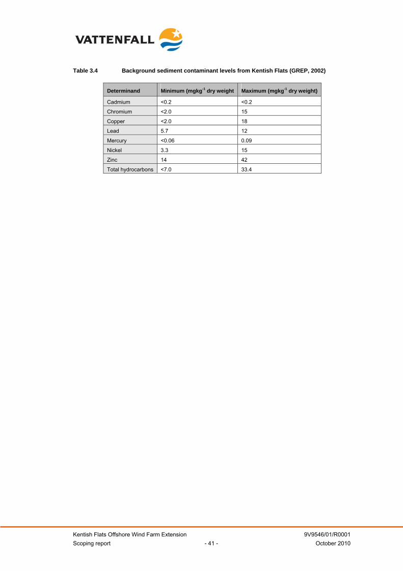
Kentish Flats Offshore Wind Farm Extension 9V9546/01/R0001 Scoping report - 41 - October 2010
Table 3.4 Background sediment contaminant levels from Kentish Flats (GREP, 2002)
Determinand Minimum (mgkg-1 dry weight Maximum (mgkg-1 dry weight)
Cadmium <0.2 <0.2
Chromium <2.0 15
Copper <2.0 18
Lead 5.7 12
Mercury <0.06 0.09
Nickel 3.3 15
Zinc 14 42
Total hydrocarbons <7.0 33.4
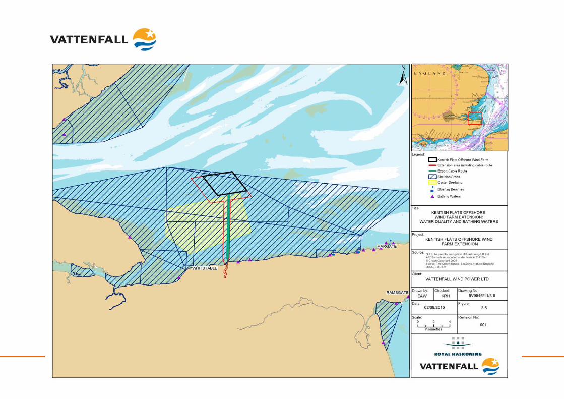
Kentish Flats Offshore Wind Farm Extension 9V9546/01/R0001 Scoping report - 42 - October 2010
Kentish Flats Offshore Wind Farm Extension 9V9546/01/R0001 Scoping report - 43 - October 2010
3.3.2 Identification of key issues
Potential impacts during construction Effects on water quality: During construction, impacts may occur from the re-suspension of sediments as a result of construction activities, such as foundation installation, installation of inter-array or export cables, the placement of scour material on the seabed or construction vessel activity. Monitoring undertaken at Kentish Flats during export cable burial activities (Emu, 2005f) indicated that suspended sediment values were a maximum of 9% above background levels and were well below the thresholds set by Cefas at that time (55 and 60 mgl-1, while the peak value not to be exceeded was >1000 mg l-1) (Emu, 2005f). Effects from the Kentish Flats Extension would not be expected to be above those experienced at Kentish Flats, given the scale of the proposed development. Contaminants present within existing sediments may also be disturbed through these activities, which may affect compliance with water quality standards. Similarly pathogens may also be released into the water column through disturbance which could potentially cause levels to be exceeded at bathing water beaches or in designated shellfish areas. In the case of the existing project, pre- and post-construction monitoring was conducted on the Whitstable oyster beds to ascertain the impacts of the re-suspension of sediment from the construction of Kentish Flats and potential contamination of the oysters (OES, 2009). The analysis of the oyster flesh for a suite of contaminants, comparing concentrations before and after the export cable installation revealed a number of changes in the levels recorded. In all cases, these were attributable to natural variation and were within relevant guidelines and standards. This monitoring confirmed the results of the background sediment contaminant analysis (indicating low levels of contaminants) and supports the original prediction that construction activities at Kentish Flats would not result in the release of sediment contaminants in levels sufficient to cause adverse effects on water quality and local shellfish, with this therefore also the case for the Kentish Flats Extension. The issue of sediment contamination and effects on water quality and shellfish production areas are not considered significant. Potential impacts during operation
Effects on water quality: The main potential impacts on water quality during the operational phase of the Kentish Flats Extension are from accidental spillage of materials during maintenance activities. Best practice for pollution prevention would be implemented to mitigate the risk from such occurrences, with all other impacts on water quality not being considered significant. Potential impacts during decommissioning
Effects on water quality: During decommissioning, the foundation structures will be removed which is likely to result in disturbance to sediments. Any impacts are therefore anticipated to be similar to those outlined during the construction phase (unless sediment quality has deteriorated significantly during the lifespan of the wind farm due to outside
Kentish Flats Offshore Wind Farm Extension 9V9546/01/R0001 Scoping report - 44 - October 2010
influences i.e. other activities) and therefore it is proposed that this effect is not significant. Potential cumulative & in-combination impacts
Cumulative effects on water quality: Any water quality impacts are likely to be manifested during the construction phase; however, given the limited scale of construction at the Kentish Flats Extension, the low levels of contaminants within the sediments and the distance to other known developments such as the London Array and Galloper Offshore Wind Farms, no cumulative effects are anticipated. Cumulative water quality effects are therefore not considered significant. In-combination effects on water quality: Given the low levels of turbidity likely to be generated by the construction of the Extension and the distance to other operations such as aggregate dredging or capital dredging, in-combination effects are considered highly unlikely to occur. In-combination effects on water quality are therefore not considered significant.
3.4 Offshore physical environment – methodology and approach to EIA
Vattenfall has commissioned geophysical surveys (see Figure 3.7) of the Kentish Flats Extension, to develop a more detailed understanding of the seabed conditions within the project area and in order to provide a baseline for the Kentish Flats Extension EIA. These data will be correlated with the data sets for the existing Kentish Flats site. The geophysical survey will collect bathymetric, seabed texture and morphology, shallow geology and magnetic anomaly data using the following instrumentation:
• Sub-bottom profiler (boomer);
• Side scan sonar;
• Swath bathymetry; and
• Magnetometer.
Survey lines will be spaced at 50m with tie lines at 500m. A programme of benthic grab sampling will also collect data on the surficial sediments of the Kentish Flats Extension and will be used to aid interpretation of the side scan sonar data to produce a seabed habitat and features map. Eventual impact assessment will also be based upon observations generated by the Kentish Flats monitoring data in relation to hydrodynamic and sedimentary effects, based on the installation of similar monopile structures and cables in unison with similar ground conditions. Given that this is the case, no physical processes modelling will be commissioned but instead the observed effects of placing a wind farm at this location within the Outer Thames Estuary will be used to describe the likely effects of the Kentish Flats Extension. Physical processes focus for the EIA: Key considerations for the EIA:
• Operational effects on wave climate and tidal currents (localised effects); and
Kentish Flats Offshore Wind Farm Extension 9V9546/01/R0001 Scoping report - 45 - October 2010
• Operational effects on morphological conditions (localised effects).
Secondary considerations for the EIA:
• Construction effects on wave climate and tidal currents;
• Construction effects on morphological conditions;
• Effects on water quality arising from construction activities;
• Operational effects on water quality;
• Cumulative and in-combination effects;
• Decommissioning effects on seabed, coastal processes and water quality.
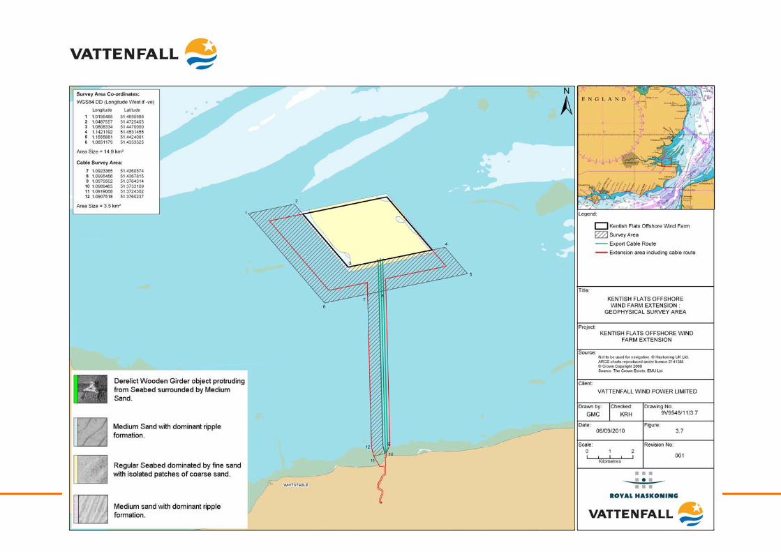
Kentish Flats Offshore Wind Farm Extension 9V9546/01/R0001 Scoping report - 46 - October 2010
Kentish Flats Offshore Wind Farm Extension 9V9546/01/R0001 Scoping report - 47 - October 2010
4 BIOLOGICAL ENVIRONMENT
This section details the existing offshore biological environment within and adjacent to the Kentish Flats Extension. Nature conservation designations are defined, with details of locally, nationally and internationally designated sites being provided. Following this, the baseline environment is described for ornithological interest, benthic and intertidal ecology, natural fish resource and marine mammals. This section also identifies any key potential issues resulting from the construction, operation and decommissioning of the Kentish Flats Extension. Finally, the approach to the EIA is provided. The biological environment has been subject to an exhaustive pre-, during- and post-construction monitoring programme, with available data sets being presented in Table 4.1 below. Table 4.1 Available biological environment data sets
Data Date The potential ornithological impact of the proposed Kentish Flats Offshore Wind Farm ESS (2002)
Kentish Flats Offshore Wind Farm Ornithological Monitoring Reports (ornithology, includes marine mammal sightings)
ESS (2004 – 2008)
Kentish Flats Offshore Wind Farm: Review of Monitoring of Red Throated Divers 2008 – 2009
Ecology Consulting (2009)
Kentish Flats Offshore Wind Farm: Review of Monitoring of Red Throated Divers 2009 – 2010
Ecology Consulting (2010)
Kentish Flats Intertidal Cable Laying Monitoring Final Report Emu (2005) Kentish Flats Proposed Wind Farm Development Baseline Macrobenthic Ecology Study Final Report
Emu (2002)
Kentish Flats Windfarm Development Macrobenthic Ecology Study; 2005 – 2007 Emu (2006 – 2008)
Kentish Flats Offshore Wind Farm Turbine Foundation Faunal Colonisation Diving Survey Emu (2008) Kentish Flats Monitoring Programme Fisheries Surveys Baseline Oyster Sampling Final Report
Emu (2005)
Kentish Flats Monitoring Programme Fisheries Surveys Post Construction Oyster Sampling Emu (2005) Kentish Flats Comparative Fisheries Comparative Study Emu (2006) Measurement and interpretation of underwater noise during construction and operation of offshore wind farms in UK waters
Nedwell et al. (20007)
Kentish Flats Offshore Wind Farm FEPA Monitoring Summary Report OES (2008) Kentish Flats Offshore Wind Farm FEPA Monitoring Summary Report OES (2009)
4.1 Nature conservation designations
4.1.1 Existing Environment
There are a number of designated sites of local, national and international nature conservation importance in the Outer Thames Estuary region. The majority of these are some distance from the Kentish Flats Extension although both Kentish Flats and the Kentish Flats Extension lie within the Outer Thames Estuary Special Protection Area (SPA). While the Kentish Flats Extension will not have any direct effect on many of these more distant designated sites, the potential exists for effects to be manifested on the features for which sites are designated.
Kentish Flats Offshore Wind Farm Extension 9V9546/01/R0001 Scoping report - 48 - October 2010
4.1.1.1 Statutory International Designations
Statutory international designated sites in the United Kingdom (UK) include Ramsar wetland sites (Wetlands of International Importance designated under the Ramsar Convention) and Natura 2000 sites, known as SPA and Special Areas of Conservation (SACs). The relevant sites are listed in Table 4.2 and are shown in Figure 4.1. SPAs are statutory designated sites that are classified under European Union (EU) law in accordance with Article 4 of the EC Directive 79/409/EEC on the conservation of wild birds (known as the Birds Directive). They are classified for rare and vulnerable birds, listed in Annex I to the Birds Directive, and for regularly occurring migratory species. Since Kentish Flats was constructed, a significant proportion of the Thames Estuary has been designated (August 2010) as a SPA for its significant red-throated diver Gavia stellata populations (the Outer Thames Estuary SPA) (see Figure 4.1) SACs are sites designated under EC Directive 92/43/EEC on the conservation of habitats and wild flora and fauna (known as the Habitats Directive), because they make a significant contribution to conserving the 189 habitat types and 788 species identified in Annexes I and II of the Directive. Since Kentish Flats was constructed, an area of the Thames Estuary to the east of and bordering Kentish Flats has been put forward by the UK Government to the EC (August 2010) as a candidate SAC (cSAC) (Margate and Long Sands cSAC) for sandbanks which are slightly covered by sea water all the time (see Figure 4.1). Table 4.2 Statutory International designated sites of relevance to the Kentish Flats Extension
Site Name Designation Features Distance to Kentish Flats Extension (km)
Distance to cable landfall (km)
Thames Estuary and Marshes
SPA/Ramsar Over winter: Avocet, hen harrier
20 25
Medway Estuary and Marshes
SPA/Ramsar Breeding: Avocet, little tern Over winter: Avocet
21 22
The Swale SPA/Ramsar Breeding: Avocet, marsh harrier, Mediterranean gull Over winter: Avocet, bar-tailed godwit, golden plover, hen harrier
10 5
Thanet Coast and Sandwich Bay
SPA/Ramsar Over winter: turnstone 8 0
Foulness SPA/Ramsar Breeding: avocet, little tern, common tern, sandwich tern Over winter: Avocet, bar-tailed godwit, golden plover, hen harrier,
9 20.2
Outer Thames Estuary SPA Red throated diver 0 0
Thanet Coast SAC Reefs, sea caves 10 10
Margate and Long Sands
cSAC Sandbanks 0 3.7
Kentish Flats Offshore Wind Farm Extension 9V9546/01/R0001 Scoping report - 49 - October 2010
4.1.1.2 Statutory National Designations
At a national level and within the study area, there are two types of designated site for nature conservation; these being Sites of Special Scientific Interest (SSSI) and National Nature Reserves (NNR) (see Figure 4.2). Distances from the Kentish Flats Extension are shown in Table 4.3 Table 4.3 Statutory nationally designated sites of relevance to the Kentish Flats Extension
Site name Designation Features Distance to Extension project (km)
Distance to cable landfall (km)
South Thames Estuary and Marshes
SSSI Grazing marsh, saltmarsh, mudflats and shingle, birds
20 -
Tankerton Slopes SSSI Geological 9 3 Sheppy Cliffs and Foreshore
SSSI Geological 12 12
Medway Estuary and Marshes SSSI
SSSI Grazing marsh, mudflats and sandflats
21 22
The Swale SSSI Grazing marsh, mudflats and sandflats
9 5.2
Thanet Coast SSSI Lagoons, saltmarsh, mudflats and sandflats, geological, birds
7 0
The Swale NNR Grazing marsh, birds 12 10 Elmley NNR Grazing marsh,
saltmarsh, birds 19 19
In addition, new marine protected areas will be put forward under the provisions of the Marine and Coastal Access Act (2009), with the Marine Conservation Zones (MCZ) due to be designated by 2012. These MCZ will augment the Natura 2000 network for species and habitats that are either not covered by the Habitats Directive or for which the Directive does not provide coverage. The process of putting forward sites has been devolved to four regional projects which are stakeholder led. The project covering the Thames Estuary region is the Balanced Seas project6. At this early stage in the process it is not possible to say whether there will be new sites of relevance to the Kentish Flats Extension; however, given the number of existing Natura 2000 sites in the region (not least the Outer Thames SPA), it is likely that any new protected areas will be within existing designations (rather than totally new sites) but with more targeted management towards specific features within them.
4.1.1.3 Non-Statutory Designations
The principal types of non-statutory sites of conservation importance are as follows:
• Local Nature Reserves (LNR);
• Areas of Outstanding Natural Beauty (AONB);
• Heritage Coasts;
6 http://www.balancedseas.org/
Kentish Flats Offshore Wind Farm Extension 9V9546/01/R0001 Scoping report - 50 - October 2010
• County Wildlife Sites (CWS);
• County Geological Sites (CGS);
• Sites of Importance for Nature Conservation (SINC);
• Ancient Woodland (AW); and
• Sensitive Marine Areas (SMA).
No non-statutory sites are located within 5km of the Kentish Flats Extension landfall.
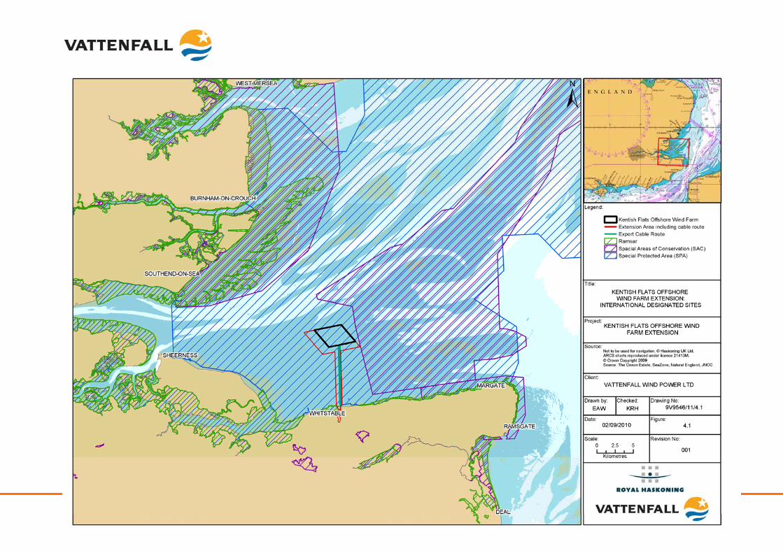
Kentish Flats Offshore Wind Farm Extension 9V9546/KF/R0001 Scoping report - 51 - October 2010
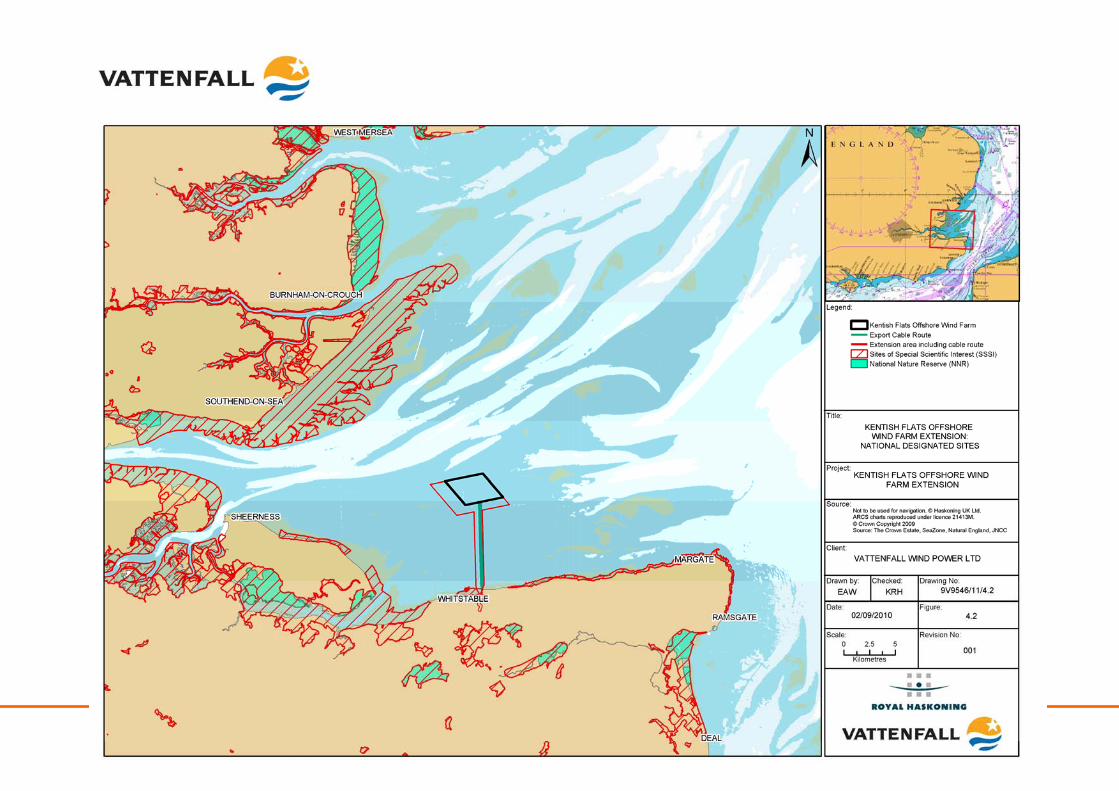
Kentish Flats Offshore Wind Farm Extension 9V9546/KF/R0001 Scoping report - 52 - October 2010
Kentish Flats Offshore Wind Farm Extension 9V9546/01/R0001 Scoping report - 53 - October 2010
4.1.2 Identification of key potential issues
Impacts during construction, operation and decommissioning
Impacts on designated sites and species (onshore): With regard to SAC, the Kentish Flats ES (GREP, 2002) concluded that there would be no direct impact as a result of construction, operation or decommissioning of Kentish Flats. For the Kentish Flats Extension, a similar conclusion can be drawn given the distance between the project area and the surrounding onshore and coastal SAC sites. With regard to onshore and coastal SPA, the potential exists for direct impacts upon the Thanet Coast and Sandwich Bay SPA and Ramsar, should the export cable(s) reach landfall to the west of Hampton Pier. Should the export cable(s) come ashore to the east of Hampton Pier, then impacts may still be likely to occur, arising from the installation of the onshore cables adjacent to that site. Mitigation was prescribed in the FEPA licence which avoided disturbance of the turnstone Arenaria interpres population (see Section 4.2 and Section 7.1 for further information), which would be adopted for the Kentish Flats Extension. In addition to this, as shown in Figures 4.4 – 4.16 and Table 4.4, there have been no recorded effects on other SPA with regards to qualifying populations, with this being particularly apparent for Sandwich tern Sterna sandvicensis, common tern Sterna hirundo and dunlin Calidris alpina. Vattenfall recognises the need to consider the potential for significant effects on other sites and populations arising from the extension project as part of the EIA process and as such impacts on designated sites and species will be a primary consideration of the EIA. As described above, should the export cable(s) make landfall to the west of Hampton pier, then the potential exists for direct impacts on the Thanet Coast SSSI. As a result of this, due consideration of the potential impacts on this site and its associated features from the installation of the export cable(s) will be undertaken as part of the EIA. Impacts on designated sites and species (offshore): With regard to the new and proposed Natura 2000 sites, the Kentish Flats Extension will have no direct impacts on the cSAC features since there is no physical overlap between the project and the cSAC. Indirect impacts on the cSAC features are considered unlikely to be significant since any impacts of the project will be highly localised (as has been demonstrated at Kentish Flats – see Section 3.2.2) and will not significantly affect the key sandbank features (see Section 4.3 for further description of impacts on benthic habitats). As part of the consultation that Vattenfall has undertaken to date, Natural England expressed the view that it no concerns regarding the impacts of the Kentish Flats Extension on the cSAC (see Appendix 1.2). For the Outer Thames Estuary SPA, impacts on the red throated diver populations are not considered to be significant when considered in isolation as the numbers recorded around the Kentish Flats form only a very small proportion of the Outer Thames population. However, potential cumulative impacts on the Thames population arising from all of the offshore wind farms that lie in or adjacent to the SPA have been highlighted as a potential concern by Natural England during preliminary discussions (see Appendix 1.3). As a result, it is possible that an Appropriate Assessment will be required for the Kentish Flats Extension (see Section 4.2, Ornithology for more information) with a likely focus on impacts on red-throated divers.

Kentish Flats Offshore Wind Farm Extension 9V9546/01/R0001 Scoping report - 54 - October 2010
If MCZ are designated near to the Kentish Flats Extension, then there may be implications depending on the features designated and management regimes selected. Vattenfall will consult with the regulatory authorities in the event of new sites being designated in the area.
4.1.3 Methodology and approach to EIA
As part of the baseline description within the ES, all designated sites at European, National and local level will be identified in relation to the project footprint. This will encompass both existing and proposed (candidate) designated sites. The investigations required to inform the potential for impacts on designated features will be covered by the investigations detailed in inter alia the geomorphology, marine ecology and ornithology sections (and where relevant the marine mammal section) of the ES (Emu, 2005a; Emu, 2005b; Emu, 2005c; Emu, 2005d; Emu, 2006a; Emu, 2006b; Emu, 2007a; Emu, 2008a; Emu, 2008b; GREP, 2002; and OES, 2009) (see Section 3.2, 4.2.2, 4.2.3, 4.3.2 and 4.3.3). If it is confirmed through further consultation that an Appropriate Assessment is required in relation to the potential cumulative effects on the red-throated diver populations then the information required for this decision process will be clearly provided within the ES. Nature conservation designations focus for the EIA: The focus for the nature conservation designations section within the ES will be on those sites that have the potential to be affected by the Kentish Flats Extension. No wide-scale effect on morphological conditions is expected and, as such, it is highly unlikely that the Margate and Long Sands cSAC will be significantly affected by the Kentish Flats Extension. This view was re-iterated by Natural England during discussion with Vattenfall (see Appendix 1.2). As impacts on SPA populations may be likely as a result of the Kentish Flats Extension, Vattenfall has committed to undertaking a suite of ornithological surveys (see Section 4.2.3), which will be used alongside the significant number of ornithological surveys already undertaken for Kentish Flats. Vattenfall will also propose appropriate mitigation where necessary to ensure no adverse affect on designated sites. Key considerations for the EIA:
• Potential impacts on turnstone populations to the west of Hampton Pier;
• Direct impacts on the Thanet Coast and Sandwich Bay SPA and Ramsar;
• Indirect impacts on the Margate & Longsands cSAC features;
• Site specific impacts on Outer Thames estuary SPA red-throated diver populations; and
• Cumulative impacts on Outer Thames estuary SPA red-throated diver populations.
Kentish Flats Offshore Wind Farm Extension 9V9546/01/R0001 Scoping report - 55 - October 2010
Secondary considerations for the EIA:
• Potential indirect impacts on other onshore or coastal international, national or local sites and their qualifying features;
• Direct impacts on the Margate & Longsands cSAC or Thanet Coast SAC features; and
• Impacts on MCZ sites (unless designated within or adjacent to the Extension and export cable route).
4.2 Ornithology
4.2.1 Existing Environment
Ornithological data have been collected for Kentish Flats (baseline and (pre, during and post-construction) monitoring surveys) and are used here to support this scoping assessment from an area covering the original development, a buffer area (which covers the entirety of the extension project area) and a control area (see Figure 4.3). In total, 108 boat-based surveys have been conducted for the baseline and subsequent monitoring surveys (OES, 2009). In addition, a further 12 winter surveys have been conducted during the winters of 2008/2009 and 2009/2010 focusing on recording the distribution of red throated divers The Kentish Flats baseline was defined by a series of boat-based surveys over fourteen months conducted during 2001 and 2002 (ESS, 2002) and described in the project ES (GREP, 2002). The data indicated that the density of birds using Kentish Flats was low in comparison to other offshore sites and the importance of the area was low given the importance of the Thames Estuary for birds in general. Notably, the data for the Kentish Flats matched the general distributions noted from other surveys, such as the JNCC aerial surveys of, for example, diver species (GREP, 2002). The ES concluded that there was little sensitivity at the original development site due to the small numbers of most species of conservation interest recorded by the site specific surveys (a conclusion generally confirmed by the subsequent monitoring program) (see Table 4.4 and Figure 4.4 – Figure 4.17). The notable exception to the general pattern was the presence of red-throated diver, in and around the Kentish Flats area (and within the Kentish Flats Extension area). Subsequent monitoring has also recorded terns flying to the south of the existing project to and from a foraging area to the east. It is considered likely that red-throated diver and terns will be the main sensitive receptors for ornithological impact. This viewpoint was corroborated by Natural England, who indicated that the Kentish Flats Extension is likely to require an Appropriate Assessment with regard to red throated diver (see Appendix 1.3).
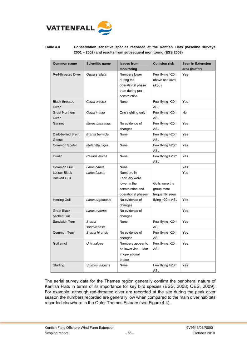
Kentish Flats Offshore Wind Farm Extension 9V9546/01/R0001 Scoping report - 56 - October 2010
Table 4.4 Conservation sensitive species recorded at the Kentish Flats (baseline surveys 2001 – 2002) and results from subsequent monitoring (ESS 2008)
Common name Scientific name Issues from
monitoring Collision risk Seen in Extension
area (buffer) Red-throated Diver Gavia stellata Numbers lower
during the operational phase than during pre-construction
Few flying >20m above sea level (ASL)
Yes
Black-throated Diver
Gavia arctica None Few flying >20m ASL
Yes
Great Northern Diver
Gavia immer One sighting only Few flying >20m ASL
No
Gannet Morus bassanus No evidence of changes
Few flying >20m ASL
Yes
Dark-bellied Brent Goose
Branta bernicla None Few flying >20m ASL
Yes
Common Scoter Melanitta nigra None Few flying >20m ASL
Yes
Dunlin Calidris alpina None Few flying >20m ASL
Yes
Common Gull Larus canus None Yes Lesser Black Backed Gull
Larus fuscus Numbers in February were lower in the construction and operational phases
Yes
Herring Gull Larus argentatus No evidence of changes
Yes
Great Black-backed Gull
Larus marinus No evidence of changes
Gulls were the group most frequently seen flying >20m ASL
Yes
Sandwich Tern Sterna sandvicensis
None Few flying >20m ASL
Yes
Common Tern Sterna hirundo No evidence of changes
Few flying >20m ASL
Yes
Guillemot Uria aalgae Numbers appear to be lower Jan - Mar in operational phase
Few flying >20m ASL
Yes
Starling Sturnus vulgaris None Few flying >20m ASL
Yes
The aerial survey data for the Thames region generally confirm the peripheral nature of Kentish Flats in terms of its importance for key bird species (ESS, 2008; OES, 2009). For example, although red-throated diver are recorded at the site during the peak diver season the numbers recorded are generally low when compared to the main diver habitats recorded elsewhere in the Outer Thames Estuary (see Figure 4.4).
Kentish Flats Offshore Wind Farm Extension 9V9546/01/R0001 Scoping report - 57 - October 2010
The post-construction monitoring data (summarised in OES, 2009) and subsequent statistical comparisons between the Kentish Flats site, the buffer area (which covers the Extension) and the reference area (for diver, cormorant, seaduck, other wildfowl, wader, gulls, terns, auks, and all birds) provided no statistically significant evidence of a change in the numbers of birds as a result of the construction or operation of Kentish Flats project, although red-throated divers were observed to be avoiding the operational site (see Section 4.2.2 below for a description of bird distributions during the operational phase). Collision risk modelling was not undertaken for any species as too few individuals were seen flying at rotor height (i.e. at > 20m above sea level (ASL)) (ESS, 2008).
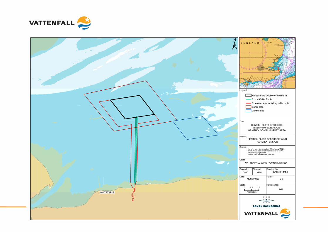
Kentish Flats Offshore Wind Farm Extension 9V9546/01/R0001 Scoping report - 58 - October 2010
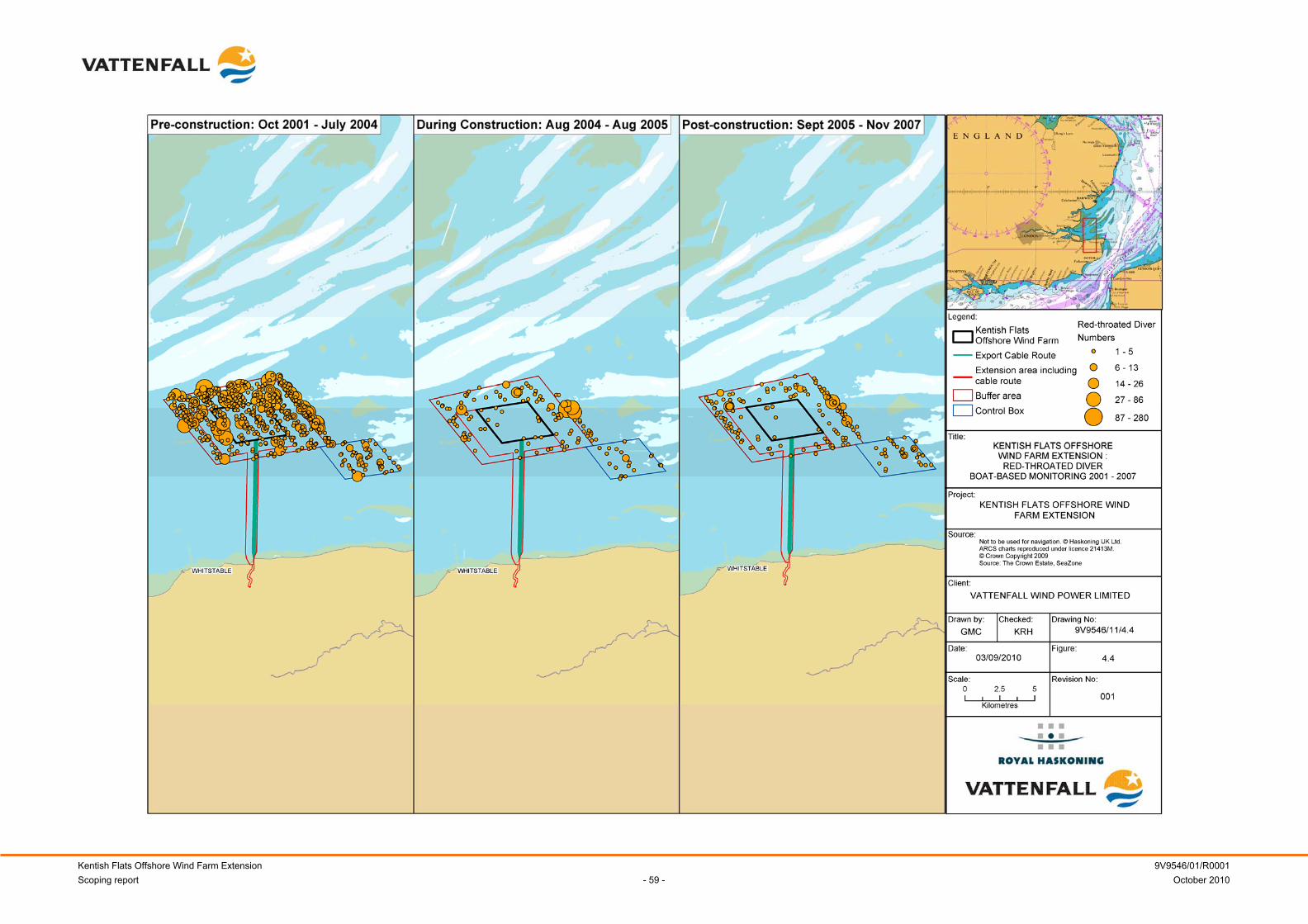
Kentish Flats Offshore Wind Farm Extension 9V9546/01/R0001 Scoping report - 59 - October 2010
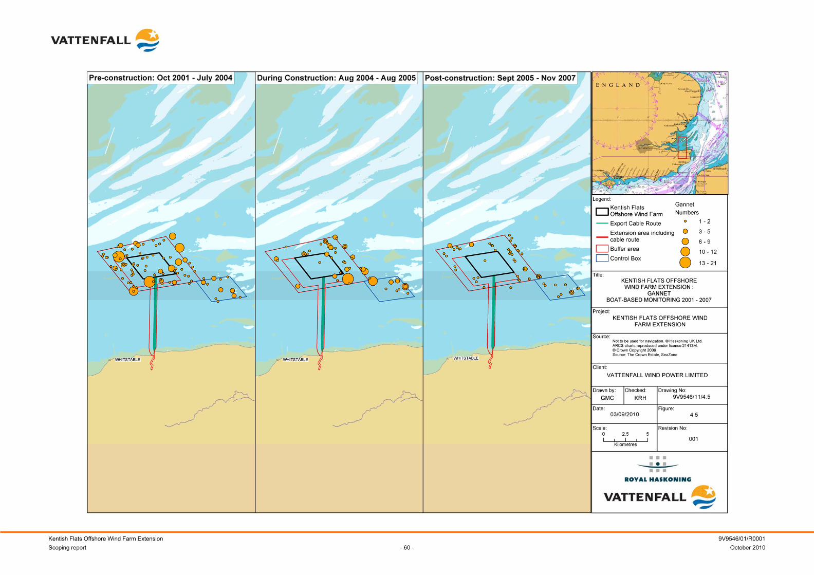
Kentish Flats Offshore Wind Farm Extension 9V9546/01/R0001 Scoping report - 60 - October 2010
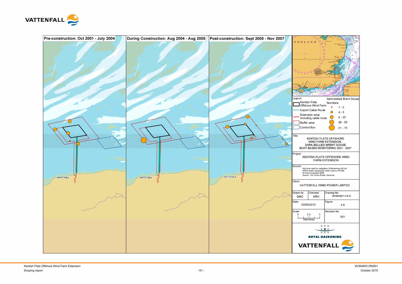
Kentish Flats Offshore Wind Farm Extension 9V9546/01/R0001 Scoping report - 61 - October 2010

Kentish Flats Offshore Wind Farm Extension 9V9546/01/R0001 Scoping report - 62 - October 2010

Kentish Flats Offshore Wind Farm Extension 9V9546/01/R0001 Scoping report - 63 - October 2010
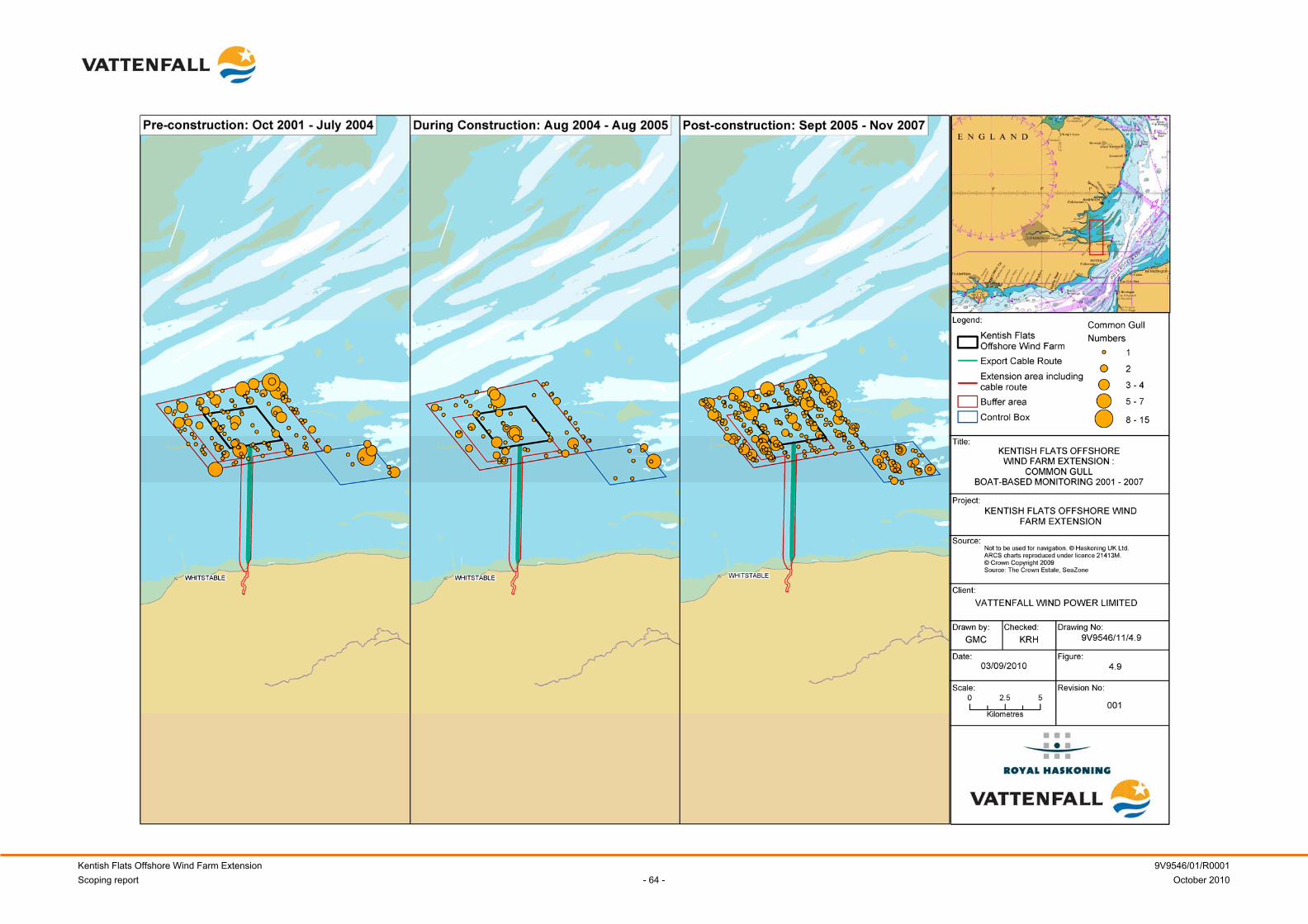
Kentish Flats Offshore Wind Farm Extension 9V9546/01/R0001 Scoping report - 64 - October 2010
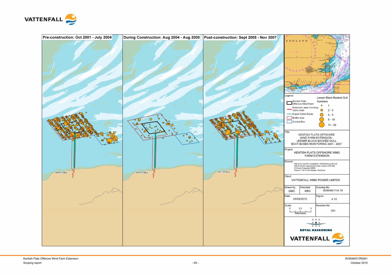
Kentish Flats Offshore Wind Farm Extension 9V9546/01/R0001 Scoping report - 65 - October 2010

Kentish Flats Offshore Wind Farm Extension 9V9546/01/R0001 Scoping report - 66 - October 2010

Kentish Flats Offshore Wind Farm Extension 9V9546/01/R0001 Scoping report - 67 - October 2010
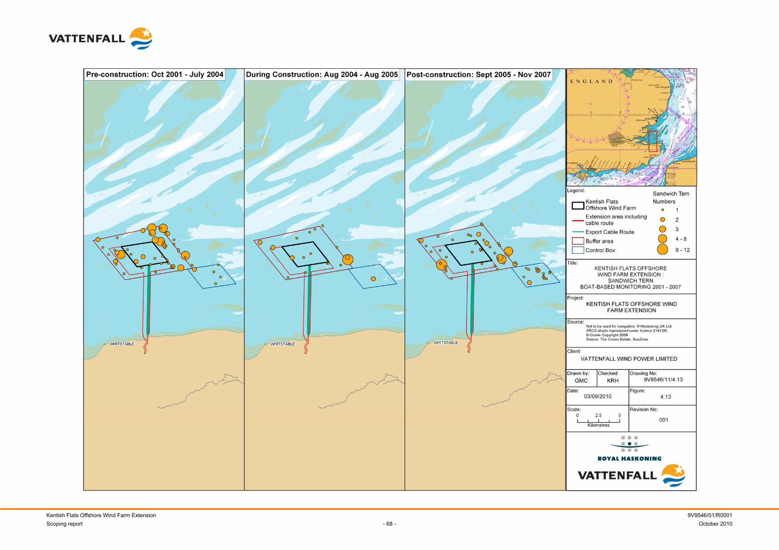
Kentish Flats Offshore Wind Farm Extension 9V9546/01/R0001 Scoping report - 68 - October 2010

Kentish Flats Offshore Wind Farm Extension 9V9546/01/R0001 Scoping report - 69 - October 2010

Kentish Flats Offshore Wind Farm Extension 9V9546/01/R0001 Scoping report - 70 - October 2010
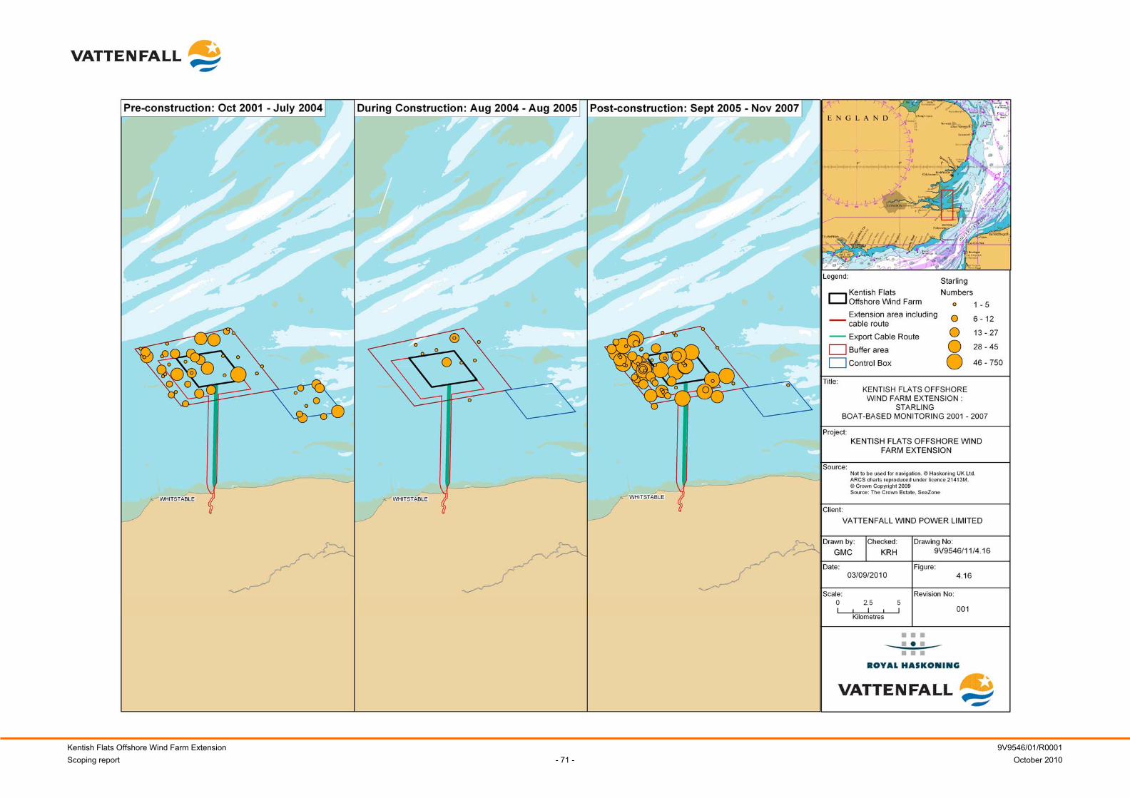
Kentish Flats Offshore Wind Farm Extension 9V9546/01/R0001 Scoping report - 71 - October 2010
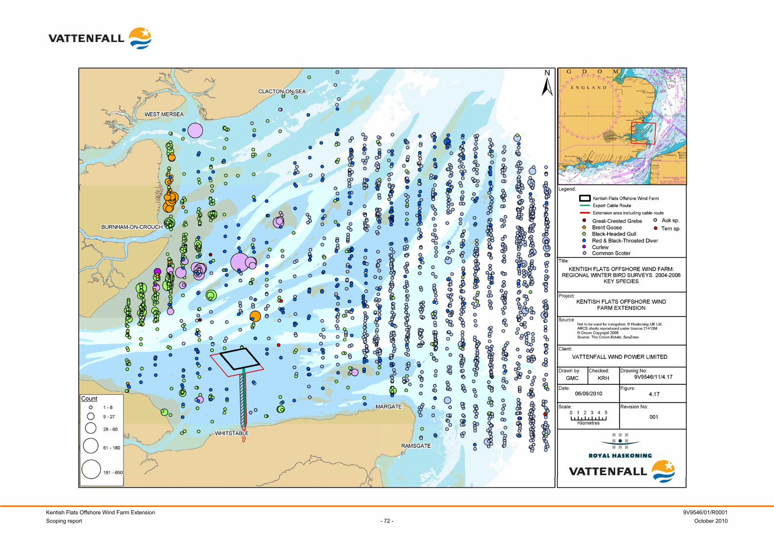
Kentish Flats Offshore Wind Farm Extension 9V9546/01/R0001 Scoping report - 72 - October 2010
Kentish Flats Offshore Wind Farm Extension 9V9546/01/R0001 Scoping report - 73 - October 2010
4.2.2 Identification of key issues
Potential impacts during construction
Disturbance and displacement: Construction activities (e.g. monopiles being installed by pile driving and an increase in boat traffic) at the Kentish Flats Extension will result in noise and vibration. The noise associated with the construction activities has the potential to disturb and displace bird species from the Kentish Flats Extension for the duration of installation activities (NERI, 2004). The presence of plant and personnel on site may also cause localised disturbance throughout construction. In all cases, such disturbance impacts are likely to be temporary and exist only when vessels are on site and / or particular construction activities are being undertaken. Therefore, birds may readily re-distribute in periods of less intense or no activity during the construction period. Interestingly, the during-construction monitoring undertaken at Kentish Flats showed that there were no statistically significant differences with general usage of the site recorded during the construction period, although the tests on the data were of low power (ESS, 2006). It is worth noting that construction was undertaken during the over-wintering diver season (specifically some cabling), although the FEPA License prevented any piling activities between mid-November and mid-March to prevent disturbance to over-wintering divers. Subsequent analysis of the red-throated diver populations at Kentish Flats (Ecology Consulting, 2009) showed that the highest numbers of divers recorded in the area were seen during the construction phase (see Table 4.5). However, detailed analysis of the spatial distribution of these divers showed that although overall numbers were high, the birds were focused in the outer buffer areas with numbers within the wind farm area (construction site) and immediate buffer area (within 500m) less than during the pre-construction period. Table 4.5 Mean and peak diver population estimates for Kentish Flats, buffer and control
areas 2002 – 2010 (from Ecology Consulting, 2010)
Wind farm + buffer Control Winter Phase Mean Peak Mean
2002 – 03 Pre-construction 608 2,226 47 2003 – 04 Pre-construction 552 1,313 5 2004 – 05 Construction 945 2,039 17 2005 – 06 Post-construction 119 408 17 2006 – 07 Post-construction 136 317 15 2008 – 09 Post-construction 86 171 186 2009 – 10 Post-construction 72 187 17
Displacement from feeding habitat and changes to prey supply: As discussed above, construction activities, such as pile installation, are likely to temporarily exclude sensitive species from within the wind farm footprint, as confirmed in the case of red-throated diver by the most recent analysis of the data for the existing project (Ecology Consulting, 2010). Noise and vibration associated with the works may also cause localised displacement of prey species, such as fish (see Section 4.5.2).
Kentish Flats Offshore Wind Farm Extension 9V9546/01/R0001 Scoping report - 74 - October 2010
The susceptibility of each bird species to this sort of disturbance may depend on:
• The feeding guild and strategy of the birds involved (i.e. aerial, swimming or surface);
• Diving foragers;
• Whether the birds present in the site are actively feeding;
• The period and duration of occupancy of the site; and
• The origin of the birds involved (i.e. whether they are breeding birds or temporary migrants).
Potential impacts during operation
Barrier effect: During operation, birds may change their flight path to avoid crossing through a wind farm, with the wind farm effectively acting as a barrier to free movement resulting in increased energetic costs of daily movements and migration (DECC, 2009). The impact as a result of any barrier effect will be species specific; large bulky species with high wing loadings, which have to repeatedly avoid the wind farm, will be affected most. The extent of a barrier effect is likely to be partly dependent on the spacing of the WTG, and whether passage is facilitated by the presence of open corridors between them. This will depend on the typical angle of flight lines taken by any given species, as well as meteorological conditions and other factors. The impact of any barrier effect is also likely to be dependent on the size of wind farm in relation to the flight path taken by birds as a whole. Monitoring data from Kentish Flats has recorded some isolated examples of birds deviating from their flight paths to avoid the operational WTG. For example, there have been occasional records of geese altering their flight path to avoid the wind farm – although on other occasions geese have been recorded flying through the array. Some slight deviation of the flight paths of common tern was also noted with a suggestion that individuals fly to the north or south of the array to their foraging area (ESS, 2008). None of these effects was considered to be significant and it appears that Kentish Flats has had no noticeable barrier effect for species of conservation importance. However, the EIA shall consider the potential barrier effects on tern populations; otherwise, barrier effects will not be significant for the Kentish Flats Extension. Disturbance and displacement: Similar to the situation during construction, certain species are likely to be more sensitive to the disturbance effects of operational wind farms and, therefore, may avoid and be displaced from an area of former use. Considering the post-construction boat survey data, statistical comparisons between Kentish Flats, the buffer area and the reference area have provided no statistically significant evidence of a change in the numbers of birds as a result of the construction or operation of Kentish Flats (OES, 2009). However, it was noted (Gill et al., 2008) that there was an apparent displacement of divers from the operational wind farm based on a qualitative review and observations reported by the ornithological surveyors.
Kentish Flats Offshore Wind Farm Extension 9V9546/01/R0001 Scoping report - 75 - October 2010
A new study has subsequently been commissioned by Vattenfall (after the acceptance of the FEPA monitoring reporting by the MFA and Natural England) which has re-analysed the data collected during the pre-construction and post-construction periods (7 years to 2007) and has also assessed new data sets from the surveys completed during 2008 – 2009 winter period, with a specific focus on effects on the red-throated diver population (Ecology Consulting, 2009). The re-analysis has shown that there has been a significant change in diver numbers within the Kentish Flats array and the buffer zone during the operational phase at a time when the wider population (as determined from the aerial surveys) appears to have been relatively stable (as was that in the control area, albeit with a limited data set) (Ecology Consulting, 2009). This confirms the qualitative observations made in previous Kentish Flats ornithological monitoring reports (Gill et al., 2008). Specifically, there has been a statistically significant decrease in diver numbers within Kentish Flats and the immediate surrounds, in addition to a shift in distribution away from the WTG, most markedly within a 500m radius of the array (Ecology Consulting, 2009). Figure 4.18 demonstrates that Kentish Flats and the immediate buffer zone have been shown to be of limited value for divers, with it being proposed (Ecology Consulting, 2009) that this is due to the nature of the available habitat adjacent to Kentish Flats, which may provide more of a focus for prey species. This correlates with surveys undertaken to date, which suggest that Kentish Flats itself is not particularly important for divers (with a raw observed density of 1.5 divers per km2, compared with densities in excess of ten-times the amount in more preferred parts of the wider Outer Thames estuary area) (Ecology Consulting, 2009). This displacement effect is therefore probably negligible in the context of the Outer Thames diver population as a whole but further investigation would be needed to test this hypothesis. The 2009 – 2010 data has shown some indications of an increased use of the area in proximity to the WTG compared with previous post-construction years (particularly in 2008 – 09) and this may indicate that divers are starting to habituate to the presence of the WTG (Ecology Consulting, 2010). However use of Kentish Flats by divers continues to be very low. The ecological importance of such avoidance behaviour would need to be addressed in the context of the wider diver population of the Outer Thames Estuary, but given the relatively low numbers recorded at Kentish Flats it is postulated that, in isolation, the impact is likely to be of negligible significance.
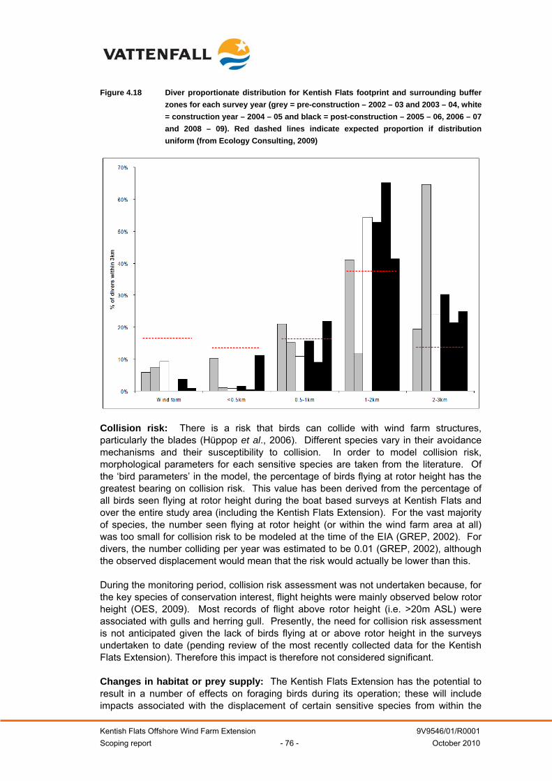
Kentish Flats Offshore Wind Farm Extension 9V9546/01/R0001 Scoping report - 76 - October 2010
Figure 4.18 Diver proportionate distribution for Kentish Flats footprint and surrounding buffer zones for each survey year (grey = pre-construction – 2002 – 03 and 2003 – 04, white = construction year – 2004 – 05 and black = post-construction – 2005 – 06, 2006 – 07 and 2008 – 09). Red dashed lines indicate expected proportion if distribution uniform (from Ecology Consulting, 2009)
Collision risk: There is a risk that birds can collide with wind farm structures, particularly the blades (Hüppop et al., 2006). Different species vary in their avoidance mechanisms and their susceptibility to collision. In order to model collision risk, morphological parameters for each sensitive species are taken from the literature. Of the ‘bird parameters’ in the model, the percentage of birds flying at rotor height has the greatest bearing on collision risk. This value has been derived from the percentage of all birds seen flying at rotor height during the boat based surveys at Kentish Flats and over the entire study area (including the Kentish Flats Extension). For the vast majority of species, the number seen flying at rotor height (or within the wind farm area at all) was too small for collision risk to be modeled at the time of the EIA (GREP, 2002). For divers, the number colliding per year was estimated to be 0.01 (GREP, 2002), although the observed displacement would mean that the risk would actually be lower than this. During the monitoring period, collision risk assessment was not undertaken because, for the key species of conservation interest, flight heights were mainly observed below rotor height (OES, 2009). Most records of flight above rotor height (i.e. >20m ASL) were associated with gulls and herring gull. Presently, the need for collision risk assessment is not anticipated given the lack of birds flying at or above rotor height in the surveys undertaken to date (pending review of the most recently collected data for the Kentish Flats Extension). Therefore this impact is therefore not considered significant. Changes in habitat or prey supply: The Kentish Flats Extension has the potential to result in a number of effects on foraging birds during its operation; these will include impacts associated with the displacement of certain sensitive species from within the
Kentish Flats Offshore Wind Farm Extension 9V9546/01/R0001 Scoping report - 77 - October 2010
Kentish Flats Extension site and as such, a small loss of foraging habitat, as discussed under disturbance and displacement. The project will also result in the direct loss of a small area of subtidal habitat, although this loss is likely to be minimal in relation to the Outer Thames Estuary area. Whilst construction noise, for example from piling operations, might temporarily displace fish from the Kentish Flats Extension, conversely fish aggregation effects of the foundation structures (see Section 4.5.2) have the potential to increase prey availability. Therefore, in the longer term certain species, such as gulls, which are not prone to displacement, may feed within the site preferentially, such effects have been recorded during monitoring at the Horns Rev offshore wind farm (NERI, 2005). Fish surveys carried out at Kentish Flats during the operational phase have not indicated any adverse effects on fish populations within the area that can be attributed to the construction of the wind farm (OES, 2009). Similarly, benthic and seabed monitoring have not shown any gross changes to the benthic habitats within the existing project area and surrounds, apart from the loss of a small area to the foundations themselves and associated small areas of scour around the structures. This being the case, it is reasonable to assume that changes in the distribution or density of prey items resulting from the development of the Kentish Flats Extension are likely to be temporary in nature and of negligible significance. Potential impacts due to decommissioning
The potential impacts during the decommissioning phase are anticipated to be similar to those described above for the construction phase. As such, they will be considered in detail as part of the EIA. Potential cumulative and in-combination impacts
Interactions between other wind farms: A number of Round 1, Round 2 and extension projects are currently operational, proposed or under construction within the Outer Thames Estuary area. There is, therefore, the potential for cumulative impacts on bird populations. Preliminary consultation with Natural England for the Kentish Flats Extension (Appendix 1.3) has highlighted the potential cumulative impacts on red-throated divers as being likely to be a key issue for the project, being located as it is within the Outer Thames Estuary SPA, which is designated for red-throated diver populations. Other wind farm projects that will be relevant with regard to cumulative impacts on the SPA include, London Array, Gunfleet Sands I and II, Greater Gabbard, Galloper, Thanet, Scroby Sands and the Norfolk Round 3 zone. Of particular note with regard to the cumulative issue, the London Array project has a 'Grampian' type condition attached to the project’s section 36 consent. This permits only one phase (comprising 175 WTG generating up to 612MW) to be constructed until such time that further evidence of potential impacts on birds is obtained and that any further development permitted will not have adverse effects upon the integrity of the Outer Thames SPA. The apparent avoidance of the operational WTG at Kentish Flats is of course relevant to the consideration of the potential cumulative effects on red-throated divers. That said, it should be noted that observations at Kentish Flats must be treated with caution since Kentish Flats does not appear to be of great importance for this species. In addition, the most recent data available suggest that some initial habituation may be occurring.
Kentish Flats Offshore Wind Farm Extension 9V9546/01/R0001 Scoping report - 78 - October 2010
Nonetheless, whilst not significant when considered in isolation, this avoidance of operational WTG will be an important consideration alongside an assessment of the availability of alternative habitat. Interactions between other activities: A number of human activities occur within or within close proximity to the Kentish Flats Extension, which could result in in-combination impacts on birds within the Outer Thames Estuary SPA (for example shipping, marine disposal sites and marine aggregate dredging). The majority of these operations tend to occur in deeper water or result in only short term and temporary disturbance; however, the impact of shipping traffic throughout the Thames Estuary may be likely to cause an in-combination effect, as it has been postulated that shipping channels may be a causative factor for diver distribution within the estuary. As such, this effect is considered significant and will be a primary consideration for the EIA.
4.2.3 Methodology and approach to EIA
Establishment of the baseline: To date, a significant number of ornithological surveys have characterised the bird use of Kentish Flats and the Kentish Flats Extension areas. Specifically, the following data sets are available as a basis for the EIA of the Kentish Flats Extension area:
• Monthly boat based surveys, 2001 – 2007;
• Monthly or bi-monthly boat based surveys (November/December to February/March) – 2008/2009 & 2009/2010 (focus on red-throated divers);
• Aerial surveys of the wider Thames Estuary strategic area (including the Kentish Flats), 2002 – 2007; and
• Digital aerial surveys (conducted by the London Array project and including the Kentish Flats) – winter season 2009/2010 and 2010/2011.
These surveys provide a continuous series of site-specific boat based data for the existing Kentish Flats site and the buffer zone (which covers the Kentish Flats Extension) together with the control area between 2002 and the present for the winter months (the key red throated diver season); summer surveys were completed between 2002 – 2007, when the FEPA monitoring ended. This, combined with the available aerial data provides a very strong data foundation for the EIA. Recognising the need to extend the original bird survey area beyond the extension area in order to replicate the original buffer area, Vattenfall have extended the survey area since December 2009. Surveys were conducted on this larger area between December 2009 and February 2010 and monthly since May 2010. Vattenfall have agreed with Natural England to continue the boat based survey program for the extended survey area and the existing control area (see Figure 4.3) until March 2011 thereby providing an updated data set for the summer months and continuing the coverage of the key winter period for another year. The ongoing surveys will employ the same survey methodologies, boat and surveyors as have been used for all of the surveys conducted to date at the Kentish Flats. . Assessment of ornithological impacts: The Kentish Flats Extension ornithological EIA section will seek to build on the knowledge accrued from the development of Kentish Flats in terms of likely key impacts and sensitivities. Based on the knowledge
Kentish Flats Offshore Wind Farm Extension 9V9546/01/R0001 Scoping report - 79 - October 2010
gained from the existing monitoring data, and pending review of the most recently collected data, it is expected that the EIA for the Kentish Flats Extension project will focus specifically on the following species:
• Red-throated diver; and
• Terns.
The potential impacts that will form the focus for the EIA will be disturbance and displacement effects during all development phases and disturbance to prey during the construction phase. Barrier effects (specifically for terns) will also be considered in detail. Presently, the need for collision risk assessment is not anticipated given the lack of birds flying at or above rotor height in the surveys undertaken to date (pending review of the most recently collected data). A particular focus will be the potential for cumulative effects on red-throated diver (other species will be considered where the potential for significant cumulative effects are apparent from a review of the baseline data). Vattenfall will assess the cumulative effects on divers through a collaborative approach working with the London Array project team and alongside the other relevant Thames wind farm developers. Specifically, the London Array project is currently undertaking a cumulative red-throated diver habitat usage and availability study using diver distribution and abundance data collected using digital aerial survey methods which includes coverage of the Kentish Flats Extension. The approach to this study has been developed and agreed with an Ornithological Review Panel (ORP) composed of representatives from Natural England and RSPB. Vattenfall are co-operating with this study and it is expected that the outputs will form an important component of the assessment of the cumulative effects for the Kentish Flats Extension. Ultimately the scope and approach of this cumulative assessment will be discussed with Natural England and the Royal Society for the Protection of Birds (RSPB), possibly through the existing ORP, in the light of the results produced by the London Array project. Offshore ornithology focus for the EIA: Key considerations for the EIA:
• Disturbance and displacement impacts (construction & operation);
• Barrier effects (focus on tern populations);
• Prey impacts (construction);
• Decommissioning impacts;
• Cumulative impacts on red throated diver from other offshore wind farm projects; and
• In-combination impacts with other (non-wind farm) activities.
Secondary considerations for the EIA:
• Collision risk (pending review of site-specific flight height data for Kentish Flats Extension);
Kentish Flats Offshore Wind Farm Extension 9V9546/01/R0001 Scoping report - 80 - October 2010
• Operational changes in habitat or prey supply;
• Cumulative impacts (other species).
4.3 Benthic and intertidal ecology
4.3.1 Existing Environment
4.3.1.1 Subtidal
The seabed of the Outer Thames Estuary is relatively shallow and comprises a heterogeneous mix of silty gravelly sand (Emu, 2002b). Sand is the dominant sediment component of the seabed substrates and shallow sand banks are common features within the Outer Thames Estuary. The sediment becomes more mixed at inshore locations where silt levels are generally increased, with the macroinvertebrate fauna being generally distributed on the basis of substrate type and depth. In general, the mixed inshore sediments host a richer and more diverse macrofauna than those offshore. The sand banks are relatively impoverished, supporting few macroinfaunal species (Emu, 2002b). A total of 249 macroinfaunal species were identified from surveys used to provide a baseline characterisation of the area for the Kentish Flats EIA (Emu, 2002b) which included a number of sample sites within the Kentish Flats Extension. A total of 193 infaunal animals, represented by 2,314 individuals were recorded during this survey. The infauna was dominated by polychaete worms, in particular Spiophanes bombyx, Scoloplos armiger, Magelona johnstoni, Goniada maculata, Eteone longa, Euclymeninae, Ophelia borealis and Notomastus latericeus. Other frequently occurring infaunal species included the bivalve, Mysella bidentata and the sea spider, Anoplodactylus petiolatus (Emu, 2002b). In addition to this, a further 56 sessile epifaunal species were identified. Important sessile epifauna, in terms of frequency of occurrence included the bryozoans (sea mats) Electra monostachys, Conopeum reticulum, Penetrantia concharum, Aspidelectra melolontha, Vesicularia spinosa and Electra pilosa together with the sponge Cliona celata and the hydroid (sea fir) Hydrallmania falcata (Emu, 2002b). Sessile epifauna were restricted in distribution and generally only recorded from trawls conducted over mixed substrates at inshore locations. The greatest diversity of sessile epifaunal species was recorded in inshore areas (near Herne Bay), while sessile epifauna were absent from the more homogeneous sandy seabed areas at offshore locations surrounding the existing Kentish Flats site. The bryozoan Flustra folicea was the most frequently occurring sessile epifaunal species. Fauna caught within the beam trawls were characteristic of the estuarine assemblage described by Rees et al. (1999). This assemblage was characterised by the hermit crab, Paguridae, common starfish, Asterias rubens, the pink prawn, Pandalus montagui, the brown shrimp, Crangon crangon and sessile epifauna, seamat Electra pilosa, sea fir Sertularia cupressina and barnacle Balanus crenatus. This type of assemblage is common throughout the UK coastal waters and across the wider north Kent, Essex and Suffolk coastal regions (Emu, 2002b). No species or habitats of conservation importance were recorded.
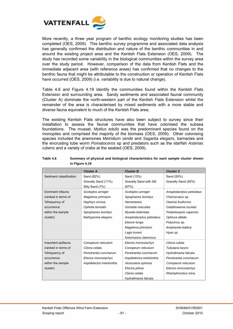
Kentish Flats Offshore Wind Farm Extension 9V9546/01/R0001 Scoping report - 81 - October 2010
More recently, a three year program of benthic ecology monitoring studies has been completed (OES, 2009). This benthic survey programme and associated data analysis has generally confirmed the distribution and nature of the benthic communities in and around the existing project area and the Kentish Flats Extension (OES, 2009). The study has recorded some variability in the biological communities within the survey area over the study period. However, comparison of the data from Kentish Flats and the immediate adjacent area (with reference areas) has confirmed that no changes to the benthic fauna that might be attributable to the construction or operation of Kentish Flats have occurred (OES, 2009) (i.e. variability is due to natural change). Table 4.6 and Figure 4.19 identify the communities found within the Kentish Flats Extension and surrounding area. Sandy sediments and associated faunal community (Cluster A) dominate the north-western part of the Kentish Flats Extension whilst the remainder of the area is characterised by mixed sediments with a more stable and diverse fauna equivalent to much of the Kentish Flats area. The existing Kentish Flats structures have also been subject to survey since their installation to assess the faunal communities that have colonised the subsea foundations. The mussel, Mytilus edulis was the predominant species found on the monopiles and comprised the majority of the biomass (OES, 2009). Other colonising species included the anemones Metridium senile and Sagartia elegans, barnacles and the encrusting tube worm Pomatoceros sp and predators such as the starfish Asterias rubens and a variety of crabs at the seabed (OES, 2009). Table 4.6 Summary of physical and biological characteristics for each sample cluster shown
in Figure 4.19
Cluster A Cluster B Cluster C Sediment classification Sand (82%)
Gravelly Sand (11%) Silty Sand (7%)
Sand (13%) Gravelly Sand with Silt (87%)
Sand (50%) Gravelly Sand (50%)
Dominant infauna (ranked in terms of %frequency of occurrence within the sample cluster)
Scoloplos armiger Magelona johnstoni Nephtys cirrosa Ophelia borealis Spiophanes bombyx Bathyporeia elegans
Scoloplos armiger Spiophanes bombyx Nemerteans Goniada maculata Mysella bidentata Anoplodactylus petiolatus Eteone longa Magelona johnstoni Lagis koreni Notomastus latericeus
Anoplodactylus petiolatus Cheirocratus sp. Owenia fusiformis Galathowenia oculata Podarkeopsis capensis Ophiura albida Polycirrus sp. Ampharete baltica Hyas sp.
Important epifauna (ranked in terms of %frequency of occurrence within the sample cluster)
Conopeum reticulum Cliona celata Penetrantia concharum Electra monostachys Aspidelectra melolontha
Electra monostachys Conopeum reticulum Penetrantia concharum Aspidelectra melolontha Vesicularia spinosa Electra pilosa Cliona celata Hydrallmania falcata
Cliona celata Tubularia larynx Hydrallmania falcata Penetrantia concharum Conopeum reticulum Electra monostachys Rhamphonotus mina
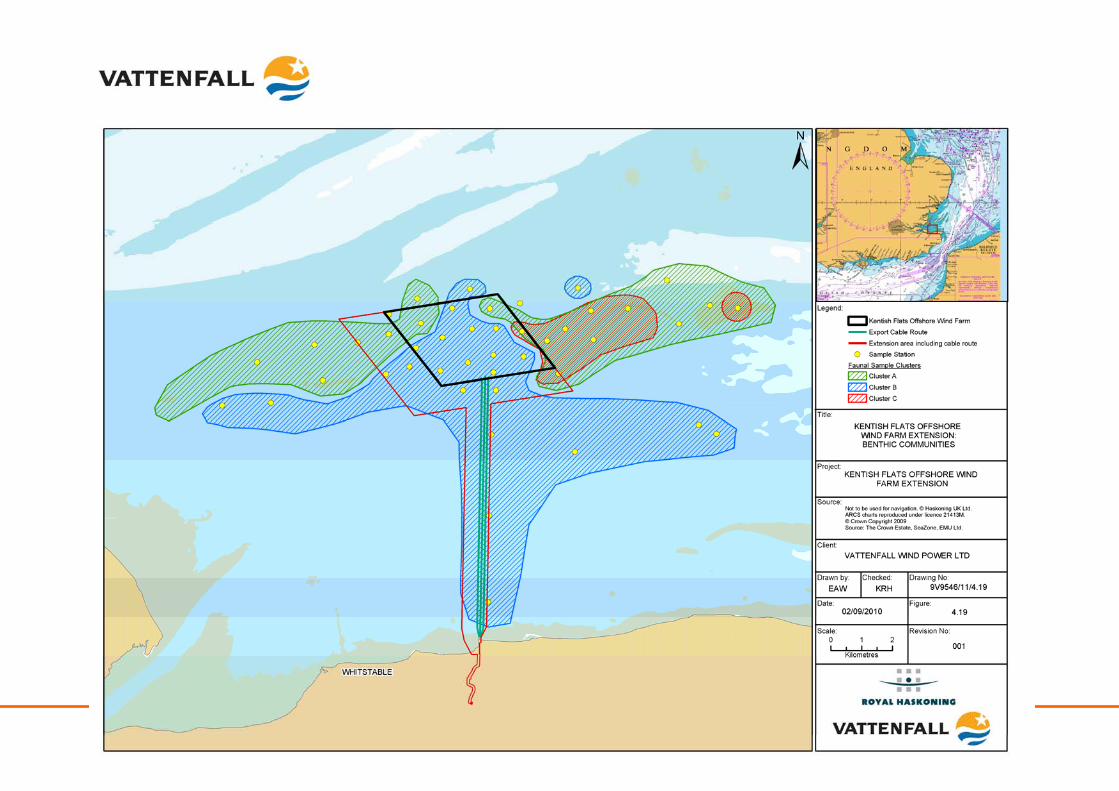
Kentish Flats Offshore Wind Farm Extension 9V9546/01/R0001 Scoping report - 82 - October 2010
Kentish Flats Offshore Wind Farm Extension 9V9546/01/R0001 Scoping report - 83 - October 2010
4.3.1.2 Intertidal
The shoreline between Whitstable and Herne Bay mostly comprises a sloping shingle upper and middle shore which grades into a lower shore of muddy sand. Exposures of the underlying London Clay may occur on the mid and lower shores, for example near Whitstable. The seawalls, which occur along much of the coast, are usually sparsely colonised by ephemeral green algae species such as Enteromorpha sp. and hard substrata may also support the brown wrack, Fucus spiralis. The communities are typical for the UK and none is of conservation importance. On a more local level, muddy sand shores backed by shingle beaches are relatively widespread throughout the this part of the Thames Estuary (Emu, 2002b). The intertidal biotopes at the landfall site at Hampton Pier are indicative of sheltered to moderately exposed coastal locations and fully marine conditions (see Figure 4.20). The biotope LS.LCS.Sh.BarSh7 ‘barren littoral shingle’ (previously listed as LGS.BarSh (Emu, 2002b)) is regarded as nationally uncommon but this likely relates to the limited number of locations surveyed under the review of UK biotope distribution. The biotopes LS.LSa.MuSa.MacAre Macoma balthica and Arenicola marina in littoral muddy sand (previously listed as LGSMacAre (Emu, 2002b)) and LR.HLR.MusB.MytB Mytilus edulis and barnacles on very exposed eulittoral rock (previous listed as ELR.MytB (Emu, 2002b)) are regarded as nationally common (Emu, 2002b) although the latter biotope may be quite rare in the Thames Estuary where it would be restricted to harder substrates. The LR.HLR.MusB.MytB biotope is likely an extension of the mussel beds on mixed substrates present on the western side of Hampton Pier with the available rock substrate, afforded by the remnants of the old pier, providing a habitat and attachment site which has been exploited by the mussels.
7 The biotopes listed in the original ES have been updated using the latest marine habitat classifications (http://www.jncc.gov.uk/marine/biotopes/hierarchy.aspx)
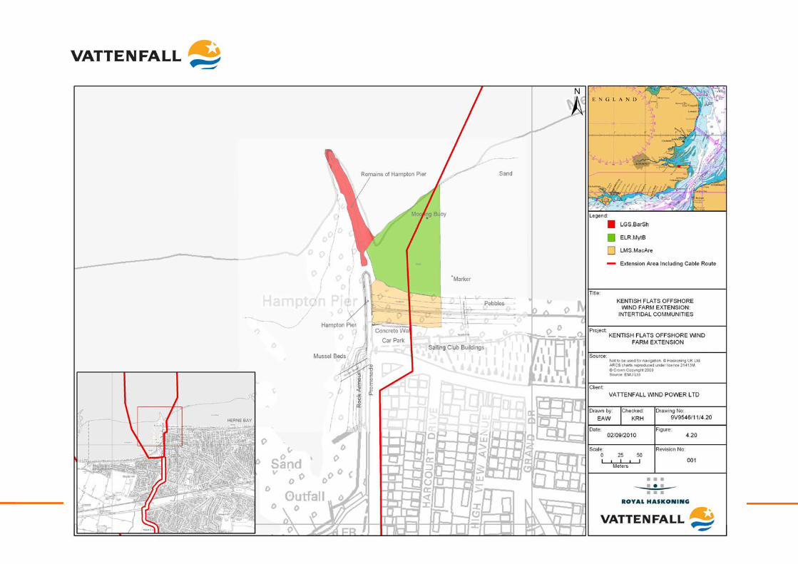
Kentish Flats Offshore Wind Farm Extension 9V9546/01/R0001 Scoping report - 84 - October 2010
Kentish Flats Offshore Wind Farm Extension 9V9546/01/R0001 Scoping report - 85 - October 2010
4.3.2 Identification of key issues
Potential impacts during construction
Physical disturbance: The primary impacts to benthic fauna from the construction of the Kentish Flats Extension include physical disturbance from jack-up vessel legs, piling and cable installation. Areas affected by jack-up operations and cable installation will be relatively small and seabed recovery is expected to occur following cessation of installation activities. The physical monitoring of the seabed at Kentish Flats has confirmed that no gross changes to the area have occurred, with areas affected by cable installation largely re-instated (OES, 2009). Depressions in the seabed created by jack-up operations are visible but affect small areas and are infilling, suggesting that benthic habitats will recover over time (Section 5.3.2.2). Monitoring of the benthos following construction confirmed that the wider Kentish Flats area has not seen a change in the faunal communities that is attributable to the construction activities (noting the areas of habitat loss or change attributable to the placement of the structures and associated scour effects) (OES, 2009) and it should be noted that no sensitive or protected habitats occur in or around the Kentish Flats Extension (noting the SAC features further to the east). The monitoring data gives confidence in predicting that, given the lack of sensitive benthic habitats, significant long term effects arising from construction activities will not occur on the benthos within the Kentish Flats Extension. Smothering: Sediment disturbance and deposition from construction activities, such as cable installation, could have an adverse and indirect impact on the benthic communities, through increased turbidity or as a result of smothering by sediment released during the construction process. Of particular note with regard to the indirect effects of the construction works is the presence of the cSAC sand bank features, the nearest of which lies directly to the east of the eastern extent of the Kentish Flats Extension. It is noted that these sandbank features are characterised as having a high degree of mobility with correspondingly mobile fauna, although the more stable muddy sand and gravel area between the banks are also included (Natural England, 2009a). The draft conservation objectives suggest that both the sandbanks and the muddy gravel habitat may be vulnerable to smothering (physical damage) although the sensitivity is noted as low or low to moderate (Natural England, 2009b). During the installation of the export cable for the existing project monitoring of the turbidity confirmed that levels of turbidity were short lived and were below threshold levels even within a few hundred metres of the installation works (Emu, 2005). Subsequent monitoring of the seabed has shown that no significant changes to the bed levels nor benthos have occurred as result of the installation (OES, 2009). It is noted also that the area is subject to some natural bedload mobility suggesting that the benthos would be tolerant of some degree of sedimentation were this to occur. Re-mobilisation of contaminated sediments: Sediment disturbance and subsequent deposition could lead to the mobilisation of contaminants that could be harmful to the benthos. The trace metal levels recorded from the sediment samples collected around Kentish Flats (including sites within or immediately adjacent to the Kentish Flats
Kentish Flats Offshore Wind Farm Extension 9V9546/01/R0001 Scoping report - 86 - October 2010
Extension) fall below any of the available guidance levels, the levels of total hydrocarbons are also generally low when compared to available reference data and the levels of PCBs recorded from the Kentish Flats sediments were all below the limits of detection from all of the sites sampled (GREP, 2002). Given the existing data, no significant impact on the benthos arising from contaminated sediments is expected to occur (also see Section 3.3.2 for discussion of oyster contaminant monitoring). Potential impacts during operation
Loss of habitat: The physical presence of foundations represents a permanent loss of habitat within a small footprint. Additionally, more temporary loss of habitat may occur due to scour around foundations. It is not anticipated; however, that such impacts will be considered significant in the context of similar available habitat in the wider area of the Outer Thames Estuary. For example, Kentish Flats is constructed using thirty 4.3m diameter piles which occupy an area of seabed of approximately 435m2; and the scour pits around the existing structures are a maximum of approximately 10m radius this equates to an area of habitat loss or change of approximately 9,800m2, which equates to around 0.1% of the wind farm area. Equivalent structures and scour at the Kentish Flats Extension would lead to a loss of a further circa 3,300m2 of benthic habitat (around 0.04% of the Extension area). Such a loss of / change in area of benthic habitat is therefore considered to be of negligible significance. Colonisation of foundations: The sub-sea structures installed at the Kentish Flats Extension would be colonised by a range of macro-invertebrate species leading to a localised increase in biodiversity. The presence of such species will provide further habitat for other species as well as serving as a refuge for fish species. Although viewed as a positive effect, this colonisation would have a negligible impact given the relatively small scale of the habitat created. A post-construction survey of the Kentish Flats monopile foundations (Emu, 2008a) found that the intertidal zone was relatively impoverished, with the predominant species being barnacles Balanus crenatus and Elminius modestus. The infralittoral zone was dominated by the mussel Mytilus edulis, with the anemones Sagartia elegans and Metridium senile. Below the mussel zone, the area was dominated by anemones along with barnacles, hydroids and the tube forming worm, Pomatoceros sp. At the seabed, the shelly sand and gravel substrate was, in places, almost completely covered with the starfish Asterias rubens (Emu, 2008a). This species is very common and likely to be present given the considerable density of its prey species, Mytilus edulis. The species recorded were comparable for the two foundations surveyed and were considered representative of the fauna colonising all of the foundations at Kentish Flats (Emu, 2008a), being typical for this type of hard substrate. The biomass values for the scrapes taken at each biological zone on the monopile confirmed that Mytilus edulis was the major biomass contributor and accounted for the intra-zonal variability in biomass observed. Therefore, given the existing knowledge gained from monitoring at Kentish Flats and the negligible significance of the colonisation issue, this impact will be a secondary consideration within the Kentish Flats Extension EIA. Potential impacts during decommissioning
The potential impacts arising during the decommissioning phase are envisaged to be similar to those described for the construction phase.
Kentish Flats Offshore Wind Farm Extension 9V9546/01/R0001 Scoping report - 87 - October 2010
Potential cumulative & in-combination impacts
Interactions between other wind farms: Interactions with the Kentish Flats Extension and other offshore wind farms are not expected, given the localised nature of the impacts on the benthos recorded at Kentish Flats and the distance to the other planned and proposed wind farm projects in the Outer Thames Estuary area (see Table 3.3). Although there would be an aggregated direct and permanent loss of habitat during the operational phase of the wind farms it is anticipated that, given the ubiquity of the species found in the Kentish Flats area across the wider southern North Sea, cumulative impacts would not be considered significant. As a result, cumulative impacts on the benthos are not considered significant and will be a secondary consideration within the Kentish Flats Extension EIA The exception to this will be a consideration of the potential for cumulative effects on the adjacent Margate and Longsands cSAC habitats with a specific focus on indirect impacts arising from plumes and sedimentation (see Section 4.3.3). Interactions between other activities: Similarly, the distance of other activities from the Kentish Flats Extension, combined with the common and widespread nature of species and habitats and the small extent of the Kentish Flats Extension means that significant in-combination impacts are not anticipated. In-combination effects on the benthos are not therefore considered significant.
4.3.3 Methodology and approach to EIA
The characterisation of the baseline environment will be informed through the existing data held for the site (see Table 4.1), specifically:
• Kentish Flats baseline benthic ecology survey (2002);
• Kentish Flats post-construction benthic ecology monitoring reports (2005 – 2007); and
• Relevant site specific geophysical survey data (as a basis for biotope mapping).
In order to correlate the existing data sets with the Kentish Flats Extension, Vattenfall propose to undertake some limited, additional benthic ecology survey work to further inform the characterisation of the project area and surrounding seabed. Specifically, the following fieldwork is proposed:
• Grab sampling at up to 15 sites (within the Kentish Flats Extension, a secondary impact area defined by the tidal excursion and from the existing control area, with sampling of a selection of previously sampled locations from the Kentish Flats monitoring program). Up to four sites will be replicate sampling sites where triplicate samples will be collected to assess small scale heterogeneity;
• 2m beam trawls collected from 5 locations across the survey area;
• Analysis of grab samples for particle size analysis (PSA), infauna and biomass; and
• Subsea video and/or photography of the seabed
Kentish Flats Offshore Wind Farm Extension 9V9546/01/R0001 Scoping report - 88 - October 2010
Surveys will be conducted in line with relevant guidance (e.g. Boyd, 2002) with methodology and final sampling locations agreed in advance with Natural England and Cefas. The data will be combined with the geophysical data sets in the ES to produce a biotope map as the basis for sensitivity assessment during the EIA process. Benthic ecology focus for the EIA: Key considerations for the EIA:
• Habitat loss due to placement of monopile foundations (construction and operation);
• Short-term impacts resulting from cable installation;
• Construction impacts on benthos arising from jack-up vessel usage or other temporary seabed disturbances;
• Smothering or sedimentation effects arising from construction activities with a specific focus on indirect effects on cSAC features;
• Cumulative impacts on cSAC from plumes and sedimentation; and
• Decommissioning impacts.
Secondary considerations for the EIA:
• Impacts on benthos from sediment contaminants (construction and operation);
• Colonisation of the subsea structures; and
• Cumulative and in-combination impacts on benthos.
4.4 Marine mammals
4.4.1 Existing Environment
The only cetacean species observed during surveys at Kentish Flats was the harbour porpoise Phocoena phocoena (ESS, 2004; ESS, 2005; ESS, 2006; ESS, 2007; and ESS, 2008). The Kentish Flats Extension lies well within the Outer Thames Estuary, where harbour porpoise numbers are low compared to waters further offshore. Figure 4.21 provides an overview of cetacean distribution as recorded during the 2004 – 2006 aerial surveys. Sightings of seals are more frequent than those for cetaceans, with a number of locations in the Thames Estuary noted as being of some importance for harbour seal Phoca vitulina (GREP, 2002). The most significant group of seals in the Thames Estuary region occur on Foulness Sands and Buxey Sands off the Essex coast in the northern Thames Estuary. Smaller groups of harbour seal are also widely distributed within the estuary including groups on sandbanks off Herne Bay and Margate, as well as other locations off the Essex coast. This includes occasional sightings on and around the Pan and Middle Sands and in the vicinity of Kentish Flats and the Kentish Flats Extension. During bird surveys at Kentish Flats, common seal were sighted in low
Kentish Flats Offshore Wind Farm Extension 9V9546/01/R0001 Scoping report - 89 - October 2010
numbers and no grey seal were sighted (ESS, 2004; ESS, 2005; ESS, 2006; ESS, 2007; and ESS, 2008).
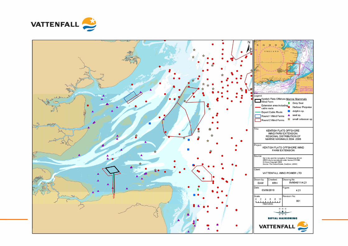
Kentish Flats Offshore Wind Farm Extension 9V9546/01/R0001 Scoping report - 90 - October 2010
Kentish Flats Offshore Wind Farm Extension 9V9546/01/R0001 Scoping report - 91 - October 2010
4.4.2 Identification of key issues
Potential impacts during construction
Disturbance through noise and vibration: A number of sources of noise and vibration are associated with offshore wind farm construction, including piling activities and the increased activity from jack-up/heavy lift plant and support vessels. Of these, it is the noise generated by piling activities that has the potential to disturb marine mammals at a considerable distance from the activity. Very close to piling activities, injuries and in extreme cases fatalities can occur. The piling noise generated by the installation of monopiles at Kentish Flats was measured as part of a COWRIE study (Nedwell et al., 2007) and compared to equivalent piling operations at other UK sites. For the 4.3m diameter piles installed at the existing site, an un-weighted peak-to-peak Source Level of 243 dB re. 1 μPa @ 1 m was estimated from the monitoring data. The shallow waters of the existing Kentish Flats project area meant that the piling noise reduced quickly with distance so that the predicted behavioural impact ranges (estimated using the dBHt metric) were very small – for harbour porpoise a range of just 2.5km and for harbour seal 2.2km (Nedwell et al., 2007). The low numbers of marine mammals in the area around the Kentish Flats Extension and the very low predicted behavioural impact ranges means that impacts on marine mammals are likely to be of negligible significance. Collision Risk: The greatest collision risk to marine mammals is likely to occur during the construction phase of the project, due to the number and types of vessels operating in the area. Ship strikes have the potential to cause mortality to marine mammals and are far from infrequent (Wilson et al., 2007). In the case of the Kentish Flats Extension, the very low density of marine mammals recorded at the site means that such collision risk is considered to be very low, however due to the significance of this impact this will be a key consideration of the EIA. Potential impacts during operation
Disturbance through noise and vibration: Underwater noise from the operation of WTG also has the potential to disturb marine mammals although at much lower levels than construction noise. In the case of Kentish Flats, Nedwell et al. (2007) recorded noise from the operational WTG as part of their COWRIE sponsored study. The report concluded that the operational noise recorded at Kentish Flats, in common with the other UK sites monitored, was very low. WTG noise was recognisable at Kentish Flats by the presence of tonal components (caused by rotating machinery) which decayed quickly with distance from the WTG (Nedwell et al., 2007). In fact, the tonal noise from adjacent shipping was found to dominate the WTG derived noise (Nedwell et al., 2007). Nedwell et al. (2007) concluded that the WTG noise represented a maximum increase above background of 3dBht which they considered to be so low that there would be no impact on marine mammals. This being the case, and given that similar WTG will be installed, it can be concluded that the operational WRT at the Kentish Flats Extension would also generate a very low
Kentish Flats Offshore Wind Farm Extension 9V9546/01/R0001 Scoping report - 92 - October 2010
level of subsea noise. Given the evidence from the COWRIE study at Kentish Flats, it is considered that operational noise impacts are unlikely to be of significance; therefore this impact will be a secondary consideration within the EIA Collision risk: Other than routine maintenance and survey activity, it is likely there will be a low density of shipping associated with the Kentish Flats Extension during the operational phase. Given that the number of marine mammals in the area is also very low, the potential for collision with wind farm associated vessels during the operational phase is considered unlikely and this will be a secondary consideration within the EIA. Barrier effects: Guidance on offshore wind farm development in relation to the Habitats and Bird Directives (Defra, 2005) indicates that barrier effects could be a potential issue. Post-construction and operational monitoring at the Nysted and Horns Rev offshore wind farms in Denmark indicates that this issue does not represent a significant concern as cetacean and pinniped species were still recorded as occurring and foraging in the operational wind farms. Given the evidence from the existing Kentish Flats monitoring data and the low importance of the Kentish Flats Extension area for marine mammals, barrier effects are unlikely to be of significance. Potential impacts during decommissioning
The impacts associated with the decommissioning of the Kentish Flats Extension on cetaceans and seals would be similar to those of construction, with the exception of any need for piling, therefore, the need for extensive mitigation measures would be significantly reduced. Potential cumulative and in-combination impacts
Interactions between other wind farms: The most significant cumulative impact for marine mammals is likely to be associated with construction noise. There is the potential for piling at the Kentish Flats Extension to overlap with that at other in-construction wind farms in the Outer Thames Estuary. However, this cumulative impact would be limited by the small number of WTG at the Kentish Flats Extension and the relatively short installation period. Interactions between other activities: There is the potential for other activities occurring in the Outer Thames Estuary to act in-combination with those of the Kentish Flats Extension. However, many of those which would normally be considered in terms of noise do not occur in close proximity to the site (e.g. oil and gas or aggregate dredging).
4.4.3 Methodology and approach to EIA
The baseline environment for marine mammals will be described through historical survey data and information such as the studies undertaken in support of the Kentish Flats EIA and subsequent boat-based and aerial ornithological monitoring data. In addition, data available from the other Outer Thames offshore wind farms, including data generated by the aerial survey program being conducted by the London Array project and general reference data available from the literature such as the SCANS II surveys will be used as appropriate.
Kentish Flats Offshore Wind Farm Extension 9V9546/01/R0001 Scoping report - 93 - October 2010
Site specific data of the noise generated by piling at the Kentish Flats is available from the COWRIE monitoring completed at the site (Nedwell et al., 2007). Since piles installed at the Kentish Flats Extension will be of a similar size to those used at the existing site, no further noise modelling should be required to inform the EIA process. The implications of the Amendments to the Conservation (Natural Habitats &c.) Regulations 1994 and the Offshore Marine Conservation (Natural Habitats, &c.) Regulations 2007 will be taken into consideration when developing the Kentish Flats Extension EIA. All cetaceans in UK waters are classified as European Protected Species (EPS) and therefore the construction of the Kentish Flats Extension is likely to require an EPS licence since:
• The local abundance and distribution of certain species could be significantly affected by the noise produced or by creation of a barrier to natural movement; or
• An EPS could be injured or killed.
As part of the consultation undertaken to date with Natural England, it was stated that that appropriate mitigation would be required to avoid disturbance from piling. However, it was Natural England’s opinion that no additional data collection would be required for extensions (assuming mitigation is in place) although some assessment of the potential for cumulative noise issues from other developments would need to be considered (Appendix 1.2). With respect to this, Vattenfall will assess the likelihood of disturbance or injury to marine mammals and as such, Vattenfall will commit to further discussions with Natural England regarding an appropriate mitigation strategy for the Kentish Flats Extension. Marine mammal focus for the EIA: Key considerations for the EIA:
• Construction noise (in particular piling noise);
• Collision risk (construction & operation);
• Decommissioning impacts; and
• Cumulative impacts– interactions between other wind farms (construction noise).
Secondary considerations for the EIA:
• Operational noise and vibration impacts;
• Barrier effects; and
• In-combination effects – interactions between other activities.
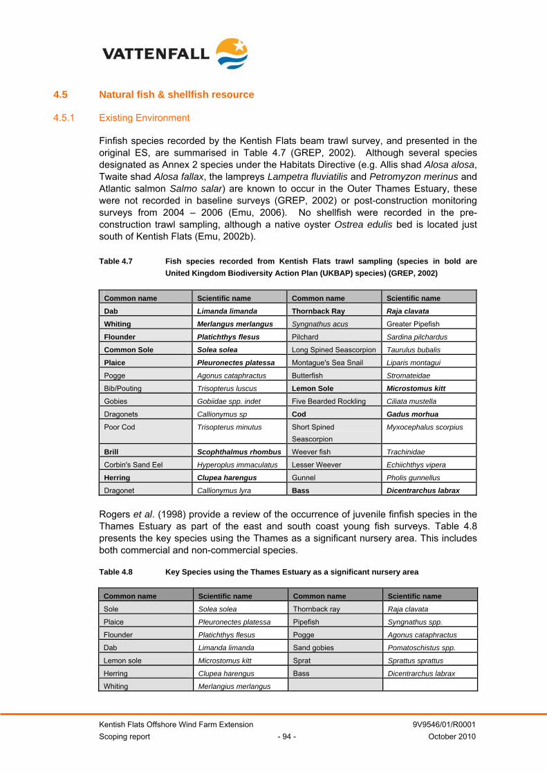
Kentish Flats Offshore Wind Farm Extension 9V9546/01/R0001 Scoping report - 94 - October 2010
4.5 Natural fish & shellfish resource
4.5.1 Existing Environment
Finfish species recorded by the Kentish Flats beam trawl survey, and presented in the original ES, are summarised in Table 4.7 (GREP, 2002). Although several species designated as Annex 2 species under the Habitats Directive (e.g. Allis shad Alosa alosa, Twaite shad Alosa fallax, the lampreys Lampetra fluviatilis and Petromyzon merinus and Atlantic salmon Salmo salar) are known to occur in the Outer Thames Estuary, these were not recorded in baseline surveys (GREP, 2002) or post-construction monitoring surveys from 2004 – 2006 (Emu, 2006). No shellfish were recorded in the pre-construction trawl sampling, although a native oyster Ostrea edulis bed is located just south of Kentish Flats (Emu, 2002b). Table 4.7 Fish species recorded from Kentish Flats trawl sampling (species in bold are
United Kingdom Biodiversity Action Plan (UKBAP) species) (GREP, 2002)
Common name Scientific name Common name Scientific name
Dab Limanda limanda Thornback Ray Raja clavata
Whiting Merlangus merlangus Syngnathus acus Greater Pipefish
Flounder Platichthys flesus Pilchard Sardina pilchardus
Common Sole Solea solea Long Spined Seascorpion Taurulus bubalis
Plaice Pleuronectes platessa Montague's Sea Snail Liparis montagui
Pogge Agonus cataphractus Butterfish Stromateidae
Bib/Pouting Trisopterus luscus Lemon Sole Microstomus kitt
Gobies Gobiidae spp. indet Five Bearded Rockling Ciliata mustella
Dragonets Callionymus sp Cod Gadus morhua
Poor Cod Trisopterus minutus Short Spined Seascorpion
Myxocephalus scorpius
Brill Scophthalmus rhombus Weever fish Trachinidae
Corbin's Sand Eel Hyperoplus immaculatus Lesser Weever Echiichthys vipera
Herring Clupea harengus Gunnel Pholis gunnellus
Dragonet Callionymus lyra Bass Dicentrarchus labrax
Rogers et al. (1998) provide a review of the occurrence of juvenile finfish species in the Thames Estuary as part of the east and south coast young fish surveys. Table 4.8 presents the key species using the Thames as a significant nursery area. This includes both commercial and non-commercial species. Table 4.8 Key Species using the Thames Estuary as a significant nursery area
Common name Scientific name Common name Scientific name
Sole Solea solea Thornback ray Raja clavata
Plaice Pleuronectes platessa Pipefish Syngnathus spp.
Flounder Platichthys flesus Pogge Agonus cataphractus
Dab Limanda limanda Sand gobies Pomatoschistus spp.
Lemon sole Microstomus kitt Sprat Sprattus sprattus
Herring Clupea harengus Bass Dicentrarchus labrax
Whiting Merlangius merlangus
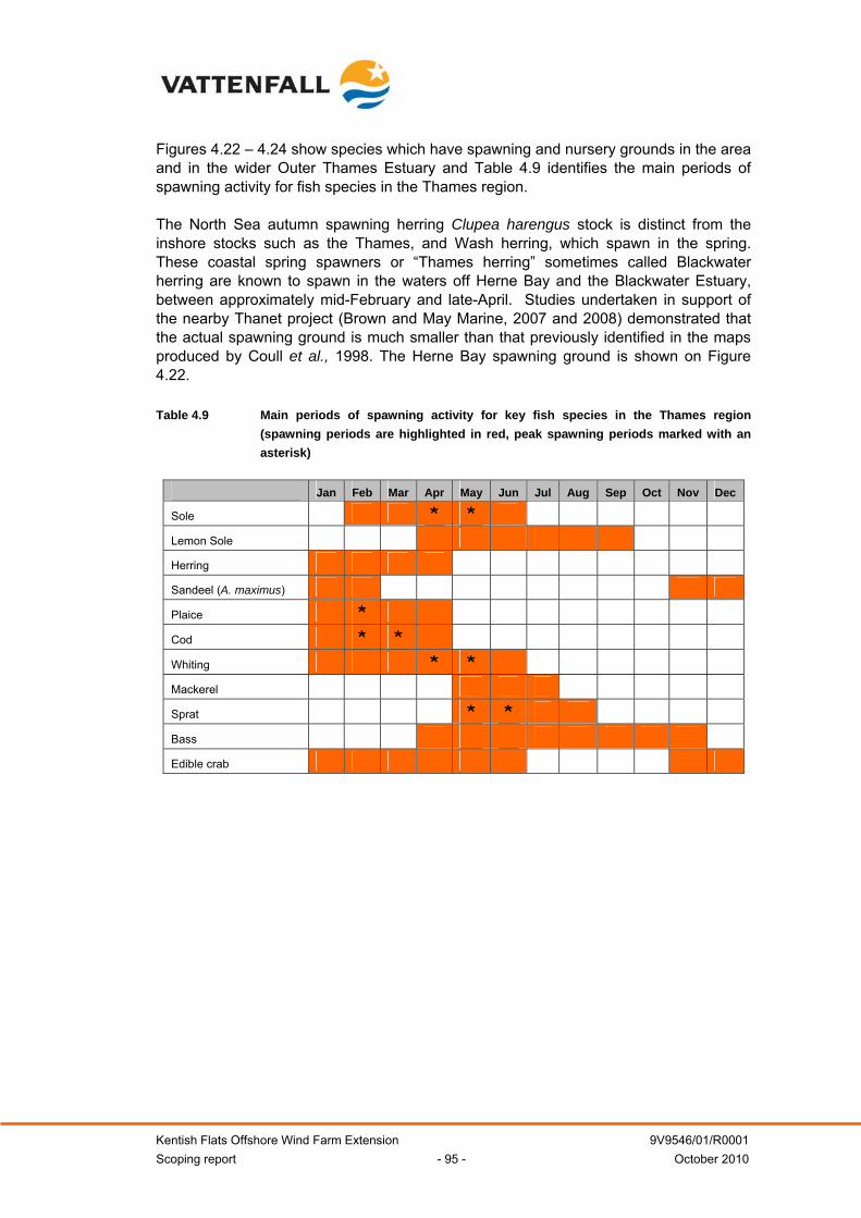
Kentish Flats Offshore Wind Farm Extension 9V9546/01/R0001 Scoping report - 95 - October 2010
Figures 4.22 – 4.24 show species which have spawning and nursery grounds in the area and in the wider Outer Thames Estuary and Table 4.9 identifies the main periods of spawning activity for fish species in the Thames region. The North Sea autumn spawning herring Clupea harengus stock is distinct from the inshore stocks such as the Thames, and Wash herring, which spawn in the spring. These coastal spring spawners or “Thames herring” sometimes called Blackwater herring are known to spawn in the waters off Herne Bay and the Blackwater Estuary, between approximately mid-February and late-April. Studies undertaken in support of the nearby Thanet project (Brown and May Marine, 2007 and 2008) demonstrated that the actual spawning ground is much smaller than that previously identified in the maps produced by Coull et al., 1998. The Herne Bay spawning ground is shown on Figure 4.22. Table 4.9 Main periods of spawning activity for key fish species in the Thames region
(spawning periods are highlighted in red, peak spawning periods marked with an asterisk)
Jan Feb Mar Apr May Jun Jul Aug Sep Oct Nov Dec
Sole * * Lemon Sole Herring Sandeel (A. maximus) Plaice * Cod * * Whiting * * Mackerel Sprat * * Bass Edible crab
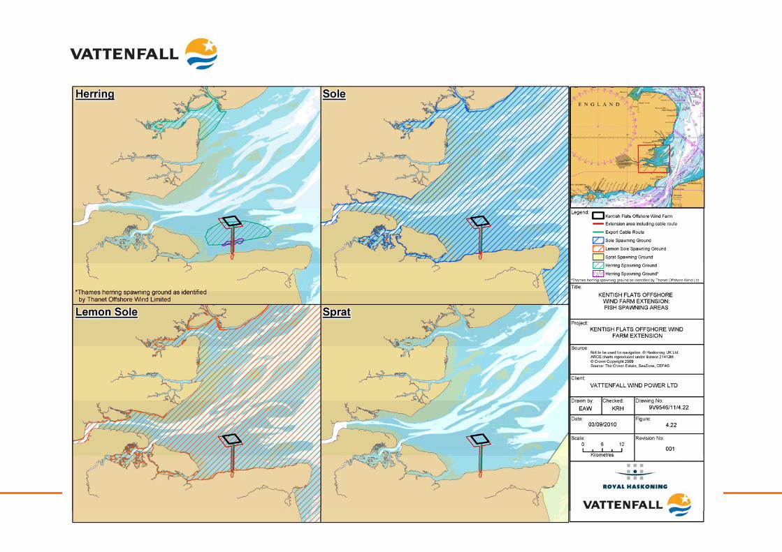
Kentish Flats Offshore Wind Farm Extension 9V9546/01/R0001 Scoping report - 96 - October 2010
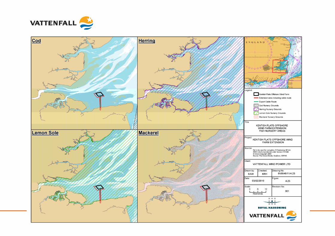
Kentish Flats Offshore Wind Farm Extension 9V9546/01/R0001 Scoping report - 97 - October 2010
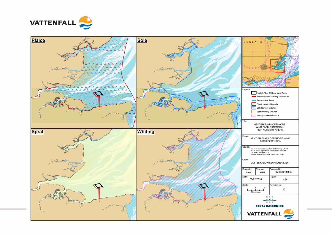
Kentish Flats Offshore Wind Farm Extension 9V9546/01/R0001 Scoping report - 98 - October 2010
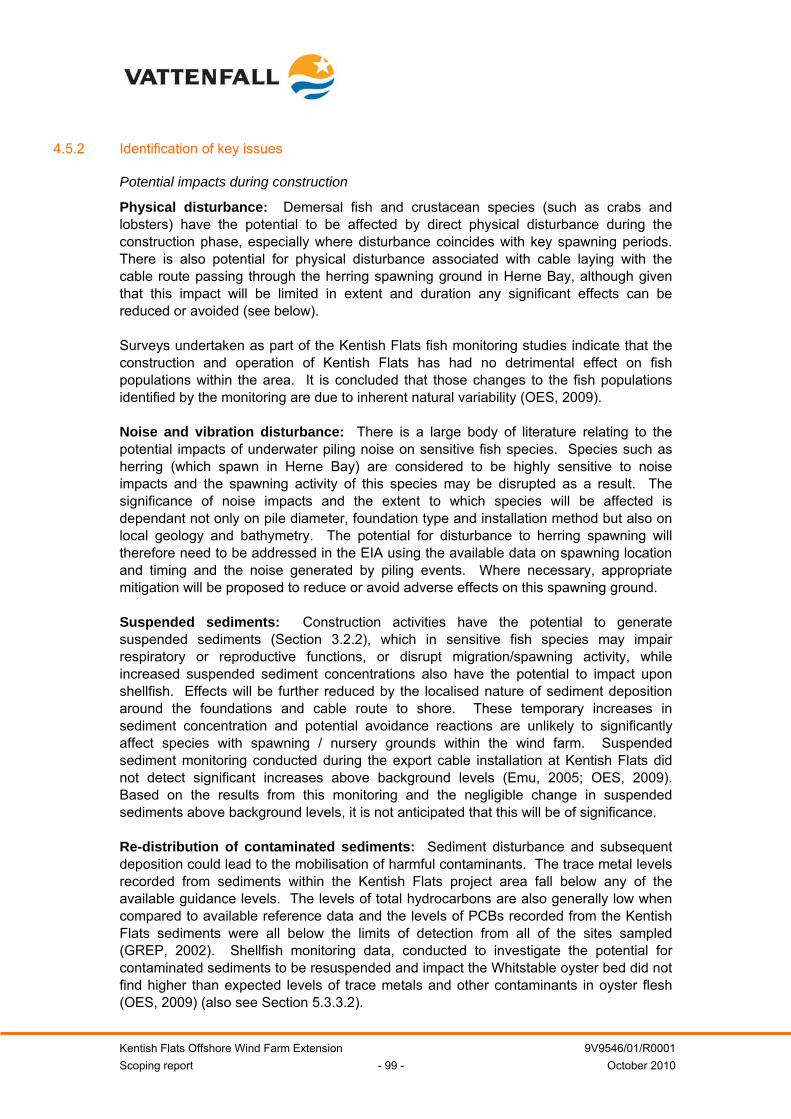
Kentish Flats Offshore Wind Farm Extension 9V9546/01/R0001 Scoping report - 99 - October 2010
4.5.2 Identification of key issues
Potential impacts during construction
Physical disturbance: Demersal fish and crustacean species (such as crabs and lobsters) have the potential to be affected by direct physical disturbance during the construction phase, especially where disturbance coincides with key spawning periods. There is also potential for physical disturbance associated with cable laying with the cable route passing through the herring spawning ground in Herne Bay, although given that this impact will be limited in extent and duration any significant effects can be reduced or avoided (see below). Surveys undertaken as part of the Kentish Flats fish monitoring studies indicate that the construction and operation of Kentish Flats has had no detrimental effect on fish populations within the area. It is concluded that those changes to the fish populations identified by the monitoring are due to inherent natural variability (OES, 2009). Noise and vibration disturbance: There is a large body of literature relating to the potential impacts of underwater piling noise on sensitive fish species. Species such as herring (which spawn in Herne Bay) are considered to be highly sensitive to noise impacts and the spawning activity of this species may be disrupted as a result. The significance of noise impacts and the extent to which species will be affected is dependant not only on pile diameter, foundation type and installation method but also on local geology and bathymetry. The potential for disturbance to herring spawning will therefore need to be addressed in the EIA using the available data on spawning location and timing and the noise generated by piling events. Where necessary, appropriate mitigation will be proposed to reduce or avoid adverse effects on this spawning ground. Suspended sediments: Construction activities have the potential to generate suspended sediments (Section 3.2.2), which in sensitive fish species may impair respiratory or reproductive functions, or disrupt migration/spawning activity, while increased suspended sediment concentrations also have the potential to impact upon shellfish. Effects will be further reduced by the localised nature of sediment deposition around the foundations and cable route to shore. These temporary increases in sediment concentration and potential avoidance reactions are unlikely to significantly affect species with spawning / nursery grounds within the wind farm. Suspended sediment monitoring conducted during the export cable installation at Kentish Flats did not detect significant increases above background levels (Emu, 2005; OES, 2009). Based on the results from this monitoring and the negligible change in suspended sediments above background levels, it is not anticipated that this will be of significance. Re-distribution of contaminated sediments: Sediment disturbance and subsequent deposition could lead to the mobilisation of harmful contaminants. The trace metal levels recorded from sediments within the Kentish Flats project area fall below any of the available guidance levels. The levels of total hydrocarbons are also generally low when compared to available reference data and the levels of PCBs recorded from the Kentish Flats sediments were all below the limits of detection from all of the sites sampled (GREP, 2002). Shellfish monitoring data, conducted to investigate the potential for contaminated sediments to be resuspended and impact the Whitstable oyster bed did not find higher than expected levels of trace metals and other contaminants in oyster flesh (OES, 2009) (also see Section 5.3.3.2).
Kentish Flats Offshore Wind Farm Extension 9V9546/01/R0001 Scoping report - 100 - October 2010
Given the extensive work done investigating this impact for Kentish Flats and the results that have been acquired, it is considered that this issue will not be of significance. Potential impacts during operation
Operational noise: During the operational phase of the wind farm, the main source of underwater noise will be the vibration mechanically generated from the WTG, which will be transmitted into the sea through the structure of the foundations (Nedwell et al., 2003). It is recognised that noise levels generated by operational wind farms are of significantly lower magnitude than those produced by other activities such as commercial fishing or aggregate dredging (CMACS, 2003). Direct measurements of operational noise at the Kentish Flats project found no evidence that the WTG contributed to background noise levels and an analysis of species perceived sound levels concluded that no effect on marine species was expected (Nedwell et al., 2007). Therefore, given the conclusions of the work undertaken to date with regard to the effects of operational noise, this impact is not considered to be of significance. Loss of habitat: During the operational phase there will be permanent loss of fish and crustacean habitat in the direct footprint of the foundations. However, the loss of area for Kentish Flats Extension is approximately 0.1% of the extension area (see Section 4.3.2, above). Therefore, such impacts will be highly localised and, based on the monitoring data obtained for Kentish Flats, unlikely to have any significant effects on the fish populations present (Emu, 2006b). Monitoring studies conducted at Kentish Flats (Kentish Flats, 2007) indicated that there were no changes to the fish resource at the site that could be related to the presence and operation of Kentish Flats; all changes over a three year period were considered to be due to natural change. Given the work done investigating this impact for Kentish Flats and the findings of those studies, this impact is not considered to be of significance for the Kentish Flats Extension. Effects of electromagnetic fields (EMF): Elasmobranchs and some teleost species (e.g. cod Gadus Morhua) are considered to be sensitive to the effects of EMF. Research undertaken to date has not been conclusive as to the EMF impacts from buried cables associated with wind farms and their potential to interfere with the electromagnetic sensory receptors used by these species to hunt prey and navigate. Recent mesocosm studies (Gill et al., 2009) showed no evidence of any positive or negative impacts on elasmobranch species as a result of EMF. Monitoring at Kentish Flats indicated an increase in thornback ray Raja clavata (nominally an EMF sensitive species) on an annual basis from 2004 to 2006. Of particular relevance is the fact that there was no discernable difference between the data for Kentish Flats and the reference areas (with no artificial EMF sources), including the population structure changes; therefore it was concluded that any changes were due to wider processes and not due to the operation of Kentish Flats (Kentish Flats, 2007). Given the lack of observed effects at Kentish Flats, coupled with the fact that the Kentish Flats Extension’s export cable will be installed alongside the Kentish Flats cables, the issue of EMF effects on fish is not considered to be significant. It is also worth noting that all cables will be buried which will additionally mitigate any potential EMF effects, by increasing the spatial separation between cable and receptor. Increase in diversity/number of individuals: Concrete and steel structures on the seabed are likely to become colonised by a range of benthic invertebrate species (see
Kentish Flats Offshore Wind Farm Extension 9V9546/01/R0001 Scoping report - 101 - October 2010
Section 4.3.2) and this small increase in the overall diversity and productivity of the local seabed communities could in turn lead to an aggregation of fish species. The presence of structures on the seabed will also increase habitat complexity and promote the aggregation of fish. However, monitoring studies conducted at Kentish Flats (Kentish Flats, 2007) concluded that all changes over a three year period were considered to be due to natural change and could not be related to the presence and operation of Kentish Flats. As no impacts (positive or negative) were detected at Kentish Flats, this impact is not considered to be significant. Potential impacts during decommissioning
The potential impacts associated with the decommissioning phase are envisaged to be similar to those described for construction. Potential cumulative impacts
Interactions with other wind farms: The main cumulative impact of concern would be from underwater noise impacts during the construction phase. Cumulative impacts could arise in conjunction with other wind farm projects if two or more projects undertake piling simultaneously. Dependant upon the proximity of other wind farm sites and the species of fish involved, the combined effect of simultaneous piling could cause an impact over an area greater than the Kentish Flats Extension when considered in isolation. Kentish Flats and the Kentish Flats Extension are situated in very shallow water and consequently, propagation of underwater sound, and particularly the very low frequency components of the underwater sound, is very poor (Nedwell et al., 2007). As a result, the behavioural impact ranges predicted from the impact pile driving operations are considerably less than those recorded for other projects (Nedwell et al., 2007). For Kentish Flats, the perceived piling sound level varied significantly between species. The range at which a strong avoidance reaction would be expected for the most sensitive fish species assessed (herring - a level of 90 dBht) was 2.5km (Nedwell et al., 2007). As such it is unlikely that there would be any cumulative effects from the Kentish Flats Extension interacting with other wind farm sites as the nearest wind farm is the London Array, approximately 25km away, on which construction for the first phase is due to be completed before work on the Kentish Flats Extension has begun. Although significant cumulative effects are considered unlikely they will be secondary considerations for the Kentish Extension EIA. Interactions with other activities: There is the potential for the impacts of other activities occurring in the Outer Thames Estuary to interact cumulatively with those of the Kentish Flats Extension. However, many of those which would normally be considered in terms of noise do not occur in close proximity to the site. There are no oil and gas licensing blocks near or adjacent to the Kentish Flats Extension and similarly the closest licensed aggregates extraction area is 40km to the north-east. Based on the noise monitoring data discussed above, there will be no in-combination impacts during the construction or operational phase of the project and these will therefore be a secondary consideration of the EIA.
4.5.3 Methodology and approach to EIA
Existing broad scale data for the study area, as collected during the Kentish Flats EIA, the subsequent benthic ecology and fish monitoring studies, the newly commissioned benthic ecology survey of the extension area and from wider studies in the Outer Thames

Kentish Flats Offshore Wind Farm Extension 9V9546/01/R0001 Scoping report - 102 - October 2010
Estuary, is considered to be comprehensive in describing the fish and shellfish resource. These data will be reviewed along with other sources, including those from nearby wind farm sites, Cefas ground fish survey stations and specific research. Assessment of impacts will be informed through the Kentish Flats monitoring studies (as detailed in Table 4.1) which have described the spatial and temporal distribution of key fish and shellfish species in the area, the findings from industry-wide studies (e.g. COWRIE funded research) such as those on EMF and piling noise impacts as well as information obtained through consultation with local sea fisheries committees and commercial fishermen. In accordance with the Cefas (2004b) guidance the assessment phase of the EIA will consider the following aspects for fish and shellfish resource in the area:
• Spawning grounds;
• Nursery grounds;
• Feeding grounds;
• Shellfish production area (including oyster beds);
• Overwintering areas for crustaceans (e.g. lobster and crab); and
• Migration routes.
Vattenfall consider there to be sufficient existing information to characterise the baseline environment from the studies undertaken for the Kentish Flats ES and the subsequent monitoring work. Therefore, no further site specific fish or shellfish survey work will be completed beyond the additional beam trawls proposed as part of the benthic ecology survey program. Natural fish resources focus for the EIA: Key considerations for the EIA:
• Physical disturbance from construction and decommissioning activities;
• Noise and vibration disturbance from construction and decommissioning activities; and
• Cumulative construction noise.
Secondary considerations for the EIA:
• Operational noise;
• Loss of habitat;
• EMF effects;
• Suspended sediments from construction activities:
• Re-suspension of contaminated sediments from construction activities;
• Aggregation effects around the new structures; and
• In-combination effects.
Kentish Flats Offshore Wind Farm Extension 9V9546/01/R0001 Scoping report - 103 - October 2010
5 HUMAN ENVIRONMENT
This section provides details relating to the offshore human environment, both within and adjacent to the Kentish Flats Extension. Anthropogenic activities of relevance to the Kentish Flats Extension include commercial fisheries, navigation and shipping, landscape and seascape, marine archaeology, radar and transmission systems, Ministry of Defence (MoD), unexploded ordinance, aggregate dredging, oil and gas extraction and tourism and recreation. This section provides a baseline for these receptors and identifies any key issues resulting from the construction, operation and decommissioning of the Kentish Flats Extension as well as setting out the proposed approach to the EIA. Currently available data sets are listed in Table 5.1 below. Table 5.1 Available human environment data sets Data Date Assessment of the Fishing Industry in Relation to the Proposed Kentish Flats wind farm. Ford (2002)
Kentish Flats Environmental Statement GREP (2002)
Fisheries data (landings, areas fished etc), Cefas, MMO, ICES 2005 – 2010 data required
Kentish Flats Monitoring Programme Fisheries Surveys – Baseline Fisheries Surveys (Final Report).
Emu (2004)
Kentish Flats Wind Farm Monitoring Programme - Fisheries Surveys - Post Construction Fisheries Survey
Emu (2006)
Kentish Flats Fisheries Comparative Study Emu (2006)
Kentish Flats Offshore Wind Farm FEPA Monitoring Summary Report OES (2008)
Kentish Flats Offshore Wind Farm FEPA Monitoring Summary Report OES (2009)
Maritime and Coastal Archaeological Assessment Wessex Archaeology (2002)
Kentish Flats Wind Farm Landscape and Seascape Visual Impact Assessment. Report to GREP, No. NE0610001a
Enviros Aspinwall (2002)
Buried unexploded ordnance threat assessment Fugro (2002)
Consultation Process – Manston and Southend Airports. Report to GREP Airport Planning & Development (APD) (2002).
Investigations into possible radar interactions with a proposed NEG Micon wind farm. S&E/S/0110.
Qinetiq (2002)
Investigations into possible effects on maritime radio frequency systems. Report to GREP, No. Qinetiq/S&E/SPS/CR021315/1.0.
Qinetiq (2002)
Public consultation study for the Kentish Flats Offshore Wind Farm Magellan House Marketing (2002)
Investigation of Technical and Operational Effects on Marine Radar Close to Kentish Flats Offshore Wind Farm
Marico Marine (2007)
5.1 Commercial fisheries
5.1.1 Existing environment
Throughout this section, commercial fishing is defined as any licensed fishing activity undertaken for declared tax profit. As there is no single data source or recognised

Kentish Flats Offshore Wind Farm Extension 9V9546/01/R0001 Scoping report - 104 - October 2010
model for establishing a commercial fisheries baseline within small, discrete sea areas such as the Kentish Flats Extension, a baseline will therefore be derived using data and information from a number of sources. The principal sources of data and information available are:
• Defra – Fisheries Statistics Unit and the Marine Management Organisation (MMO): Surveillance Section;
• Kent and Essex Sea Fisheries Committee (K&ESFC);
• International Council for the Exploration of the Sea (ICES); and
• Centre for Environment, Fisheries and Aquaculture Science (Cefas).
In addition, consultation will be carried out with the local fishermen and fishing associations from the ports of Whitstable, Herne Bay, Ramsgate and the Essex side of the estuary. The Kentish Flats Extension lies within ICES rectangle 31F1. Commercial fisheries were assessed for the original Kentish Flats EIA (GREP, 2002). It was estimated that 75% to 90% of fish harvested from the vicinity of the existing Kentish Flats project by full-time fishermen originated from fifteen boats operating out of Whitstable Harbour, Faversham and Herne Bay. There were also four part-time fishermen operating trailer-launched boats from Herne Bay that were considered important in relation to the local industry since they fished at the most productive times of the year, while there was also some activity from fishermen from Ramsgate and Queenborough (GREP, 2002). Vessels from the Essex side of the Thames Estuary sometimes fished in the vicinity of Kentish Flats when either the fishing was especially good there or especially poor on their more usual fishing grounds. However, few considered Kentish Flats itself a particularly important area for commercial fisheries (GREP, 2002). The Whitstable oyster beds to the south of the Kentish Flats Extension are dredged regularly, whilst cockle-dredgers from Whitstable and Leigh-on-Sea occasionally operate over the sandbanks to the west of the site although the main cockle production areas lie elsewhere within the estuary (GREP, 2002). Up to thirty “very part-time” fishermen, normally using small trailer-launched boats, mostly from Herne Bay, were also reported as fishing Kentish Flats. Furthermore, in exceptional years, vessels have travelled from as far away as The Wash to fish in the vicinity of the Kentish Flats Extension, typically in response to the seasonal occurrence of particular species (GREP, 2002). The commercial fishing methods that were identified as being used in this part of the Thames estuary included: (GREP, 2002):
• Trawling (either single or pairing);
• Gill-netting (fixed or attached and drifted with boat – drift netting);
• Whelk-potting;
• Lobster/crab-potting;
• Oyster-dredging;
• Suction-dredging; and
• Weed raking.
Kentish Flats Offshore Wind Farm Extension 9V9546/01/R0001 Scoping report - 105 - October 2010
Of these, netting and occasional trawling were considered to account for the majority of the activity within and around Kentish Flats and the Kentish Flats Extension. Figure 5.1 identifies the fishing activity recorded around the Kentish Flats Extension (from 2005 – 2007)8. The evidence gathered in preparation of the original EIA would suggest that the Kentish Flats Extension is of peripheral importance for the majority of fishermen in the region. However, it is noted that anecdotal evidence from the Kentish Flats maintenance vessel crews has recorded occasional fishing effort within Kentish Flats in the form of demersal trawling. Impacts on recreational fishing are considered in Section 8.5.3.
5.1.2 Identification of key issues
A range of potential impacts on commercial fishing grounds may occur during the construction and operation of an offshore wind farm, with these being described in the following section. Potential impacts during construction
Exclusion from established fishing grounds and increased conflict over diminished fishing ground: During the construction phase it is generally standard practice to establish 500m safety zones around the construction vessels. The imposition of temporary safety zones during the construction phase could result in short term increases in steaming times (distances) as a consequence of vessels having to divert around the safety zones. Fishing vessels will therefore be excluded from fishing within certain areas of the cable corridor and Kentish Flats Extension during some or all of the construction period, with effort from those vessels potentially being displaced to other areas during that period of time. Prior to construction, a Commercial Fisheries Management Plan will be established through consultation with the local fishing industry which would outline the requirements for the management of commercial fisheries during the construction phase and which will detail the role of the Fisheries Liaison Officer (FLO). Displacement of, or reduction in, fish and shellfish resource: There is the potential for a temporary displacement of sensitive fish species from the area of the construction works as a result of increased levels of underwater noise associated with piling activities. This displacement could have an indirect effect on fishing vessels operating in the area. However, given the sporadic nature of fishing activities in this area, the short period of construction and the results of monitoring at Kentish Flats to-date, this is not anticipated to be a significant long term impact. However, since noise effects on fish will be assessed, the results of the ecological assessment will be a secondary consideration of the EIA in terms of potential effects on the associated commercial fisheries.
8 Data made available by the MMO. This includes both vessel Monitoring System (VMS) data for UK vessels over 15m and overflight data of all fishing vessels. Due to issues with interpretation this figure should be seen as indicative of areas of fishing effort rather than a quantitative assessment of effort.
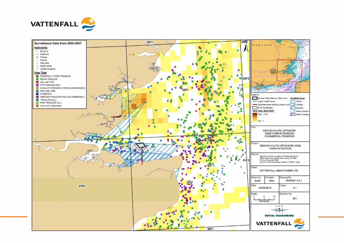
Kentish Flats Offshore Wind Farm Extension 9V9546/01/R0001 Scoping report - 106 - October 2010
Kentish Flats Offshore Wind Farm Extension 9V9546/01/R0001 Scoping report - 107 - October 2010
Loss or damage to gear: Static gear fishing occurs inshore of the extension area including around the nearshore export cable route. Kentish Flats Extension is also within an area used for occasional whelk potting; therefore, the potential exists for the loss of fishing gear as a result of construction activities and increased vessel activity. The location and timing of construction activities that are hazards to fishing operations will be widely broadcast through Notices to Mariners (NTM), Kingfisher Charts and through frequent direct communication with the fishing industry by the FLO. Therefore, fishermen will have prior notice to allow for static gear to be removed from potential construction areas. Potential impacts during operation
Exclusion from established fishing grounds: Complete exclusion of fishing activity from within the Kentish Flats Extension will not be required during the operational phase. As is the case for Kentish Flats, it is anticipated that a 50m ‘exclusion zone’ around the WTG will be applied (probably through the provisions of the PLA Directions to Shipping). Fishing vessels will be free to operate within the operational array as they have been seen to do within Kentish Flats. Further discussion will be undertaken with relevant stakeholders during the pre-application process to establish appropriate operating procedures and to address any outstanding concerns from the local fishing industry. Increased conflict over diminished fishing ground: The potential conflict over diminished ground and increased competition will be similar to that discussed during the construction phase and will be assessed as part of the EIA process. Displacement of, or reduction in, fish and shellfish resource: Monitoring studies conducted at Kentish Flats (Emu, 2006d) indicate that there have been no changes to the fish resource at the site that could be related to the construction or operation of Kentish Flats, those changes recorded being considered to be due to natural variability (OES, 2009). As such it is not anticipated the operational phase of the Kentish Flats Extension will have any significant effect on fish populations. Due to the evidence (both site specific and UK wide) available from existing wind farms which suggests that effects on fish and shellfish resources will not occur in the longer term, this impact is not considered to be significant. Refugia for fish species: The wind farm structures are also likely to act as a refuge for some species providing nursery areas for juveniles (Linley et al., 2007). The establishment of epifauna and flora on the new substrates may also increase food availability for commercial species (OSPAR, 2004). However, this may not necessarily result in increased productivity but a spatial shift in the fish resource i.e. the wind farm could act as a fish aggregation device (FAD) (Cefas, 2004). There is currently no satisfactory evidence to suggest a significant benefit from this effect at operational wind farms. Loss or damage to fishing gear: The potential exists for the physical wind farm structures or debris associated with their construction to cause damage or loss to fishing gear through snagging. This issue will be considered as part of the EIA for the Kentish Flats Extension and the appropriate mitigation and management plans will be described. Increased navigational risk and longer steaming distances: The placement of further WTG in the area will create a hazard to navigation; however, this will be mitigated by the standard markings, buoys and changes to navigational charts. There is
Kentish Flats Offshore Wind Farm Extension 9V9546/01/R0001 Scoping report - 108 - October 2010
the potential for displacement of activity from the area with the potential for increased costs as a result. However, the Kentish Flats area is of peripheral interest for most local fishermen and some of those that do have an interest in the area have been observed to continue fishing in and around the existing Kentish Flats site. As such, displacement effects are not considered significant for the Kentish Flats Extension. Economic impacts: The potential effects of the Kentish Flats Extension set out in the preceding impact statements have the potential to affect the economic status of the local fishing fleets. Therefore a valuation of the extension area will be developed and the potential direct and indirect economic effects on the relevant fishing fleets will be assessed as part of the EIA. Potential impacts during decommissioning
The impacts associated with the decommissioning are generally expected to be similar to those during the construction phase. Foundations are likely to be removed at or below the seabed upon decommissioning and as such, no impact on fishing gear is expected. A decommissioning plan will be developed and approved by the Regulatory Authorities to ensure that any hazards to fishing activities are identified and either removed or marked clearly on charts, which will mitigate the risk. This impact is not considered significant. Potential cumulative and in-combination impacts
Interactions with other wind farms: Since the limited fishing activity in the area is predominantly undertaken by vessels from local ports, significant cumulative effects with the more distant Thames Estuary wind farms will not be significant. For those vessels from more distant ports (such as Ramsgate or the Essex ports), some overlap with other projects (such as Gunfleet Sands, Thanet or London Array wind farms) is theoretically possible and will be considered as part of the EIA where consultation with the fishing industry confirms that such interactions are a concern. Interactions with other activities: The principal offshore activities that could result in in-combination effects with the Kentish Flats Extension are aggregate dredging and shipping. There is no oil and gas activity in the area. The closest licensed aggregate abstraction area to the project is Area 109-1, which is located approximately 40km north-east of the Kentish Flats Extension. Although the Outer Thames Estuary is heavily used by shipping (see Section 5.3), there are no in-combination effects on commercial shipping as a result of the interaction of the extension project with shipping activity.
5.1.3 Methodology and approach to EIA
Guidance (Cefas, 2004) recommends that there are two issues that need consideration when assessing the impacts of an offshore wind farm on commercial fishing activities. The first is the possibility of the offshore wind farm affecting populations of fish and shellfish and therefore affecting their catchability; secondly, the location of the WTG themselves will provide a physical obstruction to normal fishing activity. It is important that local fishing industry representatives and organisations are contacted at an early stage in the EIA process to update the information on the scale and seasonality of fishing activities in the area as well as to obtain their opinion on the proposed development.
Kentish Flats Offshore Wind Farm Extension 9V9546/01/R0001 Scoping report - 109 - October 2010
In line with recommended guidance, the EIA will provide evidence of the major commercial fish and shellfish species in the area, describing the fisheries, species and their seasonality. This will be done by obtaining official UK landings and fishing effort data as well as any information on fishing by foreign fleets where relevant. Specific studies and information associated with other nearby offshore wind farms will also be used to support the desk based assessment, along with information collected through consultation with relevant authorities including sea fisheries committees, fish producer organisations (FPO), relevant fisheries management organisations and most importantly information provided by the local fishing sector (including individual fishermen and commercial fishing associations). The impact of the farm construction, operation and decommissioning of the Kentish Flats Extension on the fishing industry and any economic impacts will also be assessed and discussed, drawing on knowledge and studies from existing wind farms. Where appropriate, effective mitigation measures will also be suggested based upon this knowledge and will also be informed by up-to-date guidance provided by, for example, COWRIE (Blyth-Skyrme, 2010). Commercial fisheries focus for the EIA: Key considerations for the EIA:
• Exclusion of fishing vessels from existing fishing grounds (construction and operation);
• Displacement of, or reduction in, fish and shellfish resource (construction);
• Loss or damage to gear (construction and operation);
• Economic impacts;
• Increased conflict over fishing grounds; and
• Cumulative impacts.
Secondary considerations for the EIA:
• Displacement of, or reduction in, fish and shellfish resource (operational phase);
• Increased navigational risk and longer steaming times;
• Refugia for fish species;
• Effects on recreational fishing;
• Decommissioning; and
• In-combination impacts.
5.2 Landscape, seascape and visual character
5.2.1 Existing Environment
Kentish Flats lies approximately 8.5km from the north Kent coast and is now a part of the seascape and landscape character of the area. The Kentish Flats Extension
Kentish Flats Offshore Wind Farm Extension 9V9546/01/R0001 Scoping report - 110 - October 2010
extends to the south and the west, and would thus bring the wind farm approximately 0.7km closer to the north Kent coast. The Seascape and Landscape Visual Impact Assessment (SLVIA) for Kentish Flats (GREP, 2002) identified that there were three landscape character areas and eleven seascape character areas within the then agreed study area. Of these 14 character areas, only one includes a landscape designation – the Kent Downs Area of Outstanding Beauty (AONB). The Kentish Flats Extension would only minimally increase the existing footprint and, therefore, it is not envisaged that any additional character areas or other major designations would be included in the assessment. The visual assessment undertaken for the Kentish Flats ES (GREP, 2002) identified a variety of receptors within the study area, primarily residents, tourists and recreational users of the sea. In addition to these receptors, road users using roads such as the A299 (main road along the North Kent Coast) and further inland, the M2, A2 and A28 will all also be considered as potentially sensitive receptors during the course of the assessment. Within the wider study area of the Kentish Flats Extension there are a number of other offshore wind farms operating, approved or within the planning system. Those that lie within 30km of the Kentish Flats area include Thanet, Gunfleet Sands I and II, and London Array, as well as the Port of Sheerness onshore wind farm (see Figure 5.2).
5.2.2 Identification of key issues
Potential impacts during construction
Potential landscape and seascape visual impacts during construction: There will be a visual impact arising from marine construction plant that will be used to construct and erect the WTG, in addition to the completed WTG on site over the construction programme. Other impacts are likely to result from increased vessel movements in the area as plant, materials and personnel are moved to and from site. A further source of visual impact is likely from night time lighting during the construction period. Lighting will be required at sea (construction and cable installation) if there is a 24 hour construction programme, as well as to mark wholly or partially completed structures, with the extent of this impact depending upon elements of the weather and types of lighting used. These impacts are potentially significant and will be considered in detail as part of the LSVIA process. Potential impacts during operation
Potential landscape and seascape visual impacts during operation: There will be a visual impact from the operational Kentish Flats Extension upon sensitive receptors, such as the Kent Downs AONB, with a further visual impact associated with increased vessel movements as a result of operation and maintenance activities. The increase in WTG numbers will also lead to a change in the landscape and seascape character as a result of the Kentish Flats Extension and as such, these impacts are potentially significant and will be considered in detail as part of the LSVIA process. Potential Impacts during decommissioning
Impacts arising during the decommissioning are expected to be similar to those experienced during the construction phase. There would be a temporary impact from
Kentish Flats Offshore Wind Farm Extension 9V9546/01/R0001 Scoping report - 111 - October 2010
the activities on site to remove structures, but this would be of a short duration. However, given the nature of the impact on potentially sensitive receptors, this shall be considered in further detail in the EIA. Cumulative and in-combination effects
Potential cumulative impacts may include the following:
• Cumulative landscape impacts on combined, successive or sequential views from sensitive receptors. This could result where a receptor may experience the presence of other existing and planned wind farm developments in conjunction with the Kentish Flats and the Extension site once operational; and
• Landscape impacts of the Kentish Flats Extension project viewed in combination with other structures in the Outer Thames Estuary.
As the Kentish Flats Extension will comprise a maximum of 17 WTG, much of the existing assessment of the visual impact of the site will be relevant for the assessment. Kentish Flats introduced 30 WTG to the seascape character of the Outer Thames Estuary. However, it is still important that the impacts from the Kentish Flats Extension upon the landscape resource, landscape and seascape character and visual amenity are appropriately updated, considered and assessed in the EIA. The Kentish Flats Extension has the potential to affect all these elements to a greater degree than Kentish Flats, due to the slightly closer proximity to the coastline (reducing the minimum distance to the north Kent coast from approximately 8.5km to 7.8km). It is also the case that taller WTG than those currently installed at Kentish Flats may be considered for the Kentish Flats Extension (up to 135m compared to the current tip height at the existing project of 115m). The potential for the greatest effects of the Kentish Flats Extension is likely to be cumulative impacts with Kentish Flats on the north Kent shoreline seascape unit, which includes Whitstable, Herne Bay and Reculver. Significant visual impacts may also occur at those parts of the coastal resorts of Whitstable and Herne Bay with open seaward views, as well as at Reculver. Although the OSEA (DECC, 2009a) applied a coastal buffer of 12nm (22.2km) and recommended that the bulk of new offshore wind generation capacity is sited well away from the coast, it was primarily focused on large scale projects (such as those proposed under the Round 3 initiative). As such, it does not preclude development within 12nm but instead suggests that it will be subject to assessment and must be of a scale and location that will be appropriate. Vattenfall therefore believes that the small scale of the Kentish Flats Extension fits within the guidance set out by the OSEA.
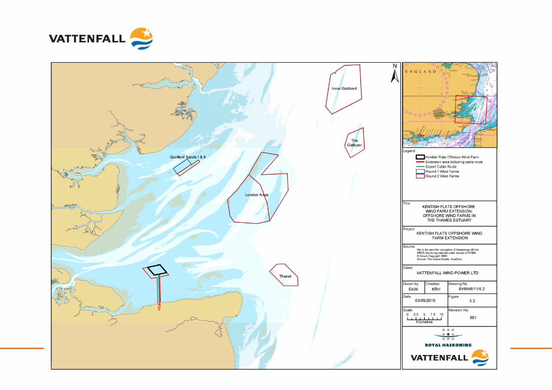
Kentish Flats Offshore Wind Farm Extension 9V9546/01/R0001 Scoping report - 112 - October 2010
Kentish Flats Offshore Wind Farm Extension 9V9546/01/R0001 Scoping report - 113 - October 2010
5.2.3 Methodology and approach to EIA
A LSVIA will be undertaken for the Kentish Flats Extension in close consultation with statutory stakeholders (e.g. Natural England, AONB officers, local authorities etc). The guidance referred to in the draft NPS for renewable energy infrastructure will be adhered to, in addition to the guidance listed below:
• The Guidance on the Assessment of the Impact of Offshore Wind Farms – DTI (2005);
• Visual representation of Wind Farms Best Practice Guidance, Scottish Natural Heritage (2007);
• Visual Assessment of Wind Farms Best Practice, University of Newcastle (2002);
• Landscape Character Assessment: Guidance for England – The Countryside Agency and Scottish Natural Heritage (2002);
• Guide to Best Practice in Seascape Assessment – Countryside Council for Wales, Brady Shipman Martin and University College of Dublin (2001);
• Maritime Ireland/Wales Interreg 1994 – 1999 Guidance ‘Guide to Best Practice in Seascape Assessment’, (GSA), published in March 2001;
• Guidelines for Landscape and Visual Impact Assessment, Institute of Environmental Management and Assessment (IEMA) and the Landscape Institute’s (2nd edition 2002); and
• Cumulative Effects of Wind Farms, Scottish Natural Heritage (SNH) (2005).
The baseline study will establish the planning policy context, the scope of the assessment and the key landscape receptors and will include the following key activities:
• A desk study of relevant current national, regional and local planning policy for the study area;
• Agreement of the main study area radius with the local planning authority;
• A desk study of nationally and locally designated landscapes for the study area;
• A desk study of existing landscape character assessments for the study area, both at national, regional and local level;
• Draft Zone of Theoretical Visibility (ZTV) studies to assist in identifying potential viewpoints and indicate the potential visibility of the Kentish Flats Extension, and therefore scope of receptors likely to be affected;
• The identification of and agreement upon, through consultation, the number and location of representative viewpoints within the study area. At present, Vattenfall propose that the four viewpoints highlighted in Table 5.2 below are selected for the LSVIA, due to the fact that these are the viewpoints that were regarded as being of significance in the ES for the existing project (GREP, 2002); and
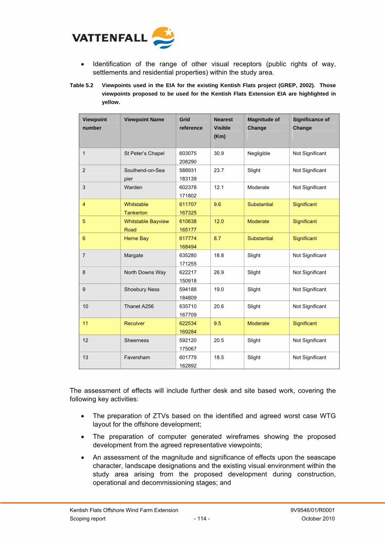
Kentish Flats Offshore Wind Farm Extension 9V9546/01/R0001 Scoping report - 114 - October 2010
• Identification of the range of other visual receptors (public rights of way, settlements and residential properties) within the study area.
Table 5.2 Viewpoints used in the EIA for the existing Kentish Flats project (GREP, 2002). Those viewpoints proposed to be used for the Kentish Flats Extension EIA are highlighted in yellow.
Viewpoint number
Viewpoint Name Grid reference
Nearest Visible (Km)
Magnitude of Change
Significance of Change
1 St Peter’s Chapel 603075 208290
30.9 Negligible Not Significant
2 Southend-on-Sea pier
588931 183139
23.7 Slight Not Significant
3 Warden 602378 171802
12.1 Moderate Not Significant
4 Whitstable Tankerton
611707 167325
9.6 Substantial Significant
5 Whitstable Bayview Road
610638 165177
12.0 Moderate Significant
6 Herne Bay 617774 168494
8.7 Substantial Significant
7 Margate 635280 171255
18.8 Slight Not Significant
8 North Downs Way 622217 150918
26.9 Slight Not Significant
9 Shoebury Ness 594188 184809
19.0 Slight Not Significant
10 Thanet A256 635710 167709
20.6 Slight Not Significant
11 Reculver 622534 169284
9.5 Moderate Significant
12 Sheerness 592120 175067
20.5 Slight Not Significant
13 Faversham 601779 162892
18.5 Slight Not Significant
The assessment of effects will include further desk and site based work, covering the following key activities:
• The preparation of ZTVs based on the identified and agreed worst case WTG layout for the offshore development;
• The preparation of computer generated wireframes showing the proposed development from the agreed representative viewpoints;
• An assessment of the magnitude and significance of effects upon the seascape character, landscape designations and the existing visual environment within the study area arising from the proposed development during construction, operational and decommissioning stages; and
Kentish Flats Offshore Wind Farm Extension 9V9546/01/R0001 Scoping report - 115 - October 2010
• The production of photomontages from a selection of the agreed viewpoints showing the anticipated view following construction of the proposed wind farm development.
Also, importantly, a cumulative assessment of the Kentish Flats Extension in relation to other offshore and onshore wind farms, as well as other developments in the Outer Thames Estuary area will be part of the assessment. Landscape, seascape, and visual impact focus for the EIA: Key considerations for the EIA:
• Visual impacts during construction;
• Visual impacts during operation;
• Visual impacts during decommissioning;
• Cumulative and in-combination effects; and
• Change in the landscape or seascape character
5.3 Shipping and navigation
5.3.1 Existing environment
The area of the Kentish Flats Extension has no merchant shipping traversing it. However, the Princes Channel to the north is a busy shipping channel being the main approach to the Thames Estuary with a high volume of traffic. Approximately 40 – 45 ships per day, head in an easterly or westerly direction to and from the Thames and Medway Ports (Figures 5.3 and 5.4). This traffic is comprised of mainly cargo ships and tankers. When the EIA for Kentish Flats was undertaken, approximately 4% of the traffic passing within 10nm of Kentish Flats passed to the south of the site (GREP, 2002). The mean position of the Princes Channel route is 2.7km (1.5 nautical miles (nm)) to the nearest part of the extension, with the closest ships passing just over 1.8km (1nm) to the north. These distances are similar to the current passing distances from Kentish Flats. The Princes channel is well marked by buoys to help ensure vessels remain within its confines. All other shipping routes are over 3.6km (2nm) from the Kentish Flats Extension. Ports of significance of relevance to the Kentish Flats Extension are:
• The Medway Ports (Sheerness, Thamesport, Ridham Dock, Chatham Dock and Rochester);
• Port of London (Tilbury, Pool of London and Greenwich); and
• Whitstable Harbour.
The main navigational marks, including the main passage marks, cardinal marks, anchorages and radio call in points are shown in Figure 5.5. Eight of the WTG on the perimeter of the existing Kentish Flats project are marked with navigational lights. The Spaniard Cardinal marker lies just beyond the south-west corner of the Kentish Flats Extension, whilst a port-hand lateral mark and two port-hand beacons lie within the cable corridor at the landfall area.
Kentish Flats Offshore Wind Farm Extension 9V9546/01/R0001 Scoping report - 116 - October 2010
There are four marine radar systems which are likely to be affected by the Kentish Flats Extension which provide coverage of shipping movements into and out of the ports listed above:
• Warden Point;
• Margate;
• Foulness; and
• Holland Point.
There is also low-to-moderate fishing vessel activity (mainly small UK vessels) and recreational vessel activity in the vicinity of the Kentish Flats Extension (see Sections 5.1 and 8.5).
5.3.2 Identification of key issues
During consultation with PLA, it was stated that one of the key factors in the selection of the location of the Kentish Flats Extension project was the need to avoid conflict with the busy shipping routes to the north and north-east of the existing site (see Appendix 1.4). Potential impacts during construction
Effects of construction related traffic: During the construction process, the works will generate a temporary increase in the vessel movements in the area (both within the Kentish Flats Extension and along the export cable route, as well as on routes to and from the chosen construction port). This is expected to include crew transfer vessels, barges, jack-up vessels, cable installation vessels and tugs. These vessels have the potential to pose a navigational risk due to the increase in traffic in and around the existing Thames estuary shipping lanes. Information relating to vessel movements and activities as well as the construction safety zones will be promulgated via Notes to Mariners (NTM) and in appropriate publications. The potential impact of this construction traffic on Thames and Medway shipping will be considered in the Kentish Flats Extension EIA as part of the marine navigational risk assessment process. Squeeze of sea area and interference with established navigation routes: The construction of the Kentish Flats Extension will not encroach on any established navigation routes. While there is heavy traffic to the north of Kentish Flats, the Kentish Flats Extension will be to the south, in waters which are too shallow for the majority of vessels. Nonetheless, the potential effects of construction on other shipping will be considered in the Kentish Flats Extension EIA as part of the marine navigational risk assessment process. Disturbance during cable burial: Inter-turbine array cables and export cables will need to be buried by dedicated cable installation vessels. The export cable route will pass through an area used by smaller vessels, which transit to and from the east and which pass to the south of Kentish Flats. However, to minimise risk, NTM will be distributed in a variety of publications and through local ports and harbours. Vattenfall will also employ a Marine Co-ordinator to ensure that risk is minimised and that information is promulgated accordingly. The potential effects on other shipping arising from cable installation will be considered in the Kentish Flats Extension EIA as part of the marine navigational risk assessment process.
Kentish Flats Offshore Wind Farm Extension 9V9546/01/R0001 Scoping report - 117 - October 2010
Potential impacts during operation
Interference with established navigation routes and changes in collision risks: As a consequence of the shallow waters within the Kentish Flats Extension (an average depth of around -5m CD) the majority of commercial vessels cannot use the site; only small recreational or fishing vessels will pass through the operational site. Therefore, only a limited number of vessels would be affected by an increase in collision risk due to the presence of an increased number of WTG. This will be mitigated by the use of markings (see below). The potential for collision risk will be assessed as part of the EIA process. Impacts on communications, radar and positioning systems: Offshore wind farms give off reflective echoes on radar and positioning systems, which has the potential to impact radar systems on certain vessels, with a consequential deterioration in functional performance of the radar. Two field trials have been conducted at offshore wind farms in the UK (Qinetiq, 2004; Marico, 2007). In 2004, the MCA conducted trials at the North Hoyle Offshore Wind Farm (off North Wales). This trial identified no problems with most systems (Global Positioning Systems (GPS), Automatic Identification System (AIS), etc.), although some areas of concern remained with regards to the potential impact on radar systems within approximately about 2.7km (1.5nm). This was stated as being due to the large vertical extent of the WTG, which returned radar responses strong enough to produce interfering side lobe, multiple and reflected echoes (ghosts). A second trial conducted at Kentish Flats on behalf of British Wind Energy Association (BWEA) in 2006 at Kentish Flats (BWEA, 2007b) concluded that:
• The ghosts phenomena detected on marine radar displays in the vicinity of offshore structures can be produced by other strong echoes close to the observing ship although not necessarily to the same extent;
• Reflections and distortions by ships structures and fittings created many of the effects, with these effects varying between vessels and radar types;
• Vessel Traffic Services (VTS) scanners static radar can be subject to similar phenomena as described above, if passing vessels provide a suitable reflecting surface. However, this effect did not seem to present a significant problem for the PLA VTS system; and
• Small vessels operating in or near Kentish Flats were detectable by radar on ships operating, near the array but were less detectable when the ship was operating within the array.
BWEA (2007b) observed that the use of an easily identifiable reference target (a small buoy, such as the Spaniard Buoy near Kentish Flats) can help the operator select the optimum radar settings. It should also be noted that extensive mitigation measures are already in existence at Kentish Flats, which are designed to decrease the navigational risk associated with impacts on communication (which include: a radar installed on one of the northern WTG, navigational lighting, fog horns and high-visibility turbine bases), as well as pilotage and coverage from PLA VTS in the general area. Impacts due to the effects of buried cables: The export cable will pass through an oyster dredging ground, necessitating that the export cable will need to be buried to an
Kentish Flats Offshore Wind Farm Extension 9V9546/01/R0001 Scoping report - 118 - October 2010
appropriate depth to avoid becoming a snagging risk for the dredgers. The burial depth will be determined during the final project design process, but is expected to be approximately 0.5 to 1m below bed level. The location of the inter-array and export cables may also affect anchoring areas and this will be considered as part of the EIA. Navigation markings and impacts on visual navigation: The Kentish Flats Extension project will require navigational markings to ensure that they are visible for vessels manoeuvring at night. The WTG will need to be painted, marked and lit in accordance with the necessary regulations (for example, the International Association of Lighthouse Authorities (IALA) recommendations and / or as directed by the Regulatory Authorities). Consultation with PLA, Trinity House Lighthouse Service (THLS), MCA and HM Coastguard will ensure that appropriate navigation aids are installed and maintained over the lifetime of the Kentish Flats Extension. Potential impacts during decommissioning
The effects during decommissioning are essentially the same as those expected during the construction phase; although there will be an incremental reduction of impact as individual WTGs are removed from the site. Potential cumulative and in-combination impacts
Cumulative impacts on receptors such as anchoring areas or marine radar may be likely as a result of the construction and operation of the Kentish Flats Extension. As such, this shall be considered as part of the EIA.
5.3.3 Methodology and approach to EIA
A Marine Navigation Risk Assessment (MNRA) will be undertaken for the Kentish Flats Extension to assess the construction, operation, and decommissioning impacts of the project. This assessment shall be based upon navigational traffic data which the PLA has agreed to provide to Vattenfall. The scope of the MNRA will be discussed with and agreed the PLA as the lead navigational authority for the Kentish Flats area and other navigation stakeholders (e.g. MCA, THLS, relevant pilot service operators, and Whitstable port). The MNRA will include a baseline review of commercial shipping and navigation, commercial fishing and recreational activities in the study area, specifically determining the proximity of the Kentish Flats Extension to shipping routes, navigation channels/separation schemes, port entrances, anchorages, pilot operations, marking and lighting of the site and areas of importance (e.g. International Maritime Organisation (IMO)). The MNRA will be carried out in accordance with the following guidance:
• MCA Marine Guidance Note 371 (M+F) Offshore Renewable Energy Installations (OREIs) – Guidance on UK Navigational Practice, Safety and Emergency Response Issues – this document highlights issues that need to be taken into consideration when assessing the impact on navigational safety from offshore renewable energy developments. This is applicable to United Kingdom internal waters, territorial seas or Renewable Energy Zones (when established) and beyond territorial seas. (MCA, 2008b);
• DTi Guidance on Assessment of the Impact of Offshore Wind Farms: Methodology for Assessing the Marine Navigational Safety Risks of Offshore
Kentish Flats Offshore Wind Farm Extension 9V9546/01/R0001 Scoping report - 119 - October 2010
Wind Farms – this document gives guidance for navigation risk assessments. The methodology is centred on risk controls and the feedback from risk controls into risk assessment (DTI, 2005); and
• IALA’s Recommendation O-131 – this document is for the guidance of marking offshore structures and created by stakeholders such as National Administrations, Lighthouse Authorities and energy extraction contractors and developers (IALA, 2005).
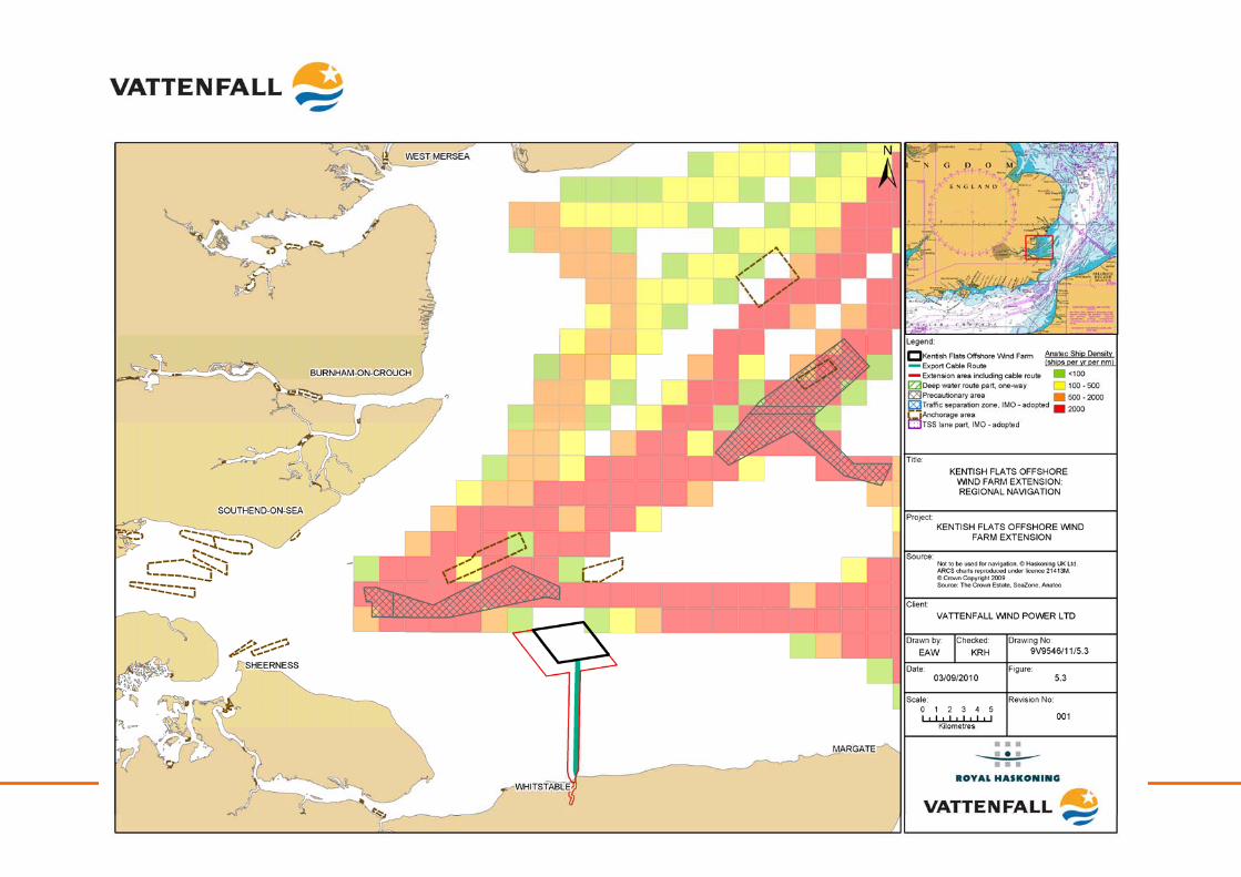
Kentish Flats Offshore Wind Farm Extension 9V9546/01/R0001 Scoping report - 120 - October 2010
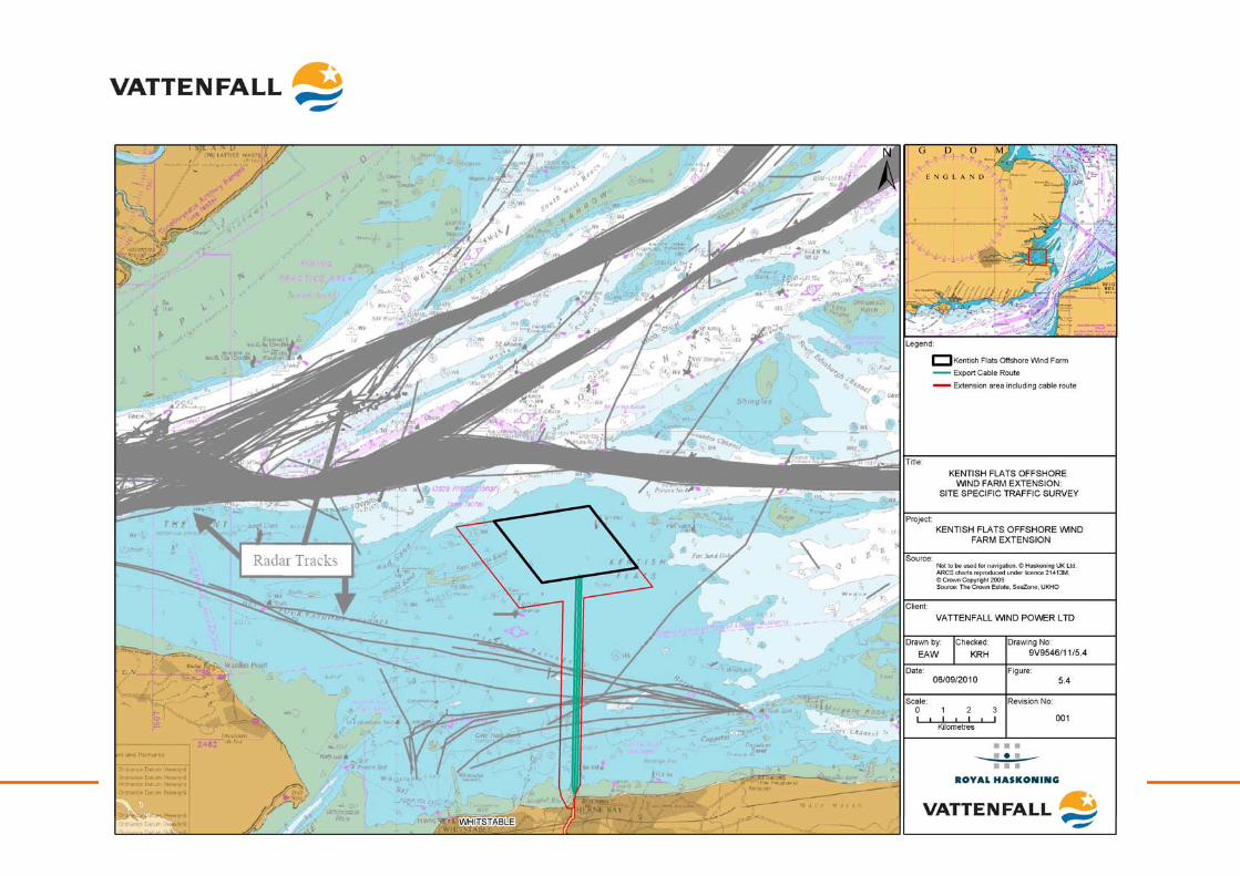
Kentish Flats Offshore Wind Farm Extension 9V9546/01/R0001 Scoping report - 121 - October 2010
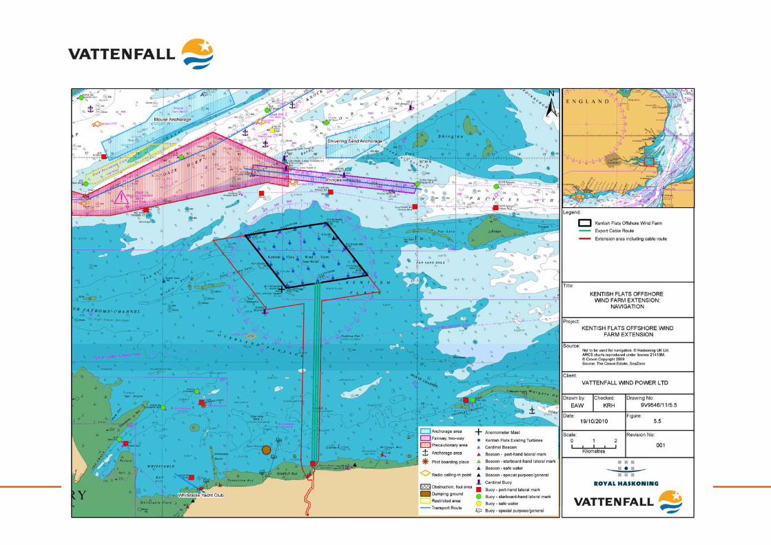
Kentish Flats Offshore Wind Farm Extension 9V9546/01/R0001 Scoping report - 122 - October 2010
Kentish Flats Offshore Wind Farm Extension 9V9546/01/R0001 Scoping report - 123 - October 2010
Shipping and navigation focus for the EIA: Key considerations for the EIA:
• Construction related traffic;
• Squeeze of sea area;
• Construction disturbance during burial of export cable;
• Obstructions to navigation;
• Interference with established navigation routes and changes in collision risk;
• Impacts due to the effects of buried cables;
• Navigation markings and impacts on visual navigation;
• Communications, radar and positioning systems; and
• Cumulative and in-combination impacts.
5.4 Marine archaeology
5.4.1 Existing environment
A site-specific archaeological study of Kentish Flats was undertaken by Wessex Archaeology (Wessex Archaeology, 2002) in support of the original EIA. This study included a consideration of both Kentish Flats and the export cable route. The North Kent coastal zone contains many important Lower, Middle and Early Upper Palaeolithic sites, and there are several periods when falling sea levels would have meant that the Kentish Flats area was dry land available for settlement. By the end of the Mesolithic (c. 4,000 BC) the wind farm site would have been on the coast, and by the Late Neolithic (2,600 BC) it would have been within the inter-tidal zone. By the Early Roman period, the sea level had risen to approximately its current position. Thus there is potential for the presence of terrestrial archaeological sites, ranging in date from the Late Upper Palaeolithic to the Iron Age, within the offshore elements of the development (GREP, 2002). There is one charted wreck, one marine archaeological site and two side-scan anomalies within the Kentish Flats Extension based on data collected for the original Kentish Flats EIA. However, as yet full coverage geophysical data is not available for the extension area so that further unknown archaeology may be present in and around the area. There are also several Roman and later wreck sites within the vicinity of the Kentish Flats with archaeological survey work having been undertaken around the Pudding Pan and Pan Sands in order to firmly identify the location of two Roman wrecks and such other sites as may appear. The marine archaeological interest in the offshore vicinity of the Kentish Flats Extension is shown in Figure 5.6.
Kentish Flats Offshore Wind Farm Extension 9V9546/01/R0001 Scoping report - 124 - October 2010
5.4.2 Identification of key issues
Potential impacts during construction
Direct physical disturbance to marine archaeological features: The installation of the foundations for the WTG, potential scour protection and cables has the potential to cause direct disturbance and damage to known and undiscovered artefacts of marine archaeological significance. Similar impacts may occur on surficial and shallow archaeology as a result of anchoring and jack-up activities associated with the construction works. However, any impacts will be mitigated through the development of a written scheme of investigation (WSI) and find protocol (including a watching brief), which may also include the use of archaeological exclusion zones. This potential impact will therefore be assessed through the Kentish Flats Extension EIA. Indirect physical disturbance to marine archaeological features: Any changes to water quality, currents, sediment transport and seabed erosion patterns has the potential to impact upon archaeological sites or deposits located within and beyond the construction site area. These changes are related to hydrodynamic and sedimentary process changes, which have the potential to adversely impact upon features of archaeological significance via erosion, transport and/or burial of these features. Based on the monitoring work undertaken to date at Kentish Flats (GREP, 2002; Emu, 2006 & Emu, 2008) it is considered unlikely that the Kentish Flats Extension will result in significant changes to the hydrodynamic regime beyond small scale changes in the immediate vicinity of the monopile foundations and therefore, potential for indirect impacts are remote. However, given the current uncertainties with regard to the location of features of archaeological interest this issue will be considered as part of the EIA process based on an assessment of the recently collected geophysical data. Potential impacts during operation
Disturbance to archaeological features: No impacts are envisaged during the operation, as no areas that have not already been disturbed during construction will be affected. As the monitoring work undertaken at Kentish Flats shows that there have been limited sediment transport effects and that scour effects are highly localised (OES, 2009), this impact is not considered significant. Exceptional maintenance activities have the potential to impact on archaeological features and these impacts will be assessed as part of the EIA, due to the potential significance of impact. Potential impacts during decommissioning
Impacts arising during the decommissioning are expected to be similar to those experienced during the construction phase. There would be a temporary impact from the activities on site to remove structures, but this would be of relatively short duration. The establishment of the archaeological environment baseline and subsequent assessment of impacts will result in the production of a detailed map of features of archaeological significance. This will facilitate the decommissioning works while minimising any impacts upon features of archaeological significance.
Kentish Flats Offshore Wind Farm Extension 9V9546/01/R0001 Scoping report - 125 - October 2010
Potential cumulative and in-combination impacts
Given that any impacts on the archaeology of the Kentish Flats Extension will be highly localised, there is no potential for cumulative or in-combination impacts with other activities and will be a secondary consideration of the EIA process.
5.4.3 Methodology and approach to EIA
An archaeological assessment of the new marine geophysical data will be undertaken as part of the EIA in line with the latest guidance on the historic environment produced by COWRIE (Wessex Archaeology, 2007). This is likely to verify the known archaeological interest within the site, whilst also serving to determine the nature of any previously unidentified anomalies. This will be augmented by a thorough desk based review of available data and development, where appropriate, of an archaeological mitigation plan. Marine archaeology focus for the EIA: Key considerations for the EIA:
• Direct physical disturbance during construction;
• Indirect physical disturbance during construction; and
• Operational impacts (exceptional maintenance).
Secondary considerations for the EIA:
• Operational impacts (normal operations);
• Decommissioning impacts; and
• Cumulative and in-combination impacts.
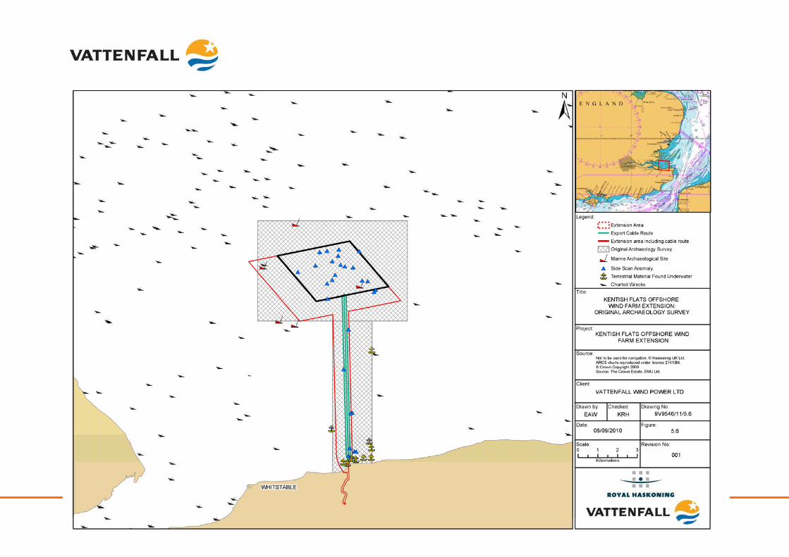
Kentish Flats Offshore Wind Farm Extension 9V9546/01/R0001 Scoping report - 126 - October 2010
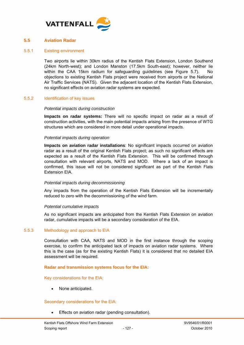
Kentish Flats Offshore Wind Farm Extension 9V9546/01/R0001 Scoping report - 127 - October 2010
5.5 Aviation Radar
5.5.1 Existing environment
Two airports lie within 30km radius of the Kentish Flats Extension, London Southend (24km North-west); and London Manston (17.5km South-east); however, neither lie within the CAA 15km radium for safeguarding guidelines (see Figure 5.7). No objections to existing Kentish Flats project were received from airports or the National Air Traffic Services (NATS). Given the adjacent location of the Kentish Flats Extension, no significant effects on aviation radar systems are expected.
5.5.2 Identification of key issues
Potential impacts during construction
Impacts on radar systems: There will no specific impact on radar as a result of construction activities, with the main potential impacts arising from the presence of WTG structures which are considered in more detail under operational impacts. Potential impacts during operation
Impacts on aviation radar installations: No significant impacts occurred on aviation radar as a result of the original Kentish Flats project; as such no significant effects are expected as a result of the Kentish Flats Extension. This will be confirmed through consultation with relevant airports, NATS and MOD. Where a lack of an impact is confirmed, this issue will not be considered significant as part of the Kentish Flats Extension EIA. Potential impacts during decommissioning
Any impacts from the operation of the Kentish Flats Extension will be incrementally reduced to zero with the decommissioning of the wind farm. Potential cumulative impacts
As no significant impacts are anticipated from the Kentish Flats Extension on aviation radar, cumulative impacts will be a secondary consideration of the EIA.
5.5.3 Methodology and approach to EIA
Consultation with CAA, NATS and MOD in the first instance through the scoping exercise, to confirm the anticipated lack of impacts on aviation radar systems. Where this is the case (as for the existing Kentish Flats) it is considered that no detailed EIA assessment will be required. Radar and transmission systems focus for the EIA:
Key considerations for the EIA:
• None anticipated.
Secondary considerations for the EIA:
• Effects on aviation radar (pending consultation).
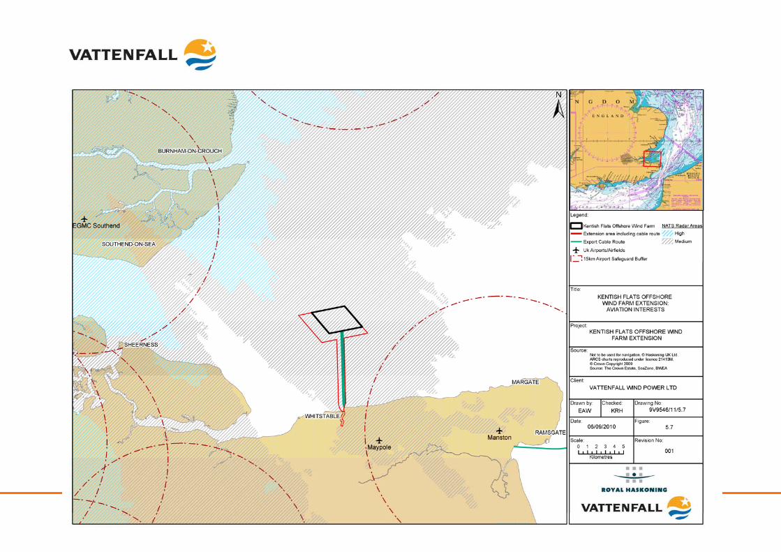
Kentish Flats Offshore Wind Farm Extension 9V9546/01/R0001 Scoping report - 128 - October 2010
Kentish Flats Offshore Wind Farm Extension 9V9546/01/R0001 Scoping report - 129 - October 2010
5.6 Ministry of Defence
5.6.1 Existing environment
Numerous areas around the UK coastal region and offshore are designated as practice or exercise areas by the Ministry of Defence (MOD) and as such, it is important that development does not impinge on these areas in order to avoid affecting the safe and continued practice of the armed forces. A review of the relevant charts showing designated MOD practice areas indicates that the nearest military practice and exercise area (PEXA) is Shoeburyness firing range on the Essex coast, approximately 12km north of the Kentish Flats Extension project site. The nearest naval PEXA is approximately 30km east of the wind farm (Royal Haskoning, 2009). As a result, there will be no interaction with any designated MOD practice areas and the Kentish Flats Extension (see Figure 5.8)
5.6.2 Identification of key issues
Potential impacts during construction
Impacts on MOD activities: Due to the distance of the site from the nearest PEXA, no impacts on MOD activities are expected as a result of the construction of the Kentish Flats Extension. Potential impacts during operation
Impacts on MOD activities: Due to the distance of the site from the nearest PEXA, no impacts on MOD activities are expected as a result of the operation of the Kentish Flats Extension. Potential impacts during decommissioning
Impacts on MOD activities: Due to the distance of the site from the nearest PEXA, no impacts on MOD activities are expected as a result of the decommissioning of the Kentish Flats Extension.
5.6.3 Methodology and approach to EIA
As no significant impacts are expected, a detailed desk-top review of potential impacts will be conducted to ascertain any potential impacts on the Ministry of Defence from the Kentish Flats Extension. MOD focus for the EIA: Secondary considerations for the EIA:
• Impacts on MOD activities (construction, operation and decommissioning)
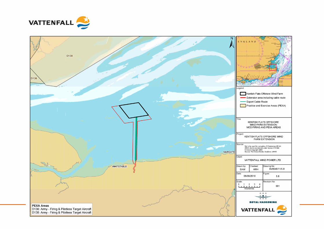
Kentish Flats Offshore Wind Farm Extension 9V9546/01/R0001 Scoping report - 130 - October 2010

Kentish Flats Offshore Wind Farm Extension 9V9546/01/R0001 Scoping report - 131 - October 2010
5.7 Unexploded ordnance
5.7.1 Existing environment
The potential exists for the presence of unexploded ordnance (UXO) at the Kentish Flats Extension due to intentional bombing, dumping of bombs, deployment of sea mines and weapons testing in the area during World War Two (GREP, 2002). Generally, the exact location of abandoned ordnance is unknown and in any case over the past 60 years could have migrated away from where it was first deposited. In contrast to some parts of the Thames, such as the main shipping channels which have been regularly dredged since the 1950s, the Kentish Flats Extension is likely to have been left comparatively undisturbed by dredging activities since the war.
5.7.2 Identification of key issues
Potential impacts during construction
Initiation of UXO: Operations such as piling or cable installation works could result in the initiation of abandoned UXO if it were present and live. The consequences of such an initiation would depend upon the size of the explosive and the distance of targets from the explosive. This issue is normally dealt with prior to construction through detailed geophysical survey and investigations. As such, this impact is considered potentially significant and a desk based review of available information will be completed as part of the EIA to identify the potential for UXO in and around the Kentish Flats Extension. Potential impacts during operation
Disturbance of UXO: Potential UXO on-site will have been mapped during the EIA and most operational maintenance activities will have little potential for disturbance of UXO. However, there is potential for exceptions, such as the use of jack-up barges for major repairs, which could disturb the seabed. This impact is therefore considered significant and shall be a primary consideration of the EIA. Potential impacts during decommissioning
Disturbance of UXO: Although there is limited potential for disturbance of UXO during operations to remove infrastructure from the site at decommissioning, due to the significance of the impact, this shall be a primary consideration of the EIA.
5.7.3 Methodology and approach to EIA
A desktop study will be conducted based upon the updated geophysical data to identify the potential for UXO to be present in and around the extension site. Key considerations for the EIA:
• Impacts on UXO (construction, operation and decommissioning).
Kentish Flats Offshore Wind Farm Extension 9V9546/01/R0001 Scoping report - 132 - October 2010
5.8 Other human activities
5.8.1 Existing environment
The BritNed Interconnector is a bipolar interconnector, with a capacity of 1000MW and a total length of 260km, which passes from the Isle of Grain in the Outer Thames to Maasvlakte (near Rotterdam) in the Netherlands. The BritNed cable runs approximately 1km north of the Kentish Flats Extension project and is currently undergoing cable tests, before commercial operation is commenced in 2011 (BritNed, 2010). The interconnector will not impact the Kentish Flats Extension, as the Extension will be to the south and west of the existing site. The London Array offshore wind farm export cables will cross the existing export cables for Kentish Flats and as such, the export cables for the Kentish Flats Extension will be required to cross London Array’s cables. A crossing agreement will be prepared through discussions with London Array. There are no oil and gas licensing blocks within or adjacent to the Kentish Flats Extension and therefore there will be no impact upon oil and gas operations. The closest licensed aggregate abstraction area to the Kentish Flats Extension is Area 109-1, which is located approximately 40km north-east of the main array, in the northern Outer Thames Estuary (Royal Haskoning, 2009). Three disposal grounds are located in the vicinity of the Kentish Flats Extension, although only one, Whitstable C (TH073), remains open for disposal, with the remaining two having been closed (Whitstable A and B) (Royal Haskoning, 2009). All anthropogenic activities are shown in Figure 5.9.
5.8.2 Identification of key issues
Potential impacts during construction
Potential interference with oil and gas operations: No impacts are anticipated on current or future oil and gas activity as there are no nearby installations and there is an absence of interest in the area following DECC’s 25th Round Oil and Gas Licensing Programme. Physical impacts on subsea cables from construction activities: The export cable corridor will need to cross up to six 132kV export cables from the London Array project (London Array, 2010). Cable crossing agreements will therefore be prepared and appropriate installation and protection measures developed accordingly. Impacts on disposal sites and dredging activities: No impacts are anticipated on capital and maintenance dredging. As the Whitstable C disposal ground is located inshore and approximately 2km to the west of the existing export cable, no impacts are expected to result from the construction of the Kentish Flats Extension.
Kentish Flats Offshore Wind Farm Extension 9V9546/01/R0001 Scoping report - 133 - October 2010
Potential impacts during operation
Potential interference with oil and gas operations: No impacts are anticipated on current or future oil and gas activity as there are no nearby installations, given the historic and current lack of interest within the area. Physical impacts on subsea cables: No impacts are expected on subsea cables during operation, as the installation of the export cables following the standard industry techniques will have ensured that any adverse effects are mitigated. Impacts on disposal sites and dredging activities: No impacts are anticipated on capital and maintenance dredging or disposal sites during the operational phase of the Kentish Flats Extension. Potential impacts during decommissioning Effects on human activities during decommissioning are anticipated to be similar to those discussed during construction of the wind farm, with an incremental reduction of impact as individual WTG are removed from the site. Impacts with other activities throughout all phases of the life of the Kentish Flats Extension will be mitigated by planning and design to avoid any problems. This impact is not therefore considered significant. Potential cumulative and in-combination impacts
With respect to human activities, there will no potential for cumulative or in-combination impacts. This impact is not therefore considered significant.
5.8.3 Methodology and approach to EIA
Vattenfall will undertake consultation with all relevant developers, operators and marine users within the vicinity of the Kentish Flats Extension to ascertain any concerns relating to the project. Any areas of concern will be identified and considered within the EIA. However, as impacts upon the above mentioned activities are not considered likely to occur, no detailed assessment within the EIA of other human activities is anticipated. Other human activities focus for the EIA:
Secondary considerations for the EIA:
• Physical impacts on subsea cables (construction and operation);
• Impacts on licensed disposal sites and dredging activities;
• Impacts on oil and gas related operations; and
• Cumulative and in-combination impacts.

Kentish Flats Offshore Wind Farm Extension 9V9546/01/R0001 Scoping report - 134 - October 2010
Kentish Flats Offshore Wind Farm Extension 9V9546/01/R0001 Scoping report - 135 - October 2010
ONSHORE ENVIRONMENT 6 PHYSICAL ENVIRONMENT
This section details the existing onshore physical environment in the vicinity of the Kentish Flats Extension covering the circa 2km cable route between the landfall site and the onshore substation. This chapter describes the existing environment and identifies key issues that may result from the construction, operation and decommissioning of the Kentish Flats Extension. The data used to inform the onshore physical environment section are detailed in Table 6.1 below. Table 6.1 Available onshore physical environment data sets
Data Date Kentish Flats Offshore Wind Farm: Environmental Statement GREP (2002)
British Geological Survey (BGS): Solid and drift geology: Sheet 273: Faversham BGS (1974)
Groundwater vulnerability map (Sheet 47: East Kent) NRA (1994)
Nitrate vulnerable zones Environment Agency (2010a)
Groundwater quality monitoring data Environment Agency (2010b)
6.1 Geology, groundwater and land quality
6.1.1 Existing Environment
The North Kent coastline can be divided into three parts by its geology, with a central alluvial section separating the clay shore between Whitstable and Reculver, from the chalk cliffs and wave-cut platforms of Thanet (GREP, 2002). From Whitstable to Reculver, much of the shore consists of slopes of London Clay, greatly modified by the construction of artificial coastal defences. The intertidal zone is dominated by mud and sand flats, which are up to 500m wide but mostly much less than this. There are also some small areas of shingle. Between Herne Bay and Reculver, cliffs which reach a maximum height of about 35m show the full sequence of Palaeocene deposits (GREP, 2002). Geology The solid geology (BGS solid & drift geology, Sheet 273 Faversham) shows the shallow drift deposits for the area around the proposed cable route to comprise of Head Brickearth deposits, which are clayey in nature and fairly thin. Underlying the Head Brickearth deposits is London Clay, which is shown to be up to approximately 140m thick (BGS, 1974). Underlying the London Clay deposits are the Oldhaven Beds (approximately 2.5m to 7.5m thick), Woolwich Beds (approximately 7.5m to 12m thick) and Thanet Beds (18m to 33.5m thick), in addition to the Upper Chalk, Middle and Lower Chalk Measures.
Kentish Flats Offshore Wind Farm Extension 9V9546/01/R0001 Scoping report - 136 - October 2010
Groundwater The Groundwater Vulnerability Map (NRA, 1994) for the area (Sheet 47: East Kent) indicates that the site is underlain by an unproductive aquifer. This is interpreted as being the function of the Head Brick Earth Deposits and the London Clay which generally have very low permeabilities. Underlying the London Clay deposits are principal aquifers systems associated with Oldhaven, Woolwich, Thanet and Chalk deposits. Principal aquifers provide significant quantities of water for people and may also sustain rivers, lakes and wetlands, whereas unproductive aquifers are generally regarded as containing insignificant bodies of water. The area is not classified as a Nitrate Vulnerable Zone (NVZ) by the Environment Agency (Environment Agency, 2010a) under the auspices of the Nitrates Directive9. The onshore elements of the Kentish Flats Extension project are not located within a groundwater source protection zone (Environment Agency, 2010b). Surface Water The nearest surface water feature to the cable is an un-named stream located approximately 10 – 15m, to the west of the proposed cable route, near Hampton Pier Avenue. The stream flows in a northerly direction and discharges to the sea. Land Quality No contaminated land desk studies or ground investigation works were completed for the Kentish Flats EIA. Installation of the original onshore cables revealed no concerns relating to contaminated land.
6.1.2 Identification of key issues
Potential impacts during construction
Impacts on geology and groundwater: The onshore section of the cable route will broadly follow the existing Kentish Flats cable route and is in urban areas that have previously been disturbed or worked. The surface of the land affected is predominantly tarmac and given the depth required for burial and the lack of significant geological resource in the area, it is not anticipated that there will be an impact upon geology. Given the absence of notable groundwater resource and relatively limited burial depth, impacts upon groundwater are anticipated to be negligible. Good practice management measures will be employed during site works to ensure that all appropriate Pollution Prevention Guidelines (PPG) and good practice guidelines are followed. Impacts on geology and groundwater are not expected to be significant. . Impacts on land quality and surface water: Due to the fact that the cable route for the Kentish Flats Extension will follow the route of the existing cables from Kentish Flats, there is very little potential for impacts on land quality and surface water. As this impact is not considered significant, no detailed studies shall be undertaken as an aspect of the EIA. 9 Directive 91/676/EEC concerning the protection of waters against pollution caused by nitrates from agricultural sources.
Kentish Flats Offshore Wind Farm Extension 9V9546/01/R0001 Scoping report - 137 - October 2010
Potential impacts during operation
Impacts on geology and groundwater: Once installed, there will be no impacts from the operation phase of the development on the onshore geological and groundwater environment. This impact is not therefore considered significant. Impacts on land quality and surface water: Impacts during operation are unlikely, as the export cables will have been installed, with the only possible impact arising should unplanned maintenance be required. As such, this impact is not considered significant. Potential impacts during decommissioning
Impacts on geology, groundwater and land quality: Impacts are not expected if the cables and infrastructure are left in place at the end of the project’s life span. Should the cables be removed as part of the decommissioning process, there will be no new contamination issues. Decommissioning impacts are therefore not considered significant. Potential cumulative impacts
Given the lack of impacts predicted from the construction, operation and decommissioning phases, the potential for cumulative impacts is considered remote. Therefore cumulative impacts will be considered to be of secondary importance during the EIA.
6.1.3 Methodology and approach to EIA
Based on the fact that the onshore works will fall immediately adjacent to and within the footprint of the onshore elements of Kentish Flats, coupled with the fact that no excavation of undeveloped land is required, impacts on geology are not considered significant and it is felt that a desk-based study will be sufficient for the EIA. Impacts on land quality and surface water are not considered significant, as the export cables for the Kentish Flats Extension will follow the existing route of the Kentish Flats export cables, where no previous issues were encountered. As such, any impact is not considered significant and will it is felt that a desk-based study will be sufficient for the EIA. The EIA shall, however, consider the relevant Local Development Frameworks (LDF) to determine whether any cumulative or in-combination impacts are likely. Geology, hydrology and land quality focus for the EIA: Secondary considerations for the EIA:
• Impacts on geology and groundwater (construction, operation and decommissioning); and
• Impacts on land quality and surface water (construction, operation and decommissioning).
Kentish Flats Offshore Wind Farm Extension 9V9546/01/R0001 Scoping report - 138 - October 2010
7 BIOLOGICAL ENVIRONMENT
This section details the existing onshore biological environment adjacent to the Kentish Flats Extension landfall and cable route. The baseline environment for ornithological interest and terrestrial habitats and species is defined, before potential issues resulting from the construction, operation and decommissioning of the Kentish Flats Extension onshore works are identified and the approach to the EIA is provided. Available data sets for the onshore biological environment are listed in Table 6.1. Table 6.1 Available onshore biological environment data sets
Data Date Kentish Flats Offshore Wind Farm Environmental Statement GREP (2002)
Kentish Flats Offshore Wind Farm FEPA Monitoring Summary Reports OES (2008 & 2009)
Kentish Flats Proposed Wind Farm Development: Baseline Macrobenthic Ecology Study: Final Report: August 2002.
Emu (2002b)
Kentish Flats Intertidal Cable Lying Monitoring: Final Report Emu (2005i)
7.1 Ornithology
7.1.1 Existing Environment
The onshore works for the Kentish Flats Extension will be within or adjacent to the Thanet Coast and Sandwich Bay SPA depending on the chosen landfall location. A detailed discussion of the potential impacts of the Kentish Flats Extension on designated sites and features is presented in Section 4. During the consultation process for the existing Kentish Flats, English Nature (now Natural England) highlighted the issue of the potential disturbance of wader species at this site as a result of cable installation, should any installation take place within the main overwintering season between October and April. The key species for the site is turnstone (also see Section 4.2). Other notable wading species recorded at the site and highlighted for consideration include (GREP, 2002):
• Golden plover Pluvialis apricaria; • Sanderling Calidris alba; • Ringed plover Charadrius hiaticula; and • Grey plover Pluvialis squatarola.
A review of the distribution and behaviour of these species at Studhill Bay (within the SPA) was undertaken as part of the Kentish Flats EIA. The review was based on detailed data produced by a comprehensive study conducted into turnstone at the Thanet Coast and Sandwich Bay SPA on behalf of English Nature (Webb, 2001; Webb, 2002). At Studhill Bay, a consistently used roost site was identified at Hampton Pier Avenue and the roadside footpath, approximately 100m from the top of the shingle beach to the east of Hampton Pier (GREP, 2002), with approximately 3% of the Thanet Coast and Sandwich Bay SPA birds being found to use this site. No onshore ecological work was undertaken for the Kentish Flats ES, outside of the intertidal areas associated with the landfall site. The potential for breeding bird habitat
Kentish Flats Offshore Wind Farm Extension 9V9546/01/R0001 Scoping report - 139 - October 2010
was also recorded as being present along much of the onshore cable route (Mundy, E. pers comm.), with a wetland bird survey (WeBS) or biological records search required to quantify the species of conservation concern present.
7.1.2 Identification of key issues
Potential impacts during construction
Disturbance of roosting and feeding sites by cable landfall installation: The potential exists for the cable installation works required for the landfall and connection of onshore cables to cause disturbance to turnstone in the SPA area, particularly during high water roosting. Outside of the main overwintering period (October to April) no such effects would occur. The original Kentish Flats FEPA licence provided mitigation for this issue as follows: ‘The Licence Holder must ensure that if cable installation occurs between October and April inclusive (the overwintering season for several wader species) the beach installation, including trenching and cable laying, avoids the sensitive period 2 hours either side of high water.’ Similar mitigation will be employed for the Kentish Flats Extension, to avoid significant effects on turnstone where installation occurs adjacent to the site. This will be set out through a brief consideration of this issue as part of the EIA process. Where the cable landfall is within the SPA area, further mitigation may be required to reduce or avoid impacts on the SPA habitats and species and this would be evaluated in the EIA where appropriate. Disturbance of onshore bird populations from piling noise offshore: The assessment of the offshore noise for the Kentish Flats EIA (GREP, 2002) concluded that noise levels at the coast would be barely audible above the background daytime levels, so that disturbance of birds onshore was not predicted to occur. It is anticipated that this would also be the case for the Kentish Flats Extension and as such, these effects are not considered significant. Disturbance of onshore bird populations from onshore construction activities: Onshore construction activities associated with the installation of the onshore cables has the potential to impact onshore bird populations, particularly during breeding periods. No onshore ornithological work has been undertaken to date and as such, impacts on breeding birds shall be a primary consideration for the EIA. Potential impacts during operation
Disturbance of roosting and feeding sites: No impacts are expected during the operation of the Kentish Flats Extension, unless major export cable maintenance, repair or replacement works are required. Disturbance of onshore bird populations: No impacts are expected during the operation of the wind farm, unless major maintenance or repair works required access to the landfall works. Potential impacts during decommissioning
Disturbance of roosting and feeding sites: No impacts are expected if the cables and infrastructure are left in place at decommissioning. Should the cables be removed, then

Kentish Flats Offshore Wind Farm Extension 9V9546/01/R0001 Scoping report - 140 - October 2010
the impacts will be similar to construction, assuming that similar mitigation is employed. However, due to the nature of any impact on the Birds Directive species, this shall be considered in further detail within the EIA. Disturbance of onshore bird populations: As no piling will be expected during decommissioning, no impacts are expected and this impact is therefore not considered significant Potential cumulative and in-combination impacts
The potential for cumulative impacts exists during the construction phase, should the activity overlap with any other activities that have the potential to affect the relevant SPA populations (principally the Thanet Coast and Sandwich Bay SPA turnstone population). The EIA shall consider the relevant LDFs to determine the potential for cumulative or in-combination impacts.
7.1.3 Methodology and approach to EIA
The information gathered as part of the EIA for the existing Kentish Flats, together with other data sources (such as WeBS) will provide sufficient information to allow baseline characterisation and will be used as the basis of a review of the potential for impacts on the turnstone populations in line with that agreed for Kentish Flats. For the remainder of the onshore cable route, WeBS data will be acquired and a biological records search undertaken for those species which have the potential to be impacted by the onshore works, with this being reported within the EIA. Onshore ornithology focus for the EIA: Key considerations for the EIA:
• Disturbance of intertidal & high water turnstone roosting and feeding sites during cable installation at the chosen landfall;
• Disturbance of breeding birds during the onshore cable installation
• Disturbance of roosting and feeding sites by cable landfall decommissioning, should cables and associated infrastructure be removed; and
• Potential cumulative impacts.
Secondary considerations for the EIA:
• Disturbance of onshore bird populations from piling noise offshore; and
• Operational impacts.

Kentish Flats Offshore Wind Farm Extension 9V9546/01/R0001 Scoping report - 141 - October 2010
7.2 Terrestrial habitats and species
7.2.1 Existing environment
The proposed onshore cable route to the existing substation will be placed underground along already tarmaced surfaces and roadside verges which were assessed as being of low ecological significance at the time of the Kentish Flats EIA (GREP, 2002). In a manner similar to the export cables for Kentish Flats, the cables will be installed from the transition pit by trenching for approximately 2km to the existing EDF Energy 132/33kV Red House Farm substation, south of Herne Bay. Works were undertaken during the construction phase of the existing project, in order to house the necessary switchgear to connect in the Kentish Flats cables and as such, it is likely that no additional infrastructure will be required at the substation. The area proposed for cable installation has already been subject to a considerable level of disturbance, with the majority of the route being adjacent to residential areas (GREP, 2002). In general, the majority of the onshore areas subject to development as part of the Kentish Flats Extension are of low ecological value. The area around the substation development is likely to be subject to a considerable level of disturbance as well as having a slightly higher potential for being of some ecological importance. No detailed, specific habitat survey (e.g. Phase I or National Vegetation Classification (NVC)) was completed for the original Kentish Flats EIA.
7.2.2 Identification of key issues
Potential impacts during construction
Impacts on terrestrial habitats and species: The review of the onshore elements of the scheme in relation to the terrestrial ecology and habitat value has indicated that the majority of the landward components will be constructed in pre-developed sites; therefore the onshore cabling will be largely restricted to tarmaced surfaces. Any lay-down areas to be used by plant or machinery will be located to minimise the potential for impact. However, given the paucity of information relating to terrestrial habitats adjacent to the export cable route and substation, this parameter shall be considered further within the EIA. Potential impacts during operation
Impacts on terrestrial habitats and species: No impacts are expected during the operation of the wind farm on the terrestrial habitats and species, unless major maintenance or repair works on the onshore export cable are required. Potential impacts during decommissioning
Impacts on terrestrial habitats and species: Impacts are not expected if the cables and infrastructure are left in place at decommissioning. Should the cables be removed, then the impacts will be similar to those experienced during construction.
Potential cumulative impacts
Impacts on terrestrial habitats and species: Given the lack of impacts predicted from the construction, operation and decommissioning phases, the potential for cumulative impacts is considered remote. However, should any concerns arise during the
Kentish Flats Offshore Wind Farm Extension 9V9546/01/R0001 Scoping report - 142 - October 2010
undertaking of the EIA, then due consideration will be given to the potential for cumulative effects.
7.2.3 Methodology and approach to EIA
An extended Phase I survey (JNCC, 2003) and protected species assessment will be undertaken to ascertain whether the timing of the installation of the export cable or use / storage of plant machinery will be likely to have any adverse effects on sensitive habitats and species. A biological records data search will be undertaken, to ascertain whether species of conservation importance have been recorded within a 500m margin of the export cable route. A Japanese knotweed Fallopia japonica survey will also be undertaken to ensure that construction activities will not lead to the spread of Japanese knotweed, should it be found adjacent to the onshore cable route. Should this species be identified, then a management plan will be developed and agreed with the Regulatory Authorities. Terrestrial habitats and species focus for the EIA: Key considerations for the EIA:
• Construction impacts on terrestrial habitats and species.
Secondary considerations for the EIA:
• Operational impacts on terrestrial habitats and species;
• Decommissioning impacts on terrestrial habitats and species; and
• Cumulative impacts on terrestrial habitats and species.
Kentish Flats Offshore Wind Farm Extension 9V9546/01/R0001 Scoping report - 143 - October 2010
8 HUMAN ENVIRONMENT
This section details the onshore human environment within the areas surrounding the Kentish Flats Extension landfall and onshore cable route and covers archaeology, traffic and access, noise dust and air quality, land quality, landscape and visual impact assessment and socio-economics. This section will identify potential issues resulting from the construction, operation and decommissioning of the Kentish Flats Extension onshore works and provides an approach to the EIA. Available data sets of relevance to the onshore human environment aspects of the Kentish Flats Extension are shown in Table 8.1. Table 8.1 Available onshore human environment data sets Data Date Kentish Flats Offshore Wind farm Environmental Statement GREP (2002)
Maritime and Coastal Archaeological Assessment Wessex Archaeology (2002)
Kentish Flats Wind Farm Landscape and Seascape Visual Impact Assessment. Report to GREP, No. NE0610001a
Enviros Aspinwall (2002)
Socio Economic Assessment for the Kentish Flats Offshore Wind Farm Geodata Institute (2002)
Public Opinion Study for the Kentish Flats Offshore Wind Farm Magellan House (2002)
Kentish Flats Offshore Wind Farm: An archaeological watching brief during the excavation of a new electricity cable duct between Hampton Pier and Thornden Wood Road, Herne Bay, Kent.
Canterbury Archaeological Trust (2005)
8.1 Archaeology
8.1.1 Existing environment
A site specific archaeological study was undertaken by Wessex Archaeology in support of the Kentish Flats EIA (Wessex Archaeology, 2002), with the location of notable features being presented in Figures 8.1 and 8.2. The Kent Sites and Monuments Record and the National Monuments Record lists 70 sites of archaeological interest within the immediate vicinity of the onshore cable route (defined as the coastal study area) (Wessex Archaeology, 2002) ranging in date from the Lower Palaeolithic (500,000 – 250,000 BP) to the present day. This record is evidence for continuous human habitation within the area over a long period of time. The bulk of the sites (41) date from the last 400 years. Prior to this time, the area was considerably less densely populated and features of archaeological interest are less frequently recorded (Wessex Archaeology, 2002). Given its history, there remains the potential for discovery of as yet unidentified features of archaeological and cultural heritage significance. The Kentish Flats EIA reports finds of several Lower Palaeolithic flint implements at the northern end of the onshore cable route, including one on the line of the cable itself and a number of post-medieval and modern sites relating to the development of the foreshore at Hampton. Along the southern half of its route, the cable crosses an area that was intensively settled and farmed between the Iron Age and the Early Saxon period (Wessex Archaeology, 2002).
Kentish Flats Offshore Wind Farm Extension 9V9546/01/R0001 Scoping report - 144 - October 2010
The following mitigation was proposed for the existing Kentish Flats project:
• A watching brief during the trenching and excavation associated with the foreshore stretch of the cable route and the interconnection facility; and
• An archaeological field evaluation in advance of the extension to the electricity sub-station.
Canterbury Archaeological Trust (CAT) undertook a watching brief along the export cable route during installation (CAT, 2005). At the northern end of Hampton Pier Avenue (south end of Hampton Pier) a series of red stock bricks, peg tile and nineteenth century glass and pottery fragments were recorded (CAT, 2005). Further to the south of Hampton Pier Avenue, the modern tarmac road surface was laid over a series concrete slabs, thought to be associated with a tramway built by the Herne Bay, Hampton and Reculver Oyster Fishery Company in the mid-nineteenth century for the transportation of freshly dredged oysters (CAT, 2005). However, apart from this, very little of archaeological interest was revealed, despite the fact that the cable route runs for approximately 2km across a part of the north Kent countryside known to be rich in archaeological sites (CAT, 2005).
8.1.2 Identification of key issues
Potential impacts during construction
Loss of archaeological sites as a result of cable installation: There is potential for the onshore cable route (from the low water mark to the substation) and associated works to impact upon sites ranging in date from the Lower Palaeolithic to the present day. If present, such sites would be subject to major impacts from trenching or HDD for the foreshore element of the cable route and the transition pit beneath the Hampton Pier car park. For the majority of its route, the onshore cable will be installed broadly along the same route as the existing Kentish Flats cables. Although no finds of significance were recorded during the installation of the existing onshore cables, a written scheme of investigation (WSI) and finds protocol (including a watching brief) will be developed and adopted during the installation of onshore cables within the vicinity of the foreshore and transition pits to ensure that adverse impacts on archaeological heritage can be mitigated. Potential impacts during operation
Impact on archaeological sites: There will be no impacts on known or potential features of archaeological and cultural heritage significance during operation of the project. As such, this issue is not considered significant. Potential impacts during decommissioning
Impact on archaeological sites: Should the cables be left in-situ and not removed during decommissioning, no impacts would be expected. If cables and associated infrastructure are removed, the potential for impacts would be considered to be low. Therefore, the impacts arising from the decommissioning of the Kentish Flats Extension are not considered significant.
Kentish Flats Offshore Wind Farm Extension 9V9546/01/R0001 Scoping report - 145 - October 2010
Potential cumulative and in-combination impacts
Potential impacts have been identified during the construction phase. However, the impacts will be highly localised and, therefore, potential for cumulative impacts is considered remote. Should any concerns arise during the EIA process, then due consideration will be given to the potential for cumulative effects.
8.1.3 Methodology and approach to EIA
The EIA for the Kentish Flats Extension will assess the potential for archaeological impacts in the intertidal zone though a desk-based study (to be undertaken as part of the project’s offshore cable route archaeological study), whilst the existing onshore data will also be reviewed. As it is intended that the Kentish Flats Extension cable route will broadly follow the existing onshore cable route, the EIA will be informed by existing data generated from the previous watching brief exercise. Consultation with key stakeholders and relevant local archaeological bodies will be undertaken to ascertain whether any new archaeological information is available that was not taken into account for Kentish Flats. A WSI and a finds protocol (including a watching brief) will be produced prior to the construction of the Kentish Flats Extension project to mitigate risk to the historic environment. Onshore archaeological focus for the EIA: Key considerations for the EIA:
• Construction impacts on onshore sites of archaeological importance.
Secondary considerations for the EIA:
• Operational and decommissioning impacts on archaeology; and
• Cumulative and in-combination impacts on archaeology.
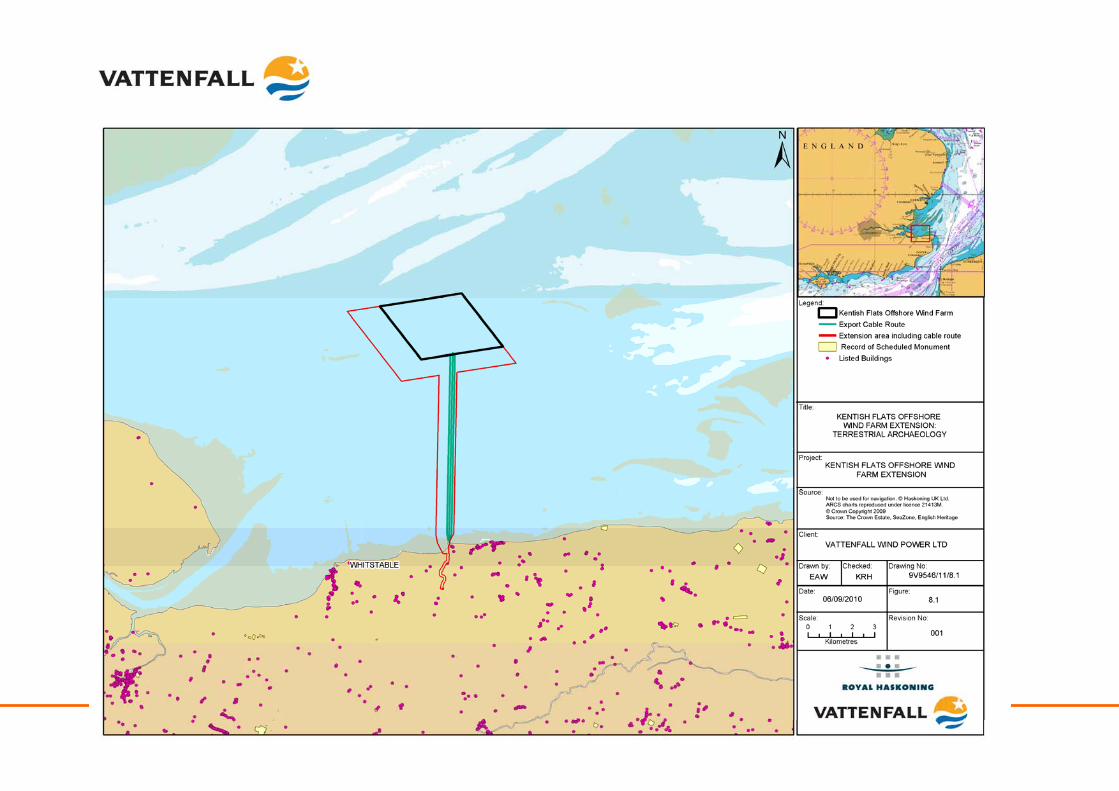
Kentish Flats Offshore Wind Farm Extension 9V9546/01/R0001 Scoping report - 146 - October 2010
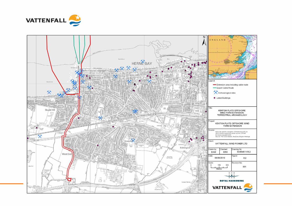
Kentish Flats Offshore Wind Farm Extension 9V9546/01/R0001 Scoping report - 147 - October 2010
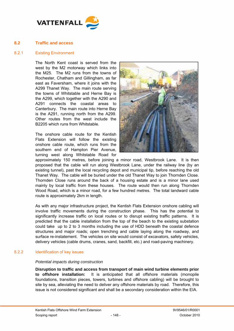
Kentish Flats Offshore Wind Farm Extension 9V9546/01/R0001 Scoping report - 148 - October 2010
8.2 Traffic and access
8.2.1 Existing Environment
The North Kent coast is served from the west by the M2 motorway which links into the M25. The M2 runs from the towns of Rochester, Chatham and Gillingham, as far east as Faversham, where it joins with the A299 Thanet Way. The main route serving the towns of Whitstable and Herne Bay is the A299, which together with the A290 and A291 connects the coastal areas to Canterbury. The main route into Herne Bay is the A291, running north from the A299. Other routes from the west include the B2205 which runs from Whitstable. The onshore cable route for the Kentish Flats Extension will follow the existing onshore cable route, which runs from the southern end of Hampton Pier Avenue, turning west along Whitstable Road for approximately 150 metres, before joining a minor road, Westbrook Lane. It is then proposed that the cable will run along Westbrook Lane, under the railway line (by an existing tunnel), past the local recycling depot and municipal tip, before reaching the old Thanet Way. The cable will be buried under the old Thanet Way to join Thornden Close. Thornden Close runs around the back of a housing estate and is a minor lane used mainly by local traffic from these houses. The route would then run along Thornden Wood Road, which is a minor road, for a few hundred metres. The total landward cable route is approximately 2km in length. As with any major infrastructure project, the Kentish Flats Extension onshore cabling will involve traffic movements during the construction phase. This has the potential to significantly increase traffic on local routes or to disrupt existing traffic patterns. It is predicted that the cable installation from the top of the beach to the existing substation could take up to 2 to 3 months including the use of HDD beneath the coastal defence structures and major roads; open trenching and cable laying along the roadway, and surface re-instatement. The vehicles on site would consist of excavators, safety vehicles, delivery vehicles (cable drums, cranes, sand, backfill, etc.) and road-paving machinery.
8.2.2 Identification of key issues
Potential impacts during construction
Disruption to traffic and access from transport of main wind turbine elements prior to offshore installation: It is anticipated that all offshore materials (monopile foundations, transition pieces, towers, turbines and offshore cabling) will be brought to site by sea, alleviating the need to deliver any offshore materials by road. Therefore, this issue is not considered significant and shall be a secondary consideration within the EIA.
Kentish Flats Offshore Wind Farm Extension 9V9546/01/R0001 Scoping report - 149 - October 2010
Disruption to traffic and access from installation of landward cabling: It is predicted that the cable installation from the top of the beach to the existing sub station will take 2 to 3 months, as described above. The onshore cables will require transport to the area and when coupled with the installation elements, may result in temporary and transitory disruption on local roads as was the case for the original project. The installation of the cable will involve the movement of small amounts of plant and heavy goods vehicles (HGV), as well as the establishment of a small construction site. Some intermittent HGV deliveries to the site will also be expected to occur. This impact will be assessed as part of the EIA process and where necessary appropriate management and mitigation measures will be designed in partnership with the Local Authority, Highways Agency and local residents, taking account of lessons learned from the original cable installation process. Potential impacts during operation
Disruption to traffic and access from maintenance work: There are unlikely to be any major traffic impacts from the operation of the Kentish Flats Extension. Onshore maintenance may require excavation of the cable route and, therefore, there is potential for impacts on traffic if this is necessary. However, this impact is not considered significant and will be considered to be of secondary importance during the EIA. Potential impacts during decommissioning
Disruption to traffic and access from decommissioning work: Once installed, the cables are expected to be left in-situ and, therefore, there will be no impacts during decommissioning. Should the cables be removed, then impacts would be similar to those for construction. However, this impact is not considered significant and will be considered to be of secondary importance during the EIA Potential cumulative impacts
Potential impacts on the existing traffic and access have been identified during the construction and operation phases. Cumulative impacts between the Kentish Flats Extension and Kentish Flats may occur if periods of construction and maintenance activity overlap. Consideration will also need to be given to other non-wind farm related activities in the project vicinity. Such activities will be identified through consultation.
8.2.3 Methodology and approach to EIA
A Traffic Impact Assessment (TIA) will be undertaken and will form part of the EIA for the Kentish Flats Extension. This shall be informed by the most recent automatic traffic count monitoring data, obtained from KCC and CCC. The scope of the TIA will be agreed with the relevant Local Highway Authority and will be in accordance with the following guidance documents:
• Guidelines for the Environmental Assessment of Road Traffic;
• The Design Manual for Roads and Bridges. Volume 11 – Environmental Assessment; and
• The Institute of Highways and Transportation (IHT) Guidelines for Traffic Impact Assessment.
The TIA will examine the impact of the development’s construction traffic and operational traffic and will include the following tasks:
Kentish Flats Offshore Wind Farm Extension 9V9546/01/R0001 Scoping report - 150 - October 2010
• Establish assessment parameters and potential impacts that require further
investigation with CCC, KCC and Kent Highways (KH);
• Gain an understanding of the construction/operational requirements and convert into vehicle movements, where gaps are identified, expert judgement will be required;
• Establish baseline traffic flows and growth to peak construction year;
• Manually assign the development traffic on the network and establish the peak construction flows as necessary10;
• Appraise the effects of changes in predicted traffic flows on receptors within the assessment cordon with particular regard to the potential impacts identified at scoping stage (e.g. accidents, severance, delays, air quality, etc.); and
• Propose a package of mitigation or management measures in respect to identified significant impacts.
A study of cumulative impacts with other developments within the vicinity will be undertaken during the EIA. Traffic and access focus for the EIA:
Key considerations for the EIA:
• Disruption from the installation of onshore cables; and
• Cumulative and in-combination impacts (where appropriate).
Secondary considerations for the EIA:
• Disruption of traffic and access from operational maintenance work;
• Disruption to traffic and access from transport of main WTG elements; and
• Impacts to traffic and access during decommissioning
8.3 Noise, dust and air quality
8.3.1 Existing environment
Potential noise sensitive receptors are defined as any occupied premises used as a dwelling (including gardens), places of worship, educational establishments, hospitals or other civic institutions, or any other property likely to be adversely affected by an increase in noise level. The closest Kentish Flats Extension WTG is approximately 7.7km from the nearest point from land (Hampton Pier), whilst the furthest WTG is 11km from land. The following
10 Operational flows may not be required if it can be demonstrated that the construction flows have the largest impact.
Kentish Flats Offshore Wind Farm Extension 9V9546/01/R0001 Scoping report - 151 - October 2010
receptors have been identified within the closest residential areas to the Kentish Flats Extension:
• Whitstable – harbour and residential area south of the proposed development, approximately 9km from the nearest WTG;
• Herne Bay – a residential area south of the proposed development, approximately 7.7km from the nearest WTG; and
• Shoeburyness – a residential area north-west of the proposed development approximately 18km from the nearest WTG.
Short-term daytime noise measurements were taken in the vicinity of the promenade at Whitstable to give an indication of the ambient conditions, with measured levels in this area being in the order of 40 dB(A) LAeq (GREP, 2002). Noise conditions along the main onshore cable route and at the substation site varied due to different levels of traffic activity through the day, particularly on the minor roads (GREP, 2002). At the existing substation site, the adjacent A299 trunk road would be expected to generate significant traffic noise throughout the day. However, ambient daytime noise levels would generally be expected to be similar to those noted at Whitstable, in the range 35 - 45 dB(A) (GREP, 2002). Air quality monitoring is undertaken in the vicinity of Kentish Flats by CCC, which reports the monitoring results. Data from Herne Bay High Street and Whitstable High Street showed the annual mean nitrogen dioxide (NO2) concentrations to be 35µgm-3 and 37µgm-3 respectively; this is below the air quality objective of 40 µgm-3 (CCC, 2009). The nearest PM10 (particles measuring 10µm or less) monitoring site at the A291 Canterbury Road, showed an annual mean of 18µgm-3 (CCC, 2009), well within the air quality objective of 40µgm-3.
8.3.2 Identification of key issues
Potential impacts during construction
Noise disturbance to sensitive receptors: Existing noise sources in Whitstable include harbour activities, traffic on local roads, and noise from wind and sea (GREP, 2002). The Kentish Flats EIA predicted that the noise level from piling activities at the nearest onshore location (Hampton Pier) would be approximately 34 dB(A) and would occur for the limited duration of piling. GREP (2002) therefore predicted that piling noise may be audible if performed during the night time period when the wind is blowing from the site towards the receptor. However, the internal noise levels at the nearest houses were predicted to be below the sleep disturbance criteria defined by the World Health Organisation (WHO), when allowing for a partially open window (GREP, 2002). The original Kentish Flats Section 36 consent included a consent condition related to onshore noise effects during piling, as follows: The noise generated during the construction of the development, when measured at an agreed Compliance Monitoring Point (CMP) shall not in neutral weather conditions exceed the following levels on any day during the following periods:
• 07.00 – 23.00 LAeq = 49dB (15 minutes); and
• 23.00 – 07.00 LAeq = 45dB (5 minutes).
Kentish Flats Offshore Wind Farm Extension 9V9546/01/R0001 Scoping report - 152 - October 2010
Feedback from the CCC Environmental health Officers following completion of the Kentish Flats piling confirmed that only two complaints were received (during the initial piling period) and that no breaches of the relevant consent conditions occurred. Onshore construction activities will include road digging and filling for export cable installation, which will require heavy plant and other machinery. However, the installation would be limited to daytime operations, reducing the potential disturbance to sensitive receptors. In addition to this, an increase in road traffic related noise may also result from the addition of primarily heavy goods vehicles to the local road network. As such, this impact has the potential to be significant and will be considered in further detail in the EIA. Air quality impacts: The potential impacts associated with the scheme will relate to:
• The generation of dust and particulates from on site activities potentially having an adverse impact on sensitive receptors; and
• Exhaust emissions from construction traffic having the potential to contribute to local ambient concentrations of NO2 and PM10.
Local background concentrations of NO2 and PM10 surrounding the onshore works are low and, as such, a large increase in road vehicles would be required to have a significant adverse impact on local air quality. Environmental Protection (2010) states that professional judgment is required when deciding whether an air quality assessment is necessary, but also provides some criteria to help establish when one is likely to be considered necessary, including:
• Proposals that would significantly alter the traffic composition on local roads, for instance, increase the number of heavy duty vehicles (HDVs) by ≥200 movements per day; and
• Large, long-term construction sites that would generate large HDV flows (>200 movements per day) over a period of a year or more.”
As the onshore construction works are not expected to generate in excess of 200 vehicle movements per day, impacts on air quality as a result of the construction of the Kentish Flats Extension are not considered likely to be significant. Construction borne dust: Dust emitted by construction activities has the potential to cause nuisance at nearby receptors, such as residential properties, via soiling of surfaces and, in the case of fine particulate matter, through effects on human health. However, the Department of Environment Food and Rural Affairs (Defra) Local Air Quality Management Technical Guidance document (LAQM.TG(09)) (Defra, 2009) states that, in terms of construction dust “concentrations fall off rapidly on moving away from the source” and that the determination of public exposure should therefore consider the distance to the actual source and not to the site boundary. The guidance also states that potential exposures beyond 200m of the source can be ignored (for the purposes of assessment against the PM10 objective) if the background concentration is less than 26µgm-3 (as is the case for the A291 Canterbury Road).
Kentish Flats Offshore Wind Farm Extension 9V9546/01/R0001 Scoping report - 153 - October 2010
As the installation of the onshore aspects of the Kentish Flats Extension are expected to be of limited duration and given the existing good air quality in the area, it is considered that the application of best practice mitigation measures for the control of dust released from the construction site will be appropriate. This would be detailed in the Kentish Flats Extension Environmental Management and Monitoring Plan (EMMP) to minimise and / or negate the release of fugitive dust from all construction activities occurring along the proposed cable route and substation location, particularly where activities will occur within 200m of any identified receptor locations. This potential impact will be discussed in further detail in the EIA. Potential impacts during operation
Operation noise disturbance to onshore receptors: A study undertaken for the Kentish Flats EIA (GREP, 2002) showed that operational noise would not reach any of the nearest properties and concluded that a comprehensive background noise survey was therefore not required. As such, there will be no impact on sensitive onshore receptors from operational noise, as predicted levels are significantly lower than those which would be audible at the sea shore, even with conditions advantageous to sound propagation (wind direction and weather). In addition, the noise emitted from the Red House Farm substation can be considered unlikely to cause significant disturbance (GREP, 2002). Air quality impacts: There are no operational impacts associated with the scheme as it will not lead to a change in vehicle flows to and from the site, or introduce any new emission sources. Dust impacts: During operation it is not expected that there will be any works which generate dust and, therefore, there is unlikely to be any impact. Potential impacts during decommissioning
If the cables are left in-situ following decommissioning, no impacts will be expected. If cables are removed, then the impacts would be expected to be less than the construction impacts, due to the fact that no excavation will be required and vehicle movements would be expected to be lower. This impact is not considered significant and will be considered to be of secondary importance during the EIA Potential cumulative impacts
The potential cumulative noise impact assessment will need to consider the existing operational noise from the Kentish Flats substation as well as any other non-wind farm related sources. No operational noise, dust or air quality impacts are likely from Kentish Flats; therefore, the potential for cumulative air quality impacts will depend on whether there are other overlapping non-wind farm related activities occurring within the vicinity. Should this be the case, this will be considered within the EIA.
8.3.3 Methodology and approach to EIA
Given that the predicted impacts are relatively low and short-term, it is proposed that noise, dust and air quality are assessed through a desk-based study for the EIA.
Kentish Flats Offshore Wind Farm Extension 9V9546/01/R0001 Scoping report - 154 - October 2010
Noise, dust and air quality focus for the EIA: Key considerations for the EIA:
• Construction noise; and
• Construction borne dust.
Secondary considerations for the EIA:
• Noise disturbance (operational and decommissioning);
• Air quality during construction and operation; and
• Dust (operation and decommissioning).
8.4 Landscape and visual character
8.4.1 Existing environment
The existing landscape character of the project area is described in detail in Section 5.2.
8.4.2 Identification of key issues
Potential impacts during construction
Visual intrusion of construction activity: The onshore works will be restricted to burial of the cable broadly alongside the route of the existing Kentish Flats cable route. Potential impacts will be limited to the temporary presence of plant in the area which is expected to 2 to 3 months. This impact is not considered significant and will be considered to be of secondary importance during the EIA. Visual disturbance from onshore lighting: The extent of the impact will depend upon elements of the weather (i.e. clear weather will mean a greater impact) and types of lighting used. Any lighting will, however, be focussed on specific work areas with the effect being mitigated by ensuring that diffuse lighting is not used. This impact is not considered significant and will be considered to be of secondary importance during the EIA. Potential impacts during operation
No onshore impacts are expected during operation, as all export cables will be buried below ground level and no new buildings will be constructed onshore as a result of the Kentish Flats Extension. Potential impacts during decommissioning
If cables are left in-situ at decommissioning, there will be no impacts during this phase of the project. Should all cables and ancillary infrastructure be removed, then the impacts would be expected to be similar to those from construction; as such, this impact is not considered significant and will be considered to be of secondary importance during the EIA.
Kentish Flats Offshore Wind Farm Extension 9V9546/01/R0001 Scoping report - 155 - October 2010
Potential cumulative impacts
Given the lack of impacts predicted from the construction, operation and decommissioning phases, the potential for cumulative impacts is considered remote. However, should any concerns arise during the undertaking of the EIA, then due consideration will be given to the potential for cumulative effects.
8.4.3 Methodology and approach to EIA
This assessment will be combined with the assessment of impacts from offshore elements and will use the same methodology (see Section 5.2). Landscape and visual impact focus for the EIA: Secondary considerations for the EIA:
• Visual intrusion of onshore construction activity;
• Visual disturbance from onshore lighting;
• Cumulative impacts (if concern arises during the EIA process); and
• Visual and landscape impacts during operation and decommissioning (providing cables are left in-situ).
8.5 Socio-economics
8.5.1 Existing environment
The socio-economic assessment will consider the potential impacts on the CCC administrative area. Comparisons will be made where appropriate to Kent, the South East England region and the UK. The nearest section of the coast to the Kentish Flats Extension is that between Whitstable and Reculver. This lies within the boundaries of CCC. The City of Canterbury consists of Canterbury itself, the coastal towns of Herne Bay and Whitstable, both of which function in part as dormitories for people who work in Canterbury, and the surrounding villages and countryside. The Canterbury area has a population of approximately 149,700, with a working population of 92,700. Unemployment is estimated by NOMIS (2010) at approximately 6.1%, which is below the national average of 7.4% (NOMIS, 2010). The population has grown steadily since 1981 by approximately 27,000 (NOMIS, 2010). Overall, 48% of the population of the CCC district live in the coastal zone wards, with population growth being higher in the coastal wards than in the Canterbury administrative district, which is itself higher than the South East and England as a whole (GREP, 2002). Canterbury has a bias towards over 60’s in its age structure, and this bias is even greater in the coastal zone. This reflects the popularity of the area as a retirement location. The Kentish Flats Extension has the potential to positively impact the regional economy, through job creation and the use of local services. As part of their wider commitment to the local communities, Vattenfall has started to work with the local Thanet College to develop and promote training opportunities and programmes for future employees of the offshore wind farm industry.
Kentish Flats Offshore Wind Farm Extension 9V9546/01/R0001 Scoping report - 156 - October 2010
Tourism and recreation
The Kentish Flats Extension is located in an area popular with tourists. NOMIS (2010) states that approximately 5600 jobs (8.9% of the work force) exist within the tourism-related industry. Herne Bay is a prime location for water sports, which includes rowing, sailing, and lifeguard and swimming clubs (RPS, 2009). The existing site is within Royal Yachting Association (RYA) defined recreational cruising and racing areas and two defined routes run through the site. These are routes along the Thames and Medway Estuary systems or harbours along the Kent coast. The potential exists for other economic benefits to be manifest through the Kentish Flats; for example, boat trips are currently available to the Kentish Flats project, with these being run from both Whitstable and Herne Bay (Bay Blast, 2010).
8.5.2 Identification of key issues
Potential impacts during construction
Economic impacts: During construction, there is likely to be positive impacts to the regional economy as local staff are employed during the construction phase. Local goods and services may be used by contractors, such as security, catering, hotel facilities or maintenance. The Kentish Flats Extension is likely to have restricted access during construction activities, for health and safety purposes, which may reduce the area available to local commercial fishermen. There will be an increase in shipping movements to the site, and recreational sailors and yachts may also be affected by the potential for restricted access to sailing routes in and around the extension area. Impacts on tourism: Onshore, local tourism may be impacted by temporary disturbance and access restrictions during onshore cable laying and landfall works. Recreational fishing: It is not considered likely that many recreational fishing vessels will be impacted by construction activities at the Kentish Flats Extension since the area is not an important site for angling activity. However, local charter skippers and angling clubs will be informed of the construction activities through the release of Notice to Mariners which will help mitigate any significant impacts. Potential impacts during operation
Economic impacts: There will be employment opportunities for operation and maintenance activities associated with the wind farm and there will be opportunities for the local supply chain to benefit. There will be no exclusion from the operational array for commercial fishermen or other water users such as yachtsmen (apart from a small 50m exclusion zone around each structure). Impacts on tourism: Impacts on tourism during operation of the Kentish Flats Extension will be associated with visual impacts and perception of the WTG, which is highly subjective and has been known to actually increase the interest at seaside resorts, as demonstrated by boat trips being run from Herne Bay and Whitstable to Kentish Flats (Bay Blast, 2010).
Kentish Flats Offshore Wind Farm Extension 9V9546/01/R0001 Scoping report - 157 - October 2010
Recreational fishing: Apart from the operational exclusion zones which Vattenfall shall seek to implement and the loss of fishing area associated with the WTG themselves, there are unlikely to be any impacts on recreational fishing during the operational phase of the Kentish Flats Extension. Potential impacts during decommissioning
Some labour will be required during the decommissioning process although numbers are not currently known. Other impacts are anticipated to be similar to those identified in the construction period. Potential cumulative impacts
A number of wind farms are being developed in the Thames Estuary, namely the London Array, Gunfleet Sands, Greater Gabbard and Galloper offshore wind farms. Cumulatively, these projects will all impact upon employment and the local economy of the south-east region in a positive manner. From a tourism perspective, there will be an increase in number of offshore wind farms around the coast; however, due to their relative distribution, their low inter-visibility with Kentish Flats means that cumulative effects are not expected to be significant.
8.5.3 Methodology and approach to EIA
It is proposed that the assessment will be undertaken through data collation and literature review in order to provide background information on the existing environment within the study area from sources such the Office for National Statistics (including NOMIS labour market statistics), regional statistics (e.g. from CCC, KCC and the South East England Development Agency11 (SEEDA)) and data obtained during consultation. The economic impact assessment will be based on the recently published studies analysing the supply chain and the economic effects of wind farms developments, together with the internal project information. Amongst other literature, the following studies will be used:
• UK Offshore Wind: Moving Up a Gear (BWEA, 2007a);
• Wind Energy in the UK: A BWEA State of the Industry Report (BWEA, 2009);
• A Prevailing Wind: Advancing UK Offshore Wind Deployment (DECC 2009d);
• Offshore wind power: big challenge, big opportunity Maximising the environmental, economic and security benefits (The Carbon Trust 2008);
• UK Offshore Wind Report 2010 (The Crown Estate, 2010);
• Renewable Supply Chain Study, for the DTI (DTI, 2004b); and
• The Offshore Valuation: A valuation of the UK’s offshore renewable energy resource (The Offshore Valuation Group, 2010).
11 It is government policy as of 2010 to replace the Regional Development Agencies with Local Enterprise Partnerships (LEPs), the detail of these new bodies and their responsibilities is not yet known.
Kentish Flats Offshore Wind Farm Extension 9V9546/01/R0001 Scoping report - 158 - October 2010
Consultation with key organisations to obtain specific information and data (e.g. local knowledge) and to discuss the potential impacts in relation to their organisations’ interests will be undertaken. It is anticipated that the following organisations will be consulted:
• CCC;
• KCC;
• SEEDA;
• Local chambers of commerce; and
• Local businesses.
Socio-economics focus for the EIA: Key considerations for the EIA:
• Socio-economic impacts during the construction, operation and decommissioning of the Kentish Flats Extension; and
• Cumulative socio-economic impacts.
Secondary considerations for the EIA:
• Effects on recreational fishing.
Kentish Flats Offshore Wind Farm Extension 9V9546/01/R0001 Scoping report - 159 - October 2010
9 INFORMATION TO SUPPORT APPROPRIATE ASSESSMENT
9.1.1 Habitat Regulations Assessment
As described in Section 1.7.4, under The Conservation of Habitats and Species Regulations 2010, the IPC must consider whether a plan or project has the potential to have an adverse effect on the integrity and features of a European site (including candidate and proposed sites). This process is known as Habitat Regulations Assessment (HRA). The ES will provide a review of the potential impacts of the proposed development, in terms of likely significant effects on the interest features of the Natura 2000 sites. This will include a consideration of the potential cumulative and in-combination effects of other activities, including Round 1, 2 and 2.5 wind farms in the Outer Thames area. The following section provides an outline of those sites to be considered as part of the EIA.
9.2 Special Protection Areas
The Kentish Flats Extension is located in close proximity to four SPA (Thames Estuary and Marshes SPA, Medway Estuary and Marshes SPA, Thanet Coast and Sandwich Bay SPA and The Swale SPA). Impacts on these coastal sites are not expected to lead to a requirement for appropriate assessment but will be considered as part of the EIA. The Kentish Flats Extension also lies wholly within the Outer Thames Estuary SPA (see Section 4.1). Natural England have indicated in preliminary consultation that cumulative effects on red-throated diver will be a focus for the Kentish Flats Extension and could give rise to the need for appropriate assessment.
9.3 Special Areas of Conservation
The Kentish Flats Extension is adjacent to the Margate and Long Sands cSAC (see Section 4.1). This site is proposed for designation to protect the Annex 1 habitat type ‘sandbanks which are slightly covered by sea water all the time’. As the impacts of the Kentish Flats Extension project on hydrodynamics, geomorphology, water quality and benthic ecology are considered likely to be either negligible or highly localised to the foundations; it is not considered that there is potential for the development to have any significant impacts upon the cSAC. In addition, the cSAC has proceeded in spite of the fact that the consented London Array Offshore Wind Farm covers a large proportion of the site’s Annex 1 habitat.
10 MITIGATION AND MONITORING
10.1 Mitigation
As part of the design process and through consultation with the relevant authorities during the pre-application phase, Vattenfall will seek to mitigate any impacts that cannot be avoided through the scheduling of works and use of best practice. This process will build on the knowledge and experience gained through the development of the Kentish Flats and Thanet projects (both in the East Kent area) and other consented and constructed offshore wind farms.
Kentish Flats Offshore Wind Farm Extension 9V9546/01/R0001 Scoping report - 160 - October 2010
10.2 Monitoring
Through the consultation process with the relevant authorities and stakeholders, Vattenfall will develop monitoring programmes as necessary for the pre-construction, construction and operational phases of the Kentish Flats Extension which will be set out in the ES.
Kentish Flats Offshore Wind Farm Extension 9V9546/01/R0001 Scoping report - 161 - October 2010
11 CONCLUSION
The information in this study has been provided to support Vattenfall’s formal request for a scoping opinion in relation to the potential impacts of the Kentish Flats Extension and the scope of the forthcoming EIA. Vattenfall believe that knowledge of the impacts associated with the construction, operation and decommissioning of offshore wind farms has progressed throughout both Round 1 and Round 2. As described in Sections 1.4 and 1.7, it is to be expected that for a number of parameters the Kentish Flats Extension EIA process need not be as onerous as it was for early projects. Furthermore, due to the exhaustive and extensive amount of data already collected for the existing Kentish Flats project, a number of potential impacts do not need to be considered in the amount of detail that would normally be expected of a new development site,. As such, it is Vattenfall’s belief that the use of relevant existing data will enable effective comparisons to be made with the Kentish Flats ES and firm conclusions to drawn based upon observed impacts. The identification of impacts throughout this report has been undertaken based upon the extensive data sets which exist for Kentish Flats, in a manner not possible on previously undeveloped sites. The small size of the Kentish Flats Extension will result in any identified impacts being limited in scale and magnitude and therefore in a large number of cases (particularly where supported by evidence from monitoring data), the predictions and conclusions made in the original ES will still remain valid. The Kentish Flats Extension benefits from the fact that a much larger project has already been constructed at the site and which has been subject to an extensive program of environmental monitoring. This allows a much greater degree of confidence in the predictions of effects and the success of recommended mitigation given that the baseline environment and the response to the existing wind farm is well documented and understood. Vattenfall has already undertaken discussions with statutory consultees regarding the development of the Kentish Flats Extension, especially with regards to the key issues and how these should be addressed. Of particular importance to the Kentish Flats Extension EIA, these discussions have enabled Vattenfall to understand where gaps exist in the extensive data sets already collected for Kentish Flats and to develop an approach to both this scoping report and the EIA which will streamline the process. This scoping report has identified the key issues associated with the construction, operation and decommissioning of the Kentish Flats Extension, with no impacts identified which have the potential to limit the scale of, or prevent the development of the Kentish Flats Extension. Vattenfall believes, therefore, that the Kentish Flats Extension project is viable, deliverable and of a scale appropriate for the location and existing project.
Kentish Flats Offshore Wind Farm Extension 9V9546/01/R0001 Scoping report - 162 - October 2010
12 REFERENCES
ABPMer (2005). Assessment of potential impact of Round 2 offshore wind farm developments on sediment transport. DTI, London. Airport Planning & Development (APD) (2002). Consultation Process – Manston and Southend Airports. Report to GREP. ATMPC WG (2009). ATC Air Performance Metrics. Available at URL: http://www.bwea.com/pdf/aviation/MOD_ATC_Surveillance_Radar_Perf_Criteria.pdf. Accessed on 25/06/2010. Band, W., Madders, M. & Whitfield, D. P. (2005). Developing field and analytical methods to assess avian collision risk at wind farms. In: de Lucas, M., Janss, G., & Ferrer, M., (eds.) Birds and Wind Power. Lynx Editions, Barcelona. http://www.quercus.pt. Barrow Offshore Wind Limited (2008). Barrow Offshore Wind Farm – Post Construction Monitoring Report – First Annual Report. Bay Blast (2010). Bay Blast Offshore Tours. Available from URL: http://www.bayblast.co.uk/bayblast-flash/index.html Accessed on 01/07/2010. British Geological Survey (1974). Solid and drift geology: Sheet 273: Faversham. BritNed (2010). Construction. Available from URL: https://www.britned.com/technique_britned/pages/default.aspx Accessed on 01/10/2010. Blyth-Skyrme, R. E. (2010). Options and opportunities for marine fisheries mitigation associated with wind farms. Final report for Collaborative Offshore Wind Research into the Environment contract FISHMITIG09. COWRIE Ltd, London. 125 pp. BOWind (2008). Barrow 1st Year Post Construction Monitoring Report. FLS-034378. Available at URL: http://www.mfa.gov.uk/environment/energy/documents/Monitoring/Barrow-1st-Years-monitoring.pdf. Accessed 12/05/2009 Boyd, S. E. (2002). Guidelines for the conduct of benthic studies at aggregate dredging sites. Department for Transport, Local Government and the Regions. CEFAS, Lowestoft, pp. 117. Brady, Shipman, Martin and University College of Dublin (2001). Guide to Best Practice in Seascape Assessment – Countryside Council for Wales. Brown & May Marine Ltd. (2007). Herring spawning survey of Thanet Offshore Wind Farm. Report for Thanet Offshore Wind Ltd. Brown & May Marine Ltd. (2008). Herring spawning survey of Thanet Offshore Wind Farm. Report for Thanet Offshore Wind Ltd. BWEA (2007a). UK Offshore Wind: Moving Up a Gear. Available on www.bwea.com/ref/reports-and-studies.html.
Kentish Flats Offshore Wind Farm Extension 9V9546/01/R0001 Scoping report - 163 - October 2010
BWEA (2007b). Investigation of Technical and Operational Effects on Marine Radar Close to Kentish Flats Offshore Wind Farm. BWEA (2009). Wind Energy in the UK: A BWEA State of the Industry Report. Available at URL www.bwea.com/ref/reports-and-studies.html. Accessed on 25/06/2010. CAA (2009). CAP 764: Policy and Guidelines on Wind Turbines, Version 2 February 2009. Available at URL: http://www.caa.co.uk/application.aspx?catid=33&pagetype=65&appid=11&mode=detail&id=2358 Accessed on 25/06/2010. Canterbury Archaeological Trust (2005). Kentish Flats Offshore Wind Farm: An archaeological watching brief during the excavation of a new electricity cable duct between Hampton Pier and Thornden Wood Road, Herne Bay, Kent. Canterbury City Council (2009). Local air quality management updating and screening assessment 2009: June 2009. Available from URL: http://www.canterbury.gov.uk/assets/environmentalprotection/updatingandscreeningassessment2009.pdf. Cefas (2004a). Greater Wash Cumulative Impacts – Coastal Processes. 1pg. CEFAS document circulated to developers, 14 October 2004. Cefas (2004b). Offshore Wind Farms: Guidance note for Environmental Impact Assessment in respect of FEPA and CPA requirements. Version 2 – June 2004. Cefas (2005). Scroby Sands Offshore Wind Farm coastal process monitoring: Final Report. Report AE0262 (Oct 2005 draft). Coull, K. A., Johnstone, R., and Rogers, S. I. (1998). Fisheries Sensitivity Maps in British Waters. Published and distributed by UKOOA Ltd. Countryside Agency and Scottish Natural Heritage (2002). Landscape Character Assessment: Guidance for England. Defra (2009). Part IV of the Environment Act 1995 / Environment (Northern Ireland) Order 2002 Part III: Local Air Quality Management: Technical Guidance LAQM.TG(09): February 2009. Defra, London, UK.
Department of Business, Environment and Regulatory Reform (BERR) (2007). Statutory Instruments. 2007 No. 1948. Electricity. The Electricity (Offshore Generating Stations) (Safety Zones) (Application Procedures and Control of Access) Regulations 2007. Department of Energy and Climate Change (DECC) (2009a). UK Offshore Energy Strategic Environmental Assessment: Future Leasing for Offshore Wind Farms and Licensing for Offshore Oil & Gas and Gas Storage. DECC (2009b). Draft National Policy Statement for Renewable Energy Infrastructure (EN-3). Available at URL:
Kentish Flats Offshore Wind Farm Extension 9V9546/01/R0001 Scoping report - 164 - October 2010
http://data.energynpsconsultation.decc.gov.uk/documents/npss/EN-3.pdf. Accessed on 25/06/2010. DECC (2009c). The UK Renewable Energy Strategy. Defra, London, UK. DECC (2009d). A Prevailing Wind: Advancing UK Offshore Wind Deployment. Department of Environment, Food and Rural Affairs (Defra) (2005). Nature Conservation Guidance on Offshore Windfarm Development. A guidance note on the implications of the EC Wild Birds and Habitats Directives for developers undertaking offshore wind farm developments. March 2005. Department of Trade and Industry (DTI) (2004a). Guidance Notes Offshore Wind farm Consents Process. Department of Trade and Industry (DTI) (2004b). Renewable Supply chain gap analysis, DTI, London. Department of Trade and Industry (DTI) (2005). Guidance on the Assessment of the Impact of Offshore Wind Farms: Seascape and Visual Impact Report (Draft 2005, Enviros Consulting Ltd for DTI). Department of Trade and Industry (DTI) (2005). Guidance on the assessment of the impact of offshore wind farms: Methodology for Assessing the Marine Navigational Safety Risks of Offshore Wind Farms. DTI in association with MCA and DfT. Department for Transport (2009). The Design Manual for Roads and Bridges. Volume 11 – Environmental Assessment. Dudgeon Offshore Wind Limited (2009). Dudgeon Offshore Wind Farm Environmental Statement. Prepared by Royal Haskoning on behalf of Dudgeon Offshore Wind Limited. June 2009. Ecology Consulting (2009). Kentish Flats Offshore Wind Farm: Review of Monitoring of Red Throated Divers 2008 – 2009. Ecology Consulting (2010). Kentish Flats Offshore Wind Farm: Review of Monitoring of Red Throated Divers 2009 – 2010. Emu (2002a). Hydrographic & Geophysical Survey Kentish Flats. Report to GREP. Report No. 02/J/1/02/0387/0292. Emu (2002b). Kentish Flats Proposed Windfarm Development: Baseline Macrobenthic Ecology Study: Final Report: August 2002. Report for GREP. EMU (2005a). Kentish Flats Offshore Windfarm Pre-Construction Debris Survey for NEG Micon UK Ltd. Report No. 04/J/1/02/0708/0450 January 2005. EMU (2005b). Kentish Flats Offshore Windfarm Post-Construction Debris Survey for Kentish Flats Ltd. Report No. 05/J/1/02/0869/0563 December 2005.
Kentish Flats Offshore Wind Farm Extension 9V9546/01/R0001 Scoping report - 165 - October 2010
Emu (2005c). Kentish Flats Offshore Windfarm Pre-Construction Swath Survey for NEG Micon UK Ltd. Report No. 04/J/1/02/0708/0457, January 2005. Emu (2005d). Kentish Flats Offshore Windfarm Post-Construction Swath Survey for NEG Micon UK Ltd. Report No. 05/J/1/02/0758/0477, March 2005. Emu (2005e). Kentish Flats Offshore Windfarm Post-Construction Swath Survey 2 for Kentish Flats Ltd. Report No. 05/J/1/02/0869/0564, December 2005. Emu (2005f). Kentish Flats Monitoring Programme Fisheries Surveys Baseline Oyster Sampling Final Report January 2005, Report No. 04/J/1/03/0704/0449. Emu (2005g). Kentish Flats Monitoring Programme Fisheries Surveys Post Construction Oyster Sampling Final Report August 2005. Report No. 04/J/1/03/0704/0520. Emu (2005h). Kentish Flats Monitoring Programme Turbidity Monitoring April 2005. Report No 05/J/1/01/0733/0500. Emu (2005i). Kentish Flats Intertidal Cable Lying Monitoring: Final Report: May 2005. Report No. 03/J/1/03/0738/0502 Emu (2006a). Kentish Flats Offshore Windfarm Post-Construction Swath Survey 3 for Kentish Flats Ltd. Report No. 06/J/1/02/0942/0590 April 2006. Emu (2006b). Kentish Flats Offshore Windfarm Post-Construction Swath Survey 4 for Kentish Flats Ltd. Report No 06/J/1/02/1019/0655 December 2006. Emu (2006c). Kentish Flats Windfarm Development Macrobenthic Ecology Study – 2005. Final Report June 2006 Report No. 05/J/1/03/0772/0510. Emu (2006d). Kentish Flats Fisheries Comparative Study Final November 2006. Report No. 06/J/1/03/0672/0610 Emu (2007a). Kentish Flats Windfarm Development Macrobenthic Ecology Study – 2006. Final Report May 2007 Report No. 06/J/1/03/0947/0633. Emu (2007b). Kentish Flats Offshore Windfarm Post-Construction Swath Survey 5 for Kentish Flats Ltd. Report No 07/J/1/02/1057/0677 May 2007. Emu (2007c). Kentish Flats Windfarm Development Macrobenthic Ecology Study- 007 June 2007 07/J/1/03/1033/0712. Emu (2008a). Kentish Flats Offshore Wind Farm Turbine Foundation Faunal Colonisation Diving Survey. Report No 08/J/1/03/1034/0839 Final November 2008. Emu (2008b). Kentish Flats Windfarm Development Macrobenthic Ecology Study- 2008 June 2008. 07/J/1/03/1033/0712. Emu (2008c). Kentish Flats Offshore Windfarm Post-Construction Swath Survey 6. Report No 07/J/1/02/1157/0729 March 2008. English Nature (1997). North Kent Coast Maritime Natural Area Draft Profile. August 1997.
Kentish Flats Offshore Wind Farm Extension 9V9546/01/R0001 Scoping report - 166 - October 2010
Environment Agency. (2010). Groundwater. Available from URL: http://www.environment-agency.gov.uk/business/topics/water/31785.aspx Accessed on 01/07/2010. European Commission (2006). A European strategy for sustainable, competitive and secure energy. Commission Green Paper of 8 March 2006. European Commission (2007). An energy policy for Europe. Communication from the Commission to the European Council and the European Parliament of 10 January 2007. European Commission (2007b). Renewable Energy Road Map, Renewable energies in the 21st century: building a more sustainable future. Commission Communication of 10 January 2007. European Council (2009). Directive 2009/28/EC of the European Parliament and of the Council of 23 April 2009 on the promotion of the use of energy from renewable sources and amending and subsequently repealing Directives 2001/77/EC and 2003/30/EC. Environmental Protection UK (2010). Development Control: Planning for Air Quality. Available from URL: http://www.environmental-protection.org.uk/assets/library/documents/Development_Control_planning_for_air_quality.pdf Accessed on 01/07/2010. Environmentally Sustainable Systems (2004). Draft Kentish Flats Wind Farm Ornithological Monitoring Report. Report to Kentish Flats Ltd, 11th May 2004. Environmentally Sustainable Systems (2005). Draft Kentish Flats Wind Farm Ornithological Monitoring Report. Report to Kentish Flats Ltd, 25th April 2005. Environmentally Sustainable Systems (2006). Draft Kentish Flats Wind Farm Fifth Ornithological Monitoring Report. Report to Kentish Flats Ltd, 20th July 2006. Environmentally Sustainable Systems (2007). Kentish Flats Offshore Wind Farm Monitoring Report. Report to Kentish Flats Ltd. Environmentally Sustainable Systems (2008). Draft Kentish Flats Wind Farm Fifth Ornithological Monitoring Report. Report to Kentish Flats Ltd, 16th July 2008. Ford, J. (2002). Unpublished report for GREP. Gill, A. B., Huang, Y., Gloyne-Philips, I., Metcalfe, J., Quayle, V., Spencer, J. & Wearmouth, V. (2009). COWRIE 2.0 Electromagnetic Fields (EMF) Phase 2: EMF-sensitive fish response to EM emissions from sub-sea electricity cables of the type used by the offshore renewable energy industry. Commissioned by COWRIE Ltd (project reference COWRIE-EMF-1-06). GREP (2002). Kentish Flats Environmental Statement. Prepared by Emu Ltd, August 2002. HM Government (2008). Climate Change Act 2008. Available at URL http://www.opsi.gov.uk/acts/acts2008/pdf/ukpga_20080027_en.pdf. Accessed on 25/06/2010.
Kentish Flats Offshore Wind Farm Extension 9V9546/01/R0001 Scoping report - 167 - October 2010
Hüppop, O., Dierschke, J., Exo, K. M., Fredrich, E., & Hill, R. (2006). Bird migration studies and potential collision risk with offshore wind turbines. IBIS 148: 90-109. Hvidt, C. B, Leonhard, S. B, Klaustrup, M. and Pedersen, J. (2006). Hydroacoustic Monitoring of fish communities at Offshore Wind Farms. Horns Rev Offshore Wind Farm Annual Report 2005. IALA (2005). IALA Recommendation O-131. The Marking of Offshore Wave and Tidal Energy Devices. Institute of Ecology and Environmental Management (IEEM) (2008). Guidelines for Ecological Impact Assessment in Britain and Ireland: Marine and Coastal. Consultation version, September 2008. Institute of Ecology and Environmental Management, London Institute of Environmental Management and Assessment (IEMA) (1993). Guidance Note No.1: Guidelines for Environmental Assessment of Road Traffic. IEMA, Lincolnshire, UK. IEMA (2010). Environmental Impact Assessment (EIA). Available from URL: http://www.iema.net/technicalservices/eiareviewservice Accessed on 03/10/2010. The Institute of Highways and Transportation (IHT) (1994). Guidelines for Traffic Impact Assessment. Infrastructure Planning Commission (2009). Guidance Note 2 on preparation of application documents under s37 of The Planning Act 2008. Infrastructure Planning Commission (2010). Advice note seven: Environmental Impact Assessment: Screening and scoping: Idenitifying the right environmental impacts. IPC, London, UK. Intergovernmental Panel on Climate Change (IPCC) (2007). Climate Change 2007: Synthesis Report. Contribution of Working Groups I, II and III to the Fourth Assessment Report of the Intergovernmental Panel on Climate Change (Core Writing Team, Pachauri, R. K., & Reisinger, A., (eds.)). IPCC, Geneva, Switzerland. JNCC (2010). The protection of marine European Protected Species from injury and disturbance Guidance for the marine area in England and Wales and the UK offshore marine area. Joint Nature Conservation Committee, Natural England and Countryside Council for Wales: June 2010. Kentish Flats Ltd. (2007). Kentish Flats Offshore Wind Farm FEPA Monitoring Summary Report. August 2007 (Final). King, S., Maclean, I., Norman, T., & Prior, A. (2009). Developing Guidance on Ornithological Cumulative Impact Assessment For Offshore Wind Farms Developers. June 2009. Report commissioned by COWRIE Ltd. Lambkin, D. O., Harris, J. M., Cooper, W. S., & Coates, T. (2009). Coastal Process Modelling for Offshore Wind Farm Environmental Impact Assessment: Best Practice Guide. COWRIE.
Kentish Flats Offshore Wind Farm Extension 9V9546/01/R0001 Scoping report - 168 - October 2010
Leonhard, S. B. and Pedersen, J. (2005). Hard Bottom Substrate Monitoring Horns Rev Offshore Wind Farm. Annual Status Report 2004. Linley, E. A. S., Wilding, T. A., Black, K.D., Hawkings, A. J. S., & Mangi, S. (2007). Review of the reef effects of offshore wind farm structures and their potential for enhancement and mitigation. Report from PLM Applications Ltd to the Department of Trade and industry, Contract No: RFCA/005/0029P. London Array (2010). Cables. Available from URL: http://www.londonarray.com/about/offshore-components/cables/. Accessed on 06/09/2010. Markus Boettcher, M., Nielsen, N. P., & Petrick, K. (2008). Employment opportunities and challenges in the context of rapid industry growth. Available at URL: http://www.bwea.com/pdf/publications/Bain%20Brief_Wind%20Energy%202008_FINAL.pdf. Accessed on 25/06/2010. Maritime and Coastguard Agency (MCA) (2008a). Marine Guidance Note (MGN) 371 (M + F) Offshore Renewable Energy Installations (OREIs): Guidance on UK Navigational Practice, Safety and Emergency Response Issues. Available at URL: http://www.mcga.gov.uk/c4mca/mgn371.pdf. Accessed on 25/06/2010. National Rivers Authority (1994). Groundwater Vulnerability Map. 1:100,000 Map Series, Sheet 47, East Kent. Nedwell, J. R., Parvin, S. J., Edwards, B., Workman, R., Brooker, A. G. & Kynoch, J. E. (2007). Measurement and interpretation of underwater noise during construction and operation of offshore wind farms in UK waters. Subacoustech Report No. 544R0738 to COWRIE. Natural England (2009a). Inshore Special Area of Conservation (SAC): Margate and Long Sands SAC Selection Assessment. Version 2.5. Natural England (2009b). Inshore Special Area of Conservation: Margate and Long Sands Draft Conservation Objectives and Advice on Operations. Version 2.0 (10th November 2009). NERI (2004). Bird numbers and distribution in the Horns Rev offshore wind farm area. Annual status report 2003. Report commissioned by Elsam Engineering A/S 2003. National Environmental Research Institute, Rønde, Denmark. NERI (2005). Bird numbers and distributions in the Horns Rev offshore wind farm area. Annual status report 2004. Report commissioned by Elsam Engineering A/S 2004. National Environmental Research Institute, Rønde, Denmark. Newell, R. C., Seiderer, L. J., & Hitchcock, D. R. (1998). The impact of dredging work in coastal waters: a review of the sensitivity to disturbance and subsequent recovery of biological resources on the sea bed. Oceanography and Marine Biology: An Annual Review, 36: 127–178.
Kentish Flats Offshore Wind Farm Extension 9V9546/01/R0001 Scoping report - 169 - October 2010
NOMIS (2010). Labour Market Profile Canterbury. Available from URL: https://www.nomisweb.co.uk/reports/lmp/la/2038431805/report.aspx. Accessed 18/07/2010. Norman. T., Buisson. R., & Askew. N. (2007). COWRIE workshop on the cumulative impact of offshore wind farms on birds. Peterborough, 3rd May. 2007. Report commissioned by COWRIE Ltd. npower renewables (2006). Annual FEPA Monitoring Report (2004 – 5) February 2006. North Hoyle Offshore Wind Farm. npower renewables (2007). Annual FEPA Monitoring Report (2005 – 6) March 2007. North Hoyle Offshore Wind Farm. OES (Offshore Environmental Solutions) (2008). Kentish Flats Offshore Wind Farm FEPA Monitoring Summary Report. OES (Offshore Environmental Solutions) (2009). Kentish Flats Offshore Wind Farm FEPA Monitoring Summary Report. Offshore Valuation Group (2010). The Offshore Valuation: A valuation of the UK’s offshore renewable energy resource. OSPAR Commission (2009). Assessment of the environmental impacts of cables. Parvin, S. J., Nedwell, J. R., & Workman, R. (2006). Underwater noise impact modelling in support of the London Array, Greater Gabbard and Thanet Offshore Wind Farms. Subacoustech report No. 710R0517. Port of London Authority (2004). Princes Channel Development: Phase II Dredging. Environmental Statement: September 2004. Qinetiq (2002). Investigations into possible radar interactions with a proposed NEG Micon wind farm. S&E/S/0110. Rees, H. L., Pendle, M. A., Waldock, R., Limpenny, D. S., & Boyd, S. E. (1999). A Comparison of Benthic Biodiversity in the North Sea, English Channel and Celtic Seas. Al of Marine Science, 56: 228-246. Risø National Laboratory (1986). European wind resources over open seas. European Wind Atlas. Rogers S. & Stocks R. (2001). North Sea Fish and Fisheries. Technical report produced for Strategic Environmental Assessment (SEA) 2. Technical Report TR 003. Rogers, S. I., Millner, R. S. & Mead, T. A (1998). The distribution and abundance of young fish on the east and south coast of England (1981 – 1997). CEFAS Science Series technical report No. 108: Young fish surveys. Royal Haskoning (2009). Assessment of opportunities and constraints for Round 2.5 extensions at the Thanet and Kentish Flats Offshore Wind Farms. Report for Vattenfall UK Limited.
Kentish Flats Offshore Wind Farm Extension 9V9546/01/R0001 Scoping report - 170 - October 2010
RPS (2006). Underwater noise impact assessment on marine mammals and fish during pile driving of proposed round 2 offshore wind farms in the Thames Estuary. Produced on behalf of London Array Limited, Greater Gabbard Offshore Winds Limited and Thanet Offshore Wind Limited. RPS (2009). Round One and Two site area extensions – Ormonde, Kentish Flats and Thanet. Report Number EOR0583-R-02-00. September 2009. Thanet Offshore Wind Ltd. (2008). Thanet Offshore Wind Farm: Protocol for the Measurement and Reporting of Underwater Noise Generated during Pile Driving Operations. The Carbon Trust (2008). Offshore wind power: big challenge, big opportunity: Maximising the environmental, economic and security benefits. The Crown Estate (2010). UK Offshore Wind Report 2010. University of Newcastle (2002). Visual Assessment of Wind Farms: Best Practice. Vattenfall (2007). Kentish Flats Fact Sheet. Produced by Vattenfall. Vattenfall (2009). Thanet Offshore Wind Farm: Measurement and assessment of underwater noise during impact piling operations to install monopile foundations. Vattenfall (2010). Thanet Offshore Wind Farm: Measurement and assessment of underwater noise during impact piling operations to install monopile foundations: additional monitoring report. Walker, R. and Judd, A. (2010). Strategic review of offshore wind farm monitoring data associated with FEPA License conditions. CEFAS, Lowestoft, UK. Wessex Archaeology (2002). Maritime and Coastal Archaeological Assessment Draft Technical Report. Wessex Archaeology (2007). Historic Environment Guidance for the Offshore Renewable Energy Sector. Prepared on behalf of COWRIE. January 2007. Wilson, B., Batty, R. S., Daunt, F., & Carter, C., (2007). Collision risks between marine renewable energy devices and mammals, fish and diving birds. Report to the Scottish Executive. Scottish Association for Marine Science, Oban, Scotland, PA37 1QA. Working Group for Wind Energy, Defence and Civil Aviation Interests (2002). Wind Energy and Aviation Interests: Interim Guidelines. Published by DTI (DTI/URN 02/1287). Available at URL: http://www.bwea.com/pdf/Wind-Energy-and-aviation-interim-guidelines.pdf Accessed on 25/06/2010.
Kentish Flats Offshore Wind Farm Extension 9V9546/01/R0001 Scoping report - 171 - October 2010
APPENDIX 1: STAKEHOLDER MEETING MINUTES
Kentish Flats Offshore Wind Farm Extension 9V9546/01/R0001 Scoping report - 172 - October 2010
A1.1 Canterbury County Council 25th November 2009
Meeting Date: 25/11/09 12.00
Venue: Canterbury CC, Canterbury
Mr Ludek Majer (LM) Mr Nick Davies (ND) Mr Nick Churchill (NC)
CCC – Development Control Manager CCC – Development Control CCC – Economic Development
Attendees:
Steve Bellew (SB) Mandy Broughton (MB)
GoBe Consultants (for Vattenfall) Vattenfall
Supporting Information PowerPoint presentation (Vattenfall Extensions CCC meet.ppt) Minutes of Meeting SB presented the findings of the constraint analysis and proposed Kentish Flats Extension (ref: PowerPoint presentation) and described the bid process. With regard to concerns over the existing Kentish Flats project and issues for the extension, CCC noted visual effects as having the highest profile but noted that the presence of the existing development and favourable local opinions meant that this was not likely to be a significant issue. It was noted by CCC that the comments locally on the existing project were positive and similarly within CCC, views are positive for the existing KF site; this provides a good basis for the extension project. The issues for the London Array cable route and associated development were noted by CCC; SB noted that the Kentish Flats Extension would be of a similar nature to the existing onshore development – cables mainly along roads; and existing substation site. With regards to other local effects, the interests of the local fishermen were noted by CCC with a need to reassure them over the existing and any future effects. SB noted a lack of any compensation claims for the existing projects. With regard to economic development, the more regional maritime initiatives were not felt to be so relevant to CCC (due to lack of major ports in the area) although research and development (R&D) initiatives would be of interest (e.g. at Sittingbourne and the University of Kent) and opportunities could be explored.
Kentish Flats Offshore Wind Farm Extension 9V9546/01/R0001 Scoping report - 173 - October 2010
A1.2 Natural England, 10th November 200912
Meeting Date: 10/11/09 10.00
Venue: Natural England offices,
Lyndhurst Alex Fawcett (AF) Natural England (NE) Steve Bellew (SB) GoBe Consultants (for Vattenfall)
Attendees:
Edwina Sleightholme (ES) Vattenfall Supporting Information
PowerPoint presentation (Vattenfall Extensions NE meet.ppt)
Minutes of Meeting SB presented the findings of the preliminary constraint analysis and Kentish Flats Extension area mapping exercise (ref: PowerPoint presentation). General Issues AF raised the visual issue as needing to be considered, although noted that extensions to existing sites may be easier in this regard. In relation to marine mammals, AF indicated that appropriate mitigation would be required to avoid disturbance from piling. However no additional data collection would be required for extensions (assuming mitigation is in place) although some assessment of the potential for cumulative noise issues from other developments would need to be considered (for example timings between projects would need to be examined and possibly managed). Kentish Flats AF noted the potential effects on the SPA (particularly in relation to red-throated diver (RTD)) especially the cumulative effects when considered alongside other projects e.g. London Array; AF highlighted this as a potentially high risk issue. SB noted the current co-operation with London Array including the proposed RTD population model being developed – AF stated that NE is involved in this and supportive of the approach (pending finalisation of the details of the study). NE has commented on the draft of the population model and is planning to meet London Array to discuss in a couple of weeks. Possible issues i.e. collision risk relating to feeding terns (from coastal SPAs) was also noted. In relation to bird data needs, assuming any extension fell within the current bird survey buffer areas then a good data set would be available for EIA of extensions, alongside the ongoing diver monitoring being conducted by Vattenfall. However AF noted that Vattenfall would need to review the available data and make the case for the current data sets as part of the scoping phase. A possible need for summer surveys in addition to the current diver surveys could, for example be required - AF to check with Victoria (Copley).
12 Note this meeting originally discussed more than one potential extension, references to the other site have been removed

Kentish Flats Offshore Wind Farm Extension 9V9546/01/R0001 Scoping report - 174 - October 2010
With respect to the SAC, AF saw no particular concerns relating to any extensions – even if some development to the east of the current Kentish Flats site was proposed – noting the example of London Array where the limited habitat loss of SAC sandbanks was of limited concern. For benthic and geophysical data, it was agreed that some limited data could be required – to cover the extension areas and update the historic data sets (and for example as a check on the presence of e.g. Sabellaria). Other Issues AF also set out a number of general issues that NE had with regard to the round 2.5 (R2.5 – the colloquial name given to the round of extensions to existing wind farms) extension process:
• The effects on current FEPA monitoring programs for the existing projects (e.g. development in bird survey buffer areas and the ability to determine effects) (not an issue for KF);
• The secondary displacement of birds in the buffer area;
• Possible increased barrier effects on migration routes (not an issue for the Thames);
• Possible increases in collision risk for birds;
• Issues associated with new bird species in areas further offshore (not an issue for KF); and
• Ability to apply a Before and After Control Impact (BACI) monitoring program – what is the baseline against which any effect of extension is measured? What is the effect of the current site? Any effects on existing control areas?
AF noted that NE were having discussions with MMO/Marine and Fisheries Agency (MFA – this organisation became the MMO in April 2010) and The Crown Estate on these more general concerns but also suggested that as a developer, Vattenfall should note the concerns. Finally AF noted a general point on how cumulative impact assessment can be achieved for all projects and concerns on Round 3 cumulative impact because of R2.5 being in there first. AF provided a general comment that the areas identified for extension look ok and are proportionate to the site now with no obvious no go zones in the areas being suggested. Further communications It was agreed that SB would meet with AF again (provisional date 30th November) to update on the proposed extension areas, EIA program, anticipated issues, etc. prior to bid submission.
Kentish Flats Offshore Wind Farm Extension 9V9546/01/R0001 Scoping report - 175 - October 2010
A1.3 Natural England, 6th July 201013
Meeting Date: 06/07/10 Venue: Vattenfall Pall Mall Alex Fawcett (AF) Natural England Attendees: Steve Bellew (SB) Ben Gowers (BGo) Kit Hawkins (KH)
GoBe Consultants (for Vattenfall) BG Renewables (for Vattenfall) Royal Haskoning
Supporting Information
PowerPoint presentation: 100705_9V9546-P0001_NE_v2
Minutes of Meeting SB & KH presented the proposed approach to the scoping of the Kentish Flats Extension project. This included:
• The general approach to the scoping – “scoping out” those issues where existing monitoring data or knowledge from the existing sites has shown no concern is likely to arise (particularly for Kentish Flats Extension); and
• Setting out the current survey proposals and design for the bird benthic and geophysical surveys and the LSVIA studies.
AF confirmed that NE understood the approach to scoping and that where appropriate data was available it should be used to scope out relevant issues in seeking to focus the EIA process for the extension projects. AF also confirmed that the approach to the surveys was acceptable, subject to provision of the full specifications in the case of the benthic and LSVIA studies, with the following comments at this stage:
• AF also noted that Appropriate Assessment is likely to be required for the Kentish Flats Extension for cumulative effects on red-throated diver.
SB noted the need to keep NE updated on the schedule for scoping (and also likely need to review proposed survey specifications, etc.). AF asked that any such notifications be copied to Graham Horton (NE). Note subsequent to the meeting, AF provided the following clarification by email (dated 7/7/10):
Thanks for a useful meeting yesterday. I met with Greater Gabbard in the afternoon who were suggesting that the bird data they have collected for the extension area during construction is very different to that which they collected prior to construction. They therefore feel that the ‘impacted’ data do not form a reasonable baseline for the extension area. This isn’t a problem for Kentish Flats.
13 Note this meeting originally discussed more than one potential extension, references to the other site have been removed
Kentish Flats Offshore Wind Farm Extension 9V9546/01/R0001 Scoping report - 176 - October 2010
A1.4 Port of London Authority 2nd November 200914
Meeting Date: 2/11/09 11.00 Venue: PLA Offices, Gravesend Captain Roy Stanbrook (RS)
PLA Lower Thames Harbour Master Attendees:
Steve Bellew (SB) GoBe Consultants (for Vattenfall) Supporting Information PowerPoint presentation (Vattenfall Extensions PLA meet.ppt)
Minutes of Meeting SB presented the findings of the preliminary constraint analysis and potential extension areas mapping exercise (ref: PowerPoint presentation). Kentish Flats RS noted that since the development of the current Kentish Flats site the dredging of the Princes Channel had been completed thereby increasing the number of ships using the Channel to the north of Kentish Flats. With respect to the possible extension areas, RS stated that PLA would not wish to see any extension north of the current Kentish Flats boundaries; a maintenance of the current separation distances when extending west or east would be required (circa 1nM). Areas to the south – some small extension south could be possible (single row?) – in this area (south of Kentish Flats) there is a fairly heavy density of recreational traffic and a small amount of small commercial traffic (coasters etc). Areas to the east or west would be of little concern to PLA (depending on the scale of extension) providing that at the northern boundary any distance to Princes Channel traffic was similar to that of the current Kentish Flats area. A western extension would probably be more favourable but some easterly extension would also be ok. PLA would not apply the MCA shipping template rigidly preferring to consider site specific conditions. In summary, a preference for small extensions to the west and possible slightly south would be most favourable received. Other Issues RS noted that PLA have plans to increase the Princes Channel depth by further dredging (to 10m depth) in the future (in the next few years?). This would tend to increase size and number of vessels passing close to Kentish Flats as well as changing the wider traffic patterns in the Thames approaches to some extent. In-combination effects – RS noted current NOREL work into possible in-combination effects on vessel radar arising from the Thames wind farm projects. A repeat of the earlier Kentish Flats studies now that Gunfleet, Thanet and Gabbard are underway is
14 Note this meeting originally discussed more than one potential extension, references to the other site have been removed
Kentish Flats Offshore Wind Farm Extension 9V9546/01/R0001 Scoping report - 177 - October 2010
possible – vessel surveys, radar trials etc. However, RS was of the view that small extensions to the existing Kentish Flats project would not necessarily be of concern in this respect. Similarly, concern remains over the potential effects of the aviation lighting issue on all projects and their effect on navigational safety. The issue continues to be the subject of discussions between THLS and CAA. With regard to existing changes to traffic patterns arising from the existing projects in the Thames – these were already factored in and changes to use of the various Thames approach channels was a natural feature of the Thames so of little additional concern. PLA data – PLA have AIS recording and interpretation system which they will use to assess any potential effects arising from additional projects. Data from this system may be available to Vattenfall for assessment of Kentish Flats area (at some cost). SB to make a request for data from PLA. Additional consultees – RS suggested contact with Medway pilots as they use the area around Kentish Flats. Catherine Spain is the contact. River Works Licence – RS suggested an extension to the current Kentish Flats licence should be possible. RS unclear on implications of the IPC process on the PLA licensing (although a river works licence is still thought to be required for any extension to Kentish Flats). Further communications RS asked that he be invited to the future TEDG meetings. SB to send request to the Group and get invite for RS for coming meeting on 26th November 2009. It was agreed that SB would contact RS for a further meeting following the project development process to present the proposed project that would form the basis of a Vattenfall bid for both projects (3rd week in November?).
Kentish Flats Offshore Wind Farm Extension 9V9546/01/R0001 Scoping report - 178 - October 2010
A1.5 Port of London Authority 19th July 2010
Meeting Date: 19/7/2010 Venue: PLA Offices, Gravesend Captain Roy Stanbrook (RS) Barry Goldman (BG)
PLA Lower Thames Harbour Master PLA VTS Manager
Attendees:
Steve Bellew Ben Gowers (BGo)
GoBe Consultants (for Vattenfall) BG Renewables (for Vattenfall)
Supporting Information PowerPoint presentations: Kentish Flats Cable Remedial strategy – PLA Meeting 19-7-10.ppt Vattenfall R2.5 PLA meet 19-7-10.ppt
Kentish Flats – Cable Burial Works SB & BGo described the cable burial risk assessment and the proposed remedial works. RS confirmed that a PLA River Works Licence would be required which might be either a new licence or possibly a variation of the existing Kentish Flats licence. RS advised Vattenfall to contact James Trimmer at the PLA to progress the licence requirements. RS confirmed that James Trimmer would require a method statement for the works and suggested a 3 month period for granting of a new licence (a variation may be quicker). RS confirmed that no environmental information would be required by PLA (that being covered by the FEPA process). RS queried the 14 day working period set out by Vestas to complete the works noting the strong tidal regime and limited working window for divers. SB & BGo agreed to clarify this with Vestas and to amend the method statement if necessary. RS confirmed that PLA were content in principle with the works from a navigational perspective, noting the need for appropriate Notice to Mariners to be issued and PLA to be kept informed of the works once underway. Kentish Flats Extension SB & BGo presented the Kentish Flats Extension layout which remains as previously presented to the PLA in November 2010 and supplied by email to PLA in December 2010. BG identified a possible concern with regard to cumulative effects on ship radar although noted that the existing mitigation radar installed at Kentish Flats had already acted to mitigate the main navigational safety risk to commercial shipping from the PLA perspective noting that the proposed extension was to the south and west. RS noted that RYA and such organisations may, however, have a view on this proposal. SB asked about access to PLA data for Kentish Flats (and Thanet) to inform the navigational risk assessments. BG confirmed that the PLA hold AIS data routinely and that this could be made available to Vattenfall with associated charges for data extraction. Contact either Gary Shaw (Navigation Systems Engineer) or BG. Radar data (that might be required for smaller non-AIS vessels) is not currently routinely archived by PLA (although it will be in the near future) but a period of data could be recorded by PLA upon request – again charges would apply for this service.
Kentish Flats Offshore Wind Farm Extension 9V9546/01/R0001 Scoping report - 179 - October 2010
SB suggested that once a navigational risk consultant was in place another meeting with PLA would be the best way ahead to determine what data was appropriate to support the risk assessment process for Kentish Flats (and Thanet). RS asked if a consultant had been identified. SB confirmed that a tender was soon to be issued – MARICO, ANATEC & LOC (BMT ISIS and ARC were also sent invitations to tender) were identified as possible consultants; PLA confirmed that any would be acceptable (noting that ANATEC already hold PLA data). For scoping, SB suggested that Vattenfall would set out a method based on access to PLA data (rather than traffic surveys) at this stage, pending further discussions. RS agreed that this would be acceptable.