Keeping New York’s Forests as Forests · Governor, State of New York ... Gerald Andritz Heather...
265
New York State Forest Resource Assessment and Strategy 1 NEW YORK STATE DEPARTMENT OF ENVIRONMENTAL CONSERVATION FOREST RESOURCE ASSESSMENT & STRATEGY 2010 – 2015 Keeping New York’s Forests as Forests
Transcript of Keeping New York’s Forests as Forests · Governor, State of New York ... Gerald Andritz Heather...
New York State Forest Resource Assessment and Strategy 1
NEW YORK STATE DEPARTMENT OF ENVIRONMENTAL CONSERVATION
FOREST RESOURCE ASSESSMENT & STRATEGY 2010 – 2015
Keeping New York’s Forests as Forests


New York State Forest Resource Assessment and Strategy i
David A.Paterson Governor, State of New York
Alexander B. Grannis
Commissioner, Department of Environmental Conservation
Robert K. Davies New York State Forester
DEPARTMENT OF ENVIRONMENTAL CONSERVATION MISSION "The quality of our environment is fundamental to our concern for the quality of life. It is hereby declared to be the policy of the State of New York to conserve, improve and protect its natural resources and environment and to prevent, abate and control water, land and air pollution, in order to enhance the health, safety and welfare of the people of the state and their overall economic and social well-being." - Environmental Conservation Law 1-0101(1)
DIVISION OF LANDS AND FORESTS MISSION To care for and enhance the lands, forests and natural resources in the state of New York for the benefit of present and future generations.

ii New York State Forest Resource Assessment and Strategy
ACKNOWLEDGEMENTS Many people have contributed to this Forest Resource Assessment and Strategy (FRAS) in a variety of ways. We gratefully acknowledge the efforts of all those who contributed to this FRAS. Their efforts have resulted in a comprehensive, forward-looking strategy to keep New York’s forests as forests and thriving into the future. Thanks go to the extensive volunteer efforts of the members of the FRAS Stakeholder Committee, whose contributions and support in partnership with DEC’s hardworking staff have made this FRAS possible. Thanks also go to DEC staff for their contributions to and their efforts bringing the FRAS together:
Gloria Van Duyne, Project Manager Jeffrey Mapes, Assistant Project Manager Gerald Andritz Heather Carl Jerry Carlson Josh Clague Sloane Crawford James Dezolt David Foreness Peter Frank Josh Houghton Mary Kramarchyk Scott McDonnell Robert Messenger Jeffrey Myers John Ozard Justin Perry Stephanie Schmid James Sessions Francis Sheehan Kurt Swartz Karin Vershoor Dylan Walrath Bruce Williamson Thanks also go to: DJ Evans, NY Natural Heritage Program
New York State Forest Resource Assessment and Strategy iii
Table of Contents
Department of Environmental Conservation Mission ....................................................... i Division of Lands and Forests Mission ............................................................................ i Acknowledgements ....................................................................................................... ii
Table of Contents ................................................................................................ iii A Letter From Our State Forester .................................................................................. vii
I. INTRODUCTION .................................................................................................... 1
Seven Criteria and Eighteen Indicators of the Montreal Process as presented by the Northeast Area Association of State Foresters ........................................................... 3
II. HISTORY .......................................................................................................... 7
III. FOREST CONDITIONS AND TRENDS ................................................................ 13
Criterion 1 – Conservation of Biological Diversity ................................................. 13 Indicator 1. Area of total land, forest land & reserved forest land ................................ 13 Indicator 2. Forest type, size class, age class & successional stage .............................. 18 Indicator 3. Extent of forest land conversion, fragmentation & parcelization ................ 21 Indicator 4. Status of forest/woodland communities & associated species of concern .. 24
Criterion 2 – Maintenance of Productive Capacity of Forest Ecosystems ................ 39 Indicator 5. Area of timberland in Acres ...................................................................... 39 Indicator 6:. Annual removal of merchantable wood volume compared with net growth43
Criterion 3 – Maintenance of Forest Ecosystem Health and Vitality ........................ 51 Indicator 7. Area of forest land affected by potentially damaging agents ..................... 51
Criterion 4 – Conservation and Maintenance of Soil and Water Resources ............. 65 Indicator 8. Soil quality on forest land ......................................................................... 65 Indicator 9. Area of forest land adjacent to surface water & forest land by watershed .. 69 Indicator 10. Water quality in forested areas ............................................................... 71
Criterion 5 – Maintenance of Forest Contribution to Global Carbon Cycles ............ 75 Indicator 11. Forest ecosystem biomass & forest carbon pools ................................... 75
Criterion 6 – Maintenance and Enhancement of Long-term Multiple Socio-economic Benefits .............................................................................................................. 83
Indicator 12. Wood & wood products production, consumption & trade ...................... 83 Indicator 13. Outdoor recreational participation & facilities ........................................ 87 Indicator 14. Investments in forest health, management, research & wood processing ................................................................................................................................. 102 Indicator 15. Forest ownership, land use & specially designated areas ...................... 106 Indicator 16. Employment and wages in forest-related sectors ................................. 125
Criterion 7 – Legal, Institutional & Economic Framework for Forest Conservation and

iv New York State Forest Resource Assessment and Strategy
Sustainable Management .................................................................................. 131 Indicator 17. Forest management standards/guidelines ........................................... 132 Indicator 18. Forest-related planning, assessment, policy & law ............................... 137
IV. EXISTING AND EMERGING BENEFITS AND SERVICES ............................................ 143
V. PRIORITY ISSUES ................................................................................................ 145
Issue 1: “Keeping Forests as Forests”: Retention of Trees and Forest Land Across New York State ................................................................................................................. 147 Issue 2: Sustaining “Working Landscapes”: Working to Provide ALL Forest Benefits and Services .................................................................................................................... 150 Issue 3: Promoting and Applying Best Management Practices to Ensure Sustainability on the Land ................................................................................................................... 151 Issue 4: Sustainable Markets for Timber Products ...................................................... 162 Issue 5: Water Quality and Supply .............................................................................. 164 Issue 6: Biodiversity .................................................................................................. 165 Issue 7: Forest health ................................................................................................ 166 Issue 8: Climate Change ............................................................................................ 167 Issue 9: Urban Tree Canopy and Green Infrastructure ................................................ 168 Issue 10: Connections Between People and the Outdoors .......................................... 171
VI. PRIORITY LANDSCAPE AREAS ............................................................................ 173
Stewardship Analysis Project (SAP) ............................................................................ 173 New York State Open Space Conservation Plan .......................................................... 174 Forest Legacy Areas .................................................................................................. 175 State-owned Land & Conservation Easements Managed by DEC ................................. 176 Important Watersheds ............................................................................................... 176 Communities at Wildfire Risk .................................................................................... 177 Urban Priority Areas .................................................................................................. 178 Community Forests ................................................................................................... 178 Multi-State Regional Priority Areas ............................................................................ 179
VII. STRATEGIES ................................................................................................. 183
Summary of Strategies .............................................................................................. 183 Issue 1 - “Keeping Forests as Forests” ....................................................................... 184 Issue 2 - Sustaining “Working Landscapes” ................................................................ 185 Issue 3 - Sustainable Forestry Practices ..................................................................... 186 Issue 4 - Sustainable Markets For Sustainable Timber Products ................................. 187 Issue 5 - Water Quality & Supply ............................................................................... 188 Issue 6 - Biodiversity ................................................................................................ 189 Issue 7 - Forest Health .............................................................................................. 190
New York State Forest Resource Assessment and Strategy v
Issue 8 - Adapting to Climate Change ....................................................................... 192 Issue 9 - Urban Tree Canopy & Green Infrastructure .................................................. 192 Issue 10 - Connections Between People & the Outdoors ............................................ 194
VIII. FOREST RESOURCE ASSESSMENT AND STRATEGY (FRAS) STAKEHOLDER
INVOLVEMENT ........................................................................................................ 203
IX. APPENDICES ................................................................................................. 207
Appendix A: Glossary of Terms and Acronyms .......................................................... 209 Appendix B: Wildfire in New York Data ...................................................................... 211 Appendix C: NYS Forest Legacy Areas Request for an Amendment to the Assessment of Need ......................................................................................................................... 225 Appendix D: Multi-State Priority Area Descriptions .................................................... 239
Northern Forest .................................................................................................... 239 Highlands Region ................................................................................................. 241 Lake Champlain Basin ........................................................................................... 244 Taconic Region ..................................................................................................... 245 Interstate 95 Corridor ........................................................................................... 247 Great Lakes Regional Collaborative ....................................................................... 248
Appendix E: References ............................................................................................. 251

New York State Forest Resource Assessment and Strategy vii
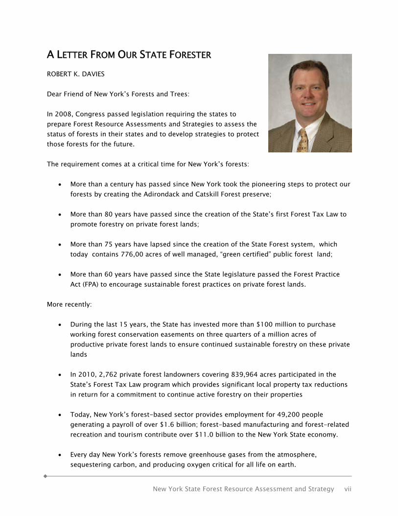
A LETTER FROM OUR STATE FORESTER ROBERT K. DAVIES Dear Friend of New York’s Forests and Trees: In 2008, Congress passed legislation requiring the states to prepare Forest Resource Assessments and Strategies to assess the status of forests in their states and to develop strategies to protect those forests for the future. The requirement comes at a critical time for New York’s forests:
• More than a century has passed since New York took the pioneering steps to protect our forests by creating the Adirondack and Catskill Forest preserve;
• More than 80 years have passed since the creation of the State’s first Forest Tax Law to
promote forestry on private forest lands;
• More than 75 years have lapsed since the creation of the State Forest system, which today contains 776,00 acres of well managed, “green certified” public forest land;
• More than 60 years have passed since the State legislature passed the Forest Practice
Act (FPA) to encourage sustainable forest practices on private forest lands. More recently:
• During the last 15 years, the State has invested more than $100 million to purchase working forest conservation easements on three quarters of a million acres of productive private forest lands to ensure continued sustainable forestry on these private lands
• In 2010, 2,762 private forest landowners covering 839,964 acres participated in the
State’s Forest Tax Law program which provides significant local property tax reductions in return for a commitment to continue active forestry on their properties
• Today, New York’s forest-based sector provides employment for 49,200 people
generating a payroll of over $1.6 billion; forest-based manufacturing and forest-related recreation and tourism contribute over $11.0 billion to the New York State economy.
• Every day New York’s forests remove greenhouse gases from the atmosphere,
sequestering carbon, and producing oxygen critical for all life on earth.
viii New York State Forest Resource Assessment and Strategy
• Every day, New York’s forests help filter and buffer clean drinking water for millions of
New Yorkers. New York’s extensive forests, both those publicly owned and managed, and those under the ownership of some 687,000 New Yorkers, which together comprise nearly 19 million acres and 63% of New York’s land area, represent an incredible asset when wisely managed, and an invaluable resource to address the modern environmental challenges of global climate change and the economic difficulties facing the State. The report, Keeping New York’ s Forest as Forests, assesses the status of New York’s nearly 19 million acres of forest land, and provides practical recommendations on how landowners, forest stakeholders and federal, state and local governments can work together to sustain the many benefits and ecosystem services our forests provide to our society. Among the many recommendations made, highlighted below are key initiatives:
• Develop new landowner incentive and tax abatement programs to encourage private forest owners to keep their lands in forest land use for the myriad of ecosystem services they provide to society at large;
• Encourage the growth and development of third party forest certification programs that
can reach more and smaller land owners to ensure sustainable forestry across all ownerships;
• Promote the development of more community owned forests in New York;
• Ensure that New York’s forests play a critical role in federal, state and local climate
action plans and programs in recognition of the substantial carbon sequestration potential and adaptation role our forests provide;
• Enhance the State’s forest health program to ensure that forest pest outbreaks are
discovered early and responded to rapidly;
• Continue and enhance the stewardship of State Forests by maintaining green certification
• Protect the State’s Forest Preserve and manage user impacts through the Unit Management Planning process;
• Engage & educate communities on the importance of urban forestry & green infrastructure;

New York State Forest Resource Assessment and Strategy ix
• Reduce the threat of subdivision & land use change on private forestland through State purchases of working forest conservation easements from willing sellers and enhancement of partnerships with non-governmental organizations and local governments; and
• Develop the next generation of New York’s forest constituency. I urge you take the time to read this report to learn more about the status of New York’s forest resources and the many ways New Yorkers can help conserve our forests and promote sustainable forestry. At a time of great environmental and economic challenge, planting trees and conserving our great forest lands are among the best strategies we can take to keep New York green while building our communities and contributing to the State’s economic recovery. Forests and trees work hard every day to protect water and air quality, shelter us from the sun and wind, provide wildlife habitat, and generate employment for thousands of people in the forest products, outdoor recreation and tourism industries. With some modest investments in their future as outlined in the report, our trees and forests can remain an important part of New York’s future, a future in which we continue to reap the benefits from our rich legacy of forests.
Robert K. Davies New York State Forester Director, Division of Lands and Forests New York State Department of Environmental Conservation


Introduction Part I
New York State Forest Resource Assessment and Strategy 1
II.. IINNTTRROODDUUCCTTIIOONN It starts with the land. New York’s forests deliver the ecosystem services our society depends on daily such as clean air, clean water, flood control, erosion control, carbon sequestration, natural cooling, drought mitigation, aquifer recharge and a steady source of fresh oxygen from plant photosynthesis. They also produce a wealth of forest products, provide a place for outdoor recreation and support associated economies. New York has a long history of responding to challenges facing our important forest resource, from the Forest Preservation Act in 1885, to the 2009 revision of the State’s Open Space Conservation Plan (OSP). As we learn more about the impacts of global climate change, it is increasingly clear that healthy forests are essential to our future. Our challenge is to keep our forests healthy and vigorous in the face of climate change, exurban sprawl, pests and diseases and invasive species. By improving sustainable forest management we can keep New York’s forests as forests, working for our future. Statewide Forest Resource Assessment and Strategy In the face of increased pressures on our forests and shrinking resources, states must focus those resources more efficiently and effectively. In response to this, The Food, Conservation, and Energy Act of 2008 (2008 Farm Bill) and the USDA Forest Service State and Private Forestry (S&PF) Redesign require states to develop a statewide forest resource assessment and strategy to analyze its forest conditions and trends and prioritize the issues facing the State’s forests resources to address these issues. Redesign focuses on three national themes: conserve working forests, protect forests from harm, and enhance benefits from trees and forests. At a minimum, statewide assessments of forest resources should: Describe forest conditions on all ownerships in the state Identify forest-related benefits and services Identify threats to the forest resources Highlight issues and trends of concern as well as opportunities for action Delineate high priority forest landscapes to be addressed Be geospatially based and make use of the best existing data The Assessment portion of this document is organized by the framework of the Montreal Process, described below. The Strategy addresses key issues developed by DEC and stakeholders who have an interest in New York’s forests. Stakeholders were provided a list of issues developed and used by the Department. Stakeholders then added to and modified this list of key issues. A list of involved stakeholders is provided in the Appendices.
Part I Introduction
2 New York State Forest Resource Assessment and Strategy
The Montreal Process The Montreal Process, an international working group dedicated to promoting sustainable forest management, developed a series of Criteria and Indicators (C&I) in 1994. Sustainable management is forest management that provides economic, social, and recreational values to society, without compromising the ability of forests to provide the same values to future generations. The C&I are used to assess sustainability of forestry practices at State, Regional, or National levels. Each Criterion serves as a category for assessment of sustainability of forest management. Indicators serve as measurable variables that may be used to assess changes over time. New York has developed this report using a modified Montreal Process of seven Criteria and 18 Indicators. The Montreal Process Criteria and Indicators includes the same seven criteria but includes a total of 64 indicators from which the Northeast Area Association of State Foresters (NAASF) with the Northeast Area of the Forest Service created 18 indicators that cover the metrics from 35 of these 64 indicators. This report is intended to assess the sustainability of New York’s forests, and the social, environmental and economic benefits provided by those forests, within the framework of the Criteria and Indicators established by the Montreal Process. As caretakers of our planet for future generations, we all have an obligation to ensure proper management of this important resource. Sustainable forest management will ensure that the many benefits we enjoy today will also be available, undiminished, to future generations. Forests are an Important Resource Today, New York faces the challenges of a changing climate that could have far greater impacts than the 1930s drought. Forests, including urban forests, provide front-line defenses against the many impacts of global warming. Urban trees help shade and cool cities where heat builds up, saving energy that would otherwise be used for air-conditioning. Forests act as sponges during storms; they absorb rainfall and reduce flooding. Trees work as filters to clean the air we breathe; they catch and remove airborne particulate matter which causes respiratory irritation and illness. Trees use carbon dioxide (a greenhouse gas) and give off oxygen, an element essential for animal life. And, in an increasingly technological society, forests can help us reconnect to the natural world. Even a short walk in a forest can be restorative. In the shade of a forest, surrounded by trees and green foliage, we can feel the calming and renewing effect of the natural environment around us. In addition to providing many benefits, New York’s forests face many threats, challenges and opportunities. This Forest Resource Assessment and Strategy (FRAS) will identify these threats, challenges and opportunities, and outline strategies to protect and improve our forest resources now and for future generations. "The nation behaves well if it treats the natural resources as assets which it must turn over to the next generation increased, and not impaired, in value." – Theodore Roosevelt

Introduction Part I
New York State Forest Resource Assessment and Strategy 3
Seven Criteria and Eighteen Indicators of the Montreal Process as presented by the Northeast Area Association of State Foresters
These indicators and metrics span the Montreal Process criteria and are recommended for use in NA-wide and State forest assessments. 1 Criterion 1. Conservation of Biological Diversity 1. Area of total land, forest land, and reserved forest land
1.1 Forest and total land area 1.2 Forest density 1.3 Forest land and population 1.4 Reserved forest land 1.5 Urban forest
2. Forest type, size class, age class, and successional stage 2.1 Forest cover type groups 2.2 Size class 2.3 Age group
3. Extent of forest land conversion 3.1 Fragmentation (text report with links; no data/graphs) 3.2 Forest land developed 3.3 Net change in forest land 3.4 Additions to and conversions from forest land 3.5 Forest parcel sizes
4. Status of forest/woodland communities and associated species of concern 4.1 Forest and woodland communities 4.2 Forest-associated and all species 4.3 Forest-associated species of concern by taxonomic group 4.4 Bird populations
Criterion 2. Maintenance of Productive Capacity of Forest Ecosystems 5. Area of timberland
5.1 Amount of timberland 6. Annual removal of merchantable wood volume compared with net growth
6.1 Net growth and removals 6.2 Type of removals
Criterion 3. Maintenance of Forest Ecosystem Health and Vitality 7. Area of forest land affected by potentially damaging agents
7.1 Tree mortality and damage type 7.2 Wildfire 7.3 Drought 7.4 Insects, diseases, plants, and animals
Criterion 4. Conservation and Maintenance of Soil and Water Resources 8. Soil quality on forest land
8.1 Soil pH

Part I Introduction
4 New York State Forest Resource Assessment and Strategy
8.2 Total soil carbon 8.3 Estimated bare soil 8.4 Bulk density 8.5 Calcium-aluminum ratio
9. Area of forest land adjacent to surface water, and forest land by watershed 9.1 Forested riparian area 9.2 Forest land by watershed
10. Water quality in forested areas 10.1 Water quality in forested areas 10.2 Stream miles impaired by percentage of watershed forested
Criterion 5. Maintenance of Forest Contribution to Global Carbon Cycles 11. Forest ecosystem biomass and forest carbon pools
11.1 Forest ecosystem biomass 11.2 Forest carbon pools 11.3 Forest carbon by forest type 11.4 Change in forest carbon
Criterion 6. Maintenance and Enhancement of Long-Term Multiple Socioeconomic Benefits to Meet the Needs of Societies 12. Wood and wood products production, consumption, and trade
12.1 Value of wood-related products 12.2 Production of roundwood 12.3 Production and consumption of roundwood equivalent 12.4 Recovered paper 12.5 Bioenergy, Trade or wood flow, Nontimber forest products
13. Outdoor recreational participation and facilities 13.1 Participation in outdoor recreation 13.2 Federal land open to recreation 13.3 Recreational facilities on State land 13.4 Trails 13.5 Campgrounds 13.6 Recreational facilities in national forests
14. Investments in forest health, management, research, and wood processing 14.1 USDA Forest Service Northeastern Area State and Private Forestry funding 14.2 State forestry agency funding 14.3 Funding for forestry research at universities 14.4 USDA Forest Service Research funding 14.5 Capital expenditures by manufacturers of wood-related products
15. Forest ownership, land use, and specially designated areas 15.1 Forest land ownership 15.2 State lands 15.3 Protected land 15.4 Private land with public conservation easements
Introduction Part I
New York State Forest Resource Assessment and Strategy 5
15.5 Forest land in tax reduction programs 15.6 Forest certification
16. Employment and wages in forest-related sectors 16.1 Wood-related products manufacturing employees 16.2 State forestry employees 16.3 USDA Forest Service employees 16.4 Wood-related products manufacturing payroll and wages 16.5 State forestry salaries
Criterion 7. Legal, Institutional, and Economic Framework for Forest Conservation and Sustainable Management 17. Forest management standards/guidelines 17.1 Types of forest management standards/guidelines
17.2 Voluntary and mandatory standards/guidelines 17.3 Monitoring of standards/guidelines
18. Forest-related planning, assessment, policy, and law 18.1 State forest planning 18.2 Nonindustrial private forest planning 18.3 National forest planning 18.4 State forest assessments 18.5 Forest laws and policies 18.6 State forest advisory committees
1 No priority is implied in the numeric listing of the criteria, indicators, and metrics.

History Part II
New York State Forest Resource Assessment and Strategy 7
IIII.. HHIISSTTOORRYY The present forests in New York began developing after the last glacier started to retreat 15,000 years ago. Almost all of New York State had been scraped over by the glaciers, and then covered with a layer of raw glacial debris. As the climate slowly warmed, plants began to migrate north to colonize the barren post-glacial landscape. Spruce species were the first to arrive, followed by white pine, hemlock, oak, beech, and finally chestnut which arrived only 2,000 years ago. The recent history of New York's forests is intertwined with the social and economic history of the State. Forests were viewed as an inexhaustible resource until the late 19th century when people realized that there would be a lumber shortage if unregulated clearing and logging continued. By the 1880s, less than 25% of New York State was forested, and the remaining uncut forests in the Catskills and Adirondacks were being logged fast. In 1885, New York created the Forest Preserve Act to protect state owned lands in the Catskills and Adirondacks from further exploitation. This act was strengthened in 1894 by an amendment to the New York State Constitution: "The lands of the state, now owned or hereafter acquired, constituting the forest preserve as now fixed by law, shall be forever kept as wild forest lands. They shall not be leased, sold or exchanged, or be taken by any corporation, public or private, nor shall the timber thereon be sold, removed or destroyed." The Forest Preserve began with 681,000 acres in the Adirondacks and 34,000 acres in the Catskills. Today there are more than 2.6 million acres in the Adirondacks and more than 300,000 acres in the Catskills, held as forever wild lands for New Yorkers today and the future. The New York Forest Preserve is the largest state-designated wilderness in the country and the largest wilderness area east of the Mississippi. The recognition of forests as a limited resource that needed to be managed for future sustainability was the beginning of the modern conservation movement. Theodore Roosevelt and Gifford Pinchot were among the leaders of the new ethic and started land use practices that we take for granted today, such as conserving open space and restoring forest land. With the advent of scientific forest management and the planting of millions of trees, the State's battered forest lands began to recover. In the 1930s, years of drought resulted in the national climate crisis known as the dustbowl - which coincided with the Great Depression. Even in New York, farms failed from drought, and millions of agricultural acres were abandoned. Some of
Part II History
8 New York State Forest Resource Assessment and Strategy
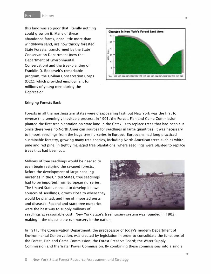
this land was so poor that literally nothing could grow on it. Many of these abandoned farms, once little more than windblown sand, are now thickly forested State Forests, transformed by the State Conservation Department (now the Department of Environmental Conservation) and the tree-planting of Franklin D. Roosevelt's remarkable program, the Civilian Conservation Corps (CCC), which provided employment for millions of young men during the Depression. Bringing Forests Back Forests in all the northeastern states were disappearing fast, but New York was the first to reverse this seemingly inevitable process. In 1901, the Forest, Fish and Game Commission planted the first tree plantation on state land in the Catskills to replace trees that had been cut. Since there were no North American sources for seedlings in large quantities, it was necessary to import seedlings from the huge tree nurseries in Europe. Europeans had long practiced sustainable forestry, growing many tree species, including North American trees such as white pine and red pine, in tightly managed tree plantations, where seedlings were planted to replace trees that had been cut. Millions of tree seedlings would be needed to even begin restoring the ravaged forests. Before the development of large seedling nurseries in the United States, tree seedlings had to be imported from European nurseries. The United States needed to develop its own sources of seedlings, grown close to where they would be planted, and free of imported pests and diseases. Federal and state tree nurseries were the best way to supply millions of seedlings at reasonable cost. New York State’s tree nursery system was founded in 1902, making it the oldest state run nursery in the nation In 1911, The Conservation Department, the predecessor of today's modern Department of Environmental Conservation, was created by legislation in order to consolidate the functions of the Forest, Fish and Game Commission; the Forest Preserve Board; the Water Supply Commission and the Water Power Commission. By combining these commissions into a single

History Part II
New York State Forest Resource Assessment and Strategy 9
department, the State greatly enhanced its ability to protect the environment, and to respond to new environmental challenges, such as the rapid abandonment of farmland that began in the 1920s. Much of the farmland in New York was on marginal land, and as better land became available out west, agriculture began to decline in New York. When the Great Depression hit, many farmers could no longer make a living on their worn out, unproductive land. The 1929 State Reforestation Act, and the 1931 Hewitt Amendment, authorized the Conservation Department to buy land for reforestation purposes. These lands were known as state reforestation areas, and were the beginning of today's State Forest system. Many of the early reforestation areas were established on some of the worst land in the State. The Conservation Department began a massive tree planting program to restore these lands for watershed protection, soil stabilization, flood prevention, and future timber production. Today, these areas are covered with healthy and well managed state forests. (State Forests are still referred to as reforestation areas as originally defined in legislation.) New York’s Forest Practice Act (FPA) of 1946 recognized the importance and contributions of private forest lands. The FPA program was deemed vital to the interests of the People of New York State in order that the practice of forestry would be encouraged, that damage to the environment caused by unplanned and exploitive overcutting might be avoided and that the industries of the state dependent upon forest products might be stabilized as far as possible. It provided free forestry assistance to private landowners and established Forest Practice Boards in each of the 14 Forest Districts of the state. The Act also established a State Forest Practice Board composed of one member from each of the District Boards. Boards were charged with the mission of developing local forest practice standards that cooperating landowners subscribed to when receiving forestry assistance. As late as 1970, 1 in 25 forest landowners received program technical assistance each year. Today that number has declined to 1 in 300 due to decreases in program staffing and a sharp increase in the number of forest owners. State funding for tree planting fell victim to the Depression, but the federal Civilian Conservation Corps (CCC), founded by President Franklin D. Roosevelt (FDR) in 1933, rescued the tree planting program in New York. Millions of tree seedlings were planted on the barren soil of the new state reforestation areas, work that provided employment for thousands of young men. FDR was especially interested in reforestation work, having begun planting his own estate with seedlings from the State Tree Nursery beginning in 1912. His trips to view CCC projects in New York typically included visits to reforestation areas. After World War II, there was a resurgence of tree planting as more farmland fell vacant. Scientific game management led to the development of state-owned Wildlife Management Areas to provide optimal habitat for game species such as waterfowl and upland birds. The Park and Recreation Land Acquisition Act of 1960 and the Environmental Quality Bond Acts of 1972 and 1986, provided funds for the acquisition of additional state forest lands, including in holdings

Part II History
10 New York State Forest Resource Assessment and Strategy
or parcels adjacent to existing state forests. Support for Forest Owners In 1912, New York became the second state in the nation to adopt legislation to provide special property tax consideration for forest land. The motivation in 1912 was concern over the depletion of New York’s forest resource from industrial harvesting and land clearing for agriculture which had reduced the state’s total forest cover to less than 25% at that time. This initial tax relief effort provided a thirty-five year property tax exemption for a maximum of 100 acres. The partial exemption resulted from the separation of the value of the timber from that of the bare land for assessment purposes. A five percent stumpage tax was levied upon the harvested volumes. The objective of the forest yield tax law was to encourage reforestation of abandoned farmland and to maintain forest lands to (timber) maturity. The success of this early legislation was limited with only 1,300 acres enrolled by 1919. The poor results of the first attempt at forest tax legislation resulted in the first reform in the early 1920’s. State Assemblyman Clarence L. Fisher of Lyons Falls, NY, led the amendment effort which embraced many of the same timber production objectives of the 1912 act, and which eventually bore his name: the Fisher Act. This Act was later codified as Section 480 of the Real Property Tax Law (RPTL) and became known as “the 480 Program”. Enrollment, which had no time limit, required 15 acres or more, with some assurance that either the tract could provide a merchantable timber crop within 30 years, or compliance with tree planting requirements. Tax liability was based on bare land values and assessments were frozen at the time of enrollment. (They could only be raised if the entire taxing jurisdiction was reassessed.) A six percent yield (stumpage) tax was due on harvested volumes. Sale of a 480 Program property had (has) no effect on its tax exempt status. However, if the land was converted to a use other than production of forest products, a six percent tax was due on the value of all standing timber. This program was administered primarily by the local assessor, but ultimate approval of an application required consent of the NYS Conservation Department. The Environmental Conservation Law of 1970 assigned agency responsibility for administration of the 480 Program to the newly-created Department of Environmental Conservation (DEC). The first 40 years of the 480 Program saw very limited participation among forest landowners. Enrollments began to significantly grow in the 1960’s and ‘70’s as inflation and property tax assessments increased. In the final year of the program (1973-74) the assessed value of enrolled land nearly quadrupled with acreage more than doubling from 365,694 to 815,503. Nevertheless, total participation remained limited with only 5% of the eligible property participating at the Program’s peak. A study by the State Board of Equalization and Assessment in 1976 showed that 80% of the total Program certified acreage was held by five owners (primarily forest products industries). This information seemingly provided evidence that the legislation failed to fulfill the broad forest conservation intent of the drafters.

History Part II
New York State Forest Resource Assessment and Strategy 11
In 1974, the State Legislature enacted a new Forest Tax Law, Section 480-a of the Real Property Tax Law, which took effect in 1975. The stated goal of 480-a was to “provide a means by which present and future forest lands may be protected and enhanced as a viable segment of the state’s economy and as an economic and environmental resource of major importance.” More emphasis was placed, in the legislation, on the silvicultural responsibilities of the owners and the main objective of the new law was clearly the improved and sustained production of crops of forest products for industrial use and economic development. (The new 480-a program did not sunset the original 480 Program and some properties remain enrolled today with their assessments frozen at pre-1974 rates.) Unlike its predecessor, 480-a requires a minimum of 50 acres and strict adherence to a DEC-approved forest management plan, as specified in both statute and regulation, as part of the on-going responsibilities of program participation. The plan must be written in accordance with acceptable silvicultural standards, include a 15-year work schedule (intended to produce periodic crops of forest products), and be updated and re-approved by the Department every 5 years. Participation also requires an annual, rolling 10-year commitment by the landowner to follow the approved management plan and keep the enrolled acres in forest crop production. The land can be sold prior to fulfilling the 10-year management commitment, but the obligation remains with the land and subsequent owners. The Creation of the Current Day Department of Environmental Conservation In 1970, on the first Earth Day, the New York State Department of Environmental Conservation (DEC) was established. This new agency joined the mission of the old Conservation Department with the missions of State environmental quality bureaus in the Department of Health. The modern Department now manages a variety of programs to protect our air, land and water resources, and the Department's public lands and private forest landowner programs contribute mightily to this effort. Partnerships to Progress Over 100 years ago, our Department’s predecessor had the wisdom and forethought to preserve land for the future benefit of the people of New York State. Considering today’s challenges and conditions, it would be unrealistic to expect State programs to be the only avenue for future land conservation. As described in the New York State Open Space Conservation Plan, open space conservation will best be achieved through partnerships among the public, different levels of government, private conservation organizations, businesses and landowners. Thus, conservation of open space is not the sole responsibility of state agencies, but rather must be pursued by the State, other public and private agencies and individual citizens working together. This partnership approach is strongly supported by the public and communities.

Part II History
12 New York State Forest Resource Assessment and Strategy
The Plan recognizes that only a fraction of the state's remaining open space deserving of protection will be conserved through direct State fee and easement acquisition. Several alternative strategies exist, which if pursued with assistance from, and in partnership with the State, can greatly enhance the capability of the citizens and communities of New York to conserve our open space resources. Alternative strategies which involve partnership approaches to open space conservation include: 1) creative land protection solutions including conservation easements; 2) the activity of private, non-profit land trusts; 3) efforts to encourage land and water-based natural resource industries; 4) local planning, zoning and active open space programs; 5) environmental and regulatory controls; and 6) tax policies and other incentives to encourage private land stewardship and conservation. Contemporary issues require creative solutions. It is the goal of this plan to outline some of the strategies that will address these issues.
Forest Conditions and Trends Part III Criterion 1. Conservation of Biological Diversity
New York State Forest Resource Assessment and Strategy 13
IIIIII.. FFOORREESSTT CCOONNDDIITTIIOONNSS AANNDD
TTRREENNDDSS Criterion 1 – Conservation of Biological Diversity
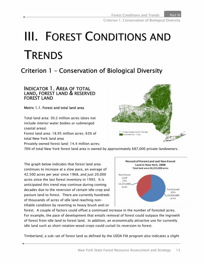
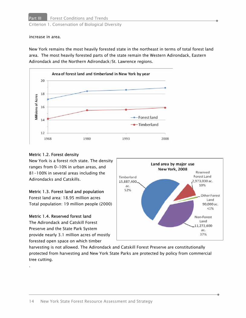
INDICATOR 1. AREA OF TOTAL LAND, FOREST LAND & RESERVED FOREST LAND Metric 1.1. Forest and total land area Total land area: 30.2 million acres (does not include interior water bodies or submerged coastal areas) Forest land area: 18.95 million acres; 63% of total New York land area Privately owned forest land: 14.4 million acres; 76% of total New York forest land area is owned by approximately 687,000 private landowners. The graph below indicates that forest land area continues to increase at a slow pace, an average of 42,500 acres per year since 1968, and just 20,000 acres since the last forest inventory in 1993. It is anticipated this trend may continue during coming decades due to the reversion of certain idle crop and pasture land to forest. There are currently hundreds of thousands of acres of idle land reaching non-tillable condition by reverting to heavy brush and/or forest. A couple of factors could offset a continued increase in the number of forested acres. For example, the pace of development that entails removal of forest could outpace the ingrowth of forest from idle land to forest land. In addition, an economically attractive use for currently idle land such as short rotation wood crops could curtail its reversion to forest. Timberland, a sub-set of forest land as defined by the USDA FIA program also indicates a slight
Part III Forest Conditions and Trends Criterion 1. Conservation of Biological Diversity
14 New York State Forest Resource Assessment and Strategy
increase in area. New York remains the most heavily forested state in the northeast in terms of total forest land area. The most heavily forested parts of the state remain the Western Adirondack, Eastern Adirondack and the Northern Adirondack/St. Lawrence regions.
Metric 1.2. Forest density New York is a forest rich state. The density ranges from 0-10% in urban areas, and 81-100% in several areas including the Adirondacks and Catskills. Metric 1.3. Forest land and population Forest land area: 18.95 million acres Total population: 19 million people (2000) Metric 1.4. Reserved forest land The Adirondack and Catskill Forest Preserve and the State Park System provide nearly 3.1 million acres of mostly forested open space on which timber harvesting is not allowed. The Adirondack and Catskill Forest Preserve are constitutionally protected from harvesting and New York State Parks are protected by policy from commercial tree cutting. .
Forest Conditions and Trends Part III Criterion 1. Conservation of Biological Diversity
New York State Forest Resource Assessment and Strategy 15
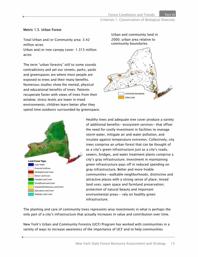
Metric 1.5. Urban Forest Total Urban and/or Community area: 3.42 million acres Urban and/or tree canopy cover: 1.315 million acres The term “urban forestry” still to some sounds contradictory and yet our streets, parks, yards and greenspaces are where most people are exposed to trees and their many benefits. Numerous studies show the mental, physical and educational benefits of trees: Patients recuperate faster with views of trees from their window; stress levels are lower in treed environments; children learn better after they spend time outdoors surrounded by greenspace.
Healthy trees and adequate tree cover produce a variety of additional benefits—ecosystem services—that offset the need for costly investment in facilities to manage storm water, mitigate air and water pollution, and insulate against temperature extremes. Collectively, city trees comprise an urban forest that can be thought of as a city’s green infrastructure just as a city’s roads, sewers, bridges, and water treatment plants comprise a city’s gray infrastructure. Investment in maintaining green infrastructure pays off in reduced spending on gray infrastructure. Better and more livable communities—walkable neighborhoods; distinctive and attractive places with a strong sense of place; mixed land uses; open space and farmland preservation; protection of natural beauty and important environmental areas— rely on healthy green infrastructure.
The planting and care of community trees represents wise investments in what is perhaps the only part of a city’s infrastructure that actually increases in value and contribution over time. New York’s Urban and Community Forestry (UCF) Program has worked with communities in a variety of ways to increase awareness of the importance of UCF and to help communities
Urban and community land in 2000; urban area relative to community boundaries.

Part III Forest Conditions and Trends Criterion 1. Conservation of Biological Diversity
16 New York State Forest Resource Assessment and Strategy
develop their own UCF programs. In 2000, New York identified nearly 650 communities which were capable of undertaking a UCF program. The US Forest Service, which provides funding for this program, directed the community support to focus on technical assistance, development of tree ordinances, tree boards and management plans for these communities. The Forest Service tracks the State’s activities through the Community Accomplishment Reporting System (CARS). As of 2009, nearly half of the CARS communities were engaged in urban forestry programs or activities. The graphics below show the communities which have worked with DEC staff and reached a certain level of tree program development.
The publication, Urban and Community Forests of the Mid-Atlantic Region (Nowak et al. 2009), provides detailed data on this topic for New York State some of which is noted below. Urban (attaining minimum population density) and community land (political boundaries) comprises 10.8 percent of the land area of New York. Between 1990 and 2000, urban and community area increased 7.2 percent. Tree canopy cover averages 40.4 percent in urban and community areas. Average impervious surface cover in New York is 2.4 percent of the total land area. Average impervious surface cover in urban and community areas is 18.3 percent. (Nowak and Walton 2005).

Forest Conditions and Trends Part III Criterion 1. Conservation of Biological Diversity
New York State Forest Resource Assessment and Strategy 17
Planting priority index for county subdivisions. The higher the index value, the greater priority for planting.
The New York State Urban and Community Forestry Council conducted a survey of municipalities in 2009. They received 207 responses. Survey results showed that in the majority of respondents’ communities (66/59.5%) the DPW/Highway superintendent was responsible for tree management. Often this title has very little tree care training. In addition, a majority (149/72.3%) of communities had no tree management plan, no tree inventory (142/68.9%, and no tree advisory group such as a tree board or parks committee (146/75.3%).
Percentage impervious surface cover within county subdivisions.
2000 population within county subdivision boundaries.
The maps on this page show greatest population and impervious surface in New York in addition to Priority Planting Areas based on David Nowak’s report. Priority Planting Areas are based on population density, impervious surfaces, and relative
Part III Forest Conditions and Trends Criterion 1. Conservation of Biological Diversity
18 New York State Forest Resource Assessment and Strategy
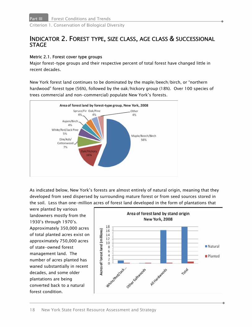
INDICATOR 2. FOREST TYPE, SIZE CLASS, AGE CLASS & SUCCESSIONAL STAGE Metric 2.1. Forest cover type groups Major forest-type groups and their respective percent of total forest have changed little in recent decades. New York forest land continues to be dominated by the maple/beech/birch, or “northern hardwood” forest type (56%), followed by the oak/hickory group (18%). Over 100 species of trees commercial and non-commercial) populate New York’s forests.
As indicated below, New York’s forests are almost entirely of natural origin, meaning that they developed from seed dispersed by surrounding mature forest or from seed sources stored in the soil. Less than one-million acres of forest land developed in the form of plantations that were planted by various landowners mostly from the 1930’s through 1970’s. Approximately 350,000 acres of total planted acres exist on approximately 750,000 acres of state-owned forest management land. The number of acres planted has waned substantially in recent decades, and some older plantations are being converted back to a natural forest condition.

Forest Conditions and Trends Part III Criterion 1. Conservation of Biological Diversity
New York State Forest Resource Assessment and Strategy 19
Metric 2.2 Size Class Approximately 60% of New York’s forests are in a large tree, or sawtimber size class; 28% are classified as poletimber; only 11% are in a stage where seedling and sapling size trees predominate. The chart above indicates that New York’s forests are growing and maturing, however, it can also be stated that its forests are “out of balance” with regard to area of particular size classes. While the balance indicated on the graph is simply an indication of area of trees of certain sizes, this also can affect the balance of other forest amenities such as wildlife population and aesthetic appeal. This condition can be attributed to both the prevailing timber management methods utilized in the state as well as the slowdown in acres reverting from an idle condition into a forested condition as well as high value agricultural land remaining as such. The major forest type groups New York differ in their current stand size class structure. The largest and second largest forest type groups, maple/beech/birch, or “northern hardwoods” and oak/hickory most closely match the overall state stand size class structure presented previously. The other five type groups diverge noticeable from the state average. The white/red/jack pine type shows a pronounced divergence from the state average as does the
Part III Forest Conditions and Trends Criterion 1. Conservation of Biological Diversity
20 New York State Forest Resource Assessment and Strategy
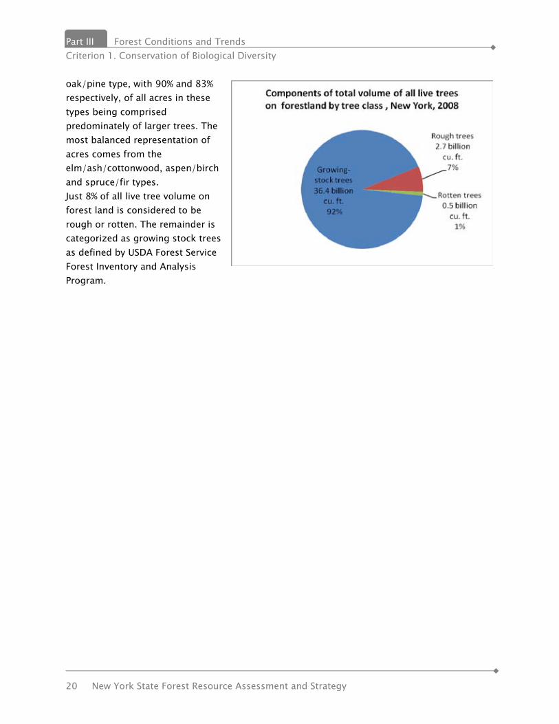
oak/pine type, with 90% and 83% respectively, of all acres in these types being comprised predominately of larger trees. The most balanced representation of acres comes from the elm/ash/cottonwood, aspen/birch and spruce/fir types. Just 8% of all live tree volume on forest land is considered to be rough or rotten. The remainder is categorized as growing stock trees as defined by USDA Forest Service Forest Inventory and Analysis Program.

Forest Conditions and Trends Part III Criterion 1. Conservation of Biological Diversity
New York State Forest Resource Assessment and Strategy 21
INDICATOR 3. EXTENT OF FOREST LAND CONVERSION, FRAGMENTATION & PARCELIZATION Metric 3.1. Fragmentation; Metric 3.2. Forest land developed; Metric 3.3. Net change in forest land; and Metric 3.4. Additions to and conversions from forest land. Conversion When the colonists arrived New York was, for the most part, forested. Forests were cut for wood products and agricultural lands. In the 1880s less than 25% of the state was forested – the lowest amount since the last ice age. In the early 1890s abandoned farmland began reverting back to forests mainly by natural regeneration. Conifer plantations were established on state owned lands with millions of seedlings. Private landowners were encouraged to plant trees on fallow land for erosion control and water quality. Forest land increased dramatically and today has leveled out. At 63% forested, New York is unlikely to see any substantial increase in forest land. Loss of forest land in the future will mainly be due to development. Parcelization and Fragmentation Parcelization occurs when large parcels of land are divided up into smaller ones. Parcelization results in an increase in the number of owners. Fragmentation occurs when continuous forest is broken up by development of roads, homes, commercial uses and agricultural purposes. Parcelization is usually the precursor to fragmentation but it does not have to be. The development of a highway which provides easier access to an urban area from undeveloped forest land could then lead to a forest owner selling off pieces of land to others who would not have been interested or have access without the highway. Forest parcelization and fragmentation cause several problems which degrade forest health. Invasive plant species, which tend to become established around forest edges, often out-compete native plants and disrupt forest ecosystems. Parcelization can and Fragmentation does result in less interior forest for plants and animals that require this specific habitat. Parcelization increases the number of forest landowners, and can make the task of managing the forest resources of the State more difficult overall. Stewardship efforts must be of sufficient scale to target the large number of landowners responsible for managing these small woodlots. For forest industry, parcelization increases costs and complexity of doing business with private forest owners. For example, instead of negotiating for a timber sale on 200 acres with one owner, they may have to (try) to deal with 5 different owners to access the same timber resource.

Part III Forest Conditions and Trends Criterion 1. Conservation of Biological Diversity
22 New York State Forest Resource Assessment and Strategy
In the last 200 years, New York has gone from being completely forested to less than 25% forested in the 1880’s from timber cutting and agricultural practices. Since the early 1890s, abandoned farmland has reverted back to forests mainly through natural regeneration. Conifer plantations were established on State owned lands and private landowners were encouraged to plant trees on fallow land for erosion control and water quality. Protecting water quality with forests has been recognized for over a century. New York’s forest land has thus increased dramatically and today has leveled out, at 63% forested, New York is unlikely to see a substantial increase in forest land. Current forest parcelization and fragmentation trends in the State will likely result in future losses of large, contiguous forested areas. Metric 3.5. Forest parcel sizes 14.4 million, or 76% of New York's 18.9 million acres of forests are owned by about 687,000 private land owners. Many studies show the size of forest parcels is decreasing and the number of landowners is increasing. This trend will not change. The project, Forests on the Edge (Stein, Susan M. 2005) describes housing density projections on private forests, by watershed, across the conterminous United States. “Results indicate that some 44.2 million acres (over 11 percent) of private forests – particularly in the East, where most private forests occur – are likely to see dramatic increases in housing development in the next three decades, with consequent impacts on ecological, economic, and social services.” The top 15 watersheds containing private forests that are projected to experience the most housing density increase by 2030 all occur in the Eastern U.S. and New York’s Middle Hudson watershed ranks 11. The report continues: “The conversion of some private forest land over time is inevitable. Although development will occur, local jurisdictions and states can plan and target efforts to prevent or reduce conversion of some of their most valuable forest lands –such as large contiguous forest tracts, forests adjacent to headwaters or riparian areas, forests with high timber or wildlife values, and forests
Forest Conditions and Trends Part III Criterion 1. Conservation of Biological Diversity
New York State Forest Resource Assessment and Strategy 23
with valuable scenic and social qualities – to keep our private working forests resilient and productive long into the future.” New York’s status as a home rule state provides local governments with the majority of control over land use laws. Because of this, local government involvement is pivotal to conservation of forests.

Part III Forest Conditions and Trends Criterion 1. Conservation of Biological Diversity
24 New York State Forest Resource Assessment and Strategy
Early successional habitat and many associated species can be found where land has been recently disturbed - Photo credit USDA-NRCS
INDICATOR 4. STATUS OF FOREST/WOODLAND COMMUNITIES & ASSOCIATED SPECIES OF CONCERN New York is a varied and complex state. New York State covers an area of 54,077 square miles, 87% of which is land. Inland lakes and rivers cover 1,894 square miles and the State has jurisdiction over 981 sq. miles of the Atlantic Ocean as well as 3,988 square miles of the Great Lakes. New York is the only state with a Great Lake and an ocean. Actually, New York claims two Great Lakes. One of the reasons for New York’s diversity is that it is the northern edge of the range for many southern species (both animals and plants) and the southern edge of the range for many northern species. (NYS Comprehensive Wildlife Conservation Strategy) Metric 4.1. Forest and woodland communities The New York Natural Heritage Program has identified 172 Natural Communities in New York State. Of those, 69 are forest and woodland related communities. The rest of the information for this metric has been taken from the Draft New York State Strategic Plan for State Forest Management. (Under development as of the completion of this document) Early Successional Habitat Assessment “Early successional habitat composed of young trees and shrubs, often occupying recently disturbed sites and areas such as abandoned farm fields, provides unique and important habitat for many wildlife species. Some of the tree and shrub species that colonize abandoned agricultural land and disturbed sites include grey birch, dogwood, aspen species, cherry, willow, and alder.” (Natural Heritage Elements - Species Level 2003-04) Historical Background: Based on records from pre-settlement land surveyors, researchers have estimated that between 2 and 6% of the pre-settlement northern hardwood forest was in young forest cover. Coastal areas, valleys and transitional hardwood sites in New York’s southern tier likely had higher percentages of young forest – typically less than 15%. An even higher amount of early successional habitat, is estimated to have been present in coastal areas (including the shores of the Great Lakes and the Atlantic). Due to

Forest Conditions and Trends Part III Criterion 1. Conservation of Biological Diversity
New York State Forest Resource Assessment and Strategy 25
more frequent disturbances in these areas from hurricanes and greater incidence of burning by Native Americans, especially in coastal oak and pitch pine forest types, 31% of this area is estimated to have been in early successional stages. Existing Conditions: Statewide, the NY GAP Analysis Program Report estimated about 2% of the state is in early successional cover. The National Land Cover Database (NLCD) (which includes emergent herbaceous wetlands) places the statewide average at about 5%. Trends: To assess trends in the age of New York’s forests, the U.S. Forest Service, Forest Inventory Data was consulted. A comparison of the 1980 and 1993 USFS Forest Service Forest Inventory Statistics of forest land outside the Forest Preserve illustrates a dramatic trend: in 1980, 30% of forest land was classified as “seedling/sapling” (which roughly approximates early successional habitat). In 1993 this habitat type dropped almost by a half to 16% of forest land in the state (outside the Forest Preserve). The most recent US Forest Service statistics are online at: http://fiatools.fs.fed.us/fido/standardrpt.html. This survey covered the period from 2003 to 2008, sampled all forest lands in New York State (including the Forest Preserve), and defined the forest by age classes instead of size classes. Under this metric, early successional habitat is best represented by forests ranging from zero to 19 years. Forests in this age range now represent 7% of the total forested acreage in New York State. While it is difficult to directly relate this to the 1980 and 1993 inventory data, it still suggests a continued reduction in area of early successional habitat. Early successional cover may continue to decrease as time progresses unless steps are taken to deliberately create, enhance and sustain new habitat. Early successional habitat is especially important in that it supports a high diversity of birds, mammals and reptiles. In fact, New York State’s Comprehensive Wildlife Conservation Strategy recognizes the value of this land cover type and identifies early successional birds as a “greatest conservation need” species group. There is no consensus within the scientific community as to what is the optimal percentage of the landscape occupied by early successional cover. Some argue that many bird and mammal species dependent on early successional habitat are declining in population, and would benefit from the creation and maintenance of this habitat type. Mid Successional Forest Habitat Assessment Historical Background: Most of the forest across New York’s landscape originated from heavy cutting and land clearing to establish farms during European settlement. In the late 1800s only 25% of New York State remained forested. Many of the lands cleared for farming proved to be of marginal quality and others failed as a result of poor farming practices depleting the soil. Farm failures peaked in the Great Depression, setting the stage for natural succession and the re-birth of forests. Existing conditions: As a result of their similar past history, most of the state’s forests are

Part III Forest Conditions and Trends Criterion 1. Conservation of Biological Diversity
26 New York State Forest Resource Assessment and Strategy
even-aged and are often less than 120 years old. The trees in these mid successional forests have grown larger than those found in early successional forests, but the vertical diversity that typifies late successional forests has not yet developed. Mid successional forests are therefore defined as forests that are pole-sized or larger, with relatively open understories. Trends and stressors: While it is possible to classify these forests as middle aged, some of the tree species are reaching and exceeding their biological maturity, especially those classified as early successional and shade intolerant, like aspen, ash and birch. These trees will be more susceptible to insect and disease issues and will naturally be replaced by more shade tolerant species. Over the next 50 to 100 years this “wave” of middle aged forests will continue to mature and develop attributes associated with late successional forest habitats, except in cases where harvesting or natural disturbances “set the clock back” on succession. Late Successional Forest Habitat Assessment State Forests, parks and preserves provide significant blocks of both actively and minimally managed late successional forest cover. Historical Background: Early settlement, land clearing for agricultural needs and industrialization of New York State removed much of the state’s forest cover. Between 1700 and 1900, approximately 75% of New York’s land area was deforested, when deforestation reached 85% or more for some counties. Large scale forest disturbance from European settlement and the rapid industrialization of the state that followed was probably the greatest event to impact New York’s forest resource since the last glacier retreated and the landscape began to recover some 10,000 years ago. Thus, most of the state’s late successional forest cover was lost in a very short period. Existing Conditions: Today, the vast majority of New York’s forests are less than 120 years of age and, by their very nature, often lack late successional habitat components such as large diameter dead standing trees (snags), large diameter deadwood on the ground (coarse woody debris) and large diameter biological legacy trees. Statewide, U.S. Forest Service inventory data show that less than 1% of the state’s forest resource is greater than 120 years in age. Most forests and forest ecosystems simply haven’t had the time to develop late successional habitat characteristics. New York State has more forest land in a “preserve” status (i.e., not permitted to be commercially harvested) than any other State in the Northeastern United States (including the States of CT, DE, ME, MD, MA, NH, NJ, OH, PA, RI, VA, VT and WV). These are lands which, over time have the potential to develop into late successional forests, barring large natural or human-caused disturbances. According to 2008 data from the US Forest Service Forest Inventory and Analysis Unit, 5% of the Northeast’s forests lands are reserved from harvesting. Over 18% of New York State’s forests are in this category.

Forest Conditions and Trends Part III Criterion 1. Conservation of Biological Diversity
New York State Forest Resource Assessment and Strategy 27
Trends: The great majority of properties within the forest preserve that underwent significant disturbance will continue to progress towards a late successional condition. A small percentage will likely undergo additional natural disturbance, but the amount of late successional habitat within the forest preserve will likely continue to increase. At some point, taking into account the eventual equilibrium between natural disturbance and forest succession, late successional forests in the forest preserve will comprise between 15 and 20 percent of the state’s forest land. Forests owned by non-industrial private landowners will contribute to the statewide late successional forest cover on lands protected from harvesting by conservation easements held by land trusts. Portions of State Forest lands will be managed using uneven-aged management systems, allowing them to develop late successional characteristics. It is virtually impossible however, that late successional forests will ever make up as high a percentage of the landscape in other parts of the state as they eventually will within the Adirondack and Catskill blue lines. Evergreen Forest Cover Habitat Assessment Evergreen (non-deciduous conifer) forests are important because they moderate temperature extremes, help improve previously eroded and nutrient-depleted soils, and provide valuable winter cover. Historical background: Evergreen cover is an important habitat that has historically been heavily impacted by early colonization and European settlement. The early demand for eastern white pine for ship masts, eastern hemlock for barn siding and beams, and hemlock bark for leather tanning, coupled with the extensive cutting of evergreens for paper pulp during the late 19th and early 20th centuries significantly impacted the state’s evergreen resource. Based on satellite images from the 2001 National Land Cover Database, about 8% of New York State is covered by evergreen forest. Eastern white pine, eastern hemlock, red spruce, black spruce, northern white cedar and balsam fir are the chief native conifers found in the state. Existing conditions: From a forest cover standpoint, the State Forest System is especially unique
Part III Forest Conditions and Trends Criterion 1. Conservation of Biological Diversity
28 New York State Forest Resource Assessment and Strategy
in that it provides a large conifer plantation and evergreen component which is significant on a statewide basis. Much of this component is comprised of plantations, which are largely a legacy of the massive tree planting campaign conducted by the Civilian Conservation Corps during the Great Depression. According to the 2001 New York GAP Report, New York State agencies, primarily the DEC, manage about 56% of the evergreen forests, but only 13% of deciduous and 22% of the mixed evergreen/deciduous forests. Both native and non-native evergreen conifers such as Austrian pine, eastern white pine, red pine, pitch pine, jack pine, Scotch pine, balsam fir, eastern hemlock, northern white cedar, Norway spruce, and white spruce have historically been planted on State Forest lands. Of these species, Norway spruce, red pine and Scotch pine have arguably been the most successful, in terms of rate of growth and volume of biomass produced per acre. Stressors and trends: A majority of State Forest plantations were established in the 1940s. Those planted with shorter-lived species like Scotch pine, those planted in poor soils, and those established on sites to which they were not well suited, have passed their biological maturity and are now being harvested and converted to more natural mixed hardwood and mixed softwood/hardwood habitats. This is widely considered the second step of the restoration process for these former agricultural lands. As a result, the evergreen forest cover on State Forests and in the landscape will be dropping over time. Other plantations of longer-lived species like Norway spruce and white pine will remain in softwood cover for a much longer period of time, since it will take longer for these stands to reach the point at which they will be converted or regenerated. Insect and disease are more prevalent in plantations which are over mature or which are experiencing other stressors from not being properly thinned or being on poor or inappropriate sites. In the case of Scotch pine, a newly introduced wood wasp, Sirex noctillio, has spread throughout most of the State and is causing significant mortality loss. Red pine plantations are experiencing a greater incidence of root rot fungi, causing general decline in some plantations. In the worst cases mortality spreads progressively through entire stands. These too will lead to a reduction in the evergreen conifer cover in the landscape. Wetlands Habitat Assessment Wetlands filter, clean and store rain and snowmelt, help reduce flooding, and provide habitat for many forms of wildlife such as geese, ducks, frogs and salamanders. Outside of the Atlantic Coast, Great Lakes and Finger Lakes regions of New York, wetlands often occur in relatively small patches within upland habitats. As such, most local populations of wetland species are small and isolated and thus vulnerable to extinction. Recent research suggests that the present understanding of how wetland patches and the plants and animals that depend upon them interact across the landscape is limited. Historical background: The New York Gap Analysis Report summarizes the estimated patterns

Forest Conditions and Trends Part III Criterion 1. Conservation of Biological Diversity
New York State Forest Resource Assessment and Strategy 29
of long-term changes in different community types across New York State. Based on the work of Noss, Laroe and Scott (1985) and Reschke (1993), about 60% of New York State’s wetlands were lost between the 1780s and 1980s. Current trends: State wetland regulations and policies have significantly slowed wetland loss, but gradual development continues to impact and fragment smaller wetland habitats that fall below the state wetland regulation size threshold. DEC is working with organizations like the Upper Susquehanna Coalition to create and improve wetlands and habitats on State Forest lands. Grassland, pinebarrens, tidal wetlands and other unique habitat assessment Historical background: Modern civilizations have long established themselves near water for agricultural, industrial and commerce purposes. As such, early development of New York initially took place along and near the Atlantic Coast, Staten Island, Long Island and the lower Hudson River Valley. As human population rapidly expanded in these areas, habitats and communities unique to New York State such as freshwater tidal wetland swamps, Coastal plain white cedar swamps, Serpentine barrens, Long Island Coastal heathland, Hempstead Plains grassland and Long Island pinebarrens were significantly impacted.
Estimated Patterns of Long Term Habitat/Community Type Loss in New York State (Adopted from the 2001 NY GAP Analysis Report) Habitat / Community Type Estimated Long Term Loss
Long Island coastal heathland More than 90% loss since the mid 1800s Hempstead Plains grassland More than 99% loss Long Island pine barrens 60 to 68 % loss Serpentine barrens, maritime heathland and pitch pine barrens
More than 90% probable loss
Coastal plain Atlantic white cedar swamp, maritime oak-holly forest, maritime red cedar forest, marl fen, marl pond shore and oak openings.
More than 90% probable loss
Alvar grassland, calcareous pavement barrens, coastal plain poor fens, dwarf pine ridges, inland Atlantic white cedar swamp, freshwater tidal swamp, inland salt marsh, mountain spruce-fir forest, patterned peat land, perched peat land, perched bog , pitch pine-pine-blueberry peat swamp, rich sloping fens and riverside ice meadow.
Around 70 to 90% probable loss

Part III Forest Conditions and Trends Criterion 1. Conservation of Biological Diversity
30 New York State Forest Resource Assessment and Strategy
The table above from the New York GAP Analysis Report lists the estimated patterns and historic changes in different habitat and community types. The authors of the New York GAP report state that “though generally poorly documented, the post-settlement changes in some plant communities most dramatically affected have been those that occupied relatively small land areas in the first place, or plant communities occurring in areas with the longest histories of settlement and development, like Long Island.” Major changes in the species composition of hardwood forests have occurred and continue to occur.” Metric 4.2. Forest-associated and all species Some species of wildlife require certain types of forested habitat to find food and raise young. The following is a sample of some forest and forest related habitats and the animals that call them home. Species that benefit from the presence of early successional forest habitat include chestnut-sided warbler, golden-winged warbler, yellow warbler, yellow-breasted chat, field sparrow, ruffed grouse, cottontail rabbit, snowshoe hare, woodcock, white-tail deer, and red and gray foxes. Late successional forest cover provides habitat for animals such as red backed, northern dusky, spotted and marble salamanders; black bear, fisher, bobcat, smokey shrew and northern flying squirrel; wood thrush, Louisiana water thrush, black-throated blue warbler, ovenbird, hermit thrush, eastern wood pewee, golden-crowned kinglet, least flycatcher, Swanson’s thrush, blue headed vireo, yellow bellied sapsucker, veery, red-eyed vireo, scarlet tanager and Cerulean warbler. Mammals that require or benefit from coniferous forest include the red squirrel, fisher, snowshoe hare, white-tailed deer and bobcat. Non-deciduous conifers also provide habitat preferred by a suite of bird species which includes the magnolia warbler, Blackburnian warbler, pine warbler, yellow-rumped warbler, red-breasted nuthatch and black-throated green warbler. Mature tall conifers also provide nesting habitat for raptors such as the northern goshawk, broad-winged hawk and sharp-shinned hawk.
Allegheny oak forest, alpine krummholz, Great Lakes dunes, ice cave talus communities, perched swamp white oak swamp, rich shrub fen and sandstone pavement barrens .
Less than 50% probable loss
Coastal plain ponds and pond shores Around 50 to 70% loss Brackish intertidal mudflats, brackish intertidal shores and coastal streams
Around 50-70% loss

Forest Conditions and Trends Part III Criterion 1. Conservation of Biological Diversity
New York State Forest Resource Assessment and Strategy 31
Statewide Species In addition to this document, the State Wildlife Conservation Strategy further describes the richness of wildlife in New York. Mammals. Ninety-two mammals live in NY, more species than any other state in the northeast. Of these, 25 are marine, three are introduced, 56 are protected and 22 are identified as Species of Greatest Conservation Need (SGCN). The mammalian SGCN are all on the decline for a variety of reasons. Though many of the species are large, charismatic species which receive warranted attention from scientists and the general public, some of the smallest and least known species, like least shrew, are most at risk. For all these animals, human manipulation of their environment, climate change, and disease threaten to reduce their numbers. Many of these species can recover to sustainable levels with vigilant monitoring and management of their habitats. Birds. The more than 300 bird species which occur in New York are the most widely documented vertebrate group in the state. All of these species receive some state or federal protection, including 20 that are listed as endangered or threatened. These 300 species represent a myriad of resident and migratory species which make homes in the varied habitats found all over New York. Ubiquitous species include the common raven, and the veery, and blue-headed vireo. Parts of Long Island, the Catskills, lower Hudson Valley, and central Adirondacks have high breeding-bird diversity, largely because of the diversity of habitats in those areas. Species that have been brought back from the brink of extinction in New York include the peregrine falcon and bald eagle. The bird populations of New York have been studied by both amateur and professional ornithologists for centuries. The Atlas of Breeding Birds of New York (Andrle and Carroll, 1988) is the most-detailed account of its kind for any region of similar size in the world and represents the efforts of thousands of amateurs and professionals alike. Introduced bird species include the European starling, house sparrow, and mute swan. The major problem with these species is the increased competition with native species for critical habitats. Other species are threatened by loss of genetic integrity through hybridization with other species. Evidence shows that the decline in American black duck populations may partly be due to hybridization with and competition from mallards (Heusmann, 1988). Introduced house sparrows compete with the state bird, the eastern bluebird for nest box space.
New York State Biodiversity of Known Species Category # of species Total species diversity 3,333 Endemism 9 Extinctions 10 Vascular plants 2,215 Mammals 92 Birds 327 Reptiles & Amphibians 70 Freshwater Fish 159

Part III Forest Conditions and Trends Criterion 1. Conservation of Biological Diversity
32 New York State Forest Resource Assessment and Strategy
Fish. New York’s 7,800 plus lakes and ponds and more than 50,000 miles of rivers and streams are home to more than 150 species of fish. Eighteen of these receive legal protection from New York State, and the shortnose sturgeon is listed as federally endangered. The freshwater fish species listed as SGCN are distributed in waterways all over the state, but French Creek in the Allegheny watershed is undeniably one of the most diverse waters with 89 species of fish. The fish of New York have been widely studied, and the distribution and status of most species is known from status reports produced at 50-year intervals, starting in 1842 with the work of J.E. DeKay. Though information is available for the more visible species, little is known about the obscure, lesser-known species which inhabit the waters of New York. Several species of fish are presumed extirpated from New York and include paddlefish, kiyi, and Atlantic salmon. Hatchery supported populations of paddlefish and Atlantic salmon remain in limited areas of the state as part of an effort to re-establish these species. Commercial over-exploitation and loss of habitat have contributed to the loss of fish species in New York. These and other pressures threaten the present freshwater fish population. Altered hydrology of waterways, primarily the building of dams, has affected the movement of fish along and between waterways. Sedimentation, pollution, and other degradation of water quality are other prominent threats to freshwater fish in the state. Insects. A sampling of the number of insects sounds something like this: There are 500 species of butterflies and moths, 180 species of mayflies and stoneflies, 190 species of dragonflies and damselflies, not to mention beetles, which make up one quarter of all described animal species. There are more dragonfly and damselfly species New York than any state except Texas. Amphibians and Reptiles. The herpetofauna of New York includes the frogs, toads, turtles, salamanders, lizards, and snakes which inhabit terrestrial and aquatic environments in and around the state. Seventy species reside in habitat complexes all over, but the New York Natural Heritage database indicates that the Lower Hudson and Susquehanna watersheds are hotspots for herpetofauna. The New York Herpetofauna Atlas (Herp Atlas) summarizes the results of surveys conducted from 1990-1999 and chronicles the distribution of the species. The atlas is not complete at the time of this report. Some of the more common species include the northern two-lined salamander, bullfrog, northern brown snake and the common snapping turtle. All the herpetofauna species listed as federally
Half of New York's biodiversity appears to be secure, but 37% of the state's native plants, vertebrate animals, and ecosystems are in jeopardy of extirpation, and 7% may have been lost already. Source: NY Natural Heritage Program
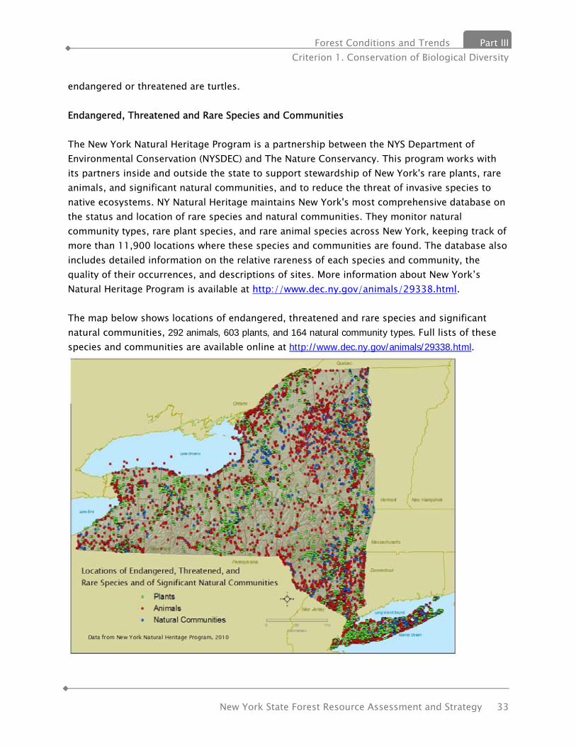
Forest Conditions and Trends Part III Criterion 1. Conservation of Biological Diversity
New York State Forest Resource Assessment and Strategy 33
endangered or threatened are turtles. Endangered, Threatened and Rare Species and Communities The New York Natural Heritage Program is a partnership between the NYS Department of Environmental Conservation (NYSDEC) and The Nature Conservancy. This program works with its partners inside and outside the state to support stewardship of New York's rare plants, rare animals, and significant natural communities, and to reduce the threat of invasive species to native ecosystems. NY Natural Heritage maintains New York's most comprehensive database on the status and location of rare species and natural communities. They monitor natural community types, rare plant species, and rare animal species across New York, keeping track of more than 11,900 locations where these species and communities are found. The database also includes detailed information on the relative rareness of each species and community, the quality of their occurrences, and descriptions of sites. More information about New York’s Natural Heritage Program is available at http://www.dec.ny.gov/animals/29338.html. The map below shows locations of endangered, threatened and rare species and significant natural communities, 292 animals, 603 plants, and 164 natural community types. Full lists of these species and communities are available online at http://www.dec.ny.gov/animals/29338.html.
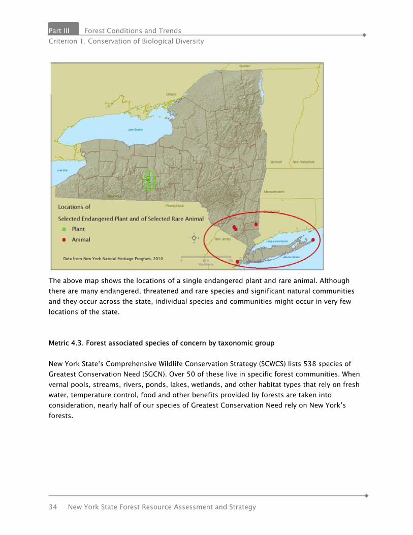
Part III Forest Conditions and Trends Criterion 1. Conservation of Biological Diversity
34 New York State Forest Resource Assessment and Strategy
The above map shows the locations of a single endangered plant and rare animal. Although there are many endangered, threatened and rare species and significant natural communities and they occur across the state, individual species and communities might occur in very few locations of the state. Metric 4.3. Forest associated species of concern by taxonomic group New York State’s Comprehensive Wildlife Conservation Strategy (SCWCS) lists 538 species of Greatest Conservation Need (SGCN). Over 50 of these live in specific forest communities. When vernal pools, streams, rivers, ponds, lakes, wetlands, and other habitat types that rely on fresh water, temperature control, food and other benefits provided by forests are taken into consideration, nearly half of our species of Greatest Conservation Need rely on New York’s forests.
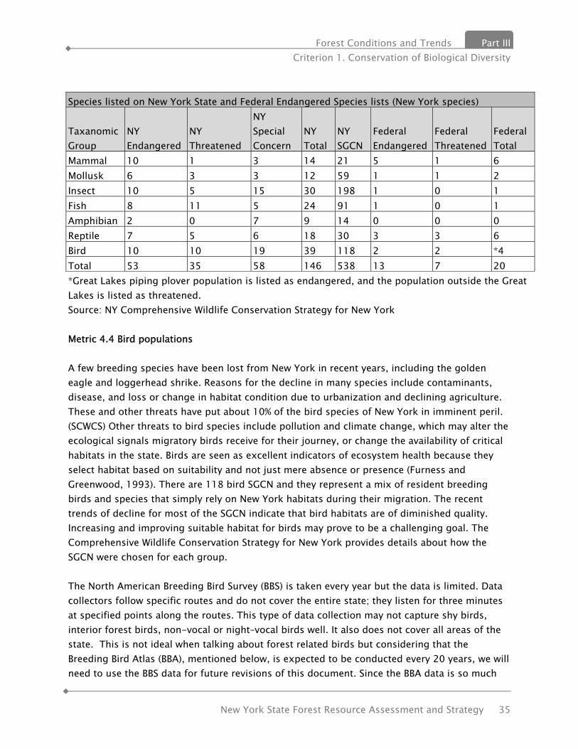
Forest Conditions and Trends Part III Criterion 1. Conservation of Biological Diversity
New York State Forest Resource Assessment and Strategy 35
Species listed on New York State and Federal Endangered Species lists (New York species)
Taxanomic Group
NY Endangered
NY Threatened
NY Special Concern
NY Total
NY SGCN
Federal Endangered
Federal Threatened
Federal Total
Mammal 10 1 3 14 21 5 1 6 Mollusk 6 3 3 12 59 1 1 2 Insect 10 5 15 30 198 1 0 1 Fish 8 11 5 24 91 1 0 1 Amphibian 2 0 7 9 14 0 0 0 Reptile 7 5 6 18 30 3 3 6 Bird 10 10 19 39 118 2 2 *4 Total 53 35 58 146 538 13 7 20 *Great Lakes piping plover population is listed as endangered, and the population outside the Great Lakes is listed as threatened. Source: NY Comprehensive Wildlife Conservation Strategy for New York Metric 4.4 Bird populations A few breeding species have been lost from New York in recent years, including the golden eagle and loggerhead shrike. Reasons for the decline in many species include contaminants, disease, and loss or change in habitat condition due to urbanization and declining agriculture. These and other threats have put about 10% of the bird species of New York in imminent peril. (SCWCS) Other threats to bird species include pollution and climate change, which may alter the ecological signals migratory birds receive for their journey, or change the availability of critical habitats in the state. Birds are seen as excellent indicators of ecosystem health because they select habitat based on suitability and not just mere absence or presence (Furness and Greenwood, 1993). There are 118 bird SGCN and they represent a mix of resident breeding birds and species that simply rely on New York habitats during their migration. The recent trends of decline for most of the SGCN indicate that bird habitats are of diminished quality. Increasing and improving suitable habitat for birds may prove to be a challenging goal. The Comprehensive Wildlife Conservation Strategy for New York provides details about how the SGCN were chosen for each group. The North American Breeding Bird Survey (BBS) is taken every year but the data is limited. Data collectors follow specific routes and do not cover the entire state; they listen for three minutes at specified points along the routes. This type of data collection may not capture shy birds, interior forest birds, non-vocal or night–vocal birds well. It also does not cover all areas of the state. This is not ideal when talking about forest related birds but considering that the Breeding Bird Atlas (BBA), mentioned below, is expected to be conducted every 20 years, we will need to use the BBS data for future revisions of this document. Since the BBA data is so much

Part III Forest Conditions and Trends Criterion 1. Conservation of Biological Diversity
36 New York State Forest Resource Assessment and Strategy
more comprehensive, we will focus it for this document. Breeding Bird Atlas The Breeding Bird Atlas is a comprehensive, statewide survey designed to reveal the distribution of breeding birds in New York. The second Atlas project in New York was conducted from 2000-2005. The first Atlas project in New York was conducted from 1980-1985 and published in 1988. The second project used the same methodology as the first Atlas to document changes that occurred in the ensuing twenty years. More than 1,200 contributors provided the data for the 2000-2005 Atlas. The second Atlas reveals changes in the distributions of many of New York’s breeding birds since the state’s first Breeding Bird Atlas was published in 1988. Over half of New York’s 253 breeding species showed a significant change in their distribution, with 70 species showing increases and 58 species showing declines. 125 species showed no change in distribution. The state was divided into ten regions, based upon the "Kingbird" reporting regions for the New York State Ornithological Association. One or two Regional Coordinators were responsible for seeing that all of the blocks in their region were surveyed. Each survey block measures 5 x 5 km (3 x 3 mi); there are 5,332 blocks in the entire state. Atlasers visited various habitats within their assigned block(s) and recorded evidence of breeding for the birds they see, using defined Breeding Codes:
Possible - bird seen in likely habitat Probable - territory, courtship, nest building Confirmed - eggs, incubation, feeding young, fledglings
The Atlas helps to identify specific areas where threatened species exist, and assists in creating management plans for those species. The state’s Comprehensive Wildlife Conservation Strategy (CWCS)consulted Breeding Bird Atlas data and found Species of Special Concern (status on Endangered Species list that draws attention to declining species) present and breeding. The CWCS was modified to benefit these species. Comparing the first and second Atlases show the influence on bird species of what has physically changed in New York since 1980:
• Human population grew 7.5% (18/62 counties lost population) • Freshwater wetlands increased and shifted • Tidal wetlands decreased • Agriculture and associated grasslands continued to decline • Forest cover stayed the same (62%), but matured
The following highlights show how physical trends have influenced bird species: Long-term forest re-growth has increased distribution of
• Wild Turkey

Forest Conditions and Trends Part III Criterion 1. Conservation of Biological Diversity
New York State Forest Resource Assessment and Strategy 37
• Common Raven Short-term forest maturation has increased distribution of
• Yellow-bellied Sapsucker • Pine Warbler
Grassland habitat loss has decreased distribution of • Vesper Sparrow • Upland Sandpiper
People-friendly” bird distributions increasing • Cooper’s Hawk • Pileated Woodpecker
Southern species distributions shifting north • Red-bellied Woodpecker • Carolina Wren
Northern species distributions shifting south • Hooded Warbler • Common Merganser • Palm Warbler
Success stories: money and management have increased distributions of • Osprey • Peregrine Falcon • Eastern Bluebird
Additional information about the New York BBA can be found on the DEC website at http://www.dec.ny.gov/animals/7312.html.

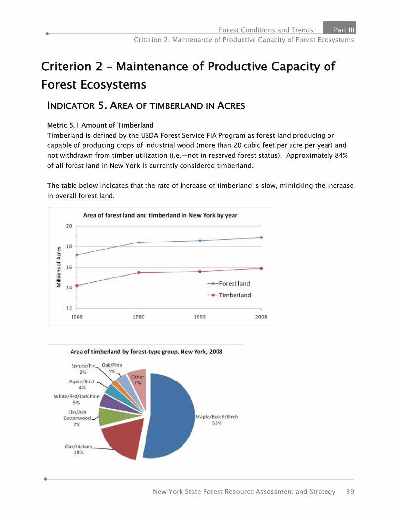
Forest Conditions and Trends Part III Criterion 2. Maintenance of Productive Capacity of Forest Ecosystems
New York State Forest Resource Assessment and Strategy 39
Criterion 2 – Maintenance of Productive Capacity of Forest Ecosystems INDICATOR 5. AREA OF TIMBERLAND IN ACRES Metric 5.1 Amount of Timberland Timberland is defined by the USDA Forest Service FIA Program as forest land producing or capable of producing crops of industrial wood (more than 20 cubic feet per acre per year) and not withdrawn from timber utilization (i.e.—not in reserved forest status). Approximately 84% of all forest land in New York is currently considered timberland. The table below indicates that the rate of increase of timberland is slow, mimicking the increase in overall forest land.

Part III Forest Conditions and Trends Criterion 2. Maintenance of Productive Capacity of Forest Ecosystems
40 New York State Forest Resource Assessment and Strategy
There has been little change in the percentage of area of the major forest type groups. An exception is the white/red/jack pine group which fell from 13% of all timberland acres in 1993, to just 5% in 2008. This decrease was offset in nearly equal parts by increases in the oak/hickory type, and the “other” forest type. It is difficult to assess the cause of the decrease in the pine forest type without more precise forest data, but reasons could include the harvest level of pine, particularly in the eastern Adirondack region, natural forest succession and conversion of plantation pine forest to hardwood forest. Approximately 57% of New York’s timberland is in large tree, or sawtimber size class. 30% is classified as poletimber and only 13% is in a stage where seedling and sapling size trees predominate. The chart above indicates that New York’s timberland is growing and maturing, and that the trend in shift of stand size classes begun prior to 1968 continues, however at a decreasing rate of increase. This condition can be attributed to prevailing timber management methods utilized in the state, which favor partial overstory removal harvests, as well as the slowdown in acres reverting from an idle condition into a forested condition. Nearly 90% of timberland acres are in a condition where trees of potential commercial value dominate. On the surface this may indicate strong productive capacity of the forest to provide timber products to New York’s existing forest products industry. However other characteristics such as timber quality, stocking class and species composition have to be analyzed together in order to make a

Forest Conditions and Trends Part III Criterion 2. Maintenance of Productive Capacity of Forest Ecosystems
New York State Forest Resource Assessment and Strategy 41
determination on the future. A little over 60% of timberland acres are considered to be poorly stocked or at medium stocking level indicating that the growth potential of the land is not being utilized. While the chart above indicates stocking for all forest types, a separate analysis of commercially important types shows that two of the predominate forest type groups, maple/beech/birch and oak/hickory, representing 71% of timberland acres, shows only a slightly lower figure with 57% of timberland in the poorly or medium stocked category. While it may appear less than optimal to have acres in anything other than a fully stocked condition, it is important to recognize that stocking levels below fully stocked may in fact be desirable depending on ownership objectives such as wildlife or if the condition is the result of deliberate and beneficial timber management practices. Some anecdotal information suggests however that many stands in New York are in the non or poorly stocked or low range of the medium stocked condition due to harvesting practices that fail to consider post harvest stocking as a priority, This can be an issue in the availability of sawtimber in the future since sawtimber volume increases will be increasingly dependent on growth of trees already in the these size classes (accretion) rather than growth appearing as a “bubble” of volume appearing suddenly from the pole size classes (ingrowth). Less than a fully stocked condition can be deemed detrimental in terms of carbon sequestration potential since these levels indicate that additional forest biomass, or carbon, could be stored standing in the forest. The following graphs provide a look at numbers of saplings and growing stock trees (>5 inches dbh) by species on timberland in 1993 and 2008. Numbers of sapling trees are at a slightly lower level in 2008 than in 1993 for most important commercial species. Exceptions are spruce, balsam fir, yellow birch and American beech. The growth in numbers of beech trees is a concern since beech has little prospect for being an important commercial species due to beech bark scale that often kills beech after reaching merchantable sizes. Regionally, beech saplings interfere with desired regeneration, and continue to be a problem for foresters in regenerating certain hardwood stands. The decline in other hardwood species is likely due to a number of factors, chief among them being:
• less idle land reverting to forest; • intensive deer browse; • interfering vegetation such as beech and fern and; • timber harvesting practices that fail to plan or provide for adequate regeneration.

Part III Forest Conditions and Trends Criterion 2. Maintenance of Productive Capacity of Forest Ecosystems
42 New York State Forest Resource Assessment and Strategy
The decline of saplings across the state and in commercially important species could lead to a reduction in overall production potential in the future.
Two important commercial species, sugar maple and northern red oak show decreases or no growth in the number of growing stock trees since either 1993 or 1980 or both. Other important species such as black cherry, eastern white pine and spruce indicate little increase in numbers over the same time periods. Red maple shows a sizeable 13% increase in numbers of trees over 5 inches, and is the highest percent increase for all commercial species.
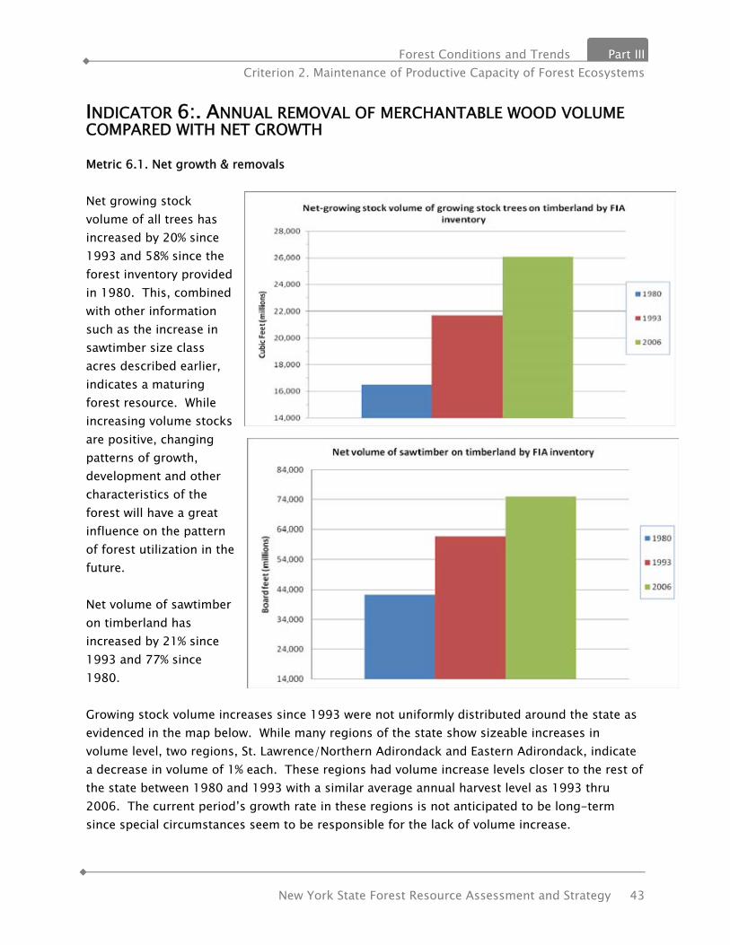
Forest Conditions and Trends Part III Criterion 2. Maintenance of Productive Capacity of Forest Ecosystems
New York State Forest Resource Assessment and Strategy 43
INDICATOR 6:. ANNUAL REMOVAL OF MERCHANTABLE WOOD VOLUME COMPARED WITH NET GROWTH Metric 6.1. Net growth & removals Net growing stock volume of all trees has increased by 20% since 1993 and 58% since the forest inventory provided in 1980. This, combined with other information such as the increase in sawtimber size class acres described earlier, indicates a maturing forest resource. While increasing volume stocks are positive, changing patterns of growth, development and other characteristics of the forest will have a great influence on the pattern of forest utilization in the future. Net volume of sawtimber on timberland has increased by 21% since 1993 and 77% since 1980. Growing stock volume increases since 1993 were not uniformly distributed around the state as evidenced in the map below. While many regions of the state show sizeable increases in volume level, two regions, St. Lawrence/Northern Adirondack and Eastern Adirondack, indicate a decrease in volume of 1% each. These regions had volume increase levels closer to the rest of the state between 1980 and 1993 with a similar average annual harvest level as 1993 thru 2006. The current period’s growth rate in these regions is not anticipated to be long-term since special circumstances seem to be responsible for the lack of volume increase.

Part III Forest Conditions and Trends Criterion 2. Maintenance of Productive Capacity of Forest Ecosystems
44 New York State Forest Resource Assessment and Strategy
A major ice storm caused serious and widespread damage in the St. Lawrence/Northern Adirondack regions in 1998. The storm resulted in vast areas of tree damage severe enough to make necessary widespread salvage harvests in the region. The event set back thousands of acres to the seedling/sapling size class. In addition, mortality was likely higher than usual in the region on those forests not salvaged. These areas registered no volume during measurement of plots from 2002-2006 since regenerating trees would not have grown to the minimum diameter (5 inches) needed to be measured as standing volume. It is anticipated that plot measurements to occur over the next decade will reflect a “bubble” of ingrowth volume to the pole size classes that will, with harvest and mortality levels close historical levels, see a return to a net increase in standing volume. The eastern Adirondack region did not experience the 1998 ice storm, so it is uncertain why this region experienced a slight growing stock volume decrease. However, we can speculate that two factors may have combined together to contribute to this result. --harvest levels in the region may have been higher than historical levels due to high levels of Canadian timber product consumption and Canadian reliance on white pine timber from the Interstate 87 corridor running through the region. --harvest levels in the region may have increased due to harvesting activities associated with the transfer of tens of thousands of acres of forest land from historical owners to new owners. Disparities between rate of volume increase or decrease between and among commercially important species is evidenced below. While most species increased in volume, American beech did not, declining by 7% between 1993 and 2006. Mortality due to beech bark disease as well as salvage harvest level probably both contributed to the decline. With the exception of aspen, all other species showed an increase of greater than or equal to 10%. With the exception of sugar maple, most hardwood showed significant gains in volume, while white pine and hemlock gains were only around 10-12%. This may reflect something about rate of ingrowth from the sapling size classes and the effect of decreasing numbers of saplings of these species indicated previously. With the exception of white ash, red maple showed the greatest percent increase since 1993, 26%. This rate of increase is about 2.5 times
Net growing stock volume percent increase on timberland by region, 1993-2006
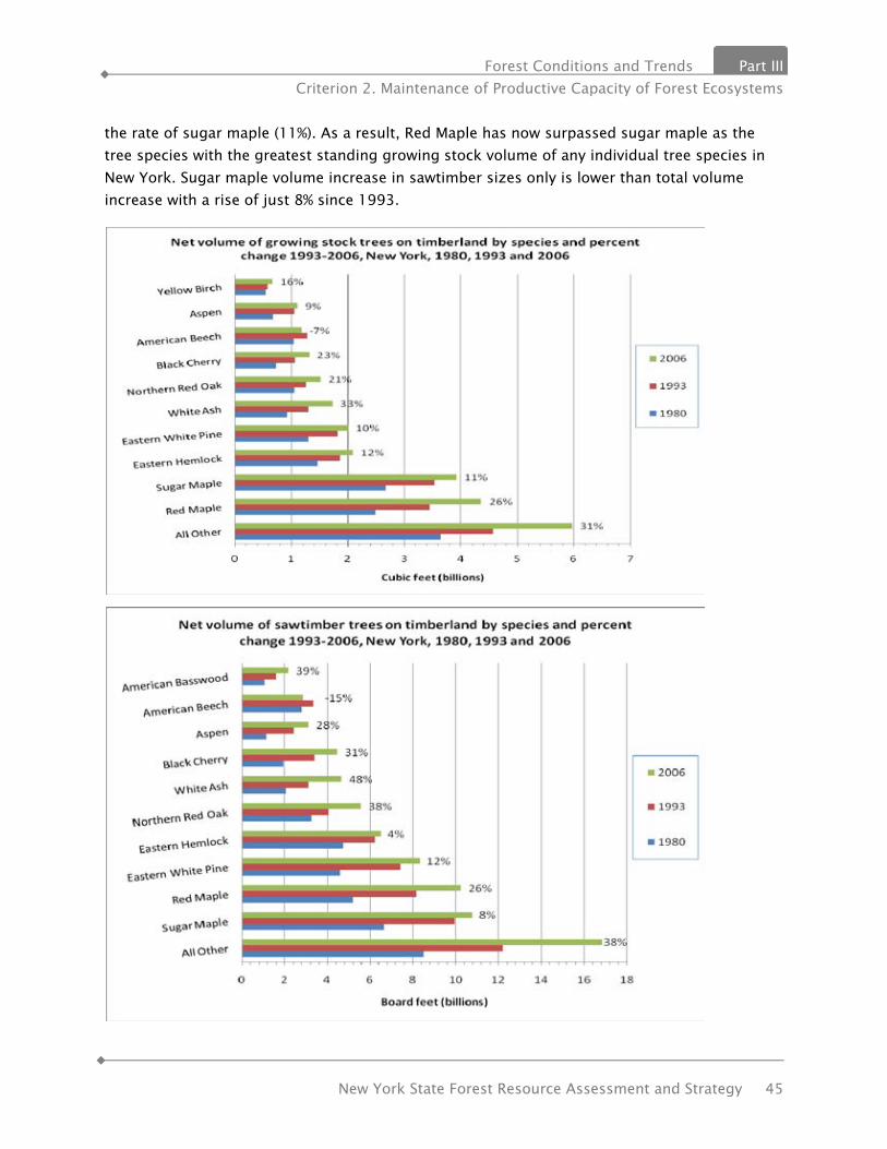
Forest Conditions and Trends Part III Criterion 2. Maintenance of Productive Capacity of Forest Ecosystems
New York State Forest Resource Assessment and Strategy 45
the rate of sugar maple (11%). As a result, Red Maple has now surpassed sugar maple as the tree species with the greatest standing growing stock volume of any individual tree species in New York. Sugar maple volume increase in sawtimber sizes only is lower than total volume increase with a rise of just 8% since 1993.
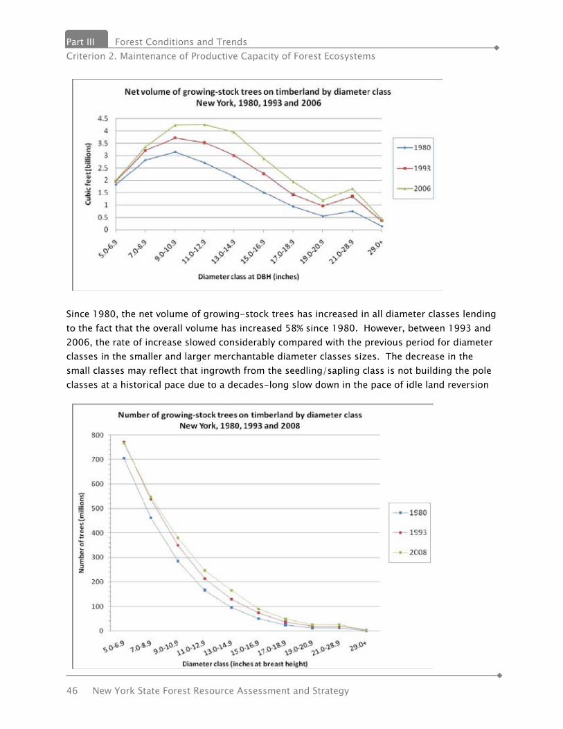
Part III Forest Conditions and Trends Criterion 2. Maintenance of Productive Capacity of Forest Ecosystems
46 New York State Forest Resource Assessment and Strategy
Since 1980, the net volume of growing-stock trees has increased in all diameter classes lending to the fact that the overall volume has increased 58% since 1980. However, between 1993 and 2006, the rate of increase slowed considerably compared with the previous period for diameter classes in the smaller and larger merchantable diameter classes sizes. The decrease in the small classes may reflect that ingrowth from the seedling/sapling class is not building the pole classes at a historical pace due to a decades-long slow down in the pace of idle land reversion
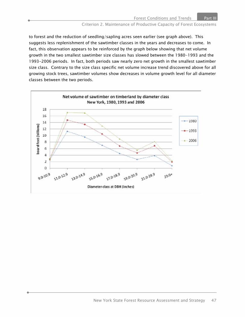
Forest Conditions and Trends Part III Criterion 2. Maintenance of Productive Capacity of Forest Ecosystems
New York State Forest Resource Assessment and Strategy 47
to forest and the reduction of seedling/sapling acres seen earlier (see graph above). This suggests less replenishment of the sawtimber classes in the years and decreases to come. In fact, this observation appears to be reinforced by the graph below showing that net volume growth in the two smallest sawtimber size classes has slowed between the 1980-1993 and the 1993-2006 periods. In fact, both periods saw nearly zero net growth in the smallest sawtimber size class. Contrary to the size class specific net volume increase trend discovered above for all growing stock trees, sawtimber volumes show decreases in volume growth level for all diameter classes between the two periods.
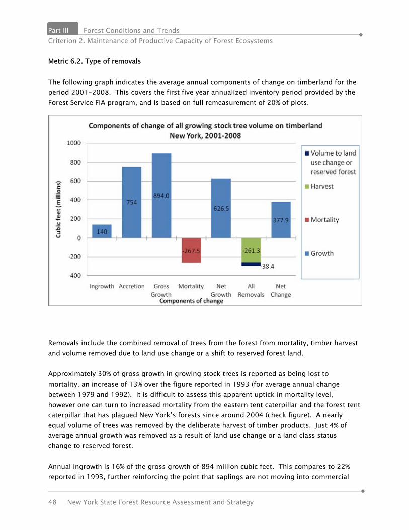
Part III Forest Conditions and Trends Criterion 2. Maintenance of Productive Capacity of Forest Ecosystems
48 New York State Forest Resource Assessment and Strategy
Metric 6.2. Type of removals The following graph indicates the average annual components of change on timberland for the period 2001-2008. This covers the first five year annualized inventory period provided by the Forest Service FIA program, and is based on full remeasurement of 20% of plots.
Removals include the combined removal of trees from the forest from mortality, timber harvest and volume removed due to land use change or a shift to reserved forest land. Approximately 30% of gross growth in growing stock trees is reported as being lost to mortality, an increase of 13% over the figure reported in 1993 (for average annual change between 1979 and 1992). It is difficult to assess this apparent uptick in mortality level, however one can turn to increased mortality from the eastern tent caterpillar and the forest tent caterpillar that has plagued New York’s forests since around 2004 (check figure). A nearly equal volume of trees was removed by the deliberate harvest of timber products. Just 4% of average annual growth was removed as a result of land use change or a land class status change to reserved forest. Annual ingrowth is 16% of the gross growth of 894 million cubic feet. This compares to 22% reported in 1993, further reinforcing the point that saplings are not moving into commercial
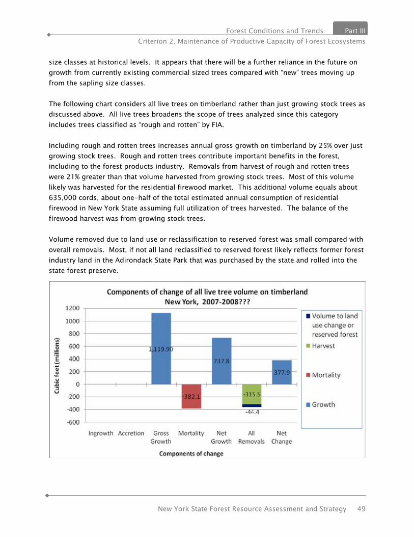
Forest Conditions and Trends Part III Criterion 2. Maintenance of Productive Capacity of Forest Ecosystems
New York State Forest Resource Assessment and Strategy 49
size classes at historical levels. It appears that there will be a further reliance in the future on growth from currently existing commercial sized trees compared with “new” trees moving up from the sapling size classes. The following chart considers all live trees on timberland rather than just growing stock trees as discussed above. All live trees broadens the scope of trees analyzed since this category includes trees classified as “rough and rotten” by FIA. Including rough and rotten trees increases annual gross growth on timberland by 25% over just growing stock trees. Rough and rotten trees contribute important benefits in the forest, including to the forest products industry. Removals from harvest of rough and rotten trees were 21% greater than that volume harvested from growing stock trees. Most of this volume likely was harvested for the residential firewood market. This additional volume equals about 635,000 cords, about one-half of the total estimated annual consumption of residential firewood in New York State assuming full utilization of trees harvested. The balance of the firewood harvest was from growing stock trees. Volume removed due to land use or reclassification to reserved forest was small compared with overall removals. Most, if not all land reclassified to reserved forest likely reflects former forest industry land in the Adirondack State Park that was purchased by the state and rolled into the state forest preserve.
Part III Forest Conditions and Trends Criterion 2. Maintenance of Productive Capacity of Forest Ecosystems
50 New York State Forest Resource Assessment and Strategy
The table below summarizes the above tables into simple “Growth to Removal” ratios. A comparison to the period from 1979-1992 shows a decrease in the ratio then of 3:1 for all removals of growing stock trees during the period to 2.1:1 between 2001 and 2008. Other comparisons are not available due to a lack of data from the previous survey. The current ratio has decreased due to both an increase in mortality rate as evidenced earlier, and an increase in timber harvest level. The increase in harvest level is attributable to an increase in harvest of sawlogs for both domestic and international markets. This is at least partially verified by anecdotal evidence and by comparing the 1993 FIA estimated log harvest provided as part of that years Timber Product Output study of about 500 million board feet, and the average annual volume harvested between 1999 and 2008 of about 750 million board feet.
Ratios of Net Growth to Removals 2001-2008
Removals From Harvest
All Removals (Harvest plus volume to land use change or reserved forest
All live trees—Timberland 2.3:1 2.0:1
Growing stock trees-Timberland
2.4:1 2.1:1
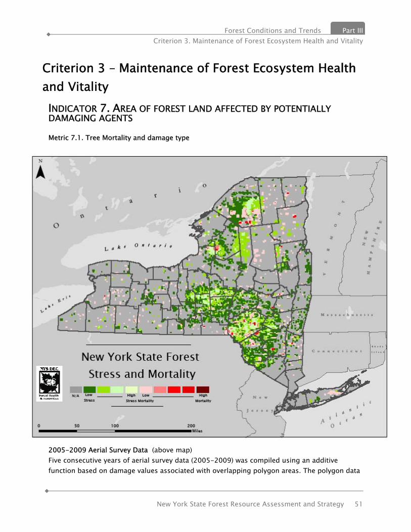
Forest Conditions and Trends Part III Criterion 3. Maintenance of Forest Ecosystem Health and Vitality
New York State Forest Resource Assessment and Strategy 51
Criterion 3 – Maintenance of Forest Ecosystem Health and Vitality INDICATOR 7. AREA OF FOREST LAND AFFECTED BY POTENTIALLY DAMAGING AGENTS Metric 7.1. Tree Mortality and damage type
2005-2009 Aerial Survey Data (above map) Five consecutive years of aerial survey data (2005-2009) was compiled using an additive function based on damage values associated with overlapping polygon areas. The polygon data

Part III Forest Conditions and Trends Criterion 3. Maintenance of Forest Ecosystem Health and Vitality
52 New York State Forest Resource Assessment and Strategy
was converted to one square mile grids with the associated damage values assigned. Those areas with multiple years of observed defoliation, discoloration and/or mortality resulted in a greater value. Generally 80-85% of the annual defoliation seen in New York can be attributed to biotic agents such as Forest Tent Caterpillar, Gypsy Moth, and Eastern Tent Caterpillar, with discoloration caused primarily by abiotic stressors such as drought and flood damage. Tree mortality can be attributed to any combination of biotic and abiotic causes, over a varying temporal landscape. Metric 7.2. Wildfire Wildfire in New York is based on the same science and environmental factors as any wildfire in the world. Fuels, weather and topography are the primary factors that determine the natural spread and destruction of every wildfire. New York has large tracts of diverse forest lands, many of which are the result of historic destructive wildfires. Although these destructive fires do not occur on an annual basis, New York’s fire history shows a cycle of fire occurrence that result in death, loss of property, destruction of forests and hazardous air quality. New York State is 30.2 million acres in size with 18.9 million acres of non federal forested lands. In addition, there is an undetermined amount of open-space non-forested lands with significant wildfire potential. The cattail-phragmites wetlands of western New York and New York City frequently burn as weather conditions allow. These fires are not only spectacular in their intensity but quite often threaten nearby homes, businesses or improvements becoming a wildland-urban interface fire. All of New York’s 19.3 million residents are affected by the most serious of wildfires. Smoke and particulate matter from wildfires 500 miles north in Quebec often finds its way to urban New York City. Wildfires in the surrounding wildland urban interface of New York City suburbs often do the same leading to much news reporting and attention by public officials.

Forest Conditions and Trends Part III Criterion 3. Maintenance of Forest Ecosystem Health and Vitality
New York State Forest Resource Assessment and Strategy 53
The Forest Ranger Division has a statutory requirement to provide a forest fire protection system for 657 of the 932 townships throughout New York. This area excludes cities and villages and covers 23.1 million acres of land including state-owned lands outside the 657 towns. The Lake Ontario Plains and New York City-Long Island areas are the general areas not included in the statutory requirement. That said, some of the largest and most destructive wildfires occur on Long Island and New York City. The Lake Ontario Plains were once much of New York’s prime agricultural lands but much of the area has reverted to hardwood forests. Fire occurrence in this area will be determined from fire department data in the future to determine the need to expand statutory responsibility to this area.
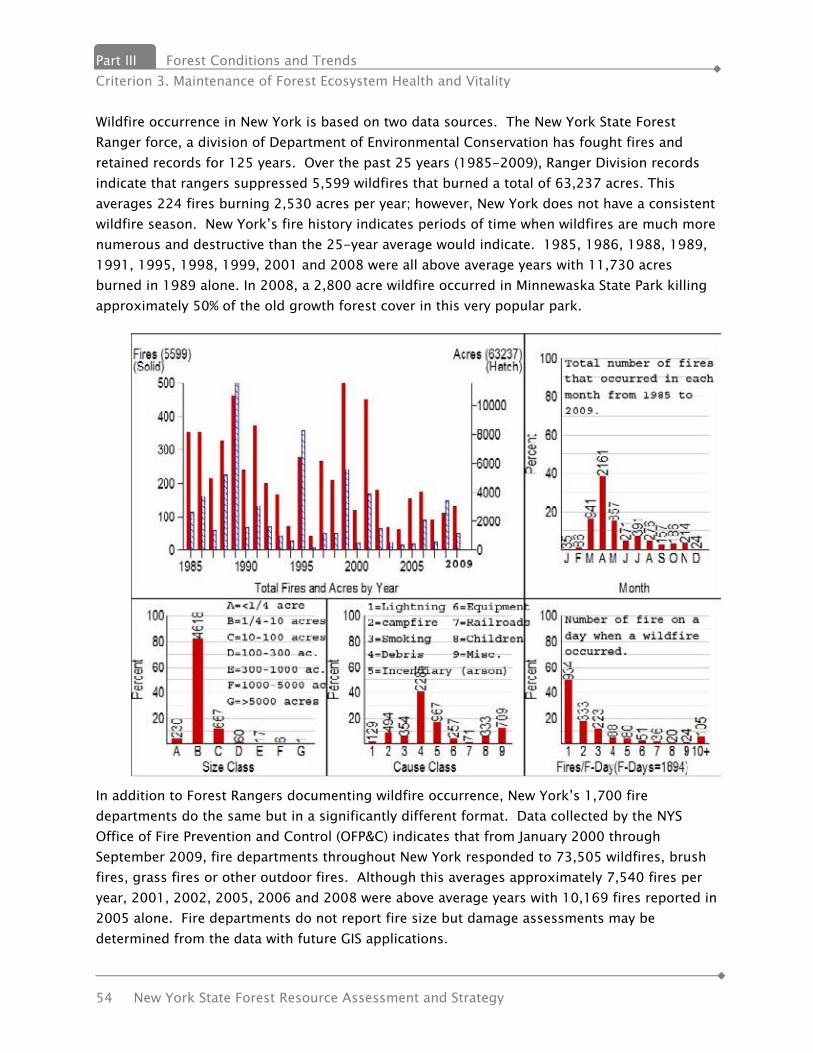
Part III Forest Conditions and Trends Criterion 3. Maintenance of Forest Ecosystem Health and Vitality
54 New York State Forest Resource Assessment and Strategy
Wildfire occurrence in New York is based on two data sources. The New York State Forest Ranger force, a division of Department of Environmental Conservation has fought fires and retained records for 125 years. Over the past 25 years (1985-2009), Ranger Division records indicate that rangers suppressed 5,599 wildfires that burned a total of 63,237 acres. This averages 224 fires burning 2,530 acres per year; however, New York does not have a consistent wildfire season. New York’s fire history indicates periods of time when wildfires are much more numerous and destructive than the 25-year average would indicate. 1985, 1986, 1988, 1989, 1991, 1995, 1998, 1999, 2001 and 2008 were all above average years with 11,730 acres burned in 1989 alone. In 2008, a 2,800 acre wildfire occurred in Minnewaska State Park killing approximately 50% of the old growth forest cover in this very popular park.
In addition to Forest Rangers documenting wildfire occurrence, New York’s 1,700 fire departments do the same but in a significantly different format. Data collected by the NYS Office of Fire Prevention and Control (OFP&C) indicates that from January 2000 through September 2009, fire departments throughout New York responded to 73,505 wildfires, brush fires, grass fires or other outdoor fires. Although this averages approximately 7,540 fires per year, 2001, 2002, 2005, 2006 and 2008 were above average years with 10,169 fires reported in 2005 alone. Fire departments do not report fire size but damage assessments may be determined from the data with future GIS applications.
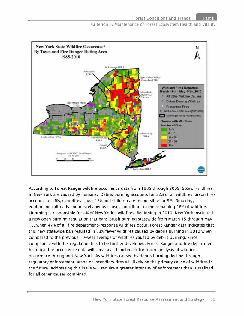
Forest Conditions and Trends Part III Criterion 3. Maintenance of Forest Ecosystem Health and Vitality
New York State Forest Resource Assessment and Strategy 55
According to Forest Ranger wildfire occurrence data from 1985 through 2009, 96% of wildfires in New York are caused by humans. Debris burning accounts for 32% of all wildfires, arson fires account for 16%, campfires cause 13% and children are responsible for 9%. Smoking, equipment, railroads and miscellaneous causes contribute to the remaining 26% of wildfires. Lightning is responsible for 4% of New York’s wildfires. Beginning in 2010, New York instituted a new open burning regulation that bans brush burning statewide from March 15 through May 15, when 47% of all fire department-response wildfires occur. Forest Ranger data indicates that this new statewide ban resulted in 33% fewer wildfires caused by debris burning in 2010 when compared to the previous 10-year average of wildfires caused by debris burning. Since compliance with this regulation has to be further developed, Forest Ranger and fire department historical fire occurrence data will serve as a benchmark for future analysis of wildfire occurrence throughout New York. As wildfires caused by debris burning decline through regulatory enforcement, arson or incendiary fires will likely be the primary cause of wildfires in the future. Addressing this issue will require a greater intensity of enforcement than is realized for all other causes combined.

Part III Forest Conditions and Trends Criterion 3. Maintenance of Forest Ecosystem Health and Vitality
56 New York State Forest Resource Assessment and Strategy
New York’s large size, diverse topography and variety of climates require that the state be divided into distinct units for describing wildfire potential and risk. Through research and 35 years of wildfire occurrence linked to fire weather indices on the date of each fire start, New York is divided into ten fire danger rating areas (FDRAs). The main criteria used to develop the boundaries of these areas are similar vegetation, fire climate and topography. These criteria are supplemented by agency regional boundaries, National Weather Service fire weather zones, political boundaries, fire occurrence history and other influences. A description of the ten FDRAs is included in the appendix of this report. In order to minimize the occurrence of wildfire and the associated property loss, forest damage and sometimes loss of life, New York will need to accomplish the following goals:
• Maintain a highly trained, well equipped forest ranger force that uses its wildfire control expertise and resources to contain to most serious of fires.
• Support fire departments with their responsibility for initial attack of most wildfires. • Enforce fire prevention laws including the apprehension of those who purposely set
fires. • Use wildfire predictive services to notify the public of fire danger and to increase initial
attack when fires occur. • Support the FireWise program as a means of reducing property loss in the wildland
urban interface. • Conduct fire prevention programs in areas of greatest need. • Support fuel reduction techniques in critical wildland urban interface communities. • Support the three communities with Community Wildfire Protection Plans (CWPP).
Cragsmoor, Albany Pine Bush and Long Island Pine Barrens, with activities that further reduce the risk of wildfire. As other communities develop CWPPs, support them in their efforts also.
• Identify communities-at-risk of destructive wildfires and support the development of CWPPs for these communities.
Metric 7.3. Drought New York is rich with water resources. Our celebrated streams, lakes, and coasts are fed by an average annual precipitation that ranges from 60 inches in the Catskills to 28 inches in the Lake Champlain Valley. But even here, in our "temperate moist" climate, normal fluctuations in regional weather patterns can lead to periods of dry weather. Occasional drought is a normal, recurrent feature of virtually every climate in the United States. The last severe droughts in New York occurred in the mid-1960s, and again in the early and mid-1980s. Meteorologists and hydrologists have their own precise definitions of drought. Meteorologists compare deficiencies in precipitation to normal levels when they speak of drought. Hydrologists

Forest Conditions and Trends Part III Criterion 3. Maintenance of Forest Ecosystem Health and Vitality
New York State Forest Resource Assessment and Strategy 57
The tiny emerald ash borer (Agrilus planipennis), is responsible for the destruction of over 50 million ash trees in the U.S. since its discovery in Michigan in 2002.
consider stream flow and water levels in aquifers, lakes, and reservoirs along with precipitation. New York uses elements of both disciplines to determine when a drought is occurring. The State Drought Index compares five parameters to historic or "normal" values to evaluate drought conditions: stream flows, precipitation, lake and reservoir storage levels, and groundwater levels. New York's Drought Management Task Force uses those factors as well as water use, duration of the dry period, and season to assess drought in different parts of the state. Drought (as is too much rain) is an additional stressor on forests. With climate change, it is expected that there will be longer periods of drought. The more stressors forests suffer, the more susceptible they are to diseases, pests and mortality. There is no current data on drought associated mortality in New York. Metric 7.4. Insects, diseases, plants, and animals Our forests are facing accelerated threats from invasive insects, plants and diseases, often brought into our country through international trade. These agents can potentially destroy
millions of acres of trees, and even eliminate certain species from our ecosystems. They
can drastically alter wildlife habitats, harm water quality, and reduce carbon sequestration by our forests. In addition, they can devastate forest-based industries, restrict recreational opportunities and damage the tourism industry. Forest pests can damage the health of our watersheds, with consequences for human health . The USFS has identified invasive species as one of the four major threats to the nation’s forests and rangelands. As previously mentioned, New York contains 18.9 million acres of forest land, more than any other state in the New York-New England region. This vast forest provides a tremendous challenge to monitor for the presence of invasive pests. Once a pest is detected, it is necessary to determine the extent of the affected area, and estimate the potential impact. An initial rapid response may have to be followed up by a more extensive eradication effort. Elm, chestnut and butternut have been virtually wiped out of our rural and urban forests because of introduced diseases. It is impossible to predict what pathogen will cause the next Dutch elm disease.
Invasive forest pests are the wildfires of the northeast.
Part III Forest Conditions and Trends Criterion 3. Maintenance of Forest Ecosystem Health and Vitality
58 New York State Forest Resource Assessment and Strategy
The Asian longhorned beetle (Anoplophora glabripennis) (ALB) was first discovered in New York City in 1996. It kills a wide variety of hardwood trees and has destroyed maple trees in New York City’s Central Park, and in Queens, Kings (Brooklyn), Richmond (Staten Island) and Nassau Counties. The sugar maple, symbol of the Northeast and the backbone of the maple syrup and fall foliage tourism industries, is most at risk. If Asian Longhorned beetle is not eradicated, it could wipe out much of the sugar maple population with consequent damage to maple-related industries. The first projected date for eradication of ALB from New York City was to be 2003. As a result of budget cuts the estimated eradication date has moved beyond 2020. The longer any pest is in the landscape, the greater the opportunity and probability it will infest new sites. Emerald ash borer (EAB) (Agrilus planipennis) was first identified in New York State June 2009, in Randolph, Cattaraugus County. EAB was first discovered in the U.S. in 2002 in southeastern Michigan. It was also found in Windsor, Ontario the same year. This Asian beetle infests and kills North American ash species (Fraxinus sp.) including green, white, black and blue ash. Thus, all native ash trees are susceptible.

Forest Conditions and Trends Part III Criterion 3. Maintenance of Forest Ecosystem Health and Vitality
New York State Forest Resource Assessment and Strategy 59
The following map shows the widespread distribution of ash in New York.
New York State Ash Distribution Source: Wilson, B.T., Lister, A.J., & Riemann, R. (in review). A nearest-neighbor imputation approach to large area mapping of tree species distributions using field sampled data. Remote Sensing of Environment.

Part III Forest Conditions and Trends Criterion 3. Maintenance of Forest Ecosystem Health and Vitality
60 New York State Forest Resource Assessment and Strategy
The following map shows the current locations of outbreaks of emerald ash borer, Asian longhorned beetle and oak wilt. The oak wilt outbreak was treated in 2009 and 2010 and is being monitored. It may have been eradicated.

Forest Conditions and Trends Part III Criterion 3. Maintenance of Forest Ecosystem Health and Vitality
New York State Forest Resource Assessment and Strategy 61
Source: Liebhold, A.M. et al. "Geographical Distribution of Forest Pest Species in the US" (manuscript in preparation) The above map shows the relative severity in total numbers of non native forests pests to New York State. The following table lists forest health agents which have caused mortality in recent years, those that are currently causing mortality, and those which may cause mortality in the near future because of proximity to New York borders.
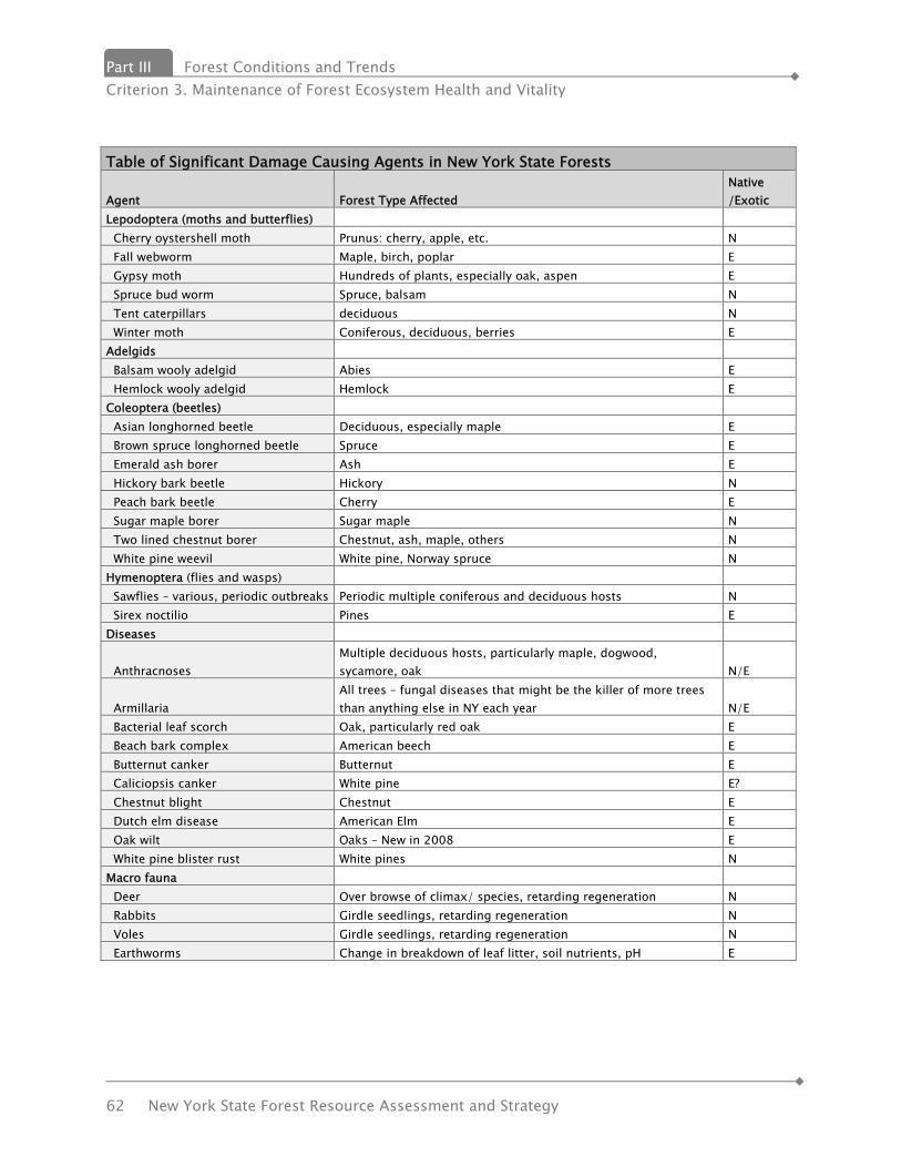
Part III Forest Conditions and Trends Criterion 3. Maintenance of Forest Ecosystem Health and Vitality
62 New York State Forest Resource Assessment and Strategy
Table of Significant Damage Causing Agents in New York State Forests
Agent Forest Type Affected Native /Exotic
Lepodoptera (moths and butterflies) Cherry oystershell moth Prunus: cherry, apple, etc. N Fall webworm Maple, birch, poplar E Gypsy moth Hundreds of plants, especially oak, aspen E Spruce bud worm Spruce, balsam N Tent caterpillars deciduous N Winter moth Coniferous, deciduous, berries E Adelgids Balsam wooly adelgid Abies E Hemlock wooly adelgid Hemlock E Coleoptera (beetles) Asian longhorned beetle Deciduous, especially maple E Brown spruce longhorned beetle Spruce E Emerald ash borer Ash E Hickory bark beetle Hickory N Peach bark beetle Cherry E Sugar maple borer Sugar maple N Two lined chestnut borer Chestnut, ash, maple, others N White pine weevil White pine, Norway spruce N Hymenoptera (flies and wasps) Sawflies – various, periodic outbreaks Periodic multiple coniferous and deciduous hosts N Sirex noctilio Pines E Diseases
Anthracnoses Multiple deciduous hosts, particularly maple, dogwood, sycamore, oak N/E
Armillaria All trees – fungal diseases that might be the killer of more trees than anything else in NY each year N/E
Bacterial leaf scorch Oak, particularly red oak E Beach bark complex American beech E Butternut canker Butternut E Caliciopsis canker White pine E? Chestnut blight Chestnut E Dutch elm disease American Elm E Oak wilt Oaks – New in 2008 E White pine blister rust White pines N Macro fauna Deer Over browse of climax/ species, retarding regeneration N Rabbits Girdle seedlings, retarding regeneration N Voles Girdle seedlings, retarding regeneration N Earthworms Change in breakdown of leaf litter, soil nutrients, pH E
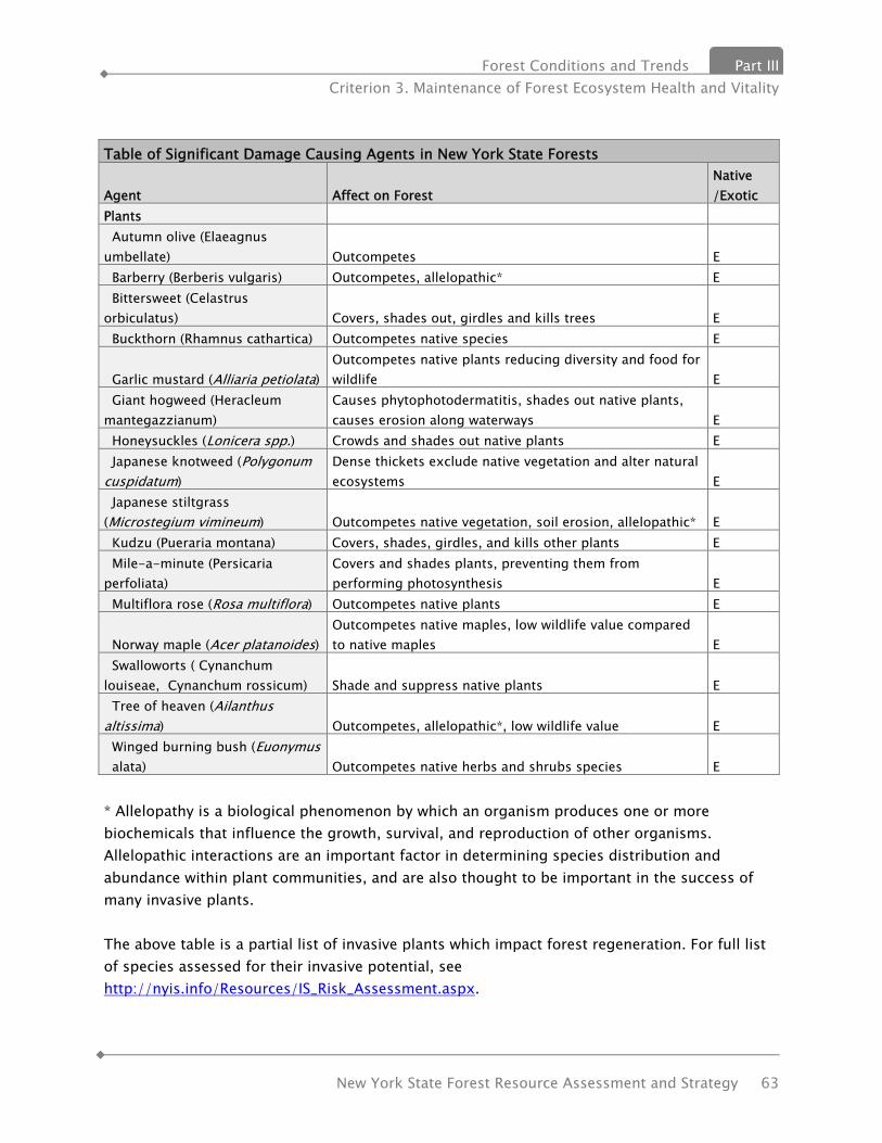
Forest Conditions and Trends Part III Criterion 3. Maintenance of Forest Ecosystem Health and Vitality
New York State Forest Resource Assessment and Strategy 63
* Allelopathy is a biological phenomenon by which an organism produces one or more biochemicals that influence the growth, survival, and reproduction of other organisms. Allelopathic interactions are an important factor in determining species distribution and abundance within plant communities, and are also thought to be important in the success of many invasive plants. The above table is a partial list of invasive plants which impact forest regeneration. For full list of species assessed for their invasive potential, see http://nyis.info/Resources/IS_Risk_Assessment.aspx.
Table of Significant Damage Causing Agents in New York State Forests
Agent Affect on Forest Native /Exotic
Plants Autumn olive (Elaeagnus umbellate) Outcompetes E Barberry (Berberis vulgaris) Outcompetes, allelopathic* E Bittersweet (Celastrus orbiculatus) Covers, shades out, girdles and kills trees E Buckthorn (Rhamnus cathartica) Outcompetes native species E
Garlic mustard (Alliaria petiolata) Outcompetes native plants reducing diversity and food for wildlife E
Giant hogweed (Heracleum mantegazzianum)
Causes phytophotodermatitis, shades out native plants, causes erosion along waterways E
Honeysuckles (Lonicera spp.) Crowds and shades out native plants E Japanese knotweed (Polygonum cuspidatum)
Dense thickets exclude native vegetation and alter natural ecosystems E
Japanese stiltgrass (Microstegium vimineum) Outcompetes native vegetation, soil erosion, allelopathic* E Kudzu (Pueraria montana) Covers, shades, girdles, and kills other plants E Mile-a-minute (Persicaria perfoliata)
Covers and shades plants, preventing them from performing photosynthesis E
Multiflora rose (Rosa multiflora) Outcompetes native plants E
Norway maple (Acer platanoides) Outcompetes native maples, low wildlife value compared to native maples E
Swalloworts ( Cynanchum louiseae, Cynanchum rossicum) Shade and suppress native plants E Tree of heaven (Ailanthus altissima) Outcompetes, allelopathic*, low wildlife value E Winged burning bush (Euonymus alata) Outcompetes native herbs and shrubs species E

Part III Forest Conditions and Trends Criterion 3. Maintenance of Forest Ecosystem Health and Vitality
64 New York State Forest Resource Assessment and Strategy
Deer White-tailed deer are a significant wildlife resource in New York State from both an economic and ecological perspective. Economically, benefits derived from deer include direct and indirect expenditures on wildlife observation and hunting; losses are primarily associated with agricultural crop damage, damage to forest regeneration, damage to ornamental plantings, and deer-vehicle collisions. Ecologically, deer can have a devastating effect on their environment. The overabundance of deer can lead to the local extirpation of certain herbaceous plant species, change future forest composition by favoring certain tree species over others and preventing regeneration, and alter habitat structure and food availability for other wildlife species. The history of white-tailed deer in New York since 1492 mirrors the history of most other game species, across North America. Pre Colonial deer densities are hypothesized to have been 8-11 deer/sq. mi, significantly lower than present density estimates for much of southern New York. Following European settlement, the deer population slowly declined over the next 350 years. Between 1870 and1920, deer numbers drastically dwindled to 1 to 2% of their pre-European population. This time period represented the greatest period of hunting pressure on wildlife ever and as a result deer were extirpated from much of New York. The devastation wrought on wildlife populations by unregulated market hunting during this period ushered in the beginnings of the modern era of wildlife management during which game populations have largely rebounded and flourished because of the acceptance of science-based management, and the enactment of federal and state wildlife laws, which established hunting licenses and seasons, bag limits, and means of legal taking. It is extremely likely that deer densities now present in many localities of the state greatly exceed pre-Columbian densities.
Forest Conditions and Trends Part III Criterion 4. Conservation and Maintenance of Soil and Water Resources
New York State Forest Resource Assessment and Strategy 65
Criterion 4 – Conservation and Maintenance of Soil and Water Resources
Soil conservation and water quality were environmental issues over one hundred years ago. New York had its least amount of forest since the retreat of the last glacier. Soils were eroding. Riparian areas and water bodies were degraded by siltation. The lack of trees meant higher water temperatures and other characteristics unfriendly to a healthy ecosystem. The solution was identified back then – increase forests. Franklin Roosevelt’s mantra to plant trees for erosion control and water quality is equally important today. Erosion can prevent trees from growing. A lack of trees causes erosion. Erosion affects water quality. Water quality and supply are limiting factors in development, while development threatens water quality and supply.
INDICATOR 8. SOIL QUALITY ON FOREST LAND Soil is important to forest sustainability since it is, literally, what supports trees. Natural soil conditions, and their ability to support tree and forest growth, are negatively impacted by a variety of factors including acid deposition, compaction, development and “hard-surfacing”, erosion, land cover, fire and even non-native earthworms. Geology and Soils The topography of New York New York has been shaped by a complex and turbulent geologic history, including multiple tectonic plate collisions, uplift and erosion of several mountain ranges, volcanic activity, earthquakes, igneous intrusions, regional metamorphism, advancing and retreating sea levels, deposition and erosion of huge deltas, and even a huge meteor strike 350 million years ago. Against this changing backdrop plants and animals evolved, first in the ocean and later on land. New York has one of the world’s best fossil records of the Devonian Period (408 to 360 million years ago) with remarkably well preserved marine sequences, and also non-marine fossils that show the transition to land. Most of the bedrock in New York is over 250 million years old, younger rocks having been almost completely removed by erosion. New York’s present landscape is dominated by the impacts of the last ice age. Only a small area of the southwestern part of the state escaped glaciation (The southwest corner of the High Allegany Plateau Ecoregion.) Glaciers shaped the high peaks in the Catskills and Adirondacks, changed hydrology, formed huge lakes, and covered much of the state with a layer of glacial till. Where huge glacial lakes once held melt-water, there are now thick sand and clay deposits such as those in the Hudson Valley and parts of Central New York. The remnants of ice age features, such as sand dunes, river sand and gravel deposits and muck-filled bogs can be

Part III Forest Conditions and Trends Criterion 4. Conservation and Maintenance of Soil and Water Resources
66 New York State Forest Resource Assessment and Strategy
found in many parts of the state. But the most ubiquitous material is glacial till, the rough mixture of rocks, sand and clay scraped up and bulldozed by the glacier’s ice. This layer of raw debris was left behind as the ice retreated, sometimes in oriented hills called drumlins, more often as an uneven layer over the underlying bedrock. Glaciers erased the existing forests and landforms of New York so thoroughly that there is almost no trace of the pre-glacial ecology. Glaciation resets the ecosystem clock. Everything has to start over again, beginning with pioneer plant species that colonize the raw rock and sterile mineral debris. New soils began to develop as organic matter accumulated with subsequent plant successions. Tree species, led by spruce about 11,000 years ago, migrated back north from their glacial refuges As species migrated, they formed many forest types some of which are no longer found today. Forest types are really temporary associations in terms of geologic time. Trees migrated as individual species, and they moved at different rates presumably depending on their dispersal abilities. Some of the early trees arriving soon after white spruce included black spruce, elm and black ash. One of the last major species to arrive was chestnut, reaching New York about 2,000 years ago. Non-glacial soils in humid, agricultural regions owe their characteristics primarily to the effects and results of chemical reactions on the bed rock from which they are derived. Under such conditions the relatively soluble materials of the bed rock are carried away while the resistant original minerals and the stable secondary compounds compose the soil particles. (Effects of Continental Glaciation on Agriculture. Part II . O. D. von Engeln Bulletin of the American Geographical Society, Vol. 46, No. 5 (1914), pp. 336-355) State Forests are often on some of the poorest farmland in the state, land that has been little softened by soil since the retreat of the glaciers. For example, some of the sandy soils in northern NY had only a thin organic layer which was quickly destroyed by farming. The result was sand drifts, which can be seen in early photographs of State Forests acquired in the 1930s. Other difficult sites were hills with very thin rocky soils, sometimes only a few inches above bedrock. Today, these sites are forested and are slowly regaining the organic matter lost to erosion. Bedrock geology forms the framework for the landscape, influencing the drainage patterns, the elevation, shape and orientation of much of the topography, and also the local climate. For example, some of the topography of New York shows a strong northeast-southwest orientation that is derived from underlying bedrock structures. Bedrock also influences soil and water chemistry. Most of the bedrock in New York, including shale, sandstone and most metamorphic rock, produces acidic soils. Where the bedrock is limestone or marble, soils are high in calcium. The difference between forest types growing on acid and calcareous soils can be dramatic. Where sandstone bedrock is next to limestone bedrock, the change in vegetation is often abrupt. Pitch pines, chestnut oaks, blueberries and other acid-loving plants will not grow on

Forest Conditions and Trends Part III Criterion 4. Conservation and Maintenance of Soil and Water Resources
New York State Forest Resource Assessment and Strategy 67
limestone. Other species are more tolerant, notably red cedar which grows well on rocky sites of any type. For red cedar, lack of shade from competition is a more important factor than soil chemistry. Location and topography is critical for a tree because, unlike an animal, it cannot physically move to another site. Many elements of a site affect a tree, including aspect, elevation, moisture availability, soil thickness and rooting depth, wind exposure, frost effects and soil chemistry. Different species have different site requirements, and the health and vigor of a tree ultimately depends on where it grows. Encouraging the growth of tree species on sites with optimal conditions is one of the important benefits of forest management. For example, sugar maple growing on a south facing dry slope is likely to be stressed by drought and heat, and more susceptible to insects and disease. However, many oak species would thrive on such a site, since they prefer warm well drained conditions. Foresters must rely on their knowledge of each tree’s and forest community’s site requirements so that their management efforts emulate natural systems and result in resilient and healthy forests. In the example above, a harvest on a south facing dry slope would focus on perpetuation of those species which do best in those conditions, such as the oak trees. This purposefully parallels the natural successional changes which nature would follow and will contribute to the overall ecological health of the area. Acid Rain In the1980s, acid rain was considered to be one of greatest threats to the health of New York’s forests. Smokestack emissions from coal-burning utility plants in the Midwest were swept east on the prevailing winds. The worst pollutants, sulfur dioxide (SO2) and oxides of nitrogen (NOx), were deposited across the Northeast in the form of acid rain or as dry acid particles. In areas where the underlying bedrock was calcium-rich limestone or marble, the buffering capacity of the soils could protect forests and lakes from much of the impact of acid rain. Unfortunately many forests in the Catskills, Adirondacks and Hudson Highlands grew on naturally acid soils with no buffering capacity to neutralize the acid deposition. Soils became even more acid, leading to the release of unbound aluminum from soil compounds. The Adirondacks became a national symbol of the tragic effects of industrial pollution. Hundreds of lakes became too acid and poisoned by aluminum to support any life, and the high elevation forests were dying, their foliage bathed in acid fog and their roots damaged by free aluminum in the thin acid soil. New York passed the 1984 State Acid Deposition Control Act to reduce sulfur and nitrogen pollution within the state. This was followed by Article IV of the 1990 EPA Clean Air Act, known as the Acid Rain Program, which required utilities to reduce emissions of SO2 and NOx. The mechanism of the cap and trade program proved to be very successful at reducing emissions, and SO2 and NOx pollution have been reduced by over 40%. Many acid lakes have been
Part III Forest Conditions and Trends Criterion 4. Conservation and Maintenance of Soil and Water Resources
68 New York State Forest Resource Assessment and Strategy
brought back to life with application of lime to neutralize the acid. As precipitation became less acid, forests began to recover. Today, with the concerns about the effects of climate change, the impact of acid rain has almost been forgotten. But it has not gone away. Long term studies of forest soils show that acid rain has caused major changes in ecosystem cycling of nitrogen, calcium and carbon. Nitrogen deposition may be lower than it was before legislation, but it continues to accumulate in forest soils. Since nitrogen levels have traditionally been considered the primary limiting factor for forest growth, some researchers have suggested that this excess nitrogen could help maintain increased tree growth stimulated by higher CO2 levels. This optimistic scenario is unlikely for many forests. The impacts of acid rain are much more widespread and persistent than formerly believed. Continued nitrogen deposition is especially destructive. Even when it merely fertilizes hemlocks, it has been linked with increased vulnerability to adelgids. Soils can become saturated with nitrogen to the point that plants can no longer absorb it and the excess nitrogen leaches out of the soil to contaminate water. Calcium leaching from acid soils is a particularly serious problem, not only because soils become even more acid, but also because calcium is critical for so many plant processes. Reduced soil calcium levels have been implicated in increased frost injury and long term decline in Sugar Maple and Red Spruce. One of the effects of global warming is changes in weather patterns, especially the shorter warmer winters which may not provide timely or sufficient cold periods for trees to become fully frost hardened.

Forest Conditions and Trends Part III Criterion 4. Conservation and Maintenance of Soil and Water Resources
New York State Forest Resource Assessment and Strategy 69
INDICATOR 9. AREA OF FOREST LAND ADJACENT TO SURFACE WATER & FOREST LAND BY WATERSHED Metric 9.1 Forested riparian areas As the adjacent two maps show, New York is a water rich and forest rich state. Data quantifying amount or percent of forested riparian areas is not available for this report.

Part III Forest Conditions and Trends Criterion 4. Conservation and Maintenance of Soil and Water Resources
70 New York State Forest Resource Assessment and Strategy
Metric 9.2 Forest land by watershed
Forest Conditions and Trends Part III Criterion 4. Conservation and Maintenance of Soil and Water Resources
New York State Forest Resource Assessment and Strategy 71
INDICATOR 10. WATER QUALITY IN FORESTED AREAS Metric 10.1. Water quality in forested areas In addition to being a forest rich state, New York is a water rich state. As the Riparian Corridors map shows, surface water abounds in New York. Forested land is critical for protecting water quality. Forests act like huge sponges, soaking up enormous amounts of rain. By the time the rain water and snowmelt have seeped through the porous forest soils to groundwater or nearby surface water, the rainwater has been cleaned and purified. This filtering effect of forests is the reason why drinking water reservoirs are almost always surrounded by trees. Protecting natural ecosystems and the services they provide is easier, more efficient and more cost effective than the typical engineered alternative. For instance, New York City has worked to restore and protect the Catskill area watersheds, the primary source of its drinking water, rather than build a multi-billion dollar water filtration plant. Similarly, the Long Island Pine Barrens, managed jointly by the State, Suffolk County and local governments, provides drinking water to millions of people. The State of New York manages more than 200,000 acres in the Catskill watershed, more than 4 times what New York City manages. The State’s involvement in land acquisition in the Catskills and other critical watersheds has been critical to drinking water quality throughout our state. In addition, private forest ownership in the NYC watersheds area, is triple that of public ownership. The most beneficial action to protect and enhance the quality and quantity of water is to encourage private owners to keep forests as forests and to implement forestry practices, such as afforestation, that restricts runoff reducing sedimentation and taking up contaminants sequestering them in forest growth. Forests are the first line of defense when protecting water quality. Water follows a long path from the time it touches the earth as rain, soaks into the ground or runs over the ground as surface flow, eventually finds its way to an aquifer, or surface body of water. Next, the water is piped treated and piped to our faucets. Starting in the watershed or aquifer recharge areas, continuing through the treatment process, and extending to the distribution system, suppliers must safeguard the water from contamination, erecting multiple barriers of protection at every stage from source to tap. It is a multiple-barrier approach; each method of protection acts as a barrier safeguarding water from contamination. (Ernst, 2004) Watershed protection is the first and most fundamental step in a multiple-barrier approach to protecting drinking water. Healthy, functioning watersheds naturally filter pollutants and moderate water quantity by slowing surface runoff and increasing the infiltration of water into the soil. The result is less flooding and soil erosion, cleaner water downstream, and greater groundwater reserves. (Ernst, 2004) When communities invest in land protection as a way to protect their drinking water, they are
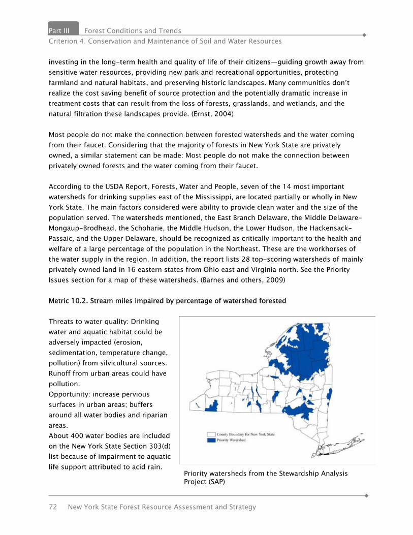
Part III Forest Conditions and Trends Criterion 4. Conservation and Maintenance of Soil and Water Resources
72 New York State Forest Resource Assessment and Strategy
investing in the long-term health and quality of life of their citizens—guiding growth away from sensitive water resources, providing new park and recreational opportunities, protecting farmland and natural habitats, and preserving historic landscapes. Many communities don’t realize the cost saving benefit of source protection and the potentially dramatic increase in treatment costs that can result from the loss of forests, grasslands, and wetlands, and the natural filtration these landscapes provide. (Ernst, 2004) Most people do not make the connection between forested watersheds and the water coming from their faucet. Considering that the majority of forests in New York State are privately owned, a similar statement can be made: Most people do not make the connection between privately owned forests and the water coming from their faucet. According to the USDA Report, Forests, Water and People, seven of the 14 most important watersheds for drinking supplies east of the Mississippi, are located partially or wholly in New York State. The main factors considered were ability to provide clean water and the size of the population served. The watersheds mentioned, the East Branch Delaware, the Middle Delaware-Mongaup-Brodhead, the Schoharie, the Middle Hudson, the Lower Hudson, the Hackensack-Passaic, and the Upper Delaware, should be recognized as critically important to the health and welfare of a large percentage of the population in the Northeast. These are the workhorses of the water supply in the region. In addition, the report lists 28 top-scoring watersheds of mainly privately owned land in 16 eastern states from Ohio east and Virginia north. See the Priority Issues section for a map of these watersheds. (Barnes and others, 2009) Metric 10.2. Stream miles impaired by percentage of watershed forested Threats to water quality: Drinking water and aquatic habitat could be adversely impacted (erosion, sedimentation, temperature change, pollution) from silvicultural sources. Runoff from urban areas could have pollution. Opportunity: increase pervious surfaces in urban areas; buffers around all water bodies and riparian areas. About 400 water bodies are included on the New York State Section 303(d) list because of impairment to aquatic life support attributed to acid rain. Priority watersheds from the Stewardship Analysis
Project (SAP)
Forest Conditions and Trends Part III Criterion 4. Conservation and Maintenance of Soil and Water Resources
New York State Forest Resource Assessment and Strategy 73
According to the EPA, more than 60 percent of U.S. water pollution comes from runoff from lawns, farms, cities, and highways, as well as leachate from septic systems So far we have discussed watersheds and not aquifers. It should be noted that virtually all of Long Island’s drinking water is drawn from a single system of underground reservoirs, known as aquifers. The Pine Barrens overlie the source of the greatest quantity of the purest drinking water on Long Island. The federal Environmental Protection Agency designated this aquifer system as the nation’s first Sole Source Aquifer, requiring special protection. Two hundred years ago, the Pine Barrens blanketed one-fourth of Long Island, assuring a plentiful supply of pure, fresh drinking water. Today, most of that land has been developed leaving a little over 102,500 acres which has been divided into categories by the NYS Central Pine Barrens Commission: Core Preservation Area (55,000 acres) and Compatible Growth Area (47,500 acres). (The Pine Barrens Legislation - NY Environmental Conservation Law Article 57)


Forest Conditions and Trends Part III Criterion 5. Maintenance of Forest Contribution to Global Carbon Cycles
New York State Forest Resource Assessment and Strategy 75
Criterion 5 – Maintenance of Forest Contribution to Global Carbon Cycles INDICATOR 11. FOREST ECOSYSTEM BIOMASS & FOREST CARBON POOLS Carbon-containing gases in the atmosphere, the so-called “greenhouse” gases, are strongly implicated as a potential source of climate change. Carbon dioxide, methane, and nitrous oxide have changed the composition of our atmosphere. Carbon dioxide concentration alone increased since the 18th century and greenhouse gases are expected to warm the earth by allowing sunlight to reach the earth’s surface while blocking heat from escaping. Some of the gases also thin the ozone layer that shields the earth from harmful solar radiation. Growing forests naturally store carbon. The age and vigor of forest vegetation affects the rate of carbon sequestration in a forest ecosystem and the overall inventory of stored carbon. The dry weight of trees are about 50 percent carbon and represent the most dynamic component of the forest ecosystem carbon pool, although the largest proportion of carbon is found in the soil. In the Northern United States, hardwoods account for a greater proportion of carbon than softwoods. Changes in carbon inventory are affected by the rate of forest growth, harvest activity, and losses of forest cover due to conversion to other land uses, as well as fire or other natural disturbances. In general, forest activities such as tree planting increase carbon sequestration, while activities such as prescribed burning release carbon into the atmosphere. The carbon inventory in Northern U.S. forests is higher than in forests of any other region of the country. An underlying factor is that forests in the North are not harvested as heavily compared to growth as forests in the South and West. Additional carbon is stored in wood that is processed or manufactured into products. Increasing carbon stored in urban and rural trees and forests is usually an inexpensive way to mitigate increasing atmospheric greenhouse gases. The carbon stored in forests and forest products mitigates the amount of carbon released into the atmosphere, which may help delay global climate change. Forests also act as climate buffers, moderating temperature extremes and creating local microclimates. Trees cool the air both by direct shade and by evaporative cooling through their leaves. The Urban Heat Island effect is caused by the predominance of heat-absorbing pavement and dark surfaces which can increase a city's temperatures by several degrees. Trees can reduce this buildup of urban heat and substantially reduce energy demands and related greenhouse gas emissions.

Part III Forest Conditions and Trends Criterion 5. Maintenance of Forest Contribution to Global Carbon Cycles
76 New York State Forest Resource Assessment and Strategy
The climate change pattern that seems to be developing in New York as a result of global warming has fewer but heavier rains with increased runoff, and more periods of summer drought. The ability of forests to soak up water is critical for reducing flooding and for absorbing adequate amounts of groundwater. Forests can also help buffer the impacts of drought by protecting soils from desiccation and erosion. During storms, forests and wetlands can be important physical buffers, slowing the force of wind by friction and as windbreaks. Metric 11.1 Forest ecosystem biomass Total forest ecosystem biomass includes the main stem of larger trees (the part of the tree that would be removed from the forest if harvested), bark, branches and foliage, stump and roots, small trees called saplings, and dead trees. Multiplying area of forest by the carbon per area estimated for forest types and age classes gives the total ecosystem biomass. The forest carbon pool includes carbon in all vegetation, litter, organic debris, and soil. Older forest stands contain more carbon than do younger stands. The figure below illustrates regional estimates of forest carbon per hectare on fully stocked timberland for the maple-beech-birch forest type, as the forest grows back after final clearcut harvest. Since 75% of the state was cleared of forest by the turn of the 21st century, this is a representative scenario for many of New York’s forests. Estimated forest carbon stores in a maple-beech-birch forest type in the Northern United States (on fully stocked timberland under average management after final clearcut harvest) (data from Birdsey 1996). Trees are about 50 percent carbon, so the amount of carbon in a forest can be directly calculated by multiplying biomass in terms of dry weight by 0.5. In Northern U.S. forests, biomass in standing large trees is about 2,920 million tons, biomass in stumps and roots is about 1,166 million tons, and biomass in saplings is 1,074 million tons (figure 5.3) (McWilliams and others 2000). Overall, only about 40 percent of the standing tree biomass is in the main stem of trees greater than 12.5 cm diameter at breast height. Eighty percent of the biomass in Northern U.S. forests is in hardwood species.
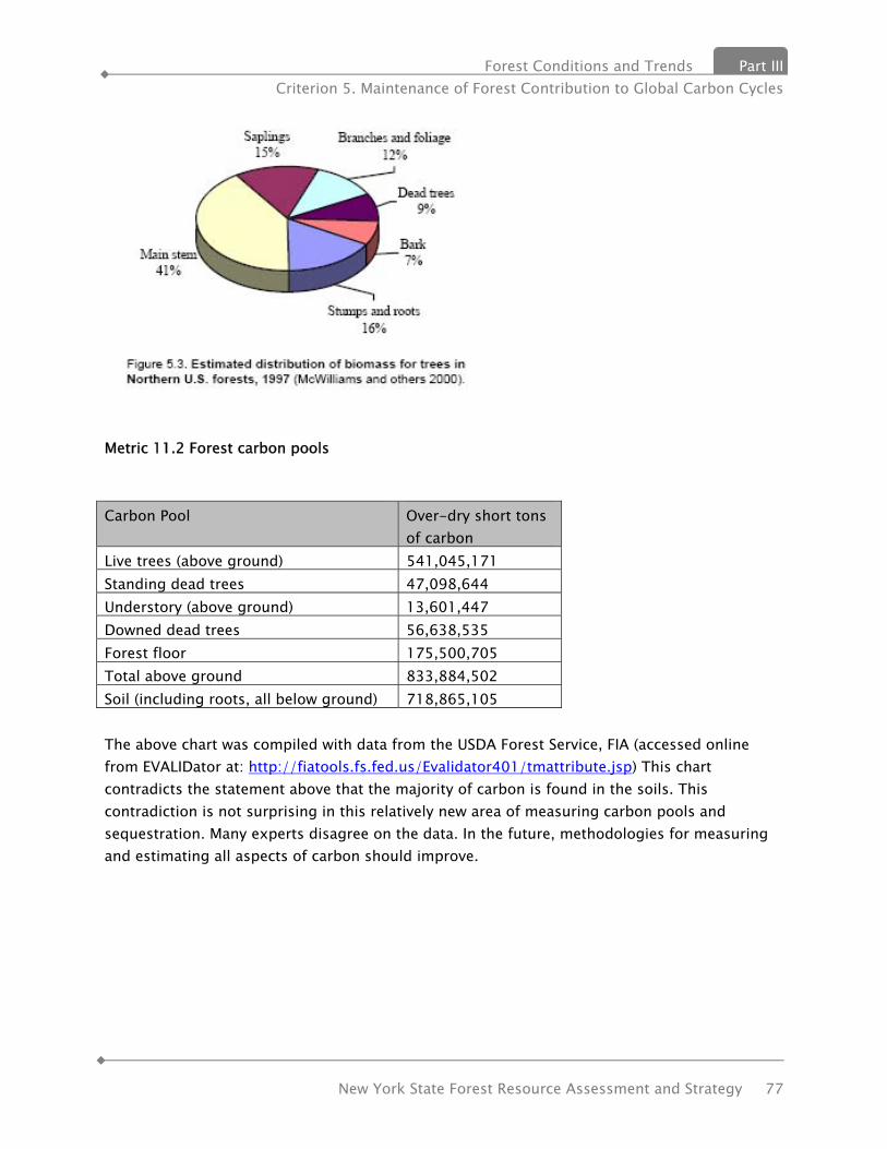
Forest Conditions and Trends Part III Criterion 5. Maintenance of Forest Contribution to Global Carbon Cycles
New York State Forest Resource Assessment and Strategy 77
Metric 11.2 Forest carbon pools Carbon Pool Over-dry short tons
of carbon Live trees (above ground) 541,045,171 Standing dead trees 47,098,644 Understory (above ground) 13,601,447 Downed dead trees 56,638,535 Forest floor 175,500,705 Total above ground 833,884,502 Soil (including roots, all below ground) 718,865,105 The above chart was compiled with data from the USDA Forest Service, FIA (accessed online from EVALIDator at: http://fiatools.fs.fed.us/Evalidator401/tmattribute.jsp) This chart contradicts the statement above that the majority of carbon is found in the soils. This contradiction is not surprising in this relatively new area of measuring carbon pools and sequestration. Many experts disagree on the data. In the future, methodologies for measuring and estimating all aspects of carbon should improve.

Part III Forest Conditions and Trends Criterion 5. Maintenance of Forest Contribution to Global Carbon Cycles
78 New York State Forest Resource Assessment and Strategy
Metric 11.3 Forest carbon by forest type
The northern forest landscape features nine major forest type groups. Over half of the carbon is stored in maple-beech-birch or oak-hickory forests (figure 5.9). Hardwood types contain more carbon than softwoods because they cover more area. New York’s forest mix differs from the overall mix of the northern forest with maple-beech-birch being the predominant forest type.
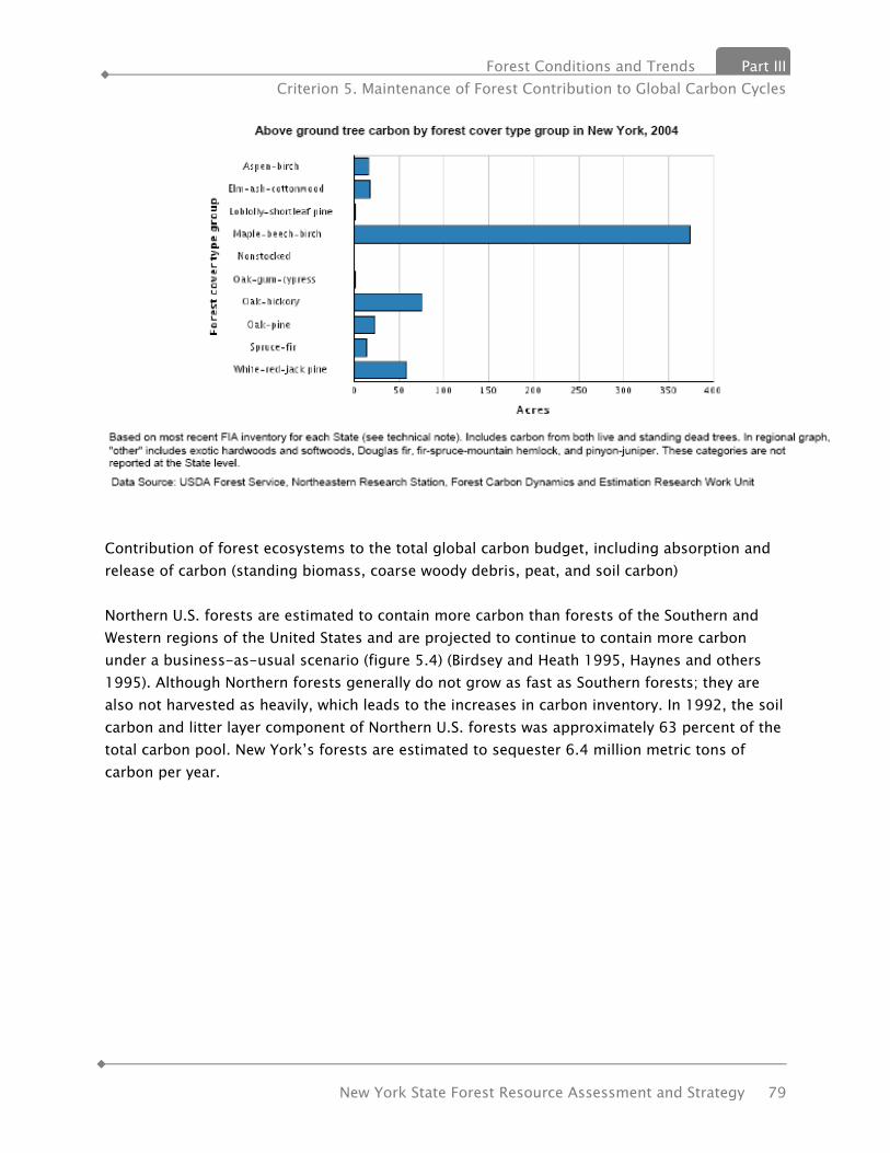
Forest Conditions and Trends Part III Criterion 5. Maintenance of Forest Contribution to Global Carbon Cycles
New York State Forest Resource Assessment and Strategy 79
Contribution of forest ecosystems to the total global carbon budget, including absorption and release of carbon (standing biomass, coarse woody debris, peat, and soil carbon) Northern U.S. forests are estimated to contain more carbon than forests of the Southern and Western regions of the United States and are projected to continue to contain more carbon under a business-as-usual scenario (figure 5.4) (Birdsey and Heath 1995, Haynes and others 1995). Although Northern forests generally do not grow as fast as Southern forests; they are also not harvested as heavily, which leads to the increases in carbon inventory. In 1992, the soil carbon and litter layer component of Northern U.S. forests was approximately 63 percent of the total carbon pool. New York’s forests are estimated to sequester 6.4 million metric tons of carbon per year.

Part III Forest Conditions and Trends Criterion 5. Maintenance of Forest Contribution to Global Carbon Cycles
80 New York State Forest Resource Assessment and Strategy
Metric 11.4 Change in forest carbon See the following figure for change in forest carbon in the 20 Northeastern Area states.
Contribution of forest products to the global carbon budget Carbon from forests can remain stored in forest products long after forests are harvested and the wood processed into products. Carbon stored in trees harvested in the early 1900s is still stored as wood in houses built then. Harvested carbon can be tracked in four general categories: wood products, landfills, wood burned for energy (which substitutes for fossil fuel), and carbon emitted from wood that is not used as an energy source. Forest Management The carbon storage potential of forests can be greatly affected by forest management and utilization standards. For instance, increased harvesting tends to lower the proportion of total carbon stored in forest ecosystems, while increasing the proportion of carbon stored in forest products. However, the exact effect that forest management has on the carbon indicators depends on forest area, growth rates, previous land use, and temporal dynamics of stands across the landscape, and other factors. It is difficult to calculate carbon storage on a per stand basis. Forest management choices affect carbon storage attributed to the stand, and the ultimate use of wood harvested from that stand will also affect its overall contribution. In addition, individual landowners may choose to maximize the carbon stored on their forest lands by not harvesting, but this strategy may result in other forest lands being harvested faster to provide wood to meet consumer demand.
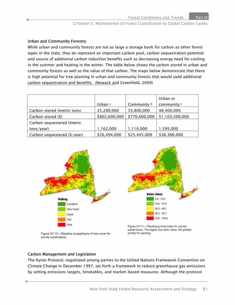
Forest Conditions and Trends Part III Criterion 5. Maintenance of Forest Contribution to Global Carbon Cycles
New York State Forest Resource Assessment and Strategy 81
Urban and Community Forestry While urban and community forests are not as large a storage bank for carbon as other forest types in the state, they do represent an important carbon pool, carbon sequestration potential and source of additional carbon reduction benefits such as decreasing energy need for cooling in the summer and heating in the winter. The table below shows the carbon stored in urban and community forests as well as the value of that carbon. The maps below demonstrate that there is high potential for tree planting in urban and community forests that would yield additional carbon sequestration and benefits. (Nowack and Greenfield, 2009)
Urban a Community b Urban or community c
Carbon stored (metric tons) 35,200,000 33,800,000 48,400,000 Carbon stored ($) $802,600,000 $770,600,000 $1,103,500,000 Carbon sequestered (metric tons/year) 1,162,000 1,116,000 1,595,000 Carbon sequestered ($/year) $26,494,000 $25,445,000 $36,366,000
Carbon Management and Legislation The Kyoto Protocol, negotiated among parties to the United Nations Framework Convention on Climate Change in December 1997, set forth a framework to reduce greenhouse gas emissions by setting emissions targets, timetables, and market-based measures. Although the protocol
Part III Forest Conditions and Trends Criterion 5. Maintenance of Forest Contribution to Global Carbon Cycles
82 New York State Forest Resource Assessment and Strategy
was not ratified by the United States, there is much discussion about the buying and selling of “carbon credits.” For instance, landowners who grow trees may be granted carbon credits because these trees are sequestering carbon, and a utility company may pay the landowner for the carbon credits to make up for the amount of carbon the company is emitting in its power plant. The Chicago Climate Exchange is a voluntary program in the United States to track credits on activities including tree planting and forest conservation (U.S. Department of Energy, Energy Information Administration, see http://www.eia.doe.gov/oiaf/1605/frntvrgg.html). New York State along with nine other northeastern states created the first cap and trade system in the United States, the Regional Greenhouse Gas Initiative (RGGI), to decrease carbon emissions. The process began in 2003 and the first compliance period began January 1, 2009. Since the RGGI process began states in the Midwest and west coast have also partnered to create cap and trade systems, which have not yet been implemented. RGGI includes afforestation as a carbon offset category. Other systems have also included forest management to sequester additional carbon as an offset category. The United States Congress has considered several climate bills over the past decade; however, no legislation has been enacted. Forestry has been contemplated as part of federal legislation and should be included as an important component of any climate legislation at the federal level through such mechanisms as offsets, supplemental carbon sequestration strategies or avoided conversion. Forests of the Northern United States are storing more carbon than forests of any other region of the United States, and they are projected to continue storing carbon. Currently, most of the carbon is stored in hardwood forest types. Additional carbon is stored in harvested wood that is processed or manufactured into products. The carbon stored in forests mitigates the amount of carbon released into the atmosphere, which may help delay global climate change.

Forest Conditions and Trends Part III Criterion 6. Maintenance and Enhancement of Long-term Multiple Socioeconomic Benefits
New York State Forest Resource Assessment and Strategy 83
Criterion 6 – Maintenance and Enhancement of Long-term Multiple Socioeconomic Benefits
INDICATOR 12. WOOD & WOOD PRODUCTS PRODUCTION, CONSUMPTION & TRADE In 1999, the New York State DEC Forest Utilization Program initiated an industrial timber harvest production and consumption reporting program to account for timber product harvest and disposition on an annual basis. This report provides an enhanced understanding of the forest industry’s economic contribution to rural New York and augments information provided by USFS FIA program. The report is widely distributed to forestry partners and industry in New York, as well as available to the forestry research community and the general public. In recent years, the report has been utilized effectively by potential developers of biomass energy facilities investigating woody biomass feedstock availability. This following summarizes the estimated industrial timber harvest production level from New York’s forests, the consumption level of New York’s primary wood processors, and the flow of harvested wood to/from New York for the calendar year 2008, the most recent data available. Production Total timber harvest production level was 150 million cubic feet, composed of the following product breakdown: Log production – 547.3 million board feet (MMbf) Pulpwood & Chips production-- 2.1 million green tons (50% pulpwood/50% chips). This is the first year in the recent past where the harvest volume of pulpwood and chip products was greater than the harvest of logs. Returned surveys (accounting for 48% of total estimated log production) indicate that 67% of New York’s log harvest was comprised of five species: sugar maple, red oak, red maple, white ash and white pine. Sugar maple alone accounted for 21% of total log production. On a volume basis, 58% of pulpwood & chip production was
Species Breakdown-Survey Reported Log Production, 2008
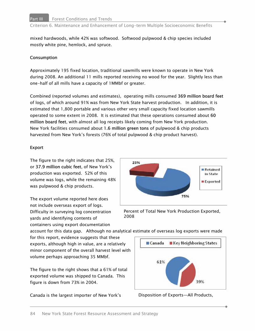
Part III Forest Conditions and Trends Criterion 6. Maintenance and Enhancement of Long-term Multiple Socioeconomic Benefits
84 New York State Forest Resource Assessment and Strategy
mixed hardwoods, while 42% was softwood. Softwood pulpwood & chip species included mostly white pine, hemlock, and spruce. Consumption Approximately 195 fixed location, traditional sawmills were known to operate in New York during 2008. An additional 11 mills reported receiving no wood for the year. Slightly less than one-half of all mills have a capacity of 1MMbf or greater. Combined (reported volumes and estimates), operating mills consumed 369 million board feet of logs, of which around 91% was from New York State harvest production. In addition, it is estimated that 1,800 portable and various other very small capacity fixed location sawmills operated to some extent in 2008. It is estimated that these operations consumed about 60 million board feet, with almost all log receipts likely coming from New York production. New York facilities consumed about 1.6 million green tons of pulpwood & chip products harvested from New York’s forests (76% of total pulpwood & chip product harvest). Export The figure to the right indicates that 25%, or 37.9 million cubic feet, of New York’s production was exported. 52% of this volume was logs, while the remaining 48% was pulpwood & chip products. The export volume reported here does not include overseas export of logs. Difficulty in surveying log concentration yards and identifying contents of containers using export documentation account for this data gap. Although no analytical estimate of overseas log exports were made for this report, evidence suggests that these exports, although high in value, are a relatively minor component of the overall harvest level with volume perhaps approaching 35 MMbf. The figure to the right shows that a 61% of total exported volume was shipped to Canada. This figure is down from 73% in 2004. Canada is the largest importer of New York’s
Percent of Total New York Production Exported, 2008
Disposition of Exports—All Products,

Forest Conditions and Trends Part III Criterion 6. Maintenance and Enhancement of Long-term Multiple Socioeconomic Benefits
New York State Forest Resource Assessment and Strategy 85
industrial timber harvest, importing 25.6 million cubic feet in 2008. Breakdown of this volume by product type and species group is as follows: Logs: 111.8 MMbf (46% HW/54% SW) Pulpwood & Chips: 281 M Green tons (83% HW) Combined, key neighboring states consumed the balance of reported imports of New York timber products, importing approximately 14.7 million cubic feet. The following indicates breakdown by product type: Logs: 39.5 MMbf (72% HW/28% SW) PW/Chips: 266 M green tons (73% HW/27% SW) Additionally, unreported volumes of logs were exported to several states in the New England, Mid-Atlantic and Mid-West regions of the US. No attempt was made to estimate this volume, and it is believed to be minor relative to the overall harvest level (<5%). Summary—Production, Consumption, and Trade – All Timber Products, 2004-2008
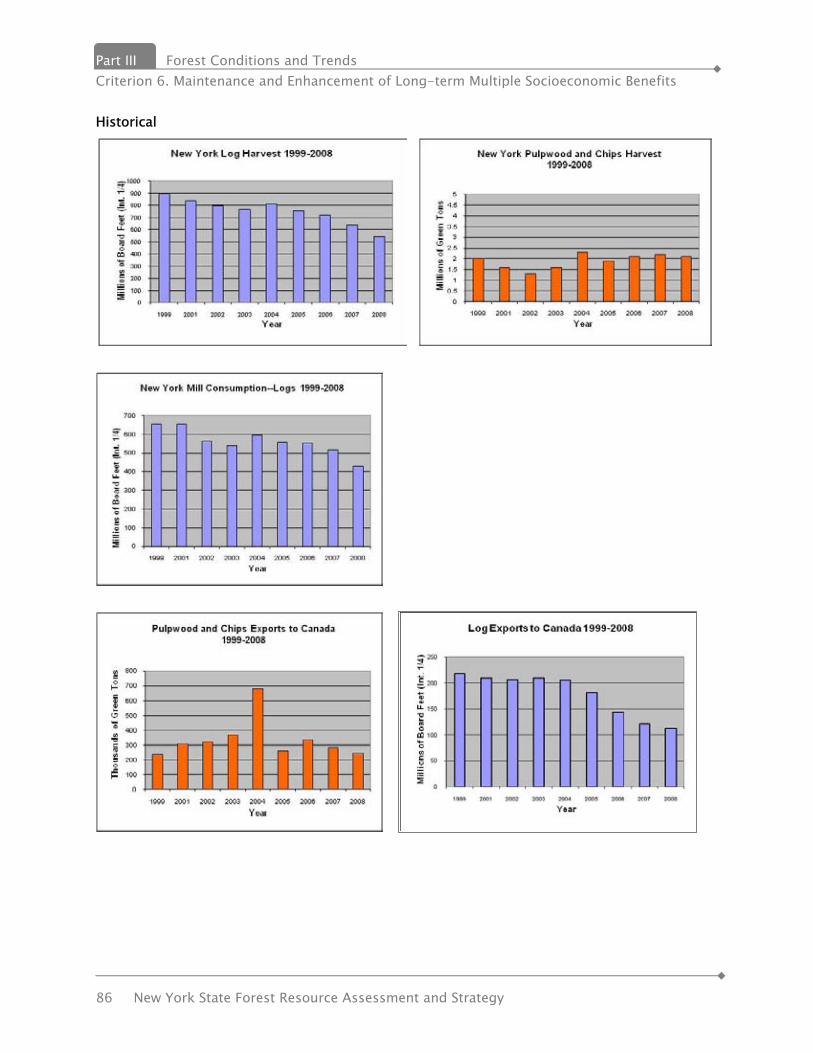
Part III Forest Conditions and Trends Criterion 6. Maintenance and Enhancement of Long-term Multiple Socioeconomic Benefits
86 New York State Forest Resource Assessment and Strategy
Historical

Forest Conditions and Trends Part III Criterion 6. Maintenance and Enhancement of Long-term Multiple Socioeconomic Benefits
New York State Forest Resource Assessment and Strategy 87
INDICATOR 13. OUTDOOR RECREATIONAL PARTICIPATION & FACILITIES Parkland and open space are two of New York State’s most valuable nonrenewable resources that enhance the quality of life. These important places have a long history dating back to Niagara Falls State Park, the “Oldest State Park” in the country and Central Park in New York City. Recognizing the value of the parks and open space, this system of protected areas continues to expand to over 6,000 public areas comprising over 4 million acres. Federal, state and local governments as stewards of these resources are faced with a challenging situation of maintaining and revitalizing an aging system while looking to the future to protect critical open space areas and addressing the needs of the citizens and the environment. These resources can no longer be viewed as islands but as systems that need to be connected to benefit both people and wildlife. The benefits derived from these efforts are far reaching – enhanced quality of life, increased tourism, improved health, protected ecosystems, and sustainability of our environment. Parks and open spaces are truly “important places” and must be protected. Currently, OPRHP and DEC are responsible for the bulk of outdoor recreation and conservation in the State. OPRHP administers about 330,000 acres of land incorporating 178 state parks, 35 historic sites, 67 marine facilities and boat launch sites, 20 parkways, over 5,000 structures, 77 developed beaches, 53 swimming pools, 29 golf courses, over 800 cabins and rental houses, 8,355 campsites, and over 1,350 miles of trail, as well as several outdoor education centers, museums, and nature centers and the Empire State Games. DEC administers nearly 4 million acres of land (including 3 million acres of Forest Preserve, over 700,000 acres of State Forest, and over 190,000 acres of Wildlife Management Areas), over 662,000 acres of Conservation Easements, 52 campgrounds, several day-use areas, 12 fish hatcheries, 1,280 miles of easements for public fishing rights, over 400 boat launch and fishing access sites, two Submerged Heritage preserves, the Belleayre Mountain Ski Center, and about 2,800 miles of trail, as well as several environmental education centers and summer camps. Metric 13.1. Participation in outdoor recreation The demand for recreation facilities is derived from the 2004 General Public Recreation Survey that addressed levels of participation and attitudes toward recreation/open space issues. This was supplemented through a survey of the local governmental park professionals which focused on facility needs, issues and trail concerns. The 2004 General Public Recreation Survey was directed at a geographically stratified selection of households residing in New York State for at least 18 months. The survey is a component of the process because it is one of the few opportunities to receive input from the entire citizenry, rather than special interest groups, park visitors, activity club members and the like. Findings from the survey were analyzed and demographic variables were assessed as to their influence on recreation choices. The results of this analysis were used together with U.S. Census data to
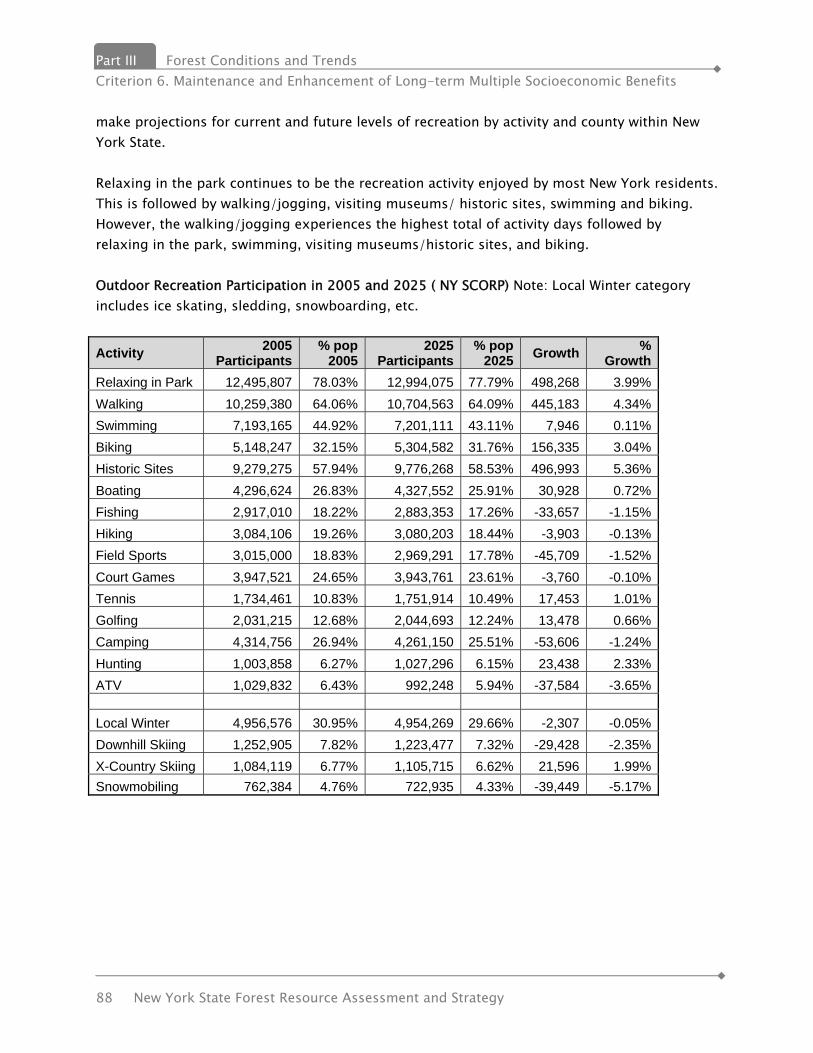
Part III Forest Conditions and Trends Criterion 6. Maintenance and Enhancement of Long-term Multiple Socioeconomic Benefits
88 New York State Forest Resource Assessment and Strategy
make projections for current and future levels of recreation by activity and county within New York State. Relaxing in the park continues to be the recreation activity enjoyed by most New York residents. This is followed by walking/jogging, visiting museums/ historic sites, swimming and biking. However, the walking/jogging experiences the highest total of activity days followed by relaxing in the park, swimming, visiting museums/historic sites, and biking. Outdoor Recreation Participation in 2005 and 2025 ( NY SCORP) Note: Local Winter category includes ice skating, sledding, snowboarding, etc.
Activity 2005 Participants
% pop 2005
2025 Participants
% pop 2025 Growth %
Growth Relaxing in Park 12,495,807 78.03% 12,994,075 77.79% 498,268 3.99% Walking 10,259,380 64.06% 10,704,563 64.09% 445,183 4.34% Swimming 7,193,165 44.92% 7,201,111 43.11% 7,946 0.11% Biking 5,148,247 32.15% 5,304,582 31.76% 156,335 3.04% Historic Sites 9,279,275 57.94% 9,776,268 58.53% 496,993 5.36% Boating 4,296,624 26.83% 4,327,552 25.91% 30,928 0.72% Fishing 2,917,010 18.22% 2,883,353 17.26% -33,657 -1.15% Hiking 3,084,106 19.26% 3,080,203 18.44% -3,903 -0.13% Field Sports 3,015,000 18.83% 2,969,291 17.78% -45,709 -1.52% Court Games 3,947,521 24.65% 3,943,761 23.61% -3,760 -0.10% Tennis 1,734,461 10.83% 1,751,914 10.49% 17,453 1.01% Golfing 2,031,215 12.68% 2,044,693 12.24% 13,478 0.66% Camping 4,314,756 26.94% 4,261,150 25.51% -53,606 -1.24% Hunting 1,003,858 6.27% 1,027,296 6.15% 23,438 2.33% ATV 1,029,832 6.43% 992,248 5.94% -37,584 -3.65%
Local Winter 4,956,576 30.95% 4,954,269 29.66% -2,307 -0.05% Downhill Skiing 1,252,905 7.82% 1,223,477 7.32% -29,428 -2.35% X-Country Skiing 1,084,119 6.77% 1,105,715 6.62% 21,596 1.99% Snowmobiling 762,384 4.76% 722,935 4.33% -39,449 -5.17%
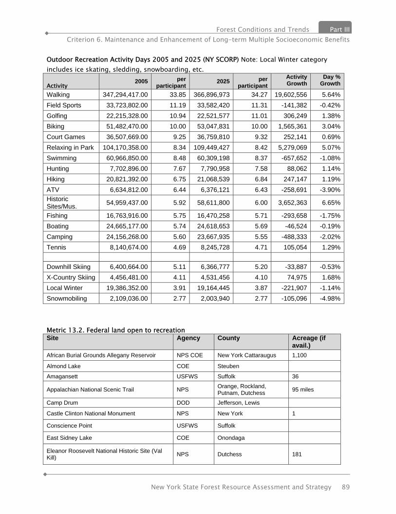
Forest Conditions and Trends Part III Criterion 6. Maintenance and Enhancement of Long-term Multiple Socioeconomic Benefits
New York State Forest Resource Assessment and Strategy 89
Outdoor Recreation Activity Days 2005 and 2025 (NY SCORP) Note: Local Winter category includes ice skating, sledding, snowboarding, etc. Activity
2005 per participant
2025 per participant
Activity Growth
Day % Growth
Walking 347,294,417.00 33.85 366,896,973 34.27 19,602,556 5.64% Field Sports 33,723,802.00 11.19 33,582,420 11.31 -141,382 -0.42% Golfing 22,215,328.00 10.94 22,521,577 11.01 306,249 1.38% Biking 51,482,470.00 10.00 53,047,831 10.00 1,565,361 3.04% Court Games 36,507,669.00 9.25 36,759,810 9.32 252,141 0.69% Relaxing in Park 104,170,358.00 8.34 109,449,427 8.42 5,279,069 5.07% Swimming 60,966,850.00 8.48 60,309,198 8.37 -657,652 -1.08% Hunting 7,702,896.00 7.67 7,790,958 7.58 88,062 1.14% Hiking 20,821,392.00 6.75 21,068,539 6.84 247,147 1.19% ATV 6,634,812.00 6.44 6,376,121 6.43 -258,691 -3.90% Historic Sites/Mus. 54,959,437.00 5.92 58,611,800 6.00 3,652,363 6.65%
Fishing 16,763,916.00 5.75 16,470,258 5.71 -293,658 -1.75% Boating 24,665,177.00 5.74 24,618,653 5.69 -46,524 -0.19% Camping 24,156,268.00 5.60 23,667,935 5.55 -488,333 -2.02% Tennis 8,140,674.00 4.69 8,245,728 4.71 105,054 1.29% Downhill Skiing 6,400,664.00 5.11 6,366,777 5.20 -33,887 -0.53% X-Country Skiing 4,456,481.00 4.11 4,531,456 4.10 74,975 1.68% Local Winter 19,386,352.00 3.91 19,164,445 3.87 -221,907 -1.14% Snowmobiling 2,109,036.00 2.77 2,003,940 2.77 -105,096 -4.98%
Metric 13.2. Federal land open to recreation Site Agency County Acreage (if
avail.) African Burial Grounds Allegany Reservoir NPS COE New York Cattaraugus 1,100
Almond Lake COE Steuben
Amagansett USFWS Suffolk 36
Appalachian National Scenic Trail NPS Orange, Rockland, Putnam, Dutchess 95 miles
Camp Drum DOD Jefferson, Lewis
Castle Clinton National Monument NPS New York 1
Conscience Point USFWS Suffolk
East Sidney Lake COE Onondaga
Eleanor Roosevelt National Historic Site (Val Kill) NPS Dutchess 181
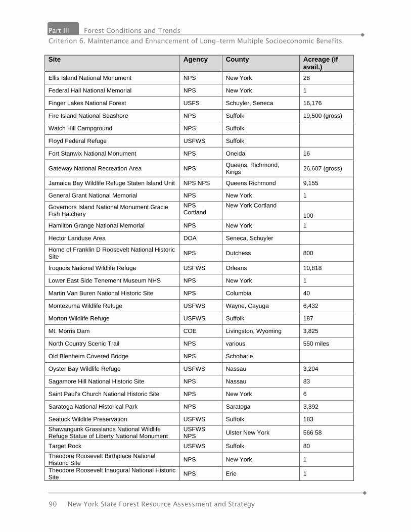
Part III Forest Conditions and Trends Criterion 6. Maintenance and Enhancement of Long-term Multiple Socioeconomic Benefits
90 New York State Forest Resource Assessment and Strategy
Site Agency County Acreage (if avail.)
Ellis Island National Monument NPS New York 28
Federal Hall National Memorial NPS New York 1
Finger Lakes National Forest USFS Schuyler, Seneca 16,176
Fire Island National Seashore NPS Suffolk 19,500 (gross)
Watch Hill Campground NPS Suffolk
Floyd Federal Refuge USFWS Suffolk
Fort Stanwix National Monument NPS Oneida 16
Gateway National Recreation Area NPS Queens, Richmond, Kings 26,607 (gross)
Jamaica Bay Wildlife Refuge Staten Island Unit NPS NPS Queens Richmond 9,155
General Grant National Memorial NPS New York 1
Governors Island National Monument Gracie Fish Hatchery
NPS Cortland
New York Cortland
100 Hamilton Grange National Memorial NPS New York 1
Hector Landuse Area DOA Seneca, Schuyler
Home of Franklin D Roosevelt National Historic Site NPS Dutchess 800
Iroquois National Wildlife Refuge USFWS Orleans 10,818
Lower East Side Tenement Museum NHS NPS New York 1
Martin Van Buren National Historic Site NPS Columbia 40
Montezuma Wildlife Refuge USFWS Wayne, Cayuga 6,432
Morton Wildlife Refuge USFWS Suffolk 187
Mt. Morris Dam COE Livingston, Wyoming 3,825
North Country Scenic Trail NPS various 550 miles
Old Blenheim Covered Bridge NPS Schoharie
Oyster Bay Wildlife Refuge USFWS Nassau 3,204
Sagamore Hill National Historic Site NPS Nassau 83
Saint Paul’s Church National Historic Site NPS New York 6
Saratoga National Historical Park NPS Saratoga 3,392
Seatuck Wildlife Preservation USFWS Suffolk 183 Shawangunk Grasslands National Wildlife Refuge Statue of Liberty National Monument
USFWS NPS Ulster New York 566 58
Target Rock USFWS Suffolk 80 Theodore Roosevelt Birthplace National Historic Site NPS New York 1
Theodore Roosevelt Inaugural National Historic Site NPS Erie 1

Forest Conditions and Trends Part III Criterion 6. Maintenance and Enhancement of Long-term Multiple Socioeconomic Benefits
New York State Forest Resource Assessment and Strategy 91
Site Agency County Acreage (if avail.)
Thomas Cole National Historic Site NPS/ Greene Co. Greene 88
Tunnison Laboratory of Fish Nutrition USFWS Cortland 100
Upper Delaware Scenic & Recreational River NPS Delaware, Sullivan, 19 (fed NY&PA)
Upper Delaware Scenic & Recreational River NPS Orange 75,000 (gross)
US Military Academy at West Point DOD Orange
Vanderbilt Mansion National Historic Site NPS Dutchess 212
Wertheim Federal Refuge USFWS Suffolk 2,362
Whitney Point Lake COE Broome
Women’s Rights National Historical Park NPS Seneca 7
COE - Corp of Engineers DOA Department of Agriculture DOD - Department of Defense NPS - National Park Service, Dept. of the Interior USFS - US Forest Service USFWS - US Fish & Wildlife Service Metric 13.3. Recreational facilities on State land As mentioned at the beginning of Indicator 13, DEC and OPRHP are responsible for the majority of outdoor recreation and conservation in the State in the form of developed facilities and undeveloped resources. Forest Preserve The statute creating the Forest Preserve incorporated all state-owned lands within three Catskill counties (later amended to incorporate four Catskill counties) and all state-owned lands in the 11 Adirondack counties (later amended to 12) that fall within the “blue line” of the Catskill and Adirondack Parks into the Forest Preserve. One of the things that make the Forest Preserve unique among public land holdings, in addition to its size of nearly 3 million acres, is the fact that the people of the State have chosen to make decisions regarding changes that would diminish the preserve through a public referendum following approval of two sessions of the State Legislature. These areas provide extensive camping, trail, hunting, fishing and other passive recreational opportunities. The Adirondack Park, established by statute in 1892, is unique among parks within the nation in that it encompasses both state and private lands. Originally established at 2.8 million acres the park is now nearly 6 million acres. Approximately 2.6 million acres in the Adirondack Park are in state ownership most all of which is classified as Forest Preserve.
Part III Forest Conditions and Trends Criterion 6. Maintenance and Enhancement of Long-term Multiple Socioeconomic Benefits
92 New York State Forest Resource Assessment and Strategy
Unique to the Adirondack Park is the Adirondack Park Agency that controls land use on state and private lands. The Adirondack Park Agency (APA) is an independent, bipartisan state agency responsible for developing long-range park policy in a forum that balances statewide concerns and the interests of local governments in the Adirondack Park. It was created by New York State law in 1971. The legislation defined the makeup and functions of the APA and authorized the Agency to develop two plans for lands within the Adirondack Park. The Adirondack Park Land Use and Development Plan regulates land use and development activities on the approximately 3.2 million acres of privately owned lands in the Park. The Adirondack Park State Land Master Plan (APSLMP) sets forth guidelines and criteria for the DEC’s management of the remaining 2.6 million acres of public lands. The policy framework provided by the APSLMP is resource-capacity driven, rather than user-demand driven, with protection of the Park’s outstanding natural resources the underlying mandate governing New York State’s provision of recreational opportunities on the State-owned lands and waters in the Adirondacks. This is reflective not only of the statewide importance of these resources, but also of their national and international significance. APA has worked with DEC in a concerted effort to undertake planning critical to improving recreational opportunities through-out the Park. Numerous unit management plans (UMPs) have been drafted and approved for specific areas that span the range of diversity from popular public campgrounds to the region’s more remote, less-used wilderness areas. As this inter-Agency planning process continues, a primary objective of APA is to work with DEC to facilitate implementation of workable, state-of-the art practices such as a “Limits of Acceptable Change” management approach to protecting natural resources, and a “Recreational Opportunity Spectrum” method of inventorying the Park’s available recreational resources. The Department of Environmental Conservation (DEC) manages 53 day use and campsite facilities within the Adirondack and Catskill Forest Preserve. APA also administers the State’s Wild, Scenic and Recreational Rivers System Act for private lands adjacent to designated rivers in the Park, and the State’s Freshwater Wetlands Act within the Park. APA operates two Visitor Interpretive Centers (VICs) at Paul Smiths, Franklin County and at Newcomb, Essex County. These Centers are the Agency’s environ-mental education and traveler orientation centers. The Catskill Park was similarly established, by statute in 1904 with 576,126 acres. Like the Adirondack Park, it includes both public and private lands. The size of this park has been enlarged to 705,500 acres. Approximately 285,000 acres is in state ownership and is classified as Forest Preserve.
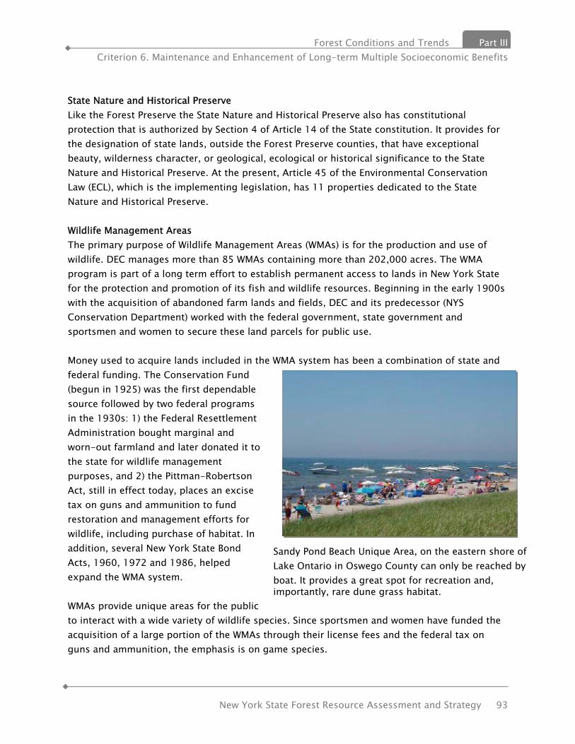
Forest Conditions and Trends Part III Criterion 6. Maintenance and Enhancement of Long-term Multiple Socioeconomic Benefits
New York State Forest Resource Assessment and Strategy 93
State Nature and Historical Preserve Like the Forest Preserve the State Nature and Historical Preserve also has constitutional protection that is authorized by Section 4 of Article 14 of the State constitution. It provides for the designation of state lands, outside the Forest Preserve counties, that have exceptional beauty, wilderness character, or geological, ecological or historical significance to the State Nature and Historical Preserve. At the present, Article 45 of the Environmental Conservation Law (ECL), which is the implementing legislation, has 11 properties dedicated to the State Nature and Historical Preserve. Wildlife Management Areas The primary purpose of Wildlife Management Areas (WMAs) is for the production and use of wildlife. DEC manages more than 85 WMAs containing more than 202,000 acres. The WMA program is part of a long term effort to establish permanent access to lands in New York State for the protection and promotion of its fish and wildlife resources. Beginning in the early 1900s with the acquisition of abandoned farm lands and fields, DEC and its predecessor (NYS Conservation Department) worked with the federal government, state government and sportsmen and women to secure these land parcels for public use. Money used to acquire lands included in the WMA system has been a combination of state and federal funding. The Conservation Fund (begun in 1925) was the first dependable source followed by two federal programs in the 1930s: 1) the Federal Resettlement Administration bought marginal and worn-out farmland and later donated it to the state for wildlife management purposes, and 2) the Pittman-Robertson Act, still in effect today, places an excise tax on guns and ammunition to fund restoration and management efforts for wildlife, including purchase of habitat. In addition, several New York State Bond Acts, 1960, 1972 and 1986, helped expand the WMA system. WMAs provide unique areas for the public to interact with a wide variety of wildlife species. Since sportsmen and women have funded the acquisition of a large portion of the WMAs through their license fees and the federal tax on guns and ammunition, the emphasis is on game species.
Sandy Pond Beach Unique Area, on the eastern shore of Lake Ontario in Oswego County can only be reached by boat. It provides a great spot for recreation and, importantly, rare dune grass habitat.
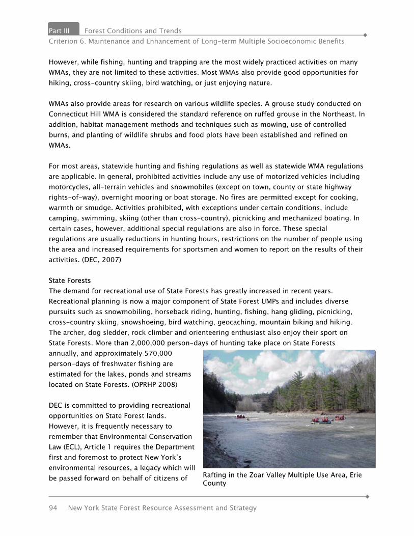
Part III Forest Conditions and Trends Criterion 6. Maintenance and Enhancement of Long-term Multiple Socioeconomic Benefits
94 New York State Forest Resource Assessment and Strategy
However, while fishing, hunting and trapping are the most widely practiced activities on many WMAs, they are not limited to these activities. Most WMAs also provide good opportunities for hiking, cross-country skiing, bird watching, or just enjoying nature. WMAs also provide areas for research on various wildlife species. A grouse study conducted on Connecticut Hill WMA is considered the standard reference on ruffed grouse in the Northeast. In addition, habitat management methods and techniques such as mowing, use of controlled burns, and planting of wildlife shrubs and food plots have been established and refined on WMAs. For most areas, statewide hunting and fishing regulations as well as statewide WMA regulations are applicable. In general, prohibited activities include any use of motorized vehicles including motorcycles, all-terrain vehicles and snowmobiles (except on town, county or state highway rights-of-way), overnight mooring or boat storage. No fires are permitted except for cooking, warmth or smudge. Activities prohibited, with exceptions under certain conditions, include camping, swimming, skiing (other than cross-country), picnicking and mechanized boating. In certain cases, however, additional special regulations are also in force. These special regulations are usually reductions in hunting hours, restrictions on the number of people using the area and increased requirements for sportsmen and women to report on the results of their activities. (DEC, 2007) State Forests The demand for recreational use of State Forests has greatly increased in recent years. Recreational planning is now a major component of State Forest UMPs and includes diverse pursuits such as snowmobiling, horseback riding, hunting, fishing, hang gliding, picnicking, cross-country skiing, snowshoeing, bird watching, geocaching, mountain biking and hiking. The archer, dog sledder, rock climber and orienteering enthusiast also enjoy their sport on State Forests. More than 2,000,000 person-days of hunting take place on State Forests annually, and approximately 570,000 person-days of freshwater fishing are estimated for the lakes, ponds and streams located on State Forests. (OPRHP 2008) DEC is committed to providing recreational opportunities on State Forest lands. However, it is frequently necessary to remember that Environmental Conservation Law (ECL), Article 1 requires the Department first and foremost to protect New York’s environmental resources, a legacy which will be passed forward on behalf of citizens of Rafting in the Zoar Valley Multiple Use Area, Erie
County
Forest Conditions and Trends Part III Criterion 6. Maintenance and Enhancement of Long-term Multiple Socioeconomic Benefits
New York State Forest Resource Assessment and Strategy 95
today’s and tomorrow’s generations. The Americans with Disabilities Act (ADA) mandates that it is the duty and responsibility of public agencies to ensure that people with disabilities have access to public recreational programs and facilities. DEC policies are described in the Universal Access section of this plan. State Forest is a generic term used to describe the more than 779,000 acres of DEC administered land located outside the Forest Preserve and under the direction of the Division of Lands and Forests in DEC. “State Forests” generally include lands classified as Reforestation Areas, Unique Areas and Multiple Use Areas. There are approximately 480 State Forest areas, ranging in size from less than 100 acres to over 9,000 acres. The State Reforestation Law of 1929 and the Hewitt Amendment of 1931 set forth legislation authorizing DEC to acquire land for Reforestation Areas, which make up approximately 85% of lands classified as State Forests. These lands are to be forever devoted to “reforestation and the establishment and maintenance thereon of forests for watershed protection, the production of timber, and for recreation and kindred purposes.” State Forests are “working forests” and are managed by employing multiple use principles to provide a wide variety of resources, products and opportunities to meet the varied demands of today’s society. The demand for recreational use of State Forests has greatly increased in recent years. Recreational activities are now a major component of State Forest Unit Management Plans and include diverse pursuits such as snowmobiling, horseback riding, hunting, fishing, hang gliding, picnicking, cross-country skiing, bird watching and hiking. State Forests often contain features of unique interest. Cultural resource sites such as old homesteads, cemeteries, Native American sites, and historical sites can provide notable opportunities and experiences for inquisitive visitors. State Forests can also harbor rare and endangered plant communities and ecosystems. These special habitats add emphasis to the stewardship responsibilities of State Forest management. Some of these communities, such as the pine barrens of Long Island and the oak savanna in Monroe County, provide the land manager with the challenge for their restoration and perpetuation and the recreational naturalist with the opportunity to observe the components of the communities. State Park System OPRHP administers about 330,000 acres of land, 178 state parks, 35 historic sites, 67 marine facilities and boat launch sites, 20 parkways, over 5,000 structures, 77 developed beaches, 53 swimming pools, 29 golf courses, over 800 cabins, cottages and rental houses, 8,566 campsites, and over 1,350 miles of trail, as well as several outdoor education centers, museums, and nature centers and the Empire State Games. Nearly 80% of the park system is in natural areas with a wide range of geological features, ecological habitats and species of plants and animals. This includes the water fall at Niagara Falls, the Genesee River gorge called the “Grand Canyon of the East” at Letchworth, extensive forested areas of Allegany and Sterling Forest State Parks, the gorges of the Finger Lakes parks, islands in the St. Lawrence and Hudson

Part III Forest Conditions and Trends Criterion 6. Maintenance and Enhancement of Long-term Multiple Socioeconomic Benefits
96 New York State Forest Resource Assessment and Strategy
Rivers, cliffs at Minnewaska, and the beaches of Long Island. Canal Corporation Canal Recreationway and Canalway Trail System Significant progress has been made over the last decade to develop the New York State Canal Recreationway, which spans the 524-mile New York State Canal System, consisting of the legendary Erie, Champlain, Oswego and Cayuga-Seneca Canals. The New York State Canal Corporation, a subsidiary of the New York State Thruway Authority, operates, maintains and promotes the system and has spearheaded the canal revitalization effort throughout New York State. The Canalway Trail, which parallels the entire New York State Canal System, will be the longest multiple use trail in the United States. More than 170 miles of trail have been completed since the Canal Corporation began the program in 1995. A total of 280 miles of trail now exist, primarily along the Erie Canal corridor. The Canalway Trail parallels the Erie, Champlain, Oswego and Cayuga-Seneca canals, creating the spine of a statewide network of trails. Major existing segments are located in the Capital District from Albany to Rotterdam Junction, between Amsterdam and Little Falls, between Rome and Syracuse in the Old Erie Canal State Park and between Newark and Lockport. Other shorter segments exist along the Erie, Champlain and Oswego Canals. The Canalway Trail will link to other important state greenway and trail systems, including the Hudson River Valley Greenway Trail System and the Genesee Valley Greenway Trail, helping to create a network of trails spanning the State. Office of General Services (OGS) OGS operates under the Public Lands Law to administer state owned land, including uplands and all ungranted lands under or formerly under the waters of New York State. The Agency issues licenses, permits, leases, easements and occasionally grants to underwater lands; disposes of uplands determined to be surplus to the needs of the State; and, provides transfers of jurisdiction for state agencies and local agencies for certain specific purposes (including recreational uses) subject to special acts of the State legislature. The latter provision is related to Article 3, Section 34 of the Public Lands Law whereby OGS facilitates the transfer of jurisdiction of state lands to county or local governments for listed purposes such as park, recreation and playground areas. These transfers are subject to reversion to the State should these uses no longer be pursued. OGS’s participation in various programs such as the Hudson River Valley Greenway, and the Heritage Rivers Program, provides the agency with the opportunity to further recreational objectives. One way OGS participates in recreational programs is by providing local communities with rights to lands underwater or filled (previously underwater), for connection

Forest Conditions and Trends Part III Criterion 6. Maintenance and Enhancement of Long-term Multiple Socioeconomic Benefits
New York State Forest Resource Assessment and Strategy 97
and access areas. OGS is also a member of the ad hoc Interagency Committee for Submerged Cultural Resources. The Committee has participants from OPRHP, DEC, the Department of Education (State Museum), DOS’s Coastal Management Program, the Attorney General’s Office and the Canal Corporation. This Committee reviews proposals and issues affecting submerged historic, archeological, and cultural resources, predominantly shipwrecks. The Committee established the first dive preserves, including the Radeaux Land Tortoise in Lake George, a floating gun platform of the French & Indian War, reputed to be North America’s oldest intact warship. Olympic Regional Development Authority (ORDA) The facilities and venues that ORDA manages and maintains are not just for elite winter athletes. They’re also a winter vacationer’s paradise. ORDA manages and operates the ski centers at Gore Mountain in North Creek, NY and Whiteface Mountain in Wilmington, NY. These facilities are open to the public and operate from mid-November to mid-April. The public also has the opportunity to experience the bobsled track and luge run at the Olympic Sports Complex in Lake Placid, NY. Also at the Sports Complex, the 31 miles of cross-country ski trails that were used during the 1980 Olympics are available to the public for skiing or snowshoeing. Lastly, ORDA offers public skating from December through March on the Speed Skating Oval used in the 1980 Olympics. Others There are various other state agencies that manage open space and/ or provide recreation programs. The Health Department encourages recreation activities to improve the health of the citizens of New York. The New York State Museum provides interpretive facilities, programs and kiosks. The Office for the Aging and Office of Children and Family Services also provide programs. Metric 13.4. Trails Trail Activities: Hiking Hiking is an activity enjoyed by many people at different levels of difficulty. As an activity, Hiking range from a short, informal walk at a nature center to a multi-day trek through the wilderness including backpacking. Involvement in hiking is predicted to be fairly flat over the projection period with a very slight decrease in number of participants offset by an increase in the number of days of hiking per participant. More information on this and other trail activities is available in the section Chapter 3 Trails and Greenways. Bicycling Bicycling is one of America’s major outdoor recreation and transportation activities. While this document is more focused on the recreational aspect of bicycling, it should be noted that the

Part III Forest Conditions and Trends Criterion 6. Maintenance and Enhancement of Long-term Multiple Socioeconomic Benefits
98 New York State Forest Resource Assessment and Strategy
transportation component will likely grow in importance as the cost of gasoline and concerns over environmental issues increase in the future. Projections based on the 2004 General Public Recreation Survey indicate both the number of participants and bicycle days/ year will increase about 3% by 2025. Because bicycling is an important mode of transportation, and because even much of the recreational bicycling takes place on public roads, an important component of improving this activity in increased safety. This can be accomplished in a number of ways including the use of helmets, traffic law education and the construction or designation of separate lanes for bicyclists. Cross-Country Skiing / Snowshoeing Over 1 million New Yorkers participate in this activity at least once a year, generating over 4 million activity days. Both the number of participants and activity days are expected to increase between now and 2025, although the potential effects of global warming have not been taken into account in these projections. Equestrian Horse ownership and ridership is a popular activity throughout New York State and is important to many local economies. Based on information from the New York State Horse Council, there are over 200,000 horses in New York and this activity produces $2.4 billion worth of goods and services within the state providing the equivalent of over 35,000 full-time jobs. Results from the 2004 General Public Recreation Survey indicated that over 5% of the state’s population had participated in this activity at least once during the previous 12 months. The average number of days per participant was 22, with those under 20 years old riding more than 30 days/year and senior citizens about 10. Additionally, when respondents to this survey were asked “What 2 activities would you most like to participate in, but can’t for any reason?”, 4.3% listed horse-back riding, the 7th highest non-winter activity mentioned. Horseback riding is not limited to the suburban and rural areas of the state. The Outdoor Recreation Facilities inventory lists equestrian trails in every county, including New York City. Within New York State, many of the trail networks provided by DEC provide support facilities such as hitching rails, horse shelters, lean-tos for riders and parking amenities. The projections for this activity indicate that between 2005 and 2025 there will be a modest increase of about 1.77% in the number of participants. However, a small decrease in the number of activity days per participant will result in the number of equestrian activity days remaining flat for this period. Nonetheless, there are areas of the state for which these participants need additional trails and other facilities.

Forest Conditions and Trends Part III Criterion 6. Maintenance and Enhancement of Long-term Multiple Socioeconomic Benefits
New York State Forest Resource Assessment and Strategy 99
ATV/Off-Road Vehicles Based on analysis of the 2005 General Public Recreation Survey, participation in ATV/ORV has increased since the previous SCORP. In 1998, approximately 5% of the respondents to the Recreation Survey indicated that they had participated in this activity. Among the 1998 group, the median level of participation was 5 days per year. By 2005, the percentage of ATV/ ORV participants increased to 6.2% and the median number of days/year for participants had increased to 10. Analyzing the results of the survey, various predictive variables can be quantified as to the extent that they influence participation in this recreational activity. One of the strongest predictors for ATV/ORV use is the type of community in which the respondent lives. The survey asked people to describe their community as ‘inner city’, ‘urban’, suburban or rural. Those living in rural areas were much more likely to be ATV/ OVRers (16% vs. 1.2% for inner city residents). A similar finding was made for frequency of participation (15.0 days vs. 1.8 days). Similarly, age is also a strong influence in the decision to participate in this activity. A higher percentage of youths participate than other age groups and they also participate more days per year. Similar findings regarding the effects of age and location on participation were noted in a study by the U.S. Forest service. This survey noted a higher overall rate of participation in these activities, but the activities were more broadly defined. Using the findings of the survey in conjunction with US Census data to determine the extent of this activity in New York State, it appears that approximately 1.03 million people participated. This represents about 6.2% of the population between the ages of 12 and 85. In January 2006, a report issued by Camoin Associates, Tug Hill Region ATV Economic Impact Study, estimated, based ATV sales data from 1996 to 2005 that statewide there were 320,000 ATVs operating in New York State. The sales data was provided by a number of industry sources. This figure seems high in comparison to DMV registration numbers. There is limited access to public lands for this activity. Currently, access to state lands by the general public is limited to some forest access roads on DEC administered lands. Additional access for the mobility impaired is available on a permit basis for hunting purposes. Most of the trails are on private lands, which may or may not be limited to use by ORV club members. Currently, ATV use is not permitted on the Forest Preserve. Upon evaluation of past efforts to accommodate ATV use and the many impacts and constraints associated with off road vehicles, within the context of ecosystem management, the Department of Environmental Conservation has made a final determination to prohibit ATV use on State Forests;
except as may be considered to accommodate a “connector trail” through the Unit Management Planning process, and;

Part III Forest Conditions and Trends Criterion 6. Maintenance and Enhancement of Long-term Multiple Socioeconomic Benefits
100 New York State Forest Resource Assessment and Strategy
except those specific routes designated for use by DEC-issued Motorized Access Permit for People with Disabilities (MAPPWD).
Snowmobiling Snowmobiling is an important part of the economy in many remote New York communities. A recent report (2003) indicated that spending attributable to snowmobiling to be in excess of $800 million. This figure includes expenditures not only on equipment, but insurance, maintenance, gasoline and travel. However, in recent years the number of snowmobiles registered in New York State has decreased from approximately 166,000 in 2002-03 to 130,000 in 2006-07. The current projections in this report are that snowmobiling will continue to decrease by about 5% both in number of participants and activity days by 2025. Rising gasoline costs along with changing demographics may explain this decrease. Snowmobiling could be-come more popular should the industry continue to become more “green” in terms of noise and pollution abatement and fuel efficiency. DEC Trails More than 2,440 miles of single and multipurpose trails traverse State Forests while the Forest Preserve has 2,610 miles of formal trails. These trails range in use from hiking, cross-country skiing and horseback riding to mountain biking, running, snowshoeing, snowmobiling and nature walks. Hiking is permitted on most of the trailways. These may range from a hiking experience of a mile or less on a nature/interpretive trail to the extended Finger Lakes Trail and the Long Path systems. Equestrian trails are located in many of DEC’s regions. The large system at Brookfield, Madison County has its counterpart at the Otter Creek system in Lewis County. These two and others are also used for snowmobiling during the winter months and receive intensive use for both pursuits. While 370 miles of trail are specifically signed for snowmobiling, this activity is not currently restricted on State Forests to trails and consequently uses more State land than is commonly recognized. Snowshoeing and cross-country skiing are other winter sports that make use of State Forest trail systems. Over four hundred miles of trail are designated for these uses and have become very popular with enthusiasts of these sports. Metric 13.5. Campgrounds Camping differs from most other outdoor recreational activities in that it is a multi-day activity frequently involving other activities such as hiking, fishing, boating, etc. The style of camping, e.g. tent, RV, etc. changes over the course of the individual’s lifetime. Younger campers are more likely to participate in backpacking and tent camping. Older campers prefer cabins and RVs.

Forest Conditions and Trends Part III Criterion 6. Maintenance and Enhancement of Long-term Multiple Socioeconomic Benefits
New York State Forest Resource Assessment and Strategy 101
Camping facilities are available throughout New York State except within New York City and they are fairly limited on Long Island. Because travel is an important component of these activities, campers in New York City and Long Island are willing to travel to the more remote areas of the state. Based on the projections for the NYS SCORP, camping in New York State is expected to decline slightly, the number of campers decreasing 1.24% and the number of camping-nights decreasing 2.02%. Metric 13.6. Recreational facilities in national forests The chart to the right shows miles of trails on national forest land in the Eastern Region.
Operator Places with
Camping # of Campsites
(est.) Places with
Cabins # of Cabins
(est.) Places with
Group Camps
State 180 6.7% 15,934 14.3% 29 6.3% 810 22.8% 21 2.7%
County 68 2.5% 1,853 1.7% 4 0.9% 39 1.1% 14 1.8%
City/Village 20 0.7% 559 0.5% 0 0.0% 0 0.0% 3 0.4%
Town 50 1.9% 1,466 1.3% 1 0.2% 1 0.0% 5 0.6%
Federal 6 0.2% 43 0.0% 0 0.0% 0 0.0% 2 0.3%
School District 3 0.1% 10 0.0% 15 3.2% 0 0.0% 2 0.3%
Non-Profit 265 9.9% 1,220 1.1% 0 0.0% 138 3.9% 214 27.7%
Private 148 5.5% 1,072 1.0% 21 4.5% 155 4.4% 108 14.0%
Commercial 1936 72.3% 88,948 80.1% 394 84.9% 2404 67.8% 404 52.3%
Total 2676 100.0% 111,105 100.0% 464 100.0% 3547 100.0% 773 100.0%
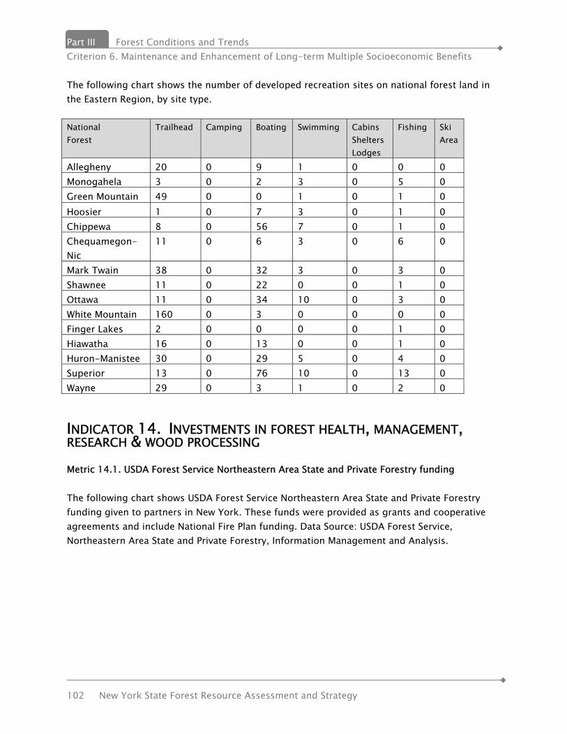
Part III Forest Conditions and Trends Criterion 6. Maintenance and Enhancement of Long-term Multiple Socioeconomic Benefits
102 New York State Forest Resource Assessment and Strategy
The following chart shows the number of developed recreation sites on national forest land in the Eastern Region, by site type. National Forest
Trailhead Camping Boating Swimming Cabins Shelters Lodges
Fishing Ski Area
Allegheny 20 0 9 1 0 0 0 Monogahela 3 0 2 3 0 5 0 Green Mountain 49 0 0 1 0 1 0 Hoosier 1 0 7 3 0 1 0 Chippewa 8 0 56 7 0 1 0 Chequamegon-Nic
11 0 6 3 0 6 0
Mark Twain 38 0 32 3 0 3 0 Shawnee 11 0 22 0 0 1 0 Ottawa 11 0 34 10 0 3 0 White Mountain 160 0 3 0 0 0 0 Finger Lakes 2 0 0 0 0 1 0 Hiawatha 16 0 13 0 0 1 0 Huron-Manistee 30 0 29 5 0 4 0 Superior 13 0 76 10 0 13 0 Wayne 29 0 3 1 0 2 0
INDICATOR 14. INVESTMENTS IN FOREST HEALTH, MANAGEMENT, RESEARCH & WOOD PROCESSING Metric 14.1. USDA Forest Service Northeastern Area State and Private Forestry funding The following chart shows USDA Forest Service Northeastern Area State and Private Forestry funding given to partners in New York. These funds were provided as grants and cooperative agreements and include National Fire Plan funding. Data Source: USDA Forest Service, Northeastern Area State and Private Forestry, Information Management and Analysis.
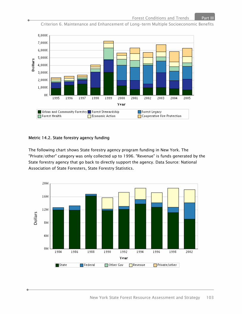
Forest Conditions and Trends Part III Criterion 6. Maintenance and Enhancement of Long-term Multiple Socioeconomic Benefits
New York State Forest Resource Assessment and Strategy 103
Metric 14.2. State forestry agency funding The following chart shows State forestry agency program funding in New York. The "Private/other" category was only collected up to 1996. "Revenue" is funds generated by the State forestry agency that go back to directly support the agency. Data Source: National Association of State Foresters, State Forestry Statistics.
Dol
lars

Part III Forest Conditions and Trends Criterion 6. Maintenance and Enhancement of Long-term Multiple Socioeconomic Benefits
104 New York State Forest Resource Assessment and Strategy
Beyond 2002, State funding continues to decline. Metric 14.3. Funding for forestry research The following chart shows funding for forestry research at universities in New York. Data Source: USDA Cooperative State Research, Education, and Extension Service (CSREES)
Metric 14.4. USDA Forest Service Research funding The following chart shows funding for USDA Forest Service Research in the Northern United States, by research station. Data Source: USDA Forest Service, Research and Development.

Forest Conditions and Trends Part III Criterion 6. Maintenance and Enhancement of Long-term Multiple Socioeconomic Benefits
New York State Forest Resource Assessment and Strategy 105
Metric 14.5. Capital expenditures by manufacturers of wood –related products The following chart shows capital expenditures by manufacturers of wood-related products in New York. Data for the logging sector are only available up to 1997. Data Source: U.S. Department of Commerce, Census Bureau, Economic Census.

Part III Forest Conditions and Trends Criterion 6. Maintenance and Enhancement of Long-term Multiple Socioeconomic Benefits
106 New York State Forest Resource Assessment and Strategy
INDICATOR 15. FOREST OWNERSHIP, LAND USE & SPECIALLY DESIGNATED AREAS Note: the metrics in this section deviate from the Montreal Process and have been reorganized to better explain the Indicator. Metric 15.1. Forest land ownership Area of forest land and number of forest owners Owner type Acres Owners Thousands Percent Thousands Private Family 11,252 60 614 Other Private 3,186 17 73 Public Federal 142 State 3,630 Local 459 Source: “Family Forest Owners of the United State, 2006” General Technical Report NRS-27. Metric 15.2. State Lands The majority of state land is in the following four categories: State Forests, Forest Preserve, Wildlife Management Areas and State Parks. The first three are managed by the NYS Department of Environmental Conservation. State Parks, including historic sites, are managed by the NY Office of Parks, Recreation and Historic Preservation. In addition, DEC owns/manages working forest Conservation Easements on private forest land. Detailed descriptions of the land classifications managed by DEC can be found on the Department’s website at http://www.dec.ny.gov/outdoor/7811.html.
Lands Managed by DEC Forest Preserve 2,861,000 acres State Forests 779,000 acres Wildlife Management Areas
202,000 acres
Education Centers and other
5,000 acres
Conservation Easements (private land)
765,000 acres
Total Managed 4,612,000

Forest Conditions and Trends Part III Criterion 6. Maintenance and Enhancement of Long-term Multiple Socioeconomic Benefits
New York State Forest Resource Assessment and Strategy 107
State Forests State Forests are located throughout New York State and include Reforestation Areas, Multiple-Use Areas, Unique Areas and State Nature and Historic Preserves. State Forests play a unique role in New York’s landscape because they: are managed under public ownership by professional foresters; allow for the sustainable use of natural resources; remain open to recreational use; and cover large land areas throughout the state. At their inception, the State Forests were set aside to offset widespread trends of agricultural abandonment and deforestation and restore the land’s ability to support vegetation. New York’s State Forests are green certified jointly by the Forest Stewardship Council (FSC) and Sustainable Forestry Initiative (SFI). Management of these lands can respond to today’s complex issues and ecological threats, such as shifting land use trends, invasive species and climate change. State Forests are set aside to provide a positive impact on water quality and ecosystem health, a proving ground for innovative forestry, an example to private landowners, and a balance to management driven by short term goals that sometimes occurs on private lands. Long term sustainability of the forested landscape requires the sort of steady ownership and consistent management that exists on State Forests.
On some of these lands, timber management is used as a tool to enhance biodiversity, create habitat features that might be lacking in the landscape, and provide a renewable supply of sustainably-harvested forest products. This timber management is adapted and modified to ensure that as many goals as possible are realized.
The high-quality timber harvested from State Forests is used by New York businesses and is often sent around the world in international markets. Some examples include: furniture quality hardwoods, softwoods for log cabins, fiber for paper making, firewood, animal bedding, wood
More than 90% of state-owned land and conservation easements with the state, some 4.6 million acres, are managed by DEC. Conservation easements are managed by DEC and allow public recreation activities on private forest land.
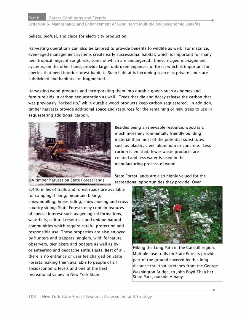
Part III Forest Conditions and Trends Criterion 6. Maintenance and Enhancement of Long-term Multiple Socioeconomic Benefits
108 New York State Forest Resource Assessment and Strategy
A timber harvest on State Forest lands
Hiking the Long Path in the Catskill region: Multiple-use trails on State Forests provide part of the ground covered by this long-distance trail that stretches from the George Washington Bridge, to John Boyd Thatcher State Park, outside Albany.
pellets, biofuel, and chips for electricity production. Harvesting operations can also be tailored to provide benefits to wildlife as well. For instance, even-aged management systems create early successional habitat, which is important for many neo-tropical migrant songbirds, some of which are endangered. Uneven-aged management systems, on the other hand, provide large, unbroken expanses of forest which is important for species that need interior forest habitat. Such habitat is becoming scarce as private lands are subdivided and habitats are fragmented. Harvesting wood products and incorporating them into durable goods such as homes and furniture aids in carbon sequestration as well. Trees that die and decay release the carbon that was previously “locked up,” while durable wood products keep carbon sequestered. In addition, timber harvests provide additional space and resources for the remaining or new trees to use in sequestering additional carbon.
Besides being a renewable resource, wood is a much more environmentally friendly building material than most of the potential substitutes such as plastic, steel, aluminum or concrete. Less carbon is emitted, fewer waste products are created and less water is used in the manufacturing process of wood. State Forest lands are also highly valued for the recreational opportunities they provide. Over
2,446 miles of trails and forest roads are available for camping, hiking, mountain biking, snowmobiling, horse riding, snowshoeing and cross country skiing. State Forests may contain features of special interest such as geological formations, waterfalls, cultural resources and unique natural communities which require careful protection and responsible use. These properties are also enjoyed by hunters and trappers, anglers, wildlife/nature observers, picnickers and boaters as well as by orienteering and geocache enthusiasts. Best of all, there is no entrance or user fee charged on State Forests making them available to people of all socioeconomic levels and one of the best recreational values in New York State.

Forest Conditions and Trends Part III Criterion 6. Maintenance and Enhancement of Long-term Multiple Socioeconomic Benefits
New York State Forest Resource Assessment and Strategy 109
State Forest Fact Sheet
State Forest Land Area
Reforestation Area 736,452 acres
779,645 acres
2.5% of New York’s total land area. Four times the size of New York City’s five boroughs.
Unique Area 22,112 acres
Multiple Use Area 16,071 acres
Miscellaneous: Natural Resource Management Area, Pine Bush, Tidal Wetland, etc.
5,010 acres
Boundary Lines
Boundary lines run adjacent to private land and often through deep woods. They are maintained, using yellow paint, signs and blazes at least once every seven years to make State land readily identifiable to recreationists and passersby while reducing unintentional trespass.
6,520 miles
Equivalent to a line from New York to the southern tip of South America
Public Forest Access Roads
Public forest access roads (PFARs), including over ten thousand culverts and bridges, are maintained so that the general public can safely enter State Forest lands with minimal environmental impact.
563 miles
Equivalent to all the city streets in both Albany and Binghamton
Trail-Based Recreation on Multiple Use Trails (includes PFARs, does not include municipal roads)
Hiking Trails 1,211 miles
2,446 miles *
* Total trail mileage. When multiple recreational uses overlap on a trail, the trail length is counted once in the total and once again for each of the uses.
Mountain Biking Trails 803 miles
Cross Country Ski Trails 881 miles
Equestrian Trails 762 miles
Snowmobile Trails 801 miles
RecreationFacilities
Trailheads / Parking Lots 705 State Forest facilities are usually of a more primitive and
Designated Campsites (additional dispersed camping is available across a majority of State Forest lands)
156

Part III Forest Conditions and Trends Criterion 6. Maintenance and Enhancement of Long-term Multiple Socioeconomic Benefits
110 New York State Forest Resource Assessment and Strategy
State Forest Fact Sheet
Boat Launches 18 undeveloped nature, in comparison with most parks and campgrounds.
Fishing Piers 6
Accessible Recreation Destinations – areas with facilities that are designed to provide access to nature for people with disabilities
27
MAPPWD Permit Routes
Motorized Access Program for People With Disabilities (MAPPWD) designated routes provide a means for permit holders to access recreational programs like hunting and fishing.
255 routes -within- 111 State Forests (incl. UA, MUA, etc.)
54 of 82 (66%) of UMP Units have at least one MAPPWD Route
Mineral Resources
Active well pads 132
Inactive well pads 76
Surface Mines (sand, gravel, etc.) 21
Historic & Cultural Resources
Un-inventoried resources including archaeological sites, fire towers, water holes, stone walls and foundations
Approx. 2,500
Water Resources
Streams by class
Class AA or A 145 miles
Class B 50 miles
Class C 1,449 miles
Class D 134 miles
Ponds, lakes, wetlands (incomplete inventory)
5,164 features 33,456 acres
Sustainable Forest Resources
Sustainable Harvest Threshold Level (Growth/year adjusted for mortality)
116,649 Mbf/year (Thousand board feet/year)
** 2% of the total value of forest products harvested from public and private lands in New York State each year
Annual harvesting (average annual rate over a ten year period)
Total 43,783 Mbf/year
Expressed as a percent of sustainable harvest threshold level
37.5%
Economic Contribution (average annual sales 1999-2008)
$5,317,564 **

Forest Conditions and Trends Part III Criterion 6. Maintenance and Enhancement of Long-term Multiple Socioeconomic Benefits
New York State Forest Resource Assessment and Strategy 111
Forest Preserve Of the 4.5 million acres of land managed by the Department of Environmental Conservation (DEC), nearly 3 million acres, or 63%, are classified as Forest Preserve. New York’s Forest Preserve is the largest state-designated wilderness in the country. Comprised of 2.6 million acres in the Adirondack Forest Preserve and 286,000 acres within the Catskill Forest Preserve, these lands represent a majority of all state owned property within the Adirondack and Catskill Parks. The two Parks were designated by the New York State legislature near the turn of the 20th century, and originally included only the state-owned Forest Preserve land. The description of each park was revised in 1912 to include ALL lands, both public and private, within the "Blue Line". This term is commonly used today, as blue is the color used on state maps to delineate the two parks. Protected as "forever wild" by Article XIV of the New York State Constitution, New York's Forest Preserve lands have exceptional scenic, recreational, and ecological value. Rugged mountain peaks, remote lakes and ponds, millions of acres of unfragmented forests, and nearly 2,000 miles of trails provide ample opportunity for many types of recreation while providing a variety of habitats for plants and wildlife. Striking a balance between recreational use and resource protection in the Forest Preserve is achieved through a park-wide land classification system and individual unit management plans. Forest Preserve lands are further broken down into categories based on their capacity to withstand use. These categories are defined in the 1987 (updated 2001) Adirondack Park State Land Master Plan (APSLMP) and/or the 1985 (updated 2008) Catskill Park State Land Master Plan (CPSLMP) depending on which Park(s) they are found in. These classifications are:
• Wilderness • Wild Forest • Canoe (Adirondacks only) • Primitive (Adirondacks only) • Primitive Bicycle Corridor (Catskills only)

Part III Forest Conditions and Trends Criterion 6. Maintenance and Enhancement of Long-term Multiple Socioeconomic Benefits
112 New York State Forest Resource Assessment and Strategy
• Intensive Use • Wild, Scenic and Recreational Rivers (Adirondacks only) • Travel Corridors (Adirondacks only) • Historic (Adirondacks only) • State Administrative
The Adirondack Park is a six-million acre patchwork of public and private lands located in northeastern New York. The area was designated in 1892 to protect the region from uncontrolled forest clearing that was common during the 1800s. Today, the Park contains a thriving mix of forests, wetlands, waterways, and human settlement. The Adirondack Forest Preserve is defined as the 2.6 million acres of state land within the Adirondack Park. Afforded constitutional protections that prevent the removal of timber, lands within New York's Forest Preserve are rich in both recreational opportunity and ecological significance. These public lands, which range from remote backcountry to DEC-operated campgrounds, include more than 1,800 miles of marked trails available for people of all interests and abilities. Depending on park-wide land classifications and specific unit management plans, there are a variety of opportunities for public enjoyment of the Forest Preserve, including hiking, camping, canoeing, hunting, fishing, trapping, snowmobiling, skiing, mountain biking, and rock climbing. The Catskill Park is a mountainous region of public and private lands in Southeastern New York's Ulster, Greene, Delaware and Sullivan Counties. Evidence of the area's unique natural history can be seen in the impressive skyline formed by the ninety-eight peaks over 3,000 feet in elevation. Human activities such as logging, quarrying, tanning, trapping, and fishing have also shaped the Park's more recent history. Today, tourism and recreation play a prominent role in both supporting the region's economy and creating an awareness of the Catskills' ecological significance. The Catskill Forest Preserve is defined as the 286,000 acres of state land within the Catskill Park. These public lands are primarily forested, but also include meadows, lakes, rivers, wetlands, waterfalls, cliffs, and many species of fish, wildlife, and plant life. The table below shows State Land Acreage by Classification (All figures are in acres except where noted. Table updated January 2009)

Forest Conditions and Trends Part III Criterion 6. Maintenance and Enhancement of Long-term Multiple Socioeconomic Benefits
New York State Forest Resource Assessment and Strategy 113
Land Classification
Catskill Park Total
Adirondack Park Total
State Total
Percent of Total
Easements
State Forest - 12,284 779,645 17%
Forest Preserve 285,533 2,581,372 2,878,187 63%
Wilderness 142,834 1,121,466 1,264,300 28%
Wild Forest 135,956 1,322,226 1,458,182 32%
Primitive - 67,772 67,772 1%
Primitive
298 - 298 0.01% Bicycle Corridor Canoe - 18,989 18,989 0.40% Intensive
5,662 20,590 26,252 0.60% Use Administrative 783 577 1,360 0.02% Historic - 530 530 0.01% Pending
- 29,222 29,222 0.60% Classification Detached
- - 11,282 0.20% Parcel Wildlife
- 2,870 197,236 4%
Management
Area Conservation
9,437 683,006 751,669 16% Easement
TOTALS: 294,970 3,276,662 4,606,737 100%

Part III Forest Conditions and Trends Criterion 6. Maintenance and Enhancement of Long-term Multiple Socioeconomic Benefits
114 New York State Forest Resource Assessment and Strategy
Wildlife Management Areas Wildlife Management Areas (WMAs) are lands owned by New York State under the control and management of the Department of Environmental Conservation's Division of Fish, Wildlife and Marine Resources. These lands have been acquired primarily for the production and use of wildlife. The WMA program is part of a long term effort to establish permanent access to lands in New York State for the protection and promotion of its fish and wildlife resources. Beginning in the early 1900s with the acquisition of abandoned farm lands and fields, DEC and its predecessor (NYS Conservation Department) have worked with the federal government, state government and sportsmen and women to secure these land parcels for public use. Money used to acquire lands included in the WMA system has been a combination of state and federal funding. The Conservation Fund, begun in 1925, was the first dependable source followed by two federal programs in the 1930s: 1) the Federal Resettlement Administration bought marginal and worn-out farmland and later donated it to the state for wildlife management purposes, and 2) the Pittman-Robertson Act, still in effect today, places an excise tax on guns and ammunition to fund restoration and management efforts for wildlife, including purchase of habitat. In addition, several New York State Bond Acts (1960, 1972 and 1986) have also helped expand the WMA system. WMA sign WMAs provide unique areas for the public to interact with a wide variety of wildlife species. Since sportsmen and women have funded the acquisition of a large portion of the WMAs through their license fees and the federal tax on guns and ammunition, the emphasis is on game species. However, while fishing, hunting and trapping are the most widely practiced activities on many WMAs, they are not limited to these activities. Most WMAs also provide good opportunities for hiking, cross-country skiing, birdwatching, or just enjoying nature. WMAs also provide areas for research on various wildlife species. A grouse study conducted on Connecticut Hill WMA is considered the standard reference on ruffed grouse in the Northeast. In addition, habitat management methods and techniques such as mowing, use of controlled burns, and planting of wildlife shrubs and food plots have been established and refined on WMAs. State Parks and Historic Sites The first state park in the country was designated at Niagara Falls (established as a State

Forest Conditions and Trends Part III Criterion 6. Maintenance and Enhancement of Long-term Multiple Socioeconomic Benefits
New York State Forest Resource Assessment and Strategy 115
Reservation in 1883). It was soon followed by other State Parks such as the Palisades along the Hudson River, the natural springs at Saratoga Springs and the Genesee River Gorge at Letchworth State Park, known as the “Grand Canyon of the East.” The NYS Office of Parks, Recreation and Historic Preservation (OPRHP) is responsible for management of State Parks and Historic Sites throughout the state. ORPHP oversees 178 parks covering 324,000 acres and 35 Historic Sites covering 7,000 acres. State Parks are established for the public to visit, enjoy and appreciate natural, cultural and physical resources and recreational opportunities, including beaches, boat launches, hiking trails, campgrounds, and golf courses. Balance is sought between recreational use, and protection of biological, physical and cultural resources. There is a combination of developed areas and forest areas. OPRHP’s policy on the forested areas is to leave them alone except for issues involving invasives or hazards. By policy, these lands are not open to any commercial timber management or harvesting. Metric 15.3 Private Protected Land Forest Legacy Program Development of the nation’s forested areas poses an increasing threat to maintaining the integrity of our country’s valuable forest lands. Intact forest lands supply timber products, wildlife habitat, soil and watershed protection, aesthetics, and recreational opportunities. However, as these areas are fragmented and disappear, so do the benefits they provide. The purpose of the Forest Legacy Program (FLP) is to protect environmentally important forest areas that are threatened by conversion to nonforest uses. The FLP is a partnership between participating states and the Forest Service, U.S. Department of Agriculture. These two entities work together to identify important forest lands and protect them for future generations. The State Forest Stewardship Coordinating Committee (SFSCC) authorized the Forest Legacy Subcommittee to act on behalf of the full SFSCC on all Forest Legacy matters. The Forest Legacy Subcommittee provides guidance on the Assessment of Need and prioritizes the State’s submission of annual projects to the US Forest Service. Conservation easements are the primary tool used to achieve this goal. Priority is given to lands that have important scenic or recreational values: riparian areas; fish and wildlife values, including threatened and endangered species; or other ecological values. Designed to encourage the protection of privately owned forest lands, FLP is an entirely voluntary program. It encourages and supports acquisition of conservation easements, legally binding agreements transferring a negotiated set of property rights from one party to another, without removing the property from private ownership. Most FLP conservation easements

Part III Forest Conditions and Trends Criterion 6. Maintenance and Enhancement of Long-term Multiple Socioeconomic Benefits
116 New York State Forest Resource Assessment and Strategy
restrict building development, require sustainable forestry practices, and protect other values. The FLP also supports fee-title land purchases in a limited number of situations where necessary to accomplish the Program’s objectives. Eligibility Criteria The FLP in New York focuses on acquisition of development and other rights that, if exercised, could threaten the traditional uses and values of the forests, including timber harvesting, public recreation, water quality, scenic quality, and wildlife habitat. With these objectives in mind, it was determined that a Forest Legacy Area (FLA) in New York should:
• include forested land threatened by present or future conversion to a non-forest use; • contain at least 50% land that meets the definition of forest land; • provide opportunities for the continuation of traditional uses; • be identified in the most recent New York State Open Space Plan as a major resource
area or priority project area; and • contain three or more of the following public values:
o public recreation opportunities; o riparian areas/wetlands; o important fish and wildlife habitat including known threatened and endangered
species; o cultural areas such as areas of historical or archeological significance; o other ecological values; o scenic resources; and/or o important plant communities.
In addition to the above criteria, which follow the federal eligibility criteria, FLA designations made after 1994 must be identified in the state Open Space Conservation Plan as a major resource area and/or protection priority.
Current Forest Legacy Areas • Northern Forest Lands Study Area (1994 AON) • Taconic Ridge (1994 AON) • New York Highlands and Sterling Forest (1994 AON) • Central Long Island Pine Barrens (1994 AON) • Catskill/Delaware New York City Watershed (1998 Amended AON)
Proposed Forest Legacy Areas • Rensselaer Plateau • Catskill Park Expansion to Catskill/Delaware NYC watershed
Potential Future Forest Legacy Areas • Allegheny Plateau • Finger Lakes/Northern Plateau

Forest Conditions and Trends Part III Criterion 6. Maintenance and Enhancement of Long-term Multiple Socioeconomic Benefits
New York State Forest Resource Assessment and Strategy 117
Each state is required to develop an Assessment of Need (AON) with includes Eligibility Criteria; identification of specific FLAs for designation; specific goals and objectives to be accomplished by the FLP; and the process to be used by the State to evaluate and prioritize projects to be considered for inclusion in the FLP. New York has concluded that the Forest Legacy Program (FLP) will request an amended AON to include the Rensselaer Plateau and expansion to the NYC watershed as part of this document. Eligibility criteria will remain the same as in the previous Amended AON which was approved on December 10, 1998, which is hereby incorporated into this document by reference. The original AON was approved on October 26, 1994. A copy of the State Lead Agency designation letter, the AON, and the AON approval letter are on file at the New York State Department of Environmental Conservation, Division of Lands and Forests in Albany. See the appendices for the request for an amended AON.
Conservation Easements Use of conservation easements is a method of protecting land from some uses and activities while keeping the land in private ownership. Conservation easements are generally used to protect land from building development and any of the following: water quality, wildlife habitat, endangered and threatened species, recreation opportunities, and significant ecosystems, viewscapes and cultural resources. Many conservation easements allow forestry practices to continue.

Part III Forest Conditions and Trends Criterion 6. Maintenance and Enhancement of Long-term Multiple Socioeconomic Benefits
118 New York State Forest Resource Assessment and Strategy
Conservation Easements are the preferred method of protection in the Forest Legacy Program. They are also one of the recommended conservation tools in the State Open Space Conservation Plan. In addition to state-owned conservation easements, private land trusts and other organizations hold conservation easements but the data is not available in a comprehensive format. The first national database of conservation easement data is in development. Five organizations, Conservation Biology Institute, Defenders of Wildlife, Ducks Unlimited, NatureServe and the Trust for Public Land will collaborate with land trusts and public agencies to create a user–friendly, highly interactive web–based system for uploading and viewing easement data. Maps, statistics, and reports from the database will support sound planning and policy–making for conservation, natural resource management, and development. The goal is to create a single, up–to–date, sustainable nationwide system for managing and accessing data about conservation easements, which ensure long–term protection of privately–owned lands. When completed, the National Conservation Easement Database (NCED) will provide the first comprehensive picture of the estimated 40 million acres of privately–owned conservation easement lands in the United States, recognizing the important contribution they make to America’s natural heritage, a vibrant economy, and healthy communities. Designed to be voluntary and secure, the NCED will respect landowner privacy, and will not collect landowner names or sensitive information. More information on this can be found at http://www.natureserve.org/projects/nced.jsp. Metric 15.4 Private Lands Nearly 80% of the state’s 18.9 million acres of forest lands are owned by more than 687,000 private landowners. Covering approximately 14.4 million acres these lands represent 76% of New York’s forest land. In 1994, the number of private owners was 491,300 covering virtually the same 14.4 million acres. “Private forest owners” also includes non-industrial owners (hunting clubs, partnerships, non-forest industry corporations) and forest industry. More than 11.2 million acres of these lands are considered as “family owned” forests. Clearly, the future of New York’s forests and the benefits
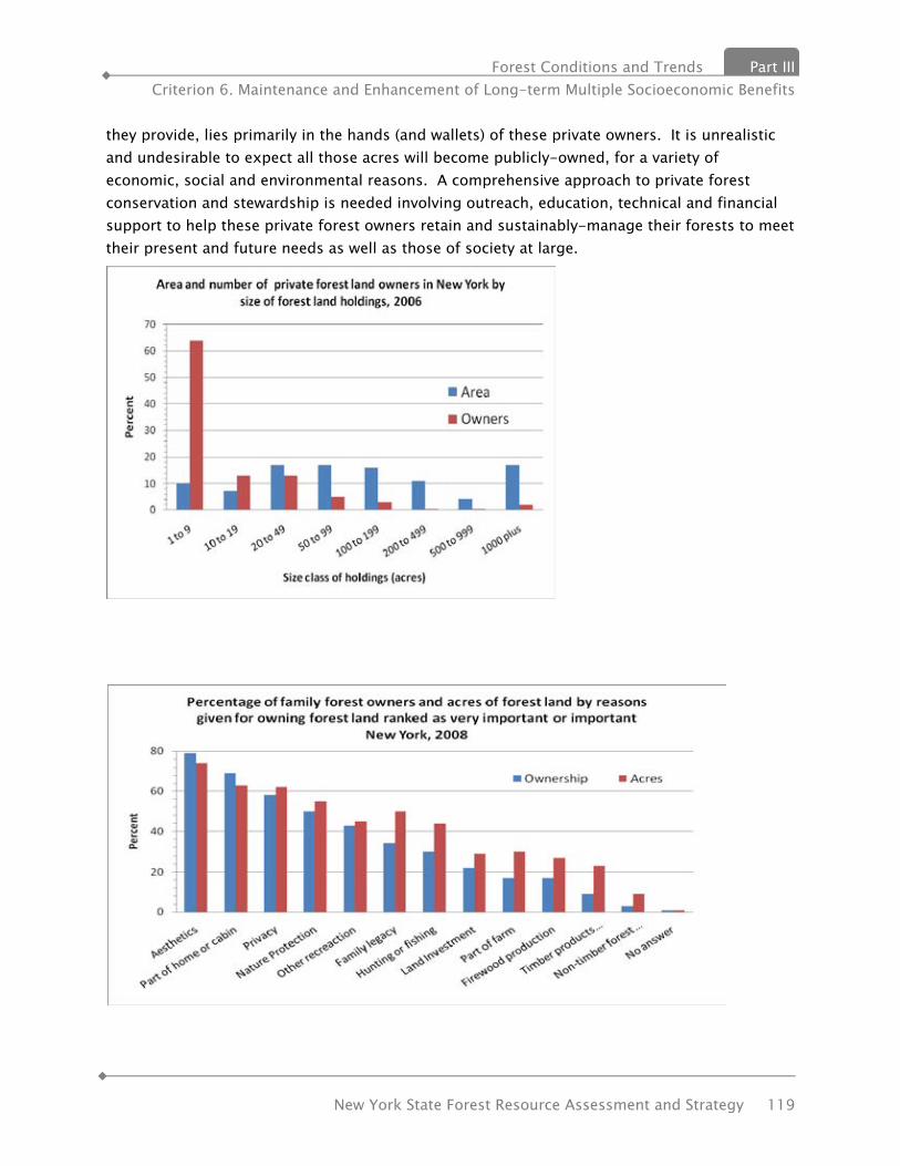
Forest Conditions and Trends Part III Criterion 6. Maintenance and Enhancement of Long-term Multiple Socioeconomic Benefits
New York State Forest Resource Assessment and Strategy 119
they provide, lies primarily in the hands (and wallets) of these private owners. It is unrealistic and undesirable to expect all those acres will become publicly-owned, for a variety of economic, social and environmental reasons. A comprehensive approach to private forest conservation and stewardship is needed involving outreach, education, technical and financial support to help these private forest owners retain and sustainably-manage their forests to meet their present and future needs as well as those of society at large.
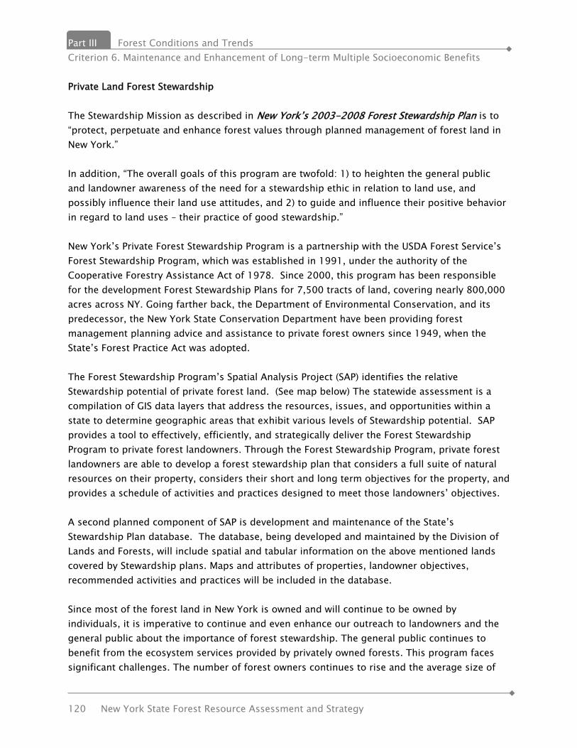
Part III Forest Conditions and Trends Criterion 6. Maintenance and Enhancement of Long-term Multiple Socioeconomic Benefits
120 New York State Forest Resource Assessment and Strategy
Private Land Forest Stewardship The Stewardship Mission as described in New York’s 2003-2008 Forest Stewardship Plan is to “protect, perpetuate and enhance forest values through planned management of forest land in New York.” In addition, “The overall goals of this program are twofold: 1) to heighten the general public and landowner awareness of the need for a stewardship ethic in relation to land use, and possibly influence their land use attitudes, and 2) to guide and influence their positive behavior in regard to land uses – their practice of good stewardship.” New York’s Private Forest Stewardship Program is a partnership with the USDA Forest Service’s Forest Stewardship Program, which was established in 1991, under the authority of the Cooperative Forestry Assistance Act of 1978. Since 2000, this program has been responsible for the development Forest Stewardship Plans for 7,500 tracts of land, covering nearly 800,000 acres across NY. Going farther back, the Department of Environmental Conservation, and its predecessor, the New York State Conservation Department have been providing forest management planning advice and assistance to private forest owners since 1949, when the State’s Forest Practice Act was adopted. The Forest Stewardship Program’s Spatial Analysis Project (SAP) identifies the relative Stewardship potential of private forest land. (See map below) The statewide assessment is a compilation of GIS data layers that address the resources, issues, and opportunities within a state to determine geographic areas that exhibit various levels of Stewardship potential. SAP provides a tool to effectively, efficiently, and strategically deliver the Forest Stewardship Program to private forest landowners. Through the Forest Stewardship Program, private forest landowners are able to develop a forest stewardship plan that considers a full suite of natural resources on their property, considers their short and long term objectives for the property, and provides a schedule of activities and practices designed to meet those landowners’ objectives. A second planned component of SAP is development and maintenance of the State’s Stewardship Plan database. The database, being developed and maintained by the Division of Lands and Forests, will include spatial and tabular information on the above mentioned lands covered by Stewardship plans. Maps and attributes of properties, landowner objectives, recommended activities and practices will be included in the database. Since most of the forest land in New York is owned and will continue to be owned by individuals, it is imperative to continue and even enhance our outreach to landowners and the general public about the importance of forest stewardship. The general public continues to benefit from the ecosystem services provided by privately owned forests. This program faces significant challenges. The number of forest owners continues to rise and the average size of

Forest Conditions and Trends Part III Criterion 6. Maintenance and Enhancement of Long-term Multiple Socioeconomic Benefits
New York State Forest Resource Assessment and Strategy 121
forest parcels continues to shrink. Development pressure and the expense of owning land are factors in landowners selling their forestland for development.
“Other” management plans include tax law plans, harvesting plans and management plans not meeting Federal Stewardship Plan standards.
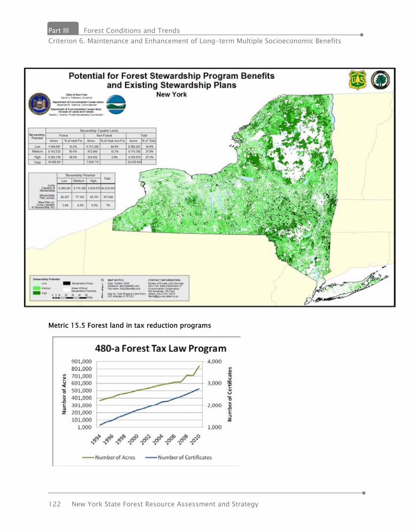
Part III Forest Conditions and Trends Criterion 6. Maintenance and Enhancement of Long-term Multiple Socioeconomic Benefits
122 New York State Forest Resource Assessment and Strategy
Metric 15.5 Forest land in tax reduction programs
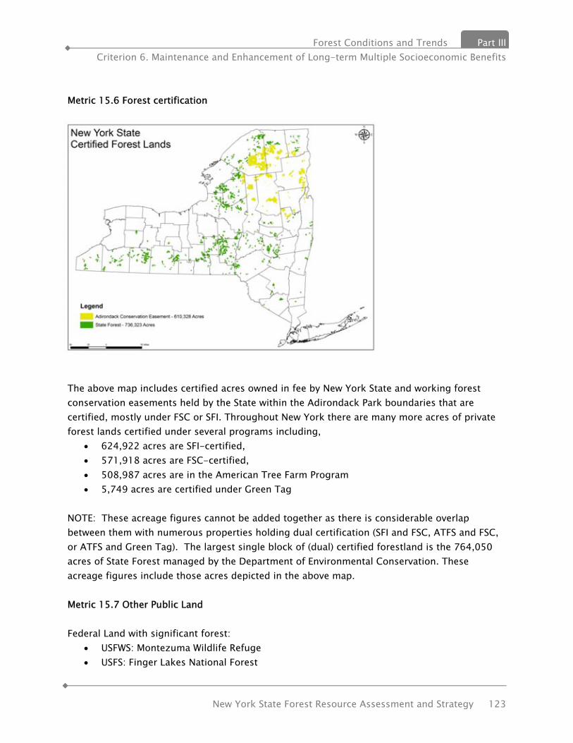
Forest Conditions and Trends Part III Criterion 6. Maintenance and Enhancement of Long-term Multiple Socioeconomic Benefits
New York State Forest Resource Assessment and Strategy 123
Metric 15.6 Forest certification
The above map includes certified acres owned in fee by New York State and working forest conservation easements held by the State within the Adirondack Park boundaries that are certified, mostly under FSC or SFI. Throughout New York there are many more acres of private forest lands certified under several programs including,
• 624,922 acres are SFI-certified, • 571,918 acres are FSC-certified, • 508,987 acres are in the American Tree Farm Program • 5,749 acres are certified under Green Tag
NOTE: These acreage figures cannot be added together as there is considerable overlap between them with numerous properties holding dual certification (SFI and FSC, ATFS and FSC, or ATFS and Green Tag). The largest single block of (dual) certified forestland is the 764,050 acres of State Forest managed by the Department of Environmental Conservation. These acreage figures include those acres depicted in the above map. Metric 15.7 Other Public Land Federal Land with significant forest:
• USFWS: Montezuma Wildlife Refuge • USFS: Finger Lakes National Forest

Part III Forest Conditions and Trends Criterion 6. Maintenance and Enhancement of Long-term Multiple Socioeconomic Benefits
124 New York State Forest Resource Assessment and Strategy
• DOD: West Point, Fort Drum Montezuma Wildlife Refuge Montezuma National Wildlife Refuge was established on September 12, 1938 as a refuge and breeding ground for migratory birds and other wildlife. The refuge provides resting, feeding, and nesting habitat for waterfowl and other migratory birds. Montezuma is situated in the middle of one of the most active flight lanes in the Atlantic Flyway. It is located at the north end of Cayuga Lake in the Finger Lakes Region of New York State. The Refuge contains 7,068 acres and is situated in Seneca, Wayne, and Cayuga Counties. Finger Lakes National Forest The Finger Lakes National Forest (FLNF) consists of over 16,000 acres located in central New York within Seneca and Schuyler Counties. The Forest provides a diverse mix of public land use opportunities including various recreation activities, grazing, wildlife habitat, clean water, and wood products. The USDA Forest Service administers the FLNF, aided by partners, other agencies, and individual volunteers. The FLNF has a local office in the town of Hector, with the administrative headquarters for the Forest currently located in Rutland, Vermont. West Point West Point has about 12,736 acres of forest land. It is the first and currently the only Army installation certified by the American Tree Farm System to have and maintain a tree farm, which has been going strong for 22 years. West Point is also a Tree City U.S.A. Fort Drum Fort Drum contains 107,265 total acres. The primary purpose of the Fort Drum Forest Management Program is to manage the installation’s 74,000 forested lands to support the Army training mission and to enhance ecosystem integrity through sound forest management practices. Additional objectives include the annual production of commercial forest products, enhancement of forested habitats to benefit wildlife, protection of watersheds, and increased opportunities for outdoor recreation. Forest management on Fort Drum is concerned with maintaining and enhancing the diversity of the forested ecosystem. This diversity allows the trainers access to different types of land formations and vegetative structures in order to provide optimal conditions for all training scenarios

Forest Conditions and Trends Part III Criterion 6. Maintenance and Enhancement of Long-term Multiple Socioeconomic Benefits
New York State Forest Resource Assessment and Strategy 125
INDICATOR 16. EMPLOYMENT AND WAGES IN FOREST-RELATED SECTORS New York’s forest products industry is as diverse as any other state in the country, with businesses ranging from pulp and paper mills, sawmills, biomass energy plants, secondary manufacturing of almost every type, as well as the foresters and logging/trucking contractors who produce raw materials and deliver them to market. As each year passes, however, challenges mount and those in the industry who continue to do well are not fearful of trying new methods, investing in the latest equipment and seeking out the best employees. Challenges being experienced by all sectors result from global competition, high energy costs and other business related costs. In addition, natural factors also provide challenges. For example, quarantines as a result of exotic and invasive forest pests cause significant challenges to operating as business as usual. Highlights
• The annual contribution of forest-based manufacturing and forest-related recreation and tourism to the New York economy is over $11.0 billion.
• Forest-based manufacturing contributes $9.1 billion in value of shipments to the economy in 2008, or 4.5 % of New York’s total manufacturing sales.
• The forest-based sector provides employment for 49,200 people and generates a payroll of over $1.6 billion.
• Forest-based recreation and tourism provides employment for over 14,600 and generates payrolls of $300 million.
• Revenues from forest-related recreation and tourism activities totaled $1.9 billion in 2005.
• New York rural landowners received estimated stumpage revenue in 2008 of over $225 million.
• The sale of Christmas trees, wreaths, and maple syrup contributed approximately $25 million in 2005.
(The Economic Importance of Wood Flows from New York’s Forests, 2007. Northeast State Foresters Association. http://www.dec.ny.gov/docs/lands_forests_pdf/economic.pdf ) New York’s forest-related sectors in terms of timber and forest products production consists of:
• forest management • timber harvesting and associated trucking • primary manufacturing • secondary manufacturing • associated forest products

Part III Forest Conditions and Trends Criterion 6. Maintenance and Enhancement of Long-term Multiple Socioeconomic Benefits
126 New York State Forest Resource Assessment and Strategy
Measuring the Importance of the Forest Products Industry in New York State The Empire State Development Corporation( ESDC) has identified and defined 16 industry clusters in the state. The clusters framework is increasingly used by the State of New York to study important industry linkages in the state and regional economies. The Forest Industry is recognized as one of the sixteen industry clusters in New York. It is currently ranked 14 of 16 using the following criteria:
• Total Employment; • Total Wages; • Average Wage; and • Location Quotient
Clusters are also analyzed and ranked by ten Department of Labor defined labor market regions The forest industry is currently ranked 5th in the North Country region of the the state, which includes the Adirondack and Tug Hill regions of the state as well as the St. Lawrence and Champlain Valleys. While most regions of the state rank in the bottom third of all clusters, four regions have the forest industry ranking 5th or better in the location quotient criteria. These regions are; Central New York Western New York Mohawk Valley Capital District Metric 16.1. Wood-related products manufacturing employment Total forest sector employment has declined from 55,218 in 2002 to 49,218 in 2008, a decrease of 11%. The chart above indicates employment breakout by industry sub-sector. Note that the Forestry and Logging sub-sector employment was the only sector to increase during this period.
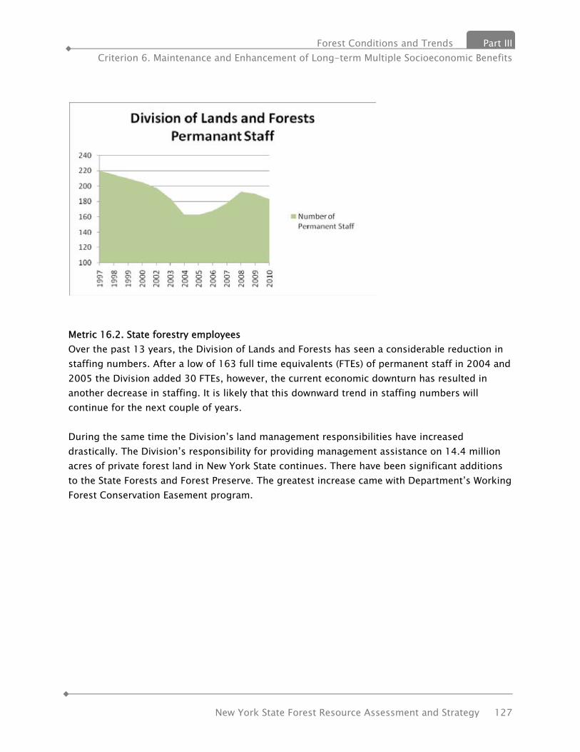
Forest Conditions and Trends Part III Criterion 6. Maintenance and Enhancement of Long-term Multiple Socioeconomic Benefits
New York State Forest Resource Assessment and Strategy 127
Metric 16.2. State forestry employees Over the past 13 years, the Division of Lands and Forests has seen a considerable reduction in staffing numbers. After a low of 163 full time equivalents (FTEs) of permanent staff in 2004 and 2005 the Division added 30 FTEs, however, the current economic downturn has resulted in another decrease in staffing. It is likely that this downward trend in staffing numbers will continue for the next couple of years. During the same time the Division’s land management responsibilities have increased drastically. The Division’s responsibility for providing management assistance on 14.4 million acres of private forest land in New York State continues. There have been significant additions to the State Forests and Forest Preserve. The greatest increase came with Department’s Working Forest Conservation Easement program.
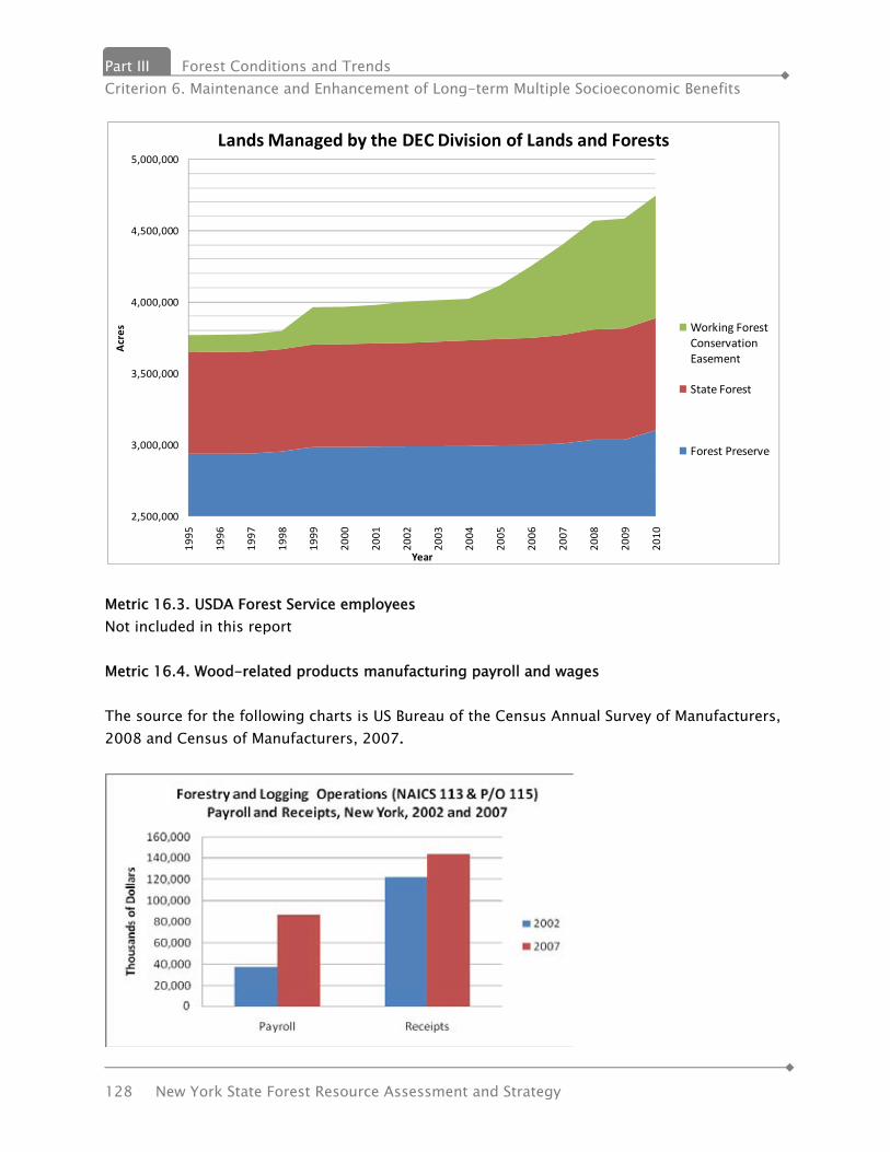
Part III Forest Conditions and Trends Criterion 6. Maintenance and Enhancement of Long-term Multiple Socioeconomic Benefits
128 New York State Forest Resource Assessment and Strategy
Metric 16.3. USDA Forest Service employees Not included in this report Metric 16.4. Wood-related products manufacturing payroll and wages The source for the following charts is US Bureau of the Census Annual Survey of Manufacturers, 2008 and Census of Manufacturers, 2007.
2,500,000
3,000,000
3,500,000
4,000,000
4,500,000
5,000,000
1995
1996
1997
1998
1999
2000
2001
2002
2003
2004
2005
2006
2007
2008
2009
2010
Acres
Year
Lands Managed by the DEC Division of Lands and Forests
Working Forest Conservation Easement
State Forest
Forest Preserve
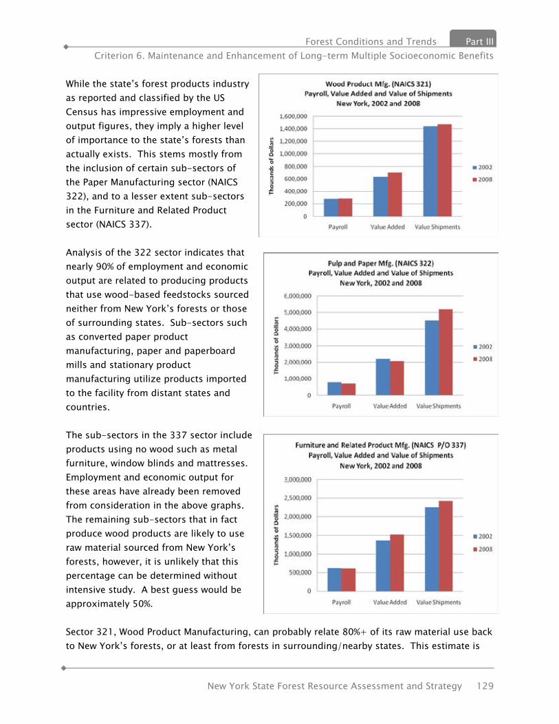
Forest Conditions and Trends Part III Criterion 6. Maintenance and Enhancement of Long-term Multiple Socioeconomic Benefits
New York State Forest Resource Assessment and Strategy 129
While the state’s forest products industry as reported and classified by the US Census has impressive employment and output figures, they imply a higher level of importance to the state’s forests than actually exists. This stems mostly from the inclusion of certain sub-sectors of the Paper Manufacturing sector (NAICS 322), and to a lesser extent sub-sectors in the Furniture and Related Product sector (NAICS 337). Analysis of the 322 sector indicates that nearly 90% of employment and economic output are related to producing products that use wood-based feedstocks sourced neither from New York’s forests or those of surrounding states. Sub-sectors such as converted paper product manufacturing, paper and paperboard mills and stationary product manufacturing utilize products imported to the facility from distant states and countries. The sub-sectors in the 337 sector include products using no wood such as metal furniture, window blinds and mattresses. Employment and economic output for these areas have already been removed from consideration in the above graphs. The remaining sub-sectors that in fact produce wood products are likely to use raw material sourced from New York’s forests, however, it is unlikely that this percentage can be determined without intensive study. A best guess would be approximately 50%. Sector 321, Wood Product Manufacturing, can probably relate 80%+ of its raw material use back to New York’s forests, or at least from forests in surrounding/nearby states. This estimate is
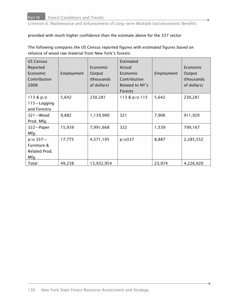
Part III Forest Conditions and Trends Criterion 6. Maintenance and Enhancement of Long-term Multiple Socioeconomic Benefits
130 New York State Forest Resource Assessment and Strategy
provided with much higher confidence than the estimate above for the 337 sector The following compares the US Census reported figures with estimated figures based on reliance of wood raw material from New York’s forests:
US Census Reported Economic Contribution 2008
Employment
Economic Output (thousands of dollars)
Estimated Actual Economic Contribution Related to NY’s Forests
Employment
Economic Output (thousands of dollars)
113 & p/o 115—Logging and Forestry
5,642 230,281 113 & p/o 115 5,642 230,281
321—Wood Prod. Mfg.
9,882 1,139,900 321 7,906 911,920
322—Paper Mfg.
15,939 7,991,668 322 1,539 799,167
p/o 337—Furniture & Related Prod. Mfg.
17,775 4,571,105 p/o337 8,887 2,285,552
Total 49,238 13,932,954 23,974 4,226,920

Forest Conditions and Trends Part III Criterion 7. Legal, Institutional & Economic Framework for Forest Conservation & Sustainable
Management
New York State Forest Resource Assessment and Strategy 131
Criterion 7 – Legal, Institutional & Economic Framework for Forest Conservation & Sustainable Management
State The body of law that established the Department of Environmental Conservation (DEC) and authorizes its programs is called Environmental Conservation Law (ECL). The full text of New York's ECL is found on the New York State Legislative Information System webpage location at: http://public.leginfo.state.ny.us/menugetf.cgi?COMMONQUERY=LAWS. DEC is responsible for administration and enforcement of the ECL. The Department's major responsibilities as assigned in Environmental Conservation Law and as related to forests are:
• Conduct sound forestry management practices on state lands, provide assistance to private forest landowners and manage fire prevention and control efforts;
• Manage the Adirondack and Catskill forest preserve and recreational facilities, including campsites and the Belleayre Mountain ski center;
• Inform the public about environmental conservation principles and encourage their participation in environmental affairs.
The ECL it is made up of broad provisions that are defined and made explicit through regulations. Those regulations which pertain to Lands and Forests can be found on the Department’s website at www.dec.ny.gov. New York’s Forest Practice Act of 1946 authorizes forestry assistance to private forest owner. It encourages the practice of forestry, so that damage to the environment caused by unplanned overcutting might be avoided and that the industries of the state dependent upon forest products might be stabilized as far as possible. New York’s Forest Preserve lands are protected as "forever wild" by Article XIV of the New York State Constitution. New York’s Forest Preserve is the largest state-designated wilderness in the country. Federal The federal Cooperative Forestry Assistance Act of 1978 (CFAA) provides the foundation for cooperative forestry programs implemented by states with federal support. The CFAA authorizes programs including Rural Forestry Assistance, Forest Stewardship, Forest Legacy, Forest Health Protection, Urban and Community Forestry, Rural Fire Prevention & Control and Community Fire protection.
Part III Forest Conditions and Trends Criterion 7. Legal, Institutional, and Economic Framework for Forest Conservation & Sustainable Management
132 New York State Forest Resource Assessment and Strategy
The Forest Stewardship Program (FSP), encourages active management by private landowners of their forested lands and related resources. In cooperation with State forestry agencies and the State Forest Stewardship Coordinating Committee, the FSP promotes a healthy sustainable forest, forest stewardship and sustainable economic development. The Forest Resource Management program provides technical assistance and information to non-federal forest owners. This program promotes healthy sustainable forests and sustainable economic development of forest resources. The Reforestation, Nursery & Genetic Resources program ensures an adequate supply of high quality, reasonably priced planting stock for reforestation and conservation programs. Federal assistance supports modernization, training and new technology for nursery, tree improvement and reforestation programs. Local New York is a “home rule” state. This means local governments have local control over land use. Zoning and lack of it has a powerful impact on the development of a community: what can be developed, how it can be developed and where it can be developed. For instance, a town can require a minimum size for a residential building lot, say 5 acres. Relative to smaller lot sizes, this results in development of a greater amount of open space per household and a greater cost by the community per household for services: sewer, water, road maintenance, etc. With proper planning, local communities can save money and provide for quality of life issues such as public greenspace and centralized business district.
INDICATOR 17. FOREST MANAGEMENT STANDARDS/GUIDELINES Metric 17.1. Types of forest management standards/guidelines Metric 17.2. Voluntary and mandatory standards/guidelines Metric 17.3. Monitoring of standards/guidelines
a. Public Lands Policies & Plans b. Forest Stewardship program
Forest management standards and guidelines are compilations of the current “state-of-the-art” and best scientific understanding of how to sustainably manage forests to ensure they can provide and protect ALL their values, goods and services, for present and future generations. They can be voluntary or mandatory, public or private, prescriptive or advisory. Where standards and guidelines apply depends on the framework within which they were developed and adopted.

Forest Conditions and Trends Part III Criterion 7. Legal, Institutional & Economic Framework for Forest Conservation & Sustainable
Management
New York State Forest Resource Assessment and Strategy 133
In New York, we have standards embodied in: • Federal law, • State laws • local (town) ordinances and regulations, • private certification schemes, (Sustainable Forestry Initiative, Forest Stewardship
Council, American Tree Farm System, Green Tag) • recognition programs (Tree City USA, Tree Line USA, Important Bird Areas, Natural
Heritage Program, etc.) The goal of all forest management standards and guidelines is to place some sideboards on the range of potential forest management decisions; discouraging or prohibiting those practices currently believed to be detrimental and encouraging those currently believed to be beneficial to society’s long-term interests.
Federal laws and standards USDA Forest Stewardship Program National Standards and Guidelines The purpose of the Forest Stewardship Program is to encourage the long-term stewardship of nonindustrial private forest lands, by assisting the owners of such lands to more actively manage their forest and related resources. The Forest Stewardship Program provides assistance to owners of forest land and other lands where good stewardship, including agroforestry applications, will enhance and sustain the long term productivity of multiple forest resources. The program provides landowners with the professional planning and technical assistance they need to keep their land in a productive and healthy condition. The planning assistance offered through the Forest Stewardship Program may also provide landowners with enhanced access to other USDA conservation programs and/or forest certification programs. The Forest Stewardship Program is authorized by the Cooperative Forestry Assistance Act of 1978, as amended, 16 U.S.C. 2103A. These standards and guidelines are intended to assist State and Territorial partners with the implementation of this authority and to provide supplemental guidance, as appropriate, to achieve intended program outcomes. A Forest Stewardship Management Plan addresses individual landowner objectives while adhering to National and State Forest Stewardship Management Plan guidelines. State guidelines must consider the NASF Principles and Guides for a Well-Managed Forest. A general outline for plans, actions and progress, as relating to these principles, can be found in NASF’s A Stewardship Handbook.

Part III Forest Conditions and Trends Criterion 7. Legal, Institutional, and Economic Framework for Forest Conservation & Sustainable Management
134 New York State Forest Resource Assessment and Strategy
The Federal Clean Water Act The Federal Clean Water Act requires States to develop non-point source pollution prevention plans covering all categories of potential non-point water pollution, including silvicultural activities. New York’s Silvicultural Non-point pollution prevention plan calls for a mix of outreach, education and voluntary “best management practices for timber harvesting” to minimize and address this potential pollution source. In 2000, the Empire State Forest Products Association, the NYC Watershed Agricultural Council’s Watershed Forestry Program, the NYS Department of Environmental Conservation jointly developed a pocket field guide of “New York State Forestry Best Management Practices for Water Quality”. This guide book has been an extremely popular and effective tool used by timber harvesters, professional foresters and forest landowners
New York State and Local Standards and Guidelines New York is a “home-rule” State which means each jurisdiction or political subdivision (i.e.: town) has the ability, within limits, to adopt regulations that could extend to forest management activities. New York’s 1980 State Forest Resources Assessment, Report, Number 17, catalogued all State laws, rules and regulations, at that time, related to forests and forestry and those related to fish and wildlife (since forests critical habitats for most wildlife). Since that time, we have seen a significant increase in the number of local regulations and ordinances that affect or impact timber harvesting and forestry activities, however a comprehensive and accurate list of those local ordinances does not exist. The following are the principal programs and regulations in New York that embody forest management standards and guidelines or regulate forestry activities:
• NYS Forest Tax Law (RPTL Section 480-a) • NYS Forestry Best Management Practices for Water Quality • Silvicultural Management Practices for Nonpoint Source Pollution Prevention and Water
Quality Protection • NYS Forest Practice Board Standards • NYS Environmental Conservation Law regulations:
o water quality, o wetlands, o stream crossings, o fire prevention, o insects and diseases,
Forest Conditions and Trends Part III Criterion 7. Legal, Institutional & Economic Framework for Forest Conservation & Sustainable
Management
New York State Forest Resource Assessment and Strategy 135
o pesticides, o rare, threatened and endangered species habitats, o Wild, Scenic and Recreational Rivers
• Strategic Plan for State Forest Management • Adirondack Park State Land Master Plan • Catskill Park State Land Master Plan
Private Certification Programs American Tree Farm System (ATFS) http://www.treefarmsystem.org/cms/pages/26_19.html Sustainable Forestry Initiative (SFI) http://www.sfiprogram.org Forest Stewardship Council (FSC) http://www.fscus.org Program for Endorsement of Forest Certification (PEFC) http://www.pefc.org Private forest certification systems develop their own criteria, standards and indicators of forest sustainability and some offer independent, third-party verification of participating landowners’ compliance with their requirements.
• 624,922 acres are SFI-certified, • 571,918 acres are FSC-certified, • 508,987 acres are in the American Tree Farm Program • 5,749 acres are certified under Green Tag
NOTE: These acreage figures cannot be added together as there is considerable overlap between them with numerous properties holding dual certification (SFI and FSC, ATFS and FSC, or ATFS and Green Tag). The largest single block of (dual) certified forestland is the 764,050 acres of State Forest managed by the Department of Environmental Conservation. Each of these standards/guidelines is continually evolving. There is increasing interest in and promotion of third party certification schemes (SFI, FSC, ATFS, PEFC) prompted by the certifying entities, environmental non-government organizations (ENGO’s), environmentally-conscious consumers and corporations that target those consumers. Governmental organizations and elected officials are also targeted to specify use of certified or sustainably-produced wood products for publicly-funded projects or purchasing. Most of the forest management standards and guidelines for privately owned/family forests are ultimately voluntary. The private sector certifications programs for industrial and family forests
Part III Forest Conditions and Trends Criterion 7. Legal, Institutional, and Economic Framework for Forest Conservation & Sustainable Management
136 New York State Forest Resource Assessment and Strategy
are all voluntary in nature. In each of these programs, a landowner voluntarily enrolls and simultaneously agrees to manage to the standards of the program. The landowners can also voluntarily remove their properties from the programs with little or no penalty to the individual landowner. Participation in the State Forest Tax Law Program is also voluntary, although it includes a rolling 10-year commitment to follow the accepted forest management plan. There are substantial penalties for failure to follow the plan or for conversion of any of the enrolled acres.
Recognition programs In addition to forest certification, two programs assess communities’ adoption of standards and guidelines for managing trees in urban and suburban settings. New York’s Urban & Community Forestry Program reports that 120 communities in New York have active, “managing” urban and community forestry programs, representing 60.5 % of the state’s population. Another 591 communities have programs classified as “developing”, in accordance with standards established by the US Forest Service’s Urban & Community Forestry Program. An additional 17.6% of New Yorkers live in these communities. Ninety-four (94) communities in New York are currently recognized as Tree Cities by the Arbor Day Foundation, which is based on a set of standards they have developed for community forestry management. Six (6) New York utility companies are similarly recognized as “Tree Lines” in a companion program of the Arbor Day Foundation. The Important Bird Area (IBA) Program of Audubon New York, in cooperation with a host of partners, has identified 136 critical bird breeding, migratory stop-over, feeding, and over-wintering areas in the state. Important Bird Areas have been identified throughout New York in all types of habitats, including forests, shrub/scrub, grasslands, freshwater and saltwater wetlands, and bodies of water. Since 1997 Audubon New York has been engaged in many efforts aimed at achieving conservation successes at IBAs. These efforts include several types of conservation actions, conservation planning, bird monitoring, and education and outreach. The New York State Bird Conservation Area Program was established in 1997 to safeguard and enhance bird populations and their habitats on State lands and waters. The goal of the Bird Conservation Area (BCA) Program is to integrate bird conservation interests into agency planning, management and research projects, within the context of agency missions. The BCA Program is modeled after the National Audubon Society's Important Bird Areas (IBA) program, which began in New York in 1996. The BCA Program applies criteria developed under the IBA program to state-owned properties. To date, fifty-two BCA sites have been designated.

Forest Conditions and Trends Part III Criterion 7. Legal, Institutional & Economic Framework for Forest Conservation & Sustainable
Management
New York State Forest Resource Assessment and Strategy 137
INDICATOR 18. FOREST-RELATED PLANNING, ASSESSMENT, POLICY & LAW Metric 18.1. State Forest and Forest Preserve planning Strategic Plan for State Forest Management A draft of the first State Forest Management Plan was released for comment in March, 2010. This statewide plan has been developed to lead future management of DEC administered State Forests. It establishes statewide guidelines through a process of public involvement and review. The plan provides a foundation for the development of unit management plans (UMPs), which set forth the specific actions to be undertaken by the department on individual State Forests. As individual UMPs are developed, this plan will serve as a guide and will be included by reference. State Forests will be managed using an Ecosystem Management approach which will holistically integrate principles of Landscape Ecology and Multiple Use Management to promote habitat biodiversity, while enhancing the overall health and resiliency of State Forests. In recognition of the fact that forests are dynamic systems, constantly being shaped by the forces of nature, we will also apply adaptive management techniques to react to insect and disease epidemics, wind and ice storms. Forest Preserve Plans The Catskill Park State Land Master Plan (CPSLMP) classifies Forest Preserve lands within the Catskill Park based on their physical character and capacity to accommodate human use based on five land classifications: wilderness, wild forest, primitive bicycle corridors, intensive use, and administrative. The Plan also designates management units and directs the Department to develop individual unit management plans that guide management activities and public use of those units. The plan was revised in August 2008 with the following highlights added:
• Creation of the new Primitive Bicycle Corridor land classification • In Wild Forests, allow for bicycle use on most roads and trails • Increase the size of the Colgate Wild Forest • Include Invasive Species Management
This plan is available on DEC’s website at http://www.dec.ny.gov/lands/43013.html. The Adirondack Park State Land Master Plan, last updated in 2001, is designed to guide the preservation, management and use of state lands within the Adirondack Park. “If there is a unifying theme to the master plan, it is that the protection and preservation of the natural resources of the state lands within the Park must be paramount. Human use and enjoyment of those lands should be permitted and encouraged, so long as the resources in their physical and biological context as well as their social or psychological aspects are not degraded”

Part III Forest Conditions and Trends Criterion 7. Legal, Institutional, and Economic Framework for Forest Conservation & Sustainable Management
138 New York State Forest Resource Assessment and Strategy
This Plan covers such topics as legislative mandate, acquisition policy recommendations, unit management plan development, classification system and guidelines and area descriptions and delineations (wilderness areas, primitive areas, canoe areas, etc.) Copies of this plan are available from the Department Bureau of Preserve Management in Albany. State Open Space Conservation Plan (OSP) New York’s formal Open Space Conservation program began in 1990, and was designed to ensure citizen input into the land acquisition decisions made by the State Department of Environmental Conservation (DEC) and the State Office of Parks, Recreation and Historic Preservation (OPRHP). Since its beginning, the program has developed a comprehensive statewide Open Space Conservation Plan (Plan) that represents current open space conservation actions, tools, and programs administered by DEC, OPRHP, the Department of State (DOS), the Adirondack Park Agency (APA), the Department of Agriculture & Markets (DAM) and the Department of Transportation (DOT); and has become an important and popular advocacy voice for conserving our State's open spaces - and the quality of life which they provide us. New York's Open Space Conservation Goals:
• To protect habitat for the diversity of plant and animal species in order to ensure the protection of healthy, viable and sustainable ecosystems.
• To protect our State's water quality, including surface and underground drinking water supplies, lakes, streams and coastal and estuarine waters needed to sustain human life and aquatic ecosystems.
• To combat global climate change by encouraging more compact community design patterns.
• To combat global climate change by sustainable stewardship of our State's forests for carbon sequestration and air quality enhancement.
• To combat climate change by protecting our State's coastlines, and broad riparian corridors and wetlands.
• To combat global climate change by adding to the tree canopy in our urban centers and urban communities in order to moderate temper-consumption.
• To maintain an interconnected network of protected lands and waters allowing wildlife to be able to shift range with climate change to follow natural migration patterns.
• To improve quality of life and overall health in our State’s communities, especially those with limited current access to open space.
• To maintain critical natural resource industries such as farming, forest products, commercial fishing and tourism.
• To protect habitat to sustain the traditional pastimes of hunting, fishing, trapping and wildlife viewing.
• To provide accessible, quality outdoor recreation and open space to all New Yorkers. • To provide places for education and research relating to ecological, environmental and

Forest Conditions and Trends Part III Criterion 7. Legal, Institutional & Economic Framework for Forest Conservation & Sustainable
Management
New York State Forest Resource Assessment and Strategy 139
cultural resources. • To protect and enhance scenic, historic and cultural resources considered to be valued
parts of the common heritage of our State's citizens. New York's Open Space Conservation Principles:
• Work in partnership with other levels of government, community groups, not-for-profit conservation organizations and private landowners to establish and achieve land conservation goals.
• Expand the conservation tools available to communities and to individuals for undertaking complementary action at the local and regional level.
• Establish focused and achievable priorities for state action to conserve specific open space parcels and cultural resources.
• Identify various conservation tools, methods strategies and actions for protecting a variety of open space resources.
• Establish conservation priorities through the objective measurement of urban and rural land conservation needs and broad-based citizen opinion.
• When utilizing land acquisition as a conservation tool, deal fairly and openly with property owners on a willing seller/willing buyer basis and work cooperatively with local governments and citizens.
• Identify future funding needs and stewardship expenses when proposing acquisition as a tool for land conservation.
• Strive to combat sprawl through smart growth planning at the local, regional and state planning level.
Environmental Conservation Law - State Forest Resource Assessment and Plan As per New York’s Environmental Conservation Law (Article 9, Title 8), the Department of Environmental Conservation is responsible to plan for present and future demands on the state's forest resources and is required to develop a periodic forest resources assessment and periodic forest resources plan. The first assessment and plan were developed in 1981 and 1985, respectively. The current FRAS planning effort will fulfill this requirement. Invasive Species In May 2010, as requested by the Governor’s Office and State Legislature, the Invasive Species Council Completed its reports: A Regulatory System for Non-native Species. This report recommends a regulatory system for preventing the importation and/or release of non-native species. It would create the first-ever official lists of invasive species for New York State that would apply to all species of animals and plants.

Part III Forest Conditions and Trends Criterion 7. Legal, Institutional, and Economic Framework for Forest Conservation & Sustainable Management
140 New York State Forest Resource Assessment and Strategy
Metric 18.2. Private non-industrial forest planning The Forest Practice act of 1946 authorizes the Department to provide advice on proper woodlot management, marketing, reforestation, and would also mark timber. Forest Stewardship Program, a joint federal / state cooperative effort has seen land management practices implemented on the landscape consistent with Stewardship planning recommendations better than 90% of the time. This is a testament to the voluntary actions taken by owners to implement wise management actions on private forest lands. Please see Private Land Stewardship under Metric 15.1 for charts showing number of new Forest Stewardship and other plans each year and associated acres. Metric 18.3. National forest planning The Finger Lakes National Forest Land and Resource Management Plan was last revised in 2006. The purpose of the Forest Plan is to provide management direction to ensure that ecosystems are capable of providing a sustainable flow of beneficial goods and services to the public. Melissa Reichert, Forest Planner for the Green Mountain and Fingerlakes National Forests is a member of New York’s State Forest Stewardship Coordinating Committee and is a member of the Stakeholder Committee for this FRAS planning effort. Metric 18.4. State forest assessments As per New York’s Environmental Conservation Law (Article 9, Title 8), the Department of Environmental Conservation is responsible to plan for present and future demands on the state's forest resources and is required to develop a periodic forest resources assessment and periodic forest resources plan. The first assessment and plan were developed in 1981 and 1985, respectively. The current FRAS planning effort will fulfill this requirement. Metric 18.5. Forest laws and policies New York has a right to practice forestry act effective March 1, 2004 and calls for the following:
• Provides a strong positive statement about the contributions of forestry to the State’s economy and environment
• Upon petition by a forest landowner or the Department of Environmental Conservation (DEC), requires towns to send proposed new ordinances that restrict forestry to DEC for review. Towns may also initiate this process voluntarily.
• Provides a 45-day period while DEC reviews the proposal. This can help achieve a dialogue leading to constructive solutions to local problems or issues.
• Offers professional DEC advice to the municipality regarding ways to achieve local
Forest Conditions and Trends Part III Criterion 7. Legal, Institutional & Economic Framework for Forest Conservation & Sustainable
Management
New York State Forest Resource Assessment and Strategy 141
objectives without negatively impacting forestry. The town can accept or reject that advice without consequence.
• Requires local land use regulations to “facilitate the practice of forestry.” • The act also makes timber theft on public and private lands an automatic criminal
offense and a Class A misdemeanor, with increased penalties and reparation provisions. Fisher Forest Tax Law, Section 480; Real Property Tax Law section 480-a These laws were designed to support forest industries by ensuring continuing crops of forest products from private lands. These tax laws were described in the History section of this document. Report No. 17 of the NYS Forest Resources Assessment: Forest Management Laws (192 pp) describes in detail laws, rules and regulations related to forests and forestry. Metric 18.6. State forest advisory committees State Forest Stewardship Coordinating Committee The Cooperative Forestry Assistance Act of 1978, as amended by several revisions to the Farm Bill since 1990, provides for the establishment of a State Forest Stewardship Coordinating Committee to serve in an advisory capacity to the State Forester relative to several Cooperative Forestry programs: Landower Assistance Programs such as Forest Stewardship and Forest Land Enhancement Programs; as well as the Forest Legacy Program. This committee also served as the base, or starting point, of invitees to the Stakeholder Committee for the overall FRAS planning effort. Forest Preserve Advisory Committee (FPAC) FPAC is a group of individuals and organizations appointed by the Director of the Division of Lands and Forests in DEC. The purpose of the committee is to provide assistance, advice and guidance to the Division and Department in the management of the New York State Forest Preserve. NYS Urban and Community Forestry Council The New York State Urban and Community Forestry Council is a not-for-profit group, organized formally in 1999, to advise and assist the NYS Department of Conservation (DEC) in executing its Urban and Community Forestry policies. The Council's major funding, supplied through the USDA Forest Service, is supplemented by membership dues and independent contributions. New York State Open Space Conservation Plan New York’s formal Open Space Conservation program began in 1990, and was designed to ensure citizen input into the land acquisition decisions made by the State Department of
Part III Forest Conditions and Trends Criterion 7. Legal, Institutional, and Economic Framework for Forest Conservation & Sustainable Management
142 New York State Forest Resource Assessment and Strategy
Environmental Conservation (DEC) and the State Office of Parks, Recreation and Historic Preservation (OPRHP). The OSP planning process involves public input and regional advisory committees which make the recommendations for conservation projects. The Forest Practice Act of 1946 created state and regional Forest Practice Boards to establish forest practice standards. The Fish and Wildlife Management Board The New York State Fish and Wildlife Management Act was passed by the Legislature in 1957 for two major purposes:
• to encourage the preservation and development of fish and wildlife resources on privately-owned lands and waters, and
• to improve public recreational access to these resources.
Existing and Emerging Benefits and Services Part IV
New York State Forest Resource Assessment and Strategy 143
IIVV.. EEXXIISSTTIINNGG AANNDD
EEMMEERRGGIINNGG BBEENNEEFFIITTSS AANNDD
SSEERRVVIICCEESS Seeing the forest for the trees: The benefits and Ecosystem Services that forests and trees provide to society. New York State is blessed with an abundance of forests. More than 63% of the State, about 18.5 million acres, is now forest land. Our forests range from the remote wilderness forests of the Adirondacks, to the urban forests of New York City and our other populated areas. What’s so important about planting trees or protecting intact forests? History informs us of the many benefits that trees and forests provide to human society, largely “free” and unnoticed. These benefits, dubbed “ecosystem services” are real, quantifiable and important to the future of the State, particularly in this era of global climate change. Just as the reforestation of much of New York accelerated during the dawning of the modern conservation movement and the great Depression as a response to both environmental and economic conditions, in the 21st century, there is an urgency to continue the State’s many forest conservation, reforestation and tree planting efforts as a way to grow our economy and address modern environmental issues. At the end of the 19th century, forested land had shrunk to less than 25% primarily from expansion of agriculture and extensive unsustainable logging. Yet today, New York has more forest than it has had in the past 150 years. New Yorkers enjoy many benefits from this forested land, benefits which have improved the lives of all residents, even those living in cities far away from large tracts of forests. These ecosystem services include clean water and clean air, fish and wildlife habitat, flood protection, open space, reduction of greenhouse gases, recreational opportunities, scenic beauty and economic benefits. The history of New York's forests is intertwined with the social and economic history of the State. Forests were viewed as an inexhaustible resource until the late 19th century when people realized that there would be a lumber shortage if unregulated logging continued. The recognition of forests as a limited resource that needed to be managed for future sustainability
Part IV Existing and Emerging Benefits and Services
144 New York State Forest Resource Assessment and Strategy
was the beginning of the modern conservation movement. Theodore Roosevelt and Gifford Pinchot were among the leaders of the new ethic and started land use practices that we take for granted today, such as conserving open space and restoring forest land. With the advent of scientific forest management and the planting of millions of trees, the State's battered forest lands began to recover. In the 1930s, years of drought resulted in the national climate crisis known as the dustbowl - which coincided with the Great Depression. Even in New York, farms failed from drought, and millions of agricultural acres were abandoned. Some of this land was so poor that literally nothing could grow on it. And some of these abandoned farms, once little more than windblown sand, are now thickly wooded State Forests, transformed by the State Conservation Department (now the Department of Environmental Conservation) and the tree-planting of Franklin D. Roosevelt's remarkable program, the Civilian Conservation Corps (CCC), which provided employment for millions of young men during the Depression. Today, New York faces the challenges of a changing climate that could have far greater impacts than the 1930s drought. Forests, including urban forests, provide front-line defenses against the many impacts of climate change. Urban trees help shade and cool cities where heat builds up, saving energy that would otherwise be used for air-conditioning. Forests act as sponges during storms; they absorb rainfall and reduce flooding. Trees work as filters to clean the air we breathe; they catch and remove airborne particulate matter which causes respiratory irritation and illness. Trees use carbon dioxide (a greenhouse gas) and give off oxygen, an element essential for animal life. And, in an increasingly technological society, forests can help us reconnect to the natural world. Even a short walk in a forest can be restorative. In the shade of a forest, surrounded by trees and green foliage, we can feel the calming and renewing effect of the natural environment around us. Take a moment to think about what New York State would be with little or no forests: A reservoir, your campsite, your town, your yard, where you work, the Adirondack Mountains, Central Park in New York City. It would be a place where few would like to live, work or in which to spend their leisure dollars. It would be a place that would be extremely vulnerable to the affects of global climate change. Thus, New York’s Forest Resources and Assessment Strategy (FRAS) outlines several strategies and actions that New York can take to keep our forests as forests. Just as homeowners invest in the upkeep of their property, New York must continue investing in our forests and open spaces to protect our environment and contribute to our economic future.

Priority Issues Part V
New York State Forest Resource Assessment and Strategy 145
VV.. PPRRIIOORRIITTYY IISSSSUUEESS The Department, with input from several forestry related organizations and individuals, including the FRAS Stakeholder Committee, has articulated a series of critical issues facing New York’s varied forest resources. The issues, and the resulting strategies and actions, provide a do-able, action-oriented agenda for the future of New York’s forests. They build upon several related and supporting strategic and program plans, including the Strategic Plan for State Forest Management, the Forest Stewardship Plan, the State Open Space Conservation Plan, the State Climate Action Plan currently under development, the Urban and Community Forestry Strategic Plan, the Adirondack Park State Land Master Plan, the Catskill Park State Land Master Plan, and the State Wildlife Conservation Strategy. The public strongly supports efforts to maintain New York’s forests, for a myriad of reasons and in the many different settings in which our forests contribute benefits to society. New Yorkers’ support is also a long standing tradition unrivaled by any other state in the country. In the 19th century, New Yorkers pioneered the concept of protecting forests from exploitation, which led to the creation of the Adirondack and Catskill Forest Preserve, now some 3 million acres. In the early 20th century, leaders like Teddy Roosevelt and Gifford Pinchot articulated the need to enhance the practice of private forestry while also enlarging national and state forests. Later in the 20th century, when faced with an economic and environmental crisis of the Great Depression and Dust Bowl, New York’s Franklin Delano Roosevelt helped put millions of people to work re-foresting the country while restoring our economy. New York’s Forest Practice Act (FPA) of 1946 recognized the importance and contributions of private forest lands to the interests of the people of the State. The FPA program encouraged good forestry practices to avoid damage to the environment caused by unplanned overcutting and helped to stabilize forest products industries in the state. In the 21st century, the State has implemented perhaps the country’s most ambitious working forest conservation easement program to keep large blocks of productive forest land in continued private, sustainable forestry while also “green certifying “ the State’s 776,000 acre State Forest system. Working to mitigate and adapt to global climate change, the State is looking at the many ways that trees and forests can contribute to this effort. The emergence of many “green infrastructure” programs now funded by the State, federal and local governments, promise to enhance the benefits of urban and community forestry and deliver its benefits to larger areas of the State. These issues, described below, provide the background and context for the strategies and actions that follow, all of which are geared at keeping New York’s forests as forests, and maintaining New York’s leadership role in sustainable forest stewardship and conservation.
Part V Priority Issues
146 New York State Forest Resource Assessment and Strategy
ISSUE 1: “KEEPING FORESTS AS FORESTS”: RETENTION OF TREES AND FOREST LAND ACROSS NEW YORK STATE
ISSUE 2: SUSTAINING “WORKING LANDSCAPES”: WORKING TO PROVIDE ALL FOREST BENEFITS AND SERVICES
ISSUE 3: PROMOTING AND APPLYING BEST MANAGEMENT PRACTICES TO ENSURE SUSTAINABILITY – ON THE LAND
ISSUE 4: SUSTAINABLE MARKETS FOR TIMBER PRODUCTS ISSUE 5: WATER QUALITY AND SUPPLY ISSUE 6: BIODIVERSITY ISSUE 7: FOREST HEALTH ISSUE 8: CLIMATE CHANGE ISSUE 9: URBAN TREE CANOPY AND GREEN INFRASTRUCTURE ISSUE 10: CONNECTIONS BETWEEN PEOPLE AND THE OUTDOORS
Priority Issues Part V
New York State Forest Resource Assessment and Strategy 147
ISSUE 1: “KEEPING FORESTS AS FORESTS”: RETENTION OF TREES AND
FOREST LAND ACROSS NEW YORK STATE
Background: New York State is blessed with more than 18.95 million acres of forest land – almost one acre for every State resident – covering 63% of our State. As previously noted, the percentage of forest cover in New York has made a dramatic recovery since early 1900’s when less than 25% of the State remained forested following decades of forest clearing for agriculture and development. Since 1885, the State of New York has invested in acquiring and managing a significant amount of forested land, in all regions of the State, ensuring the permanent retention of those forests as forests. These State Lands are held as State Forests, Wildlife Management Areas and Forest Preserve, each providing their own unique and complementary benefits, values and public “goods”. In recent decades, the State has also invested heavily in the purchase of conservation easements on private forestland, which, to date, has provided permanent protection from land use change to more than 700,000 acres of New York forestlands. Privately-owned forest lands cover 14.4 million acres and represent 76% of New York’s forest land. 11.2 million acres are considered as “family owned” forests. The public relies on these forests for clean air and water, carbon sequestration and numerous other tangible and intangible benefits. Yet, family forest owners find it increasingly difficult to keep their forests as forests. The reasons for these difficulties in keeping private forests as forests are varied. Many are economic, related to the costs of buying, holding and managing forest land. Property values, mortgage interest rates, taxes, costs of management and management services are all important drivers. Local, national and global market factors also affect the returns from direct investments in forest lands. Availability and viability of buyers for all manner of “forest products”, traditional and non-traditional and even consumer trends, market preferences and housing starts, all influence wood markets and economic returns. Regulatory factors can affect what family forest owners can and cannot do with their forests, and the benefits they might receive from them. Societal factors come into play as the attitudes of neighbors and others who do not own forest land weigh in on whether they support or even accept tree cutting within their sight or knowledge. Some factors, ultimately, are personal, related to the age of the forest owner, their personal, financial situation and the interest of their heirs in continuing to own the family forest and keep it as forested open space.
Part V Priority Issues
148 New York State Forest Resource Assessment and Strategy
Threats: Increasing property ownership burdens, especially traditional assessment practices for “highest and best uses”, which makes buying and holding on to forest land expensive in the first place for private citizens, and can pressure current owners to sell their forest land to capture that value and reallocate the assets into other investments or uses. When forests are valued or assessed for their “highest and best use”, that “use” is generally not considered to be as “forest”. New York’s Forest Tax Law seeks to address this issue; however, not all forest landowners are eligible and many have different goals for their forest land than the law currently provides. Other ownership costs, including maintaining boundary lines and property security, preparing and following management plans, timber stand improvement, invasives control, developing and maintaining forest infrastructure also add up and increase over time. State and Federal Income tax policies that favor or support development and change of land use away from forested open space often influence or drive behaviors and investments in ways that conflict with forest retention and, especially, retention of large, unfragmented forest blocks. Federal Capital Gains tax policies affecting timber assets and income as well as timber investment tax treatment have also been cited as potential threats to long-term private forest ownership. Aging landowner population is illustrated in USFS Forest Landowner Survey data, and largely is following overall demographic trends. Recent statistics indicate the average New York private forest owner is 61 years old. Similar to demographic issues facing farmers and agriculture, the state is rapidly approaching a significant “intergenerational transfer” of ownership as forest land estates pass to heirs or are sold off to cover increased medical expenses of aging owners. In many cases, the offspring and heirs of forest landowners do not share their parents’ interest in holding onto the family forest or practicing sustainable management. Invasive forest pests also pose significant threats to forest retention, as well as to other forest values articulated elsewhere in this report. In urban forests especially, pests like the emerald ash borer or Asian longhorned beetle can cause extensive losses of trees and forest canopy. Rural forests are also threatened, certainly economically and also ecologically, by invasives with the potential to wipe out entire tree species. Competing and incompatible land uses also are becoming increasing threats to forest retention and the perpetuation of forest benefits and values. Oil and gas exploration and extraction have been common across parts of New York State, and impacting forest stands, for decades. Exploration and extraction, with its associated road construction, well site clearing and transportation pipeline development can impact the integrity of forests and lead to direct loss

Priority Issues Part V
New York State Forest Resource Assessment and Strategy 149
in some cases. Recent economic and global energy conditions have led to a surge in interest in exploiting the Marcellus Shale formation which underlies much of New York State south of the State Thruway and west of the Hudson River. Marcellus shales are not naturally porous enough for gas to be extracted without employing horizontal drilling and high-volume hydraulic fracturing. Questions have been raised about possible environmental and community impacts of horizontal drilling and high-volume hydraulic fracturing. Most concerns are related to water use and management and the composition of the fluids used for fracturing the shale. Wind power generators also are increasingly looking at often forested ridge tops across New York and elsewhere as sites for commercial-scale windmills and wind farms. As with oil and gas exploitation, forests and trees may be lost or impacted by road access and site development as well as associated power transmission lines. Finally, surface mineral extraction and expansion of existing mines for sand, gravel, bluestone and other mineral resources, may also impact forest retention and integrity through long-term land use change. The public uses the ecosystem services provided by these forests but may be unaware of what it takes to keep private forests as forests and the critical role sustainable management plays. The pressures and threats identified above mean that privately-owned forests won’t always just stay as forests unless landowners can afford to keep them as such. Laws or local regulations that limit the ability of owners to practice sustainable forest management, or significantly increase the costs of doing so, can have the opposite result from what was intended. Potential adverse impacts: The threats articulated by New York forest stakeholders all have the potential, at their core, to change land use land use away from forested open space. Even if forests remain, they may be impacted in a variety of ways that reduce their ability or capacity to sustainably provide benefits, goods and services. Forested open spaces may be “parcelized” (single large ownerships broken up, through subdivision and sale, into multiple parcels with individual owners), “fragmented” (solid blocks are broken apart by deforested areas, such as farm fields or developments) or “perforated” (where smaller holes are punched in a contiguous forest canopy for dispersed house lots). Loss of forest land or changes within forests can have a wide variety of impacts. New York stakeholders have identified the following impacts of concern to New York’s forest future.
• Poorer water quality and altered hydrology (quantity and flow issues) • Long-term modifications to and reductions in water quality, hydrology and aquatic
diversity. • Alterations in forest structure and function that can derail ecological processes on which
Part V Priority Issues
150 New York State Forest Resource Assessment and Strategy
forests and forest dwellers depend • Decreased native fish and wildlife populations and habitats. • Increased tree mortality. • Increased fire risk because increased housing densities in forested landscapes generate
more potential for ignitions; make firefighting and fire preparedness in such areas more difficult, dangerous, and expensive; and restrict available management options for mitigating threats to forest lands
• Increased wildfire impacts and associated losses (ecological, social and economic). • Increased risk of introduction and spread of invasive species • Decreases in timber production and associated direct and multiplier economic activity. • Changes in scenic qualities and related social and economic benefits. • Changes in quantity, quality, diversity and cost of forest-based recreational
opportunities.
ISSUE 2: SUSTAINING “WORKING LANDSCAPES”: WORKING TO PROVIDE ALL FOREST BENEFITS AND SERVICES
Background: Simply keeping forests as forests is not enough, on its own, to meet the needs of present and future generations. Many, but clearly not all, of the desirable and essential benefits, goods and services that forests can provide come from what are called “working forests”. The focus of this issue, identified by New York stakeholders, is the need to maintain the ability of public and private forest owners to continue to practice active, sustainable management on appropriate forestlands not set aside for special purposes (such as the Forest Preserve, Unique Areas and special protection areas). This ability, in concert with those forests set aside from active management, allows forests to provide the full spectrum of their benefits for present and future generations. In most current applications, the term “working forests” is defined as forests that are capable of producing crops of timber or wood products and are not withdrawn or precluded from commercial production by law, regulation or policy. These forests are, or can be, sustainably managed and harvested to produce wood products, often under direct, voluntary third-party, or regulatory management control, supervision or certification.
Threats: Public support for continued sustainable forest management on private and public forest lands is crucial to the long term viability of forestry in New York State. The need to continually educate the public, policy makers and government at all levels, about the need to support sustainable forestry on working forest lands is critical. Similarly, it is important for the State to promote sustainable forestry practices including Best management Practices, expanded forest
Priority Issues Part V
New York State Forest Resource Assessment and Strategy 151
certification programs, and greater technical assistance to forest landowners. This can increase forest owner awareness, understanding, and knowledge of when and how active and sustainable forest management can help them achieve more value and benefit from their forest, and address public needs and goals as well. Increasing parcelization of large tracts of forestland, formerly held in single ownerships, increases the complexity and raises costs associated with actively managing forests to achieve landowner and public objectives. The lack or loss of diverse, sustainable and viable markets for forest products and services can directly impact the ability of forest owners to actively manage their forests. Ultimately, losing markets can contribute to the loss of forest land, as discussed in Issue 1, by making forest ownership unprofitable or financially untenable. Conversely, strong, diverse markets will support forest retention and encourage and facilitate sound, sustainable management. The typical forest landowner often lacks the technical knowledge, capability and/or capacity to apply sustainable management practices to achieve desired results. This may lead to inaction, or, as will be discussed in Issue 3, actions that are not sustainable and may lead to direct or indirect loss of working forests through conversion, degradation or regulation.
ISSUE 3: PROMOTING AND APPLYING BEST MANAGEMENT PRACTICES TO ENSURE SUSTAINABILITY ON THE LAND
Background: Sustainable forest management has been and continues to be a central goal for New York State and the Department of Environmental Conservation. Ultimately, forest sustainability is determined by the people and practices that directly act upon the landscape. The decisions and choices that landowners make about their forestland, and those made by foresters, timber harvesters, recreationists, and other users of forests all influence and change the resource. As stated previously, New York has a vast and diverse forest land base, held in a combination of public and private ownerships, and managed to provide a broad array of environmental, social and economic benefits, to meet the needs of present and future generations. The Forest Preserve, Unique Areas and State Parks are set-aside and managed to protect and sustain those special qualities and benefits afforded by natural areas and ecosystems. Legal guidelines and management structures are in place to achieve those goals. State Forests managed by the Department of Environmental Conservation are dual-certified under the Sustainable Forestry Initiative and Forest Stewardship Council “green certification” and can serve as models of sustainable forest management for other landowners. Urban forests are protected and managed by communities and, as discussed elsewhere, local, State and national programs are

Part V Priority Issues
152 New York State Forest Resource Assessment and Strategy
in place to promote their sustainable management. Since the vast majority of New York’s forestland is in private ownership, this Issue section focuses on the issues affecting that group and strategies to address those issues. New York stakeholders identified a number of issues and threats that do, can or will diminish or preclude the application of sustainable forestry on private forests across the landscape. Cultivating and sustaining a “Long-Term Stewardship Ethic” among private forest owners The right to own land is among the most treasured and valued rights of all American citizens. The ownership of land not only gives landowners the right of pursuing personal goals but also carries the responsibility of good stewardship. Life, and its supporting ecosystems, depends on stewardship or the ethic we apply to caring for our earth resources. Key goals of the State’s Forest Landowner Assistance Plan have been to heighten landowner awareness of the need for this stewardship ethic in relation to land use, positively influence their land use attitudes, and positively influence their behavior in regard to land management activities. Good stewardship of forest lands will help provide this country’s needs for clean water and air, healthy thriving populations of fish and wildlife, quality outdoor recreation experiences, and a continual supply of wood products. Landowners who follow a forest stewardship ethic:
• Contribute to the natural beauty of the earth • Guard against soil erosion and depletion of soil productivity • Protect wetlands, riparian areas, and stream and river cooridors • Mitigate climate change and the build-up of carbon dioxide • Protect forests from insects, diseases, wildfire, overgrazing and poor harvesting
practices • Conserve New York’s biological diversity by protecting endangered species and rare
forest communities • Ensure future generations have forests to enjoy and meet their needs
Lack of technical knowledge and expertise among owners, users, consumers, beneficiaries Sustainable forest management is purposeful, scientifically-based, properly applied and designed to achieve specific results, yielding specific, owner-desired benefits and outcomes. Silvicultural practices and guidelines, timber harvesting Best Management Practices to protect water quality and other resources, forest biomass harvesting guidelines, wildlife habitat management standards, invasive species control and management, carbon management practices and recreational development all have established science and skill sets that should be employed to ensure sustainability. The typical forest owner does not possess that scientific knowledge or application expertise, which limits their ability to practice sustainable forest management. As science and knowledge evolve, foresters and timber harvesters also need to

Priority Issues Part V
New York State Forest Resource Assessment and Strategy 153
“sharpen their axes” by learning and adopting new and better methods and techniques to reach forest landowners and conserve forest resources and achieve landowners’ sustainable forestry objectives. Gaps of knowledge and limited availability to owners, managers and practitioners Some significant and emerging areas of forest and natural resource science and management still have gaps in knowledge and uncertainties over strategies and impacts. What are the impacts of climate change on our forest ecosystems? How can or should we manage forests to mitigate or adapt to climate change? How can we detect, eradicate or manage invasive pests? How can we prevent or deal with the impacts of air pollution, acid rain and acidic deposition on forests? How can we restore habitats or maintain certain ecosystems, particularly for rare, threatened and endangered forest-dependant species? These questions need research to find answers and technology development to suggest future actions. Unsustainable or exploitive harvesting practices The average family or farm forest owner has many different reasons for owning their woodlots, and many different goals and objectives for it. With appropriate management or “silviculture” (defined as: the science-based tending and regenerating of forest stands to realize property-owner-desired benefits and sustain them over time), property owners can maintain their forests indefinitely, while using them today for many different purposes. That is the essence of sustainable forestry. It means keeping forests healthy, productive and available for future generations, while reaping benefits today. This includes monitoring forest health and other conditions, maintaining appropriate numbers, kinds and ages of trees, enhancing the growth and vigor of desirable species, and regenerating new trees and forests when the current ones reach maturity or no longer serve landowner needs and objectives. Because trees of good form and desired species have market value for a host of products that people depend on for daily living, woodlot owners can often sell trees to generate revenue and pay off their investments in ownership and management. These periodic timber harvests and sales can help meet short- and long-term needs and objectives if planned and executed with the future in mind. Unfortunately, many woodlot owners and harvesters neither use silviculture nor practice sustainable forestry. Instead they apply to unsustainable cutting practices such as diameter-limit cutting. This simplistic approach basically removes the largest, most valuable trees and leaves smaller ones. Typically, the smaller trees left behind also are the poorest form or quality, or are suppressed trees that will not respond with increased quality growth. “Economic clear-cutting” , removing only (and all) the marketable trees, and “selective cutting”, harvesting only certain selected species or quality of trees are also recognized by forestry professionals as unsustainable practices. These practices are often characterized as “high-grading”, and this has been called, by some, “the hidden disaster of US forests”.
Part V Priority Issues
154 New York State Forest Resource Assessment and Strategy
Neither diameter-limit cutting nor high-grading tries to maintain or improve forest health or productivity, which are key elements of sustainable forestry practice. Nor do these practices deliberately regenerate new, desirable trees to replace the ones removed by the cutting, ensuring and improving future woodlots. As a result, the next “forest” may have a patchy and irregular mix of open and crowded areas, short and poorly-formed trees, or trees of limited diversity, low economic and ecological value or lacking other desired characteristics. This creates undesirable conditions within the forest, reduces the potential for producing consistent amounts of wood products (including firewood, pulpwood, biomass or timber), reduces the potential economic returns from those wood products, and may adversely impact vegetative wildlife habitats and other forest values. It also may open forests to being dominated by ferns, beech sprouts, or invaded by other undesirable, non-native plants such as garlic mustard, buckthorn, Japanese barberry or multiflora rose. The situation usually worsens when a second or third diameter-limit cut is conducted in the same area in future years. Better stewardship of wooded lands following recognized, sustainable forestry principles and the advice of a professional forester can help avoid these threats to forest sustainability. With public benefits at stake, such as clean air, clean water, wildlife habitat and future timber supplies, as well as personal benefits for forest owners, some states and localities have implemented government regulations designed to ensure sound forest stewardship and conservation. To date, New York State largely relies on education, technical and financial assistance for private woodlot owners to voluntarily promote sustainable forestry. Professional forestry services and assistance are available from DEC Foresters as well as private sector foresters such as those participating in DEC’s Cooperating Forester Program and other forestry professionals working in the public and private sectors. In addition to incentives, education and outreach, consideration also should be given to targeted policies and regulations that motivate retention, expansion and beneficial management of forest lands while discouraging deforestation. In their State Assessment and Strategy, Missouri discussed this same issue well, and it is common across the entire Northeastern Area. The same principles and needs Missouri articulated apply in New York:
“Management decisions that promote healthy, productive and sustainable forests typically…
• Utilize the guidance and expertise of a professionally-educated forester. • Are based on articulated, long-term goals and values. • Consider many variables such as wildlife habitat, water quality and recreation, as
well as timber and economic returns. • Incorporate “Best Management Practices” and other investments which will protect
natural resources and increase long term values derived from forests. • Use trained loggers that have the skills to do low-impact harvesting.”

Priority Issues Part V
New York State Forest Resource Assessment and Strategy 155
Lack of forest diversity Forest owners and managers in all circumstances (urban and rural) are often confronted with forests dominated by single species or narrow age distribution. As noted in the Assessment portion of this plan, much of New York State’s pre-colonial forest was cleared for agriculture, timber, pulp and development by the early 1900’s. Since then, much of the State has returned to forests, with many of those forests being “born” all about the same time. This means, many forests are composed of trees that are roughly the same age, what foresters call an “even-aged stand”. This “sameness” poses some issues of concern with respect to biological diversity and management options for forest owners. For example, as many forests grow at the same time, areas that were once open, or stocked with seedlings and saplings, become overgrown or change into stands of pole-sized trees or more mature forest conditions. This change can lead to loss of habitats for “early-successional bird species”, such as golden-winged warblers and other songbirds, many of whom are rare, threatened or endangered. Natural disturbances (wildfires, tornadoes, hurricanes, ice storms, etc.) do alter forests in some areas and increase diversity of forest age and composition, creating a more “uneven-aged”, and perhaps, “natural” forest, but inventory data shows much of New York’s forest is becoming older, all together. In urban forest situations, many communities also find their urban trees are unnaturally similar in age or species composition. Many New York cities, towns and villages were heavily populated with stately elm trees that succumbed, over a relatively short period of time, to Dutch elm disease. Communities often replace those elms with Norway maples or silver maples which have now proven to have their own problems and threats especially from storms and Invasive pests such as the Asian longhorned beetle. Urban foresters are also finding that “too much of a good thing” is also a bad idea, as we now recognize the importance of maintaining diversity in both species and ages within the urban forest environment. Local ordinances Comprehensive planning and local zoning ordinances are tools often used to manage or direct growth, help maintain open space or other environmental benefits, or to ensure that infrastructure, such as water supply or sewage capacity are not overburdened. Depending on how such ordinances are written and enforced, they can be great tools for promoting forest sustainability. However, they can also have unintended consequences which could put them in direct conflict with sustaining forests. New York is a home rule State. Authority for planning and zoning rests with municipal governments. While the State does not require municipalities to adopt either a comprehensive plan or a zoning ordinance, those that adopt zoning and other land use regulations must assure that they are “in accordance” with an adopted comprehensive plan. Many municipalities lack either a comprehensive plan or zoning ordinance or both. Even among municipalities with
Part V Priority Issues
156 New York State Forest Resource Assessment and Strategy
both, one or the other can be out-of-date or inconsistent with the other. Such documents can discourage multiple forest uses and forest retention if they are unclear, confusing or contradictory. They can provide mixed or unreliable messages to landowners, forest businesses and residents about forest-related expectations and community goals and objectives. The State’s “Right to Practice Forestry” legislation, adopted in 2004, calls on localities to support and “facilitate the practice of forestry” in the development of local comprehensive land use plans, zoning ordinances or regulations, and provides for review and comment on proposed ordinances by the Department of Environmental Conservation. A 1995 survey performed by researchers at the SUNY College of Environmental Science and Forestry identified 123 towns with restrictions on timber harvesting or tree removal, representing about 13% of all towns Statewide. The number of municipalities with such local ordinances is growing. Private forest landowners, timber harvesters, foresters and the wood products industry are becoming concerned about the spread of these local ordinances, which can have an adverse impact on landowners, the forest industry and the local economy. For many private landowners, the opportunity to periodically earn income from their forest land is an important, if not essential, factor contributing to their ability to sustainably manage their forest and resist pressure to subdivide or develop their land. Most towns want to find the right balance between preserving traditional uses such as agriculture and forestry, economic development and resource protection or preservation. There are already a number of government, not-for-profit and industry programs in place intended to promote good forest land stewardship. These include both mandatory standards and voluntary programs and principles associated with Smart Growth and sustainable forest certification programs. Regeneration Challenges A recent study by Cornell University’s Department of Natural Resources reinforces anecdotal concerns about the level of regeneration in New York’s forests. It reports that foresters practicing in New York State estimate that “forest regeneration, in stands opened up for regeneration, was moderately or highly successful only 30% of the time.” Deer browsing and interfering vegetation are cited as the chief causes of this problem. However, it is recognized that it is difficult to discern the impact, especially from deer, compared with other factors like interfering vegetation or lack of appropriate timber management methods. Lack of interest or unwillingness of landowners to implement/invest in recommended practices such as investing in timber stand improvement (TSI) to control less desirable tree species or other control methods is cited as a contributing factor to poor regeneration success as well. The Cornell study does not address regeneration difficulties associated with forest stands where high grading is undertaken at a level that does not open a stand to where regeneration is expected to take place. However, high-grading at a lower intensity also has an effect on
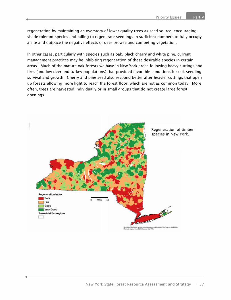
Priority Issues Part V
New York State Forest Resource Assessment and Strategy 157
regeneration by maintaining an overstory of lower quality trees as seed source, encouraging shade tolerant species and failing to regenerate seedlings in sufficient numbers to fully occupy a site and outpace the negative effects of deer browse and competing vegetation. In other cases, particularly with species such as oak, black cherry and white pine, current management practices may be inhibiting regeneration of these desirable species in certain areas. Much of the mature oak forests we have in New York arose following heavy cuttings and fires (and low deer and turkey populations) that provided favorable conditions for oak seedling survival and growth. Cherry and pine seed also respond better after heavier cuttings that open up forests allowing more light to reach the forest floor, which are not as common today. More often, trees are harvested individually or in small groups that do not create large forest openings.
Regeneration of timber species in New York.

Part V Priority Issues
158 New York State Forest Resource Assessment and Strategy
According to an analysis of Forest Service data by The Nature Conservancy, canopy regeneration is poorest in the southeast portion of the state, including Long Island, the southern Hudson Valley and southern Catskills (Figures). Regeneration in the Adirondacks is driven by low-value timber species such as American beech and balsam fir. These results indicate that limited regeneration is likely to be a problem for forests in many areas of the state. The charts below indicate the trend for both hardwoods and softwoods regarding the percent change in the number of trees in the seedling/sapling size class. Both hardwoods and softwoods showed a small decline in numbers of trees in the 1-2.9 inch class since the previous forest inventory. Softwoods showed a larger decrease in the next higher size class, while hardwoods showed only a very slight increase.
Regeneration index for northern hardwood forests in New York.

Priority Issues Part V
New York State Forest Resource Assessment and Strategy 159
Costs of management Ownership and management of forested lands entails significant costs to both private individuals and corporate entities. Initial purchase, mortgage, liability and other insurance, real property taxes, management practices and maintenance activities all have costs associated with these actions and activities. To many corporate entities the bottom line may be a fixed dollar figure. To most family forest owners a dollar figure may not constitute the bottom line as the opportunity to see wildlife, to hunt or fish, to get away from it all, to appreciate the scenery and open space may have substantial value that cannot be easily related to a dollar figure. Real property taxation continues to rank high on the list of concerns that forest owners voice as an obstruction to continued sustainable use of rural lands. State level programs that offer preferential real property tax treatment to those willing to commit to a certain level and style of land management is one way to lessen the burden of real property taxes. The State’s current Forest Tax Law offers preferential real property tax treatment to certain landowners who manage their land for timber harvest, and the local government pays for this treatment through a reduction in tax revenues. A significant question is how to continue to raise funds for local government costs normally paid for by real property tax revenue without an undue transfer of tax liability to non participating ownerships. State support of such preferential tax treatment is argued by some as a fair way to support a societal benefit. Whether done by some form of state payment to affected municipalities or individuals or as an income tax credit, alternative forms of state support for a state mandated program has been called for from many sides of the issue. A recent report by the New York State Comptroller, Economic Benefits of Open Space Preservation, addresses this issue:
“If it can be established that property tax abatement programs designed to encourage preservation of natural infrastructure provide a broad public benefit, are beneficial to all

Part V Priority Issues
160 New York State Forest Resource Assessment and Strategy
taxpayers and will not impair the ability of municipalities to provide required services, New York State should consider establishing tax abatements that encourage landowners to maintain natural stormwater abatement and water purification features on their lands.”
Income from the sale of forest products should not be taxed at such a rate that it serves as a disincentive to sustainable forestry. Enlightened capital gains treatment and recognition of the costs of long term management should result in income tax policy that is consistent with the promotion of sustainable land use and management. Management actions conducted to support and enhance long term forest health and productivity benefit both the individual owner as well as the general public. These actions cost money. Publicly supported financial assistance programs implemented at both the federal and state levels hold some promise to help keep forest as forests with sustainable management as a basis for use of these lands. However, historic levels of funds available have been wholly inadequate to address the potential need and opportunity. Investment from the private sector may hold promise to address at least in part, the need of forest owners for financial support to implement sustainable forest land use practices. Availability, diversity and viability of markets for forest products Markets for the goods and services produced by forests are essential to generate revenues and returns on investments which support and sustain private forest ownership, retention and management. Markets need to be diverse and distributed across the State to provide viable access to all forest owners. Access to those markets also should not be unduly restricted by regulations, policies or laws. Traditional markets for wood products include sawmills, veneer mills, pulp and paper manufacturers, pallet mills and firewood. These users are often called “primary markets” as they take logs, in round form, from the woods and convert them into products. Over the last 2 decades New York, like much of the Northeast, has seen a decline in the number and diversity of traditional primary wood markets as pulp and paper mills have closed or switched to imported, purchased pulp and numerous sawmills have closed or consolidated. Loss of these markets has limited management options for forest owners and managers and reduced potential returns. Losses of “secondary wood products manufacturers” that buy local lumber and turn it into furniture, cabinetry, flooring, tool handles, and other finished or semi-finished goods also have occurred. They are essential in providing the next link in the economic chain, keeping local mills and harvesters in business. Some wood products markets are “emerging” such as those for biomass for energy or chemical production, but these markets are not yet well developed or geographically-dispersed in New York. In addition to using logs, many of these markets also use, and rely on by-products of
Priority Issues Part V
New York State Forest Resource Assessment and Strategy 161
other wood-processors, including bark, chips, slabs and edgings, even papermill sludge. These users can provide an important, secondary revenue stream for sawmills, pulpmills and timber harvesters, which helps them stay viable. However, the biomass users’ viability may depend on those mills staying in business and continuing to generate affordable “by-products”. Whether those businesses can survive is often dictated by other market conditions far beyond the biomass user. There is a growing interest in, and need to explore new economic opportunities for forest landowners typically called “non-traditional markets”. These opportunities can range from recreational or hunting leases to “special forest products” such as ginseng, mushrooms, nuts, fruits and decorative botanicals, to payments for “ecosystem services” such as carbon sequestration, wildlife habitat conservation or water quality protection. Forest land leasing has been a historic practice in many areas of New York, especially on large ownerships formerly held by forest products industries. Payments for ecosystem services, on the other hand, is largely an untested and unproven concept, but one that is receiving a great deal of attention. If issues of quantification, verification, “permanence”, valuation and funding sources can be worked out, this approach could provide significant economic motivation and compensation for forest owners to retain and sustainably manage their woodlands. Availability, or lack, of incentives to promote and facilitate desirable forest management activities Agricultural policy makers in the United States have a long history of using subsidies, cost-sharing payments and monetary incentives to conserve and manage croplands and encourage adoption of practices to enhance environmental protection and stewardship. These programs have been quite successful in achieving those objectives with farmers, particularly through programs of the Federal Farm Bills including the Environmental Quality Incentive Program (EQIP), Forest Land Enhancement Program (FLEP), Wildlife Habitat Improvement Program (WHIP), Wetlands Reserve Program (WRP) and Conservation Reserve Program (CREP). Forestry incentive programs such as the former Stewardship Incentive Program, FLEP, WHIP and EQIP have been used in New York to promote and facilitate preparation of Forest Stewardship Plans for private forest owners, and implement various forest and environmental improvement practices including timber stand thinning, invasive species removal, reforestation and tree planting, riparian buffer establishment, wildlife habitat improvement, forest road stabilization and water quality protection. Demand for these practices from NY forest owners and managers has always well exceeded available funding, indicating a far greater potential for applying conservation practices on the ground. Expanding funding for forestry incentive programs can directly enhance and complement the other efforts identified in this Strategy for retaining forests and implementing sustainable forestry on-the-ground.
Part V Priority Issues
162 New York State Forest Resource Assessment and Strategy
Declining pool of trained, professional timber harvesters Whether or not a forest landowner has used the services of a professional forester, if they want to sell timber products, they typically involve a timber harvester or logger. The harvester is one of the most vital links in the forestry economic chain. They, arguably, have the most direct influence on the forests they work on and the future forests that grow. Very few landowners have the equipment or skills needed to conduct a commercial timber harvest on their own. Timber harvesters also have direct market knowledge landowners do not possess. There are two key sustainable forestry issues related to timber harvesters. The first is demographic. Numerous studies have shown that the overall population of loggers is aging and fewer new workers are joining this field. Many factors contribute to this trend. Logging is a very hazardous occupation. It’s seen as “low-tech” and low-paying, and not often recommended by high school guidance counselors to students. The work environment can be challenging – outdoors in all kinds of weather. Costs of entry to this business can be prohibitively high. The larger equipment necessary (skidders, forwarders, processors, chippers and trucks) can all be very expensive and financing can be difficult. As the current generation of timber harvesters ages out of the workforce, many question whether there will be an adequate supply of woods workers to accomplish forest management objectives in the future. Secondly, it is critically important to forest sustainability and natural resource protection that timber harvesters be well trained - skilled in harvesting techniques, business practices and resource protection. They also need appropriate incentives, direction and financial motivation to apply “best management practices” in the woods. At the end of the day, the logger is where the “boots meet the dirt” for most of the forests in New York State.
ISSUE 4: SUSTAINABLE MARKETS FOR TIMBER PRODUCTS
Background: It is necessary to have sufficiently reliable and diversified markets in order for forest landowners to practice undertake forest management. Although New York is relatively healthy in terms of the overall number and variety of markets for timber products, there is a disparity in geographic distribution of these markets, particularly for the low-grade timber product markets and the health and long-term viability of these markets can be questioned. Given the current growth to removals ratio of timber and species/condition shifts cited earlier in this report and in issue number five, there is room for additional harvesting, particularly in the area of low-grade/value timber products. Additional harvesting to revitalize degraded forests will require additional markets and the maintenance of currently existing markets. Over the last decade, New York has experienced an overall decline in the number and type of
Priority Issues Part V
New York State Forest Resource Assessment and Strategy 163
traditional markets for timber products and related wood products located in and around the state. However, while traditional and sometimes higher value markets have waned for these products, new markets such as woody biomass energy, have, and continue to emerge. Two large-scale residential wood pellet plants have recently opened, as have some co-generation and community and manufacturing-scale wood to energy facilities. The last decade also has seen the expansion of a few sawmill facilities/ownerships, and the resultant absorption of much of the product previously utilized by a large number of smaller facilities that have closed. In addition, hundreds of small, thin-kerf band mills and Amish run mills have filled in and utilize some of the timber volume left by closed traditional mills. The loss of timber product markets located in other states and Canada also has affected New York. For example, two major pulp and paper mills located in Pennsylvania and one in Ontario closed their doors during the last decade. These markets were important to the Southern Tier and North Country regions of the state, where, particularly in the Southern Tier, few markets for low-grade timber products exist. The status of markets for special forest products such as mushrooms, boughs, cones and other “forest farming” products is mostly unknown. However these markets are largely minor and economically insignificant. An exception is American ginseng, where, due to mandatory reporting to DEC Division of Lands and Forests, it is evident that markets have held steady during this timeframe. An adjunct to the need for sufficient numbers and diversification of markets for timber products is the documented need for a skilled and trained workforce to harvest and deliver timber to market. Studies indicate that the logging community is aging and that the industry is not attractive to many of those entering the workforce or looking for a career change. In addition, the logging industry is expensive to enter (e.g.-cost of equipment), has high workers compensation rates and markets are sometimes cyclical and unstable. It is also important to develop and encourage landowners’ ability to participate in emerging non-traditional markets for forest products such as carbon and ecosystem services. Income from these new markets has the potential to assist forest owners struggling with high real property taxes and other costs of forest land ownership. Unfortunately, the fledgling status and complicated nature of these markets, as well as the small and decreasing average holding size of forestland makes participation in these markets difficult for a majority of forest owners. Since 1998 the state has lost the following timber product markets:
• Two pulp and paper mills with a combined consumption level of approximately 700,000 green tons of both hardwood and softwood.
• Two medium density fiberboard panel plants Since 2006, the state has seen approximately 60 sawmills close their doors
Part V Priority Issues
164 New York State Forest Resource Assessment and Strategy
Threats:
• Currently, most harvesting of low-grade timber products takes place in the 14 county North Country region of the state. There is heavy reliance on two specific markets in this region. Further diversification of markets could safeguard the ability to continue to harvest the high levels of low-grade timber growing in the region.
• Failure to gain additional markets for low-grade timber products reduces the ability to renovate degraded stands and to prevent additional forest from becoming under/moderately stocked and underproductive.
• Absence of functioning “ecosystem services” markets
ISSUE 5: WATER QUALITY AND SUPPLY
Background: New York State has a seeming abundance of clean, high quality water. Forested watersheds have long been recognized as a very important component of maintaining water quality and supply. New York has taken many actions to protect forests in order to maintain and enhance water quality including the creation of the Forest Preserve and establishment of New York City’s upstate, surface reservoir system and the forest protection component of their Filtration Avoidance Determination. Forests are critically important to the supply of clean drinking water; however, the public is generally unaware of the threats to their water supplies or the connection between clean water and the extent and condition of forest lands in source water watersheds. The future security of water supplies will not be ensured by a focus on water treatment alone. Protecting and managing forests in source watersheds is an essential part of future strategies for providing clean, safe drinking water that citizens can afford. One of the main reasons suppliers are revisiting the idea of source protection is the growing realization that allowing untreated water quality to degrade, in addition to threatening public health, also increases treatment and capital costs. New York City estimated the cost of installing filtration alone to be nearly $7 billion, with over $300 million in annual operating costs. As a result, New York City has chosen to sustain the quality of land management in its source watershed in order to sustain high water quality for a substantially lower investment. Current research on the public health impacts of urban and agricultural runoff in untreated water sources, and a recognition of the high costs and limitations of technological fixes reinforce two principles that were taken for granted a century ago: (1) the public water supply should be reasonably clean to begin with, and (2) forests and natural lands are critical to the quantity and quality of water supplies. (Barnes, et.al., 2008)

Priority Issues Part V
New York State Forest Resource Assessment and Strategy 165
Threats: • Urban and suburban sprawl leads to:
o Loss of the land’s capacity to absorb and hold water o Increase in pollutant runoff from treated lawns, paved surfaces, rooftops and
other impervious surfaces o Disruption of natural hydrology affecting water flows, volumes, rates, retention
and storage • Lack of public awareness of the connections between forests and water (drinking
supplies, stormwater and flooding) can lead to poor management decisions and lack of support for forest retention and management
ISSUE 6: BIODIVERSITY
Background: Biodiversity, the number and variety of plant and animal life in a region, is important to us all, because it provides the ecological services on which we depend. Healthy, naturally vegetated areas clean our drinking water, ensure our water supply, provide pollinators for crops, recycle nutrients and provide fertile soils, and buffer and reduce storm damage. These services are often provided by nature's 'green infrastructure' at a lower cost than built systems. In most cases, the benefits are also not recognized nor paid for by the beneficiaries. This leads to those benefits being under-valued by society, under-protected, and under threat of loss due to apathy and disregard. If we conserve biodiversity, we are less likely to suffer disruptions of these essential services as our climate continues to change. Biodiversity is often a measure of the health of biological systems. New York State has a rich biological diversity (biodiversity). There are more dragonfly and damselfly species than any state but Texas and more mammal species than any state in the northeast (Johnson, 2001). However, only 55% of the State's plants and vertebrates are considered secure and the status of most invertebrates remains unknown according to the New York Natural Heritage Program (NYNHP) database. Rich biological diversity and the many benefits it provides depends on healthy ecosystems which are being degraded and threatened in New York, as elsewhere. According to the New York State Biodiversity Project Needs Assessment, more than 50 % of New York State’s natural vegetation has been lost or altered due to land conversion and associated species such as the piping plover, Karner blue butterfly and tiger salamander are being lost. In addition, “The loss of New York’s natural heritage is caused, in part, by direct threats which include ill-planned development, land use and land management. Thus, decision makers – from state and local government, private industry, and conservation organizations – must become better informed on how to incorporate biodiversity information into their activities and how to

Part V Priority Issues
166 New York State Forest Resource Assessment and Strategy
assess the potential effects of their decisions on biodiversity in the State. Without such biodiversity knowledge, decisions cannot effectively protect the State’s natural resources even where a decision maker desires to do so. And where such knowledge exists, to be effective, it must be accessible, available, and known to potential users.” The State Comprehensive Wildlife Conservation Strategy (CWCS) makes recommendations related to planning, land protection, management and restoration, regulatory and legislative changes, many of which support keeping forests as forests and improving the health and resiliency of those forests.
Threats: Prominent threats to New York Species of Greatest Conservation Need (SGCN) are listed in the CWCS as:
• Habitat loss and fragmentation • Degraded water quality, atmospheric deposition, and altered hydrology • Invasive species • Incompatible silvicultural and agricultural practices • Human-wildlife interactions • Climate change
ISSUE 7: FOREST HEALTH
Background: Overall forest health is being compromised by a long list of damage-causing agents which includes six moths and butterflies, two adelgids, seven beetles, two species of flies and wasps and nine diseases, as well as serious damage by deer, rabbits and voles and incursions from 11 invasive plants. These attacks and incursions are made worse in certain parts of the state by the effects of acid rain directly on the trees and indirectly on the soils that nurture them. Change is inevitable. Scientists have come to understand that disturbance is necessary for many kinds of forests and that it is the frequency, kind, degree and rate of change that is important, not necessarily the change itself. (Botkin, 1990) Threats and challenges to New York’s forest health are principally: global climate change, invasive plant and animal species, loss of habitat connections across the landscape, and poor reestablishment of desired trees and plants following natural or human caused disturbances. New York’s forests are remarkably resilient, as demonstrated by how well they have reestablished themselves following large scale land clearing associated with European settlement. However, trends in economic globalization combined with exponential growth in

Priority Issues Part V
New York State Forest Resource Assessment and Strategy 167
human population continue to significantly impact the species composition, resiliency and function of New York’s forest ecosystems. The ecological health and function of forests is dependent on a carefully balanced interdependence of species. Degradation caused by a disturbance such as invasive insect activity or improper forest management can leave forests prone to further mortality. New York’s forests are under constant stress from native pests such as pine beetles and tent caterpillars. These stresses are increasing due to changing site conditions caused by climate change, as well as the threat of damage from invasive species. First among the many factors that contribute to forest health is the presence of proper tree species composition as it relates to site conditions. Understanding the geology that underlies New York State is important in order to understand site conditions and associated forest communities on State Forests.
Threats: New York is at the center of global commerce at its ports, interstate highways and other trade routes. Invasive forest pests as an issue is like the "oil slick threatening our forests". It keeps coming. It's spreading. It will have devastating economic, environmental and social impacts. It will cost millions of dollars to address and recover from. Prevention including "Early Detection-Rapid Response" is far more effective and far less costly than reaction and recovery. More funding is needed, more research, more tools and more eyes and boots in the forest are needed to address forest invasives and protect New York’s forests for the good they provide to all, and to future generations.
ISSUE 8: CLIMATE CHANGE
Background: Carbon-containing gases in the atmosphere, the so-called “greenhouse” gases, are strongly implicated as a source of climate change. Carbon dioxide, methane, and nitrous oxide have changed the composition of our atmosphere. Carbon dioxide concentration alone has increased since the 18th century and greenhouse gases are expected to warm the earth by allowing sunlight to reach the earth’s surface while blocking heat from escaping. Some of the gases also thin the ozone layer that shields the earth from harmful solar radiation. Forests play a huge role in mitigating the effects of climate change. Growing forests naturally store carbon. The age and vigor of forest vegetation affects the rate of carbon sequestration in a forest ecosystem and the overall inventory of stored carbon. Trees are about 50 percent carbon and represent the most dynamic component of the forest ecosystem carbon pool. In the Northern United States, hardwoods account for a greater proportion of carbon than softwoods.

Part V Priority Issues
168 New York State Forest Resource Assessment and Strategy
Changes in carbon inventory are affected by the rate of forest growth, harvest activity, and losses of forest cover due to conversion to other land uses, as well as fire or other natural disturbances. In general, forest activities such as tree planting increase carbon sequestration, while activities such as prescribed burning release carbon into the atmosphere. The carbon inventory in Northern U.S. forests is higher than in forests of any other region of the country. An underlying factor is that forests in the North are not harvested as heavily compared to forests in the South and West. Additional carbon is stored in wood that is processed or manufactured into products. Increasing carbon stored in urban and rural trees and forests is usually an inexpensive way to mitigate increasing atmospheric greenhouse gases. The carbon stored in forests and forest products mitigates the amount of carbon released into the atmosphere, which may help delay global climate change. Forests also act as climate buffers, moderating temperature extremes and creating local microclimates. Trees cool the air both by direct shade and by evaporative cooling through their leaves. The Urban Heat Island effect is caused by the predominance of heat-absorbing pavement and dark surfaces which can increase a city's temperatures by several degrees. Trees can reduce this buildup of urban heat and substantially reduce energy demands and related greenhouse gas emissions. The climate change pattern that seems to be developing in New York has fewer but heavier rains with increased runoff, and more periods of summer drought. The ability of forests to soak up water is critical for reducing flooding and for absorbing adequate amounts of groundwater. Forests can also help buffer the impacts of drought by protecting soils from desiccation and erosion. During storms, forests and wetlands can be important physical buffers, slowing the force of wind by friction and as windbreaks. Large tracts of unbroken forests and connectivity between these forests is extremely important in the face of a changing climate. In the future as plant and animal populations and biotic communities respond to rising temperatures, species range expansions and contractions are expected. Habitat connectivity is important for making those range adjustments.
Threats: Climate change, human introduced invasive species
ISSUE 9: URBAN TREE CANOPY AND GREEN INFRASTRUCTURE
Background:

Priority Issues Part V
New York State Forest Resource Assessment and Strategy 169
The goal of New York’s Urban and Community Forestry program is to support municipalities, volunteer groups, and professional organizations in the planning and management of urban and community forests in the state. All of the trees within a town, village, or city make up the "community forest." The community forest can include street and yard trees, parks, cemeteries, golf courses, school grounds, and undeveloped green spaces. Urban and community forestry is the management of community forests to establish and maintain healthy trees for air and water quality benefits, energy savings, environmental health, as well as to enhance the quality of life in our urban areas where a majority of our State’s citizens live and work. Trees have numerous positive effects on human health and quality of life. They add aesthetic benefits which soften the gray infrastructure of urban landscapes. When people utilize parks and shady tree-lined streets, they are more likely to meet and establish bonds with their neighbors, which help to create a sense of community. When people enjoy spending time in their neighborhoods, they develop pride and a sense of ownership in their communities. The presence of trees and the proximity to parks has been shown to increase residential and commercial property values. Thus, 'greening' our urban areas and communities helps to support New York’s Smart Growth initiative to combat urban sprawl, to make our existing urban areas and communities more attractive; and to respond to the concern of open space conservation areas in rural areas attracting sprawl developments by targeting these locations to increase real estate values. Social benefits are supplemented with environmental and health benefits. Trees remove air and water pollutants through both their root systems and their leaves. Tree canopies shade buildings, sidewalks, streets and other structures keeping them cooler, reducing air conditioning and other energy needs in the summer; and reducing the overall “urban heat island effect.” Strategically placed trees of appropriate species will shelter buildings from cold winds in winter months, reducing heating costs. Increasing the utility and benefits provided by trees and their leaf foliage has led to the coining of a new term, "Green Infrastructure," to describe the concept of strategically planned and managed networks of natural lands (such as headwater forests, functioning wetlands and riparian areas, and stream and river corridors), working landscapes and other open spaces that conserve ecosystem values and functions, providing associated benefits to human populations. Although green infrastructure is a landscape scale enterprise, smaller scale implementation of this approach is being recognized at the urban level. Within our cities, “green infrastructure” uses plants and natural systems versus man-made, typical concrete-and-steel structures, to perform functions of cooling, air and water purification, stormwater management, and physical aesthetics. In the form of green roofs, green infra-structure reduces the urban heat island

Part V Priority Issues
170 New York State Forest Resource Assessment and Strategy
effect; - it's the closest thing to a cure-all for a myriad of problems that we have in our urban areas; and it may be cheaper than traditional engineered solutions. Perhaps most importantly, green infrastructure treats fresh water as the valuable resource that it is, rather than as a waste product of which to be drained away and disposed. Nearly half of New York’s communities have an organized tree program. Some are completely volunteer run and others are driven by well planned and funded municipal programs. Many programs fit somewhere in between. Most community forestry programs have utilized and continue to seek outside technical assistance from DEC, NYS ReLeaf (a partnership between DEC, tree care professionals, and volunteers), and tree care experts to improve their knowledge and programs. Half of New York’s communities do not have an organized tree program based on the Community Accomplishment Reporting System (CARS). Also, according to the NYS Urban and Community Forestry Council 2009 survey, 72% don’t have a tree management plan, 69% don’t have a tree inventory, 63% don’t have a tree ordinance and 55% don’t have any kind of tree advisory group. Communities continue to need support in the form of educational workshops, forester contact and financial assistance and access to the latest research in order to begin a program or improve an existing program. New York’s relatively recent law that requires members of planning boards, zoning boards of appeals, and county planning boards to receive a minimum number of hours of training a year has helped make the connection to urban forestry by introducing benefits of trees and how to create and maintain greenspace when developing zoning laws and approving site plans. Threats:
• Invasive forest pests that damage and kill urban trees. • Perceived expenses and real costs in taking care of community forests • Interest level of tree care personnel to become certified arborists – lack of knowledge
regarding the rate of exchange in resulting benefits to the community when acquiring this knowledge
• Resources for start up funds, education and technical assistance are in high demand yet low in availability
• Changes in state and local elected officials determine the future of state grants and local tree related activities
• Inadequate tree planting requirements in site plan approval process when considering commercial or residential development projects
• Lack of proper training of local tree care professionals and municipal staff in both traditional urban forestry and green infrastructure
• Reluctance of municipal staff to use volunteers
Priority Issues Part V
New York State Forest Resource Assessment and Strategy 171
• Lack of recruitment, training, and utilization of volunteers in urban forestry programs • Urban and community programs require support of local officials. Local officials change
frequently but tree maintenance is a long term proposition. This can cause disruptions in tree programs and projects until new official buy into the program.
• Vandalism to trees
ISSUE 10: CONNECTIONS BETWEEN PEOPLE AND THE OUTDOORS
Background: The 19th century conservationists recognized the importance of nature as a refuge from the noise and bustle of city life. Today, understanding the environment is critical to our future. But the sad irony is that as the natural environment becomes more important, fewer and fewer people, especially children, are in contact with it. Earlier generations of New Yorkers played outdoors much of the time. Today, most children spend far less time outdoors than did their parents. Kids are learning about nature indirectly, from television and the internet, rather than directly from contact and observation. Their outdoors experience is often limited to the artificial environment of groomed lawns and playing fields. The book Last Child in the Woods, by Richard Louv, goes into great detail about the importance of spending time in nature and discusses some of the hurdles: Fear – fear of traffic, crime, strangers, and of nature itself; computer related activities; structured activities such as sports and music; more homework; and less “free” time in general. In addition, conversations with parents most anywhere reveal a change in the amount of free, unsupervised time in nature they experienced as children and their positive feelings about it. Many of those same parents admit their children have hardly any unsupervised time in nature and supervised time is limited. As more people live in urban environments often without convenient access to the natural world – woods and fields, streams and ponds – the more foreign and uncomfortable this environment feels to them. As a connection to nature fosters a feeling of value, the opposite is true. These people pass on the lack of connection and lack of valuing nature and in turn do not support the protection of open space. We conserve our environment not just to protect our health and enforce the law, but to ensure that we, and future generations, can experience the joy of a hike or a hunt in the woods, the thrill of a swim at a clean beach, or the beauty of an unspoiled view. Whether it is a stroll in an urban waterfront park, a paddling trip in the wilderness, or walking in the woods, these connections to nature can refresh, teach, and sustain us. While use and demand for our State's campgrounds, education centers, and youth camps remains high, participation in hunting, fishing and trapping has declined. Meanwhile, research has

Part V Priority Issues
172 New York State Forest Resource Assessment and Strategy
documented a shift away from outdoor activities in the general population. We can reverse this trend by helping more families rediscover the natural world. Our efforts to connect New Yorkers to nature will be conducted with the goal of providing access, increasing environmental literacy, enhancing public health and quality of life, and building the interest and involvement of the next generation of New Yorkers to carry on the traditions of caring for the environment and protecting our State's forests and open spaces.
Threats: • Reduced play/leisure time outside • Lack of knowledge about nature in our own backyards, towns and state • Lack of knowledge about connection between nature time and health • Amount of time people devote to electronic entertainment • Fear

Priority Landscape Areas Part VI
New York State Forest Resource Assessment and Strategy 173
VVII.. PPRRIIOORRIITTYY LLAANNDDSSCCAAPPEE
AARREEAASS The issues described in this report cross all landscapes –public, private, urban, suburban and rural, and are common across state boundaries. The Department works statewide with the goal to improve the fate of forests in the entire state. At the same time, this report identifies several priority landscape areas based on existing data and on-going initiatives that are important focus areas.
STEWARDSHIP ANALYSIS PROJECT (SAP) Through the SAP those lands most capable of providing a stewardship benefit have been identified to facilitate the targeting of available resources to those lands with the greatest potential. The Spatial Analysis Project (SAP) is a GIS-based strategic management tool that facilitates the identification and spatially display of important forest lands (rich in natural resources, vulnerable to threat), tracts currently under Forest Stewardship Plans, and areas of opportunity to focus future Forest Stewardship Program efforts.
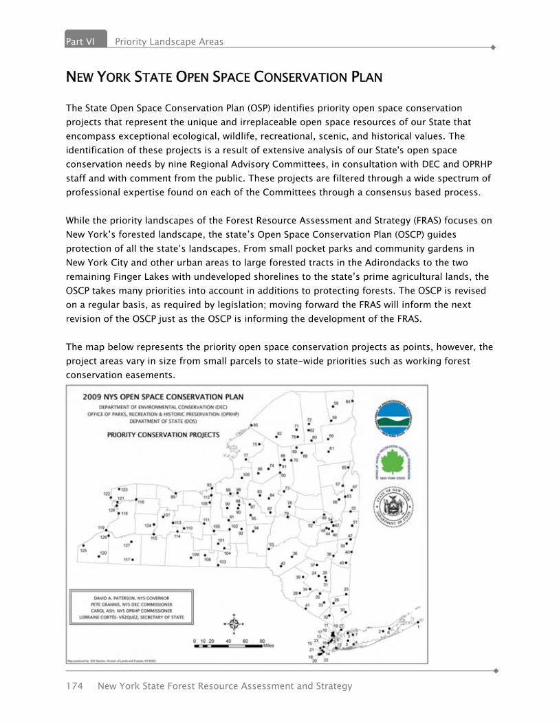
Part VI Priority Landscape Areas
174 New York State Forest Resource Assessment and Strategy
NEW YORK STATE OPEN SPACE CONSERVATION PLAN
The State Open Space Conservation Plan (OSP) identifies priority open space conservation projects that represent the unique and irreplaceable open space resources of our State that encompass exceptional ecological, wildlife, recreational, scenic, and historical values. The identification of these projects is a result of extensive analysis of our State's open space conservation needs by nine Regional Advisory Committees, in consultation with DEC and OPRHP staff and with comment from the public. These projects are filtered through a wide spectrum of professional expertise found on each of the Committees through a consensus based process. While the priority landscapes of the Forest Resource Assessment and Strategy (FRAS) focuses on New York’s forested landscape, the state’s Open Space Conservation Plan (OSCP) guides protection of all the state’s landscapes. From small pocket parks and community gardens in New York City and other urban areas to large forested tracts in the Adirondacks to the two remaining Finger Lakes with undeveloped shorelines to the state’s prime agricultural lands, the OSCP takes many priorities into account in additions to protecting forests. The OSCP is revised on a regular basis, as required by legislation; moving forward the FRAS will inform the next revision of the OSCP just as the OSCP is informing the development of the FRAS. The map below represents the priority open space conservation projects as points, however, the project areas vary in size from small parcels to state-wide priorities such as working forest conservation easements.

Priority Landscape Areas Part VI
New York State Forest Resource Assessment and Strategy 175
FOREST LEGACY AREAS
See Part III, Criteria 6, metric 15.3: protected land, and Appendix C for an overview of the Forest Legacy Program and the Request for an Amendment to the Assessment of Need.

Part VI Priority Landscape Areas
176 New York State Forest Resource Assessment and Strategy
STATE-OWNED LAND & CONSERVATION EASEMENTS MANAGED BY DEC
IMPORTANT WATERSHEDS It is a common misconception that all or most lands that supply public drinking water are publicly owned or otherwise protected. Some highly valued drinking water supplies do come from public or other lands that are protected from future development or land-use impacts. Other water supply system lands have limited protection zones, often surrounding reservoirs, lakes, or intakes, while the remainder of the watershed is vulnerable to land-use change. Many small watershed supplies, however, contain only private lands with little or no protective agreements or special land-use provisions. New York contains portions of nine important water supplies where current protection relies primarily on the forest management decisions made by hundreds or even thousands of private forest landowners. The following map shows those nine watersheds.

Priority Landscape Areas Part VI
New York State Forest Resource Assessment and Strategy 177
COMMUNITIES AT WILDFIRE RISK
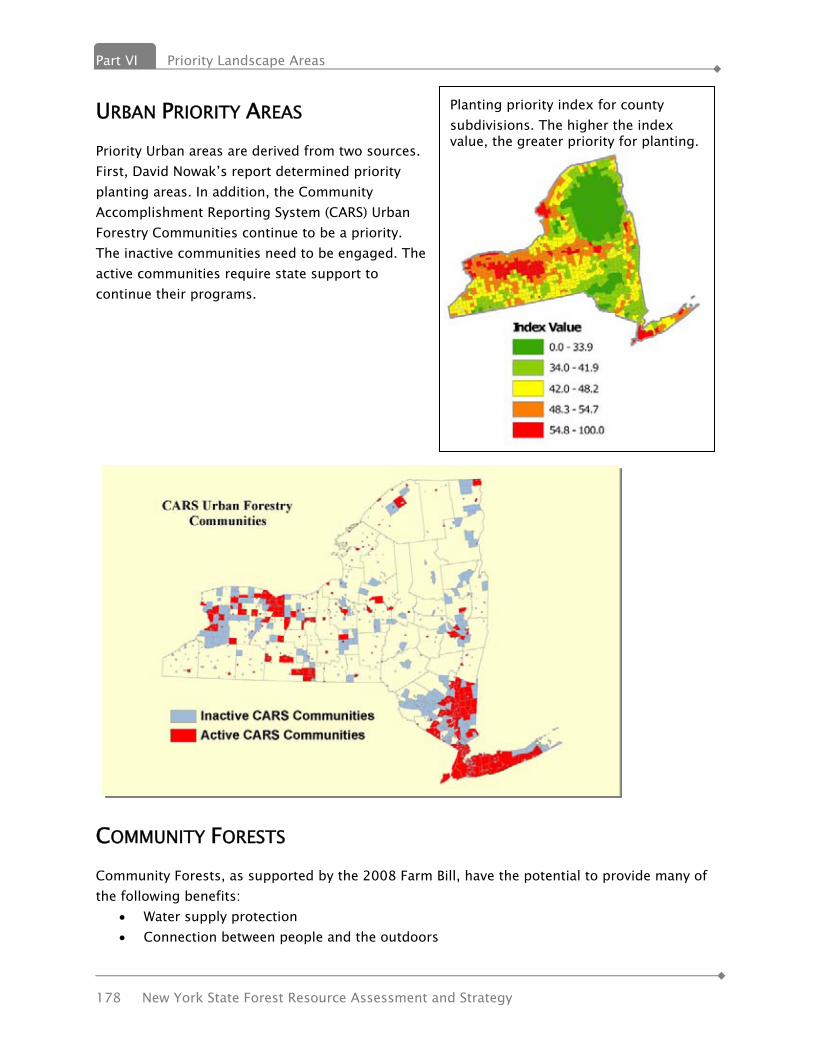
Part VI Priority Landscape Areas
178 New York State Forest Resource Assessment and Strategy
Planting priority index for county subdivisions. The higher the index value, the greater priority for planting.
URBAN PRIORITY AREAS Priority Urban areas are derived from two sources. First, David Nowak’s report determined priority planting areas. In addition, the Community Accomplishment Reporting System (CARS) Urban Forestry Communities continue to be a priority. The inactive communities need to be engaged. The active communities require state support to continue their programs.
COMMUNITY FORESTS Community Forests, as supported by the 2008 Farm Bill, have the potential to provide many of the following benefits:
• Water supply protection • Connection between people and the outdoors
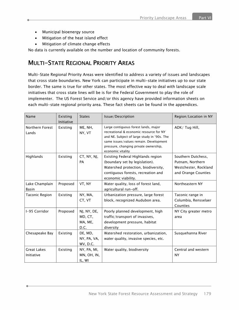
Priority Landscape Areas Part VI
New York State Forest Resource Assessment and Strategy 179
• Municipal bioenergy source • Mitigation of the heat island effect • Mitigation of climate change effects
No data is currently available on the number and location of community forests.
MULTI-STATE REGIONAL PRIORITY AREAS Multi-State Regional Priority Areas were identified to address a variety of issues and landscapes that cross state boundaries. New York can participate in multi-state initiatives up to our state border. The same is true for other states. The most effective way to deal with landscape scale initiatives that cross state lines will be is for the Federal Government to play the role of implementer. The US Forest Service and/or this agency have provided information sheets on each multi-state regional priority area. These fact sheets can be found in the appendices.
Name Existing Initiative
States Issue/Description Region/Location in NY
Northern Forest Lands
Existing ME, NH, NY, VT
Large contiguous forest lands, major recreational & economic resource for NY and NE. Subject of large study in ‘90s. The same issues/values remain. Development pressure, changing private ownership, economic vitality
ADK/ Tug Hill,
Highlands Existing CT, NY, NJ, PA
Existing Federal Highlands region (boundary set by legislation). Watershed protection, biodiversity, contiguous forests, recreation and economic viability.
Southern Dutchess, Putnam, Northern Westchester, Rockland and Orange Counties
Lake Champlain Basin
Proposed VT, NY Water quality, loss of forest land, agricultural run-off.
Northeastern NY
Taconic Region Existing NY, MA, CT, VT
Urbanization pressure, large forest block, recognized Audubon area.
Taconic range in Columbia, Rensselaer Counties
I-95 Corridor Proposed NJ, NY, DE, MD, CT, MA, ME, D.C.
Poorly planned development, high traffic/transport of invasives, development pressure, habitat diversity
NY City greater metro area
Chesapeake Bay Existing DE, MD, NY, PA, VA, WV, D.C.
Watershed restoration, urbanization, water quality, invasive species, etc.
Susquehanna River
Great Lakes Initiative
Existing NY, PA, MI, MN, OH, IN, IL, WI
Water quality, biodiversity Central and western NY
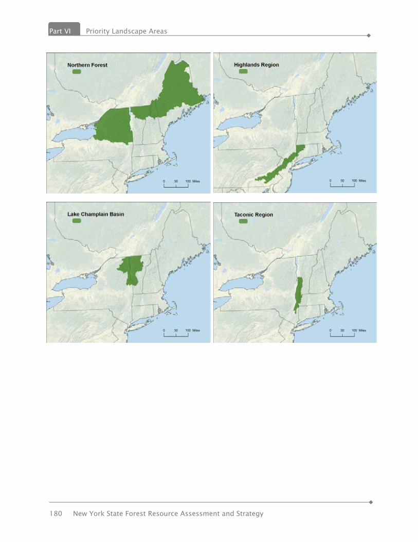
Part VI Priority Landscape Areas
180 New York State Forest Resource Assessment and Strategy

Priority Landscape Areas Part VI
New York State Forest Resource Assessment and Strategy 181


Strategies Part VII
New York State Forest Resource Assessment and Strategy 183
VVIIII.. SSTTRRAATTEEGGIIEESS
Strategies & Actions to Keep New York’s Forests as Forests The previous section of this report identifies significant issues affecting the security of New York’s forest resources. In response, this section lays out a series of strategies and actions that the State and New York’s forest stakeholders can take to ensure our forest resources continue to contribute to our State’s environment and economy. Many of the strategies and actions outlined will help address several issue areas, but are not repeated in order to avoid redundancies. At this time, approximately half of the strategies and actions are currently in progress or have been in progress by various state programs, especially within the State Department of Environmental Conservation (DEC) Division of Lands & Forests, and its partners. Several of the actions have been recommended by the public, DEC’s stakeholders and partners with experienced, professional staff within strong state conservation programs. Many of the strategies and the actions will need to be undertaken in a systematic and coordinated effort among these State agencies, stakeholders, partners and local governments.
SUMMARY OF STRATEGIES Issue 1 - Keeping Forests as Forests” - Retaining New York’s Forests
Strategy 1.1 Retain forests across the State.
Issue 2 - Sustaining “Working Landscapes” - Working to Provide a Range of Forest Benefits & Services
Strategy 2.1 Provide legal, economic & social mechanisms to ensure forest landowners have the ability to continue to practice active, sustainable forest management.
Issue 3 - Sustainable Forestry Practices
Strategy 3.1 Cultivate a long-term “Forest Stewardship Ethic”.
Strategy 3.2 Develop systematic approach w/partners & state agencies to maximize efficiency & cooperative results w/private forest landowner outreach efforts.
Strategy 3.3 Increase the use of silvicultural Best Management Practices (BMPs).
Strategy 3.4 Increase incentives & reduce costs for private forest landowners that will promote & implement sustainable forestry practices.
Issue 4 - Sustainable markets for Sustainable Timber Products
Strategy 4.1 Increase availability, diversity & economic viability of markets for sustainable

Part VII Strategies
184 New York State Forest Resource Assessment and Strategy
state forest products & services.
Strategy 4.2 Support retention, recruitment & training of sustainable timber harvesters.
Issue 5 - Water Quality & Supply
Strategy 5.1 Protect high quality watersheds, shorelines & riparian areas.
Issue 6 - Biodiversity
Strategy 6.1 Provide guidance & assistance to local governments for incorporating biodiversity principles in planning & zoning decisions.
Strategy 6.2 Provide biodiversity & sustainable forest management incentives to private forest landowners.
Strategy 6.3 Advocate for the fullest range of management tools for public & private lands.
Issue 7 - Forest health
Strategy 7.1 Fight invasive pests & diseases.
Strategy 7.2 Address catastrophic natural events.
Strategy 7.3 Expand public education programs on forest health issues.
Strategy 7.4 Support & improve wildfire management services.
Issue 8 - Climate Change
Strategy 8.1 Recognize the role of forests to mitigate & adapt to climate change.
Issue 9 - Urban Tree Canopy & Green Infrastructure
Strategy 9.1 Engage & educate communities on the importance of urban forestry & green infrastructure.
Strategy 9.2 Encourage networking of community tree boards.
Strategy 9.3 Develop a statewide database of community tree inventories.
Strategy 9.4 Incorporate green infrastructure into urban communities.
Issue 10 - Connections Between People & the Outdoors
Strategy 10.1 Support ‘Smart Growth’ & sustainable community development principles.
Strategy 10.2 Develop public stakeholders for the environment.
Strategy 10.3 Meet needs for forest-based recreation.
ISSUE 1 - “KEEPING FORESTS AS FORESTS” Retaining New York’s Forests
STRATEGY 1.1 Retain forests across New York State.
Strategies Part VII
New York State Forest Resource Assessment and Strategy 185
Actions
1.1.1 Work to reduce burden of real property taxes on private forestland owners, as recommended by the Office of the State Comptroller, by creating a new forest & open space retention programs which may include: adoption of a refundable income tax credit for open space conservation; establishment of a new “current use assessment” program for forest lands; creation of an Ecosystem Services/Environmental Benefits payment program; reform of current forest & timber assessment practices; and encourage the development of third-party “green” forest certification program that
will be affordable & accessible by small family forest landowners.
1.1.2 Reduce threat of subdivision & land use change on private forestland by: expanding State purchases of working forest conservation easements from willing
sellers; pursuing public/private, regional or statewide forest easement program partnerships
w/non-governmental organizations & local governments.
1.1.3 Engage local governments in conserving their forests & forestry values through: promotion, education & technical assistance w/local land use planning for forest
conservation & biodiversity protection, including use of ‘Smart Growth’ principles; application of local open space protection measures such as community preservation
acts/community forest program (2008 Farm Bill); and outreach, education, consultation & technical assistance to local governments
regarding the benefits of utilizing best management practices for sustainable forest management activities.
1.1.4 Permanently protect critical forest resources & values through full fee title public acquisitions of targeted, high-value forestlands.
ISSUE 2 - SUSTAINING “WORKING LANDSCAPES” Working to Provide ALL Forest Benefits & Services
STRATEGY 2.1 Provide legal, economic & social mechanisms to ensure forest owners have the ability to continue to practice active, sustainable forest management.
Actions
2.1.1 Promote the use of public & private conservation easements that include specific language allowing active, sustainable forest management.
2.1.2 Improve Forest Tax Law program to encourage greater participation by landowners in

Part VII Strategies
186 New York State Forest Resource Assessment and Strategy
active forest management.
2.1.3 Advocate for State & Federal income, capital gains & estate tax reforms that encourage & support sustainable forest management.
2.1.4 Expand State’s “Right to Practice Forestry” outreach by providing review & consultation services to local governments for planning ordinances that support sustainable forest management.
ISSUE 3 - SUSTAINABLE FORESTRY PRACTICES STRATEGY 3.1 Cultivate a long-term “Forest Stewardship Ethic”.
Actions 3.1.1 Conduct outreach efforts to inform & educate private forest landowners, the general
public & elected officials about the importance of forests, their conservation, & sustainable forest management.
3.1.2 Work w/private & public partners, & non-governmental organizations to promote strategic planning for landscape-scale conservation planning & implementation.
STRATEGY 3.2 Develop a systematic agenda w/ State Extension Forester, local cooperative extension associations, The Nature Conservancy (TNC) & State Environmental Facilities Corporation for maximizing efficiency & cooperative results of private forest landowner outreach efforts.
Actions
3.2.1 Develop affordable & accessible third-party sustainable forestry certification programs for the small family forest landowner.
3.2.2 Assist small family forest landowners to utilize sustainable forestry certification programs.
3.2.3 Continue assisting landowners w/developing Forest Stewardship management plans.
3.2.5 Develop additional BMPs & guidance to promote biomass harvesting, wildlife habitat protection, forest regeneration, timber crop production & water quality.
3.2.6 Develop landowner incentives that will work to increase the use of BMPs.
3.2.7 Establish “peer” private forest landowner networks.
3.2.8 Explore emerging areas of sustainable forestry & natural resource science.
3.2.9 Provide demonstration sites & long-term research for new practices on State Forest lands.
Strategies Part VII
New York State Forest Resource Assessment and Strategy 187
3.2.10 Address forest regeneration challenges. STRATEGY 3.3 Increase the use of silvicultural Best Management Practices (BMPs).
Actions 3.3.1 Utilize State Stewardship Analysis Program (SAP) to target outreach efforts, in order to
ensure that high priority opportunities to work w/private forest landowners of critical & significant lands are capitalized upon.
3.3.2 Implement a BMP monitoring program based on existing USFS protocols.
STRATEGY 3.4 Increase incentives & reduce costs for private forest landowners to promote & implement sustainable forest management activities.
Actions
3.4.1 Improve Forest Tax Law program to reward active forest management & promote greater participation in such program.
3.4.2 Expand & increase funding for incentive & cost-sharing programs to promote & support sustainable forest management practices on private forest lands.
3.4.3 Streamline administration of cost-sharing & incentive programs for private landowners to make participation more attractive.
3.4.4 Advocate for state & federal income, capital gains & estate tax reforms that support sustainable forest management.
3.4.5 Work w/stakeholders to become actively & quickly engaged in improving forestry incentive programs & targeted funding in the next Federal Farm Bill.
ISSUE 4 - SUSTAINABLE MARKETS FOR SUSTAINABLE TIMBER PRODUCTS STRATEGY 4.1 Increase availability, diversity & economic viability of markets for sustainable forest products & services.
Actions
4.1.1 Develop & support activities of newly formed, “NYS Wood Products Development Council”.
4.1.2 Maintain & enhance State Forest Utilization & Marketing Program capabilities.
4.1.3 Promote & expand use of locally produced forest products for household & energy uses by focusing technical assistance, favorable policies & incentives.
4.1.4 Provide incentives for young workers to enter the forest products industry.
Part VII Strategies
188 New York State Forest Resource Assessment and Strategy
4.1.5 Work w/public & private partners to promote forest product market retention, expansion & development.
4.1.6 Support efforts to develop viable, economical & profitable markets for ecosystem services, including carbon sequestration, wildlife habitat conservation, & water quality protection programs that are accessible to small forest landowners.
4.1.7 Provide outreach, education & technical assistance to private forest landowners & entrepreneurs to assist them in developing & participating in non-traditional & non-timber forest products markets.
STRATEGY 4.2 Support retention, recruitment & training of sustainable timber harvesters.
Actions
4.2.1 Support & expand timber harvester participation in State Logger Training Program.
4.2.2 Work w/ New York Forest Owners Association, Cornell Cooperative Extension, Empire State Forest Products Association & State Logger Training Inc. to promote use of trained timber harvesters by private forest landowners.
4.2.3 Support public & private sector logger safety training programs & other initiatives to improve worker productivity, increase harvesting business profitability, reduce accidents & lower workers compensation costs.
4.2.4 Support recruitment & vocational training programs that encourage youth to consider & prepare for careers in the forest industry.
ISSUE 5 - WATER QUALITY & SUPPLY STRATEGY 5.1 Protect high quality watersheds, shorelines & riparian areas.
Actions
5.1.1 Utilize web, articles, press, PLT, other public outreach opportunities & partners to promote the importance of water quality protection.
5.1.2 Prioritize & protect high quality areas based on watersheds, amount of forest land, population served and threats.
5.1.3 Protect, retain and increase forest lands along riparian corridors and shorelines.
5.1.4 Coordinate training w/communities, partnering w/DEC Division of Water & the NY Department of State.
5.1.5 Promote conservation easements & acquisition, including community forests.
Strategies Part VII
New York State Forest Resource Assessment and Strategy 189
5.1.6 Work towards the authorization of an Ecosystem Services/Environmental Benefits program that can be promoted over time to replace the current FTL, and which may be based on income tax credit rather than on reduction of real property tax liability.
5.1.8 Support watershed & aquifer protection in the Long Island Central Pine Barrens through wildfire prevention & fuel treatment projects.
5.1.9 Continue to promote the state’s timber harvesting BMPs to protect water quality.
5.1.10 Review studies & reports of critical ecosystem management projects, especially for public drinking supply watersheds.
ISSUE 6 - BIODIVERSITY STRATEGY 6.1 Provide guidance & assistance to local governments for incorporating biodiversity principles in planning & zoning decisions.
Actions
6.1.1 Maintain connectivity between important identified landscapes.
6.1.2 Promote protection & acquisition of buffer lands & corridors around core-protected areas.
6.1.3 Fill biodiversity gaps identified in the Strategic Plan for State Forest Management through development & implementation of State Forest Unit Management Plans.
6.1.4 Utilize State Nursery seed banks, equipment & expertise for collecting, storing & propagating a wide-range of species & ability to experiment w/species for which there is little or no propagation information.
6.1.5 Expand GIS database to include local land use decisions based on Hudson River Estuary Program Model.
6.1.6 Provide workshops & video conference calls to introduce & promote local government planners to utilize the state’s Natural Heritage GIS database & how it can be utilized to guide planning decisions.
STRATEGY 6.2 Provide biodiversity & sustainable forest management incentives to private forest landowners.
Actions
6.2.1 Expand incentive programs to increase forest diversity focused on the creation & retention of habitats for Species of Greatest Conservation Need.
6.2.2 Model state incentive/funding after federal cost share programs such as the Forest Land

Part VII Strategies
190 New York State Forest Resource Assessment and Strategy
Enhancement & Environmental Quality Incentives Programs.
6.2.3 Investigate comprehensive landowner incentive programs combining wildlife & forest conservation.
6.2.4 Revise tax incentive programs to take into consideration ecosystem services.
6.2.5 Expand third-party sustainable forestry certification programs that support biodiversity.
STRATEGY 6.3 Advocate for the fullest range of management tools for public & private lands.
Actions 6.3.1 Maintain & enhance landscape level biodiversity by managing forests & using timber
sales to enhance forest health & species diversity, habitats & structure, enhancing the resiliency of ecological systems & forest sustainability.
6.3.2 Plan timber harvests on State-owned Forests in a manner that develops a wider range of forest successional stages.
6.3.3 Maintain naturally occurring fire-dependent communities by conducting prescribed burns as necessary to perpetuate fire dependent communities.
6.3.4 Develop new & innovative resources to collect additional data on rare, threatened & endangered species & important natural communities that occur on public & private lands, allowing such data to be available through the State Master Habitat Database.
ISSUE 7 - FOREST HEALTH STRATEGY 7.1 Fight invasive pests & diseases. Actions
7.1.1 Develop & implement systematic statewide early detection program to minimize amount of time between infestation & detection.
7.1.2 Develop rapid & long term response capabilities at the State & local levels to minimize degree of impact.
7.1.3 Improve data collection on the status of invasives w/in the State. STRATEGY 7.2 Address catastrophic natural events.
Actions
7.2.1 Develop abilities to quantify severity & extent.

Strategies Part VII
New York State Forest Resource Assessment and Strategy 191
7.2.2 Increase preparedness planning
7.2.3 Develop & distribute BMPs to local decision makers. STRATEGY 7.3 Expand public education programs on forest health issues.
Actions
7.3.1 Continue to work closely with the PRISMS, Invasive Species Council and the Invasive Species Advisory Committee.
7.3.2 Develop and publish an educational brochure about invasive species BMPs for recreational users.
7.3.3 Encourage private landowners to manage their forests to enhance forest health and the diversity of species, habitats and structure in order to enhance the resiliency of ecological systems and forest sustainability.
7.3.4 Increase use of articles for Conservationist Magazine, newsletters, newspaper articles, web, other venues, partners to disseminate.
7.3.5 Maximize web resources, providing education on pest issues, effects, & how public citizens can participate to address issues.
7.3.6 Train people who already work with the public – use existing communication routes.
7.3.7 Support research & technology transfer on climate change & acid rain & their impacts on forest resources, invasive species detection, impacts & management; & ecosystem & habitat conservation and restoration.
STRATEGY 7.4 Support & improve wildfire management services.
Actions
7.4.1 Improve local fire departments ability to effectively contain wildfires w/in the first operation period w/out loss of life, injury or excessive property damage.
7.4.2 Understand the dynamics of wildfire occurrence as reported by fire departments & forest rangers, & modify management strategies accordingly.
7.4.3 Improve capabilities of forest rangers to contain multi-operational wildfires with no injury of loss of life & the least environmental & property damage.
7.4.4 Develop active & self sustaining Fire-Wise programs in the 51 communities-at-risk throughout the State w/a priority for those 26 towns in the Adirondack Park.
7.4.5 Support state & local governments & non-government organizations w/management of fire dependent ecosystems.

Part VII Strategies
192 New York State Forest Resource Assessment and Strategy
7.4.6 Continue management & support of the Volunteer Firefighters Association program to support wildfire containment by local fire departments.
7.4.7 Maintain & improve expertise & capability w/in DEC Forest Ranger Division in order to support fire departments, state agencies, compact members & federal agencies w/ prevention & control of wildfires.
7.4.8 Improve minimal impact strategies & techniques (MIST) of containing wildfires by developing enhanced hand-crew firefighters & improve aviation capabilities in critical wildfire areas of the State.
7.4.9 Support partners w/fire management practices to accomplish wildfire protection & ecosystem management on critical sites.
7.4.10 Utilize fire occurrence data from fire departments & forest rangers to assess trends in wildfire occurrence.
7.4.11 Assess wildfire investigation & burning law enforcement for adequate effectiveness & setting of annual priority goals.
7.4.12 Review public & media responses to wildfire prevention & occurrence.
ISSUE 8 - ADAPTING TO CLIMATE CHANGE STRATEGY 8.1 Recognize the role of forests to mitigate & adapt to climate change.
Actions
8.1.1 Increase use of sustainably produced bio-energy to replace fossil fuel use.
8.1.2 Increase practice & recognition of carbon sequestration through forest management.
8.1.3 Measure net change of forest carbon stocks on a project/regional basis using FIA data.
8.1.4 Promote economic return to landowners from carbon sequestration.
8.1.5 Understand trends in climate change & its effects on wildfire occurrence & potential.
ISSUE 9 - URBAN TREE CANOPY & GREEN INFRASTRUCTURE STRATEGY 9.1 Engage & educate communities on the importance of urban forestry & green infrastructure.
Actions
9.1.1 Expand assistance programs to increase tree canopy in local communities, stressing
Strategies Part VII
New York State Forest Resource Assessment and Strategy 193
health & societal benefits of trees.
9.1.2 Replicate & promote the adoption of tree planting ordinances by local governments, modeled after Nassau County’s current ordinances.
9.1.3 Promote the benefits of trees & native vegetation through Arbor Day & community tree planting events, service foresters, & DEC internet website.
9.1.4 Educate planning, zoning boards & encourage greenspace & tree planting in the site plan approval process.
9.1.5 Provide GIS access to the public, local government & communities to show where urban forestry & green infrastructure needs exist.
9.1.6 Continue partnerships w/the State Chapter of International Society of Arboriculture (ISA), & State Nursery Landscape Association.
STRATEGY 9.2 Encourage networking of community tree boards.
Actions
9.2.1 Form a statewide community tree board committee for information exchange.
9.2.2 Provide technical assistance through workshops & other forums.
9.2.3 Encourage professionals to volunteer on community tree boards. STRATEGY 9.3 Develop a statewide database of community tree inventories.
Actions
9.3.1 Develop program w/the goal of assisting & ensuring every community consistently digitizes street tree inventory data & paper inventories.
9.3.2 Develop infrastructure of statewide database & methods to efficiently transfer community data, as well as provide public access to community & state database.
9.3.3 Improve accuracy & collection of community tree inventories w/tree diversity statistics, population, age, etc.
9.3.4 Improve statewide urban forestry inventory by developing program’s ability to assess the benefits & needs of an urban forest, taking into consideration tree species, age, size & benefits at maturity.
STRATEGY 9.4 Incorporate green infrastructure into urban communities.
Actions
9.4.1 Promote connection between urban forests, green infrastructure & ecosystem services.

Part VII Strategies
194 New York State Forest Resource Assessment and Strategy
9.4.2 Promote stormwater management practices using trees natural systems & other green infrastructure measures.
9.4.3 Provide incentives & technical assistance to private developers.
9.4.4 Utilize State Nursery to research & propagate native species for green infrastructure applications.
9.4.5 Support private nurseries & their marketing of native species.
9.4.6 Develop a Community Forest Program administered by DEC Division of Lands & Forests in partnership w/local governments.
ISSUE 10 - CONNECTIONS BETWEEN PEOPLE & THE OUTDOORS STRATEGY 10.1 Support ‘Smart Growth’ & sustainable community development principles.
Actions
10.1.1 Encourage local open space protection measures through wider use Community Preservation Acts & the Community Forest Program (2008 Farm Bill).
10.1.2 Compile & utilize up-to-date state agency & non-governmental ‘Smart Growth’ guidance publications & materials.
10.1.3 Continue providing Adirondack & Catskill ‘Smart Growth’ technical assistance to local governments.
STRATEGY 10.2 Develop public stakeholders for the environment.
Actions
10.2.1 Work with partners to develop a support base for forestry in NYS.
10.2.2 Enhance classroom education & resources for teachers through Project Learning Tree program.
10.2.3 Promote responsible recreation through Leave No Trace & Be Careful with Fire programs.
STRATEGY 10.3 Meet needs for forest-based recreation.
Actions
10.3.1 Strengthen liability protection for private landowners.
10.3.2 Increase information disbursement on forest recreational opportunities & state programs.
Strategies Part VII
New York State Forest Resource Assessment and Strategy 195
10.3.3 Ensure habitat management through State Forest silvicultural practices.
10.3.4 Develop recreation infrastructure, i.e., trails, parking & kiosks.
10.3.5 Provide recreation opportunities where people live.
10.3.6 Support transit to recreation.
10.3.7 Develop a strategic statewide approach to accessible recreation.

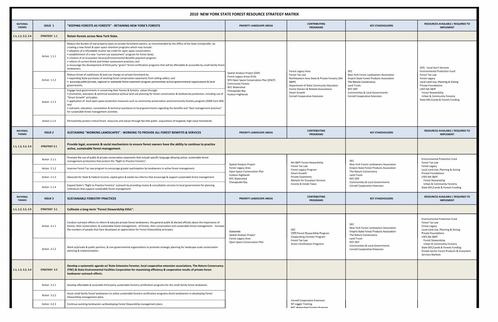
NATIONAL THEMES
ISSUE 1 "KEEPING FORESTS AS FORESTS" ‐ RETAINING NEW YORK'S FORESTS PRIORITY LANDSCAPE AREASCONTRIBUTINGPROGRAMS
KEY STAKEHOLDERSRESOURCES AVAILABLE / REQUIRED TO
IMPLEMENT
1.1, 1.2, 3.2, 3.4 STRATEGY 1.1 Retain forests across New York State.
Action 1.1.1
Reduce the burden of real property taxes on private forestland owners, as recommended by the Office of the State Comptroller, by creating a new forest & open space retention programs which may include:• adoption of a refundable income tax credit for open space conservation; • establishment of a new “current use assessment” program for forest lands;• creation of an Ecosystem Services/Environmental Benefits payment program; • reform of current forest and timber assessment practices; and ● encourage the development of third‐party “green” forest certification programs that will be affordable & accessible by small family forest landowners.
Action 1.1.2
Reduce threat of subdivision & land use change on private forestland by: • expanding State purchases of working forest conservation easements from willing sellers; and• pursuing public/private regional or statewide forest easement program partnerships w/non‐governmental organizations & local
DECNew York Forest Landowners AssociationEmpire State Forest Products AssociationThe Nature Conservancy
DOS ‐ Local Gov't Services Environmental Protection FundForest Tax LawForest LegacyLocal Land Use Planning & Zoning
2010 NEW YORK STATE FOREST RESOURCE STRATEGY MATRIX
Forest Legacy AreaForest Tax LawNortheastern Area State & Private Forestry (NA S&PF)
Spatial Analysis Project (SAP)Forest Legacy Areas (FLA)NYS Open Space Conservation Plan (OSCP)
• pursuing public/private, regional or statewide forest easement program partnerships w/non‐governmental organizations & local governments.
Action 1.1.3
Engage local governments in conserving their forests & forestry values through: • promotion, education & technical assistance w/local land use planning for forest conservation & biodiversity protection, including use of “Smart Growth” principles;• application of local open space protection measures such as community preservation acts/community forestry program (2008 Farm Bill); and• outreach, education, consultation & technical assistance to local governments regarding the benefits and “best management practices” for sustainable forest management activities.
Action 1.1.4 Permanently protect critical forest resources and values through fee‐title public acquisitions of targeted, high‐value forestlands.
NATIONAL THEMES
ISSUE 2 SUSTAINING "WORKING LANDSCAPES" ‐ WORKING TO PROVIDE ALL FOREST BENEFITS & SERVICES PRIORITY LANDSCAPE AREASCONTRIBUTINGPROGRAMS
KEY STAKEHOLDERSRESOURCES AVAILABLE / REQUIRED TO
IMPLEMENT
1.1, 1.2, 3.2, 3.4 STRATEGY 2.1Provide legal, economic & social mechanisms to ensure forest owners have the ability to continue to practice active, sustainable forest management.
Promote the use of public & private conservation easements that include specific language allowing active sustainable forest
The Nature ConservancyLand TrustsNYC DEPCommunities & Local GovernmentsCornell Cooperative Extension
Local Land Use, Planning & ZoningPrivate FoundationsUSFS NA S&PF Forest Stewardship Urban & Community ForestryState DEC/Lands & Forests Funding
S&PF)Department of State Community EducationForest Owners & Related AssociationsSmart GrowthCornell Cooperative Extension
Community ForestsNYC WatershedChesapeake BayHudson Highlands
Action 2.1.1Promote the use of public & private conservation easements that include specific language allowing active, sustainable forest management.protections that protect the "Right to Practice Forestry".
Action 2.1.2 Improve Forest Tax Law program to encourage greater participation by landowners in active forest management.
Action 2.1.3 Advocate for State & Federal income, capital gains & estate tax reforms that encourage & support sustainable forest management.
Action 2.1.4Expand State’s “Right to Practice Forestry” outreach by providing review & consultation services to local governments for planning ordinances that support sustainable forest management.
NATIONAL THEMES
ISSUE 3 SUSTAINABLE FORESTRY PRACTICES PRIORITY LANDSCAPE AREASCONTRIBUTINGPROGRAMS
KEY STAKEHOLDERSRESOURCES AVAILABLE / REQUIRED TO
IMPLEMENT
1.1, 1.2, 3.2, 3.4 STRATEGY 3.1 Cultivate a long‐term “Forest Stewardship Ethic”.
Action 3.1.1Conduct outreach efforts to inform & educate private forest landowners, the general public & elected officials about the importance of forests, their conservation, & sustainable forest management. of forests, their conservation and sustainable forest management. Increase the numbers of people that have developed an appreciation for Forest Stewardship principles.
Environmental Protection FundForest Tax LawForest LegacyLocal Land Use, Planning & ZoningP i t F d ti
DECNew York Forest Landowners AssociationEmpire State Forest Products Association
DECUSFS F t St d hi P
NA S&PF Forest StewardshipForest Tax LawForest Legacy ProgramSmart GrowthPrivate EasementsMarkets for Ecosytem ServicesIncome & Estate Taxes
DECNew York Forest Landowners AssociationEmpire State Forest Products AssociationThe Nature ConservancyLand TrustsNYC DEPCommunities & Local GovernmentsCornell Cooperative Extension
Environmental Protection FundForest Tax LawForest LegacyLocal Land Use, Planning & ZoningPrivate FoundationsUSFS NA S&PF Forest Stewardship Urban & Community ForestryState DEC/Lands & Forests Funding
Statewide
Spatial Analysis ProjectForest Legacy AreaOpen Space Conservation PlanHudson HighlandsNYC WatershedChesapeake Bay
Action 3.1.2Work w/private & public partners, & non‐governmental organizations to promote strategic planning for landscape‐scale conservation planning & implementation.
1.1, 1.2, 3.2, 3.4 STRATEGY 3.2Develop a systematic agenda w/ State Extension Forester, local cooperative extension associations, The Nature Conservancy (TNC) & State Environmental Facilities Corporation for maximizing efficiency & cooperative results of private forest landowner outreach efforts.
Action 3.2.1 Develop affordable & accessible third‐party sustainable forestry certification programs for the small family forest landowner.
Action 3.2.2Assist small family forest landowners to utilize sustainable forestry certification programs.Assist landowners in developing Forest Stewardship management plans.
Action 3.2.3 Continue assisting landowners w/developing Forest Stewardship management plans.
Private FoundationsUSFS NA S&PF Forest Stewardship Urban & Community ForestryState DEC/Lands & Forests FundingPrivate Sector Forest Products & Ecosystem Services Markets
mpire State Forest Products AssociationThe Nature ConservancyLand TrustsNYC DEPCommunities & Local GovernmentsCornell Cooperative Extension
USFS Forest Stewardship ProgramCooperating Forester ProgramForest Tax LawGreen Certification Programs
Cornell Cooperative ExtensionNY Logger TrainingNYC Watershed Foresty Program
StatewideSpatial Analysis ProjectForest Legacy AreaOpen Space Conservation Plan
NYC Watershed Foresty Program

Action 3.2.4Develop additional BMPs & guidance to promote biomass harvesting, wildlife habitat protection, forest regeneration, timber crop production & water quality.
Action 3.2.5 Develop landowner incentives that will work to increase the use of BMPs.
Action 3.2.6 Establish “peer” private forest landowner networks.
Action 3.2.7 Explore emerging areas of sustainable forestry & natural resource science.
Action 3.2.8 Provide demonstration sites & long‐term research for new practices on State Forest lands.
Action 3.2.9 Address forest regeneration challenges.
1.1, 1.2, 3.2, 3.4 STRATEGY 3.3 Increase the use of silvicultural Best Management Practices (BMPs).
Action 3.3.1Utilize State Stewardship Analysis Program (SAP) to target outreach efforts, in order to ensure that high priority opportunities to work w/private forest landowners of critical & significant lands are capitalized upon.
NYC Watershed Foresty ProgramSUNY College of Environmental Science & ForestryForest Tax LawEnvironmental Quality Incentive ProgramNY Agroforestry Resource CenterWildlife Habitat Enhancement ProgramCSPNYS Wood Products Development Council Wetlands Reserve Program
StaffFunding Environment Protection Agency NYS Environmental Facilities Corporation New York City USDA
NYC Department of Environmental ProtectionNew York Forest Landowners AssociationEmpire State Forest Products AssociationState Non‐Point Source Coordinating CommitteeState Soil & Water Conservation CommitteeCounty Soil & Water Conservation Districts
Spatial Analysis Project NY Open Space Conservation PlanForest Legacy Area Great Lakes Watershed Chesapeake Bay Watershed NYC Watershed
Action 3.3.2 Implement a BMP monitoring program based on existing USFS protocols.
1.1, 1.2, 3.2, 3.4 STRATEGY 3.4Increase incentives & reduce costs for private forest landowners to promote & implement sustainable forest management activities.
Action 3.4.1 Improve Forest Tax Law program to reward active forest management & promote greater participation in such program.
Action 3.4.2Expand & increase funding for incentive & cost‐sharing programs to promote & support sustainable forest management practices on private forest lands.
Action 3.4.3 Streamline administration of cost‐sharing & incentive programs for private landowners to make participation more attractive.
Action 3.4.4 Advocate for state & federal income, capital gains & estate tax reforms that support sustainable forest management.
Action 3.4.5Work w/stakeholders to become actively & quickly engaged in improving forestry incentive programs & targeted funding in the next Federal Farm Bill.
NATIONAL ISSUE 4 SUSTAINABLE MARKETS FOR SUSTAINABLE TIMBER PRODUCTS PRIORITY LANDSCAPE AREAS
CONTRIBUTINGKEY STAKEHOLDERS
RESOURCES AVAILABLE / REQUIRED TO THEMES
ISSUE 4 SUSTAINABLE MARKETS FOR SUSTAINABLE TIMBER PRODUCTS PRIORITY LANDSCAPE AREASPROGRAMS
KEY STAKEHOLDERSIMPLEMENT
3.6 STRATEGY 4.1 Increase availability, diversity & economic viability of markets for sustainable forest products & services.
Action 4.1.1 Develop & support activities of newly formed, “NYS Wood Products Development Council”.
Action 4.1.2 Maintain & enhance State Forest Utilization & Marketing Program capabilities.
Action 4.1.3Promote & expand use of locally produced forest products for household & energy uses by focusing technical assistance, favorable policies & incentives.
Action 4.1.4 Provide incentives for young workers to enter the forest products industry.
Action 4.1.5 Work w/public & private partners to promote forest product market retention, expansion & development.
Action 4.1.6Support efforts to develop viable, economical & profitable markets for ecosystem services, including carbon sequestration, wildlife habitat conservation, & water quality protection programs that are accessible to small forest landowners.
Action 4 1 7Provide outreach, education & technical assistance to private forest landowners & entrepreneurs to assist them in developing &
Spatial Analysis ProjectForest Legacy AreaState LandsCommunity ForestryOpen Space Conservation Plan
NYS Wood Products Development CouncilUrban and Community ForestryNYS Department of State (DOS)Division of Water
Action 4.1.7participating in non‐traditional & non‐timber forest products markets.
2.2, 3.1 STRATEGY 4.2 Support retention, recruitment & training of sustainable timber harvesters.
Action 4.2.1 Promote & expand use of locally produced forest products for household & energy uses by focusing technical assistance, favorable policies &
Action 4.2.2Work w/ New York Forest Owners Association, Cornell Cooperative Extension, Empire State Forest Products Association & State Logger Training Inc. to promote use of trained timber harvesters by private forest landowners.
Action 4.2.3Support public & private sector logger safety training programs & other initiatives to improve worker productivity, increase harvesting business profitability, reduce accidents & lower workers compensation costs.
Action 4.2.4 Support recruitment & vocational training programs that encourage youth to consider & prepare for careers in the forest industry.
NYC Department of Environmental ProtectionNew York Forest Landowners AssociationEmpire State Forest Products AssociationState Non‐Point Source Coordinating CommitteeState Soil & Water Conservation CommitteeCounty Soil & Water Conservation Districts
Environmental Quality Incentive ProgramWetlands Reserve ProgramCSP
Additional staff are needed
StatewideSpatial Analysis ProjectState ForestsCommunity ForestsOSCP
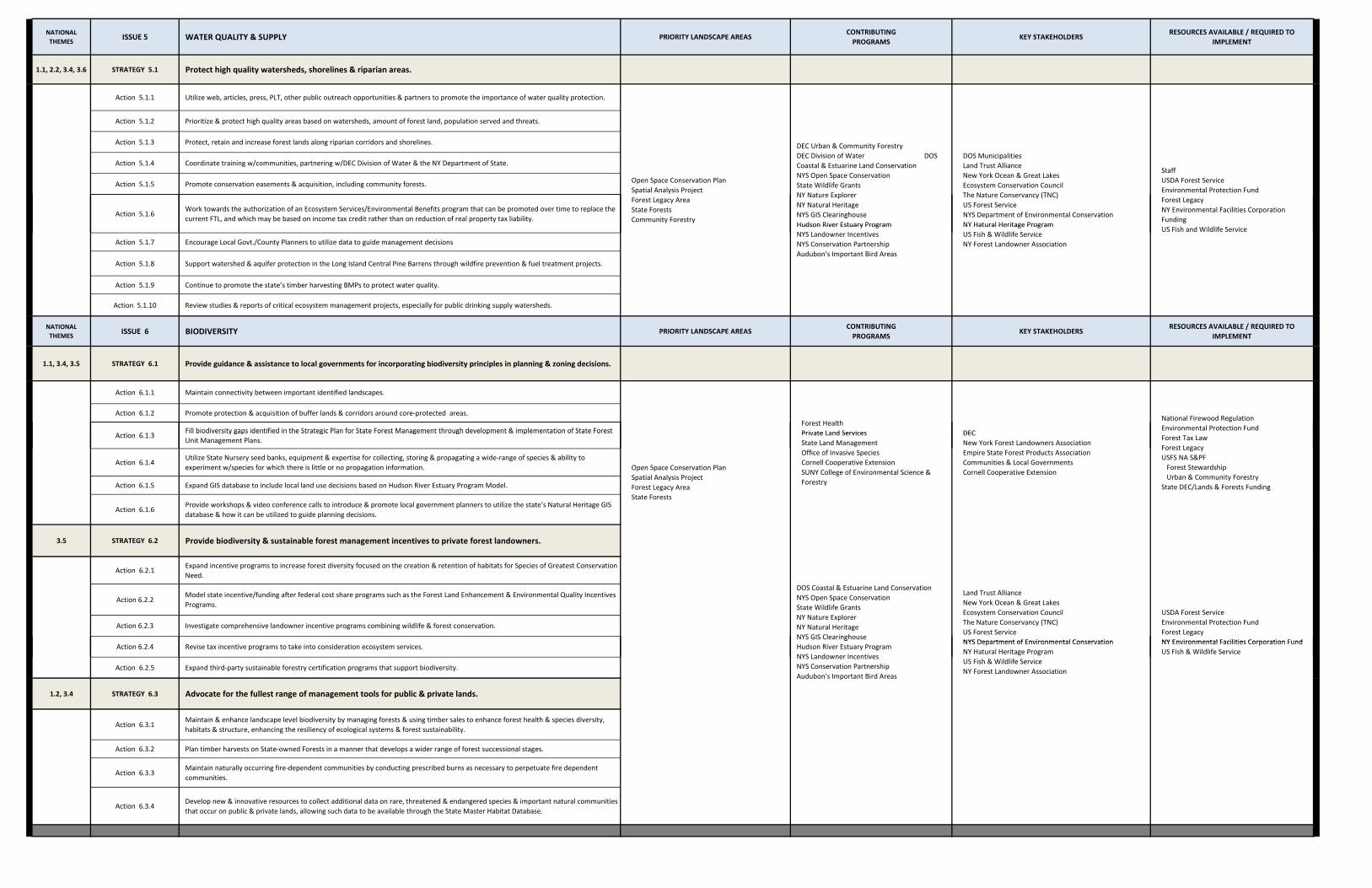
NATIONAL THEMES
ISSUE 5 WATER QUALITY & SUPPLY PRIORITY LANDSCAPE AREASCONTRIBUTINGPROGRAMS
KEY STAKEHOLDERSRESOURCES AVAILABLE / REQUIRED TO
IMPLEMENT
1.1, 2.2, 3.4, 3.6 STRATEGY 5.1 Protect high quality watersheds, shorelines & riparian areas.
Action 5.1.1 Utilize web, articles, press, PLT, other public outreach opportunities & partners to promote the importance of water quality protection.
Action 5.1.2 Prioritize & protect high quality areas based on watersheds, amount of forest land, population served and threats.
Action 5.1.3 Protect, retain and increase forest lands along riparian corridors and shorelines.
Action 5.1.4 Coordinate training w/communities, partnering w/DEC Division of Water & the NY Department of State.
Action 5.1.5 Promote conservation easements & acquisition, including community forests.
Action 5.1.6Work towards the authorization of an Ecosystem Services/Environmental Benefits program that can be promoted over time to replace the current FTL, and which may be based on income tax credit rather than on reduction of real property tax liability.
Staff USDA Forest ServiceEnvironmental Protection FundForest LegacyNY Environmental Facilities Corporation Funding
Open Space Conservation PlanSpatial Analysis ProjectForest Legacy AreaState Forests Community Forestry
DOS Municipalities Land Trust AllianceNew York Ocean & Great LakesEcosystem Conservation CouncilThe Nature Conservancy (TNC)US Forest ServiceNYS Department of Environmental ConservationNY Hatural Heritage Program
DEC Urban & Community Forestry DEC Division of Water DOS Coastal & Estuarine Land Conservation NYS Open Space ConservationState Wildlife GrantsNY Nature ExplorerNY Natural Heritage NYS GIS ClearinghouseHudson River Estuary Program
Action 5.1.7 Encourage Local Govt./County Planners to utilize data to guide management decisions
Action 5.1.8 Support watershed & aquifer protection in the Long Island Central Pine Barrens through wildfire prevention & fuel treatment projects.
Action 5.1.9 Continue to promote the state’s timber harvesting BMPs to protect water quality.
Action 5.1.10 Review studies & reports of critical ecosystem management projects, especially for public drinking supply watersheds.
NATIONAL THEMES
ISSUE 6 BIODIVERSITY PRIORITY LANDSCAPE AREASCONTRIBUTINGPROGRAMS
KEY STAKEHOLDERSRESOURCES AVAILABLE / REQUIRED TO
IMPLEMENT
1.1, 3.4, 3.5 STRATEGY 6.1 Provide guidance & assistance to local governments for incorporating biodiversity principles in planning & zoning decisions.
Action 6.1.1 Maintain connectivity between important identified landscapes.
Action 6.1.2 Promote protection & acquisition of buffer lands & corridors around core‐protected areas.
A ti 6 1 3Fill biodiversity gaps identified in the Strategic Plan for State Forest Management through development & implementation of State Forest DEC
National Firewood RegulationEnvironmental Protection Fund
Forest HealthPrivate Land Services
US Fish and Wildlife ServiceNY Hatural Heritage ProgramUS Fish & Wildlife ServiceNY Forest Landowner Association
Hudson River Estuary ProgramNYS Landowner IncentivesNYS Conservation PartnershipAudubon's Important Bird Areas
Action 6.1.3Fill biodiversity gaps identified in the Strategic Plan for State Forest Management through development & implementation of State ForestUnit Management Plans.
Action 6.1.4Utilize State Nursery seed banks, equipment & expertise for collecting, storing & propagating a wide‐range of species & ability to experiment w/species for which there is little or no propagation information.
Action 6.1.5 Expand GIS database to include local land use decisions based on Hudson River Estuary Program Model.
Action 6.1.6Provide workshops & video conference calls to introduce & promote local government planners to utilize the state’s Natural Heritage GIS database & how it can be utilized to guide planning decisions.
3.5 STRATEGY 6.2 Provide biodiversity & sustainable forest management incentives to private forest landowners.
Action 6.2.1Expand incentive programs to increase forest diversity focused on the creation & retention of habitats for Species of Greatest Conservation Need.
Action 6.2.2Model state incentive/funding after federal cost share programs such as the Forest Land Enhancement & Environmental Quality Incentives Programs.
Action 6.2.3 Investigate comprehensive landowner incentive programs combining wildlife & forest conservation.
DECNew York Forest Landowners AssociationEmpire State Forest Products AssociationCommunities & Local GovernmentsCornell Cooperative Extension
Forest Tax LawForest LegacyUSFS NA S&PF Forest Stewardship Urban & Community ForestryState DEC/Lands & Forests Funding
Land Trust AllianceNew York Ocean & Great LakesEcosystem Conservation CouncilThe Nature Conservancy (TNC)US Forest ServiceNYS Department of Environmental Conservation
USDA Forest ServiceEnvironmental Protection FundForest LegacyNY Environmental Facilities Corporation Fund
Private Land ServicesState Land ManagementOffice of Invasive SpeciesCornell Cooperative ExtensionSUNY College of Environmental Science & Forestry
Open Space Conservation PlanSpatial Analysis ProjectForest Legacy AreaState Forests
DOS Coastal & Estuarine Land Conservation NYS Open Space ConservationState Wildlife GrantsNY Nature ExplorerNY Natural Heritage NYS GIS Clearinghouse
Action 6.2.4 Revise tax incentive programs to take into consideration ecosystem services.
Action 6.2.5 Expand third‐party sustainable forestry certification programs that support biodiversity.
1.2, 3.4 STRATEGY 6.3 Advocate for the fullest range of management tools for public & private lands.
Action 6.3.1Maintain & enhance landscape level biodiversity by managing forests & using timber sales to enhance forest health & species diversity, habitats & structure, enhancing the resiliency of ecological systems & forest sustainability.
Action 6.3.2 Plan timber harvests on State‐owned Forests in a manner that develops a wider range of forest successional stages.
Action 6.3.3Maintain naturally occurring fire‐dependent communities by conducting prescribed burns as necessary to perpetuate fire dependent communities.
Action 6.3.4Develop new & innovative resources to collect additional data on rare, threatened & endangered species & important natural communities that occur on public & private lands, allowing such data to be available through the State Master Habitat Database.
NYS Department of Environmental ConservationNY Hatural Heritage ProgramUS Fish & Wildlife ServiceNY Forest Landowner Association
NY Environmental Facilities Corporation FundUS Fish & Wildlife Service
gHudson River Estuary ProgramNYS Landowner IncentivesNYS Conservation PartnershipAudubon's Important Bird Areas

NATIONAL THEMES
ISSUE 7 FOREST HEALTH PRIORITY LANDSCAPE AREASCONTRIBUTINGPROGRAMS
KEY STAKEHOLDERSRESOURCES AVAILABLE / REQUIRED TO
IMPLEMENT
2.2 STRATEGY 7.1 Fight invasive pests & diseases.
Action 7.1.1 Develop & implement systematic statewide early detection program to minimize amount of time between infestation & detection.
Action 7.1.2 Develop rapid & long term response capabilities at the State & local levels to minimize degree of impact.
Action 7.1.3 Improve data collection on the status of invasives w/in the State.
2.2 STRATEGY 7.2 Address catastrophic natural events. Statewide Issues
Action 7.2.1 Develop abilities to quantify severity & extent.
Action 7.2.2 Increase preparedness planning.
Action 7.2.3 Develop & distribute BMPs to local decision makers.
National Firewood RegulationEnvironmental Protection FundForest Tax LawForest LegacyUSFS NA S&PF Forest Stewardship Urban & Community ForestryState DEC/Lands & Forests Funding
DECNew York Forest Landowners AssociationEmpire State Forest Products AssociationThe Nature ConservancyCommunities & Local GovernmentsCornell Cooperative Extension
Forest HealthPrivate Land ServicesState Land ManagementOffice of Invasive SpeciesCornell Cooperative ExtensionSUNY College of Environmental Science & Forestry
2.2, 3.6 STRATEGY 7.3 Expand public education programs on forest health issues. Outreach & Communication
Action 7.3.1 Continue to work closely with the PRISMS, Invasive Species Council and the Invasive Species Advisory Committee.
Action 7.3.2 Develop and publish an educational brochure about invasive species BMPs for recreational users.
Action 7.3.3Encourage private landowners to manage their forests to enhance forest health and the diversity of species, habitats and structure in order to enhance the resiliency of ecological systems and forest sustainability.
Action 7.3.4 Increase use of articles for Conservationist Magazine, newsletters, newspaper articles, web, other venues, partners to disseminate.
Action 7.3.5 Maximize web resources, providing education on pest issues, effects, & how public citizens can participate to address issues.
Action 7.3.6 Train people who already work with the public – use existing communication routes.
Action 7.3.7Support research & technology transfer on climate change & acid rain & their impacts on forest resources, invasive species detection, impacts & management; & ecosystem & habitat conservation and restoration.
2.1, 3.3 STRATEGY 7.4 Support & improve wildfire management services.
Action 7.4.1Improve local fire departments ability to effectively contain wildfires w/in the first operation period w/out loss of life, injury or excessive property damage.
Action 7.4.2Understand the dynamics of wildfire occurrence as reported by fire departments & forest rangers, & modify management strategies accordingly.
Action 7.4.3Improve capabilities of forest rangers to contain multi‐operational wildfires with no injury of loss of life & the least environmental & property damage.
Action 7.4.4Develop active & self sustaining Fire‐Wise programs in the 51 communities‐at‐risk throughout the State w/a priority for those 26 towns in the Adirondack Park.
Action 7.4.5 Support state & local governments & non‐government organizations w/management of fire dependent ecosystems.
Action 7.4.6Continue management & support of the Volunteer Firefighters Association program to support wildfire containment by local fire departments.
Action 7.4.7Maintain & improve expertise & capability w/in DEC Forest Ranger Division in order to support fire departments, state agencies, compact members & federal agencies w/ prevention & control of wildfires
1,774 NYS Fire Departments TNCAdirondack Park NGO Support GroupsAdirondack Park AgencyNew York City Watershed ManagersLong Island Central Pine Barrens CommissionNortheast Forest Fire Protection Commission (Compact)Finger Lakes National ForestU. S. Park Service, Saratoga BattlefieldU. S. Fish & Wildlife Service62 County Emergency Managers932 Town Supervisors
Communities at Wildfire Risk
members & federal agencies w/ prevention & control of wildfires.
Action 7.4.8Improve minimal impact strategies & techniques (MIST) of containing wildfires by developing enhanced hand‐crew firefighters & improve aviation capabilities in critical wildfire areas of the State.
Action 7.4.9 Support partners w/fire management practices to accomplish wildfire protection & ecosystem management on critical sites.
Action 7.4.10 Utilize fire occurrence data from fire departments & forest rangers to assess trends in wildfire occurrence.
Action 7.4.11 Assess wildfire investigation & burning law enforcement for adequate effectiveness & setting of annual priority goals.
Action 7.4.12 Review public & media responses to wildfire prevention & occurrence.
932 Town Supervisors

NATIONAL THEMES
ISSUE 8 ADAPTING TO CLIMATE CHANGE PRIORITY LANDSCAPE AREASCONTRIBUTINGPROGRAMS
KEY STAKEHOLDERSRESOURCES AVAILABLE / REQUIRED TO
IMPLEMENT
STRATEGY 8.1 Recognize the role of forests to mitigate & adapt to climate change.
Action 8.1.1 Increase use of sustainably produced bio‐energy to replace fossil fuel use.
Action 8.1.2 Increase practice & recognition of carbon sequestration through forest management.
Action 8.1.3 Measure net change of forest carbon stocks on a project/regional basis using FIA data.
Action 8.1.4 Promote economic return to landowners from carbon sequestration.
Action 8.1.5 Understand trends in climate change & its effects on wildfire occurrence & potential.
NATIONAL THEMES
ISSUE 9 URBAN TREE CANOPY & GREEN INFRASTRUCTURE PRIORITY LANDSCAPE AREASCONTRIBUTINGPROGRAMS
KEY STAKEHOLDERSRESOURCES AVAILABLE / REQUIRED TO
IMPLEMENT
3.2, 3.4, 3.6, 3.7 STRATEGY 9.1 Engage & educate communities on the importance of urban forestry & green infrastructure.
Additional staff are neededFederal Government NYS Wood Products Development Council
Urban AreasSpatial Analysis ProjectState Lands
Climate Change OfficeClimate Smart CommunititesDEC NurseryUS EPA
Action 9.1.1 Expand assistance programs to increase tree canopy in local communities, stressing health & societal benefits of trees.
Action 9.1.2 Replicate & promote the adoption of tree planting ordinances by local governments, modeled after Nassau County’s current ordinances.
Action 9.1.3Promote the benefits of trees & native vegetation through Arbor Day & community tree planting events, service foresters, & DEC internet website.
Action 9.1.4 Educate planning, zoning boards & encourage greenspace & tree planting in the site plan approval process.
Action 9.1.5 Provide GIS access to the public, local government & communities to show where urban forestry & green infrastructure needs exist.
Action 9.1.6 Continue partnerships w/the State Chapter of International Society of Arboriculture (ISA), & State Nursery Landscape Association.
3.2, 3.4, 3.6, 3.7 STRATEGY 9.2 Encourage networking of community tree boards.
Action 9.2.1 Form a statewide community tree board committee for information exchange.
ReLeafNYS Urban & Community Forestry CouncilDOS
Urban & Community Forestry ProgramNeed Staff
Nowak Priority Planting AreasCARS Communitites
Outreach & CommunicationUrban ForestryGIS
Action 9.2.2 Provide technical assistance through workshops & other forums.
Action 9.2.3 Encourage professionals to volunteer on community tree boards.
3.2, 3.4, 3.6, 3.7 STRATEGY 9.3 Develop a statewide database of community tree inventories.
Action 9.3.1 Develop program w/the goal of assisting & ensuring every community consistently digitizes street tree inventory data & paper inventories.
Action 9.3.2Develop infrastructure of statewide database & methods to efficiently transfer community data, as well as provide public access to community & state database.
Action 9.3.3 Improve accuracy & collection of community tree inventories w/tree diversity statistics, population, age, etc.
Action 9.3.4Improve statewide urban forestry inventory by developing program’s ability to assess the benefits & needs of an urban forest, taking into consideration tree species, age, size & benefits at maturity.
3.2, 3.4, 3.6, 3.7 STRATEGY 9.4 Incorporate green infrastructure into urban communities.
Action 9.4.1 Promote connection between urban forests, green infrastructure & ecosystem services.
NYS Urban & Community Forestry CouncilNYS Energy, Research & Development Authority
NYSERDA Adaptation StudyGreen InfrastructureEnvironmental JusticeUrban ForestryPrivate Land ServicesOutreach & Communication
Action 9.4.1 Promote connection between urban forests, green infrastructure & ecosystem services.
Action 9.4.2 Promote stormwater management practices using trees natural systems & other green infrastructure measures.
Action 9.4.3 Provide incentives & technical assistance to private developers.
Action 9.4.4 Utilize State Nursery to research & propagate native species for green infrastructure applications.
Action 9.4.5 Support private nurseries & their marketing of native species.
Action 9.4.6 Develop a Community Forest Program administered by DEC Division of Lands & Forests in partnership w/local governments.
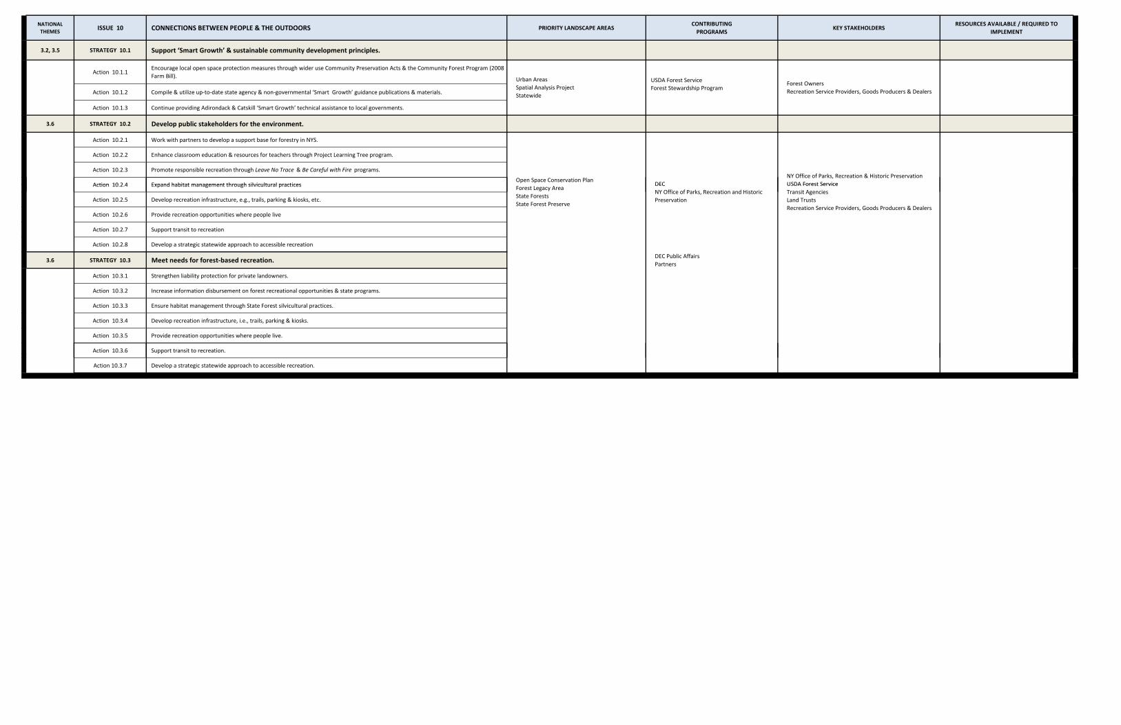
NATIONAL THEMES
ISSUE 10 CONNECTIONS BETWEEN PEOPLE & THE OUTDOORS PRIORITY LANDSCAPE AREASCONTRIBUTINGPROGRAMS
KEY STAKEHOLDERSRESOURCES AVAILABLE / REQUIRED TO
IMPLEMENT
3.2, 3.5 STRATEGY 10.1 Support ‘Smart Growth’ & sustainable community development principles.
Action 10.1.1Encourage local open space protection measures through wider use Community Preservation Acts & the Community Forest Program (2008 Farm Bill).
USDA Forest Service
Action 10.1.2 Compile & utilize up‐to‐date state agency & non‐governmental ‘Smart Growth’ guidance publications & materials. Forest Stewardship Program
Action 10.1.3 Continue providing Adirondack & Catskill ‘Smart Growth’ technical assistance to local governments.
3.6 STRATEGY 10.2 Develop public stakeholders for the environment.
Action 10.2.1 Work with partners to develop a support base for forestry in NYS.
Action 10.2.2 Enhance classroom education & resources for teachers through Project Learning Tree program.
Action 10.2.3 Promote responsible recreation through Leave No Trace & Be Careful with Fire programs.
Action 10 2 4 Expand habitat management through silvicultural practicesNY Office of Parks, Recreation & Historic PreservationUSDA Forest Service
Forest OwnersRecreation Service Providers, Goods Producers & Dealers
Urban AreasSpatial Analysis ProjectStatewide
Open Space Conservation PlanDECAction 10.2.4 Expand habitat management through silvicultural practices
Action 10.2.5 Develop recreation infrastructure, e.g., trails, parking & kiosks, etc.
Action 10.2.6 Provide recreation opportunities where people live
Action 10.2.7 Support transit to recreation
Action 10.2.8 Develop a strategic statewide approach to accessible recreation
3.6 STRATEGY 10.3 Meet needs for forest‐based recreation.DEC Public AffairsPartners
Action 10.3.1 Strengthen liability protection for private landowners.
Action 10.3.2 Increase information disbursement on forest recreational opportunities & state programs.
Action 10.3.3 Ensure habitat management through State Forest silvicultural practices.
Action 10.3.4 Develop recreation infrastructure, i.e., trails, parking & kiosks.
Action 10.3.5 Provide recreation opportunities where people live.
Action 10.3.6 Support transit to recreation.
USDA Forest ServiceTransit AgenciesLand TrustsRecreation Service Providers, Goods Producers & Dealers
Forest Legacy AreaState ForestsState Forest Preserve
DECNY Office of Parks, Recreation and Historic Preservation
pp
Action 10.3.7 Develop a strategic statewide approach to accessible recreation.

Stakeholder Involvement Part VIII
New York State Forest Resource Assessment and Strategy 203
VVIIIIII.. FFOORREESSTT RREESSOOUURRCCEE
AASSSSEESSSSMMEENNTT AANNDD SSTTRRAATTEEGGYY
((FFRRAASS)) SSTTAAKKEEHHOOLLDDEERR
IINNVVOOLLVVEEMMEENNTT As the largest forest landowner in the state and the State Agency entrusted with providing forestry assistance to private forest landowners, The Division of Lands and Forests within the Department of Environmental Conservation has long worked in partnership with many forest stakeholder organizations and individuals, including the membership of the State Forest Stewardship Coordinating Committee. For the development of the FRAS, the Division of Lands and Forests developed a list of potential stakeholders beginning with the State Forest Stewardship Coordinating Committee as the base. Members of the Stakeholder Committee were invited to participate in a kick-off meeting on November 6, 2009. At the meeting the stakeholders were asked to comment on a draft assessment and to identify additional sources of data and information. These comments were used to improve the draft assessment. Also at the first Stakeholder Committee meeting, stakeholders shared their vision for New York’s forests moving forward and identified important issues facing New York’s forests and made recommendations of where to focus strategies to address the issues identified. The FRAS Stakeholder Committee next met on and April 21, 2010. Stakeholders reviewed a revised draft of the FRAS prior to the meeting and brought comments and suggestions to the meeting on how to enhance the draft document.

Part VII Stakeholder Involvement
204 New York State Forest Resource Assessment and Strategy
FRAS Stakeholder Committee Name Organization Allison Beals Adirondack Mountain Club (SFSCC Secondary Contact) (FLP) Astor Boozer USDA NRCS (State Technical Committee) (SFSCC) Shorna Broussard Cornell University Mike Burns Empire State Forest Products Assoc (ESFPA) (SFSCC Secondary
Contact) Jack Cooper Fish & Wildlife Mgmt Board Graham Cox Audubon New York (SFSCC) (FLP) DJ Evans Natural Heritage Linda Gibbs Tug Hill Commission (SFSCC) (FLP) Ed Goodell NY-NJ Trail Conference (SFSCC) Andy Hayes NY Society of American Foresters (SFSCC) Dave Higby The Nature Conservancy (SFSCC) (FLP) Roy Hopke Forest Practice Board (SFSCC) Andy Jacob NYS DEC Division of Law Enforcement Alanah Keddell Adirondack Council Kevin King Empire State Forest Products Assoc (ESFPA) (SFSCC) (FLP) Steve Lanthier NYS Soil & Water Conservation Committee (SFSCC) Paul Lenz NYC DEP Scott Lorey Adirondack Council (SFSCC Secondary Contact) (FLP) Sean Mahar Audubon New York John Major NYS DEC Division of Fish and Wildlife (State Wildlife Agency) John Mancini NYS Conference of Mayors John McDonald, III NYS Conference of Mayors Chris Mercurio NYS Urban and Community Forestry Council Roger Monthey USDA FS -NA, State & Private Forestry (SFSCC) Tom Morrow Lyme Timber Jessica Ottney The Nature Conservancy (SFSCC Secondary Contact) MaryJeanne Packer NY Forest Owners Association (SFSCC) Harold Palmer NYS Conservation Council (SFSCC) (FLP) Tom Pavlesich NYC Watershed Agricultural Council (SFSCC Secondary Contact) Melissa Reichert Finger Lakes National Forest Patricia Riexinger NYS DEC Division of Fish & Wildlife (State Wildlife Agency) (SFSCC)Tom Rinaldi NYS DEC Forest Protection & Fire Manager J.R. Risley Forest Preserve Advisory Committee Brad Rogers NY Association of Conservation Districts (SFSCC) John Schwartz NYC DEP Matt Shurtleff Trust for Public Lands Peter Smallidge Cornell Cooperative Extension (SFSCC)

Stakeholder Involvement Part VIII
New York State Forest Resource Assessment and Strategy 205
FRAS Stakeholder Committee Name Organization Patricia Tobin NYS Urban and Community Forestry Council (SFSCC) Jim Waters Catskill Forest Association Ed White SUNY ESF-Research (SFSCC) Ethan Winter Land Trust Alliance Marilyn Wurth NYS DEC Office of Climate Change Andrew Zepp Finger Lakes Land Trust (SFSCC) (FLP) Christopher Zimmer Finger Lakes National Forest
SFSCC - State Forest Stewardship Coordinating Committee FLP - Forest Legacy Program Subcommittee of the SFSCC


Appendices Part IX
New York State Forest Resource Assessment and Strategy 207
IIXX.. AAPPPPEENNDDIICCEESS
A: Glossary of Terms and Acronyms B: Wildfire in New York Data C: Forest Legacy Program and Request for an Amendment to the Assessment of
Need D: Multi-State Priority Areas Descriptions E: References

Appendices Part IX Appendix A: Glossary of Terms and Acronyms
New York State Forest Resource Assessment and Strategy 209
APPENDIX A: GLOSSARY OF TERMS AND ACRONYMS Abiotic – pertaining to the nonliving parts of an ecosystem, such as soil, bedrock, air, water Acid rain – the deposition of a variety of acidic pollutants in either wet (e.g. rain, fog, or snow) or dry forms (e.g., gas or dust particles) Afforestation - Planting trees where there have not been any for decades or longer APHIS – U.S. Department of Agriculture Animal and Plant Health Inspection Service. http://www.aphis.usda.gov Aquifer – a saturated, permeable geologic unit of sediment or rock that can transmit significant quantities of water under ordinary hydraulic gradients Basal area – the cross-sectional area of a single stem, including the bark, mreasured at breast height (4.5 ft above the ground) Biodiversity - The variety and variability of all living organisms Biotic – pertaining to living organisms and their ecological and physiological relations BMP – Best Management Practices. Practices designed to be the most effective and practicable means to prevent or minimize environmental degradation, particularly nonpoint source water pollution. http://www.dec.ny.gov/lands/37845.html Breast height – a standard height from ground level, generally 4.5 ft., for recording diameter, circumference or basal area of a tree Clearcut – A harvest in which all or almost all of the trees are removed in one cutting Community - A group of species that occur together in a particular habitat Community Type - A class of biological communities CCC - Federal Civilian Conservation Corps DEC - New York State Department of Environmental Conservation. http://www.dec.ny.gov/index.html ECL – New York State Environmental Conservation Law - The body of law that established DEC and authorizes its programs. http://www.dec.ny.gov/regulations/387.html Ecosystem – a community (or group of communities) plus its physical surroundings, including atmosphere, soil, sunlight, and water Exurban Sprawl – expanding development, parcelization, fragmentation, and second homes Forest Land – Land at least 10 percent stocked by forest trees of any size, including land that formerly had such tree cover and that will be naturally or artificially regenerated. Forest Management – Manipulation of the forest to achieve desired outcomes Forests – an ecosystem characterized by a more or less dense and extensive tree cover, often consisting of stands varying in characteristics such as species, composition, structure, age class, and associated processes, and commonly including meadows, streams, fish, and wildlife Fragmentation – a process in which the area occupied by a community is reduced in area, subdivided into smaller units, or partitioned by barriers to movement.
Part IX Appendices Appendix A: Glossary of Terms and Acronyms
210 New York State Forest Resource Assessment and Strategy
FPA - New York State Forest Practice Act FRAS - Forest Resource Assessment and Strategy FRPC - Forest Resource Planning Committee FS - United State Forest Service. http://www.fs.fed.us Industrial wood – All commercial roundwood products except fuelwood Invasive Species – An invasive species is a species that is 1) non-native to the ecosystem under consideration, and ; 2) whose introduction causes or is likely to cause economic or environmental harm or harm to human health, whereas the harm significantly outweigh any benefits NAASF - Northeast Area Association of State Foresters. http://stateforesters.org/our_partners/regions NASF - National Association of State Foresters. http://www.stateforesters.org Native – a species that occurs naturally in a particular area Non industrial Private – An ownership class of private lands where the owner does not operate wood-using plants OSP - New York State Open Space Conservation Plan. http://www.dec.ny.gov/lands/317.html Resilience, Resilient - the ability to resist or recover from disturbance; the ability to preserve diversity, productivity and sustainability Riparian – along the banks of a river or stream. SFSCC - State Forest Stewardship Coordinating Committee Species – a group of organisms capable of interbreeding Species Diversity – a measure of the number of species within a prescribed area and their relative abundances. Succession – a gradual, directional change in the species composition of a community following a disturbance. Sustainability – balancing the broad human and ecological needs of today without compromising the ability of future generations to meet their own needs. Timberland – Forest land that is producing or is capable of producing crops of industrial wood and not withdrawn from timber utilization by statute or administrative regulation. (Note: Areas qualifying as timberland are capable of production in excess of 20 cubic feet per acre per year of industrial wood in natural stands.) Urban Forestry – the art, science, and technology of managing trees and forest resources in and around urban community areas for the physiological, sociological, economic, and aesthetic benefits trees and green infrastructure provide society. http://www.dec.ny.gov/lands/4957.html
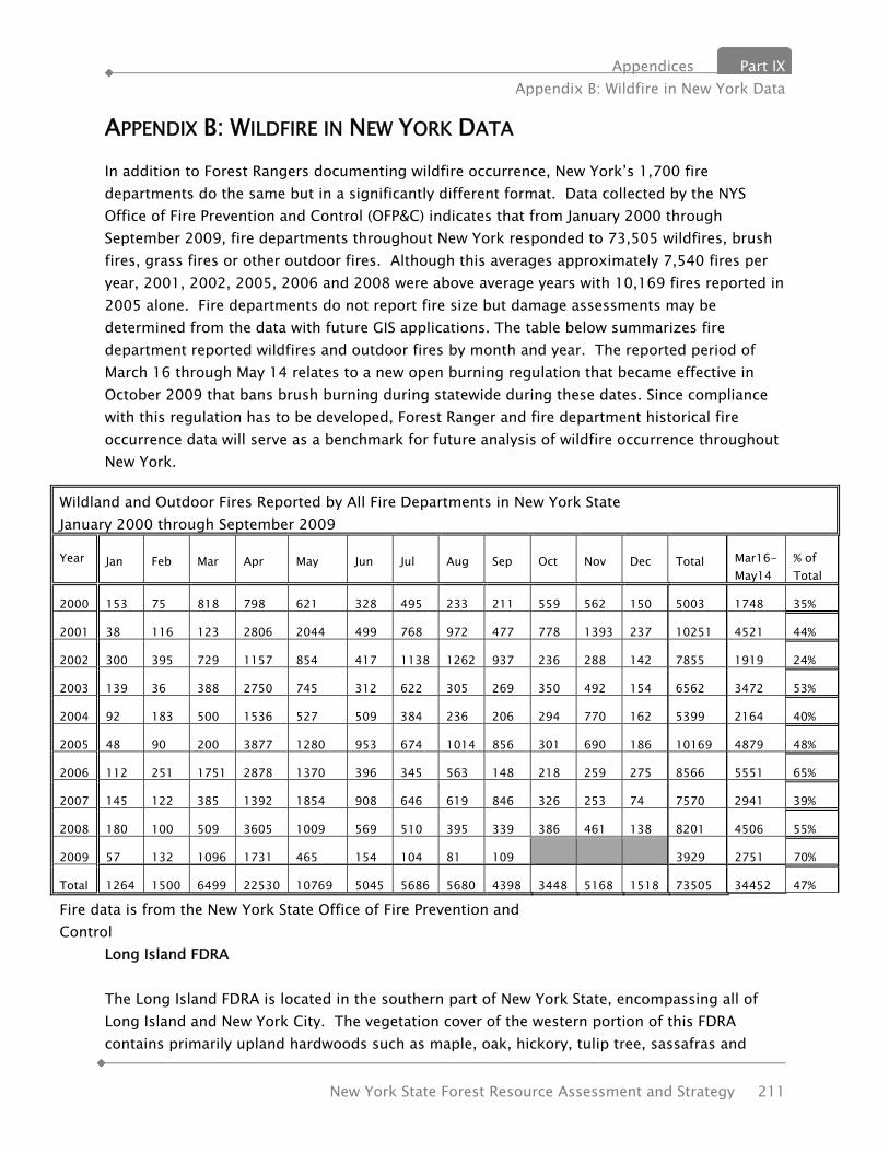
Appendices Part IX Appendix B: Wildfire in New York Data
New York State Forest Resource Assessment and Strategy 211
APPENDIX B: WILDFIRE IN NEW YORK DATA In addition to Forest Rangers documenting wildfire occurrence, New York’s 1,700 fire departments do the same but in a significantly different format. Data collected by the NYS Office of Fire Prevention and Control (OFP&C) indicates that from January 2000 through September 2009, fire departments throughout New York responded to 73,505 wildfires, brush fires, grass fires or other outdoor fires. Although this averages approximately 7,540 fires per year, 2001, 2002, 2005, 2006 and 2008 were above average years with 10,169 fires reported in 2005 alone. Fire departments do not report fire size but damage assessments may be determined from the data with future GIS applications. The table below summarizes fire department reported wildfires and outdoor fires by month and year. The reported period of March 16 through May 14 relates to a new open burning regulation that became effective in October 2009 that bans brush burning during statewide during these dates. Since compliance with this regulation has to be developed, Forest Ranger and fire department historical fire occurrence data will serve as a benchmark for future analysis of wildfire occurrence throughout New York.
Long Island FDRA The Long Island FDRA is located in the southern part of New York State, encompassing all of Long Island and New York City. The vegetation cover of the western portion of this FDRA contains primarily upland hardwoods such as maple, oak, hickory, tulip tree, sassafras and
Wildland and Outdoor Fires Reported by All Fire Departments in New York State January 2000 through September 2009
Year
Jan Feb Mar Apr May Jun Jul Aug Sep Oct Nov Dec Total Mar16-May14
% of Total
2000 153 75 818 798 621 328 495 233 211 559 562 150 5003 1748 35%
2001 38 116 123 2806 2044 499 768 972 477 778 1393 237 10251 4521 44%
2002 300 395 729 1157 854 417 1138 1262 937 236 288 142 7855 1919 24%
2003 139 36 388 2750 745 312 622 305 269 350 492 154 6562 3472 53%
2004 92 183 500 1536 527 509 384 236 206 294 770 162 5399 2164 40%
2005 48 90 200 3877 1280 953 674 1014 856 301 690 186 10169 4879 48%
2006 112 251 1751 2878 1370 396 345 563 148 218 259 275 8566 5551 65%
2007 145 122 385 1392 1854 908 646 619 846 326 253 74 7570 2941 39%
2008 180 100 509 3605 1009 569 510 395 339 386 461 138 8201 4506 55%
2009 57 132 1096 1731 465 154 104 81 109 3929 2751 70%
Total 1264 1500 6499 22530 10769 5045 5686 5680 4398 3448 5168 1518 73505 34452 47%
Fire data is from the New York State Office of Fire Prevention and Control
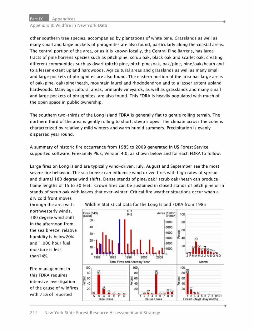
Part IX Appendices Appendix B: Wildfire in New York Data
212 New York State Forest Resource Assessment and Strategy
other southern tree species, accompanied by plantations of white pine. Grasslands as well as many small and large pockets of phragmites are also found, particularly along the coastal areas. The central portion of the area, or as it is known locally, the Central Pine Barrens, has large tracts of pine barrens species such as pitch pine, scrub oak, black oak and scarlet oak, creating different communities such as dwarf (pitch) pine, pitch pine/oak, oak/pine, pine/oak/heath and to a lesser extent upland hardwoods. Agricultural areas and grasslands as well as many small and large pockets of phragmites are also found. The eastern portion of the area has large areas of oak/pine, oak/pine/heath, mountain laurel and rhododendron and to a lesser extent upland hardwoods. Many agricultural areas, primarily vineyards, as well as grasslands and many small and large pockets of phragmites, are also found. This FDRA is heavily populated with much of the open space in public ownership. The southern two-thirds of the Long Island FDRA is generally flat to gentle rolling terrain. The northern third of the area is gently rolling to short, steep slopes. The climate across the zone is characterized by relatively mild winters and warm humid summers. Precipitation is evenly dispersed year round. A summary of historic fire occurrence from 1985 to 2009 generated in US Forest Service supported software, FireFamily Plus, Version 4.0, as shown below and for each FDRA to follow. Large fires on Long Island are typically wind-driven. July, August and September see the most severe fire behavior. The sea breeze can influence wind driven fires with high rates of spread and diurnal 180 degree wind shifts. Dense stands of pine/oak/ scrub oak/heath can produce flame lengths of 15 to 30 feet. Crown fires can be sustained in closed stands of pitch pine or in stands of scrub oak with leaves that over-winter. Critical fire weather situations occur when a dry cold front moves through the area with northwesterly winds, 180 degree wind shift in the afternoon from the sea breeze, relative humidity is below20% and 1,000 hour fuel moisture is less than14%. Fire management in this FDRA requires intensive investigation of the cause of wildfires with 75% of reported
Wildfire Statistical Data for the Long Island FDRA from 1985
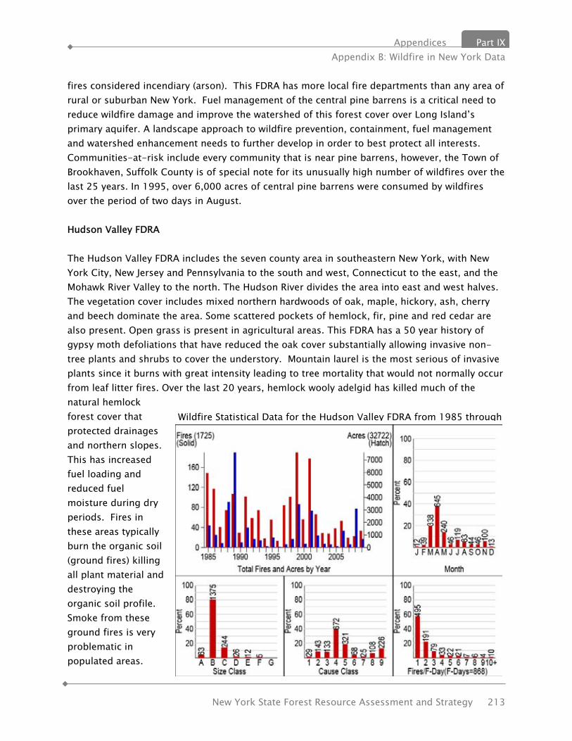
Appendices Part IX Appendix B: Wildfire in New York Data
New York State Forest Resource Assessment and Strategy 213
fires considered incendiary (arson). This FDRA has more local fire departments than any area of rural or suburban New York. Fuel management of the central pine barrens is a critical need to reduce wildfire damage and improve the watershed of this forest cover over Long Island’s primary aquifer. A landscape approach to wildfire prevention, containment, fuel management and watershed enhancement needs to further develop in order to best protect all interests. Communities-at-risk include every community that is near pine barrens, however, the Town of Brookhaven, Suffolk County is of special note for its unusually high number of wildfires over the last 25 years. In 1995, over 6,000 acres of central pine barrens were consumed by wildfires over the period of two days in August. Hudson Valley FDRA The Hudson Valley FDRA includes the seven county area in southeastern New York, with New York City, New Jersey and Pennsylvania to the south and west, Connecticut to the east, and the Mohawk River Valley to the north. The Hudson River divides the area into east and west halves. The vegetation cover includes mixed northern hardwoods of oak, maple, hickory, ash, cherry and beech dominate the area. Some scattered pockets of hemlock, fir, pine and red cedar are also present. Open grass is present in agricultural areas. This FDRA has a 50 year history of gypsy moth defoliations that have reduced the oak cover substantially allowing invasive non-tree plants and shrubs to cover the understory. Mountain laurel is the most serious of invasive plants since it burns with great intensity leading to tree mortality that would not normally occur from leaf litter fires. Over the last 20 years, hemlock wooly adelgid has killed much of the natural hemlock forest cover that protected drainages and northern slopes. This has increased fuel loading and reduced fuel moisture during dry periods. Fires in these areas typically burn the organic soil (ground fires) killing all plant material and destroying the organic soil profile. Smoke from these ground fires is very problematic in populated areas.
Wildfire Statistical Data for the Hudson Valley FDRA from 1985 through
Part IX Appendices Appendix B: Wildfire in New York Data
214 New York State Forest Resource Assessment and Strategy
The topography of the Hudson Valley FDRA includes a series of steep rocky ridges with rolling farmland in between. Elevations range from 200 feet in the Hudson Valley, to 2,200 feet on the Shawangunk Ridge and the Taconic Range. The area has relatively mild winters, with temperatures usually in the 25 to 35 degrees Fahrenheit range. Snow falls are higher in the northwest section, with little or no accumulation in the southeast section. Summers can be hot and dry with temperatures in the 90s and relative humidity as low as 20%. A summary of historic fire occurrence from 1985 to 2009 are shown in the graphs below. The primary carrier of fire is timber litter or grass. Spread rates are low to moderate. Fire intensity may be low to high with flame lengths usually less than four feet. Spotting and torching is possible. Fire intensity increases dramatically when burning in shrub understory, especially mountain laurel. Duff fires with high resistance to control are common during summer periods with sustained periods of drought. Critical fire weather situations occur when wind speeds are greater than 15 mph, relative humidity is less than 25% and 1,000-hour fuel moisture is less than 15%. Large fires (over 100 acres) are common throughout the FDRA. The Hudson Valley FDRA is a highly developed suburb of New York City with much forest cover publically owned. This includes the expansive New York City Watershed properties east of the Hudson River. Wildfires in this area generally do not result in the loss of structures but do create health issues from excessive smoke. Common summer ground fires cause great concern for the urban areas as the smoke transports into these areas. Wildfires generally need to be contained with hand crews and aviation assets rather than bulldozers due to high property values and rocky terrain. Debris burning accounts for 39% of all wildfires while 32% of fires are caused by arson or miscellaneous activities. The new open burning regulations in New York should greatly reduce debris caused wildfires over the next five years as the Ranger Division develops compliance through enforcement, however, intensive investigation of the cause of wildfires needs to occur to reduce the most serious of fires. Communities-at-risk within the Hudson Valley FDRA include the towns of Hurley, Rochester and Wawarsing in Ulster County, the Town of Mamakating, Sullivan County and the Town of Deerpark, Orange County. This is due to a high occurrence of wildfires in these towns each of which have a history of one or more large fires (over 100 acres) over the last 25 years. Several towns in Greene County have a high incidence of spring grass fires caused by debris burning with little damage or costs associated with these fires. As the Ranger Division develops compliance with the new open burning regulations, a significant reduction of fires should occur in these towns so that a community-at-risk designation may not be necessary. Catskill FDRA The Catskill FDRA is the area of New York encompassing the Catskill Park. The area is generally bordered by the Hudson Valley to the east, the Delaware River Valley to the west and southwest,

Appendices Part IX Appendix B: Wildfire in New York Data
New York State Forest Resource Assessment and Strategy 215
and the Central-Leatherstocking Region to the northwest. This FDRA contains the primary water supply and watershed of New York City (NYC). The vegetation of this FDRA is generally mixed northern hardwoods of oak, maple, hickory, ash, cherry and beech dominate the area. Some scattered pockets of hemlock, fir, pine and red cedar are also present. Open grass is present in agricultural areas. Much of this area is publically owned as either NYC Watershed or state forest preserve. Timber management, including fuel treatment is prohibited by state constitution on all state-owned lands within the Park. The area is predominantly mountainous terrain with rolling farmland at the western periphery. Elevations range from 500 feet to 4,100 feet. The area has relatively mild winters, with temperatures usually in the 25 to 35 degrees Fahrenheit range. Snow falls are highest in the mountains. Summers can be hot and dry with temperatures in the high 90s and relative humidity as low as 20%. A summary of historic fire occurrence from 1985 to 2009 is shown on this page. The primary carrier of fire is timber litter or grass. Spread rates are generally low to moderate except in areas where heavy pockets of mountain laurel will carry the fire at high rates of spread. Fire line intensity may be low to high with flame lengths usually less than four feet. Spotting and torching out of trees is possible. Fires which occur during drought periods generally burn deep into the duff. Steep and rocky terrain associated with this FDRA adds difficulty to fire control efforts. Critical fire weather situations include wind speeds greater than 15 mph, relative humidity less that 25% and 1,000-hour fuel moistures less than 15%. Few communities are at-risk in the Catskill FDRA because of the low frequency of wildfire, however, FireWise techniques should be encouraged to protect structures from a rare wildfire event or carelessness in the use of recreational fires. Upper Hudson/Champlain FDRA
Wildfire Statistical Data for the Catskill FDRA from 1985

Part IX Appendices Appendix B: Wildfire in New York Data
216 New York State Forest Resource Assessment and Strategy
This area is located north of the Capital Region and is bounded on the north by the Canadian border, the east by Lake Champlain and the New York/Vermont state line, the south by the Mohawk River Valley, and the west by the Adirondack Mountains. It encompasses Warren, Washington, Saratoga, Fulton, Essex, Clinton and southern Hamilton counties. Forest cover is generally beech/birch/maple hardwood species on northern and eastern slopes, with oak/hickory types on southern and western slopes. The predominant conifer species is white pine, found along river valleys and in lowlands, with hemlock found on the northern slopes. Swamp lands found at higher elevations contain mixes of balsam and shrub species. Two local areas of significance are the Clintonville Pine Barrens and the Flat Rock area of Altona, both in Clinton County. These areas contain fire-type species pitch and jack pine, with blueberry understory. The topography of the northern and western portions of this area is typified by mountainous terrain with elevations in excess of 3,000 feet. The southern and eastern portions of this area (along the Mohawk and Hudson River corridors) are typified by gently rolling farmland with elevations beginning at 200 feet. Large tracts of continuous woodland exist in the mountainous northern and western portions with limited access. Most wooded areas in the lower elevations of the southern and eastern portions are 100 acres or less with good vehicle access. This FDRA experiences prolonged winters with snowfall from late October to late March and early April. Rainfall in the northeastern portion from the Champlain Valley south to the Warrensburg area is influenced by the Adirondack Mountains. Summer storm tracks, from the west and northwest across the mountains, experience lifting influences on the western slopes of the Adirondacks, providing generally greater amounts of rainfall on the western edge of the range. The storms become somewhat “wrung out” by this lifting effect resulting in lower precipitation and somewhat warmer and drier conditions east of the Adirondacks. Wildfires
Wildfire Statistical Data for the Upper Hudson-Champlain FDRA from 1985 through 2009

Appendices Part IX Appendix B: Wildfire in New York Data
New York State Forest Resource Assessment and Strategy 217
caused by lightning strikes are a common occurrence in this area. A summary of historic fire occurrence in this FDRA from 1985 to 2009 is shown above. Fire behavior in this area is generally wind driven spring fires in grass/shrub fuels that exhibit high rates of spread and confound control efforts. Late summer and fall fires occurring in more mountainous areas tend to be slow moving ground fires exhibiting short to moderate surface runs in mid-afternoon and early evening. Summer fires can be persistent and exhibit high resistance to control. Severe fire runs are usually slope or wind driven. Critical fire weather situations include winds greater than 15mph or slopes greater than 25 %, relative humidity less than 25% and no precipitation for five or more days. Over-mature or damaged conifer stands with heavy fuel loadings and ladder fuels present, burn with higher fire intensities and have the potential for spotting, torching and crowning, leading to problem fire behavior. The principle cause of wildfires in this FDRA is from debris fires. This should be reduced significantly by enforcement of the new statewide burning regulations. Campfires, arson, children and lightning are also common causes of fire in this area. An active prevention program and investigation of miscellaneous fires will be needed to further reduce wildfires. Large fires and loss of structures are common in this FDRA and most towns have a high incidence of wildfire over the past 25 years. Almost every town in this FDRA is a community-at-risk. Since much of this area contains state-owned forest preserve, fuel treatment is not a viable option for publically owned lands. FireWise techniques will need to be substantially employed in order to reduce the loss of structures during the worse of fire seasons. Adirondack FDRA The Adirondack FDRA generally encompasses the Adirondack Park, excluding the High Peaks area. It is bordered on the west by the Tug Hill Plateau, the north by the St. Lawrence Valley, the east by the High Peaks and Upper Hudson/Champlain Valley, and the south by the Mohawk Valley. Forest cover is generally mixed hardwoods with extensive white pine, spruce and fir stands. This area is mountainous with elevations up to 3,000 feet interlaced by river valleys, streams and beaver flows. Climate is heavily influenced by the Great Lakes. This area experiences prolonged winters with snowfall from late October to late March and early April. Temperatures range from the 90s in summer to minus 40 degrees in winter. Summer storms, tracking from the west and northwest, move across the mountains. These storms are influenced by orographic lifting caused by the mountains, thus providing greater amounts of rainfall on the western edge of the Adirondacks. The southwestern portion of this area receives the greatest rainfall of any area of the state. Wildfires caused by lightning strikes are a common occurrence in this area. A summary of historic fire occurrence in this FDRA from 1985 to 2009 is shown below.

Part IX Appendices Appendix B: Wildfire in New York Data
218 New York State Forest Resource Assessment and Strategy
The majority of fires in this FDRA burn with low intensity and rate of spread. However, fires burning under critical weather parameters can exhibit high resistance to control and running crown fires are historically documented and entirely possible. Critical fire weather situations include relative humidity below 35%, 10 days without measurable precipitation and winds over 25 mph. The primary cause of wildfires in this FDRA is from campfires. Approximately 50% of the land base is state-owned forest preserve with significant backcountry recreational use throughout the year. Regardless of historic fire occurrence, every community in the Adirondack FDRA is a community-at-risk. FireWise techniques will need to be substantially employed in order to reduce the loss of structures during the worse of fire seasons. Fuel management on state-owned forest preserve lands is prohibited by state constitution. Adirondacks High Peaks FDRA This area in the eastern Adirondack Mountains is bordered on the west by the Saranac Chain, the north by the St. Lawrence Valley, the east by the Champlain Valley, and the south by the Blue Ridge Road. The area is completely within the Adirondack Park and is characterized by the mountainous areas within the central Park. Extensive spruce and fir stands exist at lower elevations and again at sub-alpine elevations below timberline. Mixed hardwood forests occur from valley bottoms to upper slopes. This area is composed of steep sloped mountains interlaced by river valleys, streams and beaver flows. Elevations range from 1,500 feet in the river valleys to 5,000 feet or more in the High Peaks.
Wildfire Statistical Data for the Adirondack FDRA from 1985 through
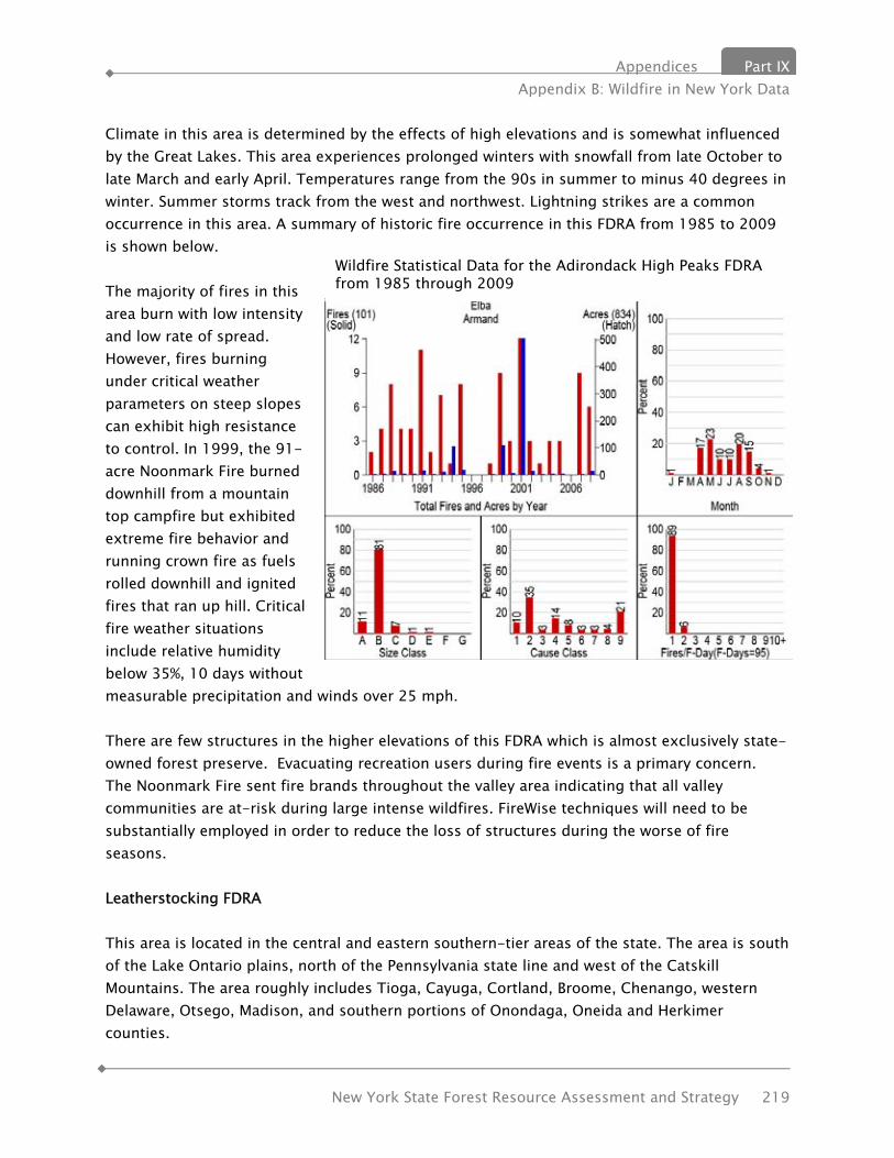
Appendices Part IX Appendix B: Wildfire in New York Data
New York State Forest Resource Assessment and Strategy 219
Climate in this area is determined by the effects of high elevations and is somewhat influenced by the Great Lakes. This area experiences prolonged winters with snowfall from late October to late March and early April. Temperatures range from the 90s in summer to minus 40 degrees in winter. Summer storms track from the west and northwest. Lightning strikes are a common occurrence in this area. A summary of historic fire occurrence in this FDRA from 1985 to 2009 is shown below. The majority of fires in this area burn with low intensity and low rate of spread. However, fires burning under critical weather parameters on steep slopes can exhibit high resistance to control. In 1999, the 91-acre Noonmark Fire burned downhill from a mountain top campfire but exhibited extreme fire behavior and running crown fire as fuels rolled downhill and ignited fires that ran up hill. Critical fire weather situations include relative humidity below 35%, 10 days without measurable precipitation and winds over 25 mph. There are few structures in the higher elevations of this FDRA which is almost exclusively state-owned forest preserve. Evacuating recreation users during fire events is a primary concern. The Noonmark Fire sent fire brands throughout the valley area indicating that all valley communities are at-risk during large intense wildfires. FireWise techniques will need to be substantially employed in order to reduce the loss of structures during the worse of fire seasons. Leatherstocking FDRA This area is located in the central and eastern southern-tier areas of the state. The area is south of the Lake Ontario plains, north of the Pennsylvania state line and west of the Catskill Mountains. The area roughly includes Tioga, Cayuga, Cortland, Broome, Chenango, western Delaware, Otsego, Madison, and southern portions of Onondaga, Oneida and Herkimer counties.
Wildfire Statistical Data for the Adirondack High Peaks FDRA from 1985 through 2009

Part IX Appendices Appendix B: Wildfire in New York Data
220 New York State Forest Resource Assessment and Strategy
This FDRA is a combination of forest and abandoned agricultural land. Primary forest types are oak/hickory and northern hardwood. Pockets of tornado-damaged areas with heavy fuel loadings are present. Ice storms occurring in 2003 and 2004 contributed to increased fuel loadings, especially at ridge tops. The majority of the area is gently rolling hills to steep slopes with valley bottoms near 500 feet elevation and ridge tops near 2,000 feet. The area was heavily glaciated during the last ice age. Most drainages flow south into the Susquehanna River Basin. The climate is characterized by relatively hard winters and moderate summers. The northern part of this area receives Lake Ontario lake-effect snows, mainly in January, adding to the snow pack. Most weather patterns come from the west. High winds and lower than normal relative humidity of Canadian Polar air masses in the spring create synoptic fire patterns. A summary of historic fire occurrence in this FDRA from 1985 to 2009 is shown below. Spring fire behavior, in the grass fuel types during moderate weather conditions, will produce flame lengths between 4-12 feet if not influenced by initial attack or other conditions. Typical fire behavior in hardwoods will produce flame lengths of 1-5 feet wind driven surface fires may produce higher rates of spread. Storm damaged areas (fuel model 13) may produce problem fire behavior, depending on the dead fuel moisture as well as the live fuel moisture and the vegetative curing of the herbaceous plants that are invading the sites. Critical fire weather situations include Canadian Polar air masses, relative humidity below 25% and five days without precipitation. The cause of wildfire in the Leatherstocking FDRA is substantially the result of debris fires escaping control. The new statewide open burning regulations should reduce this cause dramatically as compliance is developed through enforcement. Since 54% of all wildfire are caused by debris burning and it is rare that more than one structure is lost due to a single wildfire, there are no communities-at risk identified at this time in this FDRA. Further study may reveal that some communities will need to accomplish fuel treatments and implement
Wildfire Statistical Data for the Leatherstocking FDRA from 1985 through 2009

Appendices Part IX Appendix B: Wildfire in New York Data
New York State Forest Resource Assessment and Strategy 221
FireWise techniques in order to reduce potential loss from wildfire. Southern Tier FDRA This FDRA is in the southern tier of the state. The area is south of the Lake Ontario Plains, north of the Pennsylvania state line and west of the Leatherstocking FDRA. The Area includes Chautauqua, Cattaraugus, Allegany, Steuben, Chemung, Schuyler, Livingston, Orleans and Tompkins counties. This FDRA is a combination of forested land and abandoned agricultural land. Primary forest types are oak/hickory and northern hardwoods. Abandoned agricultural lands generally have a majority grass/shrub component. The majority of the area is gently rolling hills to steep slopes with valley bottoms near 500 feet elevation and ridge tops near 2,000 feet. The area was heavily glaciated during the last ice age. Most drainages flow south into either the Susquehanna or Allegheny River basins. Weather across the area is characterized by relatively hard winters and moderate summers. The western part of this area receives Lake Erie lake-effect snows, mainly in January, adding to the snow pack. Predominant weather patterns are from the west. High winds and lower than normal relative humidity associated with Canadian Polar air spring air masses create favorable fire conditions with high rates of spread. A summary of historic fire occurrence in this FDRA from 1985 to 2009 is shown below. Spring fire behavior in the grass fuel types during moderate weather conditions will produce flame lengths between 4-12 feet if not influenced by initial attack or other conditions. Typical fire behavior in hardwoods will produce flames of 1-5 feet. Higher fire intensities are observed in the oak/hickory types and may contribute to problem fire behavior, especially if an understory of rhododendron is present. Critical fire weather situations include Canadian Polar air masses, relative humidity below 25% and five days without precipitation. The cause of wildfire in the Southern Tier FDRA is substantially the result of debris fires escaping control. Enforcement of the new statewide open burning regulations should reduce
Wildfire Statistical data for the Southern Tier FDRA from 1985 through 2009

Part IX Appendices Appendix B: Wildfire in New York Data
222 New York State Forest Resource Assessment and Strategy
this cause dramatically. Since 53% of all wildfire are caused by debris burning and it is rare that more than one structure is lost due to a single wildfire, there are no communities-at risk identified at this time in this FDRA. Further study may reveal that some communities will need to accomplish fuel treatments and implement FireWise techniques in order to reduce potential loss from wildfire. Lake Ontario Plains FDRA This area encompasses land in the central and western parts of the state located south and east of Lake Ontario. It also includes the Tug Hill Plateau, western portions of the Mohawk Valley, and Areas north of the Leatherstocking FDRA and Southern Tier FDRA. The area is composed chiefly of a combination of forest and abandoned agricultural land. The primary forest types are oak/hickory and northern hardwood. The majority of the area is generally flat interspersed with gently rolling hills. The Tug Hill Plateau located on the eastern side of this FDRA is characterized by low-lying (swampy), unbroken mixed forest. The climate in this area is greatly influenced by the Great Lakes. Weather systems passing over Lake Ontario generally raise air temperatures and moisture content. Significant rainfall and snow accumulates to the east of the lake and on the Tug Hill Plateau. The lake plains south of Lake Ontario experience earlier snow melt than other portions of this FDRA. A summary of historic fire occurrence in this FDRA from 1985 to 2009 is shown below. Spring fire behavior, in the grass fuel types during moderate weather conditions, will produce flame lengths between 4-12 feet if not influenced by initial attack or other conditions. Critical fire weather situations include Canadian Polar air masses in the area, low relative humidity or extreme drought. Lake Ontario has been known to create strong sea breeze effects, which may influence fire behavior in areas near the lake. Fire history in this FDRA is generally in the eastern portions of the area due to the statutory requirement to operate a fire protection system in these towns and counties. There are no communities-at risk identified at this time in this FDRA. Further study may reveal
Wildfire Statistical Data for the Lake Ontario Plains FDRA from 1985 through 2009
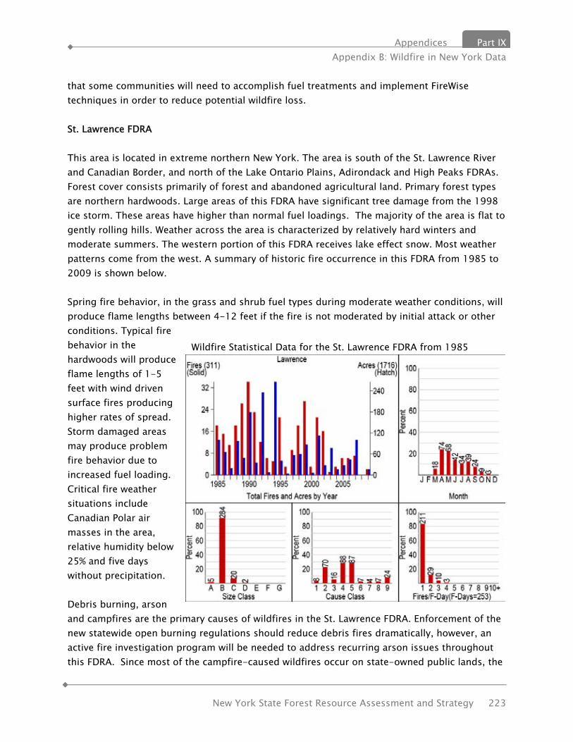
Appendices Part IX Appendix B: Wildfire in New York Data
New York State Forest Resource Assessment and Strategy 223
that some communities will need to accomplish fuel treatments and implement FireWise techniques in order to reduce potential wildfire loss. St. Lawrence FDRA This area is located in extreme northern New York. The area is south of the St. Lawrence River and Canadian Border, and north of the Lake Ontario Plains, Adirondack and High Peaks FDRAs. Forest cover consists primarily of forest and abandoned agricultural land. Primary forest types are northern hardwoods. Large areas of this FDRA have significant tree damage from the 1998 ice storm. These areas have higher than normal fuel loadings. The majority of the area is flat to gently rolling hills. Weather across the area is characterized by relatively hard winters and moderate summers. The western portion of this FDRA receives lake effect snow. Most weather patterns come from the west. A summary of historic fire occurrence in this FDRA from 1985 to 2009 is shown below. Spring fire behavior, in the grass and shrub fuel types during moderate weather conditions, will produce flame lengths between 4-12 feet if the fire is not moderated by initial attack or other conditions. Typical fire behavior in the hardwoods will produce flame lengths of 1-5 feet with wind driven surface fires producing higher rates of spread. Storm damaged areas may produce problem fire behavior due to increased fuel loading. Critical fire weather situations include Canadian Polar air masses in the area, relative humidity below 25% and five days without precipitation. Debris burning, arson and campfires are the primary causes of wildfires in the St. Lawrence FDRA. Enforcement of the new statewide open burning regulations should reduce debris fires dramatically, however, an active fire investigation program will be needed to address recurring arson issues throughout this FDRA. Since most of the campfire-caused wildfires occur on state-owned public lands, the
Wildfire Statistical Data for the St. Lawrence FDRA from 1985 through 2009

Part IX Appendices Appendix B: Wildfire in New York Data
224 New York State Forest Resource Assessment and Strategy
Department will need to further develop its state land protection through education and regulation. National State and Private Forestry Objectives The wildfire component of the national State and Private Forestry themes and objectives is to protect forests from harm. This requires that most wildfires must be contained and extinguished as soon as possible. The threat of wildfire is mostly a control on human action in or near forests. Prevention through education and regulatory enforcement is a proven technique in New York and must be continued. Few communities in New York recognize their risk to devastating wildfire. The principle communities at risk in New York are those in the Adirondack Park, those along the Shawangunk Ridge in southern New York and those surrounding the Long Island Central Pine Barrens.
Appendices Part IX Appendix C: Forest Legacy Areas
New York State Forest Resource Assessment and Strategy 225
APPENDIX C: NYS FOREST LEGACY AREAS REQUEST FOR AN AMENDMENT TO THE ASSESSMENT OF NEED
New York’s Forest Legacy Area Eligibility Criteria New York State (NYS) completed a modified Assessment of Need (AON) for the Forest Legacy Program (FLP) in 1994. The Secretary of Agriculture approved the AON and Eligibility Criteria, for which all Forest Legacy Areas (FLA) in New York State must meet. This proposed amendment analyses the addition of a Rensselaer Plateau FLA and a boundary expansion of the Catskill Park FLA based on NYS’s FLP Eligibility Criteria, which is focused on maintaining and enhancing water quality, decreasing the development of unfragmented forest lands to non-forest uses, and protecting important wildlife habitat in NYS.
The following State criteria must be met for each federally listed FLA: 1. Encompasses forests that are threatened by present or future conversion to non-forest
uses, where “threatened by conversion to non-forest use” is defined as land which has characteristics that make it attractive to changes such that traditional uses and values of the property are reasonably expected to be at risk. These characteristics may include, but are not limited to: close proximity to roads, short travel time to population centers, existence of water resources and the presence of outdoor recreation opportunities.
2. Provides potential opportunities for the continuation of traditional land uses, which are activities commonly associated with the use of forest land in NYS. These activities include, but are not limited to: public access, hiking, camping, hunting, timber harvesting, trapping, snowmobiling, and cross country skiing.”
3. Contain at least 50% lands that meet the definition of forest land, which is capable of growing a regular crop of trees but not including ledge, marsh, open swamp, bog, slopes of more than 35%, fields, rocky outcrops or similar areas.
4. Identified in the most recent NYS Open Space Conservation Plan (OSP) as a major resource area and/or priority project area.
5. Contains three (3) or more of the following identified public values: public recreation opportunities; riparian areas and wetlands; important fish and wildlife habitat w/known threatened and endangered species; cultural areas such as areas of historical or archeological significance; other ecological values; scenic resources; and/or important plant communities.
Management of New York’s Forest Legacy Areas The management of lands protected with FLP funding in NYS rests primarily with the NYS Department of Environmental Conservation (DEC). Currently, DEC manages approximately 110,000 acres of FLAs throughout New York. As additional properties are protected, conservation easements could be monitored by one of many land trusts that own property in

Part IX Appendices Appendix C: Forest Legacy Areas
226 New York State Forest Resource Assessment and Strategy
the area. Interest continues to be expressed by various land trusts within the State to assist in the management responsibilities of New York’s FLAs. Management precedent of this sort has thus far been established by the Tug Hill Tomorrow Land Trust, which monitors the Brown Tract on the Tug Hill Plateau, part of the Northern FLA.
Means for Protection 1. Acquisition of conservation easements or working forest conservation easements that
extinguish development rights on tracts is a priority forest protection strategy. 2. Timber rights may be retained by the owner and should be conditioned by the State of
New York’s Best Management Practices to minimize soil erosion. 3. Conservation easements that allow timber harvesting shall follow the prescriptions
outlined in a timber management plan prepared by a professional forester and accepted by DEC or by participation in a third-party forest certification program approved by DEC.
4. Conservation easements shall restrict the pursuit of mining, drilling, and excavation of natural resources subject to the regulations established by the State’s Mined Land Reclamation Law and Environmental Conservation Law (Article 23, Title 27).
5. Conservation easements shall prevent disposal of hazardous waste or material on subject properties.
6. Conservation easements shall also prevent construction of dams, impoundments, and other water resource developments unless there are proven benefits to wildlife, forests, and the people of the area.
7. The FLP also allows NYS to purchase land holdings for inclusion into NYS ownership as State Forest or Forest Preserve lands, which will be considered on a strategic basis, consistent with the wishes of forest landowners.
I. Proposal of a Rensselaer Plateau Forest Legacy Area
A. Location & Boundary Description The Rensselaer Plateau (Plateau) encompasses 196,000 acres of forests east of the Hudson River Valley and west of the Taconic Mountains. Located 10 miles east of the State’s Capitol of Albany within central and eastern Rensselaer County, the Plateau extends 20 miles north to south and 9 miles east to west (see Map 1). The proposed FLA would start at the junction of State Rte (SR) 22 and the Washington County line, go west to Co. Rte (CR) 114, south to CR 111, south on Parker School Rd to CR 129, southwest to SR 2, east to SR 351, south to SR 66, southeast to US Rte 20, east to SR 22, north to SR 346, east to the Vermont border, north to the junction with the Washington County line, and then west, ending west at the SR 22 starting point.
Towns with jurisdiction in the proposed Rensselaer Plateau FLA include: Berlin; Brunswick; Grafton; Nassau; Hoosic; Petersburgh; Pittstown; Poestenkill; Sand Lake; Schaghticoke; and Stephentown in Rensselaer County; and New Lebanon in Columbia County.

Appendices Part IX Appendix C: Forest Legacy Areas
New York State Forest Resource Assessment and Strategy 227
B. Eligibility Criteria Analysis 1. Threats of conversion to non-forest uses. a. Residential Development Pressure
Close proximity (20 minute drive) and easy commute from the area to the State’s capitol, Albany, and nearby cities, Troy and Schenectady.
Presence of research and development centers at Rensselaer Polytechnic Institute (RPI) located on the Plateau and nearby SUNY Albany has drawn high tech businesses to the area.
Small towns are becoming bedroom communities for the Capital District Area and development pressure is likely to become even more intense as the “Tech Valley” attracts more businesses.
Area is located in the heart of New York’s Capital Region, a region JP Morgan cites as one of the fastest expanding metros in NYS.
Second home development, often built on multi-acre lots, can produce a particularly insidious form of fragmentation where sprawl increases disproportionately to population levels, and has gradually been moving further west and north of the Hudson River into Rensselaer County from Columbia County
2-3 hour driving distance from both the New York City and the Boston metro areas attractive to buyers who have been priced out of Dutchess and Columbia counties.
Recent ownership changes of large working forest properties may mean conversion to development.
b. Growing Highway Construction Demand for Rensselaer Greywacke Bedstone Rensselaer Greywacke, the geological formation of the Plateau, is an
increasingly valuable commodity for highway construction because of its hardness, durability, and exceptional skid resistance; making it frequently specified for critical traffic areas such as highway interchanges.
Six operating mines, totaling 465 acres of permitted surface disturbance during the lifetime of the mines, are currently located on the eastern side of the Plateau with pressure to open others.
Potential wider environmental impacts are associated with Greywacke mining because of the frequent and heavy blasting used to extract this hard rock.
2. Provides opportunities for the continuation of traditional forest uses. a. Timber Products
Presently, there are six sawmills in Rensselaer County that use wood from the Plateau and other sources.
Major heat-treated firewood producer is the only supplier to a regional chain convenience store and uses wood primarily from the Plateau.
Wood from the Plateau is transported to mills in neighboring states and

Part IX Appendices Appendix C: Forest Legacy Areas
228 New York State Forest Resource Assessment and Strategy
Canada. Timber on the Plateau supports logging jobs in the associated rural
communities.
b. Water Supply & Mill Power Streams within the watersheds intersect on the Plateau and provide drinking
water, serving more than 100,000 people. In the past, waterfalls at the edge of the Plateau were used to power mills.
c. Public Access on Private Land The Rensselaer County Regional Chamber of Commerce Tourism and Travel
web site portrays the County, including the Plateau as: “Life Looks Good From Here”, “Stretching for 30 miles along the scenic and historic Hudson River, ... boasts thousands of acres of parks, miles of hiking and walking trails scores of lakes and ponds ... nature trails, ... cross country ski trails... highlight the beauty of the County.”
3. Contains at least 50% land that meets the definition of forest land.
Throughout the Plateau opportunities for forest connectivity are high because the landscape is 95% forested, and there are many landowners with over 1,000 contiguous acres in holdings. Opportunities exist to connect forested corridors from the proposed FLA to the Taconic Ridge FLA on the east of US Rte 22.
4. NYS Open Space Conservation Plan Identification The Plateau is recognized as “Priority Conservation Project” {51}, on p. 88 of the 2009 Plan.
5. Contains three or more of the identified public values. a. Important Plant Communities / Natural Communities & Forest Types
Because of the erosion-resistance of the underlying Rensselaer Greywacke bedrock, the Plateau has a steep eastern escarpment with many cliffs. The Plateau ranges from 1000 to 1800 feet in elevation and the summit is hundreds of feet higher than the surrounding areas. Although it is geologically part of the Taconic area, its comparatively level summit is quite different from the more jagged peaks of the Taconic Range. The broad summit has relatively little topographic relief and is mostly covered by glacial till of varying depths. Soils are mostly frigid, acidic and rather poorly drained. Shallow soils are close to bedrock, and deeper soils may have a fragipan. There are numerous ponds and wetlands, especially fens, and these support many unusual communities. The shallow acidic soils and the cooler climate zone support vegetation closer in type to that of the Adirondacks than to the surrounding lowlands. Despite its location near the cities of Troy and Albany, the forest cover of the Rensselaer Plateau has remained surprisingly unfragmented.

Appendices Part IX Appendix C: Forest Legacy Areas
New York State Forest Resource Assessment and Strategy 229
The New York Natural Heritage Program identifies the following communities and species found on the Plateau as significant:
Communities: Species: Thalus Cave Community Michaux’s Blue-eyed Grass Hemlock Northern Hardwood Forest Farwell’s Water Milfoil Oligatropic Dimictric Lake Marsh Arrow Grass Spruce - Northern Hardwood Forest Black Spruce Tamarack Bog Historic: Spruce Fir Swamp New England Cottontail Inland Poor Fen Beech - Maple Mesic Forest Shallow Emergent Marsh Dwarf Shrub Bog Spruce Flats b. Important Fish & Wildlife Habitat w/known Threatened & Endangered Species The Plateau has been designated as an Important Bird Area by the National Audubon Society. The area supports a great abundance and diversity of forest breeders, including many at-risk species; Cooper’s Hawk, Northern Goshawk, Red-shouldered Hawk, Wood Thrush, and Canada Warbler, to name a few, and a characteristic assemblage of more common forest species. Eighteen species of warbler are known to breed in plateau forests. Red Crossbill, White-winged Crossbill, Pine Siskin, and Evening Grosbeak have also been identified here; and with Bicknell’s Thrushes using the area during migration.
Large unfragmented interior forested blocks provide habitat for native mammals which need large continuous ranges, such as bear, bobcat, fisher, and moose. These large blocks also support biodiversity and scope for natural disturbance to play out in a series of normal ecological processes and plant community successions. Unfragmented forest areas have minimal edge areas and corridor zones, which helps protect them from invasive forest pests, diseases and plants. Fragmentation in the form of roads and development inevitably leads to exploitation by opportunistic invasive species.
c. Other Ecological Values / Ecological Connectivity Only a few miles of rural land separate the Plateau and the Taconic Ridge from the Northern FLA of both NY (Washington County) and the State of Vermont. The Hoosic River Corridor at the northern portion of the proposed FLA extends through northern Rensselaer County, thereby linking these important forest communities. Although this corridor is predominately in agricultural use with sizeable patches of forest, it represents the best connectivity between the extensive FLA forests. In the future, as plant and animal populations and biotic

Part IX Appendices Appendix C: Forest Legacy Areas
230 New York State Forest Resource Assessment and Strategy
communities respond to rising temperatures because of global climate change, we expect species range expansions and contractions. Habitat connectivity will be important for them in making those temperature range adjustments.
C. Important Environmental Values
1. Environmental Values to be Protected Intact forest landscape – ecological value Plateau watershed - recharge area; wetlands & streams; hydrological value Biodiversity value to NYS and the region Forested Landscape value to large mammal populations Interior nesting birds/Important bird area Open space value to population centers
2. Economic Values to be Protected Forest products economy Outdoor recreation, hunting, fishing, trapping, cross-country skiing, camping,
horseback riding, biking Other rural economic activities
D. Conservation Goals & FLA Objectives 1. Conservation Goals
Maintain and enhance NYS’s 5th largest unfragmented forest and its extensive range of unique wetland communities, including sedge meadow, dwarf shrub bog, spruce-fir swamp, and kettle hole bog.
Long-term protection of mammal diversity that is a-typical of the greater Capital District region, including black bear, fisher, otter, bobcat, and moose.
Long-term protection of diversity & abundance of forest bird breeders, including many state listed species.
Protect the Tomhannock Reservoir Watershed, which provides water to over 100,000 Rensselaer and Columbia county residents.
Develop the long-range and shared vision of several organizations to establish a public open space corridor and trail system across the area, connecting Dyken Pond Center to Grafton Lakes State Park, Pittstown State Forest, Capital District Wildlife Management Area, and Dickinson Hill Fire Tower.
Link the Plateau FLA (54,000-acre area northern portion, referred herein as the Hoosic River Corridor) to existing Northern FLA and adjacent Taconic Ridge FLA.
Utilize current public and local political support with potential for open space acquisition funding for the new FLA.
2. FLA Objectives Acquire conservation easements and working forest conservation easements for
long-term forest protection. Establish north-south forest connectivity to provide commuting and migration
Appendices Part IX Appendix C: Forest Legacy Areas
New York State Forest Resource Assessment and Strategy 231
corridors for boreal and high elevation species, which are especially vulnerable to the effects of climate change.
Link NYS land through forested corridors of private land with existing working forest conservation easements to enhance public recreation opportunities, retain biodiversity, support mammals requiring large home range and retain blocks for interior forest nesting bird species.
Acquire fee title to parcels where: i. the willing seller of a priority parcel has no interest in retaining the property
with an easement; ii. properties would be a significant asset to nearby, existing state owned land;
or iii. properties contain significant natural communities and rare species where
preservation is the only alternative for protecting the identified elements of biodiversity.
E. Public Benefits Economic activity on the forest land through timber harvesting can be permanently
maintained by continued private land ownership and sales of working forest conservation easements to NYS.
Acquiring public recreation rights when purchasing conservation easements from willing sellers directly enhances public benefits.
Keeping a regional forested landscape intact provides for significant wildlife habitat, water quality, and biodiversity protection.
Retaining the rural forested character of the Rensselaer Plateau and Escarpment contributes to the local culture and heritage of eastern Rensselaer County.
F. Existing Public Lands within Proposed FLA Two State parks: Grafton State Park (2,311 ac.); Cherry Plain State Park (150 ac.) Capital District Wildlife Management Area (4,043 ac.) Two State Forests: Pittstown Sate Forest (1,191 ac.); Tibbits State Forest (822 ac.) Bennington Battlefield State Historic Site (276 ac.)
G. Public Involvement Process & Analysis of Issues Prior to DEC’s consideration of adding the Rensselaer Plateau to the NYS FLP, all municipalities affected by the proposal were consulted by letter and phone by DEC’s Region 4, Regional Director, Gene Kelly. Upon receiving a majority of support from the potentially affected municipalities and local non-profit land conservation organizations, DEC publicly noticed a request for public comment and notification of a local public meeting on the proposal through its weekly Environmental Notice Bulletin (ENB) on its website, http://www.dec.ny.gov/enb/20100317_not4.html. The public information meeting was held on March 24, 2010, where approximately 100 people were in attendance. Nine (9) comments were received and recorded at this meeting and added to the 30 day public

Part IX Appendices Appendix C: Forest Legacy Areas
232 New York State Forest Resource Assessment and Strategy
comment period summary.
During the public comment period, March 17 to April 16, 2010, eighty eight (88) total comments were received; seventy nine (79) written comments and nine (9) oral comments from the public meeting. 79 comments received in support of the proposal, were from 3 potentially affected municipalities; 21 landowners; and 13 special interest groups. Support comments requested DEC to designate the Plateau as a FLA, with a majority of comments expressing the need for future protection of the area’s unfragmented forests from development pressure.
Nine (9) comments received did not support the proposal of which 5 comments were received from potentially affected landowners; 2 municipalities; 1 citizen; and 1 special interest group. Their comments expressed disagreement or concern over: i) the use of government funds for open space conservation; ii) increased land restrictions imposed on a designated FLA; iii) tax burden shifting to other landowners; and iv) development pressure not seen as a reasonable threat to the area. In order to address these concerns, DEC will provide a response to public comments in which it will continue to stress the voluntary nature of the FLP.
In addition, DEC received from the Town of Grafton, Rensselaer County, “Resolution #44 of 2010 - Resolution Opposing the Application to the US Forest Service by the New York State Department of Environmental Conservation for Designation of the Rensselaer Plateau as a Forest Legacy Area,” made on April 15, 2010. In response, NYS maintains a long-standing history of working with private landowners willing to sell their lands to the State and with the affected local municipality(ies), as established in the State's Open Space Conservation Program. Further, NYS Environmental Conservation Law, Article 49, Title 2, requires NYS to notify all affected municipalities in advance of a private landowner’s desire to sell to the State and where the State may not use NYS Environmental Protection Funds (EPF) to purchase the parcel if one of the affected municipalities does not approve.
In the face of the Town of Grafton’s Resolution should any future FLP project be proposed within the Town’s jurisdiction, DEC and the private landowner will consult with the Town and provide them with the appropriate information for them to consider. Should the Town continue to oppose any FLP project within their jurisdiction after consulting with the willing seller, DEC will not proceed with the acquisition.
Further, the proposed FLA was a priority project identified in the 2009 OSP and was subject to a 45 day public review and comment period in early 2009. From this comment period, DEC received over 100 emails and letters from the public and regional land conservation groups in support of the protection of the Rensselaer Plateau, and its inclusion in the 2009 OSP. No comments against its inclusion in the 2009 OSP were received at that time.
Appendices Part IX Appendix C: Forest Legacy Areas
New York State Forest Resource Assessment and Strategy 233
II. Catskill Park Expansion to the Catskill/Delaware NYC Watershed Forest Legacy Area
A. Location & Boundary Description The current Catskill FLA boundary was delineated in 1998 based on the watersheds of the six New York City supply reservoirs located west of the Hudson River. This proposal seeks to modify the current Catskill FLA boundary to include the remaining portions of watersheds in the Catskill Park. The expansion would be located on the southwest and eastern edges of the Park and would add the headwaters of the famous Beaverkill and Willowemoc trout streams and the Great Rondout Wetlands to the existing FLA. See the adjacent table for the watersheds and their 11 digit HUC code and the second map. The outer boundary is the Catskill Park Blue Line, established by statute in New York’s Environmental Conservation Law (ECL) section 9-0101(2). The proposed boundary modification will increase the size of the current FLA by 240,924 acres.
B. Eligibility Criteria Analysis
1. Threats of conversion to non-forest uses. a. Residential & Commercial Development Pressure
Encroaching development pressure from resort and second home development because of the area’s close proximity to New York City.
Speculative development resulting from proposed casinos in the region and increasing desire for safe haven from the metropolitan region since September 11, 2001 have resulted in increased rates of forest land conversion.
2. Provides opportunities for the continuation of traditional forest uses. Timber Products Water Supply Agriculture Outdoor Recreation & Tourism
3. Contains at least 50% land that meets the definition of forest land. The existing forest coverage within the proposed expansion FLA is 87%.
4. NYS Open Space Conservation Plan Identification
HUC_11 WATERSHED NAME 02020006140 Upper Catskill Creek 02020006150 Kaaterskill Creek 02020006200 Middle Esospus Creek 02020006210 Cementon, NY to Rondout Creek 02020007120 Vernooy Kill 02020007130 Vernooy Kill to Rochester Creek 02040102020 Middle East Branch Delaware River 02040102030 Upper Beaver Kill 02040102040 Willowemac Creek
02040102050 Lower Beaver Kill

Part IX Appendices Appendix C: Forest Legacy Areas
234 New York State Forest Resource Assessment and Strategy
The proposed boundary modification adds three priority project areas that have been identified in the 2009 OSP. These projects include the Great Rondout Wetlands {24} and the Beaverkill and Willowemoc Headwaters {36}.
5. Contains three or more of the identified public values. a. Public Recreational Opportunities
The areas proposed for addition are well known as recreation areas to outdoor enthusiasts who enjoy hunting, camping, fishing and hiking. Adding the headwaters of the Beaverkill and Willowemoc will aid in the protection of nationally renowned trout streams.
b. Scenic Resources The Catskills provide major scenic resources to NYS and serve as the backdrop for the scenic beauty of the entire Hudson Valley region.
c. Riparian Areas and Wetlands The boundary adjustment will bring in several priority wetlands within the legacy area including the Great Rondout Wetlands.
C. Conservation Goals Increase protection of a quickly decreasing, unfragmented forest ecosystem within
the Catskill region and existing FLA. Maintain the areas large, relatively undisturbed forest with extensive hiking trails and
historic carriage trails overlooking vistas of unsurpassed scenery. Sustain the balance of public and private ownership within the FLA in order to
enhance and maintain the recreational and tourism opportunities in the area. Long-term protection of several priority OSP wetlands, including the Great Rondout
Wetlands.
E. Public Benefits Economic activity on the forest land through timber harvesting can be permanently
maintained by continued private land ownership and sales of working forest conservation easements to NYS.
Acquiring public recreation rights when purchasing conservation easements from willing sellers directly enhances public benefits.
Keeping a regional forested landscape intact provides for significant wildlife habitat, water quality, and biodiversity protection.
Economic activity and the scenic viewshed which draws tourists to this area will be maintained through the acquisition of key projects within the proposed expansion FLA.
Appendices Part IX Appendix C: Forest Legacy Areas
New York State Forest Resource Assessment and Strategy 235
F. Existing Public Lands within the Proposed FLA
The 705,000 acre Catskill Park, a NYS conservation focus for the past century, presently contains more than 290,000 acres of land protected by NYS. Management of lands protected with FLP funding in the proposed expansion FLA will rest primarily with DEC.
G. Public Involvement Process & Analysis of Issues All municipalities affected by the boundary modification where notified by letter and contacted by phone by the Region 3 and Region 4, Regional Directors. In addition, the proposed boundary modification has been approved by the FLP Sub-committee of the NYS Forest Stewardship Coordinating Committee. The priority project areas located within the Catskill Expansion have been subject to public comment through the 2006 and 2009 OSP regional advisory committee and public hearings. Comments received during the 2006 review, pertaining to projects within the proposed FLA expansion, urged the State to “fully participate in protecting the Catskill River and Road Corridors, as the purchase of these watershed holdings along major road corridors like Route 28, 23, 30 and 10, will protect water resources, improve scenic vistas for visitors to the Catskills, and safeguard critical riparian buffer land.” No comments were received that expressed non-support of the listed priority conservation projects within the proposed expansion area.
Potential Future NYS FLAs
New York State is continuing to build local government and public support for the creation of two additional future Forest Legacy Areas that have been previously identified by The Nature Conservancy, Audubon, Western New York Land Conservancy, Nature Sanctuary Society of Western New York, among other members of the NYS’s Forest Stewardship Committee and our forest stakeholders. One potential FLA encompasses the far south-western portion of the State, currently referred to as the “Niagara Frontier” or “Allegheny Plateau”; and the second within NYS’s central Finger Lakes region, and referred to as the “Finger Lakes/Northern Plateau.”
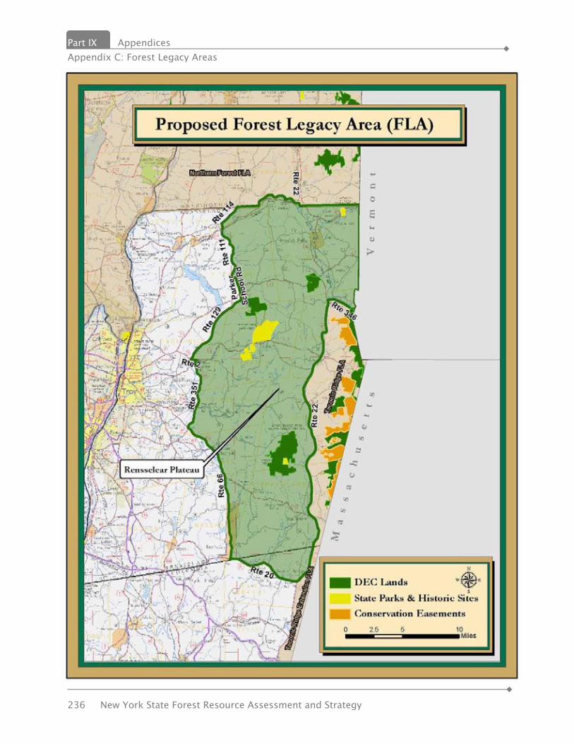
Part IX Appendices Appendix C: Forest Legacy Areas
236 New York State Forest Resource Assessment and Strategy

Appendices Part IX Appendix C: Forest Legacy Areas
New York State Forest Resource Assessment and Strategy 237

Part IX Appendices Appendix C: Forest Legacy Areas
238 New York State Forest Resource Assessment and Strategy

Appendices Part IX Appendix D: Multi-State Priority Area Descriptions
New York State Forest Resource Assessment and Strategy 239
APPENDIX D: MULTI-STATE PRIORITY AREA DESCRIPTIONS
Northern Forest
States: Maine, New Hampshire, New York, Vermont1 Issues associated with the area:
• Decreasing forest acreage caused by rapid and unrelenting conversion of forest to developed uses.
• Change in ownership patterns caused by transfer of lands into smaller parcels
• Uncertain markets present difficult challenges to forest products-based infrastructure and communities
• Loss of forest and fragmented forest undermines the integrity of forest ecosystems and fragile wildlife and fisheries habitats
Opportunities for partnership, cooperation, and projects:
• Outreach to public officials, forest industry, environmental groups, private forest landowners, and other interested members of the public in support of forest conservation
• Address loss of productive forest land to other uses, and potential impacts in the Northern Forest.
• Address economic and ecological partnerships with Canada • Engage forest landowners in stewardship efforts by providing technical and financial
assistance for improved forest management. • Work to maintain and diversify the markets for wood products that allow sustainable
forest management. • Promote third party certification to recognize sustainable forest management. • Recommend policies that encourage sustainable practices. • Work to acquire forest conservation easements to maintain working forests.
Existing efforts:
• The 4 states have entered into a MOU with the US Forest Service and the Natural Resource Conservation Service to actively cooperate in the conservation and management of working forest landscapes within the Northern Forest in the states of New York, Vermont,
Part IX Appendices Appendix C: Forest Legacy Areas
240 New York State Forest Resource Assessment and Strategy
New Hampshire, and Maine. More specifically, this effort is intended to: • Demonstrate through pilot projects how the Partners can pool resources and coordinate
their efforts so that working private forest lands in priority areas are conserved and therefore protected from conversion to other uses (i.e., “keep forests as forests”).
• Engage stakeholders in developing an implementation strategy for how to keep the Northern Forest region’s “forests as forests
• Engaged in the New England Governor’s Conference Commission on Land Conservation Forest Conservation Initiative
1The Northern Forest is defined as the area covered by the work of the Northern Forest Lands Council. The area that generally covers the following states/counties: Maine: Oxford (northern), Franklin, Somerset, Piscataquis, Penobscot, Aroostook (except eastern 1/3), Washington (northern), and Hancock (northern), (essentially everything north of Route 2) New Hampshire: Coos Vermont: Essex, Caledonia, Orleans, Franklin, Lamoille, Washington (northern), Chittenden (eastern) New York: Lewis, Oneida, Herkimer, Fulton, Hamilton, Warren, Essex, Clinton (southern), Franklin (southern), St. Lawrence (southern), (essentially the Adirondack Park and Tug Hill and environs)

Appendices Part IX Appendix D: Multi-State Priority Area Descriptions
New York State Forest Resource Assessment and Strategy 241
Highlands Region
States: Connecticut, New York, New Jersey, and Pennsylvania. The Highlands of Pennsylvania, New Jersey, New York, and Connecticut are a region of national significance bordering an expanding metropolitan area. The 3.4 million-acre region with 319 municipalities and 25 counties has abundant forests, fields, and natural resources that provide quality drinking water, recreation, and economic opportunities to its residents, but pressures to alter land use are great. Issues associated with the area:
• Protecting surface and ground water quality: millions of residents outside the Highlands region depend on drinking water from the Highlands region.
• Conserving the landscape for wildlife, rare and native plants, and environmental quality. • Sustaining important components of the forest to maintain long-term forest health and
eco-system services. • Retaining working forests and farms to ensure economic viability and livability. • Providing appropriate recreational opportunities near and along the urban corridor. • Opportunities for partnership, cooperation, and projects: • Partner with land trusts, conservation organizations, local communities and state agencies
to maintain connectivity between forests across the region. • Outreach to local communities, including counties to gather support for ecosystem
protection. • Acquiring fee interest or conservation restrictions over the largest remaining parcels of
unprotected, high conservation value forest land as identified in the Forest Service Highlands studies, within the forest core and working forest easements in buffer areas reduces the threat of development in these forests.
• Invasive species prevention and removal strategies minimize new invasive species and treat existing invasives to promote native forest regeneration.
Existing efforts:
• The US Forest Service recently (final report due out in summer 2010) completed studies in CT and PA of the natural resources in the region, which included identification of high conservation value lands, the effects of land use change on the resources, and strategies for conserving them. Studies were completed for NY and NJ in 1992 and 2002.
• $5.2 million has been appropriated to date for land protection in the four Highlands states
Part IX Appendices Appendix C: Forest Legacy Areas
242 New York State Forest Resource Assessment and Strategy
under the Highlands Conservation Act of 2004. The legislation is authorized for 10 years, and the Highlands state governors submit projects for funding consideration every year. HCA also authorizes up to $1 million per year for landowner assistance in the Highlands; no funds have been appropriated to date.
• In Connecticut, 450 acres were protected on Skiff Mountain in 2004. The area is located in the middle of a 5,300 acre greenway and open space corridor that includes Macedonia Brook State Park, the Appalachian Trail, and other land trust properties. The Trust for Public Land is working with residents to preserve an additional 1,000 acres.
• In New Jersey, the Highlands Water Protection and Planning Act was passed in 2004. The act intends to preserve both large volumes of New Jersey's fresh water sources for 5.4 million residents and the rich biodiversity in the area.
• In New York, more than 19,500 acres of Sterling Forest have been preserved to date. The forest has tremendous value as the single largest block of intact forest in the New York Highlands and serves as a source of drinking water for more than two 2 million New Jersey residents. Sterling Forest also links existing parks in New York and New Jersey, and is part of a vision to create a regional greenbelt.
• In Pennsylvania, passage of the Growing Greener II bond initiative (Pennsylvania State Act 45) in 2005 designated $625 million through 2010 for protection of natural and agricultural lands, environmental cleanup, community revitalization, and improved recreational opportunities.
Key contact persons, resources, organizations for the area or issue (phone, email, website):
• Beth Brothers, CT Department of Environmental Protection, (860) 424-3086, [email protected], http://www.ct.gov/dep/site/default.asp
• Erik Kulleseid, NYS Department of Environmental Protection, (518) 474-0430, [email protected], http://www.nysparks.com/parks/
• Jada Jackson, NJ Department of Environmental Protection, (609) 777-4248, [email protected], http://www.state.nj.us/dep/parksandforests/
• Rachel Billingham, PA Department of Conservation and Natural Resources, 717-783-0385, [email protected], http://www.dcnr.state.pa.us/forestry/
• Sadie Stevens, US Fish and Wildlife Service, (413) 253-8677, [email protected], http://www.fws.gov/northeast/ma.htm
• Joe Dibello, National Park Service, (215) 597-1581, [email protected], http://www.nps.gov/legacy/regions.html
• Martina Barnes, US Forest Service, (212) 637-3863, [email protected], http://www.na.fs.fed.us/highlands/regional/index.shtm
• Tim Abbott, Director-Litchfield Hills Greenprint Project, Trust for Public Land, (860) 672-6678, [email protected], http://www.tpl.org/tier3_cd.cfm?content_item_id=19095&folder_id=261
• Julia Somers, Executive Director, NJ Highlands Coalition, (973) 588-7190, [email protected], www.njhighlandscoalition.org

Appendices Part IX Appendix D: Multi-State Priority Area Descriptions
New York State Forest Resource Assessment and Strategy 243
• Mark Zakutansky, PA Outreach Coordinator, Highlands Coalition, (610) 868-6915, [email protected], http://www.highlandscoalition.org/blog/?page_id=15
• Kristen Sykes, Acting Executive Director, Highlands Coalition (Appalachian Mountain Club), (610) 868-6903, [email protected], http://www.highlandscoalition.org/blog/?page_id=15
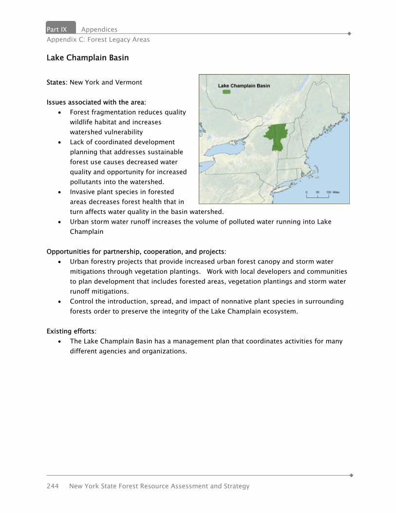
Part IX Appendices Appendix C: Forest Legacy Areas
244 New York State Forest Resource Assessment and Strategy
Lake Champlain Basin
States: New York and Vermont Issues associated with the area:
• Forest fragmentation reduces quality wildlife habitat and increases watershed vulnerability
• Lack of coordinated development planning that addresses sustainable forest use causes decreased water quality and opportunity for increased pollutants into the watershed.
• Invasive plant species in forested areas decreases forest health that in turn affects water quality in the basin watershed.
• Urban storm water runoff increases the volume of polluted water running into Lake Champlain
Opportunities for partnership, cooperation, and projects:
• Urban forestry projects that provide increased urban forest canopy and storm water mitigations through vegetation plantings. Work with local developers and communities to plan development that includes forested areas, vegetation plantings and storm water runoff mitigations.
• Control the introduction, spread, and impact of nonnative plant species in surrounding forests order to preserve the integrity of the Lake Champlain ecosystem.
Existing efforts:
• The Lake Champlain Basin has a management plan that coordinates activities for many different agencies and organizations.

Appendices Part IX Appendix D: Multi-State Priority Area Descriptions
New York State Forest Resource Assessment and Strategy 245
Taconic Region
States: New York, Vermont, Massachusetts, Connecticut Composed of several sub ranges of the Appalachian Mountains, the Taconic Mountain range from northwest Connecticut to northeast New York and extend through western Massachusetts and Western Vermont. The landscape is unique in New England as the only intact forest block to have 16,000 acres of forest protected primarily for biodiversity. With a high degree of ecological integrity and little fragmentation, these forests provide a critical, intact link between the extensive forests of the Northern and Central Appalachians. It is heavily forested and provides recreation such as the Appalachian Trail, numerous state parks and waterways. Issues associated with the area:
• This heavily forested area provides habitat to rare plants and animals. In Vermont, this area includes some of the core habitat for Indiana bat.
• This area provides many opportunities for conservation practices including conservation easements and land trust projects. Forest land here it is a priority for acquisition for TNC in Vermont, and this area contains significant sites and landscapes related to Vermont’s (and the nation’s) history.
• The area is vulnerable to development for second homes. • Ecological restoration is of utmost importance to remove invasive plants from these
unique ecosystems. In addition to vulnerability to invasive plants, this hardwood-rich area is less than 40 miles from the largest Asian-Longhorned Beetle infestation in the country.
Opportunities for partnership, cooperation, and projects:
• Protecting regional forest connectivity through partnerships with land trusts, conservation organizations, local communities and state agencies. Outreach to local communities will garner support for ecosystem protection. Acquiring fee interest or conservation restrictions over the largest remaining parcels of unprotected forest land within the forest core and working forest easements in buffer areas reduces the threat of development in these forests. Invasive species prevention and removal strategies minimize new invasive species and treat existing invasives to promote native forest regeneration.
• Funding for trails and recreation would maintain and expand recreation opportunities. Resources are also needed to continue land acquisition and easement purchase to protect
Part IX Appendices Appendix C: Forest Legacy Areas
246 New York State Forest Resource Assessment and Strategy
habitats. Continued support for forest health and monitoring programs is important. • There is opportunity for a cross border rail trail partnership with New York on the site of
the historic D&H rail bed that Vermont has been managing as multiuse trail along our border with New York. Vermont State Parks and Historic Sites own and administer properties that are included in the most important recreational resources of this region.
• While there is little state forest land in the Taconics, the Green Mountain National Forest has significant holdings here, so there are opportunities for partnership with GMNF.
• There are opportunities to collaborate with the several small colleges in the Taconics, one college has a focus on environmental issues.
Existing efforts: Twenty-five years of successful conservation effort in the landscape have set the stage for implementing broad and ambitious new conservation strategies. These strategies will leverage private money with public money, improve the resiliency of the landscape, and pioneer adaptation to climate change. Key contact persons, resources, organizations for the area or issue (phone, email, website):
• Green Mountain National Forest – http://www.fs.fed.us/r9/forests/greenmountain/htm/greenmountain/g_home.htm
• The Nature Conservancy – Vermont - http://www.nature.org/wherewework/northamerica/states/vermont/
• Vermont Agency of Natural Resources – http://www.anr.state.vt.us/ • Vermont State Historic Sites – http://www.historicvermont.org/sites/ • Vermont Department of Forests, Parks and Recreation – http://www.vtfpr.org/ • Vermont Association of Planning and Development agencies – http://www.vapda.org/ • Vermont Agency of Transportation – VTRANS – http://www.aot.state.vt.us/
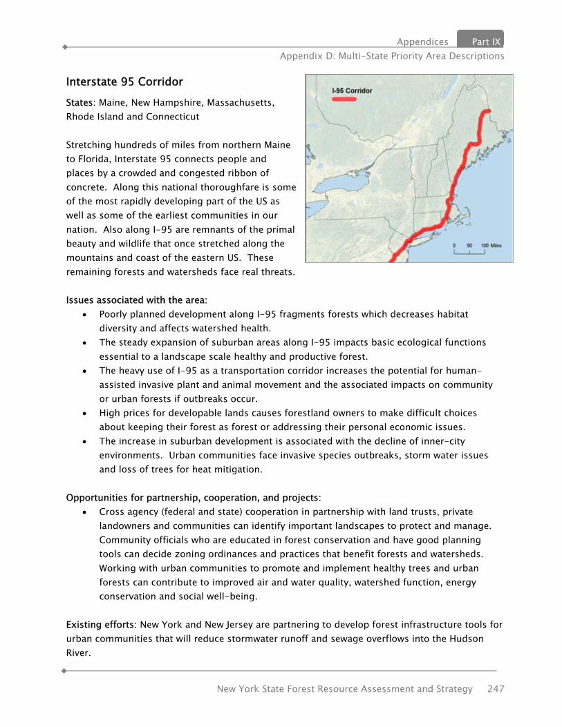
Appendices Part IX Appendix D: Multi-State Priority Area Descriptions
New York State Forest Resource Assessment and Strategy 247
Interstate 95 Corridor
States: Maine, New Hampshire, Massachusetts, Rhode Island and Connecticut Stretching hundreds of miles from northern Maine to Florida, Interstate 95 connects people and places by a crowded and congested ribbon of concrete. Along this national thoroughfare is some of the most rapidly developing part of the US as well as some of the earliest communities in our nation. Also along I-95 are remnants of the primal beauty and wildlife that once stretched along the mountains and coast of the eastern US. These remaining forests and watersheds face real threats. Issues associated with the area:
• Poorly planned development along I-95 fragments forests which decreases habitat diversity and affects watershed health.
• The steady expansion of suburban areas along I-95 impacts basic ecological functions essential to a landscape scale healthy and productive forest.
• The heavy use of I-95 as a transportation corridor increases the potential for human-assisted invasive plant and animal movement and the associated impacts on community or urban forests if outbreaks occur.
• High prices for developable lands causes forestland owners to make difficult choices about keeping their forest as forest or addressing their personal economic issues.
• The increase in suburban development is associated with the decline of inner-city environments. Urban communities face invasive species outbreaks, storm water issues and loss of trees for heat mitigation.
Opportunities for partnership, cooperation, and projects:
• Cross agency (federal and state) cooperation in partnership with land trusts, private landowners and communities can identify important landscapes to protect and manage. Community officials who are educated in forest conservation and have good planning tools can decide zoning ordinances and practices that benefit forests and watersheds. Working with urban communities to promote and implement healthy trees and urban forests can contribute to improved air and water quality, watershed function, energy conservation and social well-being.
Existing efforts: New York and New Jersey are partnering to develop forest infrastructure tools for urban communities that will reduce stormwater runoff and sewage overflows into the Hudson River.
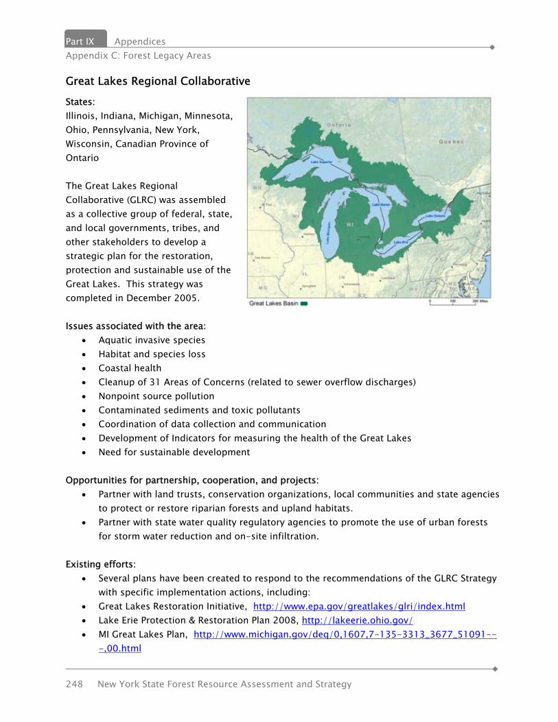
Part IX Appendices Appendix C: Forest Legacy Areas
248 New York State Forest Resource Assessment and Strategy
Great Lakes Regional Collaborative
States: Illinois, Indiana, Michigan, Minnesota, Ohio, Pennsylvania, New York, Wisconsin, Canadian Province of Ontario The Great Lakes Regional Collaborative (GLRC) was assembled as a collective group of federal, state, and local governments, tribes, and other stakeholders to develop a strategic plan for the restoration, protection and sustainable use of the Great Lakes. This strategy was completed in December 2005. Issues associated with the area:
• Aquatic invasive species • Habitat and species loss • Coastal health • Cleanup of 31 Areas of Concerns (related to sewer overflow discharges) • Nonpoint source pollution • Contaminated sediments and toxic pollutants • Coordination of data collection and communication • Development of Indicators for measuring the health of the Great Lakes • Need for sustainable development
Opportunities for partnership, cooperation, and projects:
• Partner with land trusts, conservation organizations, local communities and state agencies to protect or restore riparian forests and upland habitats.
• Partner with state water quality regulatory agencies to promote the use of urban forests for storm water reduction and on-site infiltration.
Existing efforts:
• Several plans have been created to respond to the recommendations of the GLRC Strategy with specific implementation actions, including:
• Great Lakes Restoration Initiative, http://www.epa.gov/greatlakes/glri/index.html • Lake Erie Protection & Restoration Plan 2008, http://lakeerie.ohio.gov/ • MI Great Lakes Plan, http://www.michigan.gov/deq/0,1607,7-135-3313_3677_51091--
-,00.html
Appendices Part IX Appendix D: Multi-State Priority Area Descriptions
New York State Forest Resource Assessment and Strategy 249
• Wisconsin Great Lakes Strategy, http://www.dnr.state.wi.us/org/water/greatlakes/wistrategy/
Key contact persons, resources, organizations for the area:
• Great Lakes Regional Collaborative, http://www.glrc.us • Council of Great Lakes Governors, http://www.cglg.org/ • Great Lakes and St. Lawrence Cities Initiative, http://www.glslcities.org • Great Lakes Congressional Task Force, http://www.nemw.org/index.php/congressional-
coalitions-and-task-forces/great-lakes-task-force • Great Lakes Indian Fish and Wildlife Commission, http://glifwc.org/ • U.S. Environmental Protection Agency, Great Lakes National Program Office ,
http://www.epa.gov/greatlakes/

Appendices Part IX Appendix E: References
New York State Forest Resource Assessment and Strategy 251
APPENDIX E: REFERENCES American Museum of Natural History. New York State Biodiversity Project Needs Assessment. March 2001. http://www.nybiodiversity.org/data/NYSBP_Needs_Assessment.pdf Audubon New York. Wildlife and Forestry in New York Northern Hardwoods: A Guide for Forest Owners and Managers. Barnes, Martina C.; Todd, albert H.; Lilja, Rebecca Whitney; Barten, Paul K. Forests, Water and People: Drinking water supply and forest lands in the Northeast and Midwest United States. NA-FR-01-08. Newtown Square, PA: U.S. Department of Agriculture, Forest Service, Northeastern Area State and Private Forestry. 71 p. http://na.fs.fed.us/pubs/misc/watersupply/forests_water_people_watersupply.pdf Butler, Brett J. Family Forest Owners of the United State, 2006: A Technical Document Supporting the Forest Service 2010 RPA Assessment. U.S. Forest Service. June 2008. Center for Urban Horticulture. Human Dimensions of the Urban Forest Fact Sheets. University of Washington, College of Forest Resources. http://www.naturewithin.info/urban.html Economic Resurgence in the Northern Forest: Regional Strategy and Recommendations of the Sustainable Economy Initiative. http://www.northernforest.org/economic-strategy.shtml Ernst, Caryn. 2004. Protecting the source: land conservation and the future of America’s drinking water. San Francisco, CA: Trust for Public Land, Water Protection Service. 56 p. Louv, Richard. Last child in the woods: saving our children from nature-deficit disorder / Algonquin Books of Chapel Hill, NC. 2006. 310 p. Malmsheimer, Robert w.; Heffernan, Patrick; Brink, Steve; Crandall, Douglas; Deneke, Fred; Galik, Christopher; Gee, Edmund; Helms, John A.; McClure, Nathan; Mortimer, Michael; Ruddell, Steve; Smith, Matthew; and Stewart, John. Forest Management Solutions for Mitigating Climate Change in the United States. Journal of Forestry: April/May 2008. New York 2007 Draft Wildland Fire Management Plan, NYS Department of Environmental Conservation New York State Hazard Mitigation Plan. http://www.semo.state.ny.us/programs/planning/hazmitplan.cfm NYS Adirondack Park Agency. Adirondack Park State Land Master Plan. June 2001.

Part IX Appendices Appendix C: Forest Legacy Areas
252 New York State Forest Resource Assessment and Strategy
NYS DEC. 2009 New York State Open Space Conservation Plan (OSP). http://www.dec.ny.gov/lands/47990.html NYS DEC. Draft Strategic Plan for State Forest Management. Under development. NYS DEC. State of New York Catskill Park State Land Master Plan. August 2008. http://www.dec.ny.gov/lands/43013.html NYS DEC. Urban and Community Forestry Action Plan. NYS DEC. New York State Forest Stewardship Plan. 2003-2008. NYS DEC. New York State Climate Action Plan. Under development. NYS DEC. State Comprehensive Wildlife Conservation Strategy (CWCS) Plan. http://www.dec.ny.gov/animals/30483.html NYS Office of Parks, Recreation and Historic Preservation. Statewide Comprehensive Outdoor Recreation Plan (SCORP). http://nysparks.state.ny.us/recreation/trails/statewide-plans.aspx Northern Forest Biomass Energy Action Plan. Biomass Energy Resource Center, Carsey Institute, and the Northern Forest Center. 2008. Nowak, David J.; Greenfield, Eric J. 2009. Urban and community forests of the Mid-Atlantic region: New Jersey, New York, Pennsylvania. Gen. Tech. Rep. NRS-47. Newtown Square, PA: U.S. Department of Agriculture, Forest Service, Northern Research Station. 38 p. Office of the State Comptroller, Thomas P. DiNapoli. Economic Benefits of Open Space Preservation. March 2010. Pendall, Rolf. Sprawl Without Growth: The Upstate Paradox. Center on Urban and Metropolitan Policy. http://www.brookings.edu/reports/2003/10demographics_pendall.aspx Ryan, Michael G.; Harmon, Mark E.; Birdsey, Richard A.; Giardina, Christian P.; Heath, Linda S.; Houghton, Richard A.; Jackson, Robert B.; McKinley, Duncan C.; Morrison, James F.; Murray, Brian C.; Pataki, Diane E.; Skog, Kenneth E. A synthesis of the science on forests and carbon for U.S. Forests. Smith, C. R., DeGloria, S.D., Richmond, M.E., et. al. A Gap Analysis of New York NY-GAP. Final Report and Data. 2-disc CD set. University of Idaho. Moscow, ID: U.S. Geological Survey,
Appendices Part IX Appendix E: References
New York State Forest Resource Assessment and Strategy 253
Biological Resources, National Gap Analysis Office, October 2001. Stein, Susan M.; McRoberts, Ronald E.; Alig, Ralph J.; Nelson, Mark D.; Theobald, David M.; Eley, Mike; Dechter, Mike; Carr, Mary. 2005. Forests on the edge; housing development on America’s private forests. Gen. Tech. Rep. PNW-GTR-636. Portland, OR: U.S. Department of Agriculture, Forest Service, Pacific Northwest Research Station. 16 p. Stein, B. A. (2002). States of the Union: Ranking America’s Biodiversity. Arlington, Virginia: NatureServe. http://www.natureserve.org/Reports/stateofunions.pdf Strong, K. 2008. Conserving Natural Areas and Wildlife in Your Community: Smart Growth Strategies for Protecting the Biological Diversity of New York’s Hudson River Valley. New York Cooperative Fish and Wildlife Research Unit, Cornell University, and the New York State Department of Environmental Conservation, Hudson River Estuary Program. Ithaca, N.Y. U.S.D.A. Forest Service. Forest Sustainability Indicators Information System Data Report. 81p. U.S.D.A. Forest Service. Finger Lakes National Forest Land and Resource Management Plan. United States Department of Agriculture Forest Service Eastern Region. R9-FL-FP. April 2006 U.S.D.A. Forest Service. Draft National Report on Sustainable Forests – 2010. http://www.fs.fed.us/research/sustain/2010SustainabilityReport U.S.D.A. Forest Service. Forests on the Edge Publications. http://www.fs.fed.us/openspace/fote/index.html U.S.D.A. Forest Service. Forest Service Open Space Conservation Strategy: Cooperating across boundaries to sustain working and natural landscapes. FS-889. 2007. http://www.fs.fed.us/openspace