
Keeping an Eye on the Islands - OSS.Net an Eye on the Islands: ... China, Malaysia, Philippines, ......
36
1 Keeping an Eye on the Islands: Remote Monitoring in the South China Sea Vipin Gupta Adam Bernstein Senior Member of Technical Staff Postdoctoral Fellow Sandia National Labs/CA Sandia National Labs/CA PO Box 969, MS-9201 PO Box 969, MS-9201 Livermore, CA 94551 Livermore, CA 94551 Email: [email protected] Email: [email protected] Abstract This paper explores the utility and technical feasibility of aerial and commercial satellite imaging for cooperative monitoring of islands, islets, and reefs in the South China Sea - a region that has long been a source of conflict amongst the coastal states. We examine a subset of islands and reefs to test overhead imaging systems that may be useful for verifying possible future agreements designed to defuse the multilateral conflict. Moderate-resolution (5- 10 meter) commercial satellite imagery was generally limited in utility, with the notable exception of Radarsat-1 imagery. Radar imagery proved to be an effective wide area search and detection tool, capable of detecting ships and structures independent of weather or lighting conditions. High-resolution (<1 m), aerial images provided a significant amount of information that was extremely useful for change detection analysis, ship identification, and infrastructure assessment. Based on this result, high-resolution satellite imagery should provide comparable detail from a higher vantage point, but only for limited time periods during daylight hours. Our study concludes that a combination of aerial and satellite imaging can provide timely, substantive information on ships, structures, and activities in the South China Sea. Specific political agreements covering the area may be verifiable if the provisions are tailored to the imaging capabilities and limitations that were identified in this study. All of the necessary aerial and satellite imaging platforms for South China Sea monitoring will be in place by the year 2000. From that point onward, a formal monitoring regime optimized for the South China Sea will be technically feasible. Ig
Transcript of Keeping an Eye on the Islands - OSS.Net an Eye on the Islands: ... China, Malaysia, Philippines, ......

1
Keeping an Eye on the Islands:Remote Monitoring in the South China Sea
Vipin Gupta Adam BernsteinSenior Member of Technical Staff Postdoctoral FellowSandia National Labs/CA Sandia National Labs/CAPO Box 969, MS-9201 PO Box 969, MS-9201Livermore, CA 94551 Livermore, CA 94551Email: [email protected] Email: [email protected]
Abstract
This paper explores the utility and technical feasibility of aerial and commercial
satellite imaging for cooperative monitoring of islands, islets, and reefs in the South China Sea
- a region that has long been a source of conflict amongst the coastal states. We examine a
subset of islands and reefs to test overhead imaging systems that may be useful for verifying
possible future agreements designed to defuse the multilateral conflict. Moderate-resolution (5-
10 meter) commercial satellite imagery was generally limited in utility, with the notable
exception of Radarsat-1 imagery. Radar imagery proved to be an effective wide area search
and detection tool, capable of detecting ships and structures independent of weather or lighting
conditions. High-resolution (<1 m), aerial images provided a significant amount of information
that was extremely useful for change detection analysis, ship identification, and infrastructure
assessment. Based on this result, high-resolution satellite imagery should provide comparable
detail from a higher vantage point, but only for limited time periods during daylight hours.
Our study concludes that a combination of aerial and satellite imaging can provide
timely, substantive information on ships, structures, and activities in the South China Sea.
Specific political agreements covering the area may be verifiable if the provisions are tailored
to the imaging capabilities and limitations that were identified in this study. All of the
necessary aerial and satellite imaging platforms for South China Sea monitoring will be in
place by the year 2000. From that point onward, a formal monitoring regime optimized for the
South China Sea will be technically feasible.
Ig

2
Keeping an Eye on the Islands: Remote Monitoring
in the South China Sea
Vipin Gupta and Adam Bernstein
Introduction
The Spratly islands in the South China Sea have long been a source of
conflict and ill will among the states that surround them. Brunei, China,
Malaysia, Philippines, Taiwan, and Vietnam have argued for decades about
sovereignty over the islands, islets, and reefs in this region. China, Taiwan,
and Vietnam claim the entire archipelago as their own while Brunei,
Malaysia, and the Philippines lay claim to parts of it.' Some of these states
have had serious naval skirmishes in and around the South China Sea. More
often they rely on less direct but still provocative means of controlling islands
of interest. The methods range from occupation of the islands and
construction of landing strips, markers, and other structures to more legalistic
stratagems such as the sale of exploratory oil drilling rights, the release of
maps indicating ownership, and the announcement of plans to develop
certain islands.
Much of the conflict stems from the ambiguity of the claims. Countries
often physically occupy or build structures on the islands without ever
explicitly laying legal claim to the island or reef in question. Countries appear
to be trying in this way to establish a defacto presence, which they hope may
become de jure over time.2 Such tactics raise tensions when competitors
discover the unannounced occupations, and have provoked naval battles,
diplomatic protests, and the mass arrest of fishermen operating in disputed
areas.
Unilateral efforts to patrol or otherwise locally monitor the islands are
sporadic, made difficult by the sparse distribution of the islands and by the
limited naval strength that most of the countries in the area have at their
Il

3
disposal. Multilateral cooperation is largely confined to Indonesia-sponsored
annual workshops on managing conflict in the South China Sea. The
workshops, which began in 1990, have the goal of easing tensions and
increasing cooperation among the contesting states. In the last several years,
attendees have formed working groups devoted to scientific research,
resource development, environmental protection, legal issues, and
navigational and communication safety.3 However, the workshops have
yielded little in the way of concrete results, and have not prevented
continued unilateral attempts to take control of islands.
In this context, in which diplomatic efforts move slowly while
unilateral occupation and development of the islands continues apace, it is
worth considering new ways of monitoring this conflict. Sensor technologies,
if used to observe the South China Sea in a systematic and non-intrusive
manner, might provide the necessary technical underpinnings for verifiable
agreements that could defuse the multilateral conflict. While such
technologies may not make arms control and confidence building in this
region probable, it might make it technically possible.
One monitoring approach that has been suggested for use in the South
China Sea is overhead imaging. 4 If changes could be seen remotely on
islands and the information readily shared between the interested countries,
the naval skirmishes and reprisals that have occurred in the past might be
avoided or reduced in frequency. The states' knowledge that the region is
under rigorous, multilateral remote surveillance could discourage the
unilateral development or takeover of the islands in the future.
In this paper, we explore the usefulness and technical feasibility of
cooperative monitoring of the Spratly Islands with aerial and commercial
satellite images. We begin with a short resume of the claims and conflicts in
the territory. We then select islands for analysis based on their political
significance and the availability of archived overhead imagery. We analyze
the images to determine which features can be identified, and examine the
20

* - China* - Malaysa* - Phlippines
-Taiwan-Vietnam
*- Unoccupied
SouChitSew
Fiery Cross .Reef#
ISpray=s1SM
Northeast Cay
Southwest Cay-.West York
* . sland' Thitu Island
Loalla Nan ,, -Lankiam Cayth Sand Cay soaita Islad
Ia Aba Iland ' EIldad ReefSa R .lNAmyit A
. C andaSin Cowe. " Mischief
Island % Reef
4
Pigeon Reef
~ea,
AfsonReef
/Amboyna
Cay 0 50 100 km
O 50 100 mi
Figure 1: Islands, reefs, and shoals in the Spratly island region. The color coded islands areoccupied by the state denoted in the legend.
technical constraints placed on the regime by the small size and widespread
distribution of the islands. We conclude with an assessment of both the risks
and benefits of remote sensing in the context of the sovereignty disputes in
the region.
Claims and Conflicts in the Disputed Territory
The Spratly Island chain (figure 1) consists of about 100 islands, reefs,
and sea mounts with a total land area of less than 5 square kilometers. The
small land masses are scattered across approximately 800,000 square
kilometers of ocean. Guano (used for fertilizer) and fish are the principal
natural resources.5 Some studies claim that the region has large oil and gas
reserves, although the predictions vary widely and appear to be based on little
hard data.6 Despite the uncertainty of the estimates, most of the countries in
the region are interested in the Spratlys because of their potential as a source
2r
4
Flat,Island
OanshanIsland
HalfMoon y
Shoal
-

5
for oil. The islands' geostrategic value is significant due to their proximity to
major shipping lanes and to the mainlands of the Philippines, Brunei,
Vietnam, and Malaysia. In addition, perhaps due to suspicions and
nationalist sentiments raised by decades of low-level hostilities, the islands
have acquired an import beyond their current economic and strategic value,
turning them into emblems of sovereignty to many states in the region.7
Actual claims to the Spratlys are variously based on historical evidence,
existing occupation, and limits defined by treaties and unilateral decrees.
China and Taiwan claim all features in the Spratly Islands both above and
below sea level. China occupies or has placed markers on seven to ten reefs in
the Spratlys, while Taiwan occupies one of the largest islands, known as
Taiping or Itu Abu. Vietnam claims everything above sea level in the
Spratlys as its own; it has outposts on about 23 islands or reefs. The
Philippines occupies eight islands or cays in an area it refers to as the
Kalayaan region, or "Freedomland." Malaysia claims all six islands within a
continental shelf limit defined in 1979, and occupies three of these; the other
three are occupied by Vietnam and the Philippines. Brunei's claim is most
conservative, restricted to the seas surrounding Louisa Reef, apparently not
even including the reef itself. 8
Over the past few decades, China, Malaysia, the Philippines, Taiwan and
Vietnam have all fought over sites in contested areas. Some of the salient
disputes have occurred within the past ten years. These recent incidents
show distinct patterns of confrontation in 1988, early 1995, and late 1998
separated by periods of tense calm:
* In 1988, China began construction on Fiery Cross Reef, also claimed by Vietnam. Vietnamthen engaged in a battle near the reef with China in which three Vietnamese ships weresunk and 72-75 Vietnamese killed. 9
* In 1992, China announced an oil exploration deal near the Spratlys with the US companyCrestone. In 1994, Vietnam built a drilling rig in the Crestone area, even as China claimedsovereignty over Vietnam's nearby 'Blue Dragon' exploration area.10
* In early 1995, China began construction of several buildings on Mischief Reef that thePhilippines described as "military structures." The Philippines reacted by removing

6
Chinese markers from the island and bringing journalists to the reef to observe China'sactivities. 1
* In March 1995, the Philippine navy arrested Chinese fisherman near Alicia Reef that itclaims along with China. 2 Filipino forces also arrested 62 Chinese fishermen at HalfMoon Shoal.'3
* In late March 1995, Taiwanese forces fired warning shots at a Vietnamese cargo vessel thatviolated a Taiwan-declared exclusion zone around Itu Abu, an island it occupies in theSpratlys.' 4 In the same week, Filipino forces fired warning shots at Chinese fishing boatsthat came within one mile of its occupied position on Thitu Island.' 5
* On 8 September 1998, China formally protested Vietnam's sudden occupation of OrleanaShoal and Kingston Shoal. China claims sovereignty over both of these shoals.' 6
* On 6 November 1998, the Philippines released a public statement calling for China toterminate intensified construction activities at Mischief Reef. The Philippines accusedChina of building more permanent, fortified structures on Philippine territory.' 7 Chineseofficials claimed that they were merely repairing fishing shelters that were damaged bystorms. 18
Islands Selected for Analysis
We chose specific islands for image analysis through an iterative
process. First, we selected a set of islands for study based on their political
significance and topographic features. We then searched for suitable
commercial aerial and satellite images of those islands. In situations where
no images were found, we substituted other islands into the study set and
searched the archives again.
The searches of the satellite archives concentrated on high-resolution
(<10 m), panchromatic imagery. Since published aerial photos and media
reports indicated that island activities and infrastructure were small-scale and
rudimentary, the imagery with the highest spatial detail had the best chance
of providing observable evidence of island occupations. The need for high
spatial resolution focused the data search on four satellite archives:
declassified US CORONA images, declassified Russian KVR-1000 images,
Indian IRS-1C and IRS-1D images, and Canadian Radarsat images.l1
Table 1 shows the initial set of islands that were selected for detailed
examination. The table gives the geographic location of each island and
t3

7
Island Present Geographic Significance of IslandOccupants Location
Mischief Reef China 9° 53' N, 115° 32' E China took control of the reef in early 1995,triggering ASEAN to protest the surpriseoccupation. Aerial photos indicate that Chinaconstructed several octagonal structures onthe reef. Philippines, Taiwan, and Vietnamalso have claims to the reef.
Thitu Island Philippines 11° 03' N, 114° 17' E Thitu Island is the largest Philippine-occupiedisland. The island reportedly has an airstrip,lighthouse, and power plant. China,Taiwan, and Vietnam also have claims to theisland.
Itu Abu Taiwan 10° 23' N, 114° 21' E This island is one of the larger land masses inthe area. It reportedly has a marine garrison,helicopter pad, meteorological center, andpower plant. A communications facility isreportedly under construction and an 1800meter airstrip is apparently underconsideration." China, Vietnam, and thePhilippines also claim the island.
Southwest Cay Vietnam 11° 26' N, 114' 20' E Occupied by different countries, these twoNortheast Cay Philippines 11° 27' N, 114' 21' E islands are only 4 km away from each other.
The SW and NE Cays illustrate how twocountries that do not border each other cancreate a potential frontline in the S. China Sea.
Fiery Cross Reef China 9° 40' N, 113° 02' E China began construction on this reef in earlyMarch 1988. Vietnam tried to disrupt thisconstruction, which resulted in an armedconflict. The reef reportedly holds a largeChinese observation post along with ahelicopter pad and pier.2
Spratly Island Vietnam 8° 39' N, 111° 55' E Vietnam reportedly built a lighthouse, 600 mairstrip, harbor, power plant, and radiostation.2 3 China and Taiwan also claim thisisland.
Table 1: Initial Selection of islands in the South China Sea for detailed image analysis.
explains why each was selected for image analysis. Every island that was
chosen for detailed study was either a significant base of operations or a
flashpoint with a documented history of threats and conflict between two or
more countries. Our subsequent search found high-resolution satellite images
for only two of the six selected islands: Mischief Reef and Thitu Island. Aerial

8
Table 2: Final selection of islands in the South China Sea for detailed image analysis.
imagery was found for four of the six selected islands, but only 12 photos were
publicly available. This result was quite revealing. It indicated that
declassified and commercial satellite imagery have not been used on a
sustained, systematic basis to monitor the principal conflict areas in the South
China Sea. It also indicated that aerial imagery of these same areas was either
limited or generally kept secret by the respective conflicting parties.
7-<
Island Present Geographic Significance of IslandOccupants Location
Mischief Reef China 9° 53' N, 115° 32' E China took control of the reef in early 1995,triggering an ASEAN protest of the surpriseoccupation. Aerial photos indicate that Chinaconstructed several octagonal structures onthe reef. Philippines, Taiwan, and Vietnamalso have claims to the reef.
Thitu Island Philippines 11° 03' N, 114° 17' E Thitu Island is the largest Philippine-occupiedisland. The island reportedly has an airstrip,lighthouse, and power plant. China,Taiwan, and Vietnam also have claims to theisland.
Subi Reef China 10° 54' N, 114' 06' E Located approximately 26 km SW of ThituIsland, this island reportedly has ablockhouse, supply platform, helicopterparking apron, and 100 Watt HTIW412 radiocommunicator. A Chinese garrison forcereportedly occupies the reef.25
Commodore Reef Philippines 8° 21' N, 115° 14' E Located 170 km south-southwest of MischiefReef, this reef is also claimed by China,Vietnam, and Malaysia.
Alicoa Annie No known 9' 22' N, 115' 27' E Located 56 km south-southwest of Chinese-occupants occupied Mischief Reef, this reef was near the
site of a Philippine navy confrontation withChinese fisherman in March 1995. China andthe Philippines claim this reef.
Yuan Anha No known 8° 08' N, 114' 40' E Located 80 km west-southwest of Commodoreoccupants Reef, Yuan Anha is comparable in size.
Consequently, it could become a target foroccupation in the future.

SoutlChinmSea
Fiery CrossReef
hSpratlyIsland
AmboynalCay
Northeast Cay
Southwest Cay4Subl West YorkReef Thiu nda fIsland
h Ree H, .rhitu Islanda Loalta Nan,, .Lankiam Cay
Sand Cay Loafta slandIt Aba Wand't kE d Reef I
c *.-Namyit vI c. Ia nd
Sin Cowe'- , Mischiefe
Island % ReefReef
AlicoatAnnie
Pigeon ReefAisorn' %
Reef
Yuan Anha
J , 00
Flat,Island
VanshanIsland
Half
Shoal
ICoCommodoreReef
50 100 km
50 100 mi
Figure 2: Islands and reefs in the South China Sea that were selected for detailed imageanalysis.
As a result, the selected set of islands was revised to accommodate the limited
archive of suitable images of the study area. Table 2 and Figure 2 show the
revised set of islands that were ultimately analyzed with aerial and
commercial satellite imagery. Each island was selected by considering its
relative size and significance along with the availability of archived images.
Preference was given to islands imaged by commercial satellite platforms
because this particular technology has not been tested for South China Sea
monitoring.
Analysis of Aerial and Satellite Imagery
We analyzed images of each island listed in Table 2 for infrastructure,
ongoing activities, and natural phenomena. We searched for manmade and
natural changes as well as evidence that could confirm or refute accounts in
9
_ �_�____ �__ __

10
published articles about specific islands. The image analysis enabled us to
assess the technical capabilities and limitations of the various imaging
systems that were used, and gauge the likely utility of imaging satellites that
are planned for deployment within the next few years.
Mischief Reef
In early 1995, the appropriately named Mischief Reef emerged as a
major flashpoint in the South China Sea when China began constructing and
occupying buildings on the reef. Filipino fishermen reportedly discovered the
Chinese occupation, were detained by Chinese personnel at Mischief Reef,
and subsequently notified Philippine authorities after being released.26
Philippine naval and air force reconnaissance confirmed that the Chinese had
taken control of the reef located 215 km west of undisputed Philippine
territory.27 The Philippine government perceived the Chinese action as a
direct challenge to their own sovereignty claim over Mischief Reef.
The Philippine Department of National Defense reported that several
Chinese naval ships were sighted in close proximity to the reef, including a
Yukan-class amphibious warfare ship and a Dazhi-class submarine support
ship.28 As evidence, the Philippines released aerial photos showing Chinese
activities in the area. Plate 1 is an aerial photo of an armed Chinese ship that
was reportedly at Mischief Reef in early 1995 (Note: the annotations on all
plates are based on our image interpretation). Plate 2 shows aerial photos of
two armed ships that the Philippines identified as Chinese. Both of these
ships were photographed in the spring of 1997 near Philippine-occupied areas
in the South China Sea.
In addition to the ship activity, the Philippines presented aerial photos
of four permanent building clusters on Mischief Reef that had been built by
China.29 Each cluster was constructed on top of steel pylons because the reef
submerges at high tide. Plates 3 and 4 show two of the four building clusters
in great detail. Acquired a few months after China took control of the reef, the
217

11
Plate 1: Philippine aerial photo acquired on 1 February 1995 showing a ship that wasreportedly located at Mischief Reef. The photograph has a spatial resolution of .2 meters. Ouranalysis revealed that this is a Chinese Yannan-class ship, an armed survey and researchvessel. The inset is a reference image of a Chinese Yannan-class ship from Jane's FightingShips, 1995-1996.3 The connected circles show the features in the overhead image that matchthe reference image. Because of the overhead view, neither the flag nor the identificationmarks along the bow could be seen. (Overhead aerial image courtesy: Agence France-Presse,Reference image courtesy: Jane's Information Group)
Plate 2: Philippine aerial photos acquired in the spring of 1997. These two armed ships werereportedly photographed in the South China Sea and identified as Chinese. In the largephoto, the flag is not identifiable, but the ship's pennant number ('420') is legible. The class ofthe ship is not known for certain although it may be a variant of Yenlai-class. The inset showsa Chinese Yannan-class ship with a pennant number of '24' or '124' (see Yannan-class referenceimage in Plate 1 inset). (Aerial images courtesy: Agence France-Presse)

12
Plate 3: Aerial photo showing one of four building clusters that China constructed andoccupied. The photo was taken a few months after China took control of the reef. Manyfeatures in the image were identified. The inset shows an individual standing on a platformscrutinizing the observation aircraft and a second possibly armed individual positionedbehind one of the armor shields along the periphery of the building cluster. (Courtesy: AgenceFrance-Presse)
Plate 4: Aerial photo showing another Chinese building cluster on Mischief Reef. As in Plate 1,many features in the image were identified. In both clusters, the huts were deliberately builtaway from the octagonal buildings which suggests the storage of items that need to be keptaway from the living quarters for safety or hygienic reasons. The inset shows an individualwith binoculars watching the observation aircraft as it flies by. (Courtesy: Agence France-Presse)
2I

13
Plate 5: 4 September 1997 IRS-1C satellite image of Mischief Reef. The IRS-1C panchromaticsensor acquired the image at a six meter ground sample distance. The image was thenresampled so that each pixel covers a 5 m x 5 m ground area. The four reported building clusterscould not be identified, but four distinct blips along the north, south, east, and west perimeterwere detected. In addition, a 68±5 meter long feature inside the lagoon was found that could bea naval vessel. The feature could not be conclusively identified because its shape was blurredand its shadow was not visible in the lagoon (see inset).
photos show the personnel at the building clusters carefully observing the
observation aircraft as it flies by. Both photos also show the deployment of
armor shields along the periphery of the building clusters. The Plate 3 inset
shows a possibly armed individual behind one of the armor shields facing the
observing aircraft.
IRS-1C satellite images of Mischief Reef show the entire landscape as
well as the surrounding sea. In both Plates 5 and 6, one can readily see the
reef structure, lagoon with a passable opening to the sea, small reef islets
inside the lagoon, and the ephemeral beach along the northern periphery.
s3o

14
Plate 6: 10 November 1997 IRS-1C satellite image of Mischief Reef. The IRS-1C panchromaticsensor acquired the image at a six meter ground sample distance. The image was thenresampled so that each pixel covers a 5 m x 5 m ground area. Two blips were detected along thenorth and east periphery and one naval vessel was identified. The vessel is 71+5 meters longand it has a distinct, blurred appearance (see inset). Its class could not be determined, butseveral ship classes were eliminated from consideration based on the length measurement.
Acquired 2.5 years after the Chinese occupation, these panchromatic images
show significantly less detail than the aerial photos.
The 4 September 1997 IRS-1C image shows the reef with four noticeable
blips along the north, south, east, and west perimeter (Plate 5). These blips
may be part of the four building clusters described in the media reports on the
Chinese occupation. However, it is not possible to be certain about this
because the individual buildings within each cluster are not visible. Inside
the lagoon, there is a 68 + 5 meter long feature that could possibly be a naval
vessel. Unfortunately, a more definitive identification could not be made
3,

15
because the feature's shape is blurred and its shadow could not be discerned in
the lagoon.31
In the 10 November 1997 IRS-1C image, two of the four blips along the
reef periphery could not be seen, but a feature inside the lagoon could be
positively identified as a naval vessel (see Plate 6). The Plate 6 inset clearly
shows its shape and size. Although the satellite image was too blurred to
identify the class of the vessel with certainty, the feature's measured length of
71 + 5 meters did eliminate some ship classes from consideration.3 2 If the
vessel was Chinese, it was too small to be a destroyer, frigate, or ballistic
missile submarine and too large to be a coastal patrol boat. The vessel was
also too small to be either a Yukan-class supply ship (120 meters long) or a
Dazhi-class support ship (107 meters long). Both ship classes have been
observed at Mischief Reef on earlier occasions. Thus, based on a process of
elimination, the imaged ship was probably either a replenishment ship (e.g.,
Fulin Class), a survey and research ship (e.g., Yannan Class), a cable ship
(Yudian Class), or a civilian transport/fishing ship.
Moderate resolution, panchromatic satellite imagery provided a
synoptic view of Mischief Reef as well as conclusive evidence of a ship
deployment. These initial results suggest that this type of commercial
imagery can be used under favorable weather conditions to detect large
warships and supply ships. If compared with an overhead imagery database
of known ships, the class of the imaged ships may also be identifiable.
However, this same imagery failed to reveal the building clusters
shown in the aerial photos. This suggests that higher resolution imagery is
required to detect smaller scale features such as the manned outposts shown
in Plates 3 and 4. Such high resolution imagery is also likely to be required to
determine the nature and purpose of specific activities.
The importance of high resolution imagery was concretely
demonstrated in late 1998, when the Philippine government announced
renewed Chinese construction on Mischief Reef. The Philippines accused
China of a substantial military buildup. China responded that the activity
32-

16
Plate 7: This aerial photo was released by the Philippine Department of National Defense on10 November 1998. The photo shows significant construction activity at one of the four Chinese-occupied areas on Mischief Reef. Working adjacent to octagonal structures that were built inearly 1995, the construction workers can be seen placing metal rods into position for thefoundation of a large, reinforced concrete structure.
The inset shows the concrete structure near completion just two months later. The insetpicture of the five story building was acquired on 15 January 1999 from an aircraft flying at analtitude of 300 feet. 33 It was imaged from a camera bearing offset by 90° from the camerabearing of the main photo. The different perspective views of the small hut visually showsthis difference in bearing. (Aerial images courtesy: Agence France-Presse)
merely involved the repair of existing structures damaged by heavy storms.
The conflicting accounts could have lingered on as an unsubstantiated factual
dispute, but high-resolution photographic evidence helped to clarify the type
of activity that was taking place.
Aerial photos acquired by Philippine reconnaissance show significant
construction activity around the existing building clusters (see Plates 7 and 8).
Plate 7 shows approximately 40 construction workers laying out the skeletal
frame for a new, large concrete structure. The Plate 7 inset shows the five
story concrete structure nearly completed just two months later. Plate 8
shows approximately 65 workers building a truss structure adjacent to the
existing platforms. The photo also shows shrouds covering portions of the
platform and a probable anti-air or anti-ship system surrounded by sandbags.
3;3

17
Plate 8: This aerial photo shows new construction activity at a second Chinese occupied area onMischief Reef. It was also released by the Philippine Department of National Defense on 10November 1998. In the foreground, the octagonal structures built in early 1995 can be seen withportions of the platform covered by shrouds. In the background, the construction workers can beseen erecting a large, truss structure. On the central platform, personnel can be seen around alarge, black object surrounded by sandbags. The object appears to be an anti-aircraft or anti-ship weapon system. However, the type and operational status of the probable weapon systemis not evident. (Aerial image courtesy: Agence France-Presse)
In addition to the aerial photos of the construction activity, the
Philippines released aerial photos of Chinese naval ships that supported the
operation. Plate 9 shows two Chinese amphibious warships at Mischief Reef
on 7 November 1998. Both of these large ships are Yuting-class equipped with
bow doors and helicopter decks. Plate 10 shows three Chinese naval ships
positioned next to each other at Mischief Reef on 10 December 1998. The
middle ship is a Dayun-class support ship, and the ships on either side of it
are Yuting-class.
The high-resolution aerial images of the 1998 construction and ship
activity at Mischief Reef clearly show a rapid buildup of fortified structures
53

18
Plate 9: Philippine aerial photo acquired on 7 November 1998 showing two ships reportedlyanchored at Mischief Reef. Our analysis of this photo revealed that these are Chinese Yuting-class ships. These ships are armed and designed for amphibious warfare. With a full loaddisplacement of 4,800 tons and a length of 130 meters, each ship can carry 250 troops along with10 tanks.3 4 The inset is a reference image of a Chinese Yuting-class ship from Jane's FightingShips, 1995-1996.35 Interestingly, the ship in the foreground appears to be the exact same shipas the one shown in the reference image - both are marked with pennant number '991'. Theship in the background is marked with pennant number '934'. Ships '991' and '934' were thefirst and second Yuting-class ships to be commissioned into the Chinese PLA navy.36 (Aerialimage courtesy: Agence France-Presse, Reference image courtesy: Jane's Information Group)
^^i N^- h.
Plate 10: Philippine aerial photo acquired on 10 December 1998 showing three ships reportedlyanchored at Mischief Reef. Our analysis of this photo revealed that the middle ship is aChinese Dayun-class support ship, and the ships on either side of it are Chinese Yuting-classships. The Yuting-class ship in the foreground is marked with pennant number '935'; it was thethird such ship to be commissioned into the Chinese PLA navy. 37 The inset is a reference imageof a Chinese Dayun-class ship from Jane's Fighting Ships, 1995-1996.3 The connected circlesshow the features of the middle ship that match the reference image. (Aerial image courtesy:Agence France-Presse, Reference image courtesy: Jane's Information Group)
3 V

19
with logistical support and protection provided by the Chinese PLA navy.
The construction of new multi-story, concrete buildings on the reef indicates
that the activity went well beyond the repair of existing shelters.
The aerial images also show a marked increase in Chinese capability on
Mischief Reef. China established an expanded, fortified presence that enables
deployed personnel to better withstand harsh weather and resist attack. The
fortifications can also be used to project naval power into the surrounding
area and serve as a sanctuary for Chinese fishing vessels operating in disputed
waters.39 The naval forces that have been observed at the reef demonstrate a
capability to quickly reinforce China's occupation with more personnel,
material, and heavy weaponry.
The images of Chinese activities at Mischief Reef provide some
working experience on what can and cannot be done with overhead imagery
to monitor the South China Sea as a whole. The lessons drawn from such
experience can be expanded further by analyzing images of other areas and
activities in the South China Sea.
Thitu Island
Thitu Island is the English name for the largest Philippine-occupied
island in the South China Sea. Its Filipino name is Pagasa. Philippine forces
took control of the island in the 1970s.40 Since China, Taiwan, and Vietnam
also claim this relatively large island, the Philippines established a substantial
military presence there to reinforce its claim, deter attempts by others to take
over the island, and defend itself in case of attack. The approximately 100-
man military force on Thitu Island can also be used to project power in other
parts of the South China Sea - particularly air power.41
?3 (

20
Plate 11: 4 September 1997 Radarsat-1 image of Thitu Island. This synthetic aperture radarimage was acquired in the C-Band (5.6 cm wavelength) at approximately eight meter groundsample distance. Although the radar image has the characteristic speckle appearance, therunway is clearly visible and measurable: 1294+5 meters long and 96±5 meters wide. The wavebarrier at the end of the runway and portions of the reef can also be seen.
In contrast with the fortified outposts at Mischief Reef, Thitu Island is
one of the few islands in the South China Sea with an airfield (known as
Rancudo Airfield). Plate 11 shows a Radarsat-1 satellite image of Thitu Island.
The radar image provided information on the large-scale infrastructure, but
little detail on the small-scale features such as aircraft, vehicles, and buildings.
The runway is clearly evident. Built on top of the island's coral base, it is
substantially wider than the island itself. The image also shows the wave
barrier at the end of the runway as well as portions of the island's
surrounding reef structure. Scattered throughout the island are a few bright
blips that could not be identified, but are most likely vehicles, buildings, and
other parts of the island infrastructure.
3-7

21
Plate 12: Aerial photo of Thitu Island. This image was acquired in February 1998 from a C-130transport plane.4 2 In addition to the runway, the image shows buildings amongst the lushvegetation and the aircraft parking area. An observation tower next to the taxiway can also beseen.
The inset is a close-up view of the runway which appears to consist of grass, coral, andconcrete. The photo was taken from the C-130 cockpit while on landing approach from thewest. Notice the wave barrier at the end of the runway. This same barrier can be clearly seenin the Radarsat-1 image in Plate 11.
Aerial photos of Thitu Island show the runway surface composition
and significantly more detail on the island vegetation and support
infrastructure. Plate 12 shows several buildings surrounded by natural
vegetation as well as an observation tower and aircraft parking area. The
photo shows that the island's coral foundation extends well beyond the
beaches. Thus, there is available space to enlarge the operations at the island.
Indeed, that is reportedly what the Philippines intend to do.
In early 1999, Philippine government officials announced plans to
expand and upgrade the infrastructure at Thitu Island. To accommodate a
wider array of military and civilian aircraft, it plans to cement the entire
airstrip. There are also unconfirmed reports of extending the runway,43
3r

22
although that may not be necessary because its current length is capable of
handling large transport aircraft.
The air operations are planned to be upgraded further with the
construction of "temporary" hangars to house Air Force planes.44 These
planes are reportedly OV-10 aircraft needed for increased surveillance
activities as well as increased visibility of the Philippine Air Force in the
South China Sea.45 In addition to the expansion of the air operations, the
Philippines also plan to construct a pier, causeway, and base operations
center.46
The Philippines plan to open the island for tourism as well.47 To
attract visitors to the remote area, they intend to construct at least 10 housing
units that would be used by fishermen and tourists. The use of the island by
civilians could help defray the cost of the occupation and solidify the
Philippines' claim of sovereignty over the islands in this area.
The facilities at Thitu Island and the announced plans to improve the
infrastructure make this site ripe for continued aerial and satellite
monitoring. Overhead imagery could be used to determine whether such
plans ever get implemented and how the changes would impact existing
agreements and declarations. As illustrated in Plates 11 and 12, the moderate-
resolution satellite imagery will most likely be useful for detecting and
tracking large-scale changes, while one-meter resolution aerial and satellite
imagery will probably be most useful for analyzing new construction activity
and monitoring the air traffic to and from the island.
Subi Reef
Just 26 kilometers southwest of Thitu Island, China occupies Subi Reef.
China took control of the reef in 1988.48 Although it is only above water at
low tide, it is centrally located within the archipelago (see Figure 2). It is the
northernmost Chinese-fortified position in the Spratlys, and it is relatively
3,
23
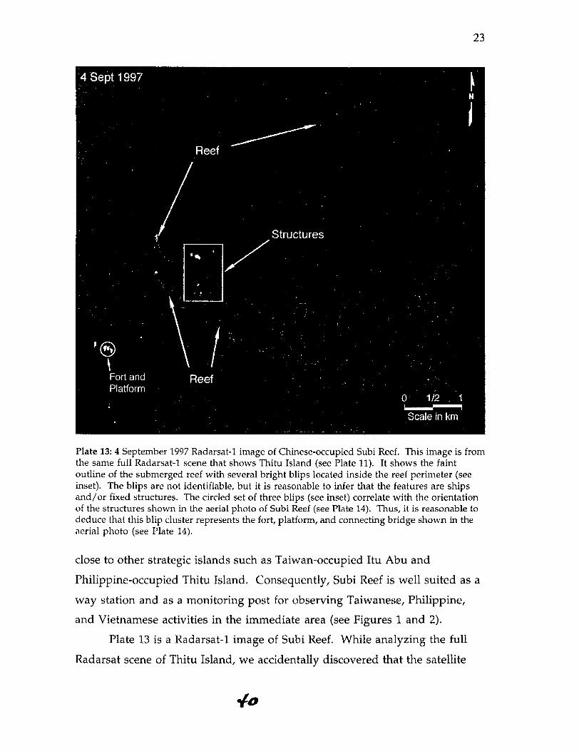
Plate 13: 4 September 1997 Radarsat-1 image of Chinese-occupied Subi Reef. This image is fromthe same full Radarsat-1 scene that shows Thitu Island (see Plate 11). It shows the faintoutline of the submerged reef with several bright blips located inside the reef perimeter (seeinset). The blips are not identifiable, but it is reasonable to infer that the features are shipsand/or fixed structures. The circled set of three blips (see inset) correlate with the orientationof the structures shown in the aerial photo of Subi Reef (see Plate 14). Thus, it is reasonable todeduce that this blip cluster represents the fort, platform, and connecting bridge shown in theaerial photo (see Plate 14).
close to other strategic islands such as Taiwan-occupied Itu Abu and
Philippine-occupied Thitu Island. Consequently, Subi Reef is well suited as a
way station and as a monitoring post for observing Taiwanese, Philippine,
and Vietnamese activities in the immediate area (see Figures 1 and 2).
Plate 13 is a Radarsat-1 image of Subi Reef. While analyzing the full
Radarsat scene of Thitu Island, we accidentally discovered that the satellite

24
Plate 14: Aerial photos of the fortified Chinese structures on Subi Reef. Both photos wereacquired by the Philippine Air Force and released in May 1997. The annotation in the overheadphoto was done by Filipino image interpreters (and it appears to be accurate).
The inset is a perspective view of the same structures shown in the overhead aerialimage. The perspective view was acquired using an aerial camera that was pointing south.(Aerial images courtesy: Philippine Armed Forces)
had also imaged China's occupied position on Subi Reef. The discovery was
made from the observation of several bright blips inside the reef perimeter.
The blips were too coarse to be identifiable, but their bright appearance
indicated that the features were distinctively shaped and probably metallic.
i I

25
The high radar backscatter from these objects suggested that these were
manmade structures.
Aerial images of Subi Reef confirmed the Radarsat detection. Plate 14
shows two aerial photos of the fortified Chinese position there. Acquired by
the Philippine Air Force, the photos show a round platform, a connecting
bridge, and a three-story, concrete fort built on top of a raised foundation. The
overhead photo also shows four naval guns and a communications dish.
These specific features could not be identified in the Radarsat image
because the resolution was too coarse. However, using the aerial photos, it
was possible to identify the blips that corresponded with the fort, platform,
and bridge. This was done by comparing the orientation of the blips with
respect to north to the orientation shown in the overhead aerial photo. From
this comparison, the structures shown in the aerial photos were matched
with the corresponding blips in the Radarsat image (see Plate 13 inset).
The analysis of Subi Reef demonstrated how image information from
different sensor platforms could be combined to provide a clearer overall
picture. The satellite image showed the layout and level of activity at the reef
while the aerial photos provided details on the fortifications. The satellite
image was useful for detecting the structures as part of a wide area sweep
while the aerial photos were useful for identifying the "dots" that were
detected. Each sensor platform compensated for the principal technical
limitations of the other sensor platform.
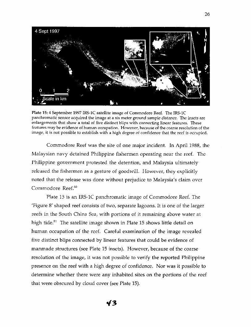
Commodore Reef
Commodore Reef is located in the southeastern quadrant of the Spratly
archipelago (see Figure 2). Located 110 km west of the Philippines' Palawaan
island and 125 km northwest of Malaysia, Commodore Reef is claimed by
China, Malaysia, the Philippines, and Vietnam. The Philippines took control
of the reef in the 1970s, although one report states that they deserted it in the
mid-1980s.4 9
*z.
26
Plate 15: 4 September 1997 IRS-1C satellite image of Commodore Reef. The IRS-1Cpanchromatic sensor acquired the image at a six meter ground sample distance. The insets areenlargements that show a total of five distinct blips with connecting linear features. Thesefeatures may be evidence of human occupation. However, because of the coarse resolution of theimage, it is not possible to establish with a high degree of confidence that the reef is occupied.
Commodore Reef was the site of one major incident. In April 1988, the
Malaysian navy detained Philippine fishermen operating near the reef. The
Philippine government protested the detention, and Malaysia ultimately
released the fishermen as a gesture of goodwill. However, they explicitly
noted that the release was done without prejudice to Malaysia's claim over
Commodore Reef.50
Plate 15 is an IRS-1C panchromatic image of Commodore Reef. The
'Figure 8' shaped reef consists of two, separate lagoons. It is one of the larger
reefs in the South China Sea, with portions of it remaining above water at
high tide.51 The satellite image shown in Plate 15 shows little detail on
human occupation of the reef. Careful examination of the image revealed
five distinct blips connected by linear features that could be evidence of
manmade structures (see Plate 15 insets). However, because of the coarse
resolution of the image, it was not possible to verify the reported Philippine
presence on the reef with a high degree of confidence. Nor was it possible to
determine whether there were any inhabited sites on the portions of the reef
that were obscured by cloud cover (see Plate 15).
6/3

27
The IRS-1C satellite image of Commodore Reef illustrates two
strengths and two weaknesses of moderate resolution, panchromatic imagery.
It can show the geographic layout of a reef in more detail than existing maps.
It can also detect blips that may be evidence of human occupation. On the
other hand, it cannot, in itself, provide conclusive evidence of a small-scale
military presence, nor can it be used to search for features obscured by clouds.
Alicoa Annie and Yuan Anha
Alicoa Annie (also known as Alicia Annie) and Yuan Anha are two
large reefs in the South China Sea that have no known occupants. However,
both are in relatively close proximity to other reefs and islands that are
occupied by various claimant states. Alicoa Annie is just 56 kilometers south-
southwest of Chinese-occupied Mischief Reef. Yuan Anha is less than 75
kilometers from reefs that are occupied by the Philippines, Malaysia, and
Vietnam (see Figures 1 and 2).
Although the Spratly conflict has sometimes been intense, Alicoa
Annie and Yuan Anha have been relatively peaceful. There have been no
documented confrontations at Yuan Anha and one at Alicoa Annie. On 25
March 1995, the Philippine navy captured four Chinese fishing boats near
Alicoa Annie and arrested 62 fishermen. 5 2 The detention of the Chinese
fishermen took place just two months after China took control of Philippine-
claimed Mischief Reef. The arrests were consistent with a pattern of seizing
fishing vessels of a claimant state shortly after it occupies another Spratly reef
or island.
Plates 16 and 17 are IRS-1C panchromatic images of Alicoa Annie and
Yuan Anha. Both were acquired in March 1998 and both are almost
completely cloud free. Alicoa Annie and Yuan Anha are appreciably larger in
size than the other selected islands and show no evidence of human
occupation whatsoever.

28
Plate 16:15 March 1998 IRS-1C satellite image of Alicoa Annie. The IRS-1C panchromaticsensor acquired the image at a six meter ground sample distance. The reef is comparable in sizewith Mischief Reef.
Plate 17: 10 March 1998 IRS-1C satellite image ofYuan Anha. The IRS-1C panchromatic sensoracquired the image at a six meter ground sample distance. This was the largest of the sixislands and reefs that were selected for detailed study.

29
Careful examination of Plates 16 and 17 failed to reveal any blips, paths, or
structures that could be attributed to the physical occupation of the reefs. This
suggests that moderate-resolution images may have limited utility not only
for detecting possible inhabited structures, but also for verifying the absence of
such structures on disputed reefs.53
Conclusions
Our study used a variety of aerial and satellite sensors to analyze the
selected islands and reefs in the South China Sea. Each study site revealed at
least one capability or limitation associated with overhead imaging. The
analysis of Mischief Reef demonstrated how high-resolution aerial images
were needed to detect and assess the controversial activities there. Moderate-
resolution, panchromatic imagery from satellites proved to be limited in
monitoring specific activities at Mischief Reef, but it was useful for ship
detection and synoptic analysis. The study of Thitu Island demonstrated the
value of radar imagery for detecting large-scale infrastructure independent of
light conditions or cloud coverage. The aerial photos showed smaller
structures such as the individual buildings and observation tower. The
accidental discovery of Chinese-occupied Subi Reef in the Radarsat-1 image
was a realistic example on how radar imagery could be used as a detection
tool. In addition, the analysis showed how coarse resolution features from
satellite imagery could be correlated with high-resolution aerial images of the
same feature.
The examination of Commodore Reef highlighted the limitations
associated with the exclusive use of moderate-resolution, panchromatic
imagery. Even though the IRS-1C satellite provided a unique bird's eye view,
it was partially obscured by cloud cover and it did not offer enough spatial
detail to verify human occupation of the reef. It did, however, show a few
"blips" of possible human occupation that could be examined more closely
with higher resolution imagery. Alicoa Annie and Yuan Anha served as

30
controls for the study. The image analysis of these two large reefs with no
known occupants came up with no evidence of physical occupation. This
suggests that such imagery may be useful for dispelling false allegations of
physical occupation and verifying the absence of structures on disputed reefs.
In addition to obtaining empirical results from the study of selected
islands and reefs, we also derived results from the different types of remote
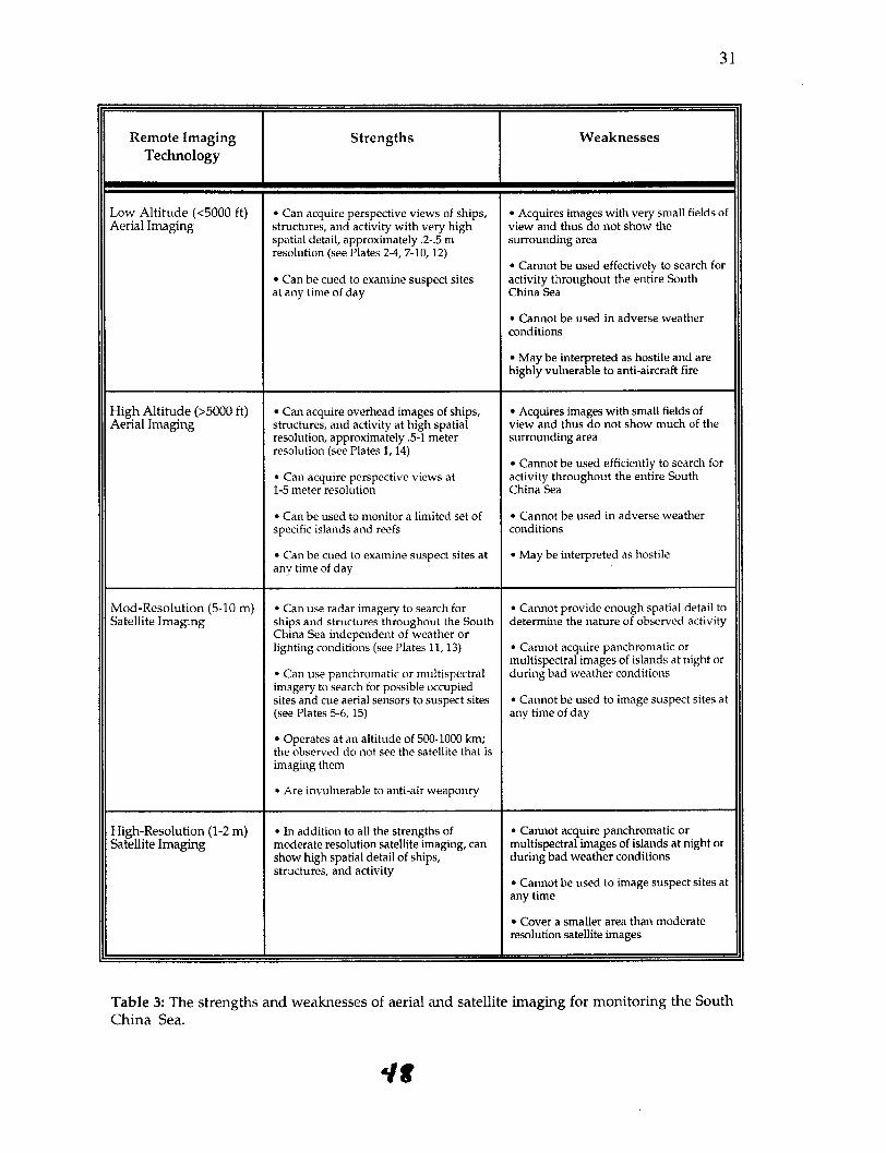
sensing systems that were used. Table 3 charts the strengths and weaknesses
of four general types of aerial and satellite imaging sensors. The assessment is
based on the technical and operational utility of each sensor for monitoring
the South China Sea specifically. The fourth type, high-resolution satellite
imaging, was not used in this study, but its strengths and weaknesses can be
extrapolated from high-resolution aerial imaging and moderate-resolution
satellite imaging.
From Table 3, we can devise an imaging strategy optimized for
monitoring the South China Sea. The overall technical objective would be to
monitor all civilian and military activity in the area without provoking an
armed incident. To do this, the imaging strategy would have to rely on
satellite imaging as much as possible; it is the only platform that can scan the
entire South China Sea on a routine basis for ship and island activity. And in
contrast with aircraft, imaging satellites can operate from a safe altitude
without the risk of being misinterpreted as a fighter-bomber.
Moderate-resolution, radar imaging satellites are the best space-based
system for performing routine search missions over the South China Sea.
Unaffected by adverse weather, radar imaging satellites are the only systems
capable of searching for controversial activities that may deliberately use
cloud cover as a screen. Radar images from satellites such as Radarsat-1 are
well suited for detecting the large ships and outposts that have been observed
in the South China Sea. If the images are delivered within 8-72 hours of
acquisition, these images could provide early warning of controversial or
prohibited activity, whether civilian or military.
'/7
31
Remote Imaging Strengths WeaknessesTechnology
Low Altitude (<5000 ft) * Can acquire perspective views of ships, * Acquires images with very small fields ofAerial Imaging structures, and activity with very high view and thus do not show the
spatial detail, approximately .2-.5 m surrounding arearesolution (see Plates 2-4, 7-10, 12)
* Cannot be used effectively to search for* Can be cued to examine suspect sites activity throughout the entire Southat any time of day China Sea
* Cannot be used in adverse weatherconditions
* May be interpreted as hostile and arehighly vulnerable to anti-aircraft fire
High Altitude (>5000 ft) · Can acquire overhead images of ships, · Acquires images with small fields ofAerial Imaging structures, and activity at high spatial view and thus do not show much of the
resolution, approximately .5-1 meter surrounding arearesolution (see Plates 1, 14)
* Cannot be used efficiently to search for* Can acquire perspective views at activity throughout the entire South1-5 meter resolution China Sea
* Can be used to monitor a limited set of * Cannot be used in adverse weatherspecific islands and reefs conditions
* Can be cued to examine suspect sites at * May be interpreted as hostileany time of day
Mod-Resolution (5-10 m) * Can use radar imagery to search for * Cannot provide enough spatial detail toSatellite Imaging ships and structures throughout the South determine the nature of observed activity
China Sea independent of weather orlighting conditions (see Plates 11, 13) * Cannot acquire panchromatic or
multispectral images of islands at night or* Can use panchromatic or multispectral during bad weather conditionsimagery to search for possible occupiedsites and cue aerial sensors to suspect sites * Cannot be used to image suspect sites at(see Plates 5-6, 15) any time of day
* Operates at an altitude of 500-1000 km;the observed do not see the satellite that isimaging them
* Are invulnerable to anti-air weaponry
High-Resolution (1-2 m) * In addition to all the strengths of * Cannot acquire panchromatic orSatellite Imaging moderate resolution satellite imaging, can multispectral images of islands at night or
show high spatial detail of ships, during bad weather conditionsstructures, and activity
* Cannot be used to image suspect sites atany time
* Cover a smaller area than moderateresolution satellite images
Table 3: The strengths and weaknesses of aerial and satellite imaging for monitoring the SouthChina Sea.
it

32
Any activity detected in a radar image would most likely appear as a
fairly coarse blip. Consequently, higher resolution images would be needed to
investigate further. To facilitate the creation of a stable monitoring regime,
commercial imaging satellites would be the preferred "close look" platform
because the images could be acquired from a safe, remote vantage point,
transmitted to a central image archive, and shared with all claimant states
and other interested parties.
If such images are unavailable in a timely fashion due to the orbital
position of the satellite, the tasking load, or cloud coverage, aerial imaging
would be the next viable option for investigating any suspect features found
in the radar satellite sweep. To minimize the risk of vulnerability and armed
confrontation, the aerial imaging should be done using visibly unarmed
aircraft flying around the suspect site at maximum possible stand-off
distances. To maximize the degree of transparency in the South China Sea,
the aerial data should be shared in a cooperative manner so that claimant
states and interested parties can independently assess the observed activity.
Such sharing could build on the precedent established by the Philippines'
routine release of aerial images of South China Sea sites.
Our remote sensing study shows that aerial and satellite imaging can
provide timely, substantive information on ships, structures, and activities in
the South China Sea. With the devised optimal monitoring strategy, future
studies can now consider verification provisions for specific political
agreements tailored to the capabilities and limitations of aerial and satellite
imaging. All of the necessary aerial and satellite imaging platforms for South
China Sea monitoring are scheduled to be in place by the year 2000. From that
point onward, a formal monitoring regime optimized for the South China
Sea will be technically feasible. Whether such a regime will be realized will
ultimately depend on multilateral agreement to an interim or permanent
solution to the Spratly conflict.

33
Acknowledgements
The authors would like to thank John Baker, Larry Brandt, George
Harris, Frank Pabian, Mark Valencia, and David Wiencek for their assistance
and comments on previous drafts of this paper. The authors would also like
to thank Tom Budge, John Olsen, and Arian Pregenzer for their guidance and
support during the course of this research project.
This research was supported in part by the Cooperative Monitoring
Center at Sandia National Laboratories. This paper was done under the
auspices of the US Department of Energy by Sandia National Laboratories
under Contract No. DE-AC04-94AL85000. The analysis, views, and opinions
expressed herein are those of the authors alone.
' CIA World Factbook, http://travelfinder.com/worldfacts/222.htm, p. 1.2 Scott Snyder, The South China Sea Dispute: Prospects for Preventive Diplomacy A Special Report ofthe United States Institute for Peace (Washington DC, USIP, August 1996), p. 8.3 Bradford L. Thomas and Daniel J. Dzurek, "The Spratly Islands Dispute," Geopolitics and InternationalBoundaries, Vol. 1, No. 3 (Winter 1996) p. 301.4 Snyder, The South China Sea Dispute, p. 17. William Dobson and M. Taylor Fravel, "Red HerringHegemon: China in the South China Sea," Current History, September 1997, pp. 258-263.5 CIA World Factbook, http://travelfinder.com/worldfacts/222.htm, p. 1.6 A news report ("Spratly Island Reserves," International Gas Report, n. 270, p. 32, March 3 1995), citesone Russian estimate of one billion tons of crude oil. The same report notes that this estimate was disputedby China and the Philippines, presumably as being too low. A September 1994 estimate of 30 billion tonsof crude, made by Chinese geology and resources minister Song Ruixang is cited in "Disputed NanshaIslands Rich in Oil and Gas," International Gas Report, 16 September 1994. Conversely, E.F. Durkee, anexploration geologist with expertise in Asia, says that referring to the Spratlys as "oil-rich" is "largelyrubbish," and notes that limited hard data exists for the area (E.F. Durkee, "Oily Claims," letter to the editorin the Far East Economic Review, 30 March 1995).7 Mark Valencia, "Troubled Waters," Bulletin of Atomic Scientists, January/February 1997, p. 50.8 Thomas and Dzurek, "The Spratly Islands Dispute," p. 306.9 "Conflict in Spratlys Spurs Rift Between Hanoi and Moscow," Christian Science Monitor, 14 June 1988.This article and others from the time refer to five Vietnamese dead and 74 missing. Later reports refer tofrom 72 to 75 Vietnamese dead."' Thomas and Dzurek, "The Spratly Islands Dispute," p. 307.l' William Branigin, "China Takes Over Philippine-Claimed Area of Disputed Island Group," TheWashington Post, 11 February 1995.12 Rene Pastor, "Philippines Holds Four Chinese boats in Spratlys," Reuters World Service, 25 March1995.13 David Botbol, "Reportage on PRC Presence on Spratly Islands: AFP Journalists Confirm Presence,"FBIS-EAS-95-063, 3 April 1995, pp. 77-78.14 Cheng-Yi Lin, "Taiwan's South China Sea Policy," Asian Survey, Vol. 37, No. 4, April 1997, p. 2.'5 Botbol, p. 78.16 "FOCUS: Vietnam Occupies Two More South China Reefs," International Boundary Monitor, 15September 1998, pp. 7-10.
4o0

34
17 Press Release on Mischief Reef, The Philippines Department of Foreign Affairs, 6 November 1998.18 "Chinese Building on Disputed Reef," Associated Press, 9 November 1998. Sandra Aguinaldo, "RP toChina: Dismantle Structures," The Manila Times, 9 November 1998.1 Radarsat archives were included in the image search because the imagery offered not only relatively highspatial detail, but also structural information on the imaged features (e.g., surface roughness, metalliccomposition, etc.).20 Chien Chung, "Economic Development of the Islets in the South China Sea," Paper delivered at the S.China Sea Conference, American Enterprise Institute, Washington DC, 7-9 September 1994, p. 15.21 Cheng-Yi Lin, pp. 324, 330.22 Mark Valencia, China and the South China Sea Disputes (London: IISS, 1996), Adelphi Paper 298, p.39.23 Chung, Table 6. Hanoi Voice of Vietnam Network, "SRV: MT Institute Installs Radio Station onTruong Sa, other islands," FBIS-EAS-96-111, 7 June 1996, p. 70.24 Chien Chung, "Economic Development of the Islets in the South China Sea," p. 15.25 Volt Contreras, Cynthia Balana, Juliet Javellana, and Martin Marfil, "Chinese Installations in SpratlysDetailed," FBIS-EAS-98-320, 16 November 1998.26 William Branigin, "China Takes Over Philippine-Claimed Area of Disputed Island Group," TheWashington Post, 11 February 1995, p. A18.27 "Philippine Navy Sends Ship to Disputed Shoal," Reuters World Service, 2 February 1995.2x Branigin, p. A18. It is possible the Yukan-class ship was actually a Yuting-class amphibious warship.
Both types of ships have similar profiles, and both operate in the South China Sea.29 Branigin, p. A18.
30 Capt. Richard Sharpe RN, editor, Jane's Fighting Ships: 1995-1996 (London: Butler and Tanner Limited,1995), p. 140.31 The feature's shadow could not be seen because it blended with the dark lagoon water. The cloud shadowscould not be seen in the lagoon either. The high sun elevation (69°) also reduced the shadow's size.32 Sharpe, Jane's Fighting Ships: 1995-1996, pp. 114-142.3 Annie Sabangan, Johnna Villaviray, and Raffy Jimenez, "China Fortifies Hold on Spratlys," The Manila
Times, 21 January 1999.34 Capt. Richard Sharpe RN, editor, Jane's Fighting Ships: 1997-1998 (London: Butler and Tanner Limited,1997), p. 129.35 Sharpe, Jane's Fighting Ships: 1995-1996, p. 131.36 Yuting-class ships '991' and '934' were commissioned on September 1992 and September 1995respectively. Both were built at the Zhonghua Shipyard. Sharpe, Jane's Fighting Ships: 1997-1998, p. 129.37 Yuting-class ship '935' was commissioned in December 1995. It was built at the Zhonghua Shipyard.Sharpe, Jane's Fighting Ships: 1997-1998, p. 129.3' Sharpe, Jane's Fighting Ships: 1995-1996, p. 134.39 There has already been one publicized case where a Chinese fishing vessel has reportedly fled to MischiefReef to elude the Philippine Navy. "China Demands Fishers' Release," Manila Times, 2 December 1998.40 Daniel Dzurek, "The Spratly Islands Dispute: Who's On First?," Maritime Briefing, Vol. 2, No. 1,1996, p. 21.41 Raffy Jimenez, "Coping in Sweet, Sad Spratlys," The Manila Times, 13 January 1999.42 The C- 130 propellers can be seen in another photo that was taken by the photographer. See TracyDahlby, "South China Sea: Crossroads of Asia," National Geographic, Vol. 194, No. 6, December 1998,p. 9.4. Johnna Villaviray, "RP Eyes Expansion of Spratlys Facilities," The Manila Times, 25 February 1999.44 Raffy Jimenez, "China Aircraft on Frequent Mischief Flights," The Manila Times, 19 December 1999.45 Ibid. The OV-10 aircraft was built by Rockwell for the US Marine Corps. It is widely used forreconnaissance, but it also can be configured as a fighter-bomber. Jane's All the World's Aircraft 1986-87(London: Jane's Publishing Company Limited, 1986), pp. 492-493.46 Villaviray, "RP Eyes Expansion of Spratlys Facilities."47 "Philippines Plan to Open Spratly Island to Tourism," Asia Pulse, 18 February 1999.

35
48 Mark Valencia, "The Spratly Islands: Dangerous Ground in the South China Sea," Pacific Review, Vol.3, No. 2, pp. 438-443.49 Mark J. Valencia, Jon M. van Dyke, and Noel Ludwig, Sharing the Resources of the South China Sea(The Hague: Martinus Nijhoff Publishers, 1997), p. 228.50 Dzurek, "The Spratly Islands Dispute," p. 25.51 Valencia et al., p. 228.52 Pastor, "Philippines Holds Four Chinese boats in Spratlys," Reuters World Service, 25 March 1995.5 3 If camouflage is used to blend the appearance of structures with the surrounding reef, high resolutionimagery or radar imagery would most likely be required to detect such structures or verify the absence ofsuch structures.

OSS '99 PROCEEDINGS Global Information Forum Information Superiority through the
Collection, Sharing and Analysis of Relevant Information: A New Approach to
Operationally-Driven All-Source Information Management Washington, D.C. 24-26
May 1999 - Link PagePrevious Speaker Biographies
Next The Role of Open Sources as the Foundation for All-Source Collection Strategies
Return to Electronic Index Page


![United States Patent - OSS.Net · United States Patent [19] Farwell 11111 111111111111 111111lllillllllll11 111111111111111 11111111111iI11111iii US005363858A [11] Patent Number:](https://static.fdocuments.in/doc/165x107/603905c969795821012ab708/united-states-patent-oss-united-states-patent-19-farwell-11111-111111111111.jpg)