KEARSNEY ABBEY RIVER DOVER KENT
35
KEARSNEY ABBEY RIVER DOVER KENT
Transcript of KEARSNEY ABBEY RIVER DOVER KENT

KEARSNEY ABBEY
RIVER DOVER
KENT

2
TABLE OF CONTENTS
INTRODUCTION
STATEMENT OF SIGNIFICANCE
SITE DESCRIPTION
LIST OF FIGURES
FIGURE 1: Boundary Map
FIGURE 2: Key Views map
FIGURE 3: Significant features map
FIGURE 4: Aerial photograph (2012)
FIGURE 5: Map of listed buildings
FIGURE 6: William Mudge, An entirely New and Accurate Survey of the County of Kent (1801)
FIGURE 7: Ordnance Surveyor’s Drawing (2” = 1 mile) (1801)
FIGURE 8: Tithe Map, River Parish (1838)
FIGURE 9: Tithe Award Schedule
FIGURE 10: Ordnance Survey 1st edition 25” map (1862-75)
FIGURE 11: Ordnance Survey 2nd edition 25” map (1897-1900)
FIGURE12: Ordnance Survey 3rd edition 25” map (1907-23)
FIGURE 13: Ordnance Survey 4th edition 25” map (1929-52)
FIGURE 14: Ordnance Survey modern edition 25” map
FIGURES 15 - 30: Photographs

3
INTRODUCTION
This site report and description has been prepared for Dover District Council by
volunteers of the Kent Gardens Trust with support and training from consultant
Virginia Hinze.
The extent of the area identified represent the remains of the designed landscape and
does not necessarily cover all remaining elements or the historical extent of landscape
changes and takes no account of current ownership.

4
STATEMENT OF SIGNIFICANCE
Summary
A picturesque landscape, managed as a public park since 1945, laid out in the 1820s around a gothic mansion with a lake, mill pond, associated water features, mock ruins and follies by John Minet Fector and his son, both of whom were prominent members of an influential Dover banking family. The mansion was largely demolished in 1959, the remaining wing serving as a park café. Age The history of the Kearsney estate goes back to the Norman Conquest and the picturesque landscape which survives today was laid out from about 1820. The dramatic scenery of the Dour valley and its proximity to the town of Dover made it an attractive place for successful local businessmen to create houses and landscapes to demonstrate their wealth and status. The Fectors, prominent Dover bankers who built the Abbey and created the gardens were one such example. Their near neighbour, lawyer William Knocker, who built Bushy Ruff House was another. Later owners of the Abbey and nearby Kearsney Court included prominent local people such as J. G. Churchward, who was a major employer in the area in the 1870s, A. Leney a local brewer and in the 1900s E. P. Barlow, managing director of paper manufacturers Wiggins Teape built Kearsney Court on land which was formerly part of the Kearsney estate. Rarity and Survival The key features of the early C19 layout which contribute to the site’s character as a picturesque landscape substantially survive and in forms in which they were designed. This include the lake with its islands and various water features and ornamental bridge, boundary walls which include mediaeval features, sham ruins, sections of two lime avenues and an ice house. Aesthetic value The gardens of Kearsney Abbey are a good and well preserved example of the picturesque landscape style created around the river and mill ponds to complement the gothic style house. There are several landscapes in Kent in this style, the best known being Scotney Castle in the west of the county. Another example is Mote Park in Maidstone where the river was dammed to create a lake as the centrepiece of the design in a similar fashion to Kearsney but on a grander scale. Kearsney Abbey’s later history as a public park is also quite typical of such landscapes, Mote Park being one and Dunorlan Park in Tunbridge Wells and Bradbourne Lakes in Sevenoaks are other examples. Group value The Kearsney Manor estate, which has a history going back before the Norman Conquest, included the site of Kearsney Court until the estate was divided in the late C19. The three sites are contiguous and laid out along the valley of the river Dour which was an important source of power for mills from mediaeval times. There was a paper mill at Bushy Ruff from late C18 until the mid C19 and a corn mill and a paper mill at Kearsney Abbey. The location of all three sites on the river Dour were exploited aesthetically as well as attracting owners associated with water-based industrial processes. All three sites made use of their riverside locations in creating their gardens. In the case of the Abbey the river was utilised to develop picturesque features to complement the gothic Abbey mansion while at the Court Mawson took advantage of the views down the river, creating a more formal, French influenced layout of walks, avenues and a canal. A more simple garden was created at Bushy Ruff along the banks of the mill pond with views to it from the house and the walled garden higher up.

5
Present day group value is gained by enhanced public ownership as interconnected public parks each having a distinct character. The three sites were used in WWII as part of the war effort for hospitals, nursing homes and military use. All the sites were developed by prominent Dover businessmen to demonstrate their status and wealth. Evidential value Considerable records exist documenting the career of the Fector family who owned the property from1799 – 1837, the building of the house and subsequent sales of the estate. There is also evidential value from the surviving physical structures such as the kitchen garden walls, ice house, and the fabric of the mock ruins and water course constructions. Historic Association The Fector family were bankers in Dover and as such were significant characters in the history of the town and its financial institutions. John Minet Fector (1812-1868) who built the Abbey was MP for Dover and had a colourful career which ended after an election in which he was accused of improper conduct. He later sold Kearsney Abbey. Subsequent owners of the estate included Joseph George Churchward a journalist and newspaper owner who was an influential figure in Dover politics in the mid C19 and became mayor of the town in 1867. In 1900 the estate was divided when the Abbey was sold to Charles Curtis and the manor and land on the north side of the river was sold to Alfred Leney a Dover brewer. The Leney family planned to build a new house west of the manor but the site of what would become Kearsney Court was sold and E.P. Barlow, managing director of Wiggins Teape paper manufacturers was responsible for building the house and gardens. Archaeological interest
There is archaeological potential in the underground remains of the Abbey mansion and ice house and in the remnants of the River Paper mill in relation to the industrial history of the area, also in the surviving fabric of other water management features such as the partially collapsed underground canal and the remains of sluices and fountains. Social and Communal value The grounds have been managed as a public park by Dover District Council since 1945 and are very popular. The C19 designed landscape has good connections with the adjacent public Russell Gardens and with the woodland and streams of the surrounding countryside which enhance its value.

6
SITE DESCRIPTION
KEARSNEY ABBEY KENT DOVER RIVER PARISH CT16 3EG TR 288438 SUMMARY OF HISTORIC INTEREST
A picturesque landscape, managed as a public park since 1945, laid out in the early 1820s around a gothic mansion with a lake, mill pond, associated water features, mock ruins and follies by John Minet Fector and his son, both of whom were prominent members of an influential Dover banking family. The mansion was largely demolished in 1959, the remaining wing serving as a park café.
CHRONOLOGY OF THE HISTORIC DEVELOPMENT
According to Hasted, the manor and lands of Kearsney Court (known then as Castney or Kersoney) were granted to the landowner Jeffry de Say after the Norman Conquest in exchange for men from his estates to help maintain the garrison at Dover. From the end of Edward I’s reign (1272-1307) until 1319 the estate was owned by the family Paganall or Painall and then passed through many hands until it was bought by Thomas Biggs in 1788.
Peter Fector (1723-1814) the owner of the Minet and Fector bank in Dover purchased the Kearsney estate of 4500 ha (11,000 acres) from the Lord of the Manor (probably Thomas Biggs) in 1790.
In 1820 Peter Fector’s son John Minet Fector (1754-1822) built a new house in the gothic style south of the Manor house and called it Kearsney Abbey, although it had no religious connections. John Minet Fector also purchased the 1587 town mill and rebuilt it to the west of the Abbey to pump water to the house. This was still operating in 1924 and the outer wall and pit still (2014) survive.
After his death his son also John Minet Fector (1812-1868), who was MP for Dover, resided in the Abbey (River Tithe Map 1836-1841) (Pigots Kent 1840) until he sold it in c.1844-6 (Gentleman’s Magazine 1846). The 1836-41 Tithe map for the parish of River shows that extensive pleasure grounds were laid out on the south side of the house, and that the river Dour was dammed to create a lake with an ornate bridge crossing it at its centre with islands on either side. The map also refers to shrubberies south of the lake and on one of the islands, a walled kitchen garden and hothouses. John Minet Fector was also responsible for the mock ruins to the west of the Abbey which were created using old stones from Dover
7
built across the stream which feeds the lake. A castellated red brick wall was built as an ‘eyecatcher’ over the waterfall at the east end of the lake but little now (2014) remains of it.
The Fector family also appears to have had a short-term interest in the River paper mill which stood at the extreme eastern end of the site on the mill pond and is now (2014) part of the park. William Phipps purchased the mill in 1777 but went bankrupt in 1782 and the mill was bought by the Fectors. Phipps recovered financially and leased the mill back from the Fectors. In 1800 he paid £21,000 to the Fectors to purchase the mill (Jon Iveson). When he died in 1819 it was taken over by his son Christopher Phipps who died in 1867 (his ownership is recorded by the Tithe map). The mill appears on OS editions until 1952. It was a working mill until 1918 when it was closed and gradually dismantled although some structural remains still (2014) survive.
On the sale of the estate in between 1844 and 1846 by John Fector it was bought by E .C. Jones (Sencicle). The 1st edition OS map (1862-1875) shows that the gardens have become more elaborate than they are shown on the Tithe map. The island on the west side of the lake has been divided into two with a fountain in between; there is also a fountain on one of the islands. Avenues of trees run south from the lake up towards Coxhill Mount. On the north bank of the east lake a row of trees has been planted and there is also a large aviary on the north side of the west lake.
By 1862 the estate had been sold to Joseph George Churchward, a journalist who came to Dover when he won the contract to convey mails between Dover and Calais in 1853 (Kelly). He was one of the town’s largest employers and his interests included politics and running local newspapers. Churchward allowed the grounds ‘to be used for fetes, rifle reviews and picnics on application’ (Kelly 1866). Churchward was elected Mayor in 1867 and his family lived in the Abbey until he sold it to the Marquess of Ely in c 1878 (Kelly). The property was sold again to Charles Curtis Esq. JP (1824-1905) in about 1899 by which time the estate was reduced to 90 acres (36 ha). Churchward, however, continued to live in the Manor, thus separating ownership of the Abbey and the Manor house for the first time. Curtis, whose death notice in The Dover Express May 5th 1905 says he resided at Kearsney Abbey until his death, that he had made his money through gun powder manufacture and that he was a JP for the county of Kent. In 1900 the family gave the piece of land east of the kitchen garden to St Peters church to enlarge the churchyard and the oak reredos in the Church was given in their memory by the family in 1914 (Booklet on St Peter and St Paul River, Peter Bowers undated).
Churchward died in 1900 after moving to London. He had sold Kearsney Manor and land on the north side of Alkham Road to Alfred Leney (1837-1900) a member of the Dover brewing family in 1898. Leney modernised the Manor but also had plans drawn up to build a new house, Kearsney Court on land west of the Abbey across the Alkham Road. Leney died in 1900 and the unfinished Kearsney Court site was sold to Edward Barlow the owner of Wiggins Teape, a paper manufacturer.
After the death of Charles Curtis the Abbey estate was sold in 1907 to Mrs. Randolph Steadman (Kelly). The Sale Particulars (Dover Library) describe the pleasure grounds on the south side of the Abbey as having wide sweeping lawns, an orange house and a boat house (which is also evident on the OS edition of 1897). The land south of the lake is described as parkland and is shown as having two avenues of well grown trees converging towards the

8
lake. A walled, 1 ha (2.5 acre) fruit and kitchen garden is described as having a pretty gabled and half-timbered head gardener’s cottage. After the end of WWI Kearsney Abbey was sold again to Mayo Collier Esq. by which time the estate was further reduced to only 23 acres (9 ha) (Kelly). There is a marble stone to commemorate the family beside one of the canals by the lake. Collier put the property up for sale in 1930 and the sale documents (Dover Library) describe the grounds much as they were in 1907. Although the 1930s sale offered the Abbey and its grounds divided into 5 lots, the OS editions between 1930 and 1952 show very little change to the gardens so it is probable that the Abbey and its gardens remained in single ownership. By 1938 Kearsney Abbey is described in Kelly as ‘unoccupied’. During the war the building and land were requisitioned by the war department and used as the Head-Quarters of Number 2 Searchlight Regiment.
Kearsney Abbey was purchased by Dover Corporation in 1945 and has been managed since then as a public park. In 1959 the principal Abbey building was demolished leaving only the west wing (formerly the billiard room) standing which is now the park café.
SITE DESCRIPTION
LOCATION, AREA, BOUNDARIES LANDFORM, SETTING
Kearsney Abbey garden is situated on the River Dour, north of the hamlet of Kearsney in Temple Ewell, 3.5 kilometres north-west of Dover and 2.5 kilometres north east of Alkham. It is in the parish of River, which is described by Hasted in 1800 as being; ‘pleasantly situated about two miles from Dover, in a variety of country of high hills and deep extensive valleys; the high London road goes through it, on the left side of which the unenclosed hills rise very sudden and high. On the other side, the slope of the valley is as sudden for two or three fields, at the bottom of which the river Dour meanders its little silver stream; on the further bank, among a narrow range of meadows, is a long straggling row of pretty neat-built houses, among which are three papermills, a corn and a seed mill’.
Today (2014) the Abbey’s grounds are directly bordered by the western fringes of the conurbations of Temple Ewell and Kearsney themselves now incorporated into the outskirts of the Dover. The Alkham Road which forms its northern boundary is a busy road and the grounds are surrounded in an arc from north to south by C19 and C20 housing. The valley and surrounding hills to the west remain open country of woods and agricultural land.
The 10 hectare site is roughly triangular in shape with a leg that extends south-eastwards to encompass the mill pond east of the ornamental lake. It is bounded to the north-west by the Alkham Road and to the north by Lower road. Both boundaries are enclosed by a flint and brick wall. The western boundary which runs along Abbey Road, is enclosed by a wire fence. On the south side a public footpath running 280 metres eastwards from Abbey Road to Chiltern Way forms the boundary.
The majority of the eastern boundary, including that which encloses the easternmost ‘leg’ of the site, abuts the back garden fences and roads of the surrounding housing of River (Lower Road north of the River Dour and Minnis Lane at the extreme eastern end of the ‘leg’). A short section however, running 70 metres north from Chiltern Way and then 200 metres due

9
east to meet Minnis Lane, is formed by two surviving sections of the Abbey’s kitchen garden wall (recorded on the 1st edition OS) which now contains housing.
ENTRANCES AND APPROACHES
The main entrance is from Alkham Road 50 metres north of the remaining wing of the Abbey and dates from when the main building was demolished in 1959. A second entrance 180 metres along Alkham Road to the west is more recent (first recorded on OS edition 1997). Each opens into a tarmac car park. A pedestrian entrance from Alkham Road 70 metres north east of the Abbey wing was the former principal entrance to the Abbey and is shown on all editions of OS maps. Two brick gate posts survive (2014) and on each side are wooden doors set into the flint and brick boundary wall.
An entrance in Lower Road 250 metres west of its junction with Minnis Lane has one standing brick pillar surviving and the remains of another at the bottom of steps. All OS editions show a footpath from this entrance leading into the grounds.
Further entrances lie on the eastern side of the site, a wooden-gated entrance from Chilton Way and two from Minnis Lane, one with a gate just south of its junction with Lower road and one 50 metres further to the south.
PRINCIPAL BUILDING
The early C19 west wing (listed grade II) is the only surviving part of Kearsney Abbey, built in 1821 by J M Fector and largely demolished in 1959 because of dry rot. Its single storey is rendered with a painted front elevation. The roof has a slated belvedere, crenelated parapet and buttresses. There are four long mullioned windows with hood moulding over them. The Abbey wing is now (2014) used as a café.
GARDENS AND PLEASURE GROUNDS
The surviving west wing of the former Abbey, now the park café, faces south across an expanse of open grass to the north side of the lake which is oriented west/south-east. The lake, which is the major feature of the Abbey’s landscape, was constructed in the early C19 by damming the river Dour and was first recorded on the Tithe map for the parish of River (1836-41). It extends across the whole of the site for 270 metres along the course of the river Dour, ending at a weir that carries the water into the adjacent 200 metre long former mill pond which, since the 1950s, has silted up with now (2014) only the river itself surviving as a water course (1950 - 1970 OS edition map)
The lake narrows in its centre to allow a tarmac path, running from north to south across the whole garden, to cross on a C19 ornamental bridge (listed grade II) which has a rusticated brown brick arch flanked by pilasters with a parapet above, the portion between the arch and the parapet being faced with flints. Above the parapet are C19 ornamental iron railings, some of which have been replaced in the mid to late C20.
There are islands in the lake on each side of the bridge. On the west side there is an ornate fountain between two islands which is first shown on the 1st edition OS map (1862-1875). The 2nd edition OS map (1897-1900) also shows a fountain (now 2014 no longer visible) on

10
each of the islands. On the northern bank of the lake at its most western point is a concrete dome that houses the system that controlled the fountains. The particulars for the sales of both of 1907 and 1930 describe the islands as having miniature gardens with rustic footbridges and stepping stones to access them. The OS maps until 2010 show various foot bridges connecting the islands which no longer (2014) survive. Only one of the islands shown on the east side of the bridge on the tithe map and subsequent OS editions until 2010 still remains. The planting on the islands was described on the Tithe Apportionment as shrubbery which has now (2014) been replaced with modern planting.
Along the whole length of the south side of the lake are five self-contained, rectangular, shallow canals, connected to each other by a flowing stream, which feed the mill pond east of the lake. The canals were built as a continuous underground channel which, since the mid C19 (the first appeared on the OS 1st edition map (1862-1875)) has suffered progressive collapse of its roof. Garden seats have been placed alongside the canals.
At the east end of the lake there are the remains of a cast iron sluice through which water runs freely to the mill pond. Beside it is an arch made of brick and flint which is attached to the surviving wall of the Abbey’s former kitchen garden (not listed). A red brick wall, built as an eye catcher at the end of the lake (listed grade II) is now (2014) in ruins visible in shallow water on the mill pond floor. At the eastern end of the silted up mill pond there is evidence of brickwork and ruins that are the remains of the River Paper mill.
An unmade path runs along the north side of the former mill pond west towards the lake; this area is managed for wild life and is covered with self seeded native trees and shrubs.
North of the lake the pleasure gardens are divided by the tarmac path that runs north/south to the bridge over the lake. The east side is laid to open grass with several large trees, of special note are a Cedrus libani and a Quercus x hispanica ‘Lucombeana’ (Nature trail, and Kearsney Abbey Tree Guide).
Beside the northern boundary wall on Alkham road is a children’s play area, laid out in C21. To the west of this is a grassy bank that covers the ice house which is shown on all OS editions from 1862. Running north to south 50 metres to the east of the ice house is a shallow canal with a grill to its north made of flint and bricks, first recorded on the 1836 Tithe map.
90 metres to the east of the Abbey wing is a steep bank, the top of which has red and black Victorian floor tiles showing through the topsoil; below, the remains of some steps are visible in the bank. These features mark the former front entrance to the Abbey.
100 metres west of the Abbey wing just within the boundary wall with the Alkham Road are the two mock ruins (both listed grade II). The first, comprising a brick ogee arch set in a Tudor arch and 2 brick gate piers with ball finials is about 3 metres high and is largely of C19th brickwork that incorporates fragments of mediaeval masonry. The second, 20 metres to the west, contains 2 pointed window openings of chamfered stones which are probably mediaeval; it contains some old stones, one of which is dated 1609. It is built across the stream which feeds the lake, the water running under the road from a fish pond in Russell Gardens (formerly the southern part of Kearsney Court’s garden).There is a footbridge over this stream with a path that leads south-west to the western entrance from Alkham Road and the second car park. On the east side of this foot bridge are the remains of a mill which

11
pumped water from the springs to the Abbey. It is thought John Fector used the remains of a C16 mill from Dover to construct it (Dover District Heritage Strategy)
PARK
The parkland lies south of the lake and extends southwards on rising ground up towards the steep slope of Coxhill Mount, the Mount lying outside the site and forming the setting for the parkland. Mixed woodland now covers the park with a few mature lime trees surviving from C19 avenue plantings. Half way up the slope (some 100 metres south of the lake) a rough track (a public footpath which is marked on the 1st edition OS map) lined by trees and with a ditch running parallel to its north, which crosses the site from east to west, marks the boundary of both the parkland and the site.
The 1st edition OS map shows the park consisting of open grass and with multiple lines of avenue trees forming a V-shape extending south from the lake beyond the parkland boundary up the steep slopes of Coxhill Mount. By 1897 these had been reduced to two single avenues the south-westerly avenue ending at the boundary of the park below Coxhill Mount (2nd edition OS map 1897-1900). The south-easterly avenue survived on both sides of the park boundary until the mid C20 (4th edition OS map 1929-52), the section outside the park disappearing when the housing was built on the north-easterly side of Coxhill Mount. A few mature lime trees from the avenues recorded survive within the mixed woodland. At the top of Coxhill Mount is a one metre cast iron pole from which point there is a view north over the valley towards Bushy Ruff and Kearsney Court.
45 metres south of the lake, to the west of the bridge, is a horse-shoe-shaped mound. This survives from the construction of an open air theatre to celebrate the Festival of Britain in 1951 (for a production of A Midsummer Night’s Dream).
REFERENCES
Books, Articles
Dover District Heritage Strategy, Dover District Council June 2012.
ghgraham.org/charlescurtis1824 Dover Express (accessed 24/01/2014)
Hall, Elisabeth, Garden Evolution of England Historic Gardens in Kent (Kent County Council & Kent Gardens Trust1995).
Hasted, Edward, Parish: River The History and Topographical Survey of the County of Kent: Volume 9 (1800) pp.437-444
Iveson John (Curator Dover Museum), Article on mills from Dover Museum.
Kelly’s Directory for River (1855-1938)
Pigot & Co National and Commercial Directory and Topography of the counties of Kent, Surrey & Sussex 1832, 1839

12
Roy John, The Nostalgia of River in the County of Kent (River Village Hall Trust 1990)
Sencicle, Lorraine, Banking on Dover (Dover, Lorraine Sencicle 1993)
Sencicle Lorraine, The Dover Historian, Article on Kearsney Manor posted on April 21, 2013 (doverhistorian.wordpress.com/2013/04/21/Kearsney-manor)
Sales details for Kearsney Abbey, 1907 and 1930, Dover Library
Kearsney Abbey Nature Trail, The Tree Brook House Dover, September 1969. Dover Library
Kearsney Abbey Tree Guide, Produced by Rotary Club of Dover 2002. Dover Library
Maps
Hasted Volume 8 (1799) Alkham
Ordnance Surveyor’s Drawing 2” to 1 mile: 1801
William Mudge, An entirely New and Accurate Survey of the County of Kent (1801)
OS 1st edition 25” map (1862-1875)
OS 2nd edition 25” map (1897-1900)
OS 3rd edition 25” map (1907-1923)
OS 4th edition 25” map (1929-1952)
Sales Map 1930, Dover Library under Kearsney Abbey.
Illustrations:
Illustrations in Kent at the opening of the 20th century, J. Bavington Jones (the Dover Society)
Research by Cilla Freud
Editor Virginia Hinze

13

14
Figure 1 Boundary Map

15
Figure 2 Key Views Map

16
Figure 3 Significant Features

17
Figure 4 Aerial View 2012

18
Figure 5 Map of Listed Buildings

19
Figure 6 William Mudge map 1801

20
Figure 7 Ordnance Surveyor.’s drawing 1801

21
Figure 8 tithe map 1838

22
Figure 9 Tithe award schedule

23
Figure 10. Ordnance Survey 1st edition (1862-75)

24
Figure 11. Ordnance Survey 2nd edition (1897-1900)

25
Figure 12. Ordnance Survey 3rd edition (1907 – 23)

26
Figure 13. Ordnance Survey 4th edition (1929 – 52)

27
Figure 14. Ordnance Survey modern edition

28
PHOTOGRAPHS
Figure 15. C19 Main entrance from Alkham Road
Figure 16. The Lake with fountain looking north

29
Figure 17. Weir at eastern end of Lake with remains of eyecatcher
Figure 18. Sluice at eastern end of the Lake

30
Figure 19. Remains of water pump
Figure 20. Mock ruins including Tudor arch

31
Figure21. Canal south of ice house
Figure 22. Footpath towards Minnis Lane

32
Figure 23. Remains of River Mill at Minnis Lane
Figure 24. Entrance on Minnis Lane

33
Figure 25. The Lake and C19 bridge looking west
Figure 26. The café

34
Figure 27. Canal alongside the Lake looking west with bridge in background
Figure 28. Cedar of Lebanon
35
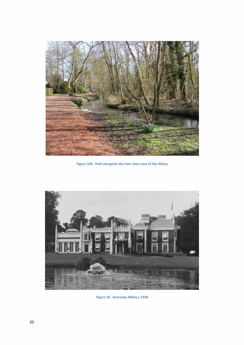
Figure 109. Path alongside the river Dour east of the Abbey
Figure 30. Kearsney Abbey c 1930