CSE 326: Data Structures Lecture #1 Introduction Henry Kautz Winter Quarter 2002.
Mount Rainier National Park Service
U.S. Department of the Interior
Kautz Glacier
NPS
ph
oto
Official In-Depth Route Description

Kautz Glacier
Stats
Approximate Elevation Gain 9500 ft, 2900 m
Approximate Length 11-12 mi, 17-19 km
Average Time to Climb Route 1-3 days
Typical HazardsSteep Icy Slopes, Ice Fall, Navigation Errors, Lack of Physical Preparation, Crevasse Falls
Attempts Per Year 460 Climbers
Average Summit Success Rate 52%
Contents2 Stats
3 Overview
History3
Statistical Route Use3
Skill Level and Experience4
Weather and Forecasts5
Climbing Strategies8
Route Description9
Approach to Wapowety Cleaver9
Van Trump Park Approach10
Camps11
Camp Hazard to Columbia Crest13
Descent 17
Current Conditions18
Ski Mountaineering18
Search and Rescue19
Assessing and Managing Risk19
Resource Protection20
Fees and Permits20
Authorized Guiding Activity22
Checking Out23
What to Bring23
Supplemental Reading24
Produced by Mount Rainier National Park Climbing Rangers, 2018
NPS
ph
oto
Cover image: A climber nearing the top of the Kautz Ice Chute, NPS Photo

Kautz Glacier 3
NPS
ph
oto
The Kautz Glacier route (the Kautz) is the third most popular climbing route on Mount Rainier after the Disappointment Cleaver and Emmons-Winthrop. It is also a considerable step up in commitment and difficulty from the Disappointment Cleaver or Emmons-Winthrop routes. The approach is long and the climbing route itself requires a high level of proficiency in ice climbing and glacier travel. The route is popular with guides and independent climbers alike. You can expect to see a few other parties on the weekends, but on the weekdays it is possible to have the route to yourself.
History
The Kautz Glacier has the longest climbing history of just about any route on the mountain. On July 8, 1857, Wapowety of the Nisqually people, lead a group of soldiers out of Fort Steilacoom bound for the summit of
Rainier. Over the course of eight days the party, consisting of Wapowety, Augustine V. Kautz, Dr. O. R. Craig and four other soldiers, made their way up the Nisqually River Valley to an elevation near 6,000 feet. There they set up camp in preparation for a summit attempt.
The next morning the party set out for the summit. They made their way up the ridge now known as Wapowety Cleaver and then onto the ice of the Kautz Glacier. One by one the party began to falter due to a mix of snow blind-ness, fatigue, and altitude issues. Finally, at approximately 6:00 pm, the last team members turned around somewhere near 12,000 feet. In Kautz’s words, “Finally we reached what may be called the top, for although there were points higher yet, the mountain spread out comparatively flat and it was much easier to get along . . . . It was after 6 o’clock and the ice was forming in my canteen and to stay on the mountain at such a temperature was to freeze to death as we brought no blankets with us.” While that party did not reach the summit first, that honor goes to P.B. Van Trump
and Hazard B. Stevens, they climbed fairly high on the volcano and deservingly have features on the route named after them. In 1921 and 1924 Joe Hazard of the Seattle Mountaineers climbed the route to the summit, proving the practicability of the “Kautz Route” and verifying that Kautz’s description was accurate.
After the initial ascents the Kautz became the standard route to the summit until climbers switched to the easier Gibraltar Ledges and Disappointment Cleaver routes out of Camp Muir. Now an average of nearly 500 climbers attempt the Kautz every summer.
This route has become a fairly popular ski descent in the last several years. The first descent was made, solo, by Dale Farnham in 1985. He went on to ski the route on five other occasions along with several other routes on Mount Rainier.
Statistical Route Use
Much like the Disappointment Cleaver and Emmons- Winthrop, the main climbing season for the Kautz begins in mid-May. Unlike the other routes, however, numbers tend to drop off rapidly after the first of August. The climbing in the Kautz ice chute generally remains good throughout the summer but as the season progresses the approach becomes increasingly more difficult and the glaciers on the upper mountain break up. A combination

Kautz Glacier 4
Route Statistics for Kautz Glacier
Route: Emmons-Winthrop
of these factors make the route difficult to climb such that use decreases dramatically in August. The Kautz is significantly less popular than the both Disappointment Cleaver and the Emmons-Winthrop routes. This is almost certainly due to the greater physical difficulty, commitment, and technical skill required to successfully climb the route. For many teams the challenge of the route and the lack of crowding is part of the attraction. Unlike the standard routes there is no bustling high camps with lots of other climbers or man-made shelters. This ads to the remote nature of this route.
The average summit success rate for all climbers is typically near 50%. Given fair weather and good climbing conditions, the most common reasons for an unsuccessful summit climb are climber fatigue and weather. Fatigue can usually be attributed to climbers having difficulty with the technical pitches in the ice chute. Climbers often underestimate the physical requirement needed to surmount the moderately difficult ice climbing on the Kautz. The fact that the technical pitches of the route are encountered near 12,000 feet adds significant difficulty.
Skill Level and Experience
The Kautz is considerably harder than either of the two standard routes on Mount Rainier. It’s difficult for climbers who have never been on Rainier or who have only experi-enced travel in the well-trodden boot paths of the standard routes to grasp the magnitude of Mount Rainier’s terrain. The difficulty of breaking trail or weaving through miles of penitentes on an already challenging peak makes for an extremely strenuous adventure.
Climbers should note that there are no guide services main-taining a climbing route. There is no shoveled trail to walk on nor are there established ladders, wands or rope lines.
Also, the route is climbed less frequently and the presence of tracks does not necessarily mean that it is the best or safest option. An example of this would be a route requiring climbers to leap across a crevasse instead of end-running it.
In the absence of a great deal of experience a successful attempt of Mount Rainier should be considered manda-tory before attempting the Kautz. This experience will give climbers an idea of the scale and difficulty of climbing Mount Rainier. It’ll also afford climbers an opportunity to test their climbing equipment, camping, and cooking systems. Plus it will be a chance to experience how they feel at higher altitudes.
Kautz Route - Key Techniques:• Roped Travel / Team Arrest• Crevasse Rescue• Simultaneous climbing with running protection • Short-pitching: provides security for short,
steep sections along the route • Pitched Ice Climbing for long, steep pitches
requiring a more secure belay
Comfort on steep snow and alpine ice will help climbers move quickly through the technical cruxes. Teams who are inexperienced at ice climbing can take hours longer than is appropriate.
Rockfall and ice fall from above and small sluffs of snow layers can cause climbers to lose their balance or footing. Be aware that a trip or tumble can be impossible to catch with self-arrest techniques in steep and icy terrain, having the ability to switch to more secure climbing techniques to catch a climber in case of an event like this are considered mandatory.

Kautz Glacier 5
Required Skill: NavigationNavigation is a critical skill all year long on Mount Rainier. Snow and blizzard-like conditions can occur any day of the year. Climbing late and getting stranded on the summit overnight and/or in a storm is a common cause of rescue missions on the Kautz. The ability to avoid being stranded due to team fitness and or poor climbing conditions is paramount but a solid foundation in map and compass navigation should be part of every mountaineer’s repertoire of skills along with the use of a GPS device for precision navigation. The lower snowfields (especially below Camp Hazard) should not be underestimated in terms of navigation difficulty in poor conditions.
Map and compass navigation can be used for ascending/descending non-glaciated terrain in limited visibility, but cannot be relied upon for navigating the heavily crevassed terrain above Camp Hazard and on the lower Nisqually. It also cannot be initiated in a white-out once the climbing party has lost their current position. If map and compass is the primary means for a parties’ navigation plan, their position must be known and tracked constantly by having physical landmarks to help identify their location.
GPS navigation is the modern standard and has many advantages over map and compass. The limita-tions of battery life and exposure of electronics to
weather are possibly the only risks associated with relying on a GPS unit as a primary form of navigation, so always take an extra set of batteries. Know at least these functions: how to record waypoints and track-logs, and how to navigate to waypoints and follow tracklogs back. Practice before you need the skill.
Weather and Forecasts
Many climbers are preoccupied with the technical aspects of climbing Mount Rainier and forget the biggest factor in their safety—the weather! It is easy to become complacent in anticipating poor weather conditions. While you are planning a climb in July, your friends are water skiing and beaching it at the ocean. Although the weather does catch many people off guard, to characterize it as ‘winter-like’ isn’t quite accurate. Below, we present an analysis of the spring and summer historical weather data. Most people can imagine, and have experience in, cold temperatures and can gear up for that attribute accordingly. Climbers have more difficulty properly anticipating the impact of wind and poor visibility. Couple this with a neglected dedication to recording your ascent path with a GPS, it may just simply not be possible to ascend or descend. If this happens on your summit attempt while above your high camp, it may lead you into the pit that many other climbers before you have fallen into and which almost always has some varying degree of negative outcome.
For a brief overview on expected temperatures, wind speeds, and precipitation, start here: Mount Rainier Recreational Forecast.
Mount Rainier: Air Temperatures Near the Summit
Averages and extremes in temperature during the summer season on Mount Rainier.

Kautz Glacier 6
We begin our analysis of the weather by considering temperature. In the graph above you see the average spread of temperatures for each week between May and September with the extremes observed as dots above and below the averages. Most often it is below freezing at the summit of Mount Rainier. Indeed, climbers can benefit from these cool temperatures as they make the snow bridges over the crevasses more firm and less prone to crevasse falls.
WindspeedThe above is a graph showing wind speeds for May- September. There are very few days where it is completely calm above 10,000 feet. The wind is generally felt most on the cleavers or ridge features. There can be isolated terrain features that create eddies in hollows depending the direction of the prevailing winds. Climbers frequently underestimate the great impact of wind which typically has a logarithmic effect on your ability to walk, navigate, or even stand. These two graphs show climbers that they must be prepared for sub-zero temperatures and wind speeds averaging 20 miles per hour.
Using this wind chill calculator, average wind chill conditions on a summer trip up Mount Rainier ranges from -5F to 10F. Extremities (hands and feet) are the first to get cold and succumb to frost-bite/nip. Climbers often underestimate the cold in June and find that their toes and hands are so cold that they cannot continue their climb and must turn around. Extra warm boots (not single layer,
thin leather boots) are a must before July 4th.
Presence of moisture/condensationThe presence of condensed moisture (surface clouds/fog) in the alpine areas is a game-changer. Never under-estimate the amount of information that is lost when visi-bility becomes restricted. Cold temperatures, high winds, and driving rain/snow can make the experience rather desperate, just because of the simple fact that you cannot see where to go. The route to the summit is often a thin corridor. If you stray just 10 feet this way or that way, you may wind up on a path that has no exit and be trapped in life-threatening conditions. Even a well-established boot-pack can disappear in minutes with drifting snow. This is how parties become stranded and happens frequently.View these models and learn to understand the informa-tion in them to understand the possibility for obscuring moisture during your climb:
• UW MM5 4/3km Mount Rainier
Atmospheric Profile
• UW MM5 4/3km Clouds 3-10K feet
• UW MM5 4/3km Clouds 10-20K feet
The Go/No Go Matrix (Weather)To assist in making a decision if one should climb based on the weather forecast, we have created this matrix. This Go/No Go Matrix only takes weather into account for a given team experience level. Other factors such as avalanche conditions, equipment issues, other team dynamics, etc., need to be evaluated as well. The actual number output from the matrix can be a rough guide, but the important
Mount Rainier: Windspeeds Near the Summit

Kautz Glacier 7
Presence of clouds from 3000 to 1000 feet elevation
part of the exercise is to discuss conditions with your team and arrive at a consensus as to what the experience level of your team is and determine how prepared you are to deal with the forecasted weather. As always, one should choose to turn back if the weather looks to be deteriorating. The matrix was created with input from guides and rangers, and represents cumulative knowledge of thousands of ascents.
Start by going down the gray column on the left. First assess the wind component at either 1, 2, or 3. Then proceed to the precipitation component, add 1,2, or 4 to your running total. Continue down the list, summing all the factors from the four rows. Then place your score in the evaluator tool relative to your team’s experience level. You can see from the below matrix that precipitation and visibility can be showstoppers, certainly on a summit climb, but even for a trip to Camp Muir.
On the lower mountain below 10,000 feet, these weather factors can often be mitigated by equipment and excep-tional experience, however, there are far narrower margins of error on the upper mountain for everyone. With
weather and navigational concerns, it can become all but impossible to reconnoiter your way and survive.
ForecastsThe reality is that the weather is forecastable. The important factors, Temperature, Wind Speed, and Presence of Moisture is forecasted to a high degree of accuracy several days in advance. There is no excuse to be uninformed of the weather. Cellular reception is available now at most locations above 6,000 feet. Bring a phone, keep it in airplane mode or off until you need it. Bring a small portable charger as a backup. The rangers can also provide forecast information.
Here are some online resources to help you develop an accurate forecast:• Mount Rainier Recreational Forecast is a general
overview updated twice daily• Northwest Avalanche Center (NWAC) has a zone
forecast for Mount Rainier• University of Washington has a bunch of forecast
models available to view online.
Go/No Go Weather Matrix
Points: 1 2 3-4
Wind Low (<15 mph) +1 Moderate (15-25 mph) +2 High (>25 mph) +3
Precip None +1 Light +2 Present +4
Visibility Clear (unlimited) +1 Overcast or Scattered Clouds +2 Restricted +4
Summit Air Temp Warmer (>30°F) +1 Moderate (20°-30°F) +2 Cold (<20°F) +3
• Wind, Precip and Visibility all as 3 or greater indicates that a climber should not attempt to climb

Kautz Glacier 8
Weather Conditions and Team Experience Evaluator Tool
Climbing Strategies
Climbers on the Kautz adopt a wider range of strategies than climbers on the Disappointment Cleaver. This is undoubtedly due to the fact that more skill and experi-ence is needed for this climb so climbers will have a larger ‘toolbox’ of skills available to them. It is also due to the various options for approaches and camping locations. We will outline a few of the options below.
Strategy 1: Two Camps, Three Nights, Up and Down the KautzThe most common strategy, and the one used by the guide services, is to climb over the course of four days. The first
day is spent approaching via either Paradise or Van Trump Park. Ideally a team will climb to 8,200 feet or above on their first day. This allows for a short day moving up to Camp Hazard or the Rock Step. From either of these camps the team can make a summit bid with light packs. Upon returning from the summit bid, teams can chose to remain at their high camp, but a better strategy is to move camp back down to a lower elevation. This is a good night to camp at the Shark Fin or even the Wilson Bench and enjoy a well earned sunset.
Strategy 2: One Camp, One night, Up and Down the KautzIt is common for very strong and competent teams to climb up and down the Kautz in two long days. In this case it is critical to make it at least to the Upper Castle before camping. Registering for the climb the day before will allow for an early start on day one and allow for some rest before continuing on to the summit.
Strategy 3: Up and OverAnother strategy is to climb the Kautz in two to four days and descend the Disappointment Cleaver and Muir Snowfield back to Paradise. This has the advantage of an easier descent via the standard route. The downside is that, along with the climbing equipment, all of the camping gear must be hauled up the technical pitches and then up to the summit and down the Disappointment Cleaver. This strategy also requires excellent weather if a team is planning to camp on Wapowety Cleaver.
Case Study: Buddy Check SAR
On the morning of July 18th, 2016, climbing rangers became concerned about a party of two on the Kautz Glacier when they missed their designated checkout time. Their car was found in the parking lot. The party had registered for the Kautz Glacier route on July 14th. On the afternoon of July 18th, a permitted soloist came down the Disappointment Cleaver route and reported to the rangers at Camp Muir that there might be problems with this overdue party.
The soloist had climbed from the high camp on the Kautz Glacier route with the party, but left them behind because they climbed more slowly than he did. He last saw them at approximately 12,000 feet on the Kautz Glacier at 10:00 AM on the 16th. He waited for them at the top of the Wapowety Cleaver (~13,000 feet) but they did not reach his location. At 8:00 PM on the 16th of July, he saw lights ascending on the Kautz Glacier from his location on the Wapowety Cleaver but did not know if it was the party he had briefly climbed with. He climbed on and eventually came over the summit and down through Camp Muir on July 18th.
On the evening of the 18th the party was officially 24 hours overdue and rangers initiated a search. Rangers established a contain-ment point at Camp Muir to catch the party if they passed through, alerted guide services on the mountain to be on the lookout, and put a note on the car at Paradise. By 8:30 AM on the morning of July 19th, rangers had assembled under an overcast sky at Joint Base Lewis McChord to board an US Army Reserve CH-47 Chinook helicopter. However, just as the mission was about to begin a guide team on a Disappointment Cleaver summit climb reported that he had found them on the summit. After an assessment the guides determined that, using their own extra food and water, they would be able to assist the overdue climbers.
The guides escorted the party down the mountain and back to Camp Muir. The party was met by a single ranger at Camp Muir who continued down the mountain back to Paradise with them.

Kautz Glacier 9
The Kautz Glacier as seen from Paradise, NPS Photo
This strategy can be very manageable and enjoyable with a good forecast and light equipment, especially as a three night / four day trip. A camp at 8,200 feet or above on day one would provide a good foundation for the rest of the trip. Day two would be a move up to Camp Hazard or the Rock Step. Day three would be spent climbing the ice chute and the rest of the Kautz Glacier to 13,000 feet on Wapowety Cleaver. On the last day the team would make an early start and climb to Columbia Crest and then descend the Disappointment Cleaver to Camp Muir and then down the Muir Snowfield to Paradise.
ROUTE DESCRIPTION Approach to Wapowety Cleaver
The Kautz begins either at the Paradise Ranger Station (5,420 feet) or the Comet Falls trail head (3,650 feet) both approaches are arduous and each has its own pros and cons.
The Paradise approach begins on the Skyline Trail to the Nisqually Moraine Trail and then follows a climber’s trail along the moraine to ~6,300 feet where several climber’s trails lead down the glacier surface (1.8-2 miles). Most climbers rope up at this point. Extreme caution should be used if visibility is reduced. Crossing the Nisqually Glacier requires navigating through several heavily crevassed areas and exposure from ice fall above. Attempting to cross the glacier without being able to see the hazards is very dangerous.
From the east moraine of the Nisqually there are two options to reach the lower part of Wapowety Cleaver. The first is to cross the Nisqually Glacier on a flat traverse at 6,300 feet to the base of a large gully called The Fan. The Fan can be climbed directly (travelling north) to a large bench at 7,300 feet. Hazards in the Fan include avalanche, rockfall and steep slopes so careful risk assessment is required.

Kautz Glacier 10
The second option is to climb uphill while traversing the Nisqually from 6,300 feet to where the Wilson Glacier merges into the Nisqually Glacier at 6,800 feet. A wide and often crevassed gully can be climbed on the climber’s left side from 6,800 feet to the large bench at 7,300 feet.
From the bench at 7,400 feet the route ascends on snow to the ridge crest to the west. Once the ridge crest is gained there are several snow benches that are suitable for camping. Most climbers will try to push to the large rock outcroppings known as the Castle. The Castle is a large camp running from 9,200 to 9,500 feet with the best sites at the upper elevations. Most parties will camp here if they are planning on a climb of 2-3 nights. If climbers are planning a single night out then they will typically continue on to Camp Hazard. Climbing rangers have observed that some parties are not roping up for the Nisqually and Wilson traverses. Some of the largest crevasses you will see on your climb are on the Nisqually above 6,400 feet. With it being warmer at this low altitude, expect snow bridges to be weak. Please rope up.
The Fan as seen from the Skyline Trail, NPS Photo
Van Trump Park Approach
An alternative to starting at Paradise is the Van Trump approach. This approach begins at the Comet Falls Trail-head, elevation 3,600 feet. Follow the Comet Falls Trail through the forest for 2.2 miles (2,000 feet of elevation gain) to a trail junction. Head towards Van Trump Park for another 0.6 miles where the maintained trail ends. From here follow social trails to the crest of a steep moraine
at 6,500 feet. Hike along the top of the moraine until the route enters the snow. The permanent snowfields here are the remnants of the Van Trump Glacier. Camp in the snow on any flat bench or continue up to the Upper Castle at 9,500 feet where this approach merges with the Paradise approach. When descending this route it is critical to have a GPS track or waypoints to find the social trail at treeline. It is difficult to find the proper moraine while descending
the Van Trump Glacier, even on a day with good visibility.
Whatever your choice of approach route, be sure to capture waypoints along all trails, especially at junctions as well as a full GPS track once you are above treeline or on a glacier or snowfield. The terrain above treeline on Mount Rainier is highly complex and in a cloud a few feet of navigation error can lead parties wildly off-course or even into a dangerous location. Capture a GPS track even if the weather is forecast to be good.
Timing and Self AssessmentThe approach to a high camp is an excellent time to consider your fitness for the upcoming summit push. There are various methods for calculating hiking and climbing times with the most common being the Munter Method. It takes some practice before it is useful but, having a time plan is critical to climbing safely. If your approach is going slowly there is very little chance that
Wilson Glacier Bench approach gully as seen from the Nisqually Glacier, NPS Photo
Approaching the Kautz Glacier via Van Trump Park, NPS Photo

Kautz Glacier 11
your team will pick up speed. The terrain and altitude only become more difficult to deal with as you ascend. The rangers will usually advise teams moving slowly through hazardous terrain to make the conservative decision and descend.
Camps
Please do not construct new rock rings and excavate new campsites when camping off the snow. Camping off snow is allowed in these areas, but discouraged. Poorly practiced, it leaves a tremendous amount of impact that takes decades to recover.
There are suitable camping locations from the ‘Wilson Bench’ at 7,400 feet to the upper sites at the Castle (9,500
feet). Also some of the highest established camps on the mountain are at the top of the Turtle Snowfield at 10,800 feet. This location is known as Camp Hazard. Addition-ally, there is a bivouac site at 13,100 feet near the top of the Wapowety Cleaver that can be used when conditions are favorable.
PARADISE APPROACH CAMPS
Wilson BenchThis camp is a wide, flat bench at 7,400 feet above a large waterfall. The area is snow-covered year-round but there is no glacier here. Climbers can move around freely but there are large moats and flowing water near the edges of the snow so caution is still advised. Parties do not normally
Approach Routes for the Kautz Glacier Route

Kautz Glacier 12
camp here on ascent due to the low elevation.
Shark Fin CampThe Shark Fin is a small cliff on Wapowety Cleaver that has the appearance of a shark’s fin when viewed from the Muir Snowfield. There is an excellent campsite on the ridge directly north of the cliff. Although it is a very aesthetic campsite it is seldom used due to the low elevation.
Wilson MoraineThere are several flat areas in the snow on the east side of Wapowety Cleaver from 8,200 to 8,600 feet.
Lower CastleThere are about three rock rings on the north side of the Lower Castle (9,250 feet). The rock rings are very close together so this site is best for a small party.
VAN TRUMP APPROACH CAMPS
Van Trump GlacierCamping is allowed in the snow above treeline on the remnants of the Van Trump Glacier. Climbers must refrain from travelling on and camping in the subalpine meadows.
Be kind to the fragile meadows in this area a practice Leave No Trace principles.
High CampsThe high camps on the Kautz are some of the oldest and highest continually used campsites on the entire mountain. Please follow Leave No Trace practices, carry all of your materials and waste off the mountain, and avoid building new rock rings.
Upper CastleThe Upper Castle is the lowest camp from which most climbers will attempt to summit. There are many large rock rings from 9,400 to 9,500 feet so this camp can be comfort-able for several large parties. There is often running water at this camp from mid-June on.
Safety Note:The camp sits at the base of the Turtle Snowfield. This permanent snowfield has several steep sections with slope angles up to 45 degrees. The center and climber’s right side (east) of the snowfield is threatened by ice and rockfall from above so climbers should stick to the west side of the snowfield close to the rock ridge.
Paradise Approach Camps

Kautz Glacier 13
Rock rings high on the Wapowety Cleaver, NPS Photo
Camp HazardOn the climber’s left side of the Turtle Snowfield at 10,800 feet there are 3 large rock rings. This site is commonly referred to as Camp Hazard although the original Camp Hazard was located closer to 11,000 feet, and was in the direct line of debris falling from the Kautz Ice Cliff and is not recommended. There can be running water near this camp when conditions are favorable. This camp is the best position for most parties to start their summit push, but it can be exposed to high winds in poor conditions.
Rock StepThere are several small rock rings just below the Rock Step that leads onto the Kautz Glacier at 11,250 feet. There is room for 3-4 large (3 person) tents and several smaller tents here. There is typically no running water at this camp.
Wapowety Bivy SitesThere are rock rings near the top of Wapowtey Cleaver at 13,100 feet. These sites are level and there can occasion-ally be running water at this site when freezing levels are high. It is a great place to camp for a team that is planning to climb ‘up-and-over’ and descend the Disappointment Cleaver. Keep in mind that this camp is extremely exposed to weather. It would not be possible to keep a tent up in a storm and even moderate (25-35 MPH) winds near the summit would make camping at this site difficult at best.
Camp Hazard To Columbia Crest
With the exception of crossing the Nisqually Glacier, the approach up to Camp Hazard only necessitates steep snow climbing. Above Camp Hazard more advanced mountain-eering skills are required. Ice climbing, rappelling, lowering, belaying, crevasse rescue, advanced navigation, and other skills may all be required for all party members. A fall while ice climbing, a crevasse fall, rock and serac fall, avalanche conditions, and high altitude are ever present factors for climbers on this route. Advanced climbing skills and honest self evaluation en route are necessary for a safe ascent.
Required Skill: Ice Climbing and Crevasse RescueClimbers on Mount Rainier are expected to be self sufficient in terms of risk assessment,
navigation, camp craft, and self rescue.
At an absolute minimum climbers should be proficient in modern ice climbing techniques prior to setting out for the Kautz. The technical grade of AI3 does not take into account the effects of altitude and fatigue. Many climbers are over-matched by the ice chute on the Kautz and/or take an excessively long time to climb through this section, while a smooth and timely ascent of the ice chute can make for a safe and enjoyable summit day.
Rangers also often observe climbers learning crevasse rescue techniques during their climb. While practice is encouraged, during the climb it should be more of a refresher of previously learned skills rather than the introduction of new skills. It is highly unlikely that a complicated crevasse rescue extraction will be completed by a person who learned to build a pulley system less than 24 hours prior.
The true climbing on the Kautz starts at 11,000 feet at a feature called the ‘Rock Step’. The Rock Step is actually a short, technical rock band that climbers must descend to get onto the Kautz Glacier. From the top of the uppermost bivy sites there is a distinct climbers’ trail that leads up and left toward the ridge crest. The trail ends at a notch on the ridge with a fixed rope secured to various rock anchors. The step is directly below the notch. In early season conditions it may be completely covered in snow. The fixed rope is used to aid climbers who choose to down-climb the step; usually with a belay. Alternatively, the step can be rappelled to the snow surface. Once climbers reach the snow they are on the Kautz Glacier.
After descending the step, climbers much traverse into the Kautz Ice Chute. This traverse is exposed to icefall from the large ice cliff above. This is a very active area and under no circumstances should climbers pause in this area. Chunks of ice and rocks of all sizes litter the area. Climbers must maintain their situational awareness here and move quickly.
Once in the chute the actual ice climbing begins. In typical conditions there are two steps in the ice chute separated by lower angle snow. The first step is the less steep of the two. It varies from a short pitch of steep snow to alpine ice to as much as 250 feet of alpine ice. There can be several narrow crevasses running across the slope as well. There can also be running water here later in the season so be careful to place ice screws out of the flowing water.
The middle of the ice chute is typically snow-covered all year long. Conditions in this area can range from steep nevé to slushy sun cups. Most parties will either ‘simul-climb’ or short-rope through this section. The snow generally covers an area from 200 to 400 vertical feet before the steepness of the glacier increases enough to

Kautz Glacier 14
warrant pitched climbing. This area is generally free of crevasses but it is exposed to ice and rockfall from above, especially from other parties.
Alpine (glacier) ice has a different consistency than water ice. It has a tendency to break off in large ‘dinner-plate’ chunks which can present a significant hazard to climbers and belayers below. Be aware of this and keep belays out of the fall line from the leader and do not climb directly below other parties.
The upper step in the ice chute is the technical crux of the Kautz Glacier and it usually provides anywhere from a short pitch to over 300 feet of AI3 ice climbing. Most parties will climb the center of the chute but easier climbing can be found in the penitentes on the climber’s
right side of the chute in late season conditions. Parties climbing at night can expect to find a layer of refrozen slush with dense, brittle ice underneath while in the daytime climbers will find a slushy layer over more plastic ice and possibly running water. Some cleaning of the surface ice will be necessary for good screw placements at all times of day. The steepness of the pitches is very consistent which can be fatiguing on the calf muscles, especially while belaying. Finding good stances and moving efficiently is critical for this part of the climb.
Climbers may be tempted to place V-thread anchors on the ascent and use them as rappel anchors on the way down; we discourage this practice. The anchors can easily melt out enough to become unsafe before the climbing party has the chance to return. With modern ropes a
Climbers at the Rock Step, NPS Photo

Kautz Glacier 15
The view from the lower pitch of the Ice Chute, looking towards the Rock Step, NPS Photo
The view from the Rock Step to the Kautz Ice Chute in typical early season conditions, NPS Photo

Kautz Glacier 16
A climber traverses into the ice chute in early season conditions, NPS Photo
Zero-thread anchor can be used for rappelling.
There are not usually crevasses on the steep pitches, although as the angle decreases climbers will begin encountering some. The crevasses generally force parties to the left where the angle is less steep. Most parties regroup as soon as it is safe to do so and reset their rope for glacier travel. The elevation here will be almost exactly 12,000 feet.
The next 1000 vertical feet of climbing is fairly mellow in terms of steepness but the crevasses on this part of the Kautz Glacier become your chief concern. This area is known for having some of the largest crevasses on the mountain and often they are ‘cathedral’ shaped where the opening at the top is narrow but the bottom flares out in giant caverns. Treat all snow bridges with respect in this area and investigate them carefully, even if there are tracks from previous climbers across them.
The route trends straight up the glacier and then slightly
right where it gains the rocks on Wapowety Cleaver. There are a few faint climber’s trails in the scree but climbers must use caution when transitioning from the glacier to the rocks as there can be large moats. Usually it is best to aim for the ridge at 13,000 feet and to stay on the glacier surface until just below that elevation. Once atop the ridge there are several rock rings for camping and there can be running water when temperatures are favorable.
From here the route onto the Nisqually Glacier is not always easy to find. The glacier is usually very broken where it runs into Wapowety Cleaver and the cracks extend well out into the center of the glacier. Often times, climbers will be forced to belay each other across thin bridges or down into crevasses in order to get out onto the Nisqually. Once this obstacle is passed however it is usually possible to find a fairly direct route to the crater rim.Columbia Crest is due north of the campsites on Wapowety Cleaver but crevasses usually force climbers to the east on the glacier until approximately 13,500 feet where large crevasses will force climbers back to the west. In most years, the route ends up in the low point of the saddle between the crater rim and Point Success.From the saddle, climbers usually take a direct line to the crater rim unless the bergschrund forces them to the climber’s left. It is just under 500 vertical feet from the saddle to the summit. Although the slope angle is not steep the bergschrund is usually present here. Small steep steps on snow bridges might need to be climbed before hitting the crater rim.
Once on the crater rim most climbers will continue around to Columbia Crest. Those that are carrying over to the Disappointment Cleaver will descend the towards the southeast along the crater rim for a short way and then follow the boot path from the Disappointment Cleaver into the crater, across it and then all the way down to Camp Muir. Climbers that are descending back down the Kautz will follow their tracks back the way they came.
A climber on the lower ice pitch, NPS Photo

Kautz Glacier 17
A climber on the upper step in the ice chute, NPS Photo
Descent
Descending the Kautz involves steep, technical down-climbing or rappelling and is a challenge to do in a timely manner. Generally the larger the party size, the longer and more complex the descent. Climbing down to the top of the Wapowety Cleaver can be very straightforward given good visibility, a GPS track, and a wand line. In the absence of these navigation aids, however, the descent can prove to be extremely dangerous. The trail left by other climbers can be faint to non-existent depending on the surface conditions. The upper Nisqually Glacier is a dangerous place to wander around with poor visibility. In those conditions it would be more prudent to stay put in the crater rather than risk getting off course on the glacier.
Once the Wapowety Cleaver has been reached, navigation becomes a bit more straightforward. Climbers must still navigate through the crevasses on the upper Kautz Glacier but the route generally trends straight down glacier.At the top of the ice chute climbers may find it difficult to climb down onto exposed ice in order to set their first rappel anchor. Easier terrain can be found to the east at the top of the chute. There climbers can belay each other into the chute rather than relying on a team arrest in steep, exposed terrain.
Depending on the length and number of ropes with the team there will be anywhere from one to three rappels to descend the upper step in the ice chute. For rappel anchors a Zero-Thread is the modern standard as it is the same strength as a V-Thread but leaves behind no litter. Down climbing this section is discouraged as at least one of the climbers will be exposed to a long fall.
Once established on the lower angle snow climbers can descend to the top of the lower ice step. One to two rappels here should get the climbers to the start of the traverse back to the Rock Step. Again, extreme caution and a quick pace is essential along this traverse due to serac fall from above.
Climbing back up the Rock Step requires some awkward 5th class moves. There is protection available off of old slings and fixed rope but this short lead can be unnerving for tired climbers. Once the climbing team is back at the top of the Rock Step it is typically easy climbing down to their tents at high camp.
Once back at camp it is tempting to settle in for the night but if it is at all possible for the team to continue descending that is almost always preferable. The Turtle Snowfield can easily be descended on foot or even by

Kautz Glacier 18
glissading in the afternoon whereas in the morning it will be frozen solid. Waiting until the Turtle is frozen usually means putting crampons back on and down climbing the 40 degree slopes. That can be extremely fatiguing and hazardous.
The best bet is to descend as low as possible, or at least to the Upper Castle before setting up camp again. This will make for a shorter and safer walk out in the morning.
The final hurdle on the Kautz is to descend to the Nisqually Glacier, cross it, and hike back up to Paradise. This is easily done with good visibility, but can be a long and nervous process in a cloud. Often times valley fog will sit in the Nisqually drainage and climbers will be forced to descend into it and navigate across the glacier. Capturing a GPS track on the approach will make this process go a lot more smoothly. Wandering around the glacier in a white out at the end of a trip is an easy way to get into trouble.
Current Conditions
Conditions change rapidly on the mountain. Not only day to day, but even hour to hour, especially when the freezing level reaches above 14,000 feet. Accurately reporting the changing conditions is difficult and it’s also hard to gauge how to report the conditions to an audience with a varying degree of skill. So take all conditions reports with a healthy amount of skepticism. There are a couple of decent sources for information out there.
• Mount Rainier Climbing Blog. The Mount Rainier National Park Climbing Rangers maintain a blog that reports current conditions on a variety of routes. Be sure to check out the archive; there are a lot of good route photos as well as other pertinent information from previous years. There’s a good chance you’ll find a report in the archive that was made during the same time frame that you’re looking to climb.
• Cascade Climbers. A northwest gem, Cascade Climbers is an online forum that’s a resource for all things climbing in the area, including trip reports, route advice, and gear recommendations.
• Turns All Year. A skier’s forum which has plenty of conditions updates from a “mostly” skier’s perspective. They organize reports by date and location. Lots of videos are also posted here.
Webcams and telemetry sites can also give up-to-date information and provide confirmation of snow reports.
• Mount Rainier Webcams. A growing network of webcams around the mountain offer a glimpse from afar of current conditions. Seasonal cameras at Camp Muir and Camp Schurman are particularly helpful in gauging what it will be like up high.
• NWAC Telemetry. The Northwest Avalanche Center provides an invaluable resource to outdoor enthusiasts in our area. Their network of professionals and volun-teers keep a learned eye focused on local weather events, snowpack concerns, and long term forecasts.
Ski Mountaineering
Ski mountaineering is slowly growing in popularity. It is a sport that is a particular hybrid of alpine touring (skiing) and alpine mountaineering (steep, roped ice and glacier travel). Ideally, one can achieve the best aspects of both modes of travel; 1) a lighter stress on the snow to limit crevasse fall potential, 2) less penetration (post-holing) when traversing up and down hill, 3) faster and easier descents. However, in experiencing the rescue load anec-dotally, the climbing rangers feel that the reality of the sport hasn’t lived up to these ideals. It seems like a dispro-portionate rate of rescue is befalling ski mountaineers. Crevasse falls seem to be a major cause of the ski moun-taineer’s demise. Skiers have either been prone to punch through an unseen crevasse unroped or fall and slide into a crevasse. These seem to result from a misjudged assess-ment of risk or an assumption that the load distribution provided by the skis will be sufficient to prevent a crevasse fall. More analysis is necessary before anything definitive can be said about the sport, but the experiential anecdotes are rapidly piling up to indicate there is a misalignment between perceived and actual risk. Once the skis are donned, skiers seem reluctant to take the skis off and put the crampons and rope back on to descend through exposed sections.
The Kautz Ice Chute and the snowfields below it can offer some of the finest steep skiing on Mount Rainier. The sustained steep pitches and massive vertical relief combined with relatively easy access make this a very attractive objective for expert ski mountaineers. The down side of attempting to ski this route is that there is a high degree of variability in terms of conditions. There have been seasons where it has been skiable through July. In others it has had un-skiable ice throughout the spring and summer.
Typically, there will be enough snow coverage in the ice chute to ski into early June. The route is known for changing rapidly, however, and it can go from an enjoyable ski descent to a technical ski mountaineering endeavor in less than 24 hours. Once there is exposed ice in the chute the descent becomes extremely risky as a fall will surely result in death in the chute. Techniques for increasing the levels of security such as belayed skiing, downclimbing and rappelling will be required in icy conditions
Transitioning from skiing to downclimbing is difficult and dangerous in steep ice and exposed terrain. It is also easy to move into unsafe terrain due to the rapid rate of descent on skis. Knowing when to back off and transition out of skis is critical to a safe descent on any route on Mount Rainier.
Kautz Glacier 19
Skiing the Kautz should only be undertaken by extremely experienced ski mountaineers who have a significant amount of experience in similar terrain. Even more impor-tantly maintaining the mindset to be able to retreat and not expose oneself to the risk in unsafe conditions is necessary.
Search and Rescue
The most common reason for the ranger’s to initiate a Search and Rescue (SAR) operation on the Kautz is a search for overdue or stranded climbers. Overcon-fidence in climbing ability leading to excessively long climbing times is the major contributing factor to climbers becoming overdue or stranded on the Kautz.
The NPS does not charge for search and rescue services. However, if non-NPS ambulances and air ambulances are required, fees are rapidly accrued. A large portion of the climbing cost recovery fee (the annual climbing pass) goes toward preparing for search and rescue incidents by hiring, equipping, and training climbing rangers. Rescues that result in a cost of more than five hundred dollars to the agency or in helicopter costs are not paid for by Mount Rainier funds. The National Park Service maintains a contingency account held nationally to pay for unprogrammed costs such as these.
The park has a staffed contract exclusive-use helicopter on duty each day between May 15 and September 15. However, due to funding and other cost saving measures, the helicopter must be assigned out on regional wildfires, and other incidents and projects throughout the summer. Nevertheless, since the inception of this exclusive-use contract, the response times to SAR incidents has decreased from 2-4 hours to 1-3 hours, depending on the location of the helicopter at the time of the incident. In addition, this exclusive-use helicopter also has a dedicated crew that knows the capabilities of the helicopter and thus operate it more safely and are prepared to respond as soon as a call comes in.
Mount Rainier also maintains a partnership with Joint-Base Lewis McChord’s US Army Reserve Chinook unit. Part of this unit’s civilian duty is to support SAR at Mount Rainier. The military Chinook CH-47F helicopter is one of the few aircraft that can fly large groups of people to the summit of Mount Rainier without experiencing performance issues.
Assessing and Managing Risk
There is nothing “safe” about mountaineering, however we can manage and mitigate risks by equipping and training sufficiently as well as making reasonable decisions. Real advancements in mountaineering safety do not come from more specialized equipment, they come from the study of human behavior, risk perception, communica-tion, and group dynamics. These subjects will offer more substantial gains for parties trying to manage their risk. Reading trip reports, reviewing accidents, and applying the
lessons learned will make your trip much safer than equipping yourself with some extra gear.
The US Coast Guard (USGG), often looked to as one of the United States’ most respected rescue resources, has developed a system of risk mitigation called Crew Resource Management (CRM). The National Park Service has recently adopted a very close derivative of this. The USCG identified the core common denominators of tragedies, injuries, and near-misses that occurred during rescue operations. In one of its applications, CRM asks you to compare and assess your intended action to these common denominators and see how well your plan of action stacks up, then asks you to either fill the gaps or refuse the risk and discontinue the activity.
If you have no other framework of risk assessment and management, then try this one. The climbing rangers use it and have had great success even conducting simple and mundane operations. Use this framework to drive the risk management conversation within your group in the weeks leading up to and the night before you climb. The climbing rangers call them “Pletsies”, or the PLETTCCCs.
(P) lanning:What is the overall plan? Departure time? Turn around time? Return time? Predict expected mountaineering methods. Contingency plan for a sick climber (even if it’s within yards of the summit)? Does someone outside the park know your plan?
(L) eadership: What is the leadership structure in your group? Even on an independent summit attempt, we recommend identifying a leader. Many groups seem to be unwilling to do this, but this simple act can make a difference by making one person in your party feel an overall sense of responsibility for the safety of the group.
(E) quipment: Do you have the correct equipment (ex. 2 pulleys, 2 prussiks, 2 anchors / person for crevasse rescue), what happens if a climber on your team loses their pack, their gloves, their sunglasses?
(T) raining: Has everyone been trained to employ the skills needed for the activity? (Cramponing, team arrest, belaying, crevasse rescue, ice climbing, anchor building)
(T) eam Fitness:Are the right team members present? Do all feel up to the task? Is everyone in a healthy mental and physical state? Don’t ascend with signs of acute mountain sickness (AMS).
( C ) ommunicationHow shall we communicate? What if the party must split up? (Not recommended!) Do we have cell phones, group radios, personal locator beacons (PLBs) or SPOT™ devices? How’s the communication comfort level in the group? Are the less-experienced climbers able to share

Kautz Glacier 20
their concerns? Are the experienced climbers listening and providing valid reassurance?
( C ) onditions:What are the (snow and weather) conditions now? What is the forecast? Do we have reasonable margins of safety? Are we within our skill and equipment levels? What are the weather trigger points for turning around? Is your team able to assess avalanche conditions, and if not will you attempt to climb anyway?
( C ) omplexity:Are we trying to do “too much” with the resources (gear, training, skill) we have? What are our critical factors (weather, team, snow conditions, leadership, equipment) for turning back?
We recommend performing this risk management activity at natural breaks during the course of your trip, for example; 1) at the initial planning phases on the phone with your friends a few days before your climb, 2) at the trailhead before your packs are on, 3) at high camps the night before your climb, and 4) before you head down the mountain.
Encourage group participation. Lesser experienced team members may be silent in front of experienced and respected individuals. Reach out specifically to these silent team members. The discussion will pay off in spades.
Resource Protection
Blue BagsOn Mount Rainier climbers must pack out all human waste. There are no toilet facilities on the Kautz route. Before leaving a ranger station, pick up a few blue bags for your trip. How many? For the Kautz we recommend at least one per day plus an extra. Many climbers suffer from gastrointestinal distress from either altitude or a change in diet. For a three day trip, bring at least two per person. There are blue bag barrels at Camp Muir (if descending the Disappointment Cleaver) and Paradise.
WandsWands are the main source of trash climbing rangers collect during the summer. Climbers believe they are ‘helping’ others out by leaving the wands they placed on their ascent. Please do not do this. You could actually be sending other climbers into harm’s way because the route may have changed. Rangers and guides end up picking up all the stray wands. We encourage the use of wands if you need them for navigation, but only if you agree to pull them. The modern standard for navigation is GPS. Practice using it and don’t forget an extra set of batteries.
Rocky FellfieldsAreas above treeline where certain freeze/thaw and wind conditions allow for plant growth are called fellfields. This is an extremely fragile environment. Social trails can rapidly develop and new campsites (rock rings) are always popping up. Plants in this microhabitat depend on rocks
for protection from wind and ice. Climbing rangers survey these campsites as the years go by and deconstruct the new ones when they develop. Please camp on snow and perform all your camp activity on snow.
Campsites for the Kautz may be devoid of snow in the middle and late summer months. Please use established rock rings. Do not manufacture new camp rings.
WildernessThe Mount Rainier Wilderness Area is part of the National Wilderness Preservation System. The five qualities of wilderness are: Natural, Undeveloped, Untrammeled, Solitude, and Primitive and Unconfined. We strive to protect these qualities in our wilderness while at the same time providing a climbing experience for the people who want to climb Mount Rainier. Not all five qualities can be protected to the highest standard at the same time.
Leave No TraceThe five qualities of wilderness can be most fully protected by practicing leave-no-trace techniques.
• Plan Ahead and Prepare• Travel and Camp on Durable Surfaces• Dispose of Waste Properly (Pack It In, Pack It Out)• Leave What You Find• Minimize Campfire Impacts (Campfires are prohibited
at Mount Rainier)• Respect Wildlife• Be Considerate of Other Visitors
For more on Leave No Trace, please visit: www.lnt.org
Fees and Permits
For current information on ranger station operating hours please visit the park’s facilities page. For climbing permit, climbing fee, and climbing reservation informa-tion please visit the park’s climbing page. Here is a brief description of the system.
There are four terms we use in relation to fees and permits (required by 36 CFR 7.5):
“Climbing Cost Recovery Fee” a. Purchase online at pay.gov ahead of your climb
(recommended) or at any ranger station when you show up to climb.
b. 100% of the revenue goes toward the Mount Rainier Climbing Program.
c. Valid for unlimited climbs in the calendar year purchased.
d. Required by each individual climbing team member.e. All party members must have paid the climbing fee for
the party to be issued a permit.

Kautz Glacier 21
“Climbing Permit”a. Only one permit per climbing party (stick together!)b. Obtain permits for the Kautz Glacier route at the
Paradise Wilderness Information Center if you are leaving from Paradise. You can also obtain a permit from the Longmire Wilderness Information Center if you are using the Comet Falls approach.
c. The actual permit is free and required for climbing and camping.
d. Normally issued as a walk-up on the day team’s start their climb
e. Can be issued up to 24 hours in advance of starting the climb
f. Remember to do one thing when you get back to the trailhead: Turn in your climbing permit.
i. You are required to check out by U.S. Code 36 CFR 7.5.
ii. We track specifics including what route you actually climbed and how many of your party made it to the summit.
“Reservation”a. Reserve your permit so that you can be assured there
is space for your climbing team for specific dates, it’s especially recommended to make a reservation for your climb if you’re:
i. Flying in or travelling a long distance.ii. Want to climb over a holiday.iii. Want to climb during a weekend in July.iv. Have a large (more than 4) party.
b. A convenience fee of $20.00 is charged per reservation (not individual).
“Solo Authorization”a. Climbing solo is restricted unless authorized by
the superintendent.
b. The superintendent delegates solo application reviewal to the climbing rangers.
c. An application for Solo Climbing Authorization can be found online.
d. It can take up to two weeks for the approval process, so plan ahead.
e. Requesting to climb solo is free, and if issued, good for the period that you have on your application.
f. Visit the park’s climbing page for a direct link to the current solo climbing form.
* National Park Service Mount Rainier Climbing Cost Recovery Fee: Special use management policies allow parks to recover the costs of managing the special use by charging a fee for that use.
The Mount Rainier Climbing Cost Recovery Fee pays for the majority of the climbing program, its rangers, their equipment, training, and supervision, as well as several resource protection measures such as the collection and
Case Study: Kautz SAR
On Tuesday, July 1st, 2008, at 8:35 PM, Rangers received a radio call from guides on the Kautz about a climber from an independent team who had sustained injuries after falling into a crevasse. Earlier that day the injured climber was descending the mountain along with four other climbers above the Kautz Ice Chute at 12,400 feet when he fell into a crevasse while crossing a snowbridge. The four members of the team were only partially successful in rescuing their partner from the crevasse and lacked the ability to continue and complete the rescue without assistance.
Two of the team members climbed down the route to seek help. After descending over 1000 feet they encountered the guides. The guides promptly contacted the NPS and a rescue was initiated. Two of the guides ascended to the injured climber to conduct an assessment. The NPS determined that a helicopter extraction would be attempted early the next morning. The team and the injured climber spent the night camped on the glacier.
At approximately 6:45 AM on Wednesday, July 2, a military operated Chinook CH-47F helicopter airlifted the injured climber off of the mountain and transported the injured climber to the hospital.

Kautz Glacier 22
processing of human waste, the construction and main-tenance of high camp toilets, and other minor resource protection efforts. Overall, it’s a fee to help the NPS facilitate and mitigate the impact that 10,000 climbers have on Mount Rainier every year.
Authorized Guiding Activity
Guiding a person or a party on a climb of Mount Rainier in exchange for any type of fee or exchange of any goods or services is considered a commercial use of the national park. Federal regulations prohibit engaging in or soliciting any business in park areas, except in accordance with the provisions of a written agreement with the United States. As in other National Park Service areas, commercial visitor services may be provided only by those holding an autho-rization from the National Park Service. The NPS uses the following principles to guide our policy and program development in regards to any commercial use in the park and mountaineering guiding in particular:
1. Commercial services are important to our visitors.a. A major responsibility of park management is to
ensure that appropriate services are provided in the national park.
2. Quality services should be provided at reasonable prices.
a. The NPS verifies that the concessioner’s rates are standard in the industry.
3. The National Park Service must remain the primary controller of park visitor services.
a. To assure that the visitor services aspects of the operation are consistent with park resource management, the NPS must continue to strictly control most aspects of the concessions operation.
4. The National Park Service Concessions Program is a partnership with private enterprise.
a. The partnership concept has worked out well because it has allowed the NPS to oversee the private operators, and in turn has allowed the private sector to provide the necessary capital while receiving the privileges of profitable businesses providing services to park visitors.
There are three categories of legal commercial ‘Summit Climb’ guiding in Mount Rainier National Park:
ConcessionsThere are three concession mountaineering guide operations in Mount Rainier National Park. The contract for each mountaineering concession is held for a ten year term. At the end of the contract term the companies must re-compete for the following term.
The three concession contracts are held by:• Rainier Mountaineering, Inc.• Alpine Ascents International• International Mountain Guides
Commercial Use AuthorizationIf the NPS determines that there is a need, it is able to issue commercial use authorizations (CUA’s) to persons (referring to individuals, corporations, and other entities) for the provision of commercial services to park visitors in limited circumstances. CUAs, although used to authorize commercial services to park visitors, are not concession contracts. They are intended to provide a simple means to authorize suitable commercial services to visitors in the park per legislation.
A current list of CUA Single Trip Summit Climb providers can be found here.
Special Use Permit in lieu of a CUAA Special Use Permit in lieu of a CUA (SUPilCUA) is issued in cases of a commercial service provided by an organization that does not derive federally taxable income. Nonprofit organizations are commercial businesses whether or not they derive taxable income and are required to have a permit. The NPS encourages use of CUAs, but if an organization objects to being issued a CUA, it must obtain a special use permit to conduct business activities in the park.
Climber navigating through crevasses, NPS photo

Kautz Glacier 23
Outside of either of these two criteria all exchanges of money, goods, or services for a guided summit climb is considered illegal.
Commercial guiding activities on the Kautz are consider-ably less than on the Disappointment Cleaver. It is similar to the activity on the Emmons-Winthrop. Each of the three guide service concessionaires may run one trip per week on the route and they must stagger their starting dates such that only one commercial group will be camped in any wilderness zone each night. Also, they are not allowed to camp on the route on Friday or Saturday nights.
Checking Out
Remember to do one thing when you get back to the trailhead. Turn in your climbing permit. You are required to check out of your climb by 36 CFR 7.5. We also track specifics including what route you actually climbed and how many of your party made it to the summit.
There is a $250 fine for not checking out so please do not hesitate to call in and checkout over the phone if your party forgets on the way out of the park.
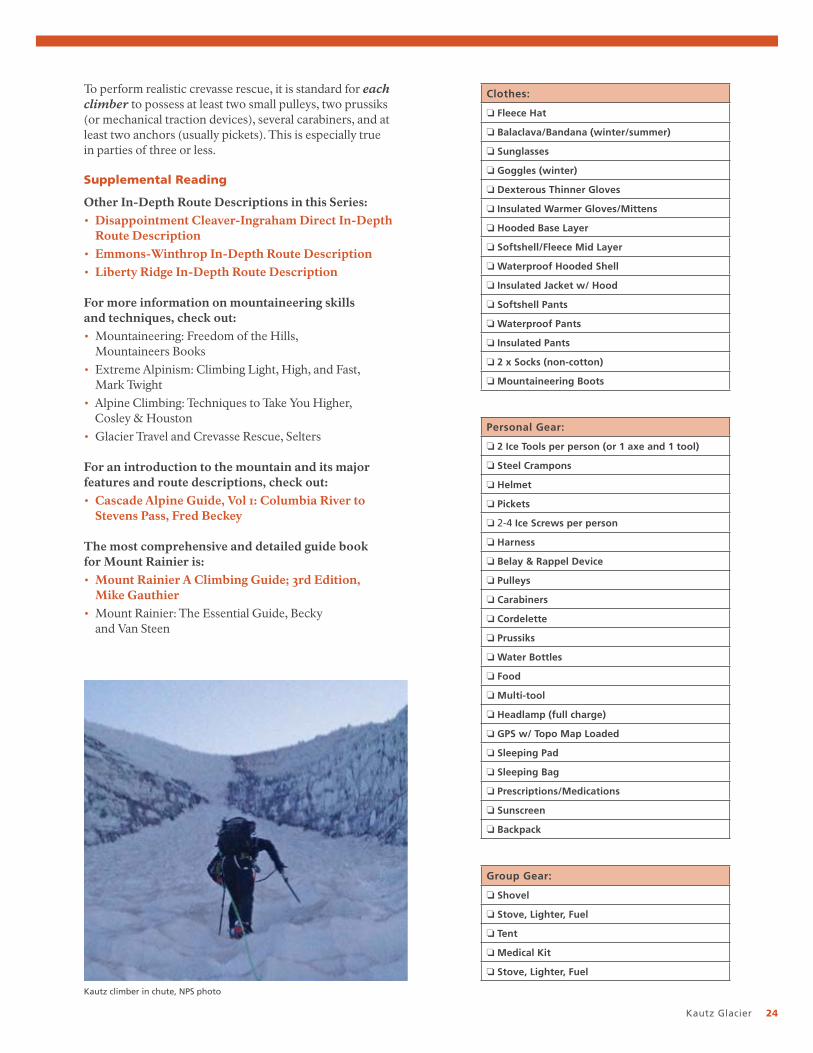
What to Bring
There is no list of required gear to bring. The list of gear can vary based on the climbing party’s skill and experience level. However, we can generally say there are common denominators to any climber’s gear choices for this route.
Climbing rangers are often frustrated by the lack of crucial gear items they see in individual parties. Teams with only one or two pickets, no pulleys, no prussiks, etc. are occasionally observed. In rare cases, extremely experienced climbers have developed systems and techniques to mitigate weight, but for the vast majority of climbers the lack of gear is a strong indicator of a lack of experience.
Climbing Permit (front). Be sure to completely fill this out. It will used as reference if your party ends up needing help.
Climbing Permit (back). Be sure to add all of your other party member’s names on the backside and an emergency contact number for them if it’s different from the party leader’s which is written on the front side.
Kautz Glacier 24
To perform realistic crevasse rescue, it is standard for each climber to possess at least two small pulleys, two prussiks (or mechanical traction devices), several carabiners, and at least two anchors (usually pickets). This is especially true in parties of three or less.
Supplemental Reading
Other In-Depth Route Descriptions in this Series:• Disappointment Cleaver-Ingraham Direct In-Depth
Route Description• Emmons-Winthrop In-Depth Route Description • Liberty Ridge In-Depth Route Description
For more information on mountaineering skills and techniques, check out:• Mountaineering: Freedom of the Hills,
Mountaineers Books• Extreme Alpinism: Climbing Light, High, and Fast,
Mark Twight• Alpine Climbing: Techniques to Take You Higher,
Cosley & Houston• Glacier Travel and Crevasse Rescue, Selters
For an introduction to the mountain and its major features and route descriptions, check out:• Cascade Alpine Guide, Vol 1: Columbia River to
Stevens Pass, Fred Beckey
The most comprehensive and detailed guide book for Mount Rainier is:• Mount Rainier A Climbing Guide; 3rd Edition,
Mike Gauthier• Mount Rainier: The Essential Guide, Becky
and Van Steen
Clothes:
❏ Fleece Hat
❏ Balaclava/Bandana (winter/summer)
❏ Sunglasses
❏ Goggles (winter)
❏ Dexterous Thinner Gloves
❏ Insulated Warmer Gloves/Mittens
❏ Hooded Base Layer
❏ Softshell/Fleece Mid Layer
❏ Waterproof Hooded Shell
❏ Insulated Jacket w/ Hood
❏ Softshell Pants
❏ Waterproof Pants
❏ Insulated Pants
❏ 2 x Socks (non-cotton)
❏ Mountaineering Boots
Group Gear:
❏ Shovel
❏ Stove, Lighter, Fuel
❏ Tent
❏ Medical Kit
❏ Stove, Lighter, Fuel
Personal Gear:
❏ 2 Ice Tools per person (or 1 axe and 1 tool)
❏ Steel Crampons
❏ Helmet
❏ Pickets
❏ 2-4 Ice Screws per person
❏ Harness
❏ Belay & Rappel Device
❏ Pulleys
❏ Carabiners
❏ Cordelette
❏ Prussiks
❏ Water Bottles
❏ Food
❏ Multi-tool
❏ Headlamp (full charge)
❏ GPS w/ Topo Map Loaded
❏ Sleeping Pad
❏ Sleeping Bag
❏ Prescriptions/Medications
❏ Sunscreen
❏ Backpack
Kautz climber in chute, NPS photo

National Park Service U.S. Department of the Interior
Mount Rainier National Park55210 238th Avenue EastAshford, WA 98304
www.nps.gov
EXPERIENCE YOUR AMERICA™