
karaka_ebook_tom__steph__michael_and_zac
24
Stephanie Payne, Tom Sawbridge, Zac THORP, MICHAEL SUN
-
Upload
stephanie-payne -
Category
Documents
-
view
222 -
download
1
description
Studio 5 - unitec
Transcript of karaka_ebook_tom__steph__michael_and_zac

Stephanie Payne, Tom Sawbridge, Zac THORP, MICHAEL SUN

Table of contents1.0 Executive summary
2.0 Introduction and Background
3.0 Concept, Goals and Objectives
4.0 Inventory and Analysis 4.1 Physical 4.1.1 Topography 4.1.2 Geology and Soils 4.1.3 Hydrology 4.1.4 Micro-climate/ Aspect 4.2 Cultural 4.2.1 Zoning 4.2.2 Existing Infrastructure 4.2.3 Karaka Collective 4.2.4 Perceptual Quality 4.2.3 Archaeological and Cultural Features 4.3 Biological 4.3.1 Regional Matrix 4.3.2 Site Scale Biological Context 4.4 Precedents
5.0 Recommendations 5.1 Land Use Suitability 5.2.1 Constraints for Development 5.1.2 Biological Opportunities 5.3.3 Opportunities for Development 5.2 Master Plan
6.0 Conclusion
7.0 Works Cited

1.0 Executive summaryThe Karaka Area Development Plan has been developed as a strategy for the sustainable expansion of the municipal urban limits of Auckland. The plan has been developed with the goal of ecologic connectivity as the base for development.
Through Extensive Physical, Cultural and Biological analysis the Karaka Area Development Plan has divided the site into 2 districts.Primarily the ecological zone and secondarily the footprint for development.
Areas that have been deemed inappropriate for development, and have thus been set aside for ecological functioning include:
• Areas where the slope exceeds 8%• areas within 15 metres either side of a stream• flood plane and areas at risk of flooding due to sea-level rise• areas directly on the coast • areas with established significant native vegetation• areas with archeological and historical significance
The table on the right shows the breakdown of the site into area as well as number of total dwellings for the proposed development.
Ecological Zone Footprint for Development
High Density
Medium Density
Low Density
Total Site
Land Area(Square Meters)
Total Number of Dwellings
Total Residents
Ecological Zone
Public Space
Commercial
Rural Density
1,862,919
3,192,882
1, 627, 413
1, 652, 930
166, 113
1,809,769
8,027,865
174,900,000
6,209
6,385
1,808
16
43,25414,418
1

2.0 Introduction and Background The City of Auckland is predicted to grow by million residents within the next 20 years(Auckland, 2012). The majority of this growth is predicted to occur in the form of intensification in the city centre. However, twenty percent of new residents are projected to reside outside the city centre. This twenty percent is the group we are con-cerned about for the purposes of this project.
Critics of the Auckland Plan have argued that eighty percent growth within Auckland’s city centre is unrealistic (Bogunovich, 2012) and have gone on to envision the continued expansion of the Auckland metropolitan urban limit. The Karaka Area Development Plan is a re-sponse to this continued expansion. As Karaka lies directly outside of the Auckland Plan’s Southern Initiative, the plan is a response to the type of type of growth Auckland can seasonably create if the municipal urban limits continue to expand. This plan also addresses the Auckland Plan’s vision of “most liveable city” and proposes a model of what development for such a city might look like.
The Karaka Area Development Plan has been developed with the vision of current residents in mind. The Karaka Collective, a group of area residents, have put forward a proposal for that outlines their vision for the development of the area. This proposal strongly favours the implementation of a bridge between Karaka and Wey-mouth. To address the ideas of the collective the Karaka Area Development Plan chosen to implement the link. However, in doing so, the Karaka Area Development Plan acknowledges the serious effects creating this link will have on the land on the southern side of the bridge. Our response is to create a stable ecological network as a frame for development. In this way, the ecology off the site will be protected and development will have the flexibility to meet Auck-lands changing needs.
New Zealand Ministry for the Environment has stated in their De-sired Outcomes for 2020 that “Scarce and fragmented habitats (such as lowland forests and grasslands, wetlands and dunelands) have increased in area and are in better ecological health due to improved ecological connections and the sustainable management of surrounding areas” (MFE, 2012). The Karaka Area Development Plan is a vision that helps achieve this Desired Outcome, while si-multaneously creating space for Auckland to grow.
2

3.0 Concept, Goals and ObjectivesConcept:
Ecological connectivity as a framework for development.
Goal:
To propose a growth strategy for Karaka that is adaptable to meet Auckland’s changing demographics, but is grounded by a stable ecological framework.
Objectives:
• establish a core patch that fits into larger regional matrix• Site scale ecological connectivity• implement sustainable development practices • create development footprint that is adaptable to Auckland’s
changing demographics• create development that is mindful of global trends (ie. climate
change, urbanization)• create development that is considerate of the ideas of the cur-
rent residents
3
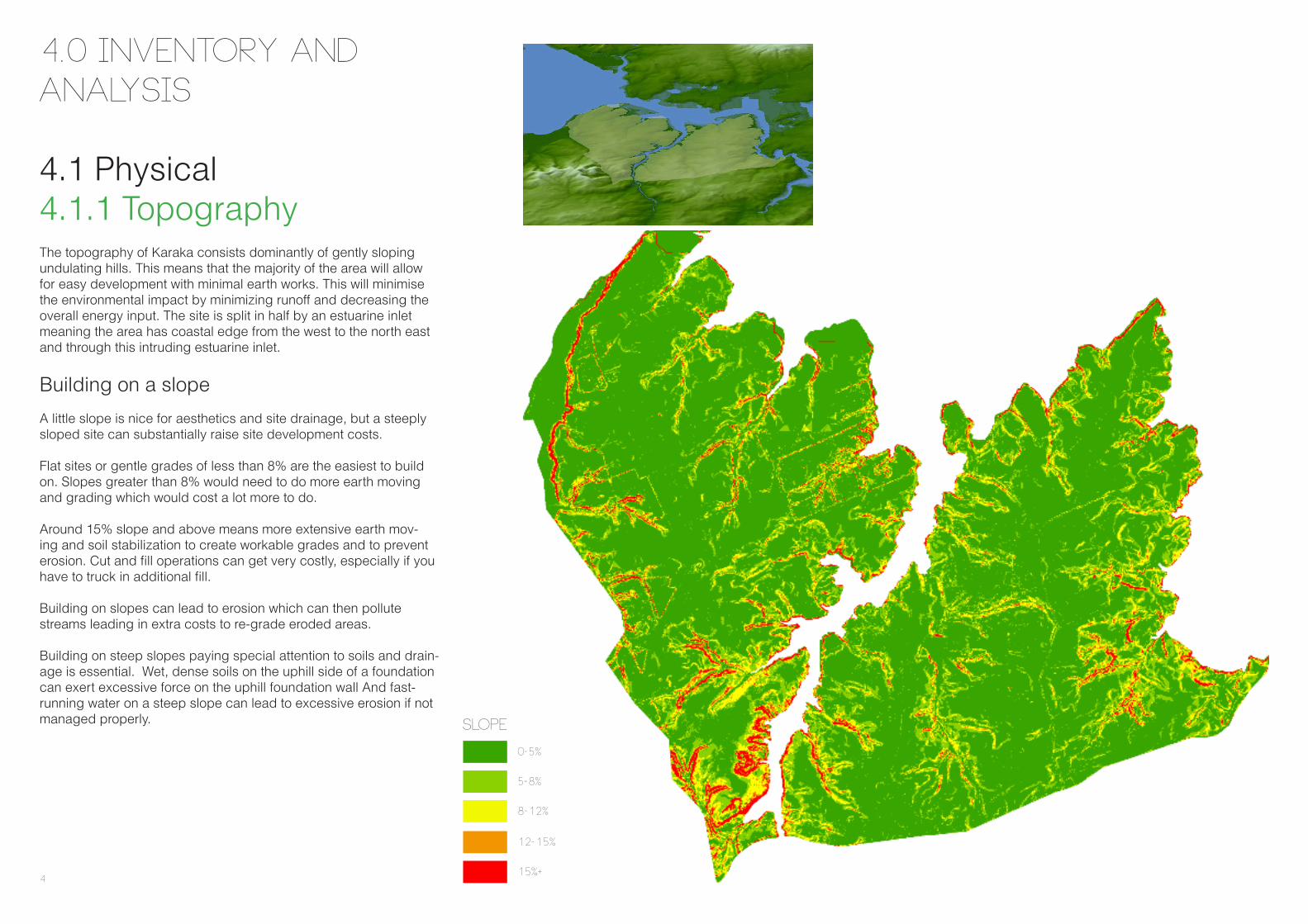
The topography of Karaka consists dominantly of gently sloping undulating hills. This means that the majority of the area will allow for easy development with minimal earth works. This will minimise the environmental impact by minimizing runoff and decreasing the overall energy input. The site is split in half by an estuarine inlet meaning the area has coastal edge from the west to the north east and through this intruding estuarine inlet.
Building on a slope
A little slope is nice for aesthetics and site drainage, but a steeply sloped site can substantially raise site development costs.
Flat sites or gentle grades of less than 8% are the easiest to build on. Slopes greater than 8% would need to do more earth moving and grading which would cost a lot more to do.
Around 15% slope and above means more extensive earth mov-ing and soil stabilization to create workable grades and to prevent erosion. Cut and fill operations can get very costly, especially if you have to truck in additional fill.
Building on slopes can lead to erosion which can then pollute streams leading in extra costs to re-grade eroded areas.
Building on steep slopes paying special attention to soils and drain-age is essential. Wet, dense soils on the uphill side of a foundation can exert excessive force on the uphill foundation wall And fast-running water on a steep slope can lead to excessive erosion if not managed properly.
4.0 Inventory and Analysis
4.1 Physical4.1.1 Topography
0-5%
5-8%
12-15%
15%+
Slope
8-12%
4

4.1.2 Geology and Soils
Geology
The geology for the Karaka area is dominated by Pomice (the voocanic ashed older then Taupo). In the east section of the site a small narrow patch of undifferentiated floodplain allurium is found. This type of rock is the only area of the site that is unsuitble for de-velopment due to it’s geologic makeup.
Soils
The entire site is made up of the same soil type. All the soil is very fertile however, the soil quality is not as good as the land surround-ing the Pukekoke area. For this reason the site historically was predominantly sheep and cattle grazing rather then intensive crop-ping. Overall, the soil type in this land is ideal for future settlement development and because there is no deficit of high quality cropland in the region, ecology and development have taken precedent over development on the site.
Ashes older than Taupo - Pomice
Sandstone or coarse Siltstone - Massive
Geology
Undifferentiated floodplain Allurium
5

4.1.3 Hydrology The main feature of the hydrology around this site is its coastal loca-tion. Furthermore the site is split in half by an estuarine inlet produc-ing a significant amount of coastal boundary. This is a delicate envi-ronment but also holds large ecological potential. Within the site itself there are a series of small streams which carry the water run off to the nearby sea. Due to the extensive clearing of the Karaka area in particular the riparian corridors and coastal fringe, the runoff flows easily over the land carrying silt and minerals with it.Consideration must also be given to the potential of sea level rise in the future. This map has allowed for a generous 3m rise in sea level which will future proof the development from most coastal issues. These areas are important ecological zones and would be prime for revegetation.
Revegetation of the riparian corridors and coastal fringe will slow down runoff and decrease the pollutants entering the harbour that are degrading the water quality off the area. This vegetation will also im-prove the habitats of the native coastal birds and aquatic life improv-ing the overall ecology of the area.
Rivers
Catchments
Sea level rise
Hydrology
6
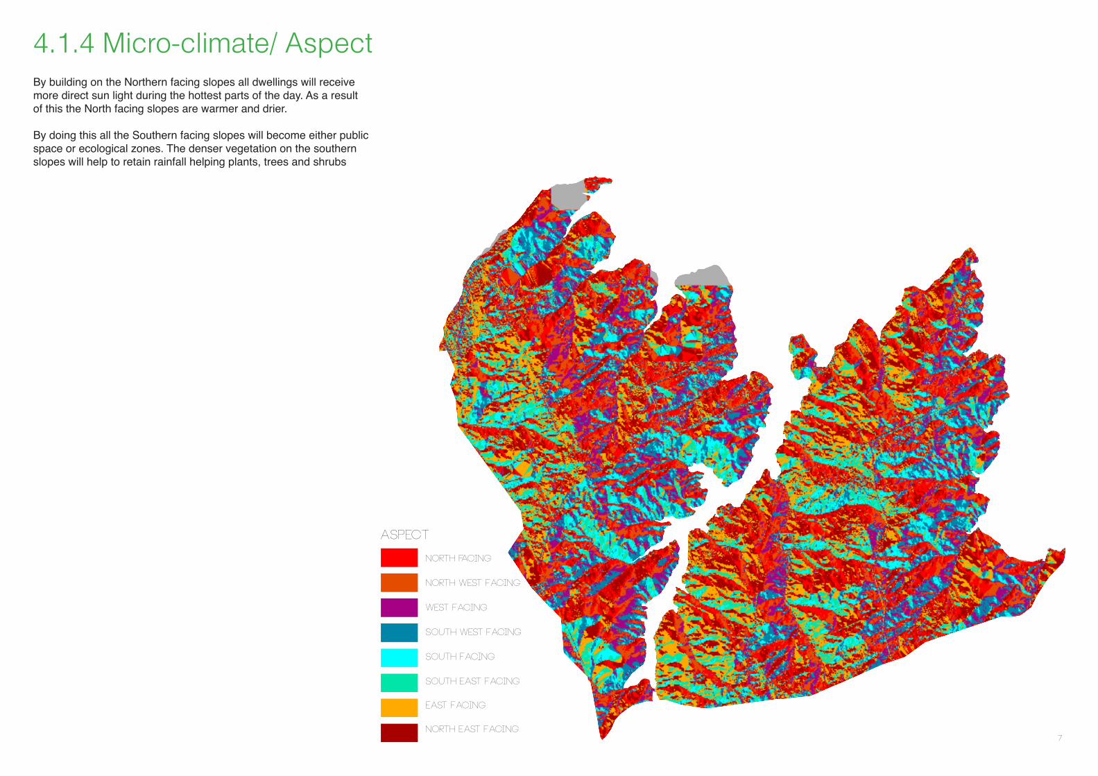
4.1.4 Micro-climate/ Aspect
North facing
North west Facing
West Facing
south West Facing
south Facing
south east Facing
east Facing
north east Facing
Aspect
By building on the Northern facing slopes all dwellings will receive more direct sun light during the hottest parts of the day. As a result of this the North facing slopes are warmer and drier.
By doing this all the Southern facing slopes will become either public space or ecological zones. The denser vegetation on the southern slopes will help to retain rainfall helping plants, trees and shrubs
7

4.2.1 Zoning
4.2 Cultural
Regional Context
Auckland is a linear city with a strong water theme as the main magnet. In the future development of the Auckland urban area it will be crucial will to maintain a strong link to the coast. Doing this will provide a delightful and sustainable life for Aucklanders and aid in the Auckland Plan’s vision of the “Most Liveable City”. Karaka is located directly adjacent to the South Auckland Initiative area (map on the left) placing it in a in a pivotal position if the city is to expand further than is currently projected.
The map shows the south Auckland development strategy in next 15 years, which is to the north of the Karaka area. Development in the region is mainly to be housing to the north of the site and em-ployment opportunities to the North-west. There will be more job opportunities in Airport, Puhinui and further north Otara It is a good indication for the new Karaka plan, by putting new residents along the new bridge and road. People could live in the Karaka area and work in the Airport or Puhinui without going around the south ban motorway. In one hand, it provided convenience transportation for the future settlement, in the other hand, it will reduce the traffic stress of south ban motorway during the peak time, and also it will inspire the economic pontifical by getting more connection to the Auckland Airport
To accommodate employment and economic activity and support a healthy social and physical environment in the Karaka area the fol-lowing points need to be addressed:
• educationalachievement• economicdevelopment• jobgrowth• publictransport• housing• socialconditions
Housing
Ú
Ú
ÚÚ
ÚFrankl in
Local Board
Frankl in Local Board
"International
Gateway
"
HowickLocal Board
Maungakiekie - Tāmaki Local Board
H ousing
H ousingH ousing
EmploymentEmployment
Employment
Employment
TotaraPark
PuhinuiReserve
AmburyRegional
Park
Māngere -Ōtāhuhu
Local BoardPapakura
LocalBoard
ManurewaLocalBoard
Ōtara -PapatoetoeLocal Board
Puketāpapa Local Board
Frankl in Local Board
MāngerePapatoetoe
Manukau
Manurewa
Papakura
Ōtara
Manukau FoodInnovationCentre
HealthInnovation
Hub
ManukauInstitute of
Technology
TertiaryEducationIncubator
AUTCampus
(Manukau)
MountEden
Howick
SaintJohns
CityCentre
FlatBush
East TāmakiHeights
Onehunga
Ihumatao Puhinui
Alfriston
Runciman
Ramarama
Drury
´ 0 52.5 Km
H
H
Warkworth
Pukekohe
Last updated: 24 April 14:30
1.3 THE SOUTHERN INITIATIVE
Local Board areasHousing development (0 - 5 years)Housing development (0 - 10 years)Key employment area (0 - 15 years)International gatewayInternational airportParks (larger than 100 hectares)
! Town centre
Educational & employment opportunities
Marae
Southern Initiative area
Satellite townH
South Auckland Initiative (Auckland, 2012)
8
4.2.2 Existing Infrastructure 4.2.4 Perceptual Quality4.2.3 Karaka Collective The Karaka Collective is a group of citizens that are supporting the 3A plan. This plan is proposal for a bridge connecting Karaka to Weymouth. In their proposal the collective details their vision for the development of both Karaka east and west. The following are points that the local residents of Karaka have outlined as important for the future growth of the region that we have used in the generation of this growth strategy.
• Integrate growth into the existing natural character and ecology of the site• bring a new sustainable lifestyle upon the old land usage• retain the sites rural character that is eveident in the site’s existing horse and dairy farms, small residential enclaves, business points schools and colleges• social development including the creation of jobs and commercial opportunities• ecological restoration• public space and social facilities• increased connection to the airport and south motorway, to encourage the future development of the area.• preserve Maori archeological and historical sites as well as early european history• education and tourism
Karaka being predominantly rural farm land, there are limited exist-ing social facilities and infrastructure. It is supplied with the basic amenities such as power, water and sewage. The area is next to the southern motorway, and there are a few roads extending within this area. The residents are mainly local farmers, some patches of residential housing are spread around the farmland. There are also two public primary schools located in Karaka (Karaka School and Te Hihi School). Strathallan is the only secondary school in the area and is a private school. Public secondary education is provided in the nearby towns of Papakura and Pukekohe.
Transport
The development of public transportation around Karaka, to the neighboring hubs and city is vital. New developments all over the world revolve heavily around making a sufficient public transport system as is has so many benefits. We cannot solve congestion by building more and more roads as they are just a temporary solu-tion soon undone by increased private vehicles. With a good public transport system fewer roads are needed saving both the natural and urban landscape. By having a good transport system taking the residents back and forth from work and the city will create a cleaner, quieter neighborhood with increased mobility for everyone.
The area of Karaka is mainly used for dairy farming and sheep farm land, but the land is well known for thorough breed horses. The main landscape character of Karaka is rural with very open views. Most of the area is flat land, however but in south Karaka the con-tours change rapidly and steep coastlines occur on some of the coastal fringe. The rural open space includes productive and culti-vated crops and grasslands, recreational spaces, exotic and na-tive botanical parklands and indigenous bush reserves border the middle estuary.
9

4.2.3 Archaeological and Cultural Features
Being one of the first of early Maori settlement area of Manuka harbor, the area has a fairly high Archaeological value. There are few Maori rock craft and early settlement evidence that exist along the coastal area and most of them are gathered around the channel in between the shore of Weymouth and Karaka. In addition, there are some archeological sites dating back to European settlement including historic infrastructure.
archeological Features
Site Boundary
Archeology
10
4.3 Biological
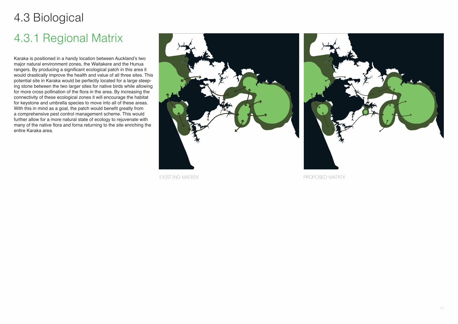
4.3.1 Regional Matrix
Karaka is positioned in a handy location between Auckland’s two major natural environment zones, the Waitakere and the Hunua rangers. By producing a significant ecological patch in this area it would drastically improve the health and value of all three sites. This potential site in Karaka would be perfectly located for a large steep-ing stone between the two larger sites for native birds while allowing for more cross pollination of the flora in the area. By increasing the connectivity of these ecological zones it will encourage the habitat for keystone and umbrella species to move into all of these areas. With this in mind as a goal, the patch would benefit greatly from a comprehensive pest control management scheme. This would further allow for a more natural state of ecology to rejuvenate with many of the native flora and forna returning to the site enriching the entire Karaka area.
Existing Matrix Proposed Matrix
11

4.3.2 Site Scale Biological Context
Short Rotation Crop land
high producing exotic grass land
mangrove
broad leaf indigenous hardwood
Herbaceous saline vegetation
Land-use
The current ecological condition of the Karaka area is far from its natural state. The area is predominantly rural and therefore consists of large areas of high producing exotic grassland. There are small patches of native bush to the south of the site but due to their size their ecological significance is minimal. Being a rural area Karaka is home to many different types of livestock but it is particularly well known for being home to thorough breed horses. It is also surpris-ingly still the home to many coastal birds that live, breed and feed in the mangroves and shallows of the Manakau Harbour that sur-rounds Karaka. The Manakau harbour was once a rich ecological zone home to expensive aquatic life and healthy water ways. Due to recent deforestation and poor land management, mineral runoff has degraded the quality of the harbour.Because of the sites surroundings and layout it has a lot of potential to rebuild a unique and dynamic ecosystem that is on the fringe of the aquatic and coastal boundary. Incorporation the redevelopment of these ecosystems into the design of the development would not only make it sustainable but would drastically increase the ecology of the entire are.
The proposed patch is very significant in size and is rounded in shape with the estuary inlet protruding into the middle of it. This means the site will have a large core and will be suitable to home key stone and umbrella species. Due to its location next to the city however, a thorough pest control scheme would greatly improve the health of the ecology in this patch and surrounding matrix.
12

4.4 PrecedentsThere are many ways to define a sustainable community but in gen-eral they can be described as places where the use if resources and emissions of greenhouse gases and other pollutants are go-ing down, not up; where the air and waterways are accessible and clean; where land is used efficiently and shared parks and public spaces are plentiful and easily visited. Where people of different ages, income levels and cultural backgrounds share equally in environmental, social and cultural benefits; mass transit, biking and walking replacing the majority of automobile traffic and mixed used communities where schools, residences and commercial spaces are near each other and powered by clean, renewable energy sources. where many needs of daily life can be met within a 20 minute walk or a 20 minute transit ride, also where industry and economic op-portunity emphasizes healthy, environmentally sound practices.
According to the Vermont – based institute for Sustainable Commu-nities (ISC), sustainable communities are essentially “economically, environmental and socially healthy and resilient” and meet “chal-lenges through integrated solutions rather than through fragmented approaches” And also sustainable communities take a long term perspective, focusing on “both the present and future, well beyond the next budget or election cycle” so that the needs of the current as well as future generations are met with adequate resources. The key to any consideration of what makes a community sustainable is the acknowledgment that there is no such thing as perfection. And according to Sustainable Communities Online “Sustainability is a process of continuous improvement so communities constantly evolve and make changes to accomplish their goals
13

Masdar City
Masdar City is a place where businesses can thrive and innovation can flourish. Masdar city is a modern Arabian city and like the other older cities in this area is in tune with its surroundings. This city brings the lowest possible ecological footprint but with the highest quality living and working environment and is rated one of the most sustainable mixed used development on the planet.
There are many ways to mark this city as sustainable and they include:
• Largereductiontargetsforenergydemand.• Largereductiontargetsforwaterdemand.• Operatingatthecuttingedgeofutilitymanagementintegra-tion through integrated municipal platform, a power generation-to-consumer smart grid and sophisticated tools to monitor – and therefore help manage – citywide consumption of power and water, and CO2 generation. While operating a green building involves the integration of a number of smart technologies and systems. Run-ning an entire city means the exponentially more complex task of integrating not only all these buildings, but also all kinds of smart and sustainable utility and infrastructure services – including elec-tricity, water, sanitation and transportation – and their associated systems, across an entire city. This is an area were we expect to generate a lot of intellectual property and make a significant contri-bution to the development of highly sustainable communities.• Providingauniquetest-bedplatformthatallowspartnersincutting-edge technology and systems to work with us to pilot, dem-onstrate, refine, develop and commercialise technologies on a very fast-to-market platform. The city will serve as an open technology platform and real-world test-bed for technologies that are relevant to the development and success of the city.• Allaspectsofurbanplanning,architecture,design,con-struction and operations are being assessed and modified to re-flect the latest in commercially viable, sustainable technologies and practices. The comprehensive nature of our focus is unique. We are looking at every place where we can reduce our embodied and operational carbon and shrink our environmental footprint.• Thecityhasmadeamajorcommitmenttosustainableprod-ucts by reducing embodied carbon emissions, increasing recycled content, using local materials, reducing waste, using timber from sustainable forests, and selecting products that have the greatest positive effect for indoor air quality during and immediately after installation.• Thecitywillhavesomeoftheworld’smostsustainable
mixed-use buildings in the world, including the Masdar Institute and Masdar Headquarters buildings.• Thecommitmenttobeingapedestrian-friendlycityputsMasdar City in a special place among modern cities with such a focus. Achieving this necessitates narrow streets, large vehicle-free neighborhoods, reliance on public versus private transportation, largely shaded walkways, integrated planning and self-sufficient neighborhoods.The city is piloting several advanced clean-transportation systems and strategies, including PRT and an electric vehicle point-to-point systems.
14
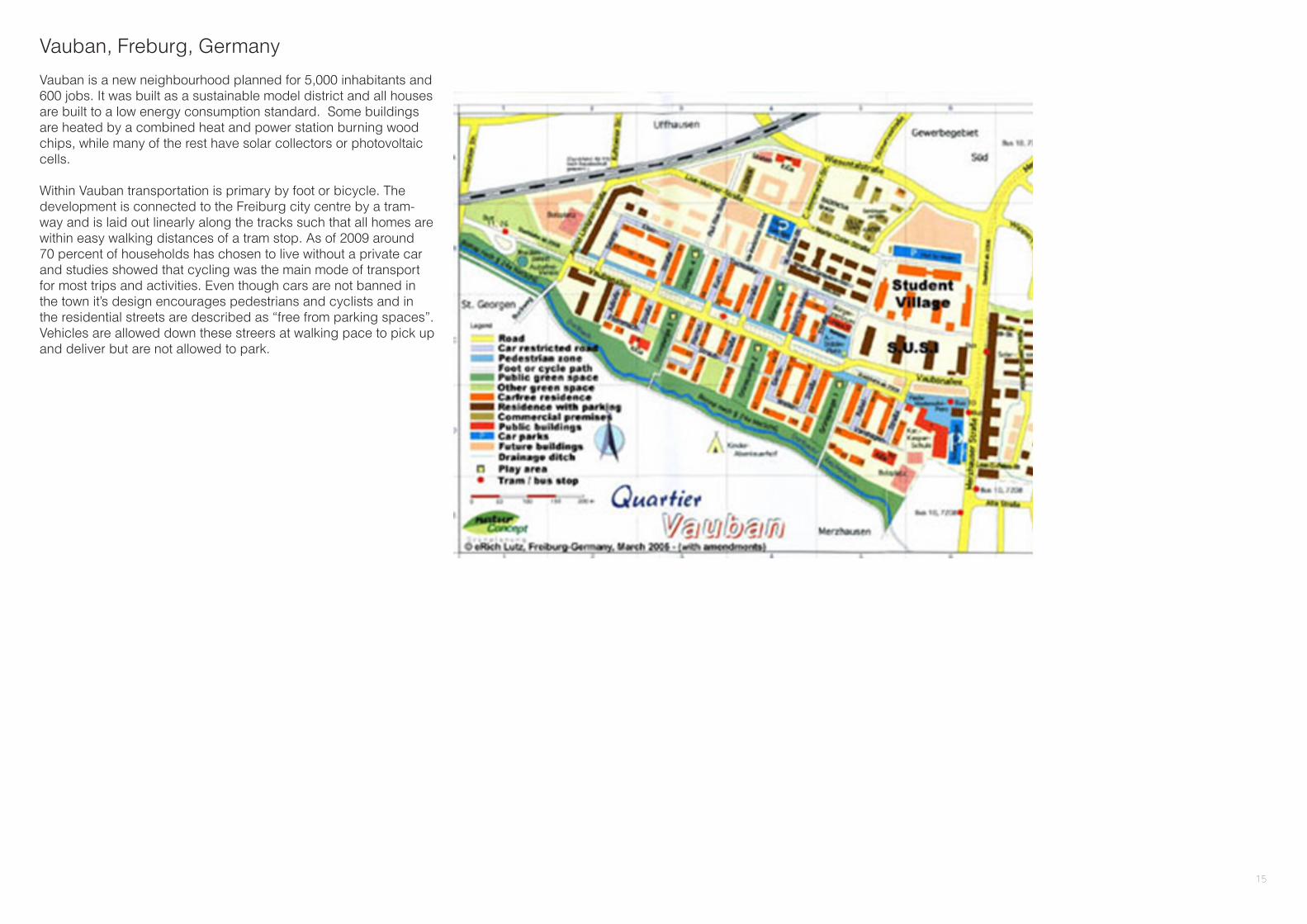
Vauban, Freburg, Germany
Vauban is a new neighbourhood planned for 5,000 inhabitants and 600 jobs. It was built as a sustainable model district and all houses are built to a low energy consumption standard. Some buildings are heated by a combined heat and power station burning wood chips, while many of the rest have solar collectors or photovoltaic cells.
Within Vauban transportation is primary by foot or bicycle. The development is connected to the Freiburg city centre by a tram-way and is laid out linearly along the tracks such that all homes are within easy walking distances of a tram stop. As of 2009 around 70 percent of households has chosen to live without a private car and studies showed that cycling was the main mode of transport for most trips and activities. Even though cars are not banned in the town it’s design encourages pedestrians and cyclists and in the residential streets are described as “free from parking spaces”. Vehicles are allowed down these streers at walking pace to pick up and deliver but are not allowed to park.
15

Chengdu, China
China is planning a building explosion of dense, sustainable sub-urbs, connected to its megacities by public transit. These “proto-type cities” could alter the course of the country’s unsustainable development.
This masterplan calls for 80,000 residents to live and work within a half – square mile circuit in which any point will be at most a 15 minute walk away.
To achieve that level of density the average height of the buildings would have to be 18 stories. But to preserve a 480 acre greenbelt around the city, and to ease officials anxious about developers chewing up so much farmland, the plan call for towers as high as 400 metres.
Trains and mass transit will connect the satellite city to Chengdu’s core as part of the firm’s plans to restrict cars and dramatically re-duce the city’s carbon footprint. The city will also deploy tactics and technologies to address waste, water and energy.
16

5.1 Land Use Suitability5.2.1 Constraints forDevelopmentAreas of the site that are not suitable for development have been derived from the inventory and analysis in section 4.0. They are summaries in the figures on the following page.
Areas of the site that have been deemed unsuitable for development include:
• Areas where the slope exceeds 8%• areas within 15 metres either side of a stream• flood plane and areas at risk of flooding due to sea-level rise• areas directly on the coast • areas with established significant native vegetation• areas with archeological and historical significance
5.1.2 Biological Opportunities
Site scale:
Areas of the site that have been deemed unsuitable for development have been optimistically reclassified as ecological opportunities. They have been set aside in our plan as ecological corridors and patches that will increase the ecological connectivity at a site scale level.
Regional context:
When establishing habitat it is in the interest of biodiversity to have one large patch than it is to have several dispersed patches. This is because core/ interior habitat is preferred and the larger the patch, the greater its ecological significance. It is for this reason that the Karaka Area Development Plan has imposed a large (80 27865 square meter) ecological patch. In doing so, the plan aims to act as a patch that can help connect ecologic movement for the greater region. This patch Would be largely Northern Lowlands ecology as it has been identified by the Ministry for the Environment as the most seriously under-protected ecology in the region (MFE, 2012).
Additionally, Creating a larger ecologic patch makes for higher density communities on the areas of development. This is important for creating walkable, connected communities.
5.3.3 Opportunities for DevelopmentIn order to determine a foot print for development, the Karaka Area Development Plan first outlined areas that were unsuitable for development, then determined how to use to merge those areas into a cohesive ecological network. Finally, after establishing that network, the plan used the areas outside the network as areas suitable for development.
5.0 Recommendations
17
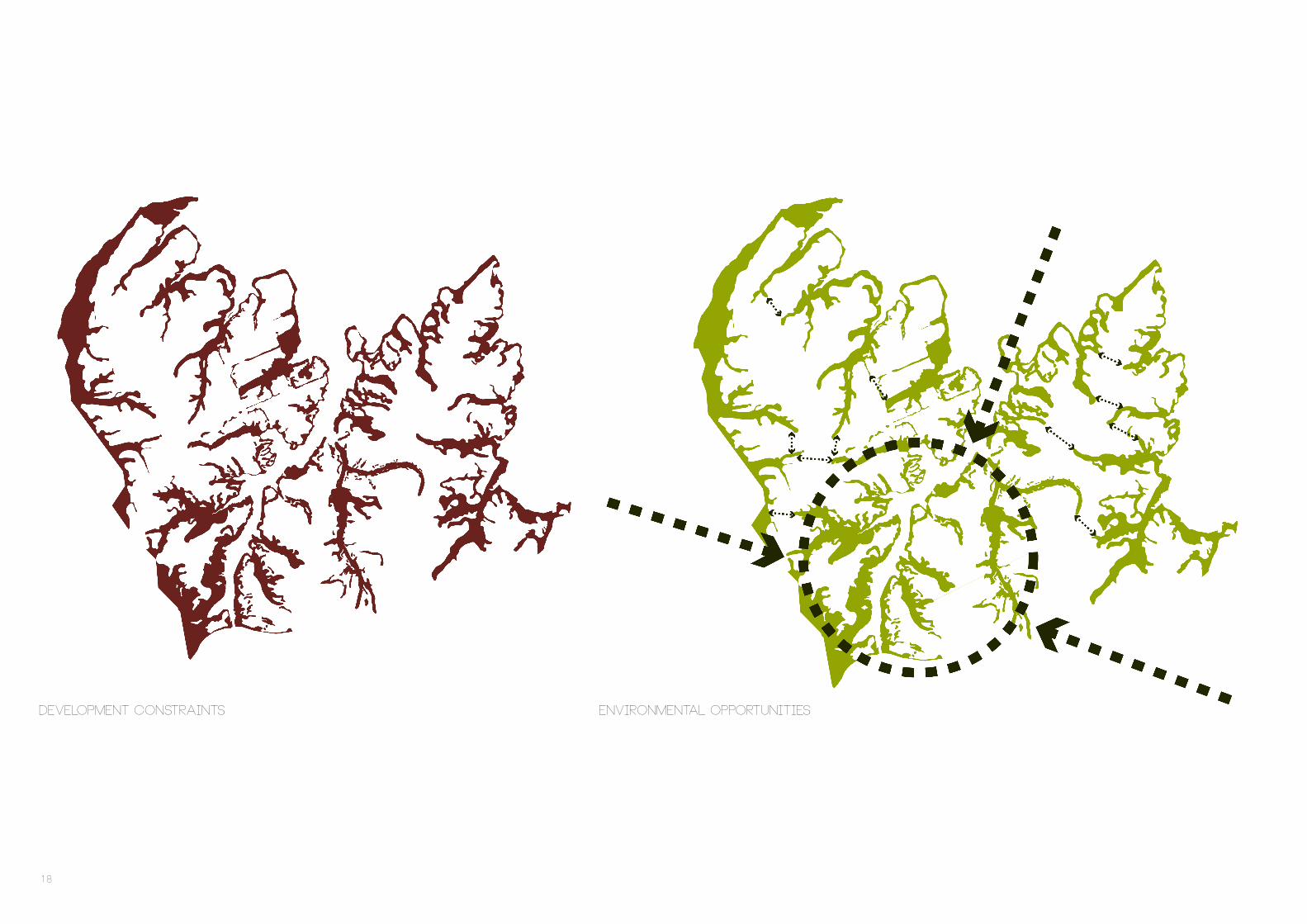
Development Constraints Environmental opportunities
18

5.2 Master Plan
High Density Housing
This term describes a type of housing where more than one new home is constructed and each home does not have its own foot-print on the land, rather the homes occupy airspace. These types of homes are the apartments that are part of mixed – use or high-density residential developments.
The high density housing will be apartment style consisting of 3-4 stories with each apartment taking up around 300 square metres.
Medium Density Housing
Medium density housing is a term used to describe residential developments that are at a higher density than standard low density suburban subdivisions but not so high that they might be regarded as high density housing. Medium density housing can range from around 25 to 80 dwellings per hectare, though most commonly the density is between 30 and 40 dwellings a hectare. This develop-ment will consist of detached, semi-attached, attached or multi unit housing. In such places the density may be about 1 home for each 500 square metres of land.
Low density Housing
Low density areas are residential developments with overall den-sities around 3-4 dwellings an acre depending on the character and density of surrounding developments. Low-density residential areas are located where natural characteristics such as terrain and soils are suitable fir residential development. Low density residential areas are usually located where public services and utilities exist or are expected to be expanded to serve sites. Examples of accept-able land uses within this designation include single family homes, cluster housing, recreational areas, schools, community – orientated public facilities and a few commercial establishments.
Low density housing is also a term used to describe the larger blocks of residential land, where separated large dwellings were constructed on properties of about 600 to 700 square metres. This development will consist of an average housing density of about 1 home for every 800 - 1000 square metres.
Rural density housing
In general, a rural area is a geographic area that is located just out-side the towns mains centre. Typical rural areas like Karaka have a very low population density with each dwelling on a 100,000 square metre lot.
High Density
Medium Density
Low Density
Total Site
Land Area(Square Meters)
Total Number of Dwellings
Total Residents
Ecological Zone
Public Space
Commercial
Rural Density
1,862,919
3,192,882
1, 627, 413
1, 652, 930
166, 113
1,809,769
8,027,865
174,900,000
6,209
6,385
1,808
16
43,25414,418
19
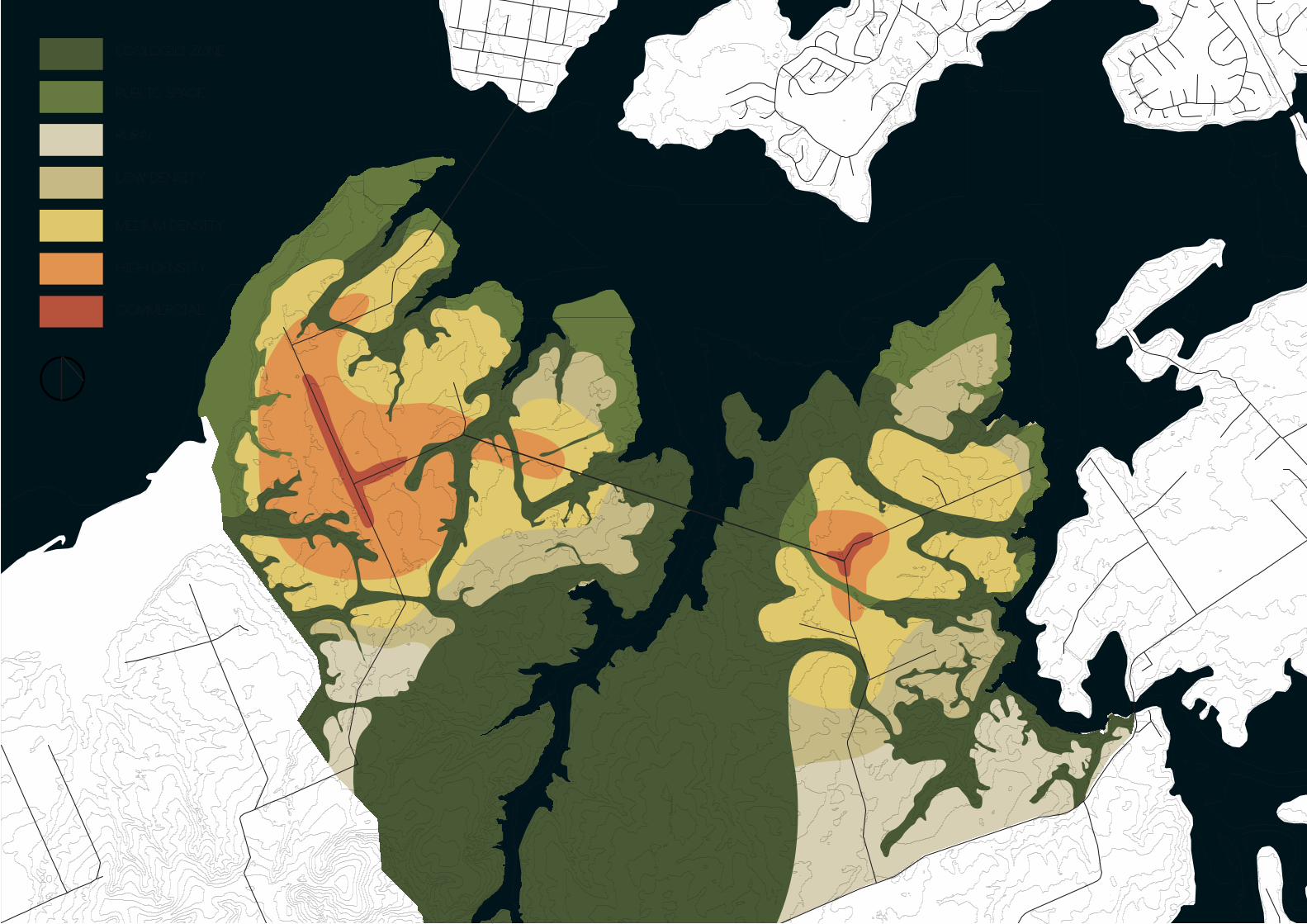
Ecologic Zone
Public Space
Rural
Low density
Medium density
high Density
Commercial
20

6.0 Conclusion
The Karaka Area Development Plan has been developed with the concept of ecological connectivity as a framework for development. It has been developed as means of accommodating Auckland’s continuous growth in a sustainable manner. The strategy accomplishes this by providing space for a strongly integrated ecologic network and derived areas for development from a landscape driven approach.
next step? implementation, phasing and monitoring of this patch will be required in the next stage of design.
In order to achieve a strong ecological base for development the Karaka Area Development Plan has implemented a large (80 27865 square meter) ecological patch to fit the site into the regional ecologic matrix. The site has also employed a connected system of ecological corridors to promote ecological connectivity on a site scale. In order to create sustainable development, the Karaka Area Development Plan has been mindful of the vision of the current area residents as well as global and regional trends. Through these actions, the plan helps to Achieve the Auckland Plan’s requirements for increased housing and is modeled with the vision of “most Liveable City” in mind, while also addressing the Ministry for the Environment’s Desired Outcomes for 2020.
21

7.0 Works Cited
Documents
Auckland Direction Plan (2012 vision) By Auckland city councilSubmission on the southern rural urban boundaryBy Karaka Collective
Auckland 2040: A Resilient urban region on the water Authors: Bogunovich, Dushko; Bradbury, Matthew.
Building competitive cities by Ministry of environment, New Zealand.A brief history of Auckland’s urban form (April, 2010), by the Social and Economic Research and Monitoring team, Auckland Regional Council
Web sites
http://buildingadvisor.com/buying-land/site-characteristics/slope-soils-water-vegetation/#jump8
http://saveivanhoe.com/higher-density-v-low-medium-and-high-den-sity
http://www.ecomagination.com/top-five-most-sustainable-cities-in-the-world
http://sustainablecitiescollective.com/joepeach/15590/five-sustain-able-towns-worlds-cities-could-learn
http://www.eco-city.gov.cn/eco/shouye/zoujinshengtaicheng/sheng-taichengjianjie/en/en.html#
http://www.dezeen.com/2012/10/24/great-city-by-adrian-smith-gor-don-gill-architecture/
http://masdarcity.ae/en/
http://www.mfe.govt.nz/publications/biodiversity/indigenous-biodiver-sity/section32/html/page6.html
22


