KANYAKUMARI DISTRICT – A PROFILE -...
23
13 CHAPTER - II KANYAKUMARI DISTRICT – A PROFILE 2.1. HISTORY Kanyakumari District takes its name from the township of Kanyakumari, the southern tip of India. (In many Indian languages the term, Kumari, means a virgin). This district is also called Kumari District. Kanyakumari town is named after the Goddess Kanyakumari, a popular deity of the area. The legend has it that Goddess Parvati, in one of her incarnations as Devikanniya, did penance on one of the rocks off this land’s end to obtain the hand of Lord Shiva. Kanyakumari is geographically a cape, and the Englishmen of the Raj called it Cape Comorin. Since ancient times Kanyakumari District has been of two geographical areas known locally as Nanjilnadu and Idainadu. The etymologists interpret the word Nanijlnadu as the country (‘nadu’) where th ere were (and still are) several agriculture plantations and fields.t 2.2. GEOGRAPHICAL FEATURES 2.2.1. Location Kanyakumari District is the southernmost district of Tamil Nadu. The district lies between 77 ° 15 and 77º 36 of the eastern longitudes and 8 o 03 and 8 o 35' of the northern latitudes.
Transcript of KANYAKUMARI DISTRICT – A PROFILE -...

13
CHAPTER - II
KANYAKUMARI DISTRICT – A PROFILE
2.1. HISTORY
Kanyakumari District takes its name from the township of
Kanyakumari, the southern tip of India. (In many Indian languages the term,
Kumari, means a virgin). This district is also called Kumari District.
Kanyakumari town is named after the Goddess Kanyakumari, a popular deity of
the area. The legend has it that Goddess Parvati, in one of her incarnations as
Devikanniya, did penance on one of the rocks off this land’s end to obtain the
hand of Lord Shiva.
Kanyakumari is geographically a cape, and the Englishmen of the Raj
called it Cape Comorin. Since ancient times Kanyakumari District has been of
two geographical areas known locally as Nanjilnadu and Idainadu. The
etymologists interpret the word Nanijlnadu as the country (‘nadu’) where th ere
were (and still are) several agriculture plantations and fields.t
2.2. GEOGRAPHICAL FEATURES
2.2.1. Location
Kanyakumari District is the southernmost district of Tamil Nadu. The
district lies between 77° 15 and 77º 36 of the eastern longitudes and 8o 03 and
8o 35' of the northern latitudes.

14
The district is bounded by Tirunelveli District on the north-east. Its
south-eastern boundary is the Gulf of Mannar. On the south and the west, the
boundaries are the Indian Ocean and the Arabian Sea. Thiruvananthapuram
District of Kerala is its northern boundary.
2.2.2 Land
Kanyakumari is the smallest district in Tamil Nadu with a land spread
of 1,684 km2 and has almost all ecosystems - forests, wetlands, fresh water
resources, marine areas and the like.
The district, once called 'the Granary of Travancore,' is fertile, with
hundreds of water bodies and an excellent canal irrigation system. Rubber and
spice plantations are there on the hilly terrain, whereas paddy fields, plantain
(banana) and coconut groves are found on the slopes and plains between the
hills and the coast.
The district is generally hilly with plains found near the coast. The
land from the coast gradually rises from sea- level to the hills of the Western
Ghats in the extreme east of the district. The district has 62 km of coast on the
western side (Arabian sea coast) and 6 km of coast on the eastern side (Gulf of
Mannar/Bay of Bengal coast).
2.2.3. Language
The main languages spoken by people of the district are Tamil and
Malayalam. English is widely understood throughout the district. While the

15
majority of the people in the district speak Tamil, many in its northern and
western areas speak Malayalam.
2.2.4. Climatic Conditions and rain fall seasons
The district has a favourable agro-climatic condition, which is
suitable for growing many varieties of crops. Its proximity to the equator, its
topography and other climatic factors favour the growth of various crops. The
paddy varieties grown in the second crop season in Thovalai and
Agasteeswaram taluks are grown during the first crop season in Kalkulam and
Vilavancode taluks. This shows that there is distinct variation in the climatic
conditions prevailing within the district. Unlike the other districts in Tamil
Nadu, it has rainfall during both the South-West and the North-East monsoons.
The South-West monsoon period starts in the month of June and ends in
September, while the North-East monsoon period starts October and ends in the
middle of December. The average rainfall is shown in the table below.
TABLE – 2.1
CLIMATIC CONDITIONS AND RAINFALL SEASONS
Sl.No Month Rainfall (in mm)
1. January 19.7
2. February 1.8
3. March 142.7
4. April 37.8
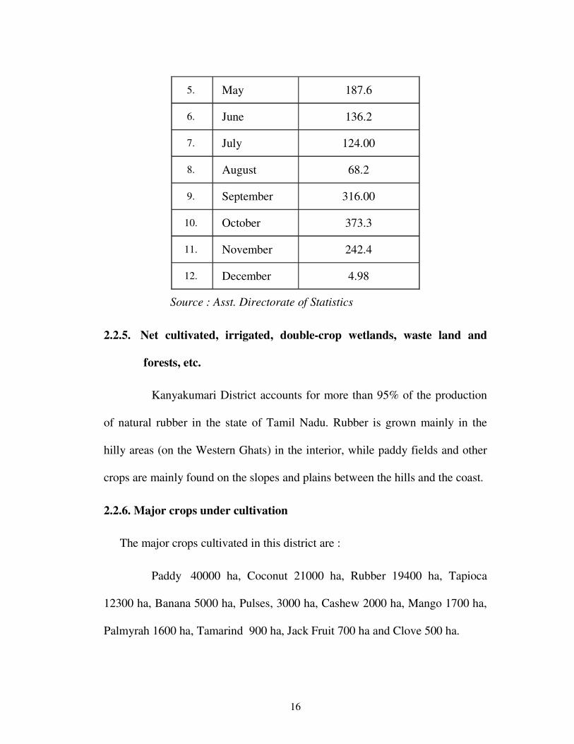
16
5. May 187.6
6. June 136.2
7. July 124.00
8. August 68.2
9. September 316.00
10. October 373.3
11. November 242.4
12. December 4.98
Source : Asst. Directorate of Statistics
2.2.5. Net cultivated, irrigated, double-crop wetlands, waste land and
forests, etc.
Kanyakumari District accounts for more than 95% of the production
of natural rubber in the state of Tamil Nadu. Rubber is grown mainly in the
hilly areas (on the Western Ghats) in the interior, while paddy fields and other
crops are mainly found on the slopes and plains between the hills and the coast.
2.2.6. Major crops under cultivation
The major crops cultivated in this district are :
Paddy 40000 ha, Coconut 21000 ha, Rubber 19400 ha, Tapioca
12300 ha, Banana 5000 ha, Pulses, 3000 ha, Cashew 2000 ha, Mango 1700 ha,
Palmyrah 1600 ha, Tamarind 900 ha, Jack Fruit 700 ha and Clove 500 ha.

17
2.2.7. Forests
1. The forests in the district are verdant and virgin and are said to be of 75
million years old. Of the total district area of 167130 ha. Government
Forests occupy an area of 50486 Hectares which comes to about 30.2 %
the total geographic area of the district.
2. After the formation of Kalakad-Mundanthurai Wildlife Sanctuary,
Kanyakumari Division was formed on April 1, 1977 as per G.O.Ms.No.
261 dated 26.03.1977 exclusively to manage the forests of this district with
Nagercoil as its headquarters.
3. In Kanyakumari Division, 14 types of forests from luxuriant tropical wet
evergreen to tropical thorn forests occur because of diverse locality
factors, (according to Champion and Seths classification). Rainfall varies
from 103 cm to 310 cm and elevation from sea level ranges to 1829 m.
The forest area is 30.2 % of total district geographical area, which is next
to Nilgiris District.
4. Many medicinal plants of high value are harvested in this District. The
Marunthuvalmalai located among the green paddy fields and fluttering
coconut palms in the district is famous for valuable medicinal plants. This
is the only district in Tamil Nadu where rubber and clove plantations have
been raised in Reserve Forests in an area of 4785.70 ha and 110 ha
respectively. The District is rich in wildlife with at least 25 types of

18
mammals, about 60 species of fishes, reptiles and amphibians. In short,
these forests are a veritable trove of biological diversion.
5. From tourism angle, the forests are highly enchanting with pleasant sholas,
hill top forests, beautiful grasslands, panoramic valleys, high hillocks,
singing streams, vast stretches of rubber plantations, extensive teak
plantations and excellent climate. Nobody should miss seeing
Mahendragiri, Maramalai, Sea field and Balamore estate area, Ecology
farm, Kalikesam, Pechiparai Dam, Perunchani Dam, Upper Kodayar,
Maruthamparai and Mukkudal areas for their scenic beauty. Kanyakumari
District alone in Tamil Nadu stands apart with its distinction of having its
entire forest area as a never-satiating picture to the tourist’s eyes.
2.2.8 . Reserve Forests
The following are the Reserve Forests in this Division:
TABLE – 2.2
RESERVE FORESTS
Sl.No Reserve Forests Area in ha
1 Therkumalai East and West 1741
2 Thadagaimalai 797
3 Poigaimalai 1243
4 Mehendragiri 4360
5 Veerapuli 28109

19
6 Velimalai 1126
7 Old Kulasekaram 694
8 Kilamalai 8106
9 Asambu 4310
Total 50486
Source: Department of Forests
2.2.9. Medicinal Plants
Medicinal Plants Conservation Area Scheme is being implemented in
this Division with the assistance of Foundation for Revitalization of Local
Health Traditions, Bangalore (FRLHT), from the year 1993 – 94 onwards.
2.2.10. Kani Settlements
Kanis are a tribe of people, basically agriculturists, who have been
inhabiting forests of Kanyakumari District and adjoining Kerala since time
immemorial. There are now 47 Kani settlements in Kanyakumari Division with
an extent of 1257.38 ha of forest land. These lands have been allotted to 927
families under Tribal Development Scheme as detailed below :

20
TABLE – 2.3
KANI SETTLEMENT
Sl.No
Name of
Reserve
Forests
Settlements No. of
Families
Total
Population
Total area in
which
settlement is
made
1 Kilamalai 15 415 1812 475.15
2 Veerapuli 31 466 2240 734.33
3 Asambu &
Veerapuli 1 46 176 40.57
Total 47 927 4228 1250.05
Source : Computed data
2.3. BASIC INFRASTRUCTURE
i) Roads, Railways
1. National Highways : 22.600 km.(doubtful)
2. State Highways : 216.552 km
3. District Roads :
a) Main District Roads : 155.400 km.
b) Other District Roads : 817.817 km.
The road network in Kanyakumari District consists of National
Highways, State Highways, District roads and rural roads. The Madras to
Nagercoil trunk road joins the Kanyakumari-Thiruvananthapuram Road by

21
taking a short diversion) near Aralvoimozhi. The latter passes through
important places over a distance of 87 km. and finally reaches the city of
Thiruvananthapuram. The erstwhile State of Travancore had adopted a policy
of nationalization of transport services, and following this the Transport
Department was formed in the state in 1938. Routes between
Thiruvananthapuram and Kanyakumari (Via) Nagercoil and between
Thiruvananthapuram and Colachel were the first to be taken up for
nationalization. After the reorganization of States in 1956, the bus transport
service in Kanyakumari District was taken over by the State Transport
Department of the then Madras State.
TABLE – 2.4
LENGTH OF ROAD (IN KILOMETRES) YEAR 2001-2002
Surfaced Roads
Unsurfaced
Roads
Grand
Total Cement
Concrete Bituminous
Water Bound
Macadam Total
1 2 3 4 5 6
239.264 2444.948 811.587 3495.799 812.953 4308.752
Source: All Panchayat Unions & Municipalities, and Town Panchayats,
Nagercoil. DFO, Nagercoil, EE, PWD State Highways, Nagercoil,
EE, PWD National Highways, Nagercoil.

22
TABLE – 2.5
RAILWAY LINES AND STATIONS YEAR: 2005-2006
Item Broad
Gauge
Meter
Gauge
Broad Gauge &
Meter Gauge Total
(1) (2) (3) (4) (5)
1. Route Length (in km.) 78 - - 78
2. Tract Length (in km.) 78 - - 78
Number of Railway
Stations 11 - - 11
Source: Station Master, Railway Station, Nagercoil.
ii. Irrigation (Canal, tube wells, wells, tanks, etc)
Rivers
Rivers provide the important source of irrigation in Kanyakumari
District. There are five of them, as shown below
TABLE 2.6
RIVERS
1 The Tambaraparani
2 The Pazhayar
3 The Valliar
4 The Ponnivaikal
5 The Paraliyar
Source: Computed data

23
TABLE – 2.7
DAMS: THERE ARE SIX DAMS CONSTRUCTED ACROSS THESE
RIVERS.
1 Pandiyan Dam
2 Puthen Dam
3 Pechipparai Dam
4 Perunchani Dam
5 Chittar Dam-I
6 Chittar Dam-II
Source: Computed data
TABLE – 2.8
CHANNELS : THERE ARE 6 CHANNELS IN THE DISTRICT.
1 Pandiyan kal
2 Thovalai Channel
3 Regulatory Kal
4 Anandanar Channel
5 Nanchinad Puthanar Channel
6 Padmanabhapuram Puthannar Channel
7 Chittar Pattanam Channel
Source: Computed data

24
The major river in the district is the Tambaraparani locally known as
the Kuzhithuraiar. This river has got two major tributaries namely the Kodayar
and the Paraliyar. There are many tributaries to the Kodayar river of which the
Chittar is the major one. The origin of Tambaraparani River is Western Ghats
and the river confluences with the Arabian Sea near Thengapattanam after
running a distance of 56 km.
The Valliar, another small river and its tributary, the Thoovalar,
originate from the Velimalai Hills. It collects the drainage from P.P. Channel
and its branches and confluences with the Arabian Sea near Manavalakurichi.
The Pazhayar, another small river, starts at Shorlacode, about 18 km
north-west of Nagercoil. This is mainly a drainage river mostly collecting the
drainage of Thovalai, Ananthanar and N.P. Channels.
Pechiparai Dam
The Travancore Government presided over by Srimoolam Thirunaal
Maharaja got the Pechiparai Dam constructed during the period of 1897-1906
by the British Engineer, Mr. Alexander Humphrey Minchin. This was built
across the Kodayar River about a mile below the confluence of its tributaries,
the Kallar, the Sittar and the Kuttiyar, at Pechiparai, 11 km north of
Kulasekaram and 45 km from Nagercoil. The cost of original construction was
Rs. 26.1 lakh. The dam is a straight gravity type masonry dam of 425.5 metres

25
long and 120.70 metres high above the deepest foundation. It does not have an
inspection gallery.
Perunchani Dam
This dam was built during the period of 1948 – 1953 by the erstwhile
Travancore-Cochin State. This was built across the Paraliyar river at
Perunchani, about 10 km east of Kulasekaram and 42 km north-west of
Nagercoil. It is across a picturesque valley between two hillocks forming an
ideal site. The dam is a straight gravity masonry one of 373.10 metres long
consisting of 275.28 metres of bulk head section. A drainage gallery of
1.52x2.29 m has been provided in the middle river section for a length of 45.70
m which serves a longitudinal inspection chamber as well as outlet for the
seepages from the foundation.
Chittar Dam-I
The Chittar Dam I is constructed across River Chittar I which has its
source in the mountains in Klamala Reserve Forest, near Ettukani and
Vandiplavukani at an elevation of over 2000 ft. above M.S.L. and is about 2.00
km up-steam of the confluence of the river with the Kodayar.
Chittar Dam-II
It is constructed across the Chittar II which has its source in Klamala
Reserve Forest at an elevation of about 2300 ft. above M.S.L. and is at about
2.00 km. up steam of the confluence of the Chittar I with the Kodayar.

26
Neyyar Dam
Neyyar Dam, situated in Kerala State, is the source of supply for
Kanyakumari Branch Channel. It takes off from the Left Bank Channel of the
Neyyar Dam at Km 38.616. However, the Irrigation Department of the Kerala
Government has been lukewarm in releasing water in this channel since the
merger of Kanyakumari District with Tamil Nadu.
2.4. DEMOGRAPHIC DATA
(i) Features of population
TABLE – 2.9
POPULATION AS PER 2001 CENSUS
1 Male 288475 49.7
2 Female 291546 50.3
Total 580021
Source: Computed data
(ii) Urban – Rural Population
TABLE – 2.10
URBAN – RURAL POPULATION
1 Rural Population 580021
2 Urban population 1093927
Source: Computed data

27
(iii) SC/ST
TABLE – 2.11
SC/ST
1 Scheduled caste 26587
2 Scheduled Tribes 3191
Source: Computed data
(iv) Work Force
TABLE – 2.12
WORK FORCE
1 Main workers 23560
2 Marginal workers 12780
3 Non workers 0
Total workers 36340
Source: Computed data
(v) Total workers classification
TABLE – 2.13
TOTAL WORKERS CLASSIFICATION
1 Cultivators 7170
2 Agricultural Labourers 22300
3 Workers in Household Industry 21240
4 Other workers 4730
Source: Computed dat

28
(vi) Area Under Principal Crops Cultivated
The cropping pattern in hectares are
TABLE – 2.14
AREA UNDER PRINCIPAL CROPS CULTIVATED
Paddy 33073
Mangos 1721
Bananas 2685
Other fruits and vegetables including
root crops 15449
Groundnut 683
Coconut 17200
Rubber 12800
Oil Seeds 350
Source: Computed data
Horticulture (Area In Hectares) :
(vii) Area under horticultural crops
TABLE - 2.15
AREA UNDER HORTICULTURAL CROPS
Fruits 6245 ha.
Vegetables 4093 ha.
Spices 2040 ha.
Flowers 110 ha.
Source: Computed data

29
( viii) The revenue in fisheries (2005-06)
TABLE - 2.16
THE REVENUE IN FISHERIES (2005-06)
SL.NO Name of the
Reservoir
Target
MT
Actual
output
Revenue
Collection
1 Pechiparai 23 MT 5.606 MT 70,202
2 Perunchani 9.50 MT 2.650 MT 29,155
3 Chitrar I & II 15 MT 3.696 MT 55,966
Source: Computed data
(xi) Animal husbandry
In Kanyakumari District the annual income from the animal
husbandry sector is as follows for the year 2006
TABLE - 2.17
ANIMAL HUSBANDRY
Sl.No Classification Income received
1 Milk Production 303.25 lakh
2 Cattle 211.11 lakh
Source: Computed data

30
(x) Mining and Forestry-based activities
In Kanyakumari District quarry leases are being granted for mining
out granite from patta lands and rough stone and earth quarry leases are being
granted in Government and patta lands under Tamil Nadu Minor Minerals
Concession Rules 1950. Public Works Department (WRO wing) is operating
sand quarries in riverbeds. A State-owned corporation called Tamil Nadu
Minerals Ltd. is also managing quarries/mines in Government lands.
In Manavalakurichi seashore, Indian Rare Earth company, owned by
Government of India, . This company is identified and classified the Minds like
Uranium, etc. works were engage in this company.
Timber, honey collection, rubber production, tea, fruits, pepper,
cashew are the forestry-based produces produced in the north- west areas of the
district. These activities have generated employment opportunities for
thousands of rural people in these areas.
(xi) Industries and other manufacturing ventures
Rural industrial growth in Kanyakumari District is helped by the
availability of resources and infrastructural facilities like good transport system.
The economy of the district is also agriculture-based. However, the economy of
this district gets fillip from rural industries like, fibre-extraction from coconut
husks, rubber plantation and handicraft industry.

31
These rural industries produce varieties of export quality handloom
products, palm products, rubber products and coir products. These industries
have generated employment opportunities for thousands of rural people.
(xii) Service and other activities
The District Administration implements the Government’s welfare
measures appreciably in this district. Many a voluntary social service
organization and religion-based organizations also contribute their mite in
boosting up the economy, education and cultural development of the people in
this district. Religion-based organizations in this district have engaged
thousands of people in their educational, industrial, medical institutions.
(xiii) Banking service
The district has a well-organized a structure of private sector, public
sector and co-operative banks. At present 16 public sector and 12 private sector
banks are functioning with their branches and extension counters
2.5. EMPLOYMENT STATUS
(i) Employment in agriculture
Kanyakumari district’s economy is an agriculture-based one.
Agriculture and allied sectors offer employment opportunities in the rural areas.
Ploughing, sowing and harvesting are the main avenues of agricultural
employment. The rate of wages paid to the agricultural labour is not based on

32
the wages fixed by the Government. But at present high wages are paid to the
agriculture labour in rural areas.
(ii) Employment in animal husbandry and fisheries
Employment in animal husbandry is based on cattle-rearing and farm
work. Rearing sheep and milch animals is the main income-oriented work
among the rural people. This yields a short-term high income to the people
below poverty line.
The Animal Husbandry Department has engaged so many people
under daily wages in this district.
This district has a vast seashore area. As such, marine fishing and
small boat fishing have also their own contributions to make towards the
district’s economy. Thousands of people have taken to fishing for their
livelihood.
(iii) Employment in mining and forestry-based activities
It is ascertained that nearly 4000 workers are being engaged in quarry
activities and nearly 15,000/- of workers are engaged in rubber plantations in
forest areas.
(iv) Employment in rural industries and other manufactures
Rural employment in Kanyakumari District is based on small scale
industries like rubber plantations, construction and brick works. The economy

33
in rural employment is low. Village entrepreneurs are engaged in making coir
products, weaving handloom cloth and making bricks.
(v) Employment in Services and other activities
In Kanyakumari District, Christian denominations and private service
organizations have been running educational, medical and industrial
institutions. These service organizations have generated employment
opportunities to thousands of people.
(vi) Employment / unemployment scenario, seasonality and related issues
In Kanyakumari District most of the people are educated and they are
capable of taking up any kind of work or self-employment for their daily bread.
So, employment problems have not arisen in this district.
2.6. MIGRATION PATTERN
i) Migration pattern
Migration is a common phenomenon in Kanyakumari District.
Migration that occurs among the public is classified as follows.
a) Migration from the rural areas to a nearby industrial town or city seeking
employment opportunities.
ii) Seasons of migration
Thousands of people, predominantly construction labour, migrate to
neighboring State, Kerala, and migration of this class takes place all through
the year.

34
iii) Rural to urban migration
This type of migration occurs in search of medical service,
educational and job opportunities. Since the rate of migration varies from time
to time, rate of migration of this class cannot be accurately estimated.
iv) Urban to rural areas migration
The rate of migration from urban to rural areas is very low in this
district.
v) Migration within the district
This type of migration is felt among the people in Government
services and the small-cale businessmen and fishermen. The rate is very low.
vi) Migration outside district
Migration from the district to places outside and abroad occurs quite
often. Young people in large numbers seek better pastures in the Gulf countries.
Highly educated and skilled professionals like doctors and engineers migrate to
the United States and select European countries.
vii) Migration outside the State, its pattern
The landless labourers migrate to Kerala seeking work opportunities.
These people are usually engaged in road works, building construction works
etc. This migration takes place all through the year. From Kerala State, the
students migrate to this district for their higher education. This migration also

35
takes place throughout the year. But the rate of migration from the other states
to Kanyakumari is very low.
7. Relevance of banking to all these sectors
The people who had been in these sectors in the past had relied on
their families, well-wishers and private financiers for meeting their capital
needs. With the setting up of new branches of private, public and co-operative
banks all over the district, the entrepreneurs and others of the present generation
have turned to the banks.
REFERENCES
1. Hand Book on Kanyakumari District – 2006 – p.21- 26
2. Ibid, p.41