Jordanelle Reservoir Resource Management Plan · This Resource Management Plan was prepared by the...
220
U.S. Department of the Interior Bureau of Reclamation April 2012 Jordanelle Reservoir Resource Management Plan Jordanelle Reservoir Bonneville Unit, Central Utah Project, UT Upper Colorado Region Provo Area Office Final
Transcript of Jordanelle Reservoir Resource Management Plan · This Resource Management Plan was prepared by the...

U.S. Department of the Interior Bureau of Reclamation April 2012
Jordanelle Reservoir Resource Management Plan Jordanelle Reservoir Bonneville Unit, Central Utah Project, UT Upper Colorado Region Provo Area Office
Final

Mission Statements
The mission of the Department of the Interior is to protect and
provide access to our Nation’s natural and cultural heritage and
honor our trust responsibilities to Indian Tribes and our
commitments to island communities.
The mission of the Bureau of Reclamation is to manage, develop,
and protect water and related resources in an environmentally and
economically sound manner in the interest of the American public.
The mission of Central Utah Water Conservancy District is to
responsibly develop, conserve, and deliver water.
The mission of Utah Division of the Wildlife Resources is to serve
the people of Utah as trustee and guardian of the state’s wildlife.
The mission of the Utah Reclamation Mitigation and Conservation
Commission is to formulate and implement the policies and
objectives to accomplish the mitigation and conservation projects
authorized in the Central Utah Project Completion Act in
coordination with federal and state fish, wildlife and recreation
agencies; local governmental entities; and the general public.
The mission of Utah State Parks and Recreation is to enhance the
quality of life by preserving and providing natural, cultural, and
recreational resources for the enjoyment, education, and inspiration
of this and future generations.
This Resource Management Plan was prepared by the Franson Civil
Engineers Consulting Team in cooperation with, and for, the
Department of the Interior, Bureau of Reclamation, Upper Colorado
Region, under Contract No. R10PC20544, Task Order No.
R10PD40068, entitled, Jordanelle Reservoir Resource Management
Plan.

U.S. Department of the Interior Bureau of Reclamation April 2012
Jordanelle Reservoir Resource Management Plan Jordanelle Reservoir Bonneville Unit, Central Utah Project, UT Upper Colorado Region Provo Area Office
prepared by:
Water & Environmental Resources Division Bureau of Reclamation, Provo Area Office Mr. Kerry Schwartz Mr. Brian Joseph
Consultants Franson Civil Engineers Inc. Frontier Corporation USA Henrie Engineering Steve Noyes
Final
Jordanelle Reservoir Resource Management Plan
Jordanelle Reservoir Bonneville Unit, Central Utah Project, UT
Upper Colorado Region Provo Area Office
United States Department of the Interior Bureau of Reclamation Upper Colorado Region
Salt Lake City, Utah
Provo Area Office Provo, Utah
In cooperation with
Central Utah Water Conservancy District Utah Division of the Wildlife Resources
Utah Reclamation Mitigation and Conservation Commission Utah State Parks and Recreation
April 2012
Jordanelle Reservoir Resource Management Plan
Final – April 2012 Preface
Preface
Reclamation determined that new resource data and/or new sampling studies,
surveys, or monitoring studies would not be collected in preparation of this RMP.
A conscious decision was made to use existing reports and documents to provide
the background and baseline conditions for this RMP dating back to the 1979
Central Utah Project Bonneville Unit Municipal and Industrial System Final
Environmental Statement and the 1987 Final Supplement to the Municipal and
Industrial System Final Environmental Statement. It is understood that this
information represents the conditions prior to the construction of Jordanelle Dam
and Reservoir and is over 30 years old. Without current baseline information, the
RMP provides as best it can to direct future work development and uses of the
resources. It cannot however, go into enough detail to determine changing
conditions without current baseline conditions, which are needed to detect any
kind of actual change. As a result of this decision, it will be necessary in the
future to determine the then current baseline conditions for any project requiring
NEPA compliance.
The primary purpose of Jordanelle Reservoir is M&I water supply, so the lake
surface will fluctuate significantly. The RMP does not consider modifying
reservoir levels, river outlet releases, water operations or the management of
water levels to manage the reservoir fishery. Rather, the RMP focuses on land
resource management and how best to manage the lands and associated resources
in a manner that is compatible and adaptable to the reservoir operations and its
annually fluctuating water levels. Therefore, water operations including timing of
water deliveries, flood control, water rights, water contracts, hydropower, and
water quality would not be impacted in any way by any proposed actions of this
document.

Jordanelle Reservoir Resource Management Plan
Preface Final – April 2012
This page is intentionally left blank

Jordanelle Reservoir Resource Management Plan
Final – April 2012 Abbreviations and Acronyms
Abbreviations and Acronyms
ac-ft acre-feet
ac-ft/yr acre-feet per year
APE area of potential effects
BIA Bureau of Indian Affairs
BLM Bureau of Land Management
BMP best management practices
B.P. before present
ca approximately
CFR Code of Federal Regulations
cfs cubic feet per second
cy cubic yards
CUP Central Utah Project
CUPCA Central Utah Project Completion Act
CUWCD Central Utah Water Conservancy District
DEQ Utah Department of Environmental Quality
DERR Division of Emergency and Remedial Response
DJOA Deer Creek/Jordanelle Reservoirs Operating Agreement
DOI U.S. Department of the Interior
EA Environmental Assessment
EIS Environmental Impact Statement
EDRR Early Detection Rapid Response
EPA U.S. Environmental Protection Agency
ESA Endangered Species Act
FEIS final environmental impact statement
FES final environmental statement
FONSI Finding of No Significant Impact
FS final supplement
GIS geographic information system
IMP inventory and monitoring program
ITA Indian Trust Asset
JSSD Jordanelle Special Service District
JTAC Jordanelle Technical Advisory Committee
M&I municipal and industrial
MCL maximum contaminate levels
Jordanelle Reservoir Resource Management Plan
Abbreviations and Acronyms Final – April 2012
Mitigation Commission Utah Reclamation Mitigation & Conservation Commission
MOA Memorandum of Agreement
MW megawatts
NAAQS National Ambient Air Quality Standards
NEPA National Environmental Policy Act
NHPA National Historic Preservation Act
NRHP National Register of Historic Places
O&M operation and maintenance
OHV off-highway vehicle
PCPI per capita personal income
PM particulate matter
PRPA Paleontological Resources Preservation Act
PRWUA Provo River Water Users Association
PSD Prevention of Significant Deterioration
PWC personal watercraft
Reclamation U.S. Bureau of Reclamation
RMP Resource Management Plan
RV recreational vehicle
SHPO Utah State Historic Preservation Office
SIO scenic integrity objective
SIP Utah’s State Implementation Plan
SR state route or state road
State Parks Utah Division of Parks and Recreation
SWPPP Storm Water Pollution Prevention Plan
TDS total dissolved solids
TMDL total maximum daily load
UDNR Utah Department of Natural Resources
UDOT Utah Department of Transportation
UDWQ Utah Division of Water Quality
UDWR Utah Division of Wildlife Resources
ug/L micrograms per liter
UGS Utah Geological Survey
UPDES Utah Pollutant Discharge Elimination System
USACE U.S. Army Corps of Engineers
USDA U.S. Department of Agriculture
USFWS U.S. Fish and Wildlife Service
WMA Wildlife Management Area
WMP Wildlife Mitigation Plan
WROS water recreation opportunity spectrum
Jordanelle Reservoir Resource Management Plan
Final – April 2012 i
Contents Page
Preface
Abbreviations and Acronyms
Chapter 1: Introduction ................................................................................ 1-1
1.1 Introduction ........................................................................................ 1-1
1.2 Purpose Statement .............................................................................. 1-1
1.3 Authority ............................................................................................ 1-3
1.4 Management Framework ................................................................... 1-3
1.5 Scope and Organization of Document ............................................... 1-5
1.6 Location/Setting ................................................................................. 1-6
1.7 Project History and Uses .................................................................... 1-7
1.8 Land Use/Management Agreements ................................................ 1-20
Chapter 2: Planning Process ........................................................................ 2-1
2.1 Introduction ........................................................................................ 2-1
2.2 RMP Guidelines ................................................................................. 2-1
2.3 Public Involvement ............................................................................ 2-2
2.4 Management Constraints and Opportunities ...................................... 2-4
2.5 Issue Statements ................................................................................. 2-5
2.6 Plan Formulation .............................................................................. 2-13
Chapter 3: Affected Environment ............................................................... 3-1
3.1 Geology, Soils and Mineral Resources .............................................. 3-1
3.2 Water Resources ................................................................................ 3-9
3.3 Water Quality ................................................................................... 3-17
3.4 Air Quality, Climate, Noise ............................................................. 3-21
3.5 Vegetation, Wetlands, Noxious Weeds ........................................... 3-24
3.6 Fish and Wildlife Resources ............................................................ 3-37
3.7 Threatened, Endangered, and Other Special Status Species ............ 3-41
3.8 Visual Resources .............................................................................. 3-50
3.9 Recreation ........................................................................................ 3-53
3.10 Transportation and Access ............................................................... 3-57
3.11 Cultural Resources ........................................................................... 3-58
3.12 Paleontological Resources ............................................................... 3-63
Jordanelle Reservoir Resource Management Plan
ii Final – April 2012
3.13 Indian Trust Assets .......................................................................... 3-64
3.14 Hazardous Materials ........................................................................ 3-65
3.15 Socioeconomic Factors (Environmental Justice) ............................. 3-66
Chapter 4: Resource Management Plan ...................................................... 4-1
4.1 Introduction ........................................................................................ 4-1
4.2 Screening Criteria .............................................................................. 4-1
4.3 Management Direction....................................................................... 4-2
4.4 Area-Wide Goals and Objectives ....................................................... 4-2
4.5 Specific-Area Goals and Objectives .................................................. 4-8
4.6 Desired Future Condition ................................................................. 4-15
Chapter 5: Plan Implementation ................................................................. 5-1
5.1 Implementation .................................................................................. 5-1
5.2 Monitoring ......................................................................................... 5-2
5.3 Plan Revision or Amendment ............................................................ 5-2
5.4 Implementation of Plan ...................................................................... 5-3
Appendices
Appendix A: List of Environmental Commitments
Appendix B: List of Preparers
Appendix C: References
Appendix D: Glossary of Terms
List of Figures Page
Chapter 1: Introduction
Figure 1-1: Location Map of Jordanelle Reservoir...................................... 1-2
Figure 1-2: Bonneville Unit Map ................................................................ 1-9
Figure 1-3: Project Vicinity Map ............................................................... 1-13
Figure 1-4: Management Areas ................................................................. 1-15
Chapter 3: Affected Environment
Figure 3-1: Geologic Map ........................................................................... 3-3
Figure 3-2: Soils Map .................................................................................. 3-5
Figure 3-3: Provo River Daily Inflow to Jordanelle Reservoir ................. 3-11
Figure 3-4: Provo River Annual Inflow to Jordanelle Reservoir .............. 3-12
Jordanelle Reservoir Resource Management Plan
Final – April 2012 iii
Figure 3-5: Releases from Jordanelle Reservoir ........................................ 3-12
Figure 3-6: Theoretical Reservoir Elevations ............................................ 3-16
Figure 3-7: Historical Reservoir Elevations .............................................. 3-16
Figure 3-8: Drainages into West Side of Jordanelle Reservoir ................. 3-19
Figure 3-9: Project Management Area Vegetation Map ............................ 3-29
Figure 3-10: Primary Activity at Jordanelle State Park ............................... 3-55
Figure 3-11: Average Visitation to Jordanelle Reservoir ............................ 3-68
Figure 3-12: Average Monthly Visitation .................................................. 3-68
Figure 3-13: Wasatch County Population Trend ......................................... 3-70
Figure 3-14: Education Attainment ............................................................. 3-73
Chapter 4: Resource Management Plan
Figure 4-1: Hailstone Recreation Area Preferred Plan .............................. 4-41
Figure 4-2: Crandall Point & Northwest Shore Preferred Plan ................. 4-43
Figure 4-3: Ross Creek Recreation Area Preferred Plan ........................... 4-45
Figure 4-4: Rock Cliff Recreation Area Preferred Plan ............................ 4-47
List of Photos Page
Chapter 1: Introduction
Photo 1-1: Jordanelle Reservoir looking northeast from Highway 40 ....... 1-6
Photo 1-2: Jordanelle Reservoir’s Primitive Shoreline .............................. 1-7
Photo 1-3: Jordanelle Dam looking upstream .......................................... 1-11
Photo 1-4: Jordanelle Dam looking East .................................................. 1-11
Photo 1-5: Looking east at Hailstone Recreation Area ............................ 1-18
Photo 1-6: Hailstone Marina..................................................................... 1-18
Photo 1-7: Crandall Point and Hailstone Recreation Area ...................... 1-19
List of Tables Page
Chapter 3: Affected Environment
Table 3-1: Soil Limitations......................................................................... 3-7
Table 3-2: Water Rights Associated with Jordanelle Reservoir ............... 3-10
Table 3-3: Jordanelle Reservoir Capacity Allocation .............................. 3-15
Table 3-4: General Habitat Types in the Project Management Area ....... 3-25
Table 3-5: Noxious Weed List for Wasatch County, Utah ...................... 3-31
Table 3-6: Listed Threatened, Endangered, & Candidate Species ........... 3-42

Jordanelle Reservoir Resource Management Plan
iv Final – April 2012
Table 3-7: Jordanelle State Park Revenues and Expenditures ................. 3-57
Table 3-8: Regional County Populations ................................................. 3-70
Table 3-9: Wasatch County Race/Ethic Distribution ............................... 3-71
Table 3-10: Unemployment Rates .............................................................. 3-72
Table 3-11: Poverty Rates .......................................................................... 3-72
Table 3-12: Household Characteristics ...................................................... 3-73
Chapter 4: Resource Management Plan
Table 4-1: Summary of Identified Goals by Category ............................... 4-3
Table 4-2: Area-Wide Management Direction ......................................... 4-17
Table 4-3: Specific-Area of Management Direction ................................ 4-49
Chapter 5: Plan Implementation
Table 5-1: Jordanelle Reservoir RMP Implementation Schedule .............. 5-4

Jordanelle Reservoir Resource Management Plan
Final – April 2012 1-1
Chapter 1: Introduction
1.1 Introduction
The Bureau of Reclamation (Reclamation), Provo Area Office, with contract
assistance from the Franson Civil Engineers Consulting Team, has prepared this
Resource Management Plan (RMP) to provide prescribed guidance for
management of resources, facilities, and access on Reclamation lands and waters
surrounding Jordanelle Reservoir in Wasatch County, Utah (Figure 1-1). An RMP includes much of the same information and analyses that the National
Environmental Policy Act (NEPA) requires in an environmental compliance
document; therefore, this RMP and companion Environmental Assessment (EA)
are intended to meet the environmental compliance requirements of NEPA, as
well as the planning information requirements of an RMP. The alternatives developed for the RMP are general in nature and the NEPA (or
EA) is programmatic in nature. Site-specific impacts will be addressed as part of
separate NEPA and National Historic Preservation Act compliance processes
prior to the implementation of individual projects proposed in the RMP; those
site-specific impacts are not addressed in the EA or RMP. A Finding of No Significant Impact (FONSI) has been signed by Reclamation and
will adopt and implement this RMP. The 10-year duration is subject to certain
contracts, agreements, and U.S. Department of the Interior (DOI), Reclamation
instructions and policy. Actions that may take place are identified but are not to
be assured because of site-specific conditions, changes in budgets, changes in
economic conditions, and changes in laws and regulations.
1.2 Purpose Statement
The purpose of the RMP is to establish a 10-year plan detailing the management
framework for the conservation, protection, and enhancement of Jordanelle
Reservoir and surrounding lands for the approximate 6,704 acre Project
Management Area. This acreage includes the water surface and the West Hills
Wildlife Management Area (West Hills WMA). The document will guide
Reclamation, along with local, state, federal, and other participating agencies, in
managing, allocating, and appropriately using Jordanelle Reservoir’s land and
water resources, while protecting the authorized project purposes as detailed in
the 1979 Central Utah Project Bonneville Unit Municipal and Industrial System
Final Environmental Statement. Preparation and implementation of an RMP are
federal actions.

Jordanelle Reservoir Resource Management Plan
1-2 Final – April 2012
Figure 1-1: Location Map of Jordanelle Reservoir

Jordanelle Reservoir Resource Management Plan
Final – April 2012 1-3
An RMP is a comprehensive planning document that identifies goals and
objectives for land use and resource management, specifies desired future land
and resource conditions, and explains the policies and actions that will be
implemented during the life of the plan to achieve those goals and objectives in
fulfillment of Reclamation’s management responsibilities.
The RMP is needed to do the following:
Provide decision makers with consistent direction and guidance to
successfully manage the resources and to protect project facilities of
Jordanelle Dam and Reservoir.
Ensure that management of the natural and recreational resources is
compatible with authorized Reclamation project purposes.
Provide a framework to resolve land use issues and concerns related to the
Project Management Area, as a result of the population growth in Wasatch
County.
Address the increasing demand for public use of the resources, while
protecting and enhancing the natural and recreational resources.
Serve as a management tool for Reclamation, and other possible managing
agencies, that outlines resources, policies, and actions that will guide the
agency over the 10-year life of the plan.
The RMP provides a coordinated plan for managing, protecting, and enhancing
the wildlife habitat, natural resources, and recreational resources and is consistent
with the mission goals identified in Reclamation’s 2000-2005 Strategic Plan.
Strategic Plan goals include the following:
Manage, develop, and protect water and related resources to help meet the
needs of current and future generations;
Operate, maintain, and rehabilitate facilities safely, reliably, and
efficiently to provide benefits; and
Advance Reclamation’s organizational effectiveness.
1.3 Authority
Title 28 of Public Law (P.L.) 102-575, section 2805 (106 Statute [Stat.] 4690,
Reclamation Recreation Management Act of October 30, 1992, provides
Reclamation with authority to prepare resource management plans.
1.4 Management Framework
Reclamation is the lead agency charged with preparing the RMP document and
the companion EA. Other government agencies having resource management

Jordanelle Reservoir Resource Management Plan
1-4 Final – April 2012
responsibilities in the Project Management Area, and participating in the resource
management planning process, include Central Utah Water Conservancy District
(CUWCD), Utah Department of Natural Resources (UDNR), Utah Division of
Parks and Recreation (State Parks), Utah Division of Wildlife Resources
(UDWR), Utah Department of Environmental Quality (DEQ), Utah Division of
Water Quality (UDWQ), U.S. Fish and Wildlife Service (USFWS), Utah State
Historic Preservation Office (SHPO), Utah Reclamation Mitigation and
Conservation Commission (Mitigation Commission), and U.S. Department of
Interior – Central Utah Project Completion Act (DOI-CUPCA) office.
Additional participants in the RMP planning process include Wasatch County and
other government agencies with specific interest and expertise, resource and
special interest groups, and private landowners.
1.4.1 Responsibilities of Other Entities in the Project Management Area
Reclamation’s management of Jordanelle Reservoir’s lands and resources is
accomplished through the following managing entities.
Central Utah Water Conservancy District
While the United States retains title to the facilities and surrounding lands,
responsibility for security, management, operation, and maintenance of Jordanelle
Dam and all project facilities within the Primary Jurisdiction Zone was transferred
by Reclamation to CUWCD. The contract between Reclamation and CUWCD
also defines the terms of repayment of costs from CUWCD to the United States
and grants CUWCD a permanent right to the use of water from the project.
Utah State Parks and Recreation
With the signing of the Memorandum of Agreement (MOA) between
Reclamation and State Parks in 2003, State Parks has management responsibility
for all project lands and recreation activities at Jordanelle Reservoir with the
exception of the Primary Jurisdiction Zone. The agreements obligate State Parks
to administer recreation and to operate, maintain, and replace recreational
facilities.
Law enforcement and fire suppression activities are primarily provided by State
Parks, UDWR, and Wasatch County. State Parks personnel respond to
emergencies with the assistance of the Wasatch County Sheriff’s Department and
Fire Department.
Utah Division of Wildlife Resources
UDWR has full authority to enforce state fishing and hunting regulations in the
Project Management Area. Hunting is not permitted in developed recreational
areas where camping, picnicking, boating, and other activities take place. UDWR
is responsible for the management of the reservoir fishery and the West Hills
WMA. UDWR conducts a fisheries stocking and monitoring program at
Jordanelle Reservoir and a weed control program at the West Hills WMA.

Jordanelle Reservoir Resource Management Plan
Final – April 2012 1-5
U.S. Fish and Wildlife Service
USFWS provides federal leadership to conserve, protect, and enhance fish and
wildlife populations and their habitats for the continuing benefit of the public.
Reclamation is responsible for management and recovery of Threatened and
Endangered Species in the Project Management Area under the Endangered
Species Act (ESA) (1973 as amended), with recommendations and consultation
provided by the USFWS. USFWS is responsible for working with Reclamation in
making recommendations for the protection of fish and wildlife and their habitats
in the Project Management Area under the auspices of the Fish and Wildlife
Coordination Act (1958 as amended).
Utah Department of Transportation
UDOT is responsible for maintenance of U.S. Highway 40 and State Routes 319,
32, and 248, which provide access to the Project Management Area.
Utah Department of Water Quality
UDWQ is responsible for ensuring that state water quality standards and
beneficial uses are met for surface waters in the Project Management Area.
Utah Reclamation Mitigation and Conservation Commission
Since the passage of the Central Utah Project Completion Act (CUPCA) in 1992
(PL 102-575 as amended) and the establishment of the Mitigation Commission,
the federal authority to plan, fund, and administer the fish and wildlife-related
mitigation for impacts of the Central Utah Project's Bonneville Unit resides with
the Mitigation Commission. The Mitigation Commission must approve any
proposed changes under the Jordanelle RMP that would affect fish and wildlife
resources that would require mitigation, or affect the prior-implemented
mitigation measures under the 1987 Wildlife Mitigation Plan.
1.5 Scope and Organization of Document
This RMP and accompanying EA provide a conceptual management framework
to conserve, protect, enhance, develop, and use the natural and recreational
resources at Jordanelle Reservoir and does not implement any specific projects.
The RMP establishes a conceptual framework for managing resources, and the
companion EA focuses on a broad scale of impacts associated with the
alternatives and their broad levels of proposed development in the Project
Management Area. As previously stated, site-specific NEPA compliance will be
completed, and all environmental, cultural resource, and paleontological resource
clearances will be obtained before any ground-disturbing activities begin.
The following paragraphs briefly describe, by chapter, the structure of this RMP.
Chapter 1 provides introductory information about the RMP, describes the
purposes of and authorization for the RMP, establishes the management
Jordanelle Reservoir Resource Management Plan
1-6 Final – April 2012
framework, describes the location of the Project Management Area, and provides
a brief project history of Jordanelle Reservoir, as well as a description of its
current uses and land use/management agreements.
Chapter 2 provides an overview of Reclamation’s planning process, provides an
overview of public involvement activities and coordination efforts with other
agencies, identifies management opportunities and constraints, and defines Issue
Statements. It also describes the plan formulation and the three alternatives,
including the Preferred Plan (Alternative A), formulated in response to the issues
identified by the public, managing entities, and Reclamation.
Chapter 3 describes the existing resources and environmental factors in the
Project Management Area, as documented in the EA.
Chapter 4 of this document describes specific goals and objectives for the Project
Management Area related to the Issue Statements. These goals and objectives
were formulated as a result of (1) public involvement, (2) agency consultation and
coordination, and (3) Reclamation review of programs and policies. The goals and
objectives for the desired future condition and the management actions/directions
were established to meet the identified issues.
Chapter 5 establishes the implementation schedule of the RMP; including
management actions, appropriate timeframes, and implementation components.
The monitoring procedures and the standards and guides used to monitor the
implementation actions are shown with the management directions (Tables 4-2
and 4-3).
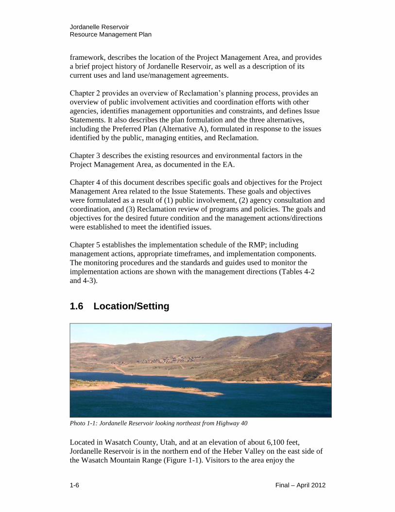
1.6 Location/Setting
Photo 1-1: Jordanelle Reservoir looking northeast from Highway 40
Located in Wasatch County, Utah, and at an elevation of about 6,100 feet,
Jordanelle Reservoir is in the northern end of the Heber Valley on the east side of
the Wasatch Mountain Range (Figure 1-1). Visitors to the area enjoy the

Jordanelle Reservoir Resource Management Plan
Final – April 2012 1-7
picturesque mountain setting as the reservoir is surrounded by rolling hills and
mountain peaks. It is part of a major recreation area that serves Wasatch and
Summit County residents and others seeking outdoor activities.
In addition to providing water for municipal and industrial needs, the reservoir
and surrounding lands provide wildlife habitat, flood control, enhanced water
quality, supplemental irrigation, and recreation opportunities.
The Project Management Area is located on Reclamation lands (across Township
(T). 2 S., Range (R). 4 E., sections 13, 24, 25, and 36; T. 2 S., R. 5 E., sections 7,
8, 17, 18, 19, 20, 23, 24, 25, 26, 27, 28, 29, 30, 31, 32, 33, 34, 35, and 36; T. 3 S.,
R. 4 E. section 1; and T. 3 S., R. 5 E., sections 4, 5, and 6.
Located in two intersecting
valleys, the reservoir has an
L-shaped configuration,
which divides the reservoir
into two arms. Its eastern arm
extends approximately five
miles from the dam to the
Provo River, and its northern
arm extends about four miles
from the dam to Ross Creek.
U.S. Highway 40 runs
adjacent to the northern arm
along the west shore of the
reservoir. State Route 32 runs
adjacent to the eastern arm
along the south shore.
Reclamation also acquired the land immediately next to the reservoir in order to
protect the reservoir’s resources from impacts of adjacent development. When
full, the open water of the reservoir covers approximately 3,024 surface acres.
Surrounding lands include approximately 3,680 acres including 2,937 acres
managed by State Parks, of which 968 acres have been developed for various
recreational and educational facilities, and the 743-acre West Hills WMA, which
is managed by UDWR. All recreational and educational facilities are currently
managed, operated, and maintained by State Parks.
1.7 Project History and Uses
The Central Utah Project (CUP) initially authorized the development of six
different units including Vernal, Jensen, Ute Indian, Uintah, Upalco, and
Bonneville. The Bonneville Unit, located on both sides of the Wasatch Mountains
in central and northeastern Utah, is the largest and most comprehensive water
Photo 1-2: Jordanelle Reservoir’s Primitive Shoreline
looking towards the East Arm

Jordanelle Reservoir Resource Management Plan
1-8 Final – April 2012
project in Utah’s history. The CUP allows Utah to beneficially use a large portion
of its allotted share of Colorado River water. The Bonneville Unit collects and
distributes water in both the Uintah Basin of eastern Utah, and the Bonneville
Basin of central Utah. The Bonneville Unit, which provides water for irrigation
and municipal and industrial uses, was divided into separate systems (Figure 1-2),
including the Municipal and Industrial (M&I) System, of which Jordanelle is a
part.
The M&I System consists of Jordanelle Dam and Reservoir, as well as the
Olmsted, Jordan, and Alpine Aqueducts, which deliver M&I water to Salt Lake
and northern Utah Counties.
Jordanelle’s primary purpose is to deliver municipal, industrial, and agricultural
water to Salt Lake, Utah, Summit (by exchange), and Wasatch Counties.
Secondary purposes include recreation, fish and wildlife, flood control, and
power. Power generation at Jordanelle Dam is authorized by DOI under a “lease
of power privilege”.
The purpose of the RMP is to identify management measures that enhance
resource management and achieve an improved future condition, at the same time
protecting the primary purpose and possibly enhancing the secondary purposes of
the project. Water operations including timing of deliveries, flood control, water
rights, water contracts, hydropower, and water quality would not be impacted in
any way by any proposed actions of this document.
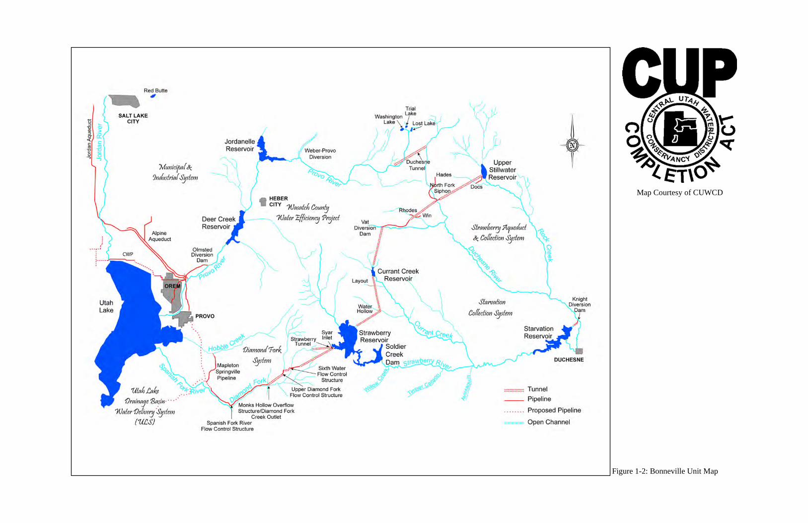
Figure 1-2: Bonneville Unit Map
Map Courtesy of CUWCD

This page is intentionally left blank
Jordanelle Reservoir Resource Management Plan
Final – April 2012 1-11
The construction of
Jordanelle Dam and
Reservoir, named after
an early pioneer in the
Heber Valley, John
Jordan, who settled his
family near where
Jordanelle Dam is
today, was authorized
under the Bonneville
Unit of the CUP. In
1979, Reclamation’s
Upper Colorado Region
completed a Final Environmental Statement (FES) for the Bonneville Unit, M&I
System. In response to strong opposition from environmental groups, the United
States and Utah Congressional Delegation conducted an in-depth investigation
and declared the Jordanelle Dam site to be geologically sound. The FES was
supplemented in 1987.
Construction of Jordanelle
Dam and Reservoir began in
1987 and was completed in
1993. The reservoir surface
area covers approximately
3,024 surface acres with a
depth of about 280 feet when
at full pool.
The reservoir was filled in July
1996. The State Park opened
for recreational use in 1995.
The dam is designed to
withstand an earthquake of
Richter scale magnitude 7.5 on the Wasatch Fault (19 miles west of the dam site),
and magnitude 6.5 for a local random earthquake directly below the dam.
Jordanelle Dam, owned by the United States, is administered by Reclamation and
operated by CUWCD.
From the project’s inception, recreation was an important component of the
design and overall management of the reservoir and surrounding lands. The initial
planning for Jordanelle State Park included three developed recreation areas and a
trail system known as the Perimeter Trail. Two of the areas, Hailstone and Rock
Cliff, were built in the early 1990’s. The third area, Ross Creek, has had limited
development. Private development around the reservoir rapidly grew between
1995 and 2007. However, the recent economic downturn has resulted in slower
growth and development.
Photo 1-3: Jordanelle Dam looking upstream
Photo 1-4: Jordanelle Dam looking East

Jordanelle Reservoir Resource Management Plan
1-12 Final – April 2012
The lands immediately surrounding the perimeter of the reservoir, and including
the reservoir, are referred to as the Project Management Area or lands within the
Project Management Boundary. These lands are shown on Figure 1-3.
1.7.1 Visitor Populations
Since 2003, the park has averaged 227,847 visitors annually. The peak annual
visitation during the past eight years (2003–2010) was 310,348 in 2007. The
lowest annual visitation was 122,169 in 2003. Visitation gradually increased each
year from 2003 to 2007 and has gradually declined each year since 2007.
Visitation in 2010 was 265,208. Peak monthly visitation occurs in July, and
almost 90% of the annual total (203,658) occurring during the five months of May
through September.
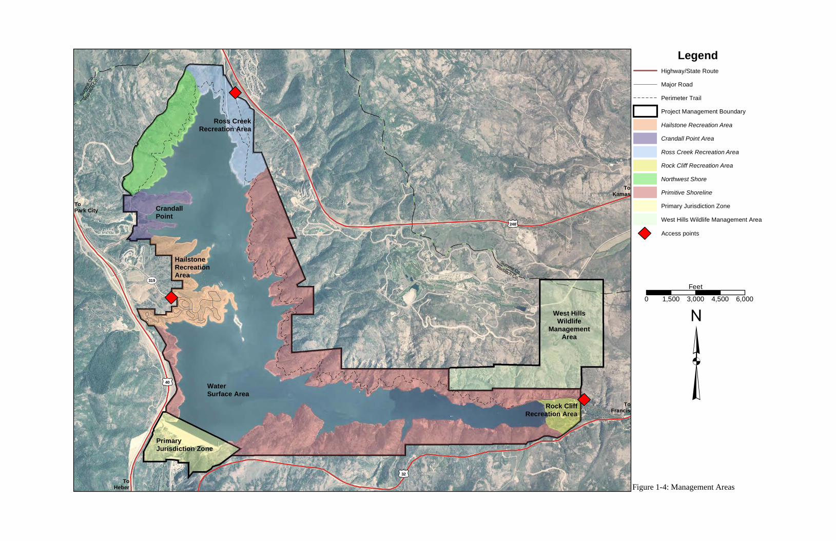
1.7.2 Reservoir Access Points
All Jordanelle lands and facilities are accessible to the public except those within
the Primary Jurisdiction Zone area. Reclamation and CUWCD have exclusive
access to the Primary Jurisdiction Zone for purposes of operation, maintenance,
and security of Jordanelle Project facilities.
Public vehicle access to the reservoir is provided at all recreation areas. Currently
there are three official access points to Jordanelle Reservoir, which include
Hailstone, Ross Creek, and Rock Cliff (Figure 1-4). Only Hailstone and Rock
Cliff have been developed with recreation facilities. Ross Creek and Crandall
Point were identified in the 1989 Jordanelle State Park Master Plan for future
development. Ross Creek has had minimal development. Public access to
Crandall Point is limited, due to easements granted to the Jordanelle Special
Service District (JSSD). A recent JSSD fence realignment provides a site for a
future access road to Crandall Point.
The 13-mile unpaved, non-motorized Perimeter Trail provides access to much of
the reservoir shoreline. The trail begins just north of Crandall Point on the west of
the reservoir and continues north along the west side of the reservoir to the Ross
Creek Recreation Area and then south along the east side of the reservoir to the
Rock Cliff Recreation Area (Figure 1-4). The trail is used by hikers, mountain
bikers, horse-riders, and cross-country skiers. Access to the Perimeter Trail is
provided at both Ross Creek and Rock Cliff, but not at Crandall Point.

LegendHighway/State RoutePerimeter Trail
County Line
Project Management BoundaryExisting Recreation Areas
³
Wasatch
Co.
Summit C
o.
0 0.25 0.5 0.75 1Miles
£¤40
£¤32
£¤248
TS319
West HillsWildlife
ManagementArea
ToPark City
ToHeber
ToFrancis
ToKamas
Figure 1-3: Project Vicinity Map
Exit 8MayflowerInterchange
Rock CliffRecreation Area
Ross CreekRecreation Area
CrandallPoint
HailstoneRecreation
Area

This page is intentionally left blank
LegendHighway/State RouteMajor RoadPerimeter TrailProject Management BoundaryHailstone Recreation AreaCrandall Point AreaRoss Creek Recreation AreaRock Cliff Recreation AreaNorthwest ShorePrimitive ShorelinePrimary Jurisdiction ZoneWest Hills Wildlife Management Area
³
Wasatch
Co.
Summ
it Co.
WaterSurface Area
0 1,500 3,000 4,500 6,000Feet
£¤40
£¤32
£¤248
TS319
West HillsWildlife
ManagementArea
Wasatch Co.
Summit Co.
PrimaryJurisdiction Zone
Figure 1-4: Management Areas
ToPark City
ToHeber
ToFrancis
ToKamas
Rock CliffRecreation Area
Ross CreekRecreation Area
CrandallPoint
HailstoneRecreationArea
Access points

This page is intentionally left blank
Jordanelle Reservoir Resource Management Plan
Final – April 2012 1-17
Current Reclamation contracts and policy prohibit exclusive access and use of
Jordanelle lands and recreation facilities.
Reclamation Manual Directives and Standards for Recreation Program
Management (LND 01-02) under Section 18 Private Exclusive
Recreational or Residential Use states: “New private recreation and
residential exclusive use, as defined in 43 CFR 429.2, is prohibited on
Reclamation lands.”
Section 18 of the June 2003 Memorandum of Agreement (MOA) between
the United States and State of Utah for the administration, operation,
maintenance and development of recreation at Jordanelle states: “New,
renewed, or modified contracts, concession contracts and permits will
include clauses that prohibit new exclusive use, and require existing
exclusive use, if any, to be phased out in accordance with an established
timetable.”
1.7.3 Existing Uses of Reservoir Lands
Jordanelle Reservoir offers an array of recreational opportunities, provides
wildlife habitat, and is a major water supply for industrial, municipal, and
irrigation uses.
Recreation is a major component of the project area and the reservoir is the main
draw for recreation. Jordanelle State Park opened June 29, 1995 and offers an
array of recreational opportunities, including: camping, picnicking, fishing,
boating, water sports, hiking, wildlife viewing, sailing, hunting, equestrian, and
mountain biking.
A survey in June-July 2010 indicated that 32-percent of respondents cited boating
as their primary activity followed by swimming, wading, or floating (10-percent),
fishing (8-percent), and water-sports involving being towed by a boat, such as
waterskiing, wakeboarding, tubing, and hydrofoil (8-percent). Eight percent also
indicated that they were at the park for non-recreation activities, including
gathering information, and to see the area. “Other” primary activities (6-percent)
included picking up or dropping off a boat, vehicle, or passenger, using the dump
station, and buying a season pass. Other primary visitation usage responses are
discussed in Section 3.9.2.
Reclamation developed three recreation areas that are currently operated by State
Parks. The three recreation areas (Figure 1-4) include the following:
Hailstone Recreation Area – The primary recreation area located on the
west shore of the north arm on US Highway 40 (Exit 8 to SR 319).
Rock Cliff Recreation Area – Located on the east end of the east arm, two
miles west of Francis on State Route 32.
Ross Creek Recreation Area – Located on the northeastern tip of the north
arm on State Route 248.
Jordanelle Reservoir Resource Management Plan
1-18 Final – April 2012
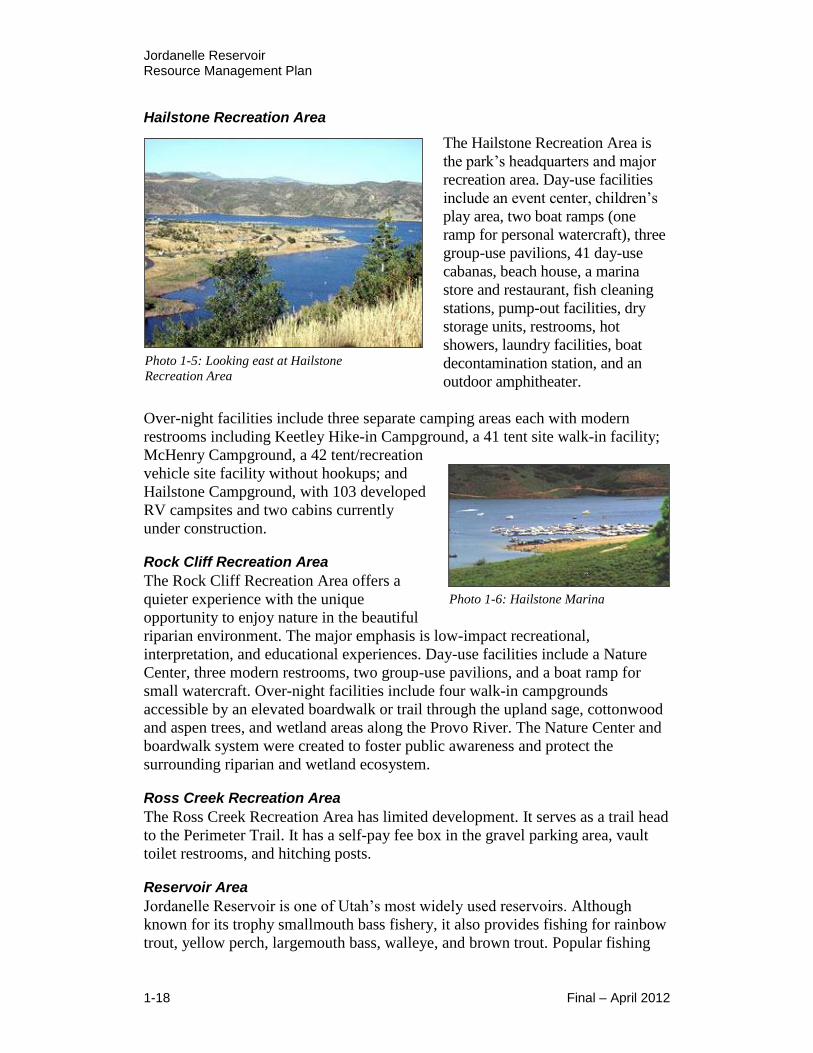
Hailstone Recreation Area
The Hailstone Recreation Area is
the park’s headquarters and major
recreation area. Day-use facilities
include an event center, children’s
play area, two boat ramps (one
ramp for personal watercraft), three
group-use pavilions, 41 day-use
cabanas, beach house, a marina
store and restaurant, fish cleaning
stations, pump-out facilities, dry
storage units, restrooms, hot
showers, laundry facilities, boat
decontamination station, and an
outdoor amphitheater.
Over-night facilities include three separate camping areas each with modern
restrooms including Keetley Hike-in Campground, a 41 tent site walk-in facility;
McHenry Campground, a 42 tent/recreation
vehicle site facility without hookups; and
Hailstone Campground, with 103 developed
RV campsites and two cabins currently
under construction.
Rock Cliff Recreation Area
The Rock Cliff Recreation Area offers a
quieter experience with the unique
opportunity to enjoy nature in the beautiful
riparian environment. The major emphasis is low-impact recreational,
interpretation, and educational experiences. Day-use facilities include a Nature
Center, three modern restrooms, two group-use pavilions, and a boat ramp for
small watercraft. Over-night facilities include four walk-in campgrounds
accessible by an elevated boardwalk or trail through the upland sage, cottonwood
and aspen trees, and wetland areas along the Provo River. The Nature Center and
boardwalk system were created to foster public awareness and protect the
surrounding riparian and wetland ecosystem.
Ross Creek Recreation Area
The Ross Creek Recreation Area has limited development. It serves as a trail head
to the Perimeter Trail. It has a self-pay fee box in the gravel parking area, vault
toilet restrooms, and hitching posts.
Reservoir Area
Jordanelle Reservoir is one of Utah’s most widely used reservoirs. Although
known for its trophy smallmouth bass fishery, it also provides fishing for rainbow
trout, yellow perch, largemouth bass, walleye, and brown trout. Popular fishing
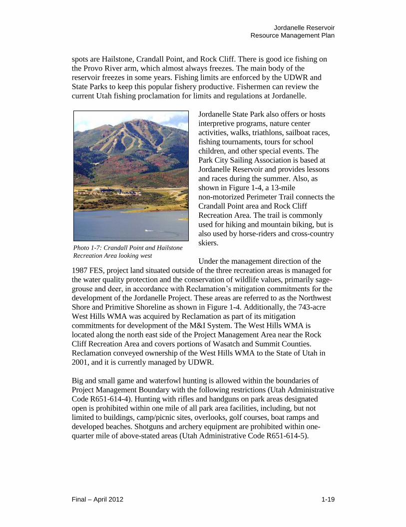
Photo 1-6: Hailstone Marina
Photo 1-5: Looking east at Hailstone
Recreation Area
Jordanelle Reservoir Resource Management Plan
Final – April 2012 1-19
spots are Hailstone, Crandall Point, and Rock Cliff. There is good ice fishing on
the Provo River arm, which almost always freezes. The main body of the
reservoir freezes in some years. Fishing limits are enforced by the UDWR and
State Parks to keep this popular fishery productive. Fishermen can review the
current Utah fishing proclamation for limits and regulations at Jordanelle.
Jordanelle State Park also offers or hosts
interpretive programs, nature center
activities, walks, triathlons, sailboat races,
fishing tournaments, tours for school
children, and other special events. The
Park City Sailing Association is based at
Jordanelle Reservoir and provides lessons
and races during the summer. Also, as
shown in Figure 1-4, a 13-mile
non-motorized Perimeter Trail connects the
Crandall Point area and Rock Cliff
Recreation Area. The trail is commonly
used for hiking and mountain biking, but is
also used by horse-riders and cross-country
skiers.
Under the management direction of the
1987 FES, project land situated outside of the three recreation areas is managed for
the water quality protection and the conservation of wildlife values, primarily sage-
grouse and deer, in accordance with Reclamation’s mitigation commitments for the
development of the Jordanelle Project. These areas are referred to as the Northwest
Shore and Primitive Shoreline as shown in Figure 1-4. Additionally, the 743-acre
West Hills WMA was acquired by Reclamation as part of its mitigation
commitments for development of the M&I System. The West Hills WMA is
located along the north east side of the Project Management Area near the Rock
Cliff Recreation Area and covers portions of Wasatch and Summit Counties.
Reclamation conveyed ownership of the West Hills WMA to the State of Utah in
2001, and it is currently managed by UDWR.
Big and small game and waterfowl hunting is allowed within the boundaries of
Project Management Boundary with the following restrictions (Utah Administrative
Code R651-614-4). Hunting with rifles and handguns on park areas designated
open is prohibited within one mile of all park area facilities, including, but not
limited to buildings, camp/picnic sites, overlooks, golf courses, boat ramps and
developed beaches. Shotguns and archery equipment are prohibited within one-
quarter mile of above-stated areas (Utah Administrative Code R651-614-5).
Photo 1-7: Crandall Point and Hailstone
Recreation Area looking west

Jordanelle Reservoir Resource Management Plan
1-20 Final – April 2012
1.8 Land Use/Management Agreements
Management agreements identify and define management and agency jurisdiction
and responsibility for the use and protection of resources within the Project
Management Boundary. Several agreements are currently active that could
influence Reclamation’s management of the Project Management Area, which
include the following active management agreements.
Memorandum of Agreement for Administration, Operation, Maintenance, and
Development of Recreation at Eleven Utah Reservoirs
Contract No. 01-LM-40-02110, Dated 06/2003
In June 2003, the United States of America entered into a MOA with the State of
Utah for the administration, operation, maintenance, and development of public
recreation and recreation facilities at eleven Reclamation reservoirs in Utah,
including Jordanelle Reservoir. In this agreement, the United States is represented
by Reclamation’s Provo Area Office. The State of Utah is represented by State
Parks and UDNR.
The primary purpose of the agreement was to transfer responsibility from the
United States to the State of Utah for the administration, operation, maintenance,
and development of public recreation, recreation facilities, and related
responsibilities, in order to provide for public use and enjoyment of the reservoir
areas consistent with project purposes. The federal land and water areas defined in
the agreement are referred to as the Project Management Boundary in the RMP
and EA, excluding the Primary Jurisdiction Zone (Figure 1-3). The Primary
Jurisdiction Zone includes the reservoir areas surrounding the dam, outlet works,
feeder canals, and distribution works.
Management within the Primary Jurisdiction Zone is the responsibility of
CUWCD with oversight by Reclamation to provide proper operation,
maintenance, and protection of project facilities, including but not limited to the
dam and appurtenant works. CUWCD operates the reservoir for distribution of
municipal, industrial, and agricultural water; recreation; fish and wildlife; flood
control; and power. The agreement acknowledges that Reclamation and CUWCD
have and reserve the right to vary the reservoir level as necessary for project
purposes. It also requires State Parks to coordinate with Reclamation and
CUWCD on any activity that could affect any of their management, operation,
and maintenance activities within the reservoir area.
The agreement states that the management, operation, and maintenance of the
reservoir area should follow an approved Resource Management Plan. The RMP
should be prepared by Reclamation in cooperation with State Parks, CUWCD,
and other appropriate federal, state, and local entities. This RMP meets that
requirement.
Jordanelle Reservoir Resource Management Plan
Final – April 2012 1-21
With respect to soil and water conservation, State Parks and Reclamation will, in
cooperation with CUWCD, take all reasonable measures necessary to minimize
siltation and erosion; protect land and water resources; prevent and suppress fire;
protect against introduction and spread of noxious weeds and other pests
detrimental to natural values, agriculture or public health and safety; and will
cooperate in soil and water conservation, and fish and wildlife enhancement
practices.
With respect to private development and use within the Project Management
Boundary, the agreement allows State Parks to enter into third party contracts in
order to carry out the functions of State Parks relating to recreation and related
administration, operations, maintenance, and development. Such contracts or
concession contracts would include clauses that prohibit exclusive use. Any
contract with duration longer than one year would need to be approved by the
manager of the Provo Area Office.
West Hills Wildlife Management Area Operating Agreement
Contract No. N/A, Dated 11/18/1992
The West Hills WMA, located adjacent to the Jordanelle Reservoir’s Project
Management Boundary and comprising of 743 acres, was acquired by Reclamation
as part of their wildlife mitigation responsibilities for development of the M&I
System. On November 18, 1992, Reclamation entered into an Operating Agreement
with UDWR, which was submitted in accordance with a Memorandum of
Understanding for land and water acquisition for the CUP. The purpose of this
agreement was to identify the necessary improvements in order to meet the
mitigation requirements. Cooperative Agreement No. 3-FC-40-14360 dated
6/25/1993 provided a funding mechanism for UDWR to implement them.
Following completion of the requirements, the West Hills WMA was quitclaimed
from Reclamation to the State of Utah for long-term ownership in 2001 via
Contract No. 01-LM-40-02050. The area is now managed and operated by UDWR.
According to the agreement, UDWR’s main objectives for the West Hills WMA
are to improve habitat for the big game (deer and elk) and sage-grouse, protection
for golden eagle breeding and nesting habitat, development of public access to
include parking areas, fencing as needed for the UDWR’s management,
informational signing, and terrestrial habitat improvements including water
developments and range improvements. These objectives are consistent with
Reclamation’s mitigation commitments. Reclamation was responsible for funding
the management objectives, and the UDWR is now responsible for the long-term
management and operation of the WMA.
Deer Creek/Jordanelle Operating Agreement
Contract No. 94-07-40-R1690, Dated 11/01/1994
On November 1, 1994, the United States, represented by Reclamation, entered
into a contract agreement with Provo Reservoir Water Users Association
(PRWUA) and CUWCD to coordinate operations of Jordanelle Reservoir and

Jordanelle Reservoir Resource Management Plan
1-22 Final – April 2012
Deer Creek Reservoir in accordance with the Provo River Project water rights and
the Bonneville Unit water rights. The primary purposes of the agreement is to
fully utilize the yield of the Provo River Project and Bonneville Unit waters for
use of PRWUA and its stockholders without adversely affecting the rights of
CUWCD and its petitioners, and without impairing the existing water rights in the
Provo River, Weber River, Duchesne River, and Utah Lake.
Washington Lake Reservoir/Jordanelle Reservoir Contract Agreement
Contract No. 95-07-40-R1800, Dated 08/04/1995
On August 4, 1995, the United States, represented by Reclamation, entered into a
contract agreement with Provo Reservoir Water Users Company, Wasatch
Irrigation Company, Timpanogos Irrigation Company, and Extension Irrigation
Company, for the exchange of storage water from Washington Lake Reservoir to
Jordanelle Reservoir.
Exchange Agreements for Storage Water in Jordanelle Reservoir
Dated 02/10/1998
Several agreements were entered into with Provo Reservoir Water Users
Company, Provo City Corporation, Washington Irrigation Company, Timpanogos
Irrigation Company, and Wasatch Irrigation Company for the exchange of storage
water from the fifteen small reservoirs at the headwaters of the Provo River in
Jordanelle Reservoir. These reservoirs include Big Elk, Crystal, Duck, Fire,
Island, Long, Lost, Marjorie, Pot, Star, Teapot, Trial, Wall, Washington, and
Weir.
Metropolitan Water District of Salt Lake City and JSSD Agreement
Contract No. N/A, Dated 12/01/1997
On December 1, 1997, the Jordanelle Special Service District (JSSD) entered into
an agreement with Metropolitan Water District of Salt Lake City for the sale and
use of untreated surplus water.
Jordanelle Special Service District Contract and Grant of Easements
Contract No. 6-LM-41-06810, Dated 09/24/1998
On September 24, 1998, the United States, represented by Reclamation, entered
into a contract and granted easements to JSSD. The perpetual easements include
construction, operation, and maintenance of a wastewater collection system.
Although JSSD facilities are on private property, the easements allow JSSD to
cross Reclamation land. The two easements are for a pipeline (Ontario Drain
Tunnel) and a stockpiling area.
Provo Area Office Access Management Policy for Jordanelle Reservoir
Approved on 4/18/2000
In July 1999, a committee was formed by the Board of State Parks to develop a
planning method to address recreation/access proposals by the private sector. The
committee developed a draft policy on January 21, 2000. The policy was
Jordanelle Reservoir Resource Management Plan
Final – April 2012 1-23
presented at a public open house on March 14, 2000 and approved by the State
Parks Board on April 18, 2000. The main points of the access policy are:
Access will only be allowed at officially designated points
Private, exclusive access to Jordanelle will not be allowed
Review and approval of access applications is dependent on the
standards set by NEPA environmental statements and the Jordanelle
State Park Master Plan
Costs associated with reviewing and processing applications, including
the appropriate level of NEPA compliance, will be borne by the
applicant
Unapproved use and access will be investigated and eliminated
Other Agreements pertaining to Jordanelle Reservoir include:
Contract # Type of
Agreement Applicant
Term of
Agreement Date
Expiration
Date 99-LM-41-00140 License Park City
Mines Co. 5 yrs. 11/1999 Expired
04-LM-41-0250 License Utah Power 10 yrs. 8/23/2004 8/2014
04-LM-41-0610 License PacifiCorp 50 yrs. 8/4/2004 8/2054
09-LM-41-0790 License CUWCD 25 yrs. 3/16/2010 3/2035
11-LM-41-0570 License Chevron
Pipe Line
Co.
25 yrs. Pending –
Waiting for
Signatures

Jordanelle Reservoir Resource Management Plan
1-24 Final – April 2012
This page is intentionally left blank

Jordanelle Reservoir Resource Management Plan
Final – April 2012 2-1
Chapter 2: Planning Process
The planning process for the Jordanelle Reservoir RMP was initiated in
September 2010. The planning process included agency coordination and public
involvement. During the RMP scoping process, various issues, constraints and
opportunities associated with the management of resources and recreation at
Jordanelle Reservoir were identified. These were evaluated and considered as
part of project alternative development. However, not all opportunities were
included in the alternatives, as some minor maintenance items can be completed
outside the RMP. These issues were classified into categories to aid in
understanding the scope of each concern and to assist in developing the Issue
Statements described in this chapter.
2.1 Introduction
The RMP provides a 10-year framework for the orderly, coordinated development
and management of the land and recreation resources under Reclamation
jurisdiction within the Project Management Boundary. The RMP should be
re-evaluated when needed within the 10-year period, and if necessary, it should be
revised to reflect changing conditions and objectives. This RMP is based on
resource conditions that were presented in the 1979 M&I System FES and 1987
FS to the M&I System FES and other existing information and data that pertain to
the Project Management Area. The RMP presents enough detail to direct future
work development and use of resources in the Project Management Area based on
existing information prepared for the project area. However, the RMP cannot
provide site-specific analysis and resource management assessments due to data
gaps or lack of current data for existing baseline conditions. Therefore, it will be
necessary in the future to determine the current baseline conditions for any
proposed action requiring NEPA compliance.
2.2 RMP Guidelines
The planning process is outlined in Reclamation’s RMP Guidebook as follows:
1. Identification of issues, opportunities, and constraints
2. Development of planning criteria
3. Inventory data and information collection
4. Analysis of resources and management framework
5. Formulation of alternatives
6. Evaluation of alternatives
Jordanelle Reservoir Resource Management Plan
2-2 Final – April 2012
7. Selection of Preferred Alternative
8. Preparation of a final RMP and NEPA document
9. Implementation and monitoring of an RMP
10. Amendment and revisions of an RMP
During the preparation of the RMP and EA documentation, each step of the
planning process was implemented in sequential order. The identification of
issues, opportunities, and constraints was developed after a meeting involving all
interested agencies and revised after the first public meeting. The planning
criteria was developed and posted on the internet for public review and comment.
Alternatives presented in the EA reflect input from the public, state and federal
agencies, and existing documentation (from various agencies). The development
of alternatives is accompanied by an analysis of environmental impact and
mitigation measures, which are presented in the EA for compliance with NEPA
regulations. The alternatives presented and evaluated are as follows:
1. No Action Alternative
2. Alternative A – Moderate Resource Development
3. Alternative B – Maximum Resource Development
The selection of the Preferred Alternative is presented in Section 2.6.
2.3 Public Involvement
Several approaches were used to assist with issue development for the
management of resources in the Project Management Area. These included the
formation of a Coordination Team, the creation of a project website, and holding
two public meetings. Media releases were used to inform the public of the
scheduled public meetings.
2.3.1 Agency Consultation and Coordination
Coordination Team
An important phase of public involvement includes coordination with managing
entities and stakeholders. The accuracy of the RMP and EA depend highly on
input provided from all interested parties. Coordination Team members consisted
of representatives from the primary stakeholders; Reclamation, CUWCD, DOI-
CUPCA office, State Parks, Mitigation Commission, UDWR, USFWS, and
Wasatch County.
Several Coordination Team meetings were held throughout the development of
the RMP. Their purpose was to compile available documents; discuss issues,
opportunities and constraints; and develop the project alternatives identified in the

Jordanelle Reservoir Resource Management Plan
Final – April 2012 2-3
EA. The Coordination Team was given the opportunity to review the RMP and
EA documents prior to public release.
Utah State Historic Preservation Office
Reclamation submitted a determination of no historic properties affected for the
Jordanelle Reservoir RMP and EA to the SHPO in March 2011. The SHPO
concurred with Reclamation’s determination in a letter dated March 23, 2011.
Native American Tribes
Reclamation conducted Native American consultation throughout the public
involvement process. Consultation letters were sent to the Ute Indian Tribe of the
Uintah and Ouray Reservation and the Northwestern Band of Shoshoni Nation of
Utah in March 2011. This consultation was conducted in compliance with 36
CFR 800.2(c)(2) on a government-to-government basis. Through this effort, each
tribe is given a reasonable opportunity to identify any concerns about historic
properties; to advise on the identification and evaluation of historic properties,
including those of traditional religious and cultural importance; to express their
views on the effects of the proposed action on such properties; and to participate
in the resolution of adverse effects. No responses were received from the tribes.
Utah Geological Survey
Reclamation requested a paleontological resource file search from Martha
Hayden, Paleontological Assistant with the UGS in March 2011. The purpose of
the file search was to identify any paleontological resources within or near the
Project Management Boundary. File search results and recommendations from
the UGS were received in a letter dated March 7, 2011.
Bureau of Indian Affairs
Reclamation contacted the Bureau of Indian Affairs (BIA) Uintah and Ouray
Agency in Fort Duchesne, Utah and the Fort Hall Agency in Fort Hall, Idaho
regarding potential impacts to Indian Trust Assets (ITA) near or within the Project
Management Boundary. No responses were received from either BIA agency.
2.3.2 Public Involvement
Public participation is an important element of both development of the RMP and
the EA. Public comments were considered in the draft preparations of the RMP
and EA and the documents were made available on the internet for public review
and comment between September 15 and November 15, 2011.
Public Meetings
Prior to the preparation of the RMP and EA, Reclamation held a public meeting
on November 4, 2010 to present the purpose and process for developing the RMP
and EA. The meeting provided an opportunity for members of the public to ask
questions concerning the project and provide oral comments. An additional two
weeks were given to provide written comments. A second meeting was held on

Jordanelle Reservoir Resource Management Plan
2-4 Final – April 2012
October 27, 2011, during the public comment period for the RMP and EA. The
public meetings were held at the Jordanelle State Park Hailstone Event Center.
World Wide Web
To facilitate public involvement, a project website
(http://www.jordanellermp.com) was created and maintained during the
preparation of the RMP and EA.
2.4 Management Constraints and Opportunities
2.4.1 Constraints
As explained in other sections of this report, the primary purpose of Jordanelle
Reservoir is to store and deliver water for municipal, industrial, and agricultural
purposes. Secondary purposes include recreation, fish and wildlife, flood control,
and power. Reclamation and/or CUWCD have entered into water delivery,
power, flood control and other contracts to implement these project purposes.
Therefore, management opportunities identified in this RMP must:
Protect the primary purpose of the Jordanelle Project to deliver water for
municipal, industrial, and agricultural purposes;
Protect the secondary purposes of the Jordanelle Reservoir, which include
recreation, fish and wildlife, flood control, and power;
Protect water quality;
Honor existing contracts and agreements, including but not limited to
water delivery, flood control, and power contracts; and
Protect the ability of Reclamation and/or CUWCD to enter into future
contracts with third-party entities to enhance the primary and secondary
project purposes within Reclamation law and the scope and authorization
of the Jordanelle Project.
Agencies are constrained by their respective legislative authorities, budgets,
personnel, current policies, and environmental limitations when addressing
management changes and other actions. The ability of agencies to manage
environmental and recreational resources will always depend on maintaining
sufficient personnel, and on the ability of the agencies to obtain adequate funding
to operate and maintain facilities and programs, as well as to protect and enhance
existing opportunities and resources.
2.4.2 Opportunities
Opportunities exist in the Project Management Area to enhance, protect, and
interpret the natural resources of the area, and to provide a range of recreation
opportunities and facilities while avoiding significant adverse effects to existing
natural resources. Opportunities cannot affect the constraints. Identified

Jordanelle Reservoir Resource Management Plan
Final – April 2012 2-5
opportunities by the public and involved agencies during the public involvement
process include:
Providing high quality recreation opportunities that have minimal
operation and maintenance costs and assist the park in becoming
financially self-sufficient.
Retrofitting existing recreation facilities to eliminate functional
deficiencies and more fully meet public expectations.
Developing new facilities and infrastructure that are well designed, well
maintained, appropriately budgeted, feasibly staffed, and consistent with
the area’s natural aesthetics.
Maintaining the area’s natural landscape and visual resources.
Providing educational opportunities and fostering public awareness for
natural resources conservation and protection.
Conserving wildlife habitat values in accordance with Reclamation’s
existing mitigation commitments.
Protecting federally-listed threatened and endangered species and
conserving habitat for other species of special concern.
Protecting against the introduction and spread of noxious weeds and
invasive aquatic species.
Protecting wetlands values.
Protecting, preserving, restoring, recognizing, and interpreting cultural and
paleontological resource sites.
Developing and providing controlled access to the reservoir water,
shoreline, and trails.
2.5 Issue Statements
The following Issue Statements provide detailed discussions of the primary issues
or opportunities identified above. The Issue Statements are intended to clarify the
scope of each concern, but some may reflect “perceptions” rather than factual data
due to the process of representing both public and partners’ opinions. The Issue
Statements provide the foundation for the development of RMP goals and
objectives and are divided into the following Issue Categories: (A) Partnerships,
(B) Water Resources, (C) Recreational and Visual Resources, (D) Natural,
Cultural, and Paleontological Resources, (E) Public Information, Health and
Safety, (F) Land Management, and (G) Project Facilities.
Jordanelle Reservoir Resource Management Plan
2-6 Final – April 2012
2.5.1 Issue Category A: Partnerships
Issue A1: Partnership Contracts
Existing contracts should be considered and protected before defining secondary
public roles and responsibilities of involved entities to ensure proposed actions
are consistent with contractual and legal obligations. Opportunities for improving
resource management among the managing partners are an ongoing issue as
demands on resources change. No specific opportunities were identified in this
RMP, however, opportunities will be evaluated as each management agreement
expires and is renewed. The possibility of additional partnerships that could
mutually improve management of lands within the Project Management Boundary
should be explored.
2.5.2 Issue Category B: Water Resources
Issue B1: Water Quality
To minimize water quality impacts from additional development and increased
use, Reclamation will continue to monitor Jordanelle Reservoir, and new facilities
will be designed to prevent increased water quality impacts. Site specific NEPA
compliance will need to occur to prevent water quality impacts due to a specific
project.
Issue B2: Water Operations
The primary purpose of Jordanelle Reservoir is to store water. As such, the water
surface level of the reservoir fluctuates from month to month and year to year in
response to reservoir inflow and calls for water. The water level fluctuates
annually from a high in late-May and early-June to a low in late-March or early-
April to meet water demands that peak during the summer months. The reservoir
level fluctuates even more dramatically over extended drought periods as inflow
decreases and calls for water increase. This wide range of fluctuation may have
adverse impacts on recreation and other resources in the area, particularly during
extended drought periods.
Secondary purposes of Jordanelle Reservoir include recreation, fish and wildlife,
flood control, and power. As stated above, the reservoir is operated first for water
supply and second for the benefit of these other important project purposes. For
example, power is generated on the water that is released for water supply rather
than releasing water to optimize power generation. Recreation and fish and
wildlife benefits are derived as the reservoir is operated for water supply. Flood
control operation of the reservoir is managed with the intent to not adversely
impact the water supply.
The water level can also fluctuate above the normal water elevation of 6166.4 feet
when the exclusive flood control portion of the reservoir capacity is utilized.
Under flood control conditions, the water level could reach 6182 feet, at which
point State Parks facilities could be inundated.
Jordanelle Reservoir Resource Management Plan
Final – April 2012 2-7
Even though widely fluctuating water surface levels may adversely affect recreation
or other important resources in the area, all alternatives considered in this RMP
assume the reservoir will continue to operate as it was designed to operate, and will
continue to meet project purposes and honor all existing contracts and agreements
with respect to water deliveries and operations.
There are a number of alternatives that will enhance resources of the area while
protecting the primary and secondary purposes of the project. These were
considered in the EA and are included in the Preferred Plan presented in Chapter 4.
2.5.3 Issue Category C: Recreational and Visual Resources
Issue C1: Recreation Development
Recreation is a secondary but very important purpose of Jordanelle Reservoir.
The greatest constraints to meeting growing and changing recreation needs at
Jordanelle are funding and fulfillment of existing wildlife mitigation
commitments. The State Parks budget, as already stated, is limited and prospects
for increases in funding are not likely. Reclamation is limited in what it can do.
Future funding will therefore need to come through the State Park’s annual budget
process, from private sources, or grants from federal or state sources.
There is a strong desire by State Parks to attain financial self-sufficiency as there
have been reductions in park operational funding in recent years and more
reductions are likely in the future. All planning associated with preparation of
this RMP has focused on actions that help the park increase revenues or reduce
expenses to become more financially stable.
Reclamation has a mitigation commitment to ensure that the management of the
Project Management Area, including recreational use, is conducive for maintaining
wildlife values within the Project Management Boundary. Reclamation also has a
mitigation commitment to consult with USFWS and appropriate state agencies for
land use plans within the Project Management Boundary.
Issue C2: Jordanelle Reservoir Opportunities
Public input identified additional opportunities for recreation at and around the
reservoir, such as creating educational opportunities, allowing access to the
Perimeter Trail from other trail systems, maintaining the existing wakeless use
areas for beaches and non-motorized watercraft use, construction of a public golf
course, development of sport fields and day-use facilities, and pursuing concession
opportunities (e.g., cross country ski trails and rentals, snowshoeing, wake tow
cable park, winter tubing, bike, non-motorized boat and/or horse rentals).
Issue C3: Jordanelle State Park Facilities
Reclamation constructed the recreation facilities as part of the Jordanelle Project,
and State Parks manages, operates, and maintains the facilities. Reclamation and
Jordanelle Reservoir Resource Management Plan
2-8 Final – April 2012
State Parks have a strong interest in ensuring that the facilities are properly
maintained and continue to provide quality long-term recreational opportunities
for the public. A number of needs and opportunities were identified during the
RMP scoping process. These are described under the following categories:
Upgrade Existing Facilities – Most of the recreational facilities at
Jordanelle Reservoir were constructed in the early 1990’s as part of the
Jordanelle Project. Significant changes have occurred in both population
and public expectations to the point that State Parks would like to modify
and renovate existing facilities to more fully meet the growing and
changing demands of the public. For example, the Hailstone Recreation
Area needs improvements to maintain its current visitation levels. Of
particular concern is the park entrance/fee station, which only has one
lane. Vehicles are often backed up ¼ mile from the entrance.
Develop New Facilities – Jordanelle State Park is one of the most popular
water recreation parks in the state. State Parks would like to maintain this
high public approval rating and expand park facilities to provide an even
greater variety and quality of services in the future. State Parks has also
been approached by private business partners who have offered to assist
with recreation development and management. State Parks and
Reclamation need to evaluate these offers in context with their overall
mission and goals.
Issue C4: Use Conflicts
Jordanelle Reservoir experiences conflicts between boaters, personal watercraft
users, sailors, and anglers due to the fact that premium fishing and/or sailing
months typically coincide with the high-use boating season. Boating management
goals should be implemented by the Recreation Park Manager including use of
designated wakeless zones to help minimize such conflicts. Maintaining wakeless
zones include the marina and beach area at Hailstone Recreation Area, the beach
area at Ross Creek Recreation Area, and the small boat launch at Rock Cliff
Recreation Area. Visitor-use surveys, reviews of the state boating regulations and
boating plan, and fish and wildlife habitat consultations with USFWS and UDWR
will help to determine what is desired and allowed. Swimming and diving in
unregulated areas of the reservoir also need to be addressed.
Issue C5: Visual Quality
A number of comments gathered during the scoping process suggested a strong
need to protect the natural beauty of the area. The beauty in all areas was
mentioned, but particularly in the Ross Creek and Rock Cliff Recreation Areas.
Jordanelle Reservoir Resource Management Plan
Final – April 2012 2-9
2.5.4 Issue Category D: Natural, Cultural, and Paleontological Resources
Issue D1: Noxious and Invasive Weeds
There are concerns with the spread and proliferation of noxious and invasive
weeds in the Project Management Area. Assistance is needed to control these
weed species. At a minimum, spraying for noxious and invasive weeds along
trails is an important element for the maintenance of the Perimeter Trail.
However, spraying is also needed on lands within the Project Management
Boundary. Wasatch County has a noxious weed department. The County
identifies 27 noxious weeds that need to be controlled. A newly established
organization, Wasatch County Cooperative Weed Management Area, was set up
to obtain federal, state, and/or private grant funds for the purpose of controlling
noxious weeds within the County. This organization may be a collaborative
resource for controlling noxious and invasive weeds at Jordanelle Reservoir.
Issue D2: Wildlife
The development of certain recreational facilities and changes in recreational land
use could result in impacts to wildlife that would require changes to the mitigation
commitments that Reclamation made in its 1979 M&I System FES and 1987 FS
to the M&I System FES. There is a need to evaluate the current and possible
future status of fulfillment of the 1987 Wildlife Mitigation Plan (1987 WMP) for
the Bonneville Unit of CUP. The original plan was predicated on certain
assumptions; among them that the bulk of the lands within the Project
Management Boundary, exclusive of the three recreation areas specifically, will
be managed in a manner that would be conducive for maintaining wildlife values,
including sage-grouse, deer and other wildlife. In addition, the West Hills WMA
was purchased to partially mitigate remaining wildlife habitat impacts of the
Bonneville Unit; specifically, sage-grouse and golden eagle impacts tied to the
construction and operation of Jordanelle Reservoir.
The 1987 mitigation commitment for land within the Project Management
Boundary, excluding the West Hills WMA, reads: “to protect wildlife values,
public access and construction activities will be restricted on designated lands in
and around the reservoir basin. The Fish and Wildlife Service and appropriate
state agencies will be consulted on use plans for lands within the Project
Management Boundary.” The 1987 commitment was to use the West Hills WMA
for sage-grouse and golden eagle protection. Big game winter habitat was added
in the 1992 operating agreement. The West Hills WMA can probably still
function for the golden eagle protection, but may be too small and isolated for
sage-grouse and big game, particularly if human disturbance from winter
recreation encroaches on crucial winter deer and elk habitat within the Project
Management Boundary and other lands adjoining the West Hills WMA.
The purpose and mission of the West Hills WMA should be reviewed as
substantial development of lands near the area has reduced its effectiveness in

Jordanelle Reservoir Resource Management Plan
2-10 Final – April 2012
accomplishing intended wildlife mitigation objectives. Also, with the proposed
future changes in management emphasis of the lands within the Project
Management Boundary, as per the outcome of this RMP, adjustments in wildlife
mitigation commitments and fulfillment may be required.
There is currently a lack of baseline natural resource inventories and biological
surveys that will be necessary to develop site-specific strategies and adaptive
management plans for protecting natural resources. Funding is the main
constraint. Reclamation could partner with other federal, state and local
governmental agencies, academic institutes and non-government organizations to
pool resources for the completion of baseline inventories and surveys.
The greatest constraints for maintaining mitigation commitments will be changes
in both on-site and off-site land use and development that may create additional
barriers for wildlife movement corridors and further isolate the West Hills WMA
from surrounding wildlife areas. Opportunities exist to minimize recreational
development and human disturbances, particularly winter activities, and place a
protective buffer around the perimeter of the West Hills WMA, but this will likely
limit opportunities for certain recreational activities.
Issue D3: Reservoir Fishery
Maintaining a good fishery, in cooperation with UDWR, at Jordanelle Reservoir
is very important because the quality of fishing has a direct effect on State Park
visitation.
Issue D4: Provo River at Rock Cliff Recreation Area
A thorough analysis of the facilities along the Provo River is needed. Channel
migration and flooding have impacted lands, facilities, and the on-going budget of
managing and correcting these impacts. Each spring, State Parks responds to
natural conditions that may damage facilities, often times at a large price tag.
Coordination with PRWUA could provide helpful information as they have
developed and are implementing an Upper Provo River maintenance program to
help mitigate flood impacts above the Jordanelle Reservoir outside the Project
Management Boundary.
Issue D5: Aquatic Invasive Species
Protecting against the introduction and spread of aquatic invasive species is of
primary importance. The Utah Aquatic Invasive Species Task Force has prepared
the 2010 Utah Aquatic Invasive Species Management Plan that deals with aquatic
invasive species, such as Dreissena mussels (quagga and zebra). The plan
includes decontaminating personal water crafts and boaters must be prepared to
complete a decontamination certification form. Hailstone Recreation Area has a
decontamination station and certified technician, both of which are needed at the
Rock Cliff Recreation Area.
Jordanelle Reservoir Resource Management Plan
Final – April 2012 2-11
Issue D6: Threatened, Endangered, and Special Status Species and Sensitive Habitats
The potential effects to federally-listed threatened and endangered species and
other special status species should be evaluated, including effects to sensitive
habitats. Natural resources that need to be protected include:
Sensitive riparian and wetland habitats.
Threatened and endangered species, and species of special concern, that
could be found in the Project Management Area, including: Ute Ladies’-
tresses (threatened plant species), sage-grouse (candidate species), and the
Columbia Spotted Frog (Conservation Agreement species).
Sensitive breeding and nesting areas for migratory birds.
In order to protect sensitive riparian and wetland areas, a protective buffer could
be placed around these habitats to minimize the potential for recreational
encroachment and human disturbances.
Issue D7: Soil Erosion and Deposition
Bank erosion is appearing in certain areas of Jordanelle Reservoir, including
major erosion problems at the Ross Creek Recreation Area largely due to the lack
of formal angler access to the reservoir. Erosion control and re-vegetation plans
will be developed and implemented in project-specific NEPA compliance. When
constructing roads and trails, steep slopes and areas already prone to landslides
should be avoided where possible. Specific measures to stabilize landslide
potential slopes will need to be identified in the project-specific NEPA
compliance.
Issue D8: Cultural Resources
Cultural resource sites have been previously identified within or near the Project
Management Boundary. As proposed development occurs, the identification,
management, and interpretation of any cultural resources within the Project
Management Boundary will be completed.
Issue D9: Paleontological Resources
No paleontological resource sites have been previously identified within or near
the Project Management Boundary. As proposed development occurs, the
identification, management, and interpretation of any paleontological resources
within the Project Management Boundary will be completed.
2.5.5 Issue Category E: Public Information, Health and Safety
Issue E1: Public Information
To optimize the value and safety of the visitor experience, considerable
information must be available to the public on a continuing basis, such as:
reservoir elevations, usability of boat ramps and other park facilities, fishing rules
and regulations, rules and regulations governing safe use of the facilities, etc.
Jordanelle Reservoir Resource Management Plan
2-12 Final – April 2012
Managing entities must have adequate funding in order to perform the appropriate
level of public information and dissemination, which takes place through the use
of various media, including the internet, brochures, radio, pamphlets, maps, etc.
Each managing partner has the opportunity and responsibility to inform the public
relative to the partner’s specific management area of responsibility.
Issue E2: Health and Safety
Adequate law enforcement must also be provided. A clear delineation of law
enforcement responsibilities between State Parks and Wasatch County must also
be understood. State Parks has the responsibility for maintaining recreation
facilities to ensure they are in a safe condition. Managing entities must have
adequate funding to perform the appropriate level of facility maintenance and law
enforcement responsibilities. Several alternatives address recreation facility
operation and maintenance.
2.5.6 Issue Category F: Land Management
Issue F1: Management Responsibilities
Applying management responsibilities throughout the area will improve the
ability of the managing partners to properly manage the lands. There are
significant potential recreation opportunities in the Ross Creek and Crandall Point
areas that could be better managed. These areas currently have minimal or no
recreation facilities and have minimal visitation. Properly planning and
implementing recreation facilities in these areas have the potential to improve
land management of the area, respond to private business partner requests,
increase recreational opportunities for the public, and increase revenue to State
Parks. Management actions to address these opportunities are included in Chapter
4 as part of the Preferred Plan.
Issue F2: Development
Developers in the Ross Creek area and the area northwest of Crandall Point have
proposed development of recreation facilities by private entities for public use on
Reclamation land. There is a need to evaluate the mission of recreation in these
areas and identify a process for addressing the area’s development and
management needs.
Issue F3: Access
Managing access to the reservoir has been a significant issue for Reclamation and
State Parks from the onset of the Jordanelle Project. Reclamation law and policy
restricts exclusive private access to, or use of, Reclamation lands and facilities to
protect water quality, natural resources, and reduce management problems. This
policy has been enforced since that time (see Section 3.9.3). Private developers
and others have proposed conceptual plans that include some level of private
development of public facilities within the Project Management Boundary. These
plans do not request exclusive access to or use of these proposed facilities.
Reclamation will need to respond to future requests based on their existing policy.
Jordanelle Reservoir Resource Management Plan
Final – April 2012 2-13
2.5.7 Issue Category G: Project Facilities
Issue G1: Security
The security of all project facilities is critically important, especially the dam and
appurtenant works within the Primary Jurisdiction Zone. All public access to the
Primary Jurisdiction Zone is restricted with dam security being jointly managed
by Reclamation and CUWCD. This is facilitated by maintaining a permanent row
of buoys 500 feet from the face of Jordanelle Dam. Assistance from the
Recreation Park Manager to provide security monitoring of the Primary
Jurisdiction Zone to help keep people away from the dam needs to be considered.
All alternatives were developed with the understanding that security of project
facilities is of paramount importance and that access to the Primary Jurisdiction
Zone is restricted.
2.6 Plan Formulation
As part of the resource management planning process, a scoping process was
implemented to analyze a range of possible management actions including
facilities development and redevelopment plans, and natural resource
management planning options. Management actions are specific tasks intended to
guide Reclamation management and managing partners in accomplishing the
activities required to properly manage Reclamation lands.
The scoping process to choose potential management actions is a multi-step
process that involves the consideration of many factors including:
Issues, opportunities, and constraints for management and development.
Reclamation policies and authorities.
Comments from the Coordination Team throughout the project.
Comments and other public input obtained during public meeting on
November 4, 2010 and throughout the public comment period to
November 19, 2010 and throughout the public review period from
September 15, 2011 to November 15, 2011.
Agency and local government needs and requirements.
By incorporating and evaluating the above-listed factors, a series of alternative
management actions at each recreation and/or land area were identified and
documented in the EA. Based on the type and extent of the action considered,
these management actions were combined into no-action, moderate-level, and
maximum-level development categories. The combined actions identified for
recreation and land areas at Jordanelle Reservoir provided a broad range of
choices in guiding the management and near-term development or redevelopment
of facilities in the Project Management Area.
Jordanelle Reservoir Resource Management Plan
2-14 Final – April 2012
2.6.1 No Action Alternative
The No Action Alternative represents a continuation of pre-RMP management
practices. On-going maintenance and associated replacement or repair of existing
facilities will continue under this alternative to maintain current values. Some
replacement of facilities/structures associated with the Rock Cliff Recreation Area
will likely continue in the short term; however, deferred maintenance will be done
only if money is available. The Rock Cliff Recreation Area is a flood-prone
environment and susceptible to damage. No further repairs will be made to
washed-out facilities under the No Action Alternative.
The No Action Alternative also includes minor, but needed, improvements at the
recreation sites around the reservoir, including the current expansion of parking
spaces and enlarging the 8-lane boat ramp to nine lanes at Hailstone Recreation
Area.
Public information programs and interpretive opportunities are included in this
alternative, as well as an increased management commitment to defining access
and enforcing regulations. Activities that help to clarify management policy and
minimize resource degradation are included.
2.6.2 Alternative A – Moderate Resource Development
Alternative A consists of a series of actions labeled the “moderate resource
development” alternative. This alternative provides for a variety of multiple uses
including developing and enhancing recreation opportunities, mitigating the loss
of wildlife habitat values that would result from future development, and
protecting and enhancing natural resources within the Project Management
Boundary in accordance with Reclamation’s existing mitigation commitments.
These improvements and management actions could reasonably be accomplished
within the 10-year planning period, given current economic conditions and
previous levels of available funds for capital improvements. This alternative
focuses on identifying those improvements that will meet the most pressing needs
and priorities, which were identified during the public involvement process by the
public, Reclamation, and state and federal agencies. Elements of this alternative
seek to solve some existing problems with facility layout, access, or deferred
maintenance on structures or facilities. Additionally, Alternative A is consistent
with and meets the project purposes.
Improvement of information dissemination, especially through the internet for
issues like lake use restrictions, lake levels, webcams and alternative recreation
opportunities will improve indirect management actions. The goal for all
recreation areas is to develop facilities and infrastructure that are well designed,
well maintained, appropriately budgeted, feasibly staffed and consistent with the
area’s natural aesthetics. Alternative A reflects this management decision and
actions.

Jordanelle Reservoir Resource Management Plan
Final – April 2012 2-15
2.6.3 Alternative B – Maximum Resource Development
Alternative B is the “maximum resource development” alternative. The focus of
this alternative is to provide for and expand a variety of recreation opportunities
above those provided for in Alternative A. This alternative incorporated all of the
same elements identified in Alternative A, but also included additional elements,
such as: upgrading of facilities, expansion of facilities, and bringing facilities up
to current standards. Alternative B also included elements that will require a
managing partner(s), private developer(s), and/or marina concessionaire that were
identified during the public involvement process. These improvements and
management actions could reasonably be accomplished within the 10-year
planning period, but would require a greater level of funding than required for
Alternative A. The emphasis of this alternative would make the conservation of
wildlife values secondary to providing recreational opportunities to the public and
would likely require changes to Reclamation’s existing commitments for wildlife
mitigation.
2.6.4 Preferred Plan
At the end of the scoping process, Alternative A – Moderate Resource
Development was chosen as the Preferred Plan. It focuses on several factors
including improvements that will rectify existing problems, provides for a variety
of multiple uses, is consistent with project purposes and can reasonably be
accomplished within the 10-year planning period. It was also chosen based on a
management decision that not all recreation areas will provide every opportunity.
By focusing on certain activities at the various recreation areas, the complexity
associated with managing for a wide array of opportunities at one site is decreased
and the effectiveness of management and enforcement is increased. It also
included consideration of the ability to secure funding as well as past management
history and likely effectiveness of the action(s).

Jordanelle Reservoir Resource Management Plan
2-16 Final – April 2012
This page is intentionally left blank
Jordanelle Reservoir
Resource Management Plan
Final – April 2012 3-1
Chapter 3: Affected Environment
3.1 Geology, Soils and Mineral Resources
Geologic and soil resources within the Project Management Area can be affected
by weather, natural erosion, wind, and physical alterations. This section discusses
the geologic and mineral resources and soil conditions in the project vicinity.
3.1.1 Geology
Jordanelle Reservoir is in an area of fairly complex geology. A geologic map of the
project vicinity can be seen on Figure 3-1. The majority of the north arm of the
reservoir is Quaternary alluvium. The majority of the alluvium was deposited
during the Pleistocene and is composed of gravel, silty gravel, and sandy silt
deposited approximately 730,000 years ago in alluvial fans (USDA, 1976). In and
adjacent to existing channels, alluvium has been deposited during the Holocene in
the channels and flood plains. These Holocene deposits are no more than three
meters thick and can be composed of boulders to pebble gravel, sand, silt, and clay.
The alluvial deposits in the east arm of the reservoir were deposited during the
Holocene and are associated with the Provo River and its flood plain. The east
arm of the reservoir is defined by steeply sloped Tertiary materials associated
with volcanic activity, primarily flow breccia and tuff. Areas of intrusive rock
and breccia are found in areas of the extrusive flow breccia and tuff. The dam
abutments are composed of these intrusive rock and breccia.
Faulting in the project vicinity is limited to a couple of concealed normal faults
west of the reservoir. The location of these concealed faults can be seen on
Figure 3-1. The faults have been concealed by the accumulation of alluvial
material in the valley. Extensive faulting and folding is present in the mountains
west of the reservoir (Bryant, 1990).
3.1.2 Mineral Resources
The area in the vicinity of Jordanelle Reservoir has a history of mining activity.
Gold, silver, copper, lead, and zinc have been produced in local mines. The
Mayflower Mine (Park Galena Mine) was the largest mine in the immediate area.
This mine was operated until 1972. Another mine in the area was the
Olson/Neihart Mine. Other small mines and prospects are located in or adjacent
to the Project Management Area. These mines processed ore and produced
tailings which were left in the project vicinity. The tailings are discussed in more
detail in Sections 3.3 and 3.14.
Jordanelle Reservoir
Resource Management Plan
3-2 Final – April 2012
Active mining in the vicinity is currently not occurring and is unlikely. The land
associated with mining is more likely to be developed for recreational opportunities
rather than mineral resources. When Reclamation acquired the land for Jordanelle
Reservoir, an effort was made to acquire the mineral rights as well. However, some
mineral rights are still held by individuals or corporations. Although there seems to
be little chance of mineral rights being developed, there is the possibility that it
could occur. Mineral rights held by Reclamation will not be utilized. Based on no
known ore reserves in the project vicinity, no future development of mineral
resources is expected to occur within the Project Management Boundary.
Based on visual observation and review of aerial photographs, no sand and gravel
pits or quarries are located within the Project Management Boundary. There is
little chance of sand and gravel being developed in the project vicinity due to the
high fines content in the soils. It is unlikely that a quarry will be developed due to
permitting difficulties associated with its proximity to high value property and
visual impacts (USDA, 1976).
3.1.3 Soils
The soils adjacent to the Jordanelle Reservoir have been derived from generally
two types of rocks. The soils on the west side of the reservoir have generally
been derived from mixed sedimentary rocks with influence by andesitic materials.
Soils east of the reservoir, including areas adjacent to the east arm of the
reservoir, were derived from Andesite. Andesite is an extrusive (formed on the
surface) volcanic rock. The soil types found around Jordanelle Reservoir can be
seen on Figure 3-2. The area around Jordanelle Reservoir has an extensive
history of volcanic activity. Areas west of the reservoir were not extensively
covered by andesitic material but may have had thin layers of andesitic material
that have weathered away and/or layers of ash from the volcanic activity. In this
way soils derived primarily from mixed sedimentary rocks on the west side of the
reservoir show an influence from andesitic materials. The alluvial soils associated
with the Provo River and Ross Creek are derived from the rock types found in the
river or creek’s watershed. The alluvial soils associated with the north arm of the
reservoir are derived primarily from mixed sedimentary soils because most of the
watershed is west of the reservoir in an area of mixed sedimentary rocks. Alluvial
soils adjacent to the Provo River or in the east arm of the reservoir were derived
mostly from Andesite rocks (USDA, 1976/Bryant, 1990).
The Soil Survey of Heber Valley Area identifies seven soils series within the
Project Management Boundary with the soil series being further delineated into
mapping units (USDA, 1976). Seventeen soil-mapping units can be found within
the Project Management Boundary. The soil series and mapping units are
identified on Figure 3-2. Soil limitations for soil types within the Project
Management Area can be seen on Table 3-1, which identifies soil limitations for
activities that currently, or may, occur within the Project Management Boundary
such as suitability for trails, septic tanks, roads, etc.
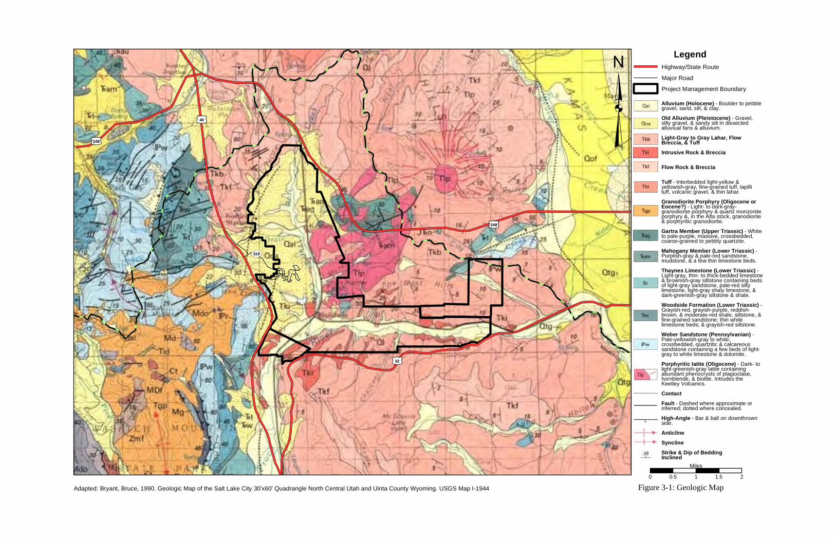
LegendHighway/State RouteMajor RoadProject Management Boundary³
0 0.5 1 1.5 2Miles
£¤40
£¤32
£¤248
TS319
Wasatch Co.
Summit Co.
Figure 3-1: Geologic Map
£¤248
Adapted: Bryant, Bruce, 1990. Geologic Map of the Salt Lake City 30'x60' Quadrangle North Central Utah and Uinta County Wyoming. USGS Map I-1944
Alluvium (Holocene) - Boulder to pebblegravel, sand, silt, & clay.Old Alluvium (Pleistocene) - Gravel,silty gravel, & sandy silt in dissectedalluviual fans & alluvium.Light-Gray to Gray Lahar, FlowBreccia, & TuffIntrusive Rock & Breccia
Flow Rock & Breccia
Tuff - Interbedded light-yellow &yellowish-gray, fine-grained tuff, lapillituff, volcanic gravel, & thin lahar.Granodiorite Porphyry (Oligocene orEocene?) - Light- to dark-gray-granodiorite porphyry & quartz monzoniteporphyry &, in the Alta stock, granodiorite& porphyritic granodiorite.Gartra Member (Upper Triassic) - Whiteto pale-purple, massive, crossbedded,coarse-grained to pebbly quartzite.Mahogany Member (Lower Triassic) -Purplish-gray & pale-red sandstone,mudstone, & a few thin limestone beds.Thaynes Limestone (Lower Triassic) -Light-gray, thin- to thick-bedded limestone& brownish-gray siltstone containing bedsof light-gray sandstone, pale-red siltylimestone, light-gray shaly limestone, &dark-greenish-gray siltstone & shale.Woodside Formation (Lower Triassic) -Grayish-red, grayish-purple, reddish-brown, & moderate-red shale, siltstone, &fine-grained sandstone; thin whitelimestone beds; & grayish-red siltstone.Weber Sandstone (Pennsylvanian) -Pale-yellowish-gray to white,crossbedded, quartzitic & calcareoussandstone containing a few beds of light-gray to white limestone & dolomite.Porphyritic Iatite (Oligocene) - Dark- tolight-greenish-gray latite containingabundant phenocrysts of plagioclase,hornblende, & biotite. Intrudes theKeetley Volcanics.ContactFault - Dashed where approximate orinferred; dotted where concealed.High-Angle - Bar & ball on downthrownside.AnticlineSynclineStrike & Dip of BeddingInclined

This page is intentionally left blank
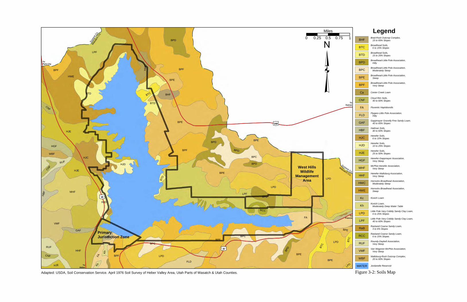
LPF
HWE
BPF
LPD
BPE
BPE
HJE
HHF
BPF
LPD
BPE
FA
MHFLPD
LPF
BPF
BPC
BTD
VMF
BPE
HJC
HJE
BPE
BPC
BPD
FA
FLDBPF
BPD
BTD
HJD
RUFLPD
HJD
BPE
BPF
HGF
BPC
HBF
BPD
RUF
BTC
HWC
BTC
WBF
BHF
BPD
RCC
BPEGAF
HJE
Kc
BTC
Kh
CNF
BPD
BPD
CNF
CNF
Kh
BTD
LPD
LegendBHF Brad-Rock Outcrop Complex,
15 to 65% Slopes
BTC Broadhead Soils, 6 to 15% Slopes
BTD Broadhead Soils, 15 to 25% Slopes
BPD Broadhead-Little Pole Association, Hilly
BPC Broadhead-Little Pole Assocaition, Moderately Steep
BPE Broadhead-Little Pole Association, Steep
BPF Broadhead-Little Pole Association, Very Steep
Ca Center Creek Loam
CNF Cloud Rim Soils, 40 to 60% Slopes
FA Fluventic Haploborolls
FLD Flygare-Little Pole Association, Hilly
GAF Gappmayer Gravelly Fine Sandy Loam, 40 to 65% Slopes
HBF Hailman Soils, 40 to 60% Slopes
HJC Henefer Soils, 6 to 10% Slopes
HJD Henefer Soils, 10 to 25% Slopes
HJE Henefer Soils, 25 to 50% Slopes
HGF Henefer-Gappmayer Association, Very Steep
MHF McPhie-Henefer Association, Very Steep
HHF Henefer-Wallsburg Association, Very Steep
HWC Horrocks-Broadhead Association, Moderately Steep
HWE Horrocks-Broadhead Association, Steep
Kc Kovich Loam
Kh Kovich Loam, Moderately Deep Water Table
LPD Little Pole Very Cobbly Sandy Clay Loam, 6 to 25% Slopes
LPF Little Pole Very Cobbly Sandy Clay Loam, 40 to 60% Slopes
RaB Rasband Coarse Sandy Loam, 3 to 6% Slopes
RCC Rasband Coarse Sandy Loam, 6 to 15% Slopes
RUF Roundy-Daybell Association, Very Steep
VMF Van Wagoner-McPhie Association, Very Steep
WBF Wallsburg-Rock Outcrop Complex, 20 to 60% Slopes
WATER Jordanelle Reservoir
³Wasa
tch Co.
Summit C
o.
0 0.25 0.5 0.75 1Miles
£¤40
£¤32
£¤248
West HillsWildlife
ManagementArea
Wasatch Co.
Summit Co.
ToPark City
ToHeber
ToFrancis
ToKamas
Figure 3-2: Soils Map
PrimaryJurisdiction Zone
Adapted: USDA, Soil Conservation Service. April 1976 Soil Survey of Heber Valley Area, Utah Parts of Wasatch & Utah Counties.

This page is intentionally left blank
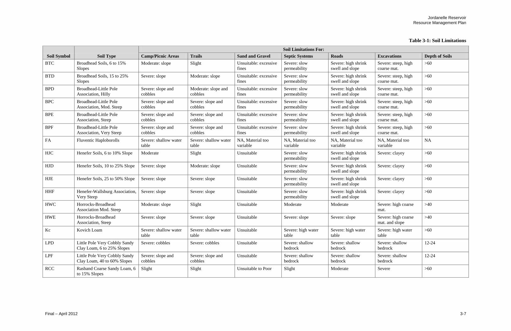
Jordanelle Reservoir
Resource Management Plan
Final – April 2012 3-7
Table 3-1: Soil Limitations
Soil Symbol Soil Type
Soil Limitations For:
Camp/Picnic Areas Trails Sand and Gravel Septic Systems Roads Excavations Depth of Soils
BTC Broadhead Soils, 6 to 15%
Slopes Moderate: slope Slight Unsuitable: excessive
fines
Severe: slow
permeability
Severe: high shrink
swell and slope
Severe: steep, high
coarse mat. >60
BTD Broadhead Soils, 15 to 25%
Slopes Severe: slope Moderate: slope Unsuitable: excessive
fines
Severe: slow
permeability
Severe: high shrink
swell and slope
Severe: steep, high
coarse mat. >60
BPD Broadhead-Little Pole
Association, Hilly
Severe: slope and
cobbles
Moderate: slope and
cobbles
Unsuitable: excessive
fines
Severe: slow
permeability
Severe: high shrink
swell and slope
Severe: steep, high
coarse mat.
>60
BPC Broadhead-Little Pole
Association, Mod. Steep
Severe: slope and
cobbles
Severe: slope and
cobbles
Unsuitable: excessive
fines
Severe: slow
permeability
Severe: high shrink
swell and slope
Severe: steep, high
coarse mat.
>60
BPE Broadhead-Little Pole
Association, Steep
Severe: slope and
cobbles
Severe: slope and
cobbles
Unsuitable: excessive
fines
Severe: slow
permeability
Severe: high shrink
swell and slope
Severe: steep, high
coarse mat.
>60
BPF Broadhead-Little Pole
Association, Very Steep
Severe: slope and
cobbles
Severe: slope and
cobbles
Unsuitable: excessive
fines
Severe: slow
permeability
Severe: high shrink
swell and slope
Severe: steep, high
coarse mat.
>60
FA Fluventic Haploborolls Severe: shallow water
table
Severe: shallow water
table
NA, Material too
variable
NA, Material too
variable
NA, Material too
variable
NA, Material too
variable NA
HJC Henefer Soils, 6 to 10% Slope Moderate Slight Unsuitable Severe: slow
permeability
Severe: high shrink
swell and slope
Severe: clayey >60
HJD Henefer Soils, 10 to 25% Slope Severe: slope Moderate: slope Unsuitable Severe: slow
permeability
Severe: high shrink
swell and slope
Severe: clayey >60
HJE Henefer Soils, 25 to 50% Slope Severe: slope Severe: slope Unsuitable Severe: slow
permeability
Severe: high shrink
swell and slope
Severe: clayey >60
HHF Henefer-Wallsburg Association,
Very Steep
Severe: slope Severe: slope Unsuitable Severe: slow
permeability
Severe: high shrink
swell and slope
Severe: clayey >60
HWC Horrocks-Broadhead
Association Mod. Steep Moderate: slope Slight Unsuitable Moderate Moderate Severe: high coarse
mat. >40
HWE Horrocks-Broadhead
Association, Steep
Severe: slope Severe: slope Unsuitable Severe: slope Severe: slope Severe: high coarse
mat. and slope
>40
Kc Kovich Loam Severe: shallow water
table
Severe: shallow water
table
Unsuitable Severe: high water
table
Severe: high water
table
Severe: high water
table
>60
LPD Little Pole Very Cobbly Sandy
Clay Loam, 6 to 25% Slopes
Severe: cobbles Severe: cobbles Unsuitable Severe: shallow
bedrock
Severe: shallow
bedrock
Severe: shallow
bedrock
12-24
LPF Little Pole Very Cobbly Sandy
Clay Loam, 40 to 60% Slopes
Severe: slope and
cobbles
Severe: slope and
cobbles
Unsuitable Severe: shallow
bedrock
Severe: shallow
bedrock
Severe: shallow
bedrock
12-24
RCC Rasband Coarse Sandy Loam, 6
to 15% Slopes Slight Slight Unsuitable to Poor Slight Moderate Severe >60

This page is intentionally left blank

Jordanelle Reservoir
Resource Management Plan
Final – April 2012 3-9
The vast majority of land within the Project Management Area has been classified
by the Utah Geologic Survey as having a low or moderate landslide potential.
The landslide potential is determined by the type of soil and inclination of the
slope. Nearly all of the shoreline on the north arm of the reservoir has a low
landslide hazard due to shallow slopes. Limited areas with steeper slopes have a
moderate landslide potential. Most areas along the east arm of the reservoir have
a moderate landslide potential due to steeper slopes. The areas with a high
landslide potential occurs downstream of the dam and along the east arm of the
reservoir. The landslide potential at the dam site is low to moderate. Some very
small areas of high landslide hazard have also been identified near Crandall Point.
The largest area of high landslide hazard occurs downstream of the dam in the
Primary Jurisdiction Zone. Hailstone, Ross Creek and Rock Cliff Recreation
Areas are all in areas with a low landslide hazard. However, slopes adjacent to
the Rock Cliff Recreation Area have moderate and high landslide potential.
Soil types specific to areas of potential future development are Henefer soils 10 to
25% slopes in the Hailstone Recreation Area, Henefer Soils 25 to 50% slopes in
the Hailstone Recreation Area and Crandall Point. The Horrocks-Broadhead
moderately steep and steep are the dominant soil types at Crandall Point and in
the Ross Creek Recreation Area. Finally, the alluvial Fluventic Haploborolls is
the dominant soil type in the Rock Cliff Recreation Area. The soils in the
Hailstone Recreation Area provide the best soil conditions for camping/picnic
areas, and trails. However, the soil conditions for septic systems, roads, and
structures are poor. Considerable effort in design and construction is needed to
accommodate the poor soil conditions. The soils at Crandall Point and the Ross
Creek Recreation Area have difficult soil conditions for most types of
improvements. Most common challenges are associated with the steep slopes.
The soils are also clayey with slow permeability and high shrink swell potential.
Thus, any improvements will require careful design and construction, taking into
account the difficult soil conditions. The soils in the Rock Cliff Recreation Area
are extremely variable due to the meandering nature of the Provo River. Thus, no
specific soil characteristics are provided in the Soil Survey of the Heber Valley
Area. However, it can be stated with confidence that the soil conditions will
present many challenges for any development. The water table is high and the
nature in which the soils were deposited means there could be significant organic
matter in the soils. Whenever there is organic matter in soils, the potential for
differential settlement is high. The fact that the Provo River meanders through
this area presents constantly changing conditions in not only soils but also in
hydrology and vegetation (USDA, 1976).
3.2 Water Resources
This section describes the historic and current water supply, water demand, and
reservoir operations of Jordanelle Reservoir.

Jordanelle Reservoir
Resource Management Plan
3-10 Final – April 2012
3.2.1 Water Supply
Water Rights
Storage of Provo River water in Jordanelle Reservoir is made possible by the
development of Colorado River water in the Uintah Basin. The Bonneville Unit,
through construction of the enlarged Strawberry Reservoir and other reservoirs
and conveyance facilities, develops water in the Uinta Mountains in northeast
Utah for trans-basin diversion to Utah Lake in the Bonneville Basin. Provo River
water that would otherwise have been stored in Utah Lake is then stored in
Jordanelle Reservoir and replaced in Utah Lake by the Colorado River water
released from Strawberry Reservoir. The project also has surplus rights on the
Provo River that are stored without need for replacement in Utah Lake. The
surplus flows are stored under criteria in the State Engineer’s Utah Lake
Distribution Plan.
Water rights associated with Jordanelle Reservoir are summarized in Table 3-2.
In addition to the water rights shown in Table 3-2, the Deer Creek/Jordanelle
Reservoirs Operating Agreement (DJOA) allows Jordanelle Reservoir rights to be
stored on a space-available basis in Deer Creek Reservoir for later exchange
upstream to Jordanelle Reservoir. The DJOA is described in greater detail in
Section 3.2.3 below.
Table 3-2: Water Rights Associated with Jordanelle Reservoir
Water Right No. Purpose
A40523 (55-4494) Appropriates up to 300,000 ac-ft/yr of surplus flows in the
Provo River Basin
A40524 (55-4495) Appropriates 400 cfs of surplus flows of the Provo River to
be diverted directly or by exchange to serve the project
requirements.
E398 (55-8506) Exchanges water from Strawberry Reservoir to Jordanelle
Reservoir via Utah Lake and the Provo River
E400 (55-8505) Exchanges Jordanelle Water to upstream points of diversion
A36639 (43-3822) Allows water in Strawberry Reservoir to be delivered to
Utah Lake and exchanged to Jordanelle Reservoir.
Change a17707 (various
water right’s)
Moves various water rights to Jordanelle Reservoir for the
wetlands below the dam
Change a17787 (55-8712) Covers the wildlife observation pond in the Rock Cliff State
Park
Water Right Nos. 55-
11108, 55-11111 through
11120, and 55-11558.
Change applications have been filed on all the water rights
associated with the Upper Provo River reservoirs that
Reclamation stabilized.
Water Right No’s 55-
11100 and 55-73
These Olmsted Power water rights, by contract, can be
diverted and stored in either Deer Creek or Jordanelle
Reservoir for the benefit of CUP.
Source: Record, 2011

Jordanelle Reservoir
Resource Management Plan
Final – April 2012 3-11
Stream Flow Records
Jordanelle Reservoir Inflow The majority of water stored in Jordanelle
Reservoir comes from the Provo River, either through direct storage of surplus
flows or storage by exchange, with a smaller amount from McHenry Creek, Ross
Creek, and other minor surface and groundwater sources. Flows from the Provo
River fluctuate widely based on climatic conditions. Figure 3-3 shows Provo
River annual flow variations based on daily averages measured at the Provo River
Hailstone Gage immediately upstream of Jordanelle Reservoir for the last 30
years. Figure 3-4 shows annual variations over a long-term period from 1980 to
2010.
Figure 3-3: Provo River Inflow to Jordanelle Reservoir (Hailstone Gage),
30-year Average Daily Flows (USGS, 2011)
0
200
400
600
800
1000
1200
1400
1600
J F M A M J J A S O N D
Mea
n F
low
(cf
s)
Month

Jordanelle Reservoir
Resource Management Plan
3-12 Final – April 2012
Figure 3-4: Provo River Inflow to Jordanelle Reservoir (Hailstone Gage),
Annual Variations based on Mean Monthly Flows (USGS, 2011)
Jordanelle Reservoir Outflow Currently, all water stored in Jordanelle
Reservoir is released through the reservoir outlet works and/or the power plant to
the Provo River. Historic releases from Jordanelle Reservoir from 1993 to 2010
are shown in Figure 3-5.
Figure 3-5: Releases from Jordanelle Reservoir, 1993 to 2010
(Reclamation, 2011)
0
500
1000
1500
2000
2500
Oct-80 Nov-84 Dec-88 Jan-93 Mar-97 Apr-01 May-05 Jul-09
Flo
w (
cfs)
Date
0
500
1000
1500
2000
2500
Jan-93 Oct-95 Jul-98 Apr-01 Jan-04 Sep-06 Jun-09
Dis
char
ge (
cfs)
Date

Jordanelle Reservoir
Resource Management Plan
Final – April 2012 3-13
Groundwater
The only groundwater utilized by the project is for culinary and irrigation use in
the Hailstone Recreation Area. Water for the Rock Cliff Recreation Area is
provided by the town of Francis. Water right number A20140 (55-11158) allows
pumping up to 79.0 ac-ft/yr from two wells for use at two homes, irrigation of up
to 12.1 acres, and other miscellaneous recreational uses in the Hailstone
Recreation Area. The water right also includes a 1.2 ac-ft storage right. Two
wells were drilled but only one is currently used, as the first well failed. During
summer months, the well operates continuously and is unable to meet the peak
summer culinary and irrigation needs. Total water use for calendar years 2009
and 2010 was 44.7 ac-ft and 47.6 ac-ft, respectively. Based on this historic use,
an additional 31.4 ac-ft/yr (79.0 ac-ft less 47.6 ac-ft) of water could be developed
to meet the current water shortages within the Hailstone Recreation Area (Record,
2011).
3.2.2 Water Demand
Jordanelle Reservoir develops 107,500 ac-ft of water per year for municipal,
industrial, and agricultural purposes. The majority of this water (92,400 ac-ft/yr)
has been allocated for M&I use in Wasatch, Utah, and Salt Lake counties and the
remainder (15,100 ac-ft/yr) for agricultural use in Wasatch and Summit counties.
Some shifts in water use from agriculture to M&I are anticipated as the demand
for M&I water increases in the future due to population growth in Wasatch and
Summit counties. (CUWCD, 2004).
The Central Utah Project also provides water for minimum stream flows in the
Provo River for stream fishery purposes. A 10 cfs minimum flow is maintained
in the Provo River below the Washington/South Kamas Canal diversion (above
Jordanelle Reservoir), 125 cfs below Jordanelle Dam, 100 cfs below the
confluence of the Provo Deer Creek and Provo River below Deer Creek Dam, and
25 cfs below the Olmsted Diversion Dam during the non-irrigation season.
3.2.3 Jordanelle Reservoir Operation
Operation Overview
Water stored in Jordanelle Reservoir consists of 1) Provo River water that is
surplus to all prior rights on the Provo River (including Utah Lake) and 2) Provo
River water that is stored by utilizing either the Utah Lake/Jordanelle exchange or
the Deer Creek/Jordanelle exchange. Operation of the Provo River is managed by
the Utah State Engineer’s office in conjunction with CUWCD and the Provo
River Water Users Association (PRWUA) consistent with the November 1, 1992
“Water Distribution Plan for the Utah Lake Drainage Basin” and terms of the
November 1, 1994 “Deer Creek/Jordanelle Reservoirs Operating Agreement.
Utah Lake Distribution Plan The Utah Lake/Jordanelle exchange allows Provo
River water that otherwise would be stored in Utah Lake and used by Utah Lake
Jordanelle Reservoir
Resource Management Plan
3-14 Final – April 2012
users to be stored in Jordanelle Reservoir for the benefit of CUWCD, conditioned
on a like amount of water being replaced in Utah Lake. The water would be
replaced to Utah Lake from other CUWCD sources including but not limited to a
releases from Strawberry Reservoir and CUWCD water rights in Utah Lake.
Deer Creek/Jordanelle Reservoirs Operating Agreement (DJOA) The Deer
Creek/Jordanelle exchange allows CUWCD water to be stored in Deer Creek
Reservoir on a space available basis for later exchange upstream to Jordanelle
Reservoir. The exchange upstream is made primarily during the spring runoff
months (May-July) by storing Deer Creek water (primarily import water from the
Duchesne and Weber Rivers) in Jordanelle Reservoir.
Jordanelle Reservoir is operated in conjunction with Deer Creek Reservoir. On
November 1, 1994, DJOA was signed by the United States, PRWUA, and
CUWCD. This agreement, among other things, allows CUP water to be stored in
Deer Creek Reservoir on a space available basis for the benefit of CUP petitioners
to effect the Deer Creek/Jordanelle Exchange” described above. The coordinated
operation of these two reservoirs is essential to meeting the water demands of the
Jordanelle Project including the need to maintain the CUP-required minimum
instream flows at the various locations along the Provo River.
Reservoir Storage Capacity
The storage capacity of Jordanelle Reservoir is allocated as shown in Table 3-3.
As shown in the table, the total reservoir capacity is 363,354 ac-ft, the live
capacity is 360,328 ac-ft (active conservation, joint use, and exclusive flood
control), and the active capacity is 310,980 ac-ft (active conservation and joint
use). Jordanelle Reservoir is considered full when it reaches elevation 6,166.4
feet. The active capacity (top of joint to top of inactive) is used for water supply
storage to meet project water demands. The Joint Use capacity is used for both
water supply (part of active capacity) and for flood control. Exclusive Flood
Control capacity, as the name implies, is used exclusively for flood control.
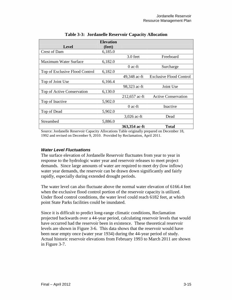
Jordanelle Reservoir
Resource Management Plan
Final – April 2012 3-15
Table 3-3: Jordanelle Reservoir Capacity Allocation
Level
Elevation
(feet)
Crest of Dam 6,185.0
3.0 feet Freeboard
Maximum Water Surface 6,182.0
0 ac-ft Surcharge
Top of Exclusive Flood Control 6,182.0
49,348 ac-ft Exclusive Flood Control
Top of Joint Use 6,166.4
98,323 ac-ft Joint Use
Top of Active Conservation 6,130.0
212,657 ac-ft Active Conservation
Top of Inactive 5,902.0
0 ac-ft Inactive
Top of Dead 5,902.0
3,026 ac-ft Dead
Streambed 5,886.0
363,354 ac-ft Total Source: Jordanelle Reservoir Capacity Allocations Table originally prepared on December 18,
1992 and revised on December 9, 2010. Provided by Reclamation, April 2011.
Water Level Fluctuations
The surface elevation of Jordanelle Reservoir fluctuates from year to year in
response to the hydrologic water year and reservoir releases to meet project
demands. Since large amounts of water are required to meet dry (low inflow)
water year demands, the reservoir can be drawn down significantly and fairly
rapidly, especially during extended drought periods.
The water level can also fluctuate above the normal water elevation of 6166.4 feet
when the exclusive flood control portion of the reservoir capacity is utilized.
Under flood control conditions, the water level could reach 6182 feet, at which
point State Parks facilities could be inundated.
Since it is difficult to predict long-range climatic conditions, Reclamation
projected backwards over a 44-year period, calculating reservoir levels that would
have occurred had the reservoir been in existence. These theoretical reservoir
levels are shown in Figure 3-6. This data shows that the reservoir would have
been near empty once (water year 1934) during the 44-year period of study.
Actual historic reservoir elevations from February 1993 to March 2011 are shown
in Figure 3-7.
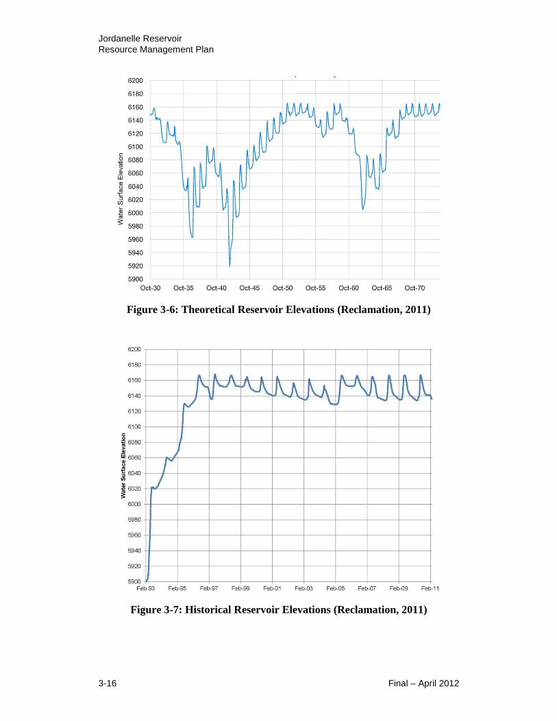
Jordanelle Reservoir
Resource Management Plan
3-16 Final – April 2012
Figure 3-6: Theoretical Reservoir Elevations (Reclamation, 2011)
Figure 3-7: Historical Reservoir Elevations (Reclamation, 2011)
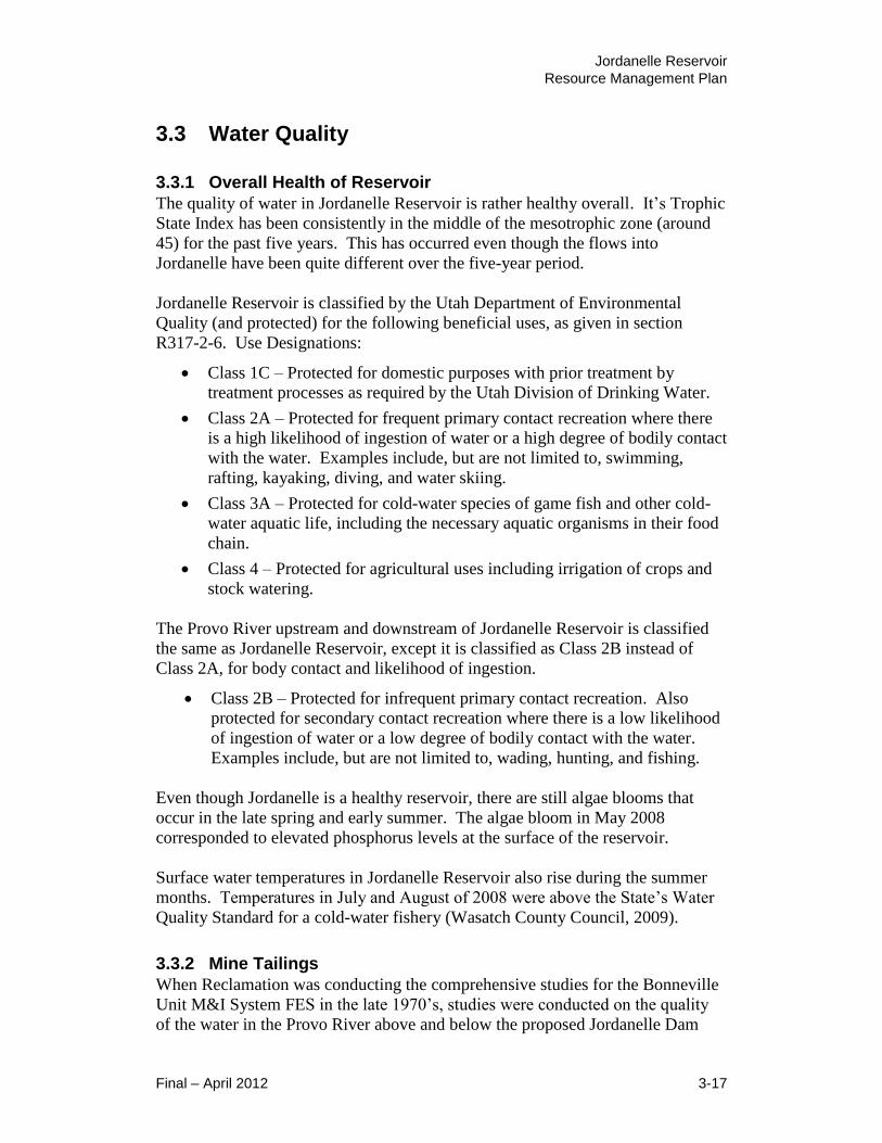
Jordanelle Reservoir
Resource Management Plan
Final – April 2012 3-17
3.3 Water Quality
3.3.1 Overall Health of Reservoir
The quality of water in Jordanelle Reservoir is rather healthy overall. It’s Trophic
State Index has been consistently in the middle of the mesotrophic zone (around
45) for the past five years. This has occurred even though the flows into
Jordanelle have been quite different over the five-year period.
Jordanelle Reservoir is classified by the Utah Department of Environmental
Quality (and protected) for the following beneficial uses, as given in section
R317-2-6. Use Designations:
Class 1C – Protected for domestic purposes with prior treatment by
treatment processes as required by the Utah Division of Drinking Water.
Class 2A – Protected for frequent primary contact recreation where there
is a high likelihood of ingestion of water or a high degree of bodily contact
with the water. Examples include, but are not limited to, swimming,
rafting, kayaking, diving, and water skiing.
Class 3A – Protected for cold-water species of game fish and other cold-
water aquatic life, including the necessary aquatic organisms in their food
chain.
Class 4 – Protected for agricultural uses including irrigation of crops and
stock watering.
The Provo River upstream and downstream of Jordanelle Reservoir is classified
the same as Jordanelle Reservoir, except it is classified as Class 2B instead of
Class 2A, for body contact and likelihood of ingestion.
Class 2B – Protected for infrequent primary contact recreation. Also
protected for secondary contact recreation where there is a low likelihood
of ingestion of water or a low degree of bodily contact with the water.
Examples include, but are not limited to, wading, hunting, and fishing.
Even though Jordanelle is a healthy reservoir, there are still algae blooms that
occur in the late spring and early summer. The algae bloom in May 2008
corresponded to elevated phosphorus levels at the surface of the reservoir.
Surface water temperatures in Jordanelle Reservoir also rise during the summer
months. Temperatures in July and August of 2008 were above the State’s Water
Quality Standard for a cold-water fishery (Wasatch County Council, 2009).
3.3.2 Mine Tailings
When Reclamation was conducting the comprehensive studies for the Bonneville
Unit M&I System FES in the late 1970’s, studies were conducted on the quality
of the water in the Provo River above and below the proposed Jordanelle Dam
Jordanelle Reservoir
Resource Management Plan
3-18 Final – April 2012
Site. The water quality in the two small tributaries that flowed into the Provo
River just above the proposed dam site was also looked at, since both the Ontario
Drain Tunnel No. 2 (then a tributary to Ross Creek) and McHenry Creek received
acid mine drainage water. The Ontario Drain Tunnel No. 2 discharged about 12-
15 cfs into Ross Creek, and the Mayflower Mine discharged less than ½ cfs into
Big Dutch Pete Hollow, a tributary to McHenry Creek (see Figure 3-8). These
four small streams now flow separately into Jordanelle Reservoir. Both mines
have been abandoned since the early 1970’s. Both mine discharges currently
contain elevated levels of various trace elements including cadmium, copper, and
zinc. The entire flow from the Ontario Drain Tunnel is currently treated by JSSD
under a UPDES permit for metals prior to discharge to Jordanelle Reservoir or for
drinking water delivery. Traces of mercury are also present in the north arm due
to little inflow and limited mixing with the main part of the reservoir (Provo River
arm).
Because of the acid mine discharges and the mine tailings that had been spilled
and scattered along McHenry Creek and deposited into a small irrigation reservoir
just above the proposed Jordanelle dam site, Reclamation indicated in the
Bonneville Unit M&I System FES there was a potential for elevated heavy metals
concentration, particularly in the Ross Creek (north) arm of Jordanelle Reservoir.
During the construction of Jordanelle Dam, Reclamation spent over ten million
dollars to clean up the mine tailings that had been slurried into the small irrigation
reservoir and the mine tailings spilled in the McHenry Creek drainage. The mine
tailings were handled as a hazardous waste under EPA guidelines, and were
encapsulated and stabilized in a clay lined and clay capped impermeable
envelope, in a location just east of Highway 40, significantly above Jordanelle
Reservoir. Reclamation is required by the DEQ, Division of Water Quality to
have a Groundwater Discharge Permit. Under this permit, Reclamation monitors
the site twice a year for any signs of surface erosion, and collects water quality
samples from the one up-gradient and the three down-gradient monitoring wells.
Reclamation then submits the water quality data, groundwater levels, and other
pertinent information in an official monitoring report and informs the State of
Utah of any violations of the Permit conditions.

Jordanelle Reservoir
Resource Management Plan
Final – April 2012 3-19
Figure 3-8: Drainages into West Side of Jordanelle Reservoir

Jordanelle Reservoir
Resource Management Plan
3-20 Final – April 2012
3.3.3 Technical Advisory Committee
Due to the above mentioned potential water quality issues, when Reclamation
submitted the draft Bonneville Unit M&I System Environmental Statement to
EPA for approval, the EPA considered opposing the project and submitting a
negative determination to the Council on Environmental Quality. Reclamation
(Regional Director N. W. Plummer) met with the State of Utah in July 1979, and
the Governor (Scott M. Matheson) agreed to take the lead in establishing an
interagency technical advisory committee to develop a Water Quality
Management Plan for the Deer Creek and Jordanelle Reservoirs.
This group was named the Jordanelle Technical Advisory Committee (JTAC) and
includes federal, state and local agencies, water districts, and municipalities.
They completed the initial Water Quality Management Plan in 1984. They have
met quarterly since that time, and each year they conduct comprehensive water
quality studies on the Provo River and on the Deer Creek and Jordanelle
reservoirs, and prepare an annual Water Quality Management Plan and
Implementation Report. The area included in the annual analysis and report has
been expanded to include essentially the entire Provo River system from the
Upper Provo to Utah Lake. The name of the group has been changed to the Provo
River Watershed Council to reflect the entire watershed approach.
Each year the Provo River Watershed Council monitors water quality at numerous
stations on the Provo River and on Deer Creek and Jordanelle Reservoirs. The
main parameters include flow, total phosphorus, dissolved total phosphorus,
TMDL phosphorus loads, total suspended solids, chlorophyll, Secchi Disk depths,
stream temperature, temperature profiles in the reservoirs, dissolved oxygen
profiles in the reservoirs, dissolved nitrates and dissolved total phosphorus in
groundwater, trace elements, and recently (2008) pharmaceuticals. Two
pharmaceuticals, diazepam and ibuprofen were found in measurable quantities in
the Provo River at River Road and downstream around Deer Creek Reservoir and
below.
The 2009 Water Quality Implementation Report also indicates that cadmium and
zinc in Big Dutch Pete Hollow below the Mayflower Mine above Jordanelle
Reservoir are a concern. The cadmium concentration exceeded the state standard
50% of the time and the average concentration is also above the cadmium
standard of 2 ug/L. The zinc concentration exceeded the 3A aquatic wildlife
standard of 120 ug/L all of the time. This is drainage from mines in the vicinity.
The flow is relatively small and is greatly diluted as it flows into McHenry Creek
and on into Jordanelle Reservoir, so the overall effect is minor.
In July 2009, the UDWR issued a New Fish Consumption Advisories notice for
the state, along with a map showing the mercury sampling sites and consumption
advisories. It includes a Fish Consumption Advisory for mercury in brown trout
and smallmouth bass in Jordanelle Reservoir. For more information, visit the
Utah Fish Advisories website: http://www.fishadvisories.utah.gov/.
Jordanelle Reservoir
Resource Management Plan
Final – April 2012 3-21
3.4 Air Quality, Climate, Noise
Air quality within the Project Management Area can be affected by weather
patterns, natural airborne pollutant emission sources such as dust or smoke, and
emissions from both stationary and mobile manmade sources. This section
discusses the existing climatic conditions, air quality, and sources of emissions in
the project vicinity, as well as describes laws and regulations that may be
applicable to the RMP.
In addition, this section considers the existing noise environment within the
Project Management Area from the noise sources and the effects of noise on
sensitive receptors.
3.4.1 Climate
The climate of the project vicinity is continental. It features low humidity,
abundant sunshine all year except in winter and early spring, relatively light
precipitation and wide ranges in annual temperature.
Summer temperatures are cool and pleasant. In the summertime, many valley
residents of the Wasatch Front visit the reservoir to escape high temperatures.
The Project Management Area is usually 11 °F cooler than Salt Lake City, as it
lies mostly above 6,000 feet above sea level, while Salt Lake City is situated at an
altitude of about 4,000 feet.
During the warmest month (July), maximum temperatures are generally in the
middle eighties and the minimum in the middle forties. Winter temperatures are
very cold. The January average minimum is only 6 °F and the maximum is in the
middle thirties (Wasatch County Planning Commission, 2010).
The bulk of the precipitation is received during the period of October to May,
when low-pressure storms from the Pacific Ocean frequent the region. On an
average, the heaviest amounts occur during December and January, but there is a
secondary maximum in August when summer thunderstorms occur. Snow
averages at 76 inches per year and rain averages at 16 inches per year (Key to the
City, 2009).
Winds are generally light to moderate during all seasons of the year, but they
become quite strong during storms.
3.4.2 Regional and Local Air Quality
Air quality in the Project Management Area presently meets the standards
established by the EPA for all criteria pollutants.
Jordanelle Reservoir
Resource Management Plan
3-22 Final – April 2012
The Clean Air Act identifies six common air pollutants that are found all over the
United States and can injure health, harm the environment or cause property
damage. These pollutants include:
Carbon Monoxide
Lead
Nitrogen Dioxide
Particulate Matter (PM10) and (PM2.5)
Ozone
Sulfur Oxides
The EPA has established National Ambient Air Quality Standards (NAAQS) for
each of these pollutants. If the air quality in a geographic area meets NAAQS, it
is called an attainment area. Areas that do not meet the NAAQS are called
nonattainment areas and must develop a comprehensive state plan to reduce
pollutant concentrations to a safe level.
These nonattainment areas are centered primarily on high population areas. The
Project Management Area currently does not reside in a nonattainment area.
Therefore, being in an attainment area, the pollutant concentrations are at a safe
level. The goal is to stay at a safe level of air quality.
3.4.3 Air Quality Regulations
Under the Clean Air Act of 1970, the EPA developed primary and secondary
NAAQS for each of the seven criteria pollutants: carbon monoxide, lead, nitrogen
dioxide, ozone, particulate matter, fine particulate matter, and sulfur dioxide.
These standards establish pollution levels in the United States that cannot legally
be exceeded during a specified time period.
Jordanelle air quality is also protected by standards described in the State of
Utah’s State Implementation Plan (SIP) which was originally submitted to the
EPA in 1972 and has since been revised to attain and maintain the NAAQS in
attainment and nonattainment areas.
In addition, the State of Utah developed rules and revised the SIP to implement
the Prevention of Significant Deterioration (PSD) program. The EPA approved
Utah’s PSD program on February 12, 1982. All attainment and unclassifiable
areas in the state must be designated as Class I, Class II or Class III under the
PSD. The classification differs in the amount of development allowable within
the area. In Utah, the only areas designated as Class I areas (the most restrictive
limits on development) are the five state National Parks. The nearest Class I area
is Capitol Reef National Park, which is approximately 150 miles south of
Jordanelle Reservoir. All other areas in the state are currently classified as Class
II areas, which mean that industrial growth is allowed in these areas, but in many

Jordanelle Reservoir
Resource Management Plan
Final – April 2012 3-23
parts of the state where the air is exceptionally clean, the air quality will not be
allowed to degrade to the level of the NAAQS.
3.4.4 Noise
Noise can be defined as the intensity, duration, and character of sounds from any
and all sources. Although subjective, sound generated from natural sources such
as flowing water, wind, or wildlife is often considered welcome as a beneficial
quality of the surrounding environments. Conversely, human-induced noise
sources such as vehicle traffic, motorized watercraft operation, and gasoline-
powered equipment (e.g., generators and maintenance equipment) are often
considered annoying.
The effects of noise can be experienced by both human and wildlife receptors,
and, in certain circumstances, sound-wave vibrations can affect physical
structures through shaking. Of primary consideration are the effects of noise on
humans within the Project Management Boundary. Effects of noise on wildlife
species are discussed, as relevant, in Section 3.6 (Fish and Wildlife Resources).
The discussion herein provides a means of considering the existing noise
environment within the Project Management Boundary and effects of the RMP
alternatives on existing noise levels. Measurements of actual noise levels within
the Project Management Boundary have not been collected, and the discussion
and assessment provided here is based on observation and qualitative
consideration of noise characteristics within the Project Management Boundary.
Because the RMP alternatives under consideration would not result in substantial
changes to the types of noise-generating activities occurring within the Project
Management Area, this qualitative consideration has been deemed appropriate for
this assessment.
Noise Sources
In general, ambient noise levels at Jordanelle Reservoir are consistent with rural,
open space areas. Background noise levels are relatively low in most areas, with
exception of areas adjacent to roadways, including US Highway 40 on the
western side of the reservoir, State Route 32 on the south shoreline, and State
Route 248 on the northeastern side of the reservoir (see Section 3.10,
Transportation and Access, for more detail on the transportation network in the
project vicinity).
US 40 experiences moderate volumes of truck and passenger vehicle traffic,
which creates a relatively continuous noise source. SR 248 and SR 32 experience
much lower traffic volumes and vehicle speeds are lower, resulting in lower and
less consistent noise levels. However, SR 248, although a minor arterial road, is
considered the “back door” to Park City and is becoming an increasingly popular
road to Park City commuters.

Jordanelle Reservoir
Resource Management Plan
3-24 Final – April 2012
Other notable noise sources that contribute to the noise environment in the project
vicinity vary depending upon time of day, weather, and season, and include those
associated with motorized recreational activities on and adjacent to Jordanelle
Reservoir, visitor activities at day-use and overnight campground areas, vehicular
noise on area access roads, and snowmobile operation during the wintertime.
Of all the noise sources within the Project Management Area, motorized
recreational vehicles may be the most prevalent. Noise from personal watercraft
(PWC) and motorized boats is reflected off the water and, depending upon
weather conditions, can be heard at locations far from the source. In addition,
because sounds levels from PWCs and other motorized boats are highly variable
as a result of engine revving (as opposed to more constant sounds from a source
such as pump or airplane), the noise tends to be more noticeable.
Sensitive Receptors
The effects of noise on human receptors, is dependent upon factors, including the
presence of receptors and the sensitivity of such receptors. Participants in noise-
generating activities are considered less sensitive to noise. Conversely, visitors or
residents not participating in activities, which create significant noise levels, may
be seeking solitude, and are therefore more affected by the presence of continuous
or variable noise. It should be noted, that individual recreationists within the
Project Management Area, may be considered as sensitive or less sensitive,
depending upon time of day and the activities in which they are participating at
any given time.
Evening, nighttime, and early morning hours are the times of day that most area
visitors and residents are most sensitive to noise. Traffic volumes on US 40 and
other area roadways are lighter, and the general solitude offered by decreased
recreational activities during these times of day result in a greater prominence of
any particular noise event that may occur. Thus, sensitive receptors are primarily
considered to be visitors and residents present within the Project Management
Boundary overnight, as well as users of day-use and fishing access areas.
Sensitive receptor locations within the Project Management Boundary include the
current campgrounds and day-use areas within the Hailstone Recreation Area and
the Rock Cliff Recreation Area. These areas are considered to be areas that may
be sensitive to noise associated with reservoir recreation activities.
3.5 Vegetation, Wetlands, Noxious Weeds
This section discusses the existing vegetation conditions of the upland, riparian
and wetland habitats that occur in the Project Management Area. It also identifies
the noxious weed species that may be found in the Project Management Area, and
discusses the management programs that are in place to control the introduction
and spread of noxious weeds in the Project Management Area.

Jordanelle Reservoir
Resource Management Plan
Final – April 2012 3-25
3.5.1 Vegetation Types
A general habitat map showing the various land cover and vegetation types within
the Project Management Area was created using mapping data from the
Southwestern Regional GAP Analysis Project (NBII 2011). The mapping data is
based on Landsat satellite imagery that was acquired between 1999 and 2001
(Lowry, et. al., 2005). The Utah portion of the mapping was completed by the
Remote Sensing/GIS Laboratory at Utah State University. The mapping data
identified a total of 19 land cover types in the Project Management Area, which
were grouped into 11 general habitat types for the purpose of the vegetation
analysis (Table 3-4; Figure 3-9). General descriptions of the vegetation
associated with the 11 habitat types are discussed below in the order listed in
Table 3-4.
Table 3-4: General Habitat Types in the Project Management Area
Vegetation/Habitat Type Acreage Percent
Total Sparsely Vegetated Cliffs and Canyon Walls 61 0.9
Deciduous Forested Woodland 87 1.3
Coniferous Forested Woodland 15 0.2
Pinyon-Juniper Woodland 101 1.5
Mixed Gamble Oak Shrubland 695 10.4
Sagebrush Shrubland 2112 31.5
Grassland/Upland Meadows 101 1.5
Riparian Woodland and Shrubland 282 4.2
Wet Meadow 13 0.2
Open Water 3,024 45.1
Developed Land 213 3.2
Total 6,704 100
Source: Lowry, et al., 2005
Sparsely Vegetated Cliffs and Canyon Walls
Sparsely Vegetated Cliffs and Canyon Walls includes steep cliff faces, narrow
canyon walls, talus slopes and smaller rock outcrops that typically have <10%
vegetative cover. There may be small patches of dense vegetation, but it typically
includes scattered trees and/or shrubs with little herbaceous cover. Plant species
may include: aspen, ponderosa pine, juniper, sumac, alderleaf, juneberry, wild
currant, wild rose, and Oregon grape. This habitat mainly occurs on the steep
terrain bordering the Provo River stream corridor in the southeast portion of the
Project Management Area.
Deciduous Forested Woodland
Deciduous Forested Woodland is comprised chiefly of aspen and bigtooth maple
without a significant conifer component. The understory may be complex with
multiple shrub and herbaceous layers, or simple with just an herbaceous layer.
Understory species may include: common juniper, alderleaf, juneberry,

Jordanelle Reservoir
Resource Management Plan
3-26 Final – April 2012
snowberry, wild currant, thimbleberry and Oregon grape. This habitat mainly
occurs in the side drainages bordering the Provo River stream corridor in the
southeast portion of the Project Management Area.
Coniferous Forested Woodland
Coniferous Forested Woodland is comprised chiefly of Douglas fir, white fir and
ponderosa pine. Engelmann spruce and blue spruce may also be present. Small
patches of aspen or bigtooth maple may be intermingled. The understory
composition can be highly variable according to shading and moisture and may
include: common juniper, Gamble oak, snowberry, alderleaf, juneberry and
Oregon grape. This habitat mainly occurs in the side drainages bordering the
Provo River stream corridor near the Rock Cliff Recreation Area.
Pinyon-Juniper Woodland
Pinyon-Juniper Woodland occurs in scattered patches on the dry foothills
surrounding the Reservoir and is dominated by pinyon pine and/or Utah juniper.
Rocky mountain juniper may be co-dominant. The understory may contain
sagebrush and other drought tolerant forbs and grasses.
Mixed Gamble Oak Shrubland
Mixed Gamble Oak Shrubland is a dominant habitat found throughout the Project
Management Area on the dry foothills surrounding the reservoir and is often
situated above the pinyon-juniper woodland. It is comprised of dense, shrubby
stands of Gamble oak.
Sagebrush Shrubland
Sagebrush Shrubland is the most abundant habitat type in the Project
Management Area. It is found on the dry foothills surrounding the reservoir. It is
dominated by mountain sagebrush and usually has a grassy understory that
includes Idaho fescue, wild rye, wheatgrass, and bromegrass.
Grassland/Upland Meadows
Grassland/Upland Meadows is dominated by perennial grass species, such as
bunch wheatgrass, Idaho fescue, sheep fescue, and Kentucky bluegrass.
Cheatgrass, thistle, prickly lettuce and other weedy forbs may be present in
disturbed areas. This habitat type is scattered throughout the Project Management
Area and occurs on rolling hills or flat well-drained surfaces.
Riparian Woodland and Shrubland
Riparian Woodland and Shrubland is mainly found along the Provo River corridor
in the southeastern portion of the Project Management Area. It occurs on the
river floodplain and reservoir shoreline and is adapted to a hydrologic regime of
annual to episodic flooding. Dominant trees may include narrow leaf
cottonwood, Fremont cottonwood, and box elder maple. Understory vegetation
can be variable depending on the hydrologic regime, but typically include various
species of willow, red-oiser dogwood, choke cherry, alder, and water birch.

Jordanelle Reservoir
Resource Management Plan
Final – April 2012 3-27
Generally, the upland vegetation surrounding this riparian habitat type is
distinctly different due to a sudden gradation in moisture content.
Wet Meadow
Wet Meadow is mainly found along the Provo River floodplain in the Rock Cliff
Recreational Area. This is an herbaceous wetland type that is comprised of
various sedges and rushes, spike rush, and riparian grass species.
Open Water
Open Water consists of the lacustrine habitat of the reservoir inundation zone and
the riverine habitat of the Provo River. Vegetation may become temporarily
established on exposed shorelines and riverbanks, but is typically short-lived due
to subsequent inundation or scouring and is typically <10% cover. When full, the
reservoir has approximately 3,024 surface acres of open water.
Developed Land
Developed Land consists primarily of the various access roads, parking areas,
lawns, playing fields, playgrounds, boat launches, visitor buildings, administrative
buildings, and other appurtenant facilities that have been developed inside the
Project Management Area. Nearly all of the developed land is associated with the
various State Park facilities.
3.5.2 Riparian Vegetation and Wetlands
Riparian vegetation and wetlands in the Project Management Area consists of
riparian woodland, shrubland, and wet meadow habitat types. Both of these
habitats types contain wetland plant communities. The plant species composition
for these habitats is discussed in Section 3.5.1. Of the 6,704 acres within the
Project Management Area, the GAP mapping data identifies approximately 282
acres of riparian woodland and shrubland (4.2%) and 13 acres of wet meadow
(0.2%) (Table 3-4). Both of these habitats and are found mainly along the Provo
River floodplain where it drains into the reservoir, and in the Rock Cliff
Recreation Area (Figure 3-9).
The Project Management Area is situated in a semi-arid environment. The main
water sources for riparian and wetland habitats are the shallow alluvial aquifer
(groundwater), seeps, and springs on the river floodplain, seasonal overbank
flooding, and areas wetted by the reservoir impoundment. The riparian woodland
and shrubland habitat is associated with flood prone areas along the riverbanks,
whereas the wet meadow habitat is associated with seeps and springs on the
floodplain and side drainages. These areas typically have a consistent and
predictable source of water and substrate conditions suitable for maintaining
riparian and wetland habitats.
Shoreline geomorphology generally restricts the extent of riparian and wetland
coverage along the shoreline and littoral zone of Jordanelle Reservoir. The
majority of the reservoir shoreline lacks suitable hydrologic and substrate

Jordanelle Reservoir
Resource Management Plan
3-28 Final – April 2012
conditions for riparian and wetland habitats because the shoreline is typically
steep sloped; it has a rocky composition; and it is typically subjected to wide
fluctuations in water levels during the summer. Fluctuations in water levels
during the summer growing season can result in the dewatering of the shoreline
and littoral zone and the erosion of exposed shoreline substrates, which limits the
establishment of riparian and wetland coverage. Additionally, there is a lack of
tributary streams around the perimeter of the reservoir shoreline that would
provide perennial sources water and depositional substrates suitable for the
establishment of riparian and wetland coverage. Subsequently, the majority of the
reservoir shoreline is bordered by sparsely vegetated rocky cliffs, exposed
substrates, sagebrush, and other vegetation adapted to a semi-arid environment.
The existing riparian woodland and shrubland vegetation helps to anchor and
stabilize the substrates on the Provo River floodplain and buffer upland runoff
draining into the river and reservoir. This helps to protect water quality in the
river and reservoir by minimizing the potential for soil erosion and sediment
transport. Additionally, the dual canopy structure of riparian trees and shrubs
provides important habitat for a diversity of migratory bird species that is not
found elsewhere in the Project Management Area.
The wet meadow is a rare habitat type within the Project Management Area. Its
coverage is probably too small to provide substantial water quality benefits for the
reservoir relative to soil stabilization and buffering of upland runoff. However, its
association with springs and wetlands provides important habitat for amphibians
that is not found elsewhere in the Project Management Area, and contributes to
both the plant and animal biodiversity of the Project Management Area.
3.5.3 Noxious Weeds
Noxious weeds can be a serious environmental problem to natural resources.
Noxious weeds can displace native plant communities, alter wildlife habitat,
reduce forage for wildlife and livestock, increase erosion and lower biodiversity.
Executive Order 13112 requires that each federal agency develop a management
program with adequate funding to control undesirable plants on lands under its
jurisdiction. It also requires that the agencies implement cooperative agreements
with state agencies to coordinate management of undesirable plants.
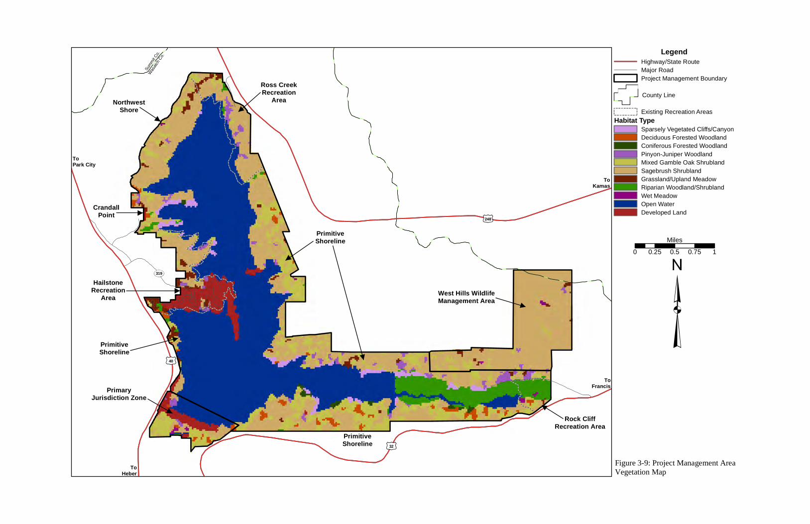
LegendHighway/State RouteMajor RoadProject Management Boundary
County Line
Existing Recreation AreasHabitat Type
Sparsely Vegetated Cliffs/CanyonDeciduous Forested WoodlandConiferous Forested WoodlandPinyon-Juniper WoodlandMixed Gamble Oak ShrublandSagebrush ShrublandGrassland/Upland MeadowRiparian Woodland/ShrublandWet MeadowOpen WaterDeveloped Land
³
Wasatch
Co.
Summit C
o.
0 0.25 0.5 0.75 1Miles
£¤40
£¤32
£¤248
TS319
West Hills WildlifeManagement Area
ToPark City
ToHeber
ToFrancis
ToKamas
Figure 3-9: Project Management AreaVegetation Map
PrimaryJurisdiction Zone
Rock CliffRecreation Area
Ross CreekRecreation
AreaNorthwestShore
CrandallPoint
HailstoneRecreation
Area
PrimitiveShoreline
PrimitiveShoreline
PrimitiveShoreline

This page is intentionally left blank
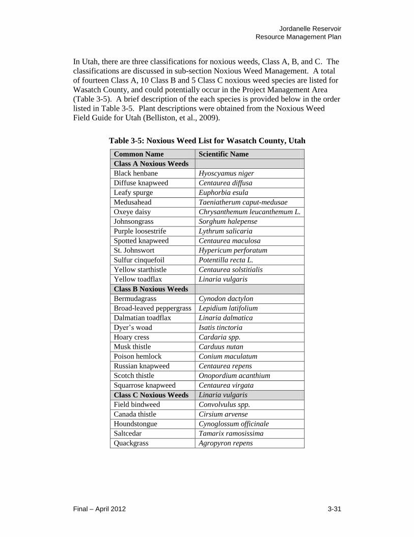
Jordanelle Reservoir
Resource Management Plan
Final – April 2012 3-31
In Utah, there are three classifications for noxious weeds, Class A, B, and C. The
classifications are discussed in sub-section Noxious Weed Management. A total
of fourteen Class A, 10 Class B and 5 Class C noxious weed species are listed for
Wasatch County, and could potentially occur in the Project Management Area
(Table 3-5). A brief description of the each species is provided below in the order
listed in Table 3-5. Plant descriptions were obtained from the Noxious Weed
Field Guide for Utah (Belliston, et al., 2009).
Table 3-5: Noxious Weed List for Wasatch County, Utah
Common Name Scientific Name
Class A Noxious Weeds Black henbane Hyoscyamus niger
Diffuse knapweed Centaurea diffusa
Leafy spurge Euphorbia esula
Medusahead Taeniatherum caput-medusae
Oxeye daisy Chrysanthemum leucanthemum L.
Johnsongrass Sorghum halepense
Purple loosestrife Lythrum salicaria
Spotted knapweed Centaurea maculosa
St. Johnswort Hypericum perforatum
Sulfur cinquefoil Potentilla recta L.
Yellow starthistle Centaurea solstitialis
Yellow toadflax Linaria vulgaris
Class B Noxious Weeds Bermudagrass Cynodon dactylon
Broad-leaved peppergrass Lepidium latifolium
Dalmatian toadflax Linaria dalmatica
Dyer’s woad Isatis tinctoria
Hoary cress Cardaria spp.
Musk thistle Carduus nutan
Poison hemlock Conium maculatum
Russian knapweed Centaurea repens
Scotch thistle Onopordium acanthium
Squarrose knapweed Centaurea virgata
Class C Noxious Weeds Linaria vulgaris
Field bindweed Convolvulus spp.
Canada thistle Cirsium arvense
Houndstongue Cynoglossum officinale
Saltcedar Tamarix ramosissima
Quackgrass Agropyron repens

Jordanelle Reservoir
Resource Management Plan
3-32 Final – April 2012
Class A Noxious Weeds
Black henbane is a native of Europe that is commonly found in waste areas,
pastures, along rights-of-way and fence lines. It can be either annual of biennial.
It grows to one to three feet tall. The leaves have pointed lobes and prominent
veins. Off-white flowers with purple centers and veins are one to two inches
wide. It blooms in late spring. Herbicides and digging are methods used to
control black henbane.
Diffuse knapweed is a native of Eurasia that is commonly found in dry
rangeland, roadsides, field edges, and waste areas. It is an annual or a short-live
perennial. It averages one to two feet tall. Leaves have finely divided lobes.
Flowers are white to rose in color. It blooms throughout the summer. Biocontrol,
herbicides, and tillage are all methods used to control diffuse knapweed.
Leafy spurge is a native of Eurasia that is an aggressive invader of pastures,
rangeland, stream banks, and waste areas. It is perennial plant that grows up to 3
feet tall, leaves are narrow and are one to four inches long. In late spring, yellow-
green flower bracts appear. The stems exude a milky fluid when damaged. It has
an extensive root system that can grow up to feet long and more than 14 feet deep.
Biocontrol and herbicides are methods used to control leafy spurge.
Medusahead is an introduced species from Eurasia. It is extremely competitive
and can completely displace other grass species. It is an annual that grows from
six inches to two feet high. The awns of the seedhead are long and become twist
as the seed matures, given the plant its common name. Using a combination of
burning, herbicide, and reseeding is the technique recommended for control of
medusahead.
Oxeye daisy is a native of Europe that can survive in a variety of environments.
It is often found in meadows, roadsides, waste areas, grasslands, or overgrazed
pastures. It is a perennial, rhizomatous herb that grows one to three feet tall. The
flowers range in diameter from one to 2.2 inches and blossoms usually appear
from June to August. Cultivation, maintaining a dense crop canopy, and
herbicides are all methods used to control oxeye daisy.
Johnsongrass is native to the Mediterranean region and was introduced to the
U.S. as a forage grass. It is a perennial grass that has erect stems from two to
eight feet tall. It has a wide distribution by using large, fleshy rhizomes. Leaf
blades are flat, up to 1 inch wide, with a prominent light midvein. Stems are stout
with prominent nodes. Herbicides are the method used to control johnsongrass.
Purple loosestrife is native to Europe and is found in shallow marshy wetland
areas and ditches. It can impede water flow and replace beneficial plants. It is a
semi-aquatic perennial that grows six to eight feet tall. It has rose-purple flowers

Jordanelle Reservoir
Resource Management Plan
Final – April 2012 3-33
that appear in columns along the upper end of stems. Biocontrol and herbicides
are methods used to control purple loosestrife.
Spotted knapweed is originally found in Eurasia and infests rangeland, pastures,
roadsides, or any disturbed soils. It is a short-lived perennial that grows to one to
three feet tall. The stems are moderately leaves and the flowers are typically pink
with spots. It blooms in early summer. Biocontrol and herbicides are methods
used to control spotted knapweed.
St. Johnswort is an introduced species from Europe. It prefers sandy or gravelly
soils. It is a perennial that grows one to three feet tall. Steams are rust colored
and woody at the base. Leaves have prominent veins and transparent dots. The
flowers are bright yellow with five petals. Biocontrol and herbicides are methods
used to control St. Johnswort.
Sulfur cinquefoil is native to Eurasia and is found in pastures, shrub dominated
areas, rights-of-way, and waste areas. It can out-compete native vegetation. It is
a perennial that grows from one to three feet tall and branches near the top.
Single or multiple stems sprout from a woody crown. It flowers from May to
June and the flowers are pale yellow and contain five heart-shaped petals.
Cultivation of annual crops, hand pulling or digging, and herbicides are methods
used to control sulfur cinquefoil.
Yellow starthistle is an introduced species from Europe that is found on dry sites
in rangeland, roadsides, and waste areas. It is an annual that grows from two to
three feet tall and has blue-green coloration. Rosette leaves are deeply lobed and
can be confused with dandelion. Stems are sparely leaved and heavily ridged.
Flowers are yellow. It has cream-colored thorns that range from ¼ to ¾ inch long
and protrude from the flowering heads. Biocontrol, herbicides, and tillage are all
methods used to control yellow starthistle.
Yellow toadflax is native to Eurasia and aggressively invades rangeland,
roadsides, field edges, and waste areas. It has an extensive root system. It is a
perennial weed that grows up to two feet tall. It has narrow, pointed leaves.
Flowers are approximately 1 inch long, yellow with an orange throat and have
long tails. They bloom in late spring into summer. Biocontrol and herbicides are
methods used to control yellow toadflax.
Class B Noxious Weeds
Bermudagrass is a low-growing and sod-forming perennial grass that probably
came from Africa. It has stolons that creep along the ground and upright stems
that are about 12 inches tall. Herbicides are the recommended method to control
bermudagrass.

Jordanelle Reservoir
Resource Management Plan
3-34 Final – April 2012
Broad-leaved peppergrass is native to southern Europe and western Asia and is
commonly found in wet drainage areas of waste areas, ditches, roadsides, and
croplands. It is perennial and grows from one to six feet tall. The rootstocks
spread laterally. The leaves have smooth to lightly toothed margins and are waxy.
White flowers form dense clusters at the end of the branches as it flowers from
summer into fall. Herbicides are the recommended method to control broad-
leaved peppergrass.
Dalmatian toadflax is an introduced species from Europe that is found on
rangeland and roadside habitat with sandy soils. It is an aggressive perennial
weed that grows from two to four feet tall. Multiple stems may come from the
base. Blue-green leaves line the stem in alternate fashion. Leaves are wedge
shaped, have a thick waxy cuticle and partially clasp the stem. Flowers are
yellow and may have white highlights and have long tails. It is difficult to
eradicate because of its deep root system. Biocontrol and herbicides are the
methods used to control dalmatian toadflax.
Dyer’s woad is an introduced species from Europe for the production of textile
dyes. It is found in waste areas, gravel pits, roadsides, pastures, field edges, and
disturbed soils. It may be a winter annual, biennial, or a short-lived perennial.
Common height ranges from one to four feet tall. It has a thick taproot that can
penetrate down to five feet deep. Leaves are blue-green with whitish midrib and
the bright yellow flowers bloom in late spring. Biocontrol, herbicides, and
digging are all recommended methods used to control dyer’s woad.
Hoary cress, also known as whitetop, is native to Europe and is commonly found
along roadways, field edges, excavation sites, grain fields, cultivated fields, and
meadows. It thrives in somewhat salinic soils. It is a perennial plant that
commonly grows one to two feet tall. It has creeping rootstocks. Leaves are
finely toothed and the upper leaves clasp the stem. It blooms with clusters of
white flowers in late spring. Biocontrol and herbicides are the methods used to
control hoary cress.
Musk thistle is native to southern Europe and western Asia and is found in
pastures, rangelands, waste areas, stream banks, and roadsides. It is biennial or a
winter annual that commonly grows from four to six feet tall. It has deeply lobed
leaves that have a dark green blade with a light green midrib. The flowers may be
violet, purple, or rose colored and they typically are bent over. Biocontrol,
herbicides, and mechanical treatment are all methods used to control musk thistle.
Poison hemlock is native to Europe and is commonly found along waterways,
roadsides, and field edges. All parts of this plant are toxic. It is biennial and
grows from six to ten feet tall. It has a large taproot. The stems have purple
spots. The leaves are finely divided and have a fern-like appearance. The flowers
are umbrella-shaped clusters on the ends of individual stalks when it blooms in

Jordanelle Reservoir
Resource Management Plan
Final – April 2012 3-35
late spring and into early summer. Biocontrol and herbicides are the methods
used to control poison hemlock.
Russian knapweed is native to Eurasia and is found on rangelands, field edges,
pastures, roadsides, and other disturbed soils. It is perennial and grows from two
to three feet tall. The roots may go 8 feet deep or more. It has basal leaves that
are lobed and are two to four inches in length. It has pinkish flowers that bloom
in early summer though late summer. Biocontrol and herbicides are the methods
used to control Russian knapweed.
Scotch thistle is native to Europe and eastern Asia and is found in waste areas,
pastures, rangeland, and along canal and stream banks. It is biennial that
commonly grows three to eight feet tall, but it may grow as high as twelve feet. It
has large, spiny leaves that grow up to two feet long and one foot wide and are
covered with dense hair. The flowers are violet to reddish with spine tipped
bracts that bloom in mid-summer. Herbicides are the recommended method used
to control scotch thistle.
Squarrose knapweed is native to the eastern Mediterranean area and is very
competitive on rangelands. It is a long-lived perennial that grows from 12 to 18
inches tall. The rosette and stems have deeply-lobed leaves. The flowers are rose
to pink in color and bloom in early to mid-summer. It is similar to diffuse
knapweed. Biocontrol and herbicides are the methods used to control squarrose
knapweed.
Class C Noxious Weeds
Field bindweed is native to Europe and is found in fields, pastures, gardens,
roadsides, and many other areas up to 10,000 feet in elevation. Its seeds can
remain viable for up to 50 years. It is perennial that has stems that can grow
prostrate or up nearby vegetation and can be up to six feet long. The root system
may grow to a depth of 10 feet or more. It has arrow-shaped leaves that are up to
two inches long. It has funnel shaped flowers that are white to pink in color and
up to one inch wide that bloom from June to September. Herbicides are the
recommended method used to control field bindweed.
Canada thistle is native to southeastern Eurasia and is adaptable to a diverse
range of habitats. It can be found in sparse to extremely dense colonies. It is a
perennial plant that commonly grows from one to four feet tall. The leaves have
spiny tipped lobes. The flowerheads are softly spined, light pink to purple in
color, and are typically ¾ inch in diameter. It blooms in July and August.
Biocontrol and herbicides are the methods used to control Canada thistle.
Houndstongue is native to Europe and if found in disturbed soils along roadsides,
trails, pastures, and rangelands. It has a bur-like seed that attaches to clothing or
animal fur to spread widely. It is biennial that grows from one to four feet tall.

Jordanelle Reservoir
Resource Management Plan
3-36 Final – April 2012
The basal leaves are approximately three inches wide and hairy. The upper leaves
are approximately one inch wide and curl with them clasping the stem. It has
small reddish purple flowers that bloom in early summer. Herbicides and digging
early are the methods used to control houndstongue.
Saltcedar is an introduced species from Eurasia and is commonly found infesting
lakes, stream banks, pastures, and rangeland. A single plant can transpire 200
gallons of water per day. It is a perennial that grows five to 20 feet tall. It has
reddish-brown stems, small and scale-like leaves, and long, slender branches.
The flowers are white to pink and are borne in finger-like clusters. The root
system is extensive. Biocontrol is being researched. Physical removal and
herbicides are currently the recommended methods for controlling saltcedar.
Quackgrass is originally found in the Mediterranean area and is found in
cropland, rangeland, pastures, and lawns. It is a perennial grass that typically
grows from one to three feet tall. It has rhizomes that can penetrate hardened
soils and even roots of other plants. The leaf blades are up to a half-inch wide.
The seedheads are three to four inches long and narrow. Herbicides are the
recommended method used to control quackgrass.
Noxious Weed Management
Executive Order 13112 was enacted in 1999 to “prevent the introduction of
invasive species and provide for their control and to minimize the economic,
ecological, and human health impacts”. Federal agencies were directed to: 1)
prevent introduction of invasive species, 2) detect and respond to control such
species in a cost-effective and environmentally sound manner, 3) monitor
invasive species population accurately and reliably, 4) provide for restoration of
native species and habitats, 5) conduct research on invasive species and develop
prevention and control techniques, and 6) promote public education on invasive
species. Futhermore, they were directed to not authorize, fund or carry out
actions that are likely to cause or promote invasive species. Federal agencies are
also required to pursue these duties in cooperation with stakeholders.
The Utah Noxious Weed Act, R98-9 of 2008 was established to protect Utah from
destructive noxious weeds. This act identifies three classes of noxious weeds and
sets criteria for the control and management of each class of noxious weeds in
Utah. Class A represents species that require Early Detection Rapid Response
(EDRR). Class A includes invasive, non-native species that pose a serious threat
to the state and should be considered as a very high priority for control
(prevention, suppression, containment, and eradication). Class B includes
invasive, non-native species that pose a threat to the state and should be
considered a high priority for control. Class C includes those invasive, non-native
species that pose a threat to state agricultural and should be managed for
suppression and containment. The act requires state agencies to evaluate their
actions with respect to the control of noxious weeds.
Jordanelle Reservoir
Resource Management Plan
Final – April 2012 3-37
Wasatch County has established a Weed Department to coordinate and enforce
weed management in the County. The County weed management plan has three
main components: 1) a public awareness program to identify the problem and
need for noxious weed control, 2) a public education program for disseminating
information on noxious weed control, and 3) a public training program for
specific management strategies and techniques to control noxious weeds. Within
the Project Management Area, State Parks and UDWR routinely coordinate their
state-mandated noxious weed control efforts with the Wasatch County Weed
Department.
3.6 Fish and Wildlife Resources
This section discusses the existing fish and wildlife species and habitat conditions
that are known to occur in the Project Management Area, and existing fish and
wildlife management plans. It also identifies invasive aquatic species that are at
risk of being introduced into the reservoir, and discusses the management
programs that are in place to control the introduction and spread of invasive
aquatic species the Project Management Area.
3.6.1 Fish
The Project Management Area contains a diversity of aquatic habitats for fish and
other aquatic organisms, including the lacustrine (lake) habitat of the reservoir
and the riverine (stream) habitat of the Provo River.
Sport Fishery
These habitats support an excellent sport fishery that is managed by the UDWR.
The UDWR stocks the reservoir regularly because the Project Management Area
is located within an hour driving time for about 70% of Utah’s population and has
good fisherman access. Each year the UDWR stocks the reservoir with thousands
of triploid rainbow trout. Triploid rainbow trout is an infertile hybrid that is
propagated and stocked in order to prevent cross-breeding (hybridization) with
other trout species.
Other trout species found in the Project Management Area include brown trout,
brook trout, tiger trout and Bonneville cutthroat trout. Brown trout is a non-native
European species, brook trout is an eastern U.S. species that is non-native to Utah,
and tiger trout is a non-native hybrid cross between brown trout and brook trout.
These non-native trout were introduced in Utah for sport fishing. As described in
Section 3.7 Threatened, Endangered and other Special Status Species, Bonneville
cutthroat trout is a native species that used to be wide-spread in the Bonneville
Basin. It receives special management under a multi-agency Conservation
Agreement to protect the integrity of the species, and to preclude its listing as a
protected species under the federal Endangered Species Act. However, the
Bonneville cutthroat trout in the Project Management Area are not a pure strain

Jordanelle Reservoir
Resource Management Plan
3-38 Final – April 2012
population, and the reservoir is not managed for the intended purpose of
sustaining a pure strain population of Bonneville cutthroat trout (Slater, 2011).
Other sport fish include yellow perch and smallmouth bass. Both of these fish
species are native to the eastern U.S. and were introduced to Utah reservoirs for
sport fishing because of their cold-water tolerance. The non-sport species are
mainly Utah chub and Utah sucker (Slater, 2011). Both of these fish species are
native to Utah and are prey species for the sport fish. In 2010, the UDWR
reported that the Utah chub has been the most abundant fish species in the
reservoir since the late 1990’s (UDWR, 2010).
Invasive Aquatic Species
Zebra mussel and quagga mussel are invasive, non-native mollusk species. The
primary spreading vector for these invasive mollusks is attachment to boat hulls
and propellers. Though these invasive mollusks have not yet been identified in
Jordanelle Reservoir, they have been found recently in other Utah reservoirs
(UDWR, 2009a). In 2010, Reclamation adopted a prevention and rapid response
plan for the Upper Colorado Region to control the spread of these invasive
species (Reclamation, 2010). In compliance with Executive Order 13112, actions
taken under the Upper Colorado Region Prevention and Rapid Response Plan for
Dreissenid Mussels are designed to minimize the economic, ecological, and
human health impacts of these invasive, non-native mollusk species. The plan
specifies guidelines for coordinated actions with other federal and state agencies,
including: 1) Prevention, 2) Early Detection, 3) Rapid Assessment, and 4) Rapid
Response or Control of the Invasive Species. The plan is a working document
and will be updated as new information becomes available and plan
implementation progresses.
The UDWR (2009a) has adopted a management plan to control a broader range of
invasive aquatic species, including zebra and quagga mussels. The Utah Aquatic
Invasive Species Management Plan was prepared in cooperation with the Utah
Aquatic Invasive Species Task Force. Task force members include: UDWR,
State Parks, Utah Department of Agriculture and Food, Utah Division of Water
Resources, Utah Angler’s Association, CUWCD, Washington County Water
Conservancy District, Ute Indian Tribe, Reclamation, USFWS, USDA Forest
Service, and DOI National Park Service. State Parks routinely implements plan
guidelines during the boating season to interdict the introduction of zebra mussels
and quagga mussels into the Project Management Area.
3.6.2 Wildlife
The vegetation and habitat types found in the Project Management Area are
discussed in Section 3.5 Vegetation, Wetlands, Noxious Weeds, and are shown on
Figure 3-9. The majority of the 6,704-acre Project Management Area consists of
open water habitat (3,024 acres (45.1%)) associated with the reservoir water
impoundment area and the Provo River. According to the Jordanelle State Park

Jordanelle Reservoir
Resource Management Plan
Final – April 2012 3-39
Bird Checklist, more than 190 species of birds have been documented in the
Project Management Area. The checklist identifies a wide range of migratory
bird species that would use the open water habitat, including: various ducks, geese
and swans; loons, grebes, American white pelican and double-crested cormorant;
various shorebirds, wading birds, gulls and terns; belted kingfisher, osprey and
wintering bald eagle.
The majority of the terrestrial habitats consists of semi-arid rangeland dominated
by sagebrush shrubland (2112 acres (31.5%)) and mixed Gamble oak shrubland
(695 acres (10.4%)), with lesser amounts of pinyon-juniper woodland (101 acres
(1.5%)) and grassland/upland meadow (101 acres (1.5%)). These semi-arid
habitats may be used and inhabited by a variety of wildlife, including: various
small mammals, ground squirrels, rabbits, marmot, passerine birds, raptors, sage-
grouse, weasel, coyote, fox, striped skunk, mule deer, elk and occasionally moose.
The riparian woodland and shrubland (282 acres (4.2%)) and wet meadow (13
acres (0.2%)) habitats represent a small but important habitat component. These
habitats mainly occur in the southeastern portion of the Project Management Area
where the Provo River floodplain drains into the reservoir, including the Rock
Cliff Recreation Area. In June 2010, the Jordanelle State Park hosted a one-day
biological survey of the Rock Cliff Recreation Area that focused on the riparian
and wetland habitats (State Parks, 2010a). The survey recorded approximately 88
taxa of macro-invertebrates and 59 species of waterfowl, shorebirds, raptors and
various other migratory birds. The survey also recorded three reptiles species
(garter snake, rubber boa and western rattlesnake) and three amphibian species
(western chorus frog, Columbia spotted frog, and tiger salamander). In addition,
three bat species were recorded (little brown bat, western small-footed myotis,
and silver-haired bat). Other mammals that know to use the riparian and wetland
habitats in the general vicinity include: moose, elk, mule deer, cougar, bobcat,
coyote, fox, badger, black bear, rabbit, porcupine, muskrat, beaver, raccoon and
mink (State Parks,, 2010a).
The deciduous forested woodland (87 acres (1.3%)) and coniferous forested
woodland (15 acres (0.2%)) are minor habitat components but provide additional
habitat diversity for wildlife. These forested habitats are used by a variety of
passerine birds, raptors, wild turkey, squirrels, chipmunks, mule deer, and elk.
The ledges on the sparsely vegetated cliffs and canyon walls (61 acres (0.9%))
may have potential nesting sites for golden eagle. The developed land (213 acres
(3.2%)) is mostly associated with the access roads, parking areas, playgrounds,
boat launches, visitor and administrative buildings associated with the Jordanelle
State Park. The developed land may provide a limited amount of habitat for
urban wildlife, such as: mice, robin, magpie, pigeons, and starlings.
According to the 1979 M&I System FES, the habitats within the fenced Project
Management Boundary would have value for wildlife because private
development would be prohibited and livestock grazing would be curtailed.
Jordanelle Reservoir
Resource Management Plan
3-40 Final – April 2012
However, grazing may be used as a habitat management tool within the West
Hills WMA. The overall land acquisition and land use for the Jordanelle
Reservoir project was intended to provide partial compensation for deer and sage-
grouse habitat loss and partially offset habitat losses for other wildlife as well.
Land uses inside the Project Management Boundary were to curtail construction
and recreation activities during critical breeding and nesting seasons, and during
winter on crucial deer winter range. Current UDWR habitat designation identify
the land on the north shore of the Rock Cliff Recreation Area as crucial winter
deer habitat, and the land around the Ross Creek Recreation Area as crucial
winter/spring deer habitat.
According to the wildlife mitigation plan in the 1987 FS to M&I System FES,
Reclamation would consult with USFWS concerning future land use and
development within the Project Management Boundary, and would manage the
area in a manner that would be conducive to wildlife, which would help reduce
the need for wildlife mitigation.
The 743-acre West Hills WMA was acquired by Reclamation for off-site
mitigation in accordance with the wildlife mitigation plan adopted in the 1987 FS
to M&I System FES. The land was acquired by Reclamation as part of
Reclamation’s mitigation responsibilities for the development of the M&I System.
The West Hills WMA is predominantly sagebrush habitat. Prior to the
development of the dam and reservoir, the project area was regionally important
to deer, elk and moose as a migration route and winter use area. The area was
also important breeding, brood rearing, and wintering habitat for sage-grouse.
UDWR (1992) management goals for the West Hills WMA include, but are not
limited to:
Habitat management for mule deer, elk and sage-grouse;
Protection for golden eagle breeding and nesting habitat;
Installation of a boundary fence and other fencing needed for wildlife
management;
Development of public access to include parking areas and fence crossing
stiles;
Information signage; and
Various terrestrial habitat improvements including control of noxious
weeds.
The region surrounding the Project Management Area has experienced rapid
residential and resort development since the operating agreement for West Hills
WMA was established between Reclamation and UDWR in 1992. Nearly all of
this development has occurred on privately owned land located outside the Project
Management Boundary. This has resulted in the loss and fragmentation of large
tracts of habitat and created barriers for big game migratory routes that were once
contiguous with the project area. Three major roadways encircle the Project

Jordanelle Reservoir
Resource Management Plan
Final – April 2012 3-41
Management Area: U.S. Highway 40, State Road 248, and State Road 32. The
concurrent increase of vehicular traffic on these roadways has also created
barriers and obstructed big game migratory routes to and from the Project
Management Area. The cumulative result is that the West Hills WMA has
become an isolated block of undeveloped habitat that may be too small and too
separated from neighboring habitats to sustain its original wildlife management
goals for mule deer, elk, and sage-grouse. Reclamation transferred the ownership
of the West Hills WMA to the State of Utah in 2001, and the area is currently
managed by UDWR.
3.7 Threatened, Endangered, and Other Special Status Species
This section identifies the threatened, endangered and special status species that
may be present in or adjacent to the Project Management Area. Threatened and
endangered species are listed for protection under the federal Endangered Species
Act (ESA) (16 U.S.C. 1531 et seq.). Candidate and petitioned species are those
species that are currently being evaluated for protective ESA listing.
Conservation agreement species are at risk species with special interagency
management and conservation plans in place as a cooperative effort to prevent the
ESA listing of the species.
3.7.1 Federally Listed Threatened, Endangered, and Candidate Species
The current list of threatened, endangered, candidate and petitioned species for
Wasatch County, Utah was acquired from the USFWS’s website, and is listed on
Table 3-6. The current listing was last updated February 24, 2011 and includes
two threatened species, four endangered species, three candidate species, and one
petitioned species for Wasatch County. There are two conservation agreement
species that are known to occur in proximity to the Project Management Area.
The general habitat requirements for each species are discussed below in the order
listed in Table 3-6.

Jordanelle Reservoir
Resource Management Plan
3-42 Final – April 2012
Table 3-6: Federally Listed Threatened, Endangered, and Candidate Species
that Could Occur in the Vicinity of the Project Management Area
Common Name Scientific Name Status
Mammals
Canada Lynx Lynx canadensis Threatened
Birds
Greater sage-grouse Centrocercus urophasianus Candidate1
Yellow-billed cuckoo Coccyzus americanus occidentalis Candidate1
Fish
Bonytail chub Gilia elegans Endangered
Colorado pikeminnow Ptychocheilus lucius Endangered
Humpback chub Gila cypha Endangered
Razorback sucker Xyrauchen texanus Endangered
Least chub Iotichthys phlegethontis Candidate1
Bonneville cutthroat trout Oncoryhynchus clarki utah Conservation
Agreement2
June sucker Chasmistes liorus Endangered3
Southern leatherside Lepidomeda aliciae Conservation
Agreement2
Amphibians
Northern leopard frog Rana pipiens Petitioned1
Columbia spotted frog Rana luteiventris Conservation
Agreement2
Plants Ute ladies’-tresses Spiranthes diluvialis Threatened 1 Candidate and petitioned species have no legal protection under the ESA. However, these
species are under active consideration by the USFWS for addition to the federal list of
endangered and threatened species and may be proposed or listed during the development of
the proposed action. 2 Species has no legal protection under the ESA, but is receiving special management under a
Conservation Agreement in order to preclude the need for ESA listing. 3 Species is not present in Wasatch County, but inhabits portions of the lower Provo River and
Utah Lake downstream of the Jordanelle Dam and Reservoir.
(Source: USFWS, 2011d)
Mammals
Canada lynx is a medium-sized, mainly nocturnal cat species. It inhabits cold,
montane and boreal, mixed-age, coniferous forests between 7,730 and 9,413 feet
in elevation that have thick undergrowth. The main food source for Canada lynx
is snowshoe hare. Other prey species include small mammals, fish, and grouse
(Ruediger, et al., 2000). Standing snags and hollow trees are important for den
sites (Clark, 2000). Habitat alteration from logging and road construction is
believed to be the leading factors contributing to the decline of the Canada lynx
(UDWR 2011). There are no critical habitat designations for Canada lynx in Utah
(Laverty, 2008). However, GAP analysis mapping from the Utah Conservation

Jordanelle Reservoir
Resource Management Plan
Final – April 2012 3-43
Data Center shows predicted habitat for the Canada lynx in the montane forests of
the Uinta and Wasatch mountain ranges.
The Project Management Area is not situated in mountain setting and does not
contain any montane habitat. The majority of the Project Management Area is
situated on lower elevation foothills that are predominantly semi-arid rangeland
and shrubland consisting of sagebrush and Gambel oak. The Project Management
Area contains some isolated patches of coniferous forest. The patches are less
than 4.5 acres in size and are located along the southeast, rocky shoreline of the
reservoir at an elevation of approximately 6,200 to 6,400 feet, which is below the
montane elevation. There are no known occurrences of Canada lynx in the
Project Management Area, which does not contain any suitable habitat for Canada
lynx due to the lack of montane, mixed-age, coniferous forests.
Birds
Greater sage-grouse is the largest grouse species in North America. It is
considered both a local migratory and a non-migratory bird across the Great
Basin. If the greater sage-grouse does migrate, it is typically a short distance (<62
miles) between winter, summer and breeding habitats (NatureServe, 2011).
Habitat needs vary during the year but are always closely associated with
sagebrush-dominated communities. Leks are usually found in open areas
surrounded by sagebrush, or they may be found in low-density stands of
sagebrush. Breeding habitat has 15-25% canopy cover of sagebrush with a robust
grass and forb understory. Summer habitat has succulent forbs and insects and is
typically located in riparian areas adjacent to sagebrush communities. Winter
habitat consists of relatively large areas with 10-25% canopy cover of sagebrush
(NatureServe, 2011). The majority of greater sage-grouse nests are constructed
beneath sagebrush, though nests may be built beneath other shrub species
(UDWR, 2009b). Sagebrush leaves form the basis of the greater sage-grouse diet
(UDWR, 2011). Threats to greater sage-grouse have included the loss and
fragmentation of habitat, predation, and hunting.
The Project Management Area is situated within the known distribution of greater
sage-grouse in Wasatch County. Greater sage-grouse is known to occur in the
West Hills WMA. The UDWR (2009b) has identified the general locale around
the West Hills WMA as important brood-rearing and winter habitat, and as a core
breeding area.
Yellow-billed cuckoo is an obligate riparian bird species. This migratory bird
species spends the winter in South America and the summer in the low-elevation
riparian forests and river floodplains of western North America. Historically,
yellow-billed cuckoo was probably a common to uncommon summer resident in
Utah and across the Great Basin. The current distribution of yellow-billed cuckoo
in Utah is poorly understood, though it appears to be an extremely rare breeder in
lowland riparian habitats statewide (UDWR, 2011).
Jordanelle Reservoir
Resource Management Plan
3-44 Final – April 2012
Yellow-billed cuckoo nests in large blocks of dense, dual-canopy, lowland
riparian forest usually 25-100 acres in size and within 333 feet of water. The
overstory may be either large gallery-forming trees 33-90 feet tall, or developing
trees 10-33 feet tall, usually cottonwoods. The understory is typically a dense
sub-canopy of regenerating trees or a scrub/shrub layer dominated by willows.
Riparian habitat is critical for breeding, migration stopovers, and as corridors for
juvenile dispersal. Yellow-billed cuckoo also require upland habitat where it can
forage on katydids, sphinx moth larvae, tent caterpillars, and other insects.
Habitat losses from agricultural, water, road, and urban development are the
major contributors to the decline of the yellow-billed cuckoo across its range.
The majority of the Project Management Area consists of semi-arid rangeland and
shrubland dominated by sagebrush and Gambel oak. The majority of the
reservoir shoreline lacks riparian-forested habitat except in the southeast corner of
the Project Management Area where the Provo River drains into Jordanelle
Reservoir. There are no known breeding pairs of yellow-billed cuckoo in the
Project Management Area. However, this riparian area contains forested riparian
habitat that could potentially be suitable for yellow-billed cuckoo as breeding,
juvenile dispersal or migratory stopover habitat.
Fish
Bonytail is a native fish species endemic to the Colorado River system. It is a
large minnow that inhabits eddies, pools, and backwaters of large, fast flowing,
warm-water rivers. The bonytail is an opportunistic feeder, eating insects,
zooplankton, algae, and higher plant matter. Threats to bonytail include the
presence of dams and other obstructions, competition from exotic fish species
(NatureServe, 2011), and habitat loss/alteration (USFWS, 2011a).
Historically, bonytail was most abundant in the Colorado River and its largest
tributaries, including the Green River in eastern Utah and the Yampa River in
western Colorado. It is believed that the bonytail has been extirpated from much
of the historic range, and the current bonytail population exists only in portions of
the Colorado River system (NatureServe, 2011). These portions of the Colorado
River system have been designated as critical habitat. There are no critical habitat
designations located outside of the Colorado River system (USFWS, 2011b).
Bonytail is listed in Wasatch County because an eastern portion of the County
drains into the Colorado River system. The Project Management Area does not
contain suitable habitat for bonytail. Additionally, the Project Management Area
is situated in the Provo River system and Great Salt Lake watershed, and does not
have any tributary connections to the Colorado River system.
Colorado pikeminnow is the largest minnow in North America. It can grow up
to six-feet long and weigh as much as 80 pounds, although such growth is

Jordanelle Reservoir
Resource Management Plan
Final – April 2012 3-45
considered rare. The Colorado pikeminnow feeds on aquatic invertebrates and
other fishes (NatureServe, 2011). Threats to the Colorado pikeminnow include
dams and other obstructions, habitat loss and the introduction of exotic fish
species (USFWS, 2011a).
Colorado pikeminnow is endemic to the Colorado River and some of its major
tributaries, including the Dolores, San Juan, Green, White, and Duchesne Rivers
(USFWS, 2011a). The current distribution is limited to the Upper Colorado River
Basin. It inhabits medium to large rivers and uses backwaters, eddies, fast-
moving deep water, and flooded bottoms during various times of year and during
different stages in its life cycle. Spawning takes place during the spring in river
segments that have alternating deep pools and shallow riffles (NatureServe,
2011).
Colorado Pikeminnow is listed in Wasatch County because an eastern portion of
the County drains into the Colorado River system. The Project Management Area
does not contain any suitable habitat for Colorado pikeminnow. Additionally, the
Project Management Area is situated in the Provo River system and Great Salt
Lake watershed, and does not have any tributary connections to the Colorado
River system.
Humpback chub is a rare minnow species that is endemic to the Colorado River
system. It can grow up to 15 inches long, and large individuals develop a hump
behind the head. The humpback chub diet consists of planktonic crustaceans,
algae, and may also include insects. Threats to the humpback chub include the
loss or alteration of habitat, dams, and obstructions on fast-moving sections of the
Colorado River or its tributaries, and competition from exotic fish species
(NatureServe, 2011).
Humpback chub inhabit segments of the Colorado River and its large tributaries
that have low to moderate gradients. Adults use various habitats, including deep
turbulent currents, riffles, eddies, shaded canyon pools, and areas under shaded
ledges in moderate currents (NatureServe, 2011). Young humpback chubs use
shallow, turbid backwaters until they are able to navigate fast-moving water.
Spawning occurs during the spring in shallow backwater areas with cobble
substrates (USFWS, 2011a).
Humpback chub is listed in Wasatch County because an eastern portion of the
County drains into the Colorado River system. The Project Management Area
does not contain any suitable habitat for humpback chub. Additionally, the
Project Management Area is situated in the Provo River system and Great Salt
Lake watershed, and does not have any tributary connections to the Colorado
River system.
Razorback sucker is a native fish species endemic to the Colorado River system.
Individuals may grow up to 24 inches long and live for 40 years or more. It is a

Jordanelle Reservoir
Resource Management Plan
3-46 Final – April 2012
benthic feeder with a diet consisting of planktonic crustaceans, diatoms,
filamentous algae, and detritus (USFWS, 2011a). Threats include competition
from exotic fish species, loss, and/or alterations to historic habitat and
impoundments that have limited fish movement and altered water temperature
regimes (NatureServe, 2011/USFWS, 2011a).
Historically, the razorback sucker was widespread throughout most of the
Colorado River Basin from Wyoming to Mexico. In the upper Colorado River
Basin, they are now found only in segments of the Green, Colorado, and San Juan
Rivers in Utah, and the Yampa River in Colorado. Razorback suckers inhabit
slow, backwater areas and impoundments in the winter months, and shallow swift
waters of mid-channel sandbars in summer months. Spawning occurs from late
April to mid-June over mixed substrates that range from silt to cobble (USFWS,
2011a).
Razorback sucker is listed in Wasatch County because an eastern portion of the
County drains into the Colorado River system. The Project Management Area
does not contain any suitable habitat for razorback sucker. Additionally, the
Project Management Area is situated in the Provo River system and Great Salt
Lake watershed, and does not have any tributary connections to the Colorado
River system.
Least chub is a small minnow species that only grows up to 2.5 inches. It
inhabits small streams and ponds and feeds primarily on algae and small
invertebrates, including mosquito larvae. The least chub is a schooling species
and prefers dense vegetation and slow-moving water. Spawning occurs in late
spring and early summer when the eggs are fertilized in the water and sink until
they attach to vegetation or the substrate (UDWR, 2011a).
The least chub is native to the Bonneville Basin. Threats to the least chub include
habitat degradation from suburban sprawl, livestock impacts (e.g., trampling and
organic pollution), predation by and competition and hybridization with several
species of introduced fishes, and predation by introduced bullfrogs (NatureServe,
2011). Wild native populations have been reduced to five areas located in
western Utah and a functionally extirpated site exists at Mona Springs in Juab
County, which is located in the Utah Lake watershed. Other drainages around
Utah Lake are thought to be within the historic habitat range for least chub.
Least chub is not present in Wasatch County (USFWS, 2011c). It is listed in
Wasatch County because part of the County is situated within the Utah Lake
watershed, and the USFWS believes that any water depletions to Utah Lake has
the possibility of affecting potential habitat for least chub. Jordanelle Reservoir is
situated on the Provo River, which drains into Utah Lake. However, the Project
Management Area does not contain any suitable habitat for the least chub, and
there are no known populations of least chub in the Project Management Area.

Jordanelle Reservoir
Resource Management Plan
Final – April 2012 3-47
Bonneville cutthroat trout is the only trout species native to the Bonneville
basin. It was commonly found throughout Utah, Wyoming, Nevada, and Idaho.
Historically, it was abundant in Utah Lake and many of its tributaries, including
the Provo River drainage. It is now found in less than 5 percent of its original
habitat. The Bonneville cutthroat trout suffered catastrophic declines during the
late 19th and early 20th centuries as a result of massive introductions of nonnative
trout (due to hybridization and/or competition) and the alteration and degradation
of its habitat by water development projects, livestock grazing, mining, and
timber harvest. A conservation agreement was agreed among various federal,
state and local governmental agencies in 1997 as a measure to implement certain
management goals and objectives in order to preclude the ESA listing of the
species. Reclamation, USFWS, Bureau of Land Management, USDA Forest
Service, Utah Department of Natural Resources, Mitigation Commission,
CUWCD and the Confederated Tribes of the Goshute Reservation are signatory to
the conservation agreement (UDWR, 1997).
Bonneville cutthroat trout is found in the reservoir. However, the reservoir does
not contain a pure strain population, and is not managed for the intended purpose
of sustaining a pure strain population of Bonneville cutthroat trout. Additionally,
no pure strains of Bonneville cutthroat trout are known to exist in the project
vicinity. The UDWR currently has no plans to introduce pure strain Bonneville
cutthroat trout into the reservoir fishery (Slater, 2011).
June sucker is endemic to Utah Lake, located in the Utah Valley near Provo,
Utah (USFWS, 2011). Throughout the year the fish occurs in Utah Lake and then
migrates to Provo River in June for spawning. Prior to settlement of Utah Valley,
several large tributaries (e.g., the Spanish Fork River, Hobble Creek, and the
Provo River) provided suitable spawning habitat, entering Utah Lake through
large deltas which provided braided, slow, meandering channels. The only habitat
known to be currently used by spawning June sucker is the last 4.9 miles of the
Provo River before it enters Utah Lake, the lowest reaches of Hobble Creek since
it was restored in 2009, and in American Fork Creek where a small group of June
Suckers were observed spawning in 2010. June sucker is not present in Jordanelle
Reservoir, and there are no known occurrences of June sucker in Wasatch County
(USFWS, 2011).
Southern leatherside is a chub species native to the Utah Lake and Sevier River
drainages in Utah. Southern leatherside inhabit desert streams; it requires flowing
water and cannot persist in lakes or reservoirs. The species has suffered
population declines due to conversion, degradation, fragmentation and loss of
habitat from various water development projects, and due to the introduction of
non-native fish predators. A conservation agreement was agreed among various
federal, state and local governmental agencies in 2010 as a measure to implement
certain management goals and objectives in order to preclude the ESA listing of
the species. Reclamation, USFWS, Bureau of Land Management, USDA Forest
Service, Utah Department of Natural Resources, Mitigation Commission,

Jordanelle Reservoir
Resource Management Plan
3-48 Final – April 2012
CUWCD, and Trout Unlimited are signatory to the conservation agreement
(UDWR, 2010b).
The reservoir is unsuitable habitat for southern leatherside. Southern leatherside
occur in streams with a broad range of temperatures and have habitat
requirements of healthy riparian vegetation and intact streambanks. Historically,
southern leatherside are known to have inhabited the Provo River. Within the
Project Management Area, it is possible that the Provo River could contain stream
habitat that would be suitable for southern leatherside. However, trout predation
would likely be a factor limiting the presence of southern leatherside.
Amphibians
Northern Leopard Frog is a medium-sized frog species that requires wetland
and aquatic habitats. Historically, it was commonly found throughout the
northern United States and Canada. It inhabits wet meadows and fields bordering
springs, slow streams, marshes, bogs, ponds, canals, floodplains, reservoirs, lakes,
and is usually found near permanent water with rooted aquatic vegetation. It has
been petitioned for federal listing because of a perceived drop in populations
(NatureServe, 2011).
The UDWR (2011) has identified the riparian and wetland vegetation along the
shoreline of the reservoir and the Provo River as potentially valuable habitat for
the northern leopard frog. Within the Project Management Area, the wet
meadows bordering the Provo River in the Rock Creek Recreational Area would
be a likely area to find northern leopard frog.
Columbia spotted frog is a conservation agreement species that is known to
occur in the project vicinity. The species ranges from southeast Alaska through
Alberta, Canada, and into Washington, Idaho, Wyoming, Montana, and disjunct
areas of Nevada and Utah. In Utah, isolated Columbia spotted frog populations
exist in the West Desert and along the Wasatch Front. Degradation and loss of
habitat have led to declines in many of these populations, especially those along
the Wasatch Front. A conservation agreement was agreed among various federal,
Utah State and local governmental agencies in 1998 as a measure to implement
certain management goals and objectives in order to preclude the ESA listing of
the species. Reclamation, USFWS, Bureau of Land Management, Utah
Department of Natural Resources, Mitigation Commission, CUWCD and the
Confederated Tribes of the Goshute Reservation are signatory to the conservation
agreement (UDWR, 1998).
Columbia spotted frog requires aquatic and wetland habitats. It is often
associated with beaver ponds and wetlands with isolated springs and seeps that
have a permanent water source. Preferred habitat usually contains emergent
herbaceous, floating, and submerged vegetation. Deep silt or muck bottoms are
needed for winter hibernation and torpor (USFWS, 2002). Columbia spotted frog
Jordanelle Reservoir
Resource Management Plan
Final – April 2012 3-49
is not capable of making long overland movements, although individuals are
known to move overland in the spring and summer after breeding.
The Heber Valley population represents the largest population of Columbia
spotted frogs in Utah. Columbia spotted frogs are known to inhabit the ponds and
wetlands bordering the Provo River downstream of the Jordanelle Dam and
Reservoir, and are also found along the approximately10-mile segment of the
Provo River stream corridor between the Jordanelle Dam and Deer Creek
Reservoir (USFWS, 2002). Within the Project Management Area, Columbia
spotted frog has been found in the wet meadow wetlands bordering the Provo
River in the Rock Cliff Recreational Area. Columbia spotted frog may be present
elsewhere in the Project Management Area where suitable wetland and aquatic
habitats are present.
Plants
Ute ladies’-tresses is a small white-flowered terrestrial orchid primarily
inhabiting wet meadows associated with perennial stream terraces, floodplains,
and oxbows at elevations between 4,300 and 6,850 feet. Surveys since 1992 have
expanded the number of vegetation and hydrology types occupied by Ute ladies’-
tresses to include seasonally flooded river terraces, sub-irrigated or spring-fed
abandoned stream channels and valleys, and lakeshores. Additionally, 26
populations have been discovered along irrigation canals, berms, levees, irrigated
meadows, excavated gravel pits, roadside borrow pits, reservoirs, and other
human-modified wetlands (Fertig, et al., 2005). Threats to this species include
habitat destruction and modification by urbanization and agriculture over grazing,
exotic plants and low population and reproductive rates (England, 1992/USFWS,
1995). Most surviving populations are small and appear to be relict in nature.
Ute Ladies’-tresses has been documented in Wasatch County on the Middle Provo
River in two separate locations. These sites are in the Heber Valley, which is
located downstream of the Jordanelle Reservoir Dam and above Deer Creek
Reservoir. The elevations of the sites range from 5580 feet to 5760 feet above
mean sea level (Fertig, et al., 2005).
Much of the shoreline of the reservoir is typically rocky and steep-sided and lacks
suitable habitat conditions for Ute ladies-tresses. The Rock Cliff Recreation Area
contains wet meadows, oxbows and gravel bars that could be suitable habitat for
Ute ladies’-tresses where the Provo River and its floodplain drain into Jordanelle
Reservoir. To date, no populations of Ute ladies-tresses have been identified in
the Rock Cliff Recreation Area, and there are no known occurrences of Ute
Ladies’-tresses at any other locations within the Project Management Area.
Jordanelle Reservoir
Resource Management Plan
3-50 Final – April 2012
3.8 Visual Resources
The purpose of this section is to provide a general overview of the visual setting
of the Project Management Area. Visual resources include undisturbed and more
natural appearing areas, as well as both temporary and permanent man-made
features. Visual quality is subjective, and it is recognized that certain visible
features that may be considered appealing or valuable to one set of viewers may
be considered distracting or displeasing to others. Although, in general, natural
resources are considered less visually intrusive or adverse, man-made features can
also be considered to have a beneficial visual quality depending on their design
and form, and whether they are consistent or contrast with the setting in which
they are located.
Utah is one of the most beautiful and diverse states in the union, particularly when
it comes to outdoor recreation landscapes. The Jordanelle area is a great
reflection of Utah’s image with its beautiful water and surrounding mountainous
scenery. Its scenic resources and the general visual environment are recognized
as an important component for recreational enjoyment of visitors and travelers
passing through the area. The character of the Project Management Area’s visual
environment should continue to be preserved as its natural aesthetics are
recognized as an important component for recreational enjoyment. Although
there are manmade features present and noise sources audible from the recreation
areas, the reservoir still affords visitors a general sense of solitude. This is due in
part because when Reclamation acquired land for the reservoir, it also acquired a
buffer zone of land area above the high water level. This adjacent land area
protects the reservoir area from the impacts of adjacent development. In addition,
the area mitigates adverse impacts to wildlife and stream fisheries.
3.8.1 Description of Project Management Area
Located in Wasatch County, Utah, and at an elevation of about 6100 feet, the
Project Management Area is in the northern end of the Heber Valley on the east
side of the Wasatch Mountain Range. Visitors to the area enjoy the picturesque
mountain setting as the reservoir is surrounded by rolling hills and mountain
peaks.
When Reclamation acquired land for the reservoir, it also acquired a buffer zone
of land area above the high water level. There are approximately 3,680 acres of
adjacent land within the Project Management Boundary (including the 743-acre
West Hills WMA) that protect the reservoir from the impacts of adjacent
development. In addition, the Project Management Area mitigates adverse
impacts to wildlife and stream fisheries, provides flood control, enhances water
quality, and provides recreation.
Jordanelle Reservoir
Resource Management Plan
Final – April 2012 3-51
Jordanelle Reservoir is located in two intersecting valleys that form an “L” shape.
The north arm of the reservoir is about 4.5 miles long and the East arm is about 5
miles long.
On the west side of the reservoir, the gently rolling terrain creates fingers, or
peninsulas. The northern portion of the Hailstone Recreation Area and Crandall
Point are located on these peninsular forms. The vegetation of this area is
primarily sagebrush, with aspens, maples, and scrub oak.
At the north end of the reservoir (Ross Creek Recreation Area), the valley flattens
out dramatically, creating a broad, flat, gently sloping shoreline. The east shore
of the North Arm is steeper than the west shore and more deeply etched by the
streams that flow into the reservoir in most areas. The vegetation of the east shore
is predominantly scrub oak and it is an important wildlife habitat.
The north shore of the east arm is known as the West Hills, which is comprised of
broad, rolling, south-facing terrain with sagebrush and pockets of scrub oak.
West Hills is an especially important wildlife habitat as it is a critical winter range
for mule deer. The north side of the east arm also contains eagle-nesting sites.
The east end of the east arm is a broad, flat river bottomland and is known as the
Rock Cliff Recreation Area. It has numerous groves of tall cottonwoods and
willows interspersed in riparian grassland meadows. The Provo River flows
through the area and is a popular fishing spot.
The south shore of the east arm is a high, rolling plateau, elevated above the
reservoir by steep cliffs. As a result, the upper area is virtually inaccessible from
the reservoir itself (DOI, Reclamation, State Parks, 1989).
3.8.2 Topography and Flood Plains
Jordanelle Reservoir is an impoundment of the Provo River. The river has a long
narrow watershed, from the Trial Lake area in the extreme western Uinta
Mountains down into the southern end of Kamas (Rhodes) Valley, then down
upper Provo Canyon into Jordanelle Reservoir. The area is vegetated with sage-
grass, oak, and mahogany, with aspen and evergreen forests on the mountains to
the west of the reservoir. Below Jordanelle Reservoir, the river enters the Heber
Valley, a wide flat alluvial valley that receives runoff from the Wasatch
Mountains on the west and the Uinta National Forest on the east.
3.8.3 Jordanelle Dam
Jordanelle Dam was constructed on the Provo River by Reclamation.
Construction of the dam began in June 1987 and was complete in April 1993. Its
construction required the relocation of US Highway 40, and resulted in the
flooding of two towns, Hailstone and Keetley. The dam is a rolled earthfill
structure with a fuse plug emergency spillway and outlet works. The rolled earth

Jordanelle Reservoir
Resource Management Plan
3-52 Final – April 2012
embankment section of the dam has a structural height above the streambed of
299 feet and a crest length of 3,700 feet at elevation 6185 feet. The reservoir first
filled in 1996.
Construction of the 13 MW Jordanelle Dam Hydropower Plant was completed in
2008. Located at the base of Jordanelle dam, the plant produces enough energy to
power 9,000 homes annually. The powerhouse is a reinforced concrete structure
constructed adjacent to the existing outlet works control structure.
The Jordanelle Dam is owned by the United States. It is administered by
Reclamation and operated by the CUWCD.
3.8.4 Jordanelle Reservoir
Jordanelle Reservoir is one of the newest reservoirs in Utah. The reservoir was
opened for recreational use in 1995. The reservoir’s benefits include water for
irrigation, municipal, and industrial use, public recreation, flood control, drought
relief, fish and wildlife mitigation and enhancement, and supplemental irrigation
water. The reservoir surface area covers approximately 3,024 surface acres with a
depth of about 280 feet when at full pool.
Although man-made, the reservoir offers what can be considered a somewhat
natural appearance of a mountain lake, visible from surrounding shoreline areas
and travelers on the roads.
State Parks, under an agreement with Reclamation, manages the reservoir’s
recreation and public use. Although Jordanelle Reservoir plays a critical role in
the area’s water storage and delivery, it is also an immensely popular recreational
destination, as described in Section 3.9.
3.8.5 Land Use
Reclamation has management authority and jurisdiction over the land within the
Project Management Boundary, as shown in Figure 1–3. This section describes
current land uses within the Project Management Area.
Recreational use of the reservoir is managed by State Parks. Land set aside and
designated for recreational purposes currently includes three recreation areas.
The two most visited are the Hailstone Recreation Area and the Rock Cliff
Recreation Area. The third, Ross Creek Recreation Area, is the least used.
Hailstone has become one of the most heavily visited recreational areas in the
state due to its location and facilities. It functions as the park’s headquarters and
major recreational complex. Hailstone’s land facilities include three separate
camping areas with a total of 186 campsites (RV and tent), children’s play areas,
two boat ramps (one ramp for personal watercraft), three group-use pavilions, 41
day-use cabanas, a beach house, marina store and restaurant, fish cleaning

Jordanelle Reservoir
Resource Management Plan
Final – April 2012 3-53
stations, pump-out facilities, dry storage units, hot showers, laundry facilities, an
event center, boat decontamination station, and an outdoor amphitheater. Visitors
can access Hailstone’s webcam at http://www.livelakeview.com/lakes/jordanelle/
to view the current conditions at the main boat ramp, dock, parking lot, and
reservoir.
Where Hailstone offers visitors multiple recreational opportunities with modern
conveniences, Rock Cliff offers visitors a more natural and unique opportunity to
interact with this beautiful riparian environment. Day-use facilities include the
Nature Center (which has the capacity to offer educational exhibits as well as day
and evening programs), three modern restrooms, two group-use pavilions, and
three walk-in campgrounds. Elevated boardwalks and well-maintained trails
guide visitors through the upland sage and wetland areas, leading to a
breathtaking view of the Provo River as it enters the Jordanelle Reservoir. Rock
Cliff’s protected habitat attracts abundant wildlife.
A minimally developed recreation area known as Ross Creek is another land area
used for recreation. The trailhead at Ross Creek provides parking, trash
receptacles, a vault toilet restroom, hitching posts, and non-motorized day-use
access to the reservoir and the trail.
Another potential development area for reservoir and trail access is Crandall
Point. Located adjacent to JSSD’s facilities, a recent JSSD fence realignment
provides a location for a future access road to Crandall Point.
Outside the recreational land use, very little development exists within the Project
Management Boundary and much is undeveloped open space. The West Hills
WMA, located adjacent to the Rock Cliff area, contains 743 acres of gently
rolling foothills covered with sagebrush and oakbrush.
As development continues to occur around the reservoir, requests for private
development for public use on Reclamation land have accelerated. The current
policy does not allow private exclusive uses in order to protect water quality and
natural resources, as well as to reduce management problems and to retain the
public nature of the resources provided by the publicly-funded CUP.
3.9 Recreation
Recreation is a major component of the Jordanelle Project. Recreation facilities
were constructed by Reclamation as part of the project and are managed by State
Parks. Jordanelle State Park opened June 29, 1995 and offers an array of
recreational opportunities, including: camping, picnicking, fishing, boating, water
sports, swimming, hiking, and mountain biking. The park also offers or hosts
interpretive programs, nature center activities, walks, triathlons, sailboat races,
tours for schoolchildren, and other special events (State Parks, 2011).
Jordanelle Reservoir
Resource Management Plan
3-54 Final – April 2012
Since 2003, the park has averaged 227,847 visitors annually. The peak annual
visitation during the past 8 years (2003–2010) was 310,348 in 2007. The lowest
annual visitation was 122,169 in 2003. Visitation gradually increased each year
from 2003 to 2007 and has gradually declined each year since 2007. Visitation in
2010 was 265,208. Peak monthly visitation is in July with almost 90% of the
annual total (203,658) occurring during the five months of May through
September (State Parks, 2011).
For purposes of this analysis, recreation at Jordanelle Reservoir has been
categorized under five headings; fishing, boating, reservoir access, recreation
experience, and park management/operations. Each is described below.
3.9.1 Fishing
Jordanelle Reservoir provides fishing for rainbow trout, cutthroat trout, and
smallmouth bass. The reservoir’s reputation as a trophy bass fishery draws over
200,000 angler hours per year. A population of brown trout produced in the
Provo River is also expanding into the reservoir. This mix of species provides a
sport fishery at the reservoir.
Fisherman access to the reservoir is provided at each of the three recreation areas:
Hailstone, Ross Creek, and Rock Cliff. A large majority of reservoir fishing is
from boat. Boat launching facilities are available only at the Hailstone and Rock
Cliff Recreation Areas. Trailheads to the Perimeter Trail, located at the Ross
Creek and Rock Cliff Recreation Areas, provide access for bank fishing to much
of the east and north shores of the reservoir.
3.9.2 Boating (motorized & non-motorized)
Jordanelle Reservoir’s over 3,000 acres of open water provides an ideal setting for
boating and other forms of water recreation. The reservoir has become a favorite
for boaters, water-skiers, wave-runners, and laser sailboats. The reservoir's sandy
beaches, day-use cabanas and children's play areas complete the experience.
Boat launching facilities are available at the Hailstone and Rock Cliff Recreation
Areas. Facilities at Hailstone include a personal watercraft ramp with courtesy
docks, an Americans with Disabilities dock, and the main 8-lane ramp with an 80-
slip marina plus courtesy docks, with utility hookups, fuel dispensing, boat
rentals, and a marina store and restaurant. The boat ramp at Rock Cliff provides
launching facilities for smaller motorized boats.
The primary recreation activities at the recreation areas are boating and other
related water sport activities. According to a visitation survey conducted by State
Parks in June and July of 2010, approximately 32% of respondents stated boating
as their primary reason for visiting the park with another 8% indicating water-
sports, such as water skiing, wakeboarding, tubing, etc. Another approximately

Jordanelle Reservoir
Resource Management Plan
Final – April 2012 3-55
5% indicated personal watercraft, such as sailboats. Sailboats typically use the
reservoir surface area immediately south of the Hailstone Recreation Area. The
Park City Sailing Association races Olympic Class Laser Sailboats weekly from
the first Tuesday in June until the last Tuesday in September. Boating and related
water sport activities cover virtually all surface areas of the reservoir, excluding
the Primary Jurisdiction Zone restricted area adjacent to the dam.
Figure 3-10: Primary Activity at Jordanelle State Park (State Parks, 2010a)
3.9.3 Reservoir Access
All Jordanelle lands and facilities are accessible to the public except those within
the Primary Jurisdiction Zone area. Reclamation and CUWCD have exclusive
access to the Primary Jurisdiction Zone for purposes of operation, maintenance,
and security of Jordanelle Project facilities.
Public access to the reservoir is provided at all recreation areas. The 13-mile
unpaved, non-motorized Perimeter Trail provides access to much of the reservoir
shoreline. The trail begins just north of Crandall Point on the west side of the
reservoir and continues north along the west side of the reservoir to the Ross
Creek Recreation Area and then south along the east side of the reservoir to the
Rock Cliff Recreation Area. The trail is used by hikers, mountain bikers, horse-
riders, and cross-country skiers. Access to the Perimeter Trail is provided at both
Ross Creek and Rock Cliff, but not at Crandall Point.
Current Reclamation contracts and policy prohibit exclusive access and use of
Jordanelle lands and recreation facilities.
32%
10% 8% 8%
6% 5% 5% 4% 3% 3% 2% 2% 2% 2% 1% 1%
6%
0%
5%
10%
15%
20%
25%
30%
35%
Jordanelle Reservoir
Resource Management Plan
3-56 Final – April 2012
Reclamation Manual Directives and Standards for Recreation Program
Management (LND 01-02) under Section 18 Private Exclusive
Recreational or Residential Use states: “New private recreation and
residential exclusive use, as defined in 43 CFR 429.2, is prohibited on
Reclamation lands.”
Section 18 of the September 2001 Memorandum of Agreement (MOA)
between the United States and State of Utah for the administration,
operation, maintenance and development of recreation at Jordanelle states:
“New, renewed, or modified contracts, concession contracts and permits
will include clauses that prohibit new exclusive use, and require existing
exclusive use, if any, to be phased out in accordance with an established
timetable.”
3.9.4 Recreation Experience
Recreation experience is defined as both the quality and variety of experiences a
visitor to Jordanelle State Park would have. Jordanelle State Park has become a
major recreation spot for residents along the populated Wasatch Front area. It is
also becoming a popular vacation destination for out-of-state visitors. A primary
goal of the park is to provide high quality recreational facilities and a wide variety
of recreational opportunities for all visitors. Both in-state and out-of-state visitors
are encouraged to spend multi-day vacations in the area.
A survey of park visitors completed in July 2010 indicates a very high satisfaction
rate among visitors to the park.
3.9.5 Recreation Management/Operations
Recreation at Jordanelle Reservoir is managed by State Parks. Staff to manage
the park has remained constant at about eight full-time-equivalents for the past
several years. Due to recent budget constraints, however, funding to support this
minimal level of staffing is decreasing to the point that future staff reductions are
expected. The state legislature reduced State Parks overall budget by $3 million
in 2012, which is expected to result in reduced funding for the Jordanelle State
Park. Further budget cuts are anticipated for future years. This financial reality
mandates that State Parks implement measures to become as financially self-
sufficient as possible in the future.
Jordanelle State Park expenditures and revenue over the past three years is shown
in Table 3-7. As shown, budget expenditures have increased while revenues have
stayed relatively constant, resulting in a significantly increasing shortfall.
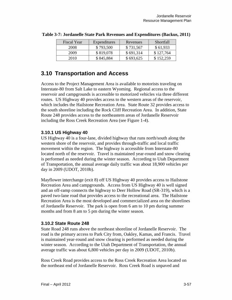
Jordanelle Reservoir
Resource Management Plan
Final – April 2012 3-57
Table 3-7: Jordanelle State Park Revenues and Expenditures (Backus, 2011)
Fiscal Year Expenditures Revenues Shortfall
2008 $ 793,500 $ 731,567 $ 61,933
2009 $ 819,078 $ 691,314 $ 127,764
2010 $ 845,884 $ 693,625 $ 152,259
3.10 Transportation and Access
Access to the Project Management Area is available to motorists traveling on
Interstate-80 from Salt Lake to eastern Wyoming. Regional access to the
reservoir and campgrounds is accessible to motorized vehicles via three different
routes. US Highway 40 provides access to the western areas of the reservoir,
which includes the Hailstone Recreation Area. State Route 32 provides access to
the south shoreline including the Rock Cliff Recreation Area. In addition, State
Route 248 provides access to the northeastern areas of Jordanelle Reservoir
including the Ross Creek Recreation Area (see Figure 1-4).
3.10.1 US Highway 40
US Highway 40 is a four-lane, divided highway that runs north/south along the
western shore of the reservoir, and provides through-traffic and local traffic
movement within the region. The highway is accessible from Interstate-80
located north of the reservoir. Travel is maintained year-round and snow clearing
is performed as needed during the winter season. According to Utah Department
of Transportation, the annual average daily traffic was about 18,900 vehicles per
day in 2009 (UDOT, 2010b).
Mayflower interchange (exit 8) off US Highway 40 provides access to Hailstone
Recreation Area and campgrounds. Access from US Highway 40 is well signed
and an off-ramp connects the highway to Deer Hollow Road (SR-319), which is a
paved two-lane road that provides access to the recreational area. The Hailstone
Recreation Area is the most developed and commercialized area on the shorelines
of Jordanelle Reservoir. The park is open from 6 am to 10 pm during summer
months and from 8 am to 5 pm during the winter season.
3.10.2 State Route 248
State Road 248 runs above the northeast shoreline of Jordanelle Reservoir. The
road is the primary access to Park City from, Oakley, Kamas, and Francis. Travel
is maintained year-round and snow clearing is performed as needed during the
winter season. According to the Utah Department of Transportation, the annual
average traffic was about 6,800 vehicles per day in 2009 (UDOT, 2010b).
Ross Creek Road provides access to the Ross Creek Recreation Area located on
the northeast end of Jordanelle Reservoir. Ross Creek Road is unpaved and

Jordanelle Reservoir
Resource Management Plan
3-58 Final – April 2012
provides access to a gravel parking area. The road is no longer maintained and is
in poor to moderate condition. This recreation area does not provide access to the
reservoir for boaters and its only purpose is to provide access to the Perimeter
Trail that runs along the northeast shoreline of Jordanelle Reservoir. The access
from SR 248 is not well signed, with hazardous ingress/egress issues.
3.10.3 State Route 32
State Road 32 is highway that runs east/west along the south shore of the
reservoir. This highway connects US Highway 40 to the town of Francis, Utah.
Rock Cliff Recreation Area is located about two miles west of Francis on the
farthest eastern corner of Jordanelle Reservoir. The highway is open year-round
and snow clearing is performed as needed during the winter season. According to
the Utah Department of Transportation, the annual average traffic was about
2,000 vehicles per day in 2009 (UDOT, 2010b).
Rock Cliff Road off State Route 32 provides access to Rock Cliff Recreational
Area. Rock Cliff Road is a paved road in moderate to good condition and is
passable to passenger vehicles. The park is open from 6 am to 10 pm during
summer months and from 8 am to 5 pm during the winter season. Access from
State Route 32 is well signed and an additional shoulder lane exists to facilitate
ingress and egress.
3.10.4 Recreation Facility Access Roads
As mentioned above, access to the recreation facilities at Jordanelle Reservoir is
generally via US Highway 40, State Route 248, and State Route 32 from which
individual access roads provide routes to each facility. Access roads vary from
paved and well maintained to unpaved and poorly maintained. Access from State
Route 248 is not well signed and has hazardous ingress/egress issues. With any
proposed development in the Ross Creek Recreation Area, access from State
Route 248 will need to be improved.
3.10.5 Planned Improvements
There are no current transportation improvements planned.
3.11 Cultural Resources
Cultural resources are defined as physical or other expressions of human activity
or occupation. Such resources include culturally significant landscapes,
prehistoric and historic archaeological sites as well as isolated artifacts or
features, traditional cultural properties, Native American and other sacred places,
and artifacts and documents of cultural and historic significance.
Section 106 of the National Historic Preservation Act (NHPA) of 1966 mandates
that Reclamation take into account the potential effects of a proposed federal
Jordanelle Reservoir
Resource Management Plan
Final – April 2012 3-59
undertaking (Federal Action in accordance with NEPA) on historic properties.
Historic properties are defined as any prehistoric or historic district, site, building,
structure or object included in, or eligible for, inclusion in the National Register
of Historic Places (NRHP). Potential effects of the described alternatives on
historic properties are the primary focus of this analysis.
The affected environment for cultural resources is identified as the APE (area of
potential effects), in compliance with the regulations to Section 106 of the NHPA
(36 CFR 800.16). The APE is defined as the geographic area within which an
undertaking may directly or indirectly cause alterations in the character or use of
historic properties. The APE for the undertaking (proposed action) includes the
entire Project Management Area.
3.11.1 Cultural History Overview
The Project Management Area lies in the Wasatch Hinterland Section of the
Middle Rocky Mountains physiographic province. The Wasatch Hinterland lies
directly east of the Wasatch Mountain Range and is comprised of mixed,
moderately rugged topography (Stokes, 1986). Archaeological investigations in
the Wasatch Hinterland remain rather sparse. Despite a lack of previous
investigations, a general cultural history of the Project Management Area may
still be given, based on the broader cultural chronological sequence of the eastern
Great Basin.
Archaeological evidence of human occupation in the eastern Great Basin extends
as far back as about 11,000 years before present (B.P.), the beginning of what is
generally referred to as the Paleo-Indian Period (ca 12,000 B.P. – 9,000 B.P.).
The Paleo-Indian Period is characterized by small mobile bands whose
subsistence strategies depended primarily on the exploitation of various extinct
and modern megafauna (Griffiths, 1998; Jennings, 1978; Madsen, 1982; McCarty,
et al., 1987; Tipps, et al., 2003). In the eastern Great Basin, most Paleo-Indian
sites have been found near late Pleistocene/early Holocene beaches, such as those
discovered around Sevier Lake. According to Madsen (1982), the distribution of
these sites suggests a dependence on lake-edge marsh environments during this
period. Projectile points generally associated with the Paleo-Indian Period
include fluted, stemmed/shouldered, and large lanceolate-types, such as Folsom
and Clovis (Griffiths, 1998; Madsen, 1982). Although distinctive artifacts
typically associated with the hunting of Pleistocene megafauna have been
discovered in the eastern Great Basin, as surface finds, there remains a lack of
stratified sites exhibiting evidence of human occupation dating to the Paleo-Indian
Period.
The next period in the cultural chronological sequence of the eastern Great Basin
is known as the Archaic Period (ca 8,500 B.P. – 2,000 B.P.). The Archaic Period
is generally divided into the Early Archaic, Middle Archaic, and Late Archaic
Periods. According to Jennings (1978), a shift to a “mobile hunting-collecting
Jordanelle Reservoir
Resource Management Plan
3-60 Final – April 2012
way of life” marks the transition from the Paleo-Indian to the Early Archaic
Period. Evidence of Early Archaic (ca 8,500 B.P. – 5,500 B.P.) human
occupation in the eastern Great Basin is almost exclusively found at lake-edge
sites, like those around the Great Salt Lake (Madsen, 1982). In contrast to Paleo-
Indian Period peoples, the Early Archaic cultures were collecting and processing
seeds, and using caves and rock shelters for food storage and habitation (Tipps, et
al., 2003; Madsen, 1982). In addition, new projectile point types also appear
during the Early Archaic Period (e.g., Pinto Series, Humboldt, Elko Series, and
Northern Side-Notched). This change in projectile point production is seen by
some as a reflection of the development of the atlatl for the pursuit of smaller,
faster game (Holmer, 1986). Projectile point styles would change again as the
Early Archaic Period transitioned into the Middle Archaic.
The production and use of Elko Series, Pinto, and Humboldt projectile points
continued into the Middle Archaic Period (ca 5,500 B.P. – 3,500 B.P.), but
Gypsum, Sudden Side-notched, Hawken Side-notched, Rocker Side-notched,
McKean Lanceolate, San Rafael, and Gate Cliff Split-stem points also begin to
appear (Griffiths, 1998). In addition, Middle Archaic Period populations began to
increase their use of upland habitats in the Great Salt Lake area, although lake
edge sites continued to be occupied. These upland areas appear to have been used
primarily as hunting camps, although grasses were also collected (Madsen, 1982).
At the end of the Middle Archaic Period, increased moisture led to rising lake
levels, a major factor in the transition to the Late Archaic Period.
The increase in moisture and the resulting rise in lake levels led to a depletion of
flora and fauna previously exploited in lake-edge marsh areas during the Middle
Archaic Period. These environmental changes contributed to an increased
settlement of upland cave and shelter areas during the Late Archaic Period
(Griffiths, 1998). During the Late Archaic Period (ca 3,500 B.P. – 2,000 B.P.),
subsistence activities shifted towards greater dependence on smaller game, such
as rabbits. Atlatl darts were replaced with smaller bow-and-arrow projectile
points such as the Rose Spring and Eastgate varieties. Few sites dating to the
Archaic Period have been identified within or near the Project Management Area.
According to Tipps et al. (2003), however, it is likely that the majority of open
lithic scatters found in the area date to this period.
The Formative Period (ca 1,600 B.P. – 650 B.P.) and the “Fremont culture,” a
term generally associated with Formative Stage cultures, followed the Late
Archaic Period. Settlement patterns generally associated with the Formative
Period in the eastern Great Basin include “villages located on alluvial fans in
intermontane valleys adjacent to marsh or riverine ecosystems” and transient
composites surrounding these villages (Madsen, 1982). Subsistence strategies
were still based on the exploitation of various wild flora and fauna, but were now
supplemented with horticulture, specifically corn agriculture. The Fremont
culture was also more sedentary than cultures from the previous cultural
chronological sequence. The use of horticulture and a more sedentary lifestyle

Jordanelle Reservoir
Resource Management Plan
Final – April 2012 3-61
also led to the development of permanent housing, in the form of pithouses, and
pottery (Tipps, et al., 2003; Griffiths, 1998). Projectile point types associated
with Formative Stage cultures include Bear River Side-notched, Uinta Side-
notched, Parowan Basal-notched, Nawthis Side-notched, and Bull Creek
(Griffiths, 1998). By about 600 B.P., evidence of the Fremont culture in the
eastern Great Basin is significantly depleted, giving way to what is commonly
termed the Late Prehistoric or Protohistoric Period (ca 750 B.P. – A.D. 1800).
The reasons for the diminishing Fremont site record remains unclear. Some
researchers postulate that climatic changes or the pressures of other cultural
groups entering the region caused the Fremont culture abandonment (Jennings,
1978). Others believe that the Fremont culture did not actually abandon the
region, but rather, that Fremont culture peoples coexisted with the new groups,
such as the ancestral Ute and Shoshone. A sheer lack of archaeological data
associated with the Protohistoric Period in the eastern Great Basin leaves many
questions about the cultural continuity, or lack thereof, unanswered. Whatever
the reasons, the evidence points to a lessening dependence on horticulture and the
subsequent dominance of a more hunter-gatherer oriented subsistence strategy,
traditionally referred to as Shoshonean or Numic. Formative Stage Fremont
culture remains still turn up at some archaeological sites dating to the
Protohistoric Period, however, unlike earlier Fremont sites, Desert Side-notched
projectile points, brownware ceramics, and tipi-type tents are also part of the
material culture (Tipps, et al., 2003). The introduction of the horse at the later
end of the Protohistoric Period dramatically changed the dynamics of subsistence
strategies for Protohistoric peoples. These groups became exceptionally mobile,
exploiting floral and faunal resources all over Utah (Hampshire, et al., 1998). As
influential as the introduction of the horse was on Protohistoric cultures, the
arrival of Euro-American explorers, trappers, and settlers into the eastern Great
Basin resulted in some of the most dramatic changes seen by Protohistoric
peoples in the region.
The arrival of Euro-Americans into the eastern Great Basin is generally classified
as the beginning of the Historic Period (ca A.D. 1800 – present). The first
European explorers to enter the eastern Great Basin were likely members of the
Dominguez-Escalante expedition in 1776 (Embry, 1996; Simms, 2008).
According to descriptions by Dominguez, large stable populations of Protohistoric
groups were living in the eastern Great Basin at the time of his arrival (Madsen,
1982). The purpose of the expedition was to find an overland trade route from
New Mexico to California. Other Euro-American explorers and fur trappers
followed, traveling throughout the eastern Great Basin during the early part of the
19th
century.
As Euro-American incursions multiplied, many traditional Protohistoric lifeways
were dramatically impacted. Many faunal resources, for instance, dwindled in
numbers as many trappers developed a reputation for shooting everything they
encountered (Hampshire, et al., 1998). Trees were cut down in large numbers for

Jordanelle Reservoir
Resource Management Plan
3-62 Final – April 2012
firewood and livestock decimated local grasses. With the arrival of Mormon
settlers in the mid-19th
century, Protohistoric populations would face even more
adversity, most notably in the form of forced relocation from traditional tribal
lands.
Historic Period settlement of the eastern Great Basin began soon after the arrival
of Mormon pioneers in 1847. Brigham Young instructed groups of colonists to
settle valleys in the area and by the 1850s; Mormon pioneers had expanded and
claimed most of the desirable land in the Salt Lake Valley (Embry, 1996;
Hampshire, et al., 1998; Tipps, et al., 2003). Mormon settlements continued to
expand out from the Salt Lake Valley, leading to numerous tribal land claim
conflicts. Utes originally occupied approximately 23.5 million acres (about 45%
of the total land area of Utah). By the 1880s, Ute peoples had been forcibly
relocated to reservations in the Uintah Basin, their land holdings having been
reduced to approximately 4 million acres (Callaway, et al., 1986).
By the beginning of the 20th
century, historical accounts of life in the eastern
Great Basin became increasingly extensive. As a result, a more specific overview
of the historical events in the Project Management Area and the immediate
vicinity can be presented. With populations in the Wasatch Front of northcentral
Utah growing exponentially, the need for water storage became increasingly
important. As early as 1905, ideas for a dam in the area were proposed as part of
a larger plan to divert and store Colorado River water from the south side of the
Uinta Mountains to the Wasatch Front by way of dams and tunnels (Embry,
1996). The Colorado River Compact of 1922 and the Upper Basin Compact of
1948 guaranteed Utah a portion of the water from the Colorado River. In order to
deliver this water to the Wasatch Front, Utah officials and Reclamation engineers
began planning the CUP in 1956. The largest unit of the Central Utah Project, the
Bonneville Unit, included a proposed reservoir on the border of Wasatch and
Summit counties on land belonging to the Jordan family. Based on the Jordan
family’s brand, Jordan L, the reservoir was to be known as Jordanelle Reservoir.
Local concern involving the impacts of the proposed Jordanelle Reservoir on the
local settlers led to decades of delays in the reservoir’s construction. Finally, in
1987, construction of Jordanelle Reservoir began.
Construction of Jordanelle Dam was essentially completed in 1993. Jordanelle
Reservoir brought increased numbers of summer tourists to the area. Local
recreation also increased and developers initiated construction on several projects
around the reservoir (Hampshire, et al., 1998). Although the area around
Jordanelle Reservoir has seen relatively substantial growth since the 1990s, the
area is still seen by many as an urban escape for people commuting to work in the
Wasatch Front and Salt Lake City (Embry, 1996).
Jordanelle Reservoir
Resource Management Plan
Final – April 2012 3-63
3.11.2 Cultural Resource Status
A Class I cultural resource literature search was conducted by Reclamation at the
Division of State History, Utah State Historic Preservation Office (SHPO) on
March 7, 2011 to identify any previously conducted cultural resource inventories
and recorded cultural resource sites within or near the Project Management Area.
Files at Reclamation and General Land Office maps for the area were also
examined. The results of the literature search included 40 previous cultural
resource inventories within approximately one mile of the Project Management
Boundary. As a result of these inventories, 68 cultural resource sites have been
identified.
The Jordanelle Reservoir RMP establishes only a conceptual framework for
managing resources at Jordanelle Reservoir and does not implement any specific
projects. As such, the scope of this RMP focuses on a broad scale of cultural
resource impacts associated with the array of alternatives and their broad levels of
proposed development within the Project Management Boundary. Site-specific
cultural resource impacts will be addressed as part of separate NEPA and Section
106 compliance processes prior to the implementation of individual projects
proposed as part of the selected RMP; those site-specific impacts are not
addressed in this RMP.
3.12 Paleontological Resources
Paleontological resources are defined as any fossilized remains, traces, or imprints
of organisms, preserved in or on the earth's crust, that are of paleontological
interest and that provide information about the history of life on earth.
Section 6302 of the Paleontological Resources Preservation Act (PRPA) of 2009
(Sections 6301-6312 of the Omnibus Land Management Act of 2009 [Public Law
111-11 123 Stat. 991-1456]) requires the Secretary of the Interior to manage and
protect paleontological resources on federal land using scientific principles and
expertise.
The affected environment for paleontological resources is represented by the same
proposed action Project Management Area APE that corresponds to cultural
resources as described in 3.11.
3.12.1 Paleontological Resource Status
A paleontological resource file search, covering the entire Project Management
Area, was conducted by the Utah Geological Survey (UGS) at the request of
Reclamation on March 7, 2011. Martha Hayden, Paleontological Assistant with
the UGS, was consulted regarding the potential for encountering previously
documented and presently unknown paleontological resources in the Project
Management Area. The UGS reply, dated March 7, 2011, stated that there are no
Jordanelle Reservoir
Resource Management Plan
3-64 Final – April 2012
previously documented paleontological localities within the Project Management
Boundary. Quaternary and Recent alluvial deposits and Tertiary volcanic
deposits that are exposed over most of the lands within the Project Management
Boundary have a low potential for yielding significant fossil localities.
According to the UGS, there may be some exposures of the Triassic Ankareh
Formation, however, located mainly in the northeast portion of the Project
Management Area, that have the potential for containing vertebrate fossils and/or
tracksites. Fossil wood has also been discovered in nearby Tertiary volcanic
deposits (the Keetley Volcanics).
The Jordanelle Reservoir RMP will establish only a conceptual framework for
managing resources at Jordanelle Reservoir and does not implement any specific
projects. As such, the scope of this RMP focuses on a broad scale of
paleontological resource impacts associated with the array of alternatives and
their broad levels of proposed development within the Project Management
Boundary. Site-specific paleontological resource impacts will be addressed as
part of separate NEPA and PRPA compliance processes prior to the
implementation of individual projects proposed as part of the selected RMP; those
site-specific impacts are not addressed in this RMP.
3.13 Indian Trust Assets
Indian Trust Assets (ITAs) are legal interests in property held in trust by the
United States for Indian tribes or individuals. The DOI’s policy is to recognize
and fulfill its legal obligations to identify, protect and conserve the trust resources
of federally recognized Indian tribes and tribal members, and to consult with
tribes on a government-to-government basis whenever plans or actions affect
tribal trust resources, trust assets, or tribal safety (please refer to Departmental
manual, 512 DM 2). Under this policy, as well as Reclamation’s ITA policy,
Reclamation is committed to carrying out its activities in a manner that avoids
adverse impacts to ITAs when possible, and to mitigate or compensate for such
impacts when it cannot. All impacts to ITAs, even those considered non-
significant, must be discussed in the trust analyses in NEPA compliance
documents and appropriate compensation or mitigation must be implemented.
Trust assets may include lands, minerals, hunting and fishing rights, traditional
gathering grounds, and water rights. Impacts to ITAs are evaluated by assessing
how the action affects the use and quality of ITAs. Any action that adversely
affects the use, value, quality or enjoyment of an ITA is considered to have an
adverse impact to the resources.

Jordanelle Reservoir
Resource Management Plan
Final – April 2012 3-65
3.13.1 Indian Trust Asset Status
Reclamation contacted the Bureau of Indian Affairs (BIA) Uintah and Ouray
Agency in Fort Duchesne, Utah and Fort Hall Agency in Fort Hall, Idaho
regarding potential impacts to ITAs within or near the Jordanelle Reservoir RMP
and EA Project Management Boundary. No ITAs were identified.
3.14 Hazardous Materials
The files of the Utah Department of Environmental Response and Remediation
(DERR) were searched to identify hazardous materials used in the Project
Management Area or areas within the Project Management Boundary that require
environmental cleanup. The most prevalent hazardous material used within the
Project Management Area is petroleum products, mainly gasoline used in vehicles
and boats. The Utah State Parks facilities currently have three underground
storage tanks registered with DERR. One of the tanks is a located at the Hailstone
Maintenance facility, which is currently used to store used oil. The tank is a
double walled fiberglass reinforced plastic tank with no record of leaks. The
second and third tanks are gasoline tanks located at the Hailstone Marina near the
boat ramp. The larger tank is a 6,000 gallon double walled fiberglass reinforced
plastic tank with no record of any leaks. The third tank is a 2,500 gallon double
walled fiberglass reinforced plastic tank. It is listed as temporarily out of use due
to a reported leak in 2005 associated with the piping. Remediation of the
contaminiated soil, groundwater, and tank has been completed. The tank is listed
as being in compliance but is currently not in use. No new storage tanks will be
permitted within the Project Management Boundary. Reclamation will work with
State Parks to phase out the existing tanks.
A search of the DERR database for facilities currently using or producing
hazardous materials identified none. However, two sets of tailings ponds
associated with the historic mining were located. The tailings have the potential
to leach heavy metals into the water and adjacent soils.
The Olson Neihart tailings ponds were located within the reservoir pool. Prior to
the filling of the reservoir the tailings associated with these ponds were moved
and put into an approved landfill identified as the Royal Street Landfill. The
landfill is located immediately southeast of the exit from Highway 40 to Highway
319 that connects to the Hailstone Marina. The landfill is located just outside of
the Project Management Boundary. There is potential for the tailings to
contaminate groundwater that flows towards Jordanelle Reservoir but the landfill
was built to modern standards with a clay liner, leachate collection system, and
cap so contamination is unlikely. The landfill is also being monitored regularly
by Reclamation to identify any leaks. No problems have been identified with
regard to this landfill.

Jordanelle Reservoir
Resource Management Plan
3-66 Final – April 2012
Adjacent to the landfill for the Olson Neihart tailings are the Mayflower Mountain
Tailings Ponds. These ponds are also located just outside of the Project
Management Boundary. These tailings ponds were once on the National
Priorities List (Superfund) but have been removed. The Utah Department of
Water Quality currently regulates the site. The site is being monitored. High
TDS concentrations have been identified in the monitoring wells. The tailings
contain heavy metals that could also contaminate soil and groundwater down-
gradient of the ponds. The Project Management Area is down-gradient of the
tailings ponds and could potentially be impacted. The owner of the ponds has
indicated a desire to cleanup the site so it can be developed, but nothing has
occurred yet.
The project vicinity has a history of mining activity. Mines in the area have
produced gold, silver, copper, lead, and zinc. There are many mining shafts and
tunnels within and adjacent to the Project Management Boundary which have
potential to allow migration of heavy metals toward the Project Management
Area. Tailings from the mining activities could be found throughout the Project
Management Area. However, DERR records do not indicate any sites other than
the tailings ponds mentioned above.
3.15 Socioeconomic Factors (Environmental Justice)
This section discusses the existing economic and social setting of the region
within which the Jordanelle Reservoir is located.
3.15.1 Regional Setting
Jordanelle Reservoir is set in a valley east of the Wasatch Mountains residing in
Wasatch County, which is located in the north-central part of Utah. The County
is bordered on the north by Summit County, on the east by Duchesne County, on
the south and southwest by Utah County, and the northwest by Salt Lake County.
Wasatch County is one of the smaller counties in the state with a total surface area
of 1,207 square miles.
Jordanelle Reservoir serves as a regional recreation resource for north central
Utah. Visitors (day-use and overnight) are most likely to come from locations
within a half hour to one hour’s drive time of the reservoir. This is due to its
close proximately to the major metropolitan area of Salt Lake City. With
Jordanelle being the closest drive from the city, it has become a popular and well-
known recreation area.
3.15.2 Economy
Wasatch County made a proactive economic move in June 2005 by forming the
Wasatch Area Economic Development Agency. The organization is a
cooperative effort between Wasatch County, Heber, Midway, and Jordanelle

Jordanelle Reservoir
Resource Management Plan
Final – April 2012 3-67
Basin entities to pool resources and strengthen local communities through
increased business development. In addition, the Wasatch Business Expansion
and Retention program was implemented to support and enhance the economic
impact of existing businesses.
To determine the overall economic health of the County, the latest information
available was pulled from the Utah Department of Workforce Services and the
Bureau of Economic Analysis.
Industries
In 2010, Wasatch County residents earned a total of $44,692,570. This amount
was less than 1 percent of the total for the entire State of Utah (Utah Department
of Workforce Services, 2011). The largest industrial sectors of Wasatch County
were government, construction, professional business services, and
leisure/hospitality. In comparison, professional business services, manufacturing,
and education/healthcare were the largest segments of the state’s economy when
measured by earnings.
Total employment in Wasatch County accounted for less than 1 percent of the
total employment in the State of Utah in 2009. The largest sectors were
government, leisure/hospitality, construction, and retail trade. These industries
accounted for over 65 percent of all jobs in the county (Bureau of Labor Statistics,
2011).
Jordanelle Reservoir Contribution
Information on this subsection was pulled from a flyer that State Parks generated
entitled “Jordanelle State Park Impacts on Wasatch County.” This information
sheds light on estimating the contribution that recreation at Jordanelle Reservoir
adds to the Wasatch County economy.
In 2010, 265,208 individuals visited Jordanelle State Park. At the time, the 2010
Wasatch County population was 23,530 according to the Governor’s Office of
Planning and Budget population estimates. Therefore, in 2010, the park and its
staff hosted a number of individuals that is more than 11 times the size of the
population of Wasatch County (GOPB, 2009).
The following figure demonstrates the trend in the number of annual visitors to
Jordanelle Reservoir.

Jordanelle Reservoir
Resource Management Plan
3-68 Final – April 2012
Figure 3-11: Annual Visitation to Jordanelle Reservoir (State Parks, 2011)
Since 2003, the park has averaged 227,847visitors annually. The park’s peak
visitation occurs in the months of May through September.
Figure 3-12: Average Monthly Visitation (State Parks, 2011)
While survey research has not been conducted at Jordanelle, data from other
similar parks may shed information on Jordanelle visitor use preferences and
patterns. A previous survey from nearby Rockport State Park suggests that the
park was a primary destination for about 80 percent of survey participants. At
2003 2004 2005 2006 2007 2008 2009 2010
Visitors 112,169 166,457 182,895 198,592 310,348 296,781 290,326 265,208
-
50,000
100,000
150,000
200,000
250,000
300,000
350,000
0
10,000
20,000
30,000
40,000
50,000
60,000
70,000
80,000
90,000
Jan Feb Mar Apr May Jun Jul Aug Sep Oct Nov Dec
Jordanelle Reservoir
Resource Management Plan
Final – April 2012 3-69
Rockport, about 90 percent of the park's visitors resided in areas outside of
Summit County, the majority being Salt Lake County residents. Given its
proximity to the Wasatch Front, it is likely that Jordanelle visitors have similar
characteristics. Rockport Reservoir is a similar distance from Salt Lake City as
Jordanelle Reservoir is and most of the trip to both reservoirs would be on
Interstate 80.
Survey data shows that on average, visitors to parks similar to Jordanelle spend
about $141 per group within close proximity of local cities and towns during each
boating trip to nearby lakes and reservoirs. Average group size at these reservoirs
is about 7.4 individuals, and average length of stay is about 1 day. This translates
into average expenditures of approximately $19 per visit, per individual.
In 2009, division planners conducted research to estimate the impacts that visitor
spending has on Wasatch County. It is likely that most spending occurring in
Wasatch County is a result of overnight visitors and visitors travelling through
Heber City during their park visit. On the high end of the analysis, it is estimated
that the 290,326 visitors to Jordanelle in 2009 generated approximately $2.6
million in local wages, earnings, rents, and tax revenues with the local area in
2009 (State Parks, 2009a). However, since most Jordanelle visitors are day-users
coming from Salt Lake County, Summit County probably receives a larger
portion of this impact.
In 2009, Wasatch County received $33,724 in sales and use taxes from park
operations (State Parks, 2009c). Along with Wasatch Mountain and Deer Creek,
the park also contributed to the $18,575 in transient room taxes receipts that these
parks generated for Wasatch County.
In 2009, Wasatch County had five major boat dealers, two boat liveries (providing
boat rentals) and three boating outfitters. Also in 2009, the Division's Boating
Program authorized (or listed as current) six Captain/Guide licenses and boat
crew permits within the county. The park and the division played key roles
facilitating economic impacts to the county through the provision of boating
opportunities.
In 2008, 2,341 off-road vehicles (OHVs) and 1,198 snowmobiles were registered
in Wasatch County, providing the county with about $97,323 in revenues (in the
form of fees in-lieu of property taxes) (State Parks, 2008). Through its
administration of statewide OHV and snowmobile programs, the Division
facilitates the provision of numerous area OHV and snowmobile opportunities
that undoubtedly bring even more economic impact to the county.
The recreation areas at Jordanelle Reservoir provide opportunities for private
businesses. In 2010, a new concession contract was put in effect at the park
providing retail items, boat rentals and other services. This privately-owned
business has the potential to generate significant revenues (past operations have
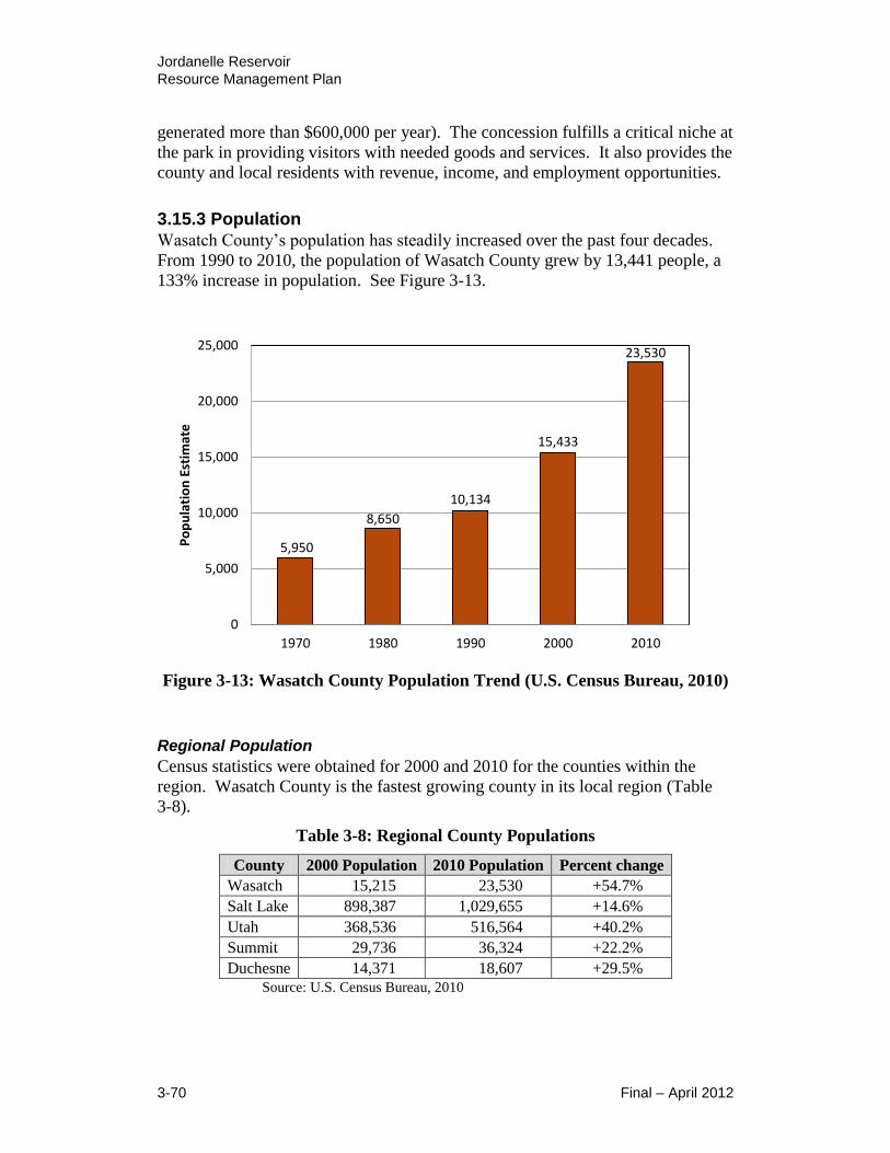
Jordanelle Reservoir
Resource Management Plan
3-70 Final – April 2012
generated more than $600,000 per year). The concession fulfills a critical niche at
the park in providing visitors with needed goods and services. It also provides the
county and local residents with revenue, income, and employment opportunities.
3.15.3 Population
Wasatch County’s population has steadily increased over the past four decades.
From 1990 to 2010, the population of Wasatch County grew by 13,441 people, a
133% increase in population. See Figure 3-13.
Figure 3-13: Wasatch County Population Trend (U.S. Census Bureau, 2010)
Regional Population
Census statistics were obtained for 2000 and 2010 for the counties within the
region. Wasatch County is the fastest growing county in its local region (Table
3-8).
Table 3-8: Regional County Populations
County 2000 Population 2010 Population Percent change
Wasatch 15,215 23,530 +54.7%
Salt Lake 898,387 1,029,655 +14.6%
Utah 368,536 516,564 +40.2%
Summit 29,736 36,324 +22.2%
Duchesne 14,371 18,607 +29.5%
Source: U.S. Census Bureau, 2010
5,950
8,650
10,134
15,433
23,530
0
5,000
10,000
15,000
20,000
25,000
1970 1980 1990 2000 2010
Po
pu
lati
on
Est
imat
e
Jordanelle Reservoir
Resource Management Plan
Final – April 2012 3-71
Racial Characteristics
Executive Order 12898, Federal Actions to Address Environmental Justice on
Minority Populations and Low-Income Populations, signed by President Clinton,
February 11, 1994, directs federal agencies to take the appropriate and necessary
steps to identify and address disproportionately high and adverse effects of federal
projects on the health or environment of minority and low-income populations to
the greatest extent practicable and permitted by law. As such, an assessment of
potential disproportional or discriminatory effects of the project is necessary for
the project. Racial data is provided here to present baseline data associated with
the assessment or potential environmental justice impacts that may occur as a
result of the RMP alternatives under consideration. Table 3-9 provides racial
composition data for Wasatch County based on year 2010 census data.
Table 3-9: Wasatch County Race/Ethnic Distribution
Share of Population 2010
Hispanic or Latino (of any race) 13.5%
Not Hispanic or Latino 86.5%
One race 85.5%
White 84.2%
Black or African American 0.2%
American Indian and Alaska Native 0.2%
Asian 0.7%
Native Hawaiian and Other Pacific Islander 0.1%
Some Other Race 0.1%
Two or More Races 0.9%
Source: U.S. Census Bureau, 2010
One notable change in the 2010 Census was another large increase in Wasatch
County’s Hispanic population. In 1990, 2.5 percent of the county’s population
was Hispanic. By 2000, that share had doubled to more than 5 percent. Now in
2010, the Hispanic population has more than doubled again to a total 13.5 percent
of the population.
3.15.4 Social Well-being
The social well-being of the area is where the basic needs of the populace are met.
Many attempts can be made to quantify social well-being. Ways to quantify the
social well-being of the area are where income levels are high enough to cover
basic wants, where there is no poverty, where unemployment is insignificant,
where there is easy access to social, medical, and educational services, and where
everyone is treated with dignity and consideration.
What can be difficult to quantify is the actual quality of life for individuals. For
example, although economic output rises, it does not guarantee a rise in life
satisfaction or “well-being.”
Jordanelle Reservoir
Resource Management Plan
3-72 Final – April 2012
For the most part, Wasatch County has a social well-being similar to that of the
State of Utah. The following subsections give details on where Wasatch County
lines up socially in comparison with state and national statistics.
Income
In 2008, Wasatch County had a per capita personal income (PCPI) of $29,060,
and the county ranked 11th
out of the 29 counties in Utah. The PCPI was 91
percent of the Utah state average of $32,050; however, only 72 percent of the
national average of $40,166. Utah’s PCPI was ranked 47th
in the United States.
Employment
Overall, the employment situation in Wasatch County has been similar to that of
the state as a whole. Table 3-10 lists unemployment rates for Wasatch County,
the state of Utah, and the United States. As noted below, Wasatch County and the
state both fair better than the average national unemployment rating.
Table 3-10: Unemployment Rates
Area 2001 2004 2006 2010
Wasatch County 4.5% 5.5% 3.2% 8.8%
Utah 4.4% 5.0% 3.0% 7.7%
United States 4.7% 5.5% 4.6% 9.6% Source: Bureau of Labor Statistics, 2011
Poverty
From 1989 through 2009, the poverty rate for Wasatch County was consistently
lower than the rates for Utah and the United States. Table 3-11 lists poverty rates
for Wasatch County, Utah, and the United States. The poverty rate for Wasatch
County increased in 2009; however, this rate remained more than three percentage
points lower than Utah’s rate and more than two percentage points lower than the
national average.
Table 3-11: Poverty Rates
Area 1989 1999 2009
Wasatch County 7.9% 5.2% 8.5%
Utah 11.4% 9.4% 11.7%
United States 13.1% 12.4% 14.3% Source: USDA Economic Research Service, 2011
Households
Based upon the data shown in Table 3-12, it is evident that Wasatch County has a
strong orientation towards family. A large literature in economics has considered
the relationship between family size and later life outcomes, including educational
attainment and adult earnings. However, a consensus as to the relationship
between family size and well-being remains elusive.

Jordanelle Reservoir
Resource Management Plan
Final – April 2012 3-73
Table 3-12: Household Characteristics
Wasatch County Utah United States
Total households 6,624 831,563 112,611,029
Family Households 80.3% 75.3% 66.7%
Nonfamily households
(householder living alone)
19.7% 24.7% 33.3%
Average family size 3.44 3.62 3.19
Source: U.S. Census Bureau, American Community Survey, 2005-2009
Education
An individual’s educational attainment is one of the most important determinants
of their life chances in terms of employment, income, health status, housing, and
many other amenities. An excellent education has benefits not only for the
individual but also for the taxpayer and society. Poor education leads to large
public and social costs in the form of lower income and economic growth,
reduced tax revenues, and higher costs of such public services as health care,
criminal justice, and public assistance.
The following figure demonstrates that Wasatch County is in good hands for
social and economic growth. Only 7.5% of Wasatch County does not attain a
high school diploma compared to the national average of 15.5%.
Figure 3-14: Education Attainment
(U.S. Census Bureau, American Community Survey, 2005-2009)
Less than9th grade
9th to 12thgrade, nodiploma
High schoolgraduate(includes
equivalency)
Somecollege, no
degree
Associate’s degree
Bachelor’s degree
Graduate orprofessional
degree
Wasatch County 1.80% 5.70% 25.70% 26.90% 10.30% 20.30% 9.30%
Utah 3.10% 6.50% 25.40% 27.00% 9.20% 19.50% 9.30%
United States 6.40% 9.10% 29.30% 20.30% 7.40% 17.40% 10.10%
0%
5%
10%
15%
20%
25%
30%
35%
Po
pu
lati
on
25
ye
ars
and
ove
r

This page is intentionally left blank

Jordanelle Reservoir Resource Management Plan
Final – April 2012 4-1
Chapter 4: Resource Management Plan
This chapter provides long-range management direction for Jordanelle Reservoir
and surrounding lands in response to public and management concerns. In order
to obtain the desired future condition, implementation of the management actions
is essential to translating RMP goals and objectives to actual application and
practice. The RMP includes general area-wide actions and specific actions.
General actions are those that are broad-based management directions that include
overall area-wide goals and objectives which apply to all lands within the Project
Management Boundary. Specific actions are management directions formulated
to be site-specific, prescriptive-based actions directed at specific purposes for
specific recreation and land management areas. These actions are intended to be
implemented over the next 10 years, or as funding is available, as described in
Chapter 5.
4.1 Introduction
The Preferred Plan for the Jordanelle Reservoir RMP was selected by
Reclamation. The plan formulation and project alternatives were discussed in
Chapter 2. The goal is to achieve recreational development while protecting, and
where possible enhancing, other resources within the Project Management
Boundary. The following provides a detailed description of the goals and
objectives and the preferred management actions/directions to obtain the desired
future condition.
Inclusion of these actions does not ensure funding, staff, or equipment will be
available to implement these actions nor does it obligate Reclamation to
implement actions in the future. Reclamation does not have direct authority to
undertake certain recreation improvements without the assistance of a managing
partner.
4.2 Screening Criteria
A standard was followed when evaluating existing/proposed uses and activities
within the Project Management Boundary by using the developed criteria. As
such, it is important that a use or activity:
Does not change the operation of the reservoir outside the existing
operational criteria.
Does not adversely affect water quality.

Jordanelle Reservoir Resource Management Plan
4-2 Final – April 2012
Complies with federal, state, and county planning, zoning, and building
requirements.
Does not adversely impact threatened, endangered or special status
species.
Meets public health/safety standards and regulations.
Complies with laws, regulations, and policies of the natural environment.
Is reasonable and financially feasible.
Can be implemented.
Is contained within the Project Management Boundary (Figure 1-3) and is
consistent with restrictions and status of project lands.
4.3 Management Direction
Management directions for the Project Management Area have been developed at
two levels:
Area-wide management directions, and
Specific-area management directions for the land management areas.
4.4 Area-Wide Goals and Objectives
Goals and objectives were developed for the RMP in direct response to the Issue
Statements detailed in Chapter 2. However, each Issue Statement may not require
a specific set of goals and objectives and, in some cases, a set of goals and
objectives may address several Issue Statements. In all cases, an effort was made
to incorporate the issues and opportunities identified in the Issue Statements into
the goals and objectives for the RMP.
Each goal describes a desired future condition in the Project Management Area.
Along with each goal is a set of objectives that describe management
actions/directions that must be completed in order to accomplish each goal.
When the objectives are implemented, the goal will be reached. A detailed
discussion of the goals and objectives for each of the Goal Categories are
described further in this chapter and include (A) Partnerships, (B) Water
Resources, (C) Recreation and Visual Resources, (D) Natural, Cultural, and
Paleontological Resources, (E) Public Information, Health and Safety, (F) Land
Management, and (G) Project Facilities. Table 4-1 provides a summary of the
goals by category.

Jordanelle Reservoir Resource Management Plan
Final – April 2012 4-3
Table 4-1: Summary of Identified Goals by Category
A. Partnerships
Support Agreements and Contracts, and Encourage Partnerships that pursue Best
Resource Management Practices
B. Water Resources
Protect Water Quality in Jordanelle Reservoir
Operate Jordanelle Reservoir to meet Project Purposes
C. Recreational And Visual Resources
Seek Funding to Support Recreation Development
Offer Additional Recreational Opportunities
Provide Appropriate Recreational Facilities
Provide for Safe, Quality Recreational Opportunities that Minimize Conflicts
Protect and Manage the Visual Resources
D. Natural, Cultural, and Paleontological Resources
Control/Manage the Introduction and Spread of Noxious Weeds
Continue Management to Maintain Wildlife Values as per the mitigation
commitments identified in the 1979 FES and the 1987 FS to the M&I System FES to
the extent practicable; mitigate for unavoidable impacts
Protect and Enhance the Quality of the Fishery
Reduce Facility Damage along Provo River at Rock Cliff Recreation Area
Control/Manage Invasive Aquatic Species
Protect and Enhance Native Vegetation and Wildlife Habitat
Control Soil Erosion
Protect and Manage Cultural and Paleontological Resources
E. Public Information, Health And Safety
Provide Public Information
Provide Adequate Safety Measures to Ensure Health and Safety of Staff and Visitors
Provide Appropriate and Safe Access to Public Use Areas
F. Land Management
Apply Internal Management Responsibilities
Continue Private Exclusive Recreational or Residential Use Policy
Manage Access to Jordanelle Reservoir
G. Project Facilities
Ensure Safety of Primary Jurisdiction Zone
Jordanelle Reservoir Resource Management Plan
4-4 Final – April 2012
4.4.1 Goal Category A: Partnerships
A.1 Goal: Support Agreements and Contracts, and Encourage Partnerships that Pursue Best Resource Management Practices (Issue A1)
Objectives:
A.1.1 Evaluate proposed use activities against project purposes, contracts,
and agreements.
A.1.2 Maintain and support partnerships and agreements to achieve the goals
of the RMP.
4.4.2 Goal Category B: Water Resources
B.1 Goal: Protect Water Quality in Jordanelle Reservoir (Issue B1)
Objectives:
B.1.1 Promote and support watershed best management practices to ensure
high quality water for all users and to meet designated beneficial uses
in the Provo River Watershed.
B.1.2 Identify water quality impacts coming from the Jordanelle Reservoir
Project Management Area and suggest ways to meet beneficial use
designations.
B.2 Goal: Operate Jordanelle Reservoir to meet Project Purposes (Issue B2)
Objectives:
B.2.1 Continue to operate Jordanelle Reservoir to meet primary project
purposes of delivering M&I and agricultural water and secondary
project purposes of recreation, fish and wildlife, flood control and
power, by honoring all existing and future contracts and agreements
with respect to water deliveries and operations.
4.4.3 Goal Category C: Recreational and Visual Resources
C.1 Goal: Seek Funding to Support Recreation Development (Issue C1)
Objectives:
C.1.1 Consider lowest “life cycle costs” (cost of facility that includes an
O&M component) in all planning and design of new or renovated
facilities, rather than choosing the lowest “capital cost”.
Jordanelle Reservoir Resource Management Plan
Final – April 2012 4-5
C.2 Goal: Offer Additional Recreational Opportunities (Issue C2)
Objectives:
C.2.1 Provide high-quality, visually appealing, accessible recreation
experience.
C.3 Goal: Provide Appropriate Recreational Facilities (Issue C3) (See Section 4.5 Site-Specific Goals and Objectives)
Objectives:
C.3.1 Recommend appropriate recreational facilities at appropriate locations.
C.3.2 Recommend facility improvements based on visitor needs.
C.3.3 Upgrade existing facilities.
C.3.4 Develop new facilities.
C.4 Goal: Provide for Safe, Quality Recreational Opportunities that Minimize Conflicts (Issue C4, C5)
Objectives:
C.4.1 Identify appropriate recreational use areas.
C.4.2 Identify recreation capacities for both land-and water-based recreation.
(Also see C.2.1)
C.4.3 Identify potential wakeless zones.
C.5 Goal: Protect and Manage the Visual Resources (Issue C5)
Objectives:
C.5.1 Establish Visual Integrity Objectives.
4.4.4 Goal Category D: Natural, Cultural, and Paleontological Resources
D.1 Goal: Control/Manage the Introduction and Spread of Noxious Weeds (Issue D1)
Objectives:
D.1.1 Identify locations and extent of where state-listed noxious weeds,
invasive exotics, and other plants are a problem requiring action.
D.1.2 Follow the Integrated Pest Management Plan.
D.2 Goal: Continue Management to Maintain Wildlife Values as per the mitigation commitments identified in the 1979 FES and the 1987

Jordanelle Reservoir Resource Management Plan
4-6 Final – April 2012
FS to the M&I System FES to the extent practicable; mitigate for unavoidable impacts (Issue D2)
Objectives:
D.2.1 Coordinate/consult with the Mitigation Commission, USFWS, and
UDWR regarding the current and future role of the West Hills WMA,
in achieving wildlife mitigation for the Bonneville Unit of CUP.
D.2.2 Review mitigation commitments made in the 1987 Wildlife
Management Plans and implement additional mitigation as necessary
as additional development occurs consistent with this RMP.
D.3 Goal: Protect and Enhance the Quality of the Fishery (Issues C3, D3)
Objectives:
D.3.1 Coordinate annual reservoir operations with the UDWR to identify
possible fishery enhancement opportunities.
D.3.2 Recommend appropriate development criteria for improving fish
habitat.
D.4 Goal: Reduce Facility Damage along Provo River at Rock Cliff Recreation Area (Issue D4)
Objectives:
D.4.1 Consultation with PRWUA could provide helpful information as they
have developed and are implementing an upper Provo River
maintenance program to help mitigate flood impacts above the
Jordanelle Reservoir.
D.5 Goal: Control/Manage Invasive Aquatic Species (Issue D5)
Objectives:
D.5.1 Coordinate with appropriate agencies (e.g., UDWR, State Parks) to
prevent invasive aquatic species.
D.5.1 Require mandatory boat inspection for aquatic invasive species and
provide boat decontamination station and trained technician.
D.6 Goal: Protect and Enhance Native Vegetation and Wildlife Habitat (Issues D1, D2, D6)
Objectives:
D.6.1 Identify areas of potential habitat for threatened, endangered, and
special status species.
D.6.2 Identify sensitive riparian and wetland habitats and protect those
habitats in accordance with the Federal Clean Water Act and
Executive Order 11990.
Jordanelle Reservoir Resource Management Plan
Final – April 2012 4-7
D.7 Goal: Control Soil Erosion (Issue D7)
Objectives:
D.7.1 Work with water users, Recreation Park Manager, and other entities as
appropriate to implement erosion control strategies.
D.8 Goal: Protect and Manage Cultural and Paleontological Resources (Issues D8, D9)
Objectives:
D.8.1 Identify the present integrity and eligibility of cultural resources,
including historic, prehistoric, and paleontological resources, where
development is proposed.
D.8.2 Recommend mechanisms to protect, preserve, restore, recognize, and
interpret historic, prehistoric, and paleontological resource sites.
4.4.5 Goal Category E: Public Information, Health and Safety
E.1 Goal: Provide Public Information (Issue E1)
Objectives:
E.1.1 Provide up-to-date information regarding reservoir elevations,
usability of boat ramps and other park facilities, fishing rules and
regulations, rules and regulations governing safe use of the facilities,
etc. using resources such as internet, brochures, radio, pamphlets,
maps, etc.
E.2 Goal: Provide Adequate Safety Measures to Ensure Health and Safety of Staff and Visitors (Issue E2)
Objectives:
E.2.1 Work with law enforcement to understand the responsibilities between
State Parks and Wasatch County.
E.2.2 Work cooperatively with other local agencies to maximize the use of
existing resources and funding to ensure adequate levels of
enforcement are provided in order to balance public safety, resource
protection, and water supply commitments.
E.3 Goal: Provide Appropriate and Safe Access to Public Use Areas (Issue C4, E2)
Objectives:
E.3.1 Evaluate current access to the Rock Cliff Recreation Area.

Jordanelle Reservoir Resource Management Plan
4-8 Final – April 2012
E.3.2 Explore the feasibility and appropriate locations of accessible boating
and fishing facilities.
4.4.6 Goal Category F: Land Management
F.1 Goal: Apply Internal Management Responsibilities (Issue F1)
Objectives:
F.1.1 Review existing contracts and agreements with managing entities to
apply agency management responsibility for internal management
boundaries outside the three defined recreation areas.
F.2 Goal: Continue Private Exclusive Recreational or Residential Use Policy (Issue F2)
Objectives:
F.2.1 Phase out existing recreation facilities deemed to be exclusive use
when lands are needed for greater public purposes.
F.2.2 Per existing policy, prohibit private, exclusive facilities by
Reclamation, its managing partners, or other private entities
F.2.3 Respond to private business partner requests for development for
public use on a case-by-case basis.
F.3 Goal: Manage Access to Jordanelle Reservoir (Issue F3)
Objectives:
F.3.1 Access must continue to be restricted in the Primary Jurisdiction Zone
or other areas that could compromise public or facility safety.
F.3.2 Restrict access that would compromise water quality or any of the
other purposes of the reservoir.
4.4.7 Goal Category G: Project Facilities
G.1 Goal: Ensure Safety of Primary Jurisdiction Zone (Issue G1)
Objectives:
G.1.1 Protect the Primary Jurisdiction Zone
4.5 Specific-Area Goals and Objectives
As described in Chapter 2 of the RMP and detailed in Chapter 2 of the
accompanying EA, the Preferred Plan (Alternative A) identifies management
actions in the specific land areas. As with the area-wide goals and objectives, the

Jordanelle Reservoir Resource Management Plan
Final – April 2012 4-9
specific-area goals and objectives address some of the Issue Statements as they
pertain to a specific land area. The land management areas are identified based
on existing recreation areas and location within the Project Management
Boundary and are the following, generally moving clockwise starting at Hailstone
Recreation Area: Hailstone Recreation Area, Crandall Point, Northwest Shore,
Ross Creek Recreation Area, Primitive Shoreline with West Hills WMA directly
to the northeast, Rock Cliff Recreation Area, Primitive Shoreline, and Primary
Jurisdiction Zone (Figure 1-4).
Each goal describes a desired future condition within each land area. The
combined actions identified by recreation and land areas provide a broad range of
choices in guiding the management and near-term development or redevelopment
of facilities in the specific areas as described below.
4.5.1 Hailstone Recreation Area
Goal: Ensure a more visitor-friendly park and help the Recreation Park Manager meet the growing needs of park visitors.
Objectives:
1. Provide high-quality recreation facilities and a wide variety of recreation
opportunities that have minimal maintenance costs and are self-sustained
by user fees.
Specific Management Actions:
Continue maintenance of existing facilities by the Recreation Park
Manager.
Continue mandatory boat inspection for aquatic invasive species and
continue to provide boat decontamination.
Provide improvements to campgrounds including RV pad modifications
and cabin development.
Provide improved access and facilities at Keetley Campground.
Drill well to develop additional water for landscape irrigation. Water for
landscaping may be obtained from a surface water source instead of from
a well.
Create internal trail system between facilities at Hailstone.
Redesign and reconstruct the entrance station to accommodate visitors at a
quicker rate and reduce traffic congestion.
Extend Perimeter Trail from Hailstone to Crandall Point.
Maintain the existing wakeless use areas for beaches, fishing and non-
motorized watercraft use, e.g., sailing and wind surfing.
Enlarge existing dry storage facility for non-motorized watercraft
including laser sailboats.

Jordanelle Reservoir Resource Management Plan
4-10 Final – April 2012
Create educational opportunities.
Increase parking for day-users.
Recreation Park Manager to continue land management activities
necessary to protect against the spread of noxious weeds and other pests
detrimental to natural values, agriculture, or public health and safety, and
to promote the growth of native species within the defined recreation area.
Consult with USFWS, Mitigation Commission, and UDWR regarding the
development of new project facilities and land use plans to protect wildlife
values envisioned in the 1987 FS to M&I System FES.
Consult with UDWQ and CUWCD about water quality impacts of any
new projects.
4.5.2 Crandall Point
Goal: Develop area to be more easily accessible to fisherman and day-use visitors. Crandall Point is to be a primitive area with no power, water, or sewer facilities.
Objectives:
1. Develop and provide controlled access to the water, shoreline, trails and
other recreation opportunities, including direct fisherman access to
shoreline.
Specific Management Actions:
Develop trailhead including: gravel parking lot, self-pay fee station, vault
toilet restrooms, and Perimeter Trail access.
Extend Perimeter Trail from Hailstone to Crandall Point.
Allow connection to Perimeter Trail from other trail systems.
Install additional trails for pedestrian and fisherman access to reservoir.
Pursue access for parking lot.
Recreation Park Manager to continue land management activities necessary
to protect against the spread of noxious weeds and other pests detrimental
to natural values, agriculture, or public health and safety, and to promote
the growth of native species within the defined recreation area.
Consult with USFWS, Mitigation Commission, and UDWR regarding the
development of new project facilities and land use plans to protect wildlife
values envisioned in the 1987 FS to M&I System FES. Mitigate for areas
lost to recreational development and use.
Consult with UDWQ and CUWCD about water quality impacts of any new
projects.
Jordanelle Reservoir Resource Management Plan
Final – April 2012 4-11
4.5.3 Northwest Shore
Goal: Provide for development and enhancement of recreation opportunities and provide wildlife habitat values. Shoreline areas are envisioned to be a primitive area with no power, water, or sewer facilities and only accessible by the Perimeter Trail or by boat.
Objectives:
1. Develop and enhance recreation opportunities that would have minimal
effects to wildlife habitat values.
Specific Management Actions:
Continue maintenance of existing Perimeter Trail by the Recreation Park
Manager.
Develop unique shoreline day-use areas, accessible by boat or by
Perimeter Trail to be managed by Recreation Park Manager. Primitive
Area: no power, water, or sewer.
Allow access to Perimeter Trail from other trail systems.
Respond to private concessionaire requests to develop, operate, and
maintain new public facilities.
Recreation Park Manager to protect against introduction and spread of
noxious weeds and other pests detrimental to natural values, agriculture, or
public health and safety, and to promote the growth of native species
within the defined recreation area.
Consult with USFWS, Mitigation Commission, and UDWR regarding the
development of new project facilities and land use plans to protect wildlife
values envisioned in the 1987 FS to M&I System FES. Mitigate for areas
lost to recreational development and use.
Consult with UDWQ and CUWCD about water quality impacts of any
new projects.
4.5.4 Ross Creek Recreation Area
Goal: Proper planning and implementation of recreation facilities to improve land management of the area, respond to private business partner requests, increase recreational opportunities for the public, and increase revenue to the Recreation Park Manager to attain self-sufficiency. It is envisioned to be a primitive area with no power, water, or sewer facilities.
Objectives:
1. Develop and enhance recreation opportunities while maintaining the area’s
natural landscape and wildlife habitat values.

Jordanelle Reservoir Resource Management Plan
4-12 Final – April 2012
2. Develop and maintain facilities and infrastructure that are well designed,
well maintained, appropriately budgeted, feasibly staffed, and consistent
with the area’s natural aesthetics.
Specific Management Actions:
Continue maintenance of existing facilities by the Recreation Park
Manager including: parking lot, self-pay fee station, vault toilet restrooms,
hitching posts, and access to Perimeter Trail.
Install access trails to reservoir.
Provide infrastructure improvements.
Pursue improved access from SR 248.
Designate the existing wakeless use areas for beaches and non-motorized
watercraft use.
Allow access to Perimeter Trail from other trail systems.
Pursue concession opportunities, e.g., bike, non-motorized boat, and/or
horse rental.
Respond to private concessionaire requests to develop, operate, and
maintain new public facilities.
Recreation Park Manager to continue land management activities necessary
to protect against the spread of noxious weeds and other pests detrimental
to natural values, agriculture, or public health and safety, and to promote
the growth of native species within the defined recreation area.
Consult with USFWS, Mitigation Commission and UDWR regarding the
development of new project facilities and land use plans to protect wildlife
values envisioned in the 1987 FS to M&I System FES. Mitigate for areas
lost to recreational development and use.
Consult with UDWQ and CUWCD about water quality impacts of any new
projects.
4.5.5 Rock Cliff Recreation Area
Goal: Provide for the preservation and enhancement of the existing facilities, as well as preserve wildlife habitat values in the area.
Objectives:
1. Develop and enhance recreation opportunities while maintaining the area’s
natural landscape and wildlife habitat values, including the Columbia
Spotted Frog, to the extent practicable.
2. Develop and maintain facilities and infrastructure that are well designed,
well maintained, appropriately budgeted, feasibly staffed, and consistent
with the area’s natural aesthetics.
Jordanelle Reservoir Resource Management Plan
Final – April 2012 4-13
Specific Management Actions:
Continue maintenance of existing facilities by the Recreation Park
Manager including: parking lot, fee station, access to Perimeter Trail,
small boat ramp, and Nature Center.
Consider alternative camping methods (e.g., yurts, cabins).
Add pavilions as needed.
Maintain Nature Center and pursue other opportunities or uses to maintain
and create additional education facilities.
Maintain current boat ramp for small watercraft (motorized and non-
motorized).
Maintain the existing wakeless use areas for beaches and non-motorized
watercraft use.
Require mandatory boat inspection for aquatic invasive species and
provide boat decontamination station and trained technician.
Allow access to Perimeter Trail from other trail systems.
Continue stream stabilization activities as necessary to protect existing
facilities, while respecting river character.
Remove utilities from the bridge and relocate to stabilize as appropriate.
Directional drilling could be used to put utilities under the river or utilities
could be placed in the access road and highway to avoid crossing the river
in the park.
Evaluate flood plain to determine the liability to facilities. Make
improvements as necessary.
Pursue improved access from SR 32.
Pursue opportunities to improve facilities.
Provide electrical hookups for camp host.
Recreation Park Manager to continue land management activities
necessary to protect against the spread of noxious weeds and other pests
detrimental to natural values, agriculture, or public health and safety, and
to promote the growth of native species within the defined recreation area.
Consult with USFWS, Mitigation Commission, and UDWR regarding the
development of new project facilities and land use plans to protect wildlife
values envisioned in the 1987 FS to M&I System FES. Mitigate for areas
lost to recreational development and use.
Consult with UDWQ and CUWCD about water quality impacts of any
new projects.
Jordanelle Reservoir Resource Management Plan
4-14 Final – April 2012
4.5.6 Primitive Shoreline Area
Goal: Provide areas only accessible by boat or by the Perimeter Trail. It is envisioned that these areas will be preserved to maintain wildlife habitat values and current conditions.
Objectives:
1. Maintain existing conditions.
Specific Management Actions:
Continue management to maintain wildlife values envisioned in the 1987
FS to M&I System FES.
Continue maintenance of existing Perimeter Trail by the Recreation Park
Manager.
Recreation Park Manager to protect against introduction and spread of
noxious weeds and other pests detrimental to natural values, agriculture, or
public health and safety.
4.5.7 Primary Jurisdiction Zone
Goal: Protect the Primary Jurisdiction Zone. The restricted area is for use exclusively by CUWCD for operation and maintenance of Jordanelle Dam.
Objectives:
1. Continue maintenance of existing facilities by CUWCD under direction of
Reclamation and protect dam face.
2. Restrict access within the Primary Jurisdiction Zone.
Specific Management Actions:
Continue maintenance of existing facilities by CUWCD under direction of
Reclamation.
Maintain a permanent row of buoys 500 feet from the face of Jordanelle
Dam.
Restrict access within the Primary Jurisdiction Zone.
Recreation Park Manager will assist with security monitoring along the
buoys to keep people away from the dam.
CUWCD and Reclamation to protect against introduction and spread of
noxious weeds and other pests detrimental to natural values, agriculture, or
public health and safety.

Jordanelle Reservoir Resource Management Plan
Final – April 2012 4-15
4.5.8 West Hills Wildlife Management Area
Goal: Preserve area to maintain wildlife habitat values.
Objectives:
1. Continue management by UDWR to implement the 1987 Wildlife
Mitigation Plan.
Specific Management Actions:
UDWR to protect against introduction and spread of noxious weeds and
other pests detrimental to natural values, agriculture, or public health and
safety.
Reevaluate mission and accomplishments of West Hills WMA and adjust
if needed to ensure fulfillment of 1987 wildlife mitigation requirements.
Evaluate potential alternative mitigation sites for required wildlife
mitigation, if needed.
4.6 Desired Future Condition
This section describes the desired future condition for Jordanelle Reservoir and its
surrounding lands following implementation of this RMP. The desired future
condition represents the primary purpose of Jordanelle Reservoir and the ongoing
uses for public purposes. The objectives will be balanced by managing entities
with maintaining water quality and delivery, protecting fish and wildlife habitat,
preserving natural, cultural, and paleontological resources, and with the public’s
desire for a recreation experience that is visually appealing, accessible, and high-
quality.
Jordanelle Reservoir is a popular vacation destination with both overnight and
day-use recreation facilities. Its location tucked on the east side of the Wasatch
Mountains makes it an ideal place to get away from the city and commune with a
natural environment without having to drive too far.
Because the primary purpose of Jordanelle Dam and Reservoir is water supply,
the water elevation fluctuates throughout the season. At high water, the reservoir
accentuates the beauty of the natural setting. At low water, the un-vegetated
shoreline ring and barren beach slope appear.
Recreational opportunities at Jordanelle Reservoir are plentiful and diverse
enough to accommodate the needs and desires of all visitors, while at the same
time protecting the environment. By separating various recreational activities at
the various recreational areas and by providing separate docks and storage
facilities for different types of watercraft, recreation visitor congestion and

Jordanelle Reservoir Resource Management Plan
4-16 Final – April 2012
conflicts on the water and surrounding areas are minimized. Sensitive areas are
protected. Parking occurs in developed areas only.
The reservoir’s shoreline continues to appear undisturbed and natural, although
campgrounds, marinas, and public access areas are present. Several types of
watercraft use the area simultaneously (ski and fishing boats, sailcraft, and
personal watercraft). The areas closest to the developed recreation facilities are
the sites of the greatest number of boater conflicts associated with high/moderate
density traffic and diversity of user types.
Visitors notice the health of shoreline and other vegetation, particularly when they
are walking along interpretive and shoreline access trails, but also adjacent to
camping and within all recreation areas. There is a sense of organization and
direction in all use areas and sights and sounds of visitors are prevalent in the
developed areas. Visitors are respectful of the resources in and around Jordanelle
Reservoir by observing posted signs and regulations including cleaning up after
themselves and their pets (allowed in designated areas) and decontaminating their
boats and watercraft before and/or after entering the reservoir as necessary.
The Hailstone Recreation Area provides the majority of the recreational
opportunities including over-night camping, day-use facilities, boat and other
watercraft launching, concessions, and event center. The Rock Cliff Recreation
Area is focused on visitors interacting with the natural environment. The Nature
Center and campsites located along the Provo River allow visitors to learn about
and observe local wildlife and their habitat. The Ross Creek Recreation Area, as
well as Crandall Point and the Northwest Shore, provide fisherman access to an
excellent trophy bass fishery. These areas are also ideal locations to access the
Perimeter Trail by horse, bike, or foot. The undeveloped natural areas
surrounding the reservoir are inhabited by wildlife with minimal sights and
sounds of humans.
Table 4-2 provides the Area-Wide Management Directions. Table 4-3 provides
the Specific-Area Management Directions. Figures 4-1 through 4-4 visually show
the facility improvements with locations identified under the Preferred Plan and
through the appropriate management actions.

Jordanelle Reservoir Resource Management Plan
Table 4-2: Area-Wide Management Direction
Category A: Partnerships
Final – April 2012 4-17
AREA-WIDE MANAGEMENT DIRECTION
MANAGEMENT DIRECTION STANDARD OR GUIDE MONITORING CONTACTS AND REFERENCES
PARTNERSHIPS
Applicable Goals:
Support Agreements and Contracts, and Encourage Partnerships that Pursue Best Resource Management Practices.
Contracts and Operations
Project Purposes Fully protect the purposes for which the Jordanelle Dam and
Reservoir lands were acquired or withdrawn.
Contract between Reclamation and CUWCD to operate and
maintenance of Jordanelle Dam and outlet works.
Deer Creek/Jordanelle Operating Agreement Contract No.
94-07-40-R1690, dated 11/01/1994.
Evaluate proposed use activities against original
purposes, contracts, and agreements. Evaluate at
the time of activity proposal and document in
Reservoir Management Reviews.
Documents on file with Reclamation, Provo Area
Office.
Potential Partnerships include: CUWCD, State
Parks, Wasatch County, UDNR, USFWS, and
other entities.
Partnerships Continue and pursue partnerships with other interested users to
facilitate best management of the resources while providing
benefits to partners.
All contracts and agreements listed in Section 1.9 of this RMP.
Accommodate public recreation as per Pl 89-72 and Title 28 of
PL 102-575.
Document progress/needs in Reservoir
Management Reviews.
UDWR, PRWUA, Mitigation Commission,
USFWS, State Parks, CUWCD, UDOT, Wasatch
County, local communities, JTAC, DEQ, and
UDWQ.
Fish and Wildlife
Fish and Wildlife Management
Work with UDWR and USFWS to protect, propagate, manage,
conserve, and distribute protected wildlife throughout the state.
Pursue environmental management activities with other private,
state and federal agencies to avoid habitat degradation or loss.
UDWR is the fish and wildlife authority for the State of Utah and
the USFWS is the federal fish and wildlife authority.
State management activities are subject to the broad policy-
making authority of the Utah State Wildlife Board.
Activities regulated by UDWR are specified in Title 23 of the
Utah Code, or addressed in rules or proclamations as provided by
Utah Code.
UDWR has primary responsibility for enforcement of fish and
wildlife related laws. However, any peace officer of the state has
the same authority to enforce these laws.
Enforce and review.
Document progress/needs in Reservoir
Management Reviews.
UDWR, USFWS, Mitigation Commission, and
appropriate law enforcement agencies.
Fish and Wildlife Use
Manage for fish and wildlife use as appropriate.
Same as above.
Contract between Reclamation and UDWR dated 11/18/1992 for
West Hills WMA Operating Agreement.
Comply with contracts, plans and agreements.
Track in Reservoir Management Reviews.
Reclamation, UDWR, and USFWS.
Contract documents on file with Reclamation,
Provo Area Office.
Highway and State Road Maintenance
Maintenance
Encourage maintenance of access roads to Jordanelle Reservoir.
UDOT is responsible for maintenance of Highway 40 and SR 32,
SR 248, and SR 319 adjacent to the Project Management Area.
UDOT
Information and Interpretation
Interpretive Partnerships
Coordinate interpretive efforts with appropriate entities such as
the Mitigation Commission and Provo River Restoration Project.
Reclamation, Mitigation Commission, State
Parks, UDWR, SHPO, churches, and others.

Jordanelle Reservoir Resource Management Plan
Table 4-2: Area-Wide Management Direction
Category A: Partnerships
4-18 Final – April 2012
AREA-WIDE MANAGEMENT DIRECTION
MANAGEMENT DIRECTION STANDARD OR GUIDE MONITORING CONTACTS AND REFERENCES
PARTNERSHIPS
Information and Interpretation cont’d
Interpretive Programs As appropriate, describe geological, paleontological, biological,
archaeological, or historical features and management concerns
that are unique or of high interest. As appropriate, develop
interpretive information for these sites.
Design interpretive service programs to help resolve management
problems, reduce management costs, obtain visitor feedback,
increase public understanding of project management, enhance
visitor use, and provide safe use of the Project Management
Area. Program elements could include:
1. Facility use guidelines and regulations.
2. Water and land use etiquette and safety regulations.
3. Project purposes and public benefits.
4. Opportunity guides and maps.
5. Reservoir watercraft conditions and hazards.
6. Developed and dispersed recreation regulations.
7. Environmental interpretation and education.
8. OHV access status, guidelines, and maps.
9. Waste management, fire prevention, sanitation, and use of
fuels and chemicals.
Determine visitor profile and interpretive
themes/media in Reservoir Management
Reviews.
Reclamation, CUWCD, State Parks, UDWR, and
other interested parties.
Signage
Establish clear, consistent signage to orient the public and
identify available opportunities at use areas and facilities.
Provide signs at key locations for effective visitor orientation,
such as entrances, boat ramps, picnic areas, and camping areas.
Coordinate warning, traffic control, interpretive, and
informational signs.
Post boundary signs at pertinent locations.
Use Upper Colorado Region Regional Sign Guide, the State
Parks Sign Handbook, and the UDOT sign standards.
Document compliance/needs in Reservoir
Management Reviews.
Reclamation, CUWCD, UDOT, State Parks,
UDWR, Wasatch County, and other interested
parties.
Recreation Management
Recreation Management
Encourage other partners for recreation management
responsibilities.
Accommodate public recreation as per PL 89-72 and Title 28 of
PL 102-575.
Current management is as a state park within the Utah State Park
system.
Comply with current contracts and agreements.
Evaluate prior to issuance of new agreements.
Document on file with Reclamation, Provo Area
Office.
Pursue environmental management activities with other private,
state and federal agencies to avoid habitat degradation or loss.
N/A Document progress/needs in Reservoir
Management Reviews.
UDWR, PRWUA, Mitigation Commission,
USFWS, State Parks, CUWCD, UDOT, Wasatch
County, local communities, JTAC, DEQ, and
UDWQ.
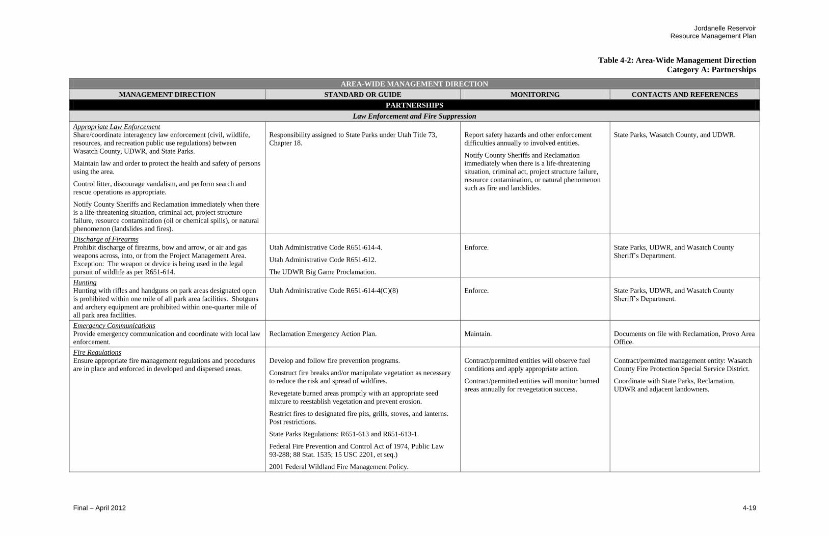
Jordanelle Reservoir Resource Management Plan
Table 4-2: Area-Wide Management Direction
Category A: Partnerships
Final – April 2012 4-19
AREA-WIDE MANAGEMENT DIRECTION
MANAGEMENT DIRECTION STANDARD OR GUIDE MONITORING CONTACTS AND REFERENCES
PARTNERSHIPS
Law Enforcement and Fire Suppression
Appropriate Law Enforcement Share/coordinate interagency law enforcement (civil, wildlife,
resources, and recreation public use regulations) between
Wasatch County, UDWR, and State Parks.
Maintain law and order to protect the health and safety of persons
using the area.
Control litter, discourage vandalism, and perform search and
rescue operations as appropriate.
Notify County Sheriffs and Reclamation immediately when there
is a life-threatening situation, criminal act, project structure
failure, resource contamination (oil or chemical spills), or natural
phenomenon (landslides and fires).
Responsibility assigned to State Parks under Utah Title 73,
Chapter 18.
Report safety hazards and other enforcement
difficulties annually to involved entities.
Notify County Sheriffs and Reclamation
immediately when there is a life-threatening
situation, criminal act, project structure failure,
resource contamination, or natural phenomenon
such as fire and landslides.
State Parks, Wasatch County, and UDWR.
Discharge of Firearms
Prohibit discharge of firearms, bow and arrow, or air and gas
weapons across, into, or from the Project Management Area.
Exception: The weapon or device is being used in the legal
pursuit of wildlife as per R651-614.
Utah Administrative Code R651-614-4.
Utah Administrative Code R651-612.
The UDWR Big Game Proclamation.
Enforce.
State Parks, UDWR, and Wasatch County
Sheriff’s Department.
Hunting
Hunting with rifles and handguns on park areas designated open
is prohibited within one mile of all park area facilities. Shotguns
and archery equipment are prohibited within one-quarter mile of
all park area facilities.
Utah Administrative Code R651-614-4(C)(8)
Enforce.
State Parks, UDWR, and Wasatch County
Sheriff’s Department.
Emergency Communications
Provide emergency communication and coordinate with local law
enforcement.
Reclamation Emergency Action Plan.
Maintain.
Documents on file with Reclamation, Provo Area
Office.
Fire Regulations
Ensure appropriate fire management regulations and procedures
are in place and enforced in developed and dispersed areas.
Develop and follow fire prevention programs.
Construct fire breaks and/or manipulate vegetation as necessary
to reduce the risk and spread of wildfires.
Revegetate burned areas promptly with an appropriate seed
mixture to reestablish vegetation and prevent erosion.
Restrict fires to designated fire pits, grills, stoves, and lanterns.
Post restrictions.
State Parks Regulations: R651-613 and R651-613-1.
Federal Fire Prevention and Control Act of 1974, Public Law
93-288; 88 Stat. 1535; 15 USC 2201, et seq.)
2001 Federal Wildland Fire Management Policy.
Contract/permitted entities will observe fuel
conditions and apply appropriate action.
Contract/permitted entities will monitor burned
areas annually for revegetation success.
Contract/permitted management entity: Wasatch
County Fire Protection Special Service District.
Coordinate with State Parks, Reclamation,
UDWR and adjacent landowners.
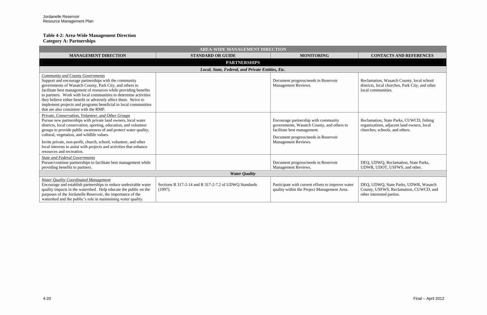
Jordanelle Reservoir Resource Management Plan
Table 4-2: Area-Wide Management Direction
Category A: Partnerships
4-20 Final – April 2012
AREA-WIDE MANAGEMENT DIRECTION
MANAGEMENT DIRECTION STANDARD OR GUIDE MONITORING CONTACTS AND REFERENCES
PARTNERSHIPS
Local, State, Federal, and Private Entities, Etc.
Community and County Governments
Support and encourage partnerships with the community
governments of Wasatch County, Park City, and others to
facilitate best management of resources while providing benefits
to partners. Work with local communities to determine activities
they believe either benefit or adversely affect them. Strive to
implement projects and programs beneficial to local communities
that are also consistent with the RMP.
Document progress/needs in Reservoir
Management Reviews.
Reclamation, Wasatch County, local school
districts, local churches, Park City, and other
local communities.
Private, Conservation, Volunteer, and Other Groups Pursue new partnerships with private land owners, local water
districts, local conservation, sporting, education, and volunteer
groups to provide public awareness of and protect water quality,
cultural, vegetation, and wildlife values.
Invite private, non-profit, church, school, volunteer, and other
local interests to assist with projects and activities that enhance
resources and recreation.
Encourage partnership with community
governments, Wasatch County, and others to
facilitate best management.
Document progress/needs in Reservoir
Management Reviews.
Reclamation, State Parks, CUWCD, fishing
organizations, adjacent land owners, local
churches, schools, and others.
State and Federal Governments
Pursue/continue partnerships to facilitate best management while
providing benefits to partners.
Document progress/needs in Reservoir
Management Reviews.
DEQ, UDWQ, Reclamation, State Parks,
UDWR, UDOT, USFWS, and other.
Water Quality
Water Quality Coordinated Management Encourage and establish partnerships to reduce undesirable water
quality impacts in the watershed. Help educate the public on the
purposes of the Jordanelle Reservoir, the importance of the
watershed and the public’s role in maintaining water quality.
Sections R 317-2-14 and R 317-2-7.2 of UDWQ Standards
(1997).
Participate with current efforts to improve water
quality within the Project Management Area.
DEQ, UDWQ, State Parks, UDWR, Wasatch
County, USFWS, Reclamation, CUWCD, and
other interested parties.

Jordanelle Reservoir Resource Management Plan
Table 4-2: Area-Wide Management Direction
Category B: Water Resources
Final – April 2012 4-21
AREA-WIDE MANAGEMENT DIRECTION
MANAGEMENT DIRECTION STANDARD OR GUIDE MONITORING CONTACTS AND REFERENCES
WATER RESOURCES
Applicable Goals:
Protect Water Quality in Jordanelle Reservoir.
Operate Jordanelle Reservoir to meet Project Purposes.
Water Operations
Care, Operation and Maintenance
Continue administration for dam and appurtenant constructed
works and factors affecting water integrity.
Operate by the:
Deer Creek/Jordanelle Coordinated Operating Agreement
Annual Operating Plan
Standing Operating Procedures
Emergency Action Plan
Designer’s Operating Criteria
Integrated Pest Management Plan
Contract between Reclamation and CUWCD for operation and
maintenance of Jordanelle Dam and outlet works.
Deer Creek/Jordanelle Operating Agreement Contract No.
94-07-40-R1690, dated 11/01/1994.
Refer to Documents.
Documents with contracts on file with
Reclamation, Provo Area Office.
Reservoir Water Level Fluctuations
Use the Jordanelle/Deer Creek coordinated water operations
agreement and flood control requirements to control water
operations.
Inform State Parks, Reclamation, UDWR, USFWS when sudden
and major reservoir fluctuations are planned.
Communicate appropriately.
CUWCD and Reclamation.
Watershed Protection
Watershed Protection Management
Encourage management practices in the Jordanelle Reservoir
watershed that maintain or improve reservoir water quality and
stream flows.
Encourage neighboring jurisdictions to construct and maintain
facilities to protect and improve water quality before it enters
Jordanelle Reservoir.
Manage towards achieving reductions in total phosphorous levels
and increases in dissolved oxygen levels.
Comply with current water quality standards.
Document in Reservoir Management Reviews.
Reclamation, UDEQ, DWQ, CUWCD, State of
Utah, State Parks, Wasatch County, and
surrounding property owners.
Water Quality
Best Management Practices
Implement Best Management Practices (BMPs) relative to water
quality in all resource activities.
As appropriate, implement a public education program to interpret
the benefits of water quality and to prevent activities that produce
pollution.
Coordinate with UDOT to ensure that controls to limit the impacts
from highway spills (including hazardous materials spills) are
implemented.
Comply with the State of Utah drinking water source protection
rule.
Where appropriate, meet or exceed state and federal water quality
standards for domestic purposes with prior treatment, recreation,
wildlife, fish, and agricultural uses.
Coordinate with counties, water districts, and Reclamation to
ensure BMPs are being implemented.
Comply with water quality standards and
regulations. Document in Reservoir
Management Reviews.
Reclamation, CUWCD, DEQ, UDWQ, State
Parks, UDWR, Wasatch County, local
communities, and others.

Jordanelle Reservoir Resource Management Plan
Table 4-2: Area-Wide Management Direction
Category B: Water Resources
4-22 Final – April 2012
AREA-WIDE MANAGEMENT DIRECTION
MANAGEMENT DIRECTION STANDARD OR GUIDE MONITORING CONTACTS AND REFERENCES
WATER RESOURCES
Water Quality cont’d
Facilities
Construct facilities to meet state and county standards.
Protect reservoir water quality from the impact of development.
Prepare site specific NEPA compliance to prevent water quality
impacts due to a specific project.
Provide for adequate restrooms and waste disposal. Locate them
to facilitate public use.
Control erosion and pollutant loading, including fuel spills.
Construct non-eroding conveyance facilities.
Follow NEPA compliance standards.
Manage water quality limit and restrict uses to protect water
quality.
Use BMPs during construction to protect quality of water in the
reservoir.
Comply with current water quality standards,
sanitation standards, and all applicable policies to
maintain facilities.
Document progress/needs in Reservoir
Management Reviews.
Environmental Protection Agency (EPA), Utah
Division of Environmental Response and
Remediation, Reclamation, State Parks,
CUWCD, DEQ, and UDWQ.
Water Quality Protection
Maintain or improve water quality.
Protect Jordanelle Reservoir for municipal, industrial, and
irrigation water purposes. Limit or restrict other uses as necessary
to protect water quality.
Do not approach or exceed Maximum Contaminate Levels
(MCL) established by EPA Safe Drinking Water Act rules and
regulations.
Prescribe and conduct water quality and
biological monitoring of the reservoir, its
tributaries, and releases through JTAC.
Members of JTAC including CUWCD and
Reclamation.
CUWCD and Reclamation.
Water Development and Conservation Implement water conservation measures.
Develop and implement water conservation measures.
Reclamation, State Parks, CUWCD, and others.
Water Quality Protection
Identify water quality impacts coming from inside the Project
Management Area and determine mitigation strategies.
Where possible, improve and maintain water quality and manage
all areas to protect water quality.
Manage to maintain clean water standards.
Where possible, manage water quality to be compatible with the
following state beneficial use designations: 2A, 2B, 3B, and 4.
As necessary, limit or restrict other uses to protect water quality.
Comply with set standards or procedures.
Document compliance or violations in Reservoir
Management Reviews.
Reclamation, EPA, CUWCD, DEQ, and UDWQ.

Jordanelle Reservoir Resource Management Plan
Table 4-2: Area-Wide Management Direction
Category C: Recreational and Visual Resources
Final – April 2012 4-23
AREA-WIDE MANAGEMENT DIRECTION
MANAGEMENT DIRECTION STANDARD OR GUIDE MONITORING CONTACTS AND REFERENCES
RECREATIONAL AND VISUAL RESOURCES
Applicable Goals:
Seek Funding to Support Recreation Development.
Offer Additional Recreational Opportunities.
Provide Adequate Recreational Facilities.
Provide for Safe, Quality Recreational Opportunities that Minimize Conflicts.
Protect and Manage the Visual Resources.
Project Funding
Project Funding
Pursue funding from private sources, or grants from federal or
state sources.
Pursue agreements with private development to develop and fund
recreational facilities.
Evaluate existing facilities and renovate them as appropriate to
increase revenue and reduce O&M.
Document changes in Reservoir Management
Reviews.
Report attained funding sources to Reclamation
annually.
Reclamation, State of Utah.
Federal and local government agencies, private
business, and volunteers, and others.
Reclamation, State Parks, private business
investors.
Reclamation, State Parks, CUWCD.
Concessions and Special Uses
Applications
Respond to recreation special-use applications according to the
following priorities:
1. Public service operations.
2. Group type operations.
3. Private operations.
An application for permit may be denied if the authorizing office
determines that:
1. The proposed use would be inconsistent or incompatible with
the purposes for which the lands are managed, or with other
uses, or
2. The proposed use would not be in the public interest, or
3. The applicant is not qualified, or
4. The use would be inconsistent with Reclamation or State
Parks policies and regulations.
5. The applicant does not or cannot demonstrate technical or
financial capability.
Comply with special use agreements. Document
in Reservoir Management Reviews.
Reclamation, State Parks, and CUWCD.
Private Initiatives
Pursue cooperative Private/Reclamation initiatives and/or
concessionaire agreements with private enterprise to achieve
needed recreation development.
Allow the private sector to provide recreation oriented
operation/maintenance, administration, and/or vendor services,
where appropriate.
Comply with contracts, agreements and existing
planning document direction. Document in
Reservoir Management Reviews.
State Parks, CUWCD, and Reclamation.
Recreation Development
Construction Priority
Generally place priority for construction/ reconstruction or
restoration of existing facilities presently below standards.
Assess ranking order. Monitor in Reservoir
Management Reviews.
Comply in design and construction.
Reclamation, State Parks, CUWCD, UDWR, and
Wasatch County.

Jordanelle Reservoir Resource Management Plan
Table 4-2: Area-Wide Management Direction
Category C: Recreational and Visual Resources
4-24 Final – April 2012
AREA-WIDE MANAGEMENT DIRECTION
MANAGEMENT DIRECTION STANDARD OR GUIDE MONITORING CONTACTS AND REFERENCES
RECREATIONAL AND VISUAL RESOURCES
Recreation Development cont’d
Development Requirements
Comply with applicable federal, state, and local laws, rules, and
regulations in the development of facilities, including sanitation
facilities.
Develop facilities based on compatibility with authorized reservoir
project purposes, long-term management and funding capability,
management goals and objectives, and environmental protection
factors. See Specific-Area Management Direction.
Federal, state, and local laws, rules and regulations.
Guidelines and principles contained in PL 89-72 as amended by
Title 28 102-575 and other laws and agreements as applicable.
Comply in design and construction.
Reclamation, State Parks, CUWCD, UDWR, and
Wasatch County.
Reclamation, State Parks, CUWCD, UDWR, and
Wasatch County.
Facility Renovation or Replacement
Generally replace facilities when renovation costs are 50 percent
or more of replacement costs or when existing facilities cease to
be compatible with site design.
Refer to Specific-Area Management Direction.
Perform annual facility condition inventories and
coordinate with Reclamation on conditions and
needs.
Document in Reservoir Management Reviews or
more often if needed.
State Parks, CUWCD, and Reclamation.
Landscaping
Allow shade tree planting above the Jordanelle Reservoir high-
water mark only under the Integrated Pest Management Plan.
Document compliance in Reservoir Management
Reviews.
Reclamation, State Parks, CUWCD and
concessionaires.
Private Development
Allow recreation development by non-federal (including
associated third party) partners as approved in writing, by
Reclamation, and when consistent with existing agreements and
planning documents.
Comply with contracts, agreements, and planning
documents. Document in Reservoir Management
Reviews.
Reclamation and State Parks.
Private Exclusive Facilities
Prohibit private, exclusive facilities by Reclamation, its managing
partners, or other private entities. Phase out existing recreation
facilities deemed to be exclusive use when lands are needed for
greater public purposes.
Enforce.
Reclamation, State Parks, and CUWCD.
WROS Classification
Perform classification study to comply with Reclamation’s Water
Recreation Opportunity Spectrum (WROS) procedure and
Guidebook. Addresses Recreation activity, setting, experience,
and benefits.
Reclamation’s WROS procedure.
Reclamation and State Parks.
Trails
Construct appropriate pedestrian, bike, fishing, and access trails.
Include sanitation and waste facilities as needed.
Allow access to Perimeter Trail from other trail systems.
See Specific-Area Management Direction.
Provide safe access to reservoir for fishing activities.
Comply with contracts, agreements, and planning
documents. Document in Reservoir Management
Reviews.
Reclamation, State Parks, and private land
owners.

Jordanelle Reservoir Resource Management Plan
Table 4-2: Area-Wide Management Direction
Category C: Recreational and Visual Resources
Final – April 2012 4-25
AREA-WIDE MANAGEMENT DIRECTION
MANAGEMENT DIRECTION STANDARD OR GUIDE MONITORING CONTACTS AND REFERENCES
RECREATIONAL AND VISUAL RESOURCES
Recreation Management
Activities
Manage for a year-round spectrum of recreation experiences while
meeting the WROS classification when completed. See WROS
Classification above.
Reclamation’s WROS procedure.
Determine user profile and preference at RMP
planning intervals (by State Parks).
Prepare an annual recreation use data report.
State Parks, Reclamation, and UDWR.
Ice Conditions
Post ice conditions during the winter months by State Parks.
Post signs at entrances in winter when safe conditions exist. Use
appropriate message.
Post signs at entrances when unsafe conditions exist. Use
appropriate message.
Prohibit highway vehicles on ice. OHV allowed for
transportation of gear.
Comply with State Park regulations. (PR-96-13)
State Parks and UDWR.
Maintenance in General
Provide facility maintenance to ensure an acceptable level of
public safety, health, and sanitation, and to protect natural
resources.
Manage by an operation and maintenance plan that prescribes
maintenance level, schedules, and tasks.
Perform annual facility condition inventories (by
State Parks) and coordinate with Reclamation on
conditions and needs. Document in Reservoir
Management Reviews.
State Parks, Reclamation, and other interested
parties.
Management by Others
Encourage other qualified entities to assume recreation
management responsibility.
Existing agreements and contracts.
Comply with existing contracts.
Reclamation and State Parks.
Management Agreement Manage recreation consistent with this Jordanelle Reservoir RMP
and the current Recreation Management Agreement.
Federal Water Project Recreation Act (PL 89-72) and current
amendments.
Use a Memorandum of Agreement (MOA) as the mechanism to
formalize relationships and responsibilities.
Comply with agreements and plans. Document in
Reservoir Management Reviews.
Reclamation, State Parks, and CUWCD.
Overnight Camping
Allow overnight camping in designated areas. See Specific-Area Management Direction.
Document in Reservoir Management Reviews.
State Parks and Reclamation.
Parking Below the High Water Mark
Generally prohibit public motorized land vehicles from driving or
parking on beaches or below the high water mark, with the
exception of watercraft launching at approved sites.
Interpret and enforce.
State Parks, Reclamation, UDWR, and CUWCD.
Picnicking
Allow picnicking in designated areas. See Specific-Area Management Direction.
Document in Reservoir Management Reviews.
State Parks and Reclamation.

Jordanelle Reservoir Resource Management Plan
Table 4-2: Area-Wide Management Direction
Category C: Recreational and Visual Resources
4-26 Final – April 2012
AREA-WIDE MANAGEMENT DIRECTION
MANAGEMENT DIRECTION STANDARD OR GUIDE MONITORING CONTACTS AND REFERENCES
RECREATIONAL AND VISUAL RESOURCES
Recreation Management cont’d
Pets Domestic animals are allowed but must always be on a maximum
six-foot leash and never left unattended. Pets are not allowed at
Rock Cliff Recreation Area, in buildings, cabins, yurts, on
beaches, or in the reservoir.
Exception: During hunting season, trained dogs under direct
control can be used to hunt wildlife other than big game.
State Parks General Park Rules.
The UDWR Big Game Proclamation.
Interpret and enforce.
State Parks.
Reservoir Water Quality Maintenance
Restrict recreation uses that threaten or exceed MCLs for
products, such as volatile and synthetic organic compounds.
EPA Safe Drinking Water Act rules and regulations.
Prescribe and conduct water quality and
biological monitoring of Jordanelle Reservoir
and its tributaries and releases as appropriate.
DEQ/UDWQ, CUWCD, Reclamation, State
Parks, and UDWR.
Special Events
Give precedence to normal park activities/operations when
scheduling special events.
Review special event requests by the recreation manager.
Comply before scheduling.
State Parks.
Use Conflicts
Minimize recreation and environmental resource conflicts and
promote user safety.
Comply with State Parks guidelines. Boating capacity will be
based upon Strategic Boating Plan.
Interpret and enforce.
State Parks.
User Fees
Charge appropriate user fees based on cost-effective, year-round
service.
Pursue possibilities for differential pricing to ease crowding.
Provide cost-effective service.
Comply with State Parks Board, State Parks guidelines, and
provisions of the recreation MOA between Reclamation and State
Parks.
Monitor compliance annually.
State Parks Board approved fee structure and
State Parks.
Watercraft Launching
Restrict watercraft launching that requires motorized tow vehicles
to designated boat ramps and permitted areas only. See
Specific-Area Management Direction.
Assess launching location. Document in
Reservoir Management Reviews or more often
if needed.
State Parks, CUWCD, and Reclamation.
Watercraft Limit
Consider establishing and implementing a watercraft capacity if
public safety, natural resources, recreational purposes, or
recreational experiences become compromised. Additional
reductions may occur to control user conflicts and promote health
and safety.
Physical/Biological:
Protect water quality at the fluctuating reservoir source.
Managerial:
Provide recreation administration by managing through the Utah
State Boating Act, rather than providing single-purpose water use
areas for individual recreation activities.
Under Utah Title 73, Chapter 18, State Parks governs the
operation, equipment, and numbering of vessels... on the waters of
this state. “Waters of this state” means any waters within the
territorial limits of this state.
Social: Provide multi-purpose opportunities with low to moderate potential for conflicts. Uses may include wind craft, personal watercraft use,
fishing, motor boating and other water-related activities.
Enforce.
State Parks.
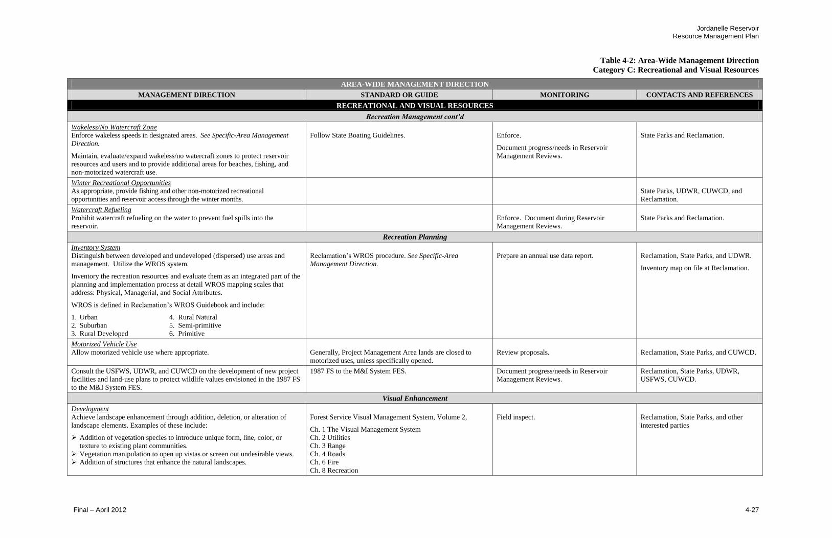
Jordanelle Reservoir Resource Management Plan
Table 4-2: Area-Wide Management Direction
Category C: Recreational and Visual Resources
Final – April 2012 4-27
AREA-WIDE MANAGEMENT DIRECTION
MANAGEMENT DIRECTION STANDARD OR GUIDE MONITORING CONTACTS AND REFERENCES
RECREATIONAL AND VISUAL RESOURCES
Recreation Management cont’d
Wakeless/No Watercraft Zone
Enforce wakeless speeds in designated areas. See Specific-Area Management
Direction.
Maintain, evaluate/expand wakeless/no watercraft zones to protect reservoir
resources and users and to provide additional areas for beaches, fishing, and
non-motorized watercraft use.
Follow State Boating Guidelines.
Enforce.
Document progress/needs in Reservoir
Management Reviews.
State Parks and Reclamation.
Winter Recreational Opportunities
As appropriate, provide fishing and other non-motorized recreational
opportunities and reservoir access through the winter months.
State Parks, UDWR, CUWCD, and
Reclamation.
Watercraft Refueling
Prohibit watercraft refueling on the water to prevent fuel spills into the
reservoir.
Enforce. Document during Reservoir
Management Reviews.
State Parks and Reclamation.
Recreation Planning
Inventory System
Distinguish between developed and undeveloped (dispersed) use areas and
management. Utilize the WROS system.
Inventory the recreation resources and evaluate them as an integrated part of the
planning and implementation process at detail WROS mapping scales that
address: Physical, Managerial, and Social Attributes.
WROS is defined in Reclamation’s WROS Guidebook and include:
1. Urban 4. Rural Natural
2. Suburban 5. Semi-primitive
3. Rural Developed 6. Primitive
Reclamation’s WROS procedure. See Specific-Area
Management Direction.
Prepare an annual use data report.
Reclamation, State Parks, and UDWR.
Inventory map on file at Reclamation.
Motorized Vehicle Use
Allow motorized vehicle use where appropriate.
Generally, Project Management Area lands are closed to
motorized uses, unless specifically opened.
Review proposals.
Reclamation, State Parks, and CUWCD.
Consult the USFWS, UDWR, and CUWCD on the development of new project
facilities and land-use plans to protect wildlife values envisioned in the 1987 FS
to the M&I System FES.
1987 FS to the M&I System FES. Document progress/needs in Reservoir
Management Reviews.
Reclamation, State Parks, UDWR,
USFWS, CUWCD.
Visual Enhancement
Development
Achieve landscape enhancement through addition, deletion, or alteration of
landscape elements. Examples of these include:
Addition of vegetation species to introduce unique form, line, color, or
texture to existing plant communities.
Vegetation manipulation to open up vistas or screen out undesirable views.
Addition of structures that enhance the natural landscapes.
Forest Service Visual Management System, Volume 2,
Ch. 1 The Visual Management System
Ch. 2 Utilities
Ch. 3 Range
Ch. 4 Roads
Ch. 6 Fire
Ch. 8 Recreation
Field inspect.
Reclamation, State Parks, and other
interested parties
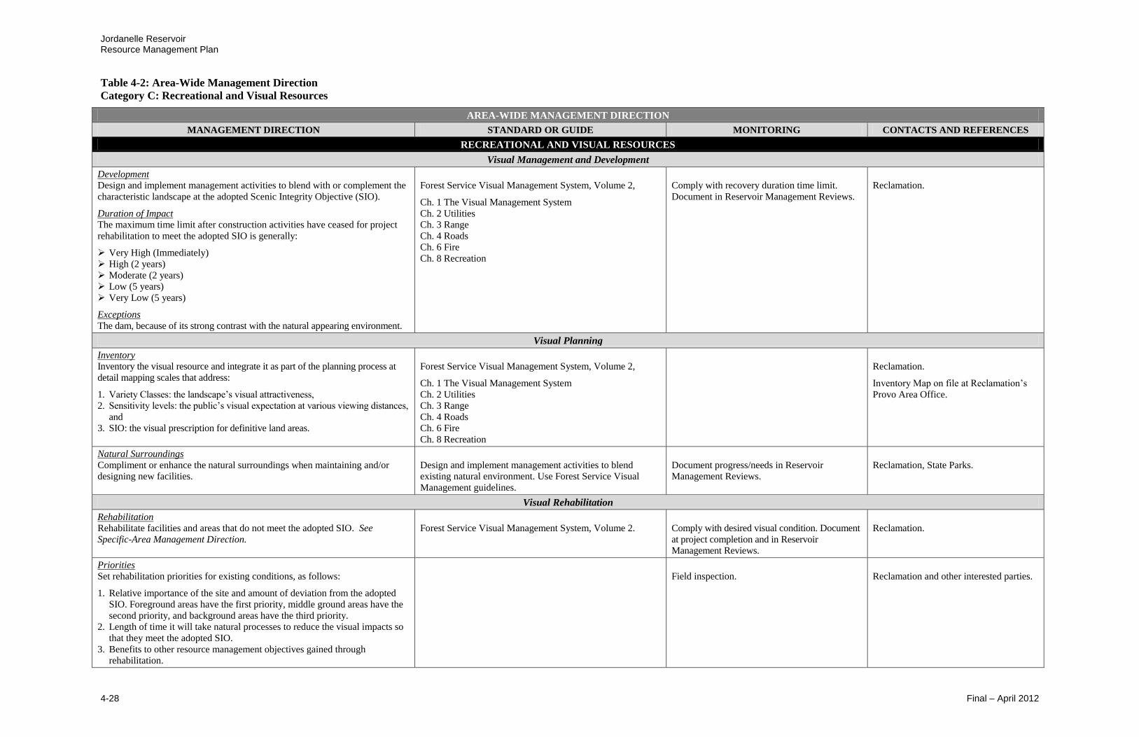
Jordanelle Reservoir Resource Management Plan
Table 4-2: Area-Wide Management Direction
Category C: Recreational and Visual Resources
4-28 Final – April 2012
AREA-WIDE MANAGEMENT DIRECTION
MANAGEMENT DIRECTION STANDARD OR GUIDE MONITORING CONTACTS AND REFERENCES
RECREATIONAL AND VISUAL RESOURCES
Visual Management and Development
Development Design and implement management activities to blend with or complement the
characteristic landscape at the adopted Scenic Integrity Objective (SIO).
Duration of Impact The maximum time limit after construction activities have ceased for project
rehabilitation to meet the adopted SIO is generally:
Very High (Immediately)
High (2 years)
Moderate (2 years)
Low (5 years)
Very Low (5 years)
Exceptions
The dam, because of its strong contrast with the natural appearing environment.
Forest Service Visual Management System, Volume 2,
Ch. 1 The Visual Management System
Ch. 2 Utilities
Ch. 3 Range
Ch. 4 Roads
Ch. 6 Fire
Ch. 8 Recreation
Comply with recovery duration time limit.
Document in Reservoir Management Reviews.
Reclamation.
Visual Planning
Inventory
Inventory the visual resource and integrate it as part of the planning process at
detail mapping scales that address:
1. Variety Classes: the landscape’s visual attractiveness,
2. Sensitivity levels: the public’s visual expectation at various viewing distances,
and
3. SIO: the visual prescription for definitive land areas.
Forest Service Visual Management System, Volume 2,
Ch. 1 The Visual Management System
Ch. 2 Utilities
Ch. 3 Range
Ch. 4 Roads
Ch. 6 Fire
Ch. 8 Recreation
Reclamation.
Inventory Map on file at Reclamation’s
Provo Area Office.
Natural Surroundings
Compliment or enhance the natural surroundings when maintaining and/or
designing new facilities.
Design and implement management activities to blend
existing natural environment. Use Forest Service Visual
Management guidelines.
Document progress/needs in Reservoir
Management Reviews.
Reclamation, State Parks.
Visual Rehabilitation
Rehabilitation
Rehabilitate facilities and areas that do not meet the adopted SIO. See
Specific-Area Management Direction.
Forest Service Visual Management System, Volume 2.
Comply with desired visual condition. Document
at project completion and in Reservoir
Management Reviews.
Reclamation.
Priorities
Set rehabilitation priorities for existing conditions, as follows:
1. Relative importance of the site and amount of deviation from the adopted
SIO. Foreground areas have the first priority, middle ground areas have the
second priority, and background areas have the third priority.
2. Length of time it will take natural processes to reduce the visual impacts so
that they meet the adopted SIO.
3. Benefits to other resource management objectives gained through
rehabilitation.
Field inspection.
Reclamation and other interested parties.
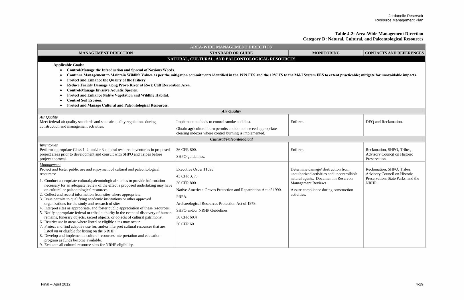
Jordanelle Reservoir Resource Management Plan
Table 4-2: Area-Wide Management Direction
Category D: Natural, Cultural, and Paleontological Resources
Final – April 2012 4-29
AREA-WIDE MANAGEMENT DIRECTION
MANAGEMENT DIRECTION STANDARD OR GUIDE MONITORING CONTACTS AND REFERENCES
NATURAL, CULTURAL, AND PALEONTOLOGICAL RESOURCES
Applicable Goals:
Control/Manage the Introduction and Spread of Noxious Weeds.
Continue Management to Maintain Wildlife Values as per the mitigation commitments identified in the 1979 FES and the 1987 FS to the M&I System FES to extent practicable; mitigate for unavoidable impacts.
Protect and Enhance the Quality of the Fishery.
Reduce Facility Damage along Provo River at Rock Cliff Recreation Area.
Control/Manage Invasive Aquatic Species.
Protect and Enhance Native Vegetation and Wildlife Habitat.
Control Soil Erosion.
Protect and Manage Cultural and Paleontological Resources.
Air Quality
Air Quality
Meet federal air quality standards and state air quality regulations during
construction and management activities.
Implement methods to control smoke and dust.
Obtain agricultural burn permits and do not exceed appropriate
clearing indexes where control burning is implemented.
Enforce.
DEQ and Reclamation.
Cultural/Paleontological
Inventories
Perform appropriate Class 1, 2, and/or 3 cultural resource inventories in proposed
project areas prior to development and consult with SHPO and Tribes before
project approval.
36 CFR 800.
SHPO guidelines.
Enforce.
Reclamation, SHPO, Tribes,
Advisory Council on Historic
Preservation.
Management
Protect and foster public use and enjoyment of cultural and paleontological
resources:
1. Conduct appropriate cultural/paleontological studies to provide information
necessary for an adequate review of the effect a proposed undertaking may have
on cultural or paleontological resources.
2. Collect and record information from sites where appropriate.
3. Issue permits to qualifying academic institutions or other approved
organizations for the study and research of sites.
4. Interpret sites as appropriate, and foster public appreciation of these resources.
5. Notify appropriate federal or tribal authority in the event of discovery of human
remains, funerary objects, sacred objects, or objects of cultural patrimony.
6. Restrict use in areas where listed or eligible sites may occur.
7. Protect and find adaptive use for, and/or interpret cultural resources that are
listed on or eligible for listing on the NRHP.
8. Develop and implement a cultural resources interpretation and education
program as funds become available.
9. Evaluate all cultural resource sites for NRHP eligibility.
Executive Order 11593.
43 CFR 3, 7.
36 CFR 800.
Native American Graves Protection and Repatriation Act of 1990.
PRPA.
Archaeological Resources Protection Act of 1979.
SHPO and/or NRHP Guidelines
36 CFR 60.4
36 CFR 60
Determine damage/ destruction from
unauthorized activities and uncontrollable
natural agents. Document in Reservoir
Management Reviews.
Assure compliance during construction
activities.
Reclamation, SHPO, Tribes,
Advisory Council on Historic
Preservation, State Parks, and the
NRHP.

Jordanelle Reservoir Resource Management Plan
Table 4-2: Area-Wide Management Direction
Category D: Natural, Cultural, and Paleontological Resources
4-30 Final – April 2012
AREA-WIDE MANAGEMENT DIRECTION
MANAGEMENT DIRECTION STANDARD OR GUIDE MONITORING CONTACTS AND REFERENCES
NATURAL, CULTURAL, AND PALEONTOLOGICAL RESOURCES
Geology/Minerals/Soils
Appropriate Minerals Management Ensure that mineral development is permissible and compatible with
project purposes. Ensure that mineral activities do not adversely affect
planned or current uses.
Leaseables: Reclamation withdrawn lands are restricted from minerals entry by
Commissioner’s order of 8-22-1952 and PLO-3676, 6-10-1965. Other lands are
subject to Mineral Leasing Act of 1920, as amended and supplemented (30 U.S.
Code [USC] 181, et. seq.), the Mineral Leasing Act for Acquired Lands as
amended (30 USC 351-359), and the Geo-thermal Steam Act of 1970 (30 USC
1001-1025). Coordinated with the DOI, Bureau of Land Management (BLM)
through an interagency agreement between Reclamation and BLM, 3-25-83.
Locatables: Subject to the 1872 Mining Law, amended by 30 USC Ch. 2.
Coordinate with the Utah Division of Oil, Gas, and Mining (authority for review
and issuance of private minerals permits). Written permission from State Parks for
mineral removal required by Utah Title 63, Chapter 11.
Salables: Subject to Reclamation’s discretion for review and issuance of permits.
Act of July 31, 1947, amended (30 USC 601 et. seq.), the Act of July 23, 1955 (30
USC 601), the Act of September 28, 1962 (30 USC 611), and Section 10 of
Reclamation Projects Act of 1939 (43 USC 387). Written permission from the
State Parks for mineral removal is required by Utah Title 63, Chapter 11.
Ensure compliance where Reclamation has
control. Document in Reservoir
Management Reviews.
Reclamation, BLM, State Parks,
Utah Division of Oil, Gas, and
Mining, and other interested parties.
Geologic Hazards During construction and/or ground-disturbing activities, avoid
geologic hazards where possible.
Analyze site-specific geologic hazards prior to locating permanent facilities.
Comply in design and construction.
Reclamation.
Soil and Moisture Preservation Prepare and execute programs for the conservation of soil and
moisture.
Document compliance during Reservoir
Management Reviews or more often as
needed.
Reclamation.
Soil Protection
Minimize adverse impacts to the soil resource, including accelerated
erosion, compaction, contamination, and displacement as appropriate.
Protect and conserve topsoil when conducting surface-disturbing activities.
Provide adequate drainage and revegetation on areas disturbed during
construction or use activities. Stabilize these areas to control soil erosion.
Rehabilitate disturbed areas that are eroding excessively and/or are contributing
significant sediment to Jordanelle Reservoir or streams.
Document compliance at project
completion, and during Reservoir
Management Reviews.
Reclamation, State Parks, UDWR,
CUWCD, and other interested
parties.
Integrated Pest Management
Pest/Aquatic Nuisance Management
First control and reduce the spread of pest/aquatic nuisance species,
then work on local established populations.
Coordinate with State of Utah and Wasatch County Public Works Pest Control
and other interested parties to regulate undesirable or invasive pests.
Monitor depredations by insects and the
presence of disease and aquatic nuisances.
Document in Reservoir Management
Reviews.
Utah Division of Water Rights,
Reclamation, State Parks, CUWCD,
local pest control officials, adjacent
landowners, concessionaires, and
other interested parties.

Jordanelle Reservoir Resource Management Plan
Table 4-2: Area-Wide Management Direction
Category D: Natural, Cultural, and Paleontological Resources
Final – April 2012 4-31
AREA-WIDE MANAGEMENT DIRECTION
MANAGEMENT DIRECTION STANDARD OR GUIDE MONITORING CONTACTS AND REFERENCES
NATURAL, CULTURAL, AND PALEONTOLOGICAL RESOURCES
Integrated Pest Management cont’d
Weeds/Noxious Weeds
Enforce the Integrated Pest Management Plan and use to control
and reduce noxious weeds and poisonous plants in the Project
Management Area.
Require those authorized to conduct soil-disturbing activities to control
noxious and/or invading weeds on the disturbed area during the use or
construction period.
Apply pesticides only after approval by Reclamation. Apply restricted-use
pesticides under the direction of certified applicators. Follow label
instructions.
Reference Noxious Weed Field Guide for Utah and Wasatch County ordinances.
Federal Noxious Weed Act of 1974 (Public Law 93-629 as amended, Public
Law 101-624 for Section 15); Carlson-Foley Act of 1968 (Public Law 90-583,
82 Stat. 1146).
Conduct annual field inspections. Monitor and
document in Reservoir Management Reviews.
Follow Reclamation Manual Policy for Pest
Management.
USDA, Utah State University
Extension, Reclamation, State Parks,
Wasatch County, CUWCD, UDWR,
permittees, concessionaires,
proponents, and other interested
parties.
Invasive Aquatic Species Continue existing programs to protect the reservoir from invasive
aquatic species through boat inspections.
Install a decontamination station and qualified technician at the
Rock Cliff Recreation Area.
Coordinate with State Parks to regulate undesired or invasive aquatic species.
Monitor insects and invasive aquatic species
by informing the public and inspecting boats.
Monitor and document in Reservoir
Management Reviews.
Reclamation, State Parks and UDWR.
Vegetation Management
Enhance Wildlife Habitat
Enhance wildlife habitat where appropriate.
Evaluate habitat condition. Document in
Reservoir Management Reviews.
Reclamation, State Parks, UDWR, and
other interested parties.
Livestock Grazing
Grazing is restricted at Jordanelle Reservoir.
Prohibit grazing in the Project Management Area. Encourage practices that
protect or enhance water quality, such as fencing.
Enforce.
Reclamation and State Parks.
Revegetate Disturbed Areas
Revegetate disturbed or damaged areas.
Close or restrict roads as needed. Rehabilitate closed roads to approximate
original contour, drain, seed and sign. Gate and/or sign restricted roads. Grade
and revegetate disturbed areas from recreation development areas.
Comply in project planning and during
implementation. Document in Reservoir
Management Reviews.
Reclamation, State Parks, and other
interested parties.
Surface Disturbing Activities
Minimize surface-disturbing activities that alter vegetative cover.
Restrict use or close sites where erosion or environmental damage is occurring.
Document vegetative condition during
Reservoir Management Reviews.
Reclamation, State Parks, and other
vegetative managing entities.
Vegetative Condition
Maintain healthy, diverse plant communities.
Develop an appropriate plant list for future landscaping, erosion
control, and water conservation.
Do not use disking or ripping vegetation treatments unless visual objectives
can be met.
Apply water conservation techniques in the development of new facilities.
Apply BMPs construction practices to protect topsoil when conducting surface
disturbing activities.
Provide adequate drainage and revegetation on areas disturbed during
construction.
Comply in the use of treatment methods.
Document in Reservoir Management Reviews.
Document compliance at project completion,
and during Reservoir Management Reviews.
Reclamation, State Parks, and other
vegetative managing entities.
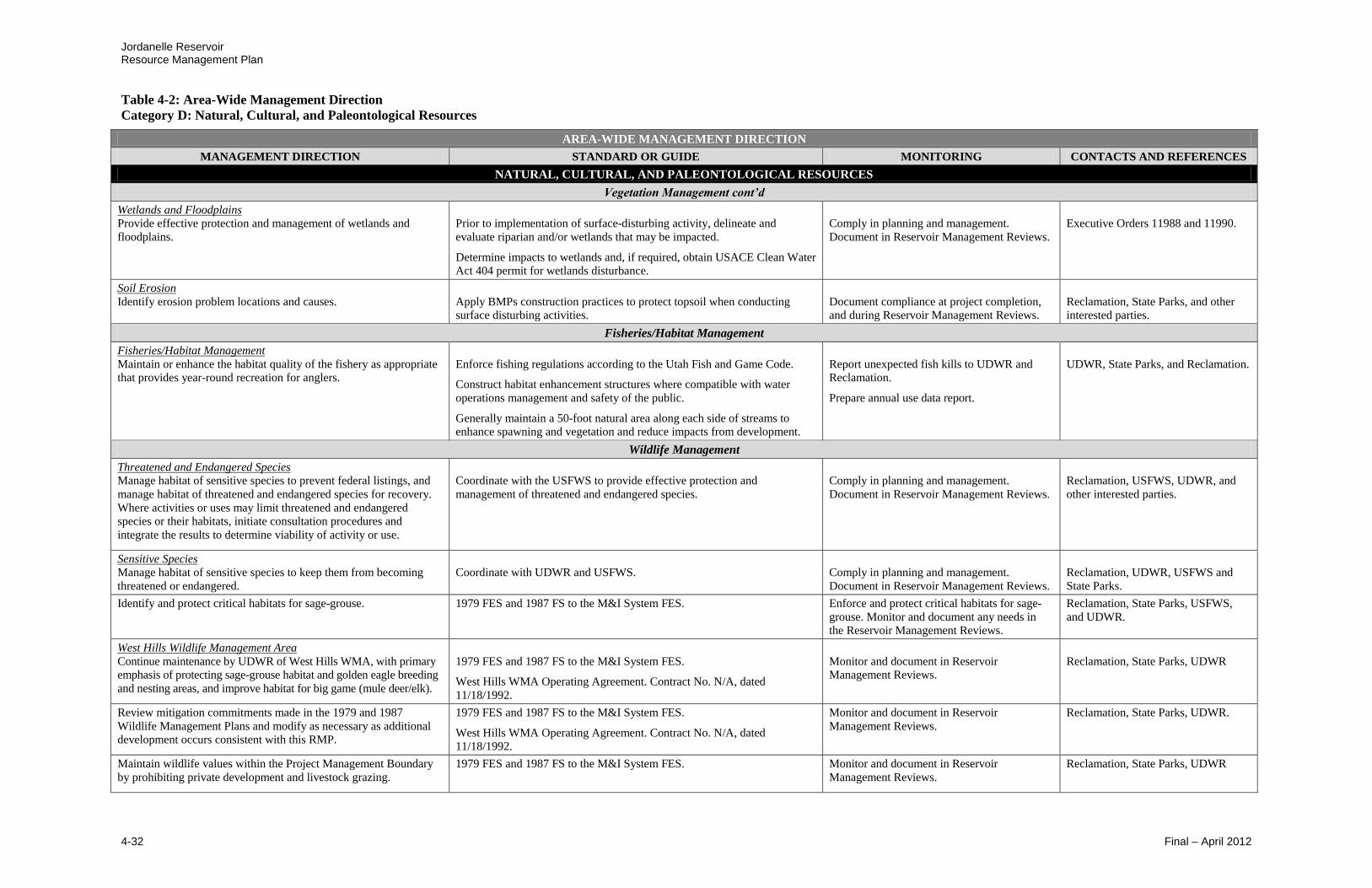
Jordanelle Reservoir Resource Management Plan
Table 4-2: Area-Wide Management Direction
Category D: Natural, Cultural, and Paleontological Resources
4-32 Final – April 2012
AREA-WIDE MANAGEMENT DIRECTION
MANAGEMENT DIRECTION STANDARD OR GUIDE MONITORING CONTACTS AND REFERENCES
NATURAL, CULTURAL, AND PALEONTOLOGICAL RESOURCES
Vegetation Management cont’d
Wetlands and Floodplains
Provide effective protection and management of wetlands and
floodplains.
Prior to implementation of surface-disturbing activity, delineate and
evaluate riparian and/or wetlands that may be impacted.
Determine impacts to wetlands and, if required, obtain USACE Clean Water
Act 404 permit for wetlands disturbance.
Comply in planning and management.
Document in Reservoir Management Reviews.
Executive Orders 11988 and 11990.
Soil Erosion
Identify erosion problem locations and causes.
Apply BMPs construction practices to protect topsoil when conducting
surface disturbing activities.
Document compliance at project completion,
and during Reservoir Management Reviews.
Reclamation, State Parks, and other
interested parties.
Fisheries/Habitat Management
Fisheries/Habitat Management
Maintain or enhance the habitat quality of the fishery as appropriate
that provides year-round recreation for anglers.
Enforce fishing regulations according to the Utah Fish and Game Code.
Construct habitat enhancement structures where compatible with water
operations management and safety of the public.
Generally maintain a 50-foot natural area along each side of streams to
enhance spawning and vegetation and reduce impacts from development.
Report unexpected fish kills to UDWR and
Reclamation.
Prepare annual use data report.
UDWR, State Parks, and Reclamation.
Wildlife Management
Threatened and Endangered Species
Manage habitat of sensitive species to prevent federal listings, and
manage habitat of threatened and endangered species for recovery.
Where activities or uses may limit threatened and endangered
species or their habitats, initiate consultation procedures and
integrate the results to determine viability of activity or use.
Coordinate with the USFWS to provide effective protection and
management of threatened and endangered species.
Comply in planning and management.
Document in Reservoir Management Reviews.
Reclamation, USFWS, UDWR, and
other interested parties.
Sensitive Species Manage habitat of sensitive species to keep them from becoming
threatened or endangered.
Coordinate with UDWR and USFWS.
Comply in planning and management.
Document in Reservoir Management Reviews.
Reclamation, UDWR, USFWS and
State Parks.
Identify and protect critical habitats for sage-grouse. 1979 FES and 1987 FS to the M&I System FES.
Enforce and protect critical habitats for sage-
grouse. Monitor and document any needs in
the Reservoir Management Reviews.
Reclamation, State Parks, USFWS,
and UDWR.
West Hills Wildlife Management Area
Continue maintenance by UDWR of West Hills WMA, with primary
emphasis of protecting sage-grouse habitat and golden eagle breeding
and nesting areas, and improve habitat for big game (mule deer/elk).
1979 FES and 1987 FS to the M&I System FES.
West Hills WMA Operating Agreement. Contract No. N/A, dated
11/18/1992.
Monitor and document in Reservoir
Management Reviews.
Reclamation, State Parks, UDWR
Review mitigation commitments made in the 1979 and 1987
Wildlife Management Plans and modify as necessary as additional
development occurs consistent with this RMP.
1979 FES and 1987 FS to the M&I System FES.
West Hills WMA Operating Agreement. Contract No. N/A, dated
11/18/1992.
Monitor and document in Reservoir
Management Reviews.
Reclamation, State Parks, UDWR.
Maintain wildlife values within the Project Management Boundary
by prohibiting private development and livestock grazing.
1979 FES and 1987 FS to the M&I System FES. Monitor and document in Reservoir
Management Reviews.
Reclamation, State Parks, UDWR

Jordanelle Reservoir Resource Management Plan
Table 4-2: Area-Wide Management Direction
Category D: Natural, Cultural, and Paleontological Resources
Final – April 2012 4-33
AREA-WIDE MANAGEMENT DIRECTION
MANAGEMENT DIRECTION STANDARD OR GUIDE MONITORING CONTACTS AND REFERENCES
NATURAL, CULTURAL, AND PALEONTOLOGICAL RESOURCES
Wildlife Management cont’d
Protect Wildlife Habitat Restrict construction and recreation activities during critical
breeding and nesting seasons, especially for important sage-grouse
and golden eagle breeding and nesting areas, and during the winter
on crucial winter deer range.
1979 FES and 1987 FS to the M&I System FES.
Enforce.
Reclamation, State Parks, UDWR.
Identify undeveloped areas at suitable locations for the long-term
conservation of wildlife values.
Evaluate suitable locations and document in
Reservoir Management Reviews.
Conduct seasonal closure of trails to avoid disturbances to crucial
winter range areas.
1979 FES and 1987 FS to the M&I System FES. Monitor and document in Reservoir Management
Reviews.
Reclamation, State Parks, UDWR
Avoid critical habitat areas for the development of new trails. 1979 FES and 1987 FS to the M&I System FES. Monitor and document in Reservoir Management
Reviews.
Place protective buffer zones around critical wildlife and wetland
habitats to minimize recreational encroachment and human
disturbances, and maintain and enforce the buffer zone boundaries.
West Hills WMA Operating Agreement. Contract No. N/A, dated
11/18/1992.
Protect critical wildlife and wetlands habitats.
Enforce and protect critical wildlife and wetland
habitats. Monitor and document any needs in the
Reservoir Management Reviews.
Reclamation, State Parks, USFWS,
and UDWR.
Vegetation and Wildlife Habitat
Identify and protect sensitive vegetation areas and conserve
long-term wildlife habitat.
Enforce and Review. Document in Reservoir
Management Reviews.
State Parks and UDWR.
Wildlife Inventory
As funding becomes available, Reclamation and other management
partners will implement a wildlife habitat inventory and monitoring
program (IMP) to include mapping of current habitat types within
and adjacent to the Project Management Boundary, an assessment of
current habitat conditions, and the identification of critical wildlife
breeding, nesting and winter use areas.
1979 FES and 1987 FS to the M&I System FES. At a minimum, these assessments will include
critical areas for sage-grouse, golden eagle and
other raptors, migratory water birds, deer, elk,
moose, federally-listed threatened, endangered,
candidate and petitioned species, and
conservation agreement species.
Update the IMP on regular basis.
Reclamation, UDWR.
Use IMP to develop site-specific strategies and adaptive
management plans for protecting natural resources.
1979 FES and 1987 FS to the M&I System FES. Monitor and document in Reservoir Management
Reviews.
Reclamation, UDWR.
Provo River at Rock Cliff Recreation Area
Consultation with PRWUA could provide helpful information as
they have developed and are implementing an upper Provo River
maintenance program to help mitigate flood impacts above
Jordanelle Reservoir.
Coordinate with PRWUA and follow maintenance plan on the Provo
River Maintenance Program for flood mitigation above Jordanelle
Reservoir.
Monitor and document in Reservoir Management
Reviews.
Reclamation, State Parks, PRWUA.
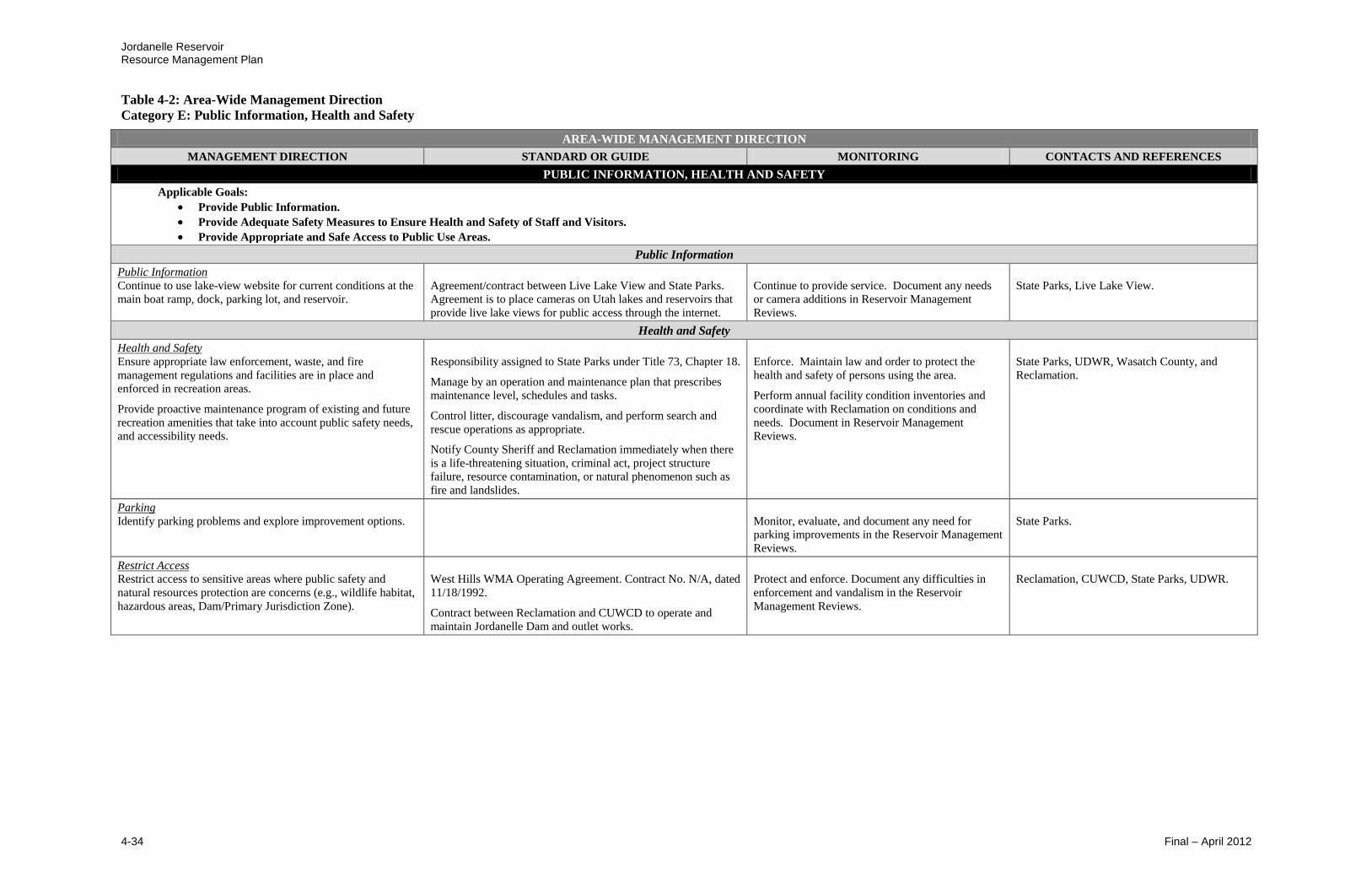
Jordanelle Reservoir Resource Management Plan
Table 4-2: Area-Wide Management Direction
Category E: Public Information, Health and Safety
4-34 Final – April 2012
AREA-WIDE MANAGEMENT DIRECTION
MANAGEMENT DIRECTION STANDARD OR GUIDE MONITORING CONTACTS AND REFERENCES
PUBLIC INFORMATION, HEALTH AND SAFETY
Applicable Goals:
Provide Public Information.
Provide Adequate Safety Measures to Ensure Health and Safety of Staff and Visitors.
Provide Appropriate and Safe Access to Public Use Areas.
Public Information
Public Information
Continue to use lake-view website for current conditions at the
main boat ramp, dock, parking lot, and reservoir.
Agreement/contract between Live Lake View and State Parks.
Agreement is to place cameras on Utah lakes and reservoirs that
provide live lake views for public access through the internet.
Continue to provide service. Document any needs
or camera additions in Reservoir Management
Reviews.
State Parks, Live Lake View.
Health and Safety
Health and Safety
Ensure appropriate law enforcement, waste, and fire
management regulations and facilities are in place and
enforced in recreation areas.
Provide proactive maintenance program of existing and future
recreation amenities that take into account public safety needs,
and accessibility needs.
Responsibility assigned to State Parks under Title 73, Chapter 18.
Manage by an operation and maintenance plan that prescribes
maintenance level, schedules and tasks.
Control litter, discourage vandalism, and perform search and
rescue operations as appropriate.
Notify County Sheriff and Reclamation immediately when there
is a life-threatening situation, criminal act, project structure
failure, resource contamination, or natural phenomenon such as
fire and landslides.
Enforce. Maintain law and order to protect the
health and safety of persons using the area.
Perform annual facility condition inventories and
coordinate with Reclamation on conditions and
needs. Document in Reservoir Management
Reviews.
State Parks, UDWR, Wasatch County, and
Reclamation.
Parking
Identify parking problems and explore improvement options.
Monitor, evaluate, and document any need for
parking improvements in the Reservoir Management
Reviews.
State Parks.
Restrict Access Restrict access to sensitive areas where public safety and
natural resources protection are concerns (e.g., wildlife habitat,
hazardous areas, Dam/Primary Jurisdiction Zone).
West Hills WMA Operating Agreement. Contract No. N/A, dated
11/18/1992.
Contract between Reclamation and CUWCD to operate and
maintain Jordanelle Dam and outlet works.
Protect and enforce. Document any difficulties in
enforcement and vandalism in the Reservoir
Management Reviews.
Reclamation, CUWCD, State Parks, UDWR.
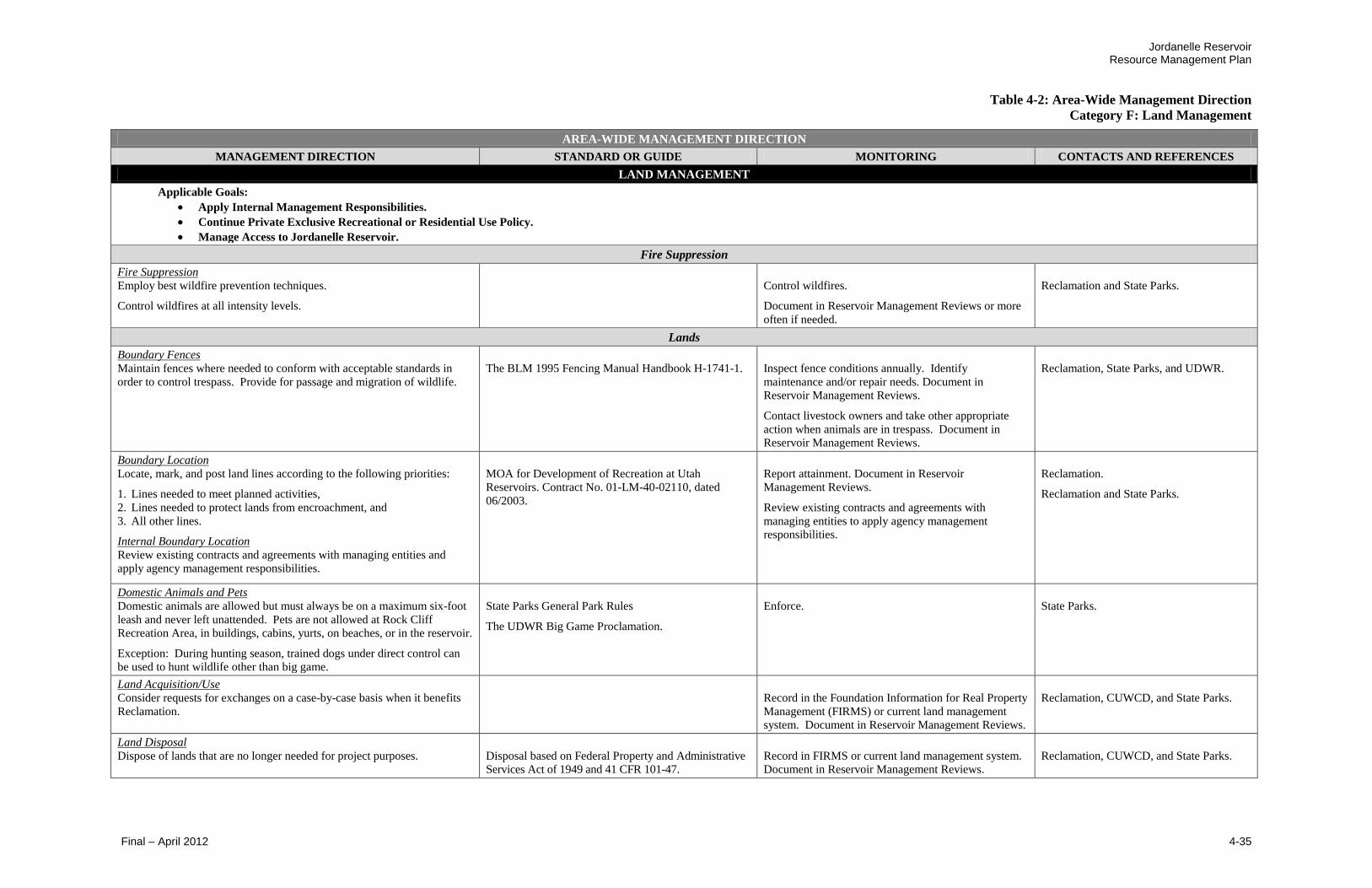
Jordanelle Reservoir Resource Management Plan
Table 4-2: Area-Wide Management Direction
Category F: Land Management
Final – April 2012 4-35
AREA-WIDE MANAGEMENT DIRECTION
MANAGEMENT DIRECTION STANDARD OR GUIDE MONITORING CONTACTS AND REFERENCES
LAND MANAGEMENT
Applicable Goals:
Apply Internal Management Responsibilities.
Continue Private Exclusive Recreational or Residential Use Policy.
Manage Access to Jordanelle Reservoir.
Fire Suppression
Fire Suppression
Employ best wildfire prevention techniques.
Control wildfires at all intensity levels.
Control wildfires.
Document in Reservoir Management Reviews or more
often if needed.
Reclamation and State Parks.
Lands
Boundary Fences
Maintain fences where needed to conform with acceptable standards in
order to control trespass. Provide for passage and migration of wildlife.
The BLM 1995 Fencing Manual Handbook H-1741-1.
Inspect fence conditions annually. Identify
maintenance and/or repair needs. Document in
Reservoir Management Reviews.
Contact livestock owners and take other appropriate
action when animals are in trespass. Document in
Reservoir Management Reviews.
Reclamation, State Parks, and UDWR.
Boundary Location
Locate, mark, and post land lines according to the following priorities:
1. Lines needed to meet planned activities,
2. Lines needed to protect lands from encroachment, and
3. All other lines.
Internal Boundary Location
Review existing contracts and agreements with managing entities and
apply agency management responsibilities.
MOA for Development of Recreation at Utah
Reservoirs. Contract No. 01-LM-40-02110, dated
06/2003.
Report attainment. Document in Reservoir
Management Reviews.
Review existing contracts and agreements with
managing entities to apply agency management
responsibilities.
Reclamation.
Reclamation and State Parks.
Domestic Animals and Pets
Domestic animals are allowed but must always be on a maximum six-foot
leash and never left unattended. Pets are not allowed at Rock Cliff
Recreation Area, in buildings, cabins, yurts, on beaches, or in the reservoir.
Exception: During hunting season, trained dogs under direct control can
be used to hunt wildlife other than big game.
State Parks General Park Rules
The UDWR Big Game Proclamation.
Enforce.
State Parks.
Land Acquisition/Use
Consider requests for exchanges on a case-by-case basis when it benefits
Reclamation.
Record in the Foundation Information for Real Property
Management (FIRMS) or current land management
system. Document in Reservoir Management Reviews.
Reclamation, CUWCD, and State Parks.
Land Disposal
Dispose of lands that are no longer needed for project purposes.
Disposal based on Federal Property and Administrative
Services Act of 1949 and 41 CFR 101-47.
Record in FIRMS or current land management system.
Document in Reservoir Management Reviews.
Reclamation, CUWCD, and State Parks.
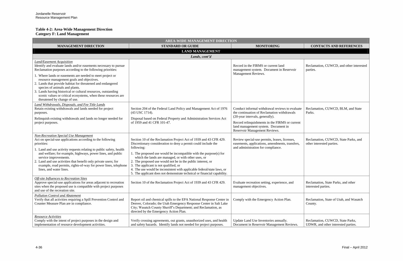
Jordanelle Reservoir Resource Management Plan
Table 4-2: Area-Wide Management Direction
Category F: Land Management
4-36 Final – April 2012
AREA-WIDE MANAGEMENT DIRECTION
MANAGEMENT DIRECTION STANDARD OR GUIDE MONITORING CONTACTS AND REFERENCES
LAND MANAGEMENT
Lands, cont’d
Land/Easement Acquisition
Identify and evaluate lands and/or easements necessary to pursue
Reclamation purposes according to the following priorities:
1. Where lands or easements are needed to meet project or
resource management goals and objectives.
2. Lands that provide habitat for threatened and endangered
species of animals and plants.
3. Lands having historical or cultural resources, outstanding
scenic values or critical ecosystems, when these resources are
threatened by change of use.
Record in the FIRMS or current land
management system. Document in Reservoir
Management Reviews.
Reclamation, CUWCD, and other interested
parties.
Land Withdrawals, Disposals, and Fee Title Lands
Retain existing withdrawals and lands needed for project
purposes.
Relinquish existing withdrawals and lands no longer needed for
project purposes.
Section 204 of the Federal Land Policy and Management Act of 1976
(43 USC 1714).
Disposal based on Federal Property and Administration Services Act
of 1959 and 41 CFR 101-47.
Conduct informal withdrawal reviews to evaluate
the continuation of Reclamation withdrawals
(20-year intervals, generally).
Record relinquishments in the FIRMS or current
land management system. Document in
Reservoir Management Reviews.
Reclamation, CUWCD, BLM, and State
Parks.
Non-Recreation Special Use Management Act on special-use applications according to the following
priorities:
1. Land and use activity requests relating to public safety, health
and welfare; for example, highways, power lines, and public
service improvements.
2. Land and use activities that benefit only private users; for
example, road permits, rights-of-way for power lines, telephone
lines, and water lines.
Section 10 of the Reclamation Project Act of 1939 and 43 CFR 429.
Discretionary consideration to deny a permit could include the
following:
1. The proposed use would be incompatible with the purpose(s) for
which the lands are managed, or with other uses, or
2. The proposed use would not be in the public interest, or
3. The applicant is not qualified, or
4. The use would be inconsistent with applicable federal/state laws, or
5. The applicant does not demonstrate technical or financial capability.
Review special-use permits, leases, licenses,
easements, applications, amendments, transfers,
and administration for compliance.
Reclamation, CUWCD, State Parks, and
other interested parties.
Off-site Influences to Recreation Sites
Approve special-use applications for areas adjacent to recreation
sites when the proposed use is compatible with project purposes
and use of the recreation site.
Section 10 of the Reclamation Project Act of 1939 and 43 CFR 429.
Evaluate recreation setting, experience, and
management objectives.
Reclamation, State Parks, and other
interested parties.
Pollution Control and Abatement
Verify that all activities requiring a Spill Prevention Control and
Counter Measure Plan are in compliance.
Report oil and chemical spills to the EPA National Response Center in
Denver, Colorado; the Utah Emergency Response Center in Salt Lake
City; Wasatch County Sheriff’s Department; and Reclamation, as
directed by the Emergency Action Plan.
Comply with the Emergency Action Plan.
Reclamation, State of Utah, and Wasatch
County.
Resource Activities
Comply with the intent of project purposes in the design and
implementation of resource development activities.
Verify crossing agreements, out grants, unauthorized uses, and health
and safety hazards. Identify lands not needed for project purposes.
Update Land Use Inventories annually.
Document in Reservoir Management Reviews.
Reclamation, CUWCD, State Parks,
UDWR, and other interested parties.
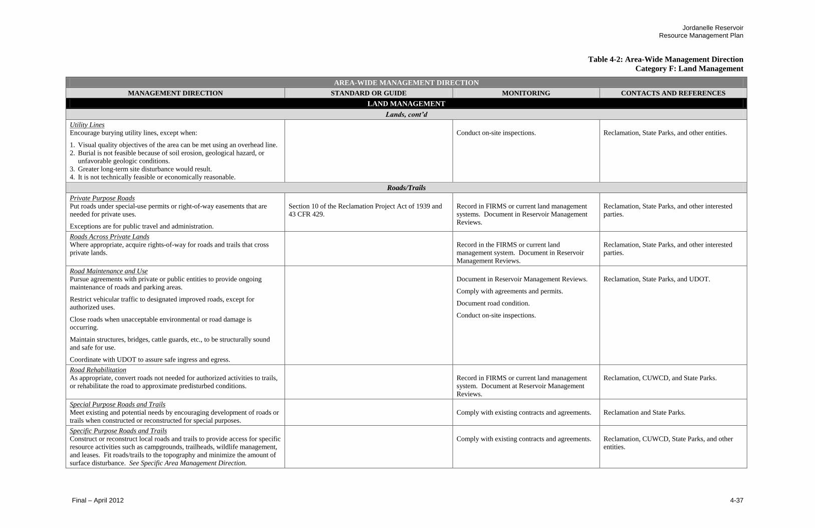
Jordanelle Reservoir Resource Management Plan
Table 4-2: Area-Wide Management Direction
Category F: Land Management
Final – April 2012 4-37
AREA-WIDE MANAGEMENT DIRECTION
MANAGEMENT DIRECTION STANDARD OR GUIDE MONITORING CONTACTS AND REFERENCES
LAND MANAGEMENT
Lands, cont’d
Utility Lines
Encourage burying utility lines, except when:
1. Visual quality objectives of the area can be met using an overhead line.
2. Burial is not feasible because of soil erosion, geological hazard, or
unfavorable geologic conditions.
3. Greater long-term site disturbance would result.
4. It is not technically feasible or economically reasonable.
Conduct on-site inspections.
Reclamation, State Parks, and other entities.
Roads/Trails
Private Purpose Roads
Put roads under special-use permits or right-of-way easements that are
needed for private uses.
Exceptions are for public travel and administration.
Section 10 of the Reclamation Project Act of 1939 and
43 CFR 429.
Record in FIRMS or current land management
systems. Document in Reservoir Management
Reviews.
Reclamation, State Parks, and other interested
parties.
Roads Across Private Lands
Where appropriate, acquire rights-of-way for roads and trails that cross
private lands.
Record in the FIRMS or current land
management system. Document in Reservoir
Management Reviews.
Reclamation, State Parks, and other interested
parties.
Road Maintenance and Use
Pursue agreements with private or public entities to provide ongoing
maintenance of roads and parking areas.
Restrict vehicular traffic to designated improved roads, except for
authorized uses.
Close roads when unacceptable environmental or road damage is
occurring.
Maintain structures, bridges, cattle guards, etc., to be structurally sound
and safe for use.
Coordinate with UDOT to assure safe ingress and egress.
Document in Reservoir Management Reviews.
Comply with agreements and permits.
Document road condition.
Conduct on-site inspections.
Reclamation, State Parks, and UDOT.
Road Rehabilitation
As appropriate, convert roads not needed for authorized activities to trails,
or rehabilitate the road to approximate predisturbed conditions.
Record in FIRMS or current land management
system. Document at Reservoir Management
Reviews.
Reclamation, CUWCD, and State Parks.
Special Purpose Roads and Trails
Meet existing and potential needs by encouraging development of roads or
trails when constructed or reconstructed for special purposes.
Comply with existing contracts and agreements.
Reclamation and State Parks.
Specific Purpose Roads and Trails
Construct or reconstruct local roads and trails to provide access for specific
resource activities such as campgrounds, trailheads, wildlife management,
and leases. Fit roads/trails to the topography and minimize the amount of
surface disturbance. See Specific Area Management Direction.
Comply with existing contracts and agreements.
Reclamation, CUWCD, State Parks, and other
entities.

Jordanelle Reservoir Resource Management Plan
Table 4-2: Area-Wide Management Direction
Category F: Land Management
4-38 Final – April 2012
AREA-WIDE MANAGEMENT DIRECTION
MANAGEMENT DIRECTION STANDARD OR GUIDE MONITORING CONTACTS AND REFERENCES
LAND MANAGEMENT
Roads/Trails, cont’d
Trail Maintenance and Use
Maintain trails for designated uses and restrict trails from
inappropriate uses.
Determine trail condition and travel status.
Document in Reservoir Management Reviews.
Reclamation, State Parks, and other interested
parties.
Travel/Access
Automobile/Motorized Vehicle Travel Prohibit vehicles from traveling and parking outside designated
roads and parking areas.
43 CFR 420.
Reclamation, UDOT, State Parks, and Wasatch
County Sheriff’s Department.
Disability Access
Construct accessible facilities that meet current guidelines.
Americans with Disabilities Act Accessibility Guidelines and
Uniform Federal Accessibility Standards (UFAS).
Comply. Document in Reservoir Management
Reviews.
Reclamation and State Parks.
Land Trespass
Where practicable, resolve land ownership, roads, and trespass
issues.
Identify land owners, involved management entities, roles, and
issues. Encourage coordination and cooperation among all
involved entities.
Monitor in Reservoir Management Reviews.
Reclamation, State Parks, and other interested
parties.
Off-Highway Vehicles Restrict off-highway vehicle (OHV) use as appropriate.
Where practicable, regulate OHV use on Reclamation lands
consistent with adjoining public and private land use.
Provide OHV enforcement through federal, state, county, or local
law enforcement agencies.
OHV Use Designations: All Reclamation lands are closed to
OHV use, except for areas or trails specifically designated as
open.
Evaluate the necessity of all roads and trails and
document in Reservoir Management Reviews.
Reclamation, State Parks, and other interested
parties
Visitor Access
Provide appropriate access. See Specific-Area Management
Direction.
State Parks and Reclamation.
No Exclusive Private Use
Maintain “No Exclusive Private Use” around the reservoir to
protect the water quality and natural resources of the area.
Protect natural resources and water quality.
Evaluate proposed development of private
development of recreation facilities in the project
area.
Reclamation, State Parks.
Access Proposals All access change proposals must consider impacts on State Park
resources (revenue, capacity issues, staff needs, enforcement,
costs, etc.)
MOA for Development of Recreation Facilities at Utah
Reservoirs. Contract No. 01-LM-40-02110, dated 06/2003.
Comply with contracts, agreements, and planning
documents. Document in Reservoir Management
Reviews.
Reclamation, State Parks.
Appropriate Public Access Identify strategies to provide appropriate public access for
adjacent private lands and nearby development and to identify
actions to effectively manage such access.
Provide appropriate and safe public access to public use areas
and adjacent lands. Comply with American with Disability Act
guidelines.
Evaluate proposed development for Deer Valley
Lakeside Resort RSPA and Town of Hideout.
Document in Reservoir Management Reviews.
State Parks, Reclamation.
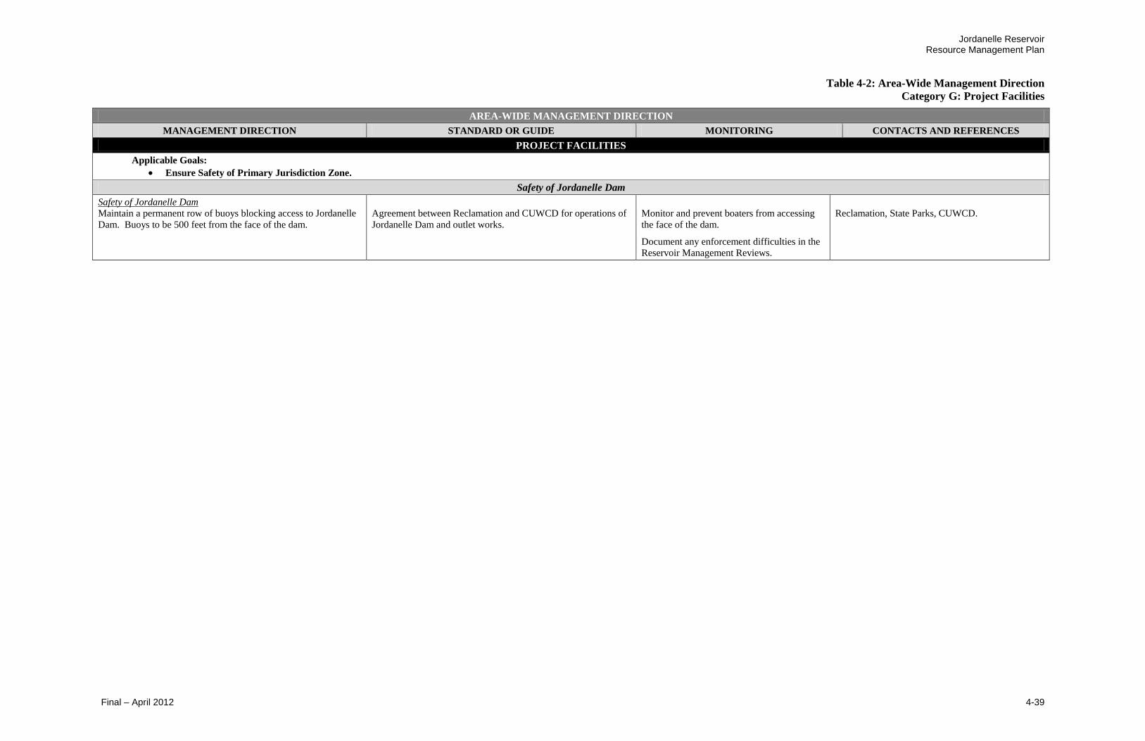
Jordanelle Reservoir Resource Management Plan
Table 4-2: Area-Wide Management Direction
Category G: Project Facilities
Final – April 2012 4-39
AREA-WIDE MANAGEMENT DIRECTION
MANAGEMENT DIRECTION STANDARD OR GUIDE MONITORING CONTACTS AND REFERENCES
PROJECT FACILITIES
Applicable Goals:
Ensure Safety of Primary Jurisdiction Zone.
Safety of Jordanelle Dam
Safety of Jordanelle Dam Maintain a permanent row of buoys blocking access to Jordanelle
Dam. Buoys to be 500 feet from the face of the dam.
Agreement between Reclamation and CUWCD for operations of
Jordanelle Dam and outlet works.
Monitor and prevent boaters from accessing
the face of the dam.
Document any enforcement difficulties in the
Reservoir Management Reviews.
Reclamation, State Parks, CUWCD.

Jordanelle Reservoir Resource Management Plan
4-40 Final – April 2012
This page is intentionally left blank

LegendHighway/State RouteProject Management Boundary
³0 400 800 1,200 1,600
Feet
Figure 4-1:Hailstone Recreation AreaPreferred Plan
£¤40
!́
!i
!i
!i
!r
!r
!5!5
!@
!̄
!7
!7
!l
!ZJ̈
!»
ñ
!£
!y
!y
!9
!9
!9
!3
!3
!3
!=
!Ö
@
7
9
£
Preferred PlanEnlarge existing dry storage facility fornon-motorized watercraft including lasersail boats.Provide improvements to campgroundsincluding RV pad modifications & cabindevelopment; Provide improved access& facilities at Keetley Campground.Create internal trail system betweenfacilities at Hailstone. (Locations TBD)Redesign & reconstruct the entrancestation to accommodate visitors at aquicker rate & reduce traffic congestion.Extend Perimeter Trail from Hailstone toCrandall Point.Continue mandatory boat inspection foraquatic invasive species & continue toprovide boat decontamination.
!Ö
´
i
r
5
¯
7
3
9
y
=
l
¨
Existing FeaturesParking Site
Public Breach
Day Use Area
Covered Pavilion
Camping Site
Boat Ramp or Dock
Ampitheater
Lakeview Grill & General Store
Boat Storage
Department of Wildlife Resources
Fish Cleaning Station
Event Center
Beach House
RV Dump Station
WellBuoys designating wakeless speed zone
Z
»
McHenryMcHenryCampgroundCampground
KeetleyKeetleyCampgroundCampground
HailstoneHailstoneCampgroundCampground
!9CabinCabin
!y
Icons shown are for management actions thatcorrespond to a physical location. Refer toSection 4.5 for complete list of specific areamanegement actions.
ñ
!i

This page is intentionally left blank

LegendHighway/State RoutePerimeter TrailProject Management Boundary
³0 500 1,000 1,500 2,000Feet
Figure 4-2:Crandall Point & Northwest ShorePreferred Plan
£¤248
!_
_i
!!i
Preferred PlanCrandall Point:Develop trailhead including: gravelparking lot, self-pay fee station, vaulttoilet restrooms, & Perimeter Trailaccess.Extend Perimeter Trail from Hailstoneto Crandall Point; Allow connection toPerimeter Trail from other trail systems;Install additional trails for pedestrianand fisherman access to reservoir.Northwest Shore:Develop unique shoreline day-useareas, accessible by boat or by trail &managed by Recreation Park Manager.Primitive Area: no power, water, orsewer. (Approximate Locations)!5
5
!5
!5
Icons shown are for management actions thatcorrespond to a physical location. Refer toSection 4.5 for complete list of specific areamanegement actions.

This page is intentionally left blank

LegendHighway/State RoutePerimeter TrailProject Management Boundary
³0 400 800 1,200 1,600
Feet
Figure 4-3:Ross Creek Recreation AreaPreferred Plan
£¤248
!_
!i!È
Ö
Preferred PlanInstall access trails to reservoir; Allowconnection to Perimeter Trail fromother trail systems.Pursue improved access from StateRoute 248.Designate the existing wakeless usearea for beaches & non-motoroizedwatercraft use.Pursue concession opportuniites,e.g., bike, non-motorized boat, and/orhorse rental.
Ö
_Existing FeaturesVault Toilet Restroom
Parking
Self-Pay Fee Station
Hitching Post
i
È
!
Abandoned Highway
!|
!|
Icons shown are for management actions thatcorrespond to a physical location. Refer toSection 4.5 for complete list of specific areamanegement actions.

This page is intentionally left blank
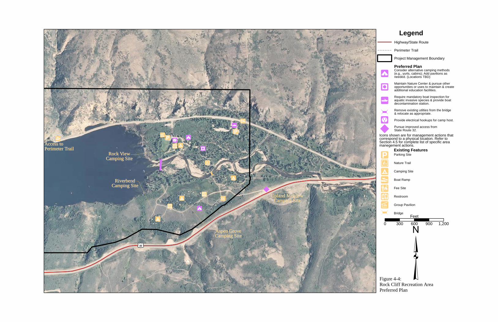
LegendHighway/State RoutePerimeter TrailProject Management Boundary
³0 300 600 900 1,200
Feet
Figure 4-4:Rock Cliff Recreation AreaPreferred Plan
£¤32
!Z
!i
!i
à
!@
!Ö
à
Ö
Preferred PlanConsider alternative camping methods(e.g., yurts, cabins); Add pavilions asneeded. (Locations TBD)Maintain Nature Center & pursue otheropportunities or uses to maintain & createadditional education facilities.Require mandatory boat inspection foraquatic invasive species & provide boatdecontamination station.Remove existing utilties from the bridge& relocate as appropriate.Provide electrical hookups for camp host.Pursue improved access fromState Route 32.
!9
!<
<
Ö
Existing FeaturesParking Site
Nature Trail
Camping Site
Boat Ramp
Fee Site
Restroom
Group Pavilion
Bridge
i
Z
@
Ö
9
y
Upland MeadowUpland MeadowCamping SiteCamping Site
RiverbendRiverbendCamping SiteCamping Site
Aspen GroveAspen GroveCamping SiteCamping Site
Rock ViewRock ViewCamping SiteCamping Site
!9
!9
!9
_
3
£
£¤32
!yAccess toAccess toPerimeter TrailPerimeter Trail !_
!_
!_
!3
!3
!£
Icons shown are for management actions thatcorrespond to a physical location. Refer toSection 4.5 for complete list of specific areamanegement actions.
!!/
îî ))
!!/
îî ))
!< à

This page is intentionally left blank

Jordanelle Reservoir Resource Management Plan
Table 4-3: Specific-Area Management Direction
Hailstone Recreation Area
Final – April 2012 4-49
SPECIFIC-AREA MANAGEMENT DIRECTION
MANAGEMENT DIRECTION STANDARD OR GUIDE MONITORING CONTACT AND REFERENCES
HAILSTONE RECREATION AREA
Goal: Ensure a more visitor-friendly park and help the Recreation Park Manager meet the growing needs of park visitors.
Land Facilities
Continue maintenance of existing facilities by the
Recreation Park Manager.
Document in Reservoir Management Reviews. State Parks, Reclamation.
Provide improvements to campgrounds including RV pad
modifications and cabin development.
Comply in planning, design and construction. Conduct
reviews. Document in Reservoir Management Reviews.
State Parks, Reclamation.
Provide improved access and facilities at Keetley
Campground.
Comply with contracts, agreements, and planning.
Document in Reservoir Management Reviews.
State Parks, Reclamation.
Drill a well to develop additional water for landscape
irrigation. Water for landscaping may be obtained from a
surface water source instead of from a well.
Follow state water laws and regulations. Water right
number A20140 (55-11158) allows pumping up to 79.0
ac-ft/yr.
Comply with current water quality and sanitation
standards. Document in Reservoir Management
Reviews.
Utah Division of Drinking Water, State Parks,
Reclamation.
Create internal trail system between facilities at
Hailstone.
Comply with contracts, agreements, and planning.
Document in Reservoir Management Reviews.
State Parks, Reclamation.
Redesign and reconstruct the entrance station to
accommodate visitors at a quicker rate and reduce traffic
congestion.
Comply with contracts, agreements, and planning.
Document in Reservoir Management Reviews.
State Parks, Reclamation.
Extend Perimeter Trail from Hailstone to Crandall Point. Comply with contracts, agreements, and planning.
Document in Reservoir Management Reviews.
State Parks, Reclamation.
Enlarge existing dry storage facility for non-motorized
watercraft including laser sailboats.
Comply with contracts, agreements, and planning.
Document in Reservoir Management Review.
State Parks, Reclamation.
Increase parking for day-users. Comply with contracts, agreements, and planning.
Document in Reservoir Management Reviews.
State Parks, Reclamation.
Recreation Opportunities
Maintain the existing wakeless use areas for beaches,
fishing and non-motorized watercraft use, e.g., sailing
and wind surfing.
Follow State Boating Guidelines.
Evaluate impacts to other reservoir resources. Evaluate
benefits. Document in Reservoir Management Reviews.
State Parks, Reclamation.
Create educational opportunities. Seek partnership with other entities to promote public
education and educational programs.
State Parks, CUWCD, UDWR, USFWS, and other
interested entities.
Noxious Weed Management
Recreation Park Manager to continue land management
activities necessary to protect against the spread of
noxious weeds and other pests detrimental to natural
values, agriculture, or public health and safety, and to
promote the growth of native species within the defined
recreation area.
Required those authorized to conduct soil disturbing
activities to control noxious and/or invading weeds on
the disturbed area during the use or construction period.
Federal Noxious Weed Act of 1974 (Public Law 93-629 as
amended, Public Law 101-624 for Section 15); Carlson-
Foley Act of 1968 (Public Law 90-583, 82 Stat. 1146).
Monitor and document in Reservoir Management
Reviews. Apply pesticides only after approval from
Reclamation.
Follow Reclamation Manual Policy for Pest
Management.
Reclamation, State Parks, Wasatch County.
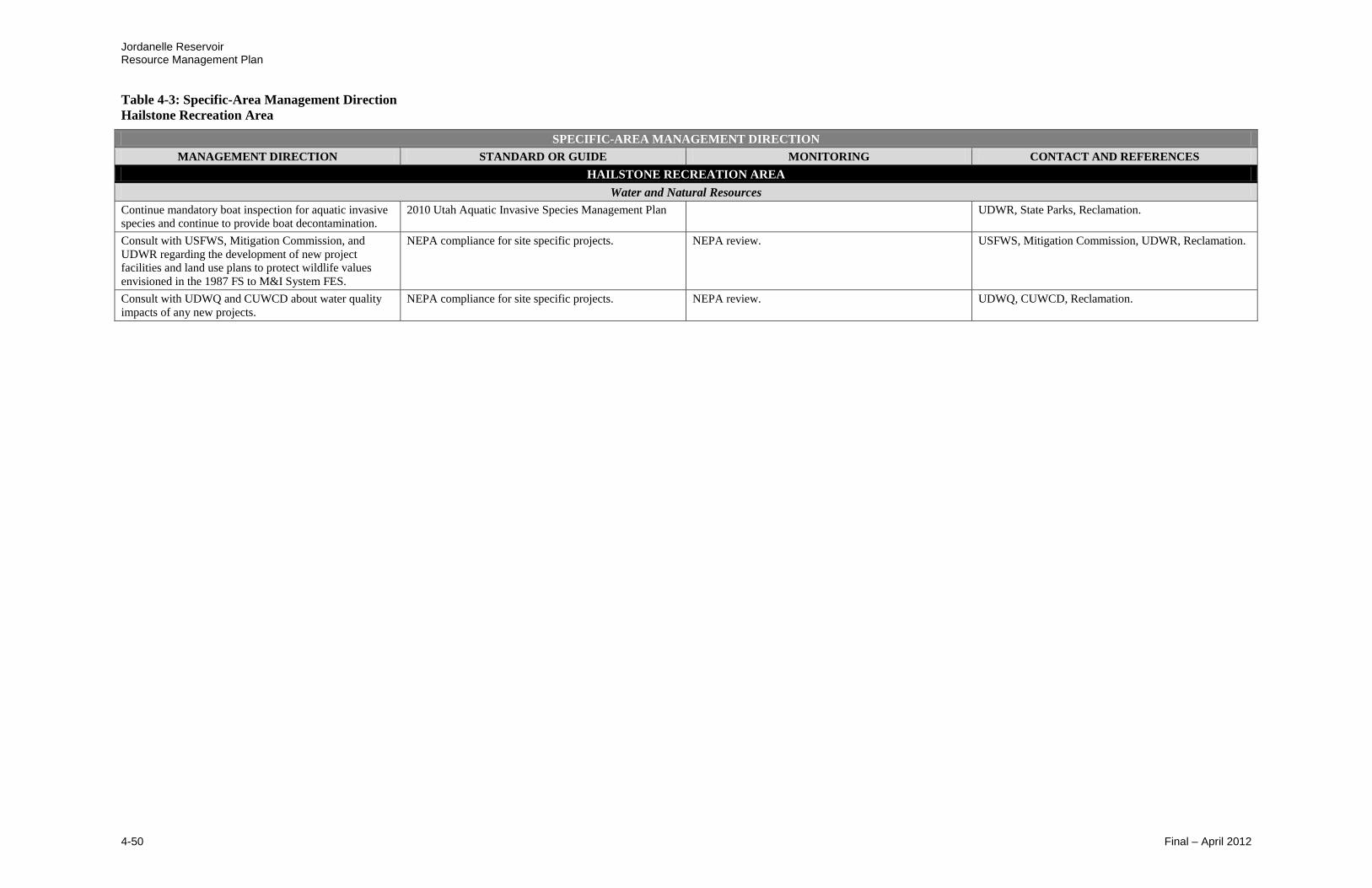
Jordanelle Reservoir Resource Management Plan
Table 4-3: Specific-Area Management Direction
Hailstone Recreation Area
4-50 Final – April 2012
SPECIFIC-AREA MANAGEMENT DIRECTION
MANAGEMENT DIRECTION STANDARD OR GUIDE MONITORING CONTACT AND REFERENCES
HAILSTONE RECREATION AREA
Water and Natural Resources
Continue mandatory boat inspection for aquatic invasive
species and continue to provide boat decontamination.
2010 Utah Aquatic Invasive Species Management Plan UDWR, State Parks, Reclamation.
Consult with USFWS, Mitigation Commission, and
UDWR regarding the development of new project
facilities and land use plans to protect wildlife values
envisioned in the 1987 FS to M&I System FES.
NEPA compliance for site specific projects. NEPA review. USFWS, Mitigation Commission, UDWR, Reclamation.
Consult with UDWQ and CUWCD about water quality
impacts of any new projects.
NEPA compliance for site specific projects. NEPA review. UDWQ, CUWCD, Reclamation.

Jordanelle Reservoir Resource Management Plan
Table 4-3: Specific-Area Management Direction
Crandall Point
Final – April 2012 4-51
SPECIFIC-AREA MANAGEMENT DIRECTION
MANAGEMENT DIRECTION STANDARD OR GUIDE MONITORING CONTACT AND REFERENCES
CRANDALL POINT
Goal: Develop area to be more easily accessible to fisherman and day-use visitors. Crandall Point is to be a primitive area with no power, water or sewer facilitates.
Land Facilities
Develop trailhead including: gravel parking lot, self-pay
fee station, vault toilet restroom, and Perimeter Trail
access.
Allow development of primitive facilities to improve
recreation experience of park visitors.
Comply with contracts, agreements, and planning.
Document in Reservoir Management Reviews.
State Parks, Reclamation.
Extend Perimeter Trail from Hailstone to Crandall Point. Comply with contracts, agreements, and planning.
Document in Reservoir Management Reviews.
State Parks, Reclamation.
Allow connection to Perimeter Trail from other trail
systems.
Comply with contracts, agreements, and planning.
Document in Reservoir Management Reviews.
State Parks, Reclamation.
Install additional trails for pedestrian and fisherman
access to reservoir.
Comply with contracts, agreements, and planning.
Document in Reservoir Management Reviews.
State Parks, Reclamation.
Pursue access for parking lot. Comply with contracts, agreements, and planning.
Document in Reservoir Management Reviews.
State Parks, Reclamation, JSSD.
Noxious Weed Management
Recreation Park Manager to continue land management
activities necessary to protect against the spread of
noxious weeds and other pests detrimental to natural
values, agriculture, or public health and safety, and to
promote the growth of native species within the defined
recreation area.
Required those authorized to conduct soil disturbing
activities to control noxious and/or invading weeds on
the disturbed area during the use or construction period.
Federal Noxious Weed Act of 1974 (Public Law 93-629 as
amended, Public Law 101-624 for Section 15); Carlson-
Foley Act of 1968 (Public Law 90-583, 82 Stat. 1146).
Monitor and document in Reservoir Management
Reviews. Apply pesticides only after approval from
Reclamation.
Follow Reclamation Manual Policy for Pest
Management.
Reclamation, State Parks, Wasatch County.
Water and Natural Resources
Consult with USFWS, Mitigation Commission, and
UDWR regarding the development of new project
facilities and land use plans to protect wildlife values
envisioned in the 1987 FS to M&I System FES.
NEPA compliance for site specific projects. NEPA review. USFWS, Mitigation Commission, UDWR, Reclamation.
Consult with UDWQ and CUWCD about water quality
impacts of any new projects.
NEPA compliance for site specific projects. NEPA review. UDWQ, CUWCD, Reclamation.

Jordanelle Reservoir Resource Management Plan
Table 4-3: Specific-Area Management Direction
Northwest Shoreline
4-52 Final – April 2012
SPECIFIC-AREA MANAGEMENT DIRECTION
MANAGEMENT DIRECTION STANDARD OR GUIDE MONITORING CONTACT AND REFERENCES
NORTHWEST SHORELINE
Goal: Provide for development and enhancement of recreation opportunities and provide wildlife habitat values. Shoreline areas are envisioned to be a primitive area with no power, water, or sewer facilities and
only accessible by the Perimeter Trail or by boat.
Land Facilities
Continue maintenance of existing Perimeter Trail by the
Recreation Park Manager.
Document in Reservoir Management Reviews. State Parks, Reclamation.
Develop unique shoreline day-use areas, accessible by
boat or by Perimeter Trail to be managed by the
Recreation Park Manager. Primitive Area: no power,
water, or sewer.
Develop facilities based on compatibility with authorized
project purposes, long-term management goals and
objectives, and environmental protection factors.
Evaluate sustainability and benefits. State Parks, Reclamation.
Allow access to Perimeter Trail from other trail systems. Comply with contracts, agreements, and planning.
Document in Reservoir Management Reviews.
State Parks, Reclamation.
Recreation Opportunities
Respond to private concessionaire requests to develop,
operate, and maintain new public facilities.
Develop facilities based on compatibility with authorized
project purposes, long-term management goals and
objectives, and environmental protection factors.
Follow state and federal guidelines.
Evaluate sustainability and benefits. State Parks, Reclamation.
Noxious Weed Management
Recreation Park Manager to protect against introduction
and spread of noxious weeds and other pests detrimental
to natural values, agriculture, or public health and safety,
and to promote the growth of native species within the
defined recreation area.
Required those authorized to conduct soil disturbing
activities to control noxious and/or invading weeds on
the disturbed area during the use or construction period.
Monitor and document in Reservoir Management
Reviews. Apply pesticides only after approval from
Reclamation.
Reclamation, State Parks, Wasatch County, and other
interested parties.
Water and Natural Resources
Consult with USFWS, Mitigation Commission, and
UDWR regarding the development of new project
facilities and land use plans to protect wildlife values
envisioned in the 1987 FS to M&I System FES.
NEPA compliance for site specific projects. NEPA review. USFWS, Mitigation Commission, UDWR, Reclamation.
Consult with UDWQ and CUWCD about water quality
impacts of any new projects.
NEPA compliance for site specific projects. NEPA review. UDWQ, CUWCD, Reclamation.

Jordanelle Reservoir Resource Management Plan
Table 4-3: Specific-Area Management Direction
Ross Creek Recreation Area
Final – April 2012 4-53
SPECIFIC-AREA MANAGEMENT DIRECTION
MANAGEMENT DIRECTION STANDARD OR GUIDE MONITORING CONTACT AND REFERENCES
ROSS CREEK RECREATION AREA
Goal: Proper planning and implementation of recreation facilities to improve land management of the area, respond to private business partner requests, increase recreational opportunities for the public, and
increase revenue to the Recreation Park Manager to attain self-sufficiency. It is envisioned to be a primitive area with no power, water, or sewer facilities.
Land Facilities
Continue maintenance of existing facilities by the
Recreation Park Manager including: parking lot, self-pay
fee station, vault toilet restrooms, hitching posts, and
access to Perimeter Trail.
Document in Reservoir Management Reviews. State Parks, Reclamation.
Install access trails to reservoir. Comply with contracts, agreements, and planning.
Document in Reservoir Management Reviews.
State Parks, Reclamation.
Provide infrastructure improvements. Develop facilities based on compatibility with authorized
project purposes, long-term management goals and
objectives, and environmental protection factors.
Evaluate sustainability and benefits. State Parks, Reclamation.
Pursue improved access from State Route 248. Follow state guidelines. Pursue partnership with UDOT to improve safety of park
visitors. Document in Reservoir Management Reviews.
Reclamation, State Parks, UDOT.
Allow access to Perimeter Trail from other trail systems. Comply with contracts, agreements, and planning.
Document in Reservoir Management Reviews.
State Parks, Reclamation.
Recreation Opportunities
Designate the existing wakeless use for beaches and non-
motorized watercraft use.
Evaluate impacts to other reservoir resources. Evaluate
benefits. Document in Reservoir Management Reviews.
State Parks, Reclamation.
Pursue concession opportunities, e.g., bike, non-
motorized boat, and/or horse rentals.
Evaluate impacts to other reservoir resources. Evaluate
benefits. Document in Reservoir Management Reviews.
State Parks, Reclamation.
Respond to private concessionaire requests to develop,
operate, and maintain new public facilities.
Develop facilities based on compatibility with authorized
project purposes, long-term management goals and
objectives, and environmental protection factors.
Follow state and federal guidelines.
Evaluate sustainability and benefits. State Parks, Reclamation.
Noxious Weed Management
Recreation Park Manager to continue land management
activities necessary to protect against the spread of
noxious weeds and other pests detrimental to natural
values, agriculture, or public health and safety, and to
promote the growth of native species within the defined
recreation area.
Required those authorized to conduct soil disturbing
activities to control noxious and/or invading weeds on
the disturbed area during the use or construction period.
Federal Noxious Weed Act of 1974 (Public Law 93-629 as
amended, Public Law 101-624 for Section 15); Carlson-
Foley Act of 1968 (Public Law 90-583, 82 Stat. 1146).
Monitor and document in Reservoir Management
Reviews. Apply pesticides only after approval from
Reclamation.
Follow Reclamation Manual Policy for Pest
Management.
Reclamation, State Parks, Wasatch County, and other
interested parties.
Water and Natural Resources
Consult with USFWS, Mitigation Commission, and
UDWR regarding the development of new project
facilities and land use plans to protect wildlife values
envisioned in the 1987 FS to M&I System FES.
NEPA compliance for site specific projects. NEPA review. USFWS, Mitigation Commission, UDWR, Reclamation.
Consult with UDWQ and CUWCD about water quality impacts of any new projects.
NEPA compliance for site specific projects. NEPA review. UDWQ, CUWCD, Reclamation.

Jordanelle Reservoir Resource Management Plan
Table 4-3: Specific-Area Management Direction
Rock Cliff Recreation Area
4-54 Final – April 2012
SPECIFIC-AREA MANAGEMENT DIRECTION
MANAGEMENT DIRECTION STANDARD OR GUIDE MONITORING CONTACT AND REFERENCES
ROCK CLIFF RECREATION AREA
Goal: Provide for the preservation and enhancement of the existing facilities, as well as preserve wildlife habitat values in the area.
Land Facilities
Continue maintenance of existing facilities by the
Recreation Park Manager including: parking lot, fee
station, access to Perimeter Trail, small boat ramp, and
Nature Center.
Document in Reservoir Management Reviews. State Parks, Reclamation.
Consider alternative camping methods (e.g., yurts,
cabins).
Add pavilions as needed.
Develop facilities based on compatibility with authorized
project purposes, long-term management goals and
objectives, and environmental protection factors.
Evaluate sustainability and benefits. Access
development scale.
State Parks, Reclamation.
Maintain current boat ramp for small watercraft
(motorized and non-motorized).
Document in Reservoir Management Reviews. State Parks, Reclamation.
Allow access to Perimeter Trail from other trail systems. Comply with contracts, agreements, and planning.
Document in Reservoir Management Reviews.
State Parks, Reclamation.
Continue stream stabilization activities as necessary to
protect existing facilities, while respecting river
character.
Comply with contracts, agreements, and planning.
Document in Reservoir Management Reviews.
State Parks, Reclamation.
Remove utilities from the bridge and relocate to stabilize
as appropriate. Directional drilling could be used to put
utilities under the river or utilities could be placed in the
access road and highway to avoid crossing the river in the
park.
Comply with contracts, agreements, and planning.
Document in Reservoir Management Reviews.
State Parks, Reclamation.
Evaluate flood plain to determine the liability to
facilities. Make improvements as necessary.
Comply with contracts, agreements, and planning.
Document in Reservoir Management Reviews.
State Parks, Reclamation.
Pursue improved access from SR 32. Follow state guidelines. Pursue partnership with UDOT to improve safety of park
visitors. Document in Reservoir Management Reviews.
Reclamation, State Parks, UDOT.
Pursue opportunities to improve facilities. Comply with contracts, agreements, and planning.
Document in Reservoir Management Reviews.
State Parks, Reclamation.
Recreation Opportunities
Maintain Nature Center and pursue other opportunities or
uses to maintain and create additional education facilities.
Document in Reservoir Management Reviews. State Parks, Reclamation.
Maintain the existing wakeless use areas for beaches and
non-motorized watercraft use.
Evaluate impacts to other reservoir resources. Evaluate
benefits. Document in Reservoir Management Reviews.
State Parks, Reclamation.
Provide electrical hookups for camp host. Comply with contracts, agreements, and planning.
Document in Reservoir Management Reviews.
State Parks, Reclamation.
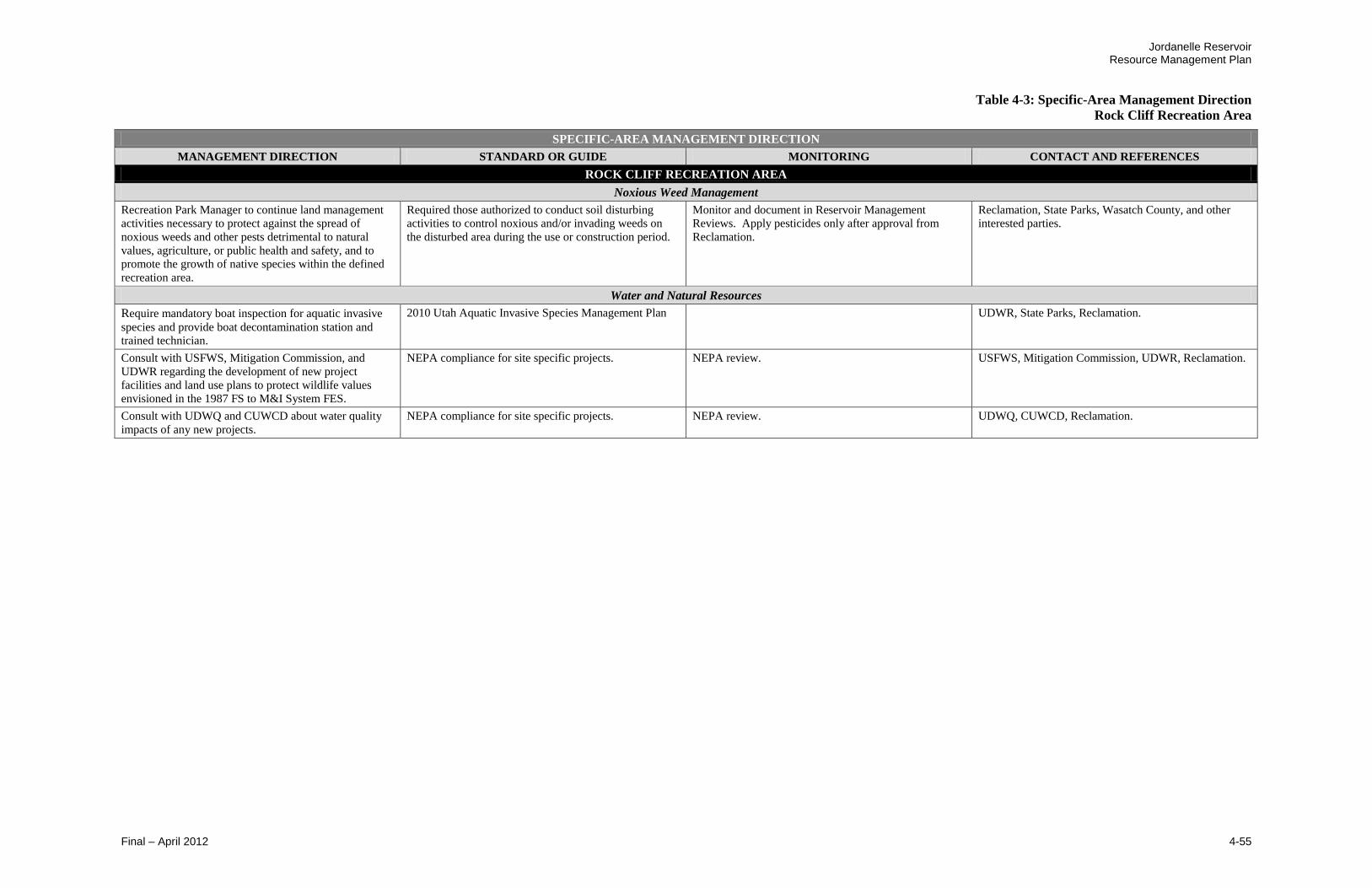
Jordanelle Reservoir Resource Management Plan
Table 4-3: Specific-Area Management Direction
Rock Cliff Recreation Area
Final – April 2012 4-55
SPECIFIC-AREA MANAGEMENT DIRECTION
MANAGEMENT DIRECTION STANDARD OR GUIDE MONITORING CONTACT AND REFERENCES
ROCK CLIFF RECREATION AREA
Noxious Weed Management
Recreation Park Manager to continue land management
activities necessary to protect against the spread of
noxious weeds and other pests detrimental to natural
values, agriculture, or public health and safety, and to
promote the growth of native species within the defined
recreation area.
Required those authorized to conduct soil disturbing
activities to control noxious and/or invading weeds on
the disturbed area during the use or construction period.
Monitor and document in Reservoir Management
Reviews. Apply pesticides only after approval from
Reclamation.
Reclamation, State Parks, Wasatch County, and other
interested parties.
Water and Natural Resources
Require mandatory boat inspection for aquatic invasive
species and provide boat decontamination station and
trained technician.
2010 Utah Aquatic Invasive Species Management Plan UDWR, State Parks, Reclamation.
Consult with USFWS, Mitigation Commission, and
UDWR regarding the development of new project
facilities and land use plans to protect wildlife values
envisioned in the 1987 FS to M&I System FES.
NEPA compliance for site specific projects. NEPA review. USFWS, Mitigation Commission, UDWR, Reclamation.
Consult with UDWQ and CUWCD about water quality
impacts of any new projects.
NEPA compliance for site specific projects. NEPA review. UDWQ, CUWCD, Reclamation.

Jordanelle Reservoir Resource Management Plan
Table 4-3: Specific-Area Management Direction
Primitive Shoreline Area
4-56 Final – April 2012
SPECIFIC-AREA MANAGEMENT DIRECTION
MANAGEMENT DIRECTION STANDARD OR GUIDE MONITORING CONTACT AND REFERENCES
PRIMITIVE SHORELINE AREA
Goal: Provide areas only accessible by boat or by the Perimeter Trail. It is envisioned that these areas will be preserved to maintain wildlife habitat values and current conditions.
Land Management
Continue management to maintain wildlife values envisioned
in the 1987 FS to the M&I System FES.
1987 FS to the M&I System FES. Document in Reservoir Management Reviews. Reclamation, UDWR.
Continue maintenance of existing Perimeter Trail by the
Recreation Park Manager.
N/A Document in Reservoir Management Reviews. State Parks, Reclamation.
Noxious Weed Management
Recreation Park Manager to protect against introduction and
spread of noxious weeds and other pests detrimental to natural
values, agriculture, or public health and safety.
Required those authorized to conduct soil disturbing activities to
control noxious and/or invading weeds on the disturbed area
during the use or construction period.
Federal Noxious Weed Act of 1974 (Public Law 93-629 as
amended, Public Law 101-624 for Section 15); Carlson-Foley
Act of 1968 (Public Law 90-583, 82 Stat. 1146).
Monitor and document in Reservoir Management
Reviews. Apply pesticides only after approval from
Reclamation.
Follow Reclamation Manual Policy for Pest
Management.
Reclamation, State Parks, Wasatch County.
Jordanelle Reservoir Resource Management Plan
Table 4-3: Specific-Area Management Direction
Primary Jurisdiction Zone
Final – April 2012 4-57
SPECIFIC-AREA MANAGEMENT DIRECTION
MANAGEMENT DIRECTION STANDARD OR GUIDE MONITORING CONTACT AND REFERENCES
PRIMARY JURISDICTION ZONE
Goal: Protect the Primary Jurisdiction Zone. The restricted area is for use exclusively by CUWCD for operation and maintenance of Jordanelle Dam.
Facility Protection
Continue maintenance of existing facilities by CUWCD
under direction of Reclamation.
Document in Reservoir Management Reviews. CUWCD, Reclamation.
Facility Protection
Maintain a permanent row of buoys 500 feet from the
face of Jordanelle Dam.
Agreement between Reclamation and CUWCD for
operations of Jordanelle Dam and outlet works.
Monitor and prevent boaters accessing the face of the dam.
Document and enforcement difficulties in the Reservoir
Management Reviews.
Reclamation, State Parks, CUWCD.
Restrict access within the Primary Jurisdiction Zone. Document any enforcement difficulties in the Reservoir
Management Reviews.
Reclamation, CUWCD.
Recreation Park Manager will assist with security
monitoring along the buoys to keep people away from the
dam.
Monitor and prevent boaters accessing the face of the
dam.
Reclamation, State Parks, CUWCD.
Noxious Weed Management
CUWCD and Reclamation to protect against introduction
and spread of noxious weeds and other pests detrimental
to natural values, agriculture, or public health and safety.
Required those authorized to conduct soil disturbing
activities to control noxious and/or invading weeds on
the disturbed area during the use or construction period.
Federal Noxious Weed Act of 1974 (Public Law 93-629 as
amended, Public Law 101-624 for Section 15); Carlson-
Foley Act of 1968 (Public Law 90-583, 82 Stat. 1146).
Monitor and document in Reservoir Management
Reviews. Apply pesticides only after approval from
Reclamation.
Follow Reclamation Manual Policy for Pest
Management.
Reclamation, CUWCD, State Parks, Wasatch County.
Jordanelle Reservoir Resource Management Plan
Table 4-3: Specific-Area Management Direction
West Hills Wildlife Management Area
4-58 Final – April 2012
SPECIFIC-AREA MANAGEMENT DIRECTION
MANAGEMENT DIRECTION STANDARD OR GUIDE MONITORING CONTACT AND REFERENCES
WEST HILLS WILDLIFE MANAGEMENT AREA
Goal: Preserve area to maintain wildlife habitat values.
Land Management
Continue management by UDWR to implement the 1992
operating agreement.
West Hills WMA Operating Agreement. Contract No. N/A,
dated 11/18/1992.
Document in Reservoir Management Reviews. Reclamation, UDWR.
Reevaluate mission and accomplishments of West Hills WMA
and adjust if needed to ensure fulfillment of 1987 wildlife
mitigation requirements.
West Hills WMA Operating Agreement. Contract No. N/A,
dated 11/18/1992.
1987 FS to the M&I System FES.
Document in Reservoir Management Reviews. Reclamation, UDWR.
Evaluate potential alternative mitigation sites for required
wildlife mitigation, if needed.
NEPA compliance for site specific projects. NEPA review. Reclamation, UDWR.
Noxious Weed Management
UDWR to protect against introduction and spread of noxious
weeds and other pests detrimental to natural values,
agriculture, or public health and safety.
Required those authorized to conduct soil disturbing activities to
control noxious and/or invading weeds on the disturbed area
during the use or construction period.
Monitor and document in Reservoir Management
Reviews. Apply pesticides only after approval from
Reclamation.
Reclamation, State Parks, Wasatch County,
and other interested parties.
Jordanelle Reservoir Resource Management Plan
Final – April 2012 5-1
Chapter 5: Plan Implementation
5.1 Implementation
Reclamation’s Provo Area Office has primary responsibility for implementation
and monitoring of the RMP. A cooperative relationship between Reclamation and
the managing partners is necessary, which includes commitment by all of the
entities to seek financial, program, and staffing resources necessary to implement
the proposed management actions. During implementation of this RMP, DOI,
Reclamation, and its managing partners will be guided by existing and future
laws, regulations, policies, and guidelines. The RMP is designed to supplement
existing direction provided by these sources.
By following the RMP, Reclamation will protect and maintain the
congressionally authorized Jordanelle Project purposes, such as ensuring water
integrity, to provide direction for contracts, permits, leases, and license
agreements and to meet the requirements of the Reclamation Act of June 17, 1902
(32 Stat. 388, 43 U.S.C. 391), and the following acts amendatory thereof and
supplementary thereto: Federal Water Project Recreation Act (PL 89-72, 79 Stat.
213, 16 U.S.C. 460); Central Utah Project Completion Act of 1992 (PL 102-575,
Titles 2 - 6); and Reclamation Recreation Management Act of 1992, (PL 102-575,
Title 28, 16 U.S.C. 460L). In implementing, Reclamation will adhere to and be
guided by other federal laws, including the Fish and Wildlife Coordination Act
(PL 85-624, U.S.C. 661, 662); Endangered Species Act (PL 93-205, 16 U.S.C.
1531 et seq.); National Historic Preservation Act of 1966 (80 Stat. 915, 16 U.S.C.
470) as amended; National Environmental Policy Act of 1969 (PL 91-190, Stat.
852); Clean Water Act (PL 95-217 33 U.S.C. 466 et seq.); National Safe Drinking
Water Act (PL 93-523 S. 433; and other applicable environmental, cultural and
paleontological resources, fish and wildlife, mineral, disabilities, conservation,
real property, and pesticide statutes, executive orders, Code of Federal
Regulations, and Departmental policies.
Implementation of specific actions will require close coordination between
Reclamation and the managing partners, due to uncertain funding. The
responsible entity will prepare a work plan to accomplish the identified actions
and request an adequate level of funding.
Effective cooperation and coordination with administering entities is necessary
for successful implementation of the RMP. Entities include: Reclamation,
Wasatch County and other local governments, CUWCD, State Parks, UDWR,
DEQ, UDWQ, USFWS, Mitigation Commission, permittees, users, interested
public, and others.
Jordanelle Reservoir Resource Management Plan
5-2 Final – April 2012
5.2 Monitoring
Periodic monitoring will be conducted by Reclamation on an on-going basis
throughout the 10-year life of the RMP to track progress in implementing the
RMP, track the effectiveness of management actions, track progress toward a
desired condition, and detect unacceptable effects. It is recommended that
monitoring should occur every 3 years or more often as needed. Monitoring
activities may be reduced when goals and objectives have been reached. On-
going evaluation of the monitoring program will allow Reclamation to make
modifications in timing of improvements, timing of mitigation implementation,
and changes in the RMP that are needed to take into account changing visitation
needs or other changes in site conditions. Specific monitoring procedures and
standards are identified with the associated management actions/directions in
Tables 4-2 and 4-3.
5.3 Plan Revision or Amendment
This RMP is projected to provide management direction for at least 10 years.
However, it is recognized that unforeseen natural and human caused events,
regulatory or organizational changes, agency budgets, shifts in user needs and
interests, or other factors may necessitate review of the plan in order to prepare a
new plan that is responsive to conditions at that time. Reclamation may revise or
amend the RMP within the established 10-year planning period. If needed, the
decision to amend the RMP will be determined by Reclamation as issues arise. A
plan revision may be needed based on the following factors:
Plan implementation that substantially alters the goals of the RMP
Changes necessitated by changed social, physical, and/or environmental or
conditions
Changes needed to accommodate changed conditions that occur during
implementation of the plan
Uses that require authorization from permits, contracts, and cooperative
agreements that is not consistent with the RMP
This RMP responds to 2011 circumstances, information, and managerial roles and
relationships. Amendments may be necessary over time to maintain a viable,
workable RMP for management of Jordanelle Reservoir resources. The need for
a plan amendment will likely be identified during implementation or monitoring
by Reclamation or managing partners if there are resource, use changes, and/or
new issues that need to be addressed. The user public or interested agencies may
also identify deficiencies, problems, or issues that need to be addressed. It is
recommended that a process similar to that employed in the development of this
RMP be used to prepare RMP amendments. The level of NEPA compliance
necessary for an amendment or revision will be determined by Reclamation. It is
Jordanelle Reservoir Resource Management Plan
Final – April 2012 5-3
expected that a comprehensive RMP revision would occur within the next 10 to
15 years.
5.4 Implementation of Plan
Due to the uncertainty of funding from fiscal year to fiscal year, a precise
schedule cannot be developed for implementing provisions of the RMP.
Therefore, the management actions have been identified to be phased in over a
specified period of time. Those actions that do not require new or additional
funding are scheduled for immediate implementation. Since this RMP identifies
such items as capital and facility improvements for budgeting purposes,
improvements that require additional appropriations of funds will occur over a
period of years as funds become available. To facilitate this, annual coordination
is needed between Reclamation and the managing partners to discuss issues,
solutions, funding sources, and implementation priorities of the management
actions. Factors to take into account that may influence timing and priority of
when a management action is to be initiated should be based on whether the
action:
Is procedural (e.g., preparing agreements) or technical (developing
specific plans)
Needs to address public health and safety concerns
Brings Reclamation into compliance with existing laws, regulations, and
E.O.s
Is required to prevent resource damage to protect wildlife species or
habitats
Requires large capital investments, such as facility or trail development
Requires the assistance or support of other entities
Table 5-1 provides a summary of the RMP implementation schedule.
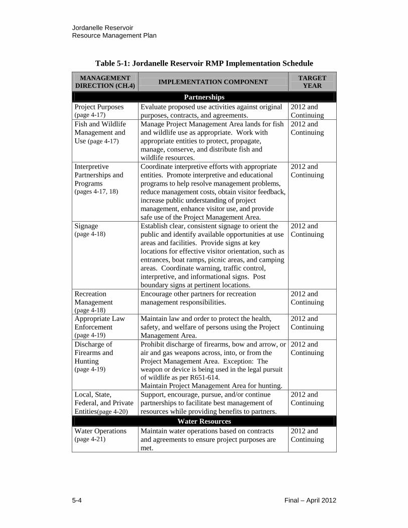
Jordanelle Reservoir Resource Management Plan
5-4 Final – April 2012
Table 5-1: Jordanelle Reservoir RMP Implementation Schedule
MANAGEMENT
DIRECTION (CH.4) IMPLEMENTATION COMPONENT
TARGET
YEAR
Partnerships
Project Purposes (page 4-17)
Evaluate proposed use activities against original
purposes, contracts, and agreements. 2012 and
Continuing Fish and Wildlife
Management and
Use (page 4-17)
Manage Project Management Area lands for fish
and wildlife use as appropriate. Work with
appropriate entities to protect, propagate,
manage, conserve, and distribute fish and
wildlife resources.
2012 and
Continuing
Interpretive
Partnerships and
Programs (pages 4-17, 18)
Coordinate interpretive efforts with appropriate
entities. Promote interpretive and educational
programs to help resolve management problems,
reduce management costs, obtain visitor feedback,
increase public understanding of project
management, enhance visitor use, and provide
safe use of the Project Management Area.
2012 and
Continuing
Signage (page 4-18)
Establish clear, consistent signage to orient the
public and identify available opportunities at use
areas and facilities. Provide signs at key
locations for effective visitor orientation, such as
entrances, boat ramps, picnic areas, and camping
areas. Coordinate warning, traffic control,
interpretive, and informational signs. Post
boundary signs at pertinent locations.
2012 and
Continuing
Recreation
Management (page 4-18)
Encourage other partners for recreation
management responsibilities. 2012 and
Continuing
Appropriate Law
Enforcement (page 4-19)
Maintain law and order to protect the health,
safety, and welfare of persons using the Project
Management Area.
2012 and
Continuing
Discharge of
Firearms and
Hunting (page 4-19)
Prohibit discharge of firearms, bow and arrow, or
air and gas weapons across, into, or from the
Project Management Area. Exception: The
weapon or device is being used in the legal pursuit
of wildlife as per R651-614. Maintain Project Management Area for hunting.
2012 and
Continuing
Local, State,
Federal, and Private
Entities(page 4-20)
Support, encourage, pursue, and/or continue
partnerships to facilitate best management of
resources while providing benefits to partners.
2012 and
Continuing
Water Resources
Water Operations (page 4-21)
Maintain water operations based on contracts
and agreements to ensure project purposes are
met.
2012 and
Continuing

Jordanelle Reservoir Resource Management Plan
Final – April 2012 5-5
MANAGEMENT
DIRECTION (CH.4) IMPLEMENTATION COMPONENT
TARGET
YEAR
Water Resources (cont’d)
Watershed
Protection
Management (page 4-21)
Encourage management practices that maintain
or improve reservoir water quality and stream
flows. Encourage neighboring jurisdictions to
construct and maintain facilities to protect and
improve water quality.
2012 and
Continuing
Best Management
Practices (BMPs) (page 4-21)
Implement BMPs relative to water quality
protection in all resource management activities.
As appropriate, implement a public education
program to interpret the benefits of water quality
and to prevent activities that produce pollution.
2012 and
Continuing
Water Quality
Protection (page 4-22)
Identify water quality impacts coming from
inside the Project Management Area and
improve and maintain water quality as possible.
2012 and
Continuing
Recreational and Visual Resources
Project Funding (page 4-23)
Identify sources for project funding from private
sources, or grants from federal or state sources. 2012 and
Continuing Development
Requirements (page 4-24)
Comply with applicable federal, state, and local
laws, rules, and regulations in the development
of facilities, including sanitation facilities.
Develop facilities based on compatibility with
authorized reservoir project purposes, long-term
management and funding capability,
management goals and objectives, and
environmental protection factors.
2012 and
Continuing
Facility Renovation
or Replacement (page 4-24)
Generally replace facilities when renovation
costs are 50 percent or more of replacement costs
or when existing facilities cease to be compatible
with site design.
2012 and
Continuing
Private
Development (page 4-24)
Allow recreation development by non-federal
(including associated third party) partners as
approved in writing, by Reclamation, and when
consistent with existing agreements and planning
documents.
2012 and
Continuing
Private Exclusive
Facilities (page 4-24)
Prohibit private, exclusive facilities by
Reclamation, its managing partners, or other
private entities. Phase out existing recreation
facilities deemed to be exclusive use when lands
are needed for greater public purposes.
2012 and
Continuing
WROS
Classification (page 4-24)
Perform classification study to comply with
Reclamation’s Water Recreation Opportunity
Spectrum (WROS) procedure and Guidebook.
Addresses recreation activity, setting,
experience, and benefits.
As funds
become
available.
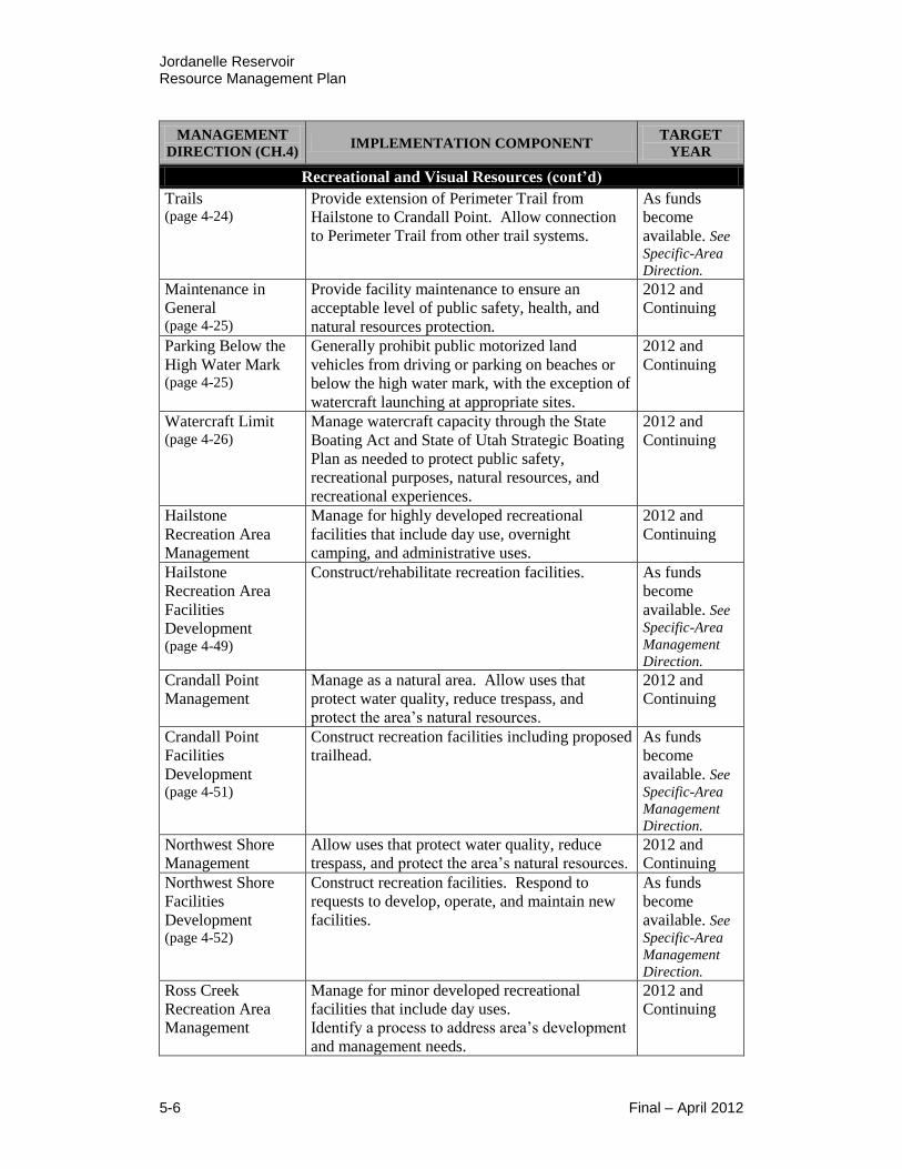
Jordanelle Reservoir Resource Management Plan
5-6 Final – April 2012
MANAGEMENT
DIRECTION (CH.4) IMPLEMENTATION COMPONENT
TARGET
YEAR
Recreational and Visual Resources (cont’d)
Trails (page 4-24)
Provide extension of Perimeter Trail from
Hailstone to Crandall Point. Allow connection
to Perimeter Trail from other trail systems.
As funds
become
available. See
Specific-Area
Direction. Maintenance in
General (page 4-25)
Provide facility maintenance to ensure an
acceptable level of public safety, health, and
natural resources protection.
2012 and
Continuing
Parking Below the
High Water Mark (page 4-25)
Generally prohibit public motorized land
vehicles from driving or parking on beaches or
below the high water mark, with the exception of
watercraft launching at appropriate sites.
2012 and
Continuing
Watercraft Limit (page 4-26)
Manage watercraft capacity through the State
Boating Act and State of Utah Strategic Boating
Plan as needed to protect public safety,
recreational purposes, natural resources, and
recreational experiences.
2012 and
Continuing
Hailstone
Recreation Area
Management
Manage for highly developed recreational
facilities that include day use, overnight
camping, and administrative uses.
2012 and
Continuing
Hailstone
Recreation Area
Facilities
Development (page 4-49)
Construct/rehabilitate recreation facilities. As funds
become
available. See
Specific-Area
Management
Direction. Crandall Point
Management Manage as a natural area. Allow uses that
protect water quality, reduce trespass, and
protect the area’s natural resources.
2012 and
Continuing
Crandall Point
Facilities
Development (page 4-51)
Construct recreation facilities including proposed
trailhead. As funds
become
available. See
Specific-Area
Management
Direction. Northwest Shore
Management Allow uses that protect water quality, reduce
trespass, and protect the area’s natural resources. 2012 and
Continuing Northwest Shore
Facilities
Development (page 4-52)
Construct recreation facilities. Respond to
requests to develop, operate, and maintain new
facilities.
As funds
become
available. See
Specific-Area
Management
Direction. Ross Creek
Recreation Area
Management
Manage for minor developed recreational
facilities that include day uses.
Identify a process to address area’s development
and management needs.
2012 and
Continuing
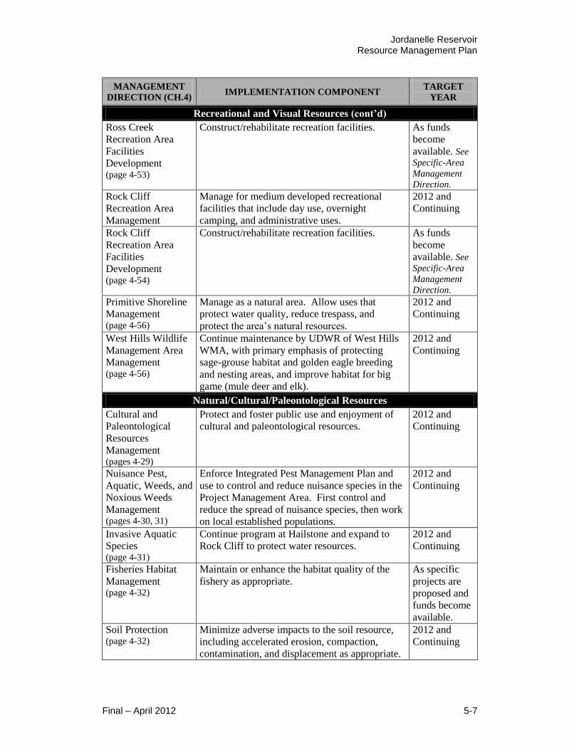
Jordanelle Reservoir Resource Management Plan
Final – April 2012 5-7
MANAGEMENT
DIRECTION (CH.4) IMPLEMENTATION COMPONENT
TARGET
YEAR
Recreational and Visual Resources (cont’d)
Ross Creek
Recreation Area
Facilities
Development (page 4-53)
Construct/rehabilitate recreation facilities. As funds
become
available. See
Specific-Area
Management
Direction. Rock Cliff
Recreation Area
Management
Manage for medium developed recreational
facilities that include day use, overnight
camping, and administrative uses.
2012 and
Continuing
Rock Cliff
Recreation Area
Facilities
Development (page 4-54)
Construct/rehabilitate recreation facilities. As funds
become
available. See
Specific-Area
Management
Direction. Primitive Shoreline
Management (page 4-56)
Manage as a natural area. Allow uses that
protect water quality, reduce trespass, and
protect the area’s natural resources.
2012 and
Continuing
West Hills Wildlife
Management Area
Management (page 4-56)
Continue maintenance by UDWR of West Hills
WMA, with primary emphasis of protecting
sage-grouse habitat and golden eagle breeding
and nesting areas, and improve habitat for big
game (mule deer and elk).
2012 and
Continuing
Natural/Cultural/Paleontological Resources
Cultural and
Paleontological
Resources
Management (pages 4-29)
Protect and foster public use and enjoyment of
cultural and paleontological resources. 2012 and
Continuing
Nuisance Pest,
Aquatic, Weeds, and
Noxious Weeds
Management (pages 4-30, 31)
Enforce Integrated Pest Management Plan and
use to control and reduce nuisance species in the
Project Management Area. First control and
reduce the spread of nuisance species, then work
on local established populations.
2012 and
Continuing
Invasive Aquatic
Species (page 4-31)
Continue program at Hailstone and expand to
Rock Cliff to protect water resources. 2012 and
Continuing
Fisheries Habitat
Management (page 4-32)
Maintain or enhance the habitat quality of the
fishery as appropriate. As specific
projects are
proposed and
funds become
available. Soil Protection (page 4-32)
Minimize adverse impacts to the soil resource,
including accelerated erosion, compaction,
contamination, and displacement as appropriate.
2012 and
Continuing
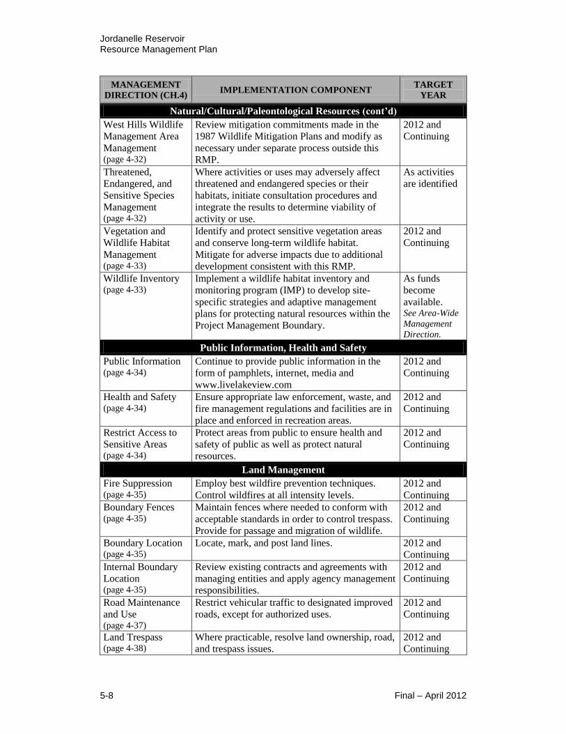
Jordanelle Reservoir Resource Management Plan
5-8 Final – April 2012
MANAGEMENT
DIRECTION (CH.4) IMPLEMENTATION COMPONENT
TARGET
YEAR
Natural/Cultural/Paleontological Resources (cont’d)
West Hills Wildlife
Management Area
Management (page 4-32)
Review mitigation commitments made in the
1987 Wildlife Mitigation Plans and modify as
necessary under separate process outside this
RMP.
2012 and
Continuing
Threatened,
Endangered, and
Sensitive Species
Management (page 4-32)
Where activities or uses may adversely affect
threatened and endangered species or their
habitats, initiate consultation procedures and
integrate the results to determine viability of
activity or use.
As activities
are identified
Vegetation and
Wildlife Habitat
Management (page 4-33)
Identify and protect sensitive vegetation areas
and conserve long-term wildlife habitat.
Mitigate for adverse impacts due to additional
development consistent with this RMP.
2012 and
Continuing
Wildlife Inventory (page 4-33)
Implement a wildlife habitat inventory and
monitoring program (IMP) to develop site-
specific strategies and adaptive management
plans for protecting natural resources within the
Project Management Boundary.
As funds
become
available. See Area-Wide
Management
Direction.
Public Information, Health and Safety
Public Information (page 4-34)
Continue to provide public information in the
form of pamphlets, internet, media and
www.livelakeview.com
2012 and
Continuing
Health and Safety (page 4-34)
Ensure appropriate law enforcement, waste, and
fire management regulations and facilities are in
place and enforced in recreation areas.
2012 and
Continuing
Restrict Access to
Sensitive Areas (page 4-34)
Protect areas from public to ensure health and
safety of public as well as protect natural
resources.
2012 and
Continuing
Land Management
Fire Suppression (page 4-35)
Employ best wildfire prevention techniques.
Control wildfires at all intensity levels. 2012 and
Continuing Boundary Fences (page 4-35)
Maintain fences where needed to conform with
acceptable standards in order to control trespass.
Provide for passage and migration of wildlife.
2012 and
Continuing
Boundary Location (page 4-35)
Locate, mark, and post land lines. 2012 and
Continuing Internal Boundary
Location (page 4-35)
Review existing contracts and agreements with
managing entities and apply agency management
responsibilities.
2012 and
Continuing
Road Maintenance
and Use (page 4-37)
Restrict vehicular traffic to designated improved
roads, except for authorized uses. 2012 and
Continuing
Land Trespass (page 4-38)
Where practicable, resolve land ownership, road,
and trespass issues. 2012 and
Continuing
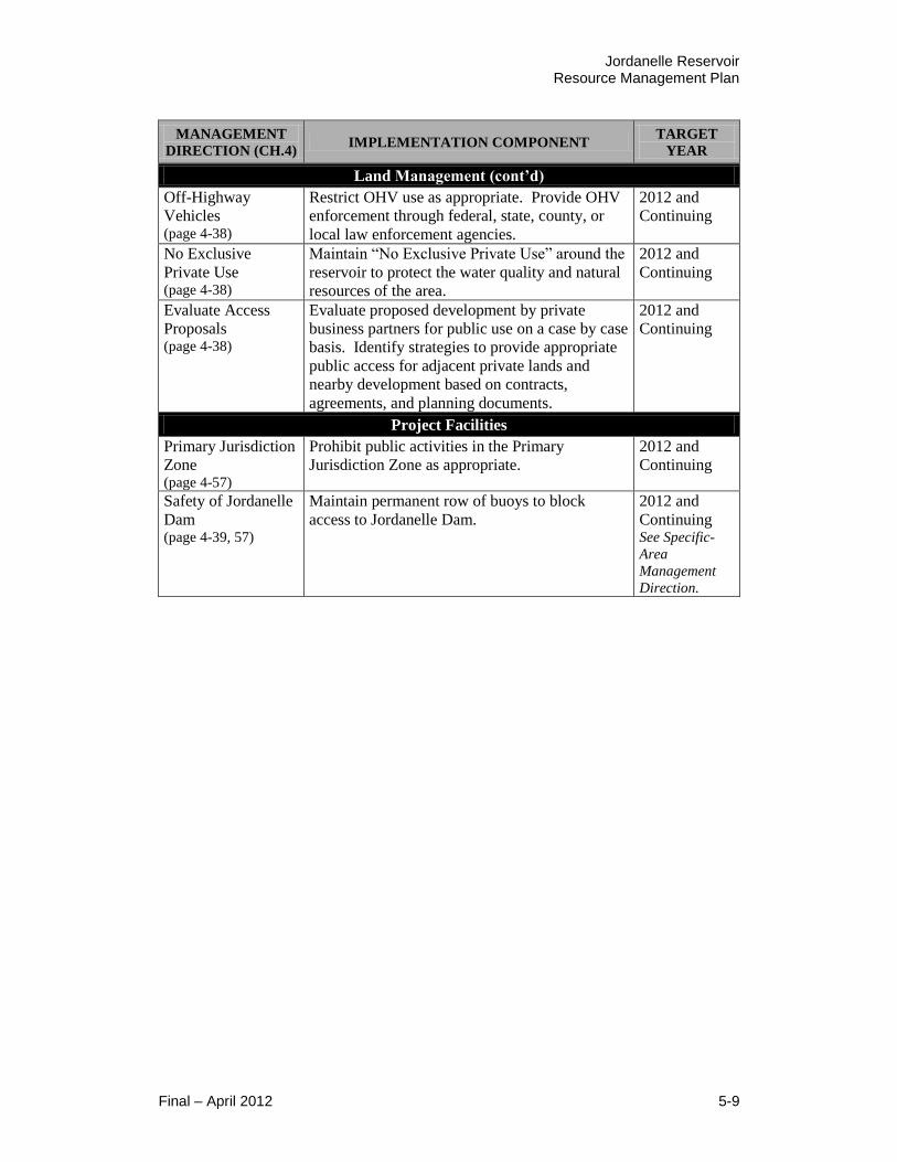
Jordanelle Reservoir Resource Management Plan
Final – April 2012 5-9
MANAGEMENT
DIRECTION (CH.4) IMPLEMENTATION COMPONENT
TARGET
YEAR
Land Management (cont’d)
Off-Highway
Vehicles (page 4-38)
Restrict OHV use as appropriate. Provide OHV
enforcement through federal, state, county, or
local law enforcement agencies.
2012 and
Continuing
No Exclusive
Private Use (page 4-38)
Maintain “No Exclusive Private Use” around the
reservoir to protect the water quality and natural
resources of the area.
2012 and
Continuing
Evaluate Access
Proposals (page 4-38)
Evaluate proposed development by private
business partners for public use on a case by case
basis. Identify strategies to provide appropriate
public access for adjacent private lands and
nearby development based on contracts,
agreements, and planning documents.
2012 and
Continuing
Project Facilities
Primary Jurisdiction
Zone (page 4-57)
Prohibit public activities in the Primary
Jurisdiction Zone as appropriate. 2012 and
Continuing
Safety of Jordanelle
Dam (page 4-39, 57)
Maintain permanent row of buoys to block
access to Jordanelle Dam. 2012 and
Continuing See Specific-
Area
Management
Direction.

Jordanelle Reservoir Resource Management Plan
5-10 Final – April 2012
This page is intentionally left blank

Jordanelle Reservoir Resource Management Plan
Final – April 2012
Appendix A
List of Environmental Commitments

Jordanelle Reservoir Resource Management Plan
Final – April 2012
This page is intentionally left blank

Jordanelle Reservoir Resource Management Plan
Final – April 2012 A-1
List of Environmental Commitments
The following environmental commitments (mitigation measures) will be
implemented to offset potential effects to environmental resources within the
Project Management Boundary. The following measures apply to all alternatives.
Prior to the initiation of any federal undertaking within the Project
Management Boundary, all cultural resources sites within the undertaking
APE area will be evaluated for their NRHP eligibility. The significance
criteria applied to evaluate cultural resources defined in 36 CFR 60.4 is
defined as follows:
The quality of significance in American history, architecture, archeology,
engineering, and culture is present in districts, sites, buildings, structures and
objects that possess integrity of location, design, setting, materials,
workmanship, feeling, and association and
A. That are associated with events that have made a significant
contribution to the broad patterns of our history; or
B. That are associated with the lives of persons significant in our past; or
C. That embody the distinctive characteristics of a type, period, or
method of construction, or that represent the work of a master, or that
possess high artistic values, or that represent a significant and
distinguishable entity whose components may lack individual
distinction; or
D. That has yielded, or may be likely to yield, information important in
prehistory or history.
If historic properties are located within the undertaking APE, and if they will
be adversely affected by activities associated with the undertaking, a
Memorandum of Agreement (MOA) will be developed. The MOA would be
among, Reclamation, the Utah State Historic Preservation Office (SHPO), the
Advisory Council on Historic Preservation (ACHP), if it chooses to
participate, and any other party that assumes responsibility under the
agreement. The MOA would include the terms and conditions agreed upon to
resolve the adverse effects of the undertaking upon historic properties.
Any person who knows or has reason to know that he/she has inadvertently
discovered possible human remains on federal land, he/she must provide
immediate telephone notification of the discovery to Reclamation’s Provo
Area Office archaeologist. Work would stop until the proper authorities are
able to assess the situation onsite. This action would promptly be followed by
written confirmation to the responsible federal agency official, with respect to
federal lands. The SHPO and interested Native American tribal
representatives would be promptly notified. Consultation would begin
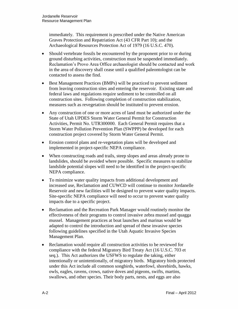
Jordanelle Reservoir Resource Management Plan
A-2 Final – April 2012
immediately. This requirement is prescribed under the Native American
Graves Protection and Repatriation Act (43 CFR Part 10); and the
Archaeological Resources Protection Act of 1979 (16 U.S.C. 470).
Should vertebrate fossils be encountered by the proponent prior to or during
ground disturbing activities, construction must be suspended immediately.
Reclamation’s Provo Area Office archaeologist should be contacted and work
in the area of discovery shall cease until a qualified paleontologist can be
contacted to assess the find.
Best Management Practices (BMPs) will be practiced to prevent sediment
from leaving construction sites and entering the reservoir. Existing state and
federal laws and regulations require sediment to be controlled on all
construction sites. Following completion of construction stabilization,
measures such as revegetation should be instituted to prevent erosion.
Any construction of one or more acres of land must be authorized under the
State of Utah UPDES Storm Water General Permit for Construction
Activities, Permit No. UTR300000. Each General Permit requires that a
Storm Water Pollution Prevention Plan (SWPPP) be developed for each
construction project covered by Storm Water General Permit.
Erosion control plans and re-vegetation plans will be developed and
implemented in project-specific NEPA compliance.
When constructing roads and trails, steep slopes and areas already prone to
landslides, should be avoided where possible. Specific measures to stabilize
landslide potential slopes will need to be identified in the project-specific
NEPA compliance.
To minimize water quality impacts from additional development and
increased use, Reclamation and CUWCD will continue to monitor Jordanelle
Reservoir and new facilities will be designed to prevent water quality impacts.
Site-specific NEPA compliance will need to occur to prevent water quality
impacts due to a specific project.
Reclamation and the Recreation Park Manager would routinely monitor the
effectiveness of their programs to control invasive zebra mussel and quagga
mussel. Management practices at boat launches and marinas would be
adapted to control the introduction and spread of these invasive species
following guidelines specified in the Utah Aquatic Invasive Species
Management Plan.
Reclamation would require all construction activities to be reviewed for
compliance with the federal Migratory Bird Treaty Act (16 U.S.C. 703 et
seq.). This Act authorizes the USFWS to regulate the taking, either
intentionally or unintentionally, of migratory birds. Migratory birds protected
under this Act include all common songbirds, waterfowl, shorebirds, hawks,
owls, eagles, ravens, crows, native doves and pigeons, swifts, martins,
swallows, and other species. Their body parts, nests, and eggs are also
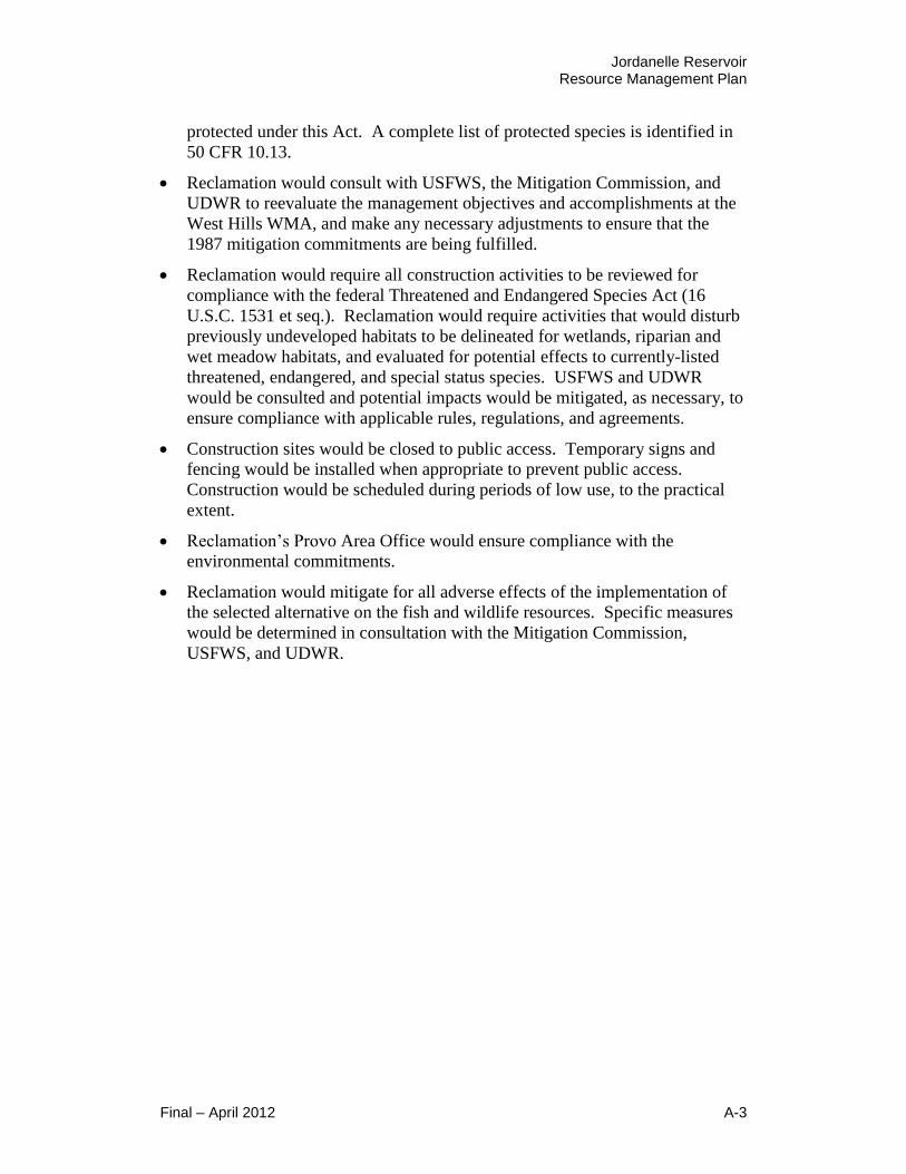
Jordanelle Reservoir Resource Management Plan
Final – April 2012 A-3
protected under this Act. A complete list of protected species is identified in
50 CFR 10.13.
Reclamation would consult with USFWS, the Mitigation Commission, and
UDWR to reevaluate the management objectives and accomplishments at the
West Hills WMA, and make any necessary adjustments to ensure that the
1987 mitigation commitments are being fulfilled.
Reclamation would require all construction activities to be reviewed for
compliance with the federal Threatened and Endangered Species Act (16
U.S.C. 1531 et seq.). Reclamation would require activities that would disturb
previously undeveloped habitats to be delineated for wetlands, riparian and
wet meadow habitats, and evaluated for potential effects to currently-listed
threatened, endangered, and special status species. USFWS and UDWR
would be consulted and potential impacts would be mitigated, as necessary, to
ensure compliance with applicable rules, regulations, and agreements.
Construction sites would be closed to public access. Temporary signs and
fencing would be installed when appropriate to prevent public access.
Construction would be scheduled during periods of low use, to the practical
extent.
Reclamation’s Provo Area Office would ensure compliance with the
environmental commitments.
Reclamation would mitigate for all adverse effects of the implementation of
the selected alternative on the fish and wildlife resources. Specific measures
would be determined in consultation with the Mitigation Commission,
USFWS, and UDWR.

Jordanelle Reservoir Resource Management Plan
A-4 Final – April 2012
This page is intentionally left blank

Jordanelle Reservoir Resource Management Plan
Final – April 2012
Appendix B
List of Preparers

Jordanelle Reservoir Resource Management Plan
Final – April 2012
This page is intentionally left blank

Jordanelle Reservoir Resource Management Plan
Final – April 2012 B-1
List of Preparers
Project Team Members
Franson Civil Engineers
1276 South 820 East, Ste. 100
American Fork, Utah 84003
801-756-0309
Jay Franson, P.E.
Principal/Technical Advisor
Charity Mair
Reports Writer/Editor
Layne Jensen, P.E.
Senior Manager/Environmental
Assessment
Matt Gurr
Designer
Lauren Ploeger, P.E.
Senior Engineer/Public Involvement
& Project Management
Alex Vaz
Engineer 1
Monique Robbins, P.E.
Senior Engineer/Resource
Management Plan
Valerie Haskin
Office Assistant
Lon Franson
Senior Designer
Jennifer Westwood
Office Assistant
Henrie Engineering
Jay Henrie
President/Project Coordination
1829 South 100 West
Orem, UT 84058
801-885-7444
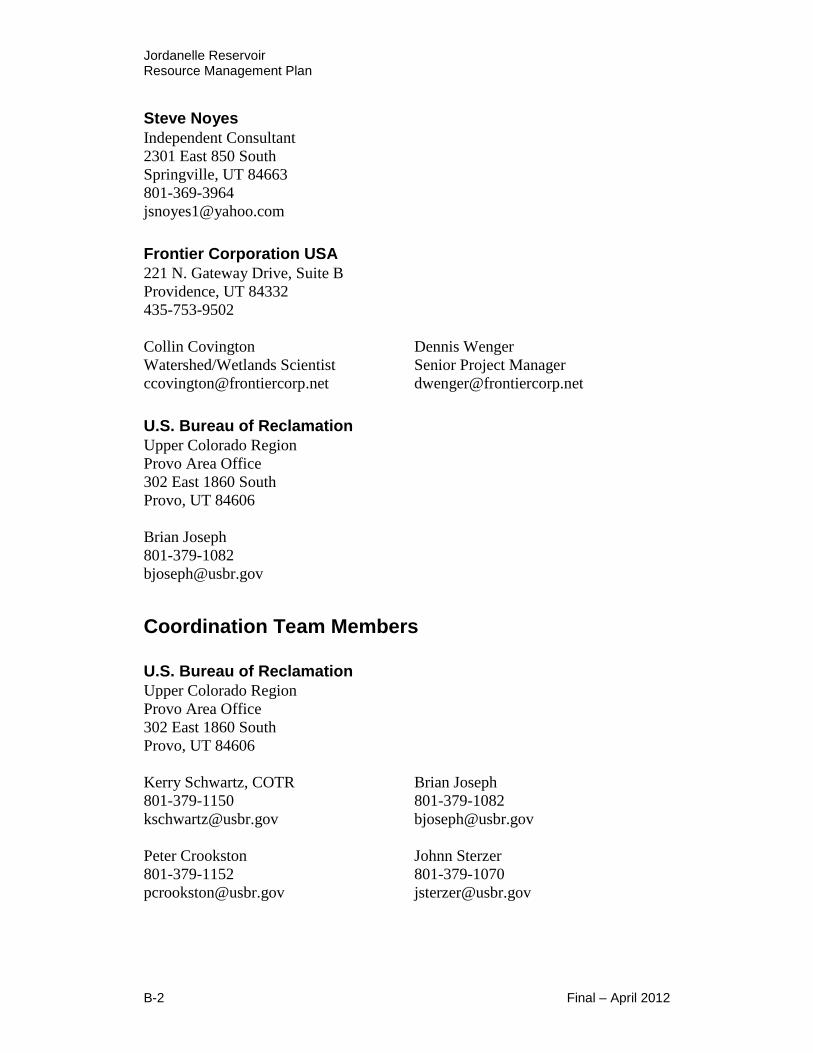
Jordanelle Reservoir Resource Management Plan
B-2 Final – April 2012
Steve Noyes
Independent Consultant
2301 East 850 South
Springville, UT 84663
801-369-3964
Frontier Corporation USA
221 N. Gateway Drive, Suite B
Providence, UT 84332
435-753-9502
Collin Covington
Watershed/Wetlands Scientist
Dennis Wenger
Senior Project Manager
U.S. Bureau of Reclamation
Upper Colorado Region
Provo Area Office
302 East 1860 South
Provo, UT 84606
Brian Joseph
801-379-1082
Coordination Team Members
U.S. Bureau of Reclamation
Upper Colorado Region
Provo Area Office
302 East 1860 South
Provo, UT 84606
Kerry Schwartz, COTR
801-379-1150
Brian Joseph
801-379-1082
Peter Crookston
801-379-1152
Johnn Sterzer
801-379-1070

Jordanelle Reservoir Resource Management Plan
Final – April 2012 B-3
Central Utah Water Conservancy District
355 W. University Pkwy
Orem, UT 84058
Jared Hansen
801-226-7152
Paul Pierpont
801-226-7190
Reed Oberndorfer
801-226-7160
Sarah Sutherland
801-226-7147
Chris Elison
801-226-7100
DOI – CUPCA office
302 East 1860 South
Provo, UT 84606
Lynn Hansen
801-379-1238
Utah State Parks and Recreation
1594 W. North Temple #116
P.O. Box 146001
Salt Lake City, UT 84114
Jamie Dalton
801-538-7207
Jeff Rasmussen
801-870-7138
Bruce Hamilton
801 533-5127
Leon Tate
801 538-7342
Fred Hayes
801 538-7323
Mary Tullius, Director
801-538-7336
Derek O’Donnell
801 538-7346
Susan Zarekarizi
801-538-7496
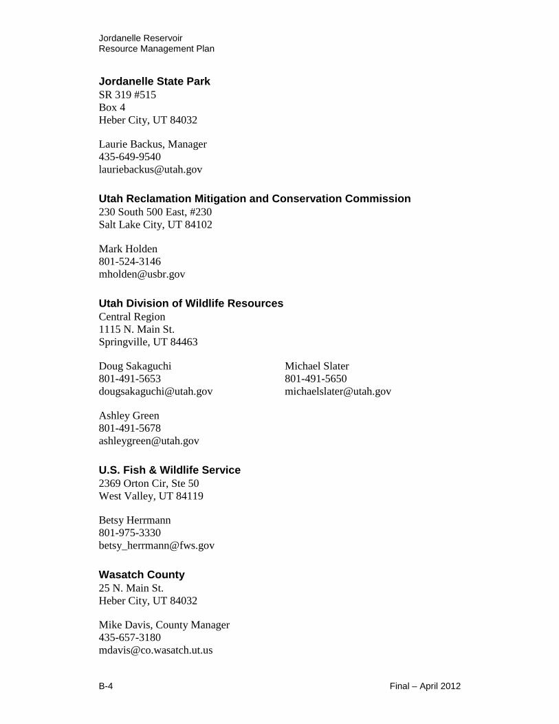
Jordanelle Reservoir Resource Management Plan
B-4 Final – April 2012
Jordanelle State Park
SR 319 #515
Box 4
Heber City, UT 84032
Laurie Backus, Manager
435-649-9540
Utah Reclamation Mitigation and Conservation Commission
230 South 500 East, #230
Salt Lake City, UT 84102
Mark Holden
801-524-3146
Utah Division of Wildlife Resources
Central Region
1115 N. Main St.
Springville, UT 84463
Doug Sakaguchi
801-491-5653
Michael Slater
801-491-5650
Ashley Green
801-491-5678
U.S. Fish & Wildlife Service
2369 Orton Cir, Ste 50
West Valley, UT 84119
Betsy Herrmann
801-975-3330
Wasatch County
25 N. Main St.
Heber City, UT 84032
Mike Davis, County Manager
435-657-3180
Jordanelle Reservoir Resource Management Plan
Final – April 2012
Appendix C
References

Jordanelle Reservoir Resource Management Plan
Final – April 2012
This page is intentionally left blank

Jordanelle Reservoir Resource Management Plan
Final – April 2012 C-1
References
Ayer, F. 2007. Low Impact Hydropower Institute Certification of the Jordanelle
Dam Hydroelectric Project. Portland, Maine: Low Impact Hydropower
Institute.
Backus, Lauri. 2011. Personal communication with Lauri Backus from Utah
State Parks on April 2011.
Belliston, N., R. Whitesides, S. Dewey, J. Merritt, & S. Burningham. 2009.
Noxious Weed Field Guide for Utah, 3rd Edition. Utah State University
Cooperative Extension Publication.
Bryant, B. 1990. Geologic Map of the Salt Lake City 30' x 60' Quadrangle,
North-Central Utah, and Uinta County Wyoming. Map I-1944, Sheet 1 of
2. USGS.
Bureau of Economic Analysis, Survey of Current Business. May 2010. Survey of
Current Business. Retrieved March 26, 2011, from
http://www.bea.gov/scb/
Bureau of Economic Analysis, U.S. Department of Commerce. 2011. Bureau of
Economic Analysis. Retrieved March 25, 2011, from http://www.bea.gov/
Bureau of Labor Statistics, U.S. Department of Labor. 2011. Bureau of Labor
Statistics. Retrieved March 24, 2011, from http://www.bls.gov/
Callaway, Donald, Joel Janetsi, and Omer C. Stewart. 1986. Ute. In Handbook
of North American Indians, Volume 11: Great Basin. Warren L.
D’Azevedo, volume editor. Smithsonian Institution. Washington D.C.
Clark, J.R. 2000. Endangered and Threatened Wildlife and Plants; Determination
of Threatened Status for the Contiguous U.S. Distinct Population Segment
of the Canada Lynx and Related Rule. Federal Register 65(58): 16052-
16086.
Central Utah Water Conservancy District. October 2004. Supplement to the
Bonneville Definite Plan Report, CUWCD with assistance from MWH
Americas, Inc., and Mayya Group International, LLC
Economic Profile System. 2009. A SocioEconomic Profile Wasatch County,
Utah. Bozeman: Headwaters Economics.

Jordanelle Reservoir Resource Management Plan
C-2 Final – April 2012
Embry, Jessie L. 1996 . A History of Wasatch County. Utah Centennial County
History Series. Utah State Historical Society and Wasatch County
Commission. Salt Lake City, Utah.
England, J. L. 1992. Endangered and Threatened Wildlife and Plants; Final Rule
to List the Plant Spiranthes Diluvialis (Ute Ladies’-tresses) as a
Threatened Species. Federal Register 57(12): 2048-2054.
Fertig, W., R. Black, and P. Wolken. 2005. Rangewide status review of Ute
Ladies'-Tresses (Spiranthes diluvialis). Prepared for the US Fish and
Wildlife Service and Central Utah Water Conservancy District. 30
September 2005. Available online: http://www.fws.gov/mountain-
prairie/species/plants/uteladiestress/SPDI_Status%20review_Fertig2005.p
df. Accessed March 2011.
Google Maps. 2011. Google Maps. Retrieved March 20, 2011, from
http://maps.google.com
Governor's Office of Planning and Budget. 2009. Utah Population Estimates,
Population by County, 1940-2009. Salt Lake City: Utah GOPB.
Griffiths, Mindy L. 1998. A Cultural Resource Inventory in the West Hills in
Summit and Wasatch Counties, Utah. Brigham Young University
Museum of Peoples and Cultures Technical Series No. 97-13. Office of
Public Archaeology, Brigham Young University. Provo, Utah.
Hylland, M., Lowe, M., & Bishop, C. 1995. Engineering Geologic Map Folio,
Western Wasatch County, Utah, Utah Geological Survey Open File
Report 319. Landslide Potential Plates 1A and 1B.
Hampshire, David, Martha Sonntag Bradley, and Allen Roberts. 1998. A History
of Summit County. Utah Centennial County History Series. Utah State
Historical Society and Summit County Commission. Salt Lake City,
Utah.
Holmer, Richard N. 1986. Common Projectile Points of the Intermountain West.
In Anthropology of the Desert West: Essays in Honor of Jesse D.
Jennings. Carole J. Condie and Don D. Fowler, eds. University of Utah
Anthropological Papers No. 110. Salt Lake City, Utah.
Jennings, Jesse D. 1978. Prehistory of Utah and the Eastern Great Basin.
University of Utah Anthropological Papers No. 98. Salt Lake City, Utah.
Jordanelle State Park. 2010. Bioblitz 2010: Rock Cliff Recreation Area,
Jordanelle State Park.

Jordanelle Reservoir Resource Management Plan
Final – April 2012 C-3
Key to the City. (2009, May 9). Wasatch County, Utah. Retrieved March 2011,
from http://www.usacitiesonline.com/utwasatchcounty.htm
Laverty, L. 2008. Endangered and Threatened Wildlife and Plants; Revised
Critical Habitat for the Contiguous United States Distinct Population
Segment of the Canada Lynx (Lynx canadensis); Proposed Rule. Federal
Register 73 (40): 10859-10896.
Lowry, J. H, Jr., R. D. Ramsey, K. Boykin, D. Bradford, P. Comer, S. Falzarano,
W. Kepner, J. Kirby, L. Langs, J. Prior-Magee, G. Manis, L. O’Brien, T.
Sajwaj, K. A. Thomas, W. Rieth, S. Schrader, D. Schrupp, K. Schulz, B.
Thompson, C. Velasquez, C. Wallace, E. Waller and B. Wolk. 2005.
Southwest Regional Gap Analysis Project: Final Report on Land Cover
Mapping Methods, RS/GIS Laboratory, Utah State University, Logan, UT.
Madsen, David B. 1982. Get It Where the Getting’s Good: A Variable Model of
Great Basin Subsistence and Settlement, Based on Data from the Eastern
Great Basin. In Man and Environment in the Great Basin. David B.
Madsen and James F. O’Connell, eds. Society for American Archaeology
Papers No. 2. Washington D.C.
Malouf, Carling I. and John M. Findlay. 1986. Euro-American Impact Before
1870. In Handbook of North American Indians, Volume 11: Great Basin.
Warren L. D’Azevedo, volume editor. Smithsonian Institution.
Washington D.C.
McCarty, Tara, Richard McCarty, Denise Evans, and Carol Wiens. 1987.
Cultural Resources Survey of the Jordanelle Reservoir Area Wasatch and
Summit Counties, Utah (Draft Report). Bureau of Reclamation, Upper
Colorado Region. Provo, Utah.
National Biological Information Infrastructure (NBII). 2011. Southwest Regional
GAP Analysis Project.
http://www.nbii.gov/portal/server.pt?open=512&objID=1853&PageID=67
58&mode=2&cached=true. Accessed March 2011.
NatureServe. 2011. NatureServe Explorer. Website: An online encyclopedia of
life [Web application]. Version 7.0. NatureServe, Arlington, Virginia.
Available online http://www.natureserve.org/explorer/. Accessed March
2011.
Pitcher, D. O., & Murray, R. R. 2008. Jordanelle: Developing New Hydro at an
Existing Dam. Hydroworld, 28(3).
Record, Justin. 2011. Personal communication with Justin Record from Bureau
of Reclamation on March 2011.

Jordanelle Reservoir Resource Management Plan
C-4 Final – April 2012
Ross Creek Conceptual Planning Team. December 2005. Ross Creek - Jordanelle
State Park Concept Plan. State of Utah Natural Resources, Division of
Parks & Recreation.
Ruediger, W., J. Claar, S. Gniadek, B. Holt, L. Lewis, S. Mighton, B. Naney, G.
Patton, R. Rinaldi, J. Trick, A. Vandehey, F. Wahl, N. Warren, D.
Wenger, and A. Williamson. 2000. Canada Lynx Conservation
Assessment and Strategy. USDA Forest Service, USDI Fish and Wildlife
Service, UDSI Bureau of Land Management, and the USDI National Parks
Service. Forest Service Publication #RI-0053, Missoula, MT. 142p.
Simms, Steven R. 2008. Ancient Peoples of the Great Basin and Colorado
Plateau. Left Coast Press. Walnut Creek, California.
Slater, Mike. 2011. Personal conversation with Utah DWR – Central Region,
Aquatics Manager on March 14, 2011.
Stokes, William Lee. 1986. Geology of Utah. Utah Museum of Natural History,
University of Utah. Salt Lake City, Utah.
Tipps, Betsy L. and Robert I. Birnie. 2003. Cultural Resources Inventory of 3700
Acres in the Proposed Victory Ranch Development Area, Summit and
Wasatch Counties, Utah. P-III Associates, Inc. Salt Lake City, Utah.
U.S. Census Bureau. 2011. US Census 2010. Retrieved March 23, 2011, from
http://2010.census.gov/2010census/
U.S. Census Bureau, American Community Survey. 2005-2009. American
Community Survey. Retrieved March 29, 2011, from
http://www.census.gov/acs/www/
U.S. Department of Agriculture, Soil Conservation Service. 1976. Soil Survey of
Heber Valley Area, Utah. National Cooperative Soil Survey.
U.S. Department of Agriculture, Economic Research Service. 2011. Economic
Research Service. Retrieved March 22, 2011, from
http://www.ers.usda.gov/
U.S. Department of the Interior, Bureau of Reclamation. 1979. Central Utah
Project Bonneville Unit Municipal and Industrial System Final
Environmental Statement. Upper Colorado Regional Office. Salt Lake
City: Bureau of Reclamation.
U.S. Department of the Interior, Bureau of Reclamation. 1987. Central Utah
Project Bonneville Unit Municipal and Industrial System Final
Supplement to the Final Environmental Statement. Upper Colorado
Region. Salt Lake City: Bureau of Reclamation.

Jordanelle Reservoir Resource Management Plan
Final – April 2012 C-5
U.S. Department of the Interior, Bureau of Reclamation and Utah Division of
State Parks and Recreation. 1989. Jordanelle State Park Master Plan
Final Report and Technical Data. Salt Lake City, Utah: Bingham
Engineering.
U.S. Department of the Interior, Bureau of Reclamation. 2001. Recreation and
Land Management Review for Jordanelle Reservoir. Bureau of
Reclamation.
U.S. Department of the Interior, Bureau of Reclamation. 2003. Resource
Management Plan Guidebook. Bureau of Reclamation.
U.S. Department of the Interior, Bureau of Reclamation. 2009a. Reservoir
Management Review for Jordanelle State Park. Bureau of Reclamation.
U.S. Department of the Interior, Bureau of Reclamation. 2009b. Jordanelle Dam.
Retrieved March 14, 2011 and June 4, 2011, from
http://www.usbr.gov/projects/Facility.jsp?fac_Name=Jordanelle+Dam&gr
oupName=Overview
U.S. Department of the Interior, Bureau of Reclamation. 2010. Upper Colorado
Region Prevention and Rapid Response Plan for Dreissenid Mussels.
Bureau of Reclamation, Upper Colorado Region, Salt Lake City, UT.
U.S. Department of the Interior, Bureau of Reclamation. 2011. Jordanelle Dam
Operations. Retrieved March 15, 2011, from
http://www.usbr.gov/uc/crsp/GetSiteInfoU.S. Environmental Protection
Agency. amended 1990. Clean Air Act. February 24, 2004. U.S. Senate.
U.S. Department of the Interior, Bureau of Reclamation. The Central Utah Project,
Bonneville Unit, Historic Reclamation Projects Book. Adam R. Eastman
http://www.usbr.gov/projects/ImageServer?imgName=Doc_122365317205
6.pdf
U.S. Department of the Interior, Central Utah Project Completion Act Office.
Municipal & Industrial System. Retrieved June 4, 2011 from
http://www.cupcao.gov/bonneville/MI.html
U.S. Fish and Wildlife Service. 1995. Ute Ladies’-tresses (Spiranthes diluvialis)
Recovery Plan. U.S. Fish and Wildlife Service, Denver, CO. 46 pp.
U.S. Fish and Wildlife Service. 2002. Status Review for the Colombia Spotted
Frog (Ranaluteiventris) on the Wasatch Front, Utah. U. S. Fish and
Wildlife Service, Denver, CO.

Jordanelle Reservoir Resource Management Plan
C-6 Final – April 2012
U.S. Fish and Wildlife Service. 2011a. U.S. Fish and Wildlife Service
Environmental Conservation Online System. Available online
http://ecos.fws.gov/ecos/indexPublic.do#. Accessed March 2011.
U.S. Fish and Wildlife Service. 2011b. U.S. Fish and Wildlife Service Critical
Habitat Portal. Available online http://crithab.fws.gov/. Accessed March
2011.
U.S. Fish and Wildlife Service. 2011c. U.S. Fish and Wildlife Service,
Mountain-Prairie Region species data. Available online
http://www.fws.gov/mountain-prairie/species/fish/leastchub/. Accessed
March 2011.
U.S. Fish & Wildlife Service. Retrieved April 2011d, from
http://www.fws.gov/mountain-prairie/endspp/CountyLists/Utah.pdf
U.S. Geological Service. 2011. Water Watch. Retrieved 3 11, 2011, from USGS:
http://waterwatch.usgs.gov/new/
U.S. National Parks and Monuments Travel Guide. 2000-2011. Jordanelle State
Park Campground Description. Retrieved March 5, 2011, from
http://www.us-parks.com/camping/ut/jordanelle-state-park-
campground.html
U.S. National Parks and Monuments Travel Guide 2000-2011. Jordanelle –
Rockcliff Area Campground, Utah. Retrieved June 4, 2011, from
http://www.us-parks.com/camping/ut/jordanelle-rockcliff-area-
campground.html
Utah Administrative Code. 2011. Rule R651-614. Fishing, Hunting and
Trapping. Retrieved June 4, 2011, from
http://www.rules.utah.gov/publicat/code/r651/r651-614.htm
Utah Department of Environmental Quality. 1992. Utah State Implementation
Plan. Salt Lake City: State of Utah.
Utah Department of Environmental Quality, Division of Environmental Response
and Remediation. 2011. Utah Department of Environmental Quality,
Division of Environmental Response and Remediation. Retrieved March
18, 2011, from http://mapserv.utah.gov/DEQ
Utah Department of Transportation. 2010a. UDOT Wasatch Back Emerging Area
Plan. UDOT.
Utah Department of Transportation. 2010b. Traffic Maps History. Retrieved
March 30, 2011, from Traffic Maps - Current Year (2009):
http://www.udot.utah.gov/main/f?p=100:pg:0::::V,T:,3039

Jordanelle Reservoir Resource Management Plan
Final – April 2012 C-7
Utah Department of Workforce Services. 2011. Utah Economic and Labor
Market Information. Retrieved March 19, 2011, from
http://jobs.utah.gov/wi/index.html
Utah Division of Air Quality. 2010. National Ambient Air Quality Standards.
State of Utah.
Utah Division of State Parks and Recreation. 2006a. Recreational Water Use
Issues and Regional Planning on Utah's Lakes and Reservoir. Institute for
Outdoor Recreation and Tourism, Utah State University.
Utah Division of State Parks and Recreation. 2006b. Utah State Park Boating
Survey: Comparison with Previous Studies. Institute for Outdoor
Recreation and Tourism, Utah State University.
Utah Division of State Parks. 2008. Off Highway Vehicle Program, Historical Off
Road Vehicle Registrations by County, 1998-2008. Salt Lake City: State
Parks and Recreation.
Utah Division of State Parks and Recreation. 2009a. Jordanelle State Park
Impacts on Wasatch County. State Parks and Recreation.
Utah Division of State Parks and Recreation. 2009b. Jordanelle State Park
Pamphlet. Salt Lake City: State Parks and Recreation.
Utah Division of State Parks and Recreation. 2009c. Fiscal Management Section,
Sales, Use, Transient Room, and Resort Tax Reports by County, 2009. Salt
Lake City: State Parks and Recreation.
Utah Division of State Parks and Recreation. June-July 2010a. Summary of
Visitation Survey Findings - Antelope Island, East Canyon, Jordanelle,
and Rockport State Parks. Salt Lake City: State Parks and Recreation.
Utah Division of State Parks and Recreation. 2010b. Utah Boating Program
Strategic Plan. State Parks and Recreation.
Utah Division of State Parks and Recreation. 2011. Retrieved from
http://stateparks.utah.gov
Utah Division of Wildlife Resources. 1992. West Hills Wildlife Management
Area Operating Agreement. Utah Department of Natural Resources,
Division of Wildlife Resources. Salt Lake City, UT.
Utah Division of Wildlife Resources. 1997. Conservation Agreement and
Strategy for Bonneville Cutthroat Trout (Onchorynchus clarki Utah).
Publication Number 97-10. Utah Department of Natural Resources,
Division of Wildlife Resources. Salt Lake City, UT.
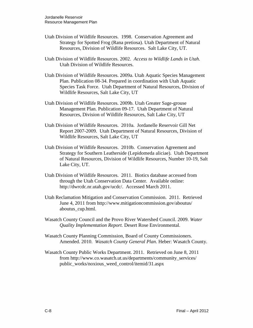
Jordanelle Reservoir Resource Management Plan
C-8 Final – April 2012
Utah Division of Wildlife Resources. 1998. Conservation Agreement and
Strategy for Spotted Frog (Rana pretiosa). Utah Department of Natural
Resources, Division of Wildlife Resources. Salt Lake City, UT.
Utah Division of Wildlife Resources. 2002. Access to Wildlife Lands in Utah.
Utah Division of Wildlife Resources.
Utah Division of Wildlife Resources. 2009a. Utah Aquatic Species Management
Plan. Publication 08-34. Prepared in coordination with Utah Aquatic
Species Task Force. Utah Department of Natural Resources, Division of
Wildlife Resources, Salt Lake City, UT
Utah Division of Wildlife Resources. 2009b. Utah Greater Sage-grouse
Management Plan. Publication 09-17. Utah Department of Natural
Resources, Division of Wildlife Resources, Salt Lake City, UT
Utah Division of Wildlife Resources. 2010a. Jordanelle Reservoir Gill Net
Report 2007-2009. Utah Department of Natural Resources, Division of
Wildlife Resources, Salt Lake City, UT
Utah Division of Wildlife Resources. 2010b. Conservation Agreement and
Strategy for Southern Leatherside (Lepidomeda aliciae). Utah Department
of Natural Resources, Division of Wildlife Resources, Number 10-19, Salt
Lake City, UT.
Utah Division of Wildlife Resources. 2011. Biotics database accessed from
through the Utah Conservation Data Center. Available online:
http://dwrcdc.nr.utah.gov/ucdc/. Accessed March 2011.
Utah Reclamation Mitigation and Conservation Commission. 2011. Retrieved
June 4, 2011 from http://www.mitigationcommission.gov/aboutus/
aboutus_cup.html.
Wasatch County Council and the Provo River Watershed Council. 2009. Water
Quality Implementation Report. Desert Rose Environmental.
Wasatch County Planning Commission, Board of County Commissioners.
Amended. 2010. Wasatch County General Plan. Heber: Wasatch County.
Wasatch County Public Works Department. 2011. Retrieved on June 8, 2011
from http://www.co.wasatch.ut.us/departments/community_services/
public_works/noxious_weed_control/itemid/31.aspx
Jordanelle Reservoir Resource Management Plan
Final – April 2012
Appendix D
Glossary of Terms

Jordanelle Reservoir Resource Management Plan
Final – April 2012
This page is intentionally left blank

Jordanelle Reservoir Resource Management Plan
Final – April 2012 D-1
Glossary of Terms
Concessionaire non-federal commercial business that supports
appropriate public recreational uses and
provides facilities, goods or services for which
revenues are collected. A concession involves
the use of lands within the Project Management
Boundary and usually involves the development
of improvements.
Coordination Team Reclamation, CUWCD, DOI-CUPCA office,
State Parks, Mitigation Commission, UDWR,
USFWS, and Wasatch County
Exclusive Use Any use which excludes other appropriate
public uses or users for extended periods of
time.
Jordanelle Project Jordanelle Reservoir and associated facilities
and resources
Laser Sailboat Small sailing dinghy, sailed by either one or two
people. Used for competitive racing.
Managing Partners Reclamation, CUWCD, UDWR, and State Parks
Primary Jurisdiction Zone Area within the Project Management Boundary
that surrounds the dam, outlet works, feeder
canals, and distribution works
Project Management Area Federal land and water areas under the primary
jurisdiction of the Department of the Interior,
Bureau of Reclamation
Project Management Boundary Boundary of the Project Management Area
Recreation Park Manager Term used to represent entity under contract
with Reclamation to manage recreation
resources; currently is State Parks.

Jordanelle Reservoir Resource Management Plan
D-2 Final – April 2012
This page is intentionally left blank