Regional Biomechanics Ankle Joint & Foot Kinematics Kinetics Pathomechanics.

Joint Regional
Planning
Panel
Thursday, 16 October 2014
THE H
ILLS S
HIR
E C
OU
NC
IL

JOINT REGIONAL PLANNING PANEL 16 OCTOBER 2014
PAGE 2
ITEM SUBJECT PAGE
ITEM-2 FURTHER JRPP REPORT - DA NO. 824/2013/JP –
RESIDENTIAL DEVELOPMENT INCLUDING SIX (6)
RESIDENTIAL FLAT BUILDINGS (174
APARTMENTS), AT-GRADE AND BASEMENT CAR
PARKING, LANDSCAPING AND COMMUNAL
FACILITIES - LOT 31 DP 247442, NO. 28 FAIRWAY
DRIVE, KELLYVILLE
3
ITEM-3 JRPP REPORT - DA 1194/2014/JP –
AN INTEGRATED HOUSING DEVELOPMENT
COMPRISING 153 DWELLINGS AND COMMUNITY
TITLE SUBDIVISION - LOT 48 DP 280036 CADDIES
BOULEVARD, ROUSE HILL
73

JOINT REGIONAL PLANNING PANEL 16 OCTOBER 2014
PAGE 3
ITEM-1 FURTHER REPORT – DA 824/2013/JP
(Sydney West Region)
JRPP No 2013SYW029
DA Number FURTHER REPORT - 824/2013/JP
Local Government Area THE HILLS SHIRE COUNCIL
Proposed Development
RESIDENTIAL DEVELOPMENT INCLUDING SIX (6)
RESIDENTIAL FLAT BUILDINGS (174 APARTMENTS), AT-
GRADE AND BASEMENT CAR PARKING, LANDSCAPING
AND COMMUNAL FACILITIES.
Street Address LOT 31 DP 247442, NO. 28 FAIRWAY DRIVE, KELLYVILLE
Applicant/Owner ARDEN CH (NSW) PTY LTD
Number of Submissions TWO (2) – AMENDED PLANS
Regional Development
Criteria (Schedule 4A
of the Act)
CAPITAL INVESTMENT VALUE EXCEEDS $20 MILLION
List of All Relevant
s79C(1)(a) Matters
The Hills LEP 2012
The Hills DCP 2012
SEPP No. 65 – Design Quality of Residential Flat
Development
Residential Flat Design Code
Recommendation APPROVAL
List all documents
submitted with this report
for the panel’s
consideration
NIL
Report by DEVELOPMENT ASSESSMENT COORDINATOR
ROBERT BUCKHAM
BACKGROUND MANDATORY REQUIREMENTS
Owner: Arden CH (NSW)
Pty Ltd
1. Section 79C (EP&A Act) -
Satisfactory
Zoning: R4 High Density
Residential and
SP2 Infrastructure
2. The Hills LEP 2012 - Satisfactory
Area: 19,693m2 3. SEPP 65 – Design Quality of
Residential Flat Development –
Satisfactory
Existing Development: Dwelling house 4. DCP Part D Section 7 – Balmoral
Road Release Area – Satisfactory

JOINT REGIONAL PLANNING PANEL 16 OCTOBER 2014
PAGE 4
5. DCP Part B Section 5 – Residential
Flat Buildings – Satisfactory
6. DCP Part C Section 1 – Parking –
Satisfactory
7. BHSC Multi Unit Housing Guidelines
Satisfactory
8. Section 94 Contribution – Currently
$4,440,570.69
9. Capital Investment Value:
$71,400,000
SUBMISSIONS REASONS FOR REFERRAL TO JRPP
1. Exhibition: 1st - Yes, 31 days.
2nd – N/A
3rd – N/A
1. Capital Investment Value in excess
of $20 million pursuant to SEPP
(Major Development) 2005.
2. Notice Adj Owners: 1st - Yes, 31 days.
2nd – Yes, 14 days
3rd – Yes, 14 days
3. Number Advised: Nine
4. Submissions
Received:
1st - Six
2nd – One
(After the
notification period)
3rd (Amended
Plans) – Two, one
in support, one
against.
EXECUTIVE SUMMARY
The Development Application is for the construction of a residential development
including 7 x four storey residential flat buildings with a total of 174 units consisting of
65 x 1 bedroom units, 89 x 2 bedroom and 20 x 3 bedroom units. Three hundred and
seventy (370) off-street car parking spaces are proposed. The Capital Investment Value
is $71,400,000.
The proposed development includes variations to The Hills DCP Part B Section 5 –
Residential Flat Buildings in respect to parking, building setbacks, and building length.
On 7 August 2014 the Joint Regional Planning Panel considered the matter. The Panel
unanimously decided that the matter be deferred pending finalised plans and further
notification.
The applicant was requested to amend the proposal to provide increased setbacks to
Horatio Avenue. The amended plans were renotified to adjoining owners including those
of a recently completed integrated housing development to the north. Two submissions

JOINT REGIONAL PLANNING PANEL 16 OCTOBER 2014
PAGE 5
were received, one in support of the modifications and another raising concern with the
development as a whole.
As addressed in the previous report to the JRPP, an assessment of the proposal against
the recently adopted DCP controls finds that 100% of the 174 units comply with the type
3 apartment size categories. In addition, 65 out of the 174 units (37%) comprise one
bedroom, 89 units comprise 2 bedroom (51%) and 20 out of the 174 units (12%)
comprise apartments with three or more bedrooms. Only the mix of one bedroom units
exceeds the 25% mix control but all these units are 75m2 in area or greater. It is
considered that the level of compliance is satisfactory when considered on merit and
given when the application was lodged.
The development was previously considered acceptable with the exception of the
setbacks to Horatio Avenue. The amendments to the design now provide a 10 metre
building setback and an eight metre balcony setback which affords an appropriate
transition to the R3 zoned land to the north. The proposal is now recommended for
approval.
In the absence of the JRPP process the matter would be determined by Council’s
Development Assessment Unit.
HISTORY
07/08/2014
Joint Regional Planning Panel meeting held. The Panel
unanimously decided that the matter be deferred pending
finalised plans and further notification.
22/08/2014 Amended Plans received detailing an increased setback to
Horatio Avenue. A 10m building setback and 8m balcony
setback provided in lieu of a 6m setback.
26/08/2014 Application notified for 14 days.
09/09/2014 New DCP controls for Residential Flat Buildings adopted by
Council.
REPORT
As identified in the history section of this report, at the JRPP meeting on 7 August 2014
the panel resolved to defer the application pending finalised plans and further
notification.
The applicant has provided additional information on 22 August 2014 and Council staff
have reviewed the information (refer Attachment 2).
The amended proposal has been assessed against the relevant planning controls and
remains consistent with the assessment outlined in the previous report to the JRPP with
the exception of building setbacks.
The amendments provide a 10m building setback and 8m balcony setback provided in
lieu of a 6m setback to Horatio Avenue. This remains a variation to the DCP which is
addressed below.

JOINT REGIONAL PLANNING PANEL 16 OCTOBER 2014
PAGE 6
(i) Building Setbacks
The following table summarises the proposed Residential Flat Building Setbacks against
the setback requirements of Clause 3.3 of The Hills DCP Part B Section 5 – Residential
Flat Buildings:
APARTMENT REQUIRED PROPOSED COMPLIANCE
Apartment Block 1
(one street frontage to
Fairway Drive)
Front (one
street frontage
= 10 metres
Side = 6 metres
Front = 11.2
metres
Side = 7.8
metres
Yes
Yes
Apartment Block 2
(one street frontage to
Fairway Drive)
Front (one
street frontage
= 10 metres
Side = 6 metres
Front = 11.9
metres
Side = 6 metres
Yes
Yes
Apartment Block 3
(internal to the site)
Side = 6 metres Side = 6.8
metres
Yes
Apartment Block 4
(one street frontage to
Horatio Avenue)
Front (one
street frontage
= 10 metres
Front = 10m
building and
8m balcony
setback from
Horatio
Avenue
No.
Apartment Block 5
(internal to the site)
Side = 6 metres Side = 6 metres Yes
Apartment Block 6
(primary street frontage to
Horatio Avenue and
secondary street frontage
to Lucinda Avenue)
Front (primary
frontage to
Horatio Avenue)
= 10 metres
Front
(secondary
frontage to
Lucinda Avenue)
= 6 metres
Front = 10m
building and
8m balcony
setback form
Horatio
Avenue
Front = 6
metres
No
Apartment Block 7
(primary street frontage to
Lucinda Avenue and
secondary street frontage
to Horatio Avenue)
Front (primary
frontage to
Horatio Avenue)
= 10 metres
Front
(secondary
frontage to
Lucinda Avenue)
= 6 metres
Side = 6 metres
Front = 10m
building and
8m balcony
setback form
Horatio
Avenue
Front = 7.2
metres
Side (south) =
6m
No
Yes
Yes

JOINT REGIONAL PLANNING PANEL 16 OCTOBER 2014
PAGE 7
The objectives for setbacks under Clause 3.3 of The Hills DCP Part B Section 5 –
Residential Flat Building are as follows:
(i) “To provide setbacks that complement the setting and contribute to the
streetscape and character of the street while allowing flexibility in siting of
buildings.
(ii) To ensure that the space in front of the building is sufficient to permit
landscaping that will complement the building form and enhance the
landscape character of the street.
(iii) Side and rear setbacks are to be proportioned to the slope of the site having
regard to the height and relationship of the buildings on adjoining properties.
(iv) The setbacks of proposed buildings are to minimise any adverse impacts such
as overshadowing and privacy on adjacent and adjoining properties.
(v) To ensure placement of buildings takes into account the retention and
protection of existing trees.”
In support of the variation, the applicant has provided the following justification:
The proposed encroachments are minor and relate to articulated building
components and balconies and will enable sufficient landscaping to be established
around the site perimeter.
There is no unreasonable impact on the privacy or solar access of adjoining
properties and will not result in adverse amenity impacts on surrounding
development.
The proposed setback to Horatio Avenue is consistent with the setbacks approved
along the opposite side of Horatio Avenue at No. 24 – 26 Fairway Drive which
approved townhouses setback 5m to 7m from Horatio Avenue.
The proposed landscaping across the site exceeds Council’s requirements and will
be provided within the setbacks, improving visual amenity and privacy.
Internal separation distances between buildings have been provided.
The amended plans provide an increased setback to Horatio Avenue which was originally
6m. The amendments provide a main building setback of 10 metres and a setback of 8
metres to balconies fronting Horatio Avenue.
The amendments to the design now provide an appropriate transition to the R3 zoned
land to the north and the proposal can now be recommended for approval.
ii. Issues Raised in Submissions
The amended plans were renotified to adjoining owners including those of a recently
completed integrated housing development to the north who have not previously been
notified as the property at that time had not been subdivided. Two submissions were
received, one in support of the amendments and another raising concern with the
development concept as a whole.
The following issues raised in the objection are addressed in the following table:
JOINT REGIONAL PLANNING PANEL 16 OCTOBER 2014
PAGE 8
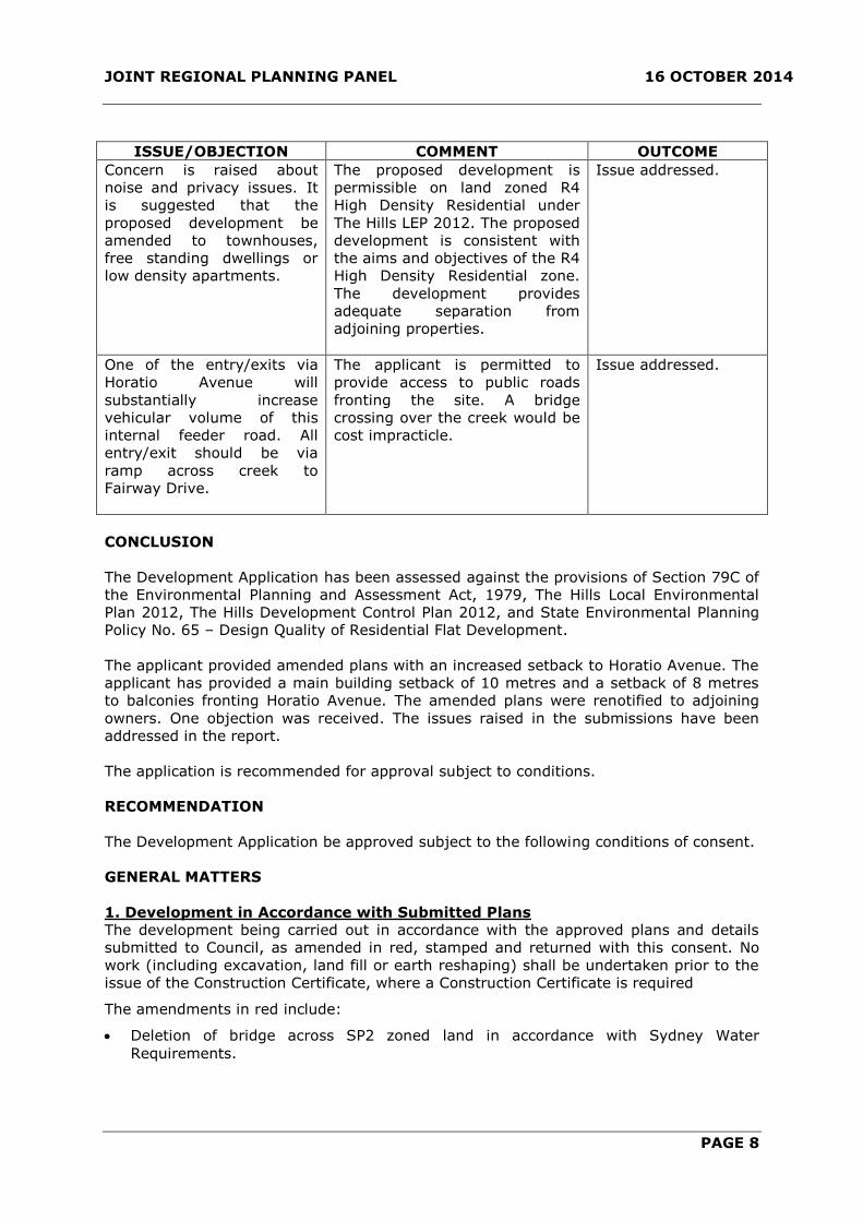
ISSUE/OBJECTION COMMENT OUTCOME
Concern is raised about
noise and privacy issues. It
is suggested that the
proposed development be
amended to townhouses,
free standing dwellings or
low density apartments.
The proposed development is
permissible on land zoned R4
High Density Residential under
The Hills LEP 2012. The proposed
development is consistent with
the aims and objectives of the R4
High Density Residential zone.
The development provides
adequate separation from
adjoining properties.
Issue addressed.
One of the entry/exits via
Horatio Avenue will
substantially increase
vehicular volume of this
internal feeder road. All
entry/exit should be via
ramp across creek to
Fairway Drive.
The applicant is permitted to
provide access to public roads
fronting the site. A bridge
crossing over the creek would be
cost impracticle.
Issue addressed.
CONCLUSION
The Development Application has been assessed against the provisions of Section 79C of
the Environmental Planning and Assessment Act, 1979, The Hills Local Environmental
Plan 2012, The Hills Development Control Plan 2012, and State Environmental Planning
Policy No. 65 – Design Quality of Residential Flat Development.
The applicant provided amended plans with an increased setback to Horatio Avenue. The
applicant has provided a main building setback of 10 metres and a setback of 8 metres
to balconies fronting Horatio Avenue. The amended plans were renotified to adjoining
owners. One objection was received. The issues raised in the submissions have been
addressed in the report.
The application is recommended for approval subject to conditions.
RECOMMENDATION
The Development Application be approved subject to the following conditions of consent.
GENERAL MATTERS
1. Development in Accordance with Submitted Plans
The development being carried out in accordance with the approved plans and details
submitted to Council, as amended in red, stamped and returned with this consent. No
work (including excavation, land fill or earth reshaping) shall be undertaken prior to the
issue of the Construction Certificate, where a Construction Certificate is required
The amendments in red include:
Deletion of bridge across SP2 zoned land in accordance with Sydney Water
Requirements.

JOINT REGIONAL PLANNING PANEL 16 OCTOBER 2014
PAGE 9
REFERENCED PLANS AND DOCUMENTS
DRAWING NO. DESCRIPTION REVISION DATE
DA-1.05 Site Plan H 13 August 2014
DA-02.01 Basement Plan (West) G 1 April 2014
DA-02.02 Basement Plan (East) H 13 August 2014
DA-02.03 Ground Floor Plan (West) G 1 April 2014
DA-02.04 Ground Floor Plan (East) H 13 August 2014
DA-02.05 Typical Floor Plan (West) G 1 April 2014
DA-02.06 First Floor Plan (East) H 13 August 2014
DA-2.07 Typical Floor Plan 2-3
(West)
G 1 April 2014
DA-2.07 Typical Floor Plan 2-3
(East)
H 13 August 2014
DA-3.01 North Elevation H 13 August 2014
DA-3.02 South Elevation H 13 August 2014
DA-3.03 East and West Elevation H 13 August 2014
DA-4.01 Section A-A H 13 August 2014
DA-4.02 Section B-B and C-C H 13 August 2014
DA-4.03 Section D-D H 13 August 2014
DA-1.03 Proposed Riparian Zone D 15 August 2013
2. Construction Certificate
Prior to construction of the approved development, it is necessary to obtain a
Construction Certificate. A Construction Certificate may be issued by Council or an
Accredited Certifier. Plans submitted with the Construction Certificate are to be amended
to incorporate the conditions of the Development Consent.
3. Building Work to be in Accordance with BCA
All building work must be carried out in accordance with the provisions of the Building
Code of Australia.
4. Compliance with NSW Office of Water
Compliance with the requirements of the NSW Office of Water as outlined in their letter
dated 14 March 2013 Ref: 10 ERM2012/0981 attached to this consent as Appendix A.
5. Compliance with NSW Police Force Requirements
The following is required by the Police, unless otherwise agreed by the Police and Council
in writing:
i. Fencing should be vertical style to stop unauthorised access to ground floor units;
ii. Materials chosen should have regard to the potential for graffiti.
iii. There is potential for unauthorised access to car parks and tenant storage areas.
Police suggest a use of a swipe card or keypad access for residents to access
these areas. Each garage door should be secured and it is recommended that a
alarm system be installed.
iv. It is recommended that during the construction phase security sensor lights be
used and security guards monitor the site.

JOINT REGIONAL PLANNING PANEL 16 OCTOBER 2014
PAGE 10
6. Liquid Storage - Pool Chemicals
All liquids onsite are to be stored within bunded areas so as to prevent water pollution.
All secondary and site containment mechanisms are to be implemented as per Appendix
2: Technical Considerations within the Storing and Handling Liquids: Environmental
Protection – Participants Manual prepared by the Department of Environment and
Climate Change NSW dated May 2007.
7. Salinity Assessment & Site Salinity Management Plan
The recommendations of the Salinity Assessment and Management Plan prepared by
Environmental Investigation Service, referenced as E26168KBrpt2-sal, dated November
2012 and submitted as part of the Development Application are to be implemented as
part of this approval. In particular:
8.5 Surface-water, Stormwater and Drainage
Surface water, storm water and drainage design should include the following:
The disturbance of natural drainage patterns should be avoided;
Where the drainage patterns are altered, appropriate, alternative artificial
drainage should be installed;
Slabs, foundations and retaining walls should be designed with subsoil drains and
good drainage to avoid water logging;
Stormwater should be managed appropriately in order to reduce infiltration.
Stormwater infrastructure should be designed to minimise leakage;
Guttering and down pipes should be properly connected and maintained;
Subsoil drains should be provided in areas where seepage discharge from the
underlying natural soil may occur, such as retained cuts, cut slopes, low lying
areas or significant changes in grade, etc; and
Surface water runoff should be directed around all stockpiles and work areas.
8. Property Numbering for Integrated Housing, Multi Unit Housing, Commercial
Developments and Industrial Developments
The responsibility for property numbering is vested solely in Council.
Buildings 1, 2 & 3 will be addressed to Fairway Drive with one letterbox bank to be
located at this frontage to accommodate units 1-84. Due to development that will occur
along Fairway Drive in the future, current street numbers will be changed. As a result of
this the site will not have an address of 28 Fairway Drive. The new street number
cannot be allocated at this time.
Buildings 4-6 will be addressed to the proposed new road Lucinda Avenue and will be
allocated the street number one (1). One bank of letterboxes is to be located at the
Lucinda Avenue frontage to accommodate units 85-176.
Unit numbers are allocated as follows
Building 1 - Units 1-24 Fairway Drive Kellyville
Building 2 - Units 24-44 Fairway Drive Kellyville
Building 3 - Units 45-84 Fairway Drive Kellyville
Building 4 - Units 85-124 / 1 Lucinda Avenue Kellyville
Building 5 - Units 125-152 / 1 Lucinda Avenue Kellyville
Building 6 - Units 153-174 / 1 Lucinda Avenue Kellyville

JOINT REGIONAL PLANNING PANEL 16 OCTOBER 2014
PAGE 11
Please refer to approved numbering correspondence and marked plan numbers DA-1.05
(Revision D) & DA-2.03 to DA-2.09 (revision D). These numbers, unless otherwise
approved by Council in writing, are to be displayed at street frontages and on all door
entrances.
If this development is subdivided in stages and given different strata numbers, this will
have an impact on the proposed unit numbers.
A diagrammatic plan is to be erected on site at driveway entry points. Clear and
accurate external directional signage is to be erected on all buildings, stairways, lift
shafts, units and lobby entry doors.
It is essential that all numbering signage throughout the complex is clear to assist
emergency service providers locate a destination with ease and speed, in the event of an
emergency.
9. Australia Post Mail Box Requirements
The number of mail boxes to be provided is to be equal to the number of residences and
one (1) for the proprietors. Mail boxes are to have a minimum internal dimension of
230mm wide x 160mm High x 330mm long and are to be provided with an opening of
230mm x 30mm for the reception of mail.
10. Subdivision Certificate Pre-Lodgement Meeting/ Check
Prior to the submission of a Subdivision Certificate application a draft copy of the final
plan, administration sheet and Section 88B instrument (where included) must be
submitted in order to establish that all conditions have been complied with.
11. Approved Street Naming
Street naming must comply with Council’s approved map which can be found on
Council’s website.
12. Street Trees
Street trees must be provided for the section of Fairway Drive, Horatio Avenue and
Lucinda Avenue within or fronting the development site spaced between 7m and 10m
apart. The location of street trees must be considerate of driveways, services, drainage
pits and sight lines at intersections. The species and size of street trees must comply
with the requirements of Council. Details demonstrating compliance with the above must
be submitted for approval before any street trees are planted.
A performance/ maintenance bond is required to be submitted to Council once the street
trees are planted. The bond will be held for one year and may be extended if
replacement street trees are required to be planted. The bond is refundable upon written
application to Council. Alternatively, street trees can be planted by Council subject to
payment of the applicable fee as per Council’s Schedule of Fees and Charges.
13. Recycled Water
The subject site must be connected to Sydney Water’s Rouse Hill Recycled Water
Scheme, unless written evidence from Sydney Water is submitted advising that this
service is not available.
14. Water Sensitive Urban Design Handover Process
An operations and maintenance plan must be prepared for all WSUD proposals. The
operations and maintenance plan must include:
a) The location and type of each WSUD element, including details of its operation and
design;
b) A brief description of the catchment characteristics, such as land uses, areas etc;
c) Estimated pollutant types, loads and indicative sources;
d) Intended maintenance responsibility, Council, landowner etc;
JOINT REGIONAL PLANNING PANEL 16 OCTOBER 2014
PAGE 12
e) Inspection method and estimated frequency;
f) Adopted design cleaning/ maintenance frequency;
g) Estimate life-cycle costs;
h) Site access details, including confirmation of legal access, access limitations etc;
i) Access details for WSUD measure, such as covers, locks, traffic control requirements
etc;
j) Description of optimum cleaning method and alternatives, including equipment and
personnel requirements;
k) Landscape and weed control requirements, noting that intensive initial planting is
required upfront to reduce the requirement for active weed removal;
l) A work method statement;
m) A standard inspection and cleaning form.
For the purposes of complying with the above a WSUD treatment system is considered
to include all functional elements of the system as well as any landscaped areas directly
surrounding the system.
15. Separate Application for Strata Subdivision
A separate application must be submitted for any proposed strata titled subdivision of
the approved development.
16. Protection of Public Infrastructure
Council must be notified of any damage to public infrastructure caused by the
development. Adequate protection must be provided prior to work commencing and
maintained during building operations. Any damage caused must be made good, to the
satisfaction of Council, before an Occupation Certificate can be issued. Public
infrastructure includes the road pavement, kerb and gutter, concrete footpaths, drainage
structures, utilities and landscaping fronting the site.
17. Vehicular Access and Parking
The formation, surfacing and drainage of all driveways, parking modules, circulation
roadways and ramps are required, with their design and construction complying with:
a) AS/ NZS 2890.1
b) AS/ NZS 2890.6
c) AS 2890.2
d) Council’s DCP Part C Section 1 – Parking
e) Council’s Driveway Specifications
Where conflict exists the Australian Standard must be used.
The following must be provided:
i. All driveways and car parking areas must be prominently and permanently line
marked, signposted and maintained to ensure entry and exit is in a forward
direction at all times and that parking and traffic circulation is appropriately
controlled.
ii. All driveways and car parking areas must be separated from landscaped areas by
a low level concrete kerb or wall.
iii. All driveways and car parking areas must be concrete or bitumen. The design
must consider the largest design service vehicle expected to enter the site. In
rural areas, all driveways and car parking areas must provide for a formed all
weather finish.

JOINT REGIONAL PLANNING PANEL 16 OCTOBER 2014
PAGE 13
iv. All driveways and car parking areas must be graded, collected and drained by pits
and pipes to a suitable point of legal discharge.
18. Detailed Design Requirements – Car Parking
The detailed design/ Construction Certificate plans must comply with the following
requirements:
f) Drawing DA-C-305 Issue B dated 12 February 2014 prepared by LP Consulting shows
a gradient of 34.8% for the driveway/ basement ramp “Lucinda Avenue Basement
East”. This must be reduced to 25% (maximum), being the maximum driveway
gradient permitted for passenger vehicles as per AS/ NZS 2890.1. Also, access to
this driveway/ basement ramp will be limited to passenger vehicles only as a result of
this steep grade. AS 2890.2 includes more stringent requirements relating to service
vehicles, including waste collection.
g) All visitor parking spaces must be 2.5m wide (minimum).
h) All resident parking spaces must be 2.4m wide (minimum).
i) Blind aisles that include visitor parking spaces require a dedicated turning area as per
AS/ NZS 2890.1.
j) No security gates/ roller shutters or the like are permitted unless the design also
includes a dedicated turning area in front of any such gate/ shutter, so that a person
is able to turn and leave the site if access is not available. Also, the gradient of this
queuing/ turning area in front of the gate/ shutter must have a gradient no steeper
than 6%.
19. Gutter and Footpath Crossing Application
Each driveway requires the lodgement of a separate gutter and footpath crossing
application, accompanied by the applicable fee as per Council’s Schedule of Fees and
Charges.
20. Minor Engineering Works
The design and construction of the engineering works listed below must be provided for
in accordance with the following documents and requirements:
a) Council’s Design Guidelines Subdivisions/ Developments
b) Council’s Works Specifications Subdivisions/ Developments
Any variance from these documents requires separate approval from Council.
Works on existing public roads or any other land under the care and control of Council
must be approved and inspected by Council in accordance with the Roads Act 1993 or
the Local Government Act 1993. A separate minor engineering works application and
inspection fee is payable as per Council’s Schedule of Fees and Charges.
i. Driveway Requirements
The design, finish, gradient and location of all driveway crossings must comply with the
above documents and Council’s Driveway Specifications.
The proposed driveways must be built to Council’s heavy duty standard.
A separate driveway application fee is payable as per Council’s Schedule of Fees and
Charges.
ii. Site Stormwater Drainage
The entire site area must be graded, collected and drained by pits and pipes to a suitable
point of legal discharge.

JOINT REGIONAL PLANNING PANEL 16 OCTOBER 2014
PAGE 14
21. Excavation/ Anchoring Near Boundaries
Earthworks near the property boundary must be carried out in a way so as to not cause
an impact on adjoining public or private assets. Where anchoring is proposed to sustain
excavation near the property boundary, the following requirements apply:
- Written owner’s consent for works on adjoining land must be obtained.
- For works adjacent to a road, anchoring that extends into the footpath verge is not
permitted, except where expressly approved otherwise by Council, or the RMS in the
case of a classified road.
- Where anchoring within public land is permitted, a bond must be submitted to
ensure their removal once works are complete. The value of this bond must relate to
the cost of their removal and must be confirmed by Council in writing before
payment.
- All anchors must be temporary. Once works are complete, all loads must be
removed from the anchors.
- A plan must be prepared, along with all accompanying structural detail and
certification, identifying the location and number of anchors proposed.
- The anchors must be located clear of existing and proposed services.
Details demonstrating compliance with the above must be submitted to the Principal
Certifying Authority and included as part of any Construction Certificate or Occupation
Certificate issued.
22. Adherence to Waste Management Plan
All commitments of the Waste Management Plan submitted as part of the Development
Application must be implemented during construction of the development. The
information submitted can change provided that the same or a greater level of reuse and
recycling is achieved as detailed in the plan. Any material moved offsite is to be
transported in accordance with the requirements of the Protection of the Environment
Operations Act 1997 and only to a place that can lawfully be used as a waste facility.
Receipts of all waste/ recycling tipping must be kept on site at all times and produced in
a legible form to any authorised officer of the Council who asks to see them.
23. Management of Construction and Demolition Waste
Waste materials must be appropriately stored and secured within a designated waste
area on site at all times, prior to its reuse on site or being sent off site. Building waste
containers are not permitted to be placed on the public way at any time unless a
separate application is approved by Council to locate a building waste container in a
public place. Any material moved off site must be transported to a place that can lawfully
be used as a waste facility or to facilities that can otherwise lawfully receive waste. The
separation and recycling of the following waste materials is required: metals, timber,
masonry products, clean waste plasterboard and mixed plastics and cardboard. This can
be achieved by source separation on site, that is, a bin for metal waste, a bin for timber,
a bin for bricks and so on. Alternatively, mixed waste may be stored in one or more bins
and sent to a waste contractor or transfer/ sorting station that will sort the waste on
their premises for recycling. Receipts of all waste/ recycling tipping must be kept on site
at all times and produced in a legible form to any authorised officer of the Council who
asks to see them.
24. Surplus Excavated Material
The disposal of surplus excavated material, other than to a licenced waste facility, is not
permitted without formal approval from Council, prior to works commencing on site. Any
unauthorised disposal of waste, which includes excavated material, is a breach of the
Protection of the Environment Operations Act 1997 and subject to substantial penalties.
Receipts of all waste/ recycling tipping must be kept on site at all times and produced in
a legible form to any authorised officer of the Council who asks to see them.

JOINT REGIONAL PLANNING PANEL 16 OCTOBER 2014
PAGE 15
25. Commencement of Domestic Waste Service
The property owner or agent acting for the owner must ensure to arrange the
commencement of a domestic waste service with Council no later than two days after
occupancy and no earlier than two days prior to occupancy of the development. The
service is to be arranged by telephoning Council on (02) 9843 0310. All requirements of
Council’s waste collection service must be complied with at all times.
26. Construction of Waste Storage Areas (Buildings One-Six)
All work involving construction of the waste storage areas is required to comply with the
requirements of Council’s Bin Storage Facility Design Specifications. Storage facility is to
be provided for a minimum of:
Buildings One-Three: Nine (9) 1100 litre bulk garbage bins and forty (40) 240 litre
mobile recycling bins.
Buildings Four-Six: Nine (9) 1100 litre bulk garbage bins and forty-two (42) 240 litre
mobile recycling bins.
27. Construction of Waste Storage Area (Building 7)
All work involving construction of the waste storage area is required to comply with the
requirements of Council’s Bin Storage Facility Design Specifications. The storage area is
required to be sized to comfortably store and manoeuvre a minimum of two (2) 660 litre
bulk garbage bins and six (6) 240 litre mobile recycling bins. The waste servicing door to
the storage area is required to open directly to the street, and have a direct access path
leading to the street, with a maximum gradient of 5%, including kerb crossing.
28. Restricted Development Area Fencing
The Restricted Development Area, being the area labelled on the riparian zone plan
(Reference: DA-1.03, revision D) is to be delineated with an appropriate fence (post and
rail or similar) to distinguish the riparian zone from the landscaped areas. No barbed
wire is to be used.
29. Vegetation Bond
Lodgement of a security bond of $40,000.00 to ensure satisfactory completion and
maintenance of the vegetation works.
The security bond will be progressively released at the following stages subject to the
submission of progress reports and the satisfactory completion of works in accordance
with the Council-approved Vegetation Management Plan (VMP):
Release of 25%, 12 months after the initial planting;
Release of a further 25%, 36 months after the initial planting;
Final release of 50%, 60 months after the initial planting.
Progress reports are required to be submitted prior to each progressive partial bond
release demonstrating compliance with the Council-approved VMP. The progress reports
shall be prepared by a professional ecologist/bush regeneration specialist and certified
by Council’s Manager – Environment and Health.
PRIOR TO THE ISSUE OF CONSTRUCTION CERTIFICATE
30. Erosion & Sediment Control Plan
Submission of an Erosion and Sediment Control Plan to the Principal Certifying Authority,
including details of:
a) Allotment boundaries
b) Location of the adjoining roads
c) Contours
d) Existing vegetation
e) Existing site drainage

JOINT REGIONAL PLANNING PANEL 16 OCTOBER 2014
PAGE 16
f) Critical natural areas
g) Location of stockpiles
h) Erosion control practices
i) Sediment control practices
j) Outline of a maintenance program for the erosion and sediment controls
(NOTE: For guidance on the preparation of the Plan refer to ‘Managing Urban
Stormwater Soils & Construction’ produced by the NSW Department of Housing).
31. Section 94 Contribution – Balmoral Road Release Area
The following monetary contributions must be paid to Council in accordance with Section
94 of the Environmental Planning and Assessment Act, 1979, to provide for the
increased demand for public amenities and services resulting from the development.
Payments comprise of the following:-
Prior to payment of the above contributions, the applicant is advised to contact Council’s
Development Contributions Officer on 9843 0268. Payment must be made by cheque or
credit/debit card. Cash payments will not be accepted.
This condition has been imposed in accordance with Contributions Plan No. 12.
Council’s Contributions Plans can be viewed at www.thehills.nsw.gov.au or a copy may
be inspected or purchased at Council’s Administration Centre.
32. Underground of Overhead Services
A Construction Certificate cannot be issued until an agreement has been reached with
Endeavour Energy, confirmed in writing, in relation to the undergrounding/ relocation of
the existing high voltage overhead power lines and the removal of the associated
easement from the title of the property.
33. Bank Guarantee Requirements
Any bank guarantee submitted in lieu of a cash bond must comply with the following:
a) Have no expiry date;
b) Be sent to Council direct from the bank;
c) Reference the development application, condition and matter to which it relates;
d) The amount must match that required to be paid;
e) If a single bank guarantee is used for multiple bonds, it must be itemised.
Should Council need to uplift the bank guarantee, notice in writing will be forwarded to
the applicant 14 days beforehand.
34. Controlled Activity Authority – NSW Office of Water
A copy of the Controlled Activity Authority required to be obtained from the NSW Office
of Water must be submitted to Council before a Construction Certificate is issued.
35. Separate Approval for WIK/ MPB Agreement
Separate approval is required where a works in kind (WIK) or material public benefit
(MPB) is proposed in lieu of the part or full payment of either a monetary contribution or
Purpose: 1
bedroom unit
Purpose: 2
bedroom unit
Purpose: 3
bedroom unit
Purpose:
Credit
No. of 1
Bedroom units:
65
No. of 2
Bedroom units:
89
No. of 3
Bedroom
units: 20
Sum of UnitsNo. of
Credits: 1Total S94
Open Space - Land 12,930.96$ 17,904.40$ 18,865.47$ 18,865.47$ 840,512.40$ 1,593,491.60$ 377,309.40$ 2,811,313.40$ 18,865.47$ 2,792,447.93$
Open Space - Capital 3,431.83$ 4,751.77$ 5,006.83$ 5,006.83$ 223,068.95$ 422,907.53$ 100,136.60$ 746,113.08$ 5,006.83$ 741,106.25$
Transport Facilities - Capital 2,443.64$ 3,383.50$ 3,565.11$ 3,565.11$ 158,836.60$ 301,131.50$ 71,302.20$ 531,270.30$ 3,565.11$ 527,705.19$
Community Facilities - Land 255.72$ 354.08$ 373.09$ 373.09$ 16,621.80$ 31,513.12$ 7,461.80$ 55,596.72$ 373.09$ 55,223.63$
Community Facilities - Capital 1,047.63$ 1,450.57$ 1,528.43$ 1,528.43$ 68,095.95$ 129,100.73$ 30,568.60$ 227,765.28$ 1,528.43$ 226,236.85$
Administration 179.48$ 248.51$ 261.85$ 261.85$ 11,666.20$ 22,117.39$ 5,237.00$ 39,020.59$ 261.85$ 38,758.74$
Drainage Facilities - Capital 273.64$ 378.88$ 399.22$ 399.22$ 17,786.60$ 33,720.32$ 7,984.40$ 59,491.32$ 399.22$ 59,092.10$
Total 20,562.90$ 28,471.71$ 30,000.00$ 30,000.00$ 1,336,588.50$ 2,533,982.19$ 600,000.00$ 4,470,570.69$ 30,000.00$ 4,440,570.69$

JOINT REGIONAL PLANNING PANEL 16 OCTOBER 2014
PAGE 17
the dedication of land. Any WIK or MPB application must be made in writing. Contact
Council to ascertain the information required to accompany any such application.
The WIK or MPB agreement must be finalised before a Construction Certificate is issued.
Once the WIK or MPB agreement has been finalised an application must be submitted to
modify the Section 94 Contribution amount identified in this consent, unless it is agreed
that the difference can be reimbursed after payment is made.
36. Sediment and Erosion Control Plan
A sediment and erosion control plan prepared in accordance with Council’s Works
Specification Subdivision/ Developments must be submitted. The plan must include:
a) Allotment boundaries;
b) Adjoining roads;
c) Contours;
d) Existing vegetation;
e) Existing site drainage;
f) Critical natural areas;
g) Location of stockpiles;
h) Erosion control practices;
i) Sediment control practices; and
j) A maintenance program for the erosion and sediment controls.
37. Stormwater Pump/ Basement Car Park Requirements
The stormwater pump-out system must provide for the following:
a) A holding tank sized to store the runoff from a 12 hour, 1 in 100 year design storm
event;
b) An alternating two pump system capable of emptying the holding tank at either the
Permissible Site Discharge rate or the rate of inflow for a five hour, 1 in 5 year design
storm event, whichever is lower;
c) An alarm system to alert a pump failure;
d) 100mm freeboard to all nearby parking spaces;
e) The system must be connected to the Onsite Stormwater Detention system before
being discharged to the street along with the remaining site runoff, under gravity.
All plans, calculations, hydraulic details and manufacturer specifications for the pump
must be submitted with certification from the designer confirming compliance with the
above requirements.
38. Draft Legal Documents
Where an encumbrance on title is required to be created as part of this consent, draft
copies of all legal documents must be submitted to Council for checking before a
Construction Certificate is issued.
39. Security Bond – Road Pavement and Public Asset Protection
In accordance with Section 80A(6)(a) of the Environmental Planning and Assessment Act
1979, a security bond of $118,320.00 is required to be submitted to Council to
guarantee the protection of the road pavement and other public assets in the vicinity of
the site during construction works. The above amount is calculated at the rate of $85.00
per square metre based on the road frontage of the subject site plus an additional 50m
on either side (174m) multiplied by the width of the road (8m).

JOINT REGIONAL PLANNING PANEL 16 OCTOBER 2014
PAGE 18
The bond must be lodged with Council before a Construction Certificate is issued.
The bond is refundable upon written application to Council and is subject to all work
being restored to Council’s satisfaction. Should the cost of restoring any damage exceed
the value of the bond, Council will undertake the works and issue an invoice for the
recovery of these costs.
40. Security Bond – External Works
In accordance with Section 80A(6)(b) of the Environmental Planning and Assessment Act
1979, a security bond is required to be submitted to Council to guarantee the
construction, completion and performance of all works external to the site. The bonded
amount must be based on 150% of the tendered value of providing all such works. The
minimum bond amount is $10,000.00. The bond amount must be confirmed with Council
prior to payment.
The bond must be lodged with Council before a Construction Certificate is issued.
The bond is refundable upon written application to Council and is subject to all work
being completed to Council’s satisfaction.
41. Engineering Works and Design
The design and construction of the engineering works listed below must be provided for
in accordance with the following documents and requirements:
a) Council’s Design Guidelines Subdivisions/ Developments
b) Council’s Works Specifications Subdivisions/ Developments
Variation from these documents can only be approved by Council’s Manager –
Subdivision and Development Certification.
Engineering works can be classified as either “subdivision works” or “building works” as
categorised below:
1. Works within an existing or proposed public road, or works within an existing or
proposed public reserve. These works can only be approved, inspected and certified
by Council in accordance with the Roads Act 1993 and the Local Government Act
1993 respectively. For Council to issue this approval the following must be provided:
a) A completed application form.
b) An electronic copy of the design plans and accompanying documentation.
c) Payment of the applicable application and inspection fees.
d) Payment of any required security bonds.
2. Works within the development site, or an adjoining private property, that relates to
existing or proposed Council infrastructure assets, such as the laying of a stormwater
pipeline or the formation of an overland flow path within a public drainage easement.
These works can only be approved, inspected and certified by Council because
Council will have an ongoing risk exposure and management/ maintenance liability
with respect to these assets once completed.
A “compliance certificate” as per Section 109(1)(a)(ii) of the Environmental Planning
and Assessment Act 1979 can be issued certifying that the detailed design for these
works complies with the requirements listed and the above documents. This
“compliance certificate” can be issued by Council’s Manager – Subdivision and
Development Certification and not a private certifier, as discussed. Once approved,
the works must be carried out under the supervision of Council’s Construction
Engineer in accordance with the terms attached to the issued “compliance
certificate”. Post construction, a further “compliance certificate” as per Section
109(1)(a)(i) of the Environmental Planning and Assessment Act 1979 can be issued
certifying that the as-built infrastructure and associated works have been carried out

JOINT REGIONAL PLANNING PANEL 16 OCTOBER 2014
PAGE 19
to the satisfaction of Council’s Construction Engineer. Alternatively, these works can
be incorporated into any construction approval granted under category (1) above.
3. Works within the development site, or adjoining private properties, that do not relate
to existing or proposed Council infrastructure assets, such as water sensitive urban
design elements or inter-allotment drainage pipelines. Such works can be approved,
inspected and certified by either Council or a private certifier, so long as the private
certifier is accredited to do so.
This certification must be included with the documentation approved as part of any
Construction Certificate. The designer of the engineering works must be qualified,
experienced and have speciality knowledge in the relevant field of work.
The following engineering works are required:
i. Full Width Road Construction
The full width construction of the roads listed below is required, including footpath
paving and other ancillary work to make this construction effective:
Road Name: Formation:
(Footpath/ Carriageway/ Footpath) (m)
Lucinda Avenue Road Type:
DCP Access Street (1)
3.5m/ 8.5m/ 3.5m (15.5m total)
Pavement Design:
Access (Design Guidelines Section 3.12)
The design must incorporate a standard kerb return radius of 7.5m based on a 4m splay
corner unless otherwise directed by Council.
ii. Partial Width Road Construction
The partial width construction of the roads listed below is required, including footpath
paving and other ancillary work to make this construction effective:
Road Name: Formation:
(Footpath/ Carriageway/ Footpath) (m)
Horatio Avenue Road Type:
DCP Access Street (1)
3.5m/ 8.5m/ 3.5m (15.5m total)
Pavement Design:
Access (Design Guidelines Section 3.12)
The design must incorporate a standard kerb return radius of 7.5m based on a 4m splay
corner unless otherwise directed by Council.
As partial width construction exists opposite, the completed road must comply with the
overall requirements outlined in the table above.
iii. Partial Width Road Reconstruction
The partial width reconstruction of the existing roads listed below is required, including
any necessary service adjustments and ancillary work required to make the construction
effective:

JOINT REGIONAL PLANNING PANEL 16 OCTOBER 2014
PAGE 20
Road Name: Formation:
(Footpath/ Carriageway/ Footpath) (m)
Fairway Drive Road Type:
DCP Enhanced Collector Road with Cycleway (3C)
4.5m/ 12m/ 3.5m (20m total)
Pavement Design:
Enhanced Collector (Design Guidelines Section 3.12)
The design must incorporate a standard kerb return radius of 7.5m based on a 4m splay
corner unless otherwise directed by Council.
Where partial width reconstruction exists opposite, the completed road must comply with
the overall requirements outlined in the table above. Where partial width reconstruction
does not exist opposite, you will be responsible for the formation of the footpath verge,
kerb and gutter and the reconstruction of 6m of road pavement. This new road
pavement must transition into the existing road pavement opposite to provide for a total
minimum carriageway width of 10m, which may require additional pavement
reconstruction.
Any requirements relating to partial width road reconstruction from the relevant section
of Council’s DCP must also be complied with. All works must be carried out in accordance
with the submitted traffic safety statement.
Where the existing road reserve width exceeds that required to be provided, the
additional width is to be evenly distributed on either side of the road carriageway to
provide for a wider footpath verge.
The wider 4.5m verge must be located on the eastern side of Fairway Drive correlating
with the cycleway required by the DCP at this location.
iv. Temporary Turning Heads
A temporary cul-de-sac turning head must be provided at the end of all roads that will
be extended into adjoining properties if/ when they are developed. The cul-de-sac must
have a diameter of 19m measured from the edge pavement.
A temporary turning head is required at the southern end of Lucinda Avenue extending
into the development site.
v. Street Names Signs
Street name signs and posts are required in accordance with the above documents and
Council’s Standard Drawing 37. Details for all signage and line-marking must be
submitted to Council for checking prior to works commencing.
vi. Concrete Footpath
A 1.2m wide concrete footpath, including access ramps at all intersections, must be
provided on one side of Lucinda Avenue and Horatio Avenue in accordance with the DCP
and the above documents.
vii. Concrete Cycleway
A 2.5m wide concrete cycleway, including access ramps at all intersections, must be
provided on the eastern side of Fairway Drive in accordance with the DCP and the above
documents.
viii. Disused Layback/ Driveway Removal
All disused laybacks and driveways must be removed and replaced with full kerb and
gutter together with the restoration and turfing of the adjoining footpath verge area.

JOINT REGIONAL PLANNING PANEL 16 OCTOBER 2014
PAGE 21
ix. Service Conduits
Service conduits to the development site, laid in strict accordance with the relevant
service authority’s requirements, are required. Services must be shown on the
engineering drawings.
x. Stormwater Drainage – Temporary Works
Grassed swale drains or temporary piped drainage must be installed to intercept, control
and redirect surface stormwater runoff from upstream undeveloped properties.
xi. Stormwater Drainage – Creek Outlets
The two piped stormwater outlets/ connections to Strangers Creek must comply with the
requirements of Council and the NSW Office of Water as well as Sydney Water, in the
case of stormwater management zoned land.
xii. Water Sensitive Urban Design Elements
Water sensitive urban design elements, being those shown on the plans prepared by LP
Consulting, are to be located generally in accordance with the plans and information
submitted with the application. With respect to rainwater reuse, a 20,000 litre rainwater
tank is required for each building (or an equivalent combined volume across the
development site as a whole).
Detailed plans for the water sensitive urban design elements must be submitted for
approval. The detailed plans must be suitable for construction, and include detailed and
representative longitudinal and cross sections of the proposed infrastructure. The design
must be accompanied, informed and supported by detailed water quality and quantity
modelling. The modelling must demonstrate a reduction in annual average pollution
export loads from the development site in line with the following environmental targets:
- 90% reduction in the annual average load of gross pollutants
- 85% reduction in the annual average load of total suspended solids
- 65% reduction in the annual average load of total phosphorous
- 45% reduction in the annual average load of total nitrogen
All model parameters and data outputs are to be provided.
These elements must be designed and constructed in accordance with best practice
water sensitive urban design techniques and guidelines. Such guidelines include, but are
not limited to, the following:
- Water Sensitive Urban Design – Technical Guidelines for Western Sydney, 2004,
http://www.wsud.org/tools-resources/index.html
- Australian Runoff Quality – A Guide to Water Sensitive Urban Design, 2005,
http://www.ncwe.org.au/arq/
42. Design of Waste Storage Area (Buildings One, Two and Three)
Prior to a Construction Certificate being issued, amended plans are required to be
submitted to Council to the satisfaction of the Resource Recovery Project Officer. The
plans must demonstrate that the waste storage room is sized to comfortably store and
manoeuvre a minimum of nine (9) 1100 litre bulk garbage bins and forty-two (40) 240
litre mobile recycling bins. Additionally, the bay width of the waste servicing area is to be
increased to be at least 4m, and the bay is not permitted to have a dog leg angle.
43. Design of Waste Storage Area (Buildings Four, Five and Six)
Prior to a Construction Certificate being issued, amended plans are required to be
submitted to Council to the satisfaction of the Resource Recovery Project Officer. The
plans must demonstrate that the waste storage room is sized to comfortably store and
manoeuvre a minimum of nine (9) 1100 litre bulk garbage bins and forty-two (42) 240

JOINT REGIONAL PLANNING PANEL 16 OCTOBER 2014
PAGE 22
litre mobile recycling bins. Additionally, the bay width of the waste servicing area is to be
increased to be at least 4m.
44. Relocation of Waste Storage Area (Building 7)
Prior to a Construction Certificate being issued, amended plans are required to be
submitted to Council to the satisfaction of the Resource Recovery Project Officer. The
waste storage room is required to be relocated to be within 8m of the street, unless it is
within the building footprint, where the maximum distance is 12m.
45. Internal Pavement Structural Design Certification
Prior to a Construction Certificate being issued, a Certified Practicing Engineer (CPEng)
must submit a letter to Council confirming the structural adequacy of the internal
pavement design (porte-cochere and rubbish collection areas). The pavement design
must be adequate to withstand the loads imposed by a loaded heavy rigid waste
collection vehicle (i.e. 28 tonne axle load) from the boundary to the waste collection
point including any manoeuvring areas.
46. Landscape Plan
A site specific Landscape Plan is to be submitted to Council’s satisfaction prior to any
works commencing on site. This plan is to show how landscaping will incorporate the use
of local provenance plants native to the local vegetation communities being River-flat
Eucalypt Forest and Cumberland Plain Woodland. Eighty percent of the plants used in the
street tree planting and in common areas are to be of local provenance groundcovers,
shrubs and trees (excluding turf and the riparian zone).
47. Biodiversity Offsetting Requirements
To offset the loss of biodiversity from the site including the removal of Cumberland Plain
Woodland, the development must purchase and retire seven (7) HN528 or HN529
ecosystem credits. A retirement certificate from the NSW BioBanking Office to
demonstrate compliance with this condition is to be provided to The Hills Shire Council’s
Manager – Environment and Health prior to issue of a Construction Certificate.
48. Landscape Plan Bond
Lodgement of a landscape bond in the amount of $10,000 to ensure satisfactory
completion is to be lodged with Council. It shall be refunded six months following issue
of the Final Occupation Certificate provided works are to the satisfaction of Council’s
Manager – Environment and Health. Works are to be certified by a qualified Landscape
Architect via the submission of appropriate documentation demonstrating compliance
with the approved landscape plan.
49. Landscape Plan Plant Procurement
The bush regeneration contractor shall order all local provenance plants that are
required to be planted as part of the Council approved Landscape Plan. Invoices detailing
the procurement shall be submitted to Council.
50. Vegetation Management Plan
A Vegetation Management Plan is to be submitted to Council prior to the release of the
construction certificate. The Vegetation Management Plan must be prepared to the
satisfaction of Council's Manager Environment and Health. The Vegetation Management
Plan is required to include information regarding how the RDA will be rehabilitated and
then managed into the future past the first 5 year rehabilitation plan.
51. Special Infrastructure Contribution – Growth Centres
The applicant is to make special infrastructure contribution in accordance with any
determination by the Minister administering the Environmental planning and Assessment
Act 1979 under Section 94EE of the Act that is in force on the date of this consent, and
must obtain a certificate to that effect from the Growths Centres Commission before a

JOINT REGIONAL PLANNING PANEL 16 OCTOBER 2014
PAGE 23
Construction certificate or subdivision certificate is issued in relation to any part of the
development to which this consent relates
More information on the Special Infrastructure Contribution can be found at the Growth
Centres Commission’s website at www.gcc.nsw.gov
To obtain an estimate of the Special Infrastructure Contribution that may be payable for
the application please email [email protected]
PRIOR TO WORK COMMENCING ON THE SITE
52. Principal Certifying Authority
A sign is to be erected in accordance with Clause 98 A (2) of the Environmental Planning
and Assessment Regulations 2000.
53. Consultation with Service Authorities
Applicants are advised to consult with Telstra, NBN Co and Australia Post regarding the
installation of telephone conduits, broadband connections and letterboxes as required.
Unimpeded access must be available to the electricity supply authority, during and after
building, to the electricity meters and metering equipment.
The building plans must be submitted to the appropriate Sydney Water office to
determine whether the development will affect Sydney Water’s sewer and water mains,
stormwater drains and/or easements. If the development complies with Sydney Water’s
requirements, the building plans will be stamped indicating that no further requirements
are necessary.
54. Approved Temporary Closet
An approved temporary closet connected to the sewers of Sydney Water, or alternatively
an approved chemical closet is to be provided on the land, prior to building operations
being commenced.
55. Erosion and Sedimentation Controls – Minor Works
Erosion and sedimentation controls shall be in place prior to the commencement of site
works; and maintained throughout construction activities until the site is landscaped
and/or suitably revegetated. The controls shall be in accordance with the details
approved by Council and/or as directed by Council Officers. These requirements shall be
in accordance with Managing Urban Stormwater – Soils and Construction produced by
the NSW Department of Housing (Blue Book).
56. Stabilised Access Point
A stabilised all weather access point is to be provided prior to commencement of site
works, and maintained throughout construction activities until the site is stabilised. The
controls shall be in accordance with the requirements with the details approved by
Council and/or as directed by Council Officers. These requirements shall be in
accordance with Managing Urban Stormwater – Soils and Construction produced by the
NSW Department of Housing (Blue Book).
57. Site Water Management Plan
A Site Water Management Plan is to be submitted to Council for approval. The plan is
required to be site specific and be in accordance with "Managing Urban Stormwater -
Soils and Construction" (The Blue Book) produced by the NSW Department of Housing.
58. Erosion & Sediment Control Plan Kept on Site
A copy of the Erosion and Sediment Control Plan must be kept on site at all times during
construction and made available to Council officers on request.
59. Traffic Control Plan
A Traffic Control Plan is required to be prepared and submitted to Council for approval.
The person preparing the plan must have the relevant accreditation to do so. Where

JOINT REGIONAL PLANNING PANEL 16 OCTOBER 2014
PAGE 24
amendments to the plan are required post approval, they must be submitted to Council
for further approval prior to being implemented.
A plan that includes full (detour) or partial (temporary traffic signals) width road closure
requires separate specific approval from Council. Sufficient time should be allowed for
this to occur.
60. Sediment and Erosion Control
The approved sediment and erosion control measures, including a stabilised all weather
access point, must be in place prior to works commencing and maintained during
construction and until the site is stabilised to ensure their effectiveness. For major
works, these measures must be maintained for a minimum period of six months
following the completion of all works.
61. Service Authority Consultation – Subdivision Works
Before subdivision works commence:
a) Documentary evidence must be submitted confirming that satisfactory arrangements
have been made for the relocation, undergrounding and/ or provision of electrical
services for the non-residue lots created by the subdivision.
b) Documentary evidence, including a notice of requirements from Sydney Water, must
be submitted confirming that satisfactory arrangements have been made for the
provision of water and sewerage facilities.
c) Consultation with the relevant telecommunications provider authorised under the
Telecommunications Act regarding the installation of telephone conduits is required.
The design and construction of these works must comply with current NBN
standards, where applicable.
62. Public Infrastructure Inventory Report
A public infrastructure inventory report must be prepared and submitted to Council
recording the condition of all public assets in the direct vicinity of the development site.
This includes, but is not limited to, the road fronting the site along with any access route
used by heavy vehicles. If uncertainty exists with respect to the necessary scope of this
report, it must be clarified with Council before works commence. The report must
include:
a) Planned construction access and delivery routes; and
b) Dated photographic evidence of the condition of all public assets.
63. Demolition Works and Asbestos Management
The demolition of any structure is to be carried out in accordance with the Occupational
Health and Safety Regulations 2001 Part 8 and AS 2601-2001. All vehicles transporting
demolition materials offsite are to have covered loads and are not to track any soil or
waste materials on the road. Should demolition works obstruct or inconvenience
pedestrian or vehicular traffic on adjoining public road or reserve, a separate application
is to be made to Council to enclose the public place with a hoard or fence. All demolition
works involving the removal and disposal of asbestos must only be undertaken by a
licenced asbestos removalist who is licenced to carry out the work. Asbestos removal
must be carried out in accordance with the WorkCover, Environment Protection Authority
and Office of Environment and Heritage requirements. Asbestos to be disposed of must
only be transported to waste facilities licenced to accept asbestos. No asbestos products
are to be reused on the site.
64. Discontinuation of Domestic Waste Service
Prior to the commencement of demolition works, and where the site ceases to be
occupied during works, the property owner or site manager must ensure to notify to
Council to collect any garbage and recycle bins from any dwelling that is to be
demolished. Trade workers are not permitted to use Council supplied bins for the

JOINT REGIONAL PLANNING PANEL 16 OCTOBER 2014
PAGE 25
disposal of any waste. The service is to be discontinued by telephoning Council on (02)
9843 0310.
65. Landscaping/ Planting – Seed Collection
Prior to clearance of the vegetation in the development area, all collectable floristic
material shall be harvested for use in future landscaping on site. Seed and other genetic
material collected from the site is to be placed in the care of a Council recognised bush
regeneration specialist for use in bush rehabilitation projects in the local area.
Details prepared by the project ecologist (in writing) demonstrating compliance is to be
submitted to The Hills Shire Council.
66. Tree Removal and Fauna Protection
A pre-construction survey is to be undertaken by a qualified ecologist to confirm no bats
are roosting in buildings on the site. Any individuals found should be captured and
released. A bat management plan shall be prepared to the satisfaction of Council to
detail how this will be undertaken if the bats are present.
If hollow-bearing tree removal is unavoidably to occur during August to February in the
hollow-dependant fauna breeding seasons, the following is required. A fauna breeding
season action plan prepared by a suitably qualified and experienced ecologist prior to
tree removal being undertaken is required. The plan must be to the satisfaction of
Council and submitted and approved prior to tree removal works being undertaken.
Prior to the clearing of any trees, a pre-clearing fauna survey will be conducted by a
qualified ecologist to identify and minimise impacts to resident fauna. All trees containing
hollows are to be clearly marked as habitat trees.
During any tree removal a Project Ecologist is to be present to re-locate any displaced
fauna that may be disturbed during this activity.
Trees marked as habitat trees will be shaken by machinery prior to clearing to encourage
any fauna remaining to leave the hollows and move on.
Trees shall be lopped in such a way that the risk of injury or mortality to fauna is
minimised, such as top-down lopping, with lopped sections gently lowered to the ground,
or by lowering whole trees to the ground with the “grab” attachment of a machine.
An experienced wildlife handler/ecologist shall be in attendance during the felling of trees
on this site in order to rescue any injured wildlife. Potential hollows in lowered trees or
sections of trees shall be searched by an experienced ecologist and any fauna shall be
removed and, if uninjured, either released into roost boxes on the site or fed, warmed
and released in the evening, or, if injured, transferred to the care of a wildlife carer and
released on the site when re-habilitated (microbats bats should only be handled by
appropriately vaccinated persons).
Details prepared by the project ecologist (in writing) demonstrating compliance is to be
submitted to The Hills Shire Council.
DURING CONSTRUCTION
67. Hours of Work
Work on the project to be limited to the following hours: -
Monday to Saturday - 7.00am to 5.00pm;
No work to be carried out on Sunday or Public Holidays.
JOINT REGIONAL PLANNING PANEL 16 OCTOBER 2014
PAGE 26
The builder/contractor shall be responsible to instruct and control sub-contractors
regarding the hours of work. Council will exercise its powers under the Protection of the
Environment Operations Act, in the event that the building operations cause noise to
emanate from the property on Sunday or Public Holidays or otherwise than between the
hours detailed above.
68. Survey Report
Survey Certificate to be submitted to the Principal Certifying Authority at footings and/or
formwork stage. The certificate shall indicate the location of the building in relation to all
boundaries, and shall confirm the floor level prior to any work proceeding on the
building.
69. Compliance with BASIX Certificate
Under clause 97A of the Environmental Planning and Assessment Regulation 2000, it is a
condition of this Development Consent that all commitments listed in BASIX Certificate
No.’s 460254M_02 (Building 1), 460269M_02 (Building 2), 460021M_02 (Building 3),
460276M_02 (Building 4), 460339M_02 (Building 5), 460342M_02 (Building 6), and
460344M_02 (Building 7) be complied with. Any subsequent version of these BASIX
Certificates will supersede all previous versions of the certificate.
A Section 96 Application may be required should the subsequent version of these BASIX
Certificates necessitate design changes to the development. However, a Section 96
Application will be required for a BASIX Certificate with a new number.
70. Roof Water Drainage
Gutter and downpipes to be provided and connected to an approved drainage system
upon installation of the roof covering.
71. Compliance with Critical Stage Inspections and Other Inspections
Nominated by the Principal Certifying Authority
Section 109E(d) of the Act requires certain specific inspections (prescribed by Clause
162A of the Regulations) and known as “Critical Stage Inspections” to be carried out for
building work. Prior to permitting commencement of the work, your Principal Certifying
Authority is required to give notice of these inspections pursuant to Clause 103A of the
Regulations.
N.B. An Occupation Certificate cannot be issued and the building may not be able to be
used or occupied where any mandatory critical stage inspections or other inspections
required by the Principal Certifying Authority are not carried out.
Where Council is nominated as Principal Certifying Authority, notification of all
inspections required is provided with the Construction Certificate approval.
NOTE: You are advised that inspections may only be carried out by the PCA
unless by prior agreement of the PCA and subject to that person being an
accredited certifier.
72. Stockpiles
Stockpiles of topsoil, sand, aggregate or other material capable of being moved by water
shall be stored clear of any drainage line, easement, natural watercourse, footpath, kerb
or roadside.
73. Dust Control
The emission of dust must be controlled to minimise nuisance to the occupants of the
surrounding premises. In the absence of any alternative measures, the following
measures must be taken to control the emission of dust:
Dust screens must be erected around the perimeter of the site and be kept in good
repair for the duration of the construction work.
All dusty surfaces must be wet down and suppressed by means of a fine water
spray. Water used for dust suppression must not cause water pollution; and

JOINT REGIONAL PLANNING PANEL 16 OCTOBER 2014
PAGE 27
All stockpiles of materials that are likely to generate dust must be kept damp of
covered.
74. Construction Noise
The emission of noise from the construction of the development shall comply with the
Interim Construction Noise Guideline published by the Department of Environment and
Climate Change (July 2009).
75. Filtration Motor
The swimming pool filter and pump shall be fully enclosed in a purpose built acoustic
enclosure to attenuate noise emitted by the swimming pool equipment. The acoustic
enclosure shall reduce the sound pressure level of the swimming pool filter and pump
equipment to a level not greater than 5dB (A) above the background noise level in
accordance with Protection of the Environmental Operations Act 1997.
76. Pool Discharge Water
Discharge and/or overflow pipe from the swimming pool and filtration unit to be
connected to the sewer where available.
All backwash water from the filtration unit is to be similarly disposed, or alternatively,
must be piped to an absorption trench.
The pool excavations not to conflict with the position of household drainage trenches or
lines, the position of which must be ascertained before pool excavation commences.
77. Swimming Pool Safety Fencing
All pools and safety barriers are to comply with the Swimming Pools Act 1992, the
Swimming Pools Regulation 2008 and Australian Standard 1926.1-2012. A fact sheet
titled Swimming Pool Fencing Requirements is available from www.thehills.nsw.gov.au.
78. Resuscitation Warning Notice
In accordance with the Swimming Pools Regulation 2008, a Warning Notice is to be
displayed in a prominent position, in the immediate vicinity of the swimming pool. The
notice is to contain a diagrammatic flow chart of resuscitation techniques, the words:
(i) "YOUNG CHILDREN SHOULD BE SUPERVISED WHEN USING THIS SWIMMING POOL",
and
(ii) "POOL GATES MUST BE KEPT CLOSED AT ALL TIMES", and
(iii) "KEEP ARTICLES, OBJECTS AND STRUCTURES AT LEAST 900 MILLIMETRES CLEAR
OF THE POOL FENCE AT ALL TIMES",
and all other details required by the Regulation.
79. Pool not to be Filled Until Occupation
The pool is not to be filled with water until the dwelling is occupied.
80. Temporary Fencing of Pools
This condition applies to unoccupied land.
On excavation and prior to installation of the pool shell or placement of the steel re-
enforcement, a fence is to be provided around the pool excavation, so as to isolate and
prevent access to it.
The fence provided is to be 1.8m high and to no less a standard than correctly joined
and secured, temporary fence panels or chainmesh. The fence is to remain in place until
the site (dwelling) has been approved for occupation.
81. Critical Stage Inspections – Subdivision Works
The subdivision works must be inspected by Council in accordance with the schedule
included in Council’s Works Specification Subdivisions/ Developments. A minimum of 24

JOINT REGIONAL PLANNING PANEL 16 OCTOBER 2014
PAGE 28
hour’s notice is required for inspections. No works are to commence until the first
inspection has been carried out.
82. Standard of Works
All work must be carried out in accordance with Council’s Works Specification
Subdivisions/ Developments and must include any necessary works required to make the
construction effective. All works, including public utility relocation, must incur no cost to
Council.
PRIOR TO ISSUE OF AN OCCUPATION AND/OR SUBDIVISION CERTIFICATE
83. Safety Glazing for Pool Fencing
If glazing is chosen to be incorporated into the pool safety fencing system, a safety
glazing certificate is to be provided to Council, or the Principal Certifying Authority,
indicating all materials and installation are in accordance with AS 1288.
84. Compliance with NSW Office of Water Requirements
A letter from the NSW Office of Water must be submitted confirming that all works
associated with the Controlled Activity Authority have been completed to their
satisfaction.
85. Completion of Subdivision Works
A Subdivision Certificate cannot be issued prior to the completion of all subdivision works
covered by this consent.
86. Compliance with Sydney Water Requirements
A letter from Sydney Water must be submitted confirming that the works have been
completed to their satisfaction.
87. Works as Executed Plans
Works as executed (WAE) plans prepared by a suitably qualified engineer or registered
surveyor must be submitted to Council when the subdivision works are completed. The
WAE plans must be prepared in accordance with Council’s Design Guidelines
Subdivisions/ Developments.
The plans must be accompanied by pavement density results, pavement certification,
concrete core test results, site fill results, structural certification, CCTV recording,
signage details and a public asset creation summary, where relevant.
88. Performance/ Maintenance Security Bond
A performance/ maintenance bond of 5% of the total cost of the subdivision works is
required to be submitted to Council. The bond will be held for a minimum defect liability
period of one year and may be extended to allow for the completion of necessary
maintenance or in the case of outstanding/ bonded works. The minimum bond amount is
$5,000.00. The bond is refundable upon written application to Council and is subject to a
final inspection.
89. Confirmation of Pipe Locations
A letter from a registered surveyor must be provided with the WAE plans certifying that
all pipes and drainage structures are located within the proposed drainage easements.
90. Removal of Sediment and Erosion Control Measures
Where the sediment and erosion control measures are required to be retained post
construction to allow the site to establish, as directed by Council’s Construction Engineer,
a $5,000.00 bond must be submitted to ensure their eventual removal, along with any
collected debris.

JOINT REGIONAL PLANNING PANEL 16 OCTOBER 2014
PAGE 29
91. Section 73 Compliance Certificate
A Section 73 Compliance Certificate issued under the Sydney Water Act 1994 must be
obtained from Sydney Water confirming satisfactory arrangements have been made for
the provision of water and sewer services. Application must be made through an
authorised Water Servicing Coordinator. The certificate must refer to this development
consent and all of the lots created.
Sydney Water’s guidelines provide for assumed concurrence for the strata subdivision of
a development approved by an earlier consent covered by a compliance certificate.
92. Provision of Electrical Services
Submission of a notification of arrangement certificate confirming satisfactory
arrangements have been made for the provision of electrical services. This must include
the under-grounding of the existing electrical services fronting the site and removal of all
redundant poles and cables, unless otherwise approved by Council in writing. The
certificate must refer to this development consent and all of the lots created.
93. Provision of Telecommunication Services
Submission of a telecommunications infrastructure provisioning confirmation certificate
issued by the relevant telecommunications provider authorised under the
Telecommunications Act, or a design compliance certificate and an as-built compliance
certificate from the company engaged to design and construct the pit and pipe
infrastructure, confirming satisfactory arrangements have been made for the provision,
or relocation, of telecommunication services including telecommunications cables and
associated infrastructure. This must include the under-grounding of the existing
telecommunication services fronting the site and removal of all redundant poles and
cables, unless otherwise approved by Council in writing. The certificate must refer to this
development consent and all of the lots created.
94. Subdivision Certificate Application
When submitted, the Subdivision Certificate application must include:
a) Three copies of the final plan.
b) The original administration sheet and Section 88B instrument, along with one copy of
each.
c) All certificates and supplementary information required by this consent.
d) An AutoCAD copy of final plan (GDA 1994 MGA94 Zone56).
95. Stormwater CCTV Recording
All piped stormwater drainage systems and ancillary structures which will become public
assets must be inspected by CCTV. A copy of the actual recording must be submitted
electronically for checking.
96. Public Asset Creation Summary
A public asset creation summary must be submitted with the WAE plans. A template is
available on Council’s website.
97. Building Adjacent to Proposed Boundary
Where any part of an existing/ partially constructed building is located within 2m of a
proposed boundary the location of such must be determined by a registered surveyor
and shown on the final plan.
98. Building Services
A letter from a registered surveyor must be submitted certifying that all facilities
servicing the existing/ partially constructed buildings are located wholly within their
respective lot or are otherwise contained within a suitable easement.

JOINT REGIONAL PLANNING PANEL 16 OCTOBER 2014
PAGE 30
99. Final Plan and 88B Instrument
The final plan and Section 88B Instrument must provide for the following. Council’s
standard recitals must be used.
i. Dedication – New Road
The dedication of the proposed public roads must be included on the final plan in
accordance with the undertaking submitted relating to dedication.
ii. Easement – Temporary Public Access
A temporary public access easement must be created over the temporary cul-de-sac
turning head a the southern end of Lucinda Avenue using the “temporary public access
easement” terms included in the standard recitals.
iii. Easement – Private Stormwater Drainage
Inter-allotment drainage easements must be created to ensure each and every lot is
provided with a legal point of discharge. Easement widths must comply with Council’s
Design Guidelines Subdivisions/ Developments.
iv. Restriction/ Positive Covenant – Riparian Corridor
The site must be burdened with a restriction and a positive covenant using the “riparian
corridor requirements/ restricted development area” terms included in the standard
recitals.
100. Creation of Restrictions / Positive Covenants
Before an Occupation Certificate is issued the following restrictions/ positive covenants
must be registered on the title of the subject site via a request document, Section 88B
instrument associated with a plan or the like. Council’s standard recitals must be used.
i. Restriction – Bedroom Numbers
The subject site must be burdened with a restriction using the “bedroom numbers” terms
included in the standard recitals.
ii. Restriction/ Positive Covenant – Water Sensitive Urban Design
The subject site must be burdened with a restriction and a positive using the “basement
stormwater pump system” terms included in the standard recitals.
iii. Positive Covenant – Stormwater Pump
The subject site must be burdened with a positive covenant that refers to the WSUD
elements referred to earlier in this consent using the “water sensitive urban design
elements” terms included in the standard recitals.
101. Security Bond – Temporary Turning Head
A $20,000.00 security bond must be provided in order to guarantee the maintenance
and subsequent removal of the temporary cul-de-sac turning head. The bond is
refundable upon written application to Council and is subject to a final inspection. If
Council is required to maintain or remove the temporary cul-de-sac turning head these
costs will be deducted from the security bond. If these costs exceed the value of the
bond Council will issue an invoice for the recovery of the outstanding amount.
This bond is not required if the temporary cul-de-sac turning head is not required to be
constructed.
102. Completion of Engineering Works
An Occupation Certificate must not be issued prior to the completion of all engineering
works covered by this consent, in accordance with this consent.

JOINT REGIONAL PLANNING PANEL 16 OCTOBER 2014
PAGE 31
103. Public Infrastructure Inventory Report - Post Construction
Before an Occupation Certificate is issued, an updated public infrastructure inventory
report must be prepared and submitted to Council. The updated report must identify any
damage to public assets and the means of rectification for the approval of Council.
104. Public Road/ Road Widening Dedication
An Occupation Certificate must not be issued until the proposed public roads/ road
widening have been dedicated in accordance with the undertaking submitted relating to
dedication.
105. Pump System Certification
Certification that the stormwater pump system has been constructed in accordance with
the approved design and the conditions of this approval must be provided by a suitably
qualified hydraulic engineer.
106. Water Sensitive Urban Design Certification
An Occupation Certificate must not be issued prior to the completion of the WSUD
elements conditioned earlier in this consent. The following documentation must be
submitted in order to obtain an Occupation Certificate:
a) WAE drawings and any required engineering certifications;
b) Records of inspections;
c) An approved operations and maintenance plan; and
d) A certificate of structural adequacy from a suitably qualified structural engineer
verifying that any structural element of the WSUD system are structurally adequate
and capable of withstanding all loads likely to be imposed on them during their
lifetime.
Where Council is not the PCA a copy of the above documentation must be submitted to
Council.
107. Internal Pavement Construction
Prior to an Occupation Certificate being issued, a Certified Practicing Engineer (CPEng)
must submit a letter to Council confirming that the internal pavement has been
constructed in accordance to the approved plans, and is suitable for use by a loaded
heavy rigid waste collection vehicle.
108. Final Inspection of Waste Storage Areas
Prior to an Occupation Certificate being issued, a final inspection of the waste storage
areas and all other waste facilities must be arranged by the Principal Certifying Authority
and must be undertaken by Council. This is to ensure compliance with Council’s design
specifications. The time for the inspection must be arranged with Council at least 48
hours prior to the Principal Certifying Authority’s suggested appointment time.
109. Agreement for Onsite Waste Collection
Prior to an Occupation Certificate being issued, an Indemnity Agreement is to be
obtained from Council, completed, signed and two original copies returned to Council for
approval. This is to enable Council and its contractor to enter onto private property with
its collection vehicles to enable it to service bins.
110. Planting Local Provenance plants for Landscaping purposes
Planting of the required local provenance plants is to be completed in accordance with
the Council-approved Landscape Plan.
Invoices detailing the source of the local provenance plant species used for Landscaping
shall be submitted to Council.

JOINT REGIONAL PLANNING PANEL 16 OCTOBER 2014
PAGE 32
111. Final Plan and 88B Instrument
a) Restriction/ Positive Covenants – Restricted Development Area
A restriction must be placed on the title to ensure that any built form on the affected lot
is located outside of the restricted development area, which must be shown on the final
plan, in accordance with the requirements of Council.
b) Restriction/ Positive Covenants – Vegetation Management Plan
A positive covenant must be placed on the title of the property to ensure the ongoing
maintenance of the restricted development area (see above) in accordance with the
(approved) vegetation management plan, in accordance with the requirements of
Council.
THE USE OF THE SITE
112. Offensive Noise
The use of the premises, building services, equipment, machinery and ancillary fittings
shall not give rise to “offensive noise” as defined under the provisions of the Protection
of the Environment Operation Act 1997. Ventilation systems, car park exhausts and
pumps and filters associated with the swimming pool shall be treated to minimise noise
so that the noise is not more than 5 dB above the background noise level when
measured at the boundary of any adjoining premise or at the window or balcony of any
unit within the site.
113. Lighting
Any lighting on the site shall be designed so as not to cause a nuisance to other
residences in the area or to motorists on nearby roads and to ensure no adverse impact
on the amenity of the surrounding area by light overspill. All lighting shall comply with
the Australian Standard AS 4282:1997 The Control of Obtrusive Effects of Outdoor
Lighting.
114. Waste and Recycling Collection
Engagement of a caretaker responsible for the movement of all bins provided to the
development to and from the waste storage and collection points (as nominated by
Council) on the day allocated by Council. Bins presented to the street for servicing must
be removed from the street within 6 hours of servicing.
115. Landscaping
Landscaping is to be maintained in accordance with the Council-approved Landscape
Plan in perpetuity.
116. Vegetation Management Plan
The Riparian Corridor is to be maintained in accordance with the Council-approved
Vegetation Management Plan in perpetuity.
ATTACHMENTS
1. Locality Plan
2. Amended Site Plan
3. Office of Water General Terms of Approval
4. Previous Report

JOINT REGIONAL PLANNING PANEL 16 OCTOBER 2014
PAGE 33
ATTACHMENT 1 – LOCALITY PLAN

JOINT REGIONAL PLANNING PANEL 16 OCTOBER 2014
PAGE 34
ATTACHMENT 2 – AMENDED SITE PLAN

JOINT REGIONAL PLANNING PANEL 16 OCTOBER 2014
PAGE 35
ATTACHEMNT 3 – OFFICE OF WATER GENERAL TERMS OF APPROVAL

JOINT REGIONAL PLANNING PANEL 16 OCTOBER 2014
PAGE 36
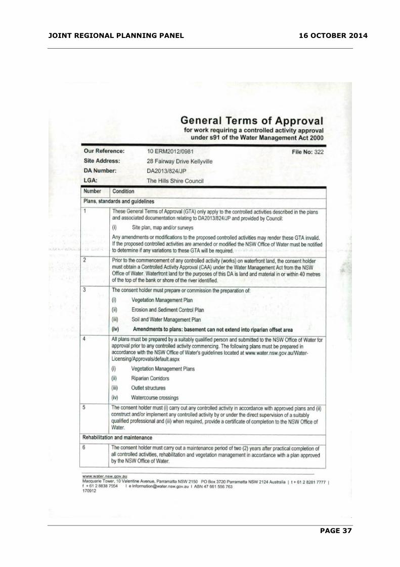
JOINT REGIONAL PLANNING PANEL 16 OCTOBER 2014
PAGE 37

JOINT REGIONAL PLANNING PANEL 16 OCTOBER 2014
PAGE 38

JOINT REGIONAL PLANNING PANEL 16 OCTOBER 2014
PAGE 39

JOINT REGIONAL PLANNING PANEL 16 OCTOBER 2014
PAGE 40
ATTACHMENT 4 – PREVIOUS REPORT TO JRPP MEETING 7 AUGUST 2014

JOINT REGIONAL PLANNING PANEL 16 OCTOBER 2014
PAGE 41

JOINT REGIONAL PLANNING PANEL 16 OCTOBER 2014
PAGE 42

JOINT REGIONAL PLANNING PANEL 16 OCTOBER 2014
PAGE 43
JOINT REGIONAL PLANNING PANEL 16 OCTOBER 2014
PAGE 44

JOINT REGIONAL PLANNING PANEL 16 OCTOBER 2014
PAGE 45

JOINT REGIONAL PLANNING PANEL 16 OCTOBER 2014
PAGE 46

JOINT REGIONAL PLANNING PANEL 16 OCTOBER 2014
PAGE 47

JOINT REGIONAL PLANNING PANEL 16 OCTOBER 2014
PAGE 48

JOINT REGIONAL PLANNING PANEL 16 OCTOBER 2014
PAGE 49
JOINT REGIONAL PLANNING PANEL 16 OCTOBER 2014
PAGE 50

JOINT REGIONAL PLANNING PANEL 16 OCTOBER 2014
PAGE 51

JOINT REGIONAL PLANNING PANEL 16 OCTOBER 2014
PAGE 52

JOINT REGIONAL PLANNING PANEL 16 OCTOBER 2014
PAGE 53

JOINT REGIONAL PLANNING PANEL 16 OCTOBER 2014
PAGE 54
JOINT REGIONAL PLANNING PANEL 16 OCTOBER 2014
PAGE 55

JOINT REGIONAL PLANNING PANEL 16 OCTOBER 2014
PAGE 56

JOINT REGIONAL PLANNING PANEL 16 OCTOBER 2014
PAGE 57

JOINT REGIONAL PLANNING PANEL 16 OCTOBER 2014
PAGE 58
JOINT REGIONAL PLANNING PANEL 16 OCTOBER 2014
PAGE 59

JOINT REGIONAL PLANNING PANEL 16 OCTOBER 2014
PAGE 60

JOINT REGIONAL PLANNING PANEL 16 OCTOBER 2014
PAGE 61

JOINT REGIONAL PLANNING PANEL 16 OCTOBER 2014
PAGE 62

JOINT REGIONAL PLANNING PANEL 16 OCTOBER 2014
PAGE 63

JOINT REGIONAL PLANNING PANEL 16 OCTOBER 2014
PAGE 64

JOINT REGIONAL PLANNING PANEL 16 OCTOBER 2014
PAGE 65

JOINT REGIONAL PLANNING PANEL 16 OCTOBER 2014
PAGE 66

JOINT REGIONAL PLANNING PANEL 16 OCTOBER 2014
PAGE 67

JOINT REGIONAL PLANNING PANEL 16 OCTOBER 2014
PAGE 68
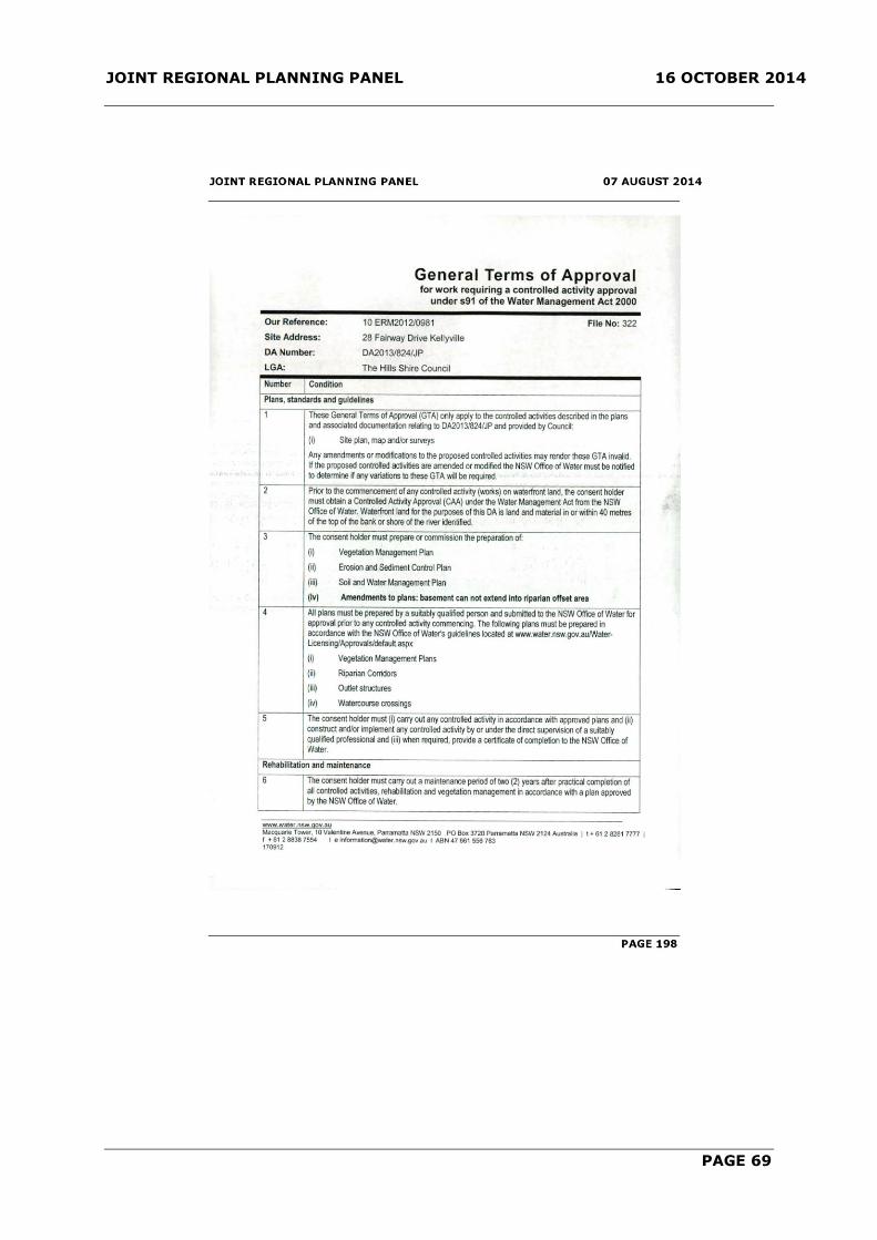
JOINT REGIONAL PLANNING PANEL 16 OCTOBER 2014
PAGE 69
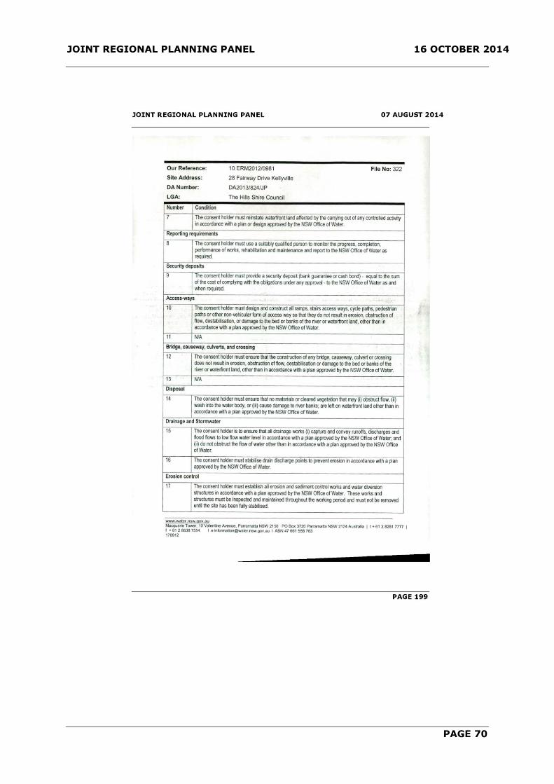
JOINT REGIONAL PLANNING PANEL 16 OCTOBER 2014
PAGE 70

JOINT REGIONAL PLANNING PANEL 16 OCTOBER 2014
PAGE 71
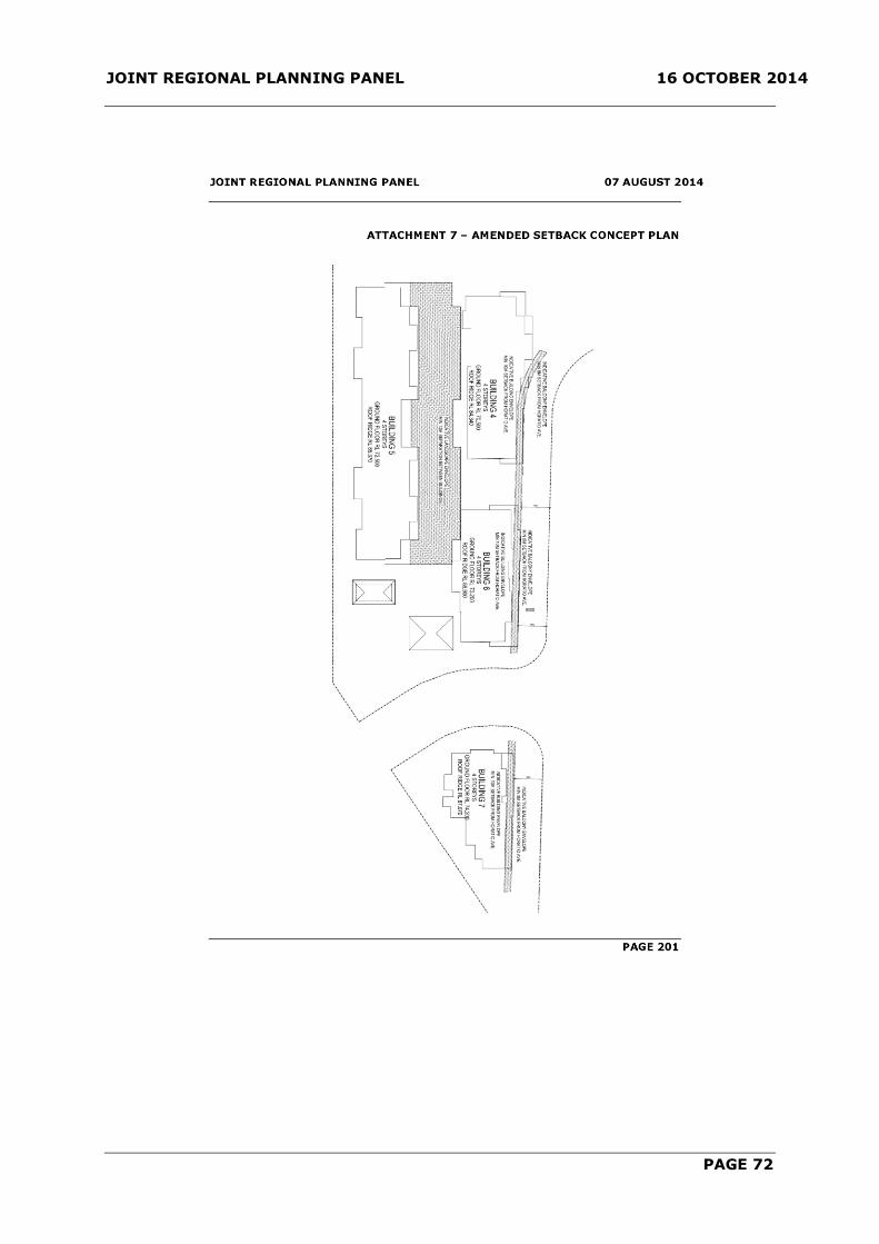
JOINT REGIONAL PLANNING PANEL 16 OCTOBER 2014
PAGE 72

JOINT REGIONAL PLANNING PANEL 16 OCTOBER 2014
PAGE 73
ITEM-2 JRPP REPORT - DA 1194/2014/JP
(Sydney West Region)
JRPP No 2014SYW052
DA Number DA 1194/2014/JP
Local Government Area THE HILLS SHIRE COUNCIL
Proposed Development AN INTEGRATED HOUSING DEVELOPMENT COMPRISING
153 DWELLINGS AND COMMUNITY TITLE SUBDIVISION
Street Address LOT 48 DP 280036 CADDIES BOULEVARD, ROUSE HILL
Applicant/Owner LEND LEASE GPT ROUSE HILL PTY LTD
Number of Submissions One
Regional Development
Criteria (Schedule 4A
of the Act)
Capital Investment value exceeding $20 Million
List of All Relevant
s79C(1)(a) Matters
LEP 2012
DCP Part D Section 6 – Rouse Hill Regional Centre
SEPP 32 – Urban Consolidation (Redevelopment of
Urban Land)
SREP 20 – Hawkesbury Nepean River
List all documents
submitted with this report
for the panel’s
consideration
Nil
Recommendation Approval subject to conditions
Report by Kristine McKenzie
Principal Executive Planner
EXECUTIVE SUMMARY
The proposal is for the erection of 153 detached dwellings and associated Community
Title subdivision and associated Community Title subdivision. The dwellings all have 3
bedrooms and comprise a variety of external designs and finishes.
The proposal includes a variation to the minimum 240m2 lot size for integrated housing
development under LEP 2012. The proposed lots the subject of the variation range from
181.1m2 to 239.2m2, being a maximum variation of 24.6%. Small lot housing was
always envisaged in the planning of the Rouse Hill Release Area and the concept pre-
dates the minimum lot size provisions of LEP 2012. Overall, Lend Lease have advised
that integrated housing will form approximately 19% of the housing yield within the
Regional Centre. The development site is close to the Town Centre, schools, community
and open space. Integrated housing delivered to date has been of a good quality and
readily accepted by the market.
JOINT REGIONAL PLANNING PANEL 16 OCTOBER 2014
PAGE 74
The proposal also includes variations to DCP Part D Section 6 – Rouse Hill Regional
Centre in regard to height, front articulation zone, corner articulation zone, non-
provision of a blade privacy wall, side setbacks and solar access. The proposed variations
are considered satisfactory as they will not result in an adverse impact to the
streetscape. The use of an integrated scheme also allows a known built form outcome for
adjoining dwellings.
The proposed development is similar in style to a number of existing developments
constructed within the Rouse Hill Regional Centre and the subject site is a discrete site
separated by public roads and open space from adjoining existing or future residential
development.
The proposal was advertised and notified to adjoining property owners. There was one
submission received to the proposal which raised concern regarding traffic and vehicle
safety at the intersection of Caddies Boulevard and Sanctuary Drive. The traffic volume
generated by the proposal is satisfactory and will not adversely impact on local roads, is
in keeping with the outcomes expected from the approved Masterplan and will not
adversely impact on intersections.
The Development Application is recommended for approval subject to conditions.
In the absence of the JRPP process, this matter would be determined by Council due to
the variation to LEP lot size standard exceeding 10%.
BACKGROUND MANDATORY REQUIREMENTS
Owner: Minister
administering the
EP and A Act
1. LEP 2012 – Permissible with
consent. Variation to lot size which
requires use of Clause 4.6.
Zoning: Part R3 Medium
Density
Residential, R4
High Density
Residential and B4
Mixed Use
2. DCP Part D Section 6 – Rouse Hill
Regional Centre - Variations
required, see report.
Area: 3.47 hectares 3. Section 79C (EP&A Act) –
Satisfactory.
Existing Development: Vacant land 4. Section 94 Contribution - N/A
however a Planning Agreement
applies to the site.

JOINT REGIONAL PLANNING PANEL 16 OCTOBER 2014
PAGE 75
SUBMISSIONS REASON FOR REFERRAL TO JRPP
1. Exhibition: Yes, 14 days. 1. Capital Investment Value in excess
of $20 million pursuant to SEPP
(Major Development) 2005.
2. Notice Adj Owners: Yes, 14 days.
3. Number Advised: 23
4. Submissions
Received:
One
HISTORY
10/01/2013 Development Application 1210/2011/HB approved for the
revised Central Precinct Plan at Council’s Delegated Authority
Meeting.
24/01/2013 Subdivision Development Application 250/2013/ZB approved
under Delegated Authority for the subdivision of Lot 8 and Lot 23
DP 270520 into a Community Title subdivision creating six
residential lots, 18 residue lots and eight community association
lots including a new road in three stages.
18/10/2013 Modification Application 250/2013/ZB/A approved under
Delegated Authority for amendments including lot numbering,
road pattern, lot dimensions and lot areas.
31/03/2014 Subject Development Application lodged.
12/05/2014 Letter sent to the applicant requesting additional information
regarding compliance with DCP Part D Section 6 – Rouse Hill
Regional Centre, submission of additional/revised plans,
additional information regarding secondary dwellings,
submission of landscape plans, submission of an acoustic report,
timing of park embellishment works, waste collection details and
engineering matters.
24/06/2014 and
17/07/2014
Additional information submitted by the applicant.
03/09/2014 Modification Application 250/2013/ZB/B approved under
Delegated Authority for amendments including lot numbering,
road pattern, new/amended laneways and amended staging.
08/09/2014 Email sent to the applicant requesting additional information
regarding balcony locations for the secondary dwellings and
setbacks.
12/09/2014 and
16/09/2014
Additional information submitted by the applicant.

JOINT REGIONAL PLANNING PANEL 16 OCTOBER 2014
PAGE 76
PROPOSAL
The Development Application is for an integrated housing development of 153 detached
dwellings and associated Community Title subdivision. The site is located within the
‘Central Residential Precinct’ of Rouse Hill Regional Centre.
The proposed dwellings are all two storey in design, with eight designs and five façade
treatments. The dwellings will have external finishes including brick and moroka painted
finishes with colorbond roofing.
In addition, five secondary dwellings are proposed above detached garages. The Granny
flat is a studio unit containing one larger room with kitchen at one end with an en-suite.
The granny flat has separate external stairs to provide access.
As outlined in the history, Subdivision Development Application 250/2013/ZB has been
approved which created parent development lots and included road and laneway
construction. These works include the ‘link’ of Civic Way to White Hart Drive i.e.: the
Central Residential Precinct to the Town Centre. This approval has not been acted upon.
ISSUES FOR CONSIDERATION
1. SEPP State and Regional Development 2011
Clause 20 of SEPP (State and Regional Development) 2011 and the Schedule 4A of the
Environmental Planning and Assessment Act, 1979 provides the following referral
requirements to a Joint Regional Planning Panel:-
Development that has a capital investment value of more than $20 million.
The proposed development has a capital investment value of $30,722,195 thereby
requiring referral to, and determination by, a Joint Regional Planning Panel.
2. Compliance with LEP 2012
The site is zoned part R3 Medium Density Residential, part R4 High Density Residential
and part B4 Mixed Use. The proposed works are located on the part of the site which is
zoned R3 Medium Density Residential and R4 High Density Residential. The proposed use
is for integrated housing which is a permissible use in the R3 Medium Density Residential
and R4 High Density Residential zones.
The proposal includes a variation to the minimum 240m2 lot size for integrated housing
development under LEP 2012. The proposed lots the subject of the variation range from
181.1m2 to 239.2m2, being a maximum variation of 24.6%.
LEP 2012 states as follows:
4.1B Exceptions to minimum lot sizes for certain residential development
(1) The objective of this clause is to encourage housing diversity without adversely
impacting on residential amenity.
(2) This clause applies to development on land in the following zones:
(a) Zone R3 Medium Density Residential
(b) Zone R4 High Density Residential

JOINT REGIONAL PLANNING PANEL 16 OCTOBER 2014
PAGE 77
(3) Development consent may be granted to a single development application for
development to which this clause applies that is both of the following:
(a) the subdivision of land into 3 or more lots,
(b) the erection of an attached dwelling or a dwelling house on each lot
resulting from the subdivision, if the size of each lot is equal to or greater
than:
(i) for the erection of a dwelling house - 240 square metres or
(ii) for the erection of an attached dwelling - 240 square metres.
The proposal satisfies the definition in that the proposal is for subdivision and the
erection of dwellings however 115 of the 153 proposed lots do not exceed 240m2. The
proposed lots are:
LOT AREA (m2) COMPLIES LOT AREA (m2) COMPLIES
132 272 Yes 209 230.8 No
133 181.1 No 210 205.2 No
134 181.1 No 211 205.2 No
135 181.1 No 212 205.2 No
136 293.9 Yes 213 301.4 Yes
137 293.9 Yes 214 344.6 Yes
138 181.1 No 215 229.9 No
139 181.1 No 216 247.5 Yes
140 181.1 No 217 314.8 Yes
141 227.6 No 218 196.5 No
142 276.6 Yes 219 195.6 No
143 217.7 No 220 307 Yes
144 232.5 No 221 193.3 No
145 190.7 No 222 192.4 No
146 231.9 No 223 239.2 No
147 181.1 No 224 300.3 Yes
148 181.1 No 225 312.3 Yes
149 250.8 Yes 226 272.3 Yes
150 224.9 No 227 248.6 Yes
151 181.1 No 228 228 No
152 181.1 No 229 228 No
153 188.7 No 230 228 No
154 190.8 No 231 250.7 Yes
155 187.9 No 232 250.7 Yes
156 192.9 No 233 219.1 No
157 277.9 Yes 234 260.6 Yes
158 279.9 Yes 235 358.9 Yes
159 191.9 No 236 184.3 No
160 191.9 No 237 207.6 No
161 227.9 No 238 215 No
162 272.9 Yes 239 233.8 No
163 187.1 No 240 316.7 Yes
164 265.7 Yes 241 253.6 Yes
165 238 No 242 230.5 No
166 219.5 No 243 292.7 Yes
167 231 No 244 362.1 Yes
168 193.1 No 245 212.7 No
169 289.6 Yes 246 215.3 No
170 209 No 247 217.8 No

JOINT REGIONAL PLANNING PANEL 16 OCTOBER 2014
PAGE 78
171 208.9 No 248 198.9 No
172 210.2 No 249 232.3 No
173 212.4 No 250 217.7 No
174 238.4 No 251 223.5 No
175 258.5 Yes 252 226.6 No
176 382.5 Yes 253 201.4 No
177 203.7 No 254 295.7 Yes
178 203.7 No 255 267.6 Yes
179 203.7 No 256 201.4 No
180 203.7 No 257 201.4 No
181 203.7 No 258 226.6 No
182 203.7 No 259 201.4 No
183 203.7 No 260 201.4 No
184 203.7 No 261 226.6 No
185 203.7 No 262 201.4 No
186 233 No 263 201.4 No
187 324.3 Yes 264 226.6 No
188 211.3 No 265 201.4 No
189 181.1 No 266 201.4 No
190 181.1 No 267 201.4 No
191 181.1 No 268 221.9 No
192 181.1 No 269 217.6 No
193 289.6 Yes 270 232.3 No
194 289.5 Yes 271 207.1 No
195 181.1 No 272 201.4 No
196 224.3 No 273 201.4 No
197 305.8 Yes 274 201.4 No
198 240.2 Yes 275 226.6 No
199 228 No 276 201.4 No
200 228 No 277 201.4 No
201 225.9 No 278 226.6 No
202 219 No 279 201.4 No
203 311.9 Yes 280 201.4 No
204 283.9 Yes 281 226.6 No
205 205.2 No 282 201.4 No
206 230.9 No 283 201.4 No
207 205.2 No 284 267.6 Yes
208 205.2 No
The applicant has submitted the following as justification:
Clause 4.6 of the Hills Shire LEP 2012 provides a process the make exceptions to
standards and comment is provided for each as follows:-
(3) Development consent must not be granted for development that contravenes a
development standard unless the consent authority has considered a written
request from the applicant that seeks to justify the contravention of the
development standard by demonstrating:
(a) that compliance with the development standard is unreasonable or unnecessary
in the circumstances of the case, and
(b) that there are sufficient environmental planning grounds to justify contravening
the development standard.

JOINT REGIONAL PLANNING PANEL 16 OCTOBER 2014
PAGE 79
Both the parent lot provision requiring 1,800m2 and the minimum lot size provision are
new controls that previously did not apply to this form of housing under the previous
planning controls. Indeed, most of the integrated housing and medium density
development so far delivered in the Rouse Hill Release Area has been approved on lots
less than 240m2.
The variation of the parent lot provision (Clause 4.1A) still enables lot sizes for the
development of a comprehensive housing solution in this part of the site as only laneway
and pedestrian connections break up the lots to result in parcels less than 1,800m2. The
DCP controls have been tailored to address the design of dwellings on lots less than
240m2 consistent with the street blocks already approved in the Central Precinct, which
in part facilitates the overall housing density range to be delivered from the Rouse Hill
Regional Centre.
All townhouses and integrated housing product delivered to date has been of superior
quality with high levels of amenity that has been well accepted in the market place. This
track record confirms that LLGPT are capable of delivering this product on lots less than
240m2 and hence this provision should be varied. The proposed development is
generally consistent with all controls which guide built form, provision of landscape,
private open space and control amenity impacts.
The proposed lot size is considered suitable to accommodate the proposed development.
(4) Development consent must not be granted for development that contravenes a
development standard unless:
(a) the consent authority is satisfied that:
(i) the applicant’s written request has adequately addressed the matters required to be
demonstrated by subclause (3), and
(ii) the proposed development will be in the public interest because it is consistent with
the objectives of the particular standard and the objectives for development within the
zone in which the development is proposed to be carried out, and
The proposed development is in the public interest as it is consistent with the objectives
and the planning framework for Rouse Hill which did not, up until the gazettal of the new
LEP, contain these minimum lots size provisions for what was previously integrated
housing. Council has consistently confirmed that the LEP process was not to remove
development rights which were built into the planning framework for the delivery of
Rouse Hill. Clause 4.6 of the LEP, which enables variation of the development standard,
will ensure Council can maintain this commitment.
(b) the concurrence of the Director-General has been obtained.
Practice Note PS08-003 issued by the Department of Planning and Infrastructure notifies
Councils of arrangements where the Director General’s concurrence can be assumed.
This applies to the standards for which exceptions are sought.
Comment:
The proposed lot areas have been reviewed. Whilst 115 lots do not comply with the LEP
2012 provision, the proposal will result in a satisfactory built form outcome. The
objective of Clause 4.1B is:
The objective of this clause is to encourage housing diversity without adversely
impacting on residential amenity.

JOINT REGIONAL PLANNING PANEL 16 OCTOBER 2014
PAGE 80
The proposed integrated housing development will encourage housing diversity as it
allows for a smaller lot size and built form. The dwellings proposed are modest in size
and design. The proposed dwellings will not adversely impact upon adjoining properties
in respect to residential amenity.
The proposed development is similar in style to a number of existing developments
constructed within the Regional Centre area. The proposal is in keeping with the existing
streetscape of the area and provides a modern dwelling design. Whilst the proposal does
not achieve the minimum site area required under LEP 2012, the proposal provides
adequate landscaped private open space areas, privacy between dwellings and a
functional internal design.
The built form reflects the design of dwellings within the immediate area and allows
reasonable solar access to courtyard areas. The proposal provides an opportunity for a
mix of dwelling types within close proximity to the established Town Centre. Schools,
community facilities and open space are also available within walking distance of the
site.
Based on the above comments it is considered that an appropriate built form outcome
will be achieved which increases housing diversity without adversely impacting upon
residential amenity.
Clause 4.6 (4) of LEP 2012 states:
Development consent must not be granted for development that contravenes a
development standard unless:
(a) the consent authority is satisfied that:
(i) the applicant’s written request has adequately addressed the matters required to
be demonstrated by subclause (3), and
Comment: The applicant has adequately addressed the matters required to be addressed
by subclause (3).
(ii) the proposed development will be in the public interest because it is consistent
with the objectives of the particular standard and the objectives for development
within the zone in which the development is proposed to be carried out, and
Comment: As detailed above, the proposal is an appropriate development outcome in
regard to public interest and is consistent with the objectives of the R3 Medium Density
Residential and R4 High Density Residential zones.
(b) the concurrence of the Director-General has been obtained.
Comment: Council has assumed concurrence under the provisions of Circular PS 08–003
issued by the Department of Planning and infrastructure.
On the basis of the above comments, the proposed variation to the lot size is considered
reasonable and will not result in an adverse impact on residential amenity to future
residents.
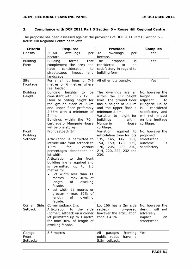
JOINT REGIONAL PLANNING PANEL 16 OCTOBER 2014
PAGE 81
2. Compliance with DCP 2011 Part D Section 6 – Rouse Hill Regional Centre
The proposal has been assessed against the provisions of DCP 2011 Part D Section 6 –
Rouse Hill Regional Centre as follows:
Criteria Required Provided Complies
Density 30-60 dwellings per
hectare.
32 dwellings per
hectare.
Yes
Building
Form
Building forms that
complement the area and
have consideration to
streetscape, impact and
landscape.
The proposal is
considered to be
satisfactory in regard to
building form.
Yes
Site
Frontage
For small lot housing, 7-9
metres or 6 metres where
rear loaded.
All other lots comply. Yes
Building
Height
Building heights to be
consistent with LEP 2012.
Floor to ceiling height for
the ground floor of 2.7m
and upper floor preferably
2.55m with a minimum of
2.4m.
Buildings within the 70m
curtilage of Mungerie House
will be one storey.
The dwellings are all
within the LEP height
limit. The ground floor
has a height of 2.75m
and the upper floor a
minimum 2.4m.
Variation to height for
buildings within
Mungerie House
curtilage.
No, however the
height limit
adjacent to
Mungerie House
is considered
satisfactory and
will not impact
on the heritage
curtilage.
Front
Building
Setback
Front setback 3m.
Articulation is permitted to
intrude into front setback to
1.5m for various
percentages dependent on
lot width.
Articulation to the front
building line is required and
is permitted up to 1.5
metres for:
Lot width less than 11
metres - max 40% of
length of dwelling
facade.
Lot width 11 metres or
greater - max 50% of
length of dwelling
facade.
Variation required to
articulation zone for lots
135, 145, 147, 152,
154, 159, 173, 175,
176, 205, 209, 210,
214, 220, 227, 232 and
239.
No, however the
proposed
streetscape
outcome is
satisfactory.
Corner Side
Setback
Corner setback 2m.
Articulation to the side
(corner) setback on a corner
lot permitted up to 1 metre
for max 40% of length of
dwelling facade.
Lot 166 has a 2m side
setback proposed
however the articulation
zone is 43%.
No, however the
design will not
adversely
impact on
streetscape.
Garage
Front
Setbacks
5.5 metres All garages fronting
public roads have a
5.5m setback.
Yes

JOINT REGIONAL PLANNING PANEL 16 OCTOBER 2014
PAGE 82
Rear
Setback
Ground floor rear setback
4m.
Upper floor setbacks to rear
boundary:
Lot depth less than 30m -
5m.
Lot depth 30m or greater –
7m
Garage setback to rear lane
- 0.5m
Articulation in the rear
setback is permitted up to
1.5m and shall include a
blade wall.
The proposed rear
setback to Lot 234 is
3.7m however no blade
wall has been provided.
No, however the
rear setback and
impacts on
privacy are
considered
reasonable.
Side
Setbacks
Detached or zero lot line:
Lot width less than 11m –
1m
Lot width 11-13.5m – 1.2m
Lot width greater than
13.5m – 1.5m
Note: zero lot lines are
permitted.
Variation to side
setbacks for Lots 132,
136, 137, 143, 162,
193, 194, 196, 197,
214, 220, 224, 227 and
232.
No, however the
separation
between
buildings is
considered
adequate to
maintain
amenity.
Building
Appearance
and
Articulation
The provision of interest in
design, articulation, and an
attractive streetscape.
The proposed buildings
are considered to be
satisfactory in terms of
design and external
appearance.
Yes
Roof Design Roof designs are to create
interest and diversity in
design.
The proposed roof
designs are considered
to be satisfactory.
Yes
Driveways 500mm landscape strip
required along all
driveways, and crossovers
widths required to be 3m.
All dwellings provide a
500mm landscape strip.
Yes
Carparking Dwellings with 1-3
bedrooms are required to
provide 1 space.
All lots have either a
single or double garage.
Yes
Garage
Design
Garages are to be designed
to be consistent with the
dwelling design and external
materials.
The proposed garages
are satisfactory in
regard to their design.
Yes
Solar Access Dwellings to comply with
BASIX. Buildings are to be
designed to optimise solar
access requirements and to
minimise impact to
adjoining properties.
Typically a minimum of 3
hours solar access to a
living area of each dwelling
is required.
All dwellings provide
satisfactory BASIX
outcomes. All dwellings
have been designed to
achieve reasonable
solar access outcomes.
Yes

JOINT REGIONAL PLANNING PANEL 16 OCTOBER 2014
PAGE 83
Landscaping A minimum 40% of each lot
shall be soft landscaping.
All lots provide in
excess of 40% soft
landscape area.
Yes
Private and
Common
Open Space
Minimum of 23% of the lot
area for lots up to 400m2,
primary area of 4m x 6m.
A portion of the private
open space areas can be
roofed or covered however
no roofing to encroach into
setback areas.
All lots provide in
excess of 23%, with
appropriate dimensions
and which are useable
areas.
Yes
Solar Access
to Private
Open Space
50% of required private
open space shall receive 3
hours of solar access
between 9am and 3pm on
June 21 (exception may be
considered if in specific
circumstances the
compliance would unduly
affect functionality or
liveability).
A variations is proposed
to the following lots:
133, 134, 135, 143,
144, 145, 146, 147,
148, 223, 231, 248,
269 and 271.
No, however the
solar access
provided to the
dwellings is
reasonable.
Fencing and
Courtyard
Walls
Fencing is to complement
the design of the building
and define private space.
Front fence height to be a
maximum 1.2m and be 25%
transparent. Side and rear
fencing is to be 1.8m high
and either masonry or
timber.
Corner lot fencing that is
1.8m high is to be no more
than 50% of the length of
the lot.
The proposed fencing is
satisfactory and will
complement the
dwelling designs.
Yes
Designing
for Privacy
Second storey windows
within or 4.5m of a side
boundary are to have
privacy measures, and 5m
of a rear boundary of a 25m
deep lot are to have
permanent privacy
measures applied.
A condition of consent
has been recommended
requiring the use of
privacy measures on
relevant windows. See
Condition 27.
Yes
a. Height within Heritage Curtilage
The DCP requires that dwellings within the 70 metre curtilage of Mungerie House are to
be single storey in design. The height limit is also required in the Masterplan and the
Central Precinct Plan. The applicant has proposed two storey dwellings in the 70 metre
curtilage. Attachment 6 shows the 70 metre curtilage around Mungerie House.
The applicant has submitted a Statement of Heritage Impact addressing the proposed
height which concludes as follows:

JOINT REGIONAL PLANNING PANEL 16 OCTOBER 2014
PAGE 84
This report concludes that the proposal for the inclusion of 2 storey town house dwellings
within the single storey limit of the Mungerie House Curtilage:
will not affect preservation of the heritage significance of the Homestead and its
setting,
will not affect any significant views to or from Mungerie House or its precinct,
will contribute to the establishment of an attractive streetscape in the New Rouse
Hill Regional Centre, complementing the setting of the Mungerie House Precinct.
Comment:
The proposal has been reviewed by Council’s Senior Strategic Planner who has concluded
as follows:
The proposed development will have a shared streetscape relationship with Mungerie
House, at the perimeter of its established curtilage. Mungerie House is separated
from the proposed development by a road, car parking bays, streets tree plantings,
the reconstituted landscape gardens of Mungerie House and the water-tank tower. It
is unlikely that these relationships will be affected by the proposal to include two
storey dwellings within the outer area of the perimeter of the curtilage;
The prominence of Mungerie House, including primary vistas to and from the house
will be retained. It is unlikely that any identified views to and from Mungerie House
would be unreasonably affected by the proposed development;
The proposed dwellings will be constructed of a range of materials that are
sympathetic to the character of the Mungerie House Precinct with articulated massing
to minimise adverse visual impacts on Mungerie House. The proposed colour and
materials schedule is considered to be appropriate and sympathetic to the heritage
item;
The proposed orientation of the dwellings towards Mungerie House provides a better
urban design outcome with respect to activation of the street frontage and visual
appearance when viewed from Mungerie House as compared to the single storey
streetscape outcome. The proposed dwellings will ultimately contribute to the
establishment of an attractive streetscape, complementing the setting of Mungerie
House; and
The proposed two storey dwellings are unlikely to reduce the prominence of Mungerie
House within its setting. The use of sympathetic materials with articulated building
massing and established landscaping and street trees are expected to minimise any
adverse visual impacts from the increased height of the dwellings.
On this basis no objection is raised to the proposed two storey design.
b. Front Articulation Zone
The DCP requires a front setback of 3 metres and allows articulation into the front
setback to either 40% or 50% of the frontage dependent on lot width. The proposal
includes variations to the extent of the articulation zone on the following lots:

JOINT REGIONAL PLANNING PANEL 16 OCTOBER 2014
PAGE 85
Proposed
Lot
Articulation
Zone
Required
Proposed
Articulation
Zone
Proposed
Lot
Articulation
Zone
Required
Proposed
Articulation
Zone
135 40% 48.2% 205 40% 58.5%
145 50% 57.6% 209 40% 62.7%
147 40% 48.2% 210 40% 58.5%
152 40% 57.6% 214 50% 56%
154 40% 48.2% 220 50% 51.6%
159 40% 58.5% 227 50% 57.6%
173 40% 58.4% 232 50% 57.6%
175 40% 62.4% 239 40% 58.5%
176 50% 58.7%
The applicant has addressed the variation as follows:
The DCP requires an assessment of the articulation against the length of the dwelling
façade. It is disagreed that the DCP allows assessment at different levels as this would
result in very undesirable streetscape, limiting variation and interest, particularly on an
upper level where the setting back upper floors would lead to tokenistic gestures rather
than features that add amenity for residents and improve streetscape.
The principles for setting controls for setbacks are primarily to allow solar access to open
space areas, minimise impacts on adjacent allotments, contribute to reducing bulk to the
streetscape, reduce the impact of garages, and allow for landscape spaces within each
allotment to address the streetscape.
Articulations in the front setback and façade are required to allow larger gardens, private
front courtyard solutions, and visual interest in the front of the home. The current DCP
controls preserve the ability to ensure the objectives and principles for the front setback
are upheld when assessing individual dwelling designs in the absence of designs
for adjacent dwellings. As such the controls ensure the outcomes can be achieved
despite in the absence of the benefit of having dwelling design for all adjacent dwellings.
The current application contains details for the façade, articulation, landscaping and
privacy measures for all adjacent dwellings whereby the impacts on adjacent dwellings
resulting from to the additional articulation can be reviewed and assessed. The features
that extend into the articulation zone, not only contribute to the streetscape, but also
add to the livability of the dwelling for future residents. They do not typically extend into
the articulation zone to the maximum allowed by the DCP, and are designed to be
usable, rather than an architectural gesture which has no function or benefit to the
resident.
Despite some dwellings containing front articulation areas exceeding the ratio compared
to the length of dwelling nominated in the DCP controls, there are no adverse impacts on
the adjacent dwellings, the streetscape or residential amenity.
Comment:
The principles within the DCP relate to defining the built area, provision of solar access
to rear yards, minimising impact to adjoining property, streetscape appearance and
minimising bulk of garages, and allowing landscape works to be undertaken.
The proposed variation has been assessed having regard to the objectives of the DCP
and is considered to be satisfactory given that the proposal will not create an adverse
impact upon streetscape and allows for appropriate articulation for the scale and design

JOINT REGIONAL PLANNING PANEL 16 OCTOBER 2014
PAGE 86
of the dwellings. Adequate area remains for landscape planting on the site, the provision
of a useable private open space and solar access.
As the development is proposed as an ‘integrated’ form of development the adjoining
development is a known outcome. As such, future residents will have appropriate levels
of amenity.
On this basis the proposed setback is considered satisfactory.
c. Articulation to a Corner Lot
The DCP limits the articulation zone to 40% for a corner lot. For Lot 166 the proposed
articulation zone is 43% which relates to the provision of a pergola over an entry to the
courtyard.
The applicant has addressed the variation as follows:
The proposed articulation along the secondary frontage extends for 43% of the dwelling
façade exceeding the DCP by 3% or 0.342m however this extended articulation zone
increases solar access into the dwelling without adverse impacts to solar access on
adjacent dwellings, assists in reducing the bulk of the frontage while providing for a
continuous landscape space along the entire frontage.
Comment:
The principles within the DCP relate to defining the built area, provision of solar access
to rear yards, minimising impact to adjoining property, streetscape appearance and
minimising bulk of garages, and allowing landscape works to be undertaken.
The proposed variation has been assessed having regard to the objectives of the DCP
and is considered to be satisfactory given that the proposal will not create an adverse
impact upon streetscape and allows for appropriate articulation for the scale and design
of the dwellings. The provision of the pergola allows for additional shading over the entry
to the courtyard and is integrated into the design of the dwelling.
On this basis the proposed variation to the articulation zone is considered satisfactory.
d. Rear Setback and Non-Provision of a Blade Wall
The DCP requires a 5m rear setback however an articulation zone can be provided to the
rear building line up to 1.5m. The DCP states that rear articulation shall include a blade
wall for the purpose of increasing privacy. The proposed rear setback to Lot 234 is 3.7m
however no blade wall has been provided.
The applicant has submitted the following justification:
The DCP refers to building articulation can be generated through such features, at no
point does the DCP mandate that articulation zones must include these features or that
articulation zones are expressly prohibited from including such areas as bedrooms. The
example of the rear articulation zone in Council’s report of 23 April 2013 shows
bedrooms within the articulation zone.
The only aspect of the proposed design not complying with this portion of the DCP is the
lack of a blade wall incorporated into the building design to increase privacy between
internal rooms of dwellings sharing a common rear boundary.
In this regard:
JOINT REGIONAL PLANNING PANEL 16 OCTOBER 2014
PAGE 87
The corner of the dwelling provides privacy from Lot 236,
The blade wall on lot 237 (bed 3) provides privacy to Bed 2 in lot 234.
The distance between bedrooms 2 of lots 234 & 237 is greater than the DCP
control for minimum building separation (8m) eliminating the requirement for the
blade wall as the separation exceeds the combined setback requirement without
utilising the articulation zone.
Comment:
The principles within the DCP relate to defining the built area, provision of solar access
to rear yards, minimising impact to adjoining property, streetscape appearance and
minimising bulk of garages, and allowing landscape works to be undertaken.
The proposed dwelling is provided with reasonable access to private open space, solar
access and landscape works. The rear setback is considered satisfactory given that the
development provides a known built form outcome. The dwelling sits at an angle on an
irregularly shaped lot and the non-provision of the blade wall is not considered to reduce
privacy between the subject site and the adjoining rear dwelling.
As such no objection is raised to the proposed variation.
e. Side Setbacks
The DCP requires a varying side setback dependent on the lot width as follows:
Lot width less than 11m 1m side setback
Lot width 11-13.5m 1.2m side setback
Lot width greater than 13.5m 1.5m side setback
The applicant has addressed the variation as follows:
Setbacks address impacts of amenity, privacy, solar access, streetscape and setting.
Because the proposed setback is a minor reduction from the existing standard and
exceeds the requirements under the Codes SEPP and the BCA, it is considered unlikely
that the proposed side setback will create any adverse impact on residential amenity. It
is recommended that the minimum proposed 1m side setback be supported on the basis
that it is unlikely to create adversely impact on residential amenity exceeds the
requirements of State Environmental Planning Policy (Exempt and Complying
Development Codes) 2008 and the Building Code of Australia.
Comment:
The principles within the DCP relate to defining the built area, provision of solar access
to rear yards, minimising impact to adjoining property, streetscape appearance and
minimising bulk of garages, and allowing landscape works to be undertaken.
The proposed variation has been assessed having regard to the objectives of the DCP
and is considered to be satisfactory given that the dwellings have been designed as an
integrated development and as such the adjoining dwelling design is known and impacts
can be considered. The proposed design does not unreasonably impact upon privacy or
overshadowing and adequate area is available for landscape works to be undertaken. the
proposed side setbacks will not create an adverse impact upon streetscape.
On this basis the proposed side setback is considered satisfactory.
JOINT REGIONAL PLANNING PANEL 16 OCTOBER 2014
PAGE 88
f. Solar Access
The DCP requires that 50% of required private open space shall receive 3 hours of solar
access between 9am and 3pm on June 21 (exception may be considered if in specific
circumstances the compliance would unduly affect functionality or liveability). Variations
are proposed to the following lots: 133, 134, 135, 143, 144, 145, 146, 147, 148, 223,
231, 248, 269 and 271.
The applicant has submitted the following as justification:
The shadow diagrams included in the architectural plans shows all the majority of lots
comply with the exception of those street blocks with an east west orientation.
The DCP for Rouse Hill Regional Centre states that “50% of required private open space
shall receive 3 hours of solar access between 9am and 3pm on June 21 (exception may
be considered if in specific circumstances the compliance would unduly affect
functionality or liveability).”
Because of the orientation of these east west blocks there is a higher potential for
dwellings to overshadow each other. One can see from the size of the dwelling that it
also has one of the smallest footprints and hence further reducing the building to
facilitate more solar access would unduly affect the functionality and live-ability of the
dwelling.
The areas of private open space are located directly accessible to living areas for private
recreation and will receive adequate solar access. Solar access is achieved in summer
and mid Spring and Autumn. Given the orientation of the site, the proposed solar access
is considered satisfactory.
Comment:
The principles of the DCP relate to the provision of a usable private open area which
caters to the needs of residents in respect to leisure, recreation and outdoor
entertaining. An adequate area of private open space has been provided which exceeds
the DCP requirements. The private open space area is directly accessible from living
areas of the dwelling and will cater for private recreation needs.
Given the orientation of the site, the proposed solar access is considered satisfactory.
3. Secondary Dwellings
Five of the proposed dwellings will also include a granny flat above the detached garage.
The granny flat is a studio unit containing one larger room with kitchen at one end with
an en-suite and balcony. The granny flats have separate external stairs to provide
access.
The proposed secondary dwelling has been assessed against the relevant provisions of
SEPP (Affordable Rental Housing) 2009.
The SEPP defines a Secondary Dwelling as follows;
“development for the purposes of a secondary dwelling includes the
following:

JOINT REGIONAL PLANNING PANEL 16 OCTOBER 2014
PAGE 89
(a) the erection of, or alterations or additions to, a secondary dwelling,
(b) alterations or additions to a principal dwelling for the purposes of a
secondary dwelling.
Note.
The standard instrument defines secondary dwelling as follows:
secondary dwelling means a self-contained dwelling that:
(a) is established in conjunction with another dwelling (the principal dwelling),
and
(b) is on the same lot of land (not being an individual lot in a strata plan or
community title scheme) as the principal dwelling, and
(c) is located within, or is attached to, or is separate from, the principal dwelling.”
The proposal includes construction of a detached secondary dwelling above the garage to
the rear/side of the proposed principal dwelling.
The SEPP states that a consent authority must not consent to development unless:
SEPP Requirement Proposal Compliance
Total floor area of the principal
dwelling and the secondary dwelling
to be no more than that permitted
under another EPI for a dwelling
house.
LEP 2012 does not set a limit on
floor space on the subject site
therefore the SEPP development
standard is not applicable to the
site.
Yes
Floor area of secondary dwelling
must be no more than 60m²
29m² (all secondary dwellings). Yes
The SEPP also states that the consent authority must not refuse a development on either
of the following grounds:
(a) Site Area if:
(i) the secondary dwelling is located within, or is attached to, the principal
dwelling, or
(ii) the site area is at least 450 square metres,
(b) Parking
if no additional parking is to be provided on the site.
The secondary dwellings are detached from the proposed principal dwelling as they are
located above the detached garage. The following lot sizes apply:
Lot 176 – 382.5m2
Lot 204 – 283.9m2
Lot 216 – 247.5m2
Lot 255 – 267.6m2
Lot 284 – 267.6m2

JOINT REGIONAL PLANNING PANEL 16 OCTOBER 2014
PAGE 90
The applicant has addressed these matters and has stated as follows:
The Masterplan for Rouse Hill has always identified the need to provide a broad range of
housing type including studio apartments and other commitments to increase the range
of smaller housing types to improve affordability. The concept of secondary dwellings is
also specifically addressed in the newly adopted DCP (see Clause 3.1.7 for setbacks for
secondary dwellings above garages).
Comment:
The aims of the SEPP relate to ensuring that a consistent planning regime is provided to
facilitate the effective delivery of affordable rental housing.
In regard to the design the following applies:
• The proposed secondary dwellings are being established with the principal
dwelling on the lot;
• The proposed secondary dwellings are located above the garage for the principal
dwelling. The principal and secondary dwelling are designed to complement each
other;
In terms of impact to adjoining properties, the secondary dwellings are located on lots
which have a rear access laneway or right-of-carriageway. As such there is appropriate
separation between building forms to allow privacy to be maintained to adjoining lots.
A balcony has been provided the secondary dwellings. The balconies are small in area,
and face the lane/right-of-carriageway and are not considered highly useable. In this
respect the use of the balconies is unlikely to result in privacy impacts to adjoining
properties.
On the basis of the design and layout of the secondary dwellings and given the
integrated format of the design ie: all dwellings will be constructed as one development,
it is considered that the proposed layout of the secondary dwellings is satisfactory and
can be supported.
Based on the above the proposed secondary dwellings are permissible and are
satisfactory.
4. Consistency with Approved Precinct Plan and Design Guidelines
a. Approved Precinct Plan
Development Consent was granted on 10 January 2013 for the Central Residential
Precinct Plan (Development Application 1210/2011/HB) at Council’s Delegated Authority
Meeting.
The Precinct Plan contained a number of conditions of consent. The proposal is generally
consistent with the conditions with the exception of Condition 5 which states as follows:
5. Mungerie House Curtilage
All buildings/dwellings within the 70 metre curtilage of Mungerie House as shown
in the Design Guidelines are limited to single storey in height.
The height of the development is addressed in Section 3 above.

JOINT REGIONAL PLANNING PANEL 16 OCTOBER 2014
PAGE 91
The Precinct Plan also included a number of plans which were approved as part of the
Development Consent as follows:-
(i) Drawing 01 - Location Plan – Satisfactory;
(ii) Drawing 02 – Land Use Context – the subject site is identified as being for
residential use. The current proposal is for integrated housing and is satisfactory.
(iii) Drawing 03 – Structure Plan – the road locations and development lots are
consistent.
(iv) Drawing 04 – Pedestrian and Cycle Network – the required pedestrian and cycle
links which affect the site have been provided within the underlying subdivision
application.
(vi) Drawing 05 – Open Space – the site includes a centralised neighbourhood park
and pocket parks.
b. Design Guideline Requirements
In addition to the DCP, the approved Precinct Plan includes Design Guidelines which
provide additional criteria for assessment of any proposal in the Precinct. The Design
Guidelines contain criteria relevant to this application relating to building character and
external materials and colours. The proposed design and external finishes are reflective
of the desired modern character of the area and is considered satisfactory.
5. Submissions
The proposal was advertised and notified to adjoining property owners for 14 days.
There was one submission received which raised the following concerns (summarised):
This development should only be approved subject to upgrade of the intersection
between Caddies Boulevard and Sanctuary Drive to improve safety.
This intersection is already unsafe due to: speed of traffic travelling along
Sanctuary Drive, foliage in the central median strip of Sanctuary Drive, the bend
in the road obscures visibility when turning from Caddies Boulevard into
Sanctuary Drive, cars use this intersection as a u-turn, and fog settles in this
location.
The proposed development and the development of sports fields and housing
estate to the south of Sanctuary Drive will further increase the risk of accidents at
this intersection due to increased traffic volumes.
Council are requested to urgently review and improve the safety of this
intersection, ideally by installing a roundabout which will make the intersection
much safer for traffic turning into Sanctuary Drive from Caddies Boulevard.
Comment:
The proposed development has been reviewed by Council’s Principal Traffic and
Transport Co-ordinator who advised:
The intersection of Caddies Boulevard and Sanctuary Drive is currently operating at a
satisfactory level of service and there is no established accident history. Caddies

JOINT REGIONAL PLANNING PANEL 16 OCTOBER 2014
PAGE 92
Boulevard is a Collector Road with a capacity of up to 6000 vehicles per day and
Sanctuary Drive is a Sub-Arterial Road with a capacity of up to 15,000 vehicles per day.
The roads are not currently operating at these maximum capacities due to future
development potential in the Rouse Hill Regional Centre, Kellyville, Rouse Hill and North
Kellyville. The sight distance has been reviewed and is satisfactory for all turning
movements. There is no requirement for works to be undertaken at the intersection to
improve vehicle access. The concerns raised about overgrown foliage have been
reviewed and there is no trimming works required.
In the future, the intersection of Caddies Boulevard and Sanctuary Drive will be
signalised. This is likely to be paid for jointly by Lend Lease GPT and Council. This will
occur when the warrant for traffic signals and pedestrian access has been met and is
likely to be required when the playing fields and residential development occurs to the
south (around 2016). These works, in conjunction with the on-going development of the
Regional Centre, will form the basis for the future signalisation.
No objection raised to the proposal and no conditions.
SUBDIVISION ENGINEERING COMMENTS
No objection raised to the proposal. Relevant conditions are included in the
recommendation.
TRAFFIC MANAGEMENT COMMENTS
No objection raised to the proposal and no conditions.
TREE MANAGEMENT COMMENTS
No objection raised to the proposal. Relevant conditions are included in the
recommendation.
HEALTH & ENVIRONMENTAL PROTECTION COMMENTS
No objection raised to the proposal. Relevant conditions are included in the
recommendation.
WASTE MANAGEMENT COMMENTS
No objection raised to the proposal. Relevant conditions are included in the
recommendation.
HERITAGE COMMENTS
No objection raised to the proposal. Relevant conditions are included in the
recommendation.
CONCLUSION
The proposal has been assessed against the provisions of Section 79C of the
Environmental Planning and Assessment Act, 1979, Local Environmental Plan 2012 and
Development Control Plan Part D Section 6 – Rouse Hill Regional Centre. The proposed
variation to lot area under Local Environmental Plan 2012 and to height, front
articulation zone, corner articulation zone, non-provision of a blade privacy wall, side
setbacks and solar access under the DCP have been assessed and will not adversely

JOINT REGIONAL PLANNING PANEL 16 OCTOBER 2014
PAGE 93
impact upon amenity to future residents. The submission received to the proposal has
been assessed and does not warrant refusal of the application.
Accordingly the application is recommended for approval subject to conditions.
IMPACTS:
Financial
This matter has no direct financial impact upon Council's adopted budget or forward
estimates.
The Hills Future - Community Strategic Plan
The proposal is considered satisfactory in regard to The Hills Future Community Strategic
plan and will provide housing diversity within the Shire through the provision of smaller
lots with a known built form outcome.
RECOMMENDATION
The Development Application be approved subject to the following conditions.
GENERAL MATTERS
1. Development in Accordance with Submitted Plans
The development being carried out in accordance with the following approved plans and
details, stamped and returned with this consent except where amended by other
conditions of consent.
REFERENCED PLANS AND DOCUMENTS
DRAWING NO. DESCRIPTION DATE
A20321 Sheet 1 Part Product Mix 19.5.14 Rev. D
A20321 Sheet 2 Part Product Mix 19.5.14 Rev. D
A20321 Sheet 2 Overall Site Plan 19.5.14 Rev. E
A20321 Sheet 3 Part Ground Site Plan 19.5.14 Rev. E
A20321 Sheet 4 Part Ground Site Plan 19.5.14 Rev. E
A20321 Sheet 5 Part Ground Site Plan 19.5.14 Rev. E
A20321 Sheet 6 Part Ground Site Plan 19.5.14 Rev. E
A20321 Sheet 7 Part Ground Site Plan 19.5.14 Rev. E
A20321 Sheet 8 Part Ground Site Plan 19.5.14 Rev. E
A20321 Sheet 9 Part Ground Site Plan 19.5.14 Rev. E
A20321 Sheet 10 Part Ground Site Plan 19.5.14 Rev. E
A20321 Sheet 11 Part First Site Plan 19.5.14 Rev. E
A20321 Sheet 12 Part First Site Plan 19.5.14 Rev. E
A20321 Sheet 13 Part First Site Plan 19.5.14 Rev. E
A20321 Sheet 14 Part First Site Plan 19.5.14 Rev. E

JOINT REGIONAL PLANNING PANEL 16 OCTOBER 2014
PAGE 94
A20321 Sheet 15 Part First Site Plan 19.5.14 Rev. E
A20321 Sheet 16 Part First Site Plan 19.5.14 Rev. E
A20321 Sheet 17 Part First Site Plan 19.5.14 Rev. E
A20321 Sheet 18 Part First Site Plan 19.5.14 Rev. E
A20321 Sheet 19 Streetscape Elevations 19.5.14 Rev. E
A20321 Sheet 20 Streetscape Elevations 19.5.14 Rev. E
A20321 Sheet 21 Streetscape Elevations 19.5.14 Rev. E
A20321 Sheet 22 Streetscape Elevations 19.5.14 Rev. E
A20321 Sheet 23 Streetscape Elevations 19.5.14 Rev. E
A20321 Sheet 24 Streetscape Elevations 19.5.14 Rev. E
A20321 Sheet 25 Private Open Space 19.5.14 Rev. E
A20321 Sheet 26 Shadow Analysis Plans 19.5.14 Rev. E
A20321 Sheet 27 Shadow Analysis Plans 19.5.14 Rev. E
A20321 Sheet 28 Shadow Analysis Plans 19.5.14 Rev. E
A20321 Sheet 29 Shadow Analysis Plans 19.5.14 Rev. E
A20321 Sheet 30 Shadow Analysis Plans 19.5.14 Rev. E
A20321 Sheet 31 Shadow Analysis Plans 19.5.14 Rev. E
A20321 Sheet 32 Shadow Analysis Plans 19.5.14 Rev. E
A20321 Sheet 33 Shadow Analysis Plans 19.5.14 Rev. E
A20321 Sheet 34 Shadow Analysis Plans 19.5.14 Rev. E
A20321 Sheet 35 Shadow Analysis Plans 19.5.14 Rev. E
A20321 Sheet 36 Shadow Analysis Plans 19.5.14 Rev. E
A20321 Sheet 37 Shadow Analysis Plans 19.5.14 Rev. E
A20321 Sheet 38 Shadow Analysis Plans 19.5.14 Rev. E
A20321 Sheet 39 Shadow Analysis Plans 19.5.14 Rev. E
A20321 Sheet 40 Shadow Analysis Plans 19.5.14 Rev. E
A20321 Sheet 41 Shadow Analysis Plans 19.5.14 Rev. E
A20321 Sheet 42 Shadow Analysis Plans 19.5.14 Rev. E
A20321 Sheet 43 Shadow Analysis Plans 19.5.14 Rev. E
A20321 Sheet 45 BASIX & Colour Pallet 19.5.14 Rev. E
A20321 Sheet 3 Type A/Façade A Floor Plans 19.5.14 Rev. D
A20321 Sheet 4 Type A/Façade A Elevations 19.5.14 Rev. D
A20321 Sheet 5 Type A/Façade B Floor Plans 19.5.14 Rev. D
A20321 Sheet 6 Type A/Façade B Elevations 19.5.14 Rev. D
A20321 Sheet 7 Type A/Façade C Floor Plans 19.5.14 Rev. D
A20321 Sheet 8 Type A/Façade C Elevations 19.5.14 Rev. D

JOINT REGIONAL PLANNING PANEL 16 OCTOBER 2014
PAGE 95
A20321 Sheet 9 Type A/Façade D Floor Plans 19.5.14 Rev. D
A20321 Sheet 10 Type A/Façade D Elevations 19.5.14 Rev. D
A20321 Sheet 11 Type A/Façade E Floor Plans 19.5.14 Rev. D
A20321 Sheet 12 Type A/Façade E Elevations 19.5.14 Rev. D
A20321 Sheet 13 Type B/Façade A Floor Plans 19.5.14 Rev. D
A20321 Sheet 14 Type B/Façade A Elevations 19.5.14 Rev. D
A20321 Sheet 15 Type B/Façade B Floor Plans 19.5.14 Rev. D
A20321 Sheet 16 Type B/Façade B Elevations 19.5.14 Rev. D
A20321 Sheet 17 Type B/Façade C Floor Plans 19.5.14 Rev. D
A20321 Sheet 18 Type B/Façade C Elevations 19.5.14 Rev. D
A20321 Sheet 19 Type C/Façade A Floor Plans 19.5.14 Rev. D
A20321 Sheet 20 Type C/Façade A Elevations 19.5.14 Rev. D
A20321 Sheet 21 Type C/Façade A Studio Elevations 19.5.14 Rev. D
A20321 Sheet 22 Type C/Façade B Floor Plans 19.5.14 Rev. D
A20321 Sheet 23 Type C/Façade B Elevations 19.5.14 Rev. D
A20321 Sheet 24 Type C/Façade B Studio Elevations 19.5.14 Rev. D
A20321 Sheet 25 Type C/Façade C Floor Plans 19.5.14 Rev. D
A20321 Sheet 26 Type C/Façade C Elevations 19.5.14 Rev. D
A20321 Sheet 27 Type C/Façade C Elevations 19.5.14 Rev. D
A20321 Sheet 28 Type E/Façade A Floor Plans 19.5.14 Rev. D
A20321 Sheet 29 Type E/Façade A Elevations 19.5.14 Rev. D
A20321 Sheet 30 Type E/Façade B Floor Plans 19.5.14 Rev. D
A20321 Sheet 31 Type E/Façade B Elevations 19.5.14 Rev. D
A20321 Sheet 32 Type F/Façade A Floor Plans 19.5.14 Rev. D
A20321 Sheet 33 Type F/Façade A Elevations 19.5.14 Rev. D
A20321 Sheet 34 Type F/Façade B Floor Plans 19.5.14 Rev. D
A20321 Sheet 35 Type F/Façade B Elevations 19.5.14 Rev. D
A20321 Sheet 36 Type G/Façade A Floor Plans 19.5.14 Rev. D
A20321 Sheet 37 Type G/Façade A Elevations 19.5.14 Rev. D
A20321 Sheet 38 Type G/Façade A Garage Elevations 19.5.14 Rev. D
A20321 Sheet 39 Type G/Façade B Floor Plans 19.5.14 Rev. D
A20321 Sheet 40 Type G/Façade B Elevations 19.5.14 Rev. D
A20321 Sheet 41 Type G/Façade B Garage Elevations 19.5.14 Rev. D
A20321 Sheet 42 Type G/Façade C Floor Plans 19.5.14 Rev. D
A20321 Sheet 43 Type G/Façade C Elevations 19.5.14 Rev. D
A20321 Sheet 44 Type G/Façade C Elevations 19.5.14 Rev. D

JOINT REGIONAL PLANNING PANEL 16 OCTOBER 2014
PAGE 96
A20321 Sheet 45 Type H/Façade A Floor Plans 19.5.14 Rev. D
A20321 Sheet 46 Type H/Façade A Elevations 19.5.14 Rev. D
A20321 Sheet 47 Type H/Façade B Floor Plans 19.5.14 Rev. D
A20321 Sheet 48 Type H/Façade B Elevations 19.5.14 Rev. D
A20321 Sheet 49 Type H/Façade C Floor Plans 19.5.14 Rev. D
A20321 Sheet 50 Type H/Façade C Elevations 19.5.14 Rev. D
A20321 Sheet 51 Type H/Façade D Floor Plans 19.5.14 Rev. D
A20321 Sheet 52 Type H/Façade D Elevations 19.5.14 Rev. D
A20321 Sheet 53 Type J/Façade A Ground Floor Plan 19.5.14 Rev. D
A20321 Sheet 54 Type J/Façade A First Floor Plan 19.5.14 Rev. D
A20321 Sheet 55 Type J/Façade A Elevations 19.5.14 Rev. D
A20321 Sheet 56 Type J/Façade B Ground Floor 19.5.14 Rev. D
A20321 Sheet 57 Type J/Façade B First Floor 19.5.14 Rev. D
A20321 Sheet 58 Type J/Façade B Elevations 19.5.14 Rev. D
A20321 Sheet 59 Type J/Façade C Ground Floor 19.5.14 Rev. D
A20321 Sheet 60 Type J/Façade C First Floor 19.5.14 Rev. D
A20321 Sheet 61 Type J/Façade C Elevations 19.5.14 Rev. D
A20321 Sheet 62 Type C/Façade A Floor Plans 19.5.14 Rev. D
A20321 Sheet 63 Type C1/Façade A Elevations 19.5.14 Rev. D
A20321 Sheet 64 Type C1/Façade A Studio Elevations 19.5.14 Rev. D
A20321 Sheet 65 Type G/Façade B Floor Plans 19.5.14 Rev. D
A20321 Sheet 66 Type C1/Façade C Elevations 19.5.14 Rev. D
A20321 Sheet 67 Type C1/Façade C Elevations 19.5.14 Rev. D
A20321 Sheet 68 Type J/Façade C First Floor 19.5.14 Rev. D
A20321 Sheet 69 Type G1/Façade C Elevations 19.5.14 Rev. D
A20321 Sheet 70 Type G1/Façade B Garage Elevations 19.5.14 Rev. D
A20321 Sheet 71 Type G/Façade C Floor Plans 19.5.14 Rev. D
A20321 Sheet 72 Type G1/Façade C Elevations 19.5.14 Rev. D
A20321 Sheet 72 Type G1/Façade C Garage Elevations 19.5.14 Rev. D
Sheet F-01 Fencing Key Plan 20-06-14 Rev. D
Sheet F-02 Fencing Key Plan 20-06-14 Rev. D
Sheet F-03 Fencing Key Plan 20-06-14 Rev. D
Sheet F-04 Fencing Key Plan 20-06-14 Rev. D
Sheet F-05 Fencing Key Plan 20-06-14 Rev. D
L-01 Landscape Plan – Lot 132 Galara Street 07-07-14 Rev. E
L-02 Landscape Plan – Lot 132 Galara Street 07-07-14 Rev. E
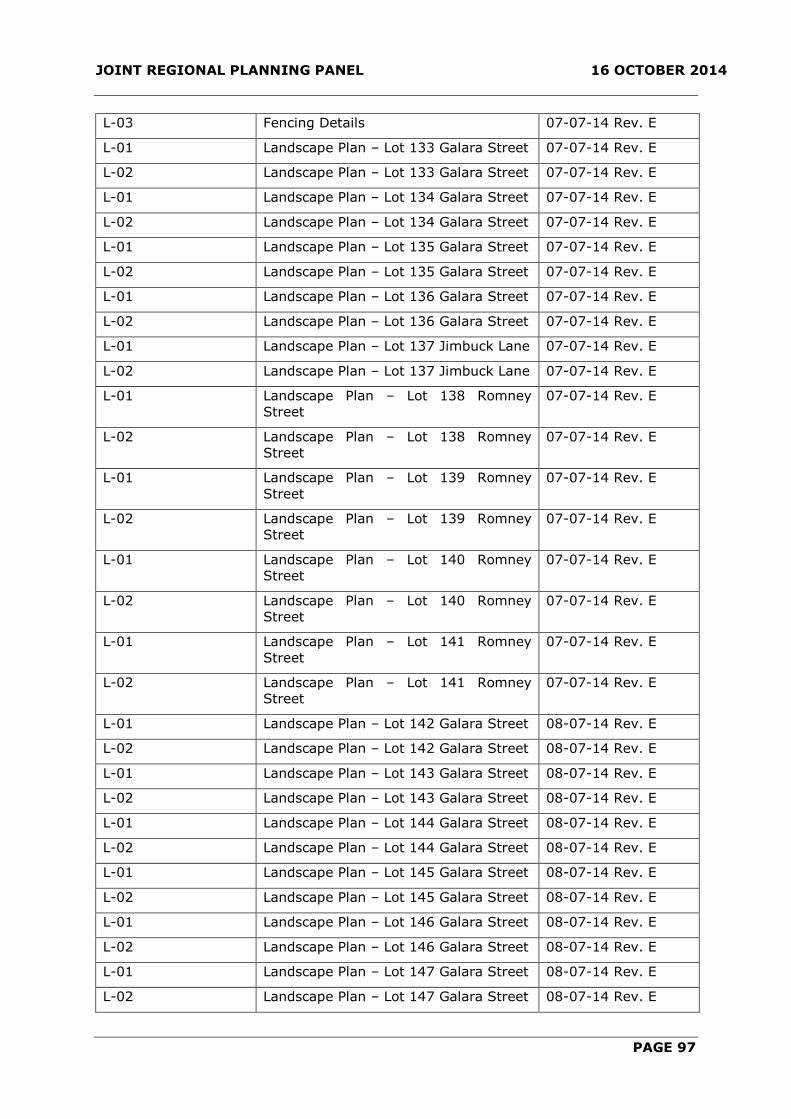
JOINT REGIONAL PLANNING PANEL 16 OCTOBER 2014
PAGE 97
L-03 Fencing Details 07-07-14 Rev. E
L-01 Landscape Plan – Lot 133 Galara Street 07-07-14 Rev. E
L-02 Landscape Plan – Lot 133 Galara Street 07-07-14 Rev. E
L-01 Landscape Plan – Lot 134 Galara Street 07-07-14 Rev. E
L-02 Landscape Plan – Lot 134 Galara Street 07-07-14 Rev. E
L-01 Landscape Plan – Lot 135 Galara Street 07-07-14 Rev. E
L-02 Landscape Plan – Lot 135 Galara Street 07-07-14 Rev. E
L-01 Landscape Plan – Lot 136 Galara Street 07-07-14 Rev. E
L-02 Landscape Plan – Lot 136 Galara Street 07-07-14 Rev. E
L-01 Landscape Plan – Lot 137 Jimbuck Lane 07-07-14 Rev. E
L-02 Landscape Plan – Lot 137 Jimbuck Lane 07-07-14 Rev. E
L-01 Landscape Plan – Lot 138 Romney
Street
07-07-14 Rev. E
L-02 Landscape Plan – Lot 138 Romney
Street
07-07-14 Rev. E
L-01 Landscape Plan – Lot 139 Romney
Street
07-07-14 Rev. E
L-02 Landscape Plan – Lot 139 Romney
Street
07-07-14 Rev. E
L-01 Landscape Plan – Lot 140 Romney
Street
07-07-14 Rev. E
L-02 Landscape Plan – Lot 140 Romney
Street
07-07-14 Rev. E
L-01 Landscape Plan – Lot 141 Romney
Street
07-07-14 Rev. E
L-02 Landscape Plan – Lot 141 Romney
Street
07-07-14 Rev. E
L-01 Landscape Plan – Lot 142 Galara Street 08-07-14 Rev. E
L-02 Landscape Plan – Lot 142 Galara Street 08-07-14 Rev. E
L-01 Landscape Plan – Lot 143 Galara Street 08-07-14 Rev. E
L-02 Landscape Plan – Lot 143 Galara Street 08-07-14 Rev. E
L-01 Landscape Plan – Lot 144 Galara Street 08-07-14 Rev. E
L-02 Landscape Plan – Lot 144 Galara Street 08-07-14 Rev. E
L-01 Landscape Plan – Lot 145 Galara Street 08-07-14 Rev. E
L-02 Landscape Plan – Lot 145 Galara Street 08-07-14 Rev. E
L-01 Landscape Plan – Lot 146 Galara Street 08-07-14 Rev. E
L-02 Landscape Plan – Lot 146 Galara Street 08-07-14 Rev. E
L-01 Landscape Plan – Lot 147 Galara Street 08-07-14 Rev. E
L-02 Landscape Plan – Lot 147 Galara Street 08-07-14 Rev. E
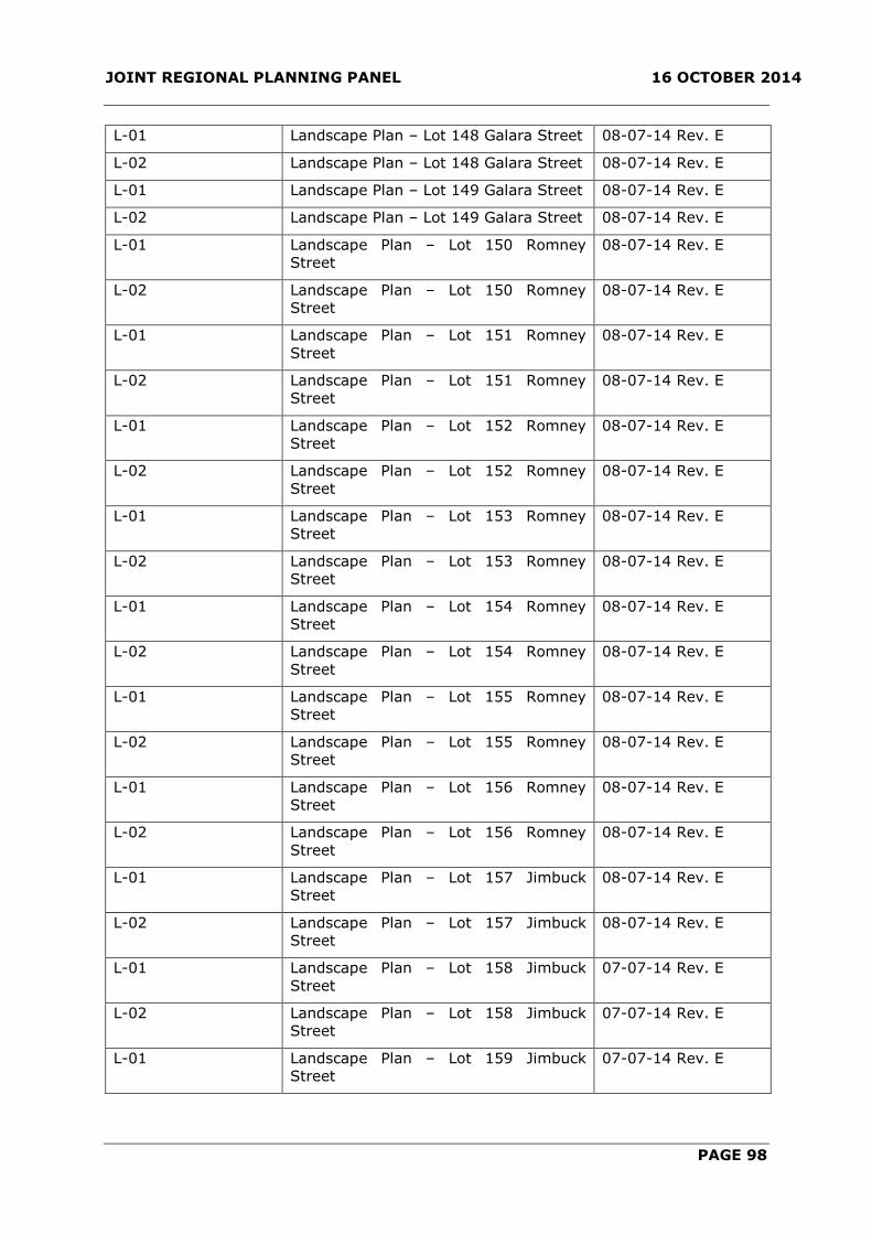
JOINT REGIONAL PLANNING PANEL 16 OCTOBER 2014
PAGE 98
L-01 Landscape Plan – Lot 148 Galara Street 08-07-14 Rev. E
L-02 Landscape Plan – Lot 148 Galara Street 08-07-14 Rev. E
L-01 Landscape Plan – Lot 149 Galara Street 08-07-14 Rev. E
L-02 Landscape Plan – Lot 149 Galara Street 08-07-14 Rev. E
L-01 Landscape Plan – Lot 150 Romney
Street
08-07-14 Rev. E
L-02 Landscape Plan – Lot 150 Romney
Street
08-07-14 Rev. E
L-01 Landscape Plan – Lot 151 Romney
Street
08-07-14 Rev. E
L-02 Landscape Plan – Lot 151 Romney
Street
08-07-14 Rev. E
L-01 Landscape Plan – Lot 152 Romney
Street
08-07-14 Rev. E
L-02 Landscape Plan – Lot 152 Romney
Street
08-07-14 Rev. E
L-01 Landscape Plan – Lot 153 Romney
Street
08-07-14 Rev. E
L-02 Landscape Plan – Lot 153 Romney
Street
08-07-14 Rev. E
L-01 Landscape Plan – Lot 154 Romney
Street
08-07-14 Rev. E
L-02 Landscape Plan – Lot 154 Romney
Street
08-07-14 Rev. E
L-01 Landscape Plan – Lot 155 Romney
Street
08-07-14 Rev. E
L-02 Landscape Plan – Lot 155 Romney
Street
08-07-14 Rev. E
L-01 Landscape Plan – Lot 156 Romney
Street
08-07-14 Rev. E
L-02 Landscape Plan – Lot 156 Romney
Street
08-07-14 Rev. E
L-01 Landscape Plan – Lot 157 Jimbuck
Street
08-07-14 Rev. E
L-02 Landscape Plan – Lot 157 Jimbuck
Street
08-07-14 Rev. E
L-01 Landscape Plan – Lot 158 Jimbuck
Street
07-07-14 Rev. E
L-02 Landscape Plan – Lot 158 Jimbuck
Street
07-07-14 Rev. E
L-01 Landscape Plan – Lot 159 Jimbuck
Street
07-07-14 Rev. E
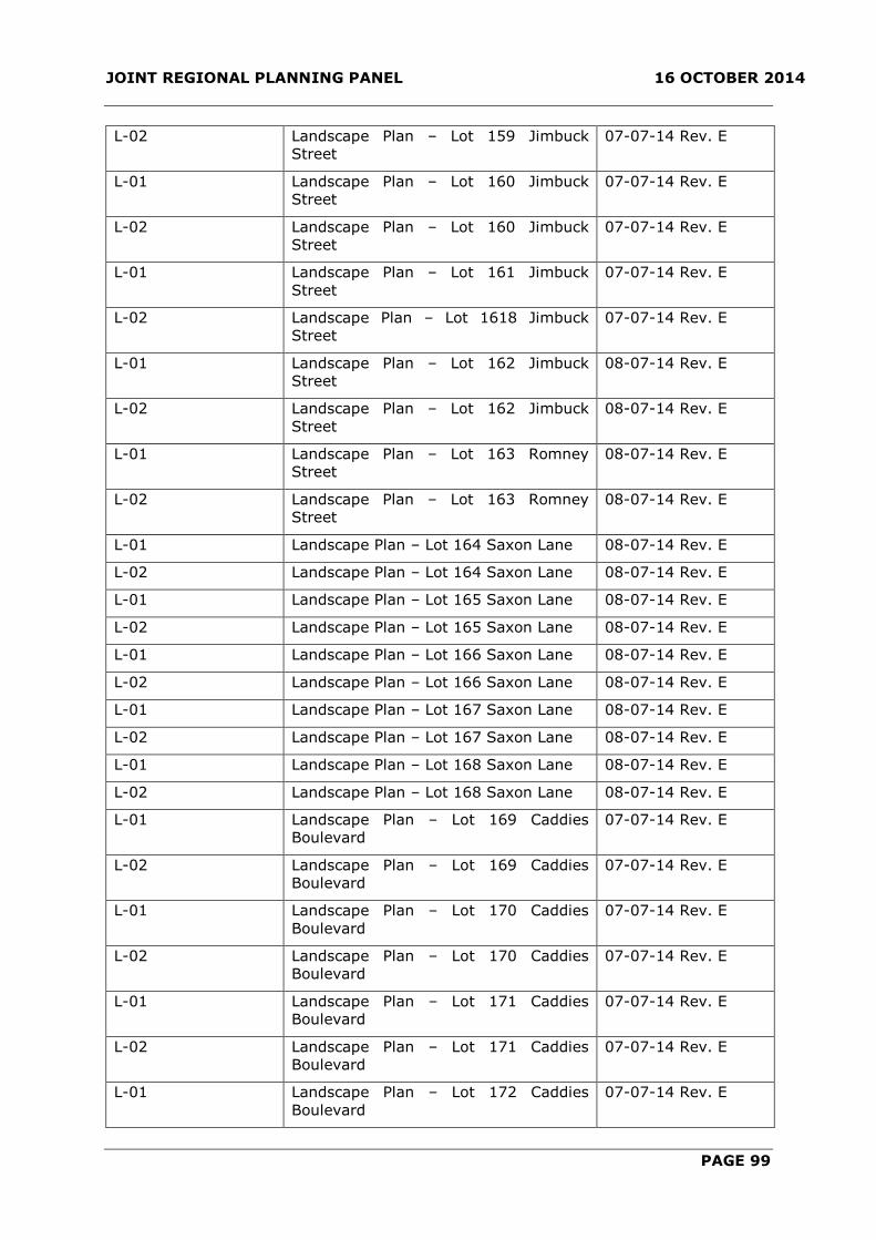
JOINT REGIONAL PLANNING PANEL 16 OCTOBER 2014
PAGE 99
L-02 Landscape Plan – Lot 159 Jimbuck
Street
07-07-14 Rev. E
L-01 Landscape Plan – Lot 160 Jimbuck
Street
07-07-14 Rev. E
L-02 Landscape Plan – Lot 160 Jimbuck
Street
07-07-14 Rev. E
L-01 Landscape Plan – Lot 161 Jimbuck
Street
07-07-14 Rev. E
L-02 Landscape Plan – Lot 1618 Jimbuck
Street
07-07-14 Rev. E
L-01 Landscape Plan – Lot 162 Jimbuck
Street
08-07-14 Rev. E
L-02 Landscape Plan – Lot 162 Jimbuck
Street
08-07-14 Rev. E
L-01 Landscape Plan – Lot 163 Romney
Street
08-07-14 Rev. E
L-02 Landscape Plan – Lot 163 Romney
Street
08-07-14 Rev. E
L-01 Landscape Plan – Lot 164 Saxon Lane 08-07-14 Rev. E
L-02 Landscape Plan – Lot 164 Saxon Lane 08-07-14 Rev. E
L-01 Landscape Plan – Lot 165 Saxon Lane 08-07-14 Rev. E
L-02 Landscape Plan – Lot 165 Saxon Lane 08-07-14 Rev. E
L-01 Landscape Plan – Lot 166 Saxon Lane 08-07-14 Rev. E
L-02 Landscape Plan – Lot 166 Saxon Lane 08-07-14 Rev. E
L-01 Landscape Plan – Lot 167 Saxon Lane 08-07-14 Rev. E
L-02 Landscape Plan – Lot 167 Saxon Lane 08-07-14 Rev. E
L-01 Landscape Plan – Lot 168 Saxon Lane 08-07-14 Rev. E
L-02 Landscape Plan – Lot 168 Saxon Lane 08-07-14 Rev. E
L-01 Landscape Plan – Lot 169 Caddies
Boulevard
07-07-14 Rev. E
L-02 Landscape Plan – Lot 169 Caddies
Boulevard
07-07-14 Rev. E
L-01 Landscape Plan – Lot 170 Caddies
Boulevard
07-07-14 Rev. E
L-02 Landscape Plan – Lot 170 Caddies
Boulevard
07-07-14 Rev. E
L-01 Landscape Plan – Lot 171 Caddies
Boulevard
07-07-14 Rev. E
L-02 Landscape Plan – Lot 171 Caddies
Boulevard
07-07-14 Rev. E
L-01 Landscape Plan – Lot 172 Caddies
Boulevard
07-07-14 Rev. E

JOINT REGIONAL PLANNING PANEL 16 OCTOBER 2014
PAGE 100
L-02 Landscape Plan – Lot 172 Caddies
Boulevard
07-07-14 Rev. E
L-01 Landscape Plan – Lot 173 Caddies
Boulevard
07-07-14 Rev. E
L-02 Landscape Plan – Lot 173 Caddies
Boulevard
07-07-14 Rev. E
L-01 Landscape Plan – Lot 174 Caddies
Boulevard
07-07-14 Rev. E
L-02 Landscape Plan – Lot 174 Caddies
Boulevard
07-07-14 Rev. E
L-01 Landscape Plan – Lot 175 Caddies
Boulevard
07-07-14 Rev. E
L-02 Landscape Plan – Lot 175 Caddies
Boulevard
07-07-14 Rev. E
L-01 Landscape Plan – Lot 176 Caddies
Boulevard
07-07-14 Rev. E
L-02 Landscape Plan – Lot 176 Caddies
Boulevard
07-07-14 Rev. E
L-01 Landscape Plan – Lot 177 Saxon Lane 07-07-14 Rev. E
L-02 Landscape Plan – Lot 177 Saxon Lane 07-07-14 Rev. E
L-01 Landscape Plan – Lot 178 Saxon Lane 07-07-14 Rev. E
L-02 Landscape Plan – Lot 178 Saxon Lane 07-07-14 Rev. E
L-01 Landscape Plan – Lot 179 Saxon Lane 07-07-14 Rev. E
L-02 Landscape Plan – Lot 179 Saxon Lane 07-07-14 Rev. E
L-01 Landscape Plan – Lot 180 Saxon Lane 07-07-14 Rev. E
L-02 Landscape Plan – Lot 180 Saxon Lane 07-07-14 Rev. E
L-01 Landscape Plan – Lot 181 Saxon Lane 08-07-14 Rev. E
L-02 Landscape Plan – Lot 181 Saxon Lane 08-07-14 Rev. E
L-01 Landscape Plan – Lot 182 Saxon Lane 08-07-14 Rev. E
L-02 Landscape Plan – Lot 182 Saxon Lane 08-07-14 Rev. E
L-01 Landscape Plan – Lot 183 Saxon Lane 08-07-14 Rev. E
L-02 Landscape Plan – Lot 183 Saxon Lane 08-07-14 Rev. E
L-01 Landscape Plan – Lot 184 Saxon Lane 08-07-14 Rev. E
L-02 Landscape Plan – Lot 184 Saxon Lane 08-07-14 Rev. E
L-01 Landscape Plan – Lot 185 Saxon Lane 08-07-14 Rev. E
L-02 Landscape Plan – Lot 185 Saxon Lane 08-07-14 Rev. E
L-01 Landscape Plan – Lot 186 Saxon Lane 08-07-14 Rev. E
L-02 Landscape Plan – Lot 186 Saxon Lane 08-07-14 Rev. E
L-01 Landscape Plan – Lot 187 Saxon Lane 08-07-14 Rev. E
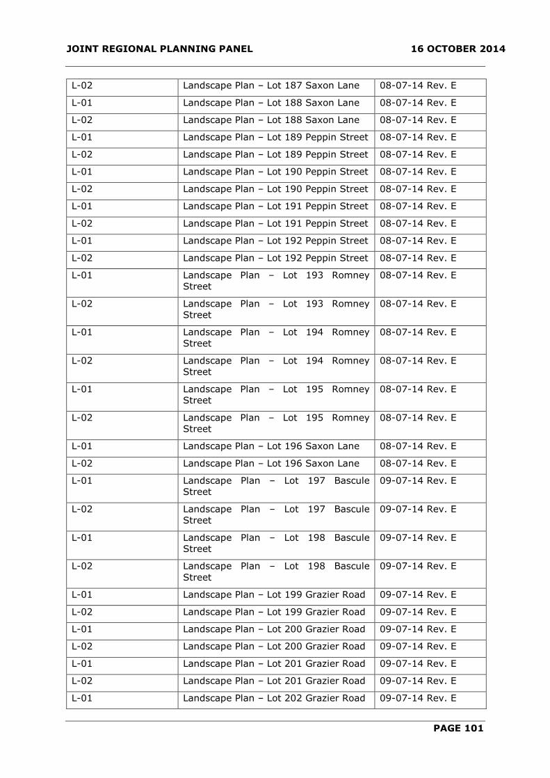
JOINT REGIONAL PLANNING PANEL 16 OCTOBER 2014
PAGE 101
L-02 Landscape Plan – Lot 187 Saxon Lane 08-07-14 Rev. E
L-01 Landscape Plan – Lot 188 Saxon Lane 08-07-14 Rev. E
L-02 Landscape Plan – Lot 188 Saxon Lane 08-07-14 Rev. E
L-01 Landscape Plan – Lot 189 Peppin Street 08-07-14 Rev. E
L-02 Landscape Plan – Lot 189 Peppin Street 08-07-14 Rev. E
L-01 Landscape Plan – Lot 190 Peppin Street 08-07-14 Rev. E
L-02 Landscape Plan – Lot 190 Peppin Street 08-07-14 Rev. E
L-01 Landscape Plan – Lot 191 Peppin Street 08-07-14 Rev. E
L-02 Landscape Plan – Lot 191 Peppin Street 08-07-14 Rev. E
L-01 Landscape Plan – Lot 192 Peppin Street 08-07-14 Rev. E
L-02 Landscape Plan – Lot 192 Peppin Street 08-07-14 Rev. E
L-01 Landscape Plan – Lot 193 Romney
Street
08-07-14 Rev. E
L-02 Landscape Plan – Lot 193 Romney
Street
08-07-14 Rev. E
L-01 Landscape Plan – Lot 194 Romney
Street
08-07-14 Rev. E
L-02 Landscape Plan – Lot 194 Romney
Street
08-07-14 Rev. E
L-01 Landscape Plan – Lot 195 Romney
Street
08-07-14 Rev. E
L-02 Landscape Plan – Lot 195 Romney
Street
08-07-14 Rev. E
L-01 Landscape Plan – Lot 196 Saxon Lane 08-07-14 Rev. E
L-02 Landscape Plan – Lot 196 Saxon Lane 08-07-14 Rev. E
L-01 Landscape Plan – Lot 197 Bascule
Street
09-07-14 Rev. E
L-02 Landscape Plan – Lot 197 Bascule
Street
09-07-14 Rev. E
L-01 Landscape Plan – Lot 198 Bascule
Street
09-07-14 Rev. E
L-02 Landscape Plan – Lot 198 Bascule
Street
09-07-14 Rev. E
L-01 Landscape Plan – Lot 199 Grazier Road 09-07-14 Rev. E
L-02 Landscape Plan – Lot 199 Grazier Road 09-07-14 Rev. E
L-01 Landscape Plan – Lot 200 Grazier Road 09-07-14 Rev. E
L-02 Landscape Plan – Lot 200 Grazier Road 09-07-14 Rev. E
L-01 Landscape Plan – Lot 201 Grazier Road 09-07-14 Rev. E
L-02 Landscape Plan – Lot 201 Grazier Road 09-07-14 Rev. E
L-01 Landscape Plan – Lot 202 Grazier Road 09-07-14 Rev. E

JOINT REGIONAL PLANNING PANEL 16 OCTOBER 2014
PAGE 102
L-02 Landscape Plan – Lot 202 Grazier Road 09-07-14 Rev. E
L-01 Landscape Plan – Lot 203 Grazier Road 09-07-14 Rev. E
L-02 Landscape Plan – Lot 203 Grazier Road 09-07-14 Rev. E
L-01 Landscape Plan – Lot 204 Caddies
Boulevard
09-07-14 Rev. E
L-02 Landscape Plan – Lot 204 Caddies
Boulevard
09-07-14 Rev. E
L-01 Landscape Plan – Lot 205 Caddies
Boulevard
09-07-14 Rev. E
L-02 Landscape Plan – Lot 205 Caddies
Boulevard
09-07-14 Rev. E
L-01 Landscape Plan – Lot 206 Caddies
Boulevard
09-07-14 Rev. E
L-02 Landscape Plan – Lot 206 Caddies
Boulevard
09-07-14 Rev. E
L-01 Landscape Plan – Lot 207 Caddies
Boulevard
09-07-14 Rev. E
L-02 Landscape Plan – Lot 207 Caddies
Boulevard
09-07-14 Rev. E
L-01 Landscape Plan – Lot 208 Caddies
Boulevard
09-07-14 Rev. E
L-02 Landscape Plan – Lot 208 Caddies
Boulevard
09-07-14 Rev. E
L-01 Landscape Plan – Lot 209 Caddies
Boulevard
09-07-14 Rev. E
L-02 Landscape Plan – Lot 209 Caddies
Boulevard
09-07-14 Rev. E
L-01 Landscape Plan – Lot 210 Caddies
Boulevard
09-07-14 Rev. E
L-02 Landscape Plan – Lot 210 Caddies
Boulevard
09-07-14 Rev. E
L-01 Landscape Plan – Lot 211 Caddies
Boulevard
20-06-14 Rev. D
L-02 Landscape Plan – Lot 211 Caddies
Boulevard
09-07-14 Rev. E
L-01 Landscape Plan – Lot 212 Caddies
Boulevard
09-07-14 Rev. E
L-02 Landscape Plan – Lot 212 Caddies
Boulevard
09-07-14 Rev. E
L-01 Landscape Plan – Lot 213 Caddies
Boulevard
09-07-14 Rev. E
L-02 Landscape Plan – Lot 213 Caddies
Boulevard
09-07-14 Rev. E

JOINT REGIONAL PLANNING PANEL 16 OCTOBER 2014
PAGE 103
L-01 Landscape Plan – Lot 214 Laneway 5 09-07-14 Rev. E
L-02 Landscape Plan – Lot 214 Laneway 5 09-07-14 Rev. E
L-01 Landscape Plan – Lot 215 Laneway 5 09-07-14 Rev. E
L-02 Landscape Plan – Lot 215 Laneway 5 09-07-14 Rev. E
L-01 Landscape Plan – Lot 216 Laneway 5 09-07-14 Rev. E
L-02 Landscape Plan – Lot 216 Laneway 5 09-07-14 Rev. E
L-01 Landscape Plan – Lot 217 Laneway 5 09-07-14 Rev. E
L-02 Landscape Plan – Lot 217 Laneway 5 09-07-14 Rev. E
L-01 Landscape Plan – Lot 218 Laneway 5 09-07-14 Rev. E
L-02 Landscape Plan – Lot 218 Laneway 5 09-07-14 Rev. E
L-01 Landscape Plan – Lot 219 Laneway 5 09-07-14 Rev. E
L-02 Landscape Plan – Lot 219 Laneway 5 09-07-14 Rev. E
L-01 Landscape Plan – Lot 220 Bascule
Street
09-07-14 Rev. E
L-02 Landscape Plan – Lot 220 Bascule
Street
09-07-14 Rev. E
L-01 Landscape Plan – Lot 221 Bascule
Street
09-07-14 Rev. E
L-02 Landscape Plan – Lot 221 Bascule
Street
09-07-14 Rev. E
L-01 Landscape Plan – Lot 222 Bascule
Street
09-07-14 Rev. E
L-02 Landscape Plan – Lot 222 Bascule
Street
09-07-14 Rev. E
L-01 Landscape Plan – Lot 223 Bascule
Street
09-07-14 Rev. E
L-02 Landscape Plan – Lot 223 Bascule
Street
09-07-14 Rev. E
L-01 Landscape Plan – Lot 224 Bascule
Street
09-07-14 Rev. E
L-02 Landscape Plan – Lot 224 Bascule
Street
09-07-14 Rev. E
L-01 Landscape Plan – Lot 225 Bascule
Street
09-07-14 Rev. E
L-02 Landscape Plan – Lot 225 Bascule
Street
09-07-14 Rev. E
L-01 Landscape Plan – Lot 226 Bascule
Street
08-07-14 Rev. E
L-02 Landscape Plan – Lot 226 Bascule
Street
08-07-14 Rev. E
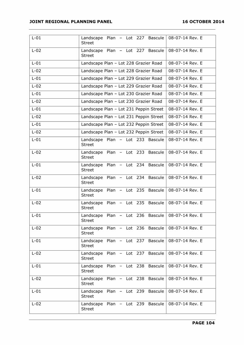
JOINT REGIONAL PLANNING PANEL 16 OCTOBER 2014
PAGE 104
L-01 Landscape Plan – Lot 227 Bascule
Street
08-07-14 Rev. E
L-02 Landscape Plan – Lot 227 Bascule
Street
08-07-14 Rev. E
L-01 Landscape Plan – Lot 228 Grazier Road 08-07-14 Rev. E
L-02 Landscape Plan – Lot 228 Grazier Road 08-07-14 Rev. E
L-01 Landscape Plan – Lot 229 Grazier Road 08-07-14 Rev. E
L-02 Landscape Plan – Lot 229 Grazier Road 08-07-14 Rev. E
L-01 Landscape Plan – Lot 230 Grazier Road 08-07-14 Rev. E
L-02 Landscape Plan – Lot 230 Grazier Road 08-07-14 Rev. E
L-01 Landscape Plan – Lot 231 Peppin Street 08-07-14 Rev. E
L-02 Landscape Plan – Lot 231 Peppin Street 08-07-14 Rev. E
L-01 Landscape Plan – Lot 232 Peppin Street 08-07-14 Rev. E
L-02 Landscape Plan – Lot 232 Peppin Street 08-07-14 Rev. E
L-01 Landscape Plan – Lot 233 Bascule
Street
08-07-14 Rev. E
L-02 Landscape Plan – Lot 233 Bascule
Street
08-07-14 Rev. E
L-01 Landscape Plan – Lot 234 Bascule
Street
08-07-14 Rev. E
L-02 Landscape Plan – Lot 234 Bascule
Street
08-07-14 Rev. E
L-01 Landscape Plan – Lot 235 Bascule
Street
08-07-14 Rev. E
L-02 Landscape Plan – Lot 235 Bascule
Street
08-07-14 Rev. E
L-01 Landscape Plan – Lot 236 Bascule
Street
08-07-14 Rev. E
L-02 Landscape Plan – Lot 236 Bascule
Street
08-07-14 Rev. E
L-01 Landscape Plan – Lot 237 Bascule
Street
08-07-14 Rev. E
L-02 Landscape Plan – Lot 237 Bascule
Street
08-07-14 Rev. E
L-01 Landscape Plan – Lot 238 Bascule
Street
08-07-14 Rev. E
L-02 Landscape Plan – Lot 238 Bascule
Street
08-07-14 Rev. E
L-01 Landscape Plan – Lot 239 Bascule
Street
08-07-14 Rev. E
L-02 Landscape Plan – Lot 239 Bascule
Street
08-07-14 Rev. E

JOINT REGIONAL PLANNING PANEL 16 OCTOBER 2014
PAGE 105
L-01 Landscape Plan – Lot 240 Bascule
Street
08-07-14 Rev. E
L-02 Landscape Plan – Lot 240 Bascule
Street
08-07-14 Rev. E
L-01 Landscape Plan – Lot 241 Peppin Street 08-07-14 Rev. E
L-02 Landscape Plan – Lot 241 Peppin Street 08-07-14 Rev. E
L-01 Landscape Plan – Lot 242 Peppin Street 08-07-14 Rev. E
L-02 Landscape Plan – Lot 242 Peppin Street 08-07-14 Rev. E
L-01 Landscape Plan – Lot 243 Laneway 7 08-07-14 Rev. E
L-02 Landscape Plan – Lot 243 Laneway 7 08-07-14 Rev. E
L-01 Landscape Plan – Lot 244 Civic Way 08-07-14 Rev. E
L-02 Landscape Plan – Lot 244 Civic Way 08-07-14 Rev. E
L-01 Landscape Plan – Lot 245 Civic Way 08-07-14 Rev. E
L-02 Landscape Plan – Lot 245 Civic Way 08-07-14 Rev. E
L-01 Landscape Plan – Lot 246 Civic Way 08-07-14 Rev. E
L-02 Landscape Plan – Lot 246 Civic Way 08-07-14 Rev. E
L-01 Landscape Plan – Lot 247 Civic Way 08-07-14 Rev. E
L-02 Landscape Plan – Lot 247 Civic Way 08-07-14 Rev. E
L-01 Landscape Plan – Lot 248 Bond Street 08-07-14 Rev. E
L-02 Landscape Plan – Lot 248 Bond Street 08-07-14 Rev. E
L-01 Landscape Plan – Lot 249 Bond Street 08-07-14 Rev. E
L-02 Landscape Plan – Lot 249 Bond Street 08-07-14 Rev. E
L-01 Landscape Plan – Lot 250 Bond Street 08-07-14 Rev. E
L-02 Landscape Plan – Lot 250 Bond Street 08-07-14 Rev. E
L-01 Landscape Plan – Lot 251 Bond Street 08-07-14 Rev. E
L-02 Landscape Plan – Lot 251 Bond Street 08-07-14 Rev. E
L-01 Landscape Plan – Lot 252 Peppin Street 08-07-14 Rev. E
L-02 Landscape Plan – Lot 252 Peppin Street 08-07-14 Rev. E
L-01 Landscape Plan – Lot 253 Peppin Street 08-07-14 Rev. E
L-02 Landscape Plan – Lot 253 Peppin Street 08-07-14 Rev. E
L-01 Landscape Plan – Lot 254 Peppin Street 08-07-14 Rev. E
L-02 Landscape Plan – Lot 254 Peppin Street 08-07-14 Rev. E
L-01 Landscape Plan – Lot 255 Peppin Street 07-07-14 Rev. E
L-02 Landscape Plan – Lot 255 Peppin Street 07-07-14 Rev. E
L-01 Landscape Plan – Lot 256 Peppin Street 07-07-14 Rev. E
L-02 Landscape Plan – Lot 256 Peppin Street 07-07-14 Rev. E
L-01 Landscape Plan – Lot 257 Peppin Street 07-07-14 Rev. E
JOINT REGIONAL PLANNING PANEL 16 OCTOBER 2014
PAGE 106
L-02 Landscape Plan – Lot 257 Peppin Street 07-07-14 Rev. E
L-01 Landscape Plan – Lot 258 Peppin Street 07-07-14 Rev. E
L-02 Landscape Plan – Lot 258 Peppin Street 07-07-14 Rev. E
L-01 Landscape Plan – Lot 259 Peppin Street 07-07-14 Rev. E
L-02 Landscape Plan – Lot 259 Peppin Street 07-07-14 Rev. E
L-01 Landscape Plan – Lot 260 Peppin Street 07-07-14 Rev. E
L-02 Landscape Plan – Lot 260 Peppin Street 07-07-14 Rev. E
L-01 Landscape Plan – Lot 261 Peppin Street 07-07-14 Rev. E
L-02 Landscape Plan – Lot 261 Peppin Street 07-07-14 Rev. E
L-01 Landscape Plan – Lot 262 Peppin Street 07-07-14 Rev. E
L-02 Landscape Plan – Lot 262 Peppin Street 07-07-14 Rev. E
L-01 Landscape Plan – Lot 263 Peppin Street 07-07-14 Rev. E
L-02 Landscape Plan – Lot 263 Peppin Street 07-07-14 Rev. E
L-01 Landscape Plan – Lot 264 Peppin Street 07-07-14 Rev. E
L-02 Landscape Plan – Lot 264 Peppin Street 07-07-14 Rev. E
L-01 Landscape Plan – Lot 265 Peppin Street 07-07-14 Rev. E
L-02 Landscape Plan – Lot 265 Peppin Street 07-07-14 Rev. E
L-01 Landscape Plan – Lot 266 Peppin Street 07-07-14 Rev. E
L-02 Landscape Plan – Lot 266 Peppin Street 07-07-14 Rev. E
L-01 Landscape Plan – Lot 267 Peppin Street 07-07-14 Rev. E
L-02 Landscape Plan – Lot 267 Peppin Street 07-07-14 Rev. E
L-01 Landscape Plan – Lot 268 Peppin Street 07-07-14 Rev. E
L-02 Landscape Plan – Lot 268 Peppin Street 07-07-14 Rev. E
L-01 Landscape Plan – Lot 269 Peppin Street 07-07-14 Rev. E
L-02 Landscape Plan – Lot 269 Peppin Street 07-07-14 Rev. E
L-01 Landscape Plan – Lot 270 Civic Way 07-07-14 Rev. E
L-02 Landscape Plan – Lot 270 Civic Way 07-07-14 Rev. E
L-01 Landscape Plan – Lot 271 Civic Way 07-07-14 Rev. E
L-02 Landscape Plan – Lot 271 Civic Way 07-07-14 Rev. E
L-01 Landscape Plan – Lot 272 Civic Way 07-07-14 Rev. E
L-02 Landscape Plan – Lot 272 Civic Way 07-07-14 Rev. E
L-01 Landscape Plan – Lot 273 Civic Way 07-07-14 Rev. E
L-02 Landscape Plan – Lot 273 Civic Way 07-07-14 Rev. E
L-01 Landscape Plan – Lot 274 Civic Way 07-07-14 Rev. E
L-02 Landscape Plan – Lot 274 Civic Way 07-07-14 Rev. E
L-01 Landscape Plan – Lot 275 Civic Way 07-07-14 Rev. E

JOINT REGIONAL PLANNING PANEL 16 OCTOBER 2014
PAGE 107
L-02 Landscape Plan – Lot 275 Civic Way 07-07-14 Rev. E
L-01 Landscape Plan – Lot 276 Civic Way 07-07-14 Rev. E
L-02 Landscape Plan – Lot 276 Civic Way 07-07-14 Rev. E
L-01 Landscape Plan – Lot 277 Civic Way 07-07-14 Rev. E
L-02 Landscape Plan – Lot 277 Civic Way 07-07-14 Rev. E
L-01 Landscape Plan – Lot 278 Civic Way 07-07-14 Rev. E
L-02 Landscape Plan – Lot 278 Civic Way 07-07-14 Rev. E
L-01 Landscape Plan – Lot 279 Civic Way 07-07-14 Rev. E
L-02 Landscape Plan – Lot 279 Civic Way 07-07-14 Rev. E
L-01 Landscape Plan – Lot 280 Civic Way 07-07-14 Rev. E
L-02 Landscape Plan – Lot 280 Civic Way 07-07-14 Rev. E
L-01 Landscape Plan – Lot 281 Civic Way 07-07-14 Rev. E
L-02 Landscape Plan – Lot 281 Civic Way 07-07-14 Rev. E
L-01 Landscape Plan – Lot 282 Civic Way 07-07-14 Rev. E
L-02 Landscape Plan – Lot 282 Civic Way 07-07-14 Rev. E
L-01 Landscape Plan – Lot 283 Civic Way 07-07-14 Rev. E
L-02 Landscape Plan – Lot 283 Civic Way 07-07-14 Rev. E
L-01 Landscape Plan – Lot 284 Civic Way 07-07-14 Rev. E
L-02 Landscape Plan – Lot 284 Civic Way 07-07-14 Rev. E
H222 Sheet 1 of 4
Sheets
Plan of Proposed Subdivision Stage 3A 11.06.2014 Rev.a
H222 Sheet 2 of 4
Sheets
Plan of Proposed Subdivision Stage 3B 11.06.2014 Rev.a
H222 Sheet 3 of 4
Sheets
Plan of Proposed Subdivision Stage 3C 11.06.2014 Rev.a
H222 Sheet 4 of 4
Sheets
Plan of Proposed Subdivision Stage 3D 11.06.2014 Rev.a
21478 Sheet 1 of 2
Sheets
Survey Plan 23/7/2010
21478 Sheet 2 of 2
Sheets
Survey Plan 23/7/2010
21478 Sheet 1 of 1
Sheets
Survey Plan 23/7/2010
--- Perspective (Lodged with DA) Lodged 31/03/2014
--- Perspective (Lodged with DA) Lodged 31/03/2014
--- Plan showing Balcony for Secondary
Dwelling Lot 176
Submitted
11/09/2014
--- Plan showing Balcony for Secondary
Dwelling Lot 204
Submitted
11/09/2014

JOINT REGIONAL PLANNING PANEL 16 OCTOBER 2014
PAGE 108
No work (including excavation, land fill or earth reshaping) shall be undertaken prior to
the issue of the Construction Certificate, where a Construction Certificate is required.
2. External Finishes
External finishes and colours shall be in accordance with the details submitted with the
development application and approved with this consent.
3. Rouse Hill Regional Centre Planning Agreement
Contributions for the 153 detached dwelling houses created are to be made in
accordance with the provisions of the Rouse Hill Regional Centre Planning Agreement
dated 29/12/2006.
4. Further Development Application for Park Works
The submission of further Development Application/s, where required, for the proposed
central and pocket parks.
5. Construction Certificate
Prior to construction of the approved development, it is necessary to obtain a
Construction Certificate. A Construction Certificate may be issued by Council or an
Accredited Certifier. Plans submitted with the Construction Certificate are to be amended
to incorporate the conditions of the Development Consent.
6. Building Work to be in Accordance with BCA
All building work must be carried out in accordance with the provisions of the Building
Code of Australia.
7. Planting Requirements
All trees planted as part of the approved landscape plan are to be minimum 75 litre pot
size. All shrubs planted as part of the approved landscape plan are to be minimum
200mm pot size. Groundcovers are to be planted at 5/m2.
8. Approved Subdivision Plan
The subdivision component of the development must be carried out in accordance with
the approved plan of subdivision prepared by Whelans Insites Drawing H222 Sheets 1 to
4 Revision A dated 11/06/2014 except where amended by other conditions of consent.
9. Protection of Public Infrastructure
Council must be notified of any damage to public infrastructure caused by the
development. Adequate protection must be provided prior to work commencing and
maintained during building operations. Any damage caused must be made good, to the
satisfaction of Council, before an Occupation Certificate can be issued. Public
infrastructure includes the road pavement, kerb and gutter, concrete footpaths, drainage
structures, utilities and landscaping fronting the site.
10. Structures Adjacent to Piped Drainage Easements
Buildings and structures, including footings and brick fences, adjacent to existing or
proposed drainage easements must be located wholly outside the easement. A design
must be provided by a structural engineer certifying that the structure will not impart a
load on the pipe in the easement.
11. Gutter and Footpath Crossing Application
Each driveway requires the lodgement of a separate gutter and footpath crossing
application, accompanied by the applicable fee as per Council’s Schedule of Fees and
Charges.
12. Minor Engineering Works
The design and construction of the engineering works listed below must be provided for
in accordance with the following documents and requirements:
a) Council’s Design Guidelines Subdivisions/ Developments
b) Council’s Works Specifications Subdivisions/ Developments

JOINT REGIONAL PLANNING PANEL 16 OCTOBER 2014
PAGE 109
Any variance from these documents requires separate approval from Council.
Works on existing public roads or any other land under the care and control of Council
must be approved and inspected by Council in accordance with the Roads Act 1993 or
the Local Government Act 1993. A separate minor engineering works application and
inspection fee is payable as per Council’s Schedule of Fees and Charges.
i. Driveway Requirements
The design, finish, gradient and location of all driveway crossings must comply with the
above documents and Council’s Driveway Specifications.
The proposed driveways must be built to Council’s residential standard.
A separate driveway application fee is payable as per Council’s Schedule of Fees and
Charges.
ii. Disused Layback/ Driveway Removal
All disused laybacks and driveways must be removed and replaced with kerb and gutter
together with the restoration and turfing of the adjoining footpath verge area.
iii. Site Stormwater Drainage
The entire site area must be graded, collected and drained by pits and pipes to a suitable
point of legal discharge.
iv. Inter-allotment Stormwater Drainage
Piped inter-allotment stormwater drainage catering for the entire area of each lot must
be provided. Each lot must be uniformly graded to its lowest point where a grated
surface inlet pit must be provided. All collected stormwater is to be piped to an approved
constructed public drainage system.
Where OSD is required, a minimum level difference of 800mm measured between the
surface level and the invert of the outlet pipe must be provided.
v. Earthworks/ Site Regrading
Earthworks are limited to that shown on the approved plans. Where earthworks are not
shown on the approved plan the topsoil within lots must not be disturbed.
vi. Service Conduits
Service conduits to each of the proposed new lots, laid in strict accordance with the
relevant service authority’s requirements, are required. Services must be shown on the
engineering drawings.
13. Subdivision Certificate Pre-Lodgement Meeting/ Check
Prior to the submission of a Subdivision Certificate application a draft copy of the final
plan, administration sheet and Section 88B instrument (where included) must be
submitted in order to establish that all conditions have been complied with.
Street addresses for the lots within this subdivision will be allocated as part of this
preliminary check process, for inclusion on the administration sheet.
14. Proposed Street Naming
A written application for street naming must be submitted to Council for approval, along
with the applicable fee as per Council’s Schedule of Fees and Charges. The street names
proposed must comply with requirements of the NSW Geographical Names Board and
Council.
The application must nominate three suggested names per street, in order of preference,
and the source of the names proposed.

JOINT REGIONAL PLANNING PANEL 16 OCTOBER 2014
PAGE 110
15. Street Trees
Street trees must be provided for the public and private roads within or fronting the
development site (excluding laneways) spaced between 7m and 10m apart and with a
minimum of one tree per lot frontage. The location of street trees must be considerate of
driveways, services, drainage pits and sight lines at intersections. The species and size
of street trees must comply with the requirements of Council. Details demonstrating
compliance with the above must be submitted for approval before any street trees are
planted.
For public roads, a performance/ maintenance bond is required to be submitted to
Council once the street trees are planted. The bond will be held for one year and may be
extended if replacement street trees are required to be planted. The bond is refundable
upon written application to Council. Alternatively, street trees can be planted by Council
subject to payment of the applicable fee as per Council’s Schedule of Fees and Charges.
16. Recycled Water
The subject site must be connected to Sydney Water’s Rouse Hill Recycled Water
Scheme, unless written evidence from Sydney Water is submitted advising that this
service is not available.
17. Road Opening Permit
Should the subdivision/ development necessitate the installation or upgrading of utility
services or any other works on Council land beyond the immediate road frontage of the
development site and these works are not covered by a Construction Certificate issued
by Council under this consent then a separate road opening permit must be applied for
and the works inspected by Council’s Maintenance Services team.
The contractor is responsible for instructing sub-contractors or service authority
providers of this requirement. Contact Council’s Construction Engineer if it is unclear
whether a separate road opening permit is required.
18. Management of Construction Waste
Any waste generated as a result of construction of the development is to be reused and
recycled where possible, and any residual waste is to be disposed of at a licensed waste
facility. Waste materials must be appropriately stored and secured within a designated
waste area on site at all times, prior to its reuse on site or being sent off site. Building
waste containers are not permitted to be placed on the public way at any time unless a
separate application is approved by Council to locate a building waste container in a
public place. The separation and recycling of the following waste materials is required:
metals, timber, masonry products, clean waste plasterboard and mixed plastics and
cardboard. This can be achieved by source separation on site, that is, a bin for metal
waste, a bin for timber, a bin for bricks and so on. Alternatively, mixed waste may be
stored in one or more bins and sent to a waste contractor or transfer/ sorting station
that will sort the waste on their premises for recycling. Receipts of all waste/ recycling
tipping must be kept on site at all times and produced in a legible form to any authorised
officer of the Council who asks to see them.
19. Commencement of Domestic Waste Services
The property owner or agent acting for the owner must ensure to arrange the
commencement of an individual domestic waste service with Council no later than two
days after occupancy and no earlier than two days prior to occupancy of a dwelling. The
service is to be arranged by telephoning Council on (02) 9843 0310. All requirements of
Council’s waste collection service must be complied with at all times.
20. Provision of Domestic Waste Storage Areas
Sufficient space must be allocated within the lot boundary of each property to store
three 240 litre mobile bins (for garbage, recycling and garden organics). The location is
required to ensure that bins are not visible from public or private roads and that the bins

JOINT REGIONAL PLANNING PANEL 16 OCTOBER 2014
PAGE 111
can be wheeled to the street without the need to go over steps, landscape edging or
gutters or through a habitable area of the dwelling.
21. Zero Lot Line Dwellings – Easement Encroachment
No element of those dwellings located on the boundary line with an adjoining lot (zero
lot line dwellings) can be located within that adjoining lot. Construction tolerances should
be accounted for when surveying and constructing these dwellings.
Similarly, the dwellings on the lots adjacent, being those lots burdened by an easement
for repair; must be located wholly outside of the easement except where it is shown on
the approved plans that the encroaching eaves/ guttering does not impede maintenance
access to either dwelling and that the encroachment is no closer than 450mm to the
boundary.
22. Acoustic assessment of certain dwellings
Any development consent granted for dwellings opposite the Northern Tributary and
Caddies Boulevard will require acoustic assessment to be submitted prior to the issue of
Construction Certificates for the individual dwellings. The acoustic assessment shall
demonstrate how compliance with the acoustic goals in clause 87 of the Infrastructure
SEPP are to be achieved.
23. Sound Level Output
The use of the premises, building services, equipment, machinery and ancillary fittings
shall not give rise to “offensive noise” as defined under the provision of the Protection of
the Environment Operation Act 1997. The sound level output shall not exceed 5 dB(A)
above the ambient background level at the closest neighbour’s boundary.
24. Contamination
Any new information, which comes to light during construction works, which has the
potential to alter previous conclusions about site contamination, shall be immediately
notified to Council.
25. Stockpiles
Stockpiles of topsoil, sand, aggregate, spoil or other material capable of being moved by
water, to be stored clear of any drainage line, easement, natural watercourse, footpath,
kerb or roadside.
26. Property Numbering for Integrated Housing
The responsibility for property numbering is vested solely in Council.
The street addresses for these lots are as follows:-
Lot 132 = 15 Galara Street Lot 165 = 14 Saxon Lane Lot 198 = 3 Bascule Street
Lot 133 = 17 Galara Street Lot 166 = 12 Saxon Lane Lot 199 = 23 Grazier Road
Lot 134 = 19 Galara Street Lot 167 = 10 Jimbuck Lane Lot 200 = 21 Grazier Road
Lot 135 = 21 Galara Street Lot 168 = 8 Jimbuck Lane Lot 201 = 19 Grazier Road
Lot 136 = 23 Galara Street Lot 169 = 54 Caddies Boulevard Lot 202 = 17 Grazier Road
Lot 137 = 3 Jimbuck Lane Lot 170 = 56 Caddies Boulevard Lot 203 = 15 Grazier Road
Lot 138 = 8 Romney Street Lot 171 = 58 Caddies Boulevard Lot 204 = 74 Caddies Boulevard
Lot 139 = 6 Romney Street Lot 172 = 60 Caddies Boulevard Lot 205 = 76 Caddies Boulevard
Lot 140 = 4 Romney Street Lot 173 = 62 Caddies Boulevard Lot 206 = 78 Caddies Boulevard
Lot 141 = 2 Romney Street Lot 174 = 64 Caddies Boulevard Lot 207 = 80 Caddies Boulevard
Lot 142 = 25 Galara Street Lot 175 = 66 Caddies Boulevard Lot 208 = 82 Caddies Boulevard
Lot 143 = 27 Galara Street Lot 176 = 68 Caddies Boulevard Lot 209 = 84 Caddies Boulevard
Lot 144 = 29 Galara Street Lot 177 = 17 Saxon Lane Lot 210 = 86 Caddies Boulevard
Lot 145 = 31 Galara Street Lot 178 = 19 Saxon Lane Lot 211 = 88 Caddies Boulevard

JOINT REGIONAL PLANNING PANEL 16 OCTOBER 2014
PAGE 112
Lot 146 = 33 Galara Street Lot 179 = 21 Saxon Lane Lot 212 = 90 Caddies Boulevard
Lot 147 = 35 Galara Street Lot 180 = 23 Saxon Lane Lot 213 = 92 Caddies Boulevard
Lot 148 = 37 Galara Street Lot 181 = 27 Saxon Lane Lot 214 = 1 Yet to be named
Lot 149 = 39 Galara Street Lot 182 = 29 Saxon Lane Lot 215 = 3 Yet to be named
Lot 150 = 26 Romney Street Lot 183 = 31 Saxon Lane Lot 216 = 5 Yet to be named
Lot 151 = 24 Romney Street Lot 184 = 33 Saxon Lane Lot 217 = 21 Bascule Street
Lot 152 = 22 Romney Street Lot 185 = 35 Saxon Lane Lot 218 = 19 Bascule Street
Lot 153 = 20 Romney Street Lot 186 = 37 Saxon Lane Lot 219 = 17 Bascule Street
Lot 154 = 18 Romney Street Lot 187 = 39 Saxon Lane Lot 220 = 15 Bascule Street
Lot 155 = 16 Romney Street Lot 188 = 17 Peppin Street Lot 221 = 13 Bascule Street
Lot 156 = 14 Romney Street Lot 189 = 15 Peppin Street Lot 222 = 11 Bascule Street
Lot 157 = 12 Romney Street Lot 190 = 13 Peppin Street Lot 223 = 9 Bascule Street
Lot 158 = 5 Jimbuck Lane Lot 191 = 11 Peppin Street Lot 224 = 7 Bascule Street
Lot 159 = 7 Jimbuck Lane Lot 192 = 9 Peppin Street Lot 225 = 5 Bascule Street
Lot 160 = 9 Jimbuck Lane Lot 193 = 13 Romney Street Lot 226 = 4 Bascule Street
Lot 161 = 11 Jimbuck Lane Lot 194 = 11 Romney Street Lot 227 = 2 Bascule Street
Lot 162 = 6 Jimbuck Lane Lot 195 = 43 Saxon Lane Lot 228 = 29 Grazier Road
Lot 163 = 7 Romney Street Lot 196 = 41 Saxon Lane Lot 229 = 31 Grazier Road
Lot 164 = 16 Saxon Lane Lot 197 = 1 Bascule Street Lot 230 = 33 Grazier Road
Lot 231 = 21 Peppin Street Lot 249 = 5 Bond Street Lot 267 = 6 Peppin Street
Lot 232 = 23 Peppin Street Lot 250 = 3 Bond Street Lot 268 = 1 Civic Way
Lot 233 = 6 Bascule Street Lot 251 = 1 Bond Street Lot 269 = 3 Civic Way
Lot 234 = 8 Bascule Street Lot 252 = 34 Peppin Street Lot 270 = 5 Civic Way
Lot 235 = 10 Bascule Street Lot 253 = 36 Peppin Street Lot 271 = 7 Civic Way
Lot 236 = 12 Bascule Street Lot 254 = 38 Peppin Street Lot 272 = 9 Civic Way
Lot 237 = 14 Bascule Street Lot 255 = 30 Peppin Street Lot 273 = 11 Civic Way
Lot 238 = 16 Bascule Street Lot 256 = 28 Peppin Street Lot 274 = 13 Civic Way
Lot 239 = 18 Bascule Street Lot 257 = 26 Peppin Street Lot 275 = 15 Civic Way
Lot 240 = 20 Bascule Street Lot 258 = 24 Peppin Street Lot 276 = 17 Civic Way
Lot 241 = 42 Peppin Street Lot 259 = 22 Peppin Street Lot 277 = 19 Civic Way
Lot 242 = 40 Peppin Street Lot 260 = 20 Peppin Street Lot 278 = 21 Civic Way
Lot 243 = 3 Yet to be named Lot 261 = 18 Peppin Street Lot 279 = 23 Civic Way
Lot 244 = 41 Civic Way Lot 262 = 16 Peppin Street Lot 280 = 25 Civic Way
Lot 245 = 39 Civic Way Lot 263 = 14 Peppin Street Lot 281 = 27 Civic Way
Lot 246 = 37 Civic Way Lot 264 = 12 Peppin Street Lot 282 = 29 Civic Way
Lot 247 = 35 Civic Way Lot 265 = 10 Peppin Street Lot 283 = 31 Civic Way
Lot 248 = 7 Bond Street Lot 266 = 8 Peppin Street Lot 284 = 33 Civic Way
PRIOR TO THE ISSUE OF CONSTRUCTION CERTIFICATE
27. Privacy Measures for Windows
Second and third storey habitable room windows within 4.5 metres of a side boundary,
within 5 metres of a rear boundary of a 25 metre deep lot or within 7 metres of a rear
JOINT REGIONAL PLANNING PANEL 16 OCTOBER 2014
PAGE 113
boundary of a 30 metre lot are to have permanent privacy measures. Acceptable privacy
measures include landscaping, alternative window arrangements, external louvers, 1.5
metre sill height or fixed and obscured glass to 1.5 metres with clear and/or operable
glass over. Details are to be provided the Private Certifying Authority prior to issue of
the Construction Certificate.
28. Balconies for Lots 176 and 204
Balconies are to be provided for the secondary dwellings for Lots 176 and 204, as shown
on the approved plans. Details are to be provided prior to issue of the Construction
Certificate.
29. Approved Plans to be Submitted to Sydney Water
The approved plans must be submitted to a Sydney Water Quick Check agent to
determine whether the development will affect any Sydney Water wastewater and water
mains, stormwater drains and/or easement, and if any requirements need to be met.
Plans will be appropriately stamped.
Please refer to the web site www.sydneywater.com.au for:
Quick Check agents details – See building and Developing then Quick Check
and
Guidelines for Building Over/Adjacent to /Sydney Water Assets – see Building and
Developing then Building and Renovating.
30. Security Bond – Road Pavement and Public Asset Protection
In accordance with Section 80A(6)(a) of the Environmental Planning and Assessment Act
1979, a security bond of $187,850.00 is required to be submitted to Council to
guarantee the protection of the road pavement and other public assets in the vicinity of
the site during construction works. The above amount is calculated at the rate of $85.00
per square metre based on the road frontage of the subject site (340m) multiplied by
the width of the northbound road carriageway in Caddies Boulevard (6.5m).
The bond must be lodged with Council before a Construction Certificate is issued.
The bond is refundable upon written application to Council and is subject to all work
being restored to Council’s satisfaction. Should the cost of restoring any damage exceed
the value of the bond, Council will undertake the works and issue an invoice for the
recovery of these costs.
31. Bank Guarantee Requirements
Any bank guarantee submitted in lieu of a cash bond must comply with the following:
a) Have no expiry date;
b) Be sent to Council direct from the bank;
c) Reference the development application, condition and matter to which it relates;
d) The amount must match that required to be paid;
e) If a single bank guarantee is used for multiple bonds, it must be itemised.
Should Council need to uplift the bank guarantee, notice in writing will be forwarded to
the applicant 14 days beforehand.
32. Erosion & Sediment Control Plan
Submission of an Erosion and Sediment Control Plan to the Principal Certifying Authority,
including details of:
a) Allotment boundaries
b) Location of the adjoining roads
c) Contours
JOINT REGIONAL PLANNING PANEL 16 OCTOBER 2014
PAGE 114
d) Existing vegetation
e) Existing site drainage
f) Critical natural areas
g) Location of stockpiles
h) Erosion control practices
i) Sediment control practices
j) Outline of a maintenance program for the erosion and sediment controls.
(NOTE: For guidance on the preparation of the Plan refer to ‘Managing Urban
Stormwater Soils & Construction’ produced by the NSW Department of Housing).
33. Construction Management Plan (Staged Applications)
A construction management plan must be submitted demonstrating how the potential for
conflict between resident and construction traffic is to be minimised and managed
throughout all stages of the development. The construction management plan must be
submitted before a Construction Certificate is issued and complied with for the duration
of works.
PRIOR TO WORK COMMENCING ON THE SITE
34. Principal Certifying Authority
A sign is to be erected in accordance with Clause 98 A (2) of the Environmental Planning
and Assessment Regulations 2000.
35. Builder and PCA Details Required
Notification in writing of the builder’s name, address, telephone and fax numbers to be
submitted to the Principal Certifying Authority prior to work commencing.
Two days before work commences, Council shall be notified of the Principal Certifying
Authority in accordance with the Regulations.
36. Management of Building Sites – Builder’s Details
The erection of suitable fencing or other measures to restrict public access to the site
and building works, materials or equipment when the building work is not in progress or
the site is otherwise unoccupied.
The erection of a sign, in a prominent position, stating that unauthorised entry to the
site is not permitted and giving an after hours contact name and telephone number. In
the case of a privately certified development, the name and contact number of the
Principal Certifying Authority.
37. Consultation with Service Authorities
Applicants are advised to consult with Telstra, NBN Co and Australia Post regarding the
installation of telephone conduits, broadband connections and letterboxes as required.
Unimpeded access must be available to the electricity supply authority, during and after
building, to the electricity meters and metering equipment.
The building plans must be submitted to the appropriate Sydney Water office to
determine whether the development will affect Sydney Water’s sewer and water mains,
stormwater drains and/or easements. If the development complies with Sydney Water’s
requirements, the building plans will be stamped indicating that no further requirements
are necessary.
38. Public Infrastructure Inventory Report
A public infrastructure inventory report must be prepared and submitted to Council
recording the condition of all public assets in the direct vicinity of the development site.
This includes, but is not limited to, the road fronting the site along with any access route
used by heavy vehicles. If uncertainty exists with respect to the necessary scope of this

JOINT REGIONAL PLANNING PANEL 16 OCTOBER 2014
PAGE 115
report, it must be clarified with Council before works commence. The report must
include:
a) Planned construction access and delivery routes; and
b) Dated photographic evidence of the condition of all public assets.
39. Approved Temporary Closet
An approved temporary closet connected to the sewers of Sydney Water, or alternatively
an approved chemical closet is to be provided on the land, prior to building operations
being commenced.
40. Erosion and Sedimentation Controls
Erosion and sedimentation controls shall be in place prior to the commencement of site
works; and maintained throughout construction activities until the site is landscaped
and/or suitably revegetated. The controls shall be in accordance with the details
approved by Council and/or as directed by Council Officers. These requirements shall be
in accordance with Managing Urban Stormwater – Soils and Construction produced by
the NSW Department of Housing (Blue Book).
41. Stabilised Access Point
A stabilised all weather access point is to be provided prior to commencement of site
works, and maintained throughout construction activities until the site is stabilised. The
controls shall be in accordance with the requirements with the details approved by
Council and/or as directed by Council Officers. These requirements shall be in
accordance with Managing Urban Stormwater – Soils and Construction produced by the
NSW Department of Housing (Blue Book).
42. Traffic Control Plan
A Traffic Control Plan is required to be prepared and submitted to Council for approval.
The person preparing the plan must have the relevant accreditation to do so. Where
amendments to the plan are required post approval, they must be submitted to Council
for further approval prior to being implemented.
A plan that includes full (detour) or partial (temporary traffic signals) width road closure
requires separate specific approval from Council. Sufficient time should be allowed for
this to occur.
43. Sediment and Erosion Control
The approved sediment and erosion control measures, including a stabilised all weather
access point, must be in place prior to works commencing and maintained during
construction and until the site is stabilised to ensure their effectiveness. For major
works, these measures must be maintained for a minimum period of six months
following the completion of all works.
44. Service Authority Consultation – Subdivision Works
Before subdivision works commence:
a) Documentary evidence must be submitted confirming that satisfactory arrangements
have been made for the relocation, undergrounding and/ or provision of electrical
services for the non-residue lots created by the subdivision.
b) Documentary evidence, including a notice of requirements from Sydney Water, must
be submitted confirming that satisfactory arrangements have been made for the
provision of water and sewerage facilities.
c) Consultation with the relevant telecommunications provider authorised under the
Telecommunications Act regarding the installation of telephone conduits is required.
The design and construction of these works must comply with current NBN
standards, where applicable.

JOINT REGIONAL PLANNING PANEL 16 OCTOBER 2014
PAGE 116
45. Erosion & Sediment Control Plan Kept on Site
A copy of the Erosion and Sediment Control Plan must be kept on site at all times during
construction and made available to Council officers on request.
46. Resubmit Waste Management Plan
Prior to works commencing on site, the Waste Management Plan submitted as part of the
Development Application and dated 31 March 2014 must be resubmitted to and
approved by Council. The plan is required to readdress the following:
Company name of the skip bin hire company or waste transport contractor/s; and
Location of waste disposal and recycling.
All commitments of the approved plan must be implemented during construction of the
development. However, the information provided can change provided that the same or
a greater level of reuse and recycling is achieved as detailed in the plan. Any material
moved offsite is to be transported in accordance with the requirements of the Protection
of the Environment Operations Act 1997 and only to a place that can lawfully be used as
a waste facility Receipts of all waste/ recycling tipping must be kept on site at all times
and produced in a legible form to any authorised officer of the Council who asks to see
them.
DURING CONSTRUCTION
47. Hours of Work
Work on the project to be limited to the following hours: -
Monday to Saturday - 7.00am to 5.00pm;
No work to be carried out on Sunday or Public Holidays.
The builder/contractor shall be responsible to instruct and control sub-contractors
regarding the hours of work. Council will exercise its powers under the Protection of the
Environment Operations Act, in the event that the building operations cause noise to
emanate from the property on Sunday or Public Holidays or otherwise than between the
hours detailed above.
48. Survey Report
Survey Certificate to be submitted to the Principal Certifying Authority at footings and/or
formwork stage. The certificate shall indicate the location of the building in relation to all
boundaries, and shall confirm the floor level prior to any work proceeding on the
building.
49. Compliance with BASIX Certificate
Under clause 97A of the Environmental Planning and Assessment Regulation 2000, it is a
condition of this Development Consent that all commitments listed in the submitted
BASIX Certificates be complied with. Any subsequent version of the BASIX Certificate
will supersede all previous versions of the certificate.
A Section 96 Application may be required should the subsequent version of this BASIX
Certificate necessitate design changes to the development. However, a Section 96
Application will be required for a BASIX Certificate with a new number.
50. Roof Water Drainage
Gutter and downpipes to be provided and connected to an approved drainage system
upon installation of the roof covering.
51. Compliance with Critical Stage Inspections and Other Inspections
Nominated by the Principal Certifying Authority
Section 109E(d) of the Act requires certain specific inspections (prescribed by Clause
162A of the Regulations) and known as “Critical Stage Inspections” to be carried out for

JOINT REGIONAL PLANNING PANEL 16 OCTOBER 2014
PAGE 117
building work. Prior to permitting commencement of the work, your Principal Certifying
Authority is required to give notice of these inspections pursuant to Clause 103A of the
Regulations.
N.B. An Occupation Certificate cannot be issued and the building may not be able to be
used or occupied where any mandatory critical stage inspections or other inspections
required by the Principal Certifying Authority are not carried out.
Where Council is nominated as Principal Certifying Authority, notification of all
inspections required is provided with the Construction Certificate approval.
NOTE: You are advised that inspections may only be carried out by the PCA
unless by prior agreement of the PCA and subject to that person being an
accredited certifier.
52. Standard of Works
All work must be carried out in accordance with Council’s Works Specification
Subdivisions/ Developments and must include any necessary works required to make the
construction effective. All works, including public utility relocation, must incur no cost to
Council.
53. Critical Stage Inspections – Subdivision Works
The subdivision works must be inspected by Council in accordance with the schedule
included in Council’s Works Specification Subdivisions/ Developments. A minimum of 24
hour’s notice is required for inspections. No works are to commence until the first
inspection has been carried out.
54. Dust Control
The emission of dust must be controlled to minimise nuisance to the occupants of the
surrounding premises. In the absence of any alternative measures, the following
measures must be taken to control the emission of dust:
Dust screens must be erected around the perimeter of the site and be kept in good
repair for the duration of the construction work.
All dusty surfaces must be wet down and suppressed by means of a fine water
spray. Water used for dust suppression must not cause water pollution; and
All stockpiles of materials that are likely to generate dust must be kept damp of
covered.
55. Construction Noise
The emission of noise from the construction of the development shall comply with the
Interim Construction Noise Guideline published by the Department of Environment and
Climate Change (July 2009).
56. Confirmation of Compliance with Zero Lot Line
Prior to the installation of the external roof tiles or sheeting, written advice from a
registered surveyor must be provided to the Principal Certifying Authority confirming
that the constructed guttering and fascia to the wall for each property using a zero lot
line, is located wholly within the property boundary.
57. Location of Dwelling
The dwellings on lots burdened by an easement for repair in response to an adjacent
zero lot line dwelling must be located wholly outside of the easement except where
Council has permitted an encroachment (limited to eaves/ guttering). This includes all
services, equipment and utilities.

JOINT REGIONAL PLANNING PANEL 16 OCTOBER 2014
PAGE 118
PRIOR TO ISSUE OF AN OCCUPATION AND/OR SUBDIVISION CERTIFICATE
58. Landscaping Prior to Issue of Occupation Certificate
The landscaping of the site shall be carried out prior to issue of the Final Occupation
Certificate (within each stage if applicable) in accordance with the approved plan. All
landscaping is to be maintained at all times in accordance with BHDCP Part D, Section 3
– Landscaping and the approved landscape plan.
59. Works as Executed Plans
Works as executed (WAE) plans prepared by a suitably qualified engineer or registered
surveyor must be submitted to Council when the subdivision works are completed. The
WAE plans must be prepared in accordance with Council’s Design Guidelines
Subdivisions/ Developments.
The plans must be accompanied by pavement density results, pavement certification,
concrete core test results, site fill results, structural certification, CCTV recording,
signage details and a public asset creation summary, where relevant.
60. Completion of Engineering Works
An Occupation Certificate must not be issued prior to the completion of all engineering
works covered by this consent, in accordance with this consent.
61. Public Infrastructure Inventory Report - Post Construction
Before an Occupation Certificate is issued, an updated public infrastructure inventory
report must be prepared and submitted to Council. The updated report must identify any
damage to public assets and the means of rectification for the approval of Council.
62. Completion of Subdivision Works
A Subdivision Certificate cannot be issued prior to the completion of all subdivision works
covered by this consent.
63. Confirmation of Pipe Locations
A letter from a registered surveyor must be provided with the WAE plans certifying that
all pipes and drainage structures are located within the proposed drainage easements.
64. Section 73 Compliance Certificate
A Section 73 Compliance Certificate issued under the Sydney Water Act 1994 must be
obtained from Sydney Water confirming satisfactory arrangements have been made for
the provision of water and sewer services. Application must be made through an
authorised Water Servicing Coordinator. The certificate must refer to this development
consent and all of the lots created.
Sydney Water’s guidelines provide for assumed concurrence for the strata subdivision of
a development approved by an earlier consent covered by a compliance certificate.
65. Provision of Electrical Services
Submission of a notification of arrangement certificate confirming satisfactory
arrangements have been made for the provision of electrical services. This must include
the under-grounding of the existing electrical services fronting the site and removal of all
redundant poles and cables, unless otherwise approved by Council in writing. The
certificate must refer to this development consent and all of the lots created.
66. Building Adjacent to Proposed Boundary
Where any part of an existing/ partially constructed building is located within 2m of a
proposed boundary the location of such must be determined by a registered surveyor
and shown on the final plan.
67. Building Services
A letter from a registered surveyor must be submitted certifying that all facilities
servicing the existing/ partially constructed buildings are located wholly within their
respective lot or are otherwise contained within a suitable easement.

JOINT REGIONAL PLANNING PANEL 16 OCTOBER 2014
PAGE 119
68. Prior or Concurrent Registration of Preceding Subdivision
A Subdivision Certificate cannot be issued for this subdivision before the preceding
stage/ subdivision pursuant to Development Consent DA 250/2013/ZB has been
registered, unless the two are registered concurrently.
69. Provision of Telecommunication Services
Submission of a telecommunications infrastructure provisioning confirmation certificate
issued by the relevant telecommunications provider authorised under the
Telecommunications Act, or a design compliance certificate and an as-built compliance
certificate from the company engaged to design and construct the pit and pipe infrastructure,
confirming satisfactory arrangements have been made for the provision, or relocation, of
telecommunication services including telecommunications cables and associated
infrastructure. This must include the under-grounding of the existing telecommunication
services fronting the site and removal of all redundant poles and cables, unless
otherwise approved by Council in writing. The certificate must refer to this development
consent and all of the lots created.
70. Final Plan and 88B Instrument
The final plan and Section 88B Instrument must provide for the following. Council’s
standard recitals must be used.
i. Easement – Private Stormwater Drainage
Inter-allotment drainage easements must be created to ensure each and every lot is
provided with a legal point of discharge. Easement widths must comply with Council’s
Design Guidelines Subdivisions/ Developments.
ii. Easement – Right of Access/ Easement for Services
A right of access/ easement for services must be created over the access handle of
proposed lots 174 to 176 and 201 to 203.
iii. Positive Covenant – Maintenance/ Repair of Shared Driveway
A positive covenant must be placed on the title of proposed lots 174 to 176 and 201 to
203 to ensure the maintenance/ repair of the shared driveway using the “maintenance/
repair of shared access” terms included in the standard recitals.
iv. Easement – Repairs/ Zero Lot Line Dwellings
A 900mm wide (minimum) easement for repairs is required over those lots adjacent to
the zero-lot line dwellings identified on the approved plan using the “zero lot line
dwellings” terms included in the standard recitals.
v. Restriction – Earthworks
All residential lots must be burdened with a restriction using the “earthworks” terms
included in the standard recitals.
vi. Restriction – Restricted Access
Lots 132, 141, 169 to 176 and 203 to 214 must be burdened with a restriction
precluding access to Caddies Boulevard using the “restricted access” terms included in
the standard recitals.
vii. Restriction – Bedroom Numbers
All lots that contain a new dwelling home/ attached dwelling must be burdened with a
restriction using the “bedroom numbers” terms included in the standard recitals.
viii. Restriction – Salinity
All residential lots must be burdened with a restriction that refers to the salinity report
submitted with the development application using the “salinity requirements” terms
included in the standard recitals.
JOINT REGIONAL PLANNING PANEL 16 OCTOBER 2014
PAGE 120
ix. Positive Covenant – Waste Collection/ Bin Presentation
For those lots that do not present their bins to their lot frontage for collection, as shown
on the waste collection location plan Ref SKC530 dated 19 May 2014 prepared by Hyder
must be burdened with a positive covenant requiring that bins are presented to the
collection location shown on that plan, using the “waste collection/ bin presentation”
terms included in the standard recitals.
71. Subdivision Certificate Application
When submitted, the Subdivision Certificate application must include:
a) Three copies of the final plan.
b) The original administration sheet and Section 88B instrument, along with one
copy of each.
c) All certificates and supplementary information required by this consent.
d) An AutoCAD copy of final plan (GDA 1994 MGA94 Zone56).
72. Site/Lot Classification Report
A site/lot classification report prepared by a suitably qualified geotechnical engineer
must be prepared and submitted following the completion of all subdivision works
confirming that all residential lots are compliant with AS 2870 and are suitable for
development. The report must be accompanied by a table which summarises the
classification of all lots created as part of the subdivision.
73. Resubmit Waste Collection Plan
Prior to an Occupation Certificate being issued, the plan entitled Stage 3 Waste
Collection Locations (drawing no. SKC530) and dated 19 May 2014 must be resubmitted
to and approved by Council. The plan is required to clearly indicate which collection point
is for which lot.
THE USE OF THE SITE
74. Waste and Recycling Collection
The collection of waste and recyclables from the development is required to be
undertaken in accordance with the approved plan entitled Stage 3 Waste Collection
Locations (drawing no. SKC530) and dated 19 May 2014, unless otherwise determined
by Council. Bin presentation will not be permitted within common driveways or to the
right hand side of one way laneways.
NOTE: A copy of the plan must be made available to all future residents to ensure they
are informed of the waste collection arrangements.
ATTACHMENTS
1. Locality Plan
2. Aerial Photograph
3. Site Plan
4. Typical Elevations
5. Typical Streetscape Elevations
6. Mungerie House 70m Curtilage
7. Perspective
8. Perspective

JOINT REGIONAL PLANNING PANEL 16 OCTOBER 2014
PAGE 121
ATTACHMENT 1 – LOCALITY PLAN

JOINT REGIONAL PLANNING PANEL 16 OCTOBER 2014
PAGE 122
ATTACHMENT 2 – AERIAL PHOTOGRAPH

JOINT REGIONAL PLANNING PANEL 16 OCTOBER 2014
PAGE 123
ATTACHMENT 3 – SITE PLAN

JOINT REGIONAL PLANNING PANEL 16 OCTOBER 2014
PAGE 124
ATTACHMENT 4 – TYPICAL ELEVATIONS

JOINT REGIONAL PLANNING PANEL 16 OCTOBER 2014
PAGE 125
ATTACHMENT 4 – TYPICAL ELEVATIONS
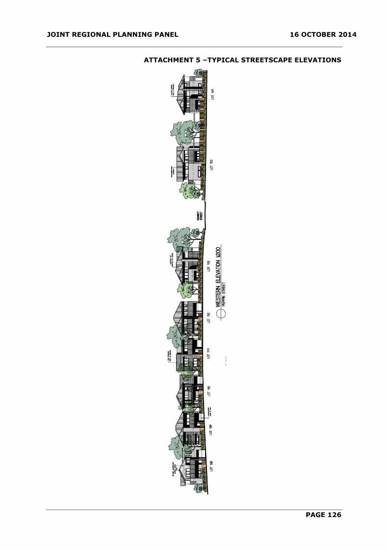
JOINT REGIONAL PLANNING PANEL 16 OCTOBER 2014
PAGE 126
ATTACHMENT 5 –TYPICAL STREETSCAPE ELEVATIONS

JOINT REGIONAL PLANNING PANEL 16 OCTOBER 2014
PAGE 127
ATTACHMENT 5 –TYPICAL STREETSCAPE ELEVATIONS

JOINT REGIONAL PLANNING PANEL 16 OCTOBER 2014
PAGE 128
ATTACHMENT 6 – MUNGERIE HOUSE 70M CURTILAGE
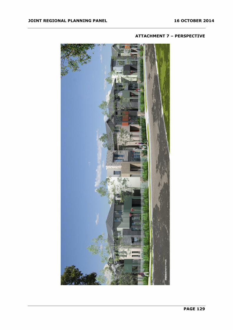
JOINT REGIONAL PLANNING PANEL 16 OCTOBER 2014
PAGE 129
ATTACHMENT 7 – PERSPECTIVE

JOINT REGIONAL PLANNING PANEL 16 OCTOBER 2014
PAGE 130
ATTACHMENT 8 – PERSPECTIVE