Joint project Mid-Term Conference · Joint project Mid-Term Conference June 12th thto 13 , 2018...
57
Joint project Mid-Term Conference June 12 th to 13 th , 2018 Proceedings : Agenda Discussion Pictures Abstracts Participant lists Ljubljana city center Slovenia Projects co-funded by European Union funds (ERDF, IPA)
Transcript of Joint project Mid-Term Conference · Joint project Mid-Term Conference June 12th thto 13 , 2018...

Joint project Mid-Term Conference June 12th to 13th, 2018
Proceedings: Agenda Discussion Pictures Abstracts Participant lists
Ljubljana city center
Slovenia
Projects co-funded by European Union funds (ERDF, IPA)
gudrun.schroemmer
Durchstreichen

PROGRAMME MID TERM CONFERENCE
June 12th & 13th 2018, Ljubljana, Slovenia
19:00 WELCOME RECEPTION for Mid-term conference of PROLINE-CE and CAMARO-D projects (location: Cekin manor, park Tivoli)
08:30 – 09:00 Registration
Tuesday, 12 June 2018
09:00 – 09:20 Conference Opening – Welcome Addresses
Representatives of Ljubljana Municipality Faculty of Natural Sciences and Engineering Faculty of Civil and Geodetic Engineering, JP Vodovod-Kanalizacija (Water Utility Ljubljana) Slovenian Water Agency
09:20 – 10:30 Session 01 – Projects and pilots
Wednesday, 13 June 2018
Presentation of the projects PROLINE-CE and CAMARO-D Hubert Siegel (Federal Ministry of Sustainability and Tourism, Forest Department, Vienna, AT – Lead Partner)
PROLINE-CE: Preliminary results of the Pilot Actions and outlook Barbara Čenčur Curk (University of Ljubljana, Faculty of Natural Sciences and Engineering, Ljubljana, SI)
MID TERM CONFERENCE (Location City Hotel, Ljubljana)
CAMARO-D: Preliminary results of the Pilot actions and outlook Renate Mayer (Agricultural Research and Education Center Raumberg-Gumpenstein, Raumberg, AT)

PROGRAMME MID TERM CONFERENCE
June 12th & 13th 2018, Ljubljana, Slovenia
11:00 – 12:00 Session 02 - Main Outputs and preliminary results
PROLINE-CE: Work-package T3 “Synopsis – Vision and Guidance“ Guido Rianna (Euro-Mediterranean Centre on Climate Change Foundation, IT) PROLINE-CE: Work-package T4 “Advancement - Strategic Positioning and Commitment “ Elisabeth Gerhardt (Federal Research and Training Centre for Forests, Natural Hazards and Landscape, Vienna, AT) CAMARO-D: Work-package T3 “Visionary Danube” Prvoslav Marjanović (Jaroslav Cerni Institute, Belgrade, RS) CAMARO-D: Work-package T4 “Progressive Danube” Albena Bobeva (Executive Forest Agency, Sofia, BG) Potential synergies of PROLINE-CE & CAMARO-D and other EU projects Barbara Čenčur Curk (University of Ljubljana, Faculty of Natural Sciences and Engineering, Ljubljana, SI)
Presentations and discussion
10:30 – 11:00 Coffee Break

PROGRAMME MID TERM CONFERENCE
June 12th & 13th 2018, Ljubljana, Slovenia
12:00 – 12:45 Related EU projects
DriDanube (“Drought risk in the Danube Region” – Danube Transnational Programme) Andreja Susnik/Gregor Gregorič (Slovenian Environment Agency, Ljubjana, SI) AMIIGA (“Integrated Approach to Management of Groundwater quality In functional urban Areas” – CENTRAL EUROPE) Joerg Prestor (Geological Survey of Slovenia, Ljubljana, SI) FRAMWAT (“Framework for improving water balance and nutrient mitigation by applying small water retention measures” – CENTRAL EUROPE) Anja Potokar (Limnos, Ljubljana, SI) FAirWAY (“Farm systems that produce good Water quality for drinking water supplies” – HORIZON 2020) Marina Pintar (University of Ljubljana, Biotechnical faculty, Ljubjana, SI)
Presentations and discussion
EU knowledge market
In front of the meeting hall there will be a place for EU projects booths (place for promotion material and roll-ups). We encourage conference participants to use the time during coffee breaks and lunch for informal networking. Participants, who are interested to use this opportunity can apply via e-mail: [email protected]

PROGRAMME MID TERM CONFERENCE
June 12th & 13th 2018, Ljubljana, Slovenia
15:30 – 16:00 Coffee Break
Catalogue of Best management practices for drinking water protection Josip Terzić (Croatian Geological Survey, Zagreb, HR) Action Plan Barbara Čenčur Curk (University of Ljubljana, Faculty of Natural Sciences and Engineering, Ljubljana, SI) Preliminary work for GOWARE Guido Rianna (Euro-Mediterranean Centre on Climate Change Foundation, IT)
14:30 – 15:00 PROLINE-CE
15:00 – 15:30 CAMARO-D
Main outcomes of the Knowledge Base Tomáš Dostál (Czech Technical University in Prague, Prague, CZ) Transnational cluster-manual for practitioners Renate Mayer (Agricultural Research and Education Center Raumberg-Gumpenstein, Raumberg, AT) Approach towards GUIDR Prvoslav Marjanović (Jaroslav Cerni Institute, Belgrade, RS)
14:30 – 17:30 Panel Discussion PROLINE-CE and CAMARO-D
Presentations
Presentations
13:00 – 14:30 Lunch

PROGRAMME MID TERM CONFERENCE
June 12th & 13th 2018, Ljubljana, Slovenia
16:00 – 17:30 Challenges for the protection of (drinking) water resources and mitigation of flood risk through the implementation of sustainable land use and water management
Stefan Kollarits, PRISMA solutions, Mödling, AT Climate Change impacts in agriculture–drought risk management Daniel Alexandru (National Meteorological Administration of Romania, Bucharest, RO) Irrigation as a sustainable land use management measure in drinking water protection areas Marina Pintar (University of Ljubljana, Biotechnical faculty, Ljubljana, SI) Transboundary drinking water protection in Adriatic region Mihael Brenčič (University of Ljubljana, Faculty of Natural Sciences and Engineering, Ljubljana, SI) Initiatives of the EUSDR Water Pole towards flood risk mitigation Károly Gombás (EUSDR PA5 HU coordinator, Hungary) Hydrological ecosystem services of forests - Learning from Slovenian case studies Urša Vilhar (Slovenian Forestry Institute, Ljubljana, SI) Catchment-oriented Flood Risk Management: Possibilities and Limitations of Spatial Planning Lukas Löschner (University of Natural Resources and Life Sciences, Vienna, AT)
Impulse presentations and panel discussions
Moderation

PROGRAMME MID TERM CONFERENCE
June 12th & 13th 2018, Ljubljana, Slovenia
Related discussion panel discussion
One of the main topics that the projects should tackle is the question how to avoid that solutions are the problems of the future. Now that gaps are known, it is important to bring people together in order to improve the process. Decision makers have to be addressed, but often these are stakeholders with conflicts of interest. It is always a question of who will benefit/who will pay? So the projects should find answers: • Are there common interests? • Are there synergies that can be created? • Can we define measures allowing a stepwise implementation - Based already on existing studies, etc.
A project should define different principals, even formulated on different levels of detail and it should also try to define workflows how the different scales can be linked (regional, national, European). For this, eventually, the dialogue between different stakeholders is of utmost importance, this is why the projects have a multi-sectoral approach! Within a project, different stakeholders can discuss in detail in a different surrounding - as a starting point to search for solutions.
For more information on the projects, please visit the project websites:
www.interreg-central.eu/proline-ce www.interreg-danube.eu/camaro-d

PROGRAMME MID TERM CONFERENCE
June 12th & 13th 2018, Ljubljana, Slovenia
Moderated panel discussion in the afternoon
More than 100 participants
Welcome reception on June 12th
Welcoming words by the Lead-Partner of both projects CAMARO-D and PROLINE-CE
© University of Ljubljana, PRISMA-solutions

PROGRAMME MID TERM CONFERENCE
June 12th & 13th 2018, Ljubljana, Slovenia
ANNEX Abstracts for both midterm-conference and panel
discussion Particpant list

PROLINE
TWO PROJECTS IN DIFFERENT PROGRAMS
Hubert SIEGEL1
GENERAL AIMS The main objective of PROLINE-Resources Protection and Non-structural Flood Mitigation Experiences)drinking water resources as well as protection against floods/droughts in an integrapproach. This encompasses
jointly developed methods and strategies towards an integrated and efficient approach of water management and proposed measures to adapt existing practices;
minimized conflicts between drinking water reso integrated land-use management and a developed implementation strategy for effectively
harmonized environmental standards in drinking water recharge areas to improve waterquality and reduce flood/droughtconditions (via pilot actions);
extended cooperation networks and knowledge exchange between partner regions, sector players and different decision makers on policy level to minimize still exiintegrated water- and land-use management, interdependency cycles environmentflood/drought prevention in C
improved effectiveness and sustainable use of capacities as well as efficof land use management and drinking water protection.
CAMARO-D (Cooperating towardsregime in the Danube river basin) aims at developing comprehensive recommendapolicy for the implementation of an innovative transnational catchmentfor the Danube River Basin. It will also provide important inputs for the further development of the EU Strategy for the Danube Region (EUSDR) and other relevant EU
Setting the frame for a harmonized transnational land use management system, taking into account the demands of water resources protection and flood prevention.
Harmonizing and improvingand climate change as well as reduction of flood risk.
Bringing life to the project outcomes by developing a transnational “Land use Development Plan” as a driving force for a transnational land use management
INNOVATIVE SOLUTIONS Previous project cooperations were focusing on landprotection and ecosystem services. PROLINE
1 Hubert SIEGEL, Austrian Federal Ministry of Sustainability & Tourism, Forest [email protected]) 2 Elisabeth GERHARDT, Austrian Research & Training Centre for Forests, Natural Hazards and Landscape, 1131 Vienna, Seckendorff-Gudent-Weg 8; (email: [email protected])3 Gudrun SCHRÖMMER, PRISMA solutions
PROLINE-CE | CAMARO-D Mid-term conference
PROLINE-CE & CAMARO-D
ERENT PROGRAMS CONNECTED BY A COMMON MESSAGE
1, Elisabeth GERHARDT2 and Gudrun SCHRÖMMER
-CE (Efficient Practices of Land Use Management Integrating Water structural Flood Mitigation Experiences) is the improved protection of
drinking water resources as well as protection against floods/droughts in an integrated land use management
jointly developed methods and strategies towards an integrated and efficient approach of water management and proposed measures to adapt existing practices; minimized conflicts between drinking water resources protection and land use activities;
use management and a developed implementation strategy for effectively harmonized environmental standards in drinking water recharge areas to improve waterquality and reduce flood/drought risks - tailored to different regional environmentconditions (via pilot actions); extended cooperation networks and knowledge exchange between partner regions, sector players and different decision makers on policy level to minimize still existing knowledge gaps concerning
use management, interdependency cycles environmentflood/drought prevention in Central Europe region; and improved effectiveness and sustainable use of capacities as well as efficient organisational structures of land use management and drinking water protection.
(Cooperating towards Advanced MAnagement Routines for land use impacts on the water Danube river basin) aims at developing comprehensive recommendations towards a strategic
policy for the implementation of an innovative transnational catchment-based “Land Use Development Plan” for the Danube River Basin. It will also provide important inputs for the further development of the EU
be Region (EUSDR) and other relevant EU-policies. Its main goals are:
for a harmonized transnational land use management system, taking into account the demands of water resources protection and flood prevention.
improving the protection of water resources against negative impacts of land use and climate change as well as reduction of flood risk.
the project outcomes by developing a transnational “Land use Development Plan” as transnational land use management
Previous project cooperations were focusing on land-use conflicts, climate change, water resources PROLINE-CE´s innovative approach will be:
Austrian Federal Ministry of Sustainability & Tourism, Forest Department, 1030 Vienna, Marxergasse 2;
Elisabeth GERHARDT, Austrian Research & Training Centre for Forests, Natural Hazards and Landscape, 1131 Vienna, [email protected])
PRISMA solutions, 2340 Mödling, Klostergasse 18; (email: Gudrun.schroemmer@
COMMON MESSAGE
Gudrun SCHRÖMMER3
(Efficient Practices of Land Use Management Integrating Water is the improved protection of
ated land use management
jointly developed methods and strategies towards an integrated and efficient approach of water
urces protection and land use activities; use management and a developed implementation strategy for effectively
harmonized environmental standards in drinking water recharge areas to improve water- and soil tailored to different regional environment- and policy
extended cooperation networks and knowledge exchange between partner regions, sector players and sting knowledge gaps concerning
use management, interdependency cycles environment-flood/drought and
ient organisational structures
Routines for land use impacts on the water tions towards a strategic
based “Land Use Development Plan” for the Danube River Basin. It will also provide important inputs for the further development of the EU
policies. Its main goals are:
for a harmonized transnational land use management system, taking into account
the protection of water resources against negative impacts of land use
the project outcomes by developing a transnational “Land use Development Plan” as
use conflicts, climate change, water resources
1030 Vienna, Marxergasse 2; (email:
Elisabeth GERHARDT, Austrian Research & Training Centre for Forests, Natural Hazards and Landscape, 1131 Vienna,
; (email: [email protected])

Synopsis of comprehensive experiences gained within previous projects and studies as a basis for determination of sustainable land use and best management practices for drinking water supply;
Operationalization of best practice strategies in different pilot actions, clusterescale by their thematic and geographic scope;
Common methodology and vision for integrated water management as an overall frame for the implementation of best practices resulting in “GOWARE” (Guide towards Optimal WAter REgime);
Transfer of PROLINE-CE results to policy level by means of DriFLU Charta, a joint declaration act signed by notable representatives; and
Capacity building inside and outside of the programme area via several events and feedback loops for stakeholders with the pomeasures tailored to the needs of diverse target groups. The structured stakeholder involvement process will support the development of networks beyond the borders of disciplines, regionscountries.
CAMARO-D develops a transnational catchmentadequate coordination and harmonization of different functionactivities. This new planning instrumentfor transnational catchment-based cooperationManagement Plans. Its operational implementation will be initiated and tested in practice within Pilot Actions respectively Pilot Areas. Existing tools and models in some of the participating countries will be checked in terms of their transferability and further developed according to the needs in the respective pilot areas. For the relevant stakeholders and decisionsustainable land use planning (GUIDR) will be developed as a practically oriented decision support tool. It will encompass a set of best practices for steering functionregarding uncertain trends concerning climate change. By means of a tailored stakeholder toolkit decision makers will get support in mitigating different conflicts of interests and receive recommendations for implementation of optimized steering tools for regional development strategies and respective funding programmes. Additionally, target-oriented trainings at agricultural and forest related schools will be organized to guarantee a fruitful dissemination also to theAs this newly developed planning instrument (LUDP) demonstrates procedures for a sound water management on a transnational basis, it provides important inputs for the further development of EUSDR and other relevant policies.
REFERENCES
www.interreg-central.eu/Content.Node/PROLINE
www.interreg-danube.eu/approved-projects/camaro
Keywords: drinking water protection, flood prevention, integrated land use management
PROLINE-CE | CAMARO-D Mid-term conference
ensive experiences gained within previous projects and studies as a basis for determination of sustainable land use and best management practices for drinking water supply;Operationalization of best practice strategies in different pilot actions, clusterescale by their thematic and geographic scope; Common methodology and vision for integrated water management as an overall frame for the implementation of best practices resulting in “GOWARE” (Guide towards Optimal WAter REgime);
CE results to policy level by means of DriFLU Charta, a joint declaration act signed by notable representatives; and Capacity building inside and outside of the programme area via several events and feedback loops for stakeholders with the possibility of public participation as well as different communication measures tailored to the needs of diverse target groups. The structured stakeholder involvement process will support the development of networks beyond the borders of disciplines, regions
develops a transnational catchment-based “Land Use Development Plan” (LUDP)adequate coordination and harmonization of different function-oriented sustainable land use management
new planning instrument provides the initial action to set framework conditions based cooperation and should therefore be integrated in existing River Basin
Management Plans. Its operational implementation will be initiated and tested in practice within Pilot Actions respectively Pilot Areas. Existing tools and models in some of the participating countries will be checked in terms of their transferability and further developed according to the needs in the respective
t stakeholders and decision-makers an innovative transnational guidance for sustainable land use planning (GUIDR) will be developed as a practically oriented decision support tool. It will encompass a set of best practices for steering function-oriented land use activities and management, also regarding uncertain trends concerning climate change. By means of a tailored stakeholder toolkit decision makers will get support in mitigating different conflicts of interests and receive recommendations for
tation of optimized steering tools for regional development strategies and respective funding oriented trainings at agricultural and forest related schools will be
organized to guarantee a fruitful dissemination also to the future generation. As this newly developed planning instrument (LUDP) demonstrates procedures for a sound water management on a transnational basis, it provides important inputs for the further development of EUSDR
central.eu/Content.Node/PROLINE-CE
projects/camaro-d
ing water protection, flood prevention, integrated land use management
ensive experiences gained within previous projects and studies as a basis for determination of sustainable land use and best management practices for drinking water supply; Operationalization of best practice strategies in different pilot actions, clustered on a transnational
Common methodology and vision for integrated water management as an overall frame for the implementation of best practices resulting in “GOWARE” (Guide towards Optimal WAter REgime);
CE results to policy level by means of DriFLU Charta, a joint declaration act
Capacity building inside and outside of the programme area via several events and feedback loops ssibility of public participation as well as different communication
measures tailored to the needs of diverse target groups. The structured stakeholder involvement process will support the development of networks beyond the borders of disciplines, regions and
“Land Use Development Plan” (LUDP) for an oriented sustainable land use management
ovides the initial action to set framework conditions and should therefore be integrated in existing River Basin
Management Plans. Its operational implementation will be initiated and tested in practice within different Pilot Actions respectively Pilot Areas. Existing tools and models in some of the participating countries will be checked in terms of their transferability and further developed according to the needs in the respective
makers an innovative transnational guidance for sustainable land use planning (GUIDR) will be developed as a practically oriented decision support tool. It
nd use activities and management, also regarding uncertain trends concerning climate change. By means of a tailored stakeholder toolkit decision makers will get support in mitigating different conflicts of interests and receive recommendations for
tation of optimized steering tools for regional development strategies and respective funding oriented trainings at agricultural and forest related schools will be
As this newly developed planning instrument (LUDP) demonstrates procedures for a sound water management on a transnational basis, it provides important inputs for the further development of EUSDR
ing water protection, flood prevention, integrated land use management

PRELIMINARY RESULTS
ABSTRACT
The main objective of the PROLINEin order to improve the current situation in the land use management, drinking water sources protection and non-structural flood mitigation. In T2, from Work Package T1 are reviewed in selected Pilot Actions.
Pilot Action presents activities performed at Pilot Site, such as study of gaps and best management practices of land use and flood protection measures for enabling drinking water protection. Implementation status of existing best management practices is identified. In case of lacks identified, possibilities of improvements are proposed. Thus, water supply management systems and best maimplemented in the Pilot Actions, in order to achieve a functionfor drinking water protection at the operational level. Measures and actions are analysed and proposed concerning mitigation of extremes and achieving a sustainable drinking water management.
Pilot Actions were selected in order to cover the broad range of possible conflicts regarding land use (forest practices, agriculture, urbanization, etc.) and flood manamanagement in different natural conditions: mountainous areas, plain areas and riparian strips. Therefore, the single Pilot Action is allocated in three clusters: mountain sites, plain sites and special sites (Figure 1 and Figure 2).
1 Barbara Čenčur Curk, University of Ljubljana, 1000 Ljubljana Kongresni trg 12 (email: barbara.cencur
PROLINE-CE | CAMARO-D Mid-term conference
PROLINE-CE
PRELIMINARY RESULTS OF THE PILOT ACTIONS AND OUTLOOK
Barbara Čenčur Curk 1
The main objective of the PROLINE-CE is implementation of the existing strategies and management plans in order to improve the current situation in the land use management, drinking water sources protection and
structural flood mitigation. In T2, best management practices for drinking water supply issues derived from Work Package T1 are reviewed in selected Pilot Actions.
presents activities performed at Pilot Site, such as study of gaps and best management practices rotection measures for enabling drinking water protection. Implementation status of
existing best management practices is identified. In case of lacks identified, possibilities of improvements are proposed. Thus, water supply management systems and best management practices should be strategically implemented in the Pilot Actions, in order to achieve a function-oriented land-use based spatial management for drinking water protection at the operational level. Measures and actions are analysed and proposed
ncerning mitigation of extremes and achieving a sustainable drinking water management.
Pilot Actions were selected in order to cover the broad range of possible conflicts regarding land use (forest practices, agriculture, urbanization, etc.) and flood management versus drinking water protection and management in different natural conditions: mountainous areas, plain areas and riparian strips. Therefore, the single Pilot Action is allocated in three clusters: mountain sites, plain sites and special sites
Figure 1: Pilot Action Areas
University of Ljubljana, Faculty of Natural Sciences and Engineering, Department of [email protected])
AND OUTLOOK
CE is implementation of the existing strategies and management plans in order to improve the current situation in the land use management, drinking water sources protection and
management practices for drinking water supply issues derived
presents activities performed at Pilot Site, such as study of gaps and best management practices rotection measures for enabling drinking water protection. Implementation status of
existing best management practices is identified. In case of lacks identified, possibilities of improvements are nagement practices should be strategically
use based spatial management for drinking water protection at the operational level. Measures and actions are analysed and proposed
ncerning mitigation of extremes and achieving a sustainable drinking water management.
Pilot Actions were selected in order to cover the broad range of possible conflicts regarding land use (forest gement versus drinking water protection and
management in different natural conditions: mountainous areas, plain areas and riparian strips. Therefore, the single Pilot Action is allocated in three clusters: mountain sites, plain sites and special sites - riparian strips
Faculty of Natural Sciences and Engineering, Department of Geology,

Figure2: Clustered Pilot Areas (Cluster 1: mountain sites, Cluster 2: plain sites and Cluster 3: special sites riparian strips)
Results of activities performed within Pilot Action are presented on the interactive web platform: http://proline-ce.fgg.uni-lj.si/ Keywords: Pilot activity, land use,protection
Figure2: Clustered Pilot Areas (Cluster 1: mountain sites, Cluster 2: plain sites and Cluster 3: special sites riparian strips)
Cluster 1 - Austrian Mountain sites
Cluster 2 - Slovenian Plain Areas
Cluster 3 - Italian Riparian strips
PROLINE-CE | CAMARO-D Mid-term conference
For all Pilot Actions cost effective and environmental friendly risk management is a prerequisite for ensuring safety of drinking water, therefore mitigation measures will be developed and piloted, including ecosystem services of water bodies and wetlands. Drinking water sources along rivers are vulnerable to floods, more distant areas to droughts. Developed best practices for flood and drought risk management will be implemented and tested concerning their contribution to improvement of drinking water safety and effectiveness including ecosystem services as well as economic efficiency. According to the outcomes of the different Pilot Actions, an Action Plan for achieving best functional patterns of land use will be lined out. It shall contain the sequence of steps in order to reach a smooth steering of using different land cover types within CE. The revised best land use management practices are a basis for the improvement of policy guidelines in the respective regions.
Practical applicability during and after project implementation is guaranteed due to meeting the various stakeholders’ needs that have been identified before. Pilot Actions cover manifold issues and conflicts between land uses, water supply and water protection needs. Thus they can be applied in order to generate similar results in other areas. The Action Plan generated is taking into account all those issues and lines out best practices identified and sets the basis for improvement of policy guidelines. By means of tailored workshops different target groups - also beyond the project partnership acquainted with this new strategic document.
Clustered Pilot Areas (Cluster 1: mountain
sites, Cluster 2: plain sites and Cluster 3: special sites -
Results of activities performed within Pilot Action are presented on the interactive web platform:
, flood protection measures, best management practices
Cluster 1: mountain sites, Cluster 2: plain sites and Cluster 3: special sites -
For all Pilot Actions cost effective and environmental friendly risk management is a prerequisite for ensuring safety of drinking water, therefore mitigation measures will be developed and piloted, including ecosystem services of water
s. Drinking water sources along rivers are vulnerable to floods, more distant areas to droughts. Developed best practices for flood and drought risk management will be implemented and tested concerning their contribution to improvement
fety and effectiveness including ecosystem services as well as economic efficiency. According to the outcomes of the different Pilot Actions, an Action Plan for achieving best functional patterns of land use will be lined out. It
of steps in order to reach a smooth steering of using different land cover types within CE. The revised best land use management practices are a basis for the improvement of policy guidelines in the respective regions.
Practical applicability during and after project implementation is guaranteed due to meeting the various stakeholders’ needs that have been identified
Pilot Actions cover manifold issues and conflicts between land uses, water supply and water protection needs. Thus they can be applied in order to generate similar results in other areas. The Action Plan generated is taking into account all those issues nd lines out best practices identified and sets the
basis for improvement of policy guidelines. By means of tailored workshops different target groups
also beyond the project partnership - become acquainted with this new strategic document.
Results of activities performed within Pilot Action are presented on the interactive web platform:
best management practices, drinking water

PRELIMINARY RESULTS
ABSTRACT
The Work package focus on three pilot action project. Therefore the project partners work directly and vegetation cover with the thematic field of water management
Protection of groundwater resources Torrents, small rivers & catchments
plant species, water pollution Rivers & accumulation lakes
species and water pollution
The partner countries selected pilot areas representing the problems in the Danube Region.
Pilot actions which take place in the relevant areas
Learning, testing, monitoring, implementation of best practice (hands on activities) Awareness activities in close cooperation with local public authorities, practitioners, research
institutions and local / regional players (cluster and pilot specific trainings). Aims: Strengthen transnational knowledge transfer
and experts, promotion of best practice and implementation. Implementation of innovative measures and tools in daily
The target of the outcomes of pilot actions is the transnational comparability based on risks 1 Renate Mayer, Agricultural Research and Education Center Raumberggumpenstein.at)
PROLINE-CE | CAMARO-D Mid-term conference
CAMARO-D
PRELIMINARY RESULTS OF THE PILOT ACTIONS AND OUTLOOK
Renate Mayer1
The Work package focus on three pilot action clusters which are the central part of activities in he project partners work directly together in the following areas
with the thematic field of water management: rotection of groundwater resources (Cluster 1)
& catchments – erosion, floods, soil compaction, surface runoff, invasive plant species, water pollution (Cluster 2)
ivers & accumulation lakes – erosion, floods, soil compaction, surface runoff, invasive plant species and water pollution (Cluster 3)
partner countries selected pilot areas representing the problems in the Danube Region.
Figure 1: CAMARO-D pilot areas
which take place in the relevant areas are divided in direct and indirect interventionsmonitoring, implementation of best practice (hands on activities)
in close cooperation with local public authorities, practitioners, research institutions and local / regional players (cluster and pilot specific trainings).
trengthen transnational knowledge transfer–lessons learnt, dialogue, workshops with stakeholders and experts, promotion of best practice and implementation. Implementation of innovative measures and tools in daily workflows.
target of the outcomes of pilot actions is the transnational comparability based on risks
Agricultural Research and Education Center Raumberg-Gumpenstein (email:
AND OUTLOOK
lusters which are the central part of activities in CAMARO-D together in the following areas with focus on land use
erosion, floods, soil compaction, surface runoff, invasive
erosion, floods, soil compaction, surface runoff, invasive plant
partner countries selected pilot areas representing the problems in the Danube Region.
are divided in direct and indirect interventions, monitoring, implementation of best practice (hands on activities),
in close cooperation with local public authorities, practitioners, research
workshops with stakeholders
target of the outcomes of pilot actions is the transnational comparability based on risks:
email: renate.mayer@raumberg-

Pilot actions Cluster 1: Water quality as a resource of particular significance to the Danube Region, therefore various related to key issues of water resources quality and quantitypresent surface and groundwater pollution risk (e.g. identify vulnerable zones and rewater quality and water levels), PP10 envisioned monitoring, numerous samplspring water and rainwater within the Kupa River catchment. Sustainability and Tourism) will elaborate a forest hydrotope model for the adequate adaptation of the actual forest management due to the drinking water protection zone Dietacherholz in Upper Austria. the groundwater level in the Enns wetlands and its relationship to plant species and soil types, as well as land use and its impact on water quality. At leachate is analysed using lysimeters in relation to climate change.measures to minimise water pollution in limestone mountains (dolines) through water(fencing) and sustainable grassland managementinteraction in the Ljubljana Moor is Action Drinking reservoir „Kinzig“ Pilot actions Cluster 2: All Cluster partners take into consideration the problems with loss of biodiversity, erosion, surface runoff, soil degradation in the pastures, grassland and arable lands. In Ochindolskarivers the problems are related with the abandoned and degraded agricultural lands (Upper Styrian Enns valley) the intensive grazing (wetlands (flood plains) have a great impact. All in some vulnerable areas the problem still exists. importance for future planning and better prevention. Austrian experiences could be transferother partners with similar problems. In three pilot areas (BG, RO, and SL) climate change (trends and extreme events) influencing land use, water resources and water capacity retention. Some recommendations and measures flood and drought risk prevention will be elaboratedAll pilot areas are torrent water catchments, where floods and river rising often occur and the nearby settlements are endangered. The torrentiality in BG, RO and AT is partially controlled through implemented technical measures and afforestation. In all countries, the risk planning and management documents are based on the EU Flood Directive. All types of land use influence quantity and quality of surface runoffwater resources depends on climate changes at different degree. Climate change (trends and extreme events) and land use changes (erosion, land degradation, soil compaction, forest fires, etc.) decline water retention capacity and increase flood and drought risk in Slovenia, Bulgaria and Romania. Romania observes a decrease in water availability. Extreme events will become more frequent and in case of durable and intensive rain new floods could be expected. The main problems are flash floods endanger settlements in all pilot areasimprovement of some strategic and planning documents in forest and water sectors and implementation of integrated management into practice
a) Scheme of alerting forest fire system © EFAb) Experimental work (Caciu-Bârseşti torrent), © ROMSILVAc) Removal invasive plant species © AREC d) Awareness raising actions in watershed “Ochindolska reka” © EFA
PROLINE-CE | CAMARO-D Mid-term conference
ater quality as a resource of particular significance to the Danube Region, therefore various esources quality and quantity will be implemented
present surface and groundwater pollution risk (e.g. identify vulnerable zones and rewater quality and water levels), PP10 envisioned monitoring, numerous sampling and measurements of spring water and rainwater within the Kupa River catchment. The Lead Partner (Austrian Federal Ministry of Sustainability and Tourism) will elaborate a forest hydrotope model for the adequate adaptation of the actual
nt due to the drinking water protection zone Dietacherholz in Upper Austria. the groundwater level in the Enns wetlands and its relationship to plant species and soil types, as well as land use and its impact on water quality. At Mountain Stoderzinkenberg (limestone), the nutrient load of the leachate is analysed using lysimeters in relation to climate change. PP2 focuses on awarenessmeasures to minimise water pollution in limestone mountains (dolines) through water
ncing) and sustainable grassland management in practice. Modelling of groundwater and surface water is planned by PP3&PP4 and analyses of stream water chemistry in Pilot (Germany) by PP12.
partners take into consideration the problems with loss of biodiversity, erosion, surface runoff, soil degradation in the pastures, grassland and arable lands. In Ochindolska (BG), Putna rivers the problems are related with the abandoned and degraded agricultural lands
the intensive grazing (Alpine pastures) and increase in maize cultivation in have a great impact. All countries have long term experience in erosion control, but
in some vulnerable areas the problem still exists. The erosion control strategy / importance for future planning and better prevention. Austrian experiences could be transferother partners with similar problems. In three pilot areas (BG, RO, and SL) climate change (trends and extreme events)
land use, water resources and water capacity retention. Some recommendations and measures will be elaborated.
All pilot areas are torrent water catchments, where floods and river rising often occur and the nearby settlements are endangered. The torrentiality in BG, RO and AT is partially controlled through implemented technical measures and afforestation. In all countries, the risk planning and management documents are based on the EU Flood Directive.
influence quantity and quality of surface runoff in the pilot areawater resources depends on climate changes at different degree. Climate change (trends and extreme events) and land use changes (erosion, land degradation, soil compaction, forest fires, etc.) decline water retention
lood and drought risk in Slovenia, Bulgaria and Romania. Romania observes a xtreme events will become more frequent and in case of durable and
intensive rain new floods could be expected. The main problems are flash floods all pilot areas. Transnational cooperation in this direction is an opportunity for
improvement of some strategic and planning documents in forest and water sectors and integrated management into practice.
Scheme of alerting forest fire system © EFA Bârseşti torrent), © ROMSILVA
Awareness raising actions in watershed “Ochindolska reka” © EFA
ater quality as a resource of particular significance to the Danube Region, therefore various analyses will be implemented. To address strongly
present surface and groundwater pollution risk (e.g. identify vulnerable zones and re-evaluate the control of ing and measurements of
The Lead Partner (Austrian Federal Ministry of Sustainability and Tourism) will elaborate a forest hydrotope model for the adequate adaptation of the actual
nt due to the drinking water protection zone Dietacherholz in Upper Austria. PP1 studies the groundwater level in the Enns wetlands and its relationship to plant species and soil types, as well as land
rzinkenberg (limestone), the nutrient load of the PP2 focuses on awareness-raising
measures to minimise water pollution in limestone mountains (dolines) through water-friendly grazing odelling of groundwater and surface water
planned by PP3&PP4 and analyses of stream water chemistry in Pilot
partners take into consideration the problems with loss of biodiversity, erosion, surface runoff, , Putna (RO) and Iska (SL)
rivers the problems are related with the abandoned and degraded agricultural lands whereas in Austria ncrease in maize cultivation in
countries have long term experience in erosion control, but / programme is of great
importance for future planning and better prevention. Austrian experiences could be transferred and used by
In three pilot areas (BG, RO, and SL) climate change (trends and extreme events) can be identified land use, water resources and water capacity retention. Some recommendations and measures for
All pilot areas are torrent water catchments, where floods and river rising often occur and the nearby settlements are endangered. The torrentiality in BG, RO and AT is partially controlled through previously implemented technical measures and afforestation. In all countries, the risk planning and management
pilot areas. The vulnerability of water resources depends on climate changes at different degree. Climate change (trends and extreme events) and land use changes (erosion, land degradation, soil compaction, forest fires, etc.) decline water retention
lood and drought risk in Slovenia, Bulgaria and Romania. Romania observes a xtreme events will become more frequent and in case of durable and
intensive rain new floods could be expected. The main problems are flash floods and river risings which Transnational cooperation in this direction is an opportunity for
improvement of some strategic and planning documents in forest and water sectors and a possibility for
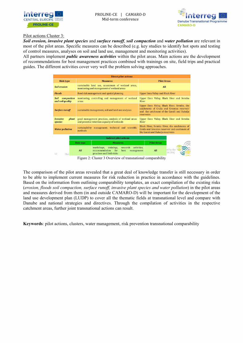
Pilot actions Cluster 3: Soil erosion, invasive plant species most of the pilot areas. Specific measures can be described (e.g. key studies to identify hot spots and testing of control measures, analyses on soil and land use, management and monitoring activities). All partners implement public awareness activitiesof recommendations for best management practices guides. The different activities cover very well the problem solving
Figure 2: The comparison of the pilot areas revealed that a great deal of knowledge transfer is still necessary in order to be able to implement current measures for risk reduction in practice in accordance with the guidelines. Based on the information from outlining comparability templates, an (erosion, floods soil compaction, surface runoff, invasive plant species and water pollutionand measures derived from them (in and outsland use development plan (LUDP)Danube and national strategies and directives. catchment areas, further joint transnational actions can result Keywords: pilot actions, clusters, water management,
PROLINE-CE | CAMARO-D Mid-term conference
and surface runoff, soil compaction and water pollutionpecific measures can be described (e.g. key studies to identify hot spots and testing
of control measures, analyses on soil and land use, management and monitoring activities). public awareness activities within the pilot areas. Main actions are the development
for best management practices combined with trainings on site, field The different activities cover very well the problem solving approaches.
Figure 2: Cluster 3 Overview of transnational comparability
The comparison of the pilot areas revealed that a great deal of knowledge transfer is still necessary in order to be able to implement current measures for risk reduction in practice in accordance with the guidelines.
the information from outlining comparability templates, an exact compilation of the existing risks erosion, floods soil compaction, surface runoff, invasive plant species and water pollution
and measures derived from them (in and outside CAMARO-D) will be important for the development of the land use development plan (LUDP) to cover all the thematic fields at transnational level and compare with Danube and national strategies and directives. Through the compilation of activities in thecatchment areas, further joint transnational actions can result.
water management, risk prevention transnational comparability
water pollution are relevant in pecific measures can be described (e.g. key studies to identify hot spots and testing
of control measures, analyses on soil and land use, management and monitoring activities). n actions are the development
combined with trainings on site, field trips and practical
The comparison of the pilot areas revealed that a great deal of knowledge transfer is still necessary in order to be able to implement current measures for risk reduction in practice in accordance with the guidelines.
exact compilation of the existing risks erosion, floods soil compaction, surface runoff, invasive plant species and water pollution) in the pilot areas
D) will be important for the development of the to cover all the thematic fields at transnational level and compare with
Through the compilation of activities in the respective
transnational comparability

WP3 “SYNOPSIS: VISION AND
HYDROLOGIC ECOSYSTEMPROTECTION AND MITIG
Ecosystem services, defined as “the benefits people obtain from ecosystems” (MA, 2005) received increasing interest after Millennium Ecosystem Assessment (MA) (2005), the former international effort to emphasize and promote the role and significance of ecosystems for human In this perspective, all the different frameworks proposed to cMA,2005; TEEB, 2010; Haines-Youngservices as the benefits to people produced by terrestrialreviews carried out by Brauman (2007; 2015) identify, to this aim, the four main “attributes”: quantity, quality, location and timing (Figure 1) in which water resources can be influenced by different ecosystems and the associated services (Figure 2)
Figure 1 Relationship of hydrologic ecosystem processes to hydrologic services On these grounds, WP3 is aimed to foster and develop measureswater protection and reducing, at the same time, the occurrence and magnitude of waterdetecting an adequate trade-off between the two objectivesTo this end, desk review and expertise of diffpossibilities for funding ecosystems services (e.g. REDD+,degradation Program) at national and transnational level. At the same time, it coul“Ecosystem services” concept into sectoral and horizontal policies enhancing the coherence among the different tools (e.g. biodiversity, climate changes, water security). These efforts will permit achieving several key products:- elaboration of a transnational, but tailored at national scale, addressing, in effective way, drinking water protection and water related disasters induced by water excess or shortage (flood and droughts)
1 GUIDO RIANNA, CMCC Foundation, REMHI Division (email: [email protected])
PROLINE-CE | CAMARO-D Mid-term conference
SYNOPSIS: VISION AND GUIDANCE"
HYDROLOGIC ECOSYSTEM SERVICES AS KEY STRATEGY FOR DRINKING WATER PROTECTION AND MITIGATION OF HYDROLOGICAL HAZARDS
Guido Rianna1
Ecosystem services, defined as “the benefits people obtain from ecosystems” (MA, 2005) received nnium Ecosystem Assessment (MA) (2005), the former international effort to
the role and significance of ecosystems for human well-beingIn this perspective, all the different frameworks proposed to categorise and describe
Young and Potschin, 2018) clearly recognizes the benefits to people produced by terrestrial ecosystem effects on freshwater.
reviews carried out by Brauman (2007; 2015) identify, to this aim, the four main “attributes”: quantity, re 1) in which water resources can be influenced by different ecosystems
and the associated services (Figure 2)
Figure 1 Relationship of hydrologic ecosystem processes to hydrologic services
On these grounds, WP3 is aimed to foster and develop measures and practices properly supporting drinking water protection and reducing, at the same time, the occurrence and magnitude of water
off between the two objectives. To this end, desk review and expertise of different Project Partners will permit identifying the most suitable possibilities for funding ecosystems services (e.g. REDD+, Reducing emissions from deforestation and forest
Program) at national and transnational level. At the same time, it could entail mainstreaming the “Ecosystem services” concept into sectoral and horizontal policies enhancing the coherence among the different tools (e.g. biodiversity, climate changes, water security). These efforts will permit achieving several key products:
but tailored at national scale, plan for land-use management addressing, in effective way, drinking water protection and water related disasters induced by water excess or
GUIDO RIANNA, CMCC Foundation, REMHI Division (email: [email protected])
DRINKING WATER L HAZARDS
Ecosystem services, defined as “the benefits people obtain from ecosystems” (MA, 2005) received nnium Ecosystem Assessment (MA) (2005), the former international effort to
being. ecosystem services (e.g.
, 2018) clearly recognizes hydrologic ecosystem ecosystem effects on freshwater. The pivotal
reviews carried out by Brauman (2007; 2015) identify, to this aim, the four main “attributes”: quantity, re 1) in which water resources can be influenced by different ecosystems
and practices properly supporting drinking water protection and reducing, at the same time, the occurrence and magnitude of water-related disasters
erent Project Partners will permit identifying the most suitable Reducing emissions from deforestation and forest
d entail mainstreaming the “Ecosystem services” concept into sectoral and horizontal policies enhancing the coherence among the
use management and its variation addressing, in effective way, drinking water protection and water related disasters induced by water excess or

- definition of recommendations properly targeted for operational (e.g. water suppliers) and and management purposes (e.g. Municipalities or Regional Authorities) promoting a sustainable and safe utilisation of water resources. All the findings and the developed approaches will then systematized Optimal WAter REgime (GOWARE)information transfer to stakeholders and providmanagement in participating regions beyond lifetime.
Figure 2: Ecohydrological flows and ecosystem services into a catchment. Left side: Conceptual diagram highlighting three main flows (precipitation, Right side: hydrologic services framework showing how ecohydrologic flows impact the ways people can use water at the catchment scale [from Taffarello et al., 2017]
REFERENCES
Brauman KA, Daily GC, Duarte TK, Mooney HA. Thehighlighting hydrologic services. Annu Rev Environ
Brauman, K.A., 2015. Hydrologic ecosystem services: linking ecohydrologic processes toin water research and watershed management. Wires Water 2,345
Haines-Young, R. and M.B. Potschin (2018): Common International Classification of Ecosystem Services (CICES) V5.1 and Guidance on the Application of the Revised Structure.
MA, 2005. Millennium Ecosystem Assessment: Ecosystems and Human WellPress, Washington, DC, p. 155.
Taffarello et al. (2017) Hydrological services in the Atlantic Forest, Brazil: An ecosystemusing ecohydrological monitoring Climate Services 8 (2017) 1
TEEB, 2010. The Economics of Ecosystems and Biodiversity: Mainstreaming theSynthesis of the Approach, Conclusions and39. Keywords: ecosystem services, hydrological services, policies, water resources, hydrological hazards
PROLINE-CE | CAMARO-D Mid-term conference
definition of recommendations properly targeted for operational (e.g. water suppliers) and and management purposes (e.g. Municipalities or Regional Authorities) promoting a sustainable and safe
All the findings and the developed approaches will then systematized CE Transnational Guide towardOptimal WAter REgime (GOWARE) conceived as the tool supporting project partners in preparing adequate information transfer to stakeholders and providing a plan for implementation of sustainable land use management in participating regions beyond lifetime.
Ecohydrological flows and ecosystem services into a catchment. Left side: Conceptual diagram highlighting three main flows (precipitation, evapotranspiration and surface runoff) in the hydrological cycle. Right side: hydrologic services framework showing how ecohydrologic flows impact the ways people can
e water at the catchment scale [from Taffarello et al., 2017]
ily GC, Duarte TK, Mooney HA. The nature and value of ecosystem services: an overviewhighlighting hydrologic services. Annu Rev Environ Resour 2007, 32:67–98.
Brauman, K.A., 2015. Hydrologic ecosystem services: linking ecohydrologic processes toin water research and watershed management. Wires Water 2,345–358.
Young, R. and M.B. Potschin (2018): Common International Classification of Ecosystem Services (CICES) V5.1 and Guidance on the Application of the Revised Structure.
Millennium Ecosystem Assessment: Ecosystems and Human Well-being
Hydrological services in the Atlantic Forest, Brazil: An ecosystemClimate Services 8 (2017) 1–16 doi.org/10.1016/j.cliser.2017.10.005
TEEB, 2010. The Economics of Ecosystems and Biodiversity: Mainstreaming the Economics of Nature: A Synthesis of the Approach, Conclusions and Recommendations of TEEB. Earthscan,
: ecosystem services, hydrological services, policies, water resources, hydrological hazards
definition of recommendations properly targeted for operational (e.g. water suppliers) and spatial planning and management purposes (e.g. Municipalities or Regional Authorities) promoting a sustainable and safe
CE Transnational Guide towards project partners in preparing adequate
lan for implementation of sustainable land use
Ecohydrological flows and ecosystem services into a catchment. Left side: Conceptual diagram
in the hydrological cycle. Right side: hydrologic services framework showing how ecohydrologic flows impact the ways people can
nature and value of ecosystem services: an overview
Brauman, K.A., 2015. Hydrologic ecosystem services: linking ecohydrologic processes to human well-being
Young, R. and M.B. Potschin (2018): Common International Classification of Ecosystem Services
being– Synthesis. Island
Hydrological services in the Atlantic Forest, Brazil: An ecosystem-based adaptation doi.org/10.1016/j.cliser.2017.10.005
Economics of Nature: A Recommendations of TEEB. Earthscan, London-Washington, p.
: ecosystem services, hydrological services, policies, water resources, hydrological hazards

PROLINE
ADVANCEMENT –
ABSTRACT
The main output of Work Package T4for “Drinking water/Floods/Land use”represents a commitment towards an optimized and effective land use and flood/drought management with efficient organizational structures regarding drinking water protection. To push the visibility of the activities conducted in PROLINE-CE and in order to bundle efforts towards and integrated land use und flood/drought management this joint declaration act will be sduring the Final Conference in June 2019 in Vienna.
The DriFLU Charta will contain transnational guidelines regarding an efficient protection of drinking water resources. This objective should be achieved through the development of sustainable and appropriate land use and management measures aiming at the protection of drinking water resources and additionally at the mitigation as well as reduction of droughts and floods influencing these resourclimate change.
The transnational DriFLU Charta will be just a very understandable, focused and short paper with the main necessary measures concerning the different land uses: forestry, agriculture, urban, grassland, wetland ageneral recommendations. Within an Annex these mentioned issues will be explained more in detail to be as precise as possible.
Additionally each participating country will develop a national DriFLU Charta focusing on the specific issues and political respectively social background.
To foster the transnational transferability respectively usability of these recommendations an intensive stakeholder involvement will be conducted within this Work Packageand Panel discussions on transnational levelback with the mid-term-conference) and national level in each participating countrynational/regional strategies and policies
The identified still existing shortcomings as well as challenges will lucidly showcase potential for future cooperation efforts. It is the responsibility of the existing partnAfter the project end, partner representatives will make efforts to monitor stakeholder actions regarding implementation of the signed commitment.
The initiated policy dialogue at regional and on European levisibility, in compliance to the relevant strategies on EU level,2030 Agenda for Sustainable Development (mainly to the Sustainable Development Goal SDG 6), EU
1 Gerhardt Elisabeth, Federal Research and Training Centre for Forests, Natural Hazards and Landscape (BFW), Vienn(email: [email protected])
PROLINE-CE | CAMARO-D Mid-term conference
PROLINE-CE: WORK PACKAGE T4
– STRATEGIC POSITIONING AND COMMITMENT
Elisabeth Gerhardt 1
The main output of Work Package T4 is the so-called DriFLU Charta. The abbreviation “DriFLU” stands “Drinking water/Floods/Land use” combining the most important thematic issues within this project.
represents a commitment towards an optimized and effective land use and flood/drought management with organizational structures regarding drinking water protection. To push the visibility of the activities
CE and in order to bundle efforts towards and integrated land use und flood/drought management this joint declaration act will be signed by notable representatives of each participating country during the Final Conference in June 2019 in Vienna.
will contain transnational guidelines regarding an efficient protection of drinking water be achieved through the development of sustainable and appropriate land
use and management measures aiming at the protection of drinking water resources and additionally at the mitigation as well as reduction of droughts and floods influencing these resources, under the challenges of
he transnational DriFLU Charta will be just a very understandable, focused and short paper with the main necessary measures concerning the different land uses: forestry, agriculture, urban, grassland, wetland ageneral recommendations. Within an Annex these mentioned issues will be explained more in detail to be as
Additionally each participating country will develop a national DriFLU Charta focusing on the specific spectively social background.
To foster the transnational transferability respectively usability of these recommendations an intensive will be conducted within this Work Package: On the one hand two Round Tables
on transnational level (the first ones on 12th/13th of June 2018 in Ljubljana back to conference) and on the other hand stakeholder operationalisation workshops on
national level in each participating country for embedding relevant drinking water protection topics in national/regional strategies and policies.
The identified still existing shortcomings as well as challenges will lucidly showcase potential for future cooperation efforts. It is the responsibility of the existing partnership to bring the Charta objectives into life.After the project end, partner representatives will make efforts to monitor stakeholder actions regarding implementation of the signed commitment.
The initiated policy dialogue at regional and on European level will provide important inputs for the projects visibility, in compliance to the relevant strategies on EU level, like EUSDR, EUSALP, EU 2020 Strategy, 2030 Agenda for Sustainable Development (mainly to the Sustainable Development Goal SDG 6), EU
Gerhardt Elisabeth, Federal Research and Training Centre for Forests, Natural Hazards and Landscape (BFW), Vienn
G AND COMMITMENT
. The abbreviation “DriFLU” stands combining the most important thematic issues within this project. It
represents a commitment towards an optimized and effective land use and flood/drought management with organizational structures regarding drinking water protection. To push the visibility of the activities
CE and in order to bundle efforts towards and integrated land use und flood/drought igned by notable representatives of each participating country
will contain transnational guidelines regarding an efficient protection of drinking water be achieved through the development of sustainable and appropriate land
use and management measures aiming at the protection of drinking water resources and additionally at the ces, under the challenges of
he transnational DriFLU Charta will be just a very understandable, focused and short paper with the main necessary measures concerning the different land uses: forestry, agriculture, urban, grassland, wetland and general recommendations. Within an Annex these mentioned issues will be explained more in detail to be as
Additionally each participating country will develop a national DriFLU Charta focusing on the specific
To foster the transnational transferability respectively usability of these recommendations an intensive On the one hand two Round Tables of June 2018 in Ljubljana back to
stakeholder operationalisation workshops on t drinking water protection topics in
The identified still existing shortcomings as well as challenges will lucidly showcase potential for future ership to bring the Charta objectives into life.
After the project end, partner representatives will make efforts to monitor stakeholder actions regarding
vel will provide important inputs for the projects like EUSDR, EUSALP, EU 2020 Strategy,
2030 Agenda for Sustainable Development (mainly to the Sustainable Development Goal SDG 6), EU
Gerhardt Elisabeth, Federal Research and Training Centre for Forests, Natural Hazards and Landscape (BFW), Vienna, Austria

Strategy on Adaptation to Climate Change, EU Water Framework Directive (River Basin Management Plan 2021-2027) and EU Floods Directive.
Keywords: PROLINE-CE, drinking water protection, land use management, joint signed declaration act
PROLINE-CE | CAMARO-D Mid-term conference
Strategy on Adaptation to Climate Change, EU Water Framework Directive (River Basin Management Plan 2027) and EU Floods Directive.
CE, drinking water protection, land use management, joint signed declaration act
Strategy on Adaptation to Climate Change, EU Water Framework Directive (River Basin Management Plan
CE, drinking water protection, land use management, joint signed declaration act

PROLINE-CE | CAMARO-D Mid-term conference
WORK-PACKAGE T3 “VISIONARY DANUBE”
Prvoslav Marjanović1, Marko Marjanović1, Dragana Spasić1 , Dragica Vulić1
ABSTRACT
Work package (WP) T3” Visionary Danube” is focused on two main activities:
ACTIVITY 5.1: DEVELOPMENT OF TRANSNATIONAL GUIDANCE
Based on the SWOT analysis, best practice reviews and pilot action cluster reports a guidance for the
Danube region for sustainable land use planning (GUIDR) will be developed.
The development will be based on the respective water intervention type (protection of water
resources or flood prevention) and focus on the improvement of water quality and enhancement of
flood prevention (through the implementation of a function-oriented land use for a sound water
management in an optimized quantitative and qualitative manner.)
There will be interfaces to soil protection, nature and water protection, management of invasive plant
species and spatial planning (with relevance for water management issues) and relevant control
mechanisms for funding programs.
This transnational decision support tool will serve as blueprint for applied protection of water
resources and prevention of floods for the whole Danube basin.
All project partners will share their specific knowledge gathered also in the course of the CAMARO-
D project to elaborate GUIDR.
GUIDR represents the initiation of practical implementation and feasibility, which can also be
understood by all involved stakeholders.
ACTIVITY 5.2: APPLICATION OF GUIDR AND STAKEHOLDER TOOLKITS
Set-up of a coordinated framework for the recommendation reports
Reports of applicable recommendations in the field of agriculture, grassland management, forestry,
spatial planning and water management for implementation
Initiation of practical implementation of GUIDR in the pilot areas
Recommended practical GUIDR implementation lineout
Stakeholder toolkits for different stakeholder groups (agriculture, grassland management, forestry,
spatial planning and water management)
All WP T3 outputs will be presented within the framework of examples of best practice principles applicable
in different settings and based on knowledge and understanding gained during the project.
In this manner the transfer of findings and knowledge will be possible and applicable throughout the Danube
basin region.
1 Prvoslav Marjanović, , Marko Marjanović, Dragana Spasić, Dragica Vulić, Jaroslav Černi Water Institute, Jaroslava Černog 80,
11226 Belgrade, Serbia, (email: [email protected])

PROLINE-CE | CAMARO-D Mid-term conference
GUIDR and the corresponding tool-kit will be a common means for implementation throughout the project
area.
It is emphasized that integration of identified gaps of current land use planning practice regarding water
protection and flood risk prevention issues and the lessons learnt will be carried out at the pilot action cluster
level.
GUIDR - Guidance for the Danube region for sustainable land use planning will be developed for decision
makers as a decision support tool. The development will be based on the respective water intervention type
and focus on the improvement of water quality and enhancement of flood prevention through the
implementation of a function-oriented land use for a sound water management in an optimized quantitative
and qualitative manner. The initiation of the practical implementation of GUIDR will be conducted in the
respective pilot areas by means of bottom-up approaches to mitigate the different conflicts of interests and to
develop prospects for action deliverables, being approached through the series of 2nd
stakeholder workshops
and trainings in selected pilot areas. The implementation of GUIDR in the pilot areas encompasses an
operational description for the application of best management practices. This includes recommendations for
implementation of steering tools for regional strategy development and funding programmes.
Within the adopted approach of work within WP T3 the focus is on credibility, legitimacy and prominence
within ecosystem based land use planning and clearly understood roles of different role players (Figure 1)
and distinct phases in the planning and implementation process (Focus of GUIDR) as shown in Figure 2.
Figure 1. Interrelationships and focus of activities within WP T3

PROLINE-CE | CAMARO-D Mid-term conference
Keywords: Ecosystem based sustainable land use planning, water quality protection, good practice
Figure 2. Planning phases and focus of GUIDR

WORK-PACKAGE T4 “PROGRESSIVE DANUBE”Concept for elaboration of “Land Use Development Plan” (LUDP)
ABSTRACT
Work package T4 “Progressive Danube” elaborates a common transferable catalogue with recommendations and joint standards in the Danube river basin for land use management with the overall purpose for protection of water resources and flood risk management. The transnational strategy “Land Use Development Plan” (LUDP) will be developed in order to integrate the policy level and will serve as a strategy for functionstrategic outline for sustainable protection of waterto an improved strategic decision process on policy level. Based on the results of pilot actions within Clusters 1, 2 and 3 (WP T2) and through enhancing the communication between stakeholders anbased LUDP will be elaborated. The target groups and stakeholders will be consulted and involved in the development of the transnational LUDP as well as the development of the strategic outlprotection of water resources, integrated management and mitigation of flood risk. actually given throughout the project duration, e.g. in the stakeholder trainings within the pilot action clusters, which serve as essential input for LUDP. essential for raising awareness and for active involvement of local population in decision making process and prevention activities. /Fig.1/
Fig. 1 Study visit about torrents and against afforestation of degraded lands,
1 Bobeva A., Executive Forest Agency, blvd. Hristo Bptev 55, Sofia 1040, Bulgaria, [email protected] 2 Ravailova E, Executive Forest Agency, blvd. Hristo Bptev 55, Sofia 1040, Bulgaria, [email protected]
PROLINE-CE | CAMARO-D Mid-term conference
CAMARO-D PACKAGE T4 “PROGRESSIVE DANUBE”
Concept for elaboration of “Land Use Development Plan” (LUDP) in Danube river basin
Bobeva A.1, Rafailova E.2
“Progressive Danube” elaborates a common transferable catalogue with recommendations and joint standards in the Danube river basin for land use management with the overall purpose for protection of water resources and flood risk management.
nal strategy “Land Use Development Plan” (LUDP) will be developed in order to integrate the policy level and will serve as a strategy for function-oriented land use in Danube river basin. LUDP will be a strategic outline for sustainable protection of water resources and mitigation of flood risk and will contribute to an improved strategic decision process on policy level.
Based on the results of pilot actions within Clusters 1, 2 and 3 (WP T2) and through enhancing the communication between stakeholders and institutions, the final framework for a transnational catchmentbased LUDP will be elaborated. The target groups and stakeholders will be consulted and involved in the development of the transnational LUDP as well as the development of the strategic outlprotection of water resources, integrated management and mitigation of flood risk. actually given throughout the project duration, e.g. in the stakeholder trainings within the pilot action
sential input for LUDP. Stakeholder workshops for knowledge transfer are essential for raising awareness and for active involvement of local population in decision making process and
Study visit about torrents and Simulation game “danger zone map for protection
against afforestation of degraded lands, © ROMSILVA floods”, © AREC
Bobeva A., Executive Forest Agency, blvd. Hristo Bptev 55, Sofia 1040, Bulgaria,
Ravailova E, Executive Forest Agency, blvd. Hristo Bptev 55, Sofia 1040, Bulgaria,
PACKAGE T4 “PROGRESSIVE DANUBE” Concept for elaboration of “Land Use Development Plan” (LUDP)
“Progressive Danube” elaborates a common transferable catalogue with recommendations and joint standards in the Danube river basin for land use management with the overall purpose for
nal strategy “Land Use Development Plan” (LUDP) will be developed in order to integrate the oriented land use in Danube river basin. LUDP will be a
resources and mitigation of flood risk and will contribute
Based on the results of pilot actions within Clusters 1, 2 and 3 (WP T2) and through enhancing the d institutions, the final framework for a transnational catchment-
based LUDP will be elaborated. The target groups and stakeholders will be consulted and involved in the development of the transnational LUDP as well as the development of the strategic outline for sustainable protection of water resources, integrated management and mitigation of flood risk. This involvement is actually given throughout the project duration, e.g. in the stakeholder trainings within the pilot action
Stakeholder workshops for knowledge transfer are essential for raising awareness and for active involvement of local population in decision making process and
Simulation game “danger zone map for protection
Bobeva A., Executive Forest Agency, blvd. Hristo Bptev 55, Sofia 1040, Bulgaria,
Ravailova E, Executive Forest Agency, blvd. Hristo Bptev 55, Sofia 1040, Bulgaria,

Relevant institutions and decision makers will be addressed as target groups for the communication and implementation of the LUDP. This will guarantee the crossthe best transnational implementation process
Fig. 2 Cross-sectoral cooperation between water and forest authorities in drinking water protection areas Bulgaria, pilot area – watershed “Ochindolska reka” The transferable catalogue with recommendations, best solutions and joint standards for function oriented land use management will be proposed as decision support tool for politicians to expand their competences and to support them in decision making proce To ensure the long-term partnership in the field of sustainable land use management, a Memorandum of Understanding about the further joint proceeding towards the implementation of LUDP will be signed. All target groups and stakeholders will be invited to provide their contribution to the potential followactivities for water protection and mitigation of flood
Keywords: joint standards, stakeholders, lan
PROLINE-CE | CAMARO-D Mid-term conference
Relevant institutions and decision makers will be addressed as target groups for the communication and implementation of the LUDP. This will guarantee the cross-regional and cross-sector coordination to achieve the best transnational implementation process. /Fig. 2/
sectoral cooperation between water and forest authorities in drinking water protection areas
watershed “Ochindolska reka”, © EFA
The transferable catalogue with recommendations, best solutions and joint standards for function oriented land use management will be proposed as decision support tool for politicians to expand their competences and to support them in decision making process.
term partnership in the field of sustainable land use management, a Memorandum of Understanding about the further joint proceeding towards the implementation of LUDP will be signed.
All target groups and stakeholders will be invited to provide their contribution to the potential followactivities for water protection and mitigation of flood-risk management in the Danube River Basin.
joint standards, stakeholders, land use development plan, land use manage
Relevant institutions and decision makers will be addressed as target groups for the communication and sector coordination to achieve
sectoral cooperation between water and forest authorities in drinking water protection areas in
The transferable catalogue with recommendations, best solutions and joint standards for function oriented land use management will be proposed as decision support tool for politicians to expand their competences
term partnership in the field of sustainable land use management, a Memorandum of Understanding about the further joint proceeding towards the implementation of LUDP will be signed.
All target groups and stakeholders will be invited to provide their contribution to the potential follow-up risk management in the Danube River Basin.
evelopment plan, land use management

POTENTIAL SYNERGIES
Barbara Čenčur Curk 1, Jerca Praprotnik Kastelic
The following document intends to show possible synergies among PROLINEprojects. It is meant to present differences between both projects on the one hand and possible synergies on the other hand, taking into consideration the two project timelines. Even if at thsimilarities concerning the structure of the project and approach on how to reach the deliverables and outputs, there are still considerable differences as it usually is the case with projects submitted in the same priority and dealing with a similar topic.
Both projects are aiming at the same goal resources in general), which is also the priority of the Central Europe Programme (Priority 3, SO3.1 To improve integrated environmental management capacities for the protection and sustainable use of natural heritage and resources) and of the Danube Transnational Programme (Priority 2, SO2.1 Strengthen transnational water management and flood risk prevention).
The focus of PROLINE-CE project is protection of drinking water sources through integrated land use management and a developed implementation strategy for effectively harmonized environmental standards in drinking water recharge areas to improve waterareas. On the other hand, CAMAROriver basin with setting the frame for a harmonized transnational land use management system, taking into account the demands of water resources protection and flood prevention.
Despite different detailed focus of both projects, synergies of both projects can of course be identified, such as e.g. development of strategies how to address stakeholders in order to conviusefulness of applications of drinking water protection concepts (PROLINEroutines for land use impacts on the water regime (CAMAROaction. Synergies are also given by the expertiseof experts is working in similar thematic fields, which supports and opens new insights for both projects. This fact also supports the usefulness of a joint Mid
Two flowcharts should help to point out in a clear way that the synergy stands for the interaction/cooperation of both projects, producing a combined effect, which is greater than the sum of their separate effects. This can be clearly seen in the schematic presentation in Figure 1 pointing out, that cross fertilisation leads to a higher level as for “stand-alone projects”.
The second flowchart, showing the implementation of workpackageCAMARO-D projects (Figure 2), presents,implemented in work packages T3 and T4 of both projects will result in a higher level/ of these outcomes (full squares for T3 and T4 in Figure 2). In comparison, outcomes of T3 and T4 without synpresented as dashed square in Figure 2, clearly indicating lower level of outcomes.
1 Barbara Čenčur Curk, University of [email protected]) 2 Jerca Praprotnik Kastelic, University of Ljubljana, Faculty of Natural Sciences and Engineering, Ljubljana ([email protected]) 3 Elisabeth Gerhardt, Federal Research and Training Centre for Forests, Natural Hazards and Landscape, Vienna([email protected]) 4 Gudrun Schroemmer, PRISMA solutions, Mödling (gudrun.schroemmer@prisma
PROLINE-CE | CAMARO-D Mid-term conference
POTENTIAL SYNERGIES OF PROLINE-CE & CAMARO-D AND OTHER EU PROJECTS
Jerca Praprotnik Kastelic2 , Elisabeth Gerhardt3, Gudrun Schroemmer
intends to show possible synergies among PROLINEprojects. It is meant to present differences between both projects on the one hand and possible synergies on the other hand, taking into consideration the two project timelines. Even if at thsimilarities concerning the structure of the project and approach on how to reach the deliverables and outputs, there are still considerable differences as it usually is the case with projects submitted in the same
ling with a similar topic.
Both projects are aiming at the same goal – protection of natural resources (drinking water and water resources in general), which is also the priority of the Central Europe Programme (Priority 3, SO3.1 To
ronmental management capacities for the protection and sustainable use of natural heritage and resources) and of the Danube Transnational Programme (Priority 2, SO2.1 Strengthen transnational water management and flood risk prevention).
CE project is protection of drinking water sources through integrated land use management and a developed implementation strategy for effectively harmonized environmental standards in drinking water recharge areas to improve water- and soil quality and reduce flood/drought risks within these areas. On the other hand, CAMARO-D project focus are land use impacts on the water regime in the Danube river basin with setting the frame for a harmonized transnational land use management system, taking into
the demands of water resources protection and flood prevention.
Despite different detailed focus of both projects, synergies of both projects can of course be identified, such as e.g. development of strategies how to address stakeholders in order to conviusefulness of applications of drinking water protection concepts (PROLINE-CE) and/or (2) management routines for land use impacts on the water regime (CAMARO-D), which can be adapted by the other pilot
n by the expertise-extension provided through the fact that an extended circle similar thematic fields, which supports and opens new insights for both projects.
This fact also supports the usefulness of a joint Mid-term Conference.
Two flowcharts should help to point out in a clear way that the synergy stands for the interaction/cooperation of both projects, producing a combined effect, which is greater than the sum of their separate effects. This
c presentation in Figure 1 pointing out, that cross fertilisation leads to a alone projects”.
The second flowchart, showing the implementation of workpackage-outcomes between PROLINED projects (Figure 2), presents, how outcomes from workpackages T1 and T2 from both projects
implemented in work packages T3 and T4 of both projects will result in a higher level/ of these outcomes (full squares for T3 and T4 in Figure 2). In comparison, outcomes of T3 and T4 without synpresented as dashed square in Figure 2, clearly indicating lower level of outcomes.
Barbara Čenčur Curk, University of Ljubljana, Faculty of Natural Sciences and Engineering, Ljubljana (emai
, University of Ljubljana, Faculty of Natural Sciences and Engineering, Ljubljana (emai
Elisabeth Gerhardt, Federal Research and Training Centre for Forests, Natural Hazards and Landscape, Vienna
Gudrun Schroemmer, PRISMA solutions, Mödling ([email protected])
D AND OTHER EU
Gudrun Schroemmer4
intends to show possible synergies among PROLINE-CE and CAMARO-D projects. It is meant to present differences between both projects on the one hand and possible synergies on the other hand, taking into consideration the two project timelines. Even if at the first glance there are similarities concerning the structure of the project and approach on how to reach the deliverables and outputs, there are still considerable differences as it usually is the case with projects submitted in the same
protection of natural resources (drinking water and water resources in general), which is also the priority of the Central Europe Programme (Priority 3, SO3.1 To
ronmental management capacities for the protection and sustainable use of natural heritage and resources) and of the Danube Transnational Programme (Priority 2, SO2.1 Strengthen
CE project is protection of drinking water sources through integrated land use management and a developed implementation strategy for effectively harmonized environmental standards in
educe flood/drought risks within these D project focus are land use impacts on the water regime in the Danube
river basin with setting the frame for a harmonized transnational land use management system, taking into
Despite different detailed focus of both projects, synergies of both projects can of course be identified, such as e.g. development of strategies how to address stakeholders in order to convince them about (1) the
CE) and/or (2) management D), which can be adapted by the other pilot
extension provided through the fact that an extended circle similar thematic fields, which supports and opens new insights for both projects.
Two flowcharts should help to point out in a clear way that the synergy stands for the interaction/cooperation of both projects, producing a combined effect, which is greater than the sum of their separate effects. This
c presentation in Figure 1 pointing out, that cross fertilisation leads to a
outcomes between PROLINE-CE and how outcomes from workpackages T1 and T2 from both projects
implemented in work packages T3 and T4 of both projects will result in a higher level/ of these outcomes (full squares for T3 and T4 in Figure 2). In comparison, outcomes of T3 and T4 without synergies are
Ljubljana, Faculty of Natural Sciences and Engineering, Ljubljana (email:
, University of Ljubljana, Faculty of Natural Sciences and Engineering, Ljubljana (email:
Elisabeth Gerhardt, Federal Research and Training Centre for Forests, Natural Hazards and Landscape, Vienna

Figure 1: Synergy of PROLINE-CE and CAMAROprojects, producing a combined effect (increased level of knowledge and outcomes), which is greater than sum of their separate effects.
In the two projects, above all, the pilcreated for those partners involved in both projects, it can be stated that in fact there is a mutual benefit in both directions in the sense that lessons learnt in one project can immediately be practiced in the other project. This was for example the ca
Such synergies are possible with many other management and land use management, whereas applying project results from past project is capi
REFERENCES
Synergy building plan for PROLINE Keywords: Synergies, PROLINE-CE, CAMARO
PROLINE-CE | CAMARO-D Mid-term conference
CE and CAMARO-D projects, producing a combined effect (increased level of knowledge and outcomes), which is greater than the
Figure 2: Flowchart of the implementation of workpackages outcomes between PROLINEand CAMARO-D projects.
In the two projects, above all, the pilot actions differ significantly. Concerning possible synergies that arecreated for those partners involved in both projects, it can be stated that in fact there is a mutual benefit in both directions in the sense that lessons learnt in one project can immediately be practiced in the other project. This was for example the case for the organisation of the stakeholder workshops.
Such synergies are possible with many other current projects dealing with drinking water protection, water agement and land use management, whereas applying project results from past project is capi
Synergy building plan for PROLINE-CE and CAMARO-D projects, Project report.
CE, CAMARO-D
Figure 2: Flowchart of the implementation of workpackages outcomes between PROLINE-CE
D projects.
. Concerning possible synergies that are created for those partners involved in both projects, it can be stated that in fact there is a mutual benefit in both directions in the sense that lessons learnt in one project can immediately be practiced in the other
se for the organisation of the stakeholder workshops.
projects dealing with drinking water protection, water agement and land use management, whereas applying project results from past project is capitalisation.

“DROUGHT RISK IN THE DANUBE REGION”
ANDREJA SUŠNIK1, GREGOR GREGORIČ
DriDanube project, having on board 15 (Slovenia, Czech Republic, Slovakia, and Montenegro), started its 2.5-year implementation in January 2017. It brings tdifferent sectors: national hydrometeorological services,and a non-governmental organisationStrategy, partnership also cooperates CAMARO-D and JoinTisza. Project’s main objective is to increaseorder to achieve that, project partnership is developing monitoring, a common methodologmethodology for drought risk assessment.project is also preparing regional Strategy to improve drought emergency response
Picture 1: Each of the expected outcomes targets a certain field of drought management and management in countries of the region and improved preparedness for next drought. Half way into project implementation, partnership prototype of Drought User Service (DUS), an interactive tool for better drought characterisation and early warning over entire Danube regionprocessed into ready-to-use drought information, available to public onlday work of end-users from farmers to national authorities in all aspects of drought management. With DUS prototype ready, a training on its use was heldwho will later on train national stakeholders.
1 ANDREJA SUŠNIK, SLOVENIAN ENVIRONMENT AGENCY, VOJKOVA 1B, 1004 LJUBLJANA, SLOVENIA [email protected]) 2 GREGOR GREGORIČ, SLOVENIAN ENVIRONMENT AGENCY, VOJKOVA 1B, 1004 LJUBLJANA, SLOVENIA [email protected]) 3 MAJA ŽUN, SLOVENIAN ENVIRONMENT AGENCY, VOJKOVA 1B, 1004 LJUBLJANA, SLOVENIA [email protected]) 4 ANDREJA MODERC, SLOVENIAN ENVIRONMENT AGENCY, VOJKOVA 1B, 1004 LJUBLJANA, SLOVENIA [email protected])
PROLINE-CE | CAMARO-D Mid-term conference
DriDanube
DANUBE REGION” – DANUBE TRANSNATIONAL
GREGOR GREGORIČ2, MAJA ŽUN3 and ANDREJA MODERC
DriDanube project, having on board 15 project partners and 8 associated strategic partners (Slovenia, Czech Republic, Slovakia, Austria, Hungary, Romania, Croatia, Bosnia and Herzegovina, Serbia
year implementation in January 2017. It brings together ydrometeorological services, universities, scientific centres, a
governmental organisation. In the frame of Danube Transnational Programme Capitalisation cooperates with consortium of partners included in sister DTP projects
is to increase capacity of the Danube region to manage droughtorder to achieve that, project partnership is developing an operational interactive tool
methodology for drought impact assessment and yield forecast as well as a unified methodology for drought risk assessment. Aiming at improving drought response to become proproject is also preparing regional Strategy to improve drought emergency response (Picture 1
Each of the expected outcomes targets a certain field of drought management and thus contributes to wholesome drought management in countries of the region and improved preparedness for next drought.
Half way into project implementation, partnership has achieved great progress towardsrvice (DUS), an interactive tool for better drought characterisation and early
warning over entire Danube region, has been developed and includes a range of satellite datasets further use drought information, available to public online. This way, it will
users from farmers to national authorities in all aspects of drought management. With DUS a training on its use was held dedicated to drought monitoring experts within the partnership
stakeholders.
ANDREJA SUŠNIK, SLOVENIAN ENVIRONMENT AGENCY, VOJKOVA 1B, 1004 LJUBLJANA, SLOVENIA
GREGOR GREGORIČ, SLOVENIAN ENVIRONMENT AGENCY, VOJKOVA 1B, 1004 LJUBLJANA, SLOVENIA
VIRONMENT AGENCY, VOJKOVA 1B, 1004 LJUBLJANA, SLOVENIA
ANDREJA MODERC, SLOVENIAN ENVIRONMENT AGENCY, VOJKOVA 1B, 1004 LJUBLJANA, SLOVENIA
DANUBE TRANSNATIONAL PROGRAMME
ANDREJA MODERC4
artners from 10 countries nia and Herzegovina, Serbia
ogether institutions from scientific centres, a research institute
n the frame of Danube Transnational Programme Capitalisation included in sister DTP projects such as
to manage drought-related risks. In interactive tool for better drought
d forecast as well as a unified Aiming at improving drought response to become pro-active, the
Picture 1).
thus contributes to wholesome drought
progress towards reaching its goal. A rvice (DUS), an interactive tool for better drought characterisation and early
includes a range of satellite datasets further ine. This way, it will improve day-to-
users from farmers to national authorities in all aspects of drought management. With DUS drought monitoring experts within the partnership
ANDREJA SUŠNIK, SLOVENIAN ENVIRONMENT AGENCY, VOJKOVA 1B, 1004 LJUBLJANA, SLOVENIA (email:
GREGOR GREGORIČ, SLOVENIAN ENVIRONMENT AGENCY, VOJKOVA 1B, 1004 LJUBLJANA, SLOVENIA (email:
VIRONMENT AGENCY, VOJKOVA 1B, 1004 LJUBLJANA, SLOVENIA (email:
ANDREJA MODERC, SLOVENIAN ENVIRONMENT AGENCY, VOJKOVA 1B, 1004 LJUBLJANA, SLOVENIA (email:

First step towards harmonized drought impacts assessment and forecasthistorical drought impacts data for 1981participating countries. Since then, partnership has putnetworks for early drought detection and its exact impacts on the fieldweekly state of soil and vegetationgrasslands are then displayed in a form ofdrought impacts data collected through natiocollection and also for validation ofmethodology for drought risk assessment was prepared and, idrought risk across Danube region are under development. The final output of DriDanube project is the Strategy to improve drought emergency response in the Danube region. A starting point of its preparation wascommon gaps and needs in each participating country.and key stakeholders, countries’ current status of droughtanalysed. Turning out that drought policy framework across the regionnational policies not addressing droughtdrought management by developinginstitutions involved in drought monitoring and drought management into a unified institutional collective proactive implementation of With main project outputs well into their final formprovide much needed feedback on theirbe tested in Croatia, Czech Republic, Montenegro and Romaniamanagement model is going to be Krivaja (Serbia). Based on findings derived from pilot actions, methodologies and drought strategy drought monitoring and/or management across all Danube region become more efficientemergency response and prepare better
REFERENCES
http://www.interreg-danube.eu/dridanube
Keywords: DriDanube, drought risk, Danube region,
PROLINE-CE | CAMARO-D Mid-term conference
drought impacts assessment and forecast across the region historical drought impacts data for 1981-2016 period and crop yield data for 2010-2016 period on the area of
nce then, partnership has put great effort into establishfor early drought detection and its exact impacts on the field, consisting
state of soil and vegetation. Detected drought impacts on soil, agricultural crops, forests and in a form of maps which will be further integrated into DUS.
drought impacts data collected through national reporting networks serve for validation of satellite data. At the same time, general scheme of common
ht risk assessment was prepared and, in addition to it, softwares for mapping of be region are under development.
The final output of DriDanube project is the Strategy to improve drought emergency response in the Danube its preparation was to see how drought is managed across the re
in each participating country. Therefore, with help of associated strategic partnerscurrent status of drought monitoring, risk assessment and management w
drought policy framework across the region is dispersed and marked with diverse drought directly, partnership set ground for synchronized and improved
by developing an optimal drought management model. It organises existing national institutions involved in drought monitoring and drought management into a unified institutional
implementation of national drought policies.
well into their final form, they are ready for testing through two pilot actionsprovide much needed feedback on their usefulness. DUS prototype with integrated methodologies is going to
epublic, Montenegro and Romania while proposed optimal drought management model is going to be tested method downscaled on river catchments of
Based on findings derived from pilot actions, project’s newly developed tool, methodologies and drought strategy will be further shaped and improved to help stakeholdersdrought monitoring and/or management across all Danube region become more efficient
prepare better for next drought.
danube.eu/dridanube
isk, Danube region, Interreg, project
across the region was to collect 2016 period on the area of
to establishing national reporting of on-field reporters on
on soil, agricultural crops, forests and integrated into DUS. This way,
for systematic impact data , general scheme of common
n addition to it, softwares for mapping of
The final output of DriDanube project is the Strategy to improve drought emergency response in the Danube see how drought is managed across the region and find
associated strategic partners monitoring, risk assessment and management were
is dispersed and marked with diverse for synchronized and improved
organises existing national institutions involved in drought monitoring and drought management into a unified institutional scheme for
, they are ready for testing through two pilot actions to DUS prototype with integrated methodologies is going to
roposed optimal drought river catchments of Tisa (Hungary) and
project’s newly developed tool, help stakeholders in the field of
drought monitoring and/or management across all Danube region become more efficient during drought

INTEGRATED APPROACH
ABSTRACT
AMIIGA is a project pulling together 12 partners from 6 countries (Poland, Germany, Italy, Czech Republic, Italy, Slovenia, Croatia) of Central Europe, all sharing the objective of developing an integrated approach to the management of groundwater quality groundwater contamination originating both from plumes and diffuse pollution of different sources, a common issue in Central Europe. 10 Associated Partners contribute to develop and carry out The AMIIGA territories cover different types of brownfield related contamination, as well as different types of groundwater bodies (porous aquifers of alluvial plains, fractured and karstic aquifers). This covers pollution by traditional industrial activities and mining related pollution. The project is developing a shared transnational management strategy to deal with groundwater contamination. Seven management plans, one for einclude the definition and timeline of remediation targets, suggestions for adjusting measures in case of new laws or realignments of the remediation targets, a monitoring plan of effects of the measurfinancial and legal considerations for implementation. Relevant institutions (public bodies, regulating bodies, water authorities) and stakeholders are involved through the establishment of Regional Implementation Groups and through workshops and trainings. Good practices are identifying and sharing. Seven Pilot Actions will test and demonstrate the innovative tools of AMIIGA and develop the Integrated Groundwater Management Approach. They are different for contaminants, hydrogeologicaland final outputs: • Remediation concept from drinking water perspective for diverse pollutants in Ljubljana (SI), • Distinction between site-specific and diffused contamination in Milan (IT), • Assessment of Natural Attenuation potential as a remediation option in Parma (IT), • InNovy Bydzov (CZ), • Passive GW treatment by bioremedial measures efficiency in Stuttgart (DE), • Solution for thKarst in Zadar (HR). Innovative tools for characterization and prioritization of groundwater contamination sources will support decision making and strategies for groundwater management in Functional Urban Areas. developing biological (Biological Molecular Tools Isotopes - CSIA) tools to make them suitable both in urban cores and their surroundings. Integrated AMIIGA approach will include also innovative remebiological process. Pilot action of Ljubljana-Ig Functional Urban Area (Slovenia) Despite the numerous protective measures, the quality of groundwater in the aquifer under the city is affected by numerous impacts that are not under control. Some pollutants originate from the distant past, others are (un)expected in groundwater. They areslowly travelling clouds or sporadic phenomena, requiring coordinated action among stakeholders. In the
1 Joerg PRESTOR, Geological Survey of Slovenia,
PROLINE-CE | CAMARO-D Mid-term conference
AMIIGA
INTEGRATED APPROACH TO MANAGEMENT OF GROUNDWATER QUALITY IN FUNCTIONAL URBAN AREAS
Joerg PRESTOR1
AMIIGA is a project pulling together 12 partners from 6 countries (Poland, Germany, Italy, Czech Republic, entral Europe, all sharing the objective of developing an integrated approach to
the management of groundwater quality in Functional Urban Areas. AMIIGA project tackles the problem of groundwater contamination originating both from plumes and diffuse pollution of different sources, a common issue in Central Europe. 10 Associated Partners contribute to develop and carry out
The AMIIGA territories cover different types of brownfield related contamination, as well as different types of groundwater bodies (porous aquifers of alluvial plains, fractured and karstic aquifers). This covers
al activities - chlorinated hydrocarbons, agriculture -
The project is developing a shared transnational management strategy to deal with groundwater contamination. Seven management plans, one for each Functional Urban Area, will be produced; they will include the definition and timeline of remediation targets, suggestions for adjusting measures in case of new laws or realignments of the remediation targets, a monitoring plan of effects of the measurfinancial and legal considerations for implementation. Relevant institutions (public bodies, regulating bodies, water authorities) and stakeholders are involved through the establishment of Regional Implementation
kshops and trainings. Good practices are identifying and sharing.
Seven Pilot Actions will test and demonstrate the innovative tools of AMIIGA and develop the Integrated Groundwater Management Approach. They are different for contaminants, hydrogeologicaland final outputs: • Remediation concept from drinking water perspective for diverse pollutants in Ljubljana
specific and diffused contamination in Milan (IT), • Assessment of Natural as a remediation option in Parma (IT), • In-situ biologically enhanced remediation in
Novy Bydzov (CZ), • Passive GW treatment by bio-reactive wall in Jaworzno (PL), • Integral monitoring of remedial measures efficiency in Stuttgart (DE), • Solution for the inverse problem using the FOKS tools in
Innovative tools for characterization and prioritization of groundwater contamination sources will support decision making and strategies for groundwater management in Functional Urban Areas. developing biological (Biological Molecular Tools - BMTs) and isotopic (Compound
CSIA) tools to make them suitable both in urban cores and their surroundings. Integrated AMIIGA approach will include also innovative remediation technologies, economically sustainable and based on
Ig Functional Urban Area (Slovenia):
Despite the numerous protective measures, the quality of groundwater in the aquifer under the city is affected by numerous impacts that are not under control. Some pollutants originate from the distant past, others are (un)expected in groundwater. They are appearing as contaminations of different concentrations, as rapidly or
clouds or sporadic phenomena, requiring coordinated action among stakeholders. In the
Geological Survey of Slovenia, Dimičeva ulica 14, 1000 Ljubljana (email: joerg.prestor
UNDWATER QUALITY IN
AMIIGA is a project pulling together 12 partners from 6 countries (Poland, Germany, Italy, Czech Republic, entral Europe, all sharing the objective of developing an integrated approach to
in Functional Urban Areas. AMIIGA project tackles the problem of groundwater contamination originating both from plumes and diffuse pollution of different sources, a common issue in Central Europe. 10 Associated Partners contribute to develop and carry out AMIIGA.
The AMIIGA territories cover different types of brownfield related contamination, as well as different types of groundwater bodies (porous aquifers of alluvial plains, fractured and karstic aquifers). This covers
pesticides and fertilizers
The project is developing a shared transnational management strategy to deal with groundwater ach Functional Urban Area, will be produced; they will
include the definition and timeline of remediation targets, suggestions for adjusting measures in case of new laws or realignments of the remediation targets, a monitoring plan of effects of the measures set in place and financial and legal considerations for implementation. Relevant institutions (public bodies, regulating bodies, water authorities) and stakeholders are involved through the establishment of Regional Implementation
kshops and trainings. Good practices are identifying and sharing.
Seven Pilot Actions will test and demonstrate the innovative tools of AMIIGA and develop the Integrated Groundwater Management Approach. They are different for contaminants, hydrogeological characteristics and final outputs: • Remediation concept from drinking water perspective for diverse pollutants in Ljubljana
specific and diffused contamination in Milan (IT), • Assessment of Natural situ biologically enhanced remediation in
reactive wall in Jaworzno (PL), • Integral monitoring of e inverse problem using the FOKS tools in
Innovative tools for characterization and prioritization of groundwater contamination sources will support decision making and strategies for groundwater management in Functional Urban Areas. AMIIGA is
BMTs) and isotopic (Compound-Specific Stable CSIA) tools to make them suitable both in urban cores and their surroundings. Integrated AMIIGA
diation technologies, economically sustainable and based on
Despite the numerous protective measures, the quality of groundwater in the aquifer under the city is affected by numerous impacts that are not under control. Some pollutants originate from the distant past, others are
appearing as contaminations of different concentrations, as rapidly or clouds or sporadic phenomena, requiring coordinated action among stakeholders. In the

case of Ljubljana, there are four most important sources and types of pollutantsmany other cities: industrial area (hexavalent chromium and new emerging pollutants), urban landfill of noncity with a cloud of pollution from the old gravel pit (desethylatrazine pollution with desethylatrazine seems to be the mossince the maximum concentrations of the pollutant have moved to a depth of 15 to 30 m, and the mass of the pollutant and the concentration are decreasing extremely slowly over the span of decades.
Figure 1. Pilot action Functional Urban Area Ljubljanaaquifer. Keywords: groundwater quality, industry, agriculture, mining, management plan
PROLINE-CE | CAMARO-D Mid-term conference
case of Ljubljana, there are four most important sources and types of pollutants, which are also typical for
other cities: industrial area (hexavalent chromium - Cr (VI)), urban core with sewage losses (nitrate and new emerging pollutants), urban landfill of non-hazardous waste (boron - B), and the hinterland of the
with a cloud of pollution from the old gravel pit (desethylatrazine - DAT) (pollution with desethylatrazine seems to be the most difficult problem from the point of view of remediation, since the maximum concentrations of the pollutant have moved to a depth of 15 to 30 m, and the mass of the pollutant and the concentration are decreasing extremely slowly over the span of decades.
. Pilot action Functional Urban Area Ljubljana-Ig (Slovenia) - schematical cross-
quality, industry, agriculture, mining, management plan
, which are also typical for
Cr (VI)), urban core with sewage losses (nitrate – NO3 B), and the hinterland of the
DAT) (Figure 1). At present, t difficult problem from the point of view of remediation,
since the maximum concentrations of the pollutant have moved to a depth of 15 to 30 m, and the mass of the pollutant and the concentration are decreasing extremely slowly over the span of decades.
-section along the alluvial

SMALL RETENTION
FRAMEWORK FOR IMPROVAPPLYING SMALL WATER
Tomasz Okruszko1, Primož Banovec
Human activities and climate change have caused an increase in the frequency of extreme climate events, including floods and droughts (Cambridge University, 2012).flood protection measures lack innovation and follow more traditional approaches without taking into account valuable ecosystem services provided by nature in the landscape settingsneed to systematically implement natural (small) water retention measures (Nthe water retention in the catchment, limit the spread of pollution and natural environment and biodiversity. The project “Framework for improving water balance and nutrient mitigation by applying small water retention measures (FramWat)” supports the idea of using landscape features to help solving environmental problems within the Central European regional framework for flood, drought and pollution mitigation by increasing the buffer capacity of the landscape. Project partners will develop methods that translate existing knowledge about the N(S)WRM approach into river basin management practice. This will result in improved water balance, decreased sediment transport and enhanced nutrient reappropriate tools for incorporating N(S)WRM into the next cycle of (RBMPs). Moreover, it will offer guidanceintegration of different planning frameworks. FramWat will create a set of outputs to be used by water authorities. multi-criteria analysis of topographical, hydrological, meteorological and economic data The VM will be incorporated into the GIS needed. Users will be able to populate the GIS statistics. A methodology will be developemeasures in river basins. Five pilot actions to test the effectiveness of N(S)WRM will be applied in six pilot catchment areas: Aist (Austria), Bednja (Croatia), Tisza (Hungary), Kamniška Bis(Slovakia) and Kamienna (Poland). and maintain complex N(S)WRM in different conditions the results of the pilot actions and stakeholders’ input, six action plans on integrating N(S)WRM into RBMPs will be developed. Lastly, trainings on the GIS tools and on assessing the effectiveness of N(S)WRM will build the capacities of all The project is co-funded by the Interreg CENTRAL EUROPE Programmefrom Austria, Croatia, Hungary, Poland, Slovakia and Slovenia.to be completed by the end of June 2020.
1 Tomasz Plruszko, Warsaw University of 2 Primož Banovec, University of Ljubljana, Faculty of Civil and Geodetic Engineering, Jamova 2, 1000 Ljubljana, Slovenia3 Alenka mubi Zalaznik, Limnos Ltd., Pozarnice 41, 1351 Brezovica pri Ljubljani,4 Anja Potokar, Limnos Ltd., Pozarnice 41, 1355 Mateja Škerjanec, University of Ljubljana, Faculty of Civil and Geodetic Engineering, Jamova 2, 1000 Ljubljana, Slovenia6 Sabina Bokal, Global Water Partnership Central and Eastern Europe, Jeseniova 17, 833 15 Bratislava, Slovakia
PROLINE-CE | CAMARO-D Mid-term conference
SMALL RETENTION – BIG DEAL!
FRAMEWORK FOR IMPROVING WATER BALANCE AND NUTRIENT MITIGATIOAPPLYING SMALL WATER RETENTION MEASURES (FRAMWAT)
, Primož Banovec2, Alenka mubi Zalaznik3, Anja Potokar4, Mateja ŠkerjanecSabina Bokal6
and climate change have caused an increase in the frequency of extreme climate events, including floods and droughts (Cambridge University, 2012). So far, the majority offlood protection measures lack innovation and follow more traditional approaches without taking into account valuable ecosystem services provided by nature in the landscape settings. Thus,
ement natural (small) water retention measures (N(S)WRM)ter retention in the catchment, limit the spread of pollution and enhance favourable conditions for
natural environment and biodiversity.
improving water balance and nutrient mitigation by applying small water supports the idea of using landscape features to help solving environmental
the Central European water bodies in a sustainable way. It aims to strengthen the common regional framework for flood, drought and pollution mitigation by increasing the buffer capacity of the
artners will develop methods that translate existing knowledge about the N(S)WRM approach into river basin management practice. This will result in improved water balance, decreased sediment transport and enhanced nutrient re-circulation. The project will provide decision makers with appropriate tools for incorporating N(S)WRM into the next cycle of River Basin
offer guidance and raise awareness about the importance ofing frameworks.
FramWat will create a set of outputs to be used by water authorities. A valorisation method criteria analysis of topographical, hydrological, meteorological and economic data
The VM will be incorporated into the GIS tool for identifying locations in river basins where N(S)WRM are needed. Users will be able to populate the GIS tool with their own data and review the resulting maps and
will be developed to help stakeholders assess the effectiveness of the system of Five pilot actions to test the effectiveness of N(S)WRM will be applied in six pilot
catchment areas: Aist (Austria), Bednja (Croatia), Tisza (Hungary), Kamniška Bis(Slovakia) and Kamienna (Poland). One of the main outputs will also be guidelines on how to plan, construct and maintain complex N(S)WRM in different conditions within the Central Europe.
pilot actions and stakeholders’ input, six action plans on integrating N(S)WRM into RBMPs will be developed. Lastly, trainings on the GIS tools and on assessing the effectiveness of N(S)WRM will build the capacities of all involved partners and stakeholders.
funded by the Interreg CENTRAL EUROPE Programme and joinsAustria, Croatia, Hungary, Poland, Slovakia and Slovenia. Project began in July 2017 and is expected
to be completed by the end of June 2020.
of Life Sciences, Nowoursynowska 166, 02-787 Warszawa, Primož Banovec, University of Ljubljana, Faculty of Civil and Geodetic Engineering, Jamova 2, 1000 Ljubljana, Slovenia
Limnos Ltd., Pozarnice 41, 1351 Brezovica pri Ljubljani, Anja Potokar, Limnos Ltd., Pozarnice 41, 1351 Brezovica pri Ljubljani, Slovenia ([email protected]) Mateja Škerjanec, University of Ljubljana, Faculty of Civil and Geodetic Engineering, Jamova 2, 1000 Ljubljana, Slovenia
Central and Eastern Europe, Jeseniova 17, 833 15 Bratislava, Slovakia
D NUTRIENT MITIGATION BY (FRAMWAT)
Mateja Škerjanec5 and
and climate change have caused an increase in the frequency of extreme climate events, So far, the majority of water management and
flood protection measures lack innovation and follow more traditional approaches without taking into Thus, there is a common
WRM) in order to improve favourable conditions for
improving water balance and nutrient mitigation by applying small water supports the idea of using landscape features to help solving environmental
to strengthen the common regional framework for flood, drought and pollution mitigation by increasing the buffer capacity of the
artners will develop methods that translate existing knowledge about the N(S)WRM approach into river basin management practice. This will result in improved water balance, decreased
provide decision makers with the asin Management Plans
about the importance of horizontal
A valorisation method (VM) based on a criteria analysis of topographical, hydrological, meteorological and economic data will be developed.
for identifying locations in river basins where N(S)WRM are with their own data and review the resulting maps and
d to help stakeholders assess the effectiveness of the system of Five pilot actions to test the effectiveness of N(S)WRM will be applied in six pilot
catchment areas: Aist (Austria), Bednja (Croatia), Tisza (Hungary), Kamniška Bistrica (Slovenia), Slaná uidelines on how to plan, construct
Based on the guidelines, pilot actions and stakeholders’ input, six action plans on integrating N(S)WRM into
RBMPs will be developed. Lastly, trainings on the GIS tools and on assessing the effectiveness of
joins together nine partners Project began in July 2017 and is expected
787 Warszawa, Polland Primož Banovec, University of Ljubljana, Faculty of Civil and Geodetic Engineering, Jamova 2, 1000 Ljubljana, Slovenia
Mateja Škerjanec, University of Ljubljana, Faculty of Civil and Geodetic Engineering, Jamova 2, 1000 Ljubljana, Slovenia Central and Eastern Europe, Jeseniova 17, 833 15 Bratislava, Slovakia

REFERENCES
Cambridge University, 2012. Managing the risk of extreme events and disaadaptation. Special Report of the Intergovernmental Panel on climate change. Cambridge.
Keywords: natural small water retentionflood protection, pollution mitigation
PROLINE-CE | CAMARO-D Mid-term conference
Cambridge University, 2012. Managing the risk of extreme events and disasters to advance climate change adaptation. Special Report of the Intergovernmental Panel on climate change. Cambridge.
water retention measures, river basin management plans, natureflood protection, pollution mitigation
sters to advance climate change adaptation. Special Report of the Intergovernmental Panel on climate change. Cambridge.
river basin management plans, nature-based solutions,

FARM SYSTEMS THAT PRDRINKING WATER SUPPL
INFORMATION ABOUT H2
GENERAL INFORMATION FairWAY project (https://www.fairwayIt has been applied to call H2020-RURand its impact on the supply of drinking water It is coordinated by Gerard Velthof from partners are involved and 13 case studieswork packages as follows: WP1 Project management; WP2 MultiMonitoring and indicators; WP4 Review of measures and oractices; WP5 Review of decision support tools t diminish pollution of water resources; WP6 Legal policy and governarecomendadtions at EU level; WP8 Disseminationa and communication; and WP9 Ethics requirements.FairWay project cooperates with alounced based on the same topic. BACKGROUND Safe drinking water is vital for human health. Diffuse pollution of nitrogen and pesticides from agriculture is the main obstacle to meet drinking water quality targets. Policies to protect drinkingachieved a consistent effectiveness in all member states. OVERALL OBJECTIVE The overall objective of the FAIRWAY project is to review current approaches and measures for protection of drinking water resources against pollution identify and further develop innovative measures and governance approaches for a more effective drinking water protection, together with relevant local, regional and national actors.
1 Marina PINTAR, University of Ljubljana Biotechnical faculty, Jamnikarjeva 101, 1000 Ljubljana, Slovenia [email protected])
PROLINE-CE | CAMARO-D Mid-term conference
FARM SYSTEMS THAT PRODUCE GOOD WATER QUADRINKING WATER SUPPLIES - FAIRWAY
INFORMATION ABOUT H2020 PROJECT
MARINA PINTAR1
https://www.fairway-project.eu) has stared on 01.06.2017 and will finish on RUR-2016-2 to the topic RUR-04-2016 Water farms
ply of drinking water, where multi-actor approach of projects has been required.
It is coordinated by Gerard Velthof from Stichting Wageningen Research (Netherlands). In the projectpartners are involved and 13 case studies (Figure 1) are included all over Europe. The project consists of nine
as follows: WP1 Project management; WP2 Multi-Actor pratforms and case studies; WP3 Monitoring and indicators; WP4 Review of measures and oractices; WP5 Review of decision support tools t diminish pollution of water resources; WP6 Legal policy and governance; WP7 Integration and recomendadtions at EU level; WP8 Disseminationa and communication; and WP9 Ethics requirements.FairWay project cooperates with a sister project WaterProtect (https://water-protect.eu/
Safe drinking water is vital for human health. Diffuse pollution of nitrogen and pesticides from agriculture is the main obstacle to meet drinking water quality targets. Policies to protect drinking water resources have not achieved a consistent effectiveness in all member states.
The overall objective of the FAIRWAY project is to review current approaches and measures for protection of drinking water resources against pollution caused by pesticides and nitrate from agriculture, and to identify and further develop innovative measures and governance approaches for a more effective drinking water protection, together with relevant local, regional and national actors.
University of Ljubljana Biotechnical faculty, Jamnikarjeva 101, 1000 Ljubljana, Slovenia
ODUCE GOOD WATER QUALITY FOR FAIRWAY
.06.2017 and will finish on 31.05.2021. 2016 Water farms-improving farming
actor approach of projects has been required.
Stichting Wageningen Research (Netherlands). In the project, 22 The project consists of nine
Actor pratforms and case studies; WP3 Monitoring and indicators; WP4 Review of measures and oractices; WP5 Review of decision support tools t
nce; WP7 Integration and recomendadtions at EU level; WP8 Disseminationa and communication; and WP9 Ethics requirements.
protect.eu/) which has been
Safe drinking water is vital for human health. Diffuse pollution of nitrogen and pesticides from agriculture is water resources have not
The overall objective of the FAIRWAY project is to review current approaches and measures for protection caused by pesticides and nitrate from agriculture, and to
identify and further develop innovative measures and governance approaches for a more effective drinking
University of Ljubljana Biotechnical faculty, Jamnikarjeva 101, 1000 Ljubljana, Slovenia (email:

Figure 1: Overview of the case study sites in SPECIFIC OBJECTIVES Specific objectives of FAIRWAY areagriculture and drinking water protection; (ii) economic barriers to practical implementing of measuresovercome these barriers; (iv) to develop protocols and datawater quality, and to increase awareness and involvement of farmers and other citizens in the monitoring of water supplies; (v) to develop effective governance approaches for small to large water suppliesidentify key strategies and good practioptions for policy and practice. Keywords: multi-actor platforms, indicators, decision support tools,
PROLINE-CE | CAMARO-D Mid-term conference
Overview of the case study sites in the project FAIRWAY
of FAIRWAY are: (i) to increase the scientific understanding of the relationship between e and drinking water protection; (ii) to increase the understanding of the social, technical and
economic barriers to practical implementing of measures; (iii) to deliver innovative measures and tools to to develop protocols and data-sets for monitoring of farming practices a
water quality, and to increase awareness and involvement of farmers and other citizens in the monitoring of to develop effective governance approaches for small to large water supplies
identify key strategies and good practices for drinking water protection and assess the implications of these
actor platforms, indicators, decision support tools, governance, policy
to increase the scientific understanding of the relationship between the understanding of the social, technical and
to deliver innovative measures and tools to sets for monitoring of farming practices and
water quality, and to increase awareness and involvement of farmers and other citizens in the monitoring of to develop effective governance approaches for small to large water supplies; (vi) to
ces for drinking water protection and assess the implications of these
policy

CATALOGUE OF BEST MA
Josip Terzić1, Jasmina Lukač Reberski
ABSTRACT
The protection of drinking water resources environmental challenge common to all countries in Cand transnational relevance. The existing diverging levels of best management practices implemea common problem in the region which additionally emphasizes the lack of integrated sustainable solutions. The PROLINE-CE deliverable D.T1.3.4 into existing policy guidelines” representworkshops held in May and June 2017 by Project Partners and their Associated Partnersparticipants included local, regional and national public authorities, infrhigher education and research facilities, interest groups and NGOs and also general publicstakeholder targeted events identified the leading problems in land use and flood management in relation to drinking water protection via SWOT analysiproject partners, as well as accenting Gaps and measures (best management practices)who assessed their relevance in respect to cost, time, sustainability, water protection functionality and limitations. In total, a set of 38 measures have been selected and elaborated by Project PD.T1.3.4, based on their significance and overall impact in the CE region regarissues in various land-use categories.most dominant ones which is to be 1). The majority of the proposed best management practices are non The compilation of the catalogue emphasized the need for further ewhich would include financial stimulus for good practices, adaptation scenarios and funding for climate change research and a more engaged approach to The expected project results include tharmonized environmental standards in the drinking water recharge areasshall improve water- and soil quality and reduce flood/drought“GOWARE” (Guide towards Optimal WAter REgime) which aims to provide an overall frame for the implementation of best practices. operationalisation and supports drinking water protectionresults to policy level will be made certain by the joint declaration act about drinking water protection, floods and land use titled DriFLU Charta. 1 Croatian Geological Survey, Department of Hydrogeology and Engineering Geology, Ulica Milana Sachsa 2, 10000 Zagreb, Croatia (email: [email protected])
PROLINE-CE | CAMARO-D Mid-term conference
CATALOGUE OF BEST MANAGEMENT PRACTICES FOR DRINKING WATER PROTECTION
Jasmina Lukač Reberski1, Ivana Boljat1, Matko Patekar1 and Ivona Baniček
The protection of drinking water resources regarding land-use management and flood protectiocommon to all countries in Central Europe (CE) and has a specific transbounda
The existing diverging levels of best management practices implemea common problem in the region which additionally emphasizes the lack of integrated sustainable solutions.
D.T1.3.4 “Transnational catalogue of strategies and measures to be integrated represents a conversion of lessons learnt from the first national stakeholder
held in May and June 2017 by Project Partners and their Associated Partnersparticipants included local, regional and national public authorities, infrastructure and service providers, higher education and research facilities, interest groups and NGOs and also general public
identified the leading problems in land use and flood management in relation to via SWOT analysis reflection, interactive dialogue between stakeholders
, as well as accenting problems that relevant stakeholders experience in their daily business(best management practices) were collected on a national level by
assessed their relevance in respect to cost, time, sustainability, water protection functionality and In total, a set of 38 measures have been selected and elaborated by Project P
on their significance and overall impact in the CE region regarding its most pronounced use categories. General (all) land uses, agriculture and forest-
to be expected due to their widespread presence in European countThe majority of the proposed best management practices are non-structural.
The compilation of the catalogue emphasized the need for further effort in effective which would include financial stimulus for good practices, adaptation scenarios and funding for climate
more engaged approach to awareness raising activities.
The expected project results include the development of an implementation strategy for effectively environmental standards in the drinking water recharge areas of the participating regions that
and soil quality and reduce flood/drought risks. It will be demonstrated in the (Guide towards Optimal WAter REgime) which aims to provide an overall frame for the
The application of selected best practices in pilot cases allows theiroperationalisation and supports drinking water protection implementation in recharge areas. results to policy level will be made certain by the joint declaration act about drinking water protection, floods
Croatian Geological Survey, Department of Hydrogeology and Engineering Geology, Ulica Milana Sachsa 2, 10000 Zagreb,
OR DRINKING WATER
and Ivona Baniček1
use management and flood protection is an and has a specific transboundary
The existing diverging levels of best management practices implementation are a common problem in the region which additionally emphasizes the lack of integrated sustainable solutions.
Transnational catalogue of strategies and measures to be integrated a conversion of lessons learnt from the first national stakeholder
held in May and June 2017 by Project Partners and their Associated Partners. The workshop astructure and service providers,
higher education and research facilities, interest groups and NGOs and also general public. These identified the leading problems in land use and flood management in relation to
s reflection, interactive dialogue between stakeholders and problems that relevant stakeholders experience in their daily business.
on a national level by the Project Partners assessed their relevance in respect to cost, time, sustainability, water protection functionality and
In total, a set of 38 measures have been selected and elaborated by Project Partners, as seen in ding its most pronounced -related measures are the
in European countries (Table
effective long-term management which would include financial stimulus for good practices, adaptation scenarios and funding for climate
implementation strategy for effectively of the participating regions that It will be demonstrated in the
(Guide towards Optimal WAter REgime) which aims to provide an overall frame for the application of selected best practices in pilot cases allows their
recharge areas. The transfer of results to policy level will be made certain by the joint declaration act about drinking water protection, floods
Croatian Geological Survey, Department of Hydrogeology and Engineering Geology, Ulica Milana Sachsa 2, 10000 Zagreb,

Table 1. Most notable best management and measures to be integrated into existing policy guidelines
Mos
t re
leva
nt b
est
man
agem
ent
prac
tice
s
Forest installation rules in floodplain of drinking water resources protection areaEstablishment of buffer stripsIncreasing the efficient use of water in agriculture and adapting to CC and crop irrigation to achieve optimum yieldsEncouraging organic farmingPreservation of existing (permanent) grasslandsWetland restoration Climate change adaptation and resilienceEvaluating effects of Soil Protection Plans on water bodiesAssessing flood impacts on drinking water supply systems and on water bodiesJoined and integrated management of drinking water resources cooperation)
Forest
Agriculture
Grassland
Wetland
General / all
Keywords: PROLINE-CE, land-use management, best management practicesstakeholder input
PROLINE-CE | CAMARO-D Mid-term conference
best management practices from the D.T1.3.4. “Transnational catalogue of strategies and measures to be integrated into existing policy guidelines”
Forest installation rules in floodplain of drinking water resources protection areaEstablishment of buffer strips Increasing the efficient use of water in agriculture and adapting to CC and crop irrigation to achieve optimum yields Encouraging organic farming Preservation of existing (permanent) grasslands
Climate change adaptation and resilience Evaluating effects of Soil Protection Plans on water bodies Assessing flood impacts on drinking water supply systems and on water bodiesJoined and integrated management of drinking water resources (horizontal and vertical
use management, best management practices, drinking water protection
Transnational catalogue of strategies
Forest installation rules in floodplain of drinking water resources protection area
Increasing the efficient use of water in agriculture and adapting to CC and crop irrigation to
Assessing flood impacts on drinking water supply systems and on water bodies (horizontal and vertical
, drinking water protection,

One of the main outputs of the PROLINEflood/drought management practicesclusters: mountain forests and grasslands
Optimal forest and grassland management measureagainst flooding are implemented pilotary innegotiations with stakeholders and set up respectivePractice Guides.
Beside floods, conflicts between land use activities and drinkingaffect drinking water quality and quantity. Selected Pilotagriculture. For all those PAs cost effective andensuring safety of drinking water, ecosystem services of water bodies and wetlands.
Drinking water sources along riverspractices for flood and drought risk management willcontribution to improvement of drinking wateras economic efficiency. An enhanceddecision making processes along rivers, also considering
According to the outcomes of the different pilot actions, aof land use will be lined out. It shall contain the sequence ofusing different land cover types within CE. The revisedthe improvement of policy guidelines informulation of specific tasks for thefor action identified lead to formulation of specific tasks for an
Keywords: Action plan, Best management practices, drinking water protection
1 Barbara Čenčur Curk, University of Ljubljana,[email protected])
PROLINE-CE | CAMARO-D Mid-term conference
PROLINE-CE
ACTION PLAN
Barbara Čenčur Curk 1
One of the main outputs of the PROLINE-CE project is Action plan for adaptation ofpractices. It will be done on the basis of outcomes from three pilot action
and grasslands; plains: agriculture, grass/wetland and 'riparian
grassland management measures focusing on the needs of waterflooding are implemented pilotary in selected mountainous areas. It is
stakeholders and set up respective contracts with private land owners
land use activities and drinking water protection in plains arequality and quantity. Selected Pilot Actions (PA) face high pressure by
those PAs cost effective and environmental friendly risk management is a prerequisite for therefore mitigation measures will be developed and piloted, includingand wetlands.
Drinking water sources along rivers are vulnerable to floods, more distant areas to droughts.and drought risk management will be implemented and tested
improvement of drinking water safety and effectiveness including ecosystem economic efficiency. An enhanced water monitoring and modelling system will be elaborated for
along rivers, also considering climate extremes.
different pilot actions, an action plan for achieving best functionalout. It shall contain the sequence of steps in order to reach a smooth
cover types within CE. The revised best land use management improvement of policy guidelines in the respective regions. The needs for action identified lead to
the improvement of policy guidelines in the respective regions. The needsormulation of specific tasks for an appropriate action schedule.
Action plan, Best management practices, drinking water protection
Barbara Čenčur Curk, University of Ljubljana, Faculty of Natural Sciences and Engineering, Ljubljana (emai
adaptation of existing land use and It will be done on the basis of outcomes from three pilot action
'riparian strips.
focusing on the needs of water supply and protection ountainous areas. It is foreseen to initiate
ith private land owners considering Best
water protection in plains are inevitable and Actions (PA) face high pressure by land use due to
management is a prerequisite for be developed and piloted, including
distant areas to droughts. Developed best be implemented and tested concerning their
ecosystem services as well system will be elaborated for optimal
for achieving best functional patterns steps in order to reach a smooth steering of
practices are a basis for for action identified lead to
the respective regions. The needs appropriate action schedule.
Faculty of Natural Sciences and Engineering, Ljubljana (email:

WP T3 “SYNOPSIS: VISION AND
THE ROAD TOWARD
Building upon outcomes of Work Packages and a vision for integrated managementwater resources and the protection against waterSuch goal is primarily pursued reclandscapes and supporting the associated services through the identification, development and implementation of tailored best practices. The several findings will be summarized in a CE GOWARE), ideally resulting in improvedrecommendations properly targeted for operational (e.g. water suppliers) and spatial planning and management purposes (e.g. Municipalities or Regional Authorities) promotingutilisation of water resources which takes due account ofGOWARE vision will support project partners in preparing awill provide a plan for implementation of sustainable landproject lifetime.
Figure 1 example of floodplain/water retention basin [credit:Sasaki] The achievement of this objective entails the carrying out of different expertise of Project Partners will permit defininguse management regarding the pilot action clusterspossibilities of funding hydrologic essential management adaptation measures
1 GUIDO RIANNA, CMCC Foundation, REMHI Division (email: [email protected])
PROLINE-CE | CAMARO-D Mid-term conference
SYNOPSIS: VISION AND GUIDANCE"
THE ROAD TOWARDS CE-GOWARE
Guido Rianna1
Work Packages T.1 and T.2, WP T3 is aimed to outline aintegrated management of landscapes ensuring the appropriate quality and quantity of the
resources and the protection against water-related hazards in the participating regionsSuch goal is primarily pursued recognising the hydrologic ecosystem functions provided by the different landscapes and supporting the associated services through the identification, development and implementation of tailored best practices.
will be summarized in a CE Transnational Guide towards Optimal WAter REgime (improved local/regional/national planning documents.
recommendations properly targeted for operational (e.g. water suppliers) and spatial planning and ment purposes (e.g. Municipalities or Regional Authorities) promoting
which takes due account of services provided by the different ecosystems.vision will support project partners in preparing adequate information transfer to stakeholders and
provide a plan for implementation of sustainable land-use management in participating regions beyond
example of floodplain/water retention basin [http://nrcsolutions.org/floodwater
he achievement of this objective entails the carrying out of different key activitiesexpertise of Project Partners will permit defining potential public services of sustainable and functuse management regarding the pilot action clusters and identifying the most effective
hydrologic ecosystem services. They will permit the oessential management adaptation measures for protection of drinking water resources and against
GUIDO RIANNA, CMCC Foundation, REMHI Division (email: [email protected])
GUIDANCE"
, WP T3 is aimed to outline a common methodology the appropriate quality and quantity of the
in the participating regions. ognising the hydrologic ecosystem functions provided by the different
landscapes and supporting the associated services through the identification, development and
Optimal WAter REgime (CE-planning documents. It will include
recommendations properly targeted for operational (e.g. water suppliers) and spatial planning and a sustainable and safe
services provided by the different ecosystems. dequate information transfer to stakeholders and
use management in participating regions beyond
utions.org/floodwater-detention;
activities. Desk reviews and potential public services of sustainable and functional land
and identifying the most effective measures and . They will permit the operational definition of
r protection of drinking water resources and against

hydrological hazards and the pinpointingorganizational structures. Moreover, it worth stressing that the accomplishment of tprovided by CAMARO-D (Cooperating towards Advanced MAnagement ROutines for land use impacts on the water regime in the Danube river basin) including several partner among those in PROLINE partnership and aimed to developbased Land Use Development Plan for a sustainable protection of water resources and mitigation of flood risk. Keywords: ecosystem services, hydrological services, policies, water
PROLINE-CE | CAMARO-D Mid-term conference
pinpointing of locally tailored recommendations
the accomplishment of these tasks will benefit from outputs and hints also D (Cooperating towards Advanced MAnagement ROutines for land use impacts on
the water regime in the Danube river basin) funded within the Interreg Danube Transnational Programme er among those in PROLINE partnership and aimed to develop
ased Land Use Development Plan for a sustainable protection of water resources and mitigation of flood
: ecosystem services, hydrological services, policies, water resources, hydrological hazards
recommendations for institutional and
benefit from outputs and hints also D (Cooperating towards Advanced MAnagement ROutines for land use impacts on
within the Interreg Danube Transnational Programme er among those in PROLINE partnership and aimed to develop a river-catchment-
ased Land Use Development Plan for a sustainable protection of water resources and mitigation of flood
resources, hydrological hazards

MAIN OUTCOMES OF THE
Tomas Dostal1, Josef Krasa, Miroslav Bauer, David Zumr, Barbora Jachymova, Jan Devaty
INTRODUCTION
The Knowledge base is one of two Outputs of Work Knowledge base summarizes results of four main activities, concluded by deliverables DT114, DT122, DT123 and DT 133 (see in References)Package. The goal of the work package was to summarize basic problems of Danube catchment, to define and describe them, to classify and also spatially evaluate them,Best Management Practices into comp
KNOWLEDGE BASE CONTENT
Knowledge base is the final output of the first thematic work package (WP T1 CAMARO-D project. Knowledge base concludes results and outcomes, collected within WP T1, into complex material. It first brings brief overview of major current environmental problems of Danube catchment, focusing on three targets of CAMAROfunctioning). All challenges and negative practices are evaluated by CAfive land management segments: water management; spatial planning; forestry; agriculture; tourism.Knowledge base then summarizes legislation conditions within individual Danube countries, related to expert fields of agriculture, forestry and spatial planning. The reviews were mainly focused on recent situation in national and EU legislation and policy within each CAMAROcatchment management situation, to provide better water quality and runofFinally, knowledge base gives brief overview of selected Best management practices (BMP) in four land management segments: arable agriculture, grassland management, forestry and spatial planning. The list is based on the transnational gap-analysis, BMPand their impacts on water management and it encompasses stakeholder needs and requirements concerning legislation, funding systems, financial instruments, the role of decisiKnowledge base (Output 3.2) is a structured summary. It is complex output material of WP T1 (WP 3). For detailed information on individual segments of expertise and materials worked out within WP T1 readers are asked to address individual specific documents available at projects/camaro-d
CONCLUSIONS
The presented knowledge base is formulated based on surveys and restakeholders of various backgrounds and interests. The analysis of the actual environmental problems and environmental management challenges in the Danube basin reflects the general perspectives of the managers, experts, researches, as well as stakeholders who work and live in the landscape (e.g. farmers, industry, local administration, etc.). One of the main merits of the report is the comparison of the views on the environmental state of the Danube basin as perceived b
1 Czech technical University in Prague, Faculty of Civil Engineering, Dept. of Irrigation, Drainage and Landscape Engineering; Thakurova 7, Praha 6, 16629, Czech Republic, (email: [email protected])
PROLINE-CE | CAMARO-D Mid-term conference
MAIN OUTCOMES OF THE KNOWLEDGE BASE
Josef Krasa, Miroslav Bauer, David Zumr, Barbora Jachymova, Jan Devaty
Knowledge base is one of two Outputs of Work Package T1 – registered O.T1.2 Knowledge base summarizes results of four main activities, concluded by deliverables DT114, DT122, DT123 and DT 133 (see in References), which covered full content of mentioned introductory Work
The goal of the work package was to summarize basic problems of Danube catchment, to define and describe nd also spatially evaluate them, to discuss them with stakeholders
Best Management Practices into complex catalogue.
NT
Knowledge base is the final output of the first thematic work package (WP T1 – Investigative Danube) of D project. Knowledge base concludes results and outcomes, collected within WP T1, into
It first brings brief overview of major current environmental problems of Danube catchment, focusing on three targets of CAMARO-D project (water quality, flood risk, and soil/landscape functioning). All challenges and negative practices are evaluated by CAMARO-D expert teams separately in five land management segments: water management; spatial planning; forestry; agriculture; tourism.Knowledge base then summarizes legislation conditions within individual Danube countries, related to
ulture, forestry and spatial planning. The reviews were mainly focused on recent situation in national and EU legislation and policy within each CAMARO-D country, in order to improve catchment management situation, to provide better water quality and runoff-retention conditions. Finally, knowledge base gives brief overview of selected Best management practices (BMP) in four land management segments: arable agriculture, grassland management, forestry and spatial planning. The list is
analysis, BMP-analysis and SWOT-analysis about current land use practices and their impacts on water management and it encompasses stakeholder needs and requirements concerning legislation, funding systems, financial instruments, the role of decision makers and knowledge transfer.Knowledge base (Output 3.2) is a structured summary. It is complex output material of WP T1 (WP 3). For detailed information on individual segments of expertise and materials worked out within WP T1 readers are
dress individual specific documents available at http://www.interreg
The presented knowledge base is formulated based on surveys and reviews performed on several scales by stakeholders of various backgrounds and interests. The analysis of the actual environmental problems and environmental management challenges in the Danube basin reflects the general perspectives of the managers,
, researches, as well as stakeholders who work and live in the landscape (e.g. farmers, industry, local administration, etc.). One of the main merits of the report is the comparison of the views on the environmental state of the Danube basin as perceived by different groups of stakeholders.
Czech technical University in Prague, Faculty of Civil Engineering, Dept. of Irrigation, Drainage and Landscape Engineering; Thakurova 7, Praha 6, 16629, Czech Republic, (email: [email protected])
KNOWLEDGE BASE
Josef Krasa, Miroslav Bauer, David Zumr, Barbora Jachymova, Jan Devaty
registered O.T1.2 – Danube Investigative. Knowledge base summarizes results of four main activities, concluded by deliverables DT114, DT122,
, which covered full content of mentioned introductory Work
The goal of the work package was to summarize basic problems of Danube catchment, to define and describe and to list and select the
Investigative Danube) of D project. Knowledge base concludes results and outcomes, collected within WP T1, into
It first brings brief overview of major current environmental problems of Danube D project (water quality, flood risk, and soil/landscape
D expert teams separately in five land management segments: water management; spatial planning; forestry; agriculture; tourism. Knowledge base then summarizes legislation conditions within individual Danube countries, related to
ulture, forestry and spatial planning. The reviews were mainly focused on recent D country, in order to improve
retention conditions. Finally, knowledge base gives brief overview of selected Best management practices (BMP) in four land management segments: arable agriculture, grassland management, forestry and spatial planning. The list is
analysis about current land use practices and their impacts on water management and it encompasses stakeholder needs and requirements concerning
on makers and knowledge transfer. Knowledge base (Output 3.2) is a structured summary. It is complex output material of WP T1 (WP 3). For detailed information on individual segments of expertise and materials worked out within WP T1 readers are
http://www.interreg-danube.eu/approved-
views performed on several scales by stakeholders of various backgrounds and interests. The analysis of the actual environmental problems and environmental management challenges in the Danube basin reflects the general perspectives of the managers,
, researches, as well as stakeholders who work and live in the landscape (e.g. farmers, industry, local administration, etc.). One of the main merits of the report is the comparison of the views on the
y different groups of stakeholders.
Czech technical University in Prague, Faculty of Civil Engineering, Dept. of Irrigation, Drainage and Landscape Engineering;

Generally, Knowledge base concluding and summarizing results of one year of work of 22 expert teams from 9 CAMARO-D countries can give information support and directions of further effort in CAMAROproject by defining most effective routing to achieve improvements in target areas.
REFERENCES
DT111 Standardized joint check
DT112 Nine GAP-analyses reports about current land use practices and their impacts on water
management
DT113 Nine analyses report of existing policy instruments/strategies resp. governance and
cross compliance synergies on national/regional levels and their current practical
implementation
DT114 Transnational synthesis status quo report on Danube basin level
DT115 List of stakeholders in involved countries for questionnaires and further involvement
DT121 Nine national review reports of existing best management practices (BMP)
DT122 Transnational review report of existing best management practices (BMP)
DT123 Four transnational best management practice catalogues (Agricultural, Forestry,
Grassland and Spatial planning)
DT131 – Questionnaire for Stakeholder investigation with methodology of SWOT evaluation of
results
DT132 Nine SWOT analyses based on the outcomes of
workshops
DT133 Evaluation and transnational conclusions of SWOT analyses
Keywords: knowledge base, water quality, best management practices, flood risk, SWOT analysis
PROLINE-CE | CAMARO-D Mid-term conference
Generally, Knowledge base concluding and summarizing results of one year of work of 22 expert teams from D countries can give information support and directions of further effort in CAMARO
most effective routing to achieve improvements in target areas.
DT111 Standardized joint check-list as a basis for the gap-analysis
analyses reports about current land use practices and their impacts on water
Nine analyses report of existing policy instruments/strategies resp. governance and
cross compliance synergies on national/regional levels and their current practical
DT114 Transnational synthesis status quo report on Danube basin level
5 List of stakeholders in involved countries for questionnaires and further involvement
DT121 Nine national review reports of existing best management practices (BMP)
DT122 Transnational review report of existing best management practices (BMP)
transnational best management practice catalogues (Agricultural, Forestry,
Grassland and Spatial planning)
Questionnaire for Stakeholder investigation with methodology of SWOT evaluation of
DT132 Nine SWOT analyses based on the outcomes of the questionnaires and the stakeholder
DT133 Evaluation and transnational conclusions of SWOT analyses
knowledge base, water quality, best management practices, flood risk, SWOT analysis
Generally, Knowledge base concluding and summarizing results of one year of work of 22 expert teams from D countries can give information support and directions of further effort in CAMARO-D
analyses reports about current land use practices and their impacts on water
Nine analyses report of existing policy instruments/strategies resp. governance and
cross compliance synergies on national/regional levels and their current practical
5 List of stakeholders in involved countries for questionnaires and further involvement
DT121 Nine national review reports of existing best management practices (BMP)
DT122 Transnational review report of existing best management practices (BMP)
transnational best management practice catalogues (Agricultural, Forestry,
Questionnaire for Stakeholder investigation with methodology of SWOT evaluation of
the questionnaires and the stakeholder
knowledge base, water quality, best management practices, flood risk, SWOT analysis

CAMARO
TRANSNATIONAL CLUSTE
Transnational comparability of risk minimisation measures Within the three clusters, the pilot actions are initializedfor best solutions was identified in a common approachminimisation measures are summarised in the As next step we prepared a template for each cluster: “In order to ensure that the most important risks and problems for the Danube Region are covered, an exact risk list (cluster-specific) is drawn up once agFor the selection of the practitioners’
Figure 1:
1 Renate Mayer, Agricultural Research and Education Center Raumberggumpenstein.at)
PROLINE-CE | CAMARO-D Mid-term conference
CAMARO-D WP T2 Explorative Danube
TRANSNATIONAL CLUSTER MANUALS FOR PRACTITIONERSRenate Mayer1
Transnational comparability of risk minimisation measures
pilot actions are initialized in the pilot regions. The transnational comparabilityidentified in a common approach. The usability for the implementation of risk
summarised in the three cluster reports. next step we prepared a template for each cluster: “Transnational Cluster Manual for Practitioners”.
In order to ensure that the most important risks and problems for the Danube Region are covered, an exact specific) is drawn up once again. Data is now collected country by country
practitioners’ manuals, an exact list of stakeholders is necessary.
Figure 1: Draft Stakeholder list Austria, Cluster 1
Agricultural Research and Education Center Raumberg-Gumpenstein (email: renate.mayer@raumberg
TIONERS
transnational comparability The usability for the implementation of risk
Transnational Cluster Manual for Practitioners”. In order to ensure that the most important risks and problems for the Danube Region are covered, an exact
Data is now collected country by country. exact list of stakeholders is necessary.
Gumpenstein (email: renate.mayer@raumberg-

National “Best practice manuals” f Within the pilot reports the actions carried outthe management concepts for risk minimisation in the pilot catchment areas are adapted. The Cluster Manuals for practitioners are designed to iEach PP collected existing and /or recommended “best practice manuals” (BPM) / handbooks related to direct /indirect interventions in the pilot area with a short description
LP1: Evaluation of measures for reduction of soil loss LP2: Forest management adaptation concepts for securing sustainable protection of groundwater resources
Steyr PP1: Water shed management and catchment hydrology, run
river PP2: Interdependencies between karst groundwater and grassland management (alpine pastures) PP3, PP10: land-use and groundwater interdependenc PP4: Ljubljansco barje -water field Brest PP5: Know how transfer and promotion stakeholder PP6, PP7, PP8: Forestry measures PP9: Reduction of disaster risks in torrential watershed of Ochindolska River PP10: Flood prevention and groundwater PP11: Interdependences between land use and groundwater quality/flood dynamics (reservoir Brno watershed) PP12: Adaption of tree species within the Danube basin with high nitrate seepage IP-PP1 Land use and groundwater quality in Gruža and Grošnica
Transnational “Best practice manuals” fThe relevant manual drafts which are suitable / adaptable for at adequate transnational BPMs for each clustermeeting. Draft examples (in Bulgaria): Afforestation activities for erosion and torrent control
Figure 2: Direct seeding in watershed “Ochindolska reka” © EFA Forest fires prevention measures after the fire in small river catchments
Figure 3: Burned forest lands,
PROLINE-CE | CAMARO-D Mid-term conference
ational “Best practice manuals” for risk minimization
the actions carried out are described in detail. The best solutions are presented and the management concepts for risk minimisation in the pilot catchment areas are adapted. The Cluster Manuals for practitioners are designed to implement the best solutions.
existing and /or recommended “best practice manuals” (BPM) / handbooks related to /indirect interventions in the pilot area with a short description or content structure
LP1: Evaluation of measures for reduction of soil loss in cropland on field and catchment scaleorest management adaptation concepts for securing sustainable protection of groundwater resources
: Water shed management and catchment hydrology, run-off/ infiltration behavior of soil
PP2: Interdependencies between karst groundwater and grassland management (alpine pastures) use and groundwater interdependencies in Kupa river catchment
field Brest & Iska river: groundwater interactions with land: Know how transfer and promotion stakeholder
Forestry measures, silvicultural practices to reduce the risk in torrential watersheds: Reduction of disaster risks in torrential watershed of Ochindolska River
: Flood prevention and groundwater : Interdependences between land use and groundwater quality/flood dynamics (reservoir Brno watershed)
of tree species within the Danube basin with high nitrate seepage Land use and groundwater quality in Gruža and Grošnica
“Best practice manuals” for risk prevention which are suitable / adaptable for at least two project partner countries to provide
BPMs for each cluster will be selected in the second pilot cluster coordination
Afforestation activities for erosion and torrent control
Direct seeding in watershed “Ochindolska reka” © EFA
Forest fires prevention measures after the fire in small river catchments
Burned forest lands, 12-16 April, 2017 – SFE Mezdra © EFA
The best solutions are presented and the management concepts for risk minimisation in the pilot catchment areas are adapted. The Cluster
existing and /or recommended “best practice manuals” (BPM) / handbooks related to or content structure, e.g.:
on field and catchment scale); Raab orest management adaptation concepts for securing sustainable protection of groundwater resources-
off/ infiltration behavior of soil-plant units, Enns
PP2: Interdependencies between karst groundwater and grassland management (alpine pastures)
Iska river: groundwater interactions with land-use
ential watersheds
: Interdependences between land use and groundwater quality/flood dynamics (reservoir Brno watershed)
least two project partner countries to provide will be selected in the second pilot cluster coordination
SFE Mezdra © EFA

Further steps After the 2nd cluster meeting and common selection of the transnational further elaborated. The respective transnational partners from different Danube countries and must demonstrate to the Danube region. Keywords: Best practice manuals for risk prevention, risk list, stakeholder list
PROLINE-CE | CAMARO-D Mid-term conference
luster meeting and common selection of the transnational BPMs, the draft The respective transnational “Practitioner Handbooks” must be valid for at least two
partners from different Danube countries and must demonstrate the requirements for implementation relevant
for risk prevention, risk list, stakeholder list, practitioners handbook
, the draft designs will be must be valid for at least two
the requirements for implementation relevant
, practitioners handbook

WORK-PACKAGE T3 “VISIONAR
APPROACH TOWARDS GUIDANCE FOR SUSTAINABL
Prvoslav Marjanovi
ABSTRACT
Sustainable land use planning as a function of water management (floods, water security, invasive species, land use regulations, intermunicipal cooperation, integration of water retention into local land use planning, , forestry, agriculture, grassland management, policy framework, etc) is the main topic of the Gudance document being prepared within the WP T3. The intention is to provide support to decision makers in the planning process and to initiate required changes in the planning process in tDanube basin. Setting guidelines for land use management to maximize catchment water retention and protection of water sources and for integration into regional land use planning instruments, the development of the transnatguidance based on experiences from pilot activitiescontribute to consolidation and strengthening The approach towards the development ofuse planning and management (Figure 1) and change (Figure 2)
1 Prvoslav Marjanović, , Marko Marjanović, 11226 Belgrade, Serbia, (email: [email protected]
PROLINE-CE | CAMARO-D Mid-term conference
TITLE
PACKAGE T3 “VISIONARY DANUBE”
DANCE FOR SUSTAINABLE LAND USE PLANNING
Prvoslav Marjanović1, Marko Marjanović1, Dragana Spasić1 , Dragica Vulić
Sustainable land use planning as a function of water management (floods, water security, invasive species, land use regulations, intermunicipal cooperation, integration of water retention into local land use planning, ,
sland management, policy framework, etc) is the main topic of the Gudance document being prepared within the WP T3. The intention is to provide support to decision makers in the planning process and to initiate required changes in the planning process in the regional context
Setting guidelines for land use management to maximize catchment water retention and protection of water sources and for integration into regional land use planning instruments, the development of the transnat
on experiences from pilot activities carried out within the project has the objective to consolidation and strengthening of institutional arrangements at national and local level.
The approach towards the development of the GUIDR is based on the steps focused on optimisation of land use planning and management (Figure 1) and functional dependence between land use planning and land use
Figure 1
, Dragana Spasić, Dragica Vulić, Jaroslav Černi Water [email protected])
E LAND USE PLANNING (GUIDR)
, Dragica Vulić1
Sustainable land use planning as a function of water management (floods, water security, invasive species, land use regulations, intermunicipal cooperation, integration of water retention into local land use planning, ,
sland management, policy framework, etc) is the main topic of the Gudance document being prepared within the WP T3. The intention is to provide support to decision makers in the
he regional context within the
Setting guidelines for land use management to maximize catchment water retention and protection of water sources and for integration into regional land use planning instruments, the development of the transnational
carried out within the project has the objective to institutional arrangements at national and local level.
the GUIDR is based on the steps focused on optimisation of land functional dependence between land use planning and land use
Jaroslav Černi Water Institute, Jaroslava Černog 80,

The main characteristic of the GUIDR is practices within the context of ecosystem based land use planning delivering ecosystem services for the benefit of human societies. (Figure 3). In this manner Sustainable land use planniinstrument in managing land use for the benefits of society.
Figure 3. Land use planning defining intervention space for ecosystem services delivery Keywords: Ecosystem based sustainable land use planning, water qu
PROLINE-CE | CAMARO-D Mid-term conference
Figure 2
The main characteristic of the GUIDR is that it is focused on defined “intervention space and associated best practices within the context of ecosystem based land use planning delivering ecosystem services for the benefit of human societies. (Figure 3). In this manner Sustainable land use planning guidance becomes a key instrument in managing land use for the benefits of society.
Figure 3. Land use planning defining intervention space for ecosystem services delivery
: Ecosystem based sustainable land use planning, water quality protection, good practice
intervention space and associated best practices within the context of ecosystem based land use planning delivering ecosystem services for the
ng guidance becomes a key
Figure 3. Land use planning defining intervention space for ecosystem services delivery
protection, good practice

CLIMATE CHANGE IMPAC
DROUGHT RISK MANAGEM
Daniel Alexandru
The climate is changing globally and in Europe. The Fifth Intergovernmental Panel on Climate Change (IPCC, 2013) concluded that the warming since the mid‑20th century has predominantly been due to greenhouse gas emissions from human activities, in particular the combustion of fossil fuels
There has been a steady increase over the last five years in national adaptation strategies and plans. By September 2016, 20 of EU Member States had adopted a national adaptation strategy and 12 (of which nine are Member States) had developed a regarding action plans has been reported for freshwater management, flood risk management, agriculture and forestry, with a focus on mainstreaming adaptation in these national areas.
Also, in Romania, the effects climate change has had and will have a significant impact on the evolution of natural conditions, agriculture and biodiversity are the areas most vulnerable to climate change, given dependent climatic coThus, may cause drought and reduce the potential for degradation of biological farmland soil. From an economic perspective, this phenomenon causes the decrease to total compromise agriculturproduction, with significant implications on food security of the population. In social, drought condition generates poverty, especially among the rural population, mainly dependent on agricultural activities.
Drought is a major natural hazard having dior socio‑economic activity which is affected. From the meteorological point of view, a drought period is defined by a significant deficit in the precipitation regime. Pedological drought refers to a signideficit in the soil moisture. For agriculture, drought is defined by parameters affectiand production.
In Romania, drought‑affected areas have expanded over the past decades. The most affected areas are in the South and Southextensive pedological drought, especially in the last 30 years. These extreme weather events cause significant economic loss in agriculture, transport, energy supply, water management, etc., and glclimate models indicated that the frequency and intensity of these events can only be expected to increase.
Along with precipitation, in the agromoisture, potential evapotranspiration, and real evapoHydrological drought affects river stream flow water for the social and economic activities.
In Romania, approximately 14.7 million ha of agricultural land (of which 9.arable land), soils are affected by drought for long periods and in consecutive years on an area of approx. 7 million hectares of arable land (48%) or excess moisture in the rainy years (about 4 million hectares). Drought is the limiting factor affecting crop production on the largest surface extension and intensity of this type of risk reduction causing fluid annual agricultural production by at least 30
1 Daniel Alexandru, National Meteorological Administration Romania, 2 Dr. Elena Mateescu, National Meteorological Administration Romania, 3 Andreea Popescu, National Meteorological Administration Romania,
PROLINE‑CE | CAMARO‑D Mid‑term conference
CLIMATE CHANGE IMPACTS IN AGRICULTURE
DROUGHT RISK MANAGEMENT
Daniel Alexandru1, Dr. Elena Mateescu2 and Andreea Popescu
The climate is changing globally and in Europe. The Fifth Assessment Report of the Intergovernmental Panel on Climate Change (IPCC, 2013) concluded that the warming since the
20th century has predominantly been due to greenhouse gas emissions from human activities, in particular the combustion of fossil fuels, agriculture and other changes in land use.
There has been a steady increase over the last five years in national adaptation strategies and plans. By September 2016, 20 of EU Member States had adopted a national adaptation strategy and 12
re Member States) had developed a national adaptation planregarding action plans has been reported for freshwater management, flood risk management,
and forestry, with a focus on mainstreaming adaptation in these national
Romania, the effects climate change has had and will have a significant impact on the evolution of natural conditions, agriculture and biodiversity are the areas most vulnerable to climate
climatic conditions and the negative ecological, economic and social Thus, may cause drought and reduce the potential for degradation of biological farmland soil. From an economic perspective, this phenomenon causes the decrease to total compromise agriculturproduction, with significant implications on food security of the population. In social, drought condition generates poverty, especially among the rural population, mainly dependent on agricultural
Drought is a major natural hazard having different definitions depending on the type of impact economic activity which is affected. From the meteorological point of view, a drought period
is defined by a significant deficit in the precipitation regime. Pedological drought refers to a signideficit in the soil moisture. For agriculture, drought is defined by parameters affecti
affected areas have expanded over the past decades. The most affected areas are in the South and South‑East of Romania, but the entire country has felt the effects of
especially in the last 30 years. These extreme weather events cause significant economic loss in agriculture, transport, energy supply, water management, etc., and glclimate models indicated that the frequency and intensity of these events can only be expected to
Along with precipitation, in the agro‑meteorological drought other parametersmoisture, potential evapotranspiration, and real evapotranspiration, become important too.
ught affects river stream flow and has an impact on providing the population with water for the social and economic activities.
In Romania, approximately 14.7 million ha of agricultural land (of which 9.arable land), soils are affected by drought for long periods and in consecutive years on an area of approx. 7 million hectares of arable land (48%) or excess moisture in the rainy years (about 4 million
ing factor affecting crop production on the largest surface extension and intensity of this type of risk reduction causing fluid annual agricultural production by at least 30
, National Meteorological Administration Romania, [email protected] Meteorological Administration Romania, [email protected]
National Meteorological Administration Romania, [email protected]
TS IN AGRICULTURE
and Andreea Popescu3
Assessment Report of the Intergovernmental Panel on Climate Change (IPCC, 2013) concluded that the warming since the
20th century has predominantly been due to greenhouse gas emissions from human activities, in , agriculture and other changes in land use.
There has been a steady increase over the last five years in national adaptation strategies and plans. By September 2016, 20 of EU Member States had adopted a national adaptation strategy and 12
national adaptation plan. Most progress regarding action plans has been reported for freshwater management, flood risk management,
and forestry, with a focus on mainstreaming adaptation in these national sectoral policy
Romania, the effects climate change has had and will have a significant impact on the evolution of natural conditions, agriculture and biodiversity are the areas most vulnerable to climate
nditions and the negative ecological, economic and social issues. Thus, may cause drought and reduce the potential for degradation of biological farmland soil. From an economic perspective, this phenomenon causes the decrease to total compromise agricultural production, with significant implications on food security of the population. In social, drought condition generates poverty, especially among the rural population, mainly dependent on agricultural
fferent definitions depending on the type of impact economic activity which is affected. From the meteorological point of view, a drought period
is defined by a significant deficit in the precipitation regime. Pedological drought refers to a significant deficit in the soil moisture. For agriculture, drought is defined by parameters affecting crops growth
affected areas have expanded over the past decades. The most affected Romania, but the entire country has felt the effects of
especially in the last 30 years. These extreme weather events cause a significant economic loss in agriculture, transport, energy supply, water management, etc., and global climate models indicated that the frequency and intensity of these events can only be expected to
meteorological drought other parameters, like soil become important too.
impact on providing the population with
In Romania, approximately 14.7 million ha of agricultural land (of which 9.4 million hectares of arable land), soils are affected by drought for long periods and in consecutive years on an area of approx. 7 million hectares of arable land (48%) or excess moisture in the rainy years (about 4 million
ing factor affecting crop production on the largest surface extension and intensity of this type of risk reduction causing fluid annual agricultural production by at least 30‑50%.

REFERENCES
Mateescu, E., Alexandru, D., 2010. Management recommendation and options to improve crop systems and yields on south2020-2050. UASVM Bucharest, Series A, Vol. LIII: 328
Berbecel, O. şi Colab., (1970), Agrometeorologia, Editura Ceres, Bucureşti. Berbecel, O., Ciovică, N., Eftimescu, Maria, Mihoc, Cornelia, (1980), Consideraţii privind
valorificarea resurselor climatice în agricultură, Revista Terra, nr. 1. Bîlteanu, Gh., (1995), Porumbul (alegerea hibrizilor, semănatul, densitatea culturii), Editura
Wegafor, Bucureşti. Bîlteanu, Gh. , (2003), Fitotehnie, 1, Ediţia a treia, Editura Ceres, Bucureşti. Budoi, Gh., Penescu, A. (1996) , Agrotehnica, Editura Ceres, Bucureşti. Dissescu, C. A., (1947-1948), Un fenomen meteorologic neobişnuit
rom. mem. soc. şt., seria a III Donciu, C., (1928), Perioadele de uscăciune şi secetă în România, Institutul meteorologic central,
Buletin Meteo. lunar, II, III, Bucureşti. Donciu, C., (1944), Secetele în România, Tehnica şi viaţa, decembrie, Bucureşti. Elena Mateescu, Rodica Povară, Rodica Oprişescu, (1999), Studiul parametrilor agrometeorologici
de stres şi impactul acestora asupra grâului de toabobului, Lucrări Ştiinţifice USAMV Bucureşti, Seria A, XLII, Nr. 1, 1999, ISSN 1221Bucureşti, 133-149 pag.
Mateescu, Elena, Oprişescu, Rodica, (2000), Gradul de vulnerabilitate al culturilor de câmp lproducerea extremelor climatice, evaluarea şi prognoza stării de vegetaţie şi recoltelor, Manuscris, INMH, Bucureşti.
Elena Mateescu, Ion Poiana, I. V. Pescaru, Oana Oprea, Daniel Alexandru, (2004): Agrometeorological monitoring system agricultural drought in Romania, Technical workshop on drought preparedness in the Balkans within the context of the UNCCD, 25
Elena Mateescu, N. Tanislav, V.V. Vatamanu (2004)de grâu și porumb din Câmpia Caracalului, Editura Sitech, Craiova, p.: 1
ASA (American Society of Agronomy), 1989,. Decision reached on sustainable agriculture. Agronomy News January, p. 15.
Managing Agricultural Production Risk Innovations in Developing Countries Agriculture & Rural Development Department World Bank disponibil la http://www.worldbank.org/rural. (The International Bank for Reconstruction and Development / The World Bank, 2005)
Climate Change 2007 – The Physical Science Basis, Contribution of Working Group I to the Fourth Assessment Report of the IPCC, (ISBN 978 0521 88009
Climate Change 2007 – Impacts, Adaptation and Vulnerability, Contribution othe Fourth Assessment Report of the IPCC, (978 0521 88010Paperback)
Climate Change 2007 – Mitigation of Climate Change, Contribution of Working Group III to the Fourth Assessment Report of the IPCC, (978 Paperback)
PCC, 2007: Climate Change 2007: Synthesis Report. Contribution of Working Groups I, II and III to the Fourth Assessment, Report of the Intergovernmental Panel on Climate Change, Published by the Intergovernmental Panel On Climate Change, © Intergovernmental Panel on Climate Change, 2008, First published 2008, ISBN 92
Keywords: climate change, agriculture, drought, impact, adaptation plan
PROLINE‑CE | CAMARO‑D Mid‑term conference
Mateescu, E., Alexandru, D., 2010. Management recommendation and options to improve crop systems and yields on south-east Romania in the context of regional climate change scenarios over
2050. UASVM Bucharest, Series A, Vol. LIII: 328-334. ISSN 1222-5339Berbecel, O. şi Colab., (1970), Agrometeorologia, Editura Ceres, Bucureşti. Berbecel, O., Ciovică, N., Eftimescu, Maria, Mihoc, Cornelia, (1980), Consideraţii privind valorificarea resurselor climatice în agricultură, Revista Terra, nr. 1.
., (1995), Porumbul (alegerea hibrizilor, semănatul, densitatea culturii), Editura
Bîlteanu, Gh. , (2003), Fitotehnie, 1, Ediţia a treia, Editura Ceres, Bucureşti. Budoi, Gh., Penescu, A. (1996) , Agrotehnica, Editura Ceres, Bucureşti.
1948), Un fenomen meteorologic neobişnuit – seceta anului 1946, An. rom. mem. soc. şt., seria a III-a, tom XXIII. Donciu, C., (1928), Perioadele de uscăciune şi secetă în România, Institutul meteorologic central,
lunar, II, III, Bucureşti. Donciu, C., (1944), Secetele în România, Tehnica şi viaţa, decembrie, Bucureşti.Elena Mateescu, Rodica Povară, Rodica Oprişescu, (1999), Studiul parametrilor agrometeorologici de stres şi impactul acestora asupra grâului de toamnă în perioada înspicare bobului, Lucrări Ştiinţifice USAMV Bucureşti, Seria A, XLII, Nr. 1, 1999, ISSN 1221
Mateescu, Elena, Oprişescu, Rodica, (2000), Gradul de vulnerabilitate al culturilor de câmp lproducerea extremelor climatice, evaluarea şi prognoza stării de vegetaţie şi recoltelor, Manuscris,
Elena Mateescu, Ion Poiana, I. V. Pescaru, Oana Oprea, Daniel Alexandru, (2004): Agrometeorological monitoring system – decision-making instrument to prevent and mitigate the agricultural drought in Romania, Technical workshop on drought preparedness in the Balkans within the context of the UNCCD, 25-26 October 2004, Poiana Braşov, Romania. Elena Mateescu, N. Tanislav, V.V. Vatamanu (2004): Impactul condițiilor de secetă asupra culturilor
și porumb din Câmpia Caracalului, Editura Sitech, Craiova, p.: 1-163.ASA (American Society of Agronomy), 1989,. Decision reached on sustainable agriculture. Agronomy News January, p. 15.
Agricultural Production Risk Innovations in Developing Countries Agriculture & Rural Development Department World Bank disponibil la http://www.worldbank.org/rural. (The International Bank for Reconstruction and Development / The World Bank, 2005)
The Physical Science Basis, Contribution of Working Group I to the Fourth Assessment Report of the IPCC, (ISBN 978 0521 88009-1 Hardback; 978 0521 70596
Impacts, Adaptation and Vulnerability, Contribution othe Fourth Assessment Report of the IPCC, (978 0521 88010-7 Hardback; 978 0521 70597
Mitigation of Climate Change, Contribution of Working Group III to the Fourth Assessment Report of the IPCC, (978 0521 88011-4 Hardback; 978 0521 70598
PCC, 2007: Climate Change 2007: Synthesis Report. Contribution of Working Groups I, II and III to the Fourth Assessment, Report of the Intergovernmental Panel on Climate Change, Published by the
nmental Panel On Climate Change, © Intergovernmental Panel on Climate Change, 2008, First published 2008, ISBN 92-9169-122-4
limate change, agriculture, drought, impact, adaptation plan
Mateescu, E., Alexandru, D., 2010. Management recommendation and options to improve crop east Romania in the context of regional climate change scenarios over
339
Berbecel, O., Ciovică, N., Eftimescu, Maria, Mihoc, Cornelia, (1980), Consideraţii privind
., (1995), Porumbul (alegerea hibrizilor, semănatul, densitatea culturii), Editura
seceta anului 1946, An. Acad.
Donciu, C., (1928), Perioadele de uscăciune şi secetă în România, Institutul meteorologic central,
Donciu, C., (1944), Secetele în România, Tehnica şi viaţa, decembrie, Bucureşti. Elena Mateescu, Rodica Povară, Rodica Oprişescu, (1999), Studiul parametrilor agrometeorologici
mnă în perioada înspicare - înflorire - umplerea bobului, Lucrări Ştiinţifice USAMV Bucureşti, Seria A, XLII, Nr. 1, 1999, ISSN 1221-5339,
Mateescu, Elena, Oprişescu, Rodica, (2000), Gradul de vulnerabilitate al culturilor de câmp la producerea extremelor climatice, evaluarea şi prognoza stării de vegetaţie şi recoltelor, Manuscris,
Elena Mateescu, Ion Poiana, I. V. Pescaru, Oana Oprea, Daniel Alexandru, (2004): instrument to prevent and mitigate the
agricultural drought in Romania, Technical workshop on drought preparedness in the Balkans within
țiilor de secetă asupra culturilor 163.
ASA (American Society of Agronomy), 1989,. Decision reached on sustainable agriculture.
Agricultural Production Risk Innovations in Developing Countries Agriculture & Rural Development Department World Bank disponibil la http://www.worldbank.org/rural. (The International Bank for Reconstruction and Development / The World Bank, 2005)
The Physical Science Basis, Contribution of Working Group I to the Fourth 1 Hardback; 978 0521 70596-7 Paperback)
Impacts, Adaptation and Vulnerability, Contribution of Working Group II to 7 Hardback; 978 0521 70597-4
Mitigation of Climate Change, Contribution of Working Group III to the 4 Hardback; 978 0521 70598-1
PCC, 2007: Climate Change 2007: Synthesis Report. Contribution of Working Groups I, II and III to the Fourth Assessment, Report of the Intergovernmental Panel on Climate Change, Published by the
nmental Panel On Climate Change, © Intergovernmental Panel on Climate Change, 2008,

IRRIGATION AS A SUSTDRINKING WATER PROTECTI
Fertile river plains in Slovenia have ideal conditions for agricultural production. agriculture affects the quality of groundwater that is intended for drinking water supply. Two important ecosystem services are covered in the s(Glavan et al., 2015).
In the research on the Drava River plain in Slovenia has beenagricultural land (cultivation technics, fertilisation, type of crop, crop rotation) influence on the leaching of nitrogen from the soil profile. Different scenarios of potential agricultural land managementcreated to run Soil and Water Assessment Tool nitrogen leaching showed vegetable production technology, followed by cereals. Effects of grassland production may lead to 76 to 98 % reduction in nitrogen lpractices (Glavan et al., 2015).
In 2011, the National Assembly of the Republic of SloveniaResolution on the strategic orientations for the development of Slovenian agric2020 - Zagotovimo.si hrano za jutri, where of agriculture and food production: - ensuring food security through the stable production of safe, high- increasing the competitiveness of agriculture and food,- sustainable use of production potentials and provision of agriculture and related public goods and- ensuring coherent and socially sustainable rural development (in cooperati
Irrigation is an effective measure to increase adopted Irrigation and Water Use Plan for Irrigation in Agriculture in the Rand the Program of Measures for the Implementation of the Irrigation and Plan for Irrigation in the Republic of Slovenia until 2023 (Načrt…, 2017).
In Slovenia we have now 10.723 ha (or 22815 ha are planned by 2023 (Načrtproduction of safe, high-quality and consumeragricultural land) potentially suitable for irrigationor 19 % of all agricultural land suitable for irrigation is in% of this area (Načrt…, 2017).
The frequent occurrence of droughts resulting from cliprimary task is to ensure adequate supply of food to the population, butenvironmental function that is to maintain the quality of water, soil, air and biodiversityirrigation systems should be planned particular carefully concentration in groundwater is mostly caused by the application of mineral and organic fertilizersnecessary to emphasize that proper irrigation reduces the adverse impact on the quality of underground(the risk of contamination of groundwater with pollution from agriculture).
1 prof. dr. Marina PINTAR, University of Ljubljana, Biotechnical faculty, Jamnikarjeva 101, 1000 Ljubljana (email: [email protected])
PROLINE-CE | CAMARO-D Mid-term conference
IRRIGATION AS A SUSTAINABLE LAND USE MANAGEMENT MEASURE IN NKING WATER PROTECTION AREAS
Marina PINTAR1
Fertile river plains in Slovenia have ideal conditions for agricultural production. But the question arises how agriculture affects the quality of groundwater that is intended for drinking water supply. Two important ecosystem services are covered in the same area: namely food production and clean fresh water
Drava River plain in Slovenia has been determined how changes in the management of agricultural land (cultivation technics, fertilisation, type of crop, crop rotation) influence on the leaching of
ifferent scenarios of potential agricultural land managementSoil and Water Assessment Tool (SWAT) model. The most drastic effect on the increase of
nitrogen leaching showed vegetable production technology, followed by cereals. Effects of grassland % reduction in nitrogen loss from soil profile in comparison to current
In 2011, the National Assembly of the Republic of Slovenia (hereinafter: the AssemblyResolution on the strategic orientations for the development of Slovenian agriculture and food industry until
, where are set out the following strategic objectives for the development
ensuring food security through the stable production of safe, high-quality and affordable food,increasing the competitiveness of agriculture and food, sustainable use of production potentials and provision of agriculture and related public goods andensuring coherent and socially sustainable rural development (in cooperation with other policies).
Irrigation is an effective measure to increase food security. Based on the Resolution, iIrrigation and Water Use Plan for Irrigation in Agriculture in the Republic of Slovenia until 2023
of Measures for the Implementation of the Irrigation and Plan for Irrigation in the Republic (Načrt…, 2017).
In Slovenia we have now 10.723 ha (or 2.3 % of agricultural land in use) of irrigation systems and additional 2023 (Načrt…, 2017) with the aim of ensuring food security with the stable quality and consumer-accessible food. There are 221,355 ha
potentially suitable for irrigation (Pintar et al., 2012) in Slovenia, suitable for irrigation is in the water protection areas
The frequent occurrence of droughts resulting from climate change has a major impact on agriculture, whose primary task is to ensure adequate supply of food to the population, but in doing so, also carry out an environmental function that is to maintain the quality of water, soil, air and biodiversityirrigation systems should be planned particular carefully in water protection areasconcentration in groundwater is mostly caused by the application of mineral and organic fertilizers
irrigation reduces the adverse impact on the quality of underground(the risk of contamination of groundwater with pollution from agriculture).
prof. dr. Marina PINTAR, University of Ljubljana, Biotechnical faculty, Jamnikarjeva 101, 1000 Ljubljana (email:
AGEMENT MEASURE IN
ut the question arises how agriculture affects the quality of groundwater that is intended for drinking water supply. Two important
and clean fresh water provisioning
how changes in the management of agricultural land (cultivation technics, fertilisation, type of crop, crop rotation) influence on the leaching of
ifferent scenarios of potential agricultural land management have been The most drastic effect on the increase of
nitrogen leaching showed vegetable production technology, followed by cereals. Effects of grassland oss from soil profile in comparison to current
(hereinafter: the Assembly) adopted a ulture and food industry until
set out the following strategic objectives for the development
and affordable food,
sustainable use of production potentials and provision of agriculture and related public goods and on with other policies).
ased on the Resolution, in 2017, the Assembly epublic of Slovenia until 2023
of Measures for the Implementation of the Irrigation and Plan for Irrigation in the Republic
3 % of agricultural land in use) of irrigation systems and additional with the aim of ensuring food security with the stable
221,355 ha (10.29 % of among which 42,367 ha
the water protection areas. Arable land covers 90
mate change has a major impact on agriculture, whose in doing so, also carry out an
environmental function that is to maintain the quality of water, soil, air and biodiversity. That is why in water protection areas. Increased nitrate
concentration in groundwater is mostly caused by the application of mineral and organic fertilizers. It is irrigation reduces the adverse impact on the quality of underground water
prof. dr. Marina PINTAR, University of Ljubljana, Biotechnical faculty, Jamnikarjeva 101, 1000 Ljubljana (email:

In drought years, groundwater is usually more polluted. drip irrigation the plant can be provided with nutrientsdissolved form by the roots, so fertilizers must dissolvewater regime in the soil. Reliance on rain is not always successful. There could be no rain or it could be moreprecipitation than the soil can holdcauses pollution. If only as much water is added irrigation, the nutrients dissolve, but remain in the rainy event later on that would cause the wcontains less nutrient residues as in non
Maintaining the active role of the root the groundwater. Where irrigation is exploit the available nutrients. Technological solutions allow system - fertigation and thus more successful exploitation of nutrients by plantsirrigation with a more appropriate way of fertilizing plants.(Slovenia) confirm that fertigation and improved irrigation scheduling nitrate leaching, and should be considered for vegetable production in or close to groundwater protection zones (Zupanc et al., 2011).
To provide farmers with relevant information and expertise for Support System for Irrigation as a support tool for farmersLIFE ViVaCCadapt, TriN, URAVIVO
REFERENCES:
Glavan, M., Pintar, M., Urbanc, J. 2015. Spatial variation of crop rotations and their impacts on provisioning ecosystem services on the river drava alluvial plain. 6139, vol. 5, p. 31-48, ilustr., doi: 10.1016/j.swaqe.2015
LIFE ViVaCCadapt: http://www.lifeNačrt razvoja namakanja in rabe vod
program ukrepov za izvedbo načrta razvoja namakanja in rabe vode za namakanje v kmetijstvu v republikiSloveniji do leta 2023. 2017.
http://www.mkgp.gov.si/fileadmin/mkgp.gov.si/pageuploads/podrocja/Kmetijstvo/Melioracije_in_komasacije/NacrtNavg2017-a.pdf
Pintar, M., Glavan, M., Tratnik, M., Cvejić, R., Zupanc, V., Korpar, P., Zupan, M., Prus, T., Mihelič, R., Grčman, H., Suhadolc, M., Tič, I., Kralj, T., Fazarinc, R., Meljo, J., Kregar, M., Krajčič, J., Bizjak, A., Zakrajšek, J. 2012. Projekcija vodnih k"konkurenčnost slovenije 2006-2013" v letu 2010 : končno poročilo179 p.,
Resolucija o strateških usmeritvah razvoja slovenskega kmetijstva in živilstvahrano za jutri« (Uradni list RS, št. 25/11) strateskih-usmeritvah-razvoja-slovenskegakmetijstvajutri-(ReSURSKZ))
TriN: http://www.bf.uni-lj.si/index.php?eID=dumpFile&t=f&f=30767&token=31d1c0da87a3ac9e03f30fd6415c9af73b825762
URAVIVO: http://www.bf.uni-lj.si/index.php?eID=dumpFile&t=f&f=30758&token=4992cf493603f169d60665cf8eee3d756ba777ba
Zupanc, V., Burnik Šturm, M., Lojen, S., KacjanJ., Pintar, M. 2011. Nitrate leaching under vegetable field above a shallow aquifer in slovenia. ecosystems & environment, issn 0167
KEYWORDS: nitrate leaching, proper irrigation
PROLINE-CE | CAMARO-D Mid-term conference
In drought years, groundwater is usually more polluted. Plants are always fertilized in advance (only with irrigation the plant can be provided with nutrients continuously). Plants can accept nutrients only in
the roots, so fertilizers must dissolve in soil water. We need to take care of tReliance on rain is not always successful. There could be no rain or it could be more
than the soil can hold it. Then water with dissolved nutrients flows into groundwaterwater is added as can be retained in the soil, what is the basic rule of
irrigation, the nutrients dissolve, but remain in the soil profile available for the plantswould cause the water to flow through the soil profile to the groundwater, this water
as in non-irrigated case.
Maintaining the active role of the root system supporting the green cover prevents the the groundwater. Where irrigation is applied, the root system is more developed and plants more efficiently exploit the available nutrients. Technological solutions allow also applying liquid fertilizers
more successful exploitation of nutrients by plantsirrigation with a more appropriate way of fertilizing plants. The results from research on Ljubljansko polje (Slovenia) confirm that fertigation and improved irrigation scheduling can be an effective way of minimizing nitrate leaching, and should be considered for vegetable production in or close to groundwater protection
To provide farmers with relevant information and expertise for proper irrigation anas a support tool for farmers, several projects are underway
URAVIVO).
Glavan, M., Pintar, M., Urbanc, J. 2015. Spatial variation of crop rotations and their impacts on provisioning ecosystem services on the river drava alluvial plain. Sustainability of water quality and ecology
10.1016/j.swaqe.2015.01.004. http://www.life-vivaccadapt.si/sl/
razvoja namakanja in rabe vode za namakanje v kmetijstvu v republiki Sloveniji do leta ukrepov za izvedbo načrta razvoja namakanja in rabe vode za namakanje v kmetijstvu v republiki
http://www.mkgp.gov.si/fileadmin/mkgp.gov.si/pageuploads/podrocja/Kmetijstvo/Melioracije_in_komasacij
Pintar, M., Glavan, M., Tratnik, M., Cvejić, R., Zupanc, V., Korpar, P., Zupan, M., Prus, T., Mihelič, R., Grčman, H., Suhadolc, M., Tič, I., Kralj, T., Fazarinc, R., Meljo, J., Kregar, M., Krajčič, J., Bizjak, A.,
. 2012. Projekcija vodnih količin za namakanje v sloveniji : ciljni raziskovalni program 2013" v letu 2010 : končno poročilo. Ljubljana: biotehniška fakulteta, 2012.
Resolucija o strateških usmeritvah razvoja slovenskega kmetijstva in živilstva do leta 2020 hrano za jutri« (Uradni list RS, št. 25/11) http://www.uradnilistsi/1/content?id=102992#!/Resolucija
slovenskegakmetijstva-in-zivilstva-do-leta-2020-Zagotovimo
lj.si/index.php?eID=dumpFile&t=f&f=30767&token=31d1c0da87a3ac9e03f30fd6415c9af73b825762
lj.si/index.php?eID=dumpFile&t=f&f=30758&token=4992cf493603f169d60665cf8eee3d756ba777bajen, S., Kacjan-Maršić, N., Adu-Gyamfi, J., Bračič
J., Pintar, M. 2011. Nitrate leaching under vegetable field above a shallow aquifer in slovenia. , issn 0167-8809. 144, issue 1, p. 167-174, doi: 10.1016/j.agee.2011.
proper irrigation
lants are always fertilized in advance (only with Plants can accept nutrients only in We need to take care of the proper
Reliance on rain is not always successful. There could be no rain or it could be more flows into groundwater what
is the basic rule of proper lants uptake. During possible
profile to the groundwater, this water
he green cover prevents the leaching of nitrate into , the root system is more developed and plants more efficiently
fertilizers by drip irrigation more successful exploitation of nutrients by plants. We also can connect
The results from research on Ljubljansko polje can be an effective way of minimizing
nitrate leaching, and should be considered for vegetable production in or close to groundwater protection
and to establish Decision several projects are underway in Slovenia (e. g.
Glavan, M., Pintar, M., Urbanc, J. 2015. Spatial variation of crop rotations and their impacts on provisioning Sustainability of water quality and ecology, issn 2212-
e za namakanje v kmetijstvu v republiki Sloveniji do leta 2023 in ukrepov za izvedbo načrta razvoja namakanja in rabe vode za namakanje v kmetijstvu v republiki
http://www.mkgp.gov.si/fileadmin/mkgp.gov.si/pageuploads/podrocja/Kmetijstvo/Melioracije_in_komasacij
Pintar, M., Glavan, M., Tratnik, M., Cvejić, R., Zupanc, V., Korpar, P., Zupan, M., Prus, T., Mihelič, R., Grčman, H., Suhadolc, M., Tič, I., Kralj, T., Fazarinc, R., Meljo, J., Kregar, M., Krajčič, J., Bizjak, A.,
oličin za namakanje v sloveniji : ciljni raziskovalni program . Ljubljana: biotehniška fakulteta, 2012.
do leta 2020 −»Zagotovimo si http://www.uradnilistsi/1/content?id=102992#!/Resolucija-o-
Zagotovimo-si-hrano-za-
lj.si/index.php?eID=dumpFile&t=f&f=30767&token=31d1c0da87a3ac9e03f30fd6415c9af73b825762
lj.si/index.php?eID=dumpFile&t=f&f=30758&token=4992cf493603f169d60665cf8eee3d756ba777ba Gyamfi, J., Bračič-Železnik, B., Urbanc,
J., Pintar, M. 2011. Nitrate leaching under vegetable field above a shallow aquifer in slovenia. Agriculture, 10.1016/j.agee.2011.08.014.

TRANSBOUNDARY DRINKI
Mihael BRENČIČ1, Barbara ČENČUR CURK
ABSTRACT
Drinking water protection zones are areas of drinking water resources. They are implemented as spatially zoned areas where prohibitions, limitations and measures are emplaced. Their design principles are based on the naturaaquifers, surface and artificial bodies as well as on the technical characteristics of the capturing facilities. Protection practices are related also to the state and regional legislation. In the frame of DRINK ADRIA project financed by IPA Adriatic Crosspractices of the drinking water resources in the eight states of Adriatic and Ionian area; Albania, Bosnia and Herzegovina, Croatia, Greece, Italy, Montenegro, Slovedrinking resources are present and practically no practice for such drinking resources protection is present. Analysis was based on the expert knowledge, extensive questionnaires and direct communication bmembers of the team and other experts. Comparison of the criteria for the establishing protection zones, legislation and implementation practices, and design practices were donecomparative analysis we have proposed guidresources based on the principle of acceptable compatibility. The principle supposes if similar protection measures according to the national legislation are implemented in the both sides of the statthe recharge area of cross-border drinking water resource this is acceptable. According to our knowledge this is first ever systematic and comparative study of drinking water protection practices among different states in the region as well as probably in the wider area. Keywords: groundwater, surface water, artificial water bodies, drinking water, transboundary water resources
Figure 1 Comparison between drinking water protection zone design in Adriatic region
1 Department of Geology, Natural Sciences and Engineering Faculty, University of Ljubljana, Aškerčeva (email: [email protected])
PROLINE-CE | CAMARO-D Mid-term conference
TRANSBOUNDARY DRINKING WATER PROTECTION IN ADRIATIC REGION
Barbara ČENČUR CURK1 and Consortium of DRINK ADRIA project
Drinking water protection zones are crucial measures for the protection of the recharge and contributing areas of drinking water resources. They are implemented as spatially zoned areas where prohibitions, limitations and measures are emplaced. Their design principles are based on the naturaaquifers, surface and artificial bodies as well as on the technical characteristics of the capturing facilities. Protection practices are related also to the state and regional legislation. In the frame of DRINK ADRIA
ced by IPA Adriatic Cross-Border Cooperation Programme we have analysed current protection practices of the drinking water resources in the eight states of Adriatic and Ionian area; Albania, Bosnia and Herzegovina, Croatia, Greece, Italy, Montenegro, Slovenia and Serbia. In the region several crossdrinking resources are present and practically no practice for such drinking resources protection is present. Analysis was based on the expert knowledge, extensive questionnaires and direct communication bmembers of the team and other experts. Comparison of the criteria for the establishing protection zones, legislation and implementation practices, and design practices were done (e.g. Fig. 1)comparative analysis we have proposed guidelines for the protection of crossresources based on the principle of acceptable compatibility. The principle supposes if similar protection measures according to the national legislation are implemented in the both sides of the stat
border drinking water resource this is acceptable. According to our knowledge this is first ever systematic and comparative study of drinking water protection practices among different states in
as probably in the wider area.
groundwater, surface water, artificial water bodies, drinking water, transboundary water
Comparison between drinking water protection zone design in Adriatic region
Department of Geology, Natural Sciences and Engineering Faculty, University of Ljubljana, Aškerčeva
IN ADRIATIC REGION
Consortium of DRINK ADRIA project
crucial measures for the protection of the recharge and contributing areas of drinking water resources. They are implemented as spatially zoned areas where prohibitions, limitations and measures are emplaced. Their design principles are based on the natural characteristics of the aquifers, surface and artificial bodies as well as on the technical characteristics of the capturing facilities. Protection practices are related also to the state and regional legislation. In the frame of DRINK ADRIA
Border Cooperation Programme we have analysed current protection practices of the drinking water resources in the eight states of Adriatic and Ionian area; Albania, Bosnia and
nia and Serbia. In the region several cross-border drinking resources are present and practically no practice for such drinking resources protection is present. Analysis was based on the expert knowledge, extensive questionnaires and direct communication between members of the team and other experts. Comparison of the criteria for the establishing protection zones,
(e.g. Fig. 1). Based on this elines for the protection of cross-border drinking water
resources based on the principle of acceptable compatibility. The principle supposes if similar protection measures according to the national legislation are implemented in the both sides of the state border dividing
border drinking water resource this is acceptable. According to our knowledge this is first ever systematic and comparative study of drinking water protection practices among different states in
groundwater, surface water, artificial water bodies, drinking water, transboundary water
Comparison between drinking water protection zone design in Adriatic region for karstic aquifers.
Department of Geology, Natural Sciences and Engineering Faculty, University of Ljubljana, Aškerčeva cesta 12, 1000 Ljubljana

INITIATIVES OF THE EUSDR WATER POLE TOWA
Károly Gombás
HEADER
The presentation will give an overview about the EU Strategy for the Danube Region in general and the Pillar-II water pole itself, especially PA5 environmental risks and PA4 water quality priority areas. working process and the tools for enhancing the basintogether with the topic-relevant programs and joint
REFERENCES
https://www.danubeenvironmentalrisks.eu/
https://www.danubewaterquality.eu/
Keywords: environmental risks, water quality,
1 EU Strategy for the Danube Region PA5 –2 EU Strategy for the Danube Region PA5 –3 EU Strategy for the Danube Region PA4 –
PROLINE-CE | CAMARO-D Mid-term conference
12-13 / 06 / 2018
USDR WATER POLE TOWARDS FLOOD RISK MITIG
Károly Gombás1, Viktor Oroszi2 and Balázs Horváth3
The presentation will give an overview about the EU Strategy for the Danube Region in general and the , especially PA5 environmental risks and PA4 water quality priority areas.
working process and the tools for enhancing the basin-wide collaborative activities will be introduced programs and joint projects.
https://www.danubeenvironmentalrisks.eu/
https://www.danubewaterquality.eu/
environmental risks, water quality, EU Strategy for the Danube Region, EUSDR
– environmental risks priority area HU coordinator (email: [email protected]– environmental risks priority area HU senior expert (email: [email protected])– water quality priority area HU coordinator (email: [email protected])
RDS FLOOD RISK MITIGATION
The presentation will give an overview about the EU Strategy for the Danube Region in general and the , especially PA5 environmental risks and PA4 water quality priority areas. The
wide collaborative activities will be introduced
the Danube Region, EUSDR PA5/PA4
[email protected]) environmental risks priority area HU senior expert (email: [email protected])
coordinator (email: [email protected])

HYDROLOGICAL ECOSYSTEM SERVICES OSLOVENIAN CASE STUDI
Slovenian Forestry Institute, Večna pot 2, SI
The importance of hydrological ecosystem servicesenvironmental impacts, extreme weather events and land use changes. Slovenia represents a hydrologic speciality in Europe due to abundant water supply and very diverse water regime in a relatively small area (Bricelj, 1994). High percentage of forested area in runoff dynamics and being a habitat for different plant and animal species. Forests with their dense crowns, litter and deep rooting systems critically influence on water, soil and nutrient fluxes inin sod., 2011). Forest soils have great water storage capacity and diminish surface water runoff which reduces the soil erosion risk. The importance of hydrological environment is increasing in the frame of sustainable forest management and protection of quantity and quality of drinking water. Water in forest is part of forest ecosystem and inmanagement should be implemented in integrated forest management on watershed level.Several case studies on provisioning and protection against erosion are presfloodplain forests and anthropogenic spruce monocultures in headwater areas of experimental watersheds. Several indicators are proposed for hydrological and moisture, regulating run-off and river flow, maintenance / improvement of water quality and decreased levels of pollutants and sediments. We present stand old-growth forests and gaps using forest hydrology model BROOK902010). Second, throughfall and rainfall interception by urban forests is presented and the ways in which urban forest management affect the amount of throughfal2017) and drinking water protection 2017). Finally, the influence of rainfall interception by forest on runoff in two small experimental watersheds in Pohorje mountains is presented, where systematically conversion of large areas of anthropogenic spruce monocultures to more natural mixed forestssod., 2015a; Vilhar, 2016). Our findings inform water resource managers, measuring and estimating indicators for hhydrology studies could help the implementation of hydrologyintegrated water resources management on watershed levelDrinking Water Directive (Council Directive 98/83/EC of 3 November 1998 on the quality of water intended for human consumption)establishing a framework for the Community action in the field of water policyGroundwater Directive 2006/118/EC
REFERENCES
Bricelj, M. 1994. Gozd in voda (Poizkus projekcije vodne bilance). Gozd seminarja, Poljče, 11.-13. oktober 1994, Univerza v Ljubljani, BF, Oddelek za gozdarstvo
Directive of the European Parliament and of the Council establishing a framework for the Community action in the field of water policy.
The Drinking Water Directive (Council Directive 98/83/EC of 3 November 1998 on the quality of water intended for human consumption).
The Floods Directive 2007/60/EC. 2007. GD.
PROLINE-CE | CAMARO-D Mid-term conference
ECOSYSTEM SERVICES OF FORESTS – LEARNING FROM SLOVENIAN CASE STUDIES
Urša Vilhar1
Slovenian Forestry Institute, Večna pot 2, SI – 1000 Ljubljana, Slovenia, [email protected]
ecosystem services in multifunctional forests is increasing due to different environmental impacts, extreme weather events and land use changes. Slovenia represents a hydrologic
to abundant water supply and very diverse water regime in a relatively small area . High percentage of forested area in Slovenia beneficially influences water supply, balancing
runoff dynamics and being a habitat for different plant and animal species. Forests with their dense crowns, litter and deep rooting systems critically influence on water, soil and nutrient fluxes in
. Forest soils have great water storage capacity and diminish surface water runoff which he importance of hydrological ecosystem services of forests in the changing
environment is increasing in the frame of sustainable forest management and protection of quantity and quality of drinking water. Water in forest is part of forest ecosystem and integrated water resources management should be implemented in integrated forest management on watershed level.Several case studies on provisioning hydrological ecosystem services by close-to-natural forest management
are presented, ranging from silver fir – beech forests in Dinaric Alps to urban floodplain forests and anthropogenic spruce monocultures in headwater areas of experimental watersheds. Several indicators are proposed for hydrological ecosystem services of forests: capture and store of rainfall
off and river flow, maintenance / improvement of water quality and decreased levels of pollutants and sediments. We present stand – level water balance and drought stress in managed and
forests and gaps using forest hydrology model BROOK90 (Vilhar in sod.. Second, throughfall and rainfall interception by urban forests is presented and the ways in which
urban forest management affect the amount of throughfall produced (Kermavnar in Vilharand drinking water protection services (Vilhar in Simončič, 2012; Vilhar in sod.
. Finally, the influence of rainfall interception by forest on runoff in two small experimental watersheds ountains is presented, where systematically conversion of large areas of anthropogenic spruce
monocultures to more natural mixed forests has started already in early 50s of the last century
water resource managers, land-use planers, forest managers and future research on indicators for hydrological ecosystem services in forests
the implementation of hydrology-oriented sylvicultural measures and improved integrated water resources management on watershed level according to Slovene and EU legislation Drinking Water Directive (Council Directive 98/83/EC of 3 November 1998 on the quality of water
n), 1998; Directive of the European Parliament and of the Council establishing a framework for the Community action in the field of water policyGroundwater Directive 2006/118/EC, 2006; The Floods Directive 2007/60/EC,
Bricelj, M. 1994. Gozd in voda (Poizkus projekcije vodne bilance). Gozd in voda: zbornik republiškega 13. oktober 1994, Univerza v Ljubljani, BF, Oddelek za gozdarstvo
Directive of the European Parliament and of the Council establishing a framework for the Community action 2000. Water Frame Directive 2000/60/EC.
The Drinking Water Directive (Council Directive 98/83/EC of 3 November 1998 on the quality of water intended for human consumption). 1998. DWD.
2007. GD.
LEARNING FROM
in multifunctional forests is increasing due to different environmental impacts, extreme weather events and land use changes. Slovenia represents a hydrologic
to abundant water supply and very diverse water regime in a relatively small area Slovenia beneficially influences water supply, balancing
runoff dynamics and being a habitat for different plant and animal species. Forests with their dense crowns, litter and deep rooting systems critically influence on water, soil and nutrient fluxes in the river basins (Pilaš
. Forest soils have great water storage capacity and diminish surface water runoff which of forests in the changing
environment is increasing in the frame of sustainable forest management and protection of quantity and tegrated water resources
management should be implemented in integrated forest management on watershed level. natural forest management
beech forests in Dinaric Alps to urban floodplain forests and anthropogenic spruce monocultures in headwater areas of experimental watersheds.
capture and store of rainfall off and river flow, maintenance / improvement of water quality and decreased
level water balance and drought stress in managed and (Vilhar in sod., 2005; Vilhar in sod.,
. Second, throughfall and rainfall interception by urban forests is presented and the ways in which (Kermavnar in Vilhar, 2017; Vilhar, 2012; Vilhar in sod., 2015b; Vilhar,
. Finally, the influence of rainfall interception by forest on runoff in two small experimental watersheds ountains is presented, where systematically conversion of large areas of anthropogenic spruce
has started already in early 50s of the last century (Vilhar in
, forest managers and future research on in forests. Results of this forest
oriented sylvicultural measures and improved according to Slovene and EU legislation (The
Drinking Water Directive (Council Directive 98/83/EC of 3 November 1998 on the quality of water 1998; Directive of the European Parliament and of the Council
establishing a framework for the Community action in the field of water policy, 2000; The , 2007)
in voda: zbornik republiškega 13. oktober 1994, Univerza v Ljubljani, BF, Oddelek za gozdarstvo: 61-76 str.
Directive of the European Parliament and of the Council establishing a framework for the Community action
The Drinking Water Directive (Council Directive 98/83/EC of 3 November 1998 on the quality of water

The Groundwater Directive 2006/118/EC.Kermavnar, J., Vilhar, U. 2017. Canopy precipitation interception in urban forests in relation to stand
structure. Urban EcosystemsPilaš, I., Feger, K.-H., Vilhar, U., Wahren, A.2011. Multidimensionality of scales
water interactions. V: Forest management and the water cycle: an ecosystemBredemeier.(ur.). Dordrecht, New York, Springer
Vilhar, U. 2016. Sestojne padavine v mešanih sestojih smreke in bukve nabeech-spruce forest in the Pohorje mountains Gozdarski vestnik
Vilhar, U. 2017. A holistic assesement of water related ecosystem services in urban forests. IUFRO 125th ANNIVERSARY Congress 2017, 18 Interactions, Freiburg, Germany, Forest Research Institute Badenstr.
Vilhar, U., Kestnar, K., Vidmar, A., Šraj, M. 2015a. Meritve in modeliranje odtoka z dveh gozdnatih porečij na Pohorju. Measuring and modelling of runoff from two forested watersheds in Pohorje. Acta hydrotechnica, 28, 48: 49-64.
Vilhar, U., Kobal, M., Žlindra, D., Verlič, A., Japelj, A. 2015b. Urban ecosystem services, related to regulation of water flow, water puforests: enhancing ecosystem services, Ljubljana, Slovenia, University of Ljubljana, Biotechnical Faculty, Department of Forestry str.
Vilhar, U., Simončič, P. 2012. Identification of Key IUrban Forests of Ljubljana. SEEFOR South
Vilhar, U., Starr, M., Katzensteiner, K., Simončič, P., Kajfežfluxes in managed and natural forests in the Dinaric karst: a model comparison study. European Journal of Forest Research,
Vilhar, U., Starr, M., Urbančič, M., Smolej, I., Simončič, P. 2005. Gap evapotranspiration and drainage fluxes in a managed and a virgin dinaric silver firEuropean journal of Forest Research
Keywords: forest hydrology, indicators, parameters, resources management
PROLINE-CE | CAMARO-D Mid-term conference
Directive 2006/118/EC. 2006. GD. Kermavnar, J., Vilhar, U. 2017. Canopy precipitation interception in urban forests in relation to stand
structure. Urban Ecosystems, 1-15. H., Vilhar, U., Wahren, A.2011. Multidimensionality of scales and approaches for forest
Forest management and the water cycle: an ecosystemBredemeier.(ur.). Dordrecht, New York, Springer: 212: 351-380.
Vilhar, U. 2016. Sestojne padavine v mešanih sestojih smreke in bukve na Pohorju. Throughfall in mixed spruce forest in the Pohorje mountains Gozdarski vestnik, 74, 1: 28-45.
Vilhar, U. 2017. A holistic assesement of water related ecosystem services in urban forests. IUFRO 125th ANNIVERSARY Congress 2017, 18 - 22 September 2017, Session Forests, Soil and Water Interactions, Freiburg, Germany, Forest Research Institute Baden-Württemberg, Freiburg, Germany
Vilhar, U., Kestnar, K., Vidmar, A., Šraj, M. 2015a. Meritve in modeliranje odtoka z dveh gozdnatih porečij Pohorju. Measuring and modelling of runoff from two forested watersheds in Pohorje. Acta
64. Vilhar, U., Kobal, M., Žlindra, D., Verlič, A., Japelj, A. 2015b. Urban ecosystem services, related to
regulation of water flow, water purification and air pollution reduction. Landscape ecology of urban forests: enhancing ecosystem services, Ljubljana, Slovenia, University of Ljubljana, Biotechnical Faculty, Department of Forestry str.
Vilhar, U., Simončič, P. 2012. Identification of Key Indicators for Drinking Water Protection Services in the Urban Forests of Ljubljana. SEEFOR South-east European Forestry, 3, 2: 103
Vilhar, U., Starr, M., Katzensteiner, K., Simončič, P., Kajfež-Bogataj, L., Diaci, J. 2010. Modelling drainage n managed and natural forests in the Dinaric karst: a model comparison study. European
129, 4: 729-740. Vilhar, U., Starr, M., Urbančič, M., Smolej, I., Simončič, P. 2005. Gap evapotranspiration and drainage
and a virgin dinaric silver fir–beech forest in Slovenia: a modelling study. European journal of Forest Research, 124, 3: 165-175.
: forest hydrology, indicators, parameters, multifunctional forest management,
Kermavnar, J., Vilhar, U. 2017. Canopy precipitation interception in urban forests in relation to stand
and approaches for forest-Forest management and the water cycle: an ecosystem-based approach. M.
Pohorju. Throughfall in mixed 45.
Vilhar, U. 2017. A holistic assesement of water related ecosystem services in urban forests. IUFRO 125th er 2017, Session Forests, Soil and Water
Württemberg, Freiburg, Germany
Vilhar, U., Kestnar, K., Vidmar, A., Šraj, M. 2015a. Meritve in modeliranje odtoka z dveh gozdnatih porečij Pohorju. Measuring and modelling of runoff from two forested watersheds in Pohorje. Acta
Vilhar, U., Kobal, M., Žlindra, D., Verlič, A., Japelj, A. 2015b. Urban ecosystem services, related to rification and air pollution reduction. Landscape ecology of urban
forests: enhancing ecosystem services, Ljubljana, Slovenia, University of Ljubljana, Biotechnical
ndicators for Drinking Water Protection Services in the 2: 103-113.
Bogataj, L., Diaci, J. 2010. Modelling drainage n managed and natural forests in the Dinaric karst: a model comparison study. European
Vilhar, U., Starr, M., Urbančič, M., Smolej, I., Simončič, P. 2005. Gap evapotranspiration and drainage beech forest in Slovenia: a modelling study.
management, integrated water

CATCHMENT-POSSIBILITIES AND LI
LÖSCHNER, LUKAS
CATCHMENT ORIENTATION
Riparians of fluvial systems are inextricably linked by the gravitational flow of water. Flood control schemes (e.g. dikes or levees) aimed at protecting vulnerable areas, as well as the intensification of land uses (e.g. land development, soil sealing or drainage of wetlands) accelerate flood runoff and increase the downstream peak discharge. On the other hand, downstream riparians can benefit from upstream measures of flood prevention (e.g. flood polders) or the extensification of land uses (e.g. restoratretention areas) in the form of attenuated and delayed peak flowsAddressing these interdependencies regional approaches in flood risk management and coordinatimandated by the EU Floods Directive (2007/60/EC). the bio-physical system (i.e. the catchment or river basin) and the administrative and judicial boundaries inflood risk management (Seher and Löschner, 2018).Against this background the contribution explores two options for catchmentmanagement in Austria – (i) regulative planning instruments and (ii) upstreamand discusses the possibilities and limitations with regard to spatial planning.
REGULATORY INSTRUMENTS
On the basis of catchment-scale instruments (such as regional plans) may designate suita(i) flood retention and flood runoff and (ii) future flood control measures, such as flood polders or river corrections. Such top-down planning directives are legallyzoning restrictions, which have to be implemented in local land use plans. They represent a highly effective instrument to secure large-scale areas and thus retention space) and in damage potential (regulatory (spatial) planning instruments are from changing flood risk, e.g. due to possible climateas the designated areas inhibit land development options, the regional plans often require a lengthy coordination process across policy sectors and, in particular, with affected land owstakeholders (Seher and Löschner, forthcoming; Lösch
UPSTREAM-DOWNSTREAM COOPERATI
Voluntary cooperation between river riparians representflood risk management. According to the Austrian(Wasserverbände) can be established between administrative bodies (i.e. municipalities) and those in charge of maintaining public traffic routes(Wassergenossenschaften) may be established among nonhave a stake in or are affected by flood protection measures
1 UNIVERSITY OF NATURAL RESOURCES AND LIFE SCIENCES VIENNAENVIRONMENTAL PLANNING AND LAND REARRANGEMENT, (email: [email protected])
PROLINE-CE | CAMARO-D Mid-term conference
-ORIENTED FLOOD RISK MANAGEMENTPOSSIBILITIES AND LIMITATIONS OF SPATIAL PLANNING
LÖSCHNER, LUKAS1, SEHER, WALTER1 and SCHINKINGER, KURT
Riparians of fluvial systems are inextricably linked by the gravitational flow of water. Flood control schemes (e.g. dikes or levees) aimed at protecting vulnerable areas, as well as the intensification of land uses (e.g.
drainage of wetlands) accelerate flood runoff and increase the downstream peak discharge. On the other hand, downstream riparians can benefit from upstream measures of flood prevention (e.g. flood polders) or the extensification of land uses (e.g. restoration of wet lands, natural retention areas) in the form of attenuated and delayed peak flows. Addressing these interdependencies – commonly referred to as upstream-downstream relations regional approaches in flood risk management and coordination at a catchment or river basin scalemandated by the EU Floods Directive (2007/60/EC). This involves overcoming the “spatial misfit” between
physical system (i.e. the catchment or river basin) and the administrative and judicial boundaries in(Seher and Löschner, 2018).
contribution explores two options for catchment(i) regulative planning instruments and (ii) upstream-downstream cooperation
scusses the possibilities and limitations with regard to spatial planning.
INSTRUMENTS
scale flood hazard and flood risk information regulatory instruments (such as regional plans) may designate suitable areas to secure the necessary land resources for
runoff and (ii) future flood control measures, such as flood polders or river down planning directives are legally-binding and generally entail zoning
zoning restrictions, which have to be implemented in local land use plans. They represent a highly effective areas and thus to mitigate both the increase in hazard potential (loss of flood
damage potential (settlement growth in hazard areas). On the regulatory (spatial) planning instruments are usually not compatible with the need for flexibility emafrom changing flood risk, e.g. due to possible climate-induced changes in the flood hydrograph. as the designated areas inhibit land development options, the regional plans often require a lengthy coordination process across policy sectors and, in particular, with affected land ow
er and Löschner, forthcoming; Löschner et al., forthcoming).
DOWNSTREAM COOPERATION
Voluntary cooperation between river riparians represents another option to encourage catchmentAccording to the Austrian Federal Water Act, water associations under public law
(Wasserverbände) can be established between administrative bodies (i.e. municipalities) and those in charge of maintaining public traffic routes, such as the Austrian Railways. In addition, water cooperativ(Wassergenossenschaften) may be established among non-state actors, including private landowners, who
flood protection measures. Such bottom-up cooperations between upstream
UNIVERSITY OF NATURAL RESOURCES AND LIFE SCIENCES VIENNA, INSTITUTE OF SPATIAL PLANNING, ENVIRONMENTAL PLANNING AND LAND REARRANGEMENT, PETER-JORDAN-STRASSE 82, VIENNA/AUSTRIA
MANAGEMENT: PLANNING
SCHINKINGER, KURT1
Riparians of fluvial systems are inextricably linked by the gravitational flow of water. Flood control schemes (e.g. dikes or levees) aimed at protecting vulnerable areas, as well as the intensification of land uses (e.g.
drainage of wetlands) accelerate flood runoff and increase the downstream peak discharge. On the other hand, downstream riparians can benefit from upstream measures of flood
ion of wet lands, natural
downstream relations – calls for on at a catchment or river basin scale, as
This involves overcoming the “spatial misfit” between physical system (i.e. the catchment or river basin) and the administrative and judicial boundaries in
contribution explores two options for catchment-oriented flood risk downstream cooperation –
regulatory spatial planning to secure the necessary land resources for
runoff and (ii) future flood control measures, such as flood polders or river binding and generally entail zoning bans or
zoning restrictions, which have to be implemented in local land use plans. They represent a highly effective mitigate both the increase in hazard potential (loss of flood
settlement growth in hazard areas). On the downside, such need for flexibility emanating
in the flood hydrograph. Moreover, as the designated areas inhibit land development options, the regional plans often require a lengthy coordination process across policy sectors and, in particular, with affected land owners and municipal
to encourage catchment-oriented al Water Act, water associations under public law
(Wasserverbände) can be established between administrative bodies (i.e. municipalities) and those in charge In addition, water cooperatives
state actors, including private landowners, who up cooperations between upstream
INSTITUTE OF SPATIAL PLANNING, STRASSE 82, VIENNA/AUSTRIA

and downstream riparians are flexible in scomaintenance of flood control measures to the coordination of emergency planning activities) and in scale (they may span administrative borders and be adjusted according to the functional ties in theaction). Moreover, compensation mechanisms consequences associated with the different activities and risk reduction measures may be tailored according to the different interests and needs ousually focus on issues related to water management in water associations is often inadequateon land use planning, the cooperative organizations aresanctions for misconduct. Therefore, suchapproaches of land use planning (Thaler et al.
REFERENCES
Löschner L, Seher W, Nordbeck R, Kopf, M (forthcoming): Blauzone Rheintal: a regional planning instrument for future-oriented flood management in a dynamic risk environment. In: HartmaSlavíková L, McCarthy S (Eds.): Nature
Nordbeck R, Löschner L, Scherhaufer P, et al (2018) Hochwasserschutzverbände als Instrument der interkommunalen Kooperation im Hochwasserrisikomanagement. ÖsAbfallwirtschaft (online first)
Seher W, Löschner L (2018): Balancing upstreamexperiences from a catchmentpp. 56-65
Seher W, Löschner L (forthcoming): Instrumente der Raumplanung für die Flächenvorsorge gegen Hochwassergefahren. In: RudolfRecht, Politik und Praxis. Verlag Österreich
Thaler T, Löschner L, Hartmann T (2017) The reconstructions and transformation in Austria in flood risk manageme573
Keywords: flood risk management;
PROLINE-CE | CAMARO-D Mid-term conference
and downstream riparians are flexible in scope (their focus may range from the joint construction and maintenance of flood control measures to the coordination of emergency planning activities) and in scale (they may span administrative borders and be adjusted according to the functional ties in the
Moreover, compensation mechanisms to account for the respective benefits and adverse consequences associated with the different activities and risk reduction measures may be tailored according to the different interests and needs of the members of the cooperation. On the other hand, usually focus on issues related to water management whereas the consideration of formal land use planning in water associations is often inadequate (Nordbeck et al., 2018) Although they are entitled to exert influence
cooperative organizations are in a weak legal position when it comes to imposing . Therefore, such governance arrangements should be complemented by formal
(Thaler et al., 2017; Seher and Löschner, 2018).
Löschner L, Seher W, Nordbeck R, Kopf, M (forthcoming): Blauzone Rheintal: a regional planning oriented flood management in a dynamic risk environment. In: Hartma
Slavíková L, McCarthy S (Eds.): Nature-Based Flood Risk Management on Private Land. Springer
Nordbeck R, Löschner L, Scherhaufer P, et al (2018) Hochwasserschutzverbände als Instrument der interkommunalen Kooperation im Hochwasserrisikomanagement. Österr
aft (online first)
Seher W, Löschner L (2018): Balancing upstream-downstream interests in flood risk management: experiences from a catchment-based approach in Austria. In: Journal of Flood Risk Management 11,
Seher W, Löschner L (forthcoming): Instrumente der Raumplanung für die Flächenvorsorge gegen In: Rudolf-Miklau F, Kanonier A (Eds.): Regionale Risiko Governance:
Verlag Österreich
schner L, Hartmann T (2017) The introduction of catchment-wide coreconstructions and transformation in Austria in flood risk management. Land Use Policy 68:563
flood risk management; spatial planning; upstream-downstream; problem of fit
pe (their focus may range from the joint construction and maintenance of flood control measures to the coordination of emergency planning activities) and in scale (they may span administrative borders and be adjusted according to the functional ties in the given field of
for the respective benefits and adverse consequences associated with the different activities and risk reduction measures may be tailored according
f the members of the cooperation. On the other hand, cooperations the consideration of formal land use planning
entitled to exert influence weak legal position when it comes to imposing
governance arrangements should be complemented by formal
Löschner L, Seher W, Nordbeck R, Kopf, M (forthcoming): Blauzone Rheintal: a regional planning oriented flood management in a dynamic risk environment. In: Hartmann T,
Based Flood Risk Management on Private Land. Springer
Nordbeck R, Löschner L, Scherhaufer P, et al (2018) Hochwasserschutzverbände als Instrument der terreichische Wasser- und
downstream interests in flood risk management: In: Journal of Flood Risk Management 11,
Seher W, Löschner L (forthcoming): Instrumente der Raumplanung für die Flächenvorsorge gegen Miklau F, Kanonier A (Eds.): Regionale Risiko Governance:
wide co-operations: Scalar nt. Land Use Policy 68:563–
downstream; problem of fit