JCOMM MANAGEMENT COMMITTEE FOURTH SESSION …€¦ · JCOMM MANAGEMENT COMMITTEE FOURTH SESSION...
60
JCOMM MANAGEMENT COMMITTEE FOURTH SESSION Paris France, 9-12 February 2005 FINAL REPORT JCOMM Meeting Report No. 34
Transcript of JCOMM MANAGEMENT COMMITTEE FOURTH SESSION …€¦ · JCOMM MANAGEMENT COMMITTEE FOURTH SESSION...

JCOMM MANAGEMENT COMMITTEE FOURTH SESSION
Paris France, 9-12 February 2005
FINAL REPORT
JCOMM Meeting Report No. 34


INTERGOVERNMENTAL OCEANOGRAPHIC COMMISSION (OF UNESCO)
_____________
WORLD METEOROLOGICAL ORGANIZATION___________
JCOMM MANAGEMENT COMMITTEE FOURTH SESSION
Paris France, 9-12 February 2005
FINAL REPORT
JCOMM Meeting Report No. 34

N O T E The designations employed and the presentation of material in this publication do not imply the expression of any opinion whatsoever on the part of the Secretariats of the Intergovernmental Oceanographic Commission (of UNESCO), and the World Meteorological Organization concerning the legal status of any country, territory, city or area, or of its authorities, or concerning the delimitation of its frontiers or boundaries.

C O N T E N T S
Report Annex I List of Participants Annex II Agenda Annex III Implementation Plan for the Global Observing System for Climate (GCOS): Explicit
JCOMM-related Actions Annex IV Excerpt from Report of the Services Programme Area Coordinator: Task Team on
JCOMM Ocean Products Development Action Group Annex V Proposed New Terms Of References for JCOMMOPS Annex VI Proposed Terms of References for the ad hoc working group for establishment of a
pilot project to collect metadata from SST and profile data in situ measuring platforms. Annex VII Statement: Data Management Annex VIII List of Actions for the Management Committee Annex IX Acronyms and other Abbreviations


- 1 -
1. Opening of the session 1.1. Opening 1.1.1 The fourth session of the Management Committee of the Joint WMO/IOC Technical Commission for Oceanography and Marine Meteorology (JCOMM) was called to order at 09.30 hours on Wednesday, 9 February 2005, in conference room XIV of the UNESCO headquarters in Paris, by the Commission co-president, Savi Narayanan. Dr Narayanan welcomed participants to the session, and particularly extended a welcome to the new leaders of the Joint Secretariat, Keith Alverson (director of the GOOS Project Office) and Edgard Cabrera (chief Ocean Affairs Division). She then introduced the Executive Secretary of IOC, Dr. Patricio Bernal. 1.1.2 On behalf of the IOC and WMO, Dr Bernal welcomed participants to the session, to IOC of UNESCO, and to Paris. He noted that the Second Session of the JCOMM (JCOMM-II), which would be held in Halifax, Canada, in September this year, would be a critical opportunity in reviewing and assessing the achievements made during the first intersessional period as well as in establishing a new vision and work plans to move forward. He pointed out that there is still some confusion as to the objective and functions of JCOMM in many quarters. He emphasized that JCOMM is a subsidiary body of both WMO and IOC, and therefore is to provide technical guidance to Members/Member States of both organizations. In particular, he insisted that JCOMM is not a new organization and noted that JCOMM should play a leading role as the mechanism under WMO and IOC to develop the maritime/oceanographic services, with better coordination of existing and planned efforts within both organizations. In this regard, Dr Bernal stressed the importance of providing precise reports on the current status of activities overseen by JCOMM, and wished this session of the Management Committee to have a fruitful deliberation to ensure a careful review of JCOMM internal/external activities directly relevant to the Commission and its work. 1.1.3. Dr Bernal then recalled the Indian Ocean tsunami catastrophe which caused huge loss of life and property in December 2004, and expressed the deepest condolences for the suffering in the Asian region. In one part of his intervention he emphasized that the tsunami disaster can be characterized as a “collective failure”, insofar societies having the knowledge and technology to avert such massive loss, have shown a remarkable inability to set in place the necessary mechanisms and institutions to make them work. He also noted that the International Coordination Group for the Tsunami Warning System in the Pacific (ICG/ITSU), coordinated by IOC, had been the only tsunami warning system anywhere, and had been seeking the support required to extend its activities to the Indian Ocean and other regions. 1.1.4 This massive disaster alerted the international community on the urgent need of having such a system at the global level. Hence the UN, in addition of providing a fast and effective human relief to the affected countries, has been acting to better coordinate and integrate the several proposals promoted by several countries. At the request of the UN, IOC is to lead such coordination activities. He also reported that WMO and IOC have agreed to collaborate in the establishment of the global tsunami warning system making use of their strong technical links. He also noted that in order to maximize the efficiency of the system as a whole, close linkage is needed with the International Secretariat of Disaster Reduction (UN/ISDR), and the associated specialist communities working on the delivery side of early warning systems, on the national/international level. Delivery of warning can be common to different types of disasters, however the detection part of the system often is specific for each phenomena. 1.1.5 Dr Bernal concluded in assuring the Committee of the full support of the joint JCOMM Secretariat, as well as of all other IOC Secretariat staff, throughout the session and beyond. He wished the participants a fruitful meeting and a pleasant stay in Paris. 1.1.6 Dr. Georgi Kortchev, Director of Applications Programme Department of WMO, spoke on behalf of the WMO. He recalled the current difficulty in the Secretariat, caused by the departure of two most experienced Secretariat members, and noted that the WMO was making efforts in every possible way to bring the expertise in preparing for JCOMM-II, including two contractual posts to

- 2 -
support JCOMM-II documentation. He particularly noted the importance of this session in reviewing the current status of JCOMM-II preparation, and wished everyone a successful meeting. 1.1.7 The list of participants in the session is given in Annex I. 1.2. Adoption of the agenda 1.2.1 The Committee adopted its agenda for the session as reproduced in Annex II. 1.3. Working arrangements 1.3.1 The Committee agreed its hours of work and other practical session arrangements. The documentation was introduced by the Secretariats. 2. Reports of co-presidents and Secretariat 2.1 The Committee noted with interest and appreciation a progress report by the Co-presidents and the Secretariat on the activities undertaken within the framework of JCOMM since MAN-III. 2.2 The Co-presidents expressed their concerns on the resources for JCOMM activities, particularly in light of the recent departure of key Secretariat staff. They urged the Joint Secretariat to seek additional resources for staff support, so that JCOMM will be able to make important contributions to the marine community as well as to the related global initiatives such as GEO, IPY, and the tsunami program. Dr Kortchev introduced the plan for contractual support for WMO-based JCOMM Secretariat in preparation of JCOMM-II, and the plan to fill three vacant positions starting from the end of 2005. 2.3 The Committee thanked the co-presidents and the Secretariat for their report, and for their ongoing efforts on behalf of JCOMM. Detailed discussion on the various issues raised is included in this report under subsequent agenda items, including the Programme Area reports and agenda item 5, JCOMM Development. The issues relating to JCOMM-II were introduced under the agenda item 6, JCOMM-II Preparation. 3. Scientific input and requirements 3.0 Dr. Ivan Frolov, director of the Arctic and Antarctic Research Institute (AARI), made a presentation on the subject of “Climatic variations of the sea ice cover extent in the Eurasian Arctic and its expected changes in the XXI century”. He presented the results of the evaluation on the role of sea ice cover in the global climate system and polycyclic structure of its inter-annual variability in the Eurasian Arctic Seas. It was noted, in the variability of sea ice extent, that negative linear trends in the beginning of twentieth century have been almost seven times more intensive than those of the end of last century. He concluded that there is no direct relationship between ice index reduction and greenhouse gases release and accumulation in the troposphere. Estimation of future changes in the twenty-first century showed that increase of ice extent could be expected in the middle (2040) and in the end (2090) of century. 3.1 Global Climate Observing System and Ocean Observations Panel for Climate 3.1.1 Dr Alan Thomas, director of the Global Climate Observing System (GCOS) Secretariat, provided an overview of the Implementation Plan (IP) for the Global Observing System for Climate in Support of the UN Framework Convention on Climate Change (UNFCCC) to the Tenth UNFCCC Conference of the Parties (COP-10). The IP contains 131 total actions with 21 actions specifically involving JCOMM. GCOS is seeking the active engagement of JCOMM as an “agent for implementation” on the 21 actions, including system improvement in developing countries, such as sea level stations in the GCOS baseline network. Those specific JCOMM-related actions are detailed in Annex III. The plan and its executive summary are available at the GCOS web site (www.wmo.ch/web/gcos/gcoshome.html).

- 3 -
3.1.2 GCOS intends to request that the WMO and IOC Executive Councils support the inclusion of relevant IP actions into the work plans of their Technical Commissions and Programmes. The COP-10 decision has requested that WMO and IOC incorporate actions from the IP into their Plans. Further GCOS requested that JCOMM might wish to consider the report, requested by UNFCCC decision 11/CP.9 and being drafted by GOOS, “on progress made towards implementing the initial ocean climate observing system”. This report is to be considered by the Subsidiary Body on Scientific and Technological Advice (SBSTA) at its 23rd session (May 2005). 3.1.3 The Committee noted the importance of the current inclusion of the GCOS IP in GEOSS documents, and of ensuring compliance of the GCOS data policy in the GEOSS process. (Action: members of JCOMM involved in the GEO process should work to maintain references to the GCOS IP, and advocate a free and open exchange of data policy). In view of the difficulties of maintaining, the ASAP networks in the face of ongoing funding shortages, the Committee requested GCOS to continue to stress its importance to global climate studies in relevant GCOS documentation. (Action: AOPC). 3.1.4 The Committee was then presented with a report by the chair of the OOPC, Dr. Ed Harrison, who reminded the Committee of OOPC's terms of reference, and of the particular challenge of the ongoing evaluation and evolution of the observing system. 3.1.5 The objectives of the ocean observing system are for climate forecasting, assessment, and research. It is also the foundation for global operational oceanography, though the OOPC is not (and no other group is) specifically dedicated to that goal. The recommendations for the 'Next Steps' of implementation have not changed since MAN-III, and are now well documented in the GCOS IP. These recommendations are based on current feasibility of observations, but research and development must continue to achieve global coverage for all Essential Climate Variables (ECVs). Major challenges remain in the use of research rather than observational funding for 'sustained' observations, and in the national planning and reporting of actions. The ocean chapter of the GCOS IP calls for about $200 million per year in incremental investment in order to achieve its targets. 3.1.6 Three major issues will require JCOMM to take an active role: (i) The development of a real-time data system, which has advantages for both climate and
operational oceanography. The telecommunications cost and capability are significant barriers in many applications, and JCOMM should address this.
(ii) The large-scale ocean analysis activities of GODAE will end in 2008. Provisions to
continue the priority activities of GODAE, based on active feedback from the user community, are necessary.
(iii) Operational warning activities, including a global tsunami warning system, were not
specifically addressed by the OOPC, but face many of the same implementation, data system, and product dissemination issues. Identification of appropriate modes of interaction and synergies between these communities—for ship time, sensors, telecommunications, and coordination of observations—are a challenge for JCOMM.
3.1.7 The Committee expressed a desire to see an enumeration of the current costs dedicated to the observing system, as a baseline for interpretation of the estimated additional cost of implementation of the GCOS Plan. The Committee also expressed concern over the apparent difficulties in engaging user communities for products from the observing system. The GODAE Symposium (November 2004) had participation from a number of intermediate users (re-sellers of operational ocean products, and these had strong interest in the development and maintenance of such products through government funded agencies. The OOPC is trying to create indices of climate variability to try to better engage the user community. The Committee concluded this agenda item by requesting the PA coordinators to plan the actions for next intersessional period in conjunction with the GCOS Plan. (Action: PA Coordinators)

- 4 -
3.2 Coastal Ocean Observations Panel (COOP) 3.2.1. Dr. Thorkild Aarup, the technical secretary of the Coastal Ocean Observations Panel (COOP), reported on the work of Panel since MAN-3 and provided a brief summary of the draft Strategic Implementation Plan for the Coastal Module of the Global Ocean Observing System. He noted that the implementation plan lists several actions where collaboration with JCOMM is envisioned. He also presented the request for consideration at JCOMM-II to “establish an ad hoc joint JCOMM- Panel for Coastal Observations (POCO) Task Team (under the JCOMM Management Committee) to work in collaboration with GOOS Regional Alliances (GRA) and National GOOS Programmes (perhaps through a global body of GOOS Regional Alliances and National GOOS Programmes such as the GOOS Regional Forum or its Council) to establish requirements and mechanisms for implementation of the Global Coastal Network (GCN). 3.2.2 The Committee thanked Mr Aarup for a succinct summary of the Plan. It considered that JCOMM should remain, working with GOOS, in implementation actions for non-physical as well as physical measurements and data products required globally. 3.2.3. However, the committee believed it was premature to act on the specific recommendations in the background document submitted by the co-chairs of the COOP, as the GSC and GRAs have not seen or reacted to the draft implementation plan. The variables required by the coastal module of GOOS have yet to be firmly established or prioritised, and a COOP follow on panel (tentatively named Panel for Coastal Observations – POCO) has not been formed yet. Once these actions are taken it will be feasible for JCOMM to work in collaboration with GRAs and National GOOS programs toward implementation of the GCN. 3.2.4. The committee recommended that JCOMM-II be provided with copies of the implementation plan for the coastal module of GOOS. JCOMM-II should again state its willingness to oversee the implementation of non-physical observations and data products required by the coastal module of GOOS on a global basis. The committee noted that, as with the global (basin-scale) module of GOOS, the specifications of techniques and protocols for the observations, data management and products should be demonstrated by pilot projects. Such projects might be carried out independently by the GRAs or jointly with JCOMM. 3.3 IOC Tsunami Programme International Coordination Group for the Tsunami Warning System in the Pacific (ICG/ITSU) 3.3.1 The Committee noted with appreciation the status report provided by Dr Francois Schindelé, Chairman of the International Coordination Group for the Tsunami Warning System in the Pacific (ICG/ITSU) which has 40 years of unique experience on management, improvement and coordination of a tsunami mitigation and warning program. 3.3.2 Dr Schindelé noted that the three essential components in a tsunami warning system are: 1) hazard assessment, 2) warning, and 3) preparedness. To mitigate the tsunami hazard, Dr Schindelé noted that it is critical to accurately assess the nature of the threat posed by the hazard, to design and implement a warning system, and to prepare at-risk areas for appropriate actions to reduce the impact of the hazard. They can be used to identify, develop, and categorize most of the activities necessary to effectively reduce the impact of tsunamis. Another key element, not directly a part of mitigation but that supports its activities, is tsunami-related research. 3.3.3 He gave a presentation on the 26 December 2004 earthquake and tsunami, highlighting the extreme height observed and catastrophic damage caused by the tsunami and the gigantic earthquake of magnitude greater than 9.0. 3.3.4 He focused on the importance of GLOSS as a global sea-level network for a tsunami warning system. After the first alarm given by the seismological data, the data of sea-level stations are absolutely necessary to confirm or not that a large tsunami was generated by an earthquake.

- 5 -
Depending on the amplitude of the tsunami recorded at several sea-level stations, the tsunami warning may be confirmed or cancelled. 3.3.5 The sea-level network must be designed for Tsunami warnings as well as for detection of other phenomena, such as storm surges through sea level change. The current system of sampling and distribution of data is inadequate for tsunami warnings; it must be designed to serve multi-communities for multi-purposes, or it will fall apart. The Committee strongly agreed to the urgent need to upgrade and maintain a well-designed sea level measurement network spatially and temporally, as one of the principal components of comprehensive marine hazard warning system. 3.3.6 Discussions on JCOMM input related to a marine hazard warning system is summarized under the agenda item 4. 3.3.7 The Committee thanked Dr Schindelé for his comprehensive presentation. IOC Tsunami Programme 3.3.8 The Committee noted with appreciation the status report provided by Mr Peter Pissierssens, Head Ocean Services IOC, on IOC’s response to the Indian Ocean tsunami of 26 December 2004. Mr Pissierssens reported that IOC/UNESCO has been actively involved in many events that were organized at the national and regional level within the framework of the planned development of a regional tsunami warning and mitigation system for the Indian Ocean region. In this regard he referred to the ASEAN leader’s meeting (Jakarta, Indonesia, 6 January 2005), the World Conference on Disaster Reduction (Kobe, Japan, 19-22 January 2005), the China- ASEAN Workshop on Tsunami Warning (Beijing, 25-26 January 2005) and the Ministerial Meeting on Regional Cooperation on Tsunami Early Warning Arrangements (Phuket, Thailand, 29 January 2005). The expertise gained by the IOC in the Pacific region through the International Coordination Group for the Tsunami Warning System in the Pacific (ICG/ITSU) was clearly recognized and highlighted during these events and IOC was called upon to lead the efforts towards the development of a regional warning and mitigation system for the Indian Ocean region. At the same time the need has been stressed to develop regional systems for other regions such as the Mediterranean (and North East Atlantic), South West Pacific, and Caribbean (and Central West Atlantic) and that all these systems should come under the umbrella of a global system. 3.3.9 He further presented an outline of the timeline of activities proposed by IOC during the next six months and informed the Committee that it was expected that these activities would be implemented through funding from a UN/ISDR proposal to the OCHA Flash Appeal using input from UNESCO/IOC. 3.3.10 He informed the Committee that the planned activities will commence with the International Coordination Meeting for the Development of a Tsunami Warning and Mitigation System for the Indian Ocean within a global framework, to be held at UNESCO Headquarters, Paris, between 3-8 March 2005. This conference will produce a draft work plan and timetable for the development of the regional tsunami warning and mitigation system for the Indian Ocean, and discuss and draft a design for a global tsunami warning system. 3.3.11 He noted that the follow-up to the Indian Ocean tsunami catastrophe will include 3 phases: (i) short-term activities covering the period March – August 2005 which will focus on planning and the provision of an interim watch service (provided by JMA, PTWC with support from WMO’s GTS); (ii) medium-term phase (1 year): a system development phase to establish the national and regional components including training; and (iii) long-term phase (beyond 2007) that will sustain the system on a long-term basis. He noted that IOC would require substantial financial support for the medium-term phase (in all regions) and some sustained support for the long-term phase (for all regions). In terms of long-term sustainability and the rare occurrence of tsunamis, he noted that many countries had called for a multi-hazard approach whereby warning centres would cover warning services for more than one ocean related natural hazard.
- 6 -
3.3.12 Mr Johannes Guddal informed the Committee that the WMO Secretary General, Mr Michel Jarraud, had welcomed the leading role of the IOC in the discussed activity but had noted also that JCOMM could form the bridge between WMO and IOC to ensure a complementary contribution of both organizations to tsunami warning and mitigation systems. He had also called for a multi-hazard approach and referred to the experience of WMO in warning systems for tropical cyclones, available in six regions, as well as the public weather services available in all countries. Mr Jarraud had also pointed the MILAC project as a typical multi-hazard related pilot project. 3.3.13 The Committee called for an integrated approach, including at the national level, between JCOMM/GLOSS and the meteorological community as the latter has day-to-day experience in maintaining observational platforms, including in the marine environment. Reference was also made to the JCOMM Global Maritime Distress and Safety System (GMDSS) - an integrated communications system using satellite and terrestrial radiocommunications to ensure that no matter where a ship is in distress, aid can be dispatched. This System ensures also the provision of Maritime Safety Information (MSI), both meteorological and navigational information, on a global basis at sea. The Committee recommended that the system should also carry tsunami bulletins and/or warning messages. (Action: SPA to cooperate with IOC Tsunami programme) 3.3.14 The Committee, realizing that the current level of interest and attention to tsunami warning and mitigation will decrease gradually, stressed the need to ensure long-term sustained support to maintain tsunami warning and mitigation systems. In this regard, the Committee recommended a comprehensive marine hazard warning system to help ensure continuous exercising and maintenance of the system. 3.3.15 The Committee noted that bathymetric data in many areas are insufficient for the development of a warning system, and evacuation plans to be implemented in the event of flooding. 4. Review of programme area activities 4.0. Each of the following agenda items was introduced by the respective Programme Area (PA) coordinators, who in particular highlighted the issues within their PAs needing action or discussion by the Committee, as well as the recommendations to JCOMM-II. 4.1 Services Programme Area 4.1.1. The Committee noted with interest and appreciation the report of the Services Programme Area Coordinator, Mr Phil Parker, presented on his behalf by Mr Henri Savina, chairman of the Expert Team on Maritime Safety Services. This report covered the work undertaken within the SPA during the past year, encompassing in particular the work of the three Expert Teams (Maritime Safety Services, Wind Waves and Storm Surges, and Sea Ice), the MPERSS rapporteur, the results of OceanOps 04, the work of the new Task Team on Ocean Products Development, and a variety of miscellaneous activities. The Committee offered its thanks to all concerned for the major contributions they had made to the work of JCOMM, as well as for the substantial proposals developed for consideration by JCOMM-II. 4.1.2 With regard to the work of the Expert Teams, the Management Committee noted in particular the success of the new GMDSS web site, the development of a guide to storm surge analysis and forecasting, and the refinement of the sea ice nomenclature, including a colour coding for ice charts. It recognized the ongoing value of the work of the teams, and endorsed the proposals for their re-establishment by JCOMM-II, as well as the priority issues to be addressed during the next intersessional period. It also endorsed the proposal for making wave forecasts mandatory in maritime safety broadcasts, as well as the eventual establishment of organized storm surge forecast and warning services, as a component of a general marine hazards warning system. 4.1.3 The Committee was pleased to note that the MPERSS could now be regarded as operational, and endorsed the proposal from the Services Coordination Group to JCOMM-II to

- 7 -
include the MPERSS plan in the Guide to Marine Meteorological Services, as well as for the establishment of a new Expert Team on Marine Pollution Response and Search and Rescue Support (MAPSAR). The Committee expressed its appreciation to Météo-France for its offer to establish and maintain a web site for MPERSS. 4.1.4 The Committee noted with interest the presentation of the report by Dr Peter Dexter (Australia), on OceanOps 04 (Toulouse May 2004), organized and sponsored by JCOMM), and expressed its particular appreciation to Météo-France for hosting and supporting the seminar, as well as to the various sponsors and the Secretariats for their efforts and support, which had all contributed to its success. The Committee agreed that OceanOps 04 had clearly demonstrated both the large and increasing range of operational or quasi-operational ocean products which existed already, as well as the expanding user community and applications for these products (See Annex IV for User classification and requirements). It endorsed the conclusions and recommendations of the seminar, including in particular the establishment of new ad hoc Task teams within SPA, on Ocean Product Development (TT/OPD) and on the JCOMM Electronic Products Bulletin re-design (TT/JEB). 4.1.5 The Committee further noted with interest the results of the GODAE Symposium (GODAE in operation – demonstrating utility, St Petersburg, Florida, November 2004), which it recognized as a natural follow-on to OceanOps 04, both in reinforcing the concept and reality of operational oceanography, and also in helping to delineate the way forward for JCOMM in addressing the major issues in the provision of ocean products and services to a range of users on an operational basis, somewhat similar to operational meteorology. The Committee in particular was of the view that the results and recommendations of OceanOps 04 and the GODAE Symposium, together, provided a clear vision of the direction to be taken by JCOMM in facilitating and coordinating the implementation of operational oceanographic products and services, as well as the issues to be addressed in achieving this goal. 4.1.6 In this context, the Committee noted with appreciation the report of the TT/OPD. It noted in particular the conclusions and recommendations of the Task Team, and took action on them as follows: (i) Recommendation: A comprehensive User Requirement Document (URD) that details the
needs, applications and scenarios for operational ocean products should be established as the basis for the development of future products and services. The URD should be developed as a rolling open document that is regularly updated with current state of the art applications. (Action: A consultant or seconded expert should be engaged by the Secretariat, to prepare, as a first step, a comprehensive compilation of existing information, based in particular on the results of OceanOps 04, the GODAE Symposium, GCOS 92, etc.), for review and follow up action by the GOOS Steering Committee and JCOMM-II.)
(ii) Recommendation: A comprehensive catalogue of existing operational or quasi-
operational ocean products is essential. Steps to achieve this are:
(a) A small group of experts (subset of or defined by the SCG) should prepare specifications for the catalogue, including product classes, parameters and access details required;
(b) A formal agreement should be established by the JCOMM Secretariat with MEDIAS-France for design of the catalogue and maintenance of the database;
(c) Initial information for the catalogue should be developed through a Secretariat survey;
(d) Update procedures need to be defined by the expert group and implemented by the Secretariat. (Action: Secretariat)
(iii) Recommendation: The GODAE Symposium agreed that guidelines for operational ocean
product presentation, symbology and nomenclature are important for users. However, it also agreed that this is a task for an international body (JCOMM) rather than GODAE.

- 8 -
Development of such guidelines, and their formal adoption by JCOMM, is not a trivial task, and it is unlikely that it could be completed by JCOMM-II even under ideal circumstances. Proposed steps to implementation are therefore: (a) Agreement is sought from MAN-IV and then JCOMM-II for the development of
such guidelines; (b) Establishment (under SCG) of a small ad hoc Task Team, comprising
representatives of major existing ocean product centres, including as a minimum the GODAE product centres, to work by email to develop a draft of the guidelines, for review through a wider JCOMM process (SCG, MAN, JCOMM members), for final presentation to the co-presidents and the Management Committee, by 2007. The URD described above should be used as a reference for capability requirements; (Action: Secretariat to prepare appropriate recommendation for JCOMM-II)
(iv) Recommendation: It is proposed that, with the approval of MAN-IV and IODE, an ad hoc
Task Team be established, under DMCG and IODE, and comprising representatives of JCOMM DM, IODE and GODAE, to develop a detailed proposal for the required standardized data and metadata formats. These would then be reviewed by the wider GODAE as well as the JCOMM and IODE process, before presentation for adoption by the Management Committee and a future IODE session in 2007. Due attention must be paid to internationally agreed metadata standards (e.g., ISO 19115 Geospatial data – Metadata). Interoperability is a key issue and user requirements/consultations must be used as the basis for data format decisions. (Action: The Data Management Programme Area Coordinator, in cooperation with the chairperson of IODE, is requested to arrange for the preparation, as a first step, of a comprehensive review of existing activities and work on this topic, and report on the issue to MAN-V. Further action, if required, can then be addressed.)
(v) Recommendation: JCOMM, with initial collaboration from GODAE, needs to develop a
rolling implementation plan, with the wider community, for the integration of new technological developments in data and product management. This issue should be included in the future work plan for the DMPA. (Action: DMPA, by 2007)
(vi) Recommendation: An interaction mechanism between GODAE/JCOMM and the coastal
modelling community is required to develop a possible Coastal Ocean Data Assimilation Experiment (CODAE) – perhaps a CODAE symposium back to back with the next GODAE Symposium, or with an appropriate JCOMM event. (Action: To be reviewed as part of the response to COOP in the next intersessional period)
(vii) Recommendation: Beyond this, JCOMM must continue the dialogue with COOP to
further define requirements for modelling and product support for non-physical variables and processes, including ecosystem modelling. This fits well with the COOP Implementation Plan, which is in the final drafting stages. (Action: As above)
(viii) Recommendation: The new merged JCOMM/GOOS CB Panel should examine
requirements and develop specific proposals regarding possible pilot projects and designated ocean product centres to support developing countries. (Action: CBPA)
(ix) Recommendation: To formally and rapidly address the question of the business case for
operational oceanography, it is proposed that an ad hoc Task Team be established for this purpose, formally under the JCOMM Management Committee (since this is a cross-cutting issue). This TT should be sponsored jointly by GODAE and, critically, include representatives of the intermediate and end user communities. Again, the TT will work primarily by email, and include ad hoc meetings as opportunity arises. Its formation does not require any approval by JCOMM in session, but the results will eventually be reported to JCOMM, and its work reviewed annually by the Management Committee. The TT should be chaired by a co-president.

- 9 -
4.1.7 With regard to the latter recommendation (ix), the Committee noted that a related study was currently being undertaken by Ms Mary Altalo (SAIC), sponsored by IOC. It therefore proposed that the results of this study, when available, should first be reviewed by JCOMM (Management Committee and SCG), before any decision was taken on what additional actions were required under JCOMM on this topic. 4.1.8 The Committee noted and endorsed the proposals from the SCG regarding the future structure and terms of reference for the SPA to be proposed to JCOMM-II, as well as the list of formal recommendations to be presented to the Commission for adoption, as following: (i) Rec. 5.4 – The future JCOMM Electronics Products Bulletin (JEB) web portal (ii) Rec. 9(1) – Modifications to the Manual on MMS - revisions to the marine broadcast
system for the GMDSS (iii) Rec. 9(2) – Modifications to the Manual on MMS – guidelines for NAVTEX services (iv) Rec. 10(1) – Modifications to the Guide to MMS – guidelines for the provision of JCOMM
ocean products (v) Rec. 10(2) – Modifications to the Guide to MMS - Marine Pollution Emergency Response
Support System (vi) Rec. 10(3) – Guide to Storm Surge Analysis and Forecasting 4.1.9 With regard to the recent tsunami event and accompanying human and environmental tragedy in the Indian Ocean region, as discussed in detail under agenda items 3 and 5, the Committee recognized that this had demonstrated, among other things, the overwhelming importance of having in place global, operational, robust and accurate tsunami warning services, as well as the need for interdisciplinary and inter-organizational cooperation to implement and run such services on a 24/7 basis. While the rapid development and implementation of global tsunami warning services was rightly being undertaken under the auspices of IOC, in particular on the basis of its leadership and experience in ITSU, there was nevertheless an important role also for WMO and National Meteorological Services in this process and in tsunami warning services in general, since it was clear that many NMSs in maritime countries had national responsibilities for some aspects of the tsunami warning process. In addition, it was also clear that a future tsunami warning system must be developed as part of a more comprehensive natural marine hazards warning system, encompassing, for example, storm surges, tropical cyclones, extreme waves, etc. All this strongly implied a future role for JCOMM in this process. 4.1.10 In this context, the Committee reviewed possible actions by JCOMM, in cooperation with IOC’s ICG/ITSU, in both the short and medium term, to assist in the process of putting in place effective and robust, comprehensive tsunami early warning services in all ocean basins. It agreed that the SPA should proceed with preparation of guidance documentation on the structure and operations of a tsunami warning service, based on existing operational directives in countries such as Australia, Japan and the USA. (Action: SCG). 4.1.11 In addition, the Management Committee recommended that the IOC Secretariat prepare at least an outline of how to construct and operate a more comprehensive natural marine hazards warning system. JCOMM already coordinates significant elements of such a system, and therefore should contribute directly to this process, through the SPA. This system will realize many economies relative to distinct warning systems as at present. The system will also require cooperation among a number of UN and other agencies which already contribute to the existing warning systems. The Management committee recommends to IOC to establish a small team to develop this outline, to include appropriate JCOMM and IOC/ITSU experts. 4.2 Observations Programme Area

- 10 -
4.2.1 The Committee noted with appreciation the report of the Observations Programme Area Coordinator, Mr Michael Johnson. Each of the OCG implementation panels continued to deal with technical issues specific to their ongoing operations. Three observing system challenges are common across all elements, and priority attention is given to these: (i) Achieving global coverage by the in situ networks; (ii) System-wide monitoring and performance reporting; (iii) Funding to meet implementation targets. 4.2.2 The first challenge is the fundamental need for achieving global coverage by the in situ networks. There is presently significant international momentum for implementation of a composite global observing system consisting of: 1) the in situ networks -- moored and drifting buoy arrays, profiling floats, tide gauge stations, and repeat ship lines; 2) continuous satellite missions; 3) data and assimilation subsystems; and 4) system management and product delivery. Two important references related to the global observations were now endorsed, including the GCOS-92 endorsed by the UNFCCC, Decision CP.10, “Encourages Parties to strengthen their efforts to address the priorities identified in the [GCOS] implementation plan, and to implement the priority elements …”; and the GEOSS 10-Year Implementation Plan to be adopted by Earth Observation Summit III in Brussels, 16 February, in particular, calling for urgent action to implement global coverage of the observational networks. The JCOMM panels are particularly well positioned to provide the logistics and organizational infrastructure needed to implement the international global arrays. In this context, the GCOS-92 identified JCOMM as the implementing agent, or a contributing implementing agent, for 21 of the specific actions listed in the GCOS-92 ocean chapter (pages 56-84). 4.2.3 Two significant milestones in achieving global coverage were noted: (i) A major milestone, 1250 global drifting buoys in sustained service, would be achieved by
the DBCP in 2005. Thus the global drifting buoy array would become the first component of the Global Ocean Observing System to be completed. The Committee endorsed the proposal that a special ceremony and celebration be held during JCOMM-II to commemorate this milestone (see para 4.2.16).
(ii) Argo achieved a significant milestone in 2004, by reaching the half way mark with 1500
floats being operational globally. 4.2.4 Secondly, a major challenge for the Observations Programme Area is to develop system-wide monitoring and performance reporting that can help in evaluating the effectiveness of the observing system and help in efforts to convince governments to provide the funding needed to meet global implementation targets. The following achievements were made under OPA in this regard: (i) JCOMMOPS has been working with the OCG to develop standard base maps showing
required global coverage against what is presently in place. A standard map projection has been accepted by the OPA for reporting system status and progress. A special web page was also developed in support of GCOS-92 to provide up-to-date maps (www.oco.noaa.gov/page_status_reports_global.jsp).
(ii) Quarterly performance reports from NOAA and MEDS of Canada were now available for
sea surface temperature and salinity, and for temperature and salinity profiles. The OPA has continued to work to develop reports for other ocean variables that have been specified by GOOS and GCOS. Access to these reports is via JCOMMOPS at www.jcommops.org/network_status.

- 11 -
(iii) A demonstration project was underway to establish a routine summary reporting in cooperation with the GOOS Program Office (a consolidated Progress Report available at www.jcommops.org/network_status). This report would allow tracking of progress toward implementation of the ocean system specified in GCOS-92. The global system is approximately 51% complete at this time.
(iv) A web page was under development to provide a single entrance portal to link to all web
sites being maintained by countries contributing to the implementation of the global ocean observing system for climate and marine services. This single entrance portal was intended to illustrate to users the “system of systems” that is being implemented by JCOMM and partners
4.2.5 As emphasized during the intersessional period, JCOMM must help in efforts to convince governments to provide the funding needed to meet global implementation targets. As noted above, the baseline GCOS system was only 51% complete. Developing easy-to-understand statistics and reports targeting decision makers has been introduced as a first step to justify new funding. (See para 4.2.4 for efforts accomplished in this regard.) In particular, the need for counties to support the SOOP XBT program had been a concern since JCOMM-I. In this context, Recommendation 8.1/1 (JCOMM-I) strongly recommended the Members/Member States to “increase the resources committed to supplying expendables for ship observations in support of international implementation plans.” To help finance expansion of the ocean observing system and to enhance the contribution of XBTs, the OPA suggested establishing a JCOMM trust fund for observational expenditures which would be managed by the JCOMM Secretariat. After some discussion, the Committee requested the OPA coordinator investigate with the Secretariat the most appropriate way to accomplish such goals. (Action: OPA Coordinator, Regina Folorunsho, Secretariat, by JCOMM-II) JCOMMOPS Development 4.2.6 The JCOMMOPS Coordinator, Mr Etienne Charpentier, reported on the development of JCOMMOPS and on discussions that had taken place since its formal establishment by JCOMM-I regarding additional support that might be provided in the future for the SOT. This followed an initial request by JCOMM-I to OCG to consider the benefits and efficiencies that could be realized by extending the terms of reference of JCOMMOPS to include also support for VOS and ASAP. In response to this request, the SOT established a Task Team on SOT Coordination. 4.2.7 The 2nd SOT meeting agreed that all of the activities proposed in the plan for JCOMMOPS to support SOT coordination were potentially of value to the work of the team, including in particular a web-based system for quickly implementing remedial action on identified problems in ship-based observations. Such a system could be similar to the existing quality control guidelines implemented by the DBCP for buoy data. At the same time, the meeting recognized that a number of the activities, both one-off and ongoing, contained in the plan might most effectively be done in national agencies, rather than on the basis of additional funding resources provided to JCOMMOPS. The meeting identified specific new activities and functions for JCOMMOPS which should be developed and implemented within the facility itself. These included adaptation of some of the monitoring tools already provided to the DBCP, SOOP for the VOS programme. Proposed SOT Coordination plan was then considered by OCG through mail exchange, and new Terms of References for JCOMMOPS proposed. These were submitted to the Data Buoy Cooperation Panel for approval as the DBCP is providing most of JCOMMOPS funding. The DBCP agreed at its 20th session to the proposed new terms of references, provided that the level of support it received from its Technical Coordinator remains about the same as before. It recommended that the new proposed terms of references for JCOMMOPS be presented for adoption at JCOMM-II. 4.2.8 The Committee agreed that the infrastructure put in place and the synergy between the DBCP and SOOP Technical Coordinator on one hand, and the Argo Technical Coordinator on the other hand, had permitted rapid and cost-effective development of numerous web based monitoring tools using modern technology such as dynamic web pages linked to a comprehensive

- 12 -
data-base, and a Geographical Information System (GIS). It agreed that the infrastructure put in place could benefit the SOT as a whole with limited additional resources. 4.2.9 The Committee expressed its considerable appreciation to the DBCP, SOOP, and Argo, and especially the Member States contributing to their respective trust funds, for providing the resources required to operate the proposed centre. It strongly recommended that Member States continue to fund JCOMMOPS, and in particular the DBCP&SOOP and Argo Technical Coordinator’s positions. It strongly supported the proposal to change the ToR for JCOMMOPS, and decided to present the recommendation to JCOMM-II for adoption provided that the SOT 3rd session which will meet in Brest in March 2005 also agrees. Proposed new ToR is given in Annex V. Satellite Issues 4.2.10 The Committee was presented with a report by the JCOMM Satellite Rapporteur, Dr Hiroshi Kawamura. He had made a presentation at CGMS 32, on the IOC satellite requirements, especially the data dissemination methods, bearing in mind the ongoing formations of GOOS Regional Alliances (GRAs). The CGMS agreed to take it as a permanent action. Dr Kawamura also noted that the need for an operational high-resolution SST product has been identified by GODAE. He emphasized the importance of developing an effective way of communication between the in-situ measurement and satellite communities, that will provide essential information for JCOMM services and products on a sustainable basis. Dr Kawamura further invited the Committee to consider designing total systems of satellite observations under the umbrella of JCOMM. The Committee recognized the importance of this issue in rationalization of the global observation network, and recommended to closely work with CGMS as well as GEO to make improvements in this context. Other Issues 4.2.11 The Management Committee was informed of some of the results from the last DBCP session, and in particular regarding the idea of establishing a voluntary contribution fund for deployment opportunities especially in the Southern Hemisphere, including by air and by ship. The Committee considered the possibility of using the proposed JCOMM trust fund on consumables for that purpose. It invited OPA to make recommendation in this regard relatively quickly so that this might be considered by JCOMM-II and DBCP-21. 4.2.12 Etienne Charpentier reported on the proposal to establish a pilot project to distribute in real time metadata regarding SST and temperature profile data. This followed a request by the seventh GSC meeting to JCOMM to develop and implement, through its OPA and sub-panels, a pilot project on the matter. A draft proposal was subsequently written with input from Panel Members and other JCOMM parties and presented at the 20th DBCP session in Chennai, 18-22 October 2004 as the DBCP provides most of the in situ SST data. 4.2.13 It was noted that the issue had a number of implications because the observational systems, data telecommunication systems, and data processing systems in place are diverse. Moreover, platform operators in charge of such in situ marine observing systems often came from different communities with different perspectives and priorities. Implementation was achieved nationally although there was substantial room for international coordination and standardization. The Committee agreed that the implementation of most of these systems was well coordinated through dedicated JCOMM sub-panels (e.g. SOT, DBCP, TIP) and other associated pilot projects (e.g., Argo). However, it also agreed that these sub-panels defined or were defining their strategies regarding metadata in relatively independent ways and that much standardization was required. 4.2.14 The Committee agreed that this issue overlaps the mandates of OPA and DMPA integration implications, however, it should be placed under the responsibility of the OCG as the main challenge was with the collection of metadata from platform operators. Therefore it decided to establish an ad hoc working group under OPA and to organize a workshop. (Action: OPA, in 2006) The workshop was tasked to (i) refine metadata categorization, (ii) establish rules to

- 13 -
determine the categorization of metadata, (iii) scope out a metadata model framework for the organization of content, (iv) clarify priorities (e.g. what observational systems to target first), (v) look for candidate centres that might be willing to eventually implement a JCOMM dedicated metadata server, and (vi) establish a JCOMM ad hoc working group tasked to write specifications in detail and to possibly formalize the project. The committee agreed with the Terms of References for the ad hoc working group. These are given in Annex VI. 4.2.15 The Committee noted with appreciation the actions accomplished within OPA, and noted the issues and recommendations to JCOMM-II as follows: (i) The OPA would plan a celebration and ceremonial deployment during JCOMM-II for the
1250th global drifting buoys in sustained service, recognizing that the global drifting buoy array would become the first component of the Global Ocean Observing System to be completed in terms of numbers. (Action: OPA, Co-presidents and host country)
(ii) The OPA work plan for the next four years should be based on implementing the ocean
chapter of the new GCOS Implementation Plan, GCOS-92, pages 56-84. Although the GCOS design is for climate requirements, the system to be put in place will also support the global weather prediction, global and ocean coastal prediction, marine environmental monitoring, and many other non-climate users. (Action: OPA)
(iii) Recommendation: The OPA should take advantage of coordination opportunities in
implementation of the global natural marine hazards warning system. The Committee again stressed the essential role of the GLOSS network in marine hazard warning system as well as other global oceanographic observing network. Detailed discussion and decisions are reported under the agenda item 4.1 and 5.3. (Action: OPA)
(iv) Recommendation: JCOMM-II should adopt the new Terms of Reference for
JCOMMOPS. Detailed discussion is reported under the agenda item 4.2.7 and 4.2.9. (Action: JCOMM-II)
(v) JCOMM should continue to interact with operational and R&D satellite operators in the
CGMS framework, for better coordination of satellite resources. (See 4.2.10 for details.) (vi) Recommendation: JCOMM should contribute to the design of total systems of satellite
observations, in particular, for ocean and coastal regions. The Committee recognized this should be accomplished in the long run to improve JCOMM’s activities in every aspect, meanwhile, noting it should be considered not only under the JCOMM umbrella but together with other related ocean observing programmes such as GOOS and its COOP.
4.3 Data Management Programme Area 4.3.1 The DMPA Coordinator reviewed the objectives and progress of the tasks of the DMPA, the work of the DMCG and its expert teams, and discussed the need for a DMPA data management strategy. 4.3.2 Prof. Lin reported that the DMPA has made progress with the implementation of activities of the DMCG and its two Expert Teams ETDMP and ETMC. Most of the activities planned by the DMCG-I session have been accomplished on schedule (see Annex of DMPA. ETDMP - now a joint group with IODE - Summary Report). DMPA has started implementation of three pilot projects: PP1 on metadata; PP2 on data assembly, quality control and quality assurance; and PP3 on end-to-end data management (E2EDM) prototype. For PP1, a report on the comparative study, including two comparison tables of eleven metadata formats has been prepared. The ODAS Metadata Center has been set up (at WDC Oceanography, Tianjin, China). The Center established its work plan that includes design of the ODAS metadata database (completed); development of web-based operating tools software with user guide for collection and input of ODAS metadata (completed and tested with DBCP metadata information corrected by the JCOMMOPS); and launched the web site (see http//jcomm.coi.gov.cn ). The PP2 has made some progress with the

- 14 -
development of unique tags based upon the use of a cyclic redundancy check for solving the problems created by matching real-time and delayed mode data from the same original observation data. MEDS has furthermore developed an on-line data dictionary for data quality assessment and flagging. For the PP3, a detailed work plan for design and development of the E2EDM prototype has been produced and a draft technical specification and work plan has been developed. This includes the marine XML schemes and other components. A working version of the E2EDM technology software components and prototype demonstrator has been developed. These are available at: http://data.oceaninfo.ru/e2edm/index.htm. 4.3.3 ETMC-I took place in Poland in July 2004. This meeting noted that the currently existing data management systems and resources should be integrated and developed to improve marine climatological data management and services. The ETMC noted that the VOSClim project was a good example of an E2EDM system operated by the GCCs. The meeting reviewed the following: IMMT and MQCS; the BUFR template for ship and buoy data, electronic logbooks, Marine Climatological Summaries Scheme (MCSS), data archival, WMO Ship Catalogue (WMO-No.47), contributions and requirements of the World Climate Programme and other climate related programmes, climate change detection monitoring and indices, Manuals, Guides, and other Technical Publications. Further progress has been made on some of these activities since the meeting. 4.3.4 The DMPA Coordinator also reported on the cooperation between DMPA and other data management activities, including WMO/FWIS and DMAC. The future DMPA work plan was described, and suggestions and recommendations given. 4.3.5 The IODE Chair, Dr Lesley Rickards, reviewed some of the major activities of IODE, including its groups of experts, global projects (e.g., GODAR, GOSUD, GTSPP, MarineXML, MEDI, OceanPortal, etc.) and capacity building activities, particularly the Ocean Data and Information Networks (e.g., ODINAFRICA, ODINCARSA). IODE centres are continuing to move from single centre/delayed mode/physical data to a more distributed system covering an appropriate range of data types and time scales. She also noted two data management conferences sponsored by IODE, one held at the end of 2004 (on Marine Biodiversity Data Management, 29 November – 1 December 2004, Hamburg, Germany); the other due to take place 11-29 April 2005 in Oostende, Belgium (ODINAFRICA-3 Data Managers Training Workshop). 4.3.6 An IODE review is in progress, and the report will be available at IODE-18. This meeting will review progress on all IODE activities and its cooperation with other bodies including JCOMM DMPA. The new IODE Project Office is due to officially open immediately prior to IODE-18. 4.3.7 The IODE Chair noted there are many relevant data management activities and initiatives in particular relating to interoperability and metadata standards with which IODE and the JCOMM DMPA should be involved (e.g., US IOOS, EU SEADATANET, MarineXML, national projects in Australia, France, Russia, UK). IODE together with the DMPA will produce a status report of data management activities and initiatives specifically looking at gaps. 4.3.8 Some discussion followed relating to the urgent need for IODE, JCOMM and WMO/FWIS to work together to develop a data management strategy. In addition, the future relationship between IODE and JCOMM was discussed, in particular, the issue of whether they should merge. After some discussion, the Committee finally agreed on the statement on this issue, which is reproduced in Annex VII. The Committee requested the Co-presidents to address this statement in IODE as well as the IOC Assembly (Action: Co-President). 4.3.9 The Committee noted with appreciation the actions accomplished, and noted the following action plans for the next intersessional period: (i) DMPA should develop the JCOMM Data Management strategy. (ii) DMPA should implement the work plan prepared at the ETDMP-I and ETMC-I meetings.

- 15 -
(iii) The work of the ETDMP on the E2EDM prototype (ETDMP Pilot Project 3) should be continued and supported to produce a working prototype of the E2EDM demonstrator by the IODE-18 and its updated version – by JCOMM-II. Data centers (in particular UK Metoffice, BODC, US NODC, Russian NODC, IFREMER) are requested to participate actively and to support this work.
(iv) Issues resulting from the ETMC-I like IMMT and MQCS, BUFR template for ship and
buoy data, electronic logbooks and WMO ship catalogue (WMO-No.47) should be prepared as formal recommendations to JCOMM-II. The Committee agreed to finalize this recommendation in the JCOMM-II DMPA report. (Action: DMPA Coordinator, by end February)
(v) DMPA should continue the comparative study of data and metadata formats and develop
a detailed proposal for standardized data and metadata formats for JCOMM data management.
(vi) DMPA should cooperate closely with FWIS/WMO, IODE and other programmes in data
management. 4.4 Capacity Building Programme Area. 4.4.1 The Committee noted with appreciation the report of the Capacity Building Programme Area Coordinator, Ms Miriam Andrioli. The regional CB requirements survey was continued during the last intersessional period. The survey was initiated in WMO Regional Association (RA) IV (North America, Central America and Caribbean), that would be completed this year with a full analysis of the priorities in this region. 4.4.2 Actions undertaken during the intersessional period also includes the participation in the First ODIMeX Editorial and Planning Meeting held in Cape Town in April 2004, by Ms. Regina Folorunsho representing the Capacity Building Coordination Group on the Steering Group for Ocean Teacher, and OceanOps’04 by the Coordinator in the subject of the Operational Meteocean Products and Services in Support of Maritime Safety and Environmental Management. The CBPA also contributed to the Benguela Forecast Workshop paper “Mechanisms and Tools in Oceanographic Capapcity Building” (Cape Town, November 2004) in support of this subregional capacity enhancement initiative in Africa. 4.4.3 An XBT training workshop was planned jointly by the Ship of Opportunity Implementation Panel (SOOPIP) of Observations PA and the Indian Ocean Global Ocean Observing System (IO-GOOS). The two and one-half day workshop was scheduled to be held in conjunction with IOGOOS-III (tentatively scheduled for mid 2005), and has been, designed to enhance regional capacity of XBT observations. Participants are expected from India, Australia, Japan, South Africa, Iran, Kuwait, Kenya, Sri Lanka and Mauritius. 4.4.4 At MAN-III a proposal was introduced for a “JCOMM/IODE CB event”, planned to take place in Bergen, Norway (17-22 April 2005) and Oostende, Belgium (1-6 May 2005) as a joint JCOMM/IODE activity. It was unlikely that this event would be held as planned, as arrangements with hosting countries and lectures had yet to be made. The Management Committee advised postponement of this event but within 2005, and requested the CBPA Coordinator and the Secretariat to consolidate this initiative in terms of resources and schedule. It further advised to investigate the possibility of combining Jamboree and the next meeting of the Capacity Building Coordination Group. (Action: Dr Guddal, CBPA Coordinator, and JCOMM/IODE Secretariat). 4.4.5 The CBPA Coordinator expressed her concerns on the lack of activities of the Task Team on Resources (TTR). She noted that the TTR should have clearly identified tasks, and should encourage more active communication with CBPA to play a role as an indispensable tool to provide practical information and support to present or future CB projects.

- 16 -
4.4.6 The Committee noted with appreciation the efforts made by the Coordinator and CBPA, and agreed on the issues and recommendations to JCOMM-II as follows: (i) Recommendation: JCOMM and GOOS should establish a fully integrated CBCG for the
next intersessional period. The CBCG should develop a work plan which will include close coordination with the IOC capacity building plan. It was considered that such measures would facilitate the decision-making process for the next intersessional period. (Action: CBCG)
(ii) JCOMM should continue making efforts to enhance coordination and communication
amongst Program Areas. (Action: PA Coordinators) (iii) Recommendation: In view of the tragic consequences of the 26 December tsunami,
JCOMM-II should underline the importance of planning by all PAs to build or strengthen every aspect of a global natural marine hazards warning system. The Committee agreed and recommended the PA Coordinators to bear it in mind in planning for the next intersessional period. (Action: JCOMM-II, PA Coordinators)
5. JCOMM Development 5.1 Communications 5.1.1 The Committee expressed appreciation to Dr Thomas Malone (director of Ocean US office) for offering the Communications Plan: Ocean US and Integrated Ocean Observing System (October 2004). The plan outlined critical audiences, goals of a communications effort, messages to be conveyed to key audiences, and immediate communications product needs. The Committee discussion highlighted the fundamental importance of a communications strategy to JCOMM work, and the recognition that any outreach activity needs to be a continuous effort and have committed both financial and human resources. 5.1.2 The JCOMM Secretariat should develop a JCOMM Communications Plan, taking into account communications plans of WMO and IOC. (Action: Secretariat, by MAN-V) Meanwhile, JCOMM communications should be improved through the use of some specified fraction of available funds. 5.2 Relationship with other organizations and bodies 5.2.1 Under this item, the Committee was presented in particular with reports on the Earth Observations Summit (Washington, DC, July 2003) and the work of the ad hoc Group on Earth Observations (GEO), established by this summit, and on plans for the International Polar Year (2007/08). International Polar Year 2007-2008 (IPY) 5.2.2 The Committee was presented with a report by the Special Advisor to the WMO Secretary-General on the International Polar Year (IPY), Dr. Eduard Sarukhanian. The IPY, March 2007 - March 2009, is planned as an intense and coordinated campaign with an inter-disciplinary emphasis, and is intended to leave the legacy of an observing system in Polar Regions. Planning for the IPY is being spearheaded by a WMO-ICSU IPY Joint Committee (JC), which has received about 1000 Expressions of Interest (EOI) in response to a November 2004 call. The Committee was pleased to learn that there were a great number of EOIs related to polar oceanography, including many proposals for establishment of observing systems in the Arctic Basin and Southern Ocean. 5.2.3 A WMO Intercommission Task Group on the IPY has been established, and included two JCOMM representatives, S. Pendlebury and I. Frolov. The Committee felt that active involvement of JCOMM representatives in the process of establishing a Project Steering Committee for large-scale projects on polar oceanography would be very helpful from the point of proper coordination

- 17 -
of the use of resources and for planning purposes. It therefore requested JCOMM representatives in WMO Intercommission Task Group as well as WMO and IOC representatives in the IPY JC to take action to this effect. (Action: JCOMM representatives on IPY, IPY Secretariat and JCOMM Secretariat) 5.2.4 The Committee stressed that, at present, regular meteorological forecasts and warning for shipping under the GMDSS do not extend to polar regions because of lack of data from these areas would make such information very unreliable, and also because of lack of broadcast coverage by Inmarsat. In view obtaining of additional data during the IPY that would certainly allow enhancements to these services, it would be highly desirable that JCOMM Observations and Services PAs to look for the possibilities for enhancing operational ocean analysis and forecast products for polar waters as an IPY project. A similar approach may also be necessary for MPERSS activity. (Action: OPA and SPA Coordinators) 5.2.5 The IPY 2007/2008 was being organized with one potential legacy being the expansion and maintenance of long-term high latitude observing systems, including underpinning research. For this legacy to become a reality, it would be necessary for JCOMM to coordinate the maintenance of any such observing system elements. JCOMM would take on such responsibility if requested to do so by GCOS and GOOS. The Committee felt that, however, there were not points of contact at present representing Arctic or Antarctic activities with which GCOS or GOOS can effectively plan for future observing systems. 5.2.6 Therefore, the Committee recommended the establishment of both an Arctic GOOS and a Southern Ocean GOOS Regional Alliance; the former has been recommended by the Implementation Plan for the Global Climate Observing System in support of the UNFCCC and the latter recommended by the IPY Planning Group. These groups should provide appropriate foci for planning and supporting the development and long-term maintenance of observing systems in these two regions. (Action: JCOMM Secretariat to bring this issue to GSC-8 and I-GOOS) Group on Earth Observations (GEO) 5.2.7 The Committee noted that since the ad hoc Group on Earth Observation (GEO) had established in the first Earth Observation Summit (EOS I) in July 2003, remarkable efforts had been made to develop a comprehensive, coordinated, and sustained Global Earth Observation System of Systems (GEOSS), by governments and the international organizations/programmes to understand and address global environmental and economic challenges. At the second Earth Observation Summit (EOS II) hosted by the Government of Japan in Tokyo on 25 April, ministers endorsed a Framework Document citing nine major areas of socio-economic benefit and outlining GEOSS. The GEOSS 10-Year Implementation Plan was to be endorsed at the ministerial level at the third Earth Observation Summit (EOS III, 16 February 2005, Brussels). As of November 2004, 53 countries 33 international/intergovernmental organizations participated in this initiative. 5.2.8 The reference documents of GEOSS (Framework Document and 10-Year Implementation Plan) introduced nine major areas of socio-economic benefit including disaster, human health, energy, climate, water cycle, weather, ecosystems, agriculture, and biodiversity. This initiative aims high-level visibility targeting decision-makers of governments, as well as making maximum use of existing observing systems. In this sense, it stressed the importance of linkages utilizing interoperable interfaces combine individual systems into a system of systems. 5.2.9. In the fifth meeting of ad hoc GEO, the participants agreed that the current ad hoc body is to be succeeded by the ministerial-guided successor mechanism, which will be named as GEO, with supports by a minimum scale Secretariat. It further agreed that the ad hoc GEO and its Secretariat will extend their activity until the end 2005, and that the formation of the GEO Secretariat should be arranged during the transition period, i.e. from EOS III to the end of 2005. Currently it was under planning for GEO establishment, including the Standing Agreement for hosting GEO Secretariat in WMO. There still remained several issues, however, yet to be agreed by Member Countries including the long-term funding mechanism, Science and Technology advisory mechanism, and User Interface Mechanism. In this context, a proposal was made to the
- 18 -
sixth meeting of GEO (February 2005) that the GEO would not create a new subsidiary body at least during the initial few years, but make maximum use of the existing programmes and projects. 5.2.10 It was again emphasized that the JCOMM should be recognized as a leading mechanism in GEOSS of Marine Observation and Services, and it is recommended that the GEOSS Plans should be consistent with the existing plans under the JCOMM umbrella – including the GEOSS 10-Year Implementation Plan and its annual Work Plan – and vice versa. The Committee stressed that the role of JCOMM in the GEOSS framework should be clearly identified, therefore the Committee requested the Secretariat to make efforts to make GEO recognize the existing plans and relevant activities in its long and short term plans. (Action: JCOMM Secretariat to keep GEO informed on JCOMM activities through WMO and IOC) 5.2.11 The Committee also noted that the GEO could be an effective tool in the future not only to get political supports for Earth Observation activities but also to enhance the communication among in-situ and remote sensing communities. In this context, the Committee encouraged that continuous efforts should be made to enhance the communication between GEO and JCOMM, not only through WMO and IOC but also through the Members/Member States of both organizations. 5.3 Integration issues 5.3.1 Based on the information given and discussion conducted under other agenda items, the Committee discussed future directions for the PAs, and in particular, the issue of enhanced interaction with natural disaster reduction communities. Related discussions are summarized under the agenda item 3.3 and 4, particularly regarding the tsunami issue. 5.4 JCOMM Strategy Document 5.4.1 The Committee reviewed the draft JCOMM Strategy Document, and offered suggestions on its improvement. While acknowledging that a visionary statement with long-term goals is an important tool for JCOMM, this must be complemented by a realistic plan of what can and needs to be accomplished in short-term work. The Secretariat will incorporate Committee comments in a new draft to reflect the real human, financial and institution costs, and scale these costs to what can realistically be accomplished both with current levels of support and with increased funding. (Action: Secretariat to circulate a new draft of the JCOMM Strategy Document to Committee members for last comments before being submitted to JCOMM-II). 5.5 Work Plan 5.5.1 The actions identified at the present session are listed in Annex VIII, together with the decisions from MAN-I to MAN-IV. 5.5.2 The Committee reviewed and agreed the JCOMM work plan for 2005 until JCOMM-II, including subsidiary body sessions. It noted that, however, the budget of the Joint Secretariat was not adequate to support the desired work plan. The Committee noted with concern the discrepancy between the requirements for JCOMM activities and the currently available resources. In this context, the members of JCOMM Management Committee, Coordination Groups and subsidiary Panels/Teams were encouraged to make efforts to find additional resources to support their activities, as well as to meet the various requirements of Members/Member States in the future. 5.5.3 The Committee noted that, in particular, the current contributions of Members/Member States were inadequate to implement the JCOMM global observing system. Therefore, it agreed that JCOMM should urge Members/Member States to increase their investments in the global observing systems. (Action: JCOMM-II)

- 19 -
6. Preparation for JCOMM-II 6.1 The second session of JCOMM (JCOMM-II) is scheduled to take place in Halifax, Canada, 19-27 September 2005. The majority of the MAN-IV discussions focused on the major directions, issues and activities that will be presented at JCOMM-II; these issues and recommendations are presented under the relevant agenda item. 6.2 Detailed planning for all necessary arrangements for the session in Halifax is well underway and is for the most part on schedule. The Committee agreed on recipients of Outstanding Service Certificates to be awarded at JCOMM-II and for a speaker for a special “Needler Memorial Lecture”. Additional suggestions were made for the scientific conference which will proceed JCOMM-II (15-17 September 2005), including a new title to emphasis the conference focus of showcasing JCOMM progress (New title: Operational oceanography and marine meteorology for the 21st century). Concern was expressed about the documentation process. In order to meet the strict deadlines necessary for the required translation into all six languages as well as be within the strict word limit for the final report, it is recognized that all written reports should be submitted to the Secretariat by 28 February 2005, with a clear and concise presentation of issues and recommendations. (Action: All Program Area coordinators to submit written reports for JCOMM-II by 28 February 2005). 7. Closure 7.1 A brainstorming session was held to further discuss key objectives for JCOMM for the next intersessional period, and the general strategy and rationale of JCOMM. 7.2 The Committee reviewed and approved the final report of the meeting. 7.3 In closing the meeting, the co-presidents expressed their appreciation to all participants for their active and constructive input to the discussions, and to the contribution for JCOMM activities in general. As this would be the last Management Committee session chaired by the current Co-Presidents, Dr Narayanan thanked all Members and participants for their remarkable support during her co-presidency. Participants in turn paid a special tribute to the Co-Presidents for their leadership, forging the JCOMM into a more effective mechanism in oceanography and marine meteorology. They concluded by expressing, on behalf of all participants, their appreciation to the joint Secretariat for its support. 7.4 The fourth session of the JCOMM Management Committee closed at 1340 on Saturday, 12 February 2005.


ANNEX I
LIST OF PARTICIPANTS MEMBERS OF COMMITTEE Ms Miriam Andrioli Coordinator, JCOMM Capacity Building PA Chief, Maritime Division Forecasting Department Servicio Meteorológico Nacional 25 de Mayo 658 1002 BUENOS AIRES Argentina Telephone: +54-11 5167 6713 Telefax: +54-11 5167 6713 E-mail: [email protected] [email protected] Dr Philippe Dandin Météo-France Direction de la Prévision Division Marine et Océanographie 42, avenue Coriolis 31057 TOULOUSE Cédex 1 France Telephone: +33-5 61 07 82 90 Telefax: +33-5 61 07 82 09 E-mail: [email protected] Dr Regina Folorunsho Nigerian Institute for Oceanography and Marine
Research PMB 12729 Victoria Island LAGOS Nigeria Telephone: +234-1 2619517 Telefax: +234-1 261 9517, 262 9738 E-mail: [email protected] [email protected] Dr Ivan Frolov Director The Arctic and Antarctic Research Institute of
Roshydromet (AARI) 38, Bering Street 199397 ST PETERSBURG Russian Federation Telephone: +7-812 352 15 20 Telefax: +7-812 352 26 88 E-mail: [email protected] Dr Johannes Guddal Co-president, JCOMM Norwegian Meteorological Institute Region West Allegt. 70
5007 BERGEN Norway Telephone: +47-55 23 66 26 Telefax: +47-55 23 67 03 E-mail: [email protected] Dr D.E. Harrison Chairman, GCOS/GOOS/WCRP Ocean
Observations Panel for Climate Pacific Marine Environmental Laboratory NOAA/PMEL/OCRD 7600 Sand Point Way, NE SEATTLE, WA 98115 USA Telephone: +1-206 526 6225 Telefax: +1-206 526 6744 E-mail: [email protected] Mr Michael Johnson Coordinator, JCOMM Observations PA NOAA Office of Global Programs 1100 Wayne Avenue, Suite 1202 SILVER SPRING, MD 20910 USA Telephone: +1-301 427 2089 ext. 169 Telefax: +1-301 427 2073 E-mail: [email protected] Dr Hiroshi Kawamura JCOMM Satellite Rapporteur Center for Atmospheric and Oceanic Studies Graduate School of Science Tohoku University SENDAI 980-8578 Japan Telephone: +81-22 271 6745 Telefax: +81-22 217 6748 E-mail: [email protected] Professor Lin Shaohua Coordinator, JCOMM Data Management PA Director-General National Marine Data & Information Service 93 Liuwei Road, Hedong District TIANJIN 300171 China Telephone: +86-22 2401 0803 Telefax: +86-22 2401 0926 E-mail: [email protected] Dr Savithri (Savi) Narayanan Co-president, JCOMM Marine Environmental Data Service Dept. of Fisheries and Oceans

ANNEX I, p. 2 W082, 12th floor 200 Kent Street OTTAWA, ON K1A 0E6 Canada Telephone: +1-613 990 0265 Telefax: +1-613 993 4658 E-mail: [email protected] Professor Worth D. Nowlin, Jr. Department of Oceanography 3146 Texas A&M University COLLEGE STATION, TX 77843-3146 USA Telephone: +1-979 845 3900 Telefax: +1-979 847 8879 E-mail: [email protected] Dr Lesley J. Rickards Chair, IOC Committee for IODE Deputy-Director British Oceanographic Data Centre (BODC) Natural Environment Research Council Bidston Observatory, Bidston Hill, Prenton MERSEYSIDE CH43 7RA United Kingdom Telephone: +44-151 653 1514 Telefax: +44-151 652 3950 E-mail: [email protected] [email protected] NON-MEMBER PARTICIPANTS /OBSERVER Dr Peter E. Dexter Ocean Policy Unit Bureau of Meteorology GPO Box 1289K Melbourne VIC 3001 Australia Telephone: +61 3 9669 4870 Telefax: +61 3 9669 4695 E-mail: [email protected] Dr Sergey Pryamikov Arctic & Antarctic Research Institute of
Roshydromet (AARI) 38, Bering Street 199397 ST PETERSBURG Russian Federation Telephone: +7 812 352 0096 Telefax: +7-812 352 26 85 E-mail: [email protected]
[email protected] Mr Henri Savina Météo-France Direction de la Prévision Division Marine et Océanographie 42, avenue Gaspard Coriolis
31057 TOULOUSE Cédex 1 France Telephone: +33-5 61 07 82 91 Telefax: +33-5 61 07 82 09 E-mail: [email protected] Dr François SCHINDELE Chairman, ITSU Scientific Advisor Département Analyse Surveillance
Environnement B.P. 12 91680 Bruyeres-le-Chatel France Telephone: +33 1 69 26 5063 Telefax: +33 (1) 69 26 70 85 E-mail: [email protected] SECRETARIAT Mr Edgard Cabrera Chief, Ocean Affairs Division World Meteorological Organization 7 bis, Avenue de la Paix Case postale No 2300 Switzerland Telephone: +41 22 730 8237 Telefax: +41 22 730 8128 E-mail: [email protected] Mr Etienne Charpentier Technical Coordinator, DBCP and SOOP JCOMMOPS 8-10 rue Hermes Parc Technologique du Canal 31526 RAMONVILLE SAINT-AGNE France Telephone: +33-5 61 39 47 82 Telefax: +33-5 61 75 10 14 E-mail: [email protected] Ms Candyce Clark Intergovernmental Oceanographic Commission UNESCO 1, rue Miollis 75732 PARIS Cédex 15 France Telephone: +33-1 45 68 39 89 Telefax: +33-1 45 68 58 12 E-mail: [email protected] Dr Albert Fischer Intergovernmental Oceanographic Commission UNESCO 1, rue Miollis 75732 PARIS Cédex 15 France

ANNEX I, p. 3
E-mail: [email protected] Telephone: +33-1 45 68 40 40 Telefax: +33-1 45 68 58 12 Mr Yves Tréglos E-mail: [email protected] GOOS Project Office Intergovernmental Oceanographic Commission Dr Georgi Kortchev UNESCO Director, Applications Programme Department 1, rue Miollis World Meteorological Organization 75732 PARIS Cédex 15 7 bis, Avenue de la Paix France Case postale No 2300 Telephone: +33-1 45 68 39 76 Switzerland Telefax: +33-1 45 68 58 13 Telephone: +41-22 730 82 21 E-mail: [email protected] Telefax: +41-22 730 81 28 E-mail: [email protected] Mr Vladimir Vladymyrov Head, IODE Project Office Ms Boram Lee C/O VLIZ GOOS Project Office Vismijn Pakhuzein 45-52 Intergovernmental Oceanographic Commission B84000 Ostende UNESCO Belgium 1, rue Miollis Telephone: +32 59 34 21 30 75732 PARIS Cédex 15 Telefax: France E-mail: [email protected] Telephone: +33-1 45 68 39 88 Telefax: +33-1 45 68 58 12 E-mail: [email protected]
Mr Peter Pissierssens Head, Ocean Services Section Intergovernmental Oceanographic Commission 1, rue Miollis 75732 PARIS Cédex 15 France Telephone: +33-1 45 68 40 46 Telefax: +33-1 45 68 58 12 E-mail: [email protected] Dr Eduard I. Sarukhanian Special Adviser to the Secretary-General on IPY World Meteorological Organization 7 bis, Avenue de la Paix Case postale No 2300 CH-1211 GENEVE 2 Switzerland Telephone: +41-22 730 84 20 Telefax: +41-22 730 80 49 E-mail: [email protected] Dr Alan Thomas GCOS Joint Planning Office World Meteorological Organization 7 bis, Avenue de la Paix Case postale No 2300 CH-1211 GENEVE 2 Switzerland Telephone: +41 22 730 8275
Telefax: +41 22 730 8052

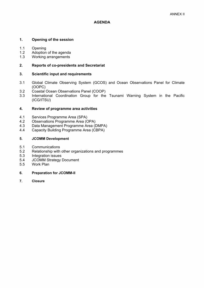
ANNEX II
AGENDA 1. Opening of the session 1.1 Opening 1.2 Adoption of the agenda 1.3 Working arrangements 2. Reports of co-presidents and Secretariat 3. Scientific input and requirements 3.1 Global Climate Observing System (GCOS) and Ocean Observations Panel for Climate
(OOPC) 3.2 Coastal Ocean Observations Panel (COOP) 3.3 International Coordination Group for the Tsunami Warning System in the Pacific
(ICG/ITSU) 4. Review of programme area activities 4.1 Services Programme Area (SPA) 4.2 Observations Programme Area (OPA) 4.3 Data Management Programme Area (DMPA) 4.4 Capacity Building Programme Area (CBPA) 5. JCOMM Development 5.1 Communications 5.2 Relationship with other organizations and programmes 5.3 Integration issues 5.4 JCOMM Strategy Document 5.5 Work Plan 6. Preparation for JCOMM-II 7. Closure


ANNEX III
IMPLEMENTATION PLAN FOR THE GLOBAL OBSERVING SYSTEM FOR CLIMATE (GCOS) - Explicit JCOMM-related Actions -
1 A5 Seek cooperation from organizations
operating drifting buoy programmes to incorporate atmospheric pressure sensors.
Parties deploying drifting buoys and buoy-operating organizations, coordinated through JCOMM with OOPC and AOPC.
2 A8 Develop and deploy precipitation-measuring instruments on the Ocean Reference Mooring Network.
Parties deploying moorings in cooperation with JCOMM and OOPC.
3 O1 Continue to seek national and multinational participation in the implementation of the global ocean observing system for climate.
IOC in consultation with GCOS, GOOS, and JCOMM.
4 O6 Improve meta-data acquisition and management for a selected, expanding subset of VOS (VOSClim) together with improved measurement systems.
Parties’ national services and ocean research agencies through JCOMM VOSClim.
5 O10 Obtain global coverage, via an enhanced drifting buoy array (total array of 1250 drifting buoys equipped with atmospheric pressure sensors as well as ocean temperature sensors), a complete Tropical Moored Buoy network (~120 moorings) and the improved VOSClim ship fleet.
Parties’ national services and research programmes through JCOMM, Data Buoy Cooperation Panel, and Tropical Mooring Implementation Panel.
6 O11 Implement the GCOS subset of the GLOSS Core Network, with geocentrically-located high-accuracy gauges. Ensure real-time exchange and archiving of data. Ensure historical sea-level records are recovered and exchanged.
Parties’ national agencies coordinated through GLOSS of JCOMM.
7 O15 Develop a robust programme to observe sea-surface salinity to include VOS ships, research ships, reference moorings, and drifting buoys.
Parties’ national services and ocean research programmes through IODE and JCOMM in collaboration with CLIVAR.
8 O19 Implement a wave measurement component as part of the Surface Reference Mooring Network.
Parties operating moorings, coordinated through the JCOMM Expert Team on Waves and Surges.
9 O20 Establish an international group to assemble surface drifting buoy motion data, ship drift current estimates, current estimates based on wind stress and surface topography fields and to prepare an integrated analyses of the surface current field.
OOPC will work with JCOMM and WCRP.
10 O21 Establish improved interactions between existing sea-ice research programmes (e.g., WCRP/CliC) and operational sea-ice groups (e.g., JCOMM Expert Team on Sea Ice).
GCOS in consultation with JCOMM and WCRP.
11 O23 Ensure sustained satellite (microwave, SAR, visible and IR) operations: improve the in situ observations from sea-ice buoys, visual surveys (SOOP and Aircraft), and ULS. Implement observations in the Arctic and Antarctic.
Parties’ national services, research programmes and Space Agencies, coordinated through the WMO Space Programme, IGOS-P Cryosphere Theme, CGMS, and CEOS; National services for in situ systems coordinated through JCOMM.
12 O24 Promote development of integrated analysis products and reanalysis using historical data archives.
JCOMM, WCRP/CliC, and IGOS-P Cryosphere Theme.

ANNEX III, p. 2
13 O26 Perform the 41 Ship-of-Opportunity XBT/XCTD trans-oceanic sections.
Parties’ national agencies coordinated through the Ship Observations Panel of JCOMM.
14 O27 Deploy the planned 3000 Argo float array, reseeding the array with replacement floats to fill gaps and maintain density (estimated 800 per year).
Parties participating in the Argo Pilot Project and in cooperation with the Observations Coordination Group of JCOMM.
15 O28 Maintain the current Tropical Moored Buoy arrays, expand the Atlantic array, and develop the Indian array – total array projected as ~120 moorings.
Parties’ national agencies coordinated through the Tropical Mooring Panel of JCOMM.
16 O33 Develop and implement comprehensive data management procedures.
IODE and JCOMM.
17 O34 Undertake a project to develop an international standard for ocean meta-data.
IODE and JCOMM in collaboration with WMO CBS and ISO.
18 O35 Undertake a project to apply the innovations emerging from the Future WMO Information System initiative, and innovations such as OPeNDAP to develop an ocean data transport system for data exchange between centres and for open use by the ocean community generally.
JCOMM.
19 O36 Plan and implement a system of regional, specialized and global data and analysis centres.
Parties’ national services under guidance from IODE and JCOMM.
20 O38 Develop enhanced and more cost-effective telecommunication capabilities, including two-way communications for dynamic control of systems, instruments and sensors.
Parties, coordinated through JCOMM.
21 O39 Develop plans for and coordinate work on data assembly and analyses.
JCOMM, in collaboration with CLIVAR, CliC, GODAE, and other relevant research and data management activities.

ANNEX IV
EXCERPT FROM REPORT OF THE SERVICES PROGRAMME AREA COORDINATOR - Task Team on JCOMM Ocean Products Development -
(as submitted by Mr Phil Parker, to MAN-IV)
2. User classification and requirements Following the lines of the second GODAE Symposium, which was designed specifically to address users and potential users of operational ocean products, such users, which include both direct end users and, more often, intermediate or middle users, may be classified into six broad categories: (i) Natural hazards and coastal impacts (ii) Integrated coastal management (iii) Marine ecosystems management: fisheries and biogeochemistry (iv) Crisis management – search and rescue and marine emergency response (v) Risk management – industry, engineering, defence, maritime safety and other at-sea operations (vi) Climate assessment and the prediction of climate variability and change. Priority needs and requirements, as identified during six of the breakout sessions at the GODAE symposium, are summarized under these categories in the following paragraphs. 2.1 Natural hazards and coastal impacts Types of requirements and response mechanisms • Tropical cyclones, coastal storms, waves, tsunamis – meteorological forecast offices • Sea-level variability and change (storm-surge to climate) – meteorological offices, climate and
ecosystems research groups • Coastal forecasting systems – meteorological offices, environmental and other research groups • Ecosystem variability and change (algae blooms, coral bleaching) – environmental protection
agencies, coastal management agencies (international to local level) Products and services should provide information at high resolution, both temporally (sub-hourly) and spatially (order of 0.5km). Operational ocean products needed by users – Daily 3-D Analyses/Forecasts of sea-level height, U, V, Salinity, T - on native grids; some fields
might be needed at higher than daily frequency – Sea-level heights – Re-analysis fields of model state variables – Toolboxes for nesting, coupling, downscaling – Some ancillary fields (barotropic tides) might be needed – 6 hourly forcing by atmospheric data is inadequate - increase to hourly if possible – Process information for sea-level rise - is rise due to ice melting or ocean warming? – Model configuration details provided - especially topography – Error/uncertainty estimation (perhaps from ensembles) Distribution – Data format standards need to be better defined. Advice should be sought from user communities
that are actively using Geographical Information systems (GIS) as a means to manage information. Format recommendations should bear in mind modern data management practice and must include a complete set of file specific metadata that conforms to a standards based international scheme (e.g., ISO 19115 Geographic information – Metadata). Self describing data containers (e.g., XML, netCDF, HDF) should be adopted in order to ensure that metadata is physically attached to data. Interoperability of data products is essential and proper mappings between data products/formats/metadata must be clearly defined and published.
- Data products should be available through a wide variety of communication networks. Emphasis should be given to modern communications technology (especially mobile telephones that are now
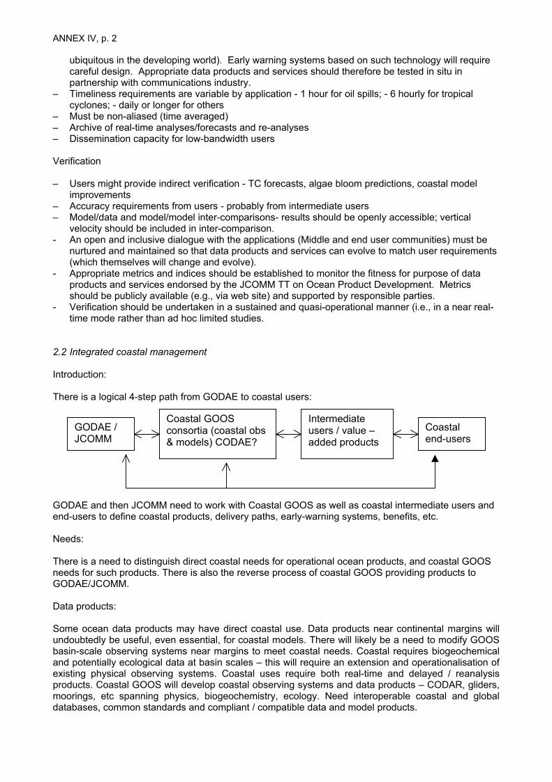
ANNEX IV, p. 2
ubiquitous in the developing world). Early warning systems based on such technology will require careful design. Appropriate data products and services should therefore be tested in situ in partnership with communications industry.
– Timeliness requirements are variable by application - 1 hour for oil spills; - 6 hourly for tropical cyclones; - daily or longer for others
– Must be non-aliased (time averaged) – Archive of real-time analyses/forecasts and re-analyses – Dissemination capacity for low-bandwidth users Verification – Users might provide indirect verification - TC forecasts, algae bloom predictions, coastal model
improvements – Accuracy requirements from users - probably from intermediate users – Model/data and model/model inter-comparisons- results should be openly accessible; vertical
velocity should be included in inter-comparison. - An open and inclusive dialogue with the applications (Middle and end user communities) must be
nurtured and maintained so that data products and services can evolve to match user requirements (which themselves will change and evolve).
- Appropriate metrics and indices should be established to monitor the fitness for purpose of data products and services endorsed by the JCOMM TT on Ocean Product Development. Metrics should be publicly available (e.g., via web site) and supported by responsible parties.
- Verification should be undertaken in a sustained and quasi-operational manner (i.e., in a near real-time mode rather than ad hoc limited studies.
2.2 Integrated coastal management Introduction: There is a logical 4-step path from GODAE to coastal users:
Coastal end-users
Intermediate users / value – added products
Coastal GOOS consortia (coastal obs & models) CODAE?
GODAE / JCOMM
GODAE and then JCOMM need to work with Coastal GOOS as well as coastal intermediate users and end-users to define coastal products, delivery paths, early-warning systems, benefits, etc. Needs: There is a need to distinguish direct coastal needs for operational ocean products, and coastal GOOS needs for such products. There is also the reverse process of coastal GOOS providing products to GODAE/JCOMM. Data products: Some ocean data products may have direct coastal use. Data products near continental margins will undoubtedly be useful, even essential, for coastal models. There will likely be a need to modify GOOS basin-scale observing systems near margins to meet coastal needs. Coastal requires biogeochemical and potentially ecological data at basin scales – this will require an extension and operationalisation of existing physical observing systems. Coastal uses require both real-time and delayed / reanalysis products. Coastal GOOS will develop coastal observing systems and data products – CODAR, gliders, moorings, etc spanning physics, biogeochemistry, ecology. Need interoperable coastal and global databases, common standards and compliant / compatible data and model products.
ANNEX IV, p. 3 High-resolution model products Coastal users require very high-resolution model products, to tens or hundreds of metres. These will likely require several levels of nesting below eddy-resolving models. Over the long run, this is a coastal GOOS responsibility, and requires access to operational model output. In the short term, development of nested (data-assimilating) coastal models is proceeding in many locations. It is possible to imagine these being organized under the banner of a Coastal Ocean Data Assimilation Experiment (CODAE). There will need to be discussion between GODAE/JCOMM and coastal modelers about timely access to 4-D model output. The requirements for accuracy, quality of model output as boundary conditions for coastal models need to be established and related to performance requirements on coastal model output. Coastal users want: Storm surge and wave prediction, models linking estuaries to offshore, early warning of Harmful Algal Blooms (HABs), downscaling of large scale climate variability (e.g. NAO) and climate change to coastal impacts, links to zooplankton and fish, diseases, high-resolution hydrodynamic models for coastal navigation and hazard, sediment transport and turbidity, advance warning of environmental impacts / events. Within the GODAE time frame, it is feasible to expect to see coastal physical models, coupled to GODAE models, providing users with products addressing storm surge and wave prediction, inshore-offshore links and downscaling of climate change and variability, and coastal navigation and hazard. This must carry over into the JCOMM operational environment. In the long term, coastal user needs require to go beyond physics to biogeochemistry and ecology. This implies basin-scale biogeochemical models to provide boundary conditions for these. A key coastal community need with very large monetary benefit for both public and private sectors (businesses, utilities) is for more accurate prediction of local weather and ocean conditions near coastal cities. This will be a value-added product derived from operational ocean outputs through weather services or other intermediate users. Lower resolution climate products Coastal communities want to address climate impacts at very fine scales. Eddy-resolving models are a key link in downscaling climate variability and climate change models / scenarios to coastal scales in space and time. Re-analysis products. Coastal users have near-real time needs, but for coastal management and planning, model scenarios and hindcasts are critical. Planners need to understand impacts of development under full spatial-temporal range of climate / ocean variability, and future climate change. They need to rerun coastal models many times under different development scenarios (implies nested models rather than single cross-scale models). In most cases, coastal managers lack the long-term time series of coastal observations they need. Is it possible to hindcasts and nested models to simulate these observations realistically? Regional evaluation of hindcasts using the available historical datasets will be important to assess their realism / accuracy. Dialogue and review with user community. GODAE/JCOMM cannot interact efficiently with diverse coastal end-users, or even with many coastal GOOS local consortia. How should a dialogue be set up so common needs, issues, can be identified? This requires some form of nested hierarchical two-way communication. It requires brokers who can interact across scales and diverse user groups. For example, private or public intermediate users / value adders may develop assessments of specific coastal user needs and product specification across national or international groups. What is the vehicle for GODAE/JCOMM to interact with coastal GOOS

ANNEX IV, p. 4 consortia, and identify their needs, and R&D challenges for both GODAE and coastal GOOS? Do we need a CODAE? A CODAE approach has been discussed between COOP and international research projects such as LOICZ and IMBER. There is support for the development of this in both the COOP and research community. GODAE/JCOMM needs to establish a formal mechanism to interact with the GOOS/IOOS Regional Alliances/Associations to ensure strong user interaction, product specification and feedback, such as: Standardization of formats, nomenclature, etc Data format standards need to be better defined. Advice should be sought from established and mandated Coastal Management user communities that are actively using Geographical Information systems (GIS) as a means to manage information (i.e., they are at the ‘cutting edge’ of where the application is likely to be for the majority of users in 5-10years from now). Format recommendations should bear in mind modern data management practice and must include a complete set of file specific metadata that conforms to a standards based international scheme (e.g., ISO 19115 Geographic information – Metadata). Self-describing data containers (e.g., XML, netCDF, HDF) should be adopted in order to ensure that metadata is physically attached to data. Interoperability of data products is essential and proper mappings between data products/formats/metadata must be clearly defined and published. 2.3 Marine ecosystems management: fisheries and biogeochemistry GODAE may move actively towards ecosystem modeling and include this goal within its mandate. This will involve developing models with living marine resources (thus providing products for users) and form partnerships with others (e.g. IMBER, LOICZ, GLOBEC, GEOHAB) to develop and apply assimilation techniques for ecosystem models. Should this then also transition to JCOMM? Fishing needs – There is a growing need for all types of ‘oceanographic’ information from short (week) to long (seasonal and interdecadal) time scales. Many different products are required (covering full range of product lines) from data synthesis, hindcast runs and operational models. Using ecosystem information to understand trends in productivity. Extreme events – The most important ecosystem information for the general public good may be on extreme ecosystem events since they will have the greatest impact. Globally Harmful Algal Blooms (HABs) provide a clear example (other examples include Baltic, Cook Island). Local river/coastal pollutant pulses, mass extinction due to ecosystem impalances. Real-time data – Aquaculture, for example, needs in situ data and remote sensed data to provide warning on extreme conditions for operational use. Real–time model results – Need for real-time model output for decision support system for fisheries (User groups in fisheries include Fishing Managers, Fishing Industry, Consultant Companies, NGO’s and Government Agencies) Near-real time - Information (data, model output) is required on longer time-scales to adjust fishing practices and for management decisions in the coastal zone (e.g. pollution events). Re-Analysis products – Retrospective analysis and integrated data sets are crucial for interpreting the long-time series of fisheries information and for making decisions. Data types – Circulation fields (e.g. transects and particle retention), T, S, turbulence, oxygen levels, light levels, mixed-layer depth, plankton and zooplankton, fish larvae (?) Model scales – May require global or basin scale models that have simplified ecosystem structure in which more detailed ecosystem models (e.g. coastal models or upwelling zones including species specific dynamics) are nested. Trick how to downscale to the inner shelf coastal applications (such as aquaculture) Re-Analysis and hindcast times - The most important timetable for retrospective reanalysis of data and hindcasting goes back to 1950 – modern period is the most crucial. Assimilation matching - Need to ensure that the data collected, and used for assimilation with the models, represent the right aspects of ecosystem dynamics to make the model most useful for the users. This is a research issue.Many of the following developments are already under way in many countries – pointing to the need: Specific verification - Each ‘product’ must be tested (locally) against the requirement of its defined user need. It is not simply possible to test the ‘generic’ model but is necessary to know what ‘type’ of

ANNEX IV, p. 5 output is required by the user and in what form. Benchmarks and verification are important to ensure data quality and gain trust of users. Translation – GODAE should help to make the products understandable to the users, making vast amounts of information useful and more easily understandable. Ease of access is also important. Communications with new users may be difficult. Dialogue - Some simple results of data already in use would require relatively little discussion for development but in general development of useful products will require many local and regional bi-lateral and multi-lateral discussions between developers and users. General strategic support could probably be provided by GODAE, but perhaps only at strategic level. Partnerships – For the development of new ecosystem models, GODAE has been encouraged to form partnerships with other major ecosystem programs, e.g. IMBER, GLOBEC, LOICZ, GEOHAB. One key issue is to match assimilation (data type and approach) with the model dynamics (more of an issue with ecosystem models). Fishing requirements – Use of ecosystem information in fisheries is growing quickly as is the sophistication of the use community (the receptor capacity). Users are just learning how to use these new ‘products’. There is an immediate demand easy and better access to existing products - easing the access issue would be very helpful. Payoff – Most of the payoff will be for the broader public benefit (with some operational exceptions, e.g. fishing practice and aquaculture) as the economic benefit may take a long time to demonstrate. Uneven capacity – The developed world has much greater capacity and the potential for use of data elsewhere is much more limited. Potential for use is uneven. This points to the need for capacity building. There is also uneven capacity among disciplines. Carbon cycle – Requirement by scientific and government community for better ecosystem models one of the key limiters for making scenario predictions Ocean impacts growing – The trend line is clearly for growing anthropogenic ocean impacts leading to the need for better management and for mitigation Specific examples Pearl farming – Cook Islands - particular physical conditions trigger oyster mortality, need warning of extreme conditions, requires in situ monitoring and model products, requires data in real-time and model forecast in short time-scales (5-10 day). However, support for such projects needs to be treated sensitively and with care, to ensure full benefits. Coral bleaching - predictions of extreme temperature events will enable predictions of possible coral bleaching. 2.4 Crisis management – search and rescue and marine emergency responseForums for user interaction on the applications of operational ocean products: Offshore weather panel, IOSC, INEMS, International symposium on off shore polar engineering, for SAR - Go to Coast Guards, Hydrographic or meteorological agencies (i) Operational ocean data and products can provide substantial improvement to the operational
decisions for crisis management. If properly used (namely fully integrated to the existing response tools and procedures), such products should help improve the response.
(ii) Operational ocean product services: Accessibility, reliability and timeliness are important. Crisis management operations always require an answer in minutes to hours for SAR & hours to days for spills. Therefore any product useful to the forecast must have guaranteed availability. Service models must be established in a manner that is effective in crisis situations. The telephone and radio together with internet access (that is not always guaranteed) must be recognized as the primary communication media. Training and practice exercises must be executed on a regular (annual? Bi-annual) basis in order to maintain the effectiveness of any service and to ensure that the best information is provided and used in the most appropriate manner by the SAR/emergency response teams teams. Services should build on multi-model ensemble collaborative exercises (i.e., run different models for the same problem) as soon as possible following notification of an event. Clear protocols for the exchange of data between agencies and providers (in a 2-way communication mode) must be established.
(iii) Data and model output should come with specifications of its refresh rate, timeliness, estimate uncertainties. Uncertainties ideally should be given as a function of lead time, space and

ANNEX IV, p. 6
variables. Contact and human expertise on the details of product preparation (parameterizations, forcing functions…) and their (objective and subjective) quality is important. Outputs should be tailored to requirements and dedicated data products for SAR/emergency response teams should be developed in close collaboration with those teams. Overburden of data should be avoided – especially given the real possibility of communication difficulties/challenges in crisis situations. Adequate backup support for products and product interpretation is required with immediate telephone access (i.e., a crisis team should be able to call up for an immediate discussion on the data product content. The emphasis must be towards a joined up inclusive approach with clear communications channels and responsibilities established and documented prior to any event. Operations documents (telephone contacts etc.) must be maintained and reviewed on a regular (1 month?) basis.
(iv) Hourly data for the next 24 hours should be a goal, and the daily update after will be important. Data are needed in a window of 1 week on each side. These data may be used directly or to drive local ocean models. There is a need to have access in real time to full 3D fields & subsets of these fields. Such data products should be supported with real time visualization tools and explanations via the web as a minimum to guarantee access to the knowledge base by non-experts. Web/data access to products must be prepared for and be capable of supporting many transactions (e.g., recent Tsunami event) in real time rather than lock up or crash.
(v) Product format is not critical as long as it is consistent, well defined and allows for easy extraction of subsets of the data. The proper definition of the interface (in terms of content and procedures) is critical.
(vi) GODAE/JCOMM should work with the “middle” users and adapt the answers to meet the needs of these different users. Needed products depend on the system used to compute drift forecasts. Most important outputs are: 1.Boundary conditions for nested models; 2.Time dependent 2 or 3D standard variables or derived products (current & elevation, sea temperature, salinity...). This should not preclude GODAE/JCOMM from taking up direct interface with end users and associated system. In fact, there is a danger that GODAE/JCOMM remains distant and potentially out of touch if the direct links are not cultivated appropriately.
2.5 Risk management – industry, engineering, defence, maritime safety and other at-sea operations User needs • Uncertainty estimates - essential for both analyses and seasonal forecasts • All politics, weather, and …. Products for this risk management sector are local • Physical oceanographic variables are of primary interest. Customer requirements are best
articulated by the middle users (still missing direct involvement with end users). • Forecasts, nowcasts, and hindcasts - all are needed – forecast periods from a few hours to as far
out as possible • Delivery refresh rates range from several times per day to once/week What should the JCOMM system provide: • A number of government and commercial “middle users” are already “doing operational
oceanography, but not in a consistent framework and not in a “Commons” area. Useful “Commons” activities include: real-time data assembly and dissemination; agreed upon uncertainty metrics; provision of techniques and methodologies as well as products
• Observational Strategies: provide rationale for operational observing system design(s); demonstrate utility of current observing systems; work on getting nations to allow deployment of Argo floats in EEZ’s and marginal seas; adaptive sampling guidance, strategy, methodology
• Lateral boundary conditions for nests: must be coordination between supplying and receiving systems (e.g. two-way coupling)
Data delivery formats: • GIS-compatible • tools that enable easy transition/transfer/ conversion between a number of agreed upon formats • compatibility of products with web services - Products for JEB • Metadata and metadata catalogue - whatever data standards are adopted must incorporate
metadata flexibility and interoperability
ANNEX IV, p. 7 Archival • Archive all observations • Archive initial conditions/analyses • Archive recent forecasts in order to see “recent” model trends (“recent” needs to be defined in
operational terms not science terms) • Any archive should be open and for the common good. A distributed approach is recommended
with data management tools in place for single point entry (e.g., OPeNDAP virtual data server type of approach)
Concerns • What happens when there is a gap in altimetry? • How can we take advantage of emerging observation systems (gliders, CODAR, modernized VOS
program) and manage the possible disappearance of others? • Must ensure that the user requirements for emerging programs (e.g., EUCOS) recognize the all-
inclusive long-term impact of strategic decisions and user requirements (rather than just those with a clear NWP requirement).
2.6 Climate assessment and the prediction of climate variability and change Short list of requirements and possible follow-up actions: • Define uncertainty of climate analysis/reanalysis products through intercomparison to facilitate
applications. • Shed light on additional observations needed through product intercomparison (e.g., to identify
areas that the products differ significantly and that have insufficient observations for validation). • Data infrastructure: serving processed data of different quality-control levels; quantification of “data
errors”. • Exploration of climate applications for real-time meso-scale products. • Seasonal-interannual predictability studies. • Observing system sensitivity experiments (OSSE). • Surface forcing comparison. • Improvement of model errors. • Budget outputs.


ANNEX V
PROPOSED NEW TERMS OF REFERENCES FOR JCOMM IN SITU OBSERVING PLATFORM SUPPORT CENTRE (JCOMMOPS)
(As submitted to MAN-IV)
The JCOMMOPS was established by JCOMM-1 in 2001 to facilitate the implementation of operational in situ ocean and marine meteorology observing systems associated with the Data Buoy Cooperation Panel (DBCP), the Ship Observations Team (SOT), and the Argo Science (now Steering) Team (AST). Under the overall guidance of the JCOMM Observations Coordination Group and following the direction of the DBCP, SOT and AST the JCOMMOPS shall: (i) Act as a focal point for implementation and operation of relevant observing platforms and
provide assistance to platform operators for free and unrestricted exchange of data by, for example, providing information on telecommunications systems, clarifying and resolving issues between platform operators and telecommunications system operators, and encouraging the implementation of standard formats;
(ii) Maintain information on relevant data requirements for observations in support of GOOS,
GCOS, and the WWW as provided by the appropriate international scientific panels and JCOMM Expert Teams and Groups, and routinely provide information on the functional status of the observing systems;
(iii) Provide a Gateway for information on instrumentation deployment and servicing opportunities,
and on operator contact information; and (iv) Provide information on the observational program; for example, on instrumentation, on
instrument evaluation, and on data quality.


ANNEX VI
PROPOSED TERMS OF REFERENCES FOR THE AD HOC WORKING GROUP FOR ESTABLISHMENT OF A PILOT PROJECT TO COLLECT METADATA
FROM SST AND PROFILE DATA IN SITU MASURING PLATFORMS. The Working Group shall:
(i) Investigate the opportunity to effectively start a pilot project a workshop shall be organized, the working group membership consolidated, and a chair-person elected;
(ii) Categorize metadata, establish the catalogue, and provide justification in terms of data
assimilation in numerical models and operational applications for each of the proposed metadata fields in these categories.
(iii) For metadata which distribution would be required along with the observational data,
review BUFR tables and templates and list any required additions and modifications to the templates.
(iv) Work with identified contact points for each concerned data processing systems and
national centres to investigate and report on implications in terms of development cost and subsequent running costs for routinely producing and distributing in real-time BUFR reports that include required metadata in addition to the observations. Suggest alternate solution if needed (e.g. for VOS data).
(v) Possibly investigate how GTS distribution of data collected via Iridium could be realized
and investigate financial implications. (vi) For metadata which distribution would not be required along with the observational
data, define dictionary and format for the exchange of such metadata. Investigate level of compatibility and feasibility to merge such a database with JCOMM ODAS metadata database as defined by JCOMM Expert Team on Marine Climatology (ETMC).
(vii) Make sure that the defined model can potentially be extended to other variables than
SST and temperature profile data, and consider existing standards when making recommendations regarding any international standard applicable to the issue (e.g. Marine XML, or Content Standard for Digital Geospatial Metadata of the US Federal Geographic Data Committee).
(viii) For metadata which distribution would not be required along with the observational
data, liaise with appropriate JCOMM/DMA, JCOMM/OPA sub-Panels, and Argo, to suggest how they would be made readily available to centralized and operational JCOMM database and distribution system and how they would eventually be made available to the end users (procedures and protocols). Sub-group is also invited to consider integration that is taking place in the oceanographic community regarding metadata (e.g. Argo, GOSUD, and OceanSites are integrating their metadata NetCDF formats and distribution systems).
(ix) Identify one or more centre willing to host such a database and associated distribution
system, and possibly willing to support associated development and running costs as a contribution in kind to the project (if not, evaluate costs).
(x) Write specifications for the pilot project, and make final recommendations to OCG
regarding development feasibility, schedule and funding (xi) Suggest other solutions if needed


ANNEX VII
Statement : DATA MANAGEMENT
The JCOMM Management Committee recognized that considerable overlap and potential duplication still exist between the activities of the JCOMM Data Management Program Area and the IODE, in spite of the merging of JCOMM ETDMP and IOC GETADE, the co-sponsoring of the data management pilot projects, and the transferring of the responsibility for the secretariat support for JCOMM data management to the IODE secretariat. Furthermore, it is no longer sufficient to provide access to data in real-time, near-real-time and/or delayed mode, but at many access times with version controls and often integrated with other data types (atmospheric and oceanic). Thus the original distinction of JCOMM providing real-time data and integrated products and services in marine meteorology and oceanography, while IODE deals with delayed-mode data, is no longer appropriate. The JCOMM Management Committee at its fourth meeting in Paris, February 2005 recommended closer collaboration between JCOMM and IODE data management activities and eventual merger of IODE and the JCOMM DMPA activities. It would immediately enhance the JCOMM operational oceanographic data management capability to match its operational observations and services capabilities. It would ensure that the data management facilities developed as parts of the IODE will evolve so as to serve also new operational ocean data requirements developed in the future as part of JCOMM. It would preclude possible duplication of efforts regarding data and metadata models, transport protocols, discovery methods, etc. It would likely reduce the use of resources (financial and human) relative to the present situation, both in JCOMM and IODE. IOC at 35th session of its Executive Council through its resolution EC-XXXV.2 IOC mandated the development of an IOC data management strategy, building on the results of the current IODE review. The JCOMM Management Committee recommends that IOC give serious consideration to the merger of IODE with the JCOMM DMPA activities, and to the development of the necessary steps to be taken to facilitate a smooth transition. The Committee recognized that any such merger must be considered with great care. Due diligence must be exercised to ensure that the ocean data capabilities needed by those outside the current JCOMM community and currently served by the IODE are maintained and continue to evolve.


ANNEX VIII
LIST OF ACTIONS FOR THE MANAGEMENT COMMITTEE (decisions from MAN-I to MAN-III)
Ref. Action By whom When Status
I. GENERAL MAN-I
2.2, MAN-II 5.5.1
To develop criteria for project adoption and implement interim procedure
co-pres., Secr.,Com. members,
small team
MAN-III, continuous
To be included in
strategy document
MAN-I 5.6 (ii)
Try making budgetary savings through a rationalization of the subsidiary bodies of JCOMM, IODE and GOOS
Secr. continuous Underway (CB and DM)
MAN-I 5.6 (iii)
To propose strategies for support from external funding for specific JCOMM programmes and activities.
Secr. continuous
JCOMM trust fund
established in WMO
MAN-I 5.7
To try expanding the funding basis for all JCOMM activities including CB and JCOMMOPS
Secr. continuous JCOMMOPS development
plan MAN-I
6.4 MAN-II 2.2.4
To prepare for CLIMAR-II and Brussels 150; to prepare a 1-page leaflet on Brussels 150
Secr. ASAP Done
MAN-II 3.3.1
To ensure that scientific requirements and importance of support for Jason-2 are communicated to appropriate policy makers
Secr. with OOPC
before June 2003 Done
MAN-II 5.1.3
MAN-III 5.5.2
To prepare basic structure and input for a JCOMM Strategy Document co-pres., Secr. ASAP Done
MAN-III 2.1
To establish and activate an ad hoc Task Team to develop the JCOMM-related component of the seventh WMO Long-Term Plan
Co-presidents Secr. ASAP pending
MAN-III 3.1.5
To prepare an initial system analysis on data availability, with evaluation and performance measures, and post to a website
Mike Johnson, Worth Nowlin ASAP Underway
MAN-III 3.1.5
To request the GPO to modify the I-GOOS yearly reporting template, to separate into coastal and open-ocean domain, and including targeted question on national commitments and data availability
Secr. ASAP Done
MAN-III 3.1.6
To reiterate the importance of VOS observations and of the PMOs to the national weather services Secr. ASAP Underway
MAN-III 2.4
5.4.1
To make efforts to enhance coordination and communications amongst themselves on relevant issues in the lead up to JCOMM-II
PA coordinators ASAP Underway
MAN-III 6.6
To finalize the annotated provisional agenda and documentation plan for JCOMM-II
Secr. ASAP Done

ANNEX VIII, p. 2
Ref. Action By whom When Status
MAN-III 7.1
To bring the Inmarsat cost issue to the WMO EC
Johannes Guddal WMO EC Done
II. COASTAL ISSUES MAN-I 3.2.3.3
To make a link to the COOP Design Plan on the JCOMM web site Secr. when Plan is
published Done
MAN-II 3.2.2
To urge that the Executive Summary of the COOP Design Plan reflect the need for meteorological measurements
GPO ASAP Done
MAN-II 3.2.3
To interact with COOP re. operational bio-geo-chemical data management co-pres., Secr. continuous Ongoing
MAN-II 3.2.6
To devise ways and means of promoting integrated approach (with Met. agencies) to development of COOP Design Plan
co-pres., Secr. ASAP Ongoing
MAN-II 3.2.7
To recommend close linkage between IODE and COOP Secr. IODE-XVII Achieved
MAN-II 3.2.5
To request COOP to provide the Implementation Plan and a working document for JCOMM II by end 2004 Secr ASAP Underway
MAN-II 3.2.5
To report to the IOC Executive Council mentioning the continuing positive interactions between COOP and JCOMM, and the willingness of JCOMM to consider taking on the responsibility for managing the data and product streams suggested by COOP as and when those systems mature.
Co-presidents IOC-EC-XXXVII Done
III. SERVICES PROGRAMME AREA
MAN-I 4.2.1 (iv)
To prepare for MPERSS and JEB workshops in 2004
France, Y. Tourre,
SPA Coord., Secr.
2003 Done
MAN-II 4.2.1.3
To finalize and implement the agreed design for WMO-No. 9, Vol. D
SPA coord., WMO Secr. April 2003 Partially
complete
MAN-II 4.2.1.5
To prepare prospectus for the JEB, including maintenance costing, to be addressed to relevant op. agencies, seeking support for maintenance. If necessary, to make alternative proposals
Y. Tourre, SCG & Secr. ASAP
Tasked to a new Task
Team on JEB
MAN-II 4.2.1.6
To invite GSC to co-sponsor the ad hoc TT on Development of Ocean Services & finalize membership
co-pres., SPA coord., Secr.
GSC-VI, then ASAP Done
MAN-II 4.2.1.7
To seek additional nominations to the TT/MPERSS and update the list of MPERSS focal points
Secr. ASAP Underway
MAN-III 4.1.7
To contact Dr. Ralph Rayner for the presentation at Ocean Ops 04 and to advise the organizing committee of his availability
Worth Nowlin ASAP Done
MAN-III 4.1.8
To develop a proposal to be submitted to the Management Committee, for the establishment of the ad hoc Task Team on JEB
SCG Ocean Ops 04 Done

ANNEX VIII, p. 3
Ref. Action By whom When Status
MAN-III 4.1.9
To establish and convene a Task Team on Ocean Products and Services
Task Team on Ocean Products
and Services members
Ocean Ops 04 Done
MAN-III 4.1.9
To submit a draft strategy for the development of new ocean products and services MAN-IV
Task Team on Ocean Products
and Services MAN-VI Done
MAN-III 5.1.2
To proceed to make a preliminary assessment and set of recommendations regarding the existing SOCs
Phil Parker MAN-IV Underway
IV. OBSERVATION PROGRAMME AREA
MAN-II 5.2.3
To hire (a) consultant(s) to compile available information on standards & reference materials
Secr; then consultant(s) ASAP
SOT expert group
established
MAN-I 3.2.3.4
To consider the need of specialized group(s) to look at both currents and waves
OCG ASAP underway
MAN-I 4.1.2 (vi)
To ask the 5 OPA component groups to report on efforts to counter vandalism and possible "lessons learned"
OPA Coord. continuous DBCP actions
MAN-II 3.1.5 & 4.1.1.9
(ii)
To request GSC/OOPC to consider how to develop performance metrics; stress the need for clear statements of requirements
co-pres., OPA Coord.,
Secr.
GSC-VI, OOPC next Done
MAN-II 3.1.6
To maintain close contacts with the CO2 Panel SOT, Secr. SOT-II,
continuous Done
MAN-II 3.1.13 & 4.1.1.9
(iv)
OCG to hold more frequent (yearly) sessions; next one back to back with OOPC
OPA Coord., Secr. continuous Changed
strategy
MAN-II 4.1.1.9
(v)
To reinforce the need to maintain Argo funding long enough
Com. members & their
agencies continuous Ongoing
MAN-II 4.1.1.9
(v)
To bring to OOPC attention that all OPA teams have funding problems in trying to meet stated implementation targets
co-pres. & Secr. OOPC VIII Done
MAN-II 4.1.2.2
To ensure that updated requirements for satellite data are coordinated with the Ocean Theme rolling review of requirements
Secr. When
requirements are expressed
Ongoing
MAN-II 4.1.2.3
To determine what kinds of products & services are wanted from the space community + which kind of distribution
Rap. on sat. & SPA ASAP Changed
strategy
MAN-II 4.1.2.5
To request advisory groups & PAs to refine their requirements re. sat. data for communication to WMO database
co-pres. & Secr. ASAP Ongoing
MAN-III 4.2.8
To relay message to Met. Services, buoy operators, and DBCP on the possible decreased emphasis of rationalization in operational meteorological network, to global observations required by JCOMM
Secr. ASAP Underway
MAN-III 4.2.9
To make a proposal on possible action by JCOMM-II, for establishing a common fund for consumables under OPA
OPA coordinator,
Secr. MAN-IV
Proposal included in
MAN-IV report

ANNEX VIII, p. 4
Ref. Action By whom When Status
MAN-III 4.2.11
To formally establish a Task Team on Satellite Data Requirements, for preparation of a position paper for the 2005 high level meeting, and undertaking other actions as required
Co-presidents, Secr ASAP Now after
JCOMM-2
V. DATA MANAGEMENT PROGRAMME AREA
MAN-II 3.1.3
To recommend to International Time Series ST to develop data and inf. man. plan, with advice from JCOMM
Secr. ASAP Done
MAN-II 4.3.1.5
To develop a JCOMM Data Management Strategy
S. Narayanan, DMPA MAN-III Deferred
MAN-II 4.3.1.6
To offer to CLIVAR to collaborate on data and information management and invite CLIVAR to next meeting of the JCOMM DMCG
co-pres., Secr. ASAP Done
MAN-II 4.3.1.10
To distribute to all DMPA members the extensive review of action items prepared by IODE Secr.
IODE Secr. ASAP To be done
MAN-II 4.3.1.16
To liaise with the DMACS Chair to include a second DMACS member in the OIT Steering Team
OIT chair, Secr. ASAP
DMACS is well engaged
in the activities of ETDMP and
OIT MAN-II 4.3.4.8
To prepare quarterly progress reports for distribution to all DMPA members
DMPA coord., Secr. quarterly Deleted
MAN-II 4.3.4.9
To request IODE Committee to consider merging GETADE with ETDMP (or suspending GETADE)
co-pres., Secr. IODE-XVII Done
MAN-II 4.3.4.9
To use GETADE funds to convene yearly sessions of ETDMP Secr. yearly Done
MAN-II 4.3.4.10
To assume Secr. responsibility for DMPA as a Joint JCOMM/IODE Secr. IODE Secr. continuous Done
MAN-II 4.3.5.2
To discharge its terms-of-reference [see report]
ad hoc group on SOCs
MAN-III or before To be done
MAN-III 4.3.5
To contact DMAC for the nomination of Bob Keeley (Canada) as an ETDMP observer to US DMAC
Co-Presidents ASAP Done
MAN-III 4.3.10
To send the IODE review questionnaire to the WMO Secretariat for its distribution to appropriate meteorology and climatology addresses
IODE Secr. ASAP Underway
MAN-III 4.3.12
To raise with the IODE Secr. the issue of GE-BCDMEP to closely liaise with the COOP for its second Session
Secr ASAP Done
MAN-III 4.3.17
To look into the issue of ADCP QC and archival, in close consultation with the JCOMM SOT
ETDMP members, with
IODE continuous To be done
MAN-III 4.3.18
To inform IODE of the proposal for the meeting plan re-arrangement, of DMCG and ETDMP 2004/2005 as required
Secr. ASAP Done
VI. CAPACITY BUILDING PROGRAMME AREA MAN-I 4.4.2
To develop capacity building requirements & communicate to CBCG
OPA & SPA Coords. ASAP Changed
strategy MAN-II 3.2.4
To consider CB requir. of COOP Design Plan CBCG, Secr. continuous Done
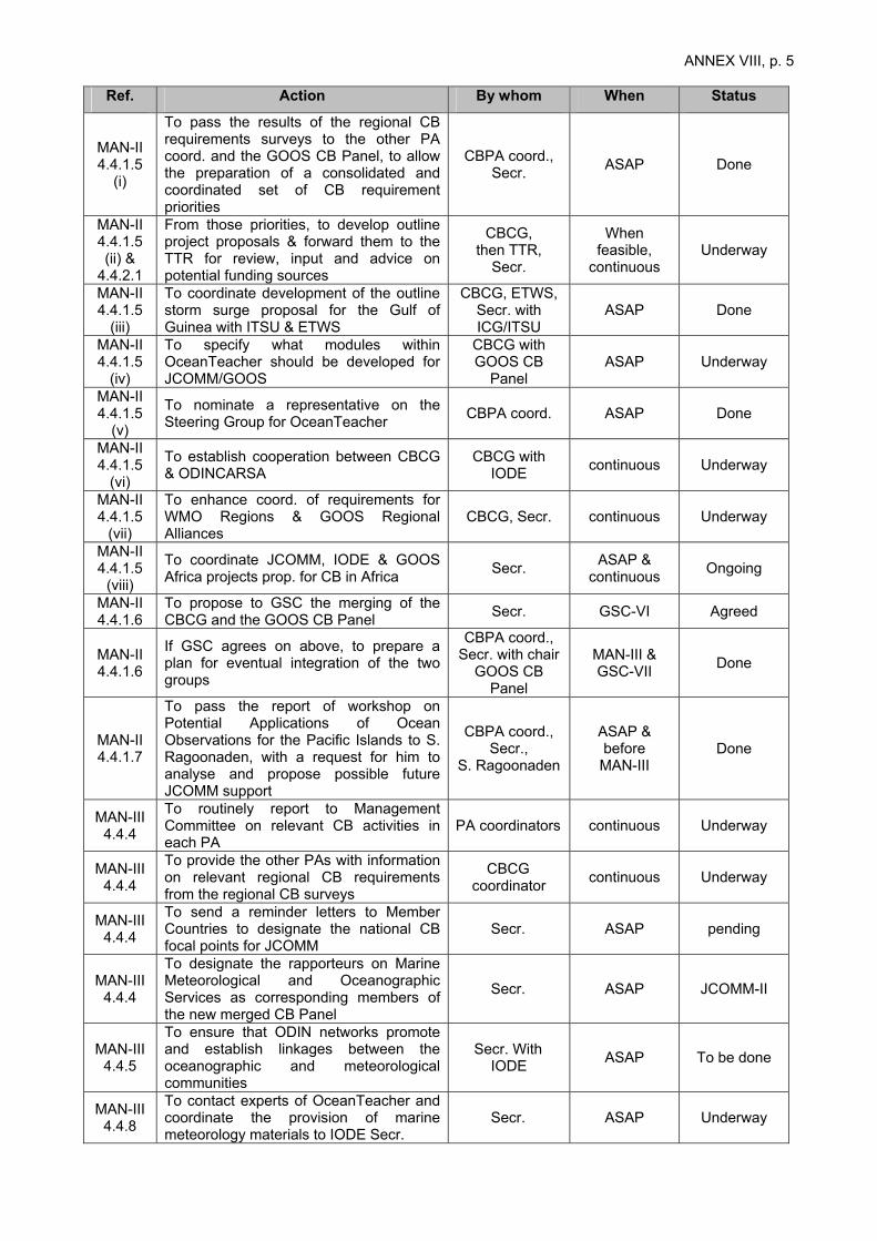
ANNEX VIII, p. 5
Ref. Action By whom When Status
MAN-II 4.4.1.5
(i)
To pass the results of the regional CB requirements surveys to the other PA coord. and the GOOS CB Panel, to allow the preparation of a consolidated and coordinated set of CB requirement priorities
CBPA coord., Secr. ASAP Done
MAN-II 4.4.1.5 (ii) &
4.4.2.1
From those priorities, to develop outline project proposals & forward them to the TTR for review, input and advice on potential funding sources
CBCG, then TTR,
Secr.
When feasible,
continuous Underway
MAN-II 4.4.1.5
(iii)
To coordinate development of the outline storm surge proposal for the Gulf of Guinea with ITSU & ETWS
CBCG, ETWS, Secr. with ICG/ITSU
ASAP Done
MAN-II 4.4.1.5
(iv)
To specify what modules within OceanTeacher should be developed for JCOMM/GOOS
CBCG with GOOS CB
Panel ASAP Underway
MAN-II 4.4.1.5
(v)
To nominate a representative on the Steering Group for OceanTeacher CBPA coord. ASAP Done
MAN-II 4.4.1.5
(vi)
To establish cooperation between CBCG & ODINCARSA
CBCG with IODE continuous Underway
MAN-II 4.4.1.5
(vii)
To enhance coord. of requirements for WMO Regions & GOOS Regional Alliances
CBCG, Secr. continuous Underway
MAN-II 4.4.1.5
(viii)
To coordinate JCOMM, IODE & GOOS Africa projects prop. for CB in Africa Secr. ASAP &
continuous Ongoing
MAN-II 4.4.1.6
To propose to GSC the merging of the CBCG and the GOOS CB Panel Secr. GSC-VI Agreed
MAN-II 4.4.1.6
If GSC agrees on above, to prepare a plan for eventual integration of the two groups
CBPA coord., Secr. with chair
GOOS CB Panel
MAN-III & GSC-VII Done
MAN-II 4.4.1.7
To pass the report of workshop on Potential Applications of Ocean Observations for the Pacific Islands to S. Ragoonaden, with a request for him to analyse and propose possible future JCOMM support
CBPA coord., Secr.,
S. Ragoonaden
ASAP & before MAN-III
Done
MAN-III 4.4.4
To routinely report to Management Committee on relevant CB activities in each PA
PA coordinators continuous Underway
MAN-III 4.4.4
To provide the other PAs with information on relevant regional CB requirements from the regional CB surveys
CBCG coordinator continuous Underway
MAN-III 4.4.4
To send a reminder letters to Member Countries to designate the national CB focal points for JCOMM
Secr. ASAP pending
MAN-III 4.4.4
To designate the rapporteurs on Marine Meteorological and Oceanographic Services as corresponding members of the new merged CB Panel
Secr. ASAP JCOMM-II
MAN-III 4.4.5
To ensure that ODIN networks promote and establish linkages between the oceanographic and meteorological communities
Secr. With IODE ASAP To be done
MAN-III 4.4.8
To contact experts of OceanTeacher and coordinate the provision of marine meteorology materials to IODE Secr.
Secr. ASAP Underway
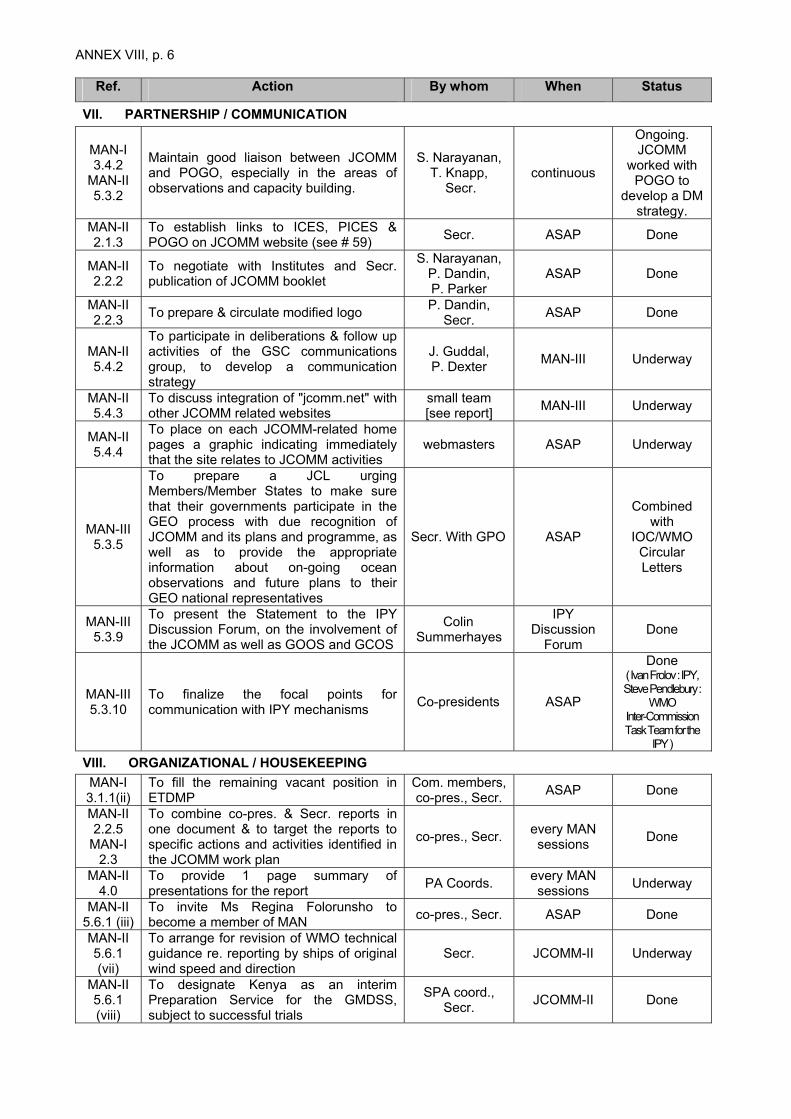
ANNEX VIII, p. 6
Ref. Action By whom When Status
VII. PARTNERSHIP / COMMUNICATION
MAN-I 3.4.2
MAN-II 5.3.2
Maintain good liaison between JCOMM and POGO, especially in the areas of observations and capacity building.
S. Narayanan, T. Knapp,
Secr. continuous
Ongoing. JCOMM
worked with POGO to
develop a DM strategy.
MAN-II 2.1.3
To establish links to ICES, PICES & POGO on JCOMM website (see # 59) Secr. ASAP Done
MAN-II 2.2.2
To negotiate with Institutes and Secr. publication of JCOMM booklet
S. Narayanan, P. Dandin, P. Parker
ASAP Done
MAN-II 2.2.3 To prepare & circulate modified logo P. Dandin,
Secr. ASAP Done
MAN-II 5.4.2
To participate in deliberations & follow up activities of the GSC communications group, to develop a communication strategy
J. Guddal, P. Dexter MAN-III Underway
MAN-II 5.4.3
To discuss integration of "jcomm.net" with other JCOMM related websites
small team [see report] MAN-III Underway
MAN-II 5.4.4
To place on each JCOMM-related home pages a graphic indicating immediately that the site relates to JCOMM activities
webmasters ASAP Underway
MAN-III 5.3.5
To prepare a JCL urging Members/Member States to make sure that their governments participate in the GEO process with due recognition of JCOMM and its plans and programme, as well as to provide the appropriate information about on-going ocean observations and future plans to their GEO national representatives
Secr. With GPO ASAP
Combined with
IOC/WMO Circular Letters
MAN-III 5.3.9
To present the Statement to the IPY Discussion Forum, on the involvement of the JCOMM as well as GOOS and GCOS
Colin Summerhayes
IPY Discussion
Forum Done
MAN-III 5.3.10
To finalize the focal points for communication with IPY mechanisms Co-presidents ASAP
Done ( Ivan Frolov : IPY, Steve Pendlebury :
WMO Inter-Commission Task Team for the
IPY ) VIII. ORGANIZATIONAL / HOUSEKEEPING MAN-I 3.1.1(ii)
To fill the remaining vacant position in ETDMP
Com. members, co-pres., Secr. ASAP Done
MAN-II 2.2.5
MAN-I 2.3
To combine co-pres. & Secr. reports in one document & to target the reports to specific actions and activities identified in the JCOMM work plan
co-pres., Secr. every MAN sessions Done
MAN-II 4.0
To provide 1 page summary of presentations for the report PA Coords. every MAN
sessions Underway
MAN-II 5.6.1 (iii)
To invite Ms Regina Folorunsho to become a member of MAN co-pres., Secr. ASAP Done
MAN-II 5.6.1 (vii)
To arrange for revision of WMO technical guidance re. reporting by ships of original wind speed and direction
Secr. JCOMM-II Underway
MAN-II 5.6.1 (viii)
To designate Kenya as an interim Preparation Service for the GMDSS, subject to successful trials
SPA coord., Secr. JCOMM-II Done

ANNEX VIII, p. 7
Ref. Action By whom When Status
MAN-II 5.6.2
To finalize decision of OPA coord. Replacement W. Nowlin ASAP Done
MAN-II 5.7.4
To provide S. Narayanan with ideas on overall theme of JCOMM-II conference & topics for individual sessions
MAN members ASAP Done
MAN-II 7.1 To arrange for MAN-III Secr., co-pres. last quarter
2003 Done
IX. JCOMM-II PREPARATION
MAN-III 6.6
To finalize the annotated provisional agenda and documentation plan for JCOMM-II
Secr. ASAP Done
MAN-III 6.7
To issue JCL for seeking nominations by Members/Member States of experts to serve on the different teams and groups
Secr. At the
appropriate time
Underway
MAN-III 6.9
To identify possible nominations for the awards in JCOMM-II
Committee members MAN-IV Discussed in
MAN-IV MAN-III
6.9 To identify speaker and topic for the “Needler Memorial Lecture” co-presidents MAN-IV Discussed in
MAN-IV MAN-III
6.10 To proceed for the JCOMM-II Technical Conference as agreed Savi Narayanan ASAP Underway

ANNEX VIII, p. 8
LIST OF ACTIONS FOR THE MANAGEMENT COMMITTEE (decisions from MAN-IV)
Ref. Action By whom When
I. General Activities
MAN-IV 3.1.3
Members/Member States involved in the GEO process to work to maintain references to the GCOS Implementation Plan, and advocate a free and open exchange of data policy
Secretariat continuous
MAN-IV 3.1.3
To continue to stress its importance to global climate studies in relevant GCOS documentation
Secretariat, AOPC continuous
MAN-IV 3.1.7,
4.2.15(ii)
To plan the actions for next intersessional period in conjunction with the GCOS plan and requirements.
PA Coordinators continuous
MAN-IV 3.3.13
4.2.15(iii)
Work on the integrated approach between JCOMM/GLOSS and the meteorological community, so as to carry tsunami bulletins and/or warning messages adding to Marine Safety Information
SPA, OPA ASAP
MAN-IV 4.4.5(iii)
To plan the actions for next interssional period building or strengthening every aspect of natural marine hazard warning system globally
PA Coordinators continuous
MAN-IV 4.1.6(ii)
To take procedure for developing a comprehensive catalogue of existing operational/quasi-operational ocean products
Secretariat, SPA ASAP
MAN-IV 4.1.6(iv)
To arrange for the preparation of comprehensive review of existing activities for the required standardized data and metadata formats, and report to MAN-IV
DMPA Coordinator in cooperation with IODE
MAN-V
MAN-IV 4.1.6(v)
To develop a rolling implementation plan for the integration of new technological developments in data and product management
DMPA coordinator 2007
MAN-IV 4.1.6(vi)
To review a possibility to establish a Coastal Data Assimilation Experiment (CODAE) and its symposium back to back with GODAE symposium
Secretariat, MAN members
Second intersessional
period
MAN-IV 4.1.6(vii)
To continue the dialogue with COOP to define requirements for modelling and product support for non-physical variables and processes, including ecosystem modelling
Secretariat, MAN members
Second intersessional
period
MAN-IV 4.1.6(viii)
To examine TT/OPD requirements and develop specific proposals regarding possible pilot projects and designated ocean product centres to support developing countries
CBPA ASAP
MAN-IV 4.1.6(ix)
To consider establishing an ad hoc Task Team to review the business case for operational oceanography under MAN, chaired by a Co-Presidnet
MAN At an appropriate timing
MAN-IV 4.1.10
To prepare a guidance documentation on the structure and operations of a Tsunami warning services, based on existing operational directives in countries such as Australia, Japan and the USA
SCG ASAP
MAN-IV 4.2.14
To establish an ad hoc working group and to organize a workshop, to implement a proposal to establish a pilot project to distribute in real-time metadata regarding SST and Temperature profile data
OPA 2006
MAN-IV 4.2.15(v)
To continue to interact with operational and R&D satellite operators in the CGMS framework
OPA, Satellite
Rapporteur Continuous
MAN-IV 4.2.15(vi)
To contribute to the design of total systems of satellite observations in particular for ocean and coastal region
OPA Satellite
Rapporteur Continuous

ANNEX VIII, p. 9
Ref. Action By whom When
MAN-IV 4.3.8
To address the statement on Data Management in IODE and IOC Assembly Co-President
IODE (Apr. 2005)
IOC Assembly (Jun.2005)
MAN-IV 4.3.9(i) To work out the DMPA data management strategy DMPA ASAP
MAN-IV 4.3.9(ii) To continue the support on E2EDM pilot project DMPA
Next intersessional
period
MAN-IV 4.3.9(v)
To continue the comparative study of data/metadata formats and develop a detailed proposal for standardized format for JCOMM data management
DMPA Continuous
MAN-IV 4.3.9(vi)
To cooperate closely with FWIS/WMO, IOD and other programmes DMPA continuous
MAN-IV 4.4.4
To consolidate the plan for CB event as well as for CBCG plan
J.Guddal, CBPA
Coordinator, Secretariat
ASAP
MAN-IV 4.4.5(i)
To establish a fully integrated CBCG, and develop a workplan including close cooperation with the IOC capacity building plan
CBCG Next
intersessional period
MAN-IV 4.4.5(ii)
To enhance coordination and communication amongst PAs PA coordinators continuous
MAN-IV 5.1.2
To develop a JCOMM Communication Plan, taking into account communications plans of WMO and IOC Secretariat MAN-IV
MAN-IV 5.2.3
To encourage the Members/Member States to be actively involved in the process of establishing Project Steering Committee for large-scale projects on polar oceanography
JCOMM representatives
on IPY, Secretariat,
IPY Secretariat
ASAP
MAN-IV 5.2.4
To look for the possibilities for enhancing operational ocean analysis and forecast products for polar waters as an IPY project
OPA and SPA coordinators ASAP
MAN-IV 5.2.6
To raise the issue of long-term maintenance of observing systems in Artic and Southern Ocean region
Secretariat GSC-8 and I-GOOS
MAN-IV 5.2.10
To make efforts to make GEO recognize the existing plans and relevant activities in its long and short term plans
Secretariat Continuous
II. Actions for Preparation of JCOMM-II
MAN-IV 4.1.6(i)
A consult or seconded expert to prepare a comprehensive compilation of existing information, based in particular on the results of OceanOps 04, the GODAE Symposium, GCOS92, etc.
Secretariat. JCOMM-II
MAN-IV 4.1.6(iii)
To prepare appropriate recommendation for JCOMM-II, on guidelines for the provision of JCOMM ocean products
Secretariat End Feb.2005
MAN-IV 4.2.5
To investigate the most appropriate way to support the SOOP XBT program, to increase the resources committed to supplying expendables for ship observations
OPA Coordinator,
Regina Folorunsho, Secretariat
JCOMM-II
MAN-IV 4.2.16(i)
To prepare a celebration and ceremonial deployment during JCOMM-II for 1250th global drifting buoys in sustained service
OPA, Co-presidents and host country
JCOMM-II
MAN-IV 4.2.16(iv)
To prepare for adoption of the new Terms of Reference for JCOMMOPS in JCOMM-II
Secretariat, OPA JCOMM-II
MAN-IV 4.3.9(iv)
To prepare appropriate recommendation for JCOMM-II, on the issues resulting from ETMC-I
DMPA Coordinator End Feb. 2005

ANNEX VIII, p. 10
Ref. Action By whom When MAN-IV
5.4.1 To circulate a new draft of the JCOMM Strategy Document to Committee members for last comments Secretariat March 2005
MAN-IV 5.5.3
To urge Members/Member States to increase their investments in the global observing systems
Co-Presidents, Secretariat JCOMM-II
MAN-IV 6.2 To submit written reports for JCOMM-II in time PA
Coordinators End February
2005

ANNEX IX
ACRONYMS AND OTHER ABBREVIATIONS AARI Arctic and Antarctic Research Institute (Russia) ASEAN Association of Southeast Asian Nations BODC British Oceanographic Data Centre BUFR Binary Universal Form for Representation of meteorological data CB Capacity Building CBCG Capacity Building Coordination Group (JCOMM) CBPA Capacity Building Programme Area (JCOMM) CEOS Committee on Earth Observation Satellites CG Coordination Group (JCOMM) CGMS Coordination Group for Meteorological Satellites CODAE Coastal Ocean Data Assimilation Experiment (tentative) COP Conference of Parties (UNFCCC) COOP Coastal Ocean Observations Panel DBCP Data Buoy Cooperation Panel (OPA) DMAC Data Management and Communications (IOOS) DMCG Data Management Coordination Group (JCOMM) DMPA Data Management Programme Area (JCOMM) E2EDM End-to-End Data Management EOS Earth Observation Summit ET Expert Team ETDMP Expert Team on Data Management Practices (DMPA) ETMC Expert Team on Marine Climatology (DMPA) ETMSS Expert Team on Maritime Safety Services (SPA) ETSI Expert Team on Sea Ice (SPA) ETWS Expert Team on Wind Waves and Storm Surges (SPA) FWIS Future WMO Information Systen GCN Global Coastal Network (GOOS) GCOS Global Climate Observing System GEO Group on Earth Observation GEOSS Global Earth Observation System of Systems GIS Geographical Information System GLOSS Global Sea-level Observing System GMDSS Global Maritime Distress and Safety System (IMO) GODAE Global Ocean Data Assimilation Experiment GODAR Global Oceanographic Data Archaeology and Rescue Project (IODE) GOOS Global Ocean Observing System GOSUD Global Ocean Surface Underway Data GPO GOOS Project Office GPS Global Positioning System GRA GOSS Regional Alliance GSC GOOS Steering Committee GTSPP Global Temperature-Salinity Pilot Project I-GOOS Intergovernmental Committee for GOOS (GOOS) ICG/ITSU International Coordination Group for ITSU (IOC) IFREMER French Research Institute for Exploitation of the Sea (France) IMMT International Maritime Meteorological Tape IOC Intergovernmental Oceanographic Commission (of UNESCO) IODE International Oceanographic Data and Information Exchange (IOC) IOGOOS Indian Ocean Global Ocean Observing System (GOOS) IOOS Integrated and Sustained Ocean Observing System (USA) IPY International Polar Year ITSU International Coordination Group for the Tsunami Warning System in the
Pacific ISDR International strategy for Disaster Reduction (UN) JCL Joint Circular Letter

ANNEX X, p. 2 JCOMM Joint WMO-IOC Technical Commission for Oceanography and Marine
Meteorology JCOMMOPS JCOMM in situ Observing Platform Support Centre JEB JCOMM Electronic Products Bulletin JMA Japan Meteorological Agency (Japan) MAN Management Committee (JCOMM) MAPSAR Expert Team on Marine Pollution Response and Search and Rescue Support
(SPA) MCSS Marine Climatological Summaries Scheme MEDI Marine Environmental Data Information Referral Service MEDS Marine Environmental Data Service (Canada) MMS Marine Meteorological Services (WMO) MPERSS Marine Pollution Emergency Response Support System (JCOMM) MQCS Minimum Quality Control Standards MSI Marine Safety Information NDR Natural Disaster Reduction NMS National Meteorological (and Hydrological) Service (WMO) NOAA National Oceanic and Atmospheric Administration (US) NODC National Oceanographic Data Centre (IODE) OCG Observations Coordination Group (JCOMM) ODAS Ocean Data Acquisition Systems, Aids and Devices ODIN Ocean Data and Information Network (IODE) ODINAFRICA ODIN for Africa ODINCINDIO ODIN for the Central Indian Ocean Region Indian Ocean ODINCARSA ODIN for the Caribbean and South America OOPC Ocean Observations Panel for Climate OPA Observations Programme Area (JCOMM) PA Programme Area (JCOMM) POGO Partnership for Observation of the Global Oceans PP Pilot Project PTWC Pacific Tsunami Warning Center (ITSU / USA) RA Regional Association (WMO) SAIC Science Applications International Corporation (Washington and London) SBSTA Subsidiary Body on Scientific and Technological Advice SC Steering Committee (GCOS) (GOOS) SCG Services Coordination Group (JCOMM) SOT Ship Observations Team (OPA) SOOP Ship-of-Opportunity Programme SPA Services Programme Area (JCOMM) SST Sea Surface Temperature TIP Tropical Moored Buoys Implementation Panel TT Task Team TT/JEB Task Team on the JCOMM Electronic Products Bulletin re-design (SPA) TT/OPD Task Team on Ocean Products Development (SPA) TTR Task Team on Resources (CBPA) UN United Nations UNESCO United Nations Educational, Scientific and Cultural Organization UNFCCC United Nations Framework Convention on Climate Change URD User Requirement Document (SPA) URL Uniform Resource Locator WDC World Data Centre WMO World Meteorological Organization (UN) XBT Expendable Bathy-Thermograph XML Extensible Markup Language