J. Geogr. Inst. Cvijic. 62(2) (93-115) Original scientific ... · J. Geogr. Inst. Cvijic. 62(2)...
23
Available online at www.gi.sanu.ac.rs J. Geogr. Inst. Cvijic. 62(2) (93-115) Original scientific paper UDC: 94"1941/1944"(497.11) DOI: 10.2298/IJGI1202093J BORDERS OF THE GERMAN OCCUPATION ZONE IN SERBIA 1941-1944 Zoran Janjetović 1 * * The Institute for Recent History of Serbia Received 1 May 2012; reviewed 19 July 2012; accepted 14 August 2012 Abstract: The article deals with the delimitation of the territory of Serbia under German occupation during WWII. Although the topic has been dealt with in Serbian and foreign historiography it is far from exhausted. The article reviews geographical, political, economic, strategic, military and other factors that contributed to drawing of Serbia’s borders under German rule. Key words: Serbia, borders, German occupation, Nedić The relevance of the topic It is interesting that the borders of Serbia under German occupation during WWII have never been definitively described in historiography. The reason is not the irrelevance of the topic or lack of pertinent literature or archival sources, but the fact that the borders – particularly those in the east and south-west kept changing during the war. This was caused by the changing military and political situation in the territory that often required local accommodations on daily basis, of which the higher-ups (Serbian or German) were not always fully aware or at least were not promptly informed. This article doesn’t aspire to definitely trace the borderline at any given moment, but rather to deal with the military, political, economic and other factors that determined it throughout the war, particularly since the existing historiographical works dealt with the topic within the framework of broader topics and sporadically, i.e. they went into greater details (if at all) only for those parts of Serbia’s borders relevant for the topic of a given work. It is important to determine the borders of the German zone of occupation in Serbia since the borders directly corresponded with events and processes within them: the economic exploitation, the level of repression, relative freedom of action of the Serbian government organs, spread of ideology etc. In turn, economic needs, political considerations, military strength, ethnic 1 Correspondence to: [email protected]
Transcript of J. Geogr. Inst. Cvijic. 62(2) (93-115) Original scientific ... · J. Geogr. Inst. Cvijic. 62(2)...

Available online at www.gi.sanu.ac.rs
J. Geogr. Inst. Cvijic. 62(2) (93-115)
Original scientific paper UDC: 94"1941/1944"(497.11)
DOI: 10.2298/IJGI1202093J
BORDERS OF THE GERMAN OCCUPATION ZONE IN SERBIA 1941-1944
Zoran Janjetović1* * The Institute for Recent History of Serbia Received 1 May 2012; reviewed 19 July 2012; accepted 14 August 2012 Abstract: The article deals with the delimitation of the territory of Serbia under German occupation during WWII. Although the topic has been dealt with in Serbian and foreign historiography it is far from exhausted. The article reviews geographical, political, economic, strategic, military and other factors that contributed to drawing of Serbia’s borders under German rule. Key words: Serbia, borders, German occupation, Nedić
The relevance of the topic
It is interesting that the borders of Serbia under German occupation during WWII have never been definitively described in historiography. The reason is not the irrelevance of the topic or lack of pertinent literature or archival sources, but the fact that the borders – particularly those in the east and south-west kept changing during the war. This was caused by the changing military and political situation in the territory that often required local accommodations on daily basis, of which the higher-ups (Serbian or German) were not always fully aware or at least were not promptly informed. This article doesn’t aspire to definitely trace the borderline at any given moment, but rather to deal with the military, political, economic and other factors that determined it throughout the war, particularly since the existing historiographical works dealt with the topic within the framework of broader topics and sporadically, i.e. they went into greater details (if at all) only for those parts of Serbia’s borders relevant for the topic of a given work. It is important to determine the borders of the German zone of occupation in Serbia since the borders directly corresponded with events and processes within them: the economic exploitation, the level of repression, relative freedom of action of the Serbian government organs, spread of ideology etc. In turn, economic needs, political considerations, military strength, ethnic 1 Correspondence to: [email protected]

J. Geogr. Inst. Cvijic. 62(2) (93-115)
94
make-up etc. influenced the drawing of borders. The paper is confined to those parts of present-day Serbia that were under direct German rule, i.e. it doesn’t deal with territories that fell under Italian, Hungarian, Bulgarian or Ustashi administration. In a way Bulgaria was an exception among the occupying powers since it was allowed to annex certain territories, whereas it served as a vicarious occupying force in stead of the Germans in others. On the other hand, Syrmium wasn’t part of the German occupation zone, but was under German rule for a while. It will be dealt with only for that period of time.
The question of the Banat
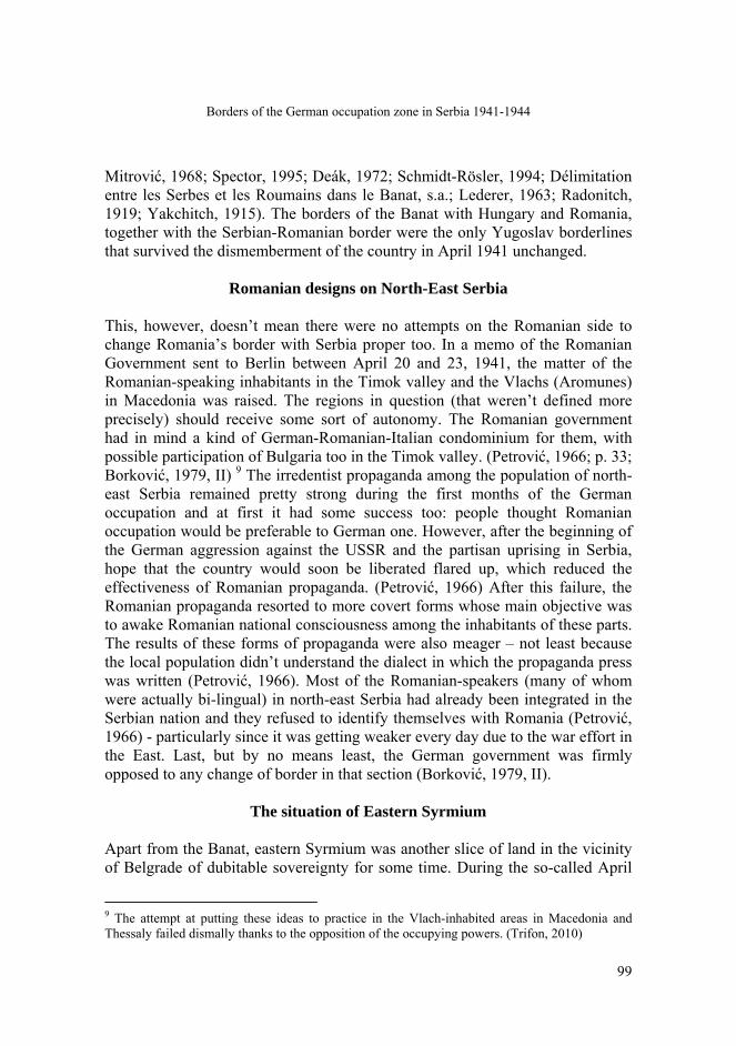
One of the reasons why many of Serbia’s borders under occupation remained so volatile was the fact that Hitler hadn’t planned invasion of Yugoslavia in advance. After long persuasion and pressure by Germany, the Yugoslav government acceded to the Tripartite Pact on March 25, 1941. This seemed to secure a safe hinterland for the intended German military operations in Greece and later on in the Soviet Union. However, the officers’ coup on March 27 upset Hitler’s apple cart. Although the new government declared adherence to the Tripartite Pact, the Fuehrer was furious and decided to smash Yugoslavia as a state. Already on March 27 he proposed offering the spoils to his allies: Italy was to receive the Dalmatian coast, Bulgaria Macedonia, and Hungary the Banat (Čulinović, 1970; Milošević, 1991). It is important to know that Hitler, like most Austrians of his time, spoke loosely of the “Banat”, meaning not only the Banat itself, but the whole of the Vojvodina (Völkl, 1991; Olshausen, 1973). On the same day he actually promised “the Banat” to Hungary and reiterated this in his talks with Hungarian minister of war Bartha on April 4, and with Hungarian ambassador Sztójay on April 6 and 19. (Völkl, 1991; Olshausen, 1973). On the very day of German attack on Yugoslavia, April 6, he issued the “General Guidelines” for dismemberment of the country (figure 1). In them, German occupation was envisaged for the “Old Serbia”. This term requires an explanation. In the parlance of Serbian 19th and early 20th century politicians, scholars and journalists the term designated Sandžak (or Raška), Kosovo and the Metohija – the historical core-land of Mediaeval Serbia. On the other hand, in foreign perception after WWI, “Old Serbia” meant the territory of Serbia before the Balkan Wars 1912/13. Hitler used the term in this latter meaning that was completely consistent with his wish to punish the Serbs (whom he perceived as the main culprits for the coup) and to reduce Serbia to a size that would make it impossible for her to disturb the German-imposed order (Neubacher, 1956; Čulinović, 1970; Terzić, 1983; Marjanović, 1963; Marjanović, 1963a; Marjanović, 1977; Schlarp, 1986).

Borders of the German occupation zone in Serbia 1941-1944
95
Figure 1. The dissmemberment of Yugoslavia, 1941
Although Hitler counted on the aid of his allies in the campaign against Yugoslavia, their territorial aspirations made their assistance not only an asset, but also a liability. This was seen already before the beginning of the attack. The Romanian government was informed that Hungarian troops would occupy the Banat (in the original meaning of the word, designating here the western part of that historical province that had been allotted to Yugoslavia after WWI) already on April 3 and threatened Romanian troops would also enter the Yugoslav part of the Banat in that case. Already on the next day, Romanian ambassador to Berlin Raoul Bossy, protested officially against the planned Hungarian occupation and stated that not even in the future could the Banat be given over to Hungary. Faced with this resistance, Hitler had to yield and he decided on April 5 that Hungarian troops wouldn’t take part in the conquest of the Banat (Völkl, 1991)2. On April 12 the provision that the Yugoslav part of the Banat would be
2 Romanian nationalist circles cherished aspirations to the Yugoslav part of the Banat ever since its division in 1918, but they seldom enjoyed the support of the Romanian government that remained loyal to its Yugoslav ally. (Aprilski rat 1941, 1969)

J. Geogr. Inst. Cvijic. 62(2) (93-115)
96
occupied by German troops was included into the “Temporary Guidelines for Division of Yugoslavia” (Vegh, 1963) that would serve as the basis for carving up Yugoslavia. Thus, the river Tisa was established as the border between the German and Hungarian-occupied territories in the Vojvodina. Although they were duly informed of this, the Hungarians (who joined in the attack only on April 113) were not quite willing to accede to this. Thus, the Hungarian troops crossed the Tisa and were greeted as liberators by the Hungarian population of Novi Kneževac, Novi Bečej and Padej (Kasaš, 1996; Neubacher, 1956). They formed a bridge-head on the Banat territory near Senta between April 15 and 17, and their troops made sorties as deep as vicinity of Kininda and Mokrin in the north, as well as near Titel in the central Banat. However, due to German demands, they had to withdraw (Völkl , 1991). In that way Hitler found himself in the predicament of having to appease two important allies who had been at daggers drawn for quite some time.4 Since Romania had been losing territories and Hungary had been gaining them for several years, it would have been politically difficult to reward Hungary and to leave Romania out in the cold once again.5 For that reason Hitler had to prevaricate, saying to Hungarian officials that the Banat would be handed over to Hungary but in few months time, and to their Romanian counterparts that the matter would be solved after the war (Völkl, 1991). However, it never was and the Serbian Banat remained under German rule for the rest of the occupation, (Kasaš, 1996; Vegh, 1963) although both Hungary and Romania continued to
3 The official justification was that because of declaration of independence of the Independent State of Croatia, Yugoslavia (with whom Hungary had signed a Contract on Eternal Friendship on December 12, 1940) ceased to exist and that it was necessary to protect the Hungarian population of the formerly Hungarian territories – i.e. the Vojvodina. (Čulinović, 1970; Kasaš, 1996) 4 The animosity between the two countries was of long standing: during the 19th century Romania sought to annex predominantly Romanian inhabited parts of Hungary. This was achieved in 1918 as the Habsburg Monarchy collapsed. Ever since “Transylvania” (as all territories Hungary lost to Romania became to be known – as opposed to a smaller territory of the historical duchy of that name) was the bone of contention between the two countries. The so-called Second Vienna Award of 1940 by which Hungary regained part of the lost territories, contrary to German wishes didn’t alleviate, but rather aggravated the situation. (Lukač, 1982; Storia del popolo romeno, 1981; Kurze Geschichte Siebenbürgens, 1990; Daicoviciu & Constantinescu (eds.), 1965) 5 Romanian dictator Antonescu expressed those feelings in a memo for the German Foreign Ministry of April 23, 1941. (Lukač, 1987) Hitler was aware of this even before the memo, and he thought of compensating Romania somewhere else sometime in the future. (Čulinović, 1970; Terzić, 1983)
Borders of the German occupation zone in Serbia 1941-1944
97
lay claim to it and to put diplomatic pressure to bear in order to obtain it (Völkl, 1991; Kasaš, 1996)6. Apart from the Hungarian-Romanian rivalry, there were several other factors that contributed significantly to the decision to leave the Banat as part of occupied Serbia, at least until the end of the war. The first, and probably the most important one was the massive presence of the German minority of some 120.000 souls.7 They greeted the German troops and even aided them in many places and their leaders hoped to establish some kind of an autonomous German state in the region (Terzić, 1983; Beer, 1987; Shimizu, 2003; Kačavenda, 1991). It is more than likely that these ideas were picked up from the VoMi (Volksdeutsche Mittelstelle – Central Office for the Volksdeutsche) ideologues that toyed with the idea of founding a German protectorate on the middle Danube with Belgrade as its center. The area would be cleansed of the Serbs and colonized by the Ethnic-Germans who would garrison the Belgrade fortress protecting the Danube.8 Nothing came of these plans (not least because of Hungary’s aspirations), but the Volksdeutsche remained an important factor determining the possession of the Banat. Since the province had been promised to Hungary, the German authorities strove to fortify the position of the Volksdeutsche for the future (Völkl, 1991). In order to do that, as well as in order to have reliable collaborators, they set up an administration in which all key positions were held by local Germans. The Banat enjoyed autonomy from the rest of Serbia and was put first under a vice-banus, and during the administrative reorganization of the country on December 18, 1941, it became one of 14 counties (okrug). It had partial autonomy in matters of economy, jurisprudence, railways, post, finances and customs (Čulinović, 1970; Atanackovć, 1959; Momčilović, 1977; Shimizu, 2003; Vegh, 1963; Miša, 1992; Völkl, 1991; Šijački, 1979). A paradoxical situation ensued: the Banat was partly and the Volksdeutsche organization completely autonomous from the (occupied) Serbian state, whereas the Ethnic-Germans – filling the most important posts in the state administration – were the strongest link of the province with the rest of Serbia. However, the Volksdeutsche-controlled 6 The Romanians continued spreading irredentist propaganda both in the Banat and in north-eastern Serbia. (Timočka krajina). (Vojni arhiv (Belgrade), Nedićeva arhiva, k. 19, f. 2, d. 62-113.) 7 According to the 1931 census the number of the Volksdeutsche in the Banat was 120.450. (Vegh, 1963; Das Schicksal der Deutschen in Jugoslawien, 1995) In order to underpin their claim to leadership in the province the leaders of the Volksdeutsche organized their own census on June 30, 1941 that established the number of 128.919 Ethnic-Germans in the Banat. (Momčilović, 1977) 8 There were several versions of this plan and the German Foreign Ministry also took part in designing them. According to the version of the state secretary Stuckart, the area should have comprised also the Bor copper mine. (Božić & Mitrović, 1967; Völkl, 1991; Macartney, 1957; Wehler, 1963; Ristović, 1991; Marjanović, 1963 a)
J. Geogr. Inst. Cvijic. 62(2) (93-115)
98
administration was much less dependent on the collaborationist Serbian government and to a much higher degree on the German military administration in Belgrade. Through the Feldkommandantur 610 in Smederevo and the Kreiskommandantur I/823 in Petrovgrad (soon to be renamed Gross Betschkerek), the Banat administration was subject to the relevant offices of the Wehrmacht (Čulinović, 1970; Vegh, 1963; Shimizu, 2003). Another important, although not decisive factor for keeping the Banat as part of the German-occupied Serbia, was economic. The destruction of Yugoslavia was Hitler’s political decision, but it was actually detrimental to economic interests of the Third Reich centered on supply of raw materials and foodstuffs. After the brief military campaign, under pressure of economic leaders its diplomacy tried to reduce the damage by securing the vital German economic interests through negotiations and agreements with the allies that sometimes included drawing of borderlines, and sometimes economic concessions (Olshausen, 1974; Aleksić, 2002; Schlarp, 1986; Čulinović, 1970; Milošević, 1991; Stojiljković, 1989). Although economic considerations in the case of the Banat were not decisive, (Völkl, 1991) they did play a significant role (Völkl, 1991; Schlarp, 1986). Just how significant is shown by demands of the chief of the Military Administration Harald Turner and the representative of the German Foreign Ministry in Belgrade, Felix Benzler, who asked in July and August 1941, at the time when it still wasn’t known who would eventually get the Banat, that due to famine in the land the possible handing-over of the province to Hungary should be postponed until the harvest was brought in (Schlarp, 1986; Völkl, 1991). As the war progressed, Hungary gave up demanding the Banat (Völkl, 1991). On the other hand, it became completely integrated into the economic plans of the Reich (Vegh, 1963). The final reason that helped prevent the cession of the Banat to Hungary was the opposition of both the German and Serbian inhabitants as well as the collaborationist Serbian government for which the German military feared it would lose all esteem among the people and would become totally dejected and unwilling to cooperate if the Banat were turned over to Hungary (Völkl, 1991; Schlarp, 1986; Olshausen, 1973). For all these reasons the Banat remained part of the German zone of occupation in Serbia and its borders remained the same as they had been before the WWII: the rivers Tisa in the west and the Danube in the south, that were natural geographical borders that had played that role since the time immemorial, (Hösch, Nehring & Sundhaussen (eds.), 2004) and the former Yugoslav-Romanian and Yugoslav-Hungarian borders in the north and east that were the result of diplomatic and military tug-of-war right after WWI (Mitrović, 1975;
Borders of the German occupation zone in Serbia 1941-1944
99
Mitrović, 1968; Spector, 1995; Deák, 1972; Schmidt-Rösler, 1994; Délimitation entre les Serbes et les Roumains dans le Banat, s.a.; Lederer, 1963; Radonitch, 1919; Yakchitch, 1915). The borders of the Banat with Hungary and Romania, together with the Serbian-Romanian border were the only Yugoslav borderlines that survived the dismemberment of the country in April 1941 unchanged.
Romanian designs on North-East Serbia
This, however, doesn’t mean there were no attempts on the Romanian side to change Romania’s border with Serbia proper too. In a memo of the Romanian Government sent to Berlin between April 20 and 23, 1941, the matter of the Romanian-speaking inhabitants in the Timok valley and the Vlachs (Aromunes) in Macedonia was raised. The regions in question (that weren’t defined more precisely) should receive some sort of autonomy. The Romanian government had in mind a kind of German-Romanian-Italian condominium for them, with possible participation of Bulgaria too in the Timok valley. (Petrović, 1966; p. 33; Borković, 1979, II) 9 The irredentist propaganda among the population of north-east Serbia remained pretty strong during the first months of the German occupation and at first it had some success too: people thought Romanian occupation would be preferable to German one. However, after the beginning of the German aggression against the USSR and the partisan uprising in Serbia, hope that the country would soon be liberated flared up, which reduced the effectiveness of Romanian propaganda. (Petrović, 1966) After this failure, the Romanian propaganda resorted to more covert forms whose main objective was to awake Romanian national consciousness among the inhabitants of these parts. The results of these forms of propaganda were also meager – not least because the local population didn’t understand the dialect in which the propaganda press was written (Petrović, 1966). Most of the Romanian-speakers (many of whom were actually bi-lingual) in north-east Serbia had already been integrated in the Serbian nation and they refused to identify themselves with Romania (Petrović, 1966) - particularly since it was getting weaker every day due to the war effort in the East. Last, but by no means least, the German government was firmly opposed to any change of border in that section (Borković, 1979, II).
The situation of Eastern Syrmium
Apart from the Banat, eastern Syrmium was another slice of land in the vicinity of Belgrade of dubitable sovereignty for some time. During the so-called April
9 The attempt at putting these ideas to practice in the Vlach-inhabited areas in Macedonia and Thessaly failed dismally thanks to the opposition of the occupying powers. (Trifon, 2010)

J. Geogr. Inst. Cvijic. 62(2) (93-115)
100
War power in Syrmium came into the hands of the Ustashi (Croatian fascists), members of the the Croatian Peasant Party, the strongrest Croat political party, and the local Volksdeutsche (Atanacković, 1968; Atanacković, 1962; Mirnić, 1974; Biber, 1966; Saopštenja o zločinima okupatora i njihovih pomagača u Vojvodini 1946). Already on April 10, with the aid of the Germans, the Independent State of Croatia (Nezavisna džava Hrvatska - NDH) was proclaimed in Zagreb under Ustashi leadership. The Ustashi pretended to unite the whole of Croatia and Bosnia-Herzegovina within the new state. Syrmium had made part of the historical Kingdom of Croatia-Slavonia (Höschet al., 2004)
and was demanded by the Ustashi on these grounds. However, the Ustashi administration was established only to the west of the line Slankamen (on the Danube) – Boljevci (on the Sava). In that way eastern part of Syrmium, with towns of Nova Pazova and Zemun (that was practically a suburb of Belgrade) remained under German control (Atanacković, 1968). Just like in the case of the Banat, there were several reasons for this. On the one hand, the Ethnic-Germans there, like those in the Banat, dreamed of an autonomous “Donauschwabenland” with a Germanized Belgrade as its capital. (Atanacković, 1968) Since Belgrade was the natural center of the region, the local Volksdeutsche were in favor of having eastern Syrmium as part of the occupied Serbia for economic reasons too (Atanacković, 1968). On the other hand, the Ustashi demanded that the historical border on the Sava and the Danube, right up to their confluence at Belgrade be reestablished (Schlarp, 1986). For their part, the German authorities in Belgrade tended to keep eastern Syrmium, and particularly Zemun as part of the German occupying zone in Serbia for economic and strategic reasons. Firstly, much of the food-supplies for Belgrade came from there. Secondly, the Belgrade airport was situated in Zemun. A short-wave radio-station important for German propaganda operated there too. For a while the very General Commissioner for Economy in Serbia Franz Neuhausen had his seat in Zemun. Other bureaucrats and military also had their premises there since the neighboring Belgrade had suffered large-scale damages during the air-raids at the beginning of the war on April 6, 1941. For these reason the military commander of Serbia and the General Commissioner for Economy demanded that east Syrmium remained under German control. This was backed by Hermann Göring in his capacity as the Commissioner of the Reich for the Four-Year Plan, and accepted by the Supreme Command of the Army as a temporary solution. The German Foreign Ministry also had nothing against it, under proviso it didn’t predetermine the future border (Krizman, 1980; Schlarp, 1986; Marjanović, 1963a; Atanacković, 1968).
Borders of the German occupation zone in Serbia 1941-1944
101
It seems the original idea was too keep east Syrmium under German control as long as Serbia was under occupation (Krizman, 1980). However, the Ustashi government, backed by German ambassador to Zagreb Siegfried Kasche, pressed for handing over of the region to the NDH. In order to establish the borders of the NDH a meeting between German and Ustashi representatives was organized in Zagreb on June 4, 1941. Among other things, it was decided that the Ustashi would take over power in juridical and cultural matters in eastern Syrmium, whereas the administrative power, as well as the control over railroads and post would remain in German hands (Schlarp, 1986; Krizman, 1980)10. In mid-August Kasche pressed again for turning the region over to the Ustashi. The representative of the Foreign Ministry Benzler agreed under condition that the above mentioned German needs for food, use of the airport and the radio-station remained satisfied. Undersecretary of the German Foreign Ministry Woermann deemed in late August this would strengthen German influence in the NDH, particularly since the Reich failed to back the NDH against Germany’s main ally, Italy in the matter of the frontier in Dalmatia. He also deemed the above mentioned military needs could be met in other ways (Krizman, 1980). On September 9 Neuhausen and the German commanding general in Serbia Bader agreed to give up east Syrmium as soon the agreement with Zagreb on the conditions was reached. However, in order not to rouse dissatisfaction in Serbia, it was recommended that Zemun should be handed over quietly, with no press coverage. The agreement was reached at the meeting on October 4 and put to practice six days later (Krizman, 1980; Marjanović, 1963a). Due to the worsening social, economic and political situation, the local Volksdeutsche were not happy with this solution and demanded in January 1942 that east Syrmium be reattached to the German-occupied zone of Serbia (Atanacković, 1968). As we shall see below, the Serbian collaborationist authorities also strove to include this area into Serbia. Nothing came of it and the border of the Independent State of Croatia continued to reach the gates of Belgrade until October 1944. The border between the german zone of occupation in Serbia and the NDH
Serbian border with that puppet state was easier to determine where no direct German interests were involved. Thus, the Ustashi leader Pavelić was allowed to promulgate the law on Croatia’s eastern border already on June 7 – soon after the meeting of June 4 (cf. supra) where it had been defined as following the Drina downstream until Bajina Bašta, whereas the rest hadn’t been fixed. It was said that the temporary borderline would go over the old Bosnian border to the
10 Čulinović is wrong when he claims the NDH government took over Syrmium and Zemun on June 4, 1941 (“with the approval of the German government” as he puts it.) (Čulinović,1970)
J. Geogr. Inst. Cvijic. 62(2) (93-115)
102
east by south-east, to the east of Nova Varoš, i.e. the border followed the Drina downstream to the confluence of the stream Brusnica with it (east of the village of Zemlica) and from there east of the Drina following the pre-WWI Bosnian-Serbian border. Kasche notified the Ustashi government on July 5 that the German Reich accepted this borderline (Krizman, 1980; Čulinović, 1970; Terzić, 1983)11. Between the promulgation of the law and its official acceptance by the Reich’s government, Pavelić tried to “rectify” the border with Serbia during his talks with the German foreign minister von Ribbentrop and with Hitler on June 6 and 9 in Fuschl. He presented them with the demand that the NDH be given Sandžak (the historic sandžak of Novi Pazar) (Krizman, 1978). The demand was based on the fact that large part of the population there were Muslims, co-nationals of the Bosnian Slav Muslims, who were styled “the flower of Croatiandom” by the Ustashi for political and propaganda purposes (Redžić, 1998; Petranović, 1988). Although the Ustashi commissioner for Bosnia-Herzegovina Hakija Hadžić was spreading pan-Croat propaganda in Sandžak, (Redžić, 1987) the matters were more complicated there: not because of the powerless Serbian Council of Commissars (that had been installed by the Germans in late April 1941), but because the other Axis partner, Italy, also had its interests in the region.
The german-italian clash of interests in Serbian territory The geographic scope of these interests was roughly defined at the meeting between the German and Italian foreign Ministers, von Ribbentrop and Ciano in Vienna on 21-22. April 1941. The line dividing German and Italian zones of influence in the former Yugoslav territory was set on April 24 by Hitler himself as going from the place where the former Yugoslav, German and Italian borders met, until peak 703 (south of Žirje) and then, roughly following the line Lučine – Ježica – Cerklje – Samobor – Petrinja – Glina – Bosanski Novi – Sanski Most – Mrkonjić Grad – Donji Vakuf – Sarajevo – Ustiprača – Priboj – Novi Pazar – Orlova Čuka – Uroševac – Tetovo – Kičevo –Lake Ohrid –Lake Prespa, with all these places being included in the German sphere of influence (Čulinović, 1970; Milošević, 1991)12. This so-called „Vienna-line” was modified in May, and so in Sandžak it now followed the line Priboj - Nova Varoš – Sjenica – Novi Pazar –
11 The thus defined borderline was more modest than the Ustashi demand of May 18, 1941, that asked for the border that would run west of Dobrek, to the eastern part of the mount Tara, Šargan, the peak of Zlatibor, Cigota and then to the east toward the Uvac. From Vis, it would go the Uvac upstream until the mouth of the Gorečanska reka, and then to south-west toward Bukovik (14 km to the south of Prijepolje) and the border with Montenegro (Krizman, 1978). 12 Terzić claims the line was deffinitively set in mid-May 1941 (Terzić, 1983).

Borders of the German occupation zone in Serbia 1941-1944
103
Kosovska Mitrovica etc. These places were put under German rule. On May 21 the line was modified yet again and Rudo, Priboj, Nova Varoš, Sjenica and Duga Poljana were ceded to Italy (Terzić, 1983; Marjanović, 1963; Marjanović, 1963a; Borozan, 1995). The Ustashi for their part, were not happy with the existing borderline: they favored a larger German zone in Sandžak hoping to establish their power under German auspices there (Milošević, 1991). This wasn’t just wishful thinking: as we shall presently see, the German government, needing increasingly more troops for the Eastern Front, tended to reduce the territory directly controlled by its own forces. In order to settle the border between the territory under the German military commander in Serbia and the Italian commands in Albania and Montenegro, a German-Italian commission met in Rome in early November of that year. However, rather than with the border in Sandžak, the German officials were more concerned with modifying the line in Kosovo so as to secure for themselves the mines of asbestos, chrome and magnesite lying 10 km to the west from the railroad-line Kosovska Mitrovica-Prilužje (Milošević, 1991).
German, Italian and Bulgarian aspirations in Kosovo This brings us to the region of Kosovo where German, Italian and Bulgarian interests clashed. To be sure, the German and the Italian interests were those that really mattered, with Bulgaria playing only a subaltern role. Italy (who had already conquered Albania in 1939 and who was utilizing Albanian nationalism) tried to make good its espousal of Greater Albanian goals: at the Vienna meeting with von Ribbentrop referred above, Ciano brought a map that showed the new Albanian border as running 10 km west of Vranje from Prespa to Kosovska Mitrovica, including the Trepča mine (Borozan, 1995). However, the German government as the senior partner, was not willing to concede that much. For that reason, the so-called “Vienna-line” (in this section) was set to run from Novi Pazar via Kosovska Mitrovica and Priština, along the railroad line Priština-Uroševac and further in direction of Tetovo (Borozan, 1995; Hadri, 1965). The Third Reich's overriding concerne was to secure the lead and zink mine of Trepča. In 1941-1942 Italian officials strove to redraw the borderline so as to include that mine as well as the chrome mines at the mount Šara in their puppet state of Greater Albania. Their German opposite numbers wanted to counter such demands and to push the borderline to the south from Kosovska Mitrovica in order to lay their hands on the coal mine Kosovo in Obilić. They didn’t give up the broader region of Kosovo, including the railroad line Kosovska Mitorvica – Priština – Uroševac – Kačanik –Skopje either. To this end they even had the cheek to refer to Serbian historical rights and national tradition (Avramovski,

J. Geogr. Inst. Cvijic. 62(2) (93-115)
104
1983)! In that section the border went from Uroševac to Orlova Čuka, where the Bulgarian territory began (Hadri, 1965). In that way Kosovska Mitrovica, Vučitrn and Lab districts of Kosovo comprising also mines of asbestos in Čabra and Rušanj were in German zone of occupation. The Vučitrn district was enlarged by part of the Gračanica district that also fell under German rule (Božović & Vavić, 1991; Hadri, 1965). The main concern of the German authorities were numerous mines in the region: apart from the already mentioned Trepča, there was the lead mine of Kopaonik in Belo Brdo, the asbestos mines near Žabari, Brabovići, Čabra, Rujište, Jagnjenica, Kozarevo and Kameščoka near Kosovska Mitrovica and the magnesite mine at Dubovac near Vučitrn. The brown-coal mine Kosovo in Obilić, on which Trepča depended, remained in the Italian-controlled territory. The chrome mine Jezerina remained in the territory alotted to Bulgaria, but the German companies had the right of exploatation (Božović & Vavić, 1991). Similarly to the Banat, the German-controlled part of Kosovo was granted a de facto autonomy and the local Albanian minority a privileged status (Čulinović, 1970; Božović & Vavić, 1991). However, this was only a temporary solution for the German authorities: they planned to resettle the Albanians from their zone of occupation into the Italian-controlled parts of Kosovo once the war ended. When planning this, they were not guided by Serbian sensitivity but by their own interests: since Italy had been fomenting Albanian nationalism, spreading irredentist propaganda in their territory and keeping alive hopes that the German-occupied part of Kosovo would some day be annexed to the “Greater Albania”, they wanted to secure their possession of the valuable mines by attaching this part of Kosovo firmer to the rest of Serbia (Avramovski, 1983; Hadri, 1965). This was probably the reason they recognized the “Greater Albania” after the capitulation of Italy in its borders as previously defined between the two Axis partners (Pichler 2006; Milošević, 1991). The borders of the German occupation zone in Serbia with the Bulgarian-
annexed territories and the Bulgarian zone of occupation The other Axis partner cherishing aspirations to portions of Kosovo was Bulgaria. It didn’t take part in the attack on Yugoslavia because Hitler didn’t want to provoke its neighbor Turkey to use the situation and undertake something that would run contrary to German wishes for stability in the region (Stojiljković, 1989). However, failure to take part in the military campaign didn’t mean Bulgaria had no territorial demands. In Kosovo Bulgaria aspired to annex the whole province and this was backed by German foreign minister at the

Borders of the German occupation zone in Serbia 1941-1944
105
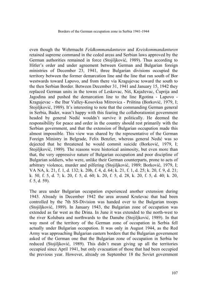
Vienna conference on April 21-22, 1941. He adduced ethnic (sic) reasons to underpin that demand. Count Ciano saw through that but obligingly said that other ways of securing German economic interests could be found. Under pressure from Albanian nationalism that it itself conjured; Italy strove to obtain as much as possible for its puppet state of “Greater Albania” (Čulinović, 1970). In that way the junior Axis partner Bulgaria (whose main concern was Macedonia anyway) received only smaller part of Kosovo after the two bigger players carved up most of the territory according to their own interests. Bulgaria was left with part of the Gnjilane district to the north from Pasjane, as well as Vitina, Kačanik and Sirinićka Župa (Čulinović, 1970; Stojiljković, 1989; Strugar, 1980). Due to the need to move an additional part of troops to the Eastern Front, the German Command of the Southeast proposed to Hitler on December 20, 1941 that the Bulgarian zone of occupation be extended so as to include the towns of Priština and Kosovska Mitrovica. This was refused, but on January 15, 1942 the Bulgarian zone of occupation was extended to the district of Lab so as to relieve German troops. On January 7 next year, the districts of Mitrovica and Vučitrn were also included into the area controlled by Bulgarian troops (Hadri, 1965; Stojiljković, 1989; Čulinović, 1970). It is important to stress that these districts remained part of the German occupation zone in Serbia, although the task of controlling the region was entrusted to Bulgarian troops after severe German set-backs and losses in the USSR. In other words, the same pattern of rule with German supreme power, Serbian civilian administration and Bulgarian military occupation was applied here as in much of the German occupation zone in Serbia, as we shall presently see. The Bulgarian government craved for several parts of Yugoslavia before its dismemberment (figure 2). The most important was Macedonia that the Bulgarian ideologues considered as historically Bulgarian land (Hösch et al., 2004; Barker, 1950; Brailsford, 1906; Stojiljković, 1989; Banac, 1988) and of which Bulgaria received a larger part after the April war (Sojiljković, 1989; Čulinović, 1970; Petranović, 1988). Apart from that Bulgaria wanted to retrieve two districts (Caribrod and Bosilegrad) it had lost to Yugoslavia after WWI under the treaty of Neuilly-sur-Saine (Stojiljković, 1989). These districts were predominantly Bulgarian-inhabited but Yugoslavia received them for strategic reason and partly as a way of punishing Bulgaria for the stab in the back it had given Serbia in 1915. Nevertheless, Bulgarian appetites didn’t stop with retrieving the lost territories from Serbia. The German authorities allowed the Bulgarian troops to occupy and annex also the districts of Vranje and Pirot with some 200.000 inhabitants (Stojiljković, 1989). Furthermore, until June 1941

J. Geogr. Inst. Cvijic. 62(2) (93-115)
106
they also occupied militarily the districts of Niš, Lužnica, Masurica, Bojanica and parts of Vlasotince and Palanka districts, as well as a narrow strip to the north-east from Zaječar, between the river Timok and the former Yugoslav-Bulgarian border (Marjanović, 1963; Strugar, 1980; Schlarp, 1986). They wanted to occupy the area around the town of Negotin too, but the local German commander prevented it (Stojiljković, 1989). Surprisingly, the negotiations between two basically unequal partners were protracted and failed to bring about a mutually satisfactory line of demarcation (Stojiljković, 1989; Glišić, 1982).
Figure 2. Parts of Yugoslavia, which were annexed and occupied by Bulgaria in World War II
One of the most important reasons for that was that the Bulgarian authorities were insatiable. They kept pushing the demarcation line illegally toward west and north-west at which both the German and the Serbian side protested: the first on economic grounds and the latter on national and political ones. The Bulgarian tactic was to nip off this or that village every now and then (Glišić, 1982; Stojiljković, 1989; VA NA, k. 20, f. 7, d. 39; k. 20b, f. 4, d. 64; k. 21, f. 1, d. 25; k. 21, f. 1, d. 132). Although not willing to tolerate that in the short run, due to their increasing demand for soldiers on the Eastern Front, the German authorities had to put under Bulgarian occupation increasingly larger chunks of territory –
Borders of the German occupation zone in Serbia 1941-1944
107
even though the Wehrmacht Feldkommandanturen and Kreiskommandanturen retained supreme command in the ceded areas and Serbian laws approved by the German authorities remained in force (Stojiljković, 1989). Thus according to Hitler’s order and under agreement between German and Bulgarian foreign ministries of December 23, 1941, three Bulgarian divisions occupied the territory between the former demarcation line and the line that ran south of Bor westwards toward Lapovo, and from there via Kragujevac toward the south to the then Serbian Border. Between December 31, 1941 and January 15, 1942 they replaced German units in the towns of Leskovac, Niš, Knjaževac, Ćuprija and Jagodina and pushed the demarcation line to the line Rgotina - Lapovo - Kragujevac - the Ibar Valley-Kosovksa Mitrovica - Priština (Borković, 1979, I; Stojiljković, 1989). It’s interesting to note that the commanding German general in Serbia, Bader, wasn’t happy with this fearing the collaborationist government headed by general Nedić wouldn’t survive it politically. He deemed the responsibility for peace and order in the country should rest primarily with the Serbian government, and that the extension of Bulgarian occupation made this almost impossible. This view was shared by the representative of the German Foreign Ministry in Belgrade, Felix Benzler, whereas general Nedić was so dejected that he threatened he would commit suicide (Borković, 1979, I; Stojiljković, 1989). The reasons were historical animosity, but even more than that, the very oppressive nature of Bulgarian occupation and poor discipline of Bulgarian soldiers, who were, unlike their German counterparts, prone to acts of arbitrary violence, murder and pilfering (Stojiljković, 1989; Borković, 1979, I; VA NA, k. 21, f. 1, d. 132; k. 20b, f. 4, d. 64; k. 21, f. 1, d. 25; k. 20, f. 9, d. 21; k. 50, f. 5, d. 7; k. 20, f. 5, d. 60; k. 20, f. 5, d. 28, k. 20, f. 5, d. 40; k. 20, f. 5, d. 59). The area under Bulgarian occupation experienced another extension during 1943. Already in December 1942 the area around Kruševac that had been controlled by the 7th SS-Division was handed over to the Bulgarian troops (Stojiljković, 1989). In January 1943, the Bulgarian zone of occupation was extended as far west as the Drina. In June it was extended to the north-west to the river Kolubara and northwards to the Danube (Stojiljković, 1989). In that way most of the territory of the German zone of occupation in Serbia fell actually under Bulgarian occupation. It was only in August 1944, as the Red Army was approaching Bulgarian eastern borders that the Bulgarian government asked of the German one that the Bulgarian zone of occupation in Serbia be reduced (Stojiljković, 1989). This didn’t mean giving up all the territories occupied since April 1941, but only evacuation of those that had been occupied the previous year. However, already on September 18 the Soviet government
J. Geogr. Inst. Cvijic. 62(2) (93-115)
108
made complete evacuation of the occupied territories in Yugoslavia and Greece a condition for signing an armistice with Bulgaria (Stojković, 1989).
Planning Serbia’s borders
The (changing) borders of Serbia in WWII didn’t exist only on maps and in practice, but also in heads of politicians, diplomats, ideologues and military men. Probably the first to express wishes for the revision of Serbia’s borders created after April 1914 was Milan Aćimović, the chairman of the Serbian caretaker government, the Council of Commissioners. He penned a memo on Serbia’s borders for the German commanding general in Serbia Schröder in June 1941. In it he argued for borders that would be more in keeping with ethnic situation on the ground, as well as with historical traditions. He defined that space with following borders: the territory north of the river Pčinja; from Veles (in Macedonia) in the south to Novi Sad (in the Bačka) in the north; from the former border with Bulgaria in the east, to Kordun and Lika (in Croatia) in the west. For economic reasons the Vardar valley south of Veles and the access to the Adriatic Sea in the valley of the Neretva should be added to the above described territory (Borković, 1979, I; Hadri, 1965; Čulinović, 1970). In this way, under pressure of circumstances, he was willing to give up the maximalist demands of Serbian nationalists, but asked nevertheless for some areas inhabited by non-Serbs, on grounds of economic viability. Aćimović claimed the borders of Serbia should be so enlarged in order to secure the German „New Order” in southeast Europe. To be sure, even such “moderate” territorial demands were unrealistic. They couldn’t be met because the Reich was banking on Serbia’s neighbors and Hitler wanted to keep Serbia as small as possible. Aćimović's successor, prime minister Milan Nedić also wanted to create an independent and enlarged Serbia. This was his avowed goal from the start (Borković, 1985). Soon after taking office, and spurred by persecution of the Serbian population of Kosovo, he asked on September 8, 1941 of the German commanding general in Serbia Dankelmann, that this area should be annexed to Serbia. He adduced geographic, historical and economic reasons in favor of this. Since the territory in question had already been carved up on higher diplomatic level, Dankelmann couldn’t but flatly refuse (Borković, 1979, II). Nedić concerned with the interests of his people as he saw them, didn’t give up the idea of enlarging Serbia. In February 1942 he and his government submitted a memo to commanding general in Serbia Paul Bader in which they asked for eastern Bosnia and Herzegovina (some 17 districts), Syrmium and parts of Dalmatia. The main reasons adduced were ethnic, but they were presented also as favorable for military actions against the partisans. Berlin’s refusal was not

Borders of the German occupation zone in Serbia 1941-1944
109
direct this time, but couched as a postponement (Borković, 1985). Having had no success there, Nedić turned to Montenegro and Sandžak, believing they were rather a burden than an asset for the Italian government. On this assumption, he even entered some talks with Italian agents but they were stopped after German admonition. For their part, the Italian authorities only used these wishes as pawns in their haggling with German officials (Borković, 1985). For a while Nedić refrained from voicing similar demands. When he was promised a meeting with Hitler in late 1942, he and his team produced a memo containing the projected borders of “Greater Serbia”. They were to run from Makarska on the Adriatic coast, to the border between Dalmatia and Bosnia on the Una, than following the Una until its confluence with the Sava, from there following the line between Đakovo and Vinkovci to the Drava near Osijek, and further through Baranya to the Hungarian border, over the Danube near Sombor, than in a straight line toward the Tisa into the Banat. This state would include also the whole of Macedonia in its borders with Albania and Greece as before WWII, except for Scutari that should be annexed to Montenegro. However, on Benzler’s suggestion, he didn’t take this memo to Berlin (Borković, 1985). He nevertheless reiterated the wishes of the Serbian government during his talks with German foreign minister before meeting Hitler in September 1943. He asked von Ribbentrop that Montenegro, Sandžak, eastern Bosnia, Syrmium, Kosovo and the Metohija be joined with Serbia. He wanted to use the moment, right after Italy’s capitulation to ask for these territories, previously controlled for greater part by Italian troops (except for Syrmium). Von Ribbentrop told him in no uncertain terms that an independent, and at that enlarged Serbia was impossible during the war and the main goal was the security of German troops (Neubacher, 1956; Borković, 1979, II; Borković, 1985). Thus his endeavors failed in the highest place, although he enjoyed the support of Hitler’s special envoy for the Balkans, Hermann Neubacher (Borković, 1985). Neubacher had plans for a federation of Serbia, Montenegro and Sandžak that would be a bulwark against communism that would strengthen the increasingly weaker German position in the Balkans. They were supported also by the German commander of the Southeast, field-marshal von Weichs. This enabled Nedić to dabble with attempts of winning over some Montenegrin leaders, but although Neubacher tried to convince Hitler of the usefulness of the idea, it was never realized because of Fuehrer’s mistrust of the Serbs whom he perceived as a people conscious of its political mission, and therefore too dangerous (Borković, 1985; Neubacher, 1956; Marjanović, 1977). It is typical that German officials came to an idea to consider such plans only after German troops had been hard pressed on various fronts: as long as German military position in

J. Geogr. Inst. Cvijic. 62(2) (93-115)
110
Europe was undisputed and as long as the final victory seemed a realistic possibility, they weren’t willing to take into account the wishes of the Serbian governments. The Serbian collaborationists were not the only ones on Serbian side to make plans for an enlarged Serbia. The royalist resistance movement, the Chetniks hatched plans of their own that were very much influenced by the wartime dismemberment of Yugoslavia and vicious persecution of the Serbs in various territories. The first to draft a comprehensive blueprint of a “Greater Serbia” was Chetnik ideologue Stevan Moljević. He envisaged a much enlarged Serbia in an enlarged Yugoslavia. Serbia should comprise Serbia proper, Sandžak, Montenegro, Bosnia and the whole of Dalmatia (with Dubrovnik enjoying a special status). Part of Croatia from Šibenik to the river Neretva, with western Herzegovina and part of Bosnia would have an autonomy within Serbia, that would also include most of Lika, almost the whole Kordun and Banija, the territory east of Pakrac (with a corridor 15-20 km wide, between Pakrac and the Hungarian border comprising Daruvar, Grubišno Polje, Slatina and part of Nova Gradiška and Požega), the whole Syrmium, Bačka, Baranya and the Banat. “Greater Serbia” would also take some territories from the neighboring countries: northern regions from Albania, districts of Ćustendil and Vidin from Bulgaria, Reşiţa and Timisoara from Romania, and districts of Szeged and Pesc from Hungary. Such enlarged Serbia, purged of non-Serbian inhabitants, would comprise some 65-70% of the territory of the enlarged Yugoslavia, which would secure Serbia the leading position within the state. The Chetnik leader Draža Mihajlović approved this scheme that recurred in several variations during the war, but that nevertheless remained wishful thinking (Tomasevich, 1975; Vesović & Nikolić, 1996). Their basic difference from the plans hatched by Nedić and his collaborators was that they were not meant to be realized under German auspices, i.e. as enlargement of the German zone of occupation in Serbia (that would eventually become an independent nation some time in the future), but rather as a fruit of the expected Allied victory. Under the given circumstances, both visions were unrealistic because they didn’t take into account enough the German interests that were decisive for carving up Yugoslavia and for tailoring the borders of rump Serbia that remained under German rule.
Borders of the German occupation zone in Serbia 1941-1944
111
Conclusion
The borders of the German occupation zone in Serbia were neither constant nor were they meant to be eternal. They were drawn as the outcome of negotiations between the Third Reich and its allies and satellites. While taking some heed of their needs and desires, the German government was led primarily by German political, military and economic interests. For that reason, Italy had to wrench concessions from its Axis partner, whereas other allies had to make do with what they were granted by the German diplomacy. Their requests had a chance of being met only if they corresponded with German interests. Bulgaria was granted a special status among Germany’s allies. The Serbian territory it was allowed to annex wasn’t that large, but the territory that fell under Bulgarian military control eventually comprised most of the German zone of occupation in Serbia. The people most concerned – the Serbs – had no say whatsoever in determining Serbia’s borders. Sometimes these borders followed the very old historical lines or geographical boundaries, but they had little to do with the territorial dispersal of the Serbian people or its vital interests. The collaborationist officials could hope to enlarge Serbia’s borders only by relying on the very aggressor that brought about the Serbian catastrophe. Since all other players had to be satisfied first, their endeavors were condemned to failure. The borders of the German zone of occupation in Serbia – and consequently of the neighboring countries that profited from subjugation of Serbia, were unjust and against the international law. For these reasons they were obliterated completely as soon as the German occupation ended.
References
Aleksić, D. (2002). Privreda Srbije u Drugom svetskom ratu, Beograd: Institut za noviju istoriju Srbije.
Aprilski rat 1941. Zbornik dokumenata, I. (1969). Beograd: Vojnoizdavački zavod. Atanacković, Ž. (1968). Srem u Narodnooslobodilačkom ratu i socijalističkoj revoluciji. Beograd:
Mesna zajednica, Mesni odbor SUBNOR-a Šimanovci. Atanackovć, Ž. (1959). Vojvodina u Borbi 1941-1945. Novi Sad: Forum. Atanackovć, Ž. (1962). Zemun i okolina u ratu i revoluciji. Beograd: Nolit Avramovski, Ž. (1983). Nemačka politika prema Albaniji posle kapitulacije Italije (1943-1944).
Istorija 20. veka, 1, 75-90. Banac, I. (1988). Nacionalno pitanje u Jugoslaviji. Porijeklo, povijest, politika. Zagreb: Globus.

J. Geogr. Inst. Cvijic. 62(2) (93-115)
112
Barker, E. (1950). Macedonia. Its Place in Balkan Power Politics. London: Royal Institute of
International Affairs. Beer, J. (1987). Donauschwäbische Geschichte aus erster Hand. München: Donauschwäbische
Kulturstiftung. Biber, D. (1966). Nacizem in Nemci v Jugoslaviji 1933-1941. Ljubljana: Cankarjeva založba. Borković, M. (1979). Kontrarevolucija u Srbiji, (Vols. 1-2). Beograd: Sloboda. Borković, M. (1985). Milan Nedić. Zagreb: Centar za informacije i publicitet. Borozan, Đ. (1995). Velika Albanija. Porijeklo, ideje, praksa. Beograd: Vojnoistorijski isntiut. Božić, N. & Mitrović, R. (1967). Vojvodina i Beograd sa okolinom u planovima rajha. Zbornik
Matice srpske za društvene nauke, 48, 116-125. Božović, B. & Vavić, M. (1991). Surova vremena na Kosovu i Metohiji. Kvislinzi i kolaboracija u
Drugom svetskom ratu. Beograd: Institut za savremenu istoriju. Brailsford, H.N. (1906). Macedonia. Its Races and their Future. London: Meuthen & co. Čulinović, F. (1970). Okupatorska podjela Jugoslavije. Beograd: Vojnoizdavački zavod. Milošević, S.D. (1991). Nemačko-italijanski odnosi na teritoriji okupirane Jugoslavije 1941-1943.
Beograd: Institut za savremenu istoriju. Daicoviciu, C. & Constantinescu, M. (eds.). (1965). Brève histoire de la Transylvanie. Bucarest:
Académie de la R.S. de Roumanie. Deák, F. (1972). Hungary at the Peace Conference. The Diplomatic History of the Treaty of
Trianon. New York: Columbia University Press. Délimitation entre les Serbes et les Roumains dans le Banat. (s.a) s.l. Glišić, V. (1982). Uspostavljanje okupacionog sistema i bugarsko-nemački sporovi oko
demarkacione linije u leskovačkom kraju 1941. godine, Leskovački zbornik, 22, 12-15. Hadri, A. (1965). Okupacioni sistem na Kosovu i Metohiji 1941-1944. Jugoslovenski istorijski
časopis, 2, 39-60. Hösch, E., Nehring, K. & Sundhaussen, H. (eds.) (2004). Lexikon zur Geschichte Südosteuropas,
Wien, Köln, Weimar: Böhlau Verlag. Kačavenda, P. (1991). Nemci u Jugoslaviji 1918-1945. Beograd: Institut za savremenu istoriju. Kasaš, A. (1996). Mađari u Vojvodini 1941-1946. Novi Sad: Filozofski fakultet. Krizman, B. (1978). Ante Pavelić i ustaše. Zagreb: Globus.

Borders of the German occupation zone in Serbia 1941-1944
113
Krizman, B. (1980). Pavelić između Hitlera i Mussolinija. Zagreb: Globus. Kurze Geschichte Siebenbürgens. (1990). Budapest: Akadémiai Kiadó. Lederer, I. J. (1963). Yugoslavia at the Paris Peace Conference. A Study in Frontiermaking. New
Haven, London: Yale University Press. Lukač, D. (1982). Treći rajh i zemlje jugoistočne Evrope, II. 1937-1941. Beograd: Vojnoizdavački
zavod. Lukač, L. (1987). Treći rajh i zemlje jugoistočne Evrope, III. 1941-1945. Beograd:
Vojnoizdavački zavod. Macartney, C.A. (1957). October Fifteenth. A History of Modrn Hungary 1925-1945, I. New
York: University Press. Marjanović, J. (1963). Ustanak i narodnooslobodilački pokret u Srbiji 1941. Beograd: Institut
društvenih nauka. Marjanović, J. (1963). The German Occupation System in Serbia 1941, Les systèmes d’occupation
en Yougoslavie 1941-1945. Belgrade: Institut društvenih nauka, 263-299. Marjanović, J. (1977). The Neubacher Plan and Practical Schemes for the Establishment of a
Greater Serbian Federation (1943-1944) in: The Third Reich and Yugoslavia 1933-1945. Belgrade: Institut za savremenu istoriju, Narodna knjiga, 486-501.
Milošević, S. D. (1991). Nemačko-italijanski odnosi na teritoriji okupirane Jugoslavije 1941-
1943. Beograd: Institut za savremenu istoriju. Mirnić, J. (1974). Nemci u Bačkoj u Drugom svetskom ratu. Novi Sad: Institut za izučavanje
istorije Vojvodine. Miša, B.P. (1991). Nemački zatvori i koncentracioni logori u Banatu 1941-1944. Beograd: Institut
za savremenu istoriju. Mitrović, A. (1968). Jugoslavija na konferenciji mira 1919-1920. Beograd: Zavod za udžbenike
SR Srbije. Mitrović, A. (1975). Razgraničenje Jugoslavije sa Mađarskom i Rumunijom 1919-1920. Prilog
proučavanju Jugoslavije na konferenciji mira u Parizu. Novi Sad: Institut za izučavanje istorije Vojvodine.
Momčilović, Đ. (1977). Banat u Narodnooslobodilačkom ratu. Beograd: Vojnoizdavački zavod. Neubacher, H. (1956). Sonderauftrag Südost 1940-1945. Bericht eines fliegenden Diplomaten.
Berlin, Frankfurt: Musterschmidt Verlag. Olshausen, K. (1973). Zwischenspiel auf dem Balkan. Die deutsche Politik gegenüber Jugoslawien
und Griechenland von März bis Juni 1941. Stuttgart: Deutsche Verlags-Anstalt.
J. Geogr. Inst. Cvijic. 62(2) (93-115)
114
Petranović, B. (1988). Istorija Jugoslavije 1918-1988, II. Narodnooslobodilački rat i revolucija
1941-1945. Beograd: Nolit. Petrović, D. (1966). Iredenta fašističke Rumunije u severoistočnoj Srbiji 1941-1944. Jugoslovenski
istorijski časopis, 3-4, 31-53. Pichler, R. (2006). Serben und Albaner im 20. Jahrhundert, in: Chiari, B. & Keßelring, A. (eds.).
Wegweiser zur Geschichte Kosovo, Paderborn, München, Wien, Zürich: Ferdinand Schöningh, 57-65
Radonitch, I. (1919). The Banat and the Serbian-Rumanian Frontier Problem. Paris. Redžić, E. (1998). Bosna i Hercegovina u Drugom svjetskom ratu. Sarajevo: Grafičko-izdavačka
kuća d.d. Redžić, E. (1987). Muslimansko autonomaštvo i 13. SS divizija. Autonomija Bosne i Hercegovine i
Hitlerov Treći Rajh. Sarajevo: Svjetlost. Ristović, M.D. (1991). Nemački „novi poredak“ i jugoistočna Evropa 1940/41-1944/45. Planovi o
budućnosti i praksa. Beograd: Vojnoizdavački zavod. Saopštenja o zločinima okupatora i njihovih pomagača u Vojvodini 1941-1944. (1946). Book 2,
Vol. 1. Srem. Novi Sad: Državna komisija za utvrđivanje zločina okupatora i njihovih pomagača.
Das Schicksal der Deutschen in Jugoslawien. (1995). Augsburg: Weltbild Verlag GmbH. Schlarp, K-H. (1986). Wirtschaft und Besatzung in Serbien 1941-1944. Ein Beitrag zur
nationalsozialistischen Wirtschaftspolitik in Südosteuropa. Stuttgart: Fraz Steiner Verlag. Shimizu, A. (2003). Die deutsche Okkupation des serbischen Banats 1941-1944 unter besonderer
Berücksichtigung der deutschen Volksgruppe in Jugoslawien. Münster: LIT Verlag. Schmidt-Rösler, A. (1994). Rumänien nach dem Ersten Weltkrieg. Die Grenzziehung in der
Dobrudscha und im Banat und die Friedensprobleme. Frankfurt, Berlin, Bern, New York, Paris, Wien: Peter Lang Verlag.
Spector, S.D., (1995). Romania at the Peace Conference. As Study of Diplomacy of Ioan I.C.
Bratianu (2nd ed.). Iaşi: Center for Romanian Studies. Stojiljković, M. (1989). Bugarska okupatorska politika u Srbiji 1941-1944. Beograd: Institut za
savremenu istoriju. Storia del popolo romeno. (1981). Roma: Editori Riuniti. Strugar, V. (1980). Sistem bugarske okupacije u jugoslovenskim oblastima (1941-1944),
Jugoslovensko-bugarski odnosi u XX veku. Zbornik radova, I. Beograd: Institut za savremenu istoriju, Narodna knjiga, 251-293.

Borders of the German occupation zone in Serbia 1941-1944
115
Šijački, Lj. (1979). Teror i pljačka okupatora u Banatu 1941-1944. godine. Istraživanja, 7, 219-308.
Terzić, V. (1983). Slom Kraljevine Jugoslavije 1941. Uzroci i posledice sloma, II. Beograd,
Ljubljana, Titograd: Narodna knjiga, Partizanska knjiga, Pobjeda. Tomasevich, J. (1975). War and Revolution in Yugoslavia 1941-1945. The Chetniks. Stanford:
Stanford University Press. Trifon, N. (2010). Cincari. Narod koji nestaje. Beograd: Lunjina. Vegh, S. (1963). Le système du pouvoir d’occupation allemande dans le Banat yougoslave 1941-
1944, Les systèmes d’occupation en Yougoslavie 1941-1944. Belgrade: Institut društvenih nauka, 495-561.
Vesović, M & Nikolić, K. (1996). Ujedinjene srpske zemlje. Ravnogorski nacionalni program.
Beograd 1996: Institut za savremenu istoriju. Völkl, E. (1991). Der Westbanat 1941-1944. Die deutsche, die ungarische und andere
Volksgruppen, München: Dr. Rudolf Trofenik. Wehler, H-U. (1963). “Reichsfestung Belgrad”. Nationalsozialistische “Raumordnung” in
Südosteuropa. Vierteljahreshefte für Zeitgeschichte, 1, 73-81. Yakchitch, G. (1915). Le Banat. Paris: Revue hebdomadaire.