IWC Island Plan Core Strategy - Proposed Submission Core Strategy April 2011 TRACKED CHANGES VERSION
259
2 1 SCOPE OF THE CONSULTATION 4 1 INTRODUCTION 9 2 THE ISLE OF WIGHT AND THE ISSUES IT FACES 20 3 SPATIAL VISION AND OBJECTIVES 26 4 KEY DIAGRAM 27 5 SPATIAL STRATEGY AND STRATEGIC POLICIES 100 6 AREA ACTION PLAN POLICIES 121 7 DEVELOPMENT MANAGEMENT POLICIES 179 8 IMPLEMENTATION AND INFRASTRUCTURE DELIVERY 188 9 MONITORING 213 10 GLOSSARY OF TERMS 225 1 APPENDIX 1: HOUSING TRAJECTORY 235 2 APPENDIX 2: NATIONAL DEVELOPMENT MANAGEMENT POLICIES 237 3 APPENDIX 3: SITES OF IMPORTANCE FOR NATURE CONSERVATION (SINCS) 252 4 APPENDIX 4: PARKING ZONES AND STANDARDS 258 5 APPENDIX 5: SAVED UDP POLICIES TO BE REPLACED Proposed Submission Core Strategy April 2011 TRACKED CHANGES VERSION Isle of Wight Council
-
Upload
ventnorblog-isle-of-wight-news -
Category
Documents
-
view
118 -
download
6
description
Isle of Wight council
Transcript of IWC Island Plan Core Strategy - Proposed Submission Core Strategy April 2011 TRACKED CHANGES VERSION
21 SCOPE OF THE CONSULTATION
41 INTRODUCTION
92 THE ISLE OF WIGHT AND THE ISSUES IT FACES
203 SPATIAL VISION AND OBJECTIVES
264 KEY DIAGRAM
275 SPATIAL STRATEGY AND STRATEGIC POLICIES
1006 AREA ACTION PLAN POLICIES
1217 DEVELOPMENT MANAGEMENT POLICIES
1798 IMPLEMENTATION AND INFRASTRUCTURE DELIVERY
1889 MONITORING
21310 GLOSSARY OF TERMS
2251 APPENDIX 1: HOUSING TRAJECTORY
2352 APPENDIX 2: NATIONAL DEVELOPMENT MANAGEMENTPOLICIES
2373 APPENDIX 3: SITES OF IMPORTANCE FOR NATURECONSERVATION (SINCS)
2524 APPENDIX 4: PARKING ZONES AND STANDARDS
2585 APPENDIX 5: SAVED UDP POLICIES TO BE REPLACED
Proposed Submission Core Strategy April 2011 TRACKED CHANGES VERSIONIsle of Wight Council
1 Scope of the consultation
Isle of Wight Local Development Framework:Topic of this consultation
Island Plan Core Strategy. The (Regulation 27) Proposed Submissionversion of the strategy providing strategic planning guidance for theIsland through until 2027.
The purpose of this consultation is to allow statutory/non-statutoryScope of this consultationstakeholders to make representations on the (Regulation 27) ProposedSubmission Core Strategy.
Isle of WightGeographical scope
Basic Information
General public and statutory/non-statutory stakeholdersTo
Isle of Wight CouncilBody responsible for theconsultation
For a 6 period of representations, starting on Tuesday 12th April 2011Durationand ending at 5pm on Tuesday 24th May 2011
Planning PolicyEnquiries
Isle of Wight Council
Planning Services
Seaclose Offices
Fairlee Road
Newport
Isle of Wight
PO30 2QS
Telephone: 01983 823552
Email: [email protected]
Preferably via the Council's online consultation facility, or by email.How to respondWritten representations can be sent to the above address.
The Council will consider the responses and may propose changes toAfter the consultationthe document as a result. The Core Strategy will then be submitted tothe Secretary of State to undergo an independent Examination.
Background
Getting to this stage
Isle of Wight CouncilProposed Submission Core Strategy April 2011 TRACKED CHANGES VERSION2

Early engagement has been undertaken through the previous roundsPrevious engagementof consultation undertaken whilst developing this strategy and atargetted stakeholder consultation in May 2010. Regulation 25consultation was undertaken for a six week period in October 2010.All of these stages have included wide involvement from keystakeholders and the general public.
3Proposed Submission Core Strategy April 2011 TRACKED CHANGES VERSIONIsle of Wight Council
1 Introduction
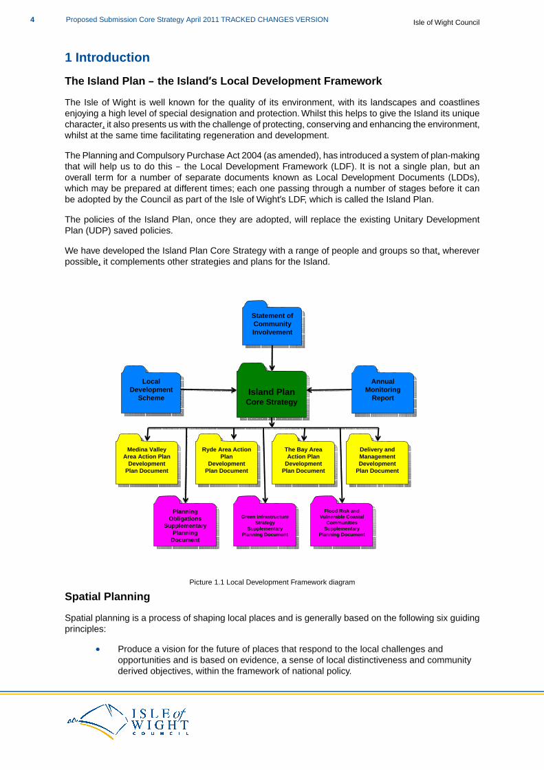
The Island Plan – the Island’s Local Development Framework
The Isle of Wight is well known for the quality of its environment, with its landscapes and coastlinesenjoying a high level of special designation and protection. Whilst this helps to give the Island its uniquecharacter, it also presents us with the challenge of protecting, conserving and enhancing the environment,whilst at the same time facilitating regeneration and development.
The Planning and Compulsory Purchase Act 2004 (as amended), has introduced a system of plan-makingthat will help us to do this – the Local Development Framework (LDF). It is not a single plan, but anoverall term for a number of separate documents known as Local Development Documents (LDDs),which may be prepared at different times; each one passing through a number of stages before it canbe adopted by the Council as part of the Isle of Wight’s LDF, which is called the Island Plan.
The policies of the Island Plan, once they are adopted, will replace the existing Unitary DevelopmentPlan (UDP) saved policies.
We have developed the Island Plan Core Strategy with a range of people and groups so that, whereverpossible, it complements other strategies and plans for the Island.
Island PlanCore StrategyIsland Plan
Core Strategy
Annual Monitoring
Report
Annual Monitoring
Report
Local Development
Scheme
Local Development
Scheme
Ryde Area Action Plan
Development Plan Document
Ryde Area Action Plan
Development Plan Document
Medina Valley Area Action Plan
Development Plan Document
Medina Valley Area Action Plan
Development Plan Document
Statement of Community Involvement
Statement of Community Involvement
The Bay Area Action Plan
Development Plan Document
The Bay Area Action Plan
Development Plan Document
Delivery and Management Development
Plan Document
Delivery and Management Development
Plan Document
Planning Obligations
Supplementary Planning
Document
Planning Obligations
Supplementary Planning
Document
Green Infrastructure Strategy
Supplementary Planning Document
Green Infrastructure Strategy
Supplementary Planning Document
Flood Risk and Vulnerable Coastal
Communities Supplementary
Planning Document
Flood Risk and Vulnerable Coastal
Communities Supplementary
Planning Document
Picture 1.1 Local Development Framework diagram
Spatial Planning
Spatial planning is a process of shaping local places and is generally based on the following six guidingprinciples:
Produce a vision for the future of places that respond to the local challenges andopportunities and is based on evidence, a sense of local distinctiveness and communityderived objectives, within the framework of national policy.
Isle of Wight CouncilProposed Submission Core Strategy April 2011 TRACKED CHANGES VERSION4
Translate this vision into a set of priorities, programmes, policies, and land allocationstogether with the public sector resources to deliver them.Create a framework for private investment and regeneration that promotes economic,environmental and social well-being for the area.Coordinate and deliver the public sector components of this vision with other agencies andprocesses.Create a positive framework for action on climate change.Contribute to the achievement of sustainable development.
The Island Plan Core Strategy
The Island Plan Core Strategy will set out how, in spatial planning terms, the Island will develop up to2027. In principle, the Island Plan Core Strategy is about “place shaping” and delivery. The strategy andpolicies set out what will be delivered. When it is appropriate, they will also set out where, when and howit will be delivered. In developing the Island Plan Core Strategy we have drawn together all the otherstrategies of the Council and other organisations that have implications for the use of land.
This document sets out our spatial vision and objectives for the Island and the strategic policies to helpdeliver them. The spatial vision, objectives and strategic policies flow from the priorities and objectivesset out in the Isle of Wight’s Sustainable Community Strategy – Eco Island.
PPS12: Local Spatial Planning sets out that Core Strategies may allocate strategic sites for developmentwhen they are considered central to achieving the strategy. The following paragraphs set out in verygeneral terms the allocations that are being made in the Core Strategy, the rationale for them (which isexplained in more detail in the supporting text to the relevant policy) and also why no housing allocationsare being made.
Creating and sustaining jobs and increasing the Island's Gross Domestic Produce (GDP) is a key driverfor the Core Strategy. The Council supports sustainable economic growth and regeneration by ensuringsustainable patterns of employment development, providing opportunities to diversify and strengthenthe local economy and increasing the range of high skilled jobs available locally. Due to the importanceof this issue to the Island, and the need to be pro-active to achieve the desired outcomes, the CoreStrategy makes five employment-related allocations to ensure that there is the certainty of new employmentland being supplied to come on-stream in a timely fashion within the plan period.
The Council will not be producing a separate Minerals and Waste Development Plan Document. WhilstMineral and Waste Planning Authorities generally prepare separate plan documents to cover the areasof minerals and waste, the approach taken by the Council to include these elements in the Core Strategyis in conformity with both Minerals Policy Statement 1: Planning and Minerals, and Planning PolicyStatement 10: Planning for Sustainable Waste Management.
An extension to the Island's landfill site at Standen Heath has been allocated in the Core Strategy. Thisis of strategic importance to the Island's infrastructure and ability to support the level of developmentplanned for the plan period, as the capacity at the existing landfill site is due to be used up by 2015.
To ensure that the Council, in its role as Mineral Planning Authority, can meet its mineral requirementof 0.1million tonnes per annum, six allocations are made for mineral extraction sites.
No housing allocations have been made in the Core Strategy. Rather the general locations for, and levelsof, housing have been identified and subsequent plan-led mechanisms for delivery. Due to the natureof the housing development on the Island and the wide range of potential sites, it was not considerednecessary to make housing allocations in the Core Strategy to ensure delivery of housing development.The policy framework will ensure continuing delivery and the Area Action Plans provide the plan-ledmechanism for housing allocations to be made.
The Island Plan Core Strategy should not be read in isolation.The Island Plan should be read as a wholealong with:
5Proposed Submission Core Strategy April 2011 TRACKED CHANGES VERSIONIsle of Wight Council
National Policy StatementsPlanning Policy Statements (PPSs)Planning Policy Guidance (PPGs)Other Island Plan Local Development Framework documents
The Plan Period
A core strategy is required to have a time horizon of at least 15 years from the date of adoption. It isexpected that the Island Plan Core Strategy will be adopted in December 2011, so the lifetime of theplan will be 2011-2027. For monitoring purposes, the exact plan period will run from the financial year2011/12 for 15 years until 2026/27.
Sustainability Appraisal / Strategic Environmental Assessment (SA/SEA)
The Island Plan Core Strategy is subject to a Sustainability Appraisal / Strategic EnvironmentalAssessment(SA/SEA). This is an iterative process and an effective way of ensuring that sustainabledevelopment principles are taken into account in the plan making process. By assessing plan policiesagainst a broad range of SA/SEA objectives, the appraisal process exposes strengths and weaknessesof the plan, which can help to develop recommendations for improvement. As well as helping to improvethe plan, the appraisal process also provides the basis for discussion between stakeholders around ashared set of objectives.
Habitats Regulations Assessment (HRA)
In the United KingdomUK, all land-use plans which are considered likely to have a significant effectonplanning authorities must assess the potential effects of land use plans on European (Natura 2000)sites are required to undergo Habitats Regulations Assessment (HRA). The purpose of this is to assessthe impact of the plan against the conservation objectives of European designations., in accordance withthe requirements of the Habitat Regulations. This assesses the impacts of the plan against theconservation objectives of the designated sites.
There are designated sites of European importance on or around the coast of the Island and are shownon the Proposals Map. The process of undertaking a HRA of this Island Plan Core Strategy has beencarried out in parallel with the SA/SEA, and both the SA/SEA and the HRA are publicly available. As aresult of the assessment, the Core Strategy includes safeguards to ensure protection of Natura 2000sites. Any subsequent Island Plan documents will also be subject to an HRA.
This Core Strategy has been subject to assessment in relation to Regulation 85 of the Habitats Regulationsto ensure that the proposals it contains will not lead to an adverse effect on the integrity of any Natura2000 or Ramsar sites.
Delivering the Island Plan
The delivery of the Island Plan will not be undertaken just by the Isle of Wight Council; it will involvepartner agencies and private sector investment. As a Council we cannot deliver everything by ourselves.It is very important that the Council continues to work with its partners to ensure the successful deliveryof the Island Plan. Chapter 8 sets out the Delivery Strategy and Infrastructure Plan,approach towardsInfrastructure Delivery and Development Implementation, whilst Chapter 9 sets out the MonitoringFramework for the Core Strategy. These chapters set out how some aspects of the policies will bedelivered and how we will ensure they are being delivered properly.
Monitoring
Reviewing and monitoring how well the Island Plan and its policies is delivering our vision and objectiveswill be essential. By assessing how well the plan is working, we can decide whether or not contingencyplans need implementing or if policies and strategies need reviewing or replacing. An Annual MonitoringReport is published in December every year, whichand will report on the effectiveness of the Island Plan
Isle of Wight CouncilProposed Submission Core Strategy April 2011 TRACKED CHANGES VERSION6
policies.
The South East Plan
The South East Plan was revoked in July 2010 by the Coalition government. Because of this we, as aCouncil, are no longer required to deliver the requirements of the South East Plan, if we choose not to.This has a wider range of implications for the preparation of the Island Plan Core Strategy and a numberof different options have been tested and considered.
The initial stages of the Core Strategy were prepared taking into account the relevant Regional SpatialStrategy (RSS), the South East Plan (SEP). On 6th July 2010 the Secretary of State announced therevocation of all RSSs with immediate effect. In light of this the evidenced approach taken in the Regulation25 Core Strategy (published October 2010) to employment provision and renewable energy was differentto that set out in the SEP. A number of other SEP targets for the Island, such as housing, waste andminerals, have been maintained.
The Secretary of State’s decision to revoke the RSS was successfully challenged in the High Court, theoutcome of which (on 10th November 2010) was to reinstate the RSS as part of the statutory developmentplan. A further challenge has been made to the Secretary of State’s statement of 10th November 2010and the accompanying letter from the Chief Planner, along with the Secretary of State’s original letter of27th May 2010. Pending determination on this matter, the existence of the challenge and the basis for itmay affect the significance and weight that may be given to the Secretary of State’s statements and tothe Chief Planner’s letter. The Government’s commitment to revoke Regional Strategies is nowconsolidated into Section 89(3) of the Localism Bill, published on 13th December 2010.
Based on the evidence available and the aspirations the Council has for the Island, we are taking forwardvarious aspects of the South East Plan.These include the annual housing target of 520 units per annumand a slightly amended renewable energy target, based on our local evidence. We have also takenforward the waste and minerals targets, as they relate closely to the housing figure and we considerthemthe evidence that we have shows them to be appropriate forto the Island.
Using this document
The Island Plan Core Strategy has links with many other documents; not only those within the LDF orthat have been prepared by the Council, but also the plans and strategies of other groups andorganisations.
Information on how each policy links with other strategies and plans can be found following each policyof this Plan. Identifying all the links between the policies is not always possible as it is difficult to determinewhich policies might be relevant in different circumstances.
When considering any aspect of the Core Strategy it is also necessary to consider the whole document:the policies of the Core Strategy should not read in isolation. All policies apply where relevant,whether or not specific cross-reference has been made. This applies to the Island Plan as a whole; allrelevant documents will need to be read together when considering a specific proposal or issue.
Consultation and next stages of the document
We have published the Regulation 27 Proposed Submission Island Plan Core Strategy to set out theCouncil'spreferred intended approach to delivering our vision for the future of the Island. We haveconsidered all appropriate alternatives and relevant matters, including consultation responses to previousversions of the Island Plan Core Strategy.
The publication of the Regulation 27 Proposed Submission Island Plan Core Strategy will triggerThereis a six week consultation period running from Friday 29th October until 4.30pm on Friday 10thDecember 2010, during which time the Council is inviting representations on this document, itsaccompanying SA/SEA and the supporting evidence base documents.in which representations can bemade on the plan's content and the supporting documents. Once the six week period is over the Council,
7Proposed Submission Core Strategy April 2011 TRACKED CHANGES VERSIONIsle of Wight Council

in line with the regulations, will then prepare a summary of the main issues raised by the representations.By considering individual representations and undertaking this summarising process the Council will beable to determine what, if any, changes should be made to the Island Plan Core Strategy before it issubmitted for independent Examination.
The Council has published the Core Strategy for a six week period in which representations will bereceived. This six week period will run from Tuesday 12th April 2011 until 5pm on Tuesday 24th May2011.
The Regulation 27 Proposed Submission Island Plan Core Strategy, the SA/SEA (including HRA) andthe supporting evidence base documents are available at www.iwight.com/islandplanon the Council'swebsite and paper copies are available at County Hall Customer Services, Seaclose Offices Receptionand all of the Island’s libraries.
If at all possible, representations should be made on-line at http://iow-consult.limehouse.co.uk/portaltheconsultation portal. Alternatively representation forms are available to download fromwww.iwight.com/islandplanthe Council's website and copies will be available at County Hall CustomerServices, Seaclose Offices Reception and all the Island’s libraries. Representation forms can be submittedby email to [email protected] or by post to:Planning Policy TeamIsle of Wight CouncilSeaclose OfficesFairlee RoadNewportIsle of WightPO30 2QS
If you have any queries relating to the content of the Island Plan Core Strategy, or the processes it goesthrough, please contact the Planning Policy Team by writing or email or in writing using the addressesabove or by telephone on 01983 823552.
Isle of Wight CouncilProposed Submission Core Strategy April 2011 TRACKED CHANGES VERSION8

2 The Isle of Wight and the Issues it Faces
The Isle of Wight
Map 2.1 Main transport links around the Island
The Isle of Wight covers an area of 147 square miles, with a coastline that runs for 57 miles. The Islandis separated from the mainland of Englandby a stretch of water known as the Solent,but is connected to the ports of Lymington, Southampton and Portsmouth on themainland’s south coast by passenger andvehicle ferries. Although physicallyseparated from the mainland, the Islandinfluences and is influenced by the widersub-regional, regional, national andinternational context.
The Island features a wide variety ofnatural, rural and urban landscapes. Over50% of the Island is designated as an Areaof Outstanding Natural Beauty (AONB) and28 miles of coastline is designated asHeritage Coast. In addition, the Island alsoincludes a very high number ofinternationally, nationally and locally important nature conservation sites.
The Island is also home to a rich variety of important habitats and species, some of which are unique tothe Island or are thriving due to the protection given to them by the Solent. The Island’s biodiversity isreally very special, with a number of key species, such as Red Squirrel, Dormouse, Bat species, GlanvilleFritillary butterfly, Field Cow Wheat, Early Gentian and Wood Calamint flourishing.
Even though 84% of the Island is rural, there are a wide range of settlements across the Island, most ofwhich have their own vernacular design and character. Many of the settlements on the Island havehistoric cores and there are currently 32 designated Conservation Areas and over 2,000 listed buildings.
Whilst the overriding character of the Island is rural, over 60% of the Island’s 143,700(1) residents livewithin the main towns of Newport, Cowes, East Cowes, Ryde, Sandown and Shanklin. Newport is theCounty Town of the Island and is the main employment centre, with the majority of public sector employersbased there (IW Council, HM Prison and the Primary Care Trust). Freshwater, Totland and Yarmouthare the main settlements to the west of the Island and Ventnor is the largest town on the south coast.Outside of these settlements there are around 30 villages and hamlets. Some of the larger villagesprovide services and facilities to surrounding villages and hamlets.
The Island is also an incredibly creative place for both the arts and the sciences, with a long list ofresidents and visitors being inspired here. Robert Hooke, Alfred Lord Tennyson, John Nash, GuglielmoMarconi, Sir Christopher Cockerell, Anthony Minghella, Alfred Noyes, Julia Margaret Cameron and JohnKeats, to name but a few. The Island has also seen the development and testing of Britain’s spacerockets, the world’s first hovercraft and the world’s first radio station.
The Island hosts the world-renowned Cowes Week, which is the longest running sailing regatta in theworld having started in 1826. Around 8,500 competitors take part, benefitting the Island’s economy andprofile. In the same vein, the Isle of Wight Festival, revived after the ‘last great event’ of 1970, is nowfirmly established as one of the country’s most popular music festivals and, along with The Bestival,attracts many thousands of people to the Island.
With a range of stunning landscapes, a large number of environmental and historic designations, acoastline and coastal waters that are protected by international and national designations, a wide range
1 Office for National Statistics 2007 mid year estimate.
9Proposed Submission Core Strategy April 2011 TRACKED CHANGES VERSIONIsle of Wight Council

of internationally renowned events and an illustrious list of residents and visitors, the Island really is aunique place.
Issues facing the Island
There are a wide range of issues that we will need to address to ensure that the Island continues to bea place where we can all live, work and play in the way we want to. It is important that we are clear andrealistic about what issues and problems we can address in the policies of the Island Plan. These willmainly relate to ideas and proposals that involve the use of land.
The characteristics and issues facing the Island can be grouped under seven broad headings; Housing,Economy, Environment, Travel, Waste, Minerals and Infrastructure.
Housing
There is considerable demand for housing on the Island. House prices are relatively high as the ratio ofhouse prices to income is high.This is demonstrated by average house prices currently being more thanseven times the average wage on the Island. Commuting, retirement and the high level of second homeownership all contribute to a shortage of supply of affordable housing this, which has the impact ofincreasing the demand for affordable housing for people on low incomes and first time buyers. This,coupled with a shortage in the supply of affordable housing, presents a particular challenge for the Island,which is accentuated by physical severance from the mainland housing markets.
In light of the above, achieving an appropriate mix of housing will be critical and a particular need for theIsland is to achieve more housing which is affordable. The focus being on providing for first time buyersand others who need to live and work on the Island, but who are currently unable to pay market houseprices. A key objective of the Core Strategy is to ensure that housing is provided to meet the needs ofIsland residents.
In line with national trends, the Island has an ageing population. However, this is even more pronouncedon the Island, with the 2001 Census indicating that 28.4% of the population was aged 60 and over(compared to 21% nationally). Forecasts indicate that the Island’s population will continue to grow between2006 and 2026, principally through in-migration, with the number of people over retirement age increasingto around 36% of the population. This will have significant impacts for economic growth, housing andservice provision.
Generally, the Island enjoys a better standard of health than isthe average for England and Wales, butit is not as good as elsewhere in the South East. Within the Island itself, there are health inequalitiesbetween different neighbourhoods and there are significant differences in life expectancy between differentwards, with some ward-level correlation between lower life expectancy and higher deprivation. In theseareas, life expectancy is up to 8 years shorter than the life expectancy of people living in wealthier areas.
Delivery of housing on the Isle of Wight has historically been based on a relatively small number of smalland medium-scale local builders delivering small and medium-scale sites. Whilst this dynamic haschanged over the last few years with a regional and national housebuilders delivering a number of largerhousing sites on the Island, it is still important to the housing market that local small and medium-scaledeveloper/builders and developments come forward.This is for a number of reasons, including maintaininglocal diversity and identity, the use of local supply chains and the creation and retention of employmentopportunities for local companies.
However, the opportunities for small and medium-sized Island builders are often limited by their lack ofpurchasing power for materials and not being cash-rich which, particularly in the current economic climate,often leads to difficulties in securing the necessary bank support to secure funding at competitive rates.
In light of this, the Council will support market-led efforts to introduce local consortia or co-operative typemodels that enable local builders and developers to work together in the supply chain to secure betterpurchasing power, procurement and other benefits that arise from greater economies of scale andpartnership working.The Council will work with the industry to explore whether such partnership working
Isle of Wight CouncilProposed Submission Core Strategy April 2011 TRACKED CHANGES VERSION10
and delivery models could be applied to a wider range of planning and delivery issues.
Housing Issues
The Core Strategy will need to plan to accommodate this likely demographic change tomeet the needs of the Island’s increasingly ageing population.Commuting, retirement and the high level of second home ownership all contribute to ashortage of supply of affordable housing for people on low incomes and first time buyers.How to provide for first time buyers and others who need to live and work on the Island, butwho are currently unable to pay market house prices. A key objective of the Core Strategyis to ensure that housing is provided to meet the needs of Island residents.
Economy
In economic terms, the Island had been experiencing high rates of growth compared with the UK andthe South East. This has changed since 2005 in that growth has slowed, but this is not unexpected.Growth sectors have included manufacturing and the service sector. The 2007 Indices of MultipleDeprivation show that the Island is more deprived than the regional average (50%) on all six districtmeasures:
Average Score – is the population weighted average of the combined scores for the LocalSuper Output Areas (LSOAs) in a local authority.Average Rank – is the population weighted average of the combined ranks for the LSOAsin the local authority.Extent – is the proportion of a local authority’s population living in the most deprived LSOAsin the country.Local Concentration – is the population weighted average of the ranks of a local authority’smost deprived LSOAs that contain exactly 10% of the local authority’s population.Income Scale – is the number of people in the local authority area who are income deprived.Employment Scale – is the number of people in the local authority area who are employmentdeprived.
On four of the measures the Island is amongst the most deprived 20% of local authorities in the region.
Even though the Island has experienced economic growth and falling unemployment over recent years,the local economy is characterised by lower wage levels (compared to the national average) and relativelyrestricted employment opportunities. The recession has affected the Island negatively, with a number ofhigh profile companies announcing a large number of job losses. The Island experiences persistentlylow economic productivity levels at only 71% of the regional average.
The structure of the local economy is changing with retailing, manufacturing, construction, health andbusiness services being the five largest employment sectors. Traditionally, the largest sectors weretourism, manufacturing and agriculture. This change in sectoral importance has had an impact upon theavailability of employment opportunities within the rural areas in particular.
Whilst the tourism sector has contracted, its impact on the Island remains extensive with it being worthover half a billion pounds per annum to the Island’s economy. The sector performs strongly during thespring and summer months, but this performance is not sustained throughout the year. The rural areasoutside the main settlements contribute approximately 22% of the total (Gross Value Added or GVA)output of the Island and this proportion has been fairly stable over time, despite changes within theeconomy.
Changes in the levels of disposable income have also seen the number of people visiting the Island fora short break increase, and this sector is forecast to experience further growth.The attractiveness of theIsland as such a destination is due to its unique tourism offer of stunning landscapes, beaches andwildlife, coupled with a wide range of local producers and craftspeople.
There is an additional economic (and social) impact of being an Island.The separation from the mainland,
11Proposed Submission Core Strategy April 2011 TRACKED CHANGES VERSIONIsle of Wight Council
although not physically great, impacts on the ease of extending markets, interacting with customers andsuppliers, access to centres of higher education and wider industry, educational, community and socialnetworks generally. All these factors can collectively impact negatively upon aspiration. A key objectiveof the Core Strategy will be to support the local economy and increase the range of higher skilled jobsavailable locally.
There is clear support for the need to focus on economic led regeneration in key regeneration areas, butthere is a strong community feeling that it is important to ensure that we enable villages and hamlets tocontinue to thrive and meet the commercial and community needs of rural areas, particularly thosevillages which act as service centres to outlying areas. A key objective of the Core Strategy is to determinethe most appropriate pattern of development and provision of services to create sustainable communities.
Whilst the primary focus to achieve this key objective would be within the principle urban settlements,there is a need to enable some levels of growth outside of these areas. This is important as the rural Isleof Wight accounts for 28% of full time equivalent (FTE) jobs, but only 22% of the economic output of theIsland. The average rural productivity (£23,252 GVA/FTE job per annum) is lower than for the wholeIsland (£29,635). Both of these figures are well below the average productivity figures for the South East(£41,501) and the UK (£40,462).
There are approximately 30,000 children and young people aged between 0-19 living on the Island and,whilst there are many good schools on the Island, attainment levels, particularly at GCSE and Key Stage2, are well below national and regional averages. In 2001, 15% of the Island population aged 16-24 hadattained degree level education. In the South East the figure was 22% and 20% for England and Wales.
The Island suffers from a “brain-drain” with many well-educated young people leaving the Island forfurther or higher education, or for greater employment opportunities.
The Council is committed to raising the standards of educational attainment and opportunity on the Island.Due to a combination of poor education standards, changing national requirements and guidance anddeclining pupil numbers, the Council is changing the school system on the Island from a three-tier to atwo-tier model of education. This process involves the rationalisation of school sites across the Islandand may present development opportunities.
Developing skills across the Island and across the age groups is also a challenging issue for the Council,especially as the Island suffers from a poorly-skilled workforce, with 33% of the adult population lackingbasic numeracy skills and 15% lacking basic literacy skills. This has a negative impact on employerswhen considering the Island as a potential location.
Economy Issues
The need to create jobs to address current unemployment and to push forward the economicregeneration of the Island.To maintain a diverse economy, where high quality tourism and supporting the expandingresearch and design and servicing of renewable energy technologies.To sustain a rural economy that brings benefit to the whole Island.To increase the skills of the Island’s workforce to ensure the wider economic aspirations ofthe Island can be realised.
Environment
The Isle of Wight is a special place and is valued by those who live and visit here. The quality andattractiveness of its natural and built environment, and the historic nature of these, is a major factor whenconsidering why people choose to live here. It is also one of the prime reasons why people visit theIsland, thereby directly contributing to our local economy and employment.
Sustaining an attractive environment is important for the Island. The Island includes countryside andcoastline with significant nature conservation interest. Our chalk grasslands, maritime cliff slopes andestuaries are particularly important, not only in a local context, but also on a regional, national and
Isle of Wight CouncilProposed Submission Core Strategy April 2011 TRACKED CHANGES VERSION12
international scale.
There is a very strong local identity and associated community feeling which can be seen through thework undertaken on Parish and Town Plans and Village Design Statements. Communities have previouslybeen concerned that some development in the past has been poorly designed and has failed to contributepositively to the quality of the built environment on the Island.This has had a negative impact and designhas too often failed to reflect local distinctiveness.
This distinctiveness has been shaped by historic development patterns, the needs of an increasingpopulation and the Island’s ever evolving economy which can be seen not only throughout the Island’smany Conservation Areas, but across the Island as a whole. A key objective of the Core Strategy is toensure that developments are constructed in line with the principles of sustainable development. At thesame time, we should not stifle innovation and creative design that achieves these goals.
The physical setting of the Island, with its constantly evolving coastline and changes being experiencedas a result of climate change, present a combination of risks to be taken into account in the Island Plan.
While much of the Island can be considered stable in terms of land movement, there are localised areas,extensively along the south coast of the Island, that are susceptible to ground movement. This is due toa combination of the Island’s geology, coastal processes, rainfall and human influence. Similarly, themajority of the Island is free from flood risk associated with the sea or watercourses, but again due to acombination of geomorphology, geology and weather events, there are areas at increased risk of floodingfrom these sources.
Parts of the Island have a long history of flooding and coastal erosion, pre-dating human influence. Manysettlements on the Island have evolved from small-scale beginnings on sites located in areas vulnerableto flooding and erosion, such as by the coast or an estuary. This historic settlement pattern is now facedwith the new challenges of rising sea levels and increased storm and rainfall events.
Environment Issues
To manage the distribution of development in the most sustainable locations, bearing inmind the highly valued natural and historic environment.To balance the protection of the environment with the need to pProvide houses,and jobs,services and supporting infrastructure on the Island, whilst conserving and enhancing thenatural environment.A focus on quality of design, with particular effort given to creating buildings and a senseof place that clearly reflect and enhance local character and distinctiveness.Plan to avoid, mitigate and adapt to flood risk and coastal erosion and look to plan positivelyand identify opportunities to benefit local communities and businesses and adapt to coastalchange.
Travel
The Island has an 826km (513 mile) road network with an 827km (514 mile) network of public rights ofway providing urban links and foot and cycle access to the countryside.
Car ownership on the Isle of Wight remains slightly higher than the national average with 75.3% ofhouseholds owning at least one car compared to 73.2% nationally(2). Traffic flows show year-on-yeargrowth, but for most of the year, congestion is not a major issue, with the exception of a number of traffic“hot spots” in Newport and Lake. However, during the summer season traffic flows change significantlywith the influx of tourist-related traffic.
Surveys indicate that the Island benefits from good public transport accessibility compared to other ruralareas, with bus and rail services between towns of similar frequency to urban areas. The ferry ports ofboth the Island and the mainland are important gateways to the Island. Numbers of people and vehicles
2 2001 Census
13Proposed Submission Core Strategy April 2011 TRACKED CHANGES VERSIONIsle of Wight Council
crossing the Solent have increased over the last 20 years placing increased pressure on ferry terminalsand the adjoining highway network.
A key objective of the Core Strategy is to reduce the need to travel and improve accessibility throughoutthe Island and accommodate development which minimises the need to travel. This can be achievedthrough working with the transport operators, employers and others to increase transport choice anddeliver sustainable developments, improved transport infrastructure, travel plans and other “hearts andminds” initiatives to look at reducing reliance on the car, improve public transport provision and increaseopportunities to walk and cycle. The aim will be to offer people more choice about the way in which theytravel, whilst seeking not to penalise those for whom the car is the only realistic solution.
The Island is dependent on its cross-Solent links to the mainland for the import and export of goods andpeople to serve the Island and its economy. There are known to be capacity issues at the ferry ports ofFishbourne and East Cowes at peak times in the summer and these will need to be managed, in relationto both current operational issues and longer-term provision that can facilitate the development andgrowth in tourism planned in this Core Strategy.The Council will need to work with the providers of theseservices to ensure that the appropriate infrastructure is in place to support these services.
Travel Issues
To locate development in the most sustainable locations, thereby reducing the need totravel by private motor car.To promote alternative modes of transport to the private motor car, thereby minimising theimpact that travel has on the Island.To ensure that the transport infrastructure that supports the Island and its links to themainland is fit for purpose and can support the level of growth that is planned.
Waste
Being an island authority does affect our opportunities to treat waste. For example, the Solent hindersboth the movement of waste between authorities for treatment (such as bulking prior to processing orrecycling) and the sharing in the investment of waste infrastructure.This severance factor has a significantinfluence on how waste is and will be treated in the future.
The Council is approaching a critical stage in the management of waste on the Island. The existingmunicipal waste collection, treatment and disposal contracts terminate in 2015. It is anticipated that theCouncil’s landfill site will also reach capacity at or around that date and other treatment and sortingfacilities belonging to the Council or third parties will be in need of reinvestment. It is the aspiration ofthe Council to be a leader in sustainable waste management and reduce residual waste to landfill to aminimum.
This presents the Council with the opportunity to review its existing arrangements and evaluate allavailable options and technologies, both through its Procurement Strategy for the Future of Waste(traditionally referred to as a Municipal Waste Management Plan) and subsequent decisions on wastemanagement including any future waste contract arrangements.The Procurement Strategy for the Futureof Waste is being developed alongside the waste elements of the Island Plan, sharing information andassessments.
While the Procurement Strategy for the Future of Waste will determine how waste will be managed inthe future, it is the role of the Core Strategy and supporting DPDs to provide a range of site options thatprovide sufficient flexibility to accommodate a range of waste management practices, of different scales,in a variety of locations.
Waste Issues
Ensuring that there is adequate landfill capacity over the short-term, whilst planning toincrease diversion from landfill in the medium to longer term.Planning to provide adequate provision for as yet unidentified waste technologies.
Isle of Wight CouncilProposed Submission Core Strategy April 2011 TRACKED CHANGES VERSION14

Minerals
Development on the Island is dependent on a supply of minerals, such as sand and gravel.These naturalresources, by the nature of being deposits in the ground, can only be extracted where they are found.Whilst the Island is fortunate to have deposits that could be extracted, there are other considerationsthat will limit the available supply, for example existing or planned development, nature conservation orlandscape concerns.
Thus, some of the Island’s mineral requirement does come from imports, including all hard stone andabout half the sand and gravel used on the Island is marine won. This in turn places an increasingimportance on the Island’s aggregate wharfs, the use of recycled materials and efficient use of materialsreliant on minerals.
Minerals Issues
Ensuring that there is the appropriate supply of land-won aggregates to serve the expecteddevelopment on the Island.To ensure that there is the ability to move aggregates to and from the Island using the RiverMedina.
Infrastructure
The road network on the Island has suffered from years of limited expenditure and maintenance and isno longer fit for purpose. The Isle of Wight Highways Private Finance Initiative (PFI) project, in additionto improving the existing network, will offer a higher standard of highways services and will help to createa significant stimulus to the local economy. For example, by opening up as many markets for local labourand suppliers as possible and providing training opportunities locally.
PFI will encompass all aspects of the highway that occurs between the fences. This includes the roadsurface, drainage, street lighting, kerbs, footways, grass verges, signs, bus shelters, etc. The PFI serviceis likely to last for 25 years, starting in 2013. It will include most of the Island’s entire adopted roadnetwork.
The PFI project is currently at an early stage, with no appointed PFI provider, so it is not possible toidentify exactly what the relationships will be with the Island Plan, as this will only become clear oncethe intentions of the Provider are known. However, there are some assumptions that can be made whichthe Core Strategy and relevant DPDs will take account of where possible:
A requirement for sites. How many, their size, where and whether their use will be permanentare questions that will only be answered as details of the PFI project are developed withthe successful contractor/provider. Certainly some form of main depot will be required andpossibly other satellite sites.A requirement for commercial wharfage for the movement of bulk materials.A demand for materials, including mineral resources both indigenous and imported.Waste issues including demand for recycling facilities and landfill capacity.Local employment and training.Traffic and access issues.
Utility Infrastructure
As an Island we are generally not self-sufficient when it comes to utilities such as water, electricity andgas. For all of these we are dependent upon them being piped over from the mainland.This clearly raisesissues over our dependency upon others to provide essential utilities and infrastructure. However, theCouncil’s ability to take direct action over the provision of these services is limited as they are commercialoperations.
The Council has been in discussion with the statutory undertakers who provide water and energy supplieson the Island, through involvement with the Infrastructure and Development Theme Group of the Local
15Proposed Submission Core Strategy April 2011 TRACKED CHANGES VERSIONIsle of Wight Council
Strategic Partnership. Information on the distribution of development across the Island has been discussedwith infrastructure providers and they have indicated that the distribution of development as set out inthis document would not create the need for majoradditional investment that would prevent delivery overthe plan period to 2027.
However, in relation to water supply, issues have occurred on the Island due to limited groundwateryields, low flows in the Island’s rivers and population increases during the summer due to tourism. TheIsland currently has up to 25% of its water supply piped over from the mainland, which is up to 20 millionlitres of water a day(3). Southern Water predicts that the demand for water on the Island will increase bymore than 15% over the next 25 years. Southern Water's Water Resources Management Plan showshow the company proposes to secure its water supplies for its customers (including the Isle of Wight)during the next twenty-five years (2010-35). This Plan has been prepared in consultation with theEnvironmental Agency and Natural England and has been subject to Appropriate Assessment, inaccordance with the Habitats Regulations, in October 2009.
Infrastructure Issues
To ensure there are the indigenous materials available to supply the PFI project.To ensure that new development uses water as efficiently as possible.
National and Local Policies and Plans that Shape the Core Strategy
The Core Strategy has been shaped by a range of national and local policies and plans, which includethe following:
National Planning Policies
Planning Policy Statements (PPSs) and their predecessors Planning Policy Guidance Notes (PPGs)have been prepared by the Government to provide statutory provision and provide guidance to localauthorities and others on planning policy and the operation of the planning system. Local authoritiesmust take the contents of PPSs and PPGs into account when preparing their development plan documents.PPSs and PPGs can be viewed at the CLG website.
Isle of Wight Unitary Development Plan 1996-2011
The Unitary Development Plan (UDP) was adopted in May 2001 and provided the framework fordevelopment on the Island to 2011. It replaced the Structure Plan and Local Plans. Some of the UDPpolicies have been ”saved” whilst the Island Plan LDF is prepared. The aims of the UDP are to:
Protect the environment by directing development to towns and villages and away from thecountryside.Ensure that there is an adequate supply of appropriate housing and employment land tomeet future needs.Encourage urban regeneration and conserve the Island’s heritage.Ensure the continued success of town centres by directing retail developments to the town,rather than “out of town”.Protect existing and encourage new community facilities.Ensure the provision of adequate transport facilities and networks and in particularsustainable transport to help reduce car usage.
Isle of Wight Sustainable Community Strategy – Eco Island
Eco Island is an ambitious strategy which sets out how the Isle of Wight will become a thriving, dynamicand confident community, in balance with its local environment. This strategy has been developed bythe Island Strategic Partnership (ISP). The ISP has worked with residents and the many sectors of thecommunity to develop the strategy, which will shape the Island from 2008 until 2020. The Council must
3 Southern Water website link for information on the Isle of Wight
Isle of Wight CouncilProposed Submission Core Strategy April 2011 TRACKED CHANGES VERSION16
have regard to the Eco Island strategy when preparing its Local Development Framework Core Strategy,which sets out the spatial planning provisions for the authority. It can be viewed atwww.eco_island.org.ukthe Eco Island website.
Area of Outstanding Natural Beauty (AONB) Management Plan 2009-2014
The Management Plan outlines the policies, actions and objectives for the management of the Island’sAONB. As well as being a legal requirement, it is also an opportunity to draw together interested partiesto generate long-term visions for the area. The overall aim is to ensure continuity and consistency ofmanagement over time, to conserve and enhance the natural beauty of the landscape for the use andenjoyment of future generations. It can be viewed at w.wightaonb.org.ukthe AONB website.
Isle of Wight Local Biodiversity Action Plan (LBAP)
The current Local Biodiversity Action Plan consists of a series of Habitat Action Plans and Species ActionPlans. The content of these plans are monitored regularly. The principle aim of the LBAP partnership,in line with national guidance, is to maintain, restore and, where feasible, recreate the nationally andlocally important priority habitats and the species that depend on them. It can be viewed atwww.wildonwight.co.ukthe Wild on Wight website.
Isle of Wight Local Geodiversity Action Plan (LGAP)
The primary function of the Isle of Wight Local Geodiversity Action Plan (IW LGAP) is to formulate astrategy to promote the Isle of Wight through the conservation and sustainable development of its EarthHeritage.The plan sets objectives, targets and determines indicators that will focus resources to conserveand enhance the heritage. By linking to other plans and initiatives such as the Island Plan issues facingthe Island’s geological resource should be managed in the most sustainable manner. It can be viewedat www.dinosaurisle.com/lgap.aspthe LGAP website.
Isle of Wight Historic Environment Action Plan (HEAP)
The HEAP is based on the Isle of Wight Historic Landscape Characterisation (HLC), which is part of anational programme sponsored by English Heritage. It identifies pressures on the historic environmentand will assist in the management of change.The HEAP promotes the conservation of historic environmentcharacter by providing a practical programme of actions to assist landowners, farmers, community groupsand individuals in the sustainable management of heritage. It can be viewed atwww.iwight.com/living_here/archaeology/hep.aspthe HEAP website.
Isle of Wight Shoreline Management Plan (SMP)
The SMP is a non-statutory policy document that provides a high level assessment of the risks over thenext 100 years from flooding and coastal erosion. The SMP sets policy for the management of coastalflooding and erosion risks for a pre-determined length of coast. It aims to balance risks with naturalprocesses and the consequences of climate change. It needs to take account of existing defences andthe natural and built environments. Some of the main objectives of the SMP directly relate to planning,as it:
sets out risks from flooding and erosion to people and developed, historic and naturalenvironment;informs others so that future land use, planning and development of the shoreline takesaccount of the risk and the preferred policies; anddiscourages inappropriate development in areas where flood and erosion risks are high.
It can be viewed at www.coastalwight.gov.uk/smp/index.htmthe Coastal Wight website.
Isle of Wight Economic Strategy
The Economic Strategy applies the South East Regional Economic Strategy 2008-2020 to the localcontext. It takes a longer-term view on the impact of growth, so that long-term opportunities for people
17Proposed Submission Core Strategy April 2011 TRACKED CHANGES VERSIONIsle of Wight Council
to have access to well paid jobs are created. It promotes enterprise and provides a climate for innovationand growth so that well paid jobs are encouraged and ensures that the wealth created on the Island canbe reinvested back into the community. Its strategy is to: ‘Invest in success to produce a more mixedeconomy, creating opportunities for increased inward investment and sustainable prosperity by prioritisingquality of life’. It can be viewed at www.iwight.com/council/documents/strategies_and_schemestheCouncil's website.
Isle of Wight Tourism Development Plan
The Tourism Development Plan seeks to ensure that the Isle of Wight maximises the potential of thetourism industry and enables it to grow in a way that is economically, socially and environmentallysustainable. It sets the foundation for a long-term tourism-related vision to 2020. The Plan identifiesshort-term actions, medium-term objectives and a long-term vision. It can be viewed atwww.iwight.com/council/documents/plansthe Council's website.
Isle of Wight Cultural Strategy
An important purpose of the strategy is to celebrate the cultural life of the Island and provide a strategicframework that will help to sustain and develop the Island’s cultural assets and values for the benefit ofboth residents and visitors.The strategy assists in developing partnerships, raising and targeting resourcesand increasing cultural opportunities for all on the Island. It can be viewed atwww.iwight.com/council/documents/strategies_and_schemesthe Council's website.
Waste Management Plan
The Plan sets out how the Council will sustain and improve its performance on waste prevention, recycling,collection, energy recovery and waste disposal over the plan period (2008-11) as the Council movestowards a long-term Municipal Waste Strategy. The Plan describes in some detail the measures theCouncil is taking to achieve success. These include plans to increase recycling rates, to develop newmeans of treating waste to reduce the levels of waste sent to landfill and to communicate with localpeople and business about the management of waste and responsibility for the local environment. It canbe viewed at http://www.iwight.com/council/departments/waste/images/IsleofWightWastePlan_final_.pdftheCouncil's website.
Isle of Wight Housing Strategy 2007-2012
The strategy sets the Island’s strategic direction with regard to the identification of housing needs, housingconditions and other related housing support needs across all tenures on the Island; it is not just a strategyabout providing ‘affordable housing’. It is the intention of the Strategy to deliver a balanced housingmarket and provide low cost homes for Island residents.This will enable maximum opportunity for peopleto find solutions to meet their own needs, whilst retaining services that deliver effective assistance tothose in high need. It can be viewed at www.iwight.com/council/documents/strategies_and_schemestheCouncil's website.
Isle of Wight Local Transport Plan 2006-2011
The Council’s second Local Transport Plan (LTP2) sets out the Council’s long-term transport vision fortransport and a five year strategy and investment programme for transport on the Island.The LTP2 seeksto place transport in the wider picture and shows the links between transport and other quality of lifeissues. The LTP2:
Includes the longer-term transport vision of the Island and establishes a five year strategy;Includes locally relevant targets for monitoring transport delivery;Explains how we intend to improve transport on the Island, how much this will cost andidentifies value for money solutions; andIs based upon the shared priorities agreed between the Local Government Association andGovernment.
Isle of Wight CouncilProposed Submission Core Strategy April 2011 TRACKED CHANGES VERSION18

LTP3 is currently being prepared and it can be viewed at www.iwight.com/council/documents/planstheCouncil's website
19Proposed Submission Core Strategy April 2011 TRACKED CHANGES VERSIONIsle of Wight Council
3 Spatial Vision and Objectives
Spatial Vision and Objectives
Spatial Vision
Eco Island is an ambitious strategy, which has been developed by the Island Strategic Partnership (ISP).The ISP is the partnership of the leading organisations on the Island (the Council, the Health Authority,the Police, voluntary and community organisations, IW College, the business community and Governmentdepartments).
The ISP has worked with residents and the many sectors of the community to develop this strategy,which shapes the Island from 2008 until 2020. The agreed vision of Eco Island, the Isle of Wight’sSustainable Community Strategy (2008-2020), is that:“We want the Isle of Wight to become a world renowned Eco Island, with a thriving sustainableeconomy and a real sense of pride and involvement, where residents and visitors enjoy healthylives, feel safe and are treated with respect.”
The Island Plan Core Strategy is the document that sets out how the areas of Eco Island that relate toland use will be delivered. Because the two documents are so closely linked, the vision of Eco Island isshared by the Island Plan Core Strategy and for that reason it is also the spatial vision of this document.
Further to the vision, Eco Island ambitions are set out under four priority themes and supported by anumber of outcomes established in 2008. The ISP has been re-evaluating its priorities and examiningthe way in which it delivers them. This has been an ongoing process which has resulted in a number ofsmall changes to the structure of the ISP and its Priority Delivery Groups. The four Priority DeliveryGroups are:
Sustainable EconomyHealthy IslandInclusive IslandSafe Island
At the time of preparing the Island Plan Proposed Submission Core Strategy, the identified outcomesfor each group were being updated. Once these have been confirmed, the following table will be amendedto reflect them.The table highlights the three groups which the Core Strategy can directly help to deliver.
The Council has produced, and the ISP has endorsed, an updated headline Economic DevelopmentStrategy for the Island that has the agreement of all stakeholders in the Partnership. Its overall goal isto create “a sustainable economy where people have better access to skills and qualifications, well paidjobs and higher aspirations”.
The Sustainable Economy Priority Delivery Group of the ISP is responsible for creating and deliveringan action plan for this strategy, which will help the Island to invest in success and provide a more mixedeconomy, create opportunities for increased inward investment and sustainable prosperity by prioritisingquality of life. Clearly, these aspirations have direct links with the Core Strategy, as a delivery vehiclefor the spatial aspects of Eco Island and the ISP.
This ongoing work updates a range of the background evidence to inform and support the Core Strategy,highlighting the strong links between Eco Island, the ISP and this document.
Isle of Wight CouncilProposed Submission Core Strategy April 2011 TRACKED CHANGES VERSION20
Priorities
We will:Sustainable Economy
Protect and enhance our Island's natural beautyCreate wealth whilst reducing our carbon footprintProduce as much of our energy as possible from renewablesourcesSupport economic development and regeneration, enablingeveryone to share in the Island's economic success, byincreasing the skills of the whole communityEnsure our children achieve better than the national averageat school and collegeReduce childhood inequalities by tackling poverty, neglectand domestic violenceSupport families and carers to provide a safe and positiveenvironment for our young people
We will:Healthy Island
Reduce levels of obesity in all agesImprove health, emotional wellbeing and life expectancyacross the Island; support vulnerable people to liveindependent livesEnsure people of all ages have places to live and things todo in their local area
We will:Safe Island
Reduce crime and substance misuseReduce anti-social behaviour and disorderReduce the fear of crime and increase public confidenceImprove the visual appeal and ambiance of our Island, nowand in the future
Table 3.1 Priorities and Outcomes of the ISP
Whilst the Council is committed to addressing all these issues, and the Core Strategy supports EcoIsland, the Core Strategy itself will not address all of the issues set out above.The ambitions and objectivesof Eco Island have therefore shaped the spatial planning objectives of the Island Plan Core Strategy.These spatial objectives stem from the spatial vision for the Island and help determine the spatial planningpolicies in this document.
Core Strategy Objectives
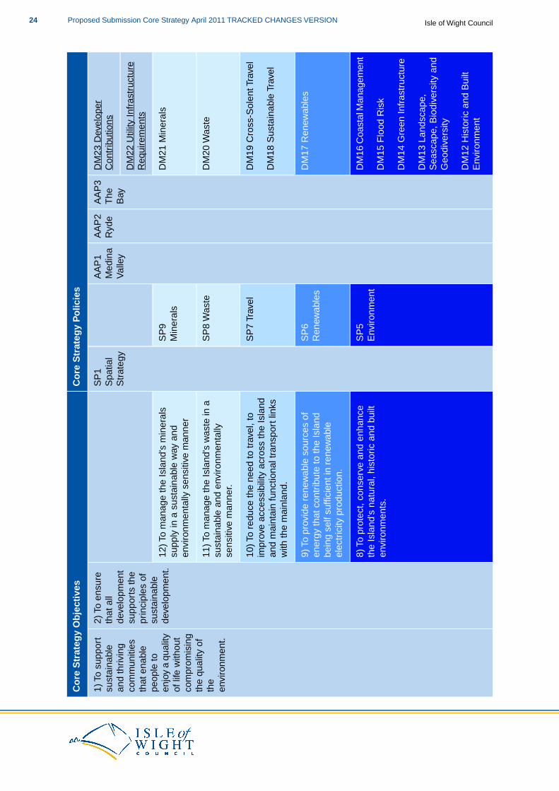
The following set of 12 strategic spatial objectives stems from and is linked to the ambitions of Eco Island.These provide the framework within which the Core Strategy policies have been developed to deliverthe spatial vision. These objectives have been extensively consulted on through the preparation of theCore Strategy; indeed, the objectives have been considerably refined as a result of extensive publicengagement and consultation. The objectives of the Core Strategy are:1) To support sustainable and thriving communities that enable people to enjoy a quality of life,without compromising the quality of the environment.2) To ensure that all development supports the principles of sustainable development.3) To ensure that housing is provided to meet the needs of Island residents.
21Proposed Submission Core Strategy April 2011 TRACKED CHANGES VERSIONIsle of Wight Council
4) To ensure that all development is designed to a high quality, creating buildings and a senseof place that reflects and enhances local character and distinctiveness.5) To promote and enhance community leisure and recreational facilities.6) To provide opportunities to diversify and strengthen the local economy and increasing therange of higher skilled jobs available locally.7) To support a diverse tourism offer on the Island, particularly focussing upon sustainableeco-tourism.8) To protect, conserve and enhance the Island's natural, historic and built environments.9) To provide renewable sources of energy that contribute to the Island being self-sufficient inrenewable electricity production.10) To reduce the need to travel, to improve accessibility across the Island and maintain functionaltransport links with the mainland.11) To manage the Island’s waste in a sustainable and environmentally sensitive way.12) To manage the Island’s minerals supply in a sustainable and environmentally sensitive way.
The Council is committed to achieving a sustainable level of growth on the Island; this is to meet theneeds of the current population and the expected population growth in the future. This growth is mainlyfocussed upon new houses and job creation, but also covers environmental aspects such as the Island'sgreen infrastructure.
This vision for the Island will, in part, be delivered by the Council, but it will also need other public sectorbodies and the private and voluntary sectors to contribute towards achieving the aspirations set out inEco Island and this document. It will, wherever possible, facilitate the needs of all parts of the Island’spopulation. However sometimes there may be competing aspirations and/or views on what should happen.All development proposals and planning applications will be judged against the policies in this document
The Core Strategy is the document in which the ”big decisions” on the future of the Island will be made(for example, the number of houses to be built over the plan period and where they will go). The Councilhas made these big decisions and where it has not been possible to make such decisions, plan-ledprocesses through which they can be made have been identified.
Creating and sustaining employment and increasing the Island's GDP is a key driver for the Core Strategy.The Council supports sustainable economic growth and regeneration by ensuring sustainable patternsof employment development, providing opportunities to diversify and strengthen the local economy andincreasing the range of high skilled jobs available locally. Due to the importance of this issue to the Island,the Core Strategy makes five employment-related allocations to ensure that there is a supply of newemployment land coming on-stream in a timely fashion within the plan period.
No housing allocations have been made in the Core Strategy, rather general locations for and levels ofhousing have been identified. Due to the nature of the housing development on the Island and the widerange of potential sites, it was not considered necessary to make housing allocations in the Core Strategy.The policy framework will ensure continuing delivery and the Area Action Plans provide the plan-ledmechanism for housing allocations to be made.
The Council is not producing a separate Minerals and Waste Development Plan Document.Whilst Mineraland Waste Planning Authorities generally prepare separate plan documents to cover the areas of mineralsand waste, the approach taken by the Council to include these elements in the Core Strategy is inconformity with both Planning Policy Statement 10: Planning for Sustainable Waste Management andMinerals Policy Statement 1: Planning and Minerals.
The strategic and detailed development management areas to be addressed are covered in the followingpolicies:
SP8 Waste: this sets out the Council’s strategic approach to waste including how the wastehierarchy will be implemented on the Island, considering first avoidance, followed by recyclingand other treatment methods aside from landfill. This policy also makes a provision forfuture landfill through a specific allocation, which is made here due to the strategic natureof both the requirement and the facility.
Isle of Wight CouncilProposed Submission Core Strategy April 2011 TRACKED CHANGES VERSION22

DM20 Waste; this policy sets out the development management principles against whichproposals for waste management facilities will be assessed.
SP9 Minerals: the local context and circumstances for minerals is detailed, including whatmay constitute exceptional circumstances and the environmental considerations that willneed to be taken account of. The policy makes a commitment to a level of supply whichthen informs a landbank and strategic mineral allocations. Mineral Safeguarding Areas areidentified and the strategic policy approach to the following areas are detailed: Recycledand Secondary Aggregates; AggregateWharves; Planning for uncertainty in mineral demand.
DM21 Minerals: this policy sets out the development management principles against whichproposals for mineral related development will be assessed.
23Proposed Submission Core Strategy April 2011 TRACKED CHANGES VERSIONIsle of Wight Council
Co
re S
trat
egy
Po
licie
sC
ore
Str
ateg
y O
bje
ctiv
es
DM
23 D
evel
oper
Con
trib
utio
nsA
AP
3T
heB
ay
AA
P2
Ryd
eA
AP
1M
edin
aV
alle
y
SP
1S
patia
lS
trat
egy
2) T
o en
sure
that
all
deve
lopm
ent
1) T
o su
ppor
tsu
stai
nabl
ean
d th
rivin
gD
M22
Util
ity In
fras
truc
ture
Req
uire
men
tssu
ppor
ts th
epr
inci
ples
of
sust
aina
ble
deve
lopm
ent.
com
mun
ities
that
ena
ble
peop
le to
enjo
y a
qual
ityD
M21
Min
eral
sS
P9
Min
eral
s12
) To
man
age
the
Isla
nd's
min
eral
ssu
pply
in a
sus
tain
able
way
and
envi
ronm
enta
lly s
ensi
tive
man
ner
of li
fe w
ithou
tco
mpr
omis
ing
the
qual
ity o
fD
M20
Was
teS
P8
Was
te11
) To
man
age
the
Isla
nd's
was
te in
asu
stai
nabl
e an
d en
viro
nmen
tally
sens
itive
man
ner.
the
envi
ronm
ent.
DM
19 C
ross
-Sol
ent T
rave
lS
P7
Trav
el10
) To
redu
ce th
e ne
ed to
trav
el, t
oim
prov
e ac
cess
ibili
ty a
cros
s th
e Is
land
DM
18 S
usta
inab
le T
rave
lan
d m
aint
ain
func
tiona
l tra
nspo
rt li
nks
with
the
mai
nlan
d.
DM
17 R
enew
able
sS
P6
Ren
ewab
les
9) T
o pr
ovid
e re
new
able
sou
rces
of
ener
gy th
at c
ontr
ibut
e to
the
Isla
ndbe
ing
self
suffi
cien
t in
rene
wab
leel
ectr
icity
pro
duct
ion.
DM
16 C
oast
al M
anag
emen
tS
P5
Env
ironm
ent
8) T
o pr
otec
t, co
nser
ve a
nd e
nhan
ceth
e Is
land
's n
atur
al, h
isto
ric a
nd b
uilt
envi
ronm
ents
.D
M15
Flo
od R
isk
DM
14 G
reen
Infr
astr
uctu
re
DM
13 L
ands
cape
,S
easc
ape,
Bio
dive
rsity
and
Geo
dive
rsity
DM
12 H
isto
ric a
nd B
uilt
Env
ironm
ent
Isle of Wight CouncilProposed Submission Core Strategy April 2011 TRACKED CHANGES VERSION24

Co
re S
trat
egy
Po
licie
sC
ore
Str
ateg
y O
bje
ctiv
es
DM
11 H
igh
Qua
lity
Tour
ism
SP
4 To
uris
m7)
To s
uppo
rt a
div
erse
tour
ism
offe
r on
the
Isla
nd, p
artic
ular
ly fo
cuss
ing
upon
sust
aina
ble
eco-
tour
ism
.
DM
10 R
ural
Ser
vice
SP
3E
cono
my
6) T
o pr
ovid
e op
port
uniti
es to
div
ersi
fyan
d st
reng
then
the
loca
l eco
nom
y an
dC
entr
es a
nd th
e W
ider
incr
easi
ng th
e ra
nge
of h
ighe
r sk
illed
jobs
ava
ilabl
e lo
cally
.R
ural
Are
a
DM
9 To
wn
Cen
tres
DM
8 E
cono
mic
Dev
elop
men
t
DM
7 S
ocia
l and
Com
mun
ityS
P2
Hou
sing
5) T
o pr
omot
e an
d en
hanc
e co
mm
unity
leis
ure
and
recr
eatio
nal f
acili
ties.
Infr
astr
uctu
re
4) T
o en
sure
that
all
deve
lopm
ent i
sde
sign
ed to
a h
igh
qual
ity, c
reat
ing
DM
6 G
ypsi
es, T
rave
llers
and
Trav
ellin
g S
how
peop
lebu
ildin
gs a
nd a
sen
se o
f pla
ce th
atD
M5
Hou
sing
for
Old
erre
flect
s an
d en
hanc
es lo
cal c
hara
cter
and
dist
inct
iven
ess.
Peo
ple
3) T
o en
sure
that
hou
sing
is p
rovi
ded
to m
eet t
he n
eeds
of I
slan
d re
side
nts.
DM
4 A
fford
able
Hou
sing
DM
3 B
alan
ced
Mix
of
Hou
sing
DM
2 D
esig
n Q
ualit
y fo
r New
Dev
elop
men
t
DM
1 S
usta
inab
le B
uild
Crit
eria
for
New
Dev
elop
men
t
Tabl
e 3.
2 C
ore
Str
ateg
y O
bjec
tives
and
Pol
icie
s
25Proposed Submission Core Strategy April 2011 TRACKED CHANGES VERSIONIsle of Wight Council
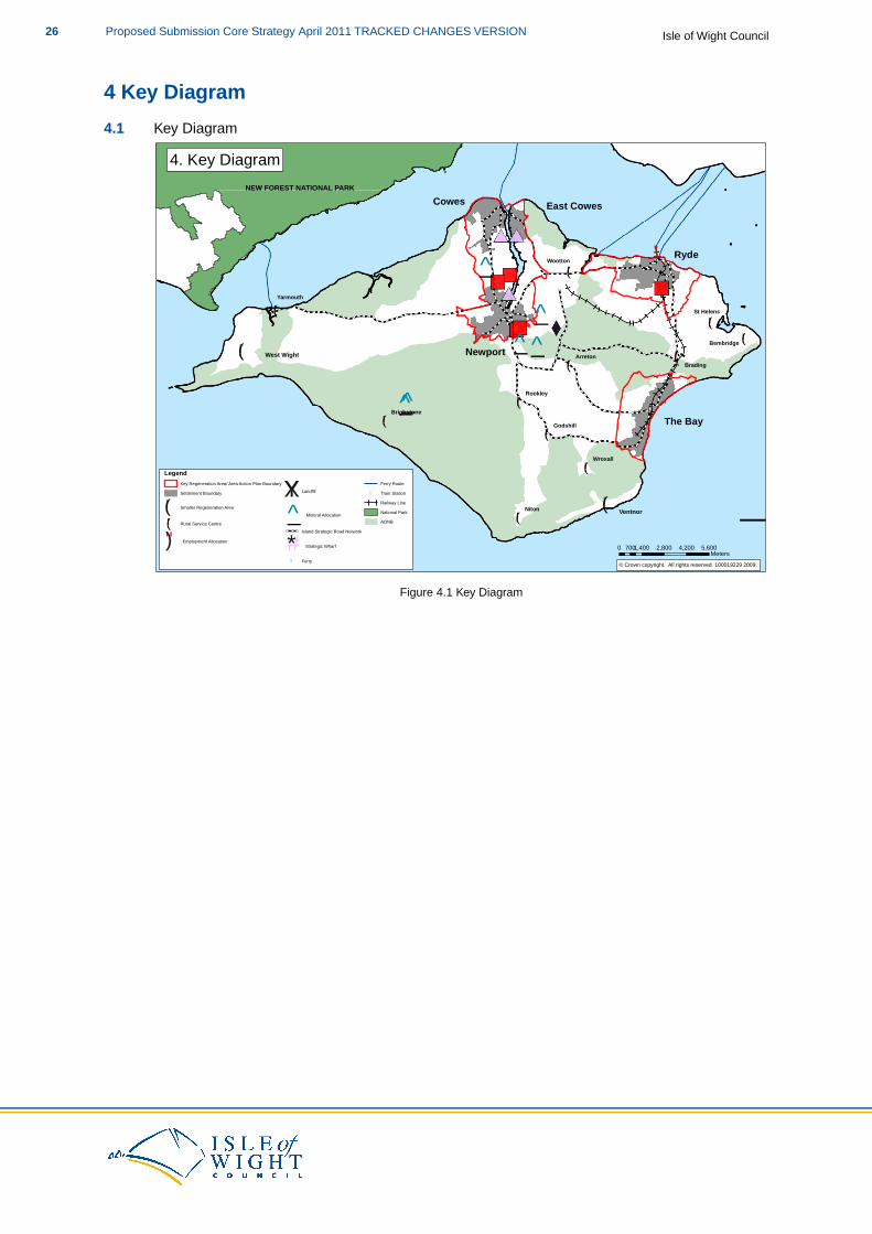
4 Key Diagram
4.1 Key Diagram
!(
!(
!(
!(
!(
!(
!(
!(
!(
!(
!(
!(
!(
Cowes
Ryde
Newport
The Bay
East Cowes
!
!
!
!
!
!
Niton
Brading
Wootton
Arreton
Rookley
Wroxall
Ventnor
Godshill
Yarmouth
Bembridge
St Helens
Brighstone
West Wight
!
!
!
!
!
!
!
!
_̂
_̂_̂
_̂
_̂̂_
NEW FOREST NATIONAL PARK
¯© Crown copyright. All rights reserved. 100019229 2009.
4. Key Diagram
0 1,400 2,800 4,200 5,600700 Meters
LegendKey Regeneration Area/ Area Action Plan Boundary Settlement Boundary
!( Smaller Regeneration Area
!( Rural Service Centre
") Employment Allocation
XY Landfill
_̂ Mineral Allocation
Island Strategic Road Network
#* Strategic Wharf
! Ferry
Ferry Route! Train Station
Railway LineNational ParkAONB
Figure 4.1 Key Diagram
Isle of Wight CouncilProposed Submission Core Strategy April 2011 TRACKED CHANGES VERSION26
5 Spatial Strategy and Strategic Policies
This section sets out the spatial strategy and strategic policies that flow from the spatial vision andobjectives set out in Chapter 3.The strategic policies set the general context for delivering and managingdevelopment on the Island.
It sets out, in spatial and strategic-level terms, where and how the requirements of the community, theCouncil and Eco Island will be achieved.The Spatial Strategy has also been shaped by the SustainabilityAppraisal/Strategic Environmental Assessment (SA/SEA), the Habitats Regulations Assessment (HRA)and the consultation work that has been undertaken to date by the Council.
When considering any aspect of the Core Strategy it is also necessary to consider the whole document:the policies of the Core Strategy should not read in isolation. All policies apply where relevant,whether or not specific cross-reference has been made. This applies to the Island Plan as a whole – allrelevant documents will need to be read together when considering a specific proposal or issue.
Spatial Strategy
SP1 Spatial Strategy
The Council will, in principle and in line with its overarching approach to economic ledregeneration and national policy, support development on appropriate land within orimmediately adjacent the defined settlement boundaries of the Key Regeneration Areas,Smaller Regeneration Areas and Rural Service Centres and will prioritise the redevelopmentof previously developed land where such land is available, suitable and viable for thedevelopment proposed.
Unless a specific local need is identified, development proposals outside of,or not immediatelyadjacent to the following defined settlements will not be supported.
Key Regeneration Areas:
Medina Valley (Newport, Cowes and East Cowes)RydeThe Bay (Sandown, Shanklin and Lake)
Smaller Regeneration Areas:
West Wight (Freshwater and Totland)Ventnor
Rural Service Centres:
ArretonBembridgeBradingBrighstoneGodshillNitonRookleySt HelensWoottonWroxallYarmouth
Appropriate land is considered to be deliverable within, and immediately adjacent, the
27Proposed Submission Core Strategy April 2011 TRACKED CHANGES VERSIONIsle of Wight Council
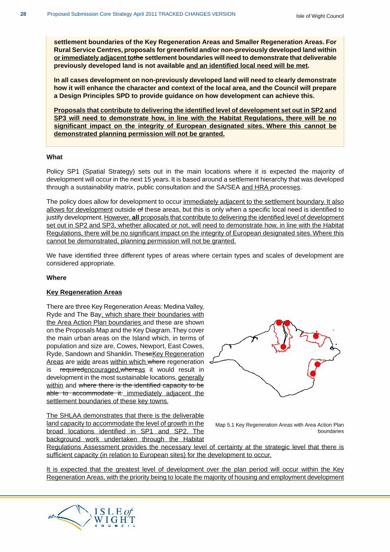
settlement boundaries of the Key Regeneration Areas and Smaller Regeneration Areas. ForRural Service Centres, proposals for greenfield and/or non-previously developed land withinor immediately adjacent tothe settlement boundaries will need to demonstrate that deliverablepreviously developed land is not available and an identified local need will be met.
In all cases development on non-previously developed land will need to clearly demonstratehow it will enhance the character and context of the local area, and the Council will preparea Design Principles SPD to provide guidance on how development can achieve this.
Proposals that contribute to delivering the identified level of development set out in SP2 andSP3 will need to demonstrate how, in line with the Habitat Regulations, there will be nosignificant impact on the integrity of European designated sites. Where this cannot bedemonstrated planning permission will not be granted.
What
Policy SP1 (Spatial Strategy) sets out in the main locations where it is expected the majority ofdevelopment will occur in the next 15 years. It is based around a settlement hierarchy that was developedthrough a sustainability matrix, public consultation and the SA/SEA and HRA processes.
The policy does allow for development to occur immediately adjacent to the settlement boundary. It alsoallows for development outside of these areas, but this is only when a specific local need is identified tojustify development. However, all proposals that contribute to delivering the identified level of developmentset out in SP2 and SP3, whether allocated or not, will need to demonstrate how, in line with the HabitatRegulations, there will be no significant impact on the integrity of European designated sites. Where thiscannot be demonstrated, planning permission will not be granted.
We have identified three different types of areas where certain types and scales of development areconsidered appropriate.
Where
Key Regeneration Areas
Map 5.1 Key Regeneration Areas with Area Action Planboundaries
There are three Key Regeneration Areas: Medina Valley,Ryde and The Bay, which share their boundaries withthe Area Action Plan boundaries and these are shownon the Proposals Map and the Key Diagram.They coverthe main urban areas on the Island which, in terms ofpopulation and size are, Cowes, Newport, East Cowes,Ryde, Sandown and Shanklin.TheseKey RegenerationAreas are wide areas within which where regenerationis requiredencouraged,whereas it would result indevelopment in the most sustainable locations, generallywithin and where there is the identified capacity to beable to accommodate it. immediately adjacent thesettlement boundaries of these key towns.
The SHLAA demonstrates that there is the deliverableland capacity to accommodate the level of growth in thebroad locations identified in SP1 and SP2. Thebackground work undertaken through the HabitatRegulations Assessment provides the necessary level of certainty at the strategic level that there issufficient capacity (in relation to European sites) for the development to occur.
It is expected that the greatest level of development over the plan period will occur within the KeyRegeneration Areas, with the priority being to locate the majority of housing and employment development
Isle of Wight CouncilProposed Submission Core Strategy April 2011 TRACKED CHANGES VERSION28
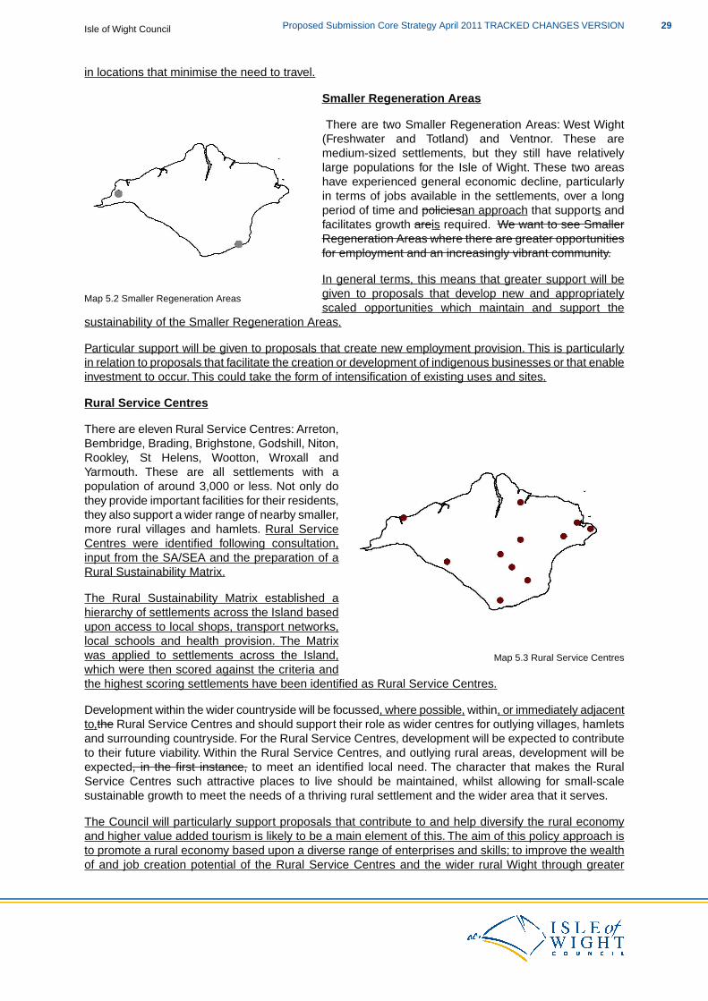
in locations that minimise the need to travel.
Map 5.2 Smaller Regeneration Areas
Smaller Regeneration Areas
There are two Smaller Regeneration Areas: West Wight(Freshwater and Totland) and Ventnor. These aremedium-sized settlements, but they still have relativelylarge populations for the Isle of Wight. These two areashave experienced general economic decline, particularlyin terms of jobs available in the settlements, over a longperiod of time and policiesan approach that supports andfacilitates growth areis required. We want to see SmallerRegeneration Areas where there are greater opportunitiesfor employment and an increasingly vibrant community.
In general terms, this means that greater support will begiven to proposals that develop new and appropriatelyscaled opportunities which maintain and support the
sustainability of the Smaller Regeneration Areas.
Particular support will be given to proposals that create new employment provision. This is particularlyin relation to proposals that facilitate the creation or development of indigenous businesses or that enableinvestment to occur. This could take the form of intensification of existing uses and sites.
Rural Service Centres
Map 5.3 Rural Service Centres
There are eleven Rural Service Centres: Arreton,Bembridge, Brading, Brighstone, Godshill, Niton,Rookley, St Helens, Wootton, Wroxall andYarmouth. These are all settlements with apopulation of around 3,000 or less. Not only dothey provide important facilities for their residents,they also support a wider range of nearby smaller,more rural villages and hamlets. Rural ServiceCentres were identified following consultation,input from the SA/SEA and the preparation of aRural Sustainability Matrix.
The Rural Sustainability Matrix established ahierarchy of settlements across the Island basedupon access to local shops, transport networks,local schools and health provision. The Matrixwas applied to settlements across the Island,which were then scored against the criteria andthe highest scoring settlements have been identified as Rural Service Centres.
Development within the wider countryside will be focussed, where possible, within, or immediately adjacentto,the Rural Service Centres and should support their role as wider centres for outlying villages, hamletsand surrounding countryside. For the Rural Service Centres, development will be expected to contributeto their future viability. Within the Rural Service Centres, and outlying rural areas, development will beexpected, in the first instance, to meet an identified local need. The character that makes the RuralService Centres such attractive places to live should be maintained, whilst allowing for small-scalesustainable growth to meet the needs of a thriving rural settlement and the wider area that it serves.
The Council will particularly support proposals that contribute to and help diversify the rural economyand higher value added tourism is likely to be a main element of this. The aim of this policy approach isto promote a rural economy based upon a diverse range of enterprises and skills; to improve the wealthof and job creation potential of the Rural Service Centres and the wider rural Wight through greater
29Proposed Submission Core Strategy April 2011 TRACKED CHANGES VERSIONIsle of Wight Council
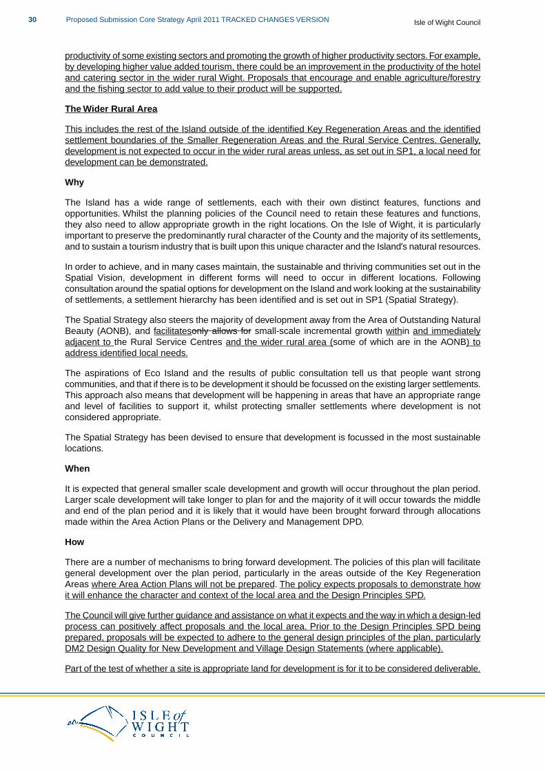
productivity of some existing sectors and promoting the growth of higher productivity sectors. For example,by developing higher value added tourism, there could be an improvement in the productivity of the hoteland catering sector in the wider rural Wight. Proposals that encourage and enable agriculture/forestryand the fishing sector to add value to their product will be supported.
The Wider Rural Area
This includes the rest of the Island outside of the identified Key Regeneration Areas and the identifiedsettlement boundaries of the Smaller Regeneration Areas and the Rural Service Centres. Generally,development is not expected to occur in the wider rural areas unless, as set out in SP1, a local need fordevelopment can be demonstrated.
Why
The Island has a wide range of settlements, each with their own distinct features, functions andopportunities. Whilst the planning policies of the Council need to retain these features and functions,they also need to allow appropriate growth in the right locations. On the Isle of Wight, it is particularlyimportant to preserve the predominantly rural character of the County and the majority of its settlements,and to sustain a tourism industry that is built upon this unique character and the Island’s natural resources.
In order to achieve, and in many cases maintain, the sustainable and thriving communities set out in theSpatial Vision, development in different forms will need to occur in different locations. Followingconsultation around the spatial options for development on the Island and work looking at the sustainabilityof settlements, a settlement hierarchy has been identified and is set out in SP1 (Spatial Strategy).
The Spatial Strategy also steers the majority of development away from the Area of Outstanding NaturalBeauty (AONB), and facilitatesonly allows for small-scale incremental growth within and immediatelyadjacent to the Rural Service Centres and the wider rural area (some of which are in the AONB) toaddress identified local needs.
The aspirations of Eco Island and the results of public consultation tell us that people want strongcommunities, and that if there is to be development it should be focussed on the existing larger settlements.This approach also means that development will be happening in areas that have an appropriate rangeand level of facilities to support it, whilst protecting smaller settlements where development is notconsidered appropriate.
The Spatial Strategy has been devised to ensure that development is focussed in the most sustainablelocations.
When
It is expected that general smaller scale development and growth will occur throughout the plan period.Larger scale development will take longer to plan for and the majority of it will occur towards the middleand end of the plan period and it is likely that it would have been brought forward through allocationsmade within the Area Action Plans or the Delivery and Management DPD.
How
There are a number of mechanisms to bring forward development. The policies of this plan will facilitategeneral development over the plan period, particularly in the areas outside of the Key RegenerationAreas where Area Action Plans will not be prepared. The policy expects proposals to demonstrate howit will enhance the character and context of the local area and the Design Principles SPD.
The Council will give further guidance and assistance on what it expects and the way in which a design-ledprocess can positively affect proposals and the local area. Prior to the Design Principles SPD beingprepared, proposals will be expected to adhere to the general design principles of the plan, particularlyDM2 Design Quality for New Development and Village Design Statements (where applicable).
Part of the test of whether a site is appropriate land for development is for it to be considered deliverable.
Isle of Wight CouncilProposed Submission Core Strategy April 2011 TRACKED CHANGES VERSION30
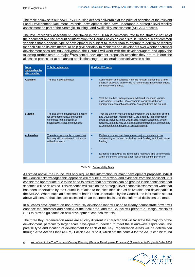
The table below sets out how PPS3: Housing defines deliverable at the point of adoption of the relevantLocal Development Document. Potential development sites have undergone a strategic-level viabilityassessment as part of the Strategic Housing Land Availability Assessment (SHLAA) process.
The level of viability assessment undertaken in the SHLAA is commensurate to the strategic nature ofthe document and the amount of information the Council holds on each site. It utilises a set of commonvariables that a generic type of development is subject to, rather than to attempt to determine viabilityfor each site on its own merits. To help give certainty to residents and developers over whether potentialdevelopment sites are truly deliverable, the Council will work with the developer/agent and apply thefollowing further tests to major (4)residential development proposals (whether they are to inform theallocation process or at a planning application stage) to ascertain how deliverable a site.
Further IWC testsThis is defined as:To bedeliverable thesite must be:
The site is available now.Available Confirmation and evidence from the relevant parties that a landdeal is in place and that there is no ransom land that could prejudicethe delivery of the site.
That the site has undergone a full detailed economic viabilityassessment using the HCA economic viability toolkit or anappropriate approach/assessment as agreed with the Council.
The site offers a sustainable locationfor development now and would
Suitable That the site can meet the requirements of the Strategic Policiesand Development Management Core Strategy (this information
contribute to the creation ofsustainable, mixed communities.
could be included in the Design and Access Statement, whererequired, and this type of information would generally be expectedto be submitted in support of an application).
There is a reasonable prospect thathousing will be delivered on the sitewithin five years.
Achievable Evidence to show that there are no major constraints to thedeliverability of the such as lack of bank funding, or infrastructurefunding.
Evidence to show that the developer is ready and able to commencewithin the period specified after receiving planning permission
Table 5.1 Deliverability Tests
As stated above, the Council will only require this information for major development proposals. Whilstthe Council acknowledges this approach will require further work and evidence from the applicant, it isconsidered appropriate due to the need to ensure that permission can be granted in the confidence thatschemes will be delivered.This evidence will build on the strategic-level economic assessment work thathas been undertaken by the Council in relation to the sites identified as deliverable and developable inthe SHLAA. Where such an assessment hasn't been undertaken by the Council, the information set outabove will ensure that sites are assessed on an equitable basis and that informed decisions are made.
In all cases development on non-previously developed land will need to clearly demonstrate how it willenhance the character and context of the local area, and the Council will prepare a Design PrinciplesSPD to provide guidance on how development can achieve this.
The three Key Regeneration Areas are all very different in character and will facilitate the majority of thedevelopment, particularly larger scale development, needed to meet the Island-wide aspirations. Theprecise type and location of development for each of the Key Regeneration Areas will be determinedthrough Area Action Plans (AAPs). Policies AAP1 to 3, which set the context for the AAPs can be found
4 As defined in the The Town and Country Planning (General Development Procedure) (Amendment) (England) Order 2006
31Proposed Submission Core Strategy April 2011 TRACKED CHANGES VERSIONIsle of Wight Council

in Chapter 6.
In the context of this policy, local need includes identified local requirements for housing, a demonstrablecontribution to maintaining local facilities (such as schools, shops and community facilities) and to maintainor enhance the wider viability of local communities.
Chapter 8: Infrastructure Delivery and Development Implementation sets out in more detail issues relatingto developer contributions and establishes that the mechanism for calculating and collecting them willbe a Community Infrastructure Levy (CIL) Charging Schedule and a Planning Obligations SupplementaryPlanning Document. It also outlines the need for flexibility when applying the policies of the Core Strategyand developer contributions, to ensure that the plan is sufficiently flexible to be deliverable.
In relation to the Spatial Strategy, you may also like to look at:
PPS1: Delivering Sustainable DevelopmentPPS3: HousingPPS7: Sustainable Development in Rural Areas
HRA for the Isle of Wight Core Strategy Appropriate Assessment, 2011; IWCSA/SEA of the Island Plan Core Strategy, 2011; IWC & EntecEco Island Sustainable Community Strategy, 2008; ISP & IWCStrategic Housing Market Assessment, 2007; GVA Grimley for IWCStrategic Housing Land Availability Assessment, 2010; IWCHousing Strategy 2007-2012, 2007; IWCIWC Housing Needs Survey, 2007 within the Strategic Housing Market AssessmentEconomic Strategy 2008-2020, 2008; IWC
Policy SP1 Spatial Strategy is linked to all the policies of this Plan
This table shows the distribution of the provisions of the Island Plan Core Strategy and is based on theKey Regeneration Areas, Smaller Regeneration Areas and the Rural Service Centres. The types ofdevelopment reflect the nine9 Strategic Policies of the Core Strategy.
MineralsWasteTravelRenewablesEnvironmentTourismRetailEmploymentHousing
The locationof mineral
Ahierarchical
Domesticscale
16.9ha>42haTotal extractionand working
approachthat matches
renewableenergy
is based onthe locationof viable
the scale ofthe wastefacility to the
generationacross thewhole
3 identifiedSmaller scaleSmaller scale>7.7ha>36.68.8ha1,26855MedinaValley
mineraldeposits.A
overallspatial
Island.Medium to junction
improvementsPrimary sequentialdevelopmentlarge scalelocation approach
has beenused to
pattern ofthe Island.
An extension
renewableenergygenerationwill befocussed on
To beidentified
To bePrimarylocation
Improvementarea
Smallerscale
>14.7ha1,900Ryde identifypotentialmineral sites,applying
to theexistinglandfill facility
suitablelocationsoutside theAONB.
identified
Primarylocation
Primarylocation
Smallerscale
Smaller scale250The Bay three layersof positive,exclusionary
on the Islandis alsoprovided for
anddiscretionarycriteria.To be
identified atSmaller scaleSmaller scaleSmaller
scaleSmaller scale200West
Wightapplicationstage
Isle of Wight CouncilProposed Submission Core Strategy April 2011 TRACKED CHANGES VERSION32
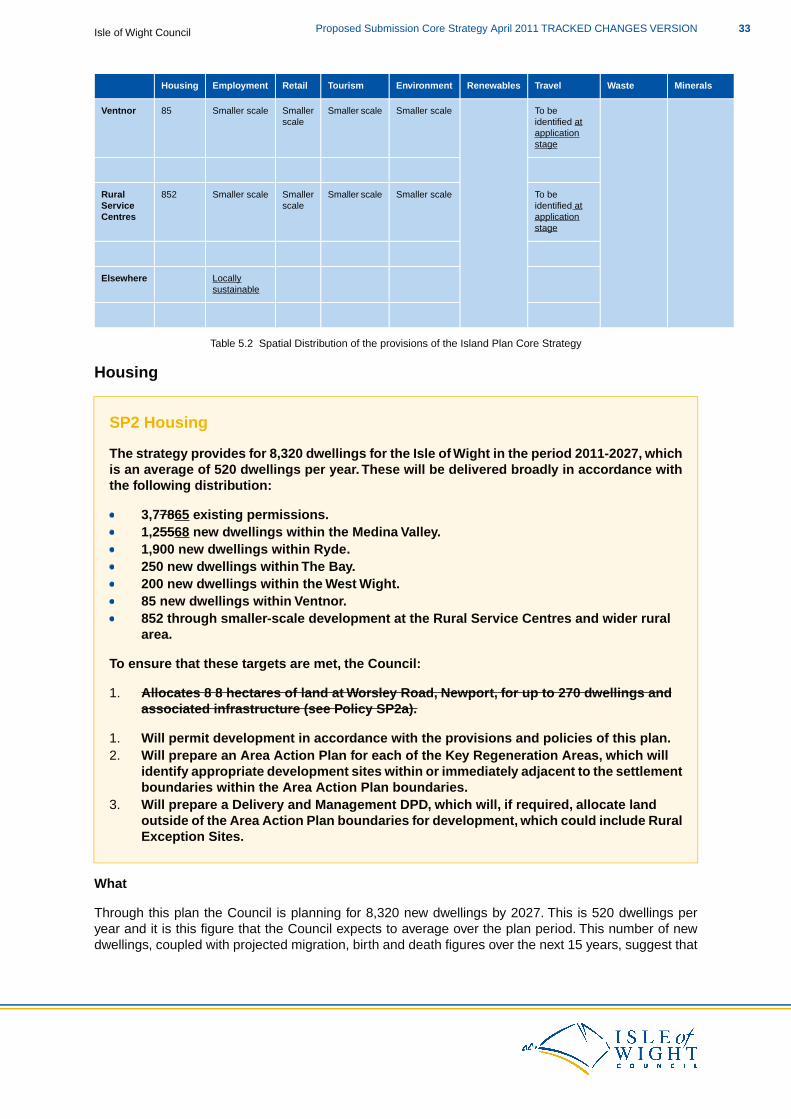
MineralsWasteTravelRenewablesEnvironmentTourismRetailEmploymentHousing
To beidentified at
Smaller scaleSmaller scaleSmallerscale
Smaller scale85Ventnor
applicationstage
To beidentified at
Smaller scaleSmaller scaleSmallerscale
Smaller scale852RuralServiceCentres application
stage
Locallysustainable
Elsewhere
Table 5.2 Spatial Distribution of the provisions of the Island Plan Core Strategy
Housing
SP2 Housing
The strategy provides for 8,320 dwellings for the Isle of Wight in the period 2011-2027, whichis an average of 520 dwellings per year. These will be delivered broadly in accordance withthe following distribution:
3,77865 existing permissions.1,25568 new dwellings within the Medina Valley.1,900 new dwellings within Ryde.250 new dwellings within The Bay.200 new dwellings within the West Wight.85 new dwellings within Ventnor.852 through smaller-scale development at the Rural Service Centres and wider ruralarea.
To ensure that these targets are met, the Council:
1. Allocates 8 8 hectares of land at Worsley Road, Newport, for up to 270 dwellings andassociated infrastructure (see Policy SP2a).
1. Will permit development in accordance with the provisions and policies of this plan.2. Will prepare an Area Action Plan for each of the Key Regeneration Areas, which will
identify appropriate development sites within or immediately adjacent to the settlementboundaries within the Area Action Plan boundaries.
3. Will prepare a Delivery and Management DPD, which will, if required, allocate land outside of the Area Action Plan boundaries for development, which could include RuralException Sites.
What
Through this plan the Council is planning for 8,320 new dwellings by 2027. This is 520 dwellings peryear and it is this figure that the Council expects to average over the plan period. This number of newdwellings, coupled with projected migration, birth and death figures over the next 15 years, suggest that
33Proposed Submission Core Strategy April 2011 TRACKED CHANGES VERSIONIsle of Wight Council
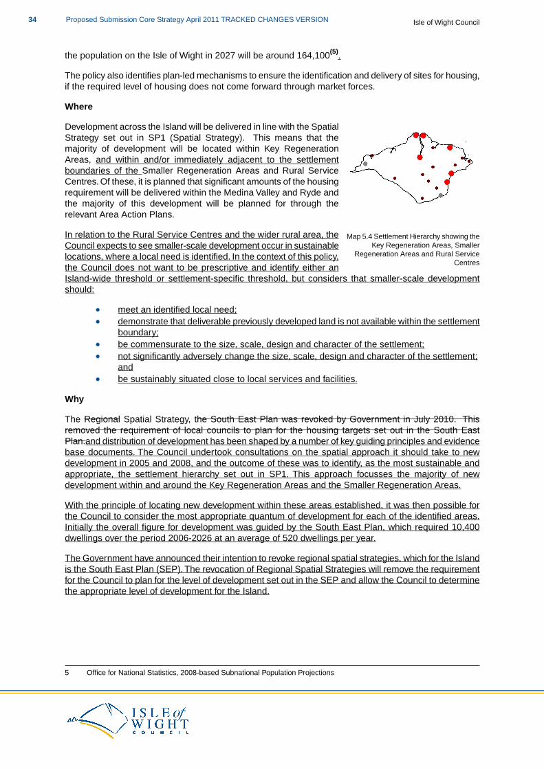
the population on the Isle of Wight in 2027 will be around 164,100(5).
The policy also identifies plan-led mechanisms to ensure the identification and delivery of sites for housing,if the required level of housing does not come forward through market forces.
Where
Map 5.4 Settlement Hierarchy showing theKey Regeneration Areas, Smaller
Regeneration Areas and Rural ServiceCentres
Development across the Island will be delivered in line with the SpatialStrategy set out in SP1 (Spatial Strategy). This means that themajority of development will be located within Key RegenerationAreas, and within and/or immediately adjacent to the settlementboundaries of the Smaller Regeneration Areas and Rural ServiceCentres. Of these, it is planned that significant amounts of the housingrequirement will be delivered within the Medina Valley and Ryde andthe majority of this development will be planned for through therelevant Area Action Plans.
In relation to the Rural Service Centres and the wider rural area, theCouncil expects to see smaller-scale development occur in sustainablelocations, where a local need is identified. In the context of this policy,the Council does not want to be prescriptive and identify either anIsland-wide threshold or settlement-specific threshold, but considers that smaller-scale developmentshould:
meet an identified local need;demonstrate that deliverable previously developed land is not available within the settlementboundary;be commensurate to the size, scale, design and character of the settlement;not significantly adversely change the size, scale, design and character of the settlement;andbe sustainably situated close to local services and facilities.
Why
The Regional Spatial Strategy, the South East Plan was revoked by Government in July 2010. Thisremoved the requirement of local councils to plan for the housing targets set out in the South EastPlan.and distribution of development has been shaped by a number of key guiding principles and evidencebase documents. The Council undertook consultations on the spatial approach it should take to newdevelopment in 2005 and 2008, and the outcome of these was to identify, as the most sustainable andappropriate, the settlement hierarchy set out in SP1. This approach focusses the majority of newdevelopment within and around the Key Regeneration Areas and the Smaller Regeneration Areas.
With the principle of locating new development within these areas established, it was then possible forthe Council to consider the most appropriate quantum of development for each of the identified areas.Initially the overall figure for development was guided by the South East Plan, which required 10,400dwellings over the period 2006-2026 at an average of 520 dwellings per year.
The Government have announced their intention to revoke regional spatial strategies, which for the Islandis the South East Plan (SEP). The revocation of Regional Spatial Strategies will remove the requirementfor the Council to plan for the level of development set out in the SEP and allow the Council to determinethe appropriate level of development for the Island.
5 Office for National Statistics, 2008-based Subnational Population Projections
Isle of Wight CouncilProposed Submission Core Strategy April 2011 TRACKED CHANGES VERSION34
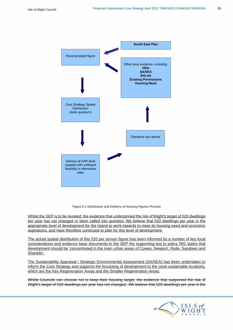
South East Plan
Housing target figure
Other local evidence, including:
HRA
SA/SEA
SHLAA
Existing Permissions
Housing Need
Core Strategy Spatial
Distribution
(tests quantum)
Delivery at AAP level
capable with sufficient
flexibility in alternative
sites
Therefore can deliver
Figure 5.1 Distribution and Delivery of Housing Figures Process
Whilst the SEP is to be revoked, the evidence that underpinned the Isle of Wight’s target of 520 dwellingsper year has not changed or been called into question. We believe that 520 dwellings per year is theappropriate level of development for the Island to work towards to meet its housing need and economicaspirations, and have therefore continued to plan for this level of development.
The actual spatial distribution of this 520 per annum figure has been informed by a number of key localconsiderations and evidence base documents.In the SEP the supporting text to policy IW2 states thatdevelopment should be 'concentrated in the main urban areas of Cowes, Newport, Ryde, Sandown andShanklin'.
The Sustainability Appraisal / Strategic Environmental Assessment (SA/SEA) has been undertaken toinform the Core Strategy and supports the focussing of development to the most sustainable locations,which are the Key Regeneration Areas and the Smaller Regeneration Areas.
Whilst Councils can choose not to keep their housing target, the evidence that supported the Isla ofWight's target of 520 dwellings per year has not changed. We believe that 520 dwellings per year is the
35Proposed Submission Core Strategy April 2011 TRACKED CHANGES VERSIONIsle of Wight Council

right level of development for the Island to work towards to meet its housing need and economicaspirations, and have therefore planned for this level of development.
The Council’s Strategic Housing Land Availability Assessment (SHLAA) shows that there is the landsupply to meet the target of 520 dwellings per year and that it is likely, within the first five years of theplan period, an average of around 64.5% will be delivered on brownfield or previously developed land(6).However, the evidence shows that it is likely that over the plan period we will not meet the national targetof 60% development on previously developed land, as the supply of that land has been fully utilised.Therefore, greenfield sites, immediately adjacent to settlement boundaries will need to be identified,considered and if appropriate delivered for development.
The SHLAA examines the extent to which possible sites, including those suggested by developers,landowners and other parties are suitable, available and achievable over a given timeframe. As requiredin PPS3: Housing, the SHLAA informs the Plan, Monitor, Manage approach to the provision of housingland and provides sufficient detail to demonstrate the Council's assessment of a five year land supply.
Through the SHLAA, the Council can demonstrate that there is a significant over supply of deliverableand developable housing sites to achieve the 520 dwellings per annum for the plan period. The SHLAAalso identified a theoretical capacity for the Key Regeneration Areas, Smaller Regeneration Areas andthe wider Island.
SHLAA Potential Housing Supply 2011-2027
Based on Isle of Wight Requirement of 520 dwellings per annum (520 x 16 years = 8,320 dwellings)
3,765(a) Existing housing permissions (7)
8,320(b) 2011-2027 requirement (16 years x 520 dwellings)
4,555(c) Additional dwellings required
1,782(d) SHLAA - within Key Regeneration Area settlement boundaries potential supply
136(e) SHLAA - within Smaller Regeneration Area settlement boundaries potential supply
107(f) SHLAA - within Rural Service Centres settlement boundaries potential supply
4,632(g) SHLAA - Other potential supply (rural sites outside of Key Regeneration Areas and not immediatelyadjacent to settlement boundaries)
15,426(h) Core Strategy potential supply outside defined settlement boundaries within Key RegenerationAreas and immediately adjacent to Smaller Regeneration Area Settlement Boundaries
700(i) Potential supply from windfall small sites (2021 onwards)
26,548(a+d+e+f+g+h+i) Total Potential Supply
18,228Potential Over Supply
Table 5.3 SHLAA Potential Supply
To contribute to the overall housing figure, our ongoing monitoring shows that 3,765 residential dwellingsare permitted. This number of residential dwellings in the development pipeline has a significant impacton the number of dwellings we need to deliver to achieve our 8,320 target, and to get to this figure weneed to deliver 4,555 new dwellings over the plan period.
With the land capacity to deliver this in the identified areas established, further consideration was givento a number of issues to establish the specific level of development within the spatial distribution.
The starting point was to identify, in percentage terms, the theoretical capacity of each area of the total
6 As shown on the Housing Trajectory in Appendix 17 Information taken from the July 2010 Land Availability Update and Housing Trajectory
Isle of Wight CouncilProposed Submission Core Strategy April 2011 TRACKED CHANGES VERSION36
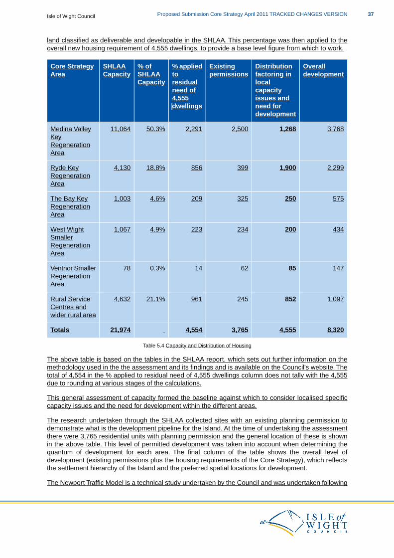
land classified as deliverable and developable in the SHLAA. This percentage was then applied to theoverall new housing requirement of 4,555 dwellings, to provide a base level figure from which to work.
Overalldevelopment
Distributionfactoring inlocalcapacityissues andneed fordevelopment
Existingpermissions
% appliedtoresidualneed of4,555dwellings
% ofSHLAACapacity
SHLAACapacity
Core StrategyArea
3,7681,2682,5002,29150.3%11,064Medina ValleyKeyRegenerationArea
2,2991,90039985618.8%4,130Ryde KeyRegenerationArea
5752503252094.6%1,003The Bay KeyRegenerationArea
4342002342234.9%1,067West WightSmallerRegenerationArea
1478562140.3%78Ventnor SmallerRegenerationArea
1,09785224596121.1%4,632Rural ServiceCentres andwider rural area
8,3204,5553,7654,55421,974Totals
Table 5.4 Capacity and Distribution of Housing
The above table is based on the tables in the SHLAA report, which sets out further information on themethodology used in the the assessment and its findings and is available on the Council's website. Thetotal of 4,554 in the % applied to residual need of 4,555 dwellings column does not tally with the 4,555due to rounding at various stages of the calculations.
This general assessment of capacity formed the baseline against which to consider localised specificcapacity issues and the need for development within the different areas.
The research undertaken through the SHLAA collected sites with an existing planning permission todemonstrate what is the development pipeline for the Island. At the time of undertaking the assessmentthere were 3,765 residential units with planning permission and the general location of these is shownin the above table. This level of permitted development was taken into account when determining thequantum of development for each area. The final column of the table shows the overall level ofdevelopment (existing permissions plus the housing requirements of the Core Strategy), which reflectsthe settlement hierarchy of the Island and the preferred spatial locations for development.
The Newport Traffic Model is a technical study undertaken by the Council and was undertaken following
37Proposed Submission Core Strategy April 2011 TRACKED CHANGES VERSIONIsle of Wight Council
on from Island-wide network modelling. This coarse level Island-wide assessment showed that at peaktimes, either on a daily or seasonal basis, the Island’s Strategic Road Network (see the Key Diagram orSP7) is near capacity at a number of key locations within Newport. Therefore, the Newport Traffic Modelconsiders the impact of growth on the network at Newport and establishes capacity levels and the pointsat which further substantial work to the network would be required. The baseline capacity figure for theMedina Valley (when broken down to look at Newport capacity), coupled with the existing permissionsin Newport would have triggered the need for further infrastructure and there was not enough certaintythat such work would have been deliverable.
The identified capacity issues at Newport meant further consideration had to be given to housingdistribution. This was based on sustainability considerations, the capacity for other locations toaccommodate it and the settlement hierarchy. As creating a new settlement had been ruled out throughearlier public consultation, Ryde, was the preferred location for further growth. Whilst it is not the CountyTown, Ryde, is the most populous town on the Island and locating such a level of development here isin line with the Council's aspirations for growth for the area. As part of this redistribution there has alsobeen further, smaller scale growth allowed for in the Bay Regeneration Area and the Smaller RegenerationAreas.
A Habitats Regulations Assessment was undertaken by the Council to inform the Core Strategy and thedistribution of development. The Assessment was undertaken to determine the likely impacts ofdevelopment on European (Natura 2000) sites, on the level of development proposed from the broadlocations set out in the Spatial Strategy. Whilst the Core Strategy is not allocating specific housing sites,it needs to demonstrate that the level of development in the broad areas identified can be achieved withno likely significant affects on European (Natura 2000) sites.
The Assessment considered the potential housing sites, either as a stand alone site or in-combinationwith other sites across the Island, identified as deliverable and developable in the SHLAA. Where sitespecific issues were known and/or identified, the assessment then considers whether it is likely thatpotential effects can be mitigated.
Overall the HRA concluded that whilst a number of sites were unacceptable due to their likely impact onEuropean sites (and should therefore not be considered for development on a matter of principle), therewas still the over-arching capacity to deliver the level of development within the broad locations identifiedwithin the Core Strategy.
Some of the potential housing sites have been identified as needing appropriate mitigation measures.The AAPs and the Delivery and Management DPDs (and their own HRAs) will be the mechanisms foridentifying the sites that will be allocated in accordance with the policies and HRA of the Core Strategy.It will be at this level that detailed in-combination effects will be assessed, to inform the Council'sdecision-making when it comes to allocating sites.
The policy approach in SP1 prioritises development on previously developed land where it is available,suitable and viable for the development proposed. However, the evidence shows that it is likely that overthe plan period we will not meet the national target of 60% development on previously developed land,as the supply of that land will have been fully utilised. Therefore, greenfield sites, immediately adjacentto settlement boundaries will need to be identified, considered and, if appropriate, delivered fordevelopment.
Through the SHLAA process, and the calculations to inform the Housing Trajectory (see Appendix 1),”small sites” are identified as those under 0.5 hectares as it is considered unlikely that these sites willbe able to accommodate 10 or more residential units and have not been considered through the SHLAAprocess. Sites which are located within settlement boundaries and identified as previously developedland can, if appropriate, come forward and be developed through the provisions of SP1 (Spatial Strategy).However, as they would come forward as ”windfall” sites, we cannot count them within the first ten yearsof the Housing Trajectory but, when completed, they will contribute to the overall delivery of the housingrequirement and target of 60% of development on previously developed land.
The Housing Trajectory set out in Appendix 1 shows the Council’s housing delivery from 2005 to date
Isle of Wight CouncilProposed Submission Core Strategy April 2011 TRACKED CHANGES VERSION38
and then the anticipated delivery until 2027. The Trajectory shows that so far we have, on average,exceeded an annual target of 520 over the five year period 2005 to 2010. These historical delivery ratesdemonstrate that, even with the current reduction in the number of housing completions, we havepreviously delivered a five year land supply. Because of this historical delivery, the existing deliverypipeline and the provisions made within this plan, the Council has a demonstrable land supply for at leastthe first five years of this plan.
The distribution of the housing figures set out in the policy has been shaped by the need to regenerateand focus on specific areas, the capacity for housing within those areas as identified by the SHLAA andconsideration of the implications on the Island's infrastructure, particularly the implications of the NewportTraffic Model on development capacity at Newport.
The Area Action Plans (AAPs) will cover a wide range of topics, but identifying sites for housing will bea primary one. As set out in PPS12: Local Spatial Planning, AAPs are designed to:
deliver planned growth areas;stimulate regeneration;protect areas particularly sensitive to change;resolve conflicting objectives in areas subject to development pressures; orfocus the delivery of area based regeneration initiatives.
This process will ensure that the Council is in a position to plan positively for the level of housingdevelopment required and to focus growth in the most sustainable locations on the Island.
It is the same rationale behind the preparation of the Delivery and Management DPD. This documentwill serve to enable development outside the Key Regeneration Areas, should it not come forward withoutCouncil intervention.
When
Due to the proposed adoption date (December 2011) of the Core Strategy, the 15 year plan period runsto 2026, which gives an end date delivery and monitoring year of the Core Strategy of 2026/27. Theoverall total number of dwellings to be delivered over the plan period is therefore 8,320.
The Local Development Scheme, which is available on the Council’s website, sets out in detail theanticipated timescales and key milestones of document preparation. The Medina Valley and Ryde AAPsare expected to be adopted in 2013, with The Bay AAP and the Delivery and Management DPD expectedin 2014.
How
If our annual monitoring indicates that the required level of development is not being delivered within, orimmediately adjacent, the boundaries of the settlements listed in SP1 (Spatial Strategy), and the Councildoes not have an adequate 5 year land supply across the Island, the Council will allocate land that isimmediately adjacent to settlement boundaries in the Delivery and Management DPD and AAPs. TheDelivery and Management DPD will be prepared in accordance with the policies of the Core Strategyand informed by the recommendations of the Core Strategy's HRA.This approach ensures flexibility andthat the Council meets its development requirements in the most sustainable available locations.
In relation to the housing provision, you may also like to look at:
PPS1: Delivering Sustainable DevelopmentPPS3: HousingPPS7: Sustainable Development in Rural AreasPPS12: Local Spatial PlanningHRA for the Isle of Wight Core Strategy Appropriate Assessment, 2011; IWCSA/SEA of the Island Plan Core Strategy, 2011; IWC & Entec
39Proposed Submission Core Strategy April 2011 TRACKED CHANGES VERSIONIsle of Wight Council
Eco-Island Sustainable Community Strategy, 2008; ISP & IWCStrategic Housing Market Assessment, 2007; GVA Grimley for IWCStrategic Housing Land Availability Assessment, 2010; IWCHousing Strategy 2007-1012, 2007; IWCIWC Housing Needs Survey, 2007 within the Strategic Housing Market Assessment
Policy SP2 Housing is particularly linked to the following policies of this plan:
DM1 Sustainable Build Criteria for New DevelopmentDM2 Design Quality for New DevelopmentDM3 Balanced Mix of HousingDM4 Locally Affordable HousingDM5 Housing for Older PeopleDM6 Gypsies, Travellers and Travelling ShowpeopleDM7 Social and Community InfrastructureDM22 Utility Infrastructure RequirementsDM23 Developer Contributions
AAP1 Medina Valley AAP2 Ryde AAP3 The Bay
SP1 Spatial StrategySP5 EnvironmentSP7 Travel
Worsley Road
What
Worsley Road is an allocation that was made in the Unitary Development Plan (UDP), which was adoptedin 2001 and covered the period 1996-2011.The 2004 Planning and Compulsory Purchase Act introducedLDFs to replace, in the case of the Island, the UDP. Because of this, since 2007 a small number of keypolicies, including the allocation at Worsley Road were saved to be used and shape development untilthe LDF was adopted.
The Worsley Road scheme has, over the years, experienced a number of issues that have preventedthe delivery of the site to date. However, the Council, the landowner and developers have been workinghard together to prepare and agree a scheme to bring the site forward. The allocation has been rolledforward in the Island Plan Core Strategy so that there is the planning framework in place to ensure thetimely delivery of the site.
The following policy requirements reflect the provisions of the previous allocation and the up-to-daterequirements of Council, following its discussions with the landowner and potential developers to date.
SP2a Worsley Road
The allocation at Worsley Road will be expected to deliver the following:
1. Up to 270 dwellings, of which at least 35% will be affordable housing and at least 20%housing for older persons, the mix and tenure type to be in conformity with theprovisions of the Core Strategy.
2. A main access to the development from Forest Road and secondary access (emergencyonly) from the south of the site.
Isle of Wight CouncilProposed Submission Core Strategy April 2011 TRACKED CHANGES VERSION40
3. An acceptable design that meets the requirements of the Highways Authority with theneeds of the Commissioner for School Places & Assets to ensure the long term viabilityof the adjoining school site.
4. Appropriate road safety measures, including inter-visibility zones on Argyll Road, tothe satisfaction of the Highway Authority.
5. A boundary fence adjoining the highways network that is no closer than 10 metres tothe school building.
6. The re-provision of school playing fields to provide, as a minimum, the same amountand standard of provision that currently exists.
7. The re-provision of the school playing fields prior to the commencement of the roadconstruction.
8. A green corridor between the existing development at Worsley Road and to the southwest and south of the site.
9. Developer contributions in conformity with the provisions of the Core Strategy.
Why
Through the work undertaken on the site to date, it has the capacity for around 270 units based ondensities appropriate to a site within the settlement boundary of Newport. The Council will expect theappropriate level of affordable and older persons housing, in line with policies DM3 (Balanced Mix ofHousing), DM4 (Locally Affordable Housing) and DM5 (Housing for Older People).
The access arrangements for the site are important to manage traffic flows associated with thedevelopment in and around Newport. The Newport Traffic Model includes this development and thehighways arrangements have been determined accordingly. The main access to the site will be fromForest Road, in the form of a new signal-controlled junction that conforms to the requisite safety anddesign requirements.
Secondary access for emergency vehicles only will be provided to the south of the site, at a point yet tobe determined. This is to enable adequate provision of access to emergency vehicles to the site, butensuring there are no traffic movements from the site into the existing residential area to the south.
The Worsley Road site is adjacent to Kitbridge School and the main access to the site will run alongsidethe school boundary. The road design of the scheme in terms of both visual appearance and layout willneed to meet the statutory safety requirements that the Council, as the Highways Authority, must applyand ensure that this does not negatively impact on the continued use of KitbridgeSchool.
This particularly needs to be considered in the provision of appropriate road safety measures. There isa requirement to provide inter-visibility zones on Argyll Road (which is to the north of Forest Road, andopposite the proposed road into the Worsley Road development). The precise location and design ofthese will need to be agreed by the Council as the Highways Authority.
41Proposed Submission Core Strategy April 2011 TRACKED CHANGES VERSIONIsle of Wight Council
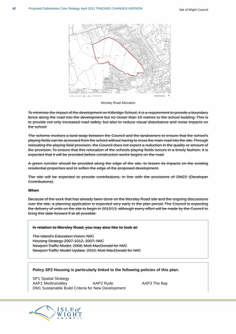
Worsley Road Allocation
To minimise the impact of the development on Kitbridge School, it is a requirement to provide a boundaryfence along the road into the development but no closer than 10 metres to the school building. This isto provide not only increased road safety, but also to reduce visual disturbance and noise impacts onthe school.
The scheme involves a land-swap between the Council and the landowners to ensure that the school’splaying fields can be accessed from the school without having to cross the main road into the site.Throughrelocating the playing field provision, the Council does not expect a reduction in the quality or amount ofthe provision. To ensure that this relocation of the schools playing fields occurs in a timely fashion, it isexpected that it will be provided before construction works begins on the road.
A green corridor should be provided along the edge of the site, to lessen its impacts on the existingresidential properties and to soften the edge of the proposed development.
The site will be expected to provide contributions, in line with the provisions of DM22 (DeveloperContributions).
When
Because of the work that has already been done on the Worsley Road site and the ongoing discussionsover the site, a planning application is expected very early in the plan period. The Council is expectingthe delivery of units on the site to begin in 2012/13, although every effort will be made by the Council tobring this date forward if at all possible.
In relation to Worsley Road, you may also like to look at:
The Island’s Education Vision; IWCHousing Strategy 2007-1012, 2007; IWCNewport Traffic Model, 2008; Mott MacDonald for IWCNewport Traffic Model Update, 2010; Mott MacDonald for IWC
Policy SP2 Housing is particularly linked to the following policies of this plan:
SP1 Spatial StrategyAAP1 MedinaValley AAP2 Ryde AAP3 The BayDM1 Sustainable Build Criteria for New Development
Isle of Wight CouncilProposed Submission Core Strategy April 2011 TRACKED CHANGES VERSION42
DM2 Design Quality for New DevelopmentDM3 Balanced Mix of HousingDM4 Locally Affordable HousingDM5 Housing for Older PeopleDM6 Gypsies, Travellers and Travelling ShowpeopleDM7 Social and Community InfrastructureDM14 Green InfrastructureDM22 Developer Contributions
Economy
SP3 Economy
Economic growth on the Island over the plan period will be focussed upon employment,retail and high quality tourism, with a target of creating around 7,550 new jobs. Economicdevelopment will primarily be located in the Key and Smaller Regeneration Areas, with locallysustainable employment opportunities being supported elsewhere. Sustainable growth inthe rural economy will be supported, particularly that which supports the continued vitalityand viability of the horticultural sector within the Arreton Valley.
The loss of large scale employment sites of one hectare or above will be resisted, wherethey are important to sustaining the local economy.
Economic Development
The strategy allows for at least 42 hectares of new economic development land to be deliveredover the plan period, primarily within the Key Regeneration Areas and the SmallerRegeneration Areas. The 42 hectares should consist of around 9 hectares of B1b, B1c andB2 uses, around 13 hectares of B8 uses and around 20 hectares of B1a uses.
To contribute to this target, the Council allocates the following sites for employment uses:
1. Up to 25 hectares of land at Horsebridge Hill, Newport, for a range of B-type employmentuses that reflect the general split outlined above to meet local and Island-wide need foremployment provision.
2. Up to 8.8 hectares of land at Stag Lane, Newport, for a range of B1, B2 and B8employment uses, primarily related to renewable energy.
3. Up to 14.7 hectares of land to the south of Nicholson Road, Ryde, for a mix of primarilysmaller scale B1 and B2 uses.
4. Up to 2.8 hectares of land to the east of Pan Lane, Newport, for a range of B1 and B2uses suitable to a mixed-use scheme.
Up to 13.2 hectares of land at St Georges Way, for at least 150,000 ft2 (gross) ofcommercial floorspace (including the possibility of a petrol filling station) and 3,000ft2
(gross) of leisure uses and the relocation of Newport Fire Station.
The strategy allows for no more than 809,000 ft2 of net retail floorspace over the plan period,primarily located within the Primary Retail Areas,Town Centres or Key Regeneration Areas.This is to be broadly split as 80% comparison goods and 20% DIY/Bulky comparison goods.
To contribute to this target and to provide for general commercial development the Councilallocates up to 10.4 hectares of land at St Georges Way, Newport, for at least 150,000 ft2
(gross) of commercial floorspace (including the possibility of a petrol filling station) and3,000 ft2 (gross) of leisure uses.
43Proposed Submission Core Strategy April 2011 TRACKED CHANGES VERSIONIsle of Wight Council
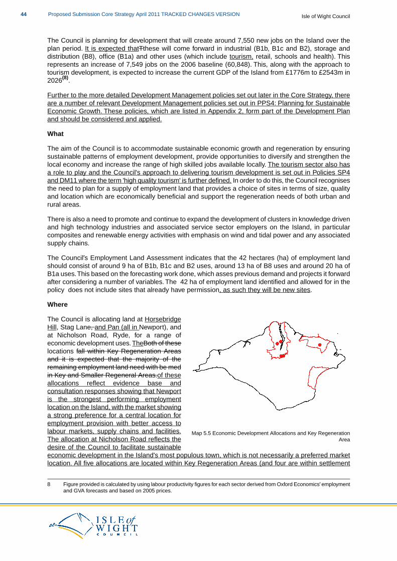
The Council is planning for development that will create around 7,550 new jobs on the Island over theplan period. It is expected thatTthese will come forward in industrial (B1b, B1c and B2), storage anddistribution (B8), office (B1a) and other uses (which include tourism, retail, schools and health). Thisrepresents an increase of 7,549 jobs on the 2006 baseline (60,848). This, along with the approach totourism development, is expected to increase the current GDP of the Island from £1776m to £2543m in2026(8).
Further to the more detailed Development Management policies set out later in the Core Strategy, thereare a number of relevant Development Management policies set out in PPS4: Planning for SustainableEconomic Growth. These policies, which are listed in Appendix 2, form part of the Development Planand should be considered and applied.
What
The aim of the Council is to accommodate sustainable economic growth and regeneration by ensuringsustainable patterns of employment development, provide opportunities to diversify and strengthen thelocal economy and increase the range of high skilled jobs available locally. The tourism sector also hasa role to play and the Council's approach to delivering tourism development is set out in Policies SP4and DM11 where the term 'high quality tourism' is further defined. In order to do this, the Council recognisesthe need to plan for a supply of employment land that provides a choice of sites in terms of size, qualityand location which are economically beneficial and support the regeneration needs of both urban andrural areas.
There is also a need to promote and continue to expand the development of clusters in knowledge drivenand high technology industries and associated service sector employers on the Island, in particularcomposites and renewable energy activities with emphasis on wind and tidal power and any associatedsupply chains.
The Council’s Employment Land Assessment indicates that the 42 hectares (ha) of employment landshould consist of around 9 ha of B1b, B1c and B2 uses, around 13 ha of B8 uses and around 20 ha ofB1a uses.This based on the forecasting work done, which asses previous demand and projects it forwardafter considering a number of variables. The 42 ha of employment land identified and allowed for in thepolicy does not include sites that already have permission, as such they will be new sites.
Where
Map 5.5 Economic Development Allocations and Key RegenerationArea
The Council is allocating land at HorsebridgeHill, Stag Lane, and Pan (all in Newport), andat Nicholson Road, Ryde, for a range ofeconomic development uses. TheBoth of theselocations fall within Key Regeneration Areasand it is expected that the majority of theremaining employment land need with be medin Key and Smaller Regeneral Areas.of theseallocations reflect evidence base andconsultation responses showing that Newportis the strongest performing employmentlocation on the Island, with the market showinga strong preference for a central location foremployment provision with better access tolabour markets, supply chains and facilities.The allocation at Nicholson Road reflects thedesire of the Council to facilitate sustainableeconomic development in the Island's most populous town, which is not necessarily a preferred marketlocation. All five allocations are located within Key Regeneration Areas (and four are within settlement
8 Figure provided is calculated by using labour productivity figures for each sector derived from Oxford Economics’ employmentand GVA forecasts and based on 2005 prices.
Isle of Wight CouncilProposed Submission Core Strategy April 2011 TRACKED CHANGES VERSION44
boundaries) and it is expected that the majority of further employment land need will be met within theKey and Smaller Regeneration Areas.
The spatial distribution of these allocated sites has been shaped by the overarching spatial strategy, theidentified need for economic development and the existing planning permissions for the key strategicemployment sites at the Island Technology Park, Whippingham and land at Kingston, East Cowes bothof which are within the Medina Valley Key Regeneration Area.
Although some provision will be brought forward in rural areas when the need to do so is demonstrated,we do not anticipate the need for significant employment land requirements in rural areas. The Councilwill be supportive of proposals for locally sustainable economic development across the Rural ServiceCentres and the rural Wight when the proposals are broadly compliant with Development Plan policies,particularly DM 8 and DM10.This could include the expansion and/or intensification of existing employmentsites.
When determining applications for employment land, the Council will support proposals that provideindustrial land with marine access, enhance the quality of office accommodation in towns and createemployment zones on the edge of towns where existing employment sites can be linked together inimaginative ways to appeal to tenants and investors alike.
Horsebridge Hill
SP3(a)
Horsebridge Hill
The Horsebridge Hill site is allocated to deliver a range of B-type employment uses to meetlocal and Island-wide need for employment provision. Further to SP3 and the relevantDevelopment Plan policies, the allocation at Horsebridge Hill will be expected to:
1. Avoid both direct and indirect adverse effects upon the integrity of designated sitesand, if necessary, provide appropriate mitigation measures.
2. Maintain a green corridor and provide pedestrian / cycle links in the general locationsidentified on the Proposals Map.
3. Retain the 7.5ha Natural Green Space area identified to contribute, along with the greencorridor, to the Green Infrastructure Network (as identified in the GI Mapping Study)and provide any specific mitigation measures.
4. Consider whether, in the southern employment site, the provision of employment usesincludes uses ancillary to the Hospital or that would create a hub of healthcare-relatedemployment provision.
5. Retain and utilise existing hedgerows and field boundaries wherever possible.6. Be designed to utilise the existing topography of the site.7. Minimise impact on existing properties by ensuring the most compatible uses are
suitably located and to provide appropriate landscape buffering between newdevelopment and existing residential properties.
8. Provide access from Horsebridge Hill to the northern employment area and accessfrom Dodnor Lane to the southern employment area.
9. Connect to the sewerage system off-site at the nearest point of adequate capacity.
The Council will work with the landowners to facilitate the delivery of the site.
45Proposed Submission Core Strategy April 2011 TRACKED CHANGES VERSIONIsle of Wight Council
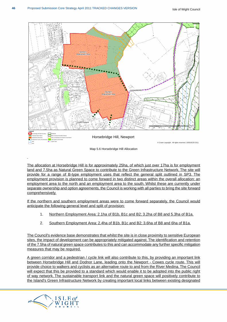
! ! ! ! ! ! ! ! ! ! ! ! ! ! ! ! ! ! ! !
! ! ! ! ! ! ! ! ! ! ! ! ! ! ! ! ! ! ! !
! ! ! ! ! ! ! ! ! ! ! ! ! ! ! ! ! ! ! !
! ! ! ! ! ! ! ! ! ! ! ! ! ! ! ! ! ! ! !
! ! ! ! ! ! ! ! ! ! ! ! ! ! ! ! ! ! ! !
! ! ! ! ! ! ! ! ! ! ! ! ! ! ! ! ! ! ! !
! ! ! ! ! ! ! ! ! ! ! ! ! ! ! ! ! ! ! !
! ! ! ! ! ! ! ! ! ! ! ! ! ! ! ! ! ! ! !
! ! ! ! ! ! ! ! ! ! ! ! ! ! ! ! ! ! ! !
! ! ! ! ! ! ! ! ! ! ! ! ! ! ! ! ! ! ! !
! ! ! ! ! ! ! ! ! ! ! ! ! ! ! ! ! ! ! !
! ! ! ! ! ! ! ! ! ! ! ! ! ! ! ! ! ! ! !
! ! ! ! ! ! ! ! ! ! ! ! ! ! ! ! ! ! ! !
! ! ! ! ! ! ! ! ! ! ! ! ! ! ! ! ! ! ! !
! ! ! ! ! ! ! ! ! ! ! ! ! ! ! ! ! ! ! !
! ! ! ! ! ! ! ! ! ! ! ! ! ! ! ! ! ! ! !
! ! ! ! ! ! ! ! ! ! ! ! ! ! ! ! ! ! ! !
! ! ! ! ! ! ! ! ! ! ! ! ! ! ! ! ! ! ! !
! ! ! ! ! ! ! ! ! ! ! ! ! ! ! ! ! ! ! !
! ! ! ! ! ! ! ! ! ! ! ! ! ! ! ! ! ! ! !
! ! ! ! ! ! ! ! ! ! ! ! ! ! ! ! ! ! ! !
! ! ! ! ! ! ! ! ! ! ! ! ! ! ! ! ! ! ! !
! ! ! ! ! ! ! ! ! ! ! ! ! ! ! ! ! ! ! !
! ! ! ! ! ! ! ! ! ! ! ! ! ! ! ! ! ! ! !
! ! ! ! ! ! ! ! ! ! ! ! ! ! ! ! ! ! ! !
! ! ! ! ! ! ! ! ! ! ! ! ! ! ! ! ! ! ! !
! ! ! ! ! ! ! ! ! ! ! ! ! ! ! ! ! ! ! !
! ! ! ! ! ! ! ! ! ! ! ! ! ! ! ! ! ! ! !
! ! ! ! ! ! ! ! ! ! ! ! ! ! ! ! ! ! ! !
! ! ! ! ! ! ! ! ! ! ! ! ! ! ! ! ! ! ! !
! ! ! ! ! ! ! ! ! ! ! ! ! ! ! ! ! ! ! !
! ! ! ! ! ! ! ! ! ! ! ! ! ! ! ! ! ! ! !
! ! ! ! ! ! ! ! ! ! ! ! ! ! ! ! ! ! ! !
! ! ! ! ! ! ! ! ! ! ! ! ! ! ! ! ! ! ! !
! ! ! ! !
! ! ! ! !
! ! ! ! !
! ! ! ! !
! ! ! ! !
! ! ! ! !
! ! ! ! !
! ! ! ! !
! ! ! ! !
! ! ! ! !
! ! ! ! !
! ! ! ! !
! ! ! ! !
! ! ! ! !
! ! ! ! !
! ! ! ! !
! ! ! ! !
! ! ! ! ! ! ! ! ! ! ! ! ! ! ! ! ! ! ! ! ! ! ! ! ! ! !
! ! ! ! ! ! ! ! ! ! ! ! ! ! ! ! ! ! ! ! ! ! ! ! ! ! !
! ! ! ! ! ! ! ! ! ! ! ! ! ! ! ! ! ! ! ! ! ! ! ! ! ! !
! ! ! ! ! ! ! ! ! ! ! ! ! ! ! ! ! ! ! ! ! ! ! ! ! ! !
! ! ! ! ! ! ! ! ! ! ! ! ! ! ! ! ! ! ! ! ! ! ! ! ! ! !
! ! ! ! ! ! ! ! ! ! ! ! ! ! ! ! ! ! ! ! ! ! ! ! ! ! !
! ! ! ! ! ! ! ! ! ! ! ! ! ! ! ! ! ! ! ! ! ! ! ! ! ! !
! ! ! ! ! ! ! ! ! ! ! ! ! ! ! ! ! ! ! ! ! ! ! ! ! ! !
! ! ! ! ! ! ! ! ! ! ! ! ! ! ! ! ! ! ! ! ! ! ! ! ! ! !
! ! ! ! ! ! ! ! ! ! ! ! ! ! ! ! ! ! ! ! ! ! ! ! ! ! !
! ! ! ! ! ! ! ! ! ! ! ! ! ! ! ! ! ! ! ! ! ! ! ! ! ! !
! ! ! ! ! ! ! ! ! ! ! ! ! ! ! ! ! ! ! ! ! ! ! ! ! ! !
! ! ! ! ! ! ! ! ! ! ! ! ! ! ! ! ! ! ! ! ! ! ! ! ! ! !
! ! ! ! ! ! ! ! ! ! ! ! ! ! ! ! ! ! ! ! ! ! ! ! ! ! !
! ! ! ! ! ! ! ! ! ! ! ! ! ! ! ! ! ! ! ! ! ! ! ! ! ! !
! ! ! ! ! ! ! ! ! ! ! ! ! ! ! ! ! ! ! ! ! ! ! ! ! ! !
! ! ! ! ! ! ! ! ! ! ! ! ! ! ! ! ! ! ! ! ! ! ! ! ! ! !
! ! ! ! ! ! ! ! ! ! ! ! ! ! ! ! ! ! ! ! ! ! ! ! ! ! !
! ! ! ! ! ! ! ! ! ! ! ! ! ! ! ! ! ! ! ! ! ! ! ! ! ! !
! ! ! ! ! ! ! ! ! ! ! ! ! ! ! ! ! ! ! ! ! ! ! ! ! ! !
! ! ! ! ! ! ! ! ! ! ! ! ! ! ! ! ! ! ! ! ! ! ! ! ! ! !
! ! ! ! ! ! ! ! ! ! ! ! ! ! ! ! ! ! ! ! ! ! ! ! ! ! !
! ! ! ! ! ! ! ! ! ! ! ! ! ! ! ! ! ! ! ! ! ! ! ! ! ! !
! ! ! ! ! ! ! ! ! ! ! ! ! ! ! ! ! ! ! ! ! ! ! ! ! ! !
! ! ! ! ! ! ! ! ! ! ! ! ! ! ! ! ! ! ! ! ! ! ! ! ! ! !
! ! ! ! ! ! ! ! ! ! ! ! ! ! ! ! ! ! ! ! ! ! ! ! ! ! !
! ! ! ! ! ! ! ! ! ! ! ! ! ! ! ! ! ! ! ! ! ! ! ! ! ! !
! ! ! ! ! ! ! ! ! ! ! ! ! ! ! ! ! ! ! ! ! ! ! ! ! ! !
! ! ! ! ! ! ! ! ! ! ! ! ! ! ! ! ! ! ! ! ! ! ! ! ! ! !
! ! ! ! ! ! ! ! ! ! ! ! ! ! ! ! ! ! ! ! ! ! ! ! ! ! !
! ! ! ! ! ! ! ! ! ! ! ! ! ! ! ! ! ! ! ! ! ! ! ! ! ! !
! ! ! ! ! ! ! ! ! ! ! ! ! ! ! ! ! ! ! ! ! ! ! ! ! ! !
! ! ! ! ! ! ! ! ! ! ! ! ! ! ! ! ! ! ! ! ! ! ! ! ! ! !
! ! ! ! ! ! ! ! ! ! ! ! ! ! ! ! ! ! ! ! ! ! ! ! ! ! !
! ! ! ! ! ! ! ! ! ! ! ! ! ! ! ! ! ! ! ! ! ! ! ! ! ! !
! ! ! ! ! ! ! ! ! ! ! ! ! ! ! ! ! ! ! ! ! ! ! ! ! ! !
! ! ! ! ! ! ! ! ! ! ! ! ! ! ! ! ! ! ! ! ! ! ! ! ! ! !
! ! ! ! ! ! ! ! ! ! ! ! ! ! ! ! ! ! ! ! ! ! ! ! ! ! !
! ! ! ! !
! ! ! ! !
! ! ! ! !
! ! ! ! !
! ! ! ! !
! ! ! ! !
! ! ! ! !
! ! ! ! !
! ! ! ! !
! ! ! ! !
! ! ! ! !
! ! ! ! !
! ! ! ! !
! ! ! ! !
! ! ! ! !
! ! ! ! !
! ! ! ! !
! ! ! ! !
HORSE
BRIDG
E HILL
DODNOR LANE
St Mary's Hospital
Northern Employment Area
SouthernEmployment Area
0 90 180 270 36045Meters
¯
© Crown copyright. All rights reserved. 100019229 2011.
Horsebridge Hill, NewportLegend
Horsebridge Hill Site BoundaryProposed Open SpaceEmployment AllocationPedestrian/ Cycle Link (Indicative)SAC
! !SPA
! !
! !RAMSARSites of Special Scientific InterestSites of Importance for Nature ConservationOpen Space (2010 Audit)Cycle Track
Map 5.6 Horsebridge Hill Allocation
The allocation at Horsebridge Hill is for approximately 25ha, of which just over 17ha is for employmentland and 7.5ha as Natural Green Space to contribute to the Green Infrastructure Network. The site willprovide for a range of B-type employment uses that reflect the general split outlined in SP3. Theemployment provision is planned to come forward in two distinct areas within the overall allocation: anemployment area to the north and an employment area to the south. Whilst these are currently underseparate ownership and option agreements, the Council is working with all parties to bring the site forwardcomprehensively.
If the northern and southern employment areas were to come forward separately, the Council wouldanticipate the following general level and split of provision:
1. Northern Employment Area: 2.1ha of B1b, B1c and B2; 3.2ha of B8 and 5.3ha of B1a.
2. Southern Employment Area: 2.4ha of B1b, B1c and B2; 3.6ha of B8 and 6ha of B1a.
The Council's evidence base demonstrates that whilst the site is in close proximity to sensitive Europeansites, the impact of development can be appropriately mitigated against. The identification and retentionof the 7.5ha of natural green space contributes to this and can accommodate any further specific mitigationmeasures that may be required.
A green corridor and a pedestrian / cycle link will also contribute to this, by providing an important linkbetween Horsebridge Hill and Dodnor Lane, leading onto the Newport - Cowes cycle route. This willprovide choice to walkers and cyclists as an alternative route to and from the River Medina. The Councilwill expect that this be provided to a standard which would enable it to be adopted into the public rightof way network. The sustainable transport link and the natural green space will positively contribute tothe Island's Green Infrastructure Network by creating important local links between existing designated
Isle of Wight CouncilProposed Submission Core Strategy April 2011 TRACKED CHANGES VERSION46

sites to the north-east of the site and the general amenity green space at Horsebridge Hill. Furtherpedestrian / cycle links will be provided, in the general locations shown on the Proposals Map, to linkthe Southern Employment Area into the St Mary's Hospital site. This will improve accessibility to andfrom the site and provide a tangible link between the Hospital and the employment allocation, which willseek to provide healthcare-related employment provision.
The area designated as natural green space incorporates a number of designated sites. Whilst themaintenance of the area in its current form will continue its contribution to the Green Infrastructure Networkand open space, it also has the ability to accommodate the site-specific mitigation measures that maybe required.
The Southern Employment Area has close links with the St Mary's Hospital site, and part of the allocationhas previously been safeguarded for potential expansion of the Hospital. Now that it has been establishedthat the previously safeguarded land is no longer required for such a purpose, it is available and suitableto come forward for employment uses.Within the Southern Employment Area, the provision of employmentuses that includes uses ancillary to the Hospital or that would create a hub of healthcare-relatedemployment provision would be encouraged, although it is acknowledged that there may not be thedemand for these types of uses for the whole site.
The site has a number of well-established hedgerows and the Council wishes to see these retained,particularly those that form the external boundaries of the site and/or form part of existing designations.It is likely that the route of the sustainable transport link across the site will need to cut across a numberof hedgerows, and where this occurs the impacts should be minimised.
The topography of the site slopes from Horsebridge Hill down towards the River Medina.Whilst the slopeis noticeable towards the northern end of the allocated area it is not significant enough to precludedevelopment occurring. However, detailed proposals should take the gradient into account whenconsidering the precise location and form of any buildings to minimise any visual impact.
It is expected that a detailed scheme will be designed to minimise disturbance (both visual and noise)and impact on amenity to existing properties and that this will be achieved by ensuring that the mostcompatible uses are located nearer to the existing residential properties. Furthermore, appropriatelandscape buffering between the new development and the existing residential properties will be provided.
Due to the employment elements of the site being two distinct areas, independent vehicular access willneed to be provided to both the northern and southern areas. For the northern employment area it isexpected that access will be provided from Horsebridge Hill, and initial technical work demonstrates thatthis should be feasible. To ensure the most appropriate access is provided, additional detailed work onthe technical aspects of a junction, based on a phased delivery of the site will be required. Should thefurther work demonstrate that access from Horsebridge Hill is not feasible, access to the site could beprovided from Stag Lane.
Discussions with the statutory provider show that there is insufficient existing capacity in the seweragesystem to meet the anticipated demand arising from the development, but off-site infrastructure to connectto the nearest point of adequate capacity would provide the local sewerage capacity required.Therefore,the development will need to provide the additional sewerage capacity necessary and this should beachieved through working with Southern Water.
SP3(a) and Habitat Regulations Assessment
Following the recommendations of the Habitat Regulations Assessment of the Core Strategy, proposalsthat relate to this policy should consider the need for mitigation measures. This will be dependent uponthe type of proposal to which the Core Strategy policies are being applied and the proximity of thedevelopment proposal to European and Ramsar sites.
The likely mitigation measures required are set out in the following table:
47Proposed Submission Core Strategy April 2011 TRACKED CHANGES VERSIONIsle of Wight Council
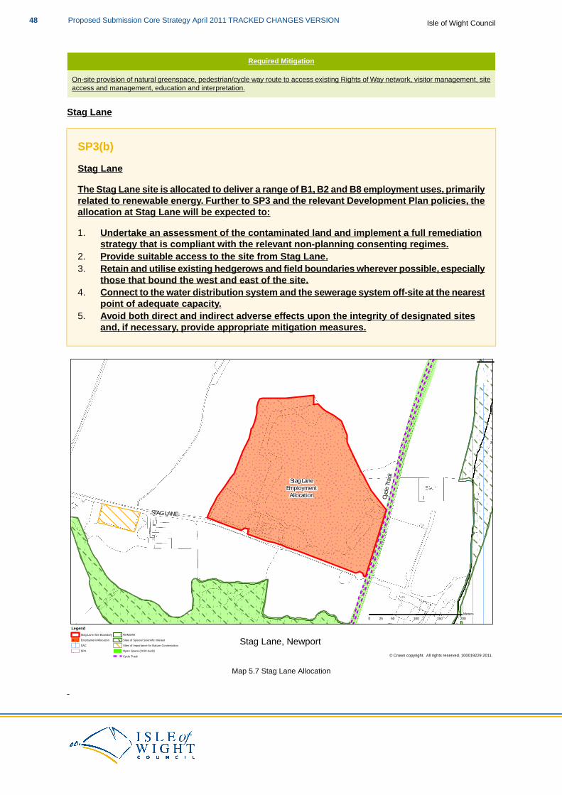
Required Mitigation
On-site provision of natural greenspace, pedestrian/cycle way route to access existing Rights of Way network, visitor management, siteaccess and management, education and interpretation.
Stag Lane
SP3(b)
Stag Lane
The Stag Lane site is allocated to deliver a range of B1, B2 and B8 employment uses, primarilyrelated to renewable energy. Further to SP3 and the relevant Development Plan policies, theallocation at Stag Lane will be expected to:
1. Undertake an assessment of the contaminated land and implement a full remediationstrategy that is compliant with the relevant non-planning consenting regimes.
2. Provide suitable access to the site from Stag Lane.3. Retain and utilise existing hedgerows and field boundaries wherever possible, especially
those that bound the west and east of the site.4. Connect to the water distribution system and the sewerage system off-site at the nearest
point of adequate capacity.5. Avoid both direct and indirect adverse effects upon the integrity of designated sites
and, if necessary, provide appropriate mitigation measures.
! ! ! ! ! ! !
! ! ! ! ! ! !
! ! ! ! ! ! !
! ! ! ! ! ! !
! ! ! ! ! ! !
! ! ! ! ! ! !
! ! ! ! ! ! !
! ! ! ! ! ! !
! ! ! ! ! ! !
! ! ! ! ! ! !
! ! ! ! ! ! !
! ! ! ! ! ! !
! ! ! ! ! ! !
! ! ! ! ! ! !
! ! ! ! ! ! !
! ! ! ! ! ! !
! ! ! ! ! ! !
! ! ! ! ! ! !
! ! ! ! ! ! !
! ! ! ! ! ! !
! ! ! ! ! ! !
! ! ! ! ! ! !
! ! ! ! ! ! !
! ! ! ! ! ! !
! ! ! ! ! ! !
! ! ! ! ! ! !
! ! ! ! ! ! !
! ! ! ! ! ! !
! ! ! ! ! ! !
! ! ! ! ! ! !
! ! ! ! ! ! !
! ! ! ! ! ! !
! ! ! ! ! ! !
! ! ! ! ! ! !
! ! ! ! ! ! !
! ! ! ! ! ! !
! ! ! ! ! ! !
! ! ! ! ! ! !
! ! ! ! ! ! ! ! ! ! ! ! ! ! ! ! ! ! ! ! ! ! ! ! ! ! ! ! ! ! ! ! ! ! ! ! ! ! ! ! ! ! ! ! ! ! ! ! ! ! ! ! ! ! ! ! ! ! ! ! !
! ! ! ! ! ! ! ! ! ! ! ! ! ! ! ! ! ! ! ! ! ! ! ! ! ! ! ! ! ! ! ! ! ! ! ! ! ! ! ! ! ! ! ! ! ! ! ! ! ! ! ! ! ! ! ! ! ! ! ! !
! ! ! ! ! ! ! ! ! ! ! ! ! ! ! ! ! ! ! ! ! ! ! ! ! ! ! ! ! ! ! ! ! ! ! ! ! ! ! ! ! ! ! ! ! ! ! ! ! ! ! ! ! ! ! ! ! ! ! ! !
! ! ! ! ! ! ! ! ! ! ! ! ! ! ! ! ! ! ! ! ! ! ! ! ! ! ! ! ! ! ! ! ! ! ! ! ! ! ! ! ! ! ! ! ! ! ! ! ! ! ! ! ! ! ! ! ! ! ! ! !
! ! ! ! ! ! ! ! ! ! ! ! ! ! ! ! ! ! ! ! ! ! ! ! ! ! ! ! ! ! ! ! ! ! ! ! ! ! ! ! ! ! ! ! ! ! ! ! ! ! ! ! ! ! ! ! ! ! ! ! !
! ! ! ! ! ! ! ! ! ! ! ! ! ! ! ! ! ! ! ! ! ! ! ! ! ! ! ! ! ! ! ! ! ! ! ! ! ! ! ! ! ! ! ! ! ! ! ! ! ! ! ! ! ! ! ! ! ! ! ! !
! ! ! ! ! ! ! ! ! ! ! ! ! ! ! ! ! ! ! ! ! ! ! ! ! ! ! ! ! ! ! ! ! ! ! ! ! ! ! ! ! ! ! ! ! ! ! ! ! ! ! ! ! ! ! ! ! ! ! ! !
! ! ! ! ! ! ! ! ! ! ! ! ! ! ! ! ! ! ! ! ! ! ! ! ! ! ! ! ! ! ! ! ! ! ! ! ! ! ! ! ! ! ! ! ! ! ! ! ! ! ! ! ! ! ! ! ! ! ! ! !
! ! ! ! ! ! ! ! ! ! ! ! ! ! ! ! ! ! ! ! ! ! ! ! ! ! ! ! ! ! ! ! ! ! ! ! ! ! ! ! ! ! ! ! ! ! ! ! ! ! ! ! ! ! ! ! ! ! ! ! !
! ! ! ! ! ! ! ! ! ! ! ! ! ! ! ! ! ! ! ! ! ! ! ! ! ! ! ! ! ! ! ! ! ! ! ! ! ! ! ! ! ! ! ! ! ! ! ! ! ! ! ! ! ! ! ! ! ! ! ! !
! ! ! ! ! ! ! ! ! ! ! ! ! ! ! ! ! ! ! ! ! ! ! ! ! ! ! ! ! ! ! ! ! ! ! ! ! ! ! ! ! ! ! ! ! ! ! ! ! ! ! ! ! ! ! ! ! ! ! ! !
! ! ! ! ! ! ! ! ! ! ! ! ! ! ! ! ! ! ! ! ! ! ! ! ! ! ! ! ! ! ! ! ! ! ! ! ! ! ! ! ! ! ! ! ! ! ! ! ! ! ! ! ! ! ! ! ! ! ! ! !
! ! ! ! ! ! ! ! ! ! ! ! ! ! ! ! ! ! ! ! ! ! ! ! ! ! ! ! ! ! ! ! ! ! ! ! ! ! ! ! ! ! ! ! ! ! ! ! ! ! ! ! ! ! ! ! ! ! ! ! !
! ! ! ! ! ! ! ! ! ! ! ! ! ! ! ! ! ! ! ! ! ! ! ! ! ! ! ! ! ! ! ! ! ! ! ! ! ! ! ! ! ! ! ! ! ! ! ! ! ! ! ! ! ! ! ! ! ! ! ! !
! ! ! ! ! ! ! ! ! ! ! ! ! ! ! ! ! ! ! ! ! ! ! ! ! ! ! ! ! ! ! ! ! ! ! ! ! ! ! ! ! ! ! ! ! ! ! ! ! ! ! ! ! ! ! ! ! ! ! ! !
! ! ! ! ! ! ! ! ! ! ! ! ! ! ! ! ! ! ! ! ! ! ! ! ! ! ! ! ! ! ! ! ! ! ! ! ! ! ! ! ! ! ! ! ! ! ! ! ! ! ! ! ! ! ! ! ! ! ! ! !
! ! ! ! ! ! ! ! ! ! ! ! ! ! ! ! ! ! ! ! ! ! ! ! ! ! ! ! ! ! ! ! ! ! ! ! ! ! ! ! ! ! ! ! ! ! ! ! ! ! ! ! ! ! ! ! ! ! ! ! !
! ! ! ! ! ! ! ! ! ! ! ! ! ! ! ! ! ! ! ! ! ! ! ! ! ! ! ! ! ! ! ! ! ! ! ! ! ! ! ! ! ! ! ! ! ! ! ! ! ! ! ! ! ! ! ! ! ! ! ! !
! ! ! ! ! ! ! ! ! ! ! ! ! ! ! ! ! ! ! ! ! ! ! ! ! ! ! ! ! ! ! ! ! ! ! ! ! ! ! ! ! ! ! ! ! ! ! ! ! ! ! ! ! ! ! ! ! ! ! ! !
! ! ! ! ! ! ! ! ! ! ! ! ! ! ! ! ! ! ! ! ! ! ! ! ! ! ! ! ! ! ! ! ! ! ! ! ! ! ! ! ! ! ! ! ! ! ! ! ! ! ! ! ! ! ! ! ! ! ! ! !
! ! ! ! ! ! ! ! ! ! ! ! ! ! ! ! ! ! ! ! ! ! ! ! ! ! ! ! ! ! ! ! ! ! ! ! ! ! ! ! ! ! ! ! ! ! ! ! ! ! ! ! ! ! ! ! ! ! ! ! !
! ! ! ! ! ! ! ! ! ! ! ! ! ! ! ! ! ! ! ! ! ! ! ! ! ! ! ! ! ! ! ! ! ! ! ! ! ! ! ! ! ! ! ! ! ! ! ! ! ! ! ! ! ! ! ! ! ! ! ! !
! ! ! ! ! ! ! ! ! ! ! ! ! ! ! ! ! ! ! ! ! ! ! ! ! ! ! ! ! ! ! ! ! ! ! ! ! ! ! ! ! ! ! ! ! ! ! ! ! ! ! ! ! ! ! ! ! ! ! ! !
! ! ! ! ! ! ! ! ! ! ! ! ! ! ! ! ! ! ! ! ! ! ! ! ! ! ! ! ! ! ! ! ! ! ! ! ! ! ! ! ! ! ! ! ! ! ! ! ! ! ! ! ! ! ! ! ! ! ! ! !
! ! ! ! ! ! ! ! ! ! ! ! ! ! ! ! ! ! ! ! ! ! ! ! ! ! ! ! ! ! ! ! ! ! ! ! ! ! ! ! ! ! ! ! ! ! ! ! ! ! ! ! ! ! ! ! ! ! ! ! !
! ! ! ! ! ! ! ! ! ! ! ! ! ! ! ! ! ! ! ! ! ! ! ! ! ! ! ! ! ! ! ! ! ! ! ! ! ! ! ! ! ! ! ! ! ! ! ! ! ! ! ! ! ! ! ! ! ! ! ! !
! ! ! ! ! ! ! ! ! ! ! ! ! ! ! ! ! ! ! ! ! ! ! ! ! ! ! ! ! ! ! ! ! ! ! ! ! ! ! ! ! ! ! ! ! ! ! ! ! ! ! ! ! ! ! ! ! ! ! ! !
! ! ! ! ! ! ! ! ! ! ! ! ! ! ! ! ! ! ! ! ! ! ! ! ! ! ! ! ! ! ! ! ! ! ! ! ! ! ! ! ! ! ! ! ! ! ! ! ! ! ! ! ! ! ! ! ! ! ! ! !
! ! ! ! ! ! ! ! ! ! ! ! ! ! ! ! ! ! ! ! ! ! ! ! ! ! ! ! ! ! ! ! ! ! ! ! ! ! ! ! ! ! ! ! ! ! ! ! ! ! ! ! ! ! ! ! ! ! ! ! !
! ! ! ! ! ! ! ! ! ! ! ! ! ! ! ! ! ! ! ! ! ! ! ! ! ! ! ! ! ! ! ! ! ! ! ! ! ! ! ! ! ! ! ! ! ! ! ! ! ! ! ! ! ! ! ! ! ! ! ! !
! ! ! ! ! ! ! ! ! ! ! ! ! ! ! ! ! ! ! ! ! ! ! ! ! ! ! ! ! ! ! ! ! ! ! ! ! ! ! ! ! ! ! ! ! ! ! ! ! ! ! ! ! ! ! ! ! ! ! ! !
! ! ! ! ! ! ! ! ! ! ! ! ! ! ! ! ! ! ! ! ! ! ! ! ! ! ! ! ! ! ! ! ! ! ! ! ! ! ! ! ! ! ! ! ! ! ! ! ! ! ! ! ! ! ! ! ! ! ! ! !
! ! ! ! ! ! ! ! ! ! ! ! ! ! ! ! ! ! ! ! ! ! ! ! ! ! ! ! ! ! ! ! ! ! ! ! ! ! ! ! ! ! ! ! ! ! ! ! ! ! ! ! ! ! ! ! ! ! ! ! !
! ! ! ! ! ! ! ! ! ! ! ! ! ! ! ! ! ! ! ! ! ! ! ! ! ! ! ! ! ! ! ! ! ! ! ! ! ! ! ! ! ! ! ! ! ! ! ! ! ! ! ! ! ! ! ! ! ! ! ! !
! ! ! ! ! ! ! ! ! ! ! ! ! ! ! ! ! ! ! ! ! ! ! ! ! ! ! ! ! ! ! ! ! ! ! ! ! ! ! ! ! ! ! ! ! ! ! ! ! ! ! ! ! ! ! ! ! ! ! ! !
! ! ! ! ! ! ! ! ! ! ! ! ! ! ! ! ! ! ! ! ! ! ! ! ! ! ! ! ! ! ! ! ! ! ! ! ! ! ! ! ! ! ! ! ! ! ! ! ! ! ! ! ! ! ! ! ! ! ! ! !
! ! ! ! ! ! ! ! ! ! ! ! ! ! ! ! ! ! ! ! ! ! ! ! ! ! ! ! ! ! ! ! ! ! ! ! ! ! ! ! ! ! ! ! ! ! ! ! ! ! ! ! ! ! ! ! ! ! ! ! !
! ! ! ! ! ! ! ! ! ! ! ! ! ! ! ! ! ! ! ! ! ! ! ! ! ! ! ! ! ! ! ! ! ! ! ! ! ! ! ! ! ! ! ! ! ! ! ! ! ! ! ! ! ! ! ! ! ! ! ! !
Cycle T
rack
STAG LANE
Stag LaneEmployment
Allocation
0 50 100 150 20025Meters
¯
© Crown copyright. All rights reserved. 100019229 2011.
Stag Lane, NewportLegend
Stag Lane Site BoundaryEmployment AllocationSAC
! !SPA
! ! !
! ! ! RAMSARSites of Special Scientific InterestSites of Importance for Nature ConservationOpen Space (2010 Audit)Cycle Track
Map 5.7 Stag Lane Allocation
Isle of Wight CouncilProposed Submission Core Strategy April 2011 TRACKED CHANGES VERSION48
The 8.8ha site at Stag Lane in Newport (as shown on the proposals map and above) is under Councilownership and directly adjacent to the recently approved Vestas Research and Development facility(currently under construction).The Council is promoting this brownfield site within the Medina Valley KeyRegeneration Area for B1, B2 and B8 uses, particularly supporting renewable energy technologies andschemes.
The site is an historic landfill and any scheme will need to include a full remediation strategy.The approachtaken towards the site by the Council is in conformity with PPS23: Planning and Pollution Control and isbased on the precautionary principle. Due to the site being an historic landfill site it is reasonable tosuspect contamination. In light of this and in line with PPS23, the Council will require at least a deskstudy of the readily available records assessing the previous uses of the site and their potential forcontamination in relation to the proposed employment uses for the site.
It is expected that such exploratory assessment of the site will confirm the potential for contamination,and therefore further studies by the developer will be required to assess the risks and identify and appraisethe options for remediation, should it be required. Planning permission is not the only consenting regimethat will be required to bring forward development on the site, therefore proposals will need to complywith the relevant non-planning consenting regimes to the satisfaction of the relevant regulatory bodies.
Access to the site will be provided from Stag Lane. Recent improvements to the junction of Stag Laneand Horsebridge Hill provide suitable access to the site from the Island's Strategic Road Network.
The site has a number of strong external boundaries in the form of existing hedgerows and the Councilwould expect to see these retained, especially to the east of the site where the existing hedgerow andwooded area are bounded by the Newport/Cowes cycle track (bridleway R207). The cycle track runsalong the route of a dismantled railway line and is one of the most popular public rights of way routeson the Island and forms an integral part of the sustainable transport network on the Island.
The site is in close proximity to the Solent and Southampton Special Protection Area (SPA) and Ramsarsite, the Solent Maritime Special Area of Conservation (SAC) and the Medina Estuary Site of SpecialScientific Interest (SSSI).Whilst a strategic assessment undertaken by the Council, through the HabitatsRegulation Assessment, indicates no likely significant adverse effect it does highlight that there is potentialfor a loss of supporting habitat and disturbance of bird species. However, this depends on the details ofthe proposal and it is considered that should mitigation be required it can be provided and incorporatedinto the final detailed development proposals.
It is understood from discussions with Southern Water that there are no local sewers or water mains inthe vicinity of the site, but there is infrastructure within 500 to 800 metres of the former tip. Therefore,the development will need to connect to the water distribution system and the sewerage system at thenearest point of adequate capacity, which will need to be determined at the planning application stage.
A developer is currently working on a potential scheme for the site and it is possible that applications forthe site may be received in advance of the Core Strategy being adopted.
On-site provision of natural greenspace, pedestrian/cycle way route to access existing Rights of Waynetwork, visitor management, site access and management, education and interpretation.
SP3(b) and Habitat Regulations Assessment
Following the recommendations of the Habitat Regulations Assessment of the Core Strategy, proposalsthat relate to this policy should consider the need for mitigation measures. This will be dependent uponthe type of proposal to which the Core Strategy policies are being applied and the proximity of thedevelopment proposal to European and Ramsar sites.
The likely mitigation measures required are set out in the following table:
49Proposed Submission Core Strategy April 2011 TRACKED CHANGES VERSIONIsle of Wight Council
Required Mitigation
Provision of appropriate greenspace buffer strip with the following elements; an area of no access, visitor management, site access andmanagement, education and interpretation.
East of Pan Lane
SP3(c)
East of Pan Lane
The East of Pan Lane site is allocated to deliver a range of B1 and B2 uses suitable to amixed-use scheme. Further to SP3 and the relevant Development Plan policies, the allocationeast of Pan Lane will be expected to:
1. Provide the internal infrastructure of the site from the Pan Meadows spine road.2. Integrate the new employment provision with the existing, to ensure a coherent provision
of employment uses.3. Minimise impact on existing properties by ensuring the most compatible uses are
suitably located and to provide appropriate landscape buffering between newdevelopment and existing residential properties.
4. Retain the southern end of the site to be used to provide the bridleway link (beingdelivered through the wider Pan Meadows development) and a suitable buffer betweennew development and the new country park.
5. Maintain the hedgerow along Pan Lane on the western edge of the site.6. Connect to the water distribution system off-site at the nearest point of adequate
capacity.7. Avoid both direct and indirect adverse effects upon the integrity of designated sites
and, if necessary, provide appropriate mitigation measures.
Isle of Wight CouncilProposed Submission Core Strategy April 2011 TRACKED CHANGES VERSION50
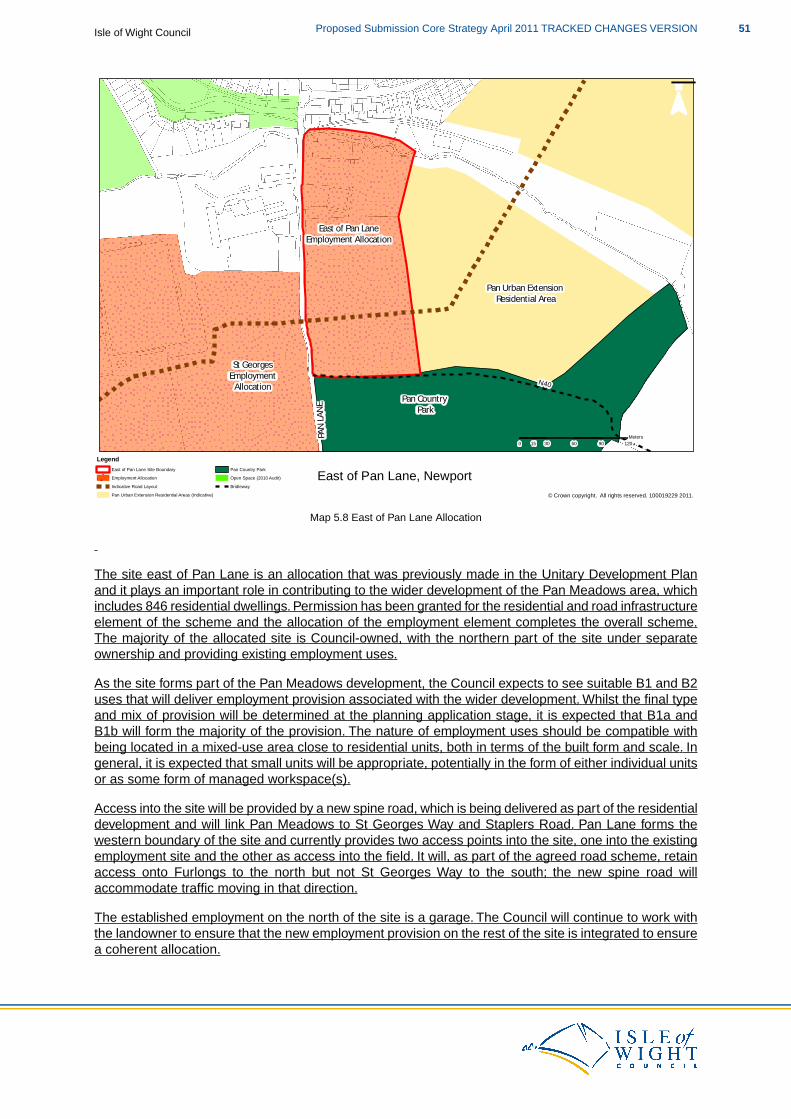
PAN LA
NE
Pan Urban Extension Residential Area
Pan Country Park
East of Pan LaneEmployment Allocation
St GeorgesEmployment
Allocation N40
0 30 60 90 12015Meters
¯
© Crown copyright. All rights reserved. 100019229 2011.
East of Pan Lane, NewportLegend
East of Pan Lane Site BoundaryEmployment AllocationIndicative Road LayoutPan Urban Extension Residential Areas (Indicative)
Pan Country ParkOpen Space (2010 Audit)Bridleway
Map 5.8 East of Pan Lane Allocation
The site east of Pan Lane is an allocation that was previously made in the Unitary Development Planand it plays an important role in contributing to the wider development of the Pan Meadows area, whichincludes 846 residential dwellings. Permission has been granted for the residential and road infrastructureelement of the scheme and the allocation of the employment element completes the overall scheme.The majority of the allocated site is Council-owned, with the northern part of the site under separateownership and providing existing employment uses.
As the site forms part of the Pan Meadows development, the Council expects to see suitable B1 and B2uses that will deliver employment provision associated with the wider development. Whilst the final typeand mix of provision will be determined at the planning application stage, it is expected that B1a andB1b will form the majority of the provision. The nature of employment uses should be compatible withbeing located in a mixed-use area close to residential units, both in terms of the built form and scale. Ingeneral, it is expected that small units will be appropriate, potentially in the form of either individual unitsor as some form of managed workspace(s).
Access into the site will be provided by a new spine road, which is being delivered as part of the residentialdevelopment and will link Pan Meadows to St Georges Way and Staplers Road. Pan Lane forms thewestern boundary of the site and currently provides two access points into the site, one into the existingemployment site and the other as access into the field. It will, as part of the agreed road scheme, retainaccess onto Furlongs to the north but not St Georges Way to the south; the new spine road willaccommodate traffic moving in that direction.
The established employment on the north of the site is a garage. The Council will continue to work withthe landowner to ensure that the new employment provision on the rest of the site is integrated to ensurea coherent allocation.
51Proposed Submission Core Strategy April 2011 TRACKED CHANGES VERSIONIsle of Wight Council
It is expected that a detailed scheme will be designed to minimise disturbance (both visual and noise)and impact on amenity to existing properties and that this will be achieved by ensuring that the mostcompatible uses are located nearer to the existing residential properties. Furthermore, appropriatelandscape buffering between the new development and the existing residential properties will be provided.
At the southern edge of the site is the route of an existing bridleway (N40) that will link with a new footpaththat will run along the edge of the Pan Meadows development and the country park.This area, indicatedon the Proposals Map, will be safeguarded for the retention of the bridleway and to provide an appropriatebuffer between the employment site and the country park.
The site has a well-established hedgerow on its western edge and the Council wishes to see this retained,particularly as it forms the external boundary of the site that fronts onto a public highway.
Discussions with the statutory provider show that there is insufficient existing capacity in the waterdistribution system to meet the anticipated demand arising from the development, but off-site infrastructureto connect to the nearest point of adequate capacity would provide the additional local sewerage capacityrequired. Therefore, the development will need to provide the additional local water distribution capacitynecessary and this should be achieved through working with Southern Water.
Proposals will be expected to demonstrate how they avoid both direct and indirect adverse effects uponthe integrity of designated sites and, if necessary, provide appropriate mitigation measures.
SP3(c) and Habitat Regulations Assessment
Following the recommendations of the Habitat Regulations Assessment of the Core Strategy, proposalsthat relate to this policy should consider the need for mitigation measures. This will be dependent uponthe type of proposal to which the Core Strategy policies are being applied and the proximity of thedevelopment proposal to European and Ramsar sites.
The likely mitigation measures required are set out in the following table:
Required Mitigation
Specific mitigation such as recreational provision and provision of supporting habitats as well as visitor management, site access andmanagement, education and interpretation.
South of Nicholson Road
SP3(d)
South of Nicholson Road
The South of Nicholson Road site is allocated to deliver a mix of primarily smaller scale B1and B2 uses. Further to SP3 and the relevant Development Plan policies, the allocation atStag Lane will be expected to:
1. Provide access to the site from Nicholson Road and examine the suitability of asecondary access point onto Smallbrook Lane.
2. Develop the site in a phased approach, working out from the centre of the site.3. Minimise impact on existing properties by ensuring the most compatible uses are
suitably located and to provide appropriate landscape buffering between newdevelopment and existing residential properties.
4. Maintain the existing rights of way network on the site and examine the possibility ofimproving footpath R52a, in line with the Rights of Way Improvement Plan.
5. Retain and utilise existing hedgerows and field boundaries wherever possible, especiallythose that form the external boundary of the site.
Isle of Wight CouncilProposed Submission Core Strategy April 2011 TRACKED CHANGES VERSION52
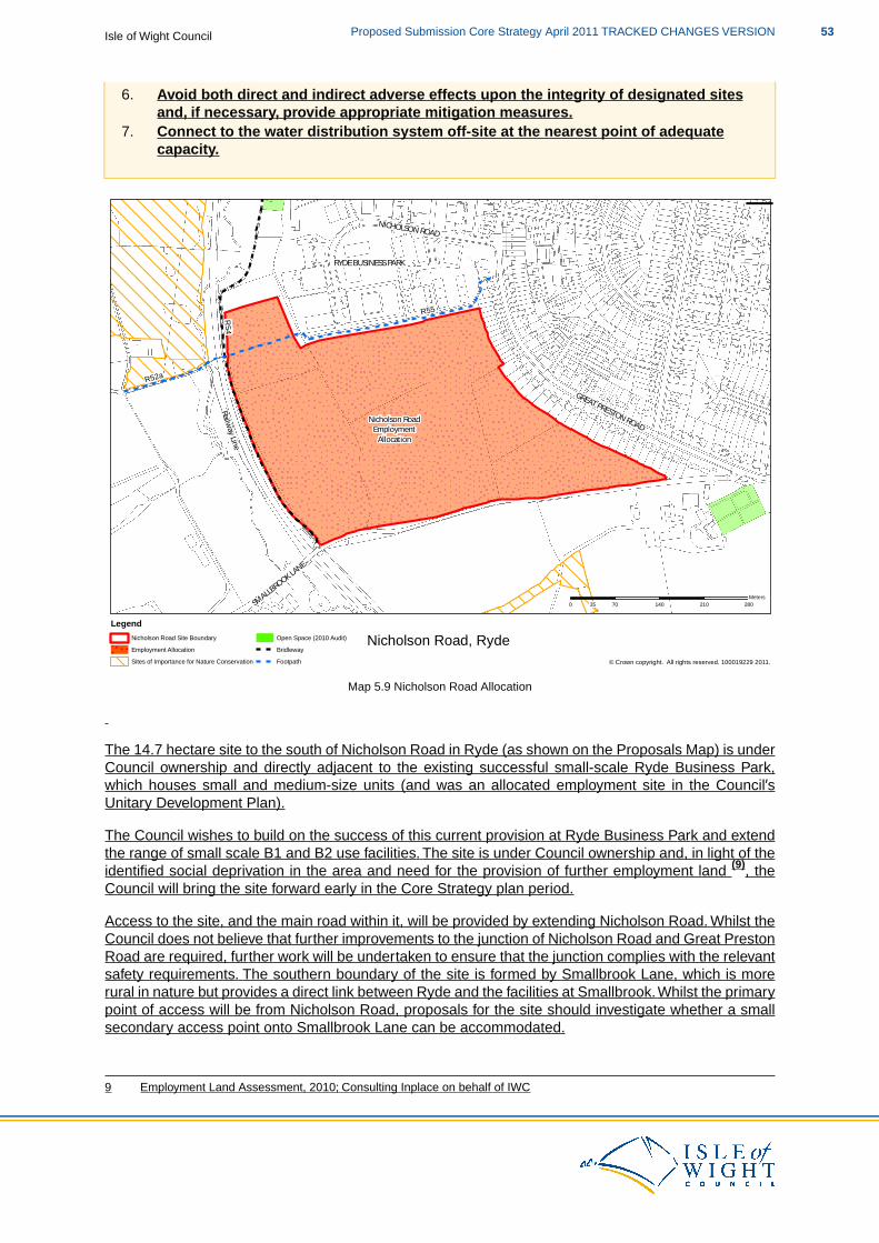
6. Avoid both direct and indirect adverse effects upon the integrity of designated sitesand, if necessary, provide appropriate mitigation measures.
7. Connect to the water distribution system off-site at the nearest point of adequatecapacity.
RYDE BUSINESS PARK
SMALLBROOK LANE
GREAT PRESTON ROAD
NICHOLSON ROAD
Railway Line
Nicholson RoadEmployment
Allocation
R55
R52a
R54
0 70 140 210 28035Meters
¯
© Crown copyright. All rights reserved. 100019229 2011.
Nicholson Road, RydeLegend
Nicholson Road Site BoundaryEmployment AllocationSites of Importance for Nature Conservation
Open Space (2010 Audit)BridlewayFootpath
Map 5.9 Nicholson Road Allocation
The 14.7 hectare site to the south of Nicholson Road in Ryde (as shown on the Proposals Map) is underCouncil ownership and directly adjacent to the existing successful small-scale Ryde Business Park,which houses small and medium-size units (and was an allocated employment site in the Council’sUnitary Development Plan).
The Council wishes to build on the success of this current provision at Ryde Business Park and extendthe range of small scale B1 and B2 use facilities. The site is under Council ownership and, in light of theidentified social deprivation in the area and need for the provision of further employment land (9), theCouncil will bring the site forward early in the Core Strategy plan period.
Access to the site, and the main road within it, will be provided by extending Nicholson Road. Whilst theCouncil does not believe that further improvements to the junction of Nicholson Road and Great PrestonRoad are required, further work will be undertaken to ensure that the junction complies with the relevantsafety requirements. The southern boundary of the site is formed by Smallbrook Lane, which is morerural in nature but provides a direct link between Ryde and the facilities at Smallbrook.Whilst the primarypoint of access will be from Nicholson Road, proposals for the site should investigate whether a smallsecondary access point onto Smallbrook Lane can be accommodated.
9 Employment Land Assessment, 2010; Consulting Inplace on behalf of IWC
53Proposed Submission Core Strategy April 2011 TRACKED CHANGES VERSIONIsle of Wight Council
The development will be designed to provide the most efficient use of the land, with the majority of theemployment provision located in the centre of the site.A phased approach to the delivery of the site willhelp to ensure a steady supply of employment land and facilities to meet the demand and that the unitsbeing delivered are meeting the needs of Island employers.
It is expected that a detailed scheme will be designed to minimise disturbance (both visual and noise)and impact on amenity to existing properties and that this will be achieved by ensuring that the mostcompatible uses are located nearer to the existing residential properties. Furthermore, appropriatelandscape buffering between the new development and the existing residential properties will be provided.
A footpath (R55) runs across the site along its northern edge and a bridleway (R54) along the length ofits western edge. R55 provides east/west access from the urban edge of Ryde into the wider rights ofway network and the countryside beyond. The Council will expect that the footpath will be maintained,although an amended route incorporated within the site could be considered. Both R54 and R55 link toR52a, a footpath which crosses the railway line. The Isle of Wight Rights of Way Improvement Plan hasidentified opportunities to improve R52a by implementing safety improvements to the footpath where itcrosses the railway line and the potential to upgrade it to a bridleway to help create improved links intothe Swanmore area. Development proposals will be expected to examine how the development canpositively contribute to achieving these aims.
The site has a number of strong external and internal boundaries, particularly the western and southernexternal boundaries and the north/south elements of the internal field boundaries.The external boundariesshould be retained and improved, where possible and appropriate, to contribute to the buffering outlinedin point 3 of SP3(d). The stronger internal field boundaries should be retained and should be used toinform the overall layout of the site and the approach to phasing.
Proposals will be expected to demonstrate how they avoid both direct and indirect adverse effects uponthe integrity of designated sites and, if necessary, provide appropriate mitigation measures.
Discussions with the statutory provider show that there is insufficient existing capacity in the waterdistribution system to meet the anticipated demand arising from the development, but off-site infrastructureto connect to the nearest point of adequate capacity would provide the additional local water distributioncapacity required. Therefore, the development will need to provide the additional local water distributioncapacity necessary and this should be achieved through working with Southern Water.
SP3(d) and Habitat Regulations Assessment
Following the recommendations of the Habitat Regulations Assessment of the Core Strategy, proposalsthat relate to this policy should consider the need for mitigation measures. This will be dependent uponthe type of proposal to which the Core Strategy policies are being applied and the proximity of thedevelopment proposal to European and Ramsar sites.
The likely mitigation measures required are set out in the following table:
Required Mitigation
Specific mitigation such as recreational provision and provision of supporting habitats as well as visitor management, site access andmanagement, education and interpretation.
St George’s Way
SP3(e)
St George’s Way
The St Georges Way site is allocated to deliver 150,000 ft2 (gross) of commercial floorspace(including the possibility of a petrol filling station) and 3,000 ft2 (gross) of leisure uses. Further
Isle of Wight CouncilProposed Submission Core Strategy April 2011 TRACKED CHANGES VERSION54
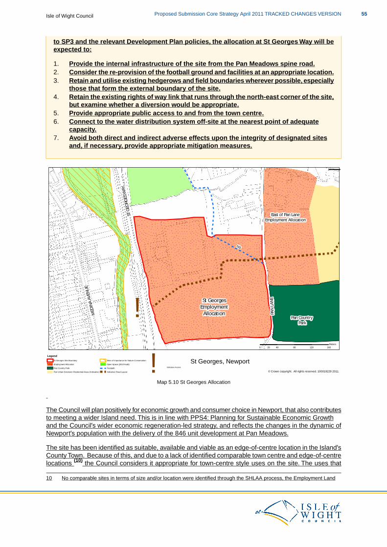
to SP3 and the relevant Development Plan policies, the allocation at St Georges Way will beexpected to:
1. Provide the internal infrastructure of the site from the Pan Meadows spine road.2. Consider the re-provision of the football ground and facilities at an appropriate location.3. Retain and utilise existing hedgerows and field boundaries wherever possible, especially
those that form the external boundary of the site.4. Retain the existing rights of way link that runs through the north-east corner of the site,
but examine whether a diversion would be appropriate.5. Provide appropriate public access to and from the town centre.6. Connect to the water distribution system off-site at the nearest point of adequate
capacity.7. Avoid both direct and indirect adverse effects upon the integrity of designated sites
and, if necessary, provide appropriate mitigation measures.
!
ST GE
ORGE
S WAY
PAN LA
NE
MEDIN
A AVE
NUE
Pan Urban Extension Residential Area
Pan Country Park
East of Pan LaneEmployment Allocation
St GeorgesEmployment
Allocation
N9
0 40 80 120 16020Meters
¯
© Crown copyright. All rights reserved. 100019229 2011.
St Georges, NewportLegend
St Georges Site BoundaryEmployment AllocationPan Country ParkPan Urban Extension Residential Areas (Indicative)
Sites of Importance for Nature ConservationOpen Space (2010 Audit)FootpathIndicative Road Layout !Indicative Access
Map 5.10 St Georges Allocation
The Council will plan positively for economic growth and consumer choice in Newport, that also contributesto meeting a wider Island need. This is in line with PPS4: Planning for Sustainable Economic Growthand the Council’s wider economic regeneration-led strategy, and reflects the changes in the dynamic ofNewport’s population with the delivery of the 846 unit development at Pan Meadows.
The site has been identified as suitable, available and viable as an edge-of-centre location in the Island’sCounty Town. Because of this, and due to a lack of identified comparable town centre and edge-of-centrelocations (10) the Council considers it appropriate for town-centre style uses on the site. The uses that
10 No comparable sites in terms of size and/or location were identified through the SHLAA process, the Employment Land
55Proposed Submission Core Strategy April 2011 TRACKED CHANGES VERSIONIsle of Wight Council
will come forward through the St Georges allocation are expected to be based upon the types of retailand leisure uses set out in Appendix B of PPS4: Planning for Sustainable Economic Growth (11).
The policy allocates land at St George’s Way for retail and leisure uses, the exact type, scale and splitof which will be determined through a market-led development brief. The Council is confident that thisapproach will create wealth and jobs, whilst providing a level of flexibility that is required to stimulateeconomic development and job creation at a time when the economy is generally depressed.
Through granting approval for 846 residential units at Pan Meadows, the Council has secured the deliveryof a spine road which runs through the development and connects onto St Georges Way. A newroundabout will be built on land under Council ownership to link the spine road and St Georges Way andthis will provide the main access into the allocated site. The roundabout has been modelled and themodelling indicated that there is no fundamental reason why a roundabout of sufficient capacity couldnot be provided on St Georges Way. Further, more detailed, layout work may be required to determinethe precise layout but, as the land which may be required to accommodate any changes to the roundaboutis under Council ownership no delivery issues are anticipated.
The allocation includes land that is currently the Island's largest football ground, with a football pitch andcapacity for 3,200 spectators and is home to Newport Football Club. This part of the site is identified asopen space (outdoor sports facilities) through the Council's 2010 Open Space, Sport and RecreationAudit. Further to the Audit a Playing Pitch Assessment and Strategy (December 2010) has beenundertaken, which assessed the quality and quantity of playing pitches across the Island. The PlayingPitch Assessment categorises St Georges Stadium as a private football club for senior football. Itrecognises that it is a high quality facility and identifies it as a 'Priority Sports Pitch'.
However, due to the methodology used (in line with best practice) the existing provision standards in theAudit do not take account of school facilities. As part of the Schools Reorganisation Programme for theIsland, sport and recreation facilities at schools will be required to be more accessible to the communitywhich changes the dynamic of open space, sport and recreation provision. Because of this it is notconsidered that the loss of a private facility would result in a deficiency within the Medina area.
Whilst the loss of such a facility is acceptable in principle, the Council will expect the re-provision of asimilar facility at an alternative location within Newport and will work with interested parties to achievethis. Development occurring on this part of the site will also be expected to provide financial contributionstowards the enhancement of changing facilities and towards the maintenance of the re-provision andenhancement of the changing facilities for the duration of the plan period.
Footpath N9 runs through the north-east corner of the site, which provides an important link out of Newportinto the wider countryside and the Pan Country Park. Because of this the Council would not want to seethe footpath lost, but does acknowledge that if it is required an appropriate diversion (perhaps towardsthe edge of the site) could be beneficial.
As set out earlier, the site is an edge-of-centre location and because of this it is expected that thedevelopment proposals will address the issue of appropriate public access to and from the town centre.The success of this site and the ongoing viability and vitality of the town centre will rely heavily on goodconnectivity between the two by means of easy pedestrian access. The Council will expect proposals to
Demand Study (2008) or the Employment Land Assessment (2010).11 Retail Convenience Shopping: convenience retailing is the provision of everyday essential items, including food, drinks,
newspapers/magazines and confectionery. Supermarkets: self-service stores selling mainly food, with a trading floorspaceof less the 2,500m2, often with car parking. Superstores: self-service stores selling mainly food, or food and non-food goods,usually with more than 2,500m2 trading floorspace, with supporting car parking. Comparison shopping: comparison retailingis the provision of items not obtained on a frequent basis. These include clothing, footwear, household and recreationalgoods. Retail warehouses: large stores specialising in the sale of household goods (such as carpets, furniture and electricalgoods), DIY items and other ranges of goods, catering for mainly car-borne customers. Retail parks: an agglomeration ofat least three retail warehouses. Warehouse clubs: large businesses specialising in volume sales of reduced priced goodsin which the operator may limit access to businesses, organisations or classes of individual. Factory outlet centres: groupsof shops specialising in selling seconds and end-of-line goods at discounted prices. Regional and sub-regional shoppingcentres: out-of-centre shopping centres which are generally over 50,000m2 gross retail area typically comprising a widevariety of comparison goods stores. Leisure Leisure parks: leisure parks often feature a mix of leisure facilities, such as amultiscreen cinema, indoor bowling centres, night club, restaurants, bars and fast-food outlets, with car parking.
Isle of Wight CouncilProposed Submission Core Strategy April 2011 TRACKED CHANGES VERSION56
address this issue in an innovative manner that doesn't necessarily solely rely on the existing rights ofway network and may involve re-modelling St Georges Approach and/or St Georges Way to providemore suitable and integrated vehicular and pedestrian access.
Discussions with the statutory provider show that there is insufficient existing capacity in the waterdistribution system to meet the anticipated demand arising from the development, but off-site infrastructureto connect to the nearest point of adequate capacity would provide the additional local sewerage capacityrequired. Therefore, the development will need to provide the additional local water distribution capacitynecessary and this should be achieved through working with Southern Water.
The allocated site is owned by two separate bodies, one of which is the Council. Both land owners willwork together to prepare a comprehensive development brief for the site and it is possible that applicationsfor the site may be received in advance of the Core Strategy being adopted.
Proposals will be expected to demonstrate how they avoid both direct and indirect adverse effects uponthe integrity of designated sites and, if necessary, provide appropriate mitigation measures.
A developer is currently working on a potential scheme for the site and it is possible that applications forthe site may be received in advance of the Core Strategy being adopted.
SP3(e) and Habitat Regulations Assessment
Following the recommendations of the Habitat Regulations Assessment of the Core Strategy, proposalsthat relate to this policy should consider the need for mitigation measures. This will be dependent uponthe type of proposal to which the Core Strategy policies are being applied and the proximity of thedevelopment proposal to European and Ramsar sites.
The likely mitigation measures required are set out in the following table:
Required Mitigation
Specific mitigation such as recreational provision and provision of supporting habitats as well as visitor management, site access andmanagement, education and interpretation.
Why
Evidence shows this to be the right approach to meet the aspirations and economic targets for the Island.
Our employment evidence base (the Employment Land Assessment, 2010) advises that the amount ofavailable employment land is much less than we originally thought in the 2008 Employment Land Study(around 20 ha, rather than around 31 ha). Not only is there less available land, there are also issuesover the deliverability of the available land caused by the recession.
There are two large sites that already have planning permission for employment uses, and the deliveryof these sites within the Medina Valley Key Regeneration Area is important to the economic prosperityof the Island and to achieving the economic-led growth the Council is advocating.
The two sites are the Island Technology Park at Whippingham and land at Kingston, East Cowes andthe Council will work with the landowners and agents of the sites to bring them forward for developmentin the short to medium term.
The Employment Land Assessment also shows us that there is less demand for employment land thanidentified in 2008, prior to the recession. However, the upper end of the 2010 demand projections (42ha) is about the same as the lower end of the 2008 demand projections (43 ha). This demonstrates thata minimum of 42 ha should be delivered, with the potential for more if the economic conditions dictate.Certainty over the provision of employment land on the Isle of Wight for the next 15 years will help bringthe Island out of the recession and grow towards its economic targets.
Therefore, the Council does not want to under-supply employment land to the market, although this must
57Proposed Submission Core Strategy April 2011 TRACKED CHANGES VERSIONIsle of Wight Council
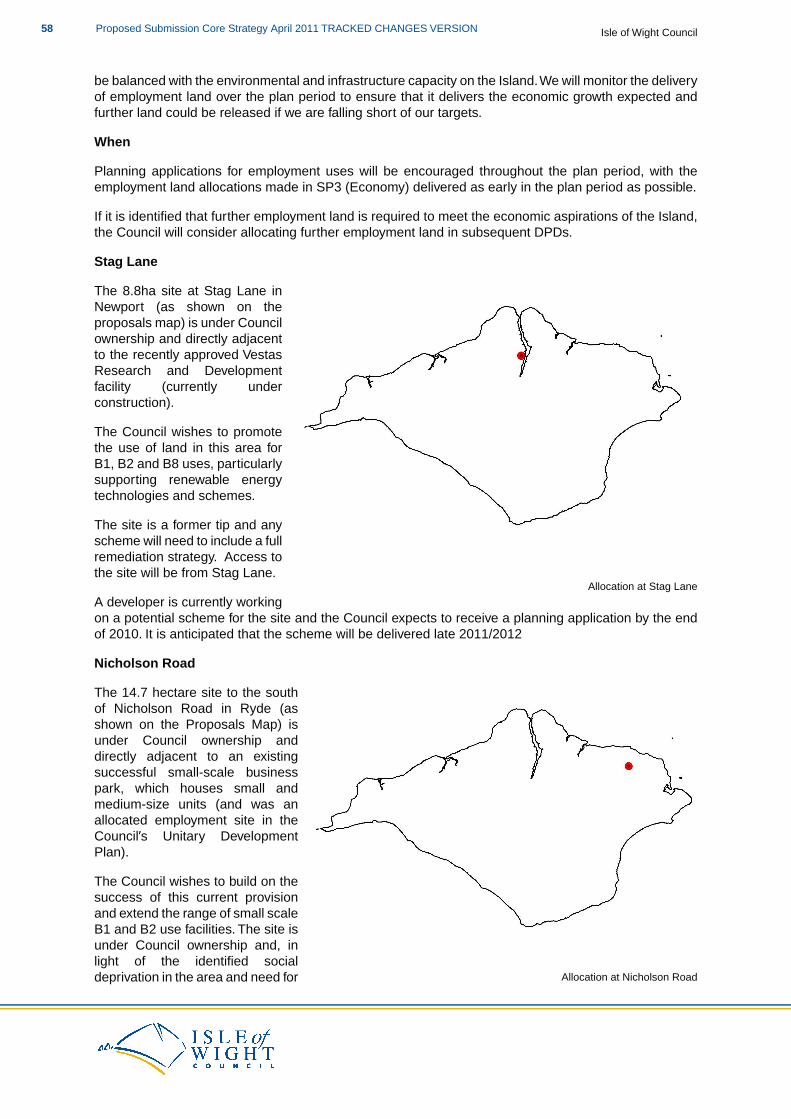
be balanced with the environmental and infrastructure capacity on the Island.We will monitor the deliveryof employment land over the plan period to ensure that it delivers the economic growth expected andfurther land could be released if we are falling short of our targets.
When
Planning applications for employment uses will be encouraged throughout the plan period, with theemployment land allocations made in SP3 (Economy) delivered as early in the plan period as possible.
If it is identified that further employment land is required to meet the economic aspirations of the Island,the Council will consider allocating further employment land in subsequent DPDs.
Stag Lane
Allocation at Stag Lane
The 8.8ha site at Stag Lane inNewport (as shown on theproposals map) is under Councilownership and directly adjacentto the recently approved VestasResearch and Developmentfacility (currently underconstruction).
The Council wishes to promotethe use of land in this area forB1, B2 and B8 uses, particularlysupporting renewable energytechnologies and schemes.
The site is a former tip and anyscheme will need to include a fullremediation strategy. Access tothe site will be from Stag Lane.
A developer is currently workingon a potential scheme for the site and the Council expects to receive a planning application by the endof 2010. It is anticipated that the scheme will be delivered late 2011/2012
Nicholson Road
Allocation at Nicholson Road
The 14.7 hectare site to the southof Nicholson Road in Ryde (asshown on the Proposals Map) isunder Council ownership anddirectly adjacent to an existingsuccessful small-scale businesspark, which houses small andmedium-size units (and was anallocated employment site in theCouncil’s Unitary DevelopmentPlan).
The Council wishes to build on thesuccess of this current provisionand extend the range of small scaleB1 and B2 use facilities. The site isunder Council ownership and, inlight of the identified socialdeprivation in the area and need for
Isle of Wight CouncilProposed Submission Core Strategy April 2011 TRACKED CHANGES VERSION58
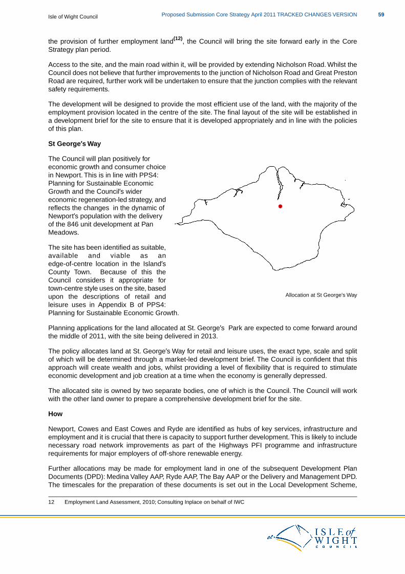
the provision of further employment land(12), the Council will bring the site forward early in the CoreStrategy plan period.
Access to the site, and the main road within it, will be provided by extending Nicholson Road. Whilst theCouncil does not believe that further improvements to the junction of Nicholson Road and Great PrestonRoad are required, further work will be undertaken to ensure that the junction complies with the relevantsafety requirements.
The development will be designed to provide the most efficient use of the land, with the majority of theemployment provision located in the centre of the site. The final layout of the site will be established ina development brief for the site to ensure that it is developed appropriately and in line with the policiesof this plan.
St George’s Way
Allocation at St George's Way
The Council will plan positively foreconomic growth and consumer choicein Newport. This is in line with PPS4:Planning for Sustainable EconomicGrowth and the Council’s widereconomic regeneration-led strategy, andreflects the changes in the dynamic ofNewport’s population with the delivery of the 846 unit development at PanMeadows.
The site has been identified as suitable,available and viable as anedge-of-centre location in the Island’sCounty Town. Because of this theCouncil considers it appropriate fortown-centre style uses on the site, basedupon the descriptions of retail andleisure uses in Appendix B of PPS4:Planning for Sustainable Economic Growth.
Planning applications for the land allocated at St. George’s Park are expected to come forward aroundthe middle of 2011, with the site being delivered in 2013.
The policy allocates land at St. George’s Way for retail and leisure uses, the exact type, scale and splitof which will be determined through a market-led development brief. The Council is confident that thisapproach will create wealth and jobs, whilst providing a level of flexibility that is required to stimulateeconomic development and job creation at a time when the economy is generally depressed.
The allocated site is owned by two separate bodies, one of which is the Council. The Council will workwith the other land owner to prepare a comprehensive development brief for the site.
How
Newport, Cowes and East Cowes and Ryde are identified as hubs of key services, infrastructure andemployment and it is crucial that there is capacity to support further development.This is likely to includenecessary road network improvements as part of the Highways PFI programme and infrastructurerequirements for major employers of off-shore renewable energy.
Further allocations may be made for employment land in one of the subsequent Development PlanDocuments (DPD): Medina Valley AAP, Ryde AAP, The Bay AAP or the Delivery and Management DPD.The timescales for the preparation of these documents is set out in the Local Development Scheme,
12 Employment Land Assessment, 2010; Consulting Inplace on behalf of IWC
59Proposed Submission Core Strategy April 2011 TRACKED CHANGES VERSIONIsle of Wight Council
which can be viewed on the Council’s website.The scale of any employment allocation will need to reflectthe scale of existing employment within the area and also the character and function of the settlement.
The Council recognises that there is a need to protect existing larger scale employment land foremployment purposes. Proposals for alternative uses will only be allowed where development does notresult in the overall loss of employment floorspace. The 2010 Employment Land Assessment assessedboth the supply and demand of employment land on the Island to consider future needs.The assessmentidentified a number of employment zones in and around the Key Regeneration Areas which includeexisting employment sites that could contribute to sustaining the local economy. Given the importanceof these key employment sites, the Council will safeguard existing employment sites of one hectare orabove where it can be demonstrated that the employment use is important to sustaining the local economy.The Council will expect evidence to demonstrate that the continuing employment use of the building orsite is unviable. As a minimum this is likely to be in the form of a marketing exercise for the building orsite, where it has been marketed as an ongoing concern at an appropriate market price for at least 12months. Policy DM8 provides the detailed guidance on how proposals and applications will be considered.
Where the development of employment land is provided as part of a mixed use scheme, the sites willbe phased to ensure that the overall strategy for economic led regeneration will be achieved and wherethis includes town centre locations this will be promoted where this makes a positive contribution to thecharacter of the town, and does not reduce the provision of retail floorspace.
The Council will consider proposals for employment land that includes an element of enabling development.This is in recognition of the history of delivery of economic development on the Island and is consideredan appropriate mechanism to enable employment land to be delivered. The provision of enablingdevelopment would not necessarily be required on the site of the employment and an open-book viabilityassessment would need to be undertaken by the developer to demonstrate why enabling developmentis required and to justify the level of enabling development proposed.
The Council will work in partnership with the IW Local Strategic Partnership, the Isle of Wight Chamberof Commerce, the local business community and service providers to develop skills and training topromote smart growth and encourage inward investment.
In relation to economic development you may also like to look at:
PPS1: Delivering Sustainable DevelopmentPPS4: Planning for Sustainable Economic Growth
HRA for the Isle of Wight Core Strategy Appropriate Assessment, 2011; IWCSA/SEA of the Island Plan Core Strategy, 2011; IWC & EntecEco-Island Sustainable Community Strategy, 2008; ISP & IWCEconomic Strategy 2008-2020, 2008; IWCEconomic Development Delivery Action Plan, 2010; Consulting Inplace for IWCEconomic Development Commentary, 2010; Consulting Inplace for IWCEmployment Land Demand Study, 2008; GVA Grimley for IWCEmployment Land Assessment, 2010; Consulting Inplace for IWCIsle of Wight Local Economic Assessment, 2010; Consulting Inplace for IWC
Retail
What
Retail on the Island is generally performing well; people tend to stay on the Island to shop for conveniencegoods, although many people do go to Southampton or Portsmouth to shop for comparison goods.
The Council will support proposals that focus on increasing the quality and consumer choice of the retailoffer on the Island for both convenience and comparison goods. This will help to facilitate increased
Isle of Wight CouncilProposed Submission Core Strategy April 2011 TRACKED CHANGES VERSION60
investment on the Island and contribute to the economic aspirations held by the Council and the Island'sresidents and is in-line with the approaches set out in PPS4.
The retail floorspace requirement over the plan period is set out in the Isle of Wight Retail Capacity StudyUpdate November 2009. The study estimates that by 2026, 809,000 ft2 of net comparison (all goods)floorspace could in theory be accommodated across the Island. However, the Council is cautious inover-reliance on the forecasts to 2026, due to the changing economic situation over the plan period,coupled with the difficulty in forecasting demand over the next 15 years.
To ensure that an up-to-date understanding of this need, the Council will review this floorspace requirementas appropriate over the plan period. It is possible that such work could inform the preparation of the AreaAction Plans and/or the Delivery and Management DPD.
Where
The primary focus for further retail growth will be within the Key Regeneration Areas and the SmallerRegeneration Areas. It is anticipated that because of location, the growth planned for the Island will bethese areas, as the need increases.
Newport is the County Town of the Isle of Wight and has the most significant retail offer on the Islandand because of this should be the main focus for further retail provision.
There is also the need to support the provision of retail development in the existing town centres ofCowes, East Cowes, Freshwater, Ryde, Sandown, Shanklin and Ventnor. The Council has recentlyundertaken a town centre health check for these town centres, which has shaped the approach set outin policy DM9 (Town Centres) and will inform specific approaches to retail to be set out in the three AreaAction Plans.
Further small scale retail provision may also be required to sustain Rural Service Centres and other ruralsettlements. Proposals for retail provision in these areas will be considered on merit and against a localneed for the facility, along with a protectionist approach to the existing retail provision.
The Council’s preferred approach to retail development is to firstly consider Town Centres and PrimaryRetail Frontage areas suitable for new or intensified retail uses, then the intensification of existing retailparks (whether they be in Town Centres or Primary Retail Frontages or not), followed by the extensionof existing retail parks and then the creation of new retail parks.
How
Clearly The provision for retail and leisure uses at St Georges Park will deliver a proportion of retailfloorspace. contributes to the delivery of the net retail floorspace identified in SP3. It is expected thatthe remainder of the floorspace, which is likely to be in the region of 659,000ft2, identified in the policywill be brought forward through market-led planning applications in the general locations identified.
The need to plan for the level of retail floorspace set out in the policy will be closely monitored throughoutthe plan period to take account of changes in need and as identified earlier the Council will review thisfloorspace requirement as appropriate over the plan period.
These changes may occur through changing levels of spending through internet shopping, through ”retailleakage” to the mainland or wider economic circumstances.
If this monitoring indicates that we are not meeting our targets for delivering retail floorspace, allocationsfor retail land may need to be made in the Area Action Plans or the Delivery and Management DPD.
SP3 and Habitat Regulations Assessment
Following the recommendations of the Habitat Regulations Assessment of the Core Strategy, proposalsthat relate to this policy should consider the need for mitigation measures. This will be dependent uponthe type of proposal to which the Core Strategy policies are being applied and the proximity of the
61Proposed Submission Core Strategy April 2011 TRACKED CHANGES VERSIONIsle of Wight Council
development proposal to European and Ramsar sites.
The likely mitigation measures required are set out in the following table:
Required Mitigation
Specific mitigation such as recreational provision and provision of supporting habitats as well as visitor management, site access andmanagement, education and interpretation.
In relation to retail you may also like to look at:
PPS1: Delivering Sustainable DevelopmentPPS4: Planning for Sustainable Economic Growth (particularly Annex B for definitions)
HRA for the Isle of Wight Core Strategy Appropriate Assessment, 2011; IWCSA/SEA of the Island Plan Core Strategy, 2011; IWC & Entec
Island-wide Retail Capacity Study Update, 2008; Drivers Jonas for IWCIsland-wide Retail Capacity Study Update, 2009; Drivers Jonas for IWCTown Centres Health Check Study, 2009; Halcrow for IWC
Policy SP3 Economy is particularly linked to the following policies of this plan:
DM8 Economic DevelopmentDM9 Town CentresDM10 Rural Service Centres and the Wider Rural AreaDM11 High Quality TourismDM22 Utility Infrastructure RequirementsDM23 Developer Contributions
AAP1 Medina Valley AAP2 Ryde AAP3 The Bay
SP1 Spatial StrategySP4 TourismSP5 Environment
Tourism
SP4 Tourism
The Council will support sustainable growth in high quality tourism and proposals thatincrease the quality of existing tourism destinations and accommodation across the Island,but particularly in The Bay area.
To reflect the special tourism offer of the Isle of Wight, proposals for tourism relateddevelopment should utilise the unique characteristics of the historic and natural environments,without compromising their integrity.The Council also wishes to see the Island become anall year round tourism destination, which develops green and new niche tourism products,and development proposals should reflect this.
Whilst the target is to improve the quality of existing tourism destinations andaccommodation, a loss of bed spaces will generally be resisted and there should be no lossof the tourism offer permitted in the Core Tourism Areas of Sandown and Shanklin (as shown
Isle of Wight CouncilProposed Submission Core Strategy April 2011 TRACKED CHANGES VERSION62
on the Proposals Map).
Tourism-related development proposals should maintain a mix of tourism accommodationthat offer a range of styles,and typesand quality of provision and make use of current orformer tourism sites wherever possible.
What
The overall vision for the Island is to maximise the benefits of a sustainable tourism industry to the benefitof the Island economy as a whole.
The Island caters for a wide range of different visitor markets and therefore needs a diverse range oftypes and quality of accommodation, and attractions and facilities to satisfy all of those market demandsand maintain its place as a premier UK visitor destination.
The aspiration for the Island, however, is to improve its economic prosperity by increasing the proportionof high end/high value visitors to the Island over the whole year.This will require an increase in the overallquality of the tourism offer in terms of accommodation, eating out opportunities, events, attractions andrelated leisure activities.
As set out elsewhere in the Core Strategy, and in many other publications about the Island, the Islandhas high quality built and natural environments. It is these assets that the Council believes should be atthe heart of the tourism offer on the Island. Such assets include open countryside enjoyed for its beautyand opportunities for recreation, historic places which provide a sense of place and a chance to stepback in time; and the Island's coastline which provides opportunities for water-based recreation includingthe harbours and marinas, some of which host premier yachting events such as Cowes Week and theOld Gaffers at Yarmouth which generates significant income for the Island. Proposals should demonstratehow the historic and natural environments have been utilised, without compromising their integrity andhow they have informed the proposal.
The tourism offer on the Island has changed over the years and this is reflected in the range of tourismdestinations and accommodation. There are a number of sites across the Island where the tourism usehas ceased or are now unsuitable to continue in their current form. The Council will support proposalsfor such locations that reinstate tourism and leisure uses as part of wider mixed-use schemes that arein conformity with the rest of the Core Strategy.
Whilst the tourism sector performs strongly during the spring and summer, this is not sustained throughoutthe year.This needs to be addressed through the provision of facilities that provide a high quality tourismoffer throughout the year, rather than just at peak times. Proposals should include anticipated openingtimes of the tourism facility (be it destination or accommodation) and the Council will consider the useof planning conditions to ensure that this occurs.
Through utilising the Island’s historic and natural environments, the Council will encourage proposalsthat develop green and new niche tourism products. Clearly the Council should not be prescriptive overwhat these might entail, but they should be consistent with the provisions of the Core Strategy. Giventhe reliance on the natural and historic environments, all tourism development will be expected not tocompromise their integrity and to make positive contributions to improving these assets where appropriate.
63Proposed Submission Core Strategy April 2011 TRACKED CHANGES VERSIONIsle of Wight Council
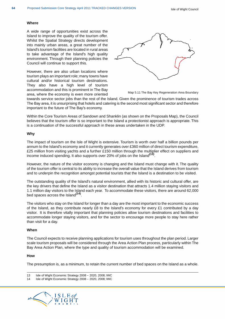
Where
Map 5.11 The Bay Key Regeneration Area Boundary
A wide range of opportunities exist across theIsland to improve the quality of the tourism offer.Whilst the Spatial Strategy directs developmentinto mainly urban areas, a great number of theIsland’s tourism facilities are located in rural areasto take advantage of the Island’s high qualityenvironment. Through their planning policies theCouncil will continue to support this.
However, there are also urban locations wheretourism plays an important role; many towns havecultural and/or historical tourism destinations.They also have a high level of tourismaccommodation and this is prominent in The Bayarea, where the economy is even more orientedtowards service sector jobs than the rest of the Island. Given the prominence of tourism trades acrossThe Bay area, it is unsurprising that hotels and catering is the second most significant sector and thereforeimportant to the future of The Bay’s economy.
Within the Core Tourism Areas of Sandown and Shanklin (as shown on the Proposals Map), the Councilbelieves that the tourism offer is so important to the Island a protectionist approach is appropriate. Thisis a continuation of the successful approach in these areas undertaken in the UDP.
Why
The impact of tourism on the Isle of Wight is extensive. Tourism is worth over half a billion pounds perannum to the Island’s economy and it currently generates over £360 million of direct tourism expenditure,£25 million from visiting yachts and a further £150 million through the multiplier effect on suppliers andincome induced spending. It also supports over 20% of jobs on the Island(13).
However, the nature of the visitor economy is changing and the Island must change with it. The qualityof the tourism offer is central to its ability to increase the overall value that the Island derives from tourismand to underpin the recognition amongst potential tourists that the Island is a destination to be visited.
The outstanding quality of the Island’s natural environment, allied with its historic and cultural offer, arethe key drivers that define the Island as a visitor destination that attracts 1.4 million staying visitors and1.1 million day visitors to the Island each year. To accommodate these visitors, there are around 62,000bed spaces across the Island(14).
The visitors who stay on the Island for longer than a day are the most important to the economic successof the Island, as they contribute nearly £8 to the Island’s economy for every £1 contributed by a dayvisitor. It is therefore vitally important that planning policies allow tourism destinations and facilities toaccommodate longer staying visitors, and for the sector to encourage more people to stay here ratherthan visit for a day.
When
The Council expects to receive planning applications for tourism uses throughout the plan period. Largerscale tourism proposals will be considered through the Area Action Plan process, particularly within TheBay Area Action Plan, where the type and quality of tourism accommodation will be examined.
How
The presumption is, as a minimum, to retain the current number of bed spaces on the Island as a whole.
13 Isle of Wight Economic Strategy 2008 – 2020, 2008; IWC14 Isle of Wight Economic Strategy 2008 – 2020, 2008; IWC
Isle of Wight CouncilProposed Submission Core Strategy April 2011 TRACKED CHANGES VERSION64
The main target is to increase the overall quality of the offer to the visitor to allow the Island to attract agreater number of high value visitors.These actions, taken together, should serve to protect and improvethe overall economic viability of the Isle of Wight.
Monitoring will play a key role in ensuring that the quality of the tourism accommodation and the numberof bed spaces is maintained and improved, in line with this policy and DM11 (High Quality Tourism).Thiswill primarily be undertaken by the use of nationally recognised quality grading schemes and an annualsurvey of the supply of accommodation across the South East undertaken by Tourism South East (TSE).
A key element of the overall approach, but one that outside the remit of planning, is to extend the periodof time during which visitors come to the Island away from the peak periods when occupancy rates inaccommodation are in the region of 80% plus.
SP4 and Habitat Regulations Assessment
Following the recommendations of the Habitat Regulations Assessment of the Core Strategy, proposalsthat relate to this policy should consider the need for mitigation measures. This will be dependent uponthe type of proposal to which the Core Strategy policies are being applied and the proximity of thedevelopment proposal to European and Ramsar sites.
The likely mitigation measures required are set out in the following table:
Required Mitigation
Specific mitigation such as potential recreational provision and provision of supporting habitats as well as visitor management, siteaccess and management, education and interpretation.
In relation to tourism you may also like to look at:
PPS1: Delivering Sustainable DevelopmentPPS4: Planning for Sustainable Economic GrowthPPS7: Sustainable Development in Rural Areas
HRA for the Isle of Wight Core Strategy Appropriate Assessment, 2011; IWCSA/SEA of the Island Plan Core Strategy, 2011; IWC & EntecIsle of Wight Hotel Futures, 2005; Tourism Solutions & ack tourism for IW Tourism & Tourism SouthEastIsle of Wight Holiday Park Sector Audit and Review, 2006; Rural Solutions for IW Tourism & TourismSouth EastTourism Development Plan, 2005; IWCEconomic Strategy 2008-2020, 2008; IWC
Policy SP4 Tourism is particularly linked to the following policies of this plan:
DM8 Economic DevelopmentDM9 Town CentresDM10 Rural Service Centres and the Wider Rural AreaDM11 High Quality TourismDM22 Utility Infrastructure RequirementsDM23 Developer Contributions
AAP1 Medina Valley AAP2 Ryde AAP3 The Bay
SP1 Spatial StrategySP3 Economy
65Proposed Submission Core Strategy April 2011 TRACKED CHANGES VERSIONIsle of Wight Council

SP5 Environment
Environment
SP5 Environment
The Council will support proposals that protect, conserve and/or enhance the Island’s naturaland historic environments. All development proposals will be expected to take account ofthe environmental capacity of an area to accommodate new development and, whereappropriate and practicable, to contribute to environmental conservation and enhancement.
Development proposals will be expected to respectprotect the integrity of international,national and local designations, the reasons for these designations and the weight given tothem.enhance their features of interest wherever possible, and respond to the emergingevidence from the Solent Disturbance and Mitigation Project.The highest levels of protectionwill be afforded to internationally and nationally important sites and areas.
The Council will identify and manage an accessible network of connected and multi-functionalopen spaces that covers the Island through the preparation of a Green Infrastructure StrategySupplementary Planning Document. This will be the way in which the Council will identifyappropriate levels of mitigation associated with development proposals as well as provideopportunities to enhance and increase the coverage and connectivity and multifunctionalityof the Island's GI network.
Development that has a demonstrable adverse impact on the Island’s natural, historic andbuilt environments should be avoided. Such development may, however, be permitted inexceptional circumstances.
In order to conserve and enhance the quality of the natural environment, the Council willregularly review existing Sites of Importance for Nature Conservation (SINCs). As a resultof this process, some boundary changes will be proposed and some new SINCs will bebrought forward.
The Council will expect development proposals to reduce the overall and local risk of floodingon the Island. Therefore it will implement a flood risk management hierarchy of assess –avoid – substitute – control – mitigate. It will also maintain an up-to-date classification offlood zones, taking into account climate change and the most recent information.
What
It is important to the Island that the natural and historic environments are identified and, wherever possible,protected, conserved and/or enhanced. The policy is intended to strike a balance between protectingour environment and allowing development that benefits the Island and its economy. All developmentproposals will be expected to take account of the environmental capacity of an area to accommodatenew development and, where appropriate and practicable, to contribute to environmental conservationand enhancement.
To expand on the existing knowledge base around Green Infrastructure (GI), a GI Strategy will beprepared. GI is the name given to collective sites with particular landscape, biodiversity and/or recreationalfunctions that form a linked network.The Green Infrastructure Strategy Supplementary Planning Document(SPD) will identify, deliver, manage and monitor the GI network on the Island. It will also provide thedetailed guidance and delivery mechanisms for GI, which includes the identification of areas of opportunityfor expansion or improvements to the network.
As the implications of climate change are becoming clearer, a risk based approach to planning for flooding
Isle of Wight CouncilProposed Submission Core Strategy April 2011 TRACKED CHANGES VERSION66
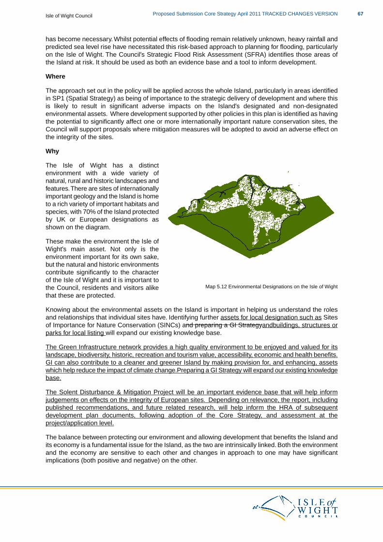
has become necessary. Whilst potential effects of flooding remain relatively unknown, heavy rainfall andpredicted sea level rise have necessitated this risk-based approach to planning for flooding, particularlyon the Isle of Wight. The Council’s Strategic Flood Risk Assessment (SFRA) identifies those areas ofthe Island at risk. It should be used as both an evidence base and a tool to inform development.
Where
The approach set out in the policy will be applied across the whole Island, particularly in areas identifiedin SP1 (Spatial Strategy) as being of importance to the strategic delivery of development and where thisis likely to result in significant adverse impacts on the Island’s designated and non-designatedenvironmental assets. Where development supported by other policies in this plan is identified as havingthe potential to significantly affect one or more internationally important nature conservation sites, theCouncil will support proposals where mitigation measures will be adopted to avoid an adverse effect onthe integrity of the sites.
Why
Map 5.12 Environmental Designations on the Isle of Wight
The Isle of Wight has a distinctenvironment with a wide variety ofnatural, rural and historic landscapes andfeatures.There are sites of internationallyimportant geology and the Island is hometo a rich variety of important habitats andspecies, with 70% of the Island protectedby UK or European designations asshown on the diagram.
These make the environment the Isle ofWight’s main asset. Not only is theenvironment important for its own sake,but the natural and historic environmentscontribute significantly to the characterof the Isle of Wight and it is important tothe Council, residents and visitors alikethat these are protected.
Knowing about the environmental assets on the Island is important in helping us understand the rolesand relationships that individual sites have. Identifying further assets for local designation such as Sitesof Importance for Nature Conservation (SINCs) and preparing a GI Strategyandbuildings, structures orparks for local listing will expand our existing knowledge base.
The Green Infrastructure network provides a high quality environment to be enjoyed and valued for itslandscape, biodiversity, historic, recreation and tourism value, accessibility, economic and health benefits.GI can also contribute to a cleaner and greener Island by making provision for, and enhancing, assetswhich help reduce the impact of climate change.Preparing a GI Strategy will expand our existing knowledgebase.
The Solent Disturbance & Mitigation Project will be an important evidence base that will help informjudgements on effects on the integrity of European sites. Depending on relevance, the report, includingpublished recommendations, and future related research, will help inform the HRA of subsequentdevelopment plan documents, following adoption of the Core Strategy, and assessment at theproject/application level.
The balance between protecting our environment and allowing development that benefits the Island andits economy is a fundamental issue for the Island, as the two are intrinsically linked. Both the environmentand the economy are sensitive to each other and changes in approach to one may have significantimplications (both positive and negative) on the other.
67Proposed Submission Core Strategy April 2011 TRACKED CHANGES VERSIONIsle of Wight Council

Through locating development in the most sustainable locations in the first instance and the protectionistapproach to the environment in this policy, the Council believes an appropriate balance has been struck.However, it is strongly felt that should there be exceptional situations, when there are overriding andcompelling economic reasons for development, the need for economic development may be greater thanthat for environmental protection. The Council is clear that this should be applied only in exceptionalcircumstances and should be considered the exception rather than the norm.
When
This policy approach will be undertaken throughout the plan period, with specific consideration beinggiven to these issues in the three Area Action Plans.
The new SINCs will be consulted on through the Island Plan Core Strategy process, with furtherconsultation then occurring on proposed SINCs that come forward once the Island Plan Core Strategyis adopted. A list of SINCs can be found in Appendix II 2 of the Core Strategy and it will be updated ona regular basis to ensure the full list of SINCs is available.
The Green Infrastructure Strategy will be prepared by the Council and will become a SupplementaryPlanning Document (SPD). It will go through public consultation and is expected to be adopted in thesummer of 2012.
How
Whilst it is difficult to define what exceptional circumstances may trigger the shift in approach outlinedabove, it is expected that they may include large scale regeneration development and providing essentialinfrastructure. Whatever the exceptional circumstances may be, the development will be expected todemonstrate what clearsubstantial public benefits outweigh the loss of the environmental assets andhow it complies with other policies in this document. ThisThe approach to this taken by the Council willalso depend on the level of designation, or significance of the asset and protection afforded to theenvironmental assets. However, if adverse impacts on European sites are demonstrated, the developmentwill not be supported by the Council.
Where granting planning permission would result in significant harm to the Island’s natural and historicenvironments, the Council will need to be satisfied that the development cannot reasonably be locatedon any alternative sites that would result in less or no harm. In the absence of any such alternatives,the Council will require evidence that adequate mitigation measures are put in place, before planningpermission is granted. Where a proposal would result in significant harm to the Island’s natural, historicand built environments which cannot be prevented, or adequately mitigated against, appropriatecompensation measures will be sought. If significant harm cannot be prevented, adequately mitigatedagainst, or compensated for, then in principle, planning permission will be refused.
The identification of new SINCs is a formal process that the Isle of Wight Biodiversity Partnership leads.The Council is a member of this Partnership, which uses Natural England and Defra guidance to informthe SINC selection process.The Partnership is now extending the consultation about new SINCs beyondthat required by the guidance.
Where future Development Plan Documents prepared by the Council include allocations of land or setsoverall levels of development such that there is potential for significant effects on one or moreinternationally important nature conservation sites, the Council will carry out assessments of such plansunder the Habitats Regulations.
In relation to the environment, you may also like to look at:
PPS5: Planning for the Historic EnvironmentPPS7: Sustainable Development in Rural AreasPPS9: Biodiversity and Geological ConservationPPG17: Planning for Open Space, Sport and Recreation
Isle of Wight CouncilProposed Submission Core Strategy April 2011 TRACKED CHANGES VERSION68
Consultation PPS: Planning for a Natural and Healthy EnvironmentPPS20: Coastal PlanningPPS25: Development and Flood Risk and Practice GuidancePPS25 Supplement: Development and Coastal Change and Practice Guide
HRA for the Isle of Wight Core Strategy Appropriate Assessment, 2011; IWCSA/SEA of the Island Plan Core Strategy, 2011; IWC & Entec
Policy SP5 Environment is linked to all policies of this plan, particularly:
DM12 Historic and Built EnvironmentDM13 Landscape, Seascape, Biodiversity and GeodiversityDM14 Green InfrastructureDM15 Flood RiskDM16 Coastal ManagementDM23 Developer Contributions
AAP1 Medina Valley AAP2 Ryde AAP3 The Bay
SP1 Spatial StrategySP2 HousingSP3 EconomySP4 TourismSP6 Renewables
Renewables
SP6 Renewables
A range of renewable energies will be encouraged across the Island to meet its target of upto 100 MW installed capacity as the on-shore contribution to becoming self-sufficient inrenewable electricity production.
The Council supports domestic and medium scale, localised provision across the Islandand recognises the need for large-scale, grid-connected renewable energy schemes.Theseschemes will be expected to contribute to the economic development and regeneration ofthe Island and help it meet its target of becoming self-sufficient in renewable electricityproduction.
The Council believes the renewable energy target can be met through the following potentialminimum contributions from a range of proven technologies:
At least 22.5 MW from windAt least 15 MW from photovoltaicsAt least 7.4 MW from wasteAt least 6 MW from biomass
It is expected that the remaining 50 MW capacity will be met from a combination of smallerscale and domestic installations, schemes granted permission but not yet built and schemesusing imported fuels.
It is accepted that a range of new technologies, other than those listed above, are likely toemerge and these will be considered on their own merits in-line with national planning policy
69Proposed Submission Core Strategy April 2011 TRACKED CHANGES VERSIONIsle of Wight Council
and the policies of the Core Strategy.
Within areas of protected and sensitive landscapes, development should generally be smallscale or community-based. It is expected that large-scale wind and photovoltaic schemeswill be located outside of the AONB (and grade 1-3a agricultural land for photovoltaics) andother designated environmental assets, although schemes within the AONB will be consideredwhen there are no alternative sites outside of the AONB and thatwhere a considerablecommunity benefit is demonstrated and considered to outweigh the landscape impact.
The Council will support large-scale heat projects where they can demonstrate sufficientbenefit to the Island and/or help to reduce the carbon emissions from existing housing andcommercial buildings.
What
Eco Island, the Island’s Sustainable Community Strategy, has the ambition for the Island to beself-sufficient in the generation of renewable electricity by 2020. For this to be realised in practice, itmeans generating enough electricity from renewable sources on the Island to meet our annual electricityconsumption.
The latest available figure (2008) shows total Island electric consumption of 588 gigawatt hours (GWh)(15)
and the Council believes that this level of consumption will be reduced over time through the introductionof efficiency measures. However, this will be counter-balanced by a number of factors, which include:additional housing, commercial/industrial development planned for in the Core Strategy; a shift to electricvehicles and electric forms of heating (e.g. heat pumps) in off-gas areas. The Council believes it istherefore prudent to plan for electricity consumption at today’s levels.
An assessment of the potential to reach the indicative 150 MW target has therefore been based on thefollowing assumptions:
1. Offshore energy could contribute in the region of 50 MW by 2020, most likely from tidalstream energy. A site off the south coast of the Island has been identified as suitable forcommercial-scale tidal energy generation with a potential capacity of 249 MW(16), butexploiting this will be very challenging due to environmental constraints and grid connectionissues. Furthermore, the industry is unlikely to be sufficiently advanced by 2020 to fullyexploit the site. 50 MW of tidal stream energy could contribute 153 GWh per annum ofrenewable electricity.
2. Renewable energy projects which have been constructed or are proposed and known tothe Council (as of October 2010) totalling 93.9 MW. These include biomass (49.9 MW), PV(16 MW), wind (24 MW) and waste to energy (4 MW) installations. This demonstrates thelikelihood of sufficient projects coming forward to meet the target, particularly with thefinancial incentives provided through Feed In Tariffs and Renewables Obligation Certificates.
3. Large-scale, stand-alone, grid-connected renewable energy developments will be requiredin order to meet the target. Whilst small- and medium-sized developments can provideconsiderable household and community benefit, their contribution to the target is relativelyinsignificant. For example, 5,000 domestic PV installations would generate a total of 10,575MWh (10.58 GWh) per year.
As outlined above, the Council believes that the remaining 50 MW identified in the policy will be achievedfrom a combination of smaller scale and domestic installations, schemes granted permission but not yetbuilt and schemes using imported fuels.As the final mix of these schemes is not yet known, the contributionto the renewable energy target has to be estimated but, as an example, the 49.9 MW biomass plantproposed for Stag Lane would produce 372 GWh.
15 Decc statistics on local electricity consumption16 “Quantification of Exploitable Tidal Energy Resources in UK Waters”, July 2007; ABPMer
Isle of Wight CouncilProposed Submission Core Strategy April 2011 TRACKED CHANGES VERSION70
Targets for renewable energy generation are usually set in terms of megawatts (MW) of installed capacity.This does not translate easily into GWh, since different technologies generate power at differentefficiencies(17). However, it is considered that total Island consumption of 588 GWh translates to a needof 150 MW installed capacity.
Because there is an identified offshore potential of around 50 MW and, as it is offshore, the Councilcannot use it to count towards its renewable energy target, the target in the policy that the Council willseek to achieve relates solely to onshore renewable energy is 100 MW.
The technologies most likely to contribute to the 2020 target are those which are currently at an advancedstage of development and are economically viable. As the target relates only to electricity generation,these are biomass, photovoltaics (PV), wind and waste to energy.That is not to say that other technologieswill not be developed during the plan period, or that new financial mechanisms will not increase theviability of other technologies, but the assessment has been based on the four generic technologiesmentioned above.
An indication of the potential minimum contribution of each of these technologies, based on the capacityto accommodate them, to the overall target is generally expected to be:
Wind – at least 22.5 MW. The Council considers that this could be achieved through, for example, 10 x2.25 MW (average) turbines in 3 small clusters of 2-5 turbines each.This would contribute approximately49 GWh per annum.
Waste – at least 7.4 MW, made up of existing and new facilities. The existing gasification plant is ratedat 2.3 MW and there is planning consent for a 1.5 MW landfill gas scheme. A recent review of AnaerobicDigestion potential shows that the Island could support a Combined Heat and Power (CHP) system ofup to 3.6 MW using waste that is currently sent to landfill, a figure which could be increased if a differenttechnology were utilised. This would contribute approximately 56 GWh per annum.
Biomass – at least 6 MW from CHP systems which have a much higher efficiency than power onlyplants. These would be supported by locally sourced fuel including waste wood, forestry residues,agricultural residues and energy crops. Systems are likely to vary in size from 100 KW to, potentially, 5MW. This would contribute approximately 39 GWh per annum.
The Council will consider proposals along the indicative thresholds set out below:
Domestic scale renewable energy schemes are those which produce up to 50KW of electricityor 45 KW of heat(18).Medium scale schemes are those that deliver up to 1 MW installed capacity.Large scale schemes are those that deliver 1 MW and above installed capacity.
Grid connection to serve the types of provision set out above is unlikely to require significant gridreinforcement, although at this size of development, proximity to the existing grid will be a key requirement.The cumulative effect of a large number of developments is likely to be more significant and the mainissues are highlighted in the Council’s Grid Connection Study. These issues will be addressed throughongoing discussions between the Council and Scottish and Southern Energy, the Island's DistributionNetwork Operator, in order to facilitate a co-ordinated approach, but will ultimately be the responsibilityof each private developer. Review of Potential for Connection of Embedded Generation Sources intoexisting Public Electricity Supply Distribution System(19).
The study demonstrates that the connection of renewable generation sources to the existing electricaldistribution system on the Island is broadly feasible at 11kV, 33kV and 132kV. Connections at 11kV willbe limited to small-scale schemes (defined in the study as up to 10MW output capacity), and it isconsidered that connections in rural locations are likely to be particularly limited by the capacities and
17 This is known as the “load factor” which is the ratio (expressed as a percentage) of the net amount of electricity generatedby a power plant to the total amount it could have generated if it were operating at its full capacity.
18 The Energy Act 200419 Prepared by Grontmij on behalf of the Isle of Wight Council, November 2010.
71Proposed Submission Core Strategy April 2011 TRACKED CHANGES VERSIONIsle of Wight Council
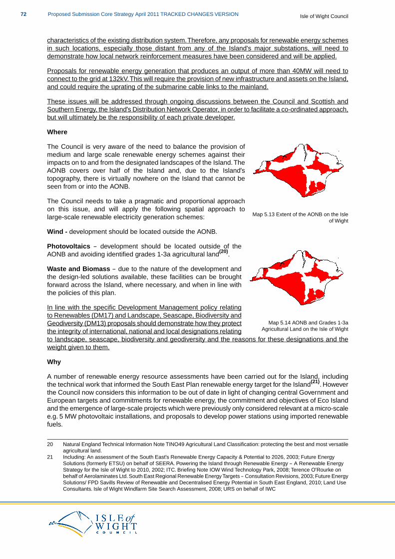
characteristics of the existing distribution system.Therefore, any proposals for renewable energy schemesin such locations, especially those distant from any of the Island's major substations, will need todemonstrate how local network reinforcement measures have been considered and will be applied.
Proposals for renewable energy generation that produces an output of more than 40MW will need toconnect to the grid at 132kV.This will require the provision of new infrastructure and assets on the Island,and could require the uprating of the submarine cable links to the mainland.
These issues will be addressed through ongoing discussions between the Council and Scottish andSouthern Energy, the Island’s Distribution Network Operator, in order to facilitate a co-ordinated approach,but will ultimately be the responsibility of each private developer.
Where
Map 5.13 Extent of the AONB on the Isleof Wight
The Council is very aware of the need to balance the provision ofmedium and large scale renewable energy schemes against theirimpacts on to and from the designated landscapes of the Island.TheAONB covers over half of the Island and, due to the Island’stopography, there is virtually nowhere on the Island that cannot beseen from or into the AONB.
The Council needs to take a pragmatic and proportional approachon this issue, and will apply the following spatial approach tolarge-scale renewable electricity generation schemes:
Wind - development should be located outside the AONB.
Map 5.14 AONB and Grades 1-3aAgricultural Land on the Isle of Wight
Photovoltaics – development should be located outside of theAONB and avoiding identified grades 1-3a agricultural land(20).
Waste and Biomass – due to the nature of the development andthe design-led solutions available, these facilities can be broughtforward across the Island, where necessary, and when in line withthe policies of this plan.
In line with the specific Development Management policy relatingto Renewables (DM17) and Landscape, Seascape, Biodiversity andGeodiversity (DM13) proposals should demonstrate how they protectthe integrity of international, national and local designations relatingto landscape, seascape, biodiversity and geodiversity and the reasons for these designations and theweight given to them.
Why
A number of renewable energy resource assessments have been carried out for the Island, includingthe technical work that informed the South East Plan renewable energy target for the Island(21). Howeverthe Council now considers this information to be out of date in light of changing central Government andEuropean targets and commitments for renewable energy, the commitment and objectives of Eco Islandand the emergence of large-scale projects which were previously only considered relevant at a micro-scalee.g. 5 MW photovoltaic installations, and proposals to develop power stations using imported renewablefuels.
20 Natural England Technical Information Note TINO49 Agricultural Land Classification: protecting the best and most versatileagricultural land.
21 Including: An assessment of the South East’s Renewable Energy Capacity & Potential to 2026, 2003; Future EnergySolutions (formerly ETSU) on behalf of SEERA. Powering the Island through Renewable Energy – A Renewable EnergyStrategy for the Isle of Wight to 2010, 2002; ITC. Briefing Note IOW Wind Technology Park, 2008; Terence O’Rourke onbehalf of Aerolaminates Ltd. South East Regional Renewable Energy Targets – Consultation Revisions, 2003; Future EnergySolutions/ FPD Savills Review of Renewable and Decentralised Energy Potential in South East England, 2010; Land UseConsultants. Isle of Wight Windfarm Site Search Assessment, 2008; URS on behalf of IWC
Isle of Wight CouncilProposed Submission Core Strategy April 2011 TRACKED CHANGES VERSION72
When
It is expected that a wide range of renewable energy projects will come forward over the lifetime of theplan. These will vary in scale from domestic micro-generation through to the large-scale. It is likely thatthese larger scale schemes will come forward in the medium term, as a significant amount of informationwill be required to support any planning application.
The Council expects that there will be interest to bring schemes forward early in the plan period, to takefull advantage of the financial support mechanisms (Feed-in Tariffs and Renewables ObligationsCertificates) for renewable electricity production. However, some of these schemes are likely to becomplex and may take a longer period of time to work up; therefore we expect a fairly even distributionof schemes coming forward over the next ten years. Because of this, the Council would like to seeimplementation at an average rate of 10 MW per annum with the hope that this target will be exceededbecause of the need to take urgent action to reduce carbon emissions.
How
The provision of renewable energy on whatever scale will be driven by private land and property owners.
SP6 and Habitat Regulations Assessment
Following the recommendations of the Habitat Regulations Assessment of the Core Strategy, proposalsthat relate to this policy should consider the need for mitigation measures. This will be dependent uponthe type of proposal to which the Core Strategy policies are being applied and the proximity of thedevelopment proposal to European and Ramsar sites.
The likely mitigation measures required are set out in the following table:
Required Mitigation
Location of facilities away from vulnerable areas. Requiring removal of pollutants by the use of taller chimney stacks. Siting of turbinesaway from potential bat and bird foraging and migration routes. Provision of supporting habitats. Site access and management.
In relation to Renewables, you may also like to look at:
PPS1: Delivering Sustainable DevelopmentPlanning and Climate Change – Supplement to PPS1PPS10: Planning for Sustainable Waste ManagementPPS22: Renewable EnergyPlanning for Renewable Energy: A Companion Guide to PPS22
HRA for the Isle of Wight Core Strategy Appropriate Assessment, 2011; IWCSA/SEA of the Island Plan Core Strategy, 2011; IWC & EntecRenewable Energy Strategy in Regional Spatial Strategies: Final Report 2009, Ove Arup & PartnersLtd on behalf of DCLG
Policy SP6 Renewables is particularly linked to the following policies of this plan:
DM17 RenewablesDM22 Utility Infrastructure RequirementsDM23 Developer Contributions
AAP1 Medina Valley AAP2 Ryde AAP3 The Bay
SP1 Spatial StrategySP2 Housing
73Proposed Submission Core Strategy April 2011 TRACKED CHANGES VERSIONIsle of Wight Council
SP3 EconomySP5 EnvironmentSP9 Waste
Travel
SP7 Travel
The Council will support proposals that increase travel choice and provide alternative meansof travel to the car.
To encourage the use of sustainable transport, all major applications will be required toprepare and implement workplace, retail and school travel plans (as appropriate) and considerother schemes and initiatives such as Safer Routes to School.
Development proposals should not negatively impact on the Island’s Strategic Road Network(as shown on the Proposals MapKey Diagram), nor on the capacity of lower level roads tosupport the proposed development. If negative impacts are identified, appropriate mitigationmeasures are expected.
Improvements to the existing road network will be required to support the level of developmentset out in the Core Strategy. The Council has identified that infrastructure improvements tofacilitate the planned level of growth will need to be in place by 2020 at the following locations:
St Mary’s roundaboutCoppins BridgeHunnyhill / Hunnycross and Riverway junction
Land, as shown on the Proposals Map, will be safeguarded to facilitate the delivery ofimprovements at these locations. Further improvement work may be required and these willbe identified in the Area Action Plans.
Proposed development associated with the final PFI project will be supported and, inparticular, that associated with the infrastructure improvements in Newport (identified above),in line with the policies of this document, in order to provide certainty over the delivery ofthe project.
The Council will support proposals that maintain the current choice of routes and methodsof crossing the Solent to ensure future flexibility and deliverability of service.
Proposals to improve key interchange areas that link the Island to the mainland will besupported.
The policy addresses three main strategic areas: general sustainable travel issues; improvements to theroad network; and cross-Solent transport links. Each of these areas is explained in greater detail below.
General Sustainable Travel Issues
What
The policy supports the Council’s wider commitment to travel choice and sustainable modes of transportand provides a planning mechanism for these issues to be considered and addressed. Alongside thisapproach, and due to the capacity and condition of the road network on the Island, development proposalswill need to consider their likely impact on the existing road network.
Isle of Wight CouncilProposed Submission Core Strategy April 2011 TRACKED CHANGES VERSION74
Where
This approach applies across the Island but, in line with the Spatial Strategy set out in SP1 SpatialStrategy the majority of development will be located in the most sustainable locations on the Island.Major development in the context of this policy is defined in the Town and Country Planning (GeneralDevelopment) Order 1995, and the full definition can be found in the Glossary.
Why
The ability to access employment, education, health services, shopping, leisure and other opportunitiescan significantly impact on people’s quality of life and their life chances. This is particularly true in thecontext of an Island where the overriding character is rural, yet most of the Island’s residents (over 60%)live in the main towns.
The Government acknowledges the links between planning, transport and accessibility and recognisesthat the location of development has a major affect on accessibility and travel patterns. By ensuring thatdevelopments are suitably located through the policies of the Core Strategy, the Council can help reducethe need to travel and increase opportunities to walk, cycle and travel by public transport.
When
These general principles guide the Island Plan Core Strategy and will be applied to all appropriatedevelopment throughout the plan period.
How
This policy, in conjunction with DM18 Sustainable Travel, establishes the ways in which new developmentwill contribute to meeting the targets and aspirations of the Island’s Local Travel Plan (LTP).
In relation to general sustainable travel issues you may also like to look at:
PPS1: Delivering Sustainable DevelopmentPPG13: Transport
HRA for the Isle of Wight Core Strategy Appropriate Assessment, 2011; IWCSA/SEA of the Island Plan Core Strategy, 2011; IWC & EntecSecond Local Transport Plan (LTP2): 2006-2011, 2006; IWC
Improvements to the road network
What
Due to work undertaken to date, the Council is aware of three junctions where improvement measureswill be required to support the level of growth planned for through the Island Plan Core Strategy. Theseareas will be safeguarded to ensure the delivery of the necessary improvements. All three areas of theroad network that have been identified to be safeguarded for improvements have been assessed in theHRA, with none having any likely significant effect.
The Council has secured Highways Private Finance Initiative (PFI)(22) funding of around £364m whichis a 25 year project that is likely to start in 2013. in principle, the policies of the Island Plan Core Strategysupport all aspects of its delivery.Through the PFI project, most of the Island’s 803km public road networkwill be rebuilt or resurfaced, as will every pavement, kerb and cycleway. Also included in the project arebridges, retaining walls and other structures on the road network such as the Island’s 12,068 street lightsand columns.The majority of the work, which is probably the largest engineering project ever undertakenon the Island, will be undertaken in the first seven years of the PFI project. Thereafter the project will
22 For further information on Highways PFI, please see information in Chapter 2 and the Glossary.
75Proposed Submission Core Strategy April 2011 TRACKED CHANGES VERSIONIsle of Wight Council
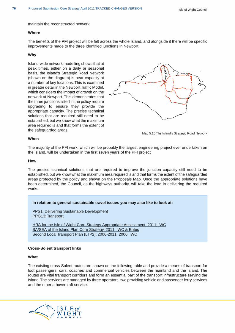
maintain the reconstructed network.
Where
The benefits of the PFI project will be felt across the whole Island, and alongside it there will be specificimprovements made to the three identified junctions in Newport.
Why
Map 5.15 The Island's Strategic Road Network
Island-wide network modelling shows that atpeak times, either on a daily or seasonalbasis, the Island’s Strategic Road Network(shown on the diagram) is near capacity ata number of key locations. This is examinedin greater detail in the Newport Traffic Model,which considers the impact of growth on thenetwork at Newport. This demonstrates thatthe three junctions listed in the policy requireupgrading to ensure they provide theappropriate capacity. The precise technicalsolutions that are required still need to beestablished, but we know what the maximumarea required is and that forms the extent ofthe safeguarded areas.
When
The majority of the PFI work, which will be probably the largest engineering project ever undertaken onthe Island, will be undertaken in the first seven years of the PFI project
How
The precise technical solutions that are required to improve the junction capacity still need to beestablished, but we know what the maximum area required is and that forms the extent of the safeguardedareas protected by the policy and shown on the Proposals Map. Once the appropriate solutions havebeen determined, the Council, as the highways authority, will take the lead in delivering the requiredworks.
In relation to general sustainable travel issues you may also like to look at:
PPS1: Delivering Sustainable DevelopmentPPG13: Transport
HRA for the Isle of Wight Core Strategy Appropriate Assessment, 2011; IWCSA/SEA of the Island Plan Core Strategy, 2011; IWC & EntecSecond Local Transport Plan (LTP2): 2006-2011, 2006; IWC
Cross-Solent transport links
What
The existing cross-Solent routes are shown on the following table and provide a means of transport forfoot passengers, cars, coaches and commercial vehicles between the mainland and the Island. Theroutes are vital transport corridors and form an essential part of the transport infrastructure serving theIsland.The services are managed by three operators, two providing vehicle and passenger ferry servicesand the other a hovercraft service.
Isle of Wight CouncilProposed Submission Core Strategy April 2011 TRACKED CHANGES VERSION76
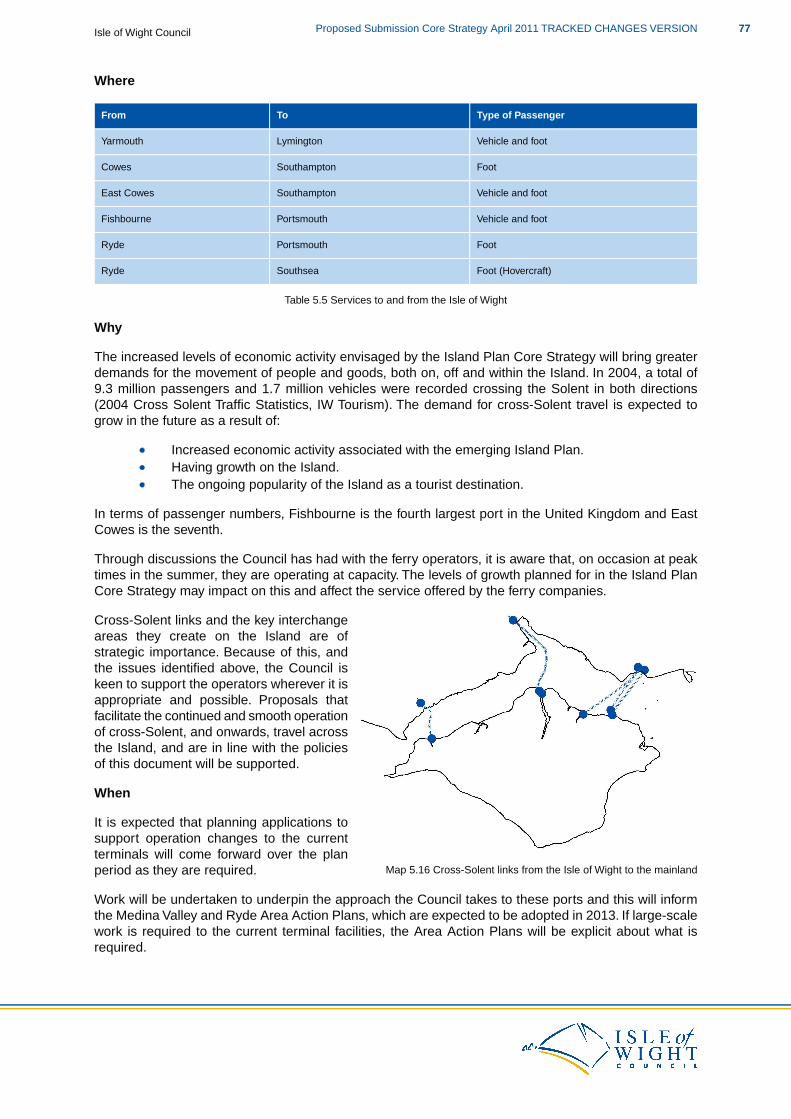
Where
Type of PassengerToFrom
Vehicle and footLymingtonYarmouth
FootSouthamptonCowes
Vehicle and footSouthamptonEast Cowes
Vehicle and footPortsmouthFishbourne
FootPortsmouthRyde
Foot (Hovercraft)SouthseaRyde
Table 5.5 Services to and from the Isle of Wight
Why
The increased levels of economic activity envisaged by the Island Plan Core Strategy will bring greaterdemands for the movement of people and goods, both on, off and within the Island. In 2004, a total of9.3 million passengers and 1.7 million vehicles were recorded crossing the Solent in both directions(2004 Cross Solent Traffic Statistics, IW Tourism). The demand for cross-Solent travel is expected togrow in the future as a result of:
Increased economic activity associated with the emerging Island Plan.Having growth on the Island.The ongoing popularity of the Island as a tourist destination.
In terms of passenger numbers, Fishbourne is the fourth largest port in the United Kingdom and EastCowes is the seventh.
Through discussions the Council has had with the ferry operators, it is aware that, on occasion at peaktimes in the summer, they are operating at capacity. The levels of growth planned for in the Island PlanCore Strategy may impact on this and affect the service offered by the ferry companies.
Map 5.16 Cross-Solent links from the Isle of Wight to the mainland
Cross-Solent links and the key interchangeareas they create on the Island are ofstrategic importance. Because of this, andthe issues identified above, the Council iskeen to support the operators wherever it isappropriate and possible. Proposals thatfacilitate the continued and smooth operationof cross-Solent, and onwards, travel acrossthe Island, and are in line with the policiesof this document will be supported.
When
It is expected that planning applications tosupport operation changes to the currentterminals will come forward over the planperiod as they are required.
Work will be undertaken to underpin the approach the Council takes to these ports and this will informthe Medina Valley and Ryde Area Action Plans, which are expected to be adopted in 2013. If large-scalework is required to the current terminal facilities, the Area Action Plans will be explicit about what isrequired.
77Proposed Submission Core Strategy April 2011 TRACKED CHANGES VERSIONIsle of Wight Council
How
The Council is working with the two main ferry providers to prepare a bid for European Interreg fundingfor a study to understand the relationship between ports and the towns that have grown around them.The bid will focus on the ports at Cowes/East Cowes and Fishbourne/Ryde.
The funding focusses on innovative approaches to improve the accessibility and connectivity betweenthe ports and their towns. The literature setting out the funding requirements states that “it is importantthat a common transport offer is created so that expansion plans are not put into jeopardy by trafficproblems and increased pollution. The project will look at ways in which different transport modes canbe used to improve port and town connectivity and other ways in improving the physical connectivity”.
If the bid is successful, it will fund work to understand these issues and, if problems are identified, proposepossible resolution measures.
SP7 and Habitat Regulations Assessment
Following the recommendations of the Habitat Regulations Assessment of the Core Strategy, proposalsthat relate to this policy should consider the need for mitigation measures. This will be dependent uponthe type of proposal to which the Core Strategy policies are being applied and the proximity of thedevelopment proposal to European and Ramsar sites.
The likely mitigation measures required are set out in the following table:
Required Mitigation
Consideration of appropriate multiple use green buffers to intercept potential impacts (eg air, light, noise, run-off etc) and in the case ofports and marine facilities provide the ability to set back to avoid future potential coastal squeeze from sea level rise (bearing in mindlimitations placed by existing development). Where appropriate, landscape screening may provide multiple benefits such as greencorridors, thereby adding to the GI network.
In relation to cross-Solent travel you may also like to look at:
DM 19 Cross-Solent TravelPPG13: Transport
HRA for the Isle of Wight Core Strategy Appropriate Assessment, 2011; IWCSA/SEA of the Island Plan Core Strategy, 2011; IWC & EntecSecond Local Transport Plan (LTP2): 2006-2011, 2006; IWC
Policy SP7 Travel is particularly linked to the following policies of this plan:
DM18 Sustainable TravelDM19 Cross-Solent TravelDM23 Developer Contributions
AAP1 Medina Valley AAP2 Ryde AAP3 The Bay
SP1 Spatial StrategySP2 HousingSP3 Economy
Isle of Wight CouncilProposed Submission Core Strategy April 2011 TRACKED CHANGES VERSION78
Waste
SP8 Waste
The Council will seek to reduce the level of waste wherever possible by providing wasteresource infrastructure and management options in accordance with the waste hierarchy,and ensuring that infrastructure for the management of waste is developed with due regardto the principles of sustainable development.
All new development will be expected to maximise contribution to waste minimisation andprovide facilities for waste and recycling through:
1. Sustainable design and construction principles, as set out in DM1.2. Construction and demolition methods that minimise waste production and maximise
re-use/recycling of materials, as far as practicable on-site.3. Making appropriate provision of waste management facilities for the finished
development that are appropriate both in scale and in treatment, treating waste as highup the waste hierarchy as possible.
Capacity requirements for recycling, composting and recovery and treatment
In order to drive the management of waste as far up the waste hierarchy as possible, andmeet both the Council’s ambition of zero non-essential waste to landfill by 2015 and relevantnational waste targets over the plan period, the Council will make provision for between 7.5to 9.7 hectares to facilitate a range of waste management technologies by:
A. Identifying appropriate sites within the Area Action Plans and the Delivery andManagement DPD, if required.
B. Not permitting development that prejudices the use of areas identified as suitable forwaste management facilities.
C. Taking a flexible approach to waste management proposals on sites identified for otheruses such as, industrial land/employment allocations, existing waste managementsites, mineral sites (for inert recycling), subject to the detailed environmental criteriaset out in Policy DM20.
Provision of future landfill
Standen Heath Extension is allocated as the Island’s strategic landfill facility to accommodatea maximum of 770,000 cubic metres of net void space capacity through to 2027. Proposalsthat deliver the landfill capacity will be required to demonstrate:
How provision of the capacity will not undermine technologies and treatments higherup the waste hierarchy.That there is clear evidence that all waste received for landfill is pre-treated and thatthe landfill is only for non-recoverable/recyclable residual waste
How the key local issues, set out in the supporting text, have been taken into account.
The Council’s approach to waste management, in terms of planning policy, can be split into three broadareas: the general approach to waste management; capacity requirements for recycling, compostingand recovery and treatment; and the provision of future landfill.These are now discussed in greater detailbelow.
79Proposed Submission Core Strategy April 2011 TRACKED CHANGES VERSIONIsle of Wight Council
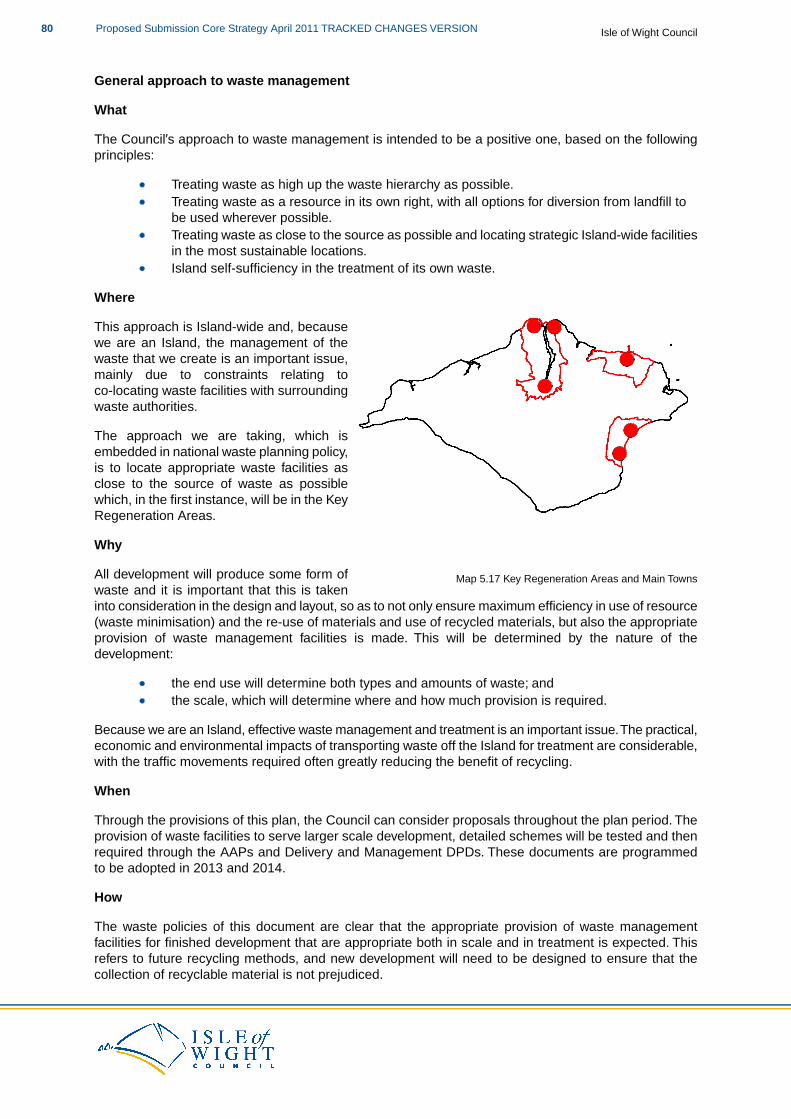
General approach to waste management
What
The Council’s approach to waste management is intended to be a positive one, based on the followingprinciples:
Treating waste as high up the waste hierarchy as possible.Treating waste as a resource in its own right, with all options for diversion from landfill tobe used wherever possible.Treating waste as close to the source as possible and locating strategic Island-wide facilitiesin the most sustainable locations.
Map 5.17 Key Regeneration Areas and Main Towns
Island self-sufficiency in the treatment of its own waste.
Where
This approach is Island-wide and, becausewe are an Island, the management of thewaste that we create is an important issue,mainly due to constraints relating toco-locating waste facilities with surroundingwaste authorities.
The approach we are taking, which isembedded in national waste planning policy,is to locate appropriate waste facilities asclose to the source of waste as possiblewhich, in the first instance, will be in the KeyRegeneration Areas.
Why
All development will produce some form ofwaste and it is important that this is takeninto consideration in the design and layout, so as to not only ensure maximum efficiency in use of resource(waste minimisation) and the re-use of materials and use of recycled materials, but also the appropriateprovision of waste management facilities is made. This will be determined by the nature of thedevelopment:
the end use will determine both types and amounts of waste; andthe scale, which will determine where and how much provision is required.
Because we are an Island, effective waste management and treatment is an important issue.The practical,economic and environmental impacts of transporting waste off the Island for treatment are considerable,with the traffic movements required often greatly reducing the benefit of recycling.
When
Through the provisions of this plan, the Council can consider proposals throughout the plan period. Theprovision of waste facilities to serve larger scale development, detailed schemes will be tested and thenrequired through the AAPs and Delivery and Management DPDs. These documents are programmedto be adopted in 2013 and 2014.
How
The waste policies of this document are clear that the appropriate provision of waste managementfacilities for finished development that are appropriate both in scale and in treatment is expected. Thisrefers to future recycling methods, and new development will need to be designed to ensure that thecollection of recyclable material is not prejudiced.
Isle of Wight CouncilProposed Submission Core Strategy April 2011 TRACKED CHANGES VERSION80
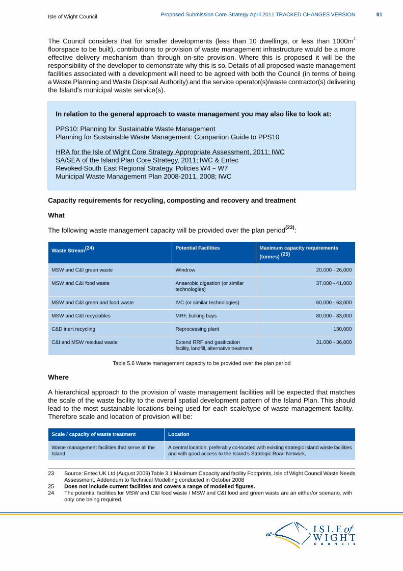
The Council considers that for smaller developments (less than 10 dwellings, or less than 1000m2
floorspace to be built), contributions to provision of waste management infrastructure would be a moreeffective delivery mechanism than through on-site provision. Where this is proposed it will be theresponsibility of the developer to demonstrate why this is so. Details of all proposed waste managementfacilities associated with a development will need to be agreed with both the Council (in terms of beinga Waste Planning and Waste Disposal Authority) and the service operator(s)/waste contractor(s) deliveringthe Island’s municipal waste service(s).
In relation to the general approach to waste management you may also like to look at:
PPS10: Planning for Sustainable Waste ManagementPlanning for Sustainable Waste Management: Companion Guide to PPS10
HRA for the Isle of Wight Core Strategy Appropriate Assessment, 2011; IWCSA/SEA of the Island Plan Core Strategy, 2011; IWC & EntecRevoked South East Regional Strategy, Policies W4 – W7Municipal Waste Management Plan 2008-2011, 2008; IWC
Capacity requirements for recycling, composting and recovery and treatment
What
The following waste management capacity will be provided over the plan period(23):
Maximum capacity requirements
(tonnes) (25)Potential FacilitiesWaste Stream(24)
20,000 - 26,000WindrowMSW and C&I green waste
37,000 - 41,000Anaerobic digestion (or similartechnologies)
MSW and C&I food waste
60,000 - 63,000IVC (or similar technologies)MSW and C&I green and food waste
80,000 - 83,000MRF, bulking baysMSW and C&I recyclables
130,000Reprocessing plantC&D inert recycling
31,000 - 36,000Extend RRF and gasificationfacility, landfill, alternative treatment
C&I and MSW residual waste
Table 5.6 Waste management capacity to be provided over the plan period
Where
A hierarchical approach to the provision of waste management facilities will be expected that matchesthe scale of the waste facility to the overall spatial development pattern of the Island Plan. This shouldlead to the most sustainable locations being used for each scale/type of waste management facility.Therefore scale and location of provision will be:
LocationScale / capacity of waste treatment
A central location, preferably co-located with existing strategic Island waste facilitiesand with good access to the Island's Strategic Road Network.
Waste management facilities that serve all theIsland
23 Source: Entec UK Ltd (August 2009) Table 3.1 Maximum Capacity and facility Footprints, Isle of Wight Council Waste NeedsAssessment, Addendum to Technical Modelling conducted in October 2008
25 Does not include current facilities and covers a range of modelled figures.24 The potential facilities for MSW and C&I food waste / MSW and C&I food and green waste are an either/or scenario, with
only one being required.
81Proposed Submission Core Strategy April 2011 TRACKED CHANGES VERSIONIsle of Wight Council
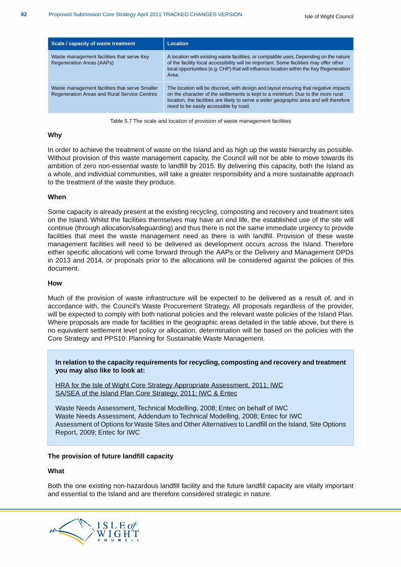
LocationScale / capacity of waste treatment
A location with existing waste facilities, or compatible uses. Depending on the natureof the facility local accessibility will be important. Some facilities may offer other
Waste management facilities that serve KeyRegeneration Areas (AAPs)
local opportunities (e.g. CHP) that will influence location within the Key RegenerationArea.
The location will be discreet, with design and layout ensuring that negative impactson the character of the settlements is kept to a minimum. Due to the more rural
Waste management facilities that serve SmallerRegeneration Areas and Rural Service Centres
location, the facilities are likely to serve a wider geographic area and will thereforeneed to be easily accessible by road.
Table 5.7 The scale and location of provision of waste management facilities
Why
In order to achieve the treatment of waste on the Island and as high up the waste hierarchy as possible.Without provision of this waste management capacity, the Council will not be able to move towards itsambition of zero non-essential waste to landfill by 2015. By delivering this capacity, both the Island asa whole, and individual communities, will take a greater responsibility and a more sustainable approachto the treatment of the waste they produce.
When
Some capacity is already present at the existing recycling, composting and recovery and treatment siteson the Island. Whilst the facilities themselves may have an end life, the established use of the site willcontinue (through allocation/safeguarding) and thus there is not the same immediate urgency to providefacilities that meet the waste management need as there is with landfill. Provision of these wastemanagement facilities will need to be delivered as development occurs across the Island. Thereforeeither specific allocations will come forward through the AAPs or the Delivery and Management DPDsin 2013 and 2014, or proposals prior to the allocations will be considered against the policies of thisdocument.
How
Much of the provision of waste infrastructure will be expected to be delivered as a result of, and inaccordance with, the Council’s Waste Procurement Strategy. All proposals regardless of the provider,will be expected to comply with both national policies and the relevant waste policies of the Island Plan.Where proposals are made for facilities in the geographic areas detailed in the table above, but there isno equivalent settlement level policy or allocation, determination will be based on the policies with theCore Strategy and PPS10: Planning for Sustainable Waste Management.
In relation to the capacity requirements for recycling, composting and recovery and treatmentyou may also like to look at:
HRA for the Isle of Wight Core Strategy Appropriate Assessment, 2011; IWCSA/SEA of the Island Plan Core Strategy, 2011; IWC & Entec
Waste Needs Assessment, Technical Modelling, 2008; Entec on behalf of IWCWaste Needs Assessment, Addendum to Technical Modelling, 2008; Entec for IWCAssessment of Options for Waste Sites and Other Alternatives to Landfill on the Island, Site OptionsReport, 2009; Entec for IWC
The provision of future landfill capacity
What
Both the one existing non-hazardous landfill facility and the future landfill capacity are vitally importantand essential to the Island and are therefore considered strategic in nature.
Isle of Wight CouncilProposed Submission Core Strategy April 2011 TRACKED CHANGES VERSION82
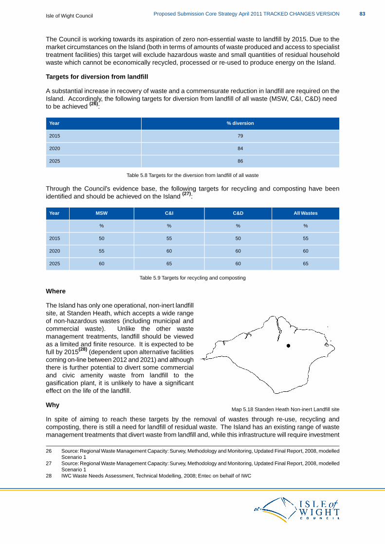
The Council is working towards its aspiration of zero non-essential waste to landfill by 2015. Due to themarket circumstances on the Island (both in terms of amounts of waste produced and access to specialisttreatment facilities) this target will exclude hazardous waste and small quantities of residual householdwaste which cannot be economically recycled, processed or re-used to produce energy on the Island.
Targets for diversion from landfill
A substantial increase in recovery of waste and a commensurate reduction in landfill are required on theIsland. Accordingly, the following targets for diversion from landfill of all waste (MSW, C&I, C&D) needto be achieved (26):
% diversionYear
792015
842020
862025
Table 5.8 Targets for the diversion from landfill of all waste
Through the Council’s evidence base, the following targets for recycling and composting have beenidentified and should be achieved on the Island (27):
All WastesC&DC&IMSWYear
%%%%
555055502015
606060552020
656065602025
Table 5.9 Targets for recycling and composting
Where
Map 5.18 Standen Heath Non-inert Landfill site
The Island has only one operational, non-inert landfillsite, at Standen Heath, which accepts a wide rangeof non-hazardous wastes (including municipal andcommercial waste). Unlike the other wastemanagement treatments, landfill should be viewedas a limited and finite resource. It is expected to befull by 2015(28) (dependent upon alternative facilitiescoming on-line between 2012 and 2021) and althoughthere is further potential to divert some commercialand civic amenity waste from landfill to thegasification plant, it is unlikely to have a significanteffect on the life of the landfill.
Why
In spite of aiming to reach these targets by the removal of wastes through re-use, recycling andcomposting, there is still a need for landfill of residual waste. The Island has an existing range of wastemanagement treatments that divert waste from landfill and, while this infrastructure will require investment
26 Source: Regional Waste Management Capacity: Survey, Methodology and Monitoring, Updated Final Report, 2008, modelledScenario 1
27 Source: Regional Waste Management Capacity: Survey, Methodology and Monitoring, Updated Final Report, 2008, modelledScenario 1
28 IWC Waste Needs Assessment, Technical Modelling, 2008; Entec on behalf of IWC
83Proposed Submission Core Strategy April 2011 TRACKED CHANGES VERSIONIsle of Wight Council
at some point in the future, the potential capacity to manage waste by these means (such as gasification,windrow composting, recycling and recovery) remains.
When
The Council has therefore already identified a need for additional landfill capacity after 2015(29). Thismust be effectively planned for within the Core Strategy plan period (to 2027) and the ProcurementStrategy for the Future of Waste (2011-2026). It will also be important within the context of procuring anew waste management contract beyond 2015. The ambition of not requiring any landfill capacity dueto the Island’s approach to waste is supported, but there is recognition that a limited amount of landfillcapacity is required in the short-term to ensure that the overall ambition can ultimately be met.
How
The landfill requirement will be reviewed and updated regularly as part of a plan-monitor-manage approachto the provision of all waste management capacity. Both the Core Strategy delivery plan and theProcurement Strategy for the Future of Waste (2011-2026) will provide monitoring indicators that will actas the trigger for when a more comprehensive review of waste modelling data is required. The monitoringinformation and modelling data will be used to measure provision of landfill, the need for capacity andindicate any need to review policy and allocations to ensure sufficient capacity is being delivered.
Therefore, both the existing facility and allocation made in the Core Strategy are safeguarded.
The allocation of a range of sites to provide a flexible approach to waste management will primarily bedelivered through the three AAPs as they represent the focus for regeneration and development on theIsland.This will generate the greatest increase in waste and, by siting waste management facilities withinthe AAP boundaries, it will accord with the principle of treating waste as close to source as possible. Itwill also raise the profile of waste management in the minds of those who generate the waste.
Once the landfill site is allocated, the Council, as the Waste Planning Authority, will need to seek planningpermission for the detailed works associated with the provision of the landfill capacity.The documentationassociated with such an application will, as required by the above policy, need to demonstrate how thelocal key constraints have been taken into account.
Whilst the Council’s evidence base demonstrates that there are no strategic level barriers to thedevelopment of further landfill capacity, there are site specific issues that require further attention andunderstanding.
The HRA concludes no likely significant effects on Bechstein’s bats, an interest feature of BriddlesfordCopses SAC, arising from the proposed waste site at Standen Heath, on the basis that the site does notinvolve loss of woodland habitat, although being within the foraging range of this species.
Therefore, the Council considers that the key local issues for the Standen Heath site are:
The potential visual impacts on the surrounding landscape and the context of the AONB.The potential impacts on the local SINCs and other biodiversity assets.The potential impacts on the drainage and watercourses from the site and in to/from thesurrounding area.The potential impact on the archaeology of the site, which includes the Motkin Boundary.
SP8 and Habitat Regulations Assessment
Following the recommendations of the Habitat Regulations Assessment of the Core Strategy, proposalsthat relate to this policy should consider the need for mitigation measures. This will be dependent uponthe type of proposal to which the Core Strategy policies are being applied and the proximity of thedevelopment proposal to European and Ramsar sites.
29 Municipal Waste Management Plan 2008-2011, 2008; IWC
Isle of Wight CouncilProposed Submission Core Strategy April 2011 TRACKED CHANGES VERSION84
The likely mitigation measures required are set out in the following table:
Required Mitigation
Enhancement of existing corridors off-site. On-site provision of appropriate greenspace buffer with no access, visitor management, siteaccess and management, education and interpretation.
In relation to the provision of future landfill capacity, you may also like to look at:
HRA for the Isle of Wight Core Strategy Appropriate Assessment, 2011; IWCSA/SEA of the Island Plan Core Strategy, 2011; IWC & Entec
Assessment of Options for Waste Sites and Other Alternatives to Landfill on the Island, Site OptionsReport, 2009; Entec for IWCIsland Plan Waste Sites Summary Report, 2009; Entec for IWCLandfill Options Assessment, 2010; Entec for IWC
Policy SP8 Waste is particularly linked to the following policies of this plan:
DM17 RenewablesDM20 WasteDM21 MineralsDM223 Developer Contributions
AAP1 Medina Valley AAP2 Ryde AAP3 The Bay
SP1 Spatial StrategySP2 Housing
Minerals
SP9 Minerals
All mineral proposals will need to demonstrate proper consideration of the relevant associatedsocial, environmental and economic effects and, where these are negative, seek in the firstinstance to avoid, then mitigate and finally compensate these effects. The local context ofpotential mineral supply is likely to create exceptional circumstances that require a flexibleapproach to be taken towards the AONB and groundwater protection, where these wouldnormally be excluded, in order to provide a realistic range of mineral sites. In such exceptionalcircumstances, mineral development will be allowed where it can be demonstrated to meetthe requirements of this policy to the Council’s satisfaction. Any permission granted formineral development that is assessed as likely to have a significant negative effect willrequire mitigation, where relevant compensation and (where permission is temporary)restoration plans, that will be carried out to high environmental standards and be specificto the local interest features that are likely to be impacted upon.
Primary Aggregates
The Council will provide for 0.1 million tonnes per annum of land-won sand and gravel, withdue regard to geological, environmental and market considerations, and maintain a landbankof at least seven years of planning permissions for land-won sand and gravel, sufficient todeliver the Island’s identified need.To ensure that this is delivered, the Council will:
85Proposed Submission Core Strategy April 2011 TRACKED CHANGES VERSIONIsle of Wight Council
1. Safeguard existing mineral sites and when the landbank falls below this indicatorthreshold, new permissions will be considered positively by the Council where theysupport the policy approach to minerals in this plan.
2. Take a sequential approach to both the identification of allocations and when determiningplanning applications, which only considers protected areas when there are strongoverriding sustainability reasons and geological conditions and negative impacts canbe properly mitigated.
3. Allocate the following sites, which are shown on the Proposals Map:
MA1: Crockers FarmMA2: Lavender FarmMA3: Cheverton FarmMA4: Blackwater Quarry (western extension)MA5: Cheverton Gravel Pit MA6: Blackwater Quarry
Mineral Safeguarding Areas (MSAs)
Mineral Safeguarding Areas (MSAs) are identified on the Proposals Map to protect thefollowing mineral related assets from unnecessary sterilisation by development:
Proven deposits of Island minerals which are, or may become, of economic importancewithin the foreseeable future.Mineral sites and infrastructure including wharves that are necessary to the processingand transport of minerals.
Recycled and Secondary Aggregates
The Council will work towards achieving a target 0.1 million tonnes per annum of recycledand secondary aggregates by 2016 through:
A. Safeguarding sites that already have permission to carry out activities associated withthe supply of recycled and secondary material; and
B. Supporting, in principle, proposals that contribute to achieving the recycled andsecondary aggregates target.
Aggregate Wharves
Aggregate Wharves, as shown on the Proposals Map, are of strategic importance in termsof the transportation of minerals and other goods and are therefore safeguarded.The Councilwill support appropriate improvement, modernisation and extension of aggregate wharvesthat are in accordance with the relevant policies of this Plan. Proposals for new wharf facilitiesshould consider the relevant areas against which all mineral applications will be consideredas detailed in policy DM21.
Planning for uncertainty in mineral demand
Where a specific development project, such as the Highways PFI, generates a significantdemand that is in addition to those accounted for in the provision of the Council’s minerallandbank, the use of borrow pits will be considered to help fulfil such an unanticipateddemand.Where such a proposal is made, it will be expected to comply with the requirementsof both this policy and DM21 and any other relevant policies within the Core Strategy.
The policy approach to minerals can be split into four distinct areas: primary aggregates; recycled andsecondary aggregates; aggregate wharves; and planning for uncertainty in mineral demand.The approachtaken to these is explained in the supporting text.
Isle of Wight CouncilProposed Submission Core Strategy April 2011 TRACKED CHANGES VERSION86

Primary Aggregates
What
Primary aggregates on the Isle of Wight relate only to sand and gravel and this is in line with the nationalpriority for the provision of land-won minerals. However, it is recognised that, at a local level, otherindigenous minerals (such as chalk) are important and, where an allocation can be identified and justified,it will receive similar consideration as sand and gravel.
Our monitoring returns for the period 2004-2009(30) show that on average the Island has been producing100,022.05 tonnes of sand and gravel per year (although the trend over the years has been of yearlyreductions of production). So the delivery of 0.1 million tonnes per annum (mtpa) over the plan periodreflects almost exactly the historical average delivery rates (since 2004).
To contribute to the delivery of the target and following technical work and assessments of sites promotedto the Council, we have allocated six sites following technical work and assessments of sites promotedto the Council. The assessment of the potential for mineral sites on the Island was undertaken betweenFebruary 2009 and October 2010 and focussed upon identifying and evaluating potential sites for sandand gravel and chalk extraction. The approach has been based upon guidance issued by the PlanningAdvisory Service which recommends three broad sets of criteria to be considered when developing siteoptions for developing plan documents. (31) These are deliverability criteria (e.g. land ownership, access);exclusionary criteria (e.g. European sites of biodiversity importance) and discretionary criteria (e.g. localdesignations). Full details of this assessment work can be viewed in the 'Assessment of the Potentialfor Mineral Sites on the Island - Site Options Report' (Entec UK Ltd, October 2010). The assessmenthas been used to inform the selection of sites for allocation.
Where
Due to the nature of sand and gravel, they can only be won where they are found. This potentially limitsthe areas of search for future reserves, especially when taking into account constraining features suchas environmental designations, the Island’s settlements and allocations. Because of this there may, inexceptional circumstances, be mineral sites identified in locations that are particularly sensitive. Wherethis is the case, extraction of the primary aggregates will need to be justified against the above policyand related Core Strategy policies, Minerals Policy Statement 1 (MPS1) and other relevant nationalplanning policy.
The allocated sites are:
30 Sales reported as part of the Aggregates Monitoring survey to SEERAWP. Figures for 2005 could not be reported due toconfidentiality.
31 Planning Advisory Service - Local Development Options Generation and Appraisal (March 2008)
87Proposed Submission Core Strategy April 2011 TRACKED CHANGES VERSIONIsle of Wight Council
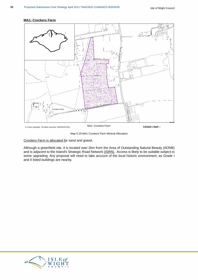
MA1: Crockers Farm
Crockers Farm COWES ROAD
NEW
PORT
ROA
D
MA1: Crockers Farm 0 30 60 90 12015Meters ¯© Crown copyright. All rights reserved. 100019229 2011.
!(
Map 5.19 MA1 Crockers Farm Mineral Allocation
Crockers Farm is allocated for sand and gravel.
Although a greenfield site, it is located over 2km from the Area of Outstanding Natural Beauty (AONB)and is adjacent to the Island’s Strategic Road Network (ISRN). Access is likely to be suitable subject tosome upgrading. Any proposal will need to take account of the local historic environment, as Grade Iand II listed buildings are nearby.
Isle of Wight CouncilProposed Submission Core Strategy April 2011 TRACKED CHANGES VERSION88
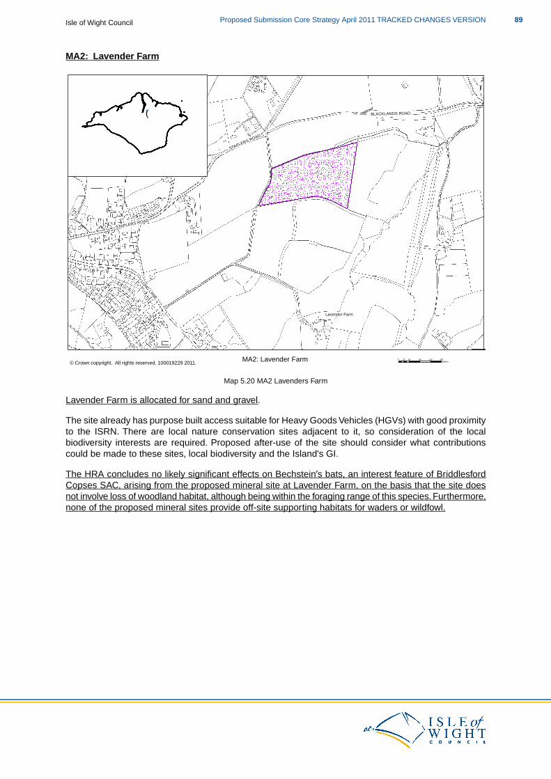
MA2: Lavender Farm
Lavender Farm
STAPLERS ROAD
STAPLERS ROAD
BLACKLANDS ROAD
LONG LANE
MA2: Lavender Farm 0 40 80 120 16020 Meters ¯© Crown copyright. All rights reserved. 100019229 2011.
!(
Map 5.20 MA2 Lavenders Farm
Lavender Farm is allocated for sand and gravel.
The site already has purpose built access suitable for Heavy Goods Vehicles (HGVs) with good proximityto the ISRN. There are local nature conservation sites adjacent to it, so consideration of the localbiodiversity interests are required. Proposed after-use of the site should consider what contributionscould be made to these sites, local biodiversity and the Island's GI.
The HRA concludes no likely significant effects on Bechstein’s bats, an interest feature of BriddlesfordCopses SAC, arising from the proposed mineral site at Lavender Farm, on the basis that the site doesnot involve loss of woodland habitat, although being within the foraging range of this species. Furthermore,none of the proposed mineral sites provide off-site supporting habitats for waders or wildfowl.
89Proposed Submission Core Strategy April 2011 TRACKED CHANGES VERSIONIsle of Wight Council
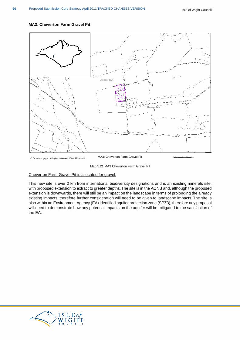
MA3: Cheverton Farm Gravel Pit
Limerstone Down
Cheverton Down
MA3: Cheverton Farm Gravel Pit 0 40 80 120 16020 Meters ¯© Crown copyright. All rights reserved. 100019229 2011.
!(
Map 5.21 MA3 Cheverton Farm Gravel Pit
Cheverton Farm Gravel Pit is allocated for gravel.
This new site is over 2 km from international biodiversity designations and is an existing minerals site,with proposed extension to extract to greater depths.The site is in the AONB and, although the proposedextension is downwards, there will still be an impact on the landscape in terms of prolonging the alreadyexisting impacts, therefore further consideration will need to be given to landscape impacts. The site isalso within an Environment Agency (EA) identified aquifer protection zone (SPZ3), therefore any proposalwill need to demonstrate how any potential impacts on the aquifer will be mitigated to the satisfaction ofthe EA.
Isle of Wight CouncilProposed Submission Core Strategy April 2011 TRACKED CHANGES VERSION90
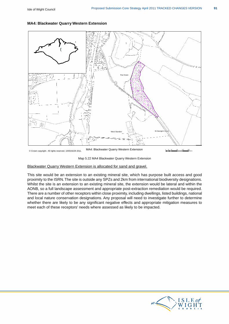
MA4: Blackwater Quarry Western Extension
West Standen St George's Down
Pan Down
BLAC
KWAT
ER R
OAD
ST GEORGES LANE
MA4: Blackwater Quarry Western Extension 0 40 80 120 16020 Meters ¯© Crown copyright. All rights reserved. 100019229 2011.
!(
Map 5.22 MA4 Blackwater Quarry Western Extension
Blackwater Quarry Western Extension is allocated for sand and gravel.
This site would be an extension to an existing mineral site, which has purpose built access and goodproximity to the ISRN.The site is outside any SPZs and 2km from international biodiversity designations.Whilst the site is an extension to an existing mineral site, the extension would be lateral and within theAONB, so a full landscape assessment and appropriate post-extraction remediation would be required.There are a number of other receptors within close proximity, including dwellings, listed buildings, nationaland local nature conservation designations. Any proposal will need to investigate further to determinewhether there are likely to be any significant negative effects and appropriate mitigation measures tomeet each of these receptors' needs where assessed as likely to be impacted.
91Proposed Submission Core Strategy April 2011 TRACKED CHANGES VERSIONIsle of Wight Council
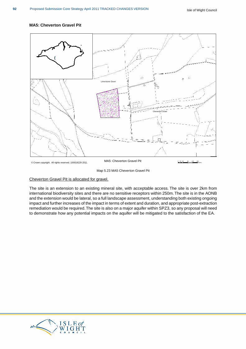
MA5: Cheverton Gravel Pit
Limerstone Down
Cheverton Down
MA5: Cheverton Gravel Pit 0 40 80 120 16020 Meters ¯© Crown copyright. All rights reserved. 100019229 2011.
!(
Map 5.23 MA5 Cheverton Gravel Pit
Cheverton Gravel Pit is allocated for gravel.
The site is an extension to an existing mineral site, with acceptable access. The site is over 2km frominternational biodiversity sites and there are no sensitive receptors within 250m. The site is in the AONBand the extension would be lateral, so a full landscape assessment, understanding both existing ongoingimpact and further increases of the impact in terms of extent and duration, and appropriate post-extractionremediation would be required.The site is also on a major aquifer within SPZ3, so any proposal will needto demonstrate how any potential impacts on the aquifer will be mitigated to the satisfaction of the EA.
Isle of Wight CouncilProposed Submission Core Strategy April 2011 TRACKED CHANGES VERSION92
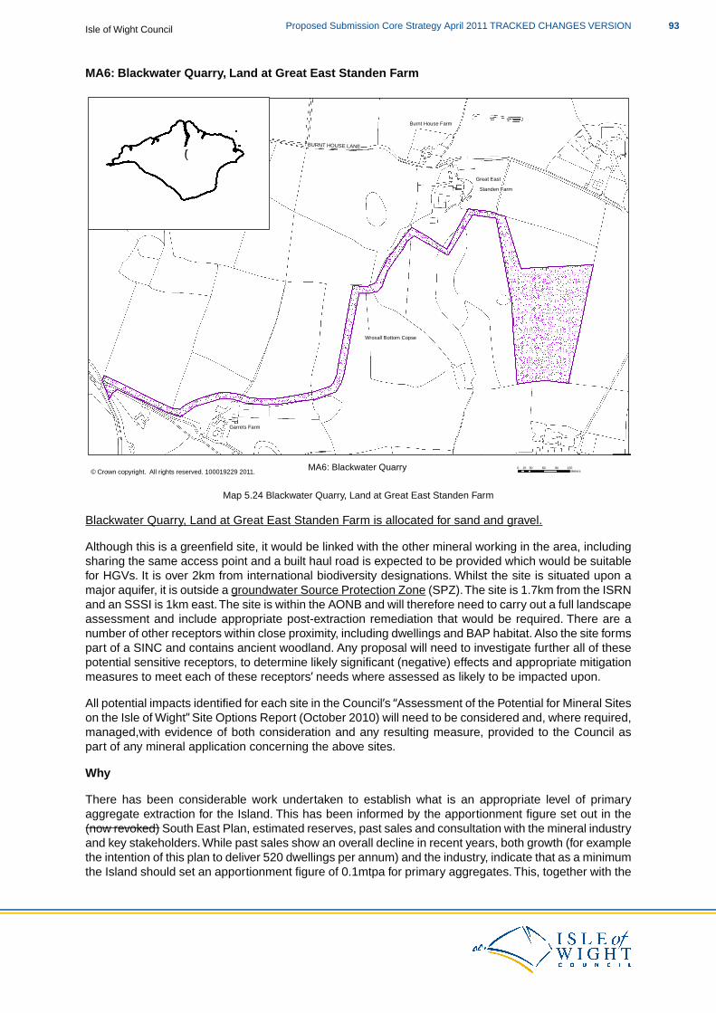
MA6: Blackwater Quarry, Land at Great East Standen Farm
Great East
Wroxall Bottom Copse
Garrets Farm
Burnt House Farm
Standen Farm
BURNT HOUSE LANE
MA6: Blackwater Quarry 0 30 60 90 12015Meters ¯© Crown copyright. All rights reserved. 100019229 2011.
!(
Map 5.24 Blackwater Quarry, Land at Great East Standen Farm
Blackwater Quarry, Land at Great East Standen Farm is allocated for sand and gravel.
Although this is a greenfield site, it would be linked with the other mineral working in the area, includingsharing the same access point and a built haul road is expected to be provided which would be suitablefor HGVs. It is over 2km from international biodiversity designations. Whilst the site is situated upon amajor aquifer, it is outside a groundwater Source Protection Zone (SPZ).The site is 1.7km from the ISRNand an SSSI is 1km east.The site is within the AONB and will therefore need to carry out a full landscapeassessment and include appropriate post-extraction remediation that would be required. There are anumber of other receptors within close proximity, including dwellings and BAP habitat. Also the site formspart of a SINC and contains ancient woodland. Any proposal will need to investigate further all of thesepotential sensitive receptors, to determine likely significant (negative) effects and appropriate mitigationmeasures to meet each of these receptors’ needs where assessed as likely to be impacted upon.
All potential impacts identified for each site in the Council’s “Assessment of the Potential for Mineral Siteson the Isle of Wight” Site Options Report (October 2010) will need to be considered and, where required,managed,with evidence of both consideration and any resulting measure, provided to the Council aspart of any mineral application concerning the above sites.
Why
There has been considerable work undertaken to establish what is an appropriate level of primaryaggregate extraction for the Island. This has been informed by the apportionment figure set out in the(now revoked) South East Plan, estimated reserves, past sales and consultation with the mineral industryand key stakeholders.While past sales show an overall decline in recent years, both growth (for examplethe intention of this plan to deliver 520 dwellings per annum) and the industry, indicate that as a minimumthe Island should set an apportionment figure of 0.1mtpa for primary aggregates. This, together with the
93Proposed Submission Core Strategy April 2011 TRACKED CHANGES VERSIONIsle of Wight Council
apportionment for recycled and secondary aggregate, will be reviewed on an annual basis.
The Council has undertaken an assessment of potential mineral sites(32).This provides detailed informationin relation to the Island’s mineral resources and potential sites to meet extraction requirements and hasinformed this Core Strategy approach. Part of this assessment approach also examined the local contextof potential mineral supply and how it is necessary to take a flexible approach to some environmentaldesignations (the AONB and groundwater protection) where these would normally exclude consideration,in order to provide a realistic range of mineral site options. However, this approach should not be seenas undermining these designations and where planning permission is sought in such areas, mitigationmeasures and appropriate restoration will be expected as detailed in policy DM21 (Minerals).
When
The Council expects the ongoing commitment to the extraction of primary aggregates to continuethroughout the plan period. In addition to the allocations made in this policy (including mineral sites,MSAs and aggregate wharves), where through monitoring it is demonstrated that these are not sufficient,further mineral allocations will be made in the AAPs and the Delivery and Management DPDs which areprogrammed to be adopted in 2013 and 2014.
How
The policy mechanisms set out in this document facilitate the delivery of the 0.1mtpa target for primaryaggregates over the plan period, whilst maintaining a seven year landbank.
The Council’s approach to MSAs is that they should cover all activities relevant and necessary to theprovision of minerals on the Island, and not be solely concerned with sand and gravel sites. MSAs will:
apply to all indigenous mineral deposits that have economic potential; andsafeguard other mineral related facilities such as existing mineral sites, handling anddistribution facilities, wharves and aggregate recycling sites.
The aim of MSAs is to help prevent unnecessary sterilisation of minerals resources however with 'nopresumption that resources defined in MSAs will be worked' (MPS1 Paragraph 13). They are areas ofknown mineral resources that are considered to be of sufficient economic value to require protection andensure that the future need for these resources is considered when applications for other forms ofdevelopment in these areas are brought forward and determined.
When it came to defining the extent of the MSAs for sand and gravel, the minerals baseline data suppliedby the BGS was selected as the best available data. In addition, sites outside the BGS sand and gravelareas where operators/ landowners/ other interested parties have indicated that minerals can be wonhave also been identified as areas to be safeguarded.
The chalk MSA consists of existing chalk extraction sites and those which have been put forward forfuture chalk extraction. Areas of the BGS chalk resource surrounding the sites up to 1000m from the siteboundary have also been safeguarded. This approach therefore protects a larger area of the potentialextent of the mineral reserves at and surrounding these sites from sterilisation in order to protect futurelocal need.
All of these areas are considered of economic importance for the longer term sustainability of the mineralindustry on the Island and should therefore be protected from development which might sterilise them,or prejudice their use for mineral development.
In relation to the general approach to primary aggregates you may also like to look at:
MPS1: Planning and Minerals and Practice GuidanceMPS2: Controlling and Mitigating the Environmental Effects of Mineral Extraction in England
32 Mineral Site Options and MSAs, 2010; Entec for IWC
Isle of Wight CouncilProposed Submission Core Strategy April 2011 TRACKED CHANGES VERSION94

HRA for the Isle of Wight Core Strategy Appropriate Assessment, 2011; IWCSA/SEA of the Island Plan Core Strategy, 2011; IWC & EntecMineral Resource Information in Support of National, Regional and Local Planning, Isle of Wight –British Geological Survey Commissioned Report CR/02/130NIsle of Wight Mineral Site Options and MSAs, 2010; Entec for IWCIsle of Wight AONB Management Plan 2009 - 2014Aggregates Monitoring Report 2008, South East England Partnership Board, 2009
Recycled and Secondary Aggregates
What
Recycled aggregate is mainly derived from construction and demolition waste. Secondary materialsinclude spent rail ballast, pulverised fuel ash, waste glass and scrap tyres. The use of such materials isgenerally encouraged as an alternative to finite natural reserves of primary aggregates.
Where
There are a number of sites across the Island that already have the relevant permissions to undertakeactivities associated with the supply and working of recycled and secondary material.
The Council recognise the importance in increasing the use of recycled and secondary aggregates andwill consider favourably proposals that contribute to the current adopted target(s). The following sitesare considered appropriate in principle for such proposals:
Existing mineral sites.Aggregate wharves and other mineral related development.Co-location with waste management sites.Industrial sites.
Proposals for recycled and secondary aggregates will still need to demonstrate the same considerationof the requirements of this policy and other relevant policies of the Core Strategy and due regard to likelysignificant negative impacts as those associated with the extraction of primary aggregates.
Why
Due to the current capacity of the sites utilising recycled and secondary material, and the target that theCouncil is working towards, there is no need to allocate further sites exclusively for such uses.Thereforea protectionist policy towards the existing facilities, along with the policy support for further sites to comeforward, is considered an appropriate approach.
The target in this policy is derived from previous work at the regional level (to support the revoked SouthEast Plan) to identify an appropriate level of provision of secondary and recycled aggregates and thendisaggregate this overall regional figure to individual MPAs based on a set of criteria. However, this figurehas not been tested locally and, given the uncertainties in relation to both the data and the fact that notall recycling requires dedicated facilities (for example the use of mobile equipment on construction sites),the demand and capacity aspects will need to tested.
The Council will undertake work to provide targets for the provision of secondary and recycled aggregatesfor the remainder of the plan period from 2016 through to 2027. This will test locally the assumptionsmade for the 2016 target and further strengthen the Council’s approach to increase the use of secondaryand recycled materials as substitutes for declining reserves of primary aggregates.
When
This approach to facilities relating to recycled and secondary aggregates will be applied throughout theplan period.
95Proposed Submission Core Strategy April 2011 TRACKED CHANGES VERSIONIsle of Wight Council
How
Whilst the sites are safeguarded, proposals that involve the loss of the activities associated with thesupply of recycled and secondary material will need to demonstrate why the uses are no longer viableor appropriate on the site.
There is the potential that, if further need for such facilities is identified and sites are not coming forwardthrough market forces, further sites could be identified in subsequent DPDs.
In relation to recycled and secondary aggregates you may also like to look at:
MPS1: Planning and Minerals and Practice GuidanceMPS2: Controlling and Mitigating the Environmental Effects of Mineral Extraction in England
HRA for the Isle of Wight Core Strategy Appropriate Assessment, 2011; IWCSA/SEA of the Island Plan Core Strategy, 2011; IWC & EntecIsle of Wight Mineral Site Options and MSAs, 2010; Entec for IWCAggregates Monitoring Report 2008, 2009; SEEPBRecycled & Secondary Aggregates Apportionment Methodology Final Report, 2005; Land UseConsultants for SEERA
Aggregate Wharves
What
Aggregate wharves on the Island provide infrastructure for the importing of minerals from the mainlandand enabling marine-won aggregate to be landed directly on the Island. While this role is essential tothe Island in terms of supplying the necessary materials for development and regeneration, there arealso secondary benefits in terms of wharf use that further define what they mean to the Island (not leasta method for the import and export of bulky goods and a source of employment).
Where
All of the Island’s aggregate wharves are located on the Medina Estuary. This results in the landings notonly occurring within the main area of the Island in terms of employment and business development (andassociated demand for raw materials), but also being centrally located for onward distribution throughoutthe Island. The Island’s aggregate wharves are (from north to south running up the Estuary):
1. Medina Wharf2. Kingston South3. Blackhouse Quay
The location of the wharves in the Key Regeneration Area of the Medina Valley has positive effectsbeyond that of mineral supply. The sharing of wharf infrastructure makes it possible to import and exportbulky goods directly by sea, rather than relying on transporting HGVs on the cross-Solent car ferries,reducing associated road transport impacts on both sides of the Solent.
However, it is also this strategic location of the Island’s aggregate wharves that places their continueduse under pressure from competing uses and constraints, including:
lack of space on existing sites;shallow water and tides limiting access;inability of operators to acquire new land adjacent to existing sites to expand;costs of ensuring navigational route access into wharves;limits on sites working 24 hours a day due to planning conditions and other restrictions;proximity to sensitive receptors;
Isle of Wight CouncilProposed Submission Core Strategy April 2011 TRACKED CHANGES VERSION96
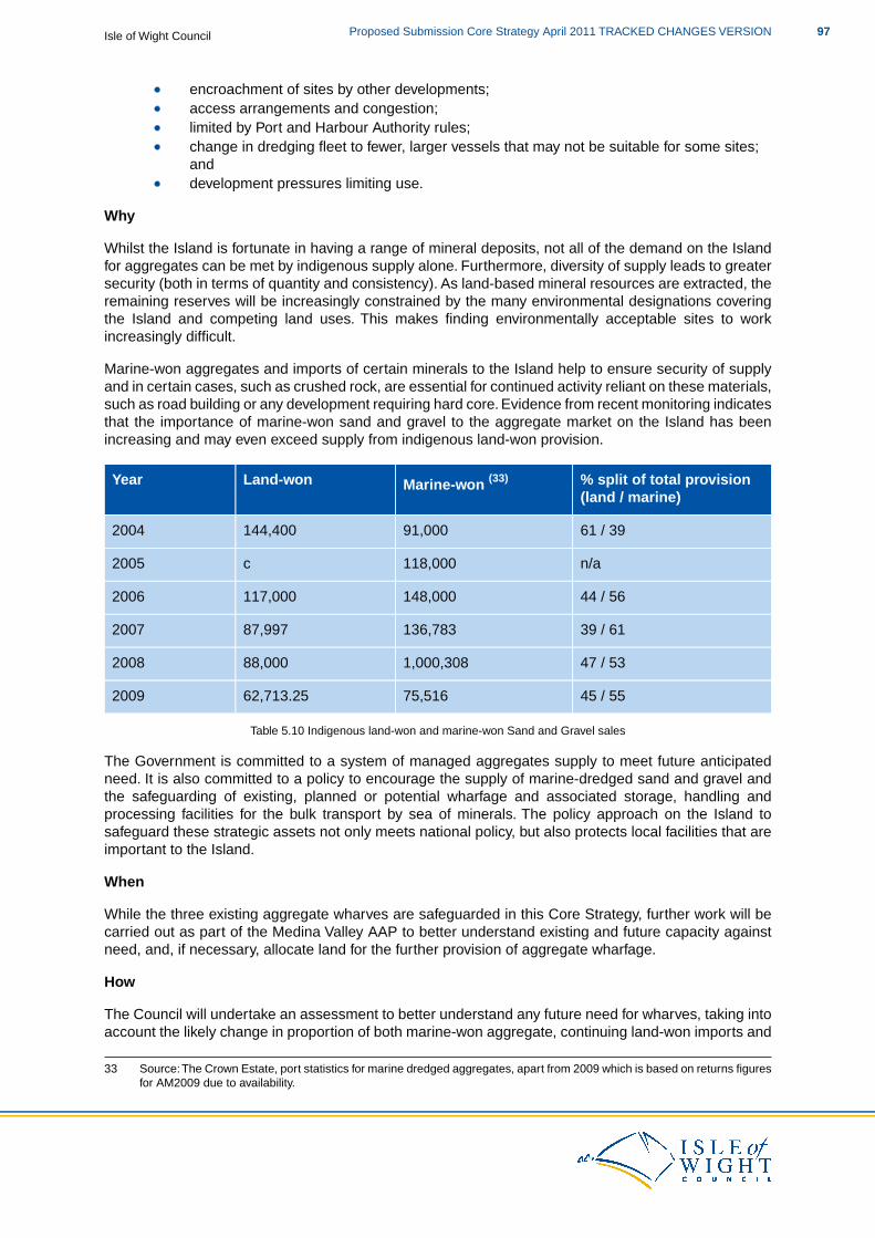
encroachment of sites by other developments;access arrangements and congestion;limited by Port and Harbour Authority rules;change in dredging fleet to fewer, larger vessels that may not be suitable for some sites;anddevelopment pressures limiting use.
Why
Whilst the Island is fortunate in having a range of mineral deposits, not all of the demand on the Islandfor aggregates can be met by indigenous supply alone. Furthermore, diversity of supply leads to greatersecurity (both in terms of quantity and consistency). As land-based mineral resources are extracted, theremaining reserves will be increasingly constrained by the many environmental designations coveringthe Island and competing land uses. This makes finding environmentally acceptable sites to workincreasingly difficult.
Marine-won aggregates and imports of certain minerals to the Island help to ensure security of supplyand in certain cases, such as crushed rock, are essential for continued activity reliant on these materials,such as road building or any development requiring hard core. Evidence from recent monitoring indicatesthat the importance of marine-won sand and gravel to the aggregate market on the Island has beenincreasing and may even exceed supply from indigenous land-won provision.
% split of total provision(land / marine)
Marine-won (33)Land-wonYear
61 / 3991,000144,4002004
n/a118,000c2005
44 / 56148,000117,0002006
39 / 61136,78387,9972007
47 / 531,000,30888,0002008
45 / 5575,51662,713.252009
Table 5.10 Indigenous land-won and marine-won Sand and Gravel sales
The Government is committed to a system of managed aggregates supply to meet future anticipatedneed. It is also committed to a policy to encourage the supply of marine-dredged sand and gravel andthe safeguarding of existing, planned or potential wharfage and associated storage, handling andprocessing facilities for the bulk transport by sea of minerals. The policy approach on the Island tosafeguard these strategic assets not only meets national policy, but also protects local facilities that areimportant to the Island.
When
While the three existing aggregate wharves are safeguarded in this Core Strategy, further work will becarried out as part of the Medina Valley AAP to better understand existing and future capacity againstneed, and, if necessary, allocate land for the further provision of aggregate wharfage.
How
The Council will undertake an assessment to better understand any future need for wharves, taking intoaccount the likely change in proportion of both marine-won aggregate, continuing land-won imports and
33 Source:The Crown Estate, port statistics for marine dredged aggregates, apart from 2009 which is based on returns figuresfor AM2009 due to availability.
97Proposed Submission Core Strategy April 2011 TRACKED CHANGES VERSIONIsle of Wight Council
the demands from major projects, particularly meeting minerals requirements as a result of demandsthat may arise through the Island’s long-term Highways PFI contract. This assessment will assist in theidentification of those sites to be safeguarded. As a minimum, the following strategic criteria are consideredsuitable:
Capacity to supply imported material to the Island.Proximity to local markets.Value of specialist infrastructure.Adequacy of existing or potential environmental safeguards.
This assessment will also provide a better understanding of the economic importance of commercialwaterfronts in the Medina Valley to the Island and will form a key part of the Medina AAP.
In relation to aggregate wharves, you may also like to look at:
MPS1: Planning and Minerals and Practice GuidanceMPS2: Controlling and Mitigating the Environmental Effects of Mineral Extraction in England
HRA for the Isle of Wight Core Strategy Appropriate Assessment, 2011; IWCSA/SEA of the Island Plan Core Strategy, 2011; IWC & EntecIsle of Wight Mineral Site Options and MSAs, 2010; Entec for IWCAggregates Monitoring Report 2008, 2009; SEEPBStudy of Aggregate Wharves and Rail Depots in South East England, 2009; SEERAThe Strategic Importance of the Marine Aggregate Industry to the UK, 2007; BGS Research ReportOR/07/019
Planning for Uncertainty in Mineral Demand
The allocation of sites to provide a seven year landbank is based on an assumption of demand remainingwithin a certain range that is close to existing and recent previous sales. However, there may be certaincivil engineering projects that place demands on the supply of aggregates that are outside of thisassumption. The Council’s Highways PFI in particular will make significant mineral demands, the typesand quantities of which will not be known until much closer to implementation, which ultimately makesanticipation and planning for this provision difficult when taking a conventional approach (i.e. throughallocations). Therefore, a more flexible approach is required and one of the ways in which thisunpredictable demand can be met is through borrow pits.
Borrow pits can be a suitable way of providing material from local sources for specific civil engineeringprojects, both reducing demand on imported minerals and the potential to prematurely shorten the lifeof the allocated landbank. Borrow pits are normally located in close proximity to the project they aresupplying and the Council would expect off-site road traffic impacts to be reduced to a minimum. Theenvironmental advantages and disadvantages in using borrow pits should be explored when consideringthese against other alternative supply options (e.g. land-won imports and marine-dredged). Identifying,assessing, operating and restoring borrow pits should be undertaken to the same standards as thosefor long-term mineral workings and should be subject to similar levels of consideration of environmentalimpacts, as detailed in policy DM21 (Minerals).
SP9 and Habitat Regulations Assessment
Following the recommendations of the Habitat Regulations Assessment of the Core Strategy, proposalsthat relate to this policy should consider the need for mitigation measures. This will be dependent uponthe type of proposal to which the Core Strategy policies are being applied and the proximity of thedevelopment proposal to European and Ramsar sites.
The likely mitigation measures required are set out in the following table:
Isle of Wight CouncilProposed Submission Core Strategy April 2011 TRACKED CHANGES VERSION98

Required Mitigation
Protection of groundwater and geodiversity resources. Management of site operations including provision of landscaping, re-routing ofRights of Way through enhancement or creation of green corridors. Restoration and aftercare for recreational and/or biodiversity provision
In relation to the planning for uncertainty in mineral demand, you may also like to look at:
MPS1: Planning and MineralsPlanning and Minerals: Practice Guide
HRA for the Isle of Wight Core Strategy Appropriate Assessment, 2011; IWCSA/SEA of the Island Plan Core Strategy, 2011; IWC & Entec
Policy SP9 Minerals is particularly linked to the following policies of this plan:
DM1 Sustainable Build Criteria for New DevelopmentDM20 WasteDM21 MineralsDM23 Developer Contributions
AAP1 Medina Valley AAP2 Ryde AAP3 The Bay
SP1 Spatial StrategySP68 Waste
99Proposed Submission Core Strategy April 2011 TRACKED CHANGES VERSIONIsle of Wight Council
6 Area Action Plan Policies
Through the Spatial Strategy, the Council is focussing the majority of the development in three main KeyRegeneration Areas. Each of the Key Regeneration Areas is different in character and the Council hasdifferent aspirations for them. Therefore, and in-line with the guidance set out in PPS12: Local SpatialPlanning, the Council will prepare an Area Action Plan (AAP) for each of the Key Regeneration Areas.
Area Action Plans are Development Plan Documents (DPDs) that address specific areas where significantchange or conservation is needed and focusses on the delivery of area based regeneration initiatives.They can assist in producing a consensus as to the right strategy for an area and how it might beimplemented and they can be a catalyst for getting several key agencies and landowners to work together.The Council is keen to bring forward the AAPs based on the emerging principles of localism, with directengagement at the neighbourhood level to ensure that the AAPs are, as far as is possible, consideredto be community plans.
It is intended that the AAPs will be prepared as much as possible by the communities within the AAPboundaries. The Council wishes to see Parish and Town Councils, or appropriate neighbourhood-levelorganisations, playing a significant role in identifying the needs of the community and the way in whichdevelopment proposals are considered and addressed in the AAPs. The Council will work with suchgroups to ensure that the appropriate technical and procedural issues have been addressed and thatthe AAPs are prepared in conformity with the overarching requirements of the Core Strategy.
The AAP boundaries do not identify an area within which development would be permitted; they are notextensions of the current settlement boundaries. The boundaries identify broad locations within whichthe Council will consider a range of land uses, including residential, employment, leisure and greenspaces, amended settlement boundaries, designated development sites and designated areas forprotection. The Area Action Plan process will also identify land uses which would not be consideredappropriate. The approaches set out in the AAPs will be in general conformity with the policies of theCore Strategy and national planning policy.
The AAP boundaries identify the Key Regeneration Areas and form an ‘area of study’, within which theissues identified in the AAP policies will be considered. Further technical work will be required to fullyassess and understand the issues, and this will form the evidence to underpin the approaches taken inthe AAPs. It is intended that the AAPs will become “mini Core Strategies” for the areas they cover andwill give a comprehensive approach to development for at least the next 15 years.
Once the AAPs have been adopted, there will be no need for the AAP boundaries to be shown on theProposals Map, as their purpose is solely to identify the area within which the AAP has a planning remit.Through the AAPs' amended settlement boundaries, designated development sites and designatedareas for protection will potentially have been identified.
Because the AAPs will make allocations, where appropriate, they will be subject to their own SA/SEA/HRAand will go through public consultation and a public consultation undertaken by an independent PlanningInspector. The expected timetable for each of the AAPs is set out in the Council's Local DevelopmentScheme, which can be viewed on the Council's website.
Medina Valley
The Medina Valley has been identified as being an appropriate area to accommodate further development,primarily due to the scale of the existing settlements and employment provisions and the sustainabilitywork undertaken by the Council. This has been supported through consultation work and the evidencedemonstrates that the area identified by the Area Action Plan (AAP) boundary has the capacity toaccommodate the required level of growth.
The allocations made in the Core Strategy reflect this spatial focus on the Medina Valley. There is landat Worsley Road allocated for residential development (see SP2 Housing)Horsebridge Hill, Stag Laneand Pan for employment uses and St Georges Way for economic development (see SP3 Economy).
Isle of Wight CouncilProposed Submission Core Strategy April 2011 TRACKED CHANGES VERSION100

What is there now and what is its role/function?
The Medina Valley lies in the central north area of the Isle of Wight, with the River Medina forming thecentral spine of the Area Action Plan (AAP) area as identified on the Proposals Map. The Medina Valleyincludes three of the Island’s main towns and centres of population: Newport (the County Town); Cowes;and East Cowes.
Work has previously been undertaken by the Council, in partnership with SEEDA and the Isle of WightEconomic Partnership on a vision for the Medina Valley and this was published as SupplementaryPlanning Guidance (SPG). Whilst the policies of the UDP that the SPG elaborated upon are beingreplaced by the Core Strategy, it is important that the work already undertaken is used to inform the AAP.
Newport
Newport is the historic County Town of the Isle of Wight and, whilst not the most populous town on theIsland (it has a population of around 25,210(34)), it is the primary commercial centre, with 103,650m2 ofground floorspace occupied by town centre uses(35).
A significant portion of the Island’s public sector employers: St Mary’s Hospital; the Isle of Wight College;HMP Isle of Wight (consisting of Albany, Camp Hill and Parkhurst Prisons); and the Isle of Wight Councilare based in Newport.
Cowes
Cowes is a town strongly associated with sailing and the Cowes Week Regatta. It has a strong tourismoffer because of this and is one of the livelier towns on the Island, particularly in the summer when, dueto visitor numbers, the population expands from its usual 10,370(36).
It is also home to large scale employment areas, including several world leading companies specialisingin aerospace, radar, electronics, communications, composites technologies and renewable energy.
East Cowes
East Cowes was, historically, an industrial port town. Due to the general decline of the manufacturingindustry that once supported the town, it now primarily serves as a local centre for its resident populationof around 5,345(37).
It is currently undergoing re-development of key sites within the town centre to contribute to theregeneration of the town. It is also home to employment areas specialising in aerospace, radar, electronics,communications, composites technologies and renewable energy, which are based either on the riverfrontage or to the southern side of East Cowes.
The River Medina
As a working river (although not currently operating at levels experienced in the past), the Medina Riveralso provides the opportunity for wharf facilities and there are a number along the river.
There is an extensive range of environmental designations within the Medina Valley, which includeinternational and national designations as well as sites identified at the local level. The majority of theseare associated, either directly or indirectly, with the river itself.
34 2009 Ward Population Estimates for England and Wales, mid-2007: Office of National Statistics, based on the Wards ofCarisbrooke East, Carisbrooke West, Fairlee, Mountjoy, Newport North, Newport South, Pan and Parkhurst.
35 Isle of Wight Town Centre Health Check Study, 2009: Halcrow, on behalf of IWC36 2009 Ward Population Estimates for England and Wales, mid-2007: Office of National Statistics, based on the Wards of
Cowes Castle East, Cowes Castle West, Cowes Central and Cowes Medina.37 2009 Ward Population Estimates for England and Wales, mid-2007: Office of National Statistics, based on the Wards of
East Cowes North and East Cowes South.
101Proposed Submission Core Strategy April 2011 TRACKED CHANGES VERSIONIsle of Wight Council
Rest of the area
Outside of the main towns, the rural and agricultural setting and activity inform the general character ofthe area, although it does have a long history as an industrial and distribution location. Whilst this hasnow reduced in scale, these activities can still be found.
Objectives for the Medina Valley
The following are the guiding objectives for the Medina Valley Area Action Plan and the provisionsof the Core Strategy and the Medina Valley Area Action Plan will contribute to achieving them forthe Medina Valley:
Housing
The area will experience residential growth of 1,25568 dwellings. These will help to sustain andstrengthen the existing communities, whilst retaining their individual character and identity.
Economy
The Medina Valley, particularly Newport, will strengthen its role as a focal point for employment onthe Island, and will particularly focus on economic development that relates to the development ofclusters in knowledge-driven and high technology industries including marine, renewables andcomposites.
It will continue to be an important area for commercial and employment related development. Thetown centres of Cowes, East Cowes and Newport will be the focus for retail and leisure developmentwithin the Medina Valley, providing for bulk convenience, food shopping and a reasonable rangeof comparison shopping facilities and other services.
Newport will continue to be the primary shopping centre on the Island and, along with the Cowesand East Cowes town centres, will continue to provide a good range of services and facilities thatmeet the needs of the towns and surrounding communities.
Environment
Development will be located in the most sustainable locations and managed to ensure that anynegative impacts on the area’s environment are kept to a minimum avoided. Where this is notpossible necessary, appropriate mitigation measures will be required.
Whilst the Medina Valley is a focus area for development, it is also home to a number of designatedand sensitive environmental sites. These sites will be conserved and wherever possible enhanced.
To determine whether strategic gaps between the main settlements in the Key Regeneration Areaare required to prevent settlement coalescence, but will also contribute to the provision and retentionof the green infrastructure network on the Island.
Travel
The transport infrastructure and network within the Medina Valley is fit for purpose to serve thetowns’ residents and visitors, and opportunities for improvements have been explored.
Waste
Waste facilities, that treat waste close to its source and as high up the waste hierarchy as possible,will be well-designed to serve existing and new development and integrate with their surroundinguses.
Isle of Wight CouncilProposed Submission Core Strategy April 2011 TRACKED CHANGES VERSION102
AAP1 Medina Valley
The Council wants to see the Medina Valley strengthen its position as the focal point forresidential and economic growth on the Isle of Wight.
To help achieve this, the Council will prepare an Area Action Plan (AAP) for the area identifiedas the Medina Valley Key Regeneration Area on the Proposals Map. It will set out a definitiveapproach to the area whilst having regard to the HRA and the policies of the Core Strategy,the objectives for the future of the area, the Cowes Waterfront: A Vision for the Medina Valleydocument and will:
1. Identify appropriate development sites, within or immediately adjacent to the settlementboundaries within the Area Action Plan boundary, for the majority of the 1,25568dwellings allocated for the area.
2. Demonstrate that the allocated sites, either individually or in combination, will have noadverse effects on the integrity of European sites.
3. Provide for the target of 35% of affordable housing, but consider whether levels ofaffordable housing higher than that set out in DM4 can be achieved.
4. Revise the developmentsettlement boundaries within the AAP boundary as required.5. Identify and allocate suitable sites for Gypsies,Travellers and Travelling Showpeople,
in line with the provisions of DM6.6. Determine whether further employmenteconomic development land is required to be
allocated to contribute to the delivery of SP3, particularly whether there is a need forB8 distribution facilities in this general location.
7. Identify employment sites with deep water frontage and establish whether those existinguses require further policy protection, to ensure that deep water access is maintainedfor employment uses that require it.
8. Establish whether there is the need for further retail allocations above that alreadyallocated.
9. Review the Town Centre Boundaries and Primary Retail Frontages.10. Define and ensure that the areas which separate the key settlements of Cowes/Newport,
and East Cowes/Newport are appropriately protected to prevent settlement coalescence.11. Determine how the identified deficiency in Green Infrastructure can be addressed.12. Identify the precise type and location of waste facilities to serve development to
significantly contribute to the waste target set out in SP8.13. Establish the nature and level of renewable energy that will be brought forward through
the proposed development, although the use of Combined Heat and Power (CHP) and/orDistrict Heating schemes will be expected.
14. Consider the feasibility of improving the sustainable transport routes on both sides ofthe River Medina.
15. Establish whether a plan-led, viable and deliverable solution can be identified to addressthe capacity issues at East Cowes ferry terminal.
16. Establish the precise form of the identified junction improvements and whether furtherminor infrastructure provisions will be required to support the location and level ofgrowth proposed within the AAP.
The Council believes the issues listed above to be the key considerations for the MedinaValley AAP. However, it may be appropriate for the AAP to consider further issues to thoselisted above, that are identified through further technical work and consultation.
The issues the AAP will look at
The Core Strategy plans for the provision of 1,25568 new dwellings in the Medina Valley. The MedinaValley AAP will allocate land within or immediately adjacent to the settlement boundaries, in accordance
103Proposed Submission Core Strategy April 2011 TRACKED CHANGES VERSIONIsle of Wight Council

with policy SP2 (Housing), for the majority of this provision. With small-scale sites within the settlementboundaries being considered acceptable in principle, we know that there is some capacity and opportunityfor residential development to come forward without Council intervention(38). Due to the thresholdsemployed in the SHLAA, it is also likely that there are a number of smaller “windfall” sites that may comeforward. Therefore, the Council does not anticipate the need to allocate land for the full number ofdwellings to ensure the delivery of the target.
The figure of 35% affordable housing is well evidenced(39) and considered to be viable on the Island.Due to the potential of housing being delivered on larger sites within the Key Regeneration Area, theCouncil wishes to explore the possibility of whether a higher contribution to the affordable housingprovision on the Island would be possible.
A further Viability Assessment for any development site that is defined as a large-scale major developmentwill be required to establish whether provision higher than 35% affordable housing is viable andappropriate.
With the planned level of growth and acceptance that a number of greenfield sites will be required, it willbe appropriate for the AAP to reconsider the settlement boundaries, to ensure that they incorporatedevelopment sites allocated in the AAP.
If suitable sites are found within the AAP boundary, the Council will allocate sites to meet the needs ofthe Gypsy, Traveller and Travelling Showpeople communities. The sites, if identified, will be broughtforward in accordance with the criteria set out in DM6 (Gypsies, Travellers and Travelling Showpeople).The sites will be small and have a maximum capacity of five/six pitches and, to ensure an appropriatespatial distribution of sites, the Council does not expect that more than two sites will be allocated withinthe Medina Valley, reflecting the proportion of development allocated to the area.
Further employment land across the Island, above that allocated in the Core Strategy, will be requiredto meet the need identified in SP3 (Economy). The AAP will examine whether further allocations ofemployment land are required in the Medina Valley, particularly in the Newport area and establish themost appropriate sites for these.The possibility of storage and distribution facilities that could be locatedsomewhere in the Medina Valley has been put forward a number of times in the past. The Council iskeen to explore this issue and provide evidence either way of the need for such a facility and the AAPis considered the appropriate process to establish this.
There are a number of employment sites on the River Medina that require and use deep water frontage.The Council is aware of the importance of such sites and wishes to examine whether a more detailedprotectionist approach is required to ensure that such sites are retained for employment uses that requireaccess to deep water frontage.
In a similar vein, and in order to meet the target for retail floorspace set out in SP3 (Economy), the AAPwill consider whether there is the need to allocate further sites, or establish a mechanism through whichfurther retail floorspace can be brought forward within the AAP boundary. As part of this process, theexisting town centre boundaries and identified Primary Retail Frontages will be reviewed and potentiallyexpanded, should the need be demonstrated.
Through public consultation it is clear that settlement coalescence, whether it be real or perceived, is asignificant issue, particularly between Newport and Cowes. Further work will be undertaken by the Councilto establish the key landscape sensitivities in the land between Newport/Cowes and Newport/East Cowesand ways in which settlement coalescence can be prevented in the future.
The overall approach to addressing waste is set out in SP6 (Renewables), along with an identified needfor a maximum of 9.7 ha to facilitate a range of waste management technologies. Due to the level ofdevelopment planned for the Medina Valley, it will be necessary to establish the precise requirementsfor treating waste as close to its source and as high up the waste hierarchy as possible. Clearly, oncethe precise location of development has been established, the most appropriate waste facility provision
38 See table 5 of the Strategic Housing Availability Assessment, 2010; IWC39 Affordable Housing Viability Paper, 2009; IWC
Isle of Wight CouncilProposed Submission Core Strategy April 2011 TRACKED CHANGES VERSION104
in terms of type, scale and location can be determined.
The principle of new development providing for renewable energy, particularly within Key RegenerationAreas, has been established within SP6 (Renewables).Whilst the provision of Combined Heat and Power(CHP) and/or District Heating systems is expected, the finer details of the provision will be establishedonce the exact location and type of development is known.
The cycle track between Newport and Cowes, which runs along the old railway line, is a well-used facility.There is a similar link between Newport and East Cowes, although this is not of the same quality anddoes not provide a complete route. The Council is keen to explore ways in which improvements to theseroutes can be facilitated and made.
As set out in the supporting text to DM19 Cross-Solent Travel, in the short to medium-term up to 2020,improvement measures that can be made within current operations and the boundaries of the existingports are expected to be able to accommodate growth in cross-Solent ferry demands. The AAPs willprovide a mechanism for any proposals to be considered and ensure that, where possible, a plan-ledsolution can be put in place in a timely fashion that enables proposals to be considered through theplanning process in good time.
The AAP will also examine whether further infrastructure improvements are required to support theplanned level of growth.The Island-wide transport model shows us that there are unlikely to be problemsassociated with the road network in supporting development. However, it is likely that a more detailedand localised transport model will need to be run to establish exact details, once the exact location ofdevelopment has been established. This work will also need to incorporate vehicle movements from theEast Cowes ferry terminal, factoring in the level of tourism growth and economic development that isplanned up to 2027.
Expected adoption timetable
The timetable for the preparation of the Medina Valley AAP can be found in the Local DevelopmentScheme, which is available to view on the Council’s website. Whilst the principles behind the AAP havebeen through an SA/SEA/HRA and the Core Strategy will go through public examination, the AAP willbe subject to its own SA/SEA/HRA and will go through public consultation and a public examinationundertaken by an independent Planning Inspector.
Whilst the Council wishes to see a comprehensive and clear planning approach to the Medina Valley,and believes that the AAP is the right way to achieve it, it accepts that planning applications may comeforward prior to the adoption of the AAP. Where this is the case, consideration will be given to whetherthe development proposal accords with the approach set out in the Core Strategy and the emergingAAP.
In relation to the Medina Valley Key Regeneration Area you may also like to look at:
PPS1: Delivering Sustainable DevelopmentPPS12: Local Spatial Planning
HRA for the Isle of Wight Core Strategy Appropriate Assessment, 2011; IWCSA/SEA of the Island Plan Core Strategy, 2011; IWC & EntecCore Strategy Policies SP1-9 and DM1-22
105Proposed Submission Core Strategy April 2011 TRACKED CHANGES VERSIONIsle of Wight Council
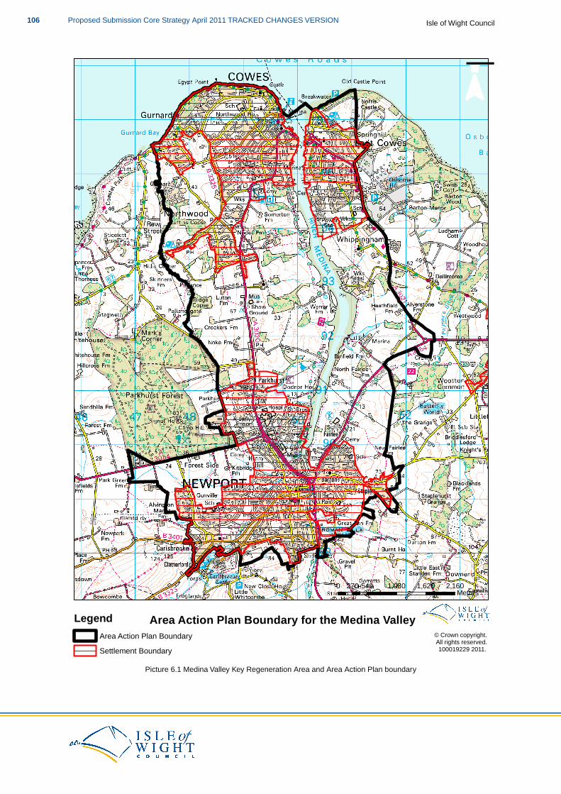
¯
© Crown copyright. All rights reserved. 100019229 2011.
0 540 1,080 1,620 2,160270 Metres
Area Action Plan Boundary for the Medina ValleyLegendArea Action Plan BoundarySettlement Boundary
Picture 6.1 Medina Valley Key Regeneration Area and Area Action Plan boundary
Isle of Wight CouncilProposed Submission Core Strategy April 2011 TRACKED CHANGES VERSION106
Ryde
Ryde has been identified as being an appropriate area to accommodate further development, mainlydue to the established size of the settlement and employment provision, along with sustainability workundertaken by the Council. This has been supported through consultation work and the evidencedemonstrates that the area identified by the Area Action Plan (AAP) boundary has the capacity toaccommodate the required level of growth.
What is there now and what is its role/function?
Ryde is known as one of the main gateways to the Island, which developed as a resort town during theRegency and Victorian periods. The town’s historic street pattern, architectural quality and variety, alongwith its iron pier (the country’s fourth longest pier) built in 1814, gives Ryde considerable historic interestand a special character and sense of place.
Considerable development in the 19th Century created a town with strong economic, social and tourismfunctions and a rich wealth of townscape quality. But changes in the patterns of tourism, and a gradualeconomic decline in the town since the 1960s, has led to a loss of economic prosperity. This has hadan impact on the quality of building maintenance and led to the loss of traditional urban features and thelonger term viability of the town as a whole. However, Ryde is now re-establishing itself as a destinationfor residents and visitors alike and is re-discovering and re-shaping its own unique identity.
Ryde is a coastal town which has the largest population of any town on the Island and serves as asecondary retail and employment centre for the Island. Surrounding the town to the south is enclosedpasture land, with pockets of landscape improvement areas. Integral to the character of Ryde is thesloping land that rises from the foreshore to the top of the town and the valley that runs through the town.
Whilst public open space is limited in Ryde, the promenade has always been, and remains, the mostsignificant public open space in the town, both socially and as a form of recreation. Over the years, theEsplanade has been extended through Appley and Puckpool has been developed as a park.
Ryde has the highest concentration of social deprivation on the Island, and an economic-led regenerationapproach is critical to tackling the challenges that this brings. The Council believes that key to tacklingthis will be achieving the long-term rejuvenation of the town’s tourism and retail offer, combined with theattraction of new jobs.
Ryde is benefitting from a Heritage Lottery Fund Townscape Heritage Initiative (THI), which utilises thecultural, social and economic value of Ryde’s vast collection of historic buildings by improving theappearance and condition of both the public realm and private building stock within the town’s core retailarea. The Council will, through the Ryde AAP, explore how this approach can be used throughout Ryde.
The Ryde AAP boundary extends westward to incorporate the vehicle ferry terminal at Fishbourne, dueto the strategic role it plays in transporting goods and people to and from the Island.
Objectives for the Ryde Area
The following are the guiding objectives for the Ryde Area Action Plan and the provisions of theCore Strategy and the Ryde Area Action Plan will contribute to achieving them for Ryde:
Housing
A level of residential growth in the most sustainable locations it can facilitate, and that will maintainits position as the Island’s largest town.
Economy
An increase in the number of jobs available, by supporting the growth of small-scale businessesand promoting clusters in knowledge driven and high technology industries, and through developing
107Proposed Submission Core Strategy April 2011 TRACKED CHANGES VERSIONIsle of Wight Council
Ryde’s own distinct tourism offer.
Environment
Development will be located in the most sustainable locations and managed to ensure that anynegative impacts on the area’s environment are avoided. Where necessary, appropriate mitigationmeasures will be required.
Improvement of the natural environment of Ryde and the surrounding area and accessibility to itincreased. The built environment of Ryde will also improve, particularly on the esplanade andinterchange area, to offer a higher quality experience.
Tourism
To expand and improve the tourism offer and experience at Ryde and to make best use of existingtourism-related sites.
Travel
The transport infrastructure and network at Ryde is fit for purpose to serve the town’s residents andvisitors, and opportunities for improvements have been explored.
Waste
Waste facilities, that treat waste close to its source and as high up the waste hierarchy as possible,will be well-designed to serve existing and new development and integrate with their surroundinguses.
AAP2 Ryde
The Council wants to see Ryde increase its residential capacity and employment provision,whilst developing a distinctive high quality tourism offer as a gateway to the Island.
To help achieve this, the Council will prepare an Area Action Plan (AAP) for the area identifiedas the Ryde Key Regeneration Area on the Proposals Map. It will set out a definitive approachto the area whilst having regard to the HRA and the policies of the Core Strategy, theobjectives for the future of the area and will:
1. Identify appropriate development sites, within or immediately adjacent to the settlementboundaries within the Area Action Plan boundary, for the majority of the 1,900 dwellingsallocated for the area.
2. Demonstrate that the allocated sites, either individually or in combination, will have noadverse effects on the integrity of European sites.
3. Provide for the target of 35% of affordable housing, but consider whether levels ofaffordable housing higher than that set out in DM4 can be achieved.
4. Revise the settlement boundaries within the AAP boundary as required.5. Identify and allocate suitable sites for Gypsies,Travellers and Travelling Showpeople,
in line with the provisions of DM6.6. Determine whether further employmenteconomic development land is required to be
allocated in this general locationto contribute to the delivery of SP3.7. Establish whether there is the need for retail allocations in this general location.8. Review the Town Centre Boundaries and Primary Retail Frontages.9. Define and ensure that the areas which separate Ryde and the surrounding settlements
are appropriately protected to prevent settlement coalescence.
Isle of Wight CouncilProposed Submission Core Strategy April 2011 TRACKED CHANGES VERSION108
10. Identify the precise type and location of waste facilities to serve development tosignificantly contribute to the waste target set out in SP8.
11. Establish the nature and level of renewable energy that will be brought forward throughthe proposed development, although the use of Combined Heat and Power (CHP) and/orDistrict Heating schemes will be expected.
12. Determine how the identified deficiency in Green Infrastructure can be addressed.13. Develop a clear and distinctive high quality tourism offer for Ryde, which could includes
the utilisation of the Harcourt Sands site as a mixed-use site, primarily based upontourism and leisure uses.
14. Prepare a masterplan for the seafront and interchange area.15. Understand whether improvements to the seafront/interchange area can be delivered
to achieve a transport hub for Ryde.16. Establish whether a plan-led, viable and deliverable solution can be identified to address
the capacity issues at Fishbourne ferry terminal.17. Establish whether further infrastructure provisions will be required to support the level
of growth proposed.
The Council believes the issues listed above to be the key considerations for the Ryde AAP.However, it may be appropriate for the AAP to consider further issues, to those listed above,that are identified through further technical work and consultation.
The issues the AAP will look at
The Core Strategy plans for the provision of 1,900 new dwellings in Ryde. The Ryde AAP will allocateland within or immediately adjacent to the settlement boundaries, in accordance with policy SP2 (Housing),for the majority of this provision.With small-scale sites, within the settlement boundaries being consideredacceptable in principle, we know that there is some capacity and opportunity for residential developmentto come forward without Council intervention(40). Due to the thresholds employed in the SHLAA, it is alsolikely that there are a number of smaller “windfall” sites that may come forward. Therefore, the Councildoes not anticipate the need to allocate land for the full number of dwellings to ensure the delivery of thetarget.
The figure of 35% affordable housing is well evidenced(41) and considered to be viable on the Island.Due to the potential of housing being delivered on larger scale sites within the Key Regeneration Area,the Council wishes to explore the possibility of whether a higher contribution to the affordable housingprovision on the Island would be viable.
A further Viability Assessment for any development site that is defined as a large-scale major developmentwill be required to establish whether provision higher than 35% affordable housing is viable andappropriate.
With the planned level of growth and acceptance that a number of greenfield sites will be required, it willbe appropriate for the AAP to reconsider the settlement boundaries, to ensure that they incorporatedevelopment sites allocated in the AAP.
If appropriate sites are found within the AAP boundary, the Council will allocate sites to meet the needsof the Gypsy, Traveller and Travelling Showpeople communities. The sites, if identified, will be broughtforward in accordance with the criteria set out in DM6 (Gypsies, Travellers and Travelling showpeople).The sites will be small and have a maximum capacity of five/six pitches and to ensure an appropriatespatial distribution of sites, the Council does not expect that more than two sites will be allocated withinthe Ryde Area Action Plan boundary reflecting the proportion of development allocated to the area.
Further employment land across the Island, above that allocated in the Core Strategy, will be required
40 See table 5 of the Strategic Housing Land Availability Assessment, 2010; IWC41 Affordable Housing Viability Paper, 2009; IWC
109Proposed Submission Core Strategy April 2011 TRACKED CHANGES VERSIONIsle of Wight Council
to meet the need identified in SP3 (Economy). The AAP will examine whether further allocations ofemployment land are required in the Ryde area, particularly with a view to stimulating the provision ofclusters of high technology industries and/or start up and incubator-style units(42).
In a similar vein, in order to meet the target for retail floorspace set out in SP3 (Economy), the AAP willconsider whether there is the need to allocate further sites, or establish a mechanism through whichfurther retail floorspace can be brought forward within the AAP boundary. As part of this process, theexisting town centre boundaries and identified Primary Retail Frontages will be reviewed and potentiallyexpanded, should the need be demonstrated.
Ryde has a clear settlement boundary, which incorporates Binstead to the west. The Council is aware,following consultation, that the prevention of settlement coalescence is an issue that people feel verystrongly about. Therefore, further work will be undertaken by the Council to establish the key landscapesensitivities in the land between Ryde/Binstead and the surrounding settlements of Fishbourne,Havenstreet, Seaview and Nettlestone and ways in which settlement coalescence can be prevented inthe future.
The overall approach to addressing waste is set out in SP6 (Renewables), along with an identified needfor a maximum of 9.7 ha to facilitate a range of waste management technologies. Due to the level ofdevelopment planned for Ryde, it will be necessary to establish the precise requirements for treatingwaste as close to its source and as high up the waste hierarchy as possible. Clearly, once the preciselocation of development has been established, the most appropriate waste facility provision in terms oftype, scale and location can be determined.
The principle of new development providing for renewable energy, particularly within Key RegenerationAreas, has been established within SP6 (Renewables).Whilst the provision of Combined Heat and Power(CHP) and/or District Heating systems is expected(43), the finer, technical details of the provision will beestablished once the exact location and type of development is known.
Evidence shows us that there is a deficiency in Green Infrastructure (GI) around the Ryde area(44). Thisis an issue that the Council, through the Ryde AAP and Green Infrastructure Strategy SPD, is keen toaddress. The AAP will expect development proposals to demonstrate how they improve the existing GInetwork and/or how they provide new GI to meet an identified deficiency.
As a gateway to the Island, it is important that Ryde has a distinctive character and its own particulartourism offer. Work undertaken by the Council(45) verifies this and suggests that it should be developeddrawing on the high quality historic environment of the town. This is something that the AAP will supportand explore. This is an issue that spatial planning alone cannot address and the Council will be workingwith a number of partners to develop this.
Harcourt Sands is an 11.4 ha brownfield site, with around 16,000m2 of buildings, on the eastern edge ofRyde. It was previously two holiday centres, which became one site in the late 1980s, known as HarcourtSands. Its target market was families who primarily visited in the school holidays, resulting in a verycontracted season for the facility. Due to the changing nature of the tourism market in the UK, trade forthe holiday centre declined dramatically, resulting in its closure in 2006. Since that time, discussionshave been ongoing between the landowner and the Council over the future uses of the site. Thesediscussions have resulted in the agreement that, in principle, mixed-use development on the site isacceptable, but the precise mix and form is still be determined.The AAP will assess the site in a greaterlevel of detail if the site owners wish to promote the site through the LDF process. Alternatively, the siteowners may wish to bring the site forward through planning application(s), which will be determinedagainst the relevant policies of the Development Plan and supported by the required level of assessment.
The Esplanade, which includes the public transport interchange at the base of the pier, is an area the
42 A need/provision identified in the Employment Land Study, 2010; Inplace Consulting for IWC43 Following the evidence and recommendations of the Isle of Wight Heat Mapping Study, 2010; Grontmij for IWC44 The Isle of Wight Green Infrastructure Mapping Study, 2010; Halcrow for IWC45 Isle of Wight Economic Strategy 2008-2020, 2008; IWC. Economic Development Delivery Action Plan, 2010; Inplace
Consulting for IWC. Economic Development Delivery Commentary, 2010; Inplace Consulting for IWC.
Isle of Wight CouncilProposed Submission Core Strategy April 2011 TRACKED CHANGES VERSION110
Council wishes to see improved. The Esplanade is important to the character of Ryde and plays a keyrole for both residents and tourists. There have been a number of proposals for the area over the years,particularly to improve the transport interchange.
The Council supports the need to improve the Esplanade, and at the very least the AAP will provide aplan-led mechanism to support change. To enable this, the Council will, through the AAP, prepare amasterplan to set out the areas it would like to see improved and the type of improvements that wouldbe expected.
A significant part of this exercise will be to understand what improvements could be made to the publictransport interchange at the base of the pier. Previous proposals for major projects to improve the areahave not come to fruition, primarily due to the parties not be able to agree land ownership issues. Becauseof this it is unlikely that large-scale comprehensive schemes will come forward for the area, but theCouncil still wishes to take the lead in exploring the opportunities that may still exist to improve thefunctionality and appearance of this key transport interchange.
As set out in the supporting text to DM19 Cross-Solent Travel, in the short to medium-term up to 2020,improvement measures that can be made within current operations and the boundaries of the existingports are expected to be able to accommodate growth in cross-Solent ferry demands. The AAPs willprovide a mechanism for any proposals to be considered and ensure that, where possible, a plan-ledsolution can be put in place in a timely fashion that enables proposals to be considered through theplanning process in good time.
The AAP will also examine whether further infrastructure improvements are required to support theplanned level of growth.The Island-wide transport model shows us that there are unlikely to be problemsassociated with the road network in supporting development. However, it is likely that a more detailedand localised transport model will need to be run to establish exact details, once the exact location ofdevelopment has been established. This work will also need to incorporate vehicle movements from theFishbourne ferry terminal, factoring in the level of tourism growth and economic development that isplanned up to 2027.
Expected adoption timetable
The timetable for the preparation of the Ryde AAP can be found in the Local Development Scheme,which is available to view on the Council’s website. Whilst the principles behind the AAP have beenthrough an SA/SEA/HRA and the Core Strategy will go through public examination, the AAP will besubject to its own SA/SEA/HRA and will go through public consultation and a public examinationundertaken by an independent Planning Inspector.
Whilst the Council wishes to see a comprehensive and clear planning approach to Ryde, and believesthat the AAP is the right way to achieve it, it accepts that planning applications may come forward priorto the adoption of the AAP.Where this is the case, consideration will be given to whether the developmentproposal accords with the approach set out in the Core Strategy and the emerging AAP.
In relation to the Ryde Key Regeneration Area you may also like to look at:
PPS1: Delivering Sustainable DevelopmentPPS12: Local Spatial Planning
HRA for the Isle of Wight Core Strategy Appropriate Assessment, 2011; IWCSA/SEA of the Island Plan Core Strategy, 2011; IWC & EntecCore Strategy Policies SP1-9 and DM1-22
111Proposed Submission Core Strategy April 2011 TRACKED CHANGES VERSIONIsle of Wight Council

Isle of Wight CouncilProposed Submission Core Strategy April 2011 TRACKED CHANGES VERSION112

© Cr
own c
opyri
ght.
All rig
hts re
serve
d. 10
0019
229 2
011.
029
058
087
01,1
6014
5Me
tres
Area
Acti
on Pl
an B
ound
ary fo
r Ryd
eLe
gend Ar
ea Ac
tion P
lan Bo
unda
rySe
ttleme
nt Bo
unda
ry
113Proposed Submission Core Strategy April 2011 TRACKED CHANGES VERSIONIsle of Wight Council

Pic
ture
6.2
Ryd
e K
ey R
egen
erat
ion
Are
a an
d A
rea
Act
ion
Pla
n bo
unda
ry
Isle of Wight CouncilProposed Submission Core Strategy April 2011 TRACKED CHANGES VERSION114
The Bay
The Bay has been identified as being an appropriate area to accommodate further development, mainlydue to the established size of the settlement and the nature of the existing employment provision, alongwith sustainability work undertaken by the Council. This has been supported through consultation workand the evidence demonstrates that the area identified by the Area Action Plan (AAP) boundary has thecapacity to accommodate the required level of growth.
What is there now and what is its role/function?
The Bay area is focussed upon a linear form of development which consists of the resort towns ofSandown and Shanklin, with the settlement of Lake linking the two. This area is the focal point forlarger-scale tourism on the Island and is home to a high level of the Island’s tourist accommodation stock.
Sandown
Due to the Island’s climate and Sandown beach, Sandown has been a resort town since Victorian times.It was during this period that the town’s seafront promenades and parks and gardens were laid out, alongwith many town and country villas, most which have now been converted to tourist accommodation orHouses in Multiple Occupation (HMOs). This has given Sandown a high concentration of the Island’stourist accommodation and facilities.
The town has a pier, which hosts an amusement arcade, and a railway station connecting it to Ryde inthe north (and onwards to the mainland) and Shanklin to the south. The town also has an importantnight-time economy supported, in the main, by the tourists staying in and visiting the town. The tourismindustry, as a whole, economically sustains Sandown and a high number of the town’s residents workin the industry.
Lake
Originally a distinct village in its own right, Lake has grown over the years and this, coupled with theexpansion of both Sandown and Shanklin, has resulted in the three settlements in effect joining up withno discernible boundary, although the character of Lake village remains.
Whilst Lake has its own stretch of beach, it does not have quite the same level of tourist pressure as itsimmediate neighbours. Although there are some tourism facilities, the settlement primarily serves theneeds of its own residents and it also benefits from a railway stationhalt.
Shanklin
The southernmost settlement of The Bay area combines a number of characteristics of its near neighbours.The town has two distinct areas: the Esplanade, with its tourist accommodation and facilities; and theOld Village, with historic buildings and Shanklin Chine.
Like Sandown, the town has a railway station and a substantial tearoom economy supported, in the main,by the tourists staying in and visiting the town. The tourism industry as a whole economically sustainsShanklin and a high number of the town’s residents work in the industry.
Rest of the area
Outside of the settlements described above, The Bay AAP boundary extends westward into relativelyflat, open and generally agricultural land. A number of small watercourses run to the north of this area,resulting in large areas of land that regularly flood.
The Isle of Wight Airport, known locally as Sandown Airport, lies to the west of the urban area of TheBay. It is a small-scale grass airfield, which has recently closed citing lack of viability due to the smallnumber of regular users. The with on-site facilities that includes hangars, a small cafe and overnightaccommodation. The closure of the facility includes the decommissioning of all runways. The Councilunderstands that a number of landowners and operators are discussing the future of the site how they
115Proposed Submission Core Strategy April 2011 TRACKED CHANGES VERSIONIsle of Wight Council

would like to use the site in the future, and as part of that process are determining landownership,issuesresolving legal disputes and day-to-day operational issues.
Objectives for The Bay
The following are the guiding objectives for The Bay Area Action Plan and the provisions of theCore Strategy and The Bay Area Action Plan will contribute to achieving them for The Bay:
Housing
A level of residential development, reflecting the constraints of the surrounding area and the typesof sites available for residential development, which will include the conversion of low quality touristaccommodation stock to residential in certain locations.
Economy
Creating a seafront which offers a quality, vibrant, year round visitor destination for tourists as wellas facilities which are needed by the local community. Improving the quality and range of touristaccommodation, retail offer and night-time economy.
Environment
Development will be located in the most sustainable locations and managed to ensure that anynegative impacts on the area’s environment are avoided. Where necessary, appropriate mitigationmeasures will be required.
Protect the floodplain of the Eastern Yar which fulfils an important local role in flood managementand nature conservation, whilst utilising the opportunities for tourism and education facilities thatfocus on the natural and historic environments of The Bay and the Island as a whole.
Tourism
Achieve a tourism industry that has substantially increased its value in the economy, and throughthe provision of top quality tourism accommodation and facilities, making The Bay a highly desirabledestination.
Refocussing the tourism offer within The Bay, particularly around Sandown Esplanade, includingCulver Parade and the hotel frontage.
Travel
To ensure that the existing transport infrastructure can facilitate the planned level of development,by providing connectivity for vehicles and pedestrians alike without eroding air quality.
Waste
Waste facilities that treat waste close to its source, and as high up the waste hierarchy as possible,will be well-designed to serve existing and new development and integrate with their surroundinguses.
AAP3 The Bay
The Council wants to see The Bay develop a high quality tourism offer and increasetourism-related employment opportunities. Residential development will be of a relativelysmall scale to reflect the limited opportunities in The Bay area.
Isle of Wight CouncilProposed Submission Core Strategy April 2011 TRACKED CHANGES VERSION116
To help achieve this, the Council will prepare an Area Action Plan (AAP) for the area identifiedas The Bay Key Regeneration Area on the Proposals Map. It will set out a definitive approachto the area whilst having regard to the HRA and the policies of the Core Strategy, theobjectives for the future of the area and will:
1. Identify appropriate development sites, within or immediately adjacent to the settlementboundaries within the Area Action Plan boundary, for the majority of the 250 dwellingsallocated for the area.
2. Demonstrate that the allocated sites, either individually or in combination, will have noadverse effects on the integrity of European sites.
3. Provide for the target of 35% of affordable housing, but consider whether levels ofaffordable housing higher than that set out in DM4 can be achieved.
4. Revise the settlement boundaries within the AAP boundary as required.5. Identify and allocate suitable sites for Gypsies,Travellers and Travelling Showpeople,
in line with the provisions of DM6.6. Determine whether further employmenteconomic development land is required to be
allocated in this general locationto contribute to the delivery of SP3.7. Establish whether there is the need for retail allocations in this general location.8. Review the Town Centre Boundaries and Primary Retail Frontages.9. Consider the appropriate way to develop a clear and distinctive high quality tourism
offer for The Bay, particularly relating to the street economy.10. Whether high quality existing hotel and tourist accommodation stock requires increased
levels of protection.11. Determine whether the existing hotel and tourist accommodation stock can be
rationalised and what opportunities may arise for conversion to residential.12. Define and ensure that the areas which separate Sandown/Lake/Shanklin from Brading
are appropriately protected to prevent settlement coalescence.13. Determine how the identified deficiency in Green Infrastructure can be addressed.14. The need for a comprehensive masterplan focussing on development and the public
realm along the Esplanade.15. Ensure that development does not negatively impact on the air quality in Lake and that
appropriate mitigation measures, if required, are implemented.16. Explore opportunities for junction improvements within The Bay, particularly looking
at the A3055.17. Identify the precise type and location of waste facilities to serve development to
significantly contribute to the target set out in Waste SP8.18. Establish the nature and level of renewable energy that will be brought forward through
the proposed development, although the use of Combined Heat and Power (CHP) and/orDistrict Heating schemes will be expected.
The Council believes the issues listed above to be the key considerations for The Bay AAP.However, it may be appropriate for the AAP to consider further issues, to those listed above,that are identified through further technical work and consultation.
The issues the AAP will look at
The Core Strategy plans for the provision of 250 new dwellings in The Bay. The Bay AAP will allocateland within or immediately adjacent to the settlement boundaries, in accordance with policy SP2 (Housing),for the majority of this provision.With small-scale sites, within the settlement boundaries being consideredacceptable in principle, we know that there is some capacity and opportunity for residential developmentto come forward without Council intervention(46). Due to the thresholds employed in the SHLAA, it is alsolikely that there are a number of smaller “windfall” sites that may come forward. Therefore, the Councildoes not anticipate the need to allocate land for the full number of dwellings to ensure the delivery of the
46 See table 5 of the Strategic Housing Land Availability Assessment, 2010; IWC
117Proposed Submission Core Strategy April 2011 TRACKED CHANGES VERSIONIsle of Wight Council
target.
The figure of 35% affordable housing is well evidenced(47) and considered to be viable on the Island.Due to the potential of housing being delivered on larger scale sites within the Key Regeneration Area,the Council wishes to explore the possibility of whether a higher contribution to the affordable housingprovision on the Island would be viable.
A further Viability Assessment for any development site that is defined as a large-scale major developmentwill be required to establish whether provision higher than 35% affordable housing is viable andappropriate.
If appropriate sites are found within the AAP boundary, the Council will allocate sites to meet the needsof the Gypsy, Traveller and Travelling Showpeople communities. The sites, if identified, will be broughtforward in accordance with the criteria set out in DM6 (Gypsies, Traveller and Travelling Showpeople).The sites will be small and have a maximum capacity of five/six pitches and, to ensure an appropriatespatial distribution of sites, the Council does not expect that more than two sites will be allocated withinThe Bay Area Action Plan boundary reflecting the proportion of development allocated to the area.
Further employment land across the Island, above that allocated in the Core Strategy, will be requiredto meet the need identified in SP3 (Economy). The AAP will examine whether further allocations ofemployment land are required in The Bay area, particularly with a view to supporting the evolving tourismoffer, but also to provide alternatives to tourist-related employment, should there be the need for theCouncil to direct the market in such a manner.
In a similar vein, in order to meet the target for retail floorspace set out in SP3 (Economy) the AAP willconsider whether there is the need to allocate further sites, or establish a mechanism through whichfurther retail floorspace can be brought forward within the AAP boundary. As part of this process, theexisting town centre boundaries and identified Primary Retail Frontages will be reviewed and potentiallyexpanded, should the need be demonstrated.
An objective of the Isle of Wight Economic Strategy is to increase the economic value of tourism. As TheBay area is already the focal point for tourism on the Island, the Council believes it is important to focuson improving the quality of the offer. It considers that improving the street economy will play an importantrole in this, whilst contributing to the general improvement of the urban environment. Whilst the AAP willnot necessarily devise a tourism strategy itself (that will be prepared in partnership between the Counciland the ISP), it will be the mechanism to deliver measures that realise such a strategy.
Whilst Core Tourism Areas have been identified in Sandown and Shanklin, the AAP provides theopportunity to examine whether further, more localised protection should be afforded to the touristaccommodation stock.
Equally, there may be the opportunity for the Council to support the rationalisation of existing tourismaccommodation stock within The Bay that is of particularly low quality. Such a course of action couldassist in raising the quality of the tourism accommodation whilst providing opportunities for the conversionof the property to residential.
In light of the issues identified and addressed above, a comprehensive masterplan focussing on theEsplanade area will be the most appropriate and thorough way to identify and define the opportunitiesfor tourism, development and the public realm in a location that is critical to the Island’s economy.
As the three main settlements within The Bay area have already in effect joined together, it is importantto ensure that this coalescence does not occur elsewhere. Due to the geography of the surrounding areathere are few settlements where this could occur, but to the north and north-west are Brading andYaverland. Further work will be undertaken by the Council to establish the key landscape sensitivities inthese areas and ways in which settlement coalescence can be prevented in the future.
Evidence shows us that there is a deficiency in Green Infrastructure (GI), particularly in natural green
47 Affordable Housing Viability Paper, 2009; IWC
Isle of Wight CouncilProposed Submission Core Strategy April 2011 TRACKED CHANGES VERSION118
space, within The Bay area(48). This is an issue that the Council, through The Bay AAP and GreenInfrastructure Strategy SPD, is keen to address. The AAP will expect development proposals todemonstrate how they improve the existing GI network and/or how they provide new GI to meet anidentified deficiency.
The Council is aware that the nature of the current road network and the limited options for improvementrestricts the traffic using the main coastal road (A3055). This is especially apparent in Lake where theA3055 intersects with the main road to Newport, the A3056. This busy junction has resulted in higherthan normal levels of air pollution being recorded. Although this level is not currently of sufficiently poorquality to designate the area as an Air Quality Management Zone, there is the risk that further trafficvolume may reduce the air quality even further.
As stated above, the Council is aware that there are limited options for improvement to the A3055.Whilstfurther development in The Bay may create extra traffic pressures, it may also provide through developercontributions the opportunity to identify and implement improvements. The AAP will investigate these ingreater detail and identify solutions, if appropriate.
The overall approach to addressing waste is set out in SP6 (Renewables), along with an identified needfor a maximum of 9.7 ha to facilitate a range of waste management technologies. Due to the level ofdevelopment planned for The Bay, it will be necessary to establish the precise requirements for treatingwaste as close to its source and as high up the waste hierarchy as possible. Clearly, once the preciselocation of development has been established, the most appropriate waste facility provision in terms oftype, scale and location can be determined.
The principle of new development providing for renewable energy, particularly within Key RegenerationAreas, has been established within SP6 (Renewables).Whilst the provision of Combined Heat and Power(CHP) and/or District Heating systems is expected(49), the finer, technical, details of the provision will beestablished once the exact location and type of development is known.
Expected adoption timetable
The timetable for the preparation of The Bay AAP can be found in the Local Development Scheme, whichis available to view on the Council’s website. Whilst the principles behind the AAP have been throughan SA/SEA/HRA and the Core Strategy will go through public examination, the AAP will be subject to itsown SA/SEA/HRA and will go through public consultation and a public examination undertaken by anindependent Planning Inspector.
Whilst the Council wishes to see a comprehensive and clear planning approach to The Bay and believesthat the AAP is the right way to achieve it, it accepts that planning applications may come forward priorto the adoption of the AAP.Where this is the case, consideration will be given to whether the developmentproposal accords with the approach set out in the Core Strategy and the emerging AAP.
In relation to the The Bay Key Regeneration Area you may also like to look at:
PPS1: Delivering Sustainable DevelopmentPPS12: Local Spatial Planning
HRA for the Isle of Wight Core Strategy Appropriate Assessment, 2011; IWCSA/SEA of the Island Plan Core Strategy, 2011; IWC & EntecCore Strategy Policies SP1-9 and DM1-22
48 The Isle of Wight Green Infrastructure Mapping Study, 2010; Halcrow for IWC49 Following the evidence and recommendations of the Isle of Wight Heat Mapping Study, 2010; Grontmij for IWC
119Proposed Submission Core Strategy April 2011 TRACKED CHANGES VERSIONIsle of Wight Council
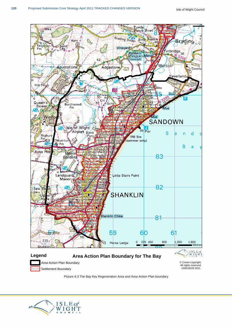
¯
© Crown copyright. All rights reserved. 100019229 2011.
0 450 900 1,350 1,800225 Metres
Area Action Plan Boundary for The BayLegendArea Action Plan BoundarySettlement Boundary
Picture 6.3 The Bay Key Regeneration Area and Area Action Plan boundary
Isle of Wight CouncilProposed Submission Core Strategy April 2011 TRACKED CHANGES VERSION120

7 Development Management Policies
Development Management is a positive and proactive approach to shaping, considering, determiningand delivering development proposals. It will be led by the Council, working closely with those proposingdevelopments and other stakeholders. It is undertaken in the spirit of partnership and inclusiveness, andsupports the delivery of key priorities and outcomes.(50)
The Government wishes to allow significant flexibility over the detailed approach each local authoritytakes to development management, tailored to their area’s circumstances and the resources necessaryand available. However, existing good practice indicates that achieving success requires local workingpractices to be based around seven key elements. These are:
a positive and proactive approach to place shaping;putting planning policy into action;front loading;taking a proportionate approach;effective engagement;proactive delivery; andmonitoring and review of development management outcomes
The relationship between development management and plan-making should be seamless. Both areintegral pillars of spatial planning and together they form a continuous cycle of planning activity which isessential for successful place shaping.
The statutory development plan (the LDF Island Plan) is the starting point for decision-makers, followedby other material considerations. Statements of national planning policy are material considerationswhich must be taken into account in decisions on planning applications where relevant. They providedecision-making policies for the purposes of development management.
To support the wider spatial planning approach, the Council will:
analyse the likely impacts and outcomes of the proposed development and judge whetherit helps to implement the development plan and national planning policy;make decisions in the wider context of contributing to sustainable development havingregard to the anticipated outcomes and quality of the development proposed; andavoid a simply mechanistic testing of proposals against fixed criteria.
Sustainable Build Criteria for New Development
DM1 Sustainable Build Criteria for New Development
The Council will support proposals which contribute to both mitigating and adapting toclimate change and to meeting the national targets to reduce carbon dioxide emissions. Allmajor development will incorporate renewable energy systems to provide at least 10% ofthe predicted energy requirements, except in those developments where district heating willbe provided.
Proposals for developments containing in excess of 250 housing units, or having an aggregatedomestic living area of greater than 18,000m2 and commercial/industrial development ofmore than one building, shall be expected to install community district heating systems thatuse low carbon heat sources. The Council will consider each case on its merits and willconsider evidence demonstrating why a development should not be required to deliver the
50 Development Management: Proactive planning from pre-application to delivery. Consultation on a draft new planning policystatement on development management, and on draft policy annexes on the pre-application and determination stages,2009; DCLG
121Proposed Submission Core Strategy April 2011 TRACKED CHANGES VERSIONIsle of Wight Council
above.
Development on the Island should include measures to reduce carbon dioxide emissionsfrom energy use, in accordance with the following energy hierarchy:
i) Minimising energy requirements.
ii) Incorporating renewable energy sources.
iii) Incorporating low carbon energy sources.
iv) Incorporating CHP/District Heating.
Proposals will be expected to demonstrate how they will:
1. Exceed, if possible, the minimum required level of the Code for Sustainable Homes and‘Very Good’ standard for BREEAM.
2. Implement the highest possible standards of energy efficiency.3. Utilise, where appropriate, decentralised, renewable and low-carbon energy supply
systems.4. Promote the re-use and recycling of building materials.5. Address waste and recycling of materials during construction.6. Conserve water resources by:
a. implementing measures to restrict predicted (calculated using the Code forSustainable Homes water calculator) internal potable water consumption measuredin litres per person per day (l/p/p/p/d) to no more than 105 l/p/p/p/d (consistent withCode levels 3 & 4); and
b. implementing sustainable supply measures for external non-potable waterconsumption by providing a system to collect rain water for use in externalirrigation/watering.
7. Provide for the storage of refuse and recyclable materials. For major developments,mini-recycling centres should be provided.
The Council will expect all applications to be accompanied by a sustainability checklist (51).to demonstrate the measures taken in order to comply with this policy.This should providean easily understood auditable evidence base that as a minimum addresses points 1-7 aboveand describes the predicted performance of the development, both before the measures areapplied and subsequently, and an assessment of the carbon emissions from the proposeddevelopment, together with details of the proposals to minimise this. Management measuresmust be detailed to ensure continued effectiveness of any proposals to meet the aboverequirements throughout the lifetime of the development, without placing any undue burdenon the Council.
Buildings account for almost half of the energy consumption and carbon emissions in the UK. The waysin which we light, heat and use our buildings all contribute to this. National policy is clear that planningshould support national targets for reducing carbon emissions(52) from domestic and non-domesticbuildings, with a progressive tightening of Building Regulations to require major reductions in carbonemissions from new homes to get to zero carbon by 2016.
The evidence developed by the Council maps domestic heat consumption across the Island and showsconcentrations within the Medina Valley (specifically Cowes and Newport) and Ryde Key Regeneration
51 The use of sustainability checklists, such as those promoted by Climate Change South East, can help deliver new homesthat outperform the existing stock in terms of efficiencies in resource use
52 The current national carbon reduction target is 80% reduction in CO2 emissions (from 1990 baseline) by 2050,
Isle of Wight CouncilProposed Submission Core Strategy April 2011 TRACKED CHANGES VERSION122
Areas.The heat mapping did not identify any areas as obvious candidates for the installation of significantlysized District Heating networks to supply existing properties. However, when considering potentialdevelopment sites as identified through the SHLAA, there are good opportunities for District Heatingnetworks within the Medina Valley and Ryde.
The requirement for all major development to incorporate renewable energy systems to provide at least10% of the predicted energy requirements should be viewed as a minimum, reflecting basic nationalpolicy requirements. This area of planning is likely to change throughout the period of the plan astechnology and practice evolves. Therefore, the Council will review this requirement in light of one ormore of the following:
new national policy, guidance and legislation;the development and mainstreaming of renewable energy technology, including changing(reducing) cost; andthe performance of this policy target locally.
If technically feasible and financially viable, a higher target may be required.achievable and the Councilwould support this. Where incorporating renewable energy production equipment is shown, by theapplicant to make the development unviable, it would not be expected.
Chapter 8 Infrastructure Delivery and Development Implementation sets out in more detail issues relatingto developer contributions and establishes that the mechanism for calculating and collecting them willbe a CIL Charging Schedule and a Planning Obligations Supplementary Planning Document. It alsooutlines the need for flexibility when applying the policies of the Core Strategy and developer contributions,to ensure that the plan is sufficiently flexible to be deliverable.
Schemes shall not be supported until the Council has approved a report provided by the applicantidentifying how the predicted CO2 emissions of the development will be reduced by at least 10% throughthe use of on-site renewable energy equipment. The carbon savings which result from this will be aboveand beyond what is required to comply with the relevant parts of the Building Regulations.
The developer shall install broadband/wireless remote sensors so that the Council (or an approvedorganisation) can monitor the energy usage of the development and/or the performance of the renewableand/or low-carbon energy generating equipment.
Before any development is occupied or sold, the renewable energy equipment shall have been installedand the Council shall be satisfied that their day-to-day operation will provide energy for the developmentfor as long as the development remains in existence.
Much of the development over the plan period will be governed by increasingly stringent BuildingRegulations, which will ensure that dwellings are carbon neutral from 2016 and non-domestic buildingsare carbon neutral from 2019. Because of this, the Council considers that there are three areas of focusto reduce Island carbon emissions:
1. Existing building stock.2. Transport emissions.3. New development.
Whilst it is difficult for the Council and its planning policies to influence the existing building stock, theCore Strategy is based on a sustainable approach that will contribute to managing transport emissionsand that can shape new development.
In respect of the Code for Sustainable Homes (CSH) the Government’s document Greener Homes forthe future sets out a target of meeting Level 6 for all new homes built by 2016. Whilst the Council wishesto see new development to be as green as possible, it cannot seek CSH minimum in advance of nationalstandards. It will however, bring forward the requirement (and ensure it is one that must be addressed,rather than discretionary) in relation to water usage to address an identified local issue.
123Proposed Submission Core Strategy April 2011 TRACKED CHANGES VERSIONIsle of Wight Council
For BREEAM (the standard that relates to non-residential development), there is no defined minimumlevel and buildings can be given a BREEAM rating of ’Pass’, ‘Good’, ‘Very Good’ and ‘Excellent orOutstanding’ depending on their performance against a number of criteria. The Council will seek thatdevelopment a minimum of a ‘Very Good’ rating, although it will encourage higher.
In buildings, carbon emissions are derived from the total fuel consumption measured through gas andelectricity meters and from “delivered” fuels such as coal, oil and Liquefied Petroleum Gas (LPG).Island-based, grid-connected, renewable electricity schemes do not directly contribute to reducing carbonemissions on the Island, since the power is fed into the national grid rather than directly into buildings,whereas renewable heat projects will have a direct effect on reducing carbon emissions since they replacefossil fuel consumption.
Renewable heat is produced either through dedicated systems such as solar hot water panels, or througha CHP plant which utilises the waste heat, usually through a District Heating system. The Council alsorecognises that CHP/District Heating schemes can use non-renewable fuels, but are inherently moreefficient than conventional non-renewable systems, hence their elevated place in the hierarchy.
The Department of Communities and Local Government’s (DCLG) final report on the “Cost Analysis ofthe Code for Sustainable Homes” (July 2008) shows that the costs of achieving the higher code levelscan vary quite substantially as a result of dwelling type, development type and site characteristics (e.g.ecological value and flood risk). This could have a potential negative impact on economic objectives.
Lowest costs are typically seen for those developments where there is potential to use site-wide, carbonsaving technologies (e.g. CHP systems). These are typically sites with relatively high numbers anddensities of development which is less likely on the Isle of Wight given the scale of development proposed.It will therefore be necessary to make extensive use of microgeneration technologies (e.g. PV) to achievethe standards required at Level 6 of the Code for Sustainable Homes.
The implementation costs are likely to be lower in the medium to long-term due to greater innovationand new technologies, improved potential to use CHP reduction, and in the costs of materials followingmore widespread adoption. It is expected that costs of compliance will fall over time.
The Isle of Wight Council is working towards establishing a target for Island-wide CO2 reductions of 40%between 2010 and 2020. This general target (4% annual reduction) has been established through the2008-11 Local Area Agreement and a general commitment to a substantial reduction in carbon emissionsin the Eco Island Sustainable Community Strategy.
Planning can make a significant contribution to improving energy efficiency, for example through influencingorientation, layout, spacing and shading. Optimising use of natural heat and light through passive solardesign (PSD) can displace energy which would have otherwise been generated from fossil fuel sources.Solar heated air and wind can also be used in natural ventilation or cooling systems. PSD can be usedin conjunction with other efficiency measures, including increasing insulation, double glazing, draughtproofing, use of energy efficient appliances and fittings, efficient heating controls and condensing boilers.
Opportunities must be taken to integrate renewable energy technologies into new developments whichcan provide a proportion of their heating, cooling or electricity needs from decentralised and renewableor low-carbon sources.
All major development will be required to consider the use of decentralised CHP sources. Evidenceshould be submitted with planning applications to demonstrate how these requirements will be met. Inthe event that these requirements are not met, robust evidence will need to be submitted to show whythey are not technically or financially achievable, having regard to the type of development involved andits design.
The Council will carry out further work into the feasibility of decentralised CHP sources as part of thework to inform the AAPs of the Key Regeneration Areas. The evidence(53) demonstrates that this isappropriate for developments above 250 units, however through the AAPs, the opportunity to provide
53 Following the evidence and recommendations of the Isle of Wight Heat Mapping Study, 2010; Grontmij for IWC
Isle of Wight CouncilProposed Submission Core Strategy April 2011 TRACKED CHANGES VERSION124
such schemes in developments under 250 units will be explored on a site-by-site basis giving considerationto viability of both delivery of the technology and how this will affect the proposal.
All developments should implement the use of sustainable construction techniques that promote there-use and recycling of building materials. Evidence of use of such sustainable construction techniquesshould be provided, for example through the use of a Considerate Constructors Scheme as detailed inthe Code for Sustainable Homes, that deals with issues such as reclamation, re-use or responsiblysourced materials as part of the consideration of construction site impacts. This evidence should alsoinclude detail on what alternatives to virgin aggregate will be used, including the amount of materials tobe used and how much virgin aggregate has been displaced by this and their source.
The evidence provided should also be able to demonstrate how, through meeting the requirements ofthis policy, the proposed development will also support the following principles of Core Strategy policyDM20 (Waste):
application of the waste hierarchy appropriate to the proposed waste stream(s) to bemanaged; andtreatment of waste as close to the source as possible.
It should also support the following principles of Core Strategy Policy DM21 (Minerals):
application of a hierarchy of resource efficiency (including reducing demand and use ofvirgin aggregate and use of secondary and recycled aggregate and other suitable alternativesbefore use of virgin aggregate) and demonstrate this.
Why is water an issue on the Island?
The Environment Agency have identified the Isle of Wight as having the highest category of water stressclassification, being ”serious” (based on a methodology of water consumption and water resources perperson).
Of all the Water Resources Management Units assessed by the Environment Agency on the Island,nearly all are classified as over-licensed or over-abstracted. The Isle of Wight Catchment AbstractionManagement Strategy (CAMS) identified future housing development pressures on public water supplyas a main issue.
In the consultation phase of the CAMS process, a number of respondents commented on the need forwater efficiency measures in order to conserve water on the Island. The reduction in water demand isof prime importance if more sustainable use of this limited resource is to be realised. With 78% of theIsland’s water abstracted for public water supply, increased water efficiency by domestic users wouldcontribute significantly to this objective.
The public water supply is dependent upon the import of water from the mainland via an under-seapipeline which supplies about a quarter of the Island’s needs. Southern Water operates the sub-Solentpipeline which currently has the capacity to transfer up to 11.85 megalitres per day (ml/d) under theSolent from ”Hampshire South” to ”Isle of Wight’” resource zone.The transfer is used to support a limitedavailability of water on the Isle of Wight. The supply comes from the River Test at Testwood and equatesto 5% of the current available supplies of Southern Water’s ”Hampshire South” zone.
All the Water Resources Management Units of the River Test are assessed by the EA as either ”NoWater Available” or ”Over-Licensed” through the Water Resource Assessment. The River BasinManagement Plan that covers the Island states that, “Although all homes have been metered since the1980s, water is transferred from the mainland to supplement the Isle of Wight’s supplies. For the Islandto become more self-sufficient in water resources, it is critical to improve water efficiency and protect thegroundwater from pollution”.
125Proposed Submission Core Strategy April 2011 TRACKED CHANGES VERSIONIsle of Wight Council
Why stipulate a target of no more than 105l/p/d (Litres per day) to restrict predicted internal potablewater consumption, consistent with Code levels 3 & 4?
The Environment Agency has carried out recent work that supports the 105l/p/d target, this includes:
a. Southern Region Water Resource Strategy, published in December 2009, under the strategicobjective of “New and existing homes and buildings are more water efficient” has the regionalaction of “…ensure that, as a minimum requirement, homes built before 2016 achieveinternal water use of 105 litres per person per day (as required by Code for SustainableHomes level 3)…”. This is then cross-referenced to LDFs with planning authorities identifiedas those who need to be involved.
b. River Basin Management Plan, South East River Basin District, Defra/EA December 2009states one of it’s example actions as, “Ensure that local spatial planning policies for newdevelopment set out strong requirements for water efficiency measures (local authorities),seeking to achieve Code for Sustainable Homes levels 3 and 4: 105 litres per person perday consumption”.
The design of all new developments should facilitate the recycling and composting of waste. The provisionof facilities should be appropriate and proportionate to the development proposal and should consider:
the most up to date Council Waste Strategy;the provision of Council waste facilities; andthe Council’s waste collection service.
In relation to DM1 you may also like to look at:
PPS: Planning and Climate Change - Supplement to PPS 1PPS: Planning and Climate Change - Practice Guidance living draftThe Code for Sustainable Homes; Technical Guide version 2, May 2009CLG (Grant Shapps) Ministerial speech July 2010 ‘Zero-Carbon Homes’The Water Efficiency Calculator for new dwellings, 2009; CLGAreas of water stress: final classification, Environment Agency 2007Isle of Wight Catchment Abstraction Management Strategy Final Strategy, 2004; EAIsle of Wight Catchment Abstraction Management Strategy Annual Update, 2008; EASouthern Region Water Resource Strategy, 2009; EARiver Basin Management Plan, South East River Basin District, 2009; Defra/EAIsle of Wight Heat Mapping Study, 2010; Grontmij for IWC
Design Quality for New Development
DM2 Design Quality for New Development
The Council will support proposals for high quality and inclusive design to protect, conserveand enhance our existing environment whilst allowing change to take place. A robust designprocess with the use of skilled designers and pre-application discussions will be promoted.Relevant information according to the site’s size, location and context will be required inorder for the Council to determine planning applications properly and quickly. All newdevelopment should respond to a clear understanding of physical, social, economic,environmental and policy context.
Development proposals will be expected to:
1. Provide an attractive, functional, accessible, safe and adaptable built environment witha sense of place.
Isle of Wight CouncilProposed Submission Core Strategy April 2011 TRACKED CHANGES VERSION126
2. Optimise the potential of the site but have regard to existing constraints such as adjacentbuildings, topography, views, water courses, hedges, trees, wildlife corridors or otherfeatures which significantly contribute to the character of the area.
3. Be appropriately landscaped to provide an attractive setting for the development thatintegrates with the surroundings.
4. Complement the character of the surrounding area, particularly in Conservation Areasand AONB, as defined in Conservation Area Appraisals, Village Design Statements orother Supplementary Planning Documents that define locally distinctive areas.
5. Minimise the consumption of natural resources and the production of waste or pollution.
Development proposals which preserve or enhance a Heritage Asset or the setting of aHeritage Asset will be supported.
One of the key objectives of the Core Strategy is achieving sustainable development. Good designensures attractive, usable, durable and adaptable places and is a key element in achieving sustainabledevelopment. The need for better urban design and guidance on how to raise standards of design areexplained in ‘By Design Urban Design in the planning system: towards better practice’ published byDTLR 2000. Good design for new development reinforces civic pride and sense of place. In order topromote good design, the Council will pursue, through publication of Supplementary Planning Documents,a high standard of urban design, architecture and landscape design.
Even small developments can have an impact on the quality of an area. Understanding the context of adevelopment can help ensure it makes a positive contribution to the locality. Site analysis and contextappraisal should always be part of the work undertaken prior to submitting a proposal, even where Designand Access Statements are not required. A robust design process can be considered as four stages: anappraisal of the issues; a design concept; pre-application discussions; and finally the formal application.
Applications need to be accompanied by accurate drawings showing the plans and elevations in context,including levels and supplemented as appropriate by perspective drawings. The Council will require alocation and site plan showing trees and landscape features, such as ponds, hedges and significantwildlife habitats covering not only the site but also adjacent buildings, trees and features.Where required,site plans should show proposed service provision and sustainable drainage systems which may affecttrees or other features.
The relevant information will vary from site to site according to the nature of the proposal's size, locationand character.The relevant information required for each application is set out through the 1APP planningapplication forms. The Council will request such information to be submitted prior to applications beingdetermined. At each stage of the design process, remember the key criteria that the proposals reflectlocal distinctiveness and the development is environmentally sustainable. The Council will support thisdesign led approach through the preparation of Conservation Area Appraisals, development briefs ordesign guides, particularly for the strategic development locations.
Some towns and villages have been altered by incongruous or jarring developments that have detractedfrom the settlement’s character. Context and local identity are important in creating a quality environmentand each settlement or site has its own distinctiveness and requirements. The Council will encourageproposals that are designed to consider social and community concerns alongside visual and functionalrequirements. The Council will encourage the production of Town/Parish Plans and Village DesignStatements to describe the local distinctiveness and requirements of individual settlements.
Hard and soft landscaping are critical design issues in development. Landscape design needs to becarefully considered from the outset; good landscape design can lead to the success of a developmentand achieve sustainable development. The design of landscaping (both within the scheme and withregard to any impact on the surrounding landscape) will be an important consideration in assessing newdevelopment and how they integrate with their surroundings. The Council will require appropriateinformation to be submitted with regard to external aspects and public realm for new developments.Guidance on what information to submit is set out in ”Landscape Checklist for New Development in
127Proposed Submission Core Strategy April 2011 TRACKED CHANGES VERSIONIsle of Wight Council
Hampshire and Isle of Wight”.
Development has a large impact on issues such as climate change, resource depletion and pollution.Developments, including new and refurbished buildings, should be designed in a way to reduce theimpact on the environment.This should not, however, be at the expense of good urban design principles,set out in the Urban Design Compendium.
The management of the environment should be considered at the outset and be an integral part of thedesign. Development can add to an area of impermeable land which can increase the risk of flooding.Surface water must be managed by Sustainable Drainage Systems and water retention methods indevelopments unless there are practical or environmental reasons for not doing so.
The Council will seek to minimise effects on the environment by encouraging development to incorporaterenewable energy technologies, energy conservation techniques and waste management facilities.Energy conservation and generation will need to be designed to minimise any adverse impact onlandscape, wildlife and amenity.
The Council will prepare a Design Principles SPD that will set out in further detail ways in which theCouncil expects the requirements of SP1 (Spatial Strategy) and DM2 (Design Quality for NewDevelopment) can be achieved. This will include information on how to prepare a robust design processwith the use of skilled designers and set out when pre-application discussions will be required.Supplementary guidance will also be established on the relevant information required to accompanyplanning applications, according to the site’s size, location and context. All new development shouldrespond to a clear understanding of physical, social, economic, environmental and policy context andthe Design Principles SPD will, in conjunction with established national design guidance, give informationon how the Council expects this to be achieved.
Prior to the Design Principles SPD being prepared, proposals will be expected to adhere to the generaldesign principles of the plan, particularly this policy and Village Design Statements (where applicable).
In relation to DM2 you may also like to look at:
PPS1: Delivering Sustainable DevelopmentBy Design - Urban Design in the Planning System towards better practice, 2000; DETR & CABEBy Design - better places to live, 2001; DTLRSafer Places - The Planning System and Crime Prevention, 2004; ODPMPlanning and Access for Disabled People: A Good Practice Guide, 2003; ODPMManual for Streets, 2007; DfTBuilding in Context, 2001; EH & CABELandscape Checklist for New Development in Hampshire and IOW, 2007
Balanced Mix of Housing
DM3 Balanced Mix of Housing
The Council will support development proposals that provide an appropriate mix of housingtypes and size, in all new development, in order to create inclusive and sustainablecommunities. Development proposals will be expected to:
1. Reflect the most up-to-date Strategic Housing Market Assessment.2. Contribute to meeting the identified housing need for the local area.3. Contribute to meeting specialist housing requirements.
The final mix will be negotiated with the developer and will be based upon the most up-to-date
Isle of Wight CouncilProposed Submission Core Strategy April 2011 TRACKED CHANGES VERSION128
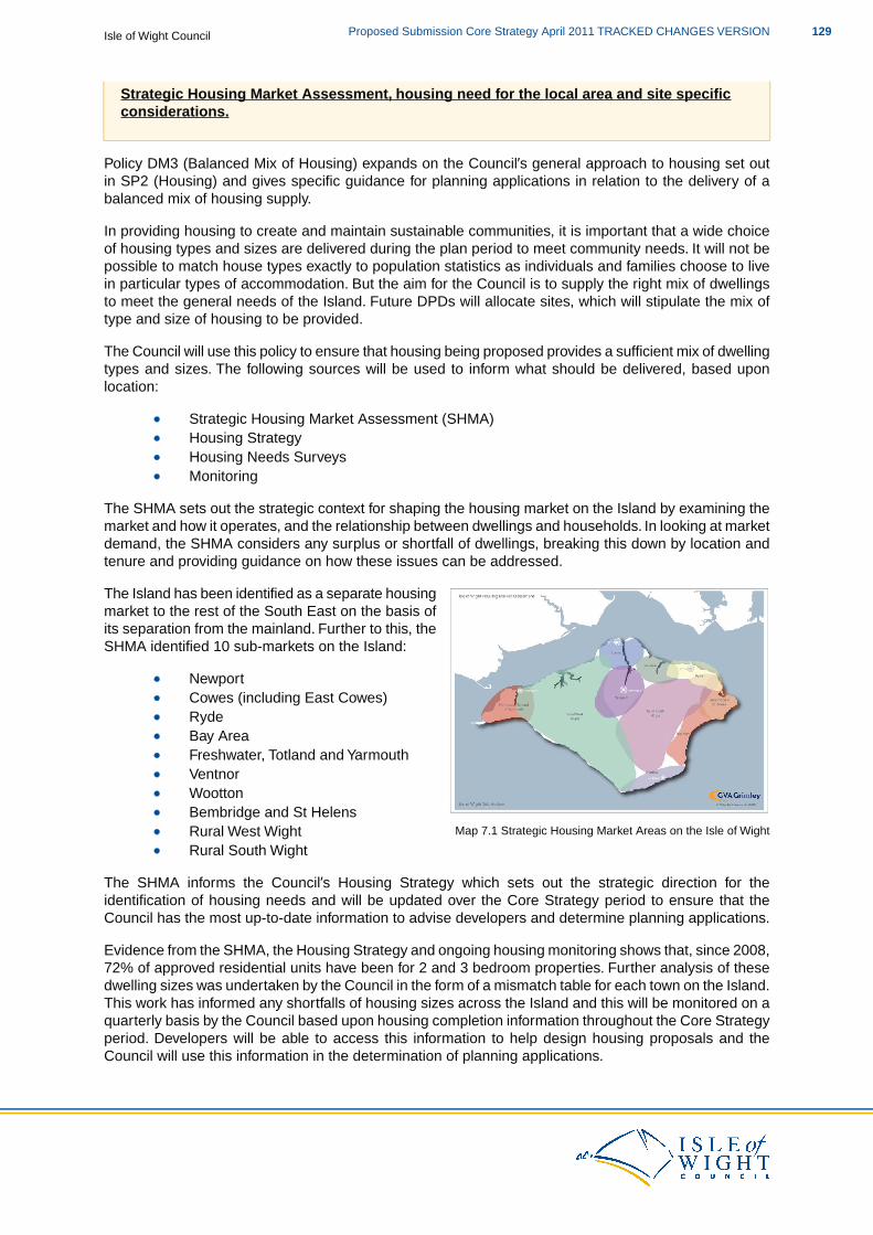
Strategic Housing Market Assessment, housing need for the local area and site specificconsiderations.
Policy DM3 (Balanced Mix of Housing) expands on the Council’s general approach to housing set outin SP2 (Housing) and gives specific guidance for planning applications in relation to the delivery of abalanced mix of housing supply.
In providing housing to create and maintain sustainable communities, it is important that a wide choiceof housing types and sizes are delivered during the plan period to meet community needs. It will not bepossible to match house types exactly to population statistics as individuals and families choose to livein particular types of accommodation. But the aim for the Council is to supply the right mix of dwellingsto meet the general needs of the Island. Future DPDs will allocate sites, which will stipulate the mix oftype and size of housing to be provided.
The Council will use this policy to ensure that housing being proposed provides a sufficient mix of dwellingtypes and sizes. The following sources will be used to inform what should be delivered, based uponlocation:
Strategic Housing Market Assessment (SHMA)Housing StrategyHousing Needs SurveysMonitoring
The SHMA sets out the strategic context for shaping the housing market on the Island by examining themarket and how it operates, and the relationship between dwellings and households. In looking at marketdemand, the SHMA considers any surplus or shortfall of dwellings, breaking this down by location andtenure and providing guidance on how these issues can be addressed.
Map 7.1 Strategic Housing Market Areas on the Isle of Wight
The Island has been identified as a separate housingmarket to the rest of the South East on the basis ofits separation from the mainland. Further to this, theSHMA identified 10 sub-markets on the Island:
NewportCowes (including East Cowes)RydeBay AreaFreshwater, Totland and YarmouthVentnorWoottonBembridge and St HelensRural West WightRural South Wight
The SHMA informs the Council’s Housing Strategy which sets out the strategic direction for theidentification of housing needs and will be updated over the Core Strategy period to ensure that theCouncil has the most up-to-date information to advise developers and determine planning applications.
Evidence from the SHMA, the Housing Strategy and ongoing housing monitoring shows that, since 2008,72% of approved residential units have been for 2 and 3 bedroom properties. Further analysis of thesedwelling sizes was undertaken by the Council in the form of a mismatch table for each town on the Island.This work has informed any shortfalls of housing sizes across the Island and this will be monitored on aquarterly basis by the Council based upon housing completion information throughout the Core Strategyperiod. Developers will be able to access this information to help design housing proposals and theCouncil will use this information in the determination of planning applications.
129Proposed Submission Core Strategy April 2011 TRACKED CHANGES VERSIONIsle of Wight Council
In addition to looking at the Island’s housing market and previous approvals to inform the types and sizesof dwellings, further information on housing needs can be used. A Housing Needs Survey for the Islandwas undertaken as part of the SHMA and local housing needs surveys have been undertaken at Ttownand Pparish level to identify particular housing needs within these communities. Developers bringingforward residential development should be addressing these identified needs as part of their proposals.
In line with policy SP1 (Spatial Strategy), proposals outside of defined settlement boundaries will needto demonstrate that they will meet a local need, therefore the SHMA and housing needs surveys will bekey tools for developers in determining what local need is. Engagement with the community is alsorequired to consider if any previously unidentified needs could be met by development proposals.
For the purpose of this policy, “specialist housing requirements” includes housing that meets the needsof older, disabled, low income and vulnerable persons.Whilst the housing requirements of older personsis dealt with in policy DM5 (Housing for Older People) and for low income and vulnerable persons isdealt with in policy DM4 (Locally Affordable Housing), this policy will help inform the types and locationof housing which should be provided.
In respect of disabled persons, developers should ensure that development proposals include housingthat is accessible or easily adaptable for disabled people, for example wheelchair access. Requirementswithin policy DM2 (Design Quality for New Development) should be taken into account when consideringand designing proposals which meet such requirement.
In order to bring forward proposals for market housing, which reflect the demand and profile of householdsrequiring market housing in line with PPS3: Housing, the final mix will be negotiated with the developer.This is to ensure that each scheme is assessed on a site by site basis and the appropriate mix for eachsite is provided.
Chapter 8: Infrastructure Delivery and Development Implementation sets out in more detail issues relatingto developer contributions and establishes that the mechanism for calculating and collecting them willbe a CIL Charging Schedule and a Planning Obligations Supplementary Planning Document. It alsooutlines the need for flexibility when applying the policies of the Core Strategy and developer contributions,to ensure that the plan is sufficiently flexible to be deliverable.
In relation to DM3 you may also like to look at:
PPS1: Delivering Sustainable DevelopmentPPS3: HousingPPS7: Sustainable Development in Rural AreasPlanning and Access for Disabled People: A Good Practice Guide, 2003; ODPMEco Island Sustainable Community Strategy, 2008; ISP & IWCHousing Strategy 2007-2012, 2007; IWCIWC Housing Needs Survey, 2007 within the Strategic Housing Market Assessment StrategicHousing Market Assessment, 2007; GVA Grimley for IWC
Locally Affordable Housing
DM4 Locally Affordable Housing
The Council will seek to deliver at least 1,590 affordable homes over the plan period.Development proposals will be expected to:
1. Provide 35% of the development as on-site affordable housing, based on developmentsof 15+ units in Key Regeneration Areas and 10+ units elsewhere.
Isle of Wight CouncilProposed Submission Core Strategy April 2011 TRACKED CHANGES VERSION130
2. Provide financial contributions towards affordable housing for developments of 1-14units in Key Regeneration Areas and 1-9 units in Smaller Regeneration Areas and ruralareas.
3. Deliver a target mix of 70% of affordable housing to be social rented and 30% forintermediate tenures.
4. Demonstrate how the proposals benefit the community.
The Council will support proposals for rural exception sites that would deliver affordablehousing immediately adjacent to Rural Service Centresoutside of identified settlementboundaries,where a local need can be demonstrated and there is no reasonable prospectof other sites meeting the identified local need.
To take account of changing economic circumstances, if a developer is unable to providethe required 35% on-site, the Council will require an open-book assessment of thedevelopment viability to demonstrate what level of affordable housing is viable for the site.
The contribution towards affordable housing will be set out in the Planning Obligations SPD.
Policy DM4 (Locally Affordable Housing) provides the specific guidance on affordable housing that willbe used to consider planning applications. The policy should be read and applied in conjunction with therest of the Core Strategy policies.
The Council’s current Housing Strategy sets the strategic direction for the identification of housing needon the Island. This Strategy makes a clear aim to ensure that the needs of those on low incomes andvulnerable people (including those with mobility needs), as well as those wanting to gain a foot on thehousing ladder, must be met.
The Strategic Housing Market Assessment (SHMA) has informed the Housing Strategy. The SHMAandhas indicated that there is a need to increase the amount of affordable housing in the market place. Thisis in order to create a mix of housing to meet the range of requirements of different types of householdsand to ensure choice for all ages and incomes., andTthis is in line with the policy approach as set out inPPS3: Housing. Both the SHMA and the Housing Strategy will be updated over the Core Strategy planperiod to ensure that the Council has the most up-to-date information to advise developers and determineplanning applications.
As part of the SHMA, a Housing Needs Survey for the Island was undertaken and local housing needssurveys have been undertaken at Ttown and Pparish level to inform housing needs within thesecommunities. Applications for residential development should address these identified needs as part ofthe proposal.
The Council will seek to deliver at least 1,590 affordable housing units over the plan period.This equatesto 35% of the total new dwellings planned for the Island in the period 2011-2027 as set out in Policy SP2(Housing)(54). Breaking this figure down further, this equates to 18200 affordable housing units providedper year across the Island.
In order to deliver these required affordable housing units, the Council will seek to provide the majorityof these units within Key Regeneration Areas, Small Regeneration Areas and Rural Service Centres,with a significant amount planned to be delivered within the Medina Valley and Ryde Regeneration Areasas outlined in Policy SP2 (Housing). The three Area Action Plans and the Delivery and ManagementDPD will allocate sites and determine the amount of affordable housing to be provided on site.
Given the policy approach set out in SP2 (Housing), and the required need for affordable housing identifiedthrough the SHMA and housing needs surveys, Policy DM4 (Locally Affordable Housing) will require the
54 We have planned for 8,320 new dwellings over the plan period. Of these 3,778 are already permitted/committed, so cannotbe counted towards the provision of affordable housing. Therefore, the figure 1,590 represents 35% of the new housingdevelopment planned (4,542 units).
131Proposed Submission Core Strategy April 2011 TRACKED CHANGES VERSIONIsle of Wight Council

following on-site provision or contribution towards affordable housing.
Housing developments of a net increase of 15+ units in Key Regeneration Areas and a net increase of10+ units elsewhere will be required to provide 35% of the development as on-site affordable housing.These thresholds are considered reasonable to require on-site provision within Key Regeneration Areasand elsewhere across the Island. Housing developments of a net increase of 1-14 units in KeyRegeneration Areas and a net increase of 1-9 units in Smaller Regeneration Areas and rural areas willbe required to provide financial contributions towards affordable housing. Where financial contributionsare required, these contributions will be instead of on-site provision, not as well as.
Although development proposals will be expected to provide 35% on-site affordable housing provision,the Council will welcome proposals which can deliver more than the 35% target as set out in the policy.
For all developments that provide on-site affordable housing, the Council will expect the developer toobtain information from a registered housing provider on the amount that they are able to pay for theunits and this must be discussed with the Council’s Housing Enabling Team. No assumptions should bemade about the availability of grant assistance. All financial contributions towards affordable housing willbe kept and spent, where possible, in the area where it was collected.
As identified in the Council’s Development Viability Report April 2009, the Council will seek to deliver atarget mix of 70% of affordable housing to be social rented and 30% for intermediate tenures on allhousing developments. The proposed mix of affordable housing types will be required to be provided bythe developer as part of the planning application process to ensure an appropriate mix has been provided.
It is important that proposals for locally affordable housing benefit the community. The Government’sintroduction of the “Community Right to Build” will provide local areas with the ability to take forwarddevelopment that meets their own needs, including the provision of affordable housing. In the case of“Community Right to Build”, if it can be demonstrated that the proposal has the support of the community,planning applications may not be required so long as some basic planning criteria can be met.
To enable proposals for affordable housing schemes to come forward which encourage communityengagement, the Council will encourage an increase in choice of registered housing providers. TheCouncil will not only continue to work with existing partners to deliver affordable housing schemes butalso seek to work with registered housing providers where it can be demonstrated that provision can beenabled with minimal or no public subsidy.
These types of providers could include community groups set up under the “Community Right to Build”or other legal bodies established for the delivery of affordable housing that meets the definition of PPS3:Housing. Planning applications will need to demonstrate how proposals for affordable housing benefitthe community. This could include demonstrating how housing will be provided for people living in thecommunity or wishing to return to the community. It could also include providing a greater critical massto support local facilities and contributing to a more sustainable and vibrant community.
In line with Policy SP1 (Spatial Strategy) proposals which deliver affordable housing in the first instance,will be focussed immediately adjacent to the defined settlement boundaries of the Rural Service Centres.Proposals outside of defined settlement boundaries will have to demonstrate that they meet a localneed.In providing for affordable housing in rural communities, the Council will support proposals for ruralexception sites outside of identified settlement boundaries. This will enable small sites to come forwardfor affordable housing which would not normally be considered for housing because they are subject topolicy constraints. Rural exception sites should only be used for affordable housing in perpetuity andseek to address the accommodation needs of the local community whilst ensuring rural areas continueto develop as sustainable communities. The SHMA and housing needs surveys will be key tools fordevelopers to determine the local need in the area. Engagements with the community will also be requiredto consider if any previously unidentified needs could be met by the development proposal.
Development forrResidential development will be expected to be of an appropriate scale and designwhich is in keeping with the local character. Where appropriate, and in respect of persons with mobilityneeds, developers should ensure that proposals for housing development are accessible or easily
Isle of Wight CouncilProposed Submission Core Strategy April 2011 TRACKED CHANGES VERSION132
adaptable for disabled people. Policy DM2 (Design Quality for New Development) should be taken intoaccount when considering and designing proposals which meet such requirements. The monitoring ofprevious approvals for affordable housing will inform the amount of affordable housing the Council willseek to deliver over the plan period.The monitoring of on-site provision and financial contributions towardsaffordable housing will be carried out by the Council on a quarterly basis and will be based upon housingcompletion information. The Council will use this information when determining planning applications.
The second part of the policy seeks to take account of changing economic circumstances if a developeris unable to provide the required 35% affordable housing provision on-site. In these circumstances, theCouncil will require an open-book assessment of the development viability to demonstrate what level ofaffordable housing is viable for the site.Where an open-book viability assessment is required, the Councilwill expect an overage agreement to be in place, should future values improve over and above what hasbeen set in the viability assessment. In these cases, both the Council and the developer will share in theimprovement.
The Council and the developer will agree a method for sharing overage. This will be compared to landregistry figures on a six monthly basis to identify where values are in relation to a value template agreedbetween both parties. It is expected that the overage percentage would be agreed between the Counciland the developer, generally in a 70/30 split in the Council’s favour. This has been the basis of theHousing Team’s previous overage agreements. The Planning Obligations SPD will clearly set out thecontribution required towards affordable housing.
Chapter 8: Infrastructure Delivery and Development Implementation sets out in more detail issues relatingto developer contributions and establishes that the mechanism for calculating and collecting them willbe a CIL Charging Schedule and a Planning Obligations Supplementary Planning Document. It alsooutlines the need for flexibility when applying the policies of the Core Strategy and developer contributions,to ensure that the plan is sufficiently flexible to be deliverable.
In relation to DM4 you may also like to look at:
PPS1: Delivering Sustainable DevelopmentPPS3: HousingPPS7: Sustainable Development in Rural AreasPlanning and Access for Disabled People: A Good Practice Guide, 2003; ODPMHousing Strategy 2007-2012, 2007; IWCIWC Housing Needs Survey, 2007 within the Strategic Housing Market Assessment StrategicHousing Market Assessment,2007; GVA Grimley for IWCLocal Housing Needs Surveys
Housing for Older People
DM5 Housing for Older People
The Council will support development proposals that contribute to the delivery of a targetof 2,050 units of older persons’ accommodation provision over the plan period. Developmentproposals will be expected to:
1. Support the development of specialist accommodation for older people in sustainablelocations where a need is demonstrated.
2. Enable delivery of a combination of new schemes and the remodelling of older specialisthousing which does not meet the Decent Homes Standard or Lifetime Homes Standard.
3. Deliver between 20% and 25% of the site as accommodation suitable for older people,when it is a major housing development.This will be provided through a combinationof market housing and specialist housing for older people.
133Proposed Submission Core Strategy April 2011 TRACKED CHANGES VERSIONIsle of Wight Council
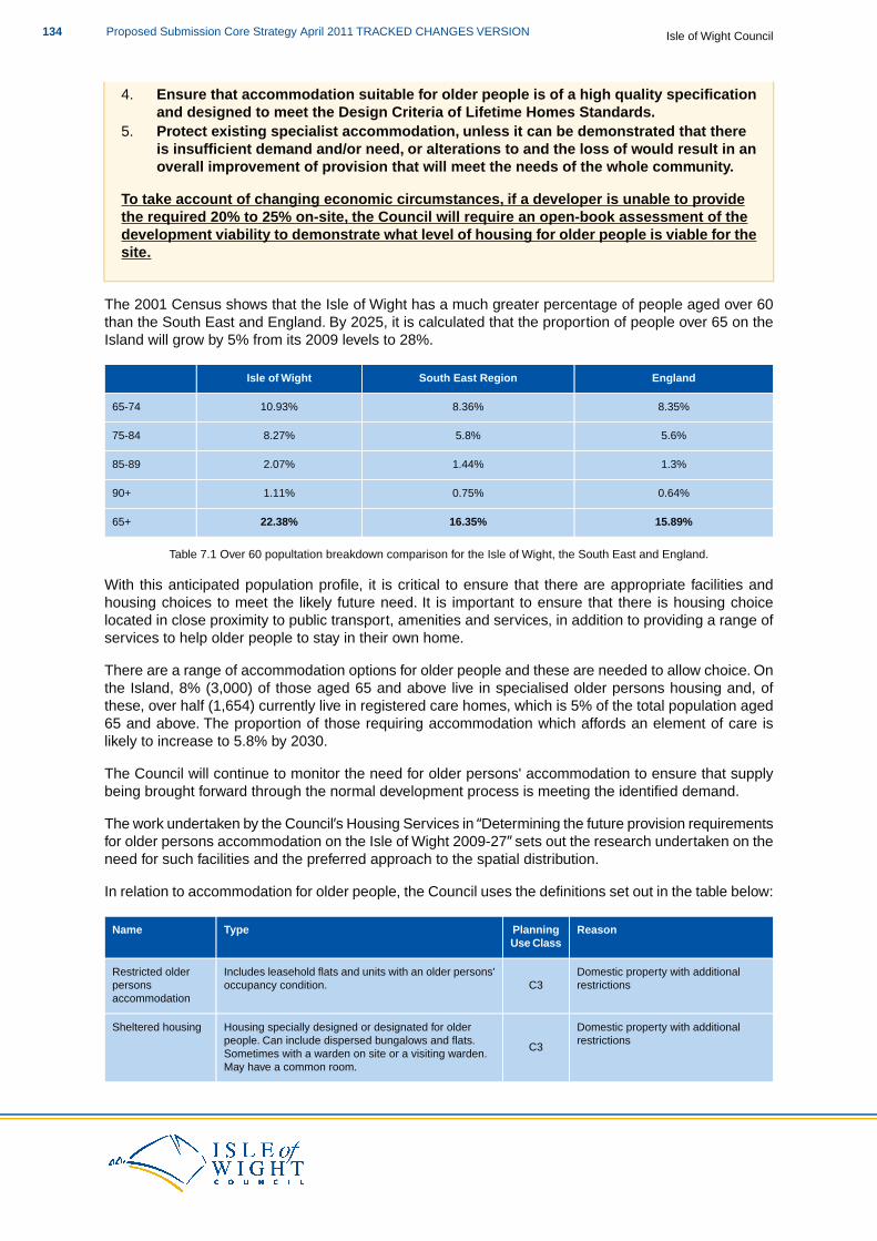
4. Ensure that accommodation suitable for older people is of a high quality specificationand designed to meet the Design Criteria of Lifetime Homes Standards.
5. Protect existing specialist accommodation, unless it can be demonstrated that thereis insufficient demand and/or need, or alterations to and the loss of would result in anoverall improvement of provision that will meet the needs of the whole community.
To take account of changing economic circumstances, if a developer is unable to providethe required 20% to 25% on-site, the Council will require an open-book assessment of thedevelopment viability to demonstrate what level of housing for older people is viable for thesite.
The 2001 Census shows that the Isle of Wight has a much greater percentage of people aged over 60than the South East and England. By 2025, it is calculated that the proportion of people over 65 on theIsland will grow by 5% from its 2009 levels to 28%.
EnglandSouth East RegionIsle of Wight
8.35%8.36%10.93%65-74
5.6%5.8%8.27%75-84
1.3%1.44%2.07%85-89
0.64%0.75%1.11%90+
15.89%16.35%22.38%65+
Table 7.1 Over 60 popultation breakdown comparison for the Isle of Wight, the South East and England.
With this anticipated population profile, it is critical to ensure that there are appropriate facilities andhousing choices to meet the likely future need. It is important to ensure that there is housing choicelocated in close proximity to public transport, amenities and services, in addition to providing a range ofservices to help older people to stay in their own home.
There are a range of accommodation options for older people and these are needed to allow choice. Onthe Island, 8% (3,000) of those aged 65 and above live in specialised older persons housing and, ofthese, over half (1,654) currently live in registered care homes, which is 5% of the total population aged65 and above. The proportion of those requiring accommodation which affords an element of care islikely to increase to 5.8% by 2030.
The Council will continue to monitor the need for older persons' accommodation to ensure that supplybeing brought forward through the normal development process is meeting the identified demand.
The work undertaken by the Council’s Housing Services in “Determining the future provision requirementsfor older persons accommodation on the Isle of Wight 2009-27” sets out the research undertaken on theneed for such facilities and the preferred approach to the spatial distribution.
In relation to accommodation for older people, the Council uses the definitions set out in the table below:
ReasonPlanningUse Class
TypeName
Domestic property with additionalrestrictionsC3
Includes leasehold flats and units with an older persons'occupancy condition.
Restricted olderpersonsaccommodation
Domestic property with additionalrestrictions
C3
Housing specially designed or designated for olderpeople. Can include dispersed bungalows and flats.
Sheltered housing
Sometimes with a warden on site or a visiting warden.May have a common room.
Isle of Wight CouncilProposed Submission Core Strategy April 2011 TRACKED CHANGES VERSION134
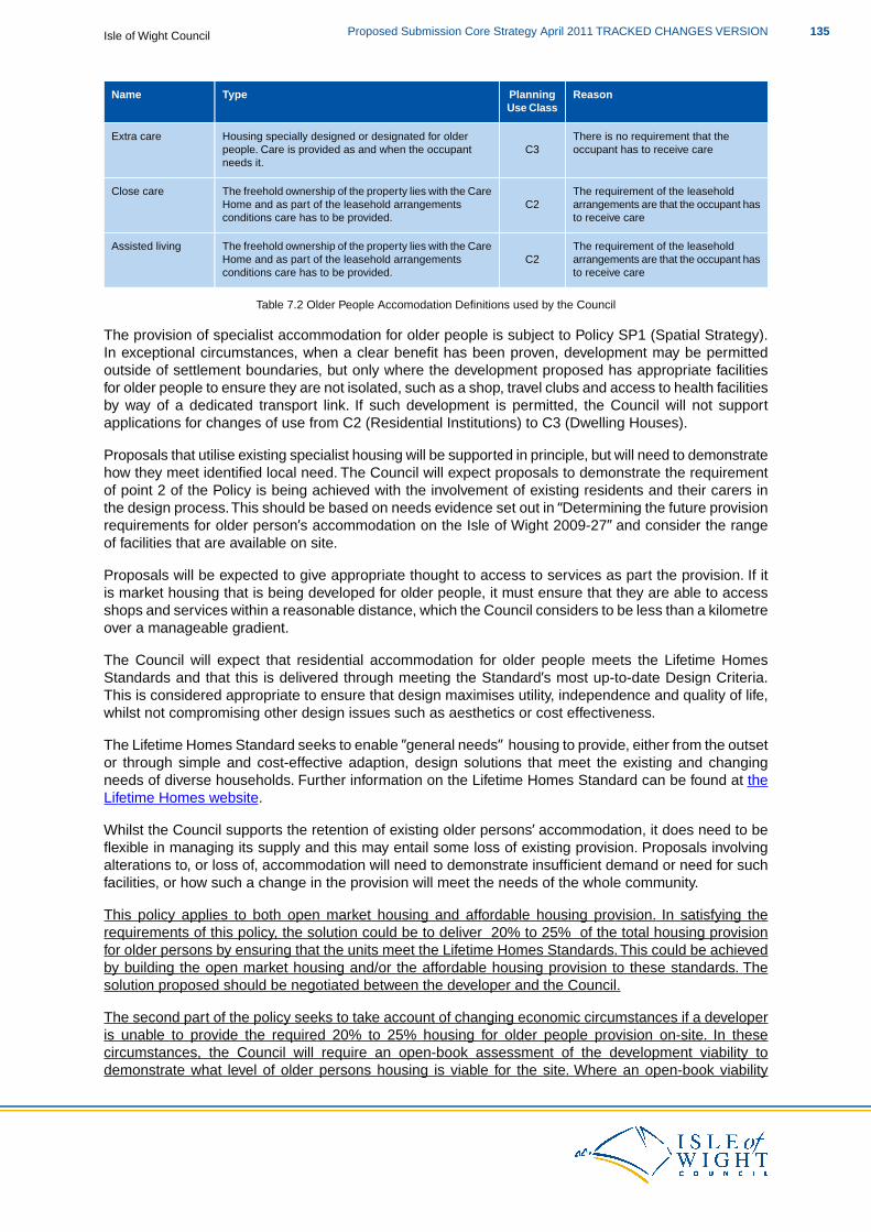
ReasonPlanningUse Class
TypeName
There is no requirement that theoccupant has to receive careC3
Housing specially designed or designated for olderpeople. Care is provided as and when the occupantneeds it.
Extra care
The requirement of the leaseholdarrangements are that the occupant hasto receive care
C2The freehold ownership of the property lies with the CareHome and as part of the leasehold arrangementsconditions care has to be provided.
Close care
The requirement of the leaseholdarrangements are that the occupant hasto receive care
C2The freehold ownership of the property lies with the CareHome and as part of the leasehold arrangementsconditions care has to be provided.
Assisted living
Table 7.2 Older People Accomodation Definitions used by the Council
The provision of specialist accommodation for older people is subject to Policy SP1 (Spatial Strategy).In exceptional circumstances, when a clear benefit has been proven, development may be permittedoutside of settlement boundaries, but only where the development proposed has appropriate facilitiesfor older people to ensure they are not isolated, such as a shop, travel clubs and access to health facilitiesby way of a dedicated transport link. If such development is permitted, the Council will not supportapplications for changes of use from C2 (Residential Institutions) to C3 (Dwelling Houses).
Proposals that utilise existing specialist housing will be supported in principle, but will need to demonstratehow they meet identified local need. The Council will expect proposals to demonstrate the requirementof point 2 of the Policy is being achieved with the involvement of existing residents and their carers inthe design process.This should be based on needs evidence set out in “Determining the future provisionrequirements for older person’s accommodation on the Isle of Wight 2009-27” and consider the rangeof facilities that are available on site.
Proposals will be expected to give appropriate thought to access to services as part the provision. If itis market housing that is being developed for older people, it must ensure that they are able to accessshops and services within a reasonable distance, which the Council considers to be less than a kilometreover a manageable gradient.
The Council will expect that residential accommodation for older people meets the Lifetime HomesStandards and that this is delivered through meeting the Standard’s most up-to-date Design Criteria.This is considered appropriate to ensure that design maximises utility, independence and quality of life,whilst not compromising other design issues such as aesthetics or cost effectiveness.
The Lifetime Homes Standard seeks to enable ”general needs” housing to provide, either from the outsetor through simple and cost-effective adaption, design solutions that meet the existing and changingneeds of diverse households. Further information on the Lifetime Homes Standard can be found at theLifetime Homes website.
Whilst the Council supports the retention of existing older persons’ accommodation, it does need to beflexible in managing its supply and this may entail some loss of existing provision. Proposals involvingalterations to, or loss of, accommodation will need to demonstrate insufficient demand or need for suchfacilities, or how such a change in the provision will meet the needs of the whole community.
This policy applies to both open market housing and affordable housing provision. In satisfying therequirements of this policy, the solution could be to deliver 20% to 25% of the total housing provisionfor older persons by ensuring that the units meet the Lifetime Homes Standards. This could be achievedby building the open market housing and/or the affordable housing provision to these standards. Thesolution proposed should be negotiated between the developer and the Council.
The second part of the policy seeks to take account of changing economic circumstances if a developeris unable to provide the required 20% to 25% housing for older people provision on-site. In thesecircumstances, the Council will require an open-book assessment of the development viability todemonstrate what level of older persons housing is viable for the site. Where an open-book viability
135Proposed Submission Core Strategy April 2011 TRACKED CHANGES VERSIONIsle of Wight Council
assessment is required, the Council will expect an overage agreement to be in place, should future valuesimprove over and above what has been set in the viability assessment. In these cases, both the Counciland the developer will share in the improvement.
The Council and the developer will agree a method for sharing overage. This will be compared to landregistry figures on a six monthly basis to identify where values are in relation to a value template agreedbetween both parties. It is expected that the overage percentage would be agreed between the Counciland the developer, generally in a 70/30 split in the Council’s favour. This has been the basis of theHousing Team’s previous overage agreements.
Chapter 8: Infrastructure Delivery and Development Implementation sets out in more detail issues relatingto developer contributions and establishes that the mechanism for calculating and collecting them willbe a CIL Charging Schedule and a Planning Obligations Supplementary Planning Document. It alsooutlines the need for flexibility when applying the policies of the Core Strategy and developer contributions,to ensure that the plan is sufficiently flexible to be deliverable.
DM5 and Habitat Regulations Assessment
Following the recommendations of the Habitat Regulations Assessment of the Core Strategy, proposalsthat relate to this policy should consider the need for mitigation measures. This will be dependent uponthe type of proposal to which the Core Strategy policies are being applied and the proximity of thedevelopment proposal to European and Ramsar sites.
The likely mitigation measures required are set out in the following table:
Required Mitigation
Specific mitigation such as recreational provision and provision of supporting habitats as well as visitor management, site access andmanagement, education and interpretation.
In relation to DM5 you may also like to look at:
PPS1: Delivering Sustainable DevelopmentPPS3: HousingEco Island Sustainable Community Strategy, 2008; ISP & IWCDetermining the future provision requirements for older persons accommodation on the Isle ofWight, 2009; IWC
Gypsies,Travellers and Travelling Showpeople
DM6 Gypsies,Travellers and Travelling Showpeople
The Council will meet the identified need for Gypsy, Traveller and Travelling Showpeoplepitches by allocating sufficient sites within the Area Action Plans and Delivery andManagement DPDs and supporting proposals that are:
1. Undertaken in line with a sequential approach which prioritises the use of previouslydeveloped land in sustainable locations within or adjacent to defined settlementboundaries.
2. Compatible with neighbouring land uses.3. Located within reasonable travelling distance and within reasonable distance by foot
and/or public transport of a settlement which offers local services and communityfacilities, including schools and health services.
4. Able to provide a safe and convenient pedestrian access to and from the site.
Isle of Wight CouncilProposed Submission Core Strategy April 2011 TRACKED CHANGES VERSION136
5. Able to accommodate on-site facilities for storage, play and residential amenity space.6. Served, or be capable of being served, by adequate mains water and sewerage
connections.7. Able to delivering smaller sites which have a maximum capacity for five/six pitches.
Permission granted on sites within the countryside will restrict the construction of permanentbuilt structures to small amenity blocks.
Applications will be expected to be accompanied by Site Management Plans.
Policy DM6 (Gypsies, Travellers and Travelling Showpeople) explains the approach that the Council willtake with regard to the provision of housing for Gypsies, Travellers and Travelling Showpeople, whichis in line with the general approach to housing set out in SP2 (Housing). This policy also gives specificguidance for planning applications.
The Housing Act 2004 conferred a duty upon Local Authorities to take account of the housing needs ofGypsies, Travellers and Travelling Showpeople when producing housing strategies and to produce astrategy on how these needs would be met. The Council is required to identify specific sites to meet thehousing needs of Gypsies, Travellers and Travelling Showpeople(55).
Accommodation needs studies, undertaken at the regional level, demonstrate that there is a clear needfor the provision of sites on the Island. The study undertaken by David Couttie Associates in 2006, toevidence regional requirements, identified a need for 24 pitches (including one transit site) to be providedon the Island between 2006 and 2011. Following work at the regional level to ascertain housing needsto 2016, this figure was increased to 27 (including one transit site) to take account of potential new familyformation.
Taking into account the Core Strategy period of 2011 to 2027, and that there has been no delivery ofsites to date (since the 2006 study), the Council considers that the provision of 27 pitches would berequired to be delivered between 2011 and 2021 to meet the identified need. The Council will, throughthe Housing Strategy, monitor the required need over the Core Strategy period and identify any furtherneed between 2021 and 2027 to ensure that additional land can be allocated if required.
The Council will allocate sites within the Area Action Plans as set out in policies AAP1 to AAP3. Theremainder of the sites will be allocated within the Delivery and Management DPD which will include therequired transit site. By allocating land to meet the Gypsy, Traveller and Travelling Showpeople housingneeds, the Council can ensure that sites are delivered in the most sustainable locations in line with PolicySP1 (Spatial Strategy).
Whilst the Council will allocate sites to meet the required need, any proposals which come forward onnon-allocated sites will be considered against the above policy criteria.
When considering applications for sites which are not allocated, the location should conform with SP1(Spatial Strategy), unless it can be justified that the site is in a more suitable location and can be deliveredto meet the identified need.
As part of the allocation process, the Council will look at existing unauthorised sites and pitches that arecurrently scattered across the Island. Provided that these sites comply with this policy, and they can bedelivered for Gypsy and Traveller accommodation, the Council will consider them appropriate for allocationif required.
Allocated sites will be located within, or adjacent to, existing defined settlement boundaries and may belocated within larger housing sites to deliver inclusive and sustainable communities as required by nationalguidance. In the first instance, sites will be expected to be previously developed land in line with policySP1 (Spatial Strategy), unless a sequential assessment can evidence that alternative greenfield land is
55 Circular 01/2006 ”Planning for Gypsy and Traveller Caravan Sites” and Circular 04/2007 “Planning for Travelling Showpeople”
137Proposed Submission Core Strategy April 2011 TRACKED CHANGES VERSIONIsle of Wight Council
more suitable and sustainable. In line will policy DM15 (Flood Risk), sites will not be located within areasat risk of flooding as identified by the Council’s Strategic Flood Risk Assessment.
Whilst a sustainable location is important to conform with Policy SP1 (Spatial Strategy), sites should alsobe in a location which are compatible with neighbouring land uses. The Council will be unlikely tofavourably consider sites which would result in poor amenity for occupants arising from intensiveemployment uses. Likewise, the Council will be unlikely to favourably consider sites where there wouldbe adverse impact upon the amenity of existing residents arising from daily traffic movements to andfrom a site.
The location of sites is also of importance in terms of access to services and facilities such as educationand health. Whilst, in the first instance, sites will be expected to be located as close as possible to suchfacilities, where an alternative site is more suitable, it is expected that these facilities can be accessedusing the public transport network or on foot. As such, on-site pedestrian access should be separate tovehicular access to ensure that there is no conflict between pedestrians and vehicles.
In terms of the layout and design of sites, developers will be expected to provide suitable on-site facilitiesto meet the needs of the occupants. These facilities should be sited and designed sensitively to reduceimpact upon neighbouring sites and the local character. The landscaping of sites will be required andshould include opportunities to protect and enhance the Green Infrastructure network in line with policyDM14 (Green Infrastructure). These on-site facilities should include:
Amenity blocks.Storage facilities.Play and residential amenity areas.Parking facilities.
A key issue to be addressed is the service of the site by mains water and sewerage connections.Developers will need to evidence that the site is already served, or can be served.Where mains connectionis not available, the developer will need to demonstrate that alternative provision of these facilities canbe made available in a sustainable manner, otherwise the Council will not consider the site suitable fordevelopment.
The density of sites is important to ensure that the identified need can be delivered sustainably andintegrated within existing or proposed development sensitively. On this basis, the Council is restrictingthe maximum number of pitches per site to five or six with associated on-site facilities. For sites in thecountryside, the Council may consider that smaller pitch numbers are required, depending upon localcontext and mains water and sewerage capacity. Countryside sites will also be restricted in terms of thescale and mass of amenity blocks per pitch to ensure that sites respect their rural context.
Developers will be expected to submit a site management plan upon application, detailing how the sitewill be managed through a registered housing provider and marketed appropriately for the Gypsy, Travellerand Travelling Showpeople communities. Appropriate conditions will be imposed to ensure that the sitemanagement plan is complied with.
DM6 and Habitat Regulations Assessment
Following the recommendations of the Habitat Regulations Assessment of the Core Strategy, proposalsthat relate to this policy should consider the need for mitigation measures. This will be dependent uponthe type of proposal to which the Core Strategy policies are being applied and the proximity of thedevelopment proposal to European and Ramsar sites.
The likely mitigation measures required are set out in the following table:
Required Mitigation
Specific mitigation such as recreational provision and provision of supporting habitats as well as visitor management, site access andmanagement, education and interpretation.
Isle of Wight CouncilProposed Submission Core Strategy April 2011 TRACKED CHANGES VERSION138
In relation to DM6 you may also like to look at:
PPS3: HousingCircular 01/2006 ‘Planning for Gypsy and Traveller Caravan Sites’Circular 04/2007 ‘Planning for Travelling Show People’Good Practice Guide ‘Designing Gypsy and Traveller Sites’,2008; CLGHousing Strategy 2007-2012, 2007; IWCGypsy & Traveller Study, Isle of Wight Appendix, 2006; David Couttie Associates for IWC et al
Social and Community Infrastructure
DM7 Social and Community Infrastructure
The Council will support development proposals that improve cultural, educational, leisureand community facilities. Development proposals will be expected to:
1. Consider the needs and requirements of all people in the community (both immediateand wider) it will serve.
2. Create opportunities to provide multi-use facilities for greater community benefit.3. Encourage appropriate intensification of existing facilities.4. Ensure that any provision of social and community infrastructure is accessible by
cycling and walking and, wherever possible, public transport.5. Be located within defined settlement boundaries, unless it can be demonstrated that
an alternative location would be more suitable to fulfil a local need.6. Support the provision of sufficient and sustainable education facilities to meet the level
of need outlined by the Council’s Schools Reorganisation Project.
The Council will only permit the loss of existing social and community infrastructure facilities,when it can be demonstrated that:
a. the facility is no longer needed for its original purpose, or viable for any other communityuse; or
b. if appropriate, an alternative facility will be provided in a location with at least an equallevel of accessibility for the community it is intended to serve.
Policy DM7 (Social and Community Infrastructure) sets out the approach that the Council will take inrespect of the provision and loss of social and community infrastructure(56) on the Island and gives specificguidance for planning applications. This policy approach will be applied throughout the Core Strategyperiod to ensure that the Island maintains a level of social and community infrastructure to serve theneeds of its residents.
For the purposes of this policy, the definition of social and community infrastructure includes indoor andoutdoor recreation and sports facilities. This includes all community facilities, regardless of size andwhether in public or private ownership, and those which are not identified within the most up-to-dateOpen Space Audit, in line with DM14 (Green Infrastructure).
A critically important part of achieving sustainable development is the need to encourage more sustainablesettlements and communities which provide for diverse community life. Facilities can provide a focus foractivities and foster community spirit and, more importantly, can provide essential services to localcommunities.The community is best placed to identify what social and community infrastructure is needed
56 Social and community infrastructure includes schools and other educational facilities, hospital facilities, health centres, GPsurgeries, dentists, childcare premises, libraries, community halls, day centres, indoor and outdoor recreation and sportsfacilities.
139Proposed Submission Core Strategy April 2011 TRACKED CHANGES VERSIONIsle of Wight Council
within their communities and these should be identified in Parish and Town Plans. In respect of thispolicy, the term community means the wider community and needs to consider areas outside of definedsettlement boundaries and across parish boundaries as to the users of such services and facilities.
Developers should take into account identified local needs within Parish and Town Plans where, forexample, any deficiencies in services and/or facilities are identified. Developers should also work closelywith the community to consider any further needs that have not been identified within Parish and TownPlans. Applications should evidence that community engagement has taken place and that the proposalwill address any such deficiency in provision. Developers should also consider the provision of thesetypes of facilities (especially where sports and leisure facilities are being provided) in conjunction withPolicy DM14 (Green Infrastructure), where the approach to open space is outlined.
In terms of new residential development, the Council will expect that, in the first instance, accommodationof social and community infrastructure is on-site where possible. If on-site provision is not achievable,any social and community infrastructure needs generated from new developments should be met throughthe provision of financial contributions. Policy DM22 (Developer Contributions) outlines how the Councilwill secure financial contributions from developers that will contribute to the delivery and maintenanceof social and community infrastructure.
In line with national policy, the Council will promote the most effective and financially efficient use of landand buildings which are currently, or have previously been, in community use, by promoting opportunitiesfor shared access. When proposing new social and community infrastructure, developers should designthe facility so that it is capable of being flexible in the way(s) that it is used and to accommodate a varietyof community needs e.g. drop-in clinic, clubs, societies etc.The types of uses that the proposal will needto accommodate will be informed by the developer’s engagement with the community.
Whilst the provision of social and community infrastructure is important to maintain and enhancesustainable communities, it is vital that such provision is accessible to the community that it will serve.Accessibility will determine the location of the proposals, especially in rural areas, and thereforeapplications will be required to demonstrate that the most sustainable location has been chosen. Thispolicy should be considered in conjunction with Policy DM18 (Sustainable Travel) to ensure that proposalsincrease travel choice and provide alternative means of travel to the car.
The focus for new social and community infrastructure will be within defined settlement boundaries wherethe Island’s growth will be accommodated over the plan period, in line with the settlement hierarchy inPolicy SP1 (Spatial Strategy). Development located outside of defined settlement boundaries will onlybe accepted where there is evidence that the type of facility is required to be in a rural location due tothe type of service or facility, or is required to meet a rural need and this would result in a more sustainableand accessible location.
As part of the Council’s Schools Reorganisation Programme, it is expected that the five new secondaryschools will provide facilities for the community, such as adult learning, community sports and childcarefacilities and that these facilities will comply with the appropriate local and national standards. Proposalswill need to demonstrate that community access will be delivered and how that will be managed out ofschool hours.
The Primary Care Trust on the Island has been reviewing its estates strategy and has identified that themain objective of the strategy is the rationalisation of its land holdings. This will include the provision ofcommunity hubs within some areas and any land use requirements and opportunities resulting from thiswill be considered through subsequent Development Plan Documents.
This policy also seeks to retain existing social and community infrastructure and this is applicable to anyfacility, located anywhere on the Island.Their potential loss can have adverse consequences, particularlyin more rural settlements, where the loss can lead to unsustainable travel patterns and isolatedcommunities. The approach set out in the second half of the policy ensures that before non-communityuses are proposed, all viable community uses are considered and assessed to prevent the unnecessaryloss of facilities.
Isle of Wight CouncilProposed Submission Core Strategy April 2011 TRACKED CHANGES VERSION140
When dealing with the potential loss of social and community infrastructure, developers should workclosely with the communities the facility serves to ascertain whether alternative, existing facilities couldserve the required needs prior to looking at new build. If a new facility is required, community involvementshould be undertaken to ensure that any proposed alternative facility will be appropriate in terms oflocation and design to serve required needs.
DM7 and Habitat Regulations Assessment
Following the recommendations of the Habitat Regulations Assessment of the Core Strategy, proposalsthat relate to this policy should consider the need for mitigation measures. This will be dependent uponthe type of proposal to which the Core Strategy policies are being applied and the proximity of thedevelopment proposal to European and Ramsar sites.
The likely mitigation measures required are set out in the following table:
Required Mitigation
Specific mitigation such as recreational provision and provision of supporting habitats as well as visitor management, site access andmanagement, education and interpretation.
In relation to DM7 you may also like to look at:
PPS1: Delivering Sustainable DevelopmentPPS3: HousingParish and Town Plans and Village Design StatementsCultural Strategy, 2004; IWCLeisure Needs Analysis, 2007; IWCThe Island’s Education Vision; IWC
Economic Development
DM8 Economic Development
The Council will, in principle and in line with national policy, support proposals that contributeto sustainable economic growth in economic development. Development proposals will beexpected The Council will support proposals for:
1. Support tThe extension of existing employment sites in sustainable locations.2. Support tThe development of clusters in knowledge-driven and high technology
industries including marine, renewables and composites.These should be focussedwithin the Medina Valley and Ryde Key Regeneration Areas.
3. Raise the level of entrepreneurship on the Island by encouragingThe development ofstart-up units and premises that offer room for the expansion of existing Islandcompanies and potential inward investors.
4. Ensure appropriate infrastructure is developed to facilitate the proposed development.5. Locate B1a (office) development in, or on the edge of, existing town centres, close to
public transport links and be accommodated as part of mixed-use development schemes,where appropriate.
6. Bring forward appropriate rRural economic development opportunities and farmdiversification schemes that contribute to the sustainability of the wider countryside.
7. Encourage tThe conversion and re-use of existing buildings.
The loss of existing employments sites of one hectare or above, where they are importantto sustaining the local economy, will be resisted. Applications for alternative uses will only
141Proposed Submission Core Strategy April 2011 TRACKED CHANGES VERSIONIsle of Wight Council
be permitted where development does not result in the overall loss of employment floorspace.
Development proposals will be expected to ensure appropriate infrastructure is developedto facilitate the proposed development.
The loss of existing employment sites within settlement boundaries will be resisted, unlessit can be demonstrated that referred to in Policy SP3 will only be permitted if:
a. the employment use is no longer needed for its original purpose, or viable for anyother employment use; and
b. the premises/site has been marketed for at least 12 months at an appropriate marketprice.
Policy DM8 (Economic Development) provides the specific guidance on economic development whichwill be used to consider planning applications. The policy should be read and applied in conjunction withother Core Strategy policies and the relevant national development management policies listed in AppendixII.
The overall development strategy for the Isle of Wight is for sustainable economic growth and regenerationwhich concentrates the majority of development within and around the main urban areas and reflectsthe approach outlined in Policy SP1 (Spatial Strategy) to concentrate development within the KeyRegeneration Areas in the first instance.
The extension of existing employment sites located on the edge of existing urban areas, and which offersustainable locations for development, will be encouraged. The extension of these sites can offeremployment opportunities for the expansion of Island companies and potential investment of newcompanies looking to locate to the Island. Applications for employment uses will be expected todemonstrate that the proposal will not adversely harm the surrounding land uses or, landscape.or thelocal ecological interests of the area, including designated sites (as set out in Policies SP5 and DM13),and provide the appropriate level of mitigation as set out in DM14. In residential areas, development willnot be expected to adversely impact on residential properties.
The Medina Valley is already a focal point for clusters of aerospace and defence companies, along withadvanced manufacturing and marine technologies. In particular, Cowes is a focal point for marinebusinesses operating along the River Medina, requiring easy river access. To facilitate sustainableeconomic growth and create jobs across the Island, the Council will support the development ofknowledge-driven and high technology industries.
Development, including the marine, renewables and composites sectors, will be focussed mainly withinthe Medina Valley and Ryde as they are identified hubs for employment growth. Applications for thedevelopment of these types of industries will need to demonstrate that the proposals do not adverselyimpact on the surrounding land uses or landscape and are easily accessible by appropriate modes oftransport.
To encourage sustainable economic growth, and regenerate the Island’s main urban areas, the Councilwill promote development proposals that provide opportunities for companies to start-up businesses andaccommodate new premises which offer existing companies room for expansion or to improve the qualityand suitability of their accommodation. In the first instance, these types of development would be expectedto be located on the edge of existing urban areas and predominately within the Key Regeneration Areasof the Medina Valley and Ryde. These areas offer sustainable locations to deliver economic growth andregeneration and reflect the approach outlined in Policy SP1 (Spatial Strategy).
In order to facilitate economic growth and serve business requirements for Island and off-shore companies,it is important that the appropriate infrastructure is provided. Policy SP3 (Economy) identifies Newport,Cowes and East Cowes and Ryde as hubs of key services, infrastructure and employment and so roadnetwork improvements identified as part of the Highways PFI programme will help to facilitate growth
Isle of Wight CouncilProposed Submission Core Strategy April 2011 TRACKED CHANGES VERSION142
within these areas. The Newport Traffic Model has also identified key infrastructure improvementsrequired to facilitate growth within Newport and the MedinaValley area. The junction improvementsidentified in Policy SP7 (Travel) are located atSt Mary’s roundabout, CoppinsBridge and Hunnycrossjunction. The land around these junctions has been safeguarded in the Core Strategy and is shown onthe Proposal Maps. Further improvement work may be required and these will be identified in the threeArea Action Plans.
Applications which propose B1a (office) development in sustainable locations in, or on the edge of,existing town centres close to public transport will be supported where the scale of development reflectsthe scale and design of existing employment within the area. Where appropriate, development ofemployment land provided as part of a mixed use scheme will need to be phased to ensure that theoverall strategy for sustainable economic growth and regeneration will be achieved.
As part of any planning approval, a phasing plan agreed between the Council and the developer willensure that each element of the scheme is delivered on-site within an agreed timescale. For both officedevelopment and mixed use schemes, including town centre locations, this will be promoted where itmakes a positive contribution to the character and function of the town, and does not reduce the provisionof retail floorspace, as identified in the approach outlined in policy DM9 (Town Centres).
It is important for the economic health of the Island’s rural economy to ensure that there is a continuationof a wide range of economic activity in rural areas which provide jobs and wealth creation. Proposals fornew employment sites outside of defined settlement boundaries will need to demonstrate that this typeof development is required to be in a rural location due to the type of economic development opportunity,or would result in a more sustainable location accessible by public transport. Development will be expectedto be of an appropriate scale and design which is in keeping with local character.
There are a large number of farm, and other rural buildings, in the countryside which could benefit fromre-use and conversion. In line with PPS4: Planning for Sustainable Economic Growth, which encouragesthe conversion and re-use of existing buildings, this policy seeks to make the best use of existing buildingsin rural areas for economic development. The re-use of buildings can encourage farm diversificationschemes to be developed and, importantly, reduce the demand for new buildings in the countryside,reduce the loss of agricultural land and greenfield sites.
In turn, the conversion of rural buildings will reduce the impact on the character of the site and thesurrounding area. Applications for economic development will need to be of a scale and design whichis in keeping with the character of the area and located with good access to the road network and publictransport. Developers will be expected to apply policy DM12 (Historic and Built Environment) whenproposing development which involves the re-use and conversion of rural buildings.
Although this policy seeks to encourage the re-use and conversion of existing rural buildings, the Councilrecognises that, in some cases, there are benefits to replacing poor quality buildings which would enablesustainable employment opportunities to take place. Applications for the replacement of such buildingswould have to demonstrate that the buildings do not significantly contribute to the existing character ofthe area. The applications would also need to consider other sites which may be more appropriate foremployment use.
In order to facilitate economic growth and serve business requirements for Island and offshore companies,it is important that the appropriate infrastructure is provided. Policy SP3 (Economy) identifies Newport,Cowes and East Cowes and Ryde as hubs of key services, infrastructure and employment and so roadnetwork improvements identified as part of the Highways PFI programme will help to facilitate growthwithin these areas. The Newport Traffic Model has also identified key infrastructure improvementsrequired to facilitate growth within Newport and the Medina Valley area. The junction improvementsidentified in Policy SP7 (Travel) are located at St Mary’s roundabout, Coppins Bridge and Hunnycrossjunction. The land around these junctions has been safeguarded in the Core Strategy and is shown onthe Proposals Map. Further improvement work may be required and these will be identified in the threeArea Action Plans.
Aggregate wharves which have been identified in Policy SP9 (Minerals) have been safeguarded and are
143Proposed Submission Core Strategy April 2011 TRACKED CHANGES VERSIONIsle of Wight Council
shown on the Proposal Maps. These wharves have been identified as strategic because they are usedfor the transportation of bulk materials on and off the Island and consist of:
a. Medina Wharfb. Kingston Southc. Blackhouse Quay
These wharves are located within the Medina Valley as they require access to the River Medina and areconsidered as key infrastructure to maintain and facilitate economic growth. There are other commercialwaterfronts located within the Medina Valley and, as stated in Policy SP9 (Minerals), the Council will beundertaking further work to better understand their role and function within the Medina Valley AAP.
Other infrastructure such as the road network and ICT connections are important to facilitate economicdevelopment. If considered necessary as part of development proposals, the Council will either requireon-site delivery or financial contributions which will be secured through Section 106 agreements. Thescale and nature of these infrastructure requirements will be assessed on a proposal-by-proposal basis.They may range from minor works to vehicular accesses to larger highway improvement and the provisionof broadband connections to service the development.
Applications which propose B1a (office) development in sustainable locations in, or on the edge of,existing town centres close to public transport will be supported where the scale of development reflectsthe scale and design of existing employment within the area. Where appropriate, development ofemployment land provided as part of a mixed use scheme will need to be phased to ensure that theoverall strategy for sustainable economic growth and regeneration will be achieved.
As part of any planning approval a phasing plan agreed between the Council and the developer willensure that each element of the scheme is delivered on-site within an agreed timescale. For both officedevelopment and mixed use schemes, including town centre locations, this will be promoted where thismakes a positive contribution to the character and function of the town, and does not reduce the provisionof retail floorspace, as identified in the approach outlined in policy DM9 (Town Centres).
It is important for the economic health of the Island’s rural economy to ensure that there is a continuationof a wide range of economic activity in rural areas which provide jobs and wealth creation. Proposals fornew employment sites outside of defined settlement boundaries will need to demonstrate that this typeof development is required to be in a rural location due to the type of economic development opportunity,or would result in a more sustainable location accessible by public transport. Development will be expectedto be of an appropriate scale and design which is in keeping with local character.
There are a large number of farm, and other rural buildings, in the countryside which could benefit fromre-use and conversion. In line with PPS4: Planning for Sustainable Economic Growth, which encouragesthe conversion and re-use of existing buildings, this policy seeks to make the best use of existing buildingsin rural areas for economic development. The re-use of buildings can encourage farm diversificationschemes to be developed and, importantly, reduce the demand for new buildings in the countryside,reduce the loss of agricultural land and greenfield sites.
In turn, the conversion of rural buildings will reduce the impact on the character of the site and thesurrounding area. Applications for economic development will need to be of a scale and design whichis in keeping with the character of the area and located with good access to the road network and publictransport. Developers will be expected to apply policy DM12 (Historic and Built Environment) whenproposing development which involves the re-use and conversion of rural buildings.
Although this policy seeks to encourage the re-use and conversion of existing rural buildings, the Councilrecognises that, in some cases, there are benefits to replacing poor quality buildings which would enablesustainable employment opportunities to take place. Applications for the replacement of such buildingswould have to demonstrate that the buildings do not significantly contribute to the existing character ofthe area. The applications would also need to consider other sites which may be more appropriate foremployment use.
Isle of Wight CouncilProposed Submission Core Strategy April 2011 TRACKED CHANGES VERSION144
The 2010 Employment Land Assessment assessed both the demand and supply of employment landon the Island to consider future needs. The assessment identified a number of employment zones inand around the Key Regeneration Areas which include existing employment sites that could contributeto sustaining the local economy. Given the importance of these key employment sites, the Council willsafeguard existing employment sites of one hectare or above where it can be demonstrated that theemployment use is important to sustaining the local economy. Applications for alternative uses will onlybe permitted where development does not result in the overall loss of employment floorspace.
There are particular areas in settlement boundaries which provide accommodation for a wide range ofbusiness uses and as such, contribute to sustainable economic growth. In order to protect the existingemployment premises/site from other non employment uses, the Council will expect evidence todemonstrate that the continuing employment use of the premises/site is no longer viable. Evidence whichmay be required to support this decision could include details of previous uses/business accounts. TheCouncil will also require appropriate target marketing to be undertaken to find other interested partieswilling to take on the current use of the premises/site. The marketing should continue for a period of atleast 12 months at an appropriate market price.
The loss of large scale employment sites is explained in Policy SP3 (Economy). There are particularareas which provide accommodation for a wide range of business uses and, as such, contribute tosustaining the local economy. In order to protect the existing employment premises/site from othernon-employment uses, the Council will expect evidence to demonstrate that the continuing employmentuse of the premises/site is no longer viable. Evidence which may be required to support this decisioncould include details of previous uses/business accounts.The Council will also require appropriate targetmarketing to be undertaken to find other interested parties willing to take on the current use of thepremises/site.The marketing should continue for a period of at least 12 months at an appropriate marketprice.
DM8 and Habitat Regulations Assessment
Following the recommendations of the Habitat Regulations Assessment of the Core Strategy, proposalsthat relate to this policy should consider the need for mitigation measures. This will be dependent uponthe type of proposal to which the Core Strategy policies are being applied and the proximity of thedevelopment proposal to European and Ramsar sites.
The likely mitigation measures required are set out in the following table:
Required Mitigation
Specific mitigation such as recreational provision and provision of supporting habitats, as well as visitor management, site access andmanagement, education and interpretation.
In relation to DM8 you may also like to look at:
PPS1: Delivering Sustainable DevelopmentPPS4: Planning for Sustainable Economic GrowthPPS5: Planning for the Historic EnvironmentPPS7: Sustainable Development in Rural AreasPPS9: Biodiversity and Geological ConservationEco-Island Sustainable Community Strategy, 2008; ISP & IWCEconomic Strategy 2008-2020, 2008; IWCEmployment Land Demand Study, 2008; GVA Grimley for IWCEmployment Land Assessment, 2010; Consulting Inplace for IWCEconomic Development Delivery Action Plan, 2010; Consulting Inplace for IWCEconomic Development Commentary, 2010; Consulting Inplace for IWCThe State of Rural Wight, 2008; IW AONB, IW Economic Partnership, IW RCC & IWC
145Proposed Submission Core Strategy April 2011 TRACKED CHANGES VERSIONIsle of Wight Council
Town Centres
DM9 Town Centres
The Council will support proposals that contribute to the diversity, choice, vitality and viabilityof town centres. Development proposals will be expected to:
1. Preserve the retail function of Town Centres and Primary Retail Frontages as definedon the Proposals Map.
2. Retain and concentrate A1 (retail) uses in Primary Retail Frontages. Proposals for thechanges of use to A2 (financial and professional services), A3 (restaurants and cafes),A4 (drinking establishments) and A5 (hot food takeaways) will only be permitted whereit can be demonstrated that, either individually or cumulatively, the development wouldhave no significant adverse impacts on the retail function, character and the viabilityof the town centre.
3. Support proposals for A2, A3, A4 and A5 uses outside of Primary Retail Frontages butwithin the Town Centre Boundary. Development would be expected to have no adverseimpacts on the retail function and viability of the town centre.
4. Support higher density mixed-use schemes in Town Centres, where they are in keepingwith the local design, character and function of the centre and do not threaten thevitality and viability of town centre retail uses.
5. Ensure proposals within the Town Centre Boundary for changes of use of ground floorpremises to other non-retail uses will not be permitted unless it can be demonstratedthat either individually or cumulatively, the development would have no significantadverse impacts on the retail function, design, character, vitality and viability of thetown centre.
Proposals for new retail development will be expected to be located within the Town CentreBoundary before edge-of-centre and out-of-centre sites are considered. Any proposal forretail development which falls outside of the identified town centre boundaries will beassessed on a sequential and impact basis as outlined in national policy.
Policy DM9 (Town Centres) provides the specific guidance on retail that will be used to consider planningapplications. The policy should be read and applied in conjunction with the rest of the Core Strategypolicies and the relevant national development management policies that are listed in Appendix II.
In line with PPS4: Planning for Sustainable Economic Growth, Local Development Documents arerequired to identify areas where development will be focussed and define these areas on the ProposalsMap.
The approach to identifying main town and village centres is set out in SP1 (Spatial Strategy). The Isleof Wight settlement hierarchy sets the parameter for policies relating to individual settlements to ensurethat these town centres can continue their distinctive role as retail centres which serve and meet theneeds of local residents and businesses alike.
The following settlements have been identified as main town centres to accommodate additional retail,leisure and business uses: Newport; Cowes; East Cowes; Ryde; Sandown; Shanklin; Freshwater; andVentnor.These settlement areas have an identified Town Centre Boundary and a Primary Retail Frontageand are identified on the Proposals Map.The policies associated with these designations seek to ensuretown centres continue as key retail areas on the Island.
In addition, the following settlements of Arreton, Brighstone, Rookley, Wroxall, Bembridge, Godshill, StHelens, Yarmouth, Brading, Niton and Wootton are identified as village centres. These centres play asupporting role to the main town centres and provide an important retail function to meet the needs oflocal communities. The policy approach to village and rural centres is set out in Policy DM10 (Village
Isle of Wight CouncilProposed Submission Core Strategy April 2011 TRACKED CHANGES VERSION146
and Rural Centres).
The 2009 Town Centre Health Check Study looked at the provision of existing town centres and identifiedareas for improvement in order to maintain and enhance the local retail offer. The defined Town CentreBoundaries and Primary Retail Frontages used to inform the Town Centre Health Check Study havebeen taken from the Unitary Development Plan boundaries previously identified as Town Centre andRetail Only Frontages, as these boundaries have worked well in focussing town centre uses within specificlocations. Any future changes to these boundaries, and further exploration of secondary retail frontageswithin town centres, will be identified in the three Area Action Plans and Management DPD. Until then,the Town Centre Health Check Study will be used to inform core retailing areas outside the PrimaryRetail Frontage.
Newport is the Island’s largest town and attracts a higher proportion of national and international retailers.Consequently, the Council believes that Newport should be maintained as the primary retail centre forthe Island and should be the main focus for further retail development.
In order to ensure a balance of uses within town centres, A1 uses will be protected and concentratedwithin the Primary Retail Frontage. Areas outside of the Primary Retail Frontage, but within the TownCentre Boundary, will offer greater opportunities to accommodate non-A1 uses as long as these do notprejudice the vitality and viability of the town centre.
Applications involving the loss of A1 uses within the Primary Retail Frontage will be expected todemonstrate that the loss will not undermine the retail function and viability of the area through theproliferation of non-A1 uses. The Town Centre Health Check and GOAD maps for the town centres willbe used to inform the number and distribution of A1 uses.
The need to protect A1 uses will be closely monitored throughout the plan period to ensure no net lossof A1 uses within the Primary Retail Frontage. Areas outside of the Primary Retail Frontage, but withinthe Town Centre Boundary, will also be monitored to identify diversification of uses within these areas.
Mixed-use development in town centres will be encouraged. However, it is expected that office andresidential development will be provided above ground floor level in order to protect and maintain retailuses within the town centre. New uses should enhance the quality, character and function of the areaand contribute to a high quality, inclusive and safe environment.
There are particular areas outside of the Primary Retail Frontage, but within the Town Centre Boundary,that are in office use. This is particularly true in Newport, where Quay Street, Pyle Street, Lugley Streetand Crocker Street provide accommodation for a wide range of business uses and, as such, have giventhese areas a particular appearance and character. In some of the smaller towns, such as Shanklin,Sandown and Ventnor, office uses often occupy the upper floors of shops along with a mixture of retailand storage space. Although the Council wishes to see this mix of uses retained, it is considered thatnon-retail uses at ground floor level could have significant adverse impacts on the retail function, character,vitality and viability of the town centre. Defined office areas within the Town Centre Boundary will beidentified in the three Area Action Plans and Delivery and Management DPD.
To ensure that town centres continue as key retail centres on the Island, proposals for new retaildevelopment will be expected to be located within the Town Centre Boundary before edge-of-centre andout-of-centre sites are considered. As outlined in PPS4: Planning for Sustainable Economic Growth,applications for retail development outside of identified town centre boundaries will be required to beassessed on a sequential and impact basis to demonstrate that, in the first instance, there are noappropriate sites located within the Town Centre Boundary.
DM9 and Habitat Regulations Assessment
Following the recommendations of the Habitat Regulations Assessment of the Core Strategy, proposalsthat relate to this policy should consider the need for mitigation measures. This will be dependent uponthe type of proposal to which the Core Strategy policies are being applied and the proximity of thedevelopment proposal to European and Ramsar sites.
147Proposed Submission Core Strategy April 2011 TRACKED CHANGES VERSIONIsle of Wight Council

The likely mitigation measures required are set out in the following table:
Required Mitigation
Public space / greenspace access, as well as visitor management, site access and management, education and interpretation.
In relation to DM9 you may also like to look at:
PPS1: Delivering Sustainable DevelopmentPPS4: Planning for Sustainable Economic Growth, particularly Annex B (for definitions)Eco Island Sustainable Community StrategyIsland-wide Retail Capacity Study Update, 2008; Drivers Jonas for IWCIsland-wide Retail Capacity Study Update, 2009; Drivers Jonas for IWCTown Centres Health Check Study, 2009; Halcrow for IWCTown Plans
Rural Service Centres and the Wider Rural Area
DM10 Village and Rural Service Centres and the Wider Rural Area
The Council will support proposals that contribute to the vitality and viability of village andrural service centres and the wider rural area. Development proposals will be expected to:
1. Preserve retail uses within Rural Service Centres to ensure that appropriate levels ofservices are provided within the local community.
2. Preserve viable retail uses located outside of defined Rural Service Centres where theymeet the needs of the local community.
3. Locate new retail development, in the first instance, within defined settlement boundariesof Rural Service Centres, or unless it can be demonstrated that an alternative locationwould be more suitable to fulfil a local need.
4. Ensure any provision of new retail development is accessible by public transport,cycling and walking.
5. Ensure planning applications for new farm shops will not adversely affect the vitalityand viability of retail uses in nearby rural service centres or the wider rural area.
The Council will only permit the loss of existing retail uses when it can be demonstratedthat either:
a. the retail use is no longer needed for its original purpose, or viable for any otherretail use; or
b. an alternative retail use will be provided in a location with at least an equal level ofaccessibility for the community it is intended to serve.
Policy DM10 (Village and Rural Service Centres and the Wider Rural Area) explains the approach theCouncil will take on planning applications in respect of the provision and loss of retail facilities withinvillage and rural service centres and the wider rural area. The policy should be read and applied inconjunction with the rest of the Core Strategy policies and the relevant national development managementpolicies that are listed in Appendix II.
For the purpose of this policy, the importance of protecting and enhancing local shopping centres withinthe rural area locations is recognised in PPS4: Planning for Sustainable Economic Growth. Local centresare defined as ”a range of small shops of local nature, serving a small catchment” and could include a
Isle of Wight CouncilProposed Submission Core Strategy April 2011 TRACKED CHANGES VERSION148
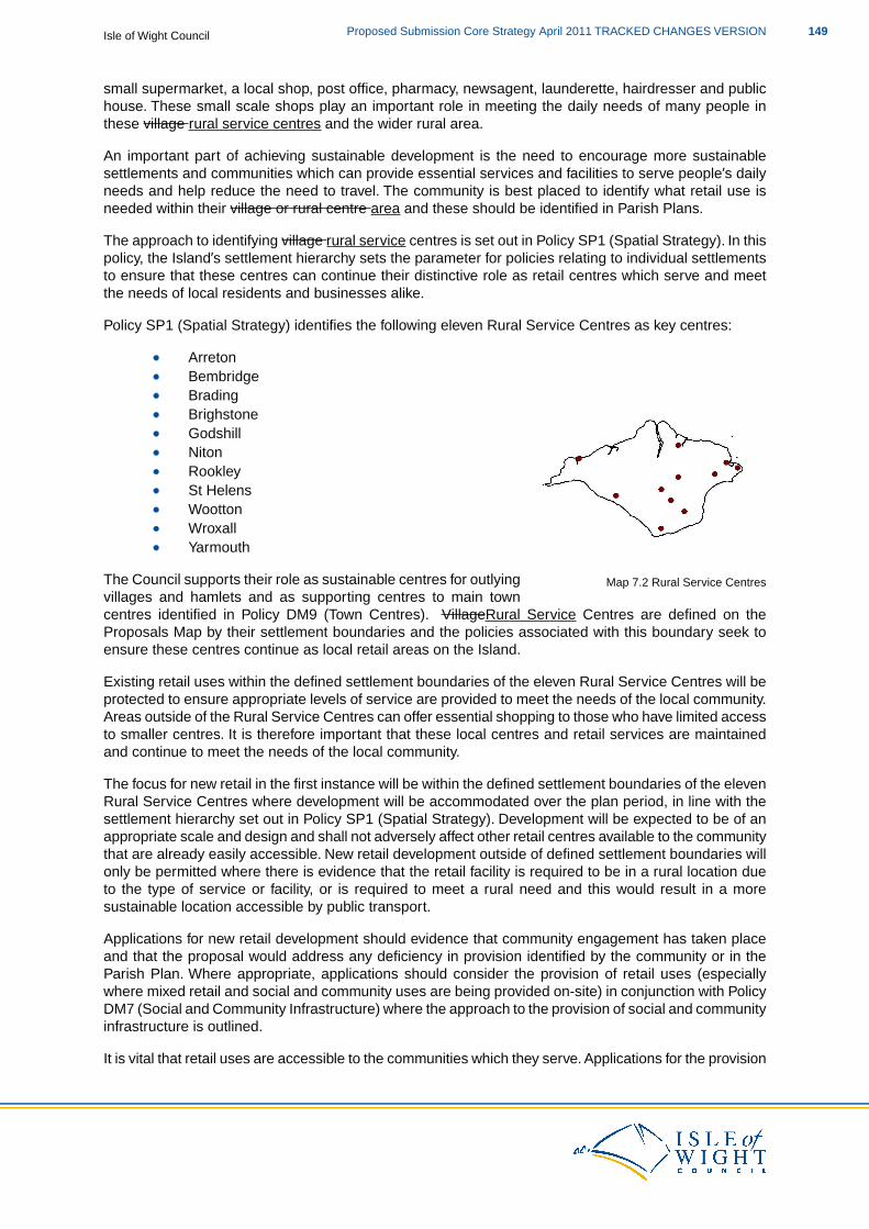
small supermarket, a local shop, post office, pharmacy, newsagent, launderette, hairdresser and publichouse. These small scale shops play an important role in meeting the daily needs of many people inthese village rural service centres and the wider rural area.
An important part of achieving sustainable development is the need to encourage more sustainablesettlements and communities which can provide essential services and facilities to serve people’s dailyneeds and help reduce the need to travel. The community is best placed to identify what retail use isneeded within their village or rural centre area and these should be identified in Parish Plans.
The approach to identifying village rural service centres is set out in Policy SP1 (Spatial Strategy). In thispolicy, the Island’s settlement hierarchy sets the parameter for policies relating to individual settlementsto ensure that these centres can continue their distinctive role as retail centres which serve and meetthe needs of local residents and businesses alike.
Policy SP1 (Spatial Strategy) identifies the following eleven Rural Service Centres as key centres:
Map 7.2 Rural Service Centres
ArretonBembridgeBradingBrighstoneGodshillNitonRookleySt HelensWoottonWroxallYarmouth
The Council supports their role as sustainable centres for outlyingvillages and hamlets and as supporting centres to main towncentres identified in Policy DM9 (Town Centres). VillageRural Service Centres are defined on theProposals Map by their settlement boundaries and the policies associated with this boundary seek toensure these centres continue as local retail areas on the Island.
Existing retail uses within the defined settlement boundaries of the eleven Rural Service Centres will beprotected to ensure appropriate levels of service are provided to meet the needs of the local community.Areas outside of the Rural Service Centres can offer essential shopping to those who have limited accessto smaller centres. It is therefore important that these local centres and retail services are maintainedand continue to meet the needs of the local community.
The focus for new retail in the first instance will be within the defined settlement boundaries of the elevenRural Service Centres where development will be accommodated over the plan period, in line with thesettlement hierarchy set out in Policy SP1 (Spatial Strategy). Development will be expected to be of anappropriate scale and design and shall not adversely affect other retail centres available to the communitythat are already easily accessible. New retail development outside of defined settlement boundaries willonly be permitted where there is evidence that the retail facility is required to be in a rural location dueto the type of service or facility, or is required to meet a rural need and this would result in a moresustainable location accessible by public transport.
Applications for new retail development should evidence that community engagement has taken placeand that the proposal would address any deficiency in provision identified by the community or in theParish Plan. Where appropriate, applications should consider the provision of retail uses (especiallywhere mixed retail and social and community uses are being provided on-site) in conjunction with PolicyDM7 (Social and Community Infrastructure) where the approach to the provision of social and communityinfrastructure is outlined.
It is vital that retail uses are accessible to the communities which they serve. Applications for the provision
149Proposed Submission Core Strategy April 2011 TRACKED CHANGES VERSIONIsle of Wight Council
of retail will be required to demonstrate that the most sustainable location has been chosen in order toensure sustainable development. This policy should be considered in conjunction with Policy DM18(Sustainable Travel) to ensure that proposals increase travel choice and provide alternative means oftravel to the car.
Farm shops can provide a retail offer to the community which they serve and contribute to the local andwider Island economy as places for people to visit and buy local produce. Applications for new farmshops will only be permitted where the extent and scale of the development will not adversely affect thevitality and viability of retail uses provided in nearby village or rural service centres or the wider ruralarea, the proposal is in keeping with the local character and offers safe access onto the local roadnetwork.
This policy seeks to retain existing retail uses to ensure the appropriate levels of service are providedto meet the needs of the community. Their potential loss could adversely affect the sustainability of thecommunity and increase the need to travel.The policy ensures that before non-retail uses are proposed,in the first instance, all viable retail uses are considered and assessed to prevent the loss of facilities.
The loss of a retail use may be permitted if it can be demonstrated that the facility is no longer viable.The Council will require appropriate target marketing to be undertaken to find other interested partieswilling to take on the current use of the premises/site. The marketing should continue for a period of atleast 12 months at an appropriate market price. Evidence which may also be required to support thisdecision could include details of previous uses/business accounts. Where appropriate, the site shouldalso be offered to the local community to manage the facility or other viable social and community facilitiesshould be considered.
When dealing with the loss of retail uses, developers should work closely with the community to ensurethat any proposed non-retail uses are acceptable in terms of location, design and scale to serve therequired needs of the community.
DM10 and Habitat Regulations Assessment
Following the recommendations of the Habitat Regulations Assessment of the Core Strategy, proposalsthat relate to this policy should consider the need for mitigation measures. This will be dependent uponthe type of proposal to which the Core Strategy policies are being applied and the proximity of thedevelopment proposal to European and Ramsar sites.
The likely mitigation measures required are set out in the following table:
Required Mitigation
Public space /greenspace access, as well as visitor management, site access and management, education and interpretation.
In relation to DM10 you may also like to look at:
PPS1: Delivering Sustainable DevelopmentPPS4: Planning for Sustainable Economic Growth, particularly Annex B (for definitions)PPS7: Sustainable Development in Rural AreasEco Island Sustainable Community StrategyIsland-wide Retail Capacity Study Update, 2008; Drivers Jonas for IWCIsland-wide Retail Capacity Study Update, 2009; Drivers Jonas for IWCTown Centres Health Check Study, 2009; Halcrow for IWCParish and Town Plans
Isle of Wight CouncilProposed Submission Core Strategy April 2011 TRACKED CHANGES VERSION150

High Quality Tourism Accommodation
DM11 High Quality Tourism
The Council will support sustainable growth in to achieve higher quality tourismaccommodation. In relation to tourist accommodation, development proposals will beexpected to:
a. Provide, wherever possible, a minimum 3* standard of accommodation in line withnationally approved quality grading schemes, or have a clear management plan in placeand to achieve this standard within 18 months.
b. Enable existing tourism businesses to adapt and improve their services, especially toimprove the quality of their offer towards a 4* and 5* provision of accommodation.
c. Improve the quality of its offer, if it is changing from one sector to another.
Proposals involving the loss of accommodation across the Island will be permitted when itcan be demonstrated that their retention is economically unviable and that the loss is thelast available course of action. If this is demonstrated, particularly when it is located withinthe settlement boundaries of the Key Regeneration Areas and Smaller Regeneration Areas,conversion of the accommodation to other uses will be considered appropriate.
Policy DM1511 (Flood RiskHigh Quality Tourism) expands on the Council’s general approach to tourismthat is set out in Policy SP3 (Economy) and SP4 (Tourism) and gives specific guidance for planningapplications.
As tThe bulk of the graded tourist accommodation on the Island is of a 3* standard. Anything constructedto a lesser level would reduce the overall standard of accommodation on the Island and the Councilwould not support this., the focus of this policy is to to ensure that the overall standard of new tourismaccommodation attains the highest possible quality standards. The Council will use the nationallyaccredited grading schemes to inform this approach, including anything new that may be introduced tosupplement them. This policy sets the quality standard which new development should achieve at aminimum of 3*. However, there is also a recognition that due to the grading schemes only applying suchstandards after the development is constructed, a new development which has been designed to reacha 3* grade, may well fall below this standard.
Where a proposal for tourist accommodation does not meet the minimum 3* standard, information isexpected to support the application to demonstrate how the scheme will meet the standard within 18months. Planning Services will liaise closely with the Council’s Economic Development, Tourism andLeisure department, and the organisations responsible for the accredited grading schemes, to establishwhether the minimum 3* standard will be met.
The Council is supportive of proposals that enable existing tourism businesses to adapt and improvetheir services. This is particularly the case when the proposed improvements would result in achievinga higher quality grading such as 4* and 5*. Again, to fully ensure that this is achieved, Planning Serviceswill liaise closely with the Council’s Economic Development, Tourism and Leisure department and theorganisations responsible for the accredited grading schemes.
Proposals may involve changing tourist accommodation from one sector to another (for example fromhotel to self catering) and planning permission would be required for a change of use. As part of anyproposal for such a change, the Council will expect an increase in the quality of the tourist accommodation,reflected in a higher accredited grading for the facility unless this is economically unviable (and if this isthe case, proposals should include a viability appraisal to demonstrate why it would be unviable).
Proposals should not result in a loss of bed spaces, unless it can be demonstrated that an improvementin standard cannot be achieved without such a loss occurring. Conditions may be required to ensurethat a minimum number of bed spaces are provided once permission has been granted.
151Proposed Submission Core Strategy April 2011 TRACKED CHANGES VERSIONIsle of Wight Council
The main drive of the Council’s approach towards the provision of tourist accommodation is to improvethe quality of the provision whilst maintaining the number of bed spaces. The Council accepts that theretention of tourist accommodation, however desirable, is not always possible. To ensure that no touristaccommodation is lost without justification, the Council will expect proposals to justify why the continueduse as tourist accommodation is economically unviable.
A number of factors need to be taken into account in assessing the viability of touristaccommodation. Some local authorities make use of an independent person or a panel of industryrepresentatives to undertake such assessments. The Council does not have a formal system for makingsuch assessments but does make use of established Tourism South East criteria, when consideringviability.
The Council will use the following criteria to establish the viability of tourist accommodation:
a. Proof of marketing for sale at a reasonable market price (for a minimum of 18 months).b. Evidence of attempts to save or reposition the business.c. Evidence of business performance when set against local and regional benchmarks, such
as the levels of occupancy relevant to the South East average.d. Evidence of professional and competent management.
In all of these criteria except the first, evidence should be provided over a minimum three year period.
DM11 and Habitat Regulations Assessment
Following the recommendations of the Habitat Regulations Assessment of the Core Strategy, proposalsthat relate to this policy should consider the need for mitigation measures. This will be dependent uponthe type of proposal to which the Core Strategy policies are being applied and the proximity of thedevelopment proposal to European and Ramsar sites.
The likely mitigation measures required are set out in the following table:
Required Mitigation
Public space / greenspace access, as well as visitor management, site access and management, education and interpretation.
In relation to DM11 you may also like to look at:
SP3 EconomyIsle of Wight Hotel Futures, 2005; Tourism Solutions & ack tourism for IW Tourism & Tourism SouthEastIsle of Wight Holiday Park Sector Audit and Review, 2006; Rural Solutions for IW Tourism & TourismSouth EastTourism Development Plan, 2005; IWCEconomic Strategy 2008-2020, 2008; IWCwww.visitsoutheastengland.com/www.iwight.com/just_visiting/
Historic and Built Environment
DM12 Historic and Built Environment
The Council will support proposals that positively conserve and enhance the special characterof the Island’s historic and built environment. Development proposals will be expected to:
Isle of Wight CouncilProposed Submission Core Strategy April 2011 TRACKED CHANGES VERSION152
1. Deliver economic led regeneration.2. Relate to the continued use, maintenance, rescue/refurbishment, repair and re-use of
heritage assets and historic places, especially where identified as being at risk, or likelyto become at risk.
3. Relate to the conservation, enhancement and enjoyment of the Island’s heritage assetsand public realm.
4. Consider and balance the relationship between the quality of place, economic, socialand environmental characteristics.
5. Reflect Be informed bythe Council’s Conservation Area Appraisals and Local ListSupplementary Planning Document.
The partial or wholedemolition ofor substantial harm to non-designated heritage assets,especially those listed nationally or locally, which make a positive contribution to the specialcharacter and/or local identity of an area, will be resisted in the first instance. Partial or wholedDemolition or substantial harm to designatedof heritage assets will only be permitted inwhollyexceptional circumstances, once consideration of viable alternatives to the demolitionor substantial alteration has been demonstrated.
Policy DM12 (Historic and Built Environment) expands on the Council’s general approach to the historicand built environments set out in Policy SP4 (Tourism) SP5 (Environment) and explains the approachthat the Council will take in respect of the built and historic environment on the Island, giving specificguidance for planning applications. It should be read and applied in conjunction with the relevant nationaldevelopment management policies listed in Appendix II.
The historic environment encompasses listed buildings, conservation areas, historic landscapes, sitesof archaeological interest and non-statutorily designated buildings or sites(57), which are collectivelyknown as heritage assets(58). These heritage assets are invariably important in their own right, but alsoform an important context which should be respected when new development is being considered.Heritage assets that are statutorily protected or nationally designated will be afforded the highest protectionin line with the relevant legislation and guidance.
The setting of heritage assets are also given protection.The setting of a heritage asset can be dynamic anddoes not have a fixed boundary. It can embrace all the surroundings from which the asset can beexperienced or that can be experienced from the asset. Consideration of the contribution that settingmakes to the significance of a place is irrespective of whether it was designed to do so or whether thereare public rights and an ability to access or experience that setting.
The Island’s historic environment provides a wealth of these distinctive features, that either individuallyor collectively help to define their surrounding area.
The Historic Environment Record, which catalogues these, currently includes:
2,502 Listed Buildings and Structures(59), of which:
29 are Grade I listed
57 Non-statutorily designated buildings or sites are those which are not listed, but that positively contribute to the character ofa conservation area, are on the local list or are identified as of local importance in Parish and Town Plans and Village DesignStatements.
58 Heritage Assets are currently defined as ”a building, monument, site or landscape of historic, archaeological, architecturalor artistic interest whether designated or not”. Heritage assets are components of the historic environment. The Council willuse the most recent central Government definition.
59 2,502 is the total number of buildings and structures that are listed on the Island. The overall number does not correlatewith the number of Grade I, II* and II given above, as one single listing can include any number of buildings and/or structures.
153Proposed Submission Core Strategy April 2011 TRACKED CHANGES VERSIONIsle of Wight Council
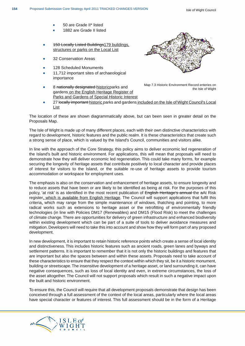
50 are Grade II* listed
Map 7.3 Historic Environment Record enteries onthe Isle of Wight
1882 are Grade II listed
150 Locally Listed Buildings179 buildings,structures or parks on the Local List
32 Conservation Areas
128 Scheduled Monuments11,712 important sites of archaeologicalimportance
8 nationally designated historicparks andgardens on the English Heritage Register ofParks and Gardens of Special Historic Interest27 locally important historic parks and gardens included on the Isle of Wight Council's LocalList
The location of these are shown diagrammatically above, but can been seen in greater detail on theProposals Map.
The Isle of Wight is made up of many different places, each with their own distinctive characteristics withregard to development, historic features and the public realm. It is these characteristics that create sucha strong sense of place, which is valued by the Island’s Council, communities and visitors alike.
In line with the approach of the Core Strategy, this policy aims to deliver economic led regeneration ofthe Island’s built and historic environment. For applications, this will mean that proposals will need todemonstrate how they will deliver economic led regeneration. This could take many forms, for examplesecuring the longevity of heritage assets that contribute positively to local character and provide placesof interest for visitors to the Island, or the suitable re-use of heritage assets to provide tourismaccommodation or workspace for employment uses.
The emphasis is also on the conservation and enhancement of heritage assets, to ensure longevity andto reduce assets that have been or are likely to be identified as being at risk. For the purposes of thispolicy, ‘at risk’ is as identified in the most recent publication of English Heritage's annual the aAt Riskregister, which is available from English Heritage. The Council will support applications that fulfil thiscriteria, which may range from the simple maintenance of windows, thatching and pointing, to moreradical works such as extensions to heritage asset or the retrofitting of environmentally friendlytechnologies (in line with Policies DM17 (Renewables) and DM15 (Flood Risk) to meet the challengesof climate change. There are opportunities for delivery of green infrastructure and enhanced biodiversitywithin existing development which can be part of a suite of tools to deliver avoidance measures andmitigation. Developers will need to take this into account and show how they will form part of any proposeddevelopment.
In new development, it is important to retain historic reference points which create a sense of local identityand distinctiveness. This includes historic features such as ancient roads, green lanes and byways andsettlement patterns. It is important to remember that it is not only the historic buildings and features thatare important but also the spaces between and within these assets. Proposals need to take account ofthese characteristics to ensure that they respect the context within which they sit, be it a historic monument,building or streetscape.The insensitive development of a heritage asset, or land surrounding it, can havenegative consequences, such as loss of local identity and even, in extreme circumstances, the loss ofthe asset altogether. The Council will not support proposals which result in such a negative impact uponthe built and historic environment.
To ensure this, the Council will require that all development proposals demonstrate that design has beenconceived through a full assessment of the context of the local areas, particularly where the local areashave special character or features of interest. This full assessment should be in the form of a Heritage
Isle of Wight CouncilProposed Submission Core Strategy April 2011 TRACKED CHANGES VERSION154
Statement, which should assess the impact of the significance of the heritage asset. Using this approachshould result in proposals which emerge from a robust design process that requires an understandingof local context. Where Heritage Statements are required, they will need to demonstrate that a fullassessment of the impact of a proposal upon the significance of a heritage asset has been made. TheCouncil will consider proposals taking into account the role the heritage asset plays in its local contextand the wider Island context ensuring that all economic, social and environmental factors are considered.
Conservation Management Plans and/or Historic Building Records are an essential tool in managingcomplex change sustainably and in realising an assets significance as physical evidence andrecording communal and other values. Management Plans and Historic Building Records may be requestedby the Council as part of an application or as a condition upon granting of consent.This type of professionalconservation research can provide the appropriate knowledge and understanding of significance necessaryto inform sustainable decision making with regard to any type of heritage assets - whether this is apark and garden, archaeological remains or a building. Where all or part of a significant place is to belost then its potential to yield information about the past should be realised through the production anddissemination of analysis and recording.
Heritage values are the framework for assessing an asset's importance on many levels (communally,historically, aesthetically and as evidence) and an understanding of the fabric, values and significanceof the place determines what change is harmful, what can be mitigated and what is beneficial.This valueapproach goes beyond consideration of the level of statutory designation, so the fact that a place doesnot meet certain criteria for statutory designation does not negate the value that it may hold in its localcommunity.
The Council will continue to prepare Conservation Area Appraisals to inidentify the potential for newconservation areas.We will also undertake Conservation Area Appraisal reviews of existing conservationareas to ensure that the areas are properly identified and understood. These appraisals will inform thespecial characteristics of these areas and any development will need to show how these documentshave been used to inform any proposals.
The Council will develop its Local List, with a view to adopting it as a Supplementary Planning Documentto inform development management decisions.The Council will also continue to work in partnership withParish and Town Councils to prepare Village Design Statements, Character Assessments and Parishand Town Plans which reflect the local character and identity of areas, with a view to adopting them asSupplementary Planning Documents.
The emphasis of this policy is to ensure the protection, conservation and enhancement of heritage assetsand therefore the Council will resist proposals which will result in the loss or partial loss of a heritageasset. In line with national policy, developers will be required to provide justification for the loss or partialloss ofharm to a heritage asset. Part of the justification should include, for example, an assessment ofalternative uses for the asset prior to its loss. The level of justification will need to be proportionate tothe type of asset being the subject of the proposal, as such assets which are of the highest significance(60)
will require ‘wholly exceptional circumstances’ to allow their loss. The Council will only consider the lossof an asset where there is an overriding public benefit resulting from the proposal and as such, eachapplication will be considered on its own merits.
In relation to DM12 you may also like to look at:
PPS5: Planning for the Historic EnvironmentConservation Principles, 2008: English HeritageHistoric Environment Local Management (HELM) at www.helm.org.ukEco-Island Sustainable Community Strategy, 2008; ISP & IWCConservation Area Appraisals, various; IWCThe IW Historic Environment Action Plan (HEAP), 2008; IWC
60 Developers should take account of PPS5, particularly Policy HE9, which sets out the guiding principles on significance atparagraph 1 and defines a ‘designated heritage asset’ and ‘significance’ in Annex 2.
155Proposed Submission Core Strategy April 2011 TRACKED CHANGES VERSIONIsle of Wight Council
Parish and Town Plans and Village Design Statements
Landscape, Seascape, Biodiversity and Geodiversity
DM13 Landscape, Seascape, Biodiversity and Geodiversity
The Council will support proposals that conserve, enhance and promote the landscape,seascape, biodiversity and geological interest of the Island. Development proposals will beexpected to:
1. Respect Protect the integrity of international, national and local designations relatingto landscape, seascape, biodiversity and geodiversity and the reasons for thesedesignations and the weight given to them and enhance their features of interestwherever possible.
2. Ensure new development avoids both direct and indirect adverse effects upon theintegrity of designated sites and, if necessary, provides appropriate mitigation measures.
3. Promote the maintenance and enhancement of the links between designated sites,especially through the provision of, and/or enhancement to, Green Infrastructure andappropriate local designations.
4. Reflect the aims and objectives of the AONB Management Plan, the Council’s LandscapeCharacter Assessment, Historic Landscape Characterisation and any further relevantlandscape assessment.
5. Positively contribute to meeting the aims and objectives of the Isle of Wight’s LocalBiodiversity Action Plan and Local Geodiversity Action Plan.
6. Minimise the threats and promote the opportunities arising from climate change on theIsland’s landscape, seascape, biodiversity and geodiversity.
Policy DM13 (Landscape, Seascape, Biodiversity and Geodiversity) should be read and applied inconjunction with the other policies of the Core Strategy and the relevant national development managementpolicies listed in Appendix II.
The Island has an extensive network of sites which are important for biodiversity and geologicalconservation, so much so that some are covered by European and Ramsar designations. Any plan ordevelopment which is considered to have a likely significant effect upon a European and/or Ramsar sitewill be subject to a Habitats Regulations Assessment and may require mitigation.The plan or developmentcan only proceed if it can be clearly demonstrated that the integrity of European site will not be adverselyaffected, other than in exceptional circumstances relating to overriding public interest.
The Island is located close to the New Forest National Park and as such any proposals as a result ofthe Island Plan Core Strategy, where there is good (or strong circumstantial) evidence of a detrimentalimpact on the aims and objectives of this national designation, will need to be assessed and, if necessary,reduce any significant impacts through changes to the proposal or other forms of mitigation.
However all development proposals will be expected to demonstrate how they have taken account ofthe hierarchy of designations through a sequential search for the most appropriate site that causes theleast harm, with further consideration given to the positive benefits to the Islands landscape, seascape,biodiversity and geological interest.
The requirement for the provision of mitigation measures to avoid adverse effects is recognition by theCouncil that any development, whether alone or in combination with other projects and plans, regardlessof its location or type, can have an impact (for example the indirect impacts associated with leisure andrecreational pressures as a result of new housing development) on the Island’s environmental assets.Both the requirement for, and nature of, mitigation will be determined by the proposal (i.e. the nature ofthe activity associated with the proposed development and its location) and the Council will only permit
Isle of Wight CouncilProposed Submission Core Strategy April 2011 TRACKED CHANGES VERSION156
development requiring such mitigation where the proposed mitigation measures are acceptable to boththe Council and relevant key environmental stakeholders (this will vary depending on the environmentalasset and the Council will advise on who this is as early in the pre-application process as possible).
Frequently the value of a designated site is significantly increased when it is considered as part of awider green infrastructure. Thus, importance lies in the spatial relationship between these sites, eitheras ecological stepping stones, or sites connected by a network of green corridors.Therefore, considerationneeds to be given to the spaces in between designated sites, where they hold an ecological value, eitheras a link, or by having interest features of significance themselves (for example brownfield sites oftencontain unusual or valuable species). Proposals will be expected to demonstrate consideration of boththe existing Green Infrastructure of the Island and what positive contribution the proposal can make tothis network in accordance with policy DM14 (Green Infrastructure).
Within the AONB Landscape Character Assessment and the Historic Environment Action Plan areas, arange of landscapes and settlement patterns are identified. The Council will use these assessments toidentify how development is likely to impact on the landscape’s character and how this may be avoidedor mitigated and how development could bring about improvements to the landscape.
Seascape – the character of the Island’s coastline
The Island is a coastal authority separated from the mainland by the Solent. It is unique in England asits entire authority boundary is coastline. This has had a profound influence on the Island, physicallyshaping it and how it is seen, providing a requirement for the consideration of ‘seascape’.
Seascape as a concept should be thought of as “the coastal landscape and adjoining areas of openwater, including views from land to sea, from sea to land and along the coastline and describes the effecton landscape at the confluence of sea and land.”(61) Therefore for the purpose of this policy, seascapeis defined as a discrete area within which there is shared inter-visibility between land and sea (a singlevisual envelope).
Every seascape therefore has three defined components:
an area of sea (the visible seaward component);a length of coastline (the visible coastline component, normally defined by prominent physicalfeatures such as headlands or other promontories); andan area of land (the visible landward component, based on either or a combination of visibilityfrom the above two points).
By contrast, ‘landscape’ starts at the coastline, and includes all areas inland, even where there are noviews or direct experience of the sea. In most situations, the landward component of a seascape willplay a significant part in seascapes and it is largely the character of the land and coastline, rather thanthe sea itself, which defines the basic character of seascapes. Seascape units are defined by usingvisibility analysis in conjunction with character assessment.
Seascape effects are the changes in the character and quality of the seascape as a result of development.Hence, seascape assessment is concerned with direct and indirect effects upon specific seascapeelements and features; more subtle effects on seascape character; and effects upon acknowledgedspecial interests such as designated landscapes, historic setting, wildness or tranquillity.
Seascape is a development of the concept of landscape and where no appraisal (such as through theHeritage Coast designation, AONB Management Plan or other landscape assessment) exists the Councilwill carry out an assessment, so that by 20124 all the Island’s coastline will have a seascape appraisal.This local definition of seascapes will be used to assess the likely impact of proposals. In the interim allcoastal development (i.e. development that is visible within one of the three defined components) will berequired to carry out an assessment of the likely impacts of the proposed development on the localcoastline and wider seascape.This should include consideration of local assets and all designations that
61 Based on DTI & Defra guidance, “Guidance on the Assessment of the impact of offshore wind farms: Seascape and visualimpact report” (2005)
157Proposed Submission Core Strategy April 2011 TRACKED CHANGES VERSIONIsle of Wight Council
contribute to the character of the coast in that area, including:
conservation areas;listed buildings;landscape designations; andviews from the coast to the sea, the sea to the coast and along the coastline.
Whilst the character of the Island’s coastline should not be comprised by development, the considerationof seascape should not be one of constraint. Rather it should be used to inform both location and design.
The myriad of designations that cover the Island are shown in detail on the Proposals Map. Associatedwith these are the AONB Management Plan, the Isle of Wight’s Local Biodiversity Action Plan and LocalGeodiversity Action Plan. Each of these plans have aims and objectives that are reviewed regularly andall development proposals will be expected to demonstrate how these aims and objectives have beenconsidered where they are relevant and how the proposal will make positive contributions towards them.
The natural environment is one of constant change. However, it is now generally recognised that therate of this change is increasing through the effects of climate change. As we all benefit from theenvironment, it is recognised as the Island’s key asset (both in social and economic terms, as well asenvironmental) and as it is the receptor of all our activities, we have a responsibility, as well as a vestedinterest, in safeguarding this natural asset and allowing natural adjustments to occur.
All development will be expected to demonstrate consideration of the effects of climate change on theIsland’s natural environment and how the proposal may aid or hinder adaptation. Particular considerationshould be given to:
How the landscape is likely to change over both the plan period and the life of thedevelopment proposal, so that any development that may appear relatively incongruousnow, will not in time detract from the landscape and character of an area.The requirement for habitats and species to migrate and not be squeezed betweendevelopment and habitat loss.The natural resource requirements of the environment such as water (both volume andquality), air quality and soil condition in order to allow natural processes and ecosystemsto function as near a natural state (i.e. without human intervention) as possible.The extent and setting of geological features and exposures of significance (for exampleRIGG sites) where these are identified in the Geodiversity Action Plan as under pressurefrom both the effects of climate change (through physical processes and sea-level rise) andhuman activity, such as exploitation of mineral resources, new development and supportinginfrastructure.
In relation to DM13 you may also like to look at:
PPS7: Sustainable Development in Rural AreasPPS9: Biodiversity and Geological ConservationPPS20: Coastal PlanningDraft PPS: Planning for a Natural and Healthy EnvironmentAONB Management Plan 2009-2014, 2009; IW AONB PartnershipHistoric Landscape Characterisation Study, 2008; IWC & English HeritageIsle of Wight Biodiversity Action Plan, 2000 onwards; IW Biodiversity PartnershipIsle of Wight Local Geodiversity Action Plan, 2010; IWC & Natural EnglandGuidance on the Assessment of the Impact of Offshore Wind Farms: Seascape and Visual ImpactReport, 2005; DTI
Isle of Wight CouncilProposed Submission Core Strategy April 2011 TRACKED CHANGES VERSION158
Green Infrastructure
DM14 Green Infrastructure
The Council will support proposals that protect, enhance and manage a diverse network ofmulti-functional Green Infrastructure (GI) assets across the Island. Development proposalswill be expected to:
1. Protect and enhance the integrity and connectivity of the Island’s GI network as identifiedin the Isle of Wight Green Infrastructure Mapping Study (July 2010).
2. Provide opportunities to enhance and increase the coverage, connectivity andmulti-functionality of the Island’s GI network. Where on-site provision is not possible,contributions will be sought to make appropriate GI provision and/or enhancementoff-site.
3. Provide appropriate mitigation measures for the loss of GI assets, where it is shownthat the loss of the asset is unavoidable in securing appropriate development.
4. Ensure that development within the Key Regeneration Areas delivers the appropriatelevels of GI provision.
5. Ensure that the areas which separate the key settlements of Cowes/Newport, EastCowes/Newport, Ryde/Wootton and The Bay/Brading are appropriately protected toprevent settlement coalescence.These areas will be further defined within the AreaAction Plans.
As part of the GI network, the Council will identify sites which are important for open space,sport and recreation.The Council will support proposals which protect, enhance and increasethe coverage of these sites by:
a. Ensuring that new development provides opportunities to enhance existing sites and/orincrease the provision of new sites as a network, where appropriate, in line with thelocal provision standards set out in the Council’s Open Space Audit.
b. Preventing the loss of an existing site unless:
i. an alternative site of equivalent or better quality and type is available or can beprovided at an equally accessible location to comply with the Open Spaces Audit localprovision standards; or
ii. a significant enhancement to the nature and quality of an existing facility will resultfrom the redevelopment of an appropriate proportion of the site for alternative uses.
Policy DM14 (Green Infrastructure) expands on the Council’s general approach to the environment thatis set out in Policy SP5 (Environment) and explains the approach that the Council will take in respect ofthe Green Infrastructure and open space provision on the Island giving specific guidance for planningapplications. It should be read and applied in conjunction with the relevant national developmentmanagement policies that are listed in Appendix II.
Green Infrastructure
This policy aims to deliver a network of accessible, high quality, high value green spaces which promotesustainability, support biodiversity and contribute to the economic, social and environmental aspirationsof the Island. Green Infrastructure (GI) identifies sites which have particular landscape, biodiversity and/orrecreational functions as a network. The key functions of GI(62) can be summarised as follows:
Conservation and enhancement of biodiversity, including the need to mitigate the potentialimpacts of new development.
62 Taken from the South East Green Infrastructure Framework (June 2009)
159Proposed Submission Core Strategy April 2011 TRACKED CHANGES VERSIONIsle of Wight Council
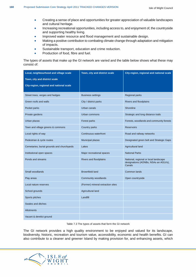
Creating a sense of place and opportunities for greater appreciation of valuable landscapesand cultural heritage.Increasing recreational opportunities, including access to, and enjoyment of, the countrysideand supporting healthy living.Improved water resource and flood management and sustainable design.Making a positive contribution to combating climate change through adaptation and mitigationof impacts.Sustainable transport, education and crime reduction.Production of food, fibre and fuel.
The types of assets that make up the GI network are varied and the table below shows what these mayconsist of:
City-region, regional and national scaleTown, city and district scaleLocal, neighbourhood and village scale
Town, city and district scale
City-region, regional and national scale
Regional parksBusiness settingsStreet trees, verges and hedges
Rivers and floodplainsCity / district parksGreen roofs and walls
ShorelineUrban canalsPocket parks
Strategic and long distance trailsUrban commonsPrivate gardens
Forests, woodlands and community forestsForest parksUrban plazas
ReservoirsCountry parksTown and village greens & commons
Road and railway networksContinuous waterfrontLocal rights of way
Designated green belt and Strategic GapsMunicipal plazasPedestrian & cycle routes
Agricultural landLakesCemetaries, burial grounds and churchyards
National ParksMajor recreational spacesInstitutional open spaces
National, regional or local landscapedesignations (AONBs, NSAs an AGLVs),Canals
Rivers and floodplainsPonds and streams
Common landsBrownfield landSmall woodlands
Open countrysideCommunity woodlandsPlay areas
(Former) mineral extraction sitesLocal nature reserves
Agricultural landSchool grounds
LandfillSports pitches
Swales and ditches
Allotments
Vacant & derelict ground
Table 7.3 The types of assets that form the GI network
The GI network provides a high quality environment to be enjoyed and valued for its landscape,biodiversity, historic, recreation and tourism value, accessibility, economic and health benefits. GI canalso contribute to a cleaner and greener Island by making provision for, and enhancing assets, which
Isle of Wight CouncilProposed Submission Core Strategy April 2011 TRACKED CHANGES VERSION160
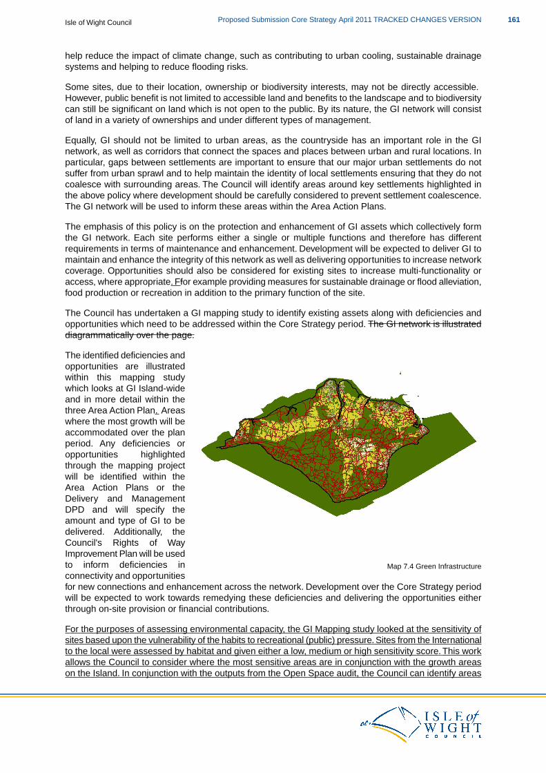
help reduce the impact of climate change, such as contributing to urban cooling, sustainable drainagesystems and helping to reduce flooding risks.
Some sites, due to their location, ownership or biodiversity interests, may not be directly accessible.However, public benefit is not limited to accessible land and benefits to the landscape and to biodiversitycan still be significant on land which is not open to the public. By its nature, the GI network will consistof land in a variety of ownerships and under different types of management.
Equally, GI should not be limited to urban areas, as the countryside has an important role in the GInetwork, as well as corridors that connect the spaces and places between urban and rural locations. Inparticular, gaps between settlements are important to ensure that our major urban settlements do notsuffer from urban sprawl and to help maintain the identity of local settlements ensuring that they do notcoalesce with surrounding areas. The Council will identify areas around key settlements highlighted inthe above policy where development should be carefully considered to prevent settlement coalescence.The GI network will be used to inform these areas within the Area Action Plans.
The emphasis of this policy is on the protection and enhancement of GI assets which collectively formthe GI network. Each site performs either a single or multiple functions and therefore has differentrequirements in terms of maintenance and enhancement. Development will be expected to deliver GI tomaintain and enhance the integrity of this network as well as delivering opportunities to increase networkcoverage. Opportunities should also be considered for existing sites to increase multi-functionality oraccess, where appropriate. Ffor example providing measures for sustainable drainage or flood alleviation,food production or recreation in addition to the primary function of the site.
The Council has undertaken a GI mapping study to identify existing assets along with deficiencies andopportunities which need to be addressed within the Core Strategy period. The GI network is illustrateddiagrammatically over the page.
Map 7.4 Green Infrastructure
The identified deficiencies andopportunities are illustratedwithin this mapping studywhich looks at GI Island-wideand in more detail within thethree Area Action Plan. Areaswhere the most growth will beaccommodated over the planperiod. Any deficiencies oropportunities highlightedthrough the mapping projectwill be identified within theArea Action Plans or theDelivery and ManagementDPD and will specify theamount and type of GI to bedelivered. Additionally, theCouncil's Rights of WayImprovement Plan will be usedto inform deficiencies inconnectivity and opportunitiesfor new connections and enhancement across the network. Development over the Core Strategy periodwill be expected to work towards remedying these deficiencies and delivering the opportunities eitherthrough on-site provision or financial contributions.
For the purposes of assessing environmental capacity, the GI Mapping study looked at the sensitivity ofsites based upon the vulnerability of the habits to recreational (public) pressure. Sites from the Internationalto the local were assessed by habitat and given either a low, medium or high sensitivity score. This workallows the Council to consider where the most sensitive areas are in conjunction with the growth areason the Island. In conjunction with the outputs from the Open Space audit, the Council can identify areas
161Proposed Submission Core Strategy April 2011 TRACKED CHANGES VERSIONIsle of Wight Council
where either new recreation provision will be required, and/or whether existing provision can be enhancedto mitigate any adverse impact from new development.
Where proposed development would result in adverse impact upon the GI network either through directloss or increased pressure on the use of sites, developers should incorporate measures into developmentproposals to avoid any adverse impacts. If the impact cannot be avoided then measures should be usedto mitigate any impacts such as on-site or alternative provision of GI before providing financial contributionstowards the network locally. Of particular importance is ensuring that development does not result innegative impacts upon Natura 2000 sites across the Island arising from recreational pressure. Workemerging from the Solent Disturbance and Mitigation Project has looked at the management of existingsites to reduce negative impacts from recreational (public) pressure.The Project has highlighted a numberof techniques that could be used as part of the management of sites such as:
Creation of dog walk routes.
Physical barriers to segregate recreational users from wildlife.
Codes of Conduct or information leaflets to deter use of more sensitive areas.
Zoning and management of areas for different recreational uses.
The Green Infrastructure Strategy will provide further guidance on the approach that developers shouldtake to mitigation, including provision standards based upon Accessible Natural Greenspace Standards(ANGSt) and the identification of Alternative Green Infrastructure Provision (AGIPs).
A project team will be set up to ensure that work undertaken meets the requirements of HabitatsRegulations Assessment. This group will help to ensure the requirements for mitigation under the HabitatsDirective are met, as set out in the Core Strategy HRA. It is proposed that the Island Plan EnvironmentSteering Group, which comprises the statutory consultees under the SEA Regulations (EnvironmentAgency, Natural England and English Heritage) as well as Southern Water, RSPB, Wildlife Trust, theIsle of Wight AONB Unit and Coastal Management Group, will undertake this role.
Green Infrastructure Strategy
The detailed guidance on the application of this policy will be contained within a Green InfrastructureStrategy SPD which will further the work of the GI mapping project on the identification of the networkand the different functions of the assets. It will also look at mitigation, identify management responsibilitiesand plans for the network, as well as sources of funding and delivery mechanisms. The Strategy willalso identify detailed monitoring criteria and responsibilities to ensure that the network is expanded andmaintained to a sufficient quality and quantity, together with the functions required from it. The strategyis programmed for adoption by the Council in May 2012.
The Planning Obligations SPD will set out the requirements for financial contributions. The Council willuse developer contributions to facilitate improvements to the integrity and connectivity of the GI network.
Chapter 8: Infrastructure Delivery and Development Implementation sets out in more detail issues relatingto developer contributions and establishes that the mechanism for calculating and collecting them willbe a CIL Charging Schedule and a Planning Obligations Supplementary Planning Document. It alsooutlines the need for flexibility when applying the policies of the Core Strategy and developer contributions,to ensure that the plan is sufficiently flexible to be deliverable.
In relation to Green Infrastructure you may also like to look at:
PPS1: Delivering Sustainable DevelopmentPlanning and Climate Change – Supplement to PPS1PPS7: Sustainable Development in Rural Areas
Isle of Wight CouncilProposed Submission Core Strategy April 2011 TRACKED CHANGES VERSION162
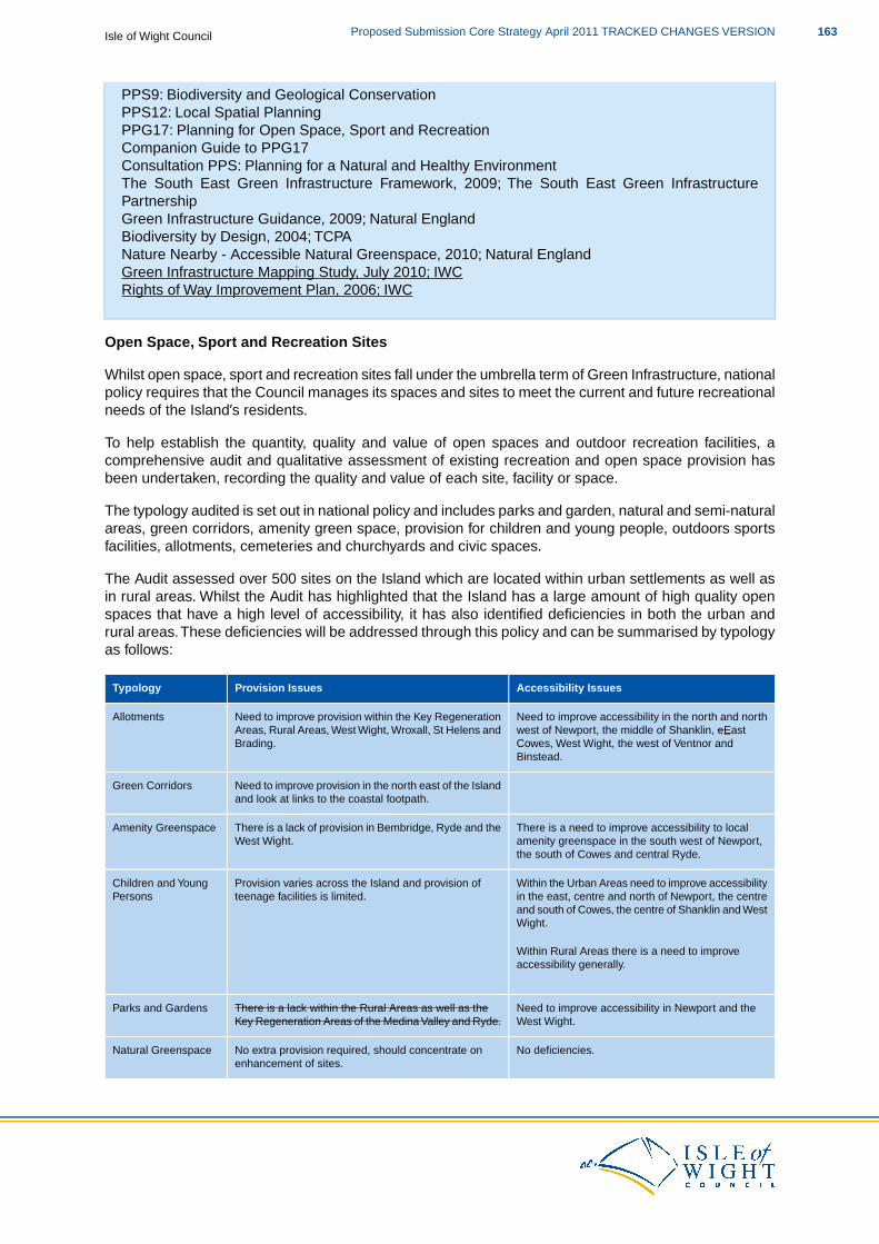
PPS9: Biodiversity and Geological ConservationPPS12: Local Spatial PlanningPPG17: Planning for Open Space, Sport and RecreationCompanion Guide to PPG17Consultation PPS: Planning for a Natural and Healthy EnvironmentThe South East Green Infrastructure Framework, 2009; The South East Green InfrastructurePartnershipGreen Infrastructure Guidance, 2009; Natural EnglandBiodiversity by Design, 2004; TCPANature Nearby - Accessible Natural Greenspace, 2010; Natural EnglandGreen Infrastructure Mapping Study, July 2010; IWCRights of Way Improvement Plan, 2006; IWC
Open Space, Sport and Recreation Sites
Whilst open space, sport and recreation sites fall under the umbrella term of Green Infrastructure, nationalpolicy requires that the Council manages its spaces and sites to meet the current and future recreationalneeds of the Island’s residents.
To help establish the quantity, quality and value of open spaces and outdoor recreation facilities, acomprehensive audit and qualitative assessment of existing recreation and open space provision hasbeen undertaken, recording the quality and value of each site, facility or space.
The typology audited is set out in national policy and includes parks and garden, natural and semi-naturalareas, green corridors, amenity green space, provision for children and young people, outdoors sportsfacilities, allotments, cemeteries and churchyards and civic spaces.
The Audit assessed over 500 sites on the Island which are located within urban settlements as well asin rural areas. Whilst the Audit has highlighted that the Island has a large amount of high quality openspaces that have a high level of accessibility, it has also identified deficiencies in both the urban andrural areas.These deficiencies will be addressed through this policy and can be summarised by typologyas follows:
Accessibility IssuesProvision IssuesTypology
Need to improve accessibility in the north and northwest of Newport, the middle of Shanklin, eEast
Need to improve provision within the Key RegenerationAreas, Rural Areas, West Wight, Wroxall, St Helens andBrading.
Allotments
Cowes, West Wight, the west of Ventnor andBinstead.
Need to improve provision in the north east of the Islandand look at links to the coastal footpath.
Green Corridors
There is a need to improve accessibility to localamenity greenspace in the south west of Newport,the south of Cowes and central Ryde.
There is a lack of provision in Bembridge, Ryde and theWest Wight.
Amenity Greenspace
Within the Urban Areas need to improve accessibilityProvision varies across the Island and provision ofteenage facilities is limited.
Children and YoungPersons in the east, centre and north of Newport, the centre
and south of Cowes, the centre of Shanklin and WestWight.
Within Rural Areas there is a need to improveaccessibility generally.
Need to improve accessibility in Newport and theWest Wight.
There is a lack within the Rural Areas as well as theKey Regeneration Areas of the Medina Valley and Ryde.
Parks and Gardens
No deficiencies.No extra provision required, should concentrate onenhancement of sites.
Natural Greenspace
163Proposed Submission Core Strategy April 2011 TRACKED CHANGES VERSIONIsle of Wight Council
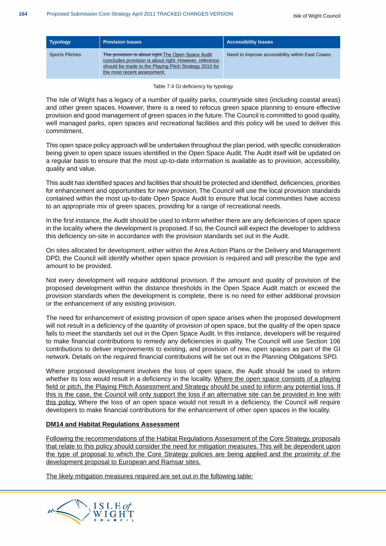
Accessibility IssuesProvision IssuesTypology
Need to improve accessibility within East Cowes.The provision is about right.The Open Space Auditconcludes provision is about right. However, reference
Sports Pitches
should be made to the Playing Pitch Strategy 2010 forthe most recent assessment.
Table 7.4 GI deficiency by typology
The Isle of Wight has a legacy of a number of quality parks, countryside sites (including coastal areas)and other green spaces. However, there is a need to refocus green space planning to ensure effectiveprovision and good management of green spaces in the future.The Council is committed to good quality,well managed parks, open spaces and recreational facilities and this policy will be used to deliver thiscommitment.
This open space policy approach will be undertaken throughout the plan period, with specific considerationbeing given to open space issues identified in the Open Space Audit. The Audit itself will be updated ona regular basis to ensure that the most up-to-date information is available as to provision, accessibility,quality and value.
This audit has identified spaces and facilities that should be protected and identified, deficiencies, prioritiesfor enhancement and opportunities for new provision. The Council will use the local provision standardscontained within the most up-to-date Open Space Audit to ensure that local communities have accessto an appropriate mix of green spaces, providing for a range of recreational needs.
In the first instance, the Audit should be used to inform whether there are any deficiencies of open spacein the locality where the development is proposed. If so, the Council will expect the developer to addressthis deficiency on-site in accordance with the provision standards set out in the Audit.
On sites allocated for development, either within the Area Action Plans or the Delivery and ManagementDPD, the Council will identify whether open space provision is required and will prescribe the type andamount to be provided.
Not every development will require additional provision. If the amount and quality of provision of theproposed development within the distance thresholds in the Open Space Audit match or exceed theprovision standards when the development is complete, there is no need for either additional provisionor the enhancement of any existing provision.
The need for enhancement of existing provision of open space arises when the proposed developmentwill not result in a deficiency of the quantity of provision of open space, but the quality of the open spacefails to meet the standards set out in the Open Space Audit. In this instance, developers will be requiredto make financial contributions to remedy any deficiencies in quality. The Council will use Section 106contributions to deliver improvements to existing, and provision of new, open spaces as part of the GInetwork. Details on the required financial contributions will be set out in the Planning Obligations SPD.
Where proposed development involves the loss of open space, the Audit should be used to informwhether its loss would result in a deficiency in the locality. Where the open space consists of a playingfield or pitch, the Playing Pitch Assessment and Strategy should be used to inform any potential loss. Ifthis is the case, the Council will only support the loss if an alternative site can be provided in line withthis policy. Where the loss of an open space would not result in a deficiency, the Council will requiredevelopers to make financial contributions for the enhancement of other open spaces in the locality.
DM14 and Habitat Regulations Assessment
Following the recommendations of the Habitat Regulations Assessment of the Core Strategy, proposalsthat relate to this policy should consider the need for mitigation measures. This will be dependent uponthe type of proposal to which the Core Strategy policies are being applied and the proximity of thedevelopment proposal to European and Ramsar sites.
The likely mitigation measures required are set out in the following table:
Isle of Wight CouncilProposed Submission Core Strategy April 2011 TRACKED CHANGES VERSION164
Required Mitigation
Specific mitigation such as recreational provision and provision of supporting habitats as well as visitor management, site access andmanagement, education and interpretation.
In relation to Open Space, Sport and Recreation, you may also like to look at:
PPS1: Delivering Sustainable DevelopmentPlanning and Climate Change – Supplement to PPS1PPS7: Sustainable Development in Rural AreasPPS9: Biodiversity and Geological ConservationPPS12: Local Spatial PlanningPPG17: Planning for Open Space, Sport and Recreation & the Companion GuideConsultation PPS: Planning for a Natural and Healthy EnvironmentNature Nearby - Accessible Natural Greenspace, 2010; Natural EnglandPlanning and Design for Outdoor Sport and Play; Sport EnglandOpen Space Audit, 2010; Halcrow for IWCA Playing Pitch Assessment and Strategy for the Isle of Wight, 2010; Halcrow for IWC
Flood Risk
DM15 Flood Risk
The Council will expect development proposals to reduce the overall and local risk of floodingon the Island. Development proposals will be expected to:
1. Demonstrably meet the aims and objectives of the Council’s Strategic Flood RiskAssessment. When undertaking FRAs in Flood Zones 2 and 3, an allowance for climatechange has to be provided. PPS25 requires this allowance to be a minimum of 100years.
2. Provide appropriate on-site sustainable draining systems (SuDS) for the disposal ofsurface water in order to ensure there is no net loss of flood storage capacity or impacton water quality.This will need to meet national and local standards for SuDS to asufficient level so as to gain approval by the SuDS Approving Body.
3. In addition to national requirements for a Flood Risk Assessment, planning applicationsfor all new developments on sites over 0.25 hectares in Flood Zone 1 should beaccompanied by a Drainage Strategy.
4. Where a proposal is in an identified Flood Risk Area, as defined by the Council underit’s responsibilities as a Lead Local Flood Authority, the Council will expect it to supportthe objectives and measures of the relevant flood risk management plans and strategy.
SuDS should be sensitively designed and located to promote biodiversity, enhancedlandscape and good quality spaces that improve public amenities in the area. ProposedSuDS schemes should demonstrate consideration of the contribution they can make to theIsland’s Green Infrastructure Strategy. The contribution made to the GI network should beproportionate to the scheme proposal and any wider environmental mitigation requirementsthe proposed development associated with the SuDS scheme requires.
On greenfield sites, SuDS will be required to achieve no increase in the relevant net run-offrate to that prior to development. All other sites should aim to achieve a reduction from theexisting run-off rate but must at least result in no net additional increase in run-off rates. Alldevelopments will be expected to maintain and improve (wherever possible) river andgroundwater quality.
165Proposed Submission Core Strategy April 2011 TRACKED CHANGES VERSIONIsle of Wight Council
For specific locations around the Island, a Flood Risk and Vulnerable Coastal CommunitiesSPD will be developed which will address the specific flood risk related issues that will needto be considered by development proposals within areas covered by the SPD. The SPD willoutline what measures will need to be demonstrated so that new developments would notbe at risk of flooding as a result of climate change, or would not worsen flood risk elsewhere.
The Council has adopted the predicted 1 in 200 year tidal flood map for the year 2115 as a replacementto the current tidal Flood Zone 3. It has also adopted the predicted 1 in 1000 year tidal flood mappingfor the year 2115 as a replacement to the current tidal Flood Zone 2. This approach ensures that thepossible impacts of climate change are incorporated into the spatial planning process.
The requirement for a minimum allowance of 100 years is related to the established lifetime of residentialdevelopment and for non-residential development this has generally been viewed as between 60 to 70years. However, where a proposal in a flood zone has an allowance of less then 100 years this will needto be justified based on use (vulnerability) and lifespan of the development and will need to be reflectedin an associated planning condition (for example time-limited consent). Such proposals will still need toadhere to the principles of the sequential approach to flood risk and been in conformity with this policy.
The policy will allow development to be located appropriately, in conformity with PPS25: Developmentand Flood Risk, taking into account both flood risk and other sustainability objectives. Flooding can causeextensive damage and it is imperative that every effort should be made to ensure that development islocated so that it is not put at risk, or displaces flood water, creating problems elsewhere.
Following the sequential approach, development in areas at risk of flooding will be avoided whereverpossible. However, where there are no reasonable alternatives, such as the regeneration of previouslydeveloped land, less vulnerable uses will be given higher priority then more vulnerable development.
Where a Drainage Strategy is required, it should detail how the proposed development does not increasecurrent run-off rates. For previously developed sites, the Drainage Strategy should describe how thedevelopment reduces surface water run-off rates and volumes. The Drainage Strategy could be carriedout as a desktop study and should be proportionate to the proposal.
In many instances, a previously developed site will be predominantly hard standing and thus run-off ratesand volumes will be high. Requiring a reduction in these rates and volumes will reduce the pressure onthe receiving surface water drainage network and/or watercourse. This approach utilises redevelopmentto deliver local flood risk reductions which is in-line with the Pitt Review and emerging approaches tomanaging surface water flood risk reductions.
If, however, the site discharges directly to the sea, then this requirement to manage rates and volumesmay be reduced, while concerns relating to pollution control may be increased and advice should besought from the Council and the Environment Agency.
As a minimum, evidence of existing surface conditions across the site should be provided and howinfiltration rates will be maintained or improved to achieve the required run-off rates, where this isappropriate. A check of the site should be made against the indicative SuDS assessment in the SFRASite Database and Settlement Appendices. This will help inform the most appropriate managementmethod for surface water run-off.
The use of SuDS will be important in the management of surface water flows as they provide an alternativemeans of managing surface water. SuDS should be appropriate to both the proposed development andlocal conditions, with the SFRA being used as the start point to inform provision.While the environmentalbenefits of SuDS are well known, equal consideration should be given to the potential flood storagecapacity that provision of Green Infrastructure may deliver. In addition, long term strategies, such asCatchment Management and Shoreline Management Plans, will be material considerations in decisionmaking.
Water as a resource on the Island is scarce and SuDS can make a significant contribution to addressing
Isle of Wight CouncilProposed Submission Core Strategy April 2011 TRACKED CHANGES VERSION166
the water demands associated with a development. For example, implementing sustainable supplymeasures for external potable water consumption by providing a system to collect rain water for use inexternal irrigation/watering, will help reduce water demands.
Therefore, the Council will expect all proposals to demonstrate consideration of the potential supplementarywater supply benefits that can be gained from SuDS that will support the policy objectives of Core StrategyPolicy DM1 (Sustainable Build Criteria for New Development) on conserving the Island’s water resources.Where proposals do not adopt this approach, the Council will expect justification.
When designing and delivering SuDS, consideration will need to be demonstrated on their long termmanagement and maintenance so that no undue burden is placed on future users/occupants of thedevelopment, the Council or the statutory wastewater undertaker.
The Council has new statutory responsibilities in the area of flood risk:
Under the Flood Risk Regulations (2009) the Council is identified as a Lead Local FloodAuthority. The Council is required to prepare management plans for identified Flood RiskAreas (by June 2015) and these will set objectives and measures that relate to the preventionof flooding. Lead Local Flood Authorities are also required to develop and implement localflood risk management strategies. Local flood risk includes surface run-off, groundwater,and ordinary watercourses (including lakes and ponds).
The Council will need to consider the full range of measures consistent with a risk management approachin developing a local flood risk strategy. Resilience, and other approaches where planning can have aninfluence (for example through site selection, design, materials and layout) in minimising the impact offlooding, should be considered where a proposal is in an identified Flood Risk Area. The Council willalso expect such proposals to support the objectives and measures of the relevant flood risk managementplans and strategy.
Under the Flood and Water Management Act (2010) the Council is a SuDS ApprovingBody. The Act requires that future construction which has drainage implications will not beable to take place until approval of the drainage system has been given by the SuDSApproving Body. Thus the Sustainable Drainage Systems (SuDS) approval process isclosely linked to the planning process and all relevant development proposals will need todemonstrate how they conform with local and national SuDS requirements. This applies topermitted developments and those that require planning permission.
Where both planning permission and SuDS approval are required, the processes will run together.Applications for the drainage system and for planning permission will be submitted together to reducethe burden on the applicant. The planning authority will notify the developer of the outcome of both theplanning permission and drainage approval at the same time, including any conditions of approval.
Pre-application discussions should ensure that SuDS are considered at the earliest stages of site designin order to maximise their use on the development and ensure a smooth approval process. SuDS assetsthat serve more than one property will be adopted and maintained by the local authority when it has beencompleted to the Council’s satisfaction. The drainage system must function as approved, including anyconditions, in the plans for the drainage system.
For specific certain locations around the Island, a Flood Risk and Vulnerable Coastal Communities SPDwill be developed which will address the specific flood risk related issues that will need to be consideredby development proposals within areas covered by the SPD. The SPD will outline what measures willneed to be demonstrated so that new developments would not be at risk of flooding as a result of climatechange, or would not worsen flood risk elsewhere. The timetable for the preparation of this document isset out in the Council’s Local Development Scheme. The Flood Risk and Vulnerable Communities SPDwill be subject to a Habitats Regulations Assessment to assess potential effects on European and Ramsarsites.
167Proposed Submission Core Strategy April 2011 TRACKED CHANGES VERSIONIsle of Wight Council
In relation to DM15 you may also like to look at:
PPS25: Development and Flood RiskPPS25 Practice GuidancePPS25 Supplement: Development and Coastal ChangePPS25 Supplement Practice GuideIsle of Wight Strategic Flood Risk Assessment, 2010; Entec for IWC
Coastal Management
DM16 Coastal Management
This policy sets out the Council’s approach to managing development in coastal areasaffected by coastal change. The Council will identify Coastal Change Management Areas(CCMAs) within the Flood Risk and Vulnerable Coastal Communities SPD.
Development proposals will be expected to:
1. Take a sustainable and practicable approach to coastal protection and flood riskmanagement. Applications for development in CCMAs will be considered where it canbe demonstrated to the satisfaction of both the Council and the Environment Agencythat:
a. an assessment of vulnerability has been carried out that shows that thedevelopment will be safe over its planned lifetime and will not have an unacceptableimpact on coastal change;
b. the character of the coast, including designations and seascape (as defined inDM13), is not compromised;
c. the development provides wider sustainability benefits; andd. the development does not hinder the creation and maintenance of a continuous
signed and managed route around the coast.
2. Support appropriate defences and/or other management approaches for the built-upareas of the Island, to a level consistent with predicted sea level rise and increasedwater flows arising from climate change.
Any development proposal that includes flood defence work with the potential to havesignificant effects on European and Ramsar sites will be subject to a project level HabitatsRegulations Assessment.
The Council will support these requirements by:
a. Identifying areas likely to be affected by physical changes to the coast and define theseas Coastal Change Management Area (CCMAs).
b. Identify the types of development that will be appropriate in CCMAs.c. Setting out the circumstances in which certain types of development may be permissible
within CCMAs.d. Identifying allocations of land for appropriate development within CCMAs (63).e. Make provision for sufficient, suitable land outside CCMAs, where development and
infrastructure needs to be relocated from CCMAs.
63 As required by the Marine and Coastal Access Act 2009
Isle of Wight CouncilProposed Submission Core Strategy April 2011 TRACKED CHANGES VERSION168
Policy DM16 (Coastal Management) should be read and applied in conjunction with the relevant nationaldevelopment management policies set out in Appendix II.
For the purposes of this policy, coastal change means physical change to the shoreline (i.e. erosion,coastal landslip, permanent inundation and coastal accretion).
The Council is making stronger links between the management of the coastline, set out in the ShorelineManagement Plan (SMP), and hierarchical risk-based sequential approach to planning informed by theSFRA. As a single island planning authority, we are, by necessity, in a unique position to lead the wayand be proactive on planning and coastal management. Because of this, we will seek to implement theGovernment’s objectives on coastal change, to ensure that the Island’s coastal communities continueto prosper and adapt to coastal change.
The Council is the lead agency in the production of the SMP, which covers the coast around the Island.This document identifies management approaches and policies for defending the coastline of the Islandover the next 100 years and these will have implications for coastal development. It also identifies locationsfor coastal protection and flood defence works, including areas where contributions are required toconstruct new defences.The SMP will be subject to Habitats Regulations Assessment.When determiningthe types of coastal protection and flood risk management works required to protect coastal assets,consideration will be given to the potential impacts upon designated biodiversity, archaeology, geologicalor landscape areas of these and where necessary mitigated against.
Identifying parts of the Island’s coast where defence may no longer occur, supports the Government’sobjectives of a sustainable approach to coastal development that seeks to work with natural processes.This is likely to result in multiple benefits, including:
taking pressure off existing defended areas, for example through an increase in sedimentsupply, dissipation of wave energy, etc;provide potential habitat gains that can offset losses through coastal squeeze or otherpressures; andhighlight areas where inappropriate development should be avoided. This will be a keyelement in informing the Island’s Coastal Change Management Areas.
The Flood Risk and Vulnerable Coastal Communities SPD will set out the Council’s approach to CoastalChange Management Areas (CCMAs) and associated guidance so that communities vulnerable to coastalchange have the necessary spatial planning framework to manage this change in the most sustainablemanner.The CCMAs will be identified by drawing on evidence from the SMP and SFRA and, importantly,in partnership with relevant local communities, key stakeholders and statutory consultees.
Once defined, CCMAs will be identified on the Proposals Map and will be accompanied by DevelopmentManagement guidance in the Flood Risk and Vulnerable Coastal Communities SPD. In the interim, allapplications likely to be affected by CCMAs should refer to the relevant national policy and sections ofthe SMP and SFRA. The Council will indicate when a proposal is likely to be affected (based on therecommended policy approach of the relevant stretch of coastline in the SMP, the proximity of the proposaland the proposed use[s]).
In relation to DM16 you may also like to look at:
PPS25: Development and Flood RiskPPS25 Practice GuidancePPS25 Supplement: Development and Coastal ChangePPS25 Supplement Practice GuideIsle of Wight Strategic Flood Risk Assessment, 2010; Entec for IWCIsle of Wight Shoreline Management Plan (2), 2010, IWC
169Proposed Submission Core Strategy April 2011 TRACKED CHANGES VERSIONIsle of Wight Council
Renewables
DM17 Renewables
The Council will, in principle, support proposals for the utilisation, distribution and thedevelopment of renewable sources of energy. Development proposals will be expected to:
1. Be informed by a landscape character assessment.2. Demonstrate how the provision of renewable energy in the proposed location contributes
to the viability and financial sustainability of Island businesses and communities.3. Reflect the capacity and sensitivity of the landscape of the Island, in line with Policy
DM13.4. Wherever possible, source any required fuels from Island-based renewable sources,
with consideration given to waste streams as potential fuel sources. Where this is notpossible, proposals will need to justify the need for non Island-based renewable fuelsources.
Policy DM17 (Renewables) expands on the Council’s general approach to renewables set out in SP6(Renewables) and gives further guidance for planning applications in relation to the provision of renewableenergy. It relates not just to the provision of renewable sources of energy, but also to the distribution ofthe energy through appropriate means.
The use of landscape character assessments, drawing on advice from Natural England, may help ininforming specific proposals relating to location, scale and design of renewable energy developments,particularly in areas of sensitive landscape.
Proposals for renewable sources of energy should demonstrate the environmental and economic benefitsof the scheme. The Council will expect this in the form of supporting information to any application andshould be commensurate to the scale of the proposal.
The importance of the landscape on the Isle of Wight is well established, and proposals for renewablesources of energy should be aware of the landscape capacity to accommodate the proposals and thesensitivity of the landscape to the proposals.
Where schemes require a fuel source, the Council expects the fuel source to be Island based and ableto be provided on a long-term basis. Where this is not possible, evidence will be required to demonstratewhy and provide information on where the renewable fuel sources originate.
There is a strong synergy between the fuel source requirements for certain renewable energy technologiesand the role that waste can play in supplying such technology. Treating waste as a resource in its ownright, in this instance as a fuel source, meets both the policy requirements of SP8 (Waste) and nationalwaste policies on treating waste as high up the waste hierarchy as possible.
By using waste as a fuel source, not only are there the benefits associated with a locally generatingenergy supply, but also the reduction in landfill demand by diversion. However, proposals intending touse waste as a fuel source will still need to comply with other areas of SP8 (Waste), particularlydemonstrating how the proposal supports and does not undermine the waste hierarchy. All renewableenergy proposals will provide evidence on how they have considered the use of waste as a fuel sourcewhere this is relevant to the technology being proposed.
It is important that renewable energy generated on the Island contributes to the Island and this can occurin a number of different ways.The Council expects proposals for renewable sources of energy to contributeto the viability and financial sustainability of Island businesses and the community and the ways in whichthis will occur should be made clear in any application. This could include: an assessment of direct jobcreation through the installation and operation of renewable energy infrastructure and supply of feedstock;indirect job creation such as the manufacture of components; and induced economic effects through
Isle of Wight CouncilProposed Submission Core Strategy April 2011 TRACKED CHANGES VERSION170
recirculation of income in the local economy.
Renewable energy schemes can also contribute to the diversification of rural economies through providingincome streams for landowners and opportunities for involvement in the supply chain e.g. production ofbiomass fuels.
Communities can benefit directly from renewable energy schemes and proposals should indicate theextent of this benefit through resident shareholding, the establishment of environmental funds for thelocal community, reduced fuel bills or some other mechanism to benefit those affected by a scheme.
DM17 and Habitat Regulations Assessment
Following the recommendations of the Habitat Regulations Assessment of the Core Strategy, proposalsthat relate to this policy should consider the need for mitigation measures. This will be dependent uponthe type of proposal to which the Core Strategy policies are being applied and the proximity of thedevelopment proposal to European and Ramsar sites.
The likely mitigation measures required are set out in the following table:
Required Mitigation
Location of facilities away from vulnerable areas. Requiring removal of pollutants by the use of taller chimney stacks. Siting of turbinesaway from potential bat and bird foraging and migration routes. Provision of supporting habitats. Site access and management.
In relation to DM17 you may also like to look at:
PPS1: Delivering Sustainable DevelopmentPlanning and Climate Change – Supplement to PPS1PPS10: Planning for Sustainable Waste ManagementPPS22 Renewable EnergyPlanning for Renewable Energy: A Companion Guide to PPS22Renewable Energy Capacity in Regional Spatial Strategies: Final Report, 2009; Ove Arup & PartnersLtd for DCLG
Sustainable Travel
DM18 Sustainable Travel
The Council will support proposals that increase travel choice and provide alternative meansof travel to the car. Development proposals will be expected to:
1. Contribute to meeting the aims and objectives of the Isle of Wight Local Transport Plan.2. Provide and improve accessibility for pedestrian, cycling, equestrian and public
transport, especially when they:
a. create sustainable routes between urban and rural areas;b. retain former railway line routes for future sustainable transport use;c. provide new cycle routes as part of the national and/or local cycle network; andd. provide safer routes to schools.
3. Comply with the Council’s Parking Zones and Residential and Non-Residential ParkingStandards.
4. Demonstrate they are well-related to the Island’s Strategic Road Network and that thenetwork has adequate capacity to accommodate the development.
171Proposed Submission Core Strategy April 2011 TRACKED CHANGES VERSIONIsle of Wight Council

Reducing the need to travel, particularly by private motor car, is an important theme for the Council, andis inherent in the aims and objectives of the Eco Island Sustainable Community Strategy and the policiesof the Core Strategy.This is primarily through the spatial strategy that focusses the majority of developmentin the most sustainable locations and the other strategic policies that dictate the broad locations of certaintypes of development.
The Council also produces the Isle of Wight Local Transport Plan (LTP), which sets out how we willdeliver the Government’s five national transport goals. It also outlines the contribution the Island’s LTPwill make to the following priorities:
Support economic growth.Tackle climate change.Promote equality of opportunity.Contribute to better safety, security and health.Improve quality of life.
Development proposals will be expected to demonstrate how they contribute to meeting the aims andobjectives of the LTP.
An important part of this is reducing the dependency on the private motor car, through improving theprovision of pedestrian, cycling, equestrian and public transport. Development proposals will be expectedto demonstrate how this will be achieved.
The Island already has an excellent network of footpaths and bridleways but the Council is always keento explore opportunities which improve this provision.Therefore, proposals that create sustainable routesbetween urban and rural areas that can be adopted as a public footpath or bridleway, will be stronglyencouraged and supported. As part of this approach, the utilisation of former railway routes to deliversuch provision is also encouraged and the Council does not wish to see development occur that mayprejudice this.
The provision of adequate, attractive and safe walking and cycling facilities (including cycle parking) isa prerequisite of a sustainable transport strategy.The Council will support improved pedestrian and cyclefacilities and will ensure that development proposals help fund the necessary improvements. Any newcycle and pedestrian routes will help add to the existing sustainable transport network and will facilitatenon-motorised travel on the Island.
Through the Unitary Development Plan, the Council has operated a system of Parking Zones across theIsland. This establishes the parking provision of new development to ensure that appropriate levels aredelivered and maintained across the Island and this approach is continued in the Core Strategy.Thresholdsfor the maximum and minimum parking provision are also made.
Maps showing the Parking Zones can be found in Appendix IV, along with tables setting out:
Non-residential vehicle parking standards.Residential vehicle parking standards.Residential cycle parking.
Development which is expected to generate significant car and/or goods vehicle movement should havegood links to the Island’s Strategic Road Network (ISRN), which is shown on the Key Diagram andindicatively below. It is also important, for safety reasons and potential traffic delays, that newdevelopments avoid a proliferation of new access points onto the ISRN. New accesses and intensifieduse of existing access onto the ISRN will not be permitted if it is considered that an increased risk ofroad traffic accidents or significant delays would result.
Within the rural area, the suitability and capacity of the road network to accommodate traffic generatedby a proposal will be key to judging its acceptability. This is particularly the case when new proposalscould reduce road safety through the generation of increased traffic and a greater use of larger vehicles.
Isle of Wight CouncilProposed Submission Core Strategy April 2011 TRACKED CHANGES VERSION172
In relation to DM18 you may also like to look at:
PPG13: TransportDelivering a Sustainable Transport System: Main Report, 2008; DfTLTP3 Guidance, 2009; DfTSecond Local Transport Plan (LTP2): 2006-2011, 2006; IWCIsle of Wight Rights of Way Improvement Plan, 2003; IWC
Cross-Solent Travel
DM19 Cross-Solent Travel
Development proposals at existing cross-Solent passenger facilities will be expected todemonstrate how they will:
1. Lead to optimisation and efficient use of the existing terminals, particularly in relationto peak level demand. Within the short to medium-term, proposals are expected to bewithin the boundaries of the existing ferry ports foot passenger and vehicle ferryterminals.
2. Meet the expected growth in cross-Solent travel.3. Lead to, or contribute towards, mitigating the traffic impact of any increase in vehicle
movements.
In assessing proposals, the environmental and economic effects of the proposed developmentwill be considered and, in particular, the scale of proposals will be required to reflect thecapacity and sensitivity of the landscape and biodiversity of the Island, in line with PolicyDM13.
The Area Action Plans and Delivery and Management DPD will identify any additional landrequired to enable growth and/or improvements to services, including the associated trafficimplications.
The optimal and efficient use of existing cross-Solent passenger terminals is of benefit to the Island’sresidents and visitors alike. Over the life of the Core Strategy, there may be proposals to improve thesefacilities that may involve changes to the current configurations. Whilst the terminal operators alreadyhave a number of permitted development rights to enable them to address issues without requiringplanning permission within their current boundaries, more significant proposals may require permission.
Any proposals that require planning permission will be expected to demonstrate how they optimise theoperators’ current facility and how the proposal will ensure the most efficient use of what are generallyconfined sites. It should be demonstrated how the proposals have considered alternative approaches toincreasing the efficiency that would not necessary have to be land-use related. The Council will considerproposals for such development in line with other Core Strategy policies and have regard to environmentalhealth issues that may occur as a result of the proposals.
Through ongoing dialogue with the ferry operators, and because of the positive approach to encouragingand facilitating tourism, the Council expects an incremental growth in cross-Solent travel over the planperiod.Whilst it is not yet clear how big this increase may be, the cross-Solent terminals will need to ableto accommodate it.
In the short to medium-term, up to 2020, improvement measures that can be made within currentoperations and the boundaries of the existing ports are expected to be able to accommodate growth incross-Solent ferry demands. There are inherent uncertainties in assumption forecasting beyond this
173Proposed Submission Core Strategy April 2011 TRACKED CHANGES VERSIONIsle of Wight Council
period and more detailed investigation will be required to review the forecast demands and determinelonger-term requirements.
A fundamental issue relating to the operation of the cross-Solent terminals is the impact on the immediatevicinity of traffic movements associated with the ferries. Whilst these are primarily operational issues,the Council will welcome proposals that identify and deliver appropriate solutions.
Should proposals come forward, they will be expected to demonstrate their environmental and economicbenefits to the immediate local area and the wider Island. Such proposals will need to consider the otherpolicies of this plan, particularly SP5 (Environment) and DM13 (Landscape, Seascape, Biodiversity andGeodiversity).
Through subsequent DPDs, the Council will, following discussions with operators and the public, identifyany necessary additional land to enable growth and/or improvements to the services provided. Thisparticularly refers to addressing any traffic issues that may arise through increased passenger numbersand traffic movements.
DM19 and Habitat Regulations Assessment
Following the recommendations of the Habitat Regulations Assessment of the Core Strategy, proposalsthat relate to this policy should consider the need for mitigation measures. This will be dependent uponthe type of proposal to which the Core Strategy policies are being applied and the proximity of thedevelopment proposal to European and Ramsar sites.
The likely mitigation measures required are set out in the following table:
Required Mitigation
Consideration of appropriate multiple use green buffers to intercept potential impacts (eg air, light, noise, run-off etc) and in the case ofports and marine facilities provide the ability to set back to avoid future potential coastal squeeze from sea level rise (bearing in mindlimitations placed by existing development). Where appropriate, landscape screening may provide multiple benefits such as greencorridors, thereby adding to the GI network.
In relation to DM19 you may also like to look at:
PPG13: TransportDelivering a Sustainable Transport System: Main Report, 2008; DfTLTP3 Guidance, 2009; DfTSecond Local Transport Plan (LTP2): 2006-2011, 2006; IWCIsle of Wight Rights of Way Improvement Plan, 2003; IWCCross Solent Movement Study, 2006; MVA for IWC
Waste
DM20 Waste
Proposals for waste management facilities will be expected to demonstrate how they will:
1. Support the delivery of the Council’s Municipal Waste Management Strategy.2. Apply the waste hierarchy appropriate to the proposed waste stream(s) to be managed.3. Provide treatment of waste as close to the source as possible.4. Consider the co-location of waste facilities.5. Apply a sequential approach including consideration of both existing waste sites and
allocations.
Isle of Wight CouncilProposed Submission Core Strategy April 2011 TRACKED CHANGES VERSION174
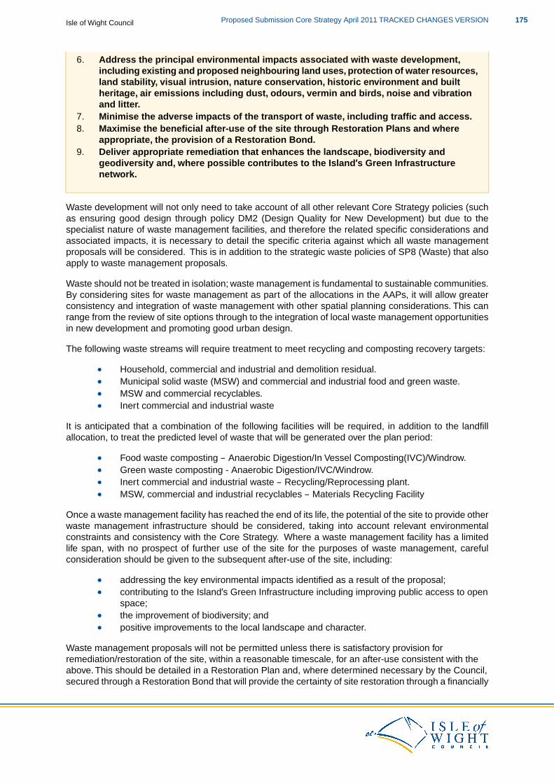
6. Address the principal environmental impacts associated with waste development,including existing and proposed neighbouring land uses, protection of water resources,land stability, visual intrusion, nature conservation, historic environment and builtheritage, air emissions including dust, odours, vermin and birds, noise and vibrationand litter.
7. Minimise the adverse impacts of the transport of waste, including traffic and access.8. Maximise the beneficial after-use of the site through Restoration Plans and where
appropriate, the provision of a Restoration Bond.9. Deliver appropriate remediation that enhances the landscape, biodiversity and
geodiversity and, where possible contributes to the Island’s Green Infrastructurenetwork.
Waste development will not only need to take account of all other relevant Core Strategy policies (suchas ensuring good design through policy DM2 (Design Quality for New Development) but due to thespecialist nature of waste management facilities, and therefore the related specific considerations andassociated impacts, it is necessary to detail the specific criteria against which all waste managementproposals will be considered. This is in addition to the strategic waste policies of SP8 (Waste) that alsoapply to waste management proposals.
Waste should not be treated in isolation; waste management is fundamental to sustainable communities.By considering sites for waste management as part of the allocations in the AAPs, it will allow greaterconsistency and integration of waste management with other spatial planning considerations. This canrange from the review of site options through to the integration of local waste management opportunitiesin new development and promoting good urban design.
The following waste streams will require treatment to meet recycling and composting recovery targets:
Household, commercial and industrial and demolition residual.Municipal solid waste (MSW) and commercial and industrial food and green waste.MSW and commercial recyclables.Inert commercial and industrial waste
It is anticipated that a combination of the following facilities will be required, in addition to the landfillallocation, to treat the predicted level of waste that will be generated over the plan period:
Food waste composting – Anaerobic Digestion/In Vessel Composting(IVC)/Windrow.Green waste composting - Anaerobic Digestion/IVC/Windrow.Inert commercial and industrial waste – Recycling/Reprocessing plant.MSW, commercial and industrial recyclables – Materials Recycling Facility
Once a waste management facility has reached the end of its life, the potential of the site to provide otherwaste management infrastructure should be considered, taking into account relevant environmentalconstraints and consistency with the Core Strategy. Where a waste management facility has a limitedlife span, with no prospect of further use of the site for the purposes of waste management, carefulconsideration should be given to the subsequent after-use of the site, including:
addressing the key environmental impacts identified as a result of the proposal;contributing to the Island’s Green Infrastructure including improving public access to openspace;the improvement of biodiversity; andpositive improvements to the local landscape and character.
Waste management proposals will not be permitted unless there is satisfactory provision forremediation/restoration of the site, within a reasonable timescale, for an after-use consistent with theabove. This should be detailed in a Restoration Plan and, where determined necessary by the Council,secured through a Restoration Bond that will provide the certainty of site restoration through a financially
175Proposed Submission Core Strategy April 2011 TRACKED CHANGES VERSIONIsle of Wight Council
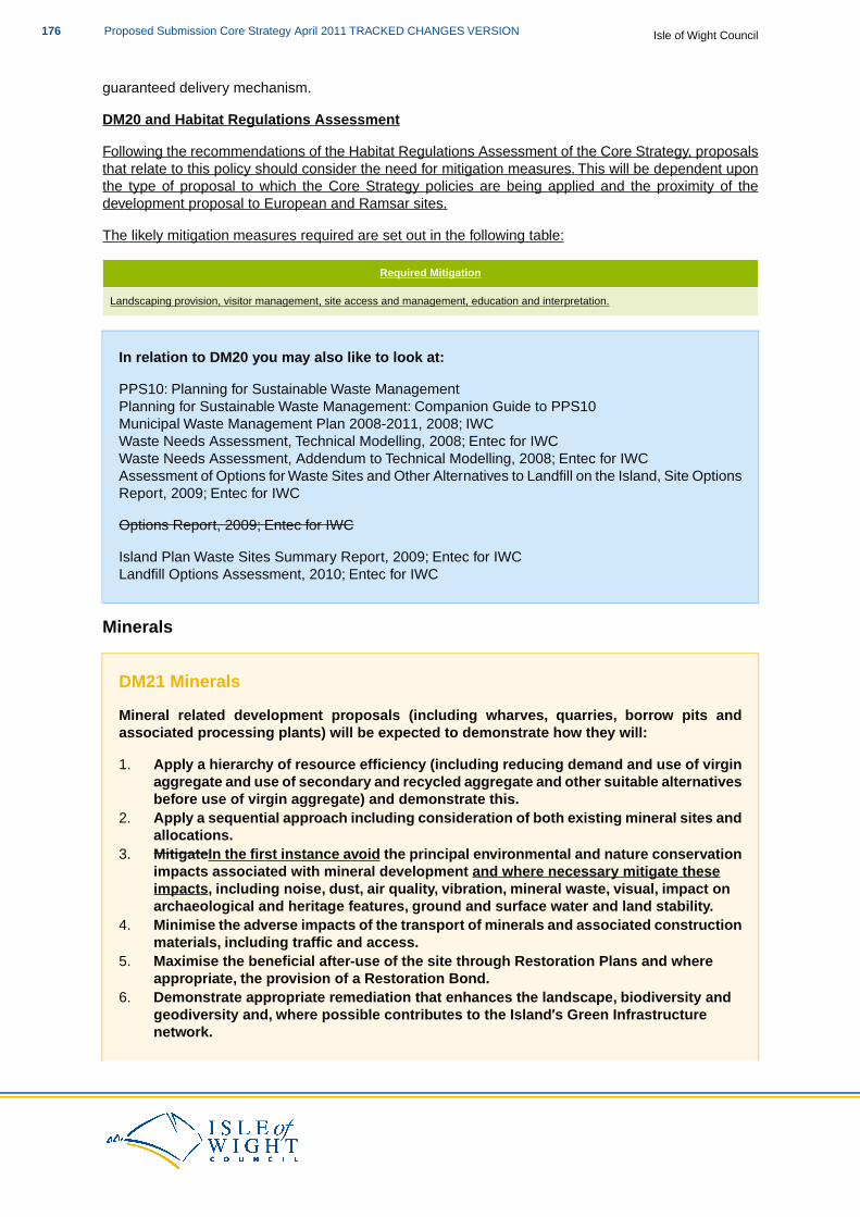
guaranteed delivery mechanism.
DM20 and Habitat Regulations Assessment
Following the recommendations of the Habitat Regulations Assessment of the Core Strategy, proposalsthat relate to this policy should consider the need for mitigation measures. This will be dependent uponthe type of proposal to which the Core Strategy policies are being applied and the proximity of thedevelopment proposal to European and Ramsar sites.
The likely mitigation measures required are set out in the following table:
Required Mitigation
Landscaping provision, visitor management, site access and management, education and interpretation.
In relation to DM20 you may also like to look at:
PPS10: Planning for Sustainable Waste ManagementPlanning for Sustainable Waste Management: Companion Guide to PPS10Municipal Waste Management Plan 2008-2011, 2008; IWCWaste Needs Assessment, Technical Modelling, 2008; Entec for IWCWaste Needs Assessment, Addendum to Technical Modelling, 2008; Entec for IWCAssessment of Options for Waste Sites and Other Alternatives to Landfill on the Island, Site OptionsReport, 2009; Entec for IWC
Options Report, 2009; Entec for IWC
Island Plan Waste Sites Summary Report, 2009; Entec for IWCLandfill Options Assessment, 2010; Entec for IWC
Minerals
DM21 Minerals
Mineral related development proposals (including wharves, quarries, borrow pits andassociated processing plants) will be expected to demonstrate how they will:
1. Apply a hierarchy of resource efficiency (including reducing demand and use of virginaggregate and use of secondary and recycled aggregate and other suitable alternativesbefore use of virgin aggregate) and demonstrate this.
2. Apply a sequential approach including consideration of both existing mineral sites andallocations.
3. MitigateIn the first instance avoid the principal environmental and nature conservationimpacts associated with mineral development and where necessary mitigate theseimpacts, including noise, dust, air quality, vibration, mineral waste, visual, impact onarchaeological and heritage features, ground and surface water and land stability.
4. Minimise the adverse impacts of the transport of minerals and associated constructionmaterials, including traffic and access.
5. Maximise the beneficial after-use of the site through Restoration Plans and whereappropriate, the provision of a Restoration Bond.
6. Demonstrate appropriate remediation that enhances the landscape, biodiversity andgeodiversity and, where possible contributes to the Island’s Green Infrastructurenetwork.
Isle of Wight CouncilProposed Submission Core Strategy April 2011 TRACKED CHANGES VERSION176
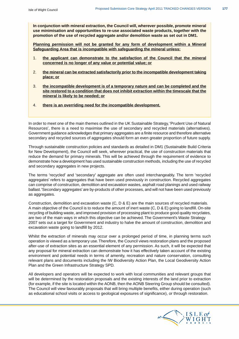
In conjunction with mineral extraction, the Council will, wherever possible, promote mineraluse minimisation and opportunities to re-use associated waste products, together with thepromotion of the use of recycled aggregate and/or demolition waste as set out in DM1.
Planning permission will not be granted for any form of development within a MineralSafeguarding Area that is incompatible with safeguarding the mineral unless:
1. the applicant can demonstrate to the satisfaction of the Council that the mineralconcerned is no longer of any value or potential value; or
2. the mineral can be extracted satisfactorily prior to the incompatible development takingplace; or
3. the incompatible development is of a temporary nature and can be completed and thesite restored to a condition that does not inhibit extraction within the timescale that themineral is likely to be needed; or
4. there is an overriding need for the incompatible development.
In order to meet one of the main themes outlined in the UK Sustainable Strategy, ‘Prudent Use of NaturalResources’, there is a need to maximise the use of secondary and recycled materials (alternatives).Government guidance acknowledges that primary aggregates are a finite resource and therefore alternativesecondary and recycled sources of aggregates should form an even greater proportion of future supply.
Through sustainable construction policies and standards as detailed in DM1 (Sustainable Build Criteriafor New Development), the Council will seek, wherever practical, the use of construction materials thatreduce the demand for primary minerals. This will be achieved through the requirement of evidence todemonstrate how a development has used sustainable construction methods, including the use of recycledand secondary aggregates in new projects.
The terms ‘recycled’ and ‘secondary’ aggregate are often used interchangeably. The term ‘recycledaggregates’ refers to aggregates that have been used previously in construction. Recycled aggregatescan comprise of construction, demolition and excavation wastes, asphalt road planings and used railwayballast. ‘Secondary aggregates’ are by-products of other processes, and will not have been used previouslyas aggregates.
Construction, demolition and excavation waste (C, D & E) are the main sources of recycled materials.A main objective of the Council is to reduce the amount of inert waste (C, D & E) going to landfill. On-siterecycling of building waste, and improved provision of processing plant to produce good quality recyclates,are two of the main ways in which this objective can be achieved. The Government’s Waste Strategy2007 sets out a target for Government and industry to halve the amount of construction, demolition andexcavation waste going to landfill by 2012.
Whilst the extraction of minerals may occur over a prolonged period of time, in planning terms suchoperation is viewed as a temporary use.Therefore, the Council views restoration plans and the proposedafter-use of extraction sites as an essential element of any permission. As such, it will be expected thatany proposal for mineral extraction can demonstrate how it has effectively taken account of the existingenvironment and potential needs in terms of amenity, recreation and nature conservation, consultingrelevant plans and documents including the IW Biodiversity Action Plan, the Local Geodiversity ActionPlan and the Green Infrastructure Strategy SPD.
All developers and operators will be expected to work with local communities and relevant groups thatwill be determined by the restoration proposals and the existing interests of the land prior to extraction(for example, if the site is located within the AONB, then the AONB Steering Group should be consulted).The Council will view favourably proposals that will bring multiple benefits, either during operation (suchas educational school visits or access to geological exposures of significance), or through restoration.
177Proposed Submission Core Strategy April 2011 TRACKED CHANGES VERSIONIsle of Wight Council
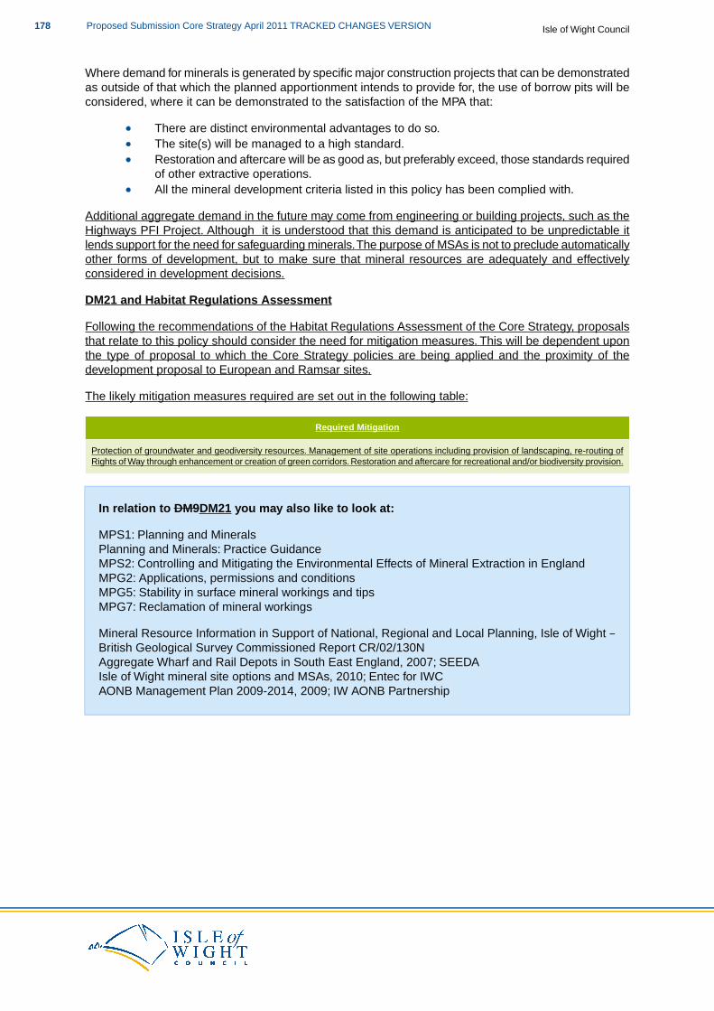
Where demand for minerals is generated by specific major construction projects that can be demonstratedas outside of that which the planned apportionment intends to provide for, the use of borrow pits will beconsidered, where it can be demonstrated to the satisfaction of the MPA that:
There are distinct environmental advantages to do so.The site(s) will be managed to a high standard.Restoration and aftercare will be as good as, but preferably exceed, those standards requiredof other extractive operations.All the mineral development criteria listed in this policy has been complied with.
Additional aggregate demand in the future may come from engineering or building projects, such as theHighways PFI Project. Although it is understood that this demand is anticipated to be unpredictable itlends support for the need for safeguarding minerals.The purpose of MSAs is not to preclude automaticallyother forms of development, but to make sure that mineral resources are adequately and effectivelyconsidered in development decisions.
DM21 and Habitat Regulations Assessment
Following the recommendations of the Habitat Regulations Assessment of the Core Strategy, proposalsthat relate to this policy should consider the need for mitigation measures. This will be dependent uponthe type of proposal to which the Core Strategy policies are being applied and the proximity of thedevelopment proposal to European and Ramsar sites.
The likely mitigation measures required are set out in the following table:
Required Mitigation
Protection of groundwater and geodiversity resources. Management of site operations including provision of landscaping, re-routing ofRights of Way through enhancement or creation of green corridors. Restoration and aftercare for recreational and/or biodiversity provision.
In relation to DM9DM21 you may also like to look at:
MPS1: Planning and MineralsPlanning and Minerals: Practice GuidanceMPS2: Controlling and Mitigating the Environmental Effects of Mineral Extraction in EnglandMPG2: Applications, permissions and conditionsMPG5: Stability in surface mineral workings and tipsMPG7: Reclamation of mineral workings
Mineral Resource Information in Support of National, Regional and Local Planning, Isle of Wight –British Geological Survey Commissioned Report CR/02/130NAggregate Wharf and Rail Depots in South East England, 2007; SEEDAIsle of Wight mineral site options and MSAs, 2010; Entec for IWCAONB Management Plan 2009-2014, 2009; IW AONB Partnership
Isle of Wight CouncilProposed Submission Core Strategy April 2011 TRACKED CHANGES VERSION178
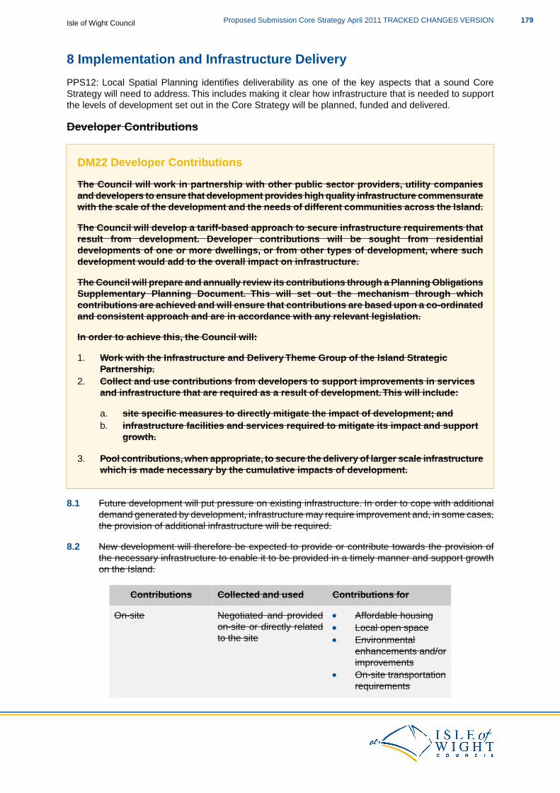
8 Implementation and Infrastructure Delivery
PPS12: Local Spatial Planning identifies deliverability as one of the key aspects that a sound CoreStrategy will need to address. This includes making it clear how infrastructure that is needed to supportthe levels of development set out in the Core Strategy will be planned, funded and delivered.
Developer Contributions
DM22 Developer Contributions
The Council will work in partnership with other public sector providers, utility companiesand developers to ensure that development provides high quality infrastructure commensuratewith the scale of the development and the needs of different communities across the Island.
The Council will develop a tariff-based approach to secure infrastructure requirements thatresult from development. Developer contributions will be sought from residentialdevelopments of one or more dwellings, or from other types of development, where suchdevelopment would add to the overall impact on infrastructure.
The Council will prepare and annually review its contributions through a Planning ObligationsSupplementary Planning Document. This will set out the mechanism through whichcontributions are achieved and will ensure that contributions are based upon a co-ordinatedand consistent approach and are in accordance with any relevant legislation.
In order to achieve this, the Council will:
1. Work with the Infrastructure and Delivery Theme Group of the Island StrategicPartnership.
2. Collect and use contributions from developers to support improvements in servicesand infrastructure that are required as a result of development.This will include:
a. site specific measures to directly mitigate the impact of development; andb. infrastructure facilities and services required to mitigate its impact and support
growth.
3. Pool contributions, when appropriate, to secure the delivery of larger scale infrastructurewhich is made necessary by the cumulative impacts of development.
8.1 Future development will put pressure on existing infrastructure. In order to cope with additionaldemand generated by development, infrastructure may require improvement and, in some cases,the provision of additional infrastructure will be required.
8.2 New development will therefore be expected to provide or contribute towards the provision ofthe necessary infrastructure to enable it to be provided in a timely manner and support growthon the Island.
Contributions forCollected and usedContributions
Negotiated and providedOn-site Affordable housingon-site or directly related Local open spaceto the site Environmental
enhancements and/orimprovementsOn-site transportationrequirements
179Proposed Submission Core Strategy April 2011 TRACKED CHANGES VERSIONIsle of Wight Council
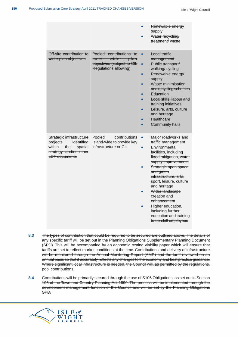
Renewable energysupplyWater recycling/treatment/ waste
Pooled contributions toOff-site contribution to Local trafficmanagementmeet wider plan
objectives (subject to CILwider plan objectives
Public transport/walking/ cyclingRegulations allowing)Renewable energysupplyWaste minimisationand recycling schemesEducationLocal skills, labour andtraining initiativesLeisure, arts, cultureand heritageHealthcareCommunity halls
Pooled contributionsStrategic infrastructure Major roadworks andtraffic managementIsland-wide to provide key
infrastructure or CILprojects identifiedwithin the spatial Environmental
facilities, includingstrategy and/or otherLDF documents flood mitigation, water
supply improvementsStrategic open spaceand greeninfrastructure, arts,sport, leisure, cultureand heritageWider landscapecreation andenhancementHigher education,including furthereducation and trainingto up-skill employees
8.3 The types of contribution that could be required to be secured are outlined above. The details ofany specific tariff will be set out in the Planning Obligations Supplementary Planning Document(SPD). This will be accompanied by an economic testing viability paper which will ensure thattariffs are set to reflect market conditions at the time. Contributions and delivery of infrastructurewill be monitored through the Annual Monitoring Report (AMR) and the tariff reviewed on anannual basis so that it accurately reflects any changes to the economy and best practice guidance.Where significant local infrastructure is needed, the Council will, as permitted by the regulations,pool contributions.
8.4 Contributions will be primarily secured through the use of S106 Obligations, as set out in Section106 of the Town and Country Planning Act 1990. The process will be implemented through thedevelopment management function of the Council and will be set by the Planning ObligationsSPD.
Isle of Wight CouncilProposed Submission Core Strategy April 2011 TRACKED CHANGES VERSION180
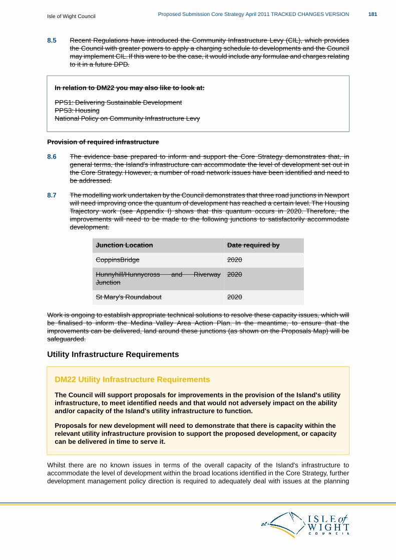
8.5 Recent Regulations have introduced the Community Infrastructure Levy (CIL), which providesthe Council with greater powers to apply a charging schedule to developments and the Councilmay implement CIL. If this were to be the case, it would include any formulae and charges relatingto it in a future DPD.
In relation to DM22 you may also like to look at:
PPS1: Delivering Sustainable DevelopmentPPS3: HousingNational Policy on Community Infrastructure Levy
Provision of required infrastructure
8.6 The evidence base prepared to inform and support the Core Strategy demonstrates that, ingeneral terms, the Island’s infrastructure can accommodate the level of development set out inthe Core Strategy. However, a number of road network issues have been identified and need tobe addressed.
8.7 The modelling work undertaken by the Council demonstrates that three road junctions in Newportwill need improving once the quantum of development has reached a certain level. The HousingTrajectory work (see Appendix I) shows that this quantum occurs in 2020. Therefore, theimprovements will need to be made to the following junctions to satisfactorily accommodatedevelopment.
Date required byJunction Location
2020CoppinsBridge
2020Hunnyhill/Hunnycross and RiverwayJunction
2020St Mary’s Roundabout
Work is ongoing to establish appropriate technical solutions to resolve these capacity issues, which willbe finalised to inform the Medina Valley Area Action Plan. In the meantime, to ensure that theimprovements can be delivered, land around these junctions (as shown on the Proposals Map) will besafeguarded.
Utility Infrastructure Requirements
DM22 Utility Infrastructure Requirements
The Council will support proposals for improvements in the provision of the Island's utilityinfrastructure, to meet identified needs and that would not adversely impact on the abilityand/or capacity of the Island's utility infrastructure to function.
Proposals for new development will need to demonstrate that there is capacity within therelevant utility infrastructure provision to support the proposed development, or capacitycan be delivered in time to serve it.
Whilst there are no known issues in terms of the overall capacity of the Island's infrastructure toaccommodate the level of development within the broad locations identified in the Core Strategy, furtherdevelopment management policy direction is required to adequately deal with issues at the planning
181Proposed Submission Core Strategy April 2011 TRACKED CHANGES VERSIONIsle of Wight Council
application stage.
Detailed proposals for development will need to ensure that through either their location or design, theydo not adversely impact on existing utility infrastructure's ability and/or capacity to function.
The Council will expect applicants to give due consideration to the issue of connection to existing utilityinfrastructure, and where appropriate demonstrate that the relevant utility providers have been involvedin the process of preparing the application.
Whilst this policy is applicable to all utility infrastructure provision (electricity, gas, telecommunications,waste water/water), it is particularly applicable to water and wastewater infrastructure provision.
In specific relation to water and wastewater infrastructure, the Council will generally condition planningpermission approvals that no development will occur until the applicant can demonstrate, through capacitycalculations from Southern Water, that there is the capacity in the system to accommodate the level ofdevelopment.
If the applicant would rather secure permission without such a condition, then a range of informationwithin their application is required, such as capacity calculations (from Southern Water), a plan indicatingintended connection points, connection routes (from the development to the proposed connection point)and, if necessary, soakaways, attenuation and overland routes of surface water.
Consideration should be given by applicants to linking the requirements outlined above with those inDM15 Flood Risk, especially those relating to SuDS and Drainage Strategies.
DM22 and Habitat Regulations Assessment
Following the recommendations of the Habitat Regulations Assessment of the Core Strategy, proposalsthat relate to this policy should consider the need for mitigation measures. This will be dependent uponthe type of proposal to which the Core Strategy policies are being applied and the proximity of thedevelopment proposal to European and Ramsar sites.
The likely mitigation measures required are set out in the following table:
Required Mitigation
Consideration of appropriate multiple use green buffers to intercept potential impacts (eg air, light, noise, run-off etc) and in the case ofports and marine facilities provide the ability to set back to avoid future potential coastal squeeze from sea level rise (bearing in mindlimitations placed by existing development). Where appropriate, landscape screening may provide multiple benefits such as greencorridors, thereby adding to the GI network.
In relation to DM22 you may also like to look at:
PPS1: Delivering Sustainable DevelopmentPPS12: Local Spatial PlanningManagement Plans of the relevant utility provider
Provision of Required Infrastructure
The evidence base prepared to inform and support the Core Strategy demonstrates that, in generalterms, the Island’s infrastructure can accommodate the level of development set out in the Core Strategy.However, a number of road network issues have been identified and need to be addressed.
The modelling work undertaken by the Council demonstrates that three road junctions in Newport willneed improving once the quantum of development has reached a certain level. The Housing Trajectorywork (see Appendix I) shows that this quantum occurs in 2020. Therefore, the improvements will needto be made to the following junctions to satisfactorily accommodate development.
Isle of Wight CouncilProposed Submission Core Strategy April 2011 TRACKED CHANGES VERSION182
Date required byJunction Location
2020Coppins Bridge
2020Hunnyhill/Hunnycross and Riverway Junction
2020St Mary’s Roundabout
Table 8.1 Junction improvements required
Work is ongoing to establish appropriate technical solutions to resolve these capacity issues, which willbe finalised to inform the Medina Valley Area Action Plan. In the meantime, to ensure that theimprovements can be delivered, land around these junctions (as shown on the Proposals Map) will besafeguarded. In addition, the Council will ensure, wherever possible, that the Newport junction improvementschemes give consideration to the needs of walkers and cyclists and, where feasible, look to provide 'offroad' segregation, taking account of existing and potential road space and the ability of junctions toaccommodate such provision without detrimental impact on traffic flows.
The mechanism for ensuring the above consideration will be through liaison between those responsiblefor developing the junction schemes (currently the Council's Highways Department) and Planning andRegulatory Services.This will be through a three phased consultation process for each scheme; preliminarydesign, detailed design and construction.These will be carried out in parallel with the statutory C sectionnotices that Highways consult upon. Any necessary air monitoring will be agreed with EnvironmentalHealth and should be related to existing air quality hotspots, with the aim of avoiding Air QualityManagement Areas (AQMAs).
Strategic Approach to the Provision of Mitigation and Green Infrastructure
Based on the Habitats Regulations Assessment (HRA) of the Island Plan Core Strategy, it is clear thatthe Plan’s policies will lead to significant impacts upon the Solent and Southampton WatersSAC/SPA/Ramsar sites, unless avoidance and mitigation measures are built in to remove or reduce theeffects.
The HRA identified the policies which would require some form of mitigation, where necessary, to befactored into a proposal. The need to apply such measures will be dependent upon the type of proposalto which Core Strategy policies are being applied and the proximity of the development proposal toEuropean and Ramsar sites.
The policy approach in SP5 Environment and DM14 Green Infrastructure sets the context for therequirement for types of mitigation set out in the table below:
Required MitigationPolicyNo.
Specific mitigation such as recreational provision and provision of supporting habitats as well as visitor management, siteaccess and management, education and interpretation.
SP3
On-site provision of natural greenspace, pedestrian/cycle way route to access existing Rights of Way network, visitormanagement, site access and management, education and interpretation.
SP3(a)
Provision of appropriate greenspace buffer strip with the following elements; an area of no access, visitor management, siteaccess and management, education and interpretation.
SP3(b)
Specific mitigation such as recreational provision and provision of supporting habitats as well as visitor management, siteaccess and management, education and interpretation.
SP3(c)
Specific mitigation such as recreational provision and provision of supporting habitats as well as visitor management, siteaccess and management, education and interpretation.
SP3(d)
Specific mitigation such as recreational provision and provision of supporting habitats as well as visitor management, siteaccess and management, education and interpretation.
SP3(e)
183Proposed Submission Core Strategy April 2011 TRACKED CHANGES VERSIONIsle of Wight Council
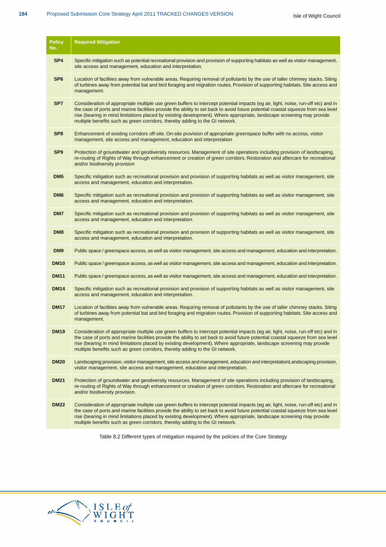
Required MitigationPolicyNo.
Specific mitigation such as potential recreational provision and provision of supporting habitats as well as visitor management,site access and management, education and interpretation.
SP4
Location of facilities away from vulnerable areas. Requiring removal of pollutants by the use of taller chimney stacks. Sitingof turbines away from potential bat and bird foraging and migration routes. Provision of supporting habitats. Site access andmanagement.
SP6
Consideration of appropriate multiple use green buffers to intercept potential impacts (eg air, light, noise, run-off etc) and inthe case of ports and marine facilities provide the ability to set back to avoid future potential coastal squeeze from sea level
SP7
rise (bearing in mind limitations placed by existing development). Where appropriate, landscape screening may providemultiple benefits such as green corridors, thereby adding to the GI network.
Enhancement of existing corridors off-site. On-site provision of appropriate greenspace buffer with no access, visitormanagement, site access and management, education and interpretation
SP8
Protection of groundwater and geodiversity resources. Management of site operations including provision of landscaping,re-routing of Rights of Way through enhancement or creation of green corridors. Restoration and aftercare for recreationaland/or biodiversity provision
SP9
Specific mitigation such as recreational provision and provision of supporting habitats as well as visitor management, siteaccess and management, education and interpretation.
DM5
Specific mitigation such as recreational provision and provision of supporting habitats as well as visitor management, siteaccess and management, education and interpretation.
DM6
Specific mitigation such as recreational provision and provision of supporting habitats as well as visitor management, siteaccess and management, education and interpretation.
DM7
Specific mitigation such as recreational provision and provision of supporting habitats as well as visitor management, siteaccess and management, education and interpretation.
DM8
Public space / greenspace access, as well as visitor management, site access and management, education and interpretation.DM9
Public space / greenspace access, as well as visitor management, site access and management, education and interpretation.DM10
Public space / greenspace access, as well as visitor management, site access and management, education and interpretation.DM11
Specific mitigation such as recreational provision and provision of supporting habitats as well as visitor management, siteaccess and management, education and interpretation.
DM14
Location of facilities away from vulnerable areas. Requiring removal of pollutants by the use of taller chimney stacks. Sitingof turbines away from potential bat and bird foraging and migration routes. Provision of supporting habitats. Site access andmanagement.
DM17
Consideration of appropriate multiple use green buffers to intercept potential impacts (eg air, light, noise, run-off etc) and inthe case of ports and marine facilities provide the ability to set back to avoid future potential coastal squeeze from sea level
DM19
rise (bearing in mind limitations placed by existing development). Where appropriate, landscape screening may providemultiple benefits such as green corridors, thereby adding to the GI network.
Landscaping provision, visitor management, site access and management, education and interpretationLandscaping provision,visitor management, site access and management, education and interpretation.
DM20
Protection of groundwater and geodiversity resources. Management of site operations including provision of landscaping,re-routing of Rights of Way through enhancement or creation of green corridors. Restoration and aftercare for recreationaland/or biodiversity provision.
DM21
Consideration of appropriate multiple use green buffers to intercept potential impacts (eg air, light, noise, run-off etc) and inthe case of ports and marine facilities provide the ability to set back to avoid future potential coastal squeeze from sea level
DM22
rise (bearing in mind limitations placed by existing development). Where appropriate, landscape screening may providemultiple benefits such as green corridors, thereby adding to the GI network.
Table 8.2 Different types of mitigation required by the policies of the Core Strategy
Isle of Wight CouncilProposed Submission Core Strategy April 2011 TRACKED CHANGES VERSION184
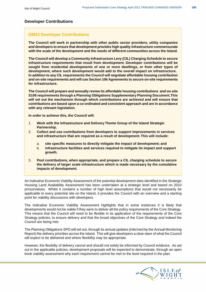
Developer Contributions
DM23 Developer Contributions
The Council will work in partnership with other public sector providers, utility companiesand developers to ensure that development provides high quality infrastructure commensuratewith the scale of the development and the needs of different communities across the Island.
The Council will develop a Community Infrastructure Levy (CIL) Charging Schedule to secureinfrastructure requirements that result from development. Developer contributions will besought from residential developments of one or more dwellings, or from other types ofdevelopment, where such development would add to the overall impact on infrastructure.In addition to any CIL requirements the Council will negotiate affordable housing contributionand on-site requirements and will use Section 106 Agreements to secure on-site requirementsfor infrastructure.
The Council will prepare and annually review its affordable housing contributions and on-siteS106 requirements through a Planning Obligations Supplementary Planning Document.Thiswill set out the mechanism through which contributions are achieved and will ensure thatcontributions are based upon a co-ordinated and consistent approach and are in accordancewith any relevant legislation.
In order to achieve this, the Council will:
1. Work with the Infrastructure and Delivery Theme Group of the Island StrategicPartnership.
2. Collect and use contributions from developers to support improvements in servicesand infrastructure that are required as a result of development.This will include:
a. site specific measures to directly mitigate the impact of development; andb. infrastructure facilities and services required to mitigate its impact and support
growth.
3. Pool contributions, when appropriate, and prepare a CIL charging schedule to securethe delivery of larger scale infrastructure which is made necessary by the cumulativeimpacts of development.
An Indicative Economic Viability Assessment of the potential development sites identified in the StrategicHousing Land Availability Assessment has been undertaken at a strategic level and based on 2010prices/values. Whilst it contains a number of high level assumptions that would not necessarily beapplicable to every potential site on the Island, it provides the Council with an overview and a startingpoint for viability discussions with developers.
The Indicative Economic Viability Assessment highlights that in some instances it is likely thatdevelopments would not be viable if they were to deliver all the policy requirements of the Core Strategy.This means that the Council will need to be flexible in its application of the requirements of the CoreStrategy policies, to ensure delivery and that the broad objectives of the Core Strategy and indeed theCouncil are being met.
The Planning Obligations SPD will set out, through its annual updates (informed by the Annual MonitoringReport) the delivery priorities across the Island. This will give developers a clear steer of what the Councilwill expect to be delivered and where flexibility may be appropriate.
However, the flexibilty of delivery cannot and should not solely be informed by Council evidence. As setout in the applicable policies, development proposals will be expected to demonstrate, through an openbook viability assessment why each requirement cannot be met to the level required in the plan.
185Proposed Submission Core Strategy April 2011 TRACKED CHANGES VERSIONIsle of Wight Council
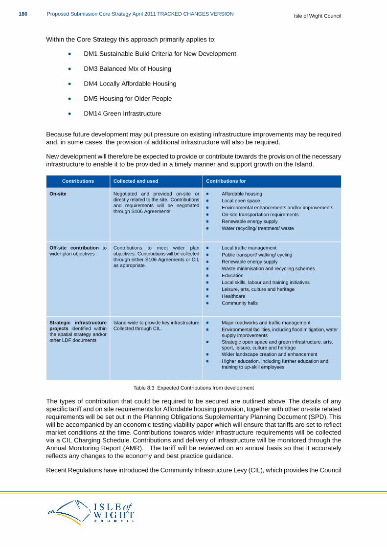
Within the Core Strategy this approach primarily applies to:
DM1 Sustainable Build Criteria for New Development
DM3 Balanced Mix of Housing
DM4 Locally Affordable Housing
DM5 Housing for Older People
DM14 Green Infrastructure
Because future development may put pressure on existing infrastructure improvements may be requiredand, in some cases, the provision of additional infrastructure will also be required.
New development will therefore be expected to provide or contribute towards the provision of the necessaryinfrastructure to enable it to be provided in a timely manner and support growth on the Island.
Contributions forCollected and usedContributions
Negotiated and provided on-site orOn-site Affordable housingdirectly related to the site. Contributions Local open spaceand requirements will be negotiated Environmental enhancements and/or improvementsthrough S106 Agreements.
On-site transportation requirementsRenewable energy supplyWater recycling/ treatment/ waste
Contributions to meet wider planOff-site contribution to Local traffic managementobjectives. Contributions will be collectedwider plan objectives Public transport/ walking/ cyclingthrough either S106 Agreements or CIL Renewable energy supplyas appropriate.
Waste minimisation and recycling schemesEducationLocal skills, labour and training initiativesLeisure, arts, culture and heritageHealthcareCommunity halls
Island-wide to provide key infrastructureStrategic infrastructure Major roadworks and traffic managementCollected through CIL.projects identified within Environmental facilities, including flood mitigation, water
supply improvementsthe spatial strategy and/orother LDF documents Strategic open space and green infrastructure, arts,
sport, leisure, culture and heritageWider landscape creation and enhancementHigher education, including further education andtraining to up-skill employees
Table 8.3 Expected Contributions from development
The types of contribution that could be required to be secured are outlined above. The details of anyspecific tariff and on site requirements for Affordable housing provision, together with other on-site relatedrequirements will be set out in the Planning Obligations Supplementary Planning Document (SPD). Thiswill be accompanied by an economic testing viability paper which will ensure that tariffs are set to reflectmarket conditions at the time. Contributions towards wider infrastructure requirements will be collectedvia a CIL Charging Schedule. Contributions and delivery of infrastructure will be monitored through theAnnual Monitoring Report (AMR). The tariff will be reviewed on an annual basis so that it accuratelyreflects any changes to the economy and best practice guidance.
Recent Regulations have introduced the Community Infrastructure Levy (CIL), which provides the Council
Isle of Wight CouncilProposed Submission Core Strategy April 2011 TRACKED CHANGES VERSION186

with greater powers to apply a charging schedule to developments and the Council willimplement CIL.
In relation to DM23 you may also like to look at:
PPS1: Delivering Sustainable DevelopmentPPS3: HousingNational Policy on Community Infrastructure Levy
187Proposed Submission Core Strategy April 2011 TRACKED CHANGES VERSIONIsle of Wight Council
9 Monitoring
9.1 This chapter is fundamental to the success of the delivery of the Core Strategy, as monitoring isessential for an effective strategy and forms an important aspect of the ‘plan, monitor, manage’approach.
9.2 A series of monitoring indicators and targets have been identified and selected from the nationalindicator set, the LDF Core Output indicators and the indicators associated with the Isle of WightLocal Area Agreement (LAA). They have been selected to ensure that there is no duplication ofeffort in terms of indicators that are more appropriately monitored elsewhere, such as in the LocalTransport Plan
9.3 Monitoring outcomes will be reported on an annual basis (from 1st April to 31st March) and will bereported through the Annual Monitoring Report (AMR). The AMR is published by the Council atthe end of every calendar year. Each document that forms part of the LDF is monitored andreported individually in the AMR.
Contingency planning
9.4 The AMR will identify whether any contingency planning is required.There are three key aspectsof the Core Strategy, which are of significant importance in terms of delivery of the Vision.Theseare:
Employment land delivery and supplyHousing delivery and supplyProvision of affordable housing
Employment land delivery and supply
9.5 In the event that take up of land allocated for economic uses does not meet the targets in theCore Strategy over a three period, the Council will review existing allocations and if needed,identify additional sites in subsequent DPDs in locations consistent with the overall spatial strategy.
Housing delivery and supply
9.6 In the event that housing delivery falls below the projected cumulative and annual target by morethan 20% over a three year period, and the projected five year supply does not identify how theshortfall can be addressed, the Council will use the Area Action Plans to identify contingencyareas for growth. These will be identified using a sequential approach of:
1. Bring forward additional sites for housing within the Key Regeneration Areas in locationsconsistent with the overall spatial strategy. Sites will be identified within the Area ActionPlans.
2. Use planning powers and, where appropriate, compulsory purchase powers to ensureallocated land is brought forward for development.
Affordable Housing
9.7 Delivery of affordable housing is linked to delivery of housing. The above measures will, to acertain extent, address the delivery of affordable housing. In addition, should monitoring of theCouncil's Housing Strategy indicate that affordable housing delivery has fallen more than 20%below the three year target, and the Core Strategy cannot identify how the shortfall will be met,the Council will:
1. Review its approach to planning obligations, prioritising funds in order that affordable housingis considered as a first priority.
Isle of Wight CouncilProposed Submission Core Strategy April 2011 TRACKED CHANGES VERSION188
2. Review Council owned land to see if there is potential to increase the delivery of affordablehousing on Council owned sites.
3. Reconsider the possibility, subject to economic viability, of achieving a higher proportion ofaffordable housing on an individual basis on allocated sites.
SP1 Spatial Strategy
DeliveryPartners
Implementationand Delivery
Indicator(s)Target(s)PolicyCoreStrategyObjectives
IWCSubsequentNumber of housing developmentX81 % of new housingSP1SpatialStrategy
1, 2, 3, 4, 5,6, 7, 8, 9,10, 11, 12 Developers
DPDs willprovide detailedsites for
delivered within or immediatelyadjacent the settlement boundarieswithin the KRAs and SRAs per annum
development to be deliveredwithin or immediately adjacent thesettlement boundaries within the
development andKey Regenerations Areas andSmaller Regeneration Areas over
Parish andTownallocated land for
various usesNumber of applications for housingdevelopment delivered within orthe plan period CouncilsEcoIsland
Theme(s):Use of AONBLandscape
immediately adjacent the settlementboundaries of the Rural ServiceCentres and other rural areas perThriving
CharacterannumIsland
Inspiring
Assessment, IWBiodiversityAction Plan, andAmount of employment land deliveredAt least 23.543 hectares ofIslandthe IW HEAP inin the Medina Valley and Ryde peremployment development to bedeterminingannumdelivered within the KeyHealthyplanningRegeneration Areas of the
Medina Valley and Ryde over theandSupportive applicationsAmount of employment land delivered
elsewhere per annumplan periodIsland
Safe and
Use of HousingStrategy toinform decisions
Amount of retail land delivered in theAt least 7.710hectares of retailWell-keptIsland about housing
developmentMedina Valley provided per annum
Amount of retail land provided
land to be provided in the KeyRegeneration Area of MedinaValley over the plan period
Use of LocalTransport Plan toelsewhere per annum
At least 60% of development onbrownfield land per annum for the
inform decisionsaboutAmount of development built on
brownfield land per annumfirst 5 years of the plan period developments
Use of Parishand Town Plans
Amount of development built on to informgreenfield land per annum decisions about
local need
SP2 Housing
DeliveryPartners
Implementation& Delivery
Indicators(s)Target(s)PoliciesCoreStrategyObjectives
IWCSubsequentNet annual dwellings provided520 dwellings per annumSP21, 2, 3, 4, 5DPDs willprovide detailed
over the plan periodHousingDevelopers
Number of dwellings built within or3,690 new dwellings built sites fordevelopment andEcoIsland Parish andimmediately adjacent to the settlement
boundaries within Medina Valley perwithin or immediatelyadjacent to the settlement allocated land for
various usesTheme(s): Town
Councilsannum
Number of dwellings built within or
boundaries within the KRAs,SRAs over the plan period
Use of AONBLandscape
ThrivingIsland
immediately adjacent to the settlementboundaries within Ryde per annum Character
Assessment, IWInspiringIsland
Number of dwellings built within or BiodiversityAction Plan, andHealthy immediately adjacent to the settlement
boundaries within The Bay per annum the IW HEAP in
189Proposed Submission Core Strategy April 2011 TRACKED CHANGES VERSIONIsle of Wight Council
DeliveryPartners
Implementation& Delivery
Indicators(s)Target(s)PoliciesCoreStrategyObjectives
determiningand Number of dwellings built within orplanningSupportive immediately adjacent to the settlementapplicationsIsland boundary of West Wight per annum
Use of HousingSafe and Number of dwellings built within orStrategy toWell-kept immediately adjacent to the settlementinform decisionsIsland boundary of Ventnor per annumabout housingdevelopment
Number of dwellings built within or852 new dwelling built withinUse of Localimmediately adjacent to the settlementor immediately adjacent toTransport Plan toboundaries within RSCsthe settlement boundariesinform decisionswithin RSCs and the
WiderOther Rural Areas aboutdevelopments
Number of dwellings built within othertheWider Rural Areas
Use of Parish
Amount of housing development built onAt least 60% of housing and Town Plansto informbrownfield land per annumdevelopment on brownfielddecisions aboutland per annum for the first
5 years of the plan period local needAmount of housing development built ongreenfield land per annum
270 dwellings to be deliveredat Worsley Road Number of dwellings built at Worsley Road
SP2a Worsley Road
DeliveryPartners
Implementation &Delivery
Indicator(s)Target(s)PoliciesCoreStrategyObjectives
SP2a1, 2, 4, 5 IWCUse ofHousing
Number of newdwellings built atWorsley Road
270dwellingsto bedelivered
WorsleyRoadEcoIsland
Theme(s):
DevelopersStrategyHSMA toinformat
Thriving decisionsWorsleyRoadIsland
Inspiring
about housingdevelopment.Use of LocalTransport Plan
Island Amount of affordablehousing provided
Atleast to inform
decisionsHealthyand
35%affordable
Amount of olderpersons housingprovided
aboutdevelopments.
SupportiveIsland
housingand20%
Amount of markethousing provided
Use of Parishand TownPlans to
Safe andWell-kept of
older informIslandpersonshousing
decisionsabout localneed.to be
deliveredas anoverallpercentage
Isle of Wight CouncilProposed Submission Core Strategy April 2011 TRACKED CHANGES VERSION190
DeliveryPartners
Implementation &Delivery
Indicator(s)Target(s)PoliciesCoreStrategyObjectives
ofhousing
SP3 Economy
DeliveryPartners
Implementation& Delivery
Indicator(s)Target(s)PoliciesCoreStrategyObjectives
IWCIW EconomicNumber of new jobs created byCreation of 7,550 new jobs overSP31, 2, 4, 6Strategyemployment type per annumthe plan period
EconomicEcoIsland NaturalIW EconomicEmployment statistics from ONSTheme(s):
Thriving
Enterprise
IW CCTI
DevelopmentDevelopmentDelivery ActionPlanAmount of employment landAt least 42 hectares of
DevelopersIsland
Use of Economicdelivered per annum per typeemployment land to be
delivered over the plan periodInward
InspiringIsland forecast data for
the IslandDelivery of Stag Land
Delivery of Nicholson RoadInvestors
LSPHealthyandSupportiveIsland
Continuouspartnershipworking withrelevantAmount of B1b uses delivered per
annumA least 9 hectares of B1b, B1cand B2 uses to be delivered
IslandCompanies
Safe andWell-kept
organisations toensure targetsare metAmount of B1c uses delivered per
annum
over the plan period
Island
Use of LocalAmount of B2 uses delivered per Transport Plan toannum inform decisions
aboutdevelopments
Amount of B8 uses delivered perAt least 13 hectares of B8 usesannumto be delivered over the plan Use of
period employment landassessment to
Amount of B1a uses delivered perAt least 20 hectares of B1a inform planningdecisionsannumuses to be delivered over the
plan periodUse of GOAD
Amount of net retail floorspace809,000 ft2 of net retail maps to informplanningdelivered per annumfloorspace to be delivered overdecisions
Delivery of St Georges Waythe plan period
Broad split of 80% comparisongoods and 20% DIY/Bulky Amount of comparison goods netcomparison goods net retail floorspace delivered per annumfloorspace
Amount DIY/Bulky comparisongoods net floorspace delivered perannum
SP3(a) Horsebridge Hill
DeliveryPartners
Implementation & DeliveryIndicator(s)Target(s)PoliciesCore StrategyObjectives
IWCIW Economic Strategy4.5ha of B1b, B1c &17ha for a range ofSP3(a)1, 2, 4, 6B2B-type employment
uses reflecting the split
191Proposed Submission Core Strategy April 2011 TRACKED CHANGES VERSIONIsle of Wight Council
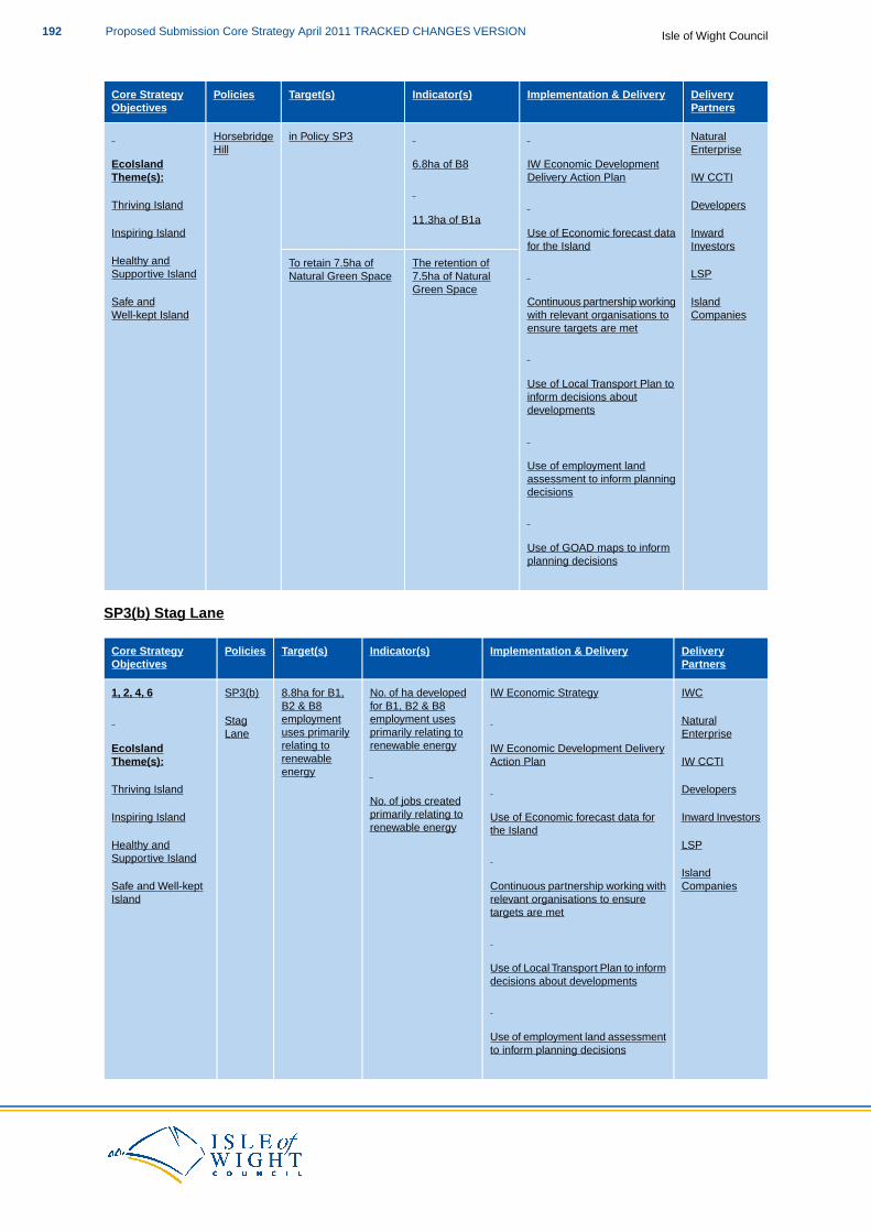
DeliveryPartners
Implementation & DeliveryIndicator(s)Target(s)PoliciesCore StrategyObjectives
in Policy SP3 NaturalHorsebridgeEnterpriseHill
EcoIsland IW Economic Development6.8ha of B8Theme(s): IW CCTIDelivery Action Plan
Thriving Island Developers11.3ha of B1a
Inspiring Island InwardInvestors
Use of Economic forecast datafor the Island
The retention ofTo retain 7.5ha ofHealthy andSupportive Island LSP7.5ha of NaturalNatural Green Space
Green SpaceIslandContinuous partnership workingSafe andCompanieswith relevant organisations to
ensure targets are metWell-kept Island
Use of Local Transport Plan toinform decisions aboutdevelopments
Use of employment landassessment to inform planningdecisions
Use of GOAD maps to informplanning decisions
SP3(b) Stag Lane
DeliveryPartners
Implementation & DeliveryIndicator(s)Target(s)PoliciesCore StrategyObjectives
IWCIW Economic StrategyNo. of ha developed8.8ha for B1,SP3(b)1, 2, 4, 6for B1, B2 & B8employment uses
B2 & B8employmentStag Natural
primarily relating touses primarilyLaneEcoIsland
EnterpriseIW Economic Development Deliveryrenewable energyrelating to
renewableenergy
Theme(s): IW CCTIAction Plan
Thriving Island DevelopersNo. of jobs createdprimarily relating toInspiring Island Inward InvestorsUse of Economic forecast data forrenewable energy
Healthy and LSPthe Island
Supportive IslandIsland
Continuous partnership working withSafe and Well-kept Companiesrelevant organisations to ensuretargets are met
Island
Use of Local Transport Plan to informdecisions about developments
Use of employment land assessmentto inform planning decisions
Isle of Wight CouncilProposed Submission Core Strategy April 2011 TRACKED CHANGES VERSION192
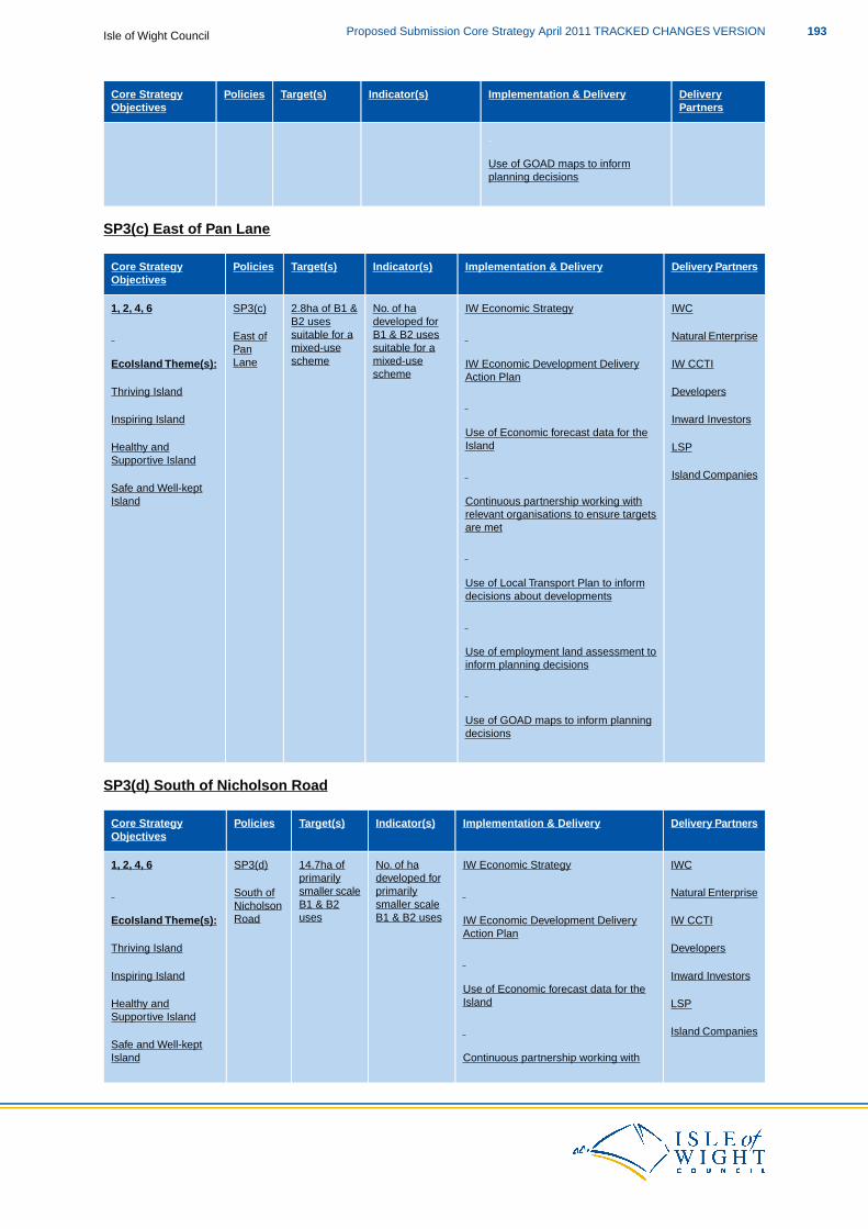
DeliveryPartners
Implementation & DeliveryIndicator(s)Target(s)PoliciesCore StrategyObjectives
Use of GOAD maps to informplanning decisions
SP3(c) East of Pan Lane
Delivery PartnersImplementation & DeliveryIndicator(s)Target(s)PoliciesCore StrategyObjectives
IWCIW Economic StrategyNo. of ha2.8ha of B1 &SP3(c)1, 2, 4, 6developed forB1 & B2 uses
B2 usessuitable for aEast of Natural Enterprise
suitable for amixed-usePanmixed-useschemeLaneEcoIsland Theme(s): IW CCTIIW Economic Development Delivery
Action Planscheme
Thriving Island Developers
Inspiring Island Inward InvestorsUse of Economic forecast data for theIslandHealthy and LSP
Supportive IslandIsland Companies
Continuous partnership working withSafe and Well-keptIsland
relevant organisations to ensure targetsare met
Use of Local Transport Plan to informdecisions about developments
Use of employment land assessment toinform planning decisions
Use of GOAD maps to inform planningdecisions
SP3(d) South of Nicholson Road
Delivery PartnersImplementation & DeliveryIndicator(s)Target(s)PoliciesCore StrategyObjectives
IWCIW Economic StrategyNo. of ha14.7ha ofSP3(d)1, 2, 4, 6developed forprimarily
primarilysmaller scaleSouth of Natural Enterprise
smaller scaleB1 & B2NicholsonB1 & B2 usesusesRoadEcoIsland Theme(s): IW CCTIIW Economic Development Delivery
Action PlanThriving Island Developers
Inspiring Island Inward InvestorsUse of Economic forecast data for theIslandHealthy and LSP
Supportive IslandIsland Companies
Continuous partnership working withSafe and Well-keptIsland
193Proposed Submission Core Strategy April 2011 TRACKED CHANGES VERSIONIsle of Wight Council
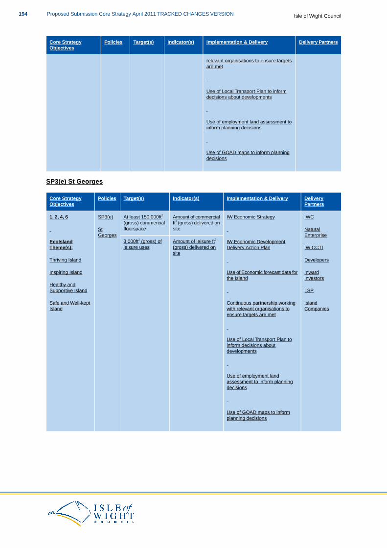
Delivery PartnersImplementation & DeliveryIndicator(s)Target(s)PoliciesCore StrategyObjectives
relevant organisations to ensure targetsare met
Use of Local Transport Plan to informdecisions about developments
Use of employment land assessment toinform planning decisions
Use of GOAD maps to inform planningdecisions
SP3(e) St Georges
DeliveryPartners
Implementation & DeliveryIndicator(s)Target(s)PoliciesCore StrategyObjectives
IWCIW Economic StrategyAmount of commercialAt least 150,000ft2SP3(e)1, 2, 4, 6ft2 (gross) delivered onsite
(gross) commercialfloorspaceSt
GeorgesNaturalEnterprise
IW Economic DevelopmentAmount of leisure ft2
(gross) delivered on3,000ft2 (gross) ofleisure uses
EcoIslandTheme(s): IW CCTIDelivery Action Plan
siteDevelopersThriving Island
InwardUse of Economic forecast data forInspiring IslandInvestorsthe Island
Healthy andLSPSupportive Island
IslandContinuous partnership workingSafe and Well-keptCompanieswith relevant organisations to
ensure targets are metIsland
Use of Local Transport Plan toinform decisions aboutdevelopments
Use of employment landassessment to inform planningdecisions
Use of GOAD maps to informplanning decisions
Isle of Wight CouncilProposed Submission Core Strategy April 2011 TRACKED CHANGES VERSION194
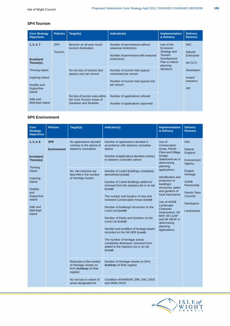
SP4 Tourism
DeliveryPartners
Implementation& Delivery
Indicator(s)Target(s)PoliciesCore StrategyObjectives
IWCUse of theNumber of permissions withoutBecome an all year roundSP41, 2, 4, 7EconomicStrategy and
seasonal restrictionstourism destinationTourism Natural
EnterpriseTourismDevelopmentPlan to inform
Number of permissions with seasonalrestrictionsEcoIsland
Theme(s): IW CCTIplanningdecisionsNumber of tourism bed spacesNo net loss of tourism bed DevelopersThriving Island
consented per annumspaces over per annumInwardInvestors
Inspiring IslandNumber of tourism bed spaces lostper annum
ISPHealthy andSupportiveIsland
Number of applications refusedNo loss of tourism uses withinSafe and the Core Tourism Areas of
Sandown and ShanklinWell-kept Island Number of applications approved
SP5 Environment
DeliveryPartners
Implementation& Delivery
Indicator(s)Target(s)PoliciesCoreStrategyObjectives
IWCUse ofNumber of applications decided inNo applications decidedSP51, 2, 4, 8ConservationAreas, Parish
accordance with statutory consulteeadvice
contrary to the advice ofstatutory consulteesEnvironment Natural
EnglandPlans and VillageDesignStatements etc in
Number of applications decided contraryto statutory consultee advice
EcoIslandTheme(s):
Thriving
EnvironmentAgencydetermining
planningapplicationsNumber of Listed Buildings completelyNo net reduction (or English
HeritageIsland
Identification anddemolished (Local)less x%) in the number
of Heritage AssetsAONB
InspiringIsland protection of
buildings/Number of Listed Buildings added to/removed from the statutory list or at risk Partnership
Healthy structures, parksand gardens of
(Local)Parish/ TownCouncils
andSupportive local importance
The number and location of new andreviewed Conservation Areas (Local)Island
Use of AONBLandscape
Number of buildings/ structures on theDevelopers
Safe andWell-kept Character
Assessment, IWLocal List (Local) Landowners
IslandBAP, IW LGAPand IW HEAP inNumber of Parks and Gardens on the
Local List (Local) determiningplanning
Number and condition of heritage assets applicationsrecorded on the IW HER (Local)
The number of heritage assetscompletely destroyed, removed from/added to the statutory list or at risk(Local)
Number of Heritage Assets on EH’sReduction in the numberBuildings At Risk registerof Heritage Assets on
EH’s Buildings At Riskregister
Condition of RAMSAR, SPA, SAC, SSSINo net loss in extent ofand NNRs RIGSareas designated for
195Proposed Submission Core Strategy April 2011 TRACKED CHANGES VERSIONIsle of Wight Council
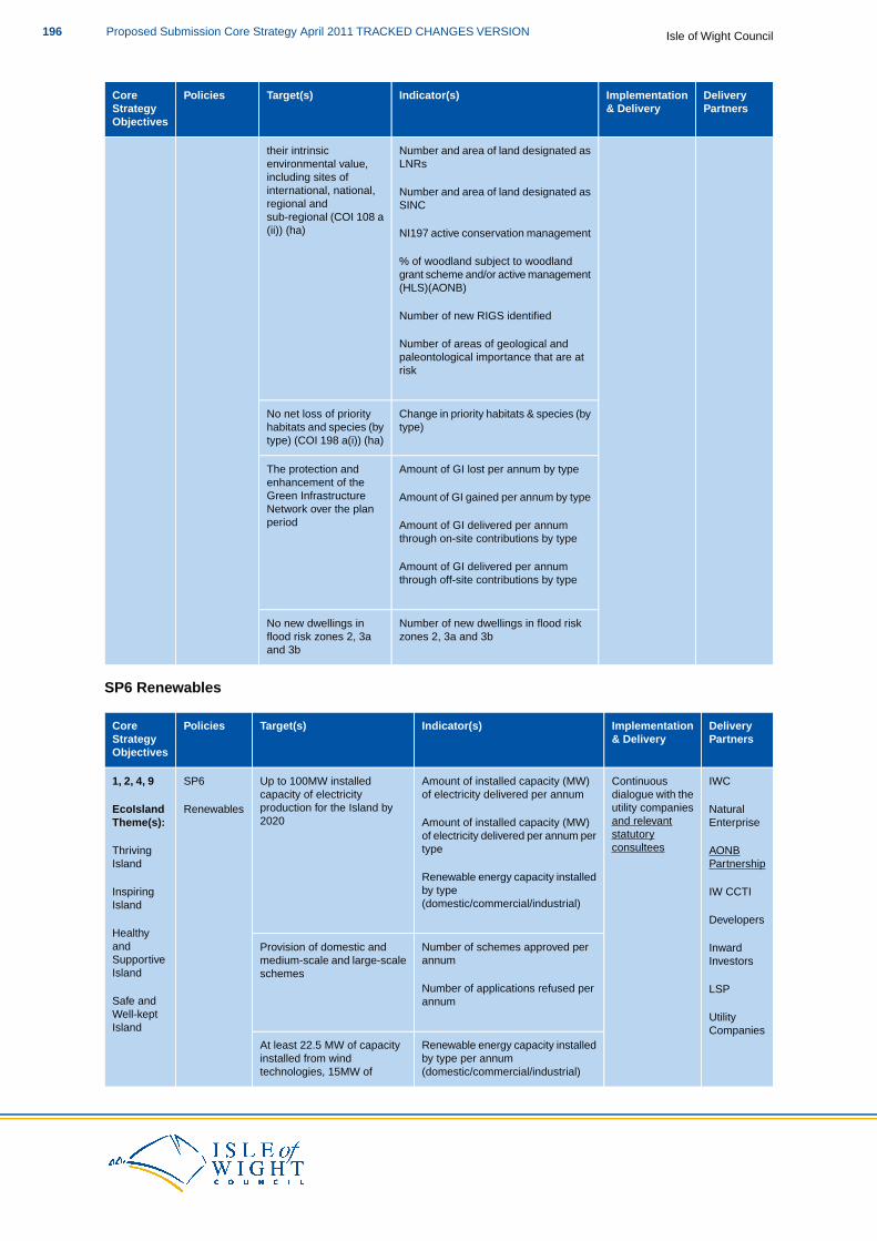
DeliveryPartners
Implementation& Delivery
Indicator(s)Target(s)PoliciesCoreStrategyObjectives
their intrinsic Number and area of land designated asenvironmental value, LNRsincluding sites ofinternational, national, Number and area of land designated asregional and SINCsub-regional (COI 108 a(ii)) (ha) NI197 active conservation management
% of woodland subject to woodlandgrant scheme and/or active management(HLS)(AONB)
Number of new RIGS identified
Number of areas of geological andpaleontological importance that are atrisk
Change in priority habitats & species (byNo net loss of prioritytype)habitats and species (by
type) (COI 198 a(i)) (ha)
Amount of GI lost per annum by typeThe protection andenhancement of theGreen Infrastructure Amount of GI gained per annum by typeNetwork over the planperiod Amount of GI delivered per annum
through on-site contributions by type
Amount of GI delivered per annumthrough off-site contributions by type
Number of new dwellings in flood riskNo new dwellings inzones 2, 3a and 3bflood risk zones 2, 3a
and 3b
SP6 Renewables
DeliveryPartners
Implementation& Delivery
Indicator(s)Target(s)PoliciesCoreStrategyObjectives
IWCContinuousAmount of installed capacity (MW)Up to 100MW installedSP61, 2, 4, 9dialogue with theutility companies
of electricity delivered per annumcapacity of electricityproduction for the Island by2020
RenewablesEcoIslandTheme(s):
NaturalEnterpriseand relevant
statutoryconsultees
Amount of installed capacity (MW)of electricity delivered per annum pertypeThriving AONB
Island PartnershipRenewable energy capacity installedby typeInspiring IW CCTI(domestic/commercial/industrial)Island
HealthyDevelopers
Number of schemes approved perProvision of domestic andandSupportive
InwardInvestorsannummedium-scale and large-scale
schemesIsland
LSPNumber of applications refused perannumSafe and
Well-keptIsland
UtilityCompanies
Renewable energy capacity installedby type per annum
At least 22.5 MW of capacityinstalled from wind
(domestic/commercial/industrial)technologies, 15MW of
Isle of Wight CouncilProposed Submission Core Strategy April 2011 TRACKED CHANGES VERSION196
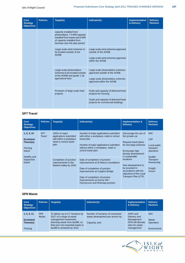
DeliveryPartners
Implementation& Delivery
Indicator(s)Target(s)PoliciesCoreStrategyObjectives
capacity installed fromphotovoltaics, 7.4 MW capacityinstalled from waste and 6 MWof capacity installed frombiomass over the plan period
Large-scale wind schemes approvedLarge-scale wind schemes tooutside of the AONBbe located outside of the
AONBLarge-scale wind schemes approvedwithin the AONB
Large-scale photovoltaics schemesLarge-scale photovoltaicsapproved outside of the AONBschemes to be located outside
of the AONB and grade 1-3aagricultural land Large-scale photovoltaics schemes
approved within the AONB
Scale and capacity of delivered heatProvision of large-scale heatprojects for housingprojects
Scale and capacity of delivered heatprojects for commercial buildings
SP7 Travel
DeliveryPartners
Implementation &Delivery
Indicator(s)Target(s)PoliciesCoreStrategyObjectives
IWCDiscourage the use ofNumber of major applications submitted100% of majorSP7Travel
1, 2, 4, 10the private carwith either a workplace, retail or school
travel planapplications submittedwith either a workplace,retail or school travelplan
LSP
Local public
EcoIslandTheme(s): Request travel plans
for new large schemesNumber of major applications submittedwithout either a workplace, retail orschool travel plan
ThrivingIsland
Healthy and
transportoperators
Quality
Encourage highdensity developmentin sustainablelocationsDate of completion of junctionCompletion of junction Transport
PartnershipSupportiveIsland
New development tobe provided in
improvements at St Mary’s roundabout
Date of completion of junction
improvements in theMedina Valley by 2020
FreightForumaccordance with the
objectives of the LocalTransport Plan (LTP)
improvements at Coppins Bridge
Date of completion of junctionimprovements at Hunny Hill /Hunnycross and Riverway junction
SP8 Waste
DeliveryPartners
Implementation& Delivery
Indicator(s)Target(s)PoliciesCoreStrategyObjectives
IWCAAPs andNumber of hectares of consentedTo deliver up to 9.7 hectares bySP8Waste
1, 2, 4, 11Delivery andManagement
waste development per annum by:2027 of a range of wastemanagement treatments,diverting waste from landfill, so
EcoIslandTheme(s):
WasteOperatorsDPD will allocate
sites for wasteCapacity, and;
that zero non-essential waste tolandfill is achieved by 2015 EnvironmentThriving management
197Proposed Submission Core Strategy April 2011 TRACKED CHANGES VERSIONIsle of Wight Council
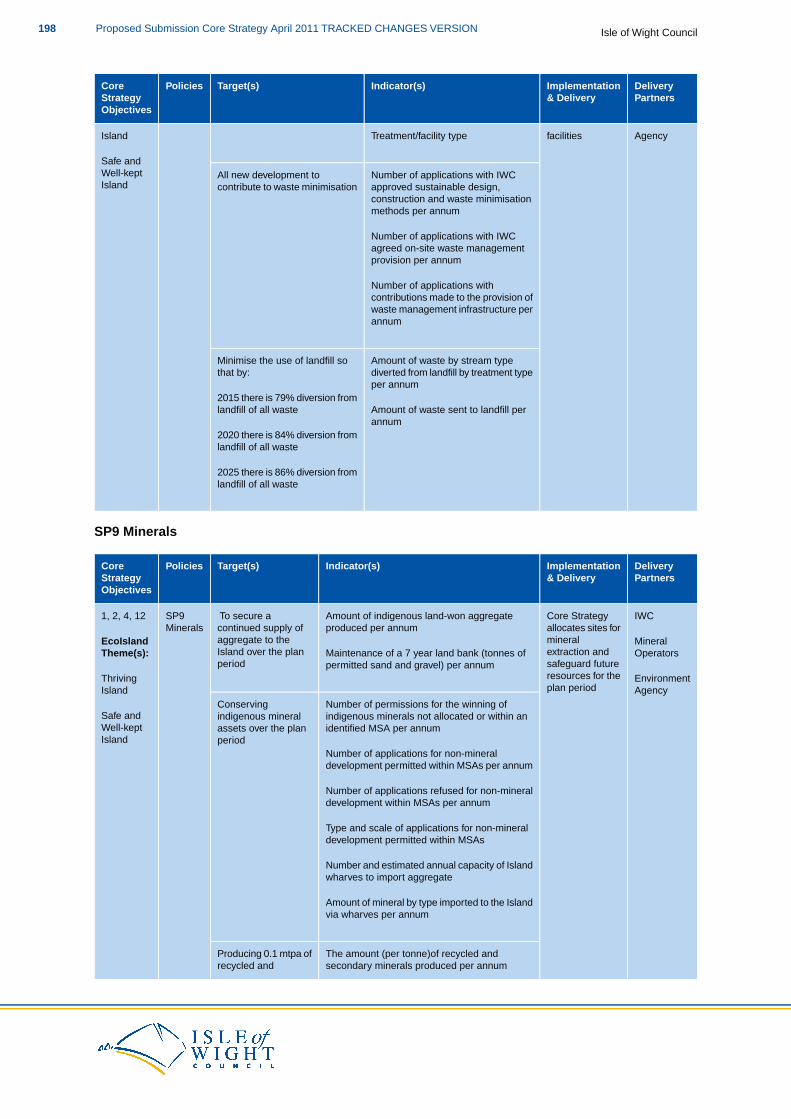
DeliveryPartners
Implementation& Delivery
Indicator(s)Target(s)PoliciesCoreStrategyObjectives
facilitiesTreatment/facility typeIsland
Safe and
Agency
Number of applications with IWCAll new development toWell-keptIsland approved sustainable design,
construction and waste minimisationcontribute to waste minimisation
methods per annum
Number of applications with IWCagreed on-site waste managementprovision per annum
Number of applications withcontributions made to the provision ofwaste management infrastructure perannum
Amount of waste by stream typeMinimise the use of landfill sodiverted from landfill by treatment typethat by:per annum
2015 there is 79% diversion fromAmount of waste sent to landfill perlandfill of all wasteannum
2020 there is 84% diversion fromlandfill of all waste
2025 there is 86% diversion fromlandfill of all waste
SP9 Minerals
DeliveryPartners
Implementation& Delivery
Indicator(s)Target(s)PoliciesCoreStrategyObjectives
IWCCore StrategyAmount of indigenous land-won aggregateTo secure aSP9Minerals
1, 2, 4, 12allocates sites formineral
produced per annumcontinued supply ofaggregate to theIsland over the plan
EcoIslandTheme(s):
MineralOperatorsextraction and
safeguard futureMaintenance of a 7 year land bank (tonnes ofpermitted sand and gravel) per annumperiod
ThrivingIsland
EnvironmentAgency
resources for theplan period
Number of permissions for the winning ofConservingSafe and indigenous minerals not allocated or within anindigenous mineralWell-kept identified MSA per annumassets over the planIsland
Number of applications for non-mineralperiod
development permitted within MSAs per annum
Number of applications refused for non-mineraldevelopment within MSAs per annum
Type and scale of applications for non-mineraldevelopment permitted within MSAs
Number and estimated annual capacity of Islandwharves to import aggregate
Amount of mineral by type imported to the Islandvia wharves per annum
The amount (per tonne)of recycled andProducing 0.1 mtpa ofsecondary minerals produced per annumrecycled and
Isle of Wight CouncilProposed Submission Core Strategy April 2011 TRACKED CHANGES VERSION198

DeliveryPartners
Implementation& Delivery
Indicator(s)Target(s)PoliciesCoreStrategyObjectives
secondary minerals Number and capacity of permissions grantedby 2016 associated with the provision of recycled and
secondary minerals
AAP1 Medina Valley
DeliveryPartners
Implementation &Delivery
Indicator(s)Target(s)PoliciesCore Strategy Objectives
IWCFurther Target(s) to beAchievement ofPreparation ofAAP11, 2, 3, 4, 5, 6, 7, 8, 9, 10,determined and monitoredthrough the AAP
milestones for thepreparation of the
AAP in line withLocal
MedinaValley
11, 12Parish and Town
Medina Valley AAPwithin the Local
DevelopmentScheme
EcoIsland Theme(s): CouncilsTo be delivered throughthe Medina Valley AreaDevelopment SchemeThriving Island Local amenityAction Plan
Inspiring Islandgroups
DevelopersHealthy and SupportiveIsland
Safe and Well-kept Island
AAP2 Ryde
Delivery PartnersImplementation &Delivery
Indicator(s)Target(s)PoliciesCore Strategy Objectives
IWCFurther Target(s) to beAchievement ofPreparation ofAAP21, 2, 3, 4, 5, 6, 7, 8, 9, 10,determined and monitoredthrough the AAP
milestones for thepreparation of the
AAP in line withLocal
Ryde11, 12Parish and Town
Ryde AAP within theLocal Development
DevelopmentScheme
CouncilsTo be delivered throughthe Ryde Area Action PlanSchemeEcoIsland Theme(s): Local amenity
groupsThriving Island
DevelopersInspiring Island
Healthy and SupportiveIsland
Safe and Well-kept Island
AAP3 The Bay
Delivery PartnersImplementation &Delivery
Indicator(s)Target(s)PoliciesCore Strategy Objectives
IWCFurther Target(s) to beAchievement ofPreparation ofAAP11, 2, 3, 4, 5, 6, 7, 8, 9, 10,determined and monitoredthrough the AAP
milestones for thepreparation of The
AAP in line withLocal
The Bay11, 12Parish and Town
Bay AAP within theLocal Development
DevelopmentScheme
EcoIsland Theme(s): CouncilsTo be delivered throughthe The Bay Area ActionSchemeThriving Island Local amenityPlan
Inspiring Islandgroups
DevelopersHealthy and SupportiveIsland
199Proposed Submission Core Strategy April 2011 TRACKED CHANGES VERSIONIsle of Wight Council

Delivery PartnersImplementation &Delivery
Indicator(s)Target(s)PoliciesCore Strategy Objectives
Safe and Well-kept Island
DM1 Sustainable Build Criteria for New Development
DeliveryPartners
Implementation& Delivery
Indicator(s)Target(s)PoliciesCoreStrategyObjectives
IWCAll developmentNumber of developments reachingAll major development toDM11, 2, 3, 4proposals shouldembrace all
required CSH or BREEAM standardsset out within Policy DM1 per annum
incorporate renewableenergy systems to provideSustainableEcoIsland Developers
aspects ofat least 10% of thepredicted energy
Build Criteriafor New
Theme(s):Architectsdesign, including
sustainableNumber of developments with a waterconsumption per household ofrequirements, except in
those developments whereDevelopmentThriving
Island& Agents
construction,efficiency
105lpppd per annumDistrict Heating will beprovided.Safe and
Parish &Townmeasures,
security andNumber of major developments notproviding a minimum of at least 10%Well-kept Councils
accessibilityof the predicted energy requirementsIslandCABE
Robust designfrom renewable energy systems perannum
DesignCouncil
and accessstatements
Number of major developments where100% provision ofPre-applicationDistrict Heating is installed & capacitycommunity district heating Localadvice which isper annumin line with thresholds of the amenityconsistent andpolicy groupsrobust
Number of developments reaching All developments to exceedPublic realmrequired CSH or BREEAM standardsif possible the minimumstrategiesset out within Policy DM1 per annumrequired level of the CSH
and BREEAMDesign BriefsNumber of developments not reaching
required CSH or BREEAM standardsset out within Policy DM1 per annum
The number of developments using Increase use of recycled orrecycled or secondary buildingsecondary buildingmaterials in new development permaterials in newannumdevelopments over the plan
period
Number of developments with a waterAll new developments toconsumption per household of moreresult in no more thanthan 105lpppd per annum105lpppd water
consumption per householdNumber of developments with a waterconsumption per household of lessthan 105lpppd per annum
Number of applications received withAll applications to bea sustainability checklist per annumsubmitted with a
sustainability checklistNumber of application received withouta sustainability checklist per annum
DM2 Design Quality for New Development
Delivery PartnersImplementation& Delivery
Indicator(s)Target(s)PoliciesCore StrategyObjectives
IWCNumber of applicationsAll applicationsDM21, 2, 3, 4
Isle of Wight CouncilProposed Submission Core Strategy April 2011 TRACKED CHANGES VERSION200
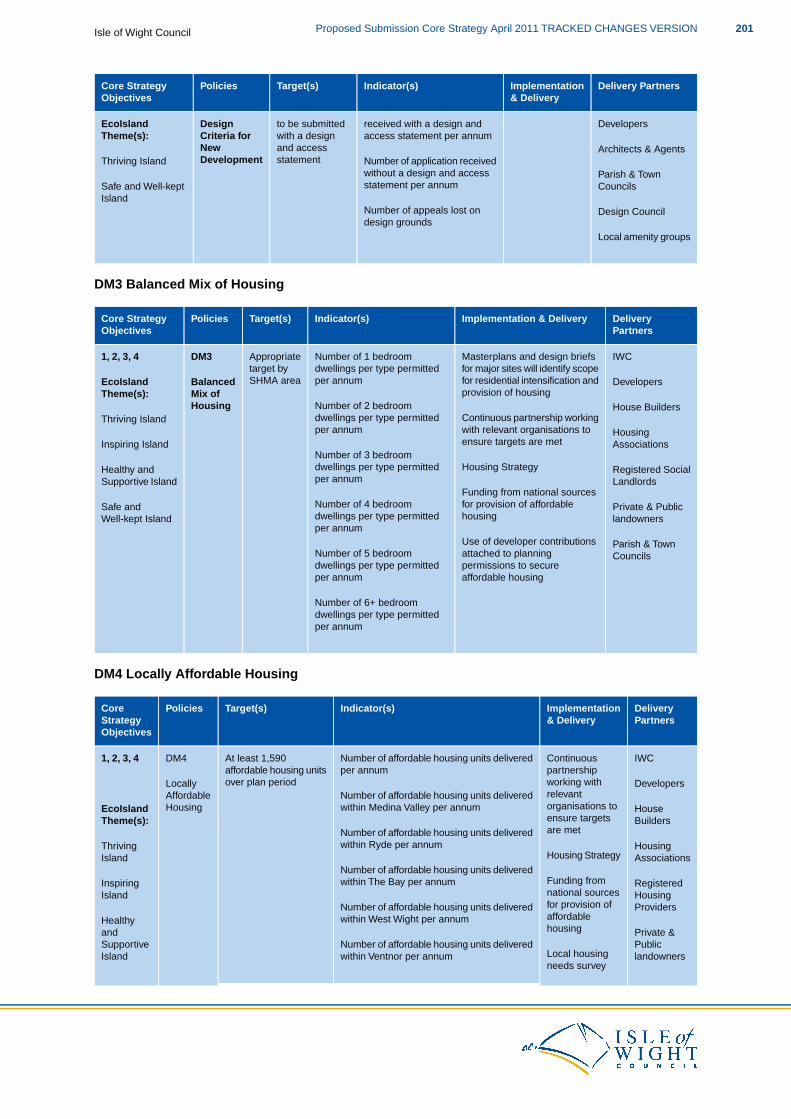
Delivery PartnersImplementation& Delivery
Indicator(s)Target(s)PoliciesCore StrategyObjectives
EcoIsland Developersreceived with a design andto be submittedDesignTheme(s): access statement per annumwith a design
and accessstatement
Criteria forNewDevelopmentThriving Island
Architects & Agents
Parish & TownNumber of application receivedwithout a design and accessstatement per annumSafe and Well-kept Councils
IslandDesign CouncilNumber of appeals lost on
design grounds
Local amenity groups
DM3 Balanced Mix of Housing
DeliveryPartners
Implementation & DeliveryIndicator(s)Target(s)PoliciesCore StrategyObjectives
IWCMasterplans and design briefsNumber of 1 bedroomAppropriateDM31, 2, 3, 4for major sites will identify scopefor residential intensification and
dwellings per type permittedper annum
target bySHMA areaBalancedEcoIsland Developers
provision of housingMix ofTheme(s):Number of 2 bedroomHousing
Thriving IslandHouse Builders
Continuous partnership workingwith relevant organisations to
dwellings per type permittedper annum Housing
ensure targets are metInspiring Island AssociationsNumber of 3 bedroom
Housing Strategydwellings per type permittedHealthy and Registered Socialper annumSupportive Island Landlords
Funding from national sourcesfor provision of affordableNumber of 4 bedroomSafe and Private & Publichousingdwellings per type permittedWell-kept Island landowners
Use of developer contributionsper annum
Parish & Townattached to planningNumber of 5 bedroom Councilspermissions to secureaffordable housing
dwellings per type permittedper annum
Number of 6+ bedroomdwellings per type permittedper annum
DM4 Locally Affordable Housing
DeliveryPartners
Implementation& Delivery
Indicator(s)Target(s)PoliciesCoreStrategyObjectives
IWCContinuousNumber of affordable housing units deliveredAt least 1,590DM41, 2, 3, 4partnershipworking with
per annumaffordable housing unitsover plan periodLocally Developers
relevantNumber of affordable housing units deliveredAffordableorganisations towithin Medina Valley per annumHousingEcoIsland
Theme(s):HouseBuildersensure targets
are metNumber of affordable housing units deliveredwithin Ryde per annumThriving Housing
Housing StrategyIsland AssociationsNumber of affordable housing units delivered
Funding fromwithin The Bay per annumInspiring Registerednational sourcesIsland Housingfor provision ofNumber of affordable housing units delivered Providersaffordablehousing
within West Wight per annumHealthyand Private &
Number of affordable housing units deliveredSupportive PublicLocal housingwithin Ventnor per annumIsland landownersneeds survey
201Proposed Submission Core Strategy April 2011 TRACKED CHANGES VERSIONIsle of Wight Council

DeliveryPartners
Implementation& Delivery
Indicator(s)Target(s)PoliciesCoreStrategyObjectives
Number of affordable housing units deliveredSafe and Parish &Use of developerwithin the RSCsWell-kept Towncontributions
Island Councilsattached toplanningpermissions to
Number of affordable housing units deliveredacross the rest of the Island
secure affordablehousing
Number of developments that provide 35%100% of developmentsand above affordable housing on site perto provide 35% on siteannumaffordable housing
where it is requiredNumber of developments that provide under35% affordable housing on site
Number of developments that do not provideon site affordable housing per annum
Number of developments that provide100% of developmentsfinancial contributions per annumto provide financial
contributions where onsite provision is not Number of development that do not providerequired financial contributions per annum
Number of social rented affordable housing70% of affordableunits deliveredhousing to be social
rented
Number of intermediate tenures affordable30% of affordablehousing units deliveredhousing to be
intermediate tenures
DM5 Housing for Older People
DeliveryPartners
Implementation& Delivery
Indicator(s)Target(s)PoliciesCoreStrategyObjectives
IWCContinuousNumber of housing units suitable for older2050 units of older personsDM51, 2, 3, 4partnershipworking with
persons delivered per annumaccommodation provisionover the plan periodHousingEcoIsland Developers
relevantNumber of housing units not suitable forfor OlderTheme(s):organisations toolder persons delivered per annumPeople
ThrivingHouseBuildersensure targets
are met% of older persons accommodation unitsIslandmeeting Lifetime Homes standards
InspiringIsland
HousingAssociationsHousing Strategy
Number of housing units suitable for older20 to 25% of all majorHealthy and
RegisteredSocialpersons within major developmentshousing developments toLandlordsSupportive delivered per annumbe accommodation suitable
IslandNumber of housing units not suitable for
for older peoplePrivate &PublicSafe and older persons within major developmentslandownersWell-kept delivered per annum
Parish &Island
Number of housing units suitable for older No net loss of housing TownCouncilspersons delivered per annumunits suitable for older
persons housing over theplan period Number of housing units suitable for older
persons lost per annum
Isle of Wight CouncilProposed Submission Core Strategy April 2011 TRACKED CHANGES VERSION202
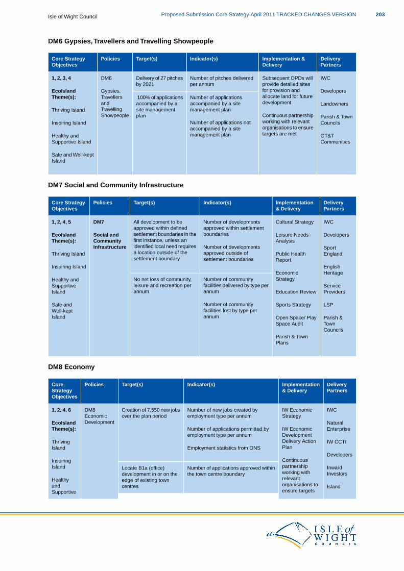
DM6 Gypsies,Travellers and Travelling Showpeople
DeliveryPartners
Implementation &Delivery
Indicator(s)Target(s)PoliciesCore StrategyObjectives
IWCSubsequent DPDs willNumber of pitches deliveredDelivery of 27 pitchesDM61, 2, 3, 4provide detailed sitesfor provision and
per annumby 2021EcoIsland Gypsies, Developers
Number of applications 100% of applications allocate land for futuredevelopment
Travellersand
Theme(s):Landownersaccompanied by a site
management planaccompanied by asite management
Continuous partnershipTravellingShowpeople
Thriving Island
Inspiring IslandParish & TownCouncilsNumber of applications not
accompanied by a site
planworking with relevantorganisations to ensuretargets are metHealthy and
Supportive IslandGT&TCommunities
management plan
Safe and Well-keptIsland
DM7 Social and Community Infrastructure
DeliveryPartners
Implementation& Delivery
Indicator(s)Target(s)PoliciesCore StrategyObjectives
IWCCultural StrategyNumber of developmentsAll development to beDM71, 2, 4, 5approved within settlementboundaries
approved within definedsettlement boundaries in theSocial andEcoIsland DevelopersLeisure Needsfirst instance, unless anidentified local need requires
CommunityInfrastructure
Theme(s):
Thriving IslandSportEngland
Analysis
Public HealthNumber of developmentsapproved outside ofsettlement boundaries
a location outside of thesettlement boundary
Inspiring Island EnglishHeritage
Report
EconomicStrategyNumber of community
facilities delivered by type perannum
No net loss of community,leisure and recreation perannum
Healthy andSupportiveIsland
ServiceProvidersEducation Review
Number of community LSPSports StrategySafe andfacilities lost by type perWell-kept
Island annum Parish &Town
Open Space/ PlaySpace Audit
CouncilsParish & TownPlans
DM8 Economy
DeliveryPartners
Implementation& Delivery
Indicator(s)Target(s)PoliciesCoreStrategyObjectives
IWCIW EconomicNumber of new jobs created byCreation of 7,550 new jobsDM81, 2, 4, 6Strategyemployment type per annumover the plan periodEconomic
DevelopmentEcoIsland NaturalIW EconomicNumber of applications permitted byTheme(s): EnterpriseDevelopmentemployment type per annumDelivery ActionThriving IW CCTIPlanEmployment statistics from ONSIsland
InspiringDevelopers
ContinuouspartnershipNumber of applications approved withinLocate B1a (office)Island Inward
Investorsworking withrelevant
the town centre boundarydevelopment in or on theedge of existing towncentres Island
HealthyandSupportive
organisations toensure targets
203Proposed Submission Core Strategy April 2011 TRACKED CHANGES VERSIONIsle of Wight Council
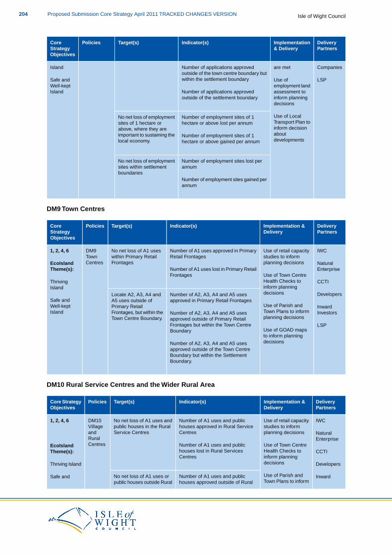
DeliveryPartners
Implementation& Delivery
Indicator(s)Target(s)PoliciesCoreStrategyObjectives
are metIsland Number of applications approved Companiesoutside of the town centre boundary butwithin the settlement boundary LSPUse of
employment landassessment to
Safe andWell-keptIsland Number of applications approved
outside of the settlement boundary inform planningdecisions
Number of employment sites of 1No net loss of employment Use of LocalTransport Plan tohectare or above lost per annumsites of 1 hectare orinform decisionabove, where they are
important to sustaining the aboutdevelopments
Number of employment sites of 1hectare or above gained per annumlocal economy.
Number of employment sites lost perNo net loss of employmentannumsites within settlement
boundariesNumber of employment sites gained perannum
DM9 Town Centres
DeliveryPartners
Implementation &Delivery
Indicator(s)Target(s)PoliciesCoreStrategyObjectives
IWCUse of retail capacityNumber of A1 uses approved in PrimaryNo net loss of A1 usesDM91, 2, 4, 6studies to informplanning decisions
Retail Frontageswithin Primary RetailFrontages
TownCentresEcoIsland Natural
Number of A1 uses lost in Primary RetailTheme(s): EnterpriseUse of Town CentreFrontages
ThrivingIsland
CCTIHealth Checks toinform planningdecisionsNumber of A2, A3, A4 and A5 usesLocate A2, A3, A4 and
Safe andDevelopers
Use of Parish andapproved in Primary Retail FrontagesA5 uses outside of
Primary RetailFrontages, but within the
Well-keptIsland
InwardInvestorsTown Plans to inform
planning decisionsNumber of A2, A3, A4 and A5 usesapproved outside of Primary RetailFrontages but within the Town Centre
Town Centre Boundary.LSP
Use of GOAD mapsto inform planning
Boundary
decisionsNumber of A2, A3, A4 and A5 usesapproved outside of the Town CentreBoundary but within the SettlementBoundary.
DM10 Rural Service Centres and the Wider Rural Area
DeliveryPartners
Implementation &Delivery
Indicator(s)Target(s)PoliciesCore StrategyObjectives
IWCUse of retail capacityNumber of A1 uses and publicNo net loss of A1 uses andDM101, 2, 4, 6studies to informplanning decisions
houses approved in Rural ServiceCentres
public houses in the RuralService Centres
Villageand NaturalRuralCentresEcoIsland
EnterpriseUse of Town CentreHealth Checks to
Number of A1 uses and publichouses lost in Rural ServicesTheme(s): CCTI
inform planningCentres
Thriving Island Developersdecisions
Use of Parish andNumber of A1 uses and publicNo net loss of A1 uses or InwardSafe andTown Plans to informhouses approved outside of Ruralpublic houses outside Rural
Isle of Wight CouncilProposed Submission Core Strategy April 2011 TRACKED CHANGES VERSION204

DeliveryPartners
Implementation &Delivery
Indicator(s)Target(s)PoliciesCore StrategyObjectives
Service Centres where a Investorsplanning decisionsWell-keptIsland
Service Centres
Number of A1 uses and publiclocal need can be identified
LSPhouses lost outside of Rural ServicesCentres
DM11 High Quality Tourism
DeliveryPartners
Implementation &Delivery
Indicator(s)Target(s)PoliciesCoreStrategyObjectives
IWCActive promotion ofNumber of developments for tourismAll applications forDM111, 2, 4, 6, 7the Island as atourist destination
accommodation reaching 3* standardstourism accommodationto be for a 3* standardHighEcoIsland Tourism
Number of developments for tourismQualityTheme(s): accommodationMemorandum ofaccommodation not reaching 3*Tourism
Thrivingproviders
understandingbetween IWC and
standardsIsland Natural
EnterpriseIW Chamber ofCommerce,Tourism and
Number of developments for tourismaccommodation reaching 4* or 5*
Existing tourismaccommodation to
Safe andWell-keptIsland
CCTI
Developers
Industry (CCTI) onroles andresponsibilities with
standards
Number of developments for tourism
become 4 *or 5*standard
regard to tourismaccommodation not reaching 4* or 5* Inward Investors
Use of Tourismstandards
Development Plan
Number of tourism bed spaces lost perNo net loss of tourismto inform planningdecisions
annumaccommodation
Number of tourism bed spaces gainedper annum
DM12 Built and Historic Environment
DeliveryPartners
Implementation& Delivery
Indicator(s)Target(s)PolicyCoreStrategyObjectives
IWCUse ofNumber of Listed Buildings completelyNo net reduction (or lessDM121, 2, 4, 8ConservationAreas, Parish
demolished (Local)x%) in the number ofHeritage AssetsBuilt &EcoIsland Natural
Plans and VillageNumber of Listed Buildings added to/HistoricTheme(s): EnglandDesignremoved from the statutory list or at riskEnvironment
Thriving AONBStatements etc indetermining
(Local)Island Partnership
planningThe number and location of new andapplicationsreviewed Conservation Areas (Local)Safe and English
Well-kept HeritageIdentification andNumber of buildings/ structures on theIsland
Parish andprotection ofbuildings/
Local List (Local)Town
structures, parksNumber of Parks and Gardens on the Councilsand gardens ofLocal List (Local)local importance
Number and condition of heritage assetsInterestedlocal
recorded on the IW HER (Local) groups
The number of heritage assets completelydestroyed, removed from/ added to thestatutory list or at risk (Local)
205Proposed Submission Core Strategy April 2011 TRACKED CHANGES VERSIONIsle of Wight Council
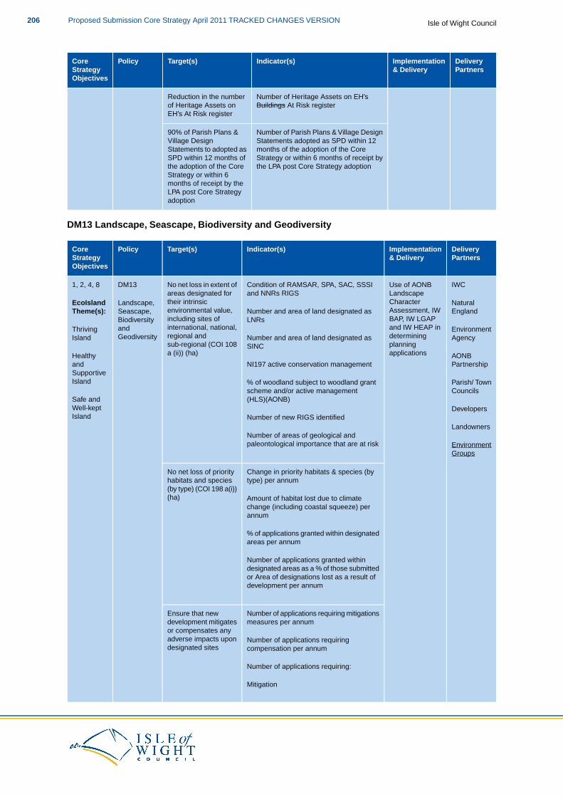
DeliveryPartners
Implementation& Delivery
Indicator(s)Target(s)PolicyCoreStrategyObjectives
Number of Heritage Assets on EH’sReduction in the numberBuildings At Risk registerof Heritage Assets on
EH’s At Risk register
Number of Parish Plans & Village DesignStatements adopted as SPD within 12
90% of Parish Plans &Village Design
months of the adoption of the CoreStatements to adopted asStrategy or within 6 months of receipt bythe LPA post Core Strategy adoption
SPD within 12 months ofthe adoption of the CoreStrategy or within 6months of receipt by theLPA post Core Strategyadoption
DM13 Landscape, Seascape, Biodiversity and Geodiversity
DeliveryPartners
Implementation& Delivery
Indicator(s)Target(s)PolicyCoreStrategyObjectives
IWCUse of AONBCondition of RAMSAR, SPA, SAC, SSSINo net loss in extent ofDM131, 2, 4, 8LandscapeCharacter
and NNRs RIGSareas designated fortheir intrinsicenvironmental value,
Landscape,Seascape,
EcoIslandTheme(s):
NaturalEnglandAssessment, IW
BAP, IW LGAPNumber and area of land designated asLNRsincluding sites of
international, national,BiodiversityandThriving Environmentand IW HEAP in
determiningNumber and area of land designated asregional andsub-regional (COI 108
GeodiversityIsland Agencyplanningapplications
SINCa (ii)) (ha) AONBHealthy
PartnershipNI197 active conservation managementandSupportiveIsland Parish/ Town% of woodland subject to woodland grant
Councilsscheme and/or active managementSafe and (HLS)(AONB)Well-keptIsland
Developers
LandownersNumber of new RIGS identified
Number of areas of geological andpaleontological importance that are at risk Environment
Groups
Change in priority habitats & species (byNo net loss of prioritytype) per annumhabitats and species
(by type) (COI 198 a(i))(ha) Amount of habitat lost due to climate
change (including coastal squeeze) perannum
% of applications granted within designatedareas per annum
Number of applications granted withindesignated areas as a % of those submittedor Area of designations lost as a result ofdevelopment per annum
Number of applications requiring mitigationsEnsure that newmeasures per annumdevelopment mitigates
or compensates anyadverse impacts upon Number of applications requiringdesignated sites compensation per annum
Number of applications requiring:
Mitigation
Isle of Wight CouncilProposed Submission Core Strategy April 2011 TRACKED CHANGES VERSION206
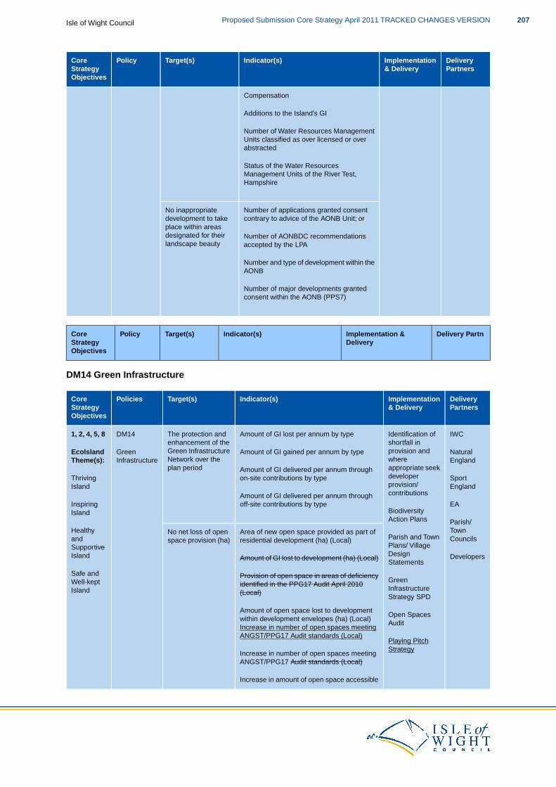
DeliveryPartners
Implementation& Delivery
Indicator(s)Target(s)PolicyCoreStrategyObjectives
Compensation
Additions to the Island’s GI
Number of Water Resources ManagementUnits classified as over licensed or overabstracted
Status of the Water ResourcesManagement Units of the River Test,Hampshire
Number of applications granted consentNo inappropriatecontrary to advice of the AONB Unit; ordevelopment to take
place within areasdesignated for their Number of AONBDC recommendationslandscape beauty accepted by the LPA
Number and type of development within theAONB
Number of major developments grantedconsent within the AONB (PPS7)
Delivery PartnImplementation &Delivery
Indicator(s)Target(s)PolicyCoreStrategyObjectives
DM14 Green Infrastructure
DeliveryPartners
Implementation& Delivery
Indicator(s)Target(s)PoliciesCoreStrategyObjectives
IWCIdentification ofAmount of GI lost per annum by typeThe protection andDM141, 2, 4, 5, 8shortfall inprovision andAmount of GI gained per annum by type
enhancement of theGreen InfrastructureNetwork over the
GreenInfrastructure
EcoIslandTheme(s):
NaturalEnglandwhere
appropriate seekdeveloper
Amount of GI delivered per annum throughon-site contributions by type
plan period
SportThrivingprovision/Island EnglandcontributionsAmount of GI delivered per annum through
off-site contributions by typeInspiringIsland
EA
Parish/
BiodiversityAction Plans
Area of new open space provided as part ofNo net loss of open TownCouncils
Healthyand Parish and Town
Plans/ Villageresidential development (ha) (Local)space provision (ha)
DevelopersSupportiveIsland
Safe and
DesignStatements
Green
Amount of GI lost to development (ha) (Local)
Provision of open space in areas of deficiencyidentified in the PPG17 Audit April 2010Well-kept
Island InfrastructureStrategy SPD
(Local)
Amount of open space lost to developmentOpen Spaces
within development envelopes (ha) (Local)Audit
Increase in number of open spaces meetingANGST/PPG17 Audit standards (Local)
Playing PitchStrategy
Increase in number of open spaces meetingANGST/PPG17 Audit standards (Local)
Increase in amount of open space accessible
207Proposed Submission Core Strategy April 2011 TRACKED CHANGES VERSIONIsle of Wight Council
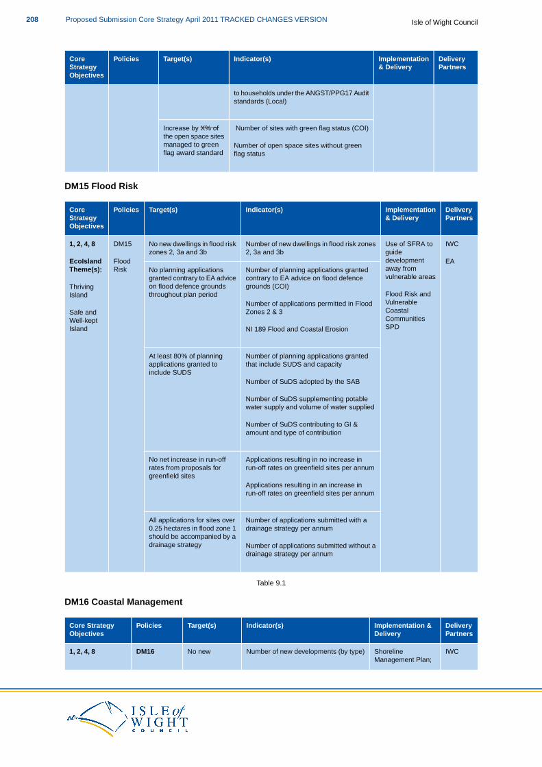
DeliveryPartners
Implementation& Delivery
Indicator(s)Target(s)PoliciesCoreStrategyObjectives
to households under the ANGST/PPG17 Auditstandards (Local)
Number of sites with green flag status (COI)Increase by X% ofthe open space sitesmanaged to green Number of open space sites without greenflag award standard flag status
DM15 Flood Risk
DeliveryPartners
Implementation& Delivery
Indicator(s)Target(s)PoliciesCoreStrategyObjectives
IWCUse of SFRA toNumber of new dwellings in flood risk zonesNo new dwellings in flood riskDM151, 2, 4, 8guidedevelopment
2, 3a and 3bzones 2, 3a and 3bEcoIsland Flood EA
Number of planning applications grantedcontrary to EA advice on flood defence
No planning applicationsgranted contrary to EA advice
away fromvulnerable areas
RiskTheme(s):
Thriving grounds (COI)on flood defence groundsthroughout plan period Flood Risk and
VulnerableIsland
Number of applications permitted in FloodZones 2 & 3 Coastal
CommunitiesSafe andWell-kept
SPDIsland NI 189 Flood and Coastal Erosion
Number of planning applications grantedAt least 80% of planningthat include SUDS and capacityapplications granted to
include SUDSNumber of SuDS adopted by the SAB
Number of SuDS supplementing potablewater supply and volume of water supplied
Number of SuDS contributing to GI &amount and type of contribution
Applications resulting in no increase inNo net increase in run-offrun-off rates on greenfield sites per annumrates from proposals for
greenfield sitesApplications resulting in an increase inrun-off rates on greenfield sites per annum
Number of applications submitted with aAll applications for sites overdrainage strategy per annum0.25 hectares in flood zone 1
should be accompanied by adrainage strategy Number of applications submitted without a
drainage strategy per annum
Table 9.1
DM16 Coastal Management
DeliveryPartners
Implementation &Delivery
Indicator(s)Target(s)PoliciesCore StrategyObjectives
IWCShorelineNumber of new developments (by type)No newDM161, 2, 4, 8Management Plan;
Isle of Wight CouncilProposed Submission Core Strategy April 2011 TRACKED CHANGES VERSION208
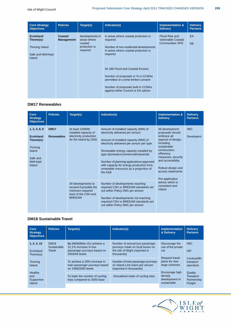
DeliveryPartners
Implementation &Delivery
Indicator(s)Target(s)PoliciesCore StrategyObjectives
Flood Risk andin areas where coastal protection isdevelopments inCoastalEcoIsland EAVulnerable Coastalrequiredareas whereManagementTheme(s):Communities SPDcoastal
protection isThriving IslandNE
Number of non-residential developmentsin areas where coastal protection isrequiredrequiredSafe and Well-kept
Island
NI 189 Flood and Coastal Erosion
Number of proposals or % in CCMAspermitted on a time-limited consent
Number of proposals built in CCMAsagainst either Council or EA advice
DM17 Renewables
DeliveryPartners
Implementation &Delivery
Indicator(s)Target(s)PoliciesCoreStrategyObjectives
IWCAll developmentAmount of installed capacity (MW) ofAt least 100MWDM171, 2, 4, 8, 9proposals shouldembrace all
electricity delivered per annuminstalled capacity ofelectricity productionfor the Island by 2020
RenewablesEcoIslandTheme(s):
Developersaspects of design,includingsustainable
Amount of installed capacity (MW) ofelectricity delivered per annum per type
Thrivingconstruction,Renewable energy capacity installed byIslandefficiencytype (domestic/commercial/industrial)measures, securitySafe andand accessibilityNumber of planning applications approvedWell-kept
with capacity for energy production fromIslandRobust design andaccess statements
renewable resources as a proportion ofthe total
Pre-application
Number of developments reachingAll developments to advice which isconsistent andrequired CSH or BREEAM standards setexceed if possible therobustout within Policy DM1 per annumminimum required
level of the CSH andBREEAM Number of developments not reaching
required CSH or BREEAM standards setout within Policy DM1 per annum
DM18 Sustainable Travel
DeliveryPartners
Implementation& Delivery
Indicator(s)Target(s)PoliciesCoreStrategyObjectives
IWCDiscourage theNumber of annual bus passengerBy 2010/2011, tTo achieve aDM181, 2, 4, 10use of the privatecar
journeys made on local buses onthe Isle of Wight (reported in
12.1% increase in buspassenger journeys based on
SustainableTravelEcoIsland ISP
thousands)2003/04 levelsTheme(s):Local publicRequest travel
plans for newNumber of train passenger journeysTo achieve a 20% increase in transportThrivinglarge schemeson Island Line trains per annumtrain passenger journeys based operatorsIsland
(reported in thousands)on 1999/2000 levelsQualityHealthy Encourage high
density Annualised index of cycling tripsTo triple the number of cycling Transportanddevelopment intrips compared to 2000 base Partnership
FreightSupportiveIsland sustainable
209Proposed Submission Core Strategy April 2011 TRACKED CHANGES VERSIONIsle of Wight Council
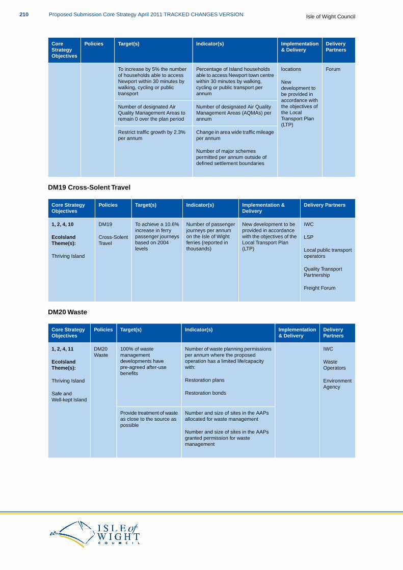
DeliveryPartners
Implementation& Delivery
Indicator(s)Target(s)PoliciesCoreStrategyObjectives
locationsPercentage of Island householdsTo increase by 5% the number Forumable to access Newport town centrewithin 30 minutes by walking,
of households able to accessNewport within 30 minutes by New
cycling or public transport perwalking, cycling or public development toannumtransport be provided in
accordance withNumber of designated Air QualityNumber of designated Air the objectives of
the LocalManagement Areas (AQMAs) perQuality Management Areas toTransport Planannumremain 0 over the plan period(LTP)
Change in area wide traffic mileageRestrict traffic growth by 2.3%per annumper annum
Number of major schemespermitted per annum outside ofdefined settlement boundaries
DM19 Cross-Solent Travel
Delivery PartnersImplementation &Delivery
Indicator(s)Target(s)PoliciesCore StrategyObjectives
IWCNew development to beNumber of passengerTo achieve a 10.6%DM191, 2, 4, 10provided in accordancewith the objectives of the
journeys per annumon the Isle of Wight
increase in ferrypassenger journeysCross-SolentEcoIsland LSP
Local Transport Planferries (reported inbased on 2004TravelTheme(s):Local public transport(LTP)thousands)levels
Thriving Island operators
Quality TransportPartnership
Freight Forum
DM20 Waste
DeliveryPartners
Implementation& Delivery
Indicator(s)Target(s)PoliciesCore StrategyObjectives
IWCNumber of waste planning permissions100% of wasteDM201, 2, 4, 11per annum where the proposedoperation has a limited life/capacity
managementdevelopments have
WasteEcoIsland Waste
with:pre-agreed after-useTheme(s): Operatorsbenefits
Restoration plansThriving Island EnvironmentAgency
Restoration bondsSafe andWell-kept Island
Number and size of sites in the AAPsProvide treatment of wasteallocated for waste managementas close to the source as
possibleNumber and size of sites in the AAPsgranted permission for wastemanagement
Isle of Wight CouncilProposed Submission Core Strategy April 2011 TRACKED CHANGES VERSION210
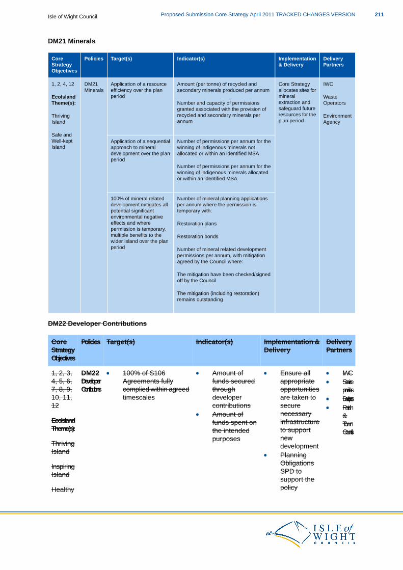
DM21 Minerals
DeliveryPartners
Implementation& Delivery
Indicator(s)Target(s)PoliciesCoreStrategyObjectives
IWCCore StrategyAmount (per tonne) of recycled andApplication of a resourceDM211, 2, 4, 12allocates sites formineral
secondary minerals produced per annumefficiency over the planperiod
MineralsEcoIsland Waste
extraction andNumber and capacity of permissionsTheme(s): Operatorssafeguard futuregranted associated with the provision ofresources for therecycled and secondary minerals perThriving Environmentplan periodannumIsland
Safe and
Agency
Number of permissions per annum for theApplication of a sequentialWell-keptIsland winning of indigenous minerals not
allocated or within an identified MSAapproach to mineraldevelopment over the planperiod
Number of permissions per annum for thewinning of indigenous minerals allocatedor within an identified MSA
Number of mineral planning applications100% of mineral relatedper annum where the permission isdevelopment mitigates alltemporary with:potential significant
environmental negativeeffects and where Restoration planspermission is temporary,multiple benefits to the Restoration bondswider Island over the planperiod Number of mineral related development
permissions per annum, with mitigationagreed by the Council where:
The mitigation have been checked/signedoff by the Council
The mitigation (including restoration)remains outstanding
DM22 Developer Contributions
DeliveryImplementation &Indicator(s)Target(s)PoliciesCorePartnersDeliveryStrategy
Objectives
DM221, 2, 3, IWCEnsure allappropriate
Amount offunds secured
100% of S106Agreements fullyDeveloper4, 5, 6, Service
providersopportunitiesare taken to
throughdeveloper
complied within agreedtimescales
Contributions7, 8, 9,10, 11,12
Developerssecurecontributions Parish
&necessaryinfrastructureEcoIsland
Theme(s):
Amount offunds spent onthe intended
TownCouncilsto support
newdevelopmentThriving
Island
purposes
PlanningObligationsInspiringSPD toIslandsupport thepolicyHealthy
211Proposed Submission Core Strategy April 2011 TRACKED CHANGES VERSIONIsle of Wight Council
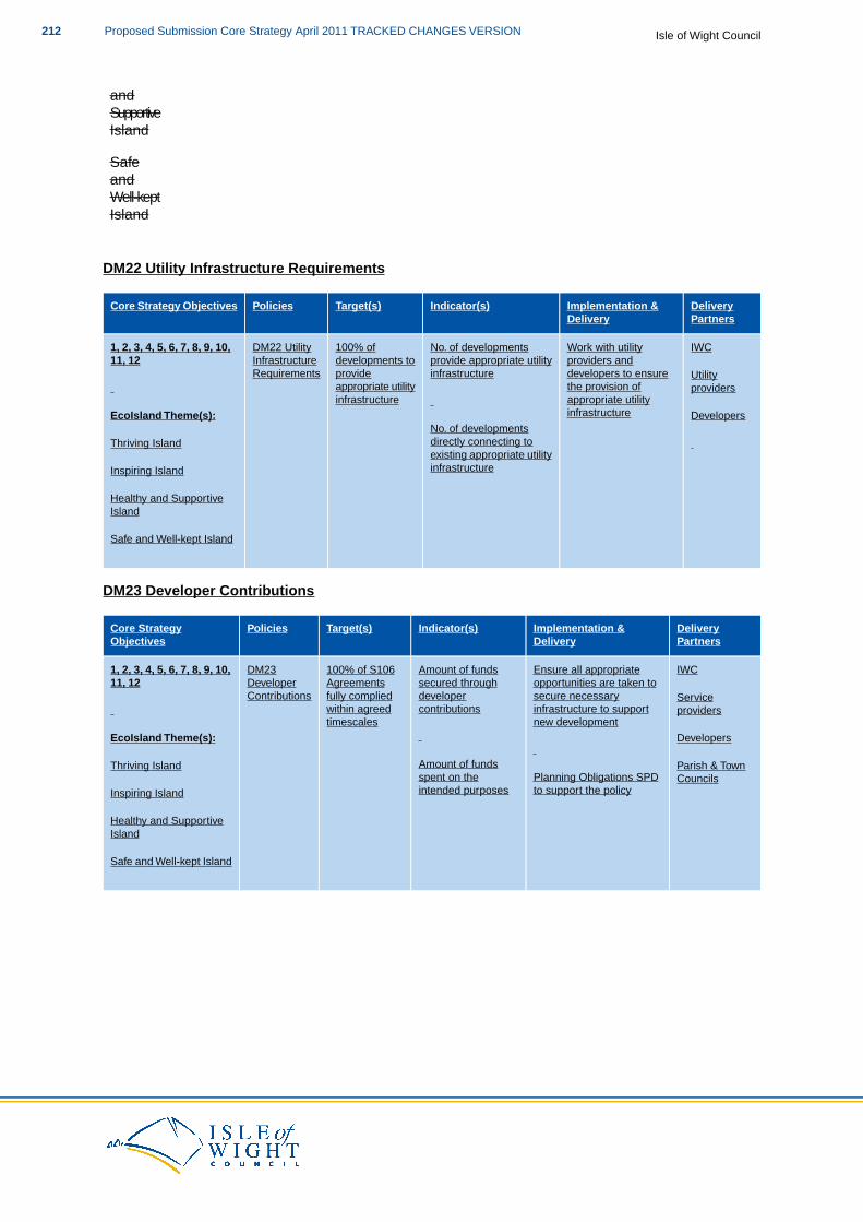
andSupportiveIsland
SafeandWell-keptIsland
DM22 Utility Infrastructure Requirements
DeliveryPartners
Implementation &Delivery
Indicator(s)Target(s)PoliciesCore Strategy Objectives
IWCWork with utilityNo. of developments100% ofDM22 Utility1, 2, 3, 4, 5, 6, 7, 8, 9, 10,providers anddevelopers to ensure
provide appropriate utilityinfrastructure
developments toprovide
InfrastructureRequirements
11, 12Utility
the provision ofappropriate utilityinfrastructure
providersappropriate utilityinfrastructureEcoIsland Theme(s): Developers
No. of developmentsdirectly connecting toThriving Islandexisting appropriate utilityinfrastructureInspiring Island
Healthy and SupportiveIsland
Safe and Well-kept Island
DM23 Developer Contributions
DeliveryPartners
Implementation &Delivery
Indicator(s)Target(s)PoliciesCore StrategyObjectives
IWCEnsure all appropriateAmount of funds100% of S106DM231, 2, 3, 4, 5, 6, 7, 8, 9, 10,opportunities are taken tosecure necessary
secured throughdeveloper
Agreementsfully complied
DeveloperContributions
11, 12Service
infrastructure to supportcontributionswithin agreed providersnew developmenttimescales
EcoIsland Theme(s): Developers
Amount of fundsThriving Island Parish & TownPlanning Obligations SPDspent on the Councilsto support the policyintended purposesInspiring Island
Healthy and SupportiveIsland
Safe and Well-kept Island
Isle of Wight CouncilProposed Submission Core Strategy April 2011 TRACKED CHANGES VERSION212
10 Glossary of Terms
DescriptionReference
An area where monitoring demonstrates that national air quality objectives are notbeing achieved. A Local Air Quality Action Plan is then required to improve the airquality.
Air QualityManagementArea (AQMA)
Anaerobic digestion is a treatment that composts biodegradable waste in the absenceof oxygen, producing a biogas that can be used to generate electricity and heat.
AnaerobicDigestion
Woodland which has been in continuous existence since 1600. It is identified in theancient woodland inventories produced by Natural England and there is an obligation
AncientWoodland
to consult the Forestry Commission on all planning applications within or adjoiningancient woodlands.
Part of the Local Development Framework, the AMR will assess the implementationof the Local Development Scheme and the extent to which policies in LocalDevelopment Documents are being successfully implemented.
AnnualMonitoringReport (AMR)
An AAP is used to provide a planning framework for areas of change and areas ofconservation. They have the status of development plan documents. The identified
Area ActionPlans (AAP)
AAP boundaries form an 'area of study', within which the issues identified in the AAPpolicies will be considered.
Landscape of national importance, designated under the National Parks and Accessto the Countryside Act 1949. The primary purpose of the AONB designation is to
Area ofOutstanding
conserve and enhance the natural beauty of the landscape with secondary aims toNaturalhave consideration for the interests of those who live and work there and support theneed for quiet enjoyment of the countryside.
Beauty(AONB)
The Environmental Assessment Method is a rating system for environmentally friendlydesign, developed by the Government’s Building Research Establishment. It includesassessing carbon dioxide emissions from the building once in use.
BREEAM
A change in the climate’s mean and variability for an extended period of decades, ormore. The term is sometimes used to refer specifically to climate change caused by
ClimateChange
human activity; for example, the United Nations Framework Convention on ClimateChange defines it as “a change of climate which as attributed directly of indirectly tohuman activity that alters the composition of the global atmosphere and which is inaddition to natural climate variability observed over comparable time periods”.
Identified areas where coastal change (the physical change to the shoreline, suchas erosion, coastal landslip, permanent inundation and coastal accretion) will bemanaged.
CoastalChangeManagementAreas(CCMAs)
The Code measures the sustainability of a new home against categories of sustainabledesign, rating the whole home as a complete package.The Code uses a 1 to 6* rating
Code forSustainableHomes (CSH) system to communicate the overall sustainability performance of a new home. The
Code sets minimum standards for energy and water use at each level and, withinEngland, replaces the EcoHomes scheme.
The simultaneous generation of usable heat and power (usually electricity) in a singleprocess, thereby reducing wasted heat and putting to use heat that would normally
CombinedHeat andPower (CHP) be wasted to the atmosphere, rivers or seas. CHP is an efficient form of decentralised
213Proposed Submission Core Strategy April 2011 TRACKED CHANGES VERSIONIsle of Wight Council
DescriptionReference
energy supply providing heating and electricity at the same time. CHP’s overall fuelefficiency can be around 70-90% of the input fuel, depending on the heat-load; muchbetter than most power stations which are only up to around 40-50% efficient.
Waste produced by businesses and commerce, and includes waste from schools,restaurants, offices, retail and wholesale businesses, and manufacturing industries.
Commercialand Industrial(C&I) Waste
A charging mechanism for local authorities to use on most types of development. CILcharges will be based on simple formulae, which relate the size of the charge to the
CommunityInfrastructureLevy (CIL) size and character of the development paying it. The proceeds of the levy will be
spent on infrastructure to support the development of the area.
A process advocated by the Coalition Government, which is likely to be set out in theLocalism Bill. It involves giving groups of local people the power to deliver developmentin their local community, with minimal involvement in the planning process.
CommunityRight to Build
A document that identifies whether an area should be designated as a conservationarea. They are undertaken by Local Authorities and need to be based on rationaland consistent judgements.
ConservationAreaAppraisals
Areas designated by the Local Authority due to their special architectural or historicinterest, the character or appearance of which it is desirable to preserve or enhance.
ConservationAreas
A document that identifies whether an area should be designated as a conservationarea.They are undertaken by Local Authorities and need to be based on rational andconsistent judgements.
ConservationAreaAppraisals
Non-putrescible waste arising from construction or demolition activity, and has thepotential for resource recovery. It may include materials such as brick, timber, concreteand steel.
ConstructionandDemolition(C&D) Waste
It sets out the long term spatial vision for the local planning authority area, as well asthe spatial objectives and the strategic policies to deliver that vision.The Core Strategyhas the status of a development plan document.
Core Strategy
A document, prepared by the Council, which will identify key decisions and makerecommendations on: waste reduction; reuse; recycling and composting; residual
Council’sWaste
waste treatment; and waste disposal. These decisions will: be made in conjunctionProcurementStrategy with all relevant stakeholders; include relevant community engagement and education;
and detail the required collection systems and infrastructure necessary to implementand deliver the decisions.
This will facilitate appropriate delivery and management of development outside ofthe Area Action Plan boundaries, in line with the overarching principles of the CoreStrategy.
Delivery andManagementDPD
The government department responsible for promoting community cohesion andequality, as well as responsibility for housing, urban regeneration, planning and localgovernment. It prepares and publishes national Planning Policy Statements.
DepartmentofCommunitiesand LocalGovernment(DCLG)
Isle of Wight CouncilProposed Submission Core Strategy April 2011 TRACKED CHANGES VERSION214
DescriptionReference
Will set out in further detail ways in which the Council expects the requirements ofSP1 and DM2 can be achieved. This will include information on how to prepare a
DesignPrinciplesSPD robust design process with the use of skilled designers and set out when
pre-application discussions will be required. Supplementary guidance will also beestablished on the relevant information required to accompany planning applications,according to the site’s size, location and context. All new development should respondto a clear understanding of physical, social, economic, environmental and policycontext and the Design Principles SPD will, in conjunction with established nationaldesign guidance, give information on how the Council expects this to be achieved.
A World Heritage Site, Scheduled Monument, Listed Building, Protected Wreck Site,Registered Park and Garden, Registered Battlefield or Conservation Area designatedas such under the relevant legislation.
DesignatedHeritageAsset
Payments made to ensure that new development provides or contributes to towardsthe provision of necessary infrastructure.
DeveloperContributions
Development plan documents (DPDs) consist of spatial planning documents that aresubject to independent examination.
DevelopmentPlanDocument(DPD)
See Sustainable Community Strategy.Eco-Island
Economic development and regeneration are areas of growing responsibility for localEconomic-LedRegeneration government. At their heart, they involve linking policy on place shaping with policy
on labour markets.This is to ensure that local residents, particularly the low paid andunemployed, benefit from growth in the economy.They are large and complex areas,so much so that we need two different, but overlapping terms to cover them. Theyinclude activities like support for enterprise and growth, skills training, action onworklessness, sustainable development and more.
Regeneration tends to focus on physical activity. It crosses over into other core localgovernment functions like planning and community development. Economicdevelopment and regeneration also involve collaboration and partnership workingwith businesses, the third sector and statutory national bodies. Economic-ledregeneration therefore is the regeneration of a site, area or locality with a focus oneconomic development.
Areas of land adjacent to existing employment sites which could link existingemployment sites to one another via new employment development.
EmploymentZones
An EU-wide network of nature protection areas established under the 1992 HabitatsDirective.The aim of the network is to assure the long-term survival of Europe’s most
European(Natura 2000)Sites valuable and threatened species and habitats. It is comprised of Special Areas of
Conservation (SAC) designated by Member States under the Habitats Directive, andalso incorporates Special Protection Areas (SPAs).
Shops which sell local produce directly from the producers to the consumer withoutusing distributors or other third parties.
Farm Shops
An environmental programme introduced by the Government to promote widespreaduptake of a range of small-scale renewable and low-carbon electricity generation
Feed inTariffs (FITs)
technologies. It is intended that FITs will open up low-carbon electricity generation
215Proposed Submission Core Strategy April 2011 TRACKED CHANGES VERSIONIsle of Wight Council
DescriptionReference
beyond the traditional energy companies by making it more cost effective forcommunities and householders to buy electricity. The scheme covers a number oftechnologies up to a maximum capacity of 5MW.
A document to set out the Council’s approach to Coastal Change Management Areasand associated guidance, so that communities vulnerable to coastal change have
Flood Riskand
the necessary spatial planning framework to manage this change in the mostsustainable manner.
VulnerableCoastalCommunitiesSPD
Front loading is the idea that a strong emphasis needs to be placed upon work at theearly stages of the plan making and planning application processes, so that the laterstages will run more smoothly.
Front loading
Full time equivalent is the ration of number of paid hours during a period (part time,full time, contracted) by the number of working hours in that period, Monday to Friday.
Full TimeEquivalent(FTE)
A thermal recovery and treatment process, similar to incineration and pyrolysis, whichcan be used to generate heat and power.
Gasification
Geological diversity is the variety of earth materials, forms and processes thatconstitute either the whole Earth or a specific region of it.
Geodiversity
A unit of energy representing one billion watt hours and is equivalent to one millionkilowatt hours. Gigawatt hours are often used as a measure of the output of largeelectricity power stations.
Gigawatthours (GWh)
A large scale map showing individual shops and businesses and their names.Goad Maps
The physical environment within and between cities, towns and villages, specificallythe network of open space, waterways, woodlands, green corridors and opencountryside.
GreenInfrastructure(GI)
A network of GI sites, which collectively provides a high quality environment to beenjoyed and valued for its landscape, biodiversity, historic, recreation and tourismvalue, accessibility, economic and health benefits.
GreenInfrastructureNetwork
An SPD which will set out more detailed guidance on GI and will further the work ofthe GI mapping project on the identification of the network and the different functions
GreenInfrastructureStrategy SPD of the assets. It will also identify detailed monitoring criteria and responsibilities to
ensure that the network is expanded and maintained to a sufficient quality and quantity.
The total market value of all final goods and services produced in a country in a givenyear, equal to total consumer, investment and government spending, plus the valueof exports, minus the value of imports.
GrossDomesticProduce(GDP)
An established measure of the contribution to the economy of each individual producer,industry or sector in the UK and is used in the estimation of Gross Domestic Product.
Gross ValueAdded (GVA)
Gypsies and Travellers are defined as persons of nomadic habit of life whatever theirGypsies,Travellers race or origin, including such persons who on grounds only of their own or theirand family's or dependants' educational or health needs or old age have ceased to travel
Isle of Wight CouncilProposed Submission Core Strategy April 2011 TRACKED CHANGES VERSION216
DescriptionReference
temporarily or permanently, but excluding members of an organised group of travellingTravellingShowpeople show people or circus people travelling together as such.
Travelling Showpeople are defined as members of a group organised for the purposesof holding fairs, circuses or shows (whether or not travelling together as such). Thisincludes such person who on the grounds of their own or their family's or dependants'more localised pattern of trading, educational or health needs or old age have ceasedto travel temporarily or permanently, but excludes Gypsies and Travellers.
In the UK, all land-use plans which are considered likely to have a significant effecton European (Natura 2000) sites are required to undergo HRAs. The purpose of this
HabitatsRegulations
is to assess the impact of the plan against the conservation objectives of Europeandesignations.
Assessment(HRA)
Waste that contains hazardous properties that may render it harmful to human healthor the environment. The European Commission has issued a Directive on the
HazardousWaste
controlled management of such waste (91/689/EEC) and hazardous waste is definedon the basis of a list, the European Waste Catalogue, drawn up under that Directive.
A building, monument, site, place, area or landscape positively identified as havinga degree of significance meriting consideration in planning decisions. Heritage assets
HeritageAsset
are the valued components of the historic environment. They include designatedheritage assets (as defined in PPS5) and assets identified by the Local PlanningAuthority during the process of decision-making or through the plan-making process(including local listing).
Undeveloped stretches of the coastline particularly noted for their beauty, tranquillityand scientific interest, as defined by Natural England. The primary aim of the
HeritageCoast
HeritageCoast definition is to protect and enhance people’s quiet enjoyment of thesecoasts and to maintain and improve the environmental health of the inshore watersand beaches.
Heritage-led regeneration can be defined as the improvement of disadvantagedHeritage-LedRegeneration people or places through the delivery of a heritage focused project. There are three
distinct types of heritage-led regeneration:
• Area-based regeneration (for instance physical regeneration of a town centre,conservation area, or historic landscape)
• Single building regeneration (the physical regeneration of a single building)
• Heritage project regeneration (a socially beneficial project not involving physicalregeneration, but based around a historic building).
The type of visitor that the Island is seeking to attract, to raise the profile of the Islandas a tourist destination and to maximise revenue from tourism.
High end/highvalue visitors
Involves Local Authorities The Council is procuring a private sector partner to upgrade,operate and maintain theirmost of the Island's highways network and street scene
HighwaysPrivate
for a period of approximately 25 years. The highways and street scene will typicallyFinanceInitiative (PFI) be upgraded in the first 5 to 10 years of the contract and then maintained at agreed
service levels for the remainder of the contract term.
217Proposed Submission Core Strategy April 2011 TRACKED CHANGES VERSIONIsle of Wight Council
DescriptionReference
All aspects of the environment resulting from the interaction between people andplaces through time, including all surviving physical remains of past human activity,
HistoricEnvironment
whether visible, buried or submerged, and landscaped, planted or managed flora.Those elements of the historic environment that hold significance are called heritageassets.
The aerobic decomposition of shredded and mixed organic waste within an enclosedcontainer, where the control systems for material degradation are fully automated.
In VesselComposting(IVC) Moisture, temperature and odour can be regulated, and stable compost can be
produced much more quickly than outdoor windrow composting.
Indices of deprivation identify areas of multiple deprivation at the small local level.They are based on a methodology developed by the Social Disadvantage Research
Indices ofMultipleDeprivation Centre at the University of Oxford and separate indices have been constructed for
England, Northern Ireland, Scotland and Wales.
The Landfill Directive defines waste as inert if:Inert waste
1) It does not undergo any significant physical, chemical or biological transformations;
2) It does not dissolve, burn or otherwise physically or chemically react, biodegradeor adversely affect other matter with which it comes into contact in a way likely togive rise to environmental pollution or harm to human health; and
3) Its total leachability and pollutant content and the ecotoxicity of its leachate areinsignificant and, in particular, do not endanger the quality of any surface water orgroundwater.
See Core Strategy.Island PlanCore Strategy
A partnership of stakeholders who develop ways of involving local people in shapingthe future of their neighbourhood in how services are provided.They are often single,
IslandStrategic
multi-agency bodies which aim to bring together locally the public, private, communityand voluntary sectors.
Partnership(ISP) (alsoknown as aLocalStrategicPartnershipor LSP)
The Island does not have any roads that are under the control of the Highways Agencyand defined as part of the national Strategic Road Network.There is, though, a locally
IslandStrategic
important strategic road network on the Island which for the purposes of the IslandPlan is referred to as the Island Strategic Road Network (ISRN).
Road Network(ISRN)
Established in 1999 and includes representatives of conservation bodies, statutoryagencies, local government, landowners and local groups. A steering group meets
IWBiodiversityPartnership regularly to oversee the work involving the delivery of the IW Biodiversity Plan and
related biodiversity events.
Addresses the management of water resources at a local level. They make moreinformation on water resources and licensing practice publicly available and allow
IW CatchmentAbstraction
the balance between the needs of abstractors, other water users and the aquaticManagement
Isle of Wight CouncilProposed Submission Core Strategy April 2011 TRACKED CHANGES VERSION218
DescriptionReference
Strategy(CAMS)
environment to be considered in consultation with the local community and interestedparties.
Areas identified in the Island Plan Core Strategy as focal points for development overthe plan period.
KeyRegenerationAreas (KRAs)
A measurement of energy (often electricity) of one thousand watts.Kilowatt (KW)
Knowledge driven industries refer to technologies (such as engineering ormanagement) that can provide economic benefit and job creation. High technologyindustries refer to the most advanced technology currently available.
Knowledgedriven andhightechnologyindustries
In relation to minerals, the landbank is the sum in tonnes of all permitted reserveswith valid planning permission including, dormant sites and current non-working sites,
Landbank
but not those so defined in the relevant schedules to the Planning and CompensationAct 1991 and the Environment Act 1995 at a specified time.
The collective term in the Planning and Compulsory Purchase Act for the developmentplan documents, the supplementary planning documents, and the statement ofcommunity involvement.
LocalDevelopmentDocuments(LDDs)
The name for the portfolio of local development documents consisting of developmentplan documents, supplementary planning documents, a statement of community
LocalDevelopment
involvement, the local development scheme and annual monitoring reports.TogetherFramework(LDF) these documents provide the framework for delivering the spatial strategy for the
area.
Sets out the programme for preparing local development documents.LocalDevelopmentScheme(LDS)
As defined by the Town and Country Planning (General Development) Order 1995MajorDevelopment major development is defined as the provision of dwelling houses where:
the number of dwelling houses to be provided is 10 or more; orthe development is to be carried out on a site having an area of 0.5ha or moreand it is not known whether the development falls within para (a) (i) of the Order;orthe provision of buildings or buildings where the floorspace to be created by thedevelopment is 1,000m2 or more; ordevelopment is carried out on a site having an area of 1 hectare or more; orwaste development.
A MRF is a facility at which components of a mixed waste stream are extracted bythe use of mechanical separation techniques. MRFs may be high and low technology
MaterialsRecoveryFacility (MRF) facilities, depending on the sophistication of plant and equipment employed and the
numbers of staff working in the operation of the process.
219Proposed Submission Core Strategy April 2011 TRACKED CHANGES VERSIONIsle of Wight Council
DescriptionReference
A measurement of energy (often electricity) of one million watts.Megawatt(MW)
Involves taking action to reduce the impact of human activity, usually in the form ofdevelopment, on the environment.
Mitigation
These refer to development which combine residential with commercial or retaildevelopment and is often located in town centres.
Mixed useschemes
Household waste and any other wastes collected by the Council, or its agents, suchas municipal parks and gardens waste, beach cleansing waste, commercial orindustrial waste and waste resulting from the clearance of fly-tipped materials.
MunicipalSolid Waste(MSW)
The Council’s strategy that sets out how it will sustain and improve its performanceon waste prevention, recycling, collection, energy recovery and waste disposal. The
MunicipalWaste
Council currently has a short term Strategy in place (2008-11) and is working towardsa longer term Strategy.
ManagementStrategy
Set out the national requirements for particular types of major infrastructure, togetherwith a series of criteria relating to the benefits and impacts of a development.
NationalPolicyStatements
A technical document which incorporates traffic data collection, the updating of existingtraffic models and a number of recommendations in light of the traffic modelling.Originally undertaken in 2008, with an update in 2010.
NewportTraffic Model
Non-essentialwaste
Parish and Town Plans set out a vision for how the community wants to develop, andidentify the action needed to achieve it. It makes links between issues and sets out
Parish andTown Plans
a broad vision for the future. They are prepared by Parish and Town Councils, withassistance from the Council.
An SPD that will set out developer contribution requirements from developmenttowards items such as services, infrastructure and facilities that arise from newdevelopment on the Island.
PlanningObligationsSPD
Notes that set out the Government’s policies on different aspects of planning. Nowbeing replaced by PPSs (see below).
PlanningPolicyGuidance(PPGs)
Planning Policy Statements (PPSs) are prepared by the Government after publicPlanningPolicy consultations to explain the statutory provisions and provide guidance to LocalStatements(PPS’s)
Authorities and others on planning policy and the operation of the planning system.
They also explain the relationship between planning policies and other policies whichhave an important bearing on issues of development and land use. Local Authoritiesmust take their contents into account in preparing plans and the guidance may alsobe relevant on individual planning applications and appeals.
Water that is fit for drinking, being free from contamination and not containing asufficient quantity of saline material to be regarded as a mineral water.
Potable Water
Isle of Wight CouncilProposed Submission Core Strategy April 2011 TRACKED CHANGES VERSION220
DescriptionReference
Areas identified on the Proposals Map, which include a high proportion of retail usesand in which there is a presumption against the loss of retail uses.
Primary RetailFrontages
The groups responsible for delivering the ISP’s priorities.PriorityDeliveryGroups (forthe ISP)
The Council is seeking to develop a Procurement Strategy for the Future of Waste.The development of the strategy will identify key decisions and make recommendations
ProcurementStrategy for
on: waste reduction; reuse; recycling and composting; residual waste treatment; andwaste disposal.
the Future ofWaste /MunicipalWasteStrategy
An illustration on a base map, reproduced from or based upon a map base to aregistered scale, of all the policies contained in development plan documents. It must
ProposalsMap
be revised as each new development plan document is adopted and it should alwaysreflect the up-to-date planning strategy in the area.
Sites identified by the signatory states to the International Convention at Ramsar,Iran in 1971, for the protection of internationally important wetlands and wildfowlhabitats. In England, the sites are identified by Natural England on behalf of DEFRA.
Ramsar Site
Areas of land which are important for the conservation of geological andgeomorphological features worthy of protection for their educational, research,historical or aesthetic importance.
RegionallyImportantGeological/Geomorphological Site (RIGGS)
A green certificate issued to an accredited generator for eligible renewable electricitygenerated within the UK and supplied to customers within the UK by a licensed
RenewablesObligations
electricity supplier. One ROC is issued for each megawatt hour (MWh) of eligiblerenewable output generated.
Certificates(ROCs)
A facility which, using a range of potential methods and technologies, is capable ofusing household and business waste, leftover after recycling and composting, as afuel to generate heat and electricity.
ResourceRecoveryFacility (RRF)
A financial mechanism for the delivery of Restoration Plans. Usually this a financialbond paid to the local Council, only to be used if the Restoration Plan is notimplemented satisfactorily.
RestorationBonds
A Plan, in relation to either waste or mineral uses that sets out how the site will berestored, once the waste or mineral use has finished. Usually they relate to and
RestorationPlans
elaborate on aftercare conditions requiring that the restored land is landscaped,planted, cultivated, fertilised, watered, drained or otherwise treated for a specificperiod so as to bring it to a required standard to provide benefits to biodiversity,geodiversity and the local landscape and for agriculture, forestry or amenity use.
Settlements with a population of around 3,000 or less. Not only do they provideimportant facilities for their residents, they also support a wider range of nearbysmaller, more rural villages and hamlets.
Rural ServiceCentres
221Proposed Submission Core Strategy April 2011 TRACKED CHANGES VERSIONIsle of Wight Council
DescriptionReference
A broad term relating to the method of protecting needed land, facilities or reservesand of preventing inappropriate development from affecting it.
Safeguarding
The defined extent of a settlement, identified in line with national guidance.is shownon the Proposals Map.The focus for development is within and immediately adjacentthe settlement boundary as set out in Policy SP1.
SettlementBoundary
A series of non-statutory sites designated to seek to ensure, in the public interest,the conservation, maintenance and enhancement of species and habitats of
Site ofImportance
substantive nature conservation value. SINCs should include all areas of substantivefor Naturevalue, including both the most important and the most distinctive species, habitats,geological and geomorphological features within a national, regional and local context.
Conservation(SINC)
Areas of land of special scientific interest notified by Natural England under the Wildlifeand Countryside Act 1981, as amended.The national SSSI series provides statutory
Site ofSpecial
protection for the best examples of the UK’s flora, fauna, geological of physiographicalScientificfeatures. Many SSSIs are also designated as sites of international importance (SAC,SPA and/or Ramsar sites).
Interest(SSSI)
Medium-sized settlements which have a relatively large population in the Isle of Wightcontext. These areas will experience a level of growth over the plan period.
SmallerRegenerationAreas
The Environment Agency has defined Source Protection Zones (SPZs) for 2000groundwater sources such as wells, boreholes and springs used for public drinking
SourceProtectionZone (SPZ) water supply. These zones show the risk of contamination from any activities that
might cause pollution in the area. The closer the activity, the greater the risk. Thereare three main zones (inner, outer and total catchment) and a fourth zone of specialinterest, which is occasionally applied, to a groundwater source.
The Regional Spatial Strategy for the South East, which was revoked by the CoalitionGovernment in July 2010, and therefore the Council is no longer bound by its
South EastPlan
requirements.forms part of the Development Plan. The Coalition Government hasstated its intention to revoke all Regional Spatial Strategies and has included themechanism for doing this in its Localism Bill.
Areas of open water and land of international importance designated under the ECHabitats Directive for the conservation of natural habitats and wild fauna and flora,
Special Areasof
which are considered rare or endangered and are recognised as being under particularConservation(SAC) threat. In the UK, the Government has decided that all land areas included will already
be SSSIs, but that SACs may include areas at sea.
SPAs are areas which have been identified as being of international importance forthe breeding, feeding, wintering or migration of rare and vulnerable species of bird
SpecialProtectionArea (SPA) found within European Union countries.They are European designated sites, classified
under the ‘Birds Directive 1979’ which provides enhanced protection given by theSSSI status all SPAs also hold.
It sets out the standards which authorities must achieve in involving local communitiesin the preparation of local development documents and development managementdecisions.
Statement ofCommunityInvolvement(SCI)
A document which outlines the flood risk on the Island and, in particular, the floodrisk associated with future development as part of the Island Plan.
StrategicFlood Risk
Isle of Wight CouncilProposed Submission Core Strategy April 2011 TRACKED CHANGES VERSION222
DescriptionReference
Assessment(SFRA)
An assessment of land availability for housing which informs the Island Plan. It is arequirement of Planning Policy Statement 3: Housing.
StrategicHousing LandAvailabilityAssessment(SHLAA)
An assessment of housing need and demand which informs the Island Plan. It is arequirement of Planning Policy Statement 3: Housing.
StrategicHousingMarketAssessment(SHMA)
Supplementary planning documents provide supplementary information about thepolicies in development plan documents. They do not form part of the developmentplan and are not subject to independent examination.
SupplementaryPlanningDocument(SPD)
A sustainability appraisal is a tool for appraising policies to ensure they reflectsustainable development objectives (i.e. social, environmental and economic factors)
SustainabilityAppraisal/Strategic
and are required to be undertaken for all local development documents. This is oftenEnvironmentalundertaken in conjunction with the strategic environmental assessment, which is aAssessment
(SA/SEA) generic term used to describe environmental assessment as applied to policies, plansand programmes. The European SEA directive (2001/42/EC) requires a formalenvironmental assessment of certain plans and programmes, including those in thefield of planning and land use.
Sustainable development is the core principle underpinning planning. At the heart ofsustainable development is the simple idea of ensuring a better quality of life for
SustainableDevelopment
everyone, now and for future generations. A widely used definition was drawn up bythe World Commission on Environment and Development in 1987, “development thatmeets the needs of the present without compromising the ability of future generationsto meet their own needs.”
A sustainable community strategy sets out the strategic visions for a place andprovides a vehicle for considering how to address difficult issues such as the economic
SustainableCommunity
future of an area, social exclusion and climate change. It is a vision document whichStrategy(SCS) needs to be aligned with the Core Strategy. For the Isle of Wight, the SCS is the
Eco-Island document.
A sequence of management practices and control structures, often referred to asSuDS, designed to drain water in a more sustainable manner than some conventionaltechniques. Typically these are used to attenuate run-off from development sites.
SustainableDrainageSystems(SuDS)
Section 106 of the Town and Country Planning Act 1990 (as amended) allowing LocalPlanning Authorities to negotiate arrangements whereby the developer makes some
S106Agreements
undertaking if they obtain planning permission.These are known interchangeably asplanning agreements, planning obligations or planning gain.
An area defined in line with PPS4, which includes the primary shopping area andareas of predominantly leisure, business and other main town centre uses within oradjacent to the primary shopping area.
Town CentreBoundary
223Proposed Submission Core Strategy April 2011 TRACKED CHANGES VERSIONIsle of Wight Council
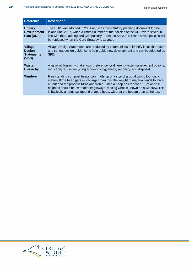
DescriptionReference
The UDP was adopted in 2001 and was the statutory planning document for theIsland until 2007, when a limited number of the policies of the UDP were saved in
UnitaryDevelopmentPlan (UDP) line with the Planning and Compulsory Purchase Act 2004. These saved policies will
be replaced when the Core Strategy is adopted.
Village Design Statements are produced by communities to identify local characterand set out design guidance to help guide new development and can be adopted asSPD.
VillageDesignStatements(VDS)
A national hierarchy that shows preference for different waste management options:reduction; re-use; recycling & composting; energy recovery; and disposal.
WasteHierarchy
Free standing compost heaps can made up of a size of around two to four cubicmetres. If the heap gets much larger than this, the weight of material tends to force
Windrow
air out and the process turns anaerobic. Once a heap has reached 1.5m or so inheight, it should be extended lengthways, making what is known as a windrow. Thisis basically a long, low mound shaped heap, wider at the bottom than at the top.
Isle of Wight CouncilProposed Submission Core Strategy April 2011 TRACKED CHANGES VERSION224
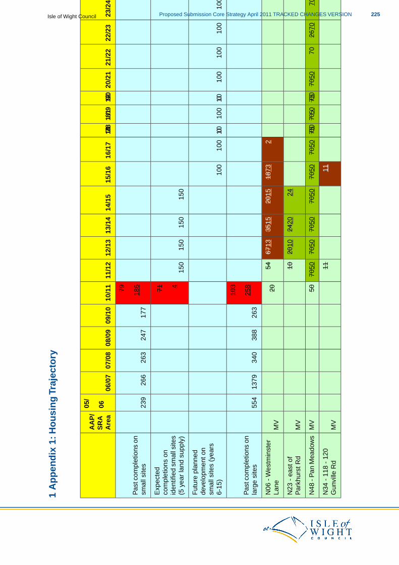
1 A
pp
end
ix 1
: Ho
usi
ng
Tra
ject
ory
26/2
725
/26
24/2
523
/24
22/2
321
/22
20/2
119/
2018
/1917/
1816
/17
15/1
614
/15
13/1
412
/13
11/1
210
/11
09/1
008
/09
07/0
806
/07
05/
AA
P/
SR
A06
Are
a
79
177
247
263
266
239
Pas
t com
plet
ions
on
smal
l site
s18
6
150
150
150
150
71E
xpec
ted
com
plet
ions
on
4id
entif
ied
smal
l site
s(5
yea
r la
nd s
uppl
y)
100
100
100
100
100
100
100
100
100
100
100
100
Fut
ure
plan
ned
deve
lopm
ent o
nsm
all s
ites
(yea
rs6-
15)
103
263
388
340
1379
554
Pas
t com
plet
ions
on
larg
e si
tes
258
218
7320
1535
1567
1354
20M
VN
06 -
Wes
tmin
ster
Lane
2424
2020
1010
MV
N23
- e
ast o
fP
arkh
urst
Rd
6670
7026
7070
7050
7050
7050
7050
7050
7050
7050
7050
7050
7050
50M
VN
48 -
Pan
Mea
dow
s
1111
MV
N34
- 1
18 -
120
Gun
ville
Rd
225Proposed Submission Core Strategy April 2011 TRACKED CHANGES VERSIONIsle of Wight Council
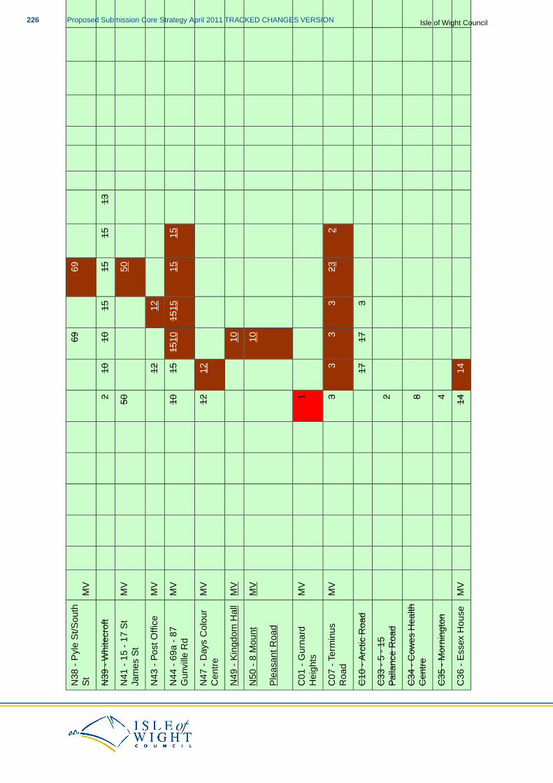
6969
MV
N38
- P
yle
St/S
outh
St
1315
1515
1010
2N
39 -
Whi
tecr
oft
5050
MV
N41
- 1
5 -
17 S
tJa
mes
St
1212
MV
N43
- P
ost O
ffice
1515
1515
1510
1510
MV
N44
- 6
9a -
87
Gun
ville
Rd
1212
MV
N47
- D
ays
Col
our
Cen
tre
10M
VN
49 -
Kin
gdom
Hal
l
10M
VN
50 -
8 M
ount
Ple
asan
t Roa
d
1M
VC
01 -
Gur
nard
Hei
ghts
223
33
33
MV
C07
- T
erm
inus
Roa
d
317
17C
10 -
Arc
tic R
oad
2C
33 -
5 -
15
Pal
lanc
e R
oad
8C
34 -
Cow
es H
ealth
Cen
tre
4C
35 -
Mor
ning
ton
1414
MV
C36
- E
ssex
Hou
se
Isle of Wight CouncilProposed Submission Core Strategy April 2011 TRACKED CHANGES VERSION226
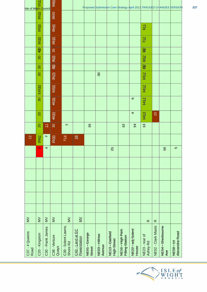
12M
VC
37 -
4 Q
ueen
sR
oad
1533
2030
1030
1030
4030
3030
3011
030
3020
2020
426
MV
C20
- K
ings
ton
117
4M
VC
30 -
Fra
nk J
ames
5965
*50
6035
5535
4539
3535
3525
3525
3525
5255
4535
4030
3025
30M
VC
38 -
Ven
ture
Qua
ys
771
4M
VC
39 -
Sol
ent L
awns
,S
hore
Rd
28M
VC
40 -
Lan
d at
EC
Pow
erst
atio
n
15N
E01
- G
eorg
eS
tree
t
30N
E03
- H
illris
eA
venu
e
21N
E13
- O
akfie
ldH
igh
Str
eet
12N
E16
- H
igh
Par
kF
illin
g S
tatio
n
64
14N
E22
- a
dj S
olen
tH
ouse
611
712
1012
1012
1012
1012
1412
1412
1413
13R
NE
23 -
rea
r of
Ash
ey R
d
20R
NE
52 -
Cla
rk M
asts
16N
E54
- S
herb
ourn
eA
ve
5N
E58
- 1
4A
lexa
ndra
Roa
d
227Proposed Submission Core Strategy April 2011 TRACKED CHANGES VERSIONIsle of Wight Council
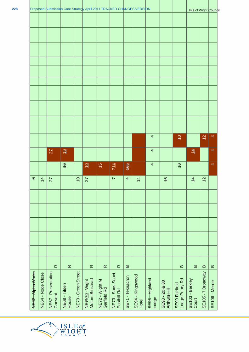
8N
E62
- A
lpha
Wor
ks
14N
E64
- N
ode
Clo
se
2727
RN
E67
- P
rese
ntat
ion
Con
vent
1616
RN
E68
- T
ilden
Hou
se
10N
E70
- G
reen
Str
eet
1027
RN
E71
70 -
Wig
htM
otor
s B
inst
ead
15R
NE
72 -
Wig
ht M
Gar
field
Rd
714
7R
NE
73 -
San
s S
ouci
Eas
thill
Rd
165
4B
SE
71 -
Tek
nacr
on
14S
E94
- K
ings
woo
dH
otel
44
4S
E96
- H
ighl
and
Lodg
e
16S
E98
- 2
0 &
30
Art
hurs
Hill
1010
BS
E99
Fai
rfie
ldLo
dge
Prio
ry R
d
1414
BS
E10
3 -
Ber
kley
Cou
rt
1212
BS
E10
5 - 7
Bro
adw
ay
44
4B
SE
106
- M
errie
Isle of Wight CouncilProposed Submission Core Strategy April 2011 TRACKED CHANGES VERSION228
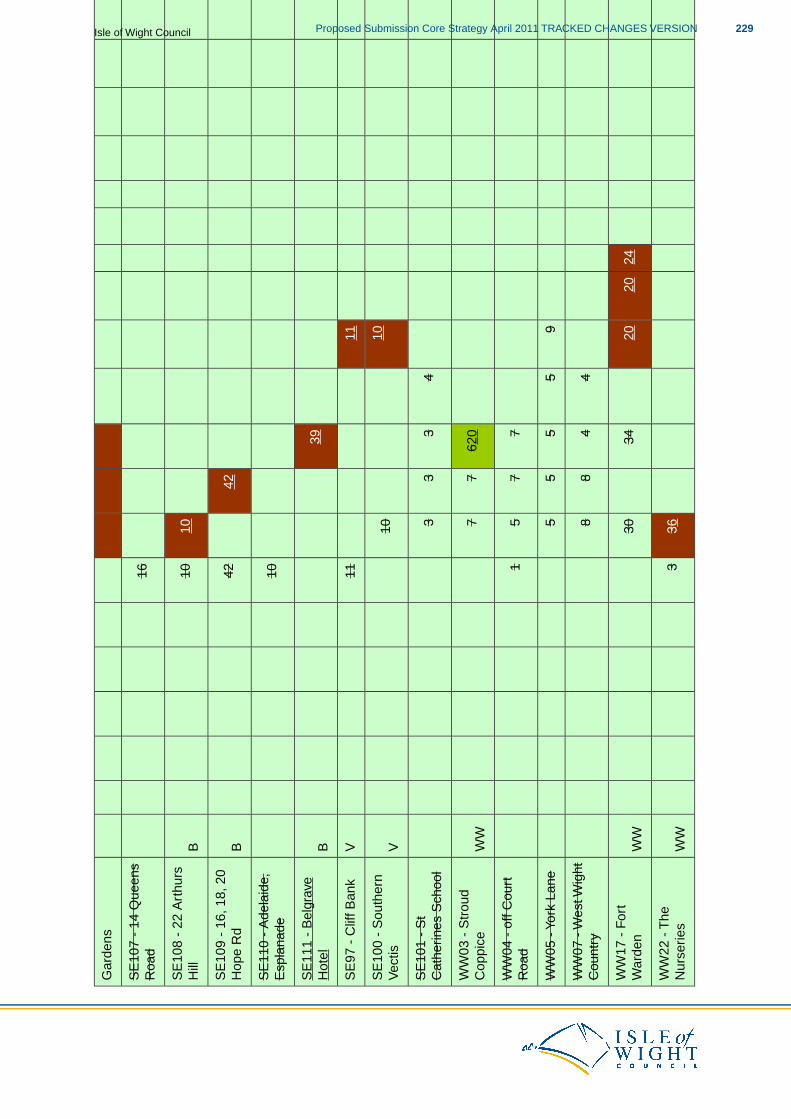
Gar
dens
16S
E10
7 -
14 Q
ueen
sR
oad
1010
BS
E10
8 -
22 A
rthu
rsH
ill
4242
BS
E10
9 -
16, 1
8, 2
0H
ope
Rd
10S
E11
0 -
Ade
laid
e,E
spla
nade
39B
SE
111
- B
elgr
ave
Hot
el
1111
VS
E97
- C
liff B
ank
1010
VS
E10
0 -
Sou
ther
nV
ectis
43
33
SE
101
- S
tC
athe
rines
Sch
ool
620
77
WW
WW
03 -
Str
oud
Cop
pice
77
51
WW
04 -
off
Cou
rtR
oad
95
55
5W
W05
- Y
ork
Lane
44
88
WW
07 -
Wes
t Wig
htC
ount
ry
2420
2034
30W
WW
W17
- F
ort
War
den
363
WW
WW
22 -
The
Nur
serie
s
229Proposed Submission Core Strategy April 2011 TRACKED CHANGES VERSIONIsle of Wight Council
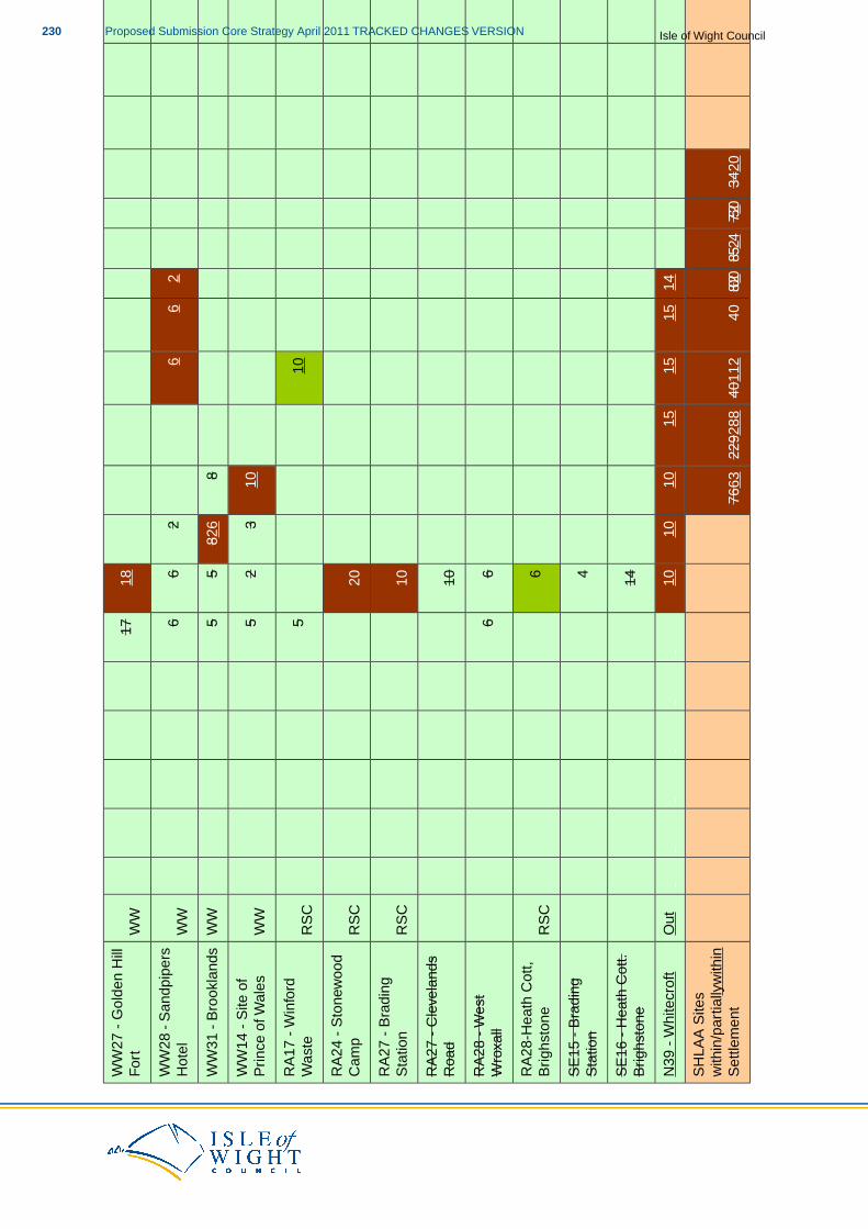
1817
WW
WW
27 -
Gol
den
Hill
For
t
26
62
66
WW
WW
28 -
San
dpip
ers
Hot
el
882
65
5W
WW
W31
- B
rook
land
s
103
25
WW
WW
14 -
Site
of
Prin
ce o
f Wal
es
105
RS
CR
A17
- W
info
rdW
aste
20R
SC
RA
24 -
Sto
new
ood
Cam
p
10R
SC
RA
27 -
Bra
ding
Sta
tion
10R
A27
- C
leve
land
sR
oad
66
RA
28 -
Wes
tW
roxa
ll
6R
SC
RA
28-H
eath
Cot
t,B
righs
tone
4S
E15
- B
radi
ngS
tatio
n
14S
E16
- H
eath
Cot
t.B
righs
tone
1415
1515
1010
10O
utN
39 -
Whi
tecr
oft
3420
7520
8524
8020
4040
112
2292
8876
63
SH
LAA
Site
sw
ithin
/par
tially
with
inS
ettle
men
t
Isle of Wight CouncilProposed Submission Core Strategy April 2011 TRACKED CHANGES VERSION230
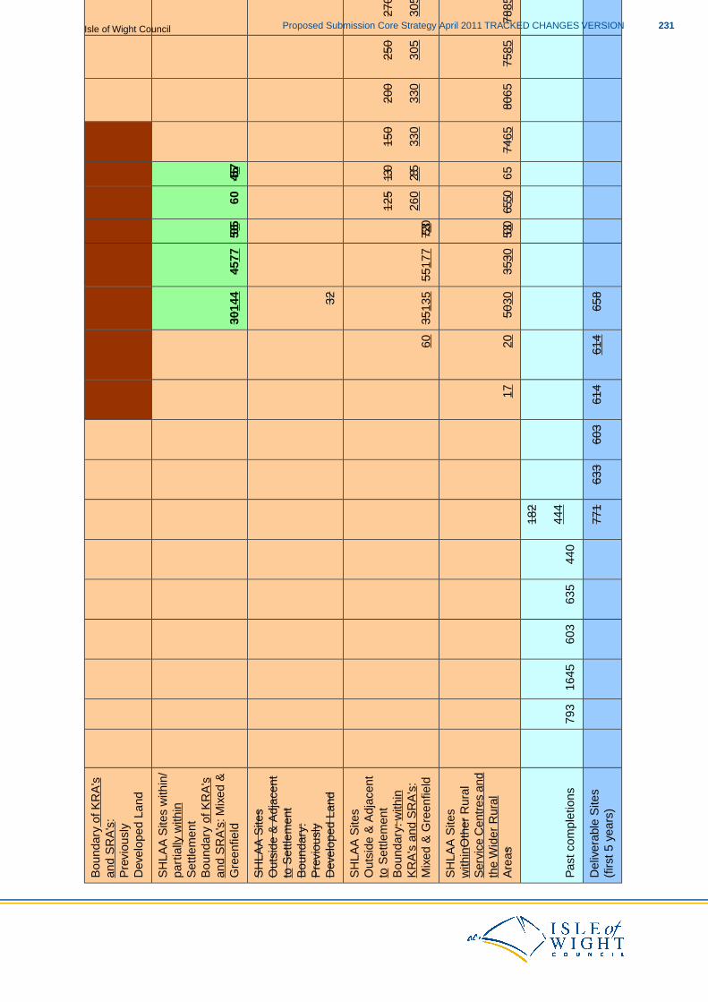
Bou
ndar
y of
KR
A's
and
SR
A's
:P
revi
ousl
yD
evel
oped
Lan
d
4557
6050
6545
7730
144
SH
LAA
Site
s w
ithin
/pa
rtia
lly w
ithin
Set
tlem
ent
Bou
ndar
y of
KR
A's
and
SR
A's
: Mix
ed &
Gre
enfie
ld
32
SH
LAA
Site
sO
utsi
de &
Adj
acen
tto
Set
tlem
ent
Bou
ndar
y:P
revi
ousl
yD
evel
oped
Lan
d
250
280
280
270
250
200
150
130
125
75230
5517
735
135
60
SH
LAA
Site
sO
utsi
de &
Adj
acen
t
163
225
225
305
305
330
330
285
260
to S
ettle
men
tB
ound
ary:
with
inK
RA
's a
nd S
RA
's:
Mix
ed &
Gre
enfie
ld
8510
085
105
8010
578
8575
8580
6574
6565
6550
5030
3530
5030
2017
SH
LAA
Site
sw
ithin
Oth
er R
ural
Ser
vice
Cen
tres
and
the
Wid
er R
ural
Are
as
182
440
635
603
1645
793
Pas
t com
plet
ions
444
658
614
614
603
633
771
Del
iver
able
Site
s(f
irst 5
yea
rs)
231Proposed Submission Core Strategy April 2011 TRACKED CHANGES VERSIONIsle of Wight Council
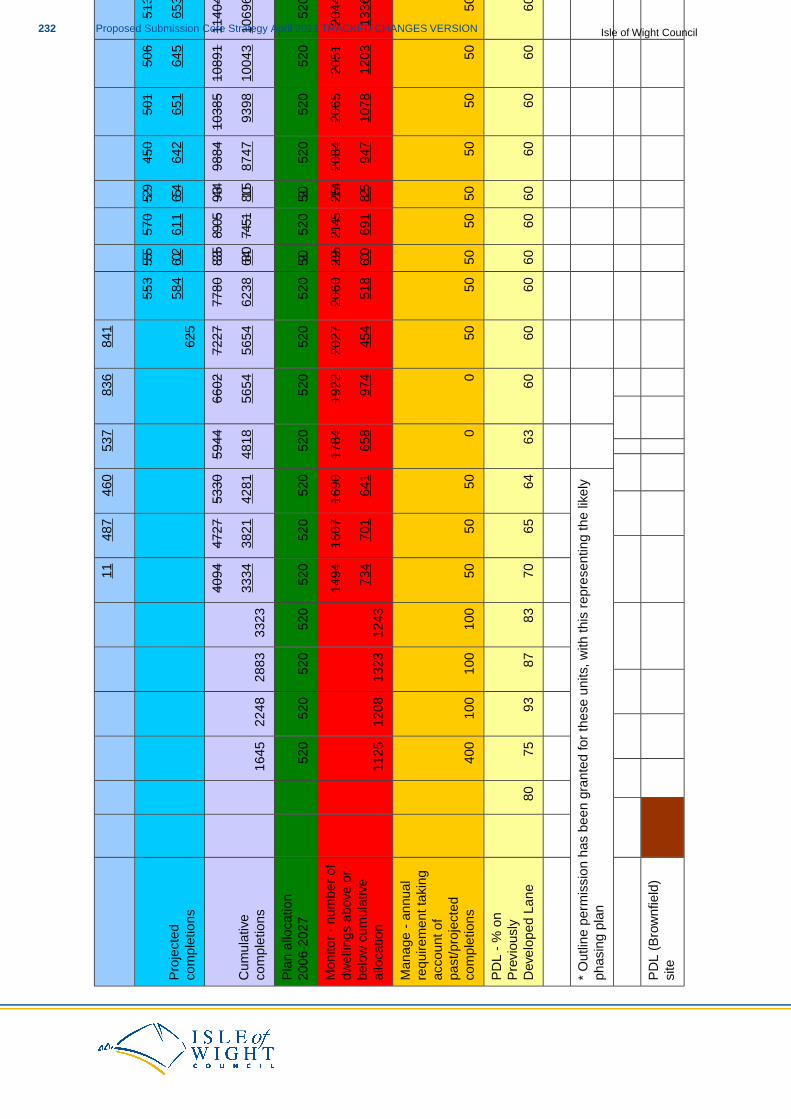
841
836
537
460
487
11
435
465
519
513
506
501
450
529
570
555
553
625
Pro
ject
edco
mpl
etio
ns36
349
650
065
364
565
164
265
461
160
258
4
1282
312
388
1192
311
404
1089
110
385
9884
9434
8905
8335
7780
7227
6602
5944
5330
4727
4094
3323
2883
2248
1645
Cum
ulat
ive
com
plet
ions
1205
511
692
1119
610
696
1004
393
9887
4781
0574
5168
4062
3856
5456
5448
1842
8138
2133
34
520
520
520
520
520
520
520
520
520
520
520
520
520
520
520
520
520
520
520
520
520
Pla
n al
loca
tion
2006
-202
7
1903
1988
2043
2044
2051
2065
2084
2154
2145
2095
2060
2027
1922
1784
1690
1607
1494
1243
1323
1208
1125
Mon
itor
- nu
mbe
r of
dwel
lings
abo
ve o
r11
3512
9213
1613
3612
0310
7894
782
569
160
051
845
497
465
864
170
173
4be
low
cum
ulat
ive
allo
catio
n
5050
5050
5050
5050
5050
5050
00
5050
5010
010
010
040
0
Man
age
- an
nual
requ
irem
ent t
akin
gac
coun
t of
past
/pro
ject
edco
mpl
etio
ns
6060
6060
6060
6060
6060
6060
6063
6465
7083
8793
7580
PD
L -
% o
nP
revi
ousl
yD
evel
oped
Lan
e
* O
utlin
e pe
rmis
sion
has
bee
n gr
ante
d fo
r th
ese
units
, with
this
rep
rese
ntin
g th
e lik
ely
phas
ing
plan
PD
L (B
row
nfie
ld)
site
Isle of Wight CouncilProposed Submission Core Strategy April 2011 TRACKED CHANGES VERSION232
Gre
enfil
ed s
ite
Mix
ed (
mix
of P
DL
& G
reen
field
)
Tabl
e 1.
1
233Proposed Submission Core Strategy April 2011 TRACKED CHANGES VERSIONIsle of Wight Council
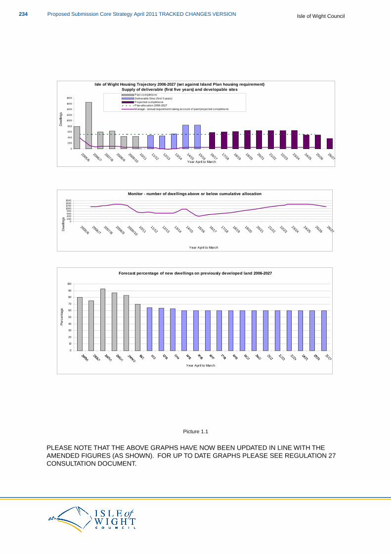
Isle of Wight Housing Trajectory 2006-2027 (set against Island Plan housing requirement)
Supply of deliverable (first five years) and developable sites
0
200
400
600
800
1000
1200
1400
1600
1800
2005/6
2006/7
2007/8
2008/9
2009/10
10/1111/12
12/1313/14
14/1515/16
16/1717/18
18/1919/20
20/2121/22
22/2323/24
24/2525/26
26/27Year April to March
Dw
ellin
gs
Past completionsDeliverable Sites (first 5 years)Pro jected completionsPlan allocation 2006-2027M anage - annual requirement taking account o f past/pro jected completions
Monitor - number of dwellings above or below cumulative allocation
0200400600800
1000120014001600
2005/6
2006/7
2007/8
2008/9
2009/10
10/1111/12
12/1313/14
14/1515/16
16/1717/18
18/1919/20
20/2121/22
22/2323/24
24/2525/26
26/27
Year April to March
Dw
ellin
gs
Forecast percentage of new dwellings on previously developed land 2006-2027
0
10
20
30
40
50
60
70
80
90
100
Year April to March
Perc
enta
ge
Picture 1.1
PLEASE NOTE THAT THE ABOVE GRAPHS HAVE NOW BEEN UPDATED IN LINE WITH THEAMENDED FIGURES (AS SHOWN). FOR UP TO DATE GRAPHS PLEASE SEE REGULATION 27CONSULTATION DOCUMENT.
Isle of Wight CouncilProposed Submission Core Strategy April 2011 TRACKED CHANGES VERSION234
2 Appendix 2: National Development Management Policies
PPS4: Economic Development
National Development Management policies relating to this topic are:
EC10: Determining planning applications for economic development.
EC11: Determining planning applications for economic development (other than main town centreuses) not in accordance with an up to date development plan.
EC12: Determining planning applications for economic development in rural areas.
EC13: Determining planning applications affecting shops and services in local centres and villages.
EC14: Supporting evidence for planning applications for main town centre uses.
EC15: The consideration of sequential assessments for planning applications for main town centreuses that are not in a centre and not in accordance with an up to date development plan.
EC16: The impact assessment for planning applications for main town centre uses that are not ina centre and not in accordance with an up to date development plan.
EC17: The consideration of planning applications for development of main town centre uses not ina centre and not in accordance with an up to date development plan.
EC18: Application of car parking standards for non-residential development.
EC19: The effective use of conditions for main town centre uses.
PPS25: Supplement: Development and Coastal Change
National Development Management policies relating to this topic are:
DCC4: Evidence requirements for validation of planning applications in the Coastal ChangeManagement Areas.
DCC5: Policy principles guiding the consideration of applications for development in Coastal ChangeManagement Areas.
Draft PPS: Planning for a Natural and Health Environment
Emerging National Development Management policies relating to this topic are:
NE8: Policy principles guiding the determination of applications in relation to the natural environment.
NE9: Policy principles relating to the maintenance of an adequate supply of open space, greeninfrastructure, sports, recreational and play facilities.
NE10: Policy principles guiding the determination of applications affecting playing fields.
NE11: The consideration of applications for floodlighting for sports and recreational facilities.
NE12: Proposals for sport and recreation requiring natural features and water.
235Proposed Submission Core Strategy April 2011 TRACKED CHANGES VERSIONIsle of Wight Council

NE13: Sport and recreation provision in nationally designated areas.
NE14: Proposals for major sports development and mixed use sport and recreational facilities.
Isle of Wight CouncilProposed Submission Core Strategy April 2011 TRACKED CHANGES VERSION236
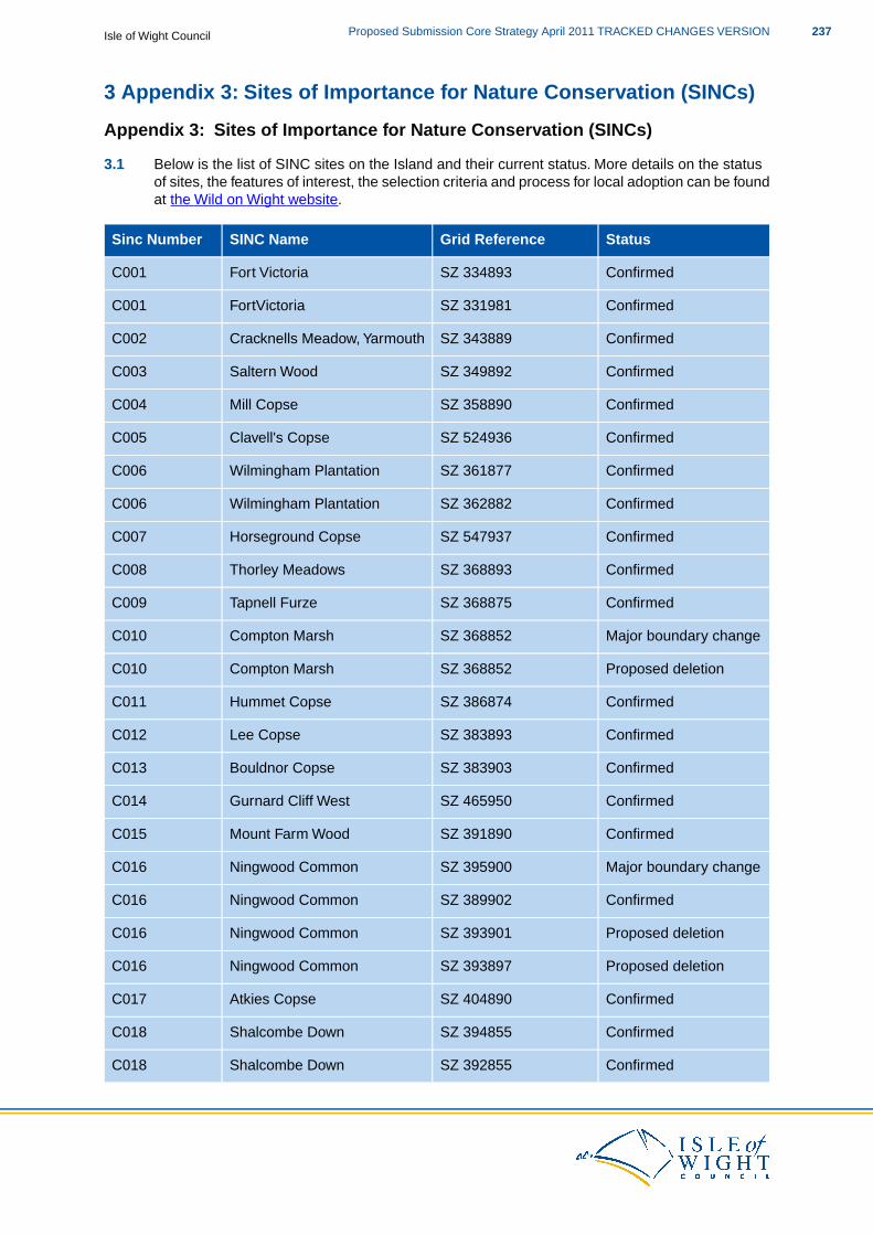
3 Appendix 3: Sites of Importance for Nature Conservation (SINCs)
Appendix 3: Sites of Importance for Nature Conservation (SINCs)
3.1 Below is the list of SINC sites on the Island and their current status. More details on the statusof sites, the features of interest, the selection criteria and process for local adoption can be foundat the Wild on Wight website.
StatusGrid ReferenceSINC NameSinc Number
ConfirmedSZ 334893Fort VictoriaC001
ConfirmedSZ 331981FortVictoriaC001
ConfirmedSZ 343889Cracknells Meadow, YarmouthC002
ConfirmedSZ 349892Saltern WoodC003
ConfirmedSZ 358890Mill CopseC004
ConfirmedSZ 524936Clavell's CopseC005
ConfirmedSZ 361877Wilmingham PlantationC006
ConfirmedSZ 362882Wilmingham PlantationC006
ConfirmedSZ 547937Horseground CopseC007
ConfirmedSZ 368893Thorley MeadowsC008
ConfirmedSZ 368875Tapnell FurzeC009
Major boundary changeSZ 368852Compton MarshC010
Proposed deletionSZ 368852Compton MarshC010
ConfirmedSZ 386874Hummet CopseC011
ConfirmedSZ 383893Lee CopseC012
ConfirmedSZ 383903Bouldnor CopseC013
ConfirmedSZ 465950Gurnard Cliff WestC014
ConfirmedSZ 391890Mount Farm WoodC015
Major boundary changeSZ 395900Ningwood CommonC016
ConfirmedSZ 389902Ningwood CommonC016
Proposed deletionSZ 393901Ningwood CommonC016
Proposed deletionSZ 393897Ningwood CommonC016
ConfirmedSZ 404890Atkies CopseC017
ConfirmedSZ 394855Shalcombe DownC018
ConfirmedSZ 392855Shalcombe DownC018
237Proposed Submission Core Strategy April 2011 TRACKED CHANGES VERSIONIsle of Wight Council
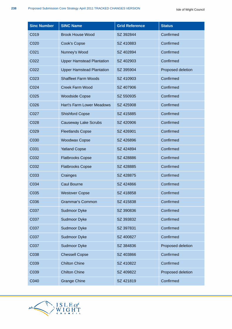
StatusGrid ReferenceSINC NameSinc Number
ConfirmedSZ 392844Brook House WoodC019
ConfirmedSZ 410883Cook's CopseC020
ConfirmedSZ 402894Nunney's WoodC021
ConfirmedSZ 402903Upper Hamstead PlantationC022
Proposed deletionSZ 395904Upper Hamstead PlantationC022
ConfirmedSZ 410903Shalfleet Farm WoodsC023
ConfirmedSZ 407906Creek Farm WoodC024
ConfirmedSZ 550935Woodside CopseC025
ConfirmedSZ 425908Hart's Farm Lower MeadowsC026
ConfirmedSZ 415885Shishford CopseC027
ConfirmedSZ 420906Causeway Lake ScrubsC028
ConfirmedSZ 426901Fleetlands CopseC029
ConfirmedSZ 426896Woodwax CopseC030
ConfirmedSZ 424894Yatland CopseC031
ConfirmedSZ 428886Flatbrooks CopseC032
ConfirmedSZ 428885Flatbrooks CopseC032
ConfirmedSZ 428875CraingesC033
ConfirmedSZ 424866Caul BourneC034
ConfirmedSZ 418858Westover CopseC035
ConfirmedSZ 415838Grammar's CommonC036
ConfirmedSZ 390836Sudmoor DykeC037
ConfirmedSZ 393832Sudmoor DykeC037
ConfirmedSZ 397831Sudmoor DykeC037
ConfirmedSZ 400827Sudmoor DykeC037
Proposed deletionSZ 384836Sudmoor DykeC037
ConfirmedSZ 403866Chessell CopseC038
ConfirmedSZ 410822Chilton ChineC039
Proposed deletionSZ 409822Chilton ChineC039
ConfirmedSZ 421819Grange ChineC040
Isle of Wight CouncilProposed Submission Core Strategy April 2011 TRACKED CHANGES VERSION238
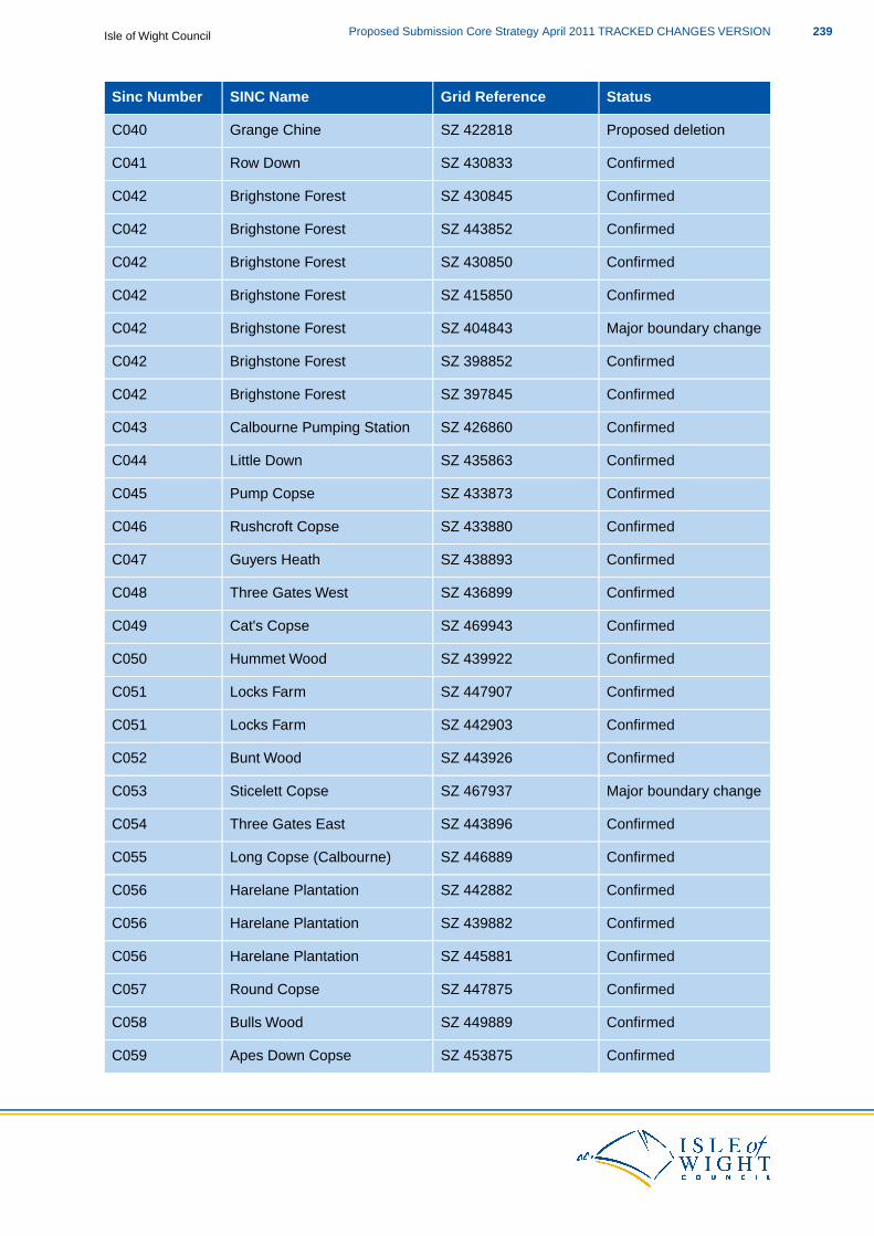
StatusGrid ReferenceSINC NameSinc Number
Proposed deletionSZ 422818Grange ChineC040
ConfirmedSZ 430833Row DownC041
ConfirmedSZ 430845Brighstone ForestC042
ConfirmedSZ 443852Brighstone ForestC042
ConfirmedSZ 430850Brighstone ForestC042
ConfirmedSZ 415850Brighstone ForestC042
Major boundary changeSZ 404843Brighstone ForestC042
ConfirmedSZ 398852Brighstone ForestC042
ConfirmedSZ 397845Brighstone ForestC042
ConfirmedSZ 426860Calbourne Pumping StationC043
ConfirmedSZ 435863Little DownC044
ConfirmedSZ 433873Pump CopseC045
ConfirmedSZ 433880Rushcroft CopseC046
ConfirmedSZ 438893Guyers HeathC047
ConfirmedSZ 436899Three Gates WestC048
ConfirmedSZ 469943Cat's CopseC049
ConfirmedSZ 439922Hummet WoodC050
ConfirmedSZ 447907Locks FarmC051
ConfirmedSZ 442903Locks FarmC051
ConfirmedSZ 443926Bunt WoodC052
Major boundary changeSZ 467937Sticelett CopseC053
ConfirmedSZ 443896Three Gates EastC054
ConfirmedSZ 446889Long Copse (Calbourne)C055
ConfirmedSZ 442882Harelane PlantationC056
ConfirmedSZ 439882Harelane PlantationC056
ConfirmedSZ 445881Harelane PlantationC056
ConfirmedSZ 447875Round CopseC057
ConfirmedSZ 449889Bulls WoodC058
ConfirmedSZ 453875Apes Down CopseC059
239Proposed Submission Core Strategy April 2011 TRACKED CHANGES VERSIONIsle of Wight Council
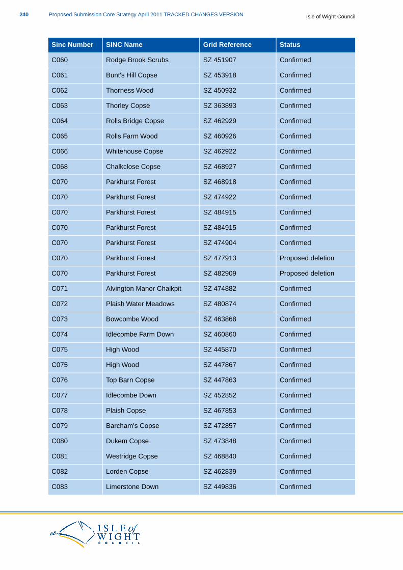
StatusGrid ReferenceSINC NameSinc Number
ConfirmedSZ 451907Rodge Brook ScrubsC060
ConfirmedSZ 453918Bunt's Hill CopseC061
ConfirmedSZ 450932Thorness WoodC062
ConfirmedSZ 363893Thorley CopseC063
ConfirmedSZ 462929Rolls Bridge CopseC064
ConfirmedSZ 460926Rolls Farm WoodC065
ConfirmedSZ 462922Whitehouse CopseC066
ConfirmedSZ 468927Chalkclose CopseC068
ConfirmedSZ 468918Parkhurst ForestC070
ConfirmedSZ 474922Parkhurst ForestC070
ConfirmedSZ 484915Parkhurst ForestC070
ConfirmedSZ 484915Parkhurst ForestC070
ConfirmedSZ 474904Parkhurst ForestC070
Proposed deletionSZ 477913Parkhurst ForestC070
Proposed deletionSZ 482909Parkhurst ForestC070
ConfirmedSZ 474882Alvington Manor ChalkpitC071
ConfirmedSZ 480874Plaish Water MeadowsC072
ConfirmedSZ 463868Bowcombe WoodC073
ConfirmedSZ 460860Idlecombe Farm DownC074
ConfirmedSZ 445870High WoodC075
ConfirmedSZ 447867High WoodC075
ConfirmedSZ 447863Top Barn CopseC076
ConfirmedSZ 452852Idlecombe DownC077
ConfirmedSZ 467853Plaish CopseC078
ConfirmedSZ 472857Barcham's CopseC079
ConfirmedSZ 473848Dukem CopseC080
ConfirmedSZ 468840Westridge CopseC081
ConfirmedSZ 462839Lorden CopseC082
ConfirmedSZ 449836Limerstone DownC083
Isle of Wight CouncilProposed Submission Core Strategy April 2011 TRACKED CHANGES VERSION240
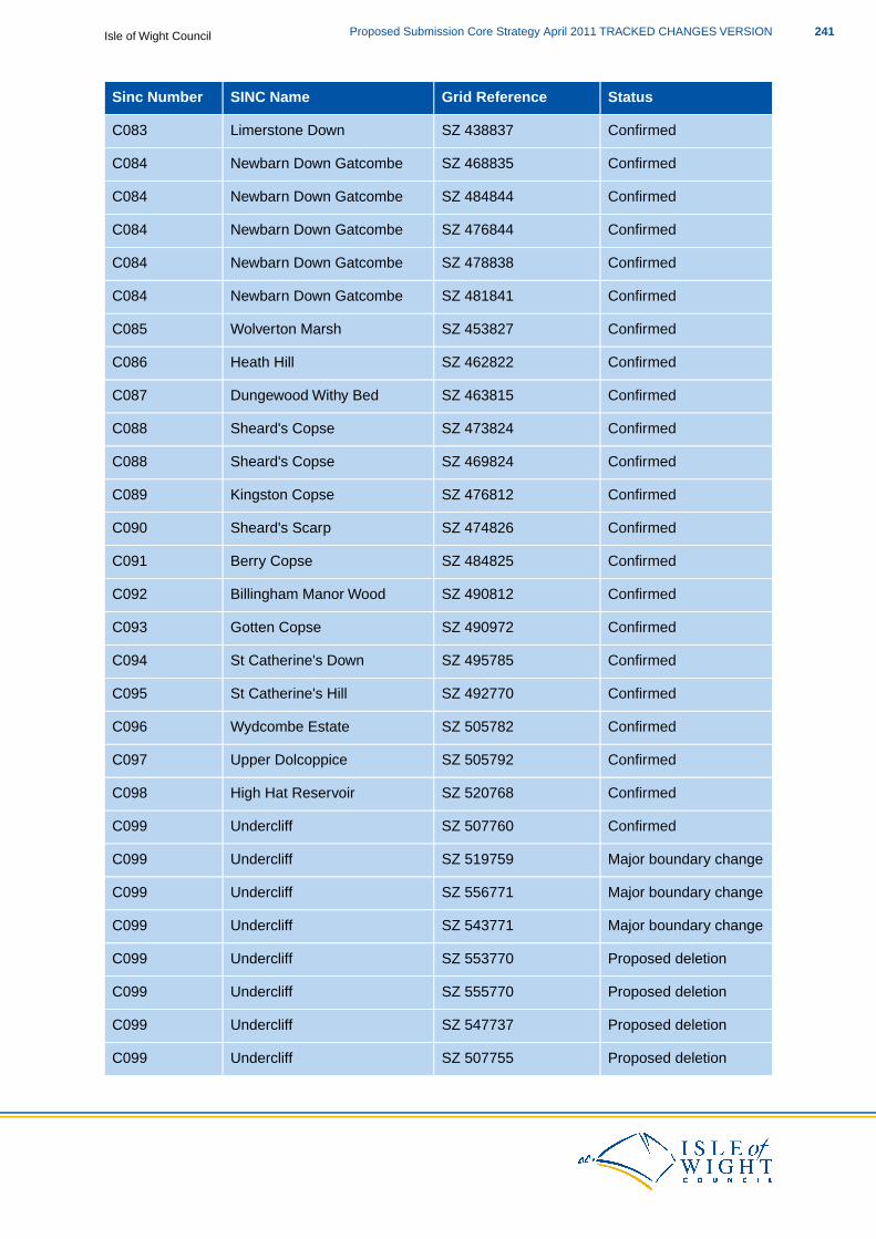
StatusGrid ReferenceSINC NameSinc Number
ConfirmedSZ 438837Limerstone DownC083
ConfirmedSZ 468835Newbarn Down GatcombeC084
ConfirmedSZ 484844Newbarn Down GatcombeC084
ConfirmedSZ 476844Newbarn Down GatcombeC084
ConfirmedSZ 478838Newbarn Down GatcombeC084
ConfirmedSZ 481841Newbarn Down GatcombeC084
ConfirmedSZ 453827Wolverton MarshC085
ConfirmedSZ 462822Heath HillC086
ConfirmedSZ 463815Dungewood Withy BedC087
ConfirmedSZ 473824Sheard's CopseC088
ConfirmedSZ 469824Sheard's CopseC088
ConfirmedSZ 476812Kingston CopseC089
ConfirmedSZ 474826Sheard's ScarpC090
ConfirmedSZ 484825Berry CopseC091
ConfirmedSZ 490812Billingham Manor WoodC092
ConfirmedSZ 490972Gotten CopseC093
ConfirmedSZ 495785St Catherine's DownC094
ConfirmedSZ 492770St Catherine's HillC095
ConfirmedSZ 505782Wydcombe EstateC096
ConfirmedSZ 505792Upper DolcoppiceC097
ConfirmedSZ 520768High Hat ReservoirC098
ConfirmedSZ 507760UndercliffC099
Major boundary changeSZ 519759UndercliffC099
Major boundary changeSZ 556771UndercliffC099
Major boundary changeSZ 543771UndercliffC099
Proposed deletionSZ 553770UndercliffC099
Proposed deletionSZ 555770UndercliffC099
Proposed deletionSZ 547737UndercliffC099
Proposed deletionSZ 507755UndercliffC099
241Proposed Submission Core Strategy April 2011 TRACKED CHANGES VERSIONIsle of Wight Council
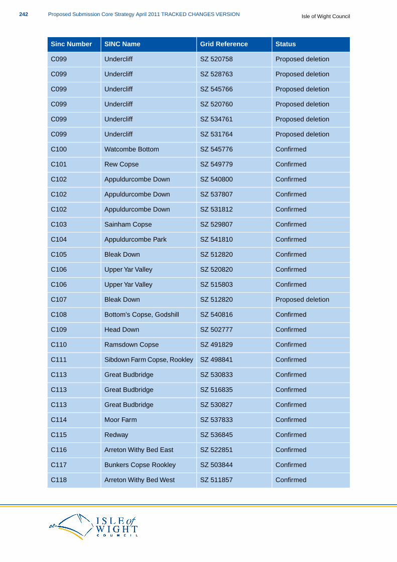
StatusGrid ReferenceSINC NameSinc Number
Proposed deletionSZ 520758UndercliffC099
Proposed deletionSZ 528763UndercliffC099
Proposed deletionSZ 545766UndercliffC099
Proposed deletionSZ 520760UndercliffC099
Proposed deletionSZ 534761UndercliffC099
Proposed deletionSZ 531764UndercliffC099
ConfirmedSZ 545776Watcombe BottomC100
ConfirmedSZ 549779Rew CopseC101
ConfirmedSZ 540800Appuldurcombe DownC102
ConfirmedSZ 537807Appuldurcombe DownC102
ConfirmedSZ 531812Appuldurcombe DownC102
ConfirmedSZ 529807Sainham CopseC103
ConfirmedSZ 541810Appuldurcombe ParkC104
ConfirmedSZ 512820Bleak DownC105
ConfirmedSZ 520820Upper Yar ValleyC106
ConfirmedSZ 515803Upper Yar ValleyC106
Proposed deletionSZ 512820Bleak DownC107
ConfirmedSZ 540816Bottom's Copse, GodshillC108
ConfirmedSZ 502777Head DownC109
ConfirmedSZ 491829Ramsdown CopseC110
ConfirmedSZ 498841Sibdown Farm Copse, RookleyC111
ConfirmedSZ 530833Great BudbridgeC113
ConfirmedSZ 516835Great BudbridgeC113
ConfirmedSZ 530827Great BudbridgeC113
ConfirmedSZ 537833Moor FarmC114
ConfirmedSZ 536845RedwayC115
ConfirmedSZ 522851Arreton Withy Bed EastC116
ConfirmedSZ 503844Bunkers Copse RookleyC117
ConfirmedSZ 511857Arreton Withy Bed WestC118
Isle of Wight CouncilProposed Submission Core Strategy April 2011 TRACKED CHANGES VERSION242
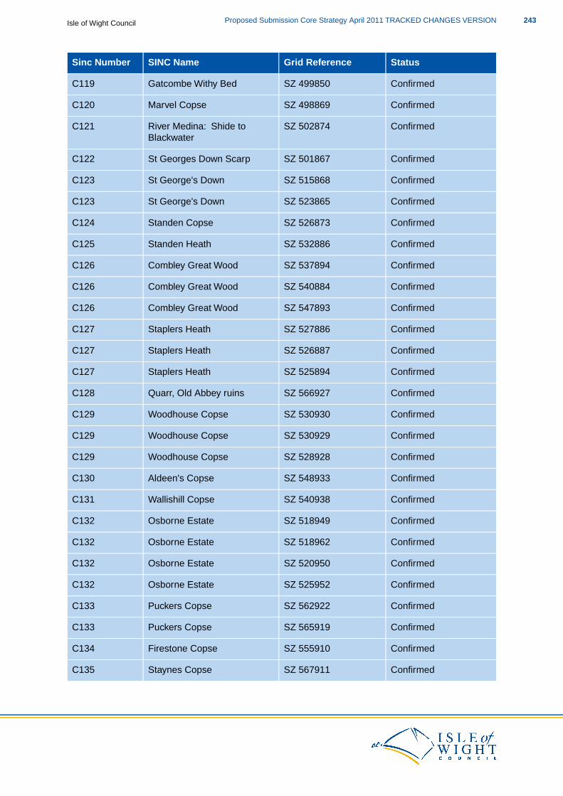
StatusGrid ReferenceSINC NameSinc Number
ConfirmedSZ 499850Gatcombe Withy BedC119
ConfirmedSZ 498869Marvel CopseC120
ConfirmedSZ 502874River Medina: Shide toC121Blackwater
ConfirmedSZ 501867St Georges Down ScarpC122
ConfirmedSZ 515868St George's DownC123
ConfirmedSZ 523865St George's DownC123
ConfirmedSZ 526873Standen CopseC124
ConfirmedSZ 532886Standen HeathC125
ConfirmedSZ 537894Combley Great WoodC126
ConfirmedSZ 540884Combley Great WoodC126
ConfirmedSZ 547893Combley Great WoodC126
ConfirmedSZ 527886Staplers HeathC127
ConfirmedSZ 526887Staplers HeathC127
ConfirmedSZ 525894Staplers HeathC127
ConfirmedSZ 566927Quarr, Old Abbey ruinsC128
ConfirmedSZ 530930Woodhouse CopseC129
ConfirmedSZ 530929Woodhouse CopseC129
ConfirmedSZ 528928Woodhouse CopseC129
ConfirmedSZ 548933Aldeen's CopseC130
ConfirmedSZ 540938Wallishill CopseC131
ConfirmedSZ 518949Osborne EstateC132
ConfirmedSZ 518962Osborne EstateC132
ConfirmedSZ 520950Osborne EstateC132
ConfirmedSZ 525952Osborne EstateC132
ConfirmedSZ 562922Puckers CopseC133
ConfirmedSZ 565919Puckers CopseC133
ConfirmedSZ 555910Firestone CopseC134
ConfirmedSZ 567911Staynes CopseC135
243Proposed Submission Core Strategy April 2011 TRACKED CHANGES VERSIONIsle of Wight Council

StatusGrid ReferenceSINC NameSinc Number
ConfirmedSZ 562898KittenocksC136
ConfirmedSZ 576905Stroud WoodC137
ConfirmedSZ 577897Ashey CemeteryC138
ConfirmedSZ 567894Rowlands WoodC139
ConfirmedSZ 570896Rowlands WoodC139
ConfirmedSZ 553893Walkershill CopseC140
ConfirmedSZ 553890Walkershill CopseC140
ConfirmedSZ 557887Walkershill CopseC140
ConfirmedSZ 560894Walkershill CopseC140
ConfirmedSZ 559884Walkershill CopseC140
ConfirmedSZ 561886Walkershill CopseC140
ConfirmedSZ 353878Backet's PlantationC141
ConfirmedSZ 353874Backet's CopseC142
ConfirmedSZ 557876Mersley Down NorthC143
ConfirmedSZ 555872Mersley Chalk PitC144
ConfirmedSZ 561872Mersley Chalk PitC144
ConfirmedSZ 417889Fry's CopseC145
ConfirmedSZ 573872Knighton DownC146
ConfirmedSZ 563870Knighton West WoodC147
ConfirmedSZ 573870Knighton East WoodC148
ConfirmedSZ 563857Lynch CopseC149
ConfirmedSZ 573878Ashey DownC150
ConfirmedSZ 580879Ashey DownC150
ConfirmedSZ 565858Newchurch MarshesC151
ConfirmedSZ 560860Newchurch MarshesC151
ConfirmedSZ 555856Newchurch MarshesC151
ConfirmedSZ 549852Horringford Withy BedC152
ConfirmedSZ 340855Freshwater Bay CliffsC153
ConfirmedSZ 469950Hornhill CopseC154
Isle of Wight CouncilProposed Submission Core Strategy April 2011 TRACKED CHANGES VERSION244
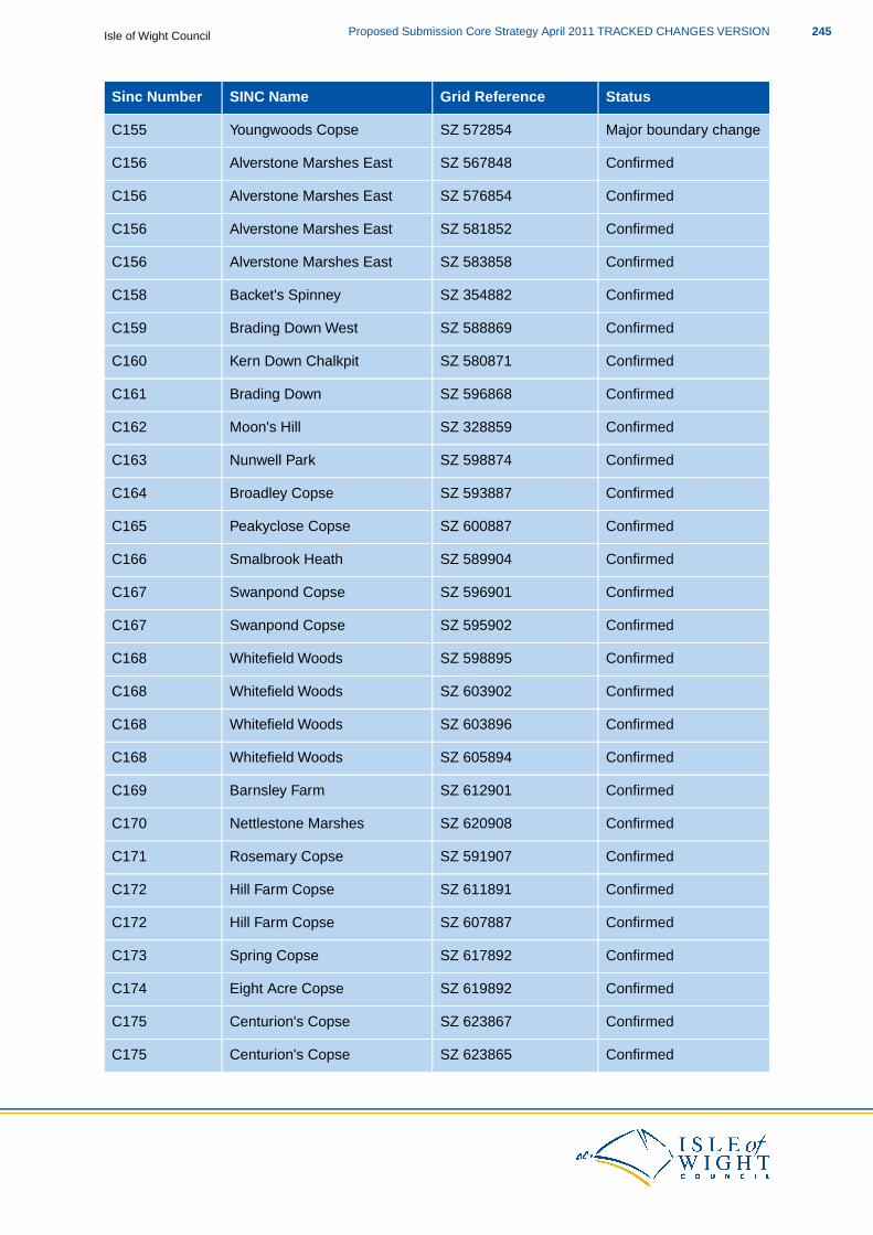
StatusGrid ReferenceSINC NameSinc Number
Major boundary changeSZ 572854Youngwoods CopseC155
ConfirmedSZ 567848Alverstone Marshes EastC156
ConfirmedSZ 576854Alverstone Marshes EastC156
ConfirmedSZ 581852Alverstone Marshes EastC156
ConfirmedSZ 583858Alverstone Marshes EastC156
ConfirmedSZ 354882Backet's SpinneyC158
ConfirmedSZ 588869Brading Down WestC159
ConfirmedSZ 580871Kern Down ChalkpitC160
ConfirmedSZ 596868Brading DownC161
ConfirmedSZ 328859Moon's HillC162
ConfirmedSZ 598874Nunwell ParkC163
ConfirmedSZ 593887Broadley CopseC164
ConfirmedSZ 600887Peakyclose CopseC165
ConfirmedSZ 589904Smalbrook HeathC166
ConfirmedSZ 596901Swanpond CopseC167
ConfirmedSZ 595902Swanpond CopseC167
ConfirmedSZ 598895Whitefield WoodsC168
ConfirmedSZ 603902Whitefield WoodsC168
ConfirmedSZ 603896Whitefield WoodsC168
ConfirmedSZ 605894Whitefield WoodsC168
ConfirmedSZ 612901Barnsley FarmC169
ConfirmedSZ 620908Nettlestone MarshesC170
ConfirmedSZ 591907Rosemary CopseC171
ConfirmedSZ 611891Hill Farm CopseC172
ConfirmedSZ 607887Hill Farm CopseC172
ConfirmedSZ 617892Spring CopseC173
ConfirmedSZ 619892Eight Acre CopseC174
ConfirmedSZ 623867Centurion's CopseC175
ConfirmedSZ 623865Centurion's CopseC175
245Proposed Submission Core Strategy April 2011 TRACKED CHANGES VERSIONIsle of Wight Council
StatusGrid ReferenceSINC NameSinc Number
ConfirmedSZ 625860Bembridge DownC177
ConfirmedSZ 617860Bembridge DownC177
ConfirmedSZ 639865Breaches CopseC178
ConfirmedSZ 540875Arreton Down NorthC179
ConfirmedSZ 565816Apse Castle WoodC180
ConfirmedSZ 598906PennyfeathersC181
ConfirmedSZ 568925Quarr WoodC182
ConfirmedSZ 570925Quarr WoodC182
ConfirmedSZ 412869Calbourne MeadowsC183
ConfirmedSZ 380841Compton Grange MarshC184
ConfirmedSZ 430871Newbarn CopseC185
ConfirmedSZ 516875Wroxall Bottom CopseC186
ConfirmedSZ 327875Fort Warden FieldsC187
ConfirmedSZ 339878Golden HillC188
ConfirmedSZ 342872Stroud CoppiceC189
ConfirmedSZ 460833Mount AraratC190
ConfirmedSZ 416896Shalfleet MillC191
ConfirmedSZ 413893Shalfleet ChurchyardC192
ConfirmedSZ 423837Buddle BrookC193
ConfirmedSZ 486912Noke PlantationC194
ConfirmedSZ 482926Ridge CopseC195
ConfirmedSZ 497926Great Werrar WoodC196
ConfirmedSZ 493920Stag CopseC197
ConfirmedSZ 498918Stag Lane PondC198
ConfirmedSZ 501923Little Werrar WoodC199
Major boundary changeSZ 513924Heathfield MeadowsC200
ConfirmedSZ 512914Blackbush CopseC201
ConfirmedSZ 491879Mount JoyC202
ConfirmedSZ 486881Carisbrooke CastleC203
Isle of Wight CouncilProposed Submission Core Strategy April 2011 TRACKED CHANGES VERSION246
StatusGrid ReferenceSINC NameSinc Number
ConfirmedSZ 487878Carisbrooke CastleC203
ConfirmedSZ 488881Carisbrooke Waterworks PondC204
ConfirmedSZ 503887River Medina: ShideC205
ConfirmedSZ 489884Lukley BrookC206
ConfirmedSZ 490885Lukley BrookC206
ConfirmedSZ 514833Bohemia BogC207
ConfirmedSZ 408895Woodside CoppiceC208
ConfirmedSZ 407889Pondclose CoppiceC209
ConfirmedSZ 573927The Keys WoodC210
ConfirmedSZ 583930Ryde House GroundsC211
ConfirmedSZ 578914Dame Anthony's CommonC212
ConfirmedSZ 593913Swanmore MeadowsC213
ConfirmedSZ 602926Ryde Canoe LakeC214
ConfirmedSZ 608922Appley ParkC215
ConfirmedSZ 607907Cothey Bottom CopseC217
ConfirmedSZ 531921Lushington CopseC218
ConfirmedSZ 534914Quarrell's CopseC219
ConfirmedSZ 543918Fernhill WoodC220
ConfirmedSZ 549916The Old Millpond WoottonC221
ConfirmedSZ 555920New CopseC222
ConfirmedSZ 553925Ashlake CopseC223
ConfirmedSZ 638870Steyne WoodC224
ConfirmedSZ 639870Steyne WoodC224
ConfirmedSZ 632897Nodes Point MeadowC225
ConfirmedSZ 634905Priory WoodsC226
ConfirmedSZ 622905Longlands CopseC227
ConfirmedSZ 609860Marshcombe CopseC228
ConfirmedSZ 606861Morton MarshC229
ConfirmedSZ 516930Heathfield CopseC230
247Proposed Submission Core Strategy April 2011 TRACKED CHANGES VERSIONIsle of Wight Council
StatusGrid ReferenceSINC NameSinc Number
ConfirmedSZ 503947East Cowes CemeteryC231
ConfirmedSZ 508964Springhill/Western WoodC232
ConfirmedSZ 513965Springhil/Western WoodC232
ConfirmedSZ 506964Shrape MudsC233
ConfirmedSZ 481963Princes Esplanade WoodC234
ConfirmedSZ 477956Gurnard Cliff EastC235
ConfirmedSZ 473951Gurnard MarshC236
ConfirmedSZ 471952Gurnard MarshC236
ConfirmedSZ 480940Ruffins CopseC237
ConfirmedSZ 474944Ruffins CopseC237
ConfirmedSZ 483934Ward's CopseC238
ConfirmedSZ 494939Simmington CopseC239
ConfirmedSZ 498939Calving Close CopseC240
ConfirmedSZ 495946Cowes Cemetery and WoodsC241
ConfirmedSZ 496947Cowes Cemetery and WoodsC241
ConfirmedSZ 496947Cowes Cemetery and WoodsC241
ConfirmedSZ 496944Cowes Cemetery and WoodsC241
ConfirmedSZ 494935Waterclose CopseC242
ConfirmedSZ 587802Luccombe ChineC243
ConfirmedSZ 585811Luccombe ChineC243
ConfirmedSZ 583794Luccombe ChineC243
ConfirmedSZ 581794Luccombe ChineC243
ConfirmedSZ 564788Wroxall CopseC244
Major boundary changeSZ 569785Ventnor Radar StationC245
ConfirmedSZ 566773Ventnor Eastern CliffsC246
ConfirmedSZ 574777Bonchurch UndercliffC247
ConfirmedSZ 580780Monks BayC248
ConfirmedSZ 527818Godshill ChurchC249
ConfirmedSZ 536858Perreton Down and MarshC250
Isle of Wight CouncilProposed Submission Core Strategy April 2011 TRACKED CHANGES VERSION248
StatusGrid ReferenceSINC NameSinc Number
ConfirmedSZ 536858Perreton Down and MarshC250
ConfirmedSZ 578800Lynch Copse, ShanklinC251
ConfirmedSZ 573809Hungerberry CloseC252
ConfirmedSZ 575814Sibden HillC253
ConfirmedSZ 577815Sibden HillC253
ConfirmedSZ 612913Bullen Cross WoodC254
ConfirmedSZ 572832Ninham/Barton Withy BedC255
ConfirmedSZ 574829Ninham/Barton Withy BedC255
ConfirmedSZ 576827Old Colver Withy BedC256
ConfirmedSZ 578825Landguard Manor Farm CopseC257
ConfirmedSZ 579827Landguard Manor Farm CopseC257
ConfirmedSZ 585830Hilliard's CemeteryC258
ConfirmedSZ 594826Lake CliffsC259
ConfirmedSZ 591822Lake CliffsC259
ConfirmedSZ 588822Lake CliffsC259
ConfirmedSZ 570844Borthwood CopseC260
ConfirmedSZ 584848Sandown Golf CourseC261
ConfirmedSZ 579648Sandown Golf CourseC261
ConfirmedSZ 604850Sandown LevelsC262
ConfirmedSZ 566853Pope's Farm MarshC263
ConfirmedSZ 607873Brading ChurchyardC264
ConfirmedSZ 615881Brading Marshes NorthC265
ConfirmedSZ 498913Dodnor CreekC266
ConfirmedSZ 487834Hollow Lane, ChillertonC267
ConfirmedSZ 594893Whitefield Farm CopseC268
ConfirmedSZ 587865Rowdown CopseC270
ConfirmedSZ 561803St Martin's DownC271
ConfirmedSZ 475787South DownC272
ConfirmedSZ 506924Werrar MeadowC273
249Proposed Submission Core Strategy April 2011 TRACKED CHANGES VERSIONIsle of Wight Council

StatusGrid ReferenceSINC NameSinc Number
ConfirmedSZ 478794Windmill CopseC274
ConfirmedSZ 524912Fattingpark CopseC275
ConfirmedSZ 342896Westhill Meadow, NortonC276
ConfirmedSZ 548793Wroxall Meadow SouthC277
ConfirmedSZ 552788Pitts Farm DownC278
Proposed additionalSZ 412901Shalfleet Farm WoodsPC023
Proposed additionalSZ 486896Kitbridge FarmPC279
Proposed additionalSZ 510931Padmore FieldsPC280
Proposed additionalSZ 329876Colwell CommonPC281
Proposed additionalSZ 375886Thorley ChurchyardPC282
Proposed additionalSZ 554777Ventnor CemeteryPC283
Proposed additionalSZ 509919Island Harbour SaltmarshPC284
Proposed additionalSZ 649878St Luke's Cemetery,PC285Bembridge
Proposed additionalSZ 508900St Paul's Cemetery,NewportPC286
Proposed additionalSZ 324868Turville's Field, TotlandPC287
Proposed additionalSZ 377848High Grange MarshPC288
Proposed additionalSZ 385837Brook FieldPC289
Proposed additionalSZ 322861Lacey's Farm Fields, TolandPC290
Proposed additionalSZ 465817Cranmore WithybedPC291
Proposed additionalSZ 458817Cranmore WithybedPC291
Proposed additionalSZ 478801Corve CopsePC292
Proposed additionalSZ 532909Wootton Common CemeteryPC293
Proposed additionalSZ 625889St Helens Green WestPC294
Proposed additionalSZ 447841Cheverton DownPC295
Proposed additionalSZ 444873AshengrovePC296
Proposed additionalSZ 473906Clamerkin Farm FieldsPC297
Proposed additionalSZ 478933Pallance LanePC298
Proposed additionalSZ 480930Pallance LanePC298
Isle of Wight CouncilProposed Submission Core Strategy April 2011 TRACKED CHANGES VERSION250

StatusGrid ReferenceSINC NameSinc Number
Proposed additionalSZ 499760Niton Radar StationPC299
Proposed additionalSZ 641866Bembidge School LawnPC300
Proposed additionalSZ 618914Westbrook MeadowPC301
Table 3.1
251Proposed Submission Core Strategy April 2011 TRACKED CHANGES VERSIONIsle of Wight Council
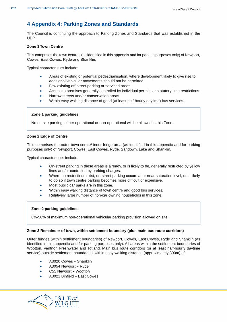
4 Appendix 4: Parking Zones and Standards
The Council is continuing the approach to Parking Zones and Standards that was established in theUDP.
Zone 1 Town Centre
This comprises the town centres (as identified in this appendix and for parking purposes only) of Newport,Cowes, East Cowes, Ryde and Shanklin.
Typical characteristics include:
Areas of existing or potential pedestrianisation, where development likely to give rise toadditional vehicular movements should not be permitted.Few existing off-street parking or serviced areas.Access to premises generally controlled by individual permits or statutory time restrictions.Narrow streets and/or conservation areas.Within easy walking distance of good (at least half-hourly daytime) bus services.
Zone 1 parking guidelines
No on-site parking, either operational or non-operational will be allowed in this Zone.
Zone 2 Edge of Centre
This comprises the outer town centre/ inner fringe area (as identified in this appendix and for parkingpurposes only) of Newport, Cowes, East Cowes, Ryde, Sandown, Lake and Shanklin.
Typical characteristics include:
On-street parking in these areas is already, or is likely to be, generally restricted by yellowlines and/or controlled by parking charges.Where no restrictions exist, on-street parking occurs at or near saturation level, or is likelyto do so if town centre parking becomes more difficult or expensive.Most public car parks are in this zone.Within easy walking distance of town centre and good bus services.Relatively large number of non-car owning households in this zone.
Zone 2 parking guidelines
0%-50% of maximum non-operational vehicular parking provision allowed on site.
Zone 3 Remainder of town, within settlement boundary (plus main bus route corridors)
Outer fringes (within settlement boundaries) of Newport, Cowes, East Cowes, Ryde and Shanklin (asidentified in this appendix and for parking purposes only). All areas within the settlement boundaries ofWootton, Ventnor, Freshwater and Totland. Main bus route corridors (or at least half-hourly daytimeservice) outside settlement boundaries, within easy walking distance (approximately 300m) of:
A3020 Cowes – ShanklinA3054 Newport – RydeC55 Newport – WoottonA3021 Binfield – East Cowes
Isle of Wight CouncilProposed Submission Core Strategy April 2011 TRACKED CHANGES VERSION252

B3330 Ryde – ShanklinB3395 Bembridge – SandownB3340 Nettlestone – Seaview
Typical characteristics include:
On-street parking is generally unrestricted (controls confined to main distributor roads) andis not currently a significant problem.Few public car parks in this zone. Those which do exist are not heavily used outside theholiday season.Reasonable access on foot or cycle to the local town centre shops, schools and othercommunity facilities.Reasonable access to bus services, but these may be less frequent than half-hourly.Large number of car-owning households and private parking spaces in this zone.
Zone 3 parking guidelines
0%-75% of maximum non-operational vehicular parking provision allowed on site.
Zone 4 Rural Areas
All areas not included in Zones 1-3 (as identified in this appendix and for parking purposes only).
Typical characteristics include:
Very few on-street parking restrictions.Accessibility to main town centres relatively difficult except by car.
Zone 4 parking guidelines
Restricting parking in this area is more likely to deter desirable inward investment than encouragethe frequency or availability of public transport in the area. The Council would not wish todisadvantage those in rural areas which are not well served by public transport, and whilst seekingto reduce the amount of car use, will allow a higher level of off-street parking (0-100%) in this Zonewhere public access is poorer and the development would help maintain the rural economy.
Non residential vehicle parking standards (maximum and minimum)
Minimum off-streetcycle parking provision(m2)
Minimum operationalvehicle parkingprovision
Maximum nonoperational off-streetvehicle parkingprovision
DevelopmentCategory
U s eClass
1 per 100Supermarkets <1000 m21 space per 10m2Food StoreA1Shops
1 lorry spaceStaff: 1 space per 100m2
Supermarkets <2500 m2
2 lorry spaces
Superstores >2500 m2
3 lorry spaces
Stores <1000 m21 space per 20m2Non-Food
253Proposed Submission Core Strategy April 2011 TRACKED CHANGES VERSIONIsle of Wight Council
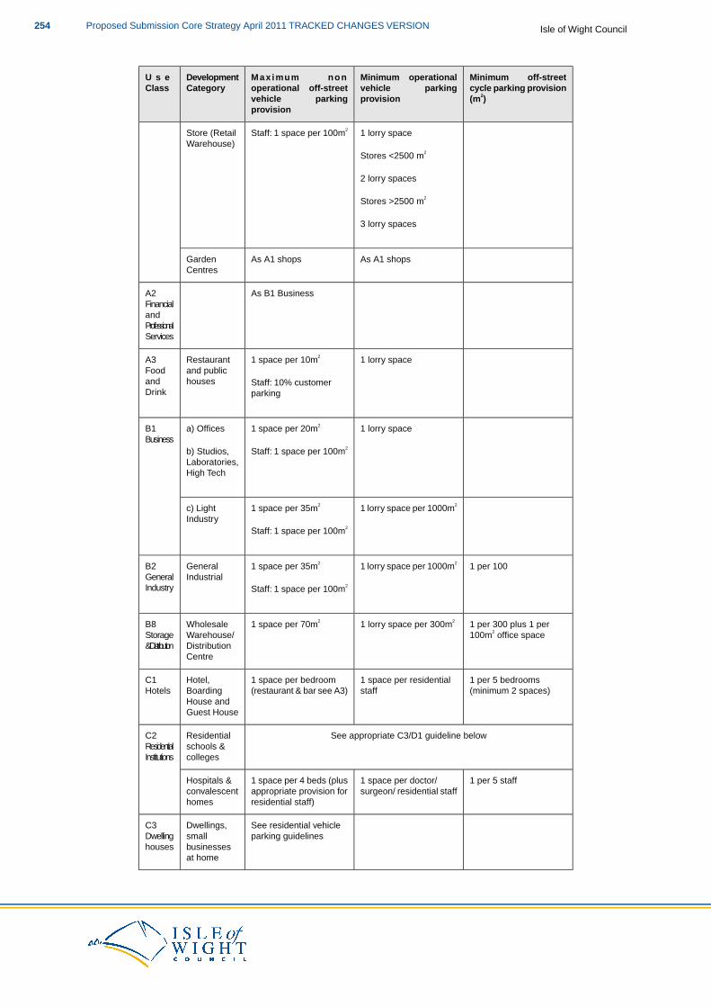
Minimum off-streetcycle parking provision(m2)
Minimum operationalvehicle parkingprovision
Maximum nonoperational off-streetvehicle parkingprovision
DevelopmentCategory
U s eClass
Store (Retail 1 lorry spaceStaff: 1 space per 100m2
Warehouse)Stores <2500 m2
2 lorry spaces
Stores >2500 m2
3 lorry spaces
As A1 shopsAs A1 shopsGardenCentres
As B1 BusinessA2FinancialandProfessionalServices
1 lorry space1 space per 10m2RestaurantA3and publichouses
Foodand Staff: 10% customerDrink parking
1 lorry space1 space per 20m2a) OfficesB1Business
Staff: 1 space per 100m2b) Studios,Laboratories,High Tech
1 lorry space per 1000m21 space per 35m2c) LightIndustry
Staff: 1 space per 100m2
1 per 1001 lorry space per 1000m21 space per 35m2GeneralB2IndustrialGeneral
Industry Staff: 1 space per 100m2
1 per 300 plus 1 per1 lorry space per 300m21 space per 70m2WholesaleB8100m2 office spaceWarehouse/Storage
Distribution&DistributionCentre
1 per 5 bedrooms1 space per residential1 space per bedroomHotel,C1(minimum 2 spaces)staff(restaurant & bar see A3)BoardingHotels
House andGuest House
See appropriate C3/D1 guideline belowResidentialC2schools &ResidentialcollegesInstitutions
1 per 5 staff1 space per doctor/1 space per 4 beds (plusHospitals &surgeon/ residential staffappropriate provision forconvalescent
residential staff)homes
See residential vehicleDwellings,C3parking guidelinessmallDwelling
businesseshousesat home
Isle of Wight CouncilProposed Submission Core Strategy April 2011 TRACKED CHANGES VERSION254
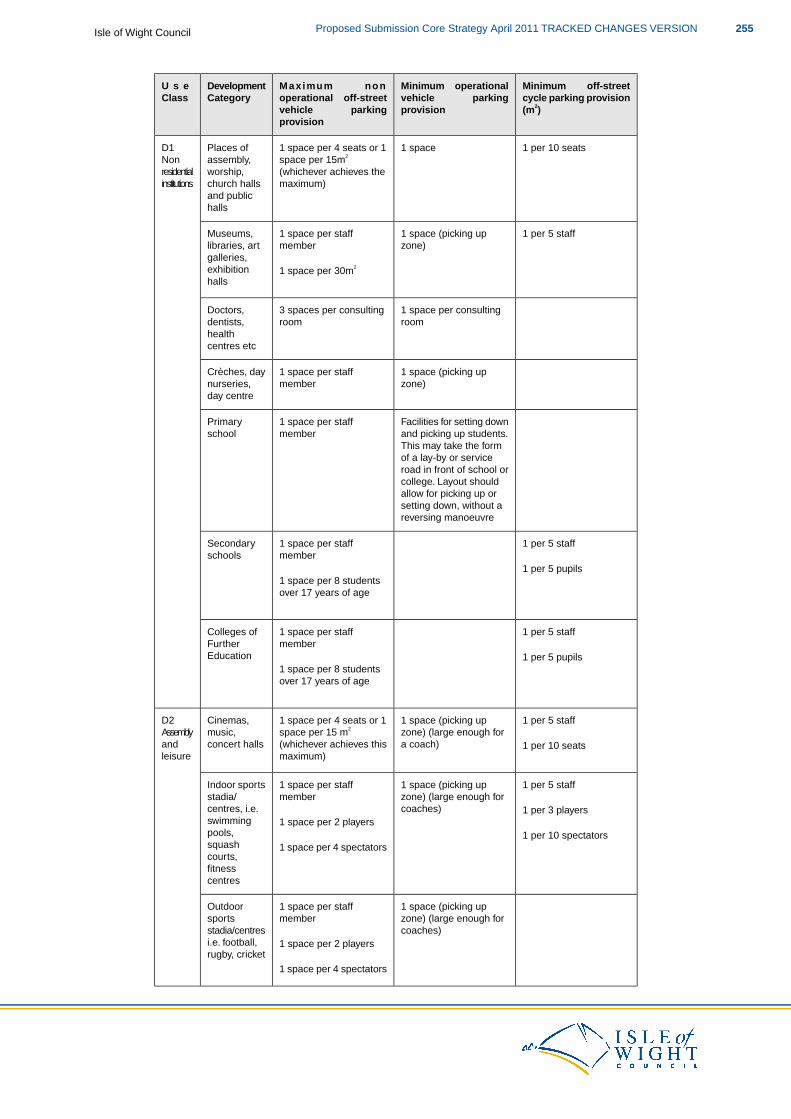
Minimum off-streetcycle parking provision(m2)
Minimum operationalvehicle parkingprovision
Maximum nonoperational off-streetvehicle parkingprovision
DevelopmentCategory
U s eClass
1 per 10 seats1 space1 space per 4 seats or 1Places ofD1space per 15m2assembly,Non(whichever achieves theworship,residentialmaximum)church hallsinstitutions
and publichalls
1 per 5 staff1 space (picking up1 space per staffMuseums,zone)memberlibraries, art
galleries,exhibition 1 space per 30m2
halls
1 space per consulting3 spaces per consultingDoctors,roomroomdentists,
healthcentres etc
1 space (picking up1 space per staffCrèches, dayzone)membernurseries,
day centre
Facilities for setting down1 space per staffPrimaryand picking up students.memberschoolThis may take the formof a lay-by or serviceroad in front of school orcollege. Layout shouldallow for picking up orsetting down, without areversing manoeuvre
1 per 5 staff1 space per staffSecondarymemberschools
1 per 5 pupils1 space per 8 studentsover 17 years of age
1 per 5 staff1 space per staffColleges ofmemberFurther
Education 1 per 5 pupils1 space per 8 studentsover 17 years of age
1 per 5 staff1 space (picking up1 space per 4 seats or 1Cinemas,D2zone) (large enough fora coach)
space per 15 m2
(whichever achieves thismusic,concert halls
Assemblyand 1 per 10 seats
maximum)leisure
1 per 5 staff1 space (picking up1 space per staffIndoor sportszone) (large enough forcoaches)
memberstadia/centres, i.e.swimming
1 per 3 players1 space per 2 players
pools,squash
1 per 10 spectators1 space per 4 spectators
courts,fitnesscentres
1 space (picking up1 space per staffOutdoorzone) (large enough formembersportscoaches)stadia/centres
i.e. football, 1 space per 2 playersrugby, cricket
1 space per 4 spectators
255Proposed Submission Core Strategy April 2011 TRACKED CHANGES VERSIONIsle of Wight Council
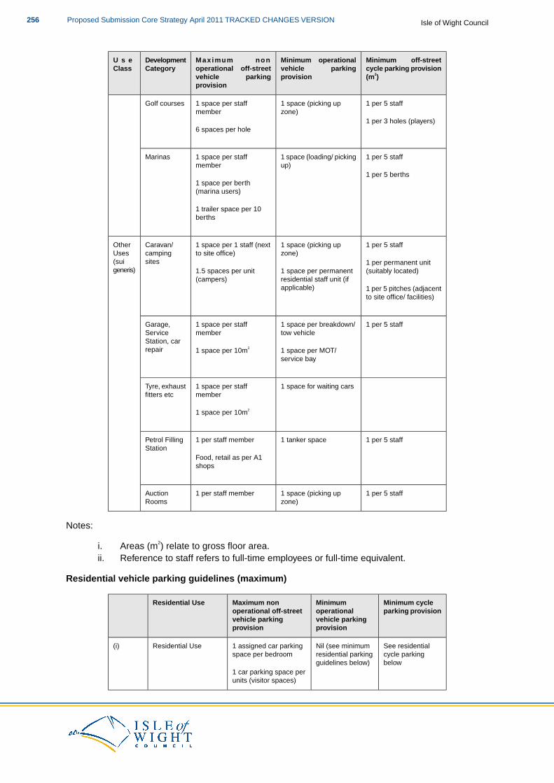
Minimum off-streetcycle parking provision(m2)
Minimum operationalvehicle parkingprovision
Maximum nonoperational off-streetvehicle parkingprovision
DevelopmentCategory
U s eClass
1 per 5 staff1 space (picking up1 space per staffGolf courseszone)member
1 per 3 holes (players)6 spaces per hole
1 per 5 staff1 space (loading/ picking1 space per staffMarinasup)member
1 per 5 berths1 space per berth(marina users)
1 trailer space per 10berths
1 per 5 staff1 space (picking up1 space per 1 staff (nextCaravan/Otherzone)to site office)camping
sitesUses(suigeneris)
1 per permanent unit(suitably located)1 space per permanent1.5 spaces per unit
residential staff unit (ifapplicable)
(campers)1 per 5 pitches (adjacentto site office/ facilities)
1 per 5 staff1 space per breakdown/1 space per staffGarage,tow vehiclememberService
Station, carrepair 1 space per MOT/1 space per 10m2
service bay
1 space for waiting cars1 space per staffTyre, exhaustmemberfitters etc
1 space per 10m2
1 per 5 staff1 tanker space1 per staff memberPetrol FillingStation
Food, retail as per A1shops
1 per 5 staff1 space (picking up1 per staff memberAuctionzone)Rooms
Notes:
i. Areas (m2) relate to gross floor area.ii. Reference to staff refers to full-time employees or full-time equivalent.
Residential vehicle parking guidelines (maximum)
Minimum cycleMinimumMaximum nonResidential Useparking provisionoperationaloperational off-street
vehicle parkingvehicle parkingprovisionprovision
See residentialNil (see minimum1 assigned car parkingResidential Use(i)cycle parkingresidential parkingspace per bedroombelowguidelines below)
1 car parking space perunits (visitor spaces)
Isle of Wight CouncilProposed Submission Core Strategy April 2011 TRACKED CHANGES VERSION256

1 space per 5 staff1 space for every 2 unitsSheltered(ii)accommodation –residential staff as per(i) above
Residential cycle parking
Minimum Cycle Parking ProvisionResidential Use
One, preferably covered space per dwelling, suitablyFlatted developmentlocated to allow secure cycle parking
None required (on the assumption that the garageHousing with a garage and/or curtilageor garden space is sufficient to allow for provision ofsafe cycle storage).
257Proposed Submission Core Strategy April 2011 TRACKED CHANGES VERSIONIsle of Wight Council
5 Appendix 5: Saved UDP Policies to be Replaced
S3 Strategic PolicyS7 Strategic PolicyS8 Strategic PolicyG1 Development Envelopes for Towns and VillagesG4 General Locational Criteria for DevelopmentG5 Development Outside Defined SettlementsG11 Coastal DevelopmentD1 Standards of DesignD5 Shop Fronts and SignsD9 Works of Art, Artefacts or Architectural FeaturesD13 Energy ConservationD14 Light SpillageB7 Demolition of Non-Listed Buildings in a Conservation AreaB9 Protection of Archaeological HeritageB10 Parks and Gardens and Landscapes of Historic InterestH3 Allocation of Residential Development SitesH7 Extension and Alteration of Existing PropertiesH9 Residential Development Outside Development BoundariesH14 Locally Affordable Housing as an Element of Housing SchemesH15 Locally Affordable Housing as Rural ExceptionsE3 Resist the Development of Allocated EmploymentLand for Other UsesE5 Allocation of EmploymentLandE7 Employment Sites with Deep Water FrontageC11 Sites of Local Importance for Nature ConservationC12 Development Affecting Trees and WoodlandC17 Conservation of Barns and other Rural BuildingsC22 Keeping of Horses for Recreational PurposesC23 Stables and Field Shelters in the CountrysideC24 Commercial Riding EstablishmentsL4 Protection of Open Spaces, Village Greens and AllotmentsL5 Developments Within Parks and GardensL10 Opens Space in Housing DevelopmentM3 Criteria for New Mineral WorkingsM6 Aggregate WharvesM8 Restoration and AftercareM9 Minerals SitesW2 LandfillW3 Waste Collecting, Sorting, Reclamation and Transfer SitesTR7 Highway Consideration for New DevelopmentTR16 Parking Policies and GuidelinesTR17 Public Rights of WayTR18 Railway Line and Former Railway NetworkTR19 AirportsT4 Designation of Hotel AreasT5 Development Outside of Defined Hotel AreasT6 Permanent Accommodation Sites (other than Hotels)T10 The use of Tourist Accommodation for Permanent Residential UseR1 Existing Town CentresR2 New Retail DevelopmentR5 Retail-Only Frontages
Isle of Wight CouncilProposed Submission Core Strategy April 2011 TRACKED CHANGES VERSION258

R6 Areas Outside Retail-Only FrontagesU2 Ensuring Adequate Educational Social and Community Facilities for the Future PopulationU5 Schools ProvisionU7 Provision of School Playing Fields, and Protection from DevelopmentU10 Provision of Burial Grounds and CrematoriaU18 Development of Renewable Energy
259Proposed Submission Core Strategy April 2011 TRACKED CHANGES VERSIONIsle of Wight Council