ITU A|Z • Vol 12 No 1 • March 2015 • 37-51 Urban sections yardim-hacihasanoglu-1201.pdf ·...
15
Urban sections Abstract Today, the perception of layered transportation infrastructure has to be merged with the architecture and urban design. Especially the underground transporta- tion modes affect the grounds of the city. is study focuses on investigating the relations of grounds and the transportation infrastructure. Exploring the inter- action level of urban spaces with the transportation systems in terms of their ex- pansions below and above the ground is the problem itself. Moreover finding a relation between urban spaces, transportation hubs and their typologies and how these typologies shaping urban grounds in the transportation context. Aſter that, İstanbul is the case area of analyzing the urban land with respect to ground and underground relations and typologies that have examined. e selected zones of İstanbul for showing the relation between ground and transportation have the major quality of being in the networks of city transportation system and these are supported by the map called ‘typology mapping’. Keywords Transportation infrastructure, Urban section, Urban ground, Sectional typolo- gies, Architectural diagrams. Nurgül YARDIM 1 , Orhan HACIHASANOĞLU 2 1 [email protected] • PhD Student, Bilgi University, Istanbul, Turkey 2 [email protected] • Faculty of Architecture and Design, Özyeğin University, Istanbul, Turkey Received: December 2013 Final Acceptance: April 2014 ITU A|Z • Vol 12 No 1 • March 2015 • 37-51
Transcript of ITU A|Z • Vol 12 No 1 • March 2015 • 37-51 Urban sections yardim-hacihasanoglu-1201.pdf ·...

Urban sections
AbstractToday, the perception of layered transportation infrastructure has to be merged
with the architecture and urban design. Especially the underground transporta-tion modes affect the grounds of the city. This study focuses on investigating the relations of grounds and the transportation infrastructure. Exploring the inter-action level of urban spaces with the transportation systems in terms of their ex-pansions below and above the ground is the problem itself. Moreover finding a relation between urban spaces, transportation hubs and their typologies and how these typologies shaping urban grounds in the transportation context. After that, İstanbul is the case area of analyzing the urban land with respect to ground and underground relations and typologies that have examined. The selected zones of İstanbul for showing the relation between ground and transportation have the major quality of being in the networks of city transportation system and these are supported by the map called ‘typology mapping’.
KeywordsTransportation infrastructure, Urban section, Urban ground, Sectional typolo-gies, Architectural diagrams.
Nurgü l YARDIM 1, Orhan HACIHASANO ĞLU 2
1 [email protected] • PhD Student, Bilgi University, Istanbul, Turkey2 [email protected] • Faculty of Architecture and Design, Özyeğin University, Istanbul, Turkey
Received: December 2013 Final Acceptance: April 2014
ITU A|Z • Vol 12 No 1 • March 2015 • 37-51
ITU A|Z • Vol 12 No 1 • March 2015 • N. Yardım, O. Hacıhasanoğlu
38
1. Introduction“Anything is possible to build, or not
to build, we could therefore ask the ques-tion as to why styles and fashion and methods tend to become common prac-tice within our enviroment” (Alsop and Störmer, 1993).
In this study, investigate the impor-tance of grounds and having relation with the transportation infrastruc-ture spaces are the main purposes to reach. As societies become increas-ingly urbanized, decision making and spatial viability make cities more and more complex. So that, the analysis is a multi dimensional way both for pub-lic-private-social collaborations and urban infrastucture. According to Sa-fier “Cities are the most complex, dy-namic and powerful systems for gen-erating and transmitting wealth and well being for very large numbers of people that have so far been evolved by humanity”(Safier, 1993). Moreover, cities are places where great differenc-es and determined poverty can effect boundaries. The characters are sharp-ened by the contemporary globaliza-tion that restructuring the layouts of urban life. These layouts are very large scale and capital intensive. Therefore urban lands and settlements are shift-ing on the basis of globalization. Urban transportation systems are significant determining parts of daily functions. Particularly after the first half of the 20th century, people’s movement ca-pability in the cities are limited. After-wards, cities become important cen-ters of global and national economics then this leads to transportation systems are restructuring accordance with the needs of developments. As the cities getting modernized by the help of economical developments, the city has more mobility than ever.
Bain stated that underground spac-es are invisible so that their design has difficulties. They need to make people aware that there is a space. It is the role of their entrance spaces (1990). The space that allows people to go below the surface. So that en-trances should give people sense of arrival, the mood of the structure and they have a strong identity re-flecting a place of psychological and physical transition between the exte-
rior and interior world. The analysis part of the study is made for reflection of transportation infrastructure by covering selected transportation hubs in İstanbul. This is based on a back-ward reading about the typology de-velopment. In this context, a map of İstanbul’s rail network is superposed by the constituted typology forms.
2. The aim and the scope of the re-search
As the cities grow, need for in-frastructure is formed. This is not an end product, infrastructure also develops and changes its capacity year by year. The reason is that citizens wants to move and they need more construction and more layered infra-structure. Infrastructure was modelled by architects. Their approach is making a plan and understanding the capaci-ty of a clear idea would bring order to the chaos of the metropolis. The major goal of this study as Lerup states, city and mobility relationship. As mobili-ty is a key to a high standart for living and transportation routes are being expandede and connections are being improved, the more speed is being in-creased in this society (Lerup, 2004). Besides, the word ‘infrastructure’ is de-fined in 1927, Oxford English Dictio-nary; “To understand the technical systems that support a society roads, bridges, water supply, wastewater, flood management, telecommunica-tions, gas and electric lines as one cate-gory, it was first necessary to see it fail”. These definion of supporting systems all together rely on the city’s transfor-mation in architecture indeed. Accord-ing to the report of Urban Age Report in 2009, allowing centralization of eco-nomic functions and the accomodation of a growing population on metropoli-tan rail and bus routes; transportation infrastructure is a crucial driver of urban form and structures. Moreover, where public transportation is not placed regularly then motorways begin to dominate the space that will result in straggling forms of development and over-crowding as private car use persistently runs ahead of road build-ing. Every surface of the city take the meaning of transition zone. This view of transition zones help cities to inte-

Urban sections
39
grate the transformation infrastructure with the urban ground. In short, public spaces linked and thought with the transportation modes and edited by functional passages in so-ciety. As seen in the diagram (See Figure 1), public spaces can shift and scale where the transportation infra-structure and ground interacts.
Multilevel infrastructure deals with mixing different urban functions into the same urban structure in order to create a social blender. Functions such as public transportation, parking facil-ities and other possible amenities like a flea-market or temporary exhibits come together and impact the urban life. They create borders as they make new connections with these spaces. Possibilities of new urban structures are coming from the existing site con-ditions somehow.The projects which care the multilevel infrastructure work through the levels of the site.Today this kind of approach chang-es through more dynamic relations. New sectional variations are searched for the interaction of ground and in-frastructure. The ground level takes
the public mission in itself at the same time combined with traffic solutions. Ground level is the transitional part of the transportation typologies. It has paths and corridors along the fields, has borders and multi-layered sec-tions. The physical importance of the urban ground is that, behaves like a base for the transportation infra-structure. The city’s dynamism affects its borders, its pattern and its ways. In the diagram (See Figure 2), the ground dynamism can be seen.
Understanding the ground in the new, dynamic city one should have a look for below and above the ground relations with the infrastructure. Be-sides, ground has the power to change space qualities. For instance, raising the population in daytime is possible by placing the ground level in different forms. This choice merges for making the ground level more crowded, and make the area of mixed-used func-tioning.
Beside the infrastructure relations, this study takes the public space as an issue. In the contempoarary level; economic movements and activities have the supreme effect on urban grounds. In other words, the life style of people in cities, their purchase power and movement capacity has directly affect the public space.
Today public space is a process of structuring the urban enviroment and the infrastructure levels of the city. When interpreting ‘public space’, the functions of infrastructure and city have to be taken into consideration.mMore public the relations get, the spaces getting more mobile.mThey can be structures placing in the city like transitional zones. These complex spaces should have been understood by the governance. To the side, their integration with the public transpor-tation or private cars is the man-agement problem (The City Factory ). When analyzing public space, prop-erties became prominent as collec-tive spaces, welcoming places and accessible spaces. Their respond to the citizens’ daily needs is important and make the good feelings for the city. To be sure these kinds of expectations from the public spaces are not only related with their characteristics of
Figure 1. Transition zone diagram (Yardım, 2012).
Figure 2. Ground diagram (Yardım, 2012).

ITU A|Z • Vol 12 No 1 • March 2015 • N. Yardım, O. Hacıhasanoğlu
40
place but also the interaction with the transportation levels of the land. Considering the public space, the publicless level decreases through the underground. It can be reasonable saying the transformation has rea-sons like necessity, curiosity and try-ing to escape from the space, by widening it. This is possible in a very restrictive sense, or by searching to utilize the third dimension, upwards or downwards.
The use of underground is a pref-erence in the city. In the concept of ‘artifice of hiding’ Shannon&Smets dis-cuss about the layers of city which goes to the underground and begins to hide. Thinking with these definitions of infrastructure, public space and under-ground worlds, the study has the idea about urban sections. Sectioning the urban land, demonstrate the concept of urban public space’s significance. These sections are needed to understand the area in both directions in space. The horizontal and vertical dimensions of the space and their important qual-ities can be shown in fully sections. Conceptually, these sections exist in between building heights, facades, sloped forms and ground line. Ac-cording to White, sections show the shape of space and its relations with the activities in the area take place (White, 1999).
3. Material and methodology“Space is neither absolute, relative
or relational in itself, but it can become one or all simultaneously depending on the circumstances. The problem of the proper conceptualization of space is resolved through human practice with respect to it” (Haug, 1993).
In this research, the analysis of lay-ered transportation infrastructures and their architectural diagrams are the main initiatives put into practice. In the same way the underground space formations and their ground level relations are to be analyzed in the study. The examination is mostly placed on section drawings of the projects. These sections are including the project transportation and fuction-al layers and also the structures’ inter-action with the all urban environment
in both vertical and horizantal man-ner. Equally important, to explain interaction levels in the city context, typologies of transportation structures are introduced with their differences in the ground relations. Nevertheless, these typology making process has certain parameters. For this, analyzed case projects’ values, their philoso-phies and conceptual approach of in-teraction are used. In this case, there exist new relations and parameters. At the same time, due to the impact of relations between underground structures with urban space, the val-ue of research coming from the at-titudes of integration. Therefore, one of the determining factors in the selection of the section diagrams to be ana-lyzed is their hint of the transpor-tation modes and program elements they include; and that the visuals of the case projects should give an indication of their urban contexts. Furthermore, this methodology has a chance to an-swer the questions for the typological approach.
Even though this study’s method is primarily intended to put forward a useful, multi layered thinking of urban grounds and underground, the an-swers of the questions about the city, time, mobility and the transforma-tions of all are have been thought. On the other hand, following ques-tions are used for helping through thesis in its methodological approach.
Why is the urban space affected by transportation infrastructures? • How can the interaction level of
urban spaces with the transporta-tion systems analyzing in terms of their expansions below and above the ground is the problem itself?
• How infrastructural values are shaping urban spaces in the trans-portation context?
• How can architecture and urban design enhance the social and com-mercial potential of the transport interchange?
• Can architecture continue to re-late the space of structures and cities, when this space itself, is dis-solving into a universal flow?
• What are the mediums that coming from the below to above in urban context?

Urban sections
41
4. Below and above ground structure typologies conceptual framework
Urban space relationship is the ex-perience of analyzing interactions and to fit the typologies. In this context, urban grounds are important tools for overcoming the design process of structures both underground and superstructures above the ground. To make an interaction level with the urban sections and ground, this termi-nology can help. In addition to that, taking the important parts of the case study sections and their analyses help to improve these “coding and typ-ing” process (See Table 1).
Below and above structures have always been places for citizens to vis-it, to live or to pass. From this view, with the help of the parameters in
their design and relation process, it is a way to represent types of struc-tures. The condition of the system ‘structure’ can adapt it very different forms including layers of the site. The important thing is that the transpor-tation modes are intersecting mostly the underground. Especially while examining the relations or typolo-gies of them, ground level transpor-tation is not so much effective on typologies. The rule for classification follows a logic of identifying major parameters of urban structures which are intrinsic to the functioning of transportation spaces. These ‘parama-ters’ are shown in the sections of the land. All aspects of the urban grounds are going to define by the sectional analyses. Since these sec-tions are perceived by the legends of the transportation, urban ground and users, they include definitions and examples of everyday urbanism. As seen in the Table 2, there appear to be six primary types of urban in between transportation related struc-tures, namely; ‘stations as usual’, ‘public spaces’, ‘continuous transporation part’, ‘megastructures’, ‘hubs in network’ and ‘through mixed-use spaces’.
These codes refer the parameters of the existing typologies. The Figure 3 shows the process of developing ty-pology codes. Step by step it contains the context, scale, form, architecture, program and action.
4.1. Stations as usual We are living through the tran-
sition spaces and we all experience our days in different types of urban structures. Yet a very important shift is that, awering of the ground levels as much as the underground. Today, city‘s multi-modal passanger inter-changes are tranforming from becom-ing only transport centers. There are offices and shops around railway sta-tions; restaurants, supermarkets and meeting facilities are developed in motorway service areas; pedestrian zones specialize in services oriented toward tourists and other occasional visitors, and hotels, conference centres, commercial and entertainment cen-tres are springing up around airports (Bertolini, 2006). The desire to stop
Table 1. Coding and typing process (Yardım, 2012).
Table 2. Parameters and typology codes (Yardım, 2012).

ITU A|Z • Vol 12 No 1 • March 2015 • N. Yardım, O. Hacıhasanoğlu
42
the transportation in points of new functions is the conceptual frame of stations. Stations as usual are the “schematic basis” of modern transpr-tation life (See Figure 4).
It is interesting to relate Auge‘s defi-nition of non-place with the stations as usual respectively. Multi-modal passanger interchanges are cases of ‘non-places’ rather than public space and they reduce the social relations and sense of identity. This approach argued increasing mobility has allow space as a transit zone, as a station. Then these called non-place experi-ence change the physical enviroment and conditions of city (Augé, 1995). On the other hand, Bertolini fully aware of the stations as a structure of living. His words “Let us take the case of railway stations. For those who work there, stations are, instead of being non-places, places where socializa-tion and/or conflicts take place, just as at any other workplace” is basically a stance for the social life of stations (Bertolini, 2006).
4.2. Continuous transportation part The basic purpose of the trans-
portation infrastructure, in both its theoretical and structure, is to move for new spaces for changing the pa-rameters. Rather than to prefer to go outside or to stay in an enclosed volume, the transportation levels can choose to stay on their own places.
The continuous transportation is the type or an approach to make a reference of continuity and mobility (See Figure 5).
As Norberg-Schultz discussed as an artificial artifact; a station identifes, orients and connects for the society. “The theory of identification suggests
that identity consists rather in an inte-rior organization of understood things, and that growing up therefore depends on being open to what surrounds us. We have to know where we are and how we are, to experience exis-tence as meaningful”( Norberg-Schul-tz,1985). In a manner of continuous transportation approach, these mean-ings of experience is important as they are the real space of people. The urban structure has become a world for “underground architecture” to commit services of daily routine. Respectively, these ongoing strcutures are the faces of urban surround-ings.Themfeatures of urban structures characterize the interaction of urban enviroment, urban identiy as well as humans. In making a case for con-tinous forms, it is assumed that the tram goes through the lines and only stop when see the sign (Haapala, 1998).
4.3. Public space As cities were slowly starting to
aware of the importance of the public spaces, the transportation parts of the cities are thought to be public squares when they touch the ground level. As considering the stations are part of ur-ban development perspective, they are not only the transportation nodes but also the urban structures giving life to the public spaces. At this point Shannon&Smets‘s prospect about in-frastructure is important.
Chiefly, they see it like a public space and mark the structure like ac-cesible place to almost everyone, and a common itinerary or a collective place. The fact that transportation infra-structure is thought to expand the public realm beyond the boundaries of a single space. Then it gets the
Figure 3. Developing typology codes (Yardım, 2012).

Urban sections
43
public space articulation by aspira-tions and dignity of contemporary society. Especially, the formation of infrastructure always potentially con-tains comprehensive urban Project (Shannon and Smeths, 2010).
In formulating infrastructure as a typology of public space, spatial forms and their offshoots could be thought. In this sense, unique vi-suals for immediate sensation on the ground is directly related with the pub-lic space quality and entrance design of the stations. Therefore, depending on a enclosure volumes and the out-er skins in the ground will define the overall layout. They are the only places of connection between sur-face and underworld.Trancik stated that in cities of the past, the designs for streets, squares, parks and other spaces in public realm were integrated with the design of individual buildings (Trancik, 1986).
In the modern city each element is the responsibility of a different public or private organization, and the unity of the total environment is lost. Vari-ous development and urban-renewal, by and large, put together separately, without an overriding plan for public
space. The result is a patchwork quilt of private buildings and privately ap-propriated spaces (See Figure 6).
4.4. Mega structuresThe term mega structure large-
ly means many functions of a city and defined by an architect Fumi-hiko Maki in 1964. He defined a mega structure as a large frame in which all the functions of a city or part of a city are housed. More-over, the mega structure presented having great promises for infra-structure as public investment. Public structures are stimulated by substantial public investment can be made in in-frastructures (Maki, 1964). It has the implementation made by technolo-gy calling ‘human-made feature on landscape’. Today the replacement of mega structure by independent sys-tems and their hierarchical levels are the same. It can called as a dynam-ic contact that the relation between constitutes of mega structure. In this sense, if there is a contextual and programmatic condition, systems can vary.
The intersection between mega structures and infrastructure trans-
Figure 4. Principal section of the typology code ‘stations as usual’ (Yardım, 2012).
Figure 5. Principal section of the typology code ‘continuous transportation part’ (Yardım, 2012).

ITU A|Z • Vol 12 No 1 • March 2015 • N. Yardım, O. Hacıhasanoğlu
44
portation seems a largely urban matter (See Figure 7). The approach for such a structure is a way to express all the lay-ers of the city. It is inspired the mega structure can continue a pattern of increasing human activity within the city. The mega structure can modify in urban sections and plan medium. Even it appears as a structure, its in-tegration with the context is one of the respectables it has. Banham, who used this term in 1976, declared that the mega structure to be understood as a framework of urban structure needs small units can be plugged-in. Under the sophisticated vision of mega structures, the sections mean intersection of functions, actions and modes of transportation respectively. These huge structures are called big transportation infrastructures.
Koolhaas discuss the mega-architec-ture and infrastructure of the city. He declares architecture is a medium that transforms by bigness then this accumulation generates a new kind of city. This bigness seem to be an urban and it competes with the city. At the same time bigness often represent the city. In this sense it looks like a city. “If urbanism generates potential and ar-chitecture exploits it, bigness enlists
the generosity of urbanism against the meanness of architecture” (Kool-haas, 1998).
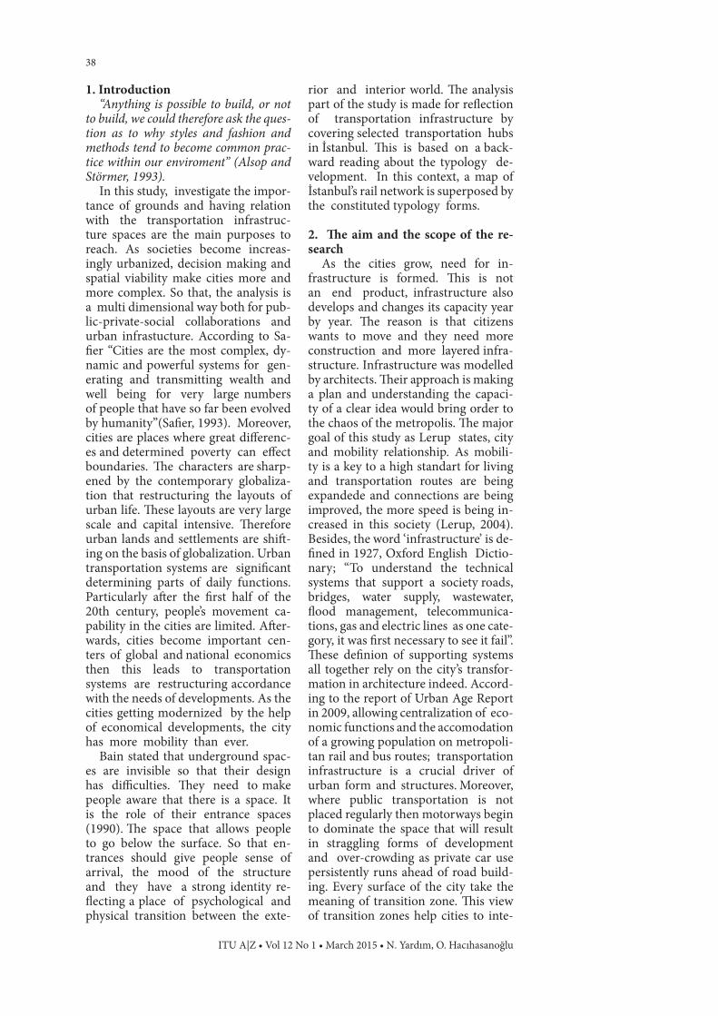
4.5. Hubs in networkNetworks inevitably take the fea-
tures of both global and local char-acteristics of the existing landscape. The place, the urban structure or defined as the hub in the network merged from two characteristics and a special arrangement for its own site in its network mapping. The hub inside the network brings out new activ-ities and functions and enriches the place in more public level [16]. At the same time passengers are attracted by the hubs and the other staff that con-tribute the local economy. These infra-structural networks and the nodes of hubs are the idea of mixing local char-acteristics in other layers of the site. In addition, all modes of transportation can integrate the hub taking the idea of site forces (See Figure 8).
According to Lynch, the strategic spots are the nodes in teh city. They can be junction places of transporta-tion modes over the paths like mo-ments of shifting or they are concen-trations as a street corner hangout or an enclosed square. Such a con-
Figure 6. Principal section of the typology code ‘public space’ (Yardım, 2012).
Figure 7. Principal section of the typology code ‘megastructures’ (Yardım, 2012).
Urban sections
45
cept of node is related with the concept of paths and journey as well. Therefore, the polarizing centers of the places are typically named as cores are the varia-tion of the nodes (Lynch, 1960).
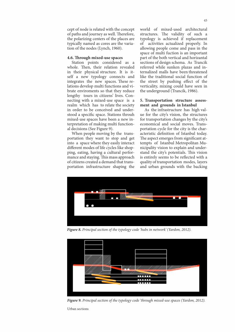
4.6. Through mixed-use spacesStation points considered as a
whole. Then, their relation revealed in their physical structure. It is it-self a new typology connects and integrates the new spaces. These re-lations develop multi functions and vi-brate enviroments so that they reduce lengthy tours in citizens’ lives. Con-necting with a mixed-use space is a realm which has to relate the society in order to be conceived and under-stood a specific space. Stations throuh mixed-use spaces have been a new in-terpretation of making multi function-al decisions (See Figure 9).
When people moving by the trans-portation they want to stop and get into a space where they easily interact different modes of life cycles like shop-ping, eating, having a cultural perfor-mance and staying. This mass approach of citizens created a demand that trans-portation infrastructure shaping the
world of mixed-used architectural structures. The validity of such a typology is achieved if replacement of activities actualized properly. In allowing people come and pass in the space of multi fuction is an important part of the both vertical and horizantal sections of design schema. As Trancik referred while sunken plazas and in-ternalized malls have been threatened like the traditional social function of the street by pushing effect of the verticality, mixing could have seen in the underground (Trancik, 1986).
5. Transportation structure assess-ment and grounds in Istanbul
As the infrastructure has high val-ue for the city’s vision, the structures for transportation changes by the city’s economical and social moves. Trans-portation cycle for the city is the char-acteristic definition of Istanbul today. The aspect emerges from significant at-tempts of Istanbul Metropolitan Mu-nicipality vision to explain and under-stand the city’s potentials. This vision is entirely seems to be reflected with a quality of transportation modes, layers and urban grounds with the backing
Figure 8. Principal section of the typology code ‘hubs in network’ (Yardım, 2012).
Figure 9. Principal section of the typology code ‘through mixed-use spaces (Yardım, 2012).

ITU A|Z • Vol 12 No 1 • March 2015 • N. Yardım, O. Hacıhasanoğlu
46
of population density in the city. In his book “Metabolism of Architecture”, Kurukowa stated that the grounds of city like residence or working spaces change with respect to growth of pop-ulation and its structure. He referred Le Corbusier that the cities are com-prising of living, working and recre-ational spaces linking each other by transportation. Generally, the most important feature is daily-life spaces having multi functional concepts re-spectively (Kurukawa, 1977).
This complex structure of city emerges from a discourse which takes its reference from transportation assessment. In Istanbul, the laws of city are exactly like those mentioned above. The characteristics of Istanbul grounds in relation with the infrastructure is formed by social needs of the city it-self. This environment of mixed-used functioning serves the spaces as an input. So that, the rational utilizing of transportation will enhance the quality of the public spaces and will have positive influence on the cre-ation of more harmonious environ-ments. The idea that transportation structures are placed with the public spaces is characterized by choice of event types. According to Tschumi , there is no architecture as soon as there is no event, program, action. Therefore, the public places are al-ways affect the architecture of the transitional zones of the cities and their relations with the ground both in physically and logically. Togeth-er with the actions and events that take place in the social and politi-cal realm of architecture ground can be seen as the public space (Tschumi, 1996).
Istanbul is a city mixing all the lo-cation based contours of living and transporting in the one pot. As Cruz explained, city is the spatial con-figuration that comes into existence by complex systems of juxtaposed and overlaid elements that inter-af-fect and interact with each other (Cruz, 2011). The most compelling parts of this urban realm is creating boundar-ies. Geography, topography, pre-exist-ing man-made conditions, regulatory frames, economic and political situ-ations are modes that regulated in
perception in city. It is easier to follow Istanbul’s transportation infrastruc-ture looking through the juxtaposed layers. While public spaces have remained relatively static; new fre-quencies of transportation have ag-gravated the problems. The tension between transportation infrastructure and public spaces is most apparent at station points in Istanbul. The complex networks of subway system, ferries, taxis, freeway, trams, buses, trains have been implemented in the last years give pressure on new public spaces. The typologies of interaction aspect of transportation and ground can be seen in every network of İstanbul’s transportation system. By exploring the potential relationships of trans-portation infrastructure and ground level, it is simple to imagine the urban sections respectively. In perception of Istanbul through urban sections is important. The aesthetic relationship between transportation and urban grounds has been poetically described by urban sections. They are having the quality of not only the layers of trans-portation but also the layers of histo-ry. Especially transportation demands make Istanbul’s rapid growth more fast and historical context demands make revaluation of public spaces within modern urban structures. The changing metropolitan needs trans-portation that considered in context of historical development of layers and the necessity of pedestrian zones. Cit-ies getting modern, economical factors getting better and prevails mobility. In the cities there exists people count in the day time three times more than the population. The population of Istanbul is 14 million then Istanbul’s daily mo-bility is 24 million now, it will become 35 million in future. All the plans, net-work decisions are made according to these variables. Istanbul has this net-work decisions with a lot of modes of transportation. The factor is to make how is the integrated transpor-tation is possible and breathing in transportation (www.istanbul-ulasim.com.tr ). Moreover, Istanbul Rail Net-work Map identifies the modes and the their superimposing relations. The network density seems logically de-veloped all around city.

Urban sections
47
The analysis of different zones is composed of urban and architectural scale transportation projects in Istan-bul. The common denominator of these projects is to deal with the transportation infrastructure and ground level typologies. These urban forms are generated with particular attributes of scale, space, and speed that are both specific and generic. The exciting thing about these ur-ban structures is rather than being complex, they are public or utterly ge-neric in Istanbul’s network. They are everyday spaces because the masses of people sharing, experiencing and perceiving in them. Moreover their strategic locations and characteris-tics make the land more related with them in terms of scale and density.
The view of the cities have grown rapidly, always need solutions and sug-gestions in design perspective for the basic infrastructural transformations. Like in Istanbul, since local adminis-trations are not financially autono-mous, they are gazed upon searches for new resources to implement their decisions. The relations with the po-litical states of the city have loyalty with the private and public sectors to devel-op projects on the city (Erder, 2009). As can be seen in Figure 10, “Zone Location Mapping” diagram intro-duced below, the cases for show-ing the relation between ground and
transportation in Istanbul have the ma-jor quality of being in the networks of city transportation system. Whether they have designed multi-functional or entirely for transportation pur-poses, these urban structures show the urban section quality as well. One of them is Yenikapı area and the other zone is the metro line of Hacıosman - Şişhanane. The urban structures have become centers of attraction, when the increasing demands of qual-ified ground level getting higher. These zones analyzed in terms of leading factors and their properties of the pro-gramming that they have been trans-forming large-scale multi-used archi-tectural forms.
6. Conclusions and recommanda-tions
Imagine yourself putting together all your favourite memories in an unending and loosely
fitting jigsaw in such a way that you could always wander back through them, indulging and enjoying them at will. In such a way that they can be endlessly rearranged or juxtaposed. Ultimately, the effect becomes faintly exotic. The old favourites are tweaked by new playmates, the half-memo-ries overlaid by more recent experi-ences. Strange new mixtures of fact and fantasy fitler through. New -but perhaps only conjectured-memories
Figure 10. Zone location mapping.

ITU A|Z • Vol 12 No 1 • March 2015 • N. Yardım, O. Hacıhasanoğlu
48
emerge out of the scrambling pro-cess. Now imagine yourself starting to manipulate these memories and hybrid memories, starting to infiltrate the experienced with the could-be-ex-perinced and, as the adrenaline surges, the might-be-experienced and even beyond: to the if-only-they-could-be-experienced (Cook, 2003):
Today, with the perhaps the excep-tion of the highly complex modes of transportation in cities, their stations don’t care much for the urban spaces. Transportation layers make use of ex-isting spaces and occupy underground or ground level with only the entranc-es. Alternatively, the shopping mall entrances or mixed-use complex-es can also a way to connect the ground with these urban structures. Such an attitude generally makes the interaction thinking in a box. It may seem paradoxical to mention architectural qualities of the trans-portation structures relation to ur-ban design. However, the typologi-cal approaches for the underground levels and their consequences make the public real. According to Sennett ,public realm is a materialized space (1996). It houses physical spaces such as square and street within an urban or rural envi ronment. It is the spirit of the city. In fact, the desire to feel the all
structure is inherent in many types of stations. In some cases like Yenikapı, it experienced that the relation of be-low and above the ground makes the city, urban design and the landscape is much more accepted. The creation of the transportation infrastructure and the ground level interaction is going to be more analyzed and excogitated way.
A contemporary sense of the ur-ban section asist by aligning the in-frastructure in a way that underlines the spatial features for citizens. Besides all the typological approaches and the selected zones of İstanbul, the outcome is the mapping about the European part of İstanbul. It is named as ‘typol-ogy mapping’. As seen in the Figure 11, this mapping examines the most qualified stations by the help of ty-pological approaches that have benn determined in the research. Transpor-tation and regeneration projects has taken into consideration by means of connections and relationships are principally defined in that respect. Therefore, it is a way to see defined typologies in their design approaches. By doing so, their impact on İstanbul and effectiveness on their sites makes the perception of interacting of ground and transportation respectively.
Figure 11. Istanbul typology mapping (Yardım, 2012).

Urban sections
49
ReferencesAlsop, W., Störmer, J. (1993). Archi-
tectural Monographs No 33. Academy Editions, London.
Augé, M. (1995). Non-Places: Intro-duction to an Anthropology of Super-modernity. Verso.
Bain, B. A. (1990). The Entry Expe-rience: Preferences of the Mobility Im-paried. Enviromental Design Research Association Conferance, Atlanta.
Bertolini. L. (2006). Fostering Ur-banity in a Mobile Society: Linking Con-cepts and Practices. Journal of Urban Design, 11:3, 319-334. Date retrieved: 19.03.2012, adress: http://dx.doi.org/10.1080/13574800600888269.
Cook, P. (2003). The City Seen as Garden of Ideas. Monacelli Press.
Cruz, C. (2011). City Generator. In, The John H. Daniels Faculty of Archi-tecture, Winter 2011 Final Thesis Re-views.
Erder, S. (2009). Local Governance in İstanbul. The Urban Age Istanbul Con-ference, Date retrieved: 02.01.2012, adress: http://urban-age.net/confer-ences/istanbul/.
Haapala, A. (1998). Strangeness and familiarity in the urban environment. The City as CulturalMetaphor. Stud-ies in Urban Aesthetics. (International Institute of Applied Aesthetics Series, Vol. 4.)
Harvey, D. (2006). A Critical Reader. ed. Castree, N., Gregory, D., Blackwell Publishing, Cambridge.
Haug, R.T., (1993). The Practical Handbook of Compost Engineering, Lewis Publishers, Florida, USA., Lewis Publishers, Florida, USA.
Koolhaas, R., Mau, B., Werlemann,
H. (1998). S M L XL, Monacelli Press, New York.
Kurukawa, K. (1977). Metabolism in Architecture. Studio Vista, London.
La Fabrique de la Cité/The City Fac-tory. What is the place for public spaces in the city of the future? Seminar , Bar-celona 4-6 May 4-6 May.
Lerup, L. (2004). The City is Always Running away Itself. In, Form Follows Fun, ed. Kristin Feireiss. Birkhauser.
Lynch, K. (1960). The Image of the City, MIT Press, Cambridge.
Maki, F. (1964). Investigations in Collective Form. A special publication No. 2, Washington University.
Norberg-Schultz, C. (1985). The Concept of Dwelling: On the Way to Figurative Architecture. Electa/Rizzoli, New York.
Safier, M. (1993). The Inter-Dimen-sional Analysis of Urban Development: A guide to the Organization of Cases and Their Linkages. Development Plan-ning Unit, University of London. Date retrieved: 20.03.2012, adress: http://www.ucl.ac.uk/dpu-projects/ drivers_urb_change/.
Sennett, R. (1996). Kamusal İnsanın Çöküşü. Ayrıntı Yayınları, İstanbul.
Shannon, M., Smeths. M. (2010). The Landscape of Contemporary Infra-structure. 2010. Rotterdam: NAi Pub-lishers.
Trancik, R. (1986). Finding Lost Space. New York.
Tschumi, B. (1996). Architecture and Disjunction. MIT Press, Cambridge.
White, E. (1999). Path-Portal-Place. Architectural Media Ltd.,USA. <http://www.istanbul-ulasim.com.tr>, date re-trieved 15.02.2012.
Kentsel kesitlerBu çalışmada, çok katmanlı ulaşım
altyapısının kentsel tasarım ve mimari ile olan ilişkisi, kent zemininin bu du-rumdan nasıl etkilendiği kesitsel tipo-lojiler elde edilerek okunmaya çalışıl-mıştır. Bu incelemelerde kesit çizimleri üzerinden istenilen ilişkiler aranmıştır. Amaç, projelerin ulaşım ve fonksiyonel katmanlarının yanı sıra, onları oluştu-ran strüktürlerin de kentsel çevre ile olan etkileşimlerini hem dikey hem de yatay tutumları ile kesitler üzerin-
den okumaktır. Kentler yıllar geçtikçe büyürler ve değişirler. Kentlerin büyü-mesiyle, geleneksel şehirlerden met-ropollere doğru, ileriyi tahmin eden değişimler olmaktadır. Artan nüfusla beraber, teknolojiler ve ulaşım araçları gelişerek 20. yüzyılın sosyal ve fizik-sel koşullarını etkiler. Bu bağlamda, kentler gelişip değişime ihtiyaç duy-dukları sürece de ulaşım altyapısı ye-niden biçimlenmek için evrilir. Bunun altında yatan sebep, kentlilerin hare-ket etme isteklerine cevap olarak çok

ITU A|Z • Vol 12 No 1 • March 2015 • N. Yardım, O. Hacıhasanoğlu
50
katmanlı ulaşım sistemlerine gereksi-nim duymalarıdır. Tüm bu gelişimler, günümüzde özellikle yer altı ulaşım sistemleri ile farklı seviyelerden olu-şan ulaşım altyapısı algısının kentsel tasarım ve mimari ile birlikte yapısal-laşmakta olduğu bir yere gelmektedir. Bu bağlamda, yeraltı ulaşım modları kentin zeminini fazlaca etkilemektedir. Kentlerin bu dinamik halleri kentsel mekan ve ulaşım altyapısını birleştiren yeni haller aramaktadır. Bu noktada altyapı strüktürlerini zeminin farkında olarak yapmak, onlara bir kimlik ka-zandırmak suretiyle oluşturulan yakla-şım farklı bir yol olarak görülebilir. Bu durumda ele alınan problem, kentsel mekanların ve ulaşım sistemlerinin yer altı ve yerüstündeki uzantılarıyla nasıl bir etkileşim içinde olduklarını araştır-maktır. Ortaya çıkan farklı ilişkilerin hangi sebeplerden kaynaklandığını ve nasıl farklı tipoloji yaklaşımları ortaya çıkardığını anlamaktır.
Bu çalışma, zeminin ve ulaşım alt-yapısının ilişkisine odaklanmaktadır. Kentsel mekânların ve ulaşım sistemi-nin etkileşim seviyesi zemin üstü ve altına yayılmaları problem olarak ele alınmaktadır. Diğer taraftan, ulaşım bağlamının içindeki kentsel mekânlar, geleneksel merkezler ve bunların tipo-lojileri ile bu tipolojik yaklaşımların kent zeminini nasıl şekillendirdiği üze-rine bir ilişki bulmaya odaklanmakta-dır.
Araştırmanın temelinde yer alan hareketlilik kavramı; kamusal mekan-ların ve ulaşım yollarının yüksek stan-dartlarda ilişki kurmasını ve geliştiril-melerini sağlar. Bu durum kentlinin de hızının artmasına neden olur. 21. yüzyılın yaşam biçimi bu hızın izle-rinden oluşmaktadır denilebilir. Ko-laylaşan ve ekonomikleşen ulaşımla beraber bireylerin hareketlilikleri de artar, kentin sosyal ve çevresel halle-ri de bu durumdan etkilenir. Böylece, kent mekanlarının zemin altı ve üstü ile olan ilişkileri tasarım sürecini bire-bir etkilemeye başlar. Dış mekanlar ve girişler elemanlaşırlar. Kamusal mekan bu durumlara göre yeniden şekillenir. Özellikle kentin olaysallıklarını zemin kelimesiyle tasvir ederken, zemin ve yer altı kelimeleri karşımıza çıkmak-tadır. Bu çalışmada pratiğe dökülen ilk başlangıç noktası, katmanlı ulaşım alt-
yapıları ve onların mimari diyagramla-rının analizleridir. Aynı durum, yeraltı mekânlarının biçimlenmeleri ve zemin seviyesi ile ilişkilendirilmeleri için de geçerlidir. Bu inceleme özellikle pro-jelerin kesit çizimleri üzerinden yürü-tülmüştür. Amaç, projelerin ulaşım ve fonksiyonel katmanlarının yanı sıra, onları oluşturan strüktürlerin de kent-sel çevre ile olan etkileşimlerini hem dikey hem de yatay tutumları ile ke-sitler üzerinden okumaktır. Bu süreçte belirlenen yöntemle incelenen örnek projeler kendilerine ulaşım modları , zemin perspektifi ve kentsel strüktür başlıklarının altında yer bulmaktadır-lar. Aynı derecede önemli olan bir ko-nuda, kent bağlamında, ulaşım strük-tür tipoloji yaklaşımlarının zeminle kurdukları ilişki farklarıyla nasıl değiş-tiğini açıklayabilmektir. Tüm bunların yanında, bu tipolojilerin bir yaklaşım olarak literatürde yer bulabilmesi için bazı seçilmiş parametreler oluşturul-muştur. Bu parametreler, çalışma bo-yunca belli başlıklar altında incelenen örnek projelerin değerleri, felsefeleri ve kavramsal yaklaşım etkileşimleri üze-rinden çıkarılmıştır. Aynı zamanda, yeraltı strüktürlerinin kentsel mekân-lar ile olan birbirlerini etkileyici iliş-kileriyle birlikte, araştırmanın değeri tüm bu yaklaşımların bütünleşmesin-den gelmektedir.
Etkileşimlerin kentsel kesitlere et-kisi de büyük olmaktadır. Bu bağlam-da kesitler kentin kamusal spotlarının kavramsal önemini de ispatlamaktadır. Zemin seviyesinde ve ulaşımın oluş-turulduğu ve devam ettiği alanlarda kentsel kesit kavramı hem düşey hem de yatay düzlemde anlaşılmaya çalı-şılmaktadır. Kesitlerin ulaşım kavra-mının en önemli anlatımlarından biri olduğu düşünülürse, günlük kentleşme örnekleri üzerinden çeşitli tanımlama-lar yapılabilir. Tüm bu karşılaştırılan ve incelenen örneklerin kesite ilişkin var-yasyonlarında yeni kentsel tipolojiler ortaya sunulmaktadır. Bunlar sadece fiziksel değil sosyal etkiler ve farklar olarak da okunmalıdır. Bu şekilde altı farklı “ulaşım ilişkili kent mekânı” olarak tipoloji yaklaşımlarına isim ve-rilmiştir. ‘olağan istasyonlar’, ‘devamlı ulaşım parçası’, ‘kamusal mekânlar’, ‘büyük strüktürler’, ‘ağlardaki düğüm noktaları’ ve ‘karma kullanımlı mekan-

Urban sections
51
lar boyunca alanlar’. Tüm bu tipolojik yaklaşımlar, mev-
cut dokunun belirli bir süreç içine gelişmesiyle oluşmaktadır. Bağlamla başlayan bu devamlılık üzerine ölçek, form, mimari tasarım ve program parametrelerinin eklenmesiyle, ön-görülen tipolojilerin gerçek aksiyon alanlarını belirler. İstanbul, literatür çalışmalarının ve tipolojik yaklaşım sürecinin üstüne örnek alanların seçil-diği kent olarak çalışmada yer almakta-dır. Kentsel kesitlerin yerüstü ve yeraltı ilişkiler ele alınarak tip değerlendirme-leri yapılmıştır. Gelişen İstanbul’un sosyal ihtiyaçları zeminlerin altyapı ile ilişki kurmasını desteklemiştir. Karma kullanımlı fonksiyonlaşma mekanların tasarımına bir girdi oluyorsa, rasyonel ulaşım sisteminin kalitesi de kamu-sal mekan oluşturarak artmaktadır. Ulaşım strüktürlerinin İstanbul’da ka-musal alanlarla etkileşimli yerleşmesi kentin karakteristiği öne çıkarmakta-dır. Bu bağlamda, farklı kentsel ve mi-mari ölçeklerde oluşan proje alanları İstanbul örneği içinde ele alınmıştır. Bu alanların ortak paydası ulaşım alt-yapısı ve zemin ilişkisinde oluşturduk-ları ilişki çeşitleridir. Seçilen bölgeler İstanbul’daki çok katmanlı ulaşım alt-yapısını ve zemin ilişkisinin kuvvetli olduğu ve kentin ulaşım ağında bulu-nan ana merkezler olarak seçilmiştir. Bu bölgeler çok fonksiyonlu bölgeler ya da tümüyle ulaşım amaçlı tasarlan-mış olabildikleri halde her durumda da kentsel kesitlerinin farklı değerleri bu-lunmaktadır.
Çalışmada kentsel kesitler mekan-sal, ölçeksel ve hız bakımından jenerik olarak ele alınmaktadırlar. Bu duruma büyük ölçek ve kara kullanımlı alan-ların mimari olarak yorumlanması da denilebilir. Kentin çekim noktası ola-rak da kentsel strüktürlere sahip olan yada olacak olan bu alanlar Yenikapı bölgesi ve Hacıosman-Şişhane metro hattıdır. İki durumda da kenti etkile-mesi beklenilen strüktürler istenilen ve beklenilen nitelikli zemin arayışla-
rının da cevaplarını bulmaya çalışmak-tadırlar. Bu iki bölge, onlara öncülük eden faktörlerin ve içerdikleri öncelikli program elemanlarının etkisiyle büyük ölçekli ve karma kullanımlı mimari formlara dönüşmektedirler.
Genel çerçevede, zemin denilen aksi-yon alanlarının özellikle yer altı ulaşım sistemleri ile ilişkisi sorgulanmaktadır. Bu durum İstanbul’un Avrupa yaka-sındaki yer altı ulaşım haritalamasına tipolojiler üzerinden bakılmasıyla yeni bir haritalama yaklaşımı oluşturmak-tadır. Ulaşım altyapısının kendi strük-türünü yaratırken tek başına olmadığı, kentsel mekanların hem sosyal hem de fiziksel anlamda ve farklı ölçeklerde yapının bileşeni olduğu sonucu çıka-rılabilir. Bunun yanı sıra, oluşturulan tipolojik yaklaşımlardan ve İstanbul’da örnek bölgelerinin incelenmesi sonu-cunda, gözleme dayalı bir ‘tipoloji ha-ritalaması’ oluşturulmuştur. Bu şekilde İstanbul Avrupa yakasındaki genel-likle yeraltı bazlı ulaşım sistemlerinin kentsel zeminler ile olan ilişkisi kentsel kesitlere verilen tipolojiler üzerinden okunabilmektedir.
Ulaşım ve yenileme projelerinin kentle ve birbirleriyle kurdukları bağlar ve ilişki yöntemleri bu şekilde bir par-çada olsa tanımlanabilmektedir. Böy-lece, tipolojilerin tasarım yaklaşımla-rında bir yöntem olarak ele alınması bir yol olarak ortaya çıkarılmış olur. İstanbul ve ulaşımın kent üzerindeki etkisinde ‘zemin’ kavramı önem kazan-maya başlar. Sonuç olarak çok katman-lı ulaşım altyapısının kentsel mekanda etkileri görülmektedir. Düşünülmüş mimari çözümler ve kentsel tasarımlar, yeraltı katmanlarını tipolojik olarak et-kileyebilir ve kente hizmet etmelerini sağlayabilir. Gelecekte, özellikle Yeni-kapı örneğinde olduğu gibi, kentsel ta-sarım ve altyapı etkileşiminin çok daha iç içe geçeceğinin izlerini görmekteyiz. Zeminin farkındalığını arttırmak, ula-şım altyapısının kentsel mekanlar ve mimari dille ifadesi kentin kesitlerine bakarak mümkün olmaktadır.