ITS Multimodal Initiatives in Virginia Chris Francis.pdf · • I-66 ATM Initiative ... (RSE)...
28
ITS Multimodal Initiatives in Virginia HRTO Subcommittee Meeting Hampton, VA, June 11, 2013 Chris Francis ITS Program Development Manager Operations and Security Division
-
Upload
phungkhanh -
Category
Documents
-
view
212 -
download
0
Transcript of ITS Multimodal Initiatives in Virginia Chris Francis.pdf · • I-66 ATM Initiative ... (RSE)...

ITS Multimodal Initiatives in Virginia HRTO Subcommittee Meeting
Hampton, VA, June 11, 2013
Chris FrancisITS Program Development ManagerOperations and Security Division

Advancing VDOT’s Operations Program
• Address Recurring and Non-Recurring Congestion
• Aligned to VA Multimodal Transportation Plan (VTrans)
• Approaches – Non-Pricing, Pricing, Context Sensitive
• Suite of Solutions - ATM, ICM, DMA, CV, Hybrid
• Candidate Multimodal Technology Applications
• Organizing Strategy: Network/Corridor Based
• Framework for Development & Delivery2

New Technology Deployment Framework
3

4
Project Development Process Overview

Candidate Locations
Urban• I-66 ATM Initiative (Project Deployment Underway)
• I-95/I-395 ICM Initiative (Project Development Completed)
• I-64 DMA Initiative (Visioning)
Rural• I-77 ATSM Initiative (Project Deployment Underway)
• I-64 ATSM Initiative (Project Deployment Underway)

Candidate Locations
Urban• I-66 ATM Initiative (Project Deployment Underway)
• I-95/I-395 ICM Initiative (Project Development Completed)
• I-64 DNM Initiative (Visioning)
Rural• I-77 ATSM Initiative (Project Development Completed)
• I-64 ATSM Initiative (Project Development Completed)
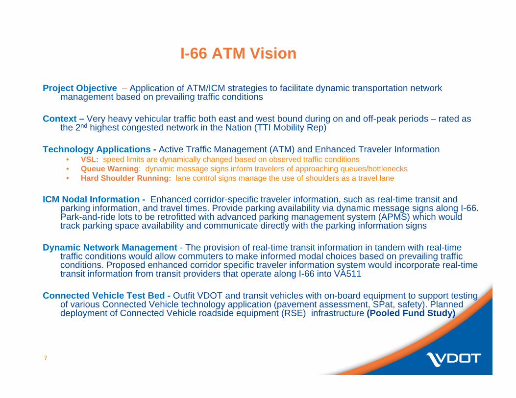
I-66 ATM Vision
7
Project Objective – Application of ATM/ICM strategies to facilitate dynamic transportation network management based on prevailing traffic conditions
Context – Very heavy vehicular traffic both east and west bound during on and off-peak periods – rated as the 2nd highest congested network in the Nation (TTI Mobility Rep)
Technology Applications - Active Traffic Management (ATM) and Enhanced Traveler Information• VSL: speed limits are dynamically changed based on observed traffic conditions• Queue Warning: dynamic message signs inform travelers of approaching queues/bottlenecks• Hard Shoulder Running: lane control signs manage the use of shoulders as a travel lane
ICM Nodal Information - Enhanced corridor-specific traveler information, such as real-time transit and parking information, and travel times. Provide parking availability via dynamic message signs along I-66. Park-and-ride lots to be retrofitted with advanced parking management system (APMS) which would track parking space availability and communicate directly with the parking information signs
Dynamic Network Management - The provision of real-time transit information in tandem with real-time traffic conditions would allow commuters to make informed modal choices based on prevailing traffic conditions. Proposed enhanced corridor specific traveler information system would incorporate real-time transit information from transit providers that operate along I-66 into VA511
Connected Vehicle Test Bed - Outfit VDOT and transit vehicles with on-board equipment to support testing of various Connected Vehicle technology application (pavement assessment, SPat, safety). Planned deployment of Connected Vehicle roadside equipment (RSE) infrastructure (Pooled Fund Study)

8
I-66: Haymarket to DC

ATM Display Concept
Full DMS
ATM Gantry
Between ½ mile to 1 mile spacing (1 Kilometer to 1.5 Kilometer)
Travel Time on DMS(advance of decision point)
Example with HOV Lane, No Shoulder Running Example with HOV Lane and Shoulder Running
9

I-66 ATM System Context (Links to Users)
10

I-66 ATM Functions
11
Vehicle Data Collection
Roadway ImageMonitoring
Incident Detection
DataCollection &Condition Monitoring
Environmental Detection
Information &ControlOutput
RoadwayMessaging(Lane, Queue
Warning, Speed, HOV Access)
Road StatusInformation
(VA 511, Police, etc.)
GateControl
(HOV ramps)
Ramp MeteringRates
DataProcessing & Decision Support
ATMControl
ATMDecision Support
Operator Review and Intervention

I-66 ATM Project Segments and Treatments
12
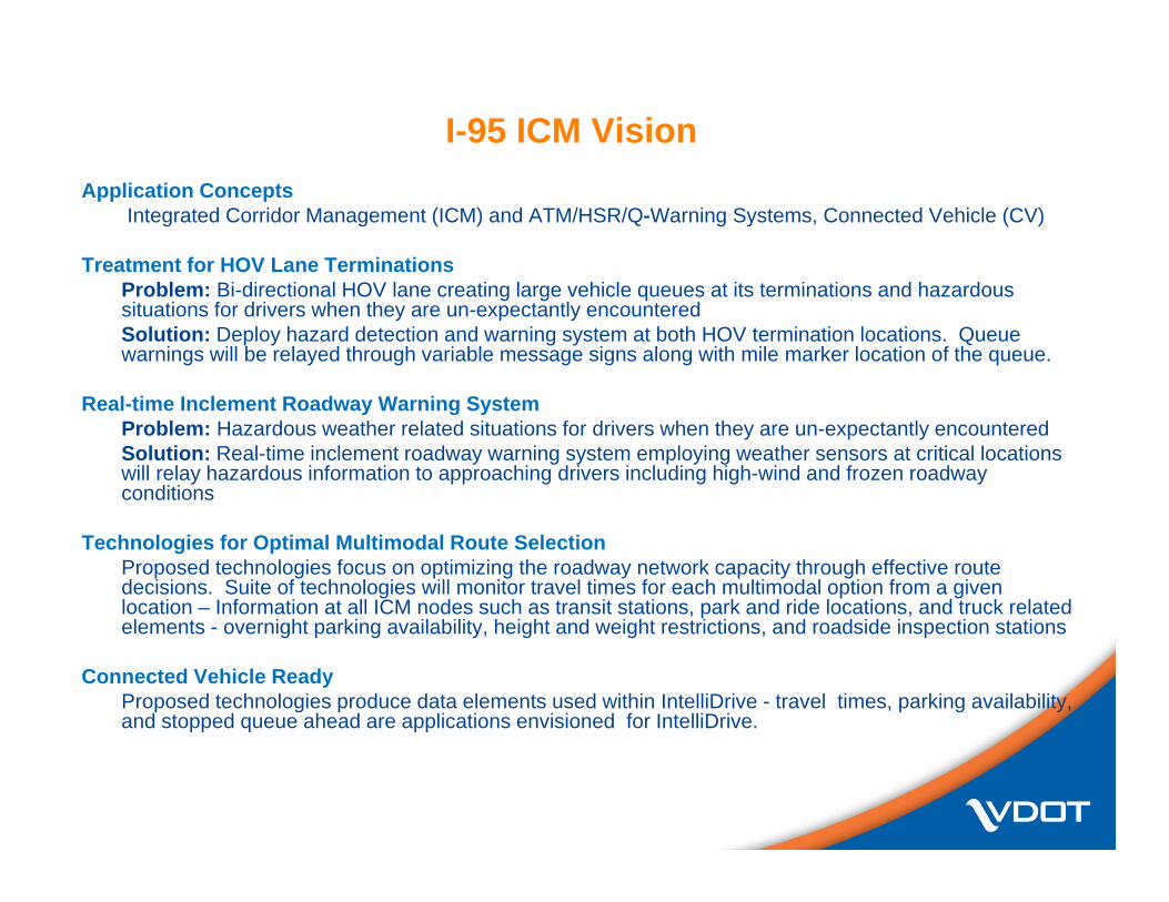
I-95 ICM VisionApplication Concepts
Integrated Corridor Management (ICM) and ATM/HSR/Q-Warning Systems, Connected Vehicle (CV)
Treatment for HOV Lane TerminationsProblem: Bi-directional HOV lane creating large vehicle queues at its terminations and hazardous situations for drivers when they are un-expectantly encounteredSolution: Deploy hazard detection and warning system at both HOV termination locations. Queue warnings will be relayed through variable message signs along with mile marker location of the queue.
Real-time Inclement Roadway Warning SystemProblem: Hazardous weather related situations for drivers when they are un-expectantly encounteredSolution: Real-time inclement roadway warning system employing weather sensors at critical locations will relay hazardous information to approaching drivers including high-wind and frozen roadway conditions
Technologies for Optimal Multimodal Route SelectionProposed technologies focus on optimizing the roadway network capacity through effective route decisions. Suite of technologies will monitor travel times for each multimodal option from a given location – Information at all ICM nodes such as transit stations, park and ride locations, and truck related elements - overnight parking availability, height and weight restrictions, and roadside inspection stations
Connected Vehicle Ready Proposed technologies produce data elements used within IntelliDrive - travel times, parking availability, and stopped queue ahead are applications envisioned for IntelliDrive.

Proposed Corridor Definition – Fredericksburg to DC State Line
Mark Center

ICM Subsystems
Integrated management of freeway, arterial, transit, and parking systems within thecorridorPro-active, joint, multi-modal managementOptimize use of existing infrastructureCorridor managed as a systemUtilize spare capacityProvide choicesReal-time traveler information
Arterial Systems
Freeway Systems
BusSystems
RailSystems
ParkingSystems

Project Details
Project Limits - Spotsylvania Interchange (MM 126) to 14th
Street Bridge (DC State Line)
Project SegmentsI. US 1/17 to Rt 610 (MM126-
144)II. Rt 610 to I-495 (MM144-170)III. I-495 to 14th St Br (I-395,
MM0-8)
Develop ICM strategies, applications and technology-based solutions
I-95/I-395 ICM Concept-of-Operations & Project Development Task began October, 2011
16

Stakeholder Engagement & Project Development
Operations, Traffic, and Travel Demand
As-Built Infrastructure and
ITS AssetsTransit Projects and
TDM Initiatives
Roadway Projects and Transit/TDM
InitiativesCorridor Assessment
(Baseline)Project Needs and
Strategy Formulation
StakeholderNeeds
TechnologyOptions
Overall ICMApproach
Coordination withTransit /TDM/Other
VDOT and Multi-Modal Stakeholders
Project andOperationalKnowledge
Needs andFunctionalInput
DeploymentRecommendations
SystemArchitecture
TechnologyDefinitions
SystemLocations
Technology Deployment Plan
CoordinationOn SystemElements
Concept-of-Operations& Project Scoping
PerformanceMeasures
Refined SystemConcept
Roles andResponsibilities
Multi-modalOperational Scenarios
OperationalRoles andMOU Needs
ICM Project Development Activities

ICM Applications
• Multi-Modal Travel Time Information• Pre-trip, en-route multi-mode travel time information
(roadside signs and VA 511)• End-to-end user-centered trip tool based on updated VA 511• Address road, transit options and available parking should
transit, carpool or slugging option be considered by traveler
• Real-time Parking Management and Guidance• Park-and-ride space, guidance information (VDOT and
transit parking facilities) where travelers have two or more options relative to parking and either transit or carpooling / slugging
• Present comparative travel time information for transit options (including next bus / train departure) along with parking space availability.
• Use roadside signs and add functionality to VA 511

Emphasis Areas
Traveler Information-Related Packages Corridor-wideBuild on 511 / current rideshare initiativesPre-trip orientationEncourage mode shift, moves from SOV to HOV and transitEntire investment could qualify as a TMP-related offset
Operations-Related Packages Segment-based (but includes central hardware/software)Infrastructure-orientedEn-route orientationBenefits to various modesTMP-related offsets could be at least $3.96M of above
Decision Support and Performance Management Systems are future elements

Institutional View: The ICM Partnership
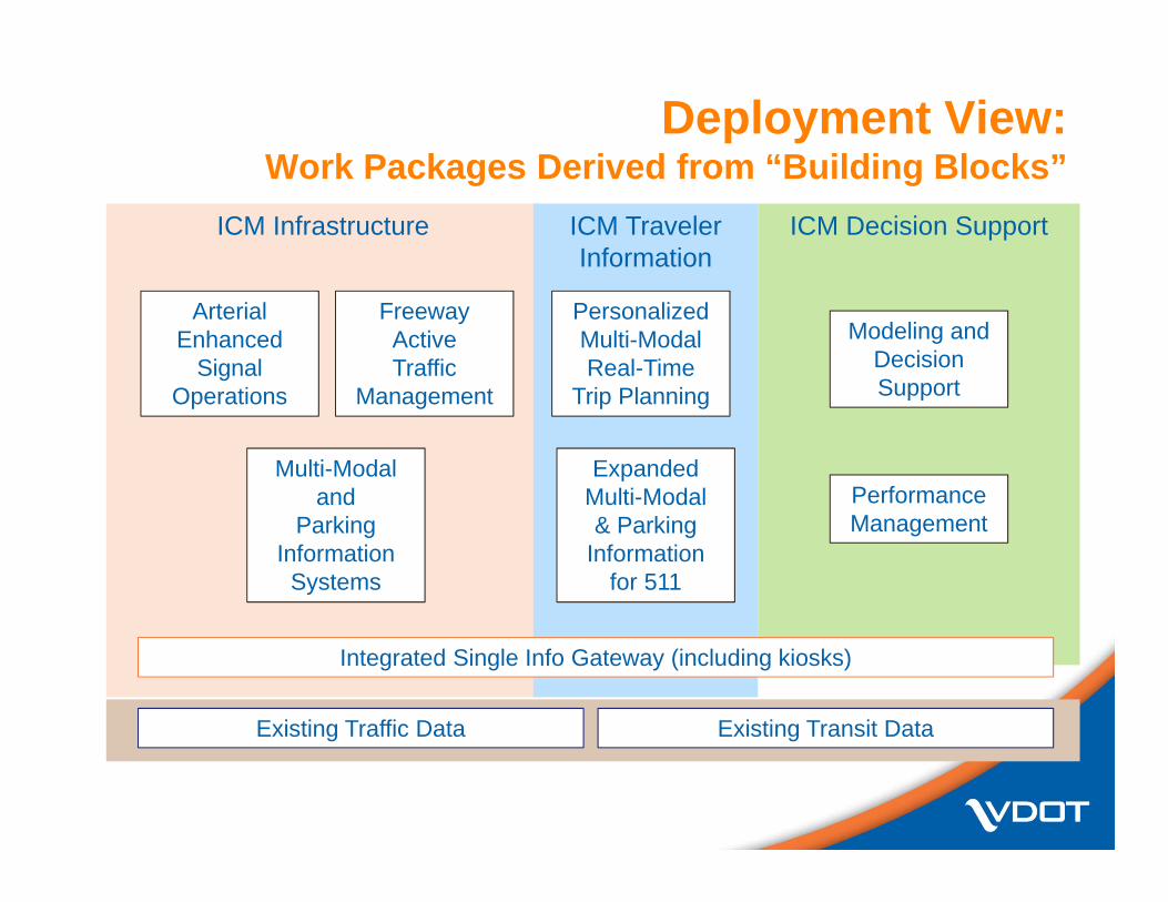
Deployment View:Work Packages Derived from “Building Blocks”
ICM Infrastructure
Multi-Modal and
ParkingInformation
Systems
FreewayActiveTraffic
Management
ArterialEnhanced
SignalOperations
ICM Traveler Information
Expanded Multi-Modal& Parking
Informationfor 511
PersonalizedMulti-ModalReal-Time
Trip Planning
ICM Decision Support
PerformanceManagement
Modeling andDecisionSupport
Existing Traffic Data Existing Transit Data
Integrated Single Info Gateway (including kiosks)

I-64 DNM Vision
22
Project Location - critical link in transportation network in Hampton Roads area connecting largest ports on the east coast, large military installations, and numerous recreational attractions
Context - Heavy vehicular traffic traveling in and out of the region via the Hampton Roads Bridge Tunnel (HRBT) connecting Southside (Norfolk, Virginia Beach, Chesapeake) to the peninsula (Hampton, Newport News, Williamsburg) resulting in congestion and long queues at the approaches to the HRBT
Technology Applications - The project will deploy technologies to address two common contributors to congestion - over-height vehicles and sudden onset of queuing, primary cause of congestion and often evident on the approaches to Tunnels, Movable Bridges, Ferries, etc, integrated traveler info
Over Height Detection System – Deployment of CB override transmitters upstream of the approach to the westbound tube of the HRBT to alert trucks of the height restriction at HRBT at a sufficient distance so that they can divert to another route
Active Queue Warning System will be installed to alert motorists of stopped or slow moving traffic ahead so that they can reduce speed and avoid making abrupt stop when the end of queue is reached by providing real-time information at points where they can divert to other routes
Technologies for Optimal Multimodal Route SelectionProposed technologies focus on optimizing the roadway network capacity through effective route decisions. Suite of technologies will monitor travel times for each multimodal option from a given location – Information at all ICM nodes such as transit stations, park and ride locations, HOV, etc
Dynamic Route Guidance at decision points to allow drivers particularly non-local who are not familiar with the road network on potential diversion routes to act on information provided

23
I-64: Denbigh Blvd to I-264

I-64: Denbigh Blvd to I-264 Example

Probe Data
E-payment
Signal Phase and Timing
Real Time Network Data
Situation Relevant Information
Instrumented Roadside
(Roadside Equipment, or RSE)
Opportunity for Innovation
Safety Messages
“The Network”
Preparing Virginia for Dynamic Mobility

Role of Traffic Operations
With New Technologies

27
VDOT’s Vision for Advancing Operations
• ATM, ICM, DMA, Connected Vehicle Technologies are becoming Core Elements of VDOT’s Role in Road Operations
• These concepts and technologies are to address Congestion and Safety Issues in both Urban and Rural Sections of the Roadway System
• Recurring and Non-recurring Congestion is the major focus • Weather related aspects - Fog, Wind, Ice, etc are the focus
• I-66 is a Good “First Location” in Northern Virginia for ATM technology application followed by other potential locations statewide
• Integration of Modal Operations and application of emerging Technologies and Tools to address Safety & Mobility issues
27
Optimizing the use of existing transportation “infrastructure”
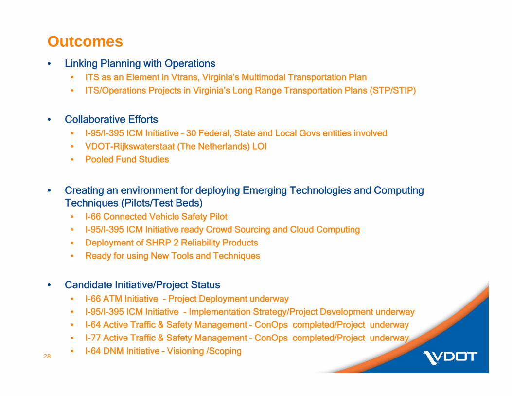
Outcomes• Linking Planning with Operations
• ITS as an Element in Vtrans, Virginia’s Multimodal Transportation Plan• ITS/Operations Projects in Virginia’s Long Range Transportation Plans (STP/STIP)
• Collaborative Efforts• I-95/I-395 ICM Initiative – 30 Federal, State and Local Govs entities involved• VDOT-Rijkswaterstaat (The Netherlands) LOI• Pooled Fund Studies
• Creating an environment for deploying Emerging Technologies and Computing Techniques (Pilots/Test Beds)
• I-66 Connected Vehicle Safety Pilot• I-95/I-395 ICM Initiative ready Crowd Sourcing and Cloud Computing• Deployment of SHRP 2 Reliability Products• Ready for using New Tools and Techniques
• Candidate Initiative/Project Status• I-66 ATM Initiative - Project Deployment underway• I-95/I-395 ICM Initiative - Implementation Strategy/Project Development underway• I-64 Active Traffic & Safety Management – ConOps completed/Project underway• I-77 Active Traffic & Safety Management – ConOps completed/Project underway• I-64 DNM Initiative – Visioning /Scoping
28