SatinDoll(alto) - kohamajazz.comkohamajazz.com/img/fromk/SatinDoll(alto).pdf · i

L A N D O F V A L E N C I A
Itineraries in theAlto Mijares-L'Alcalatén districtsThe mountain areas of AltoMijares and part of theL'Alcalatén are dominatedby the Penyagolosa peakto the north and the Espina-Espadán mountains tothe south. They offertravellers a view of the Landof Valencia which is verydifferent from thebeachfront fun and sun:attractive rural sceneswhere silence reignssupreme and nature can beenjoyed to the full. Theselands are all waiting to bediscovered at the calmpace of the hiker, or from
the saddle of a horse orthe seat of a bicycle.
The magnificentopportunities provided bythis area for natureexcursions are fullycovered by the long-distance and short-distancehiking routes known inSpain as the Senderos deGran Recorrido (GRs) andSenderos de PequeñoRecorrido (PRs). These aretraditional trails used byhikers, who mark themusing different colouredpaints or signposts. Thesetrails can be used byanyone in reasonably goodshape with some hiking orwalking practice overmountain terrain. Pleaseremember that the
conservation of theseareas is aresponsibility we allshare. Do not lightfires or leaverubbish behind; takeit back with you untilyou can deposit it inan appropriateplace. Respectcroplands, oldbuildings, and animaland plant life ingeneral.
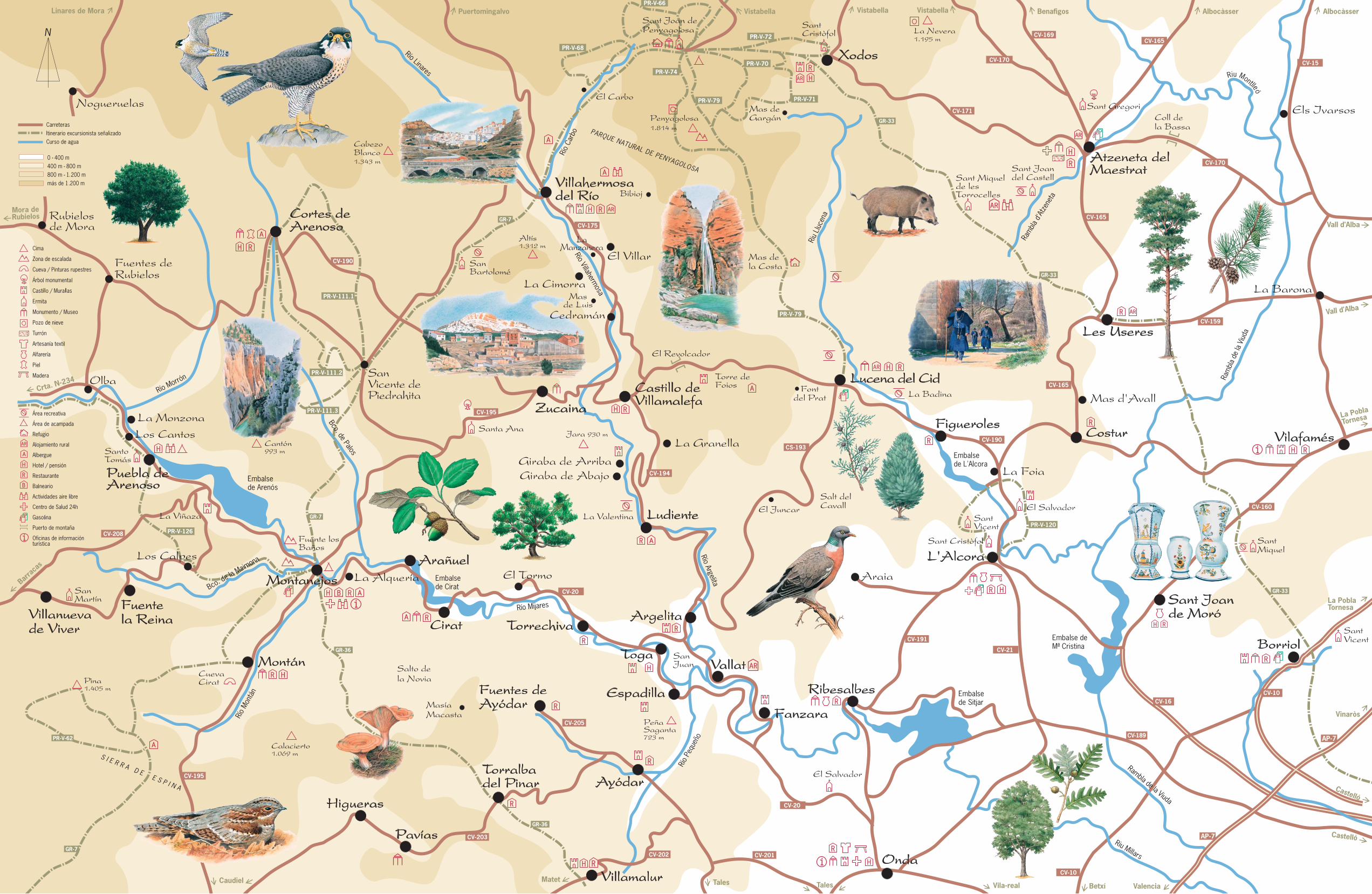
1. Long Distance RouteGR-7The GR-7 crosses thedistrict, running through thetowns of Villahermosa delRío, San Vicente de Cortés,Montanejos and Montán.It is marked with red andwhite paint. The sectionbetween Villahermosa delRío and Sant Joan dePenyagolosa gives hikersa view of the Carbo river,an authentic mountainstream bordered by theoccasional riverbankmillhouse or orchard. Thesection betweenMontanejos and Montánoffers spectacular vistasover the Maimona ravine.For further details, see the'Topo-Guía' publications(in Spanish) in two volumes:Fredes-Sant Joande Penyagolosa (Castelló,1987), and Sant Joande Penyagolosa-Andilla(Castelló, 1993).
2. Long Distance RouteGR-33The GR-33 (red and whitemarks) runs from the cityof Castelló de la Plana tothe Sant Joan dePenyagolosa peak. Fromthe town of Les Useres itfollows the same routeused by the procession inthe famous annualpilgrimage taking placehere. The section betweenXodos and thesanctuary of Sant Joan dePenyagolosa can becombined with the PR-V-71or 73 to form a circularroute around the centralpart of the Penyagolosamassif.
3. Long Distance RouteGR-36The GR-36 (red and whitemarks) runs through the
Espadán mountains fromMontanejos to Villavieja.The section betweenVillamalur and Torralba delPinar traversesinteresting vegetation underthe shadow of the Pinarmountain (1,047m).
4. Short Distance RoutePR-V-79The PR-V-79 (yellow andwhite marks) links Lucenadel Cid to Sant Joan dePenyagolosa following thetrail once used by icedealers who storedmountain snow in so-called'neveras', or 'iceboxes' onthe slopes leading down tothe plain. It runs by themountain shelter Mas de laCosta, a home base forhikers and mountain bikers,with excursions describedin a leaflet published by theCentre Excursionista de
València Centros de AireLibre: Mas de la Costa(Valencia, 1996).
5. Short Distance RoutePR-V-64 / PR-V-74NetworkThere is a network of 11short distance routes(marked in yellow and white)covering part of thePenyagolosa massif. Theseroutes all have one leg thatleads to the sanctuary ofSant Joan de Penyagolosa,and some combine with theGR-7, GR-33 or PR-V-79.There is a 'Topo-Guía'publication (in Valencian)covering the network fromthe Centre Excursionista deCastelló: Penyagolosa,excursions a peu (Castelló,1994).
The district offers a widevariety of routes, fromsimple walks to a chapelto day-long excursions. Notall trails are signposted,however, enabling hikersto find their own way.Guidebooks, detailed mapsand knowledgeable guidesare recommended. Inaddition to the publicationsmentioned above thefollowing arerecommended: Caminandopor la Sierra Espadán(Valencia, 1980), and DelMijares al Peñagolosa(Valencia, 1989), both byLuis Gispert; a science-oriented hikers' guideedited by José Sanchocalled Itinerarios por el Valledel Mijares (Almassora,1990); and the hikers'guidebook by RicardoMuñoz El Maestrazgo,l'Alcalatén y el Ducado deVillahermosa (Antinea,Vinaròs, 1996).
Along the many local roadswith very little traffic andthe quiet forest trails,cyclists have manypossibilities for enjoyment,with a wide variety of goodslopes to choose from.Circular tours such as thesecan be made: L'Alcora-Ribesalbes-Fanzara-Argelita-Lucena del Cid-L'Alcora(70km); Montanejos-Zucaina-Castillo deVillamalefa-Argelita-Cirat-Montanejos (65km).Mountain-bikers can followa number of forest trails inthe area, for example, acomplete tour of thePenyagolosa massif fromSant Joan to Lucena delCid. In the Espadánmountains, the villages ofTorralba del Pinar, Villamalurand Cirat are good homebases for excursions.
All hikers and bikers shouldconsult detailed mapsbefore planning theirexcursions, and seekadditional writteninformation in guidebooks.The area described in thispublication is covered bythe following 1:50,000scale maps: Mora deRubielos 28-23 (591),Villahermosa del Río 29-23(592), Cuevas del Vinromá30-23 (593), Manzanera28-24 (614), Alcora 29-24(615), Vilafamés 30-24(616), Segorbe 29-25(640).
Practical TipsCrossing the Mijares rivervalley is the local routeCV-20, starting in Onda andarriving at Puebla deArenoso, passing throughthe villages of Toga, Ciratand Montanejos. InMontanejos the CV-195links to Montán and theAlto Palancia district. Ondaalso connects to Ayódarand Fuentes de Ayódar viathe CV-201, as well as toVillamalur and Torralba delPinar, which lie next to theSierra Espadán. To visitthe valley of theVillahermosa-Argelita riverfollow the CV-194 fromArgelita to Ludiente andCastillo de Villamalefa.
The L'Alcalatén and thenorthern part of the AltoMijares can be reachedusing the CV-16 fromCastelló to L'Alcora by CV-190 to Lucena del Cid,Castillo de Villamalefa,Zucaina and Cortes deArenoso.
TouristInformation OfficesTourist Info CastellóPl. Mª Agustina, 512003 CastellóTel. 964 · 35 86 88Fax 964 · 35 86 89E-mail:[email protected]
www.landofvalencia.com
Castelló
València
AlacantTourist Info MontanejosCtra. Tales s/n12448 Montanejos-CastellóTel. 964 · 13 11 53Fax 964 · 13 11 52E-mail:[email protected]
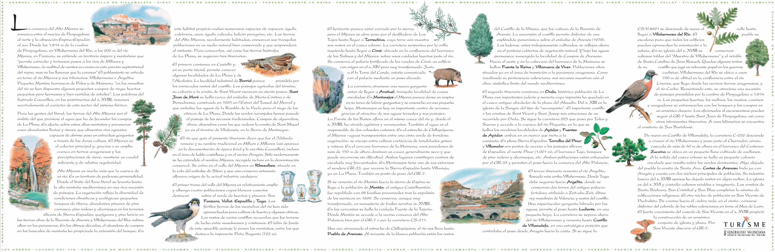
a comarca del Alto Mijares seenmarca entre el macizo de Penyagolosaal norte y la alineación Espina-Espadánal sur. Desde los 1.814 m de la cumbrede Penyagolosa, en Villahermosa del Río, a los 200 m del ríoMijares, en Fanzara, se extiende un territorio áspero y montañoso que“permite estrecho y tortuosos pasos á los rios de Millares yVillahermosa...la multitud de montes es común en esta porción septentrionaldel reyno, mas no las llanuras que la coronan” El poblamiento se articulaen torno al río Mijares y sus tributarios: Villahermosa o Argelita;Pequeño; Montán; barrancos de Palos y de Maimona: “en las revueltasdel rio se han dispuesto algunos pequeños campos de riego; huertaspequeñas pero hermosas y bien vestidas de árboles”. Las palabras delilustrado Cavanilles, en las postrimerías del s. XVIII, resumenacertadamente el carácter de este sector del sistema ibérico.
Para las gentes del litoral, las tierras del Alto Mijares son elámbito del que proviene el agua que ha de fecundar los camposde La Plana. En efecto, sobre estas altas montañas y paramerascaen abundantes lluvias y nieves que alimentan ríos agrestes
capaces de abrirse paso en estrechas gargantasa través de las duras calizas. El Mijares esel colector principal y, gracias a su ampliacuenca en tierras aragonesas y lasprecipitaciones de nieve, mantiene un caudalsuficiente y de relativa regularidad.
Alto Mijares es mucho más que la cuenca deun río. Es un territorio de poderosa personalidad.Desde el límite del llano litoral se levanta hasta
la alta montaña mediterránea en una rica sucesiónde paisajes. La vegetación refleja la diversidad decondiciones climáticas y ecológicas: pequeñosbosques de ribera; abundantes pinares de pinocarrasco; pino rodeno y alcornoque en los terrenos
silíceos de Sierra Espadán; quejigares y pino laricio enlas tierras altas de la Baronía de Arenós y Villahermosa del Río; sabinaalbar en las parameras. En las últimas décadas, el abandono de camposen los bancales de montaña ha propiciado la extensión del bosque. En
este hábitat propicio vuelan numerosas especies de rapaces: águilaculebrera, azor, águila calzada, halcón peregrino, etc. Las tierrasdel Alto Mijares, secularmente habitadas, enmarcan sus tranquilas
poblaciones en un medio natural bien conservado y que sorprenderáal visitante. Para conocerlos, así como las tierras limítrofesde La Plana, se sugieren tres itinerarios.
El primero comienza en Castelló y,en su parte inicial, permite conoceralgunas localidades de La Plana y del’Alcalatén. La localidad industrial de BorriolBorriol parece presidida porlos enriscados restos del castillo. Los paisajes agrícolas del término,su calvario o la ermita de Sant Vicent merecen un atento paseo. SantSantJoan de MoróJoan de Moró se halla cerca del embalse de María Cristina o deBenadressa, construido en 1925 en l’Estret del Tossal del Morral yque embalsa las aguas de la Rambla de la Viuda para el riego de los
cítricos de La Plana. Desde los verdes naranjales hemos pasadoal paisaje de los secanos tradicionales. Campos de algarrobos,olivos, almendros como los que rodean la ermita de Sant Miquel
ya en el término de Vilafamés, en la Serra de Montnegre.
El río que guía el presente itinerario dicen que fue el Idúbedaromano y su nombre tradicional es Millars o Millares (así aparece
en la documentación de época foral y lo escribía Cavanilles), inclusoen el área de habla castellana y en el vecino Aragón. Sólo modernamentese ha extendido el nombre Mijares, recogido incluso en la denominacióncomarcal. Se entra en el valle del Mijares en RibesalbesRibesalbes, situado enla cola del embalse de Sitjar, y que aún conserva artesaníaalfarera origen de la actual industria azulejera.
El primer tramo del valle del Mijares es relativamente amplioy alberga cuatro poblaciones cuyos blancos caseríosdestacan sobre el verde de huertas y pinares. Son
FanzaraFanzara, VVallatallat, EspadillaEspadilla y TTogaoga. Lasfértiles tierras de los meandros del río han sidoaprovechadas para cultivos de huerta y algunos cítricos.
Los restos de varios castillos recuerdan que fue terrenode lucha entre musulmanes y cristianos. El telón de fondo
de este apacible paisaje lo ponen las montañas, entre las quedestaca la imponente Peña Saganta (723 m).
del Castillo de la Viñaza, que fue cabeza de la Baronía deArenós. La ascensión al castillo permite disfrutar de unaespléndida panorámica sobre el embalse de Arenós (1978).Las laderas, antes trabajosamente cultivadas, se reflejan ahoraen el pantano cubiertas de vegetación natural. Y bajo las aguas
permanece sumergida la localidad de Campos de Arenoso.Hacia el oeste y en la cabecera del barranco de la Maimona sehallan Fuente la ReinaFuente la Reina y Villanueva de ViverVillanueva de Viver. Poblaciones altas
situadas ya en el área de transición a la paramera aragonesa. Comoresaltando su pertenencia valenciana, sus secanos muestran aún elolivo, simbólico límite del mundo mediterráneo.
El segundo itinerario comienza en OndaOnda, histórica población de LaPlana con importantes judería y morería cuya impronta ha quedado enel casco antiguo alrededor de la plaza del Almudín. Del s. XIII es laiglesia de la Sangre del tipo de “reconquista”. El importante castilloo las ermitas de Sant Vicent y Sant Josep son estaciones de unrecorrido por Onda. Se sigue la carretera 223 que pasa por Tales ySueras y accede a la cuenca del río Pequeño, en la que sehallan las recoletas localidades de AAyódaryódar y FuentesFuentesde Ade Ayódaryódar, ambas en un marco que invita a lacaminata. En plena Sierra Espadán, TTorralba del Pinarorralba del Pinary VillamalurVillamalur son puntos de acceso a los paisajes silíceosde Espadán: el monte Pinar (1.001 m), el barranco Tajo, bosquesde pino rodeno y alcornoque, etc. Ambas poblaciones están enlazadaspor el GR-33 y permiten el paso hacia la comarca del Alto Palancia.
El tercer itinerario remonta el río Argelita,llamado más arriba Villahermosa. Desde Togadebe seguirse hacia ArgelitaArgelita, donde seconservan dos torres del antiguo palacio-fortaleza atribuido a Zeit-abu Zeit, último
rey musulmán de Valencia, y restos del castillo.Una espectacular garganta labrada por las
aguas, permite el paso hasta LudienteLudiente, en unapequeña hoya. La carretera se separa ahoradel río Villahermosa y remonta hasta CastilloCastillo
de Villamalefade Villamalefa, en una estratégica posición quecontrolaba el paso desde Aragón hacia la costa. Si se sigue la
CS-V-8621 se desciende de nuevo al valle hastallegar a Villahermosa del RíoVillahermosa del Río. El pueblo seescalona para que todos los edificiospuedan aprovechar la orientación a lasolana. En su iglesia del s. XVIII se conservanvaliosas tablas del “Maestro de Villahermosa” y el retablode Santa Catalina de Joan Rexach. Quedan algunos restosde su castillo que jugó un relevante papel en las guerras
carlistas. Villahermosa del Río se ubica a unos700 m de altitud en la confluencia entre el río
Linares, que llega desde las vecinas tierras aragonesas, yel río Carbo. Remontando este, se atraviesa una sucesión
de paisajes presididos por la cumbre de Penyagolosa a 1.814m. Las pequeñas huertas, los molinos, las masías, caminos
y azagadores se entremezclan con los bosques y los campos enun armónico damero. Los aficionados al excursionismo puedenseguir el GR-7 hasta Sant Joan de Penyagolosa, así comootros interesantes itinerarios. A unos kilómetros se encuentra
el ermitorio de San Bartolomé.
De nuevo en Castillo de Villamalefa, la carretera C-232 desciendea cruzar el río Villahermosa y pasa junto al Chorrador, airosacascada de más de 40 m de altura en el barranco del Centenar.ZucainaZucaina se ubica en un pequeño llano cultivado de avellanos.A la salida del casco urbano se halla un pequeño calvario
encalado que resalta sobre los verdes dominantes. Algo alejadadel pueblo la ermita de Santa Ana. Cortes de ArenosoCortes de Arenoso linda ya conAragón y cuenta con dos núcleos principales de población. Su industrialanera del s. XVIII apenas ha dejado restos en algún molino. La iglesiaes del s. XVI y custodia valiosos retablos e imaginería. Las ermitas deSanta Bárbara, San Cristóbal y San Blas completan la nómina deedificaciones religiosas. El otro núcleo de población es San Vicente dePiedrahita. De camino hacia él –sobre todo, en el otoño– convienedisfrutar del colorido de los robles valencianos en torno al Mas de León.El fuerte crecimiento del caserío de San Vicente en el s. XVIII propició
la construcción de un armónicoconjunto de iglesia y plaza. Por
San Vicente discurre el GR-7.
•
V
IL
LA
NU
EV
A
DE
V
IV
ER
•
Z
UC
AI
NA
•
L
’A
LC
OR
A
•
XO
DO
S
•
CO
ST
UR
•
A
TZ
EN
ET
A
DE
L
MA
ES
TR
AT
L E S U S E R E S • L U C E N A D E L C I D • S A N T J O A N D E M O R Ó • B O R R I O L • V I L A F A M É S • P A V Í A S • H I G U E R A S • R I B E S A L B E S • F I G U E R O L E S • O N D A • A R A Ñ U E L • A R G E L I T A • A Y Ó D A R • C A S T I L L O D E V I L L A M A L E F A • C I R A T • C O R T E S D E A R E N O S O • E S P A D I L L A • F A N Z A R A • F U E N T E L A R E I N A • F U E N T E S D E A Y Ó D A R • L U D I E N T E •
• M
ON
TA
NE
JO
S •
P
UE
BL
A D
E A
RE
NO
SO
•
T
OG
A •
T
OR
RA
LB
A D
EL
P
IN
AR
•
T
OR
RE
CH
IV
A •
V
AL
LA
T V
IL
LA
HE
RM
OS
A
El horizonte parece estar cerrado por la sierra,pero el Mijares se abre paso por el desfiladero de LosTajos hasta llegar a TTorrechivaorrechiva, cuya torre aún muestrasus restos en el casco urbano. La carretera serpentea por la orillaizquierda hasta llegar a CiratCirat, ubicado en la confluencia del barrancode las Salinas y del Mijares, sobre unas cuidadas huertas junto al río.Se conserva el palacio fortificado de los condes de Cirat, un edificio
con origen en el s. XIV pero muy transformado. Juntoa él la Torre del Conde, antaño comunicadacon el palacio mediante un paso elevado.
La carretera atraviesa una nueva gargantaantes de llegar a ArañuelArañuel, tranquila localidad de casasencaladas. En MontanejosMontanejos el Mijares parece darse un respiroen su tarea de labrar gargantas y se ensancha en una pequeña
hoya. Montanejos es hoy un importante centro de veraneogracias al atractivo de sus aguas termales y sus paisajes.
La Fuente de los Baños aflora en el mismo cauce del río y, desde els. XVIII, ha atraído agüistas y veraneantes. También el agua es elresponsable de dos colosales cañones. En el estrecho de Chillapájaros,el Mijares –aguas transparentes entre una cinta verde de frondosavegetación– se encaja entre calizas cretácicas de tonalidades grisesy rojizas. En el cercano barranco de la Maimona, unos paredones demás de 150 m de altura dominan un cauce generalmente seco y quepuede recorrerse sin dificultad. Ambos lugares constituyen centros deescalada muy frecuentados. En Montanejos tiene uno de sus extremosel sendero GR-33, que recorre la Sierra Espadán hasta Villavieja,ya en La Plana. También es punto de paso del GR-7.
Si se remonta el río Montán hacia la sierra de Espina sellega a la población de MontánMontán, el antiguo Castellmontánfue repoblado con 28 familias provenzales tras la expulsiónde los moriscos en 1609. Se conserva, aunque muytransformado, un monasterio de frailes servitas (s. XVIII).En las cercanías se halla la cuidada Fuente de la Tejería.Desde Montán se accede a la vecina comarca del AltoPalancia bien por el GR-7 o por la carretera CS-211.
Una vez atravesado el estrecho de Chillapájaros, el río nos lleva hastaPuebla de ArenosoPuebla de Arenoso. Al suroeste de la blanca población están los restos
• A R A Ñ U E L • A R G E L I T A • A Y Ó D A R • C A S T I L L O D E V I L L A M A L E F A • C I R A T • C O R T E S D E A R E N O S O • E S P A D I L L A • F A N Z A R A • F U E N T E L A R E I N A • F U E N T E S D E A Y Ó D A R • L U D I E N T E • M O N T Á N • M O N T A N E J O S • P U E B L A D E A R E N O S O • T O G A • T O R R A L B A D E L P I N A R • T O R R E C H I V A • V A L L A T • V I L L A H E R M O S A D E L R Í O • V I L L A M A L U R
PARQUE NATURAL DE PENYAGOLOSA


![Mijares v. Ranada, G.R. No. 139325, [April 12, 2005]](https://static.fdocuments.in/doc/165x107/5695d1dc1a28ab9b02982ed7/mijares-v-ranada-gr-no-139325-april-12-2005.jpg)