Item No. 9.1 - Halifax
81
P.O. Box 1749 Halifax, Nova Scotia B3J 3A5 Canada Item No. 9.1.1 Halifax Regional Council June 9, 2020 TO: Mayor Savage and Members of Halifax Regional Council SUBMITTED BY: Jacques Dubé, Chief Administrative Officer DATE: January 24, 2020 SUBJECT: Dutch Village Road Complete Streets Functional Plan ORIGIN On July 19, 2016, the following motion of Regional Council was put and passed: “Direct staff to undertake preliminary design work to confirm the cost and feasibility of providing pedestrian and bicycle infrastructure, and potentially other streetscape elements where needed, on Dutch Village Road and report back to Regional Council, and further that if approved by Regional Council, the project be considered for future delivery through the active transportation capital program and include a public engagement process.” The Making Connections: 2014-19 Halifax Active Transportation Priorities Plan, approved by Regional Council on September 9, 2014, lists Dutch Village Road as a Candidate Bicycle Route. The Integrated Mobility Plan - Action 69: Deliver the following Priority Sidewalk Connection by 2020: Dutch Village Road; Action 121: Identify “Strategic Corridors” – existing road corridors that are key to regional traffic flow, transit, goods movement and active transportation – and develop plans that will guide their development over time. LEGISLATIVE AUTHORITY Halifax Regional Municipality Charter, subsection 318(2): “In so far as is consistent with their use by the public, the Council has full control over the streets in the Municipality.” Halifax Regional Municipality Charter, subsection 322(1): “The Council may design, lay out, open, expand, construct, maintain, improve, alter, repair, light, water, clean, and clear streets in the Municipality.” RECOMMENDATION ON PAGE 2
Transcript of Item No. 9.1 - Halifax

P.O. Box 1749 Halifax, Nova Scotia B3J 3A5 Canada
Item No. 9.1.1 Halifax Regional Council
June 9, 2020
TO: Mayor Savage and Members of Halifax Regional Council
SUBMITTED BY: Jacques Dubé, Chief Administrative Officer
DATE: January 24, 2020
SUBJECT: Dutch Village Road Complete Streets Functional Plan
ORIGIN
On July 19, 2016, the following motion of Regional Council was put and passed:
“Direct staff to undertake preliminary design work to confirm the cost and feasibility of providing pedestrian and bicycle infrastructure, and potentially other streetscape elements where needed, on Dutch Village Road and report back to Regional Council, and further that if approved by Regional Council, the project be considered for future delivery through the active transportation capital program and include a public engagement process.”
The Making Connections: 2014-19 Halifax Active Transportation Priorities Plan, approved by Regional Council on September 9, 2014, lists Dutch Village Road as a Candidate Bicycle Route.
The Integrated Mobility Plan - Action 69: Deliver the following Priority Sidewalk Connection by 2020: Dutch Village Road; Action 121: Identify “Strategic Corridors” – existing road corridors that are key to regional traffic flow, transit, goods movement and active transportation – and develop plans that will guide their development over time.
LEGISLATIVE AUTHORITY
Halifax Regional Municipality Charter, subsection 318(2): “In so far as is consistent with their use by the public, the Council has full control over the streets in the Municipality.”
Halifax Regional Municipality Charter, subsection 322(1): “The Council may design, lay out, open, expand, construct, maintain, improve, alter, repair, light, water, clean, and clear streets in the Municipality.”
RECOMMENDATION ON PAGE 2

Dutch Village Road Complete Streets Functional Plan Council Report - 2 - June 9, 2020
RECOMMENDATION
It is recommended that Halifax Regional Council
1. Suspend the rules of procedure under Schedule 7, the Transportation Standing Committee Termsof Reference, of Administrative Order One, the Procedures of the Council Administrative Order.
2. Direct the Chief Administrative Officer to proceed with the detailed design of Dutch Village Roadbetween Alma Crescent / Supreme Court and Joseph Howe Drive / Bayers Road as described inthe Discussion section of this report.
3. Direct the Chief Administrative Officer to consider the addition of streetscaping elements such astrees, benches, bicycle racks, waste receptacles and potentially other elements to beautify thecorridor during detailed design, and if included, ensure the corridor is maintained as an ‘EnhancedMaintenance Area’.
EXECUTIVE SUMMARY
This report seeks Council direction to proceed with the detailed design and construction of improvements to Dutch Village Road, including enhancements for pedestrians and cyclists. The 2017 Integrated Mobility Plan (IMP) identifies Dutch Village Road as a Priority Sidewalk Connection based on the lack of sidewalk on a street with high traffic volumes and transit service in an area where residential and commercial density is expected to continue to increase. The IMP sets targets to increase the number of trips made by walking, bicycling or transit and recognizes the inter-relationship of transportation and land use. With the increased residential intensification enabled along Dutch Village Road by recent MPS and LUB amendments, as well as the proximity to the regional greenway network (i.e. Chain of Lakes Trail), there is an opportunity to influence how people travel by filling in the gaps in the active transportation infrastructure. In addition to the IMP, the Active Transportation Priorities Plan identifies Dutch Village Road as a candidate bicycle route.
WSP Canada Inc. were retained in 2018 to complete a functional design study, which investigated multiple design options for active transportation upgrades between Alma Crescent / Supreme Court and Joseph Howe Drive (but not including those intersections). The design options were evaluated based on their improvements to the pedestrian & cyclist environment, impacts to traffic, and impacts to curbside activities (e.g. parking). The functional plan recommends an improved pedestrian realm with sidewalk and curb on both sides of the street, a raised protected bicycle lane on both sides of the street, and potentially space for amenities such as benches, waste receptacles, bicycle parking, transit waiting areas and vegetation. It also includes standard width travel lanes, intersection improvements, and shortened pedestrian crossing distance. The plan would improve access management to properties by replacing “nose-in” parking and with defined driveways. The proposed bicycle facilities on Dutch Village Road will connect to the Chain of Lakes Trail and support safer trips for cyclists from Fairview to Clayton Park, Bayers Lake Business Park as well as the Halifax Peninsula. The study considered necessary property acquisition, utility relocation, construction cost and feedback from impacted stakeholders and the public. The preferred functional plan strives to improve the safety and functionality of the street as well as create an environment in which the Dutch Village Road area can thrive and grow.
The original project did not include the intersections of Dutch Village Road at Alma Crescent / Supreme Court and at Joseph Howe Drive. The original scope was limited to the section of the street that currently lacks a sidewalk on the west side. However, based on feedback from the public and internal stakeholders, the functional design scope was expanded to include both intersections. Recommended active transportation and road safety upgrades stemming from this work include extending the bicycle lanes to the intersections and closing the right turn channels at Alma Crescent and Joseph Howe Drive.
With approval of the recommendations in this report, the proposed functional design plan will move to the detailed design stage. Upon completion of the detailed design process, a construction tender can then be considered. The earliest construction date would be 2021/22; however, this would be contingent upon a

Dutch Village Road Complete Streets Functional Plan Council Report - 3 - June 9, 2020
number of factors including a timely completion of the detailed design, budget availability, and overall priorities pursuant to the capital budget process.
BACKGROUND
The Integrated Mobility Plan (IMP), approved by Regional Council in December 2017, identifies Dutch Village Road as a Priority Sidewalk Connection (Action 69). According to HRM’s evaluation criteria, the west side of Dutch Village Road is rated HIGH for a new sidewalk due to road classification, presence of bus stops and passenger volume, along with the nearby land uses such as daycares, shopping, employment, and high density residential. Additionally, the 2014 Making Connections: Active Transportation Priorities Plan, identifies Dutch Village Road as a Candidate Bicycle Route.
The IMP also recommends undertaking ‘Strategic Corridor Plans’ to guide the development of roads that are key to regional traffic flow, transit, goods movement and active transportation (Action 121) and to take a Complete Streets approach to redesigning a street (Policy 2.3.5a). A ‘complete streets’ approach considers how the street functions as a destination or ‘place’ as well as a transportation ‘link’ and aims to improve the comfort and safety for all transportation modes, especially active transportation and transit.
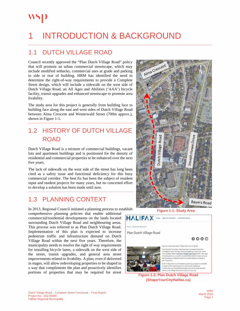
Dutch Village Road is a major collector road that runs in a crescent. The 700m section that is the subject of this report connects Joseph Howe Drive at Bayers Road with Alma Crescent (Figure 1). The area has a mixture of commercial buildings, vacant lots, and apartments buildings. Recently approved Municipal Planning Strategy (MPS) and Land Use By-law (LUB) amendments resulting from the “Plan Dutch Village Road” project, are contributing to an increase in the density of residential and commercial buildings in the area. Over 20 construction permits have been issued in the previous five years, which represent over $40.5 million of private investment.
The MPS promotes an urban commercial streetscape with reduced setbacks, commercial uses at grade, and parking to side, rear, or underground. It is expected to increase pedestrian traffic and active transportation infrastructure demand on Dutch Village Road within the next five years. Dutch Village Road has daily traffic volumes exceeding 16,000 vehicles per day.
The lack of sidewalk on the west side of the street, between Sunnybrae Avenue and Alma Crescent, has been cited as a safety issue and a functional deficiency for this busy commercial corridor. Since there is no curb or sidewalk on the west side, vehicular access to property is uncontrolled, and portions of off-street parking spaces encroach into the right-of-way. Most of this parking is perpendicular to the travel way causing motorists to drive in and back out into traffic, creating conflicts with other motorists, cyclists and pedestrians. Between January 2015 and December 2017, fifty-six collisions were documented in the corridor. Transit currently operates two routes along Dutch Village Road between Alma Crescent and Joseph Howe Drive
Figure 1: Extent of the Functional Design Study along DutchVillage Road

Dutch Village Road Complete Streets Functional Plan Council Report - 4 - June 9, 2020 (Routes #28 and #137). Existing west-side transit stops are currently not accessible since there is no curb or sidewalk. There is also an opportunity to connect Dutch Village Road to the Chain of Lakes Trail. To address the challenges outlined above, WSP was engaged in May 2018 to prepare a functional design for the section between Alma Crescent and Westerwald Street (~700m). This work was partially funded by the provincial Connect2 program and was completed in March 2019. Based on feedback from the public and internal stakeholders, staff undertook further functional planning work at both intersections to ensure better consideration of transitions for the proposed bicycle and pedestrian improvements at Bayers Road/ Joseph Howe Drive and at Supreme Court / Alma Crescent. DISCUSSION The primary objective of this project was to investigate options to improve conditions for pedestrians and cyclists on Dutch Village Road. In collaboration with a mutli-departmental staff team, including Transportation & Public Works, Planning & Development and Halifax Transit, the consultants performed the following tasks:
1. Detailed investigation of existing conditions; 2. Explored three cross-sections and used an evaluation matrix along with feedback from the project
steering committee to focus further on a preferred cross-section; 3. Prepared a functional design based on the preferred option; 4. Carried out public and stakeholder engagement related to the proposed option; 5. Identified necessary property acquisition and utility relocation requirements to support the proposed
option. The consultant’s findings and recommendations are included in Attachment A. EXISTING CONDITIONS
Active Transportation:
There is a wide concrete sidewalk without a buffer on the east side of the street. On the west side of the street, pedestrians currently walk on the shoulder of the road without any barrier separating them from travelling vehicles (approximately 8,000 southbound per day) or those backing in and out of parking. Most of the shoulder consists of a swale with periodic catch-basins to capture stormwater, providing for an uncomfortable walking / rolling experience. There are no bicycle facilities along Dutch Village Road, which limits Fairview residents’ connection to existing and planned AT facilities nearby (the Chain of Lakes Trail connects Fairview to Bayers Lake, and a planned multi-use path on Bayers Road will provide an “all ages & abilities” bikeway connection from Fairview to the Halifax Peninsula).
Transit:
Halifax Transit currently operates two routes between Alma Crescent and Joseph Howe Drive (Routes #28 and #137). The Moving Forward Together Plan (MFTP) does not identify Dutch Village Road as a priority transit corridor and does not envision additional service here in the future. At present, because of the lack of curb and sidewalk on the west side, the bus stops require waiting passengers to stand on the shoulder of the road. The stops are currently inaccessible because a curb and level landing area are needed to deploy the ramp.
Traffic:
The cross-section on Dutch Village Road generally consists of two lanes of traffic that widen at the intersections. The roadway currently accommodates an average weekday traffic volume of approximately 16,700 vehicles per day. The width of the right-of-way is inconsistent throughout the corridor, ranging from
Dutch Village Road Complete Streets Functional Plan Council Report - 5 - June 9, 2020
18.0m to 21.5m and increasing to approximately 27.0m near the Bayers Road / Joseph Howe Drive intersection.
Parking: Most fronting commercial properties have off-street parking and / or loading on private property. Some parking spaces fronting Dutch Village Road currently encroach on the municipal right-of-way and are perpendicular to the roadway. The functional plan looked at reclaiming the municipal right-of-way for the active transportation improvements and providing parallel on-street parking spaces instead.
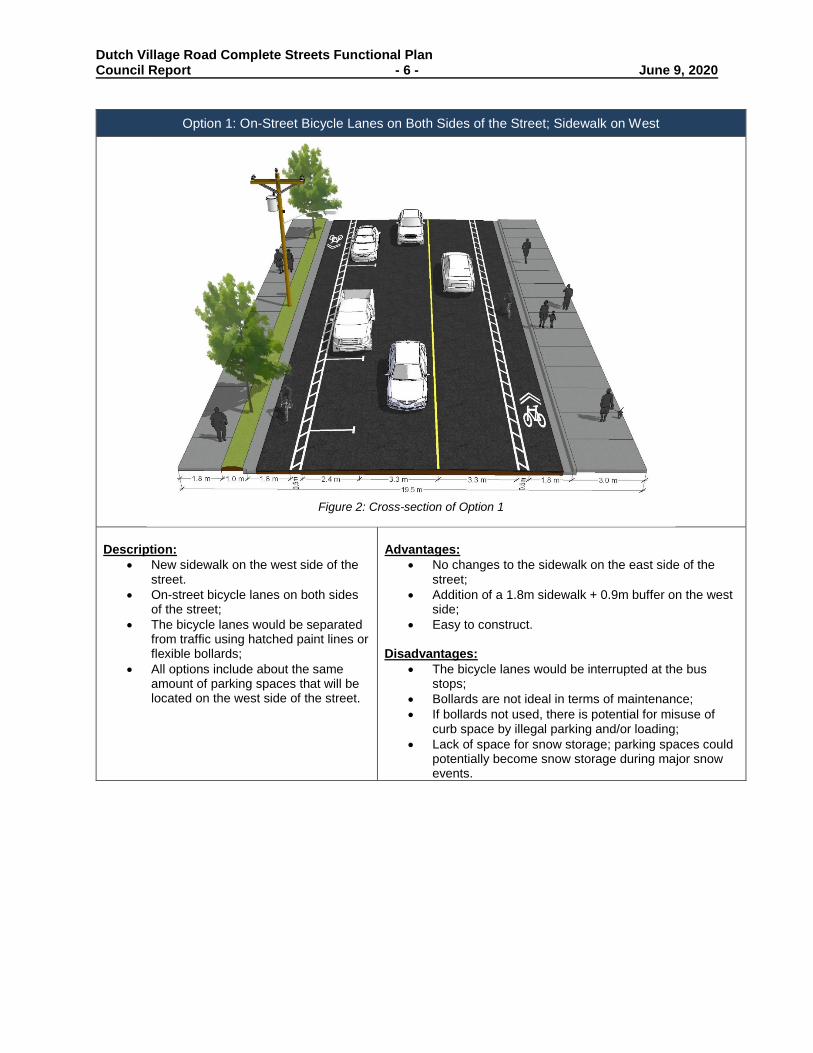
CROSS-SECTIONS AND CONCEPTUAL DESIGN OPTIONS
Consultants initially explored three cross-sections before settling on a preferred functional design option for the corridor. All the options included a new sidewalk between Alma Crescent and Sunnybrae Avenue on the west side of the street. From the three original options, Option 2 was determined to best satisfy the project’s goals and objectives and was developed further to form the recommended option. Figures 3-5 provide a description and summary of key advantages and disadvantages of each cross-section.
Please note that the figures are diagrammatic and are not intended to illustrate detailed features. Detailed design for each section of the corridor will be informed by the functional design drawings developed as part of this plan. The detailed design process will include a more focused investigation of the constraints and opportunities for each section. Efforts will be made to improve elements of the design where possible; for example, increasing the width of cross section elements such as the buffer between the traffic lanes and the bicycle lanes. The detailed design process may also reveal physical constraints not identified in the functional design that require changes to the configuration of the corridor or ROW expansion. During detailed design, any exceptions to municipal design standards will need to be identified and presented to HRM’s Variance Request Committee for review and approval.
Space left intentionally blank
Dutch Village Road Complete Streets Functional Plan Council Report - 6 - June 9, 2020
Option 1: On-Street Bicycle Lanes on Both Sides of the Street; Sidewalk on West
Description:
• New sidewalk on the west side of the street.
• On-street bicycle lanes on both sides of the street;
• The bicycle lanes would be separated from traffic using hatched paint lines or flexible bollards;
• All options include about the same amount of parking spaces that will be located on the west side of the street.
Advantages:
• No changes to the sidewalk on the east side of the street;
• Addition of a 1.8m sidewalk + 0.9m buffer on the west side;
• Easy to construct. Disadvantages:
• The bicycle lanes would be interrupted at the bus stops;
• Bollards are not ideal in terms of maintenance; • If bollards not used, there is potential for misuse of
curb space by illegal parking and/or loading; • Lack of space for snow storage; parking spaces could
potentially become snow storage during major snow events.
Figure 2: Cross-section of Option 1

Dutch Village Road Complete Streets Functional Plan Council Report - 7 - June 9, 2020
Option 2: Raised Bicycle Lane on West Side & On-Street Bicycle Lane on East Side; Sidewalk on West Description:
• New sidewalk on the west side of the street. • Raised bicycle lane on the west side of the
street; • Distinction between the sidewalk and the
raised bicycle lane will be achieved using a different surface material;
• On-street bicycle lane on the east side of the street;
• All options include about the same amount of parking spaces that will be located on the west side of the street.
Advantages:
• No changes to the sidewalk on the east side of the street;
• On-street bicycle lane on the east side can be installed without any curb modification;
• Raised bicycle lane is appropriate for the high traffic volumes present on Dutch Village Road;
• Bicycle / vehicle conflicts are reduced by the physical separation of the raised bicycle lane
• Addition of a sidewalk on the west side. Disadvantages:
• The bicycle lane on the east side would be interrupted at the bus stops;
• Bollards would limit illegal parking/ loading in the bicycle lane but are challenging to maintain;
• Inconsistent bicycle facility type along the corridor;
• Lack of space for snow storage; parking spaces could potentially become snow storage during major snow events.
• Difficult to maintain.
Figure 3: Cross-section of Option 2

Dutch Village Road Complete Streets Functional Plan Council Report - 8 - June 9, 2020
Option 3: Multi-Use Trail On East Side; Sidewalk on West
Description: • New sidewalk on the west side of the street;• Replaces the existing sidewalk on the east
side with a 3.5m multi-use pathway;• The sidewalk and multi-use trail have
buffers separating them from traffic.• All options include about the same amount
of parking spaces that will be located on thewest side of the street.
Advantages: • Seamless tie-in with the Chain of Lakes Trail.• Presents a better environment for tree
survival with adequate soil structure andspecies selection.
• Availability of space for snow storage.
Disadvantages: • Requires removal of existing sidewalk on the
east side, which is currently in goodcondition.
• A multi-use trail on an urban commercialstreet with allowances for zero setbackdevelopment and expected high pedestrianvolumes would not be appropriate, asconflicts between pedestrians and cyclistswould be challenging to manage.
• Two-way bicycle traffic on one side of a two-way roadway that has a high density ofdriveways and intersections is notappropriate and increases the collision riskbetween vehicles and people riding bicyclesparticularly in the contraflow direction.Curvature of the roadway, and localtopography exacerbate this disadvantage.
Based on the analysis above, Option 2 was chosen to move forward for further development.
Figure 4: Cross-section of Option 3

Dutch Village Road Complete Streets Functional Plan Council Report - 9 - June 9, 2020 RECOMMENDED FUNCTIONAL DESIGN OPTION
To address the disadvantages associated with Option 2 described above, the possibility of installing raised bicycle lanes on both sides of the street was explored in more detail and is being recommended as the preferred option moving forward. Figure 5 illustrates the recommended cross-section along the corridor. The following section describes the proposed changes and associated impacts. Active Transportation:
Walking • New sidewalk on the west side of the street, where there currently isn’t any, will reduce exposure
to conflicts with vehicular traffic. • Include a buffer separating pedestrians from traffic where space allows. • Narrower street crossings, crosswalks enhanced with rectangular rapid flashing beacons (RRFB).
Bicycling
• Protected bicycle lanes on both sides of the street connecting to the Chain of Lakes Trail (COLT) – which in turn provides a connection to planned bicycle facilities on Bayers Road (supports commuters between Fairview, Clayton Park and the Halifax Peninsula). Attachment E illustrates how the proposed Dutch Village Road bicycle facility relates to the larger plan as outlined in the IMP.
Figure 5: Preferred Cross-section

Dutch Village Road Complete Streets Functional Plan Council Report - 10 - June 9, 2020
Transit:
All bus stops along the corridor will be accessible. Stops 6613, located on the east side of Dutch Village Road before Rosedale Avenue, & 6638, located on the east side of Dutch Village Road before Sunnybrae Avenue, will be consolidated and moved to between Central Avenue and Rosedale Avenue. The functional plan will enable the installation of a shelter on the west side if warranted in the future.
Parking:
The design will impact 24 parking spaces that currently encroach on the right-of-way by re-orienting these spaces from perpendicular to parallel and adding curbs with defined driveways. Five additional 15-min on-street parking spaces will be impacted with the proposed intersection improvements. However, the functional plan includes 30 on-street, parallel parking spaces with a net increase of 1 parking space. During major snow events, parking spaces could potentially become snow storage until clearance is complete.
With the anticipated parking technology, it would be possible to introduce paid parking in the area if desired to further encourage turnover along the commercial area and offer flexibility for patrons. The pay stations would be added concurrent with the construction of the proposed cross section.
Access Management:
The functional design includes access management improvements for the corridor particularly on the west side of the street. Currently, vehicles can enter and exit the street at any point, which increases the risk of conflict with other vehicles, pedestrians and cyclists. With the addition of curb and sidewalk driveways will be defined and access will be better managed.
Property Acquisition:
The functional plan identified several small parcels of land that are necessary to achieve the preferred cross section. These are largely the result of an irregular streetline, and one already includes some municipal infrastructure (a sidewalk). Staff have performed a sensitivity analysis on the functional plan proposed by WSP and reduced the number of required parcels from six to four. However, during the detailed design process, more lands may be identified.
Staff have already initiated the property acquisition process – if negotiations fail, there are two ways the municipality could proceed:
1. Some on-street parking spaces could be compromised to maintain priority on delivering theinfrastructure required for pedestrians and cyclists.
2. Expropriate the lands necessary to achieve the desired cross-section.
INTERSECTION IMPROVEMENTS
Proposed changes at intersections and the anticipated impacts are summarized in Table 1. A Multi-Modal Level of Service (MMLOS) and traffic impact analysis were completed to evaluate these changes on various modes of transportation – results are summarized in Attachments B and C. The traffic analysis for proposed conditions indicates that all movements currently operate within HRM’s acceptable limits. Overall, the proposed changes are expected to have minimal impact on general vehicle operations on Dutch Village Road. Traffic analysis was based on AM and PM peak periods and included intersection delay and queue length.
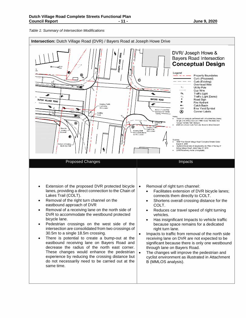
Dutch Village Road Complete Streets Functional Plan Council Report - 11 - June 9, 2020 Table 1: Summary of Intersection Modifications
Intersection: Dutch Village Road (DVR) / Bayers Road at Joseph Howe Drive
Proposed Changes Impacts
• Extension of the proposed DVR protected bicycle lanes, providing a direct connection to the Chain of Lakes Trail (COLT).
• Removal of the right turn channel on the eastbound approach of DVR
• Removal of a receiving lane on the north side of DVR to accommodate the westbound protected bicycle lane.
• Pedestrian crossings on the west side of the intersection are consolidated from two crossings of 30.5m to a single 18.5m crossing.
• There is potential to create a bump-out at the eastbound receiving lane on Bayers Road and decrease the radius of the north east corner. These changes would enhance the pedestrian experience by reducing the crossing distance but do not necessarily need to be carried out at the same time.
• Removal of right turn channel: • Facilitates extension of DVR bicycle lanes;
connects them directly to COLT. • Shortens overall crossing distance for the
COLT. • Reduces car travel speed of right turning
vehicles. • Has insignificant Impacts to vehicle traffic
because space remains for a dedicated right turn lane.
• Impacts to traffic from removal of the north side receiving lane on DVR are not expected to be significant because there is only one westbound through lane on Bayers Road.
• The changes will improve the pedestrian and cyclist environment as illustrated in Attachment B (MMLOS analysis).

Dutch Village Road Complete Streets Functional Plan Council Report - 12 - June 9, 2020
Intersection: Dutch Village Road (DVR) at Supreme Court / Alma Crescent
Proposed Changes Impacts
• A raised protected bicycle lane on the east side.• A painted bicycle lane on the west side
(recommended to avoid a bumpy ride resultingfrom crossing multiple driveways if bicycle lanewas raised in this location. Transition to raisedprotected bicycle lane takes place beyond gasstation driveway).
• Loss of approximately five 15-min parkingspaces between Alma Crescent and Deal Street
• Side street parking is available with observedlow occupancy
• Perpendicular parking of abutting property, civic3617/3619, encroaches on HRM right-of-way.This plan reclaims the space for a sidewalk,bicycle lane, and buffer.
• Removal of right turn channel on south eastcorner (corner “A”) is necessary to extend thebicycle lane to the intersection. This will alsoimprove visibility and mitigate pedestrian andvehicle conflicts.
• Addition of one parking space on DVR frontingCivic 3635.
• Impacts to traffic are not expected to besignificant.
• The MMLOS analysis suggests that theconditions for cyclists and pedestrians willslightly improve with the reduction ofuncontrolled conflict points resulting from theremoval of the right turn channel. Conditions fortransit, goods movement and automobiles willremain relatively the same.
• The crossing distance on the north side ofDutch Village Road will decrease from twocrossings of about 21m to 16.0m. The crossingdistance isn’t further decreased to avoid vehicleconflict paths introduced with the removal of theright turn channel. To accommodate this, staffpropose changing the signal timing plans toreflect the increase in the Flash Don’t Walk timefor the NB approach from 11 seconds to 16seconds and for the EB & WB approach from10 seconds to 16 seconds.

Dutch Village Road Complete Streets Functional Plan Council Report - 13 - June 9, 2020
Streetscaping
Streetscaping was not a consideration of the functional planning process; however, the corridor was subsequently evaluated using various criteria being developed internally to assess potential areas for streetscaping in the Regional Centre. While this corridor is outside that area, it rated reasonably high due to it being the ‘main street’ of an existing and growing pedestrian oriented commercial district, along with the opportunity to integrate streetscaping with other construction (i.e. of this new AT infrastructure and potentially with ROW reinstatement following redevelopment of adjacent property).
Several streetscaping opportunities were also identified, including but not limited to: installation of various site furnishings (e.g. bike racks, benches, waste receptacles); the use of decorative materials (e.g. unit pavers in the boulevard or pedestrian lighting); tree planting (likely requiring soil cells or trenches to provide soil below the urban hardscape); and horticultural planting in the realigned median at Sunnybrae Avenue. Strategies to mitigate the impact of overhead wires could also be considered, like burying the laterals, or using higher poles to place overhead electrical wires beyond sightlines.
As described in the Financial Implications section, should Council approve the recommendations of this report, minor streetscaping opportunities will be explored further through the detailed design phase and included in the project’s construction if feasible.
FINANCIAL IMPLICATIONS
It is expected that detailed design of this project will be undertaken by HRM staff. A Class D cost estimate for construction is $1.8 million, which includes new curb and sidewalk on the west side of the street, protected bicycle lanes, and related street and intersection improvements. The estimated annual additional operating costs of the proposed pedestrian and cyclist improvements are approximately $12,000.
An additional capital allowance of $400,000 should also be considered to undertake some streetscaping improvements if feasible (as described above) in this emerging pedestrian-oriented commercial district (as described in the Discussion section). Dutch Village Road is currently outside the coverage of HRM’s Enhance Maintenance Area (EMA) and is in a 4-year contracted winter maintenance area. The contract would likely need to be amended to capture the additional costs of maintenance. There will also be consideration to potentially add the Dutch Village Road area to the EMA at the end of the contract period with consideration of additional staffing and capital requirements for service, at least for the summer period.
Should Council direct staff to continue with this project, property acquisition will continue where identified in the functional plan through the detailed design phase and construction will target 2021 at the earliest. Incidental costs associated with the project will continue to be funded through other capital accounts.
The 20/21 proposed capital budget includes supplementary sheet Mobility2 for Major Strategic Modal Corridor: Dutch Village Road and identifies $50,000 in 20/21 to support in-house detailed design, and $2,250,000 in 21/22 for construction. Acquisition of properties is expected to cost approximately $85,000 and will be funded through CT190009-IMP Land Acquisition.
RISK CONSIDERATION
Staff have initiated the property acquisition process for the parcels needed to achieve the design goals. If negotiations fail, there are two ways the municipality could proceed:
1. The preferred cross-section could be adjusted accordingly, likely by compromising some proposedon-street parking spaces.
2. Expropriate the lands necessary to achieve the desired cross-section.
The impact and likelihood of the risk that businesses will experience less store traffic due to parking changes is unlikely as the preferred option contains an equivalent number of on-street parking spaces, with the

Dutch Village Road Complete Streets Functional Plan Council Report - 14 - June 9, 2020 orientation and location of parking changed. Most businesses also have private off-street parking and there is more on-street parking on the side streets. The increased residential densification happening along Dutch Village Road will increase foot traffic. The risks of not proceeding with the project include continued pedestrian-vehicle conflict on a roadway with over 16,000 vehicles per day and no sidewalk on one side; continued collision risks related to the configuration of the encroaching perpendicular parking; continued allowance of relatively high-speed turns in an increasing pedestrian oriented commercial district; continued gap in bicycle connection between Fairview and the Chain of Lakes Trail and planned Bayers Road multi-use pathway. Properties fronting on this corridor were 'up-zoned' in 2016 to allow higher residential densities with zero setback to the front lot line and encouragement of commercial uses at ground level. Commercial uses require level pedestrian access and egress, so it is critical that detailed design and construction of the sidewalk be advanced. Development interest in the area is increasing and the sooner the new sidewalk is designed and built, the easier it will be to match the level of the new sidewalk with the first-floor level of abutting buildings. COMMUNITY ENGAGEMENT Attempts were made to have one-on-one meetings with all property owners whose customer parking is currently encroaching into the public ROW to make them aware of the project and its impact on their use of the ROW. Most were aware that their front yard parking was encroaching and understood the rationale for introducing curb and associated driveways (i.e. access control in place of currently unrestricted access to all west side properties where curb is absent). Some expressed concerns that the bicycle lanes were not needed; however, the main impact to their use of the ROW will result from the introduction of curb and sidewalk, whether a bicycle lane is included or not. The preferred functional design (excluding the intersections) was presented at a public meeting on February 20, 2019 at the Centennial Arena. The property owners with parking encroaching on the right-of-way were invited to attend via an email and / or a phone call. Other residents of HRM were notified of the public meeting through a combination of advertisements on social media (i.e. Facebook and Instagram), and a paid advertisement in the Community Herald. In addition, a Shape Your City online engagement portal was established. Feedback was collected via in-person comments, and an online survey. The information obtained from the public was used to evaluate their response to the design. Survey results are summarized in Attachment D. Most of the open house attendees and survey respondents were in favor of the project. Many raised concerns regarding the exclusion of the intersections from the functional plan – these have since been addressed, as described in the Discussion section. There was also a sentiment expressed for additional streetscaping along Dutch Village Road. ENVIRONMENTAL IMPLICATIONS This project supports the Council Priority Outcome of building healthy, livable communities: it aims to make it more convenient for residents to choose sustainable transportation options for everyday transportation. This is reflected in the improvements to active transportation infrastructure, which will support more people to walk, cycle, and get to the bus, promoting a shift in non-auto modes and a reduction in greenhouse gas (GHG) emissions.

Dutch Village Road Complete Streets Functional Plan Council Report - 15 - June 9, 2020
ALTERNATIVES
Halifax Regional Council could choose not to approve the recommendations outlined in this report and could choose from the alternatives presented below:
1. Direct the CAO to proceed with alternative cross-sections / conceptual design options, or somevariation thereof. This may require a supplementary staff report. These options are notrecommended for the reasons outlined in the Discussion section of this report.
2. Direct the CAO to abandon the project and that make no changes to Dutch Village Road. Thisalternative is not recommended as it is not consistent with the policy direction outlined in the IMP.
ATTACHMENTS
Attachment A: Dutch Village Road Functional Design Plan (WSP) Attachment B: Intersection Improvements & Multimodal Impact Analysis Attachment C: Intersection Functional Design Drawings Attachment D: Shape Your City Results Attachment E: Bicycle Network in the IMP
A copy of this report can be obtained online at halifax.ca or by contacting the Office of the Municipal Clerk at 902.490.4210.
Report Prepared by: Leen Romaneh, Planner I, Strategic Transportation Planning, 902.490.4495
Report Approved by: Tanya Davis, Strategic Transportation Planning Program Manager, 902.490.1206

Project No. 181-06948 March 2019
HALIFAX REGIONAL MUNICIPALITY
DUTCH VILLAGE ROAD COMPLETE STREET FUNCTIONAL PLAN
FINAL REPORT
Attachment A

Dutch Village Road – Complete Street Functional – Final Report Project No. 181-06948 Halifax Regional Municipality
WSPMarch 2019
Page i
EXECUTIVE SUMMARY Council recently approved the “Plan Dutch Village Road” policy that will promote an urban commercial streetscape, which may include modified setbacks, commercial uses at grade and parking to the side or the rear of buildings. HRM has identified the need to determine the right-of-way requirements to provide a Complete Street design, which will include a sidewalk on the west side of Dutch Village Road, an All Ages and Abilities (‘AAA’) bicycle facility, transit upgrades and enhanced streetscape to promote area livability. The ongoing development of a planning strategy to create growth opportunities and an urban commercial streetscape on Dutch Village Road, makes the street an ideal candidate for application of the Integrated Mobility Plan’s Complete Street principles.
The study area for this project is generally from building face to building face along the east and west sides of Dutch Village Road between Alma Crescent and Westerwald Street (700m approx.). The Dutch Village Road Complete Street Functional Plan includes a series of cross sections and concept design options to improve Dutch Village Road. The following are summaries of the concept design options.
THREE CROSS SECTIONS WSP prepared three cross sections to modify Dutch Village Road which included:
1) On-Street Bicycle Lanes: On-street bicycle lanes with a new concrete sidewalk on the west side of the street. The bicycle lanes are 1.8m in width and have a 0.5m buffer area from the travel lane. This buffer area could be hatched paint lines, flexible bollards or pre-cast curb.
2) Raised Bicycle Lane on West Side & On-Street Bicycle Lane on East Side: A new protected and raised bicycle lane and sidewalk on the west side of the street. On the east side, a separated bicycle lane is proposed so that the existing curb and sidewalk can remain unchanged. The raised bicycle lane is above the street level and is typically at sidewalk level. Distinction between the sidewalk area and the raised bicycle lane can be achieved using different surface materials to delineate where the pedestrians and bicyclist travel.
3) Multi-Use Trail on East Side: The existing sidewalk on the east side of the street would be replaced with a 3.5m multi-use pathway. On the west side of the street, a concrete sidewalk is added. Both the sidewalk and the multi-use pathway have a buffer area separating them from the street, allowing for street trees and other street amenities. The intent of the multi-use pathway is for pedestrians, cyclists and other active transportation users to share the space. Users are encouraged to keep to the right when travelling and overtake slower users on the left.
Based on an evaluation analysis along with feedback from the Technical Committee and key stakeholders, two alternatives of Option #2 were prepared, and Options #1 & #3 were removed from consideration.
TWO CONCEPT DESIGNS To focus on a preferred solution, WSP prepared two concept designs based on the Raised Bicycle Lane on West Side & Buffered Bicycle Lane on East Side (#2). Both options are adaptable to the changing right-of-way width within the corridor. Opportunities are available to include on-street parallel parking or to extend the sidewalk and create a bus loading area. The two concept designs options are described below:
A) Raised Bicycle Lane on West Side & On-street Bicycle Lane on East Side: Option A features a separated on-street bicycle lane on the east side of the street and a raised bicycle lane along with a new sidewalk on the west side. Physically separating the bicycle lane from the vehicle travel lane is beneficial to reducing conflict between bicycles and vehicles. Since new curb and sidewalk is required on the west side of the street, constructing a raised bicycle lane along side it would be cost effective. Since the existing sidewalk on the east side of the street was viewed as being in satisfactory condition, an on-street bicycle lane with a physical buffer was included.

Dutch Village Road – Complete Street Functional – Final Report Project No. 181-06948 Halifax Regional Municipality
WSPMarch 2019
Page ii
B) Raised Bicycle Lane on West & East: Option B includes a raised bicycle lane on both sides of the street. Having both bicycle facilities separated (both vertically and horizontally) increases the level of comfort and provides quality cycling infrastructure along Dutch Village Road. There is added cost to this option compared to Option A, as the existing curb on the east side of the street will need to be removed and rebuilt.
Based on feedback from the Technical Committee and key stakeholders, Option B was the preferred option.
PREFERRED OPTION The preferred functional plan put forward in this study creates an improved pedestrian realm with sidewalks on both sides of the street and space for street amenities such as benches, waste receptacles, bicycle parking, transit waiting areas and vegetation. An All Ages and Abilities (‘AAA’) bicycle facility is established by creating raised bicycle lanes, at sidewalk level, that includes a tactile buffer between them and the sidewalk. The travel lanes on the street are narrowed and better defined to help control vehicle travel speeds and shorten crossing distances while maintaining full functionality of traffic operations. The plan improves access management to properties by eliminating street conflicts created by “nose-in” parking and replacing that with defined driveways and on-street parallel parking. The proposed bicycle facilities on Dutch Village Road will connect into the existing Chain of Lakes Trail facilities with future opportunities on Westerwald Street to be designated as a Local Street Bikeway.
The preferred functional plan not only improves the many safety and functional operations of the existing street but creates an environment in which the Dutch Village Road area can thrive and grow.
CONCLUSION & RECOMMENDATIONS Based on the background review, stakeholder and public engagement, as well as conceptual design, the following recommendations have been developed for consideration by the Municipality.
NEXT STEPS
It is recommended to include the existing intersections of Bayers Road/Joseph Howe Drive and Alma Crescent/Dutch Village Road within the scope of the detailed design. This will assist with the continuity of the bicycle lanes, connecting to the Chain of Lake Trail and completing the necessary improvements at the signalized intersection.
While initial engagement with abutting property owners was completed during the conceptual design, it is recommended to further engage with property owners, who may be affected by the proposed changes, to modify the design as needed at the 60% detailed design stage.
Complete the detailed design of Dutch Village Road, acquire any needed property and relocate the necessary utility poles. Other items to consider during detailed design include:
o Review driveway locations and width to ensure they meet the needs of users. o Review width of curb to allow enough space for emergency vehicles. o Review any grade constraints/ ROW space for retaining walls. o Determine where space is available to include bus shelters. o Review potential underground conflicts, such as catchbasin relocations. o Review opportunities to include trees and landscape features along corridor where is space is
available. Construct the project with the proposed sidewalk and the raised bicycle lane on the west side and the raised
bicycle lane on the east side of Dutch Village Road. o There may be potential to construct in two phases with Phase 1 including the section from Joseph
Howe Drive/Bayers Road intersection to Sunnybrae Avenue with the realignment of the Shoppers Drug Mart Driveway and Phase 2 would be the completion of the remainder of the corridor. Phase 2 may also be completed in two stages with completing the sidewalk and raised bicycle lane on the west side of Dutch Village Road with a painted bicycle lane on the east side. Later the raised bicycle lane on the east side could be added. Completing Phase 2 all at once would be ideal as it would only disrupt the community for a construction season.
Dutch Village Road – Complete Street Functional – Final Report Project No. 181-06948 Halifax Regional Municipality
WSPMarch 2019
Page iii
TABLE OF CONTENTS
EXECUTIVE SUMMARY ............................................ I
1 INTRODUCTION & BACKGROUND ............... 1 1.1 Dutch Village Road ........................................................ 1 1.2 History of Dutch Village Road ...................................... 1 1.3 Planning Context ........................................................... 1 1.4 Study Objectives ........................................................... 3
2 EXISTING CONDITIONS & OPERATIONS .... 4 2.1 Data Collection .............................................................. 6 2.1.1 Legal & Topographical Survey .............................................................. 6
2.1.2 Collision History ..................................................................................... 6
3 PROJECT APPROACH / FRAMEWORK ........ 7 3.1 Design Objectives/Considerations .............................. 7 3.2 Evaluation Framework .................................................. 8
4 CONCEPTUAL DESIGN OPTIONS ................ 9 4.1 Three cross sections .................................................... 9 4.2 Options Evaluation ...................................................... 11 4.3 Two Concept Designs ................................................. 13 4.4 Crosswalk Analysis & Warrants ................................ 15 4.5 Preferred Option .......................................................... 16 4.5.1 Public Open House ............................................................................. 18
4.6 Cost Estimates for Preferred Option ......................... 18
5 SUMMARY & RECOMMENDATIONS .......... 19 5.1 Summary ...................................................................... 19 5.2 Recommendations ...................................................... 19
APPENDICES APPENDIX A – PEDESTRIAN COUNTS
APPENDIX B – OPEN HOUSE BOARDS APPENDIX C – PUBLIC FEEDBACK APPENDIX D – FUNCTIONAL DESIGN PLAN APPENDIX E – COST ESTIMATES
Dutch Village Road – Complete Street Functional – Final Report Project No. 181-06948 Halifax Regional Municipality
WSPMarch 2019
Page 1
1 INTRODUCTION & BACKGROUND
1.1 DUTCH VILLAGE ROAD Council recently approved the “Plan Dutch Village Road” policy that will promote an urban commercial streetscape, which may include modified setbacks, commercial uses at grade and parking to side or rear of building. HRM has identified the need to determine the right-of-way requirements to provide a Complete Street design, which will include a sidewalk on the west side of Dutch Village Road, an All Ages and Abilities (‘AAA’) bicycle facility, transit upgrades and enhanced streetscape to promote area livability.
The study area for this project is generally from building face to building face along the east and west sides of Dutch Village Road between Alma Crescent and Westerwald Street (700m approx.), shown in Figure 1-1.
1.2 HISTORY OF DUTCH VILLAGE ROAD
Dutch Village Road is a mixture of commercial buildings, vacant lots and apartment buildings and is positioned for the density of residential and commercial properties to be enhanced over the next five years.
The lack of sidewalk on the west side of the street has long been cited as a safety issue and functional deficiency for this busy commercial corridor. The best fix has been the subject of resident input and student projects for many years, but no concerted effort to develop a solution has been made until now.
1.3 PLANNING CONTEXT In 2013, Regional Council initiated a planning process to establish comprehensive planning policies that enable additional commercial/residential developments on the lands located surrounding Dutch Village Road and neighbouring areas. This process was referred to as Plan Dutch Village Road. Implementation of this plan is expected to increase pedestrian traffic and infrastructure demand on Dutch Village Road within the next five years. Therefore, the municipality needs to resolve the right of way requirements for installing bicycle lanes, a sidewalk on the west side of the street, transit upgrades, and general area street improvements related to livability. A plan, even if delivered in stages, will allow redeveloping properties to be shaped in a way that compliments the plan and proactively identifies portions of properties that may be required for street
Figure 1-2: Plan Dutch Village Road [ShapeYourCityHalifax.ca]
Figure 1-1: Study Area

Dutch Village Road – Complete Street Functional – Final Report Project No. 181-06948 Halifax Regional Municipality
WSPMarch 2019
Page 2
purposes. In 2016 the policy changes were approved, and they allow increase in residential and commercial density on lands surrounding Dutch Village Road.
In 2014, HRM completed the “Making Connections: 2014-2019 Halifax Active Transportation Priorities Plan” which illustrated the priority projects for creating active transportation connections across the municipality (Figure 1-3).
More recently, Halifax Regional Council unanimously approved the Integrated Mobility Plan (2017). One of the foundational policies in the Plan is that of Complete Streets, which is an approach to street design and maintenance that aims to improve the comfort and safety of users of all transportation modes including pedestrians, bicyclists and transit users.
The complete streets approach also includes the idea that street design should take into consideration all the modes, if trade offs are needed due to limited ROW, that mode priority be informed by the maps in the IMP. In the case of DVR, this project was initiated to address the major sidewalk gap. The street is a candidate route for bicycles facilities in the AT Plan and the functional planning goals aim to resolve how facilities for both modes can be accommodated.
The IMP included the identification of strategic sidewalk projects within HRM (Policy 3.1.5 (a)) specifically Action 69, to deliver the following priority sidewalk connections by 2020 on Dutch Village Road shown in Figure 1-4. The elements that make up a Complete Street, taken from the Integrated Mobility Plan are shown in Figure 1-5.
Figure 1-4: Existing Sidewalks (IMP, Figure 14 & 15, Page 89)
Figure 1-3: Making Connections: AT Priorities Plan
Figure 1-5: Complete Street Features (IMP, p 56)

Dutch Village Road – Complete Street Functional – Final Report Project No. 181-06948 Halifax Regional Municipality
WSPMarch 2019
Page 3
1.4 STUDY OBJECTIVES The primary goal of this project is to follow the Integrated Mobility Plan Complete Street Principles in developing and evaluating design options for Dutch Village Road to include a ‘AAA’ bicycle facility with sidewalk on the west side and enhanced transit facilities. Specific project objectives include:
1. Complete a detailed investigation of the existing conditions within the study area, using available topographical survey, GIS mapping and the establishment of the functional operations of the study area.
2. Develop an understanding of existing active transportation needs from past comments/discussions with HRM.
3. Review and verify the existing legal and topographical survey provided by HRM and identify the right-of-way along the study corridor.
4. Prepare three cross sections with a ‘AAA’ bicycle facility and sidewalk on the west side of Dutch Village Road. Engage with HRM Internal Technical Committee to review and select two options to proceed with conceptual design.
5. Prepare two conceptual designs based on feedback from HRM Technical Committee and engage with them to review and select the preferred design.
6. Meet with abutting business and property owners and other stakeholders to discuss the preferred functional design option and impacts.
7. Present the preferred functional design option to the general public to identify the relevant constraints and obtain feedback on the preferred option.
8. Revise the preferred functional design option as necessary and prepare Class ‘C’ cost estimates for Dutch Village Road upgrades.
9. Prepare a final report that summarizes the findings of the study and also includes the functional design drawings with phasing recommendations for Dutch Village Road.

Dutch Village Road – Complete Street Functional – Final Report Project No. 181-06948 Halifax Regional Municipality
WSPMarch 2019
Page 4
2 EXISTING CONDITIONS & OPERATIONS Dutch Village Road is a major collector that runs 900m in a loop, connecting Joseph Howe Drive with Alma Crescent. Roadway characteristics are summarized in Table 2-1.
Table 2-1: Roadway Characterisitics
DUTCH VILLAGE ROAD (ALMA CRESCENT TO JOSEPH HOWE DRIVE/BAYERS RD INTERSECTION)
TRAFFIC LANES
Generally, two wide lanes of traffic running north to south from Alma Crescent to Westerwald Street.
Lanes typically accommodate a vehicle to pass another that is stopped to turn left or a bus at the curb without impeding oncoming traffic.
ROW is very inconsistent throughout the length of the corridor, varying from approximately 18.0m to 21.5m, increasing to as much as 27.0m nearing the approach to the Bayers Road and Joseph Howe Drive intersection.
TRAFFIC VOLUMES
Traffic data obtained by HRM Traffic Management in July 2011, indicate weekday two-way traffic volumes of approximately 16,700 vehicles per day (vpd) on Dutch Village Road between Westerwald Street and the intersection of Bayers Road at Joseph Howe Drive.
Turning movement counts were provided for the intersections of Dutch Village Road at Alma Crescent and Bayers Road at Joseph Howe Drive. Additional 2018 turning movement counts were conducted at Central Avenue, Rosedale Avenue and Deal Street.
PUBLIC TRANSIT
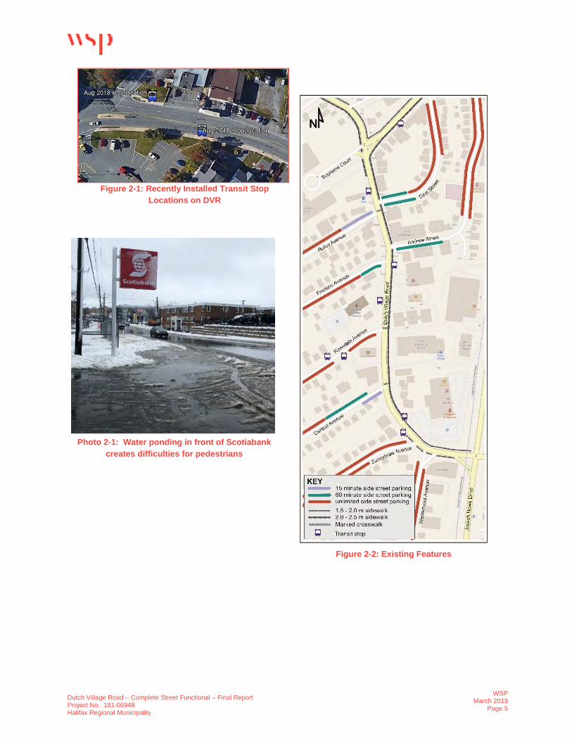
Dutch Village Road is serviced by Halifax Transit Routes #28 (Bayers Lake) and #137 (Clayton Park Express). In August 2018, two new stop locations were added, see Figure 2-1. The Moving Forward Together plan does not propose additional service in the future.
There are several transit stops on the corridor however, none of the stops have rider amenities such as a shelter or bench, although the stop at Sunnybrae has a concrete pad with no shelter.
Transit data collected by Halifax Transit indicated that there were typically 4 transit riders during each of the AM and PM peak hours on Dutch Village Road.
PARKING/ LOADING
One-hour spaces on the east side of the street, north of Deal Street. There is on-street parking available on side streets near Dutch Village Road. Some of this parking is time limited to one hour or fifteen minutes to encourage turnover for nearby business. Figure 2-2 shows parking supply on side streets connecting to Dutch Village Road.
Data on parking utilization is not available.
PEDESTRIANS/
BICYCLES
There is concrete sidewalk on the east side of the street only (good to very good condition). The sidewalk varies from 1.5m to 2.5m in width and lacks a boulevard, which detracts from pedestrian comfort.
On the west side of the street, pedestrians walk on a paved shoulder separated from the travel lanes by a painted shoulder line. The asphalt on the shoulder is generally in very poor condition. Most of the shoulder is formed as a swale with periodic catchbasins to capture stormwater, as seen in Photo 2-1.
There are three locations on the street where marked crosswalks are provided: Central Avenue, Rosedale Avenue and Deal Street and are shown in Figure 2-2. Pedestrian data were collected at these crosswalk by WSP in 2018.
There are no existing bicycle lanes along Dutch Village Road.
UTILITIES There is existing infrastructure along Dutch Village Road which includes utility poles and underground stormwater management. There are approximately 19 utility poles on the west side and approximately 4 utility poles on the east side of Dutch Village Road.
Dutch Village Road – Complete Street Functional – Final Report Project No. 181-06948 Halifax Regional Municipality
WSPMarch 2019
Page 5
Figure 2-1: Recently Installed Transit Stop Locations on DVR
Photo 2-1: Water ponding in front of Scotiabank creates difficulties for pedestrians
Figure 2-2: Existing Features

Dutch Village Road – Complete Street Functional – Final Report Project No. 181-06948 Halifax Regional Municipality
WSPMarch 2019
Page 6
2.1 DATA COLLECTION
2.1.1 LEGAL & TOPOGRAPHICAL SURVEY
HRM provided the detailed legal and topographic survey information of the study area from Highland Geomatics and Engineering on March 23, 2018, which included street widths, property boundaries, bus stop locations, street centrelines, existing trail locations and underground infrastructure. Aerial imagery and mapping was provided to identify the property boundaries and the right-of-way limits. The data was imported into AutoCAD drawings for use as the topographic base for the options review.
2.1.2 COLLISION HISTORY
Collision history data was provided by HRM with a summary of 56 collisions being documented between January 2015 and December 2017 inclusive. The most common type of collision was due to vehicles backing out of nose-in off-street parking stalls into the road and getting rear-ended. The collisions are illustrated in Figure 2-3.
Figure 2-3: Three-Year Collision History
Dutch Village Road – Complete Street Functional – Final Report Project No. 181-06948 Halifax Regional Municipality
WSPMarch 2019
Page 7
3 PROJECT APPROACH / FRAMEWORK
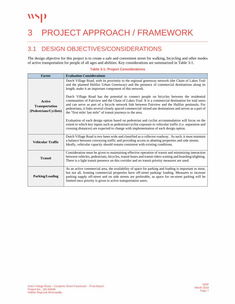
3.1 DESIGN OBJECTIVES/CONSIDERATIONS The design objective for this project is to create a safe and convenient street for walking, bicycling and other modes of active transportation for people of all ages and abilities. Key considerations are summarized in Table 3-1.
Table 3-1: Project Considerations
Factor Evaluation Considerations
Active Transportation
(Pedestrians/Cyclists)
Dutch Village Road, with its proximity to the regional greenway network (the Chain of Lakes Trail and the planned Halifax Urban Greenway) and the presence of commercial destinations along its length, make it an important component of this network.
Dutch Village Road has the potential to connect people on bicycles between the residential communities of Fairview and the Chain of Lakes Trail. It is a commercial destination for trail users and can serve as part of a bicycle network link between Fairview and the Halifax peninsula. For pedestrians, it links several closely spaced commercial/ mixed use destinations and serves as a part of the “first mile/ last mile” of transit journeys to the area.
Evaluation of each design option based on pedestrian and cyclist accommodation will focus on the extent to which key inputs such as pedestrian/cyclist exposure to vehicular traffic (i.e. separation and crossing distances) are expected to change with implementation of each design option.
Vehicular Traffic Dutch Village Road is two lanes wide and classified as a collector roadway. As such, it must maintain a balance between conveying traffic and providing access to abutting properties and side streets. Ideally, vehicular capacity should remain consistent with existing conditions.
Transit Consideration must be given to maintaining effective operation of transit and minimizing interaction between vehicles, pedestrians, bicycles, transit buses and transit riders waiting and boarding/alighting. There is a light transit presence on this corridor and no transit priority measures are used.
Parking/Loading
As an active commercial area, the availability of space for parking and loading is important as most, but not all, fronting commercial properties have off-street parking/ loading. Measures to increase parking supply off-street and on side streets are preferable, as space for on-street parking will be limited once priority is given to active transportation users.

Dutch Village Road – Complete Street Functional – Final Report Project No. 181-06948 Halifax Regional Municipality
WSPMarch 2019
Page 8
3.2 EVALUATION FRAMEWORK Evaluation criteria were developed to inform a comparative analysis of options. These criteria are described below and were applied to the three concept design options outlined in Section 4 along with the existing conditions. The criteria listed in Table 3-2 are in no particular order and have not been assigned relative weighting. They are intended to identify strengths and weaknesses of the option being evaluated.
Table 3-2: Evaluation Criteria
Criteria Evaluation Considerations
User Experience
Walking A preferred user experience for walking would include adequate sidewalk width and separation from traffic.
Bicycling
A preferred user experience for bicycling captures the elements of an All Ages and Abilities facility. That includes ease of comprehension on where to be and how to operate as a cyclist as well as a perception of safety and includes separation from higher volumes and speeds of motor vehicle traffic.
Transit A preferred user experience for transit users includes adequacy of waiting areas, convenience and visibility of stop locations, ease of boarding and alighting buses and adequate connecting facilities for pedestrians.
Modal Conflicts
Pedestrian-Vehicle Each of the travel modes that will be accommodated within the corridor have potential to conflict with each other. Higher scores in this category are given when the modes are better separated so that physical conflict is reduced.
Pedestrian-Bicycle Bicycle-Vehicle
Impact to Parking
On-street Parking/Loading
While provision of on-street parking is not essential, given that additional parking off-street or on side streets may accommodate any loss, it is seen as a valued feature. Some on-street loading areas are desirable for the commercial businesses.
Off-street Parking Sufficient off-street parking opportunities should be available to accommodate parking demand.
Roadway Characteristics
Existing AT Connections
Active transportation facilities need to connect well with the regional network. In this instance, a strong connection to the existing Chain of Lakes Trail is important.
Access to Properties
In this category, higher scores are given when access to adjacent properties by vehicles are not hampered.
Traffic Impacts As a collector street, safe and functional flow of traffic needs to be maintained. Adequate lane widths are important factors.
Transit Operations Buses need to operate safely and efficiently within the corridor. While pulling buses out of the traffic flow is not viewed as necessary, providing safe areas for buses to stop and return to traffic is important.
Green Space with Amenities
Better scores in this category are given to options that provide additional space within the street right-of-way for grass, trees and other vegetation as well as street furniture such as benches.
Other Considerations
Cost to Implement
Without going into detailed measurement and calculation, a general sense of the relative cost of each option is developed and evaluated. In general, options that preserve existing infrastructure score better than options that require new infrastructure to be constructed.
Cost to Operate The key elements to determining operating cost are maintenance and snow/ice removal. While physically separating elements of the street may benefit the users, it can make street maintenance more complicated and costly.
Property Acquisition
Acquisition of additional property outside of the street ROW should be minimized, particularly where it would be costly or where it would greatly impact the existing land owner.

Dutch Village Road – Complete Street Functional – Final Report Project No. 181-06948 Halifax Regional Municipality
WSPMarch 2019
Page 9
4 CONCEPTUAL DESIGN OPTIONS
4.1 THREE CROSS SECTIONS WSP prepared three cross sections to modify Dutch Village Road using the “Streetmix” online software and they are described and illustrated below.
OPTION #1: ON-STREET BICYCLE LANES The first option (see Figure 4-1) includes on-street bicycle lanes with a new concrete sidewalk on the west side of the street. The bicycle lanes are a generous 1.8m in width and have a 0.5m buffer area from the travel lane. This buffer area could be hatched paint lines, flexible bollards or pre-cast curb. The bicycle lanes would be interrupted at bus stop locations and they are also not ideal in terms of maintenance.
Figure 4-1: Cross Section – Option #1
OPTION #2: RAISED BICYCLE LANE ON WEST SIDE & ON-STREET BICYCLE LANE ON EAST SIDE This option (see Figure 4-2) creates a new protected and raised bicycle lane and sidewalk on the west side of the street. To minimize cost, a separated bicycle lane is proposed on the east side of the street, so that the existing curb and sidewalk can remain unchanged. The raised bicycle lane is above the street level and is typically at sidewalk level. Distinction between the sidewalk area and the raised bicycle lane can be achieved using different surface materials to delineate where the pedestrians and bicyclist travel. Some options include concrete/asphalt, painted lines, surface materials (“dots”) or other slightly raised features from the normal surface.

Dutch Village Road – Complete Street Functional – Final Report Project No. 181-06948 Halifax Regional Municipality
WSPMarch 2019
Page 10
Figure 4-2: Cross Section – Option #2
OPTION #3: MULTI-USE TRAIL ON EAST SIDE Option #3 (see Figure 4-3) replaces the existing sidewalk on the east side of the street with a 3.5m multi-use pathway. On the west side of the street, a concrete sidewalk is added. Both the sidewalk and the multi-use pathway have a buffer area separating them from the street, allowing for street trees and other street amenities. The intent of the multi-use pathway is for pedestrians, cyclists and other active transportation users to share the space. Users are encouraged to keep to the right when travelling and overtake slower users on the left.
Figure 4-3: Cross Section – Option #3

Dutch Village Road – Complete Street Functional – Final Report Project No. 181-06948 Halifax Regional Municipality
WSPMarch 2019
Page 11
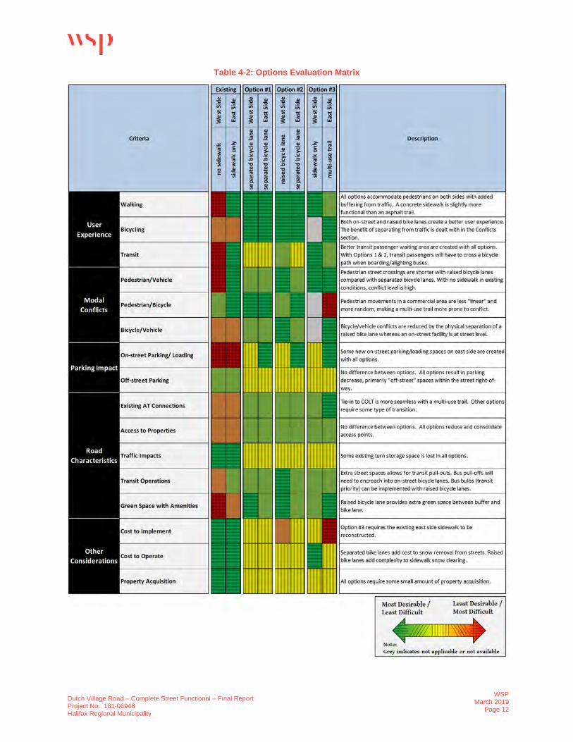
4.2 OPTIONS EVALUATION The evaluation framework outlined in Section 3.2 was applied to each of the three options described in Section 4.1. This evaluation, along with discussion with HRM staff, was used to distill these options to the two concept designs shown in Section 4.3. The evaluation also contributed to the determination of the preferred functional design (Section 4.4). To provide a cursory comparison of alternatives, each of the evaluation criterion was given equal weight and scored from one to five points, where five points represents where the criteria is best satisfied, and one point represents an instance where the criteria is not well met. The tabulation of this scoring is provided in Table 4-1 and the results of the evaluation are shown in Table 4-2.
The evaluation ranked Option #2 as highest. This was then used to develop two concept designs.
Table 4-1: Options Evaluation Matrix Scores
Option Description Evaluation Scoring
Existing West Side No sidewalk 43
102 East Side Sidewalk only 59
Option #1 West Side Separated bicycle lane with new sidewalk 61
123 East Side Separated bicycle lane 62
Option #2 West Side Raised bicycle lane with new sidewalk 63
125 East Side Separated bicycle lane 62
Option #3 West Side New Sidewalk 51
111 East Side Multi-use trail 60
Note: As bicycling is accommodated on only the east side of the street in Option #3, the same score is applied to both sides
Dutch Village Road – Complete Street Functional – Final Report Project No. 181-06948 Halifax Regional Municipality
WSPMarch 2019
Page 12
Table 4-2: Options Evaluation Matrix
Dutch Village Road – Complete Street Functional – Final Report Project No. 181-06948 Halifax Regional Municipality
WSPMarch 2019
Page 13
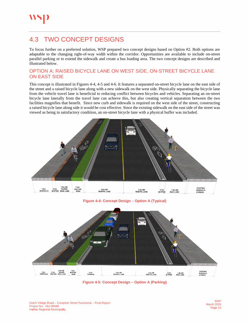
4.3 TWO CONCEPT DESIGNS To focus further on a preferred solution, WSP prepared two concept designs based on Option #2. Both options are adaptable to the changing right-of-way width within the corridor. Opportunities are available to include on-street parallel parking or to extend the sidewalk and create a bus loading area. The two concept designs are described and illustrated below.
OPTION A: RAISED BICYCLE LANE ON WEST SIDE, ON-STREET BICYCLE LANE ON EAST SIDE This concept is illustrated in Figures 4-4, 4-5 and 4-6. It features a separated on-street bicycle lane on the east side of the street and a raised bicycle lane along with a new sidewalk on the west side. Physically separating the bicycle lane from the vehicle travel lane is beneficial to reducing conflict between bicycles and vehicles. Separating an on-street bicycle lane laterally from the travel lane can achieve this, but also creating vertical separation between the two facilities magnifies that benefit. Since new curb and sidewalk is required on the west side of the street, constructing a raised bicycle lane along side it would be cost effective. Since the existing sidewalk on the east side of the street was viewed as being in satisfactory condition, an on-street bicycle lane with a physical buffer was included.
Figure 4-4: Concept Design – Option A (Typical)
Figure 4-5: Concept Design – Option A (Parking)

Dutch Village Road – Complete Street Functional – Final Report Project No. 181-06948 Halifax Regional Municipality
WSPMarch 2019
Page 14
Figure 4-6: Concept Design – Option A (Transit)
OPTION B: RAISED BICYCLE LANE ON WEST SIDE & EAST SIDE Although implementing a separated on-street bicycle lane on the east side of the street helps to reduce the project cost by allowing the existing sidewalk to remain unaffected, it creates an inconsistent corridor with two different types of cycling treatments. To address this, while continuing to recognize the value of using raised bicycle lanes, Option B was developed and is illustrated in Figures 4-7, 4-8 and 4-9. With this option, a raised bicycle lane is created on both sides of the street. Having both bicycle facilities separated (both vertically and horizontally) increases the level of comfort and provides quality cycling infrastructure along Dutch Village Road. There is added cost to this option compared to Option A, as the existing curb on the east side of the street will need to be removed and rebuilt.
Figure 4-7: Concept Design – Option B (Typical)

Dutch Village Road – Complete Street Functional – Final Report Project No. 181-06948 Halifax Regional Municipality
WSPMarch 2019
Page 15
Figure 4-8: Concept Design – Option B (Parking)
Figure 4-9: Concept Design – Option B (Transit)
4.4 CROSSWALK ANALYSIS & WARRANTS Pedestrian crossing warrants were completed prior to completing the preferred design option for Dutch Village Road. The Transportation Association of Canada (TAC) Pedestrian Crossing Control Guide (2018) was used to evaluate the three existing crosswalks and the proposed crosswalk located near Westerwald Street.
The Transportation Association of Canada (TAC) is a national engineering body that has established warrant criteria based on best practices for marking crosswalks in the Pedestrian Crossing Control Guide, 2018. This guide is used by Canadian jurisdictions to determine whether a site is a candidate for pedestrian crossing control and what the appropriate pedestrian treatment at a road crossing should be. When using the Guide, the crosswalk location under consideration is assessed based on:
a) Pedestrian volumes b) Vehicular volumes c) Spacing - how close to the nearest controlled crossing? d) Connectivity to existing infrastructure such as sidewalks. Should a marked crosswalk be installed to support
pedestrian connectivity?
Dutch Village Road – Complete Street Functional – Final Report Project No. 181-06948 Halifax Regional Municipality
WSPMarch 2019
Page 16
At the beginning of the project, WSP collected pedestrian and vehicular volume data on Wednesday, May 30, 2018 at the Dutch Village Road intersections with Central, Rosedale, and Rufus / Deal. This data indicates two-way peak hourly traffic volumes of around 1,300 vehicles per hour (vph) on Dutch Village Road and that each of the three marked crosswalks crossing Dutch Village Road were observed to average more than 15 pedestrians per hour. The count summaries are included in Appendix A.
The TAC Pedestrian Crossing Control Guide, 2018 contains a Decision Support Tool that considers the warrant criteria and provides a recommendation on whether a site is a candidate for pedestrian crossing control. The assessment of each of the Pedestrian warrant criteria is summarized in Table 4-3.
Table 4-3: Pedestrian Crossing Warrant Considerations
Criteria Warrant Met?
Rufus / Deal Rosedale Central Westerwald a) Pedestrian
Volume Yes (33 / hr) Yes (18 / hr) Yes (20 / hr) Not Available
b) VehicularVolume
Yes (~1,300 vph) Yes (~1,300 vph) Yes (~1,300 vph) Yes (~1,300 vph)
c) Spacing
No(~100m from
signalized crossing at Alma Crescent
Yes(However, thiscrossing is only
100m from Central Avenue.
Consideration could be given to
consolidating the two crossings)
Yes(However, thiscrossing is only
100m from Rosedale Avenue.
Consideration could be given to
consolidating the two crossings)
No(~100m from signalized crossing at Joseph Howe
Drive
d) Connectivity Yes Yes Yes
Yes(Provides added continuity
from COLT connection)
Considering the results of the warrant criteria and to provide network connectivity, the TAC Pedestrian Crossing Control Guide, 2018 finds that the sites are candidates for pedestrian crossing control.
In addition to providing guidance on whether a location should be considered for pedestrian crossing control, the Guide contains a Decision Support Tool that provides guidance on appropriate level of control for a pedestrian crossing. With a two-lane crossing of Dutch Village Road and an estimated daily average volume of over 12,000 vehicles, the Decision Support Tool recommends that if the marked crosswalks crossing Dutch Village Road at these three locations are maintained they should be considered for a “RRFB” level of control. This type of control is a marked (zebra) crosswalk with side-mounted rectangular rapid flashing beacons and crosswalk signage.
4.5 PREFERRED OPTION Following review of the two options identified in Section 4.3, HRM staff agreed that Option B was preferred. Although this option requires the existing sidewalk on the east side of the street to be modified, it was felt this option resulted in better infrastructure consistency and is more aligned with the objective of creating a ‘AAA’ bicycle facility. Applying this preferred cross-section to the street layout produced the functional plan drawings, shown in Appendix D.
The following features are beneficial to the safety and operation of the street and have been incorporated into the design:
The driveway to the Shoppers Drug Mart property has been relocated to the north, farther away from theJoseph Howe Drive intersection (see Figure 4-10). This location will result in fewer turning conflicts andbetter crossing sight distance for vehicles exiting from the driveway. Although this change will necessitatemodifications to the parking layout on the site, it is not expected to result in any net loss of parking spaces.The before and after images are shown for comparison and additional information can be found in AppendixB.

Dutch Village Road – Complete Street Functional – Final Report Project No. 181-06948 Halifax Regional Municipality
WSPMarch 2019
Page 17
Figure 4-10: Shoppers Drug Mart Concept
A median island has been upgraded at the Sunnybrae Avenue intersection (see Figure 4-10). The key benefitof this treatment is that it physically prevents left turning traffic to and from Sunnybrae Avenue. Thesemovements are currently prohibited by a sign and a smaller median. Another benefit of this island is that itnarrows the travel lanes, resulting in slower vehicle travel speeds and creates a “gateway” as vehicles crossfrom the wide street expanses of Bayers Road and Joseph Howe Drive into the commercial district.
A horizonal curve at Andrew Street has been “smoothened” by shifting the alignment within the ROW.Adding to the radius of this curve will improve sight distance.
Improvements are made to access management, particularly on the west side of the street. Currently, vehiclescan enter and exit the street at any point, which raises the risk of vehicle conflict and decreases thepredictability of vehicle movements. Consolidating the entry and exit points to well-defined drivewaysreduces conflict locations between vehicles and pedestrians and makes the potential conflicts much safer.
The proposed buffer areas between the street and the bicycle lane, combined with the ability to extend thecurb into the street, creates opportunity for expanded waiting areas at transit stops. In some cases, there maybe an opportunity to add a shelter where passenger volumes warrant one.
Several parking bays have been created where right-of-way space allows it on the west side of the street.These bays can include a mixture of short-duration public parking, accessible parking and loading zones.This determination can be made at a later date by the Municipality in consultation with the local businesseswho will rely on this parking. Considering the loss of existing 24 “nose-in” parking spots, the addition of 29on-street parking spots is expected to result in a small net gain of parking.
A new marked crosswalk is proposed to be placed at the Sunnybrae intersection to accommodate what isanticipated to be a high desire crossing area from the residential area to the Shoppers Drug Mart and otherdestinations. The upgraded median island adds to the safety of a pedestrian crossing at this location, bynarrowing the travel lanes and providing a refuge area so that pedestrians can cross the two streams of trafficone at a time.
All of the pedestrian crossings along Dutch Village Road (four in total) are recommended to be enhancedwith side-mounted rectangular rapid flashing beacons (RRFB) in addition to side mounted signs.
With the new sidewalk and curb on the west side of Dutch Village Road, the road will be narrowed andaccommodate two lanes of traffic. The existing road had two lanes of traffic with additional asphalt space(due to no curb on the west side) allowing for vehicles to pass a stopped transit vehicle or a vehicle waitingto turn left. With the narrower roadway, vehicles may wait behind stopped buses or other vehicles making aleft turn movement and this may increase delay on the corridor. While buses at stops may increase delay tosome traffic, this is expected to be minimal given the low bus volumes. Overall, the proposed changes willhave a minimal negative impact on traffic flow delay on Dutch Village Road.

Dutch Village Road – Complete Street Functional – Final Report Project No. 181-06948 Halifax Regional Municipality
WSPMarch 2019
Page 18
There are 3 utility poles on the east side and 10 utility poles on the west side of Dutch Village Road that willrequire relocation.
4.5.1 PUBLIC OPEN HOUSE
An open house session was held for members of the public on February 20th, 2019 from 6-8pm in the multi-purpose room at Centennial Arena (27 Vimy Avenue), to review the preferred design option for the Dutch Village Road. Using panel displays, residents and members of the public were shown the design option for the raised bicycle facilities from Joseph Howe Drive to Alma Crescent. Members of the public were asked to provide their feedback and a highlight summary is provided below.
Copies of the public open house boards are included in Appendix B with the public feedback for each board presented in Appendix C.
HIGHLIGHT SUMMARY:
Additional lighting and trees/shrubs would be an added benefit to Dutch Village Road.
Favorable of the protected bike lanes and being separated from vehicles.
Bus shelters at the transit stops would be a nice addition.
The new sidewalk on the west side is badly needed and the curb bumpouts provides better visibility atcrosswalk locations.
Want to see a better connection to COLT travelling from Dutch Village Road ‘AAA’ bicycle facility.
4.6 COST ESTIMATES FOR PREFERRED OPTION Class ‘C’ cost estimates have been prepared for the preferred design option provided in Appendix D. The cost estimates do not include possible property acquisition, relocation of utility poles and services or underground infrastructure relocation. Even though HRM does not pay for relocation of utility poles, utility pole relocation is required along Dutch Village Road.
It is estimated that these measures can be implemented for a budget of $950,000 plus HST. The breakdown per phase is as follows and is further described in Appendix E.
Photo 4-1: Open House – Evening Session

Dutch Village Road – Complete Street Functional – Final Report Project No. 181-06948 Halifax Regional Municipality
WSPMarch 2019
Page 19
5 SUMMARY & RECOMMENDATIONS
5.1 SUMMARY The ongoing development of a planning strategy to create growth opportunities and an urban commercial streetscape on Dutch Village Road, makes the street an ideal candidate for application of the Integrated Mobility Plan’s Complete Street principles.
The preferred functional plan put forward in this study creates an improved pedestrian realm with sidewalks on both sides of the street and space for street amenities such as benches, waste receptacles, bicycle parking, transit waiting areas and vegetation. An All Ages and Abilities (‘AAA’) bicycle facility is established by creating raised bicycle lanes, at sidewalk level that includes a tactile buffer between them and the sidewalk. The travel lanes on the street are narrowed and better defined to help control vehicle travel speeds and shorten crossing distances while maintaining full functionality of traffic operations. The plan improves access management to properties by eliminating street conflicts created by “nose-in” parking and replacing that with defined driveways and on-street parallel parking. The proposed bicycle facilities on Dutch Village Road will connect into the existing Chain of Lakes Trail facilities with future opportunities on Westerwald Street to be designated as a Local Street Bikeway.
The preferred functional plan not only addresses the many safety and functional deficiencies of the existing street but creates an environment in which the Dutch Village Road area can thrive and grow.
5.2 RECOMMENDATIONS Based on the background review, stakeholder and public engagement, as well as conceptual design, the following recommendations have been developed for consideration by the Municipality.
NEXT STEPS
It is recommended to include the existing intersections of Bayers Road/Joseph Howe Drive and Alma Crescent/Dutch Village Road within the scope of the detailed design. This will assist with the continuity of the bicycle lanes, connecting to the Chain of Lake Trail and completing the necessary improvements at the signalized intersection.
While initial engagement with abutting property owners was completed during the conceptual design, it is recommended to further engage with property owners, who may be affected by the proposed changes, to modify the design as needed at the 60% detailed design stage.
Complete the detailed design of Dutch Village Road, acquire any needed property and relocate the necessary utility poles. Other items to consider during detailed design include:
o Review driveway locations and width to ensure they meet the needs of users. o Review width of curb to allow enough space for emergency vehicles. o Review any grade constraints/ ROW space for retaining walls. o Determine where space is available to include bus shelters. o Review potential underground conflicts, such as catchbasin relocations. o Review opportunities to include trees and landscape features along corridor where is space is
available. Construct the project with the proposed sidewalk and the raised bicycle lane on the west side and the raised
bicycle lane on the east side of Dutch Village Road. o There may be potential to construct in two phases with Phase 1 including the section from Joseph
Howe Drive/Bayers Road intersection to Sunnybrae Avenue with the realignment of the Shoppers Drug Mart Driveway and Phase 2 would be the completion of the remainder of the corridor. Phase 2 may also be completed in two stages with completing the sidewalk and raised bicycle lane on the west side of Dutch Village Road with a painted bicycle lane on the east side. Later the raised bicycle lane on the east side could be added. Completing Phase 2 all at once would be ideal as it would only disrupt the community for a construction season.

Dutch Village Road – Complete Street Functional – Final ReportProject No. 181-06948
Halifax Regional Municipality
Appendix A PEDESTRIAN COUNTS

Appendix A ‐ Traffic Volume Data Page A‐1
A B C D E F G H I J K L07:00 07:15 4 53 0 0 0 0 0 115 6 7 1 9 19507:15 07:30 1 45 2 2 0 2 2 142 6 9 0 16 22707:30 07:45 1 34 6 2 0 1 13 196 2 5 0 16 27607:45 08:00 2 53 8 2 0 1 14 214 4 5 20 23 34608:00 08:15 4 57 1 1 0 1 13 224 6 5 3 23 33808:15 08:30 4 66 3 2 0 2 6 190 8 10 0 12 30308:30 08:45 6 78 0 0 0 3 8 217 9 5 4 13 34308:45 09:00 3 91 5 0 0 4 7 157 11 6 0 13 297
16 254 12 5 0 7 41 845 27 25 27 71 133007:00 08:00 8 185 16 6 0 4 29 667 18 26 21 64 104408:00 09:00 17 292 9 3 0 10 34 788 34 26 7 61 1281
Total Peds07:00 08:00 5408:00 09:00 87
A B C D E F G H I J K L11:30 11:45 7 106 6 1 0 0 5 110 8 3 1 7 25411:45 12:00 11 119 4 4 0 2 2 92 10 6 1 7 25812:00 12:15 7 113 6 2 0 3 4 102 10 3 2 6 25812:15 12:30 9 96 3 1 0 0 0 114 17 6 0 5 25112:30 12:45 11 99 4 2 0 1 3 102 9 5 1 4 24112:45 13:00 9 106 4 4 0 1 7 117 6 2 0 10 26613:00 13:15 4 130 3 0 0 3 1 114 16 6 0 10 28713:15 13:30 6 111 1 2 0 3 5 105 9 3 1 2 248
33 431 14 7 0 5 11 447 48 19 1 29 104511:30 12:30 34 434 19 8 0 5 11 418 45 18 4 25 102112:30 13:30 30 446 12 8 0 8 16 438 40 16 2 26 1042
Total Peds11:30 12:30 7212:30 13:30 77
A B C D E F G H I J K L16:00 16:15 13 139 5 4 1 4 1 109 17 3 1 6 30316:15 16:30 9 142 6 3 0 6 2 120 14 1 0 3 30616:30 16:45 8 142 4 6 0 3 3 132 12 4 1 6 32116:45 17:00 11 152 1 7 0 5 4 119 8 2 0 1 31017:00 17:15 12 159 9 6 1 3 6 117 10 1 0 10 33417:15 17:30 18 141 4 4 0 2 6 143 17 2 0 9 34617:30 17:45 12 145 0 4 2 4 2 114 14 2 0 11 31017:45 18:00 14 122 1 1 0 2 5 115 14 3 2 6 285
49 594 18 23 1 13 19 511 47 9 1 26 131116:00 17:00 41 575 16 20 1 18 10 480 51 10 2 16 124017:00 18:00 56 567 14 15 3 11 19 489 55 8 2 36 1275
Total Peds16:00 17:00 8717:00 18:00 88
Wednesday, May 30, 2018
Table A-1
Dutch Village Road@
Rufus Avenue / Deal Street
Halifax, NS
AM Peak Period Volume Data
TimeDutch Village Road Deal Street Dutch Village Road Rufus Avenue
Total VehiclesNorthbound Approach Westbound Approach Southbound Approach Eastbound Approach
AM Peak Hour
Ped 1 Ped 2 Ped 3 Ped 432 9 0 1342 18 0 27
Midday Peak Period Volume Data
TimeDutch Village Road Deal Street Dutch Village Road Rufus Avenue
Total VehiclesNorthbound Approach Westbound Approach Southbound Approach Eastbound Approach
Midday Peak Hour
Ped 1 Ped 2 Ped 3 Ped 423 25 0 2434 23 0 20
PM Peak Period Volume Data
TimeDutch Village Road Deal Street Dutch Village Road Rufus Avenue
Total VehiclesNorthbound Approach Westbound Approach Southbound Approach Eastbound Approach
PM Peak Hour
Ped 1 Ped 2 Ped 3 Ped 432 36 0 1933 39 0 16
Ped 1
Ped 2
Ped 3
Ped 4
Rufus Avenue
Dutch Village Road
A B C
I H G
JKL
FED
Deal Street
WSP Canada Inc. June 2018

Appendix A ‐ Traffic Volume Data Page A‐2
A B H I J L07:00 07:15 0 59 129 5 6 18 21707:15 07:30 4 45 154 2 7 23 23507:30 07:45 2 36 212 5 5 33 29307:45 08:00 4 59 225 4 5 35 33208:00 08:15 4 58 252 3 5 35 35708:15 08:30 4 60 215 4 9 30 32208:30 08:45 10 81 231 9 8 31 37008:45 09:00 4 92 181 6 10 26 319
22 258 923 20 27 131 138107:00 08:00 10 199 720 16 23 109 107708:00 09:00 22 291 879 22 32 122 1368
Total Peds07:00 08:00 1608:00 09:00 30
A B H I J L11:30 11:45 7 127 108 14 9 11 27611:45 12:00 16 128 97 5 9 12 26712:00 12:15 10 108 112 4 5 13 25212:15 12:30 12 124 115 7 6 12 27612:30 12:45 11 107 103 6 7 15 24912:45 13:00 7 112 127 12 12 18 28813:00 13:15 5 127 124 6 10 6 27813:15 13:30 6 122 119 7 8 12 274
35 470 469 31 35 51 109111:30 12:30 45 487 432 30 29 48 107112:30 13:30 29 468 473 31 37 51 1089
Total Peds11:30 12:30 3812:30 13:30 50
A B H I J L16:00 16:15 15 144 127 9 11 8 31416:15 16:30 16 164 123 3 3 11 32016:30 16:45 24 167 130 6 8 8 34316:45 17:00 18 160 117 9 7 6 31717:00 17:15 19 174 147 4 5 5 35417:15 17:30 22 175 141 12 6 7 36317:30 17:45 16 172 117 7 5 11 32817:45 18:00 17 137 111 10 5 11 291
83 676 535 31 26 26 137716:00 17:00 73 635 497 27 29 33 129417:00 18:00 74 658 516 33 21 34 1336
Total Peds16:00 17:00 3917:00 18:00 55
Rosedale Avenue
0
Ped 1
AM Peak Hour
Time
Halifax, NSWednesday, May 30, 2018
AM Peak Period Volume Data
Total Vehicles
Dutch Village Road
Ped 3 Ped 40
Dutch Village Road Rosedale AvenueNorthbound Approach Southbound Approach Eastbound Approach
Ped 1 Ped 3 Ped 4
Midday Peak Hour
Rosedale Avenue
7
Northbound Approach Southbound Approach Eastbound Approach
Midday Peak Period Volume Data
Time
18 12
Total Vehicles
Table A-2
Dutch Village Road@
Ped 1 Ped 3 Ped 4
PM Peak Period Volume Data
Eastbound Approach Total Vehicles
Rosedale Avenue
PM Peak Hour
Dutch Village RoadNorthbound Approach
Dutch Village RoadSouthbound ApproachTime
9
0 14 250 38 17
0 14 240 18 32
Dutch Village Road Dutch Village Road
Rosedale Avenue
Dutch Village Road
A B
I H
JL
Ped 1
Ped 3
Ped 4
WSP Canada Inc. June 2018

Appendix A ‐ Traffic Volume Data Page A‐3
A B H I J L07:00 07:15 3 29 139 0 5 22 19807:15 07:30 2 43 168 3 4 23 24307:30 07:45 4 32 238 1 1 32 30807:45 08:00 2 54 256 2 7 32 35308:00 08:15 11 52 269 7 3 39 38108:15 08:30 11 58 243 6 3 23 34408:30 08:45 3 70 259 9 9 26 37608:45 09:00 10 83 201 3 7 12 316
27 234 1027 24 22 120 145407:00 08:00 11 158 801 6 17 109 110208:00 09:00 35 263 972 25 22 100 1417
Total Peds07:00 08:00 1808:00 09:00 41
A B H I J L11:30 11:45 11 123 108 12 5 8 26711:45 12:00 19 136 99 9 8 11 28212:00 12:15 7 101 127 3 4 10 25212:15 12:30 12 127 119 4 5 7 27412:30 12:45 8 114 116 5 3 9 25512:45 13:00 8 102 137 5 3 10 26513:00 13:15 11 130 135 3 5 12 29613:15 13:30 9 122 125 3 4 9 272
39 473 507 17 16 38 109011:30 12:30 49 487 453 28 22 36 107512:30 13:30 36 468 513 16 15 40 1088
Total Peds11:30 12:30 3412:30 13:30 29
A B H I J L16:00 16:15 35 166 127 4 4 12 34816:15 16:30 35 162 119 10 4 9 33916:30 16:45 29 178 141 6 3 13 37016:45 17:00 32 178 123 4 0 10 34717:00 17:15 36 174 141 12 3 9 37517:15 17:30 41 161 130 12 1 7 35217:30 17:45 29 167 115 8 4 10 33317:45 18:00 29 143 118 6 2 14 312
138 691 535 34 7 39 144416:00 17:00 131 684 510 24 11 44 140417:00 18:00 135 645 504 38 10 40 1372
Total Peds16:00 17:00 4217:00 18:00 36
Ped 4
0 29 70 25 17
PM Peak Hour
Ped 1 Ped 3
0 19
PM Peak Period Volume Data
TimeDutch Village Road Dutch Village Road Central Avenue
Total VehiclesNorthbound Approach Southbound Approach Eastbound Approach
151 12 16
Midday Peak Hour
Ped 1 Ped 3 Ped 4
Midday Peak Period Volume Data
TimeDutch Village Road Dutch Village Road Central Avenue
Total VehiclesNorthbound Approach Southbound Approach Eastbound Approach
Ped 3 Ped 4
0 28 130 9 9
AM Peak Period Volume Data
TimeDutch Village Road Dutch Village Road Central Avenue
Total VehiclesNorthbound Approach Southbound Approach Eastbound Approach
AM Peak Hour
Ped 1
Wednesday, May 30, 2018
Table A-3
Dutch Village Road@
Central Avenue
Halifax, NS
Central Avenue
Dutch Village Road
A B
I H
JL
Ped 1
Ped 3
Ped 4
WSP Canada Inc. June 2018

Dutch Village Road – Complete Street Functional – Final ReportProject No. 181-06948
Halifax Regional Municipality
Appendix B OPEN HOUSE BOARDS

What is the Dutch Village Road Complete Street Project?• The draft functional plan for Dutch Village Road creates a consistent vision for the road’s look and function.
It includes the installation of bicycle lanes, a west-side sidewalk, transit upgrades, and general pedestrian-experience improvements.
• The recommended design complements the Integrated Mobility Plan’s (IMP) overarching objectives andprinciples.
• This is a ‘Complete Streets’ project, aiming to add missing pedestrian and bicycle infrastructure, and integratethese changes with improvements to bus stops and a Halifax Water project.
• The project extends from along both sides of Dutch Village Road from Alma Crescent to Joseph Howe Drive(700m approximately).
Project Steps1. Public engagement and draft design options.2. Finalize functional design reports.3. Bring preferred option to Council for functional plan approval (2019).4. Complete detailed design of selected option (2019).5. Determine construction schedule constraints related to utility relocation
and land acquisition.6. Position selected option for Council budget approval for phased
construction subject to scheduling and acquisition constraints.
What’s next for the Dutch Village Road Complete Streets project? A functional design report is nearing completion for the road which will identify the opportunities and constraints for the Design Options. This will include conceptual options for the road as well as a summary of what we heard from public engagement events. Feedback will be used to inform the functional design used to advance towards a detailed design.
We are here
PREFERRED DESIGNDUTCH VILLAGE ROAD COMPLETE STREET
Background• The municipality has been working to implement the
in the 2014-19 Active Transportation Priorities Plan which
entire region. Together, these AT facility projects will createa safe, convenient, and connected network for cyclists totravel to and from common origins and destinations in themunicipality.
•
as a Priority Sidewalk Connection to be realized by 2020.The Integrated Mobility Plan (IMP) sets a goal to deliveran all ages and abilities (‘AAA’) bicycling network in theRegional Centre by 2022.
• Curbs and sidewalks were replaced on the east sideof Dutch Village Road in 1979, but none have beenconstructed on the west side between Sunnybrae Avenueand Alma Crescent.
• Fifty-six collisions have been documented over the lastthree years. There is a need to balance parking needs withaccess control and pedestrian safety. West side access isuncontrolled, and most of the “off-street” parking that isperpendicular to the travel way encroaches into the public
along this very busy street.

SEGMENT: ALMA CRESCENT TO FREDERICK AVENUE
Existing Conditions
AlmaCrescent
Rufus Avenue
Frederick Avenue
S1
S2
S1
Preferred Design: Alma Crescent to Frederick Avenue
Development of two one-way ‘AAA’ protected bike lanes along Dutch Village Road from Deal Street to Frederick Avenue, with a connection to the Chain of Lakes Trail (COLT).
The west side of Dutch Village Road will have a separated concrete sidewalk. A reduction in direct access parking stalls increases your sense of safety while walking.
The bus stop on the west side of Dutch Village Road will have a raised platform, making it an accessible stop.
The intersection of Dutch Village Road and Alma Crescent continues to operate with acceptable levels of delay.
P Existing parking on the west side of Dutch Village Road within the right-of-way will be removed and 29 on-street parking stalls will be added for the entire project.
STREET USER IMPACTS
Dutch Village Road
Dutch Village Road
Dea
l Str
eet
S1
S2
CROSS SECTIONS
Bike Lane Transit Stop
ExampleImages
On Street Parking
E2 E3 E4
E1
E2
E4
E4
E3
A
A
Rufus Avenue
Frederick Avenue
And
rew
Stre
et
Dutch Village Road
Dutch Village Road
Dea
l Str
eet
Existing Conditions Image
The Boss Plaza
The Boss Plaza
And
rew
Stre
et
West East
West East
West Side
East Side
AlmaCrescent
Di ttii ff T llDirDirectectionion ofof TrTraveavell
No sidewalk
West Side
East Side
LEGEND
SignalizedIntersection
Bus Stop Bike Lane Property Line
Accessible Parking Utility Pole
Improved Crosswalk
E1

SEGMENT: FREDERICK AVENUE TO CENTRAL AVENUE
Preferred Design: Frederick Avenue to Central Avenue
Frederick Avenue
Rosedale Avenue
Central Avenue
S2 S2S2
Existing Conditions
A B
AB
E1
E2
E1
E4
E3
Dutch Village Road
Rosedale
Avenue
Central Avenue
Dutch Village Road
Bike Lane Transit StopImproved Crosswalk
ExampleImages
On Street Parking
E1 E2 E3 E4
STREET USER IMPACTSDevelopment of two one-way ‘AAA’ protected bike lanes along Dutch Village Road from Frederick Avenue to Central Avenue, with a connection to the Chain of Lakes Trail (COLT).
The west side of Dutch Village Road will have a separated concrete sidewalk. A reduction in direct access parking stalls increases your sense of safety while walking.
Relocation of transit stop.
PExisting parking on the west side of Dutch Village Road within the right-of-way will be removed and 29 on-street parking stalls will be added for the entire project.
CROSS SECTION
S2
Existing Conditions Images
C
C
West Side
East Side
DiDi ii fff T avellDirection of TravellNo sidewalk
West East
Frederick Avenue
West SideEast Side
LEGEND
SignalizedIntersection
Bus Stop Bike Lane Property Line
Accessible Parking Utility Pole

SEGMENT: CENTRAL AVENUE TO JOSEPH HOWE DRIVE
Preferred Design: Central Avenue to Joseph Howe Drive
Existing Conditions
S3
S2
Dutch Village Road
CentralAvenue
Westerwald Street
CROSS SECTIONS
S2
S3
STREET USER IMPACTSDevelopment of two one-way ‘AAA’ protected bike lanes along Dutch Village Road from Central Avenue to a connection to the Chain of Lakes Trail (COLT).
The west side of Dutch Village Road will have a separated concrete sidewalk. A reduction in direct access parking stalls increases your sense of safety while walking. New crosswalk placed near Westerwald Street.
Reduction of a lane on Dutch Village Road towards Joseph Howe Drive. A left-turn lane is provided at the new access to Shoppers Drug Mart.
P Existing parking on the west side of Dutch Village Road within the right-of-way will be removed and 29 on-street parking stalls will be added for the entire project.Sunnybrae
Avenue
JosephHowe Drive
A
E1
E2
E4
E3Dutch Village Road
CentralAvenue
Westerwald StreetSunnybraeAvenue
JosephHowe Drive
A
West Side
East Side
DiDi ii ff TT llDirDirectectc ionion ofof TrTraveavell
Median does not block illegal turning
No sidewalk
West East
West East
Wide, exposed pedestrian crossing
West SideEast
Side
LEGEND
SignalizedIntersection
Bus Stop Bike Lane Property Line
Accessible Parking Utility Pole

Comments about the Alma Crescent to Frederick Avenue segment
Comments about the Frederick Avenue to Central Avenue segment
Comments about the Central Avenue to Joseph Howe Drive segment
General Comments
COMMENT BOARD

Dutch Village Road – Complete Street Functional – Final ReportProject No. 181-06948
Halifax Regional Municipality
Appendix C PUBLIC FEEDBACK

Page 1
DUTCH VILLAGE ROAD COMPLETE STREET – PREFERRED DESIGN Public Open House, Wednesday, February 20th, 2019
COMMENT BOARD
Alma Crescent to Frederick Avenue Segment Likes Concerns
None.
Ken’s Seafood. I am an owner at 3560 Dutch Village. I pay property tax on commercial land. The entrance to the property only accommodates the residential and not the commercial. As of now we have parking for seven cars; with the proposed plan we will be cut back to two. I would at least like three spots.
Zipper merge at Bedford Highway Get rid of billboards. Thru right and thru left at the Boss Plaza intersection.
Frederick Avenue to Central Avenue Segment Likes Concerns
None.
Crosswalk at Frederick East side has too many entrances for businesses – not safe.
Option to see if having only one entrance / exit will actually allow for more business parking (DQ, Giant Tiger).
Add in ground electrical poles and lighting Fairview United Church? Realign Rosedale
Central Avenue to Joseph Howe Drive Segment Likes Concerns
Like all the changes, especially near Shoppers / Westerwald and Sunnybrae. Seems to solve a lot of concerns.
Right now although not “designated” in the morning commute there are 2 lanes of traffic from Frederick to Joe Howe. This will reduce that to 1 and increase morning traffic.
Move crosswalk (at Joe Howe and Dutch Village intersection) so there is a line of sight between drivers making an right turn onto Joe Howe and pedestrians.
Put protective bollards along sidewalk (in front of plaza at Westerwald / Dutch Village / Joe Howe)
Add bike ramp (at bus stop on Dutch Village Road)

Page 2
General Feedback: Street is very dark. Lighting? Negative impact on local businesses who lose parking spots. Is this being considered? Seem to be some “variables” based on future land acquisitions. What happens if they all don’t come through? I like most of what I see. Bike lanes (protected) are a big plus. Crosswalk is needed at Frederick Ave., crossing Dutch Village
Road. Be great if you could sign up for updates and future meetings. Even our councillor didn’t include it in his newsletter. I only found
at via twitter. Lots of trees! Nice lighting! More trees and traffic calming near crosswalks would be nice. Bus shelter on West and East side of D.V.R. near Giant Tiger and near Shoppers Drug Mart. More trees. Make “Downtown Fairview” a destination for families. Add nice street lighting. Think Hydrostone type estectics.
Plenty of restaurants. Overall this seems like a good progressive design. As a pedestrian and cyclist, I would love to see this become reality in the
coming years. The bike lanes separated from car traffic are an excellent idea! This is a main traffic artery. Curious how narrowing lanes with raised curbs will affect traffic flow? What about emergency
vehicles needing to get through during peak times?
Online Survey Questions: 1) What do you like about the proposed functional plan for Dutch Village Road between Alma
Crescent and Bayer's Road? The protected bike lane and west side sidewalk. The focus on active transportation and transit priority is excellent! Pedestrian island is very good progress, also sidewalk and cycle lanes. Bump outs at crosswalk locations are really needed on this
road due to fast moving traffic, so this is very welcome. Everything! I think it makes the area more walkable and easier to access for all. I really like the pedestrian improvements around
Shoppers Drug Mart (which is awful to navigate with my son's stroller) as well as the sidewalks on both sides of Dutch Village. I like the changes to the parking at the businesses. Changing the shoppers entrance isn't bad. And adding the median to eliminate
people going up Sunnybrae Dr. It is fantastic! Improved sidewalks and a new bike lane is so badly needed here. It's an unsafe area that is rapidly growing and
I'm looking forward to seeing the positive changes, thank you! Improved sidewalk infrastructure. Having a side walk and some parking to use the services on the street would be great. I think this is a great improvement for the
Fairview area, that I would like to see for the rest of the Fairview as well. 1. Like proposed median to block illegal turn onto Sunnybrae; 2. Like proposed sidewalks and crosswalks on Dutch Village Rd. I like that it will create an organized, rejuvenated road that will provide safety to an area that has a lot of pedestrians. I am quite pleased with the plan. Provides a much-needed facelift for the area and will make the neighbourhood more pleasant
and feel more like a neighbourhood. I hope it can be implemented! The look and feel of the proposed plan to make it more aesthetically and pedestrian friendly. Hopefully a narrower roadway will
slow cars down as cars travel excessively fast in this area. Removing some parking, parking lot entrances/exits to help alleviate congestion is also a good move.
It becomes a walkable community. Yes! The increased pedestrian and bicycle usage is a tremendous improvement. The absence of sidewalks on the west side of Dutch
Village Road is a big problem which this plan addresses. New protected bike lanes are the way to go. This plan would improve the whole area.
Sidewalks and bus stops are definitely welcomed addition and sorting out the free for all parking situation. I like the pedestrian improvements and the bike lanes added to the street. I also like the bump out crosswalks that help separate
parking areas. And the bump out bus stops are another plus since it removes the problem of leaving and entering traffic (which is what I hope the municipality does for all of Spring Garden instead of just half). I know many people have concerns about the parking, but the plan organizes the spots and removes the problem of perpendicular parking.

Page 3
I think any upgrade would be splendid. I would like to see pull over lanes for public transit rather than a bus stop blocking a lane of traffic
Bicycle lanes and green space are very important. I'm not sure of the importance of having on street parking, especially across from the Dairy Queen and Giant Tiger when there is ample parking in both locations. The vacant lot on the corner of Dutch Village and Rosedale is a contaminated property due to the previous location of a gas station. This is a very small lot and would be very expensive to clean up. Therefore, it may be a good idea to make this a public space. Many people may not know this, but the great country music star Hank Snow married Minni Aalders who is from Fairview. Hank was from Shelburne and spent a lot of time in Fairview walking these streets as he made his way to see in CHNS radio to perform live. Hank went on to become a world-class performer in Nashville, performing regularly at the Grand Ole Opry and is inducted into Country Music Hall of Fame. Perhaps, the potential green space mentioned above could be an ideal location for a bronze statue in recognition of his great talent.
2) Do you have any questions, comments or concerns about the proposed functional plan? The lack of east/north-bound AAA cycling infrastructure connection near Joseph Howe is disappointing. The quality of the
cycling infrastructure goes from AAA level to sharing the road with 3 lanes of traffic. The priority is again given to traffic capacity instead of cyclist safety.
There is no infrastructure for cyclists at the intersection of Joseph Howe and DRV, where cyclists are most vulnerable to traffic incidents - this is needed. Measures such as advance boxes and cycle lanes through the intersections should be considered to allow connectivity, as well as a cycle lane along Titus and Lacewood and to connect with the multi purpose route on Joseph Howe.
The turning lane from DVR onto Jo Howe is surplus to requirements and makes the road unnecessarily wide. Why not remove this and turn this land into a community feature - some trees perhaps? I would also welcome more points to cross the road by using pedestrian islands, as the crosswalks are far apart. Ped. islands can be used instead of crosswalks to cross a road safely. Many pedestrians do cross the road at key points such as by Giant Tiger - desire lines should be allowed for in the design plans. I am not sure why we need on street parking in addition to the existing car parking lot. There is adequate space already and the parking is at a location where pedestrians often cross the road. The cars will restrict their view and that of drivers.
I feel that Dutch Village and surrounding area could be the "new north end" and having green spaces and some seating like benches would make it more of a destination. Somewhere you can park your car or bike, walk to or jump of the bus and access services and spend some time in the area will be good for all! I feel sad for the businesses in the area because even though I live less 5 minutes walking distance from most of these businesses I avoid the area because of the lack of walkability. I think these changes will increase the number of businesses in the area and will be so good for the neighbourhood.
I do not like the elimination of the turn lane on Westerwald. It is painful now let alone when someone will be there turning left. That will totally slow down getting out. The left turn lane allows people to merge into the roadway. This will slow it down so we never get out!
Disappointed to see the intersection with Alma Crescent is not included. Can a solution be found to connect the west side bike lane to the Chain of Lakes trail on the southwest side of the intersection with Joseph Howe as well?
Stop talking start doing... the area is an eye sore. Does the bike lane on DVR (along Shoppers Drug Mart) connect all the way to Joe Howe? It looks like it stops right after the
driveway for Shoppers, it would be great if it connected to Joe Howe and the major bike route there. I'm concerned about local businesses reactions to the reduction of parking on the west side of the street.
Currently many people use Dutch Village as a two-lane road going towards Halifax, since the right turn towards the highway is usually slower during the morning. I think this should be taken into consideration, since reducing the size of the road would cause a lot more traffic in the area.
1. Strongly oppose bike lane on Dutch Village. Any bike traffic would travel on Joe Howe. Have the project team assessed bike lane needs on the street? With new housing developments in the area traffic will greatly - and has already- increased. We need better road space for vehicles not the very sparse bike traffic.
2. Sunnybrae needs a sidewalk. There’s a school on the street! I don’t believe the planners spent enough time considering the traffic flows on Dutch Village. It is very hard to turn left on to
Dutch Village from all connecting streets because there are rarely breaks in traffic. This is due to lack of stop signs etc. I am also concerned that buses will not be able to safely make a right turn from Rosedale on to Dutch Village with the reduced lane sizes. Ultimately, it would be great to see less traffic on Dutch Village but that would mean a better plan for Windsor street exchange

Page 4
and Bayer's Road and Connaught as they are the bottle necks. I would honestly rather see the money spent on fixing the bottle necks in the city.
Concerns are the number of vehicles that travel this road during morning/afternoon commute. Already busy but don't see anyplans to ease this congestion. The same number of lanes and reduction of lanes in some areas will only add to congestion. Thisentire block (Joseph Howe, Dutch Village) is at times gridlocked if there are traffic issues getting onto the 102 or at the WindsorStreet Exchange.
Concerned about turning left onto Dutch Village Rd in the mornings. There should be signal lights to ease the traffic flow.There should be two lanes leading onto the Windsor exchange. One lane turns left which is rarely used.
I think it looks great. I just want to ensure that there would also be trees planted along the sides. The street is so barren now.Some trees would make a great improvement as well.
None. This is an excellent plan. I’m very concerned about the entry and exit points of the AAA bike lanes. The recent bump outs at Joseph Howe intersection
squeeze cyclists into traffic lane, instead of leaving a comfortable buffer. Before bump outs, there was ample room for cyclist topull up to lights, and cars to safely pass. I understand the AAA concept, but when the lane simply disappears into traffic wherecars have no awareness of cyclists, it's a bad idea. Better would be to have a well marked bike lane with street, signs, notseparated. Also, much easier for cyclists when joining and leaving bike lane. For example, it looks simple for N to S to COLTtrail to connect to bike lane, but what about S to N from COLT or Bayer's road? With all these curbs, cut ins and outs, greatlyslows cyclists, not intuitive
I am concerned about the abrupt end to the cycling routs on each end of the road. I hope the entirety of Titus and Lacewood willbe improved with a similar design at some point soon since the road never functions to capacity in the first place.
I love the look of it. I assume there is enough room for bicycle lanes and sidewalks. Hard to believe. I'm hoping this improves thesight lines at Central and Dutch Village for vehicles. There has already been an increase in illegal parking on Andrew Street atDutch Village Road. In front of the Ville building, vehicles are always parked and blocking the fire hydrant. Andrew Street isoften down to one lane due to the congestion of illegal parking at Andrew and Dutch Village. The alternative being Percy Streetand Dutch Village, it is unsafe to make a left-hand turn, so most of the street drives up to Andrew. This parking is a direct resultof the Ville building not providing sufficient parking for its tenants. From the designs it looks like you might be planning parallelparking on the road. Look forward to the changes. I will never be on a bike even in my own lane on Dutch Village Road. Waytoo dangerous.

Dutch Village Road – Complete Street Functional – Final ReportProject No. 181-06948
Halifax Regional Municipality
Appendix D FUNCTIONAL DESIGN PLAN

Esso
Dutch Village Road
MAT
CH
LIN
E A
Cambridge FinancialService
The Anchor
The Boss Plaza
NOTES1. ALL MODIFICATIONS SHOWN ARE
PRELIMINARY AND CONCEPTUAL ONLY.
Drawn: E. SEYMOUR
Reviewed: C. McCARTHY
Project #: 181-06948
Date: MAR. 08, 2019
DUTCH VILLAGEROAD
FILE
: C
:\USE
RS\
PHIL
.NIC
KER
SON
\DES
KTO
P\18
1-06
948
- DVR
30%
DES
IGN
.DW
GSh
eet:E
sso-
Alm
a
HALIFAX, NOVA SCOTIA
SHEET OF 4
DUTCH VILLAGE ROADCOMPLETE STREET
FUNCTIONALDESIGN DRAWINGS
1

Dutch Village Road
MAT
CH
LIN
E A
MAT
CH
LIN
E B
Head Shoppe
TimHortons
U-Haul
FancyTailorShop
Giant Tiger
TheEmbroideryEdge
Kwik-way A+ TaxServices
Ken'sSeafood
NOTES1. ALL MODIFICATIONS SHOWN ARE
PRELIMINARY AND CONCEPTUAL ONLY.
Drawn: E. SEYMOUR
Reviewed: C. McCARTHY
Project #: 181-06948
Date: MAR. 08, 2019
DUTCH VILLAGEROAD
FILE
: C
:\USE
RS\
PHIL
.NIC
KER
SON
\DES
KTO
P\18
1-06
948
- DVR
30%
DES
IGN
.DW
GSh
eet:F
redr
ick-
Dea
l
HALIFAX, NOVA SCOTIA
SHEET OF 4
DUTCH VILLAGE ROADCOMPLETE STREET
FUNCTIONALDESIGN DRAWINGS
2

een
MAT
CH
LIN
E B
MAT
CH
LIN
E C
The Children'sGarden
FairviewUnited Church
Frenchies
Scotiabank
SchofieldInsurance
Venmar
NOTES1. ALL MODIFICATIONS SHOWN ARE
PRELIMINARY AND CONCEPTUAL ONLY.
Drawn: E. SEYMOUR
Reviewed: C. McCARTHY
Project #: 181-06948
Date: MAR. 08, 2019
DUTCH VILLAGEROAD
FILE
: C
:\USE
RS\
PHIL
.NIC
KER
SON
\DES
KTO
P\18
1-06
948
- DVR
30%
DES
IGN
.DW
GSh
eet:C
entra
l-Ros
edal
e
HALIFAX, NOVA SCOTIA
SHEET OF 4
DUTCH VILLAGE ROADCOMPLETE STREET
FUNCTIONALDESIGN DRAWINGS
3

ShoppersDrug Mart
Velos Pizza/Corner Pocket
nseess
StylesAlive
BancoManagementLtd.
MAT
CHLI
NE C
Blend to existing sidewalk
Add Site Parking
Landscape Area
Consider Westerwaldstreet as a future local
street bikeway.
Connect to existingCOLT
Asphalt Multi-Use Trail
Landscape Area
Blend to existing sidewalk
Blend to Existing sidewalk
NOTES1. ALL MODIFICATIONS SHOWN ARE
PRELIMINARY AND CONCEPTUAL ONLY.
Drawn: E. SEYMOUR
Reviewed: C. McCARTHY
Project #: 181-06948
Date: MAR. 08, 2019
DUTCH VILLAGEROAD
FILE
: C
:\USE
RS\
PHIL
.NIC
KER
SON
\DES
KTO
P\18
1-06
948
- DVR
30%
DES
IGN
.DW
GSh
eet:S
hopp
ers
HALIFAX, NOVA SCOTIA
SHEET OF 4
DUTCH VILLAGE ROADCOMPLETE STREET
FUNCTIONALDESIGN DRAWINGS
4

Dutch Village Road – Complete Street Functional – Final ReportProject No. 181-06948
Halifax Regional Municipality
Appendix E COST ESTIMATES

ESTIMATE OF PROBABLE COSTSDUTCH VILLAGE ROAD COMPLETE STREET CONCEPT
PROJECT NO. 181-06948DATE: March 13, 2019CLIENT: HRMCONSULTANT: WSPUNIT PRICE SOURCE: HRM / WSP
a)b)
c)d)
e)
f)
ITEM DESCRIPTION UNITS UNIT PRICE QNTY. COST
NOTES:
DISCLAIMER: This estimate of probable construction cost is approximate only. Actual cost may vary significantly from this estimate due to market conditions such
as material and labour costs, time of year, industry workload, competition, etc. This estimate has been prepared based on our experience with similar projects.
This estimate has not been prepared by obtaining any estimates or quotes from contractors. Due to the uncertainties of what contractors bid, WSP cannot make
any assurances that this estimate will be within a reasonable range of the tendered low bid. When assessing this project for business feasibility purposes this
estimate should not be relied upon without considering these factors.
ALL PRICES SHOWN ARE IN 2019 CANADIAN DOLLARS EXCLUDING HST.ESTIMATES ARE INTENDED FOR HIGH-LEVEL BUDGETING OF CONSTRUCTION COSTS ONLY. DETAILED DESIGN REQUIRED FOR MORE ACCURATE COST ESTIMATION.
NO ALLOWANCE HAS BEEN MADE FOR COST OF UTILITY POLE RELOCATION, PROPERTY ACQUISITION, ENGINEERING, OR CONSTRUCTION ADMIN./INSPECTION.
CATCHBASIN RELOCATION COSTS INCLUDE REMOVAL OF EXISTING CATCHBASIN, INSTALLATION OF NEW CATCHBASIN, CONNECTION TO EXISTING CB LEADS AND REINSTATEMENT. NO ALLOWANCE HAS BEEN MADE FOR ADJUSTMENTS OR UPGRADES TO THE STORM SEWER MAIN.
Sub-Total $727,450
ESTIMATED COST (excl. HST) $950,000Contingency (30%) $218,235
ESTIMATE BASED ON 30% DESIGN DRAWINGS, DATED MAR. 07, 2019.
UTILITY POLE RELOCATION UNIT PRICES ARE FOR BUDGETING PURPOSES ONLY AND MAY VARY SIGNIFICANTLY DEPENDING ON TYPE AND AMOUNT OF OVERHEAD UTILITIES, POLE ALIGNMENT AND REINSTATEMENT COSTS. QUOTES FROM NOVA SCOTIA POWER AND/OR COMMUNICATIONS UTILITIES REQUIRED FOR MORE ACCURATE ESTIMATES.

Attachment B: Intersection Improvements & Multimodal Impact Analysis
Dutch Village Road: Complete Streets Improvements
Prepared by:
HRM Strategic Transportation Planning October 2019

Intersection Improvements and Multimodal Impact Analysis Page 2
Planning & Development Email: [email protected] October 21, 2019
Table of Contents Introduction ................................................................................................................................................... 3
Background ............................................................................................................................................... 3
Objective ................................................................................................................................................... 3
Dutch Village Road / Bayers Road – Joseph Howe Drive Intersection ............................................................. 4
Existing Conditions .................................................................................................................................... 4
Proposed Modifications ............................................................................................................................ 5
Traffic Impact Analysis ............................................................................................................................... 6
Multi-Modal Level of Service (MMLOS) ..................................................................................................... 7
Dutch Village Road – Supreme Court / Alma Crescent Intersection ................................................................ 8
Existing Conditions .................................................................................................................................... 8
Proposed Modifications ............................................................................................................................ 9
Traffic Impact Analysis ............................................................................................................................. 12
Multi-Modal Level of Service (MMLOS) ................................................................................................... 13
Concluding Thoughts ................................................................................................................................... 14

Intersection Improvements and Multimodal Impact Analysis Page 3
Planning & Development Email: [email protected] October 21, 2019
Introduction Background
Halifax Regional Municipality (HRM) is currently in the process of planning and designing for active transportation improvements along Dutch Village Road. In early 2019, WSP completed a functional plan for Dutch Village Road (DVR), which recommended unidirectional protected bicycle lanes and sidewalks on both sides of the street between Joseph Howe Drive / Bayers Road and Alma Crescent but did not include either intersection as they were out of scope. However, due to their importance to pedestrian and cyclist safety and comfort and based on feedback from the public and internal stakeholders, staff increased the scope of the functional design study to include both intersections.
Staff are proposing changes to intersection configuration at Alma Crescent / Supreme Court and Bayers Road / Joseph Howe Drive to achieve the design goals of the functional design. The changes would ensure that the bicycle facility connects directly to the Chain of Lakes Trail (COLT), facilitate the potential future continuation of the protected bicycle facility, reduce conflicts between bicycles and right turning vehicles, reduce pedestrian crossing distance, reduce speed of right turning vehicles and improve intersection sightlines. Staff have completed a traffic impact analysis & multimodal level of service (MMLOS) analysis for the proposed changes at both intersections.
Objective
The objective of this report is to present a summary of the proposed intersection changes and a review of the potential multimodal impacts resulting from the extension of the proposed bicycle facility.
Space Left Intentionally Blank
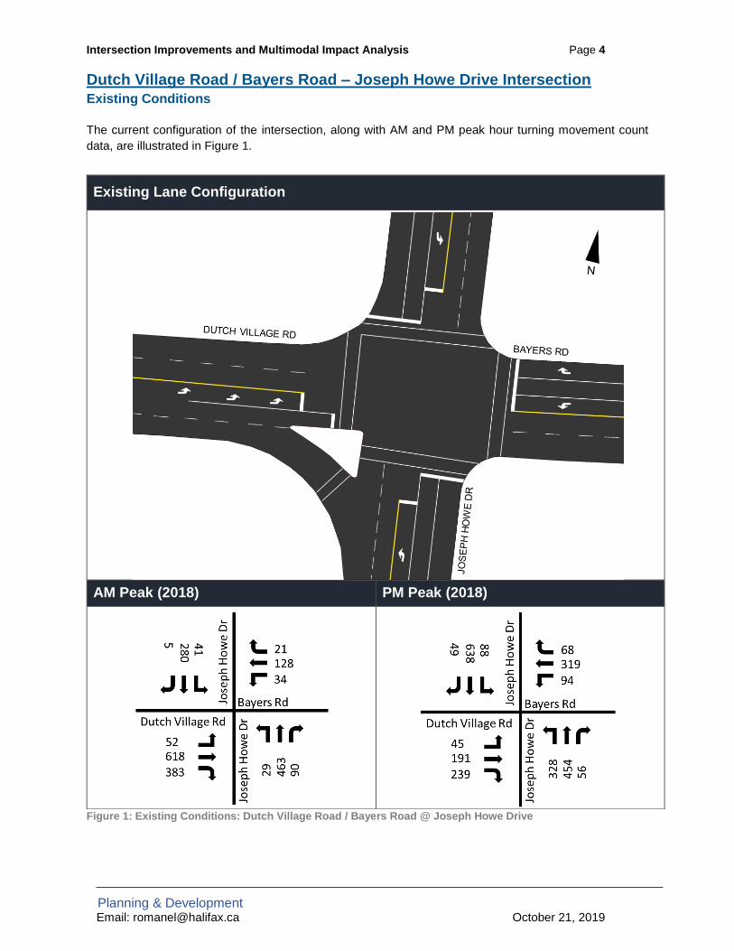
Intersection Improvements and Multimodal Impact Analysis Page 4
Planning & Development Email: [email protected] October 21, 2019
Dutch Village Road / Bayers Road – Joseph Howe Drive Intersection Existing Conditions
The current configuration of the intersection, along with AM and PM peak hour turning movement count data, are illustrated in Figure 1.
Figure 1: Existing Conditions: Dutch Village Road / Bayers Road @ Joseph Howe Drive
Existing Lane Configuration
AM Peak (2018) PM Peak (2018)

Intersection Improvements and Multimodal Impact Analysis Page 5
Planning & Development Email: [email protected] October 21, 2019
Proposed Modifications
The proposed configuration of the Dutch Village Road / Bayers Road & Joseph Howe Drive intersection is illustrated in Figure 2. This proposal blends with the WSP functional plan at approximately Sunnybrae Avenue. An Intersection Performance Analysis and a Multimodal Level of Service (MMLOS) Analysis were carried out and results are summarized in the following section.
All corner radii have been tested with Autoturn and accommodate turning of heavy single unit trucks, HRM aerial fire trucks and articulated buses. Notes describing how the proposal would modify each corner of the intersection (labelled A, B, C, & D) are provided below.
West Side (corners A & B) – Required: • Extension of the proposed DVR protected bicycle lanes, providing a direct connection to the Chain
of Lakes Trail (COLT). • The COLT will be extended slightly to connect to the modified intersection. • Removal of the right turn channel on the eastbound approach of DVR facilitates the extension of
the DVR bicycle lanes, significantly shortens the COLT crossing distance, and reduces conflicts between bicycles / pedestrians and right turning vehicles. This change also reduces the speed of right turning vehicles.
• Removal of a receiving lane on the west side of DVR to accommodate the westbound protected bicycle lane. Impacts to Bayers Road through traffic are not anticipated since there is only one westbound through lane.
• The pedestrian crossings on the west side of the intersection are consolidated from two crossings of 30.5m to a single 18.5m crossing.
• Existing traffic signal on corner “A” would need to be relocated. • The proposed eastbound left turn storage length is approximately 27m.
Figure 2: Proposed Intersection Configuration – Dutch Village Road @ Joseph Howe Drive / Bayers Road

Intersection Improvements and Multimodal Impact Analysis Page 6
Planning & Development Email: [email protected] October 21, 2019
East Side (corners C & D) - Optional: • There is potential to create a bump-out on the eastbound receiving lane on Bayers Rd (corner “C”)
and reduce the radius of corner “D” from 8.3m to 7.5m. These changes would enhance the pedestrian experience by reducing the crossing distance on both the Joseph Howe and Bayers Road legs.
• The left turn lane stop bar on Bayers Road would need to be moved back to accommodate turns by large vehicles.
• The existing walk request button and traffic lights on corner “D” would need to be relocated. • The addition of the bicycle lane on DVR is not reliant on the modifications to these corners.
Traffic Impact Analysis
Staff completed an intersection performance analysis to evaluate traffic operations based on the existing intersection configurations as well as intersection modifications. The analysis was completed for AM and PM peak periods using Synchro 10 and existing signal timing plans. The intersection performance analysis results are summarized below in Table 1.
The results of the traffic analysis for existing conditions indicate that all movements currently operate within HRM’s acceptable limits. The traffic analysis indicated that the proposed changes will have a minimal impact on traffic operations at the intersections. There’s a possibility that the software is slightly
underestimating the impacts of replacing a right turn channel with a dedicated right turn lane, but it shows that the latter still provides sufficient capacity.
Table 1: Intersection Performance Analysis Results: Dutch Village Road / Bayers Road @ Joseph Howe Road
L T R L T R L T R L T RCount 52 618 383 34 128 21 29 463 90 41 280 5Delay 12.1 21.3 3.1 14.6 12.2 0 21.1 33V/C 0.09 0.69 0.42 0.17 0.14 0.03 0.08 0.19
95th% Queue 11.6 132.3 16 9.7 23.2 0 10 17Int. Delay
Delay 12.1 21.3 3.3 14.6 12.2 0 21.1 33V/C 0.09 0.69 0.43 0.17 0.14 0.03 0.08 0.19
95th% Queue 11.6 132.3 16.1 9.7 23.2 0 10 17Int. Delay
Count 45 191 239 94 319 68 328 454 56 88 638 49Delay 37.3 33.6 6.5 35.5 41.7 8.6 17.7 26.1V/C 0.31 0.42 0.43 0.37 0.71 0.17 0.7 0.3
95th% Queue 20.6 61.3 19.1 35.1 103.6 11.2 52.1 29.3Int. Delay
Delay 37.3 33.6 6.8 35.5 41.7 8.6 17.7 26.1V/C 0.31 0.42 0.45 0.37 0.71 0.17 0.7 0.3
95th% Queue 20.6 61.3 19.2 35.1 103.6 11.2 52.1 29.3Int. Delay
35.5
Proposed Conditions
23.8 30.2
Joseph Howe Road
18.8
EB WB NB SBDutch Village Road Bayers Road
23.80.4250.8
Am
Pea
k
0.42 0.3250.8 39
18.8
Existing Conditions
30.20.3239
Proposed Conditions
9.4 25.30.27 0.5635.5 87.8
22.3
PM
Pea
k
Existing Conditions
9.4 25.3
22.2
0.27 0.5587.8
Intersection Improvements and Multimodal Impact Analysis Page 7
Planning & Development Email: [email protected] October 21, 2019
Multi-Modal Level of Service (MMLOS)
The multi-modal level of service (MMLOS) analysis results for the PM peak are summarized in Figure 3. With the addition of unidirectional protected bicycle lanes on Dutch Village Road – the LOS for cyclists improves from an E to a C. The MMLOS target for cyclists is notreached as conflict points still exist – thiscould be potentially reduced with a two-stage turn box to facilitate left turns froma protected bicycle lane. This willincrease the bicycle level of service andcan be considered at the detailed designphase.
The MMLOS analysis suggests that there will be no impact to transit, or auto movement. Goods movement will be slightly impacted by the reduction of the effective curb radius. Additionally, the conditions for pedestrians will slightly improve due to the reduced crossing distance at the Dutch Village Road approach and the northbound Joseph Howe Drive approach. That said, the number of uncontrolled conflicts remain, and the cycle length does not change. Even though the proposed changes will positively impact the overall pedestrian realm, the MMLOS tool is coarse-grained and is not sensitive enough to capture all those changes.
Figure 3: MMLOS analysis for the existing and proposed conditions for Dutch Village Road / Bayers Road at Joseph Howe Drive
SCENARIO:
Area Type:
MODE
Target C B B E E
Actual E D B C B
Target C B B E E
Actual D D B D B
Target C B B E E
Actual D D B D BPriority Corridor No Yes Yes No No
Number of
Uncontrolled Conflicts
Number of
Uncontrolled Conflicts
% of Transit Priority
Measures (of Ideal)
Avg. Curb Lane Width
(m)
% of movements with
exclusive turn lanes
11-13 8-10 N/A 3.40 - 3.59 35 - 60%
Avg. Crossing Width
(m)Priority Treatments
Transit Movement V/C
Ratio
Avg. Effective Curb
Radius (m)Turn prohibitions
17.5 - 21 30 - 49% 0.60 - 0.69 13 - 14 0
Cycle Length (sec) Cycle Length (sec)Transit Movement
Delay (sec)
Truck Intersection
Delay (sec)
Car Intersection Delay
(sec)
76 - 90 76 - 90 21 - 35 21 - 35 21 - 35
Target C B C E E
Actual D E B C BPriority Corridor No Yes No No No
Number of
Uncontrolled Conflicts
Number of
Uncontrolled Conflicts
% of Transit Priority
Measures (of Ideal)
Avg. Curb Lane Width
(m)
% of movements with
exclusive turn lanes
11-13 > 13 N/A 3.80 - 3.99 60 - 85%
Avg. Crossing Width
(m)Priority Treatments
Transit Movement V/C
Ratio
Avg. Effective Curb
Radius (m)Turn prohibitions
> 21 30 - 49% < 0.60 15 - 16 0
Cycle Length (sec) Cycle Length (sec)Transit Movement
Delay (sec)
Truck Intersection
Delay (sec)
Car Intersection Delay
(sec)
76 - 90 76 - 90 21 - 35 21 - 35 21 - 35
Environment
Space
Time
Existing Conditions - Dutch Village Road / Bayers Road at Joseph Howe Drive
Suburban
Proposed Option 1 - Dutch Village Road at Alma Crescent / Supreme Court
Dutch Village Road at Alma Crescent / Supreme Court
Dutch Village Road - PM Peak
Proposed Option 2 - Dutch Village Road at Alma Crescent / Supreme Court
Environment
Time
Space
SCENARIO:
Area Type:
MODE
Target C B B E E
Actual E D B C B
Target C B B E E
Actual D D B D B
Target C B B E E
Actual D D B D BPriority Corridor No Yes Yes No No
Number of
Uncontrolled Conflicts
Number of
Uncontrolled Conflicts
% of Transit Priority
Measures (of Ideal)
Avg. Curb Lane Width
(m)
% of movements with
exclusive turn lanes
11-13 8-10 N/A 3.40 - 3.59 35 - 60%
Avg. Crossing Width
(m)Priority Treatments
Transit Movement V/C
Ratio
Avg. Effective Curb
Radius (m)Turn prohibitions
17.5 - 21 30 - 49% 0.60 - 0.69 13 - 14 0
Cycle Length (sec) Cycle Length (sec)Transit Movement
Delay (sec)
Truck Intersection
Delay (sec)
Car Intersection Delay
(sec)
76 - 90 76 - 90 21 - 35 21 - 35 21 - 35
Target C B B E E
Actual D E B C BPriority Corridor No Yes Yes No No
Number of
Uncontrolled Conflicts
Number of
Uncontrolled Conflicts
% of Transit Priority
Measures (of Ideal)
Avg. Curb Lane Width
(m)
% of movements with
exclusive turn lanes
11-13 > 13 N/A 3.80 - 3.99 60 - 85%
Avg. Crossing Width
(m)Priority Treatments
Transit Movement V/C
Ratio
Avg. Effective Curb
Radius (m)Turn prohibitions
> 21 30 - 49% < 0.60 15 - 16 0
Cycle Length (sec) Cycle Length (sec)Transit Movement
Delay (sec)
Truck Intersection
Delay (sec)
Car Intersection Delay
(sec)
76 - 90 76 - 90 21 - 35 21 - 35 21 - 35
Target C B B E E
Actual D C B C BPriority Corridor No Yes Yes No No
Number of
Uncontrolled Conflicts
Number of
Uncontrolled Conflicts
% of Transit Priority
Measures (of Ideal)
Avg. Curb Lane Width
(m)
% of movements with
exclusive turn lanes
11-13 11-13 N/A 3.80 - 3.99 60 - 85%
Avg. Crossing Width
(m)Priority Treatments
Transit Movement V/C
Ratio
Avg. Effective Curb
Radius (m)Turn prohibitions
17.5 - 21 80 - 89% < 0.60 < 11 0
Cycle Length (sec) Cycle Length (sec)Transit Movement
Delay (sec)
Truck Intersection
Delay (sec)
Car Intersection Delay
(sec)
76 - 90 76 - 90 21 - 35 21 - 35 21 - 35
Environment
Space
Time
Proposed Conditions - Dutch Village Road / Bayers Road at Joseph Howe
Drive
Environment
Space
Time
Existing Conditions - Dutch Village Road / Bayers Road at Joseph Howe Drive
Suburban
Proposed Option 1 - Dutch Village Road at Alma Crescent / Supreme Court
Dutch Village Road at Alma Crescent / Supreme Court
Dutch Village Road - PM Peak
Proposed Option 2 - Dutch Village Road at Alma Crescent / Supreme Court
Environment
Time
Space
Target C B C E E
Actual D C B C BPriority Corridor No Yes No No No
Number of
Uncontrolled Conflicts
Number of
Uncontrolled Conflicts
% of Transit Priority
Measures (of Ideal)
Avg. Curb Lane Width
(m)
% of movements with
exclusive turn lanes
11-13 11-13 N/A 3.80 - 3.99 60 - 85%
Avg. Crossing Width
(m)Priority Treatments
Transit Movement V/C
Ratio
Avg. Effective Curb
Radius (m)Turn prohibitions
17.5 - 21 80 - 89% < 0.60 < 11 0
Cycle Length (sec) Cycle Length (sec)Transit Movement
Delay (sec)
Truck Intersection
Delay (sec)
Car Intersection Delay
(sec)
76 - 90 76 - 90 21 - 35 21 - 35 21 - 35
Environment
Space
Time
Proposed Conditions - Dutch Village Road / Bayers Road at Joseph Howe
Drive

Intersection Improvements and Multimodal Impact Analysis Page 8
Planning & Development Email: [email protected] October 21, 2019
Dutch Village Road – Supreme Court / Alma Crescent Intersection Existing Conditions
The current configuration of the intersection, along with AM and PM peak hour turning movement count data, are illustrated in Figure 4.
Figure 4: Existing Conditions: Dutch Village Road @ Alma Crescent
Existing Lane Configuration
AM Peak PM Peak

Intersection Improvements and Multimodal Impact Analysis Page 9
Planning & Development Email: [email protected] October 21, 2019
Proposed Modifications
This proposal blends with the WSP functional plan at approximately Deal Street. All corner radii have been tested with Autoturn and accommodate turning of heavy single unit trucks, HRM aerial fire trucks and articulated buses. Staff prepared two functional design options for the DVR – Alma Crescent intersection. Option 1 includes unidirectional protected bicycle lanes on both sides of the street up to the intersection, whereas option 2 substitutes the southbound protected bicycle lane with a painted one. Both options are illustrated in Figure 5 & Figure 6. Staff also explored two variations on option 2 (options 2B & 2C) that address a potential conflict at the intersection (illustrated in Figure 7 & Figure 8). All options propose similar modifications to accommodate the northbound bicycle lane on DVR. The following is a description of the proposed modifications: Notes describing how the proposal would modify each corner of the intersection (labelled A, B, C, & D) are provided below. Modifications Common to Options 1 & 2:
East Side (corners A & B) – Required: • A raised protected westbound bicycle lane. • Loss of approximately five 15-min parking spaces between Alma Crescent and Deal Street
Potential for side streets to absorb the parking loss. • Parking of abutting property, Civic 3617/3619, encroaches on HRM’s right-of-way. This concept
claims the space for the sidewalk and the bicycle lane. • Removal of the slip lane on corner “A” of DVR is necessary to extend the bicycle lane to the
intersection. This will also improve visibility and mitigate pedestrian and vehicle conflicts. • Addition of one parking space on DVR facing Civic 3635. • Better defined driveways for Civic 3617/3619 & Civic 3613/3615. • Removal of right turn channel at the Supreme Court approach to reduce conflict with cyclists and
to extend the eastbound bicycle lane to the intersection. • No property acquisition is required.
West Side (corners C & D) - Optional: • Traffic lights would not need to be relocated.

Intersection Improvements and Multimodal Impact Analysis Page 10
Planning & Development Email: [email protected] October 21, 2019
Option 1: Option 2A:
• A raised protected eastbound bicycle lane.• Modified existing right in/out at the underground parking access for the Boss Plaza to address illegal and unsafe left
turns from DVR onto the underground parking access & from the underground parking access to DVR.• Because of the number of driveways on the west side of DVR, a raised protected bicycle lane would undulate
multiple times creating an inconsistent and undesirable experience for southbound cyclists.
• A painted eastbound bicycle lane that transitions into a raised protected bicycle lane after the gas station driveway.• This option helps eliminate inconsistency in cyclist experience and is recommended.• There is potential for conflict between vehicles turning right (from DVR to DVR) and those turning left (from DVR to
DVR) due to intersection geometry, topography, and set back left turn lane.
Figure 5: Proposed Intersection Configuration (Option 1) – Dutch Village Road @ Joseph Howe Drive / Bayers Road Figure 6: Proposed Intersection Configuration (Option 2A) – Dutch Village Road @ Alma Crescent / Supreme Court
Dutch Village Road
Alma Crescent Alma Crescent
Dutch Village Road
Intersection Improvements and Multimodal Impact Analysis Page 11
Planning & Development Email: [email protected] October 21, 2019
Option 2B: Option 2C:
• Option 2B reduces the potential for conflict between right turning vehicles (from DVR to DVR) and left turning vehicles (from DVR to DVR), while attempting to minimize the pedestrian crossing distance (14.4m).
• The radius at corner “A” is 9.0m. • This option clearly delineates parking spaces on the north/east side of DVR.
• Option 2C also reduces the potential for conflict but produces the longest pedestrian crossing (16m) as it omits a bump-out on corner “A”.
• The radius at corner “A” is 7.5m. • This option requires modifying the signal timing plans to accommodate the longer crossing distance by increasing
the Flash Don’t Walk time on the eastbound and westbound approaches (Supreme Court & DVR) from 10s to 16s at the southbound and northbound approaches (Alma Crescent & DVR) from 11s to 16s.
The Project Steering Committee (including representatives from HRM Traffic Management, Active Transportation, and Halifax Transit) reviewed the two functional designs and the variations on Option 2C. There was agreement that Option 2C would best fit the project objectives and reduce potential conflicts between vehicles, pedestrians and cyclists. Option 2 eliminates inconsistency in the cyclist’s experience caused by the number of driveways on the west side of Dutch Village Road. Therefore, staff recommend the implementation of Option 2C. The traffic impact analysis and the MMLOS analysis were completed for the recommended option and are described in the following section.
Figure 7: Proposed Intersection Configuration (Option 2B) – Dutch Village Road @ Alma Crescent / Supreme Court
Figure 8: Proposed Intersection Configuration (Option 2C) – Dutch Village Road @ Alma Crescent / Supreme Court
Dutch Village Road
Alma Crescent
Alma Crescent

Intersection Improvements and Multimodal Impact Analysis Page 12
Planning & Development Email: [email protected] October 21, 2019
Traffic Impact Analysis
Staff completed an intersection performance analysis to evaluate traffic operations based on the existing intersection configurations as well as intersection modifications for the preferred Option 2C. The analysis was completed for the AM and PM peak periods using Synchro 10 and existing and proposed signal timing plans. The intersection performance analysis results are summarized below in .
Table 2.
The results of the traffic analysis for existing conditions indicate that all movements currently operate within HRM’s acceptable limits. The traffic analysis indicated that the proposed changes will have minimal impact on traffic operations at the intersections.
Table 2: Intersection Performance Analysis Results: Dutch Village Road @ Alma Crescent / Supreme Court
L T R L T R L T R L T RCount 26 189 115 95 10 5 24 25 18 438 827 15Delay 0 9.6V/C 0.01 0.61
95th% Queue 0 45.4Int. Delay
Delay 0 13.2V/C 0.01 0.65
95th% Queue 0 58.7Int. Delay
Count 45 611 79 229 118 298 38 36 24 342 383 20Delay 6.3 21.2V/C 0.51 0.75
95th% Queue 19.3 59.7Int. Delay
Delay 6 22.7V/C 0.49 0.76
95th% Queue 19.2 61.3Int. Delay
14.2
NB WB EB SB
Am
Pe
ak
0.78171.7
18
Existing Conditions
13.90.73
136.5
11.10.27
29.20.6695.6
Proposed Conditions
19.60.3433
Proposed Conditions
11.70.3961.9
23.5
PM
Pe
ak
Existing Conditions
11.4
0.3027.5
28.50.6595.7
Dutch Village Road
37.30.4233.5
33.114.6
23.8
Supreme Court Alma Crescent
25.90.2319.4
23.20.1818.9
49.40.7881.4
25.40.2926.9
47.223.3
0.3961.9
0.7681.8
25.20.2826.9

Intersection Improvements and Multimodal Impact Analysis Page 13
Planning & Development Email: [email protected] October 9, 2019
Multi-Modal Level of Service (MMLOS)
The multi-modal level of service (MMLOS) analysis results for the PM peak are summarized in Figure 9. According to the analysis, the conditions for cyclists improve slightly with the addition of bicycle lanes on Dutch Village Road. However, the analysis also shows that the LOS does not improve beyond a D as the approaches on Supreme Court, Alma Crescent do not have any bicycle facilities on them nor are there plans for any at the time being. The conditions for pedestrians improve as the pedestrian crossing changes from a 24.5m two-stage crossing to a 16.0m one-stage crossing. The removal of the right turn channel also reduces the number of uncontrolled conflict points between pedestrians and vehicles. Conditions for transit and automobiles do not change. However, conditions for goods movement slightly worsen with the reduction of the turn radii and the width of the curb lanes.
Target C B C E E
Actual E D B C BPriority Corridor No Yes No No No
Number of
Uncontrolled Conflicts
Number of
Uncontrolled Conflicts
% of Transit Priority
Measures (of Ideal)
Avg. Curb Lane Width
(m)
% of movements with
exclusive turn lanes
> 13 8-10 N/A 3.60 - 3.79 35 - 60%
Avg. Crossing Width
(m)Priority Treatments
Transit Movement V/C
Ratio
Avg. Effective Curb
Radius (m)Turn prohibitions
> 21 < 30% 0.60 - 0.69 > 18 0
Cycle Length (sec) Cycle Length (sec)Transit Movement
Delay (sec)
Truck Intersection
Delay (sec)
Car Intersection Delay
(sec)
76 - 90 76 - 90 21 - 35 21 - 35 21 - 35
Space
Dutch Village Road at Alma Crescent / Supreme Court
Environment
Time
SCENARIO:
Area Type:
MODE
Target C B B E E
Actual E D B C B
Target C B B E E
Actual D D B D B
Target C B B E E
Actual D D B D BPriority Corridor No Yes Yes No No
Number of
Uncontrolled Conflicts
Number of
Uncontrolled Conflicts
% of Transit Priority
Measures (of Ideal)
Avg. Curb Lane Width
(m)
% of movements with
exclusive turn lanes
11-13 8-10 N/A 3.40 - 3.59 35 - 60%
Avg. Crossing Width
(m)Priority Treatments
Transit Movement V/C
Ratio
Avg. Effective Curb
Radius (m)Turn prohibitions
17.5 - 21 30 - 49% 0.60 - 0.69 13 - 14 0
Cycle Length (sec) Cycle Length (sec)Transit Movement
Delay (sec)
Truck Intersection
Delay (sec)
Car Intersection Delay
(sec)
76 - 90 76 - 90 21 - 35 21 - 35 21 - 35
Target C B B E E
Actual D E B C BPriority Corridor No Yes Yes No No
Number of
Uncontrolled Conflicts
Number of
Uncontrolled Conflicts
% of Transit Priority
Measures (of Ideal)
Avg. Curb Lane Width
(m)
% of movements with
exclusive turn lanes
11-13 > 13 N/A 3.80 - 3.99 60 - 85%
Avg. Crossing Width
(m)Priority Treatments
Transit Movement V/C
Ratio
Avg. Effective Curb
Radius (m)Turn prohibitions
> 21 30 - 49% < 0.60 15 - 16 0
Cycle Length (sec) Cycle Length (sec)Transit Movement
Delay (sec)
Truck Intersection
Delay (sec)
Car Intersection Delay
(sec)
76 - 90 76 - 90 21 - 35 21 - 35 21 - 35
Target C B B E E
Actual D C B C BPriority Corridor No Yes Yes No No
Number of
Uncontrolled Conflicts
Number of
Uncontrolled Conflicts
% of Transit Priority
Measures (of Ideal)
Avg. Curb Lane Width
(m)
% of movements with
exclusive turn lanes
11-13 11-13 N/A 3.80 - 3.99 60 - 85%
Avg. Crossing Width
(m)Priority Treatments
Transit Movement V/C
Ratio
Avg. Effective Curb
Radius (m)Turn prohibitions
17.5 - 21 80 - 89% < 0.60 < 11 0
Cycle Length (sec) Cycle Length (sec)Transit Movement
Delay (sec)
Truck Intersection
Delay (sec)
Car Intersection Delay
(sec)
76 - 90 76 - 90 21 - 35 21 - 35 21 - 35
Environment
Space
Time
Proposed Conditions - Dutch Village Road / Bayers Road at Joseph Howe
Drive
Environment
Space
Time
Existing Conditions - Dutch Village Road / Bayers Road at Joseph Howe Drive
Suburban
Proposed Option 1 - Dutch Village Road at Alma Crescent / Supreme Court
Dutch Village Road at Alma Crescent / Supreme Court
Dutch Village Road - PM Peak
Proposed Option 2 - Dutch Village Road at Alma Crescent / Supreme Court
Environment
Time
Space
Target C B C E E
Actual D D B D BPriority Corridor No Yes No No No
Number of
Uncontrolled Conflicts
Number of
Uncontrolled Conflicts
% of Transit Priority
Measures (of Ideal)
Avg. Curb Lane Width
(m)
% of movements with
exclusive turn lanes
11-13 8-10 N/A 3.40 - 3.59 35 - 60%
Avg. Crossing Width
(m)Priority Treatments
Transit Movement V/C
Ratio
Avg. Effective Curb
Radius (m)Turn prohibitions
17.5 - 21 30 - 49% 0.60 - 0.69 13 - 14 0
Cycle Length (sec) Cycle Length (sec)Transit Movement
Delay (sec)
Truck Intersection
Delay (sec)
Car Intersection Delay
(sec)
76 - 90 76 - 90 21 - 35 21 - 35 21 - 35
Environment
Time
Space
Figure 9: MMLOS analysis for the existing and proposed conditions for Dutch Village Road at Supreme Court / Alma Crescent

Intersection Improvements and Multimodal Impact Analysis Page 14
Planning & Development Email: [email protected] October 9, 2019
Concluding Thoughts Staff have completed an analysis of the traffic impacts and the Multi-Modal Level of Service impacts associated with the proposed intersection upgrades on Dutch Village Road. These findings supplement the analyses for the various functional design options considered for the Dutch Village Road / Bayers Road at Joseph Howe Drive and Alma Crescent / Supreme Court intersections. The proposed changes will facilitate the extension of the DVR bicycle lanes and provide a direct connection to the Chain of Lakes Trail (COLT). They also confer some benefits upon pedestrians at each intersection.
Overall, the traffic impact analysis suggests that there will be a minimal impact to traffic operations along the corridor (during peak periods). The MMLOS analysis suggests that the design will improve conditions for cyclists and pedestrians. The analysis also suggests that any impacts to transit, goods movement and automobiles will be very minimal and would not impede their operations.

Attachment C

What do you like about the proposed functional plan for Dutch Village Road between Alma Crescent and
Bayer's Road?
Do you have any questions, comments or concerns about the proposed functional plan?
1 The protected bikelane and west side sidewalk
2The focus on active transportation and transit priority is excellent!
The lack of east/north-bound AAA cycling infrastructure connection near Joseph Howe is disappointing. The quality of the cycling infrastructure goes from AAA level to sharing the road with 3 lanes of traffic. The priority is again given to traffic capacity instead of cyclist safety.
3
Pedestrian island is very good progress, also sidewalk and cycle lanes. Bump outs at crosswalk locations are really needed on this road due to fast moving traffic, so this is very welcome.
There is no infrastructure for cyclists at the intersection of Jo Howe and DRV, where cyclists are most vulnerable to traffic incidents - this is needed. Measures such as advance boxes and cycle lanes through the intersections should be considered to allow connectivity, as well as a cycle lane along Titus and Lacewood and to connect with the multi purpose route on Jo Howe.
The turning lane from DVR onto Jo Howe is surplas to requirements and makes the road uneccessarily wide. Why not remove this and turn this land into a community feature - some trees perhaps?
I would also welcome more points to cross the road by using pedestrian islands, as the crosswalks are far apart. Ped. islands can be used instead of crosswalks to cross a road safely. Many pedestrians do cross the road at key points such as by Giant Tiger - desire lines should be allowed for in the design plans.
I am not sure why we need on street parking in addition to the existing car parking lot. There is adequate space already and the parking is at a location where pedestrians often cross the road. The cars will restict their view and that of drivers.
4
Everything! I think it makes the area more walkable and easier to access for all. I really like the pedestrian improvements around shoppers drug mart (which is awful to navigate with my son's stroller) as well as the sidewalks on both sides of Dutch village.
I feel that Dutch Village and surrounding area could be the "new north end" and having green spaces and some seating like benches would make it more of a destination. Somewhere you can park your car or bike, walk to or jump of the bus and access services and spend some time in the area will be good for all! I feel sad for the businesses in the area because even though I live less 5 minutes walking distance from most of these businesses I avoid the area because of the lack of walkability. I think these changes will increase the number of businesses in the area and will be so good for the neighbourhoid
5I like the changes to the parking at the businesses. Changing the shoppers entrance isn't bad. And adding the median to eliminate people going up Sunnybrae Dr.
I do not like the elimination of the turn lane on Westerwald. It is painful now let alone when someone will be there turning left. That will totally slow down getting out. The left turn lane allows people to merge into the roadway. This will slow it down so we never get out!
6
Disappointed to see the intersection with Alma Crescent is not included. Can a solution be found to connect the west side bike lane to the Chain of Lakes trail on the southwest side of the intersection with Joseph Howe as well?
7 Stop talking start doing... the area is an eye sore
8
It is fantastic! Improved sidewalks and a new bike lane is so badly needed here. It's an unsafe area that is rapidly growing and I'm looking forward to seeing the positive changes, thank you!
Does the bike lane on DVR (along Shoppers Drugmart) connect all the way to Joe Howe? It looks like it stops right after the driveway for Shoppers, it would be great if it connected to Joe Howe and the major bike route there.
#
Attachment D
9 Improved sidewalk infrastructure.I'm concerned about local businesses reactions to the reduction of parking on the west side of the street.
10
Having a side walk and some parking to use the services on the street would be great.I think this is a great improvement for the fairview area, that I would like to see for the rest of the fairview as well.
Currently many people use dutch village as a two lane road going towards Halifax,since the right turn towards the highway is usually slower during the morning.I think this should be taken into consideration, since reducing the size of the road would cause a lot more traffic in the area.
11
1. Like proposed median to block illegal turn onto Sunnybrae2. Like proposed sidewalks and crosswalks on Dutch Village Rd
1. Strongly oppose bike lane on Dutch Village. Any bike traffic would travel on Joe Howe. Have the project team assessed bike lane needs on the street? With new housing developments in the area traffic will greatly - and has already- increased. We need better road space for vehicles not the very sparse bike traffic.2. Sunnybrae needs a sidewalk. There’s a school on the street!
12I like that it will create an organized, rejuvenated road that will provide safety to an area that has a lot of pedestrians
I dont believe the planners spent enough time considering the traffic flows on Dutch Village. It is very hard to turn left on to Dutch Village from all connecting streets because there are rarely breaks in traffic. This is due to lack of stop signs etc. I am also concerned that buses will not be able to safely make a right turn from Rosedale on to Dutch Village with the reduced lane sizes. Ultimately, it would be great to see less traffic on Dutch Village but that would mean a better plan for Windsor street exchange and bayer's road and connaught as they are the bottle necks. I would honestly rather see the money spent on fixing the bottle necks in the city
13
I am quite pleased with the plan. Provides a much needed facelift for the area and will make the neighbourhood more pleasant and feel more like a neighbourhood. I hope it can be implemented!
14
The look and feel of the proposed plan to make it more aesthetically and pedestrian friendly. Hopefully a narrower roadway will slow cars down as cars travel excessively fast in this area. Removing some parking, parking lot entrances/exits to help alleviate congestion is also a good move.
Concerns are the number of vehicles that travel this road during morning/afternoon commute. Already busy but don't see any plans to ease this congestion. The same number of lanes and reduction of lanes in some areas will only add to congestion. This entire block (Joseph Howe, Dutch Village) is at times gridlocked if there are traffic issues getting onto the 102 or at the Windsor Street Exchange.
15 It becomes a walkable community
Concerned about turning left onto Dutch Village Rd in the mornings. There should be signal lights to ease the traffic flow.
There should be two lanes leading onto the Windsor exchange. One lane turns left which is rarely used.
16 Yes!I think it looks great. I just want to ensure that there would also be trees planted along the sides. The street is so barren now. Some trees would make a great improvement as well.
17
The increased pedestrian and bicycle usage is a tremendous improvement. The absence of sidewalks on the west side of Dutch Village Road is a big problem which this plan addresses. New protected bike lanes are the way to go. This plan would improve the whole area.
None. This is an excellent plan.

18Sidewalks and bus stops are definitely welcomed addition and sorting out the free for all parking situation.
I'm very concerned about the entry and exit points of the AAA bike lanes. The recent bump outs at Joseph Howe intersection squeeze cyclists into traffic lane, instead of leaving a comfortable buffer. Before bump outs, there was ample room for cyclist to pull up to lights, and cars to safely pass.I understand the AAA concept, but when the lane simply dissapears into traffic where cars have no awareness of cyclists, it's a bad idea. Better would be to have a well marked bike lane with street, signs, not separated. Also much easier for cyclists when joining and leaving bike lane. For example, it looks simple for N to S to CCLT trail to connect to bike lane, but what about S to N from CCLT or Bayer's road? With all these curbs, cut ins and outs, greatly slows cyclists, not intuitive.
19
I like the pedestrian improvements and the bike lanes added to the street. I also like the bump out crosswalks that help separate parking areas. And the bump out bus stops are another plus since it removes the problem of leaving and entering traffic (which is what I hope the municipality does for all of Spring Garden instead of just half). I know many people have concerns about the parking, but the plan organizes the spots and removes the problem of perpendicular parking.
I am concerned about the abrupt end to the cycling routs on each end of the road. I hope the entirety of Titus and Lacewood will be improved with a similar design at some point soon since the road never functions to capacity in the first place.
20 I think any upgrade would be splendid.
I love the look of it. I assume there is enough room for bicycle lanes and sidewalks.Hard to believe. I'm hoping this improves the sight lines at Central and Dutch Villagefor vehicles. There has already been an increase in illegal parking on Andrew Street at Dutch Village Road. In front of the Ville building, vehicles are always parked andblocking the fire hydrant. Andrew Street is often down to one lane due to the congestion of illegal parking at Andrew and Dutch Village. The alternative beingPercy Street and Dutch Village, it is unsafe to make a left hand turn, so most ofthe street drives up to Andrew. This parking is a direct result of the Ville building not providing sufficient parking for its tenants. From the designs it looks like youmight be planning parallel parking on the road. Look forward to the changes. I will never be on a bike even in my own lane on Dutch Village Road. Way too dangerous.

21
I would like to see pull over lanes for public transit rather than a bus stop blocking a lane of traffic Bicycle lanes and green space are very important. I'm not sure of the importance of having on street parking, especially across from the Dairy Queen and Giant Tiger when there is ample parking in both locations. The vacant lot on the corner of Dutch Village and Rosedale is a contaminated property due to the previous location of a gas station. This is a very small lot and would be very expensive to clean up. Therefore, it may be a good idea to make this a public space. Many people may not know this, but the great country music star Hank Snow married Minni Aalders who is from Fairview. Hank was from Shelburne and spent a lot of time in Fairview walking these streets as he made his way to see in CHNS radio to perform live. Hank went on to become a world-class performer in Nashville, performing regularly at the Grand Ole Opry and is inducted into Country Music Hall of Fame. Perhaps, the potential green space mentioned above could be an ideal location for a bronze statue in recognition of his great talent.
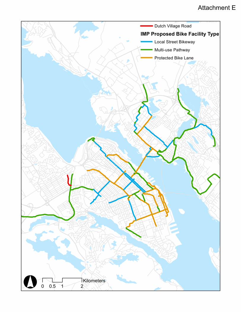
° 0 1 20.5Kilometers
Dutch Village RoadIMP Proposed Bike Facility Type
Local Street BikewayMulti-use PathwayProtected Bike Lane
Attachment E