ISBN 978-952-15-0279-7 (printed) ISBN 978-952-15-4216-9 (PDF)


Goulburn Broken Waterway Strategy 2014-2022 P a g e | ii
Published by:
Goulburn Broken Catchment Management Authority,
PO Box 1752, Shepparton 3632
© Goulburn Broken Catchment Management Authority, 2014.
Please cite this document as: GBCMA (2014) Goulburn Broken Waterway Strategy 2014-2022, Goulburn Broken Catchment Management Authority, Shepparton.
ISBN: 978-1-876600-04-4
Disclaimer
This publication may be of assistance to you, but the Goulburn Broken Catchment Management Authority does not guarantee that the publication is without flaw of any kind or is wholly appropriate for your particular purposes and therefore disclaims all liability for any error, loss or other consequences that may arise from you relying on information in this publication.
Note specific reference to funding levels in this strategy are for indicative purposes only. The level of Government investment in this strategy will depend upon budgets and Government priorities
For further information, please contact:
Goulburn Broken Catchment Management Authority
Waterways, Wetlands and Strategic River Health
P.O. Box 1752, Shepparton 3632
Ph. (03) 5822 7700
Visit: www.gbcma.vic.gov.au
Front cover photo credits from left to right (top row): Canoeing on the Goulburn River (GB CMA); Lake Benalla from Monash Bridge (Kirsten Hein, Mark Ainsworth); Murray cod returned to the river (Wally Cubbin); Sunday Creek, Mt Disappointment (Krissi Flynn); (second row): Kirwans Bridge Victoria (Wally Cubbin); Fishing Goulburn River along Majors Creek (Wally Cubbin); Goulburn River at Molesworth (Belinda Fisher); Water for agriculture (C. Sexton, GB CMA).
Goulburn Broken Waterway Strategy 2014-2022 P a g e | iii
Our Strategy The Goulburn Broken Waterway Strategy (the Strategy), together with a range of related sub-strategies, underpin the Regional Catchment Strategy (RCS). This Strategy presents an integrated catchment planning framework for waterways in the Goulburn Broken region and is the primary guide for priority setting, maintenance and improvement of our waterways.
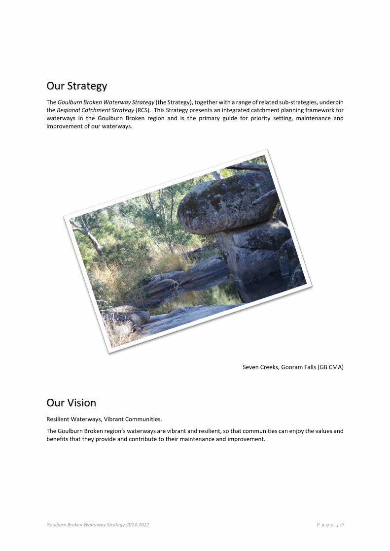
Seven Creeks, Gooram Falls (GB CMA)
Our Vision Resilient Waterways, Vibrant Communities.
The Goulburn Broken region’s waterways are vibrant and resilient, so that communities can enjoy the values and benefits that they provide and contribute to their maintenance and improvement.
Goulburn Broken Waterway Strategy 2014-2022 P a g e | iv
Foreword Waterways (rivers and wetlands) are the lifeblood of our region. They are also the barometer by which we can assess the current and past management of our waterways and surrounding catchment and how well we are achieving “clean green agriculture”, which is so important for the prosperity of our rural community.
We now have evidence to demonstrate the benefit of the implementation of the previous Regional River Health Strategy. For example, sensitive instream works and establishing appropriate vegetation on frontages has reduced bank erosion and promoted faster natural revegetation recovery following flood events. This has also been the case for post-bushfire recovery. Another critical result provided by works is the reduction of phosphorous and nitrogen into our waterways which in turn reduces the likelihood of algal blooms and low oxygen events in some waterways, particularly over summer.
We now have better tools to improve the resilience of some ecosystems or reduce their chance of loss or decline.
The Goulburn Broken Catchment Management Authority (GB CMA), as the lead agency for natural resource management in the catchment, is responsible for the development and oversight of a regional catchment strategy framework together with our community and partners.
The Goulburn Broken Waterway Strategy is one of several sub-strategies underpinning the Goulburn Broken Regional Catchment Strategy (RCS). The RCS presents the high-level priorities, outputs and outcomes at the catchment scale, whereas this Strategy presents the detail and supporting framework relevant to waterway management to enable delivery of the strategic intent of the RCS.
This Strategy applies an asset-based approach and incorporates resilience-based thinking for maintaining and improving the social, economic, cultural and environmental values of waterways. The Strategy recognises the vast range of social, environmental, cultural and economic values that waterways provide to our regional community and visitors alike.
This Strategy reflects on the vast amount of work the community has achieved over many years and incorporates recent environmental and policy drivers and knowledge gained through research and monitoring. It identifies the key threats to important values and provides recommendations to influence the future management of waterways in the catchment. Actions to maintain and improve our waterways are clearly established.
The GB CMA recognises its critical role in forming and developing regional partnerships with the community and all levels of government. Success in implementing this Strategy will occur through partnerships with our community and government agencies.
The Strategy is a living document that will be continuously improved and updated over its life.
We wish to acknowledge the contribution of our community in the development of the Strategy. Our community has identified values and threats, participated on the Community Reference Group and provided photographs depicting the way in which their local waterway is valued. Our partner agencies have also supported the development of the Strategy through input on Reference Groups and direct contribution to Chapters within this Strategy.
We seek your support in the implementation of this Strategy so the region’s valued waterways can be maintained and improved, for now and into the future and we can maintain their value as an important tourism asset and the harmony in which this asset sits with agricultural production.
Murray Chapman Chair Goulburn Broken Catchment Management Authority
Chris Norman Chief Executive Officer Goulburn Broken Catchment Management Authority
Goulburn Broken Waterway Strategy 2014-2022 P a g e | v
About Our Strategy Waterways (rivers and wetlands) are one of the most striking features of our landscape. They provide us with enjoyment, provide cultural values, and contribute significantly to the economic and social health of our region and our community.
There is no better time than now for people in all catchments of Australia to pause and celebrate how vital waterways are to the community, and to contribute towards their maintenance and improvement.
Local waterways are valued by local communities and the many visitors to the region as well as other users of our precious water resources well beyond our region.
Our waterways support many species of plants and animals unique to Australia (like the Murray cod, Platypus and the humble Yabby). Our waterways also provide billions of dollars to the economy, support one third of all food produced in Australia, provide our everyday drinking water, support tourism and provide recreational opportunities. They are indeed a key asset to us all.
Our catchment has great places to camp, including the Goulburn River and tributary streams, and is also the home of Barmah Forest, which together with the Millewa Forest in NSW, forms the largest River Red Gum forest in the world.
Fresh water is a scarce and precious resource in many areas across the globe. We are fortunate to have good water supplies in the most populated parts of Australia, but we have one of the driest climates in the world and our water reserves are limited. Many waterways are becoming increasingly polluted and work has commenced in the Murray-Darling Basin to better balance the water available for the health of the waterways.
Waterways in good condition provide a range of benefits for our regional industries, agriculture and the wider community (Jones 2001). Key benefits of services include, but are not limited to:
• provision of conduits for the supply of water for agriculture;
• water quality improvement (Hairsine 2001), which can reduce the cost of treatment prior to human usage;
• support for populations of native and introduced fish species popular with local and visiting anglers; and
• utilisation for tourism, recreation and aesthetics.
This Strategy reflects on the vast amount of work the community has achieved over many years and incorporates recent environmental and policy drivers and knowledge gained through research and monitoring. It identifies key threats to community values and provides recommendations to influence the future management of waterways in the catchment.
While our community is already taking action to maintain waterways, there is still more that can be done. Taking positive action is the best way to help our waterways.
Communities can assist in maintaining and improving our waterways, by:
• finding out about our local waterways (and the values they contain/provide);
• maintaining and managing buffer areas by fencing and re-establishing native vegetation;
• maintaining and improving public reserves for waterway health;
• getting involved with and encouraging participation in native fish and river health education programs; and
• working with local groups on waterway projects (for example, Waterwatch, Landcare, Indigenous groups and recreational anglers).

Goulburn Broken Waterway Strategy 2014-2022 P a g e | vi
This Strategy encourages our community to enjoy our waterways and contribute to their maintenance and improvement.
A review of works undertaken over recent years provides confidence that we are maintaining and improving many elements and reaches of the region’s waterways. Examples include a reduction in the level of nutrients entering our waterways, maintenance of threatened species (even after being subjected to bushfire and drought) and maintaining rivers in the catchment as prime recreational areas.
The Strategy is one of several sub-strategies supporting the Goulburn Broken Regional Catchment Strategy (RCS). The RCS presents a framework and vision for integrated catchment management in the region, identifies land, water and biodiversity assets, sets 20 year condition objectives for those assets, and outlines regional priorities and management measures to achieve the objectives.
The intent of this Strategy is to:
• identify priority waterways based on their environmental, social, cultural and economic values, and set objectives for their management;
• develop a work and activity program to achieve these objectives, and targets against which to measure progress in reaching these objectives;
• provide a consistent, defensible process for identifying priorities for government investment in waterways; and
• engage key stakeholders and the community in the process of developing the Strategy to ensure that the priority assets chosen reflect areas of high community value.
This Strategy has been structured and compiled with input from our community and our many partners. The Strategy is a living document that will be regularly reviewed and updated over its life. This will require continuous engagement of community and partner agencies to ensure an adaptive management approach is used to improve the resilience of our waterways and catchment as we face the challenges of the future together. As part of this approach, we have been undertaking a new challenge in developing a workable resilience matrix for waterways based on sound science.
The Strategy comprises four major sections:
• PART A – Regional Overview and Strategic Context;
• PART B – The Approach, Vision, Goals and Guiding Principles;
• PART C – Regional Program – Implementation of Management Activities; and
• PART D – Implementing the Strategy.
The Strategy identifies priority waterways for investment into the next decade and identifies strategic challenges and opportunities.
The Strategy also includes management planning for the Barmah Forest Ramsar Site in accordance with Action 12.3 of the Victorian Waterway Management Strategy (2013).
A number of filters have been applied to develop a list of priority waterways from the large list of waterways identified within the Index of Stream Condition and Index of Wetland Condition. Filter one applied the definition of high value waterways as identified within the Victorian Waterway Management Strategy (2013) followed by filter two, which used the list of regional goals established by the Community Reference Committee.

Goulburn Broken Waterway Strategy 2014-2022 P a g e | vii
Filter One: waterways are considered high value if they have one, or more, of the following characteristics:
• formally recognised significance;
• presence of highly threatened or rare species and ecological communities;
• high naturalness values (for example, aquatic invertebrate communities or riparian vegetation) or special waterway features (for example, drought refuges or important bird habitat); and
• high social, cultural or economic values (for example, recreational fishing, Aboriginal cultural heritage and urban or rural water sources).
Filter Two: involved identifying waterways with values relating to regional goals established by the Community Reference Committee to maintain the resilience of the region’s waterways to ensure:
• waterways of high community value are maintained or improved;
• water quality in priority water supply catchments is maintained or improved;
• populations of threatened aquatic dependent species will be maintained or improved (including Trout cod, Macquarie perch, Murray cod, Eel tailed catfish, Barred galaxias, Golden perch);
• Barmah Forest (Ramsar site) will be managed to maintain its ecological character;
• the values associated with Heritage Rivers will be maintained or improved;
• wetlands with formally recognised significance are maintained or improved;
• waterways in a near-natural or ecologically healthy state are retained; and
• urban waterways are managed to improve environmental condition, amenity and water security.
Additional filters include application of the risk-based assessment contained within AVIRA (Aquatic Value Identification and Risk Assessment) and finally, a feasibility review of management activities.
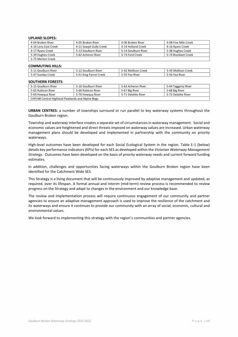
Over the next eight years, investment will target priority waterways within the six Social Ecological Systems1 (SES). Priority waterways are defined by reach or wetland identification number and name within each SES (e.g. Basin - Waterway Reach (5-54), and Waterway Name (Broken River) or Wetland ID and Name):
AGRICULTURAL FLOODPLAINS: 4-01 Broken River 4-21 Broken Creek 4-22 Broken Creek 4-23 Broken Creek 4-24 Broken Creek 4-32 Boosey Creek 4-36 Tullah Creek 5-01 Goulburn River 5-02 Goulburn River 5-03 Goulburn River 5-04 Goulburn River 5-05 Goulburn River 60101 One Tree Swamp 60102 Two Tree Swamp 60118 Gaynors Swamp 60205 Kanyapella Basin 60240 Yambuna Bridge Rd 60265 Mansfield Swamp 60269 Wallenjoe Swamp 60706 Barmah Forest 62010 Doctors Swamp 63156 Gemmills Swamp 63173 Reedy Swamp 63203 Black Swamp 63206 Kinnairds Wetland 66906 Sampys Swamp 66911 Taylors Swamp 67091 Mulquiney Rd
PRODUCTIVE PLAINS: 4-03 Broken River 4-13 Holland Creek 4-34 Boosey Creek 5-06 Goulburn River 5-07 Goulburn River 5-08 Goulburn River 5-09 Goulburn River 5-10 Goulburn River 5-17 Seven Creeks 5-18 Seven Creeks 5-19 Seven Creeks 5-20 Seven Creeks 5-22 Honeysuckle Creek 5-23 Honeysuckle Creek 5-37 Hughes Creek 5-76 Honeysuckle Creek 61918 Tahbilk Lagoon 62900 Stockyard Plain 67053 Moodie Swamp 67905 Dowdle Swamp 67909 Winton Wetland Complex
1 The RCS identifies seven SESs including a Catchment Wide SES. Priority waterways within the Catchment Wide SES have not been listed as they incorporate all the priority waterways and wetlands listed in the other six SESs.
Goulburn Broken Waterway Strategy 2014-2022 P a g e | viii
UPLAND SLOPES: 4-04 Broken River 4-05 Broken River 4-06 Broken River 4-08 Five Mile Creek 4-10 Lima East Creek 4-11 Sawpit Gully Creek 4-14 Holland Creek 4-16 Ryans Creek 4-17 Ryans Creek 5-13 Goulburn River 5-14 Goulburn River 5-38 Hughes Creek 5-39 Hughes Creek 5-62 Acheron River 5-73 Ford Creek 5-74 Brankeet Creek 5-75 Merton Creek
COMMUTING HILLS: 5-11 Goulburn River 5-12 Goulburn River 5-42 Mollison Creek 5-43 Mollison Creek 5-47 Sunday Creek 5-51 King Parrot Creek 5-55 Yea River 5-56 Yea River
SOUTHERN FORESTS: 5-15 Goulburn River 5-16 Goulburn River 5-63 Acheron River 5-64 Taggerty River 5-65 Rubicon River 5-66 Rubicon River 5-67 Big River 5-68 Big River 5-69 Howqua River 5-70 Howqua River 5-71 Delatite River 5-72 Delatite River CHP/AB Central Highland Peatlands and Alpine Bogs
URBAN CENTRES: a number of townships surround or run parallel to key waterway systems throughout the Goulburn Broken region.
Township and waterway interface creates a separate set of circumstances in waterway management. Social and economic values are heightened and direct threats imposed on waterway values are increased. Urban waterway management plans should be developed and implemented in partnership with the community on priority waterways.
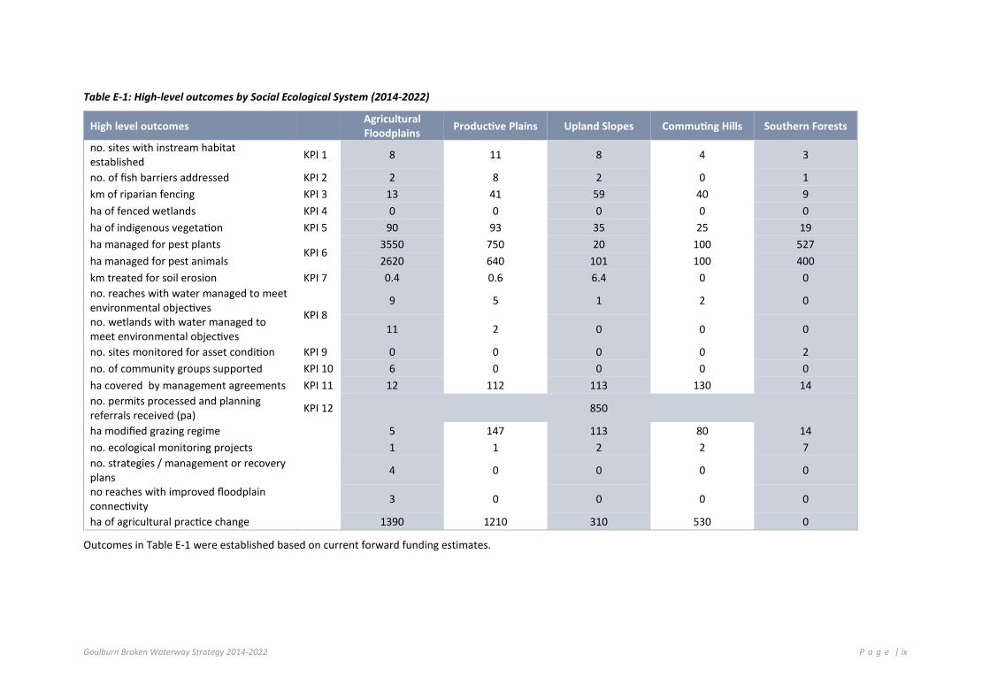
High-level outcomes have been developed for each Social Ecological System in the region. Table E-1 (below) details key performance indicators (KPIs) for each SES as developed within the Victorian Waterway Management Strategy. Outcomes have been developed on the basis of priority waterway needs and current forward funding estimates.
In addition, challenges and opportunities facing waterways within the Goulburn Broken region have been identified for the Catchment Wide SES.
This Strategy is a living document that will be continuously improved by adaptive management and updated, as required, over its lifespan. A formal annual and interim (mid-term) review process is recommended to review progress on the Strategy and adapt to changes in the environment and our knowledge base.
The review and implementation process will require continuous engagement of our community and partner agencies to ensure an adaptive management approach is used to improve the resilience of the catchment and its waterways and ensure it continues to provide our community with an array of social, economic, cultural and environmental values.
We look forward to implementing this strategy with the region’s communities and partner agencies.
Goulburn Broken Waterway Strategy 2014-2022 P a g e | ix
Table E-1: High-level outcomes by Social Ecological System (2014-2022)
High level outcomes Agricultural Floodplains Productive Plains Upland Slopes Commuting Hills Southern Forests
no. sites with instream habitat established KPI 1 8 11 8 4 3
no. of fish barriers addressed KPI 2 2 8 2 0 1 km of riparian fencing KPI 3 13 41 59 40 9 ha of fenced wetlands KPI 4 0 0 0 0 0 ha of indigenous vegetation KPI 5 90 93 35 25 19 ha managed for pest plants
KPI 6 3550 750 20 100 527
ha managed for pest animals 2620 640 101 100 400 km treated for soil erosion KPI 7 0.4 0.6 6.4 0 0 no. reaches with water managed to meet environmental objectives KPI 8
9 5 1 2 0
no. wetlands with water managed to meet environmental objectives 11 2 0 0 0
no. sites monitored for asset condition KPI 9 0 0 0 0 2 no. of community groups supported KPI 10 6 0 0 0 0 ha covered by management agreements KPI 11 12 112 113 130 14 no. permits processed and planning referrals received (pa) KPI 12 850
ha modified grazing regime 5 147 113 80 14 no. ecological monitoring projects 1 1 2 2 7 no. strategies / management or recovery plans 4 0 0 0 0
no reaches with improved floodplain connectivity 3 0 0 0 0
ha of agricultural practice change 1390 1210 310 530 0
Outcomes in Table E-1 were established based on current forward funding estimates.

Goulburn Broken Waterway Strategy 2014-2022 P a g e | x
Table of Contents PART A Regional Overview and Strategic Context Our Strategy ............................................................................................................................................................ iii
Our Vision ............................................................................................................................................................... iii
Foreword................................................................................................................................................................. iv
About Our Strategy .................................................................................................................................................. v
Table of Contents ..................................................................................................................................................... x
Acknowledgement of Traditional Owners ............................................................................................................ xiv
Acknowledgements .............................................................................................................................................. xiv
Chapter authors ..................................................................................................................................................... xv
Photograph credits ............................................................................................................................................... xvi
Chapter One: ............................................................................................................................................................ 2
Introduction ............................................................................................................................................................. 2
1.1 Structure of the Document ...................................................................................................................... 2
1.2 The Waterway Strategy ........................................................................................................................... 3
1.3 Program Logic and Structure of the Document ....................................................................................... 4
1.4 Implementing the Strategy ...................................................................................................................... 5
1.5 Guiding Principles .................................................................................................................................... 5
Chapter Two: ........................................................................................................................................................... 7
Regional Overview: The Goulburn Broken Catchment ............................................................................................ 7
2.1 Waterways ............................................................................................................................................... 7
2.2 Waterways of the Goulburn River Basin .................................................................................................. 7
2.3 Waterways of the Broken River Basin ...................................................................................................... 8
2.4 Waterway Condition .............................................................................................................................. 10
2.5 Wetlands of the Goulburn Broken Region ............................................................................................. 12
2.6 Wetland Condition ................................................................................................................................. 14
2.7 Recognition of Aboriginal Values of Waterways .................................................................................... 14
2.8 Communities Value their Waterways .................................................................................................... 21
Chapter Three: ....................................................................................................................................................... 22
Strategic Context ................................................................................................................................................... 22
3.1 State Framework .................................................................................................................................... 22
3.2 Regional Framework for Waterway Management ................................................................................ 23
3.3 National Framework .............................................................................................................................. 24
3.4 International Framework ....................................................................................................................... 25
3.5 Formally Recognised Significance – Barmah Forest ............................................................................... 26

Goulburn Broken Waterway Strategy 2014-2022 P a g e | xi
3.6 Roles and Responsibilities of the CMA, Community and Partner Organisations ................................... 26
3.7 Review of the Goulburn Broken River Health Strategy (2005) .............................................................. 27
3.8 Protecting the Ecological Character of the Barmah Forest .................................................................... 33
Chapter Four: ......................................................................................................................................................... 47
Challenges and Opportunities ............................................................................................................................... 47
4.1 Management of Riparian Land............................................................................................................... 48
4.2 Water Quality ......................................................................................................................................... 55
4.3 Management of the Environmental Water Reserve .............................................................................. 59
4.4 Groundwater .......................................................................................................................................... 62
4.5 Floodplain Management ........................................................................................................................ 66
4.6 Public Infrastructure in our Waterways ................................................................................................. 67
4.7 Management of Threatened Aquatic Dependent Species ..................................................................... 69
4.8 Management of Recreational Fisheries ................................................................................................. 73
4.9 Management of Invasive Species ........................................................................................................... 75
4.10 Management of the River Channel ........................................................................................................ 78
4.11 Management of Extreme Events ........................................................................................................... 81
4.12 Influence of the Surrounding Catchment .............................................................................................. 84
4.13 Potential Impacts and Adaption to Climate Change .............................................................................. 90
4.14 Management and Use of Water Storages .............................................................................................. 95
PART B Our Approach to the Strategy Chapter Five: .......................................................................................................................................................... 98
Overview Of Approach ........................................................................................................................................... 98
5.1. Overview of Approach ........................................................................................................................... 98
5.2 Program Logic ........................................................................................................................................ 99
5.3 Vision and Regional Goals .................................................................................................................... 100
5.4 Aquatic Value Identification and Risk Assessment (Avira) – The Asset Based Approach .................... 101
5.5 Managing for Waterway Resilience ..................................................................................................... 102
Chapter Six: .......................................................................................................................................................... 106
Priority Setting ..................................................................................................................................................... 106
6.1 Identifying Priority Waterways ............................................................................................................ 106
6.2 Defining Waterways ............................................................................................................................. 106
6.3 Identifying High Value Waterways ....................................................................................................... 107
6.4 Priority Waterways .............................................................................................................................. 107
6.5 Developing the Regional Work Program .............................................................................................. 114

Goulburn Broken Waterway Strategy 2014-2022 P a g e | xii
PART C Regional Work Program - Implementation of Management Activities Chapter Seven: ..................................................................................................................................................... 118
The Action Plan .................................................................................................................................................... 118
7.1 Regional Work Program (8-Year Work Program) ................................................................................. 118
7.2 Agricultural Floodplains ....................................................................................................................... 119
7.3 Productive Plains .................................................................................................................................. 130
7.4 Upland Slopes ...................................................................................................................................... 141
7.5 Commuting Hills ................................................................................................................................... 148
7.6 Southern Forests .................................................................................................................................. 152
7.7 Urban Centres ...................................................................................................................................... 157
7.8 Assumptions ......................................................................................................................................... 160
7.9 Outcomes by SES/Landscape ............................................................................................................... 162
PART D Implementing the Strategy Chapter Eight: ...................................................................................................................................................... 166
Implementing the Strategy .................................................................................................................................. 166
8.1 Implementing the Strategy .................................................................................................................. 166
8.2 Maintenance ........................................................................................................................................ 166
8.3 Best Practice ........................................................................................................................................ 168
8.4 Compliance .......................................................................................................................................... 170
8.5 Monitoring and Evaluation .................................................................................................................. 171
8.6 Community Engagement ..................................................................................................................... 176
8.7 Roles and Responsibilities .................................................................................................................... 179
8.8 Cost-Sharing Principles for Waterway Management Programs .......................................................... 179
8.9 Strategy Review ................................................................................................................................... 180
8.10 Waterway Program Implementation Schedules .................................................................................. 181
References and further reading ........................................................................................................................... 182
PART E Appendices Appendix A: Partners and their roles and responsibilities in waterway management ............................................. i
Appendix B: Values and threats of waterways considered in the regional priority setting process ....................... v
Appendix C: AVIRA Metrics / Categories to be used to identify High Value waterways. ..................................... viii
Appendix D: Index of Stream Condition results (1999, 2004 and 2010) and Stream States by Social Ecological System ................................................................................................................................................................................. x
Appendix E: High value waterways and their associated values in the Goulburn Broken catchment, by landscape ..............................................................................................................................................................................xvii
Appendix F: High value wetlands by Social Ecological System (landscape) ......................................................... xxiii

Goulburn Broken Waterway Strategy 2014-2022 P a g e | xiii
Appendix G: Priority waterways ......................................................................................................................... xxxv
Appendix H - Priority wetlands .............................................................................................................................. xli
Appendix I - Costings applied to strategic priorities ............................................................................................... lii
Appendix J - Glossary of Terms .............................................................................................................................. liii
Appendix K - Acronyms .......................................................................................................................................... lvi
Appendix L: List of achievements from the last strategy (Goulburn Broken River Health Strategy 2005-2013) . lviii
Appendix M: Priority waterways (risk and feasibility) ........................................................................................... lix
Appendix N: Receipt of comments from community (that informed the preparation of the waterway strategy)lxii
Appendix O: Opportunities and challenges – (priority management actions) .................................................... lxiii

Goulburn Broken Waterway Strategy 2014-2022 P a g e | xiv
Acknowledgement of Traditional Owners The Goulburn Broken Catchment Management Authority and our community acknowledge the Traditional Owners of land, the Yorta Yorta Nations, Taungurung Clans and other custodians, in the Goulburn Broken catchment and strongly respect the rich culture and intrinsic connection the Traditional Owners have to the land – past, present and into the future.
Acknowledgements This Strategy has been prepared by the Goulburn Broken Catchment Management Authority with the support of the community and partner agencies.
The project has been led by the Waterway Strategy Community Reference Committee with the oversight of the GB CMA Board, and assistance of the Partnership Team, agency partners and the community. Members of the Committee wish to acknowledge the support provided from the following groups and individuals (in alphabetical order, with affiliations):
Community Reference Group Mr Barry Croke (Naringaningalook) Mr Bill Wells (Strathbogie) Mr Greg McKenzie (Kyabram) Ms Helen Reynolds (Congupna) Mr Jay Whittaker (Bunbartha) Ms Jill Breadon (Mansfield) Mr John Avard (Colbinabbin) Mr Peter Ingham (Murrindindi) Mr Wally Cubbin (Nagambie)
Partner Agencies Mr Mark Turner Goulburn Broken Catchment Management Authority Dr Anne Graesser Goulburn-Murray Water Mr Greg Smith Goulburn-Murray Water Mr Ken Ellis Goulburn-Murray Water Ms Carmel O'Dwyer Department of Environment and Primary Industries Mr Bruce Wehner Parks Victoria Mr Simon Casanelia Goulburn Broken Catchment Management Authority Ms Sue Berwick Department of Environment and Primary Industries Mr Dan McLaughlin Parks Victoria
We would also like to acknowledge the contribution of the Waterway Strategy Writers Group, staff at the Department of Environment and Primary Industries (in particular the Water and Catchment Group) and guidance provided from the overarching strategic document, the Victorian Waterway Management Strategy (2013).

Goulburn Broken Waterway Strategy 2014-2022 P a g e | xv
Chapter authors
Chapter 2.7: Recognition of Aboriginal values of waterways
Yorta Yorta Nations Aboriginal Corporation, (Neil Morris), Taungurung Clans Aboriginal Corporation (Meg Goulding)
Chapter 3.8: Protecting the ecological character of the Barmah Forest
Jennifer Hale
Chapter 4.1: Management of riparian lands Mark Turner (GB CMA) Chapter 4.2: Water quality Goulburn Broken Regional Water Quality Forum Chapter 4.3: Management of the environmental water reserve
Tim Barlow, Geoff Earl (GB CMA)
Chapter 4.4: Groundwater Matthew Hudson (Goulburn-Murray Water) Chapter 4.5: Floodplain management Guy Tierney (GB CMA) Chapter 4.7: Management of threatened aquatic dependent species
Jarod Lyon (Arthur Rylah Institute)
Chapter 4.8: Recreational fishing Judy Dixon (Mansfield Shire Council), David Kramer (Future Fish Foundation), Rob Loats (VRFish), Wally Cubbin (Goulburn Valley Association of Angling Clubs), Mark Turner (GB CMA), Mick Hall (Australian Trout Foundation), Julia Menzies, Russell Strongman, John Douglas and Anthony Forster (DEPI), Steven Trelfall (Trelly’s Tackle World) and Ron Lewis (Native Fish Australia)
Chapter 6: Priority setting Greg Peters (Riverness) Chapter 8.6: Community engagement Fiona Lloyd Strategic overview
Greg Woodward (DEPI), Amber Clarke (DEPI) and Statewide CMA Writing Group
AVIRA/population and data management Meegan Judd (GB CMA), Jodi Egginton, Andrea White (DEPI)
GB CMA and partner organisations Mark Turner, Simon Casanelia, GB Partnership Team
Edit/review Cathy Walker, Fleur Baldi (GB CMA), Simon Casanelia (GB CMA)
Technical edit Trudi Ryan (Natural Communication)

Goulburn Broken Waterway Strategy 2014-2022 P a g e | xvi
Photograph credits
Front Page From left to right (top row): Canoeing on the Goulburn River (GB CMA); Lake Benalla from Monash Bridge (Kirsten Hein, Mark Ainsworth); Murray cod returned to the river (Wally Cubbin); Sunday Creek, Mt Disappointment (Krissi Flynn); (second row): Kirwans Bridge Victoria (Wally Cubbin); Fishing Goulburn River along Majors Creek (Wally Cubbin); Goulburn River at Molesworth (Belinda Fisher); Water for agriculture (C. Sexton, GB CMA).
Chapter 1 Nagambie Lakes (Wally Cubbin); Great Egret on Lake Benalla (Kirsten Hein); Lake Benalla Waterway Trail (GB CMA); Tahbilk backwaters (GB CMA); Young Macquarie perch (ARI); Building protective fencing on Holland Creek (GB CMA); Hughes Creek rock pool (GB CMA); Fishing the Goulburn River (Wally Cubbin).
Chapter 2 Scar tree in the landscape (YYNAC from NRM Plan); Lyn Thorpe River Painting - Dunguladja Wala Dunguladja Yenbenal = Strong Water Strong People; Working on Country Project Team Protecting the Ecological Character of Barmah (YYNAC); Participants on Yorta Yorta Youth Journey (G Sutherland GB CMA); TCAC, ARI and Mount Buller Alpine Commission staff inspecting Alpine bogs (G Sutherland); Artefacts at Strathbogie (G Sutherland); Hughes Creek recording of grinding grooves (G Sutherland); Shane Monk (TCAC) talking to Parks Victoria staff about treatment areas at Cathedral Range State Park (G Sutherland).
Chapter 3 Tahbilk fish passage, crossing modification (Simon Casanelia GB CMA); Broken River flood recovery (G Brennan GB CMA); Goulburn River Recreational Fishing Licence project (S Kosch GB CMA); Broken River bank protection (G Brennan GB CMA).
Chapter 4 Goulburn River (Seymour, 1958); Goulburn River (Seymour, 1958); Ryans Creek (1939); Goulburn River (Seymour, 1947); Hughes Creek (Avenel); Howqua River (1959) from Our river heritage, historic photos of Victoria’s internal waterways - Our Water our Future.
Chapter 7 Boosey Creek Tungamah (GB CMA); Broken River upstream of Lake Nillahcootie (GB CMA); Catchment resilience - Buxton (GB CMA); Dry wetland Broken River floodplain (GB CMA); Field monitoring (GB CMA); Lake Benalla pest plant encroachment (GB CMA); Hughes Creek Rock Pool (J and L Dalziel).
Goulburn Broken Waterway Strategy 2014-2022 P a g e | 2
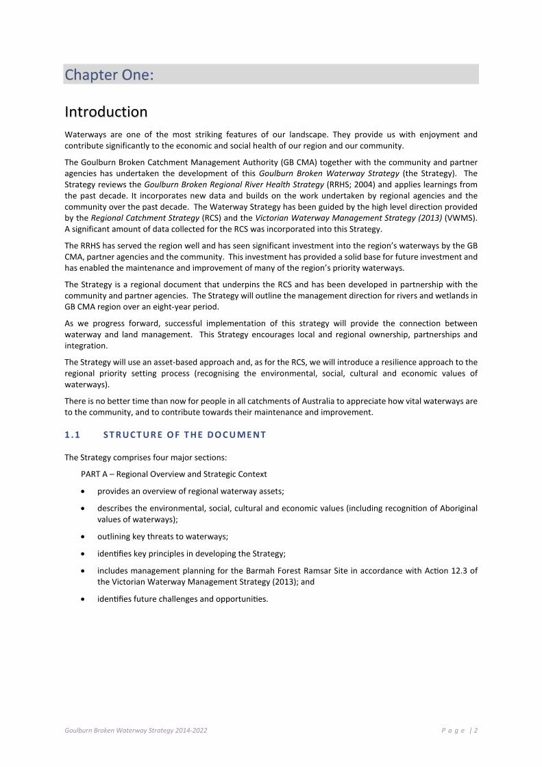
Introduction Waterways are one of the most striking features of our landscape. They provide us with enjoyment and contribute significantly to the economic and social health of our region and our community.
The Goulburn Broken Catchment Management Authority (GB CMA) together with the community and partner agencies has undertaken the development of this Goulburn Broken Waterway Strategy (the Strategy). The Strategy reviews the Goulburn Broken Regional River Health Strategy (RRHS; 2004) and applies learnings from the past decade. It incorporates new data and builds on the work undertaken by regional agencies and the community over the past decade. The Waterway Strategy has been guided by the high level direction provided by the Regional Catchment Strategy (RCS) and the Victorian Waterway Management Strategy (2013) (VWMS). A significant amount of data collected for the RCS was incorporated into this Strategy.
The RRHS has served the region well and has seen significant investment into the region’s waterways by the GB CMA, partner agencies and the community. This investment has provided a solid base for future investment and has enabled the maintenance and improvement of many of the region’s priority waterways.
The Strategy is a regional document that underpins the RCS and has been developed in partnership with the community and partner agencies. The Strategy will outline the management direction for rivers and wetlands in GB CMA region over an eight-year period.
As we progress forward, successful implementation of this strategy will provide the connection between waterway and land management. This Strategy encourages local and regional ownership, partnerships and integration.
The Strategy will use an asset-based approach and, as for the RCS, we will introduce a resilience approach to the regional priority setting process (recognising the environmental, social, cultural and economic values of waterways).
There is no better time than now for people in all catchments of Australia to appreciate how vital waterways are to the community, and to contribute towards their maintenance and improvement.
1 .1 S T R UCT UR E O F T HE DO C U ME NT
The Strategy comprises four major sections:
PART A – Regional Overview and Strategic Context
• provides an overview of regional waterway assets;
• describes the environmental, social, cultural and economic values (including recognition of Aboriginal values of waterways);
• outlining key threats to waterways;
• identifies key principles in developing the Strategy;
• includes management planning for the Barmah Forest Ramsar Site in accordance with Action 12.3 of the Victorian Waterway Management Strategy (2013); and
• identifies future challenges and opportunities.

Goulburn Broken Waterway Strategy 2014-2022 P a g e | 3
PART B – The Approach, Vision, Goals and Guiding Principles:
• presents the approach taken in the development of the Strategy;
• identifies high-value waterways based on environmental, social, cultural and economic values;
• identifies and spatially maps priority waterways for investment over the next eight years through a risk-based prioritisation process; and
• defines high-level (20 year) goals for waterways in the region.
PART C – Regional Work Program – Implementation of Management Activities:
• develops a regional work program for priority waterways (over the eight-year planning cycle).
PART D – Implementing the Strategy:
• identifies best practice, roles and responsibilities and factors that may influence the implementation of the Strategy.
1 .2 T HE WA T E RW AY ST RA T EG Y
This second generation strategy will be known as the Goulburn Broken Waterway Strategy (the Strategy). It has been developed by the GB CMA in partnership with regional agencies and the community. This reflects the regional planning process for waterway management set out in the Victorian Waterway Management Strategy where regional waterway strategies provide a single planning document for waterway management in each region of Victoria. The Strategy will be the primary mechanism for implementing statewide waterway policy and replaces the current Goulburn Broken Regional River Health Strategy (2004). The overarching aim of the Strategy is to provide a single, regional planning document for whole-of-catchment management (i.e. rivers, estuaries and wetlands) and an action plan for achieving integrated waterway outcomes.
The Strategy includes management planning for the Barmah Forest Ramsar Site in accordance with Action 12.3 of the Victorian Waterway Management Strategy.
The development of regional waterway strategies is a statutory requirement under the Water Act 1989 (Section 190) and also fulfil the statutory requirement for developing management plans for Heritage Rivers in accordance with the Heritage Rivers Act 1992. All Heritage Rivers will be considered as high value assets in the priority setting process and then management activities for these assets will be determined through the regional priority setting process.
There are also several other plans that do not have waterway health as their primary consideration but have implications for waterway management. As such, these need to be considered in waterway health planning and implementation. These include other action plans under the RCS such as the Regional Vegetation Plans, Biodiversity Action Plans and SES local plans.
The broad intent of the Strategy is to:
• identify high value waterways (based on environmental, social, cultural and economic values);
• determine priority waterways for the eight-year planning period;
• include a regional work program of management activities for priority waterways (including environmental water management); and
• guide investment into multi-year projects and annual work programs.

Goulburn Broken Waterway Strategy 2014-2022 P a g e | 4
1 .3 P R OG RA M L OGI C AND S T R UCT UR E O F T HE D OC U M ENT
This Strategy was prepared in accordance with the requirements of the Victorian Waterway Management Strategy (DEPI 2013) and Regional Waterway Strategy Guidelines (DEPI 2013). Table 1-1 summarises the Program Logic, going from the broadest level of the ‘regional vision’ to the finest level of activity targets. Table 1-1 also provides direction to relevant Chapters in this Strategy.
Table 1-1: Program Logic framework, linking vision, regional goals and management activities
RCS Vision Healthy, resilient and increasingly productive landscapes supporting vibrant communities
Waterway Strategy Vision Section 5.2: Resilient Waterways, Vibrant Communities
Regi
onal
Sca
le
Regional Goals (20+ years)
Section 5.2.1: Maintain and improve the resilience of the region’s waterways: Social: Maintain or improve waterways of high community value. Economic: Maintain or improve water quality in priority water supply catchments. Environment: Populations of threatened aquatic dependent species will be maintained or improved - including Trout cod, Macquarie perch, Murray cod, Eel tailed catfish, Barred galaxias, Golden perch. Barmah Forest (Ramsar site) will be managed to maintain its ecological character. The values associated with Heritage Rivers will be maintained or improved. Wetlands with formally recognised significance are maintained or improved. Waterways in a near natural or ecologically healthy state are retained. Urban Waterways Urban waterways are managed to improve environmental condition, amenity and water security.
Wat
erw
ay S
cale
Long-term resource condition (8+ years) (i.e. long-term target for waterway condition – relates to values identified in regional goals)
Sections 7.2 to 7.9 Management outcome targets (1-8 years) (i.e. short-term target addressing impact/risk – relates to impacts/risks to these values identified in risk assessments) Management activity output (annual) (i.e. target for activity to be conducted addressing impact/risk)
Project activities
Develop an annual Investment Plan and Annual Work Plan and Monitoring Program. Prepare and execute project contracts and service level agreements for the annual works plan and monitoring program. Hold works and activity meetings to plan and monitor the implementation of the project. Develop Annual Communications Plan. Record and map annual works and monitoring program. Technical review and amendment of the 4-year project outcome and monitoring.
Assumptions
Implementation of Best Practice will lead to maintaining or improving the resilience of the region’s waterway (refer to: GHD (2012) Department of Sustainability and Environment - River and Estuary Conceptual Models to Support Development of Regional Waterway Strategies)
Foundation activities
Communications Plan. Documentation of Best Practice. Compliance Activities. Collate preferred/best practice pest plant control techniques. Collate relevant legislation, labels, permits and codes of practice. (Chapter 8)
Goulburn Broken Waterway Strategy 2014-2022 P a g e | 5
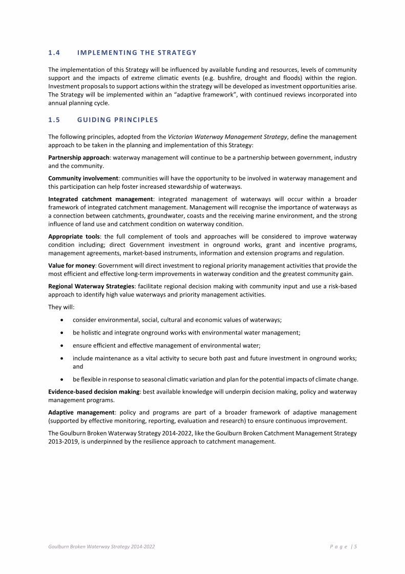
1 .4 I M PL E M ENT I N G T H E S T RAT EG Y
The implementation of this Strategy will be influenced by available funding and resources, levels of community support and the impacts of extreme climatic events (e.g. bushfire, drought and floods) within the region. Investment proposals to support actions within the strategy will be developed as investment opportunities arise. The Strategy will be implemented within an “adaptive framework”, with continued reviews incorporated into annual planning cycle.
1 .5 G UI DI N G PRI NCI P LE S
The following principles, adopted from the Victorian Waterway Management Strategy, define the management approach to be taken in the planning and implementation of this Strategy:
Partnership approach: waterway management will continue to be a partnership between government, industry and the community.
Community involvement: communities will have the opportunity to be involved in waterway management and this participation can help foster increased stewardship of waterways.
Integrated catchment management: integrated management of waterways will occur within a broader framework of integrated catchment management. Management will recognise the importance of waterways as a connection between catchments, groundwater, coasts and the receiving marine environment, and the strong influence of land use and catchment condition on waterway condition.
Appropriate tools: the full complement of tools and approaches will be considered to improve waterway condition including; direct Government investment in onground works, grant and incentive programs, management agreements, market-based instruments, information and extension programs and regulation.
Value for money: Government will direct investment to regional priority management activities that provide the most efficient and effective long-term improvements in waterway condition and the greatest community gain.
Regional Waterway Strategies: facilitate regional decision making with community input and use a risk-based approach to identify high value waterways and priority management activities.
They will:
• consider environmental, social, cultural and economic values of waterways;
• be holistic and integrate onground works with environmental water management;
• ensure efficient and effective management of environmental water;
• include maintenance as a vital activity to secure both past and future investment in onground works; and
• be flexible in response to seasonal climatic variation and plan for the potential impacts of climate change.
Evidence-based decision making: best available knowledge will underpin decision making, policy and waterway management programs.
Adaptive management: policy and programs are part of a broader framework of adaptive management (supported by effective monitoring, reporting, evaluation and research) to ensure continuous improvement.
The Goulburn Broken Waterway Strategy 2014-2022, like the Goulburn Broken Catchment Management Strategy 2013-2019, is underpinned by the resilience approach to catchment management.

Goulburn Broken Waterway Strategy 2014-2022 P a g e | 6
Nagambie Lakes (Wally Cubbin); Great Egret on Lake Benalla (Kirsten Hein); Lake Benalla Waterway Trail (GB CMA); Tahbilk backwaters (GB CMA); Young Macquarie perch (ARI): Building protective fencing on Holland Creek (GB CMA): Hughes Creek rock pool (GB CMA); Fishing the Goulburn River (Wally Cubbin).

Goulburn Broken Waterway Strategy 2014-2022 P a g e | 7
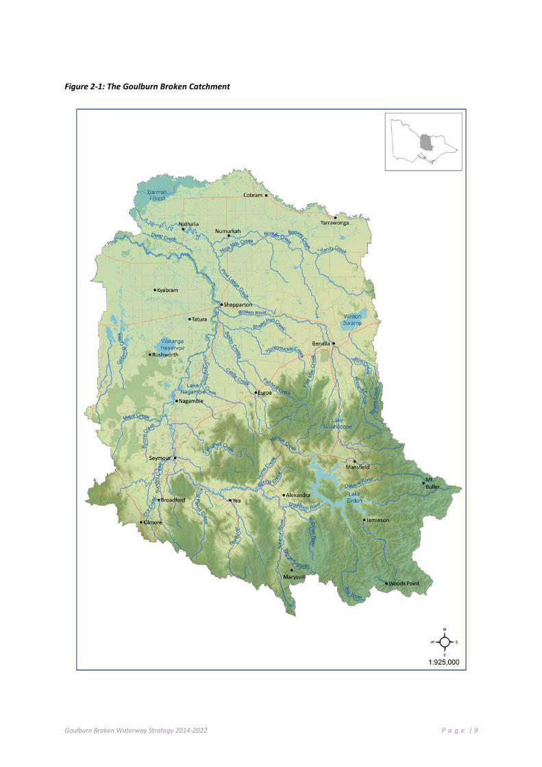
Regional Overview: The Goulburn Broken Catchment The Goulburn Broken catchment extends from the Great Dividing Range near the outskirts of Melbourne to the River Murray on the border with New South Wales (Figure 2.1).
The catchment contains a diversity of landscapes, communities and natural and constructed features. Our landscapes boast snow-covered alps, forests, granitic outcrops, gentle sloping plains, box woodlands and red gum floodplains and a mosaic of natural assets, river pathways, forested regions and agricultural development.
2 .1 W A T E RW AY S
Waterways, including floodplains, wetlands and groundwater aquifers, are an integral part of the catchment providing many environmental, social, cultural and economic services (GB CMA 2013). They underpin livelihoods (providing water for agriculture, commercial and domestic uses), contain significant flora and fauna habitat, have high recreational and aesthetic values, and are central to the culture of local Indigenous communities.
There are two major river basins within the catchment: the Goulburn and the Broken (refer to Figure 2.1). These form part of the Murray-Darling Basin and cover approximately 2.4 million hectares (ha) or 10.5% of Victoria and 2% of the Murray-Darling Basin.
The total length of waterways within these basins is over 44,000 km. The vast majority are small ephemeral headwater streams found on the steep slopes of the Great Dividing Range in the south of the catchment. Larger more perennial rivers and creeks total approximately 15,000 km in length.
Wetlands are a major feature of the landscape, with a range of wetland features present. Over 2,000 wetlands have been mapped and classified in the Goulburn Broken region and these cover approximately 86,000 ha. These wetlands include large permanent lakes, floodplain billabongs, small spring soaks, alpine bogs and shallow freshwater depressions. The vast majority of wetlands are located on private land; they are mostly ephemeral and occur on the region’s floodplains (refer to Chapter 2.5).
Our catchment is also home to Barmah Forest, which together with the Millewa Forest in NSW, forms the largest River Red Gum forest in the world.
2 .2 W A T E RW AY S O F T H E G O UL BU RN RI V ER BAS I N
The Goulburn River Basin is Victoria’s largest covering 1.6 million ha or 7.1% of Victoria. The Goulburn River itself is 570 km long, flowing from the Great Dividing Range upstream of Woods Point to the Murray River east of Echuca. It has a mean annual water discharge of 3,040 GL representing 13.7% of the total state discharge. Native vegetation has been retained over much of the mountainous areas in the south, however, clearing for agriculture has been extensive in the valleys and plains.
Stream flow along the Goulburn River has been modified by two major features: Eildon Reservoir and the Goulburn Weir. Lake Eildon is located in the river’s upper catchment, immediately below the confluence with the Delatite River. It has a capacity of 3,334 GL. On average, 91% of water released from Lake Eildon is diverted for irrigation purposes and supplies about 60% of water used in the Goulburn Murray Irrigation District (GMW website). With such a large storage capacity, operation of the lake fully regulates downstream flows in all but wet years (GB CMA 2008). The Goulburn Weir is approximately 235 km downstream of Lake Eildon, and north of Nagambie. It holds 25 GL and is usually held close to capacity to facilitate the diversion of water into irrigation channels and to supply Waranga Basin, which has a capacity of 432 GL and is used to store winter and spring flows from tributaries downstream of Lake Eildon.
The Goulburn River, its tributaries and associated floodplain and wetland habitats support a variety of threatened species of high conservation value including the iconic Murray cod, the endemic Barred galaxias, one of only two self-sustaining populations of Trout cod in Australia and the critically endangered Alpine Tree Frog. The waterways and their associated floodplain and wetland habitats also contain many important cultural heritage

Goulburn Broken Waterway Strategy 2014-2022 P a g e | 8
sites, provide water for agriculture and urban centres within and downstream of the basin, and support a variety of recreational activities such as fishing and boating.
The Goulburn River downstream of the Goulburn Weir is listed in ‘A Directory of Important Wetlands in Australia’ and downstream of Lake Eildon it is classified as a Heritage River under the Heritage Rivers Act 1992 (Vic) together with Big River and the Howqua River upstream of Lake Eildon. Upper reaches of the Goulburn, Taggerty and Big Rivers have been classified as ecologically healthy (see Chapter 5.4.1 and Appendix D).
There are several major rural towns and cities in the Goulburn basin including Shepparton, Mooroopna, Seymour and Kyabram, and a further eight communities with populations greater than 1,500.
2 .3 W A T E RW AY S O F T H E B RO KEN R I VE R BA SI N
The Broken River basin is 772,386 ha or 3.4% of Victoria’s total area. The Broken River is a tributary of the Goulburn River and joins the Goulburn River at Shepparton. The basin also includes the catchment of the Broken Creek that diverges from the Broken River west of Winton Wetlands and flows north-west to the River Murray.
Most of the Broken River catchment has been cleared of native vegetation for agricultural purposes including grazing in the south and mixed cereal and dryland grazing in the central region. A large part of the northern section is within the Murray Valley irrigation district where intensive horticultural, dairy and livestock production occurs.
Broken River stream flow is extremely variable both between seasons and between years. The three months from July to September generally account for over half the annual stream flow. The catchment has a mean annual flow of 325,000 ML. However, annual flow has varied from a minimum of 5,000 ML in the drought year of 1943, to a maximum of more than 1,000,000 ML in the flood years of 1917 and 1956.
Two major storages have been constructed within the catchment: Lake Nillahcootie and Lake Mokoan. Lake Nillahcootie is located in the Broken River’s upper catchment and has a capacity of 40,000 ML. The Lake provides water for stock, domestic and irrigation. Lake Mokoan was constructed in 1971 and had a capacity of 365,000 ML. It was an off river water storage designed to provide water to the Murray and Goulburn irrigation areas. Lake Mokoan was decommissioned in 2004 and is being restored to its natural wetland habitat. The Winton Wetlands Committee of Management is overseeing the restoration project.
The Broken River, its tributaries and associated floodplain and wetland habitats are a stronghold for native flora and fauna in the region including many threatened species of high conservation value including Silver perch and the nationally threatened Macquarie perch.
The Broken Creek, Muckatah Depression and the Broken River downstream of Benalla are listed in ‘A Directory of Important Wetlands in Australia’ and a reach of Ryans Creek in the upper Broken River catchment has been classified as ecologically healthy.
The city of Benalla is the largest urban community in the basin. There are also a number of major towns including Cobram, Nathalia, Yarrawonga and Numurkah.
Holland Creek Native Fish Project
Holland Creek, nestled within the Tatong Valley, supports the threatened Macquarie perch.
The demonstration reach project is addressing a range of threats to the creek and Macquarie perch through fencing, stock control and revegetation, weed control and increasing the diversity of instream habitat.
A number of field days have been held with the community and the project is supported by a Community Reference Group who meet regularly to track progress on the project.
Goulburn Broken Waterway Strategy 2014-2022 P a g e | 9
Figure 2-1: The Goulburn Broken Catchment
Goulburn Broken Waterway Strategy 2014-2022 P a g e | 10
2.3.1 VALUES AND THREATS
Values
The local community and visitors to the region identify with a range of waterway values and view these as important to maintain and protect:
• recreational fishing; • native flora and fauna; • water supply for townships, stock and domestic; • water supply for agriculture and industry; • tourism and recreation; • cultural and heritage; and • aesthetic and lifestyle.
Threats
Threatening activities and processes to waterways include, but are not limited to:
• catchment clearing (forestry agreements, policy and harvesting practices);
• potential impacts of climate change; • groundwater extraction; • salinity; • pest plant and animal invasion; • snag removal; • stock access to riparian land; • waterway regulation and flow diversion; • environmental flows (impact on
recreational values) • forest agreements policy and harvesting
practices • river channel hydrology (rates of rise and
fall, unseasonal flow); • wave action – jet skiing, water skiing and
wake boarding; and • urban and agricultural development.
These activities and processes are linked to: • physical degradation of riverbanks and
channels; • reduced water quality and temperature; • loss of instream and riparian habitat and
complexity; • modified flow and flood regimes; • a decline in the diversity and abundance
of biodiversity; • reduced primary production and nutrient
cycling; • changes to river and floodplain
morphology; and • disruption of lifecycles and breeding cues.
2 .4 W A T E RW AY C ON DI T I O N
River and stream condition in Victoria is assessed using the Index of Stream Condition (ISC) (DEPI 2013a). The ISC is an integrated measure of river condition that assesses changes in hydrology, water quality, streamside vegetation, bed and bank condition, instream habitat and aquatic macroinvertebrate diversity.
The 2004 ISC assessment of selected river reaches in the Goulburn and Broken Basins indicated that most are in moderate (54%) and poor (23%) condition, with a small proportion being in very poor condition (6%) (see Figure 2.2). This is due to modified flow regimes, degraded riparian vegetation, poor bank condition and low water quality from elevated nutrients. Approximately 11% of reaches assessed were in good condition and 5% were in excellent condition. Ryans Creek and the Big, Howqua and Rubicon rivers all have reaches in excellent condition. These waterways are all unregulated and native vegetation has been retained over much of their catchments.
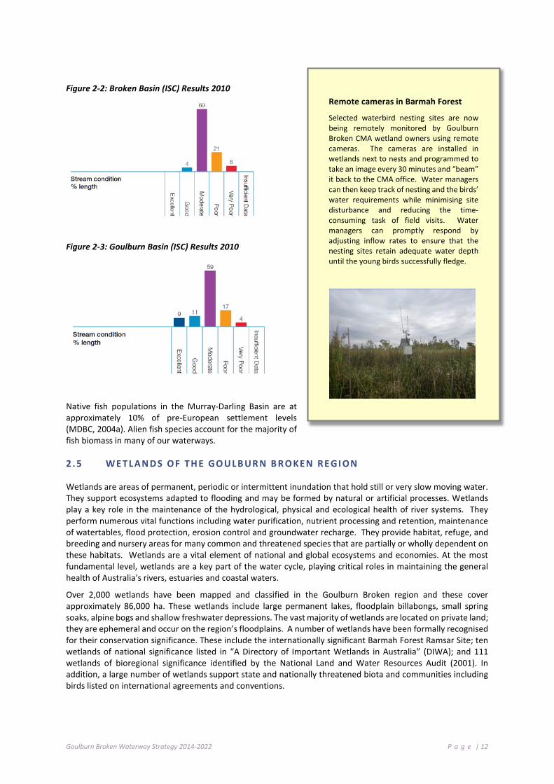
The 2010 ISC assessment monitored water quality at 23 reaches across the Goulburn Broken region. Nearly half of the reaches were in moderate condition (44%), followed by 21% in excellent condition and 18% in good, 13% in poor and 4% in very poor condition.
Goulburn Broken Waterway Strategy 2014-2022 P a g e | 11
Water quality was assessed in seven of the 36 reaches in the Broken River basin. Of these, five were in moderate condition, one was in poor condition and one was in very poor condition (reach 22 on the Broken Creek). All tested reaches had elevated levels of phosphorus and turbidity. The generally poor water quality reflects the highly modified natural environment.
Flow stress scores varied widely across the Goulburn Broken region with some streams under extreme flow stress and others with natural, or near natural, flow regimes. Flow stress scores ranged from one (very poor) through to nine (excellent) within the catchment.
Flow stress scores in the Broken River catchment ranged from one (poor), at reaches 1 and 2 on the lower Broken River to nine (excellent) at reaches 16 and 17 on Ryans Creek. Flow regimes of streams below Lake Eildon in the Goulburn River catchment were under significantly more stress than those in the upper reaches of the catchment. Notably, the lower reaches of the Goulburn River (1-14) had highly modified flow regimes, reflected in flow stress scores of zero or one. In contrast, reach 34 on Deep Creek at Barmah had a near natural flow regime. Upstream of Lake Eildon, reaches 15 and 16 on the Goulburn River, reaches 67 and 68 on the Big River and reaches 69 and 70 on the Howqua River also had natural or near natural flow regimes.
Results for vegetation condition in the streamside zone ranged from reaches in poor condition to those in reference condition across the region. Reflecting land use, reaches in reference condition were located in the densely vegetated south of the region and those in poorer condition were predominantly located in areas where land had been cleared. Overall, streamside zone vegetation in the majority of reaches (56% in both the Broken and Goulburn catchments) was in good or excellent condition.
Results for physical form in the Goulburn Broken region ranged predominantly from moderate to good. Of the 117 reaches assessed, 35 reaches (30%) were in moderate condition and 68 reaches (58%) were in good condition. Of the remainder, four reaches (3%) were in poor physical condition and 10 reaches (9%) were in excellent condition.
Almost every reach in the Goulburn Broken region was assessed for aquatic life (105 out of 117 reaches tested). The majority of the reaches were found to be in good or excellent condition (39% and 16% respectively). Of the remainder, 16% were in poor condition and 29% were in moderate condition. No reaches in the Goulburn Broken region were assessed as very poor.
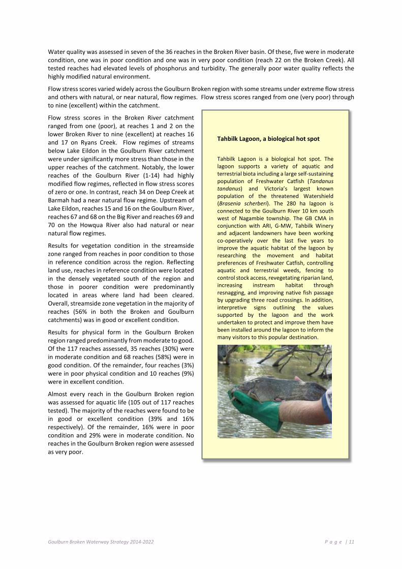
Tahbilk Lagoon, a biological hot spot
Tahbilk Lagoon is a biological hot spot. The lagoon supports a variety of aquatic and terrestrial biota including a large self-sustaining population of Freshwater Catfish (Tandanus tandanus) and Victoria’s largest known population of the threatened Watershield (Brasenia scherberi). The 280 ha lagoon is connected to the Goulburn River 10 km south west of Nagambie township. The GB CMA in conjunction with ARI, G-MW, Tahbilk Winery and adjacent landowners have been working co-operatively over the last five years to improve the aquatic habitat of the lagoon by researching the movement and habitat preferences of Freshwater Catfish, controlling aquatic and terrestrial weeds, fencing to control stock access, revegetating riparian land, increasing instream habitat through resnagging, and improving native fish passage by upgrading three road crossings. In addition, interpretive signs outlining the values supported by the lagoon and the work undertaken to protect and improve them have been installed around the lagoon to inform the many visitors to this popular destination.
Goulburn Broken Waterway Strategy 2014-2022 P a g e | 12
Figure 2-2: Broken Basin (ISC) Results 2010
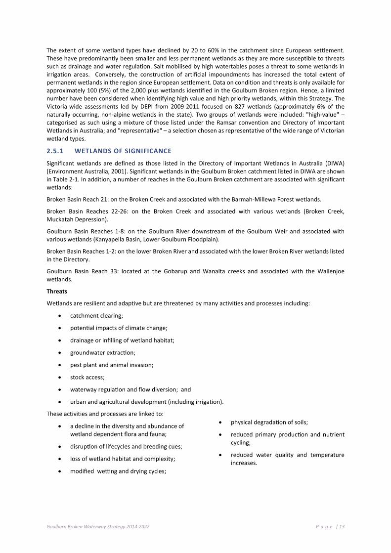
Figure 2-3: Goulburn Basin (ISC) Results 2010
Native fish populations in the Murray-Darling Basin are at approximately 10% of pre-European settlement levels (MDBC, 2004a). Alien fish species account for the majority of fish biomass in many of our waterways.
2 .5 W E T L AN D S O F T H E GO U LB UR N B R O KEN RE G I ON
Wetlands are areas of permanent, periodic or intermittent inundation that hold still or very slow moving water. They support ecosystems adapted to flooding and may be formed by natural or artificial processes. Wetlands play a key role in the maintenance of the hydrological, physical and ecological health of river systems. They perform numerous vital functions including water purification, nutrient processing and retention, maintenance of watertables, flood protection, erosion control and groundwater recharge. They provide habitat, refuge, and breeding and nursery areas for many common and threatened species that are partially or wholly dependent on these habitats. Wetlands are a vital element of national and global ecosystems and economies. At the most fundamental level, wetlands are a key part of the water cycle, playing critical roles in maintaining the general health of Australia's rivers, estuaries and coastal waters.
Over 2,000 wetlands have been mapped and classified in the Goulburn Broken region and these cover approximately 86,000 ha. These wetlands include large permanent lakes, floodplain billabongs, small spring soaks, alpine bogs and shallow freshwater depressions. The vast majority of wetlands are located on private land; they are ephemeral and occur on the region’s floodplains. A number of wetlands have been formally recognised for their conservation significance. These include the internationally significant Barmah Forest Ramsar Site; ten wetlands of national significance listed in “A Directory of Important Wetlands in Australia” (DIWA); and 111 wetlands of bioregional significance identified by the National Land and Water Resources Audit (2001). In addition, a large number of wetlands support state and nationally threatened biota and communities including birds listed on international agreements and conventions.
Remote cameras in Barmah Forest
Selected waterbird nesting sites are now being remotely monitored by Goulburn Broken CMA wetland owners using remote cameras. The cameras are installed in wetlands next to nests and programmed to take an image every 30 minutes and “beam” it back to the CMA office. Water managers can then keep track of nesting and the birds’ water requirements while minimising site disturbance and reducing the time-consuming task of field visits. Water managers can promptly respond by adjusting inflow rates to ensure that the nesting sites retain adequate water depth until the young birds successfully fledge.
Goulburn Broken Waterway Strategy 2014-2022 P a g e | 13
The extent of some wetland types have declined by 20 to 60% in the catchment since European settlement. These have predominantly been smaller and less permanent wetlands as they are more susceptible to threats such as drainage and water regulation. Salt mobilised by high watertables poses a threat to some wetlands in irrigation areas. Conversely, the construction of artificial impoundments has increased the total extent of permanent wetlands in the region since European settlement. Data on condition and threats is only available for approximately 100 (5%) of the 2,000 plus wetlands identified in the Goulburn Broken region. Hence, a limited number have been considered when identifying high value and high priority wetlands, within this Strategy. The Victoria-wide assessments led by DEPI from 2009-2011 focused on 827 wetlands (approximately 6% of the naturally occurring, non-alpine wetlands in the state). Two groups of wetlands were included: "high-value" – categorised as such using a mixture of those listed under the Ramsar convention and Directory of Important Wetlands in Australia; and "representative" – a selection chosen as representative of the wide range of Victorian wetland types.
2.5.1 WETLANDS OF SIGNIFICANCE
Significant wetlands are defined as those listed in the Directory of Important Wetlands in Australia (DIWA) (Environment Australia, 2001). Significant wetlands in the Goulburn Broken catchment listed in DIWA are shown in Table 2-1. In addition, a number of reaches in the Goulburn Broken catchment are associated with significant wetlands:
Broken Basin Reach 21: on the Broken Creek and associated with the Barmah-Millewa Forest wetlands.
Broken Basin Reaches 22-26: on the Broken Creek and associated with various wetlands (Broken Creek, Muckatah Depression).
Goulburn Basin Reaches 1-8: on the Goulburn River downstream of the Goulburn Weir and associated with various wetlands (Kanyapella Basin, Lower Goulburn Floodplain).
Broken Basin Reaches 1-2: on the lower Broken River and associated with the lower Broken River wetlands listed in the Directory.
Goulburn Basin Reach 33: located at the Gobarup and Wanalta creeks and associated with the Wallenjoe wetlands.
Threats
Wetlands are resilient and adaptive but are threatened by many activities and processes including:
• catchment clearing;
• potential impacts of climate change;
• drainage or infilling of wetland habitat;
• groundwater extraction;
• pest plant and animal invasion;
• stock access;
• waterway regulation and flow diversion; and
• urban and agricultural development (including irrigation).
These activities and processes are linked to:
• a decline in the diversity and abundance of wetland dependent flora and fauna;
• disruption of lifecycles and breeding cues;
• loss of wetland habitat and complexity;
• modified wetting and drying cycles;
• physical degradation of soils;
• reduced primary production and nutrient cycling;
• reduced water quality and temperature increases.

Goulburn Broken Waterway Strategy 2014-2022 P a g e | 14
Table 2-1: Significant wetlands in the Goulburn Broken catchment (Environment Australia, 2001)
Significant wetlands in the Goulburn Broken catchment Location and description River Basin Area (ha)
Barmah Forest Ramsar Site Murray River floodplain between Ulupna Island and Barmah. 29,500
(Ramsar)
Broken Creek Between 8 km NNW of Benalla to Barmah Forest. Includes Moodie Swamp. Broken 2,500
Muckatah Depression 11 km SE of Yarrawonga to 2 km east Numurkah. Includes Dowdle Swamp gazetted as State Wildlife Reserve.
Broken 2,909
Kanyapella Basin 13 km ESE of Echuca. Kanyapella Wildlife Management Co-operative Area. Goulburn 2,581
Lower Goulburn River Floodplain
150 km d/s Goulburn Weir to Murray confluence. Heritage River, two State Wildlife Reserves (Gemmills Swamp & Reedy Swamp) & Loch Garry Wildlife Management Co-operative Area.
Goulburn 13,000
Lower Broken River Between 8 km NNW of Benalla & Shepparton. Broken 1,268
Wallenjoe Wetlands 10 km N of Colbinabbin. Goulburn 303
Central Highlands Peatlands Upper Goulburn catchment. Includes Oaks, Poley, Snobs, Tom Burns and Storm creeks. Goulburn 33
Big River Upper Goulburn catchment. Heritage River. Goulburn 1,465
Howqua River Upper Goulburn catchment. Heritage River. Goulburn 1,520
2 .6 W E T L AN D C ON DI T I ON
The Index of Wetland Condition (IWC) is an integrated measure of wetland condition that assesses changes in hydrology, water quality and salinity, surrounding vegetation, original size and form, soil disturbance, and the diversity, structure and composition of wetland vegetation.
Since 2009, IWC assessments have been conducted at 116 wetlands across the region. Results indicate that most are in good (38%) and moderate (40%) condition, and a small proportion are in excellent (6%), poor (15%) and very poor condition (<2%). The percentage of wetlands in excellent or good condition indicates both the effectiveness of management and the degree of wetland resilience. However, that approximately 57% of wetlands are in moderate to very poor condition indicates many wetlands in the region are still subject to threatening processes. The results also indicated that wetlands on public land are generally in better condition than those on private land, although there are still examples of wetlands in good condition on private land.
Information on condition is used to inform policy, assess risks to the values of rivers, estuaries and wetlands, determine management priorities, set targets and monitor the longer term trends in condition. Condition data helps DEPI and Catchment Management Authorities (CMAs) identify the processes that threaten rivers, estuaries and wetlands and understand how these systems respond to management actions to address those threats.
2 .7 R EC OG NI T I ON O F ABO R I GI N AL VA L UE S O F W AT ER WA Y S
The Goulburn Broken catchment is a rich and diverse community. The catchment has an estimated population of 215,000 people (Montecillo 2012), which includes approximately 6,000 Indigenous Australians, many of whom identify as Traditional Owners of this area (GB CMA 2013).
The Traditional Owners of the Goulburn Broken catchment have an intrinsic connection to the landscapes, wildlife and water within the landscape (GB CMA 2004).
Traditional Owners in the north of the catchment (see Figure 2.4) are represented by Yorta Yorta Nation, whose traditional lands include the northern plains of the Goulburn and Murray rivers.
The south of the catchment (see Figure 2.4) forms part of the traditional lands of Taungurung Clans, which includes the mountains and rivers to the Great Divide. Taungurung Clans is defined by nine clans: Buthera Balug;

Goulburn Broken Waterway Strategy 2014-2022 P a g e | 15
Look William; Moomoom Gundidj; Nattarak Balug; Nira Balug; Warring-Illum Balug; Yarran-Illam; Yeeren-Illam-Balug and Yowung- llam Balug.
The Yorta Yorta Nation Aboriginal Corporation (YYNAC) and Taungurung Clans Aboriginal Corporation (TCAC) are both Registered Aboriginal Parties (RAPS), under the Aboriginal Heritage Act 20062.
Traditional Owners’ knowledge of land and water resources and cultural heritage in the landscape is rich and unique.
Figure 2.4: Registered Aboriginal Party boundaries within the Goulburn Broken region
2 The Victorian Aboriginal Heritage Act 2006 (the Act) recognises Aboriginal people as the primary guardians, keepers and knowledge holders of Aboriginal cultural heritage. At a local level, Registered Aboriginal Parties (RAPs) are the voice of Aboriginal people in the management and protection of Aboriginal cultural heritage.
RAPs have responsibilities relating to the management of Aboriginal cultural heritage under the Act. These include evaluating Cultural Heritage Management Plans, providing advice on applications for Cultural Heritage Permits, decisions about Cultural Heritage Agreements and advice or application for interim or ongoing Protection Declarations.
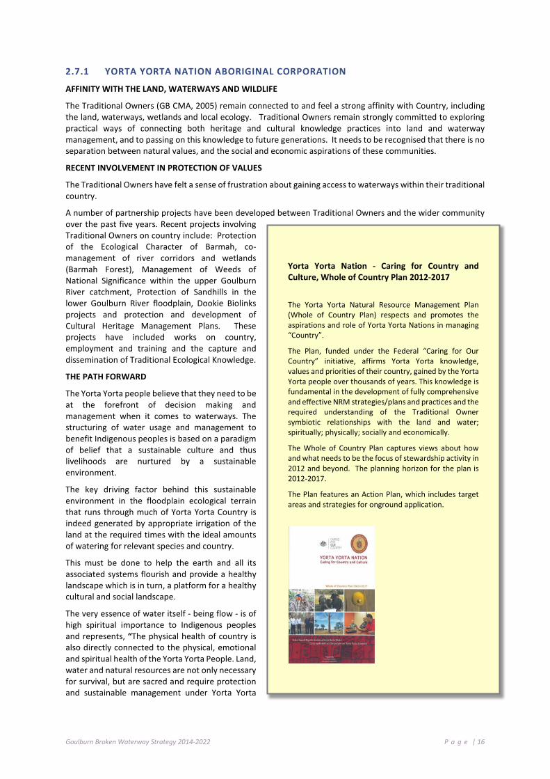
Goulburn Broken Waterway Strategy 2014-2022 P a g e | 16
2.7.1 YORTA YORTA NATION ABORIGINAL CORPORATION
AFFINITY WITH THE LAND, WATERWAYS AND WILDLIFE
The Traditional Owners (GB CMA, 2005) remain connected to and feel a strong affinity with Country, including the land, waterways, wetlands and local ecology. Traditional Owners remain strongly committed to exploring practical ways of connecting both heritage and cultural knowledge practices into land and waterway management, and to passing on this knowledge to future generations. It needs to be recognised that there is no separation between natural values, and the social and economic aspirations of these communities.
RECENT INVOLVEMENT IN PROTECTION OF VALUES
The Traditional Owners have felt a sense of frustration about gaining access to waterways within their traditional country.
A number of partnership projects have been developed between Traditional Owners and the wider community over the past five years. Recent projects involving Traditional Owners on country include: Protection of the Ecological Character of Barmah, co-management of river corridors and wetlands (Barmah Forest), Management of Weeds of National Significance within the upper Goulburn River catchment, Protection of Sandhills in the lower Goulburn River floodplain, Dookie Biolinks projects and protection and development of Cultural Heritage Management Plans. These projects have included works on country, employment and training and the capture and dissemination of Traditional Ecological Knowledge.
THE PATH FORWARD
The Yorta Yorta people believe that they need to be at the forefront of decision making and management when it comes to waterways. The structuring of water usage and management to benefit Indigenous peoples is based on a paradigm of belief that a sustainable culture and thus livelihoods are nurtured by a sustainable environment.
The key driving factor behind this sustainable environment in the floodplain ecological terrain that runs through much of Yorta Yorta Country is indeed generated by appropriate irrigation of the land at the required times with the ideal amounts of watering for relevant species and country.
This must be done to help the earth and all its associated systems flourish and provide a healthy landscape which is in turn, a platform for a healthy cultural and social landscape.
The very essence of water itself - being flow - is of high spiritual importance to Indigenous peoples and represents, “The physical health of country is also directly connected to the physical, emotional and spiritual health of the Yorta Yorta People. Land, water and natural resources are not only necessary for survival, but are sacred and require protection and sustainable management under Yorta Yorta
Yorta Yorta Nation - Caring for Country and Culture, Whole of Country Plan 2012-2017
The Yorta Yorta Natural Resource Management Plan (Whole of Country Plan) respects and promotes the aspirations and role of Yorta Yorta Nations in managing “Country”.
The Plan, funded under the Federal “Caring for Our Country” initiative, affirms Yorta Yorta knowledge, values and priorities of their country, gained by the Yorta Yorta people over thousands of years. This knowledge is fundamental in the development of fully comprehensive and effective NRM strategies/plans and practices and the required understanding of the Traditional Owner symbiotic relationships with the land and water; spiritually; physically; socially and economically.
The Whole of Country Plan captures views about how and what needs to be the focus of stewardship activity in 2012 and beyond. The planning horizon for the plan is 2012-2017.
The Plan features an Action Plan, which includes target areas and strategies for onground application.

Goulburn Broken Waterway Strategy 2014-2022 P a g e | 17
lore - a system of natural resource management that kept country and people healthy for thousands of years” (Yorta Yorta Nation Whole of Country Plan 2012-2017, page 9).
It is of critical importance that waterways are viewed within Yorta Yorta ideology, particularly being a floodplain based people over a large portion of our country. All wetlands are of high importance; some more so for containing a high diversity of available resources. Even those of less abundant commodities are valued in a cultural sense on the same tier of significance. For example, the act alone of being by the river is a direct, ancestrally inherited use of the water with intrinsic spiritual, cultural and social values imbued in the place, time and experience.
Considering these factors, the monitoring of waters and flows is indeed significant to Indigenous Yorta Yorta ideology also in relation to the impact that flows have on those communities downstream, knowing that other communities upstream have respected waters so as to provide for quality water downstream.
FAUNA
The impact that watering regimes have on culturally significant fauna species is also one of importance. Lack of water, or lack of water to specific wetland areas, can be debilitating for species such as the Broad Shelled Turtle, the totem of the Yorta Yorta people.
The Yorta Yorta, in consultation with Arthur Rylah Institute (ARI), have already conducted a detailed monitoring program of Broad Shelled Turtles within the landscape of the Barmah National Park. “The Yorta Yorta people and ARI shared their knowledge to find out more about the local distribution and abundance of this species. The Elders shared Indigenous Ecological Knowledge and the creation story of the turtle and ARI scientists shared survey and identification techniques and scientific knowledge of the turtles….This will help to determine where and when to direct cultural flows to ensure the ongoing survival of this species in the region.” (Yorta Yorta Whole of Country Plan 2012-2017, page 20).
It is thus a high priority for Yorta Yorta people to be strongly involved in all future research into and management of water on Yorta Yorta country. The focus in particular of how water management relates to threatened, rare and totemic species is paramount. This has been identified as one of the key areas of future capacity building among Yorta Yorta people with the underlying belief that it is absolutely critical for Indigenous people to be heavily involved in this sacred and spiritual space. “Land use plans and park management plans should incorporate Yorta Yorta knowledge about endangered and threatened species, and traditional approaches to protection alongside specialised contemporary methods.” (Yorta Yorta Whole of Country Plan 2012-2017, page 30).
2.7.2 TAUNGURUNG CLANS ABORIGINAL CORPORATION
OUR CONNECTION, OUR ROLE
As the Traditional Owners of a large part of the Goulburn Broken and North Central catchment area, we as Taungurung People have a crucial role in managing and caring for the waterways that nourish this catchment.
Water is the lifeblood of our Country. It keeps Country alive by nurturing and sustaining plants, animals, soils and ecosystems. As Traditional Owners, we have responsibilities handed to us by our Ancestors to continue to look after Country. As water is the source of life for our Country, we have had and will continue to have significant responsibilities relating to how water is managed now and into the future. Taungurung people have always and will always continue to look after Country.
“Look after Country and the Country will look after you”
Brian Patterson (Elder)

Goulburn Broken Waterway Strategy 2014-2022 P a g e | 18
HOW WATER CONNECTS US
Country is comprised of many complex and intricate connections that create our cultural landscape. These connections spread deep through time - to the creation of our Country. Our Dreaming has at its heart the origins of the rivers, creeks and swamps that have watered and sustained our Country for thousands of years.
Water connects our cultural places as our Ancestors camped where water was available and where resources sustained by water were plentiful. Large gatherings of our Clans and in particular for ceremonial purposes were held where there was good water and a plentiful water supply. Taungurung people followed the waterways in their regular travels around clan Country. Each waterway and water body was part of our ancestors’ intimate understanding and knowledge of Country.
Waterways also functioned as spatial markers between clans and between the Taungurung and neighbouring tribes. For example, the origins of the Goulburn River watershed along the Great Dividing Range marked the boundary between the Taungurung and the Woiwurrung to the south.
HEALTH OF WATERWAYS – HEALTH OF COMMUNITY
The health of our waterways has a direct impact on the health and wellbeing of our community. The Taungurung People want to continue to be involved in looking after our waterways as this will mean we are looking after our Country as a whole and with that, our community. It is critical to us as Taungurung People that we are active in these processes, just as our Ancestors were for thousands of years before us. We want the opportunity to show the cultural leadership that we believe is necessary if we are to heal Country and heal our community.
NATIVE FLORA AND FAUNA
There are many species of flora and fauna in Taungurung Country that are dependent on healthy waterways, either directly or indirectly. Conserving and enhancing the biodiversity of our Country is a fundamental aspiration of the Taungurung people. Healthy waterways are essential to biodiversity and sustainable and healthy ecosystems. Healthy waterways (which were our supermarkets) means the continuance of our living culture. The land, water, flora and fauna are as one to Taungurung people and are not separate elements to be managed.
IMPORTANT WATERWAYS
Our community has sustained significant change since European colonisation of our Country in the 1830s. Despite these changes, we maintain a strong commitment and attachments to the waterways that water our Country. The major waterways feeding our Country are important lifelines and hold special importance to the Taungurung community. The Goulburn River and Broken River catchments, in particular, are of great significance to our community. They are ancestral dreaming corridors and tell the story of the creation of our Country. Our
Partnerships: Involvement in Research on Country
The Taungurung Alpine Bog communities project is an important “Caring for Our Country” partnership initiative between the GB CMA and the TCAC. The project follows on from the Victorian Peatlands Spatial Action Plan and aims to develop a co-ordinated approach to land management of sensitive bog wetland areas over a broad area cross-tenure in the Alpine region.
At present the location of Alpine Bogs in the Goulburn Broken catchment/ Taungurung Country is not well known or accurately defined. Preliminary research has been undertaken to identify these bogs based on studies of topography and aerial imagery combined with some ground truthing undertaken by Taungurung representative Shane Monk.
To assist in developing management actions for protection of these wetlands it is vital that we have clarity around the extent, location and quality of these wetlands.
The Taungurung community is working with the GB CMA and specialists from the Arthur Rylah Institute on mapping, identifying and assessing the Alpine Bogs on Taungurung Country. This is an excellent opportunity for the Taungurung people to work on key Country initiatives that involve the transfer of knowledge and skills through employment on key land and water management projects.
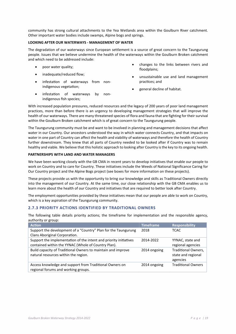
Goulburn Broken Waterway Strategy 2014-2022 P a g e | 19
community has strong cultural attachments to the Yea Wetlands area within the Goulburn River catchment. Other important water bodies include swamps, Alpine bogs and springs.
LOOKING AFTER OUR WATERWAYS - MANAGEMENT OF WATER
The degradation of our waterways since European settlement is a source of great concern to the Taungurung people. Issues that we believe undermine the health of the waterways within the Goulburn Broken catchment and which need to be addressed include:
• poor water quality;
• inadequate/reduced flow;
• infestation of waterways from non-indigenous vegetation;
• infestation of waterways by non-indigenous fish species;
• changes to the links between rivers and floodplains;
• unsustainable use and land management practices; and
• general decline of habitat.
With increased population pressures, reduced resources and the legacy of 200 years of poor land management practices, more than before there is an urgency to developing management strategies that will improve the health of our waterways. There are many threatened species of flora and fauna that are fighting for their survival within the Goulburn Broken catchment which is of great concern to the Taungurung people.
The Taungurung community must be and want to be involved in planning and management decisions that affect water in our Country. Our ancestors understood the way in which water connects Country, and that impacts on water in one part of Country can affect the health and viability of waterways and therefore the health of Country further downstream. They knew that all parts of Country needed to be looked after if Country was to remain healthy and viable. We believe that this holistic approach to looking after Country is the key to its ongoing health.
PARTNERSHIPS WITH LAND AND WATER MANAGERS
We have been working closely with the GB CMA in recent years to develop initiatives that enable our people to work on Country and to care for Country. These initiatives include the Weeds of National Significance Caring for Our Country project and the Alpine Bogs project (see boxes for more information on these projects).
These projects provide us with the opportunity to bring our knowledge and skills as Traditional Owners directly into the management of our Country. At the same time, our close relationship with the GB CMA enables us to learn more about the health of our Country and initiatives that are required to better look after Country.
The employment opportunities provided by these initiatives mean that our people are able to work on Country, which is a key aspiration of the Taungurung community.
2.7.3 PRIORITY ACTIONS IDENTIFIED BY TRADITIONAL OWNERS
The following table details priority actions; the timeframe for implementation and the responsible agency, authority or group:
Action Timeframe Responsibility Support the development of a “Country” Plan for the Taungurung Clans Aboriginal Corporation.
2018 TCAC
Support the implementation of the intent and priority initiatives contained within the YYNAC (Whole of Country Plan).
2014-2022 YYNAC, state and regional agencies
Build capacity of Traditional Owners to maintain and improve natural resources within the region.
2014 ongoing Traditional Owners, state and regional agencies
Access knowledge and support from Traditional Owners on regional forums and working groups.
2014 ongoing Traditional Owners

Goulburn Broken Waterway Strategy 2014-2022 P a g e | 20
Scar tree in the Landscape (YYNAC from NRM Plan); Lyn Thorpe River Painting Dunguladja Wala Dunguladja Yenbenal = Strong Water Strong People; Working on Country Project Team Protecting the Ecological Character of Barmah (YYNAC); Participants on Yorta Yorta Youth Journey (Gaye Sutherland, GB CMA); TCAC, ARI and Mount Buller Mt Stirling Resort Management staff inspecting Alpine Bogs (Gaye Sutherland); Artefacts at Strathbogie (Gaye Sutherland); Hughes Creek recording of grinding grooves (Gaye Sutherland); Shane Monk (TCAC) talking to Parks Victoria staff about treatment areas at Cathedral Range State Park (Gaye Sutherland).
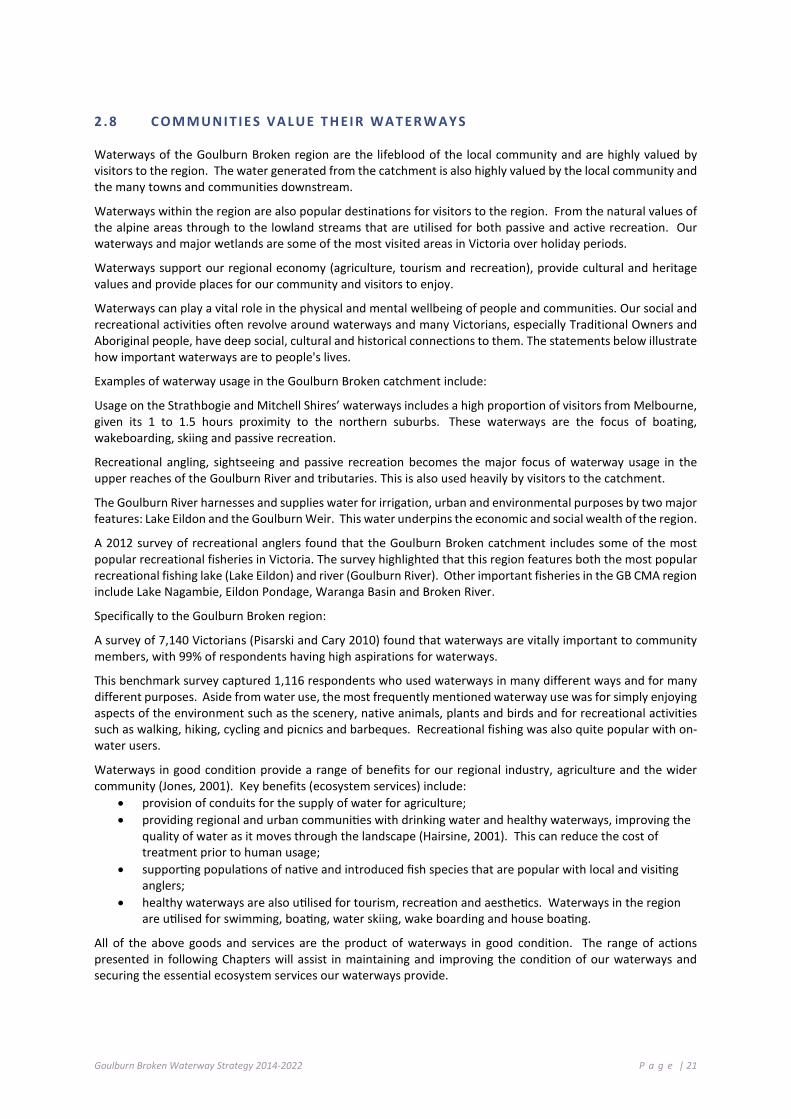
Goulburn Broken Waterway Strategy 2014-2022 P a g e | 21
2 .8 C O M M UNI T I E S VA L UE T H EI R WAT ER W AY S
Waterways of the Goulburn Broken region are the lifeblood of the local community and are highly valued by visitors to the region. The water generated from the catchment is also highly valued by the local community and the many towns and communities downstream.
Waterways within the region are also popular destinations for visitors to the region. From the natural values of the alpine areas through to the lowland streams that are utilised for both passive and active recreation. Our waterways and major wetlands are some of the most visited areas in Victoria over holiday periods.
Waterways support our regional economy (agriculture, tourism and recreation), provide cultural and heritage values and provide places for our community and visitors to enjoy.
Waterways can play a vital role in the physical and mental wellbeing of people and communities. Our social and recreational activities often revolve around waterways and many Victorians, especially Traditional Owners and Aboriginal people, have deep social, cultural and historical connections to them. The statements below illustrate how important waterways are to people's lives.
Examples of waterway usage in the Goulburn Broken catchment include:
Usage on the Strathbogie and Mitchell Shires’ waterways includes a high proportion of visitors from Melbourne, given its 1 to 1.5 hours proximity to the northern suburbs. These waterways are the focus of boating, wakeboarding, skiing and passive recreation.
Recreational angling, sightseeing and passive recreation becomes the major focus of waterway usage in the upper reaches of the Goulburn River and tributaries. This is also used heavily by visitors to the catchment.
The Goulburn River harnesses and supplies water for irrigation, urban and environmental purposes by two major features: Lake Eildon and the Goulburn Weir. This water underpins the economic and social wealth of the region.
A 2012 survey of recreational anglers found that the Goulburn Broken catchment includes some of the most popular recreational fisheries in Victoria. The survey highlighted that this region features both the most popular recreational fishing lake (Lake Eildon) and river (Goulburn River). Other important fisheries in the GB CMA region include Lake Nagambie, Eildon Pondage, Waranga Basin and Broken River.
Specifically to the Goulburn Broken region:
A survey of 7,140 Victorians (Pisarski and Cary 2010) found that waterways are vitally important to community members, with 99% of respondents having high aspirations for waterways.
This benchmark survey captured 1,116 respondents who used waterways in many different ways and for many different purposes. Aside from water use, the most frequently mentioned waterway use was for simply enjoying aspects of the environment such as the scenery, native animals, plants and birds and for recreational activities such as walking, hiking, cycling and picnics and barbeques. Recreational fishing was also quite popular with on-water users.
Waterways in good condition provide a range of benefits for our regional industry, agriculture and the wider community (Jones, 2001). Key benefits (ecosystem services) include:
• provision of conduits for the supply of water for agriculture; • providing regional and urban communities with drinking water and healthy waterways, improving the
quality of water as it moves through the landscape (Hairsine, 2001). This can reduce the cost of treatment prior to human usage;
• supporting populations of native and introduced fish species that are popular with local and visiting anglers;
• healthy waterways are also utilised for tourism, recreation and aesthetics. Waterways in the region are utilised for swimming, boating, water skiing, wake boarding and house boating.
All of the above goods and services are the product of waterways in good condition. The range of actions presented in following Chapters will assist in maintaining and improving the condition of our waterways and securing the essential ecosystem services our waterways provide.

Goulburn Broken Waterway Strategy 2014-2022 P a g e | 22
Strategic Context This Chapter:
Sets the strategic context for the Strategy by outlining its relationship to other regional, state and federal policies; and
Discusses achievements/knowledge gained during implementation of the previous regional RHS.
3 .1 S T AT E FR A ME W O R K
The Victorian Waterway Management Strategy (2013) (VWMS) provides the framework for government, in partnership with the community, to manage rivers, estuaries and wetlands so they can support environmental, social, cultural and economic values now and into the future. The VWMS updates the Victorian River Health Strategy (2002) (VRHS) that was a significant milestone for river management in Victoria and extends the scope to cover waterways generally, including wetlands and estuaries. The VWMS outlines clear principles for regional decision making on river maintenance and restoration, identifying regional priorities for management activities and statewide direction on important management issues affecting river health.
Victoria’s water allocation framework provides the basis for water resource management in Victoria. Under the Water Act 1989, the Victorian Government retains the overall right to the use, flow and control of all surface water and groundwater on behalf of all Victorians. All water taken for consumptive purposes is done so under entitlements set out in the Water Act 1989. Victoria’s water allocation framework takes a whole-of-system water management approach and considers all water resources (surface water and groundwater) for both consumptive and environmental purposes at all phases of the water cycle. Like surface water, groundwater is allocated for commercial and irrigation purposes under strict licensing arrangements under the Water Act 1989.
The Water Act 1989 also defines the Environmental Water Reserve (EWR) as the amount of water set aside to meet environmental needs. The Victorian Environmental Water Holder was established in 2011, under the Water Act 1989, as an independent statutory body responsible for making decisions on the most efficient and effective use of Victoria’s environmental entitlements.
The Water Act 1989 (s.190) requires ‘an Authority’ that has a waterway management district to prepare a ‘waterway strategy’ for the purposes of performing its functions under s.189 (1) of the Act. The Water Act 1989 lists the nine Catchment Management Authorities and Melbourne Water Corporation as authorities with a waterway management district. This Strategy will replace the existing River Health Strategy that was prepared by the Goulburn Broken community in 2004. The regional waterway strategies are a key component of the integrated waterway management framework (see Figure 3.1) outlined in the Victorian Waterway Management Strategy (2013).
The key statewide policy framework for water quality protection in Victoria is the State Environment Protection Policy (Waters of Victoria). It provides a statutory framework for state and local government agencies, businesses and communities to work together to maintain and rehabilitate Victoria’s surface water environments. The policy identifies beneficial uses of water and sets the environmental quality objectives and policy directions required to address higher risk impacts and activities.
The Flora and Fauna Guarantee Act 1988 is the key piece of Victorian legislation for the conservation of threatened species and communities and for the management of potentially threatening processes. The Act lists threatened species and ecological communities and threatening processes.
The Heritage Rivers Act 1992 makes provision for Victorian heritage rivers by providing for the protection of public land in specific rivers and river catchment areas in Victoria. Heritage Rivers in the Goulburn Broken Region include the Goulburn, Big and Howqua Rivers.

Goulburn Broken Waterway Strategy 2014-2022 P a g e | 23
Figure 3-1: Integrated waterway management planning framework
3 .2 R EG I O NA L FR A ME W OR K F OR WAT ER W AY M A NAG E MEN T
The Catchment and Land Protection Act 1994 establishes Regional Catchment Strategies (RCSs) as the primary framework for integrated management of land, water and biodiversity in each of the ten catchment regions of Victoria. The GB CMA is responsible for preparing the Goulburn Broken RCS and co-ordinating and monitoring its implementation. The Goulburn Broken RCS is the overarching strategy, under which are a range of sub-strategies and action plans for the Goulburn Broken region. The long-term objectives and priorities for action in the Goulburn Broken RCS that relate to waterways will be implemented through this Strategy.
Regional planning processes for waterway management were established in 2002 under the VRHS and implemented through the ten regional River Health Strategies (RRHSs). Community input and participation in these regional planning processes was a critical element in ensuring that regional planning reflected the community values of waterways in each region. The RRHSs identified high value rivers and priority management actions to be undertaken over a six-year period. These RRHSs were the cornerstone of the regional planning framework for waterways (supported in some areas by regional wetland strategies), but have now passed their intended lifespan. The development of this Strategy is a statutory requirement under the Water Act 1989 and will replace the current Goulburn Broken Regional River Health Strategy 2004 (RRHS).
Water resource planning in Victoria is addressed through development of regional Sustainable Water Strategies (SWSs) that set out long-term regional plans to secure water for regional growth, while safeguarding the future of its rivers and other natural water sources. They investigate the range of potential changes to water availability under several climate change scenarios. The regional SWSs examine future consumptive demand and environmental needs and set out proposed options to balance and secure water for all users. The SWSs are where the Victorian Government, in partnership with regional communities, decides whether additional water is required for the environment.

Goulburn Broken Waterway Strategy 2014-2022 P a g e | 24
3 . 3 N AT I ON AL FRA M E W OR K
Water reform at the federal level has been guided by the National Water Initiative (NWI) since 2004. Under this agreement, governments across Australia have committed to actions to achieve a more cohesive national approach to the way Australia manages, measures, plans for, prices and trades water. The National Water Initiative recognises the need to build on the water reforms of the 1994 Council of Australian Government (COAG) agreement to ensure increased productivity and efficiency of Australia’s water use. It includes clear steps to return river and groundwater systems to environmentally sustainable levels of extraction and achieve integrated management of environmental water. The program focuses on environmental sites. Further information is available from the Murray-Darling Basin Authority (MDBA) website: http://www.mdba.gov.au/about-basin/environmental-sites.
There has also been significant legislative reform in water resource management at the federal level. The Water Act 2007 (Cth) established the Murray-Darling Basin Authority and required the MDBA to prepare the Basin Plan; a strategic plan for the integrated and sustainable management of water resources in the Murray-Darling Basin. The Act also established the Commonwealth Environmental Water Holder to manage the Commonwealth’s environmental water. The Water Amendment Act 2008 (Cth) transferred the functions of the Murray-Darling Basin Commission to the new Murray-Darling Basin Authority (MDBA). The MDBA is now the single body responsible for overseeing water resource planning in the Murray-Darling Basin and a strategic plan for the integrated and sustainable management of water resources (the Basin Plan) was signed into law in November 2012. The Basin Plan sets legal limits on the amount of surface water and groundwater that can be taken from Victoria’s share of the Murray-Darling Basin from 1 July 2019 onwards.
The Basin Plan provides a co-ordinated approach to water use across the Basin's four States and the ACT (MDBA, 2012). According to MDBA (2012) the Plan is an adaptive framework that will be implemented over a seven year timeframe. It aims to achieve a balance between environmental, economic and social considerations. It allows for further improvements in outcomes through a sustainable diversion limits adjustment mechanism and a constraints management strategy. The Plan is supported by Commonwealth investment in modernising irrigation infrastructure and voluntary water purchasing through the environmental water recovery strategy (see Chapter 4.12.4).
This strategy supports the plan through: Annual Watering Plans, Irrigation Modernisation and support of monitoring programs to assess the effectiveness of the Plan.
The Living Murray Initiative is one of Australia's most significant river restoration programs. Established in 2002 in response to declining river health, it aims to achieve a healthy working River Murray system for the benefit of all Australians. This includes returning water to the environment. The Living Murray has recovered almost 500GL of water to help improve the health of six icon sites. It is a partnership of the NSW, Victorian, South Australian, ACT and Australian governments, co-ordinated by the MDBA.
The Environment Protection and Biodiversity Conservation Act 1999 (Cth) is the Australian Government’s central piece of environmental legislation. It provides a legal framework to maintain and manage nationally and internationally important flora, fauna, ecological communities, Ramsar sites and heritage places defined in the Act as matters of national environmental significance. The Environment Protection and Biodiversity Conservation Act 1999 (EPBC Act) establishes a framework for managing Ramsar sites. The Australian Ramsar Management Principles set out in Schedule 6 of the Environment Protection and Biodiversity Conservation Regulations 2000 (Cth) provide direction on the management of Ramsar sites. These principles are applied to management planning for the Barmah Forest Ramsar Site within the Goulburn Broken RWS. Two threatened ecological wetland communities, which are present within the Goulburn Broken catchment, are listed under the EPBC Act:
• • Seasonal herbaceous wetlands; and
• • Alpine bogs and fens.
The Native Title Act 1993 (Cth) provides a framework for the maintenance and recognition of native title. The Act gives Indigenous Australians who hold native title rights and interests—or who have made a native title claim—the right to be consulted and, in some cases, to participate in decisions about activities proposed to be undertaken on the land.

Goulburn Broken Waterway Strategy 2014-2022 P a g e | 25
3 . 4 I N T E RNA T I ONA L F RAM E W O R K
The Australian Government has ratified several international human rights instruments that recognise and maintain Indigenous peoples’ special connection to land and waters and provide for the right to practice, revitalise, teach and develop culture, customs and spiritual practices and to utilise natural resources (for example, the United Nations Declaration of Rights of Indigenous Peoples).
The Convention on Wetlands of International Importance (the Ramsar Convention) provides the framework for national action and international co-operation for the conservation and wise use of wetlands and their resources. The Convention encourages member countries to nominate sites containing representative, rare or unique wetlands, or that are important for conserving biological diversity, to the List of Wetlands of International Importance (Ramsar sites). Within the Goulburn Broken region, the Barmah Forest is listed as a Ramsar site.
As a contracting party to the Ramsar Convention, Australia is required to meet a number of obligations including the maintenance of the ecological character of its Ramsar sites through conservation and wise use.
The Ramsar Convention also encourages planning to promote the conservation and sustainable use of all wetlands. The Goulburn Broken RWS also addresses this requirement at the regional level.
Ramsar sites are a matter of national environmental significance under the Environment Protection and Biodiversity Act 1999 (Cth).
Japan Australian Migratory Bird Agreement (JAMBA), China-Australian Migratory Bird Agreement (CAMBA) and Republic of Korea-Australian Migratory Bird Agreement (ROKAMBA) listed species recorded in GB CMA wetlands are shown in Table 3-1.
Table 3-1: JAMBA, CAMBA and ROKAMBA listed species recorded in GB CMA wetlands
Common Name Scientific Name JAMBA CAMBA ROKAMBA GB CMA Wetland
Garganey Anas querquedula
Fork-tailed Swift Apus pacificus
Eastern Great Egret Ardea modesta
Sharp-tailed Sandpiper Calidris acuminata
Curlew Sandpiper Calidris ferruginea
Red-necked Stint Calidris ruficollis
Latham's Snipe Gallinago hardwickii
White-bellied Sea-Eagle Haliaeetus leucogaster
White-throated Needletail Hirundapus caudacutus
Caspian Tern Hydropogne tschegrava (Hydroprogne caspia)
Bar-tailed Godwit Limosa lapponica
Rainbow Bee-eater Merops ornatus
Grey Plover Pluvialis squatarola
Painted Snipe Rostratula benghalensis
Wood Sandpiper Tringa glareola
Marsh Sandpiper Tringa stagnatilis

Goulburn Broken Waterway Strategy 2014-2022 P a g e | 26
3 .5 F O R M AL LY R EC OGN I SE D SIG NI F IC ANC E – BA R MA H F O RE S T
The Barmah Forest Ramsar Site was listed in 1982 and the baseline ecological character was established at this point in time.
As a contracting party to the Ramsar Convention, Australia is required to maintain the ecological character of its Ramsar sites at the time they were listed through conservation and wise use. The ecological character is defined by the Ramsar Convention as “the combination of the ecosystem components, processes and benefits/services that characterise the wetlands at a given point in time”. A change in ecological character is the “human induced adverse alteration of any ecosystem component, process and or ecosystem benefit/service”.
This Strategy includes management planning for the Barmah Forest Ramsar Site in accordance with Action 12.3 of the Victorian Waterway Management Strategy (2013).
An ecological character description (ECD) has been completed for the Barmah Forest Ramsar Site (Hale and Butcher 2011). This defines limits of acceptable change (LACs) for ecosystem services/benefits (values) and physical, chemical and biological ecosystem components and processes that are considered critical to the ecological character of the Ramsar site. It also identifies knowledge gaps and recommends monitoring needs for the Ramsar site.
3 .6 R O LE S AND RE S P ON SI B IL I T I E S O F T HE C MA , C O M MU NIT Y AND P AR T NE R O R GANI S AT I O N S
The Goulburn Broken CMA, along with nine other CMAs, was established in 1997 by the Victorian Government, under the Catchment and Land Protection Act 1994, with the aim of creating a whole of catchment approach to natural resource management in the state.
The primary goal of the Victorian CMAs is to ensure the maintenance and restoration of land and water resources, the sustainable development of natural resource-based industries and the conservation of our natural and cultural heritage. The CMAs are designated with specific responsibility for the management of waterways, drainage and floodplains under Part 10 of the Water Act 1989.
The range of functions that CMAs undertake include:
• developing a Waterway Strategy and associated action plans;
• developing and implementing work programs;
• authorising works on waterways, acting as a referral body for planning applications, licences to take and use water and construct dams for water use and other waterway health issues;
• identifying regional priorities for environmental watering and facilitating water delivery;
• providing input into water allocation processes;
• developing and co-ordinating regional floodplain management plans;
• managing regional drainage, as appropriate;
• responding to natural disasters and incidents affecting waterways such as bushfires, floods and algal blooms; and
• undertaking community participation and awareness programs.
Key partnerships have developed within the Goulburn Broken region to assist in the maintenance and improvement of waterways. These partnerships, including with the community and state agencies, have provided clarity around key roles and responsibilities (see Appendix A). These roles and responsibilities were further defined within the Victorian Waterway Management Strategy (DEPI 2013b).

Goulburn Broken Waterway Strategy 2014-2022 P a g e | 27
3 .7 R E VI E W O F T HE G OUL B URN BR O K EN RI V ER HE ALT H ST R AT EGY ( 200 5)
The Goulburn Broken Regional River Health Strategy (2005) and the mid-term review “Addendum” provided direction for the waterway maintenance and improvement over the past decade. The strategy directed investment and established priorities for delivery of onground works for the authority, partner agencies and the community.
3.7.1 THE ADDENDUM – MID-TERM REVIEW
The Goulburn Broken Regional River Health Strategy (2005) recommended a mid-term review with a detailed evaluation of the Strategy’s implementation. The review assessed achievements made, whether progress was adequate, and considered if there was new science and knowledge that needed to be taken into account and incorporated.
A number of developments and new directions in Victorian water resource management policy followed completion of the Regional River Health Strategies in 2004 (including Our Water Our Future 2004, Our Environment Our Future 2006, Northern Region Sustainable Water Strategy 2009 and the Water (Resource Management) Act 2005).
The Millennium drought further challenged river health and Victoria’s water resource management with the state experiencing over a decade of dry conditions and large areas subjected to catastrophic bushfires. More recently (2010-2012), significant areas have been subjected to unseasonal summer flooding.
The former RRHSs were aimed at long-term management during long-term average climate conditions, and did not adequately cover contingencies required to manage through extreme drought and/or dry years. To address this issue the CMAs developed Environmental Drought Response Plans (EDRPs) in each summer from 2006-07 through to 2009-2010. These plans identified high value ecological assets seriously at risk during low flow periods and put in place work and emergency watering programs to protect these assets as well as increased monitoring programs and contingency actions where necessary.
A review of the Strategy (The Addendum) followed the above events confirming the value of conducting a mid-term review.
3.7.2 LEARNINGS FROM THE REVIEW
The major learnings from the mid-term review of the Goulburn Broken Regional River Health Strategy 2005 and implications of recent policy, environmental factors and knowledge that will influence the future management of natural resources, river health and water in the catchment are summarised in Table 3-2. Progress towards meeting these recommendations at the time of preparing this Strategy is also presented.
Table 3-2: Influence of reviews on the River Health Program
Influence and method of incorporation Action taken/knowledge gained Status Policy Development of operating strategies for priority systems that address management of the systems under current and future climate change scenarios have been included as priority actions under EWR priorities.
Climate change project initiated (development of ERA process). Annual Watering Plans (process developed and employed) for the Broken River, Broken Creek, Goulburn River and wetlands.
Achieved
Drought management plans and dry inflow management plans will continue to be prepared. This information to be incorporated into regional refugia planning processes.
Dry inflow management plans evolved into Annual Watering Plans. Refugia project information considered in their development. Refugia identified under low flow.
Achieved
Plan and implement infrastructure upgrades to supply environmental water to priority wetlands. (MUs L1, L4 and L2).
Progressing through the EWR team (see below). Environmental watering employed.
Achieved

Goulburn Broken Waterway Strategy 2014-2022 P a g e | 28
Influence and method of incorporation Action taken/knowledge gained Status Identify high priority actions and projects within flagship areas, biolinks and high priority waterways (see Figure 3-1, Figure 4-2 and Chapter 4).
Working with biodiversity team to identify. Look at sites benefiting terrestrial and aquatic biodiversity.
Achieved
Environment Catastrophic bushfires have destroyed a significant area of the upper Goulburn River catchment. Major focus on rehabilitation and post fire recovery effort in priority management units (U2, U3, U4 and U6) and priority river reaches in transition year and in the Addendum.
Bushfire recovery project initiated in upper Goulburn catchment.
Achieved
CMA maintains a strategic and ongoing role in projects to improve knowledge base on climate variability and impact of dry inflows and incorporate findings as appropriate.
Charles Sturt University: Identifying low risk climate change adaptation: A case study of the Goulburn Broken Catchment Management Authority (Lukasiewicz et al., 2012) University of Canberra: Predicting water quality and ecological responses to a changing climate: informing adaptation initiatives (Dyer et al., 2012; Harrison et al., 2012).
Ongoing
Foster regional refugia planning to identify future scenarios and opportunities for effective investment. Incorporated in to regional program (Strategic and EWR).
Zonation project (Monash University) undertaken for the Goulburn Broken region.
completed
Develop local management rules to manage stream flows in priority river reaches/catchment (Yea River and King Parrot Creek).
GMW has started this process. Ongoing
Support water strategies, support water savings and educate community of the links between land use change and water quality and river health through engagement programs.
Progress being made on a number of fronts (and by a range of partners).
Ongoing
Supports efforts to identify and monitor for potential threats (acid sulphate soils, reduced flows, extraction).
Waterwatch undertook some site assessments – no sites identified.
Implemented and ongoing
Knowledge Identification and delivery of integrated programs benefiting both river health and biodiversity.
Still some progress to be made. Good progress with wetland Tender project.
On going
Plan for a review of the Regional River Health Strategies prior to 2013 based on the direction of the (VWMS).
This document represents the outcome of the current review.
In progress
Assessment of Achievements Overall, a substantial program of works has been implemented across the catchment. However, an assessment of progress of all works related actions to date against targets indicates that a substantial number of works targets are significantly behind schedule, with original targets being more aspirational with the expectation of more resources. A substantial program of complementary initiatives has been implemented. These initiatives underpin works investment and assessment of long-term effectiveness of works undertaken. Many priority programs are continuing. Priorities, reduced targets to be aligned with current funding levels. Clear targets established within priority reaches, management units (including the nature of target action). Alignment of programs to state and federal priorities (biolinks, flagship and resilience).
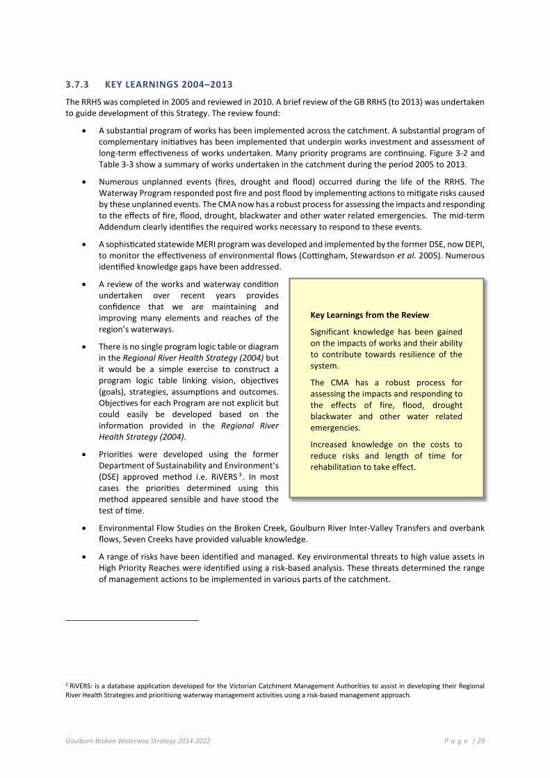
Goulburn Broken Waterway Strategy 2014-2022 P a g e | 29
3.7.3 KEY LEARNINGS 2004–2013
The RRHS was completed in 2005 and reviewed in 2010. A brief review of the GB RRHS (to 2013) was undertaken to guide development of this Strategy. The review found:
• A substantial program of works has been implemented across the catchment. A substantial program of complementary initiatives has been implemented that underpin works investment and assessment of long-term effectiveness of works undertaken. Many priority programs are continuing. Figure 3-2 and Table 3-3 show a summary of works undertaken in the catchment during the period 2005 to 2013.
• Numerous unplanned events (fires, drought and flood) occurred during the life of the RRHS. The Waterway Program responded post fire and post flood by implementing actions to mitigate risks caused by these unplanned events. The CMA now has a robust process for assessing the impacts and responding to the effects of fire, flood, drought, blackwater and other water related emergencies. The mid-term Addendum clearly identifies the required works necessary to respond to these events.
• A sophisticated statewide MERI program was developed and implemented by the former DSE, now DEPI, to monitor the effectiveness of environmental flows (Cottingham, Stewardson et al. 2005). Numerous identified knowledge gaps have been addressed.
• A review of the works and waterway condition undertaken over recent years provides confidence that we are maintaining and improving many elements and reaches of the region’s waterways.
• There is no single program logic table or diagram in the Regional River Health Strategy (2004) but it would be a simple exercise to construct a program logic table linking vision, objectives (goals), strategies, assumptions and outcomes. Objectives for each Program are not explicit but could easily be developed based on the information provided in the Regional River Health Strategy (2004).
• Priorities were developed using the former Department of Sustainability and Environment’s (DSE) approved method i.e. RiVERS 3 . In most cases the priorities determined using this method appeared sensible and have stood the test of time.
• Environmental Flow Studies on the Broken Creek, Goulburn River Inter-Valley Transfers and overbank flows, Seven Creeks have provided valuable knowledge.
• A range of risks have been identified and managed. Key environmental threats to high value assets in High Priority Reaches were identified using a risk-based analysis. These threats determined the range of management actions to be implemented in various parts of the catchment.
3 RiVERS: is a database application developed for the Victorian Catchment Management Authorities to assist in developing their Regional River Health Strategies and prioritising waterway management activities using a risk-based management approach.
Key Learnings from the Review
Significant knowledge has been gained on the impacts of works and their ability to contribute towards resilience of the system.
The CMA has a robust process for assessing the impacts and responding to the effects of fire, flood, drought blackwater and other water related emergencies.
Increased knowledge on the costs to reduce risks and length of time for rehabilitation to take effect.
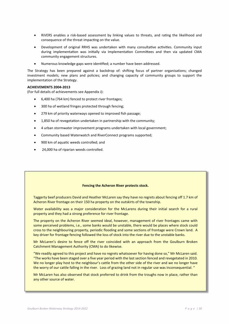
Goulburn Broken Waterway Strategy 2014-2022 P a g e | 30
• RiVERS enables a risk-based assessment by linking values to threats, and rating the likelihood and consequence of the threat impacting on the value.
• Development of original RRHS was undertaken with many consultative activities. Community input during implementation was initially via Implementation Committees and then via updated CMA community engagement structures.
• Numerous knowledge gaps were identified; a number have been addressed.
The Strategy has been prepared against a backdrop of: shifting focus of partner organisations; changed investment models; new plans and policies; and changing capacity of community groups to support the implementation of the Strategy.
ACHIEVEMENTS 2004-2013 (For full details of achievements see Appendix J):
• 6,400 ha (764 km) fenced to protect river frontages;
• 300 ha of wetland fringes protected through fencing;
• 279 km of priority waterways opened to improved fish passage;
• 1,850 ha of revegetation undertaken in partnership with the community;
• 4 urban stormwater improvement programs undertaken with local government;
• Community based Waterwatch and RiverConnect programs supported;
• 900 km of aquatic weeds controlled; and
• 24,000 ha of riparian weeds controlled.
Fencing the Acheron River protects stock.
Taggerty beef producers David and Heather McLaren say they have no regrets about fencing off 1.7 km of Acheron River frontage on their 150 ha property on the outskirts of the township.
Water availability was a major consideration for the McLarens during their initial search for a rural property and they had a strong preference for river frontage.
The property on the Acheron River seemed ideal, however, management of river frontages came with some perceived problems, i.e., some banks would be unstable, there would be places where stock could cross to the neighbouring property, periodic flooding and some sections of frontage were Crown land. A key driver for frontage fencing followed the loss of stock into the river due to the unstable banks.
Mr McLaren’s desire to fence off the river coincided with an approach from the Goulburn Broken Catchment Management Authority (CMA) to do likewise.
“We readily agreed to this project and have no regrets whatsoever for having done so,” Mr McLaren said. “The works have been staged over a five year period with the last section fenced and revegetated in 2010. We no longer play host to the neighbour’s cattle from the other side of the river and we no longer have the worry of our cattle falling in the river. Loss of grazing land not in regular use was inconsequential. “
Mr McLaren has also observed that stock preferred to drink from the troughs now in place, rather than any other source of water.

Goulburn Broken Waterway Strategy 2014-2022 P a g e | 31
Before and after images of rehabilitation works: Tahbilk Fish Passage, crossing modification (Simon Casanelia, GB CMA); Broken River, Flood Recovery (Geoff Brennan GB CMA); Goulburn River Recreational Fishing Licence project (Sue Kosch GB CMA); Broken River, bank protection (Geoff Brennan GB CMA).
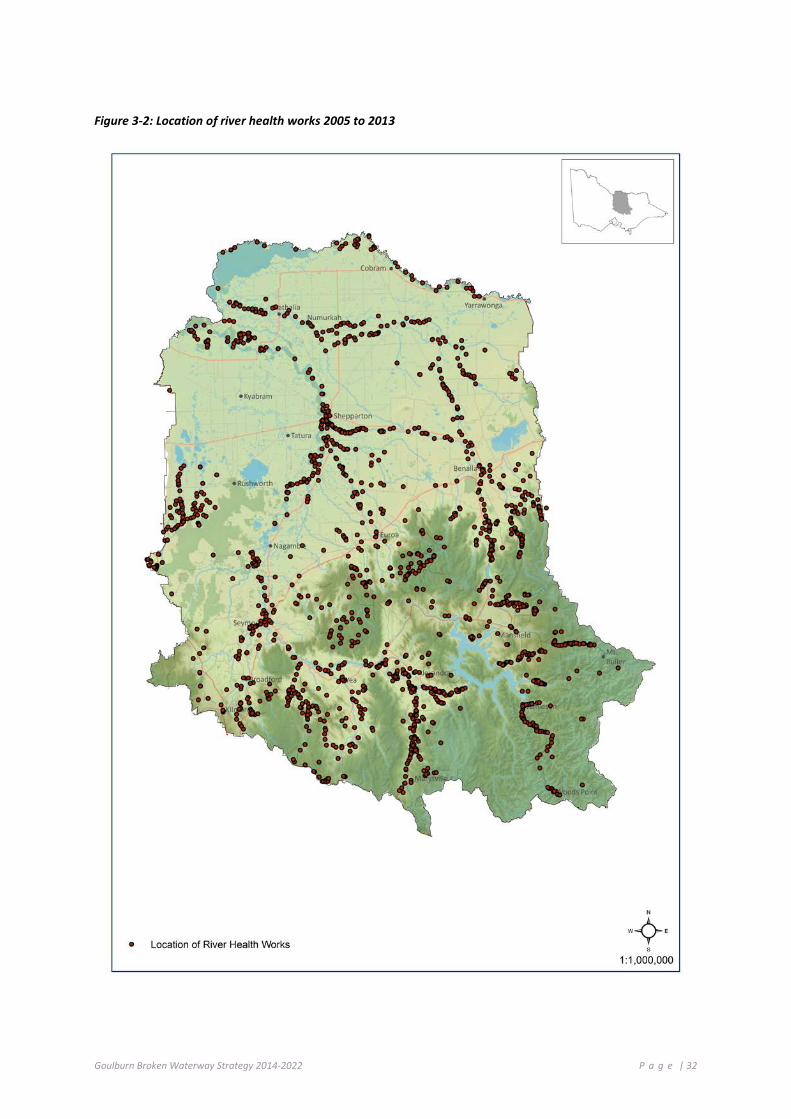
Goulburn Broken Waterway Strategy 2014-2022 P a g e | 32
Figure 3-2: Location of river health works 2005 to 2013

Goulburn Broken Waterway Strategy 2014-2022 P a g e | 33
3 .8 P R OT ECT I NG T H E ECO L O GI C AL C HA RAC T ER O F T H E BAR M AH FO R E ST
The Barmah Forest Ramsar Site is located in northern Victoria and was designated under the Ramsar Convention in 1982. The site consists of a section of the River Murray floodplain between Ulupna Island and Barmah Township (Figure 3-3). It is predominantly River Red Gum (Eucalyptus camaldulensis) open forest and woodland and, along with the adjoining Millewa group of forests in NSW, forms the largest stand of River Red Gum in the world. It is also recognised as an Icon Site within The Living Murray program (MDBA 2011). It features alluvial fan-shaped deposits along the River Murray with ox-bows and meander scrolls as well as source-bordering dunes.
The Barmah Forest Ramsar Site supports a variety of wetland habitats, which vary from permanent lakes, billabongs and ponding effluents; through shallow basins with prolonged seasonal flooding. These support rushland or grassland communities in the wetter regions, through to gradational River Red Gum forest and woodland communities with a variety of vegetation understories. The site is declared National Park under the management of Parks Victoria and Yorta Yorta Nations Aboriginal Corporation. The key characteristics of the site and the wetland types present according to the Ramsar Convention classification system are shown in Table 3-3.
Figure 3-3: Location of Barmah Forest (Source: DEPI 2013c)
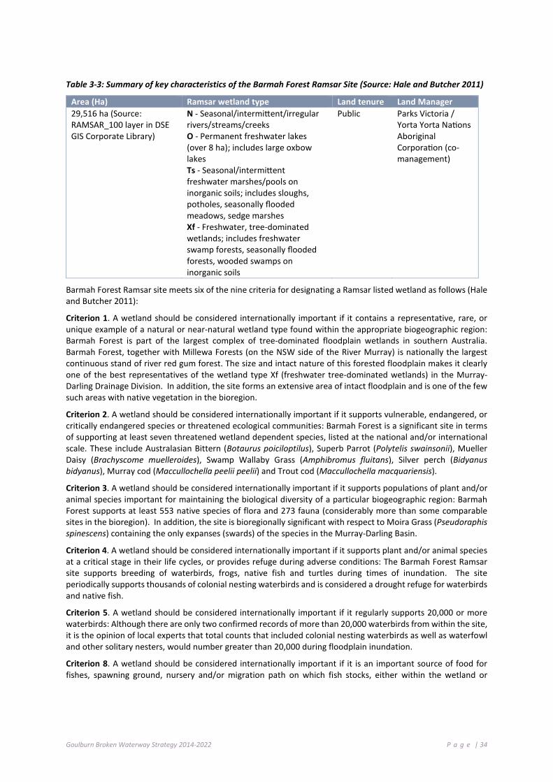
Goulburn Broken Waterway Strategy 2014-2022 P a g e | 34
Table 3-3: Summary of key characteristics of the Barmah Forest Ramsar Site (Source: Hale and Butcher 2011)
Area (Ha) Ramsar wetland type Land tenure Land Manager 29,516 ha (Source: RAMSAR_100 layer in DSE GIS Corporate Library)
N - Seasonal/intermittent/irregular rivers/streams/creeks O - Permanent freshwater lakes (over 8 ha); includes large oxbow lakes Ts - Seasonal/intermittent freshwater marshes/pools on inorganic soils; includes sloughs, potholes, seasonally flooded meadows, sedge marshes Xf - Freshwater, tree-dominated wetlands; includes freshwater swamp forests, seasonally flooded forests, wooded swamps on inorganic soils
Public Parks Victoria / Yorta Yorta Nations Aboriginal Corporation (co-management)
Barmah Forest Ramsar site meets six of the nine criteria for designating a Ramsar listed wetland as follows (Hale and Butcher 2011):
Criterion 1. A wetland should be considered internationally important if it contains a representative, rare, or unique example of a natural or near-natural wetland type found within the appropriate biogeographic region: Barmah Forest is part of the largest complex of tree-dominated floodplain wetlands in southern Australia. Barmah Forest, together with Millewa Forests (on the NSW side of the River Murray) is nationally the largest continuous stand of river red gum forest. The size and intact nature of this forested floodplain makes it clearly one of the best representatives of the wetland type Xf (freshwater tree-dominated wetlands) in the Murray-Darling Drainage Division. In addition, the site forms an extensive area of intact floodplain and is one of the few such areas with native vegetation in the bioregion.
Criterion 2. A wetland should be considered internationally important if it supports vulnerable, endangered, or critically endangered species or threatened ecological communities: Barmah Forest is a significant site in terms of supporting at least seven threatened wetland dependent species, listed at the national and/or international scale. These include Australasian Bittern (Botaurus poiciloptilus), Superb Parrot (Polytelis swainsonii), Mueller Daisy (Brachyscome muelleroides), Swamp Wallaby Grass (Amphibromus fluitans), Silver perch (Bidyanus bidyanus), Murray cod (Maccullochella peelii peelii) and Trout cod (Maccullochella macquariensis).
Criterion 3. A wetland should be considered internationally important if it supports populations of plant and/or animal species important for maintaining the biological diversity of a particular biogeographic region: Barmah Forest supports at least 553 native species of flora and 273 fauna (considerably more than some comparable sites in the bioregion). In addition, the site is bioregionally significant with respect to Moira Grass (Pseudoraphis spinescens) containing the only expanses (swards) of the species in the Murray-Darling Basin.
Criterion 4. A wetland should be considered internationally important if it supports plant and/or animal species at a critical stage in their life cycles, or provides refuge during adverse conditions: The Barmah Forest Ramsar site supports breeding of waterbirds, frogs, native fish and turtles during times of inundation. The site periodically supports thousands of colonial nesting waterbirds and is considered a drought refuge for waterbirds and native fish.
Criterion 5. A wetland should be considered internationally important if it regularly supports 20,000 or more waterbirds: Although there are only two confirmed records of more than 20,000 waterbirds from within the site, it is the opinion of local experts that total counts that included colonial nesting waterbirds as well as waterfowl and other solitary nesters, would number greater than 20,000 during floodplain inundation.
Criterion 8. A wetland should be considered internationally important if it is an important source of food for fishes, spawning ground, nursery and/or migration path on which fish stocks, either within the wetland or
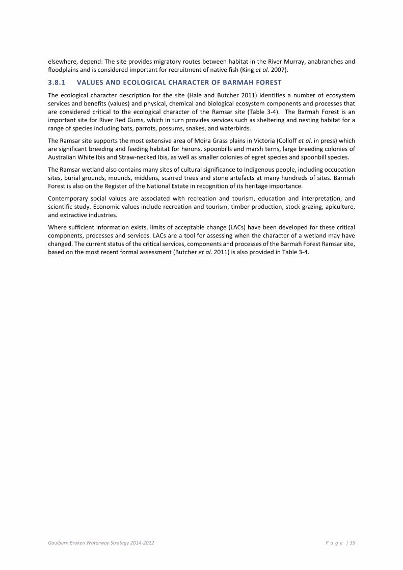
Goulburn Broken Waterway Strategy 2014-2022 P a g e | 35
elsewhere, depend: The site provides migratory routes between habitat in the River Murray, anabranches and floodplains and is considered important for recruitment of native fish (King et al. 2007).
3.8.1 VALUES AND ECOLOGICAL CHARACTER OF BARMAH FOREST
The ecological character description for the site (Hale and Butcher 2011) identifies a number of ecosystem services and benefits (values) and physical, chemical and biological ecosystem components and processes that are considered critical to the ecological character of the Ramsar site (Table 3-4). The Barmah Forest is an important site for River Red Gums, which in turn provides services such as sheltering and nesting habitat for a range of species including bats, parrots, possums, snakes, and waterbirds.
The Ramsar site supports the most extensive area of Moira Grass plains in Victoria (Colloff et al. in press) which are significant breeding and feeding habitat for herons, spoonbills and marsh terns, large breeding colonies of Australian White Ibis and Straw-necked Ibis, as well as smaller colonies of egret species and spoonbill species.
The Ramsar wetland also contains many sites of cultural significance to Indigenous people, including occupation sites, burial grounds, mounds, middens, scarred trees and stone artefacts at many hundreds of sites. Barmah Forest is also on the Register of the National Estate in recognition of its heritage importance.
Contemporary social values are associated with recreation and tourism, education and interpretation, and scientific study. Economic values include recreation and tourism, timber production, stock grazing, apiculture, and extractive industries.
Where sufficient information exists, limits of acceptable change (LACs) have been developed for these critical components, processes and services. LACs are a tool for assessing when the character of a wetland may have changed. The current status of the critical services, components and processes of the Barmah Forest Ramsar site, based on the most recent formal assessment (Butcher et al. 2011) is also provided in Table 3-4.
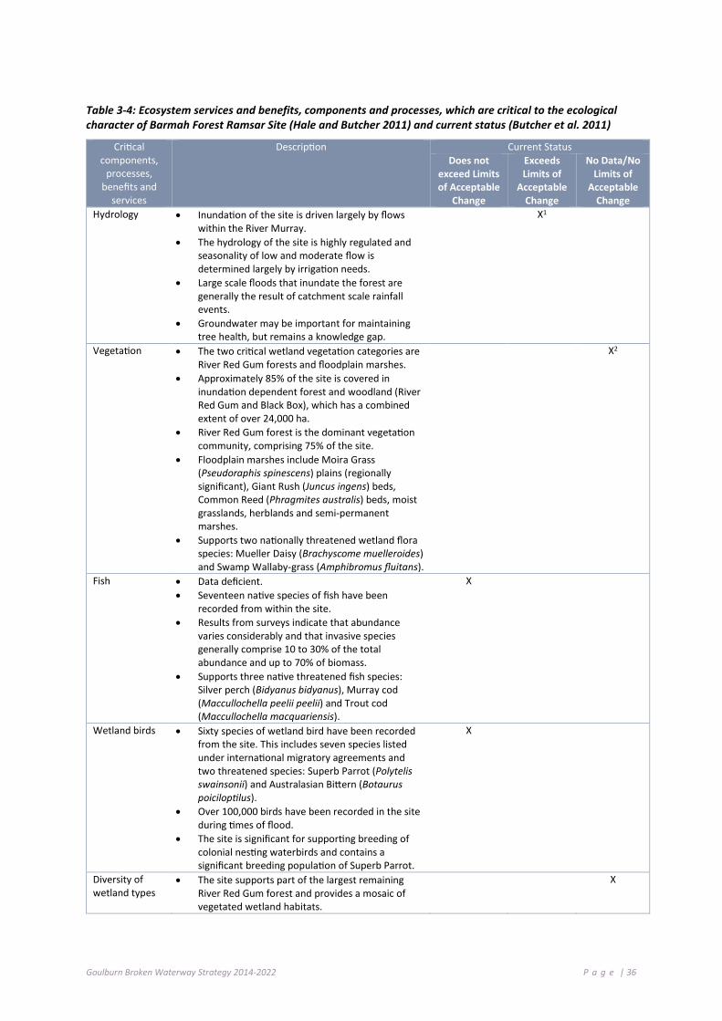
Goulburn Broken Waterway Strategy 2014-2022 P a g e | 36
Table 3-4: Ecosystem services and benefits, components and processes, which are critical to the ecological character of Barmah Forest Ramsar Site (Hale and Butcher 2011) and current status (Butcher et al. 2011)
Critical components,
processes, benefits and
services
Description Current Status Does not
exceed Limits of Acceptable
Change
Exceeds Limits of
Acceptable Change
No Data/No Limits of
Acceptable Change
Hydrology • Inundation of the site is driven largely by flows within the River Murray.
• The hydrology of the site is highly regulated and seasonality of low and moderate flow is determined largely by irrigation needs.
• Large scale floods that inundate the forest are generally the result of catchment scale rainfall events.
• Groundwater may be important for maintaining tree health, but remains a knowledge gap.
X1
Vegetation • The two critical wetland vegetation categories are River Red Gum forests and floodplain marshes.
• Approximately 85% of the site is covered in inundation dependent forest and woodland (River Red Gum and Black Box), which has a combined extent of over 24,000 ha.
• River Red Gum forest is the dominant vegetation community, comprising 75% of the site.
• Floodplain marshes include Moira Grass (Pseudoraphis spinescens) plains (regionally significant), Giant Rush (Juncus ingens) beds, Common Reed (Phragmites australis) beds, moist grasslands, herblands and semi-permanent marshes.
• Supports two nationally threatened wetland flora species: Mueller Daisy (Brachyscome muelleroides) and Swamp Wallaby-grass (Amphibromus fluitans).
X2
Fish • Data deficient. • Seventeen native species of fish have been
recorded from within the site. • Results from surveys indicate that abundance
varies considerably and that invasive species generally comprise 10 to 30% of the total abundance and up to 70% of biomass.
• Supports three native threatened fish species: Silver perch (Bidyanus bidyanus), Murray cod (Maccullochella peelii peelii) and Trout cod (Maccullochella macquariensis).
X
Wetland birds • Sixty species of wetland bird have been recorded from the site. This includes seven species listed under international migratory agreements and two threatened species: Superb Parrot (Polytelis swainsonii) and Australasian Bittern (Botaurus poiciloptilus).
• Over 100,000 birds have been recorded in the site during times of flood.
• The site is significant for supporting breeding of colonial nesting waterbirds and contains a significant breeding population of Superb Parrot.
X
Diversity of wetland types
• The site supports part of the largest remaining River Red Gum forest and provides a mosaic of vegetated wetland habitats.
X

Goulburn Broken Waterway Strategy 2014-2022 P a g e | 37
Critical components,
processes, benefits and
services
Description Current Status Does not
exceed Limits of Acceptable
Change
Exceeds Limits of
Acceptable Change
No Data/No Limits of
Acceptable Change
Biodiversity • The site supports the regionally significant Moira Grass vegetation community and a significant number of plant and animal species.
X
Physical habitat • Barmah Forest Ramsar site provides habitat for feeding and breeding of wetland birds.
X
Threatened species
• The Ramsar site supports seven species listed under the EPBC Act and/or the IUCN Red List.
X
Ecological connectivity
• The Ramsar site provides important migratory routes between riverine, wetland and floodplain habitats for fish spawning and recruitment.
X
Organic carbon cycling
• As part of a major floodplain system, the site is important for the cycling of nutrients, particularly carbon both on the floodplain and as a source of organic carbon to receiving waterways.
X
1. There is evidence of a decline in small and medium floods in the past decade as a result of water use, prolonged drought and potential effects of climate change. The hydrology LAC for small (in-channel) and medium (overbank) flows have been exceeded (Hale and Butcher 2011).
2. No recent quantitative assessment, but extent of giant rush has expanded at the expense of Moira grass and it is possible the LAC for Moira grass has been exceeded (Hale and Butcher 2011).
3.8.2 THREATS TO THE VALUES OF BARMAH FOREST
The ecological character description identifies a number of threats to the values of the Barmah Forest Ramsar Site (Table 3-5). Of these, the most recent Ramsar Rolling Review (Butcher et al. 2011) identified water resource development, climate change and invasive species as the threats most likely to impact on ecological character of the Barmah Forest Ramsar site in the next ten years.
Goulburn Broken Waterway Strategy 2014-2022 P a g e | 38
Table 3-5: Summary of threats to the ecological character of the Barmah Forest Ramsar site (Hale and Butcher 2011)
Actual or likely threat or threatening activities
Potential impact(s) to wetland components, processes and/or service Likelihood 1 Timing 2
Water resource development (decreased frequency and duration of inundation; altered seasonality of inundation)
Reduced health and extent of River Red Gum forests and floodplain marshes. Altered vegetation community composition. Decreased habitat for fauna feeding and breeding. Absence or disruption of bird, fish and frog breeding events.
Certain Current
Climate change (increased temperatures and decreased rainfall).
Exacerbate effects of water resource development and altered fire regimes.
Certain Long-term
Altered fire regimes (increased frequency and intensity of fires)
Death of mature River Red Gums. Adverse changes to forest structure. Loss or degradation of habitat.
Medium Current
Invasive species (weeds, carp, horses)
Predation or competition with native flora and fauna. Increased risk of destructive wildfire through increased understorey biomass.
Certain Current
Human disturbance (recreation)
Loss or degradation of habitat through unauthorised firewood collection. Soil and riparian zone degradation by off road vehicles or watercraft. Increased risk of destructive wildfire.
Medium Current
1 Where Certain is defined as known to occur at the site or has occurred in the past; Medium is defined as not known from the site but occurs at similar sites; and Low is defined as theoretically possible, but not recorded at this or similar sites.
2 Where Current is defined as happening at the time of writing (2010); long-term is defined as greater than 10 years.
An Index of Wetland Condition (IWC) assessment was conducted for the Barmah Forest Ramsar Site at 30 representative plots in 2009. It concluded that while the overall condition of the Ramsar site was good, with 80% of plots assessed considered in “good” condition, hydrology was assessed as moderate or poor (Papas et al 2012). This reflects the long-term changes in hydrology as a result of river regulation, compounded by the long dry period from 1996 to 2009.
The level of risk posed to the assets within the Barmah Forest Ramsar Site is shown in Table 3-6.

Goulburn Broken Waterway Strategy 2014-2022 P a g e | 39
Table 3-6: Barmah Forest Ramsar Site – values, threats and risk assessment.
Type Attribute AVIRA score
(Barmah)
Altered Wetland
Form
Changed Water
Regime
Degraded Water Quality
Invasive Fauna
(Terrestrial)
Invasive Fauna
(Aquatic)
Invasive Flora
(Wetland)
Invasive Flora
(Riparian)
Reduced Wetland
Area
Soil Disturbance
Degraded Wetland
Buffer
Livestock Access to
Buffer 1 5 3 5 5 2 2 1 2 2 1
Envi
ronm
enta
l
Important Bird Habitat
5 High Risk (Reduce Threat)
Very High Risk
(Reduce Threat)
Moderate Risk
(Reduce Threat)
High Risk (Reduce Threat)
Low Risk (Reduce Threat)
High Risk (Reduce Threat)
Moderate Risk
(Reduce Threat)
High Risk (Reduce Threat)
Low Risk (Reduce Threat)
Moderate Risk
(Reduce Threat)
Low Risk (Protect)
Significant Birds
5 High Risk (Reduce Threat)
Very High Risk
(Reduce Threat)
Moderate Risk
(Reduce Threat)
High Risk (Reduce Threat)
Low Risk (Reduce Threat)
High Risk (Reduce Threat)
Moderate Risk
(Reduce Threat)
Moderate Risk
(Reduce Threat)
Low Risk (Reduce Threat)
Moderate Risk
(Reduce Threat)
Low Risk (Protect
Significant invertebrates
2 Very Low Risk (No Priority Action)
High Risk (Reduce Threat)
Moderate Risk
(Reduce Threat)
Low Risk (Reduce Threat)
Moderate Risk
(Reduce Threat)
Low Risk (Reduce Threat)
Very Low Risk
(Reduce Threat)
Very Low Risk
(Reduce Threat)
Low Risk (Reduce Threat)
Low Risk (Reduce Threat)
Low Risk (Protect)
Significant flora
5 Moderate Risk
(Reduce Threat)
Very High Risk
(Reduce Threat)
Low Risk (Reduce Threat)
Very High Risk
(Reduce Threat)
High Risk (Reduce Threat)
Very High Risk
(Reduce Threat)
Very High Risk
(Reduce Threat)
Moderate Risk
(Reduce Threat
Moderate Risk
(Reduce Threat)
Low Risk (Reduce Threat)
Low Risk (Protect)
Significant fish
5 High Risk (Reduce Threat)
Very High Risk
(Reduce Threat)
Very High Risk
(Reduce Threat)
High Risk (Reduce Threat)
Very High Risk
(Reduce Threat)
High Risk (Reduce Threat)
Moderate Risk
(Reduce Threat)
Low Risk (Reduce Threat)
Low Risk (Reduce Threat)
Low Risk (Reduce Threat)
Low Risk (Protect)
Significant amphibians
5 Moderate Risk
(Reduce Threat)
High Risk (Reduce Threat)
High Risk (Reduce Threat)
High Risk (Reduce Threat)
High Risk (Reduce Threat)
Moderate Risk
(Reduce Threat)
Low Risk (Reduce Threat)
Low Risk (Reduce Threat)
Low Risk (Reduce Threat)
Moderate Risk
(Reduce Threat)
Low Risk (Protect)
Significant wetland
vegetation
5 High Risk (Reduce Threat)
Very High Risk
(Reduce Threat)
Low Risk (Reduce Threat)
High Risk (Reduce Threat)
Moderate Risk
(Reduce Threat)
Very High Risk
(Reduce Threat)
Moderate Risk
(Reduce Threat)
Moderate Risk
(Reduce Threat)
Very High Risk
(Reduce Threat)
Moderate Risk
(Reduce Threat)
Low Risk (Protect)
Significant mammals
5 Low Risk (Reduce Threat)
Moderate Risk
(Reduce Threat)
Low Risk (Reduce Threat)
Moderate Risk
(Reduce Threat)
Very Low Risk
(Reduce Threat))
Low Risk (Reduce Threat)
Low Risk (Reduce Threat)
Low Risk (Reduce Threat)
Low Risk (Reduce Threat)
Low Risk (Reduce Threat)
Low Risk (Protect)
Significant aquatic reptiles
5 High Risk (Reduce Threat)
Very High Risk
(Reduce Threat)
Moderate Risk
(Reduce Threat)
Very High Risk
(Reduce Threat)
High Risk (Reduce Threat)
High Risk (Reduce Threat)
Moderate Risk
(Reduce Threat)
Low Risk (Reduce Threat)
Moderate Risk
(Reduce Threat)
Moderate Risk
(Reduce Threat)
Low Risk (Protect)
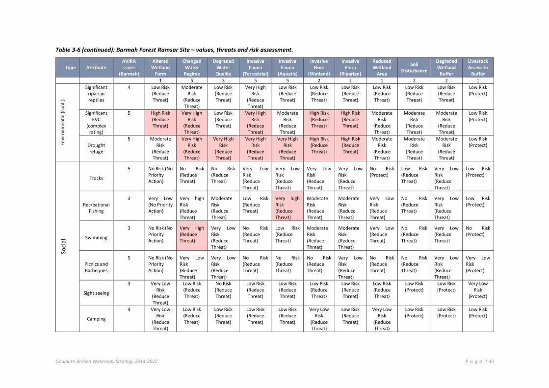
Goulburn Broken Waterway Strategy 2014-2022 P a g e | 40
Table 3-6 (continued): Barmah Forest Ramsar Site – values, threats and risk assessment.
Type Attribute AVIRA score
(Barmah)
Altered Wetland
Form
Changed Water
Regime
Degraded Water Quality
Invasive Fauna
(Terrestrial)
Invasive Fauna
(Aquatic)
Invasive Flora
(Wetland)
Invasive Flora
(Riparian)
Reduced Wetland
Area
Soil Disturbance
Degraded Wetland
Buffer
Livestock Access to
Buffer 1 5 3 5 5 2 2 1 2 2 1
Envi
ronm
enta
l (co
nt.)
Significant riparian reptiles
4 Low Risk (Reduce Threat)
Moderate Risk
(Reduce Threat)
Low Risk (Reduce Threat)
Very High Risk
(Reduce Threat)
Low Risk (Reduce Threat)
Low Risk (Reduce Threat)
Low Risk (Reduce Threat)
Low Risk (Reduce Threat)
Low Risk (Reduce Threat)
Low Risk (Reduce Threat)
Low Risk (Protect)
Significant EVC
(complex rating)
5 High Risk (Reduce Threat)
Very High Risk
(Reduce Threat)
Low Risk (Reduce Threat)
Very High Risk
(Reduce Threat)
Moderate Risk
(Reduce Threat)
High Risk (Reduce Threat)
High Risk (Reduce Threat)
Moderate Risk
(Reduce Threat)
Moderate Risk
(Reduce Threat)
Moderate Risk
(Reduce Threat)
Low Risk (Protect)
Drought refuge
5 Moderate Risk
(Reduce Threat)
Very High Risk
(Reduce Threat)
Very High Risk
(Reduce Threat)
Very High Risk
(Reduce Threat)
Very High Risk
(Reduce Threat)
High Risk (Reduce Threat)
High Risk (Reduce Threat)
Moderate Risk
(Reduce Threat)
Moderate Risk
(Reduce Threat)
Moderate Risk
(Reduce Threat)
Low Risk (Protect)
Soci
al
Tracks
5 No Risk (No Priority Action)
No Risk (Reduce Threat)
No Risk (Reduce Threat)
Very Low Risk (Reduce Threat)
Very Low Risk (Reduce Threat)
Very Low Risk (Reduce Threat)
Very Low Risk (Reduce Threat)
No Risk (Protect)
Low Risk (Reduce Threat)
Very Low Risk (Reduce Threat)
Low Risk (Protect)
Recreational Fishing
3 Very Low (No Priority Action)
Very high Risk (Reduce Threat)
Moderate Risk (Reduce Threat)
Low Risk (Reduce Threat)
Very high Risk (Reduce Threat)
Moderate Risk (Reduce Threat)
Moderate Risk (Reduce Threat)
Very Low Risk (Reduce Threat)
No Risk (Reduce Threat)
Very Low Risk (Reduce Threat)
Low Risk (Protect)
Swimming
3 No Risk (No Priority Action)
Very High (Reduce Threat)
Very Low Risk (Reduce Threat)
No Risk (Reduce Threat)
Low Risk (Reduce Threat)
Moderate Risk (Reduce Threat)
Moderate Risk (Reduce Threat)
Very Low (Reduce Threat)
No Risk (Reduce Threat)
Very Low (Reduce Threat)
No Risk (Protect)
Picnics and Barbeques
5 No Risk (No Priority Action)
Very Low Risk (Reduce Threat)
Very Low Risk (Reduce Threat)
No Risk (Reduce Threat)
No Risk (Reduce Threat)
No Risk (Reduce Threat)
Very Low Risk (Reduce Threat)
No Risk (Reduce Threat)
No Risk (Reduce Threat)
Very Low Risk (Reduce Threat)
Very Low Risk (Protect)
Sight seeing
3 Very Low Risk
(Reduce Threat)
Low Risk (Reduce Threat)
No Risk (Reduce Threat)
Low Risk (Reduce Threat)
Low Risk (Reduce Threat)
Low Risk (Reduce Threat)
Low Risk (Reduce Threat)
Low Risk (Reduce Threat)
Low Risk (Protect)
Low Risk (Protect)
Very Low Risk
(Protect)
Camping
4 Very Low Risk
(Reduce Threat)
Low Risk (Reduce Threat)
Low Risk (Reduce Threat)
Low Risk (Reduce Threat)
Low Risk (Reduce Threat)
Very Low Risk
(Reduce Threat)
Low Risk (Reduce Threat)
Very Low Risk
(Reduce Threat)
Low Risk (Protect)
Low Risk (Protect)
Low Risk (Protect)
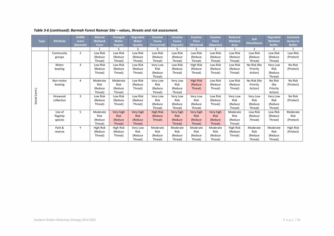
Goulburn Broken Waterway Strategy 2014-2022 P a g e | 41
Table 3-6 (continued): Barmah Forest Ramsar Site – values, threats and risk assessment.
Type Attribute AVIRA score
(Barmah)
Altered Wetland
Form
Changed Water
Regime
Degraded Water Quality
Invasive Fauna
(Terrestrial)
Invasive Fauna
(Aquatic)
Invasive Flora
(Wetland)
Invasive Flora
(Riparian)
Reduced Wetland
Area
Soil Disturbance
Degraded Wetland
Buffer
Livestock Access to
Buffer 1 5 3 5 5 2 2 1 2 2 1
Soci
al (c
ont.)
Community groups
2 Low Risk (Reduce Threat)
Low Risk (Reduce Threat)
Low Risk (Reduce Threat)
Low Risk (Reduce Threat)
Low Risk (Reduce Threat)
Low Risk (Reduce Threat)
Low Risk (Reduce Threat)
Low Risk (Reduce Threat)
Low Risk (Reduce Threat)
Low Risk (Reduce Threat)
Low Risk (Protect)
Motor boating
3 Low Risk (Reduce Threat)
Low Risk (Reduce Threat)
Low Risk (Reduce Threat)
Very Low Risk
(Reduce Threat)
Low Risk (Reduce Threat)
High Risk (Reduce Threat)
Low Risk (Reduce Threat)
Low Risk (Reduce Threat)
No Risk (No Priority Action)
Very Low Risk
(Reduce Threat)
No Risk (Protect)
Non-motor boating
4 Moderate Risk
(Reduce Threat)
Moderate Risk
(Reduce Threat)
Low Risk (Reduce Threat)
Very Low Risk
(Reduce Threat)
Very Low Risk
(Reduce Threat)
High Risk (Reduce Threat)
Low Risk (Reduce Threat)
Low Risk (Reduce Threat)
No Risk (No Priority Action)
No Risk (No
Priority Action)
No Risk (Protect)
Firewood collection
3 Low Risk (Reduce Threat)
Low Risk (Reduce Threat)
Low Risk (Reduce Threat)
Very Low Risk
(Reduce Threat)
Very Low Risk
(Reduce Threat)
Very Low Risk
(Reduce Threat)
Low Risk (Reduce Threat)
Very Low Risk
(Reduce Threat)
Very Low Risk
(Reduce Threat)
Very Low Risk
(Reduce Threat)
No Risk (Protect)
Use of flagship species
5 Moderate Risk
(Reduce Threat)
Very high Risk
(Reduce Threat)
Very high Risk
(Reduce Threat)
High Risk (Reduce Threat)
Very high Risk
(Reduce Threat)
Very high Risk
(Reduce Threat)
Very high Risk
(Reduce Threat)
Moderate Risk
(Reduce Threat)
Low Risk (Reduce Threat)
Low Risk (Reduce Threat)
Moderate Risk
(Protect)
Park & reserve
Y High Risk (Reduce Threat)
High Risk (Reduce Threat)
Very Low Risk
(Reduce Threat)
Moderate Risk
(Reduce Threat)
Moderate Risk
(Reduce Threat)
Moderate Risk
(Reduce Threat)
Moderate Risk
(Reduce Threat)
High Risk (Reduce Threat)
Moderate Risk
(Reduce Threat)
Moderate Risk
(Reduce Threat)
High Risk (Protect)

Goulburn Broken Waterway Strategy 2014-2022 P a g e | 42
3.8.3 INFORMING MANAGEMENT OF BARMAH FOREST
The ecosystem services and benefits (values) and threats in the ecological character descriptions are considered in setting strategic priorities for the key regional management issues of environmental water (Chapter 4.3), floodplain management (Chapter 4.5), threatened species (Chapter 4.7), invasive species (Chapter 4.9), catchment management (Chapter 4.12) and climate change (Chapter 4.13). They are also aligned with values and threats used in the Aquatic Value Identification and Risk Assessment framework (Chapter 5) to inform priority setting for waterways in the region (Chapter 6), including the identification of priority management strategies.
There are a number of strategies and plans already in place for the management of the Barmah Forest Ramsar site. These include:
• Barmah-Millewa Forest Environmental Water Management Plan (MDBA 2012): under the Living Murray initiative, this plan describes ecological objectives for an area that includes the Barmah Forest Ramsar Site, and specifies watering regimes, works and water delivery arrangements to meet those objectives. Specifically ecological objectives and watering regimes are specified for the critical components of vegetation (River Red Gum and Moira Grass communities), native fish and breeding waterbirds.
• Environmental Water Delivery: Yarrawonga to Tocumwal and Barmah-Millewa (Ecological Associates and SKM 2011): developed for the Commonwealth Environmental Water Office to establish an operational framework for the delivery of environmental water to an area that includes the Barmah Forest Ramsar site to meet ecological objectives.
• Yorta Yorta NRM Management Plan (which includes the Barmah-Millewa Forest Ecosystem).
• Parks Victoria are developing a Horse Management Strategy (in progress).
• This Strategy seeks to integrate and co-ordinate management activities within the Barmah Forest Ramsar site with the long-term resource condition target to: “Maintain or improve the ecological character of the Barmah Forest Ramsar site”.
The Works and activities program for the Barmah Forest Ramsar site is shown in Table 3-7and in Chapter 7.
3.8.4 MONITORING RAMSAR SITES
The Australian Government Department of the Environment is developing a three-year Ramsar Rolling Review program for reporting the status of the ecological character of Australia’s Ramsar sites.
The broad aims of the Ramsar Rolling Review program are to:
• review and report on the status of the ecological character of Australia’s Ramsar sites (including positive or adverse change);
• be a tool to assist site management to maintain ecological character, improve links between ecological character, site management plans and monitoring programs for critical components, processes and services and associated threats;
• provide input to a database of baseline and threat data;
• record updates as knowledge gaps are addressed and refinement of LACs;
• highlight issues and facilitate assessment of a potential change of character, focussing on proactive management before the situation requires notification; and
• identify broad trends or common threats across site and jurisdiction boundaries.
Under the Ramsar rolling review, reporting for the Barmah Forest Ramsar site will focus on the LACs (refer to Table 3-6) but may also include critical components, processes or services where knowledge gaps exist (Table 3-7) or key threats as identified in the Barmah Forest Ramsar Site Ecological Character Description (Hale and Butcher 2011).

Goulburn Broken Waterway Strategy 2014-2022 P a g e | 43
The Ramsar site manager will be responsible for updating the Rolling Review database for the Barmah Forest Ramsar site every 3 years. Actions related to the monitoring requirements are described in Table 3-8 and Table 3-9. Monitoring is carried out under the Living Murray Program, as part of the management of the environmental water reserve (section 4.3) and the region’s waterway program.
Table 3-7: Works Program (Barmah Forest Ramsar site)
Management Unit Agricultural Floodplains
Basin Broken Wetland Barmah Forest Identification No.
60706 Values Important Bird Habitats (5), Significant EVCs (5), Camping (4), Motor Boating (4), Non-
Motor Boating (4), Picnics and Barbecues (5), Recreational Fishing (5), Sightseeing (5), Tracks (5), Significant Birds (5)
Threats Altered Hydrology Invasive Fauna, Invasive Fauna (Aquatic and Terrestrial)
Long-term Resource Condition
Maintain or Improve the Ecological Character of Barmah
Improve flow regime by 2021
Riparian and floodplain vegetation condition is maintained or improved by 2025
Management Outcome Targets Management Activity/Output Quantity Lead agency/partner
AF.38 Improved vegetation structure and diversity throughout reach
AF 38.1 Monitoring the Ecological Character of Barmah (Ramsar Site) and fill knowledge gaps.
1 Parks Victoria / GB CMA / DEPI (Region)
AF 38.2 Control invasive pest plant species (Aquatic: arrowhead)
1,000 ha
GB CMA / Parks Victoria / YYNAC
AF 38.3 Control invasive pest animal species (rabbit, fox, pig, horse)
500 ha
AF 38.4 Control invasive pest plant species (Terrestrial: willow, blackberry)
1,000 ha
AF.39 Increase community knowledge of site and program of works (progress)
AF 39.1 Co-ordinate engagement event, (Conference / field day)
5 (No.)
AF.40 Environmental water program will target altered hydrology threat score
AF 40.1 Management of flow releases - Deliver water to river reach at required timing
Based on seasonal watering plan (See Chapter 4.3)
DEPI / GB CMA / Fisheries NSW / VEWH (CEWH/MDBA)

Goulburn Broken Waterway Strategy 2014-2022 P a g e | 44
Table 3-8: Limits of acceptable change (LAC) and associated monitoring requirements for the Barmah Forest Ramsar site (adapted from Hale and Butcher 2011)
Critical components, processes and services Limit of Acceptable Change Monitoring requirements Priority for
monitoring
Hydrology
Minimum of 10,400 ML a day (River Murray at Yarrawonga) no less than seven years in any 10 year period, with a mean duration no less than 100 days; and a maximum interval of four years between the flow threshold.
Minimum of 16,000 ML a day (River Murray at Yarrawonga) no less than seven years in any 10 year period, with a mean duration no less than 90 days; and a maximum interval of four years between the flow threshold.
Minimum of 35,000 ML a day (River Murray at Yarrawonga) no less than 10 years in any 20 year period, with a mean duration no less than 60 days; and a maximum interval of 10 years between the flow threshold.
Minimum of 60,000 ML a day (River Murray at Yarrawonga) no less than 12 years in any 50 year period, with a mean duration no less than 21 days; and a maximum interval of 12 years between the flow threshold.
Continuous measurement of river flow in the River Murray at Yarrawonga.
High
Vegetation – River red gum forests and woodland
Extent vegetation to be no less than: • 19,350 ha of river red gum forest • 2,400 ha of river red gum woodland
River red gum condition to be “moderate” (according to the method of Cunningham et al. 2009) or better for at least 80% of forest.
Five-yearly mapping extent of River Red Gum communities in the Barmah Forest Ramsar site.
Annual surveys of river red gum condition.
Medium
Vegetation – Floodplain marshes
Extent of floodplain marshes to be no less than: • 1,350 ha of Moira grass • 450 ha of giant rush
Annual assessment of the extent and composition of floodplain marsh vegetation communities.
High
Vegetation – threatened species
Presence of Mueller Daisy (Brachyscome muelleroides) and Swamp Wallaby-grass (Amphibromus fluitans) in permanent and intermittent wetlands within the site.
Annual vegetation surveys. Medium

Goulburn Broken Waterway Strategy 2014-2022 P a g e | 45
Critical components, processes and services Limit of Acceptable Change Monitoring requirements Priority for
monitoring
Native fish (species richness)
Presence of the following species in no less than two in five annual surveys: • Australian Smelt (Retropinna semoni) • Carp Gudgeons (Hypseleotris spp.) • Dwarf Flat-headed Gudgeon (Philypnodon macrostomus) • Flat-headed Gudgeon (Philypnodon grandiceps) • Unspecked Hardyhead (Craterocephalus stercusmuscarum fulvus) • Murray-Darling Rainbowfish (Melanotaenia fluviatilis).
Annual fish composition and abundance at representative locations across the Ramsar site.
Medium
Native fish (threatened species)
Presence of Murray cod, Trout cod and Silver perch in three out of five of annual surveys. Annual fish surveys. Medium
Wetland birds (abundance)
Successful breeding (80% chicks fledged) of colonial waterbirds in at least five years in 10.
Thousands of colonial nesting birds in no less than two years in 10.
Flood event monitoring of breeding colonial nesting waterbirds and known breeding locations.
High
Wetland birds (threatened species)
Presence of Australasian Bittern when Tall Marsh is inundated.
Presence of Superb Parrot and evidence of breeding annually.
Bittern surveys in emergent vegetation wetlands during inundation events.
Annual surveys of Superb Parrots.
High

Goulburn Broken Waterway Strategy 2014-2022 P a g e | 46
Table 3-9: Knowledge gaps for the Barmah Forest Ramsar site (Hale and Butcher 2011)
Critical components, processes and services
Knowledge Gap Monitoring requirements
Hydrology Extent, frequency and duration of inundation for wetlands within the site benchmarked at the time of listing.
Regular flood inundation mapping.
Wetland vegetation – floodplain forests
The condition of forests at the time of listing.
Forest structure at the time of listing: tree age classes, coarse woody debris loads.
Continued monitoring of River Red Gum condition on an annual basis (including recruitment and age classes).
Wetland vegetation – floodplain marshes
The extent, community composition and condition of floodplain marshes at the time of listing. In particular, current extent of Moira grasslands within the site is a critical knowledge gap.
Annual monitoring of the extent and condition of floodplain marsh vegetation.
Native fish Species composition, use of off-stream habitats, variability across site.
Annual monitoring of fish community composition and abundance.
Wetland birds Quantitative data for waterbirds and nesting wetland birds.
Flood event monitoring of breeding colonial nesting waterbirds and known breeding locations.
Importance of the site for the endangered Australasian bittern.
Include Barmah Forest in the Birds Australia National Bittern Surveys (BA 2011).

Goulburn Broken Waterway Strategy 2014-2022 P a g e | 47
Challenges and Opportunities This Chapter:
Identifies the key strategic challenges and opportunities facing waterway management in the region.
Sets the framework and actions for priority strategic management issues.
The Strategy presents a high-level regional work program to guide investment over an eight-year period (see Chapter 7). It identifies and describes the major strategic opportunities and challenges facing waterway management in the region.
The Victorian Waterway Management Strategy (2013) details the statewide approach to key management issues and identifies statewide actions for implementation.
This Chapter outlines the background, principles, policies and actions for specific waterway management issues relating to identified opportunities and challenges4 within the Goulburn Broken region:
Chapter Challenge and Opportunity
4.1 Management of Riparian Land
4.2 Water Quality
4.3 Management of the Environmental Water Reserve
4.4 Groundwater
4.5 Floodplain Management
4.6 Public Infrastructure
4.7 Management of Threatened Aquatic Dependent Species
4.8 Management of Recreational Fisheries
4.9 Management of Invasive Species
4.10 Management of the River Channel
4.11 Management of Extreme Events
4.12 Influence of the Surrounding Catchment
4.13 Planning for Climate Change
4.14 Management and Use of Water Storages
4 It is acknowledged that many other challenges and opportunities could be considered within this Waterway Strategy; this is not an exhaustive list. The challenges and opportunities listed are considered to be a priority at the time of preparing this Strategy. However, within an adaptive framework, other challenges may be identified and addressed over the life of this strategy.
Goulburn Broken Waterway Strategy 2014-2022 P a g e | 48
4 .1 M A NAG E MEN T O F R I P AR I AN L AN D
The purpose of this Chapter is to provide strategic direction for the management of riparian land, which contributes significantly to the condition and resilience of values contained within waterway systems.
Riparian land adjoins waterways and its management has a significant impact on overall waterway condition. The capacity of riparian land to support a healthy waterway system and to contribute to supporting the values associated with adjacent land relies on its condition including the width, connectivity and structure of the vegetation present. Good riparian land contributes towards channel stability, supplies organic matter to waterways, filters light, filters pollutants from the surrounding catchment and contributes to the health and values of neighbouring land.
Riparian land also has a range of important values. The land is highly valued for production. It supports an array of threatened plant and animal species and is a site for recreation, tourism, cultural and heritage values.
In this Strategy, the objective for the management of riparian land is: To maintain or improve the resilience of riparian land as a key contributor to the condition and health of the region’s waterways. This Chapter explores how riparian land can be best managed towards this objective.
4.1.1 FUNCTIONS OF RIPARIAN LAND
Riparian land is important because it is often the most fertile and productive part of the landscape, in terms of both agricultural production and natural ecosystems. It often has deeper and better quality soils, and supports a higher diversity of plants and animals than the surrounding land. Many native plants are found only, or primarily, in riparian areas, and these areas are also essential to many terrestrial and aquatic animals for all or part of their lifecycle. Riparian land further provides important refuge during times of drought.
Riparian land supports many social, cultural, economic and environmental values we associate with our waterways.
4.1.2 RIPARIAN LAND OWNERSHIP AND MANAGEMENT
Riparian management should be seen as one part, albeit a very important part, of sound management at the property scale and at other larger scales, such as sub catchments and catchments. Even the best management of riparian land will not overcome management practices elsewhere that lead to excessive soil erosion, off-site loss of nutrients and other contaminants (Australian River Restoration Centre website).
A number of organisations and individuals are responsible for riparian land management in the Goulburn Broken region (See Table 4-1).
Victoria has a unique network of public riparian land known as Crown frontages (owned by the State), which were mostly established between the 1850s and the 1880s in recognition of their value as a public resource. Crown frontages occur mostly on larger waterways. Riparian land is usually privately owned on smaller waterways in agricultural landscapes. There are about 30,000 km of Crown frontages in Victoria of an estimated 85,000 km of rivers and creeks (therefore about 170,000 km of frontage).
About 22,000 km of Crown frontages are within cleared catchments (the other 8,000 km are in larger public land blocks such as parks and State forests). Crown frontage can vary from a few metres to kilometres wide, with the average width being about 20 to 40 metres. The total area of Crown frontage in Victoria is about 100,000 ha, which is only 0.4% of the State and 1.1% of the total public land estate. At present, about 17,000 km of the 22,000 km of Crown frontages within cleared catchments are managed by the adjacent landowner under about 10,000 agricultural licences. Most of the licences are for grazing purposes, with a small and diminishing number for the cultivation of crops. These licences are typically renewed every five years, with the next renewal scheduled for October 2014. The average licence fee is $85 for five years, calculated on productive value of the land but discounted based on weed management and other obligations on the licensee. (DEPI 2013b).
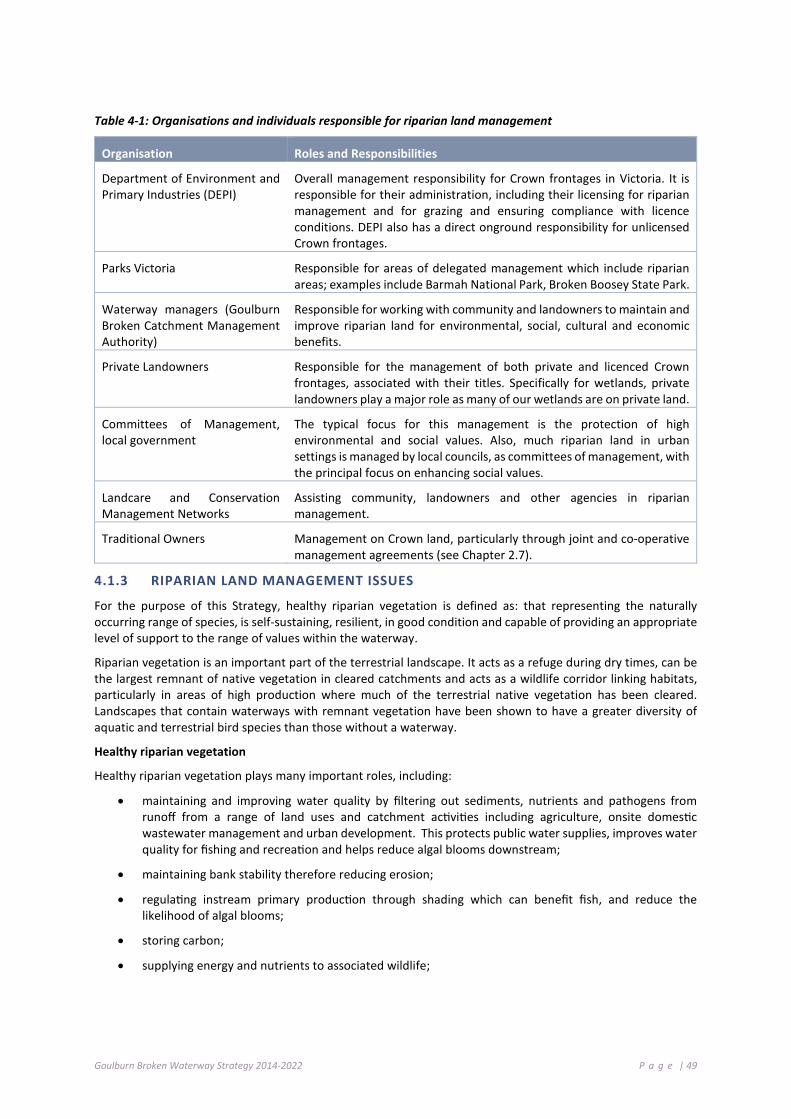
Goulburn Broken Waterway Strategy 2014-2022 P a g e | 49
Table 4-1: Organisations and individuals responsible for riparian land management
Organisation Roles and Responsibilities
Department of Environment and Primary Industries (DEPI)
Overall management responsibility for Crown frontages in Victoria. It is responsible for their administration, including their licensing for riparian management and for grazing and ensuring compliance with licence conditions. DEPI also has a direct onground responsibility for unlicensed Crown frontages.
Parks Victoria Responsible for areas of delegated management which include riparian areas; examples include Barmah National Park, Broken Boosey State Park.
Waterway managers (Goulburn Broken Catchment Management Authority)
Responsible for working with community and landowners to maintain and improve riparian land for environmental, social, cultural and economic benefits.
Private Landowners Responsible for the management of both private and licenced Crown frontages, associated with their titles. Specifically for wetlands, private landowners play a major role as many of our wetlands are on private land.
Committees of Management, local government
The typical focus for this management is the protection of high environmental and social values. Also, much riparian land in urban settings is managed by local councils, as committees of management, with the principal focus on enhancing social values.
Landcare and Conservation Management Networks
Assisting community, landowners and other agencies in riparian management.
Traditional Owners Management on Crown land, particularly through joint and co-operative management agreements (see Chapter 2.7).
4.1.3 RIPARIAN LAND MANAGEMENT ISSUES
For the purpose of this Strategy, healthy riparian vegetation is defined as: that representing the naturally occurring range of species, is self-sustaining, resilient, in good condition and capable of providing an appropriate level of support to the range of values within the waterway.
Riparian vegetation is an important part of the terrestrial landscape. It acts as a refuge during dry times, can be the largest remnant of native vegetation in cleared catchments and acts as a wildlife corridor linking habitats, particularly in areas of high production where much of the terrestrial native vegetation has been cleared. Landscapes that contain waterways with remnant vegetation have been shown to have a greater diversity of aquatic and terrestrial bird species than those without a waterway.
Healthy riparian vegetation
Healthy riparian vegetation plays many important roles, including:
• maintaining and improving water quality by filtering out sediments, nutrients and pathogens from runoff from a range of land uses and catchment activities including agriculture, onsite domestic wastewater management and urban development. This protects public water supplies, improves water quality for fishing and recreation and helps reduce algal blooms downstream;
• maintaining bank stability therefore reducing erosion;
• regulating instream primary production through shading which can benefit fish, and reduce the likelihood of algal blooms;
• storing carbon;
• supplying energy and nutrients to associated wildlife;

Goulburn Broken Waterway Strategy 2014-2022 P a g e | 50
• providing essential aquatic habitat through fallen logs, leaves and other plant material. For example, wood that falls into waterways can create deep holes and provides native fish protection from predation; and
• maintaining the integrity of the waterway through tree roots preventing undercutting of banks (ARRC web site, DEPI 2013b).
The ‘Index of Stream Condition’ (DEPI 2013a) has been used to assess 117 reaches in the Goulburn Broken catchment. Results from these assessments showed the entire range of indices for reach health from ‘reference’ (natural) condition to ‘poor’ condition. Overall, the majority of reaches (62% in both the Broken and Goulburn basins) were in good or excellent condition. Sixteen of the 117 reaches assessed across the region were in excellent condition, with the majority of these located in the Goulburn basin. Notably, reaches 63, 66 and 67-68 (on the Acheron, Rubicon and Big Rivers, respectively) in the heavily vegetated highlands of the Goulburn basin were in reference condition. The lowest and upper reaches of the Goulburn, Dabyminga, Yea, Murrindindi, Taggerty, Howqua and Delatite rivers were in near reference condition (reaches 1, 15-16, 50, 57, 59, 64, 70 and 72, respectively).
The health of reaches reflected associated land use, with reaches in reference condition located in the reserves and uncleared land in the south of the catchment and those in poor condition located where associated riparian and surrounding land had been cleared. For further information see: Third Index of Stream Condition report or http://bit.ly/1pzSFm6 (DEPI, 2013a).
Weeds
Weeds are an important management issue because they displace native species and affect both the biological and physical processes of ecosystems. Single species can dominate riparian land reducing biodiversity and the associated native animals because weeds modify and usually reduce habitat opportunities.
Different weed species have different impacts. For example, highly invasive transformer species, e.g. Broom, Blackberries, Tree Willows and Shrub Willows, often form dense infestations, and have significant impacts on many ecosystem processes, such as provision of habitat and natural regeneration of native species. Scrambling species have the potential to severely affect the growth and health of native vegetation (e.g. Cape Ivy and English Ivy) by smothering native plants and trees. In contrast, other species such as some flatweeds and Yorkshire Fog rarely form dense infestations in riparian areas and generally appear to have comparatively less impact on biological and physical processes; although it is important to note that such species may be more problematic in other ecosystems.
Riparian areas are particularly susceptible to weed invasion and are often invaded by multiple weed species. This susceptibility to invasion is a result of the natural disturbance processes associated with flooding, favourable environmental conditions and the continued input of weed propagules from upstream and surrounding land. The impacts of human activities have also increased the likelihood of weeds establishing in riparian areas, which often have a higher edge to area ratio making them more vulnerable to invasion. Despite the challenges, well designed weed management programs can achieve positive outcomes in riparian areas (Ede and Hunt 2008).
Weeds in riparian areas may:
• change vegetation community composition;
• inhibit recruitment and growth of native plant species;
• decrease food and habitat for native fauna, both terrestrial and aquatic;
• change aquatic food webs;
• provide food and habitat for exotic animals such as foxes and blackbirds;
• change soil nutrient processes;
• decrease water quality;
• change sedimentation, erosion and hydrological processes;
• decrease water quantity (e.g. willows);

Goulburn Broken Waterway Strategy 2014-2022 P a g e | 51
• change water temperature and light conditions by overshading the waterway; and
• reduce access and recreational opportunities (Ede and Hunt 2008).
Land managers are currently required to manage certain pest plants and animals on private riparian land and through licence conditions for Crown frontages under the Catchment and Land Protection Act 1994. These include the pest plant species Blackberries, Willows and Desert ash.
Willows
Willows are now regarded as one of the most serious riparian weeds in Australia and are listed as one of Australia’s 20 Weeds of National Significance (Holland Clift & Davies 2007). In decades past willows were used in waterway management to combat bank erosion. It is now understood that the negative impact of willows in and along waterways far outweighs any positive values.
Willows are considered a serious weed in a number of parts of the catchment particularly along the upper Goulburn River and tributaries, the mid Broken River, Holland and Ryans creeks.
Willow impacts in waterways includes:
• increased erosion and flooding;
• reduced quality and flow of water;
• reduced availability of water;
• less habitat available for fish, birds, frogs, insects, mammals and reptiles;
• obstructing access to streams for fishing and aquatic activities; and
• damage to nearby infrastructure (Holland Clift & Davies 2007).
For further information see http://www.weeds.org.au/WoNS/willows/
The GB CMA will work in a voluntary and co-operative approach with landowners to manage weeds including willow and blackberry infestations to improve the condition of the region’s waterways.
Stock and waterways
Stock access can have a detrimental impact on waterway condition and present risks to human health through reduced water quality. Impacts include:
• soil pugging and reducing grass cover, resulting in increased sediment and nutrient runoff to a waterway;
• restricting regeneration of native vegetation, reducing its ability to maintain waterway health;
• increased erosion;
• reduction in habitat for native fauna;
• soil compaction; and
• increased weed invasion into riparian land.
Restricting stock access to waterways can have many landowner benefits. These include:
• reduced erosion;
• reduced stock losses;
• controlled water quality for livestock which may improve stock health;
• improved stock manageability; and

Goulburn Broken Waterway Strategy 2014-2022 P a g e | 52
• benefits to the broader community through reduced pollution in waterways, downstream of the stock access area.
For further information see: Stock and Waterways: A Managers Guide (Land & Water Australia)
Research has shown that stock accessing waterways upstream of drinking water offtakes possess a significant risk to human health. The Victorian Department of Health commissioned a report to look at this issue which found there is a significant risk in allowing stock access.
For a full report (Public health issues associated with stock accessing waterways upstream of drinking water offtakes) see: http://www.health.vic.gov.au/water/drinkingwater/protecting-our-drinking-water-catchments
The GB CMA will work with water authorities and landowners in a voluntary but targeted approach to reduce stock access to waterways upstream of drinking water offtakes.
Controlled grazing
Fencing to restrict or control grazing results in the issue of stock gaining access to water. A private frontage or traditional Crown frontage licence allows stock direct access to the stream or river as a source of water. However, if landowners hold a riparian management licence and the area is fenced to prevent stock access to the waterway, a take and use licence is available from Goulburn-Murray Water to access water for stock (if the land manager does not already have a take and use licence or the volume of the existing water licence is not adequate for the stock’s water needs). In this case, water does not need to be purchased on the water market, but an application fee and annual renewal fee may apply. Grants are available for assistance in funding alternative water supplies.
For further information see: Stock and Waterways: A Managers Guide (Land & Water Australia) and http://www.depi.vic.gov.au/water/rivers-estuaries-and-wetlands/implementation-and-monitoring/managing-grazing-on-riparian-land.
The GB CMA will work with landowners who want to improve the condition of their frontage and establish a specific controlled grazing regime relevant to their frontage where appropriate.
Water licence fees are now reduced for farmers who fence off Crown land along rivers to manage stock access as part of riparian management projects conducted with CMAs.
Landowners whose land abuts a Crown frontage and who apply for a new take and use licence for stock water will now be reimbursed for their application fee. From 1 November 2013, their annual fee will be waived for three years and they will be given a longer licence period saving up to $2,100.
CMAs will now pay the cost of the initial application fee back to landowners to encourage more farmers with Crown frontages to sign up to works like fencing, revegetation and off-stream stock watering which will provide flow-on environmental benefits (see http://www.depi.vic.gov.au/water/rivers-estuaries-and-wetlands/implementation-and-monitoring/take-and-use-licences).
Where landowners have fenced off an existing licenced Crown frontage (and transferred the licence to a riparian management licence) the GB CMA will facilitate a process with GMW to obtain a licence and volume for stock water
Please note: some ongoing costs will be need to be borne by the landowner
Goulburn Broken Waterway Strategy 2014-2022 P a g e | 53
Bushfire
A common misconception is that riparian land in good condition or well vegetated riparian areas pose a significant bushfire risk. These areas actually pose a lower bushfire threat to assets than the threat posed by other parts of the landscape (DEPI 2013b). Well vegetated riparian land retains moisture and provides fire refuge areas for wildlife.
Statewide policy relating to bushfire and riparian land management described in Chapter 9.3.1 of the VWMS. (DEPI 2013b)
Access to riparian areas for recreation
Nearly half (4,760 km), of the approximate 10,000 km of streams in the Goulburn Broken region are abutted by Crown frontage. Where a Crown frontage exists, the public has the right to enter and remain on the land for certain recreational purposes such as walking, fishing or bird watching. Members of the public should not interfere with the purpose of any licenced frontage and are not permitted to camp or light fires on licenced Crown frontages.
Environmental and productivity benefits of good management
Good management of riparian areas can have positive environmental, social and productivity benefits. One way to plan well for multiple benefits at the property scale is to develop a Whole Farm Plan (refer to Chapter 4.12.3).
Production benefits include: management of grazing; access to water for stock; maintain channel stability; shelter belts; management of pests (through wildlife); stock management; and property values.
Environmental benefits include: protection of threatened species (flora and fauna); carbon sequestration; protection of water quality; and maintenance of channel stability.
Social benefits include: improved drinking water quality; public access; aesthetics; recreation and tourism; cultural and heritage values; and maintenance of channel stability.
Partnering with landowners to improve condition
The VWMS outlines the statewide approach to improved riparian management and discusses the need for voluntary and co-operative partnerships between landowners and government agencies. The GB CMA will assist in improving riparian management by providing information and investment for the improvement of riparian condition.
Typical management activities that can be supported by GB CMA investment assistance include:
• Fencing to remove uncontrolled stock grazing on riparian land. Under statewide policy such government investment is applied where fencing “will aim to be at least 20 metres wide on average from the top of the bank and must not be narrower than 10 metres any one place”;
• Revegetation or natural regeneration, through practices such as tube stock planting, direct seeding and management that allows natural regeneration;
• Pest plant and animal management. Landowners are currently required to manage certain pest plants and animals on private riparian land and through licence conditions for Crown frontages under the Catchment and Land Protection Act 1994.
• Off stream watering infrastructure; and
• Mechanisms relating to wetlands and riparian land often involve revegetation and protection of private land through tools such as Market Based Instruments, land swaps, management agreements and covenants.
State Government investment in riparian management (DEPI 2013b, d) will target priority activities that will identify high value waterways and establish priority riparian management activities as determined through this Strategy (see Chapter 7). It is also important to align the management action with the key threats and threatening process (GHD 2012) and Chapter 6.7.

Goulburn Broken Waterway Strategy 2014-2022 P a g e | 54
Riparian Management Agreements
Partnering with landowners will involve voluntary riparian management agreements (for Crown and private land) and licence arrangements with (adjoining) landowners. These agreements will be legally binding and set out management actions and responsibilities.
Riparian Management Licences
A riparian management licence for a Crown frontage recognises that all or part of the frontage is being managed by a licensee to maintain or improve the riparian environment (e.g. fenced out and supporting native vegetation). A riparian management licence is typically generated through the conversion of an existing grazing licence as part of an agreement between a landowner and the GB CMA for undertaking riparian protection and improvement works such as fencing and revegetation. The long-term management responsibilities agreed to by the landowner in the CMA agreement are incorporated as special conditions into a riparian management licence. These special conditions remain with the licence which may be transferred if the adjacent private land changes hands. Licences are generally renewed every five years. Many projects on Crown land that include fencing to manage stock access to a waterway qualify for a riparian management licence e.g. CMA, Landcare or privately funded projects (DEPI 2013b).
The GB CMA will work in a voluntary and co-operative approach to change licence agreements with landowners who undertake activities to improve the resilience of the region’s priority riparian lands.
4.1.4 PRIORITY ACTIONS FOR RIPARIAN MANAGEMENT
The following table details priority actions; the timeframe for implementation and the responsible agency, authority or group:
Action Timeframe Responsibility
Undertake strategic revegetation and associated riparian works such as fencing, weed management and the provision of off-stream stock watering infrastructure on priority waterways, wetlands and floodplains to maintain and improve the resilience of targeted waterways.
2014-2022 GB CMA, Landowners
Link strategic land management actions to key (priority) riparian management programs within areas that contribute to waterway resilience.
2014-2022 GB CMA, DEPI (region), Landcare and Landowners

Goulburn Broken Waterway Strategy 2014-2022 P a g e | 55
4 .2 W A T E R QU AL I T Y
Development of the Goulburn Broken Water Quality Strategy (WQS) commenced in 1994. The WQS aimed to reduce potential catchment Total Phosphorus (TP) loads exported from the catchment by 65% (from an estimated 371t of TP) to reduce the risk and incidence of blue green algal events. Implementation began in 1996 and a review of the Strategy and its implementation was commissioned in 2007. Overall, a substantial reduction in TP export from the catchment has been achieved. Analyses of trends generally show improving or stable water quality conditions. The review highlighted “new” issues to be addressed including climate change impacts on water quality. Implementation of the Strategy improves the resilience of the catchment’s streams and water bodies.
4.2.1 REVIEW PROCESS
The 2007 review of the Goulburn Broken Water Quality Strategy (1996), commissioned by the GB CMA was conducted by Feehan Consulting (2008). The initial strategy had been implemented for a decade and new water quality issues were emerging.
The Water Quality Strategy (1996) aimed, “to improve and maintain water quality at optimum levels within and downstream of the catchment for native ecosystems, recreation, human and animal consumption, agriculture and industry."
The first step in this review process was an examination of the outcomes from community efforts towards the goals stated in the Strategy. It was not a detailed review exercise.
A further review was undertaken in 2010 that underwent a detailed assessment of the Strategy’s performance. The review identified new water quality issues for the community to focus on: pathogens, sedimentation, impacts of catastrophic events and impacts of development pressure.
The current aim is “to maintain and improve water quality for the range beneficial uses (values).”
Regional partnership agreement for managing water quality incidents in the
Goulburn Broken region
A partnership agreement for managing water quality incidents was established in 2007 by key agencies with regulatory or functional responsibilities for waterways in the Goulburn Broken region. The ‘Partnership Agreement for Preparedness and Response to Waterway Incidents in the Goulburn Broken Catchment’ clearly outlines roles and responsibilities for responding to regional waterway incidents and is signed by the Department of Sustainability and Environment, the Environment Protection Authority Victoria, the Goulburn Broken Catchment Management Authority, Goulburn-Murray Water, Goulburn Valley Region Water Corporation, North East Region Water Corporation and the Department of Health.
The agreement provides a regional framework for response and recovery from waterway incidents that are not covered by existing arrangements. The intent of the agreement was to clearly establish the framework for leadership, and provide guidance in operations, communications and investigation of waterway incidents. This was considered essential to ensure a co-ordinated approach and to maintain the confidence of the community while all agencies carry out their respective roles in protecting, restoring and maintaining water quality of waterways.
In support of the agreement, a Water and River Contingency Planning Group was also established for the region that considers a range of waterway and water quality issues, including fish death incidents. This group meets on a regular basis throughout the year, and more frequently when risks to waterways increase.
The agreement has provided useful guidance during dry inflow conditions (that were experienced during the drought) and for managing water quality incidents such as low dissolved oxygen, blackwater and fish deaths that were caused by regional flooding.

Goulburn Broken Waterway Strategy 2014-2022 P a g e | 56
4.2.2 LESSONS LEARNED
A number of key lessons have emerged from the WQS implementation process:
• understanding and involvement of key sectors of the community and industry was critical in strategy preparation and implementation;
• working out what is important; our process helped determine the key issues (in the case study areas and nutrient management);
• working with imperfect knowledge; these processes never have perfect knowledge. We had to state our assumptions and move on. We have been able to test our assumptions over time and many have been monitored and proven adequate;
• availability of data; the Goulburn Broken catchment is considered “data rich”, but even so, data was not available to investigate all questions. We could not wait for data to become available on all topics;
• target setting is an imperfect process. Our approach of setting targets is based on best management practices (BMPs) and worked well for us;
• monitoring of water quality parameters is relatively straight forward. Monitoring of BMP implementation is very difficult; and
• integration with other programs; achieving implementation by integrating with other programs already established in the catchment has worked well and reduced overlap and duplication and increased investment.
4.2.3 BASIN SALINITY MANAGEMENT STRATGY
The Murray-Darling Basin Salinity Management Strategy guides communities and governments in working together to control salinity whilst protecting key natural resource assets across the Murray-Darling Basin. The Basin Salinity Management Strategy builds on the success of the 1989 Salinity and Drainage Strategy (MDBA, 2014).
Onground salinity management is largely achieved through activities being implemented at a local, state and territory level.
The objectives of the Murray-Darling Basin Salinity Management Strategy (MDBA 2014) are:
• maintain water quality of the Murray and Darling Rivers for agricultural, environmental, urban, industrial and recreational use;
• monitor and manage salt loads in all tributary rivers of the Murray–Darling Basin;
• manage land degradation through protecting important terrestrial ecosystems, productive farm land, cultural heritage and built infrastructure; and
• maximise net benefits resulting from salinity management across the Basin.
4.2.4 IMPLEMENTATION
Development of an integrated and co-ordinated water quality strategy for the Goulburn Broken catchment has been completed and implementation is progressing. Substantial reductions of nutrient outputs from major sources have been achieved, but it is too early to determine whether objectives are being met or will continue to be met.
However, the Goulburn Broken WQS is considered, by the Regional Water Quality Forum, the correct approach for delivering improvement in water quality (nutrients) within the region.
Goulburn Broken Waterway Strategy 2014-2022 P a g e | 57
The Goulburn Broken Water Quality Co-ordination Group
The Goulburn Broken Water Quality Co-ordination Group aims to ensure all relevant partners understand what is being achieved and how their component and activities fit towards achieving water quality goals for the region. The meetings provide a mechanism for regional consideration of relevant issues. The group focuses, at a strategic level, on: technical and science issues, communication and facilitation, co-ordination and information sharing and aligning activities to relevant strategies.
The region has also established a Regional Water and Contingency Planning Group that assesses risks and responds to waterway incidents.
Members of the above groups include (not limited to): the Goulburn Broken Catchment Management Authority; Goulburn-Murray Water; Goulburn Valley Region Water Authority; North East Region Water Authority; local government; Waterwatch; Northern Regional Water Monitoring Partnership; Department of Health; Department of Environment and Primary Industry; and Environment Protection Authority Victoria.
4.2.5 STRATEGIC APPROACH
The recommended strategic approach to water quality management includes:
• involvement of the community in water quality issues (planning, implementation and monitoring);
• implementation of an adaptive management approach and measure the change in resilience;
• determine, understand and address the key issues;
• advance our knowledge in general including potential impacts of climate change;
• continue to improve our knowledge base (data, risks, adaptive management);
• use best available data and knowledge and acknowledge that this could be imperfect;
• set and monitor appropriate targets;
• integrate water quality activities with other programs and stakeholders (agencies and community) via partnership approaches; and
• maintain sufficient investment.
4.2.6 STRATEGIC PRIORITIES
The Goulburn Broken Water Quality Co-ordination Group completed a review of strategic priorities in mid-2012. Strategic priorities are shown in Table 4-2.
The Group assessed regional water quality issues with the aim of developing a works program to be addressed by the Group, and their respective organisations, over time.

Goulburn Broken Waterway Strategy 2014-2022 P a g e | 58
Table 4-2: Strategic Priorities (2012)
Strategic Priority Why it is a priority What is the key Action to be done? Land Development and Planning Sewerage Scheme Planning/ On site Waste Water Management
Source of human infectious organisms (pathogens). Source of sediment and turbidity and nutrients.
Development, implementation and monitoring of domestic wastewater management plans across the region. Assess priority development zones for their impact on beneficial uses. Ensure adequate sewerage management (demand/need) strategies exist to for existing townships and development areas. Assess impacts of diffuse sources across the region and develop risk assessment and mitigation activities for beneficial uses. Ensure effective use of existing planning controls and implementation of “best practice”.
Partnerships A means of managing water quality issues in the catchment.
Maintain and support Regional Water Quality Forum and River and Water Contingency Planning Group (Waterway Incidents). Support Northern Water Monitoring Partnership.
Source and Fate of Pollutants Helps us understand how pollutants are sourced, transported and can be managed.
Assess the risk posed to beneficial uses (surface and subsurface) from key pollutants (pathogens, nutrients, sediments). Develop and implement programs to address high risk areas and pollutants. Maintain links with research providers.
Riparian Land Management
Riparian land can be a source of pollutants (especially sediment, turbidity and human infectious organisms).
Accelerate the level of riparian management “best practice” initiatives.
Support Policy 9.6 from the Victorian Waterway Management Strategy (2013), which relates to addressing pathogen risks from stock accessing waterways upstream of drinking water offtakes.
4.2.7 PRIORITY ACTIONS FOR WATER QUALITY
The following table details priority actions; the timeframe for implementation and the responsible agency, authority or group:
Action Timeframe Responsibility Development of domestic wastewater management plans across the region. 2015 OLV, DEPI, Local
Government Development, implementation and monitoring of domestic wastewater management plans across the region.
2016-2022 OLV, DEPI, Local Government
Continue to support “Waterwatch” within the region. 2015-2022 GB Water Quality Forum
Maintain and support Northern Regional Water Monitoring Partnership and River and Water Contingency/Planning Group.
2014-2022 All
Assess the risk posed to beneficial uses (surface and subsurface) from key pollutants (pathogens, nutrients, sediments).
2014-2022 GB CMA (Waterway Manager)
Assess pathogen risks from stock accessing waterways upstream of drinking water offtakes, as part of riparian management programs, in line with Policy 9.6 of the Victorian Waterway Management Strategy (2013).
2016 GB CMA

Goulburn Broken Waterway Strategy 2014-2022 P a g e | 59
4 .3 M A NAG E MEN T O F T HE EN VI RO N MEN T A L W A T E R RE S ER V E
Environmental water management aims to restore components of natural flow regimes in rivers and watering regimes in wetlands to maintain and improve their resilience. Natural flow and watering regimes have been heavily impacted by river regulation and water consumption, and by artificial barriers that reduce wetland access to natural sources of water.
Environmental water management has developed substantially during the life of the 2004 Goulburn Broken River Health Strategy. A number of plans and strategies have been prepared to support policy initiatives: the 2009 Northern Victorian Sustainable Water Strategy, the Commonwealth Water Act 2007, and the 2012 Basin Plan. Environmental water holders have been established by the Victorian and Commonwealth governments, and the GB CMA has been designated as the manager of environmental water in this catchment. The Environmental Water planning process is shown in Figure 4-1.
Policy and administrative arrangements will continue to evolve with the implementation of the Basin Plan through the life of this Strategy.
Initially, the only managed environmental water5 was 500,000 ML for Barmah Forest, and 27,500 ML for all Northern Victorian wetlands. In the Goulburn system, there is now an additional 265,000 ML of High Reliability Water Shares and 169,000 ML of Low Reliability Water Shares, with similar amounts held in the Victorian Murray supply system. These water entitlements are adequate to meet some or all of the currently identified environmental flow components. However, the Basin Plan currently requires greater volumes to be acquired to provide for all the environmental needs throughout the Murray-Darling Basin.
With significant volumes of environmental water available, environmental flows are now routinely being planned and managed in the Barmah Forest, the lower Goulburn River, the lower Broken Creek, the upper Broken Creek, and various wetlands. This is managed through the Annual Watering Plan process.
5 The amounts delivered are not the full amount of water available to the system.
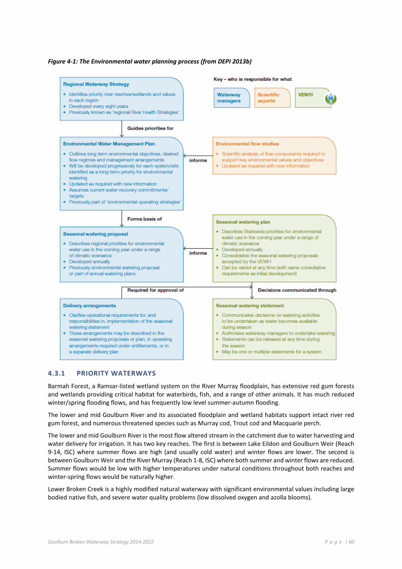
Goulburn Broken Waterway Strategy 2014-2022 P a g e | 60
Figure 4-1: The Environmental water planning process (from DEPI 2013b)
4.3.1 PRIORITY WATERWAYS
Barmah Forest, a Ramsar-listed wetland system on the River Murray floodplain, has extensive red gum forests and wetlands providing critical habitat for waterbirds, fish, and a range of other animals. It has much reduced winter/spring flooding flows, and has frequently low level summer-autumn flooding.
The lower and mid Goulburn River and its associated floodplain and wetland habitats support intact river red gum forest, and numerous threatened species such as Murray cod, Trout cod and Macquarie perch.
The lower and mid Goulburn River is the most flow altered stream in the catchment due to water harvesting and water delivery for irrigation. It has two key reaches. The first is between Lake Eildon and Goulburn Weir (Reach 9-14, ISC) where summer flows are high (and usually cold water) and winter flows are lower. The second is between Goulburn Weir and the River Murray (Reach 1-8, ISC) where both summer and winter flows are reduced. Summer flows would be low with higher temperatures under natural conditions throughout both reaches and winter-spring flows would be naturally higher.
Lower Broken Creek is a highly modified natural waterway with significant environmental values including large bodied native fish, and severe water quality problems (low dissolved oxygen and azolla blooms).

Goulburn Broken Waterway Strategy 2014-2022 P a g e | 61
Wetlands, both along watercourses and isolated on the riverine plains have a variety of environmental values, and are also priorities for improved flow management.
Several unregulated streams throughout the catchment are also priorities, although active flow management is not possible, as there are no upstream storages where water can be accessed and delivered. Flow management in unregulated systems can be actively managed through managing the diverters, (Stream Flow Management Plans, rostering, local management rules, etc.). Published local management rules for unregulated streams across the Goulburn Broken that sets out flow restrictions, and roster arrangements on unregulated systems can be found on the Goulburn-Murray Water website: www.g-mwater.com.au.
4.3.2 MANAGEMENT OBJECTIVES
Management objectives have been set for all priority waterways. Environmental flow studies have been completed for the Goulburn River, the Broken River, the upper and lower Broken Creek, Seven Creeks, Yea River and King Parrot Creek. Wetland Management Plans are available for all priority wetlands, including Barmah Forest, Reedy Swamp, Black Swamp, Kinnairds Wetland, Moodie Swamp, Doctors Swamp, Gaynor Swamp, One Tree Swamp, Two Tree Swamp, Wallenjoe Swamp, and Mansfield Swamp.
4.3.3 STRATEGIC PRIORITIES
Given that environmental water has become available for use and the ongoing implementation of the Basin Plan, the key focus for environmental water management will continue to be the regulated water supply systems and the environmental assets that can be supplied from them.
The continued development and updating of management frameworks, practices and capabilities are key priorities.
Adaptive management, based on applying environmental water and understanding the outcomes from its use, will be critical for building knowledge to maximise the long-term benefits.
Community understanding of and involvement in environmental water management will improve the development of long-term environmental water management.
It is also important that unregulated systems are managed though the development of management rules, environmental flow studies and management of diverters.

Goulburn Broken Waterway Strategy 2014-2022 P a g e | 62
4.3.4 PRIORITY ACTIONS FOR ENVIRONMENTAL WATER RESERVES
The following table details priority actions; the timeframe for implementation and the responsible agency, authority or group:
Action Timeframe Responsibility
Support development of environmental monitoring and research programs focused on key environmental watering priorities (including wetland vegetation), and establish processes to routinely assess results and feed back into future flow management decisions.
2018-2021 DEPI, GB CMA, VEWH, ARI, Universities
Redevelop river health and environmental flow objectives for the Goulburn River between Lake Eildon and Goulburn Weir (to accommodate high summer flows and cold water).
2014-2021 GB CMA
Develop Environmental Water Management Plans for the Goulburn River, upper and lower Broken Creek.
2014-2018 GB CMA
Develop a multi-year environmental flow planning framework for the Goulburn River, including compatibility with River Murray environmental flow release needs from the Goulburn River.
2014-2021 GB CMA, VEWH
Develop an understanding of the issues associated with lower Goulburn floodplain watering to develop options for maximising environmental outcomes while minimising social and economic impacts.
2014-2018 GB CMA, DEPI, VEWH
Develop and implement works and other actions to provide water supply to priority wetlands and streams (e.g. regulators).
2014-2021 GB CMA, DEPI
Understand the potential impacts of environmental flow management on economic and social activities, and minimise impacts where possible.
2016-2021 GB CMA, VEWH GMW, DEPI (policy), RMW Work with GMW and River Murray Water to maximise the potential
environmental outcomes from management of consumptive water en-route and supply system operation flexibility. Increase community communication and engagement in environmental flow management. Develop a better understanding of groundwater dependent ecosystems and look for opportunities to maintain and improve these. Continue to develop and implement strategic actions at Barmah Forest. Undertake planning to address delivery constraints and to advocate for over-bank environmental flows.
2014-2022 GB CMA, VEWH, DEPI
4 .4 G R OUN D WA T E R
Groundwater resources in the Goulburn Broken catchment are managed by Goulburn-Murray Water (GMW), in line with the requirements of the Water Act (1989) and associated policy. GMW has been delegated responsibility for licensing bore construction and the take and use of groundwater, and leads the development and implementation of groundwater management plans.
Groundwater management plans were historically developed to manage areas of intensive groundwater use; designated as Water Supply Protection Areas (WSPAs). These statutory plans were developed by a ministerially appointed committee (including representation from GB CMA) and endorsed by the Minister for Water.
More recently, GMW has been developing groundwater local management plans. The plans typically cover areas of less intensive groundwater use; referred to as groundwater management areas (GMAs). Local management plans are developed in consultation with a stakeholder and community reference group and are endorsed by GMW.
Groundwater management plans take into account the potential impact of groundwater extraction on streams, springs, wetlands and other Groundwater Dependent Ecosystems (GDEs). Current and proposed groundwater management plans for the Goulburn Broken catchment are shown in Figure 4-2.

Goulburn Broken Waterway Strategy 2014-2022 P a g e | 63
State policy and guidance on groundwater planning and licensing matters is provided by the Department of Environment and Primary Industries. Key policy documents include the Northern Region Sustainable Water Strategy (DSE, 2009), and the Groundwater Framework for Victoria (DSE 2012).
Groundwater management arrangements in the Goulburn Broken catchment are subject to the requirements of the Basin Plan. Under the Basin Plan, water resource plans must be developed by 2019.
4.4.1 GROUNDWATER DEPENDENT ECOSYSTEMS
Groundwater Dependent Ecosystems (GDEs) rely on groundwater for part or all of their water requirements. Not all GDEs draw on groundwater directly and not all are solely reliant on groundwater. Groundwater commonly provides a key and reliable source of water to an array of important regional ecosystems. As with surface flow, groundwater can be the main factor controlling the distribution of ecosystem types.
Six types of Groundwater Dependent Ecosystems (Geoscience Australia, 2013) have been identified in Australia6:
• terrestrial vegetation that relies on the availability of shallow groundwater;
• wetlands such as paperbark swamp forests and mound springs;
• river baseflow systems where groundwater discharge provides a significant baseflow component to the river;
• aquifer and cave ecosystems where life exists independent of sunlight;
• terrestrial fauna, both native and introduced species, that rely on groundwater as a source of drinking water; and
• estuarine and near-shore marine systems, such as coastal mangroves, salt marshes and sea-grass beds, which rely on the submarine discharge of groundwater.
In many cases, the groundwater system of the region provides baseflow in rivers and wetlands that many ecosystems depend on. Hence, the management of groundwater quantity and quality is required so that key GDEs are not adversely impacted upon. GDE management is also determined by the degree and nature of their groundwater dependency.
The Groundwater Dependent Ecosystems Atlas (http://www.bom.gov.au/water/groundwater/gde/map.shtml) provides a wide-ranging register of the location and characteristics of GDEs within the Goulburn Broken region (and across Australia). The Atlas shows ecosystems including springs, wetlands, rivers and vegetation that interact with the subsurface presence of groundwater, or the surface expression of groundwater.
6 Victoria does not propose to protect all types of GDEs in licensing decisions. High value priority GDEs need to be identified. (DEPI comment)

Goulburn Broken Waterway Strategy 2014-2022 P a g e | 64
Figure 4-2: Goulburn Broken Groundwater Management Units as of 2014 (source Goulburn-Murray Water)
For up to date Groundwater Management Units refer to http://www.g-mwater.com.au/water-resources/ground-water.
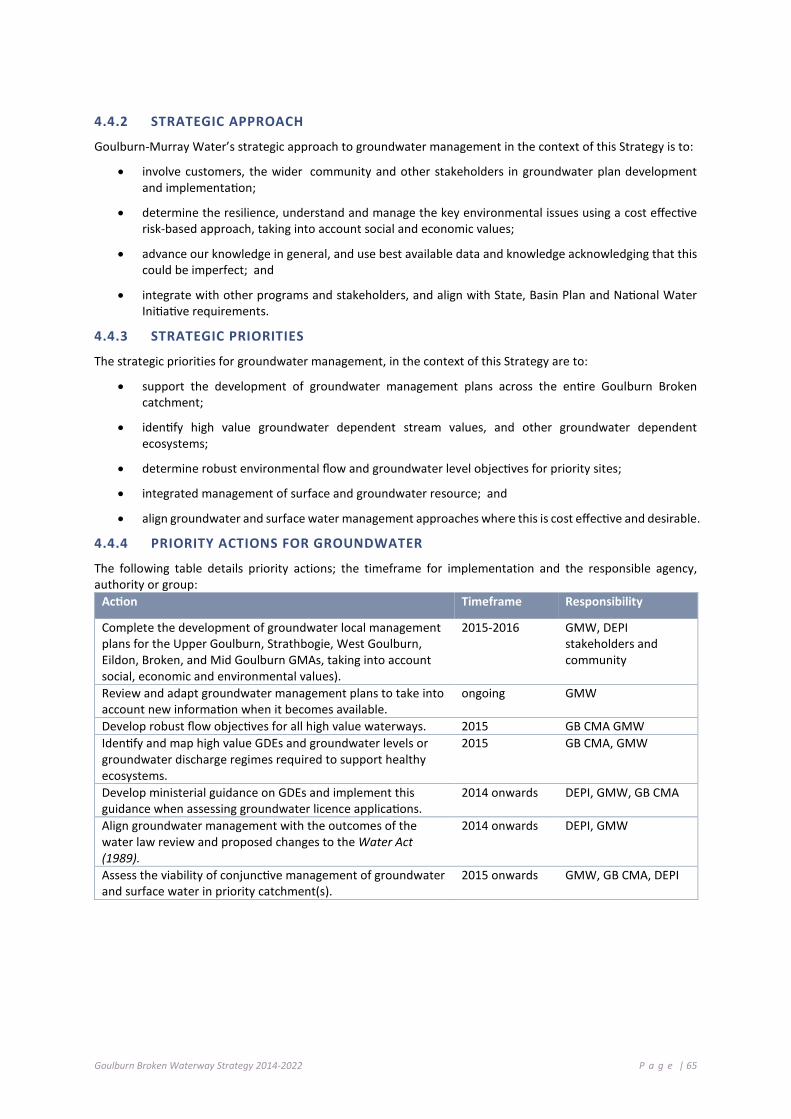
Goulburn Broken Waterway Strategy 2014-2022 P a g e | 65
4.4.2 STRATEGIC APPROACH
Goulburn-Murray Water’s strategic approach to groundwater management in the context of this Strategy is to:
• involve customers, the wider community and other stakeholders in groundwater plan development and implementation;
• determine the resilience, understand and manage the key environmental issues using a cost effective risk-based approach, taking into account social and economic values;
• advance our knowledge in general, and use best available data and knowledge acknowledging that this could be imperfect; and
• integrate with other programs and stakeholders, and align with State, Basin Plan and National Water Initiative requirements.
4.4.3 STRATEGIC PRIORITIES
The strategic priorities for groundwater management, in the context of this Strategy are to:
• support the development of groundwater management plans across the entire Goulburn Broken catchment;
• identify high value groundwater dependent stream values, and other groundwater dependent ecosystems;
• determine robust environmental flow and groundwater level objectives for priority sites;
• integrated management of surface and groundwater resource; and
• align groundwater and surface water management approaches where this is cost effective and desirable.
4.4.4 PRIORITY ACTIONS FOR GROUNDWATER
The following table details priority actions; the timeframe for implementation and the responsible agency, authority or group:
Action Timeframe Responsibility
Complete the development of groundwater local management plans for the Upper Goulburn, Strathbogie, West Goulburn, Eildon, Broken, and Mid Goulburn GMAs, taking into account social, economic and environmental values).
2015-2016 GMW, DEPI stakeholders and community
Review and adapt groundwater management plans to take into account new information when it becomes available.
ongoing GMW
Develop robust flow objectives for all high value waterways. 2015 GB CMA GMW Identify and map high value GDEs and groundwater levels or groundwater discharge regimes required to support healthy ecosystems.
2015 GB CMA, GMW
Develop ministerial guidance on GDEs and implement this guidance when assessing groundwater licence applications.
2014 onwards DEPI, GMW, GB CMA
Align groundwater management with the outcomes of the water law review and proposed changes to the Water Act (1989).
2014 onwards DEPI, GMW
Assess the viability of conjunctive management of groundwater and surface water in priority catchment(s).
2015 onwards GMW, GB CMA, DEPI
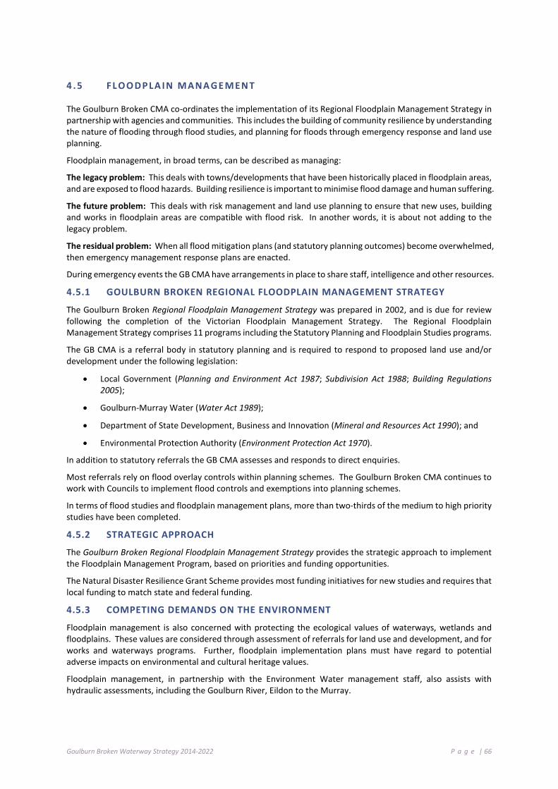
Goulburn Broken Waterway Strategy 2014-2022 P a g e | 66
4 .5 F L O O DP LA I N M ANA GE M EN T
The Goulburn Broken CMA co-ordinates the implementation of its Regional Floodplain Management Strategy in partnership with agencies and communities. This includes the building of community resilience by understanding the nature of flooding through flood studies, and planning for floods through emergency response and land use planning.
Floodplain management, in broad terms, can be described as managing:
The legacy problem: This deals with towns/developments that have been historically placed in floodplain areas, and are exposed to flood hazards. Building resilience is important to minimise flood damage and human suffering.
The future problem: This deals with risk management and land use planning to ensure that new uses, building and works in floodplain areas are compatible with flood risk. In another words, it is about not adding to the legacy problem.
The residual problem: When all flood mitigation plans (and statutory planning outcomes) become overwhelmed, then emergency management response plans are enacted.
During emergency events the GB CMA have arrangements in place to share staff, intelligence and other resources.
4.5.1 GOULBURN BROKEN REGIONAL FLOODPLAIN MANAGEMENT STRATEGY
The Goulburn Broken Regional Floodplain Management Strategy was prepared in 2002, and is due for review following the completion of the Victorian Floodplain Management Strategy. The Regional Floodplain Management Strategy comprises 11 programs including the Statutory Planning and Floodplain Studies programs.
The GB CMA is a referral body in statutory planning and is required to respond to proposed land use and/or development under the following legislation:
• Local Government (Planning and Environment Act 1987; Subdivision Act 1988; Building Regulations 2005);
• Goulburn-Murray Water (Water Act 1989);
• Department of State Development, Business and Innovation (Mineral and Resources Act 1990); and
• Environmental Protection Authority (Environment Protection Act 1970).
In addition to statutory referrals the GB CMA assesses and responds to direct enquiries.
Most referrals rely on flood overlay controls within planning schemes. The Goulburn Broken CMA continues to work with Councils to implement flood controls and exemptions into planning schemes.
In terms of flood studies and floodplain management plans, more than two-thirds of the medium to high priority studies have been completed.
4.5.2 STRATEGIC APPROACH
The Goulburn Broken Regional Floodplain Management Strategy provides the strategic approach to implement the Floodplain Management Program, based on priorities and funding opportunities.
The Natural Disaster Resilience Grant Scheme provides most funding initiatives for new studies and requires that local funding to match state and federal funding.
4.5.3 COMPETING DEMANDS ON THE ENVIRONMENT
Floodplain management is also concerned with protecting the ecological values of waterways, wetlands and floodplains. These values are considered through assessment of referrals for land use and development, and for works and waterways programs. Further, floodplain implementation plans must have regard to potential adverse impacts on environmental and cultural heritage values.
Floodplain management, in partnership with the Environment Water management staff, also assists with hydraulic assessments, including the Goulburn River, Eildon to the Murray.
Goulburn Broken Waterway Strategy 2014-2022 P a g e | 67
4.5.4 STRATEGY REVIEW
The new Victorian Floodplain Management Strategy will take into account a number of recent Parliamentary Inquiries into flooding. It is anticipated that a new Goulburn Broken Regional Floodplain Management Strategy will be developed following the release of the state strategy. Until this time, the Goulburn Broken CMA is working on an Interim Floodplain Management Strategy with Local Government that focuses on study priorities over the next two to three years.
4.5.5 PRIORITY ACTIONS FOR FLOODPLAIN
The following table details priority actions; the timeframe for implementation and the responsible agency, authority or group:
Action Timeframe Responsibility Carry out statutory planning obligations as a referral body, and to provide advice to the general community.
2021 GB CMA
Carry out flood modelling and flood mapping. ongoing GB CMA Work with the Environmental Water Reserve Team to achieve environmental outcomes both within and outside of the catchment.
2015 onwards GMW, GB CMA, DEPI
Complete review of the Goulburn Broken Floodplain Management Strategy.
2015-2017 GB CMA
4 .6 P U BLI C I N FR A ST R UC T U R E I N O UR WAT ERW A Y S
Public infrastructure in our waterways is defined as structures, facilities, buildings or areas of land used for public or community purposes located in, across or adjacent to waterways (DEPI 2013b). Common examples include weirs, dams, bridges, roads, communication cables, levees, boat ramps and jetties, public buildings and sports fields. Public infrastructure is distinguished from private assets (such as private land or buildings).
Waterway processes that can pose risks to public infrastructure include erosion, sedimentation, floods and avulsion.
In addition to maintaining or improving waterway condition, the protection of public infrastructure from waterway processes is an important consideration in waterway management because:
• significant public funds have already been invested in the establishment of infrastructure that produce/provide various public goods and services;
• public infrastructure enables/increases other waterway values (particularly social and economic); and
• by identifying the risks to public infrastructure and managing them before they become severe, the long-term economic costs to the community will be reduced (i.e. replacement costs are often far more expensive than maintenance costs).
The development of the RWSs provides a clear opportunity for waterway managers and stakeholders to determine management arrangements/activities that the waterway manager or other regional agencies should undertake over the eight-year planning cycle.

Goulburn Broken Waterway Strategy 2014-2022 P a g e | 68
4.6.1 VICTORIAN GOVERNMENT POLICY: MANAGING PUBLIC INFRASTRUCTURE
The Victorian Waterway Management Strategy details the roles and responsibilities for the management of public infrastructure on waterways:
• waterway managers and asset owners will share information to assess risks to public infrastructure from waterway processes;
• asset owners, waterway managers and relevant beneficiaries of the public infrastructure should negotiate required management activities to manage serious risks to public infrastructure from waterway processes;
• management of serious risks to public infrastructure from waterway processes will be undertaken in accordance with the directions outlined in the Victorian Government response to the Environment and Natural Resources Committee (ENRC) Inquiry into Flood Mitigation Infrastructure in Victoria (where relevant);
• approvals to construct public and private infrastructure on waterways requires a number of approvals, including a “Works on Waterways” permit; and
• in most instances, the adjacent land manager remains responsible for the management and maintenance of the infrastructure.
4.6.2 PRINCIPLES AND CONSIDERATIONS
Principles and considerations for the management of public infrastructure derived from the Victorian Waterway Management Strategy include:
• managing risks to public infrastructure is primarily the responsibility of the asset owner;
• the level of protection required for public infrastructure should be decided by asset owners;
• waterway managers have a number of functions including information provision, works and licensing; and
• investment in river health (for example, erosion control, revegetation etc.) will reduce risks to public infrastructure over time.
4.6.3 CMA ROLES AND RESPONSIBILITIES: PUBLIC INFRASTRUCTURE
The key roles and responsibilities for Catchment Management Authorities in the management of public infrastructure are:
• Preparation of Waterway Strategies
1. regional waterway management programs will give consideration to waterway processes (for example, floods, erosion and avulsion) and their implications for broad scale risk to public infrastructure in the catchment;
2. there is an expectation that CMAs will align waterway condition improvement works with public asset protection where possible;
3. when a priority management activity in the Strategy involves works at an existing structure, waterway managers will take a lead role in negotiating an agreement on future management responsibility for the structure; and
4. CMAs have a role in the regulation (through licensing) of waterway works or activities undertaken to maintain, repair or protect public infrastructure.

Goulburn Broken Waterway Strategy 2014-2022 P a g e | 69
• Provision of information and support
5. CMAs will provide flood hazard information at a particular scale to enable asset owners to undertake mitigation measures where available;
6. there is no expectation on CMAs to undertake risk assessments for non-CMA owned/managed public infrastructure;
7. CMAs will identify risks to public infrastructure (for example, avulsion of rivers, sediment transport impacts etc.) when they are known and where appropriate;
8. CMAs will attempt to identify knowledge gaps and provide information to asset owners;
9. CMAs often have a detailed knowledge of the location and rates of erosion, flooding, avulsion and other waterway processes that may threaten public infrastructure and this should be shared with asset owners; and
10. CMAs may be called upon to provide a support role in emergency response situations given their capability.
4 .7 M A NAG E MEN T O F T HR EA T EN E D A Q UA T I C D E PE ND ENT S PEC I E S
Many rivers and wetlands within the Goulburn Broken catchment support national (Environment Protection and Biodiversity Conservation Act 1999; EPBC) and state (Flora and Fauna Guarantee Act 1988) listed fauna and Australian Rare or Threatened (AROT) flora. On average, 60 rare or threatened faunal species are found within 100 metres of a watercourse in the Goulburn Broken catchment (GB CMA 2005). Twelve of these species are listed under national EPBC legislation and of these, six species (Macquarie perch, Murray cod, Silver perch, Trout cod, Barred galaxias and the Spotted tree-frog) are solely dependent on stream environments in good condition. The recovery of many of these threatened species is being addressed under national Recovery Plans, state Action Statements or other protection through the management of threatening processes (see Table 4-3and Table 4-4). In addition, the implementation of programs under the previous Regional River Health Strategy (2004) also facilitate the protection of key aquatic species.
Of the 42 significant flora species recorded within 100 metres of a watercourse, none are listed under the EPBC Act, but five are considered AROTs (Small Scurf Pea, Narrow Goodenia, Alpine Bent, Highland Bush Pea and Ausfield’s Wattle) (GB CMA 2005). Of these, only Alpine Bent, which occurs along high priority reaches, could be considered dependent on waterway environments (GB CMA 2005). The only records for Alpine Bent are in the upper Goulburn (Reach 16).
Many threatened species now persist only in small patches of remnant habitat dominated by human influences (Bennett et al. 2006). As such, management activities generally aim to protect these patches from threats, help build connectivity between patches, and to ultimately increase the size and number of populations to reduce the risk of extinction. Understanding the causes of population declines (past, present and future), and the processes by which threats act upon the threatened biota, is fundamental to the design of effective practical management of threatened species (Norris 2004). In recent years, monitoring in the Goulburn Broken catchment has focused on known populations (presence, numbers and diversity) and assessing the impact of management actions (i.e. fishways, habitat restoration. Hence, there is increased knowledge on populations where monitoring has been undertaken.
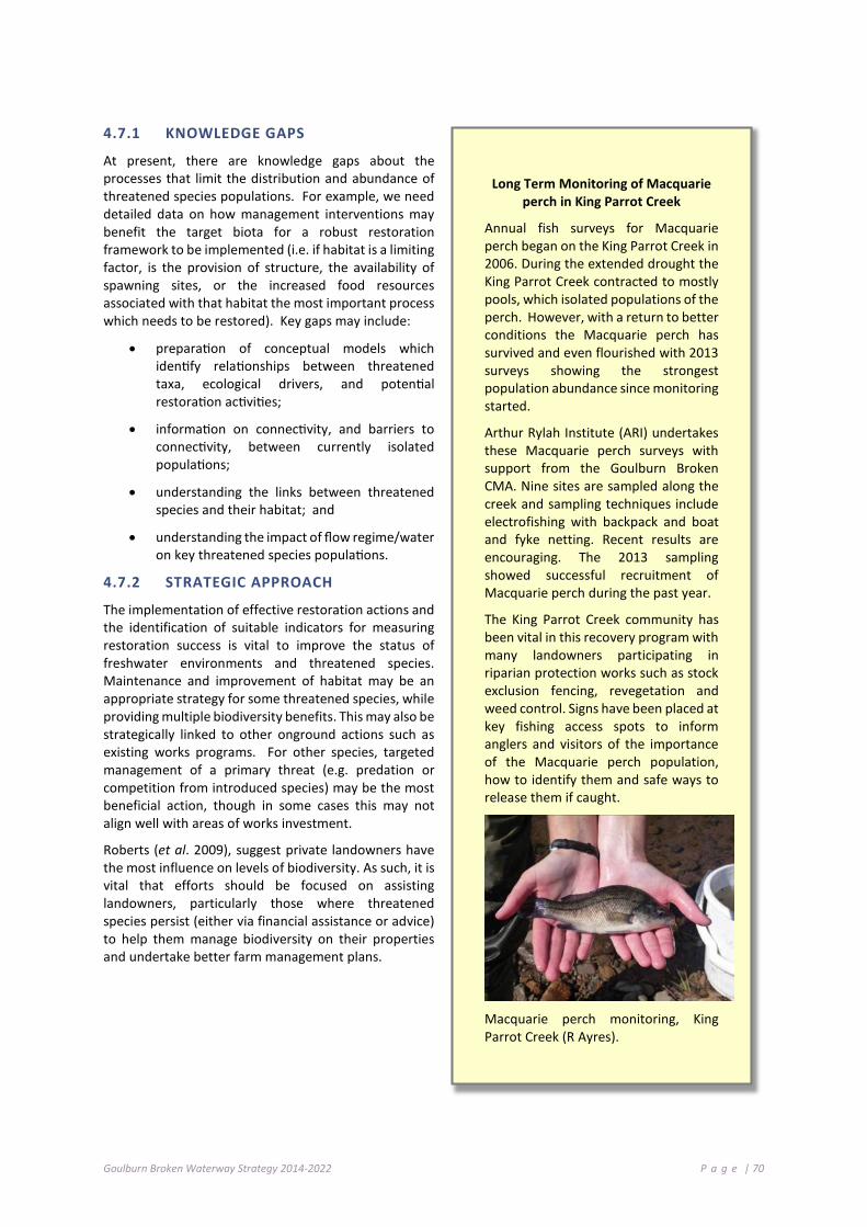
Goulburn Broken Waterway Strategy 2014-2022 P a g e | 70
4.7.1 KNOWLEDGE GAPS
At present, there are knowledge gaps about the processes that limit the distribution and abundance of threatened species populations. For example, we need detailed data on how management interventions may benefit the target biota for a robust restoration framework to be implemented (i.e. if habitat is a limiting factor, is the provision of structure, the availability of spawning sites, or the increased food resources associated with that habitat the most important process which needs to be restored). Key gaps may include:
• preparation of conceptual models which identify relationships between threatened taxa, ecological drivers, and potential restoration activities;
• information on connectivity, and barriers to connectivity, between currently isolated populations;
• understanding the links between threatened species and their habitat; and
• understanding the impact of flow regime/water on key threatened species populations.
4.7.2 STRATEGIC APPROACH
The implementation of effective restoration actions and the identification of suitable indicators for measuring restoration success is vital to improve the status of freshwater environments and threatened species. Maintenance and improvement of habitat may be an appropriate strategy for some threatened species, while providing multiple biodiversity benefits. This may also be strategically linked to other onground actions such as existing works programs. For other species, targeted management of a primary threat (e.g. predation or competition from introduced species) may be the most beneficial action, though in some cases this may not align well with areas of works investment.
Roberts (et al. 2009), suggest private landowners have the most influence on levels of biodiversity. As such, it is vital that efforts should be focused on assisting landowners, particularly those where threatened species persist (either via financial assistance or advice) to help them manage biodiversity on their properties and undertake better farm management plans.
Long Term Monitoring of Macquarie perch in King Parrot Creek
Annual fish surveys for Macquarie perch began on the King Parrot Creek in 2006. During the extended drought the King Parrot Creek contracted to mostly pools, which isolated populations of the perch. However, with a return to better conditions the Macquarie perch has survived and even flourished with 2013 surveys showing the strongest population abundance since monitoring started.
Arthur Rylah Institute (ARI) undertakes these Macquarie perch surveys with support from the Goulburn Broken CMA. Nine sites are sampled along the creek and sampling techniques include electrofishing with backpack and boat and fyke netting. Recent results are encouraging. The 2013 sampling showed successful recruitment of Macquarie perch during the past year.
The King Parrot Creek community has been vital in this recovery program with many landowners participating in riparian protection works such as stock exclusion fencing, revegetation and weed control. Signs have been placed at key fishing access spots to inform anglers and visitors of the importance of the Macquarie perch population, how to identify them and safe ways to release them if caught.
Macquarie perch monitoring, King Parrot Creek (R Ayres).

Goulburn Broken Waterway Strategy 2014-2022 P a g e | 71
Table 4-3: Flora and Fauna Guarantee Act 1998 listings and Action Statements for species, Potentially Threatening Processes and Communities - Riverine and Wetland related or Dependent
Flora and Fauna Guarantee Action Statements (Aquatic Dependent)
Barred galaxias (Galaxias olidus var. fuscus) No. 65; Macquarie perch (Macquaria australasica) (in prep.); Spotted tree frog (Litoria spenceri) No.112; Trout cod (Maccullochella macquariensis) (No. 38).
Fauna - Growling Grass-frog, Alpine Tree-frog; Murray Spiny-cray; White-bellied Sea-Eagle, Superb Parrot (RRG forest).
Flora - Fat Spectacles (Menkea crassa), Ridged Water-milfoil (Myriophyllum porcatum), Small Scurf-pea (Cullen parvum), Summer Leek-orchid (Prasophyllum canaliculatum), Narrow Goodenia (Goodenia macbarronii), Warby Range Swamp Gum (Eucalyptus cadens) and Buxton Gum (Eucalyptus crenulata).
Communities: Alpine Bog Community, Creekline Grassy Woodland (Goldfields), Granite Foothills Spring Wetland (North East); Lowland Riverine Fish Community of the Southern Murray-Darling Basin, Montane Swamp Complex, Red Gum No. 1 community.
Flora and Fauna Guarantee Threatening processes (Riverine and Wetland related)
Alteration to the natural flow regimes of rivers and streams.
Alteration to the natural temperature regimes of rivers and streams (i.e. cold water releases from impoundments).
Removal or degradation of native riparian vegetation along Victorian rivers and streams.
Habitat fragmentation and removal of wood debris from Victorian streams.
Increase in sediment input into Victorian rivers and streams due to human induced activities (i.e. land clearing).
Input of toxic substances into Victorian rivers and streams (i.e. agricultural chemicals).
Introduction of exotic fish species and native species translocated into waterbodies outside their natural range within a Victorian river catchment after 1770.
Loss of hollow-bearing trees in Victorian native forests.
Barriers to fish movement (i.e. weirs).
Introduction of diseases and parasites carried by exotic fish species which can effect native fish.
The invasion of native vegetation by environmental weeds.
Use of lead shot in cartridges for the hunting of waterfowl.
Use of Phytophthora-infected gravel in construction of roads, bridges and reservoirs.
Loss and degradation of native plant and animal habitat by invasion of escaped garden plants, including aquatic plants.
Table 4-4: Goulburn Broken fauna with EPBC Recovery Plans (Aquatic Dependent Species)
Recovery Plan Title Species Scientific Name Species Common Name
Spotted tree frog Recovery Plan Litoria spenceri Spotted tree frog
National Recovery Plan for the Trout cod 2008 Maccullochella macquariensis Trout cod
National Recovery Plan for Murray cod Maccullochella peelii peelii Murray cod
National recovery plan for Macquarie perch - In-progress Macquaria australasica Macquarie perch
National Recovery Plan for the Barred galaxias 2010 Galaxias fuscus Barred galaxias
Goulburn Broken Waterway Strategy 2014-2022 P a g e | 72
4.7.3 STRATEGIC PRIORITIES
The threatened aquatic species work program aims to ensure the survival of all threatened aquatic species and maintain current populations in the catchments to maintain current ecosystem function. Further, we aim to expand the range of species and communities and foster resilience within the waterway to ensure the maintenance and improvement of threatened species populations.
There is a need to prioritise sites containing threatened species based upon their resilience to avoid extinction. A multifaceted approach to prioritisation is required that takes into account biodiversity loss, resource limitations and cultural values while meeting overarching legislative obligations. An alternate consideration to prioritising individual species by geographical areas and rank these areas for conservation based on the number of threatened species they contain in addition to the risk posed by these threatening processes (Coates and Atkins 2001). Another approach for prioritising threatened species (and populations) is to examine and rank each threat in order to implement actions to mitigate their impacts. Managing waterways for threatened species must consider other cultural, social and economic values within the waterway and in adjacent reaches.
4.7.4 PRIORITY ACTIONS FOR THREATENED AQUATIC SPECIES
The following table details priority actions; the timeframe for implementation and the responsible agency, authority or group:
Action Timeframe Responsibility
Develop and implement strategies to improve the resilience of waterways to enable the re-establishment of robust self-sustaining populations of Macquarie perch and Trout cod in the Goulburn River between Lake Eildon and Barmah. In particular, ensure connectivity with satellite populations in Hughes Creek, Seven Creeks, King Parrot Creek, Holland Creek and Yea River.
2050 DEPI (ARI), GB CMA, community
Identify, prioritise and implement strategies to reduce extinction risk by translocation and stocking of threatened species.
2050 DEPI (ARI), Fisheries Victoria, GB CMA, community
Undertake research and monitoring to identify and prioritise recovery actions, in line with action statements and recovery plans and adaptive management principles.
2050 DEPI (ARI), Fisheries Victoria
Ensure connectivity with wetland and off channel habitats along the Goulburn river (Catfish and Macquarie perch).
2030 GB CMA
Deliver community initiatives and partnerships to maintain or improve habitat for threatened species and farm production, such as weed control, revegetation and soil and catchment stabilisation.
2014-2022 Agency stakeholders, community
Develop a plan for listed Aquatic biodiversity values including an objective for threatened species, threatening processes and communities and management approaches to optimise conservation outcomes and ecosystem function with resilience being achieved to the desired level.
2022 DEPI (Regional Services), DEPI (ARI), GB CMA
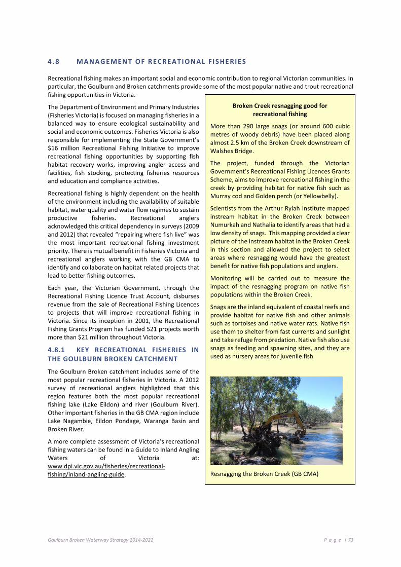
Goulburn Broken Waterway Strategy 2014-2022 P a g e | 73
4 .8 M A NAG E MEN T O F R EC RE AT I ON AL F I S HE RI E S
Recreational fishing makes an important social and economic contribution to regional Victorian communities. In particular, the Goulburn and Broken catchments provide some of the most popular native and trout recreational fishing opportunities in Victoria.
The Department of Environment and Primary Industries (Fisheries Victoria) is focused on managing fisheries in a balanced way to ensure ecological sustainability and social and economic outcomes. Fisheries Victoria is also responsible for implementing the State Government’s $16 million Recreational Fishing Initiative to improve recreational fishing opportunities by supporting fish habitat recovery works, improving angler access and facilities, fish stocking, protecting fisheries resources and education and compliance activities.
Recreational fishing is highly dependent on the health of the environment including the availability of suitable habitat, water quality and water flow regimes to sustain productive fisheries. Recreational anglers acknowledged this critical dependency in surveys (2009 and 2012) that revealed “repairing where fish live” was the most important recreational fishing investment priority. There is mutual benefit in Fisheries Victoria and recreational anglers working with the GB CMA to identify and collaborate on habitat related projects that lead to better fishing outcomes.
Each year, the Victorian Government, through the Recreational Fishing Licence Trust Account, disburses revenue from the sale of Recreational Fishing Licences to projects that will improve recreational fishing in Victoria. Since its inception in 2001, the Recreational Fishing Grants Program has funded 521 projects worth more than $21 million throughout Victoria.
4.8.1 KEY RECREATIONAL FISHERIES IN THE GOULBURN BROKEN CATCHMENT
The Goulburn Broken catchment includes some of the most popular recreational fisheries in Victoria. A 2012 survey of recreational anglers highlighted that this region features both the most popular recreational fishing lake (Lake Eildon) and river (Goulburn River). Other important fisheries in the GB CMA region include Lake Nagambie, Eildon Pondage, Waranga Basin and Broken River.
A more complete assessment of Victoria’s recreational fishing waters can be found in a Guide to Inland Angling Waters of Victoria at: www.dpi.vic.gov.au/fisheries/recreational-fishing/inland-angling-guide.
Broken Creek resnagging good for recreational fishing
More than 290 large snags (or around 600 cubic metres of woody debris) have been placed along almost 2.5 km of the Broken Creek downstream of Walshes Bridge.
The project, funded through the Victorian Government’s Recreational Fishing Licences Grants Scheme, aims to improve recreational fishing in the creek by providing habitat for native fish such as Murray cod and Golden perch (or Yellowbelly).
Scientists from the Arthur Rylah Institute mapped instream habitat in the Broken Creek between Numurkah and Nathalia to identify areas that had a low density of snags. This mapping provided a clear picture of the instream habitat in the Broken Creek in this section and allowed the project to select areas where resnagging would have the greatest benefit for native fish populations and anglers.
Monitoring will be carried out to measure the impact of the resnagging program on native fish populations within the Broken Creek.
Snags are the inland equivalent of coastal reefs and provide habitat for native fish and other animals such as tortoises and native water rats. Native fish use them to shelter from fast currents and sunlight and take refuge from predation. Native fish also use snags as feeding and spawning sites, and they are used as nursery areas for juvenile fish.
Resnagging the Broken Creek (GB CMA)

Goulburn Broken Waterway Strategy 2014-2022 P a g e | 74
4.8.2 STRATEGIC PRIORITIES
Fisheries Victoria, key partners and the GB CMA have identified the following key strategic priorities for the management of inland fishing:
• Maintain key fisheries assets;
• Advocate for fish habitat recovery works;
• Manage fish stocking;
• Encourage compliance with regulations;
• Improve angler access; and
• Develop recreational fishing opportunities.
4.8.3 FISHERY MANAGEMENT PRIORITIES
Fisheries Victoria and the GB CMA convened a workshop in July 2013 with key recreational fishing representatives and relevant agencies to identify key fisheries management priorities for the region. The ideas and proposals from this forum were reviewed by Fisheries Victoria against the strategic priorities and are captured as fishery management priorities. These priorities were then aligned with the key drivers of this Strategy. The outcomes of this workshop builds on past fishery management planning processes, in particular, the 2011 Goulburn Broken Fishery Management Plan.
4.8.4 PRIORITY ACTIONS FOR FISHERY MANAGEMENT
The following table details priority actions; the timeframe for implementation and the responsible agency, authority or group:
Action Timeframe Responsibility
Support habitat restoration works where they align with popular recreational fishing river reaches or critical habitat needs for threatened species (Fisheries Victoria Inland Fishing Survey 2012).
2021 DEPI, GB CMA
Investigate the feasibility of using over-bank environmental flows in the Goulburn and Broken Rivers to improve native fish recruitment.
2022 DEPI, GB CMA, MBDA
Investigate the feasibility of improving the native fish recreational fishing in the Waranga Basin through habitat improvement (Refer Goulburn-Murray Water Waranga Basin Land and On-Water Management Plan 2011).
2018 GB CMA, DEPI, VRFish, ATF
Support the re-establishment of woody habitat in the GB CMA region based on the outcomes of DEPI’s habitat mapping study recommendations (DEPI 2013g).
2025 DEPI, GB CMA
Focus efforts to establish stocked populations of Trout cod and Macquarie perch in the Goulburn River (between the junction of Hughes Creek and King Parrot Creek).
2022 DEPI, GB CMA, VRFish
Investigate the case for re-establishing freshwater catfish populations near the junction of the Broken Creek and Goulburn River confluence using the Vic Fish Stock consultative process.
2022 DEPI, Vic Fish Stock
Improve recreational fishing outcomes in the Goulburn River tailrace fishery by protecting and where needed, re-establishing riparian and instream habitat.
2022 GB CMA, DEPI
Goulburn Broken Waterway Strategy 2014-2022 P a g e | 75
4 .9 M A NAG E MEN T O F I NV A S I VE S PE CI E S
Invasive flora and fauna pose a major threat to the health of the region’s waterways. Management of invasive species requires a multi-faceted approach through planning and implementation over a range of jurisdictions.
An invasive species is a species that occurs, as a result of human activities, beyond its accepted normal distribution and threatens environmental, agricultural, cultural or other social values (DSE 2012).
Invasive species include organisms from other continents and translocated native species. Invasive species that may impact waterways include vertebrates, plants (aquatic and riparian species), invertebrates, algae, pathogens and diseases.
Priority invasive species within the Goulburn Broken catchment include:
Invasive Species Priority
Vertebrates European carp (Cyprinus carpio); Oriental Weatherloach (Misgurnus anguillicaudatus); Redfin (Perca fluviatilis); Brown trout (Salmo trutta); Rainbow trout (Oncorhynchus mykiss); Mosquito fish (Gambusia affinis).
Plants Blackberry (Rubus fruticosus agg. Species) and Willow (Salix spp.).
Cabomba (Cabomba caroliniana) and Arrowhead (Sagittaria).
The management of invasive species in waterways (DSE 2012) needs to be holistic and integrated with other waterway health activities, other pest plant and animal control works and fisheries management activities (i.e. Integrated Catchment Management Framework).
It is clear that initiatives articulated in this Strategy will be ineffectual without adequate resources being directed towards the management of invasive species.
Stocking of both native and introduced fish species takes place in Victoria to improve recreational fishing opportunities. At the state level, the Translocation Evaluation Panel advises Fisheries Victoria on issues related to the translocation of live inland aquatic organisms in accordance with protocols and guidelines. Regionally, stocking is considered through a consultative process involving regional input from land and waterway managers and recreational anglers (See Recreational Fishing Chapter 4.8).
There is currently limited understanding of how waterway restoration activities influence the establishment and spread of invasive species, including how activities designed to eradicate or reduce the impact of one invasive species can influence the establishment and spread of other invasive species. There is some evidence that control of invasive species can have unintended secondary consequences. It is recommended that a risk-based assessment is undertaken, including the development of a conceptual model to aid the identification of intended and unintended consequences.
Management Framework
The Victorian Waterway Management Strategy (DEPI 2013b) sets out policy direction on issues pertinent to waterway health, including the threat from invasive species. Waterway managers have an important role in undertaking regional actions to contain high risk established invasive species and in protecting high value rivers, estuaries and wetlands from the range of impacts associated with invasive species. A framework for the management of invasive species in waterways is outlined in Table 4-5.

Goulburn Broken Waterway Strategy 2014-2022 P a g e | 76
4.9.1 PRIORITY ACTIONS FOR INVASIVE SPECIES
The following table details priority actions; the timeframe for implementation and the responsible agency, authority or group:
Action Timeframe Responsibility
Assess the risks of inland aquatic invasive species spread through the Victorian water grid.
2015-2018 DEPI, Waterway managers, Water corporations
Support multi-jurisdictional process and actions to manage invasive species.
Ongoing DEPI, Waterway managers, Water corporations
Support research into the management and control of invasive species.
2015-2050 DEPI, Waterway managers, Water corporations
Identify stream lengths that may require selective removal in very limited sections of a few upper catchment streams to protect valuable species and ecosystems, working in collaboration with relevant stakeholders and interest groups.
2014-2022 DEPI (Regional Services / ARI), Waterway managers
Encourage and support efforts for control methods and management of carp within priority waterways (identified) within the region. Highlight level of urgency.
2018 DEPI (ARI), GB CMA
Facilitate “carp muster” days on identified “hot spots” (waterways, storages).
2014-2022 DEPI (ARI), Fisheries Victoria, GB CMA
Encourage support efforts for improved control of invasive plant species including biological and chemical control methods.
2022 Research organisations
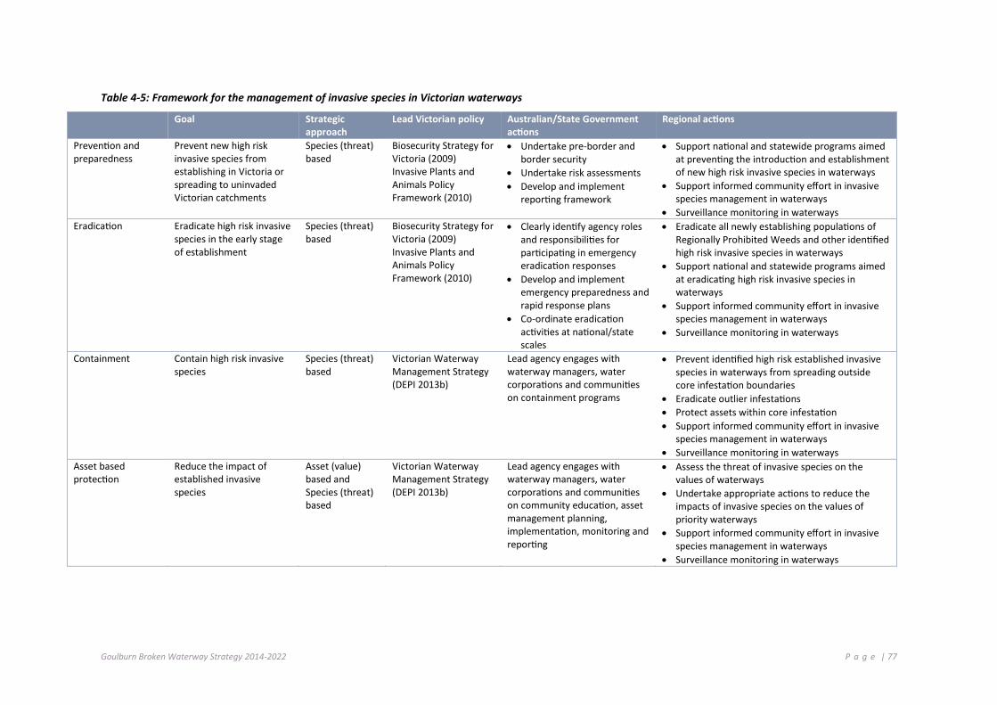
Goulburn Broken Waterway Strategy 2014-2022 P a g e | 77
Table 4-5: Framework for the management of invasive species in Victorian waterways
Goal Strategic approach
Lead Victorian policy Australian/State Government actions
Regional actions
Prevention and preparedness
Prevent new high risk invasive species from establishing in Victoria or spreading to uninvaded Victorian catchments
Species (threat) based
Biosecurity Strategy for Victoria (2009) Invasive Plants and Animals Policy Framework (2010)
• Undertake pre-border and border security
• Undertake risk assessments • Develop and implement
reporting framework
• Support national and statewide programs aimed at preventing the introduction and establishment of new high risk invasive species in waterways
• Support informed community effort in invasive species management in waterways
• Surveillance monitoring in waterways Eradication Eradicate high risk invasive
species in the early stage of establishment
Species (threat) based
Biosecurity Strategy for Victoria (2009) Invasive Plants and Animals Policy Framework (2010)
• Clearly identify agency roles and responsibilities for participating in emergency eradication responses
• Develop and implement emergency preparedness and rapid response plans
• Co-ordinate eradication activities at national/state scales
• Eradicate all newly establishing populations of Regionally Prohibited Weeds and other identified high risk invasive species in waterways
• Support national and statewide programs aimed at eradicating high risk invasive species in waterways
• Support informed community effort in invasive species management in waterways
• Surveillance monitoring in waterways
Containment Contain high risk invasive species
Species (threat) based
Victorian Waterway Management Strategy (DEPI 2013b)
Lead agency engages with waterway managers, water corporations and communities on containment programs
• Prevent identified high risk established invasive species in waterways from spreading outside core infestation boundaries
• Eradicate outlier infestations • Protect assets within core infestation • Support informed community effort in invasive
species management in waterways • Surveillance monitoring in waterways
Asset based protection
Reduce the impact of established invasive species
Asset (value) based and Species (threat) based
Victorian Waterway Management Strategy (DEPI 2013b)
Lead agency engages with waterway managers, water corporations and communities on community education, asset management planning, implementation, monitoring and reporting
• Assess the threat of invasive species on the values of waterways
• Undertake appropriate actions to reduce the impacts of invasive species on the values of priority waterways
• Support informed community effort in invasive species management in waterways
• Surveillance monitoring in waterways
Goulburn Broken Waterway Strategy 2014-2022 P a g e | 78
4 .10 M A NAG E MEN T O F T HE R I VE R CH ANN EL
Management of the waterway channel (DEPI 2013b) needs to be based on an understanding of the geomorphological and hydrological processes that exist within our catchment.
The focus of early waterway management was directed towards improving channel efficiency, navigation and preventing nuisance flooding by opening the channel (removal of instream obstructions), channel straightening and channel realignment. Fortunately most of these actions are not currently practiced.
Erosion and sedimentation processes are comparatively balanced where catchments and water regimes are largely unaltered. In such situations, the focus of management is on maintaining natural processes, managing invasive species and managing waterway related bushfire risks, flood risks and drought impacts.
River channels may become unstable and channel forms altered where natural river channel processes have been accelerated or changed by land use in the catchment, outdated river management activities or by changes to the water regimes. These changes may result in lower resistance to flood damage, increased erosion and alterations to overbank flow.
Improving channel stability and the condition of river channels in degraded areas requires a long-term approach that focuses on riparian management programs (see Chapter 4.1) and Integrated Catchment Management (see Chapter 4.12.2).
Successful management of the river channel requires an approach that:
• clearly identifies the uses (values) of the waterway;
• clearly identifies roles and responsibilities;
• promotes partnerships with land and water managers, local government and the community;
• sets out the management approach; and
• defines best practice standards for maintenance and improvement works.
Waterways within the Goulburn Broken catchment will be managed to achieve appropriate rates of erosion, sedimentation and avulsion over the long-term, consistent with natural processes.
Management of waterways will focus on maintaining or improving the bed, banks, instream habitat, riparian land and overall integrated catchment management to improve resistance and resilience to adverse impacts of waterway processes on river channel condition and public infrastructure.
Options for changing river operations to improve the water regime in priority regulated rivers will be investigated as part of the regional Waterway Strategies (See Chapter 4.3) (DEPI 2013b)

Goulburn Broken Waterway Strategy 2014-2022 P a g e | 79
4.10.1 WORKS ON WATERWAYS
Works and activities within waterways include the construction of bridges and access crossings, bed and bank erosion control works, stormwater drainage outlets, removal of invasive instream vegetation, installation of pipelines and stream realignment.
Such works have the potential to degrade the physical form of waterways and reduce the environmental values of the channel and associated habitats (e.g. crossings, access points, bridges). It is important that controls, standards and guidelines are in place to manage the risks posed by such works and activities.
Works on Waterways
The rationale for the Goulburn Broken CMA to manage works on waterways (Regulatory Impact Statement, RMCG 2013) is to ensure that:
Works (e.g. construction of crossings and deviation of flows) and activities on waterways (e.g. erosion control) are regulated under one consistent framework to minimise the impact on the waterway; and
The full costs associated with undertaking non-beneficial works on waterways are borne by the people who undertake those works, not by the broader community.
Where works and activities in waterways are not undertaken in accordance with best-practice standards, they may pose a risk to waterway values, landowners or public infrastructure. In addition to the regulatory provisions under the Water Act 1989, the Technical Guidelines for Waterway Management and the Guidelines for Assessment of Applications for Permits and Licences for Works on Waterways provide guidance to waterway managers on best management practice for engineering works in waterways.
4.10.2 PRIORITY ACTIONS FOR WORKS ON WATERWAYS
The following table details priority actions; the timeframe for implementation and the responsible agency, authority or group:
Action Timeframe Responsibility
Provide adequate resources to enable the management of works on waterways to prevent threats to the ecological systems and constructed assets.
2014-2022 GB CMA, DEPI
Goulburn Broken Waterway Strategy 2014-2022 P a g e | 80
4.10.3 PREVENTING DEGRADATION OF THE RIVER CHANNEL
Works and activities need to consider erosion and sedimentation processes and be regularly maintained to minimise the risk of flood damage.
Waterway managers (DEPI 2013b) will work with proponents of works and activities in waterways to:
1. ensure compliance with regulatory requirements
2. promote best-practice standards of design to:
maintain or improve the environmental resilience of the site and surrounds;
avoid causing instability or adverse site impacts or increased flood impacts;
minimise the risk of damage to the works from future flooding and waterway processes;
reduce the likelihood of affecting other parties and infrastructure; and
encourage adequate operation and maintenance of works into the future.
Large woody debris including logs or “snags” and native instream vegetation are important habitat in rivers. They provide shelter, food resources and breeding sites for a range of instream animals, including threatened fish species, as well as contributing to biological processes within the river channel.
Large woody habitat is an important structural component of rivers, assisting in the formation of features such as scour pools and channel bars and in stabilising the river channel. In the major lowland rivers, large woody habitat may be the only stable substrate and provide an important source of instream nutrients.
Instream diversity has been heavily modified since European settlement. Extensive removal of large woody habitat and instream vegetation clearing occurred in Victoria from the late 1800s to late 1990s to increase conveyance of flood water (DEPI 2013a,b). However, extensive research has shown that large woody habitat has negligible impact on channel capacity and removal does little to improve flood conveyance. In addition, instream vegetation and large woody habitat structures have been found to reduce bed erosion.
The removal of large woody habitat and instream vegetation is a recognised threatening process. Removal of this resource leads to increases in flow velocity, bed degradation, channel enlargement and loss of important instream habitat.
There may be some isolated instances where the removal of large woody habitat or instream vegetation is warranted to maintain the social or economic values of a waterway or to reduce an immediate threat to public infrastructure or public risk. In such cases, waterway managers will need to balance the habitat benefits against the level of risk.
The Victorian Investment Framework funded project, “Instream Woody Habitat Assessment” (IWH), aimed to assist government and regional waterway managers in prioritising the protection and rehabilitation of instream woody habitat in rivers (DEPI 2013e). Researchers from the Department of Environment and Primary Industries’ (DEPI) Arthur Rylah Institute (ARI) have been working with Fisheries Victoria, Catchment Management Authorities, the University of Melbourne and Melbourne Water to investigate past and present IWH densities in Victorian rivers.
The project mapped IWH densities in approximately 38,000 river reaches across Victoria. Field assessments of natural IWH densities were undertaken in “pristine” river reaches using hand-held GPS and underwater sonar. The results for the Goulburn Broken region shows that many of our waterways are depleted in woody habitat. These results will guide the strategic implementation of habitat improvement activities in the region.
On the basis of the IWH project and the AVIRA risk assessment process, priority waterways for the improvement of instream diversity include: Goulburn River (reaches 1–8), Goulburn River (reaches 9–14), Broken Creek (reaches 21–23), Broken River (reaches 1–4) and lower floodplain of Goulburn River tributaries (Yea River, King Parrot Creek and Acheron River).
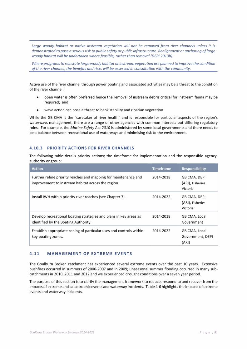
Goulburn Broken Waterway Strategy 2014-2022 P a g e | 81
Large woody habitat or native instream vegetation will not be removed from river channels unless it is demonstrated to pose a serious risk to public safety or public infrastructure. Realignment or anchoring of large woody habitat will be undertaken where feasible, rather than removal (DEPI 2013b).
Where programs to reinstate large woody habitat or instream vegetation are planned to improve the condition of the river channel, the benefits and risks will be assessed in consultation with the community.
Active use of the river channel through power boating and associated activities may be a threat to the condition of the river channel:
• open water is often preferred hence the removal of instream debris critical for instream fauna may be required; and
• wave action can pose a threat to bank stability and riparian vegetation.
While the GB CMA is the “caretaker of river health” and is responsible for particular aspects of the region’s waterways management, there are a range of other agencies with common interests but differing regulatory roles. For example, the Marine Safety Act 2010 is administered by some local governments and there needs to be a balance between recreational use of waterways and minimising risk to the environment.
4.10.3 PRIORITY ACTIONS FOR RIVER CHANNELS
The following table details priority actions; the timeframe for implementation and the responsible agency, authority or group:
Action Timeframe Responsibility
Further refine priority reaches and mapping for maintenance and improvement to instream habitat across the region.
2014-2018 GB CMA, DEPI (ARI), Fisheries Victoria
Install IWH within priority river reaches (see Chapter 7). 2014-2022 GB CMA, DEPI (ARI), Fisheries Victoria
Develop recreational boating strategies and plans in key areas as identified by the Boating Authority.
2014-2018 GB CMA, Local Government
Establish appropriate zoning of particular uses and controls within key boating zones.
2014-2022 GB CMA, Local Government, DEPI (ARI)
4 .11 M A NAG E MEN T O F EXT RE M E E VE NT S
The Goulburn Broken catchment has experienced several extreme events over the past 10 years. Extensive bushfires occurred in summers of 2006-2007 and in 2009; unseasonal summer flooding occurred in many sub-catchments in 2010, 2011 and 2012 and we experienced drought conditions over a seven year period.
The purpose of this section is to clarify the management framework to reduce, respond to and recover from the impacts of extreme and catastrophic events and waterway incidents. Table 4-6 highlights the impacts of extreme events and waterway incidents.

Goulburn Broken Waterway Strategy 2014-2022 P a g e | 82
Table 4-6: Impacts of extreme events and waterway incidents
Event Impacts Floods • accelerated rates of river channel erosion;
• channel avulsions (the abandonment of the main river channel in favour of a new course);
• channel widening; • sedimentation, infilling of deep pools and shallow channels, and impacts on
wetlands; • loss of large woody habitat structures; • damage to waterway and environmental activities (fences, riparian vegetation
and erosion control activities); • spread of invasive species; • damage and threats to infrastructure (erosion and debris); • waste from sewage treatment facilities may enter waterways; • loss of livestock; and • reduced raw water quality.
Bushfire • increase in runoff may result in flooding; • increased sediment and nutrient loads into waterways; • nutrient increase may result in algal blooms; • increased erosion may result in sediment transport; • reduced oxygen levels can cause fish deaths; • natural breeding cycles of aquatic native species may be disrupted and
biological functions impaired; • native animal habitat destroyed; • increased risk of weed invasion; • loss of riparian vegetation through bushfire can reduce shading, thereby
increasing the water temperature of rivers or wetlands; • increase the risk of erosion in the next flood; • contamination of water storages and potable water supplies with ash,
sediment and fire retardants; • damage public infrastructure and waterway assets (fences, revegetation and
erosion control works); and • livestock deaths.
Drought • reduce pool connectivity and native fish movement; • loss of immobile aquatic species; • reduced instream water quality; and • change of riparian vegetation structure.
Waterway Incidents: Low DO blackwater and algal blooms
• reduced instream water quality; • fish deaths; and • damage to aquatic flora and fauna.
Chemical Spills • fish deaths; • damage to aquatic flora and fauna; and • water unfit for many uses (human, stock, etc.).
4.11.1 EMERGENCY MANAGEMENT ARRANGEMENTS
Floods and bushfires, along with a range of other events, may be classified as emergencies (DSE 2012). Key legislation and policies for emergency management in Victoria include the Emergency Management Act (2013), underpinned by the Emergency Management Manual Victoria, that identifies high-level roles and responsibilities for agencies involved in emergency management. Further changes to the Emergency Management Act (2013) will be made in 2014 and 2015. The Manual also contains the State Emergency Response Plan, State Relief and Recovery Plan and outlines structures for emergency planning at state and regional levels.
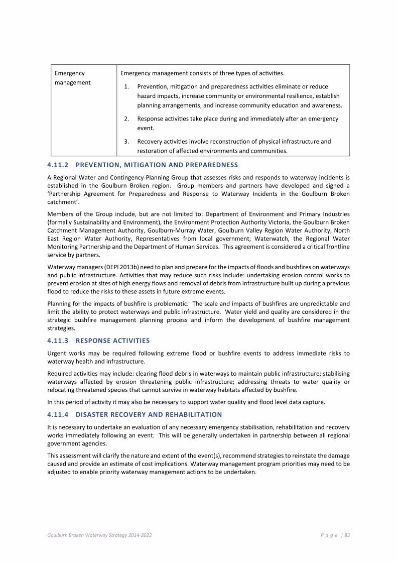
Goulburn Broken Waterway Strategy 2014-2022 P a g e | 83
Emergency management
Emergency management consists of three types of activities.
1. Prevention, mitigation and preparedness activities eliminate or reduce hazard impacts, increase community or environmental resilience, establish planning arrangements, and increase community education and awareness.
2. Response activities take place during and immediately after an emergency event.
3. Recovery activities involve reconstruction of physical infrastructure and restoration of affected environments and communities.
4.11.2 PREVENTION, MITIGATION AND PREPAREDNESS
A Regional Water and Contingency Planning Group that assesses risks and responds to waterway incidents is established in the Goulburn Broken region. Group members and partners have developed and signed a ‘Partnership Agreement for Preparedness and Response to Waterway Incidents in the Goulburn Broken catchment’.
Members of the Group include, but are not limited to: Department of Environment and Primary Industries (formally Sustainability and Environment), the Environment Protection Authority Victoria, the Goulburn Broken Catchment Management Authority, Goulburn-Murray Water, Goulburn Valley Region Water Authority, North East Region Water Authority, Representatives from local government, Waterwatch, the Regional Water Monitoring Partnership and the Department of Human Services. This agreement is considered a critical frontline service by partners.
Waterway managers (DEPI 2013b) need to plan and prepare for the impacts of floods and bushfires on waterways and public infrastructure. Activities that may reduce such risks include: undertaking erosion control works to prevent erosion at sites of high energy flows and removal of debris from infrastructure built up during a previous flood to reduce the risks to these assets in future extreme events.
Planning for the impacts of bushfire is problematic. The scale and impacts of bushfires are unpredictable and limit the ability to protect waterways and public infrastructure. Water yield and quality are considered in the strategic bushfire management planning process and inform the development of bushfire management strategies.
4.11.3 RESPONSE ACTIVITIES
Urgent works may be required following extreme flood or bushfire events to address immediate risks to waterway health and infrastructure.
Required activities may include: clearing flood debris in waterways to maintain public infrastructure; stabilising waterways affected by erosion threatening public infrastructure; addressing threats to water quality or relocating threatened species that cannot survive in waterway habitats affected by bushfire.
In this period of activity it may also be necessary to support water quality and flood level data capture.
4.11.4 DISASTER RECOVERY AND REHABILITATION
It is necessary to undertake an evaluation of any necessary emergency stabilisation, rehabilitation and recovery works immediately following an event. This will be generally undertaken in partnership between all regional government agencies.
This assessment will clarify the nature and extent of the event(s), recommend strategies to reinstate the damage caused and provide an estimate of cost implications. Waterway management program priorities may need to be adjusted to enable priority waterway management actions to be undertaken.

Goulburn Broken Waterway Strategy 2014-2022 P a g e | 84
4.11.5 PRIORITY ACTIONS FOR MANAGEMENT OF EXTREME EVENTS
The following table details priority actions; the timeframe for implementation and the responsible agency, authority or group:
Action Timeframe Responsibility That the Regional Water and Contingency Planning Group continue to operate to plan and respond to waterway incidents.
Ongoing Regional Water Quality Partners
Provide Input to Fire Protection Plans, Fire Operation Plans and Municipal Emergency Management Plans to ensure that high value waterways are maintained.
Ongoing Catchment Management Authorities
(from Policy 15.4 VWMS) Adopt a risk-based approach to address the impacts of floods and bushfires on waterways and associated public infrastructure. Develop a program of onground works to reduce the impacts on waterways and public infrastructure from flood and bushfire. The program will be included in the regional Waterway Strategies and will constitute the disaster mitigation strategy for flood and bushfires in relation to waterways in the catchment management region.
2018 Waterway managers (Catchment Management Authorities) and regional partners
Establish a regional Planning Group to respond to emergency works and monitoring following extreme events.
2018 Waterway managers (Catchment Management Authorities) Frontline service
For natural flood and bushfire disasters, waterway managers will prepare and submit to the Department of Treasury and Finance, applications for funding in accordance with the National Natural Disaster Relief and Recovery Arrangements Determination 2011.
2014-2022 Waterway managers (Catchment Management Authorities) Frontline service
Following extreme events a review of waterway priorities will be undertaken.
as required (2022)
Waterway managers (Catchment Management Authorities) Statement of Obligations/Water Act (1989)
4 .12 I N F L UEN CE O F T H E SU R RO UN DI N G CAT CHM E NT
The condition of neighbouring catchments and land is a key driver of waterway condition (DSE 2013). Therefore management of waterway condition must consider and integrate with the management of the surrounding catchment. It is also important to integrate with related catchment management and regional programs.
Some activities occurring on the land surrounding or adjacent to waterways have a significant effect on water quality, bed and bank stability, floodplain connectivity, aquatic biodiversity and riparian vegetation (see Table 4-7).
Catchment management must consider a range of scales, from landscape, to sub-catchment through to property.
These linkages are currently recognised by the integrated catchment management framework operating within the Goulburn Broken region. While funding may often be silo-based every effort is made to integrate projects at a local scale, and to achieve multiple benefits from investment. With the proposition of RCS based funding, silos will be removed and lead to more effective integrated projects and simplified community participation.
Major management activities that influence river health are shown in Table 4-7 (DSE 2002).

Goulburn Broken Waterway Strategy 2014-2022 P a g e | 85
Table 4-7: Major land management activities that influence river health
Activity Impact on Waterway Condition Catchment clearing including urbanisation, peri-urban development and rural subdivisions
• Changed stream flows - peakier, less base flow; can increase instream erosion and sedimentation;
• Construction of dams and weirs have altered the natural hydrograph; • Increased catchment erosion hence sedimentation of streambed,
smothering biota; • Poor quality runoff causing deterioration of instream habitat; • Industrial and urban pollutants and waste have contributed to loss of water
quality; • Increased salinity levels; • Loss of wetland habitat; • Widening of channels; • Shallowing of channels; • Filling in of deep pools with sand and sediment; • Invasion of exotic biota. Riparian land and wetlands have been invaded by
aggressive exotic domestic and agricultural weeds; and • The removal of deep rooted vegetation has led to a rise in the water table,
mobilising salt stored in the soil, contributing to a reduction in water quality. Inappropriate land management
• Increased input of contaminants such as sediment, salt or nutrients, depending on land use;
• Rabbit infestation, which can damage riparian vegetation, increase erosion and hence increase sediment input;
• Loss of wetland habitat; and • Increased runoff, (containing high concentrations of nutrients including
Phosphorous (P) and Nitrogen (N)), has caused extensive rill, sheet and gully erosion.
Disposal of poor quality effluents
• Reduced habitat quality from poor water quality; • Changed species composition; and • Algal blooms.
Degradation of the frontage/riparian land
• Changed vegetation structure and species composition, especially of the understorey;
• Reduced regeneration; • Weed invasion; • Bank instability hence erosion and sediment deposition in waterways; • Reduced/no input of organic matter and snags to rivers; • Reduced quality of bank habitat for aquatic animals; • Bank erosion and sedimentation leading to changed channel shape; • Increased turbidity; • Increased water temperature; • Changes in dissolved oxygen levels in the water; • Loss of woody debris; • Channel incision; • Compaction of the soil by hoofed feet has led to a decline in the soil
structure and has contributed to the increase in runoff, further erosion, nutrification and continued river degradation; and
• Decreased interception of rainwater by riparian vegetation due to its removal.

Goulburn Broken Waterway Strategy 2014-2022 P a g e | 86
4.12.1 STRATEGIC PRIORITIES
Key strategic priorities for the management of adjacent lands for the protection of waterways over the life of this Strategy are:
1. Integrated Catchment Management (See Chapter 4.12.2)
2. Riparian Management (See Chapter 4.1)
3. Floodplain Management (See Chapter 4.5)
4. Protection of Water Quality (See Chapter 4.2)
5. Planning (Property, Local and Catchment Scale, See Chapter 4.12.3)
6. Water Savings (See Chapter 4.12.4)
7. Integrated Water Cycle Management (See Chapter 4.12.5)
4.12.2 INTEGRATED CATCHMENT MANAGEMENT
Integrated catchment management is the co-ordinated involvement of agencies, stakeholders and the catchment community in policy making, planning, and management to protect the resilience of the catchment. Integrated catchment management recognises the intrinsic linkages between land use in catchments and subsequent impacts on land, water and biodiversity and seeks a holistic approach to their management.
The Waterway Program will be integrated with other key regional programs based on the seven Social Ecological Systems (SESs) or landscapes: Agricultural Floodplains; Productive Plains; Commuting Hills; Upland Slopes; Southern Forests; Urban and catchment wide. The planning framework for the catchment is shown in Figure 4-3.

Goulburn Broken Waterway Strategy 2014-2022 P a g e | 87
Figure 4-3: Integrated Catchment Planning (Catchment to SES) (source Goulburn Broken Regional Catchment Strategy)
4.12.3 PLANNING
Catchment and regional scale
While much can be undertaken to maintain or improve the condition of our waterways, management must consider the broader context of the entire catchment.
The Department of Planning and Community Development (DPCD) is responsible for land use planning and environmental assessment in Victoria. This includes managing the regulatory framework and providing advice on planning policy, strategic planning and urban design.
Under Victoria’s planning system, local councils and the Victorian Government develop planning schemes to control land use and development, and to ensure the protection and conservation of land.
Sub-regional scale
Sub-regional scale planning will be undertaken through the development of SES Integration Plans, which will be promoted by the CMA.
Local scale
Local scale planning will be implemented through the Whole Farm Planning (WFP) process of planning, property design and management based on natural resources and economic factors.
Whole farm planning focuses on all of the farm assets (physical and nonphysical) over a long period of time (perhaps several generations). WFP incorporates the knowledge and skills to be able to plan such aspects as a sub-division, irrigation layouts, assess land capability and potential of a farm.

Goulburn Broken Waterway Strategy 2014-2022 P a g e | 88
Key components of a Whole Farm Plan include: land classing, soils, farm water supply, biodiversity, pest plants and animals, pastures, succession planning, waterway assets, grazing management, drought management, prioritising works, identifying threats and assets, cropping techniques, tillage and development of realistic action plans.
4.12.4 WATER SAVINGS
The Farm Water Program began in 2009 as a result of a consortium of Northern Victorian agencies and industry organisations (led by the GB CMA) developing a funding proposal to help irrigators achieve farm water savings through improved farm irrigation systems.
Water savings are shared between farmers and the environment, with at least half the water savings transferred to the Victorian or (mainly) Commonwealth environmental water holder. This means more water is also available to protect and restore waterway health, which in turn builds the resilience of the catchment’s waterways and secures supply for domestic, industrial and agricultural use.
More efficient water delivery systems (on and off farm) reduce groundwater accessions and nutrient runoff and help address re-emerging salinity and water table issues in the catchment’s Agricultural Floodplains.
Types of farm works funded include improving border-check irrigation by lasering, reuse systems, outlet automation, appropriate flows, farm channel reconnections, installing pipes and risers, installing scheduling equipment, including soil, plant or weather monitoring systems to calculate water needs; and conversion of border check irrigation to a pressurised system including centre pivot, linear move, fixed sprinkler or surface and sub-surface drip.
There are several features of the Farm Water Program that ensure best practice (and reduce risk). These are:
• works are based on robust Whole Farm Plans (these have been undertaken across the region for more than 20 years);
• water savings are based on a water-savings calculator, developed from research over the past 20 years;
• costings are based on quoted costs and checked against regional industry standards;
• the Farm Water Program includes all the main partners in water management in Northern Victoria including Northern Victoria Irrigators, Dairy Australia, North Central CMA, North East CMA, Goulburn-Murray Water, DEPI and Goulburn Broken CMA (lead partner); and
• there are synergies with the irrigation modernisation program and land and water management plans.
The program has significant flow on effects for local economies across the Goulburn-Murray Water services area, creating jobs, boosting industry confidence and maintaining social vigour.
To date, more than $200 million has been secured from a range of sources: the Australian Government’s On Farm Irrigation Efficiency Program ($46 million); the former Northern Victorian Irrigation Renewal Project ($16 million); the Victorian On Farm State Priority Project ($45 million) and the Victorian Farm Modernisation Project (up to $100 million delivered in three tranches).
The program is being delivered in three rounds. Round 1 (148 projects worth $35 million, saved a total of 18 GL) was completed in March 2013 and Round 2 (234 projects, worth $61 million, will save a total of 33 GL) is due to be completed by March 2014. Expressions of interest for Round 3 (worth $30 million) closed in 2013/2014.
4.12.5 INTEGRATED WATER CYCLE MANAGEMENT (IWCM)
New pressures are placed on the management of our precious water resources as the region’s urban centres develop and Melbourne’s Growth Corridor extends northwards into the region. Increased growth places additional pressures on drinking water supplies, the quality and quantity of storm water runoff, drainage networks, and wastewater management facilities. All of these pressures will potentially impact on waterway health, the environment and the liveability of our communities and the impacts may be exacerbated by climate variability.
The Living Victoria systems analysis approach has been used to inform the development and publication of a new water cycle planning framework for metropolitan Melbourne, “Melbourne’s Water Future” based on Integrated

Goulburn Broken Waterway Strategy 2014-2022 P a g e | 89
Water Cycle Management principles. Similar spatial analysis and systems modelling in regional Victoria is expected to provide a template for Integrated Water Cycle Management in the regions.
The development of these regional frameworks will be co-ordinated by the Office of Living Victoria. The Office of Living Victoria (OLV) proposes to work with key regional stakeholders, water authorities, local government, catchment management authorities, regulators, the development industry, and all other identified stakeholders to improve the water efficiency and liveability of existing and new communities.
A whole of water cycle planning and management approach in new urban developments and the urban infill/redevelopment of existing towns can ensure there is sufficient fit for purposes water for the community and the environment.
Benefits of the program include:
• Water quality (Refer to Water Quality Chapter 4.2);
• Environmental Flows;
• A community engaged in whole of water cycle management;
• Suburbs old and new designed with water in mind;
• Sensible use of water in our homes, gardens, community facilities and businesses;
• Resilient water systems;
• Improved natural waterways; and
• Reduced inefficiency and waste.
Some elements identified in the development of Melbourne’s Water Future that may translate to rural areas include but are not limited to: the use of rainwater tanks on lots to mitigate storm water runoff, the use of rain water tanks to provide water supplies for non-potable uses such as toilet flushing, washing machines and gardens, better utilisation of stormwater through rain gardens, swale drains and nature strips, using existing and constructed wetlands to act as bio-filters, improving water quality before reuse or return to stream, commercial building reuse of water from roof surfaces and paved areas, sports clubs redirecting stormwater to their grounds, and consideration of purple pipes (recycled water) for substitution for non-potable and industrial uses.
4.12.6 ENGAGEMENT AND PARTICIPATION OF OUR COMMUNITY
Private landowners, including farmers, landowners and absentee landowners, are the largest group of stakeholders that can bring about improvements to our catchments and waterways.
Our community gains a more productive landscape and a healthier environment through the implementation of best practice property management. The implementation of best practice often follows financial support through incentives and grants. This follows the decision by the relevant authority that there is an appropriate level of landowner support and capacity to implement best practice.
It is important that the landowners not only recognise their responsibilities but also that adopting best management practices can lead to improvements to their bottom line.
Community engagement needs to be inclusive and involve (but not limited to): anglers, sporting clubs, community groups and clubs, field naturalists, sporting shooters, etc.
Goulburn Broken Waterway Strategy 2014-2022 P a g e | 90
4.12.7 SALINITY MANAGEMENT AND WATERWAY HEALTH
The management of salt within the landscape and the related threat to the region’s wetlands and waterways is recognised as one of the critical aspects of the overall natural health of the Goulburn Broken catchment.
The GB CMA, with support of its regional partners and the Victorian government, manages salt impacts in accordance with the Murray-Darling Basin Salinity Management Strategy. This involves regular monitoring and analysing of surface drainage systems, stream flows and groundwater pumping activities to estimate the salinity impacts of regional activities. The quantity and quality of stream flows is monitored at key locations across the catchment to allow the separation of salinity sources on the key rivers and streams.
The management of salt flows to the River Murray, as the key recipient of flows, is the cornerstone of the planning and operation of the various salinity programs across the Basin. The co-ordinated management approach is reliant on continued monitoring and reporting to allow trends, changes and key threats and opportunities to be identified and addressed.
The GB CMA will need to review its salinity accountability arrangements to ensure salinity impacts remain within acceptable levels under the new Murray-Darling Basin Plan Water Quality and Salinity Management Plan.
4.12.8 PRIORITY ACTIONS, INFLUENCE OF THE SURROUNDING CATCHMENT
The following table details priority actions; the timeframe for implementation and the responsible agency, authority or group:
Action Timeframe Responsibility Facilitate adoption and implementation of IWCM principles in the region. Develop and implement IWCM projects.
2015-2019 GB CMA, Water Corporations (Goulburn Valley Water) and Municipalities
Progress partnership approach to establish programs that leads to a reduction in water use across the catchment.
2014-2022 GB CMA, Water Corporations (Goulburn Valley Water) and Municipalities
Promote best practice: multi-benefit gaining a more productive landscape and a healthier environment within the Communications Strategy (see Chapter 8).
2015-2021 DEPI, GB CMA and Landcare
Include waterways as key features (in all levels of planning) within Local Planning including Whole Farm Plans.
2015-2021 DEPI, GB CMA, Landowners and Landcare
Provide protection for key waterways through Land Use Planning.
2015-2021 Local Government, DEPI, GB CMA
4 .13 P O T EN T I A L I MP ACT S A ND A DA PT I ON T O CL I MAT E C HANG E
It is generally accepted (Dyer et al. 2012) that the climate is changing and it is predicted that major changes to runoff, stream flow and water quality will result. These changes are likely to leave freshwater ecosystems exposed to increased risk of degradation.
Evidence now suggests that most of the warming observed in the last 50 years is due to human activities (DSE 2012; http://www.climatechange.vic.gov.au/what-is-climate-change).
Climate change has the potential to adversely impact our environment, our communities and our economy. It is widely considered that as a community we need to take action now to reduce our greenhouse gas emissions and prepare for the potential impacts of climate change.
Climate change may potentially alter global and local climates. In Victoria, this could mean a warmer and drier future, with an increasing likelihood of more extreme events such as heatwaves, bushfires and storm surges.
This Chapter details how potential climate change is to be considered into the future to maintain and improve the condition of waterway values.

Goulburn Broken Waterway Strategy 2014-2022 P a g e | 91
4.13.1 PREDICTIONS
The future climate of the Goulburn Broken region is expected to be hotter and drier than it is today (DSE 2008b). By 2030, average annual temperatures will be around 0.8°C warmer but the greatest increases are expected in spring and summer (0.9°C). The number of hot days (days over 30°C) is also expected to increase. Reductions in the total average annual rainfall of around 3% are expected, with the greatest reductions occurring in spring (7%). Increases in potential evaporation and reductions in relative humidity are expected to contribute to drier conditions. More frequent extreme events such as extreme rainfall, bushfires and droughts are expected (DSE 2008b).
The scenarios and assessment of impacts are shown in Table 4-8:
Table 4-8: Summary of projected annual climate changes for the Goulburn Broken region relative to 1990 (80% confidence range)
Season Attribute 2030 2070 (lower emissions)
Annual Average Temperature +0.9°C (0.6 to 1.2°C) +1.5°C (1.0 to 2.0°C)
Average rainfall (%) -3% (-9% to +1%) -6% (-14% to +2%)
Potential Evaporation (%) +3% (1 to 5%) +4% (1 to 8%)
Wind Speed (%) -1% (-6 to +4%) -1% (-10 to +6%)
Relative Humidity (%) -0.7% (-1.5 to -0.1%) -1.2% (-2.4 to -0.1%)
Solar Radiation (%) +0.8% (no change to +1.9%) +1.3% (no change to +3.1%)
For further information see: Climate Change in Goulburn Broken document.
4.13.3 POTENTIAL IMPACTS OF CLIMATE CHANGE
Victoria’s communities, industries and environment are likely to be impacted by climate change. The difficulty is, and will remain for some time, uncertainty over the scale and timing of climate change impacts. However, a high level of variability is certain (DSE 2012a).
With the additional effects of climate change, human influences will become even more severe as ecosystems are progressively exposed to greater risk.
Preliminary research (DSE 2012a) suggests climate change is already impacting on Victoria’s plants and animals. Many of Victoria's ecosystems have a limited ability to adapt to climate change (DSE, 2012a). Those restricted to small geographic areas, or unable to migrate fast enough to keep pace with shifting climatic zones, will be particularly vulnerable. However, some ecosystems and species will be advantaged or unaffected by climate change.
Projected drying trends over much of Victoria will render water resources increasingly vulnerable (DSE 2012a). At the same time, population increases will increase demand for water.
These impacts could be, however, offset if we get more rain in summer although intense storm events are likely to impact on water quality attributes such as turbidity, sedimentation and blackwater. An initial planning process was undertaken by the CMA, research institutions and partner agencies to identify the current threats and predict if climate change will alter the level of threat to assets and the resilience of the region. The outcome of this work is shown in Table 4-9, where each threat is considered and the suggested impact of climate change is categorised (i.e. increased level of threat, decreased level of threat, no change).

Goulburn Broken Waterway Strategy 2014-2022 P a g e | 92
Table 4-9: Climate change, influence on threat levels and management strategies (adaptation)
Prediction (Goulburn Broken region)
Thre
at (A
VIRA
)
Threat Association to prediction
Threat (under Climate Change prediction)
Strategy
A. Annual warming of 0.3 to 1.6°C by 2030 and 0.8 to 5.0°C by 2070
B. Daytime maximum temperatures and night time minimum temperatures are likely to rise at a similar rate
C. Warming is likely to be greater in spring and summer
D. 10-60% increase in the number of hot summer days (35°C) by 2030 and a 20-300% increase by 2070 on the plains. Rate of increase will be greater in the mountains
E. 0-50% reduction in the number of frost days by 2030 and a 50-100% decrease by 2070
F. Annual rainfall decreases are likely (changes of +3% to -10% by 2030 and +10 to -25% by 2070)
G. Extreme daily rainfall events are likely to become more intense.
H. Area with at least 1 day snow cover per year likely to be reduced 10-40% by 2030 with 22-85% by 2050
I. Area with at least 60 days snow cover shrinks 18-60% by 2020 and 38-96% by 2050
J. At Mt Hotham, peak snow depth declines 10-50% by 2020 and 25-95% by 2050
K. Droughts are likely to become longer and more frequent, particularly in winter-spring
L. Rainfall deficiencies that currently occur once every 5 winter springs may occur once every 3-5 years by 2030 and once every 2-3 years by 2070
M. Due to hotter conditions droughts are also more likely to become more intense
N. 10-40% increase in the frequency of days with extreme fire-weather risk by 2020, and 20-120% increase by 2050
O. 4-25% increase in the frequency of days with very high and extreme fire-weather risk by 2020, and 15-70% increase by 2050
ALTE
RED
WAT
ER R
EGIM
ES
Increase in Low Flow Frequency F,K,L,M increase Environmental Flows
Reduction in High Flow Frequency F,K,L,M increase Environmental Flows, Modify Barriers,
Floodplain Connectivity
Increase in Proportion of Zero Flow F,K,L,M increase Environmental Flows
Change in Monthly Stream flow Variability F,K,L,M increase Environmental Flows, Fish Migration
Altered Stream flow Seasonality F,K,L,M increase Environmental Flows, Fish Migration
ALTE
RED
PHYS
ICAL
FO
RM Bank Instability F,K,L,M,N,G increase Riparian and Frontage Management,
Erosion Control
Bed Instability (Degradation) F,K,L,M,N,G increase Riparian and Frontage Management,
Erosion Control
POO
R W
ATER
QUA
LITY
Degraded Water Quality N,OM,K,L,F slight
increase Water Quality Improvement/Protection
Thermal Water Pollution N same
Riparian and Frontage Management, Erosion Control, Catchment Management (point and diffuse source)
Disturbance of Acid Sulphate Soils same Riparian and Frontage Management,
Catchment Management
DEGR
ADED
HAB
ITAT
S
Degraded Riparian Vegetation
A,D,F,K,L,M,F increase Riparian and Frontage Management
Loss of Instream Habitat F,K,L,M,G same Riparian and Frontage Management,
Habitat Management (instream)
Sedimentation F,K,L,M slight
increase
Riparian and Frontage Management, Erosion Control, Catchment Management (point and diffuse source)
Livestock Access same Stock Exclusion/management (Riparian and Frontage Management)
POW
ER
Hydro-Electricity K same
INVA
SIVE
FLO
RA A
ND
FAU
NA
Invasive Flora (Riparian) F,K,L,M increase
Stock Exclusion/management (Riparian and Frontage Management), Water Quality protection
Invasive Flora (Aquatic) F,K,L,M increase
Invasive Fauna (Terrestrial) F,K,L,M increase
Invasive Fauna (Aquatic) F,K,L,M increase
REDU
CED
CON
NEC
TIVI
TY Barriers to Fish
Migration F,K,L,M,G increase Reconnect floodplains, Modify Barriers
Reduced Riparian Connectivity F,K,L,M,G increase Reconnect floodplains
Reduced Floodplain Connectivity F,K,L,M increase Environmental Flows, Reconnect
floodplains

Goulburn Broken Waterway Strategy 2014-2022 P a g e | 93
4.13.3 VICTORIAN CLIMATE CHANGE ADAPTATION PLAN
This first Victorian Government Climate Change Adaptation Plan (Victorian Government 2013) was tabled in Parliament in 2013 and focuses on government preparedness for climate change by ensuring that:
• appropriate risk management strategies are in place for public assets and services;
• disaster resilience strategies are being implemented; and
• government policies and programs encourage and facilitate climate resilience and adaptive capacity across the State. The plan highlights the risk to our waterways.
Key strategies and priorities have been developed within the Plan so that consistent and clear directions are provided to adaptation planning across the Victorian Government. High level strategies include:
• managing risks to public assets and services;
• managing risks to natural assets and natural resource-based industries;
• building disaster resilience and integrated emergency management;
• improving access to research and information for decision-making;
• supporting private sector adaptation; and
• strengthening partnerships with local government and communities.
The Victorian Government Climate Change Adaptation Plan (Victorian Government 2013) presents adaptation programs to address potential climate change risks to the Hume region.
4.13.4 POSITION OF THE GOULBURN BROKEN CATCHMENT MANAGEMENT AUTHORITY
The Goulburn Broken Climate Change Integration Strategy (GB CMA 2012) provides a framework for implementing the Goulburn Broken CMA climate change actions. The Authority and partners also implement State Government policies and principles.
The major recommendation was:
“In dealing with climate change and likely impacts, the Goulburn Broken CMA will focus on adaptation strategies to increase catchment resilience; greenhouse gas sequestration activity such as carbon brokering will be engaged for the purpose of assisting adaptation responses; and mitigation initiatives led by local government will be actively supported.”
The outcomes and goals for the Goulburn Broken Climate Change Integration Strategy are summarised in the Table 4-10.
Table 4-10: Goulburn Broken CMA Climate Change Integration Strategy Outcomes and Goals (linked to the Strategy)
Outcomes Goals Integrate climate change (science, risks and potential impacts) into GB CMA programs
• Sub-strategies include climate change analysis and actions as they are renewed or developed.
Improve understanding of climate change
• Adequate climate change information is available to add value to planning and investment decisions.
• Improve the Goulburn Broken CMA’s knowledge of potential impacts of climate change by initiating or partnering climate change research projects.
Pool and attract resources
• New funds will be sourced for projects through climate change funding programs by the Goulburn Broken CMA and its partners.
Build catchment resilience into sequestration activities
• Carbon sequestration activities undertaken by the GB CMA take into account and align with standards to promote resilience of the catchment.
• Encourage other government agencies and industry to take into account and align with standards to promote catchment resilience.
Support community mitigation efforts • Partner community climate change organisations or agencies.
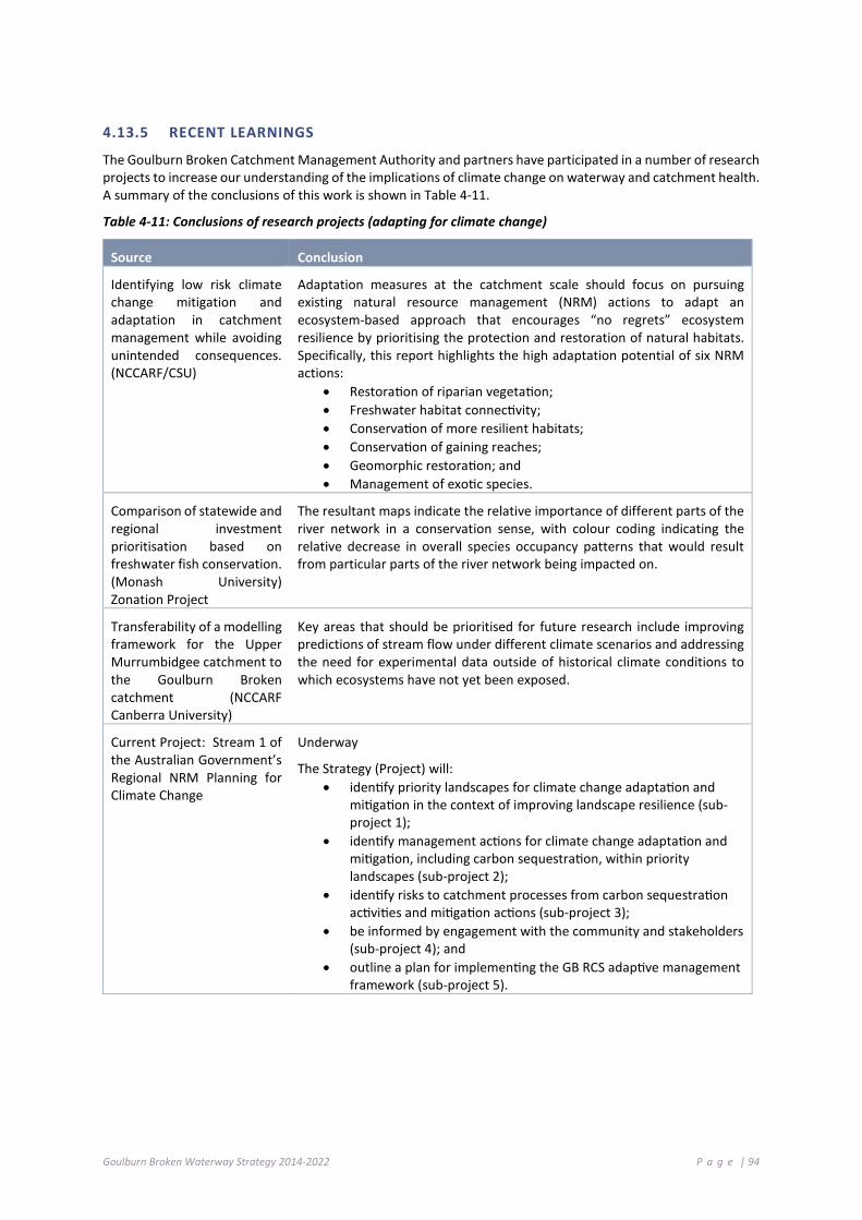
Goulburn Broken Waterway Strategy 2014-2022 P a g e | 94
4.13.5 RECENT LEARNINGS
The Goulburn Broken Catchment Management Authority and partners have participated in a number of research projects to increase our understanding of the implications of climate change on waterway and catchment health. A summary of the conclusions of this work is shown in Table 4-11.
Table 4-11: Conclusions of research projects (adapting for climate change)
Source Conclusion
Identifying low risk climate change mitigation and adaptation in catchment management while avoiding unintended consequences. (NCCARF/CSU)
Adaptation measures at the catchment scale should focus on pursuing existing natural resource management (NRM) actions to adapt an ecosystem-based approach that encourages “no regrets” ecosystem resilience by prioritising the protection and restoration of natural habitats. Specifically, this report highlights the high adaptation potential of six NRM actions:
• Restoration of riparian vegetation; • Freshwater habitat connectivity; • Conservation of more resilient habitats; • Conservation of gaining reaches; • Geomorphic restoration; and • Management of exotic species.
Comparison of statewide and regional investment prioritisation based on freshwater fish conservation. (Monash University) Zonation Project
The resultant maps indicate the relative importance of different parts of the river network in a conservation sense, with colour coding indicating the relative decrease in overall species occupancy patterns that would result from particular parts of the river network being impacted on.
Transferability of a modelling framework for the Upper Murrumbidgee catchment to the Goulburn Broken catchment (NCCARF Canberra University)
Key areas that should be prioritised for future research include improving predictions of stream flow under different climate scenarios and addressing the need for experimental data outside of historical climate conditions to which ecosystems have not yet been exposed.
Current Project: Stream 1 of the Australian Government’s Regional NRM Planning for Climate Change
Underway
The Strategy (Project) will: • identify priority landscapes for climate change adaptation and
mitigation in the context of improving landscape resilience (sub-project 1);
• identify management actions for climate change adaptation and mitigation, including carbon sequestration, within priority landscapes (sub-project 2);
• identify risks to catchment processes from carbon sequestration activities and mitigation actions (sub-project 3);
• be informed by engagement with the community and stakeholders (sub-project 4); and
• outline a plan for implementing the GB RCS adaptive management framework (sub-project 5).

Goulburn Broken Waterway Strategy 2014-2022 P a g e | 95
4.13.6 PRIORITY ACTIONS FOR POTENTIAL CLIMATE CHANGE MANAGEMENT AND ADAPTATION
In implementing this Strategy the following key actions are recommended, when considering the outcome of recent research and considering the influence of key threats to aquatic environments.
The following table details priority actions; the timeframe for implementation and the responsible agency, authority or group:
Action Timeframe Responsibility
Increase awareness of the impact of potential climate change and adaptation options.
2014-2022 GB CMA, DEPI
Increase awareness of the impact of climate change on threats and resilience of systems at a range of scales.
2014-2022 GB CMA, DEPI
Accelerate the rate of riparian maintenance and improvement works and water regime management in priority waterways.
2014-2022 GB CMA, Community
Accelerate the rate and encourage broad land-based improvement works and actions (erosion and sediment control).
2014-2022 DEPI, Community
Refine and maintain critical aquatic dependent refugia (consider Zonation Project).
2014-2022 GB CMA, DEPI (ARI), Community
Model likely vegetation changes under climate change scenarios for waterway zone (by SES).
2014-2022 Research Organisations, DEPI
Plan (as required) for environmental watering and associated works in compensating for reduced frequency and duration of flooding under climate change.
2014-2022 GB CMA
Reduce flow thresholds to priority floodplain wetlands (identifying these) to restore flooding frequency at lower river levels.
2014-2022 GB CMA
4 .14 M A NAG E MEN T AND U S E O F W AT E R S T ORA G E S
A number of major storages exist within the catchment for the purpose of harnessing and delivery of water. Many of these are located on stream (i.e. Lake Eildon, Goulburn Weir, Waranga Basin and Lake Nillahcootie). The management of these lake systems are under the control of Goulburn-Murray Water. Many waterways provide multiple purposes (i.e. environmental, cultural) and are utilised for social and economic values (see Chapters 4.2 and 4.3).
Where recreational activities occur on water storages (DEPI 2013b) that could threaten waterway condition, the relevant waterway manager/land manager will identify and manage those risks, where possible.
Water storages are key sites of on-water recreation and tourism as well as being critical infrastructure for supporting the region’s primary agriculture and industries, and in some instances, for providing minor flood mitigation.
Land and On-water Management Plans have been prepared for Lake Eildon, Nagambie Waterways, Lake Nillahcootie and Lake Mulwala within the Goulburn Broken catchment. These ‘Plans’ provide a strategic approach to the management of land and on-water issues. The intent of the plans is to better manage increasing pressures on the important values of the lakes and associated foreshores, including community awareness and involvement, recreation, public access and safe use, environmental and cultural heritage and public land management. Implementation of the Land and On-water Management Plans will address a range of threats to the storages, and in turn, protect key community, environmental and cultural values.
Operation of these storages can, at times, be a key threat to some values within receiving waters (see Chapters 6 and 7). Management of these storages need to recognise these values and minimise the effect on them.

Goulburn Broken Waterway Strategy 2014-2022 P a g e | 96
Goulburn River (Seymour, 1958); Goulburn River (Seymour, 1958); Ryans Creek (1939); Goulburn River (Seymour, 1947); Hughes Creek (Avenel); Howqua River (1959); Historic photos of Victoria’s internal waterways Our River Heritage - Our Water Our Future
Goulburn Broken Waterway Strategy 2014-2022 P a g e | 97

Goulburn Broken Waterway Strategy 2014-2022 P a g e | 98
Overview of Approach This Chapter:
Sets out the approach taken in the development of the Strategy; and
Sets out the approach to the identification of priority waterways
5 .1 . O V E R VI E W O F A PP ROA CH
This Strategy was prepared in accordance with the requirements of the Victorian Waterway Management Strategy (DEPI 2013b, d). The development of the Strategy has involved a range of processes and has included information and input from the Regional Catchment Strategy (2013) planning process, regional planning group processes and the community. The Strategy has been developed to provide implementation detail to the high-level outcomes within the Regional Catchment Strategy.
This Strategy incorporates the following key elements:
Gather data and information(AVIRA, community input, local knowledge)
Develop Waterway Strategy Goals
Identify High Value Waterways (Filter 1)
Identify waterways with values relating to regional goals(Filter 2)
Identify threats to waterway values and assess level of risk(Filter 3)
Identify management activites and targets for priority waterways(assess feasibility and cost effectiveness of management activities)
Develop regional work program and targets for eight year period

Goulburn Broken Waterway Strategy 2014-2022 P a g e | 99
5 .2 P R OG RA M L OGI C
Program logic is a commonly used planning approach in NRM that uses a diagram to demonstrate the rationale for a program and express how change is expected to occur.
Program logic provides the rationale for how the Strategy will contribute to the vision for Victoria’s waterways, as identified in the Victorian Waterway Management Strategy (DEPI 2013b) and the Goulburn Broken region’s vision, as identified in the Goulburn Broken Regional Catchment Strategy (GB CMA 2013). (See Section 5.3)
The simplified program logic for the Strategy is illustrated in Figure 5-1. It describes how each year, specific management activities and outputs are delivered by regional agencies to achieve particular management outcomes. Over the eight-year planning period, these outputs and outcomes collectively contribute to either maintaining or improving the environmental condition of waterways. In the long-term, this will ensure that Victoria’s waterways can continue to support environmental, social, cultural and economic values.
Figure 5-1: Program logic for Strategy

Goulburn Broken Waterway Strategy 2014-2022 P a g e | 100
5 .3 V I S I ON AN D R EGI O NAL G OA LS
This Strategy requires a vision to guide its development and set its direction.
To ensure that the Strategy links to both the Victorian Waterway Management Strategy (DEPI 2013b) and the Goulburn Broken Regional Catchment Strategy (2013), their visions were used as a starting point (section 5.2).
The Vision for Victoria’s waterways is:
Victoria’s rivers, estuaries and wetlands are healthy and well-managed; supporting environmental, social, cultural and economic values that are able to be enjoyed by all communities.
The Vision for the Goulburn Broken catchment is:
Healthy, resilient and increasingly productive landscapes supporting vibrant communities.
Based on the above, the Vision for the region’s waterways is:
Resilient Waterways, Vibrant Communities.
The waterway systems of the Goulburn Broken region are vibrant and resilient so that
communities can enjoy the values and benefits they provide and contribute to their maintenance
and improvement.
The 20 to 30 year objectives for waterways (from the Regional Catchment Strategy, 2013): Waterways Long-term objectives include:
• 350 km of river maintained in excellent or good condition;
• Ecological flow objectives met in high value reaches;
• Nutrient loads reduced or improved; • Riparian condition maintained or
improved along 550 km of river; • Instream habitat maintained or
improved along 140 km of river; and • The maintenance and improvement
of significant wetlands feature in Shepparton Irrigation Region groundwater and salt management planning (Oppy 2010).
Water quality The resource condition target is to reduce potential phosphorus loads by 65% by 2016 (GB CMA 1996). This will be achieved by reducing phosphorus loads from:
• Irrigation drains by 50%; • Dryland and diffuse sources by 20%; • Wastewater management facilities by
80%; • Urban storm water; and • Intensive agricultural industries and
local water quality issues. Floodplains
• Reduce the impact of flooding on the built environment; and
• Provide ecosystems with natural flooding patterns where appropriate.
Salinity
• Manage shallow groundwater for salinity control within the SIR by improved irrigation management on farms, improved surface water management within drainage catchments and consistently pumping groundwater with appropriate reuse over 216,000 ha;
• Keep increases to salinity levels of the River Murray at Morgan at or below 8.9EC (electrical conductivity units); and
• Ensure no net increase instream salinity in the Goulburn River upstream of Goulburn Weir.

Goulburn Broken Waterway Strategy 2014-2022 P a g e | 101
5.3.1 REGIONAL GOALS
A set of high-level goals were developed to assist in setting broad directions for management and identifying priority waterways in the Goulburn Broken region. The goals are:
• Maintain or improve the resilience of the region’s waterways;
Social
• Maintain or improve waterways of high community value;
Economic
• Maintain or improve water quality in priority water supply catchments;
Environment
• Populations of threatened aquatic dependent species will be maintained or improved including Trout cod, Macquarie perch, Murray cod, Eel tailed catfish, Barred galaxias, Golden perch, wetland-dependent threatened species and nationally threatened ecological communities (seasonal herbaceous wetlands and alpine bogs and fens);
• Barmah Forest (Ramsar site) will be managed to maintain its ecological character;
• The values associated with Heritage Rivers will be maintained or improved;
• Wetlands with formally recognised significance are maintained or improved;
• Waterways in a near natural or ecologically healthy state are retained;
Urban Waterways
Urban waterways are managed to improve environmental condition, amenity and water security.
In general, the regional goals were developed to:
• Apply to a timeframe generally longer than 20 years;
• Have a conceptual or qualitative link to management outcomes; and
• Be region wide and guide priority setting.
5 .4 A Q UAT I C V AL UE I D ENT I F I C AT I ON AND RI S K A S SE S S M E NT ( A VI R A) – T HE A S S ET - BA S ED A P PR OA CH
Threat-based approaches to natural resource management have lessened across Australia over the past decade, and have been largely replaced with asset-based approaches that focus on important natural ‘assets’, rather than on threat-based issues.
AVIRA (Aquatic Value Identification and Risk Assessment) is the framework that contains information on waterway assets and threats and applies a risk assessment process to assist in the planning for waterway management activities.

Goulburn Broken Waterway Strategy 2014-2022 P a g e | 102
AVIRA is an update of the RiVERS7 decision support tool that was used in the development of the first RRHSs and will inform the development of the RWSs across Victoria.
The AVIRA decision-support tool has been developed to replace the RiVERS decision-support tool. RiVERS was an asset inventory that documented the social, economic and environmental assets (what we now call ‘values’), and the threats to these assets (values), for rivers across the state.
AVIRA stores information on the environmental, social and economic values of rivers (see Appendix B), but will also include information on the values of selected estuary and wetland assets. For each asset, AVIRA stores information on the threats to these values and conducts an automated risk assessment for every value/threat combination. AVIRA undertakes the first four of the steps of the asset-based approach.
AVIRA was used to inform priority setting for the development of this Strategy. AVIRA also incorporated a risk-based assessment for all waterways.
The data contained in the AVIRA database is considered the best available at the time this Strategy was prepared. The list of values and threats contained in AVIRA is shown in Appendix B.
5 .5 M A NAGI NG F O R W AT E R WA Y RE S I L I EN CE
The Stockholm Resilience Centre defines resilience as “the capacity of a system, be it an individual, a forest, a city or an economy, to deal with change and continue to develop. It is about the capacity to use shocks and disturbances like a financial crisis or climate change to spur renewal and innovative thinking. Resilience thinking embraces learning, diversity and above all the belief that humans and nature are strongly coupled to the point that they should be conceived as one social-ecological system.”
By applying a resilience approach, the Strategy aims to maintain, and where possible improve, the values contained within a river or wetland system. By applying this approach the whole system will be managed, rather than an individual aspect or value, for the benefit of current and future generations.
The resilience of our waterways is dependent on achievement of the high-level outputs and outcomes identified within the Regional Catchment Strategy. These will be achieved through the delivery of the actions contained within this Strategy.
The Strategy has considered the resilience of our waterways to:
• determine if waterways are in the state in which we desire;
• determine measures required to maintain resilience; and
• determine if/which waterways are close to a tipping point.
It is clear that waterway values exist across the range of waterway states. For example, threatened species and waterway recreation exist in near natural and working rivers. The values that exist within the stream all need to be taken into account when deciding on the appropriate management strategies prior to the implementation of works. Often, not all threats need to be addressed to reach the desired condition or state.
It is clear that we need to understand the current state of the waterway and determine a desired future state to determine what management measures need to be employed.
7 RiVERS is a database application developed for the Victorian Catchment Management Authorities which was utilised to assist in developing Regional River Health Strategies and prioritising waterway management activities using a risk-based management approach.
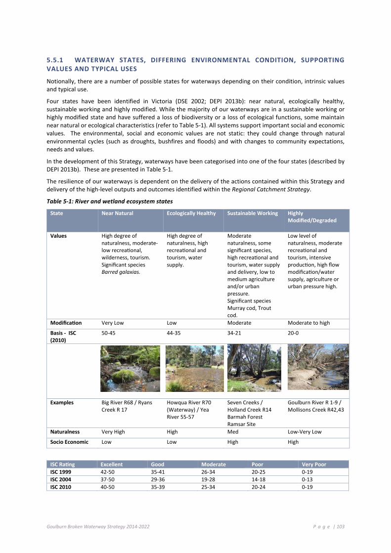
Goulburn Broken Waterway Strategy 2014-2022 P a g e | 103
5.5.1 WATERWAY STATES, DIFFERING ENVIRONMENTAL CONDITION, SUPPORTING VALUES AND TYPICAL USES
Notionally, there are a number of possible states for waterways depending on their condition, intrinsic values and typical use.
Four states have been identified in Victoria (DSE 2002; DEPI 2013b): near natural, ecologically healthy, sustainable working and highly modified. While the majority of our waterways are in a sustainable working or highly modified state and have suffered a loss of biodiversity or a loss of ecological functions, some maintain near natural or ecological characteristics (refer to Table 5-1). All systems support important social and economic values. The environmental, social and economic values are not static: they could change through natural environmental cycles (such as droughts, bushfires and floods) and with changes to community expectations, needs and values.
In the development of this Strategy, waterways have been categorised into one of the four states (described by DEPI 2013b). These are presented in Table 5-1.
The resilience of our waterways is dependent on the delivery of the actions contained within this Strategy and delivery of the high-level outputs and outcomes identified within the Regional Catchment Strategy.
Table 5-1: River and wetland ecosystem states
State Near Natural Ecologically Healthy Sustainable Working Highly Modified/Degraded
Values High degree of naturalness, moderate-low recreational, wilderness, tourism. Significant species Barred galaxias.
High degree of naturalness, high recreational and tourism, water supply.
Moderate naturalness, some significant species, high recreational and tourism, water supply and delivery, low to medium agriculture and/or urban pressure. Significant species Murray cod, Trout cod.
Low level of naturalness, moderate recreational and tourism, intensive production, high flow modification/water supply, agriculture or urban pressure high.
Modification Very Low Low Moderate Moderate to high
Basis - ISC (2010)
50-45 44-35 34-21 20-0
Examples Big River R68 / Ryans Creek R 17
Howqua River R70 (Waterway) / Yea River 55-57
Seven Creeks / Holland Creek R14 Barmah Forest Ramsar Site
Goulburn River R 1-9 / Mollisons Creek R42,43
Naturalness Very High High Med Low-Very Low
Socio Economic Low Low High High
ISC Rating Excellent Good Moderate Poor Very Poor ISC 1999 42-50 35-41 26-34 20-25 0-19 ISC 2004 37-50 29-36 19-28 14-18 0-13 ISC 2010 40-50 35-39 25-34 20-24 0-19

Goulburn Broken Waterway Strategy 2014-2022 P a g e | 104
Using the data contained within the Index of Stream Condition (ISC)8 (Appendix D) and by applying the rules from the Table above, the waterways close to “tipping point” are identified in Table 5-2. The ISC has been applied to the process of identifying and defining tipping points and states for rivers only; further work is required to evaluate tipping points and states for wetlands. Those approaching a tipping point in near natural or ecologically healthy are considered priority waterways for the development of work programs.
Table 5-2: Streams approaching a tipping point (identified by applying the ISC and condition states)
State (Current) Rules Applied Waterways9 Approaching “State”
Near Natural ISC (at 45-46) (none) Ecological Healthy
Ecologically Healthy
ISC (at 35-36) Goulburn River (5-15); Acheron River (5-62); Rubicon River (5-65); Howqua River (5-69) and Delatite River (5-72)
Sustainable Working
Sustainable Working
ISC (at 21–22) Creightons Creek (5-27); Deep Creek (5-34); Dairy Creek (5-53); Delatite River (5-71) and Kurkurac Creek (5-78)
Highly Modified
Waterways within the region have been subjected to many shocks over the past decade including drought, bushfire and flood. Overall, they have been remarkably resilient to these pressures. Key drivers likely to impact on the region’s waterways over the life of this Strategy include floods and bushfire (Table 5-3). These key shocks are unlikely to see our waterways approach a tipping point and move to an alternative state, in the life of this Strategy.
For each waterway within AVIRA a state has been assigned based on the Index of Stream Condition. These states are shown in Appendix D.
5.5.2 PRIORITY ACTION FOR TIPPING POINTS
Table 5-3 summarises the key characteristics of each stream condition state and describes the key shocks, drivers and thresholds or tipping points for each system.
There remains many knowledge gaps in waterway resilience, specifically relating condition, trends and their associated tipping points. Improvement of these knowledge gaps is a priority and will be undertaken as resources are identified during the life of this Strategy.
The following table details priority actions; the timeframe for implementation and the responsible agency, authority or group:
Action Timeframe Responsibility
Further refine States and Tipping points at SES, reach and asset scales for waterways.
2015 GB CMA, Educational Institutions, Researchers
Improve resilience of those waterways and approaching a “tipping point” based on the ISC through delivery of priority actions in Chapter 7.
2014-2022 GB CMA, GMW, Parks Victoria, Municipal Government, DEPI (regional), Community
8 The 2004 and 2010 ISC results cannot be directly compared due to the different methodology that has been employed. 9 An assessment of wetlands was incomplete and will be developed over time.

Goulburn Broken Waterway Strategy 2014-2022 P a g e | 105
Table 5-3: States, Shocks, Drivers and Tipping Points
State Key Characteristics Main values delivered
Near Natural/
Pristine
• all plant and animal species in the waterway or wetland are native (no exotic species exists within the system);
• natural ecosystem processes are maintained; • major natural habitat features are represented and are
maintained over time; and • native riparian vegetation communities exist sustainably
for the majority of its length.
Good water quality, aesthetics, native flora and fauna, cultural, natural Flow (quantity), refugia.
Shocks Drivers Thresholds
Fire/Drought • Climate
Encroachment of pest plants, pest animals.
State Key Characteristics Main values delivered
Near Ecologically Healthy
• the majority of plant and animal species in the waterway or wetland are native (minimal exotic species exists in the system);
• natural ecosystem processes are maintained; • major natural habitat features are represented and are
maintained over time; and • native riparian vegetation communities exist sustainably
for the majority of its length.
Good water quality, aesthetics, native flora and fauna, exotic flora and fauna, cultural.
Shocks Drivers Thresholds Fire, Floods, Drought
• Climate, land development, population, land use intensification
Changed channel hydrology, channel modification, changed riparian/adjacent land use.
State Key Characteristics Main values delivered Sustainable/ Working
• native and exotic plant and animal species are present in the waterway or wetland;
• major natural habitat features are modified; • linkages between river and floodplain and associated
wetlands; are often modified; • native riparian vegetation communities modified for
majority of its length; • adjacent land use modified; and • flow regimes slightly to highly modified.
Tourism/recreation, provision of water supply, native and exotic flora and fauna, cultural.
Shocks Drivers Thresholds Fire. Floods, Drought, Salinisation, Inappropriate water regimes, Water Quality Shocks (DO, Algae, etc.)
• Climate, land development, population, land use intensification.
Land use change, channel modification, changes to flow regimes, changes to riparian land.
State Key Characteristics Main values delivered Highly Modified/ Degraded
• native plants have been highly modified/removed or dominated by exotic species in the waterway or wetland;
• natural ecosystem processes are highly modified; • major natural habitat features are highly modified; • linkages between river and floodplain and associated
wetlands are highly modified; • adjacent land use highly modified; and • flow regimes are highly modified.
Tourism/recreation, provision of water supply, cultural, heritage, urban recreation.

Goulburn Broken Waterway Strategy 2014-2022 P a g e | 106
Priority Setting This Chapter:
Sets out the approach taken to establish priority waterways within the Strategy
6 .1 I DE NT I F YI NG P RI OR I T Y W AT E R WA Y S
Waterways within the Goulburn Broken region provide our community with an immense array of values. These include environmental (e.g. native fish, vegetation), economic (e.g. water supply, supporting agriculture and production), cultural and social (e.g. recreation, aesthetics). A number of existing threats could potentially impact on these values.
While we would like to rehabilitate all waterways in the region, we don’t have the necessary resources (people, dollars, time) to complete such a task. Therefore, we have to find some way of allocating the available resources to the region’s highest priority waterways.
The key objective of the Strategy is to identify priority waterways for investment over the next eight years to ensure we maintain the resilience of these systems to support or improve the values they provide.
6 .2 D E FI NI NG WAT ER W AY S
6.2.1 ASSETS
Identification and ranking of priority waterways was informed by the Aquatic Value Identification and Risk Assessment (AVIRA) decision support tool (refer to Appendix B). AVIRA is an asset inventory, which:
• documents the environmental, social and economic values and threats associated with waterway assets (river reaches, wetlands and estuaries); and
• assesses risks to values to assist in planning for waterway management activities.
For the Goulburn Broken region, 117 river reaches and 158 wetlands were assessed using data from the third ISC (Index of Stream Condition) and IWC (Index of Wetland Condition). This data was considered the best and most comprehensive information available at the time the Strategy was prepared.

Goulburn Broken Waterway Strategy 2014-2022 P a g e | 107
6 .3 I DE NT I F YI NG HI G H VA L UE WAT ER W AY S
The Victorian Waterway Management Strategy (DEPI 2013b) states that waterways will be considered high value if they have one, or more, of the following characteristics:
• formally recognised significance;
• presence of highly threatened or rare species and communities;
• high naturalness values (for example, aquatic invertebrate communities and riparian vegetation) or special waterway features (for example, drought refuges and important bird habitat); and
• high social, cultural and economic values (for example, recreational fishing, Aboriginal cultural heritage, urban/rural water sources).
For waterway assets in AVIRA, the above characteristics can be assessed using specific scoring rules as detailed in Appendix C. If a waterway meets one or more of these scoring rules, it is considered to be a high value waterway. Thus:
• all 117 river reaches in the Goulburn Broken region were identified as high value waterways; and
• 114 of 158 wetlands in the Goulburn Broken region were identified as high value wetlands.
These results are summarised by SES (Landscape) in Appendix E and summarised by SES (Landscape) in Table 6-1.
Table 6-1: High value waterways and wetlands by SES in the Goulburn Broken region
Socio-Ecological System Number of High Value Waterways Number of High Value Wetlands
Agricultural Floodplains 18 90
Productive Plains 43 16
Upland Slopes 21 4
Commuting Hills 23
Southern Forests 12 3
TOTAL 117 113
6 .4 P RI O RI T Y WA T E R WAY S
As shown in Table 6-1, a high number of waterways within the region were identified as high value waterways. However, to develop a realistic eight-year regional work program, the number of waterways must be reduced and prioritised.
The approach adopted was to identify which high value waterways aligned to the regional goals. This involved the identification of relevant and/or attributable AVIRA values and the determination of scoring cut-offs (or rules).
AVIRA rules for linking high value waterways to regional goals are detailed in Table 6-2. AVIRA rules could not be developed for the urban waterways goal.
A short list of 64 waterways from 117 high value waterways, and 15 wetlands from the list of 113 high value wetlands was developed by applying rules from regional goals (Appendix E and Appendix F).
A number of additional wetlands were included to make 23 in total, as they form part of current priority wetlands for the delivery of environmental water or the protection of threatened biota (Moodie Swamp, Tahbilk Lagoon, One Tree Swamp, Two Tree Swamp, Wallenjoe Swamp, Alpine Bogs and Stockyard Plain).
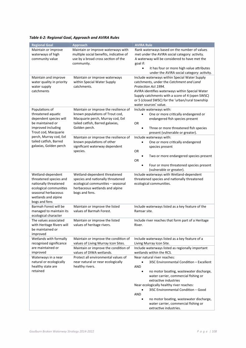
Goulburn Broken Waterway Strategy 2014-2022 P a g e | 108
Table 6-2: Regional Goal, Approach and AVIRA Rules
Regional Goal Approach AVIRA Rule Maintain or improve waterways of high community value
Maintain or improve waterways with multiple social benefits, indicative of use by a broad cross section of the community.
Rank waterways based on the number of values met under the AVIRA social category: activity. A waterway will be considered to have met the goal if:
• it has four or more high value attributes under the AVIRA social category: activity.
Maintain and improve water quality in priority water supply catchments
Maintain or improve waterways within Special Water Supply catchments.
Include waterways within Special Water Supply catchments, under the Catchment and Land Protection Act 1994. AVIRA identifies waterways within Special Water Supply catchments with a score of 4 (open SWSC) or 5 (closed SWSC) for the ‘urban/rural township water sources’ value.
Populations of threatened aquatic dependent species will be maintained or improved including Trout cod, Macquarie perch, Murray cod, Eel tailed catfish, Barred galaxias, Golden perch
Maintain or improve the resilience of known populations of Trout cod, Macquarie perch, Murray cod, Eel tailed catfish, Barred galaxias, Golden perch.
Include waterways with: • One or more critically endangered or
endangered fish species present OR
• Three or more threatened fish species present (vulnerable or greater).
Maintain or improve the resilience of known populations of other significant waterway dependent species.
Include waterways with: • One or more critically endangered
species present OR
• Two or more endangered species present OR
• Four or more threatened species present (vulnerable or greater).
Wetland-dependent threatened species and nationally threatened ecological communities seasonal herbaceous wetlands and alpine bogs and fens
Wetland-dependent threatened species and nationally threatened ecological communities – seasonal herbaceous wetlands and alpine bogs and fens.
Include waterways with Wetland-dependent threatened species and nationally threatened ecological communities.
Barmah Forest will be managed to maintain its ecological character
Maintain or improve the listed values of Barmah Forest.
Include waterways listed as a key feature of the Ramsar site.
The values associated with Heritage Rivers will be maintained or improved
Maintain or improve the listed values of heritage rivers.
Include river reaches that form part of a Heritage River.
Wetlands with formally recognised significance are maintained or improved
Maintain or improve the condition of values of Living Murray Icon Sites.
Include waterways listed as a key feature of a Living Murray Icon Site.
Maintain or improve the condition of values of DIWA wetlands.
Include waterways listed as regionally important wetlands within the RCS.
Waterways in a near natural or ecologically healthy state are retained
Protect all environmental values of near natural or near ecologically healthy rivers.
Near natural river reaches: • 3ISC Environmental Condition – Excellent
AND • no motor boating, wastewater discharge,
water carrier, commercial fishing or extractive industries
Near ecologically healthy river reaches: • 3ISC Environmental Condition – Good
AND • no motor boating, wastewater discharge,
water carrier, commercial fishing or extractive industries.

Goulburn Broken Waterway Strategy 2014-2022 P a g e | 109
6.4.1 ASSESSING RISK AND FEASIBILITY
Assessing Risks
A risk assessment is undertaken in AVIRA for each waterway. For example, for each river reach, 38 values are assessed against 22 threats, resulting in 836 risk level assessments.
For each high value waterway with links to one or more regional goals, the following approach was taken:
1. Identify all threats to high value attributes (linked to regional goals) where the recommended treatment is “Reduce Threat” (see Figure 6-1).
2. Determine a “first cut” of the feasibility (high, medium, low) of reducing each threat.
Priority for the development of the regional works program should then be given to:
• waterways with higher scores (in general these have significant value and management of the threats is feasible); and
• waterways with very low scores (in general these are waterways with minimal threats that just require maintenance).
A summary of recommended actions from the regional priority setting processes is as follows:
Figure 6-1: Summary Outcomes of the regional priority setting process
Considering Technical Feasibility
A “first cut” of the technical feasibility (high, medium, low) of reducing each threat (i.e. implementing onground actions) was determined for each identified risk. Social and/or economic factors were assessed later when developing the works program.
Calculating a Priority Waterway Score
Raw scores were calculated for each risk/feasibility combination to calculate the score for a priority waterway as follows: raw score = risk level x feasibility
where: risk level = 5–very high; 4-high; 3-moderate; 2-low; 1-very low
feasibility score = 3–high; 2–medium; 1–low.
All raw scores for a waterway were then added and the total divided by the number of raw scores calculated. This produced a Priority Waterway Score (ranging from 0-Low and 15-High) from which a priority list of waterways can be established. Once Priority Waterway Scores were calculated for each priority waterway, the waterways could be ranked from highest score to lowest score. See Appendix K for high-level results (risk and feasibility).
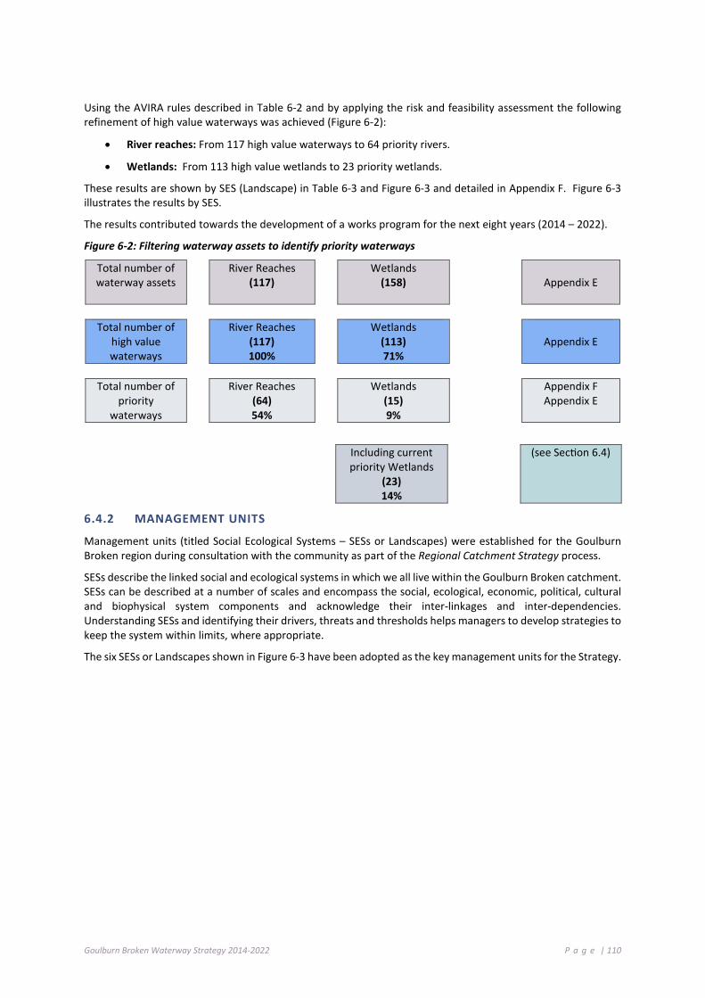
Goulburn Broken Waterway Strategy 2014-2022 P a g e | 110
Using the AVIRA rules described in Table 6-2 and by applying the risk and feasibility assessment the following refinement of high value waterways was achieved (Figure 6-2):
• River reaches: From 117 high value waterways to 64 priority rivers.
• Wetlands: From 113 high value wetlands to 23 priority wetlands.
These results are shown by SES (Landscape) in Table 6-3 and Figure 6-3 and detailed in Appendix F. Figure 6-3 illustrates the results by SES.
The results contributed towards the development of a works program for the next eight years (2014 – 2022).
Figure 6-2: Filtering waterway assets to identify priority waterways
Total number of waterway assets
River Reaches (117)
Wetlands (158)
Appendix E
Total number of high value waterways
River Reaches (117) 100%
Wetlands (113) 71%
Appendix E
Total number of
priority waterways
River Reaches (64) 54%
Wetlands (15) 9%
Appendix F Appendix E
Including current
priority Wetlands (23) 14%
(see Section 6.4)
6.4.2 MANAGEMENT UNITS
Management units (titled Social Ecological Systems – SESs or Landscapes) were established for the Goulburn Broken region during consultation with the community as part of the Regional Catchment Strategy process.
SESs describe the linked social and ecological systems in which we all live within the Goulburn Broken catchment. SESs can be described at a number of scales and encompass the social, ecological, economic, political, cultural and biophysical system components and acknowledge their inter-linkages and inter-dependencies. Understanding SESs and identifying their drivers, threats and thresholds helps managers to develop strategies to keep the system within limits, where appropriate.
The six SESs or Landscapes shown in Figure 6-3 have been adopted as the key management units for the Strategy.

Goulburn Broken Waterway Strategy 2014-2022 P a g e | 111
Figure 6-3: Priority Waterways – Example of risks and feasibilities spreadsheet
5-05 Goulburn River Priority Waterway Score #DIV/0!
Type Category Status LinkEnvironmental Formally Recognised Significance x x
RepresentativenessRare or Threatened Species/Communities x xNaturalnessLandscape Features x
Social Activity xPlacePeople x x
Economic Water xPower GenerationOther Resources
Risk Assessment
Type Value Name Value Score Goal Link Threat Name Threat Score Association Confidence Risk Level Treatment High Moderate LowEnvironmental Significant Amphibians 5 x Invasive Fauna (Aquatic) 5 High High Very High Reduce Threat LevelEnvironmental Significant EVCs 5 x Invasive Fauna (Terrestrial) 5 High High Very High Reduce Threat LevelEnvironmental Significant Fish Migratory 5 x Inc in Low Flow Magnitude 5 High High Very High Reduce Threat LevelEnvironmental Significant Fish Migratory 5 x Inc in Prop of Zero Flow 5 High High Very High Reduce Threat LevelEnvironmental Significant Fish Migratory 5 x Invasive Fauna (Aquatic) 5 High High Very High Reduce Threat LevelSocial Motor Boating 5 x Inc in Prop of Zero Flow 5 High Low Very High Reduce Threat LevelSocial Recreational Fishing 5 x Inc in Prop of Zero Flow 5 High Low Very High Reduce Threat LevelSocial Recreational Fishing 5 x Invasive Fauna (Aquatic) 5 High Low Very High Reduce Threat Level
Protect and improve the values associated with Heritage Rivers
High Value Waterway Status Links to Regional Goals
GoalProtect all populations of threatened aquatic dependent fauna species within known locationsRetain the ecologcal character of Barmah Forest/Wetland
Feasibility
Enhance urban waterways in partnership with local government (aligned with community expectations and values)Protect and enhance wetlands with recognised conservation significanceProtect rivers in pristine and near ecologically healthy statusMaintain and improve water quality in high priority water supply catchmentsMaintain high value recreation areas

Goulburn Broken Waterway Strategy 2014-2022 P a g e | 112
Table 6-3: Priority Waterways in the Goulburn Broken Catchment, by Landscape
AGRICULTURAL FLOODPLAINS PRODUCTIVE PLAINS UPLAND SLOPES 4-01 Broken River 4-21 Broken Creek 4-22 Broken Creek 4-23 Broken Creek 4-24 Broken Creek 4-32 Boosey Creek 4-36 Tullah Creek 5-01 Goulburn River 5-02 Goulburn River 5-03 Goulburn River 5-04 Goulburn River 5-05 Goulburn River 60101 One Tree Swamp 60102 Two Tree Swamp 60118 Gaynors Swamp 60205 Kanyapella Basin 60240 Yambuna Bridge Road Wetland 60265 Mansfields Swamp 60269 Wallenjoe Swamp 60706 Barmah Forest 62010 Doctors Swamp 63156 Gemmills Swamp 63173 Reedy Swamp 63203 Black Swamp 63206 Kinnairds Wetland 66906 Sampys Swamp 66911 Taylors Swamp 67091 Mulquiney Road Wetland
4-03 Broken River 4-13 Holland Creek 4-34 Boosey Creek 5-06 Goulburn River 5-07 Goulburn River 5-08 Goulburn River 5-09 Goulburn River 5-10 Goulburn River 5-17 Seven Creeks 5-18 Seven Creeks 5-19 Seven Creeks 5-20 Seven Creeks 5-22 Honeysuckle Creek 5-23 Honeysuckle Creek 5-37 Hughes Creek 5-76 Honeysuckle Creek 61918 Tahbilk Lagoon 62900 Stockyard Plain 67053 Moodie Swamp 67905 Dowdle Swamp 67909 Winton Wetland Complex
4-04 Broken River 4-05 Broken River 4-06 Broken River 4-08 Five Mile Creek 4-10 Lima East Creek 4-11 Sawpit Gully Creek 4-14 Holland Creek 4-16 Ryans Creek 4-17 Ryans Creek 5-13 Goulburn River 5-14 Goulburn River 5-38 Hughes Creek 5-39 Hughes Creek 5-62 Acheron River 5-73 Ford Creek 5-74 Brankeet Creek 5-75 Merton Creek
COMMUTING HILLS SOUTHERN FORESTS 5-11 Goulburn River 5-12 Goulburn River 5-42 Mollison Creek 5-43 Mollison Creek 5-47 Sunday Creek 5-51 King Parrot Creek 5-55 Yea River 5-56 Yea River
5-15 Goulburn River 5-16 Goulburn River 5-63 Acheron River 5-64 Taggerty River 5-65 Rubicon River 5-66 Rubicon River 5-67 Big River 5-68 Big River 5-69 Howqua River 5-70 Howqua River 5-71 Delatite River 5-72 Delatite River CHP/AB Central Highland Peatlands / Alpine Bogs

Goulburn Broken Waterway Strategy 2014-2022 P a g e | 113
Figure 6-4: Priority Waterways within each Social Ecological System/Landscape

Goulburn Broken Waterway Strategy 2014-2022 P a g e | 114
6 .5 D E V EL O PI N G T H E REG I O NA L W OR K P R OGR A M
This section establishes the strategic understanding of the management activities and strategies required to reduce the threats to values.
The Conceptual Model Project (GHD 2012b) is the basis of this work and has produced a set of conceptual models that provide consistent assumptions about the relationships between values and threats and the management activities required to reduce threats to values.
The conceptual models provide consistent, and as far as possible evidence-based, assumptions on the relationships between values and threats; management objectives to reduce the threats to values and the management activities required to achieve particular specified outcomes.
A matrix (Table 6-4) identifying management strategy options to maintain waterways and/or reduce high risk threats was prepared from the models (GHD 2012).
Management strategies to mitigate threats are rated on the confidence in the approach and temporal response of the management activity to mitigate the threat.
Temporal responses have been developed to align with the timeframe of the RWSs. Temporal responses have been scored as a 1, 2 or 3 where the scores are defined as:
Temporal Rating Clarifier
1 Expected response to management activity less than one year
2 Expected response to management activity in 1-8 years
3 Expected response to management activity greater than 8 years
Confidence in the effectiveness of the management activity to treat the threat has been defined as High or Medium which are defined as follows:
Confidence Ratings Clarifier
High Repeated scientific evidence supports association rating
Medium Expert/professional opinion based on logical/plausible connection rather than direct evidence

Goulburn Broken Waterway Strategy 2014-2022 P a g e | 115
Table 6-4: (GHD, 2012) identifies management strategy options to maintain waterways and/or reduce high risk threat
Most Used Onground Works Other Works
Threats to River Reaches
Aqua
tic W
eed
Cont
rol
Buffe
r Str
ip E
stab
lishm
ent
Envi
ronm
enta
l Wat
er
Fenc
ing
Rem
nant
s
Graz
ing
Regi
me
Chan
ge
Nat
ural
Reg
ener
ation
Off
Stre
am W
ater
ing
Pest
Ani
mal
Man
agem
ent
Pest
Pla
nt C
ontr
ol
Reve
geta
tion
Soil
Eros
ion
Cont
rol
Stre
am B
ank
Stab
ilisa
tion
Stre
am B
ed S
tabi
lisati
on
Fish
Pas
sage
Urb
an S
torm
wat
er
Man
agem
ent
Wet
land
Wat
erin
g Re
gim
e Ch
ange
d
Resn
aggi
ng st
ream
s
Fire
Reg
ime
Chan
ge
Soil
Cons
erva
tion
Stoc
k Co
ntai
nmen
t
ALTERED WATER REGIMES
Altered Flow Regimes
Increase in Low Flow Magnitude H1
Reduction in High Flow Magnitude H1
Increase in Proportion of Zero Flow
H1
Change in Monthly Stream flow Variability
H1 M2
Altered Stream flow Seasonality H1 H1
ALTERED PHYSICAL FORM
Bank Instability H2 H2 H2 H2 M2 H2 H2 H1 M2 H2
Bed Instability (Degradation) H2 M2 H2 H2 H1 H2
POOR WATER QUALITY
Degraded Water Quality H2 H2 M2 H2 H2 H1 H1 H1 H2 H2
Thermal Water Pollution
Disturbance of Acid Sulphate Soils

Goulburn Broken Waterway Strategy 2014-2022 P a g e | 116
Most Used Onground Works Other Works
Threats to River Reaches
Aqua
tic W
eed
Cont
rol
Buffe
r Str
ip
Esta
blish
men
t
Envi
ronm
enta
l Wat
er
Fenc
ing
Rem
nant
s
Graz
ing
Regi
me
Chan
ge
Nat
ural
Reg
ener
ation
Off
Stre
am W
ater
ing
Pest
Ani
mal
M
anag
emen
t
Pest
Pla
nt C
ontr
ol
Reve
geta
tion
Soil
Eros
ion
Cont
rol
Stre
am B
ank
Stab
ilisa
tion
Stre
am B
ed S
tabi
lisati
on
Fish
Pas
sage
Urb
an S
torm
wat
er
Man
agem
ent
Wet
land
Wat
erin
g Re
gim
e Ch
ange
d
Resn
aggi
ng st
ream
s
Fire
Reg
ime
Chan
ge
Soil
Cons
erva
tion
Stoc
k Co
ntai
nmen
t
DEGRADED HABITATS
Degraded Riparian Vegetation H2 H2 H1 H2 H2 H2 H1 H2 H1
Large Trees H3 M3 M3 H3 M1 M1 M3
Loss of Instream Habitat H3
Large Wood H2 H3 H1
Sedimentation H2 H2 M2 H2 H2 H1 H2
Livestock Access M3 M2 H2 H1 H1 H2
INVASIVE FLORA AND FAUNA
Invasive Flora (Riparian) H H H2 M2 H1 M2 H1 H2 M2
Trees M2 H1 H3 H3 M3 H1 M2 H1 H2 M3
Shrub Layer M2 H2 H2 H2 M2 H1 M2 H1 H1 M2
Ground Layer M1 H3 H2 H1 M1 H1 M2 H1 H1 M1
Invasive Flora (Aquatic) H1 H2 H1 M1
Invasive Fauna (Terrestrial) H2
Invasive Fauna (Aquatic) M2 H1
REDUCED CONNECTIVITY
Barriers to Fish Migration H1
Reduced Riparian Connectivity M3 H2
Longitudinal Continuity H2 M2 H H2 M2 2 M2 M2 H2 H2
Vegetation width H2 H H H2 H2 M2 M2 H1 H1 H2
Reduced Floodplain Connectivity H1 H1

117

Goulburn Broken Waterway Strategy 2014-2022 P a g e | 118
The Action Plan This Chapter:
Introduces priority waterways, identifies values and threats and identifies strategic directions for their maintenance and improvement;
Defines high-level (20 year) goals for waterways in the region; and
Commences the introduction of the proposed works and implementation plan.
7 .1 R EG I O NA L W OR K P RO G RA M (8 Y EA R W OR K PR OG RA M)
The six major Social Ecological Systems (SESs) within the Goulburn Broken region are introduced in this Chapter. The values, threats and risks to the environmental, economic and social value of priority waterways are described for each SES or unit, together with Strategic Priorities, Management Objectives and Implementation Targets.
Social Ecological Systems (SESs) describe the linked social and ecological systems in which we all live. SESs can be described at a number of scales and embrace the social, ecological, economic, political, cultural and biophysical system components and acknowledge their inter-linkages and inter-dependencies. Understanding SESs and identifying their drivers, threats and thresholds helps managers to develop strategies to keep the system within limits, where appropriate.
The construct of the six Social Ecological Systems was established during consultation with the community as part of the Regional Catchment Strategy process. These have been adopted as the key management Units for the Strategy.
1. Agricultural Floodplains
2. Productive Plains
3. Upland Slopes
4. Commuting Hills
5. Southern Forests
6. Urban Centres
7. Catchment Wide SES (See Challenges and Opportunities – Chapter 4)
7.1.1 RESOURCING THE STRATEGY
The implementation of this Strategy will be influenced by available funding and resources, level of community support and the impacts of extreme events within the region. Investment proposals to support actions within the Strategy will be developed as investment opportunities arise. Where relevant, project investment proposals will be prepared in conjunction with delivery partners and the community.
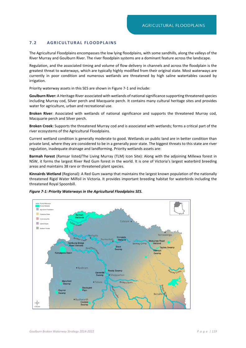
Goulburn Broken Waterway Strategy 2014-2022 P a g e | 119
7 .2 A GRI CU LT UR AL FL O OD P LA I N S
The Agricultural Floodplains encompasses the low lying floodplains, with some sandhills, along the valleys of the River Murray and Goulburn River. The river floodplain systems are a dominant feature across the landscape.
Regulation, and the associated timing and volume of flow delivery in channels and across the floodplain is the greatest threat to waterways, which are typically highly modified from their original state. Most waterways are currently in poor condition and numerous wetlands are threatened by high saline watertables caused by irrigation.
Priority waterway assets in this SES are shown in Figure 7-1 and include:
Goulburn River: A Heritage River associated with wetlands of national significance supporting threatened species including Murray cod, Silver perch and Macquarie perch. It contains many cultural heritage sites and provides water for agriculture, urban and recreational use.
Broken River: Associated with wetlands of national significance and supports the threatened Murray cod, Macquarie perch and Silver perch.
Broken Creek: Supports the threatened Murray cod and is associated with wetlands; forms a critical part of the river ecosystems of the Agricultural Floodplains.
Current wetland condition is generally moderate to good. Wetlands on public land are in better condition than private land, where they are considered to be in a generally poor state. The biggest threats to this state are river regulation, inadequate drainage and landforming. Priority wetlands assets are:
Barmah Forest (Ramsar listed/The Living Murray (TLM) Icon Site): Along with the adjoining Millewa forest in NSW, it forms the largest River Red Gum forest in the world. It is one of Victoria’s largest waterbird breeding areas and maintains 38 rare or threatened plant species.
Kinnairds Wetland (Regional): A Red Gum swamp that maintains the largest known population of the nationally threatened Rigid Water Milfoil in Victoria. It provides important breeding habitat for waterbirds including the threatened Royal Spoonbill.
Figure 7-1: Priority Waterways in the Agricultural Floodplains SES.

Goulburn Broken Waterway Strategy 2014-2022 P a g e | 120
Management Unit Agricultural Floodplains
Basin Goulburn Waterway Goulburn River Identification No. 5-1, 5-2, 5-3, 5-4,
5-5
Values
Native Fish (2), Riparian Vegetation Condition (4), Significant Amphibians (1) Significant Birds Riparian (2), Significant Birds Waterway (4), Significant EVCs (5), Significant Fish Migratory (1), Significant Fish Non Migratory (1), Significant Mammals (2), Camping (4), Game Hunting (5), Motor Boating (5), Non-Motor Boating (3), Recreational Fishing (5), Tracks (5), Landscape (0)
Threats Bank Instability (3), Change in Monthly Streamflow Variable (3), Increase in Low Flow Magnitude (5), Increase in Prop of Zero Flow (5), Invasive Fauna (Terrestrial) (5), Loss of Instream Habitat (Large Wood) (3), Red in High Flow Magnitude (4)
State: Sustainable
Working
Long-term Resource Condition
Improve flow regime by 2021
Riparian and floodplain vegetation condition is maintained or improved by 2025
Populations of native fish are maintained or improved by 2025
Instream habitat is maintained or improved by 2030
Management Outcome Targets Management Activity/Output Quantity Lead agency/partner
AF.1 Environmental water program will improve altered hydrology threat score
AF 1.1 Deliver water to river reach
Based on seasonal watering plan (See Chapter 4.3)
Water Corporation GB CMA
AF.2 Improved vegetation structure and diversity throughout reach
AF 2.1 Control invasive pest plant species (Non-woody and Woody)
400 ha Parks Victoria, YYNAC joint management
AF 2.2 Control invasive pest animal species (Terrestrial) 740 ha
Parks Victoria, YYNAC joint management
AF 2.3 Modify agricultural practice change 480 ha GB CMA, DEPI
(region)
AF.3 Improve recreational opportunities within reach AF 3.1 Develop and implement
Recreational Strategy 1 GB CMA, Parks Victoria, Local Government
AF.4 Increase bank stability and reduce erosion and sediment input
AF 4.1 Establish earthworks (Armouring) 0.3 km
GB CMA / Parks Victoria /YYNAC Joint management
AF.5 Increase instream diversity, (Large Wood) AF 5.1 Install waterway structure (Large
wood) 5 sites GB CMA
Estimated cost of activities for Goulburn River (5-1, 5-2, 5-3, 5-4 and 5-5) $1,320,000
AF.6 Water Quality will be maintained or improved AF 6.1 Deliver farm reuse/ recycle
programs (No. Landowners) 240 (No.) CMA, Landowners
Estimated cost of activities for Goulburn River (Water Quality: 5-1, 5-2, 5-3, 5-4 and 5-5) $4,880,000
AF.7 Enhance floodplain to river linkages AF 7.1 Implement Lower Goulburn
Floodplain Management Plan 3 reaches GB CMA, Local Government, Community
Estimated cost of activities for Goulburn River (Floodplain reconnection: 5-1, 5-2, 5-3, 5-4 and 5-5) $50,000,000
AF.8
Improve community awareness of urban rivers and wetlands and encourage participation in their maintenance
AF 8.1 Deliver RiverConnect – Shepparton/Mooroopna 1
GB CMA, Parks Victoria, GSCC, YYNAC, Education institutions
Estimated cost of activities for Goulburn River (RiverConnect: 5-1, 5-2, 5-3, 5-4 and 5-5) $400,000
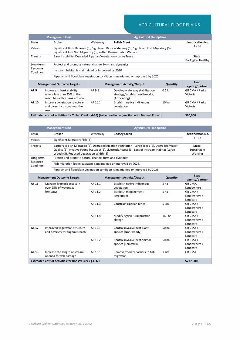
Goulburn Broken Waterway Strategy 2014-2022 P a g e | 121
Management Unit Agricultural Floodplains Basin Broken Waterway Tullah Creek Identification No.
4 - 36 Values Significant Birds Riparian (5), Significant Birds Waterway (5), Significant Fish Migratory (5), Significant Fish Non Migratory (5), within Ramsar Listed Wetland
Threats Bank Instability, Degraded Riparian Vegetation – Large Trees State: Ecological Healthy
Long-term Resource Condition
Protect and promote natural channel form and dynamics
Instream habitat is maintained or improved by 2030
Riparian and floodplain vegetation condition is maintained or improved by 2025
Management Outcome Targets Management Activity/Output Quantity Lead agency/partner
AF.9 Increase in bank stability where less than 25% of the reach has active bank erosion
AF 9.1 Develop waterway stabilisation strategy/establish earthworks, (Armouring)
0.1 km GB CMA / Parks Victoria
AF.10 Improve vegetation structure and diversity throughout the reach
AF 10.1 Establish native indigenous vegetation
10 ha GB CMA / Parks Victoria
Estimated cost of activities for Tullah Creek ( 4-36) (to be read in conjunction with Barmah Forest) $90,000
Management Unit Agricultural Floodplains
Basin Broken Waterway Boosey Creek Identification No. 4 - 32 Values Significant Migratory Fish (5)
Threats Barriers to Fish Migration (5), Degraded Riparian Vegetation - Large Trees (4), Degraded Water Quality (5), Invasive Fauna (Aquatic) (5), Livestock Access (3), Loss of Instream Habitat (Large Wood) (3), Reduced Vegetation Width (3)
State: Sustainable
Working Long-term Resource Condition
Protect and promote natural channel form and dynamics
Fish migration (open passage) is maintained or improved by 2025.
Riparian and floodplain vegetation condition is maintained or improved by 2025
Management Outcome Targets Management Activity/Output Quantity Lead agency/partner
AF 11 Manage livestock access in over 25% of waterway frontages
AF 11.1 Establish native indigenous vegetation
5 ha GB CMA, Landowners
AF 11.2 Establish management agreement
5 ha GB CMA / Landowners / Landcare
AF 11.3 Construct riparian fence 5 km GB CMA / Landowners / Landcare
AF 11.4 Modify agricultural practice change
160 ha GB CMA / Landowners / Landcare
AF.12 Improved vegetation structure and diversity throughout reach
AF 12.1 Control invasive pest plant species (Non-woody)
50 ha GB CMA / Landowners / Landcare
AF 12.2 Control invasive pest animal species (Terrestrial)
50 ha GB CMA / Landowners / Landcare
AF.13 Increase the length of stream opened for fish passage
AF 13.1 Remove/modify barriers to fish migration
1 site GB CMA
Estimated cost of activities for Boosey Creek ( 4-32) $237,500

Goulburn Broken Waterway Strategy 2014-2022 P a g e | 122
Management Unit Agricultural Floodplains
Basin Broken Waterway Broken Creek Identification No. 4-21, 4-22, 4-23,
4-24 Values Significant Birds Waterway (5), Significant Fish Migratory (5) Significant Birds Waterway (4), Significant Reptiles Riparian (4) Camping (4), Motor Boating (4), Picnics and Barbecues (5), Recreational Fishing (5)
Threats Degraded Riparian Vegetation - Large Trees (4), Invasive Fauna (Aquatic) (5), Invasive Fauna (Terrestrial) (5), Loss of Instream Habitat (Large Wood) (3)
State: Sustainable
Working Long-term Resource Condition
Instream habitat is maintained or improved by 2030
Water quality is maintained or improved by 2030
Riparian and floodplain vegetation condition is maintained or improved by 2025
Populations of native fish are maintained or improved by 2025
Management Outcome Targets Management Activity/Output Quantity Lead agency/partner
AF 14 Reduce the impact of pest (fish) animals
AF 14.1 Install waterway structure (carp screen)
9 (No.) GB CMA / Fisheries Victoria
AF.15 Manage livestock access in over 80% of waterway frontages
AF 15.1 Construct riparian fence 2 km GB CMA / Parks Victoria
AF 15.2 Modify agricultural practice change
480 ha GB CMA / Parks Victoria/ landowners
AF 15.3 Establish management agreement
2 ha GB CMA / Parks Victoria
AF 16 Maintain or improve instream habitat diversity
AF 16.1 Install waterway structure (Large wood)
3 sites GB CMA
AF 17 Reduce the impact of pest plant and animal species
AF 17.1 Control invasive pest plant species (Woody)
200 ha Parks Victoria / Landowners
AF 17.2 Control invasive pest animal species (Terrestrial)
100 ha Parks Victoria / Landowners
AF.18 Environmental water program will improve altered hydrology threat score
AF 18.1 Deliver water to river reach (4-21, 22, 23 and 24)
Based on seasonal watering plan (See Chapter 4.3)
Water Corporation / GB CMA
Estimated cost of activities for Broken Creek ( 4-21, 4-22, 4-23, 4-24) $495,000
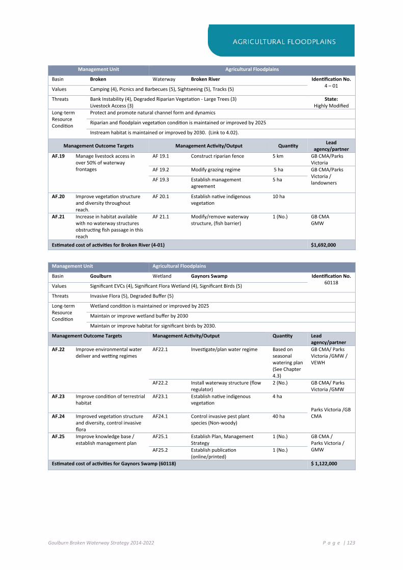
Goulburn Broken Waterway Strategy 2014-2022 P a g e | 123
Management Unit Agricultural Floodplains
Basin Broken Waterway Broken River Identification No. 4 – 01 Values Camping (4), Picnics and Barbecues (5), Sightseeing (5), Tracks (5)
Threats Bank Instability (4), Degraded Riparian Vegetation - Large Trees (3) Livestock Access (3)
State: Highly Modified
Long-term Resource Condition
Protect and promote natural channel form and dynamics
Riparian and floodplain vegetation condition is maintained or improved by 2025
Instream habitat is maintained or improved by 2030. (Link to 4.02).
Management Outcome Targets Management Activity/Output Quantity Lead agency/partner
AF.19 Manage livestock access in over 50% of waterway frontages
AF 19.1 Construct riparian fence 5 km GB CMA/Parks Victoria
AF 19.2 Modify grazing regime 5 ha GB CMA/Parks Victoria / landowners
AF 19.3 Establish management agreement
5 ha
AF.20 Improve vegetation structure and diversity throughout reach.
AF 20.1 Establish native indigenous vegetation
10 ha
AF.21 Increase in habitat available with no waterway structures obstructing fish passage in this reach
AF 21.1 Modify/remove waterway structure, (fish barrier)
1 (No.) GB CMA GMW
Estimated cost of activities for Broken River (4-01) $1,692,000
Management Unit Agricultural Floodplains
Basin Goulburn Wetland Gaynors Swamp Identification No. 60118 Values Significant EVCs (4), Significant Flora Wetland (4), Significant Birds (5)
Threats Invasive Flora (5), Degraded Buffer (5)
Long-term Resource Condition
Wetland condition is maintained or improved by 2025
Maintain or improve wetland buffer by 2030
Maintain or improve habitat for significant birds by 2030.
Management Outcome Targets Management Activity/Output Quantity Lead agency/partner
AF.22 Improve environmental water deliver and wetting regimes
AF22.1 Investigate/plan water regime Based on seasonal watering plan (See Chapter 4.3)
GB CMA/ Parks Victoria /GMW / VEWH
AF22.2 Install waterway structure (flow regulator)
2 (No.) GB CMA/ Parks Victoria /GMW
AF.23 Improve condition of terrestrial habitat
AF23.1 Establish native indigenous vegetation
4 ha Parks Victoria /GB CMA AF.24 Improved vegetation structure
and diversity, control invasive flora
AF24.1 Control invasive pest plant species (Non-woody)
40 ha
AF.25 Improve knowledge base / establish management plan
AF25.1 Establish Plan, Management Strategy
1 (No.) GB CMA / Parks Victoria / GMW AF25.2 Establish publication
(online/printed) 1 (No.)
Estimated cost of activities for Gaynors Swamp (60118) $ 1,122,000

Goulburn Broken Waterway Strategy 2014-2022 P a g e | 124
Management Unit Agricultural Floodplains
Basin Goulburn Wetland Kanyapella Basin Identification No. 60205 Values Significant EVCs (4), Significant Flora Wetland (4)
Threats Invasive Fauna (Aquatic) (5), Invasive Fauna (Terrestrial) (5), Changed Water Regime (5), Degraded Buffer (5)
Long-term Resource Condition
Reduce the threat of invasive species by 2030
Improve flow regime by 2021
Management Outcome Targets Management Activity/Output Quantity Lead agency/partner
AF.26 Improve environmental water delivery and wetting regimes
AF 26.1 Investigate / plan water regime Based on seasonal watering plan (See Chapter 4.3)
GB CMA/ Parks Victoria /GMW/VEWH
AF 26.1 Modify waterway structure(sill) 1 (No.)
AF.27 Improve condition of terrestrial habitat
AF 27.1 Establish native indigenous vegetation
10 ha GMW/ Parks Victoria /GB CMA /Landcare AF 27.2 Control invasive pest animal
species (Terrestrial) 400 ha
AF.28 Maintain or improve water quality from adjacent lands
AF 28.1 Modify agricultural practice change
160 ha GB CMA /DEPI (Ag Services)/GMW
AF.29 Improved vegetation structure and diversity, control invasive flora
AF 29.1 Control invasive pest plant species (Non-woody)
400 ha GMW/ Parks Victoria /GB CMA
AF.30 Knowledge transfer AF 30.1 Prepare publication, (online/printed)
1 (No.)
Estimated cost of activities for Kanyapella Basin (60205) $575,000
Management Unit Agricultural Floodplains
Basin Goulburn Wetland Yambuna Bridge Rd (wetland) Identification No. 60240 Values Significant Birds (5)
Threats Invasive Fauna (Aquatic) (5), Invasive Fauna (Terrestrial) (5), Changed Water Regime (5)
Long-term Resource Condition
Establish Management Plan by 2030
Reduce the threat of invasive species by 2030
Management Outcome Targets Management Activity/Output Quantity Lead agency/partner
AF.31 Development of site management plan
AF 31.1 Develop Plan (Site Management Strategy)
1 (No.) GB CMA/Parks Victoria
AF.32 Improved vegetation structure and diversity, control invasive flora
AF 32.1 Control invasive pest animal species (Terrestrial)
(included in Goulburn Reach 2)
Estimated cost of activities for Yambuna Bridge Rd wetland (60240) $50,000

Goulburn Broken Waterway Strategy 2014-2022 P a g e | 125
Management Unit Agricultural Floodplains
Basin Goulburn Wetland Mansfield, Wallenjoe, One Tree and Two Tree Swamps
Wetland Identification No
60265 60269 60101 60102
Values Significant EVCs (4), Significant Flora Wetland (4), Significant Birds (5), Important Bird Habitats (5)
Threats Changed Water Regime (5), Degraded Buffer (5)
Long-term Resource Condition
Improve flow regime by 2021
Maintain or improve wetland buffer by 2030
Maintain or improve habitat for significant birds by 2030.
Management Outcome Targets Management Activity/Output Quantity Lead agency/partner
AF.33 Environmental water program will target altered hydrology threat score
AF 33.1 Management of flow releases - Deliver water to wetlands at required timing
Based on seasonal watering plan (See Chapter 4.3)
GB CMA / Parks Victoria / GMW / VEWH
AF 33.2 Modify waterway structure (sill) 1 (No.) GB CMA / Parks Victoria / GMW
AF.34 Improve condition of terrestrial habitat
AF 34.1 Establish native indigenous vegetation
10 ha Parks Victoria / GB CMA
AF.35 Maintain or improve water quality from adjacent lands
AF 35.1 Modify agricultural practice change
100 ha GB CMA / GMW
AF.36 Improved vegetation structure and diversity, control invasive flora
AF 36.1 Control invasive pest plant species (Non-woody)
250 ha Parks Victoria /GB CMA
AF.37 Knowledge transfer AF 37.1 Establish publication (online/printed)
1 No GB CMA/ Parks Victoria / GMW
Estimated cost of activities for Mansfield, Wallenjoe, One Tree and Two Tree Swamps (60265, 60269, 60101,60102) $780,000

Goulburn Broken Waterway Strategy 2014-2022 P a g e | 126
Management Unit Agricultural Floodplains
Basin Broken Wetland Barmah Forest Identification No. 60706 Values Important Bird Habitats (5), Significant EVCs (5), Camping (4), Motor Boating (4), Non-Motor
Boating (4), Picnics and Barbecues (5), Recreational Fishing (5), Sightseeing (5), Tracks (5), Significant Birds (5)
Threats Altered Hydrology Invasive Fauna, Invasive Fauna (Aquatic and Terrestrial)
Long-term Resource Condition
Maintain or Improve the Ecological Character of Barmah
Improve flow regime by 2021
Riparian and floodplain vegetation condition is maintained or improved by 2025
Management Outcome Targets Management Activity/Output Quantity Lead agency/partner
AF.38 Improved vegetation structure and diversity throughout reach
AF 38.1 Monitoring the Ecological Character of Barmah (Ramsar Site) and fill knowledge gaps.
1 Parks Victoria / GB CMA / DEPI (Region)
AF 38.2 Control invasive pest plant species (Non-woody)
1,000 ha
GB CMA / Parks Victoria / YYNAC
AF 38.3 Control invasive pest animal species (Terrestrial)
500 ha
AF 38.4 Control invasive pest plant species (Non-woody and Woody)
1,000 ha
AF.39 Increase community knowledge of site and program of works (progress)
AF 39.1 Co-ordinate engagement event, (Conference / field day)
5 (No.)
AF.40 Environmental water program will target altered hydrology threat score
AF 40.1 Management of flow releases - Deliver water to river reach at required timing
Based on seasonal watering plan (See Chapter 4.3)
DEPI / GB CMA / Fisheries NSW / VEWH (CEWH/MDBA)
Estimated cost of activities for Barmah Forest (60706) $3,075,000
Management Unit Agricultural Floodplains
Basin Goulburn Wetland Doctors Swamp Identification No. 60210 Values Important Bird Habitats (5), Significant EVCs (5)
Threats Invasive Fauna (Aquatic) (5), Invasive Fauna (Terrestrial) (5), Degraded Buffer (4)
Long-term Resource Condition
Maintain or improve habitat for significant birds by 2030.
Reduce the threat of invasive species by 2030
Management Outcome Targets Management Activity/Output Quantity Lead agency/partner
AF.41 Environmental water program will target altered hydrology threat score
AF 41.1 Management of flow releases - Deliver water to river reach at required timing
Based on seasonal watering plan (See Chapter 4.3)
GB CMA/ Parks Victoria / GMW / VEWH
AF.42 Improved vegetation structure and diversity throughout site
AF 42.1 Control invasive pest animal species (Terrestrial)
250 ha Parks Victoria / GB CMA
AF 42.2 Establish native indigenous vegetation
10 ha
AF.43 Knowledge transfer AF 43.1 Establish publication (online/printed)
1 (No.)
Estimated cost of activities for Doctors Swamp (60210) $110,000

Goulburn Broken Waterway Strategy 2014-2022 P a g e | 127
Management Unit Agricultural Floodplains
Basin Goulburn Wetland Gemmills Swamp Identification No. 63156 Values Important Bird Habitats (5), Significant EVCs (5),
Threats Invasive Fauna (Aquatic) (5), Invasive Fauna (Terrestrial) (5), Changed Water Regime (5)
Long-term Resource Condition
Reduce the threat of invasive species by 2030
Management Outcome Targets Management Activity/Output Quantity Lead agency/partner
AF.44 Improved vegetation structure and diversity throughout reach
AF 44.1 Control invasive pest plant species (Non-woody)
150 ha Parks Victoria / GB CMA AF 44.2 Control invasive pest animal
species (Terrestrial) 150 ha
Estimated cost of activities for Gemmills Swamp (63156) $105,000
Management Unit Agricultural Floodplains
Basin Goulburn Wetland Reedy Swamp Wildlife Identification No. 63173 Values Important Bird Habitats (5), Significant Birds (5), Significant Amphibians (5)
Threats Invasive Fauna (Aquatic) (5), Invasive Fauna (Terrestrial) (5), Changed Water Regime (5),
Long-term Resource Condition
Reduce the threat of invasive species by 2030
Maintain or improve habitat for significant birds by 2030
Management Outcome Targets Management Activity/Output Quantity Lead agency/partner
AF.45 Improved vegetation structure and diversity throughout reach
AF 45.1 Control invasive pest animal species (Terrestrial)
100 ha p.a. Parks Victoria
AF.46 Environmental water program will target altered hydrology threat score
AF 46.1 Construct waterway structure (flow regulator)
2 (No.) GMW/ GB CMA
AF 46.2 Management of flow releases - Deliver water to river reach at required timing
Based on seasonal watering plan (See Chapter 4.3)
GB CMA/GMW/ Parks Victoria / VBEWH
AF.47 Improve the management of surrounding catchment. Reduce nutrient impact on site
AF 47.1 Modify agricultural practice change
10 ha GB CMA/Local Government/ Parks Victoria
AF.48 Control nutrient inputs, Reduce nutrients at source of discharge water
AF 48.1 Construct wetland/water storage (Nutrient management)
4 (no.) GB CMA / COGS
Estimated cost of activities for Reedy Swamp Wildlife Reserve (63173) $770,000

Goulburn Broken Waterway Strategy 2014-2022 P a g e | 128
Management Unit Agricultural Floodplains
Basin Broken Wetland Black Swamp Identification No. 63203 Values Important Bird Habitats (5), Significant Birds (5)
Threats Invasive Fauna (Aquatic) (5), Invasive Fauna (Terrestrial) (5), Degraded Buffer (4)
Long-term Resource Condition
Reduce the threat of invasive species by 2030
Maintain or improve wetland buffer by 2030
Management Outcome Targets Management Activity/Output Quantity Lead agency/partner
AF.49 Environmental water program will target altered hydrology threat score
AF 49.1 Management of flow releases - deliver water to river reach at required timing
Based on seasonal watering plan (See Chapter 4.3)
GB CMA / GMW / Parks Victoria / VEWH
AF.50 Invasive species control (carp access) in to site from adjacent waterway
AF 50.1 Control invasive pest animal species (Aquatic). Modify waterway structure (carp screen)
1 (No.) GB CMA / Parks Victoria
AF.51 Improved vegetation structure and diversity throughout the site
AF.51.1 Establish native indigenous vegetation
5 ha GB CMA / Parks Victoria
AF 51.2 Control invasive pest plant species (Non-woody)
10 ha
AF 51.3 Control invasive pest animal species (Terrestrial)
10 ha
Estimated cost of activities for Black Swamp (63203) $100,000
Management Unit Agricultural Floodplains
Basin Broken Wetland Sampys Swamp Identification No. 66906 Values Significant Birds (4)
Threats Invasive Fauna (Aquatic) (5), Invasive Fauna (Terrestrial) (5), Degraded Buffer (5)
Long-term Resource Condition
Maintain or improve habitat for significant birds by 2030
Management Outcome Targets Management Activity/Output Quantity Lead agency/partner
AF. 52 Improved vegetation structure and diversity throughout site
AF 52.1 Establish native indigenous vegetation
5 ha GB CMA / Land managers
AF 52.2 Control invasive pest animal species (Terrestrial)
10 ha
Estimated cost of activities for Sampys Swamp (66906) $50,000
Management Unit Agricultural Floodplains
Basin Broken Wetland Taylors Swamp Identification No. 66911 Values Significant Birds (4)
Threats Invasive Fauna (Aquatic) (5), Invasive Fauna (Terrestrial) (5), Degraded Buffer (5)
Long-term Resource Condition
Maintain or improve habitat for significant birds by 2030
Management Outcome Targets Management Activity/Output Quantity Lead agency/partner
AF. 53 Improved vegetation structure and diversity throughout site
AF 53.1 Establish native indigenous vegetation
3 ha Parks Victoria / GB CMA
AF 53.2 Control invasive pest animal species (Terrestrial)
10 ha
Estimated cost of activities for Taylors Swamp (66911) $34,000
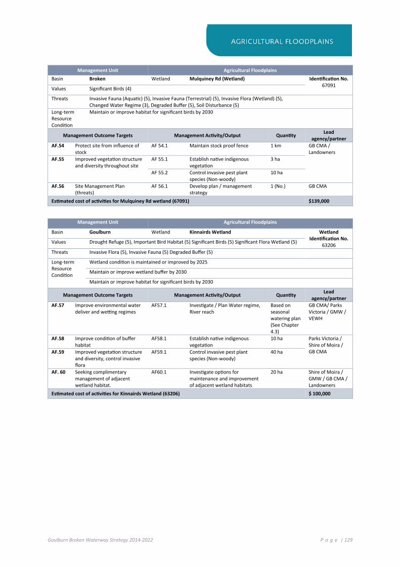
Goulburn Broken Waterway Strategy 2014-2022 P a g e | 129
Management Unit Agricultural Floodplains
Basin Broken Wetland Mulquiney Rd (Wetland) Identification No. 67091 Values Significant Birds (4)
Threats Invasive Fauna (Aquatic) (5), Invasive Fauna (Terrestrial) (5), Invasive Flora (Wetland) (5), Changed Water Regime (3), Degraded Buffer (5), Soil Disturbance (5)
Long-term Resource Condition
Maintain or improve habitat for significant birds by 2030
Management Outcome Targets Management Activity/Output Quantity Lead agency/partner
AF.54 Protect site from influence of stock
AF 54.1 Maintain stock proof fence 1 km GB CMA / Landowners
AF.55 Improved vegetation structure and diversity throughout site
AF 55.1 Establish native indigenous vegetation
3 ha
AF 55.2 Control invasive pest plant species (Non-woody)
10 ha
AF.56 Site Management Plan (threats)
AF 56.1 Develop plan / management strategy
1 (No.) GB CMA
Estimated cost of activities for Mulquiney Rd wetland (67091) $139,000
Management Unit Agricultural Floodplains
Basin Goulburn Wetland Kinnairds Wetland Wetland Identification No.
63206 Values Drought Refuge (5), Important Bird Habitat (5) Significant Birds (5) Significant Flora Wetland (5)
Threats Invasive Flora (5), Invasive Fauna (5) Degraded Buffer (5)
Long-term Resource Condition
Wetland condition is maintained or improved by 2025
Maintain or improve wetland buffer by 2030
Maintain or improve habitat for significant birds by 2030
Management Outcome Targets Management Activity/Output Quantity Lead agency/partner
AF.57 Improve environmental water deliver and wetting regimes
AF57.1 Investigate / Plan Water regime, River reach
Based on seasonal watering plan (See Chapter 4.3)
GB CMA/ Parks Victoria / GMW / VEWH
AF.58 Improve condition of buffer habitat
AF58.1 Establish native indigenous vegetation
10 ha Parks Victoria / Shire of Moira / GB CMA AF.59 Improved vegetation structure
and diversity, control invasive flora
AF59.1 Control invasive pest plant species (Non-woody)
40 ha
AF. 60 Seeking complimentary management of adjacent wetland habitat.
AF60.1 Investigate options for maintenance and improvement of adjacent wetland habitats
20 ha Shire of Moira / GMW / GB CMA / Landowners
Estimated cost of activities for Kinnairds Wetland (63206) $ 100,000

Goulburn Broken Waterway Strategy 2014-2022 P a g e | 130
7 .3 P R O DU CT I V E PL AI N S
Waterways in this region occur on the open plains and are the outfall from the Strathbogie Ranges and other surrounding hills. These waterways are largely unregulated, except for the Goulburn River and are mostly in moderate condition. Major threats to waterways include European carp, degraded riparian vegetation through grazing pressure, poor instream habitat and water harvesting in the upper catchments. Wetlands within the Productive Plains are generally in a moderate to good state.
Priority waterway assets include:
Goulburn River: A Heritage River associated with wetlands of national significance that supports threatened species including Murray cod, Silver perch and Macquarie perch. The Goulburn River floodplain contains cultural heritage sites and provides water for agriculture, urban centres and recreational use.
Hughes Creek and Seven Creeks: Supports the threatened Macquarie perch and Murray cod.
Broken River: Associated with wetlands of national significance and supports the threatened Murray cod, Macquarie perch and Silver perch.
Doctors Swamp (Bioregional): One of the most intact River Red Gum swamps in Victoria. It supports a diverse number of species including 73 wetland flora species and 44 wetland fauna species.
Tahbilk Lagoon (Bioregional): A large billabong connected to the Goulburn River. The wetland is a biological hot spot that maintains a number of threatened species including the Broad-shelled Turtle, the most southerly remnant freshwater Catfish population and the largest known Watershield (native waterlily) population in Victoria.
Figure 7-2: Priority Waterways in the Productive Plains SES

Goulburn Broken Waterway Strategy 2014-2022 P a g e | 131
Management Unit Productive Plains
Basin Broken Waterway Holland Creek Identification No. 4-13 Values Significant Fish Migratory (5)
Threats Bank Instability (5), Barriers to Fish Migration (4), Degraded Riparian Vegetation - Large Trees (3), Degraded Water Quality (5), Livestock Access (3), Reduced Vegetation Width (3)
State: Sustainable
Working Long-term Resource Condition
Riparian and floodplain vegetation condition is maintained or improved by 2025
Instream habitat is maintained or improved by 2030
Management Outcome Targets Management Activity/Output Quantity Lead agency/partner
PP.1 Manage livestock access in over 50% of waterway frontages
PP 1.1 Construct riparian fence 2 km GB CMA / Landcare / landowners
PP 1.2 Modify grazing regime 4 ha GB CMA / Landcare / landowners PP 1.3 Establish management
agreement 4 ha
PP 1.4 Modify agricultural practice change
160 ha
PP.2 Increase in habitat availability within instream zone
PP 2.1 Install waterway structure (Large wood)
1 site GB CMA
PP.3 Improved vegetation structure and diversity throughout reach
PP 3.1 Undertake native indigenous vegetation supplementary planting
4 ha GB CMA / Landcare
PP.4 Increase in habitat available with no waterway structures obstructing fish passage in this reach
PP 4.1 Install waterway structure (Fishway)
1 GB CMA
Estimated cost of activities for Holland Creek (4-13) $212,000

Goulburn Broken Waterway Strategy 2014-2022 P a g e | 132
Management Unit Productive Plains
Basin Goulburn Waterway Goulburn River Identification No. 5-08 / 5-07 / 5-06 Values Native Fish (2), Riparian Vegetation Condition (4), Significant Birds Waterway (4), Significant
EVCs (5), Significant Fish Migratory (5), Significant Fish Non Migratory (5), Camping (4), Game Hunting (5), Motor Boating (5), Non-Motor Boating (3), Recreational Fishing (5), Sightseeing (5), Swimming (5)
Threats Altered Streamflow Seasonality (3), Bank Instability (5), Increase in Low Flow Magnitude (5), Increase in Prop of Zero Flow (5), Invasive Fauna (Terrestrial) (5), Loss of Instream Habitat (Large Wood) (4), Red in High Flow Magnitude (4)
State: Sustainable
Working Long-term Resource Condition
Riparian and floodplain vegetation condition is maintained or improved by 2025
Instream habitat is maintained or improved by 2030
Improve flow regime by 2021
Management Outcome Targets Management Activity/Output Quantity Lead agency/partner
PP.5 Environmental water program will target altered hydrology threat score
PP 5.1 Management of flow releases - deliver water to river reach at required timing
Based on seasonal watering plan (See Chapter 4.3)
DEPI/GB CMA
PP.6 Manage livestock access in over 50% of waterway frontages
PP 6.1 Modify grazing regime 10 km GB CMA / Landcare/ landowners PP 6.2 Establish management
agreement 10 ha
PP.7 Increase in habitat availability within instream zone
PP 7.1 Install waterway structure (Large wood)
3 sites GB CMA
PP.8 Improved vegetation structure and diversity throughout reach
PP 8.1 Control invasive pest plant species (Non-woody and Woody)
200 ha Parks Victoria
PP 8.2 Control invasive pest animal species (Terrestrial)
30 ha
PP.9 Increase bank stability within zones of active bank erosion
PP 9.1 Establish earthworks (Armouring) 0.1 km GB CMA
Estimated cost of activities for Goulburn River (5-6, 5-7, and 5-8) $525,000
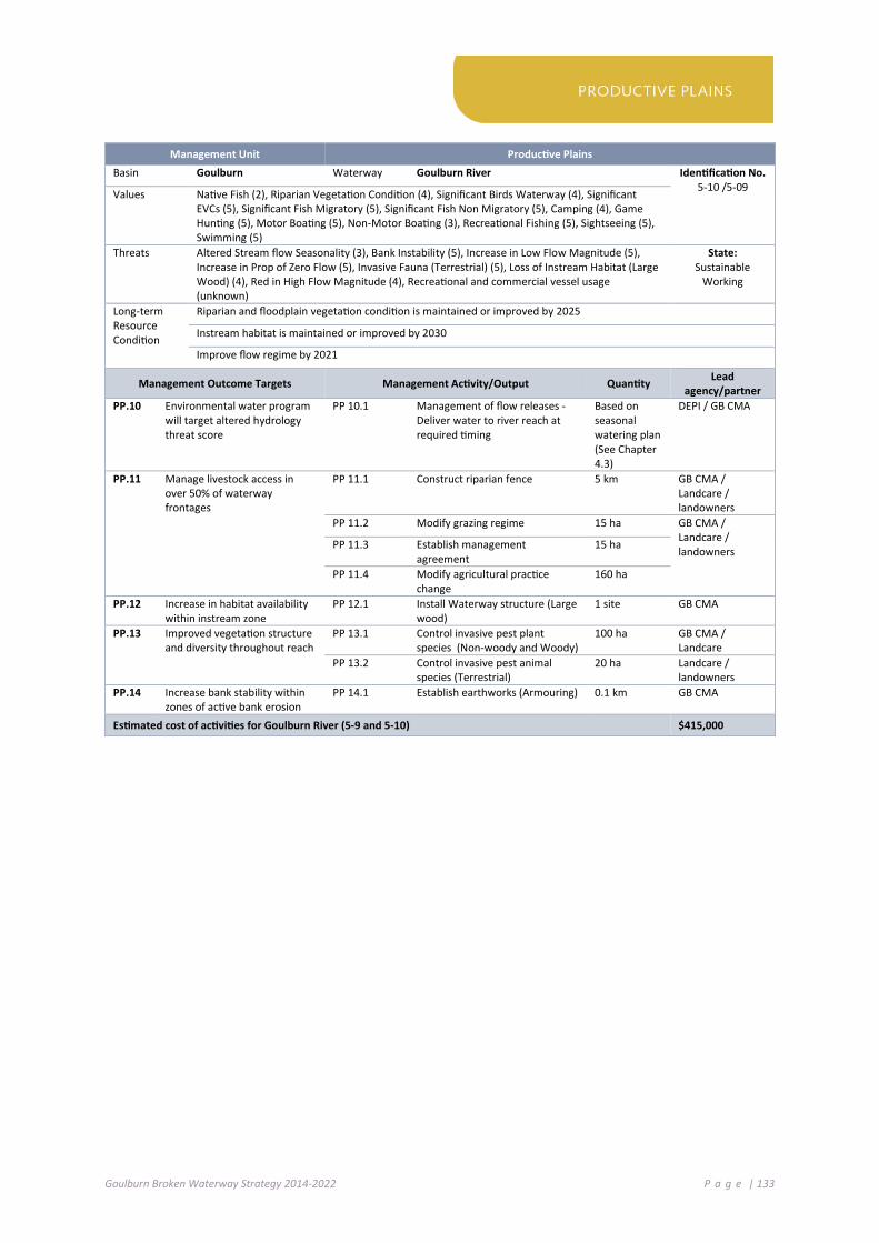
Goulburn Broken Waterway Strategy 2014-2022 P a g e | 133
Management Unit Productive Plains
Basin Goulburn Waterway Goulburn River Identification No. 5-10 /5-09 Values Native Fish (2), Riparian Vegetation Condition (4), Significant Birds Waterway (4), Significant
EVCs (5), Significant Fish Migratory (5), Significant Fish Non Migratory (5), Camping (4), Game Hunting (5), Motor Boating (5), Non-Motor Boating (3), Recreational Fishing (5), Sightseeing (5), Swimming (5)
Threats Altered Stream flow Seasonality (3), Bank Instability (5), Increase in Low Flow Magnitude (5), Increase in Prop of Zero Flow (5), Invasive Fauna (Terrestrial) (5), Loss of Instream Habitat (Large Wood) (4), Red in High Flow Magnitude (4), Recreational and commercial vessel usage (unknown)
State: Sustainable
Working
Long-term Resource Condition
Riparian and floodplain vegetation condition is maintained or improved by 2025
Instream habitat is maintained or improved by 2030
Improve flow regime by 2021
Management Outcome Targets Management Activity/Output Quantity Lead agency/partner
PP.10 Environmental water program will target altered hydrology threat score
PP 10.1 Management of flow releases - Deliver water to river reach at required timing
Based on seasonal watering plan (See Chapter 4.3)
DEPI / GB CMA
PP.11 Manage livestock access in over 50% of waterway frontages
PP 11.1 Construct riparian fence 5 km GB CMA / Landcare / landowners
PP 11.2 Modify grazing regime 15 ha GB CMA / Landcare / landowners PP 11.3 Establish management
agreement 15 ha
PP 11.4 Modify agricultural practice change
160 ha
PP.12 Increase in habitat availability within instream zone
PP 12.1 Install Waterway structure (Large wood)
1 site GB CMA
PP.13 Improved vegetation structure and diversity throughout reach
PP 13.1 Control invasive pest plant species (Non-woody and Woody)
100 ha GB CMA / Landcare
PP 13.2 Control invasive pest animal species (Terrestrial)
20 ha Landcare / landowners
PP.14 Increase bank stability within zones of active bank erosion
PP 14.1 Establish earthworks (Armouring) 0.1 km GB CMA
Estimated cost of activities for Goulburn River (5-9 and 5-10) $415,000
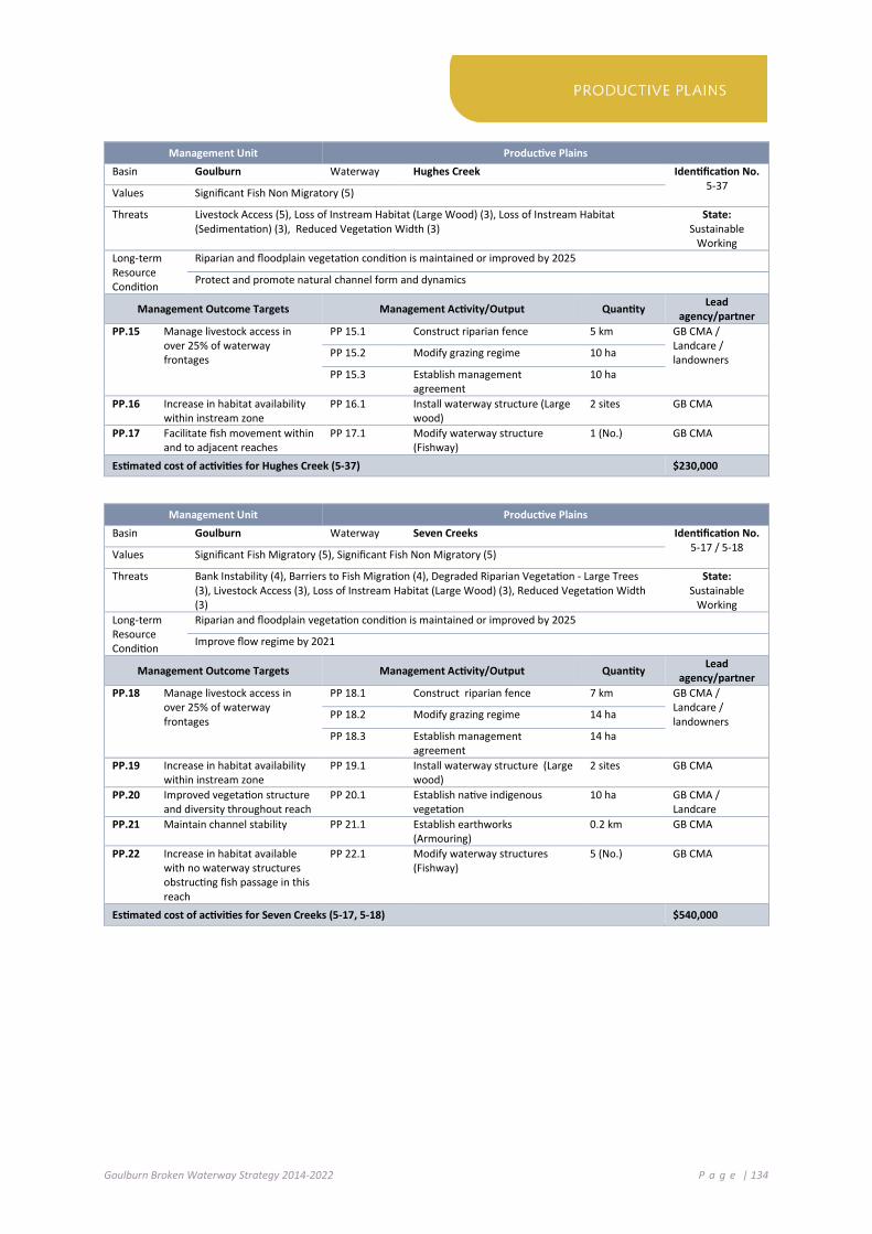
Goulburn Broken Waterway Strategy 2014-2022 P a g e | 134
Management Unit Productive Plains
Basin Goulburn Waterway Hughes Creek Identification No. 5-37 Values Significant Fish Non Migratory (5)
Threats Livestock Access (5), Loss of Instream Habitat (Large Wood) (3), Loss of Instream Habitat (Sedimentation) (3), Reduced Vegetation Width (3)
State: Sustainable
Working Long-term Resource Condition
Riparian and floodplain vegetation condition is maintained or improved by 2025
Protect and promote natural channel form and dynamics
Management Outcome Targets Management Activity/Output Quantity Lead agency/partner
PP.15 Manage livestock access in over 25% of waterway frontages
PP 15.1 Construct riparian fence 5 km GB CMA / Landcare / landowners PP 15.2 Modify grazing regime 10 ha
PP 15.3 Establish management agreement
10 ha
PP.16 Increase in habitat availability within instream zone
PP 16.1 Install waterway structure (Large wood)
2 sites GB CMA
PP.17 Facilitate fish movement within and to adjacent reaches
PP 17.1 Modify waterway structure (Fishway)
1 (No.) GB CMA
Estimated cost of activities for Hughes Creek (5-37) $230,000
Management Unit Productive Plains
Basin Goulburn Waterway Seven Creeks Identification No. 5-17 / 5-18 Values Significant Fish Migratory (5), Significant Fish Non Migratory (5)
Threats Bank Instability (4), Barriers to Fish Migration (4), Degraded Riparian Vegetation - Large Trees (3), Livestock Access (3), Loss of Instream Habitat (Large Wood) (3), Reduced Vegetation Width (3)
State: Sustainable
Working Long-term Resource Condition
Riparian and floodplain vegetation condition is maintained or improved by 2025
Improve flow regime by 2021
Management Outcome Targets Management Activity/Output Quantity Lead agency/partner
PP.18 Manage livestock access in over 25% of waterway frontages
PP 18.1 Construct riparian fence 7 km GB CMA / Landcare / landowners PP 18.2 Modify grazing regime 14 ha
PP 18.3 Establish management agreement
14 ha
PP.19 Increase in habitat availability within instream zone
PP 19.1 Install waterway structure (Large wood)
2 sites GB CMA
PP.20 Improved vegetation structure and diversity throughout reach
PP 20.1 Establish native indigenous vegetation
10 ha GB CMA / Landcare
PP.21 Maintain channel stability PP 21.1 Establish earthworks (Armouring)
0.2 km GB CMA
PP.22 Increase in habitat available with no waterway structures obstructing fish passage in this reach
PP 22.1 Modify waterway structures (Fishway)
5 (No.) GB CMA
Estimated cost of activities for Seven Creeks (5-17, 5-18) $540,000

Goulburn Broken Waterway Strategy 2014-2022 P a g e | 135
Management Unit Productive Plains Basin Goulburn Waterway Seven Creeks Identification No.
5-19 / 5 -20 Values Significant Fish Migratory (5), Significant Fish Non Migratory (5)
Threats Bank Instability (4), Barriers to Fish Migration (4), Degraded Riparian Vegetation - Large Trees (3), Livestock Access (3), Loss of Instream Habitat (Large Wood) (3), Reduced Vegetation Width (3)
State: Sustainable
Working Long-term Resource Condition
Populations of native fish are maintained or improved by 2025
Riparian and floodplain vegetation condition is maintained or improved by 2025
Improve flow regime by 2021
Management Outcome Targets Management Activity/Output Quantity Lead agency/partner
PP.23 Manage livestock access in over 25% of waterway frontages
PP 23.1 Construct riparian fence 10 km GB CMA/ Landcare/ landowners
PP 23.2 Modify grazing regime 20 ha GB CMA/ Landcare/ landowners PP 23.3 Establish management
agreement 20 ha
PP.24 Increase in habitat availability within instream zone
PP 24.1 Install waterway structure (Large wood)
1 site GB CMA
PP.25 Monitor population and distribution of Trout cod and Macquarie perch
PP 25.1 Develop and Implement Monitoring Plan (Aquatic: Macquarie perch, Trout cod)
1 (No.) GB CMA
PP.26 Improving our knowledge on stream flow / groundwater interactions.
PP 26.1 Investigate links between groundwater and channel hydrology
1 (No.) GMW
Estimated cost of activities for Seven Creeks (5-19, 5-20) $550,000
Management Unit Productive Plains
Basin Broken Waterway Boosey Creek Identification No. 4 - 34 Values Significant Amphibians (5), Significant Reptiles Riparian (5)
Threats Degraded Riparian Vegetation - Large Trees (4), Invasive Fauna (Terrestrial) (5), Livestock Access (3), Loss of Instream Habitat (Large Wood) (3), Reduced Vegetation Width (3)
State: Highly Modified
Long-term Resource Condition
Riparian and floodplain vegetation condition is maintained or improved by 2025
Instream habitat is maintained or improved by 2030
Management Outcome Targets Management Activity/Output Quantity Lead agency/partner
PP.27 Manage livestock access in over 25% of waterway frontages
PP 27.1 Construct riparian fence 2 km GB CMA / Landcare / landowners PP 27.2 Modify grazing regime 4 ha
PP 27.3 Establish management agreement
4 ha
PP.28 Improved vegetation structure and diversity throughout reach
PP 28.1 Establish native indigenous vegetation
4 ha
PP 28.2 Control invasive pest animal species (Terrestrial)
10 ha
Estimated cost of activities for Boosey Creek (4-34) $97,000

Goulburn Broken Waterway Strategy 2014-2022 P a g e | 136
Management Unit Productive Plains
Basin Broken Waterway Broken River Identification No. 4-03 Values Significant Birds Riparian (5), Significant Birds Waterway (4), Significant Fish Migratory (5),
Significant Mammals (4) Threats Barriers to Fish Migration (4), Degraded Riparian Vegetation - Large Trees (3), Degraded Water
Quality (5), Invasive Fauna (Terrestrial) (5), Invasive Flora (Aquatic) (3), Livestock Access (3), Loss of Instream Habitat (Large Wood) (3), Reduced Vegetation Width (3)
State: Sustainable
Working Long-term Resource Condition
Improve flow regime by 2021
Riparian and floodplain vegetation condition is maintained or improved by 2025
Management Outcome Targets Management Activity/Output Quantity Lead agency/partner
PP.29 Manage livestock access in over 25% of waterway frontages
PP 29.1 Construct riparian fence 5 km GB CMA / Landcare / landowners PP 29.2 Modify grazing regime 10 ha
PP 29.3 Establish management agreement
10 ha
PP 29.4 Modify agricultural practice change
160 ha
PP.30 Increase in habitat availability within instream zone
PP 30.1 Install waterway structure (Large wood)
1 site GB CMA
PP.31 Increase in habitat available with no waterway structures obstructing fish passage in this reach
PP 31.1 Install waterway structure / modify structure (Fishway)
1 (No.) GB CMA
PP.32 Improved vegetation structure and diversity throughout reach
PP 32.1 Establish native indigenous vegetation
10 ha GB CMA / Landcare
PP 32.2 Control invasive pest animal species (Terrestrial)
20 ha Landcare / landowners
PP 32.3 Control invasive pest plant species (Non-woody and Woody)
15 ha GB CMA / GMW / Landcare / Landowners
Estimated cost of activities for Broken River (4-03) $2,805,000

Goulburn Broken Waterway Strategy 2014-2022 P a g e | 137
Management Unit Productive Plains
Basin Broken Wetland Winton Wetland Complex Identification No. 67909 Values Important Bird Habitats (-), Significant EVCs (-), Recreational Fishing (-), Sightseeing (5), Tracks
(5), Significant Birds (-) Threats Invasive Fauna, Invasive Fauna (Aquatic and Terrestrial), Water Quality
Long-term Resource Condition
Support the Winton Wetland Rehabilitation
Maintain or improve wetland buffer by 2030
Wetland condition is maintained or improved by 2025
Management Outcome Targets Management Activity/Output Quantity Lead agency/partner
PP.33 Support Return to Winton Wetland project
Support the Winton Wetland recovery initiative Winton Wetland Committee of Management (WWCOM) / GB CMA
Estimated cost of activities for Winton Wetland Complex (67909) $0 PP.34 Improved vegetation structure
and diversity throughout reach PP 34.1 Control invasive pest plant
species (Non-woody and Woody) 400 ha WWCOM,
Landcare, GB CMA
PP 34.2 Control invasive pest animal species (Terrestrial)
400 ha WWCOM, Landcare, GB CMA
PP 34.3 Modify agricultural practice change
480 ha GB CMA, DEPI (region)
PP.35 Manage livestock access in over 25% of waterway frontages
PP 35.1 Establish native indigenous vegetation
15 ha GB CMA, landowners
PP 35.2 Establish management agreement
15 ha GB CMA / Landowners / Landcare
PP 35.3 Modify grazing regime 50 ha GB CMA / Landowners / Landcare
Estimated cost of activities for Winton Wetland Complex (67909) – Catchment Program $4,637,500
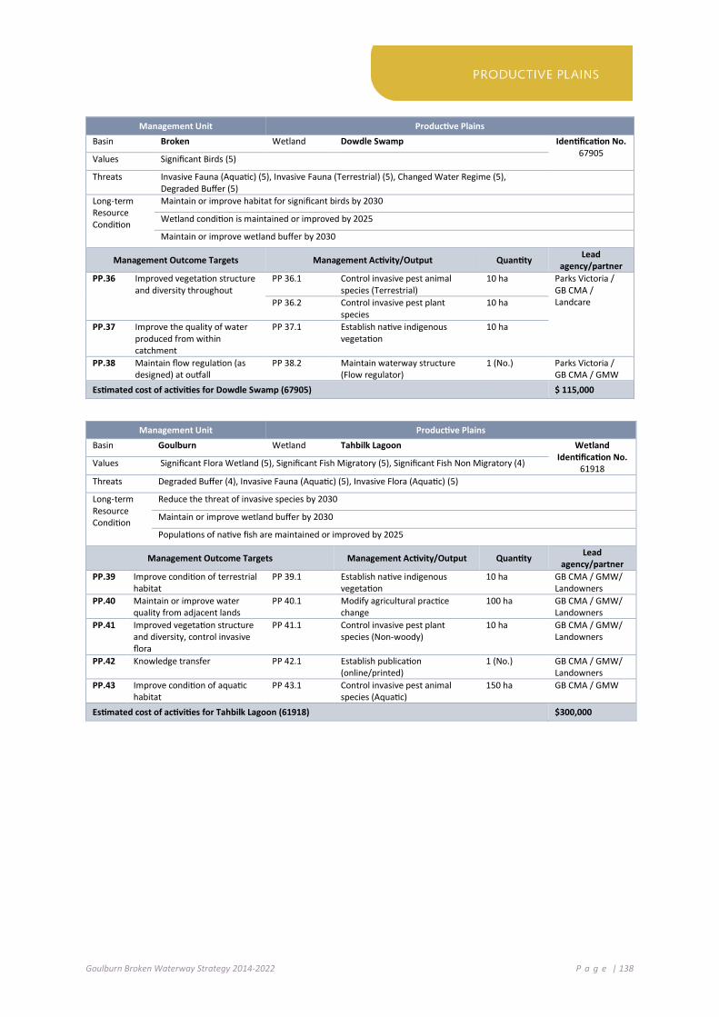
Goulburn Broken Waterway Strategy 2014-2022 P a g e | 138
Management Unit Productive Plains
Basin Broken Wetland Dowdle Swamp Identification No. 67905 Values Significant Birds (5)
Threats Invasive Fauna (Aquatic) (5), Invasive Fauna (Terrestrial) (5), Changed Water Regime (5), Degraded Buffer (5)
Long-term Resource Condition
Maintain or improve habitat for significant birds by 2030
Wetland condition is maintained or improved by 2025
Maintain or improve wetland buffer by 2030
Management Outcome Targets Management Activity/Output Quantity Lead agency/partner
PP.36 Improved vegetation structure and diversity throughout
PP 36.1 Control invasive pest animal species (Terrestrial)
10 ha Parks Victoria / GB CMA / Landcare
PP 36.2 Control invasive pest plant species
10 ha
PP.37 Improve the quality of water produced from within catchment
PP 37.1 Establish native indigenous vegetation
10 ha
PP.38 Maintain flow regulation (as designed) at outfall
PP 38.2 Maintain waterway structure (Flow regulator)
1 (No.) Parks Victoria / GB CMA / GMW
Estimated cost of activities for Dowdle Swamp (67905) $ 115,000
Management Unit Productive Plains
Basin Goulburn Wetland Tahbilk Lagoon Wetland Identification No.
61918 Values Significant Flora Wetland (5), Significant Fish Migratory (5), Significant Fish Non Migratory (4)
Threats Degraded Buffer (4), Invasive Fauna (Aquatic) (5), Invasive Flora (Aquatic) (5)
Long-term Resource Condition
Reduce the threat of invasive species by 2030
Maintain or improve wetland buffer by 2030
Populations of native fish are maintained or improved by 2025
Management Outcome Targets Management Activity/Output Quantity Lead agency/partner
PP.39 Improve condition of terrestrial habitat
PP 39.1 Establish native indigenous vegetation
10 ha GB CMA / GMW/ Landowners
PP.40 Maintain or improve water quality from adjacent lands
PP 40.1 Modify agricultural practice change
100 ha GB CMA / GMW/ Landowners
PP.41 Improved vegetation structure and diversity, control invasive flora
PP 41.1 Control invasive pest plant species (Non-woody)
10 ha GB CMA / GMW/ Landowners
PP.42 Knowledge transfer PP 42.1 Establish publication (online/printed)
1 (No.) GB CMA / GMW/ Landowners
PP.43 Improve condition of aquatic habitat
PP 43.1 Control invasive pest animal species (Aquatic)
150 ha GB CMA / GMW
Estimated cost of activities for Tahbilk Lagoon (61918) $300,000
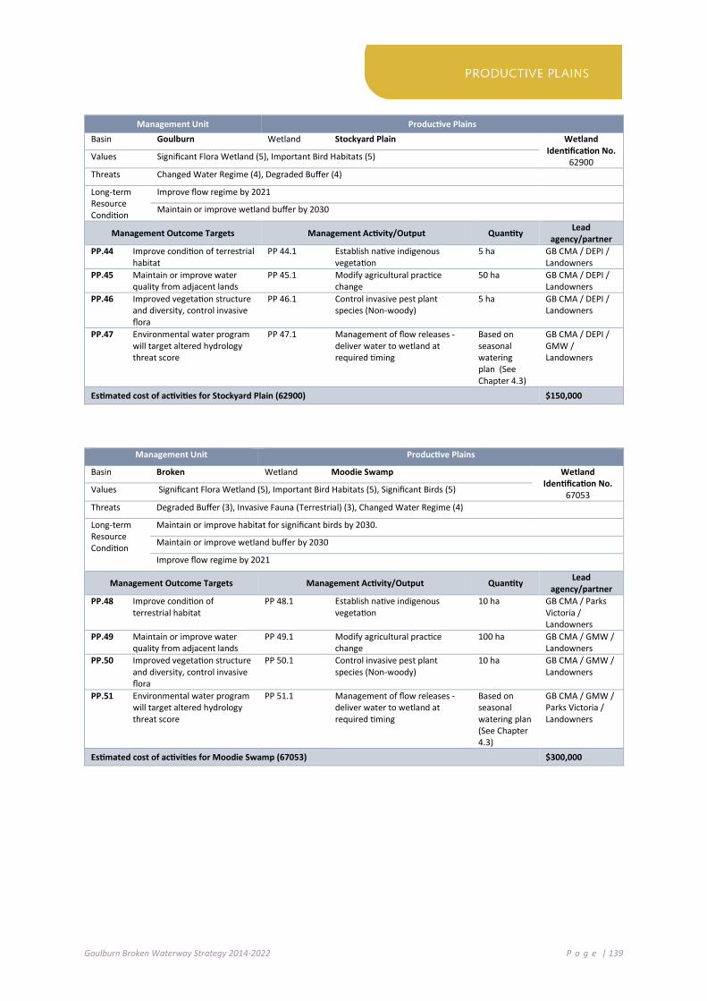
Goulburn Broken Waterway Strategy 2014-2022 P a g e | 139
Management Unit Productive Plains
Basin Goulburn Wetland Stockyard Plain Wetland Identification No.
62900 Values Significant Flora Wetland (5), Important Bird Habitats (5)
Threats Changed Water Regime (4), Degraded Buffer (4)
Long-term Resource Condition
Improve flow regime by 2021
Maintain or improve wetland buffer by 2030
Management Outcome Targets Management Activity/Output Quantity Lead agency/partner
PP.44 Improve condition of terrestrial habitat
PP 44.1 Establish native indigenous vegetation
5 ha GB CMA / DEPI / Landowners
PP.45 Maintain or improve water quality from adjacent lands
PP 45.1 Modify agricultural practice change
50 ha GB CMA / DEPI / Landowners
PP.46 Improved vegetation structure and diversity, control invasive flora
PP 46.1 Control invasive pest plant species (Non-woody)
5 ha GB CMA / DEPI / Landowners
PP.47 Environmental water program will target altered hydrology threat score
PP 47.1 Management of flow releases - deliver water to wetland at required timing
Based on seasonal watering plan (See Chapter 4.3)
GB CMA / DEPI / GMW / Landowners
Estimated cost of activities for Stockyard Plain (62900) $150,000
Management Unit Productive Plains
Basin Broken Wetland Moodie Swamp Wetland Identification No.
67053 Values Significant Flora Wetland (5), Important Bird Habitats (5), Significant Birds (5)
Threats Degraded Buffer (3), Invasive Fauna (Terrestrial) (3), Changed Water Regime (4)
Long-term Resource Condition
Maintain or improve habitat for significant birds by 2030.
Maintain or improve wetland buffer by 2030
Improve flow regime by 2021
Management Outcome Targets Management Activity/Output Quantity Lead agency/partner
PP.48 Improve condition of terrestrial habitat
PP 48.1 Establish native indigenous vegetation
10 ha GB CMA / Parks Victoria / Landowners
PP.49 Maintain or improve water quality from adjacent lands
PP 49.1 Modify agricultural practice change
100 ha GB CMA / GMW / Landowners
PP.50 Improved vegetation structure and diversity, control invasive flora
PP 50.1 Control invasive pest plant species (Non-woody)
10 ha GB CMA / GMW / Landowners
PP.51 Environmental water program will target altered hydrology threat score
PP 51.1 Management of flow releases - deliver water to wetland at required timing
Based on seasonal watering plan (See Chapter 4.3)
GB CMA / GMW / Parks Victoria / Landowners
Estimated cost of activities for Moodie Swamp (67053) $300,000

Goulburn Broken Waterway Strategy 2014-2022 P a g e | 140
Management Unit Productive Plains Basin Goulburn Waterway Honeysuckle Creek (Stony Creek) Identification No.
5-22 / 5-23 / 5-76 Values Aquatic invertebrate Community Condition (3), Community Groups (3), Native Fish (2), Riparian Vegetation Condition (3), Significant EVCs (5), Significant Fish Migratory (4), Significant Flora Terrestrial (3) Flagship Species (5)
Threats Bank Instability (5), Barriers to fish migration (4), Degraded Riparian Vegetation (4), Increase in low flow magnitude (3), Invasive fauna aquatic (5), Invasive fauna terrestrial (5), Livestock access (3), Reduced Vegetation width (3)
State: Sustainable
Working Long-term Resource Condition
Riparian and floodplain vegetation condition is maintained or improved by 2025
Populations of native fish are maintained or improved by 2025
Management Outcome Targets Management Activity/Output Quantity Lead agency/partner
PP.52 Increase bank stability and reduce erosion and sediment input
PP 52.1 Establish earthworks (Armouring) 0.2 km GB CMA
PP.53 Improve vegetation structure and diversity throughout the reach
PP 53.1 Establish native indigenous vegetation
10 ha GB CMA/ landowners/Landcare
PP.54 Manage livestock access in over 25% of waterway frontages
PP 54.1 Construct riparian fence 5 km GB CMA / Landcare / landowners PP 54.2 Modify grazing regime 10 ha
PP 54.3 Establish management agreement
10 ha
Estimated cost of activities for Honeysuckle Creek (5-22, 5-23, 5-76) $237,000
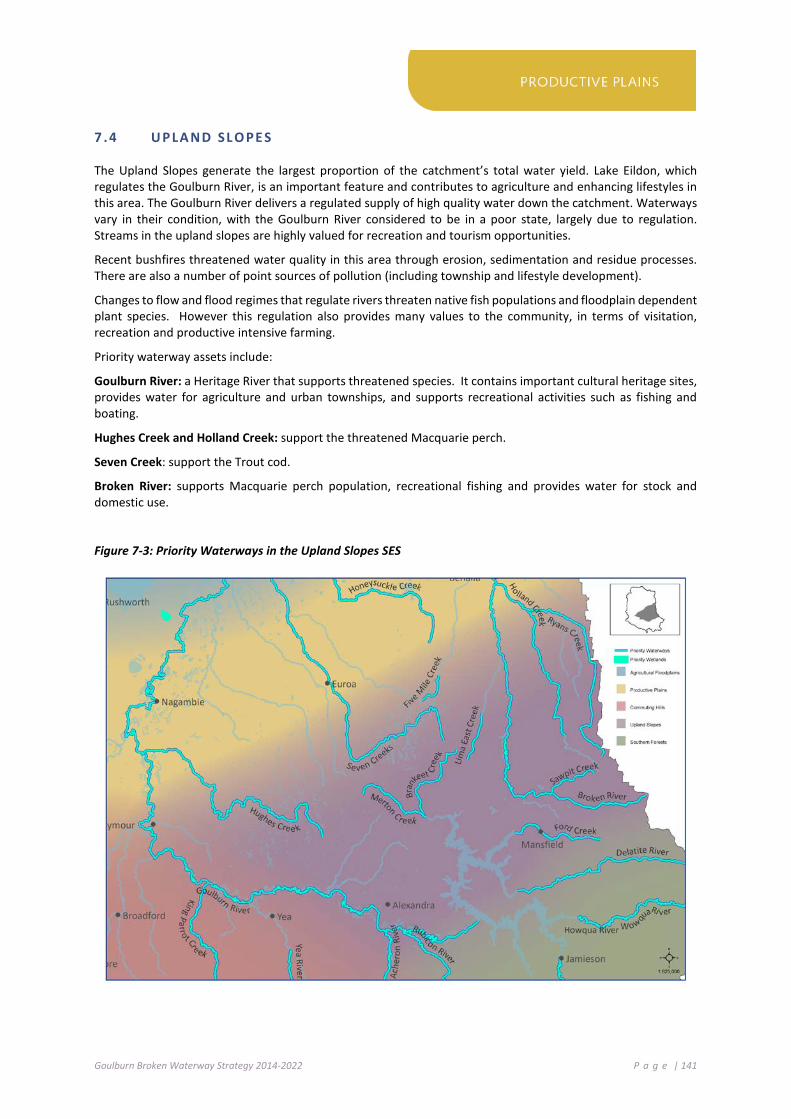
Goulburn Broken Waterway Strategy 2014-2022 P a g e | 141
7 .4 U P LA ND SL O PE S
The Upland Slopes generate the largest proportion of the catchment’s total water yield. Lake Eildon, which regulates the Goulburn River, is an important feature and contributes to agriculture and enhancing lifestyles in this area. The Goulburn River delivers a regulated supply of high quality water down the catchment. Waterways vary in their condition, with the Goulburn River considered to be in a poor state, largely due to regulation. Streams in the upland slopes are highly valued for recreation and tourism opportunities.
Recent bushfires threatened water quality in this area through erosion, sedimentation and residue processes. There are also a number of point sources of pollution (including township and lifestyle development).
Changes to flow and flood regimes that regulate rivers threaten native fish populations and floodplain dependent plant species. However this regulation also provides many values to the community, in terms of visitation, recreation and productive intensive farming.
Priority waterway assets include:
Goulburn River: a Heritage River that supports threatened species. It contains important cultural heritage sites, provides water for agriculture and urban townships, and supports recreational activities such as fishing and boating.
Hughes Creek and Holland Creek: support the threatened Macquarie perch.
Seven Creek: support the Trout cod.
Broken River: supports Macquarie perch population, recreational fishing and provides water for stock and domestic use.
Figure 7-3: Priority Waterways in the Upland Slopes SES

Goulburn Broken Waterway Strategy 2014-2022 P a g e | 142
Management Unit Upland Slopes
Basin Broken Waterway Holland Creek Identification No. 4-14 Values Significant Fish Migratory (5)
Threats Bank Instability (4), Barriers to Fish Migration (4), Livestock Access (3), Reduced Vegetation Width (3)
State: Sustainable
Working Long-term Resource Condition
Populations of native fish are maintained or improved by 2025
Riparian and floodplain vegetation condition is maintained or improved by 2025
Fish migration (open passage) is maintained or improved by 2025
Management Outcome Targets Management Activity/Output Quantity Lead agency/partner
US.1 Manage livestock access in over 25% of waterway frontages
US 1.1 Construct riparian fence 5 km GB CMA / Landcare / landowners US 1.2 Modify grazing regime 5 ha
US 1.3 Establish management agreement
5 ha
US.2 Increase bed and bank stability at sites of active bank erosion
US 2.1 Establish earthworks (Armouring) 0.1 km GB CMA
US.3 Increase in habitat availability – modify waterway structures obstructing fish passage
US 3.1 Modify waterway structure (Fishway)
2 (No.) GB CMA
US.4 Assessment of fish populations US 4.1 Undertake assessment of Macquarie perch (population and distribution)
1 (No.) GB CMA / DEPI (ARI)
Estimated cost of activities for Holland Creek (4-14) $300,000
Management Unit Upland Slopes
Basin Goulburn Waterway Acheron River Identification No. 5-62 Values Aqua Invert Community Condition (5), Riparian Vegetation Condition (4)
Threats Livestock Access (5), Loss of Instream Habitat (Large Wood) (4) State: Ecologically
Healthy Long-term Resource Condition
Maintain “Ecological Healthy Status”
Instream habitat is maintained or improved by 2030
Management Outcome Targets Management Activity/Output Quantity Lead agency/partner
US.5 Increase in habitat availability within instream zone
US 5.1 Install waterway structure (Large wood)
1 site GB CMA
US.6 Manage livestock access in over 25% of waterway frontages
US 6.1 Construct riparian fence 4 km GB CMA / Landcare / landowners US 6.2 Modify grazing regime 8 ha
US 6.3 Establish management agreement
8 ha
US 6.4 Modify agricultural practice change
50 ha
Estimated cost of activities for Acheron River (5-62) $160,000
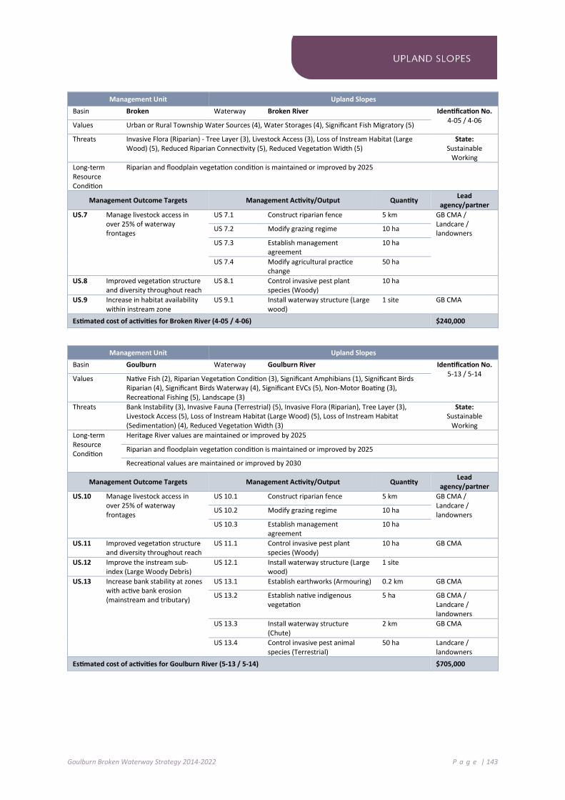
Goulburn Broken Waterway Strategy 2014-2022 P a g e | 143
Management Unit Upland Slopes
Basin Broken Waterway Broken River Identification No. 4-05 / 4-06 Values Urban or Rural Township Water Sources (4), Water Storages (4), Significant Fish Migratory (5)
Threats Invasive Flora (Riparian) - Tree Layer (3), Livestock Access (3), Loss of Instream Habitat (Large Wood) (5), Reduced Riparian Connectivity (5), Reduced Vegetation Width (5)
State: Sustainable
Working Long-term Resource Condition
Riparian and floodplain vegetation condition is maintained or improved by 2025
Management Outcome Targets Management Activity/Output Quantity Lead agency/partner
US.7 Manage livestock access in over 25% of waterway frontages
US 7.1 Construct riparian fence 5 km GB CMA / Landcare / landowners US 7.2 Modify grazing regime 10 ha
US 7.3 Establish management agreement
10 ha
US 7.4 Modify agricultural practice change
50 ha
US.8 Improved vegetation structure and diversity throughout reach
US 8.1 Control invasive pest plant species (Woody)
10 ha
US.9 Increase in habitat availability within instream zone
US 9.1 Install waterway structure (Large wood)
1 site GB CMA
Estimated cost of activities for Broken River (4-05 / 4-06) $240,000
Management Unit Upland Slopes
Basin Goulburn Waterway Goulburn River Identification No. 5-13 / 5-14 Values Native Fish (2), Riparian Vegetation Condition (3), Significant Amphibians (1), Significant Birds
Riparian (4), Significant Birds Waterway (4), Significant EVCs (5), Non-Motor Boating (3), Recreational Fishing (5), Landscape (3)
Threats Bank Instability (3), Invasive Fauna (Terrestrial) (5), Invasive Flora (Riparian), Tree Layer (3), Livestock Access (5), Loss of Instream Habitat (Large Wood) (5), Loss of Instream Habitat (Sedimentation) (4), Reduced Vegetation Width (3)
State: Sustainable
Working Long-term Resource Condition
Heritage River values are maintained or improved by 2025
Riparian and floodplain vegetation condition is maintained or improved by 2025
Recreational values are maintained or improved by 2030
Management Outcome Targets Management Activity/Output Quantity Lead agency/partner
US.10 Manage livestock access in over 25% of waterway frontages
US 10.1 Construct riparian fence 5 km GB CMA / Landcare / landowners US 10.2 Modify grazing regime 10 ha
US 10.3 Establish management agreement
10 ha
US.11 Improved vegetation structure and diversity throughout reach
US 11.1 Control invasive pest plant species (Woody)
10 ha GB CMA
US.12 Improve the instream sub-index (Large Woody Debris)
US 12.1 Install waterway structure (Large wood)
1 site
US.13 Increase bank stability at zones with active bank erosion (mainstream and tributary)
US 13.1 Establish earthworks (Armouring) 0.2 km GB CMA
US 13.2 Establish native indigenous vegetation
5 ha GB CMA / Landcare / landowners
US 13.3 Install waterway structure (Chute)
2 km GB CMA
US 13.4 Control invasive pest animal species (Terrestrial)
50 ha Landcare / landowners
Estimated cost of activities for Goulburn River (5-13 / 5-14) $705,000

Goulburn Broken Waterway Strategy 2014-2022 P a g e | 144
Management Unit Upland Slopes
Basin Goulburn Waterway Ford Creek / Brankeet Creek / Merton Creek Identification No. 5-73 / 5-74 / 5-75 Values Urban or Rural Township Water Sources (4)
Threats Livestock Access (3) Bank Instability (3), Livestock Access (3), Reduced Vegetation Width (3)
State: Sustainable
Working Long-term Resource Condition
Riparian and floodplain vegetation condition is maintained or improved by 2025
Management Outcome Targets Management Activity/Output Quantity Lead agency/partner
US.14 Manage livestock access in over 25% of waterway frontages
US 14.1 Construct riparian fence 4 km GB CMA / Landcare / landowners US 14.2 Modify grazing regime 8 ha
US 14.3 Establish management agreement
8 ha
US 14.4 Modify agricultural practice change
50 ha
US.15 Increase bank stability at zones with active bank erosion (mainstream and tributary)
US 15.1 Establish earthworks (Armouring) 0.1 km GB CMA
US 15.2 Establish native indigenous vegetation
8 ha GB CMA / Landcare / landowners
Estimated cost of activities for Brankeet / Merton system (5-73 / 5-74 / 5-75) $194,000
Management Unit Upland Slopes
Basin Broken Waterway Broken River Identification No. 4-04 Values Significant Fish Migratory (5), Significant Fish Non Migratory (5)
Threats Barriers to Fish Migration (4), Increase in Low Flow Magnitude (3), Loss of Instream Habitat (Large Wood) (3)
State: Sustainable
Working Long-term Resource Condition
Improve flow regime by 2021
Instream habitat is maintained or improved by 2030
Populations of native fish are maintained or improved by 2025
Management Outcome Targets Management Activity/Output Quantity Lead agency/partner
US.16 Environmental water improving the flow magnitude threat score
US 16.1 Deliver water regime, River reach Based on seasonal watering plan (See Chapter 4.3)
GB CMA / GMW
US.17 Increase in habitat available - address waterway structures obstructing fish passage in this reach
US 17.1 Investigate waterway structure (Fishway)
1 (No.) GB CMA
US.18 Improve the instream sub-index (Large Woody Debris)
US 18.1 Install waterway structure (Large wood)
2 sites GB CMA
Estimated cost of activities for Broken River (4-04) $180,000
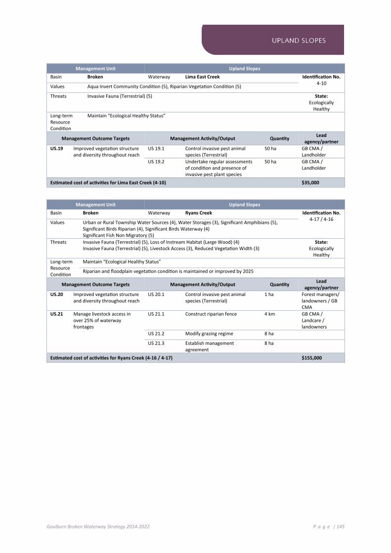
Goulburn Broken Waterway Strategy 2014-2022 P a g e | 145
Management Unit Upland Slopes
Basin Broken Waterway Lima East Creek Identification No. 4-10 Values Aqua Invert Community Condition (5), Riparian Vegetation Condition (5)
Threats Invasive Fauna (Terrestrial) (5) State: Ecologically
Healthy Long-term Resource Condition
Maintain “Ecological Healthy Status”
Management Outcome Targets Management Activity/Output Quantity Lead agency/partner
US.19 Improved vegetation structure and diversity throughout reach
US 19.1 Control invasive pest animal species (Terrestrial)
50 ha GB CMA / Landholder
US 19.2 Undertake regular assessments of condition and presence of invasive pest plant species
50 ha GB CMA / Landholder
Estimated cost of activities for Lima East Creek (4-10) $35,000
Management Unit Upland Slopes
Basin Broken Waterway Ryans Creek Identification No. 4-17 / 4-16 Values Urban or Rural Township Water Sources (4), Water Storages (3), Significant Amphibians (5),
Significant Birds Riparian (4), Significant Birds Waterway (4) Significant Fish Non Migratory (5)
Threats Invasive Fauna (Terrestrial) (5), Loss of Instream Habitat (Large Wood) (4) Invasive Fauna (Terrestrial) (5), Livestock Access (3), Reduced Vegetation Width (3)
State: Ecologically
Healthy Long-term Resource Condition
Maintain “Ecological Healthy Status”
Riparian and floodplain vegetation condition is maintained or improved by 2025
Management Outcome Targets Management Activity/Output Quantity Lead agency/partner
US.20 Improved vegetation structure and diversity throughout reach
US 20.1 Control invasive pest animal species (Terrestrial)
1 ha Forest managers/ landowners / GB CMA
US.21 Manage livestock access in over 25% of waterway frontages
US 21.1 Construct riparian fence 4 km GB CMA / Landcare / landowners
US 21.2 Modify grazing regime 8 ha
US 21.3 Establish management agreement
8 ha
Estimated cost of activities for Ryans Creek (4-16 / 4-17) $155,000
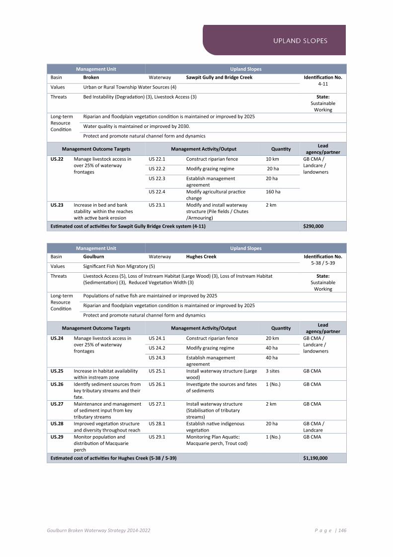
Goulburn Broken Waterway Strategy 2014-2022 P a g e | 146
Management Unit Upland Slopes
Basin Broken Waterway Sawpit Gully and Bridge Creek Identification No. 4-11 Values Urban or Rural Township Water Sources (4)
Threats Bed Instability (Degradation) (3), Livestock Access (3) State: Sustainable
Working Long-term Resource Condition
Riparian and floodplain vegetation condition is maintained or improved by 2025
Water quality is maintained or improved by 2030.
Protect and promote natural channel form and dynamics
Management Outcome Targets Management Activity/Output Quantity Lead agency/partner
US.22 Manage livestock access in over 25% of waterway frontages
US 22.1 Construct riparian fence 10 km GB CMA / Landcare / landowners US 22.2 Modify grazing regime 20 ha
US 22.3 Establish management agreement
20 ha
US 22.4 Modify agricultural practice change
160 ha
US.23 Increase in bed and bank stability within the reaches with active bank erosion
US 23.1 Modify and install waterway structure (Pile fields / Chutes /Armouring)
2 km
Estimated cost of activities for Sawpit Gully Bridge Creek system (4-11) $290,000
Management Unit Upland Slopes
Basin Goulburn Waterway Hughes Creek Identification No. 5-38 / 5-39 Values Significant Fish Non Migratory (5)
Threats Livestock Access (5), Loss of Instream Habitat (Large Wood) (3), Loss of Instream Habitat (Sedimentation) (3), Reduced Vegetation Width (3)
State: Sustainable
Working Long-term Resource Condition
Populations of native fish are maintained or improved by 2025
Riparian and floodplain vegetation condition is maintained or improved by 2025
Protect and promote natural channel form and dynamics
Management Outcome Targets Management Activity/Output Quantity Lead agency/partner
US.24 Manage livestock access in over 25% of waterway frontages
US 24.1 Construct riparian fence 20 km GB CMA / Landcare / landowners US 24.2 Modify grazing regime 40 ha
US 24.3 Establish management agreement
40 ha
US.25 Increase in habitat availability within instream zone
US 25.1 Install waterway structure (Large wood)
3 sites GB CMA
US.26 Identify sediment sources from key tributary streams and their fate.
US 26.1 Investigate the sources and fates of sediments
1 (No.) GB CMA
US.27 Maintenance and management of sediment input from key tributary streams
US 27.1 Install waterway structure (Stabilisation of tributary streams)
2 km GB CMA
US.28 Improved vegetation structure and diversity throughout reach
US 28.1 Establish native indigenous vegetation
20 ha GB CMA / Landcare
US.29 Monitor population and distribution of Macquarie perch
US 29.1 Monitoring Plan Aquatic: Macquarie perch, Trout cod)
1 (No.) GB CMA
Estimated cost of activities for Hughes Creek (5-38 / 5-39) $1,190,000

Goulburn Broken Waterway Strategy 2014-2022 P a g e | 147
Management Unit Upland Slopes Basin Broken Waterway Five Mile Creek Identification No.
4-08 Values Aquatic Invertebrate Community Condition (3), Community Groups (3), Game Hunting (5), Riparian vegetation Condition (5), Significant EVC’s (5), Swimming (3), Flagship species (3)
Threats Invasive Fauna Aquatic (5), Invasive Fauna Terrestrial (5), Livestock Access (3), Loss of Instream Habitat Large Wood (2)
State: Ecologically
Healthy Long-term Resource Condition
Maintain “Ecological Healthy Status”
Riparian and floodplain vegetation condition is maintained or improved by 2025
Instream habitat is maintained or improved by 2030
Management Outcome Targets Management Activity/Output Quantity Lead agency/partner
US.30 Manage livestock access in over 25% of waterway frontages
US 30.1 Construct riparian fence 2 km GB CMA / Landcare / landowners US 30.2 Modify grazing regime 4 ha
US 30.3 Establish management agreement
4 ha
US 30.4 Establish native indigenous vegetation
2 ha
Estimated cost of activities for Five Mile Creek (4-08) $70,000

Goulburn Broken Waterway Strategy 2014-2022 P a g e | 148
7 .5 C O M M UT I NG HI LL S
The remaining extent of forest in the Commuting Hills SES contributes to healthy river ecosystems, which ideally provide constant yields of filtered high quality water down the catchment.
Threats to waterways in this SES largely relate to runoff and water quality.
Waterways are classified as being in good condition, however, water yield and quality has been influenced by recent bushfires. Invasive species, including European carp, also threaten water quality in this SES.
Priority waterways include:
Goulburn River: a Heritage River that supports high community values (including tourism, recreation and aesthetics.
King Parrot Creek and Yea River: supports populations of the threatened Macquarie perch.
Acheron River: environmental Site of Significance.
Taggerty River: contains ecologically healthy and representative reaches and supports the threatened Barred galaxias.
Mollisons Creek and Sunday Creek: supply of water for urban, stock and domestic uses.
Figure 7-4: Priority Waterways in the Commuting Hills SES

Goulburn Broken Waterway Strategy 2014-2022 P a g e | 149
Management Unit Commuting Hills
Basin Goulburn Waterway Mollisons Creek Identification No. 5-42 / 5-43 Values Urban or Rural Township Water Sources (4), Water Storages (3)
Threats Degraded Water Quality (5), Livestock Access (5), Reduced Vegetation Width (3) State: Sustainable
Working Long-term Resource Condition
Riparian and floodplain vegetation condition is maintained or improved by 2025
Water quality is maintained or improved by 2030.
Management Outcome Targets Management Activity/Output Quantity Lead agency/partner
CH.1 Manage livestock access in over 50% of waterway frontages
CH 1.1 Construct riparian fence 15 km GB CMA / Landcare / landowners CH 1.2 Modify grazing regime 30 ha
CH 1.3 Establish management agreement
30 ha
CH 1.4 Modify agricultural practice change
160 ha
CH.2 Improve vegetation structure and diversity throughout reach CH 2.1 Establish native indigenous
vegetation 5 ha
Estimated cost of activities for Mollisons Creek (5-42 / 5-43) $545,000
Management Unit Commuting Hills
Basin Goulburn Waterway King Parrot Creek Identification No. 5-51 Values Significant Fish Migratory (5)
Threats Livestock Access (5), Loss of Instream Habitat (Large Wood) (3), Reduced Vegetation Width (3) State: Sustainable
Working Long-term Resource Condition
Populations of native fish are maintained or improved by 2025
Riparian and floodplain vegetation condition is maintained or improved by 2025
Instream habitat is maintained or improved by 2030
Management Outcome Targets Management Activity/Output Quantity Lead agency/partner
CH.3 Manage livestock access in over 50% of waterway frontages
CH 3.1 Construct riparian fence 5 km GB CMA / Landcare / landowners CH 3.2 Modify grazing regime 10 ha
CH 3.3 Establish management agreement
10 ha
CH.4 Increase in habitat availability within instream zone
CH 4.1 Install waterway structure (Large wood)
1 site GB CMA
CH.5 Improved vegetation structure and diversity throughout reach
CH 5.1 Control invasive pest plant species (Woody)
40 ha GB CMA / Landcare / landowners
CH.6 Monitor population and distribution of Macquarie perch
CH 6.1 Develop and implement Monitoring Plan (Aquatic: Macquarie perch)
1 (No.) GB CMA, DEPI (ARI)
Estimated cost of activities for King Parrot Creek (5-51) $650,000

Goulburn Broken Waterway Strategy 2014-2022 P a g e | 150
Management Unit Commuting Hills
Basin Goulburn Waterway Yea River Identification No. 5-55 and 5 - 56 Values Significant Fish Migratory (5)
Threats Barriers to Fish Migration (3), Livestock Access (5), Loss of Instream Habitat (Large Wood) (5) Reduced Vegetation Width (3)
State: Sustainable
Working Long-term Resource Condition
Populations of native fish are maintained or improved by 2025
Riparian and floodplain vegetation condition is maintained or improved by 2025
Instream habitat is maintained or improved by 2030
Management Outcome Targets Management Activity/Output Quantity Lead agency/partner
CH.7 Manage livestock access in over 50% of waterway frontages
CH 7.1 Construct riparian fence 10 km GB CMA / Landcare / landowners CH 7.2 Modify grazing regime 20 ha
CH 7.3 Establish management agreement
20 ha
CH.8 Increase in habitat availability within instream zone
CH 8.1 Install waterway structure (Large wood)
1 site GB CMA
CH 8.2 Investigate the management of high sediment sources and fates
1 (No.) GB CMA
CH.9 Improved vegetation structure and diversity throughout reach
CH 9.1 Establish native indigenous vegetation
15 ha GB CMA / Landcare
CH 9.2 Control invasive pest plant species (Woody)
40 ha GB CMA, DEPI
CH.10 Monitor population and distribution of Macquarie perch
CH 10.1 Develop and implement Monitoring Plan (Aquatic: Macquarie perch)
1 (No.) GB CMA, DEPI (ARI)
Estimated cost of activities for Yea River (5-55 / 5-56) $1,070,000

Goulburn Broken Waterway Strategy 2014-2022 P a g e | 151
Management Unit Commuting Hills
Basin Goulburn Waterway Goulburn River Identification No. 5 - 12 / 5 - 11 Values Native Fish (2), Riparian Vegetation Condition (3), Significant Amphibians (1), Significant Birds
Riparian (4), Significant Birds Waterway (4), Significant EVCs (5), Significant Fish Migratory (1), Significant Mammals (1), Non-Motor Boating (3), Landscape (3)
Threats Invasive Fauna (Terrestrial) (5), Invasive Flora (Riparian) - Tree Layer (3), Livestock Access (5), Loss of Instream Habitat (Large Wood) (4), Loss of Instream Habitat (Sedimentation) (4), Reduction in High Flow Magnitude (3), Reduced Vegetation Width (4)
State: Highly Modified
Long-term Resource Condition
Improve flow regime by 2021
Riparian and floodplain vegetation condition is maintained or improved by 2025
Heritage River values are maintained or improved by 2025
Management Outcome Targets Management Activity/Output Quantity Lead agency/partner
CH.11 Manage livestock access in over 40% of waterway frontages
CH 11.1 Construct riparian fence 10 km GB CMA / Landcare / landowners CH 11.2 Modify grazing regime 20 ha
CH 11.3 Establish management agreement
20 ha
CH 11.4 Modify agricultural practice change
320 ha
CH.12 Increase in habitat availability within instream zone
CH 12.1 Install waterway structure (Large wood)
2 sites GB CMA
CH 12.2 Investigate the management of high sediment sources and fates
1 (No.) GB CMA
CH.13 Improved vegetation structure and diversity throughout reach
CH 13.1 Establish native indigenous vegetation
5 ha GB CMA / DEPI/ landowners
CH 13.2 Control invasive pest plant species (Woody)
20 ha
CH 13.3 Control invasive pest animal species (Terrestrial)
100 ha
CH.14 Environmental water program will target altered hydrology threat score
CH 14.1 Deliver Water regime, River reach: Management of flow releases - Deliver water to river reach at required timing
Based on seasonal watering plan (See Chapter 4.3)
DEPI / GB CMA/ Parks NSW
Estimated cost of activities for Goulburn River (5-11 / 5-12) $1,250,000
Management Unit Commuting Hills
Basin Goulburn Waterway Sunday Creek Identification No. 5 - 47 Values Urban or Rural Township Water Sources (4), Significant Fish Non Migratory (5)
Threats Degraded Water Quality (5), Livestock Access (1) State: Sustainable
Working Long-term Resource Condition
Riparian and floodplain vegetation condition is maintained or improved by 2025
Water quality is maintained or improved by 2030
Management Outcome Targets Management Activity/Output Quantity Lead agency/partner
CH.15 Manage livestock access in over 40% of waterway frontages
CH 15.1 Modify agricultural practice change
50 ha GB CMA / local government / landowners CH 15.2 Establish management
agreement 50 ha
Estimated cost of activities for Sunday Creek (5-47) $50,000

Goulburn Broken Waterway Strategy 2014-2022 P a g e | 152
7 .6 S O U T HE RN F O RE ST S
The Southern Forests contribute to healthy river ecosystems and provide constant yields of filtered high quality water. Waterways in this SES are considered to be in a good to excellent state.
This area supports several significant native fish species.
Increasing numbers of tracks for timber extraction and recreational activities intensifies erosion, resulting in reduced water quality. This results in increased sedimentation of waterways, destruction of fish habitat and changes to stream condition.
The current condition of wetlands is considered to be good. The major threats to wetlands are pest plant and animal invasion and soil erosion.
Priority waterways assets include:
Goulburn River: a Heritage River that is an ecologically healthy reach. Its tributaries support threatened species (Spotted Tree Frog and Alpine Bent).
Rubicon River: a priority river with near “Ecologically Healthy” status, supports Barred galaxias in tributary streams – Keppel Hut Creek, Pheasant Creek, Perkins Creek, Taggerty River, Torbreck River and Stanleys Creek.
Big River: a Heritage River and representative reaches that supports the threatened Spotted Tree Frog.
Howqua River: a Heritage River that has high economic values through tourism and recreation values.
Alpine bogs (National significance): areas that support the nationally threatened Alpine Sphagnum Bogs and associated fens ecological community.
Central Highlands Peatlands (DIWA listed): five separate sphagnum moss dominated bogs located along rivers and gullies in the Central Highlands.
Figure 7-5: Priority Waterways in the Southern Forests SES
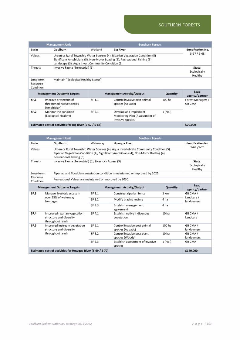
Goulburn Broken Waterway Strategy 2014-2022 P a g e | 153
Management Unit Southern Forests
Basin Goulburn Wetland Big River Identification No. 5-67 / 5-68 Values Urban or Rural Township Water Sources (4), Riparian Vegetation Condition (5)
Significant Amphibians (5), Non-Motor Boating (5), Recreational Fishing (5) Landscape (3), Aqua Invert Community Condition (5)
Threats Invasive Fauna (Terrestrial) (5) State: Ecologically
Healthy Long-term Resource Condition
Maintain “Ecological Healthy Status”
Management Outcome Targets Management Activity/Output Quantity Lead agency/partner
SF.1 Improve protection of threatened native species (Amphibian)
SF 1.1 Control invasive pest animal species (Aquatic)
100 ha Forest Managers / GB CMA
SF.2 Monitor the condition (Ecological Healthy)
SF 2.1 Develop and implement Monitoring Plan (Assessment of Invasive species)
1 (No.)
Estimated cost of activities for Big River (5-67 / 5-68) $70,000
Management Unit Southern Forests
Basin Goulburn Waterway Howqua River Identification No. 5-69 /5-70 Values Urban or Rural Township Water Sources (4), Aqua Invertebrate Community Condition (5),
Riparian Vegetation Condition (4), Significant Amphibians (4), Non-Motor Boating (4), Recreational Fishing (5)
Threats Invasive Fauna (Terrestrial) (5), Livestock Access (3) State: Ecologically
Healthy Long-term Resource Condition
Riparian and floodplain vegetation condition is maintained or improved by 2025
Recreational Values are maintained or improved by 2030.
Management Outcome Targets Management Activity/Output Quantity Lead agency/partner
SF.3 Manage livestock access in over 25% of waterway frontages
SF 3.1 Construct riparian fence 2 km GB CMA / Landcare / landowners SF 3.2 Modify grazing regime 4 ha
SF 3.3 Establish management agreement
4 ha
SF.4 Improved riparian vegetation structure and diversity throughout reach
SF 4.1 Establish native indigenous vegetation
10 ha GB CMA / Landcare
SF.5 Improved instream vegetation structure and diversity throughout reach
SF 5.1 Control invasive pest animal species (Aquatic)
100 ha GB CMA / landowners
SF 5.2 Control invasive pest plant species (Woody)
10 ha GB CMA / landowners
SF 5.3 Establish assessment of invasive species
1 (No.) GB CMA
Estimated cost of activities for Howqua River (5-69 / 5-70) $140,000
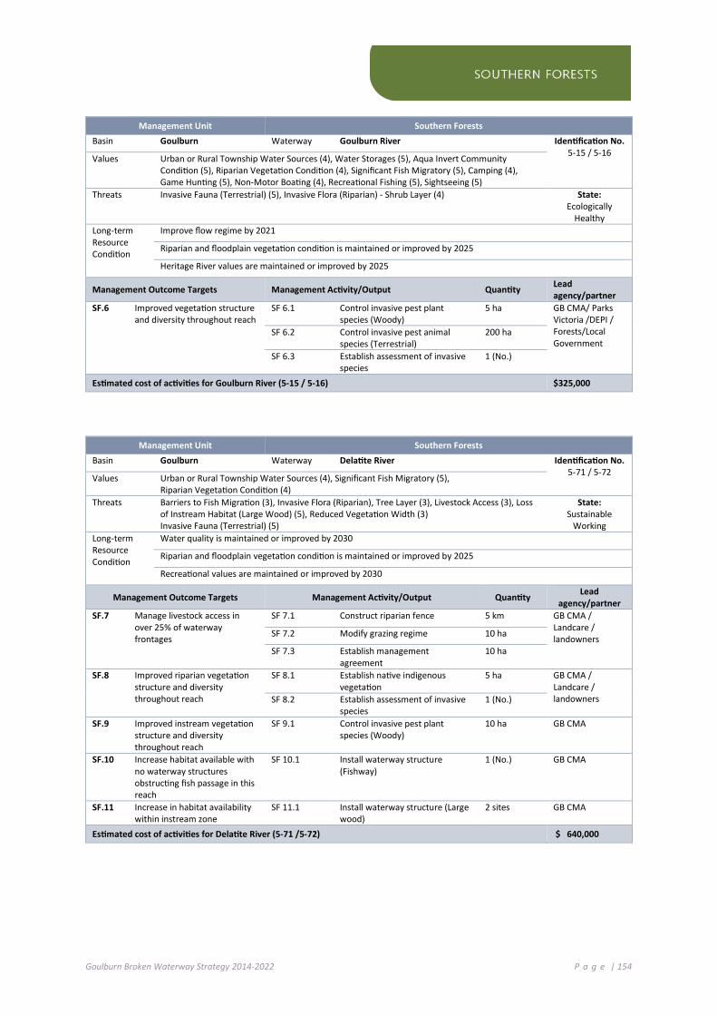
Goulburn Broken Waterway Strategy 2014-2022 P a g e | 154
Management Unit Southern Forests
Basin Goulburn Waterway Goulburn River Identification No. 5-15 / 5-16 Values Urban or Rural Township Water Sources (4), Water Storages (5), Aqua Invert Community
Condition (5), Riparian Vegetation Condition (4), Significant Fish Migratory (5), Camping (4), Game Hunting (5), Non-Motor Boating (4), Recreational Fishing (5), Sightseeing (5)
Threats Invasive Fauna (Terrestrial) (5), Invasive Flora (Riparian) - Shrub Layer (4) State: Ecologically
Healthy Long-term Resource Condition
Improve flow regime by 2021
Riparian and floodplain vegetation condition is maintained or improved by 2025
Heritage River values are maintained or improved by 2025
Management Outcome Targets Management Activity/Output Quantity Lead agency/partner
SF.6 Improved vegetation structure and diversity throughout reach
SF 6.1 Control invasive pest plant species (Woody)
5 ha GB CMA/ Parks Victoria /DEPI / Forests/Local Government
SF 6.2 Control invasive pest animal species (Terrestrial)
200 ha
SF 6.3 Establish assessment of invasive species
1 (No.)
Estimated cost of activities for Goulburn River (5-15 / 5-16) $325,000
Management Unit Southern Forests
Basin Goulburn Waterway Delatite River Identification No. 5-71 / 5-72 Values Urban or Rural Township Water Sources (4), Significant Fish Migratory (5),
Riparian Vegetation Condition (4) Threats Barriers to Fish Migration (3), Invasive Flora (Riparian), Tree Layer (3), Livestock Access (3), Loss
of Instream Habitat (Large Wood) (5), Reduced Vegetation Width (3) Invasive Fauna (Terrestrial) (5)
State: Sustainable
Working Long-term Resource Condition
Water quality is maintained or improved by 2030
Riparian and floodplain vegetation condition is maintained or improved by 2025
Recreational values are maintained or improved by 2030
Management Outcome Targets Management Activity/Output Quantity Lead agency/partner
SF.7 Manage livestock access in over 25% of waterway frontages
SF 7.1 Construct riparian fence 5 km GB CMA / Landcare / landowners SF 7.2 Modify grazing regime 10 ha
SF 7.3 Establish management agreement
10 ha
SF.8 Improved riparian vegetation structure and diversity throughout reach
SF 8.1 Establish native indigenous vegetation
5 ha GB CMA / Landcare / landowners SF 8.2 Establish assessment of invasive
species 1 (No.)
SF.9 Improved instream vegetation structure and diversity throughout reach
SF 9.1 Control invasive pest plant species (Woody)
10 ha GB CMA
SF.10 Increase habitat available with no waterway structures obstructing fish passage in this reach
SF 10.1 Install waterway structure (Fishway)
1 (No.) GB CMA
SF.11 Increase in habitat availability within instream zone
SF 11.1 Install waterway structure (Large wood)
2 sites GB CMA
Estimated cost of activities for Delatite River (5-71 /5-72) $ 640,000

Goulburn Broken Waterway Strategy 2014-2022 P a g e | 155
Management Unit Southern Forests
Basin Goulburn Waterway Taggerty River Identification No. 5-64 Values Aqua Invert Community Condition (5), Riparian Vegetation Condition (4)
Threats Loss of Instream Habitat (Large Wood) (3) State: Ecologically
Healthy Long-term Resource Condition
Maintain “Ecological Healthy Status”
Instream habitat is maintained or improved by 2030
Management Outcome Targets Management Activity/Output Quantity Lead agency/partner
SF.12 Monitor status and condition
Estimated cost of activities for Taggerty River (5-64) $ (see maintenance)
Management Unit Southern Forests
Basin Goulburn Waterway Acheron River Identification No. 5-63 Values Aqua Invert Community Condition (5), Riparian Vegetation Condition (5)
Threats Loss of Instream Habitat (Large Wood) (3) State: Ecologically
Healthy Long-term Resource Condition
Maintain “Ecological Healthy Status”
Instream habitat is maintained or improved by 2030
Management Outcome Targets Management Activity/Output Quantity Lead agency/partner
SF.13 Monitor status and condition
Estimated cost of activities for Acheron River (5-63) $ (see maintenance)
Management Unit Southern Forests
Basin Goulburn Wetland Central Highland Peatlands and Alpine Bogs Identification No. CHP / AB Values Significant EVCs (5)
Threats Degraded buffer (5), Invasive Fauna (Terrestrial) (5), Invasive Flora (Riparian) (5)
Long-term Resource Condition
Wetland Condition is maintained or improved by 2025
Management Outcome Targets Management Activity/Output Quantity Lead agency/partner
SF.14 Improved vegetation structure and diversity throughout reach
SF 14.1 Control invasive pest plant species (Woody)
500 ha DEPI (Region) / Forest Managers / GB CMA/TCAC/ Parks Victoria / Alpine Resort Management Boards
SF 14.2 Implement the Victorian Alpine Peatlands Spatial Action Plan
100 ha
SF.15 Monitor the condition (Ecological Healthy)
SF 15.1 Refine and implement Monitoring Plan: Assessment of Invasive Species
1 (No.)
Estimated cost of activities for Central Highland Peatlands and Alpine Bogs (CHP/AB) $1,000,000
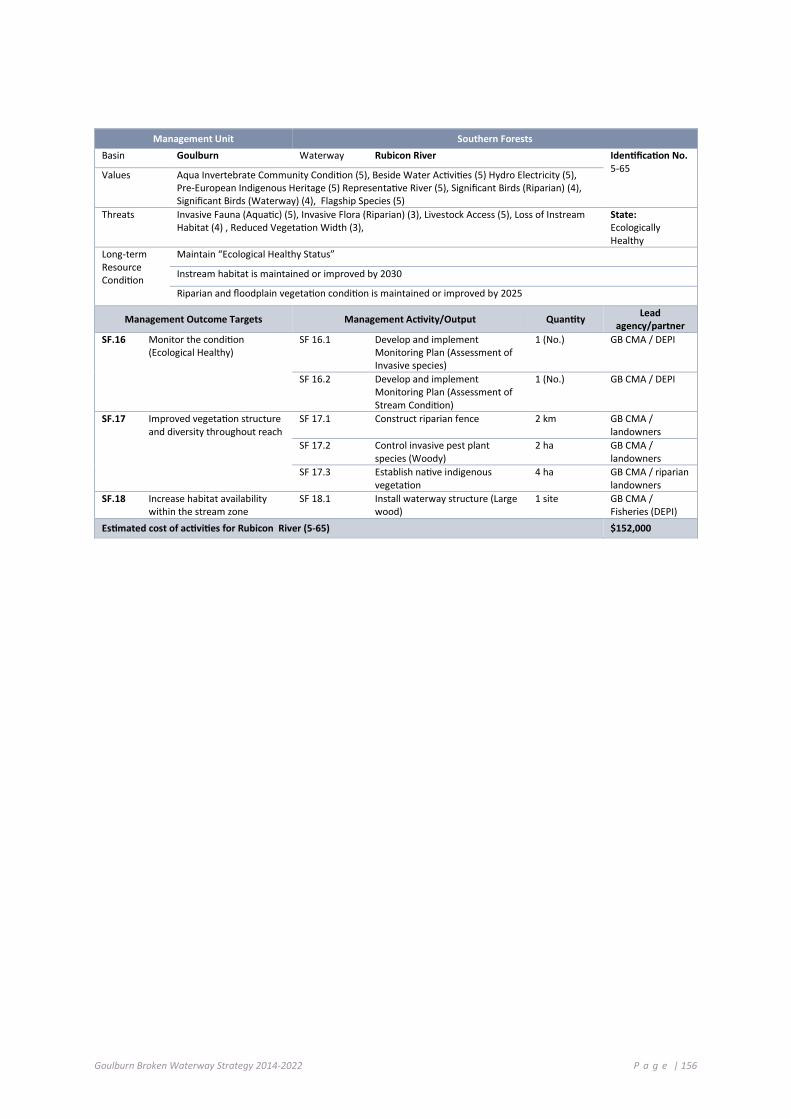
Goulburn Broken Waterway Strategy 2014-2022 P a g e | 156
Management Unit Southern Forests
Basin Goulburn Waterway Rubicon River Identification No. 5-65 Values Aqua Invertebrate Community Condition (5), Beside Water Activities (5) Hydro Electricity (5),
Pre-European Indigenous Heritage (5) Representative River (5), Significant Birds (Riparian) (4), Significant Birds (Waterway) (4), Flagship Species (5)
Threats Invasive Fauna (Aquatic) (5), Invasive Flora (Riparian) (3), Livestock Access (5), Loss of Instream Habitat (4) , Reduced Vegetation Width (3),
State: Ecologically Healthy
Long-term Resource Condition
Maintain “Ecological Healthy Status”
Instream habitat is maintained or improved by 2030
Riparian and floodplain vegetation condition is maintained or improved by 2025
Management Outcome Targets Management Activity/Output Quantity Lead agency/partner
SF.16 Monitor the condition (Ecological Healthy)
SF 16.1 Develop and implement Monitoring Plan (Assessment of Invasive species)
1 (No.) GB CMA / DEPI
SF 16.2 Develop and implement Monitoring Plan (Assessment of Stream Condition)
1 (No.) GB CMA / DEPI
SF.17 Improved vegetation structure and diversity throughout reach
SF 17.1 Construct riparian fence 2 km GB CMA / landowners
SF 17.2 Control invasive pest plant species (Woody)
2 ha GB CMA / landowners
SF 17.3 Establish native indigenous vegetation
4 ha GB CMA / riparian landowners
SF.18 Increase habitat availability within the stream zone
SF 18.1 Install waterway structure (Large wood)
1 site GB CMA / Fisheries (DEPI)
Estimated cost of activities for Rubicon River (5-65) $152,000

Goulburn Broken Waterway Strategy 2014-2022 P a g e | 157
7 .7 U RB AN CE NT R E S
Historically our urban areas and satellite townships were built near or in close proximity to waterways. Waterways were a focal point for development because they provided water, food and recreation resources.
Waterways in urban areas provide a range of environmental, social and economic values (Table 7-1). Urban areas also present a threat to some of the values we associate with waterways.
Table 7-1: Values and Threats within Urban Waterways
Values Threats (direct)
Social
Recreational fishing
Non-Motor boating
Motor boating
Camping
Swimming
Walking, hiking, cycling
Sightseeing
Picnics/barbecues
Pre-European (Indigenous)
Post-European landscape
Community groups
Economic
Urban/Rural township water sources
Wastewater discharges
Channel modification
Removal of Large woody debris
Development
Water discharge
Waste discharge
Removal/modification of native vegetation
Litter
Weeds
7.7.1 MANAGEMENT ARRANGEMENTS
The GB CMA and in some areas, local councils, are the managers of urban sections of waterways within the Goulburn Broken region (DSE 2012). Strategic planning documents that influence the management of waterways in regional urban areas include:
• GB CMA Waterway Strategy: Management activities to improve the condition of priority waterways in urban areas are identified in this Strategy (see Chapter 4).
• GB CMA Regional Floodplain Management Strategies: CMAs are also responsible for floodplain management and have previously developed Regional Floodplain Management Strategies.
• Local Stormwater Plans: Local councils are responsible for managing stormwater and drainage infrastructure in urban areas. In undertaking waterway management actions in regional urban areas, CMAs have previously relied on strong partnerships, cost-sharing arrangements and goodwill from local government and other partners.
• Urban Waterway plans: In partnership with the community some local governments together with the local Catchment Management Authority, have developed a management plan for urban waterways (see section 7.7.2).

Goulburn Broken Waterway Strategy 2014-2022 P a g e | 158
7.7.2 URBAN WATERWAYS IN THE REGION
A number of townships surround or run parallel to key waterway systems throughout the Goulburn Broken region.
The township and waterway interface creates a separate set of circumstances with respect to waterway management; social and economic values are heightened and direct threats to waterway values are increased.
Urban waterways within priority waterways are shown in Table 7-2.
7.7.3 ISSUES
A number of key threats are evident within Urban Waterways, these are grouped under the following key issues:
• Stormwater management;
• Recreation and open space planning;
• Water reuse planning and implementation; and
• Urban encroachment.
Waterways in urban centres have been highly modified to accommodate development and built infrastructure. Water is extracted from the rivers for consumptive use and waste and storm water is discharged. Waste water is treated prior to discharge, but often stormwater is not.
Waterways are a major feature of urban centres but are under stress from numerous threats associated with high density living, such as gross and diffuse pollutants, flood mitigation works that change flows, water weeds and European carp, all of which reduce the quality of water.
Pollutants change the chemistry of water which in turn affects fish populations and the food resources they rely on.
7.7.4 STRATEGIC SUPPORT AND RECOMMENDED STRATEGIES
The Municipal Association of Victoria (MAV) strongly supports consultation with local government to investigate incentives for local government and household interventions to retain, use and infiltrate urban stormwater runoff through capital works programs. The MAV understands current issues around the regulatory uncertainty of stormwater ownership will be considered through the review of the Water Act 1989. Therefore, this should be considered as part of the implementation of this action, as well as greater information about the economic rationalisation of various stormwater reuse projects, including maintenance costs.
The MAV supports the extension of water performance standards to other types of development in Victoria. However, Clause 56.07 of the Victorian Planning Provisions, which currently applies to residential subdivisions, is not without its challenges and requires review before being transposed to other types of development.
RiverConnect
More and more Shepparton and Mooroopna residents are enjoying their stunning riverine environment because of the RiverConnect project.
RiverConnect links the goodwill and energy of many and varied groups and individuals, enhancing existing activities and creating the opportunity to develop bigger, whole of community projects.
People from vastly different backgrounds are interacting through educational, recreational, artistic, cultural heritage and environmental activities.
RiverConnect resulted from a ground swell in understanding that the time had come to embrace the Goulburn and Broken Rivers and the opportunities they present. The RiverConnect vision is for the riverine environment to be the heart and soul of Shepparton and Mooroopna.
RiverConnect working groups on Education, Aboriginal Participation, Land Management and Communication involve more people in implementing detailed actions listed in the RiverConnect Strategic Plan, which was prepared in 2011 after extensive community consultation.
Eighteen of the nineteen schools in the RiverConnect area have adopted a reach and thousands of students participate in activities on the banks of the Goulburn and Broken Rivers each year.

Goulburn Broken Waterway Strategy 2014-2022 P a g e | 159
This Strategy does not address the management of domestic onsite waste systems, which is largely the responsibility of local government. Domestic wastewater management has been a significant recent issue for councils; in particular the role of councils in onsite domestic wastewater management in open potable water supply catchments. New potable guidelines are expected to be released shortly by the Victorian Government. These guidelines will increase the requirements of councils in domestic wastewater management planning.
The MAV strongly believes that this Strategy is an opportunity to improve the integration of agencies involved in domestic wastewater management for improved water quality outcomes, to avoid repetition in legislated roles.
Waterway corridors in the catchment of the Goulburn and Broken Rivers are important assets that are threatened by urbanisation. In particular, Plan Melbourne (2014) identifies areas around Kilmore and Broadford as new growth areas for Melbourne. Melbourne Water has developed guidelines to protect waterway corridors in greenfield development areas. The Goulburn Broken CMA will adopt Melbourne Water’s guidelines for waterway corridors and incorporate them into the CMA best practice guidelines for land use and planning.
Table 7-2: Existing Management Plans for waterways in urban centres
Township Social Ecological System Waterway Existing Management Plans
Shepparton Mooroopna
Agricultural Floodplains Goulburn River Urban Land Use Study
Shepparton-Mooroopna Stormwater Quality Strategy prepared for City of Greater Shepparton - February 1999
Shepparton Agricultural Floodplains Broken River
Nathalia Agricultural Floodplains Broken Creek
Stormwater Strategy for Moira Shire Council Numurkah Agricultural Floodplains Broken Creek
Katamatite Agricultural Floodplains Broken Creek
Murchison Productive Plains Goulburn River
Benalla Productive Plains Broken River Lake Benalla Riverine Trail and Waterway Management Plan
Stormwater Strategy for Benalla Rural City
Nagambie Productive Plains Lake Nagambie Land and On-Water Management Plan 2012
Tungamah Productive Plains Boosey Creek Boosey Creek Management Plan
Avenel Productive Plains Hughes Creek
Seymour Commuting Hills Goulburn River Stormwater Strategy for Mitchell Shire
Molesworth /Thornton
Commuting Hills Goulburn River
Broadford Commuting Hills Sunday Creek
Broadford Commuting Hills Dry Creek
Kilmore Commuting Hills Kilmore Creek
Yea Commuting Hills Yea River

Goulburn Broken Waterway Strategy 2014-2022 P a g e | 160
7.7.5 PRIORITY ACTIONS FOR URBAN CENTRES
The following table details priority actions; the timeframe for implementation and the responsible agency, authority or group.
Action Timeframe Responsibility
Encourage and support local government in the development and implementation of urban waterway plans
2014-2022 GB CMA, Local Government, Community Interest Groups
Provide protection to urban waterways in planning schemes 2014-2022 Local Government
Support urban waterway community actions and activities 2014-2022 Local Government, GB CMA, Community
Incorporate Melbourne Water Corporation (MWC) waterway corridor guidelines in the CMA best practice guidelines for land use and planning
2014-2022 Local Government, GB CMA
7 .8 A S S U M PT I O N S
The assumptions underpinning the link between Implementation Targets and Management Outcomes is derived from:
• conceptual models (from GHD, 2011) that will provide consistent assumptions about the relationships between values and threats and the management activities required to reduce threats to values;
• evidence used to determine the confidence rating for association values (from Doeg, 2009) between values and threats; and
• assumptions developed by the GB CMA over the life of the previous River Health Strategy (see Table 7-3).
Table 7-3: Outputs Assumptions and Outcomes
Implementation Strategy Assumption Outcomes Link to KPIs
Environmental Water
Waterways with negotiated environmental flow regimes
Increase the Hydrology ISC rating. Influence instream habitat and aquatic life.
Number of river reaches with improved environmental flow regimes.
Number of river reaches and wetlands with water managed to meet environmental objectives.
Number of reaches with water improved floodplain connectivity.
Management of Riparian Land
Kilometres of riparian land subject to weed management
Improve riparian flora and fauna diversity.
Promote the regeneration of native species.
Protect significant riparian flora and fauna species.
Promote aquatic biodiversity and habitat.
Additional area and length of habitat improved – riparian.
Hectares managed for pest plant and animals.
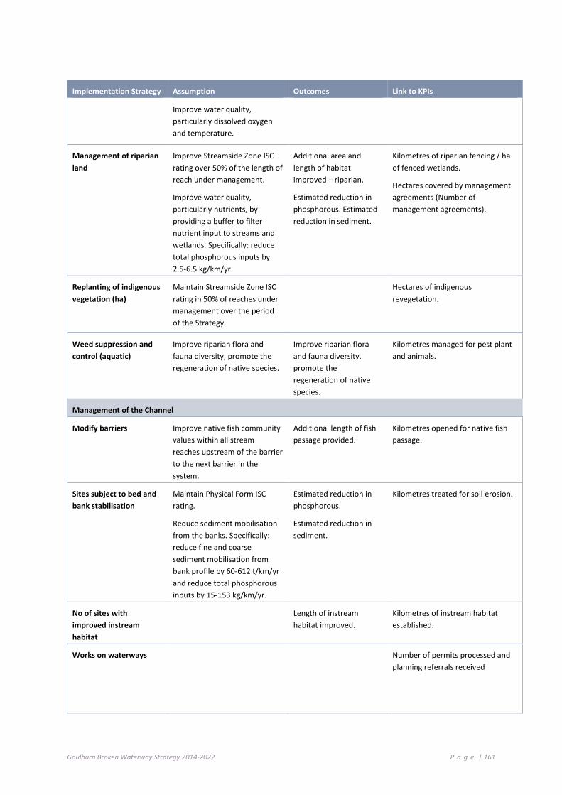
Goulburn Broken Waterway Strategy 2014-2022 P a g e | 161
Implementation Strategy Assumption Outcomes Link to KPIs
Improve water quality, particularly dissolved oxygen and temperature.
Management of riparian land
Improve Streamside Zone ISC rating over 50% of the length of reach under management.
Improve water quality, particularly nutrients, by providing a buffer to filter nutrient input to streams and wetlands. Specifically: reduce total phosphorous inputs by 2.5-6.5 kg/km/yr.
Additional area and length of habitat improved – riparian.
Estimated reduction in phosphorous. Estimated reduction in sediment.
Kilometres of riparian fencing / ha of fenced wetlands.
Hectares covered by management agreements (Number of management agreements).
Replanting of indigenous vegetation (ha)
Maintain Streamside Zone ISC rating in 50% of reaches under management over the period of the Strategy.
Hectares of indigenous revegetation.
Weed suppression and control (aquatic)
Improve riparian flora and fauna diversity, promote the regeneration of native species.
Improve riparian flora and fauna diversity, promote the regeneration of native species.
Kilometres managed for pest plant and animals.
Management of the Channel
Modify barriers Improve native fish community values within all stream reaches upstream of the barrier to the next barrier in the system.
Additional length of fish passage provided.
Kilometres opened for native fish passage.
Sites subject to bed and bank stabilisation
Maintain Physical Form ISC rating.
Reduce sediment mobilisation from the banks. Specifically: reduce fine and coarse sediment mobilisation from bank profile by 60-612 t/km/yr and reduce total phosphorous inputs by 15-153 kg/km/yr.
Estimated reduction in phosphorous.
Estimated reduction in sediment.
Kilometres treated for soil erosion.
No of sites with improved instream habitat
Length of instream habitat improved.
Kilometres of instream habitat established.
Works on waterways Number of permits processed and planning referrals received

Goulburn Broken Waterway Strategy 2014-2022 P a g e | 162
Implementation Strategy Assumption Outcomes Link to KPIs
Water quality/savings
No. of reaches with water quality improvements
Estimated reduction in phosphorous, sediments etc.
Number of reaches with water quality improvements.
Other
No. of plans developed for rivers and creeks of high social value
Additional area and number of NRM group action plans developed and being implemented.
No. reaches with community programs/ engagement initiatives
Increase regional community understanding and knowledge about river health issues.
Number of waterways with local Action Plans.
Encourage greater community involvement in river management and restoration.
Number of community groups supported.
Monitoring Number of sites monitored for asset condition.
7 .9 O U T C O ME S B Y S E S / LA ND S CA PE
High-level (20 year) goals for waterways in the region for each priority waterway, together with Management Targets and Management Activity are described in the previous Chapter. High-level outcomes by Social Ecological System/Landscape are presented in Table 7-4.
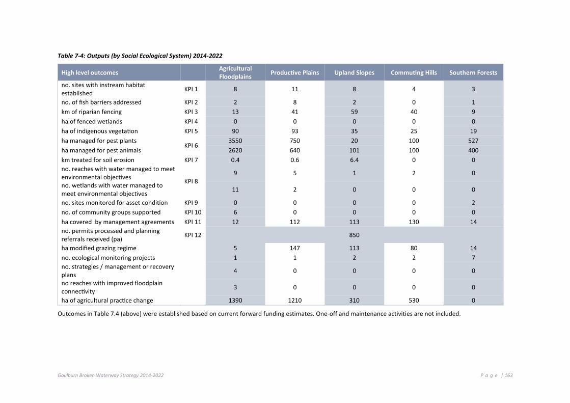
Goulburn Broken Waterway Strategy 2014-2022 P a g e | 163
Table 7-4: Outputs (by Social Ecological System) 2014-2022
High level outcomes Agricultural Floodplains Productive Plains Upland Slopes Commuting Hills Southern Forests
no. sites with instream habitat established KPI 1 8 11 8 4 3
no. of fish barriers addressed KPI 2 2 8 2 0 1 km of riparian fencing KPI 3 13 41 59 40 9 ha of fenced wetlands KPI 4 0 0 0 0 0 ha of indigenous vegetation KPI 5 90 93 35 25 19 ha managed for pest plants
KPI 6 3550 750 20 100 527
ha managed for pest animals 2620 640 101 100 400 km treated for soil erosion KPI 7 0.4 0.6 6.4 0 0 no. reaches with water managed to meet environmental objectives KPI 8
9 5 1 2 0
no. wetlands with water managed to meet environmental objectives 11 2 0 0 0
no. sites monitored for asset condition KPI 9 0 0 0 0 2 no. of community groups supported KPI 10 6 0 0 0 0 ha covered by management agreements KPI 11 12 112 113 130 14 no. permits processed and planning referrals received (pa) KPI 12 850
ha modified grazing regime 5 147 113 80 14 no. ecological monitoring projects 1 1 2 2 7 no. strategies / management or recovery plans 4 0 0 0 0
no reaches with improved floodplain connectivity 3 0 0 0 0
ha of agricultural practice change 1390 1210 310 530 0
Outcomes in Table 7.4 (above) were established based on current forward funding estimates. One-off and maintenance activities are not included.

Goulburn Broken Waterway Strategy 2014-2022 P a g e | 164
Boosey Creek Tungamah (GB CMA); Broken River upstream of Lake Nillahcootie (GB CMA); Catchment resilience Buxton (GB CMA); Dry wetland Broken River floodplain (GB CMA); Field Monitoring (GB CMA); Lake Benalla pest plant encroachment (GB CMA); Hughes Creek Rock Pool (J and L Dalziel)

Goulburn Broken Waterway Strategy 2014-2022 P a g e | 165

Goulburn Broken Waterway Strategy 2014-2022 P a g e | 166
Implementing the Strategy This Chapter:
Identifies best practice, roles and responsibilities and factors that may influence the implementation of the Strategy.
8 .1 I M PL E M ENT I N G T H E S T RAT EG Y
Priority management issues and the identification of priority waterways and activities required to maintain their resilience were detailed in previous Chapters of this Strategy.
A range of supporting actions, “Foundation Actions”, are necessary for the successful implementation of this Strategy. These range from the implementation of onground waterway protection works (as highlighted in the previous Chapter) to influencing planning, undertaking maintenance and engaging partners.
Our community and stakeholders have made a substantial contribution to the success of works to date and will underpin the success of this Strategy.
We will work together with stakeholders including community groups, local government and water authorities in the region throughout the life of this Strategy.
This Chapter outlines the management approaches behind this Strategy, including: maintenance, enforcement, MERI (Monitoring Evaluation, Reporting and Improvement), community engagement, information sharing and assignment of roles and responsibilities.
8 .2 M A I NT ENAN CE
The Strategy aims to maintain or improve waterways by protecting and enhancing the resilience of the waterway systems. Maintenance of the systems, together with maintenance of previous investment, are critical elements of the program. Maintenance of previous waterway investment includes, but is not limited to:
• riparian (control of pest plants and animals, maintain effectiveness of fencing, control grazing); and
• structural works (ensure ongoing effectiveness).
The Technical Guidelines for Waterway Management (DSE 2007) represent current best management practice and incorporate advances in environmental and technical practice for river health restoration and maintenance since the 1991 publication of “Guidelines for Stabilising Waterways”. A summary of the nature of the activity and maintenance recommendations are shown in Table 8-1. The costs associated with maintenance, compliance and best practice are also shown in Table 8-1.
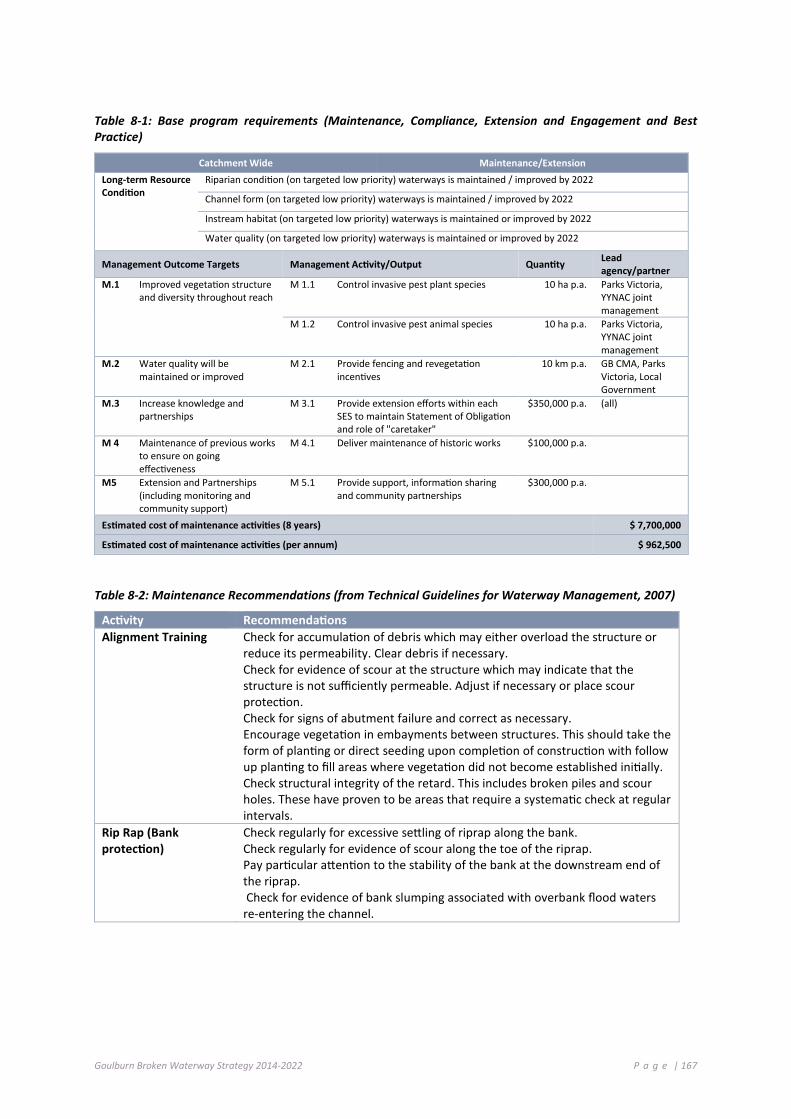
Goulburn Broken Waterway Strategy 2014-2022 P a g e | 167
Table 8-1: Base program requirements (Maintenance, Compliance, Extension and Engagement and Best Practice)
Catchment Wide Maintenance/Extension Long-term Resource Condition
Riparian condition (on targeted low priority) waterways is maintained / improved by 2022
Channel form (on targeted low priority) waterways is maintained / improved by 2022
Instream habitat (on targeted low priority) waterways is maintained or improved by 2022
Water quality (on targeted low priority) waterways is maintained or improved by 2022
Management Outcome Targets Management Activity/Output Quantity Lead agency/partner
M.1 Improved vegetation structure and diversity throughout reach
M 1.1 Control invasive pest plant species 10 ha p.a. Parks Victoria, YYNAC joint management
M 1.2 Control invasive pest animal species 10 ha p.a. Parks Victoria, YYNAC joint management
M.2 Water quality will be maintained or improved
M 2.1 Provide fencing and revegetation incentives
10 km p.a. GB CMA, Parks Victoria, Local Government
M.3 Increase knowledge and partnerships
M 3.1 Provide extension efforts within each SES to maintain Statement of Obligation and role of "caretaker"
$350,000 p.a. (all)
M 4 Maintenance of previous works to ensure on going effectiveness
M 4.1 Deliver maintenance of historic works $100,000 p.a.
M5 Extension and Partnerships (including monitoring and community support)
M 5.1 Provide support, information sharing and community partnerships
$300,000 p.a.
Estimated cost of maintenance activities (8 years) $ 7,700,000
Estimated cost of maintenance activities (per annum) $ 962,500
Table 8-2: Maintenance Recommendations (from Technical Guidelines for Waterway Management, 2007)
Activity Recommendations Alignment Training Check for accumulation of debris which may either overload the structure or
reduce its permeability. Clear debris if necessary. Check for evidence of scour at the structure which may indicate that the structure is not sufficiently permeable. Adjust if necessary or place scour protection. Check for signs of abutment failure and correct as necessary. Encourage vegetation in embayments between structures. This should take the form of planting or direct seeding upon completion of construction with follow up planting to fill areas where vegetation did not become established initially. Check structural integrity of the retard. This includes broken piles and scour holes. These have proven to be areas that require a systematic check at regular intervals.
Rip Rap (Bank protection)
Check regularly for excessive settling of riprap along the bank. Check regularly for evidence of scour along the toe of the riprap. Pay particular attention to the stability of the bank at the downstream end of the riprap. Check for evidence of bank slumping associated with overbank flood waters re-entering the channel.
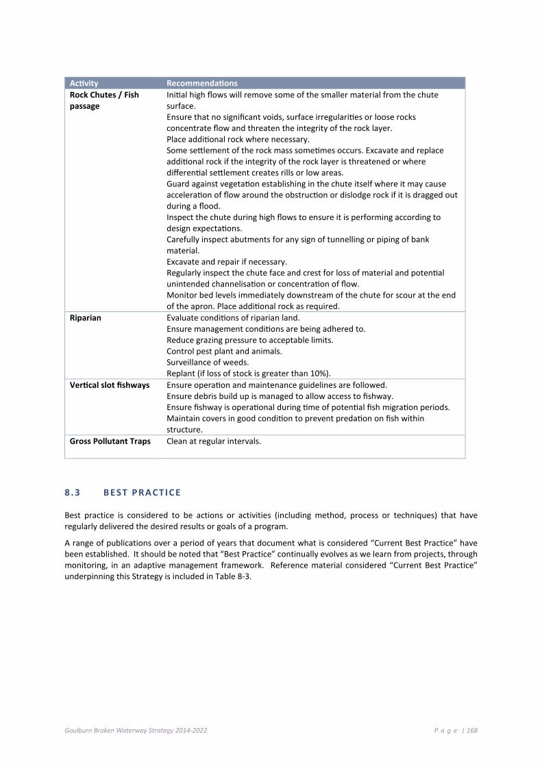
Goulburn Broken Waterway Strategy 2014-2022 P a g e | 168
Activity Recommendations Rock Chutes / Fish passage
Initial high flows will remove some of the smaller material from the chute surface. Ensure that no significant voids, surface irregularities or loose rocks concentrate flow and threaten the integrity of the rock layer. Place additional rock where necessary. Some settlement of the rock mass sometimes occurs. Excavate and replace additional rock if the integrity of the rock layer is threatened or where differential settlement creates rills or low areas. Guard against vegetation establishing in the chute itself where it may cause acceleration of flow around the obstruction or dislodge rock if it is dragged out during a flood. Inspect the chute during high flows to ensure it is performing according to design expectations. Carefully inspect abutments for any sign of tunnelling or piping of bank material. Excavate and repair if necessary. Regularly inspect the chute face and crest for loss of material and potential unintended channelisation or concentration of flow. Monitor bed levels immediately downstream of the chute for scour at the end of the apron. Place additional rock as required.
Riparian Evaluate conditions of riparian land. Ensure management conditions are being adhered to. Reduce grazing pressure to acceptable limits. Control pest plant and animals. Surveillance of weeds. Replant (if loss of stock is greater than 10%).
Vertical slot fishways Ensure operation and maintenance guidelines are followed. Ensure debris build up is managed to allow access to fishway. Ensure fishway is operational during time of potential fish migration periods. Maintain covers in good condition to prevent predation on fish within structure.
Gross Pollutant Traps Clean at regular intervals.
8 .3 B E ST P RA CT I C E
Best practice is considered to be actions or activities (including method, process or techniques) that have regularly delivered the desired results or goals of a program.
A range of publications over a period of years that document what is considered “Current Best Practice” have been established. It should be noted that “Best Practice” continually evolves as we learn from projects, through monitoring, in an adaptive management framework. Reference material considered “Current Best Practice” underpinning this Strategy is included in Table 8-3.

Goulburn Broken Waterway Strategy 2014-2022 P a g e | 169
Table 8-3: Reference Material and Further Reading considered “Current Best Practice” underpinning this Strategy
Recommended Strategy Reference Material / Further Reading
Riparian Management Department of Sustainability and Environment (2007) Technical Guidelines for Waterway Management
Rip Rap (Edition 18) Inlands Rivers and Riparian Zones
Rip Rap (Edition 22) Riparian Research
Price R. & Lovett S. (1999) Riparian Land Management Technical Guidelines Vol 2), LWRRDC
Department of Environment and Primary Industries. 2013. Managing grazing on riparian land. Decision support tool and guidelines. East Melbourne, Victoria.
Staton, J. & O’Sullivan, J., 2006. Stock and waterways: a manager’s guide. Land & Water Australia, Canberra
Revegetation Department of Natural Resources & Environment (2000) Revegetation Guide for the Goulburn Broken Catchment, Edited by Gill Earl, Fleur Stelling, Mary Titcumb and Sue Berwick. Department of Natural Resources & Environment see: http://www.gbcma.vic.gov.au/default.asp?ID=biodiversity_pubs
Willow Management Department of Primary Industries (2007), Willows, A Management Guide, DPI
Frankenberg J. (2004) Goulburn Broken Catchment Willow Management Strategy, Goulburn Broken Catchment Management Authority, Shepparton
National Willow Best Practice Management Guidelines
Weed Management Blood K. (2002) Best Practice Management Guide For Environmental Weeds – General Guidelines, Department of Natural Resources and Environment (www.weeds.crc.org.au)
E. Bruzzese, F. Mahr and Faithfull I., (2000) Best Practice Management Guide For Environmental Weeds - Blackberry, Rubus fruticosus aggregate, Keith Turnbull Research Institute and Weeds CRC, Melbourne
Elissa van Oosterhout (2009) ,Weeds of National Significance (Cabomba Control Manual), Department of Primary Industries NSW
Habitat (Instream) Rip Rap (Edition 16 ) Managing snags and large woody debris
River Habitat Rehabilitation Through Resnagging (undated) Arthur Rylah Institute, Department of Natural Resources and Environment
Alignment Training Department of Sustainability and Environment (2007) Technical Guidelines for Waterway Management
Erosion Control (bed and banks) / Bed seeding
Department of Sustainability and Environment (2007) Technical Guidelines for Waterway Management
Irrigation Extraction / native fish
Cameron, L. and Baumgartner, L. 2005. Native fish in irrigation supply offtakes. Brochure prepared by the NSW Department of Primary Industries as part of a project funded by the Murray-Darling Basin Commission (Project No. R5006). 4pp.
Tim Blackley (2003) Screening Irrigation Offtakes in the Murray-Darling Basin to Reduce Loss of Native Fish
Urban Wetlands Melbourne Water (2005) Constructed Wetland Systems Design Guidelines for Developers
Urban Stormwater CSIRO (2006) Urban Stormwater, Best Practice Environmental Management Guidelines, Melbourne Water, Melbourne
Water Quality (General) SKM (2004), Water Quality Current Recommended Practices (CRPs) for the Goulburn Broken Catchment, Goulburn Broken Catchment Management Authority, Shepparton
Timber Harvesting Code of Practice for Timber Production 2007
Evidence used to determine the confidence for association of values and their threat
Department of Sustainability and Environment (2009) Confidence Levels for the AVIRA Association Values, Sustainable Water, Environment & Innovation Division, Department of Sustainability and Environment
Linking Actions to address threats
Department of Sustainability and Environment (2011) Report for Conceptual Models for Regional Strategies for Healthy Rivers and Wetlands, GHD and Riverness
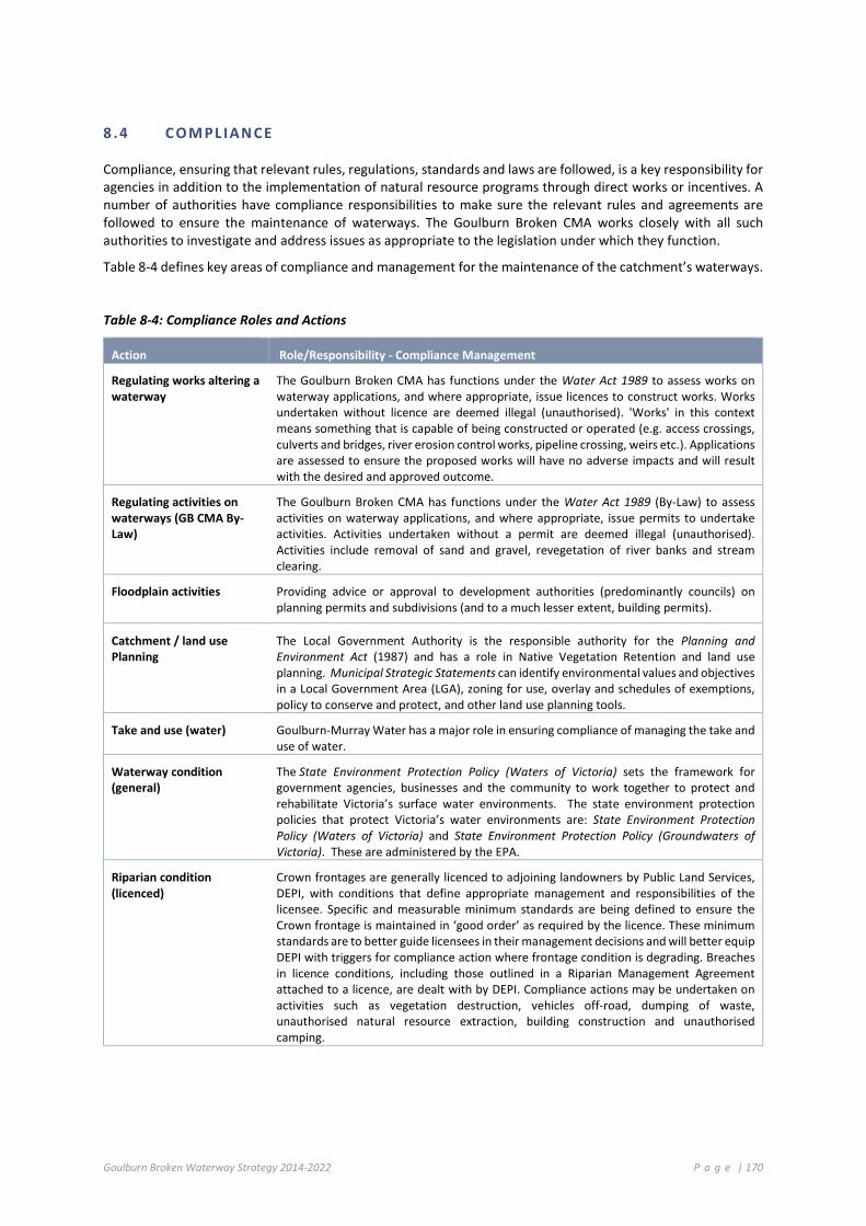
Goulburn Broken Waterway Strategy 2014-2022 P a g e | 170
8 .4 C O M PL I AN CE
Compliance, ensuring that relevant rules, regulations, standards and laws are followed, is a key responsibility for agencies in addition to the implementation of natural resource programs through direct works or incentives. A number of authorities have compliance responsibilities to make sure the relevant rules and agreements are followed to ensure the maintenance of waterways. The Goulburn Broken CMA works closely with all such authorities to investigate and address issues as appropriate to the legislation under which they function.
Table 8-4 defines key areas of compliance and management for the maintenance of the catchment’s waterways.
Table 8-4: Compliance Roles and Actions
Action Role/Responsibility - Compliance Management
Regulating works altering a waterway
The Goulburn Broken CMA has functions under the Water Act 1989 to assess works on waterway applications, and where appropriate, issue licences to construct works. Works undertaken without licence are deemed illegal (unauthorised). 'Works' in this context means something that is capable of being constructed or operated (e.g. access crossings, culverts and bridges, river erosion control works, pipeline crossing, weirs etc.). Applications are assessed to ensure the proposed works will have no adverse impacts and will result with the desired and approved outcome.
Regulating activities on waterways (GB CMA By-Law)
The Goulburn Broken CMA has functions under the Water Act 1989 (By-Law) to assess activities on waterway applications, and where appropriate, issue permits to undertake activities. Activities undertaken without a permit are deemed illegal (unauthorised). Activities include removal of sand and gravel, revegetation of river banks and stream clearing.
Floodplain activities Providing advice or approval to development authorities (predominantly councils) on planning permits and subdivisions (and to a much lesser extent, building permits).
Catchment / land use Planning
The Local Government Authority is the responsible authority for the Planning and Environment Act (1987) and has a role in Native Vegetation Retention and land use planning. Municipal Strategic Statements can identify environmental values and objectives in a Local Government Area (LGA), zoning for use, overlay and schedules of exemptions, policy to conserve and protect, and other land use planning tools.
Take and use (water) Goulburn-Murray Water has a major role in ensuring compliance of managing the take and use of water.
Waterway condition (general)
The State Environment Protection Policy (Waters of Victoria) sets the framework for government agencies, businesses and the community to work together to protect and rehabilitate Victoria’s surface water environments. The state environment protection policies that protect Victoria’s water environments are: State Environment Protection Policy (Waters of Victoria) and State Environment Protection Policy (Groundwaters of Victoria). These are administered by the EPA.
Riparian condition (licenced)
Crown frontages are generally licenced to adjoining landowners by Public Land Services, DEPI, with conditions that define appropriate management and responsibilities of the licensee. Specific and measurable minimum standards are being defined to ensure the Crown frontage is maintained in ‘good order’ as required by the licence. These minimum standards are to better guide licensees in their management decisions and will better equip DEPI with triggers for compliance action where frontage condition is degrading. Breaches in licence conditions, including those outlined in a Riparian Management Agreement attached to a licence, are dealt with by DEPI. Compliance actions may be undertaken on activities such as vegetation destruction, vehicles off-road, dumping of waste, unauthorised natural resource extraction, building construction and unauthorised camping.

Goulburn Broken Waterway Strategy 2014-2022 P a g e | 171
Table 8-4: (continued) Compliance Roles and Actions
Action Role/Responsibility - Compliance Management
Riparian condition (unlicensed)
Grazing of unlicensed Crown Land is considered unauthorised occupation and can instigate compliance actions by DEPI. Similar to licenced Crown frontage, any activity that causes deterioration to riparian condition is illegal and subject to compliance action.
Riparian condition (freehold)
See above regulation of “works” and “activities”.
It is a role of local government to administer planning permits and/or undertake compliance related vegetation management on freehold land, including along streams. The Goulburn Broken CMA may assist with technical advice where invited to do so.
Native vegetation Local government plays an important role in achieving the objective of the permitted clearing regulations. They are responsible for setting directions for land use and development within their local area, and assessing the majority of permits to remove native vegetation.
Local governments have also expanded their role in the native vegetation regulatory system by providing over-the-counter offsets for the removal of native vegetation.
Litter The EPA has a key role in protecting Victorians and the environment from litter. Littering is illegal under the Environment Protection Act 1970. EPA officers, local government officers, police and other enforcement agencies can issue ‘on the spot’ fines for littering.
Waste The EPA is responsible for the management and enforcement of the primary legislation for waste management in Victoria (under the Environment Protection Act 1970). Primary legislation provides the regulatory framework for society by imposing restrictions and controls on the activities of individuals and corporate bodies.
Waterway incidents (pollution / chemical spills / natural events / dead stock)
The Goulburn Broken Partnership Agreement has the intention of clearly establishing the framework for leadership, and providing guidance in operations, communications and investigation of waterway incidents. This is considered essential to ensuring a co-ordinated approach and in order to maintain the confidence of the public while all agencies carry out their respective roles in protecting, restoring and maintaining the quality of the waterways. The key agencies with regulatory or functional responsibilities for waterways in the Goulburn Broken catchment are: Goulburn-Murray Water; Environmental Protection Authority (EPA); Department of Environment and Primary Industries; Goulburn Broken Catchment Management Authority; Goulburn Valley Region Water Authority; North East Region Water Authority; and Department of Health.
Fish Deaths Waterway Incident (Fish Death) Response Guidelines applies to government agencies and authorities with responsibilities under a range of legislation for management of the environment, waterways, fisheries and health. It describes expected organisational roles and responsibilities and enables a framework to establish regional response plans that describe incident management arrangements, regional contacts, communication processes and review processes. It is intended that the regional arrangements will be included in regional and municipal emergency plans.
8 .5 M O NI T O RI N G A ND EV A L UAT I O N
The management of rivers, estuaries and wetlands in the region is conducted within an adaptive management framework. The ability to learn from previous experience and update management approaches to reflect the knowledge gained during implementation is at the core of adaptive management. Figure 8-1 presents the eight-year adaptive management cycle of the Victorian Waterway Management Program and regional Waterway Strategies. The cycle includes (DEPI 2013b):
• Strategy and Planning: state policy framework and targets, planning for waterway management through regional waterway strategies with priorities and regional targets;
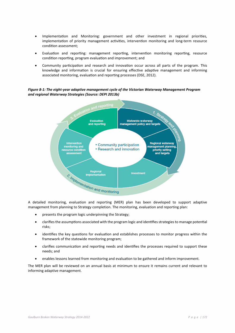
Goulburn Broken Waterway Strategy 2014-2022 P a g e | 172
• Implementation and Monitoring: government and other investment in regional priorities, implementation of priority management activities, intervention monitoring and long-term resource condition assessment;
• Evaluation and reporting: management reporting, intervention monitoring reporting, resource condition reporting, program evaluation and improvement; and
• Community participation and research and innovation occur across all parts of the program. This knowledge and information is crucial for ensuring effective adaptive management and informing associated monitoring, evaluation and reporting processes (DSE, 2012).
Figure 8-1: The eight-year adaptive management cycle of the Victorian Waterway Management Program and regional Waterway Strategies (Source: DEPI 2013b)
A detailed monitoring, evaluation and reporting (MER) plan has been developed to support adaptive management from planning to Strategy completion. The monitoring, evaluation and reporting plan:
• presents the program logic underpinning the Strategy;
• clarifies the assumptions associated with the program logic and identifies strategies to manage potential risks;
• identifies the key questions for evaluation and establishes processes to monitor progress within the framework of the statewide monitoring program;
• clarifies communication and reporting needs and identifies the processes required to support these needs; and
• enables lessons learned from monitoring and evaluation to be gathered and inform improvement.
The MER plan will be reviewed on an annual basis at minimum to ensure it remains current and relevant to informing adaptive management.

Goulburn Broken Waterway Strategy 2014-2022 P a g e | 173
8.5.1 MONITORING
Monitoring activities are targeted to inform evaluation and reporting on Strategy implementation. Monitoring activities also include the collection of information relating to foundational influences and externalities that impact on Strategy implementation. Foundational influences include factors such as climatic variability, drought, flood, bushfire and potential impacts of climate change; and externalities include factors such as land use change, population growth, government support, economic conditions, community expectations and landowner attitudes.
Monitoring activities will be consistent with the statewide monitoring processes co-ordinated through the Victorian Waterway Management Program. This program includes targeted resource condition and intervention monitoring to inform both state and regional evaluation and reporting processes.
8.5.2 EVALUATION
The strategy and planning phase of the adaptive management cycle includes the development of pre-determined key evaluation questions by which to assess the Strategy and gain new knowledge and information. Evaluation questions provide the basis for evaluation design and associated monitoring processes.
Evaluation of the Strategy will include an assessment of the extent to which the outcomes have been achieved at each level of the program logic underpinning the Strategy. It will also address the assumptions in the program logic and provide direction and improved knowledge for subsequent planning cycles.
The evaluation questions developed for the Strategy address these five categories (DSE, 2012):
• Impact - changes to resource condition, management activities or institutions.
• Appropriateness - addressing the needs of beneficiaries and against best practice.
• Effectiveness - achievement of desired management outputs and resource condition objectives.
• Efficiency - value or return from investment.
• Legacy - after the activity/program ends.
The scale and frequency of evaluation will vary throughout the life of the Strategy, and will include an annual review cycle and more detailed reviews in the fourth and final year of the Strategy.
The annual reviews will assess progress towards the planned management activities and outputs, and associated financials. These reviews will consider any new knowledge and information that may require changes to planned management activities and outputs. The annual review will be undertaken by the CMA and will align with regional investment processes.
The interim review will also assess progress towards management activities and outputs, and where possible, review progress towards management outcomes. This review may also provide new knowledge and information that may lead to an update of the Strategy to support an adaptive approach.
The final independent review of the Strategy will focus on capturing all of the knowledge gained during implementation of the Strategy, and an assessment of achievements and progress against Strategy targets. This will ensure there is a clear record of achievements and lessons learned, and an evidence base for updating or changing regional programs and management approaches in the future. This final review will be undertaken through an independent process.

Goulburn Broken Waterway Strategy 2014-2022 P a g e | 174
8.5.3 REPORTING
Reporting is an important tool to ensure accountability for the investment of government funds into waterway management activities. Over the long-term, consistent and effective reporting provides evidence to evaluate and communicate the effectiveness of the Strategy (DEPI 2013b).
Annual management reporting is a component of the annual review cycle, and includes reporting on the activities and outputs achieved for the year and associated financials. This reporting is delivered through the CMA Annual Report, and annual investment reports for existing funding arrangements with the State Government. This reporting generally comprises both tabular and spatial information. Financial audits are required to ensure that reported expenditure is accurate and accountable. These audits will be led by DEPI and provides assurance that investment in delivering outputs has been strategic, cost effective and consistent (DEPI 2013f).
Public reporting against Strategy management outcome targets will occur, at a minimum, following the final review of the Strategy. The CMA will also support reporting of management outcome targets for the Victorian Waterway Management Strategy (DEPI 2013b) in 2016 and 2020. These reporting processes will be informed through the reviews undertaken in the third and final year of the Strategy.
Resource condition reporting is led through the Victorian Waterway Management Program. This involves the collection, analysis and reporting of information on the condition of Victoria’s waterways every eight years, subject to available funding (DEPI 2013b). This reporting, combined with regional knowledge, provides the collective data to assess the condition of waterways over the long-term.
The monitoring, evaluation and reporting plan for the Strategy identifies further detail of the key stakeholders at organisational, community, regional, state and federal levels who should be kept informed on the progress of the Strategy or would benefit from Strategy information. It also identifies what they need to know and how it will be communicated.
8.5.4 KNOWLEDGE GAPS AND RESEARCH
The process of developing the program logic and evaluation questions identifies the areas where critical knowledge gaps exist. The monitoring, evaluation and reporting plan for the Strategy identifies the key knowledge gaps identified through this process, and also identifies the strategies for addressing them. These strategies may involve collating existing information or proposing areas for further research programs. To align with the Victorian Waterway Management Program, the Strategy will support research that:
• provides essential knowledge to address critical short-term and/or strategic long-term knowledge gaps. The resulting research findings will be incorporated into policy and management; and
• targets knowledge gaps or low confidence in the relationships between outputs, management outcomes and long-term resource condition outcomes (if significant for waterway management and investment) (DEPI 2013b).
Research will be directed to investigating those relationships where there is little scientific evidence, or the confidence in the evidence is low. This targeted approach to research also provides an increased focus on prediction and testing, rather than more general, descriptive research. It is also vital that research is targeted to better understanding the effectiveness of management activities in which there is significant Victorian Government investment (for example, riparian revegetation) (DEPI 2013b).
Over the past 15 years, the GB CMA and partners have invested significant resources to address knowledge gaps and to better understand assumptions that are made with respect to this and related programs. Table 8-5 presents the list of identified knowledge gaps (GB CMA, 2005) and the action taken.

Goulburn Broken Waterway Strategy 2014-2022 P a g e | 175
Table 8-5: Identified knowledge gaps (GB CMA 2005) and actions taken to improve knowledge
Knowledge gap Recommended Action/Activity Status
Water quality data
Implement key findings of the report into water quality monitoring in the catchment “Water Quality Monitoring Review”. Consider spatial nature of WQ data and encourage extension to current project as necessary.
A review of water quality monitoring was undertaken across all programs. This led to a rationalisation of water quality sites. Sites were established to reflect extreme events (these were subsequently removed after 4 years).
ISC data Conduct 5 yearly evaluations of stream condition and develop Catchment Report Card. Increase spatial nature of assessments Review ISC assessment process, including validation of results and data storage.
ISC was undertaken by the Department of Sustainability and Environment (now Department of Environment and Primary Industries) in 2010.
Water temperature Investigate impacts of degraded riparian land on water temperature.
Not funded.
Assets and values Commence assessment and collect available data on additional assets and threats associated with river health.
Additional asset and threat data was captured and included in AVIRA.
Trout cod Investigate potential new locations for stocking or translocation of Trout cod, as outlined in the Trout cod Recovery Plan.
Investigation underway for the re-establishment of Trout cod in Hughes Creek. Preliminary brief for habitat and geomorphic investigation prepared.
Representative rivers Following the 2004 ISC evaluation, identify a reach suitable for Representative River for the North Central Floodplains River Region.
No action taken.
Economic analysis Determine the economic value of healthy rivers within the Goulburn Broken region.
No action taken.
8.5.5 STRATEGIC ACTIONS
Action Timeframe Responsibility Annual Monitoring Plan be established for the Waterway Program
2014-2022 GB CMA, Partners.
The Monitoring Plan is to consider the follow project themes: Theme Considerations Estimated Resourcing Water Quality Contribution to the Regional Water Quality Monitoring Program
Monitoring Costs $70,000 p.a.
Native fish Movement, populations/status and breeding, habitat. $100,000 p.a. Flows VEFMAP $120,000 p.a.
WETMAP (under development) TBA CEWH - Goulburn River long-term intervention monitoring (CEWH funding for 5 years) TBA
Barmah TLM (future unknown past 2013-14) $150,000 p.a. Wetland/Flow Monitoring the ecological response of wetlands and streams to
environmental watering $75,000 p.a.
Waterway Condition
IWC and ISC TBA
Weeds Monitor new aquatic pest plants in wetlands Monitoring control options for aquatic weeds $150,000 p.a.

Goulburn Broken Waterway Strategy 2014-2022 P a g e | 176
8 .6 C O M M UNI T Y EN GAGE M EN T
Community engagement activities to implement the Strategy will be informed by the 2013-14 Goulburn Broken CMA Community Engagement Strategy and Action Plan (see Figure 8-2. for the strategy and action plan framework) and guided by the Community Engagement and Partnerships Framework (Figure 8-3) for Victoria’s Catchment Management Authorities (November 2012).
The 2013-14 Goulburn Broken CMA Community Engagement Strategy and Action Plan prioritises:
• Ongoing stakeholder analysis;
• Continuous investigation and development of appropriate community engagement tools/approaches;
• Inclusion of a community engagement component in all project planning and development (including a focus on each SES); and
• Increased staff capability in community engagement; community engagement was critical to developing this Strategy. Engagement activities included:
o Establishment of a Reference Group comprised of community members and representatives from partner agencies such as Department of Environment and Primary Industries and Goulburn-Murray Water;
o Development of a WeConnect site to seek feedback on the development of the Strategy;
o Completion of an interactive survey, seeking input on values, threats, and support for management;
o A request for waterway photographs through Flickr, many of which were used in this publication;
o Regular newsletters and updates sent to all interested parties; and
o Regular updates in the Goulburn Broken CMA’s monthly newspaper column (distributed 55,000+ readers).
These activities have built a solid body of knowledge, contacts and networks that will provide a useful springboard in helping guide implementation efforts.
Providing specific details of implementation engagement activities is unrealistic, however, given the Strategy is a long-term plan for improving our waterways. Figure 8-2 demonstrates the broad approach:
Figure 8-2: Community Engagement and Partnerships Framework for Victoria’s Catchment Management Authorities - an overview of the community engagement and partnerships approach

Goulburn Broken Waterway Strategy 2014-2022 P a g e | 177
Importantly, all efforts will be guided by the five principles that underpin the Community Engagement and Partnerships Framework for Victoria’s Catchment Management Authorities:
1. We will embed community engagement and build partnerships in all that we do;
2. Our people will be actively supported to engage communities and to build partnerships;
3. Our community engagement and partnership approaches will be well planned, tailored, targeted, and evaluated;
4. We will provide meaningful opportunities for our communities and partners to contribute to strategies and initiatives; and
5. We will work transparently and respectfully with our communities and partners, and establish clear roles and expectations.
These principles recognise that the CMA does not own or directly manage natural resources. To achieve agreed outcomes and meet our responsibilities we must proactively and effectively engage and work with others to deliver initiatives that achieve improved catchment health and sustained practice change.
All engagement activities will be complemented by the 2013-14 Goulburn Broken Communication and Marketing Strategy and Action Plan, and sub-strategies including the Goulburn Broken Environmental Water Communication and Media Plan.
Ongoing evaluation of the effectiveness of community engagement activities is essential to ensure they remain relevant and target the right people, in the right way.
Their effectiveness will be measured by:
• evidence communities are further informed and engaged in NRM;
• new partnerships or relationships have been established;
• there is evidence of practice change in the community;
• partnerships are healthy and productive; and
• there is facilitation of an integrated approach to NRM.
ACTION: An Annual Community Engagement Plan will be developed for the Strategy Implementation
Responsibility: Goulburn Broken Catchment Management Authority Timeframe Annually

Goulburn Broken Waterway Strategy 2014-2022 P a g e | 178
Figure 8-3: Updated 2013 Community Engagement Strategy framework
1. Why develop this strategy?
2. Who is this strategy targeting?
3. What will this strategy achieve and how will this be measured?
4. How will this strategy be implemented?
5. When will the Community Engagement Strategy and Action Plan be implemented and reviewed?
To achieve actions on the ground and improvements in natural resource management (NRM) practice the Goulburn Broken CMA must engage the community and stakeholders.
Community engagement - the mutual participation of stakeholders in formation of policy and service delivery.
Stakeholders - this includes but is not limited to Goulburn Broken CMA staff, partners and investors; landowners; the community; industry; and all levels of government.
Well-developed, strong partnerships that help the Catchment deliver on the RCS.
Increase the resilience and capability of NRM groups so they can be the custodians of the Catchment.
An engaged community will: • have input into the design/direction-setting of local projects; • demonstrate improved/devolved decision-making skills; • have faith in the Goulburn Broken CMA’s role in NRM in the catchment as described in the RCS;
and • advocate on the Goulburn Broken CMA’s behalf.
Development of a Community Engagement Action Plan will prioritise:
Ongoing stakeholder analysis
Continuous investigation and development of appropriate community engagement tools/approaches
Inclusion of a community engagement component in all project planning and development (including a focus on the SESs)
Increased staff capability in community engagement
The Community Engagement Strategy and Action Plan are designed to be flexible, dynamic and responsive documents that reflect the constantly evolving environment the Goulburn Broken CMA and its stakeholders operate in. The Communication and Marketing Manager will take the lead in supporting program managers to review the strategy annually and the action plan at least twice a year.
Goulburn Broken Waterway Strategy 2014-2022 P a g e | 179
8 .7 R O LE S AND R E S P ON SI B I L I T I E S
For effective waterway management it is vital to clearly outline:
• institutional arrangements and the roles, responsibilities and partnerships for waterway management;
• funding arrangements for waterway management activities; and
• accountability for complex management issues, such as new and existing structures in waterways.
The general roles of key management groups within the catchment are shown in Appendix A.
8 .8 C O S T - S H ARI NG P RI NC I P LE S F OR WAT ER WA Y M ANA GE M ENT P RO G RA M S
While the framework for waterway management outlined in this Strategy will ensure that resources are directed to the areas of highest priority, the achievement of the vision for waterways is a significant task requiring considerable resources and long-term commitment. Cost-sharing with beneficiaries (those which benefit from a management activity) can be an effective way to more efficiently achieve outcomes with available government resources.
Beneficiaries that need to be considered in waterway management activities include:
• water corporations, given their dependence on a healthy water resource base and their potential impacts on healthy waterways;
• direct beneficiaries (for example, recreational groups, private landowners);
• local government representing regional economic benefits (for example, increased tourism from healthy waterways);
• the broader Victorian community; and
• owners and managers of public infrastructure.
It is important to ensure that funding mechanisms reflect the general cost-sharing principles for natural resource management and truly represent, in a fair and equitable way, the groups that are impacted and the various beneficiaries of waterway management.
Cost-sharing principles for waterway management programs will be applied in the implementation of this Strategy. Contributions of beneficiaries for activities that are part of the implementation of the Strategy will be negotiated during the planning process.
Duty of care
All natural resource users and managers have a duty of care to ensure they do not damage the natural resource base, as outlined in the Catchment and Land Protection Act 1994. They are responsible for making good any damage incurred as a result of their actions.
Beneficiary pays
When it is not possible to attribute damage, then primary beneficiaries should pay. Users, both existing and future, are expected to pay for activities that provide private benefits. Contributions from secondary beneficiaries will, where appropriate, be negotiated with the primary beneficiaries.
Government contributions to private beneficiaries
Government contributes primarily for activities which produce public benefits. Government may agree to contribute to land and water management activities that provide private benefits, where the cumulative uptake of these activities provides significant public benefit and government support is required to facilitate this uptake.
Positive benefit-cost
Before Government will contribute to any land or water management activity, the activity must be technically sound, the benefits must outweigh the costs and it must be considered a priority management activity.
Goulburn Broken Waterway Strategy 2014-2022 P a g e | 180
Private cost-share contributions
Management activities will be prioritised on the basis of the most public benefit for the least public cost. Where the public cost of a management activity is reduced by financial and in-kind contributions by private or corporate stakeholders, this will influence the level of priority for the action.
Upfront and maintenance costs
Waterway managers may collaborate with private landowners, and with other government agencies, to bring a built asset up to a declared standard, after which time (in general), the maintenance of the built asset will be the responsibility of the beneficiary.
Disasters
The cost of repair and recovery of essential public assets following natural disasters will be in accordance with the nationally agreed natural disaster relief and recovery arrangements.
Statewide policy and monitoring
Government will contribute to the cost of statewide planning, statewide resource monitoring and assessment, and research and investigations where they are crucial to sustainable land and water management.
8 .9 S T RAT EG Y RE V I E W
The Strategy contained within the document is dynamic, however the fundamentals of the values, threats and issues to be addressed are unlikely to change within the time of this strategy’s delivery (2014 to 2022).
The identified programs and implementation targets for the next eight years (2014-2022) will be followed and two key review processes built into the Strategy Framework.
Interim Review (after four years): A mid-term review of this Strategy will be undertaken in 2018-19, after four years to assess progress towards targets and may lead CMAs to change or update management actions and targets as required.
Eight Year Review: A full review of the Strategy will be undertaken in 2022-23 at the completion of the implementation period. This review will reflect on achievements made, whether progress is adequate, and consider whether there is new science and knowledge that needs to be taken into account and incorporated.
ACTION: A mid-term review of this Strategy will be undertaken, after four years which will be used to assess progress towards targets and may lead CMAs to change or update management actions
Responsibility: Goulburn Broken Catchment Management Authority Timeframe 2018-2019
ACTION: A full review of the Strategy will be undertaken at the completion of the implementation period
Responsibility: Goulburn Broken Catchment Management Authority Timeframe 2022-2023

Goulburn Broken Waterway Strategy 2014-2022 P a g e | 181
8 .10 W A T E RW AY P R OGR AM I MP L EM ENT AT I ON S C H ED U LE S
Implementation of the recommended strategies in Chapter 4 and 7 is reliant on support from state and federal Governments, partner agencies and the community. Depending on this level of support, a different implementation schedule may result.
Table 8-6: The following table details overall implementation costs for this Strategy
Program Waterway Resources Program Waterway Resources AGRICULTURAL FLOODPLAINS $66,124,500 AF 01-05 Goulburn River $1,320,000 AF 33-37 Mansfield/Wallenjoe
Swamps $780,000
AF 06 Goulburn Landscape $4,880,000 AF 38-40 Barmah Forest $3,075,000 AF 07 Lower Goulburn River $50,000,000 AF 41-43 Doctors Swamp $110,000 AF 08 Goulburn (urban) $400,000 AF 44 Gemmills Swamp $105,000 AF 09-10 Tullah Creek $90,000 AF 45-48 Reedy Swamp $770,000 AF 11-13 Boosey Creek $237,500 AF 49-51 Black Swamp $100,000 AF 14-18 Broken Creek $495,000 AF 52 Sampys Swamp $50,000 AF 19-21 Broken River $1,692,000 AF 53 Taylors Swamp $34,000 AF 22-25 Gaynors Swamp $1,122,000 AF 54-56 Mulquiney Rd (Wetland) $139,000 AF 26-30 Kanyapella Basin $575,000 AF 57-60 Kinnairds Wetland $100,000 AF 31-32 Yambuna Bridge $50,000 PRODUCTIVE PLAINS $11,113,500 PP 01-04 Holland Creek $212,000 PP 33 Winton Wetland $- PP 05-09 Goulburn River $525,000 PP 34-35 Winton Wetland (tribs) $4,637,500 PP 10-14 Goulburn River $415,000 PP 36-38 Dowdle Swamp $115,000 PP 15-17 Hughes Creek $230,000 PP 39-43 Tahbilk Lagoon $300,000 PP 18-22 Seven Creeks $540,000 PP 44-47 Stockyard Plain $150,000 PP 23-26 Seven Creeks $550,000 PP 48-51 Moodie Swamp $300,000 PP 27-28 Boosey Creek $97,000 PP 52-54 Honeysuckle Creek $237,000 PP 29-32 Broken River $2,805,000 UPLAND SLOPES $3,519,000 US 01-04 Holland Creek $300,000 US 19 East Creek $35,000 US 05-06 Acheron River $160,000 US 20-21 Ryans Creek $155,000 US 07-09 Broken River $240,000 US 22-23 Bridge Creek system $290,000 US 10-13 Goulburn River $705,000 US 24-29 Hughes Creek $1,190,000 US 14-15 Ford /Brankeet /
Merton Creeks $194,000 US 30 Five Mile Creek $70,000
US 16-18 Broken River $180,000 COMMUTING HILLS $3,565,000 CH 01-02 Mollisons Creek $545,000 CH 11-14 Goulburn River $1,250,000 CH 03-06 King Parrot Creek $650,000 CH 15 Sunday Creek $50,000 CH 07-10 Yea River $1,070,000 SOUTHERN FORESTS $2,327,000 SF 01-02 Big River $70,000 SF 12 Taggerty River $- SF 03-05 Howqua River $140,000 SF 13 Acheron River $- SF 06 Goulburn River $325,000 SF 14-15 Peatlands & Bogs $1,000,000 SF 07-11 Delatite River $640,000 SF 16-18 Rubicon River $152,000 ANNUAL OPERATING COSTS $2,517,500 p.a. Maintenance Statement of Obligations (Maintenance, Compliance, Extension and Engagement and Best Practice) (per annum)
$962,500 p.a.
Monitoring Plan $665,000 p.a. Management of the Environmental Water Reserve (per annum) $340,000 p.a. Statutory Functions (Floodplain Management/Works on Waterways) (per annum) $550,000 p.a.
Goulburn Broken Waterway Strategy 2014-2022 P a g e | 182
References and further reading Australian River Restoration Centre website http://arrc.com.au/
Bennett A., Radford J. & Haslem A. (2006) Properties of land mosaics: implications for nature conservation in agricultural environments. Biological Conservation 133, 250-264.
Butcher R., Brooks S., Cottingham P., Hale J. & Watkins D. (2011). Ramsar Rolling Review: Phase 2 pilot testing. Submitted to Australian Government Department of Sustainability, Environment, Water, Populations and Communities.
Chesterfield E. (1986) Changes in the vegetation of the river red gum forests at Barmah, Victoria. Australian Forestry, 49: 4-15.
Chesterfield E.A., Loyn R.H. & Macfarlane M.A. (1984) Flora and fauna of Barmah State Forest and their management. Forests Commission of Victoria, Victoria.
Coates D.J. & Atkins, K.A. (2001). Priority setting and the conservation of Western Australia's diverse and highly endemic flora. Biological Conservation 97, 251-263.
Colloff M.J., Ward K.A. & Roberts J. (2013) Ecology and conservation of grassy wetlands dominated by spiny mudgrass Pseudoraphis spinescens in the southern Murray-Darling Basin, Australia. Aquatic Conserve: Mar. Freshwater Ecosystems. DOI: 10.1002/aqc.2390.
Cottingham, P., Stewardson, M. and Webb, A. (2005) Victorian Environmental Flows Monitoring and Assessment Program. Stage 1: Statewide Framework. Report to the Department of Sustainability and Environment, Victoria, CRC for Freshwater Ecology and CRC for Catchment Hydrology, Melbourne.
Department of the Environment, Water, Heritage and the Arts and the Department of Agriculture, Fisheries and Forestry (2009) Developing and using program logic in natural resource management. Commonwealth of Australia.
Department of the Environment, Water, Heritage and the Arts and the Department of Agriculture, Fisheries and Forestry (2012) Australian Government Caring for our Country Monitoring, Evaluation, Reporting and Improvement Plan - MERI Plan Template v0.2. Commonwealth of Australia.
DEPI (2009) Biosecurity Strategy for Victoria. Biosecurity Victoria, Department of Primary Industries, Melbourne.
DEPI (2010) Invasive Plants and Animals Policy Framework. Department of Primary Industries, Melbourne.
DEPI (2013a) Index of Stream Condition – refer to http://www.depi.vic.gov.au/water/water-resource-reporting/Third-Index-of-Stream-Condition-report. Department of Environment and Primary Industries, East Melbourne.
DEPI (2013b) Victorian Waterway Management Strategy. Victorian Government Department of Environment and Primary Industries, East Melbourne, Victoria.
DEPI (2013c) Barmah Forest Ramsar Site Boundary Description Technical Report. Department of Environment and Primary Industries, East Melbourne, Victoria.
DEPI (2013d) Ministerial Guidelines for the Regional Waterway Strategies. Victorian Government Department of Environment and Primary Industries, East Melbourne, Victoria.
DEPI (2013e) Instream Woody Habitat Assessment Department of Environment and Primary Industries, East Melbourne, Victoria.
DEPI (2013f) DEPI Output data standard. Victorian Government Department of Environment and Primary Industries, East Melbourne, Victoria.
DEPI (2013g) Instream Woody Habitat Assessment – Fact Sheet and associated spatial data. Victorian Government Department of Environment and Primary Industries, East Melbourne, Victoria and Arthur Rylah Institute.

Goulburn Broken Waterway Strategy 2014-2022 P a g e | 183
Doeg T (2009) Confidence Levels for the AVIRA Association Values, Prepared for Sustainable Water, Environment & Innovation Division, Department of Sustainability and Environment, Melbourne
DSE (2002) Victorian River Health Strategy, Department of Sustainability and Environment, Melbourne.
DSE (2004a) Atlas of Victorian Wildlife. Department of Sustainability and Environment, Victoria.
DSE (2004b). Victorian Flora Information System. Department of Sustainability and Environment, Victoria.
DSE (2004c). Our Water Our Future: Securing Our Water Future Together. Victorian Government White Paper. Department of Sustainability and Environment, Victoria.
DSE (2006). Our Environment Our Future: Sustainability Action Statement. Department of Sustainability and Environment, Victoria.
DSE (2007), Technical Guidelines for Waterway Management, Department of Sustainability and Environment, Victoria.
DSE (2008a) Barmah Forest Ramsar Site ecological character description. Victorian Government Department of Sustainability and Environment, Melbourne.
DSE (2008b) Climate Change in Goulburn Broken, Victorian Government Department of Sustainability and Environment, Melbourne.
DSE (2009) Northern Region Sustainable Water Strategy, Department of Sustainability and Environment, Melbourne.
DSE (2011) My Victorian Waterway – Personal connections with rivers, estuaries and wetlands in Victoria. Victorian Government Department of Sustainability and Environment.
DSE (2012a) Understanding Climate Change, http://www.climatechange.vic.gov.au/what-is-climate-change, State of Victoria
DSE (2012b) Monitoring, Evaluation and Reporting Framework for Land, Water and Biodiversity. Victorian Government Department of Sustainability and Environment, Melbourne.
DSE (2012c) Report for Conceptual Models for Regional Strategies for Healthy Rivers and Wetlands, Report to the Department of Sustainability and Environment, GHD and Riverness.
DSEWPC (2013) Australian Ramsar Wetlands: Barmah Forest. URL address: http://www.environment.gov.au/cgi-bin/wetlands/ramsardetails.pl?refcode=14. Accessed 12/08/2013. Department of Sustainability, Environment, Water, Population and Communities, Canberra.
DSEWPC, (2013) Barmah Forest, http://www.environment.gov.au/cgi-bin/wetlands/ramsardetails.pl?refcode=14#. Department of Sustainability, Environment, Water, Population and Communities, Commonwealth of Australia
Dyer F., El Sawah S., Lucena-Moya P., Harrison E., Croke B., Tschierke A., Griffiths R., Brawata R., Kath J., Reynoldson T. & Jakeman A. (2012) Predicting water quality and ecological responses. National Climate Change Adaptation Research Facility, Gold Coast.
Ede, F.J. & Hunt T.D. (2008) Habitat management guide - Riparian: Weed management in riparian areas: south-eastern Australia. CRC for Australian Weed Management, Adelaide.
Environment Australia (2001) Directory of Important Wetlands in Australia, Third Edition. Environment Australia, Canberra.
GB CMA (2005) Goulburn Broken Regional River Health Strategy 2005-2015. Goulburn Broken Catchment Management Authority, Shepparton.
GB CMA (2009) Goulburn Broken Regional River Health Strategy 2005-2015, Addendum. Goulburn Broken Catchment Management Authority, Shepparton.
GB CMA (2012) Goulburn Broken Climate Change Integration Strategy, Goulburn Broken Catchment Management Authority, Shepparton.

Goulburn Broken Waterway Strategy 2014-2022 P a g e | 184
GB CMA (2013) Goulburn Broken Regional Catchment Strategy, Goulburn Broken Catchment Management Authority, Shepparton.
Geoscience Australia (2013) Australian Government, website, Understanding Groundwater Resources, Groundwater Dependent Ecosystems.
GHD (2012a) Department of Sustainability and Environment - River and Estuary Conceptual Models to Support Development of Regional Waterway Strategies. GHD - Unpublished client report.
GHD (2012b) Report for Conceptual Models for Regional Strategies for Healthy Rivers and Wetlands, Department of Sustainability and Environment, Melbourne.
Hairsine P. (2001) in Cork et al (2001) Natural Assets, An Inventory of Ecosystem Goods and Services in the Goulburn Broken Catchment, CSIRO Sustainable Ecosystems, Canberra.
Hale J. and Butcher R. (2011). Ecological Character Description for the Barmah Forest Ramsar Site. Report to the Department of Sustainability, Environment, Water, Population and Communities, Canberra.
Holland-Clift S. & Davies J. (2007) Willows National Management Guide: current management and control options for willows (Salix spp.) in Australia. Victorian Department of Primary Industries, Geelong.
Jones G. (2001) in Cork S. et al (2001) Natural Assets, An Inventory of Ecosystem Goods and Services in the Goulburn Broken Catchment, CSIRO Sustainable Ecosystems, Canberra
King, A.J., Tonkin, Z. & Mahoney, J. (2007) Assessing the effectiveness of environmental flows on fish recruitment in Barmah-Millewa Forest. Prepared by Arthur Rylah Institute for Environmental Research, Department of Sustainability and Environment, Melbourne.
Loyn R.H., Lumsden L.F., & Ward K.A. (2002) Vertebrate fauna of Barmah Forest, a large forest of River Red Gum Eucalyptus camaldulensis on the floodplain of the Murray River. Victorian Naturalist 119: 114-132.
Lukasiewicz A., Finlayson C. M. & Pittock J. (2012) Identifying low risk climate change adaption: A case study of the Goulburn Catchment Authority, Report No. 72. Charles Sturt University.
MDBA (2001) Basin Salinity Management Strategy, Murray-Darling Basin Authority, Canberra, http://www.mdba.gov.au/what-we-do/mon-eval-reporting/bsms.
MDBA (2011) The Living Murray story — one of Australia’s largest river restoration projects. Murray-Darling Basin Authority, Canberra.
MDBA (2012), Basin Plan, http://www.mdba.gov.au/what-we-do/basin-plan
MDBA (2014) Water Quality and Salinity Management Plan, http://www.mdba.gov.au/what-we-do/water-planning/wqsm/wqsm-plan
Montecillo O. (2012) Analysis of economic data: Goulburn Broken Catchment. Unpublished report. Department of Primary Industries, Victoria.
Morris K. & Papas P (2012) Wetland conceptual models: associations between wetland values, threats and management interventions. Arthur Rylah Institute for Environmental Research, Unpublished client report, Department of Sustainability and Environment, Heidelberg, Victoria
Norris K. (2004). Managing threatened species: the ecological toolbox, evolutionary theory and declining-population paradigm. Journal of Applied Ecology 41, 413-426.
Oppy I (2010) Shepparton Irrigation Region Groundwater and Salt Management Program Environmental Projects - Strategic approach to project scoping and prioritisation, GMW, Tatura.
Papas, P. and Moloney, P. (2012). Victoria’s wetlands 2009–2011: statewide assessments and condition modelling. Arthur Rylah Institute for Environmental Research Technical Report Series No. 229. Department of Sustainability and Environment, Heidelberg.
Pisarski A. & Cary J. and The State of Victoria Department of Sustainability and Environment (2010) Victorian Waterway Health Social Condition Benchmarking Project, Department of Sustainability and Environment, Melbourne.
Goulburn Broken Waterway Strategy 2014-2022 P a g e | 185
Roberts K., Kenway J. and Miles C. (2009). Reviewing the mix of methods to accelerate progress to achieving biodiversity targets in a Victorian Catchment Management Authority. Australasian Journal of Environmental Management 16(3), 149-157.
RMCG (2013). Department of Environment and Primary Industries: Making of the Waterways Protection Model By-Law, Regulatory Impact Statement - Version 5. RMCG, Bendigo, Victoria.
SKM (2005) Barmah Forest Groundwater Monitoring Review to May 2004. Report prepared for Goulburn-Murray Water. Sinclair Knight Merz, Victoria, Australia. (62pp).
Victorian Government Climate Change Adaptation Plan (2013) Victorian Government, Melbourne.
YYNAC (2012). Caring for Country and Culture, Whole of Country Plan 2012-2017. Yorta Yorta Nations Aboriginal Corporation.

i
Goulburn Broken Waterway Strategy 2014-2022
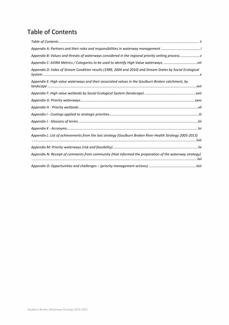
Goulburn Broken Waterway Strategy 2014-2022
Table of Contents Table of Contents ................................................................................................................................................ ii
Appendix A: Partners and their roles and responsibilities in waterway management ........................................ i
Appendix B: Values and threats of waterways considered in the regional priority setting process .....................v
Appendix C: AVIRA Metrics / Categories to be used to identify High Value waterways. .................................. viii
Appendix D: Index of Stream Condition results (1999, 2004 and 2010) and Stream States by Social Ecological System .................................................................................................................................................................. x
Appendix E: High value waterways and their associated values in the Goulburn Broken catchment, by landscape ......................................................................................................................................................... xvii
Appendix F: High value wetlands by Social Ecological System (landscape) .................................................... xxiii
Appendix G: Priority waterways ..................................................................................................................... xxxv
Appendix H - Priority wetlands ........................................................................................................................... xli
Appendix I - Costings applied to strategic priorities ............................................................................................ lii
Appendix J - Glossary of terms ........................................................................................................................... liii
Appendix K - Acronyms ....................................................................................................................................... lvi
Appendix L: List of achievements from the last strategy (Goulburn Broken River Health Strategy 2005-2013) ......................................................................................................................................................................... lviii
Appendix M: Priority waterways (risk and feasibility) ........................................................................................ lix
Appendix N: Receipt of comments from community (that informed the preparation of the waterway strategy) .......................................................................................................................................................................... lxii
Appendix O: Opportunities and challenges – (priority management actions) ................................................. lxiii
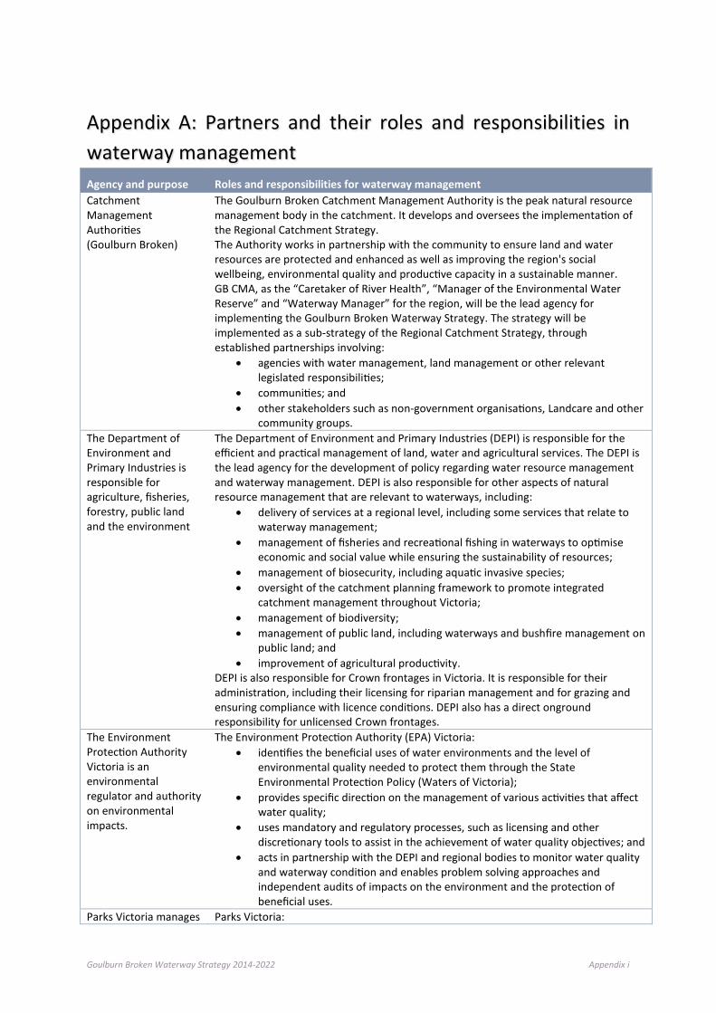
Goulburn Broken Waterway Strategy 2014-2022 Appendix i
Appendix A: Partners and their roles and responsibilities in waterway management Agency and purpose Roles and responsibilities for waterway management Catchment Management Authorities (Goulburn Broken)
The Goulburn Broken Catchment Management Authority is the peak natural resource management body in the catchment. It develops and oversees the implementation of the Regional Catchment Strategy. The Authority works in partnership with the community to ensure land and water resources are protected and enhanced as well as improving the region's social wellbeing, environmental quality and productive capacity in a sustainable manner. GB CMA, as the “Caretaker of River Health”, “Manager of the Environmental Water Reserve” and “Waterway Manager” for the region, will be the lead agency for implementing the Goulburn Broken Waterway Strategy. The strategy will be implemented as a sub-strategy of the Regional Catchment Strategy, through established partnerships involving:
• agencies with water management, land management or other relevant legislated responsibilities;
• communities; and • other stakeholders such as non-government organisations, Landcare and other
community groups. The Department of Environment and Primary Industries is responsible for agriculture, fisheries, forestry, public land and the environment
The Department of Environment and Primary Industries (DEPI) is responsible for the efficient and practical management of land, water and agricultural services. The DEPI is the lead agency for the development of policy regarding water resource management and waterway management. DEPI is also responsible for other aspects of natural resource management that are relevant to waterways, including:
• delivery of services at a regional level, including some services that relate to waterway management;
• management of fisheries and recreational fishing in waterways to optimise economic and social value while ensuring the sustainability of resources;
• management of biosecurity, including aquatic invasive species; • oversight of the catchment planning framework to promote integrated
catchment management throughout Victoria; • management of biodiversity; • management of public land, including waterways and bushfire management on
public land; and • improvement of agricultural productivity.
DEPI is also responsible for Crown frontages in Victoria. It is responsible for their administration, including their licensing for riparian management and for grazing and ensuring compliance with licence conditions. DEPI also has a direct onground responsibility for unlicensed Crown frontages.
The Environment Protection Authority Victoria is an environmental regulator and authority on environmental impacts.
The Environment Protection Authority (EPA) Victoria: • identifies the beneficial uses of water environments and the level of
environmental quality needed to protect them through the State Environmental Protection Policy (Waters of Victoria);
• provides specific direction on the management of various activities that affect water quality;
• uses mandatory and regulatory processes, such as licensing and other discretionary tools to assist in the achievement of water quality objectives; and
• acts in partnership with the DEPI and regional bodies to monitor water quality and waterway condition and enables problem solving approaches and independent audits of impacts on the environment and the protection of beneficial uses.
Parks Victoria manages Parks Victoria:
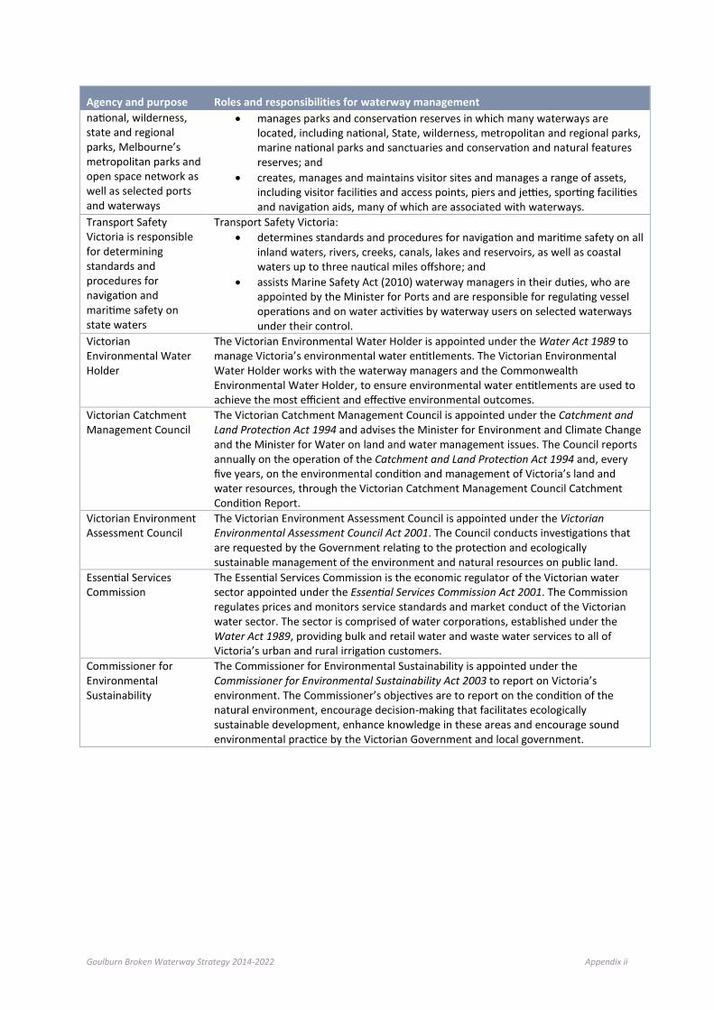
Goulburn Broken Waterway Strategy 2014-2022 Appendix ii
Agency and purpose Roles and responsibilities for waterway management national, wilderness, state and regional parks, Melbourne’s metropolitan parks and open space network as well as selected ports and waterways
• manages parks and conservation reserves in which many waterways are located, including national, State, wilderness, metropolitan and regional parks, marine national parks and sanctuaries and conservation and natural features reserves; and
• creates, manages and maintains visitor sites and manages a range of assets, including visitor facilities and access points, piers and jetties, sporting facilities and navigation aids, many of which are associated with waterways.
Transport Safety Victoria is responsible for determining standards and procedures for navigation and maritime safety on state waters
Transport Safety Victoria: • determines standards and procedures for navigation and maritime safety on all
inland waters, rivers, creeks, canals, lakes and reservoirs, as well as coastal waters up to three nautical miles offshore; and
• assists Marine Safety Act (2010) waterway managers in their duties, who are appointed by the Minister for Ports and are responsible for regulating vessel operations and on water activities by waterway users on selected waterways under their control.
Victorian Environmental Water Holder
The Victorian Environmental Water Holder is appointed under the Water Act 1989 to manage Victoria’s environmental water entitlements. The Victorian Environmental Water Holder works with the waterway managers and the Commonwealth Environmental Water Holder, to ensure environmental water entitlements are used to achieve the most efficient and effective environmental outcomes.
Victorian Catchment Management Council
The Victorian Catchment Management Council is appointed under the Catchment and Land Protection Act 1994 and advises the Minister for Environment and Climate Change and the Minister for Water on land and water management issues. The Council reports annually on the operation of the Catchment and Land Protection Act 1994 and, every five years, on the environmental condition and management of Victoria’s land and water resources, through the Victorian Catchment Management Council Catchment Condition Report.
Victorian Environment Assessment Council
The Victorian Environment Assessment Council is appointed under the Victorian Environmental Assessment Council Act 2001. The Council conducts investigations that are requested by the Government relating to the protection and ecologically sustainable management of the environment and natural resources on public land.
Essential Services Commission
The Essential Services Commission is the economic regulator of the Victorian water sector appointed under the Essential Services Commission Act 2001. The Commission regulates prices and monitors service standards and market conduct of the Victorian water sector. The sector is comprised of water corporations, established under the Water Act 1989, providing bulk and retail water and waste water services to all of Victoria’s urban and rural irrigation customers.
Commissioner for Environmental Sustainability
The Commissioner for Environmental Sustainability is appointed under the Commissioner for Environmental Sustainability Act 2003 to report on Victoria’s environment. The Commissioner’s objectives are to report on the condition of the natural environment, encourage decision-making that facilitates ecologically sustainable development, enhance knowledge in these areas and encourage sound environmental practice by the Victorian Government and local government.
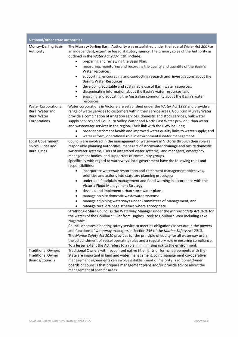
Goulburn Broken Waterway Strategy 2014-2022 Appendix iii
National/other state authorities
Murray-Darling Basin Authority
The Murray–Darling Basin Authority was established under the federal Water Act 2007 as an independent, expertise based statutory agency. The primary roles of the Authority as outlined in the Water Act 2007 (Cth) include:
• preparing and reviewing the Basin Plan; • measuring, monitoring and recording the quality and quantity of the Basin's
Water resources; • supporting, encouraging and conducting research and investigations about the
Basin's Water Resources; • developing equitable and sustainable use of Basin water resources; • disseminating information about the Basin's water resources; and • engaging and educating the Australian community about the Basin’s water
resources. Water Corporations Rural Water and Rural Water Corporations
Water corporations in Victoria are established under the Water Act 1989 and provide a range of water services to customers within their service areas. Goulburn Murray Water provide a combination of irrigation services, domestic and stock services, bulk water supply services and Goulburn Valley Water and North East Water provide urban water and wastewater services in the region. Their link with the RWS includes;
• broader catchment health and improved water quality links to water supply; and • water reform, operational role in environmental water management.
Local Government Shires, Cities and Rural Cities
Councils are involved in the management of waterways in Victoria through their role as responsible planning authorities, managers of stormwater drainage and onsite domestic wastewater systems, users of integrated water systems, land managers, emergency management bodies, and supporters of community groups. Specifically with regard to waterways, local government have the following roles and responsibilities:
• incorporate waterway restoration and catchment management objectives, priorities and actions into statutory planning processes;
• undertake floodplain management and flood warning in accordance with the Victoria Flood Management Strategy;
• develop and implement urban stormwater plans; • manage on-site domestic wastewater systems; • manage adjoining waterways under Committees of Management; and • manage rural drainage schemes where appropriate.
Strathbogie Shire Council is the Waterway Manager under the Marine Safety Act 2010 for the waters of the Goulburn River from Hughes Creek to Goulburn Weir including Lake Nagambie. Council operates a boating safety service to meet its obligations as set out in the powers and functions of waterway managers in Section 216 of the Marine Safety Act 2010. The Marine Safety Act 2010 provides for the principle of equity for all waterway users, the establishment of vessel operating rules and a regulatory role in ensuring compliance. To a lesser extent the Act refers to a role in minimising risk to the environment.
Traditional Owners Traditional Owner Boards/Councils
Traditional Owners with recognised native title rights or formal agreements with the State are important in land and water management. Joint management co-operative management agreements can involve establishment of majority Traditional Owner boards or councils that prepare management plans and/or provide advice about the management of specific areas.

Goulburn Broken Waterway Strategy 2014-2022 Appendix iv
In addition to the above State partnerships, regional roles and responsibilities of partners are summarised below.
Regional Partner Roles and responsibilities for waterway management
Community Landholders
Landholders are vital to successful implementation of this strategy, as most works are on privately owned land or affect areas that require private co-operation, and their land management practices have a vital role in catchment health. Under the Catchment and Land Protection Act 1994 landholders are required to:
• protect water resources; • avoid causing or contributing to land degradation which causes or may cause
damage to land of another owner; • conserve soil; • eradicate regionally prohibited weeds and prevent the growth and spread of
regionally controlled weeds; and • prevent the spread of, and as far as possible eradicate, established pest animals.
Individuals Community members have an important role in protecting waterway health by avoiding and reporting pollution, reducing resource consumption and contributing to environmental management processes.
Community Groups Community groups (such as Landcare, Waterwatch, EstuaryWatch, ‘Friends of’ groups ) participate in regional planning, priority setting and the implementation of regional works programs, participate in monitoring waterways condition and undertake projects in priority areas.
Industry Industry can assist in the protection and improvement of waterways by managing its activities in accordance with the principles of ecologically sustainable development and minimising impact on the environment by the implementation of best practices, in accordance with ‘duty of care’ responsibilities and good corporate citizenship.
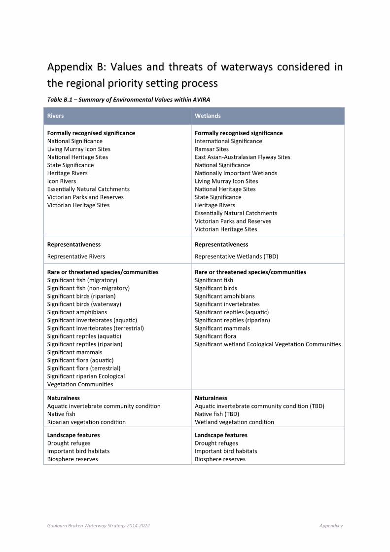
Goulburn Broken Waterway Strategy 2014-2022 Appendix v
Appendix B: Values and threats of waterways considered in the regional priority setting process Table B.1 – Summary of Environmental Values within AVIRA
Rivers Wetlands
Formally recognised significance National Significance Living Murray Icon Sites National Heritage Sites State Significance Heritage Rivers Icon Rivers Essentially Natural Catchments Victorian Parks and Reserves Victorian Heritage Sites
Formally recognised significance International Significance Ramsar Sites East Asian-Australasian Flyway Sites National Significance Nationally Important Wetlands Living Murray Icon Sites National Heritage Sites State Significance Heritage Rivers Essentially Natural Catchments Victorian Parks and Reserves Victorian Heritage Sites
Representativeness
Representative Rivers
Representativeness
Representative Wetlands (TBD)
Rare or threatened species/communities Significant fish (migratory) Significant fish (non-migratory) Significant birds (riparian) Significant birds (waterway) Significant amphibians Significant invertebrates (aquatic) Significant invertebrates (terrestrial) Significant reptiles (aquatic) Significant reptiles (riparian) Significant mammals Significant flora (aquatic) Significant flora (terrestrial) Significant riparian Ecological Vegetation Communities
Rare or threatened species/communities Significant fish Significant birds Significant amphibians Significant invertebrates Significant reptiles (aquatic) Significant reptiles (riparian) Significant mammals Significant flora Significant wetland Ecological Vegetation Communities
Naturalness Aquatic invertebrate community condition Native fish Riparian vegetation condition
Naturalness Aquatic invertebrate community condition (TBD) Native fish (TBD) Wetland vegetation condition
Landscape features Drought refuges Important bird habitats Biosphere reserves
Landscape features Drought refuges Important bird habitats Biosphere reserves
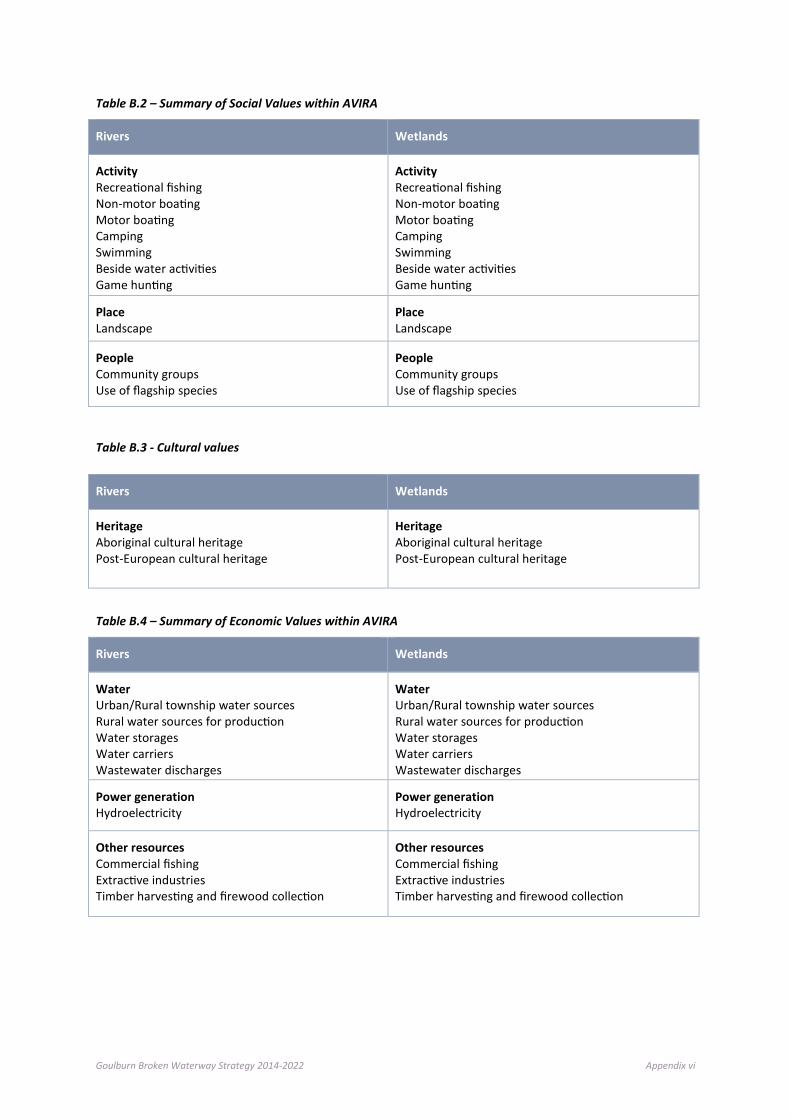
Goulburn Broken Waterway Strategy 2014-2022 Appendix vi
Table B.2 – Summary of Social Values within AVIRA
Rivers Wetlands
Activity Recreational fishing Non-motor boating Motor boating Camping Swimming Beside water activities Game hunting
Activity Recreational fishing Non-motor boating Motor boating Camping Swimming Beside water activities Game hunting
Place Landscape
Place Landscape
People Community groups Use of flagship species
People Community groups Use of flagship species
Table B.3 - Cultural values
Table B.4 – Summary of Economic Values within AVIRA
Rivers Wetlands
Water Urban/Rural township water sources Rural water sources for production Water storages Water carriers Wastewater discharges
Water Urban/Rural township water sources Rural water sources for production Water storages Water carriers Wastewater discharges
Power generation Hydroelectricity
Power generation Hydroelectricity
Other resources Commercial fishing Extractive industries Timber harvesting and firewood collection
Other resources Commercial fishing Extractive industries Timber harvesting and firewood collection
Rivers Wetlands
Heritage Aboriginal cultural heritage Post-European cultural heritage
Heritage Aboriginal cultural heritage Post-European cultural heritage

Goulburn Broken Waterway Strategy 2014-2022 Appendix vii
Table B.5 – Summary of Threat Values within AVIRA
Rivers Wetlands
ALTERED WATER REGIMES Altered Flow Regimes Increase in Low Flow Magnitude Reduction in High Flow Magnitude Increase in Proportion of Zero Flow Change in Monthly Streamflow Variability Altered Streamflow Seasonality
ALTERED WATER REGIMES Changed Water Regime
ALTERED PHYSICAL FORM Bank Instability Bed Instability (Degradation)
ALTERED PHYSICAL FORM Reduced Wetland Area Altered Wetland Form
POOR WATER QUALITY Degraded Water Quality Thermal Water Pollution Disturbance of Acid Sulphate Soils
POOR WATER QUALITY Changed Water Properties Disturbance of Acid Sulphate Soils
DEGRADED HABITATS Degraded Riparian Vegetation Large Trees Loss of Instream Habitat Large Wood Sedimentation Livestock Access
DEGRADED HABITATS Soil Disturbance
INVASIVE FLORA AND FAUNA Invasive Flora (Riparian) Trees Shrub Layer Ground Layer Invasive Flora (Aquatic) Invasive Fauna (Terrestrial) Invasive Fauna (Aquatic)
INVASIVE FLORA AND FAUNA Invasive Flora (Wetland) Invasive Fauna (Terrestrial) Invasive Fauna (Aquatic)
REDUCED CONNECTIVITY Barriers to Fish Migration Reduced Riparian Connectivity Longitudinal Continuity Vegetation Width Reduced Floodplain Connectivity
REDUCED CONNECTIVITY Reduced Wetland Connectivity

Goulburn Broken Waterway Strategy 2014-2022 Appendix viii
Appendix C: AVIRA Metrics / Categories to be used to identify High Value waterways. Value Type High Value Category AVIRA Score/ category
Environmental Values
Formally Recognised – Int. Significance
Ramsar Sites (wetlands only) Yes East Asian-Australasian Flyway sites (wetlands/estuaries only) Yes
Formally Recognised – National Significance
Nationally Important Wetlands Yes Living Murray Icon Sites Yes National Heritage Sites Yes Heritage Rivers Yes Icon Rivers Yes Essentially Natural Catchments Yes Victorian Parks and Reserves Yes Victorian Heritage Sites Yes
Representativeness Representative Rivers Yes
Rare or threatened species/communities
Significant fish 4-5 Significant birds 4-5 Significant amphibians (rivers/wetlands only) 4-5 Significant invertebrates (rivers and wetlands only) 4-5
Significant reptiles 4-5 Significant mammals (rivers and wetlands only) 4-5 Significant flora 4-5 Significant riparian EVCs (rivers only) 5 Significant wetland EVCs (wetlands only) 4-5 Significant estuarine EVCs (estuaries only) 4-5
Naturalness
Aquatic invertebrate community condition (rivers/ wetlands only) 4-5
Native fish communities (rivers only) 4-5 Riparian vegetation condition (rivers only) 4-5 Wetland vegetation condition (wetlands only) 4-5 Drought refuges 3,5 Important bird habitat 5 Biosphere Reserves Yes
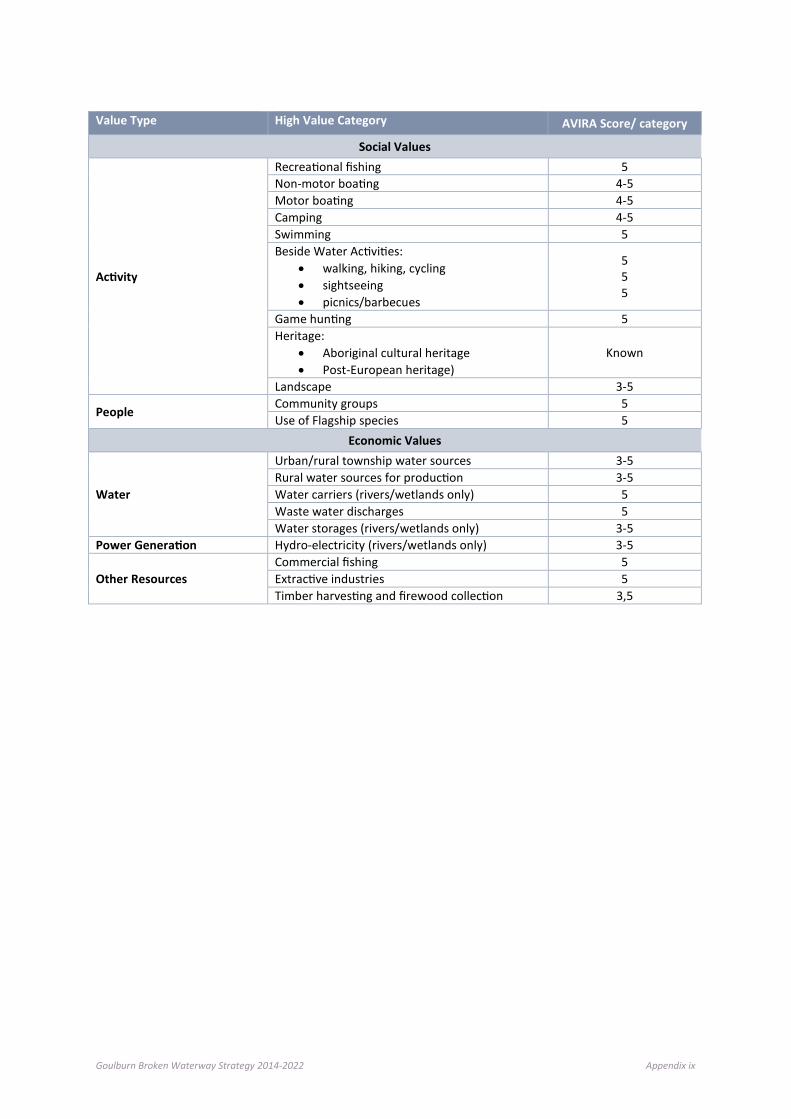
Goulburn Broken Waterway Strategy 2014-2022 Appendix ix
Value Type High Value Category AVIRA Score/ category
Social Values
Activity
Recreational fishing 5 Non-motor boating 4-5 Motor boating 4-5 Camping 4-5 Swimming 5 Beside Water Activities:
• walking, hiking, cycling • sightseeing • picnics/barbecues
5 5 5
Game hunting 5 Heritage:
• Aboriginal cultural heritage • Post-European heritage)
Known
Landscape 3-5
People Community groups 5 Use of Flagship species 5
Economic Values
Water
Urban/rural township water sources 3-5 Rural water sources for production 3-5 Water carriers (rivers/wetlands only) 5 Waste water discharges 5 Water storages (rivers/wetlands only) 3-5
Power Generation Hydro-electricity (rivers/wetlands only) 3-5
Other Resources Commercial fishing 5 Extractive industries 5 Timber harvesting and firewood collection 3,5

Goulburn Broken Waterway Strategy 2014-2022 Appendix x
Appendix D: Index of Stream Condition results (1999, 2004 and 2010) and Stream States by Social Ecological System
Name Basin Reach Length Social Ecological System ISC 1999 Rating ISC 2004 Rating ISC 2010 Rating (b) Stream State
Broken River 4-1 41413 Agricultural Floodplains
21 Poor 20 Moderate 19 Poor Highly Modified
Goulburn River
5-1 41399 Agricultural Floodplains
22 Poor 15 Poor 32 Moderate Sustainable Working
Broken River 4-2 33882 Productive Plains 18 Very Poor 23 Moderate 24 Poor Sustainable Working
Goulburn River
5-2 35484 Agricultural Floodplains
22 Poor 16 Poor 26 Moderate Sustainable Working
Broken River 4-3 24748 Productive Plains 21 Poor 18 Poor 27 Moderate Sustainable Working
Goulburn River
5-3 45934 Agricultural Floodplains
22 Poor 14 Poor 32 Moderate Sustainable Working
Broken River 4-4 35101 Upland Slopes 19 Very Poor 20 Moderate 27 Moderate Sustainable Working
Goulburn River
5-4 19396 Agricultural Floodplains
22 Poor 18 Poor 38 Good Ecological Healthy
Broken River 4-5 21639 Upland Slopes 29 Marginal 18 Poor 25 Moderate Sustainable Working
Goulburn River
5-5 16188 Agricultural Floodplains
20 Poor 16 Poor 34 Moderate Sustainable Working
Broken River 4-6 26574 Upland Slopes 31 Marginal 16 Poor 31 Moderate Sustainable Working
Goulburn River
5-6 20589 Productive Plains 20 Poor 16 Poor 32 Moderate Sustainable Working
Five Mile Creek
4-7 44785 Productive Plains 27 Marginal 20 Moderate 32 Moderate Sustainable Working

Goulburn Broken Waterway Strategy 2014-2022 Appendix xi
Name Basin Reach Length Social Ecological System ISC 1999 Rating ISC 2004 Rating ISC 2010 Rating (b) Stream State
Goulburn River
5-7 19558 Productive Plains 24 Poor 17 Poor 37 Good Ecological Healthy
Five Mile Creek
4-8 8894 Productive Plains N/A 20 Moderate 39 Good Ecological Healthy
Goulburn River
5-8 34366 Productive Plains 21 Poor 19 Moderate 30 Moderate Sustainable Working
Lima East Creek
4-9 16536 Upland Slopes 23 Poor 22 Moderate 32 Moderate Sustainable Working
Goulburn River
5-9 30289 Productive Plains N/A 15 Poor 29 Moderate Sustainable Working
Lima East Creek
4-10 10989 Upland Slopes 29 Marginal 24 Moderate 37 Good Ecological Healthy
Goulburn River
5-10 20525 Productive Plains 19 Very Poor 9 Very Poor 28 Moderate Sustainable Working
Sawpit Creek 4-11 13658 Upland Slopes 30 Marginal 18 Poor 26 Moderate Sustainable Working
Goulburn River
5-11 24099 Commuting Hills 8 Very Poor 10 Very Poor 23 Poor Sustainable Working
Goulburn River
5-12 26886 Commuting Hills 18 Very Poor 13 Poor 19 Very Poor Highly Modified
Holland Creek 4-13 14657 Productive Plains 32 Marginal 25 Moderate 26 Moderate Sustainable Working
Goulburn River
5-13 37946 Upland Slopes 21 Poor 15 Poor 25 Moderate Sustainable Working
Holland Creek 4-14 38237 Upland Slopes 33 Marginal 23 Moderate 29 Moderate Sustainable Working
Goulburn River
5-14 49985 Upland Slopes 22 Poor 16 Poor 32 Moderate Sustainable Working
Holland Creek 4-15 18608 Upland Slopes Excellent 38 Excellent 30 Moderate Sustainable Working
Goulburn River
5-15 37851 Southern Forests 44 Excellent 34 Good 35 Good Ecological Healthy
Ryans Creek 4-16 28074 Upland Slopes 30 Marginal 16 Poor 37 Good Ecological Healthy

Goulburn Broken Waterway Strategy 2014-2022 Appendix xii
Name Basin Reach Length Social Ecological System ISC 1999 Rating ISC 2004 Rating ISC 2010 Rating (b) Stream State
Goulburn River
5-16 48272 Southern Forests 34 Marginal 36 Good 42 Excellent Ecological Healthy
Ryans Creek 4-17 26848 Upland Slopes 43 Excellent 41 Excellent 32 Moderate Ecological Healthy Seven Creeks 5-17 38464 Productive Plains 31 Marginal 25 Moderate 28 Moderate Sustainable
Working Sam Creek 4-18 23943 Upland Slopes 27 Marginal 12 Very Poor 29 Very Poor Sustainable
Working Seven Creeks 5-18 26251 Productive Plains 27 Marginal 25 Moderate 26 Moderate Sustainable
Working Watchbox Creek
4-19 22111 Upland Slopes 28 Marginal 24 Moderate 34 Very Poor Sustainable Working
Seven Creeks 5-19 30243 Productive Plains 29 Marginal 26 Moderate 28 Moderate Sustainable Working
Winton Creek 4-20 18781 Productive Plains 24 Poor 22 Moderate 34 Very Poor Sustainable Working
Seven Creeks 5-20 30777 Productive Plains 32 Marginal 24 Moderate 31 Moderate Sustainable Working
Broken Creek 4-21 23558 Agricultural Floodplains
25 Poor 26 Moderate 25 Moderate Sustainable Working
Faithfulls Creek
5-21 46346 Productive Plains 25 Poor 23 Moderate 33 Moderate Sustainable Working
Broken Creek 4-22 37273 Agricultural Floodplains
22 Poor 25 Moderate 21 Poor Sustainable Working
Honeysuckle Creek
5-22 49709 Productive Plains 31 Marginal 26 Moderate 29 Moderate Sustainable Working
Broken Creek 4-23 42881 Agricultural Floodplains
20 Poor 28 Moderate 26 Moderate Sustainable Working
Honeysuckle Creek
5-23 34638 Productive Plains 26 Marginal 23 Moderate 28 Moderate Sustainable Working
Broken Creek 4-24 38536 Agricultural Floodplains
21 Poor 20 Moderate 26 Moderate Sustainable Working
Sheep Pen Creek
5-24 31587 Productive Plains 26 Marginal 10 Very Poor 25 Moderate Sustainable Working

Goulburn Broken Waterway Strategy 2014-2022 Appendix xiii
Name Basin Reach Length Social Ecological System ISC 1999 Rating ISC 2004 Rating ISC 2010 Rating (b) Stream State
Broken Creek 4-25 23874 Agricultural Floodplains
21 Poor 20 Moderate 21 Poor Sustainable Working
Castle Creek 5-25 57706 Productive Plains 30 Marginal 22 Moderate 14 Very Poor Highly Modified Broken Creek 4-26 22302 Productive Plains 20 Poor 18 Poor 24 Poor Sustainable
Working Castle Creek 5-26 27995 Productive Plains 29 Marginal 18 Poor 20 Poor Highly Modified Broken Creek 4-27 37692 Productive Plains 18 Very Poor 18 Poor 22 Poor Sustainable
Working Creightons Creek
5-27 49673 Productive Plains 34 Marginal 24 Moderate 21 Poor Sustainable Working
Nine Mile Creek
4-28 40664 Agricultural Floodplains
31 Marginal 27 Moderate 27 Moderate Sustainable Working
Creightons Creek
5-28 27573 Productive Plains 30 Marginal 19 Moderate 23 Poor Sustainable Working
Nine Mile Creek
4-29 45845 Productive Plains 27 Marginal 16 Poor 29 Moderate Sustainable Working
Pranjip Creek 5-29 31855 Productive Plains 33 Marginal 18 Poor 20 Poor Highly Modified Pine Lodge Creek
4-30 40838 Agricultural Floodplains
25 Poor 15 Poor 25 Moderate Sustainable Working
Cornella Creek
5-30 21236 Agricultural Floodplains
30 Marginal 20 Moderate 15 Very Poor Highly Modified
Pine Lodge Creek
4-31 17977 Agricultural Floodplains
27 Marginal 16 Poor 23 Poor Sustainable Working
Cornella Creek
5-31 43386 Productive Plains 31 Marginal 24 Moderate 15 Very Poor Highly Modified
Boosey Creek 4-32 45634 Agricultural Floodplains
26 Marginal 19 Moderate 26 Moderate Sustainable Working
Yallagalorrah Creek
5-32 12359 Productive Plains 25 Poor 8 Very Poor 14 Very Poor Highly Modified
Boosey Creek 4-33 31455 Productive Plains 26 Marginal 21 Moderate 22 Poor Sustainable Working
Goborup Creek
5-33 32516 Productive Plains 33 Marginal 25 Moderate 26 Moderate Sustainable Working
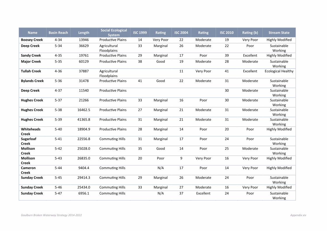
Goulburn Broken Waterway Strategy 2014-2022 Appendix xiv
Name Basin Reach Length Social Ecological System ISC 1999 Rating ISC 2004 Rating ISC 2010 Rating (b) Stream State
Boosey Creek 4-34 13946 Productive Plains 14 Very Poor 22 Moderate 19 Very Poor Highly Modified Deep Creek 5-34 36629 Agricultural
Floodplains 33 Marginal 26 Moderate 22 Poor Sustainable
Working Sandy Creek 4-35 19761 Productive Plains 29 Marginal 17 Poor 39 Excellent Highly Modified Major Creek 5-35 60129 Productive Plains 38 Good 19 Moderate 28 Moderate Sustainable
Working Tullah Creek 4-36 37887 Agricultural
Floodplains 11 Very Poor 41 Excellent Ecological Healthy
Bylands Creek 5-36 31478 Productive Plains 41 Good 22 Moderate 31 Moderate Sustainable Working
Deep Creek 4-37 11540 Productive Plains 30 Moderate Sustainable Working
Hughes Creek 5-37 21266 Productive Plains 33 Marginal 16 Poor 30 Moderate Sustainable Working
Hughes Creek 5-38 16462.5 Productive Plains 27 Marginal 21 Moderate 31 Moderate Sustainable Working
Hughes Creek 5-39 41365.8 Productive Plains 31 Marginal 21 Moderate 31 Moderate Sustainable Working
Whiteheads Creek
5-40 18904.9 Productive Plains 28 Marginal 14 Poor 20 Poor Highly Modified
Sugarloaf Creek
5-41 22556.8 Commuting Hills 31 Marginal 17 Poor 24 Poor Sustainable Working
Mollison Creek
5-42 25028.0 Commuting Hills 35 Good 14 Poor 25 Moderate Sustainable Working
Mollison Creek
5-43 26835.0 Commuting Hills 20 Poor 9 Very Poor 16 Very Poor Highly Modified
Cameron Creek
5-44 9404.4 Commuting Hills N/A 17 Poor 14 Very Poor Highly Modified
Sunday Creek 5-45 29414.3 Commuting Hills 29 Marginal 26 Moderate 24 Poor Sustainable Working
Sunday Creek 5-46 25434.0 Commuting Hills 33 Marginal 27 Moderate 16 Very Poor Highly Modified Sunday Creek 5-47 6956.1 Commuting Hills N/A 37 Excellent 24 Poor Sustainable
Working
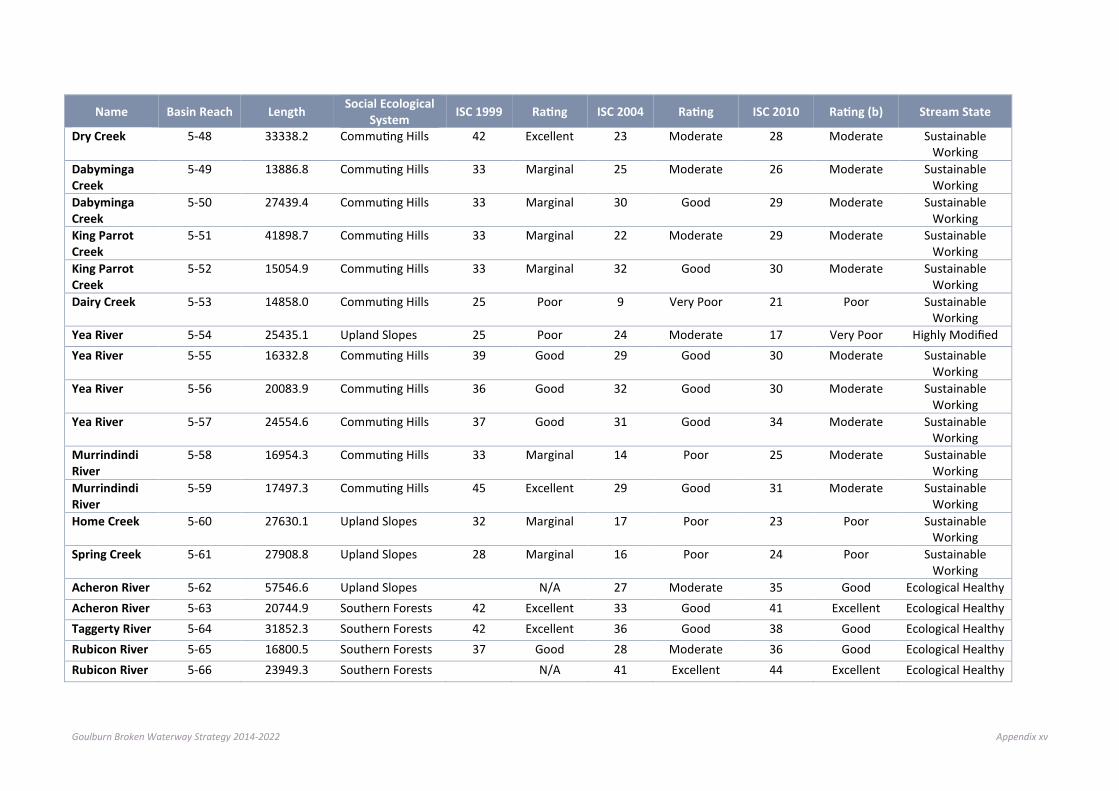
Goulburn Broken Waterway Strategy 2014-2022 Appendix xv
Name Basin Reach Length Social Ecological System ISC 1999 Rating ISC 2004 Rating ISC 2010 Rating (b) Stream State
Dry Creek 5-48 33338.2 Commuting Hills 42 Excellent 23 Moderate 28 Moderate Sustainable Working
Dabyminga Creek
5-49 13886.8 Commuting Hills 33 Marginal 25 Moderate 26 Moderate Sustainable Working
Dabyminga Creek
5-50 27439.4 Commuting Hills 33 Marginal 30 Good 29 Moderate Sustainable Working
King Parrot Creek
5-51 41898.7 Commuting Hills 33 Marginal 22 Moderate 29 Moderate Sustainable Working
King Parrot Creek
5-52 15054.9 Commuting Hills 33 Marginal 32 Good 30 Moderate Sustainable Working
Dairy Creek 5-53 14858.0 Commuting Hills 25 Poor 9 Very Poor 21 Poor Sustainable Working
Yea River 5-54 25435.1 Upland Slopes 25 Poor 24 Moderate 17 Very Poor Highly Modified Yea River 5-55 16332.8 Commuting Hills 39 Good 29 Good 30 Moderate Sustainable
Working Yea River 5-56 20083.9 Commuting Hills 36 Good 32 Good 30 Moderate Sustainable
Working Yea River 5-57 24554.6 Commuting Hills 37 Good 31 Good 34 Moderate Sustainable
Working Murrindindi River
5-58 16954.3 Commuting Hills 33 Marginal 14 Poor 25 Moderate Sustainable Working
Murrindindi River
5-59 17497.3 Commuting Hills 45 Excellent 29 Good 31 Moderate Sustainable Working
Home Creek 5-60 27630.1 Upland Slopes 32 Marginal 17 Poor 23 Poor Sustainable Working
Spring Creek 5-61 27908.8 Upland Slopes 28 Marginal 16 Poor 24 Poor Sustainable Working
Acheron River 5-62 57546.6 Upland Slopes N/A 27 Moderate 35 Good Ecological Healthy Acheron River 5-63 20744.9 Southern Forests 42 Excellent 33 Good 41 Excellent Ecological Healthy Taggerty River 5-64 31852.3 Southern Forests 42 Excellent 36 Good 38 Good Ecological Healthy Rubicon River 5-65 16800.5 Southern Forests 37 Good 28 Moderate 36 Good Ecological Healthy Rubicon River 5-66 23949.3 Southern Forests N/A 41 Excellent 44 Excellent Ecological Healthy

Goulburn Broken Waterway Strategy 2014-2022 Appendix xvi
Name Basin Reach Length Social Ecological System ISC 1999 Rating ISC 2004 Rating ISC 2010 Rating (b) Stream State
Big River 5-67 36563.0 Southern Forests 45 Excellent 36 Good 44 Excellent Ecological Healthy Big River 5-68 21988.1 Southern Forests 47 Excellent 42 Excellent 44 Excellent Ecological Healthy Howqua River 5-69 8365.8 Southern Forests 44 Excellent 29 Good 35 Good Ecological Healthy Howqua River 5-70 55765.6 Southern Forests 40 Good 38 Excellent 42 Excellent Ecological Healthy Delatite River 5-71 32402.2 Southern Forests 31 Marginal 32 Good 22 Poor Sustainable
Working Delatite River 5-72 23041.5 Southern Forests N/A 32 Good 36 Good Ecological Healthy Ford Creek 5-73 26359.3 Upland Slopes 23 Poor 11 Very Poor 19 Very Poor Highly Modified Brankeet Creek
5-74 25461.4 Upland Slopes 30 Marginal 24 Moderate 31 Moderate Sustainable Working
Merton Creek 5-75 21638.7 Upland Slopes 19 Very Poor 20 Moderate 26 Moderate Sustainable Working
Honeysuckle Creek
5-76 30753.3 Productive Plains 29 Moderate Sustainable Working
Burnt Creek 5-77 19319.4 Productive Plains 23 Poor Sustainable Working
Kurkuruc Creek
5-78 35963.7 Commuting Hills 21 Poor Sustainable Working
Godfrey Creek 5-79 22331.8 Commuting Hills 29 Moderate Sustainable Working
Wormangal Creek
5-80 32063.6 Productive Plains 31 Moderate Sustainable Working
Yea River 5-81 10484.7 Commuting Hills 15 Very Poor Highly Modified

Goulburn Broken Waterway Strategy 2014-2022 Appendix xvii
Appendix E: High value waterways and their associated values in the Goulburn Broken catchment, by landscape
Waterway Environmental Values Social Values Economic Values
SES Name No.
Form
ally
Rec
ogni
sed
Sign
ifica
nce
Repr
esen
tativ
enes
s
Rare
or T
hrea
tene
d Sp
ecie
s/Co
mm
uniti
es
Nat
ural
ness
Land
scap
e Fe
atur
es
Activ
ity
Plac
e
Peop
le
Wat
er
Pow
er G
ener
ation
Oth
er R
esou
rces
Agricultural Floodplains Broken River 4~01 x x x x x x Productive Plains Broken River 4~02 x x x x x x Productive Plains Broken River 4~03 x x x x x x Upland Slopes Broken River 4~04 x x x x x x Upland Slopes Broken River 4~05 x x x x x Upland Slopes Broken River 4~06 x x x x x x Productive Plains Five Mile Creek 4~07 x x x x Productive Plains Five Mile Creek 4~08 x x x Upland Slopes Lima East Creek 4~09 x x x x x Upland Slopes Lima East Creek 4~10 x x x Upland Slopes Sawpit Creek 4~11 x x x x Productive Plains Holland Creek 4~13 x x x x x Upland Slopes Holland Creek 4~14 x x x x x Upland Slopes Holland Creek 4~15 x x x x x Upland Slopes Ryans Creek 4~16 x x x x x x
Upland Slopes Ryans Creek 4~17 x x x x x x

Goulburn Broken Waterway Strategy 2014-2022 Appendix xviii
Waterway Environmental Values Social Values Economic Values
SES Name No.
Form
ally
Rec
ogni
sed
Sign
ifica
nce
Repr
esen
tativ
enes
s
Rare
or T
hrea
tene
d Sp
ecie
s/Co
mm
uniti
es
Nat
ural
ness
Land
scap
e Fe
atur
es
Activ
ity
Plac
e
Peop
le
Wat
er
Pow
er G
ener
ation
Oth
er R
esou
rces
Upland Slopes Sam Creek 4~18 x x x Upland Slopes Watchbox Creek 4~19 x x x x Productive Plains Winton Creek 4~20 x x Agricultural Floodplains Broken Creek 4~21 x x x x x x x Agricultural Floodplains Broken Creek 4~22 x x x x x x Agricultural Floodplains Broken Creek 4~23 x x x x x Agricultural Floodplains Broken Creek 4~24 x x x x x Agricultural Floodplains Broken Creek 4~25 x x x x x Productive Plains Broken Creek 4~26 x x x x x x x Productive Plains Broken Creek 4~27 x x x x x x Agricultural Floodplains Nine Mile Creek 4~28 x x x x x Agricultural Floodplains Nine Mile Creek 4~29 x Agricultural Floodplains Pine Lodge Creek 4~30 x Agricultural Floodplains Pine Lodge Creek 4~31 x Agricultural Floodplains Boosey Creek 4~32 x x x x Productive Plains Boosey Creek 4~33 x x x Productive Plains Boosey Creek 4~34 x x x x Productive Plains Sandy Creek 4~35 x x Agricultural Floodplains Tullah Creek 4~36 x x x x Agricultural Floodplains Deep Creek 4~37 x Agricultural Floodplains Goulburn River 5~01 x x x x x x x Agricultural Floodplains Goulburn River 5~02 x x x x x x x
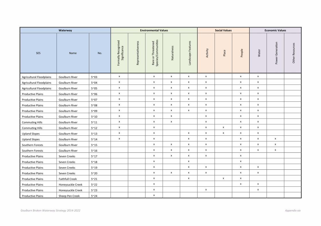
Goulburn Broken Waterway Strategy 2014-2022 Appendix xix
Waterway Environmental Values Social Values Economic Values
SES Name No.
Form
ally
Rec
ogni
sed
Sign
ifica
nce
Repr
esen
tativ
enes
s
Rare
or T
hrea
tene
d Sp
ecie
s/Co
mm
uniti
es
Nat
ural
ness
Land
scap
e Fe
atur
es
Activ
ity
Plac
e
Peop
le
Wat
er
Pow
er G
ener
ation
Oth
er R
esou
rces
Agricultural Floodplains Goulburn River 5~03 x x x x x x x Agricultural Floodplains Goulburn River 5~04 x x x x x x x Agricultural Floodplains Goulburn River 5~05 x x x x x x x Productive Plains Goulburn River 5~06 x x x x x x x Productive Plains Goulburn River 5~07 x x x x x x x Productive Plains Goulburn River 5~08 x x x x x x x Productive Plains Goulburn River 5~09 x x x x x x x Productive Plains Goulburn River 5~10 x x x x x x Commuting Hills Goulburn River 5~11 x x x x x x Commuting Hills Goulburn River 5~12 x x x x x x Upland Slopes Goulburn River 5~13 x x x x x x x Upland Slopes Goulburn River 5~14 x x x x x x x Southern Forests Goulburn River 5~15 x x x x x x x Southern Forests Goulburn River 5~16 x x x x x x x Productive Plains Seven Creeks 5~17 x x x x x Productive Plains Seven Creeks 5~18 x x x Productive Plains Seven Creeks 5~19 x x x x x Productive Plains Seven Creeks 5~20 x x x x x x Productive Plains Faithfull Creek 5~21 x x x x Productive Plains Honeysuckle Creek 5~22 x x x Productive Plains Honeysuckle Creek 5~23 x x x Productive Plains Sheep Pen Creek 5~24 x

Goulburn Broken Waterway Strategy 2014-2022 Appendix xx
Waterway Environmental Values Social Values Economic Values
SES Name No.
Form
ally
Rec
ogni
sed
Sign
ifica
nce
Repr
esen
tativ
enes
s
Rare
or T
hrea
tene
d Sp
ecie
s/Co
mm
uniti
es
Nat
ural
ness
Land
scap
e Fe
atur
es
Activ
ity
Plac
e
Peop
le
Wat
er
Pow
er G
ener
ation
Oth
er R
esou
rces
Productive Plains Castle Creek 5~25 x x Productive Plains Castle Creek 5~26 x x Productive Plains Creightons Creek 5~27 x x x Productive Plains Creightons Creek 5~28 x x x Productive Plains Pranjip Creek 5~29 x x Agricultural Floodplains Cornella Creek 5~30 x x Productive Plains Cornella Creek 5~31 x x x Productive Plains Yallagalorrah Creek 5~32 x Productive Plains Goborup Creek 5~33 x x Agricultural Floodplains Deep Creek 5~34 x x Productive Plains Major Creek 5~35 x x x Productive Plains Bylands Creek 5~36 x x x Productive Plains Hughes Creek 5~37 x x x x x x
Productive Plains Hughes Creek 5~38 x x x x x Productive Plains Hughes Creek 5~39 x x x x x
Commuting Hills Whiteheads Creek 5~40 x Commuting Hills Sugarloaf Creek 5~41 x x x Commuting Hills Mollison Creek 5~42 x x x
Commuting Hills Mollison Creek 5~43 x Commuting Hills Kurkurac Creek 5~44 x x Commuting Hills Sunday Creek 5~45 x x x Commuting Hills Sunday Creek 5~46 x x x x
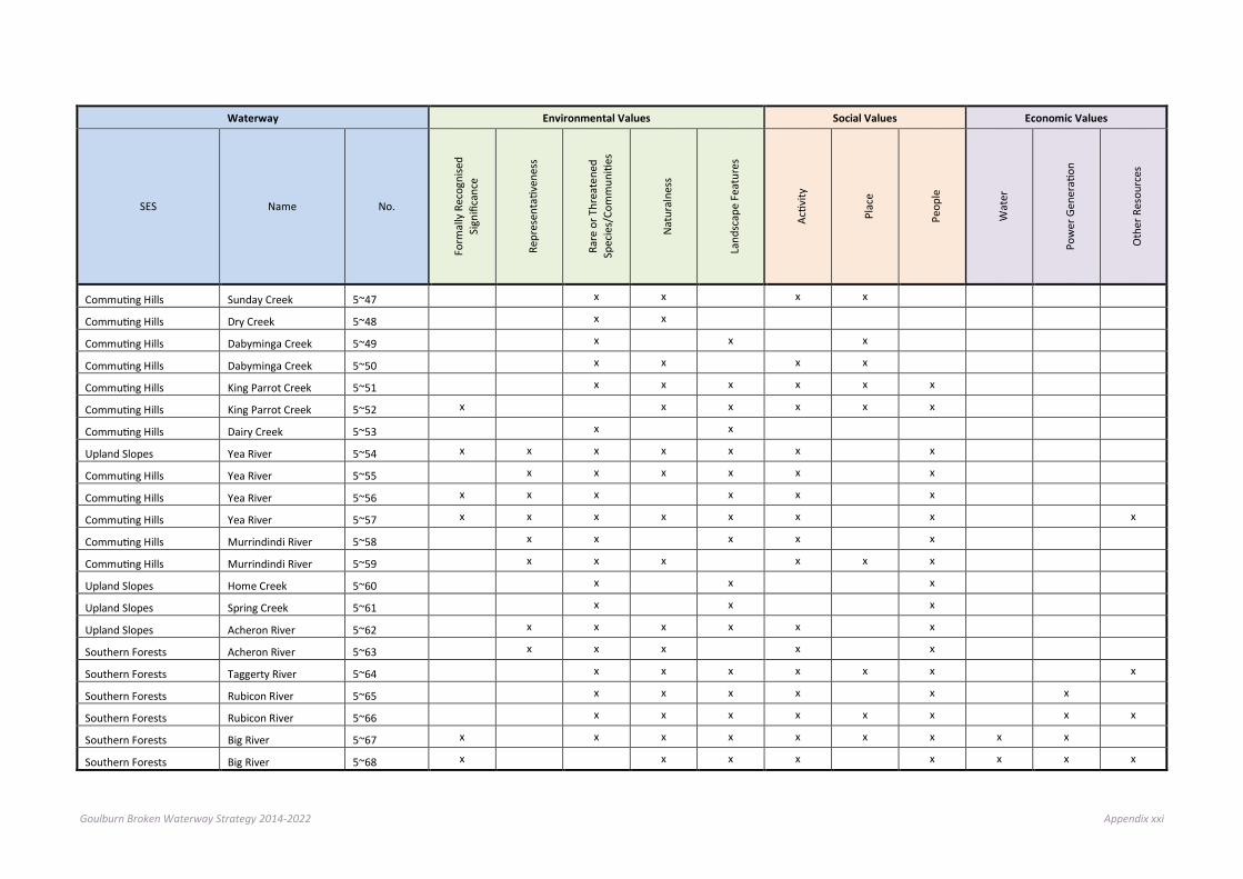
Goulburn Broken Waterway Strategy 2014-2022 Appendix xxi
Waterway Environmental Values Social Values Economic Values
SES Name No.
Form
ally
Rec
ogni
sed
Sign
ifica
nce
Repr
esen
tativ
enes
s
Rare
or T
hrea
tene
d Sp
ecie
s/Co
mm
uniti
es
Nat
ural
ness
Land
scap
e Fe
atur
es
Activ
ity
Plac
e
Peop
le
Wat
er
Pow
er G
ener
ation
Oth
er R
esou
rces
Commuting Hills Sunday Creek 5~47 x x x x Commuting Hills Dry Creek 5~48 x x Commuting Hills Dabyminga Creek 5~49 x x x Commuting Hills Dabyminga Creek 5~50 x x x x Commuting Hills King Parrot Creek 5~51 x x x x x x Commuting Hills King Parrot Creek 5~52 x x x x x x Commuting Hills Dairy Creek 5~53 x x Upland Slopes Yea River 5~54 x x x x x x x Commuting Hills Yea River 5~55 x x x x x x Commuting Hills Yea River 5~56 x x x x x x Commuting Hills Yea River 5~57 x x x x x x x x
Commuting Hills Murrindindi River 5~58 x x x x x Commuting Hills Murrindindi River 5~59 x x x x x x Upland Slopes Home Creek 5~60 x x x Upland Slopes Spring Creek 5~61 x x x Upland Slopes Acheron River 5~62 x x x x x x Southern Forests Acheron River 5~63 x x x x x Southern Forests Taggerty River 5~64 x x x x x x x
Southern Forests Rubicon River 5~65 x x x x x x Southern Forests Rubicon River 5~66 x x x x x x x x
Southern Forests Big River 5~67 x x x x x x x x x Southern Forests Big River 5~68 x x x x x x x x

Goulburn Broken Waterway Strategy 2014-2022 Appendix xxii
Waterway Environmental Values Social Values Economic Values
SES Name No.
Form
ally
Rec
ogni
sed
Sign
ifica
nce
Repr
esen
tativ
enes
s
Rare
or T
hrea
tene
d Sp
ecie
s/Co
mm
uniti
es
Nat
ural
ness
Land
scap
e Fe
atur
es
Activ
ity
Plac
e
Peop
le
Wat
er
Pow
er G
ener
ation
Oth
er R
esou
rces
Southern Forests Howqua River 5~69 x x x x x x x x x Southern Forests Howqua River 5~70 x x x x x x x x Southern Forests Delatite River 5~71 x x x x x x x x Southern Forests Delatite River 5~72 x x x x x x x Upland Slopes Ford Creek 5~73 x x x x x Upland Slopes Brankeet Creek 5~74 x x x x x x x Upland Slopes Merton Creek 5~75 x x x x x Productive Plains Honeysuckle Creek 5~76 x x Productive Plains Burnt Creek 5~77 x Commuting Hills Kurkurac Creek 5~78 x Commuting Hills Godfrey Creek 5~79 x x Productive Plains Wormangal Creek 5~80 x
Commuting Hills Yea River 5~81 x x
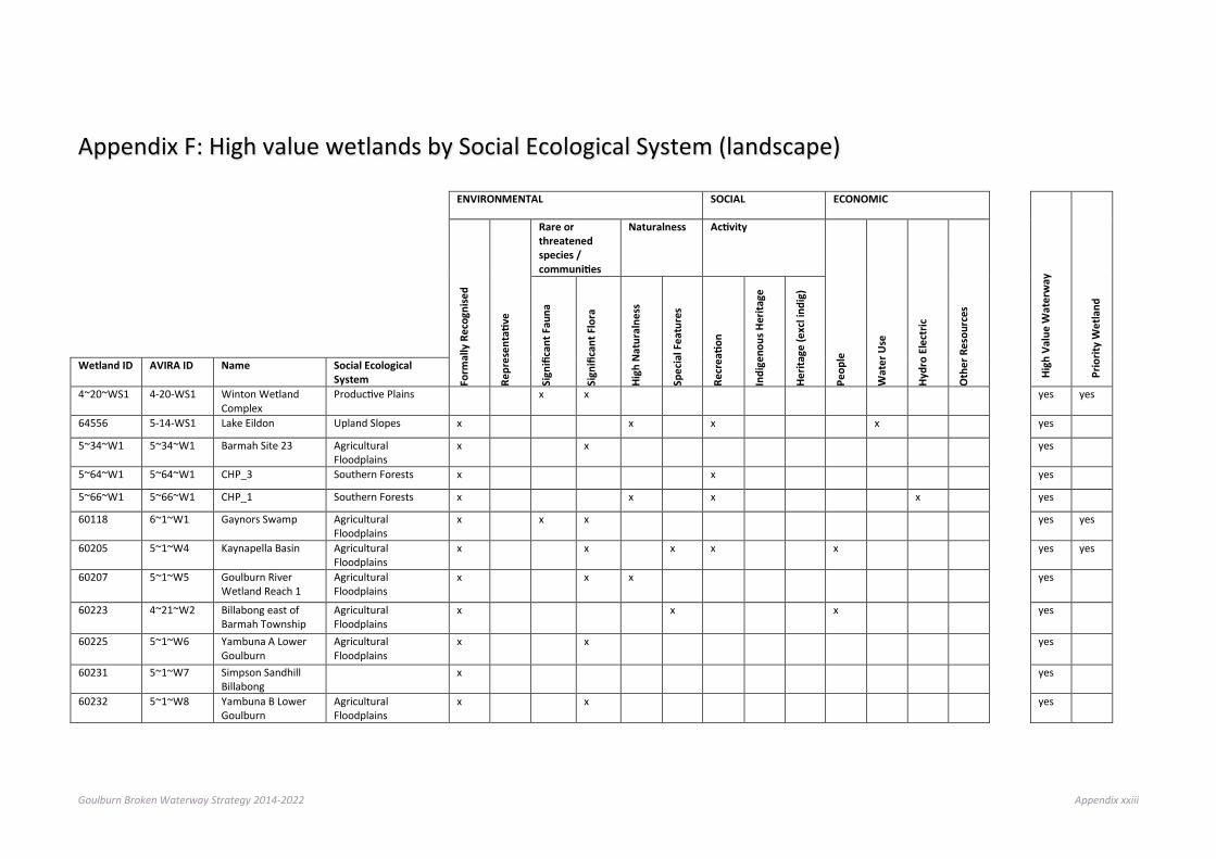
Goulburn Broken Waterway Strategy 2014-2022 Appendix xxiii
Appendix F: High value wetlands by Social Ecological System (landscape) ENVIRONMENTAL SOCIAL ECONOMIC
High
Val
ue W
ater
way
Prio
rity
Wet
land
Form
ally
Rec
ogni
sed
Repr
esen
tativ
e
Rare or threatened species / communities
Naturalness Activity
Peop
le
Wat
er U
se
Hydr
o El
ectr
ic
Oth
er R
esou
rces
Sign
ifica
nt F
auna
Sign
ifica
nt F
lora
High
Nat
ural
ness
Spec
ial F
eatu
res
Recr
eatio
n
Indi
geno
us H
erita
ge
Herit
age
(exc
l ind
ig)
Wetland ID AVIRA ID Name Social Ecological System
4~20~WS1 4-20-WS1 Winton Wetland Complex
Productive Plains x x yes yes
64556 5-14-WS1 Lake Eildon Upland Slopes x x x x yes
5~34~W1 5~34~W1 Barmah Site 23 Agricultural Floodplains
x x yes
5~64~W1 5~64~W1 CHP_3 Southern Forests x x yes
5~66~W1 5~66~W1 CHP_1 Southern Forests x x x x yes
60118 6~1~W1 Gaynors Swamp Agricultural Floodplains
x x x yes yes
60205 5~1~W4 Kaynapella Basin Agricultural Floodplains
x x x x x yes yes
60207 5~1~W5 Goulburn River Wetland Reach 1
Agricultural Floodplains
x x x yes
60223 4~21~W2 Billabong east of Barmah Township
Agricultural Floodplains
x x x yes
60225 5~1~W6 Yambuna A Lower Goulburn
Agricultural Floodplains
x x yes
60231 5~1~W7 Simpson Sandhill Billabong
x yes
60232 5~1~W8 Yambuna B Lower Goulburn
Agricultural Floodplains
x x yes
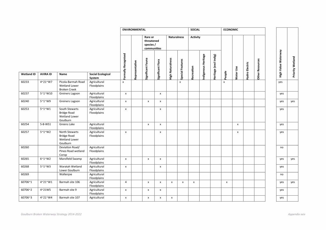
Goulburn Broken Waterway Strategy 2014-2022 Appendix xxiv
ENVIRONMENTAL SOCIAL ECONOMIC
High
Val
ue W
ater
way
Prio
rity
Wet
land
Form
ally
Rec
ogni
sed
Repr
esen
tativ
e
Rare or threatened species / communities
Naturalness Activity
Peop
le
Wat
er U
se
Hydr
o El
ectr
ic
Oth
er R
esou
rces
Sign
ifica
nt F
auna
Sign
ifica
nt F
lora
High
Nat
ural
ness
Spec
ial F
eatu
res
Recr
eatio
n
Indi
geno
us H
erita
ge
Herit
age
(exc
l ind
ig)
Wetland ID AVIRA ID Name Social Ecological System
60233 4~21~W7 Picola-Barmah Road Wetland Lower Broken Creek
Agricultural Floodplains
x x x yes
60237 5~1~W10 Greiners Lagoon Agricultural Floodplains
x x yes
60240 5~1~W9 Greiners Lagoon Agricultural Floodplains
x x x yes yes
60253 5~1~W1 South Stewarts Bridge Road Wetland Lower Goulburn
Agricultural Floodplains
x x yes
60254 5-8-WS1 Greens Lake Agricultural Floodplains
x x x yes
60257 5~1~W2 North Stewarts Bridge Road Wetland Lower Goulburn
Agricultural Floodplains
x x x yes
60260 Deviation Road/ Pineo Road wetland Corop
Agricultural Floodplains
no
60265 6~1~W2 Mansfield Swamp Agricultural Floodplains
x x x yes yes
60268 5~1~W3 Waratah Wetland Lower Goulburn
Agricultural Floodplains
x x yes
60269 Wallenjoe Agricultural Floodplains
no
60706~1 4~21~W1 Barmah site 106 Agricultural Floodplains
4 x x x x x x yes yes
60706~2 4~21W5 Barmah site 9 Agricultural Floodplains
x x x yes
60706~3 4~21~W4 Barmah site 107 Agricultural x x x x yes

Goulburn Broken Waterway Strategy 2014-2022 Appendix xxv
ENVIRONMENTAL SOCIAL ECONOMIC
High
Val
ue W
ater
way
Prio
rity
Wet
land
Form
ally
Rec
ogni
sed
Repr
esen
tativ
e
Rare or threatened species / communities
Naturalness Activity
Peop
le
Wat
er U
se
Hydr
o El
ectr
ic
Oth
er R
esou
rces
Sign
ifica
nt F
auna
Sign
ifica
nt F
lora
High
Nat
ural
ness
Spec
ial F
eatu
res
Recr
eatio
n
Indi
geno
us H
erita
ge
Herit
age
(exc
l ind
ig)
Wetland ID AVIRA ID Name Social Ecological System Floodplains
60706~4 4~21~W8 Barmah site 15 Agricultural Floodplains
x x x yes
60709~1 4~21~W6 Barmah site 12 Agricultural Floodplains
x x x yes
60709~2 4~36~W2 Barmah site 85 Agricultural Floodplains
x x x yes
60714 4~21~W9 Barmah site 16 Agricultural Floodplains
x x x yes
60717 4~21~W3 Barmah site 91 Agricultural Floodplains
x x yes
60718 4~36~W1 Barmah site 3 Agricultural Floodplains
x x yes
60928 Crosses whiteheads road at whitehead creek
Commuting Hills no
60950 Near Trawool Commuting Hills no
60954 Greenslopes Road Trawool
Commuting Hills no
60961 Near Gardners Road Kerrisdale
Commuting Hills no
61006 Homewood Swamp Wildlife reserve
Commuting Hills no
61033 Near McCrackens Road Ghin Ghin
Upland Slopes/ Commuting Hills
no
61056 Between highlands and Switzerland road
Upland Slopes/ Commuting Hills
no

Goulburn Broken Waterway Strategy 2014-2022 Appendix xxvi
ENVIRONMENTAL SOCIAL ECONOMIC
High
Val
ue W
ater
way
Prio
rity
Wet
land
Form
ally
Rec
ogni
sed
Repr
esen
tativ
e
Rare or threatened species / communities
Naturalness Activity
Peop
le
Wat
er U
se
Hydr
o El
ectr
ic
Oth
er R
esou
rces
Sign
ifica
nt F
auna
Sign
ifica
nt F
lora
High
Nat
ural
ness
Spec
ial F
eatu
res
Recr
eatio
n
Indi
geno
us H
erita
ge
Herit
age
(exc
l ind
ig)
Wetland ID AVIRA ID Name Social Ecological System
61067 Near Killingworth Upland Slopes/ Commuting Hills
no
61903 Near Puckapunyal Productive Plains no
61908 Near Puckapunyal Productive Plains no
61910 Billabong at Mitchellstown
Productive Plains no
61918 Tahbilk Lagoon Productive Plains no
61919 5~8~WS2 Waranga Reservoir Agricultural Floodplains
x x yes
61950 Near intersection of Mullers Rd and Terrara Lane Tahbilk
Productive Plains x yes
61955 5~8~WS3 Goulburn Weir Productive Plains x x x x yes
62010 5~8~W1 Doctors Swamp Agricultural Floodplains
x x x x 3 x yes yes
62023 5~8~W2 Finlay Road Wetland A
Productive Plains x yes
62024 5~8~W3 Finlay Road Wetland B
Productive Plains x x x yes
62027 5~8~W4 Finlay Road Wetland C
Productive Plains x yes
62036 Intersection of Ballantynes and Wormangal-Wharing Rd Nagambie
Productive Plains no
62038 5~8~W5 Orchard Lagoon Productive Plains x x x yes
62040 5~8~W6 Earnshaw Lagoon Productive Plains x x yes

Goulburn Broken Waterway Strategy 2014-2022 Appendix xxvii
ENVIRONMENTAL SOCIAL ECONOMIC
High
Val
ue W
ater
way
Prio
rity
Wet
land
Form
ally
Rec
ogni
sed
Repr
esen
tativ
e
Rare or threatened species / communities
Naturalness Activity
Peop
le
Wat
er U
se
Hydr
o El
ectr
ic
Oth
er R
esou
rces
Sign
ifica
nt F
auna
Sign
ifica
nt F
lora
High
Nat
ural
ness
Spec
ial F
eatu
res
Recr
eatio
n
Indi
geno
us H
erita
ge
Herit
age
(exc
l ind
ig)
Wetland ID AVIRA ID Name Social Ecological System
62045 5~8~W7 Blacks Track Lagoon Productive Plains x x yes
62062 Murchison Violet Town road and Cassidys road Murchison East
Agricultural Floodplains
no
62079 Deanes Rd and Dargalong Rd Wahring
Productive Plains/ Agricultural Floodplains
no
62147 Cnr Howells and Carters Road Molka
Productive Plains no
62175 Kerrs Road Wetland Productive Plains no
62900 Stockyard Plain Agricultural Floodplains
no
62905 5~2~W1 Powers Creek Wetland
Agricultural Floodplains
x x yes
62906 5~2~W2 Yambuna C Lower Goulburn
Agricultural Floodplains
x x yes
62933 5~2~W3 Blacks Rd Wetland Agricultural Floodplains
x yes
62937 5~2~W4 Kotupna A Wetland Lower Goulburn
Agricultural Floodplains
x x yes
62941 5~2~W5 Kotupna B Wetland Lower Goulburn
Agricultural Floodplains
x x yes
62943 5~2~W6 Mitchells Lagoon Agricultural Floodplains
x x yes
62948 5~2~W7 Hagans Lagoon Agricultural Floodplains
x x yes

Goulburn Broken Waterway Strategy 2014-2022 Appendix xxviii
ENVIRONMENTAL SOCIAL ECONOMIC
High
Val
ue W
ater
way
Prio
rity
Wet
land
Form
ally
Rec
ogni
sed
Repr
esen
tativ
e
Rare or threatened species / communities
Naturalness Activity
Peop
le
Wat
er U
se
Hydr
o El
ectr
ic
Oth
er R
esou
rces
Sign
ifica
nt F
auna
Sign
ifica
nt F
lora
High
Nat
ural
ness
Spec
ial F
eatu
res
Recr
eatio
n
Indi
geno
us H
erita
ge
Herit
age
(exc
l ind
ig)
Wetland ID AVIRA ID Name Social Ecological System
62966 5~2~W8 Magnusson Bend Billabong
Agricultural Floodplains
x x yes
62980 4~22~W1 Tinklers Road Wetland Lower Broken Creek
Agricultural Floodplains
x x x x yes
63001 5~2~W9 Hanlons Lane Lagoon Lower Goulburn
Agricultural Floodplains
x yes
63018 4~22~W2 Wetland west of Nathalia Lower Broken Creek
Agricultural Floodplains
x x x x yes
63024 5~3~W1 Booths Road Lagoon Lower Goulburn
Agricultural Floodplains
x x yes
63037 4~23~W1 Murray Valley Highway Lower Broken Creek
Agricultural Floodplains
x x x yes
63058 Hooper and Manly Road Wetland Mooroopna North West
Agricultural Floodplains
no
63069 5~3~W2 Black George Agricultural Floodplains
x x yes
63073 4~23~W2 Carlands Swamp Lower Broken Creek
Agricultural Floodplains
x x x x yes
63077 4~23~W3 Blacksmiths Road Wetland Lower Goulburn
Agricultural Floodplains
x x x x yes
63079 5~3~W3 O'Briens Road Wetland
Agricultural Floodplains
x x yes

Goulburn Broken Waterway Strategy 2014-2022 Appendix xxix
ENVIRONMENTAL SOCIAL ECONOMIC
High
Val
ue W
ater
way
Prio
rity
Wet
land
Form
ally
Rec
ogni
sed
Repr
esen
tativ
e
Rare or threatened species / communities
Naturalness Activity
Peop
le
Wat
er U
se
Hydr
o El
ectr
ic
Oth
er R
esou
rces
Sign
ifica
nt F
auna
Sign
ifica
nt F
lora
High
Nat
ural
ness
Spec
ial F
eatu
res
Recr
eatio
n
Indi
geno
us H
erita
ge
Herit
age
(exc
l ind
ig)
Wetland ID AVIRA ID Name Social Ecological System
63088 4~23~W4 Baxters Road Wetland Lower Broken Creek
Agricultural Floodplains
x x x yes
63104 5~3~W4 Bunyip Swamp Agricultural Floodplains
x x yes
63129 5~3~W5 Pullar Swamp Agricultural Floodplains
x x x yes
63136 5~4~W1 Levee Bank Hole Agricultural Floodplains
x yes
63138 no
63145 5~6~W1 Garners Swamp Agricultural Floodplains
x x yes
63149 5~6~W4 Pouges Lagoon Agricultural Floodplains
x yes
63150 5~4~W2 Alexander Swamp/'Coo
Agricultural Floodplains
x x x x yes
63152 5~6~W2 Garner Billabong Agricultural Floodplains
x x x yes
63153 5~6~W3 Arcadia Downs Wetland Lower Goulburn
Agricultural Floodplains
x x yes
63155 5~6~W5 Daunts Bend Agricultural Floodplains
x x yes
63156 5~5~W1 Gemmills Swamp Agricultural Floodplains
x x x x x x yes yes
63157 5~4~W3 Double Lagoon Agricultural Floodplains
x x yes
63168 5~4~W4 McCracken Bend Agricultural Floodplains
x x x yes
63169 Daunts Bend Agricultural no

Goulburn Broken Waterway Strategy 2014-2022 Appendix xxx
ENVIRONMENTAL SOCIAL ECONOMIC
High
Val
ue W
ater
way
Prio
rity
Wet
land
Form
ally
Rec
ogni
sed
Repr
esen
tativ
e
Rare or threatened species / communities
Naturalness Activity
Peop
le
Wat
er U
se
Hydr
o El
ectr
ic
Oth
er R
esou
rces
Sign
ifica
nt F
auna
Sign
ifica
nt F
lora
High
Nat
ural
ness
Spec
ial F
eatu
res
Recr
eatio
n
Indi
geno
us H
erita
ge
Herit
age
(exc
l ind
ig)
Wetland ID AVIRA ID Name Social Ecological System Floodplains
63171 5~4~W5 Pump Swamp Agricultural Floodplains
x x yes
63173 5~4~W6 Reedy Swamp Agricultural Floodplains
x x x x 3 yes yes
63177 5~6~W6 Long Lagoon Agricultural Floodplains
x yes
63203 4~30~W1 Black Swamp Agricultural Floodplains
x x x x x yes yes
63206 4~24~W1 Kinnairds Swamp Agricultural Floodplains
x x x 3 x yes yes
63208 4~30~W2 Sellicks Road Broken Creek Wetland
Agricultural Floodplains
x x x x x yes
63903 4~36~W4 Barmah site 5 Agricultural Floodplains
x x x yes
63907 4~36~W3 Barmah site 30 Agricultural Floodplains
x x x yes
63915 Minchins Lane Picola West
Agricultural Floodplains
no
63921 4~36~W8 Barmah site 2 Agricultural Floodplains
x x yes
63922 4~36~W7 Barmah site 56 Agricultural Floodplains
x x yes
63969~1 4~36~W12 Barmah site 21 Agricultural Floodplains
x x x yes
63969~2 4~36~W21 Barmah site 19 Agricultural Floodplains
x x x x yes
63971~1 4~36~W11 Barmah site 4 Agricultural Floodplains
x x x yes
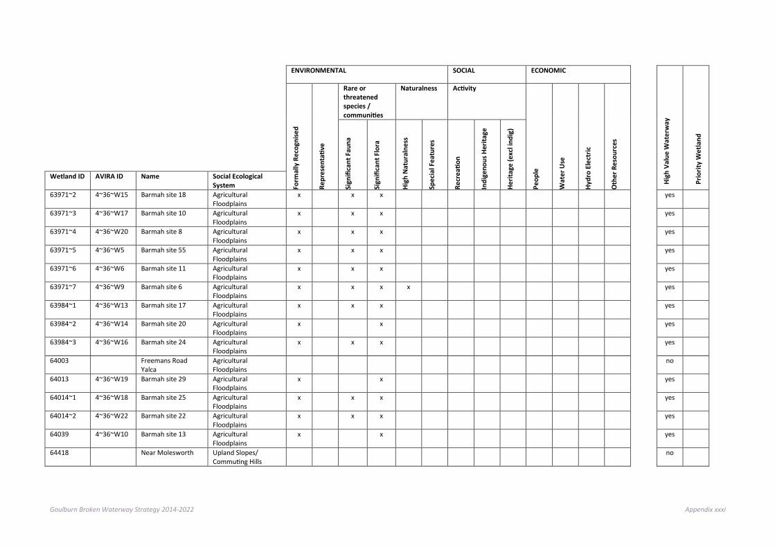
Goulburn Broken Waterway Strategy 2014-2022 Appendix xxxi
ENVIRONMENTAL SOCIAL ECONOMIC
High
Val
ue W
ater
way
Prio
rity
Wet
land
Form
ally
Rec
ogni
sed
Repr
esen
tativ
e
Rare or threatened species / communities
Naturalness Activity
Peop
le
Wat
er U
se
Hydr
o El
ectr
ic
Oth
er R
esou
rces
Sign
ifica
nt F
auna
Sign
ifica
nt F
lora
High
Nat
ural
ness
Spec
ial F
eatu
res
Recr
eatio
n
Indi
geno
us H
erita
ge
Herit
age
(exc
l ind
ig)
Wetland ID AVIRA ID Name Social Ecological System
63971~2 4~36~W15 Barmah site 18 Agricultural Floodplains
x x x yes
63971~3 4~36~W17 Barmah site 10 Agricultural Floodplains
x x x yes
63971~4 4~36~W20 Barmah site 8 Agricultural Floodplains
x x x yes
63971~5 4~36~W5 Barmah site 55 Agricultural Floodplains
x x x yes
63971~6 4~36~W6 Barmah site 11 Agricultural Floodplains
x x x yes
63971~7 4~36~W9 Barmah site 6 Agricultural Floodplains
x x x x yes
63984~1 4~36~W13 Barmah site 17 Agricultural Floodplains
x x x yes
63984~2 4~36~W14 Barmah site 20 Agricultural Floodplains
x x yes
63984~3 4~36~W16 Barmah site 24 Agricultural Floodplains
x x x yes
64003 Freemans Road Yalca
Agricultural Floodplains
no
64013 4~36~W19 Barmah site 29 Agricultural Floodplains
x x yes
64014~1 4~36~W18 Barmah site 25 Agricultural Floodplains
x x x yes
64014~2 4~36~W22 Barmah site 22 Agricultural Floodplains
x x x yes
64039 4~36~W10 Barmah site 13 Agricultural Floodplains
x x yes
64418 Near Molesworth Upland Slopes/ Commuting Hills
no
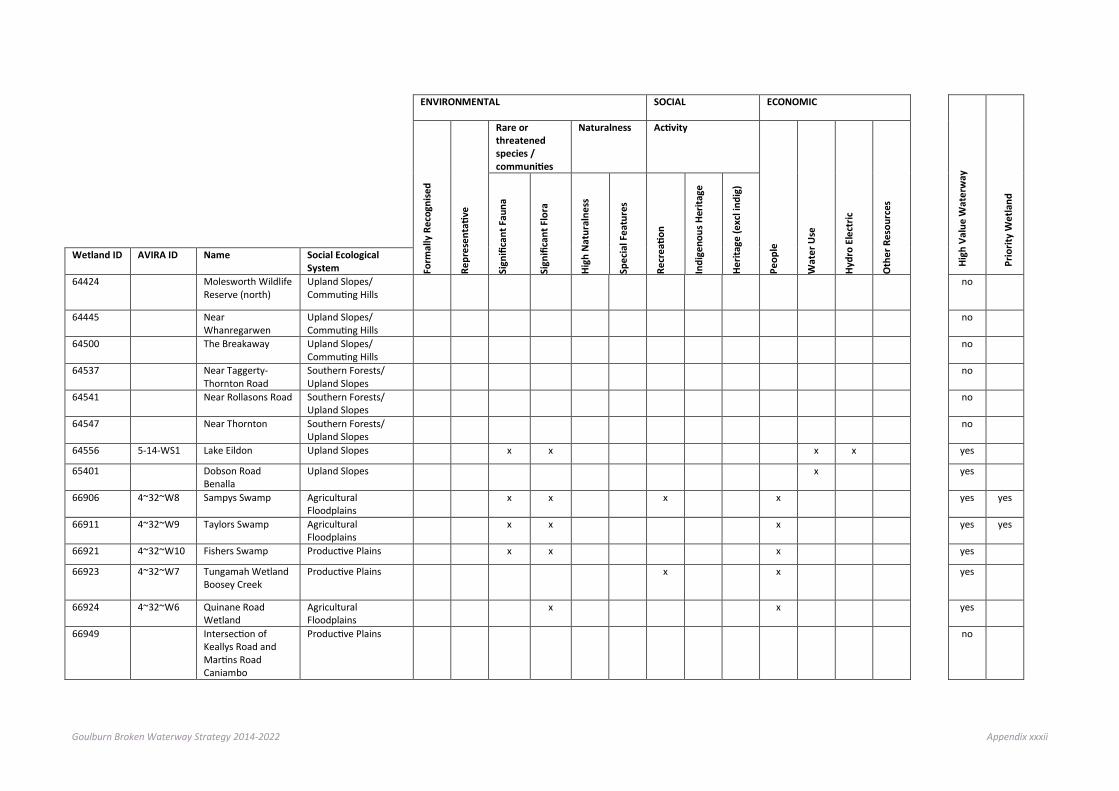
Goulburn Broken Waterway Strategy 2014-2022 Appendix xxxii
ENVIRONMENTAL SOCIAL ECONOMIC
High
Val
ue W
ater
way
Prio
rity
Wet
land
Form
ally
Rec
ogni
sed
Repr
esen
tativ
e
Rare or threatened species / communities
Naturalness Activity
Peop
le
Wat
er U
se
Hydr
o El
ectr
ic
Oth
er R
esou
rces
Sign
ifica
nt F
auna
Sign
ifica
nt F
lora
High
Nat
ural
ness
Spec
ial F
eatu
res
Recr
eatio
n
Indi
geno
us H
erita
ge
Herit
age
(exc
l ind
ig)
Wetland ID AVIRA ID Name Social Ecological System
64424 Molesworth Wildlife Reserve (north)
Upland Slopes/ Commuting Hills
no
64445 Near Whanregarwen
Upland Slopes/ Commuting Hills
no
64500 The Breakaway Upland Slopes/ Commuting Hills
no
64537 Near Taggerty-Thornton Road
Southern Forests/ Upland Slopes
no
64541 Near Rollasons Road Southern Forests/ Upland Slopes
no
64547 Near Thornton Southern Forests/ Upland Slopes
no
64556 5-14-WS1 Lake Eildon Upland Slopes x x x x yes
65401 Dobson Road Benalla
Upland Slopes x yes
66906 4~32~W8 Sampys Swamp Agricultural Floodplains
x x x x yes yes
66911 4~32~W9 Taylors Swamp Agricultural Floodplains
x x x yes yes
66921 4~32~W10 Fishers Swamp Productive Plains x x x yes
66923 4~32~W7 Tungamah Wetland Boosey Creek
Productive Plains x x yes
66924 4~32~W6 Quinane Road Wetland
Agricultural Floodplains
x x yes
66949 Intersection of Keallys Road and Martins Road Caniambo
Productive Plains no

Goulburn Broken Waterway Strategy 2014-2022 Appendix xxxiii
ENVIRONMENTAL SOCIAL ECONOMIC
High
Val
ue W
ater
way
Prio
rity
Wet
land
Form
ally
Rec
ogni
sed
Repr
esen
tativ
e
Rare or threatened species / communities
Naturalness Activity
Peop
le
Wat
er U
se
Hydr
o El
ectr
ic
Oth
er R
esou
rces
Sign
ifica
nt F
auna
Sign
ifica
nt F
lora
High
Nat
ural
ness
Spec
ial F
eatu
res
Recr
eatio
n
Indi
geno
us H
erita
ge
Herit
age
(exc
l ind
ig)
Wetland ID AVIRA ID Name Social Ecological System
66958 Lake Rowan Productive Plains no
67009 4~24~W2 Barnes Road Muckatah Depression
Agricultural Floodplains
x x x yes
67044 Youarang Road Wetland Youarang
Productive Plains no
67053 Moodies Swamp Productive Plains no
67086 4~32~W2 Kennedys Swamp Agricultural Floodplains
x x yes
67091 4~32~W4 Mulquiney Road Wetland
Agricultural Floodplains
x x yes yes
67092 4~32~W1 Wren Road Upper Boosey Creek Anabranch St James
Productive Plains x x yes
67093 4~32~W3 Stacey Road Wetland
Agricultural Floodplains
x x yes
67096 4~32~W5 Kels Swamp Agricultural Floodplains
x x yes
67137 4~2~W1 Broken River Reach 2
Productive Plains x x x yes
67149 4~1~W1 Broken River Reach 1
Productive Plains x x x yes
67424 Bott Road/ Racecourse Road Cobram
Agricultural Floodplains
no
67804 4~4~WS1 Lake Nillahcootie Upland Slopes x x x yes
67812 4-16-WS1 Loombah Weir Upland Slopes x x yes
67904 4~24~W3 Inchbolds Productive Plains x x x x yes

Goulburn Broken Waterway Strategy 2014-2022 Appendix xxxiv
ENVIRONMENTAL SOCIAL ECONOMIC
High
Val
ue W
ater
way
Prio
rity
Wet
land
Form
ally
Rec
ogni
sed
Repr
esen
tativ
e
Rare or threatened species / communities
Naturalness Activity
Peop
le
Wat
er U
se
Hydr
o El
ectr
ic
Oth
er R
esou
rces
Sign
ifica
nt F
auna
Sign
ifica
nt F
lora
High
Nat
ural
ness
Spec
ial F
eatu
res
Recr
eatio
n
Indi
geno
us H
erita
ge
Herit
age
(exc
l ind
ig)
Wetland ID AVIRA ID Name Social Ecological System
67905 4~24~W4 Dowdle Swamp Productive Plains x x x x x yes yes
67909~1 Winton Swamp Productive Plains no
67909~2 Winton Swamp Productive Plains no
67909~3 Winton Swamp Productive Plains no
67925 Ashmeads Swamp Productive Plains no
67926 Bill Friday Swamp Productive Plains no
67929 Humphries Swamp Productive Plains no
67932 Lindsays Swamp Productive Plains no

Goulburn Broken Waterway Strategy 2014-2022 Appendix xxxv
Appendix G: Priority waterways1
GOAL
SOCIAL ECONOMIC ENVIRONMENT PRIORITY WATERWAY
Maintain and improve
waterways of high
community value
Maintain and improve
water quality in priority
water supply catchments
Populations of threatened
aquatic dependent species will
be maintained or
improved
Barmah Forest will retain its
ecological character
The values associated
with Heritage Rivers will be maintained or
improved
Wetlands with formally
recognised significance
are maintained or
improved
Rivers in a near natural or
ecologically healthy state are retained
4~1 Broken River x
x
4~2 Broken River 4~3 Broken River x
x
x
4~4 Broken River x
x
x
4~5 Broken River
x x
x
4~6 Broken River
x
x
4~7 Five Mile Creek 4~8 Five Mile Creek
x x
4~9 Lima East Creek 4~10 Lima East Creek
x x
4~11 Sawpit Creek
x
x
4~13 Holland Creek
x
x
4~14 Holland Creek
x
x
4~15 Holland Creek
1 High Value Waterways with values that match regional goals

Goulburn Broken Waterway Strategy 2014-2022 Appendix xxxvi
GOAL
SOCIAL ECONOMIC ENVIRONMENT PRIORITY WATERWAY
Maintain and improve
waterways of high
community value
Maintain and improve
water quality in priority
water supply catchments
Populations of threatened
aquatic dependent species will
be maintained or
improved
Barmah Forest will retain its
ecological character
The values associated
with Heritage Rivers will be maintained or
improved
Wetlands with formally
recognised significance
are maintained or
improved
Rivers in a near natural or
ecologically healthy state are retained
4~16 Ryans Creek
x
x
4~17 Ryans Creek
x x
x
4~18 Sam Creek 4~19 Watchbox Creek 4~20 Winton Creek 4~21 Broken Creek x
x
x
4~22 Broken Creek x
x
x
4~23 Broken Creek x
x
4~24 Broken Creek
x
x
4~25 Broken Creek 4~26 Broken Creek 4~27 Broken Creek 4~28 Nine Mile Creek 4~29 Nine Mile Creek 4~30 Pine Lodge Creek 4~31 Pine Lodge Creek 4~32 Boosey Creek
x
x
4~33 Boosey Creek 4~34 Boosey Creek
x
x
4~35 Sandy Creek 4~36 Tullah Creek
x
x
4~37 Deep Creek

Goulburn Broken Waterway Strategy 2014-2022 Appendix xxxvii
GOAL
SOCIAL ECONOMIC ENVIRONMENT PRIORITY WATERWAY
Maintain and improve
waterways of high
community value
Maintain and improve
water quality in priority
water supply catchments
Populations of threatened
aquatic dependent species will
be maintained or
improved
Barmah Forest will retain its
ecological character
The values associated
with Heritage Rivers will be maintained or
improved
Wetlands with formally
recognised significance
are maintained or
improved
Rivers in a near natural or
ecologically healthy state are retained
5~1 Goulburn River x
x
x
5~2 Goulburn River x
x
x
5~3 Goulburn River x
x
x
5~4 Goulburn River x
x
x
x
5~5 Goulburn River x
x
x
x
5~6 Goulburn River x
x
x
x
5~7 Goulburn River x
x
x
5~8 Goulburn River x
x
x
x
5~9 Goulburn River x
x
x
x
5~10 Goulburn River
x
x
5~11 Goulburn River x
x
x
5~12 Goulburn River
x
x
5~13 Goulburn River
x
x
5~14 Goulburn River x
x
x
x
5~15 Goulburn River x x x
x x
5~16 Goulburn River x x x
x x
5~17 Seven Creeks
x
x
5~18 Seven Creeks
x
x
5~19 Seven Creeks
x x
x
5~20 Seven Creeks
x x
x
5~21 Faithfull Creek

Goulburn Broken Waterway Strategy 2014-2022 Appendix xxxviii
GOAL
SOCIAL ECONOMIC ENVIRONMENT PRIORITY WATERWAY
Maintain and improve
waterways of high
community value
Maintain and improve
water quality in priority
water supply catchments
Populations of threatened
aquatic dependent species will
be maintained or
improved
Barmah Forest will retain its
ecological character
The values associated
with Heritage Rivers will be maintained or
improved
Wetlands with formally
recognised significance
are maintained or
improved
Rivers in a near natural or
ecologically healthy state are retained
5~22 Honeysuckle Creek
x
x
5~23 Honeysuckle Creek
x
x
5~24 Sheep Pen Creek 5~25 Castle Creek 5~26 Castle Creek 5~27 Creightons Creek 5~28 Creightons Creek 5~29 Pranjip Creek 5~30 Cornella Creek 5~31 Cornella Creek 5~32 Yallagalorrah Creek 5~33 Goborup Creek 5~34 Deep Creek 5~35 Major Creek 5~36 Bylands Creek 5~37 Hughes Creek
x
x
5~38 Hughes Creek
x
x
5~39 Hughes Creek
x
x
5~40 Whiteheads Creek 5~41 Sugarloaf Creek 5~42 Mollison Creek
x
x
5~43 Mollison Creek
x
x
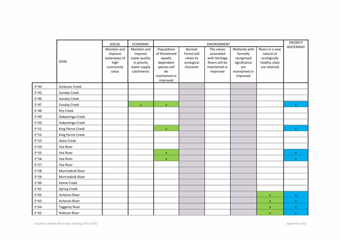
Goulburn Broken Waterway Strategy 2014-2022 Appendix xxxix
GOAL
SOCIAL ECONOMIC ENVIRONMENT PRIORITY WATERWAY
Maintain and improve
waterways of high
community value
Maintain and improve
water quality in priority
water supply catchments
Populations of threatened
aquatic dependent species will
be maintained or
improved
Barmah Forest will retain its
ecological character
The values associated
with Heritage Rivers will be maintained or
improved
Wetlands with formally
recognised significance
are maintained or
improved
Rivers in a near natural or
ecologically healthy state are retained
5~44 Kurkurac Creek 5~45 Sunday Creek 5~46 Sunday Creek 5~47 Sunday Creek
x x
x
5~48 Dry Creek 5~49 Dabyminga Creek 5~50 Dabyminga Creek 5~51 King Parrot Creek
x
x
5~52 King Parrot Creek 5~53 Dairy Creek 5~54 Yea River 5~55 Yea River
x
x
5~56 Yea River
x
x
5~57 Yea River 5~58 Murrindindi River 5~59 Murrindindi River 5~60 Home Creek 5~61 Spring Creek 5~62 Acheron River
x x
5~63 Acheron River
x x
5~64 Taggerty River
x x
5~65 Rubicon River
x x

Goulburn Broken Waterway Strategy 2014-2022 Appendix xl
GOAL
SOCIAL ECONOMIC ENVIRONMENT PRIORITY WATERWAY
Maintain and improve
waterways of high
community value
Maintain and improve
water quality in priority
water supply catchments
Populations of threatened
aquatic dependent species will
be maintained or
improved
Barmah Forest will retain its
ecological character
The values associated
with Heritage Rivers will be maintained or
improved
Wetlands with formally
recognised significance
are maintained or
improved
Rivers in a near natural or
ecologically healthy state are retained
5~66 Rubicon River
x
x x
5~67 Big River
x x
x
x x
5~68 Big River
x
x
x x
5~69 Howqua River
x
x
x x
5~70 Howqua River
x x
x
x x
5~71 Delatite River
x x
x
5~72 Delatite River
x
x x
5~73 Ford Creek
x
x
5~74 Brankeet Creek
x
x
5~75 Merton Creek
x
x
5~76 Honeysuckle Creek 5~77 Burnt Creek 5~78 Kurkurac Creek 5~79 Godfrey Creek 5~80 Wormangal Creek 5~81 Yea River
64
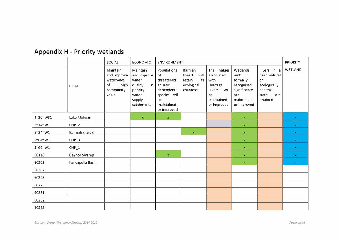
Goulburn Broken Waterway Strategy 2014-2022 Appendix xli
Appendix H - Priority wetlands
GOAL
SOCIAL ECONOMIC ENVIRONMENT PRIORITY
WETLAND
Maintain and improve waterways of high community value
Maintain and improve water quality in priority water supply catchments
Populations of threatened aquatic dependent species will be maintained or improved
Barmah Forest will retain its ecological character
The values associated with Heritage Rivers will be maintained or improved
Wetlands with formally recognised significance are maintained or improved
Rivers in a near natural or ecologically healthy state are retained
4~20~WS1 Lake Mokoan
x x
x
x
5~14~W1 CHP_2
x
x
5~34~W1 Barmah site 23
x
x
x
5~64~W1 CHP_3
x
x
5~66~W1 CHP_1
x
x
60118 Gaynor Swamp
x
x
x
60205 Kanyapella Basin
x
x
60207
60223
60225
60231
60232
60233
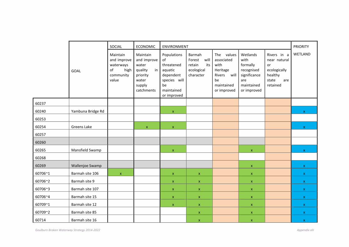
Goulburn Broken Waterway Strategy 2014-2022 Appendix xlii
GOAL
SOCIAL ECONOMIC ENVIRONMENT PRIORITY
WETLAND
Maintain and improve waterways of high community value
Maintain and improve water quality in priority water supply catchments
Populations of threatened aquatic dependent species will be maintained or improved
Barmah Forest will retain its ecological character
The values associated with Heritage Rivers will be maintained or improved
Wetlands with formally recognised significance are maintained or improved
Rivers in a near natural or ecologically healthy state are retained
60237
60240 Yambuna Bridge Rd
x
x
60253
60254 Greens Lake
x x
x
60257
60260
60265 Mansfield Swamp
x
x
x
60268
60269 Wallenjoe Swamp
x
x
60706~1 Barmah site 106 x
x x
x
x
60706~2 Barmah site 9
x x
x
x
60706~3 Barmah site 107
x x
x
x
60706~4 Barmah site 15
x x
x
x
60709~1 Barmah site 12
x x
x
x
60709~2 Barmah site 85
x
x
x
60714 Barmah site 16
x
x
x
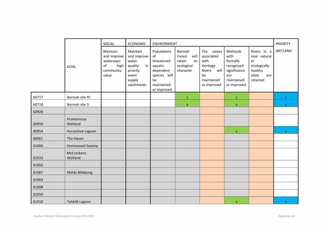
Goulburn Broken Waterway Strategy 2014-2022 Appendix xliii
GOAL
SOCIAL ECONOMIC ENVIRONMENT PRIORITY
WETLAND
Maintain and improve waterways of high community value
Maintain and improve water quality in priority water supply catchments
Populations of threatened aquatic dependent species will be maintained or improved
Barmah Forest will retain its ecological character
The values associated with Heritage Rivers will be maintained or improved
Wetlands with formally recognised significance are maintained or improved
Rivers in a near natural or ecologically healthy state are retained
60717 Barmah site 91
x
x
x
60718 Barmah site 3
x
x
x
60928
60950
Praetemissa Wetland
60954 Horseshoe Lagoon
x
x
60961 The Haven
61006 Homewood Swamp
61033
McCrackens Wetland
61056
61067 Molds Billabong
61903
61908
61910
61918 Tahbilk Lagoon
x
x

Goulburn Broken Waterway Strategy 2014-2022 Appendix xliv
GOAL
SOCIAL ECONOMIC ENVIRONMENT PRIORITY
WETLAND
Maintain and improve waterways of high community value
Maintain and improve water quality in priority water supply catchments
Populations of threatened aquatic dependent species will be maintained or improved
Barmah Forest will retain its ecological character
The values associated with Heritage Rivers will be maintained or improved
Wetlands with formally recognised significance are maintained or improved
Rivers in a near natural or ecologically healthy state are retained
61919 Waranga Reservoir
x x
x
61950
61955 Goulburn Weir
x x
x
62010 Doctors Swamp
x
x
x
62023
62024
62027
62036
62038
62040
62045
62062
62079
62147
62175
62900 Stockyard Plain
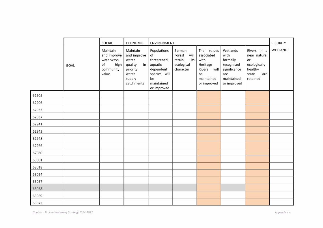
Goulburn Broken Waterway Strategy 2014-2022 Appendix xlv
GOAL
SOCIAL ECONOMIC ENVIRONMENT PRIORITY
WETLAND
Maintain and improve waterways of high community value
Maintain and improve water quality in priority water supply catchments
Populations of threatened aquatic dependent species will be maintained or improved
Barmah Forest will retain its ecological character
The values associated with Heritage Rivers will be maintained or improved
Wetlands with formally recognised significance are maintained or improved
Rivers in a near natural or ecologically healthy state are retained
62905
62906
62933
62937
62941
62943
62948
62966
62980
63001
63018
63024
63037
63058
63069
63073

Goulburn Broken Waterway Strategy 2014-2022 Appendix xlvi
GOAL
SOCIAL ECONOMIC ENVIRONMENT PRIORITY
WETLAND
Maintain and improve waterways of high community value
Maintain and improve water quality in priority water supply catchments
Populations of threatened aquatic dependent species will be maintained or improved
Barmah Forest will retain its ecological character
The values associated with Heritage Rivers will be maintained or improved
Wetlands with formally recognised significance are maintained or improved
Rivers in a near natural or ecologically healthy state are retained
63077
63079
63088
63104 Bunyip Swamp
63129 Pullar Swamp
63136
63138
63145
63149
63150 Alexander Swamp
63152
63153
63155
63156 Gemmills Swamp
x
x
x
63157
63168
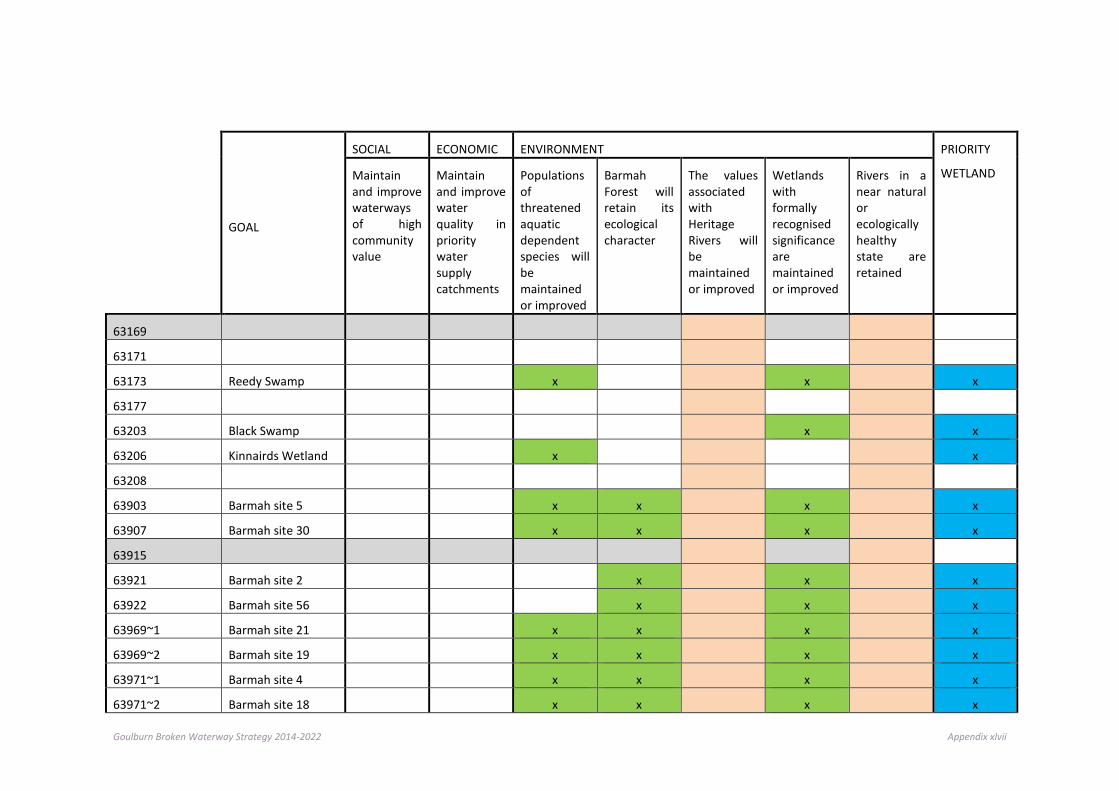
Goulburn Broken Waterway Strategy 2014-2022 Appendix xlvii
GOAL
SOCIAL ECONOMIC ENVIRONMENT PRIORITY
WETLAND
Maintain and improve waterways of high community value
Maintain and improve water quality in priority water supply catchments
Populations of threatened aquatic dependent species will be maintained or improved
Barmah Forest will retain its ecological character
The values associated with Heritage Rivers will be maintained or improved
Wetlands with formally recognised significance are maintained or improved
Rivers in a near natural or ecologically healthy state are retained
63169
63171
63173 Reedy Swamp
x
x
x
63177
63203 Black Swamp
x
x
63206 Kinnairds Wetland
x
x
63208
63903 Barmah site 5
x x
x
x
63907 Barmah site 30
x x
x
x
63915
63921 Barmah site 2
x
x
x
63922 Barmah site 56
x
x
x
63969~1 Barmah site 21
x x
x
x
63969~2 Barmah site 19
x x
x
x
63971~1 Barmah site 4
x x
x
x
63971~2 Barmah site 18
x x
x
x

Goulburn Broken Waterway Strategy 2014-2022 Appendix xlviii
GOAL
SOCIAL ECONOMIC ENVIRONMENT PRIORITY
WETLAND
Maintain and improve waterways of high community value
Maintain and improve water quality in priority water supply catchments
Populations of threatened aquatic dependent species will be maintained or improved
Barmah Forest will retain its ecological character
The values associated with Heritage Rivers will be maintained or improved
Wetlands with formally recognised significance are maintained or improved
Rivers in a near natural or ecologically healthy state are retained
63971~3 Barmah site 10
x x
x
x
63971~4 Barmah site 8
x x
x
x
63971~5 Barmah site 55
x x
x
x
63971~6 Barmah site 11
x x
x
x
63971~7 Barmah site 6
x x
x
x
63984~1 Barmah site 17
x x
x
x
63984~2 Barmah site 20
x
x
x
63984~3 Barmah site 24
x x
x
x
64003
64013 Barmah site 29
x
x
x
64014~1 Barmah site 25
x x
x
x
64014~2 Barmah site 22
x x
x
x
64039 Barmah site 13
x
x
x
64418 Zerby's
64424
Molesworth State Wildlife Reserve

Goulburn Broken Waterway Strategy 2014-2022 Appendix xlix
GOAL
SOCIAL ECONOMIC ENVIRONMENT PRIORITY
WETLAND
Maintain and improve waterways of high community value
Maintain and improve water quality in priority water supply catchments
Populations of threatened aquatic dependent species will be maintained or improved
Barmah Forest will retain its ecological character
The values associated with Heritage Rivers will be maintained or improved
Wetlands with formally recognised significance are maintained or improved
Rivers in a near natural or ecologically healthy state are retained
64445 Cremona Park
64500 The Breakaway
64537
64541 Evans Wetland
64547 Taylors Breakaway
64556 Lake Eildon
x x
x
65401
66906 Sampys Swamp
x
x
66911 Taylors Swamp
x
x
66921 Fishers Swamp
66923
66924
66949 Holylands Plains
66958
67009
67044

Goulburn Broken Waterway Strategy 2014-2022 Appendix l
GOAL
SOCIAL ECONOMIC ENVIRONMENT PRIORITY
WETLAND
Maintain and improve waterways of high community value
Maintain and improve water quality in priority water supply catchments
Populations of threatened aquatic dependent species will be maintained or improved
Barmah Forest will retain its ecological character
The values associated with Heritage Rivers will be maintained or improved
Wetlands with formally recognised significance are maintained or improved
Rivers in a near natural or ecologically healthy state are retained
67053 Moodies Swamp
x
x
67086
67091 Mulquiney Road
x
x
67092
67093
67096 Kels Swamp
67137 208
67149
67424
67804 Lake Nillahcootie
x x
x
67812 Loombah Weir
x x
x
67904
67905 Dowdle Swamp
x
x
67909~1 Sergeant’s Swamp
67909~2 Winton Swamp
x
x
67909~3 Green Swamp
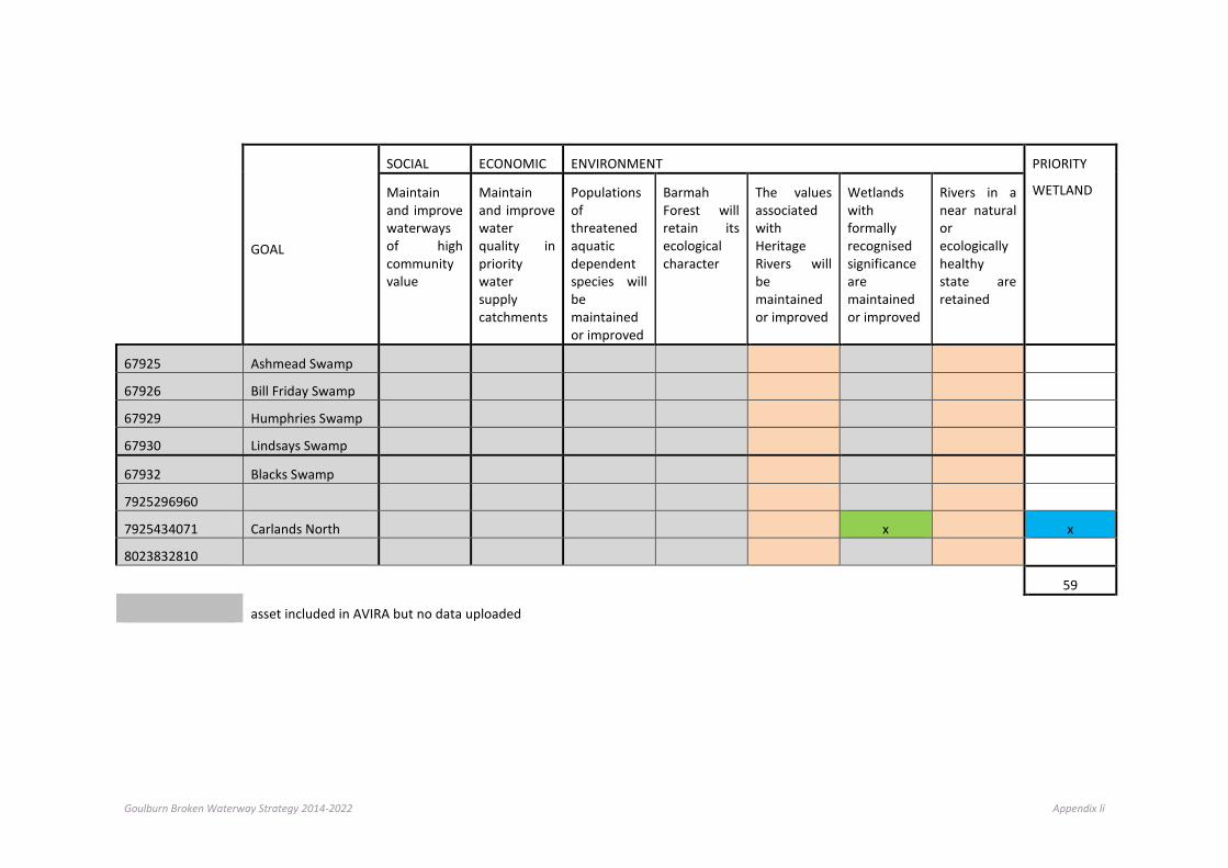
Goulburn Broken Waterway Strategy 2014-2022 Appendix li
GOAL
SOCIAL ECONOMIC ENVIRONMENT PRIORITY
WETLAND
Maintain and improve waterways of high community value
Maintain and improve water quality in priority water supply catchments
Populations of threatened aquatic dependent species will be maintained or improved
Barmah Forest will retain its ecological character
The values associated with Heritage Rivers will be maintained or improved
Wetlands with formally recognised significance are maintained or improved
Rivers in a near natural or ecologically healthy state are retained
67925 Ashmead Swamp
67926 Bill Friday Swamp
67929 Humphries Swamp
67930 Lindsays Swamp
67932 Blacks Swamp
7925296960
7925434071 Carlands North
x
x
8023832810
59
asset included in AVIRA but no data uploaded

Goulburn Broken Waterway Strategy 2014-2022 Appendix lii
Appendix I - Costings applied to strategic priorities Management Strategy Implementation Targets Unit Cost (+/- 20%)
Riparian Management Frontage protection fencing $20,000 / km
Pest Plant control / maintenance
$5,000 / ha
Aquatic weed (pest plant) $10,000 / km
Revegetation (native stock) $8,000 / ha
Alternative Water $5,000 / km
Woody weed management $15,000 - $30,000 / km
Pest Animal Control $200 - $5,000 / ha
Management of the River Channel
Reinstatement of IWD $20,000 - $40,000 / km
Bed control $5,000 - $50,000 / km
Bank Control $25,000 / site
Gully erosion $10,000 / site
Asset protection $5,000-$25,000 / site
Management of Environmental Water
Carp Screens $25,000-$40,000 / site
Monitoring Water Quality Sampling (low complexity)
$1,000 / site
Macro-invertebrate sampling $3,000 / site
Fish Community / movement / other
$5,000 / site
Supporting Actions Extension (Statutory Role)
Maintenance
Engagement of Community 10% of program
Project Management / Governance
15% of program
Workshops (Community / Traditional Owners)
$2,500 / half day
Field Days / Events $500 - $10,000 / day
Goulburn Broken Waterway Strategy 2014-2022 Appendix liii
Appendix J - Glossary of terms AROT: Australian Rare or Threatened Species
Aquatic: relating to water. Formerly used for inland waters but may be used for marine and estuarine waters as well.
AVIRA Database: AVIRA is a database (which is a development from RiVERS) that integrates environmental, social and economic information from a variety of sources into a single package. AVIRA relies on existing datasets, including the Index of Stream Condition, statewide flora and fauna databases, EPA water quality datasets and data collated by the CMAs.
Avulsion: In sedimentary geology and fluvial geomorphology, avulsion is the rapid abandonment of a river channel and the creation of a new river channel.
Bankfull width: where the river channel is filled from the top of one bank to the other.
Benthic: bottom dwelling. Usually refers to organisms living on the substratum. This assemblage is collectively known as benthos.
Biota: all organisms of an ecosystem (usually the fauna and flora).
Biomass: the total mass of living material occupying a specific part or the whole of an ecosystem at a given time. Usually expressed as live or dry weight per unit area.
Degraded: the lowering of a streambed with time due to erosion and transport of bed materials, or the blockage of sediment sources.
Detritus: organic debris from decomposing organisms and their products. A major source of nutrients and energy for some aquatic food webs.
Ecologically Healthy Waterway: a river which retains the major ecological features and functioning of that river prior to European settlement and which would be able to sustain these characteristics into the future.
Ecosystem: the combination of a community (biota) and its abiotic environment. Ecosystems are characterised by ecological processes such as the flow of energy and nutrients through food webs.
Ecotone: region lying between two ecosystems, often sharing some ecological features of both. The riparian zone represents an ecotone between a river or stream and its catchment.
Ephemeral: containing water only after unpredictable rain.
Erosion: the process by which the surface of the earth is worn away by the action of water, glaciers, wind and waves.
Eutrophication: an increase in the nutrient status of a body of water. Occurs naturally with increasing age of a waterbody, but much more rapidly as a by-product of human activity.
Environmental Water Reserve (EWR): the share of water resources set aside to maintain the environmental values of a water system.
Floodplain: the land adjacent to a channel at the elevation of the bankfull discharge.
Geomorphology: the science that studies the evolution of the earth’s surface. The systematic examination of landforms and their interpretation of geologic history.
Groundwater: water occurring below the ground’s surface.
Indigenous: a plant native to an area; has not been introduced from elsewhere.

Goulburn Broken Waterway Strategy 2014-2022 Appendix liv
Index of Stream Condition: the Index of Stream Condition (ISC) methodology was developed to benchmark the condition of streams (a snapshot of the catchment), assess the effectiveness of programs and to assist with priority setting. The Index is a measure of a stream’s change from natural or ideal conditions. It presents an indication of the extent of change in respect of five key “stream health” indices: Hydrology (change in volume and seasonal flow); Physical Form (stability, degradation/aggradation, influence of artificial barriers and abundance/absence of instream debris); Streamside Zone (Plant species – native/exotic, spatial extent, width, continuity and links); Water Quality (assessment of total phosphorus, turbidity, conductivity and pH); and Aquatic Life (abundance and type of macro invertebrates).
Large woody debris: branches and tree boles that have fallen into the watercourse. Often referred to as snags.
Macroinvertebrates: larger invertebrates, and large enough to be observed without the aid of a microscope. Their body length usually exceeds 1mm.
Management Action/Implementation Targets: short term targets (1-5 years), relating to management actions or capacity-building.
Noxious: an official designation for a plant that is a serious weed and must be controlled.
Overgrazed: land that has been grazed by livestock to the extent that erosion and soil degradation is occurring.
Overland flow: downslope, surface movement of runoff other than in defined channels, usually with high erosion potential.
Pugging: livestock trampling soil and water together, to create muddy depressions at the edge of rivers and other waterbodies.
Ramsar: Australia is a signatory to the Convention on Wetlands (Ramsar, Iran, 1971) the broad aims of which are to halt, and where possible reverse, the worldwide loss of wetlands and to conserve those that remain through wise use and management. The convention is commonly known as the Ramsar Convention after the Iranian town in which it was first signed in 1971.
Reach: a length of stream, typically 20 to 30 km long, which is relatively homogenous with regard to the hydrology, physical form, water quality and aquatic life.
Refuge: areas where plants and animals can take refuge, during times of climatic or biological stress and which support the individuals that will recolonise the surrounding landscape when conditions improve. Refuges provide conditions suitable for survival of species that may be declining elsewhere.
Resource Condition Target: specific, time bound and measurable targets, relating largely to the desired condition of natural resources in the longer term.
Riffle: an area of river which is wide and shallow, the water flowing over a pebble bed with protruding rocks. A stream section with fast and turbulent flow, rapids.
Rivers: rivers are defined here as major rivers, streams or creeks and their tributaries, and include the water, the channel and surrounding land, known as riparian land.
RiVERS Database: RiVERS is a database (pre AVIRA) that integrates environmental, social and economic information from a variety of sources into a single package. RiVERS was used by CMAs in the development of the first asset based strategies.
Rare: a species that characteristically has a limited distribution and or abundance due to the specificity of their habitat requirements or that has a limited distribution and abundance because habitat resources have been modified or lost.
Riparian vegetation: vegetation found along the bank of streams and rivers.
Riparian zone: any land which adjoins, directly influences, or is influenced by a body of water.
Threatened: a generic term used to describe taxa that are rare, vulnerable, endangered or insufficiently known and are subject to a threatening process.
Vulnerable: species likely to become endangered in the short term should a threatening process continue.
Goulburn Broken Waterway Strategy 2014-2022 Appendix lv
Waterway: rivers and streams, their associated estuaries and floodplains (including floodplain wetlands) and non-riverine wetlands.
Water-dependent: aquatic species or those dependent on river water for survival.
Weed: any useless, troublesome or noxious plant, especially one that grows profusely.
Wetlands: wetlands are still-water environments, usually occurring where water collects in depressions in the landscape from either surface water or groundwater. Wetlands can include swamps, lakes and peatlands. Some wetlands are dependent on groundwater for their existence; others depend on surface water run-off or large floods from adjacent rivers.

Goulburn Broken Waterway Strategy 2014-2022 Appendix lvi
Appendix K - Acronyms Acronym Full Description
ANZECC guidelines Australian and New Zealand guidelines for fresh and marine water quality
ARRC Australian River Restoration Centre
AVIRA Aquatic Value Identification and Risk Assessment
CAMBA China-Australia Migratory Bird Agreement
CEWO Commonwealth Environmental Water Office
CFI Carbon Farming Initiative
CMA Catchment Management Authority
Cth Commonwealth
DEPI Department of Environment and Primary Industries
DIWA Directory of Important Wetlands in Australia
DPI Department of Primary Industries
DSE Department of Sustainability and Environment
ENRC Environment and Natural Resources Committee
EPA Environment Protection Authority
EPBC Act Environment Protection and Biodiversity Conservation Act 1999
EWMP Environmental Water Management Plans
EWR Environmental Water Reserve
FFG Act Flora and Fauna Guarantee Act 1988
GDEs Groundwater Dependent Ecosystems
IPA Invasive Plants and Animals
ISC Index of Stream Condition
IWC Index of Wetland Condition
IWCM Integrated water cycle management
IWCP Integrated Water Cycle Plan
JAMBA Japan Australia Migratory Bird Agreement
KPI Key Performance Indicator
NDRRA Natural Disaster Relief and Recovery Arrangements
NRM Natural Resource Management
NWQMS National Water Quality Management Strategy
OLV Office of Living Victoria
RCS Regional Catchment Strategy
ROKAMBA Republic of Korea-Australia Migratory Bird Agreement
RRHS Regional River Health Strategy

Goulburn Broken Waterway Strategy 2014-2022 Appendix lvii
Acronym Full Description
RWS regional Waterway Strategy
RMW River Murray Water
SEPP State Environment Protection Policies
SEPP (WoV) State Environment Protection Policy (Waters of Victoria)
SWS Sustainable Water Strategy
TUL Take and Use Licence
VCMC Victorian Catchment Management Council
VEAC Victorian Environment Assessment Council
VEFMAP Victorian Environmental Flows Monitoring and Assessment Program
VEWH Victorian Environmental Water Holder
VRHS Victorian River Health Strategy
VWMS Victorian Waterway Management Strategy
VWQMN Victorian Water Quality Monitoring Network
WMIS Water Management Information System
WoNS Weeds of National Significance
WSUD Water sensitive urban design
WUL Water Use Licence

Goulburn Broken Waterway Strategy 2014-2022 Appendix lviii
Appendix L: List of achievements from the last strategy (Goulburn Broken River Health Strategy 2005-2013)
Work / Activity type January 2005 to October 2009 November 2009 to December 2013
Sum of Output 1
Sum of Output 2
Sum of Output 3
Sum of Output 1
Sum of Output 2
Sum of Output 3
Alternative Water - Output 1=no. points 373 112 0 0
Bank Stabilisation - Output 1=stabilised (km), Output 2=structures (no), Output 3=protected (km) 21.4 158 41.3 27.8 278 67.9
Bed Stabilisation - Output 1=stabilised (km), Output 2=structures (no), Output 3=protected (km) 10.7 76 28.8 5.1 18 10.2
Community Support - Output 1=no. groups (no), Output 2=no. participants (no) 3 37
EWR - Output 1=water provided (ML), Output 2=stream reaches supported (no) 40 0 37,431 0
Fencing (Remnant Veg/Special Area) - Output 1=area fenced (ha), Output 2=fence length (km) 149.6 19.6 16.3 4.8
Fencing (River) – Debris removal and Fence reinstatement – Output 1=Debris removed (km), Output 2=Fence reinstated= (km)
21.3 24.5
Fencing (River) – Fence replacement – Output 1=Fence relaced (km) 53.1
Fencing (River) - Output 1=area fenced (ha), Output 2=fence length (km), Output 3=stream length (km) 6,287.7 722.2 799.2 882.8 145.8 143.8
Fencing (Wetland) - Output 1=area fenced (ha), Output 2=fence length (km) 2,202.9 9.8 13.2 4.6
Fish Passage - Output 1=stream length (km), Output 2=no. fish barriers addressed (no) 216.1 14 26 4
G-M Water Channel & Drainage Weed Management – Output 1=area treated (ha) 945.8 4.2
Habitat - Output 1=no. debris replaced/relocated (no), Output 2=habitat established (km) 378.1 14.7 1,279 26.1
Investigation - Output 1=area covered (ha), Output 2=no. of sites (no), Output 3=no. undertaken (no) 306 61 61
Monitoring - Output 1=no. reports (no), Output 2=no. sites monitored (no) 1 408
Projects - Output 1=No. projects (no) 565 76
Revegetation - Output 1=revegetation area (ha), Output 2=stream length (km), Output 3=plants (no) 1,146.2 395.2 361,220 659.0 554.6 197,116.6
RMA - Output 1=area of CL protected (ha), Output 2=length of CL protected (km), Output 3=area of FH protected(ha)
212.3 2,988.6 139.1
Site Inspection Riparian Protection - Output 1=no. inspections (no) 134
Survey - Output 1=No of surveys 6
Urban Stormwater - Output 1=no. systems installed (no) 1 3
Weeds (Aquatic) - Output 1=stream length controlled/eradicated (km) 392.1 509.5
Weeds (Frontage) - Output 1=area treated (ha), Output 2=stream length (km) 20,034.9 785.2 4,560.1 981.5

Goulburn Broken Waterway Strategy 2014-2022 Appendix lix
Appendix M: Priority waterways (risk and feasibility) The following graphs represent the results of the overall risk and feasibility assessments, undertaken for priority waterways. The results are shown on a SES/Landscape basis. The x axis on the graphs represent lowest to highest priority score, when applying risk and feasibility process.
0 2 4 6 8 10 12
Goulburn River (R2)
Tullah Creek (R36)
Boosey Creek (R32)
Goulburn River (R1)
Goulburn River (R4)
Goulburn River (R5)
Goulburn River (R3)
Broken Creek (R24)
Broken Creek (R22)
Broken Creek (R21)
Priority score
Agricultural Floodplains
0 1 2 3 4 5 6 7 8
Holland Creek (R13)
Goulburn River (R8)
Seven Creeks (R17)
Seven Creeks (R18)
Goulburn River (R6)
Boosey Creek (34)
Goulburn River (R7)
Goulburn River (R10)
Seven Creeks (R19)
Goulburn River (R9)
Honeysuckle Creek (R23)
Seven Creeks (R20)
Honeysuckle Creek (R22)
Broken River (R3)
Priority score
Productive Plains

Goulburn Broken Waterway Strategy 2014-2022 Appendix lx
0 1 2 3 4 5 6 7 8
Holland Creek (R14)
Acheron River (R62)
Broken River (R5)
Goulburn River (R13)
Brankeet Creek (R74)
Broken River (R4)
Lima East Creek (R10)
Yea River (R54)
Watchbox Creek (R19)
Ryans Creek (R17)
Ford Creek (R73)
Goulburn River (R14)
Ryans Creek (R16)
Merton Creek (R75)
Broken River (R6)
Priority score
Upland Slopes
0 1 2 3 4 5 6 7
Hughes Creek (R37)
Sunday Creek (R46)
Mollison Creek (R42)
King Parrot Creek (R51)
Hughes Creek (R38)
Yea River (R55)
Yea River (R56)
Mollison Creek (R43)
Goulburn River (R12)
Sunday Creek (R47)
Goulburn River (R11)
Priority score
Commuting Hills

Goulburn Broken Waterway Strategy 2014-2022 Appendix lxi
0 1 2 3 4 5 6 7
Rubicon River (R65)
Big River (R67)
Big River (R68)
Howqua River (R70)
Howqua River (R69)
Goulburn River (R15)
Delatite River (R71)
Goulburn River (R16)
Taggerty River (R64)
Rubicon River (R66)
Acheron River (R63)
Delatite River (R72)
Priority score
Southern Forests

Goulburn Broken Waterway Strategy 2014-2022 Appendix lxii
Appendix N: Receipt of comments from community (that informed the preparation of the waterway strategy) The following methods were employed to seek comments from the community and partner agencies.
Formal submission of the “draft” Regional Waterway Strategy Department of Environment and Primary Industries (DEPI)
Regional Consultation Groups Goulburn Broken Catchment Management Authority Board
Regional Waterway Strategy Community Reference Group
Air Media UG FM, 3SR FM, Mt Buller 91.1FM (est. 170,000+ listeners)
Social Media Facebook and Twitter
[Chough-chat] FW: Waterway Strategy - Community Consultation (mailing list for stakeholders involved in Biodiversity Management in the Goulburn Broken Catchment)
268 recipients
CMA web based e-newsletter 680 recipients
Print media Country News
Web site www.GB CMA.vic.gov.au
Correspondence (formal/email) 96 Community NRM Groups, 7 Landcare and 5 Conservation Management Networks. (email)
Local Government
EPA (Regional)
Urban and Rural Water Corporations
Submissions were received from the following individuals, groups and agencies.
Benalla Rural City Council
Department of Environment and Primary Industries
Goulburn-Murray Water
Goulburn Valley Environment Group (Community)
Goulburn Valley Water
Jarod Lyon (Arthur Rylah Institute for Environmental Research)
Matthew Hudson (GMW/Community)
Mel Haddow (Climate Change) GB CMA Biodiversity Projects
Murrindindi Shire Council
Neil Harris (Community)
Ray Russell (Community)
Ray Thomas (Community)
Shire of Strathbogie
Steven Hicks (Community)
Terry Court (Community)
Terry Hunter (Goulburn-Murray Water)
Wetlands Section. Aquatic Systems Policy Branch, Water Reform Division, Department of the Environment
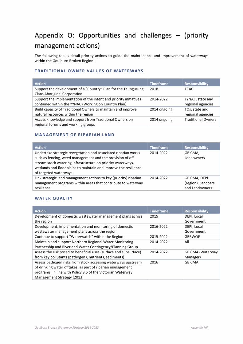
Goulburn Broken Waterway Strategy 2014-2022 Appendix lxiii
Appendix O: Opportunities and challenges – (priority management actions) The following tables detail priority actions to guide the maintenance and improvement of waterways within the Goulburn Broken Region:
T RA DI T I O NAL O WN ER VA L UE S O F W AT E RW A Y S
Action Timeframe Responsibility Support the development of a “Country” Plan for the Taungurung Clans Aboriginal Corporation
2018 TCAC
Support the implementation of the intent and priority initiatives contained within the YYNAC (Working on Country Plan)
2014-2022 YYNAC, state and regional agencies
Build capacity of Traditional Owners to maintain and improve natural resources within the region
2014 ongoing TOs, state and regional agencies
Access knowledge and support from Traditional Owners on regional forums and working groups
2014 ongoing Traditional Owners
M A NAG E MEN T O F R I P AR I AN L AN D
Action Timeframe Responsibility Undertake strategic revegetation and associated riparian works such as fencing, weed management and the provision of off-stream stock watering infrastructure on priority waterways, wetlands and floodplains to maintain and improve the resilience of targeted waterways
2014-2022 GB CMA, Landowners
Link strategic land management actions to key (priority) riparian management programs within areas that contribute to waterway resilience
2014-2022 GB CMA, DEPI (region), Landcare and Landowners
W A T E R QU AL I T Y
Action Timeframe Responsibility Development of domestic wastewater management plans across the region
2015 DEPI, Local Government
Development, implementation and monitoring of domestic wastewater management plans across the region
2016-2022 DEPI, Local Government
Continue to support “Waterwatch” within the Region 2015-2022 GBRWQF Maintain and support Northern Regional Water Monitoring Partnership and River and Water Contingency/Planning Group
2014-2022 All
Assess the risk posed to beneficial uses (surface and subsurface) from key pollutants (pathogens, nutrients, sediments)
2014-2022 GB CMA (Waterway Manager)
Assess pathogen risks from stock accessing waterways upstream of drinking water offtakes, as part of riparian management programs, in line with Policy 9.6 of the Victorian Waterway Management Strategy (2013)
2016 GB CMA
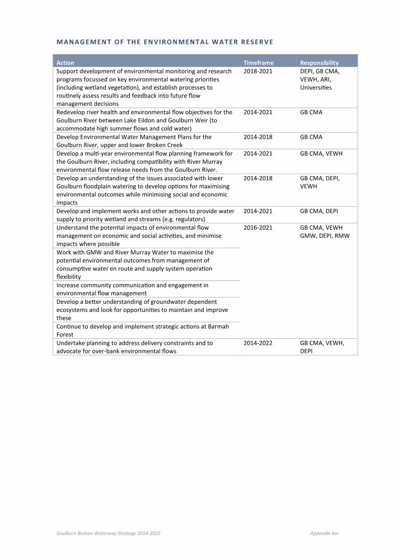
Goulburn Broken Waterway Strategy 2014-2022 Appendix lxiv
M A NAG E MEN T O F T HE EN VI RO N MEN T A L W A T E R RE S ER V E
Action Timeframe Responsibility Support development of environmental monitoring and research programs focussed on key environmental watering priorities (including wetland vegetation), and establish processes to routinely assess results and feedback into future flow management decisions
2018-2021 DEPI, GB CMA, VEWH, ARI, Universities
Redevelop river health and environmental flow objectives for the Goulburn River between Lake Eildon and Goulburn Weir (to accommodate high summer flows and cold water)
2014-2021 GB CMA
Develop Environmental Water Management Plans for the Goulburn River, upper and lower Broken Creek
2014-2018 GB CMA
Develop a multi-year environmental flow planning framework for the Goulburn River, including compatibility with River Murray environmental flow release needs from the Goulburn River.
2014-2021 GB CMA, VEWH
Develop an understanding of the issues associated with lower Goulburn floodplain watering to develop options for maximising environmental outcomes while minimising social and economic impacts
2014-2018 GB CMA, DEPI, VEWH
Develop and implement works and other actions to provide water supply to priority wetland and streams (e.g. regulators)
2014-2021 GB CMA, DEPI
Understand the potential impacts of environmental flow management on economic and social activities, and minimise impacts where possible
2016-2021 GB CMA, VEWH GMW, DEPI, RMW
Work with GMW and River Murray Water to maximise the potential environmental outcomes from management of consumptive water en route and supply system operation flexibility Increase community communication and engagement in environmental flow management Develop a better understanding of groundwater dependent ecosystems and look for opportunities to maintain and improve these Continue to develop and implement strategic actions at Barmah Forest Undertake planning to address delivery constraints and to advocate for over-bank environmental flows
2014-2022 GB CMA, VEWH, DEPI

Goulburn Broken Waterway Strategy 2014-2022 Appendix lxv
G R OUN D WA T E R
Action Timeframe Responsibility Complete the development of groundwater local management plans for the Upper Goulburn, Strathbogie, West Goulburn, Eildon, Broken, and Mid Goulburn GMAs, taking into account social, economic and environmental values)
2014-2015 GMW, DEPI stakeholders and community
Review and adapt groundwater management plans to take into account new information when it becomes available
ongoing GMW
Develop robust flow objectives for all high value waterways 2015 GB CMA GMW Identify and map high value GDEs and groundwater levels or groundwater discharge regimes required to support healthy ecosystems
2015 GB CMA, GMW
Develop ministerial guidance on GDEs and implement this guidance when assessing groundwater licence applications
2014 onwards DEPI, GMW, GB CMA
Align groundwater management with the outcomes of the water law review and proposed changes to the Water Act (1989)
2014 onwards DEPI, GMW
Assess the viability of conjunctive management of groundwater and surface water in priority catchment(s)
2015 onwards GMW, GB CMA, DEPI
F L O O DP LA I N M ANA GE M EN T
Action Timeframe Responsibility
Carry out statutory planning obligations as a referral body, and to provide advice to the general community
2021 GB CMA
Carry out flood modelling and flood mapping ongoing GB CMA
Work with the Environmental Water Reserve Team to achieve environmental outcomes both within and outside of the catchment
2015 onwards GMW, GB CMA, DEPI
Complete review of the Goulburn Broken Floodplain Management Strategy
2015-2017 GB CMA
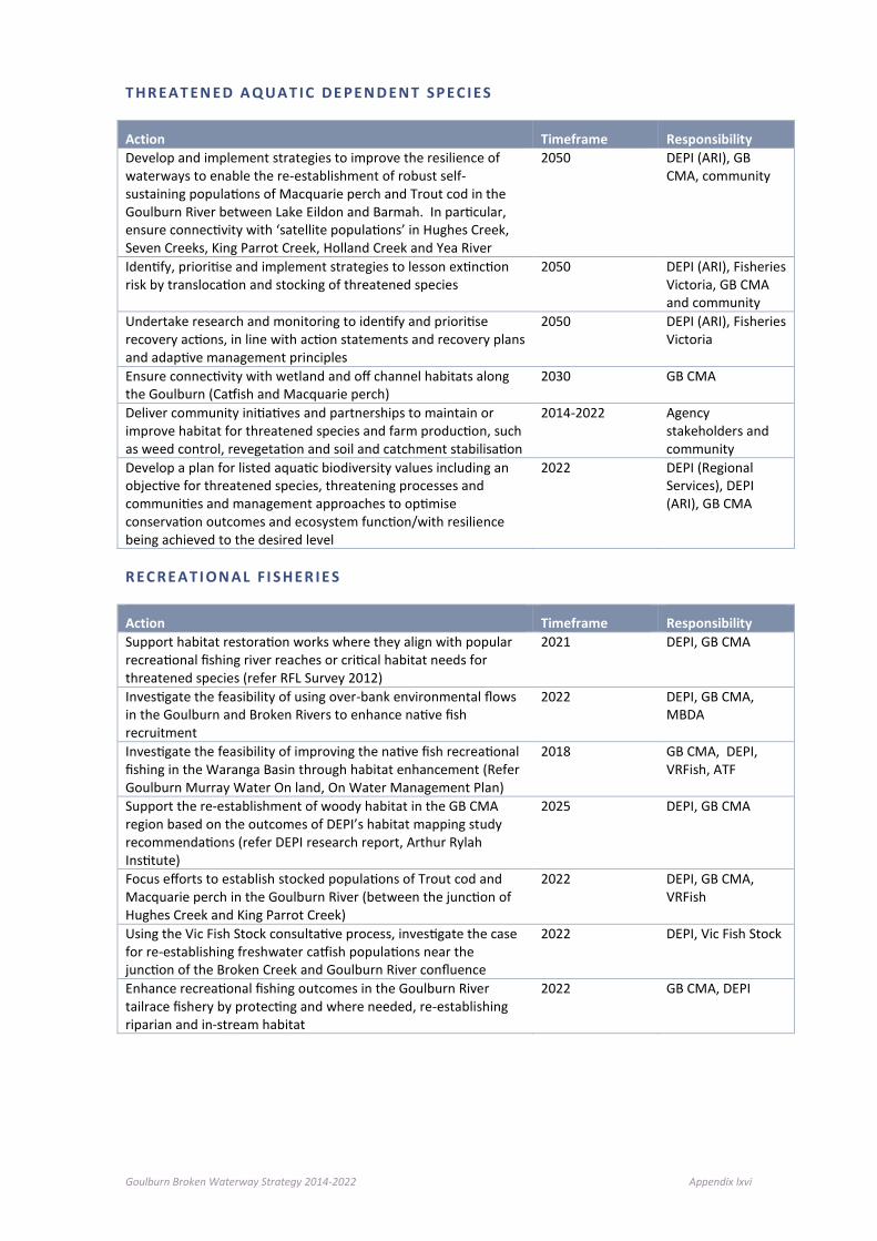
Goulburn Broken Waterway Strategy 2014-2022 Appendix lxvi
T HR EAT EN ED A Q UAT I C DE PEN D ENT SP EC I ES
Action Timeframe Responsibility Develop and implement strategies to improve the resilience of waterways to enable the re-establishment of robust self-sustaining populations of Macquarie perch and Trout cod in the Goulburn River between Lake Eildon and Barmah. In particular, ensure connectivity with ‘satellite populations’ in Hughes Creek, Seven Creeks, King Parrot Creek, Holland Creek and Yea River
2050 DEPI (ARI), GB CMA, community
Identify, prioritise and implement strategies to lesson extinction risk by translocation and stocking of threatened species
2050 DEPI (ARI), Fisheries Victoria, GB CMA and community
Undertake research and monitoring to identify and prioritise recovery actions, in line with action statements and recovery plans and adaptive management principles
2050 DEPI (ARI), Fisheries Victoria
Ensure connectivity with wetland and off channel habitats along the Goulburn (Catfish and Macquarie perch)
2030 GB CMA
Deliver community initiatives and partnerships to maintain or improve habitat for threatened species and farm production, such as weed control, revegetation and soil and catchment stabilisation
2014-2022 Agency stakeholders and community
Develop a plan for listed aquatic biodiversity values including an objective for threatened species, threatening processes and communities and management approaches to optimise conservation outcomes and ecosystem function/with resilience being achieved to the desired level
2022 DEPI (Regional Services), DEPI (ARI), GB CMA
R EC RE AT I ON AL F I S HER I E S
Action Timeframe Responsibility Support habitat restoration works where they align with popular recreational fishing river reaches or critical habitat needs for threatened species (refer RFL Survey 2012)
2021 DEPI, GB CMA
Investigate the feasibility of using over-bank environmental flows in the Goulburn and Broken Rivers to enhance native fish recruitment
2022 DEPI, GB CMA, MBDA
Investigate the feasibility of improving the native fish recreational fishing in the Waranga Basin through habitat enhancement (Refer Goulburn Murray Water On land, On Water Management Plan)
2018 GB CMA, DEPI, VRFish, ATF
Support the re-establishment of woody habitat in the GB CMA region based on the outcomes of DEPI’s habitat mapping study recommendations (refer DEPI research report, Arthur Rylah Institute)
2025 DEPI, GB CMA
Focus efforts to establish stocked populations of Trout cod and Macquarie perch in the Goulburn River (between the junction of Hughes Creek and King Parrot Creek)
2022 DEPI, GB CMA, VRFish
Using the Vic Fish Stock consultative process, investigate the case for re-establishing freshwater catfish populations near the junction of the Broken Creek and Goulburn River confluence
2022 DEPI, Vic Fish Stock
Enhance recreational fishing outcomes in the Goulburn River tailrace fishery by protecting and where needed, re-establishing riparian and in-stream habitat
2022 GB CMA, DEPI

Goulburn Broken Waterway Strategy 2014-2022 Appendix lxvii
M A NAG E MEN T O F I NV A S I VE S PE CI E S
Action Timeframe Responsibility Assess the risks of inland aquatic invasive species spread through the Victorian water grid
2015-2018 DEPI, Waterway managers, water corporations
Support multi-jurisdictional process and actions to manage invasive species
Ongoing DEPI, Waterway managers, water corporations
Support research into the management and control of invasive species
2015-2050 DEPI, Waterway managers, water corporations
Identify stream lengths that may require selective removal in very limited sections of a few upper catchment streams to protect valuable species and ecosystems, working in collaboration with relevant stakeholders’ interest groups
2014-2022 DEPI (Regional Services / ARI), Waterway managers
Encourage and support efforts for control methods and management of carp within priority waterways (identified) within the region Highlight level of urgency
2018 DEPI (ARI), GB CMA
Facilitate “carp muster” days on identified “hot spots” (waterways and wetlands, storages)
2014-2022 DEPI (ARI), Fisheries Victoria, GB CMA
Encourage support efforts for enhanced control of invasive plant species. – biological and chemical control methods
2022 Research Organisations
M A NAG E MEN T O F T HE R I VE R CH ANN EL
Action Timeframe Responsibility Provide adequate resources to enable the management of works on waterways to prevent threats to the ecological systems and manmade assets
2014-2022 GB CMA, DEPI (Waterway Policy)
Further refine priority reaches and mapping for maintenance and improvement to in stream habitat across the region
2014-2018 GB CMA, DEPI (ARI), Fisheries Victoria
Install IWH within priority river reaches (see Chapter 7) 2014-2022 GB CMA, DEPI (ARI), Fisheries Victoria
Develop recreational boating strategies and plans in key areas as identified by the Boating Authority
2014-2018 GB CMA, Local Government
Establish within key boating zones appropriate zoning of particular uses and controls
2014-2022 GB CMA, Local Government, DEPI (ARI)
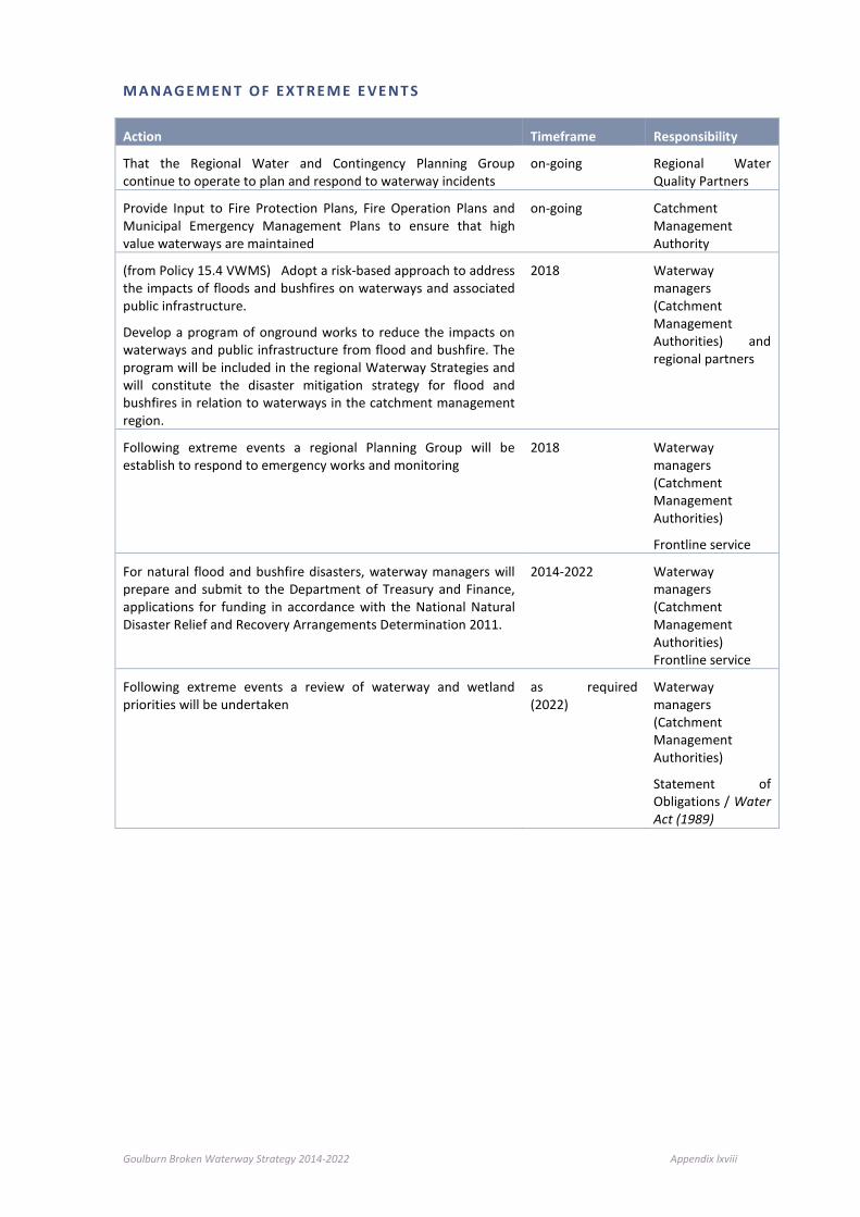
Goulburn Broken Waterway Strategy 2014-2022 Appendix lxviii
M A NAG E MEN T O F EXT RE M E E VE NT S
Action Timeframe Responsibility
That the Regional Water and Contingency Planning Group continue to operate to plan and respond to waterway incidents
on-going Regional Water Quality Partners
Provide Input to Fire Protection Plans, Fire Operation Plans and Municipal Emergency Management Plans to ensure that high value waterways are maintained
on-going Catchment Management Authority
(from Policy 15.4 VWMS) Adopt a risk-based approach to address the impacts of floods and bushfires on waterways and associated public infrastructure.
Develop a program of onground works to reduce the impacts on waterways and public infrastructure from flood and bushfire. The program will be included in the regional Waterway Strategies and will constitute the disaster mitigation strategy for flood and bushfires in relation to waterways in the catchment management region.
2018 Waterway managers (Catchment Management Authorities) and regional partners
Following extreme events a regional Planning Group will be establish to respond to emergency works and monitoring
2018 Waterway managers (Catchment Management Authorities)
Frontline service
For natural flood and bushfire disasters, waterway managers will prepare and submit to the Department of Treasury and Finance, applications for funding in accordance with the National Natural Disaster Relief and Recovery Arrangements Determination 2011.
2014-2022 Waterway managers (Catchment Management Authorities) Frontline service
Following extreme events a review of waterway and wetland priorities will be undertaken
as required (2022)
Waterway managers (Catchment Management Authorities)
Statement of Obligations / Water Act (1989)

Goulburn Broken Waterway Strategy 2014-2022 Appendix lxix
I N F L UEN CE O F T H E SU R RO UN DI N G CAT CHM E NT
Action Timeframe Responsibility Facilitate adoption and implementation of IWCM principles in the region. Develop and implement IWCM projects
2015 - 2019 CMA, Water Corporations (Goulburn Valley Water) and Municipalities
Progress partnership approach to establish programs that leads to a reduction in water use across the catchment
2014 - 2022 CMA, Water Corporations (Goulburn Valley Water) and Municipalities
Promote best practice: Multi-benefit - gaining a more productive landscape and a healthier environment within the Communications Strategy (see Chapter 8)
2015-2021 DEPI, GB CMA and Landcare
Include waterways and wetlands as key features (in all levels of planning) within Local Planning - including Whole Farm Plans
2015-2021 DEPI, GB CMA, Landowners and Landcare
Provide protection for key waterways and wetlands through Land Use Planning
2015-2021 Local Government, DEPI, GB CMA
P O T EN T I A L CL I MAT E C HA NGE
Action Timeframe Responsibility Increase awareness of the potential impact of climate change and adaptation options
2014 - 2022 GB CMA, DEPI
Increase awareness of the potential impact of climate change on threats and resilience of systems at a range of scales
2014 - 2022 GB CMA, DEPI
Accelerate the rate of riparian maintenance and improvement works and water regime management in priority waterways and wetlands
2014 - 2022 GB CMA, Community
Accelerate the rate and encourage broad land-based improvement works and actions (erosion and sediment control)
2014 - 2022 DEPI, Community
Refine and maintain critical aquatic dependent refugia (consider Zonation Project)
2014 - 2022 GB CMA, DEPI (ARI), Community
Model likely vegetation changes under climate change scenarios for waterway zone (by SES)
2014 - 2022 Research Organisations, DEPI (Sustainable Water Environments Division)
Plan (as required) for environmental watering and associated works in compensating for reduced frequency and duration of flooding under climate change
2014 - 2022 GB CMA
Reduce flow thresholds to priority floodplain wetlands (identifying these) to restore flooding frequency at lower river levels
2014 - 2022 GB CMA